Embed Size (px)
Citation preview
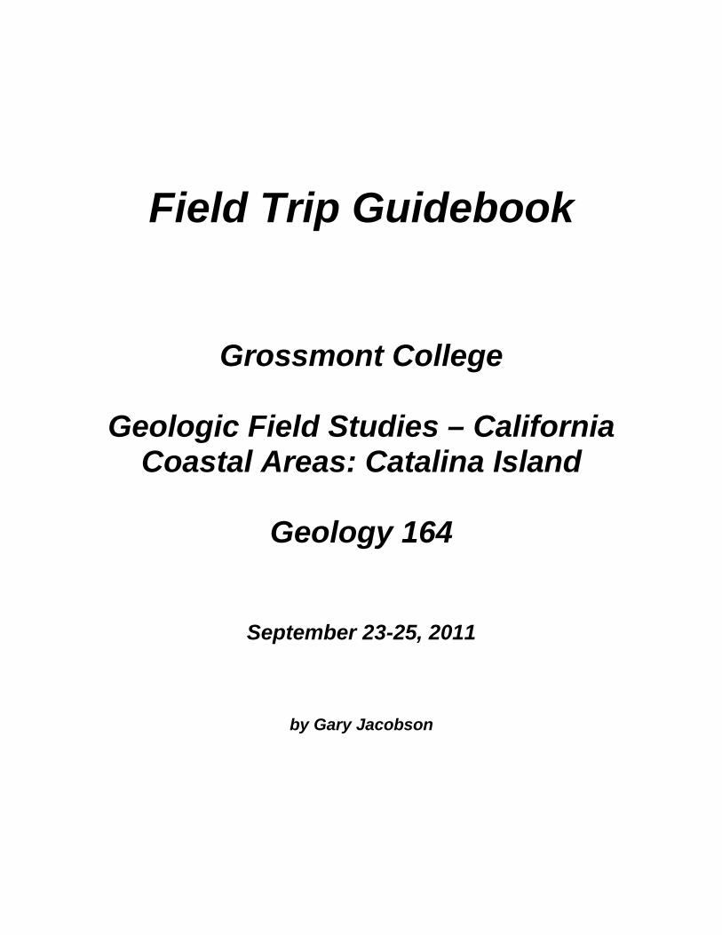
Field Trip Guidebook
Grossmont College
Geologic Field Studies – California Coastal Areas: Catalina Island
Geology 164
September 23-25, 2011
by Gary Jacobson
Field Trip Guide
PART 1: Port of Los Angles / Long Beach and the Catalina Channel
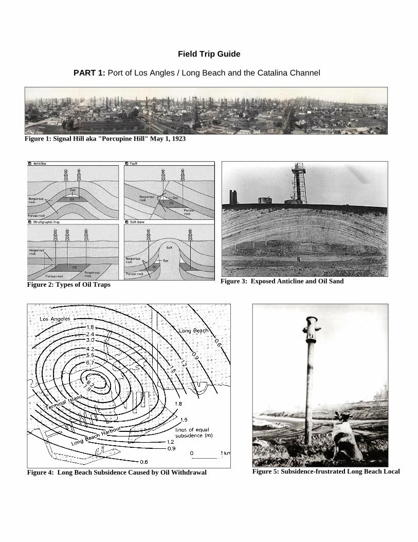
Figure 1: Signal Hill aka "Porcupine Hill" May 1, 1923
Figure 2: Types of Oil Traps
Figure 3: Exposed Anticline and Oil Sand
Figure 4: Long Beach Subsidence Caused by Oil Withdrawal
Figure 5: Subsidence-frustrated Long Beach Local
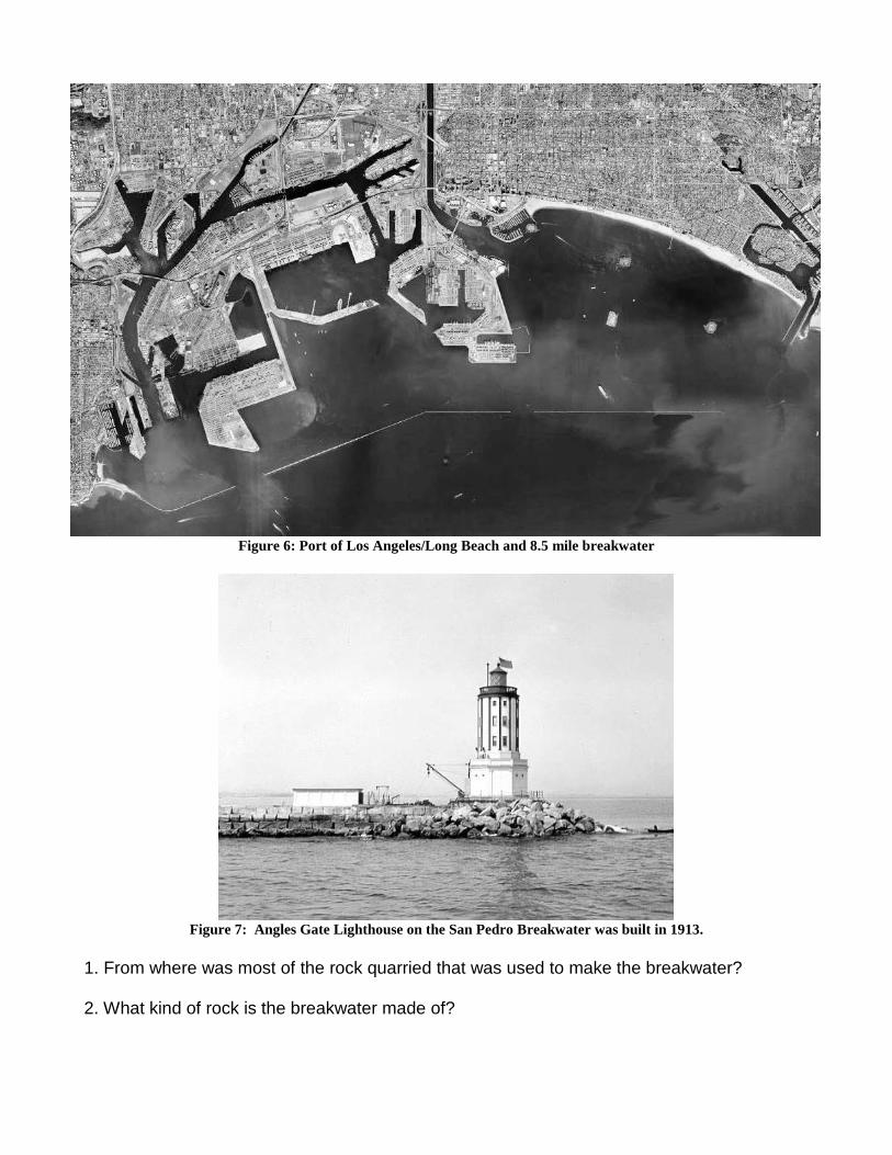
Figure 6: Port of Los Angeles/Long Beach and 8.5 mile breakwater
Figure 7: Angles Gate Lighthouse on the San Pedro Breakwater was built in 1913.
1. From where was most of the rock quarried that was used to make the breakwater? 2. What kind of rock is the breakwater made of?
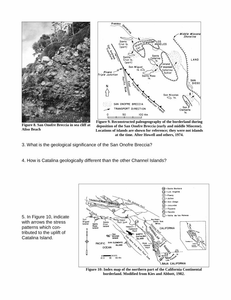
Figure 8. San Onofre Breccia in sea cliff at Aliso Beach
Figure 9. Reconstructed paleogeography of the borderland during deposition of the San Onofre Breccia (early and middle Miocene). Locations of islands are shown for reference; they were not islands
at the time. After Howell and others, 1974. 3. What is the geological significance of the San Onofre Breccia? 4. How is Catalina geologically different than the other Channel Islands?
5. In Figure 10, indicate with arrows the stress patterns which con-tributed to the uplift of Catalina Island.
Figure 10: Index map of the northern part of the California Continental
borderland. Modified from Kies and Abbott, 1982.
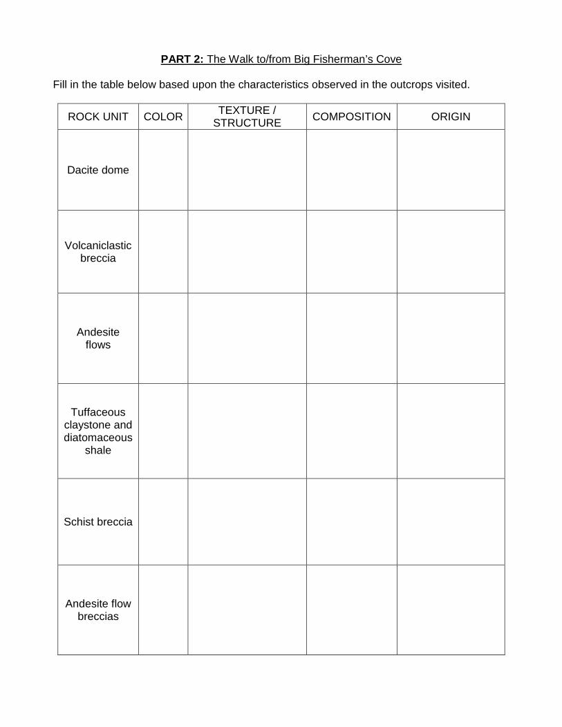
PART 2: The Walk to/from Big Fisherman’s Cove Fill in the table below based upon the characteristics observed in the outcrops visited.
ROCK UNIT COLOR TEXTURE / STRUCTURE COMPOSITION ORIGIN
Dacite dome
Volcaniclastic breccia
Andesite flows
Tuffaceous claystone and diatomaceous
shale
Schist breccia
Andesite flow breccias
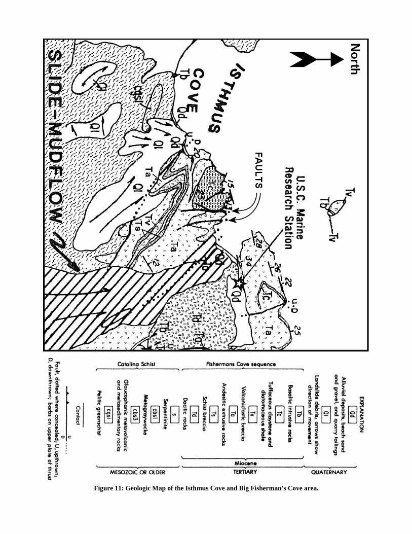
Figure 11: Geologic Map of the Isthmus Cove and Big Fisherman's Cove area.
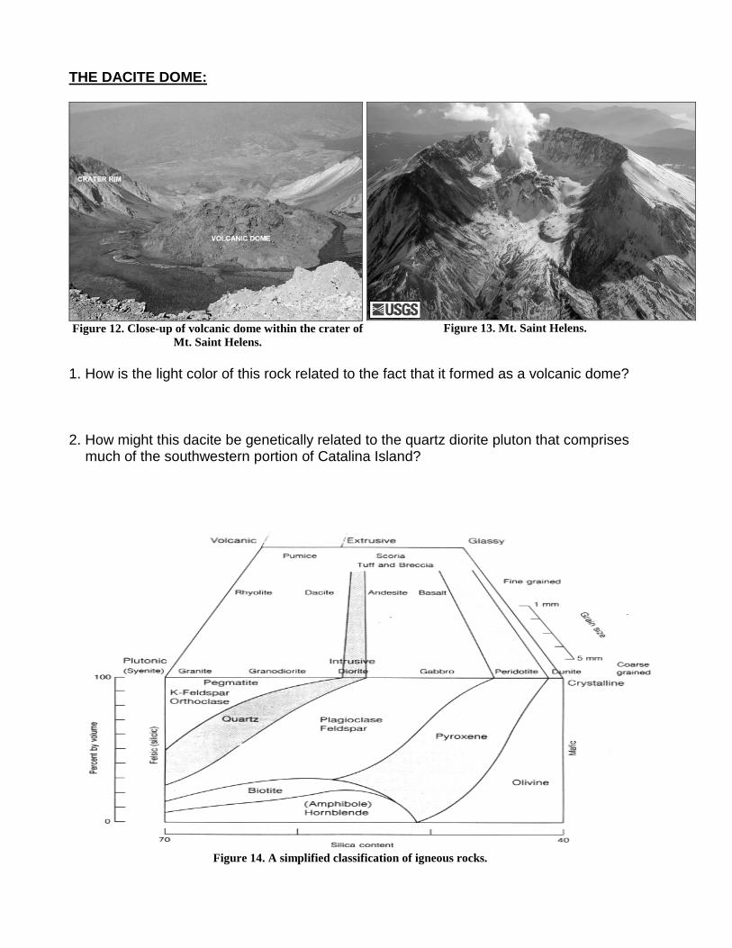
THE DACITE DOME:
Figure 12. Close-up of volcanic dome within the crater of
Mt. Saint Helens.
Figure 13. Mt. Saint Helens.
1. How is the light color of this rock related to the fact that it formed as a volcanic dome? 2. How might this dacite be genetically related to the quartz diorite pluton that comprises
much of the southwestern portion of Catalina Island?
Figure 14. A simplified classification of igneous rocks.
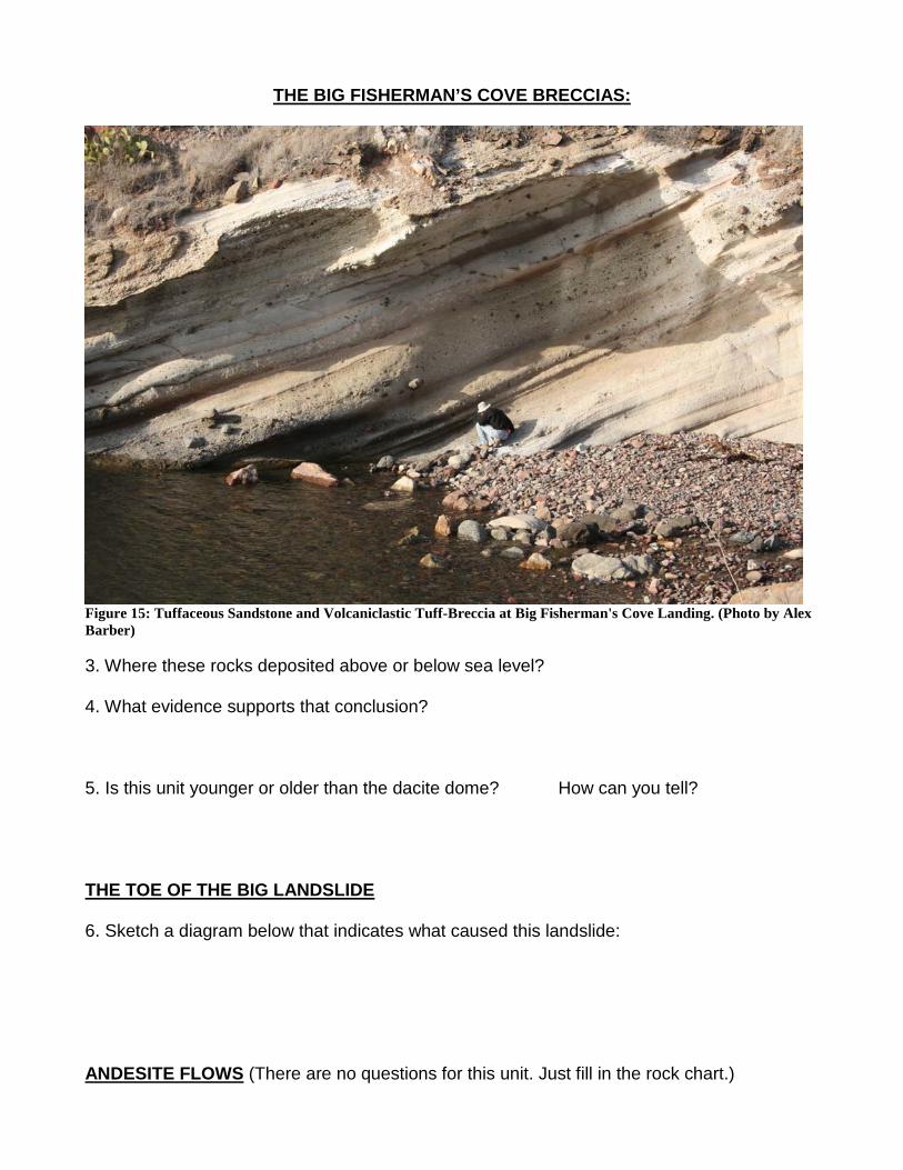
THE BIG FISHERMAN’S COVE BRECCIAS:
Figure 15: Tuffaceous Sandstone and Volcaniclastic Tuff-Breccia at Big Fisherman's Cove Landing. (Photo by Alex Barber) 3. Where these rocks deposited above or below sea level? 4. What evidence supports that conclusion? 5. Is this unit younger or older than the dacite dome? How can you tell? THE TOE OF THE BIG LANDSLIDE 6. Sketch a diagram below that indicates what caused this landslide: ANDESITE FLOWS (There are no questions for this unit. Just fill in the rock chart.)
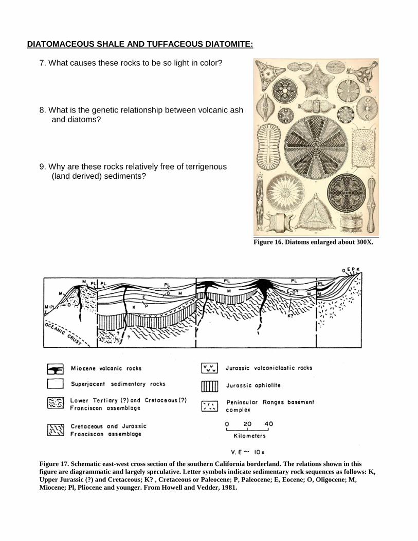
DIATOMACEOUS SHALE AND TUFFACEOUS DIATOMITE:
7. What causes these rocks to be so light in color? 8. What is the genetic relationship between volcanic ash
and diatoms? 9. Why are these rocks relatively free of terrigenous
(land derived) sediments?
Figure 16. Diatoms enlarged about 300X.
Figure 17. Schematic east-west cross section of the southern California borderland. The relations shown in this figure are diagrammatic and largely speculative. Letter symbols indicate sedimentary rock sequences as follows: K, Upper Jurassic (?) and Cretaceous; K? , Cretaceous or Paleocene; P, Paleocene; E, Eocene; O, Oligocene; M, Miocene; Pl, Pliocene and younger. From Howell and Vedder, 1981.
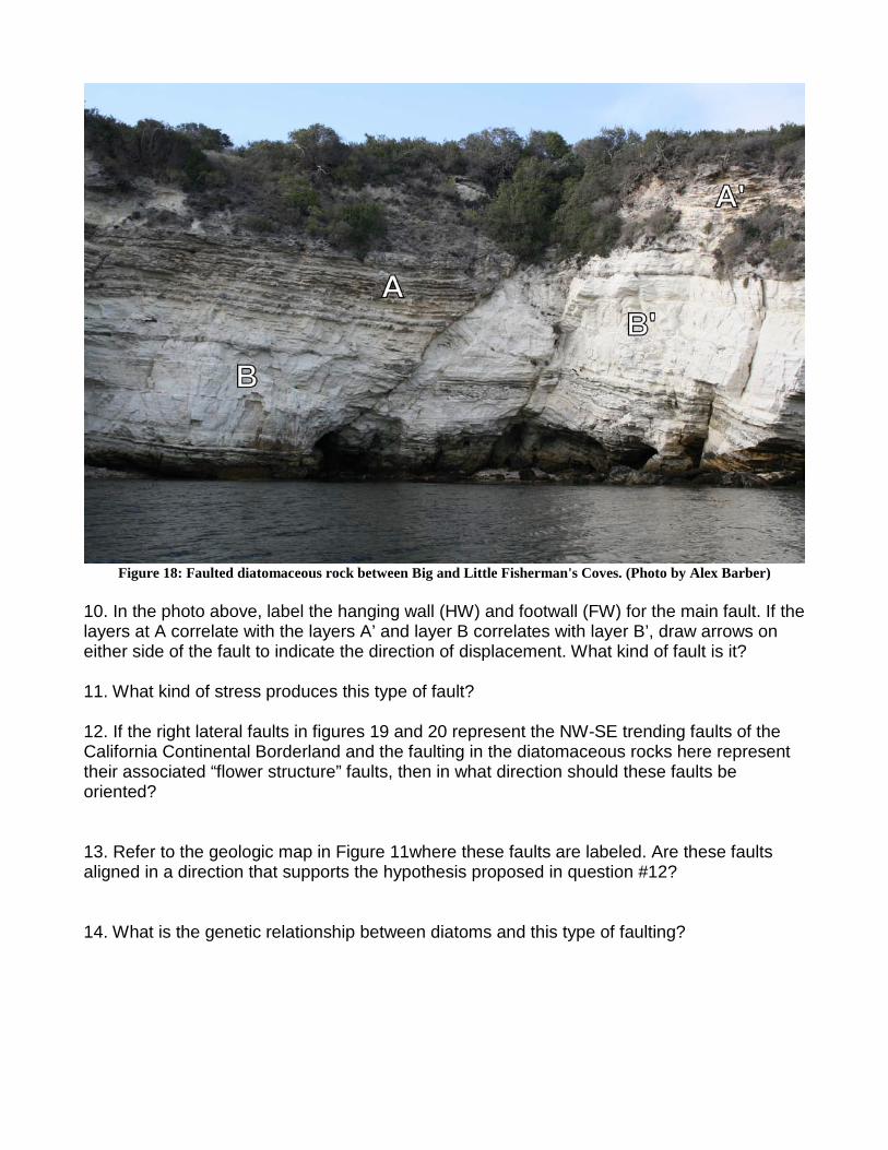
Figure 18: Faulted diatomaceous rock between Big and Little Fisherman's Coves. (Photo by Alex Barber)
10. In the photo above, label the hanging wall (HW) and footwall (FW) for the main fault. If the layers at A correlate with the layers A’ and layer B correlates with layer B’, draw arrows on either side of the fault to indicate the direction of displacement. What kind of fault is it? 11. What kind of stress produces this type of fault? 12. If the right lateral faults in figures 19 and 20 represent the NW-SE trending faults of the California Continental Borderland and the faulting in the diatomaceous rocks here represent their associated “flower structure” faults, then in what direction should these faults be oriented? 13. Refer to the geologic map in Figure 11where these faults are labeled. Are these faults aligned in a direction that supports the hypothesis proposed in question #12? 14. What is the genetic relationship between diatoms and this type of faulting?
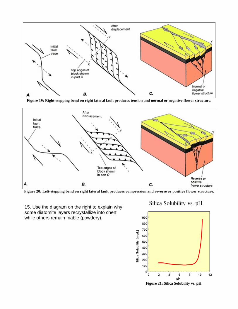
Figure 19: Right-stepping bend on right lateral fault produces tension and normal or negative flower structure.
Figure 20: Left-stepping bend on right lateral fault produces compression and reverse or positive flower structure.
15. Use the diagram on the right to explain why some diatomite layers recrystallize into chert while others remain friable (powdery).
Figure 21: Silica Solubility vs. pH
THE ROAD-CUT BRECCIAS:
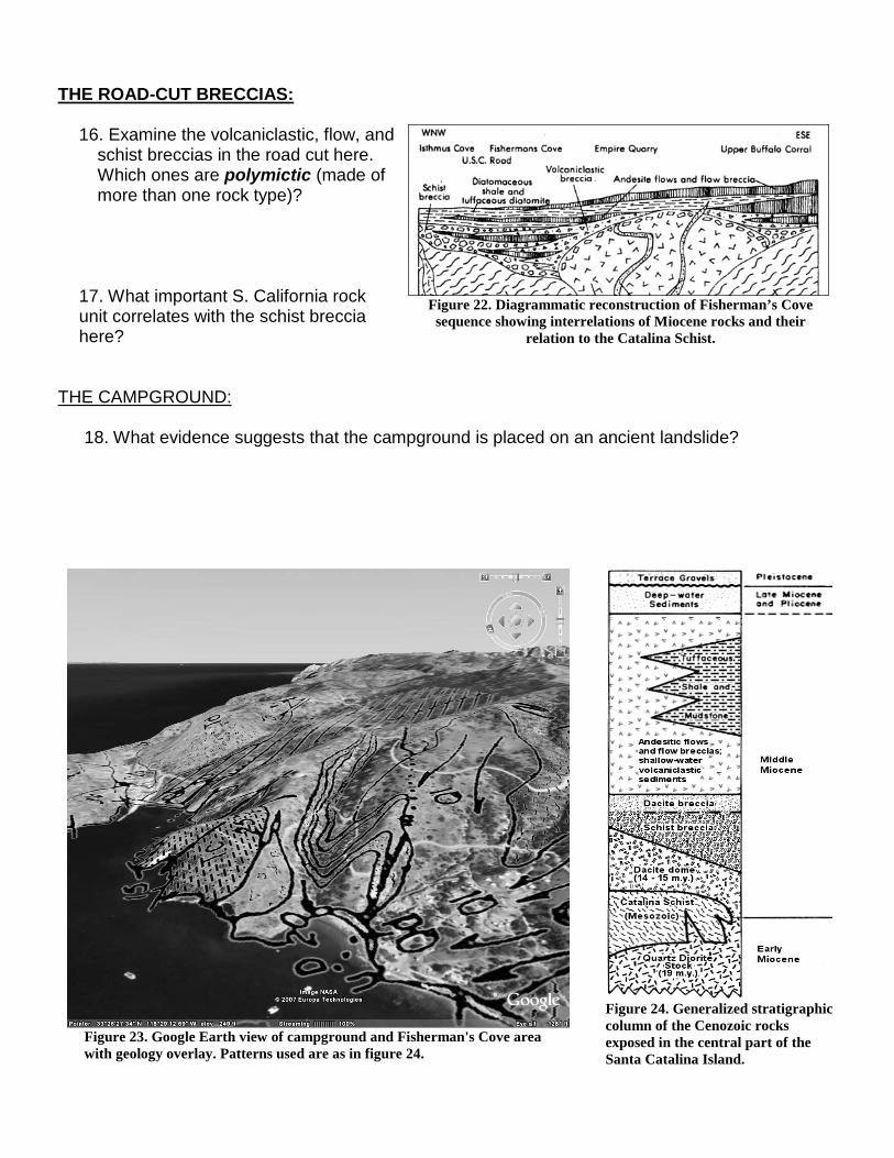
16. Examine the volcaniclastic, flow, and schist breccias in the road cut here. Which ones are polymictic (made of more than one rock type)?
17. What important S. California rock unit correlates with the schist breccia here?
Figure 22. Diagrammatic reconstruction of Fisherman’s Cove
sequence showing interrelations of Miocene rocks and their relation to the Catalina Schist.
THE CAMPGROUND: 18. What evidence suggests that the campground is placed on an ancient landslide?
Figure 23. Google Earth view of campground and Fisherman's Cove area with geology overlay. Patterns used are as in figure 24.
Figure 24. Generalized stratigraphic column of the Cenozoic rocks exposed in the central part of the Santa Catalina Island.
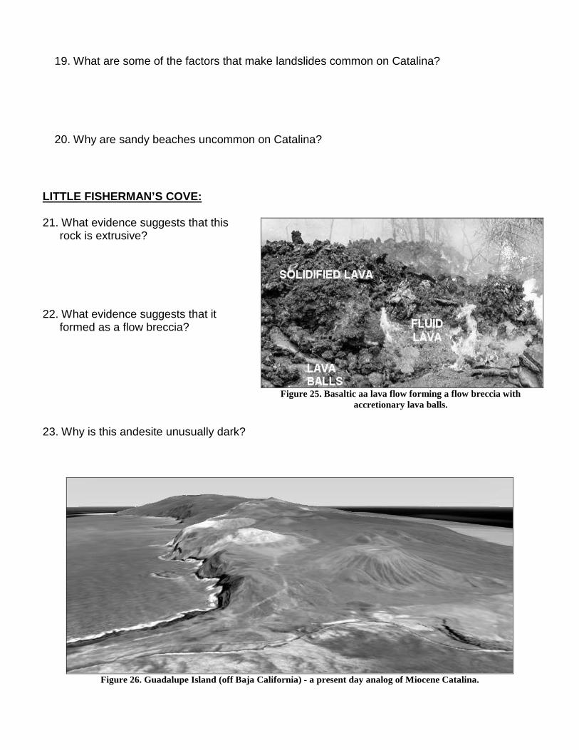
19. What are some of the factors that make landslides common on Catalina? 20. Why are sandy beaches uncommon on Catalina?
Figure 26. Guadalupe Island (off Baja California) - a present day analog of Miocene Catalina.
LITTLE FISHERMAN’S COVE: 21. What evidence suggests that this
rock is extrusive? 22. What evidence suggests that it
formed as a flow breccia? 23. Why is this andesite unusually dark?
Figure 25. Basaltic aa lava flow forming a flow breccia with
accretionary lava balls.
PART 3: Bison and Blueschist - Catalina’s Interior
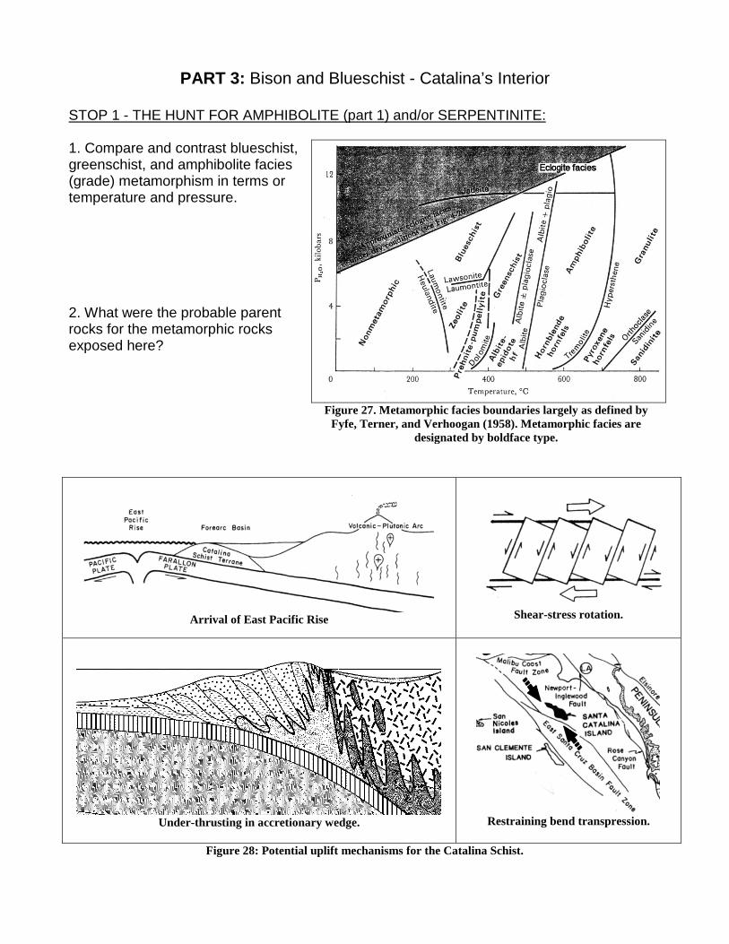
STOP 1 - THE HUNT FOR AMPHIBOLITE (part 1) and/or SERPENTINITE: 1. Compare and contrast blueschist, greenschist, and amphibolite facies (grade) metamorphism in terms or temperature and pressure. 2. What were the probable parent rocks for the metamorphic rocks exposed here?
Figure 27. Metamorphic facies boundaries largely as defined by
Fyfe, Terner, and Verhoogan (1958). Metamorphic facies are designated by boldface type.
Arrival of East Pacific Rise
Shear-stress rotation.
Under-thrusting in accretionary wedge.
Restraining bend transpression.
Figure 28: Potential uplift mechanisms for the Catalina Schist.
STOP 2 - THE BIG GREEN ROCK: 3. What minerals color this rock green? 4. What was the probable parent rock for this metamorphic rock?
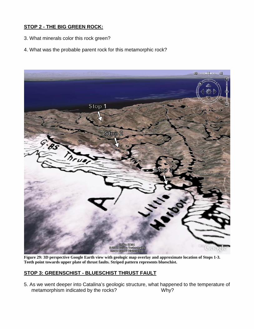
Figure 29: 3D perspective Google Earth view with geologic map overlay and approximate location of Stops 1-3. Teeth point towards upper plate of thrust faults. Striped pattern represents blueschist. STOP 3: GREENSCHIST - BLUESCHIST THRUST FAULT 5. As we went deeper into Catalina’s geologic structure, what happened to the temperature of
metamorphism indicated by the rocks? Why?
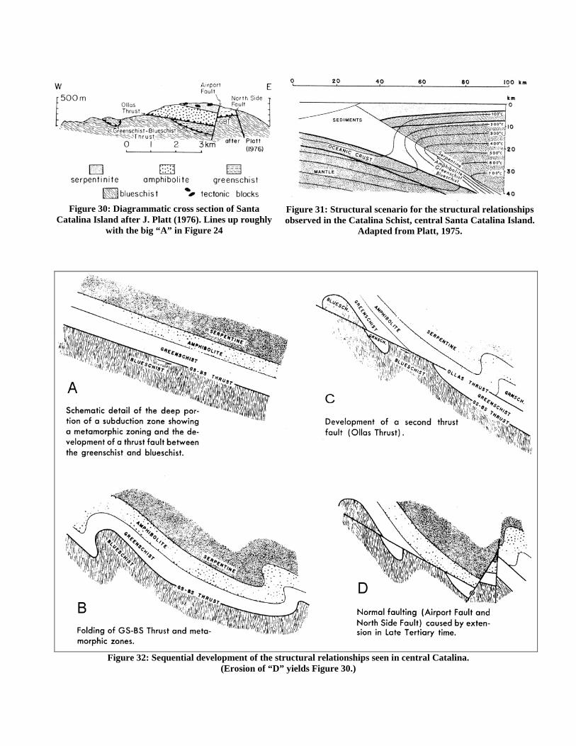
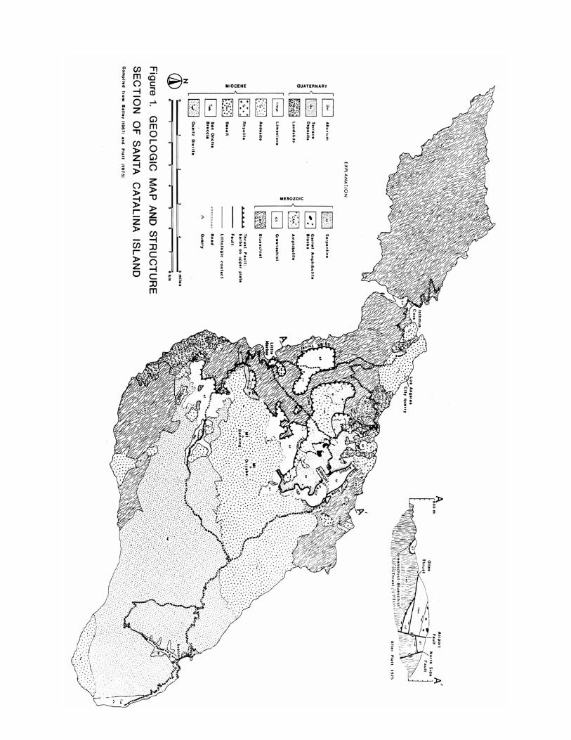
Figure 30: Diagrammatic cross section of Santa
Catalina Island after J. Platt (1976). Lines up roughly with the big “A” in Figure 24
Figure 31: Structural scenario for the structural relationships observed in the Catalina Schist, central Santa Catalina Island.
Adapted from Platt, 1975.
Figure 32: Sequential development of the structural relationships seen in central Catalina.
(Erosion of “D” yields Figure 30.)
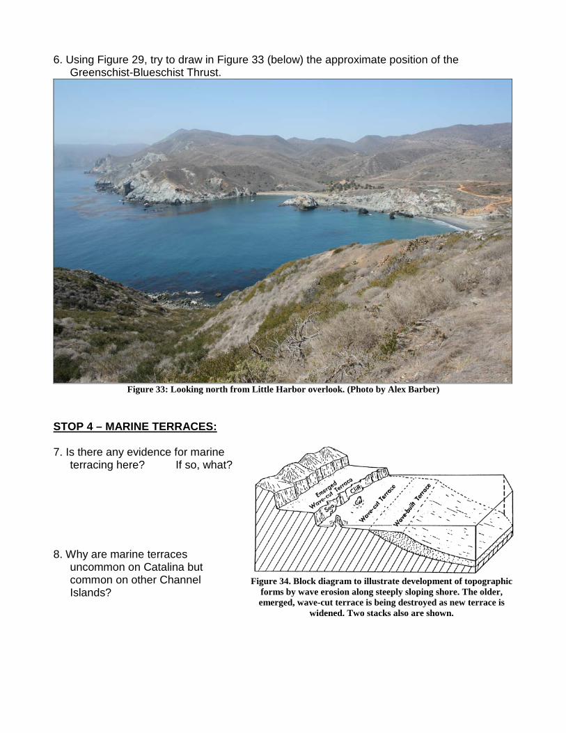
6. Using Figure 29, try to draw in Figure 33 (below) the approximate position of the Greenschist-Blueschist Thrust.
Figure 33: Looking north from Little Harbor overlook. (Photo by Alex Barber)
STOP 4 – MARINE TERRACES: 7. Is there any evidence for marine
terracing here? If so, what? 8. Why are marine terraces
uncommon on Catalina but common on other Channel Islands?
Figure 34. Block diagram to illustrate development of topographic
forms by wave erosion along steeply sloping shore. The older, emerged, wave-cut terrace is being destroyed as new terrace is
widened. Two stacks also are shown.
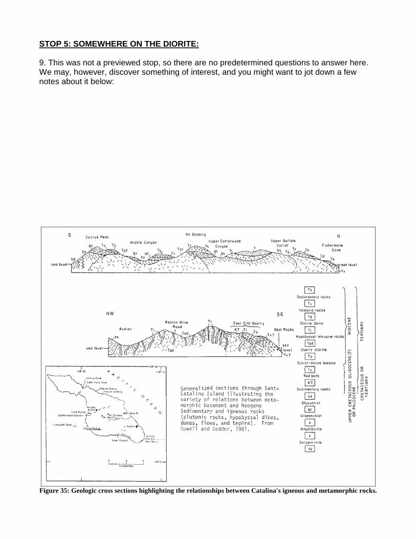
STOP 5: SOMEWHERE ON THE DIORITE: 9. This was not a previewed stop, so there are no predetermined questions to answer here. We may, however, discover something of interest, and you might want to jot down a few notes about it below:
Figure 35: Geologic cross sections highlighting the relationships between Catalina's igneous and metamorphic rocks.
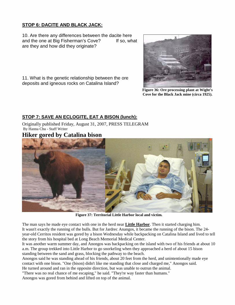
STOP 6: DACITE AND BLACK JACK: 10. Are there any differences between the dacite here and the one at Big Fisherman’s Cove? If so, what are they and how did they originate? 11. What is the genetic relationship between the ore deposits and igneous rocks on Catalina Island?
Figure 36: Ore processing plant at Wight’s Cove for the Black Jack mine (circa 1925).
STOP 7: SAVE AN ECLOGITE, EAT A BISON (lunch): Originally published Friday, August 31, 2007, PRESS TELEGRAM By Hanna Chu - Staff Writer
Hiker gored by Catalina bison
Figure 37: Territorial Little Harbor local and victim.
The man says he made eye contact with one in the herd near Little Harbor. Then it started charging him. It wasn't exactly the running of the bulls. But for Jardrec Anangos, it became the running of the bison. The 24-year-old Cerritos resident was gored by a bison Wednesday while backpacking on Catalina Island and lived to tell the story from his hospital bed at Long Beach Memorial Medical Center. It was another warm summer day, and Anongos was backpacking on the island with two of his friends at about 10 a.m. The group trekked into Little Harbor to go snorkeling when they approached a herd of about 15 bison standing between the sand and grass, blocking the pathway to the beach. Anongos said he was standing ahead of his friends, about 20 feet from the herd, and unintentionally made eye contact with one bison. "One (bison) didn't like me standing that close and charged me," Anongos said. He turned around and ran in the opposite direction, but was unable to outrun the animal. "There was no real chance of me escaping," he said. "They're way faster than humans." Anongos was gored from behind and lifted on top of the animal.
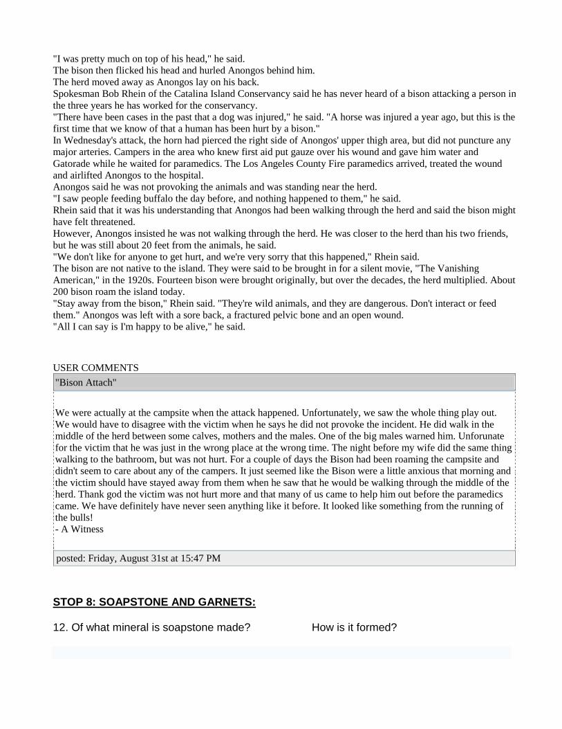
"I was pretty much on top of his head," he said. The bison then flicked his head and hurled Anongos behind him. The herd moved away as Anongos lay on his back. Spokesman Bob Rhein of the Catalina Island Conservancy said he has never heard of a bison attacking a person in the three years he has worked for the conservancy. "There have been cases in the past that a dog was injured," he said. "A horse was injured a year ago, but this is the first time that we know of that a human has been hurt by a bison." In Wednesday's attack, the horn had pierced the right side of Anongos' upper thigh area, but did not puncture any major arteries. Campers in the area who knew first aid put gauze over his wound and gave him water and Gatorade while he waited for paramedics. The Los Angeles County Fire paramedics arrived, treated the wound and airlifted Anongos to the hospital. Anongos said he was not provoking the animals and was standing near the herd. "I saw people feeding buffalo the day before, and nothing happened to them," he said. Rhein said that it was his understanding that Anongos had been walking through the herd and said the bison might have felt threatened. However, Anongos insisted he was not walking through the herd. He was closer to the herd than his two friends, but he was still about 20 feet from the animals, he said. "We don't like for anyone to get hurt, and we're very sorry that this happened," Rhein said. The bison are not native to the island. They were said to be brought in for a silent movie, "The Vanishing American," in the 1920s. Fourteen bison were brought originally, but over the decades, the herd multiplied. About 200 bison roam the island today. "Stay away from the bison," Rhein said. "They're wild animals, and they are dangerous. Don't interact or feed them." Anongos was left with a sore back, a fractured pelvic bone and an open wound. "All I can say is I'm happy to be alive," he said.
USER COMMENTS "Bison Attach"
We were actually at the campsite when the attack happened. Unfortunately, we saw the whole thing play out. We would have to disagree with the victim when he says he did not provoke the incident. He did walk in the middle of the herd between some calves, mothers and the males. One of the big males warned him. Unforunate for the victim that he was just in the wrong place at the wrong time. The night before my wife did the same thing walking to the bathroom, but was not hurt. For a couple of days the Bison had been roaming the campsite and didn't seem to care about any of the campers. It just seemed like the Bison were a little anxious that morning and the victim should have stayed away from them when he saw that he would be walking through the middle of the herd. Thank god the victim was not hurt more and that many of us came to help him out before the paramedics came. We have definitely have never seen anything like it before. It looked like something from the running of the bulls! - A Witness
posted: Friday, August 31st at 15:47 PM
STOP 8: SOAPSTONE AND GARNETS: 12. Of what mineral is soapstone made? How is it formed?
Serpentine + Carbon Dioxide → Talc + Magnesite + Water
Chlorite + Quartz → Kyanite + Talc + H2O
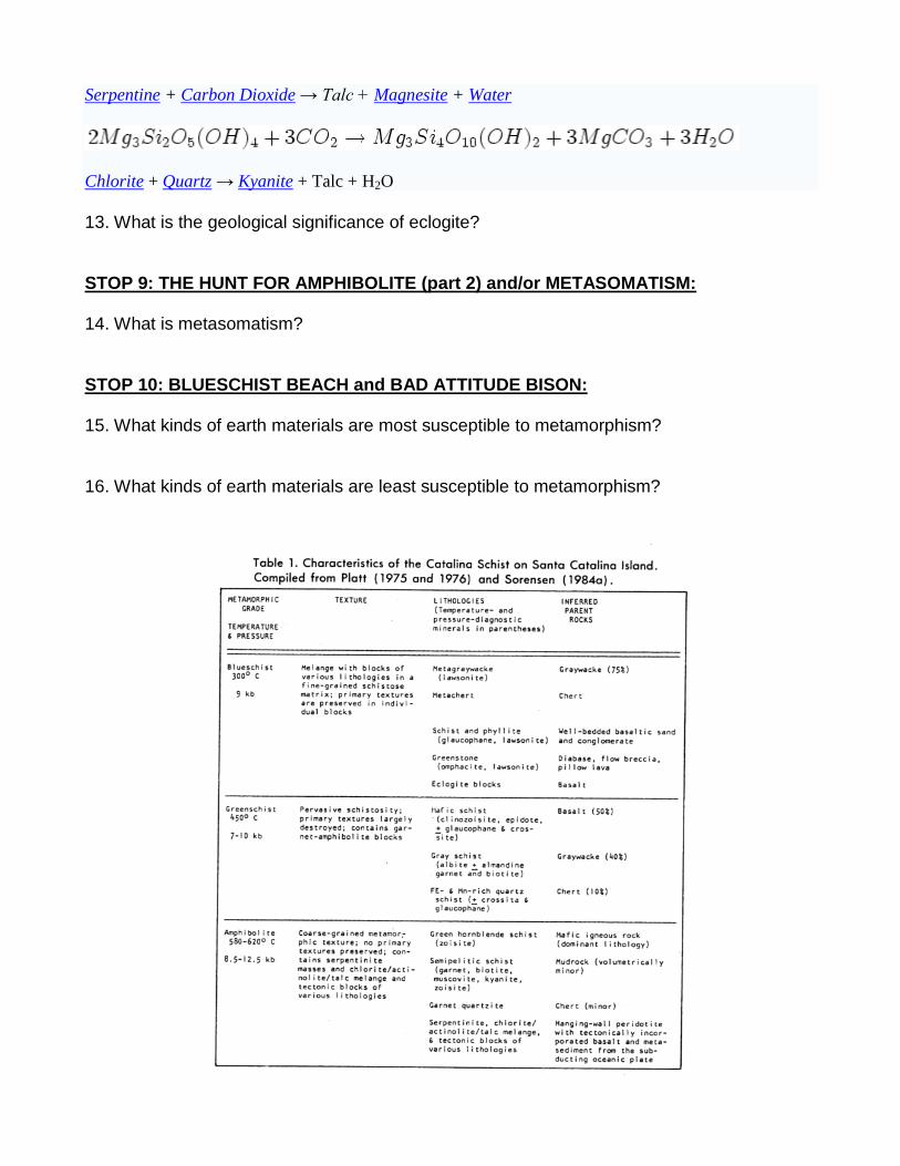
13. What is the geological significance of eclogite? STOP 9: THE HUNT FOR AMPHIBOLITE (part 2) and/or METASOMATISM: 14. What is metasomatism? STOP 10: BLUESCHIST BEACH and BAD ATTITUDE BISON: 15. What kinds of earth materials are most susceptible to metamorphism? 16. What kinds of earth materials are least susceptible to metamorphism?
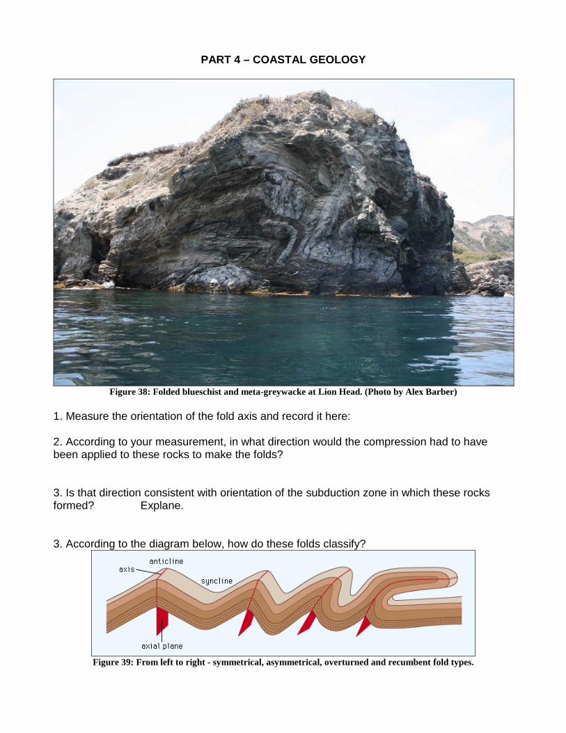
PART 4 – COASTAL GEOLOGY
Figure 38: Folded blueschist and meta-greywacke at Lion Head. (Photo by Alex Barber)
1. Measure the orientation of the fold axis and record it here: 2. According to your measurement, in what direction would the compression had to have been applied to these rocks to make the folds? 3. Is that direction consistent with orientation of the subduction zone in which these rocks formed? Explane. 3. According to the diagram below, how do these folds classify?
Figure 39: From left to right - symmetrical, asymmetrical, overturned and recumbent fold types.

4. What does the low dip angle of their axial planes indicate about their origin? 5. What would happen to these folds at higher metamorphic grades?