Embed Size (px)
Citation preview
1 GEL 109 Field Trip 2 Notes
Dawn Y. Sumner
We are going to look at the Cretaceous Great Valley Sequence along Cache Creek, as well as migration of the Cache Creek channel at the town of Guinda. The sites are about an hour north and slightly east of Davis, in the eastern Coast Ranges (see the map). We will leave from the loading dock at 8 am and will be back before 7:30 pm both Saturday and Sunday. Please bring:
Field Gear:
Hand lens Hammer Ruler with millimeters Grain size card Field note book (Rite-in-the-Rain) Pencils and pens Brunton (if you have one) Acid bottle with dilute HCl These notes
Personal Things: Lunch Water/drinks Appropriate clothing (including rain gear) Hat Boots
We will be measuring stratigraphic sections through parts of a submarine fan. Shales and turbidites are the dominant rock types. While measuring the section, we will record grain size, grain composition where possible, and sedimentary structures. There are a few faults as well. We will use the sections and observations to interpret the depositional environment of the deposits.

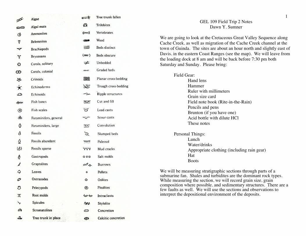
2
7

6 3

4 Sample Column:
(Note that this is an idealized turbidite, and many of the features I show in this column will not be present in many of the turbidites you observe. Make sure that you accurately record the features that are present, not the ones that you think “should” be there! There are many interesting conclusions that can come from the absence of features as well as their presence.)
5
(Both figures from Ingersoll, 1978)

First Set of Assignments (Saturday am): Assignments A and B are at the same site and on the road side of Cache Creek. A) Identify in the rocks and then sketch the following sedimentary structures (You will turn in these sketches.): Current Ripple Lamination Planar Lamination Soft Sediment Deformation in Sandstone B) Choose one turbidite with good sedimentary structures, and draw a mini stratigraphic column of the turbidite like that shown on page 4 of the field trip notes. Draw yours very accurately, including all of the features you see and none that you do not see. Include a few centimeters of the bed above and below it. Label the Bouma facies that are present in your turbidite. You will turn in this min-strat column. C) Assignment C is on the opposite side of the creek and can be done before assignments A and B. Every student should measure strikes and dips as well as 9 meters of section. 1. Measure the strike and dip of at least three beds, and record your results. If your results are very different, ask for help. 2. Set up the Jacobs staff to measure bedding thickness using the average of your strike and dip measurements. 3. Measure 9 meters of section using the Jacobs staff, without describing the rocks. Check your distance against that measured by Dawn and the TA’s. If it is significantly different, e.g. >20 cm off, ask for help and try again. 4. Decide how to divide these rocks into two facies, and describe the facies, including grain size, sedimentary structures, and bed thickness.
Second Set of Assignments (Saturday pm): These exercises are on the road side of Cache Creek, upstream of the bridge. Sites 1-5 are marked with duct tape. In groups of 2-3 (and NOT 4 or more), use a Jacobs staff to measure a stratigraphic column at each of sites 1-5. The minimum length of section you should measure is written on the tape marking the site. These are the steps you should take: 1) Measure the strike and dip of bedding 2-3 times at the site. 2) Set up the Jacobs staff to measure bedding with that orientation 3) Decide where to start measuring 4) Measure rock thickness while simultaneously describing the rocks and drawing a stratigraphic column. 5) While measuring the column, accurately draw a stratigraphic column to represent all important features of the rock:
thickness of each layer >5 cm thick grain size of each layer sandstone versus shale for composition sedimentary structures present
6) After finishing your section, divide the rocks into an appropriate number of facies (maybe 2-4) and write a couple sentences describing each. The jobs can easily be divided up as follows: a) One student to hold and site with the Jacobs staff. b) One student to draw the stratigraphic column to record the observations. c) Third student to discuss the thicknesses, composition, and sedimentary structures in the rock layers with help from the others. You should rotate jobs between sites so that each student measures at least one section and draws at least one stratigraphic column. For the other sites, you can decide which jobs you prefer within your group. You do not have to measure the columns in numerical order by site number, but do record the site number for each column.
Third Set of Assignments (Sunday am-~3 pm): Measure a long stratigraphic column at a site down stream from Saturday’s exercises in groups of 2 or 3. We will take these steps: 1) Walk through part of the section looking at the rock types and
features. 2) Each group should define at least 3 facies based on the rock types
and using the ideas on facies developed Saturday afternoon. 3) Each student should describe in words the facies in their own
notebook and the group should give each one of them a name. 4) Each group should decide how much detail they want to use when
measuring the section. Two options are to: A) describe beds in detail, e.g. every bed >5 cm thick as was done Saturday afternoon; or B) lump groups of thin beds together into facies and record facies types and any beds >25 cm thick. If you describe beds in detail, you will not have time to measure as much sediment thickness, but you will get an excellent idea of how the beds vary. If you lump thin beds, you will get a better sense of how sedimentation changes with a greater thickness of rocks.
5) Each group will decide where to start. Here are two approaches: A) start at the first exposure of rocks; or B) start at a change in facies. Either is fine for our purposes here. Normally, your research goals influence your choice. Write down your reasons for starting where you did.
6) Each group will measure a substantial thickness of section, at least 25 meters if every bed >5 cm is described, 50 meters if every bed >25 cm is recorded. As the section is being measured, it is CRITICAL that you describe and draw the stratigraphic column for each Jacobs staff interval. (This may seem awkward before you are comfortable with the Jacobs staff, but once you get used to the process, this is a much more efficient way to measure section than either measuring-then-describing or writing-descriptions-rather-than-drawing. One reason to draw your stratigraphic column is that it keeps you from forgetting to make critical measurements, e.g. grain size or lithology, which are easy to forget if writing out the description in text.)
7) Record observed sedimentary structures and your facies type.
8) After finishing your stratigraphic column, interpret any changes in facies from the base to the top in terms of a submarine turbidite fan.
Things to turn in from the turbidite sections: 1) Your sketches of sedimentary structures. 2) Copies of your 5 short strat columns from Saturday. These were
measured in groups, but each student needs to turn in a copy; a photocopy is fine.
3) Your facies descriptions for each of the 5 short strat columns in easily legible form, preferably typed.
4) A neatly REDRAFTED copy of your long strat section as well as a copy of the original field section. Each student should draw their own redrafted section.
5) A ~3 page (single spaced) report describing the long strat section you measured, including: a) the general location and why you started where you did; b) the facies you defined and their characteristics; c) the flow characteristics represented by your facies, d) a discussion of the changes in depositional environment from the bottom to top of the long section, and e) an interpretation of the overall depositional environment.
Fourth Assignment (Sunday pm): We will stop and look at Cache Creek in the town of Guinda, a site of
substantial erosion during a recent flood. Draw a sketch of a stretch of river channel showing:
1) where the flow is fastest and slowest 2) where the channel is deepest and shallowest 3) where you predict erosion and deposition Draw a second sketch of stratification in a deposit that is currently
being eroded. This might be the cut bank at the outside of the major river bend or the interior of a gravel bar.
This assignment will change depending on what we see.


![Caning of Senator Sumner, Part Three - Furman …facweb.furman.edu/~bensonlloyd/sumner/SumnerPart3ver1b.doc · Web view[The Caning of Senator Sumner] [Part Three] [H1]Part Three:](https://img.pdfslide.us/doc/110x75/5aa7a2597f8b9a6d5a8c9eae/caning-of-senator-sumner-part-three-furman-bensonlloydsumnersumnerpart3ver1bdocweb.jpg)