Embed Size (px)
Citation preview
Federal Interagency Geospatial Concept of Operations (GeoCONOPS)
Version 3.0 | June 2011
Final Draft
DHS Geospatial Concept of Operations (GeoCONOPS)
ii | Version 3.0 | June 2011
Team
Mem
bersG
eoCO
NO
PSRequirem
ents &
Capabilities
M
ission Areas
Disaster
Operations
CatastrophicD
isastersM
itigation &
PreparednessA
ppendices
Revision RegisterPrefaceVersion Date Summary of Changes Name
1.0 06/30/09 Final Draft
2.0 06/28/10 Final Draft
3.0 06/29/2011 Final Draft
DHS Geospatial Concept of Operations (GeoCONOPS)
June 2011 | Version 3.0 Table of Contents | 1
Team
M
embe
rsG
eoC
ON
OPS
Requ
irem
ents
&
Cap
abili
ties
M
issi
on A
reas
Dis
aste
r O
pera
tion
sC
atas
trop
hic
Dis
aste
rsM
itig
atio
n &
Pr
epar
edne
ssA
ppen
dice
s
Table of Contents
Team Members . . . . . . . . . . . . . . . . . . . . . . . . . . . . . . . 5
1.0 Geospatial Concept of Operations. . . . . . . . . . . . . 7
1.1 Mission Statement . . . . . . . . . . . . . . . . . . . . . . . . . . . . . . . . . . . . . . . 8
1.2 Overview 8
1.3 GeoCONOPS Community . . . . . . . . . . . . . . . . . . . . . . . . . . . . . . . . . 9
1.3.1 State Authorities . . . . . . . . . . . . . . . . . . . . . . . . . . . . . . . . . . . 11
1.3.2 Information Support Services . . . . . . . . . . . . . . . . . . . . . . . . . 11
1.3.3 Infrastructure . . . . . . . . . . . . . . . . . . . . . . . . . . . . . . . . . . . . . .12
1.3.4 Civil Support . . . . . . . . . . . . . . . . . . . . . . . . . . . . . . . . . . . . .12
1.3.5 People . . . . . . . . . . . . . . . . . . . . . . . . . . . . . . . . . . . . . . . . . . .13
1.3.6 Operations/Coordination . . . . . . . . . . . . . . . . . . . . . . . . . . .13
1.4 Audience and Intended Use . . . . . . . . . . . . . . . . . . . . . . . . . . . . . . . 14
1.5 Alignment with NIMS and NRF . . . . . . . . . . . . . . . . . . . . . . . . . . . 14
1.6 Determination of Authorities . . . . . . . . . . . . . . . . . . . . . . . . . . . . . . 16
2.0 Geospatial Requirements and Capabilities . . . . . 19
2.1 Geospatial Mission Support . . . . . . . . . . . . . . . . . . . . . . . . . . . . . . 20
2.1.1 Coordination Requirements . . . . . . . . . . . . . . . . . . . . . . . . . . .20
2.1.2 Staf n Requirements. . . . . . . . . . . . . . . . . . . . . . . . . . . . . . . .21
2.1.3 echno o Requirements. . . . . . . . . . . . . . . . . . . . . . . . . . . . .21
2.1.4 Geospatial Capabilities . . . . . . . . . . . . . . . . . . . . . . . . . . . . . .22
2.2 Geospatial Data . . . . . . . . . . . . . . . . . . . . . . . . . . . . . . . . . . . . . . . . 22
2.2.1 Authoritative Data . . . . . . . . . . . . . . . . . . . . . . . . . . . . . . . . . .22
2.2.2 Essential Elements of Information . . . . . . . . . . . . . . . . . . . . .23
2.2.3 Data Dissemination . . . . . . . . . . . . . . . . . . . . . . . . . . . . . . . . .23
2.3 Geospatial Production and Delivery . . . . . . . . . . . . . . . . . . . . . . . 23
2.3.1 Production . . . . . . . . . . . . . . . . . . . . . . . . . . . . . . . . . . . . . . . .23
2.3.2 Deliver . . . . . . . . . . . . . . . . . . . . . . . . . . . . . . . . . . . . . . . . . .24
. . . . . . . . . . . . . . . . . . . . . 25
3.1 Damage Assessments. . . . . . . . . . . . . . . . . . . . . . . . . . . . . . . . . . . . . 26
3.1.1 Ima er and Derived Products . . . . . . . . . . . . . . . . . . . . . . . .26
3.1.2 Models . . . . . . . . . . . . . . . . . . . . . . . . . . . . . . . . . . . . . . . . . . .28
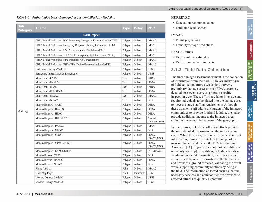
3.1.3 Field Data Collection. . . . . . . . . . . . . . . . . . . . . . . . . . . . . . . .31
3.2 Life-Saving Missions . . . . . . . . . . . . . . . . . . . . . . . . . . . . . . . . . . . . 33
3.2.1 Search and Rescue . . . . . . . . . . . . . . . . . . . . . . . . . . . . . . . . . .33
3.2.2 Critical Medical Support . . . . . . . . . . . . . . . . . . . . . . . . . . . . .34
3.2.3 Provision of Critical Food, Shelter, and Water . . . . . . . . . . . .37
3.3 Recovery . . . . . . . . . . . . . . . . . . . . . . . . . . . . . . . . . . . . . . . . . . . . . . 38
3.3.1 Public Assistance . . . . . . . . . . . . . . . . . . . . . . . . . . . . . . . . . . .38
3.3.2 Individual Assistance . . . . . . . . . . . . . . . . . . . . . . . . . . . . . . . .40
3.4 Mitigation . . . . . . . . . . . . . . . . . . . . . . . . . . . . . . . . . . . . . . . . . . . . . 41
4.0 Disaster Operations . . . . . . . . . . . . . . . . . . . . . . . 45
4.1 DHS National Operations Center . . . . . . . . . . . . . . . . . . . . . . . . . . 46
4.2 DHS National Infrastructure Coordinating Center . . . . . . . . . . . 48
4.3 FEMA National Response Coordination Center . . . . . . . . . . . . . . 50
4.4 FEMA Regional Response Coordination Centers . . . . . . . . . . . . . 52
4.5 FEMA Joint Field Operations . . . . . . . . . . . . . . . . . . . . . . . . . . . . . 54
4.6 FEMA Interim Operating Facility . . . . . . . . . . . . . . . . . . . . . . . . . 58
5.0 Catastrophic Disasters. . . . . . . . . . . . . . . . . . . . . 61
5.1 Natural Events. . . . . . . . . . . . . . . . . . . . . . . . . . . . . . . . . . . . . . . . . . 62
5.1.1 Notice Events . . . . . . . . . . . . . . . . . . . . . . . . . . . . . . . . . . . . . .62
DHS Geospatial Concept of Operations (GeoCONOPS)
2 | Table of Contents Version 3.0 | June 2011
Team
Mem
bersG
eoCO
NO
PSRequirem
ents &
Capabilities
M
ission Areas
Disaster
Operations
CatastrophicD
isastersM
itigation &
PreparednessA
ppendices
5.1.2 No-Notice Events . . . . . . . . . . . . . . . . . . . . . . . . . . . . . . . . . . .62
5.2 The New Madrid Earthquake Scenario . . . . . . . . . . . . . . . . . . . . . 62
5.2.1 Modeled Earthquake Impacts. . . . . . . . . . . . . . . . . . . . . . . . . .62
5.2.2 GeoCONOPS Mission Area Support . . . . . . . . . . . . . . . . . . . .65
5.3 Post-Event Efforts (long-term) . . . . . . . . . . . . . . . . . . . . . . . . . . . . 81
5.4 Activities Outside NMSZ Scenario . . . . . . . . . . . . . . . . . . . . . . . . . 82
5.4.1 Pre-Event Emer enc Activities . . . . . . . . . . . . . . . . . . . . . . . .82
5.4.2 Non Earthquake Activities . . . . . . . . . . . . . . . . . . . . . . . . . . . .83
6.0 Mitigation & Preparedness. . . . . . . . . . . . . . . . . . 85
6.1 Mitigation . . . . . . . . . . . . . . . . . . . . . . . . . . . . . . . . . . . . . . . . . . . . . 86
6.1.1 Risk Anal sis. . . . . . . . . . . . . . . . . . . . . . . . . . . . . . . . . . . . . . .86
6.1.2 Risk Reduction . . . . . . . . . . . . . . . . . . . . . . . . . . . . . . . . . . . . .89
6.1.3 Risk Insurance . . . . . . . . . . . . . . . . . . . . . . . . . . . . . . . . . . . . .93
6.2 Preparedness . . . . . . . . . . . . . . . . . . . . . . . . . . . . . . . . . . . . . . . . . . . 94
Appendix A: Mission Engineering Methodology Overview . . . . . . . . . . . . . . . . . . . . . . . . . . . . . . . . . . 103
Appendix B: Authoritative Data Matrix . . . . . . . . . . 105
Appendix C: Civil Support. . . . . . . . . . . . . . . . . . . . . 147
Appendix D: DHS Intelligence & Analysis – Interagency Remote Sensing Coordination Cell . . . . . . . . . . . . . . 151
Appendix E: DHS OneView . . . . . . . . . . . . . . . . . . . . 153
Appendix F: Actors . . . . . . . . . . . . . . . . . . . . . . . . . . 155
Appendix G: Referenced Documents . . . . . . . . . . . . 157
Appendix H: Related CONOPS/SOPs . . . . . . . . . . . . 159
Appendix I: Acronyms. . . . . . . . . . . . . . . . . . . . . . . . 165
List of Best Practices
Best Practices - Requests for Information . . . . . . . . . . . . . . . . . . . . . . . 24
Best Practices - FEMA Damage Polygons . . . . . . . . . . . . . . . . . . . . . . . 30
Best Practices - Disaster Clearinghouses . . . . . . . . . . . . . . . . . . . . . . . . 32
Best Practices - Search and Rescue Management. . . . . . . . . . . . . . . . . 35
Best Practices - USACE Commodities Model . . . . . . . . . . . . . . . . . . . . 39
Best Practices - FEMA Region VI Field Data Collection Tool. . . . . . . 41
Best Practices - FEMA Post Katrina Damage Assessment for Individual Assistance . . . . . . . . . . . . . . . . . . . . . . . . . . . . . . . . . . . . . . . . 42
Best Practices - Advisory Base Flood Elevations . . . . . . . . . . . . . . . . . 43
Best Practices - DHS OneView . . . . . . . . . . . . . . . . . . . . . . . . . . . . . . . . 47
Best Practices - HAZUS Concept of Operations. . . . . . . . . . . . . . . . . . 52
Best Practices - Disaster Data and Production . . . . . . . . . . . . . . . . . . . 56
Best Practices - Estimating Search and Rescue Requirements . . . . . . 69
Best Practices - USGS Earthquake Products & Situational Awareness . . . . . . . . . . . . . . . . . . . . . . . . . . . . . . . . . . . . . . . 77
Best Practices - Modeling Socio-Economic Vulnerability. . . . . . . . . . . . . . . . . . . . . . . . . . . . . . . . . 80
Best Practices - ENVAS for Environmental Assessments. . . . . . . . . . . 95
Table of Contents (continued)
DHS Geospatial Concept of Operations (GeoCONOPS)
June 2011 | Version 3.0 Table of Contents | 3
Team
M
embe
rsG
eoC
ON
OPS
Requ
irem
ents
&
Cap
abili
ties
M
issi
on A
reas
Dis
aste
r O
pera
tion
sC
atas
trop
hic
Dis
aste
rsM
itig
atio
n &
Pr
epar
edne
ssA
ppen
dice
s
Figure 1–1: GeoCONOPS Development Phases . . . . . . . . . . . . . . . . . . 8
Figure 1–2: GeoCONOPS Community Model . . . . . . . . . . . . . . . . . . . 10
Figure 1–3: State Authorities . . . . . . . . . . . . . . . . . . . . . . . . . . . . . . . . . 11
Figure 1–4: Information Support Services . . . . . . . . . . . . . . . . . . . . . 11
Figure 1–5: Infrastructure . . . . . . . . . . . . . . . . . . . . . . . . . . . . . . . . . . . 12
Figure 1–6: Civil Support . . . . . . . . . . . . . . . . . . . . . . . . . . . . . . . . . . . 12
Figure 1–7: People. . . . . . . . . . . . . . . . . . . . . . . . . . . . . . . . . . . . . . . . . . 13
Figure 1–8: Operations/Coordination . . . . . . . . . . . . . . . . . . . . . . . . . 13
Figure 1–9: Federal Response - Stafford Act Support to States . . . . . 15
Figure 3–1: Damage Assessment Maps - Nisqually Earthquake . . . . 26
Figure 3–2: TCPED Process. . . . . . . . . . . . . . . . . . . . . . . . . . . . . . . . . . 27
Figure 3–3: Imagery Sample . . . . . . . . . . . . . . . . . . . . . . . . . . . . . . . . . 28
Figure 3–4: Imagery-Derived Data Sample . . . . . . . . . . . . . . . . . . . . . 28
Figure 4–1: Disaster Operations Reporting Structure . . . . . . . . . . . . 45
Figure 4–2: Example JFO/GIU Organizational Chart . . . . . . . . . . . . 53
Figure 4–3: Example IMAT Organizational Chart . . . . . . . . . . . . . . . 59
Figure 5–1: Regional Ground Shaking Intensity from NMSZ Earthquake Scenario. . . . . . . . . . . . . . . . . . . . . . . . . . . . . . . . . . 63
Figure 5–2: Total Casualties from Scenario Earthquake . . . . . . . . . . 63
Figure 5–3: Estimated Damage to General Building Stock . . . . . . . . 64
Figure 5–4: Major Damage to River Crossing Bridges in NMSZ . . . 64
Figure 5–5: Distribution of Water Outages on Day 1 in NMSZ . . . . . 64
Figure 5–6: New Madrid Geospatial Activities . . . . . . . . . . . . . . . . . . 66
Figure 5–7: New Madrid Geospatial Timeline . . . . . . . . . . . . . . . . . . . 67
Figure 5–8: Geospatial Timeline – Life-Saving . . . . . . . . . . . . . . . . . . 68
List of Figures
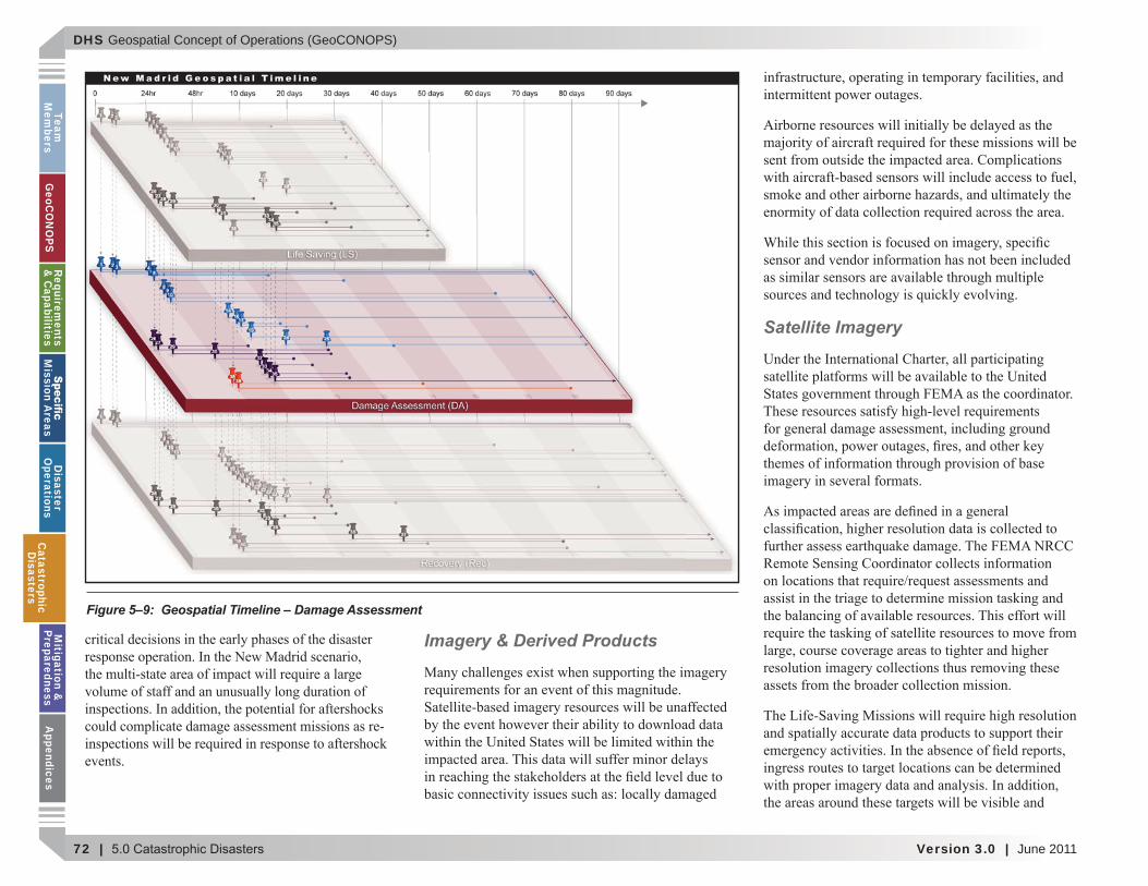
Figure 5–9: Geospatial Timeline – Damage Assessment . . . . . . . . . . . 72
Figure 5–10: Geospatial Timeline – Recovery . . . . . . . . . . . . . . . . . . . 76
Figure 6–1: Emergency Management Lifecycle. . . . . . . . . . . . . . . . . . 85
Figure A–1: Geospatial CONOPS Community Model . . . . . . . . . . . 104
Figure C–1: Request For Assistance Process Decision Matrix . . . . . 148
Figure E–1: DHS OneView . . . . . . . . . . . . . . . . . . . . . . . . . . . . . . . . . 154

DHS Geospatial Concept of Operations (GeoCONOPS)
4 | Table of Contents Version 3.0 | June 2011
Team
Mem
bersG
eoCO
NO
PSRequirem
ents &
Capabilities
M
ission Areas
Disaster
Operations
CatastrophicD
isastersM
itigation &
PreparednessA
ppendices
Table 2–1: Geospatial Roles and Responsibilities . . . . . . . . . . . . . . . . 20
Table 2–2: Federal Geospatial Teams . . . . . . . . . . . . . . . . . . . . . . . . . . 22
Table 3–1: Authoritative Data - Damage Assessment Mission - Imagery . . . . . . . . . . . . . . . . . . . . . . . . . . . . . . . . . . . . . . . . . . 29
Table 3–2: Authoritative Data - Damage Assessment Mission - Modeling. . . . . . . . . . . . . . . . . . . . . . . . . . . . . . . . . . . . . . . . . . 31
Table 3–3: Authoritative Data - Damage Assessment Mission - Ground Truth . . . . . . . . . . . . . . . . . . . . . . . . . . . . . . . . . . . . . . . . . . . . . . 33
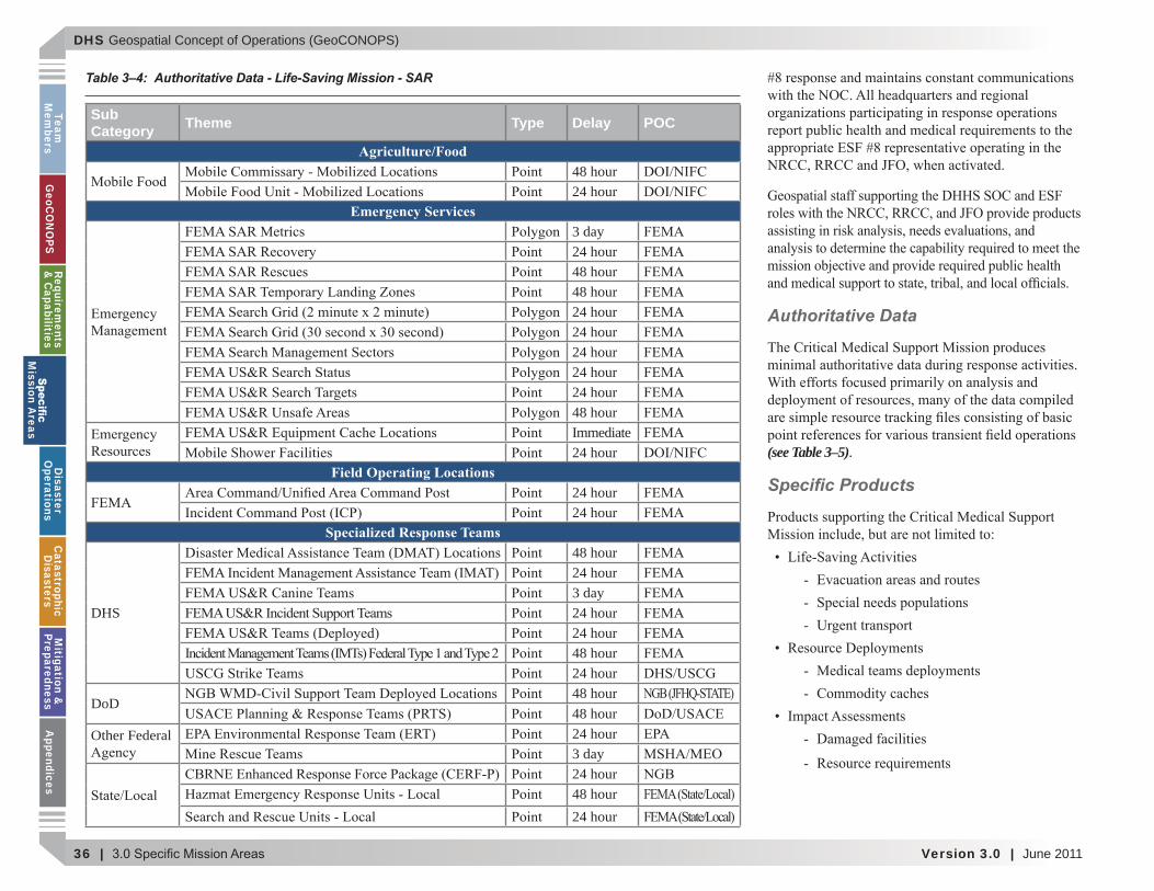
Table 3–4: Authoritative Data - Life-Saving Mission - SAR. . . . . . . . 36
Table 3–5: Authoritative Data - Life-Saving Mission - Critical Medical Support. . . . . . . . . . . . . . . . . . . . . . . . . . . . . . . . . . . . . . . . . . . . 37
Table 3–6: Authoritative Data – Critical Food Shelter and Water. . . 38
Table 3–7: Authoritative Data - Recovery Mission - Public Assistance . . . . . . . . . . . . . . . . . . . . . . . . . . . . . . . . . . . . . . . . . . . 40
Table 3–8: Authoritative Data - Recovery Mission - Individual Assistance . . . . . . . . . . . . . . . . . . . . . . . . . . . . . . . . . . . . . . . . 41
Table 3–9: Authoritative Data - Recovery Mission - Mitigation. . . . . 43
Table 4–1: Authoritative Data - Disaster Operations - NOC . . . . . . . 46
Table 4–2: Authoritative Data - Disaster Operations - NICC. . . . . . . 50
Table 4–3: Authoritative Data - Disaster Operations - NRCC . . . . . . 51
Table 4–4: Authoritative Data - Disaster Operations - RRCC . . . . . . 54
Table 4–5: Authoritative Data - Disaster Operations - JFO . . . . . . . . 57
Table 5–1: Estimate of “At Risk” and Shelter Seeking Populations: NMSZ Scenario Earthquake. . . . . . . . . . . . . . . . . . . . . . . . . . . . . . . . . . 63
Table 5–2: Estimated Damage to Essential Facilities in the NMSZ . . 64
Table 5–3: Sample Life-Saving EEIs by ESF . . . . . . . . . . . . . . . . . . . . 69
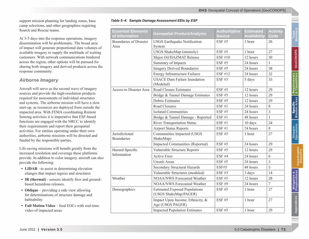
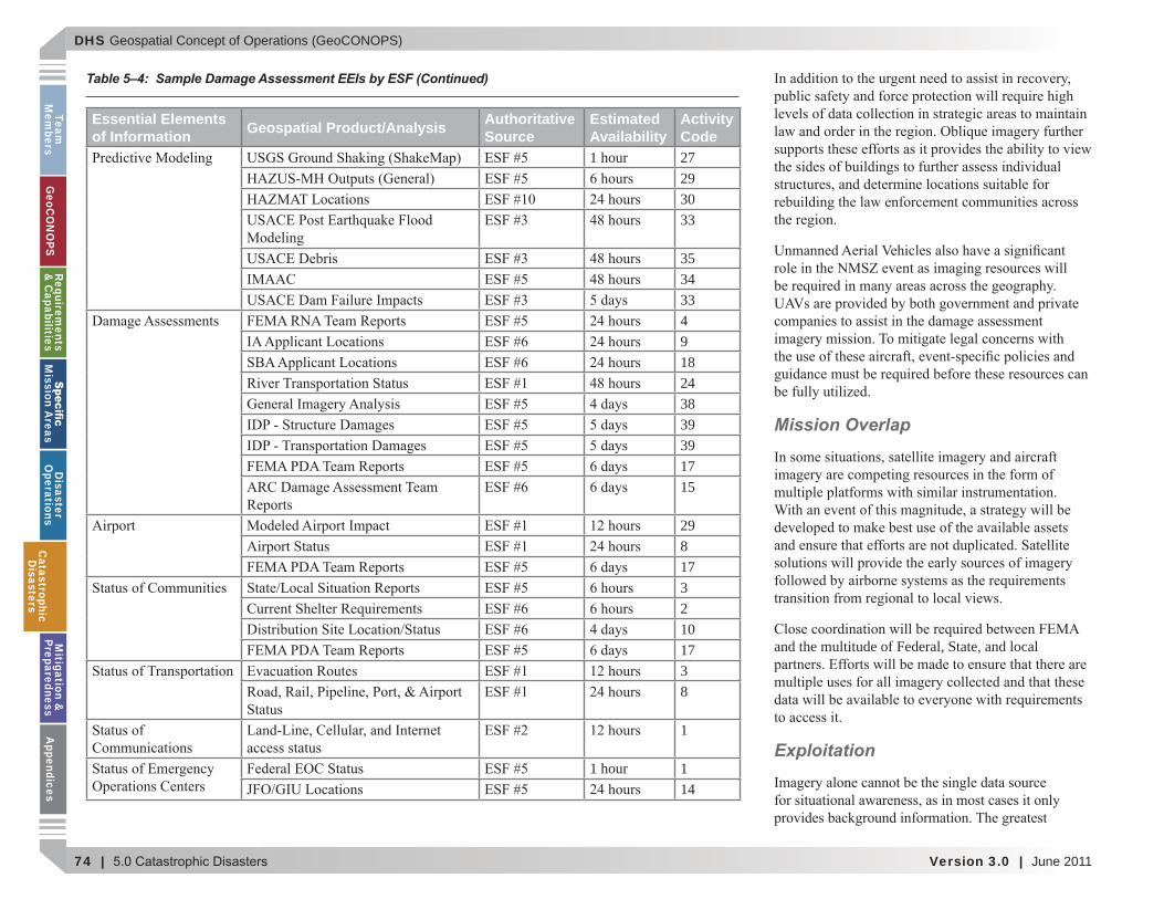
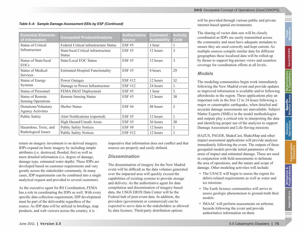
Table 5–4: Sample Damage Assessment EEIs by ESF. . . . . . . . . . . . . 73
Table 5–5: Sample Recovery EEIs by ESF . . . . . . . . . . . . . . . . . . . . . . 78
Table 5–6: Event-Speci c Missions . . . . . . . . . . . . . . . . . . . . . . . . . . . . 84
Table 6–1: Authoritative Data – FEMA HAZUS Program . . . . . . . . . 86
Table 6–2: Authoritative Data – FEMA Map Modernization Program . . . . . . . . . . . . . . . . . . . . . . . . . . . . . . . . . . . . . 87
Table 6–3: Authoritative Data – FEMA Mitigation Planning. . . . . . . 88
Table 6–4: Authoritative Data – FEMA National Dam Safety Program. . . . . . . . . . . . . . . . . . . . . . . . . . . . . . . . . . . . . . . . . . . . . 88
Table 6–5: Authoritative Data – NIST Disaster Failures and Studies Program. . . . . . . . . . . . . . . . . . . . . . . . . . . . . . . . . . . . . . . . . . . . 89
Table 6–6: Authoritative Data – FEMA Community Rating System 90
Table 6–7: Authoritative Data – FEMA Flood Mitigation Assistance Program . . . . . . . . . . . . . . . . . . . . . . . . . . . . . . . . . . . . . . . . . 90
Table 6–8: Authoritative Data – FEMA Hazard Mitigation Grant Program. . . . . . . . . . . . . . . . . . . . . . . . . . . . . . . . . . . . . . . . . . . . . 90
Table 6–9: Authoritative Data – FEMA National Earthquake Hazards Reduction Program . . . . . . . . . . . . . . . . . . . . . . . . . . . . . . . . . . . . . . . . . 92
Table 6–10: Authoritative Data – FEMA Pre-Disaster Mitigation. . . 92
Table 6–11: Authoritative Data – FEMA Repetitive Flood Claims . . 93
Table 6–12: Authoritative Data – FEMA Severe Repetitive Loss. . . . 93
Table 6–13: Authoritative Data – FEMA Risk Insurance Division . . 94
Table 6–14: Authoritative Data – FEMA Chemical Stockpile Emergency Preparedness Program . . . . . . . . . . . . . . . . . . . . . . . . . . . . 96
Table 6–15: Authoritative Data – FEMA Citizen Corps . . . . . . . . . . . 96
Table 6–16: Authoritative Data – FEMA Continuity of Operations Division . . . . . . . . . . . . . . . . . . . . . . . . . . . . . . . . . . . . . . . . . 98
Table 6–17: Authoritative Data – FEMA Integrated Public Alert and Warning System . . . . . . . . . . . . . . . . . . . . . . . . . . . . . . . . . . . . . . . . . . . . 98
Table 6–18: Authoritative Data – FEMA Logistics Management Directorate. . . . . . . . . . . . . . . . . . . . . . . . . . . . . . . . . . . . 100
Table 6–19: Authoritative Data – FEMA Public Affairs . . . . . . . . . . 101
Table 6–20: Authoritative Data – FEMA Radiological Emergency Preparedness Program . . . . . . . . . . . . . . . . . . . . . . . . . . . . . . . . . . . . . 101
Table D–1: IRSCC Member Agencies and Organizations . . . . . . . . 152
List of Tables
DHS Geospatial Concept of Operations (GeoCONOPS)
June 2011 | Version 3.0 Team Members | 5
Team
M
embe
rsG
eoC
ON
OPS
Requ
irem
ents
&
Cap
abili
ties
M
issi
on A
reas
Dis
aste
r O
pera
tion
sC
atas
trop
hic
Dis
aste
rsM
itig
atio
n &
Pr
epar
edne
ssA
ppen
dice
s
TEAM MEMBERS
Team
M
embe
rs

DHS Geospatial Concept of Operations (GeoCONOPS)
6 | Team Members Version 3.0 | June 2011
Team
Mem
bersG
eoCO
NO
PSRequirem
ents &
Capabilities
M
ission Areas
Disaster
Operations
CatastrophicD
isastersM
itigation &
PreparednessA
ppendices
GIOT Team Member List
1.
2.
3.
4.
5.
6.
7.
8.
9. Department of Homeland Security
10.
11.
12.
13.
14.
15.
16.
17.
18.
19.
20.
21.
22.
23.
24.
25.
26.
27.
Team
Mem
bers
DHS Geospatial Concept of Operations (GeoCONOPS)
June 2011 | Version 3.0 1.0 Geospatial Concept of Operations | 7
Team
M
embe
rsG
eoC
ON
OPS
Requ
irem
ents
&
Cap
abili
ties
M
issi
on A
reas
Dis
aste
r O
pera
tion
sC
atas
trop
hic
Dis
aste
rsM
itig
atio
n &
Pr
epar
edne
ssA
ppen
dice
s
1.0 GEOSPATIAL CONCEPT OF OPERATIONS
Geo
CO
NO
PS
DHS Geospatial Concept of Operations (GeoCONOPS)
8 | 1.0 Geospatial Concept of Operations Version 3.0 | June 2011
Team
Mem
bersG
eoCO
NO
PSRequirem
ents &
Capabilities
M
ission Areas
Disaster
Operations
CatastrophicD
isastersM
itigation &
PreparednessA
ppendices
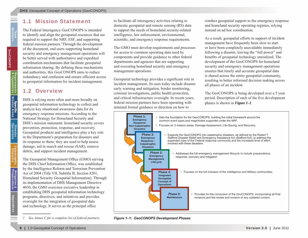
1.1 Mission Statement
1
1.2 Overview
1 See Annex C for a complete list of federal partners.
health protection,
conduct
of incident
Figure 1–1.
Figure 1–1: GeoCONOPS Development Phases
Intelligence and Military communities.
GeoCONOPS, incorporating all final on of any outdated content.
lifecycle to include preparedness,
Phase 1:Emergency Response
Non-CatastrophicDisasters
Phase 2:Emergency Response -
CatastrophicDisasters
Phase 3:Emergency
ManagementLifecycle
Phase 4: IntegratedGeospatialConcept of Operations
Phase 5:Maintenance
GeoC
ON
OPS

DHS Geospatial Concept of Operations (GeoCONOPS)
June 2011 | Version 3.0 1.0 Geospatial Concept of Operations | 9
Team
M
embe
rsG
eoC
ON
OPS
Requ
irem
ents
&
Cap
abili
ties
M
issi
on A
reas
Dis
aste
r O
pera
tion
sC
atas
trop
hic
Dis
aste
rsM
itig
atio
n &
Pr
epar
edne
ssA
ppen
dice
s
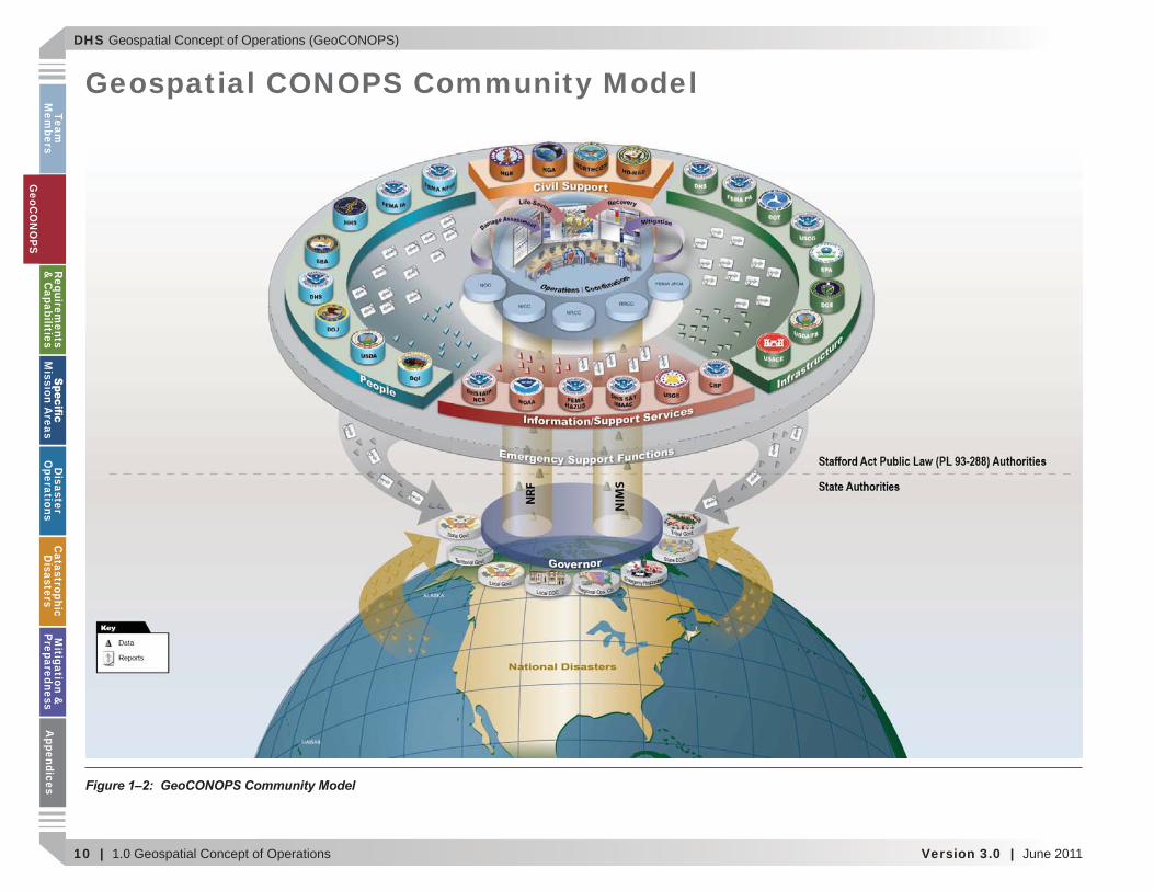
1.3 GeoCONOPS Community
Figure 1–2
Geo
CO
NO
PS
DHS Geospatial Concept of Operations (GeoCONOPS)
10 | 1.0 Geospatial Concept of Operations Version 3.0 | June 2011
Team
Mem
bersG
eoCO
NO
PSRequirem
ents &
Capabilities
M
ission Areas
Disaster
Operations
CatastrophicD
isastersM
itigation &
PreparednessA
ppendices
Geospatial CONOPS Community Model
Figure 1–2: GeoCONOPS Community Model
GeoC
ON
OPS
DHS Geospatial Concept of Operations (GeoCONOPS)
June 2011 | Version 3.0 1.0 Geospatial Concept of Operations | 11
Team
M
embe
rsG
eoC
ON
OPS
Requ
irem
ents
&
Cap
abili
ties
M
issi
on A
reas
Dis
aste
r O
pera
tion
sC
atas
trop
hic
Dis
aste
rsM
itig
atio
n &
Pr
epar
edne
ssA
ppen
dice
s
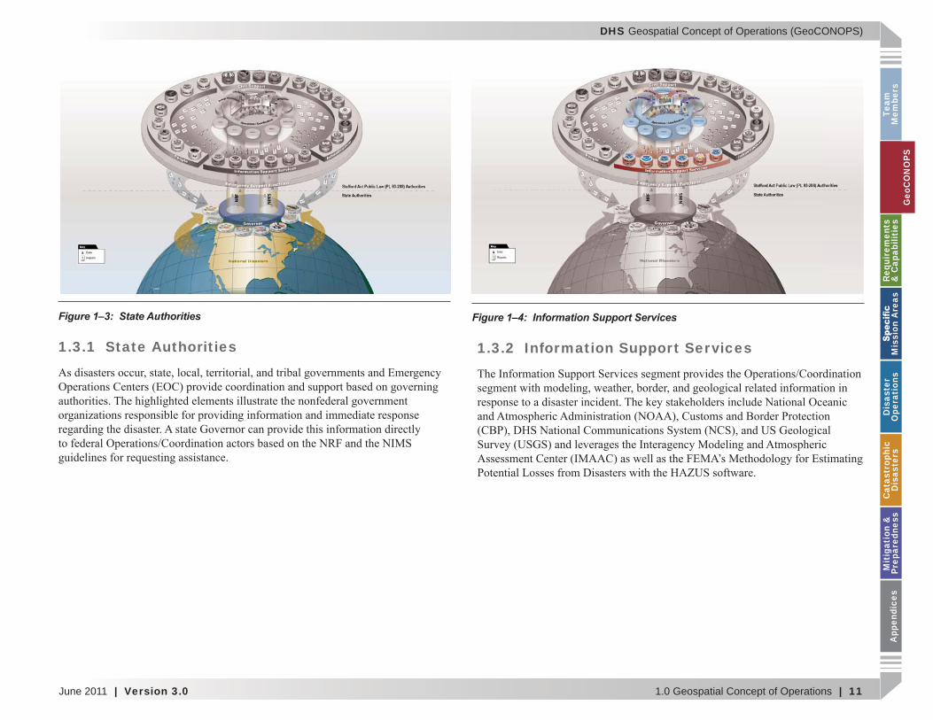
1.3.1 State Authorities 1.3.2 Information Support Services
Figure 1–3: State Authorities Figure 1–4: Information Support Services
Geo
CO
NO
PS
DHS Geospatial Concept of Operations (GeoCONOPS)
12 | 1.0 Geospatial Concept of Operations Version 3.0 | June 2011
Team
Mem
bersG
eoCO
NO
PSRequirem
ents &
Capabilities
M
ission Areas
Disaster
Operations
CatastrophicD
isastersM
itigation &
PreparednessA
ppendices
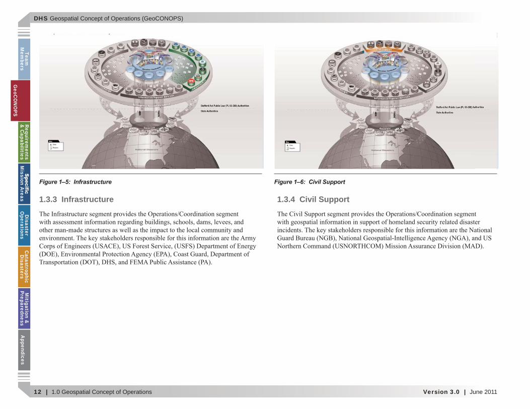
1.3.3 Infrastructure 1.3.4 Civil Support
Figure 1–5: Infrastructure Figure 1–6: Civil Support
GeoC
ON
OPS
DHS Geospatial Concept of Operations (GeoCONOPS)
June 2011 | Version 3.0 1.0 Geospatial Concept of Operations | 13
Team
M
embe
rsG
eoC
ON
OPS
Requ
irem
ents
&
Cap
abili
ties
M
issi
on A
reas
Dis
aste
r O
pera
tion
sC
atas
trop
hic
Dis
aste
rsM
itig
atio
n &
Pr
epar
edne
ssA
ppen
dice
s
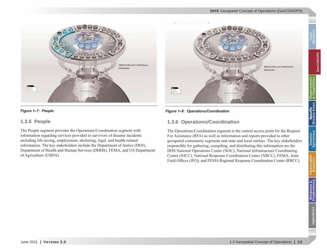
1.3.5 People 1.3.6 Operations/Coordination
Figure 1–7: People Figure 1–8: Operations/Coordination
Geo
CO
NO
PS
DHS Geospatial Concept of Operations (GeoCONOPS)
14 | 1.0 Geospatial Concept of Operations Version 3.0 | June 2011
Team
Mem
bersG
eoCO
NO
PSRequirem
ents &
Capabilities
M
ission Areas
Disaster
Operations
CatastrophicD
isastersM
itigation &
PreparednessA
ppendices
1.4 Audience and Intended Use
1.5 Alignment with NIMS and NRF Preparedness, Pre-event Planning and
Coordination.
Resource Management.
Coordination and Management.
for information. Management and Maintenance/Standards and
Technology.
GeoC
ON
OPS
DHS Geospatial Concept of Operations (GeoCONOPS)
June 2011 | Version 3.0 1.0 Geospatial Concept of Operations | 15
Team
M
embe
rsG
eoC
ON
OPS
Requ
irem
ents
&
Cap
abili
ties
M
issi
on A
reas
Dis
aste
r O
pera
tion
sC
atas
trop
hic
Dis
aste
rsM
itig
atio
n &
Pr
epar
edne
ssA
ppen
dice
s
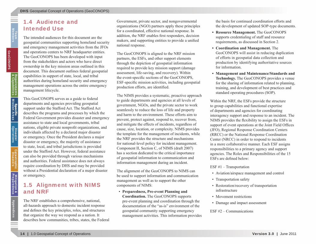
Figure 1–9: Federal Response - Stafford Act Support to States
Support
Medical
Geo
CO
NO
PS
DHS Geospatial Concept of Operations (GeoCONOPS)
16 | 1.0 Geospatial Concept of Operations Version 3.0 | June 2011
Team
Mem
bersG
eoCO
NO
PSRequirem
ents &
Capabilities
M
ission Areas
Disaster
Operations
CatastrophicD
isastersM
itigation &
PreparednessA
ppendices
Social and economic community impact
implementation
Figure 1–9
1.6 Determination of Authorities
The Robert T. Stafford Disaster Relief and Emergency Assistance Act (Stafford Act)
National Response Framework (NRF), January
National Incident Management System (NIMS)
Homeland Security Act of 2002
Post-Katrina Emergency Management Reform Act (PKEMRA)
Homeland Security Presidential Directive-5 (HSPD-5), Management of Domestic Incidents,
GeoC
ON
OPS
DHS Geospatial Concept of Operations (GeoCONOPS)
June 2011 | Version 3.0 1.0 Geospatial Concept of Operations | 17
Team
M
embe
rsG
eoC
ON
OPS
Requ
irem
ents
&
Cap
abili
ties
M
issi
on A
reas
Dis
aste
r O
pera
tion
sC
atas
trop
hic
Dis
aste
rsM
itig
atio
n &
Pr
epar
edne
ssA
ppen
dice
s
HSPD-7, Critical Infrastructure Identi cation, Prioritization, and Protection
HSPD-8, National Preparedness
Geo
CO
NO
PS

DHS Geospatial Concept of Operations (GeoCONOPS)
18 | 1.0 Geospatial Concept of Operations Version 3.0 | June 2011
Team
Mem
bersG
eoCO
NO
PSRequirem
ents &
Capabilities
M
ission Areas
Disaster
Operations
CatastrophicD
isastersM
itigation &
PreparednessA
ppendices
This page intentionally left blank.
GeoC
ON
OPS
DHS Geospatial Concept of Operations (GeoCONOPS)
June 2011 | Version 3.0 | 19
Team
M
embe
rsG
eoC
ON
OPS
Requ
irem
ents
&
Cap
abili
ties
M
issi
on A
reas
Dis
aste
r O
pera
tion
sC
atas
trop
hic
Dis
aste
rsM
itig
atio
n &
Pr
epar
edne
ssA
ppen
dice
s
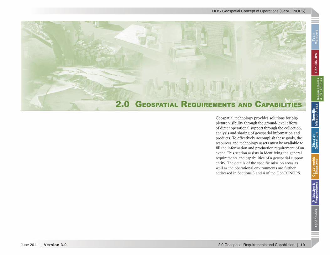
2.0 GEOSPATIAL REQUIREMENTS AND CAPABILITIES
Requ
irem
ents
&
Cap
abili
ties
DHS Geospatial Concept of Operations (GeoCONOPS)
20 | Version 3.0 | June 2011
Team
Mem
bersG
eoCO
NO
PSRequirem
ents &
Capabilities
M
ission Areas
Disaster
Operations
CatastrophicD
isastersM
itigation &
PreparednessA
ppendices
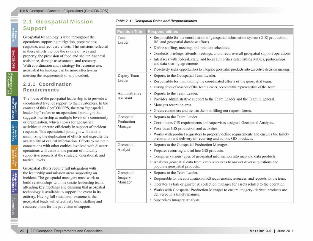
2.1 Geospatial Mission Support
2.1.1 Coordination Requirements
Table 2–1: Geospatial Roles and Responsibilities
Position Title Responsibilities
Requirements
& C
apabilities
DHS Geospatial Concept of Operations (GeoCONOPS)
June 2011 | Version 3.0 | 21
Team
M
embe
rsG
eoC
ON
OPS
Requ
irem
ents
&
Cap
abili
ties
M
issi
on A
reas
Dis
aste
r O
pera
tion
sC
atas
trop
hic
Dis
aste
rsM
itig
atio
n &
Pr
epar
edne
ssA
ppen
dice
s
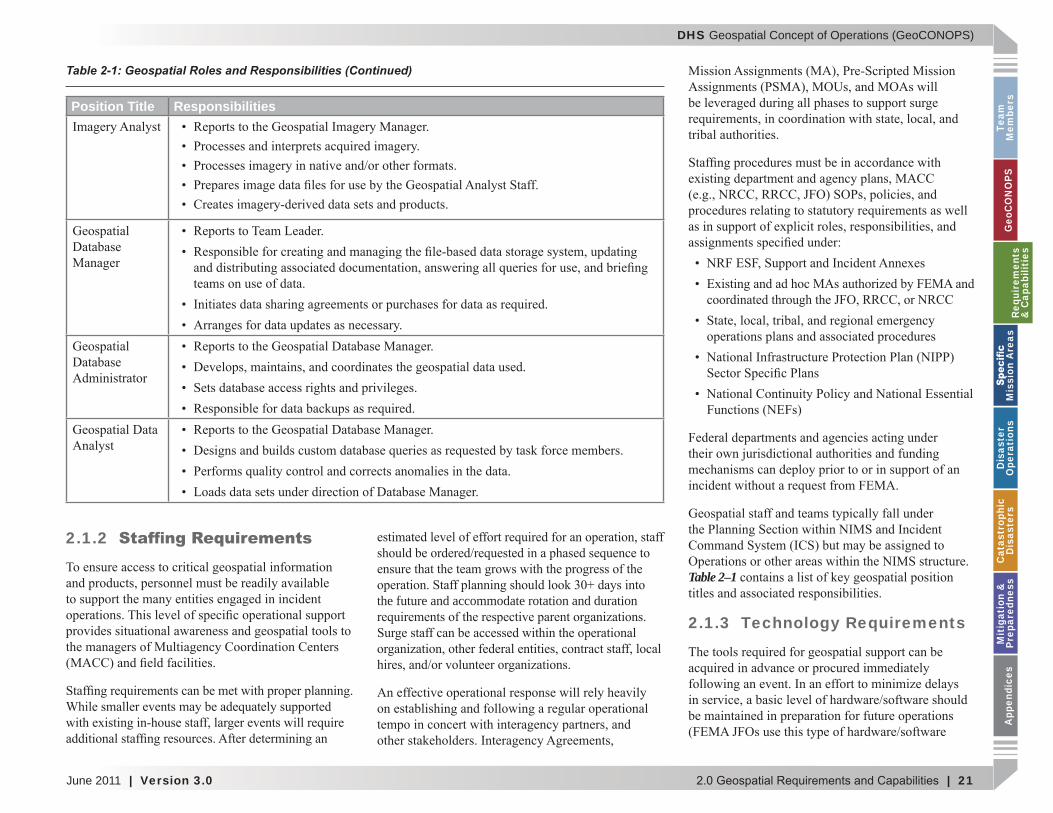
2.1.2
the future and accommodate rotation and duration
Table 2–1
2.1.3 Technology Requirements
Position Title Responsibilities
Table 2-1: Geospatial Roles and Responsibilities (Continued)
Requ
irem
ents
&
Cap
abili
ties

DHS Geospatial Concept of Operations (GeoCONOPS)
22 | Version 3.0 | June 2011
Team
Mem
bersG
eoCO
NO
PSRequirem
ents &
Capabilities
M
ission Areas
Disaster
Operations
CatastrophicD
isastersM
itigation &
PreparednessA
ppendices
the
2.1.4 Geospatial Capabilities
Table 2–2.
2.2 Geospatial Data
2.2.1 Authoritative Data
Rational Authority.
Expert Authority.
are created.
Appendix B
Table 2–2: Federal Geospatial Teams
Team Type Location
Field
Field
Field
FieldField
Requirements
& C
apabilities

DHS Geospatial Concept of Operations (GeoCONOPS)
June 2011 | Version 3.0 | 23
Team
M
embe
rsG
eoC
ON
OPS
Requ
irem
ents
&
Cap
abili
ties
M
issi
on A
reas
Dis
aste
r O
pera
tion
sC
atas
trop
hic
Dis
aste
rsM
itig
atio
n &
Pr
epar
edne
ssA
ppen
dice
s
2.2.2 Essential Elements of Information
and inf 1
f f f f
1 More information can be obtained at http .f dc.ov participation orkin - roups-subcommittees hs
dhs- dm
2.2.3 Data Dissemination
2.3 Geospatial Production and Delivery
Fixed facilities
Field facilities are typically created rapidly to
2.3.1 Production
completion.
Requ
irem
ents
&
Cap
abili
ties
DHS Geospatial Concept of Operations (GeoCONOPS)
24 | Version 3.0 | June 2011
Team
Mem
bersG
eoCO
NO
PSRequirem
ents &
Capabilities
M
ission Areas
Disaster
Operations
CatastrophicD
isastersM
itigation &
PreparednessA
ppendices
2.3.2 Delivery
.
Best Practices - Requests for Information
Requirements
& C
apabilities
DHS Geospatial Concept of Operations (GeoCONOPS)
June 2011 | Version 3.0 | 25
Team
M
embe
rsG
eoC
ON
OPS
Requ
irem
ents
&
Cap
abili
ties
M
issi
on A
reas
Dis
aste
r O
pera
tion
sC
atas
trop
hic
Dis
aste
rsM
itig
atio
n &
Pr
epar
edne
ssA
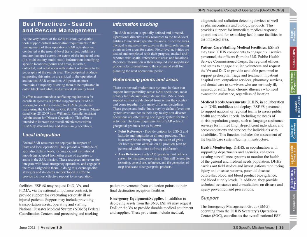
ppen
dice
s
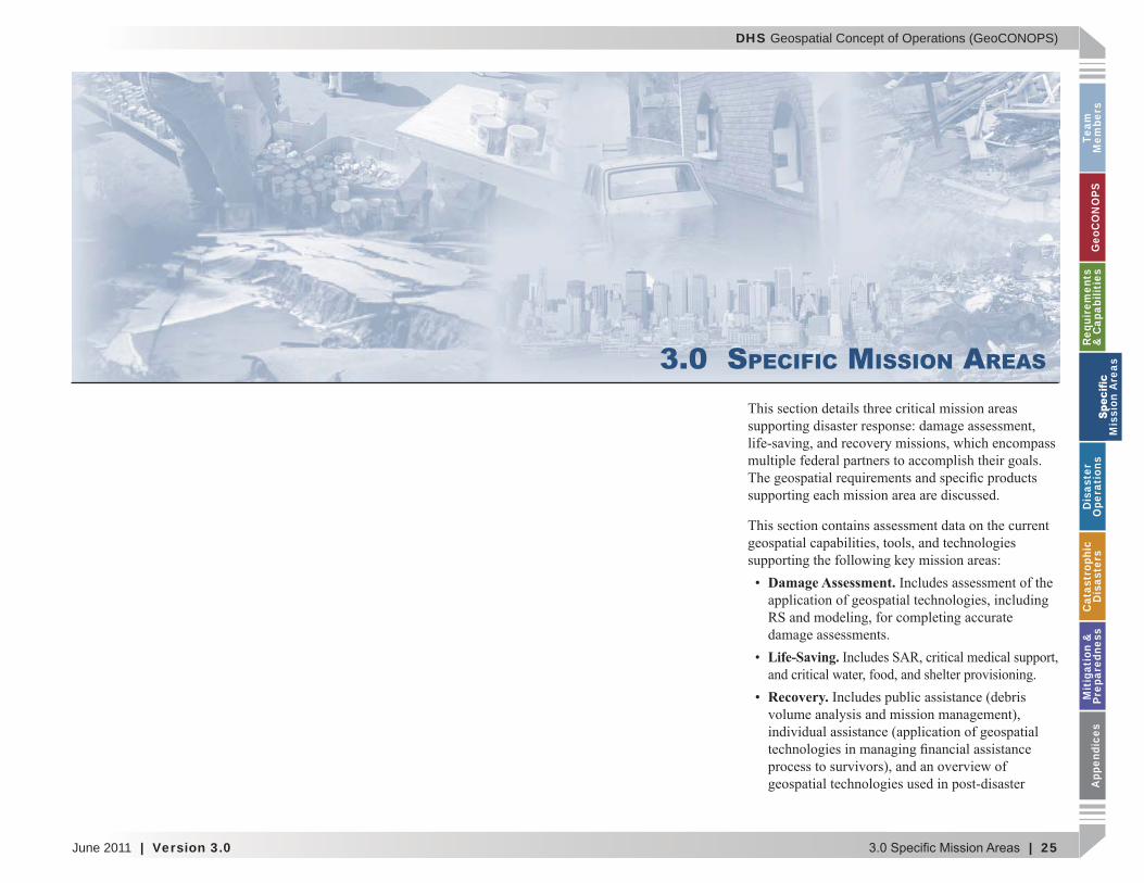
3.0 SPECIFIC MISSION AREAS
Damage Assessment.
Life-Saving.
Recovery.
M
issi
on A
reas
DHS Geospatial Concept of Operations (GeoCONOPS)
26 | Version 3.0 | June 2011
Team
Mem
bersG
eoCO
NO
PSRequirem
ents &
Capabilities
M
ission Areas
Disaster
Operations
CatastrophicD
isastersM
itigation &
PreparednessA
ppendices
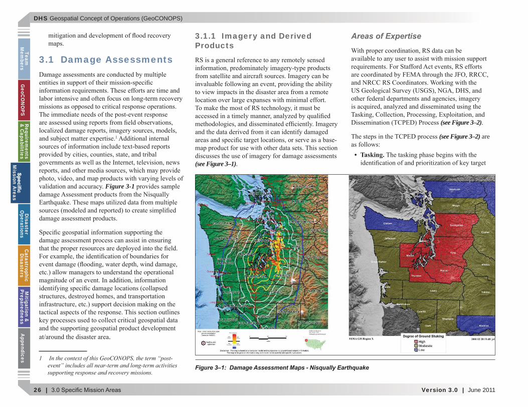
3.1 Damage Assessments
1
Figure 3-1
.
1 In the context of this GeoCONOPS, the term “post-event includes all near-term and lon -term activities supportin response and recover missions.
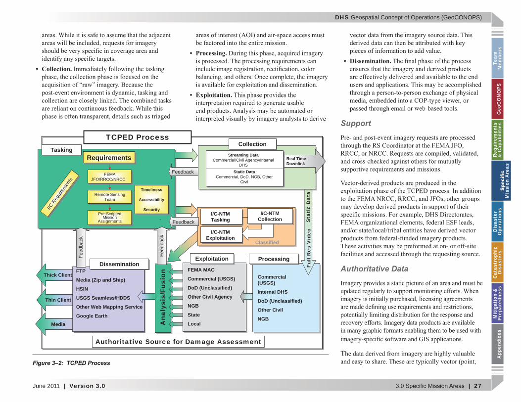
3.1.1 Imagery and Derived Products
(see Figure 3–1).
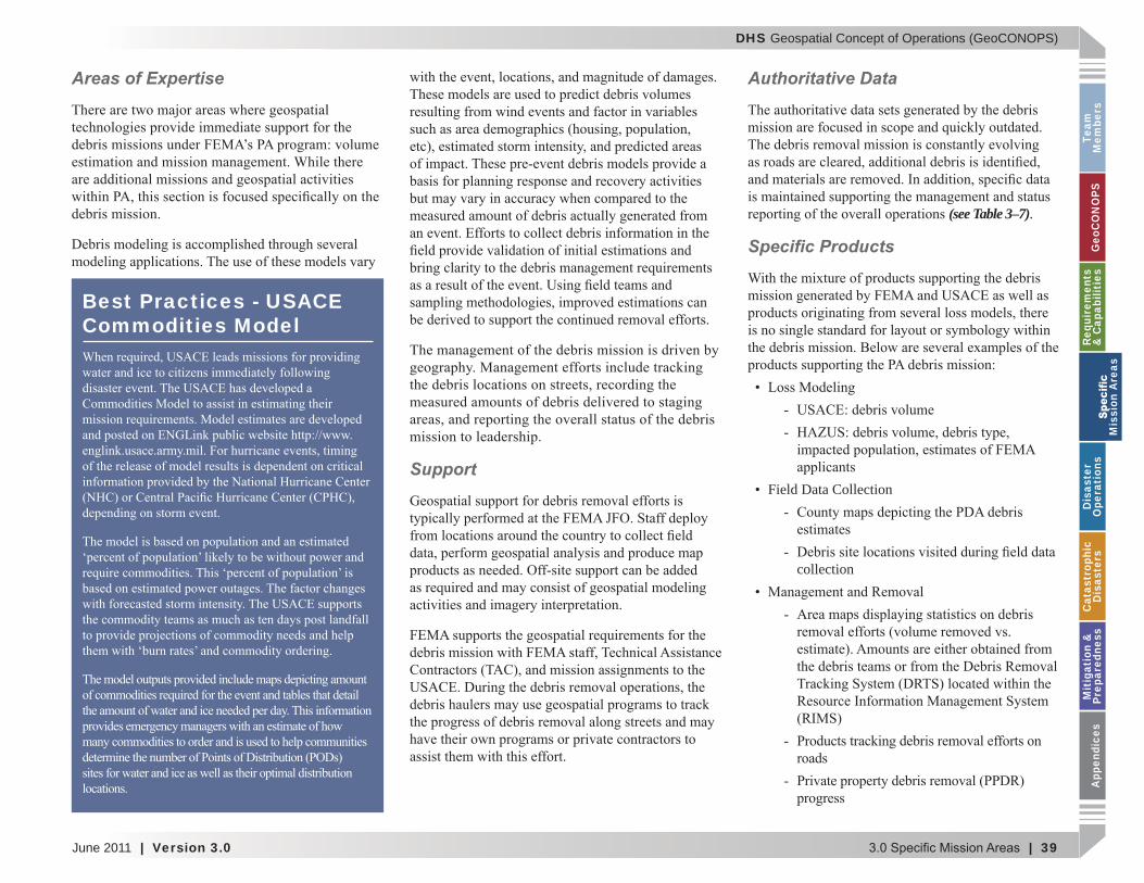
Areas of Expertise
(see Figure 3–2).
(see Figure 3–2) are
Tasking.
Figure 3–1: Damage Assessment Maps - Nisqually Earthquake
M
ission Areas
DHS Geospatial Concept of Operations (GeoCONOPS)
June 2011 | Version 3.0 | 27
Team
M
embe
rsG
eoC
ON
OPS
Requ
irem
ents
&
Cap
abili
ties
M
issi
on A
reas
Dis
aste
r O
pera
tion
sC
atas
trop
hic
Dis
aste
rsM
itig
atio
n &
Pr
epar
edne
ssA
ppen
dice
s
Collection.
Processing.
Exploitation.
Dissemination.
Support
Authoritative Data
Figure 3–2: TCPED Process
ProcessingProcessing
Commercial(USGS)
Internal DHS
DoD (Unclassified)
Other Civil
NGB
Ana
lysi
s/Fu
sion
CollectionCollection
Real TimeDownlink
Streaming DataCommercial/Civil Agency/Internal
DHSStatic Data
Commercial, DoD, NGB, OtherCivil
Feedback
Sta
tic
Dat
aFu
ll R
es V
ideo
TCPED ProcessTaskingTasking
Timeliness
Accessibility
Security
Timeliness
Accessibility
SecurityI/CReq
uirem
ents
I/CReq
uirem
ents
Pre-ScriptedMission
Assignments
Pre-ScriptedMission
Assignments
Remote SensingTeam
Remote SensingTeam
RequirementsRequirements
FEMAJFO/RRCC/NRCC
FEMAJFO/RRCC/NRCC
I/C-NTMExploitation
I/C-NTMTasking
I/C-NTMCollectionI/C-NTMMI/C NI/C NT
ctionCollecCCollecI/C-NTM
Collection
Classified
ExploitationExploitation
FEMA MAC
Commercial (USGS)
DoD (Unclassified)
Other Civil Agency
NGB
State
Local
Feed
back
Thick Client
Thin Client
Media
FTP
Media (Zip and Ship)
HSIN
USGS Seamless/HDDS
Other Web Mapping Service
Google Earth
Authoritative Source for Damage Assessment
DisseminationDissemination
Feed
back
Feedback
M
issi
on A
reas

DHS Geospatial Concept of Operations (GeoCONOPS)
28 | Version 3.0 | June 2011
Team
Mem
bersG
eoCO
NO
PSRequirem
ents &
Capabilities
M
ission Areas
Disaster
Operations
CatastrophicD
isastersM
itigation &
PreparednessA
ppendices
(see Table 3–1).
Speci c Products
Raster Products
(see Figure 3–3).
Vector Products
(see Figure 3–4).
3.1.2 Models
Areas of Expertise
Hazards US-MultiHazard (HAZUS-MH).
HURRicane EVACuation (HURREVAC).
Interagency Modeling and Atmospheric Assessment Center (IMAAC).
LandScan USA.
Figure 3–3: Imagery Sample
Figure 3–4: Imagery-Derived Data Sample
M
ission Areas

DHS Geospatial Concept of Operations (GeoCONOPS)
June 2011 | Version 3.0 | 29
Team
M
embe
rsG
eoC
ON
OPS
Requ
irem
ents
&
Cap
abili
ties
M
issi
on A
reas
Dis
aste
r O
pera
tion
sC
atas
trop
hic
Dis
aste
rsM
itig
atio
n &
Pr
epar
edne
ssA
ppen
dice
s
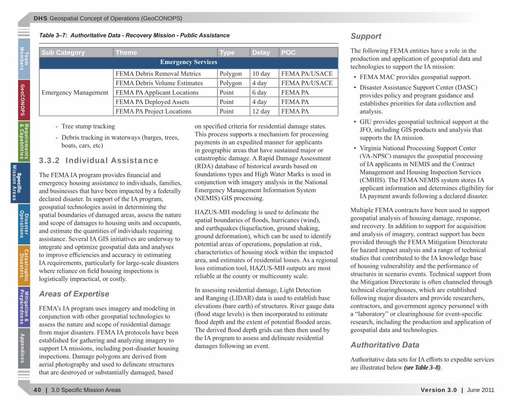
Sub Category Theme Type Delay POCEmergency Services
4 day24 hour48 hour24 hour24 hour
Event Impact24 hour48 hour24 hour24 hour3 day
Video 24 hour3 day48 hour24 hour24 hour
Imagery4 day7 day4 day4 day3 day
Video 24 hour
3 day
Table 3–1: Authoritative Data - Damage Assessment Mission - Imagery
National Infrastructure Simulation and Analysis Center (NISAC).
Sea, Land, Overland, Surge from Hurricanes (SLOSH).
USACE Debris Model.
Support
M
issi
on A
reas
DHS Geospatial Concept of Operations (GeoCONOPS)
30 | Version 3.0 | June 2011
Team
Mem
bersG
eoCO
NO
PSRequirem
ents &
Capabilities
M
ission Areas
Disaster
Operations
CatastrophicD
isastersM
itigation &
PreparednessA
ppendices
Authoritative Data
(see Table 3–2).
Speci c Products
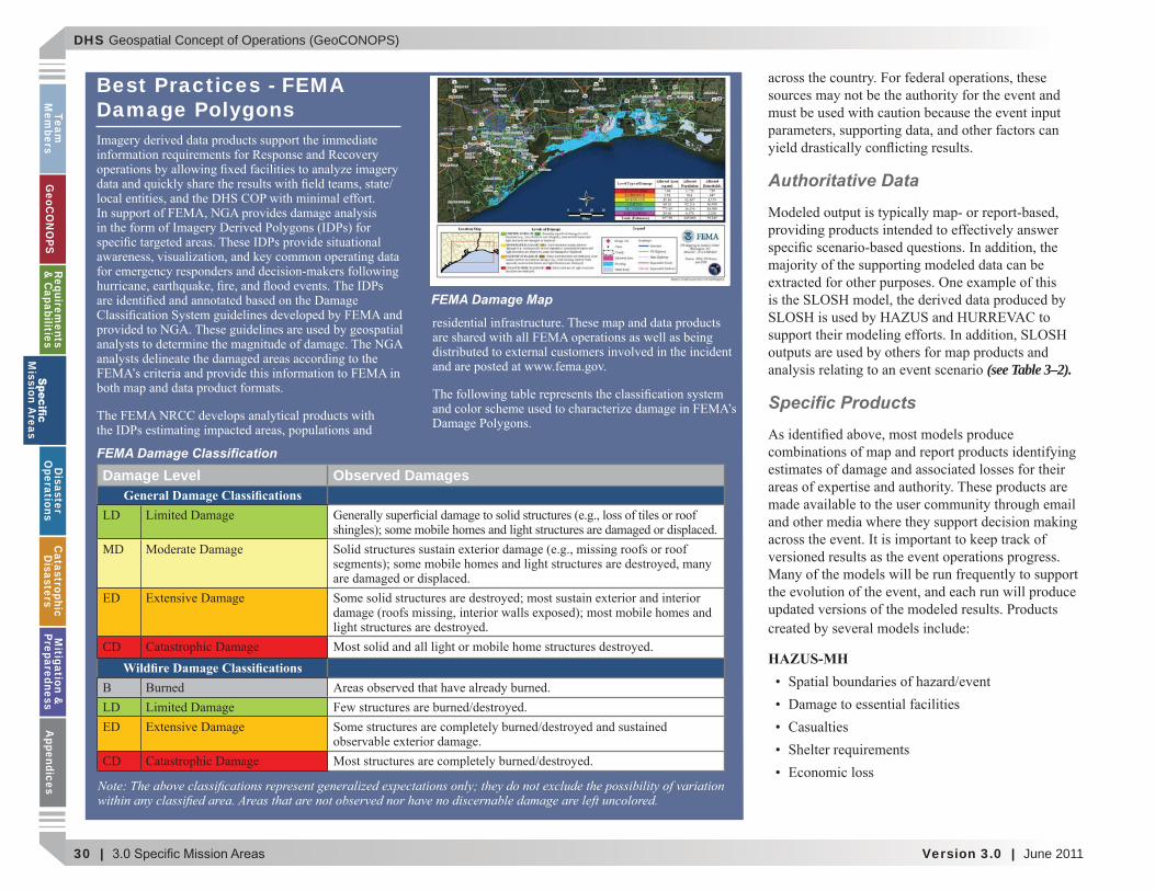
HAZUS-MH
Best Practices - FEMA Damage Polygons
Damage Level Observed DamagesGeneral Damage Classi cations
MD
CDWild re Damage Classi cations
CD
FEMA Damage Map
FEMA Damage Classi cation
Note he above classi cations represent enerali ed expectations onl the do not exclude the possibilit of variation ithin an classi ed area. Areas that are not observed nor have no discernable dama e are left uncolored.
M
ission Areas
DHS Geospatial Concept of Operations (GeoCONOPS)
June 2011 | Version 3.0 | 31
Team
M
embe
rsG
eoC
ON
OPS
Requ
irem
ents
&
Cap
abili
ties
M
issi
on A
reas
Dis
aste
r O
pera
tion
sC
atas
trop
hic
Dis
aste
rsM
itig
atio
n &
Pr
epar
edne
ssA
ppen
dice
s
HURREVAC
IMAAC
USACE Debris
3.1.3 Field Data Collection
Sub Category Theme Type Delay POC
Event Impact
24 hour24 hour
24 hour24 hour24 hour24 hour24 hour24 hour24 hour24 hour24 hour24 hour24 hour24 hour DHS24 hour24 hour24 hour24 hour
Hurricane Center24 hour24 hour DHS24 hour
24 hour
24 hour24 hour DHS24 hour24 hour DHS24 hourImmediate24 hour24 hour
Table 3–2: Authoritative Data - Damage Assessment Mission - Modeling
M
issi
on A
reas
DHS Geospatial Concept of Operations (GeoCONOPS)
32 | Version 3.0 | June 2011
Team
Mem
bersG
eoCO
NO
PSRequirem
ents &
Capabilities
M
ission Areas
Disaster
Operations
CatastrophicD
isastersM
itigation &
PreparednessA
ppendices
Best Practices - Disaster Clearinghouses
Areas of Expertise
of data manually out of
American Red Cross (ARC).
FEMA PDA Teams.
FEMA IA Inspections.
FEMA Mitigation High Water Marks.
FEMA Mitigation Assessment Team (MAT).
FEMA Public Assistance (PA) Inspections.
Small Business Administration (SBA) Inspections.
Local Red-Tag/Yellow-Tag Reports.
M
ission Areas
DHS Geospatial Concept of Operations (GeoCONOPS)
June 2011 | Version 3.0 | 33
Team
M
embe
rsG
eoC
ON
OPS
Requ
irem
ents
&
Cap
abili
ties
M
issi
on A
reas
Dis
aste
r O
pera
tion
sC
atas
trop
hic
Dis
aste
rsM
itig
atio
n &
Pr
epar
edne
ssA
ppen
dice
s
Support
Authoritative Data
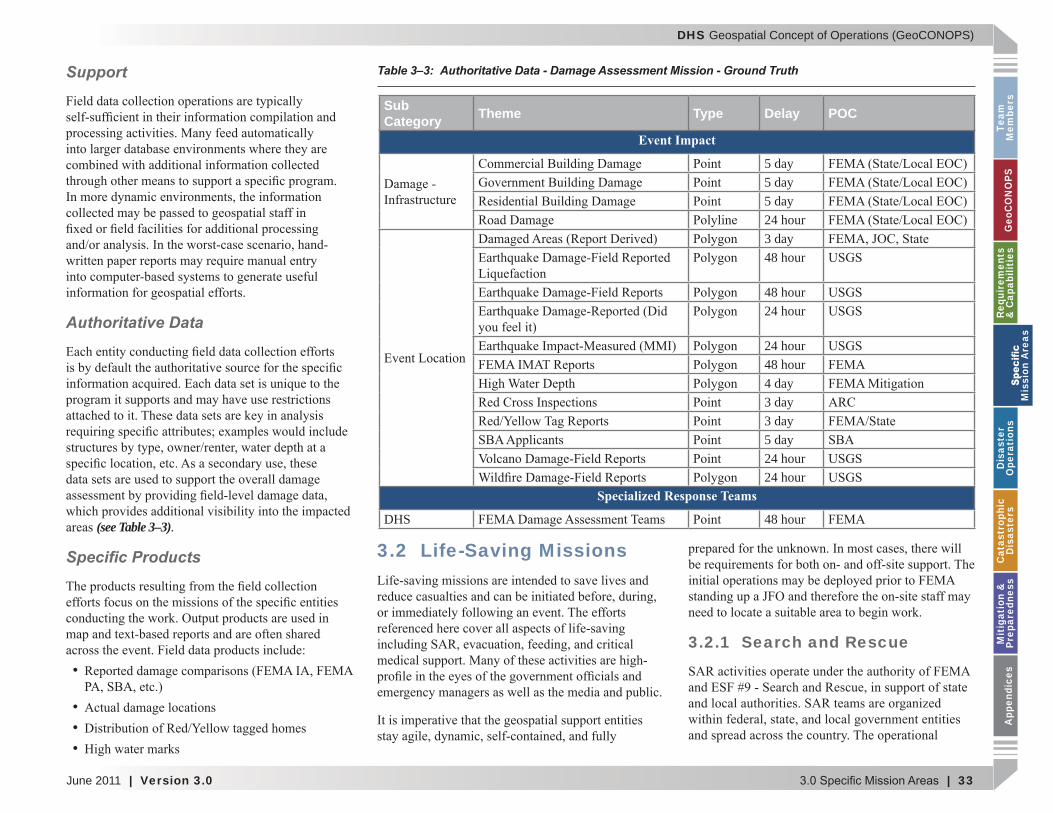
(see Table 3–3).
Speci c Products 3.2 Life-Saving Missions
3.2.1 Search and Rescue
Table 3–3: Authoritative Data - Damage Assessment Mission - Ground Truth
Sub Category Theme Type Delay POC
Event Impact
5 day5 day5 day24 hour3 day48 hour
48 hour24 hour
24 hour48 hour4 day3 day3 day5 day24 hour24 hour
Specialized Response Teams
DHS 48 hour
M
issi
on A
reas
DHS Geospatial Concept of Operations (GeoCONOPS)
34 | Version 3.0 | June 2011
Team
Mem
bersG
eoCO
NO
PSRequirem
ents &
Capabilities
M
ission Areas
Disaster
Operations
CatastrophicD
isastersM
itigation &
PreparednessA
ppendices
Areas of Expertise
Structural Collapse (Urban) Search and Rescue (US&R)Primar A enc FEMA
Waterborne Search and RescuePrimar A enc D S SCG
Inland/Wilderness Search and RescuePrimar A enc Department of the Interior DOINational Park Service NPS
Support
Authoritative Data
(see Table 3–4).
Speci c Products
Operational Management
Safety
Tactical Missions
3.2.2 Critical Medical Support
Areas of Expertise
Patient Evacuations.
M
ission Areas
DHS Geospatial Concept of Operations (GeoCONOPS)
June 2011 | Version 3.0 | 35
Team
M
embe
rsG
eoC
ON
OPS
Requ
irem
ents
&
Cap
abili
ties
M
issi
on A
reas
Dis
aste
r O
pera
tion
sC
atas
trop
hic
Dis
aste
rsM
itig
atio
n &
Pr
epar
edne
ssA
ppen
dice
s
Emergency Equipment/Supplies. In addition to
Best Practices - Search and Rescue Management
Local Integration
Information tracking
Referencing points and areas
Point Reference
Area Reference
the impacted area.
Patient Care/Staf ng Medical Facilities.
Medical Needs Assessments.
Health Monitoring.
Support
M
issi
on A
reas
DHS Geospatial Concept of Operations (GeoCONOPS)
36 | Version 3.0 | June 2011
Team
Mem
bersG
eoCO
NO
PSRequirem
ents &
Capabilities
M
ission Areas
Disaster
Operations
CatastrophicD
isastersM
itigation &
PreparednessA
ppendices
Authoritative Data
(see Table 3–5).
Speci c Products
Table 3–4: Authoritative Data - Life-Saving Mission - SAR
Sub Category Theme Type Delay POC
Agriculture/Food48 hour24 hour
Emergency Services3 day24 hour48 hour48 hour24 hour24 hour24 hour24 hour24 hour48 hourImmediate24 hour
Field Operating Locations24 hour24 hour
Specialized Response Teams
DHS
48 hour24 hour3 day24 hour24 hour48 hour24 hour
DoD48 hour48 hour
Other Federal 24 hour3 day24 hour48 hour24 hour
M
ission Areas
DHS Geospatial Concept of Operations (GeoCONOPS)
June 2011 | Version 3.0 | 37
Team
M
embe
rsG
eoC
ON
OPS
Requ
irem
ents
&
Cap
abili
ties
M
issi
on A
reas
Dis
aste
r O
pera
tion
sC
atas
trop
hic
Dis
aste
rsM
itig
atio
n &
Pr
epar
edne
ssA
ppen
dice
s
3.2.3 Provision of Critical Food, Shelter, and Water
Areas of Expertise
Feeding Operations.
Sheltering.
Bulk Distribution of Emergency Commodities.
Table 3–5: Authoritative Data - Life-Saving Mission - Critical Medical Support
Sub Category Theme Type Delay POCEmergency Services
3 day
Event Impact24 hour24 hour24 hour48 hour DHHS
Healthcare and Public Health
Healthcare3 day DHHS3 day DHHSimmediate
24 hour DHHS/CDCSpecialized Response Teams
DHHS 3 day DHHS
DHS
3 day
24 hour
24 hour48 hour3 day
3 day
M
issi
on A
reas

DHS Geospatial Concept of Operations (GeoCONOPS)
38 | Version 3.0 | June 2011
Team
Mem
bersG
eoCO
NO
PSRequirem
ents &
Capabilities
M
ission Areas
Disaster
Operations
CatastrophicD
isastersM
itigation &
PreparednessA
ppendices
Support
Authoritative Data
(see Table 3–6).
Speci c Products
Shelter
3.3 Recovery
3.3.1 Public Assistance
Table 3–6: Authoritative Data – Critical Food Shelter and Water
Sub Category Theme Type Delay POCEmergency Services
24 hour3 day24 hour24 hour
Event Impact48 hour
Field Operating Locations24 hour24 hour
3 day24 hour
M
ission Areas
DHS Geospatial Concept of Operations (GeoCONOPS)
June 2011 | Version 3.0 | 39
Team
M
embe
rsG
eoC
ON
OPS
Requ
irem
ents
&
Cap
abili
ties
M
issi
on A
reas
Dis
aste
r O
pera
tion
sC
atas
trop
hic
Dis
aste
rsM
itig
atio
n &
Pr
epar
edne
ssA
ppen
dice
s
Areas of Expertise
Support
Authoritative Data
(see Table 3–7).
Speci c Products
Field Data Collection
collection
Best Practices - USACE Commodities Model
M
issi
on A
reas
DHS Geospatial Concept of Operations (GeoCONOPS)
40 | Version 3.0 | June 2011
Team
Mem
bersG
eoCO
NO
PSRequirem
ents &
Capabilities
M
ission Areas
Disaster
Operations
CatastrophicD
isastersM
itigation &
PreparednessA
ppendices
3.3.2 Individual Assistance
Areas of Expertise
Support
Authoritative Data
(see Table 3–8).
Table 3–7: Authoritative Data - Recovery Mission - Public Assistance
Sub Category Theme Type Delay POCEmergency Services
10 day4 day6 day4 day12 day
M
ission Areas
DHS Geospatial Concept of Operations (GeoCONOPS)
June 2011 | Version 3.0 | 41
Team
M
embe
rsG
eoC
ON
OPS
Requ
irem
ents
&
Cap
abili
ties
M
issi
on A
reas
Dis
aste
r O
pera
tion
sC
atas
trop
hic
Dis
aste
rsM
itig
atio
n &
Pr
epar
edne
ssA
ppen
dice
s
Speci c Products
3.4 Mitigation
Best Practices - FEMA Region VI Field Data Collection Tool
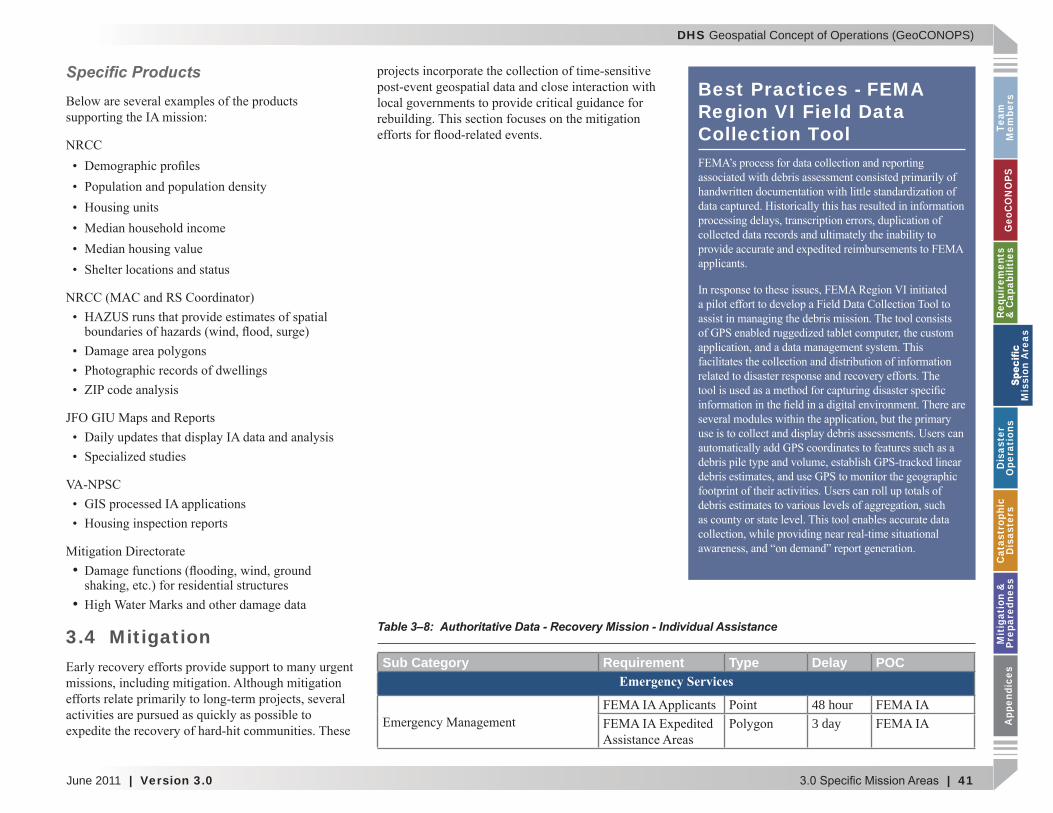
Table 3–8: Authoritative Data - Recovery Mission - Individual Assistance
Sub Category Requirement Type Delay POCEmergency Services
48 hour3 day
M
issi
on A
reas

DHS Geospatial Concept of Operations (GeoCONOPS)
42 | Version 3.0 | June 2011
Team
Mem
bersG
eoCO
NO
PSRequirem
ents &
Capabilities
M
ission Areas
Disaster
Operations
CatastrophicD
isastersM
itigation &
PreparednessA
ppendices
Areas of Expertise
High Water Mark Collection.
Storm Surge Inundation Mapping. Flood
Advisory Base Flood Elevations (ABFE). In
Support
Authoritative Data
(see Table 3–9)
Best Practices - FEMA Post Katrina Damage Assessment for Individual Assistance
from Hurricane Wilma.
M
ission Areas
DHS Geospatial Concept of Operations (GeoCONOPS)
June 2011 | Version 3.0 | 43
Team
M
embe
rsG
eoC
ON
OPS
Requ
irem
ents
&
Cap
abili
ties
M
issi
on A
reas
Dis
aste
r O
pera
tion
sC
atas
trop
hic
Dis
aste
rsM
itig
atio
n &
Pr
epar
edne
ssA
ppen
dice
s
Speci c Products
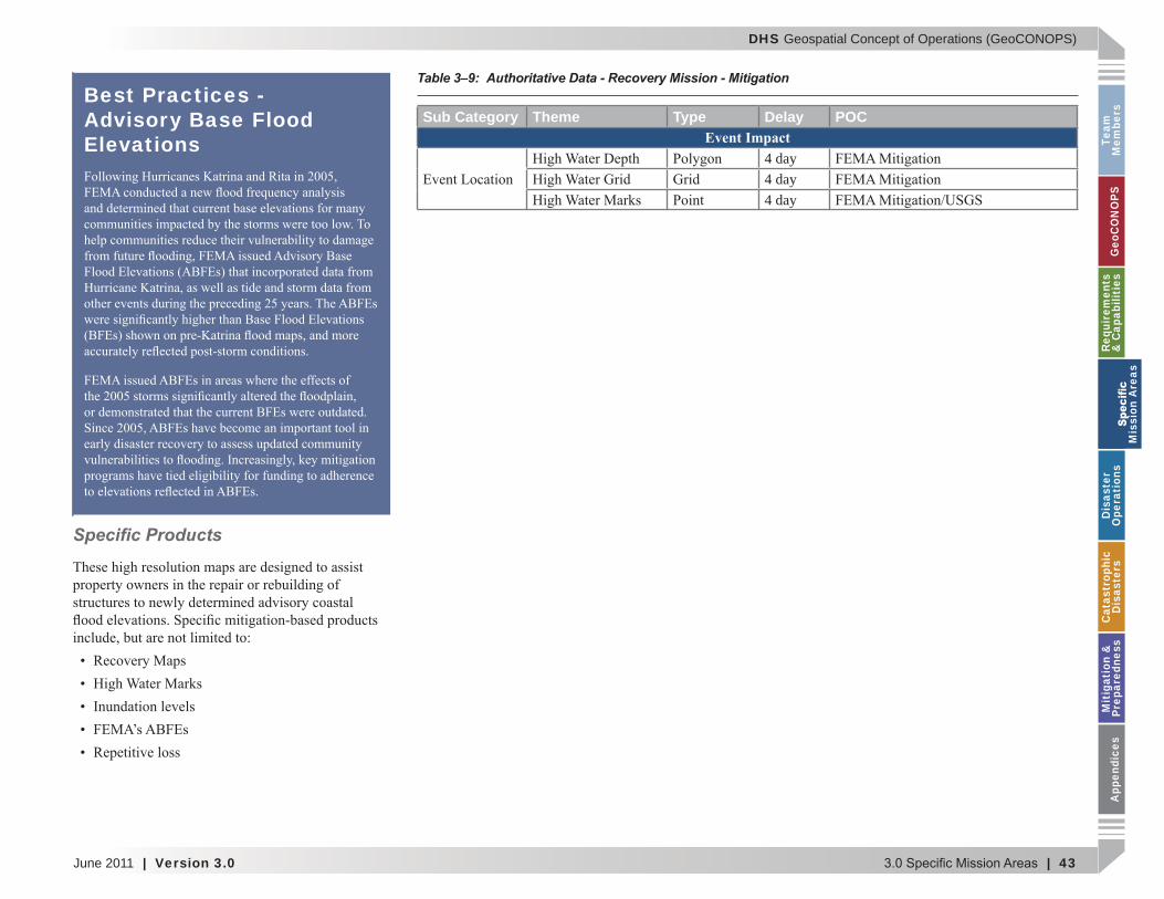
Table 3–9: Authoritative Data - Recovery Mission - Mitigation
Sub Category Theme Type Delay POCEvent Impact
4 day4 day4 day
Best Practices - Advisory Base Flood Elevations
M
issi
on A
reas

DHS Geospatial Concept of Operations (GeoCONOPS)
44 | Version 3.0 | June 2011
Team
Mem
bersG
eoCO
NO
PSRequirem
ents &
Capabilities
M
ission Areas
Disaster
Operations
CatastrophicD
isastersM
itigation &
PreparednessA
ppendices
This page intentionally left blank.
M
ission Areas
DHS Geospatial Concept of Operations (GeoCONOPS)
June 2011 | Version 3.0 | 45
Team
M
embe
rsG
eoC
ON
OPS
Requ
irem
ents
&
Cap
abili
ties
M
issi
on A
reas
Dis
aste
r O
pera
tion
sC
atas
trop
hic
Dis
aste
rsM
itig
atio
n &
Pr
epar
edne
ssA
ppen
dice
s
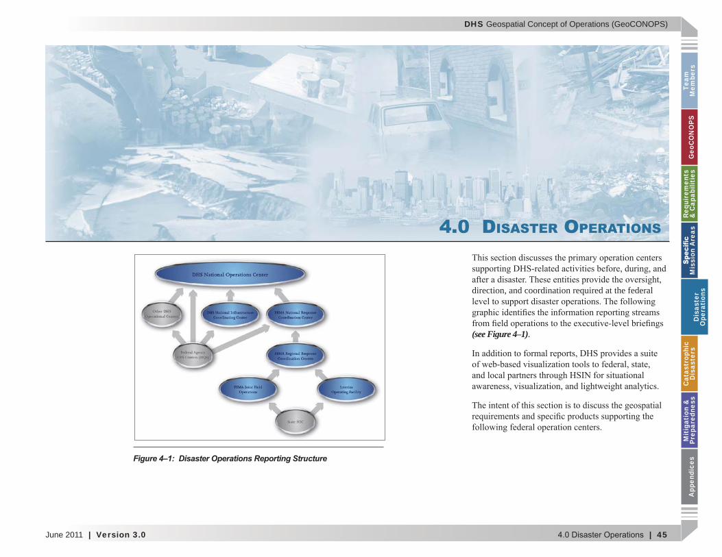
4.0 DISASTER OPERATIONS
direction, and coordination required at the federal
(see Figure 4–1).
Figure 4–1: Disaster Operations Reporting Structure
Dis
aste
r O
pera
tion
s
DHS Geospatial Concept of Operations (GeoCONOPS)
46 | Version 3.0 | June 2011
Team
Mem
bersG
eoCO
NO
PSRequirem
ents &
Capabilities
M
ission Areas
Disaster
Operations
CatastrophicD
isastersM
itigation &
PreparednessA
ppendices
4.1 DHS National Operations CenterOverview
Roles and Responsibilities
Spatial Tagging
GIS Support
Remote Sensing
Modeling
Table 4–1: Authoritative Data - Disaster Operations - NOC
Sub Category Theme Type Delay POCEmergency Services
12 hour24 hour
Event Impact24 hour
Disaster
Operations
DHS Geospatial Concept of Operations (GeoCONOPS)
June 2011 | Version 3.0 | 47
Team
M
embe
rsG
eoC
ON
OPS
Requ
irem
ents
&
Cap
abili
ties
M
issi
on A
reas
Dis
aste
r O
pera
tion
sC
atas
trop
hic
Dis
aste
rsM
itig
atio
n &
Pr
epar
edne
ssA
ppen
dice
s
Operational Support
Production MethodsAuthoritative Data
(see Table 4–1).
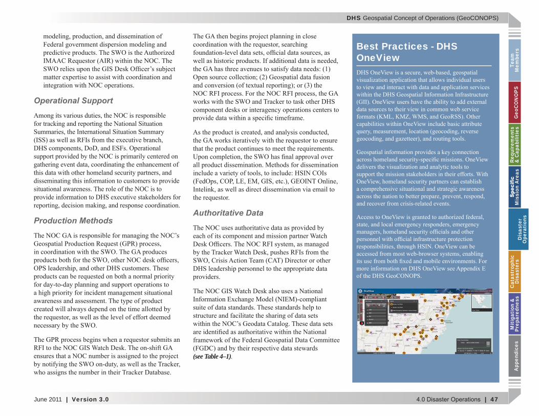
Best Practices - DHS OneView
Dis
aste
r O
pera
tion
s
DHS Geospatial Concept of Operations (GeoCONOPS)
48 | Version 3.0 | June 2011
Team
Mem
bersG
eoCO
NO
PSRequirem
ents &
Capabilities
M
ission Areas
Disaster
Operations
CatastrophicD
isastersM
itigation &
PreparednessA
ppendices
Product Speci cations
NOC Message Alerts.
NOC COP.
Spot Reports.
Security, Water, Electricity, Accessibility, Telecom Charts.
4.2 DHS National Infrastructure Coordinating Center Overview
e
Roles and Responsibilities
GIS Support.
RS.
Disaster
Operations
DHS Geospatial Concept of Operations (GeoCONOPS)
June 2011 | Version 3.0 | 49
Team
M
embe
rsG
eoC
ON
OPS
Requ
irem
ents
&
Cap
abili
ties
M
issi
on A
reas
Dis
aste
r O
pera
tion
sC
atas
trop
hic
Dis
aste
rsM
itig
atio
n &
Pr
epar
edne
ssA
ppen
dice
s
Modeling.
Operational Support
Daily Support.
National Security Speci c Events (NSSE) Support.
Incident/Event State Support.
Quick Look
Spot Reports
location information.
Current Situation Reports
location and any CI affected in the area.
Production Methods
Authoritative Data
Dis
aste
r O
pera
tion
s
DHS Geospatial Concept of Operations (GeoCONOPS)
50 | Version 3.0 | June 2011
Team
Mem
bersG
eoCO
NO
PSRequirem
ents &
Capabilities
M
ission Areas
Disaster
Operations
CatastrophicD
isastersM
itigation &
PreparednessA
ppendices
(see Table 4–2):
Product Speci cations
4.3 FEMA National Response Coordination CenterOverview
Roles and Responsibilities
GIS Support (FEMA MAC).
Table 4–2: Authoritative Data - Disaster Operations - NICC
Sub Category Theme Type Delay POCEmergency Services
3 hour3 hour24 hour24 hour
Event Impact24 hour24 hour
Disaster
Operations
DHS Geospatial Concept of Operations (GeoCONOPS)
June 2011 | Version 3.0 | 51
Team
M
embe
rsG
eoC
ON
OPS
Requ
irem
ents
&
Cap
abili
ties
M
issi
on A
reas
Dis
aste
r O
pera
tion
sC
atas
trop
hic
Dis
aste
rsM
itig
atio
n &
Pr
epar
edne
ssA
ppen
dice
s
RS.
. Modeling.
Operational Support
Production Methods
Sub Category Theme Type Delay POC
Emergency Services48 hour5 day6 day12 dayimmediate24 hour
Event Impact24 hour3 day
Video 24 hour3 day24 hour
Field Operating LocationsDoD 24 hour
Specialized Response Teams
DHS
24 hour
24 hour
48 hour
Table 4–3: Authoritative Data - Disaster Operations - NRCC
Dis
aste
r O
pera
tion
s
DHS Geospatial Concept of Operations (GeoCONOPS)
52 | Version 3.0 | June 2011
Team
Mem
bersG
eoCO
NO
PSRequirem
ents &
Capabilities
M
ission Areas
Disaster
Operations
CatastrophicD
isastersM
itigation &
PreparednessA
ppendices
Authoritative Data
(see Table 4–3).
Product Speci cations
4.4 FEMA Regional Response Coordination Centers Overview
Roles and Responsibilities
Best Practices - HAZUS Concept of Operations
Disaster
Operations
DHS Geospatial Concept of Operations (GeoCONOPS)
June 2011 | Version 3.0 | 53
Team
M
embe
rsG
eoC
ON
OPS
Requ
irem
ents
&
Cap
abili
ties
M
issi
on A
reas
Dis
aste
r O
pera
tion
sC
atas
trop
hic
Dis
aste
rsM
itig
atio
n &
Pr
epar
edne
ssA
ppen
dice
s
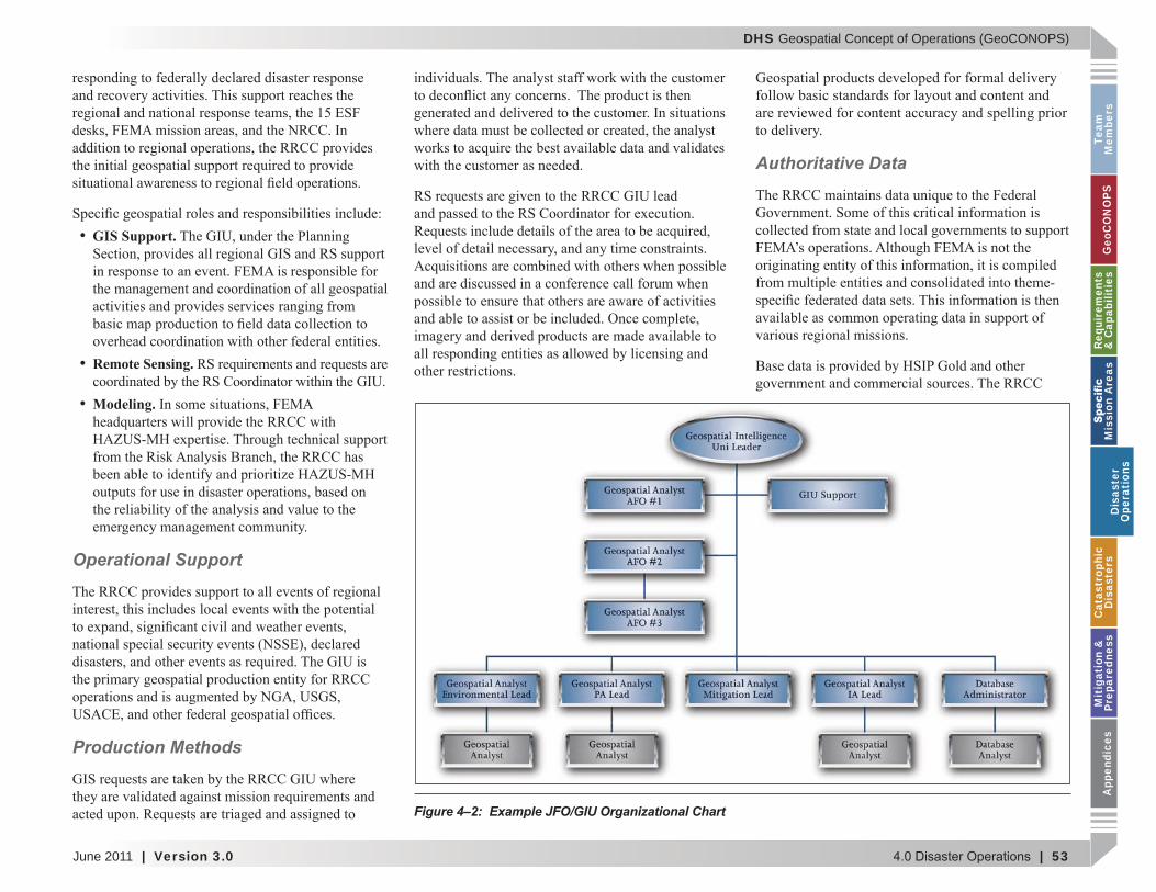
GIS Support.
Remote Sensing.
Modeling.
Operational Support
Production Methods
Authoritative Data
Figure 4–2: Example JFO/GIU Organizational Chart
Dis
aste
r O
pera
tion
s
DHS Geospatial Concept of Operations (GeoCONOPS)
54 | Version 3.0 | June 2011
Team
Mem
bersG
eoCO
NO
PSRequirem
ents &
Capabilities
M
ission Areas
Disaster
Operations
CatastrophicD
isastersM
itigation &
PreparednessA
ppendices
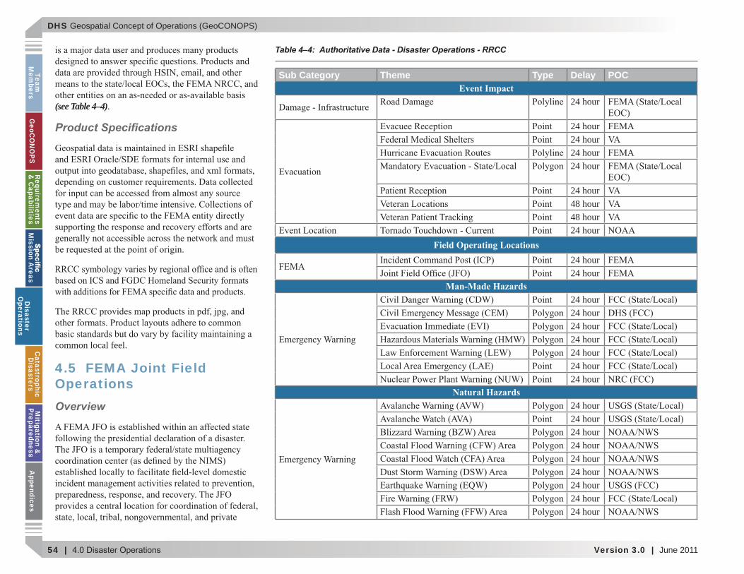
(see Table 4–4).
Product Speci cations
common local feel.
4.5 FEMA Joint Field OperationsOverview
Table 4–4: Authoritative Data - Disaster Operations - RRCC
Sub Category Theme Type Delay POCEvent Impact
24 hour
24 hour24 hour24 hour24 hour
24 hour48 hour48 hour24 hour
Field Operating Locations24 hour24 hour
Man-Made Hazards24 hour24 hour24 hour24 hour24 hour24 hour24 hour
Natural Hazards24 hour24 hour24 hour24 hour24 hour24 hour24 hour24 hour24 hour
Disaster
Operations
DHS Geospatial Concept of Operations (GeoCONOPS)
June 2011 | Version 3.0 | 55
Team
M
embe
rsG
eoC
ON
OPS
Requ
irem
ents
&
Cap
abili
ties
M
issi
on A
reas
Dis
aste
r O
pera
tion
sC
atas
trop
hic
Dis
aste
rsM
itig
atio
n &
Pr
epar
edne
ssA
ppen
dice
s(see Figure 4–2)
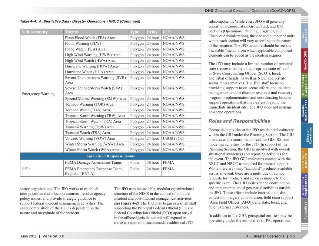
Roles and Responsibilities
Sub Category Theme Type Delay POC24 hour24 hour24 hour24 hour24 hour24 hour24 hour24 hour
24 hour
24 hour24 hour24 hour24 hour24 hour24 hour24 hour24 hour24 hour24 hour
Specialized Response Teams
DHS48 hour24 hour
Table 4–4: Authoritative Data - Disaster Operations - RRCC (Continued)
Dis
aste
r O
pera
tion
s
DHS Geospatial Concept of Operations (GeoCONOPS)
56 | Version 3.0 | June 2011
Team
Mem
bersG
eoCO
NO
PSRequirem
ents &
Capabilities
M
ission Areas
Disaster
Operations
CatastrophicD
isastersM
itigation &
PreparednessA
ppendices
duplication of effort.
GIS Support.
RS.
Modeling.
Operational Support
at the JFO.
Production Methods
Best Practices - Disaster Data and Production
Disaster
Operations
DHS Geospatial Concept of Operations (GeoCONOPS)
June 2011 | Version 3.0 | 57
Team
M
embe
rsG
eoC
ON
OPS
Requ
irem
ents
&
Cap
abili
ties
M
issi
on A
reas
Dis
aste
r O
pera
tion
sC
atas
trop
hic
Dis
aste
rsM
itig
atio
n &
Pr
epar
edne
ssA
ppen
dice
s
Authoritative Data
(see Table 4–5).
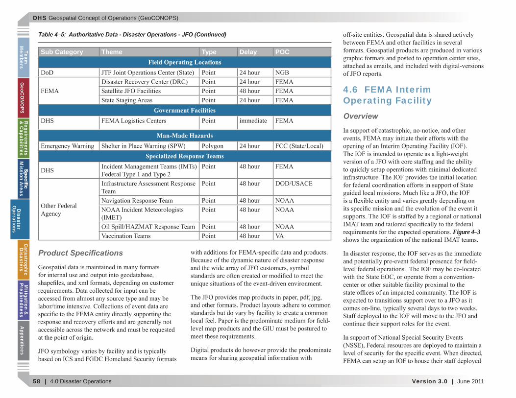
Sub Category Theme Type Delay POCEmergency Services
24 hour48 hour6 day12 day48 hour48 hour48 hour48 hour48 hour
Event Impact48 hour5 day
24 hour5 day
5 day
48 hour48 hour48 hour3 day48 hour CDC24 hour48 hour48 hour24 hour24 hour48 hour
Table 4–5: Authoritative Data - Disaster Operations - JFO
Dis
aste
r O
pera
tion
s
DHS Geospatial Concept of Operations (GeoCONOPS)
58 | Version 3.0 | June 2011
Team
Mem
bersG
eoCO
NO
PSRequirem
ents &
Capabilities
M
ission Areas
Disaster
Operations
CatastrophicD
isastersM
itigation &
PreparednessA
ppendices
Product Speci cations
4.6 FEMA Interim Operating FacilityOverview
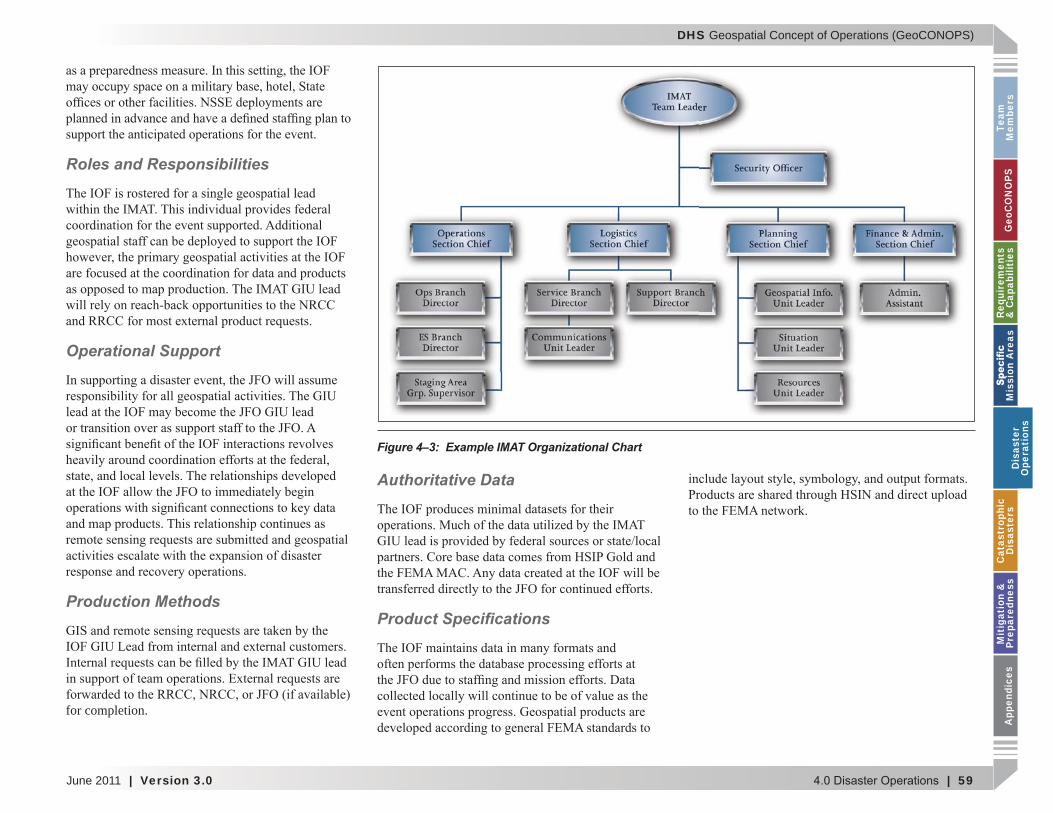
Figure 4–3
Sub Category Theme Type Delay POCField Operating Locations
DoD 24 hour24 hour48 hour24 hour
Government FacilitiesDHS immediate
Man-Made Hazards24 hour
Specialized Response Teams
DHS 48 hour
Other Federal
48 hour
48 hour48 hour
48 hour48 hour
Table 4–5: Authoritative Data - Disaster Operations - JFO (Continued)
Disaster
Operations
DHS Geospatial Concept of Operations (GeoCONOPS)
June 2011 | Version 3.0 | 59
Team
M
embe
rsG
eoC
ON
OPS
Requ
irem
ents
&
Cap
abili
ties
M
issi
on A
reas
Dis
aste
r O
pera
tion
sC
atas
trop
hic
Dis
aste
rsM
itig
atio
n &
Pr
epar
edne
ssA
ppen
dice
s
Roles and Responsibilities
Operational Support
Production Methods
for completion.
Authoritative Data
Product Speci cations
Figure 4–3: Example IMAT Organizational Chart
Dis
aste
r O
pera
tion
s

DHS Geospatial Concept of Operations (GeoCONOPS)
60 | Version 3.0 | June 2011
Team
Mem
bersG
eoCO
NO
PSRequirem
ents &
Capabilities
M
ission Areas
Disaster
Operations
CatastrophicD
isastersM
itigation &
PreparednessA
ppendices
This page intentionally left blank.
Disaster
Operations
DHS Geospatial Concept of Operations (GeoCONOPS)
June 2011 | Version 3.0 | 61
Team
M
embe
rsG
eoC
ON
OPS
Requ
irem
ents
&
Cap
abili
ties
M
issi
on A
reas
Dis
aste
r O
pera
tion
sC
atas
trop
hic
Dis
aste
rsM
itig
atio
n &
Pr
epar
edne
ssA
ppen
dice
s
5.0 CATASTROPHIC DISASTERS
Cat
astr
ophi
cD
isas
ters
DHS Geospatial Concept of Operations (GeoCONOPS)
62 | Version 3.0 | June 2011
Team
Mem
bersG
eoCO
NO
PSRequirem
ents &
Capabilities
M
ission Areas
Disaster
Operations
CatastrophicD
isastersM
itigation &
PreparednessA
ppendices
5.1 Natural Events
the country.
5.1.1 Notice Events
5.1.2 No-Notice Events
5.2 The New Madrid Earthquake Scenario
Figure 5–1
5.2.1 Modeled Earthquake Impacts
Casualties
CatastrophicD
isasters

DHS Geospatial Concept of Operations (GeoCONOPS)
June 2011 | Version 3.0 | 63
Team
M
embe
rsG
eoC
ON
OPS
Requ
irem
ents
&
Cap
abili
ties
M
issi
on A
reas
Dis
aste
r O
pera
tion
sC
atas
trop
hic
Dis
aste
rsM
itig
atio
n &
Pr
epar
edne
ssA
ppen
dice
s
Figure 5–2.
Displaced Population and Shelter Requirements
Table 5–1.
Table 5-1, conducted
Building Damage
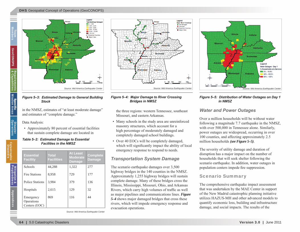
Figure 5–3,
Essential Facilities
Table 5–2
Figure 5–1: Regional Ground Shaking Intensity from NMSZ Earthquake Scenario
Figure 5–2: Total Casualties from Scenario Earthquake
Source: Mid America Earthquake Center Source: Mid America Earthquake Center
State & FEMA Region Total
Total Population
At Risk (Day 1)
Seeking Shelter (Day 1)
At Risk (Day 3)
Seeking Shelter (Day 3)
4,447,100 9,645 3,081 601,561 173,4124,041,769 53,860 14,952 850,615 233,9092,844,658 61,997 18,345 705,032 205,5075,689,283 316,681 91.103 2,072,942 562,468
12,419,293 50,285 15,588 650,247 185,139Indiana 6,080,485 9,932 2,701 579,627 153,570
2,673,400 124,730 38,827 937,518 285,8655,595,211 103,655 30,074 842,002 237,991
43,791,199 730,795 214,671 7,239,544 2,037,861
Table 5–1: Estimate of “At Risk” and Shelter Seeking Populations: NMSZ Scenario Earthquake
Source: Mid America Earthquake Center
Cat
astr
ophi
cD
isas
ters
DHS Geospatial Concept of Operations (GeoCONOPS)
64 | Version 3.0 | June 2011
Team
Mem
bersG
eoCO
NO
PSRequirem
ents &
Capabilities
M
ission Areas
Disaster
Operations
CatastrophicD
isastersM
itigation &
PreparednessA
ppendices
Transportation System Damage
Figure 5–4
Water and Power Outages
(see Figure 5–5).
Scenario Summary
Figure 5–3: Estimated Damage to General Building Stock
Figure 5–4: Major Damage to River Crossing Bridges in NMSZ
Figure 5–5: Distribution of Water Outages on Day 1 in NMSZ
Table 5–2: Estimated Damage to Essential Facilities in the NMSZ
Essential Facility
Total Facilities
At Least Moderate Damage
Complete Damage
44,288
8,958
3,984
2,615
869
1,322
729
379
129
116
277
177
136
32
44
Source: Mid America Earthquake Center
Source: Mid America Earthquake Center Source: Mid America Earthquake Center Source: Mid America Earthquake Center
CatastrophicD
isasters
DHS Geospatial Concept of Operations (GeoCONOPS)
June 2011 | Version 3.0 | 65
Team
M
embe
rsG
eoC
ON
OPS
Requ
irem
ents
&
Cap
abili
ties
M
issi
on A
reas
Dis
aste
r O
pera
tion
sC
atas
trop
hic
Dis
aste
rsM
itig
atio
n &
Pr
epar
edne
ssA
ppen
dice
s
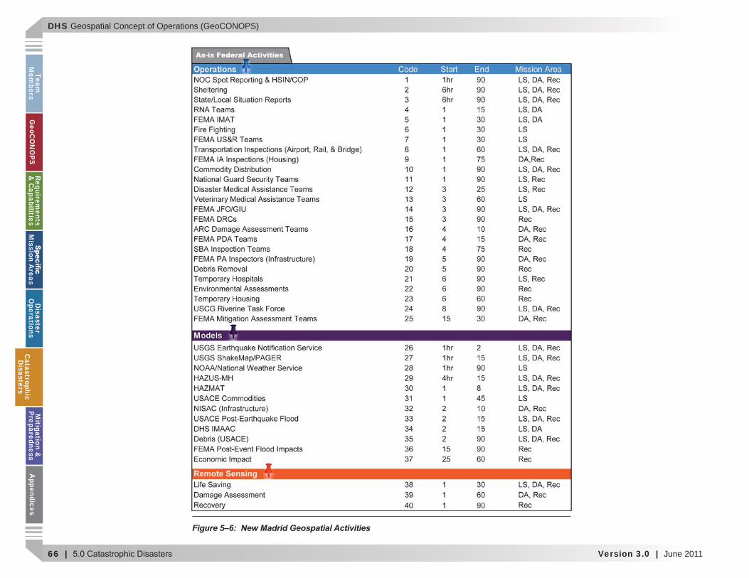
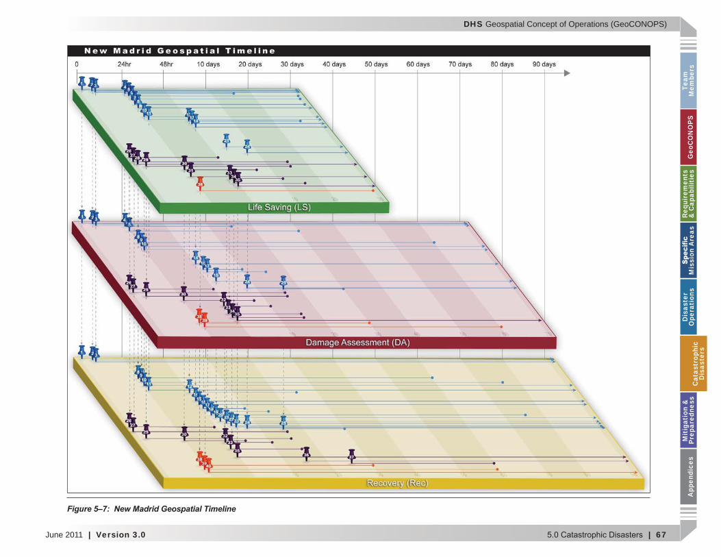
5.2.2 GeoCONOPS Mission Area Support
Figure 5–6 and Figure 5–7
(see Figure 5–6)
(see Figure 5–7)
end time.
operational duration
platter. Support
5.3.2.1 Life-Saving Mission
Cat
astr
ophi
cD
isas
ters
DHS Geospatial Concept of Operations (GeoCONOPS)
66 | Version 3.0 | June 2011
Team
Mem
bersG
eoCO
NO
PSRequirem
ents &
Capabilities
M
ission Areas
Disaster
Operations
CatastrophicD
isastersM
itigation &
PreparednessA
ppendices
Figure 5–6: New Madrid Geospatial Activities
CatastrophicD
isasters
DHS Geospatial Concept of Operations (GeoCONOPS)
June 2011 | Version 3.0 | 67
Team
M
embe
rsG
eoC
ON
OPS
Requ
irem
ents
&
Cap
abili
ties
M
issi
on A
reas
Dis
aste
r O
pera
tion
sC
atas
trop
hic
Dis
aste
rsM
itig
atio
n &
Pr
epar
edne
ssA
ppen
dice
s
Figure 5–7: New Madrid Geospatial Timeline
Cat
astr
ophi
cD
isas
ters
DHS Geospatial Concept of Operations (GeoCONOPS)
68 | Version 3.0 | June 2011
Team
Mem
bersG
eoCO
NO
PSRequirem
ents &
Capabilities
M
ission Areas
Disaster
Operations
CatastrophicD
isastersM
itigation &
PreparednessA
ppendices
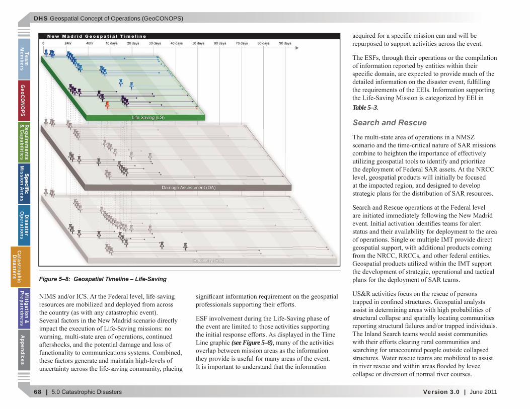
(see Figure 5–8)
Table 5–3.
Search and Rescue
Figure 5–8: Geospatial Timeline – Life-Saving
CatastrophicD
isasters
DHS Geospatial Concept of Operations (GeoCONOPS)
June 2011 | Version 3.0 | 69
Team
M
embe
rsG
eoC
ON
OPS
Requ
irem
ents
&
Cap
abili
ties
M
issi
on A
reas
Dis
aste
r O
pera
tion
sC
atas
trop
hic
Dis
aste
rsM
itig
atio
n &
Pr
epar
edne
ssA
ppen
dice
s
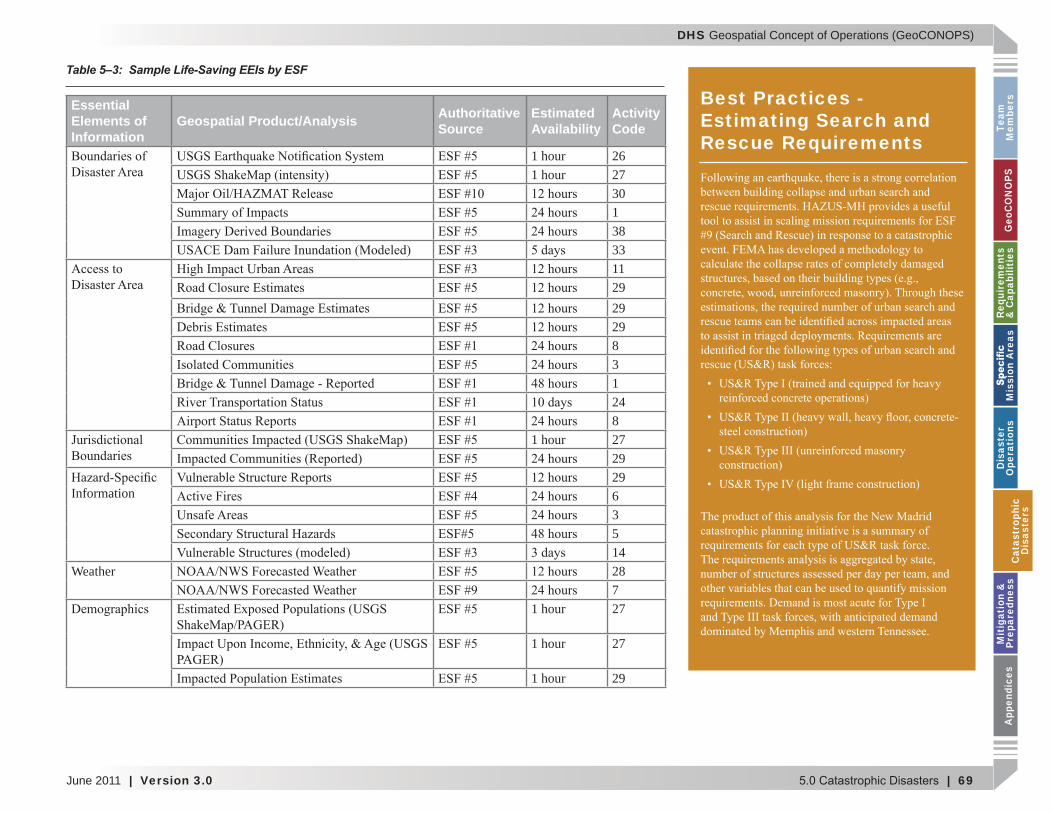
Table 5–3: Sample Life-Saving EEIs by ESF
Essential Elements of Information
Geospatial Product/Analysis Authoritative Source
Estimated Availability
Activity Code
1 hour 261 hour 27
301383311292929831248
1 hour 2729
Information2963514
Weather 287
1 hour 27
1 hour 27
1 hour 29
Best Practices - Estimating Search and Rescue Requirements
Cat
astr
ophi
cD
isas
ters
DHS Geospatial Concept of Operations (GeoCONOPS)
70 | Version 3.0 | June 2011
Team
Mem
bersG
eoCO
NO
PSRequirem
ents &
Capabilities
M
ission Areas
Disaster
Operations
CatastrophicD
isastersM
itigation &
PreparednessA
ppendices
Critical Medical Support
are required.
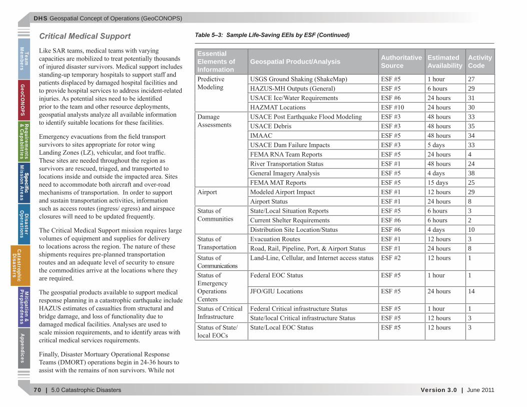
Table 5–3: Sample Life-Saving EEIs by ESF (Continued)
Essential Elements of Information
Geospatial Product/Analysis Authoritative Source
Estimated Availability
Activity Code
1 hour 272931303335343342438252983210381
1 hour 1
14
1 hour 133
CatastrophicD
isasters
DHS Geospatial Concept of Operations (GeoCONOPS)
June 2011 | Version 3.0 | 71
Team
M
embe
rsG
eoC
ON
OPS
Requ
irem
ents
&
Cap
abili
ties
M
issi
on A
reas
Dis
aste
r O
pera
tion
sC
atas
trop
hic
Dis
aste
rsM
itig
atio
n &
Pr
epar
edne
ssA
ppen
dice
s
Provision of Critical Food, Shelter, and Water
5.3.2.2 Damage Assessment Mission
(see Table 5–4)
(see Figure 5–9)
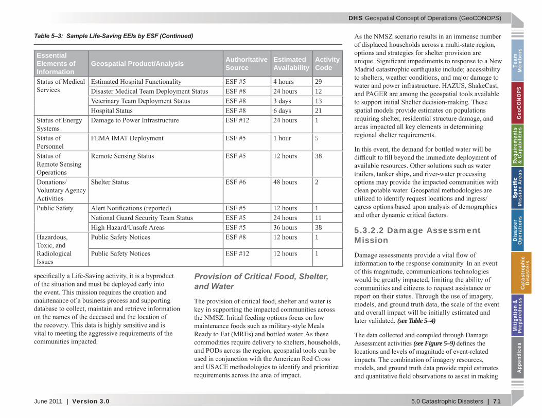
Essential Elements of Information
Geospatial Product/Analysis Authoritative Source
Estimated Availability
Activity Code
291213211
1 hour 5
38
2
111381
1
Table 5–3: Sample Life-Saving EEIs by ESF (Continued)
Cat
astr
ophi
cD
isas
ters
DHS Geospatial Concept of Operations (GeoCONOPS)
72 | Version 3.0 | June 2011
Team
Mem
bersG
eoCO
NO
PSRequirem
ents &
Capabilities
M
ission Areas
Disaster
Operations
CatastrophicD
isastersM
itigation &
PreparednessA
ppendices
Imagery & Derived Products
Satellite Imagery
Figure 5–9: Geospatial Timeline – Damage Assessment
CatastrophicD
isasters
DHS Geospatial Concept of Operations (GeoCONOPS)
June 2011 | Version 3.0 | 73
Team
M
embe
rsG
eoC
ON
OPS
Requ
irem
ents
&
Cap
abili
ties
M
issi
on A
reas
Dis
aste
r O
pera
tion
sC
atas
trop
hic
Dis
aste
rsM
itig
atio
n &
Pr
epar
edne
ssA
ppen
dice
s
Airborne Imagery
LIDAR
IR (thermal)
Oblique
Full Motion Video
Essential Elements of Information Geospatial Product/Analysis Authoritative
SourceEstimated Availability
Activity Code
1 hour 26
1 hour 27301383233
292929831248
1 hour 27
29
Information2963514
Weather 287
1 hour 27
1 hour 27
1 hour 29
Table 5–4: Sample Damage Assessment EEIs by ESF
Cat
astr
ophi
cD
isas
ters
DHS Geospatial Concept of Operations (GeoCONOPS)
74 | Version 3.0 | June 2011
Team
Mem
bersG
eoCO
NO
PSRequirem
ents &
Capabilities
M
ission Areas
Disaster
Operations
CatastrophicD
isastersM
itigation &
PreparednessA
ppendices
Mission Overlap
and the multitude of Federal, State, and local
Exploitation
Essential Elements of Information Geospatial Product/Analysis Authoritative
SourceEstimated Availability
Activity Code
1 hour 27293033
3534334918243839391715
2981732101738
1
1 hour 114
Table 5–4: Sample Damage Assessment EEIs by ESF (Continued)
CatastrophicD
isasters
DHS Geospatial Concept of Operations (GeoCONOPS)
June 2011 | Version 3.0 | 75
Team
M
embe
rsG
eoC
ON
OPS
Requ
irem
ents
&
Cap
abili
ties
M
issi
on A
reas
Dis
aste
r O
pera
tion
sC
atas
trop
hic
Dis
aste
rsM
itig
atio
n &
Pr
epar
edne
ssA
ppen
dice
s
Dissemination
Models
Essential Elements of Information Geospatial Product/Analysis Authoritative
SourceEstimated Availability
Activity Code
1 hour 13
3
29
321
1 hour 538
2
13811
Table 5–4: Sample Damage Assessment EEIs by ESF (Continued)
Cat
astr
ophi
cD
isas
ters
DHS Geospatial Concept of Operations (GeoCONOPS)
76 | Version 3.0 | June 2011
Team
Mem
bersG
eoCO
NO
PSRequirem
ents &
Capabilities
M
ission Areas
Disaster
Operations
CatastrophicD
isastersM
itigation &
PreparednessA
ppendices
Field Data Collection
Incident Management Assistance Teams (IMAT)
Rapid Needs Assessment (RNA)
PA Inspection Teams
American Red Cross Inspection Teams
IA PDA Teams team
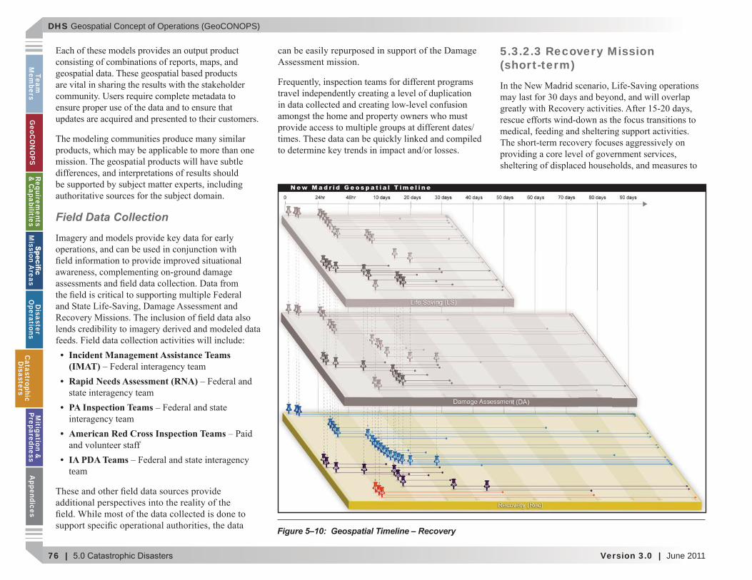
5.3.2.3 Recovery Mission (short-term)
Figure 5–10: Geospatial Timeline – Recovery
CatastrophicD
isasters
DHS Geospatial Concept of Operations (GeoCONOPS)
June 2011 | Version 3.0 | 77
Team
M
embe
rsG
eoC
ON
OPS
Requ
irem
ents
&
Cap
abili
ties
M
issi
on A
reas
Dis
aste
r O
pera
tion
sC
atas
trop
hic
Dis
aste
rsM
itig
atio
n &
Pr
epar
edne
ssA
ppen
dice
s
(see Figure 5–10)
Public Assistance
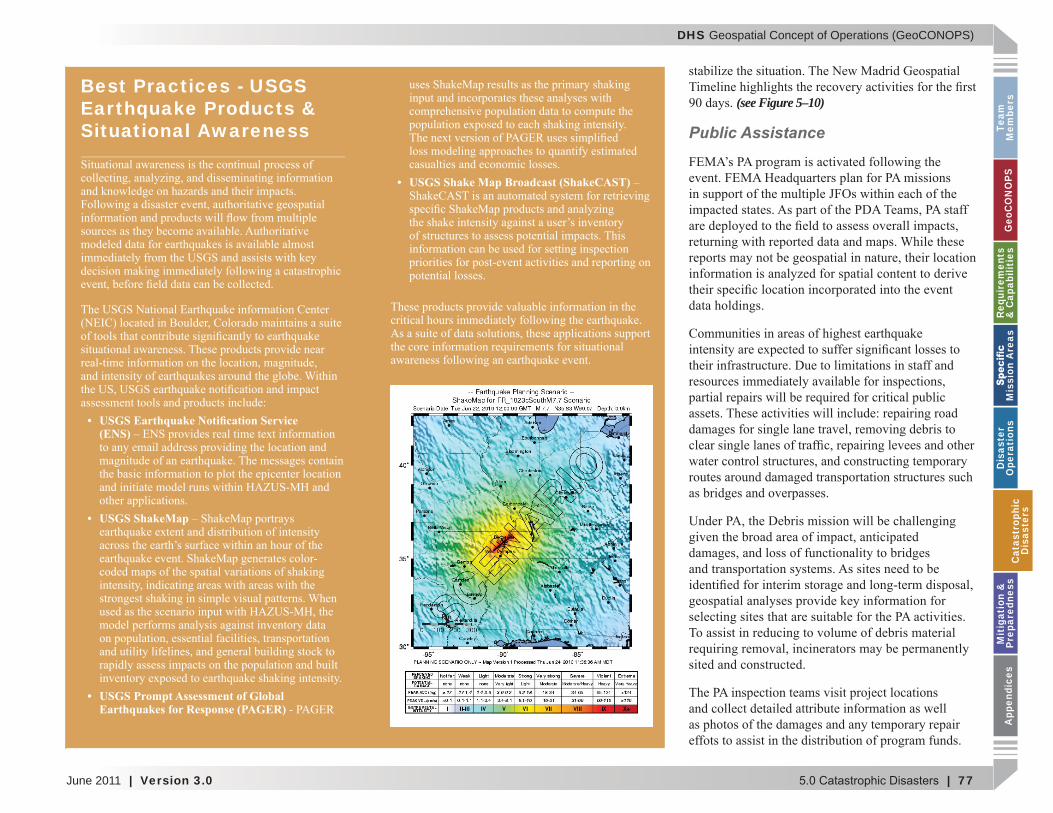
Best Practices - USGS Earthquake Products & Situational Awareness
USGS Earthquake Noti cation Service (ENS)
USGS ShakeMap
USGS Prompt Assessment of Global Earthquakes for Response (PAGER)
USGS Shake Map Broadcast (ShakeCAST)
Cat
astr
ophi
cD
isas
ters
DHS Geospatial Concept of Operations (GeoCONOPS)
78 | Version 3.0 | June 2011
Team
Mem
bersG
eoCO
NO
PSRequirem
ents &
Capabilities
M
ission Areas
Disaster
Operations
CatastrophicD
isastersM
itigation &
PreparednessA
ppendices
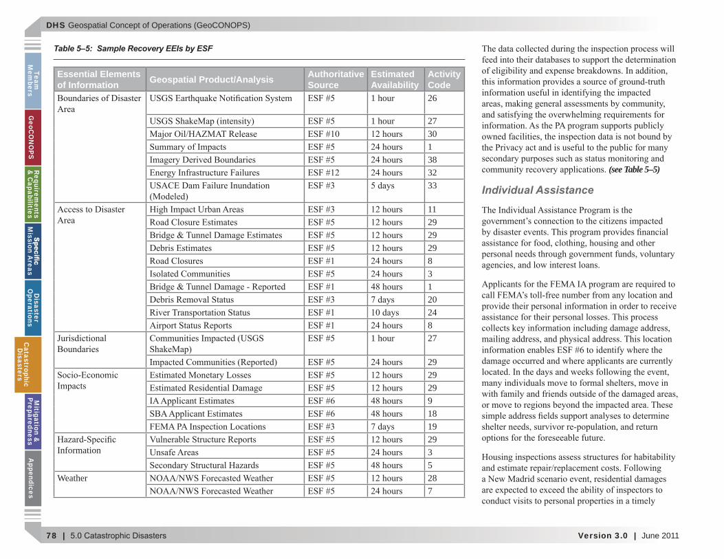
(see Table 5–5)
Individual Assistance
Essential Elements of Information Geospatial Product/Analysis Authoritative
SourceEstimated Availability
Activity Code
1 hour 26
1 hour 27301383233
1129292983120248
1 hour 27
29292991819
Information2935
Weather 287
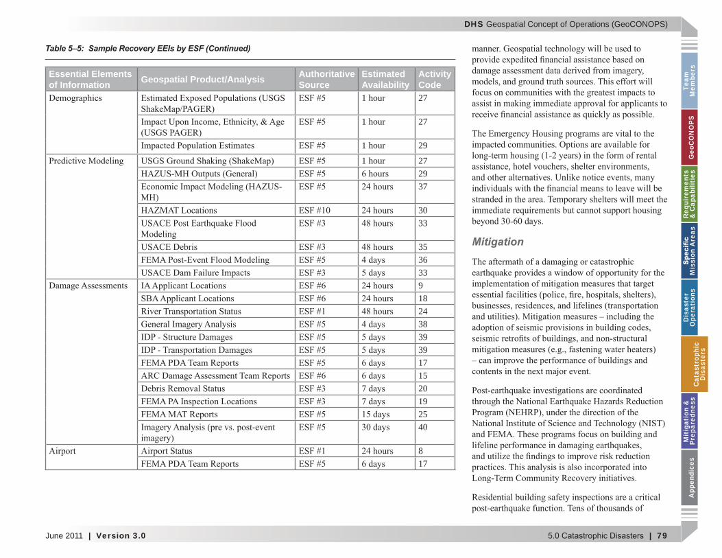
Table 5–5: Sample Recovery EEIs by ESF
CatastrophicD
isasters
DHS Geospatial Concept of Operations (GeoCONOPS)
June 2011 | Version 3.0 | 79
Team
M
embe
rsG
eoC
ON
OPS
Requ
irem
ents
&
Cap
abili
ties
M
issi
on A
reas
Dis
aste
r O
pera
tion
sC
atas
trop
hic
Dis
aste
rsM
itig
atio
n &
Pr
epar
edne
ssA
ppen
dice
s
Mitigation
Essential Elements of Information Geospatial Product/Analysis Authoritative
SourceEstimated Availability
Activity Code
1 hour 27
1 hour 27
1 hour 29
1 hour 272937
3033
35363391824383939171520192540
817
Table 5–5: Sample Recovery EEIs by ESF (Continued)
Cat
astr
ophi
cD
isas
ters
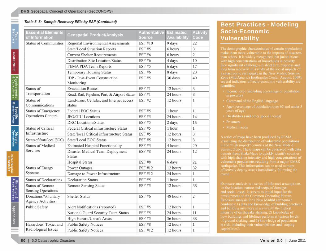
DHS Geospatial Concept of Operations (GeoCONOPS)
80 | Version 3.0 | June 2011
Team
Mem
bersG
eoCO
NO
PSRequirem
ents &
Capabilities
M
ission Areas
Disaster
Operations
CatastrophicD
isastersM
itigation &
PreparednessA
ppendices
Essential Elements of Information Geospatial Product/Analysis Authoritative
SourceEstimated Availability
Activity Code223210172340
381
1 hour 11415
1 hour 1332912
21321
1 hour 138
2
1113811
Table 5–5: Sample Recovery EEIs by ESF (Continued) Best Practices - Modeling Socio-Economic Vulnerability
CatastrophicD
isasters
DHS Geospatial Concept of Operations (GeoCONOPS)
June 2011 | Version 3.0 | 81
Team
M
embe
rsG
eoC
ON
OPS
Requ
irem
ents
&
Cap
abili
ties
M
issi
on A
reas
Dis
aste
r O
pera
tion
sC
atas
trop
hic
Dis
aste
rsM
itig
atio
n &
Pr
epar
edne
ssA
ppen
dice
s
5.3 Post-Event Efforts (long-term) Community-Based Products
impact data to include economic impact and an
Project Monitoring
Transition to State and Local Governments
Cat
astr
ophi
cD
isas
ters
DHS Geospatial Concept of Operations (GeoCONOPS)
82 | Version 3.0 | June 2011
Team
Mem
bersG
eoCO
NO
PSRequirem
ents &
Capabilities
M
ission Areas
Disaster
Operations
CatastrophicD
isastersM
itigation &
PreparednessA
ppendices
5.4 Activities Outside NMSZ Scenario
5.4.1 Pre-Event Emergency Activities
Personnel Activation
to a central location in preparation of deployment
Evacuation & ShelteringResource Deployment
CatastrophicD
isasters
DHS Geospatial Concept of Operations (GeoCONOPS)
June 2011 | Version 3.0 | 83
Team
M
embe
rsG
eoC
ON
OPS
Requ
irem
ents
&
Cap
abili
ties
M
issi
on A
reas
Dis
aste
r O
pera
tion
sC
atas
trop
hic
Dis
aste
rsM
itig
atio
n &
Pr
epar
edne
ssA
ppen
dice
s
Remote Sensing Mission Planning
5.4.2 Non Earthquake Activities
Personnel Activation
Evacuation & Sheltering
Mission Planning
Table 5–6.
Cat
astr
ophi
cD
isas
ters
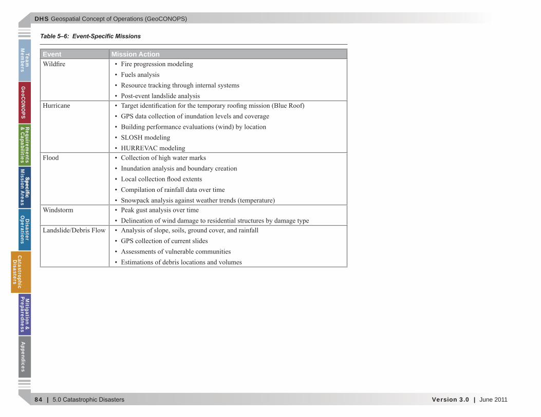
DHS Geospatial Concept of Operations (GeoCONOPS)
84 | Version 3.0 | June 2011
Team
Mem
bersG
eoCO
NO
PSRequirem
ents &
Capabilities
M
ission Areas
Disaster
Operations
CatastrophicD
isastersM
itigation &
PreparednessA
ppendices
Event Mission Action
Hurricane
Flood
Table 5–6: Event-Speci c Missions
CatastrophicD
isasters
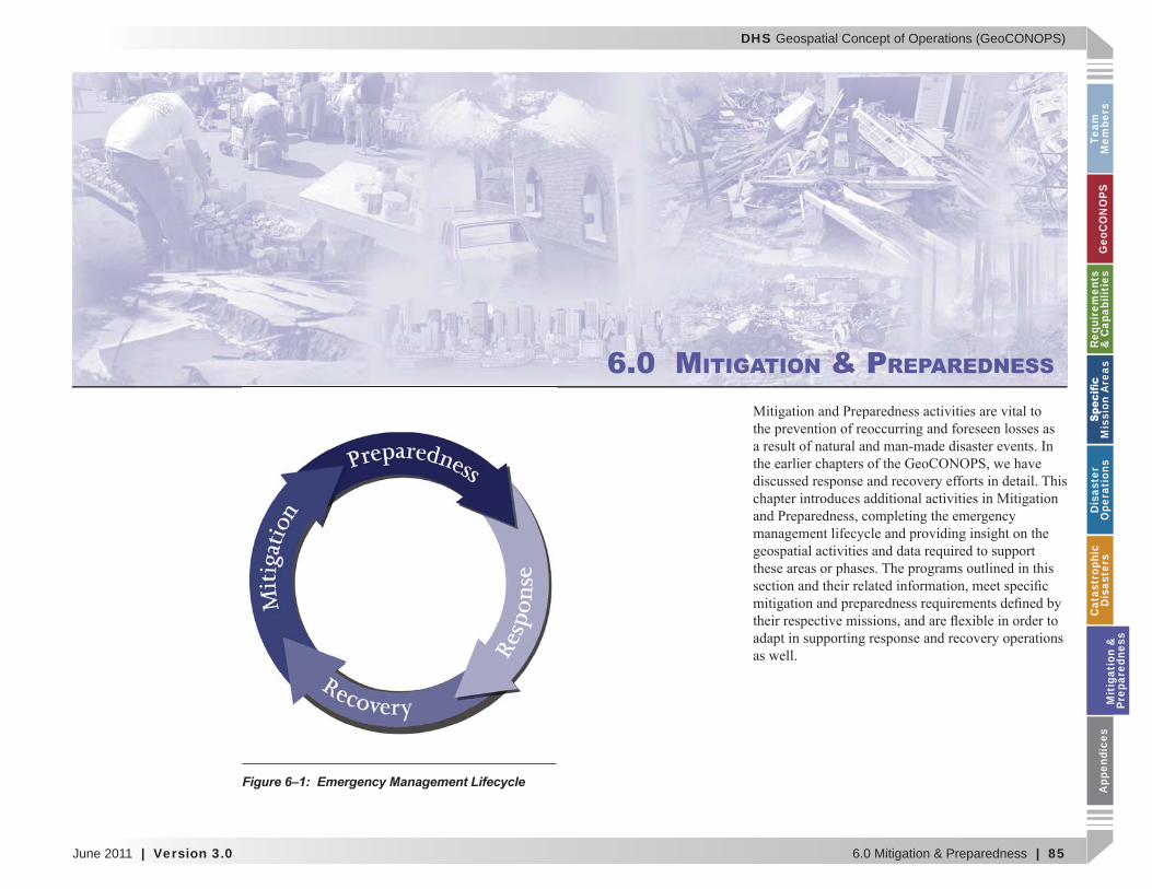
DHS Geospatial Concept of Operations (GeoCONOPS)
June 2011 | Version 3.0 6.0 Mitigation & Preparedness | 85
Team
M
embe
rsG
eoC
ON
OPS
Requ
irem
ents
&
Cap
abili
ties
M
issi
on A
reas
Dis
aste
r O
pera
tion
sC
atas
trop
hic
Dis
aste
rsM
itig
atio
n &
Pr
epar
edne
ssA
ppen
dice
s
6.0 MITIGATION & PREPAREDNESS
Figure 6–1: Emergency Management Lifecycle
Mit
igat
ion
&
Prep
ared
ness
DHS Geospatial Concept of Operations (GeoCONOPS)
86 | 6.0 Mitigation & Preparedness Version 3.0 | June 2011
Team
Mem
bersG
eoCO
NO
PSRequirem
ents &
Capabilities
M
ission Areas
Disaster
Operations
CatastrophicD
isastersM
itigation &
PreparednessA
ppendices
6.1 Mitigation
6.1.1 Risk Analysis
FEMA HAZUS Program
Overview
Operational Support
Earthquake:
Hurricane:
Flood:
Authoritative Data
(see Table 6–1)
Table 6–1: Authoritative Data – FEMA HAZUS Program
Sub Category Theme Type POC
Mitigation &
Preparedness
DHS Geospatial Concept of Operations (GeoCONOPS)
June 2011 | Version 3.0 6.0 Mitigation & Preparedness | 87
Team
M
embe
rsG
eoC
ON
OPS
Requ
irem
ents
&
Cap
abili
ties
M
issi
on A
reas
Dis
aste
r O
pera
tion
sC
atas
trop
hic
Dis
aste
rsM
itig
atio
n &
Pr
epar
edne
ssA
ppen
dice
s
(Section 3.0, Table 3-2).
Speci c Products
FEMA Map Modernization Program
Overview
Operational Support
Authoritative Data
(see Table 6–2)
Speci c Products
FEMA Mitigation Planning
Overview
Table 6–2: Authoritative Data – FEMA Map Modernization Program
Sub Category Theme Type POCBase Map
Natural Hazards
Mit
igat
ion
&
Prep
ared
ness
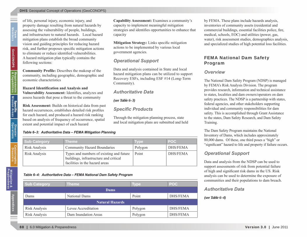
DHS Geospatial Concept of Operations (GeoCONOPS)
88 | 6.0 Mitigation & Preparedness Version 3.0 | June 2011
Team
Mem
bersG
eoCO
NO
PSRequirem
ents &
Capabilities
M
ission Areas
Disaster
Operations
CatastrophicD
isastersM
itigation &
PreparednessA
ppendices
Community Profile:
Hazard Identification and Analysis and Vulnerability Assessment:
Risk Assessment:
Capability Assessment:
capacity
Mitigation Strategy:
Operational Support
Authoritative Data
(see Table 6–3)
Speci c Products
FEMA National Dam Safety Program
Overview
Operational Support
Authoritative Data
(see Table 6–4)
Table 6–3: Authoritative Data – FEMA Mitigation Planning
Sub Category Theme Type POC
Table 6–4: Authoritative Data – FEMA National Dam Safety Program
Sub Category Theme Type POCDams
Natural Hazards
Mitigation &
Preparedness
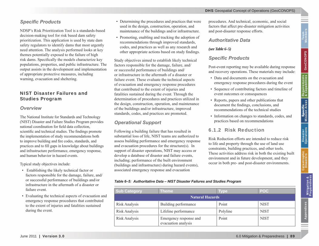
DHS Geospatial Concept of Operations (GeoCONOPS)
June 2011 | Version 3.0 6.0 Mitigation & Preparedness | 89
Team
M
embe
rsG
eoC
ON
OPS
Requ
irem
ents
&
Cap
abili
ties
M
issi
on A
reas
Dis
aste
r O
pera
tion
sC
atas
trop
hic
Dis
aste
rsM
itig
atio
n &
Pr
epar
edne
ssA
ppen
dice
s
Speci c Products
NIST Disaster Failures and Studies Program
Overview
Operational Support
Authoritative Data
(see Table 6–5)
Speci c Products
6.1.2 Risk Reduction
Table 6–5: Authoritative Data – NIST Disaster Failures and Studies Program
Sub Category Theme Type POCNatural Hazards
Mit
igat
ion
&
Prep
ared
ness
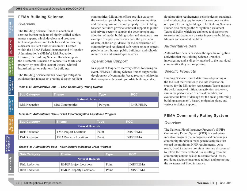
DHS Geospatial Concept of Operations (GeoCONOPS)
90 | 6.0 Mitigation & Preparedness Version 3.0 | June 2011
Team
Mem
bersG
eoCO
NO
PSRequirem
ents &
Capabilities
M
ission Areas
Disaster
Operations
CatastrophicD
isastersM
itigation &
PreparednessA
ppendices
FEMA Building Science
Overview
Operational Support
Authoritative Data
Speci c Products
FEMA Community Rating System
Overview
Table 6–6: Authoritative Data – FEMA Community Rating System
Sub Category Theme Type POCNatural Hazards
Table 6–7: Authoritative Data – FEMA Flood Mitigation Assistance Program
Sub Category Theme Type POCNatural Hazards
Table 6–8: Authoritative Data – FEMA Hazard Mitigation Grant Program
Sub Category Theme Type POCNatural Hazards
Mitigation &
Preparedness
DHS Geospatial Concept of Operations (GeoCONOPS)
June 2011 | Version 3.0 6.0 Mitigation & Preparedness | 91
Team
M
embe
rsG
eoC
ON
OPS
Requ
irem
ents
&
Cap
abili
ties
M
issi
on A
reas
Dis
aste
r O
pera
tion
sC
atas
trop
hic
Dis
aste
rsM
itig
atio
n &
Pr
epar
edne
ssA
ppen
dice
s
Operational Support
Authoritative Data
(see Table 6–6)
Speci c Products
FEMA Flood Mitigation Assistance Program
Overview
Operational Support
Authoritative Data
(see Table 6–7)
Speci c Products
FEMA Hazard Mitigation Grant Program
Overview
Operational Support
Authoritative Data
(see Table 6–8)
Speci c Products
Mit
igat
ion
&
Prep
ared
ness
DHS Geospatial Concept of Operations (GeoCONOPS)
92 | 6.0 Mitigation & Preparedness Version 3.0 | June 2011
Team
Mem
bersG
eoCO
NO
PSRequirem
ents &
Capabilities
M
ission Areas
Disaster
Operations
CatastrophicD
isastersM
itigation &
PreparednessA
ppendices
FEMA National Earthquake Hazards Reduction Program
Overview Operational Support
Authoritative Data
(see Table 6–9)
Speci c Products
FEMA Pre-Disaster Mitigation
Overview
Operational Support
Authoritative Data
(see Table 6–10)
Speci c Products
Table 6–9: Authoritative Data – FEMA National Earthquake Hazards Reduction Program
Sub Category Theme Type POCNatural Hazards
Table 6–10: Authoritative Data – FEMA Pre-Disaster Mitigation
Sub Category Theme Type POCNatural Hazards
Mitigation &
Preparedness
DHS Geospatial Concept of Operations (GeoCONOPS)
June 2011 | Version 3.0 6.0 Mitigation & Preparedness | 93
Team
M
embe
rsG
eoC
ON
OPS
Requ
irem
ents
&
Cap
abili
ties
M
issi
on A
reas
Dis
aste
r O
pera
tion
sC
atas
trop
hic
Dis
aste
rsM
itig
atio
n &
Pr
epar
edne
ssA
ppen
dice
s
6.1.3 Risk Insurance
FEMA Repetitive Flood Claims
Overview
Operational Support
Authoritative Data
(see Table 6–11)
Speci c Products
FEMA Severe Repetitive Loss
Overview
Operational Support
Authoritative Data
(see Table 6–12)
Table 6–11: Authoritative Data – FEMA Repetitive Flood Claims
Sub Category Theme Type POCNatural Hazards
Table 6–12: Authoritative Data – FEMA Severe Repetitive Loss
Sub Category Theme Type POCNatural Hazards
Mit
igat
ion
&
Prep
ared
ness
DHS Geospatial Concept of Operations (GeoCONOPS)
94 | 6.0 Mitigation & Preparedness Version 3.0 | June 2011
Team
Mem
bersG
eoCO
NO
PSRequirem
ents &
Capabilities
M
ission Areas
Disaster
Operations
CatastrophicD
isastersM
itigation &
PreparednessA
ppendices
Speci c Products
FEMA Risk Insurance Division
Overview
Operational Support
Authoritative Data
(see Table 6–13)
Speci c Products
6.2 Preparedness
DHS National Planning Scenarios
Overview
Operational Support
Authoritative Data
Table 6–13: Authoritative Data – FEMA Risk Insurance Division
Sub Category Theme Type POCNatural Hazards
Mitigation &
Preparedness
DHS Geospatial Concept of Operations (GeoCONOPS)
June 2011 | Version 3.0 6.0 Mitigation & Preparedness | 95
Team
M
embe
rsG
eoC
ON
OPS
Requ
irem
ents
&
Cap
abili
ties
M
issi
on A
reas
Dis
aste
r O
pera
tion
sC
atas
trop
hic
Dis
aste
rsM
itig
atio
n &
Pr
epar
edne
ssA
ppen
dice
s
Speci c Products
FEMA Chemical Stockpile Emergency Preparedness Program
Overview
Operational Support
Best Practices - ENVAS for Environmental Assessments
Mit
igat
ion
&
Prep
ared
ness
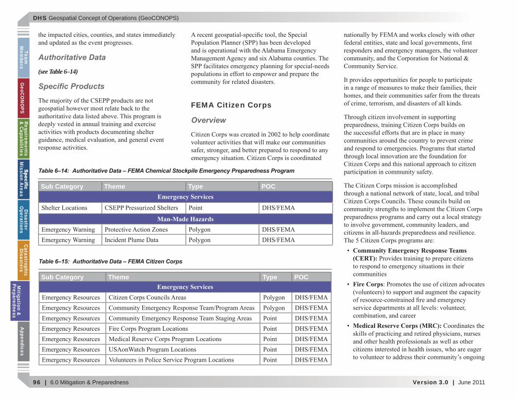
DHS Geospatial Concept of Operations (GeoCONOPS)
96 | 6.0 Mitigation & Preparedness Version 3.0 | June 2011
Team
Mem
bersG
eoCO
NO
PSRequirem
ents &
Capabilities
M
ission Areas
Disaster
Operations
CatastrophicD
isastersM
itigation &
PreparednessA
ppendices
Authoritative Data
(see Table 6–14)
Speci c Products
FEMA Citizen Corps
Overview
Community Emergency Response Teams (CERT):
Fire Corps
Medical Reserve Corps (MRC):
Table 6–14: Authoritative Data – FEMA Chemical Stockpile Emergency Preparedness Program
Sub Category Theme Type POCEmergency Services
Man-Made Hazards
Table 6–15: Authoritative Data – FEMA Citizen Corps
Sub Category Theme Type POCEmergency ServicesM
itigation &
Preparedness
DHS Geospatial Concept of Operations (GeoCONOPS)
June 2011 | Version 3.0 6.0 Mitigation & Preparedness | 97
Team
M
embe
rsG
eoC
ON
OPS
Requ
irem
ents
&
Cap
abili
ties
M
issi
on A
reas
Dis
aste
r O
pera
tion
sC
atas
trop
hic
Dis
aste
rsM
itig
atio
n &
Pr
epar
edne
ssA
ppen
dice
s
USAonWatch:
Volunteers in Police Service (VIPS):
Operational Support
Fire Corps
MRC
USAonWatch
VIPS
Authoritative Data
(see Table 6–15)
Speci c Products
FEMA Continuity of Operations Division
Overview
Operational Support
Mit
igat
ion
&
Prep
ared
ness
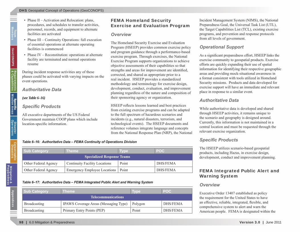
DHS Geospatial Concept of Operations (GeoCONOPS)
98 | 6.0 Mitigation & Preparedness Version 3.0 | June 2011
Team
Mem
bersG
eoCO
NO
PSRequirem
ents &
Capabilities
M
ission Areas
Disaster
Operations
CatastrophicD
isastersM
itigation &
PreparednessA
ppendices
Authoritative Data
(see Table 6–16)
Speci c Products
FEMA Homeland Security Exercise and Evaluation Program
Overview
Operational Support
Authoritative Data
Speci c Products
FEMA Integrated Public Alert and Warning System
OverviewTable 6–17: Authoritative Data – FEMA Integrated Public Alert and Warning System
Sub Category Theme Type POCTelecommunications
Table 6–16: Authoritative Data – FEMA Continuity of Operations Division
Sub Category Theme Type POCSpecialized Response Teams
Mitigation &
Preparedness
DHS Geospatial Concept of Operations (GeoCONOPS)
June 2011 | Version 3.0 6.0 Mitigation & Preparedness | 99
Team
M
embe
rsG
eoC
ON
OPS
Requ
irem
ents
&
Cap
abili
ties
M
issi
on A
reas
Dis
aste
r O
pera
tion
sC
atas
trop
hic
Dis
aste
rsM
itig
atio
n &
Pr
epar
edne
ssA
ppen
dice
s
Department of Homeland Security to implement
Operational Support
Authoritative Data
(see Table 6–17)
Speci c Products
FEMA Logistics Management Directorate
Overview
Logistics Operations -
Logistics Plans and Exercises -
Distribution Management -
Property Management -
Operational Support
Mit
igat
ion
&
Prep
ared
ness
DHS Geospatial Concept of Operations (GeoCONOPS)
100 | 6.0 Mitigation & Preparedness Version 3.0 | June 2011
Team
Mem
bersG
eoCO
NO
PSRequirem
ents &
Capabilities
M
ission Areas
Disaster
Operations
CatastrophicD
isastersM
itigation &
PreparednessA
ppendices
Authoritative Data
(see Table 6–18)
Speci c Products
FEMA National Exercise Division
Overview
Operational Support
Authoritative Data
Speci c Products
FEMA Public Affairs
Overview
Operational Support
Table 6–18: Authoritative Data – FEMA Logistics Management Directorate
Sub Category Theme Type POCField Operation Locations
Government Facilities
Mitigation &
Preparedness
DHS Geospatial Concept of Operations (GeoCONOPS)
June 2011 | Version 3.0 6.0 Mitigation & Preparedness | 101
Team
M
embe
rsG
eoC
ON
OPS
Requ
irem
ents
&
Cap
abili
ties
M
issi
on A
reas
Dis
aste
r O
pera
tion
sC
atas
trop
hic
Dis
aste
rsM
itig
atio
n &
Pr
epar
edne
ssA
ppen
dice
s
Authoritative Data
(see Table 6–19)
Speci c Products
FEMA Radiological Emergency Preparedness Program
Overview
Operational Support
Authoritative Data
(see Table 6–20)
Speci c Products
Table 6–19: Authoritative Data – FEMA Public Affairs
Sub Category Theme Type POCEvent Damage
Table 6–20: Authoritative Data – FEMA Radiological Emergency Preparedness Program
Sub Category Theme Type POCEvent Impact
Man-Made Hazards
Mit
igat
ion
&
Prep
ared
ness

DHS Geospatial Concept of Operations (GeoCONOPS)
102 | 6.0 Mitigation & Preparedness Version 3.0 | June 2011
Team
Mem
bersG
eoCO
NO
PSRequirem
ents &
Capabilities
M
ission Areas
Disaster
Operations
CatastrophicD
isastersM
itigation &
PreparednessA
ppendices
This page intentionally left blank.
Mitigation &
Preparedness
DHS Geospatial Concept of Operations (GeoCONOPS)
June 2011 | Version 3.0 | 103
Team
M
embe
rsG
eoC
ON
OPS
Requ
irem
ents
&
Cap
abili
ties
M
issi
on A
reas
Dis
aste
r O
pera
tion
sC
atas
trop
hic
Dis
aste
rsM
itig
atio
n &
Pr
epar
edne
ssA
ppen
dice
s
APPENDIX A: MISSION ENGINEERING METHODOLOGY OVERVIEW
App
endi
ces
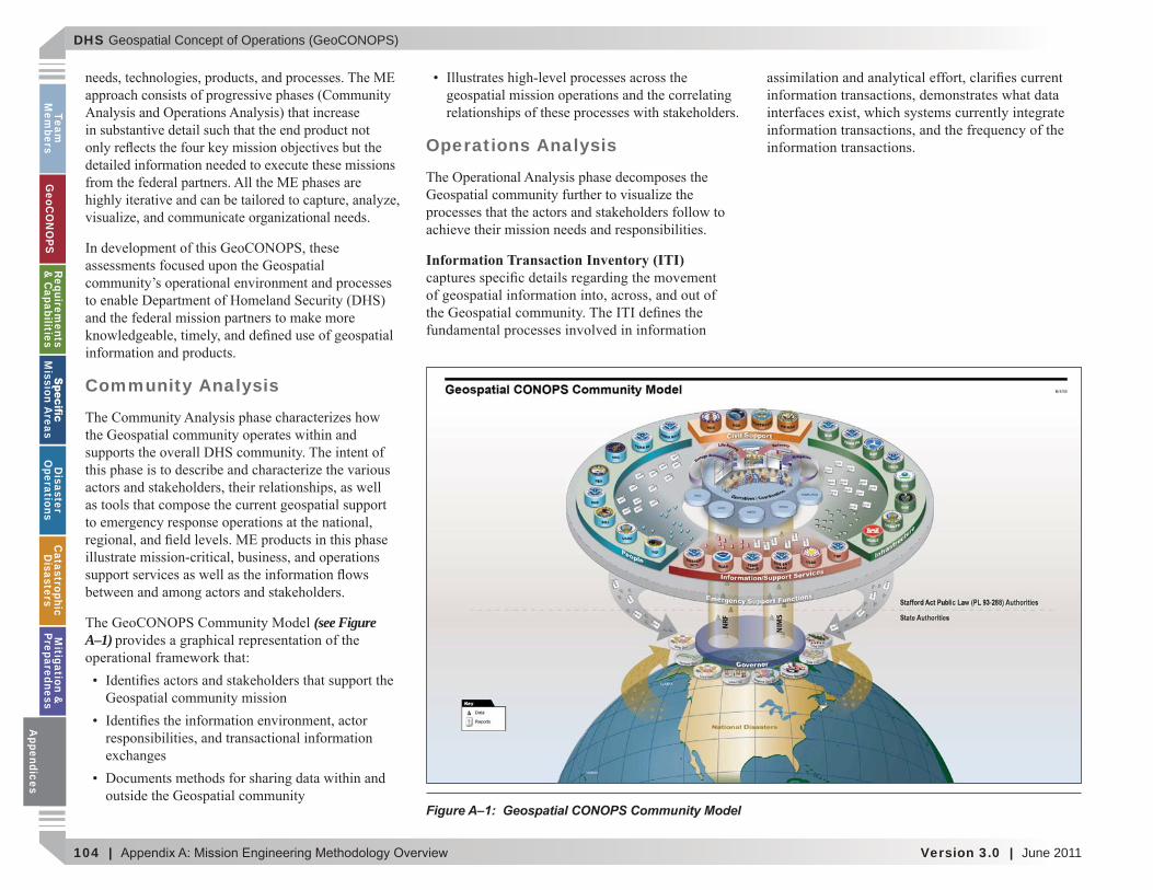
DHS Geospatial Concept of Operations (GeoCONOPS)
104 | Version 3.0 | June 2011
Team
Mem
bersG
eoCO
NO
PSRequirem
ents &
Capabilities
M
ission Areas
Disaster
Operations
CatastrophicD
isastersM
itigation &
PreparednessA
ppendices
Community Analysis
(see Figure A–1)
Operations Analysis
Information Transaction Inventory (ITI)
Figure A–1: Geospatial CONOPS Community Model
Appendices
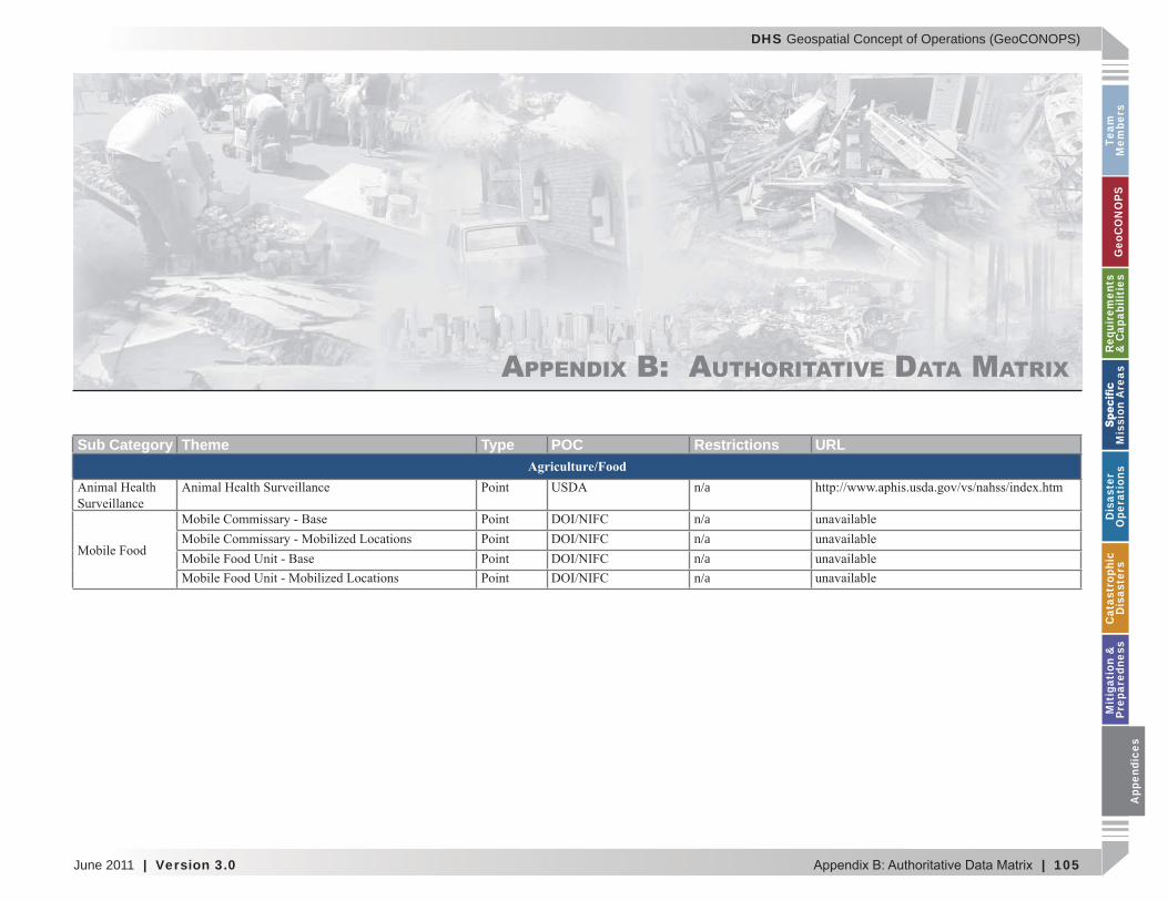
DHS Geospatial Concept of Operations (GeoCONOPS)
June 2011 | Version 3.0 | 105
Team
M
embe
rsG
eoC
ON
OPS
Requ
irem
ents
&
Cap
abili
ties
M
issi
on A
reas
Dis
aste
r O
pera
tion
sC
atas
trop
hic
Dis
aste
rsM
itig
atio
n &
Pr
epar
edne
ssA
ppen
dice
s
APPENDIX B: AUTHORITATIVE DATA MATRIX
Sub Category Theme Type POC Restrictions URLAgriculture/Food
n/a
n/an/an/an/a
App
endi
ces
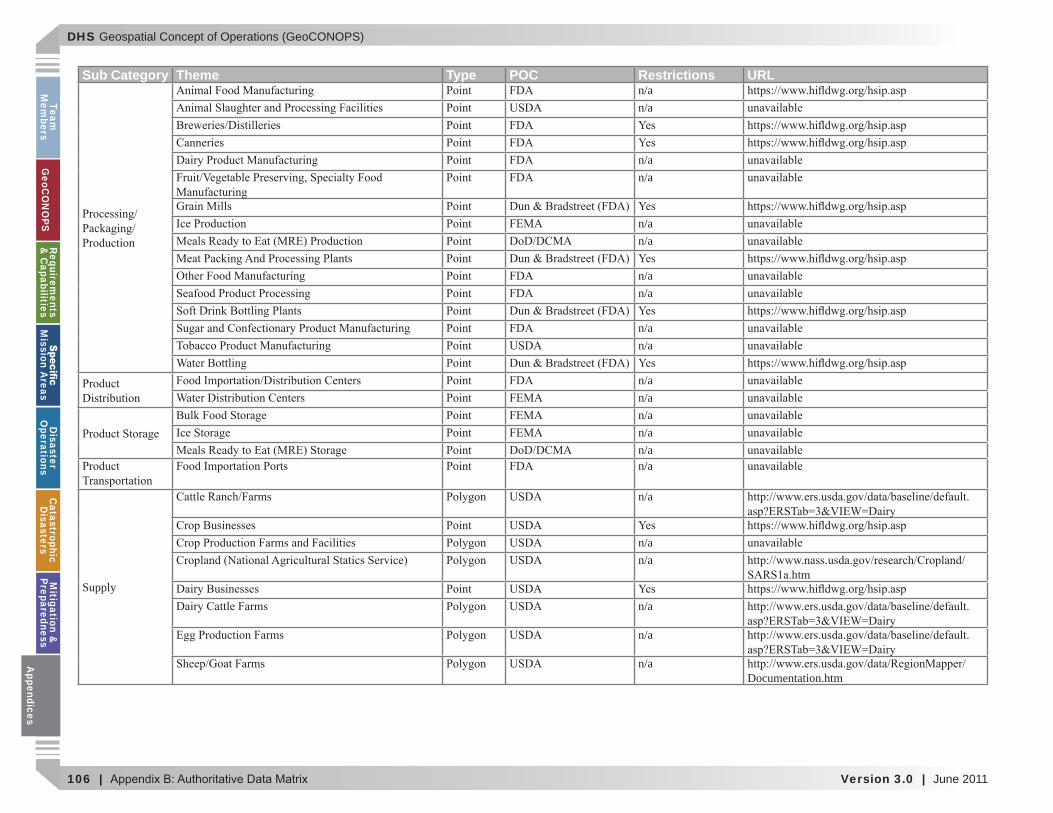
DHS Geospatial Concept of Operations (GeoCONOPS)
106 | Version 3.0 | June 2011
Team
Mem
bersG
eoCO
NO
PSRequirem
ents &
Capabilities
M
ission Areas
Disaster
Operations
CatastrophicD
isastersM
itigation &
PreparednessA
ppendices
Sub Category Theme Type POC Restrictions URLn/an/a
n/an/a
n/an/a
n/an/a
n/an/a
n/an/an/an/an/an/a
Supply
n/a
n/an/a
n/a
n/a
n/aDocumentation.htm
Appendices
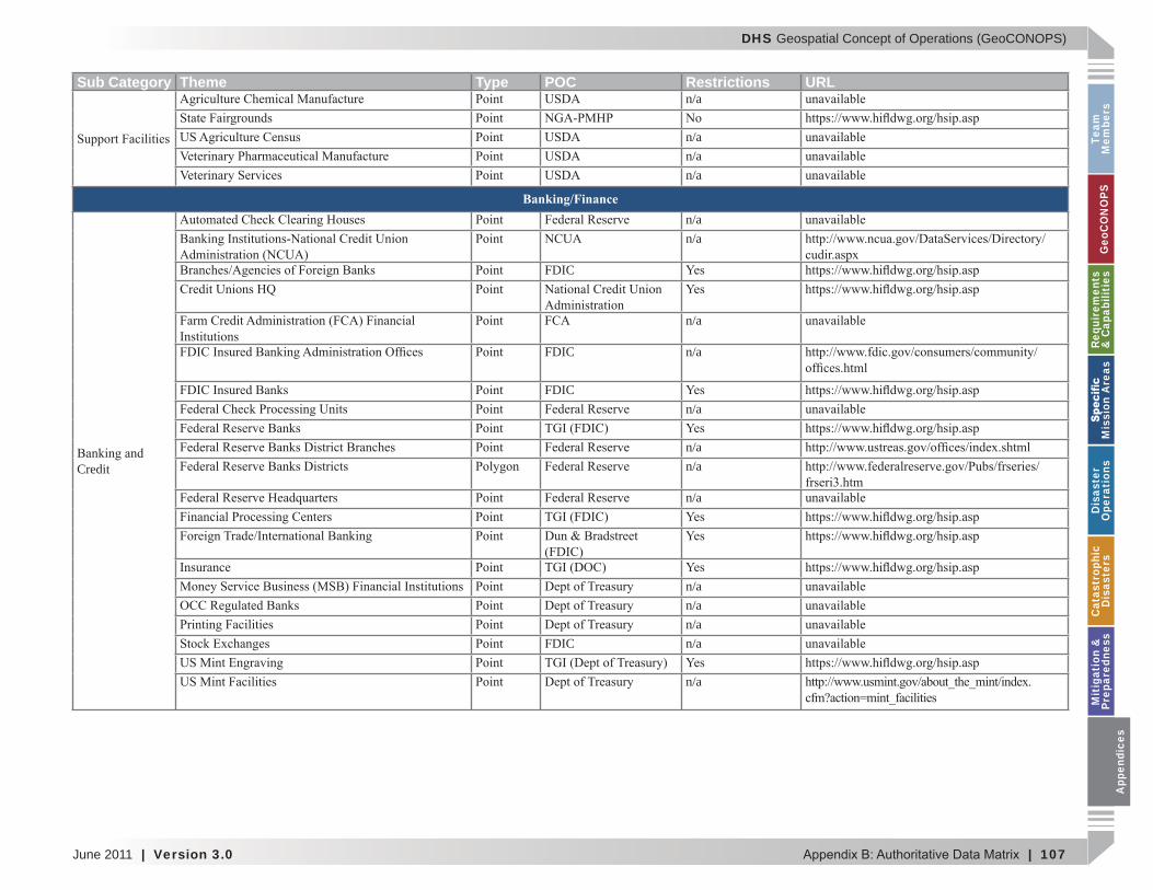
DHS Geospatial Concept of Operations (GeoCONOPS)
June 2011 | Version 3.0 | 107
Team
M
embe
rsG
eoC
ON
OPS
Requ
irem
ents
&
Cap
abili
ties
M
issi
on A
reas
Dis
aste
r O
pera
tion
sC
atas
trop
hic
Dis
aste
rsM
itig
atio
n &
Pr
epar
edne
ssA
ppen
dice
s
Sub Category Theme Type POC Restrictions URLn/a
n/an/an/a
Banking/Finance
Credit
n/an/a
FDIC
n/a
FDIC n/a
FDICn/a
n/an/a
n/a
n/an/an/a
FDIC n/a
n/a
App
endi
ces

DHS Geospatial Concept of Operations (GeoCONOPS)
108 | Version 3.0 | June 2011
Team
Mem
bersG
eoCO
NO
PSRequirem
ents &
Capabilities
M
ission Areas
Disaster
Operations
CatastrophicD
isastersM
itigation &
PreparednessA
ppendices
Sub Category Theme Type POC Restrictions URL
Financial n/an/an/an/a
Base Map
n/an/a
Water
n/an/a
n/a
n/a
n/a
Appendices
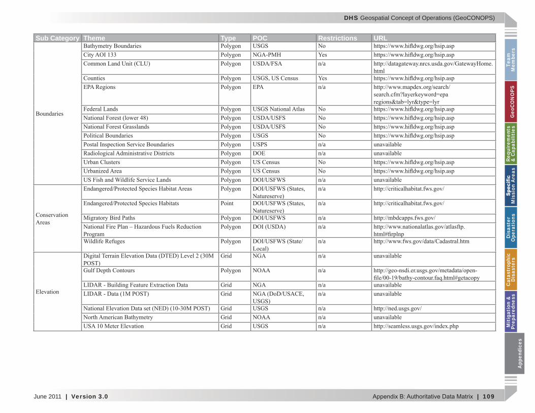
DHS Geospatial Concept of Operations (GeoCONOPS)
June 2011 | Version 3.0 | 109
Team
M
embe
rsG
eoC
ON
OPS
Requ
irem
ents
&
Cap
abili
ties
M
issi
on A
reas
Dis
aste
r O
pera
tion
sC
atas
trop
hic
Dis
aste
rsM
itig
atio
n &
Pr
epar
edne
ssA
ppen
dice
s
Sub Category Theme Type POC Restrictions URL
n/ahtml
n/a
n/an/a
n/an/a
n/a
n/an/a
n/a
n/a
n/a
n/an/a
n/an/an/a
App
endi
ces
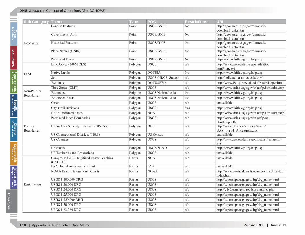
DHS Geospatial Concept of Operations (GeoCONOPS)
110 | Version 3.0 | June 2011
Team
Mem
bersG
eoCO
NO
PSRequirem
ents &
Capabilities
M
ission Areas
Disaster
Operations
CatastrophicD
isastersM
itigation &
PreparednessA
ppendices
Sub Category Theme Type POC Restrictions URL
n/a
Soil n/an/an/a
n/a
n/an/a
DHS n/a
n/an/a
n/an/a
n/an/a
n/an/an/an/an/an/an/a
Appendices
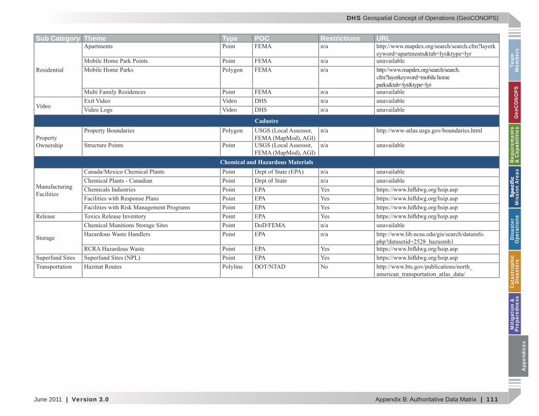
DHS Geospatial Concept of Operations (GeoCONOPS)
June 2011 | Version 3.0 | 111
Team
M
embe
rsG
eoC
ON
OPS
Requ
irem
ents
&
Cap
abili
ties
M
issi
on A
reas
Dis
aste
r O
pera
tion
sC
atas
trop
hic
Dis
aste
rsM
itig
atio
n &
Pr
epar
edne
ssA
ppen
dice
s
Sub Category Theme Type POC Restrictions URLn/a
n/an/a
n/a
VideoVideo DHS n/aVideo DHS n/a
Cadastren/a
n/a
Chemical and Hazardous Materialsn/a
Dept of State n/a
n/an/a
App
endi
ces
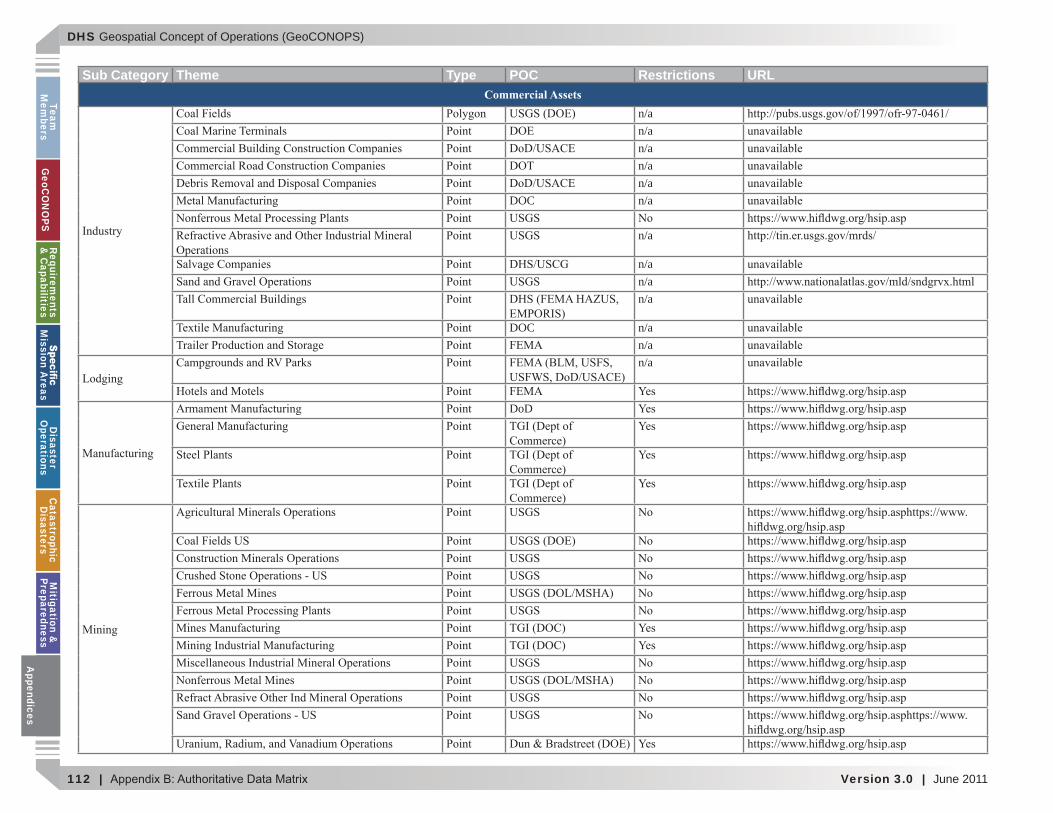
DHS Geospatial Concept of Operations (GeoCONOPS)
112 | Version 3.0 | June 2011
Team
Mem
bersG
eoCO
NO
PSRequirem
ents &
Capabilities
M
ission Areas
Disaster
Operations
CatastrophicD
isastersM
itigation &
PreparednessA
ppendices
Sub Category Theme Type POC Restrictions URLCommercial Assets
n/an/an/an/an/a
DOC n/a
n/a
n/an/an/a
DOC n/an/an/a
DoD
Appendices
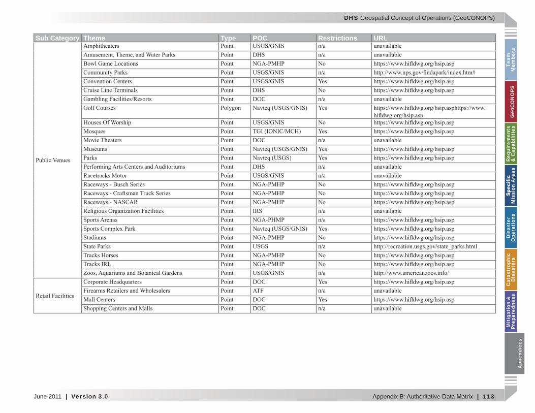
DHS Geospatial Concept of Operations (GeoCONOPS)
June 2011 | Version 3.0 | 113
Team
M
embe
rsG
eoC
ON
OPS
Requ
irem
ents
&
Cap
abili
ties
M
issi
on A
reas
Dis
aste
r O
pera
tion
sC
atas
trop
hic
Dis
aste
rsM
itig
atio
n &
Pr
epar
edne
ssA
ppen
dice
s
Sub Category Theme Type POC Restrictions URLn/a
DHS n/a
n/a
DHSDOC n/a
DOC n/a
DHS n/an/a
n/an/a
n/a
n/aDOC
n/aDOCDOC n/a
App
endi
ces
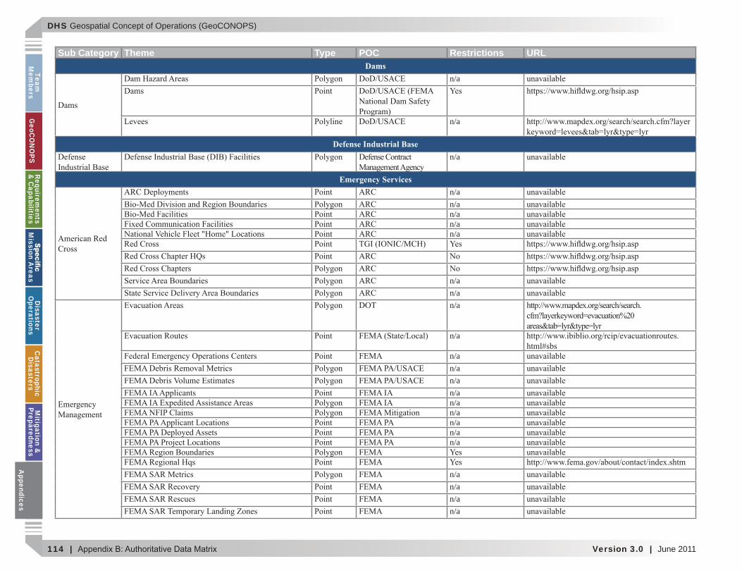
DHS Geospatial Concept of Operations (GeoCONOPS)
114 | Version 3.0 | June 2011
Team
Mem
bersG
eoCO
NO
PSRequirem
ents &
Capabilities
M
ission Areas
Disaster
Operations
CatastrophicD
isastersM
itigation &
PreparednessA
ppendices
Sub Category Theme Type POC Restrictions URLDams
n/a
n/a
Defense Industrial Basen/a
Emergency Servicesn/an/an/an/an/a
n/an/an/a
n/a
n/an/an/an/an/an/an/an/an/a
n/an/an/an/a
Appendices
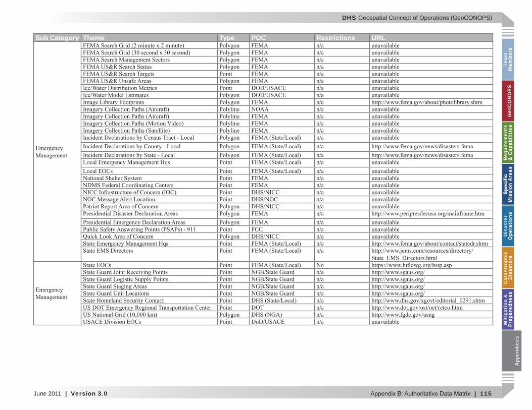
DHS Geospatial Concept of Operations (GeoCONOPS)
June 2011 | Version 3.0 | 115
Team
M
embe
rsG
eoC
ON
OPS
Requ
irem
ents
&
Cap
abili
ties
M
issi
on A
reas
Dis
aste
r O
pera
tion
sC
atas
trop
hic
Dis
aste
rsM
itig
atio
n &
Pr
epar
edne
ssA
ppen
dice
s
Sub Category Theme Type POC Restrictions URLn/an/an/an/an/an/an/an/an/an/an/an/an/an/an/an/an/an/an/an/an/an/an/an/an/a
FCC n/an/an/an/a
n/an/an/an/a
State Homeland Security Contact n/an/an/an/a
App
endi
ces
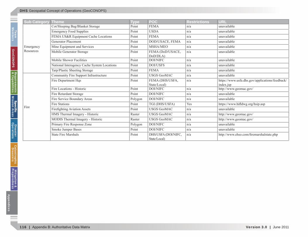
DHS Geospatial Concept of Operations (GeoCONOPS)
116 | Version 3.0 | June 2011
Team
Mem
bersG
eoCO
NO
PSRequirem
ents &
Capabilities
M
ission Areas
Disaster
Operations
CatastrophicD
isastersM
itigation &
PreparednessA
ppendices
Sub Category Theme Type POC Restrictions URLn/an/an/an/an/an/a
n/an/an/a
Fire
n/an/a
n/an/an/a
n/an/an/an/an/an/a
Appendices
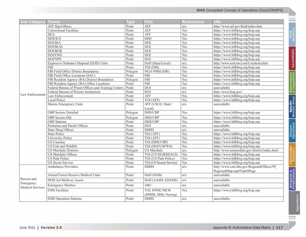
DHS Geospatial Concept of Operations (GeoCONOPS)
June 2011 | Version 3.0 | 117
Team
M
embe
rsG
eoC
ON
OPS
Requ
irem
ents
&
Cap
abili
ties
M
issi
on A
reas
Dis
aste
r O
pera
tion
sC
atas
trop
hic
Dis
aste
rsM
itig
atio
n &
Pr
epar
edne
ssA
ppen
dice
s
Sub Category Theme Type POC Restrictions URLn/a
DHSDOIDOIDOI
DOI/FWS DOIDOI
n/a
DOJ n/aDOJ n/a
n/a
DOJ n/aDHHS n/a
n/a
DHHS n/a
n/an/an/a
DHHS n/a
App
endi
ces

DHS Geospatial Concept of Operations (GeoCONOPS)
118 | Version 3.0 | June 2011
Team
Mem
bersG
eoCO
NO
PSRequirem
ents &
Capabilities
M
ission Areas
Disaster
Operations
CatastrophicD
isastersM
itigation &
PreparednessA
ppendices
Sub Category Theme Type POC Restrictions URLEnergy
n/a
n/a
n/an/a
n/a
n/an/an/a
Appendices

DHS Geospatial Concept of Operations (GeoCONOPS)
June 2011 | Version 3.0 | 119
Team
M
embe
rsG
eoC
ON
OPS
Requ
irem
ents
&
Cap
abili
ties
M
issi
on A
reas
Dis
aste
r O
pera
tion
sC
atas
trop
hic
Dis
aste
rsM
itig
atio
n &
Pr
epar
edne
ssA
ppen
dice
s
Sub Category Theme Type POC Restrictions URLn/an/an/a
n/a
n/a
n/an/an/an/a
n/a
n/a
n/a
n/a
App
endi
ces
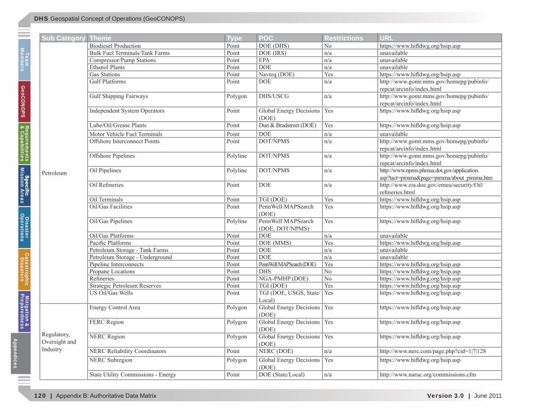
DHS Geospatial Concept of Operations (GeoCONOPS)
120 | Version 3.0 | June 2011
Team
Mem
bersG
eoCO
NO
PSRequirem
ents &
Capabilities
M
ission Areas
Disaster
Operations
CatastrophicD
isastersM
itigation &
PreparednessA
ppendices
Sub Category Theme Type POC Restrictions URL
n/an/an/a
n/a
n/a
n/an/a
n/a
n/a
n/a
n/a
n/an/a
DHS
n/a
n/a
Appendices
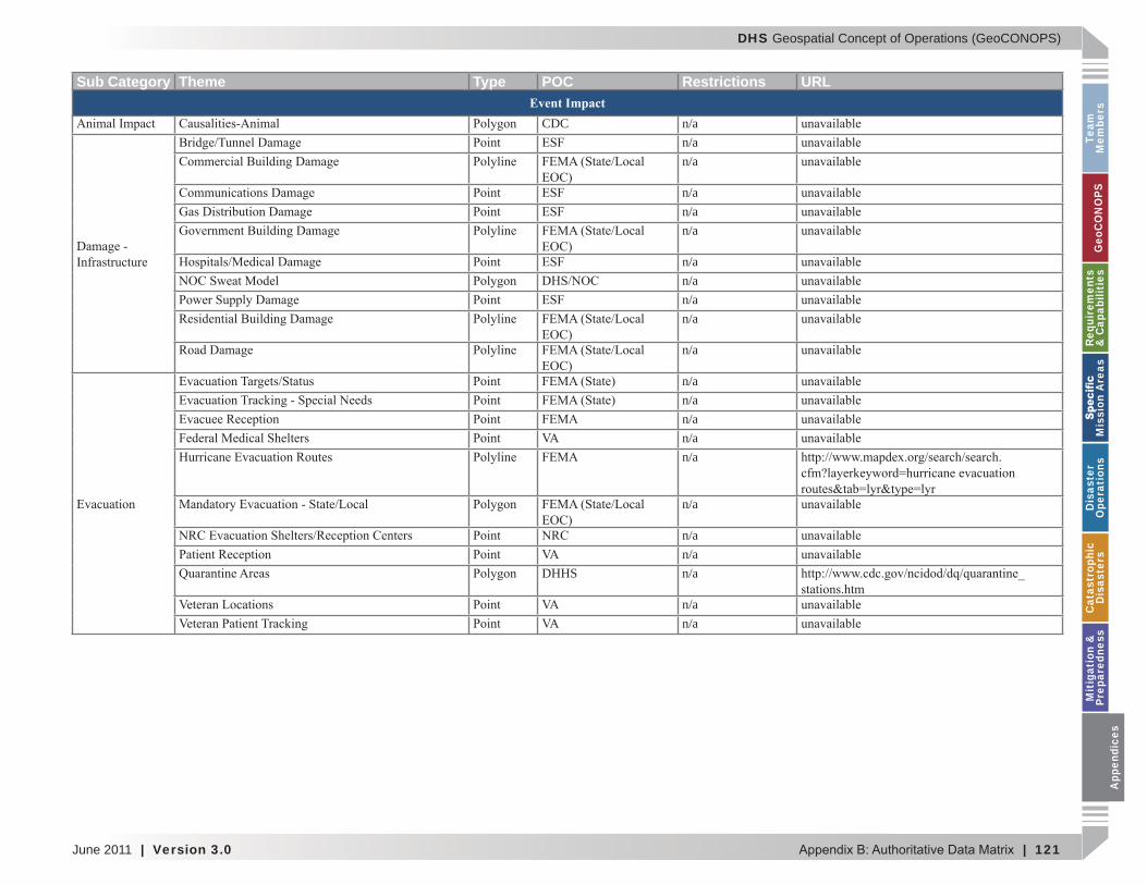
DHS Geospatial Concept of Operations (GeoCONOPS)
June 2011 | Version 3.0 | 121
Team
M
embe
rsG
eoC
ON
OPS
Requ
irem
ents
&
Cap
abili
ties
M
issi
on A
reas
Dis
aste
r O
pera
tion
sC
atas
trop
hic
Dis
aste
rsM
itig
atio
n &
Pr
epar
edne
ssA
ppen
dice
s
Sub Category Theme Type POC Restrictions URLEvent Impact
CDC n/an/an/a
n/an/an/a
n/an/an/an/a
n/a
n/an/an/an/an/a
n/a
n/an/a
DHHS n/a
n/an/a
App
endi
ces
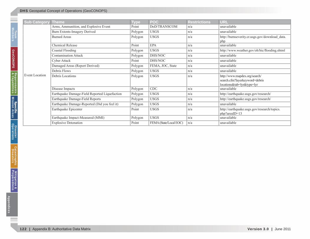
DHS Geospatial Concept of Operations (GeoCONOPS)
122 | Version 3.0 | June 2011
Team
Mem
bersG
eoCO
NO
PSRequirem
ents &
Capabilities
M
ission Areas
Disaster
Operations
CatastrophicD
isastersM
itigation &
PreparednessA
ppendices
Sub Category Theme Type POC Restrictions URLn/an/an/a
phpn/an/an/an/an/an/an/a
CDC n/an/an/an/an/a
n/an/a
Appendices
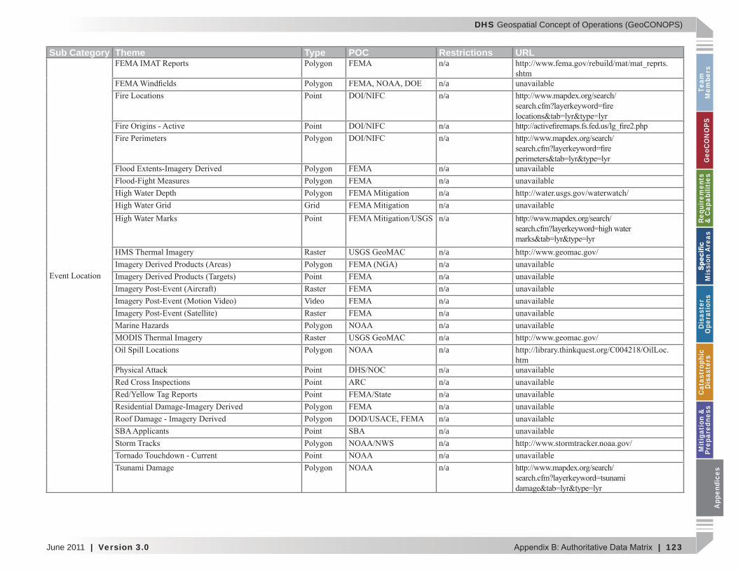
DHS Geospatial Concept of Operations (GeoCONOPS)
June 2011 | Version 3.0 | 123
Team
M
embe
rsG
eoC
ON
OPS
Requ
irem
ents
&
Cap
abili
ties
M
issi
on A
reas
Dis
aste
r O
pera
tion
sC
atas
trop
hic
Dis
aste
rsM
itig
atio
n &
Pr
epar
edne
ssA
ppen
dice
s
Sub Category Theme Type POC Restrictions URLn/a
n/an/a
n/an/a
n/an/an/an/an/a
n/an/an/an/a
Video n/an/an/an/an/a
htmn/an/an/an/an/an/an/an/an/a
App
endi
ces
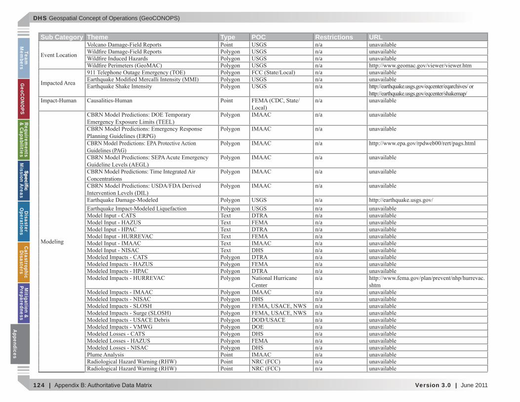
DHS Geospatial Concept of Operations (GeoCONOPS)
124 | Version 3.0 | June 2011
Team
Mem
bersG
eoCO
NO
PSRequirem
ents &
Capabilities
M
ission Areas
Disaster
Operations
CatastrophicD
isastersM
itigation &
PreparednessA
ppendices
Sub Category Theme Type POC Restrictions URLn/an/an/an/an/an/an/a
n/a
n/a
n/a
n/a
n/a
n/a
n/a
n/an/an/an/an/an/an/a
DHS n/an/an/an/a
Centern/a
n/aDHS n/a
n/an/an/an/a
DHS n/an/a
DHS n/an/an/an/a
Appendices
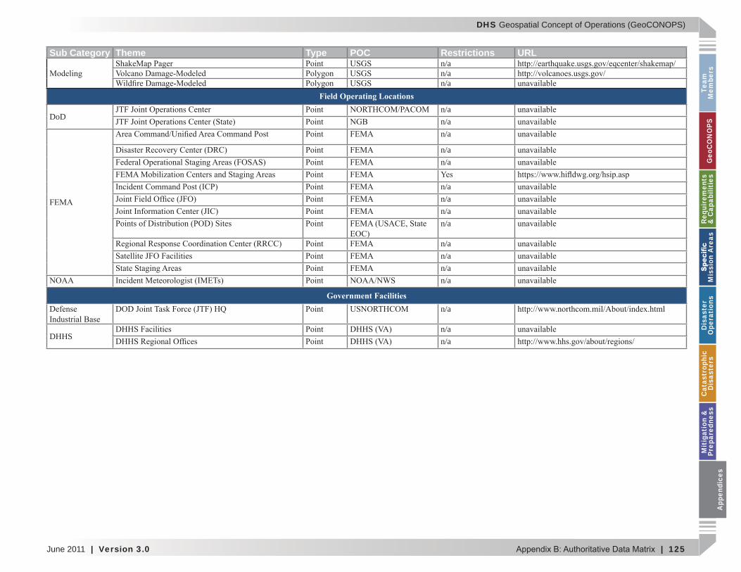
DHS Geospatial Concept of Operations (GeoCONOPS)
June 2011 | Version 3.0 | 125
Team
M
embe
rsG
eoC
ON
OPS
Requ
irem
ents
&
Cap
abili
ties
M
issi
on A
reas
Dis
aste
r O
pera
tion
sC
atas
trop
hic
Dis
aste
rsM
itig
atio
n &
Pr
epar
edne
ssA
ppen
dice
s
Sub Category Theme Type POC Restrictions URLn/an/an/a
Field Operating Locations
DoDn/an/an/a
n/an/a
n/an/an/an/a
n/an/an/an/a
Government Facilitiesn/a
DHHSn/an/a
App
endi
ces
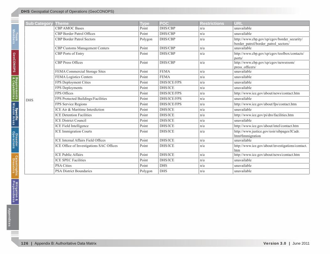
DHS Geospatial Concept of Operations (GeoCONOPS)
126 | Version 3.0 | June 2011
Team
Mem
bersG
eoCO
NO
PSRequirem
ents &
Capabilities
M
ission Areas
Disaster
Operations
CatastrophicD
isastersM
itigation &
PreparednessA
ppendices
Sub Category Theme Type POC Restrictions URL
DHS
n/an/an/a
n/an/a
n/a
n/an/an/an/an/an/an/an/an/an/an/an/a
n/an/a
htmn/an/a
DHS n/aDHS n/a
Appendices
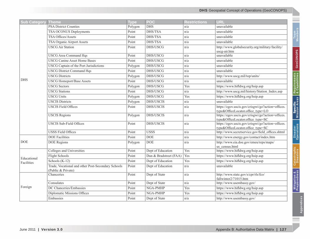
DHS Geospatial Concept of Operations (GeoCONOPS)
June 2011 | Version 3.0 | 127
Team
M
embe
rsG
eoC
ON
OPS
Requ
irem
ents
&
Cap
abili
ties
M
issi
on A
reas
Dis
aste
r O
pera
tion
sC
atas
trop
hic
Dis
aste
rsM
itig
atio
n &
Pr
epar
edne
ssA
ppen
dice
s
Sub Category Theme Type POC Restrictions URL
DHS
DHS n/an/an/an/an/a
n/an/an/an/an/an/a
n/a
n/an/a
n/a
n/a
n/an/an/a
n/a
Dept of State n/a
Dept of State n/a
Dept of State n/a
App
endi
ces
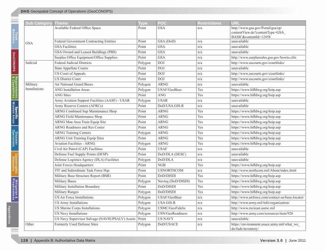
DHS Geospatial Concept of Operations (GeoCONOPS)
128 | Version 3.0 | June 2011
Team
Mem
bersG
eoCO
NO
PSRequirem
ents &
Capabilities
M
ission Areas
Disaster
Operations
CatastrophicD
isastersM
itigation &
PreparednessA
ppendices
Sub Category Theme Type POC Restrictions URLn/a
n/an/an/an/a
Judicial DOJ n/aDOJ n/aDOJ n/aDOJ n/a
Military n/a
n/an/a
n/an/an/a
n/aDoD/DISDI
DoD/DISDIDoD/DISDI
n/an/an/an/an/a
Other n/a
Appendices
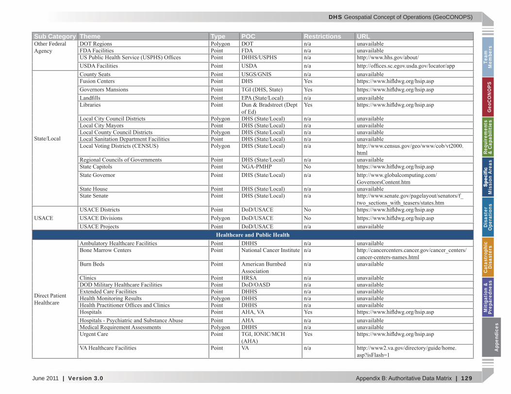
DHS Geospatial Concept of Operations (GeoCONOPS)
June 2011 | Version 3.0 | 129
Team
M
embe
rsG
eoC
ON
OPS
Requ
irem
ents
&
Cap
abili
ties
M
issi
on A
reas
Dis
aste
r O
pera
tion
sC
atas
trop
hic
Dis
aste
rsM
itig
atio
n &
Pr
epar
edne
ssA
ppen
dice
s
Sub Category Theme Type POC Restrictions URLOther Federal n/a
n/an/an/an/a
DHS
n/a
n/an/an/an/an/a
htmln/a
n/a
n/aState Senate n/a
n/aHealthcare and Public Health
Healthcare
DHHS n/an/a
n/a
n/an/a
DHHS n/aDHHS n/aDHHS n/a
n/aDHHS n/a
n/a App
endi
ces
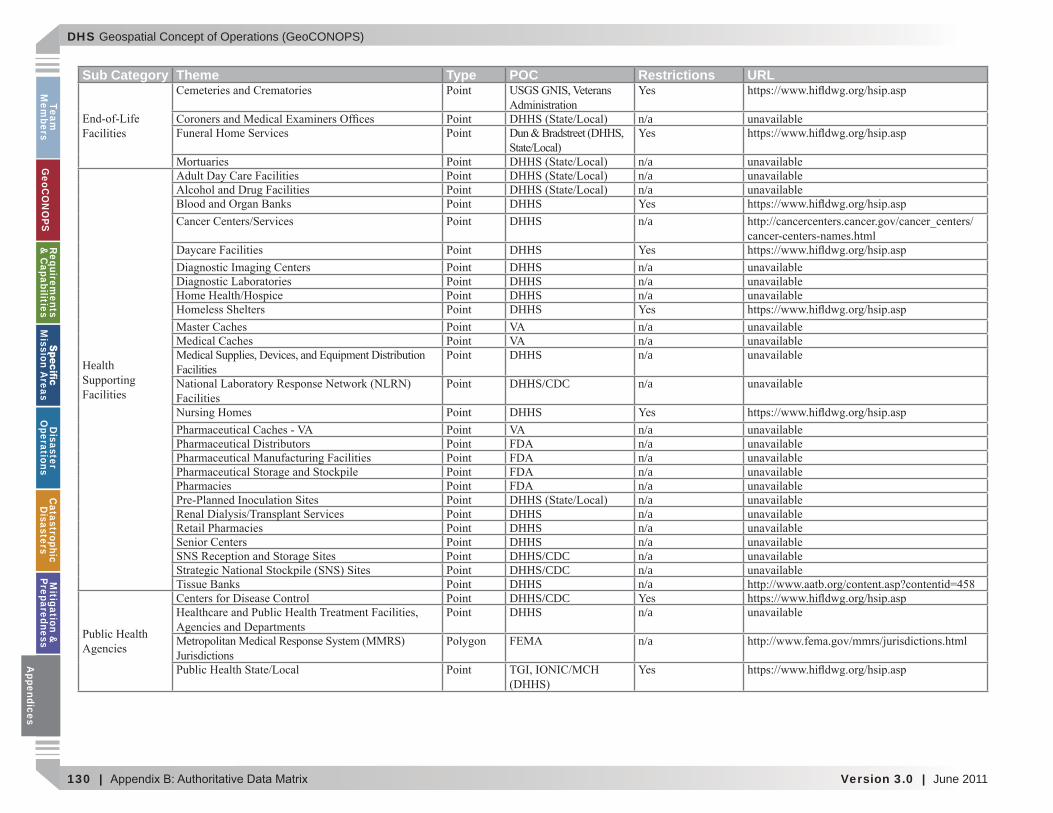
DHS Geospatial Concept of Operations (GeoCONOPS)
130 | Version 3.0 | June 2011
Team
Mem
bersG
eoCO
NO
PSRequirem
ents &
Capabilities
M
ission Areas
Disaster
Operations
CatastrophicD
isastersM
itigation &
PreparednessA
ppendices
Sub Category Theme Type POC Restrictions URL
n/a
n/a
Health
n/an/a
DHHSDHHS n/a
DHHSDHHS n/aDHHS n/aDHHS n/aDHHS
n/an/a
DHHS n/a
DHHS/CDC n/a
DHHSn/an/an/an/an/an/a
DHHS n/aDHHS n/aDHHS n/aDHHS/CDC n/aDHHS/CDC n/aDHHS n/aDHHS/CDCDHHS n/a
n/a
Appendices
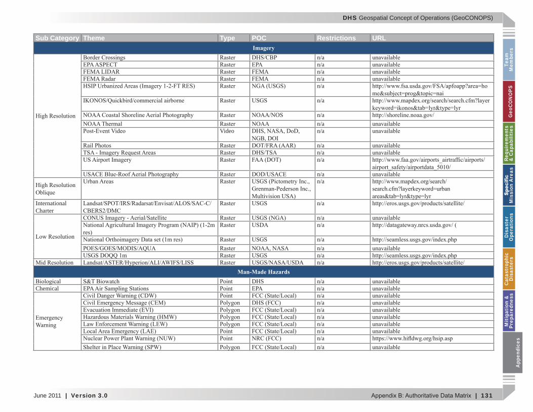
DHS Geospatial Concept of Operations (GeoCONOPS)
June 2011 | Version 3.0 | 131
Team
M
embe
rsG
eoC
ON
OPS
Requ
irem
ents
&
Cap
abili
ties
M
issi
on A
reas
Dis
aste
r O
pera
tion
sC
atas
trop
hic
Dis
aste
rsM
itig
atio
n &
Pr
epar
edne
ssA
ppen
dice
s
Sub Category Theme Type POC Restrictions URLImagery
n/an/an/an/an/a
n/a
n/an/a
Video n/a
n/an/an/a
n/an/a
International Charter
n/a
n/an/a
n/an/an/an/a
Man-Made HazardsDHS n/a
Chemical n/an/an/an/an/an/an/an/an/a
App
endi
ces
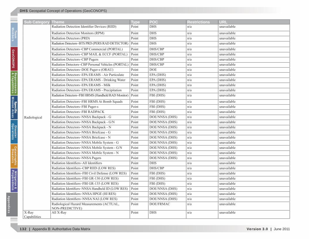
DHS Geospatial Concept of Operations (GeoCONOPS)
132 | Version 3.0 | June 2011
Team
Mem
bersG
eoCO
NO
PSRequirem
ents &
Capabilities
M
ission Areas
Disaster
Operations
CatastrophicD
isastersM
itigation &
PreparednessA
ppendices
Sub Category Theme Type POC Restrictions URLDHS n/a
DHS n/aDHS n/aDHS n/a
n/an/an/an/an/an/an/an/an/an/a
n/an/an/an/an/an/an/an/an/an/an/an/a
DHS n/an/an/an/an/an/an/an/an/a
DHS n/a
Appendices
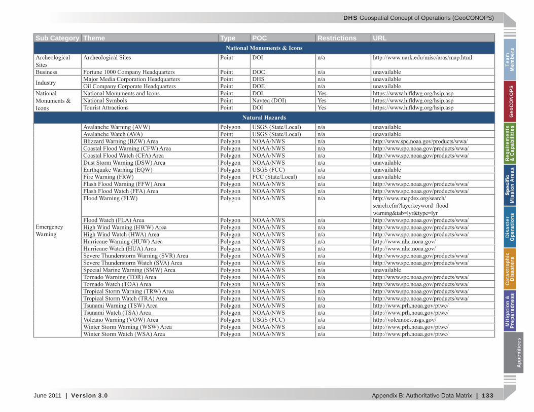
DHS Geospatial Concept of Operations (GeoCONOPS)
June 2011 | Version 3.0 | 133
Team
M
embe
rsG
eoC
ON
OPS
Requ
irem
ents
&
Cap
abili
ties
M
issi
on A
reas
Dis
aste
r O
pera
tion
sC
atas
trop
hic
Dis
aste
rsM
itig
atio
n &
Pr
epar
edne
ssA
ppen
dice
s
Sub Category Theme Type POC Restrictions URLNational Monuments & Icons
DOI n/a
DOC n/aDHS n/a
n/aDOI
DOI
Natural Hazardsn/an/an/an/an/an/an/an/an/an/an/a
n/an/an/an/an/an/an/an/an/an/an/an/an/an/an/an/an/a
App
endi
ces
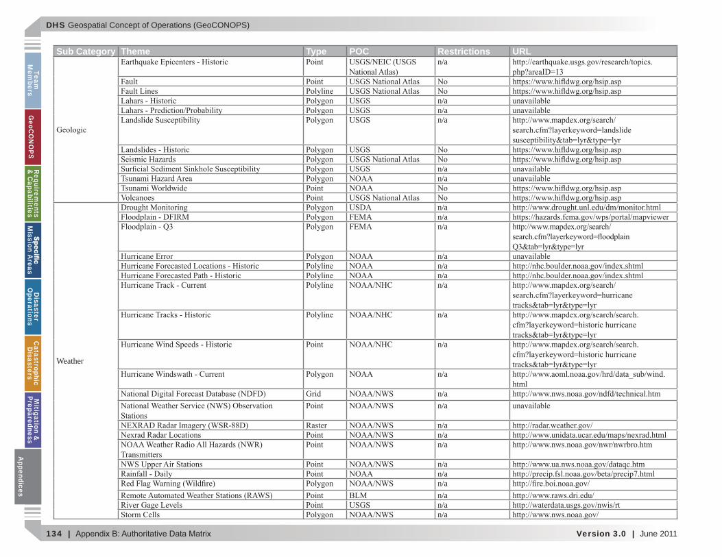
DHS Geospatial Concept of Operations (GeoCONOPS)
134 | Version 3.0 | June 2011
Team
Mem
bersG
eoCO
NO
PSRequirem
ents &
Capabilities
M
ission Areas
Disaster
Operations
CatastrophicD
isastersM
itigation &
PreparednessA
ppendices
Sub Category Theme Type POC Restrictions URLn/a
Fault
n/an/an/a
n/an/a
Weather
n/an/an/a
n/an/an/an/a
n/a
n/a
n/ahtml
n/an/a
n/an/an/a
n/an/an/an/an/an/a
Appendices
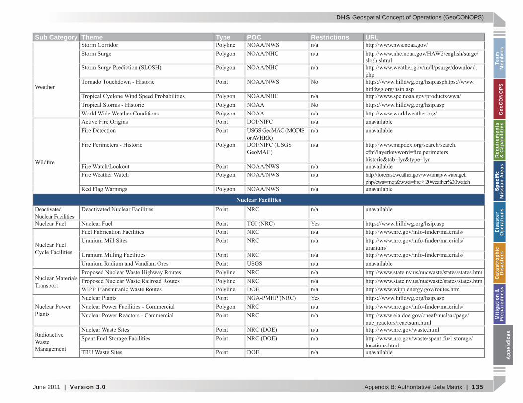
DHS Geospatial Concept of Operations (GeoCONOPS)
June 2011 | Version 3.0 | 135
Team
M
embe
rsG
eoC
ON
OPS
Requ
irem
ents
&
Cap
abili
ties
M
issi
on A
reas
Dis
aste
r O
pera
tion
sC
atas
trop
hic
Dis
aste
rsM
itig
atio
n &
Pr
epar
edne
ssA
ppen
dice
s
Sub Category Theme Type POC Restrictions URL
Weather
Storm Corridor n/an/a
n/aphp
n/a
n/an/a
Fire Detection n/a
n/a
n/aFire Weather Watch n/a
n/a
Nuclear Facilitiesn/a
n/an/a
uranium/n/an/an/an/an/a
n/an/a
n/an/a
n/a
App
endi
ces
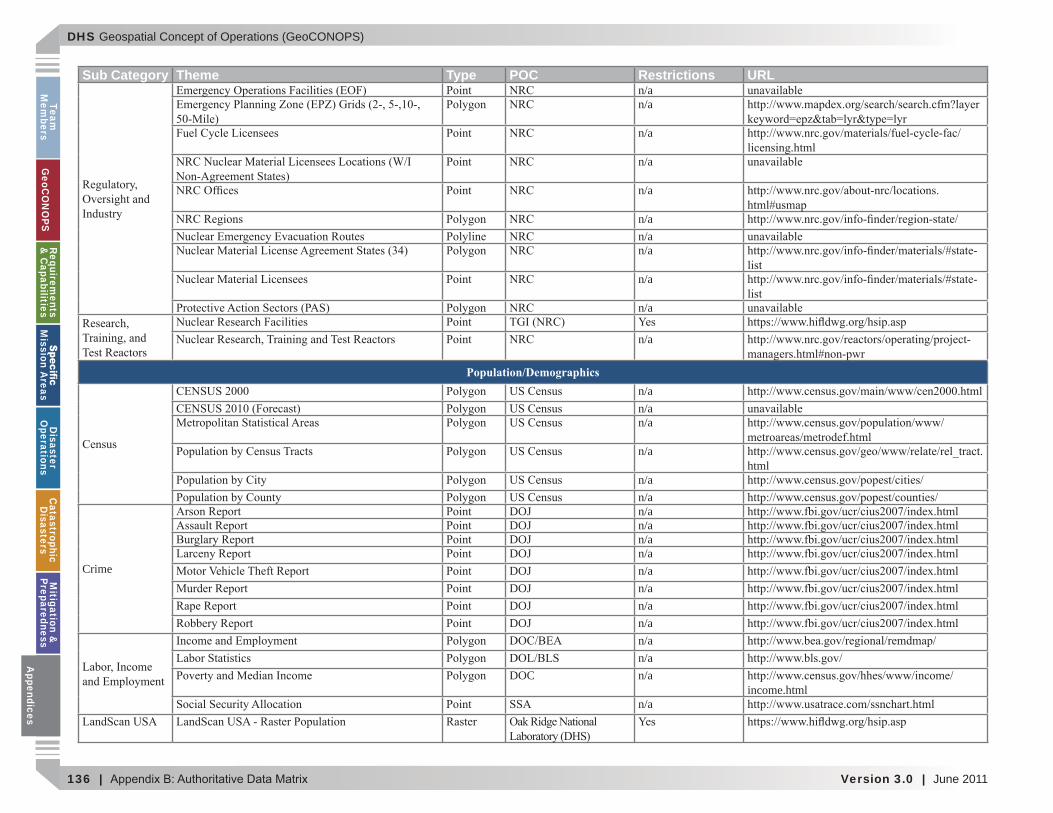
DHS Geospatial Concept of Operations (GeoCONOPS)
136 | Version 3.0 | June 2011
Team
Mem
bersG
eoCO
NO
PSRequirem
ents &
Capabilities
M
ission Areas
Disaster
Operations
CatastrophicD
isastersM
itigation &
PreparednessA
ppendices
Sub Category Theme Type POC Restrictions URLn/an/a
n/a
n/a
n/a
n/an/an/a
n/a
n/a
n/a
Population/Demographicsn/an/an/a
n/ahtml
n/an/a
Crime
DOJ n/aDOJ n/aDOJ n/aDOJ n/aDOJ n/aDOJ n/aDOJ n/aDOJ n/a
n/an/a
DOC n/aincome.html
n/a
Appendices
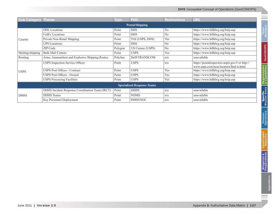
DHS Geospatial Concept of Operations (GeoCONOPS)
June 2011 | Version 3.0 | 137
Team
M
embe
rsG
eoC
ON
OPS
Requ
irem
ents
&
Cap
abili
ties
M
issi
on A
reas
Dis
aste
r O
pera
tion
sC
atas
trop
hic
Dis
aste
rsM
itig
atio
n &
Pr
epar
edne
ssA
ppen
dice
s
Sub Category Theme Type POC Restrictions URLPostal/Shipping
Courier
DHSDHS
DHS
n/a
n/a
Specialized Response Teams
DHHS
DHHS n/an/a
DHHS/SOC n/a
App
endi
ces
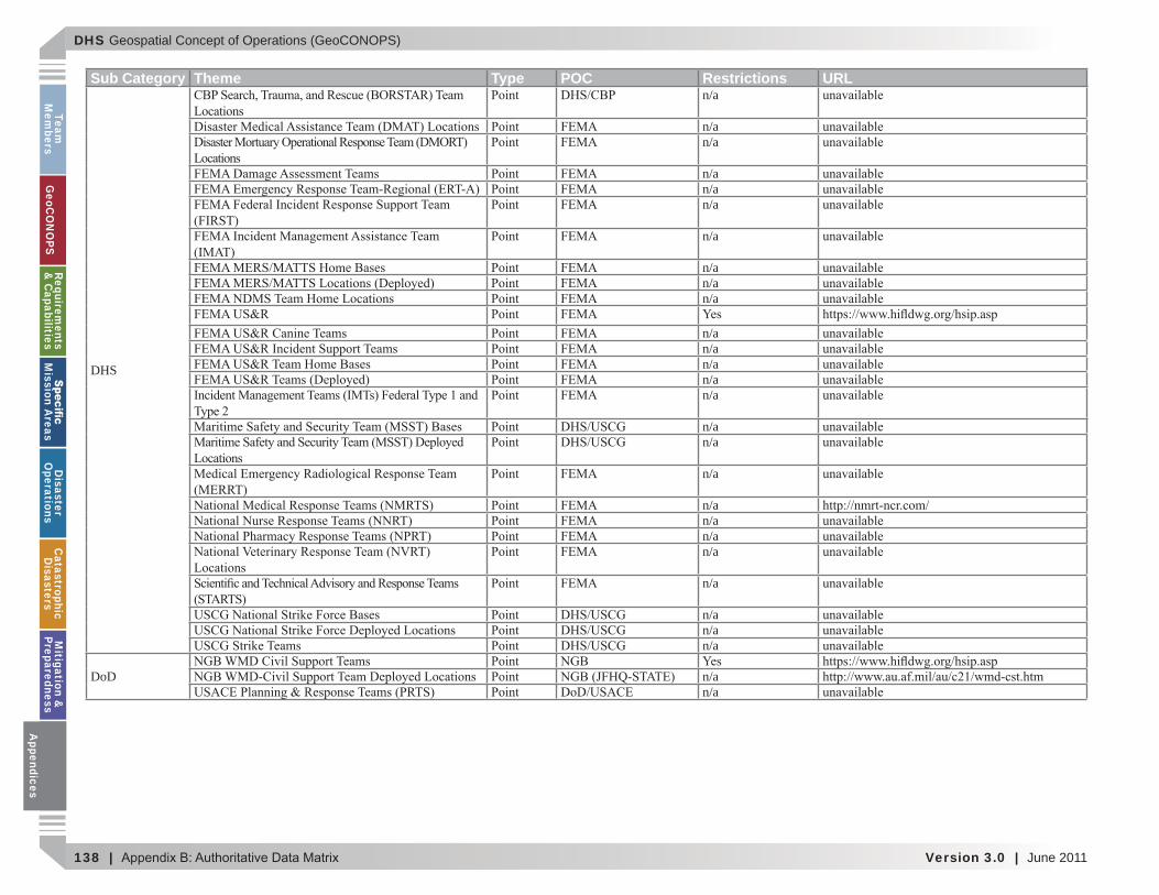
DHS Geospatial Concept of Operations (GeoCONOPS)
138 | Version 3.0 | June 2011
Team
Mem
bersG
eoCO
NO
PSRequirem
ents &
Capabilities
M
ission Areas
Disaster
Operations
CatastrophicD
isastersM
itigation &
PreparednessA
ppendices
Sub Category Theme Type POC Restrictions URL
DHS
n/a
n/an/a
n/an/an/a
n/a
n/an/an/a
n/an/an/an/an/a
n/an/a
n/a
n/an/an/an/a
n/a
n/an/an/a
DoD n/an/a
Appendices
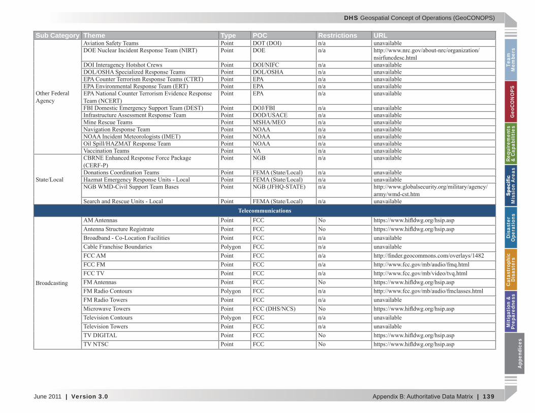
DHS Geospatial Concept of Operations (GeoCONOPS)
June 2011 | Version 3.0 | 139
Team
M
embe
rsG
eoC
ON
OPS
Requ
irem
ents
&
Cap
abili
ties
M
issi
on A
reas
Dis
aste
r O
pera
tion
sC
atas
trop
hic
Dis
aste
rsM
itig
atio
n &
Pr
epar
edne
ssA
ppen
dice
s
Sub Category Theme Type POC Restrictions URL
Other Federal
n/an/a
n/an/an/an/an/a
n/an/an/an/an/an/an/an/a
n/an/an/a
n/aTelecommunications
FCCFCCFCC n/aFCC n/aFCC n/a
FCC FM FCC n/aFCC n/aFCCFCC n/aFCC n/a
FCC n/aFCC n/aFCCFCC
App
endi
ces
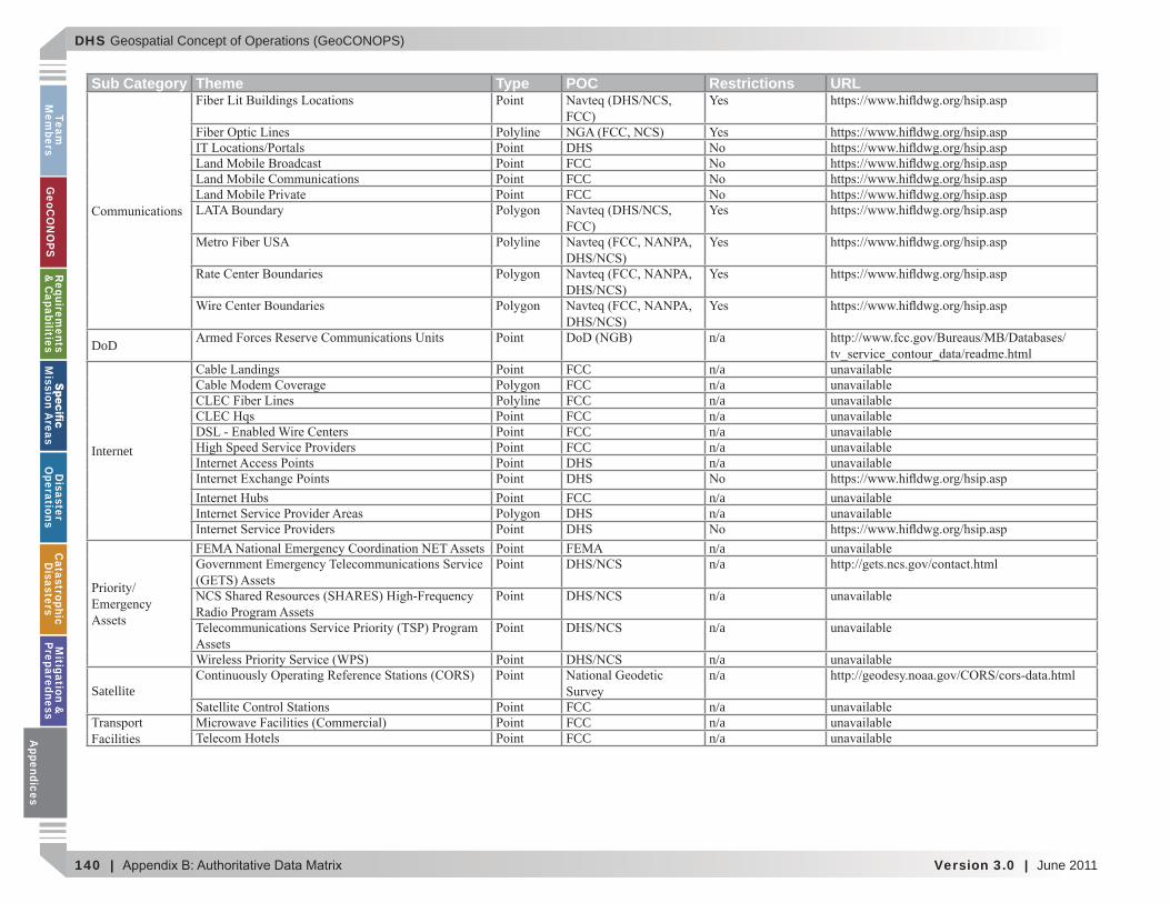
DHS Geospatial Concept of Operations (GeoCONOPS)
140 | Version 3.0 | June 2011
Team
Mem
bersG
eoCO
NO
PSRequirem
ents &
Capabilities
M
ission Areas
Disaster
Operations
CatastrophicD
isastersM
itigation &
PreparednessA
ppendices
Sub Category Theme Type POC Restrictions URL
DHSFCCFCCFCC
DoD n/a
Internet
FCC n/aFCC n/aFCC n/aFCC n/aFCC n/aFCC n/aDHS n/aDHSFCC n/aDHS n/aDHS
n/an/a
n/a
n/a
n/a
Satelliten/a
FCC n/aFCC n/aFCC n/aA
ppendices
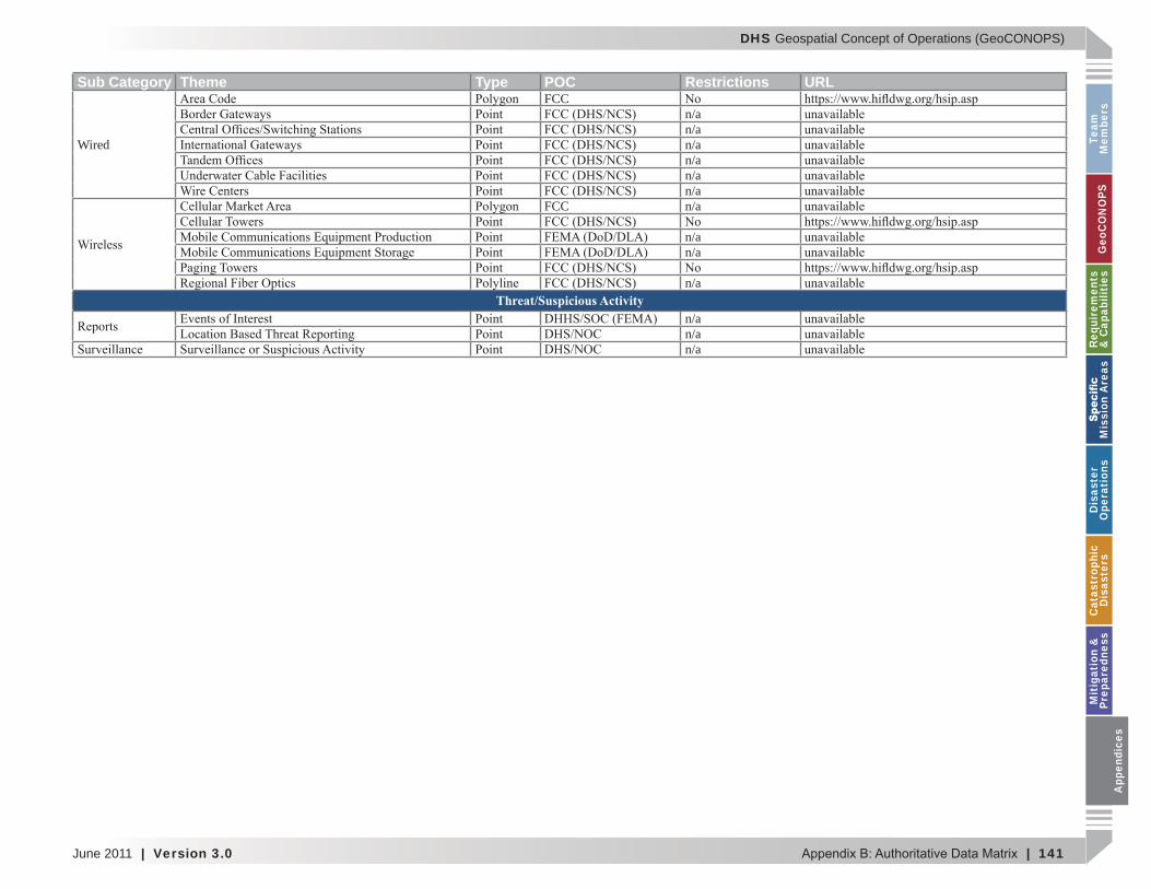
DHS Geospatial Concept of Operations (GeoCONOPS)
June 2011 | Version 3.0 | 141
Team
M
embe
rsG
eoC
ON
OPS
Requ
irem
ents
&
Cap
abili
ties
M
issi
on A
reas
Dis
aste
r O
pera
tion
sC
atas
trop
hic
Dis
aste
rsM
itig
atio
n &
Pr
epar
edne
ssA
ppen
dice
s
Sub Category Theme Type POC Restrictions URL
Wired
FCCn/an/an/an/an/an/a
FCC n/a
n/an/a
n/aThreat/Suspicious Activity
n/an/an/a
App
endi
ces
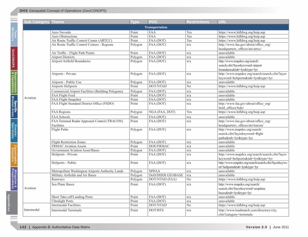
DHS Geospatial Concept of Operations (GeoCONOPS)
142 | Version 3.0 | June 2011
Team
Mem
bersG
eoCO
NO
PSRequirem
ents &
Capabilities
M
ission Areas
Disaster
Operations
CatastrophicD
isastersM
itigation &
PreparednessA
ppendices
Sub Category Theme Type POC Restrictions URLTransportation
n/a
n/an/an/a
n/a
n/a
n/an/an/an/a
n/an/a
n/a
n/an/an/an/a
n/a
n/an/a
n/a
n/an/a
Intermodal n/a
Appendices
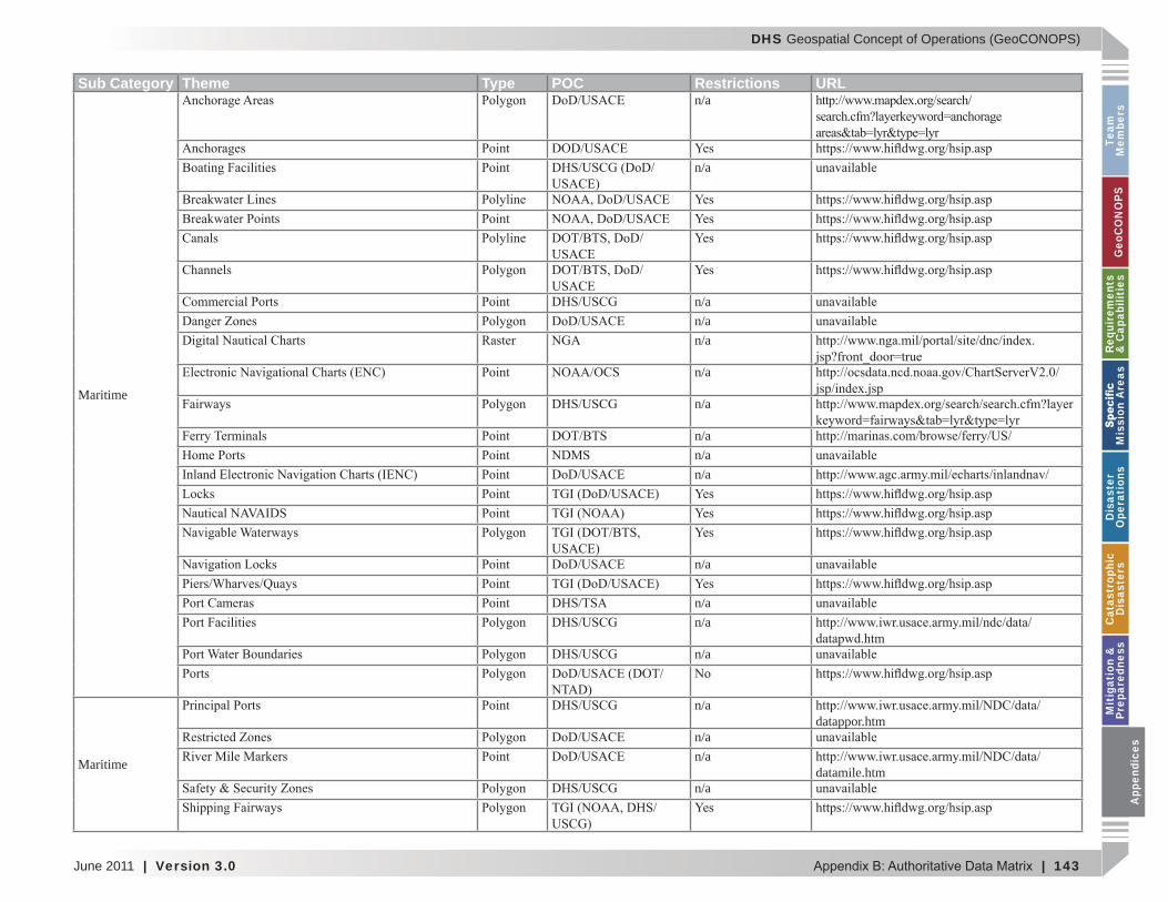
DHS Geospatial Concept of Operations (GeoCONOPS)
June 2011 | Version 3.0 | 143
Team
M
embe
rsG
eoC
ON
OPS
Requ
irem
ents
&
Cap
abili
ties
M
issi
on A
reas
Dis
aste
r O
pera
tion
sC
atas
trop
hic
Dis
aste
rsM
itig
atio
n &
Pr
epar
edne
ssA
ppen
dice
s
Sub Category Theme Type POC Restrictions URL
Maritime
n/a
n/a
n/an/an/a
n/a
n/a
n/an/an/a
n/a
n/an/a
n/a
Maritime
n/adatappor.htm
n/an/a
datamile.htmn/a
App
endi
ces
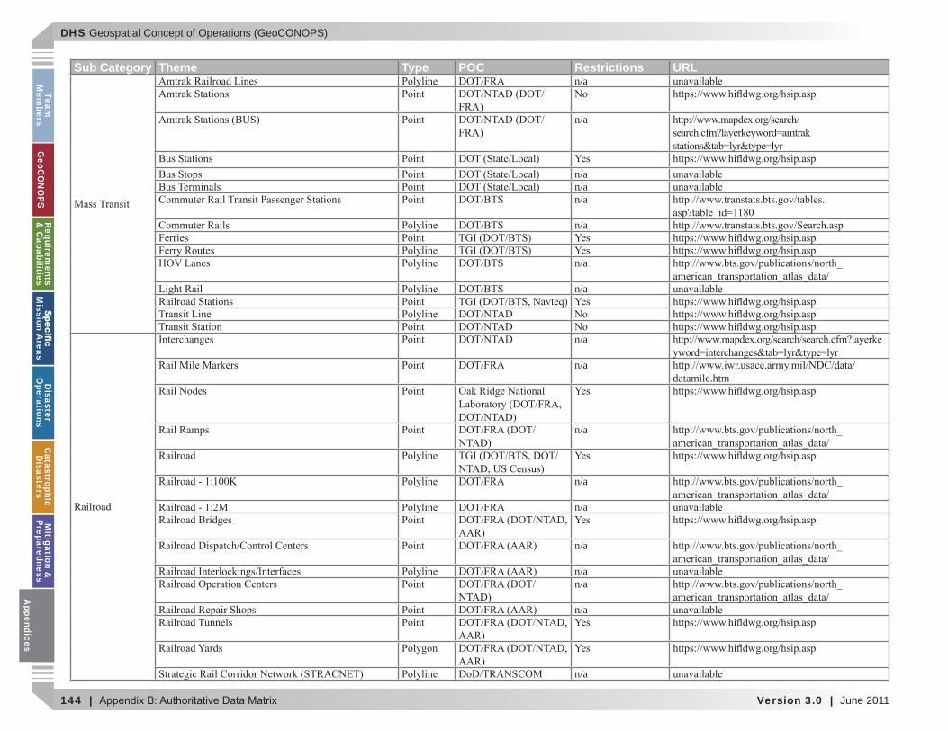
DHS Geospatial Concept of Operations (GeoCONOPS)
144 | Version 3.0 | June 2011
Team
Mem
bersG
eoCO
NO
PSRequirem
ents &
Capabilities
M
ission Areas
Disaster
Operations
CatastrophicD
isastersM
itigation &
PreparednessA
ppendices
Sub Category Theme Type POC Restrictions URLn/a
n/a
n/an/an/a
n/a
n/a
n/a
n/a
n/adatamile.htm
n/a
n/a
n/a
n/a
n/an/a
n/a
n/a
Appendices

DHS Geospatial Concept of Operations (GeoCONOPS)
June 2011 | Version 3.0 | 145
Team
M
embe
rsG
eoC
ON
OPS
Requ
irem
ents
&
Cap
abili
ties
M
issi
on A
reas
Dis
aste
r O
pera
tion
sC
atas
trop
hic
Dis
aste
rsM
itig
atio
n &
Pr
epar
edne
ssA
ppen
dice
s
Sub Category Theme Type POC Restrictions URLn/an/an/an/a
n/a
n/a
Video n/an/an/an/a
n/an/an/an/an/an/a
Watern/a
Supply
n/a
n/an/an/a
Surface Water n/an/an/an/an/a A
ppen
dice
s
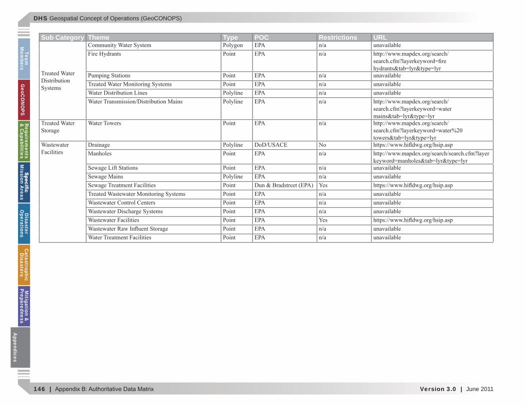
DHS Geospatial Concept of Operations (GeoCONOPS)
146 | Version 3.0 | June 2011
Team
Mem
bersG
eoCO
NO
PSRequirem
ents &
Capabilities
M
ission Areas
Disaster
Operations
CatastrophicD
isastersM
itigation &
PreparednessA
ppendices
Sub Category Theme Type POC Restrictions URLn/an/a
n/an/an/an/a
n/a
n/a
n/an/a
n/an/an/a
n/an/a
Appendices
DHS Geospatial Concept of Operations (GeoCONOPS)
June 2011 | Version 3.0 | 147
Team
M
embe
rsG
eoC
ON
OPS
Requ
irem
ents
&
Cap
abili
ties
M
issi
on A
reas
Dis
aste
r O
pera
tion
sC
atas
trop
hic
Dis
aste
rsM
itig
atio
n &
Pr
epar
edne
ssA
ppen
dice
s
APPENDIX C: CIVIL SUPPORT
App
endi
ces
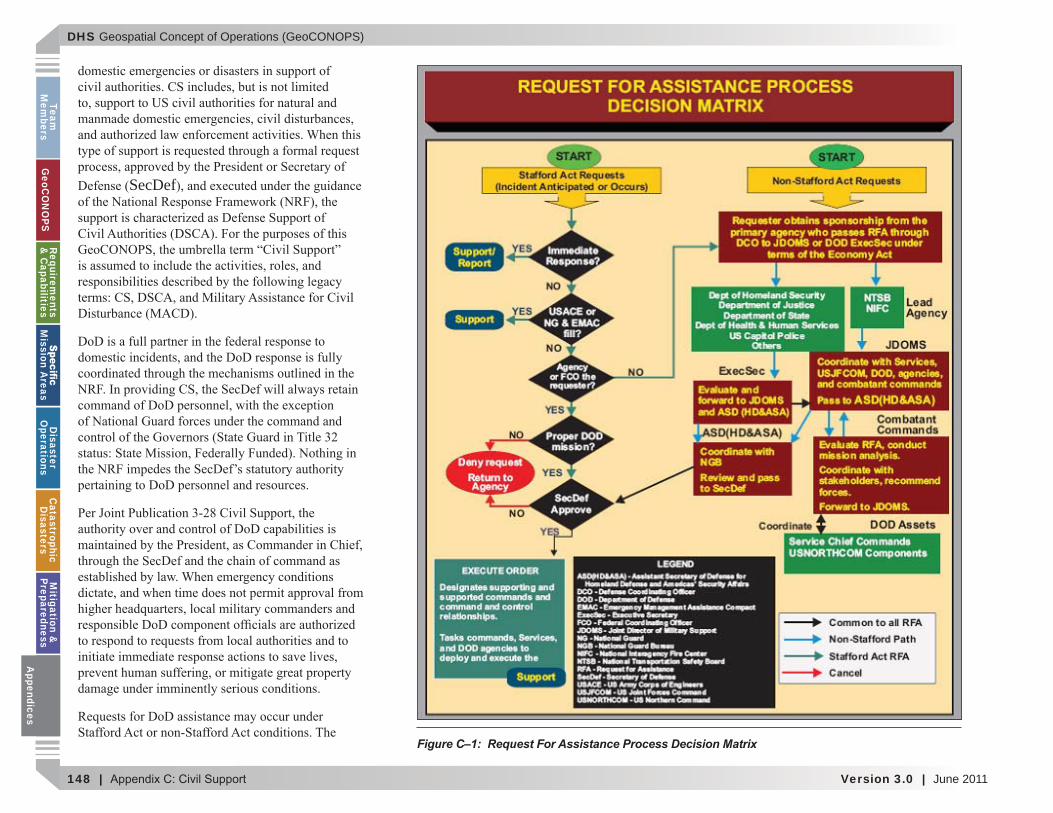
DHS Geospatial Concept of Operations (GeoCONOPS)
148 | Version 3.0 | June 2011
Team
Mem
bersG
eoCO
NO
PSRequirem
ents &
Capabilities
M
ission Areas
Disaster
Operations
CatastrophicD
isastersM
itigation &
PreparednessA
ppendices
SecDef
Figure C–1: Request For Assistance Process Decision Matrix
Appendices
DHS Geospatial Concept of Operations (GeoCONOPS)
June 2011 | Version 3.0 | 149
Team
M
embe
rsG
eoC
ON
OPS
Requ
irem
ents
&
Cap
abili
ties
M
issi
on A
reas
Dis
aste
r O
pera
tion
sC
atas
trop
hic
Dis
aste
rsM
itig
atio
n &
Pr
epar
edne
ssA
ppen
dice
s
1
2
1 Joint Publication 3-28, Civil Support, September 14, 2007.
2 DOD Support to Domestic Incidents, Januar 2008. Prepared b he Of ce of the Assistant Secretar of Defense omeland Defense and America s Securit Affairs. A
ppen
dice
s
DHS Geospatial Concept of Operations (GeoCONOPS)
150 | Version 3.0 | June 2011
Team
Mem
bersG
eoCO
NO
PSRequirem
ents &
Capabilities
M
ission Areas
Disaster
Operations
CatastrophicD
isastersM
itigation &
PreparednessA
ppendices
3 (see Figure C–1).
3 Joint Publication 3-28, Civil Support , September 14, 2007, p II-5.
Appendices
DHS Geospatial Concept of Operations (GeoCONOPS)
June 2011 | Version 3.0 | 151
Team
M
embe
rsG
eoC
ON
OPS
Requ
irem
ents
&
Cap
abili
ties
M
issi
on A
reas
Dis
aste
r O
pera
tion
sC
atas
trop
hic
Dis
aste
rsM
itig
atio
n &
Pr
epar
edne
ssA
ppen
dice
s
Overview
APPENDIX D: DHS INTELLIGENCE & ANALYSIS – INTERAGENCY REMOTE SENSING COORDINATION CELL
App
endi
ces
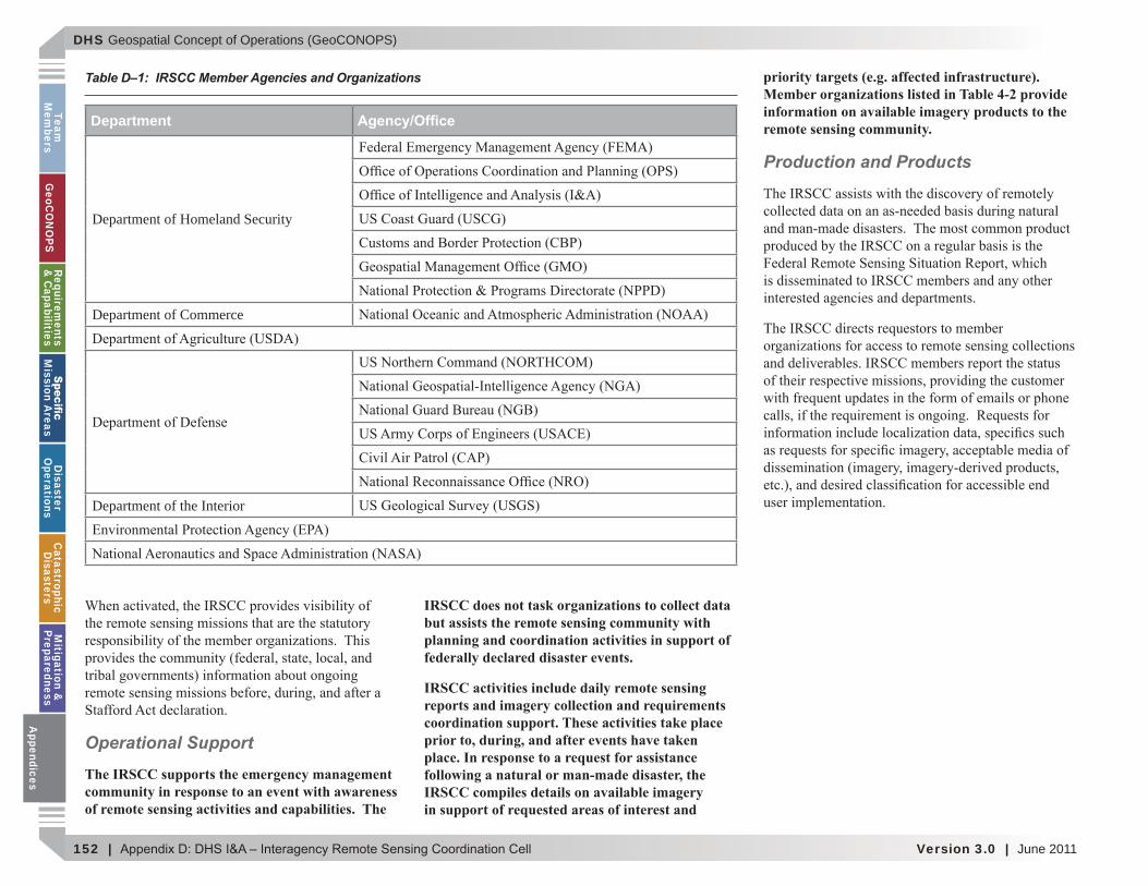
DHS Geospatial Concept of Operations (GeoCONOPS)
152 | Version 3.0 | June 2011
Team
Mem
bersG
eoCO
NO
PSRequirem
ents &
Capabilities
M
ission Areas
Disaster
Operations
CatastrophicD
isastersM
itigation &
PreparednessA
ppendices
Operational Support
The IRSCC supports the emergency management community in response to an event with awareness of remote sensing activities and capabilities. The
IRSCC does not task organizations to collect data but assists the remote sensing community with planning and coordination activities in support of federally declared disaster events.
IRSCC activities include daily remote sensing reports and imagery collection and requirements coordination support. These activities take place prior to, during, and after events have taken place. In response to a request for assistance following a natural or man-made disaster, the IRSCC compiles details on available imagery in support of requested areas of interest and
priority targets (e.g. affected infrastructure). Member organizations listed in Table 4-2 provide information on available imagery products to the remote sensing community.
Production and Products
T
Department
Department of Homeland Security
Department of Commerce
Department of the Interior
Table D–1: IRSCC Member Agencies and Organizations
Appendices
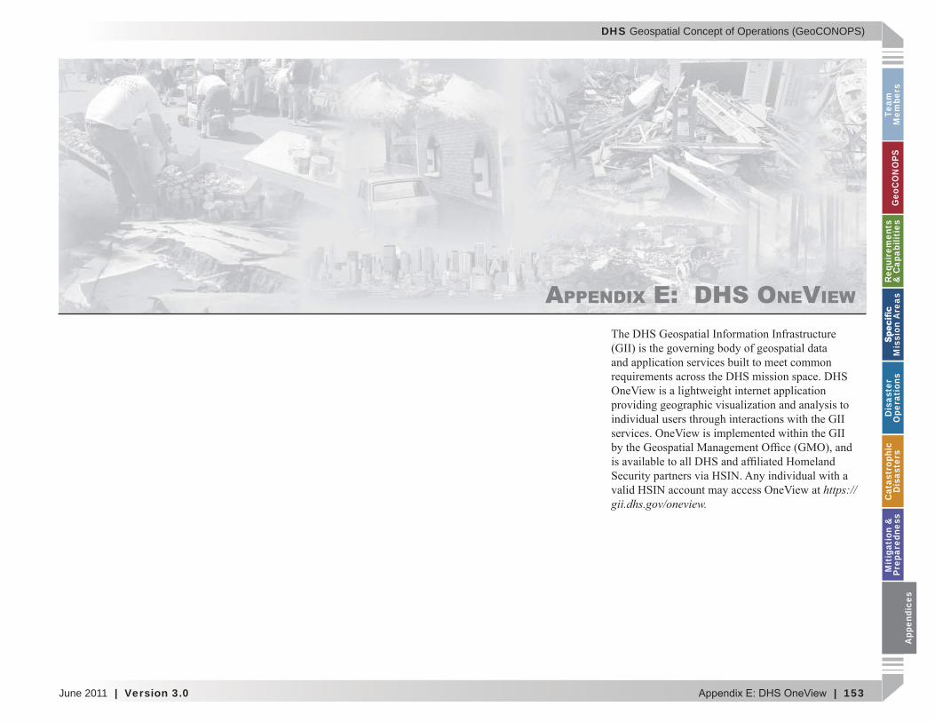
DHS Geospatial Concept of Operations (GeoCONOPS)
June 2011 | Version 3.0 | 153
Team
M
embe
rsG
eoC
ON
OPS
Requ
irem
ents
&
Cap
abili
ties
M
issi
on A
reas
Dis
aste
r O
pera
tion
sC
atas
trop
hic
Dis
aste
rsM
itig
atio
n &
Pr
epar
edne
ssA
ppen
dice
s
APPENDIX E: DHS ONEVIEW
https://ii.dhs. ov/onevie .
App
endi
ces
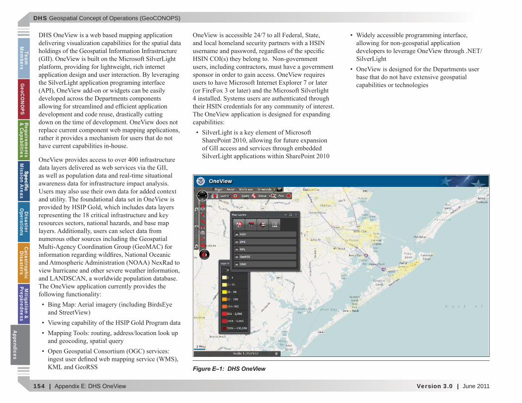
DHS Geospatial Concept of Operations (GeoCONOPS)
154 | Version 3.0 | June 2011
Team
Mem
bersG
eoCO
NO
PSRequirem
ents &
Capabilities
M
ission Areas
Disaster
Operations
CatastrophicD
isastersM
itigation &
PreparednessA
ppendices
Figure E–1: DHS OneView
Appendices
DHS Geospatial Concept of Operations (GeoCONOPS)
June 2011 | Version 3.0 | 155
Team
M
embe
rsG
eoC
ON
OPS
Requ
irem
ents
&
Cap
abili
ties
M
issi
on A
reas
Dis
aste
r O
pera
tion
sC
atas
trop
hic
Dis
aste
rsM
itig
atio
n &
Pr
epar
edne
ssA
ppen
dice
s
APPENDIX F: ACTORS
App
endi
ces

DHS Geospatial Concept of Operations (GeoCONOPS)
156 | Version 3.0 | June 2011
Team
Mem
bersG
eoCO
NO
PSRequirem
ents &
Capabilities
M
ission Areas
Disaster
Operations
CatastrophicD
isastersM
itigation &
PreparednessA
ppendices
This page intentionally left blank.
Appendices

DHS Geospatial Concept of Operations (GeoCONOPS)
June 2011 | Version 3.0 | 157
Team
M
embe
rsG
eoC
ON
OPS
Requ
irem
ents
&
Cap
abili
ties
M
issi
on A
reas
Dis
aste
r O
pera
tion
sC
atas
trop
hic
Dis
aste
rsM
itig
atio
n &
Pr
epar
edne
ssA
ppen
dice
s
APPENDIX G: REFERENCED DOCUMENTS
National Incident Management System (NIMS),
National Infrastructure Protection Plan (NIPP),
National Response Framework (NRF), January
Defense Production Act App
endi
ces
DHS Geospatial Concept of Operations (GeoCONOPS)
158 | Version 3.0 | June 2011
Team
Mem
bersG
eoCO
NO
PSRequirem
ents &
Capabilities
M
ission Areas
Disaster
Operations
CatastrophicD
isastersM
itigation &
PreparednessA
ppendices
Homeland Security Act of 2002
The Robert T. Stafford Disaster Relief and Emergency Assistance Act (Stafford Act), as amended
HSPD-5, Management of Domestic Incidents,
HSPD-7, Critical Infrastructure Identi cation, Prioritization, and Protection
CI and to protect them.
HSPD-8, National Preparedness
national domestic all-hazards preparedness goal
HSPD-20/National Security Presidential Directive-51 National Continuity Policy, May
Civil Support, Joint Publication 3-28
Homeland Defense, Joint Publication 3-27, July
Department of Defense (DoD) Support to Domestic Incidents
Appendices
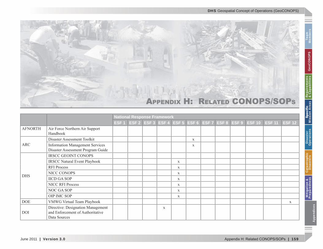
DHS Geospatial Concept of Operations (GeoCONOPS)
June 2011 | Version 3.0 | 159
Team
M
embe
rsG
eoC
ON
OPS
Requ
irem
ents
&
Cap
abili
ties
M
issi
on A
reas
Dis
aste
r O
pera
tion
sC
atas
trop
hic
Dis
aste
rsM
itig
atio
n &
Pr
epar
edne
ssA
ppen
dice
s
APPENDIX H: RELATED CONOPS/SOPS
National Response FrameworkESF 1 ESF 2 ESF 3 ESF 4 ESF 5 ESF 6 ESF 7 ESF 8 ESF 9 ESF 10 ESF 11 ESF 12
DHS
DOI
App
endi
ces
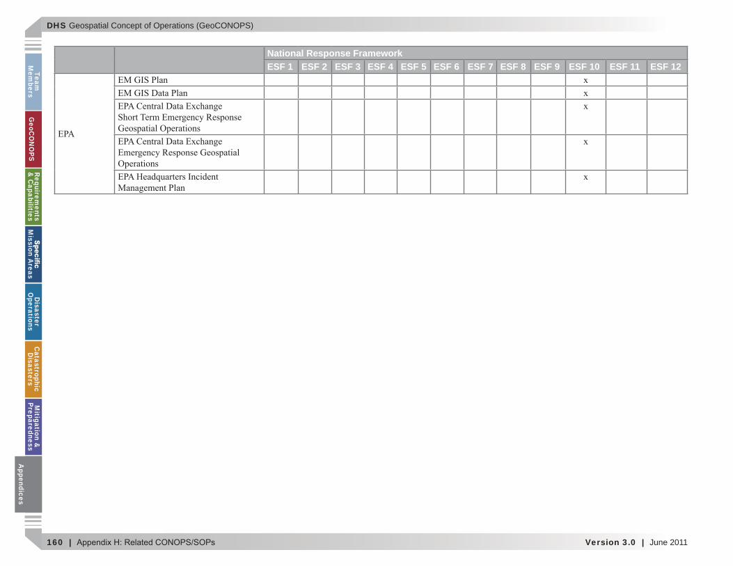
DHS Geospatial Concept of Operations (GeoCONOPS)
160 | Version 3.0 | June 2011
Team
Mem
bersG
eoCO
NO
PSRequirem
ents &
Capabilities
M
ission Areas
Disaster
Operations
CatastrophicD
isastersM
itigation &
PreparednessA
ppendices
National Response FrameworkESF 1 ESF 2 ESF 3 ESF 4 ESF 5 ESF 6 ESF 7 ESF 8 ESF 9 ESF 10 ESF 11 ESF 12
Appendices
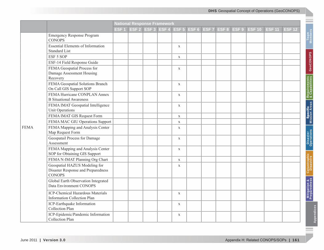
DHS Geospatial Concept of Operations (GeoCONOPS)
June 2011 | Version 3.0 | 161
Team
M
embe
rsG
eoC
ON
OPS
Requ
irem
ents
&
Cap
abili
ties
M
issi
on A
reas
Dis
aste
r O
pera
tion
sC
atas
trop
hic
Dis
aste
rsM
itig
atio
n &
Pr
epar
edne
ssA
ppen
dice
s
National Response FrameworkESF 1 ESF 2 ESF 3 ESF 4 ESF 5 ESF 6 ESF 7 ESF 8 ESF 9 ESF 10 ESF 11 ESF 12
App
endi
ces
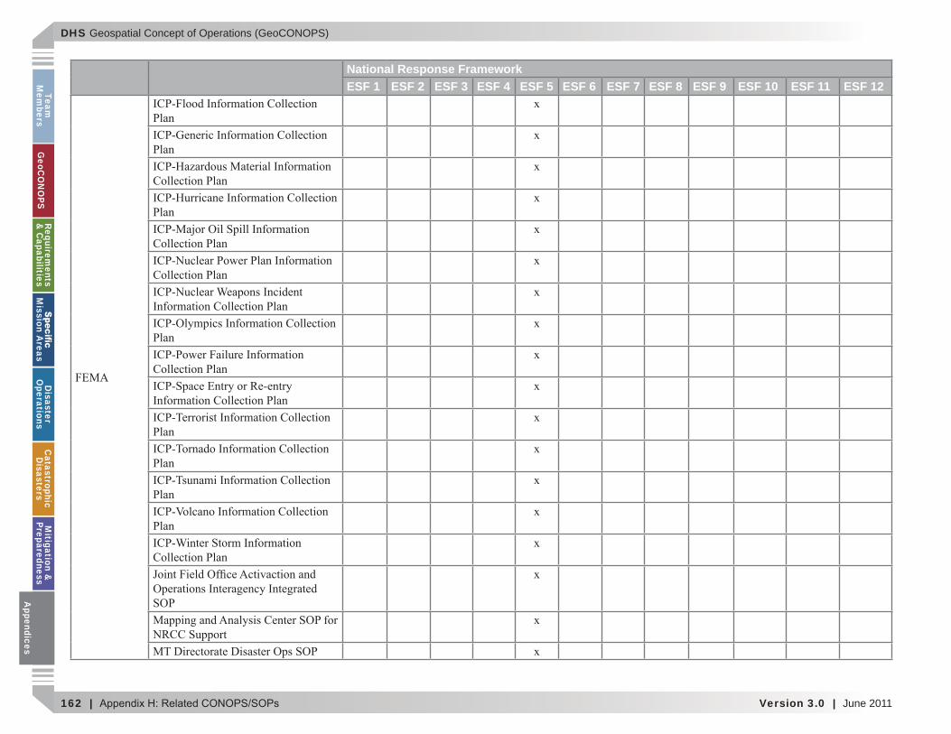
DHS Geospatial Concept of Operations (GeoCONOPS)
162 | Version 3.0 | June 2011
Team
Mem
bersG
eoCO
NO
PSRequirem
ents &
Capabilities
M
ission Areas
Disaster
Operations
CatastrophicD
isastersM
itigation &
PreparednessA
ppendices
National Response FrameworkESF 1 ESF 2 ESF 3 ESF 4 ESF 5 ESF 6 ESF 7 ESF 8 ESF 9 ESF 10 ESF 11 ESF 12
Appendices
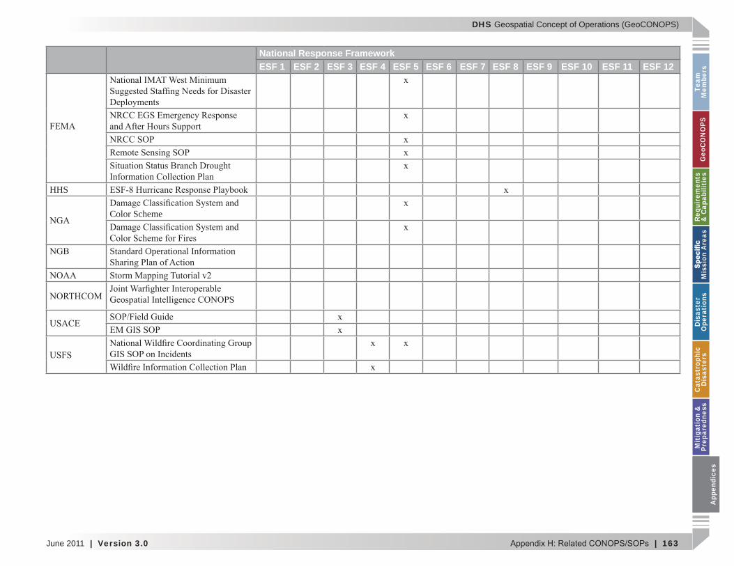
DHS Geospatial Concept of Operations (GeoCONOPS)
June 2011 | Version 3.0 | 163
Team
M
embe
rsG
eoC
ON
OPS
Requ
irem
ents
&
Cap
abili
ties
M
issi
on A
reas
Dis
aste
r O
pera
tion
sC
atas
trop
hic
Dis
aste
rsM
itig
atio
n &
Pr
epar
edne
ssA
ppen
dice
s
National Response FrameworkESF 1 ESF 2 ESF 3 ESF 4 ESF 5 ESF 6 ESF 7 ESF 8 ESF 9 ESF 10 ESF 11 ESF 12
HHS
Color Scheme
Standard Operational Information
App
endi
ces

DHS Geospatial Concept of Operations (GeoCONOPS)
164 | Version 3.0 | June 2011
Team
Mem
bersG
eoCO
NO
PSRequirem
ents &
Capabilities
M
ission Areas
Disaster
Operations
CatastrophicD
isastersM
itigation &
PreparednessA
ppendices
This page intentionally left blank.
Appendices
DHS Geospatial Concept of Operations (GeoCONOPS)
June 2011 | Version 3.0 | 165
Team
M
embe
rsG
eoC
ON
OPS
Requ
irem
ents
&
Cap
abili
ties
M
issi
on A
reas
Dis
aste
r O
pera
tion
sC
atas
trop
hic
Dis
aste
rsM
itig
atio
n &
Pr
epar
edne
ssA
ppen
dice
s
APPENDIX I: ACRONYMS
ABFE
AFO AFRCC
CenterARC
CA CAT CBP CBRN
CDC
CFDA
CI CIMS A
ppen
dice
s
DHS Geospatial Concept of Operations (GeoCONOPS)
166 | Version 3.0 | June 2011
Team
Mem
bersG
eoCO
NO
PSRequirem
ents &
Capabilities
M
ission Areas
Disaster
Operations
CatastrophicD
isastersM
itigation &
PreparednessA
ppendices
CIO CIR Critical Information
CM Community ModelCMHIS
COI CONPLAN CONUS COP COOP CPIMD
CRS CSEPP
CS CST
CWIN
DASC Center
DCE DCO DEGS
DHHS Department of Health and
DHS Department of Homeland Security
DMAT
DMORT DoD DOE DOI Department of InteriorDOJ DOL DOS Department of StateDOT DPO-MA
DRG DRTS
DSCA
EA EAS EEI
informationEMG EMIMS
EMS ENS EOC EPA
ESF ESFLG
FAA
FBI FCO FEMA
FGDC
FIRM FOC FOUO
GA GeoCONOPS
GDM GIS GISC
GIU GMO GPR GSA
HAS HazMat HAZUS-MH HD HLT HM HQ
Appendices
DHS Geospatial Concept of Operations (GeoCONOPS)
June 2011 | Version 3.0 | 167
Team
M
embe
rsG
eoC
ON
OPS
Requ
irem
ents
&
Cap
abili
ties
M
issi
on A
reas
Dis
aste
r O
pera
tion
sC
atas
trop
hic
Dis
aste
rsM
itig
atio
n &
Pr
epar
edne
ssA
ppen
dice
s
HSDN Homeland Secure Data
HSIN Homeland Security Information
HSIN-I Homeland Security Information
HSIP Homeland Security
HSPD
HUD
HURREVAC
I&A IA IASD
IAP IAS iCAV
ICEPP
ICG
ICP ICPACC
CommitteeICS IDP IGA
IICD
IIPG IMAAC
CenterIMAT
IMC IMPT
IOC IOF IP IRSCC
Coordination CellISS International Situation
SummaryIST ITT
JFO JFLCC
CommandJIC Joint Information CenterJOC JRIES
JTF JWICS
KMO
LANL
LIDAR LSA
MAA MA MAC MACC
CenterMACD
MAT ME MERS
SupportMIGS
MIL Military MOA MOU Memorandum of
MWCL
NASA
NCC
NCS
NDMS
NEF App
endi
ces
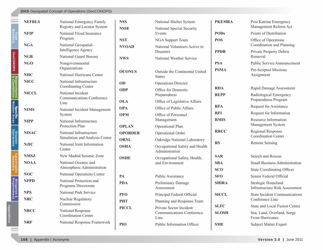
DHS Geospatial Concept of Operations (GeoCONOPS)
168 | Version 3.0 | June 2011
Team
Mem
bersG
eoCO
NO
PSRequirem
ents &
Capabilities
M
ission Areas
Disaster
Operations
CatastrophicD
isastersM
itigation &
PreparednessA
ppendices
NEFRLS
NFIP
NGA
NGB NGO
NHC NICC
NICCL
NIMS
NIPP
NISAC
NJIC Center
NMSZ NOAA
NOC NPPD
NPS NRC
NRCC Coordination Center
NRF
NSS NSSE
NST NVOAD
NWS
OCONUS
OD ODP
OLA OPA OPM
OPLAN OPORDER Operational OrderORNL OSHA Occupational Safety and Health
OSHE Occupational Safety, Health,
PA PDA
PFO PHT PICCL
PIO
PKEMRA
PODs POS
PPDR
PSA PSMA
RDA REPP
RFA RFI RMIS
RRCC Coordination Center
RS
SAR SBA SCO SFO SHIRA
SICCL
SLFC SLOSH
SME
Appendices

DHS Geospatial Concept of Operations (GeoCONOPS)
June 2011 | Version 3.0 | 169
Team
M
embe
rsG
eoC
ON
OPS
Requ
irem
ents
&
Cap
abili
ties
M
issi
on A
reas
Dis
aste
r O
pera
tion
sC
atas
trop
hic
Dis
aste
rsM
itig
atio
n &
Pr
epar
edne
ssA
ppen
dice
s
SNL SNS SOP SOC SWAT SWO
TAC
TEMP TCPED
TSA
UCS USACE
USAF USAID
U.S.C. USCG USDA
USFS USGS
USNORTHCOM Command
USPACOM US&R
VAL VA-NPSC
Support CenterVMWG
VOAD
VOLAG VTC
WFO WMD
App
endi
ces

DHS Geospatial Concept of Operations (GeoCONOPS)
170 | Version 3.0 | June 2011
Team
Mem
bersG
eoCO
NO
PSRequirem
ents &
Capabilities
M
ission Areas
Disaster
Operations
CatastrophicD
isastersM
itigation &
PreparednessA
ppendices
This page intentionally left blank.
Appendices