Embed Size (px)
Citation preview
Finding of No Significant Impact 1 Seaview Avenue Corridor Bridgeport, CT
FEDERAL HIGHWAY ADMINISTRATION
FINDING OF NO SIGNIFICANT IMPACT
Seaview Avenue Corridor Bridgeport, Connecticut
State Project No. 15-371
Federal Project No. H072(001)
The Connecticut Department of Transportation (CTDOT) is undertaking the Seaview Avenue Corridor Project; utilizing federal funds provided by the Federal Highway Administration (FHWA). Seaview Avenue serves an important local transportation function and is one of the few roadways in Bridgeport connecting I-95 with US Route 1 (Boston Avenue). The existing two-lane roadway is in poor condition and does not safely, efficiently, and adequately accommodate the type and volume of traffic currently using this route. Any development or expansion of businesses in the Seaview Avenue area, are expected to further exacerbate the existing traffic and safety problems. The purpose of this project is to improve traffic circulation patterns; improve operation of the Boston Avenue intersection for vehicular traffic, bicyclists, and pedestrians; provide aesthetic and pedestrian safety improvements along the entire corridor; and provide access to underutilized properties while preserving neighborhood integrity. Project Description The project includes reconstruction and streetscape improvements centered on portions of the Seaview Avenue and Bond Street corridors. The project includes two distinct sections: 1) Section 1, which begins at Barnum Avenue extending north to Boston Avenue (US Route 1); and 2) Section 2, from the Seaview Avenue/ Boston Avenue intersection north to the Bond Street / Steward Street intersection. The total length of the project corridor is approximately 4,750 feet. Section 1 – Seaview Avenue from Barnum Avenue to Boston Avenue (US Route 1) Improvements will include pavement rehabilitation, replacement and/or upgrade of traffic signal equipment, new sidewalks and curbs, streetscape enhancements, and relocation of above ground utilities. The intersection at Boston Avenue (US Route 1) will be realigned to accommodate a “normalized” four-way intersection with Seaview Avenue and relocated Bond Street. In addition, a new storm drainage system will be constructed along Seaview Avenue and the existing combined sewer system that currently extends from approximately Huron Street to Boston Avenue will be separated. Section 2 – Bond Street from Boston Avenue (US Route 1) to Stewart Street Improvements in this section will include the construction of a new three-lane roadway and relocation of Bond Street slightly to the west. Configuration of this road will be one lane in each
Finding of No Significant Impact 2 Seaview Avenue Corridor Bridgeport, CT
direction and will include left turning lanes along the corridor to facilitate access to current and future potential development (including the new Harding High School) along Bond Street between Boston Avenue and Stewart Street. No additional left turn lanes are proposed at the intersection of Stewart Street and Bond Street, and the intersection will remain as an all way stop sign controlled intersection. Work will include the incorporation of streetscape improvements; and the existing Bond Street footprint will be rehabilitated and modified to become a frontage road with additional on-street parking. Additionally, new drainage trunk lines and stormwater drainage structures will be constructed along the relocated Bond Street. Construction for the project is anticipated to begin in the Spring of 2019 and the current approximate total project cost is estimated at approximately $14 million. Alternatives Considered
Through a separate earlier project, the Seaview Avenue corridor was evaluated as part of a larger effort for developing transportation improvements between I-95 and Boston Avenue (EA/EIE, March 2006). In that document, a number of alternatives were reviewed including those listed below: Alternative 1 – Two-lane upgrade to conform to current roadway standards Alternative 2 – Four-lane widening, maintaining existing Seaview Avenue centerline Alternative 3 – Four-lane widening, shifting the Seaview Avenue centerline west Alternative 4 – Three-lane widening, shifting the Seaview Avenue centerline west Alternative 5 – Combined Seaview Avenue upgrade and construction of two-lane arterial Alternative 6 - New limited-access arterial west of Seaview Avenue Alternative 6a-6d – Alignment variations focused on the approach to the US Route 1 intersection
with Seaview Avenue At that time Alternative 6 was the chosen as the preferred alternative. However, the old project did not advance to construction due to funding constraints and potential environmental impacts. It was since determined that the current project would be targeted to improving existing infrastructure to safely handle existing and expected traffic volumes while adhering to available levels of funding. Therefore, none of the previously studied alternatives were carried forward, as this project is intended to have a much smaller footprint, and fewer impacts than the previously studied alternatives. Alternatives Considered in Addition to the Proposed Design This current project is proposed to include limited widening and improvements between Barnum Avenue and Boston Avenue where there are ROW restrictions and/or adjacent resources, and more extensive widening where there are potentially less restrictive areas north of Boston Avenue. The current proposal will have a much smaller project footprint, and fewer impacts than the previously studied alternatives. During preliminary design, the City of Bridgeport, CTDOT and the design team met on several occasions with representatives from General Electric (GE) to discuss potential alternatives given
Finding of No Significant Impact 3 Seaview Avenue Corridor Bridgeport, CT
GE’s concerns about property acquisition with the proposed intersection alignment of Seaview Avenue, Bond Street and US Route 1. The design team prepared two (2) additional alternatives to assess whether there were alternate designs that could minimize impacts to the GE property, optimize safety and traffic flow through the intersection and avoid extensive impacts to existing businesses and residences in the area. Full descriptions and schematics of each can be found in Appendix A of this FONSI; however the following provides a summary of these alternatives: Intersection Configuration “A” – Boston Avenue (US Route 1)/ Seaview Avenue/ Bond Street The initial alternative that was prepared and discussed with GE sought to minimize impacts to GE property (1285 Parcel) and shift the new Bond Street roadway (and intersection) to the east, away from GE property. This results in reductions to impacts to the GE property; however, the alternative creates a number of undesirable impacts including:
This alternative creates a skewed intersection of 72 degrees; while this is minimally acceptable for geometry, it is not optimal for maximizing safety and sight lines.
Total acquisition of four (4) properties is required (3 multi-family residential buildings and a minority-owned commercial muffler shop).
Given the multi-family residential relocations needed and the current socioeconomic demographics of the local population, Environmental Justice (EJ) concerns are introduced.
Additional costs associated with the increased ROW are estimated at approximately $1.45 million.
Intersection Configuration “B” – Boston Avenue (US Route 1)/ Seaview Avenue/ Bond Street The design team presented a modified alternate concept that was a ‘middle ground’ in alignment between the selected alternative and Intersection Configuration ‘A’. This alternative sought to lessen impacts to the GE property while at the same time maintaining limited skew angle and minimizing other property impacts. The expected impacts include:
Maintains the same skewed intersection as “Configuration A”. Eliminates impacts to the 3 multi-family residential buildings; however, this alignment
would require the acquisition of approximately half of the existing parking on the Yankee Muffler site (1290 Boston Avenue), thereby negatively impacting the business and/or potentially rendering the site as non-conforming for parking. Assuming there is a need to acquire the entire minority owned business to limit partial acquisition of GE property, this would raise considerable concerns as the project lies within an EJ community.
Shifting the intersection to the east would cause additional operational issues. Cost associated with a potential total acquisition of the Yankee Muffler business (if
required), estimated at approximately $540,000 (including demolition and miscellaneous costs, such as relocation assistance).
GE submitted a further refinement to the Intersection Configuration ‘B’ concepts (see FONSI Appendix A, figure 5) however, many of the concerns with Intersection Configuration ‘B’
Finding of No Significant Impact 4 Seaview Avenue Corridor Bridgeport, CT
remain, namely:
Creates an even larger skew (66 degrees) for the Bond Street leg of the intersection. This represents a worsening of potential sightlines, safety and turning movements, as well as longer pedestrian crossings on Boston Avenue (US Route 1).
Given the further shifting of the intersection alignment to the east, not only do the potential operational concerns identified with Intersection Configuration ‘B’ for the Yankee Muffler driveway location (Boston Avenue) increase but with this refinement, the driveway would enter the intersection proper and is no longer at or behind a stop bar (Boston Avenue, eastern approach) which is a safety concern for business users and traffic within the intersection. Given the skew of the intersection and access point to the property on Boston Avenue, it is likely there would be further safety concerns introduced related to visibility of signal heads from the egress at Yankee Muffler.
The alignment results in similar impacts to the Yankee Muffler shop outlined above (Intersection Configuration ‘B’), negatively impacting the business and potentially rendering that property non-conforming for parking as well as safety concerns of ingress and egress on Boston Avenue.
Outreach A scoping notice was published in the Environmental Monitor under the Connecticut Environmental Policy Act (CEPA) to inform the public of the proposed project on April 7, 2015. The notice included a project description and solicited written comments from the public and state regulatory agencies. The comment period closed on May 7, 2015, and although several comments were received there were no requests to hold a public scoping meeting. A list of comments received during scoping are available in Appendix B of the EA. A full list of public outreach efforts and agency coordination that took place prior to the publication of the EA is available within the Public Involvement section of the EA. A public hearing for the EA was held on Thursday, February 8, 2018 in the Hollander Auditorium at Bridgeport Hospital. Per 23 CFR 771.119, a notice of availability of the EA/ notice of the public hearing was published in the Connecticut Post on January 24, 2018 and February 6, 2018, as well as La Voz, a Spanish periodical, on Friday, January 26th. These notices can be found in the attached Appendix C. The 30-day public review period closed on February 23, 2018. Hardcopies of the EA were made available for public inspection at the Connecticut Department of Transportation, FHWA’s Glastonbury Connecticut Division Office, the Bridgeport Public Library (Main Branch), the Bridgeport Public Library (Old Mill Green Branch), and the Connecticut State Library (Hartford). The EA was also available online at www.ct.gov/environmentaldocuments. Additionally, the following various units of Federal, State, and local government received a notice of availability of the EA/ notice of the public hearing: CT Department of Energy and Environmental Protection (CTDEEP), CT Department of Economic and Community Development (DECD), CT Department of Public Health (DPH), CT Office of Policy and Management (OPM), CT State Historic Preservation Office (SHPO), US Army Corps of Engineers (USACOE), US Environmental Protection Agency (USEPA), US Fish and Wildlife
Finding of No Significant Impact 5 Seaview Avenue Corridor Bridgeport, CT
Service (USFWS), Office of the Governor, the Bridgeport Mayor’s Office, and the relevant US Senators, State Senators and State Representatives. Seventeen (17) members of the public signed the attendance list at the hearing. Additionally, a Spanish translator was available at the hearing; however their services were ultimately not needed. One individual provided oral comments at the hearing; and throughout the 30-day public comment period, CTDOT received comments from five (5) organizations/ businesses, and two (2) members of the public. The organizations/businesses that submitted comments include East Side Neighborhood Revitalization Zone, Greater Bridgeport Transit, Optimus Health Care, DuPont Corporation/Sporting Goods Properties Inc., and General Electric. Comments and responses are located in Appendix A; and a transcript of the public hearing is available as Appendix B. No response was required for the comment received during the public hearing. Environmental Impacts and Analysis The various environmental impacts and analysis associated with this project are described in detail in the EA. Since circulation of the EA, no new impacts have been identified; and a list of environmental commitments is located in the EA. No significant adverse impacts are anticipated from the proposed action; and the following brief summary of impacts supports decision to issue a FONSI: Right of Way (ROW) – The ROW impacts along Seaview Avenue should generally be marginal, and would only entail minor sliver acquisitions. A total of ten (10) commercial and one (1) residential property will likely be impacted. These are necessary to accommodate the additional roadway widths. All sliver acquisitions are expected to occur along the western side of Seaview Avenue. The largest acquisition will occur on the property owned by General Electric on the western side of Bond Street between US Route 1 (Boston Avenue) and Stewart Street. General Electric submitted comments regarding the impacts to their property, and these comments along with responses are located in Appendix A of this FONSI. In addition, minor easements to accommodate proposed slopes and drainage system improvements may be required; however this will be determined at a later date as the design process progresses. No acquisitions are expected along the eastern side of Seaview Avenue or Bond Street. Surface Water Resources – The project site is located in an urbanized area, and is not in proximity to Wild and Scenic Rivers, or surface waters on the Nationwide River Inventory list. The project is also not anticipated to impact reservoirs, lakes, detention basins, or stormwater management facilities. The modifications to the existing roadway drainage systems may result in minor direct impacts to Yellow Mill Channel. New drainage trunk lines and drainage structures will be installed along the relocated Bond Street and the majority of Seaview Avenue. Additionally, any combined sewers will be separated within the project limits. The roadway improvements associated with this project that could potentially contribute to the degradation of water quality are temporary in nature and minor in scope; and will be avoided or minimized by following Best Management Practices (BMPs) during construction. The project is
Finding of No Significant Impact 6 Seaview Avenue Corridor Bridgeport, CT
not likely to adversely affect water quality. Wetlands – Installation of new or improved drainage system structures within wetlands may be required. This may result in minor impacts on jurisdictional wetlands requiring approval from both the ACOE and CTDEEP. A determination of the need and appropriate permit review process will be determined once detailed drainage design information is available. Drinking Water Sources – Impacts to drinking water sources are not anticipated. The project is not located within a public drinking water supply source. However, the project is located within the public water supply service area for the Aquarion Water Company (AWC) main system. CTDOT will coordinate with AWC regarding any proposed water distribution main relocations or replacements as design progresses. Floodplains – Installation of new or improved drainage structures within the 100-year floodplain may be required. A Flood Management Certification will be required, but any impacts will be minor. A final determination of impacts and any required permitting will be made following completion of a detailed drainage design. No impacts on the floodway for Yellow Mill Channel are anticipated. Terrestrial Habitat - There are no unique or high-quality habitats present within the project area, nor will the project require CTDEEP fisheries coordination. Threatened and Endangered Species - No impacts to threatened and endangered species are anticipated for this project. Historic/Cultural Resources – The Section 106 process has been completed and it was determined that the project will have “No Adverse Effect” on historic/cultural resources. Parks and Recreation Impacts – This project will not impact or use any parks, recreation areas, or wildlife/waterfowl refuges. Air Quality - An Air Quality Assessment was performed and the project is in conformity with the Clean Air Act. Noise – A noise analysis was performed using the FHWA-approved traffic noise prediction model; and it was determined that substantial noise increases are not predicted as a result of the project. Noise abatement will therefore not be implemented. The noise analysis is included in the EA as Appendix G. Hazardous Materials – The project vicinity includes sites with known contamination issues. This includes the former General Electric facility located on the west of Bond Street and to the north of US Route 1, a hazardous waste management facility under Connecticut law and a federal Resource Conservation and Recovery Act (RCRA) site. Buildings have been removed and hazardous waste areas have been investigated and remediated in recent years. GE is currently performing corrective action pursuant to RCRA. Any acquisition of the GE property will require the City of Bridgeport and/or the State to coordinate with GE and appropriate regulatory
Seaview Avenue Corridor – Project No. 15-371 Public Comments and Responses A-1
APPENDIX A
Public Review Comments and Responses
Seaview Avenue Corridor Bridgeport, Connecticut
State Project No. 15-371 Finding of No Significant Impact Prepared for:
Connecticut Department of Transportation
Prepared by:
Stantec Consulting Services Inc.
Seaview Avenue Corridor – Project No. 15-371 Public Comments and Responses A-2
Response Key
No response required.
Seaview Avenue Corridor – Project No. 15-371 Public Comments and Responses A-3
Response Key
No response required.
Seaview Avenue Corridor – Project No. 15-371 Public Comments and Responses A-4
+
Response Key
No response required.
Seaview Avenue Corridor – Project No. 15-371 Public Comments and Responses A-5
Response Key
No response required.
Seaview Avenue Corridor – Project No. 15-371 Public Comments and Responses A-6
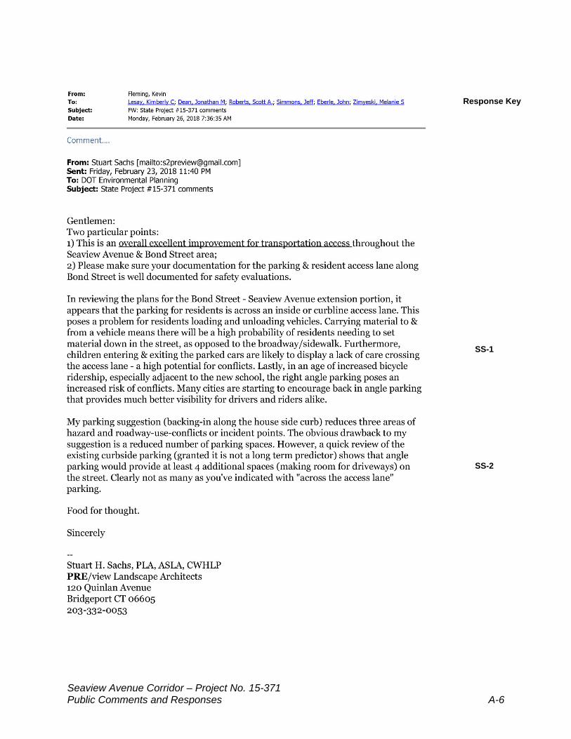
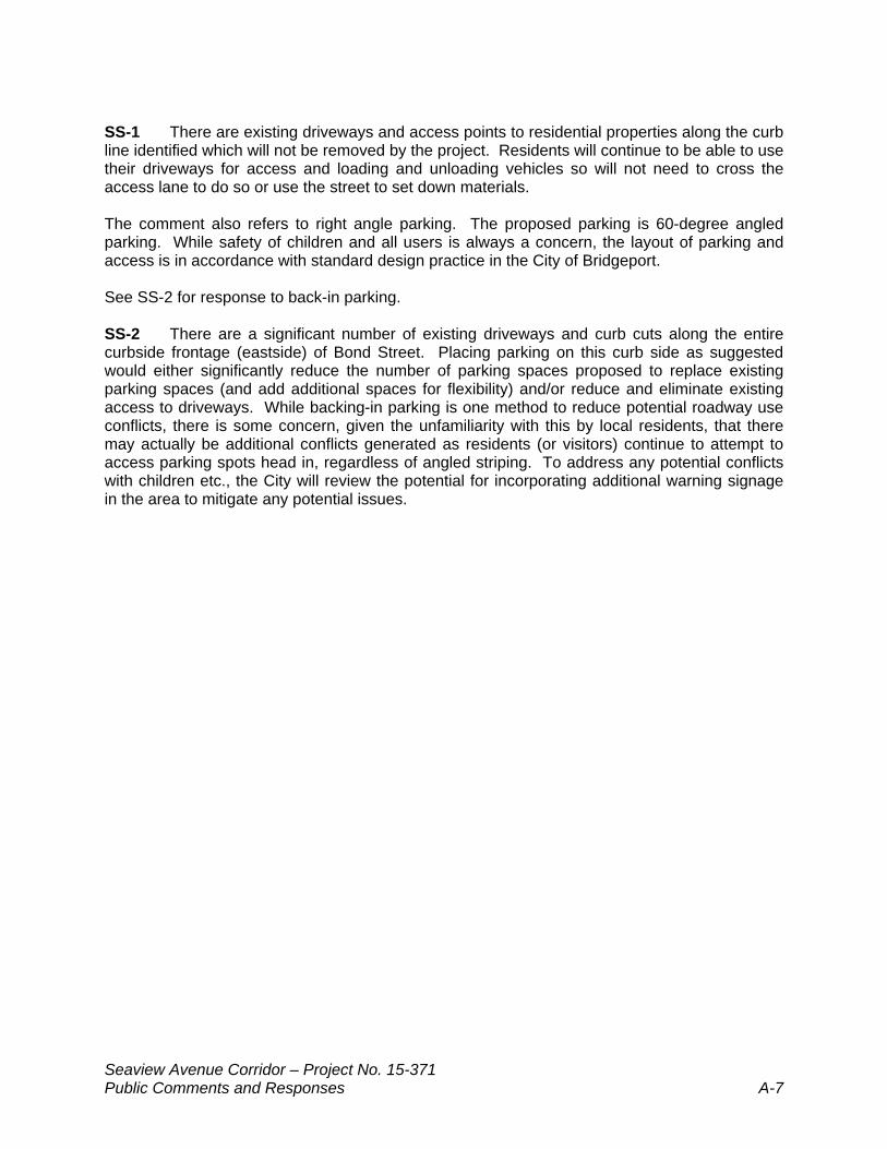
Responses to Stuart H. Sachs, PLA, ASLA, CWHLP
SS-1
SS-2
Response Key
Seaview Avenue Corridor – Project No. 15-371 Public Comments and Responses A-7
SS-1 There are existing driveways and access points to residential properties along the curb line identified which will not be removed by the project. Residents will continue to be able to use their driveways for access and loading and unloading vehicles so will not need to cross the access lane to do so or use the street to set down materials. The comment also refers to right angle parking. The proposed parking is 60-degree angled parking. While safety of children and all users is always a concern, the layout of parking and access is in accordance with standard design practice in the City of Bridgeport. See SS-2 for response to back-in parking. SS-2 There are a significant number of existing driveways and curb cuts along the entire curbside frontage (eastside) of Bond Street. Placing parking on this curb side as suggested would either significantly reduce the number of parking spaces proposed to replace existing parking spaces (and add additional spaces for flexibility) and/or reduce and eliminate existing access to driveways. While backing-in parking is one method to reduce potential roadway use conflicts, there is some concern, given the unfamiliarity with this by local residents, that there may actually be additional conflicts generated as residents (or visitors) continue to attempt to access parking spots head in, regardless of angled striping. To address any potential conflicts with children etc., the City will review the potential for incorporating additional warning signage in the area to mitigate any potential issues.
Seaview Avenue Corridor – Project No. 15-371 Public Comments and Responses A-8
Response Key
Seaview Avenue Corridor – Project No. 15-371 Public Comments and Responses A-9
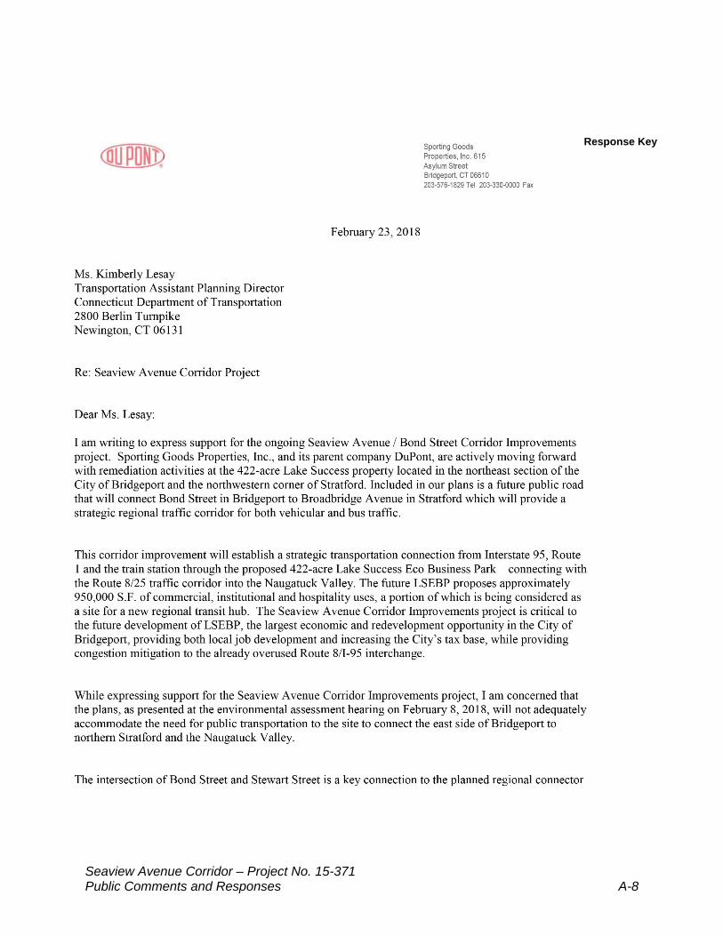
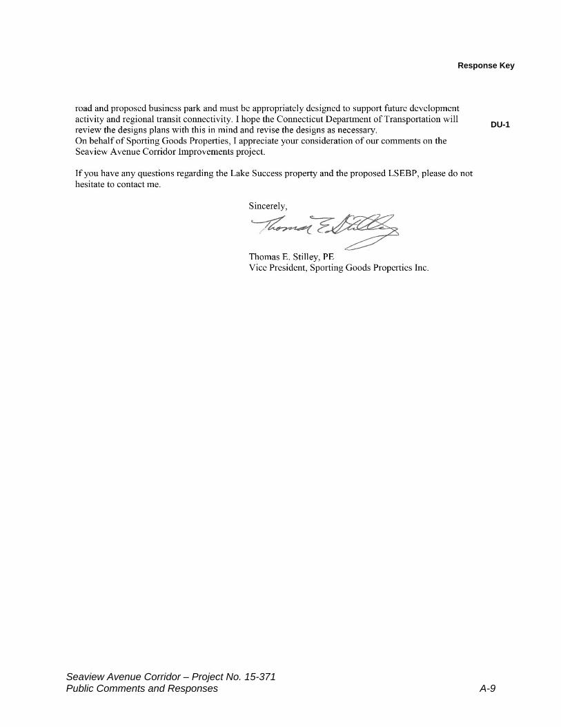
DU-1
Response Key
Seaview Avenue Corridor – Project No. 15-371 Public Comments and Responses A-10
Responses to DuPont Sporting Goods Properties Inc. DU-1 The roadway corridor design has taken into consideration future truck and bus traffic as part of the design for each intersection and in accordance with CTDOT design guidelines to assure the accounting for said vehicles in the corridor. Specifically, the curb radii at the terminating intersection at Bond Street and Stewart Street have been designed to allow Greater Bridgeport Transit (GBT) buses to make the various turns to or from any future roadway serving any proposed development of the Lake Success Eco-Business Park (LSEBP). Should future development of the LSEBP require greater modifications to the intersection based on any specific needs identified, there is available space for modifications to the intersection by future developers.
Seaview Avenue Corridor – Project No. 15-371 Public Comments and Responses A-11
Response Key
Seaview Avenue Corridor – Project No. 15-371 Public Comments and Responses A-12
Response Key
GE-1
GE-2
GE-3
Seaview Avenue Corridor – Project No. 15-371 Public Comments and Responses A-13
Response Key
GE-4
GE-5
Response Key
Seaview Avenue Corridor – Project No. 15-371 Public Comments and Responses A-14
GE-6
GE-7
Response Key
Seaview Avenue Corridor – Project No. 15-371 Public Comments and Responses A-15
Response Key
Seaview Avenue Corridor – Project No. 15-371 Public Comments and Responses A-16
EXHIBIT A
Seaview Avenue Corridor – Project No. 15-371 Public Comments and Responses A-17
Exhibit A (cont’d)
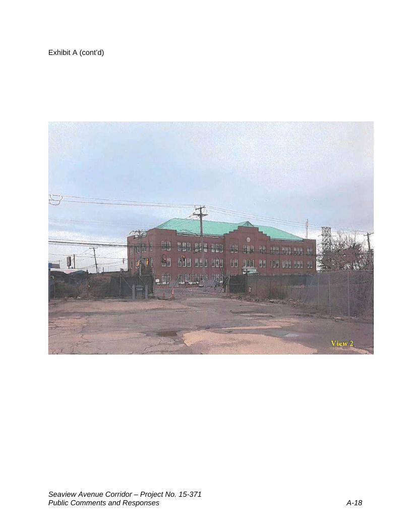
Seaview Avenue Corridor – Project No. 15-371 Public Comments and Responses A-18
Exhibit A (cont’d)
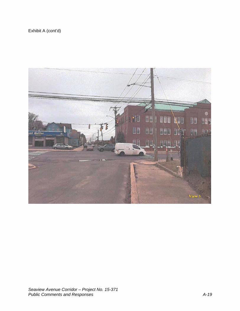
Seaview Avenue Corridor – Project No. 15-371 Public Comments and Responses A-19
Exhibit A (cont’d)
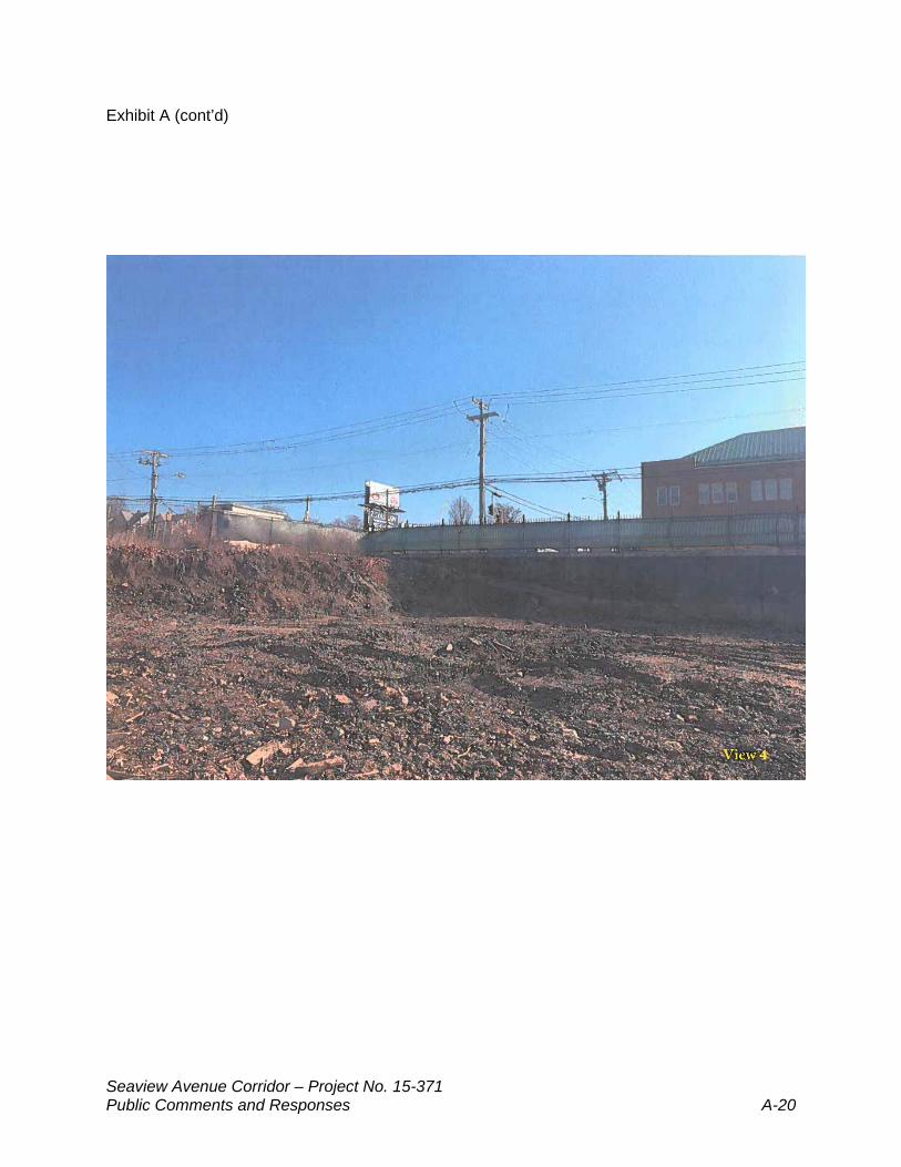
Seaview Avenue Corridor – Project No. 15-371 Public Comments and Responses A-20
Exhibit A (cont’d)
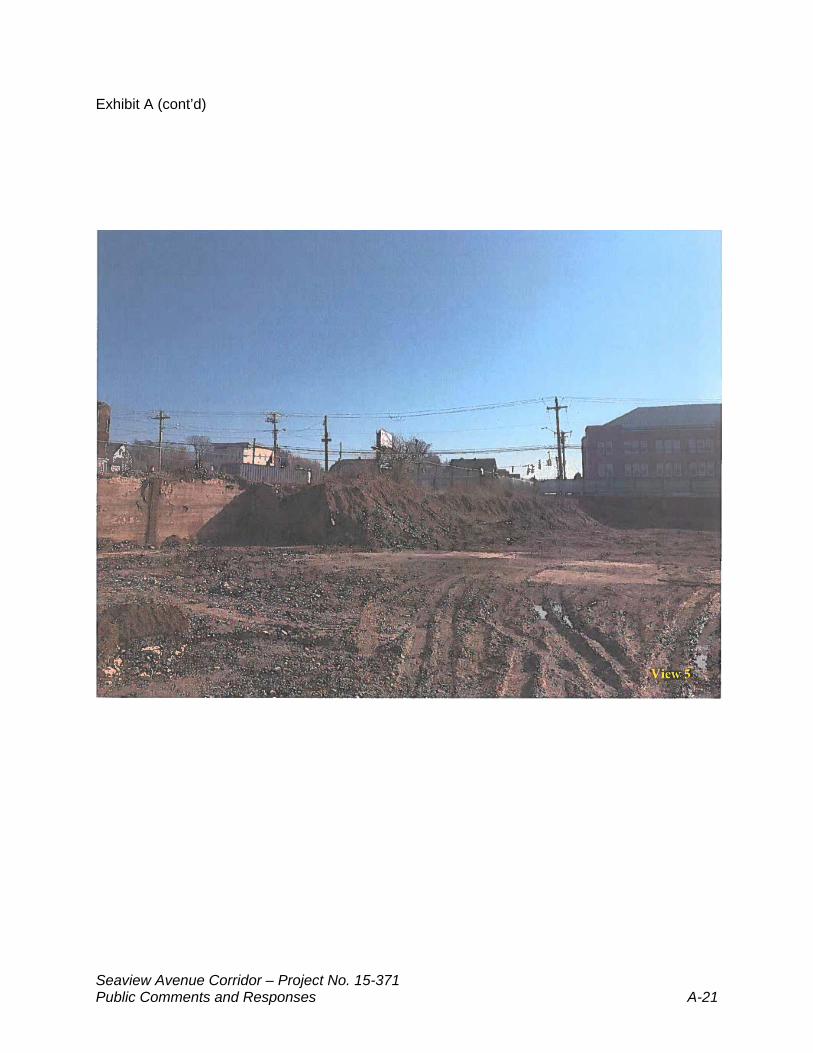
Seaview Avenue Corridor – Project No. 15-371 Public Comments and Responses A-21
Exhibit A (cont’d)
Seaview Avenue Corridor – Project No. 15-371 Public Comments and Responses A-22
EXHIBIT B
Seaview Avenue Corridor – Project No. 15-371 Public Comments and Responses A-23
Exhibit B (cont’d)
Seaview Avenue Corridor – Project No. 15-371 Public Comments and Responses A-24
EXHIBIT C
Seaview Avenue Corridor – Project No. 15-371 Public Comments and Responses A-25
Exhibit C (cont’d)
Seaview Avenue Corridor – Project No. 15-371 Public Comments and Responses A-26
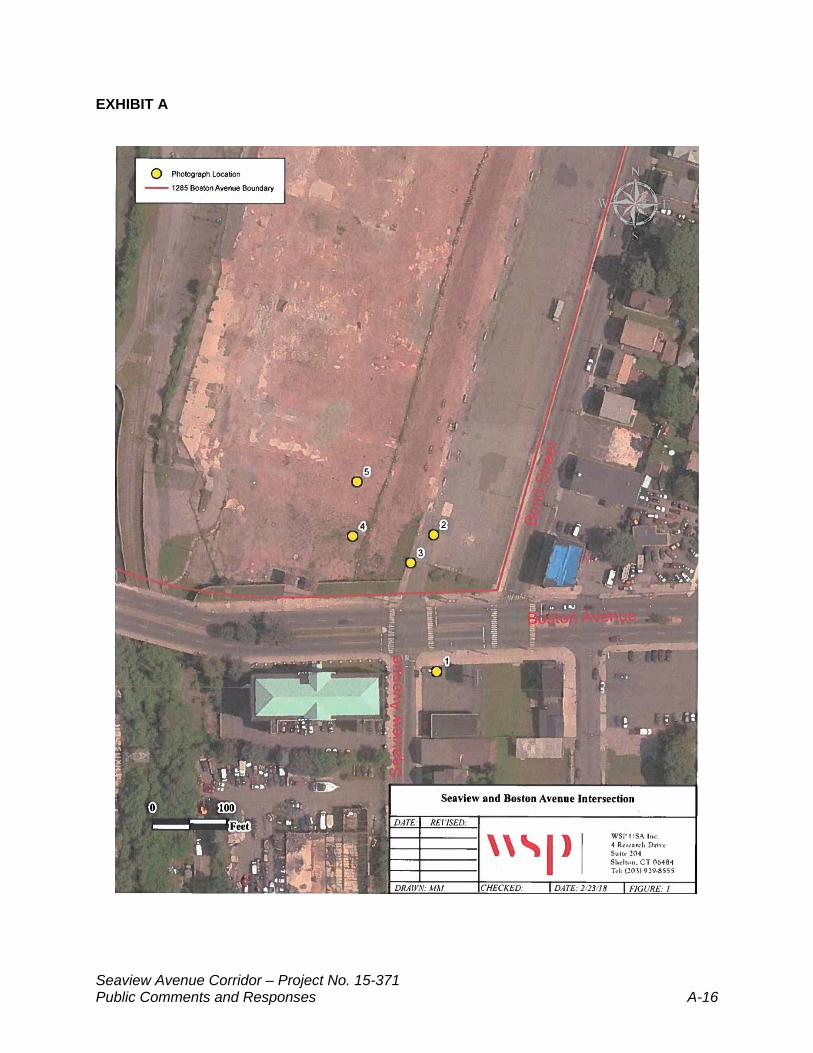
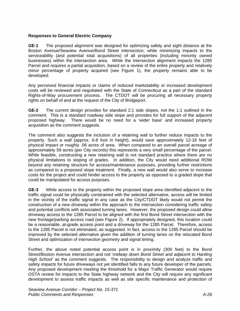
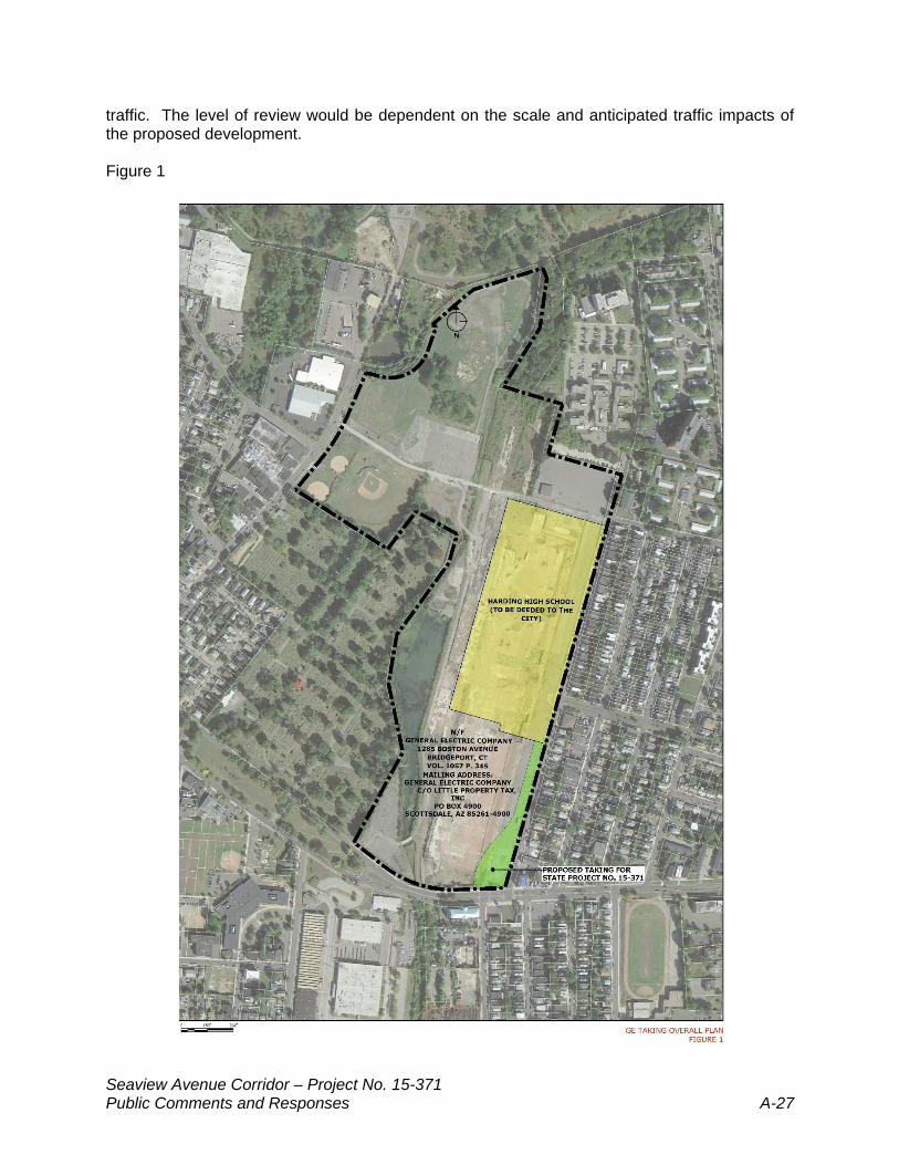
Responses to General Electric Company GE-1 The proposed alignment was designed for optimizing safety and sight distance at the Boston Avenue/Seaview Avenue/Bond Street intersection, while minimizing impacts to the serviceability (and potential total acquisitions) of all properties (including minority owned businesses) within the intersection area. While the intersection alignment impacts the 1285 Parcel and requires a partial acquisition, based on a review of the entire property and relatively minor percentage of property acquired (see Figure 1), the property remains able to be developed. Any perceived financial impacts or claims of reduced marketability or increased development costs will be reviewed and negotiated with the State of Connecticut as a part of the standard Rights-of-Way procurement process. The CTDOT will be procuring all necessary property rights on behalf of and at the request of the City of Bridgeport. GE-2 The current design provides for standard 2:1 side slopes, not the 1:1 outlined in the comment. This is a standard roadway side slope and provides for full support of the adjacent proposed highway. There would be no need for a ‘wider base’ and increased property acquisition as the comment suggests. The comment also suggests the inclusion of a retaining wall to further reduce impacts to the property. Such a wall (approx. 6-8 foot in height), would save approximately 12-16 feet of physical impact or roughly .06 acres of area. When compared to an overall parcel acreage of approximately 59 acres (per City records) this represents a very small percentage of the parcel. While feasible, constructing a new retaining wall is not standard practice where there are no physical limitations to sloping of grades. In addition, the City would need additional ROW beyond any retaining structure for access/maintenance purposes, providing further restrictions as compared to a proposed slope treatment. Finally, a new wall would also serve to increase costs for the project and could hinder access to the property as opposed to a graded slope that could be manipulated for access purposes. GE-3 While access to the property within the proposed slope area identified adjacent to the traffic signal could be physically constrained with the selected alternative, access will be limited in the vicinity of the traffic signal in any case as the City/CTDOT likely would not permit the construction of a new driveway within the approach to the intersection considering traffic safety and potential conflicts with associated turning lanes. However, the proposed design could allow driveway access to the 1285 Parcel to be aligned with the first Bond Street intersection with the new frontage/parking access road (see Figure 2). If appropriately designed, this location could be a reasonable, at-grade access point and a driveway for the 1285 Parcel. Therefore, access to the 1285 Parcel is not eliminated, as suggested. In fact, access to the 1285 Parcel should be improved by the selected alternative given the addition of turning lanes on the relocated Bond Street and optimization of intersection geometry and signal timing. Further, the above noted potential access point is in proximity (300 feet) to the Bond Street/Boston Avenue intersection and not ‘midway down Bond Street and adjacent to Harding High School’ as the comment suggests. The responsibility to design and analyze traffic and safety impacts for future driveways not yet identified falls to any future developer of the parcels. Any proposed development meeting the threshold for a Major Traffic Generator would require OSTA review for impacts to the State highway network and the City will require any significant development to assess traffic impacts as well as site specific maintenance and protection of
Seaview Avenue Corridor – Project No. 15-371 Public Comments and Responses A-27
traffic. The level of review would be dependent on the scale and anticipated traffic impacts of the proposed development. Figure 1
Seaview Avenue Corridor – Project No. 15-371 Public Comments and Responses A-28
Figure 2
GE-4 As the proposed roadway construction will not limit the parcels’ development (and associated job creation, increased tax revenues, and improved property values for neighbors) from a physical or zoning (i.e. impacts do not create zoning non-conformity) perspective, the negative impacts to the community resulting from the partial acquisition would be minor. Any perceived financial impacts or claims of reduced marketability or increased development costs will be reviewed and negotiated with the State of Connecticut as a part of the standard Rights-of-Way procurement process. GE-5 (Consideration of Alternatives) The comment suggests the need to evaluate alternatives (both past and current) that were identified during the current design process. The following summarizes alternative design considerations for the Boston Avenue/Seaview Avenue/Bond Street intersection. No-Build The current intersection is a substandard, offset intersection with no turn lanes for the Seaview Avenue or Bond Street approaches to the noted intersection. Given deficiencies, the current intersection operates at a minimally acceptable overall level of service (LOS) “D” (See Appendix F of the EA for definitions), with the Seaview Avenue northbound approach operating at a failing LOS F in the AM peak hour. Given the growth of traffic volumes to the design year of 2040 and no improvements to the intersection, the overall intersection will operate at a failing LOS F and all approaches will operate at failing LOS E/F for the design year of 2040. This condition would negatively impact traffic flow and safety in the corridor along with negatively impacting the other goals of the project as described in the Purpose and Need section of the EA. Consequently, the No Build Alternative was determined not to be an acceptable alternate.
Seaview Avenue Corridor – Project No. 15-371 Public Comments and Responses A-29
Past Alternatives Considered As explained in the EA, an earlier project (Project 15-288, 2006) evaluated the Seaview Avenue Corridor as part of a larger effort for developing transportation improvements between I-95 and Boston Avenue). In that assessment, various alternatives were reviewed including those listed below.
Alternative 1 – Two-lane upgrade to conform to current roadway standards. Alternative 2 – Four-lane widening, maintaining existing Seaview Avenue centerline. Alternative 3 – Four-lane widening, shifting the Seaview Avenue centerline west. Alternative 4 – Three-lane widening, shifting the Seaview Avenue centerline west. Alternative 5 – Combined Seaview Avenue upgrade and construction of two-lane
arterial. Alternative 6 – New limited-access arterial west of Seaview Avenue. Alternatives 6a–6d – Alignment variations focused on the approach to the US Route
1 intersection with Seaview Avenue. The study eventually resulted in the selection of Alternative 6 as the proposed action given the anticipated detrimental neighborhood impacts of the previous more extensive widening and alignment proposals. However, as noted in the EA for this project, the Alternatives that were evaluated in the 2006 EA/EIE were not considered to be reasonable alternatives for several reasons. All the Alternatives, except for Alternative 1, were proposed to include a wider roadway corridor and right-of-way (ROW) (between 70 and 100 feet for the proposed road) when compared to the existing 50-foot ROW or would require construction of at least part of the roadway on a new alignment. This would result in extensive property acquisitions and substantial community impacts, historic resource impacts, and additional impacts on wetlands and surface water features for Alternatives 4, 5, and 6. Given these concerns as well as financial constraints, none of the Alternatives were determined to be carried forward and the proposed design was targeted to improve the existing infrastructure to safely handle existing and expected traffic volumes. Current Alternatives Considered This current project is proposed to include limited widening and improvements between Barnum Avenue and Boston Avenue where there are ROW restrictions and/or adjacent resources, and more extensive widening where there are potentially less restrictive areas north of Boston Avenue. The current proposal will have a much smaller project footprint, and fewer impacts than the previously studied alternatives. During the preliminary design process, the City, CTDOT and consultant met on many occasions with GE representatives to review the project, present potential impacts, and evaluate potential alternatives. Given GE’s stated concerns with the proposed intersection alignment, the design consultant prepared two (2) additional alternatives to assess whether there were alternative designs that could minimize impacts to GE property, optimize safety and traffic flow through the intersection and avoid extensive impacts to existing businesses and residences in the intersection area. The following provides a summary of alternatives considered:
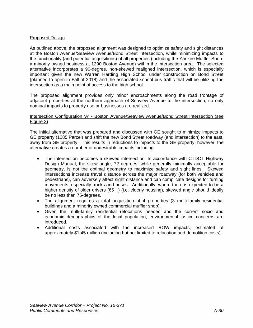
Seaview Avenue Corridor – Project No. 15-371 Public Comments and Responses A-30
Proposed Design As outlined above, the proposed alignment was designed to optimize safety and sight distances at the Boston Avenue/Seaview Avenue/Bond Street intersection, while minimizing impacts to the functionality (and potential acquisitions) of all properties (including the Yankee Muffler Shop-a minority owned business at 1290 Boston Avenue) within the intersection area. The selected alternative incorporates a 90-degree, non-skewed realigned intersection, which is especially important given the new Warren Harding High School under construction on Bond Street (planned to open in Fall of 2018) and the associated school bus traffic that will be utilizing the intersection as a main point of access to the high school. The proposed alignment provides only minor encroachments along the road frontage of adjacent properties at the northern approach of Seaview Avenue to the intersection, so only nominal impacts to property use or businesses are realized. Intersection Configuration ‘A’ - Boston Avenue/Seaview Avenue/Bond Street Intersection (see Figure 3) The initial alternative that was prepared and discussed with GE sought to minimize impacts to GE property (1285 Parcel) and shift the new Bond Street roadway (and intersection) to the east, away from GE property. This results in reductions to impacts to the GE property; however, the alternative creates a number of undesirable impacts including:
The intersection becomes a skewed intersection. In accordance with CTDOT Highway Design Manual, the skew angle, 72 degrees, while generally minimally acceptable for geometry, is not the optimal geometry to maximize safety and sight lines. Skewed intersections increase travel distance across the major roadway (for both vehicles and pedestrians), can adversely affect sight distance and can complicate designs for turning movements, especially trucks and buses. Additionally, where there is expected to be a higher density of older drivers (65 +) (i.e. elderly housing), skewed angle should ideally be no less than 75-degrees.
The alignment requires a total acquisition of 4 properties (3 multi-family residential buildings and a minority owned commercial muffler shop).
Given the multi-family residential relocations needed and the current socio and economic demographics of the local population, environmental justice concerns are introduced.
Additional costs associated with the increased ROW impacts, estimated at approximately $1.45 million (including but not limited to relocation and demolition costs)
Seaview Avenue Corridor – Project No. 15-371 Public Comments and Responses A-31
Figure 3
Seaview Avenue Corridor – Project No. 15-371 Public Comments and Responses A-32
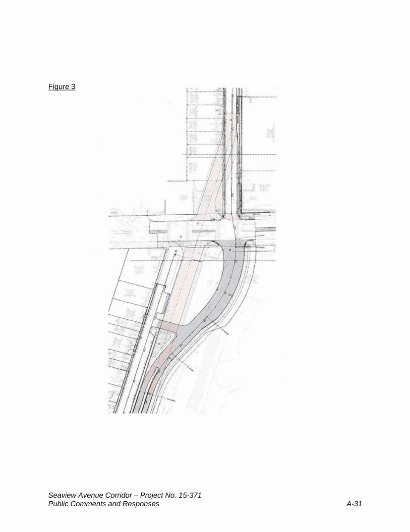
Intersection Configuration ‘B’ -- Boston Avenue/Seaview Avenue/Bond Street Intersection (see Figure 4) The design team presented a modified alternate concept that was a ‘middle ground’ in alignment between the selected alternative and Intersection Configuration ‘A’. This alternative sought to lessen impacts to the GE property while at the same time maintaining limited skew angle and minimizing other property impacts. The expected impacts included:
Maintains a skewed intersection at 72-degree (same as Intersection Configuration ‘A’), still less than ideal 90-degree for safety and sightlines
While eliminating impacts to the three (3) multi-family residential buildings outlined in Intersection Configuration ‘A’, the alignment would take approximately half of the existing parking on the Yankee Muffler site (1290 Boston Avenue) thereby negatively impacting the business and/or potentially rendering the site as non-conforming for parking. Assuming there is a need to acquire the entire minority owned business to limit partial acquisition of GE property, this would raise environmental justice concerns as the project lies within an Environmental Justice community.
The shifting of the intersection to the east would cause additional operational issues, as the existing curb cut for the Yankee Muffler business (on Boston Avenue) would lack appropriate separation from the Seaview Avenue/Boston Avenue corner radius.
Cost associated with a potential total acquisition of the Yankee Muffler business (if required), estimated at approximately $540,000 (including demolition and miscellaneous costs, such as relocation assistance).
Figure 4 This alternative also continued to negatively impact (though to a lesser degree) the at-grade portions of the GE property with which they (GE) appear most concerned.
Seaview Avenue Corridor – Project No. 15-371 Public Comments and Responses A-33
Within their commentary, GE submitted a further refinement to the Intersection Configuration ‘B’ concepts (GE Exhibit C, see Figure 5 below) however, many of the concerns with Intersection Configuration ‘B’ remain, namely:
Creates an even larger skew (66 degrees) for the Bond Street leg of the intersection (see commentary on skew for Intersection Configuration ‘B’. As outlined above, this represents a worsening of potential sightlines, safety and turning movements, as well as longer pedestrian crossings of the major roadway (Boston Avenue). Excessive pedestrian crossing distances increase pedestrian exposure time, increase the potential of vehicle-pedestrian conflict, and add to vehicle delay.
Given the further shifting of the intersection alignment to the east, not only do the
potential operational concerns identified with Intersection Configuration ‘B’ for the Yankee Muffler driveway location (Boston Avenue) increase but with this refinement, the driveway would enter the intersection proper and is no longer at or behind a stop bar (Boston Avenue, eastern approach) which is a safety concern for business users and traffic within the intersection. Given the skew of the intersection and access point to the property on Boston Avenue, it is likely there would be further safety concerns introduced related to visibility of signal heads from the egress at Yankee Muffler.
It should be noted that the refinement sketch seems to reflect a ‘closing’ of the existing
Boston Avenue driveway serving the Yankee Muffler business with new curb ramp and sidewalk area due to the easterly shifting of the roadway but it is presumed this was not the designer’s intent.
The alignment results in similar impacts to the Yankee Muffler shop outlined above
(Intersection Configuration ‘B’), negatively impacting the business and potentially rendering that property non-conforming for parking as well as safety concerns of ingress and egress on Boston Avenue.
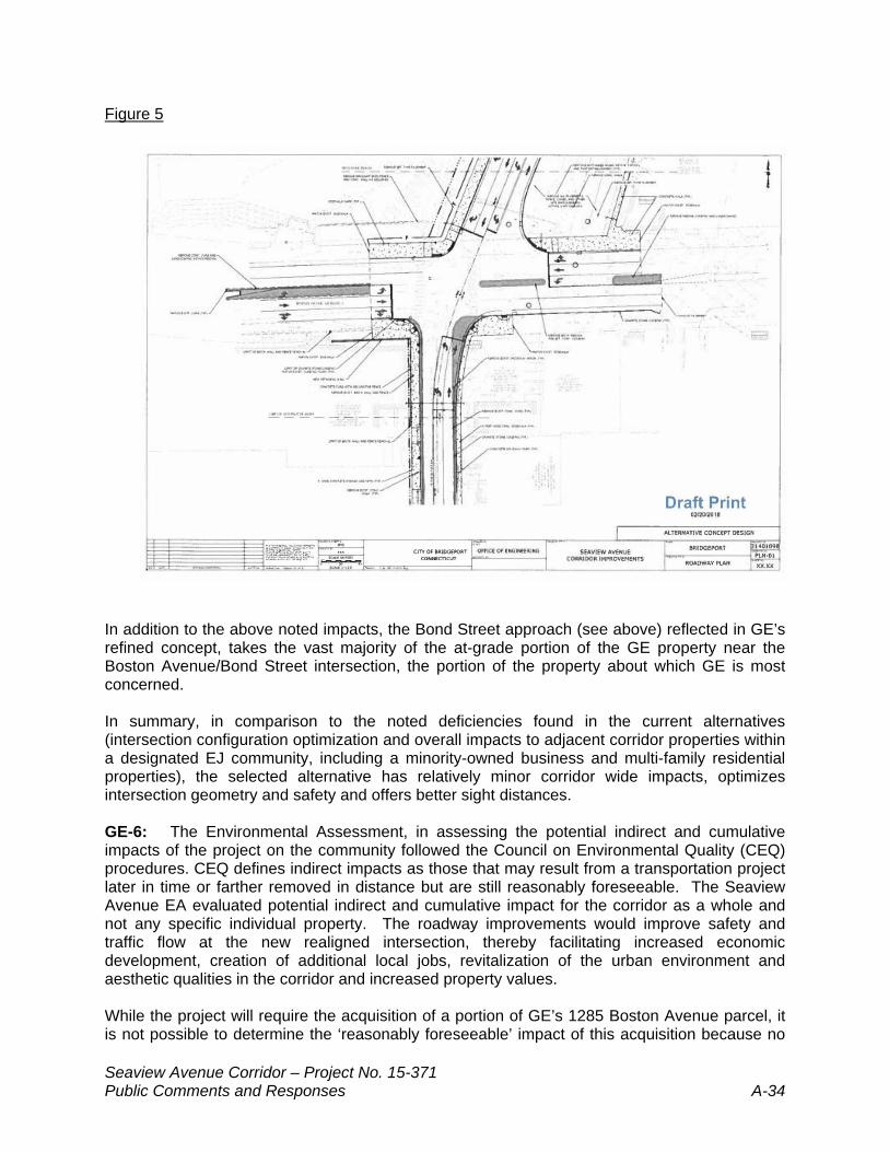
Seaview Avenue Corridor – Project No. 15-371 Public Comments and Responses A-34
Figure 5 In addition to the above noted impacts, the Bond Street approach (see above) reflected in GE’s refined concept, takes the vast majority of the at-grade portion of the GE property near the Boston Avenue/Bond Street intersection, the portion of the property about which GE is most concerned. In summary, in comparison to the noted deficiencies found in the current alternatives (intersection configuration optimization and overall impacts to adjacent corridor properties within a designated EJ community, including a minority-owned business and multi-family residential properties), the selected alternative has relatively minor corridor wide impacts, optimizes intersection geometry and safety and offers better sight distances. GE-6: The Environmental Assessment, in assessing the potential indirect and cumulative impacts of the project on the community followed the Council on Environmental Quality (CEQ) procedures. CEQ defines indirect impacts as those that may result from a transportation project later in time or farther removed in distance but are still reasonably foreseeable. The Seaview Avenue EA evaluated potential indirect and cumulative impact for the corridor as a whole and not any specific individual property. The roadway improvements would improve safety and traffic flow at the new realigned intersection, thereby facilitating increased economic development, creation of additional local jobs, revitalization of the urban environment and aesthetic qualities in the corridor and increased property values. While the project will require the acquisition of a portion of GE’s 1285 Boston Avenue parcel, it is not possible to determine the ‘reasonably foreseeable’ impact of this acquisition because no
Seaview Avenue Corridor – Project No. 15-371 Public Comments and Responses A-35
development plan has been filed with the City to date. However, the partial acquisition of the 1285 Boston Avenue parcel will not prevent the property from being redeveloped in the future. GE-7 It is understood that the acquisition of any of the 1285 Parcel will require the City and/or State to coordinate with GE and regulatory agencies to complete any remaining remediation. The condition of the property upon purchase by the City and/or State will determine which type of remediation will be required (i.e. capping, additional soil removals etc.) Any required remediation costs pursuant to the site’s status as an “interim status treatment storage and disposal facility” are typically reviewed and negotiated with the State of Connecticut as a part of the standard Rights-of-Way procurement process. As noted in the comment, the preliminary plans provided did suggest the potential use of a portion of the acquisition (a non- contiguous remnant portion of the property to be taken) as greenspace or a public park. This was further explained at the Public Hearing as potentially requiring additional soils removals and/or capping with hardscape surfaces (urban hardscape park, additional parking). It was outlined that this would be further discussed with City/CTDOT as design progresses.
APPENDIX B
Public Hearing Transcript
Seaview Avenue Corridor Bridgeport, Connecticut
State Project No. 15-371 Finding of No Significant Impact
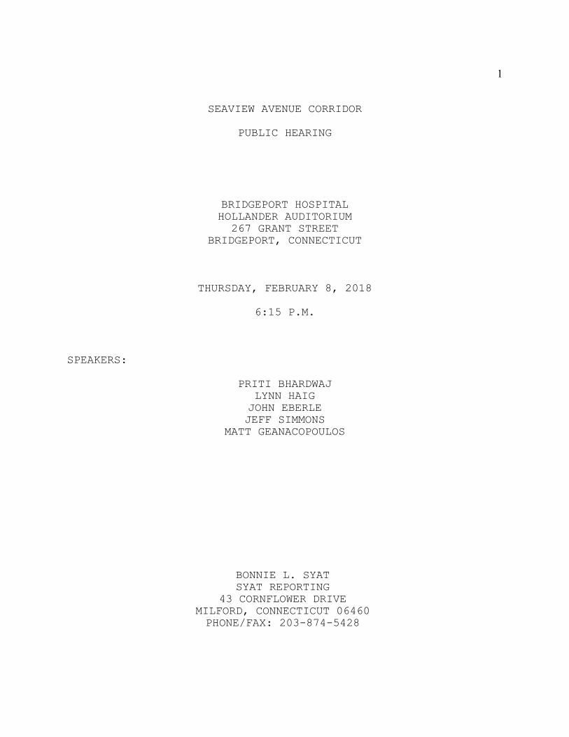
1
SEAVIEW AVENUE CORRIDOR
PUBLIC HEARING
BRIDGEPORT HOSPITALHOLLANDER AUDITORIUM267 GRANT STREET
BRIDGEPORT, CONNECTICUT
THURSDAY, FEBRUARY 8, 2018
6:15 P.M.
SPEAKERS:
PRITI BHARDWAJLYNN HAIG
JOHN EBERLEJEFF SIMMONS
MATT GEANACOPOULOS
BONNIE L. SYATSYAT REPORTING
43 CORNFLOWER DRIVEMILFORD, CONNECTICUT 06460PHONE/FAX: 203-874-5428
2
1 MS. BHARDWAJ: Good evening, ladies
2 and gentlemen, my name is Priti Bhardwaj from
3 the Connecticut Department of Transportation.
4 And I will be serving as the moderator
5 tonight for the public hearing.
6 Okay. We are meeting with you this
7 evening in order to discuss the environmental
8 assessment and preliminary design for Project
9 Number 15-371, corridor improvements for the
10 Seaview Avenue located in the City of
11 Bridgeport, Connecticut.
12 Our goal tonight is to provide an
13 overview of the project; review findings from
14 the project’s environmental assessment and
15 hear from you about how the project might
16 impact or benefit your community.
17 Some of the items that will be
18 covered on tonight’s agenda will be the
19 project overview; findings from the
20 environmental assessment; the rights of way
21 process and your comments.
22 I’d like to introduce the various
23 individuals who are here this evening and
24 will be presenting: Ms. Lynn Haig, Director
25 of Planning from the City of Bridgeport, to
3
1 be followed by Mr. John Eberle and
2 Mr. Jeff Simmons, both of Stantec
3 Engineering, who will be giving the technical
4 portion of the presentation; and
5 Mr. Matt Geanacopoulos from the Department’s
6 Division of Rights of Way who will be
7 explaining the rights of way process.
8 This public hearing is being
9 conducted in accordance with the Connecticut
10 Department of Transportation’s policy on
11 public involvement, public hearings for
12 highway layouts and designs and in accordance
13 to the latest version of the public
14 involvement guidance manual.
15 Documents are available for the
16 public’s inspection and copying at the
17 Connecticut Department of Transportation,
18 Room 2155, 2800 Berlin Turnpike in Newington,
19 Connecticut.
20 Also at FHWA, Federal Highway
21 Administration, located in the Glastonbury
22 office, at 628 Hebron Avenue, Number 303,
23 Glastonbury, Connecticut, and at each of the
24 following locations: Connecticut State
25 Library, located in Hartford, Connecticut and
4
1 the Bridgeport Public Library, the main
2 branch, and the Old Mill Green branch.
3 I will now discuss the format for
4 tonight’s hearing and then I will turn the
5 podium over to presenters. I will then
6 moderate the hearing as we listen to your
7 comments.
8 During the hearing we are going to
9 be limiting it to comments and public
10 statements only, not questions. For anyone
11 who has any additional questions, we will be
12 happy to stay and answer them after the
13 hearing has concluded tonight.
14 For your information, our
15 presentation should take approximately 45
16 minutes to complete. My intent is to conduct
17 a fair and orderly hearing tonight by
18 following a particular format. We would
19 appreciate your patience during my remarks as
20 well as the presentations to follow by
21 holding your remarks and comments until this
22 portion of the hearing of the hearing has
23 been completed. We will be happy to remain
24 here this evening until everyone has had a
25 reasonable opportunity to speak.
5
1 Experience has shown that audible
2 recordings can only be made if the person
3 making a statement uses the microphone
4 connected to the recording equipment. The
5 microphones have been set up, and if you wish
6 to make a statement, please come to the
7 microphone after I read your name from the
8 sign-up sheet. Please introduce yourself,
9 and if you are representing an organization,
10 please give its name as well.
11 If you didn’t sign up to speak, but
12 a question comes to mind, feel free to raise
13 your hand. I will be happy to recognize
14 you after I go through the speaker sign-up
15 sheet.
16 For those individuals who have a
17 prepared statement, you may read it into the
18 record if you so desire. However, if the
19 statement is lengthy, you are asked to offer
20 a written copy of the statement for the
21 record and give a brief summary of its
22 contents. Such attachments to the record
23 carry as much weight as the transcribed
24 verbal testimony received here tonight when
25 the transcript is reviewed.
6
1 If you wish to speak this evening,
2 we have a sign-up sheet at the entrance to
3 the room. There is a three minute time limit
4 on all first time speakers. There will be no
5 yielding of your time to other speakers, your
6 time is for your own comments. If after all
7 the first time speakers have finished, anyone
8 would like the opportunity to speak again, a
9 reasonable amount of additional time will be
10 allotted for this purpose. Anyone who wishes
11 to present written comments for the public
12 hearing record should give them to me before
13 the end of tonight’s hearing.
14 As a result of information that you
15 might learn at tonight’s hearing, you may
16 wish to make additional comments on the
17 proposed project. Written statements or
18 exhibits may be mailed or delivered to the
19 attention of Ms. Kimberly Lesay,
20 Transportation Assistant Planning Director,
21 Bureau of Policy and Planning, Connecticut
22 Department of Transportation, 2800 Berlin
23 Turnpike, Newington, Connecticut 06131.
24 This information is also in the
25 handout available when you entered the room
7
1 tonight. The deadline for receipt of
2 comments on this proposal is February 23rd,
3 2018. Written statements or exhibits must be
4 postmarked by this date and must be
5 reproducible in black and white on not larger
6 than 8 1/2 by 11 inch paper. This information
7 will be made part of the public hearing
8 record and will be considered in the same
9 regard as oral statements.
10 At this point I will now turn the
11 podium over to Ms. Lynn Haig, Director of
12 Planning from the City of Bridgeport. She
13 will be followed by Mr. John Eberle and
14 Mr. Jeff Simmons of Stantec, and then
15 followed by Mr. Matt Geanacopoulos from the
16 Department.
17 (Whereupon Ms. Haig came to the
18 podium.)
19 MS. HAIG: Good evening. Thank you
20 all for coming.
21 There’s a tremendous potential for
22 redevelopment and renewal sitting along the
23 Seaview Avenue Corridor. Improving the
24 transportation infrastructure is one of
25 several keys necessary to unlock that
8
1 potential.
2 Over the past two decades there
3 have been numerous studies, concept drawings,
4 neighborhood meetings and an environmental
5 assessment. I spoke to a few of you on the
6 way in and yes, you’ve lived through all of
7 them.
8 Throughout that time the project
9 scope was large, impacting a greater area and
10 requiring a substantial number of property
11 acquisitions. The project being presented
12 this evening is straightforward and much more
13 simple. It is anchored on the north by the
14 new Harding High School and on the south by a
15 proposed Barnum Train Station. It improves
16 vehicular movement along the corridor with
17 the addition of turn lanes at intersections
18 and a reconfigured four-way intersection at
19 Boston and Seaview Avenues.
20 The project also encourages and
21 facilitates pedestrian movement through
22 landscaping and incorporation of a ten foot
23 wide multi-use trail. That’s professional
24 speak for wide sidewalks that allows bicycles
25 and pedestrians. We are just as concerned
9
1 about the people as we are about the vehicles
2 that move along the corridor.
3 City efforts to unlock the rivers
4 and waterfront, develop a new train station
5 and set up Terra Place, which is the shop
6 tower space down on Barnum Avenue for
7 development cannot be successful on their
8 own. Each of these efforts have bolstered
9 with nearby successes and improvements.
10 The Seaview Avenue Corridor Project
11 provides the necessary infrastructure
12 improvements to help all of these other
13 efforts become successful and helps to unlock
14 the redevelopment potential of the corridor.
15 There has been strong public support to date
16 for these improvements.
17 Thank you for being here tonight,
18 and we welcome your input and continued
19 involvement.
20 Now for John Eberle for the project
21 overview.
22 (Whereupon John Eberle came to the
23 podium.)
24 MR. EBERLE: So what I want to do
25 is, I want to kind of review the actual
10
1 project with you before we kind of turn it
2 over to looking at some of the environmental
3 assessments that we’ve done and kind of point
4 those out.
5 Before I go on, really the
6 important thing that we kind of want to touch
7 on that are up on the screen is; why are we
8 even doing this project? What’s the purpose
9 and need of this project? And for any of
10 those who have actually looked at the
11 environmental assessment, you’ll see those
12 fairly well laid out.
13 Number 1. Obviously improve the
14 traffic circulation through the corridor.
15 That’s one of key project needs for this.
16 The operation of Boston Avenue
17 intersection is another critical purpose and
18 need of this project, not only for vehicles,
19 but for pedestrians and bicyclists through
20 the area. And I’ll talk a little bit about
21 existing conditions versus proposed and where
22 we think this is going.
23 Another purpose is provide the
24 aesthetic and pedestrian safety improvements
25 to the corridor so that you, and I’ll share
11
1 some of our initial work on that. And
2 lastly, provide improved access to the
3 underutilized properties along the way. And
4 a lot of that is on the western side of the
5 corridor that we’re talking about.
6 So that’s the, that’s essentially
7 what the purpose is. And before I get into
8 the, just to kind of explain where we stand
9 here when I get into some of the preliminary
10 design; we are at preliminary design. So
11 we’re basically at a 30/35 percent design
12 level. Some of you who came out, maybe it’s
13 now nine months ago to kind of, when we
14 shared some of this, we were pretty much at
15 the same stage, but now we have the
16 environmental work behind us as well.
17 So what I wanted to do is kind of
18 just walk you through the existing conditions
19 for those who are not familiar. I’m sure
20 many of you are familiar with them, but I’ll
21 walk through.
22 So the project is, as Lynn stated,
23 are essentially Barnum Avenue to the south.
24 And just so that you know; north is to the
25 right, all right? So right is north, left is
12
1 south. Some of the other -- Metro North
2 Railroad is below Barnum, to the left of the
3 page. You see the high school up to the
4 right of the page.
5 So we’re beginning at Barnum Avenue
6 and we’re ending at Stewart Street. So we’re
7 not extending. We’re not doing any work on
8 the railroad and we’re not going further
9 north than Stewart Street for this.
10 I’ll be talking a bit -- And what
11 you see in the orange is actually the
12 project, Seaview and Bond. What we do to
13 both of these are a little different as far
14 as reconstruction versus new roadway. And
15 I’ll do that in a minute.
16 So we’re going to start here with
17 the existing conditions. This is obviously
18 Barnum Avenue intersection. It’s an
19 intersection with reported high accidents.
20 It has capacity issues. As some of you know,
21 most of the approaches here are one lane. So
22 there’s no dedicated left turns, so it
23 creates some capacity problems in this area,
24 especially on northbound Seaview entering the
25 intersection. So I’ll just walk us up
13
1 through and just take a quick look.
2 So this is a typical corridor
3 between Barnum and Seaview. We’re looking at
4 a 30 foot wide existing pavement area.
5 Parking is generally on the eastside.
6 There’s no parking on the westside or left
7 side, as it were. One lane in each
8 direction. And this picture doesn’t really
9 do a good job perhaps, but sidewalks are on
10 both sides, but it’s kind of a mishmash of
11 bituminous and concrete. Same with the
12 curbs. You’ve got granite curbs. You’ve got
13 concrete curbs. You’ve got no curbs in
14 areas. So it’s -- And even the pavement is
15 in poor condition. So another reason for
16 going forward with the project.
17 The other thing you’ll notice in
18 this is that there’s no bike facilities up
19 and down Seaview. So bikes basically travel
20 in the way of traffic and with the traffic.
21 And the other thing that is fairly clear as
22 we kind of walk up is there’s no streetscape
23 amenities on the corridor. Now you might
24 point out a tree here there maybe, but we
25 don’t call that a full streetscape or

14
1 amenity.
2 The other thing you’ll notice, and
3 I’ll talk a little bit about it as we get
4 into the actual design, is the utilities.
5 All the utilities are generally on the west
6 side or the left of the highway.
7 So again, just kind of walking up
8 the roadway. Here we’re approaching Boston
9 Avenue. You can see the Boston Commons
10 residential units on the left, in the brick,
11 and Yankee Muffler is up there to the right
12 as we approach. So this is actually a kind
13 of a pinch point, kind of, and I’ll share
14 some of that when we’re looking at, looking
15 at the design.
16 So here we are. This is at the
17 Boston Avenue/Seaview/Bond Street
18 intersection. We’re kind of looking up Bond
19 Street at this point. This intersection, for
20 those who, you know, know the area, is an
21 offset intersection. It’s offset by like 75
22 feet, which is certainly substandard if you
23 were to have an offset. And I’ll talk about
24 how we’re going to address that.
25 For those that use the
15
1 intersection, it failed in a lot of
2 attributes and capacity, especially
3 northbound on Seaview where there really is
4 just one lane approaching the intersection.
5 There’s no left-turn lanes, there’s no right-
6 turn lanes. So you get a bottleneck. And the
7 Seaview to Bond and Bond to Seaview offset is
8 a very problematic and awkward movement as
9 well. So that’s just another part of the
10 existing condition.
11 So here we’re kind of looking up
12 and you’ll notice that we changed the weather
13 to winter, just to keep you guys current.
14 We’re looking up Bond Street now.
15 This begins Section 2. So you’ve got two
16 sections of this. We’ve got Barnum Avenue to
17 Boston Avenue and then Boston Avenue up to
18 Stewart Street.
19 In this corridor we’re talking,
20 we’re looking at a 32 foot existing roadway
21 section. Again, one lane in each direction.
22 Basically the same conditions apply; poor
23 pavement, sidewalks. There are sidewalks on
24 both sides. But again, the condition of them
25 is not great. And again you’ll note no formal
16
1 bike facility to the corridor. So we’re just
2 walking up.
3 Here you’re actually starting to
4 see the parking on the westside, which is not
5 illegal. But what you find, because of the
6 tight corridor, sometimes you’ll be out there
7 and you’ll have folks actually parking on
8 sidewalks to try to clear out of the, out of
9 the roadway. So just something that we
10 wanted, we want to keep in mind. And then
11 this side really just kind of gives you the
12 obvious, that it’s a heavily trafficked area.
13 There’s a lot of traffic out there today and
14 growing with other developments that could be
15 in the corridor and Barnum Station and what
16 might come.
17 So that takes us to what are we
18 going to do. So, you know, how are we going
19 to improve this? I just walked through the
20 existing conditions. Again, I want to start
21 off by there’s two sections here. And I’m
22 going to go through these section-by-section.
23 Barnum Avenue to Seaview. Barnum
24 Avenue on Seaview to Boston Avenue is kind of
25 one section. We’re not doing a new roadway
17
1 there, and I’ll walk you through what we’re
2 going to be doing, but we’re not doing a
3 realignment. It’s basically going to be
4 reconstruction of the roadway that’s there
5 and new pavement along with a whole host of
6 other things.
7 So just kind of describing the
8 section, the cross-section of the roadway as
9 you would see it; if you look on the right,
10 these are the residences on the eastside of
11 the roadway. And again, if anyone afterwards
12 wants to stay behind and we kind of, you
13 know, look at your property in particular.
14 But essentially we’re holding the property
15 line there and doing all these improvements
16 heading west. So there will be a widening
17 here, but all of that is to the west.
18 So as you come out, you’ll have a
19 five foot sidewalk outside those residences.
20 The parking lane that exists now will still
21 exist. We’re not getting rid of that. We’re
22 not eliminating that. We’ll have a lane in
23 each direction, one lane in each direction.
24 What is being added and what the widening
25 essentially is for, is now we’re looking to
18
1 put in a five foot buffer strip, a element
2 where the utilities actually will go. You’ll
3 have planters, decorative pavements,
4 pedestrian scale lighting and things like
5 that. So that’s going to be that area. And
6 then, as Lynn kind of already alluded to,
7 beyond that is a ten foot shared use path,
8 okay, that will connect, you know, Barnum
9 Avenue up to eventually the Warren Harding
10 High School.
11 So you’ll have completely new
12 sidewalks, new granite curbs, new pavement.
13 Everything will be coming out that’s out
14 there now and there will be new construction
15 but within the alignment that’s essentially
16 there.
17 So I just want to kind of walk,
18 through, and -- You know you can see this.
19 But again, definitely take some time to take
20 a look at the boards that we gave you, if you
21 want to take a look at what your property is.
22 And in plan view, I just kind of want walk
23 up.
24 So now you’ve seen what I said as
25 far as the cross section in plan view.
19
1 Again, keep in mind the bottom or the
2 eastside of the roadway, we’ll hold the
3 property line and expand to the other side.
4 So just looking at Barnum Avenue,
5 that’s one of the first changes that you see
6 here. What you see is that we’re including
7 and incorporating left-turn lanes. So that’s
8 going to help the capacity of that
9 intersection. And no doubt, you know,
10 eventually will help with safety as well.
11 And then there will be a new signal there.
12 So that will be a completely redone
13 intersection.
14 With some of these other
15 intersections, Huron Street, Grant Street,
16 any intersection you see up here, we’ll also
17 be looking at -- They will be all
18 reconstructed so they’ll have, they’ll be
19 completely in line with ADA accessability
20 through the area. So that will be the other
21 thing that we looked at.
22 Grant Avenue, that will remain as
23 is. There’s no signal going there. It will
24 remain a four-way stop. So there’s really no
25 change to that, just more of an improvement
20
1 as we go along.
2 Seaview Avenue. And this is really
3 basically the same cross section, you know.
4 Going forward you note, you know, the
5 elements really on the west side of the
6 roadway going up. And then here we start to
7 enter the intersection, the Boston Avenue
8 intersection. And one thing I’ll note here
9 is; if you look at the streetscape elements,
10 the, you know, the rusty planter strip as it
11 were, this is a tight pinch point. So we have
12 Boston Commons, the residential units that we
13 have, Yankee Muffler on the other side. So
14 one of the things we’ll be looking to do here
15 is to kind of eliminate that strip, use that
16 area so that we can get these, the lanes in
17 that we want to get in, and I’ll talk about
18 that in a minute.
19 The other thing about this
20 intersection, and this is probably a good
21 time to make sure I don’t blind anyone. So
22 just to kind of give everyone -- So here’s
23 Seaview now. This essentially exists as it
24 is. Right now you come into an intersection,
25 you do an offset. This is Bond Street today.
21
1 Okay. So that’s that offset. So the plan
2 here is to realign this intersection, make it
3 a 90 degree four-way with a new signal which
4 will help the capacity and safety in this, in
5 this area. One thing that, and I do want to
6 raise it is that; given this alignment there
7 will be an area here that will be the City’s
8 when we’re all done. We have not determined
9 what’s going to happen with that because
10 there are a lot of issues out here as far as
11 environmental compliance. So whether that
12 remains -- Right now it’s bituminous I
13 believe. Whether that remains a parking lot
14 or something else has not been determined at
15 this point. We’ll kind of work with that
16 through the design going forward.
17 So one thing that you’ll see here
18 that is maybe not a huge deal for folks, but
19 there are sightline issues at this
20 intersection. And basically because of the
21 wall that’s out in front of Boston Commons,
22 one of the things that we’ll be doing as part
23 of this project is to increase or help with
24 the intersection sight distance by doing some
25 relocation of that wall. So that will be a
22
1 net benefit as we go forward.
2 So Boston Avenue intersection, I
3 kind of talked about it and now you’re just
4 looking at it from a different perspective.
5 This kind of gives you a closeup of the
6 new configurations. So what you see there
7 are now new left-turn lanes on Seaview that’s
8 going to help capacity through the area.
9 Certainly Bond Street you have now an
10 exclusive left, an exclusive right and a
11 through lane on the new Bond Street. So
12 that’s certainly going to help the capacity
13 going through here. And then just even --
14 Even making this a non-offset intersection
15 is going to make it safer and improve
16 capacity.
17 So now Section 2. And this is
18 where I talk about being two sections. Where
19 the first section was kind of reconstruction
20 with an expanded area for and pathway, this
21 actually will be a new roadway. And you’ll
22 see it better in the slides that I’m about to
23 show, but I wanted you to see, you know, the
24 treatment of what you’re going to see if you
25 walk out your home across, across the way.
23
1
2 So on the right here, these are the
3 residences along Bond Street to the eastside,
4 okay? Again, we’re holding that right-of-way
5 line, that property line, and all the
6 expansion is heading west. So you come out
7 there, you’ll have a five foot sidewalk.
8 What was old Bond Street will actually now be
9 a dedicated parking area dedicated to the
10 residents and the folks along this stretch.
11 So old Bond Street becomes a new parking
12 area. And what you see on the left of this,
13 that’s the new Bond Street. The new Bond
14 Street is actually constructed to the west of
15 the existing Bond Street. And Bond Street
16 here will have a lane in each direction and
17 it will also have a dedicated left-turn lane,
18 which you’ll see in some of the other
19 graphics for the high school and for any
20 development that happens in this immediate,
21 excuse me, in this immediate area.
22 The other aspect of this section
23 obviously is the planted medians that we’re
24 going to get in there. I think right now
25 we’re looking at an 8 foot median, plus
24
1 medians in the Bond Street itself. So there
2 will be a great opportunity to plant and do a
3 really nice job aesthetically out here.
4 Again, all new sidewalks, new curbing.
5 Everything’s, you know, reconstructed to new,
6 new conditions.
7 And this is the plan. So this is
8 the plan which probably gives you a better
9 sense of what we’re talking about. I know a
10 section can be hard to look at.
11 So here are the residences along
12 the westside, or the eastside. This is old
13 Bond Street, okay? So what you’re seeing
14 there is that this now all becomes parking
15 dedicated to the residents and whoever
16 belongs there. So you’re actually moving the
17 roadway further away from the residences,
18 which I think, you know, ends up being a good
19 thing.
20 Then as I indicated, you know,
21 there will be opportunities for planted
22 medians within here. These are left-turn
23 lanes. This one actually feeds the high
24 school there. So there will be improvements
25 that way.
25
1 One thing to note, and as we come
2 to the end of the project, you see the high
3 school up to the north of this, or the top I
4 should say. This part ends at Stewart
5 Street. Basically the same thing I just
6 talked about. So you have your roadway, old
7 roadway here that becomes parking and then
8 you’ll have your one lane in each direction,
9 dedicated left, and another thru lane.
10 The high school, just as
11 information, was actually designed with this
12 roadway in mind, or a roadway coming. So
13 there’s very, there’s just only a little bit
14 of tweaking that has to be done. So we’re
15 not reconstructing Harding High School to get
16 this roadway in. Some forethought was given
17 to make sure there’s room there.
18 And Stewart Street with be a three-
19 way stop control. So no signal. Basically
20 it will stay as it is. And that’s basically
21 where we touch down.
22 So I’m just going to kind of
23 quickly go through some slides to kind of
24 check the boxes on what we should be talking
25 about.
26
1 Utilities. One of the key things
2 that we’re going to be doing as we get
3 further in design. We really haven’t done a
4 lot of that right now. That’s really the
5 next stage, design.
6 All storm drainage systems out
7 there will be upgraded. In new areas you
8 will have completely new storm drainage
9 systems up to the current, up to the current
10 code. We’re looking to separate the combined
11 system in Seaview. So that’s going to be
12 part of this, and provide a new stormwater
13 drainage system in there.
14 Relocate utility poles. So on Bond
15 Street, those utility poles will be shifted
16 far to the west, you know, on the edge of the
17 new roadway. And Seaview, and maybe I
18 mentioned this, but the poles, actually where
19 they are now, if you want to get a, you know,
20 a sense of where this buffer will be, those
21 poles are not actually going to have to move.
22 What we tried to do to design this is that
23 they are within the buffer area. So there
24 may be some utility coordination there. But
25 we’ll get into that fairly soon.
27
1 One thing, green infrastructure
2 features. And now this dawns on me. I
3 didn’t talk about one thing on one of the
4 slides, and it is important to this project,
5 and that’s the stormwater quality.
6 When we’re talking about the
7 buffered landscape and talk about the
8 planters, those planters are going to work
9 two ways. They’re going to be planters
10 aesthetically pleasing, but they’re also
11 going to act as infiltration basins. So
12 they’re going to be able to treat stormwater
13 with those basins and not just dump the water
14 into the, you know, structure out into the
15 wetlands and the Yellow Mill Channel. So
16 that is an important part of this project, is
17 where we have the opportunity, we’re going to
18 take advantage of them.
19 So that’s basically the utility
20 construction element. And this is typically,
21 you know, the most important slide as far as
22 the general public because they think
23 everyone can, you know, might be able to get
24 behind what the improvements are, but getting
25 there and doing the construction is always a
28
1 very, you know, sensitive thing. And we’ve
2 got, you’ve got to understand that.
3 As we go forward in design, we’ll
4 be developing fairly detailed construction
5 plans, working with the community and seeing
6 what needs to happen. Some of the main
7 points of that plan in talking to you folks
8 really is maintaining property access,
9 business and residential, you know, through
10 the area. We’re in luck for a lot of this
11 because we’re not making huge changes in
12 grade, which are really a problem when you’re
13 trying to keep access.
14 The other thing that I should
15 mention that facilitates this is; where
16 Seaview is being built, you know, in its
17 footprint now, which presents certain
18 problems, Bond Street is actually offline.
19 So you’re going to be able to build Bond
20 Street for the most part while existing Bond
21 Street maintains and runs as it is. So
22 that’s actually a plus to this project.
23 We’ll develop a maintenance and a
24 traffic plan that will detail what we’re
25 going to do with the traffic, any short-term
29
1 closures or whatnot. We’ll work with that.
2 The other thing that we recognize
3 is that there’s a, you know, the bus line and
4 the transit. And during construction, not
5 even just construction, but during design.
6 we’re meeting with GBT and coordinating all
7 their stuff with them. So we’ll work with
8 them on what we need to do to make sure that
9 it’s as painless as possible. There’s always
10 pain, but if we can make it as painless as
11 possible, great.
12 Streetscape materials, just real
13 quickly.
14 So we haven’t done anything as far
15 as identifying what the materials were or are
16 going to be. So we’ll have lighting,
17 pedestrian scale lighting, decorative pavers.
18 There will be planted medians. There will be
19 new trees. We haven’t gotten there yet,
20 that’s something we’ll work closely with the
21 City and the State as we go forward. Just to
22 kind of let you know that we haven’t
23 forgotten it.
24 Rights of way. So this is the
25 other thing. Matt will come up and talk more
30
1 about the process, but we want to just
2 reflect, you know, what we’re doing.
3 We indicated that there’s a seven
4 foot widening to the west for some of this,
5 except when you get into the intersection
6 where it’s a little bit more intrusive on the
7 westside.
8 We’ve identified 11 properties at
9 this point that we think we’ll need some
10 acquisition, whether it’s a sidewalk easement
11 or something like that. So 11 properties.
12 Most of those properties are on the west
13 side. So on the east side, chances are there
14 will be some temporary rights that we’ll have
15 to get because, you know, we’re redoing the
16 sidewalks so there’s going to be some impact
17 here. So we just wanted to, you know, flesh
18 that out. So there’s 11 properties. No
19 total takes at this point. We think we’re
20 fine. We will look at -- There may be
21 additional drainage easements that we might
22 need as we start the drainage design. We’ll
23 go through that, through that process as we
24 get more details.
25 And finally, just to kind of give
31
1 you, and I spoke to some of you out there,
2 just to kind of give you a sense. I know
3 this has been long delayed and Lynn has, you
4 know, talked about the delays here. All
5 things being equal, if we’re moving forward
6 with this and things look good, we’re
7 anticipating a design completion in the
8 winter or spring of 2019. Bidding of the
9 projects, getting a contractor on board in
10 the spring of 2019.
11 Construction we anticipate would be
12 spring or summer of 2019 into ‘20. The ‘21
13 that you see up there is probably punch work,
14 like in the spring ‘20/’21. So we anticipate
15 that ‘20 would probably be the main season
16 here for construction.
17 And then project cost. Overall
18 right now we’ve got it pegged at the PD level
19 at 11.5 million dollars.
20 So with that, I will sit down and
21 call Jeff up.
22 (Whereupon Mr. Simmons came to the
23 podium.)
24 MR. SIMMONS: All right. Good
25 evening everyone.
32
1 I’m going to walk through some of
2 the environmental review that was completed.
3 So I guess the first question that
4 many of you may have is why are we doing an
5 environmental review. Well it’s all required
6 by a federal law, National Environmental
7 Policy Act or NEPA, which basically is
8 triggered by any federal program. So federal
9 expenditures or funding or a federal permit
10 would typically trigger a NEPA review.
11 There’s a wide array of different types of
12 impacts and impacts to different resources.
13 I’ll get into that in a little bit more
14 detail very soon. And there’s a lot of
15 underlying federal regulations that kind of
16 drive what we’re looking at, what types of
17 impacts and then also what types of
18 significance criteria we might exceed.
19 For this project we’re looking at
20 an environmental assessment. The Department
21 and Federal Highway decided at the beginning
22 of the process that we really didn’t
23 understand what the impacts were going to be,
24 and so we go through an EA process to look at
25 all the different impacts.
33
1 There are different pathways
2 through NEPA, depending on the complexity of
3 the project and whether or not you are
4 expecting to have substantial impacts.
5 There’s also a separate review
6 process under the Connecticut Environmental
7 Policy Act. I won’t talk about that a whole
8 lot other than to say that it was initiated
9 with the issuance of the notice of scoping
10 back in 2015, in April, which we collected
11 comments from folks on. And it will go
12 through a separate review process, and
13 presumably at the end we’ll publish a
14 checklist results of the environmental review
15 in the environmental monitor.
16 As I said, NEPA has a lot of
17 different types of impacts that we look at.
18 There’s kind of a laundry list here. I won’t
19 go through all of them, but the highlighted
20 ones here I have flags on and I’ll get into a
21 little bit more of the details. But
22 basically it covers anything from the natural
23 environment. So things like wetlands and
24 surface waters through more human environment
25 types of impacts, so, air and noise and
34
1 community impacts.
2 So I’ll just proceed here through
3 and we’ll talk about surface waters and
4 wetlands.
5 Obviously we’re talking about a
6 pretty urbanized environment. I will say
7 that this dashed box is not the footprint of
8 the project. I just want to make that clear.
9 It’s actually just to orient you so you can
10 see it in the maze of roads that’s here.
11 The major feature from a water
12 quality perspective is Stillman Pond and
13 Yellow Mill Channel. It’s well away from the
14 project corridor. So we don’t anticipate any
15 direct impacts from the roadway itself. I
16 think what we may have are some minor
17 impacts. Once we get into the drainage
18 design a little bit further, there will be
19 some, probably some outlet structures or some
20 connection that will have to be made, which
21 most likely would discharge into Yellow Mill
22 Channel or somewhere to the west.
23 I think overall probably the most
24 important message out of is that there will
25 be a real long-term benefit, I think, from
35
1 the project because all the green
2 infrastructure that John talked about
3 already. And just updating and upgrading the
4 stormwater system I think is going to
5 actually lead to an improvement in water
6 quality.
7 I should say that for any of the
8 minor impacts that we might have from a
9 drainage system will have to go through a
10 permit process with the State and the Feds.
11 Flood plains. Kind of the same
12 story. We have flood plains associated with
13 Yellow Mill Channel. It’s kind of hard to
14 see in the slide here, but it’s well outside
15 of the project footprint. So we don’t
16 anticipate any impacts. Again, if we have to
17 as part of the drainage system, it should be
18 minor impacts, and we would get whatever
19 appropriate permits we have to, have to get,
20 including a flood management certificate.
21 Rare species. Again, we’re talking
22 about an urbanized environment. So there’s
23 not a lot of habitat out there. We did
24 conduct a review of two databases for rare
25 species. The IPAC database is a US Fish and
36
1 Wildlife Service, so it looks that -- Well
2 let me back up for a second.
3 So rare species, what I’m talking
4 about that I’m talking about federally listed
5 or state listed threatened and endangered
6 species. So the IPAc database gets a
7 federally, what’s in the federal records for
8 documented occurrences of any rare species.
9 We also looked at the Connecticut
10 Department of Energy and Environmental
11 Protect as a natural diversity database. So
12 we looked at that. And this graphic actually
13 highlights, you know, that there really
14 aren’t any resources in the project corridor.
15 The closest I think you have is down here
16 close to the coast. So we don’t expect any
17 impacts to rare species.
18 Historic resources. The Department
19 went through a pretty lengthy consultation
20 process looking at both archeological and
21 historic properties in the project corridor.
22 There’s no archeological resources. They
23 consulted with the tribes also. And they did
24 discover that there’s an historic district.
25 It’s on the east side of Bond Street, and
37
1 it’s highlighted in pink here. It’s the
2 Remington City Historic District.
3 In any case, we don’t anticipate
4 any impacts on any of the properties that in
5 the historic districts. So there’s no, no
6 impact.
7 So the conclusion of this process
8 was that they were issued a determination of
9 no adverse effect under Section 106 of the
10 National Historic Preservation Act.
11 The Department also conducted a
12 noise analysis, a noise study. They did a
13 number of things. They went out in the field
14 and collected ambient noise measurements,
15 using noise meters at a number of locations
16 along the project corridor. They also did
17 modeling. They used a traffic noise model
18 which is federal highways, approved noise
19 models for noise studies. They modeled
20 existing conditions and they modeled the
21 future build conditions. And the results of
22 the analysis are that there was no increase
23 in noise levels at any of the model sites.
24 So no significant impacts.
25 Air quality. This region of the
38
1 state is actually in a non-attainment zone or
2 area for ozone, which means it’s not meeting
3 current air quality standards for ozone.
4 It’s in an attainment maintenance area for
5 particulate matter. That’s what the PM 2.5
6 is.
7 The Department went through a
8 process of doing a conformity analysis and
9 also a qualitative, they qualitative
10 assessment of mobile source air toxics.
11 Essentially at the end of the process they
12 determined that the project is in conformity
13 with the Clean Air Act. So there’s no
14 significant impacts expected.
15 There’s been, obviously, a lot of
16 industrial activity in the project corridor
17 dating back quite a ways. So we looked at
18 hazardous materials.
19 The Department went through a
20 process of doing a land use, a land, a
21 corridor land use evaluation. And basically
22 what that does is they look at -- They do a
23 file review, they do a reconnaissance in the
24 field, windshield survey. They look at some
25 of the past history of the properties, who
39
1 owned it. And then they assess the risk of
2 contamination on those properties. So they
3 looked at 107 properties in all and came up
4 with 88 properties that are low-risk
5 potential, five medium risk and then 14 at a
6 high risk.
7 Essentially what they’re
8 recommending is that the next step of the
9 process would be to look at the properties
10 that are medium or high risk where we have
11 some level of disturbance. So what we’ll do
12 is we’ll do some additional studies in those
13 areas, determine what, you know, if there’s
14 contamination issues and then what it is and
15 then we’ll develop procedures to mitigate any
16 impact. So we don’t expect any significant
17 impacts from this.
18 And as I’ve said before, we may
19 need to get some permits that would be
20 primarily for any drainage system features.
21 That will be determined later as we get into
22 the design of the drainage system a little
23 further. But it could require a state
24 inland/wetlands/watercourses permit, Clean
25 Water Act, a Army Corp 404 permit, a 401
40
1 water quality certification. As I mentioned,
2 a flood management certification may be
3 necessary and then a stormwater permit. So
4 that will all be determined as we go through
5 design and refine some of the features.
6 We looked community impacts. I
7 think overall there’s -- This has a lot, an
8 opportunity to provide a lot of benefits to
9 the community. John talked about more
10 efficient traffic flow, better access to
11 underutilized properties in the project
12 corridor right now, enhanced property values,
13 improved safety, aesthetic enhancements with
14 all the street scaping that’s proposed and
15 then, obviously, the stormwater quality
16 improvements. But with any project, there’s
17 always some, some impacts. I think we expect
18 minor impacts, and probably most of them will
19 be limited to the construction period. So
20 things like intermittent traffic
21 interruptions, noise and air quality impacts,
22 mostly with construction equipment and
23 whatnot.
24 John talked about property impacts.
25 There’s going to be some easements and
41
1 acquisitions. That will have to happen as
2 part of the project.
3 A lot of the construction period
4 impacts can be mitigated, things like
5 developing and maintenance of a traffic plan
6 so that we don’t have a lot of interruptions
7 of traffic during construction.
8 Equipment and operational measures.
9 Basically using state-of-the-art or new
10 equipment that has, you know, up-to-date
11 emissions controls for noise and air quality,
12 you know, really focusing the work on certain
13 periods of time when it disrupts activities
14 to adjacent properties. Those are all things
15 that could be, could be done as part of the
16 construction process.
17 And then fugitive dust control is
18 dust that’s frequently generated by
19 construction projects. But with application
20 of water or other agents, dust control
21 agents, you can usually take care of it.
22 Pathway barriers is just kind of
23 like a temporary baffle that can be installed
24 around a piece of equipment or something to
25 buffer an adjacent property from noise
42
1 impacts, for instance, for construction, a
2 piece of construction equipment.
3 Environmental justice. So this is
4 something that’s required by a presidential
5 executive order. And so what it requires is
6 that there’s no adverse disproportionately
7 high or adverse impacts on low-income or
8 minority populations. Based on the census
9 data we have that situation here at Seaview.
10 I think, as I reiterated before, I think
11 generally a lot of the impacts are, the
12 effects are going to be positive for the
13 community, which includes the environmental
14 justice population that live there. So I
15 think their impacts basically will be overall
16 positive. And there may be, again, some
17 minor impacts associated with construction.
18 So the end result is no disproportionally
19 high or adverse impacts are anticipated on
20 environmental justice communities.
21 Indirect and cumulative impacts.
22 So I guess the first thing is, you know,
23 indirect impacts are essentially impacts that
24 occur. Your project may have an impact,
25 result in an impact somewhere else later in
43
1 time or further away in distance that’s
2 foreseeable. Cumulative impacts would be
3 something along the lines you had an impact
4 on your project added to past, present and
5 future, foreseeable future projects.
6 So there’s -- We went through an
7 eight step process. It’s a process that
8 follows guidelines with CEQ, or the Council
9 on Environmental Quality, as well as the
10 National Cooperative Highway Research
11 Program. And the process is really kind of a
12 qualitative process. But essentially you
13 look through all the various resources in the
14 area and do an inventory of the resources.
15 You look at and identify the potential
16 impacts and assess the consequences and
17 develop mitigation. So you’re looking at the
18 general of the project and its vicinity.
19 It has -- We expect that there will
20 be some positive and some negative impacts to
21 the community. Overall a lot of the positive
22 impacts would be things like, you know,
23 safety improvements as we talked about, you
24 know, economic development, jobs that go with
25 that. You know the negative impacts would be
44
1 more like what I’ve already discussed, you
2 know, air quality, noise, mostly temporary
3 types of things.
4 I should say I know there was a lot
5 of concern about development on the Lake
6 Success Business Park, which is to the north.
7 As John was indicating, this project ends at
8 Stewart Street. So we don’t anticipate any
9 impacts on that property from this project.
10 I think that, you know, any project
11 that’s proposed for that property would have
12 to go through its own review process, through
13 the Feds, the State and the local community.
14 So it will go through a review process, but
15 it’s not part of this project.
16 So I think at the end of this we
17 came to the conclusion that there’s no
18 substantial indirect or cumulative impacts as
19 a result of this project.
20 So I guess just to summarize; I
21 won’t read all of these but the column on the
22 left indicates there’s no impacts anticipated
23 for many of the resources evaluated, which a
24 lot rare species and things like that. There
25 are some minor impacts anticipated, largely
45
1 temporary construction oriented, construction
2 period oriented, which I already went
3 through; surface water, wetlands, air, noise,
4 hazardous materials, community impacts,
5 environmental justice and indirect and
6 cumulative impacts.
7 So at the end of this process I
8 think, as of now, based on the analysis that
9 we have, the next step would be to go to the
10 finding of no significant impact and not to
11 an environmental impact statement. I guess,
12 you know, you folks will be submitting
13 comments. The Department will have to go
14 back and look at those comments and we’ll do
15 any additional studies that, you know, come
16 up that are required. So all of these
17 documents, there’s -- You can look at the
18 handout that was provided. And on there it
19 tells you how you can download the documents
20 from DOT’s website or where it’s located
21 locally here in the community where you can
22 actually review the entire environmental
23 assessment if you want to. There’s a lot
24 more details and there’s some attachments in
25 there which, you know, if you really want to
46
1 dive into the details you can do that.
2 Now I’m going to hand it off to
3 Matt to talk about rights of way.
4 (Whereupon Mr. Geanacopoulos came
5 to the podium.)
6 MR. GEANACOPOULOS: Good evening
7 everyone. I am Matt Geanacopoulos from the
8 Department’s division of rights of way. It’s
9 our office’s responsibility to acquire the
10 property rights that are needed for
11 transportation projects.
12 As John explained earlier, the
13 project plans for this project now at least
14 call for partial impacts to several
15 properties up and down the corridor. And the
16 Department will be acquiring those property
17 rights on behalf of the City. So I’m just
18 here tonight to give you a brief rundown of
19 what that means and what our process looks
20 like.
21 First things first. All property
22 rights will be acquired in accordance with
23 the Connecticut General Statute
24 Sections 13A-73 and 13A-98E. And whatever
25 federal money is used in any aspect of a
47
1 project, as it anticipates to be the case
2 here, the Department adheres to the Uniform
3 Relocation Assistance and Real Property of
4 Acquisitions Policies Act of 1970 as amended.
5 Once the design progresses to a
6 point where we have a better idea of what the
7 impacts will be, we will begin the right to
8 our acquisition process and that starts with
9 each affected property owner getting a letter
10 of intent to acquire from the Department.
11 And that letter will be accompanied by a
12 property map which will depict the property
13 impacts to that property.
14 At that point an evaluation will
15 take place where we will establish an offer
16 of just compensation for the property rights
17 to be acquired. That offer will be sent out
18 to the property owner in writing and
19 subsequently an agent from our office will go
20 out and meet with the property owner.
21 They’ll explain the project, the impacts to
22 their particular property and they will
23 explain how the State came up with the
24 offer.
25 The property owner will have a

48
1 reasonable period to consider the State’s
2 offer and a chance to negotiate if they so
3 desire. If an agreement is reached, the
4 State will prepare the necessary paperwork to
5 effect the transfer of property rights.
6 However, if an agreement cannot be reached,
7 the State reserves its right to acquire the
8 necessary rights to its power of eminent
9 domain.
10 What happens in that case is; the
11 State files a notice of condemnation in the
12 superior court along with a deposit in the
13 amount of the State’s offer. The property
14 owner would have six months from that date to
15 appeal for a reassessment of the damages,
16 essentially more money.
17 I just want to one thing clear.
18 Whether or now the owner agrees or wants to
19 appeal for more money, that money that would
20 be deposited into the Court in the amount of
21 the original offer would be available to be
22 withdrawn by the property owner at any time.
23 I know sometimes people don’t like the word
24 eminent domain, and it is a tough process,
25 but the property owner would still be
49
1 entitled to at least the State’s offer of
2 just compensation.
3 That’s just a brief rundown of our
4 process. I kind of breezed through it. So
5 I’ll be here to answer any questions if any
6 affected property owners are here at the
7 presentation. But for now, I will turn it
8 over to Priti to open up to comments.
9 MS. BHARDWAJ: Okay. We will now be
10 starting the public statement and comments
11 portion of the hearing. I would like to
12 emphasize again to please limit your time to
13 statements or comments only, not questions.
14 This is a public hearing geared towards the
15 environmental assessment to the project.
16 The ground rules, which I discussed earlier,
17 are available on the screen for your
18 reference. Please limit your questions and
19 statements to the allotted three minutes so
20 that everyone has an ample opportunity to be
21 heard.
22 If you still have additional
23 questions, we will be happy to remain here
24 tonight to speak with you one-on-one
25 regarding any other individual questions that
50
1 your might have.
2 Okay. So I will start with the
3 official public speaker list. And I will
4 start with the elected officials list. And
5 we have zero people signed up. So let me
6 just ask; is there anyone in the audience who
7 is an elected official that would like to
8 come up and speak if you didn’t get a chance
9 to sign up?
10 (No response.)
11 MS. BHARDWAJ: Okay. There’s no
12 one here who is an elected public official.
13 Then I will start with the speaker sign-up
14 list. And we have all of one person,
15 Stuart Sachs. Please come up to the
16 microphone and state your name and
17 organization please.
18 (Whereupon Mr. Sachs came to the
19 podium.)
20 MR. SACHS: Thank you. Is this on?
21 THE REPORTER: Yes it is.
22 MR. SACHS: My name is Stuart Sachs.
23 I am a professional landscape architect. I
24 did the original neighborhood revitalization
25 zone plan. And of particular interest was
51
1 the roadway alignment that I drew at the
2 time. It’s what has been adopted. I thank
3 the crews.
4 What’s not particularly mentioned
5 is that in the future, with the roadway
6 realignment, the traffic congestion will make
7 that intersection more ideal for G.E.’s
8 property development because the passing
9 traffic will only have one intersection to
10 negotiate, not two with congestion. And I
11 think that’s important to know, because at
12 the time some of the residents were asking
13 about not wanting to disaffect some of the
14 neighborhood. And I want to stress that
15 point, that the roadway alignment was
16 particular for safety reasons, but also the
17 aesthetic and functional reasons.
18 Thank you.
19 MS. BHARDWAJ: Thank you for your
20 comments, sir.
21 If there are no more people who
22 have signed up for the public speakers list,
23 I’ll open it up to the audience. Is there
24 anyone who would like to come up and make a
25 comment or statement?
52
1 (No response.)
2 MS. BHARDWAJ: I guess we have a
3 very shy audience here tonight. Anybody?
4 (No response.)
5 MS. BHARDWAJ: Okay. All right. If
6 there are no further comments I will now
7 close tonight’s hearing. On behalf of
8 Commissioner James Redeker, I would like to
9 thank you for coming and expressing your
10 views tonight. Please remember that you have
11 until February 23rd, 2018 to submit any
12 written postmarked comments to the
13 Connecticut Department of Transportation.
14 Thank you for coming and have a
15 good evening.
16
17 Whereupon the hearing adjourned
18 at 7:12 p.m.)
19
20
21
22
23
24
C E R T I F I C A T E
APPENDIX C
Public Noticing and Availability of the Environmental Assessment
Seaview Avenue Corridor Bridgeport, Connecticut
State Project No. 15-371 Finding of No Significant Impact
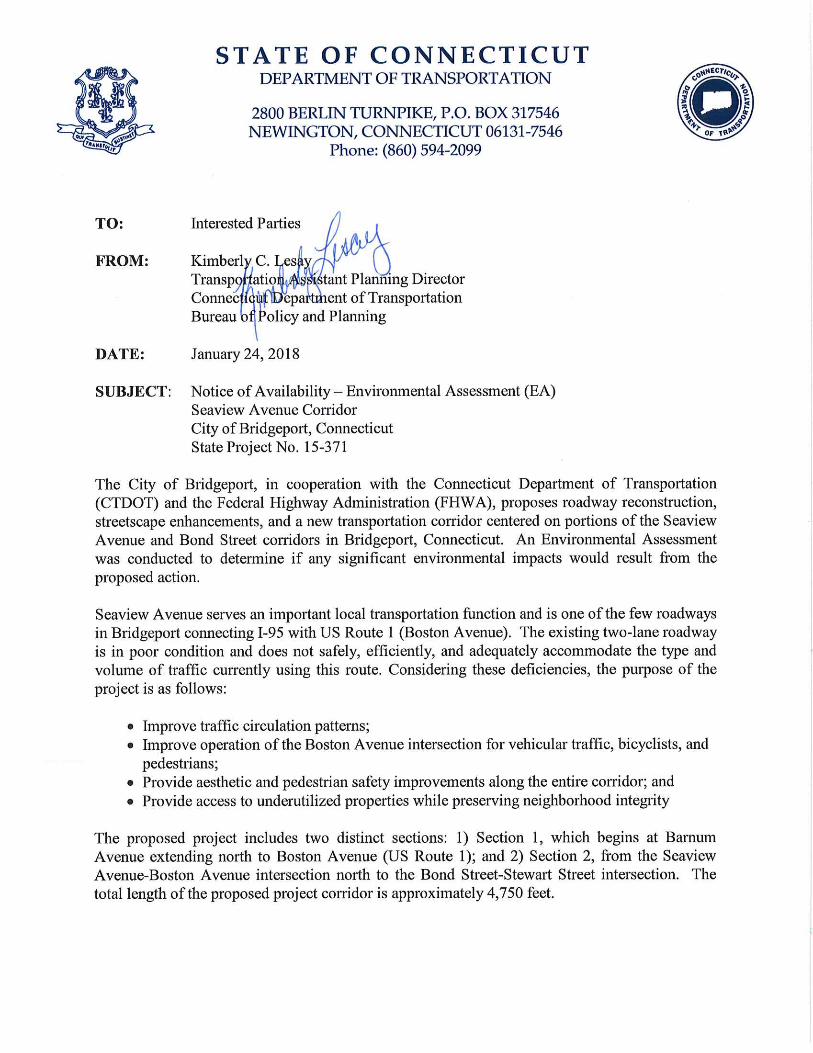
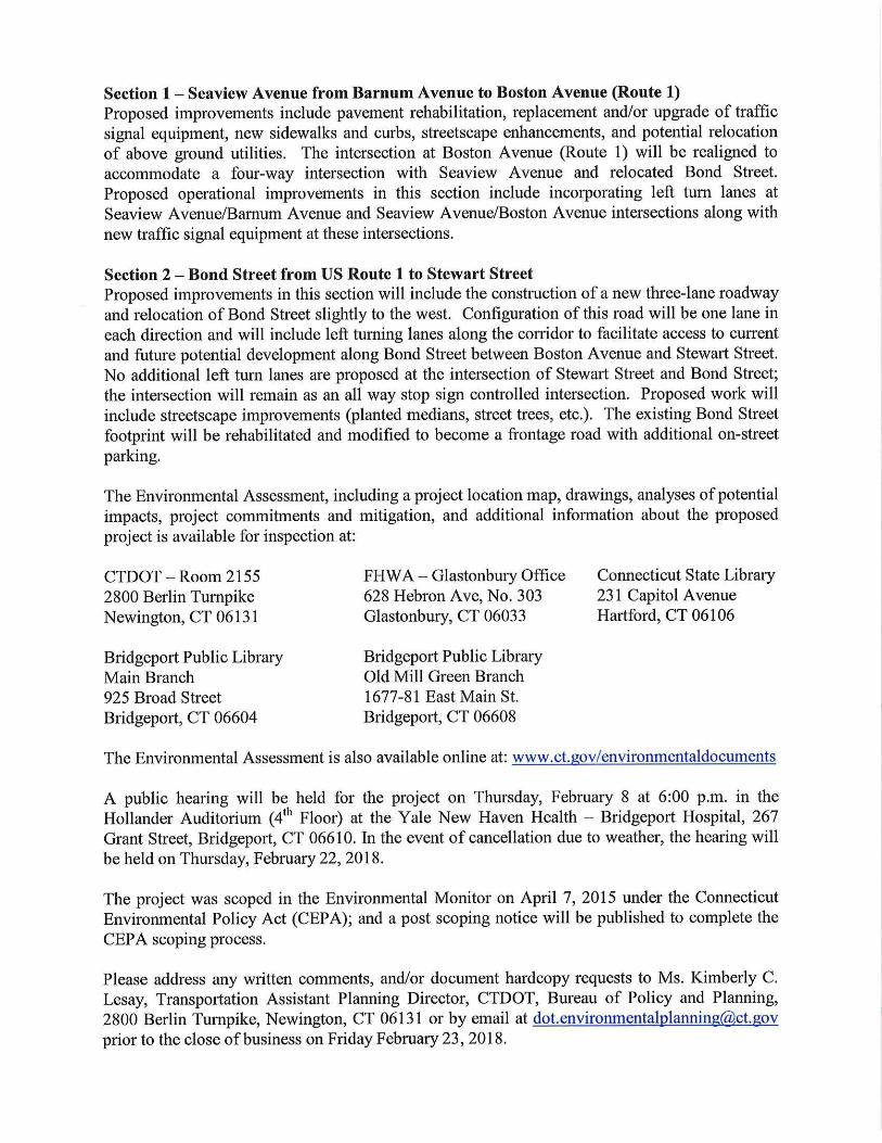
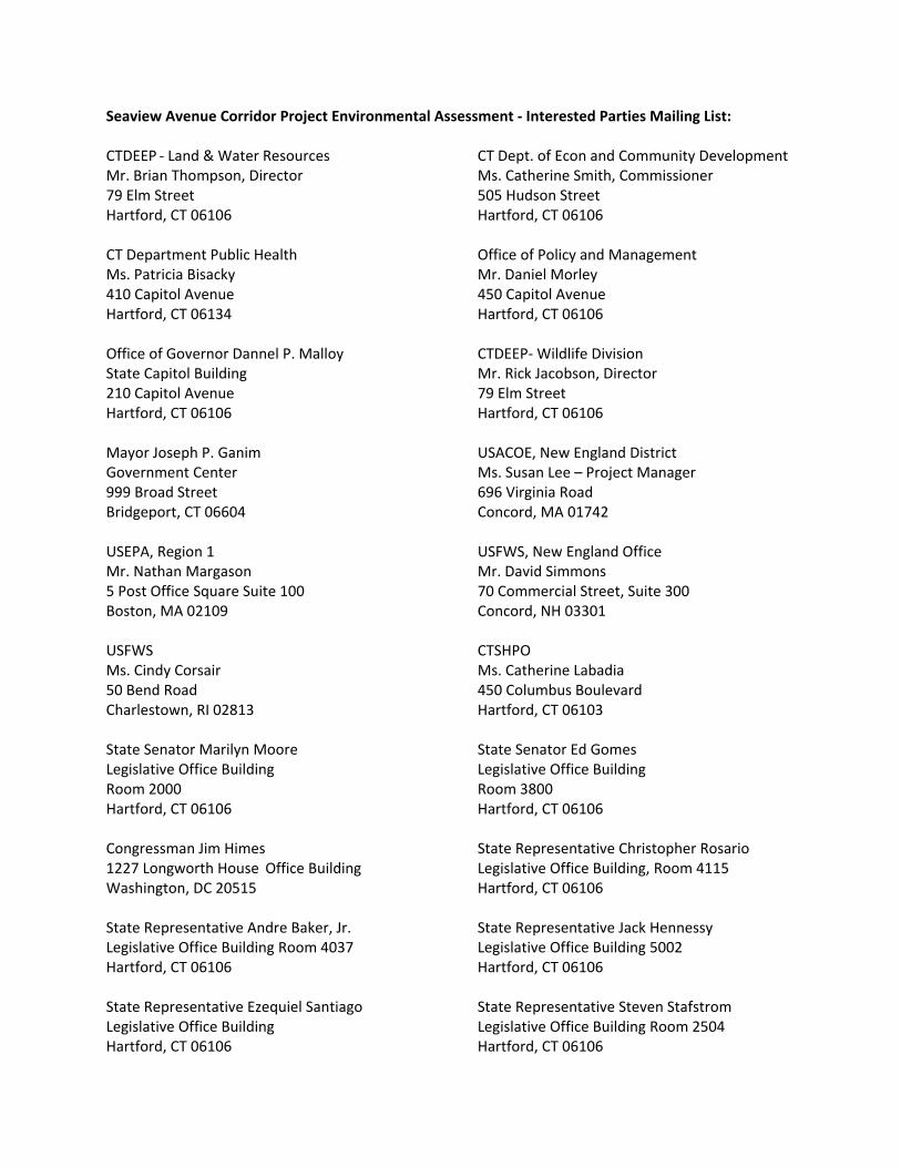
Seaview Avenue Corridor Project Environmental Assessment ‐ Interested Parties Mailing List: CTDEEP ‐ Land & Water Resources CT Dept. of Econ and Community Development Mr. Brian Thompson, Director Ms. Catherine Smith, Commissioner 79 Elm Street 505 Hudson Street Hartford, CT 06106 Hartford, CT 06106 CT Department Public Health Office of Policy and Management Ms. Patricia Bisacky Mr. Daniel Morley 410 Capitol Avenue 450 Capitol Avenue Hartford, CT 06134 Hartford, CT 06106 Office of Governor Dannel P. Malloy CTDEEP‐ Wildlife Division State Capitol Building Mr. Rick Jacobson, Director 210 Capitol Avenue 79 Elm Street Hartford, CT 06106 Hartford, CT 06106 Mayor Joseph P. Ganim USACOE, New England District Government Center Ms. Susan Lee – Project Manager 999 Broad Street 696 Virginia Road Bridgeport, CT 06604 Concord, MA 01742 USEPA, Region 1 USFWS, New England Office Mr. Nathan Margason Mr. David Simmons 5 Post Office Square Suite 100 70 Commercial Street, Suite 300 Boston, MA 02109 Concord, NH 03301 USFWS CTSHPO Ms. Cindy Corsair Ms. Catherine Labadia 50 Bend Road 450 Columbus Boulevard Charlestown, RI 02813 Hartford, CT 06103 State Senator Marilyn Moore State Senator Ed Gomes Legislative Office Building Legislative Office Building Room 2000 Room 3800 Hartford, CT 06106 Hartford, CT 06106 Congressman Jim Himes State Representative Christopher Rosario 1227 Longworth House Office Building Legislative Office Building, Room 4115 Washington, DC 20515 Hartford, CT 06106 State Representative Andre Baker, Jr. State Representative Jack Hennessy Legislative Office Building Room 4037 Legislative Office Building 5002 Hartford, CT 06106 Hartford, CT 06106 State Representative Ezequiel Santiago State Representative Steven Stafstrom Legislative Office Building Legislative Office Building Room 2504 Hartford, CT 06106 Hartford, CT 06106

State Representative Charlie Stallworth United States Senator Richard Blumenthal Legislative Office Building Room 5005 706 Hart Senate Office Building Hartford, CT 06106 Washington, DC 20510 United States Senator Christopher Murphy 136 Hart Senate Office Building Washington, DC 20510
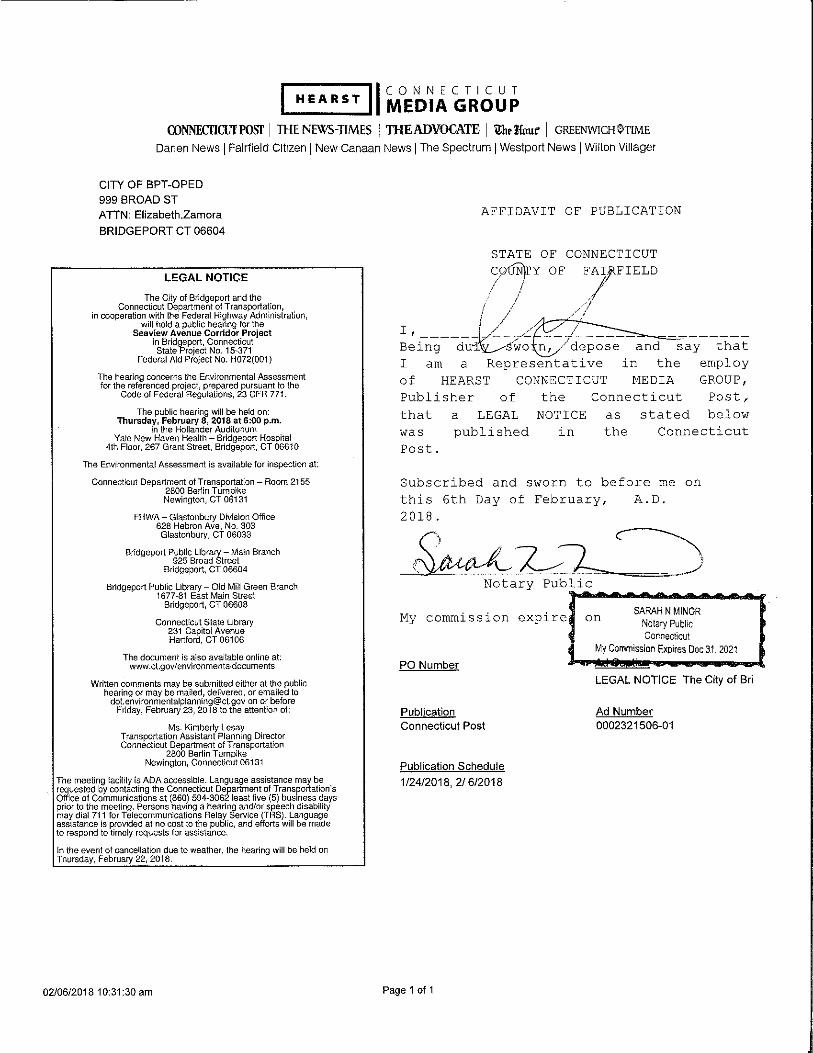
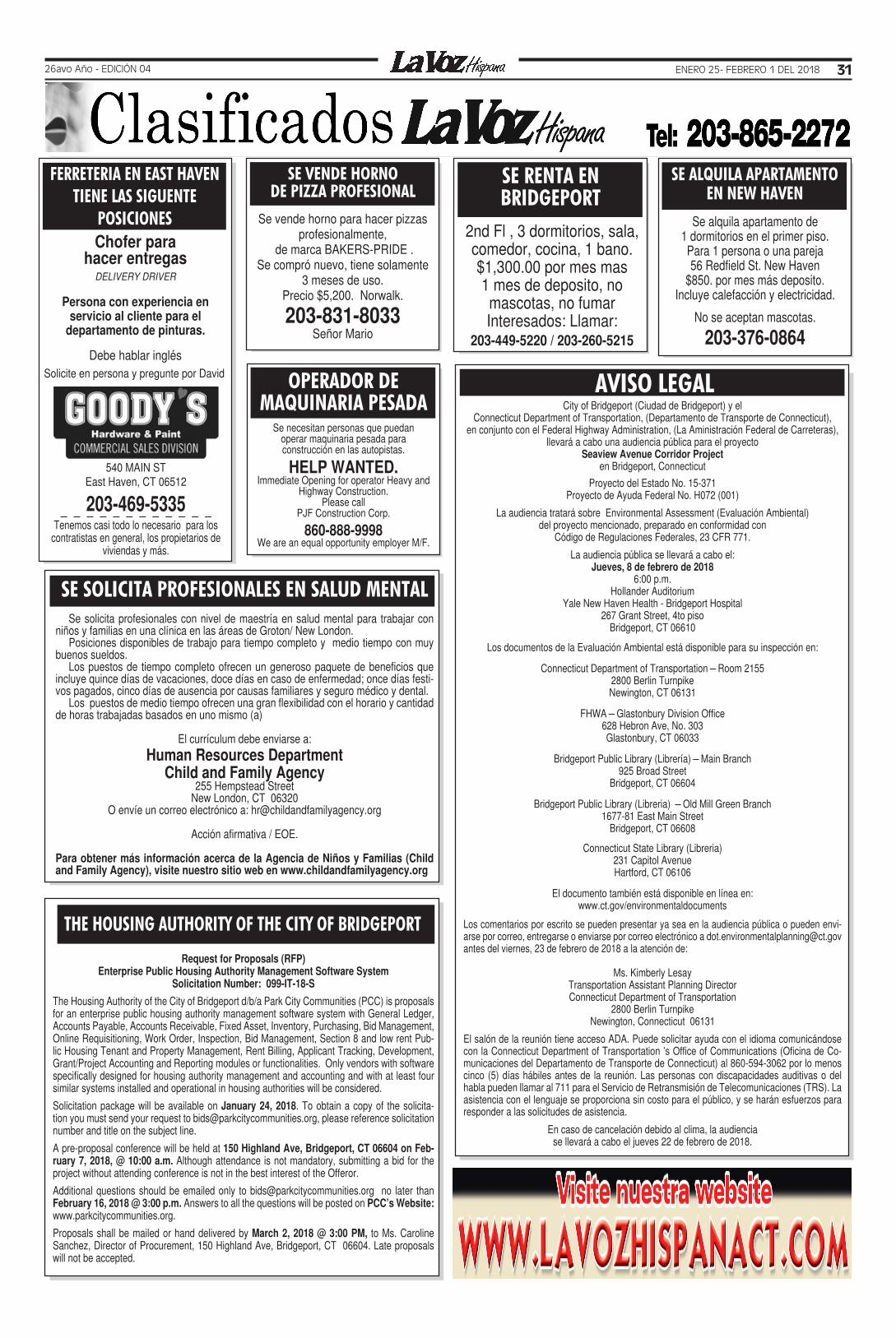
ENERO 25- FEBRERO 1 DEL 2018 3126avo Año - EDICIÓN 04
SE RENTA EN BRIDGEPORT
2nd Fl , 3 dormitorios, sala, comedor, cocina, 1 bano.$1,300.00 por mes mas 1 mes de deposito, no mascotas, no fumar Interesados: Llamar:
203-449-5220 / 203-260-5215
SE ALQUILA APARTAMENTO EN NEW HAVEN
Se alquila apartamento de 1 dormitorios en el primer piso.Para 1 persona o una pareja56 Redfield St. New Haven
$850. por mes más deposito. Incluye calefacción y electricidad.
No se aceptan mascotas.
203-376-0864
OPERADOR DE MAQUINARIA PESADA
Se necesitan personas que puedan operar maquinaria pesada para construcción en las autopistas.
HELP WANTED. Immediate Opening for operator Heavy and
Highway Construction.Please call
PJF Construction Corp.
860-888-9998We are an equal opportunity employer M/F.
City of Bridgeport (Ciudad de Bridgeport) y elConnecticut Department of Transportation, (Departamento de Transporte de Connecticut),
en conjunto con el Federal Highway Administration, (La Aministración Federal de Carreteras),llevará a cabo una audiencia pública para el proyecto
Seaview Avenue Corridor Project en Bridgeport, Connecticut
Proyecto del Estado No. 15-371Proyecto de Ayuda Federal No. H072 (001)
La audiencia tratará sobre Environmental Assessment (Evaluación Ambiental)del proyecto mencionado, preparado en conformidad con
Código de Regulaciones Federales, 23 CFR 771.
La audiencia pública se llevará a cabo el:Jueves, 8 de febrero de 2018
6:00 p.m.Hollander Auditorium
Yale New Haven Health - Bridgeport Hospital 267 Grant Street, 4to piso
Bridgeport, CT 06610
Los documentos de la Evaluación Ambiental está disponible para su inspección en:
Connecticut Department of Transportation – Room 21552800 Berlin TurnpikeNewington, CT 06131
FHWA – Glastonbury Division Office628 Hebron Ave, No. 303Glastonbury, CT 06033
Bridgeport Public Library (Librería) – Main Branch925 Broad Street
Bridgeport, CT 06604
Bridgeport Public Library (Libreria) – Old Mill Green Branch1677-81 East Main Street
Bridgeport, CT 06608
Connecticut State Library (Libreria)231 Capitol AvenueHartford, CT 06106
El documento también está disponible en línea en:www.ct.gov/environmentaldocuments
Los comentarios por escrito se pueden presentar ya sea en la audiencia pública o pueden envi-arse por correo, entregarse o enviarse por correo electrónico a [email protected] antes del viernes, 23 de febrero de 2018 a la atención de:
Ms. Kimberly LesayTransportation Assistant Planning DirectorConnecticut Department of Transportation
2800 Berlin TurnpikeNewington, Connecticut 06131
El salón de la reunión tiene acceso ADA. Puede solicitar ayuda con el idioma comunicándose con la Connecticut Department of Transportation ’s Office of Communications (Oficina de Co-municaciones del Departamento de Transporte de Connecticut) al 860-594-3062 por lo menos cinco (5) días hábiles antes de la reunión. Las personas con discapacidades auditivas o del habla pueden llamar al 711 para el Servicio de Retransmisión de Telecomunicaciones (TRS). La asistencia con el lenguaje se proporciona sin costo para el público, y se harán esfuerzos para responder a las solicitudes de asistencia.
En caso de cancelación debido al clima, la audiencia se llevará a cabo el jueves 22 de febrero de 2018.
AVISO LEGAL
Se solicita profesionales con nivel de maestría en salud mental para trabajar con niños y familias en una clínica en las áreas de Groton/ New London.
Posiciones disponibles de trabajo para tiempo completo y medio tiempo con muy buenos sueldos.
Los puestos de tiempo completo ofrecen un generoso paquete de beneficios que incluye quince días de vacaciones, doce días en caso de enfermedad; once días festi-vos pagados, cinco días de ausencia por causas familiares y seguro médico y dental.
Los puestos de medio tiempo ofrecen una gran flexibilidad con el horario y cantidad de horas trabajadas basados en uno mismo (a)
El currículum debe enviarse a: Human Resources Department
Child and Family Agency255 Hempstead Street
New London, CT 06320O envíe un correo electrónico a: [email protected]
Acción afirmativa / EOE.
Para obtener más información acerca de la Agencia de Niños y Familias (Child and Family Agency), visite nuestro sitio web en www.childandfamilyagency.org
SE SOLICITA PROFESIONALES EN SALUD MENTAL
THE HOUSING AUTHORITY OF THE CITY OF BRIDGEPORT
Request for Proposals (RFP)Enterprise Public Housing Authority Management Software System
Solicitation Number: 099-IT-18-S
The Housing Authority of the City of Bridgeport d/b/a Park City Communities (PCC) is proposals for an enterprise public housing authority management software system with General Ledger, Accounts Payable, Accounts Receivable, Fixed Asset, Inventory, Purchasing, Bid Management, Online Requisitioning, Work Order, Inspection, Bid Management, Section 8 and low rent Pub-lic Housing Tenant and Property Management, Rent Billing, Applicant Tracking, Development, Grant/Project Accounting and Reporting modules or functionalities. Only vendors with software specifically designed for housing authority management and accounting and with at least four similar systems installed and operational in housing authorities will be considered.
Solicitation package will be available on January 24, 2018. To obtain a copy of the solicita-tion you must send your request to [email protected], please reference solicitation number and title on the subject line.
A pre-proposal conference will be held at 150 Highland Ave, Bridgeport, CT 06604 on Feb-ruary 7, 2018, @ 10:00 a.m. Although attendance is not mandatory, submitting a bid for the project without attending conference is not in the best interest of the Offeror.
Additional questions should be emailed only to [email protected] no later than February 16, 2018 @ 3:00 p.m. Answers to all the questions will be posted on PCC’s Website: www.parkcitycommunities.org.
Proposals shall be mailed or hand delivered by March 2, 2018 @ 3:00 PM, to Ms. Caroline Sanchez, Director of Procurement, 150 Highland Ave, Bridgeport, CT 06604. Late proposals will not be accepted.
FERRETERIA EN EAST HAVENTIENE LAS SIGUENTE
POSICIONES
Solicite en persona y pregunte por David
540 MAIN STEast Haven, CT 06512
203-469-5335Tenemos casi todo lo necesario para los
contratistas en general, los propietarios de viviendas y más.
Chofer para hacer entregas
DELIVERY DRIVER
Persona con experiencia en servicio al cliente para el
departamento de pinturas.
Debe hablar inglés
SE VENDE HORNODE PIZZA PROFESIONAL
Se vende horno para hacer pizzas profesionalmente,
de marca BAKERS-PRIDE .Se compró nuevo, tiene solamente
3 meses de uso.Precio $5,200. Norwalk.
203-831-8033Señor Mario