Embed Size (px)
Citation preview

February 2011
110214_GCOM.ppt

2
GCOM-C GCOM-W
Comparison
Input
Cooperation with the climate model research institutions
Monitoring and understanding of the Earth environment change
Scenario
Policy design
Data
Operational use
Knowledge
Main responsibility of JAXA
Satellite observation
Demonstrate long-term global observation of various geophysical parameters for understanding climate variability and water cycle.
Two medium-sized satellites, three generations with one year overlap to ensure 10-15 years stable data records.
Cooperation with climate models and direct contribution to operational users.
Model prediction
Atmosphere
Ocean Land
Cryosphere

GCOM consists of GCOM-W and GCOM-C series - GCOM-W with AMSR2 (Advanced Microwave Scanning Radiometer2)
and its follow-on will contribute to the observations related to global water and energy circulation.
- GCOM-C with SGLI (Second-generation Global Imager) and its follow-on will contribute to the surface and atmospheric measurements related to the carbon cycle and radiation budget.
GCOM is long-term mission to observe more than 10 years. - Three consecutive generations of satellites with one year overlap in
orbit enables over 13 years observation in total.
GCOM-W1 GCOM-W2
GCOM-W3
GCOM-C1 GCOM-C2
GCOM-C3
1year
JFY2011 Launch
Launch
1year
JFY2014 (JFY2018)
(JFY2015)
(JFY2022)
(JFY2020)
3

Instrument Advanced Microwave Scanning Radiometer-2
Orbit
Sun Synchronous orbit Altitude:699.6km (on Equator) Inclination: 98.2 degrees Local sun time: 13:30+/-15 min
Size 5.1m (X) * 17.5m (Y) * 3.4m (Z) (on-orbit)
Mass 1991kg
Power gen. More than 3880W (EOL)
Launch JFY 2011 by H-IIA Rocket
Design Life 5-years
GCOM-W1 (Water)
Instrument Second-generation Global Imager
Orbit
Sun Synchronous orbit Altitude:798km (on Equator) Inclination: 98.6 deg. Local sun time: 10:30+/- 15min
Size 4.6m (X) * 16.3m (Y) * 2.8m (Z) (on orbit)
Mass 2093kg
Power gen. More than 4000W (EOL)
Launch JFY 2014 by H-IIA Rocket
Design Life 5-years
GCOM-C1 (Climate)
4
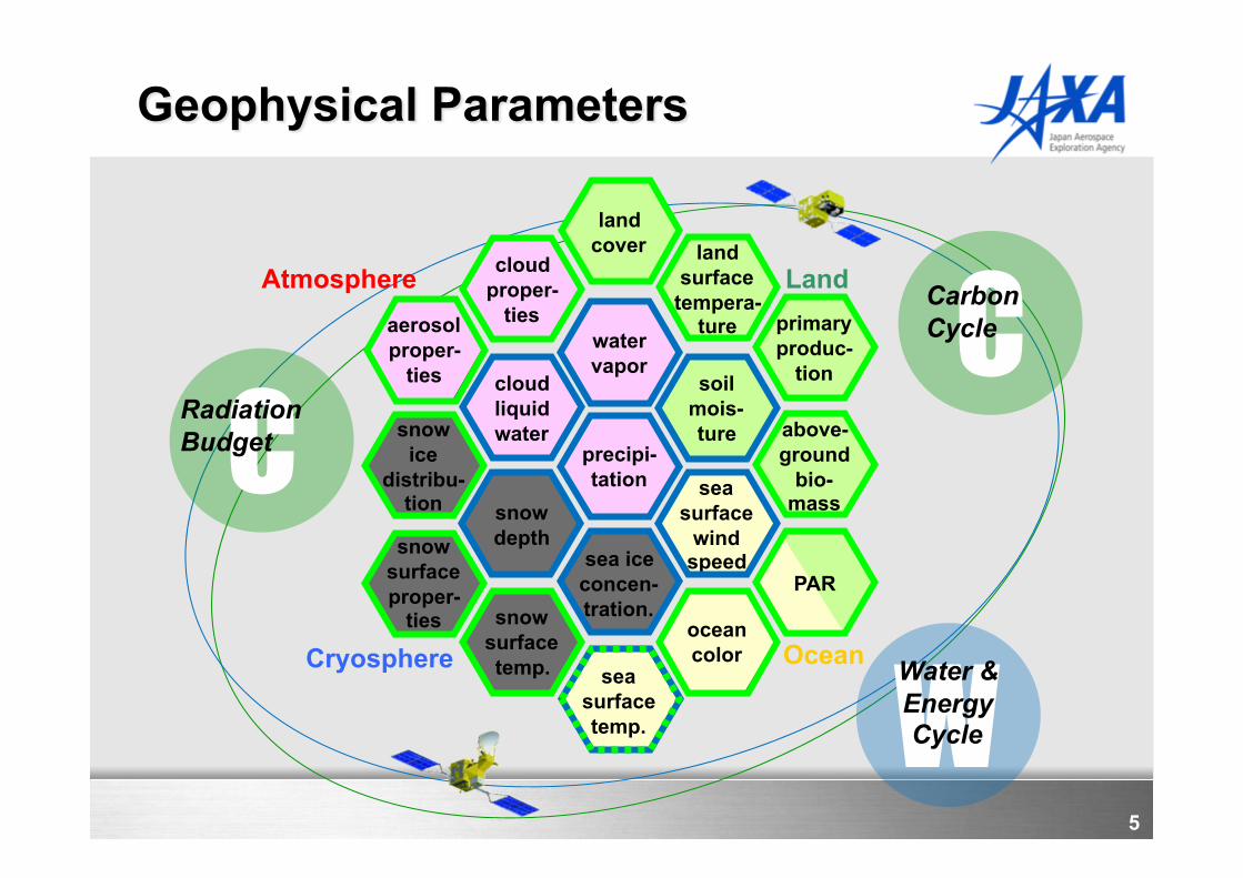
cloud liquid water
soil mois- ture snow
ice distribu-
tion
sea ice concen- tration.
ocean color
water vapor
cloud proper-
ties
snow depth
snow surface temp.
land cover land
surface tempera-
ture
sea surface temp.
sea surface
wind speed
precipi- tation
aerosol proper-
ties
snow surface proper-
ties
above- ground
bio- mass
primary produc-
tion
PAR
Land
Ocean Cryosphere
Atmosphere
C Radiation Budget
C Carbon Cycle
W Water & Energy Cycle
5

Page 6
GCOM-W1/AMSR2 characteristics
Scan and rate Conical scan at 40 rpm
Antenna Offset parabola with 2.0m dia.
Swath width 1450km
Incidence angle Nominal 55 degrees
Digitization 12bits
Dynamic range 2.7-340K
Polarization Vertical and horizontal
AMSR2 Channel Set
Center Freq. [GHz]
Band width [MHz]
Pol. Beam width [deg] (Ground res. [km])
Sampling interval
[km]
6.925/ 7.3 350
V and H
1.8 (35 x 62)
10 10.65 100 1.2 (24 x 42) 18.7 200 0.65 (14 x 22) 23.8 400 0.75 (15 x 26) 36.5 1000 0.35 (7 x 12) 89.0 3000 0.15 (3 x 5) 5
AMSR-E AMSR2
6
Deployable main reflector system with 2.0m diameter.
Frequency channel set is identical to that of AMSR-E except 7.3GHz channel for helping RFI mitigation.
Two-point external calibration with the improved HTS (hot-load).
Deep space calibration maneuver to check consistency between main reflector and CSM.
Add a redundant momentum wheel to increase reliability.

SGLI channels
CH
λ Δλ Lstd Lmax IFOV
nm VN, P: W/m2/sr/µm T: Kelvin m
VN1 380 10 60 210 250
VN2 412 10 75 250 250
VN3 443 10 64 400 250
VN4 490 10 53 120 250
VN5 530 20 41 350 250
VN6 565 20 33 90 250
VN7 673.5 20 23 62 250
VN8 673.5 20 25 210 250
VN9 763 12 40 350 1000
VN10 868.5 20 8 30 250
VN11 868.5 20 30 300 250
SW1 1050 20 57 248 1000
SW2 1380 20 8 103 1000
SW3 1630 200 3 50 250
SW4 2210 50 1.9 20 1000
T1 10800 740 300 340 500
T2 12000 740 300 340 500
P1 673.5 20 25 250 1000
P2 868.5 20 30 300 1000
GCOM-C SGLI characteristics
Scan Push-broom electric scan (VNR: VN & P) Wisk-broom mechanical scan (IRS: SW & T)
Scan width 1150km cross track (VNR: VN & P) 1400km cross track (IRS: SW & T)
Digitalization 12bit Polarization 3 polarization angles for P Along track direction
Nadir for VN, SW and T, +45 deg and -45 deg for P
On-board calibration
VN: Solar diffuser, Internal lamp (PD), Lunar by pitch maneuvers, and dark current by masked pixels and nighttime obs.
SW: Solar diffuser, Internal lamp, Lunar, and dark current by deep space window
T: Black body and dark current by deep space window All: Electric calibration
Visible & Near infrared push-broom Radiometer (VNR)
Polarization (along-track slant) radiometer (P)
shortwave & thermal InfraRed (T) Scanner (IRS)
SGLI : Second generation GLobal Imager
7

Integrated water vapor Integrated cloud liquid water
Sea surface wind speed Precipitation
8

Sea Surface Temperature
Sea Surface Wind Speed
Total Precipitable Water
Precipitation
Soil Moisture Content
Snow Depth 9

SGLI 250m resolution will enable to detect more fine structure in the coastal area such as river outflow, regional blooms, and small current.
(a) GLI 1km Osaka Bay (1 Oct. 2003, CHL by LCI)
(b) GLI 250m Osaka Bay (1 Oct. 2003, CHL by LCI)
250m Ocean color chlorophyll-a and NDVI simulated using GLI 250m channels
Hiroshi Murakami, Mitsuhiro Toratani and Hajime Fukushima, Satellite ocean color observation with 250 m spatial resolution using ADEOS-II GLI, Remote Sensing of the Marine Environment, Proceedings of SPIE, Volume 6406-05, Nov. 28, 2006 10

(d) 1km
Simulated thermal infrared images using ASTER data over Tokyo Bay in the night on August 4, 2003.
500m resolution of TIR ↓
Enables detection of fine structures such as land and coastal water surface temperature influenced by the city and the river flows.
(c) 500m
(b) 250m (a) 90m
SGLI-standard
SGLI-option*
* SGLI has TIR observation
with 250m spatial resolution
as a optional capability.
ASTER-original
11

12