Embed Size (px)
Citation preview

6 Framingham The initial section of this chapter is a profile of the Town of Framingham. The second section describes existing bicycling and walking conditions and recommendations for improvements. The findings are based on meetings and correspondence with local staff, fieldwork, and review of previous studies. These include:
• Preliminary Design Application for Pedestrian Improvements and/or Bicycle Facilities, Transit Oriented Development (TOD), July 2006, the Town of Framingham.
• The Downtown Visualization Project, April 2007, by the Framingham Downtown Renaissance (FDR). FDR is a coalition of community groups in Framingham interested in the economic vitality of the downtown area.
• Downtown Study, August 2007, BETA Group, Inc., for the Town of Framingham. 6.1 COMMUNITY PROFILE This section includes a short history of Framingham, a general description of land use, population and employment data, an overview of the transportation network, and crash data. 6.1.1 HISTORY Settled in 1647 on the west bank of the Sudbury River along the Old Connecticut Path connecting Boston and Hartford, Framingham was incorporated as a town in 1700. Framingham was an outpost in the Abolitionist movement, with regular visits by William Lloyd Garrison, Sojourner Truth, Wendell Phillips, and Henry David Thoreau. In 1871, the Lowell Railroad completed a stretch of rail through the town, establishing it as an exchange hub for eastern Massachusetts. Trolley connections along the Worcester Turnpike (State Route 9) in 1903 strengthened the town’s connection to rail. Following World War II, Framingham became a commercial hub for the MetroWest region between Boston and Worcester, attracting General Electric and Shoppers World in 1948 and 1951, respectively. To facilitate inter- and intrastate travel and economic development in the area, the Massachusetts Turnpike (Interstate 90) opened in 1957. The Massachusetts Turnpike bisects the town, with interchanges on the west side at Route 9 and on the east side at State Route 30.
Boston Region MPO • 71
6.1.2 LAND USE Framingham, which is the most populous town in Massachusetts, is a collection of neighborhoods: Downtown Framingham, Framingham Center, Coburnville, Lokerville, Salem End, Nobscot, Pinefield, Ridgefield, and Saxonville. In addition to its large residential base, Framingham’s economy is based on retail and office complexes. There are scatterings of small manufacturing facilities and commercial services, such as plumbing, mechanical, and electrical services, which are typical in communities of this size. Framingham has three major business districts, the “Golden Triangle,” Downtown/ South Framingham, and West Framingham. Additionally, there are several business hubs that provide medical, retail, educational, office, and biotechnical services in the villages of Framingham Center, Saxonville, and Nobscot, and along the Route 9 corridor. 6.1.3 POPULATION AND EMPLOYMENT The 2000 population of 66,911 people was an increase of 3.0 percent from 1990. The Metropolitan Area Planning Council (MAPC) projects the population to grow by 8.9 percent, to 72,841, by 2030, and projects employment to grow by 8.2 percent, increasing from 45,055 in 2000 to 48,758 by 2030.
TABLE 6-1 Population and Employment,
in Framingham in 2000, 2010, 2020, and 2030
Census Data 2000 2010 Change
2000-2010 2020 Change
2010-2020 2030 Change
2020-2030Population 66,911 68,856 2.9% 71,040 3.2% 72,841 2.5%Employment 45,055 46,610 3.5% 47,980 2.9% 48,758 1.6%
6.1.4 TRANSPORTATION Several state highways travel through Framingham: Routes 9 and 30 bisect Framingham Center, both connecting Boston with points west. The north–south State Route 126 and the east–west State Route 135 connect Downtown Framingham with Concord, Massachusetts, and Woonsocket, Rhode Island, and with Dedham and Northborough, respectively. The Massachusetts Turnpike roughly parallels Route 9, connecting Boston with points west, and, as Interstate 90, continues to Washington State. The Framingham commuter rail station, on the Worcester/Framingham Line, is located on Waverley Street on the southwest edge of downtown, within the study area. Service is provided between Worcester and Boston. Some runs begin and end in Framingham, the line’s terminus until service to Worcester was restored in 1994. There is bicycle parking at the station. The town secured transit-oriented-development funding to improve the pedestrian connections between the station and the parking garage on Pearl Street.
Boston Region MPO • 72
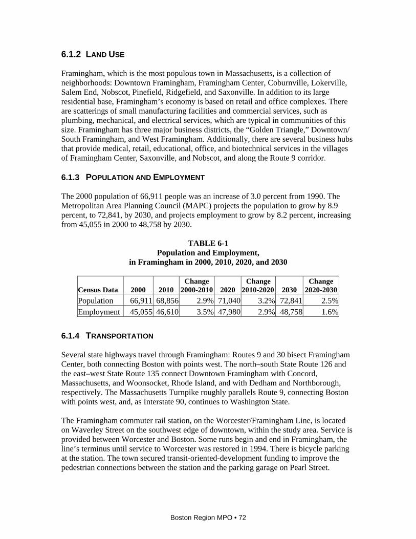
The MetroWest Regional Transit Authority (MWRTA) provides bus service to the Town of Framingham and 10 other municipalities. All of the buses are equipped with bicycle racks. The six routes (2, 3, 4, 5, 6, and 7) originate from the central hub, the MWRTA offices at 160 Waverley Street, just east of the study area. The MWRTA also provides door-to-door service for eligible individuals who have physical, cognitive, or mental disabilities. This service, which runs 365 days a year, 6:00 AM to 1:00 AM, is similar to the MBTA’s RIDE service. Previously to July 2009, the MWRTA contracted with the MBTA to provide RIDE service in the MWRTA area. The Massachusetts Port Authority operates the Logan Express bus service from Shoppers World to Boston’s Logan International Airport. A private bus carrier, Peter Pan, provides service between Worcester and Boston. CSX provides freight service through Framingham to Northeast Corridor destinations. The Bay Circuit Trail passes through the northwest corner of Framingham. This facility, intended primarily for hiking, is a circumferential trail around the metropolitan Boston area, extending from Plum Island to Kingston Bay. On the eastern side of town is the proposed Cochituate Rail Trail, extending to Natick Center. 6.1.5 CRASH AND USAGE DATA Between 2002 and 2006 there were 116 reported crashes involving pedestrians in Framingham, representing 1.4 percent of all crashes and resulting in four fatalities. In the same period there were 91 reported crashes involving bicyclists, representing 1.1 percent of all crashes, and no fatalities. These data are shown in Table 6-2, along with motor-vehicle crashes. The latter category refers to crashes involving motor vehicles only, as the bicycle and pedestrian crashes also involve motor vehicles.
TABLE 6-2 Bicycle, Pedestrian, Motor-Vehicle and Total Crashes and Fatalities
in Framingham, by Number and Percentage, 2002-2006
Crashes Fatalities Mode Number Percentage Number Percentage Bicycle 91 1.1% 0 0.0% Pedestrian 116 1.4% 4 25.0% Motor Vehicles 8,135 97.5% 12 75.0% Total 8,342 100% 16 100%
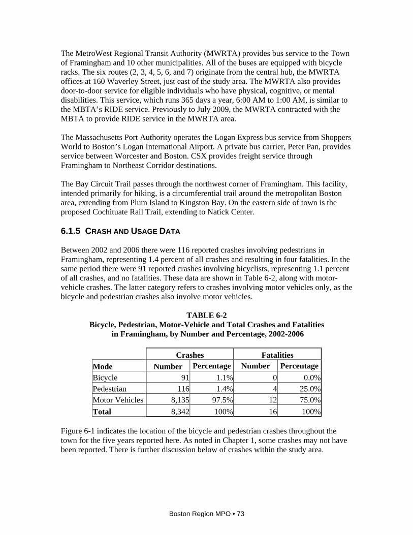
Figure 6-1 indicates the location of the bicycle and pedestrian crashes throughout the town for the five years reported here. As noted in Chapter 1, some crashes may not have been reported. There is further discussion below of crashes within the study area.
Boston Region MPO • 73
MARLBOROUGH
FRAMINGHAM
NATICK
SOUTHBOROUGH
ASHLANDSHERBORN
HOPKINTON
SUDBURY
WAYLAND
LOWTHER RD
RUSSET LN
RICKY LN
HILL ST
FEMIA RD
AQUEDUCT RD
REDMEN DR
WILLI
S ST
ROYCE RD
CROSS ST
ESTY ST
BROOKS RD
SHER
MAN S
T
HUDSON ST
JOCLYN AVE
ALFRED RD
DAVIS
RD
MOUL
TON R
D
PEAR
L ST
BARRY DR
FRANCONIA AVE
DOES
KIN DR
CREST RD
RONS WAY
THIRD ST
BRYD
EN R
D
WESSON RD
DEAN
RD
HOLL
Y LN
KARAL DR
SHOR
E RD
LEON
ARD D
R
LAKE ST
ELLIS ST
SAVOY RD
CATHERINE RD
RICHA
RD RD
COVE
AVE
DEBRA LNDORIS RD
WAYSIDE INN RD
LINCOLN ST
NEW YORK AVE
ROCKWOOD ST
RICE R
D
COTTAGE ST
CARTER DR
M AIN
ST
LAND
H AM
RD
WINT
ER ST
PARMENTER ST
FAY
RD
MILLWOOD ST
COOK LN
WALN
UT
ST
CORDA VI LLE RD
NIXON
RD
FEL CH
R D
ELM STGARVEY RD
BISHO
P ST
WEST RD
MYRT
LE ST
SOUT
H MAIN
ST
GRAN
T ST
KEND
ALL L
N
BALD
WIN A
VE
HERIT A GE AVE
WILSON ST
BETH
ANY R
D
SINGLET A RY LN
ROCKLAND ST
PORTER RD
OA
KVALE RD
OAKS RD
WEST
ERN A
VE
D ONNA
RD
LOKER ST
NEWTON ST
MILL ST
PARK AV E
FLANAGAN DR
JUNIPER LN
NADI
NE
RD
LINDA RD
PERRY ST
CROSS ST
CORD
AVILL
E ST
PROSPECT ST
MORSE ST
RIVER ST
MAIN ST
FO
UNT AIN ST
NOBS
COT RD
COMMONWEALTH RD
CURVE ST
WHIT
E BA
GLEY
RD BOSTON RD
MAPLE S
T
OAK ST
UNION ST
HIGH ST
FLUTIE PASS
BEUL
AH ST
OAK ST
GROVE ST
BELKNAP RD
HARTFORD ST
SUMMER ST
HARR
INGTO
N RD
BROOK ST
ARLIN
GTON
ST
POND ST
ATWOO D RD
BEACON ST
WAVENEY RD
LA CLEDE AVE
FARM
RD
MAYN
ARD R
DSTAT E ST
BEAVER ST
FRONT ST
WINCH S T
SPRING ST
OREGON RD
MARL
BORO
RD
HEME
NW
AY
RD
WOO DRIDG E RD
MASSACHUSETTS TURNPIKE
JEAN ST
WEST PLAIN ST
VOSE ST
WEST CENTRAL ST
KENDALL AVE
GREEN STAR
SENA
L RD
SPEEN ST
BRAC
KETT
RD
FRANKLIN ST
GRIFFIN RD
HIGHLAND ST
PLEASANT ST
PEMBERTON RD
OAK HILL RD
KANSAS ST
THOMAS RD
WOODS
IDE RD
AUBURN ST
CONCORD R D
WORCESTER ST
MAIDEN LN
NORTH RD
DICEN ZO B O U LEVA
RD
DAR
L E N E DR
HAGER ST
BADG
ER R D
LANE
W OOD
AVE
BRUS H HILL R D
CALIF
ORNIA A
VE
EDMANDS
RD
SYLVESTER RD
NEWBURY
ST
EDEN ST
WOODMERE RD
BROADMEADOW RD
RIDGE
AVE
ASH S
T
DEER
RUN
RING RD
PINE ST
EAST MAIN STTRIPP ST
WILLOW
STPARKERVI LL E R D
EV ERETT ST
PARKER RD
TED LN
WABA N ST
GATES STTURNPIKE RD
PINERIDGE RD
NORTH AVE
BARBER R D
POTTER RD
HOWE ST
PARMENTER RD
MIDDLE
RD
KELSEY RD
MEADOW ST LAKE
RD
PELHAM ISLAND RD
SHATTUCK ST
ANDERSON RD
BENSON AVE
SAUCIER ST
CHERRY ST
LINCO
LN RD
WARR EN RD
EAST RD
NORTH LN
LANES END
CLARKE DR
EATON RD
HOME AVE
BANT
RY RD
S IMPSON DR
BIRCH LN
WESTGATE RD
VICTORIA RD
PRI OR DR
JOSL IN LN
ELIOT ST
LILLIAN RD
ALTA RD
LEDGE WOOD RD
SHAW DR
A ST
MANOR AVE
TEMPLE ST
STONE BRIDGE RD
HIGH S T
BLACKBERRY LN
ALDEN
RD
SEAR
S RD
WELD ST
SECO
ND ST
COLE RD
PITTS ST
TIMBER LN
TYLER ST
P LAIN ST
HEARD RDSLOANE DR
LORING DR
MORAN DR
OVERLO
OK RD
BIGELOW D R
JEFFERSON ST
INDIAN HEAD RDCONCORD ST
KEITH RD
DOW
ST
KELLOG G ST
SWAN
SON RD
ESSEX ST
PEQUOT RD
CED AR
ST
FERN ST
JOHN ST
LANTERN RD
FRANCINE RD
C RD
PITT R
DVALLEY RD
BEECH ST
BERR
Y ST
HEA TH ST
TUCKER ST
DAVIDSON RD
FRAMINGHAM RD
TERRI RD
FULLE
R RD
B RD
ALDER LN
EDITH RD
DALE RD
A RD
CIDER MILL RD
HAMILTON ST
SYLV
IA AV
E
DOVE RD
T R AVIS RD
HIGLEY RD
SCHOOL ST
EDGEWOOD RD
LINDE
N ST
NICHO
LS ST
NE
WFIELD
DR
IVY L N
CRAF
T RD
OLYMPIC ST
DRAPER ST
ANGE
LICA
DR
TURNER RD
WINTER LN
GRO VER RD
FLYNN ST
EDGE
LL DR
C ST
ROSE LNLA
URIE
LN
30
126
85
27135
9
16
20
90
FRAMINGHAM
WESTNATICK
ASHLAND
SOUTHBOROUGH
2 2
23 22
2 2
2
4
4222
5
32 22254
2234
3
2 22
2
1124
6
22
Hultman
Aqueduct Trail
Route 85 Turnpike to Marlborough Center
Cochituate State Park
Sudbury Aqueduct
Hultman Aqueduct
Weston
Aqueduct
Cochituate
Rail Trail
Bay C
ircuit Trail
Uppe r Charle s T ra il
Cochituate
Aqueduct
Bay C
ircuit
Trail
Upper
Charle
s
Bruce
Freem
an-Fr
aming
ham
Sudb
ury
Bay Circuit Trail
Natick Rt 135-Middlesex Ave Path
Union -
Hemenway
45 2
22
2
2
2
2
4
3
5
2
11
6
4
32
43
2
2
22
2
2
22
2
32
2
2
2
4
2
2
LegendCrash involving:
PedestrianBicyclist
Boston Region MPO
FIGURE 6-1 Framingham: Crashes in 2002-2006 Involving Pedestrians and Bicyclists
Bicycle and Pedestrian Improvements in Six Urban Centers

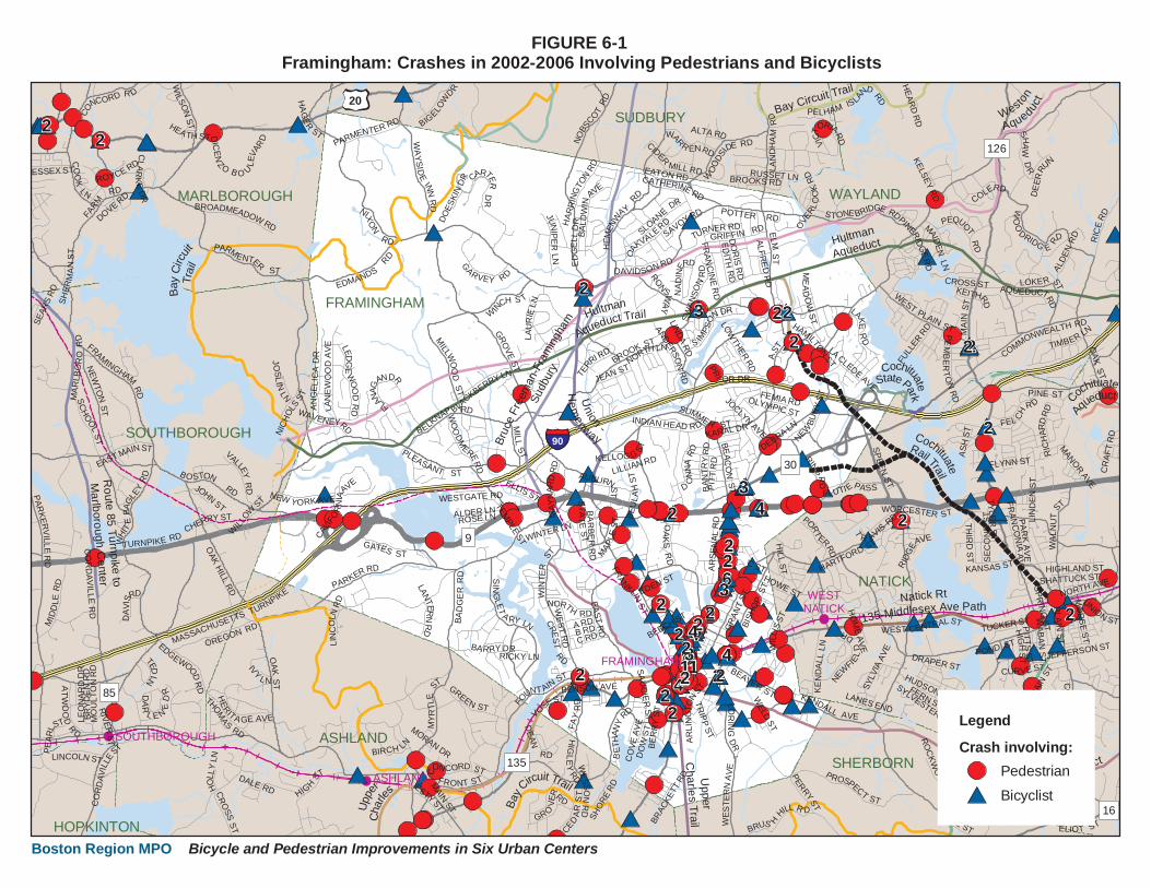
6.2 STUDY AREA The first part of this section of the chapter defines the study area and gives an overview of transit services and walking and bicycling conditions. Subsequent sections give more details on the different parts of the study area. Downtown Framingham is a commercial area as well as the center of municipal services. The study area for Framingham (shown in Figure 6-2) is discussed in terms of the following sections:
• The Downtown “Double Y” • The Neighborhood Northwest of Downtown • The Neighborhood Northeast of Downtown • The Neighborhood Southwest of Downtown • The Neighborhood Southeast of Downtown
The Downtown “Double-Y” is so called because of the Y-split of Concord Street and Union Avenue in front of the Memorial Building and the upside-down Y-split of Irving and Hollis Streets (also known as Burkis Square). There are 21 inbound trains to Boston leaving from the Framingham commuter rail station, between 6:05 AM and 12:30 AM, and 20 outbound trains from Boston, that leave Boston between 5:50 AM and 12:12 AM. The 166-space parking lot has 4 accessible spaces and 10 bicycle spaces. All six of the MWRTA bus routes stop in Downtown Framingham, as well as other locations within the study area. Service runs between 6:30 AM and 7:00 PM. Along the major roadways, the sidewalks are concrete, with granite curbs, and are in good condition. The sidewalks along moderately busy roadways are generally in decent condition, and most of them are concrete, with granite curbs, although some are asphalt with granite curbs. Some have weeds and minor cracking. Away from the main arterials, the sidewalks are usually asphalt, with granite curbs, and are in poor condition. Some of the minor roads have no sidewalks. Sidewalks without granite curbs generally blend in with the street whenever there is a driveway and are patched and uneven in places. The sidewalks that cross the railroad tracks along Concord Street and Claflin Street are in poor condition. Only sidewalks along Union Avenue and Concord and Hollis Streets in the downtown area have street trees. The crosswalks in the study area are generally highly visible, with exclusive curb ramps for each crosswalk. However, crosswalks should be added at many locations, particularly in the neighborhood northeast of downtown. Almost all of the existing crosswalks extend along the most logical path for pedestrians. Many of the crosswalks are zebra-style; some are ladder-style, with yellow rungs and white parallel bars. Crosswalks near the Memorial Building, where the only curb extensions are found, are brick. The crosswalks to the north of the roundabout there intersect islands, providing refuge for crossing pedestrians.
Boston Region MPO • 75
FRAMINGHAM
Farm
Pond
Highly visible crosswalk
Moderately faded crosswalk
Very faded crosswalk
No curb ramp
Shared curb ramp
Sidewalk in good condition
Sidewalk in fair condition
Sidewalk in poor condition
Indicates one way street
Train station
Train line
School
Playground
Library
Post office
Police department
Municipal building
Community center
Museum
Park
Traffic signal
Legend
FIGURE 6-2Downtown Framingham
Existing Conditions
PG
M
PO
0 0.25 Miles
300 Feet0
PG
M
PO
CharterSchool
RMV
Franklin St
Union A
ve
Pearl St
Lexington St Lincoln St
Tho
mps
on S
t
Sanger S
t
William H. W
elch Wy
Proctor St
Con
cord
St
Frederick St Ric
hard
son
Cir
Torrey St
Milt
on S
tFr
eem
an S
t
Davis St
Gra
nt S
t
Clinton St
Howard St
Kendall St
Concord S
t
FranklinS
t
Par
kP
l
Park St
Waverley St
Ced
ar S
t
Hig
hlan
d S
t
Hay
es S
t
Hol
lis S
t
Hollis CtGordon St
Arlingt
on S
t
ArlingtonPl
Ale
xand
er S
t
East St
Taylor St
South S
t
Columbia St
Irving St
Marble S
t
Waverley St
AvonS
t
Pine St
Waushakum Ave
Claflin St
Irving St
Howard St
Lack of sidewalks
Disrepair near railroad tracks
Lack of crosswalks
Lack of sidewalk separation
Potential for bike lanes
Narrow, obstructed sidewalk
N
Boston Region MPO Bicycle and Pedestrian Improvements in Six Urban Centers
Long crosswalks exist at the southern fork of Burkis Square, across Hollis and Irving Streets. There are several signalized pedestrian crossings. None have countdown signals. The pedestrian phases at some are short, while others are adequate in length. There are no pedestrian countdown signals. There are no bicycle lanes, although some of the roadways are wide enough to accommodate them. Many of the roadways have on-street parking, which increases the risks to bicyclists. The edges of the roadway generally do not have significant cracks or large pieces of debris, and the drainage grates are set back from the roadway. See Figure 6-2 for more information on the bicycle network. The only bicycle parking are two ribbon racks located under the station platform at the MBTA Framingham commuter rail station. During the five-year period 2002 through 2006, 30 of the 91 bicycle crashes in Framingham occurred in the study area. For crashes involving pedestrians, 34 of the 116 town-wide occurrences were in the study area. None of these 64 crashes resulted in a fatality. As seen in Figure 6-3, most crashes occurred on Hollis, Concord, and Waverley Streets and on Union Avenue. This is possibly due to the higher incidence of walking and bicycling on these roadways. On Tuesday, August 26, 2008, there were 128 bicyclists and 934 pedestrians counted from 2:00 PM to 6:00 PM on Concord Street between Kendall and Park Streets. There are no counts available in other areas of town, so relative walking and bicycling rates cannot be determined. The intersection with the highest number of crashes is Waverley and Concord Streets, where 11 occurred. There were five crashes at several intersections on Concord Street: at Lincoln Street, Clinton Street, and Howard Street. There were five crashes on Hollis Street, in the vicinity of Hollis Court and Gordon Street. There were four crashes at the following locations: Hollis and Claflin Streets, and Concord and Park Streets. There were three crashes at the following locations: Concord and Kendall Streets; Concord Street at Union Avenue; and Union Avenue at Pearl Street. The following sections give more details on existing conditions and list recommendations, which are illustrated in Figure 6-4. 6.2.1 DOWNTOWN “DOUBLE-Y” This area, particularly the Y-split in front of the Memorial Building, has undergone a number of improvements over the years, including the addition of street trees, narrowing of the roadway, a brick plaza in front of the Memorial Building, and an improved roundabout. Besides the Memorial Building, which is Framingham’s town hall, the police department is located here, as well as numerous businesses and residences, both single and multifamily.
Boston Region MPO • 77
2
2
2
2
22
5
2ROXANNA STREET
CEDA
R STR
EET
EVERIT CIRCLE
WAVERLEY STREET
IRVING STREET
PROCTOR STREET
LINCOLN STREET
EVERIT AVENUE
FOUNTAIN STREET
ARLINGTO
N STREE
T
WAVERLEY COURT
HAYE
S STR
EET
SANGER STREET
MILTO
N STR
EET
LEXINGTON STREET
BEAVER STREET
OAK PLACE
CLAFLIN STREET
RICH ARDSON
CI RCLE
UNION AVENUE
SOUTH STREETHOLLIS COURT
CLINTON STREETTORREY STREET
LAWRENCE STREET
PARK STREET
TAYLOR STREET
CASEY COURT
HOWARD STREETPA
R K PL
ACE
SNOW STREET
PHIPP
S ST
REET
SAUCIER STREET
DAVIS STREET
WEBS
TER
STRE
ET
SUMM
IT ST
REET
CLARK STREET
FREDERICK STREET
COLUMBIA STR
EET
ARLINGTON PLACE
WILLIAM H.
WELCH WAY
ALEX
ANDE
R ST
REET
MARBLE STREET
MELLEN STREET HI
GHLA
ND ST
REET
GORDON STREET
EAST STREET
KENDALL STREET
BISHO
P STR
EET
BLAN
DIN AV
ENUE
GRAN
T STR
EET
HOLL
IS ST
REET
HENRY STREET
CONC
ORD ST
REETPEARL STREET
FREE
MAN S
TREE
T
FRAMINGHAM
2
3
3
43
6
2
LegendStudy Area
Crash involving:PedestrianBicyclist
FIGURE 6-3 Downtown Framingham
Boston Region MPO
Crashes in 2002-2006 Involving Pedestrians and Bicyclists
Bicycle and Pedestrian Improvements in Six Urban Centers
FRAMINGHAM
Farm
Pond
PG
M
PO
CharterSchool
RMV
Franklin St
Union A
ve
Pearl St
Lexington St Lincoln St
Tho
mps
on S
t
Sanger S
t
William H. W
elch Wy
Proctor St
Con
cord
St
Frederick St Ric
hard
son
Cir
Torrey St
Milt
on S
tFr
eem
an S
t
Davis St
Gra
nt S
t
Clinton St
Howard St
Kendall St
Concord S
t
FranklinS
t
Par
kP
l
Park St
Waverley St
Ced
ar S
t
Hig
hlan
d S
t
Hay
es S
t
Hol
lis S
t
Hollis CtGordon St
Arlingt
on S
t
ArlingtonPl
Ale
xand
er S
t
East St
Taylor St
South S
t
Columbia St
Irving St
Marble S
t
Waverley St
AvonS
t
Pine St
Waushakum Ave
Claflin St
Irving St
Howard St
N
Boston Region MPO Bicycle and Pedestrian Improvements in Six Urban Centers
PO
Legend
FIGURE 6-4Downtown Framingham
Recommendations
F
PG
CURB +
# Recommendation number
Add bike parking
Add crosswalk
Shorten crossing
Move crosswalk
Add curb extension
Remove parking
Plant trees
Street furniture
Add vegetation buffer
Add bicycle lanes
Add sidewalk
Improve sidewalk
Widen walk area
Train station
Train line
School
Library
Post office
Fire department
Playground
Community center
Park
Traffic signal
0 0.25 Miles
300 Feet0
CU
RB
+
CU
RB
+
CU
RB
+CU
RB
+
CU
RB
+
CU
RB
+
CURB +CURB +
CURB +
CURB +CURB +
CU
RB
+
CU
RB
+
CURB +
CURB +
CURB +
CURB +
CURB +
18
18
1818
18
18
18
18
18
16
16
16
16
19
11
9
9
9
9
9
20
37
45
45
4
5
5 7
7
6
6
8
6
6
22
21
24
25
2
3
3
1
1
17
10
39
39
3946
38
38
38
39
41
46
4848
48
4848
48
48
48
49
50
45
2830
30
30
30
30
30
30
3030
31
37
37
33 32
15
15
35
31
23
7
36
50
40
42
4340
34
2929
29
27
27
26
26
1213
14
14
4
Create crosswalks
Create crosswalks
Create crosswalks
Create sidewalks
Create sidewalks
Plant trees
Create crosswalk.Consider roundabout
Add curb extensions
Create vegetated bufferson both sides, and createa mid-block crossing
Mark bicycle lanes oradd Bicycles Sharethe Road signs
Install pedestriancountdown signals
Create crosswalkwith curb extensions
Create two crosswalks, eliminate a crosswalk
Trim vegetation
Create vegetated buffer
Createbicyclelanes
Create vegetation buffer,switch angle parking toback-in
Mark parking and travel lanes
Markshoulders
Improve existing sidewalkson Pearl and Franklin Sts
Install vegetation and improve walking surface
Improvesidewalks
Create crosswalks
Add pedestrianphase to signal
Create crosswalks
Create crosswalks
Widen walking area
Create bicycle lanes
Create crosswalks
Update signal
Tighten corners
Create bicycle lanes
Improve or construct sidewalks
Install vegetation andpathways in parking lots
General Recommendations
Install pedestriancountdown signals
For minor roads maintainregular street-cleaningprogram, and improveroadway edges
Create buffers betweensidewalks and roadwayswhere feasible
Square offintersection
Create bicycle lane and shoulder
Add curb extensions
Improve intersection
Improve sidewalks
Mark bicycle lanes or shoulders
Mark lanes
No turn on red, noblocking the intersection
Stripe lanes
Mark lanes and installBicycle Share the Road signs
6 15 28 37 45
Provide bicycle parking
Bicycling Existing Conditions The four major roadways feeding into the downtown area, Union Avenue, Concord Street, Irving Street, and Hollis Street, are two-lane and two-way, except the Concord/Hollis Street spine, which is four lanes wide. All have parking on both sides except Irving Street, which has parking only on the west side. The Concord/Hollis Street spine is 59 feet wide. The width of the feeder routes are the following: Union Avenue, 44 feet wide; Concord Street, 41 to 42 feet; Irving Street, 31 to 32 feet; and Hollis Street, 38 feet. A single dashed white line divides the travel lanes moving in the same direction along the spine of Concord and Irving Streets, and a double yellow line separates the lanes moving in opposite directions throughout the area. The roadway surface is mostly smooth, with no major impediments. The roadway edge is clear of obstructions that would negatively impact the safety of bicyclists. Recommendations 1. For the Concord/Irving spine, with a width of 59 feet, mark 7-foot parking lanes,
12.5-foot outside travel lanes, and 10-foot inside travel lanes.
2. For Union Street, with a width of 44 feet, mark two 7-foot parking lanes, two 5-foot bicycle lanes, and two 10-foot travel lanes.
3. For the two-lane section of Concord Street, with a width of 41 to 42 feet, mark two 7-foot parking lanes, two 10-foot travel lanes, and two 3.5-foot shoulders.
4. On Irving Street, with a width of 31 to 32 feet, mark an 11-foot travel lane in the southbound direction, where there is no parking allowed, and a 13-foot lane in the northbound direction, with “Bicycles Share the Road” signs.
5. Given that Hollis Street is 38-feet wide, create a 7-foot parking lane on one side, an adjacent 5-foot bicycle lane, two 11-foot travel lanes, and a 4.5-foot outside lane. Alternatively, create two 7-foot parking lanes and two 10-foot travel lanes, leaving two 2-foot marked shoulders, and install “Bicycles Share the Road” signs.
6. Provide bicycle parking near the Memorial Building, the town square between Park and Howard Streets, the Danforth Art Museum, the community center on Hollis Street, and commercial areas downtown.
Boston Region MPO • 80
Walking Existing Conditions Sidewalks extend along both sides of all of the roadways in this area. The sidewalks are greater than five feet wide along the four roadways feeding the downtown corridor and along the spine. All sidewalks are concrete, with granite curbs, with some brickwork around the Memorial Building. With one exception, the surface is smooth and free of significant bumps or cracks. The exception is where the railroad tracks cross the sidewalks along Concord Street, on both sides of the street. Here the sidewalk is patchy asphalt, with no curbs. In general, there are no buffers between the sidewalks and roadways but there are street trees throughout the area. There are numerous crosswalks but only the two crosswalks in Burkis Square share a curb ramp. All of the crosswalks are zebra-style and are highly visible. Concord and Howard Streets – The intersection has a four-way stoplight with pedestrian-activated crossing signals. The signal has an exclusive pedestrian phase consisting of a 6- second “Walk” signal and a 12-second flashing “Don’t Walk” signal. There are crosswalks across each side of the intersection, and all are zebra-style. Clockwise, they are 59, 40, 59, and 29 feet long. Using a 3.5-foot-per-second standard, the pedestrian phase is barely adequate for the lengths of the crossings. It should be noted that traffic that is stopped at the railroad tracks frequently blocks this crosswalk. Irving/Concord/Waverley Streets – This intersection is located just south of the mainline railroad tracks that carry the MBTA commuter rail service and CSX freight trains. There is a four-way stoplight with pedestrian-activated crossing signals. The signal has an exclusive pedestrian phase consisting of a 7-second “Walk” signal and a 16-second flashing “Don’t Walk” signal. There are crosswalks across each side of the intersection, all zebra-style. Clockwise, they are 66, 48, 69, and 54 feet long. Using a 3.5-foot-per-second standard, the pedestrian phase is adequate for the lengths of the crossings. Recommendations 7. Install pedestrian countdown signals throughout the study area. 8. Create a crosswalk across Concord Street, about halfway between Kendall Street and
the splitter island south of the roundabout. 9. Construct curb extensions for all the crosswalks across Concord Street. 10. Plant vegetation, either in the ground or in barrels, where the railroad tracks cross
Concord Street, between the street and the sidewalk. Improve the sidewalk and other walking surfaces in this area and consider installing bollards.
Boston Region MPO • 81

11. In the short term, create a crosswalk across Irving Street, with a refuge island, to the north of the intersection with Hollis Street. Narrow the roadway width and turning radii where possible. For the longer term, consider creating a traffic roundabout here, similar to the one in front of the Memorial Building.
12. At the Concord-Howard Street intersection, prohibit right-turns-on-red from Howard
Street eastbound, and install signs on Howard Street eastbound and Concord Street southbound that prohibit blocking the intersection.
6.2.2 THE NEIGHBORHOOD NORTHWEST OF DOWNTOWN This neighborhood has several activity centers, including the Danforth Museum, library, Registry of Motor Vehicles, post office, and parking garage. There are several commercial businesses along Franklin Street and Union Avenue, and residences along Pearl, Proctor, and Lexington Streets. There are several surface parking lots. There is a small park a couple of blocks north of the Memorial Building, close to the library. Bicycling Existing Conditions The roadways in this neighborhood are generally in fair condition. The two major streets, Franklin Street and Union Avenue, run parallel to each other northwest from the downtown. The minor streets, Lexington, Pearl, Proctor, Park, Howard, and Thompson, generally run east–west. Sanger and Lincoln Streets run north–south. William H. Welch Way is essentially a roadway through a parking lot. The major streets are two-way; most of the minor streets are one-way. The two major streets have parking on both sides. Franklin Street, currently being reconstructed with an expected completion date of 2010, is 33 to 37 feet wide. Union Avenue is approximately 44 feet wide. Both of these streets have only a double yellow centerline. Many of the minor streets do not have any striping. The roadway edges of these streets are generally clear of obstructions that would impact the safety of bicyclists. There is parking at the library for 10 bicycles. Recommendations 13. Stripe traffic lines on Howard and Franklin Streets around the town square.
14. See Recommendation 2 above for Union Avenue. For Franklin Street, for sections wider than 36 feet, mark two 7-foot parking lanes and two travel lanes of 11.0 to 11.5 feet wide, and install “Bicycles Share the Road” signs. For sections that are less than 36 feet in width, consider eliminating parking on one side. Which side allows parking can be alternated.
15. Install bicycle parking within the parking garage on Pearl Street and across the street at the Registry of Motor Vehicles.
Boston Region MPO • 82
Walking Existing Conditions Sidewalks in the neighborhood range from being in good condition to being nonexistent. The sidewalks along Union Avenue are concrete, with granite curbs, and are in good condition. Most of the sidewalks along Franklin Street are asphalt, with granite curbs, and are in fair condition. There are no sidewalks along the south side of William H. Welch Way, the north–south portion of Pearl Street, the east side of Howard Street, the west side of Howard Street as it approaches the train station, or the south side of Proctor Street. There is a sidewalk bisecting the park that runs along Thompson Street, but it does not safely connect the sidewalk network in the area, due in part to the absence of crosswalks. There are no vegetation buffers between sidewalks and roadways in this corridor, nor are there street trees. Few front yards have large trees that provide shade for the street. There is no buffer between the sidewalk and paved areas, primarily parking lots, along Franklin Street between Park and Proctor Streets, the east side of Union Avenue between the Memorial Building and William H. Welch Way, and the north side of Pearl Street next to the Danforth Museum. Sidewalks slope down slightly to the level of intersecting roadways and driveways. There are several crosswalks, but only one along Franklin Street. Some of the crosswalks are zebra-style, others yellow-and-white ladder-style. Most are highly visible. Some crosswalks share a curb ramp. There is no signalized pedestrian crossing in this corridor. Recommendations
16. Create curbed sidewalks along both sides of Pearl Street, the south side of Proctor Street, and on Franklin Street as it approaches the parking lot for the commuter rail station (south of the town square).
17. Improve the existing sidewalks along Pearl Street and Franklin Street. (Note: This is part of the Franklin Street improvements.)
18. Create crosswalks for the following intersections:
• Franklin and Lexington Streets • Franklin and Pearl Streets • Franklin and Proctor Streets • Pearl and Proctor Streets • Franklin and Howard Streets • The south leg of Franklin and Park Streets • Park Place and Park Street • The north leg of Union Avenue and Pearl Street
Boston Region MPO • 83
• The north leg of Union Avenue and Lexington Street • The north and south legs of Lexington and Lincoln Streets
19. Plant trees along Franklin Street as it approaches the commuter rail parking lot
20. Create vegetation buffers on the west and east sides of Franklin Street between the sidewalk and the parking lots between Proctor and Park Streets, and create a mid-block crossing.
21. Create a vegetation buffer between the sidewalk and the parking lots on the east side of Union Avenue between William Welch Way and the Memorial Building. Change the direction of angle parking to back-in.
22. Create a vegetation buffer on the north side of Pearl Street next to the Danforth Museum.
23. Install planters and medians and plant trees in parking lots to beautify the lots and provide pedestrians with pathways through these areas.
24. Keep the vegetation trimmed along the east side of Sanger Street.
25. At the park at Pearl, Sanger, and Thompson Streets:
• Create a crosswalk on Pearl Street, on the west side of Sanger Street • Eliminate the crosswalk on the northeast side of the park that crosses Pearl
Street • Create a crosswalk across Thompson Street that connects to the walking path in
the park, which is already connected to a crosswalk across Pearl Street 6.2.3 THE NEIGHBORHOOD NORTHEAST OF DOWNTOWN There are businesses along Concord and Howard Streets, a charter school on Clinton Street, and numerous small multi-family buildings. There are a few parking lots. The large, remodeled, mainly residential Dennison Triangle is just east of this neighborhood. Bicycling Existing Conditions The roadways are generally in fair condition. The major streets, Concord, Grant, and Howard, are two-way, as are many of the minor streets–Frederick, Kendall, Richardson, Torrey, and Freeman. Clinton, Milton, and Davis Streets are one-way. The three major streets have parking on both sides, except for Grant Street south of Clinton. The width of Concord Street is 41 and 42 feet, Grant Street is 29 to 38 feet, and Howard Street is 39 to 41 feet. The only striping on these streets is a double yellow centerline. Many of the minor streets have no striping. The roadway edges are generally clear of obstructions that would affect the safety of bicyclists.
Boston Region MPO • 84

There is no bicycle parking in this part of the study area. Recommendations
26. On Howard Street, mark 7-foot parking lanes and 10-foot travel lanes, leaving marked shoulders of 2.5 to 3.5 feet. See Recommendation 3 above for Concord Street.
27. Where Grant Street is only 29-feet wide, prohibit parking and stripe 10-foot travel
lanes and 4.5-foot bicycle lanes. Alternatively, mark a 7-foot parking lane on one side, a 12-foot travel lane adjacent to the parking lane, and a 10-foot travel lane on the non-parking side, with “Bicycles Share the Road” signs. Where Grant Street is 38-feet wide, create a 7-foot parking lane on one side, an adjacent 5-foot bicycle lane, two 11-foot travel lanes, and a 4.5-foot outside lane. Alternatively, create two 7-foot parking lanes and two 10-foot travel lanes, leaving two 2-foot marked shoulders, and install “Bicycles Share the Road” signs.
28. Place bicycle racks at the school on Clinton Street.
Walking Existing Conditions The conditions of the sidewalks in the neighborhood range from good to poor. The sidewalks along Concord, Kendall, Grant, and Freeman Streets, and the north side of Howard Streets, are concrete, with granite curbs, and are in good condition. The sidewalks along most of Frederick, Torrey, and Milton Streets, and the south side of Howard Street, are asphalt, with granite curbs, and are in fair or poor condition. There are no sidewalks along the south side of Howard Street in the vicinity of Grant and Frederick Streets. There are no vegetation buffers between the sidewalk and the roadways, nor are there street trees. Few front yards have large trees that provide shade along the street. The sidewalks slope down slightly to the level of intersecting roadways and driveways. There are a number of highly visible, zebra-style crosswalks, but no crosswalks in the residential areas. A couple of crosswalks share a curb ramp. Lincoln and Concord Streets – The intersection has a three-way stoplight with three pedestrian-activated crossing signals. The signal post on the east side is not situated conveniently, being about 10 yards south of the crosswalk. The two signal posts on the west side are hard to operate. The signal is not the standard “Walk” and “Don’t Walk” type, but is an antiquated simultaneous yellow and red light to indicate the pedestrian crossing phase. Furthermore, the signals cannot be viewed from all sidewalks. Pedestrians crossing eastbound on Concord Street cannot tell whether they have the right of way. There is an exclusive pedestrian phase of 12 seconds, which is inadequate for the
Boston Region MPO • 85

crosswalks, even for pedestrians starting at the beginning of the phase. But with no flashing signal, pedestrians have no idea whether the walk phase has just begun or is ending soon. Recommendations
29. Improve the sidewalks along Frederick, Torrey and Milton Streets.
30. Create crosswalks for the following intersections:
• All legs at Clinton and Milton Streets intersection • All legs at Freeman and Clinton Streets • All legs at Davis and Freeman Streets • All legs at Davis and Grant Streets • All legs at Torrey and Milton Streets • All legs at Torrey and Freeman Streets • All legs at Frederick and Howard Streets • All legs at Frederick Street and Richardson Court • The east, west, and north legs at Grant and Clinton Streets • The east and west legs at Grant and Howard Streets
31. Improve, and construct where necessary, a sidewalk along the south side of Howard Street from Concord Street to the Dennison Triangle.
32. Improve the signal at Lincoln and Concord Streets to include traditional pedestrian signals (“Walk” and “Don’t Walk”). Ensure that these signals are installed in a manner convenient to users at all legs of the intersection and that there is enough time for pedestrians to cross safely.
33. Tighten the corner for right turns from Concord Street to Lincoln Street and from Lincoln Street to Concord Street by widening the sidewalks or by adding curb extensions. Install a curb extension on the east side of Concord Street at the crosswalk north of Lincoln Street.
34. Improve the intersection of Freeman, Frederick, and Kendall Streets.
• Add crosswalks across all streets. • Consider striping a pattern or constructing a low-profile brick or textured
concrete area in the middle of the intersection to decrease the travel area and help guide motorists
6.2.4 THE NEIGHBORHOOD SOUTHWEST OF DOWNTOWN This neighborhood includes the commuter rail station on Waverley Street, businesses along Hollis and Waverley Streets, the Boys and Girls Club on Hollis Street at Claflin, numerous small multi-family buildings, and a few parking lots.
Boston Region MPO • 86
Bicycling Existing Conditions All the roads are two lanes wide and two-way, with the exception of Waverley Street near the intersection with Concord and Irving Streets. On the east side of this intersection there is one lane heading eastbound; heading westbound there is a left-turn lane, a through lane, and a right-turn lane. On the eastbound approach, there is one lane heading westbound and two lanes heading eastbound, one of which is left-turn-only. The major streets, Hollis and Waverley, are in good condition. Two minor streets, Claflin and Cedar, are in poor condition. Hollis Street, which is approximately 38 feet wide, has parking on both sides. Waverley Street, which is approximately 43 feet wide, has parking for a short section on the north side, west of the intersection with Concord and Irving Streets. Both streets have a double yellow centerline. There are marked shoulders on Waverley Street. The minor streets generally do not have any striping. The roadway edges of the major streets are generally clear of obstructions, but the minor streets have obstructions—mainly litter and uneven paved surfaces–that would impact the safety of bicyclists. The two ribbon racks at the commuter rail station, located under the station platform roof, hold ten bicycles. Recommendations
35. Given the 43-foot width of Waverley Street at the intersection with Irving and Concord Streets, create a 10-foot left-turn lane eastbound, and 11-foot travel lanes and 5.5-foot bicycle lanes in each direction. For Hollis Street, see Recommendation 5.
36. For the minor roads, maintain a regular street-cleaning program and improve the edges, either through reconstruction or re-paving.
37. Install bicycle lockers at the MBTA commuter rail station and bicycle parking at the Boys and Girls Club and in commercial areas.
Walking Existing Conditions Sidewalks in the neighborhood range from being good to nonexistent. The sidewalks along Hollis and Waverley Streets are concrete, with granite curbs, and are in good condition. Those along Calflin and Cedar Streets generally are asphalt, with granite curbs, and are in fair to poor condition. There is no distinction between the sidewalk, the street, and the railroad tracks along Claflin Street. There are no sidewalks along the west side of Cedar Street just south of Waverley Street.
Boston Region MPO • 87

There are no vegetation buffers between the sidewalk and the roadways. There are street trees only along Hollis Street. Few front yards have large trees that provide shade for pedestrians. There is no buffer between the sidewalk and paved areas along most of Waverley Street. The sidewalks slope down slightly to the level of intersecting roadways and driveways. There are a few crosswalks along this corridor, on Waverley, Cedar, Claflin, Hollis, Avon, and Gordon Streets, and on Hollis Court and Waushakum Avenue. All of the crosswalks have two curb ramps each. The crosswalk across Avon Street is yellow-and-white ladder-style. All the other crosswalks are zebra-style. There is a traffic signal at Hollis and Pine Streets and Waushakum Avenue, but no pedestrian phase. Recommendations
38. Improve the sidewalks along Claflin and Cedar Streets, including the area where the railroad tracks cross Claflin Street. This area should be kept free of litter. Also, improve the sidewalks on Hollis Street between Claflin and Pine Streets to better define the separation between the street and the sidewalk near the railroad tracks, and between parking lots and the sidewalk north of the tracks on the west side of the street.
39. Create crosswalks for the following intersections:
• All legs at Claflin and Hayes Streets • All legs at Claflin and Highland Streets • All legs at Claflin and Cedar Streets • The east and west legs at Cedar and Waverley Streets • The north leg at Claflin and Hollis Streets • The north leg at Hollis Street and Hollis Court
40. Create curb extensions on the Waverley Street crosswalks.
41. Add a pedestrian phase at the signalized intersection of Hollis and Pine Streets and Waushakum Avenue.
42. Just north of this intersection, square off the intersection of Avon Street as it intersects Hollis Street. Currently, the crosswalk is unnecessarily long.
6.2.5 THE NEIGHBORHOOD SOUTHEAST OF DOWNTOWN This neighborhood is characterized by commercial businesses along Irving and Waverley Streets, a park, and a playground on the corner of Arlington and Gordon Streets, numerous small multi-family buildings, and a few small parking lots.
Boston Region MPO • 88
Bicycling Existing Conditions The roadways are generally in fair condition. The major streets, Irving, South, and Waverley, are in good condition. The minor streets, Arlington, Gordon, and Columbia, are in fair condition. All of the streets are two-way except for Gordon and Columbia. South Street, which is approximately 35 feet wide, has parking on both sides. Irving Street, with a width of 31 to 32 feet, has parking on the west side. Waverley Street is approximately 48 feet wide and has no parking. All have a double yellow centerline and no other striping. The minor streets have no striping. The roadway edges of these streets are generally clear of obstructions that would impact the safety of bicyclists. There is no bicycle parking in the neighborhood. Recommendations
43. For South Street, with a width of 35 feet, alternate a 7-foot parking lane from one side to the other. Adjacent to the parking lane, create a 5-foot bicycle lane. Mark two 10-foot travel lanes and a 3-foot shoulder on the non-parking side.
44. Given the 48-foot width of Waverley Street, mark two 12-foot travel lanes and two 6-foot bicycle lanes, allowing extra room for a parking lane where desired, or left-turn storage lanes. Alternatively, mark a 16-foot back-in angle-parking lane on the south side, a 6-foot bicycle lane, two 10.5-foot travel lanes, and a 5-foot bicycle lane. Eliminate the parking lane wherever a storage lane is desired. A longer-term alternative is to expand the area south of the railroad tracks and create a tree and vegetation border.
45. Provide bicycle parking at the playground and in commercial areas. Walking Existing Conditions The sidewalks along Irving, South, and Waverley Streets are concrete, with granite curbs, and are in good condition. There is no sidewalk on the north side of Waverley Street. Most of the sidewalks along the minor streets are asphalt, with granite curbs, and are in fair to poor condition. The sidewalk along the south side of Columbia Street is too narrow, especially because it has poles and other obstructions. There are no vegetation buffers between the sidewalk and the roadways, nor are there any street trees. Few front yards have large trees that provide shade along the street. The sidewalks along the west side of Gordon Street have little to distinguish them from the street, since there is no curb. The sidewalks slope down slightly to the level of intersecting roadways and driveways.
Boston Region MPO • 89

There is only one crosswalk along South Street, and none near the park on Arlington Street. Most of the crosswalks are highly visible, some zebra-style and some yellow-and-white ladder-style. None of the crosswalks share a curb ramp. The intersection of Irving and Arlington Streets has a four-way stoplight with pedestrian-activated crossing signals. The signal has an exclusive pedestrian phase consisting of an 8-second “Walk” signal and a 7-second flashing “Don’t Walk” signal. There are crosswalks on all but the northwest leg of the intersection, all ladder-style with yellow rungs. Clockwise, they are 31, 32, and 33 feet long. Using a 3.5-foot-per-second standard for pedestrians crossing a roadway, the pedestrian phase is adequate for the lengths of the crossings. Recommendations
46. Improve the sidewalks along Gordon and Arlington Streets, including better curbs along Gordon Street, to demarcate the street from the sidewalk.
47. Widen the sidewalk and/or move the obstructions along the southeast side of Columbia Street.
48. Create crosswalks for the following intersections:
• All legs at South and Arlington Streets • All legs at Arlington and Gordon Streets adjacent to the park • All legs at South and Columbia Streets • The northwest leg at Columbia and Irving Streets • The northwest leg at Arlington and Irving Streets • The southeast and northeast legs at Arlington Street and Arlington Place • All legs at Taylor and South Streets • All legs at East and South Streets • All legs at Irving, Alexander, and South Streets
49. Create a curb extension for the crosswalk across Irving Street at Columbia Street, on the southeast side of the intersection.
50. Create buffers wherever feasible between the sidewalks and the roadways.
Boston Region MPO • 90