Embed Size (px)
Citation preview

FEASIBILITY STUDY
SR 386 (Vietnam Veterans Blvd)US 31 E Connector From State Route 386 to State Route 109 (Phase 2)From State Route 386 to State Route 109 (Phase 2)
PIN11461700
PREPARED BY Gresham Smith and Partners
For the N h ill MPO d Cit f G ll ti Nashville MPO and City of Gallatin
in cooperation with Tennessee Department of Transportation
Project Planning Division
October 3 2011
Feasibility Study SR 386US 31E Connector Gallatin and Sumner County TN
TABLE OF CONTENTS
10 PURPOSE OF THE FEASIBILITY STUDY 1
20 STUDY HISTORY AND BACKGROUND 3
30 STUDY AREA PROFILE 3
31 Community Characteristics 3 32 Existing and Future Land Use 8 33 Transportation Plans 15 34 Bicycle and Pedestrian Plans 15 35 Other Multi-modal Facilities18 36 Potential Future Coordination 18
40 PRELIMINARY PROJECT NEED 19
41 Safety 19 42 System Linkage 20 43 Level of Service Analysis 21 44 Capacity 23 45 Economic Development 24
50 OPTIONS FOR IMPROVEMENT 25
51 No-Build Option 25 52 Build Options26 53 Possible Modifications to the State Route System 28 54 Control of Access 31 55 Environmental Constraints 31
60 ASSESSMENT OF CORRIDOR OPTIONS34
70 SUMMARY37
i
Feasibility Study SR 386US 31E Connector Gallatin and Sumner County TN
LIST OF TABLES TABLE 1 POPULATION GROWTH 3 TABLE 2 LIST OF MAJOR EMPLOYERS 5 TABLE 3 CITY OF GALLATIN COMMUNITY CHARACTER (FUTURE LAND USE) MAP CATEGORIES 11 TABLE 4 CRASH SUMMARY 19 TABLE 5 DEFINITION OF LEVEL OF SERVICE 24 TABLE 6 LOS FOR BASE YEAR AND DESIGN YEAR CONDITIONS 22 TABLE 7 AADT FOR BASE YEAR AND DESIGN YEAR CONDITIONS 22 TABLE 8 PLANNING LEVEL COSTS FOR BUILD OPTIONS 28 TABLE 9 PLANNING LEVEL COSTS FOR BUILD OPTIONS 37
LIST OF FIGURES FIGURE 1 STUDY AREA WITHIN ITS REGIONAL CONTEXT 2 FIGURE 2 LOCATION MAP 1 FIGURE 3 PLANNING AND POLITICAL BOUNDARIES 4 FIGURE 4 MAJOR EMPLOYERS AND TRAFFIC GENERATORS 7 FIGURE 5 CITY OF GALLATIN EXISTING LAND USEMAP 9 FIGURE 6 CITY OF GALLATIN COMMUNITY CHARACTER MAP (FUTURE LAND USE MAP) 10 FIGURE 7 SUMNER COUNTY GENERAL FRAMEWORK MAP (FUTURE LAND USEMAP) 14 FIGURE 8 PROPOSED BIKE AND PEDESTRIAN PROJECTS 17 FIGURE 9 BUILD OPTIONS 27 FIGURE 10 PROPOSED CHANGES TO STATE ROUTING SYSTEM 30
APPENDICES
A Stakeholder Meeting and Field Review Summary B Transportation Improvement Projects C Traffic Data D Typical Sections and Corridor Layout Sheets E Environmental Screening Maps F TDOT Early Environmental Screening
ii
Feasibility Study SR 386US 31E Connector Gallatin and Sumner County TN
10 PURPOSE OF THE FEASIBILITY STUDY The purpose of this study is to investigate options for development of a new or improved connector roadway between State Route (SR) 386 in the southwest part of Gallatin Sumner County and US 31E (Broadway) north of downtown Gallatin Figure 1 depicts the study area in its regional context
In early 2010 the City of Gallatin requested that the Tennessee Department of Transportation (TDOT) prepare a Transportation Planning Report (TPR) for Phase 2 of a connector roadway north west and southwest of downtown Gallatin In February of 2010 TDOT agreed to undertake the study and to cooperate with the City and the Nashville Area Metropolitan Planning Organization (MPO) TDOT the City the MPO and the Cityrsquos engineering Consultant Gresham Smith and Partners make up the Study Team In the early planning phases of the study TDOT recommended that the more appropriate type of document for this is a Feasibility Study including Phase 1 TPRs are generally for projects that are more advanced in planning and included in Long Range Transportation Plans
This project is intended to address anticipated future transportation needs which have been identified through coordination with local officials and agencies The project area has been targeted as a prime area for future development and its success is dependent on a connected local and regional roadway system The following items indicate the need for the project
bull Safety ndash Both the SR 174 intersection with Belvedere Drive and with SR 109 have crash rates of approximately 15 to 17 times greater than the statewide rate for an intersection of its type thus indicating that safety is a concern along this segment of SR 174
bull System Linkage ndash An alternate route is desired between the southwest and northeast sides of town The SR 386US 31E Connector will provide the desired connectivity by linking SR 386 with SR 174 and US 31E north of downtown
bull Capacity ndash By allowing travelers to use the SR 386US 31E Connector to access points northeast of downtown this project may reduce future congestion on US 31E through downtown Gallatin which will improve the traffic operations and safety along this segment of roadway It should also be noted that it is not cost beneficial to widen US 31E through downtown Gallatin
bull Social Demands for Economic Development ndash The Gallatin on the Move 2020 plan specifies more intensive land uses than those currently present in the study area
1
Feasibility Study SR 386US 31E Connector Gallatin and Sumner County TN
Figure 1 Study Area within its Regional Context
2
Feasibility Study SR 386US 31E Connector Gallatin and Sumner County TN
20 STUDY HISTORY AND BACKGROUND This Study focuses on Phase 2 of a proposed connector roadway However a brief history of Phase 1 is also presented below The study area for Phase 2 is illustrated in Figure 2
Phase 1mdashAlbert Gallatin AvenueHatten Track Road Extension An Advance Planning Report (APR) was approved in March of 2000 which recommended extending Hatten Track Road from its current western terminus to SR 109 and then making improvements to existing Hatten Track Road and North Water Avenue and the intersection of SR 174Albert Gallatin Avenue North Water Avenue and SR 174Dobbins Pike This extension would provide an alternate travel route for those desiring to bypass the core of the city
The Phase 1 improvement for which a TPR was approved by TDOT in June of 2010 is in the Long Range Transportation Plan (LRTP) as project 5004 in the year 2016 The LRTP describes the project as follows ldquoUpgrade Gallatin Water (Dobbins to Blythe) and Hatten Track extend Hatten Track to connect to SR-109 bypass via new interchangerdquo It is also in the FY 2008-2011 Transportation Improvement Program (TIP) as project 2008-51-032 which is described as ldquoEast-West Corridor (Albert Gallatin Avenue (SR-174) Hatten Track Road Extension Extend SR 174Albert Gallatin Avenue from SR-174North Water Avenue intersection to new interchange onto SR-109 Roadway will address congestion occurring on SR-6 and provide alternative route to access SR-109 and SR-386rdquo
Phase 2mdashSR 386US 31 E Connector At their January 12 2010 work session in which Phase 1 was discussed Gallatin City Council members in attendance discussed the desirability of extending the Albert Gallatin AvenueHatten Track Road Extension in the future across SR 109 from the existing planned extension and around (north and west of) existing development to terminate on the south at the SR 386Greenlea Boulevard interchange (The study area is depicted in Figure 2) The Council unanimously voted to pursue the Phase 2 Extension by requesting that the project be added to the MPOrsquos LRTP In February of 2010 TDOT agreed to lead the development of a TPR for Phase 2 (Since that time TDOT has determined that this study should be a Feasibility Study project rather than a TPR and include the Phase 1 project)
Long Range Transportation Plan 2010 Update On January 25 2010 the City of Gallatin submitted to the MPO a list of new high priority projects for the 2035 LRTP and the FY 2011-2014 TIP The proposed project listed as priority number 1 for the City of Gallatin is the SR 174Albert Gallatin Avenue and Hatten Track Road Extension Phase 1 Phase 1 is the project studied in the 2010 TPR and as described in the 2030 LRTP (project 5004) and in the FY 2008-2011 TIP The draft LRTP includes Phase 1 in the project list for projects with identified funding Phase 2 however is in the plan only as an unfunded illustrative project at this point in time as the planning work has not been completed to a point where it can be funded Phase 2 involves the SR 174Albert Gallatin Avenue and Hatten Track Road Extension from SR 109 to SR 174 (Long Hollow Pike) and SR 386 with a completion timeframe being after 2015 These two projects both have independent utility
3
Feas
ibili
ty S
tudy
SR
386
US
31E
Con
nect
or G
alla
tin a
nd S
umne
r Cou
nty
TN
Figu
re 2
Lo
catio
n M
ap
1
Feasibility Study SR 386US 31E Connector Gallatin and Sumner County TN
2010 Stakeholder Meeting for the Feasibility Study The purpose of this November 16 2010 meeting was to inform stakeholders that TDOT and their subconsultant Gresham Smith and Partners (GSampP) in cooperation with the City of Gallatin and the MPO have begun work on a Transportation Planning Report (TPR) (now a Feasibility Study) and to obtain stakeholder input on transportation problems and other issues in the study area GSampP invited approximately thirty (30) stakeholders (eg primarily local government representatives and elected local officials) As a result of a November 11 2010 local newspaper article which followed an announcement of the meeting at the City Councilrsquos November 9 2010 working session a number of members of the public also attended A comprehensive summary of the meeting as well as copies of the sign in sheets are included as Appendix A
A brief summary of the meeting is provided below
bull Attendees were informed that this is the first meeting held for the Phase 2 Feasibility Study
bull The Study Team explained that the Phase 2 study is intended to examine transportation improvements in the area between SR 386 and US 31E The Feasibility Study will develop
o Present traffic and projected traffic for the area o Cross section options for the roadway o Access control options o Cost estimate
bull Concerns voiced from meeting attendees included the following
o A member of the public stated that drawing traffic away from the downtown business district could be an issue for business owners
o A member of the public stated that the City owns property near the intersection of Long Hollow Pike and Red River Road that could accommodate roadway improvements Traffic desiring to travel north to the Civic Center area or schools for example could then use Blythe The individual questioned whether that would be a less expensive way to accommodate traffic
o County Executive Anthony Holt stated that it is vitally important to improve SR 386 and SR 109 because Sumner County is a county without an interstate He said that he supports Mayor Graves on the Hatten Track project and this project He understands the comment made that the integrity of downtown needs to be protected however there is a need for greater access to SR 109 and SR 386
2
Feasibility Study SR 386US 31E Connector Gallatin and Sumner County TN
30 STUDY AREA PROFILE 31 Community Characteristics The study area for this Feasibility Study includes land within the incorporated city limits of the City of Gallatin land within the unincorporated area of the Gallatin Municipal Planning Region as well as land within the Gallatin Urban Growth Boundary Area Figure 3 depicts these planning and political boundaries in relation to the study area limits As shown the Gallatin Municipal Planning Region covers the eastern portion of the study area The planning region limits expand north of the study area toward Old Douglas Road but in the western portion of the study area the planning region limits do not extend west beyond the Twin Eagles subdivision (just west of SR 109) or the Cambridge Farms subdivision The extreme northwestern portion of the study area includes unincorporated land outside of the Gallatin Municipal Planning Region but within the Urban Growth Boundary Area which is under the jurisdiction of Sumner County
Population and Growth In 2008 Gallatin had a population of 29343 people For comparison purposes the populations for both Sumner County and the State of Tennessee are shown in Table 1 Between 1990 and 2008 Gallatin experienced a 561 percent increase in population as compared to 505 percent for Sumner County and 274 percent in Tennessee as a whole Between 2000 and 2008 Gallatin grew by 263 percent
Table 1 Population Growth
Population Percent Change
1990-2008Location 1990 2000 2008
(2009)
Tennessee 4877185 5689283 6214888 (6296254) 274
Sumner County 103281 130449 155474 (158759) 505
City of Gallatin 18794 23230 29343 561
Source US Census 1990 and 2000 and 2008 US Census Population Estimates Estimates as available
As reflected in the above statistics the City of Gallatin and Sumner County as a whole have faced a tremendous amount of growth pressure in recent years due to population growth as compared to the State of Tennessee The growth rate accelerated in the midshy1990s when the City of Gallatin adopted a major update to the General Development and Transportation Plan and a new Zoning Ordinance in 1998 that helped implement the plan According to the Gallatin Economic Development Agency the population of Gallatin is forecasted to grow by six (6) percent to 31073 by 2013 and is projected to continue to have a steady growth rate over the next twenty (20) years The SR 386 and SR 109 corridors have been identified by the City as emerging areas of future growth
3
Feas
ibili
ty S
tudy
SR
386
US
31E
Con
nect
or G
alla
tin a
nd S
umne
r Cou
nty
TN
Figu
re 3
Pl
anni
ng a
nd P
oliti
cal B
ound
arie
s
Sou
rce
Ada
pted
from
Gal
latin
on
the
Mov
e 20
20
4
Feasibility Study SR 386US 31E Connector Gallatin and Sumner County TN
Major Employers and Traffic Generators The largest employment sectors in Gallatin include management professional and related occupations sales and office occupations production transportation and material moving occupations Combined these occupation categories represent roughly 75 percent of the labor force
The largest employment sector in the Gallatin area is industrial and manufacturing which provides an estimated 7500 jobs Twenty-two major industrial manufacturers and distributors are located in existing industrial parks or commercial centers Gallatin has planned for several new industrial centers which is an objective in Gallatin On the Move 2020 the Cityrsquos long-range growth land use and major thoroughfaretransportation plan
The major private employers and traffic generators in the general study area are listed in Table 2 and shown in Figure 4 Note that the list does not include the Sumner County Government which employs approximately 3900 workers that mostly work within the Sumner County School System
Sumner Regional Health Systems operates Sumner Regional Medical Center a 155shybed full-service hospital located east of Gallatin on SR 25Hartsville Pike Located on Gap Boulevard and fronting on US 31E northeast of the Volunteer State Community College (VSCC) is Gap Inc the Cityrsquos largest employer with approximately 1250 jobs
Volunteer State Community College is the Cityrsquos third largest employer and is located at 1480 Nashville Pike (US 31E) It is a two-year community college that offers associate degrees and technical certificates for over 70 programs to approximately 7500 students VSCC also offers classes for the community and area businesses through the Division of Continuing Education and Economic Development
Table 2 List of Major Employers Company Industry Employees
Sumner Regional Health Center Medical centerhospital admin corporate office 1326 Gap Inc Clothing distribution 1250 Volunteer State Community College EducationTwo-year public college 800 RR Donnelley amp Sons Binding 320 ABC Group Fuel Systems Automotive fuel systems 305 SERVPRO Industries Inc Cleaning and restorationcorporate headquarters 254 Hoeganaes Corporation Powdered metal products 197 Natural Industrial Concepts Industrial manufacturing 168 Charles C Parks Food distribution 150 ABC Technologies Plastic automotive parts 150
Source Forward Sumner Economic Council and Gallatin Economic Development Agency 2009
According to the 2035 Comprehensive Plan Sumner Countyrsquos Blueprint to the Future the retail industrial and office sectors are forecasted to increase at an annual rate of 160 to 180 percent in Sumner County through 2035 This is projected in part by the announcement by the Gallatin Economic Development Agency of a 207-acre expansion
5
Feasibility Study SR 386US 31E Connector Gallatin and Sumner County TN
of the Gallatin Industrial Center as well as plans for future office space development in the area near VSCC and the Sumner County Administration Building This industrial growth is enhanced by the CSXT railroad that has a line that runs north-south through Gallatin on the east side of the study area between North Blythe Avenue and North Water Avenue and then runs parallel to US 31E connecting to Nashville
In addition in June 2009 the Silver Eagle Bus Manufacturing company announced its relocation from Brownsville Texas to Gallatin Once fully operational the companyrsquos business plan anticipates hiring more than 500 people in its new 150000 square-foot facility which will be located well southeast of the study area and on the opposite side of US 31E from the study area
6
Feasibility Study SR 386US 31E Connector Gallatin and Sumner County TN
Figure 4 Major Employers and Traffic Generators
7
Feasibility Study SR 386US 31E Connector Gallatin and Sumner County TN
32 Existing and Future Land Use Existing land uses in the study area as shown in Gallatin on the Move 2020 are depicted in Figure 5 Within Corridors A and B the existing land use is ruralagricultural
Within Corridor A from the west side of SR 109 and southward toward Greenlea Boulevard development becomes sparse and the land is mostly utilized for ruralagricultural uses Scattered rural residential homes horse farms and barns are located within the corridor just south of its intersection with SR 25 and on the southern end near Greenlea Boulevard Existing low density residential subdivisions are scattered along the boundary of the corridor located near the corridorrsquos intersection with SR 109 on the north (Twin Eagles Subdivision) and to the southwest of the corridorrsquos intersection with SR 25 and along Greenlea Boulevard at the south end of the corridor (Cambridge Farms Subdivision)
The primary nature of the land use within Corridor B is ruralagricultural The large and expanding rural residentiallow density residential subdivision the Twin Eagles Subdivision is located on the northwest side of Corridor B near the intersection of SR 109 with Corridor A and B (proposed Hatten Track Road Extension) The Eagle Creek Development is a residential subdivision that lies to the northwest of the SR 109 intersection with SR 174Long Hollow Pike The Long Hollow Golf Course is the primary land use along Corridor B The golf course is located on the north side of SR 174Long Hollow Pike between its intersection with SR 386 and SR 109 On the southern side of Corridor B along SR 174Long Hollow Pike there is industrial development clustered along Belvedere Drive At the intersection of SR 174 and Belvedere Drive lies Thorntonrsquos Gas Station and a carpet outlet
Along SR 174Long Hollow Pike between Corridor A and B lies a John Deere retailer the entrance to the Stratford Park Subdivision the Cambridge Shopping Center and a Phillips 66 gas station
The Community Character Map from Gallatin on the Move 2020 incorporates categories that describe in detail the Cityrsquos vision for growth and development for the next 20 years The Community Character Map serves as a future land use map for the City A close-up of the Community Character Map that shows the study corridors is shown in Figure 6 Eleven major development areas are shown within the study corridors Neighborhood Center Regional Activity Center Suburban Neighborhood Emerging Suburban Neighborhood Established Town Neighborhood Revitalization Emerging Walkable Community Rural Community North Gallatin Emerging Business Park GreenLea Business Center Commercial Corridor and Parks and Open Space A brief summary of these categories are shown in Table 3
8
Feas
ibili
ty S
tudy
SR
386
US
31E
Con
nect
or G
alla
tin a
nd S
umne
r Cou
nty
TN
Figu
re 5
C
ity o
f Gal
latin
Exi
stin
g La
nd U
se M
ap
Sou
rce
Ada
pted
from
Gal
latin
on
the
Mov
e 20
20
9
Feas
ibili
ty S
tudy
SR
386
US
31E
Con
nect
or G
alla
tin a
nd S
umne
r Cou
nty
TN
Figu
re 6
C
ity o
f Gal
latin
Com
mun
ity C
hara
cter
Map
(Fut
ure
Land
Use
Map
)
Sou
rce
Ada
pted
from
Gal
latin
on
the
Mov
e 20
20
10
Feasibility Study SR 386US 31E Connector Gallatin and Sumner County TN
Table 3 City of Gallatin Community Character (Future Land Use) Map Categories Community Character Category
Community Character Map Areas
General Description Primary Land Uses Appropriate Density Intensity
Centers
Neighborhood Center
Neighborhood scale mixed-use centers that serve the surrounding neighborhood
Small and large scale apartments and townhomes vertical mixed-use neighborhood commercial
035 Floor Area Ratio
Regional Activity Center
Regional-scale mixed-use centers that include retail office and residential uses
Large-scale apartments and townhomes horizontal and vertical mixed-use commercialofficeretail big box retail hospitality publicinstitutional entertainment and cultural facilities
075 Floor Area Ratio
Neighborhoods
Suburban Neighborhood Emerging
Developable areas where conventional suburban neighborhood development is appropriate
Single family residential small and large-scale apartments and townhomes public Institutional
1-3 units per acre
Suburban Neighborhood Established
Stable neighborhoods developed with narrow smaller lots generally prior to 1950
Single family residential small and large scale apartments and townhomes
2-5 units per acre
Town Neighborhood Revitalization
Neighborhoods developed with narrow smaller lots generally prior to 1950 with a need for new investment and revitalization
Single family residential small-scale apartments and townhomes
5-8 units per acre
Emerging Walkable Community
Developable areas where walkable neighborhoods Traditional Neighborhood Development (TND) is appropriate and a variety of housing types
Single and multiple family residential office retail civic
Varies
Rural Community
Sparsely developed areas where agricultural use and character is common and expansion of urban services is not anticipated
Agricultural large lot and conservation subdivision single family residential passive recreation civic uses (rural scale)
1 unit per 2+ acres
Special Districts North Gallatin Emerging Business Park
A predominantly undeveloped area bound by SR 109 Bypass and Old Hwy 109 north of the City limits
Light industry business parks warehouse commercial hospitality transportation communicationutilities
050 Floor Area Ratio
11
Feasibility Study SR 386US 31E Connector Gallatin and Sumner County TN
Community Character Category
Community Character Map Areas
General Description Primary Land Uses Appropriate Density Intensity
GreenLea Business Center
Emerging special area that includes a mix of industrial and commercialoffice uses to diversify the Cityrsquos economic base
Light industry business parks warehouse commercial hospitality transportation communicationutilities single and multi-family residential (when part of an approved master plan)
050 Floor Area Ratio
Corridors Commercial Corridor
Stable commercial corridors where development is encouraged
Small and large-scale apartments and townhomes office vertical mixed use commercialretail
075 Floor Area Ratio
Preserve Parks and Open Space
Primarily public or privately-owned land intended to remain as open space for preservation and recreation needs and not suitable for development
Passive and active recreation undeveloped areas in natural state
Not applicable
Source Gallatin on the Move 2020
One of the objectives in Gallatin on the Move 2020 is to ldquoPromote desired development patterns with incentives and preparation of master plans for large undeveloped areas where growth is expected over the next 20 yearsrdquo The plan specifically refers to the Bowles property in the western portion of Corridor A and B It states ldquoAlong with the completion of new infrastructure such as the extension of the Hatten Track Road through the Bowles property the City should coordinate with property owners to establish a detailed visionrdquo (ie master plan) that is consistent with the overall City vision thus allowing the City to promote specific goals and objectivesrdquo
In 2007 the City of Gallatin approved a Preliminary Master Development Plan for Phases 6 through 12 of the Twin Eagles Subdivision If built this development expansion would be located to the north of the current subdivision west of SR 109 and within the Gallatin Municipal Planning Region In addition a Preliminary Master Development Plan for Phases 1 through 4 of The Reserve was approved by the City of Gallatin in 2010 The Reserve is designed as a 68 acre single-family residential development of 158 buildable lots to the southwest of SR 25 adjacent to Wentworth Drive on the west side of the Cambridge Farms subdivision Corridor A of the proposed project overlaps with these two proposed subdivision expansions It is recommended that the City of Gallatin Planning Commission preserve the right-of-way needed for the SR 386US 31E connector project
The GreenLea Business Center is described in Gallatin on the Move 2020 as ldquoan emerging employment and residential special area that includes a mix of industrial office residential and commercial uses that take advantage of the areasrsquo location adjacent to SR 386 and the CSXT Railroad Much of this area is currently undeveloped and presents an opportunity for commercial industrial and office growth adjacent to existing and emerging residential and commercial areasrdquo In addition the intent of the North Gallatin Emerging Business Park development pattern is to accommodate lessshy
12
Feasibility Study SR 386US 31E Connector Gallatin and Sumner County TN
intensive uses such as corporateregional headquarters call and data centers light manufacturing and ldquogreenrdquo companies with a relatively high-density mix of industrial and commercial uses in a campus-like setting
Another objective in Gallatin on the Move 2020 is to ldquoCoordinate with the Sumner County Planning Commission and Sumner County Commission to establish a process for adoption and implementation of the recommendations of the plan for areas within the Gallatin Urban Growth Boundary area outside of the Planning Regionrdquo This objective is applicable to the north and western portions of the study area that are located within unincorporated Sumner County but inside the Gallatin Urban Growth Boundary limits Figure 7 shows a close-up of the General Framework Map from the 2035 Comprehensive Plan Sumner Countyrsquos Blueprint to the Future that is intended to serve as a future land use plan for unincorporated Sumner County As illustrated the preferred land use patterns within the study corridors include a Regional Employment Center and Suburban development
The Regional Employment Center is shown in the same area as North Gallatin Emerging Business Park (between SR 109 and Old SR 109) in Gallatin on the Move 2020 The purpose of the Regional Employment Center designation is to locate office parks manufacturing centers corporate campuses or major universities near major transportation corridors that can provide basic jobs and keep people in the county during normal work hours The Suburban development pattern is consistent with the Suburban Neighborhood Emerging and Rural Community character categories shown in the Gallatin on the Move 2020 Community Character map and it is designated for low density residential land uses of one dwelling unit per acre or less The Conservation designations shown to the north of Corridors A and B are associated with conservation easements held by the Land Trust of Tennessee
13
Feas
ibili
ty S
tudy
SR
386
US
31E
Con
nect
or G
alla
tin a
nd S
umne
r Cou
nty
TN
Figu
re 7
Su
mne
r Cou
nty
Gen
eral
Fra
mew
ork
Map
(Fut
ure
Land
Use
Map
)
Sou
rce
Ada
pted
from
203
5 C
ompr
ehen
sive
Pla
n S
umne
r Cou
ntyrsquo
s B
luep
rint t
o th
e Fu
ture
14
Feasibility Study SR 386US 31E Connector Gallatin and Sumner County TN
33 Transportation Plans There are multiple transportation studies that cover the City of Gallatin and Sumner County The numerous recommended transportation improvements planned within the vicinity of the study area are listed in Appendix B The extensive list of projects in Appendix B are categorized under the following plans bull Gallatin on the Move 2020 City of Gallatin General Development and
Transportation Plan 2008-2020 bull 2035 Comprehensive Plan Sumner Countyrsquos Blueprint to the Future bull Nashville Metropolitan Planning Organizationrsquos 2030 Long Range Transportation
Plan bull Nashville Metropolitan Planning Organizationrsquos Transportation Improvement
Program Fiscal Years 2011-2015 (Draft ndash scheduled for adoption December 2010)
34 Bicycle and Pedestrian Plans Greenway multi-use paths branch greenway trails bicycle lanes and bicycle routes have been planned in Gallatin as part of the overall transportation system to serve as multi-modal community connectors and natural resources conservation areas For the Phase 1 Albert Gallatin AvenueHatten Track Road Extension bike lanes were designated between SR 109 and SR 174 (Dobbins Pike) Bike lanes are also being proposed as part of the Phase 2 SR 386US 31E Connector
Based on the projects shown in Gallatin on the Move 2020 the proposed bicycle and pedestrian projects within the study area are illustrated in Figure 8 Below is a detailed description from the plan of the projects that cross into or are within the study corridors
The City of Gallatin 2006 Greenways Master Plan organized the greenway multi-use paths into eight corridors prioritized according to their feasibility availability and level of connectivity The following two greenway projects are within the study corridors
bull Project 4 ndash Town Creek Trail A multi-use path 357 miles long that is expected to start at Triple Creek Park and generally follow Town Creek southwesterly and then end at a trail head near the SR 109 Bypass (near Ryan Avenue) This trail was ranked first (1) out of eight (8) on the priority list in the 2006 Greenways Master Plan
bull Project 9 - East Camp Creek Trail A trail 472 miles long that would start just south of US 31E and run in a northeasterly direction along the Camp Creek This trail was ranked six (6) out of eight (8) on the priority list in the 2006 Greenways Master Plan
The Plan also shows two greenway spurs to promote further connectivity between the greenways and bicycle and pedestrian facilities
bull Project 12 ndash East Camp Creek Spur ndash ldquoA trail spur extending up Camp Creek towards SR 386 to provide bicycle and pedestrian access into this future development areardquo
bull Project 13 - Hatten Track Trail Spur ldquoA trail spur extending into the Hatten Track from the East Camp Creek Trail to provide bicycle and pedestrian access into the development areardquo
15
Feasibility Study SR 386US 31E Connector Gallatin and Sumner County TN
Bike lanes are on-road facilities designated by striping signing and pavement markings that are for the preferential or exclusive use of bicycles whereas bike routes are on-road facilities indicated by directional and informational markers such as ldquoBike Routerdquo andor ldquoShare the Roadrdquo signs that utilize little or no striping The proposed bike lanes and bike routes in Figure 9 were originally proposed as part of the City of Gallatin Bicycle and Pedestrian Master Plan of 2000 (denoted by ldquoBrdquo) the 2000 Major Thoroughfare Plan (denoted by ldquoTrdquo) and the 2005 State Route 386 Area Study (denoted by ldquoASrdquo) The following bicycle lane and route projects are located within the study corridors
bull Project 14 ndash Long Hollow Pike Provide bike lanes ldquofrom the western boundary of the study area to Red River Road It is recommended that pedestrian and bike facilities are included when roadway improvements are planned including connections at a possible interchange with SR 386rdquo (B T AS)
bull Project 15 ndash US 31E (Nashville Pike) Currently there are no bike lanes along US 31E to accommodate bicyclists Project 15 is intended to provide bike lanes ldquofrom the western boundary of the study area through downtown to the eastern boundary of the study planning area US 31E west of SR 109 is marked as a bicycle route Further it is TDOTrsquos vision to have a continuous bike route from Nashville to Gallatin via US 31E (Nashville Pike) It is recommended that any development or redevelopment along Nashville Pike should include provisions to provide bike lanesrdquo (B AS)
bull Project 16 ndash GreenLea Boulevard Provide bike lanes from Long Hollow Pike to US 31 E (AS)
bull Project 18 ndash Bison Trail Extension Provide bike lanes ldquofrom GreenLea Boulevard to connect up with Saundersville Road in Hendersonville west of Lower Station Camp Creek Roadrdquo (AS)
bull Project 23 - Hatten Track Road Extension Provide bike lanes ldquobetween SR 109 Bypass to Dobbins PikeSR 174North Water Avenue These bike lanes would connect the SR 109 Bypass to other facilities Bike lanes are recommended east of North Water Avenue thus completing a bike system (Project 27)rdquo (B T)
bull Project 26 ndash Red River Road Provide bike lanes ldquofrom Bradford Drive to US 31EMain Street Bike lanes are recommended to connect to the Bradford Drive route to complete a multi-modal loop around the golf course and into downtownrdquo (B)
bull Project 27 ndash SR 174Albert Gallatin Avenue Provide bike lanes ldquofrom North Water Avenue to East Broadway AvenueUS 31E This bike route runs along the north side of Gallatin Municipal Park and would connect with multiple bike facilities Bike lanes are recommended west of North Water Avenue thus completing a bike system (Project 23)rdquo (B)
bull Project 31 ndash Old Highway 109 Provide bike routes ldquofrom Hatten Track Road to the northern planning boundary This planned bike route would provide multiple connections to other bike lanes andor routes connecting the northwest area to downtown Gallatinrdquo (B)
16
Feas
ibili
ty S
tudy
SR
386
US
31E
Con
nect
or G
alla
tin a
nd S
umne
r Cou
nty
TN
Figu
re 8
Pr
opos
ed B
ike
and
Pede
stria
n Pr
ojec
ts
Sou
rce
Ada
pted
from
City
of G
alla
tin 2
006
Gre
enw
ays
Mas
ter P
lan
17
Feasibility Study SR 386US 31E Connector Gallatin and Sumner County TN
Project 35 ndash Dobbins Pike Provide bike routes ldquobetween the northern planning boundary to Albert Gallatin Avenue This is an integral part of a bike route corridor through the heart of the City of Gallatin This section connects the northern portion to the Civic Center Bike Routes are recommended north of Broadway Avenue thus completing a bike system (Project 36 37)rdquo (B)
bull Project 43 (Blythe Avenue) is categorized as a ldquobike lanes and sidewalks projectrdquo that is recommended within the study corridors It is intended ldquoto provide an alternate to North Water and US 31E for access to the recreational areas on the north side of the City It is recommended to incorporate bike lanes and sidewalks with any future roadway wideningrdquo
bull Project 46 (Albert Gallatin Avenue) is categorized as a ldquosidewalks and pedestrian crossing projectrdquo that is recommended within the study corridors It is intended ldquobetween North Water Avenue and US 31E to serve the recreational users of the Gallatin Civic Centerrdquo
35 Other Multi-modal Facilities The Gallatin on the Move 2020 Plan recommends flexible bus service within the City of Gallatin The service would travel along a designated route but would be flexible enough to deviate off route to pick up or drop off passengers For instance if a route traveled from downtown to Volunteer State Community College the service could deviate off route for a certain distance (typically 34 mile) or to a certain boundary This type of service design addresses ADA requirements while expanding coverage to additional areas
Gallatin North-South Flex The north-south flexible bus service using one vehicle is proposed to operate along Albert Gallatin Avenue Blythe Avenue Eastland Street and Water Avenue Sites served include the Civic Center low-income housing along Blythe Avenue at Small Street the downtown square and homes and businesses along Water Avenue Deviations could also serve low-income housing along Lackey Circle low-income housing along Boyers Avenue at Hull Circle and other homes and businesses within a frac34 mile buffer of the route
36 Potential Future Coordination This study has involved local stakeholders including City Council representatives and business owners in early planning and development of the proposed project
A CSX Railroad line runs north-south through the study area of the Phase 1 Albert Gallatin AvenueHatten Track Road Extension which has been incorporated into this study The bridge on North Water Avenue crossing over the depressed railroad line will need to be replaced requiring coordination with the CSX Railroad A representative of CSX was invited to the stakeholder meeting for both the Phase 1 study and this study but did not attend
Coordination with the US Army Corps of Engineers will be required for the blue line stream crossings and possibly for wetland impacts The Tennessee Department of Environment and Conservation will also need to be coordinated with in regard to potential permitting and possibly for hazardous materials
18
Feasibility Study SR 386US 31E Connector Gallatin and Sumner County TN
In addition the City must coordinate with local developers proposing developments within or adjacent to the corridors under study to ensure that future implementation should the study become a project remains viable
40 PRELIMINARY PROJECT NEED This project is intended to address anticipated future transportation needs which have been identified through coordination with local officials and agencies The project area has been targeted as a prime area for future development and its success is dependent on a connected local and regional roadway system
41 Safety The following is a summary of the crash history on SR 109 and SR 174 for the latest three-year period for which data is available (2007 ndash 2009) Table 4 summarizes two segments of roadway and two major intersections in the project area showing the number of crashes and the comparison of the actual crash rate with the statewide average crash rate for the same functional classification The actual rate is derived from a formula that takes into account factors such as total number of crashes length of roadway and the time period over which the crashes occurred
The SR 174 intersection with Belvedere Drive and the SR 174 intersection with SR 109 have crash rates of approximately 15 to 17 times greater than the statewide rate for an intersection of its type thus indicating that safety is a concern along this segment of SR 174 The number of crashes suggests a need for an alternate route or intersection configuration to help separate through and local traffic
Table 4 Crash Summary
SectionIntersection Description Log Mile(s)
Crashes
Actual Crash Rate
State Average
Crash Rate
SR 109 from SR 174 (Long Hollow Pike) to Old Highway 109 421-760 28 035 201
SR 174 (Long Hollow Pike) from SR 386 to SR 109 1354-1459 13 016 275
SR 174 (Long Hollow Pike) intersection with Belvedere Drive 1428 22 156 099
SR 174 (Long Hollow Pike) intersection with ramps for southbound SR 109 1445-1451 24 170 099
SR 174 (Long Hollow Pike) intersection with ramps for northbound SR 109 1452-1449 15 107 099
for this type of roadway
A summary of the 2006-2008 crash data findings for each segment and intersection is as follows
19
Feasibility Study SR 386US 31E Connector Gallatin and Sumner County TN
bull SR 109 from SR 174 (Long Hollow Pike) to Old Highway 109 The statewide average crash rate for a roadway of the same functional classification (urban arterial four lane divided) is 201 while the actual rate is 035 for this segment of SR 109 The actual crash rate for this segment of roadway is well below the statewide average and therefore does not indicate a safety issue There were twenty-eight (28) documented crashes resulting in no fatalities no incapacitating injuries and nine (9) other injuries
bull SR 174 (Long Hollow Pike) from SR 386 to SR 109 The statewide average crash rate for a roadway of the same functional classification (urban minor arterial four lane with turn lane) is 275 while the actual rate is 016 for this segment of SR 174 The actual crash rate for this segment of roadway is well below the statewide average and therefore does not indicate a safety issue There were thirteen (13) documented crashes resulting in no fatalities no incapacitating injuries and four (4) non-incapacitating injuries
bull SR 174 (Long Hollow Pike) intersection with Belvedere Drive The statewide average crash rate for an intersection of this type is 099 The actual rate for the intersection is 156 which is slightly higher than the statewide average This intersection is the location of an existing industrial area that is slated for use in the future as the ldquoGreenlea Business Centerrdquo Of the twenty-two (22) crashes at the signalized intersection with Belvedere Drive ten (10) involved personal injury and thirteen (13) were rear end collisions
bull SR 174 (Long Hollow Pike) intersection with ramps for southbound SR 109 from Log Miles 1445 -1451 The statewide average crash rate for an intersection of this type is 099 while the actual rate for the intersection is 170 which is slightly higher than the statewide average There were twenty-four (24) documented crashes at this intersection resulting in no fatalities or incapacitating injuries but ten (10) non-incapacitating injuries Twelve (12) of the crashes occurred at log mile 1449 which is the signalized intersection for the right-turn ramp onto SB SR-109 and the left-turn ramp from SB SR-109
bull SR 174 (Long Hollow Pike) intersection with ramps for northbound SR 109 from Log Miles 1452 -1459 The statewide average crash rate for an intersection of this type is 099 while the actual rate for the intersection is 107 which is slightly higher than the statewide average There were fifteen (15) documented crashes at this intersection resulting in no fatalities or incapacitating injuries but four (4) non-incapacitating injuries Seven (7) of the crashes occurred at log mile 1458 which is the signalized intersection for the right-turn ramp from NB SR 109 lanes and the left-turn ramp to NB SR 109 lanes
42 System Linkage An alternate route between the southwest and northeast sides of Gallatin is desired The SR 386US 31E Connector will link SR 386 with SR 174 and US 31E north of downtown and provide ldquothroughrdquo traffic the ability to avoid the congested segment of US 31 E through downtown Gallatin
20
Feasibility Study SR 386US 31E Connector Gallatin and Sumner County TN
Furthermore construction of the SR 386US 31E Connector will create a more accessible and resilient transportation system by improving route options dispersing traffic over more roads and therefore reducing delays when a particular roadway segment is closed due to an incident construction or for other reasons
43 Level of Service Analysis To determine how well traffic operates under the No-Build and Build Conditions a level of service analysis was conducted A ldquoLevel of Servicerdquo (LOS) index was used to gauge the operational performance for each roadway segment The LOS is a qualitative measure that describes traffic conditions related to speed and travel time freedom to maneuver traffic interruptions etc There are six levels ranging from ldquoArdquo to ldquoFrdquo with ldquoFrdquo being the worst Each level represents a range of operating conditions Table 6 defines the traffic flow conditions and approximate driver comfort level at each level of service
LOS analysis was performed using the Highway Capacity Software (HCS+) for the No-Build and Build conditions for the base year of 2016 and the design year of 2036 Each roadway segment for Corridors A and B was analyzed using the multi-lane highways module in the HCS+ software The roadway characteristics that affect the LOS and were included in the analysis include free-flow speed lane width and lateral clearance median type access point density general terrain characteristics number of heavy vehicles in the traffic flow and the directional distribution of traffic The HCS+ results are included in Appendix C
It should be noted that the segments of US 31E and the segments where Corridors A and B are combined (Phase 1) were not analyzed using the HCS+ software because the speed limit on the roadway is lower than can be accommodated in the multi-lane highways module Furthermore the traffic signals along these segments will impact the LOS on the roadway segments and an arterial-level analysis is needed to properly determine the LOS In the absence of turning movement counts at the intersections the AADT volumes on these segments were equated to generally accepted volume thresholds to determine the arterial LOS
The results of the LOS analysis are summarized in Table 7
The LOS analysis indicates that under the 2036 No-Build and Build Conditions the segment of SR 386 from Greenlea Boulevard to SR 174 and then SR 174 to N Belvedere Drive operates at LOS E during peak periods Due to projected 2036 AADT volumes in the range of 54950 to 56250 vehicles per day these segments need to be widened by one (1) travel lane in each direction in order to accommodate the projected traffic A more detailed discussion of the improvements needed for these segments is included in Section 52
21
Feasibility Study SR 386US 31E Connector Gallatin and Sumner County TN
Table 5 Definition of Level of Service
Level of Service
Definition
A Free flow operations Vehicles are almost completely unimpeded in their ability to maneuver with the traffic stream The general level of physical and psychological comfort provided to the driver is high
B Reasonable free flow operations The ability to maneuver within the traffic stream is only slightly restricted and the general level of physical and psychological comfort provided to the driver is still high
C Flow with speeds at or near free flow speeds Freedom to maneuver within the traffic stream is noticeably restricted and lane changes require more vigilance on the part of the driver The driver notices an increase in tension
D Speeds decline with increasing traffic Freedom to maneuver within the traffic stream is more noticeably limited The driver experiences reduced physical and psychological comfort levels
E At lower boundary the facility is at capacity Operations are volatile because there are virtually no gaps in the traffic stream There is little room to maneuver The driver experiences poor levels of physical and psychological comfort
F Breakdowns in traffic flow The number of vehicles entering the highway section exceed the capacity or ability of the highway to accommodate that number of vehicles There is little room to maneuver The driver experiences poor levels of physical and psychological comfort
Source TDOT TPR Manual (2010)
Table 6 LOS for Base Year and Design Year Conditions
Roadway Segment
Level of Service 2016 2036
No-Build No-Build Build Corridor A ndash SR 109 Bypass to SR 25 - - A A Corridor A ndash SR 25 to SR 174 - - A A Corridor A ndash SR 174 to SR 386 - - A A Corridor B ndash SR 386 ndash Harris Ln to SR 174 C B E C E C Corridor B ndash SR 174 ndash SR 386 to N Belvedere Dr C B E C E C Corridor B ndash SR 174 ndash N Belvedere Dr to SR 109 Bypass C B D C D C
Corridor B ndash SR 109 Bypass ndash SR 174 to SR 25 A A B A B A Corridor B ndash SR 109 Bypass ndash SR 25 to Hatten Track Extension (phase 1) A A B A B A
Corridor AB (Phase 1) Hatten Track ndash SR 109 Bypass to Blythe Ave - - C
22
Feasibility Study SR 386US 31E Connector Gallatin and Sumner County TN
Roadway Segment Level of Service
2016 2036 No-Build No-Build Build
Corridor AB (Phase 1) Old State Highway 109 ndash Blythe Ave to N Water Ave B B B
Corridor AB (Phase 1) Albert Gallatin Ave ndash N Water Ave to US 31E A B B
US 31E ndash SR 109 to River Rd E F F US 31E ndash River Rd to Eastland St D E D US 31E ndash Eastland St to N Water Ave E F E US 31E ndash N Water Ave to SR 174 B D C
Direction 1Direction 2
44 Capacity As stated in the Transportation Improvement Plan (TIP) for Albert Gallatin AvenueHatten Track Road Extension (Phase 1) the construction of the Extension is anticipated to ldquoaddress congestion occurring on SR 6 [US 31E] and provide an alternative route to access SR 109 and SR 386rdquo The existing traffic on US 31E (SR 6West Main StreetEast Broadway) in downtown Gallatin has a projected 2016 Average Annual Daily Traffic (AADT) volume of approximately 31600 vehiclesday which exceeds the capacity of a five (5) lane urban arterial resulting in LOS E
The construction of both the Phase 1 Extension of SR 174Albert Gallatin Avenue and Hatten Track Road and the Phase 2 SR 386US 31E Connector is anticipated to divert approximately twenty-five (25) percent of the traffic away from US 31E in the downtown area This traffic reduction is anticipated to reduce the AADT on US 31E to a level that can be better accommodated by the existing roadway resulting in LOS C
By reducing the AADT on the most heavily congested segments of US 31E the levels of service at the signalized intersections and associated vehicular delay is anticipated to improve Generally speaking the arterial levels of service improve on US 31E between River Road (SR 25) and SR 174 in the Build Condition More detailed information on the capacity analysis is provided later in this section
Traffic Projections Traffic volumes for the No-Build and Build Conditions were projected in support of this Feasibility Study TDOT provided AADT volumes on roadways within the study area for a base year of 2016 and design year 2036 which were determined using the Nashville MPO travel demand model as well as TDOT 24-hour counts The AADT volumes for the No-Build and Build Conditions for the base and design years are presented in Table 5 The traffic diagrams provided by TDOT is provided in Appendix C
In order to accommodate the projected 2036 Build Condition AADT volumes ranging from 14710 to 17120 vehicles per day a four-lane typical section is needed for Corridor A A more detailed discussion of the proposed typical section for Corridor A is included in Section 52
23
Feasibility Study SR 386US 31E Connector Gallatin and Sumner County TN
Table 7 AADT for Base Year and Design Year Conditions
Roadway Segment
AADT 2016 2036
No-Build No-Build Build Corridor A ndash SR 109 Bypass to SR 25 - - 14710 Corridor A ndash SR 25 to SR 174 - - 16020 Corridor A ndash SR 174 to SR 386 - - 17120 Corridor B ndash SR 386 ndash Harris Ln to SR 174 32300 51680 54950 Corridor B ndash SR 174 ndash SR 386 to N Belvedere Dr 36250 52900 56250
Corridor B ndash SR 174 ndash N Belvedere Dr to SR 109 Bypass 35000 45500 48380
Corridor B ndash SR 109 Bypass ndash SR 174 to SR 25 16500 27400 23290 Corridor B ndash SR 109 Bypass ndash SR 25 to HattenTrack Extension (Phase 1) 13100 22250 21100
Corridor AB (Phase 1) Hatten Track ndash SR 109 Bypass to Blythe Ave - - 10700
Corridor AB (Phase 1) Old Highway 109 ndash Blythe Ave to N Water Ave 7050 8950 15370
Corridor AB (Phase 1) Albert Gallatin Ave ndash NWater Ave to US 31E 5800 8550 11450
US 31E ndash SR 109 to River Rd 31600 41100 39030 US 31E ndash River Rd to Eastland St 20600 28020 22330 US 31E ndash Eastland St to N Water Ave 25000 33250 26500 US 31E ndash N Water Ave to SR 174 14450 19050 15180
Source Tennessee Department of Transportation (2011)
45 Economic Development As discussed in Section 32 and depicted in Figure 6 the Gallatin on the Move 2020 plan specifies more intensive land uses than those currently present in the study area Along Phase 1 of the proposed Albert Gallatin AvenueHatten Track Road the land on the west side of the project adjacent to SR 109 is slated as the North Gallatin Emerging Business Park
In the current study area which includes the above segment but also includes land in and adjacent to the northwest quadrant of the SR 386 and SR 109 intersection the future land use plan specifies land along SR 174 (Long Hollow Pike) and SR 386 for future development as 1) a Regional Activity Center and 2) Greenlea Business Center (includes some existing industrial uses)
Adequate roadway connectivity to and from these areas is essential for the City to realize their future plans for economic development
24
Feasibility Study SR 386US 31E Connector Gallatin and Sumner County TN
50 OPTIONS FOR IMPROVEMENT 51 No-Build Option The No-Build Option provides a baseline for evaluating the benefits and costs created by the Build Options and is defined as the roadway conditions as they currently exist The No-Build Option examines the impacts to the transportation system if the transportation improvements identified as the Build Options are not constructed
Together SR 386 and SR 174 currently serve as the roadway link between Greenlea Boulevard and the SR 109 Bypass Within the study area SR 386 is classified as a freeway with a four (4)-lane divided typical section Between SR 386 and the SR 109 Bypass SR 174 is classified as an urban minor arterial and consists of a five (5)-lane section with a center left turn lane SR 109 Bypass between SR 174 and the proposed Hatten Track extension is classified as an urban principal arterial and consists of four (4)-lane divided typical section US 31E is classified as an urban principal arterial and consists of a five (5)-lane section through downtown Gallatin transitions to a four (4)shylane divided typical section north of River Road then to a two (2)-lane divided section north or N Boyers Avenue and then to a three (3)-lane typical section south of JoAnn Street which continues to the intersection with Albert Gallatin Avenue
As indicated in the LOS analysis in Section 43 the segment of SR 386 from Greenlea Boulevard to SR 174 and then on to N Belvedere Drive operates at LOS E under the No-Build Option Additionally the segments of US 31E from SR 109 Bypass to N Water Avenue operate at either LOS E or F which does not meet minimum operational requirements
25
Feasibility Study SR 386US 31E Connector Gallatin and Sumner County TN
52 Build Options As stated previously and illustrated in Figure 9 there are two corridor options under the Build Condition Corridor A and Corridor B Phase 1 consists of the Albert Gallatin AvenueSR 174 Extension which is proposed to end at an interchange with SR 109 Phase 2 consists of either Corridor A or Corridor B which both utilize the Phase 1 extension from SR 109 to US 31E A description of each Build Option follows
Appendix D contains the typical sections and layout sheets for Phase 2 A description of the roadway segment for each feature follows
Corridor A
bull Corridor A is on new alignment from the SR 386Green Lea interchange and travels north along the east side of Liberty Branch Creek intersecting with SR 25 continues northeast and intersects with Douglas Lane and then continues east to SR 109 at which point it intersects the Phase 1 Albert Gallatin AvenueHatten Track Road extension east to US 31E Corridor A is approximately 39 miles in length
bull The typical section includes four twelve (12)-foot lanes (two (2) in each direction) a 48-foot depressed median six (6)-foot inside shoulders and twelve (12)-foot shared use outside shoulders (to accommodate bike lanes) within 200 feet of proposed right-of-way
bull The widening of SR 386 and SR 174 as described under the Corridor B option must be completed in addition to the building of Corridor A in order to ensure adequate traffic flow and operations on the surrounding roadway network
Corridor B
bull Corridor B follows SR 386 from the interchange with Greenlea Boulevard east to the intersection with Long Hollow Pike at which point the state routing designation changes to SR 174 Corridor B then follows SR 174 to the interchange with SR 109 it then travels north on SR 109 until it intersects with the Phase 1 Albert Gallatin AvenueHatten Track Road extension Corridor B is approximately 34 miles in length
bull Under the Corridor B option SR 386 and SR 174 between Greenlea Boulevard and the SR 109 Bypass will be widened for approximately 14 miles to account for future projected traffic growth
o SR 386 will be widened from four (4) to six (6) lanes (three (3) in each direction) each having a width of twelve (12) feet with twelve (12)-foot shoulders and a 64-foot wide depressed median The present right-ofshyway width for this section is 260 feet with additional right-of-way and easements to be obtained as needed for construction
o The typical section for the improved segment of SR 174 will be widened from five (5) to seven (7) twelve (12)-foot travel lanes (three (3) in each direction and a twelve (12)-foot center turn lane) with twelve (12)-foot shared use outside shoulders (to accommodate bike lanes) This widened section would require a minimum right-of-way of 180 feet
26
Feas
ibili
ty S
tudy
SR
386
US
31E
Con
nect
or G
alla
tin a
nd S
umne
r Cou
nty
TN
Figu
re 9
B
uild
Opt
ions
27
Feasibility Study SR 386US 31E Connector Gallatin and Sumner County TN
bull In addition to widening the identified segments of SR 386 and SR 174 several signalized intersections and two bridges will need to be improved so that the additional lanes can be accommodated The intersections that will require improvements include the following
- SR 386 at SR 174 - SR 174 at Belvedere Drive - SR 174 interchange with SR 109 Bypass
bull While all three of these intersections will require upgrades associated with the roadway widening improvements the SR 174 interchange with the SR 109 Bypass will also require geometric alterations so that traffic can smoothly transition from one route to the other The southbound off-ramp from SR 109 Bypass will need to be extended to form the third westbound lane of SR 174 The third eastbound lane of SR 174 will become a right-turn-only lane onto SR 109 Bypass
bull In addition to the intersection improvements the bridge over East Camp Creek as well as the westbound bridge over Liberty Branch Creek will both need to be widened to accommodate the future widening and meet traffic demands
bull If Corridor B is selected without Corridor A an eastbound to northbound SR 109 clover leaf loop will be needed to accommodate future left turn volumes This would require re-alignment of the ramps on the east side of SR 109 and widening of the bridge on SR 109 at East Camp Creek
Costs TDOT planning level base per mile costs were used to develop estimates for the corridor options and are summarized in Table 8 It should be noted that even if Corridor A is constructed Corridor B will need to be widened along SR 386 and SR 174 to accommodate the future traffic volumes The interchange improvements at SR 109 however would not be needed as motorists travelling north to SR 109 would utilize Corridor A The widening cost for SR 386 and SR 174 is approximately $10000000
Also a two (2) lane depressed median section could be constructed as an interim phase for Corridor A allowing future build out to four (4) lanes which would reduce the interim phase construction cost approximately $11000000
Table 8 Planning Level Costs for Build Options
Item Corridor A (39 Miles)
Corridor B (34 Miles)
Right-of-Way $3608400 $2229675 Total Construction $30490980 $17252905 Preliminary Engineering $3049098 $1725291 Total Cost $37148478 $21207871
53 Possible Modifications to the State Route System During the NEPA phase when the preferred alignment is selected TDOT may review the current state route system for possible modification For example possible changes to the state routing system could include designating SR 174 to follow Long Hollow Pike to
28
Feasibility Study SR 386US 31E Connector Gallatin and Sumner County TN
Greenlea Boulevard and then follow Corridor A to SR 109 continue across SR 109 along Albert Gallatin AvenueHatten Track Road Extension (Phase 1) and reconnect with the existing SR 174 at Dobbins Pike (see Figure 10) Accordingly the SR 174 designation would be removed from Greenlea Boulevard through downtown to Dobbins Pike Based on these possible changes approximately 26 miles would be removed and 54 miles would be added resulting in a net gain of 294 miles to the state route system
29
Feas
ibili
ty S
tudy
SR
386
US
31E
Con
nect
or G
alla
tin a
nd S
umne
r Cou
nty
TN
Figu
re 1
0 P
ropo
sed
Cha
nges
to S
tate
Rou
ting
Syst
em
30
Feasibility Study SR 386US 31E Connector Gallatin and Sumner County TN
54 Control of Access The City of Gallatin Zoning Ordinance (amended October 20 2009) establishes access management standards in Section 1306 for driveways providing vehicular access from arterial collector and local streets (roads in the study area are classified as arterials and collector streets) In addition Gallatin on the Move 2020 outlines additional access management policies that should be applied to the Cityrsquos arterial road system (including long range planning project planning and design right-of-way acquisition redesign of existing arterial corridors and driveway permitting)
Within the study area SR 174 between SR 386 and SR 109 is currently not access controlled and is subject to future development SR 109 is access controlled between SR 25 and Old Highway 109 The proposed extension will ultimately not require a break in the access control on SR 109 because an interchange is planned to allow access between SR 109 and the Albert Gallatin AvenueHatten Track Road Extension (Phase 1) and the SR 386US 31E Connector
In addition the project will be designed to provide limited access along the proposed Build Option ndash Corridor A as well as along the Hatten Track extension (Phase 1) from SR 109 to the east For an at-grade intersection the access control distance will be a minimum of 100 feet from any intersection For an interchange the access control will be 300 feet from the ramp terminals treating each side of the cross road independently
55 Environmental Constraints The environmental screening presented in this Feasibility Study has been provided by the TDOT Early Environmental Screening (EES) reports A detailed environmental study of the corridors identified in this Feasibility Study would occur during future project phases in compliance with National Environmental Policy Act provisions Environmental screening maps produced in support of the analysis in this report are found in Appendix E A full copy of the TDOT EES reports can be found in Appendix F The TDOT EES reports revealed the following
Impacts Evaluated within 1000 feet of the Project Area bull Community ResourceInstitution
The project area is home to one public school Joe Shafer Middle School is located at 240 Albert Gallatin Avenue which is to the north of Corridors A and B
bull Minority Population of over 24 Percent Appendix E Map 1 illustrates the minority population in the project area by Census Block for the 2000 US Census The average percentage of minority populations for the City of Gallatin in 2000 was 217 percent The county-wide minority population for Sumner County was 85 percent The City of Gallatin average is comparable to the statewide average of 198 percent but the Sumner County average is considerably lower than the statewide average Among the census blocks encompassing the project area one has a minority population higher than the City of Gallatin as a whole This Census Block is identified as Census Tract 205 Block Group 1 Block 1014 and is contained within Corridor B
31
Feasibility Study SR 386US 31E Connector Gallatin and Sumner County TN
The percentage of the population that identified themselves as a minority in this Census Block is 33 percent (or 7 out of 21 persons)
bull Sensitive Community Population Linguistically Isolated Populations Linguistically isolated populations are located within 1000 feet of the project area
bull Population living Below Poverty above the State Average of 135 Percent Appendix E Map 2 shows the percentage of the population living below poverty in the project area by Census Block Group The project area is encompassed by four Census Block Groups The percent of the population living below poverty in 2000 (based on 1999 income) within the City of Gallatin averaged 144 percent This is higher than the County and statewide averages of 81 and 135 percent respectively One Census Block Group within the project area has a percent of the population below poverty that is higher than the City County and statewide averages This Block Group is Census Tract 208 Block Group 2 and has 159 percent of the population in the Block Group living below poverty (or 289 out of 1807 persons) This Block Group is crossed by Corridor B (as highlighted in Appendix E Map 2)
bull Possible Substantial Impact on the Endangered Bat Species There is a known occurrence of Indiana or grey bats within four (4) miles of the project area It is anticipated that a) avoidanceminimization of potential impacts to species will be needed b) surveys for the species for the project may be required c) coordination with USFWS will be needed to establish Section 7 biological conclusions for the project and d) seasonal construction limitations will likely be necessary
bull Impact on Railroads A railroad exists within the project study area It is anticipated that impacts to the railroad can be avoided since the proposed project will be greater than 200 feet from the railroad There is the remote possibility of minor involvement on railroad property to accommodate drainage but there will be no grade crossing
bull Cemetery Sites and Properties There are no known cemetery sites within or abutting the project area
Impacts Evaluated within 2000 feet of the Project Area
bull TWRA Lakes and Other Public Lands No TWRA lake property is found within the project area but it is anticipated that a medium impact on the project is anticipated as a public park (city owned little league park) lies within the project area It is possible to locate the proposed project in such a way that it avoids any impacts or taking of the park property A moderate level of effort and time will be required to resolve the projectrsquos environmental impact on the park and to move forward with project development Indirect impacts (audible and visual) to the park may occur and need to be studied If there is indirect impact additional design would be needed to design the appropriate mitigation measures
32
Feasibility Study SR 386US 31E Connector Gallatin and Sumner County TN
bull National Register Sites No impacts are anticipated to any National Register of Historic Place (NRHP) listed properties as there are no properties abutting or within the project area
According to the State Historic Preservation Office (SHPO) records approximately ten (10) properties in Sumner County have been surveyed within the project area although none of which were deemed eligible for the NRHP by the surveyor Additional survey work is needed in future project phases to determine NRHP eligibility for the resources that are within the projectrsquos Area of Potential Effect (APE)
bull Superfund Sites No impacts are anticipated as there are no known contaminated land tracts abutting or within the project area
bull Pyritic Rock Pyritic rock is not known to occur in the project area and thus the project does not involve exaction Limestone and dolomite are present
Impacts Evaluated within 4000 feet of the Project Area
bull Terrestrial Species A minimal impact on the project is predicated as there is a known rare or state protected terrestrial species (the Thryomanes bewickii) located within the project area A survey for the species may be required
bull Wetland and Floodplain Impacts Substantial impacts to wetlands within the project area are probable A total of 33 acres of wetlands exists within 4000 feet of the project area Compensatory mitigation will be required Design effort will be needed to avoid and minimize impacts to wetlands to the maximum extent practicable
According to Federal Emergency Management Association (FEMA) Flood Insurance Rate Maps (FIRM) the project area is bisected by the 100-year floodplain Areas along East Camp Creek and Liberty Branch fall within this flood zone FIRMs depicting the 100-year floodplains within the project area were digitized and are included in Appendix E Map 3 Both Corridor A and Corridor B cross the 100-year floodplain
bull TDEC Conservation Sites and TDEC Scenic Waterways No TDEC Conservation Sites or scenic waterways are within the project area
bull Tennessee Natural Areas Program The project area does not include a Natural Area
bull Wildlife Management Area No impacts are anticipated to any Wildlife Management Areas as there are none that abut or are located within the project area
33
Feasibility Study SR 386US 31E Connector Gallatin and Sumner County TN
Impacts Evaluated within 10000 feet of the Project Area
bull Caves The Lackey Cave is present within 10000 feet of the project area and thus a medium project impact is anticipated It is possible to avoid impacts to the cave in future design phases of the project With the presence of a cave there are likely concerns involving the federally and state protected Indiana grey bat Additional design will be needed to avoid impacts to cave passages or entrances to develop access to the cave (if required) to conduct stability analysis of the project to determine right of way acquisition development and coordination of corrective actions for environmental effects (ie mitigation etc) associated with project construction in this terrain and to design water quality treatment measures Construction time will likely be affected either by requiring an extended contract period or strategic placement of the project in the let schedule to maximize the contractors time to construct the project
bull Aquatic Species There is no known occurrence of a rare state or federally-protected aquatic species within the project area
60 ASSESSMENT OF CORRIDOR OPTIONS TDOT has developed a set of seven guiding principles by which all transportation projects are to be evaluated These guiding principles address concerns for system management mobility economic growth safety community environmental stewardship and fiscal responsibility This section includes a discussion of each guiding principle as it pertains to the options evaluated in this Feasibility Study
Guiding Principle 1 Preserve and Manage the Existing Transportation System When the construction of SR 386 (Vietnam Veterans Boulevard) was completed SR 386 became a major asset to the City of Gallatin acting as a corridor to accommodate both local and through traffic and providing access to Gallatinrsquos downtown commercial core via SR 174Long Hollow Pike and US 31E Over time the section of US 31E through downtown has become congested The function of the SR 386US 31E Connector will be to provide the second phase of an east-west connector between SR 386 and US 31ESR 6East Broadway on the north side of the City thereby diverting some of the traffic away from US 31E from the most congested segments through downtown The proposed improvements as part of the Phase 2 project will provide a new connection between SR 386 and SR 109 which will result in preservation of the existing transportation system in the City of Gallatin
SR 109 SR 174 and US 31E are critical travel corridors for the City of Gallatin US 31E is not only a key commercial corridor for area residents and truck traffic but it also connects Gallatin to the towns of Bethpage and Westmoreland in Tennessee and Scottsville in Kentucky to the north and Nashville to the south SR 174 connects Gallatin to Oak Grove Tennessee and Scottsville Kentucky to the north and SR 109 connects Gallatin to Portland to the north The Build Option presented as Corridor A involves construction of a roadway on new location which can help extend the life of these
34
Feasibility Study SR 386US 31E Connector Gallatin and Sumner County TN
important existing routes by diverting some regional traffic andor lessening the future growth of traffic on these roads as indicated under the Build Scenario
Guiding Principle 2 Move a Growing Diverse and Active Population As discussed in Section 31 of this Feasibility Study the population of the City of Gallatin grew by 561 percent between 1990 and 2008 and Sumner County grew by 505 percent figures higher than the State of Tennessee as a whole (274 percent) The options presented in this study are intended to provide improved traffic conditions to support the arearsquos growing population and increasing amounts of externally generated traffic as well as support recommended future land use for the area which is outlined in Gallatin on the Move 2020
The SR 386US 31E Connector is anticipated to divert some traffic away from US 31E through downtown potentially reducing congestion and creating a safer and more hospitable environment for local traffic pedestrians and bicyclists
Guiding Principle 3 Support the Statersquos Economy Both SR 109 and US 31E are regional roadways that facilitate the movement of goods and services The SR 386US 31E Connector will provide better access to and support development in the area to the west of East Camp Creek which supports the vision of the City of Gallatin to promote the area as an emerging business park
Guiding Principle 4 Maximize Safety and Security The proposed project will create opportunities for the separation of through and local traffic alleviating traffic congestion in the downtown area especially on US 31E The proposed project will also eliminate the need for some tractor trailers and other large trucks to travel though the City which will potentially reduce crashes with local traffic which typically turns and stops frequently
Guiding Principle 5 Build Partnerships for Livable Communities A stakeholder meeting was held in support of this Feasibility Study in order to obtain input on transportation problems and other issues in the study area During the TPR development process additional coordination will be undertaken Additionally in keeping with TDOTrsquos Public Involvement Process the provisions of NEPA and Safe Accountable Flexible Efficient Transportation Equity Act ndash A Legacy for Users (SAFETEA-LU) and the provisions of the Tennessee Environmental Streamlining Agreement (TESA) if warranted this project will be coordinated with the public and additional governmental agencies beginning in the NEPA project phase
35
Feasibility Study SR 386US 31E Connector Gallatin and Sumner County TN
Guiding Principle 6 Promote Stewardship of the Environment Potential adverse environmental impacts were identified in the TDOT Environmental Screening and were considered in the development of the corridors included in this study Detailed technical environmental studies are needed to fully address the impacts
Should federal funding be obtained for the project a NEPA document will be prepared in future phases of the project The NEPA document will assess the projectrsquos impacts on the natural social and built environment and all efforts will be made to avoid adverse impacts during design development If impacts cannot be avoided they will be minimized and mitigated Early and continuous coordination will continue to take place with the appropriate federal state and local agencies and the public This coordination will assist with the identification of important resources early in the planning process and will help ensure the proposed project promotes stewardship of the environment
Guiding Principle 7 Emphasize Financial Responsibility The cost estimates presented in this study are offered for planning comparison purposes only and will fluctuate with inflation and any unexpected conditions It is TDOTrsquos goal to follow a comprehensive transportation planning process promote coordination among public and private operators of transportation systems and support efforts to provide stable funding for the public component of the transportation system This entails exercising financial responsibility in the development and implementation of roadway projects and minimizing cost to taxpayers
36
Feasibility Study SR 386US 31E Connector Gallatin and Sumner County TN
70 SUMMARY In summary this project is needed to address anticipated future transportation needs which have been identified through coordination with local officials and agencies The project area has been targeted as a prime area for future development and its success is dependent on a connected local and regional roadway system The project is needed based on the following
bull Improve Safety ndash Both the SR 174 intersection with Belvedere Drive and with SR 109 have crash rates of approximately 15 to 17 times greater than the statewide rate for an intersection of its type thus indicating that safety is a concern along this segment of SR 174
bull Promote System Linkage ndash An alternate route is desired between the southwest and northeast sides of town The SR 386US 31E Connector will provide the desired connectivity by linking SR 386 with SR 174 and US 31E north of downtown
bull Address Capacity Issues ndash By allowing travelers to use the SR 386US 31E Connector to access points northeast of downtown this project may reduce future congestion on US 31E through downtown Gallatin which will improve the traffic operations and safety along this segment of roadway It should also be noted that it is not cost beneficial to widen US 31E through downtown Gallatin
bull Meet Economic Development Demands ndash The Gallatin on the Move 2020 plan specifies more intensive land uses than those currently present in the study area
As stated previously there are two corridor options under the Build Condition for the SR 386US 31E Connector (Phase 2) Corridor A and Corridor B Planning level cost estimates for the corridor options were developed and are summarized in Table 9 It should be noted that even if Corridor A is constructed Corridor B will need to be widened along SR 386 and SR 174 to accommodate the future traffic volumes The interchange improvements at SR 109 however would not be needed as motorists travelling north to SR 109 would utilize Corridor A The widening cost for SR 386 and SR 174 is approximately $10000000
Also a two (2) lane depressed median section could be constructed as an interim phase for Corridor A allowing future build out to four (4) lanes which reduce the interim phase construction cost approximately $11000000
Table 9 Planning Level Costs for Build Options
Item Corridor A (39 Miles)
Corridor B (34 Miles)
Right-of-Way $3608400 $2229675 Total Construction $30490980 $17252905 Preliminary Engineering $3049098 $1725291 Total Cost $37148478 $21207871
If federal funding is utilized for this proposed project a TPR and NEPA document will be undertaken
37

Feasibility Study SR 386US 31E Connector Gallatin and Sumner County TN
LIST OF TABLES TABLE 1 POPULATION GROWTH 3 TABLE 2 LIST OF MAJOR EMPLOYERS 5 TABLE 3 CITY OF GALLATIN COMMUNITY CHARACTER (FUTURE LAND USE) MAP CATEGORIES 11 TABLE 4 CRASH SUMMARY 19 TABLE 5 DEFINITION OF LEVEL OF SERVICE 24 TABLE 6 LOS FOR BASE YEAR AND DESIGN YEAR CONDITIONS 22 TABLE 7 AADT FOR BASE YEAR AND DESIGN YEAR CONDITIONS 22 TABLE 8 PLANNING LEVEL COSTS FOR BUILD OPTIONS 28 TABLE 9 PLANNING LEVEL COSTS FOR BUILD OPTIONS 37
LIST OF FIGURES FIGURE 1 STUDY AREA WITHIN ITS REGIONAL CONTEXT 2 FIGURE 2 LOCATION MAP 1 FIGURE 3 PLANNING AND POLITICAL BOUNDARIES 4 FIGURE 4 MAJOR EMPLOYERS AND TRAFFIC GENERATORS 7 FIGURE 5 CITY OF GALLATIN EXISTING LAND USEMAP 9 FIGURE 6 CITY OF GALLATIN COMMUNITY CHARACTER MAP (FUTURE LAND USE MAP) 10 FIGURE 7 SUMNER COUNTY GENERAL FRAMEWORK MAP (FUTURE LAND USEMAP) 14 FIGURE 8 PROPOSED BIKE AND PEDESTRIAN PROJECTS 17 FIGURE 9 BUILD OPTIONS 27 FIGURE 10 PROPOSED CHANGES TO STATE ROUTING SYSTEM 30
APPENDICES
A Stakeholder Meeting and Field Review Summary B Transportation Improvement Projects C Traffic Data D Typical Sections and Corridor Layout Sheets E Environmental Screening Maps F TDOT Early Environmental Screening
ii
Feasibility Study SR 386US 31E Connector Gallatin and Sumner County TN
10 PURPOSE OF THE FEASIBILITY STUDY The purpose of this study is to investigate options for development of a new or improved connector roadway between State Route (SR) 386 in the southwest part of Gallatin Sumner County and US 31E (Broadway) north of downtown Gallatin Figure 1 depicts the study area in its regional context
In early 2010 the City of Gallatin requested that the Tennessee Department of Transportation (TDOT) prepare a Transportation Planning Report (TPR) for Phase 2 of a connector roadway north west and southwest of downtown Gallatin In February of 2010 TDOT agreed to undertake the study and to cooperate with the City and the Nashville Area Metropolitan Planning Organization (MPO) TDOT the City the MPO and the Cityrsquos engineering Consultant Gresham Smith and Partners make up the Study Team In the early planning phases of the study TDOT recommended that the more appropriate type of document for this is a Feasibility Study including Phase 1 TPRs are generally for projects that are more advanced in planning and included in Long Range Transportation Plans
This project is intended to address anticipated future transportation needs which have been identified through coordination with local officials and agencies The project area has been targeted as a prime area for future development and its success is dependent on a connected local and regional roadway system The following items indicate the need for the project
bull Safety ndash Both the SR 174 intersection with Belvedere Drive and with SR 109 have crash rates of approximately 15 to 17 times greater than the statewide rate for an intersection of its type thus indicating that safety is a concern along this segment of SR 174
bull System Linkage ndash An alternate route is desired between the southwest and northeast sides of town The SR 386US 31E Connector will provide the desired connectivity by linking SR 386 with SR 174 and US 31E north of downtown
bull Capacity ndash By allowing travelers to use the SR 386US 31E Connector to access points northeast of downtown this project may reduce future congestion on US 31E through downtown Gallatin which will improve the traffic operations and safety along this segment of roadway It should also be noted that it is not cost beneficial to widen US 31E through downtown Gallatin
bull Social Demands for Economic Development ndash The Gallatin on the Move 2020 plan specifies more intensive land uses than those currently present in the study area
1
Feasibility Study SR 386US 31E Connector Gallatin and Sumner County TN
Figure 1 Study Area within its Regional Context
2
Feasibility Study SR 386US 31E Connector Gallatin and Sumner County TN
20 STUDY HISTORY AND BACKGROUND This Study focuses on Phase 2 of a proposed connector roadway However a brief history of Phase 1 is also presented below The study area for Phase 2 is illustrated in Figure 2
Phase 1mdashAlbert Gallatin AvenueHatten Track Road Extension An Advance Planning Report (APR) was approved in March of 2000 which recommended extending Hatten Track Road from its current western terminus to SR 109 and then making improvements to existing Hatten Track Road and North Water Avenue and the intersection of SR 174Albert Gallatin Avenue North Water Avenue and SR 174Dobbins Pike This extension would provide an alternate travel route for those desiring to bypass the core of the city
The Phase 1 improvement for which a TPR was approved by TDOT in June of 2010 is in the Long Range Transportation Plan (LRTP) as project 5004 in the year 2016 The LRTP describes the project as follows ldquoUpgrade Gallatin Water (Dobbins to Blythe) and Hatten Track extend Hatten Track to connect to SR-109 bypass via new interchangerdquo It is also in the FY 2008-2011 Transportation Improvement Program (TIP) as project 2008-51-032 which is described as ldquoEast-West Corridor (Albert Gallatin Avenue (SR-174) Hatten Track Road Extension Extend SR 174Albert Gallatin Avenue from SR-174North Water Avenue intersection to new interchange onto SR-109 Roadway will address congestion occurring on SR-6 and provide alternative route to access SR-109 and SR-386rdquo
Phase 2mdashSR 386US 31 E Connector At their January 12 2010 work session in which Phase 1 was discussed Gallatin City Council members in attendance discussed the desirability of extending the Albert Gallatin AvenueHatten Track Road Extension in the future across SR 109 from the existing planned extension and around (north and west of) existing development to terminate on the south at the SR 386Greenlea Boulevard interchange (The study area is depicted in Figure 2) The Council unanimously voted to pursue the Phase 2 Extension by requesting that the project be added to the MPOrsquos LRTP In February of 2010 TDOT agreed to lead the development of a TPR for Phase 2 (Since that time TDOT has determined that this study should be a Feasibility Study project rather than a TPR and include the Phase 1 project)
Long Range Transportation Plan 2010 Update On January 25 2010 the City of Gallatin submitted to the MPO a list of new high priority projects for the 2035 LRTP and the FY 2011-2014 TIP The proposed project listed as priority number 1 for the City of Gallatin is the SR 174Albert Gallatin Avenue and Hatten Track Road Extension Phase 1 Phase 1 is the project studied in the 2010 TPR and as described in the 2030 LRTP (project 5004) and in the FY 2008-2011 TIP The draft LRTP includes Phase 1 in the project list for projects with identified funding Phase 2 however is in the plan only as an unfunded illustrative project at this point in time as the planning work has not been completed to a point where it can be funded Phase 2 involves the SR 174Albert Gallatin Avenue and Hatten Track Road Extension from SR 109 to SR 174 (Long Hollow Pike) and SR 386 with a completion timeframe being after 2015 These two projects both have independent utility
3
Feas
ibili
ty S
tudy
SR
386
US
31E
Con
nect
or G
alla
tin a
nd S
umne
r Cou
nty
TN
Figu
re 2
Lo
catio
n M
ap
1
Feasibility Study SR 386US 31E Connector Gallatin and Sumner County TN
2010 Stakeholder Meeting for the Feasibility Study The purpose of this November 16 2010 meeting was to inform stakeholders that TDOT and their subconsultant Gresham Smith and Partners (GSampP) in cooperation with the City of Gallatin and the MPO have begun work on a Transportation Planning Report (TPR) (now a Feasibility Study) and to obtain stakeholder input on transportation problems and other issues in the study area GSampP invited approximately thirty (30) stakeholders (eg primarily local government representatives and elected local officials) As a result of a November 11 2010 local newspaper article which followed an announcement of the meeting at the City Councilrsquos November 9 2010 working session a number of members of the public also attended A comprehensive summary of the meeting as well as copies of the sign in sheets are included as Appendix A
A brief summary of the meeting is provided below
bull Attendees were informed that this is the first meeting held for the Phase 2 Feasibility Study
bull The Study Team explained that the Phase 2 study is intended to examine transportation improvements in the area between SR 386 and US 31E The Feasibility Study will develop
o Present traffic and projected traffic for the area o Cross section options for the roadway o Access control options o Cost estimate
bull Concerns voiced from meeting attendees included the following
o A member of the public stated that drawing traffic away from the downtown business district could be an issue for business owners
o A member of the public stated that the City owns property near the intersection of Long Hollow Pike and Red River Road that could accommodate roadway improvements Traffic desiring to travel north to the Civic Center area or schools for example could then use Blythe The individual questioned whether that would be a less expensive way to accommodate traffic
o County Executive Anthony Holt stated that it is vitally important to improve SR 386 and SR 109 because Sumner County is a county without an interstate He said that he supports Mayor Graves on the Hatten Track project and this project He understands the comment made that the integrity of downtown needs to be protected however there is a need for greater access to SR 109 and SR 386
2
Feasibility Study SR 386US 31E Connector Gallatin and Sumner County TN
30 STUDY AREA PROFILE 31 Community Characteristics The study area for this Feasibility Study includes land within the incorporated city limits of the City of Gallatin land within the unincorporated area of the Gallatin Municipal Planning Region as well as land within the Gallatin Urban Growth Boundary Area Figure 3 depicts these planning and political boundaries in relation to the study area limits As shown the Gallatin Municipal Planning Region covers the eastern portion of the study area The planning region limits expand north of the study area toward Old Douglas Road but in the western portion of the study area the planning region limits do not extend west beyond the Twin Eagles subdivision (just west of SR 109) or the Cambridge Farms subdivision The extreme northwestern portion of the study area includes unincorporated land outside of the Gallatin Municipal Planning Region but within the Urban Growth Boundary Area which is under the jurisdiction of Sumner County
Population and Growth In 2008 Gallatin had a population of 29343 people For comparison purposes the populations for both Sumner County and the State of Tennessee are shown in Table 1 Between 1990 and 2008 Gallatin experienced a 561 percent increase in population as compared to 505 percent for Sumner County and 274 percent in Tennessee as a whole Between 2000 and 2008 Gallatin grew by 263 percent
Table 1 Population Growth
Population Percent Change
1990-2008Location 1990 2000 2008
(2009)
Tennessee 4877185 5689283 6214888 (6296254) 274
Sumner County 103281 130449 155474 (158759) 505
City of Gallatin 18794 23230 29343 561
Source US Census 1990 and 2000 and 2008 US Census Population Estimates Estimates as available
As reflected in the above statistics the City of Gallatin and Sumner County as a whole have faced a tremendous amount of growth pressure in recent years due to population growth as compared to the State of Tennessee The growth rate accelerated in the midshy1990s when the City of Gallatin adopted a major update to the General Development and Transportation Plan and a new Zoning Ordinance in 1998 that helped implement the plan According to the Gallatin Economic Development Agency the population of Gallatin is forecasted to grow by six (6) percent to 31073 by 2013 and is projected to continue to have a steady growth rate over the next twenty (20) years The SR 386 and SR 109 corridors have been identified by the City as emerging areas of future growth
3
Feas
ibili
ty S
tudy
SR
386
US
31E
Con
nect
or G
alla
tin a
nd S
umne
r Cou
nty
TN
Figu
re 3
Pl
anni
ng a
nd P
oliti
cal B
ound
arie
s
Sou
rce
Ada
pted
from
Gal
latin
on
the
Mov
e 20
20
4
Feasibility Study SR 386US 31E Connector Gallatin and Sumner County TN
Major Employers and Traffic Generators The largest employment sectors in Gallatin include management professional and related occupations sales and office occupations production transportation and material moving occupations Combined these occupation categories represent roughly 75 percent of the labor force
The largest employment sector in the Gallatin area is industrial and manufacturing which provides an estimated 7500 jobs Twenty-two major industrial manufacturers and distributors are located in existing industrial parks or commercial centers Gallatin has planned for several new industrial centers which is an objective in Gallatin On the Move 2020 the Cityrsquos long-range growth land use and major thoroughfaretransportation plan
The major private employers and traffic generators in the general study area are listed in Table 2 and shown in Figure 4 Note that the list does not include the Sumner County Government which employs approximately 3900 workers that mostly work within the Sumner County School System
Sumner Regional Health Systems operates Sumner Regional Medical Center a 155shybed full-service hospital located east of Gallatin on SR 25Hartsville Pike Located on Gap Boulevard and fronting on US 31E northeast of the Volunteer State Community College (VSCC) is Gap Inc the Cityrsquos largest employer with approximately 1250 jobs
Volunteer State Community College is the Cityrsquos third largest employer and is located at 1480 Nashville Pike (US 31E) It is a two-year community college that offers associate degrees and technical certificates for over 70 programs to approximately 7500 students VSCC also offers classes for the community and area businesses through the Division of Continuing Education and Economic Development
Table 2 List of Major Employers Company Industry Employees
Sumner Regional Health Center Medical centerhospital admin corporate office 1326 Gap Inc Clothing distribution 1250 Volunteer State Community College EducationTwo-year public college 800 RR Donnelley amp Sons Binding 320 ABC Group Fuel Systems Automotive fuel systems 305 SERVPRO Industries Inc Cleaning and restorationcorporate headquarters 254 Hoeganaes Corporation Powdered metal products 197 Natural Industrial Concepts Industrial manufacturing 168 Charles C Parks Food distribution 150 ABC Technologies Plastic automotive parts 150
Source Forward Sumner Economic Council and Gallatin Economic Development Agency 2009
According to the 2035 Comprehensive Plan Sumner Countyrsquos Blueprint to the Future the retail industrial and office sectors are forecasted to increase at an annual rate of 160 to 180 percent in Sumner County through 2035 This is projected in part by the announcement by the Gallatin Economic Development Agency of a 207-acre expansion
5
Feasibility Study SR 386US 31E Connector Gallatin and Sumner County TN
of the Gallatin Industrial Center as well as plans for future office space development in the area near VSCC and the Sumner County Administration Building This industrial growth is enhanced by the CSXT railroad that has a line that runs north-south through Gallatin on the east side of the study area between North Blythe Avenue and North Water Avenue and then runs parallel to US 31E connecting to Nashville
In addition in June 2009 the Silver Eagle Bus Manufacturing company announced its relocation from Brownsville Texas to Gallatin Once fully operational the companyrsquos business plan anticipates hiring more than 500 people in its new 150000 square-foot facility which will be located well southeast of the study area and on the opposite side of US 31E from the study area
6
Feasibility Study SR 386US 31E Connector Gallatin and Sumner County TN
Figure 4 Major Employers and Traffic Generators
7
Feasibility Study SR 386US 31E Connector Gallatin and Sumner County TN
32 Existing and Future Land Use Existing land uses in the study area as shown in Gallatin on the Move 2020 are depicted in Figure 5 Within Corridors A and B the existing land use is ruralagricultural
Within Corridor A from the west side of SR 109 and southward toward Greenlea Boulevard development becomes sparse and the land is mostly utilized for ruralagricultural uses Scattered rural residential homes horse farms and barns are located within the corridor just south of its intersection with SR 25 and on the southern end near Greenlea Boulevard Existing low density residential subdivisions are scattered along the boundary of the corridor located near the corridorrsquos intersection with SR 109 on the north (Twin Eagles Subdivision) and to the southwest of the corridorrsquos intersection with SR 25 and along Greenlea Boulevard at the south end of the corridor (Cambridge Farms Subdivision)
The primary nature of the land use within Corridor B is ruralagricultural The large and expanding rural residentiallow density residential subdivision the Twin Eagles Subdivision is located on the northwest side of Corridor B near the intersection of SR 109 with Corridor A and B (proposed Hatten Track Road Extension) The Eagle Creek Development is a residential subdivision that lies to the northwest of the SR 109 intersection with SR 174Long Hollow Pike The Long Hollow Golf Course is the primary land use along Corridor B The golf course is located on the north side of SR 174Long Hollow Pike between its intersection with SR 386 and SR 109 On the southern side of Corridor B along SR 174Long Hollow Pike there is industrial development clustered along Belvedere Drive At the intersection of SR 174 and Belvedere Drive lies Thorntonrsquos Gas Station and a carpet outlet
Along SR 174Long Hollow Pike between Corridor A and B lies a John Deere retailer the entrance to the Stratford Park Subdivision the Cambridge Shopping Center and a Phillips 66 gas station
The Community Character Map from Gallatin on the Move 2020 incorporates categories that describe in detail the Cityrsquos vision for growth and development for the next 20 years The Community Character Map serves as a future land use map for the City A close-up of the Community Character Map that shows the study corridors is shown in Figure 6 Eleven major development areas are shown within the study corridors Neighborhood Center Regional Activity Center Suburban Neighborhood Emerging Suburban Neighborhood Established Town Neighborhood Revitalization Emerging Walkable Community Rural Community North Gallatin Emerging Business Park GreenLea Business Center Commercial Corridor and Parks and Open Space A brief summary of these categories are shown in Table 3
8
Feas
ibili
ty S
tudy
SR
386
US
31E
Con
nect
or G
alla
tin a
nd S
umne
r Cou
nty
TN
Figu
re 5
C
ity o
f Gal
latin
Exi
stin
g La
nd U
se M
ap
Sou
rce
Ada
pted
from
Gal
latin
on
the
Mov
e 20
20
9
Feas
ibili
ty S
tudy
SR
386
US
31E
Con
nect
or G
alla
tin a
nd S
umne
r Cou
nty
TN
Figu
re 6
C
ity o
f Gal
latin
Com
mun
ity C
hara
cter
Map
(Fut
ure
Land
Use
Map
)
Sou
rce
Ada
pted
from
Gal
latin
on
the
Mov
e 20
20
10
Feasibility Study SR 386US 31E Connector Gallatin and Sumner County TN
Table 3 City of Gallatin Community Character (Future Land Use) Map Categories Community Character Category
Community Character Map Areas
General Description Primary Land Uses Appropriate Density Intensity
Centers
Neighborhood Center
Neighborhood scale mixed-use centers that serve the surrounding neighborhood
Small and large scale apartments and townhomes vertical mixed-use neighborhood commercial
035 Floor Area Ratio
Regional Activity Center
Regional-scale mixed-use centers that include retail office and residential uses
Large-scale apartments and townhomes horizontal and vertical mixed-use commercialofficeretail big box retail hospitality publicinstitutional entertainment and cultural facilities
075 Floor Area Ratio
Neighborhoods
Suburban Neighborhood Emerging
Developable areas where conventional suburban neighborhood development is appropriate
Single family residential small and large-scale apartments and townhomes public Institutional
1-3 units per acre
Suburban Neighborhood Established
Stable neighborhoods developed with narrow smaller lots generally prior to 1950
Single family residential small and large scale apartments and townhomes
2-5 units per acre
Town Neighborhood Revitalization
Neighborhoods developed with narrow smaller lots generally prior to 1950 with a need for new investment and revitalization
Single family residential small-scale apartments and townhomes
5-8 units per acre
Emerging Walkable Community
Developable areas where walkable neighborhoods Traditional Neighborhood Development (TND) is appropriate and a variety of housing types
Single and multiple family residential office retail civic
Varies
Rural Community
Sparsely developed areas where agricultural use and character is common and expansion of urban services is not anticipated
Agricultural large lot and conservation subdivision single family residential passive recreation civic uses (rural scale)
1 unit per 2+ acres
Special Districts North Gallatin Emerging Business Park
A predominantly undeveloped area bound by SR 109 Bypass and Old Hwy 109 north of the City limits
Light industry business parks warehouse commercial hospitality transportation communicationutilities
050 Floor Area Ratio
11
Feasibility Study SR 386US 31E Connector Gallatin and Sumner County TN
Community Character Category
Community Character Map Areas
General Description Primary Land Uses Appropriate Density Intensity
GreenLea Business Center
Emerging special area that includes a mix of industrial and commercialoffice uses to diversify the Cityrsquos economic base
Light industry business parks warehouse commercial hospitality transportation communicationutilities single and multi-family residential (when part of an approved master plan)
050 Floor Area Ratio
Corridors Commercial Corridor
Stable commercial corridors where development is encouraged
Small and large-scale apartments and townhomes office vertical mixed use commercialretail
075 Floor Area Ratio
Preserve Parks and Open Space
Primarily public or privately-owned land intended to remain as open space for preservation and recreation needs and not suitable for development
Passive and active recreation undeveloped areas in natural state
Not applicable
Source Gallatin on the Move 2020
One of the objectives in Gallatin on the Move 2020 is to ldquoPromote desired development patterns with incentives and preparation of master plans for large undeveloped areas where growth is expected over the next 20 yearsrdquo The plan specifically refers to the Bowles property in the western portion of Corridor A and B It states ldquoAlong with the completion of new infrastructure such as the extension of the Hatten Track Road through the Bowles property the City should coordinate with property owners to establish a detailed visionrdquo (ie master plan) that is consistent with the overall City vision thus allowing the City to promote specific goals and objectivesrdquo
In 2007 the City of Gallatin approved a Preliminary Master Development Plan for Phases 6 through 12 of the Twin Eagles Subdivision If built this development expansion would be located to the north of the current subdivision west of SR 109 and within the Gallatin Municipal Planning Region In addition a Preliminary Master Development Plan for Phases 1 through 4 of The Reserve was approved by the City of Gallatin in 2010 The Reserve is designed as a 68 acre single-family residential development of 158 buildable lots to the southwest of SR 25 adjacent to Wentworth Drive on the west side of the Cambridge Farms subdivision Corridor A of the proposed project overlaps with these two proposed subdivision expansions It is recommended that the City of Gallatin Planning Commission preserve the right-of-way needed for the SR 386US 31E connector project
The GreenLea Business Center is described in Gallatin on the Move 2020 as ldquoan emerging employment and residential special area that includes a mix of industrial office residential and commercial uses that take advantage of the areasrsquo location adjacent to SR 386 and the CSXT Railroad Much of this area is currently undeveloped and presents an opportunity for commercial industrial and office growth adjacent to existing and emerging residential and commercial areasrdquo In addition the intent of the North Gallatin Emerging Business Park development pattern is to accommodate lessshy
12
Feasibility Study SR 386US 31E Connector Gallatin and Sumner County TN
intensive uses such as corporateregional headquarters call and data centers light manufacturing and ldquogreenrdquo companies with a relatively high-density mix of industrial and commercial uses in a campus-like setting
Another objective in Gallatin on the Move 2020 is to ldquoCoordinate with the Sumner County Planning Commission and Sumner County Commission to establish a process for adoption and implementation of the recommendations of the plan for areas within the Gallatin Urban Growth Boundary area outside of the Planning Regionrdquo This objective is applicable to the north and western portions of the study area that are located within unincorporated Sumner County but inside the Gallatin Urban Growth Boundary limits Figure 7 shows a close-up of the General Framework Map from the 2035 Comprehensive Plan Sumner Countyrsquos Blueprint to the Future that is intended to serve as a future land use plan for unincorporated Sumner County As illustrated the preferred land use patterns within the study corridors include a Regional Employment Center and Suburban development
The Regional Employment Center is shown in the same area as North Gallatin Emerging Business Park (between SR 109 and Old SR 109) in Gallatin on the Move 2020 The purpose of the Regional Employment Center designation is to locate office parks manufacturing centers corporate campuses or major universities near major transportation corridors that can provide basic jobs and keep people in the county during normal work hours The Suburban development pattern is consistent with the Suburban Neighborhood Emerging and Rural Community character categories shown in the Gallatin on the Move 2020 Community Character map and it is designated for low density residential land uses of one dwelling unit per acre or less The Conservation designations shown to the north of Corridors A and B are associated with conservation easements held by the Land Trust of Tennessee
13
Feas
ibili
ty S
tudy
SR
386
US
31E
Con
nect
or G
alla
tin a
nd S
umne
r Cou
nty
TN
Figu
re 7
Su
mne
r Cou
nty
Gen
eral
Fra
mew
ork
Map
(Fut
ure
Land
Use
Map
)
Sou
rce
Ada
pted
from
203
5 C
ompr
ehen
sive
Pla
n S
umne
r Cou
ntyrsquo
s B
luep
rint t
o th
e Fu
ture
14
Feasibility Study SR 386US 31E Connector Gallatin and Sumner County TN
33 Transportation Plans There are multiple transportation studies that cover the City of Gallatin and Sumner County The numerous recommended transportation improvements planned within the vicinity of the study area are listed in Appendix B The extensive list of projects in Appendix B are categorized under the following plans bull Gallatin on the Move 2020 City of Gallatin General Development and
Transportation Plan 2008-2020 bull 2035 Comprehensive Plan Sumner Countyrsquos Blueprint to the Future bull Nashville Metropolitan Planning Organizationrsquos 2030 Long Range Transportation
Plan bull Nashville Metropolitan Planning Organizationrsquos Transportation Improvement
Program Fiscal Years 2011-2015 (Draft ndash scheduled for adoption December 2010)
34 Bicycle and Pedestrian Plans Greenway multi-use paths branch greenway trails bicycle lanes and bicycle routes have been planned in Gallatin as part of the overall transportation system to serve as multi-modal community connectors and natural resources conservation areas For the Phase 1 Albert Gallatin AvenueHatten Track Road Extension bike lanes were designated between SR 109 and SR 174 (Dobbins Pike) Bike lanes are also being proposed as part of the Phase 2 SR 386US 31E Connector
Based on the projects shown in Gallatin on the Move 2020 the proposed bicycle and pedestrian projects within the study area are illustrated in Figure 8 Below is a detailed description from the plan of the projects that cross into or are within the study corridors
The City of Gallatin 2006 Greenways Master Plan organized the greenway multi-use paths into eight corridors prioritized according to their feasibility availability and level of connectivity The following two greenway projects are within the study corridors
bull Project 4 ndash Town Creek Trail A multi-use path 357 miles long that is expected to start at Triple Creek Park and generally follow Town Creek southwesterly and then end at a trail head near the SR 109 Bypass (near Ryan Avenue) This trail was ranked first (1) out of eight (8) on the priority list in the 2006 Greenways Master Plan
bull Project 9 - East Camp Creek Trail A trail 472 miles long that would start just south of US 31E and run in a northeasterly direction along the Camp Creek This trail was ranked six (6) out of eight (8) on the priority list in the 2006 Greenways Master Plan
The Plan also shows two greenway spurs to promote further connectivity between the greenways and bicycle and pedestrian facilities
bull Project 12 ndash East Camp Creek Spur ndash ldquoA trail spur extending up Camp Creek towards SR 386 to provide bicycle and pedestrian access into this future development areardquo
bull Project 13 - Hatten Track Trail Spur ldquoA trail spur extending into the Hatten Track from the East Camp Creek Trail to provide bicycle and pedestrian access into the development areardquo
15
Feasibility Study SR 386US 31E Connector Gallatin and Sumner County TN
Bike lanes are on-road facilities designated by striping signing and pavement markings that are for the preferential or exclusive use of bicycles whereas bike routes are on-road facilities indicated by directional and informational markers such as ldquoBike Routerdquo andor ldquoShare the Roadrdquo signs that utilize little or no striping The proposed bike lanes and bike routes in Figure 9 were originally proposed as part of the City of Gallatin Bicycle and Pedestrian Master Plan of 2000 (denoted by ldquoBrdquo) the 2000 Major Thoroughfare Plan (denoted by ldquoTrdquo) and the 2005 State Route 386 Area Study (denoted by ldquoASrdquo) The following bicycle lane and route projects are located within the study corridors
bull Project 14 ndash Long Hollow Pike Provide bike lanes ldquofrom the western boundary of the study area to Red River Road It is recommended that pedestrian and bike facilities are included when roadway improvements are planned including connections at a possible interchange with SR 386rdquo (B T AS)
bull Project 15 ndash US 31E (Nashville Pike) Currently there are no bike lanes along US 31E to accommodate bicyclists Project 15 is intended to provide bike lanes ldquofrom the western boundary of the study area through downtown to the eastern boundary of the study planning area US 31E west of SR 109 is marked as a bicycle route Further it is TDOTrsquos vision to have a continuous bike route from Nashville to Gallatin via US 31E (Nashville Pike) It is recommended that any development or redevelopment along Nashville Pike should include provisions to provide bike lanesrdquo (B AS)
bull Project 16 ndash GreenLea Boulevard Provide bike lanes from Long Hollow Pike to US 31 E (AS)
bull Project 18 ndash Bison Trail Extension Provide bike lanes ldquofrom GreenLea Boulevard to connect up with Saundersville Road in Hendersonville west of Lower Station Camp Creek Roadrdquo (AS)
bull Project 23 - Hatten Track Road Extension Provide bike lanes ldquobetween SR 109 Bypass to Dobbins PikeSR 174North Water Avenue These bike lanes would connect the SR 109 Bypass to other facilities Bike lanes are recommended east of North Water Avenue thus completing a bike system (Project 27)rdquo (B T)
bull Project 26 ndash Red River Road Provide bike lanes ldquofrom Bradford Drive to US 31EMain Street Bike lanes are recommended to connect to the Bradford Drive route to complete a multi-modal loop around the golf course and into downtownrdquo (B)
bull Project 27 ndash SR 174Albert Gallatin Avenue Provide bike lanes ldquofrom North Water Avenue to East Broadway AvenueUS 31E This bike route runs along the north side of Gallatin Municipal Park and would connect with multiple bike facilities Bike lanes are recommended west of North Water Avenue thus completing a bike system (Project 23)rdquo (B)
bull Project 31 ndash Old Highway 109 Provide bike routes ldquofrom Hatten Track Road to the northern planning boundary This planned bike route would provide multiple connections to other bike lanes andor routes connecting the northwest area to downtown Gallatinrdquo (B)
16
Feas
ibili
ty S
tudy
SR
386
US
31E
Con
nect
or G
alla
tin a
nd S
umne
r Cou
nty
TN
Figu
re 8
Pr
opos
ed B
ike
and
Pede
stria
n Pr
ojec
ts
Sou
rce
Ada
pted
from
City
of G
alla
tin 2
006
Gre
enw
ays
Mas
ter P
lan
17
Feasibility Study SR 386US 31E Connector Gallatin and Sumner County TN
Project 35 ndash Dobbins Pike Provide bike routes ldquobetween the northern planning boundary to Albert Gallatin Avenue This is an integral part of a bike route corridor through the heart of the City of Gallatin This section connects the northern portion to the Civic Center Bike Routes are recommended north of Broadway Avenue thus completing a bike system (Project 36 37)rdquo (B)
bull Project 43 (Blythe Avenue) is categorized as a ldquobike lanes and sidewalks projectrdquo that is recommended within the study corridors It is intended ldquoto provide an alternate to North Water and US 31E for access to the recreational areas on the north side of the City It is recommended to incorporate bike lanes and sidewalks with any future roadway wideningrdquo
bull Project 46 (Albert Gallatin Avenue) is categorized as a ldquosidewalks and pedestrian crossing projectrdquo that is recommended within the study corridors It is intended ldquobetween North Water Avenue and US 31E to serve the recreational users of the Gallatin Civic Centerrdquo
35 Other Multi-modal Facilities The Gallatin on the Move 2020 Plan recommends flexible bus service within the City of Gallatin The service would travel along a designated route but would be flexible enough to deviate off route to pick up or drop off passengers For instance if a route traveled from downtown to Volunteer State Community College the service could deviate off route for a certain distance (typically 34 mile) or to a certain boundary This type of service design addresses ADA requirements while expanding coverage to additional areas
Gallatin North-South Flex The north-south flexible bus service using one vehicle is proposed to operate along Albert Gallatin Avenue Blythe Avenue Eastland Street and Water Avenue Sites served include the Civic Center low-income housing along Blythe Avenue at Small Street the downtown square and homes and businesses along Water Avenue Deviations could also serve low-income housing along Lackey Circle low-income housing along Boyers Avenue at Hull Circle and other homes and businesses within a frac34 mile buffer of the route
36 Potential Future Coordination This study has involved local stakeholders including City Council representatives and business owners in early planning and development of the proposed project
A CSX Railroad line runs north-south through the study area of the Phase 1 Albert Gallatin AvenueHatten Track Road Extension which has been incorporated into this study The bridge on North Water Avenue crossing over the depressed railroad line will need to be replaced requiring coordination with the CSX Railroad A representative of CSX was invited to the stakeholder meeting for both the Phase 1 study and this study but did not attend
Coordination with the US Army Corps of Engineers will be required for the blue line stream crossings and possibly for wetland impacts The Tennessee Department of Environment and Conservation will also need to be coordinated with in regard to potential permitting and possibly for hazardous materials
18
Feasibility Study SR 386US 31E Connector Gallatin and Sumner County TN
In addition the City must coordinate with local developers proposing developments within or adjacent to the corridors under study to ensure that future implementation should the study become a project remains viable
40 PRELIMINARY PROJECT NEED This project is intended to address anticipated future transportation needs which have been identified through coordination with local officials and agencies The project area has been targeted as a prime area for future development and its success is dependent on a connected local and regional roadway system
41 Safety The following is a summary of the crash history on SR 109 and SR 174 for the latest three-year period for which data is available (2007 ndash 2009) Table 4 summarizes two segments of roadway and two major intersections in the project area showing the number of crashes and the comparison of the actual crash rate with the statewide average crash rate for the same functional classification The actual rate is derived from a formula that takes into account factors such as total number of crashes length of roadway and the time period over which the crashes occurred
The SR 174 intersection with Belvedere Drive and the SR 174 intersection with SR 109 have crash rates of approximately 15 to 17 times greater than the statewide rate for an intersection of its type thus indicating that safety is a concern along this segment of SR 174 The number of crashes suggests a need for an alternate route or intersection configuration to help separate through and local traffic
Table 4 Crash Summary
SectionIntersection Description Log Mile(s)
Crashes
Actual Crash Rate
State Average
Crash Rate
SR 109 from SR 174 (Long Hollow Pike) to Old Highway 109 421-760 28 035 201
SR 174 (Long Hollow Pike) from SR 386 to SR 109 1354-1459 13 016 275
SR 174 (Long Hollow Pike) intersection with Belvedere Drive 1428 22 156 099
SR 174 (Long Hollow Pike) intersection with ramps for southbound SR 109 1445-1451 24 170 099
SR 174 (Long Hollow Pike) intersection with ramps for northbound SR 109 1452-1449 15 107 099
for this type of roadway
A summary of the 2006-2008 crash data findings for each segment and intersection is as follows
19
Feasibility Study SR 386US 31E Connector Gallatin and Sumner County TN
bull SR 109 from SR 174 (Long Hollow Pike) to Old Highway 109 The statewide average crash rate for a roadway of the same functional classification (urban arterial four lane divided) is 201 while the actual rate is 035 for this segment of SR 109 The actual crash rate for this segment of roadway is well below the statewide average and therefore does not indicate a safety issue There were twenty-eight (28) documented crashes resulting in no fatalities no incapacitating injuries and nine (9) other injuries
bull SR 174 (Long Hollow Pike) from SR 386 to SR 109 The statewide average crash rate for a roadway of the same functional classification (urban minor arterial four lane with turn lane) is 275 while the actual rate is 016 for this segment of SR 174 The actual crash rate for this segment of roadway is well below the statewide average and therefore does not indicate a safety issue There were thirteen (13) documented crashes resulting in no fatalities no incapacitating injuries and four (4) non-incapacitating injuries
bull SR 174 (Long Hollow Pike) intersection with Belvedere Drive The statewide average crash rate for an intersection of this type is 099 The actual rate for the intersection is 156 which is slightly higher than the statewide average This intersection is the location of an existing industrial area that is slated for use in the future as the ldquoGreenlea Business Centerrdquo Of the twenty-two (22) crashes at the signalized intersection with Belvedere Drive ten (10) involved personal injury and thirteen (13) were rear end collisions
bull SR 174 (Long Hollow Pike) intersection with ramps for southbound SR 109 from Log Miles 1445 -1451 The statewide average crash rate for an intersection of this type is 099 while the actual rate for the intersection is 170 which is slightly higher than the statewide average There were twenty-four (24) documented crashes at this intersection resulting in no fatalities or incapacitating injuries but ten (10) non-incapacitating injuries Twelve (12) of the crashes occurred at log mile 1449 which is the signalized intersection for the right-turn ramp onto SB SR-109 and the left-turn ramp from SB SR-109
bull SR 174 (Long Hollow Pike) intersection with ramps for northbound SR 109 from Log Miles 1452 -1459 The statewide average crash rate for an intersection of this type is 099 while the actual rate for the intersection is 107 which is slightly higher than the statewide average There were fifteen (15) documented crashes at this intersection resulting in no fatalities or incapacitating injuries but four (4) non-incapacitating injuries Seven (7) of the crashes occurred at log mile 1458 which is the signalized intersection for the right-turn ramp from NB SR 109 lanes and the left-turn ramp to NB SR 109 lanes
42 System Linkage An alternate route between the southwest and northeast sides of Gallatin is desired The SR 386US 31E Connector will link SR 386 with SR 174 and US 31E north of downtown and provide ldquothroughrdquo traffic the ability to avoid the congested segment of US 31 E through downtown Gallatin
20
Feasibility Study SR 386US 31E Connector Gallatin and Sumner County TN
Furthermore construction of the SR 386US 31E Connector will create a more accessible and resilient transportation system by improving route options dispersing traffic over more roads and therefore reducing delays when a particular roadway segment is closed due to an incident construction or for other reasons
43 Level of Service Analysis To determine how well traffic operates under the No-Build and Build Conditions a level of service analysis was conducted A ldquoLevel of Servicerdquo (LOS) index was used to gauge the operational performance for each roadway segment The LOS is a qualitative measure that describes traffic conditions related to speed and travel time freedom to maneuver traffic interruptions etc There are six levels ranging from ldquoArdquo to ldquoFrdquo with ldquoFrdquo being the worst Each level represents a range of operating conditions Table 6 defines the traffic flow conditions and approximate driver comfort level at each level of service
LOS analysis was performed using the Highway Capacity Software (HCS+) for the No-Build and Build conditions for the base year of 2016 and the design year of 2036 Each roadway segment for Corridors A and B was analyzed using the multi-lane highways module in the HCS+ software The roadway characteristics that affect the LOS and were included in the analysis include free-flow speed lane width and lateral clearance median type access point density general terrain characteristics number of heavy vehicles in the traffic flow and the directional distribution of traffic The HCS+ results are included in Appendix C
It should be noted that the segments of US 31E and the segments where Corridors A and B are combined (Phase 1) were not analyzed using the HCS+ software because the speed limit on the roadway is lower than can be accommodated in the multi-lane highways module Furthermore the traffic signals along these segments will impact the LOS on the roadway segments and an arterial-level analysis is needed to properly determine the LOS In the absence of turning movement counts at the intersections the AADT volumes on these segments were equated to generally accepted volume thresholds to determine the arterial LOS
The results of the LOS analysis are summarized in Table 7
The LOS analysis indicates that under the 2036 No-Build and Build Conditions the segment of SR 386 from Greenlea Boulevard to SR 174 and then SR 174 to N Belvedere Drive operates at LOS E during peak periods Due to projected 2036 AADT volumes in the range of 54950 to 56250 vehicles per day these segments need to be widened by one (1) travel lane in each direction in order to accommodate the projected traffic A more detailed discussion of the improvements needed for these segments is included in Section 52
21
Feasibility Study SR 386US 31E Connector Gallatin and Sumner County TN
Table 5 Definition of Level of Service
Level of Service
Definition
A Free flow operations Vehicles are almost completely unimpeded in their ability to maneuver with the traffic stream The general level of physical and psychological comfort provided to the driver is high
B Reasonable free flow operations The ability to maneuver within the traffic stream is only slightly restricted and the general level of physical and psychological comfort provided to the driver is still high
C Flow with speeds at or near free flow speeds Freedom to maneuver within the traffic stream is noticeably restricted and lane changes require more vigilance on the part of the driver The driver notices an increase in tension
D Speeds decline with increasing traffic Freedom to maneuver within the traffic stream is more noticeably limited The driver experiences reduced physical and psychological comfort levels
E At lower boundary the facility is at capacity Operations are volatile because there are virtually no gaps in the traffic stream There is little room to maneuver The driver experiences poor levels of physical and psychological comfort
F Breakdowns in traffic flow The number of vehicles entering the highway section exceed the capacity or ability of the highway to accommodate that number of vehicles There is little room to maneuver The driver experiences poor levels of physical and psychological comfort
Source TDOT TPR Manual (2010)
Table 6 LOS for Base Year and Design Year Conditions
Roadway Segment
Level of Service 2016 2036
No-Build No-Build Build Corridor A ndash SR 109 Bypass to SR 25 - - A A Corridor A ndash SR 25 to SR 174 - - A A Corridor A ndash SR 174 to SR 386 - - A A Corridor B ndash SR 386 ndash Harris Ln to SR 174 C B E C E C Corridor B ndash SR 174 ndash SR 386 to N Belvedere Dr C B E C E C Corridor B ndash SR 174 ndash N Belvedere Dr to SR 109 Bypass C B D C D C
Corridor B ndash SR 109 Bypass ndash SR 174 to SR 25 A A B A B A Corridor B ndash SR 109 Bypass ndash SR 25 to Hatten Track Extension (phase 1) A A B A B A
Corridor AB (Phase 1) Hatten Track ndash SR 109 Bypass to Blythe Ave - - C
22
Feasibility Study SR 386US 31E Connector Gallatin and Sumner County TN
Roadway Segment Level of Service
2016 2036 No-Build No-Build Build
Corridor AB (Phase 1) Old State Highway 109 ndash Blythe Ave to N Water Ave B B B
Corridor AB (Phase 1) Albert Gallatin Ave ndash N Water Ave to US 31E A B B
US 31E ndash SR 109 to River Rd E F F US 31E ndash River Rd to Eastland St D E D US 31E ndash Eastland St to N Water Ave E F E US 31E ndash N Water Ave to SR 174 B D C
Direction 1Direction 2
44 Capacity As stated in the Transportation Improvement Plan (TIP) for Albert Gallatin AvenueHatten Track Road Extension (Phase 1) the construction of the Extension is anticipated to ldquoaddress congestion occurring on SR 6 [US 31E] and provide an alternative route to access SR 109 and SR 386rdquo The existing traffic on US 31E (SR 6West Main StreetEast Broadway) in downtown Gallatin has a projected 2016 Average Annual Daily Traffic (AADT) volume of approximately 31600 vehiclesday which exceeds the capacity of a five (5) lane urban arterial resulting in LOS E
The construction of both the Phase 1 Extension of SR 174Albert Gallatin Avenue and Hatten Track Road and the Phase 2 SR 386US 31E Connector is anticipated to divert approximately twenty-five (25) percent of the traffic away from US 31E in the downtown area This traffic reduction is anticipated to reduce the AADT on US 31E to a level that can be better accommodated by the existing roadway resulting in LOS C
By reducing the AADT on the most heavily congested segments of US 31E the levels of service at the signalized intersections and associated vehicular delay is anticipated to improve Generally speaking the arterial levels of service improve on US 31E between River Road (SR 25) and SR 174 in the Build Condition More detailed information on the capacity analysis is provided later in this section
Traffic Projections Traffic volumes for the No-Build and Build Conditions were projected in support of this Feasibility Study TDOT provided AADT volumes on roadways within the study area for a base year of 2016 and design year 2036 which were determined using the Nashville MPO travel demand model as well as TDOT 24-hour counts The AADT volumes for the No-Build and Build Conditions for the base and design years are presented in Table 5 The traffic diagrams provided by TDOT is provided in Appendix C
In order to accommodate the projected 2036 Build Condition AADT volumes ranging from 14710 to 17120 vehicles per day a four-lane typical section is needed for Corridor A A more detailed discussion of the proposed typical section for Corridor A is included in Section 52
23
Feasibility Study SR 386US 31E Connector Gallatin and Sumner County TN
Table 7 AADT for Base Year and Design Year Conditions
Roadway Segment
AADT 2016 2036
No-Build No-Build Build Corridor A ndash SR 109 Bypass to SR 25 - - 14710 Corridor A ndash SR 25 to SR 174 - - 16020 Corridor A ndash SR 174 to SR 386 - - 17120 Corridor B ndash SR 386 ndash Harris Ln to SR 174 32300 51680 54950 Corridor B ndash SR 174 ndash SR 386 to N Belvedere Dr 36250 52900 56250
Corridor B ndash SR 174 ndash N Belvedere Dr to SR 109 Bypass 35000 45500 48380
Corridor B ndash SR 109 Bypass ndash SR 174 to SR 25 16500 27400 23290 Corridor B ndash SR 109 Bypass ndash SR 25 to HattenTrack Extension (Phase 1) 13100 22250 21100
Corridor AB (Phase 1) Hatten Track ndash SR 109 Bypass to Blythe Ave - - 10700
Corridor AB (Phase 1) Old Highway 109 ndash Blythe Ave to N Water Ave 7050 8950 15370
Corridor AB (Phase 1) Albert Gallatin Ave ndash NWater Ave to US 31E 5800 8550 11450
US 31E ndash SR 109 to River Rd 31600 41100 39030 US 31E ndash River Rd to Eastland St 20600 28020 22330 US 31E ndash Eastland St to N Water Ave 25000 33250 26500 US 31E ndash N Water Ave to SR 174 14450 19050 15180
Source Tennessee Department of Transportation (2011)
45 Economic Development As discussed in Section 32 and depicted in Figure 6 the Gallatin on the Move 2020 plan specifies more intensive land uses than those currently present in the study area Along Phase 1 of the proposed Albert Gallatin AvenueHatten Track Road the land on the west side of the project adjacent to SR 109 is slated as the North Gallatin Emerging Business Park
In the current study area which includes the above segment but also includes land in and adjacent to the northwest quadrant of the SR 386 and SR 109 intersection the future land use plan specifies land along SR 174 (Long Hollow Pike) and SR 386 for future development as 1) a Regional Activity Center and 2) Greenlea Business Center (includes some existing industrial uses)
Adequate roadway connectivity to and from these areas is essential for the City to realize their future plans for economic development
24
Feasibility Study SR 386US 31E Connector Gallatin and Sumner County TN
50 OPTIONS FOR IMPROVEMENT 51 No-Build Option The No-Build Option provides a baseline for evaluating the benefits and costs created by the Build Options and is defined as the roadway conditions as they currently exist The No-Build Option examines the impacts to the transportation system if the transportation improvements identified as the Build Options are not constructed
Together SR 386 and SR 174 currently serve as the roadway link between Greenlea Boulevard and the SR 109 Bypass Within the study area SR 386 is classified as a freeway with a four (4)-lane divided typical section Between SR 386 and the SR 109 Bypass SR 174 is classified as an urban minor arterial and consists of a five (5)-lane section with a center left turn lane SR 109 Bypass between SR 174 and the proposed Hatten Track extension is classified as an urban principal arterial and consists of four (4)-lane divided typical section US 31E is classified as an urban principal arterial and consists of a five (5)-lane section through downtown Gallatin transitions to a four (4)shylane divided typical section north of River Road then to a two (2)-lane divided section north or N Boyers Avenue and then to a three (3)-lane typical section south of JoAnn Street which continues to the intersection with Albert Gallatin Avenue
As indicated in the LOS analysis in Section 43 the segment of SR 386 from Greenlea Boulevard to SR 174 and then on to N Belvedere Drive operates at LOS E under the No-Build Option Additionally the segments of US 31E from SR 109 Bypass to N Water Avenue operate at either LOS E or F which does not meet minimum operational requirements
25
Feasibility Study SR 386US 31E Connector Gallatin and Sumner County TN
52 Build Options As stated previously and illustrated in Figure 9 there are two corridor options under the Build Condition Corridor A and Corridor B Phase 1 consists of the Albert Gallatin AvenueSR 174 Extension which is proposed to end at an interchange with SR 109 Phase 2 consists of either Corridor A or Corridor B which both utilize the Phase 1 extension from SR 109 to US 31E A description of each Build Option follows
Appendix D contains the typical sections and layout sheets for Phase 2 A description of the roadway segment for each feature follows
Corridor A
bull Corridor A is on new alignment from the SR 386Green Lea interchange and travels north along the east side of Liberty Branch Creek intersecting with SR 25 continues northeast and intersects with Douglas Lane and then continues east to SR 109 at which point it intersects the Phase 1 Albert Gallatin AvenueHatten Track Road extension east to US 31E Corridor A is approximately 39 miles in length
bull The typical section includes four twelve (12)-foot lanes (two (2) in each direction) a 48-foot depressed median six (6)-foot inside shoulders and twelve (12)-foot shared use outside shoulders (to accommodate bike lanes) within 200 feet of proposed right-of-way
bull The widening of SR 386 and SR 174 as described under the Corridor B option must be completed in addition to the building of Corridor A in order to ensure adequate traffic flow and operations on the surrounding roadway network
Corridor B
bull Corridor B follows SR 386 from the interchange with Greenlea Boulevard east to the intersection with Long Hollow Pike at which point the state routing designation changes to SR 174 Corridor B then follows SR 174 to the interchange with SR 109 it then travels north on SR 109 until it intersects with the Phase 1 Albert Gallatin AvenueHatten Track Road extension Corridor B is approximately 34 miles in length
bull Under the Corridor B option SR 386 and SR 174 between Greenlea Boulevard and the SR 109 Bypass will be widened for approximately 14 miles to account for future projected traffic growth
o SR 386 will be widened from four (4) to six (6) lanes (three (3) in each direction) each having a width of twelve (12) feet with twelve (12)-foot shoulders and a 64-foot wide depressed median The present right-ofshyway width for this section is 260 feet with additional right-of-way and easements to be obtained as needed for construction
o The typical section for the improved segment of SR 174 will be widened from five (5) to seven (7) twelve (12)-foot travel lanes (three (3) in each direction and a twelve (12)-foot center turn lane) with twelve (12)-foot shared use outside shoulders (to accommodate bike lanes) This widened section would require a minimum right-of-way of 180 feet
26
Feas
ibili
ty S
tudy
SR
386
US
31E
Con
nect
or G
alla
tin a
nd S
umne
r Cou
nty
TN
Figu
re 9
B
uild
Opt
ions
27
Feasibility Study SR 386US 31E Connector Gallatin and Sumner County TN
bull In addition to widening the identified segments of SR 386 and SR 174 several signalized intersections and two bridges will need to be improved so that the additional lanes can be accommodated The intersections that will require improvements include the following
- SR 386 at SR 174 - SR 174 at Belvedere Drive - SR 174 interchange with SR 109 Bypass
bull While all three of these intersections will require upgrades associated with the roadway widening improvements the SR 174 interchange with the SR 109 Bypass will also require geometric alterations so that traffic can smoothly transition from one route to the other The southbound off-ramp from SR 109 Bypass will need to be extended to form the third westbound lane of SR 174 The third eastbound lane of SR 174 will become a right-turn-only lane onto SR 109 Bypass
bull In addition to the intersection improvements the bridge over East Camp Creek as well as the westbound bridge over Liberty Branch Creek will both need to be widened to accommodate the future widening and meet traffic demands
bull If Corridor B is selected without Corridor A an eastbound to northbound SR 109 clover leaf loop will be needed to accommodate future left turn volumes This would require re-alignment of the ramps on the east side of SR 109 and widening of the bridge on SR 109 at East Camp Creek
Costs TDOT planning level base per mile costs were used to develop estimates for the corridor options and are summarized in Table 8 It should be noted that even if Corridor A is constructed Corridor B will need to be widened along SR 386 and SR 174 to accommodate the future traffic volumes The interchange improvements at SR 109 however would not be needed as motorists travelling north to SR 109 would utilize Corridor A The widening cost for SR 386 and SR 174 is approximately $10000000
Also a two (2) lane depressed median section could be constructed as an interim phase for Corridor A allowing future build out to four (4) lanes which would reduce the interim phase construction cost approximately $11000000
Table 8 Planning Level Costs for Build Options
Item Corridor A (39 Miles)
Corridor B (34 Miles)
Right-of-Way $3608400 $2229675 Total Construction $30490980 $17252905 Preliminary Engineering $3049098 $1725291 Total Cost $37148478 $21207871
53 Possible Modifications to the State Route System During the NEPA phase when the preferred alignment is selected TDOT may review the current state route system for possible modification For example possible changes to the state routing system could include designating SR 174 to follow Long Hollow Pike to
28
Feasibility Study SR 386US 31E Connector Gallatin and Sumner County TN
Greenlea Boulevard and then follow Corridor A to SR 109 continue across SR 109 along Albert Gallatin AvenueHatten Track Road Extension (Phase 1) and reconnect with the existing SR 174 at Dobbins Pike (see Figure 10) Accordingly the SR 174 designation would be removed from Greenlea Boulevard through downtown to Dobbins Pike Based on these possible changes approximately 26 miles would be removed and 54 miles would be added resulting in a net gain of 294 miles to the state route system
29
Feas
ibili
ty S
tudy
SR
386
US
31E
Con
nect
or G
alla
tin a
nd S
umne
r Cou
nty
TN
Figu
re 1
0 P
ropo
sed
Cha
nges
to S
tate
Rou
ting
Syst
em
30
Feasibility Study SR 386US 31E Connector Gallatin and Sumner County TN
54 Control of Access The City of Gallatin Zoning Ordinance (amended October 20 2009) establishes access management standards in Section 1306 for driveways providing vehicular access from arterial collector and local streets (roads in the study area are classified as arterials and collector streets) In addition Gallatin on the Move 2020 outlines additional access management policies that should be applied to the Cityrsquos arterial road system (including long range planning project planning and design right-of-way acquisition redesign of existing arterial corridors and driveway permitting)
Within the study area SR 174 between SR 386 and SR 109 is currently not access controlled and is subject to future development SR 109 is access controlled between SR 25 and Old Highway 109 The proposed extension will ultimately not require a break in the access control on SR 109 because an interchange is planned to allow access between SR 109 and the Albert Gallatin AvenueHatten Track Road Extension (Phase 1) and the SR 386US 31E Connector
In addition the project will be designed to provide limited access along the proposed Build Option ndash Corridor A as well as along the Hatten Track extension (Phase 1) from SR 109 to the east For an at-grade intersection the access control distance will be a minimum of 100 feet from any intersection For an interchange the access control will be 300 feet from the ramp terminals treating each side of the cross road independently
55 Environmental Constraints The environmental screening presented in this Feasibility Study has been provided by the TDOT Early Environmental Screening (EES) reports A detailed environmental study of the corridors identified in this Feasibility Study would occur during future project phases in compliance with National Environmental Policy Act provisions Environmental screening maps produced in support of the analysis in this report are found in Appendix E A full copy of the TDOT EES reports can be found in Appendix F The TDOT EES reports revealed the following
Impacts Evaluated within 1000 feet of the Project Area bull Community ResourceInstitution
The project area is home to one public school Joe Shafer Middle School is located at 240 Albert Gallatin Avenue which is to the north of Corridors A and B
bull Minority Population of over 24 Percent Appendix E Map 1 illustrates the minority population in the project area by Census Block for the 2000 US Census The average percentage of minority populations for the City of Gallatin in 2000 was 217 percent The county-wide minority population for Sumner County was 85 percent The City of Gallatin average is comparable to the statewide average of 198 percent but the Sumner County average is considerably lower than the statewide average Among the census blocks encompassing the project area one has a minority population higher than the City of Gallatin as a whole This Census Block is identified as Census Tract 205 Block Group 1 Block 1014 and is contained within Corridor B
31
Feasibility Study SR 386US 31E Connector Gallatin and Sumner County TN
The percentage of the population that identified themselves as a minority in this Census Block is 33 percent (or 7 out of 21 persons)
bull Sensitive Community Population Linguistically Isolated Populations Linguistically isolated populations are located within 1000 feet of the project area
bull Population living Below Poverty above the State Average of 135 Percent Appendix E Map 2 shows the percentage of the population living below poverty in the project area by Census Block Group The project area is encompassed by four Census Block Groups The percent of the population living below poverty in 2000 (based on 1999 income) within the City of Gallatin averaged 144 percent This is higher than the County and statewide averages of 81 and 135 percent respectively One Census Block Group within the project area has a percent of the population below poverty that is higher than the City County and statewide averages This Block Group is Census Tract 208 Block Group 2 and has 159 percent of the population in the Block Group living below poverty (or 289 out of 1807 persons) This Block Group is crossed by Corridor B (as highlighted in Appendix E Map 2)
bull Possible Substantial Impact on the Endangered Bat Species There is a known occurrence of Indiana or grey bats within four (4) miles of the project area It is anticipated that a) avoidanceminimization of potential impacts to species will be needed b) surveys for the species for the project may be required c) coordination with USFWS will be needed to establish Section 7 biological conclusions for the project and d) seasonal construction limitations will likely be necessary
bull Impact on Railroads A railroad exists within the project study area It is anticipated that impacts to the railroad can be avoided since the proposed project will be greater than 200 feet from the railroad There is the remote possibility of minor involvement on railroad property to accommodate drainage but there will be no grade crossing
bull Cemetery Sites and Properties There are no known cemetery sites within or abutting the project area
Impacts Evaluated within 2000 feet of the Project Area
bull TWRA Lakes and Other Public Lands No TWRA lake property is found within the project area but it is anticipated that a medium impact on the project is anticipated as a public park (city owned little league park) lies within the project area It is possible to locate the proposed project in such a way that it avoids any impacts or taking of the park property A moderate level of effort and time will be required to resolve the projectrsquos environmental impact on the park and to move forward with project development Indirect impacts (audible and visual) to the park may occur and need to be studied If there is indirect impact additional design would be needed to design the appropriate mitigation measures
32
Feasibility Study SR 386US 31E Connector Gallatin and Sumner County TN
bull National Register Sites No impacts are anticipated to any National Register of Historic Place (NRHP) listed properties as there are no properties abutting or within the project area
According to the State Historic Preservation Office (SHPO) records approximately ten (10) properties in Sumner County have been surveyed within the project area although none of which were deemed eligible for the NRHP by the surveyor Additional survey work is needed in future project phases to determine NRHP eligibility for the resources that are within the projectrsquos Area of Potential Effect (APE)
bull Superfund Sites No impacts are anticipated as there are no known contaminated land tracts abutting or within the project area
bull Pyritic Rock Pyritic rock is not known to occur in the project area and thus the project does not involve exaction Limestone and dolomite are present
Impacts Evaluated within 4000 feet of the Project Area
bull Terrestrial Species A minimal impact on the project is predicated as there is a known rare or state protected terrestrial species (the Thryomanes bewickii) located within the project area A survey for the species may be required
bull Wetland and Floodplain Impacts Substantial impacts to wetlands within the project area are probable A total of 33 acres of wetlands exists within 4000 feet of the project area Compensatory mitigation will be required Design effort will be needed to avoid and minimize impacts to wetlands to the maximum extent practicable
According to Federal Emergency Management Association (FEMA) Flood Insurance Rate Maps (FIRM) the project area is bisected by the 100-year floodplain Areas along East Camp Creek and Liberty Branch fall within this flood zone FIRMs depicting the 100-year floodplains within the project area were digitized and are included in Appendix E Map 3 Both Corridor A and Corridor B cross the 100-year floodplain
bull TDEC Conservation Sites and TDEC Scenic Waterways No TDEC Conservation Sites or scenic waterways are within the project area
bull Tennessee Natural Areas Program The project area does not include a Natural Area
bull Wildlife Management Area No impacts are anticipated to any Wildlife Management Areas as there are none that abut or are located within the project area
33
Feasibility Study SR 386US 31E Connector Gallatin and Sumner County TN
Impacts Evaluated within 10000 feet of the Project Area
bull Caves The Lackey Cave is present within 10000 feet of the project area and thus a medium project impact is anticipated It is possible to avoid impacts to the cave in future design phases of the project With the presence of a cave there are likely concerns involving the federally and state protected Indiana grey bat Additional design will be needed to avoid impacts to cave passages or entrances to develop access to the cave (if required) to conduct stability analysis of the project to determine right of way acquisition development and coordination of corrective actions for environmental effects (ie mitigation etc) associated with project construction in this terrain and to design water quality treatment measures Construction time will likely be affected either by requiring an extended contract period or strategic placement of the project in the let schedule to maximize the contractors time to construct the project
bull Aquatic Species There is no known occurrence of a rare state or federally-protected aquatic species within the project area
60 ASSESSMENT OF CORRIDOR OPTIONS TDOT has developed a set of seven guiding principles by which all transportation projects are to be evaluated These guiding principles address concerns for system management mobility economic growth safety community environmental stewardship and fiscal responsibility This section includes a discussion of each guiding principle as it pertains to the options evaluated in this Feasibility Study
Guiding Principle 1 Preserve and Manage the Existing Transportation System When the construction of SR 386 (Vietnam Veterans Boulevard) was completed SR 386 became a major asset to the City of Gallatin acting as a corridor to accommodate both local and through traffic and providing access to Gallatinrsquos downtown commercial core via SR 174Long Hollow Pike and US 31E Over time the section of US 31E through downtown has become congested The function of the SR 386US 31E Connector will be to provide the second phase of an east-west connector between SR 386 and US 31ESR 6East Broadway on the north side of the City thereby diverting some of the traffic away from US 31E from the most congested segments through downtown The proposed improvements as part of the Phase 2 project will provide a new connection between SR 386 and SR 109 which will result in preservation of the existing transportation system in the City of Gallatin
SR 109 SR 174 and US 31E are critical travel corridors for the City of Gallatin US 31E is not only a key commercial corridor for area residents and truck traffic but it also connects Gallatin to the towns of Bethpage and Westmoreland in Tennessee and Scottsville in Kentucky to the north and Nashville to the south SR 174 connects Gallatin to Oak Grove Tennessee and Scottsville Kentucky to the north and SR 109 connects Gallatin to Portland to the north The Build Option presented as Corridor A involves construction of a roadway on new location which can help extend the life of these
34
Feasibility Study SR 386US 31E Connector Gallatin and Sumner County TN
important existing routes by diverting some regional traffic andor lessening the future growth of traffic on these roads as indicated under the Build Scenario
Guiding Principle 2 Move a Growing Diverse and Active Population As discussed in Section 31 of this Feasibility Study the population of the City of Gallatin grew by 561 percent between 1990 and 2008 and Sumner County grew by 505 percent figures higher than the State of Tennessee as a whole (274 percent) The options presented in this study are intended to provide improved traffic conditions to support the arearsquos growing population and increasing amounts of externally generated traffic as well as support recommended future land use for the area which is outlined in Gallatin on the Move 2020
The SR 386US 31E Connector is anticipated to divert some traffic away from US 31E through downtown potentially reducing congestion and creating a safer and more hospitable environment for local traffic pedestrians and bicyclists
Guiding Principle 3 Support the Statersquos Economy Both SR 109 and US 31E are regional roadways that facilitate the movement of goods and services The SR 386US 31E Connector will provide better access to and support development in the area to the west of East Camp Creek which supports the vision of the City of Gallatin to promote the area as an emerging business park
Guiding Principle 4 Maximize Safety and Security The proposed project will create opportunities for the separation of through and local traffic alleviating traffic congestion in the downtown area especially on US 31E The proposed project will also eliminate the need for some tractor trailers and other large trucks to travel though the City which will potentially reduce crashes with local traffic which typically turns and stops frequently
Guiding Principle 5 Build Partnerships for Livable Communities A stakeholder meeting was held in support of this Feasibility Study in order to obtain input on transportation problems and other issues in the study area During the TPR development process additional coordination will be undertaken Additionally in keeping with TDOTrsquos Public Involvement Process the provisions of NEPA and Safe Accountable Flexible Efficient Transportation Equity Act ndash A Legacy for Users (SAFETEA-LU) and the provisions of the Tennessee Environmental Streamlining Agreement (TESA) if warranted this project will be coordinated with the public and additional governmental agencies beginning in the NEPA project phase
35
Feasibility Study SR 386US 31E Connector Gallatin and Sumner County TN
Guiding Principle 6 Promote Stewardship of the Environment Potential adverse environmental impacts were identified in the TDOT Environmental Screening and were considered in the development of the corridors included in this study Detailed technical environmental studies are needed to fully address the impacts
Should federal funding be obtained for the project a NEPA document will be prepared in future phases of the project The NEPA document will assess the projectrsquos impacts on the natural social and built environment and all efforts will be made to avoid adverse impacts during design development If impacts cannot be avoided they will be minimized and mitigated Early and continuous coordination will continue to take place with the appropriate federal state and local agencies and the public This coordination will assist with the identification of important resources early in the planning process and will help ensure the proposed project promotes stewardship of the environment
Guiding Principle 7 Emphasize Financial Responsibility The cost estimates presented in this study are offered for planning comparison purposes only and will fluctuate with inflation and any unexpected conditions It is TDOTrsquos goal to follow a comprehensive transportation planning process promote coordination among public and private operators of transportation systems and support efforts to provide stable funding for the public component of the transportation system This entails exercising financial responsibility in the development and implementation of roadway projects and minimizing cost to taxpayers
36
Feasibility Study SR 386US 31E Connector Gallatin and Sumner County TN
70 SUMMARY In summary this project is needed to address anticipated future transportation needs which have been identified through coordination with local officials and agencies The project area has been targeted as a prime area for future development and its success is dependent on a connected local and regional roadway system The project is needed based on the following
bull Improve Safety ndash Both the SR 174 intersection with Belvedere Drive and with SR 109 have crash rates of approximately 15 to 17 times greater than the statewide rate for an intersection of its type thus indicating that safety is a concern along this segment of SR 174
bull Promote System Linkage ndash An alternate route is desired between the southwest and northeast sides of town The SR 386US 31E Connector will provide the desired connectivity by linking SR 386 with SR 174 and US 31E north of downtown
bull Address Capacity Issues ndash By allowing travelers to use the SR 386US 31E Connector to access points northeast of downtown this project may reduce future congestion on US 31E through downtown Gallatin which will improve the traffic operations and safety along this segment of roadway It should also be noted that it is not cost beneficial to widen US 31E through downtown Gallatin
bull Meet Economic Development Demands ndash The Gallatin on the Move 2020 plan specifies more intensive land uses than those currently present in the study area
As stated previously there are two corridor options under the Build Condition for the SR 386US 31E Connector (Phase 2) Corridor A and Corridor B Planning level cost estimates for the corridor options were developed and are summarized in Table 9 It should be noted that even if Corridor A is constructed Corridor B will need to be widened along SR 386 and SR 174 to accommodate the future traffic volumes The interchange improvements at SR 109 however would not be needed as motorists travelling north to SR 109 would utilize Corridor A The widening cost for SR 386 and SR 174 is approximately $10000000
Also a two (2) lane depressed median section could be constructed as an interim phase for Corridor A allowing future build out to four (4) lanes which reduce the interim phase construction cost approximately $11000000
Table 9 Planning Level Costs for Build Options
Item Corridor A (39 Miles)
Corridor B (34 Miles)
Right-of-Way $3608400 $2229675 Total Construction $30490980 $17252905 Preliminary Engineering $3049098 $1725291 Total Cost $37148478 $21207871
If federal funding is utilized for this proposed project a TPR and NEPA document will be undertaken
37
Feasibility Study SR 386US 31E Connector Gallatin and Sumner County TN
10 PURPOSE OF THE FEASIBILITY STUDY The purpose of this study is to investigate options for development of a new or improved connector roadway between State Route (SR) 386 in the southwest part of Gallatin Sumner County and US 31E (Broadway) north of downtown Gallatin Figure 1 depicts the study area in its regional context
In early 2010 the City of Gallatin requested that the Tennessee Department of Transportation (TDOT) prepare a Transportation Planning Report (TPR) for Phase 2 of a connector roadway north west and southwest of downtown Gallatin In February of 2010 TDOT agreed to undertake the study and to cooperate with the City and the Nashville Area Metropolitan Planning Organization (MPO) TDOT the City the MPO and the Cityrsquos engineering Consultant Gresham Smith and Partners make up the Study Team In the early planning phases of the study TDOT recommended that the more appropriate type of document for this is a Feasibility Study including Phase 1 TPRs are generally for projects that are more advanced in planning and included in Long Range Transportation Plans
This project is intended to address anticipated future transportation needs which have been identified through coordination with local officials and agencies The project area has been targeted as a prime area for future development and its success is dependent on a connected local and regional roadway system The following items indicate the need for the project
bull Safety ndash Both the SR 174 intersection with Belvedere Drive and with SR 109 have crash rates of approximately 15 to 17 times greater than the statewide rate for an intersection of its type thus indicating that safety is a concern along this segment of SR 174
bull System Linkage ndash An alternate route is desired between the southwest and northeast sides of town The SR 386US 31E Connector will provide the desired connectivity by linking SR 386 with SR 174 and US 31E north of downtown
bull Capacity ndash By allowing travelers to use the SR 386US 31E Connector to access points northeast of downtown this project may reduce future congestion on US 31E through downtown Gallatin which will improve the traffic operations and safety along this segment of roadway It should also be noted that it is not cost beneficial to widen US 31E through downtown Gallatin
bull Social Demands for Economic Development ndash The Gallatin on the Move 2020 plan specifies more intensive land uses than those currently present in the study area
1
Feasibility Study SR 386US 31E Connector Gallatin and Sumner County TN
Figure 1 Study Area within its Regional Context
2
Feasibility Study SR 386US 31E Connector Gallatin and Sumner County TN
20 STUDY HISTORY AND BACKGROUND This Study focuses on Phase 2 of a proposed connector roadway However a brief history of Phase 1 is also presented below The study area for Phase 2 is illustrated in Figure 2
Phase 1mdashAlbert Gallatin AvenueHatten Track Road Extension An Advance Planning Report (APR) was approved in March of 2000 which recommended extending Hatten Track Road from its current western terminus to SR 109 and then making improvements to existing Hatten Track Road and North Water Avenue and the intersection of SR 174Albert Gallatin Avenue North Water Avenue and SR 174Dobbins Pike This extension would provide an alternate travel route for those desiring to bypass the core of the city
The Phase 1 improvement for which a TPR was approved by TDOT in June of 2010 is in the Long Range Transportation Plan (LRTP) as project 5004 in the year 2016 The LRTP describes the project as follows ldquoUpgrade Gallatin Water (Dobbins to Blythe) and Hatten Track extend Hatten Track to connect to SR-109 bypass via new interchangerdquo It is also in the FY 2008-2011 Transportation Improvement Program (TIP) as project 2008-51-032 which is described as ldquoEast-West Corridor (Albert Gallatin Avenue (SR-174) Hatten Track Road Extension Extend SR 174Albert Gallatin Avenue from SR-174North Water Avenue intersection to new interchange onto SR-109 Roadway will address congestion occurring on SR-6 and provide alternative route to access SR-109 and SR-386rdquo
Phase 2mdashSR 386US 31 E Connector At their January 12 2010 work session in which Phase 1 was discussed Gallatin City Council members in attendance discussed the desirability of extending the Albert Gallatin AvenueHatten Track Road Extension in the future across SR 109 from the existing planned extension and around (north and west of) existing development to terminate on the south at the SR 386Greenlea Boulevard interchange (The study area is depicted in Figure 2) The Council unanimously voted to pursue the Phase 2 Extension by requesting that the project be added to the MPOrsquos LRTP In February of 2010 TDOT agreed to lead the development of a TPR for Phase 2 (Since that time TDOT has determined that this study should be a Feasibility Study project rather than a TPR and include the Phase 1 project)
Long Range Transportation Plan 2010 Update On January 25 2010 the City of Gallatin submitted to the MPO a list of new high priority projects for the 2035 LRTP and the FY 2011-2014 TIP The proposed project listed as priority number 1 for the City of Gallatin is the SR 174Albert Gallatin Avenue and Hatten Track Road Extension Phase 1 Phase 1 is the project studied in the 2010 TPR and as described in the 2030 LRTP (project 5004) and in the FY 2008-2011 TIP The draft LRTP includes Phase 1 in the project list for projects with identified funding Phase 2 however is in the plan only as an unfunded illustrative project at this point in time as the planning work has not been completed to a point where it can be funded Phase 2 involves the SR 174Albert Gallatin Avenue and Hatten Track Road Extension from SR 109 to SR 174 (Long Hollow Pike) and SR 386 with a completion timeframe being after 2015 These two projects both have independent utility
3
Feas
ibili
ty S
tudy
SR
386
US
31E
Con
nect
or G
alla
tin a
nd S
umne
r Cou
nty
TN
Figu
re 2
Lo
catio
n M
ap
1
Feasibility Study SR 386US 31E Connector Gallatin and Sumner County TN
2010 Stakeholder Meeting for the Feasibility Study The purpose of this November 16 2010 meeting was to inform stakeholders that TDOT and their subconsultant Gresham Smith and Partners (GSampP) in cooperation with the City of Gallatin and the MPO have begun work on a Transportation Planning Report (TPR) (now a Feasibility Study) and to obtain stakeholder input on transportation problems and other issues in the study area GSampP invited approximately thirty (30) stakeholders (eg primarily local government representatives and elected local officials) As a result of a November 11 2010 local newspaper article which followed an announcement of the meeting at the City Councilrsquos November 9 2010 working session a number of members of the public also attended A comprehensive summary of the meeting as well as copies of the sign in sheets are included as Appendix A
A brief summary of the meeting is provided below
bull Attendees were informed that this is the first meeting held for the Phase 2 Feasibility Study
bull The Study Team explained that the Phase 2 study is intended to examine transportation improvements in the area between SR 386 and US 31E The Feasibility Study will develop
o Present traffic and projected traffic for the area o Cross section options for the roadway o Access control options o Cost estimate
bull Concerns voiced from meeting attendees included the following
o A member of the public stated that drawing traffic away from the downtown business district could be an issue for business owners
o A member of the public stated that the City owns property near the intersection of Long Hollow Pike and Red River Road that could accommodate roadway improvements Traffic desiring to travel north to the Civic Center area or schools for example could then use Blythe The individual questioned whether that would be a less expensive way to accommodate traffic
o County Executive Anthony Holt stated that it is vitally important to improve SR 386 and SR 109 because Sumner County is a county without an interstate He said that he supports Mayor Graves on the Hatten Track project and this project He understands the comment made that the integrity of downtown needs to be protected however there is a need for greater access to SR 109 and SR 386
2
Feasibility Study SR 386US 31E Connector Gallatin and Sumner County TN
30 STUDY AREA PROFILE 31 Community Characteristics The study area for this Feasibility Study includes land within the incorporated city limits of the City of Gallatin land within the unincorporated area of the Gallatin Municipal Planning Region as well as land within the Gallatin Urban Growth Boundary Area Figure 3 depicts these planning and political boundaries in relation to the study area limits As shown the Gallatin Municipal Planning Region covers the eastern portion of the study area The planning region limits expand north of the study area toward Old Douglas Road but in the western portion of the study area the planning region limits do not extend west beyond the Twin Eagles subdivision (just west of SR 109) or the Cambridge Farms subdivision The extreme northwestern portion of the study area includes unincorporated land outside of the Gallatin Municipal Planning Region but within the Urban Growth Boundary Area which is under the jurisdiction of Sumner County
Population and Growth In 2008 Gallatin had a population of 29343 people For comparison purposes the populations for both Sumner County and the State of Tennessee are shown in Table 1 Between 1990 and 2008 Gallatin experienced a 561 percent increase in population as compared to 505 percent for Sumner County and 274 percent in Tennessee as a whole Between 2000 and 2008 Gallatin grew by 263 percent
Table 1 Population Growth
Population Percent Change
1990-2008Location 1990 2000 2008
(2009)
Tennessee 4877185 5689283 6214888 (6296254) 274
Sumner County 103281 130449 155474 (158759) 505
City of Gallatin 18794 23230 29343 561
Source US Census 1990 and 2000 and 2008 US Census Population Estimates Estimates as available
As reflected in the above statistics the City of Gallatin and Sumner County as a whole have faced a tremendous amount of growth pressure in recent years due to population growth as compared to the State of Tennessee The growth rate accelerated in the midshy1990s when the City of Gallatin adopted a major update to the General Development and Transportation Plan and a new Zoning Ordinance in 1998 that helped implement the plan According to the Gallatin Economic Development Agency the population of Gallatin is forecasted to grow by six (6) percent to 31073 by 2013 and is projected to continue to have a steady growth rate over the next twenty (20) years The SR 386 and SR 109 corridors have been identified by the City as emerging areas of future growth
3
Feas
ibili
ty S
tudy
SR
386
US
31E
Con
nect
or G
alla
tin a
nd S
umne
r Cou
nty
TN
Figu
re 3
Pl
anni
ng a
nd P
oliti
cal B
ound
arie
s
Sou
rce
Ada
pted
from
Gal
latin
on
the
Mov
e 20
20
4
Feasibility Study SR 386US 31E Connector Gallatin and Sumner County TN
Major Employers and Traffic Generators The largest employment sectors in Gallatin include management professional and related occupations sales and office occupations production transportation and material moving occupations Combined these occupation categories represent roughly 75 percent of the labor force
The largest employment sector in the Gallatin area is industrial and manufacturing which provides an estimated 7500 jobs Twenty-two major industrial manufacturers and distributors are located in existing industrial parks or commercial centers Gallatin has planned for several new industrial centers which is an objective in Gallatin On the Move 2020 the Cityrsquos long-range growth land use and major thoroughfaretransportation plan
The major private employers and traffic generators in the general study area are listed in Table 2 and shown in Figure 4 Note that the list does not include the Sumner County Government which employs approximately 3900 workers that mostly work within the Sumner County School System
Sumner Regional Health Systems operates Sumner Regional Medical Center a 155shybed full-service hospital located east of Gallatin on SR 25Hartsville Pike Located on Gap Boulevard and fronting on US 31E northeast of the Volunteer State Community College (VSCC) is Gap Inc the Cityrsquos largest employer with approximately 1250 jobs
Volunteer State Community College is the Cityrsquos third largest employer and is located at 1480 Nashville Pike (US 31E) It is a two-year community college that offers associate degrees and technical certificates for over 70 programs to approximately 7500 students VSCC also offers classes for the community and area businesses through the Division of Continuing Education and Economic Development
Table 2 List of Major Employers Company Industry Employees
Sumner Regional Health Center Medical centerhospital admin corporate office 1326 Gap Inc Clothing distribution 1250 Volunteer State Community College EducationTwo-year public college 800 RR Donnelley amp Sons Binding 320 ABC Group Fuel Systems Automotive fuel systems 305 SERVPRO Industries Inc Cleaning and restorationcorporate headquarters 254 Hoeganaes Corporation Powdered metal products 197 Natural Industrial Concepts Industrial manufacturing 168 Charles C Parks Food distribution 150 ABC Technologies Plastic automotive parts 150
Source Forward Sumner Economic Council and Gallatin Economic Development Agency 2009
According to the 2035 Comprehensive Plan Sumner Countyrsquos Blueprint to the Future the retail industrial and office sectors are forecasted to increase at an annual rate of 160 to 180 percent in Sumner County through 2035 This is projected in part by the announcement by the Gallatin Economic Development Agency of a 207-acre expansion
5
Feasibility Study SR 386US 31E Connector Gallatin and Sumner County TN
of the Gallatin Industrial Center as well as plans for future office space development in the area near VSCC and the Sumner County Administration Building This industrial growth is enhanced by the CSXT railroad that has a line that runs north-south through Gallatin on the east side of the study area between North Blythe Avenue and North Water Avenue and then runs parallel to US 31E connecting to Nashville
In addition in June 2009 the Silver Eagle Bus Manufacturing company announced its relocation from Brownsville Texas to Gallatin Once fully operational the companyrsquos business plan anticipates hiring more than 500 people in its new 150000 square-foot facility which will be located well southeast of the study area and on the opposite side of US 31E from the study area
6
Feasibility Study SR 386US 31E Connector Gallatin and Sumner County TN
Figure 4 Major Employers and Traffic Generators
7
Feasibility Study SR 386US 31E Connector Gallatin and Sumner County TN
32 Existing and Future Land Use Existing land uses in the study area as shown in Gallatin on the Move 2020 are depicted in Figure 5 Within Corridors A and B the existing land use is ruralagricultural
Within Corridor A from the west side of SR 109 and southward toward Greenlea Boulevard development becomes sparse and the land is mostly utilized for ruralagricultural uses Scattered rural residential homes horse farms and barns are located within the corridor just south of its intersection with SR 25 and on the southern end near Greenlea Boulevard Existing low density residential subdivisions are scattered along the boundary of the corridor located near the corridorrsquos intersection with SR 109 on the north (Twin Eagles Subdivision) and to the southwest of the corridorrsquos intersection with SR 25 and along Greenlea Boulevard at the south end of the corridor (Cambridge Farms Subdivision)
The primary nature of the land use within Corridor B is ruralagricultural The large and expanding rural residentiallow density residential subdivision the Twin Eagles Subdivision is located on the northwest side of Corridor B near the intersection of SR 109 with Corridor A and B (proposed Hatten Track Road Extension) The Eagle Creek Development is a residential subdivision that lies to the northwest of the SR 109 intersection with SR 174Long Hollow Pike The Long Hollow Golf Course is the primary land use along Corridor B The golf course is located on the north side of SR 174Long Hollow Pike between its intersection with SR 386 and SR 109 On the southern side of Corridor B along SR 174Long Hollow Pike there is industrial development clustered along Belvedere Drive At the intersection of SR 174 and Belvedere Drive lies Thorntonrsquos Gas Station and a carpet outlet
Along SR 174Long Hollow Pike between Corridor A and B lies a John Deere retailer the entrance to the Stratford Park Subdivision the Cambridge Shopping Center and a Phillips 66 gas station
The Community Character Map from Gallatin on the Move 2020 incorporates categories that describe in detail the Cityrsquos vision for growth and development for the next 20 years The Community Character Map serves as a future land use map for the City A close-up of the Community Character Map that shows the study corridors is shown in Figure 6 Eleven major development areas are shown within the study corridors Neighborhood Center Regional Activity Center Suburban Neighborhood Emerging Suburban Neighborhood Established Town Neighborhood Revitalization Emerging Walkable Community Rural Community North Gallatin Emerging Business Park GreenLea Business Center Commercial Corridor and Parks and Open Space A brief summary of these categories are shown in Table 3
8
Feas
ibili
ty S
tudy
SR
386
US
31E
Con
nect
or G
alla
tin a
nd S
umne
r Cou
nty
TN
Figu
re 5
C
ity o
f Gal
latin
Exi
stin
g La
nd U
se M
ap
Sou
rce
Ada
pted
from
Gal
latin
on
the
Mov
e 20
20
9
Feas
ibili
ty S
tudy
SR
386
US
31E
Con
nect
or G
alla
tin a
nd S
umne
r Cou
nty
TN
Figu
re 6
C
ity o
f Gal
latin
Com
mun
ity C
hara
cter
Map
(Fut
ure
Land
Use
Map
)
Sou
rce
Ada
pted
from
Gal
latin
on
the
Mov
e 20
20
10
Feasibility Study SR 386US 31E Connector Gallatin and Sumner County TN
Table 3 City of Gallatin Community Character (Future Land Use) Map Categories Community Character Category
Community Character Map Areas
General Description Primary Land Uses Appropriate Density Intensity
Centers
Neighborhood Center
Neighborhood scale mixed-use centers that serve the surrounding neighborhood
Small and large scale apartments and townhomes vertical mixed-use neighborhood commercial
035 Floor Area Ratio
Regional Activity Center
Regional-scale mixed-use centers that include retail office and residential uses
Large-scale apartments and townhomes horizontal and vertical mixed-use commercialofficeretail big box retail hospitality publicinstitutional entertainment and cultural facilities
075 Floor Area Ratio
Neighborhoods
Suburban Neighborhood Emerging
Developable areas where conventional suburban neighborhood development is appropriate
Single family residential small and large-scale apartments and townhomes public Institutional
1-3 units per acre
Suburban Neighborhood Established
Stable neighborhoods developed with narrow smaller lots generally prior to 1950
Single family residential small and large scale apartments and townhomes
2-5 units per acre
Town Neighborhood Revitalization
Neighborhoods developed with narrow smaller lots generally prior to 1950 with a need for new investment and revitalization
Single family residential small-scale apartments and townhomes
5-8 units per acre
Emerging Walkable Community
Developable areas where walkable neighborhoods Traditional Neighborhood Development (TND) is appropriate and a variety of housing types
Single and multiple family residential office retail civic
Varies
Rural Community
Sparsely developed areas where agricultural use and character is common and expansion of urban services is not anticipated
Agricultural large lot and conservation subdivision single family residential passive recreation civic uses (rural scale)
1 unit per 2+ acres
Special Districts North Gallatin Emerging Business Park
A predominantly undeveloped area bound by SR 109 Bypass and Old Hwy 109 north of the City limits
Light industry business parks warehouse commercial hospitality transportation communicationutilities
050 Floor Area Ratio
11
Feasibility Study SR 386US 31E Connector Gallatin and Sumner County TN
Community Character Category
Community Character Map Areas
General Description Primary Land Uses Appropriate Density Intensity
GreenLea Business Center
Emerging special area that includes a mix of industrial and commercialoffice uses to diversify the Cityrsquos economic base
Light industry business parks warehouse commercial hospitality transportation communicationutilities single and multi-family residential (when part of an approved master plan)
050 Floor Area Ratio
Corridors Commercial Corridor
Stable commercial corridors where development is encouraged
Small and large-scale apartments and townhomes office vertical mixed use commercialretail
075 Floor Area Ratio
Preserve Parks and Open Space
Primarily public or privately-owned land intended to remain as open space for preservation and recreation needs and not suitable for development
Passive and active recreation undeveloped areas in natural state
Not applicable
Source Gallatin on the Move 2020
One of the objectives in Gallatin on the Move 2020 is to ldquoPromote desired development patterns with incentives and preparation of master plans for large undeveloped areas where growth is expected over the next 20 yearsrdquo The plan specifically refers to the Bowles property in the western portion of Corridor A and B It states ldquoAlong with the completion of new infrastructure such as the extension of the Hatten Track Road through the Bowles property the City should coordinate with property owners to establish a detailed visionrdquo (ie master plan) that is consistent with the overall City vision thus allowing the City to promote specific goals and objectivesrdquo
In 2007 the City of Gallatin approved a Preliminary Master Development Plan for Phases 6 through 12 of the Twin Eagles Subdivision If built this development expansion would be located to the north of the current subdivision west of SR 109 and within the Gallatin Municipal Planning Region In addition a Preliminary Master Development Plan for Phases 1 through 4 of The Reserve was approved by the City of Gallatin in 2010 The Reserve is designed as a 68 acre single-family residential development of 158 buildable lots to the southwest of SR 25 adjacent to Wentworth Drive on the west side of the Cambridge Farms subdivision Corridor A of the proposed project overlaps with these two proposed subdivision expansions It is recommended that the City of Gallatin Planning Commission preserve the right-of-way needed for the SR 386US 31E connector project
The GreenLea Business Center is described in Gallatin on the Move 2020 as ldquoan emerging employment and residential special area that includes a mix of industrial office residential and commercial uses that take advantage of the areasrsquo location adjacent to SR 386 and the CSXT Railroad Much of this area is currently undeveloped and presents an opportunity for commercial industrial and office growth adjacent to existing and emerging residential and commercial areasrdquo In addition the intent of the North Gallatin Emerging Business Park development pattern is to accommodate lessshy
12
Feasibility Study SR 386US 31E Connector Gallatin and Sumner County TN
intensive uses such as corporateregional headquarters call and data centers light manufacturing and ldquogreenrdquo companies with a relatively high-density mix of industrial and commercial uses in a campus-like setting
Another objective in Gallatin on the Move 2020 is to ldquoCoordinate with the Sumner County Planning Commission and Sumner County Commission to establish a process for adoption and implementation of the recommendations of the plan for areas within the Gallatin Urban Growth Boundary area outside of the Planning Regionrdquo This objective is applicable to the north and western portions of the study area that are located within unincorporated Sumner County but inside the Gallatin Urban Growth Boundary limits Figure 7 shows a close-up of the General Framework Map from the 2035 Comprehensive Plan Sumner Countyrsquos Blueprint to the Future that is intended to serve as a future land use plan for unincorporated Sumner County As illustrated the preferred land use patterns within the study corridors include a Regional Employment Center and Suburban development
The Regional Employment Center is shown in the same area as North Gallatin Emerging Business Park (between SR 109 and Old SR 109) in Gallatin on the Move 2020 The purpose of the Regional Employment Center designation is to locate office parks manufacturing centers corporate campuses or major universities near major transportation corridors that can provide basic jobs and keep people in the county during normal work hours The Suburban development pattern is consistent with the Suburban Neighborhood Emerging and Rural Community character categories shown in the Gallatin on the Move 2020 Community Character map and it is designated for low density residential land uses of one dwelling unit per acre or less The Conservation designations shown to the north of Corridors A and B are associated with conservation easements held by the Land Trust of Tennessee
13
Feas
ibili
ty S
tudy
SR
386
US
31E
Con
nect
or G
alla
tin a
nd S
umne
r Cou
nty
TN
Figu
re 7
Su
mne
r Cou
nty
Gen
eral
Fra
mew
ork
Map
(Fut
ure
Land
Use
Map
)
Sou
rce
Ada
pted
from
203
5 C
ompr
ehen
sive
Pla
n S
umne
r Cou
ntyrsquo
s B
luep
rint t
o th
e Fu
ture
14
Feasibility Study SR 386US 31E Connector Gallatin and Sumner County TN
33 Transportation Plans There are multiple transportation studies that cover the City of Gallatin and Sumner County The numerous recommended transportation improvements planned within the vicinity of the study area are listed in Appendix B The extensive list of projects in Appendix B are categorized under the following plans bull Gallatin on the Move 2020 City of Gallatin General Development and
Transportation Plan 2008-2020 bull 2035 Comprehensive Plan Sumner Countyrsquos Blueprint to the Future bull Nashville Metropolitan Planning Organizationrsquos 2030 Long Range Transportation
Plan bull Nashville Metropolitan Planning Organizationrsquos Transportation Improvement
Program Fiscal Years 2011-2015 (Draft ndash scheduled for adoption December 2010)
34 Bicycle and Pedestrian Plans Greenway multi-use paths branch greenway trails bicycle lanes and bicycle routes have been planned in Gallatin as part of the overall transportation system to serve as multi-modal community connectors and natural resources conservation areas For the Phase 1 Albert Gallatin AvenueHatten Track Road Extension bike lanes were designated between SR 109 and SR 174 (Dobbins Pike) Bike lanes are also being proposed as part of the Phase 2 SR 386US 31E Connector
Based on the projects shown in Gallatin on the Move 2020 the proposed bicycle and pedestrian projects within the study area are illustrated in Figure 8 Below is a detailed description from the plan of the projects that cross into or are within the study corridors
The City of Gallatin 2006 Greenways Master Plan organized the greenway multi-use paths into eight corridors prioritized according to their feasibility availability and level of connectivity The following two greenway projects are within the study corridors
bull Project 4 ndash Town Creek Trail A multi-use path 357 miles long that is expected to start at Triple Creek Park and generally follow Town Creek southwesterly and then end at a trail head near the SR 109 Bypass (near Ryan Avenue) This trail was ranked first (1) out of eight (8) on the priority list in the 2006 Greenways Master Plan
bull Project 9 - East Camp Creek Trail A trail 472 miles long that would start just south of US 31E and run in a northeasterly direction along the Camp Creek This trail was ranked six (6) out of eight (8) on the priority list in the 2006 Greenways Master Plan
The Plan also shows two greenway spurs to promote further connectivity between the greenways and bicycle and pedestrian facilities
bull Project 12 ndash East Camp Creek Spur ndash ldquoA trail spur extending up Camp Creek towards SR 386 to provide bicycle and pedestrian access into this future development areardquo
bull Project 13 - Hatten Track Trail Spur ldquoA trail spur extending into the Hatten Track from the East Camp Creek Trail to provide bicycle and pedestrian access into the development areardquo
15
Feasibility Study SR 386US 31E Connector Gallatin and Sumner County TN
Bike lanes are on-road facilities designated by striping signing and pavement markings that are for the preferential or exclusive use of bicycles whereas bike routes are on-road facilities indicated by directional and informational markers such as ldquoBike Routerdquo andor ldquoShare the Roadrdquo signs that utilize little or no striping The proposed bike lanes and bike routes in Figure 9 were originally proposed as part of the City of Gallatin Bicycle and Pedestrian Master Plan of 2000 (denoted by ldquoBrdquo) the 2000 Major Thoroughfare Plan (denoted by ldquoTrdquo) and the 2005 State Route 386 Area Study (denoted by ldquoASrdquo) The following bicycle lane and route projects are located within the study corridors
bull Project 14 ndash Long Hollow Pike Provide bike lanes ldquofrom the western boundary of the study area to Red River Road It is recommended that pedestrian and bike facilities are included when roadway improvements are planned including connections at a possible interchange with SR 386rdquo (B T AS)
bull Project 15 ndash US 31E (Nashville Pike) Currently there are no bike lanes along US 31E to accommodate bicyclists Project 15 is intended to provide bike lanes ldquofrom the western boundary of the study area through downtown to the eastern boundary of the study planning area US 31E west of SR 109 is marked as a bicycle route Further it is TDOTrsquos vision to have a continuous bike route from Nashville to Gallatin via US 31E (Nashville Pike) It is recommended that any development or redevelopment along Nashville Pike should include provisions to provide bike lanesrdquo (B AS)
bull Project 16 ndash GreenLea Boulevard Provide bike lanes from Long Hollow Pike to US 31 E (AS)
bull Project 18 ndash Bison Trail Extension Provide bike lanes ldquofrom GreenLea Boulevard to connect up with Saundersville Road in Hendersonville west of Lower Station Camp Creek Roadrdquo (AS)
bull Project 23 - Hatten Track Road Extension Provide bike lanes ldquobetween SR 109 Bypass to Dobbins PikeSR 174North Water Avenue These bike lanes would connect the SR 109 Bypass to other facilities Bike lanes are recommended east of North Water Avenue thus completing a bike system (Project 27)rdquo (B T)
bull Project 26 ndash Red River Road Provide bike lanes ldquofrom Bradford Drive to US 31EMain Street Bike lanes are recommended to connect to the Bradford Drive route to complete a multi-modal loop around the golf course and into downtownrdquo (B)
bull Project 27 ndash SR 174Albert Gallatin Avenue Provide bike lanes ldquofrom North Water Avenue to East Broadway AvenueUS 31E This bike route runs along the north side of Gallatin Municipal Park and would connect with multiple bike facilities Bike lanes are recommended west of North Water Avenue thus completing a bike system (Project 23)rdquo (B)
bull Project 31 ndash Old Highway 109 Provide bike routes ldquofrom Hatten Track Road to the northern planning boundary This planned bike route would provide multiple connections to other bike lanes andor routes connecting the northwest area to downtown Gallatinrdquo (B)
16
Feas
ibili
ty S
tudy
SR
386
US
31E
Con
nect
or G
alla
tin a
nd S
umne
r Cou
nty
TN
Figu
re 8
Pr
opos
ed B
ike
and
Pede
stria
n Pr
ojec
ts
Sou
rce
Ada
pted
from
City
of G
alla
tin 2
006
Gre
enw
ays
Mas
ter P
lan
17
Feasibility Study SR 386US 31E Connector Gallatin and Sumner County TN
Project 35 ndash Dobbins Pike Provide bike routes ldquobetween the northern planning boundary to Albert Gallatin Avenue This is an integral part of a bike route corridor through the heart of the City of Gallatin This section connects the northern portion to the Civic Center Bike Routes are recommended north of Broadway Avenue thus completing a bike system (Project 36 37)rdquo (B)
bull Project 43 (Blythe Avenue) is categorized as a ldquobike lanes and sidewalks projectrdquo that is recommended within the study corridors It is intended ldquoto provide an alternate to North Water and US 31E for access to the recreational areas on the north side of the City It is recommended to incorporate bike lanes and sidewalks with any future roadway wideningrdquo
bull Project 46 (Albert Gallatin Avenue) is categorized as a ldquosidewalks and pedestrian crossing projectrdquo that is recommended within the study corridors It is intended ldquobetween North Water Avenue and US 31E to serve the recreational users of the Gallatin Civic Centerrdquo
35 Other Multi-modal Facilities The Gallatin on the Move 2020 Plan recommends flexible bus service within the City of Gallatin The service would travel along a designated route but would be flexible enough to deviate off route to pick up or drop off passengers For instance if a route traveled from downtown to Volunteer State Community College the service could deviate off route for a certain distance (typically 34 mile) or to a certain boundary This type of service design addresses ADA requirements while expanding coverage to additional areas
Gallatin North-South Flex The north-south flexible bus service using one vehicle is proposed to operate along Albert Gallatin Avenue Blythe Avenue Eastland Street and Water Avenue Sites served include the Civic Center low-income housing along Blythe Avenue at Small Street the downtown square and homes and businesses along Water Avenue Deviations could also serve low-income housing along Lackey Circle low-income housing along Boyers Avenue at Hull Circle and other homes and businesses within a frac34 mile buffer of the route
36 Potential Future Coordination This study has involved local stakeholders including City Council representatives and business owners in early planning and development of the proposed project
A CSX Railroad line runs north-south through the study area of the Phase 1 Albert Gallatin AvenueHatten Track Road Extension which has been incorporated into this study The bridge on North Water Avenue crossing over the depressed railroad line will need to be replaced requiring coordination with the CSX Railroad A representative of CSX was invited to the stakeholder meeting for both the Phase 1 study and this study but did not attend
Coordination with the US Army Corps of Engineers will be required for the blue line stream crossings and possibly for wetland impacts The Tennessee Department of Environment and Conservation will also need to be coordinated with in regard to potential permitting and possibly for hazardous materials
18
Feasibility Study SR 386US 31E Connector Gallatin and Sumner County TN
In addition the City must coordinate with local developers proposing developments within or adjacent to the corridors under study to ensure that future implementation should the study become a project remains viable
40 PRELIMINARY PROJECT NEED This project is intended to address anticipated future transportation needs which have been identified through coordination with local officials and agencies The project area has been targeted as a prime area for future development and its success is dependent on a connected local and regional roadway system
41 Safety The following is a summary of the crash history on SR 109 and SR 174 for the latest three-year period for which data is available (2007 ndash 2009) Table 4 summarizes two segments of roadway and two major intersections in the project area showing the number of crashes and the comparison of the actual crash rate with the statewide average crash rate for the same functional classification The actual rate is derived from a formula that takes into account factors such as total number of crashes length of roadway and the time period over which the crashes occurred
The SR 174 intersection with Belvedere Drive and the SR 174 intersection with SR 109 have crash rates of approximately 15 to 17 times greater than the statewide rate for an intersection of its type thus indicating that safety is a concern along this segment of SR 174 The number of crashes suggests a need for an alternate route or intersection configuration to help separate through and local traffic
Table 4 Crash Summary
SectionIntersection Description Log Mile(s)
Crashes
Actual Crash Rate
State Average
Crash Rate
SR 109 from SR 174 (Long Hollow Pike) to Old Highway 109 421-760 28 035 201
SR 174 (Long Hollow Pike) from SR 386 to SR 109 1354-1459 13 016 275
SR 174 (Long Hollow Pike) intersection with Belvedere Drive 1428 22 156 099
SR 174 (Long Hollow Pike) intersection with ramps for southbound SR 109 1445-1451 24 170 099
SR 174 (Long Hollow Pike) intersection with ramps for northbound SR 109 1452-1449 15 107 099
for this type of roadway
A summary of the 2006-2008 crash data findings for each segment and intersection is as follows
19
Feasibility Study SR 386US 31E Connector Gallatin and Sumner County TN
bull SR 109 from SR 174 (Long Hollow Pike) to Old Highway 109 The statewide average crash rate for a roadway of the same functional classification (urban arterial four lane divided) is 201 while the actual rate is 035 for this segment of SR 109 The actual crash rate for this segment of roadway is well below the statewide average and therefore does not indicate a safety issue There were twenty-eight (28) documented crashes resulting in no fatalities no incapacitating injuries and nine (9) other injuries
bull SR 174 (Long Hollow Pike) from SR 386 to SR 109 The statewide average crash rate for a roadway of the same functional classification (urban minor arterial four lane with turn lane) is 275 while the actual rate is 016 for this segment of SR 174 The actual crash rate for this segment of roadway is well below the statewide average and therefore does not indicate a safety issue There were thirteen (13) documented crashes resulting in no fatalities no incapacitating injuries and four (4) non-incapacitating injuries
bull SR 174 (Long Hollow Pike) intersection with Belvedere Drive The statewide average crash rate for an intersection of this type is 099 The actual rate for the intersection is 156 which is slightly higher than the statewide average This intersection is the location of an existing industrial area that is slated for use in the future as the ldquoGreenlea Business Centerrdquo Of the twenty-two (22) crashes at the signalized intersection with Belvedere Drive ten (10) involved personal injury and thirteen (13) were rear end collisions
bull SR 174 (Long Hollow Pike) intersection with ramps for southbound SR 109 from Log Miles 1445 -1451 The statewide average crash rate for an intersection of this type is 099 while the actual rate for the intersection is 170 which is slightly higher than the statewide average There were twenty-four (24) documented crashes at this intersection resulting in no fatalities or incapacitating injuries but ten (10) non-incapacitating injuries Twelve (12) of the crashes occurred at log mile 1449 which is the signalized intersection for the right-turn ramp onto SB SR-109 and the left-turn ramp from SB SR-109
bull SR 174 (Long Hollow Pike) intersection with ramps for northbound SR 109 from Log Miles 1452 -1459 The statewide average crash rate for an intersection of this type is 099 while the actual rate for the intersection is 107 which is slightly higher than the statewide average There were fifteen (15) documented crashes at this intersection resulting in no fatalities or incapacitating injuries but four (4) non-incapacitating injuries Seven (7) of the crashes occurred at log mile 1458 which is the signalized intersection for the right-turn ramp from NB SR 109 lanes and the left-turn ramp to NB SR 109 lanes
42 System Linkage An alternate route between the southwest and northeast sides of Gallatin is desired The SR 386US 31E Connector will link SR 386 with SR 174 and US 31E north of downtown and provide ldquothroughrdquo traffic the ability to avoid the congested segment of US 31 E through downtown Gallatin
20
Feasibility Study SR 386US 31E Connector Gallatin and Sumner County TN
Furthermore construction of the SR 386US 31E Connector will create a more accessible and resilient transportation system by improving route options dispersing traffic over more roads and therefore reducing delays when a particular roadway segment is closed due to an incident construction or for other reasons
43 Level of Service Analysis To determine how well traffic operates under the No-Build and Build Conditions a level of service analysis was conducted A ldquoLevel of Servicerdquo (LOS) index was used to gauge the operational performance for each roadway segment The LOS is a qualitative measure that describes traffic conditions related to speed and travel time freedom to maneuver traffic interruptions etc There are six levels ranging from ldquoArdquo to ldquoFrdquo with ldquoFrdquo being the worst Each level represents a range of operating conditions Table 6 defines the traffic flow conditions and approximate driver comfort level at each level of service
LOS analysis was performed using the Highway Capacity Software (HCS+) for the No-Build and Build conditions for the base year of 2016 and the design year of 2036 Each roadway segment for Corridors A and B was analyzed using the multi-lane highways module in the HCS+ software The roadway characteristics that affect the LOS and were included in the analysis include free-flow speed lane width and lateral clearance median type access point density general terrain characteristics number of heavy vehicles in the traffic flow and the directional distribution of traffic The HCS+ results are included in Appendix C
It should be noted that the segments of US 31E and the segments where Corridors A and B are combined (Phase 1) were not analyzed using the HCS+ software because the speed limit on the roadway is lower than can be accommodated in the multi-lane highways module Furthermore the traffic signals along these segments will impact the LOS on the roadway segments and an arterial-level analysis is needed to properly determine the LOS In the absence of turning movement counts at the intersections the AADT volumes on these segments were equated to generally accepted volume thresholds to determine the arterial LOS
The results of the LOS analysis are summarized in Table 7
The LOS analysis indicates that under the 2036 No-Build and Build Conditions the segment of SR 386 from Greenlea Boulevard to SR 174 and then SR 174 to N Belvedere Drive operates at LOS E during peak periods Due to projected 2036 AADT volumes in the range of 54950 to 56250 vehicles per day these segments need to be widened by one (1) travel lane in each direction in order to accommodate the projected traffic A more detailed discussion of the improvements needed for these segments is included in Section 52
21
Feasibility Study SR 386US 31E Connector Gallatin and Sumner County TN
Table 5 Definition of Level of Service
Level of Service
Definition
A Free flow operations Vehicles are almost completely unimpeded in their ability to maneuver with the traffic stream The general level of physical and psychological comfort provided to the driver is high
B Reasonable free flow operations The ability to maneuver within the traffic stream is only slightly restricted and the general level of physical and psychological comfort provided to the driver is still high
C Flow with speeds at or near free flow speeds Freedom to maneuver within the traffic stream is noticeably restricted and lane changes require more vigilance on the part of the driver The driver notices an increase in tension
D Speeds decline with increasing traffic Freedom to maneuver within the traffic stream is more noticeably limited The driver experiences reduced physical and psychological comfort levels
E At lower boundary the facility is at capacity Operations are volatile because there are virtually no gaps in the traffic stream There is little room to maneuver The driver experiences poor levels of physical and psychological comfort
F Breakdowns in traffic flow The number of vehicles entering the highway section exceed the capacity or ability of the highway to accommodate that number of vehicles There is little room to maneuver The driver experiences poor levels of physical and psychological comfort
Source TDOT TPR Manual (2010)
Table 6 LOS for Base Year and Design Year Conditions
Roadway Segment
Level of Service 2016 2036
No-Build No-Build Build Corridor A ndash SR 109 Bypass to SR 25 - - A A Corridor A ndash SR 25 to SR 174 - - A A Corridor A ndash SR 174 to SR 386 - - A A Corridor B ndash SR 386 ndash Harris Ln to SR 174 C B E C E C Corridor B ndash SR 174 ndash SR 386 to N Belvedere Dr C B E C E C Corridor B ndash SR 174 ndash N Belvedere Dr to SR 109 Bypass C B D C D C
Corridor B ndash SR 109 Bypass ndash SR 174 to SR 25 A A B A B A Corridor B ndash SR 109 Bypass ndash SR 25 to Hatten Track Extension (phase 1) A A B A B A
Corridor AB (Phase 1) Hatten Track ndash SR 109 Bypass to Blythe Ave - - C
22
Feasibility Study SR 386US 31E Connector Gallatin and Sumner County TN
Roadway Segment Level of Service
2016 2036 No-Build No-Build Build
Corridor AB (Phase 1) Old State Highway 109 ndash Blythe Ave to N Water Ave B B B
Corridor AB (Phase 1) Albert Gallatin Ave ndash N Water Ave to US 31E A B B
US 31E ndash SR 109 to River Rd E F F US 31E ndash River Rd to Eastland St D E D US 31E ndash Eastland St to N Water Ave E F E US 31E ndash N Water Ave to SR 174 B D C
Direction 1Direction 2
44 Capacity As stated in the Transportation Improvement Plan (TIP) for Albert Gallatin AvenueHatten Track Road Extension (Phase 1) the construction of the Extension is anticipated to ldquoaddress congestion occurring on SR 6 [US 31E] and provide an alternative route to access SR 109 and SR 386rdquo The existing traffic on US 31E (SR 6West Main StreetEast Broadway) in downtown Gallatin has a projected 2016 Average Annual Daily Traffic (AADT) volume of approximately 31600 vehiclesday which exceeds the capacity of a five (5) lane urban arterial resulting in LOS E
The construction of both the Phase 1 Extension of SR 174Albert Gallatin Avenue and Hatten Track Road and the Phase 2 SR 386US 31E Connector is anticipated to divert approximately twenty-five (25) percent of the traffic away from US 31E in the downtown area This traffic reduction is anticipated to reduce the AADT on US 31E to a level that can be better accommodated by the existing roadway resulting in LOS C
By reducing the AADT on the most heavily congested segments of US 31E the levels of service at the signalized intersections and associated vehicular delay is anticipated to improve Generally speaking the arterial levels of service improve on US 31E between River Road (SR 25) and SR 174 in the Build Condition More detailed information on the capacity analysis is provided later in this section
Traffic Projections Traffic volumes for the No-Build and Build Conditions were projected in support of this Feasibility Study TDOT provided AADT volumes on roadways within the study area for a base year of 2016 and design year 2036 which were determined using the Nashville MPO travel demand model as well as TDOT 24-hour counts The AADT volumes for the No-Build and Build Conditions for the base and design years are presented in Table 5 The traffic diagrams provided by TDOT is provided in Appendix C
In order to accommodate the projected 2036 Build Condition AADT volumes ranging from 14710 to 17120 vehicles per day a four-lane typical section is needed for Corridor A A more detailed discussion of the proposed typical section for Corridor A is included in Section 52
23
Feasibility Study SR 386US 31E Connector Gallatin and Sumner County TN
Table 7 AADT for Base Year and Design Year Conditions
Roadway Segment
AADT 2016 2036
No-Build No-Build Build Corridor A ndash SR 109 Bypass to SR 25 - - 14710 Corridor A ndash SR 25 to SR 174 - - 16020 Corridor A ndash SR 174 to SR 386 - - 17120 Corridor B ndash SR 386 ndash Harris Ln to SR 174 32300 51680 54950 Corridor B ndash SR 174 ndash SR 386 to N Belvedere Dr 36250 52900 56250
Corridor B ndash SR 174 ndash N Belvedere Dr to SR 109 Bypass 35000 45500 48380
Corridor B ndash SR 109 Bypass ndash SR 174 to SR 25 16500 27400 23290 Corridor B ndash SR 109 Bypass ndash SR 25 to HattenTrack Extension (Phase 1) 13100 22250 21100
Corridor AB (Phase 1) Hatten Track ndash SR 109 Bypass to Blythe Ave - - 10700
Corridor AB (Phase 1) Old Highway 109 ndash Blythe Ave to N Water Ave 7050 8950 15370
Corridor AB (Phase 1) Albert Gallatin Ave ndash NWater Ave to US 31E 5800 8550 11450
US 31E ndash SR 109 to River Rd 31600 41100 39030 US 31E ndash River Rd to Eastland St 20600 28020 22330 US 31E ndash Eastland St to N Water Ave 25000 33250 26500 US 31E ndash N Water Ave to SR 174 14450 19050 15180
Source Tennessee Department of Transportation (2011)
45 Economic Development As discussed in Section 32 and depicted in Figure 6 the Gallatin on the Move 2020 plan specifies more intensive land uses than those currently present in the study area Along Phase 1 of the proposed Albert Gallatin AvenueHatten Track Road the land on the west side of the project adjacent to SR 109 is slated as the North Gallatin Emerging Business Park
In the current study area which includes the above segment but also includes land in and adjacent to the northwest quadrant of the SR 386 and SR 109 intersection the future land use plan specifies land along SR 174 (Long Hollow Pike) and SR 386 for future development as 1) a Regional Activity Center and 2) Greenlea Business Center (includes some existing industrial uses)
Adequate roadway connectivity to and from these areas is essential for the City to realize their future plans for economic development
24
Feasibility Study SR 386US 31E Connector Gallatin and Sumner County TN
50 OPTIONS FOR IMPROVEMENT 51 No-Build Option The No-Build Option provides a baseline for evaluating the benefits and costs created by the Build Options and is defined as the roadway conditions as they currently exist The No-Build Option examines the impacts to the transportation system if the transportation improvements identified as the Build Options are not constructed
Together SR 386 and SR 174 currently serve as the roadway link between Greenlea Boulevard and the SR 109 Bypass Within the study area SR 386 is classified as a freeway with a four (4)-lane divided typical section Between SR 386 and the SR 109 Bypass SR 174 is classified as an urban minor arterial and consists of a five (5)-lane section with a center left turn lane SR 109 Bypass between SR 174 and the proposed Hatten Track extension is classified as an urban principal arterial and consists of four (4)-lane divided typical section US 31E is classified as an urban principal arterial and consists of a five (5)-lane section through downtown Gallatin transitions to a four (4)shylane divided typical section north of River Road then to a two (2)-lane divided section north or N Boyers Avenue and then to a three (3)-lane typical section south of JoAnn Street which continues to the intersection with Albert Gallatin Avenue
As indicated in the LOS analysis in Section 43 the segment of SR 386 from Greenlea Boulevard to SR 174 and then on to N Belvedere Drive operates at LOS E under the No-Build Option Additionally the segments of US 31E from SR 109 Bypass to N Water Avenue operate at either LOS E or F which does not meet minimum operational requirements
25
Feasibility Study SR 386US 31E Connector Gallatin and Sumner County TN
52 Build Options As stated previously and illustrated in Figure 9 there are two corridor options under the Build Condition Corridor A and Corridor B Phase 1 consists of the Albert Gallatin AvenueSR 174 Extension which is proposed to end at an interchange with SR 109 Phase 2 consists of either Corridor A or Corridor B which both utilize the Phase 1 extension from SR 109 to US 31E A description of each Build Option follows
Appendix D contains the typical sections and layout sheets for Phase 2 A description of the roadway segment for each feature follows
Corridor A
bull Corridor A is on new alignment from the SR 386Green Lea interchange and travels north along the east side of Liberty Branch Creek intersecting with SR 25 continues northeast and intersects with Douglas Lane and then continues east to SR 109 at which point it intersects the Phase 1 Albert Gallatin AvenueHatten Track Road extension east to US 31E Corridor A is approximately 39 miles in length
bull The typical section includes four twelve (12)-foot lanes (two (2) in each direction) a 48-foot depressed median six (6)-foot inside shoulders and twelve (12)-foot shared use outside shoulders (to accommodate bike lanes) within 200 feet of proposed right-of-way
bull The widening of SR 386 and SR 174 as described under the Corridor B option must be completed in addition to the building of Corridor A in order to ensure adequate traffic flow and operations on the surrounding roadway network
Corridor B
bull Corridor B follows SR 386 from the interchange with Greenlea Boulevard east to the intersection with Long Hollow Pike at which point the state routing designation changes to SR 174 Corridor B then follows SR 174 to the interchange with SR 109 it then travels north on SR 109 until it intersects with the Phase 1 Albert Gallatin AvenueHatten Track Road extension Corridor B is approximately 34 miles in length
bull Under the Corridor B option SR 386 and SR 174 between Greenlea Boulevard and the SR 109 Bypass will be widened for approximately 14 miles to account for future projected traffic growth
o SR 386 will be widened from four (4) to six (6) lanes (three (3) in each direction) each having a width of twelve (12) feet with twelve (12)-foot shoulders and a 64-foot wide depressed median The present right-ofshyway width for this section is 260 feet with additional right-of-way and easements to be obtained as needed for construction
o The typical section for the improved segment of SR 174 will be widened from five (5) to seven (7) twelve (12)-foot travel lanes (three (3) in each direction and a twelve (12)-foot center turn lane) with twelve (12)-foot shared use outside shoulders (to accommodate bike lanes) This widened section would require a minimum right-of-way of 180 feet
26
Feas
ibili
ty S
tudy
SR
386
US
31E
Con
nect
or G
alla
tin a
nd S
umne
r Cou
nty
TN
Figu
re 9
B
uild
Opt
ions
27
Feasibility Study SR 386US 31E Connector Gallatin and Sumner County TN
bull In addition to widening the identified segments of SR 386 and SR 174 several signalized intersections and two bridges will need to be improved so that the additional lanes can be accommodated The intersections that will require improvements include the following
- SR 386 at SR 174 - SR 174 at Belvedere Drive - SR 174 interchange with SR 109 Bypass
bull While all three of these intersections will require upgrades associated with the roadway widening improvements the SR 174 interchange with the SR 109 Bypass will also require geometric alterations so that traffic can smoothly transition from one route to the other The southbound off-ramp from SR 109 Bypass will need to be extended to form the third westbound lane of SR 174 The third eastbound lane of SR 174 will become a right-turn-only lane onto SR 109 Bypass
bull In addition to the intersection improvements the bridge over East Camp Creek as well as the westbound bridge over Liberty Branch Creek will both need to be widened to accommodate the future widening and meet traffic demands
bull If Corridor B is selected without Corridor A an eastbound to northbound SR 109 clover leaf loop will be needed to accommodate future left turn volumes This would require re-alignment of the ramps on the east side of SR 109 and widening of the bridge on SR 109 at East Camp Creek
Costs TDOT planning level base per mile costs were used to develop estimates for the corridor options and are summarized in Table 8 It should be noted that even if Corridor A is constructed Corridor B will need to be widened along SR 386 and SR 174 to accommodate the future traffic volumes The interchange improvements at SR 109 however would not be needed as motorists travelling north to SR 109 would utilize Corridor A The widening cost for SR 386 and SR 174 is approximately $10000000
Also a two (2) lane depressed median section could be constructed as an interim phase for Corridor A allowing future build out to four (4) lanes which would reduce the interim phase construction cost approximately $11000000
Table 8 Planning Level Costs for Build Options
Item Corridor A (39 Miles)
Corridor B (34 Miles)
Right-of-Way $3608400 $2229675 Total Construction $30490980 $17252905 Preliminary Engineering $3049098 $1725291 Total Cost $37148478 $21207871
53 Possible Modifications to the State Route System During the NEPA phase when the preferred alignment is selected TDOT may review the current state route system for possible modification For example possible changes to the state routing system could include designating SR 174 to follow Long Hollow Pike to
28
Feasibility Study SR 386US 31E Connector Gallatin and Sumner County TN
Greenlea Boulevard and then follow Corridor A to SR 109 continue across SR 109 along Albert Gallatin AvenueHatten Track Road Extension (Phase 1) and reconnect with the existing SR 174 at Dobbins Pike (see Figure 10) Accordingly the SR 174 designation would be removed from Greenlea Boulevard through downtown to Dobbins Pike Based on these possible changes approximately 26 miles would be removed and 54 miles would be added resulting in a net gain of 294 miles to the state route system
29
Feas
ibili
ty S
tudy
SR
386
US
31E
Con
nect
or G
alla
tin a
nd S
umne
r Cou
nty
TN
Figu
re 1
0 P
ropo
sed
Cha
nges
to S
tate
Rou
ting
Syst
em
30
Feasibility Study SR 386US 31E Connector Gallatin and Sumner County TN
54 Control of Access The City of Gallatin Zoning Ordinance (amended October 20 2009) establishes access management standards in Section 1306 for driveways providing vehicular access from arterial collector and local streets (roads in the study area are classified as arterials and collector streets) In addition Gallatin on the Move 2020 outlines additional access management policies that should be applied to the Cityrsquos arterial road system (including long range planning project planning and design right-of-way acquisition redesign of existing arterial corridors and driveway permitting)
Within the study area SR 174 between SR 386 and SR 109 is currently not access controlled and is subject to future development SR 109 is access controlled between SR 25 and Old Highway 109 The proposed extension will ultimately not require a break in the access control on SR 109 because an interchange is planned to allow access between SR 109 and the Albert Gallatin AvenueHatten Track Road Extension (Phase 1) and the SR 386US 31E Connector
In addition the project will be designed to provide limited access along the proposed Build Option ndash Corridor A as well as along the Hatten Track extension (Phase 1) from SR 109 to the east For an at-grade intersection the access control distance will be a minimum of 100 feet from any intersection For an interchange the access control will be 300 feet from the ramp terminals treating each side of the cross road independently
55 Environmental Constraints The environmental screening presented in this Feasibility Study has been provided by the TDOT Early Environmental Screening (EES) reports A detailed environmental study of the corridors identified in this Feasibility Study would occur during future project phases in compliance with National Environmental Policy Act provisions Environmental screening maps produced in support of the analysis in this report are found in Appendix E A full copy of the TDOT EES reports can be found in Appendix F The TDOT EES reports revealed the following
Impacts Evaluated within 1000 feet of the Project Area bull Community ResourceInstitution
The project area is home to one public school Joe Shafer Middle School is located at 240 Albert Gallatin Avenue which is to the north of Corridors A and B
bull Minority Population of over 24 Percent Appendix E Map 1 illustrates the minority population in the project area by Census Block for the 2000 US Census The average percentage of minority populations for the City of Gallatin in 2000 was 217 percent The county-wide minority population for Sumner County was 85 percent The City of Gallatin average is comparable to the statewide average of 198 percent but the Sumner County average is considerably lower than the statewide average Among the census blocks encompassing the project area one has a minority population higher than the City of Gallatin as a whole This Census Block is identified as Census Tract 205 Block Group 1 Block 1014 and is contained within Corridor B
31
Feasibility Study SR 386US 31E Connector Gallatin and Sumner County TN
The percentage of the population that identified themselves as a minority in this Census Block is 33 percent (or 7 out of 21 persons)
bull Sensitive Community Population Linguistically Isolated Populations Linguistically isolated populations are located within 1000 feet of the project area
bull Population living Below Poverty above the State Average of 135 Percent Appendix E Map 2 shows the percentage of the population living below poverty in the project area by Census Block Group The project area is encompassed by four Census Block Groups The percent of the population living below poverty in 2000 (based on 1999 income) within the City of Gallatin averaged 144 percent This is higher than the County and statewide averages of 81 and 135 percent respectively One Census Block Group within the project area has a percent of the population below poverty that is higher than the City County and statewide averages This Block Group is Census Tract 208 Block Group 2 and has 159 percent of the population in the Block Group living below poverty (or 289 out of 1807 persons) This Block Group is crossed by Corridor B (as highlighted in Appendix E Map 2)
bull Possible Substantial Impact on the Endangered Bat Species There is a known occurrence of Indiana or grey bats within four (4) miles of the project area It is anticipated that a) avoidanceminimization of potential impacts to species will be needed b) surveys for the species for the project may be required c) coordination with USFWS will be needed to establish Section 7 biological conclusions for the project and d) seasonal construction limitations will likely be necessary
bull Impact on Railroads A railroad exists within the project study area It is anticipated that impacts to the railroad can be avoided since the proposed project will be greater than 200 feet from the railroad There is the remote possibility of minor involvement on railroad property to accommodate drainage but there will be no grade crossing
bull Cemetery Sites and Properties There are no known cemetery sites within or abutting the project area
Impacts Evaluated within 2000 feet of the Project Area
bull TWRA Lakes and Other Public Lands No TWRA lake property is found within the project area but it is anticipated that a medium impact on the project is anticipated as a public park (city owned little league park) lies within the project area It is possible to locate the proposed project in such a way that it avoids any impacts or taking of the park property A moderate level of effort and time will be required to resolve the projectrsquos environmental impact on the park and to move forward with project development Indirect impacts (audible and visual) to the park may occur and need to be studied If there is indirect impact additional design would be needed to design the appropriate mitigation measures
32
Feasibility Study SR 386US 31E Connector Gallatin and Sumner County TN
bull National Register Sites No impacts are anticipated to any National Register of Historic Place (NRHP) listed properties as there are no properties abutting or within the project area
According to the State Historic Preservation Office (SHPO) records approximately ten (10) properties in Sumner County have been surveyed within the project area although none of which were deemed eligible for the NRHP by the surveyor Additional survey work is needed in future project phases to determine NRHP eligibility for the resources that are within the projectrsquos Area of Potential Effect (APE)
bull Superfund Sites No impacts are anticipated as there are no known contaminated land tracts abutting or within the project area
bull Pyritic Rock Pyritic rock is not known to occur in the project area and thus the project does not involve exaction Limestone and dolomite are present
Impacts Evaluated within 4000 feet of the Project Area
bull Terrestrial Species A minimal impact on the project is predicated as there is a known rare or state protected terrestrial species (the Thryomanes bewickii) located within the project area A survey for the species may be required
bull Wetland and Floodplain Impacts Substantial impacts to wetlands within the project area are probable A total of 33 acres of wetlands exists within 4000 feet of the project area Compensatory mitigation will be required Design effort will be needed to avoid and minimize impacts to wetlands to the maximum extent practicable
According to Federal Emergency Management Association (FEMA) Flood Insurance Rate Maps (FIRM) the project area is bisected by the 100-year floodplain Areas along East Camp Creek and Liberty Branch fall within this flood zone FIRMs depicting the 100-year floodplains within the project area were digitized and are included in Appendix E Map 3 Both Corridor A and Corridor B cross the 100-year floodplain
bull TDEC Conservation Sites and TDEC Scenic Waterways No TDEC Conservation Sites or scenic waterways are within the project area
bull Tennessee Natural Areas Program The project area does not include a Natural Area
bull Wildlife Management Area No impacts are anticipated to any Wildlife Management Areas as there are none that abut or are located within the project area
33
Feasibility Study SR 386US 31E Connector Gallatin and Sumner County TN
Impacts Evaluated within 10000 feet of the Project Area
bull Caves The Lackey Cave is present within 10000 feet of the project area and thus a medium project impact is anticipated It is possible to avoid impacts to the cave in future design phases of the project With the presence of a cave there are likely concerns involving the federally and state protected Indiana grey bat Additional design will be needed to avoid impacts to cave passages or entrances to develop access to the cave (if required) to conduct stability analysis of the project to determine right of way acquisition development and coordination of corrective actions for environmental effects (ie mitigation etc) associated with project construction in this terrain and to design water quality treatment measures Construction time will likely be affected either by requiring an extended contract period or strategic placement of the project in the let schedule to maximize the contractors time to construct the project
bull Aquatic Species There is no known occurrence of a rare state or federally-protected aquatic species within the project area
60 ASSESSMENT OF CORRIDOR OPTIONS TDOT has developed a set of seven guiding principles by which all transportation projects are to be evaluated These guiding principles address concerns for system management mobility economic growth safety community environmental stewardship and fiscal responsibility This section includes a discussion of each guiding principle as it pertains to the options evaluated in this Feasibility Study
Guiding Principle 1 Preserve and Manage the Existing Transportation System When the construction of SR 386 (Vietnam Veterans Boulevard) was completed SR 386 became a major asset to the City of Gallatin acting as a corridor to accommodate both local and through traffic and providing access to Gallatinrsquos downtown commercial core via SR 174Long Hollow Pike and US 31E Over time the section of US 31E through downtown has become congested The function of the SR 386US 31E Connector will be to provide the second phase of an east-west connector between SR 386 and US 31ESR 6East Broadway on the north side of the City thereby diverting some of the traffic away from US 31E from the most congested segments through downtown The proposed improvements as part of the Phase 2 project will provide a new connection between SR 386 and SR 109 which will result in preservation of the existing transportation system in the City of Gallatin
SR 109 SR 174 and US 31E are critical travel corridors for the City of Gallatin US 31E is not only a key commercial corridor for area residents and truck traffic but it also connects Gallatin to the towns of Bethpage and Westmoreland in Tennessee and Scottsville in Kentucky to the north and Nashville to the south SR 174 connects Gallatin to Oak Grove Tennessee and Scottsville Kentucky to the north and SR 109 connects Gallatin to Portland to the north The Build Option presented as Corridor A involves construction of a roadway on new location which can help extend the life of these
34
Feasibility Study SR 386US 31E Connector Gallatin and Sumner County TN
important existing routes by diverting some regional traffic andor lessening the future growth of traffic on these roads as indicated under the Build Scenario
Guiding Principle 2 Move a Growing Diverse and Active Population As discussed in Section 31 of this Feasibility Study the population of the City of Gallatin grew by 561 percent between 1990 and 2008 and Sumner County grew by 505 percent figures higher than the State of Tennessee as a whole (274 percent) The options presented in this study are intended to provide improved traffic conditions to support the arearsquos growing population and increasing amounts of externally generated traffic as well as support recommended future land use for the area which is outlined in Gallatin on the Move 2020
The SR 386US 31E Connector is anticipated to divert some traffic away from US 31E through downtown potentially reducing congestion and creating a safer and more hospitable environment for local traffic pedestrians and bicyclists
Guiding Principle 3 Support the Statersquos Economy Both SR 109 and US 31E are regional roadways that facilitate the movement of goods and services The SR 386US 31E Connector will provide better access to and support development in the area to the west of East Camp Creek which supports the vision of the City of Gallatin to promote the area as an emerging business park
Guiding Principle 4 Maximize Safety and Security The proposed project will create opportunities for the separation of through and local traffic alleviating traffic congestion in the downtown area especially on US 31E The proposed project will also eliminate the need for some tractor trailers and other large trucks to travel though the City which will potentially reduce crashes with local traffic which typically turns and stops frequently
Guiding Principle 5 Build Partnerships for Livable Communities A stakeholder meeting was held in support of this Feasibility Study in order to obtain input on transportation problems and other issues in the study area During the TPR development process additional coordination will be undertaken Additionally in keeping with TDOTrsquos Public Involvement Process the provisions of NEPA and Safe Accountable Flexible Efficient Transportation Equity Act ndash A Legacy for Users (SAFETEA-LU) and the provisions of the Tennessee Environmental Streamlining Agreement (TESA) if warranted this project will be coordinated with the public and additional governmental agencies beginning in the NEPA project phase
35
Feasibility Study SR 386US 31E Connector Gallatin and Sumner County TN
Guiding Principle 6 Promote Stewardship of the Environment Potential adverse environmental impacts were identified in the TDOT Environmental Screening and were considered in the development of the corridors included in this study Detailed technical environmental studies are needed to fully address the impacts
Should federal funding be obtained for the project a NEPA document will be prepared in future phases of the project The NEPA document will assess the projectrsquos impacts on the natural social and built environment and all efforts will be made to avoid adverse impacts during design development If impacts cannot be avoided they will be minimized and mitigated Early and continuous coordination will continue to take place with the appropriate federal state and local agencies and the public This coordination will assist with the identification of important resources early in the planning process and will help ensure the proposed project promotes stewardship of the environment
Guiding Principle 7 Emphasize Financial Responsibility The cost estimates presented in this study are offered for planning comparison purposes only and will fluctuate with inflation and any unexpected conditions It is TDOTrsquos goal to follow a comprehensive transportation planning process promote coordination among public and private operators of transportation systems and support efforts to provide stable funding for the public component of the transportation system This entails exercising financial responsibility in the development and implementation of roadway projects and minimizing cost to taxpayers
36
Feasibility Study SR 386US 31E Connector Gallatin and Sumner County TN
70 SUMMARY In summary this project is needed to address anticipated future transportation needs which have been identified through coordination with local officials and agencies The project area has been targeted as a prime area for future development and its success is dependent on a connected local and regional roadway system The project is needed based on the following
bull Improve Safety ndash Both the SR 174 intersection with Belvedere Drive and with SR 109 have crash rates of approximately 15 to 17 times greater than the statewide rate for an intersection of its type thus indicating that safety is a concern along this segment of SR 174
bull Promote System Linkage ndash An alternate route is desired between the southwest and northeast sides of town The SR 386US 31E Connector will provide the desired connectivity by linking SR 386 with SR 174 and US 31E north of downtown
bull Address Capacity Issues ndash By allowing travelers to use the SR 386US 31E Connector to access points northeast of downtown this project may reduce future congestion on US 31E through downtown Gallatin which will improve the traffic operations and safety along this segment of roadway It should also be noted that it is not cost beneficial to widen US 31E through downtown Gallatin
bull Meet Economic Development Demands ndash The Gallatin on the Move 2020 plan specifies more intensive land uses than those currently present in the study area
As stated previously there are two corridor options under the Build Condition for the SR 386US 31E Connector (Phase 2) Corridor A and Corridor B Planning level cost estimates for the corridor options were developed and are summarized in Table 9 It should be noted that even if Corridor A is constructed Corridor B will need to be widened along SR 386 and SR 174 to accommodate the future traffic volumes The interchange improvements at SR 109 however would not be needed as motorists travelling north to SR 109 would utilize Corridor A The widening cost for SR 386 and SR 174 is approximately $10000000
Also a two (2) lane depressed median section could be constructed as an interim phase for Corridor A allowing future build out to four (4) lanes which reduce the interim phase construction cost approximately $11000000
Table 9 Planning Level Costs for Build Options
Item Corridor A (39 Miles)
Corridor B (34 Miles)
Right-of-Way $3608400 $2229675 Total Construction $30490980 $17252905 Preliminary Engineering $3049098 $1725291 Total Cost $37148478 $21207871
If federal funding is utilized for this proposed project a TPR and NEPA document will be undertaken
37
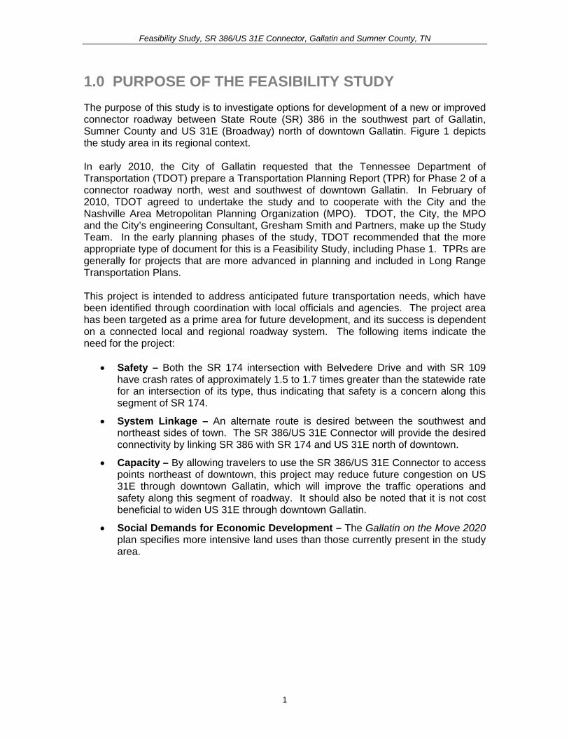
Feasibility Study SR 386US 31E Connector Gallatin and Sumner County TN
20 STUDY HISTORY AND BACKGROUND This Study focuses on Phase 2 of a proposed connector roadway However a brief history of Phase 1 is also presented below The study area for Phase 2 is illustrated in Figure 2
Phase 1mdashAlbert Gallatin AvenueHatten Track Road Extension An Advance Planning Report (APR) was approved in March of 2000 which recommended extending Hatten Track Road from its current western terminus to SR 109 and then making improvements to existing Hatten Track Road and North Water Avenue and the intersection of SR 174Albert Gallatin Avenue North Water Avenue and SR 174Dobbins Pike This extension would provide an alternate travel route for those desiring to bypass the core of the city
The Phase 1 improvement for which a TPR was approved by TDOT in June of 2010 is in the Long Range Transportation Plan (LRTP) as project 5004 in the year 2016 The LRTP describes the project as follows ldquoUpgrade Gallatin Water (Dobbins to Blythe) and Hatten Track extend Hatten Track to connect to SR-109 bypass via new interchangerdquo It is also in the FY 2008-2011 Transportation Improvement Program (TIP) as project 2008-51-032 which is described as ldquoEast-West Corridor (Albert Gallatin Avenue (SR-174) Hatten Track Road Extension Extend SR 174Albert Gallatin Avenue from SR-174North Water Avenue intersection to new interchange onto SR-109 Roadway will address congestion occurring on SR-6 and provide alternative route to access SR-109 and SR-386rdquo
Phase 2mdashSR 386US 31 E Connector At their January 12 2010 work session in which Phase 1 was discussed Gallatin City Council members in attendance discussed the desirability of extending the Albert Gallatin AvenueHatten Track Road Extension in the future across SR 109 from the existing planned extension and around (north and west of) existing development to terminate on the south at the SR 386Greenlea Boulevard interchange (The study area is depicted in Figure 2) The Council unanimously voted to pursue the Phase 2 Extension by requesting that the project be added to the MPOrsquos LRTP In February of 2010 TDOT agreed to lead the development of a TPR for Phase 2 (Since that time TDOT has determined that this study should be a Feasibility Study project rather than a TPR and include the Phase 1 project)
Long Range Transportation Plan 2010 Update On January 25 2010 the City of Gallatin submitted to the MPO a list of new high priority projects for the 2035 LRTP and the FY 2011-2014 TIP The proposed project listed as priority number 1 for the City of Gallatin is the SR 174Albert Gallatin Avenue and Hatten Track Road Extension Phase 1 Phase 1 is the project studied in the 2010 TPR and as described in the 2030 LRTP (project 5004) and in the FY 2008-2011 TIP The draft LRTP includes Phase 1 in the project list for projects with identified funding Phase 2 however is in the plan only as an unfunded illustrative project at this point in time as the planning work has not been completed to a point where it can be funded Phase 2 involves the SR 174Albert Gallatin Avenue and Hatten Track Road Extension from SR 109 to SR 174 (Long Hollow Pike) and SR 386 with a completion timeframe being after 2015 These two projects both have independent utility
3
Feas
ibili
ty S
tudy
SR
386
US
31E
Con
nect
or G
alla
tin a
nd S
umne
r Cou
nty
TN
Figu
re 2
Lo
catio
n M
ap
1
Feasibility Study SR 386US 31E Connector Gallatin and Sumner County TN
2010 Stakeholder Meeting for the Feasibility Study The purpose of this November 16 2010 meeting was to inform stakeholders that TDOT and their subconsultant Gresham Smith and Partners (GSampP) in cooperation with the City of Gallatin and the MPO have begun work on a Transportation Planning Report (TPR) (now a Feasibility Study) and to obtain stakeholder input on transportation problems and other issues in the study area GSampP invited approximately thirty (30) stakeholders (eg primarily local government representatives and elected local officials) As a result of a November 11 2010 local newspaper article which followed an announcement of the meeting at the City Councilrsquos November 9 2010 working session a number of members of the public also attended A comprehensive summary of the meeting as well as copies of the sign in sheets are included as Appendix A
A brief summary of the meeting is provided below
bull Attendees were informed that this is the first meeting held for the Phase 2 Feasibility Study
bull The Study Team explained that the Phase 2 study is intended to examine transportation improvements in the area between SR 386 and US 31E The Feasibility Study will develop
o Present traffic and projected traffic for the area o Cross section options for the roadway o Access control options o Cost estimate
bull Concerns voiced from meeting attendees included the following
o A member of the public stated that drawing traffic away from the downtown business district could be an issue for business owners
o A member of the public stated that the City owns property near the intersection of Long Hollow Pike and Red River Road that could accommodate roadway improvements Traffic desiring to travel north to the Civic Center area or schools for example could then use Blythe The individual questioned whether that would be a less expensive way to accommodate traffic
o County Executive Anthony Holt stated that it is vitally important to improve SR 386 and SR 109 because Sumner County is a county without an interstate He said that he supports Mayor Graves on the Hatten Track project and this project He understands the comment made that the integrity of downtown needs to be protected however there is a need for greater access to SR 109 and SR 386
2
Feasibility Study SR 386US 31E Connector Gallatin and Sumner County TN
30 STUDY AREA PROFILE 31 Community Characteristics The study area for this Feasibility Study includes land within the incorporated city limits of the City of Gallatin land within the unincorporated area of the Gallatin Municipal Planning Region as well as land within the Gallatin Urban Growth Boundary Area Figure 3 depicts these planning and political boundaries in relation to the study area limits As shown the Gallatin Municipal Planning Region covers the eastern portion of the study area The planning region limits expand north of the study area toward Old Douglas Road but in the western portion of the study area the planning region limits do not extend west beyond the Twin Eagles subdivision (just west of SR 109) or the Cambridge Farms subdivision The extreme northwestern portion of the study area includes unincorporated land outside of the Gallatin Municipal Planning Region but within the Urban Growth Boundary Area which is under the jurisdiction of Sumner County
Population and Growth In 2008 Gallatin had a population of 29343 people For comparison purposes the populations for both Sumner County and the State of Tennessee are shown in Table 1 Between 1990 and 2008 Gallatin experienced a 561 percent increase in population as compared to 505 percent for Sumner County and 274 percent in Tennessee as a whole Between 2000 and 2008 Gallatin grew by 263 percent
Table 1 Population Growth
Population Percent Change
1990-2008Location 1990 2000 2008
(2009)
Tennessee 4877185 5689283 6214888 (6296254) 274
Sumner County 103281 130449 155474 (158759) 505
City of Gallatin 18794 23230 29343 561
Source US Census 1990 and 2000 and 2008 US Census Population Estimates Estimates as available
As reflected in the above statistics the City of Gallatin and Sumner County as a whole have faced a tremendous amount of growth pressure in recent years due to population growth as compared to the State of Tennessee The growth rate accelerated in the midshy1990s when the City of Gallatin adopted a major update to the General Development and Transportation Plan and a new Zoning Ordinance in 1998 that helped implement the plan According to the Gallatin Economic Development Agency the population of Gallatin is forecasted to grow by six (6) percent to 31073 by 2013 and is projected to continue to have a steady growth rate over the next twenty (20) years The SR 386 and SR 109 corridors have been identified by the City as emerging areas of future growth
3
Feas
ibili
ty S
tudy
SR
386
US
31E
Con
nect
or G
alla
tin a
nd S
umne
r Cou
nty
TN
Figu
re 3
Pl
anni
ng a
nd P
oliti
cal B
ound
arie
s
Sou
rce
Ada
pted
from
Gal
latin
on
the
Mov
e 20
20
4
Feasibility Study SR 386US 31E Connector Gallatin and Sumner County TN
Major Employers and Traffic Generators The largest employment sectors in Gallatin include management professional and related occupations sales and office occupations production transportation and material moving occupations Combined these occupation categories represent roughly 75 percent of the labor force
The largest employment sector in the Gallatin area is industrial and manufacturing which provides an estimated 7500 jobs Twenty-two major industrial manufacturers and distributors are located in existing industrial parks or commercial centers Gallatin has planned for several new industrial centers which is an objective in Gallatin On the Move 2020 the Cityrsquos long-range growth land use and major thoroughfaretransportation plan
The major private employers and traffic generators in the general study area are listed in Table 2 and shown in Figure 4 Note that the list does not include the Sumner County Government which employs approximately 3900 workers that mostly work within the Sumner County School System
Sumner Regional Health Systems operates Sumner Regional Medical Center a 155shybed full-service hospital located east of Gallatin on SR 25Hartsville Pike Located on Gap Boulevard and fronting on US 31E northeast of the Volunteer State Community College (VSCC) is Gap Inc the Cityrsquos largest employer with approximately 1250 jobs
Volunteer State Community College is the Cityrsquos third largest employer and is located at 1480 Nashville Pike (US 31E) It is a two-year community college that offers associate degrees and technical certificates for over 70 programs to approximately 7500 students VSCC also offers classes for the community and area businesses through the Division of Continuing Education and Economic Development
Table 2 List of Major Employers Company Industry Employees
Sumner Regional Health Center Medical centerhospital admin corporate office 1326 Gap Inc Clothing distribution 1250 Volunteer State Community College EducationTwo-year public college 800 RR Donnelley amp Sons Binding 320 ABC Group Fuel Systems Automotive fuel systems 305 SERVPRO Industries Inc Cleaning and restorationcorporate headquarters 254 Hoeganaes Corporation Powdered metal products 197 Natural Industrial Concepts Industrial manufacturing 168 Charles C Parks Food distribution 150 ABC Technologies Plastic automotive parts 150
Source Forward Sumner Economic Council and Gallatin Economic Development Agency 2009
According to the 2035 Comprehensive Plan Sumner Countyrsquos Blueprint to the Future the retail industrial and office sectors are forecasted to increase at an annual rate of 160 to 180 percent in Sumner County through 2035 This is projected in part by the announcement by the Gallatin Economic Development Agency of a 207-acre expansion
5
Feasibility Study SR 386US 31E Connector Gallatin and Sumner County TN
of the Gallatin Industrial Center as well as plans for future office space development in the area near VSCC and the Sumner County Administration Building This industrial growth is enhanced by the CSXT railroad that has a line that runs north-south through Gallatin on the east side of the study area between North Blythe Avenue and North Water Avenue and then runs parallel to US 31E connecting to Nashville
In addition in June 2009 the Silver Eagle Bus Manufacturing company announced its relocation from Brownsville Texas to Gallatin Once fully operational the companyrsquos business plan anticipates hiring more than 500 people in its new 150000 square-foot facility which will be located well southeast of the study area and on the opposite side of US 31E from the study area
6
Feasibility Study SR 386US 31E Connector Gallatin and Sumner County TN
Figure 4 Major Employers and Traffic Generators
7
Feasibility Study SR 386US 31E Connector Gallatin and Sumner County TN
32 Existing and Future Land Use Existing land uses in the study area as shown in Gallatin on the Move 2020 are depicted in Figure 5 Within Corridors A and B the existing land use is ruralagricultural
Within Corridor A from the west side of SR 109 and southward toward Greenlea Boulevard development becomes sparse and the land is mostly utilized for ruralagricultural uses Scattered rural residential homes horse farms and barns are located within the corridor just south of its intersection with SR 25 and on the southern end near Greenlea Boulevard Existing low density residential subdivisions are scattered along the boundary of the corridor located near the corridorrsquos intersection with SR 109 on the north (Twin Eagles Subdivision) and to the southwest of the corridorrsquos intersection with SR 25 and along Greenlea Boulevard at the south end of the corridor (Cambridge Farms Subdivision)
The primary nature of the land use within Corridor B is ruralagricultural The large and expanding rural residentiallow density residential subdivision the Twin Eagles Subdivision is located on the northwest side of Corridor B near the intersection of SR 109 with Corridor A and B (proposed Hatten Track Road Extension) The Eagle Creek Development is a residential subdivision that lies to the northwest of the SR 109 intersection with SR 174Long Hollow Pike The Long Hollow Golf Course is the primary land use along Corridor B The golf course is located on the north side of SR 174Long Hollow Pike between its intersection with SR 386 and SR 109 On the southern side of Corridor B along SR 174Long Hollow Pike there is industrial development clustered along Belvedere Drive At the intersection of SR 174 and Belvedere Drive lies Thorntonrsquos Gas Station and a carpet outlet
Along SR 174Long Hollow Pike between Corridor A and B lies a John Deere retailer the entrance to the Stratford Park Subdivision the Cambridge Shopping Center and a Phillips 66 gas station
The Community Character Map from Gallatin on the Move 2020 incorporates categories that describe in detail the Cityrsquos vision for growth and development for the next 20 years The Community Character Map serves as a future land use map for the City A close-up of the Community Character Map that shows the study corridors is shown in Figure 6 Eleven major development areas are shown within the study corridors Neighborhood Center Regional Activity Center Suburban Neighborhood Emerging Suburban Neighborhood Established Town Neighborhood Revitalization Emerging Walkable Community Rural Community North Gallatin Emerging Business Park GreenLea Business Center Commercial Corridor and Parks and Open Space A brief summary of these categories are shown in Table 3
8
Feas
ibili
ty S
tudy
SR
386
US
31E
Con
nect
or G
alla
tin a
nd S
umne
r Cou
nty
TN
Figu
re 5
C
ity o
f Gal
latin
Exi
stin
g La
nd U
se M
ap
Sou
rce
Ada
pted
from
Gal
latin
on
the
Mov
e 20
20
9
Feas
ibili
ty S
tudy
SR
386
US
31E
Con
nect
or G
alla
tin a
nd S
umne
r Cou
nty
TN
Figu
re 6
C
ity o
f Gal
latin
Com
mun
ity C
hara
cter
Map
(Fut
ure
Land
Use
Map
)
Sou
rce
Ada
pted
from
Gal
latin
on
the
Mov
e 20
20
10
Feasibility Study SR 386US 31E Connector Gallatin and Sumner County TN
Table 3 City of Gallatin Community Character (Future Land Use) Map Categories Community Character Category
Community Character Map Areas
General Description Primary Land Uses Appropriate Density Intensity
Centers
Neighborhood Center
Neighborhood scale mixed-use centers that serve the surrounding neighborhood
Small and large scale apartments and townhomes vertical mixed-use neighborhood commercial
035 Floor Area Ratio
Regional Activity Center
Regional-scale mixed-use centers that include retail office and residential uses
Large-scale apartments and townhomes horizontal and vertical mixed-use commercialofficeretail big box retail hospitality publicinstitutional entertainment and cultural facilities
075 Floor Area Ratio
Neighborhoods
Suburban Neighborhood Emerging
Developable areas where conventional suburban neighborhood development is appropriate
Single family residential small and large-scale apartments and townhomes public Institutional
1-3 units per acre
Suburban Neighborhood Established
Stable neighborhoods developed with narrow smaller lots generally prior to 1950
Single family residential small and large scale apartments and townhomes
2-5 units per acre
Town Neighborhood Revitalization
Neighborhoods developed with narrow smaller lots generally prior to 1950 with a need for new investment and revitalization
Single family residential small-scale apartments and townhomes
5-8 units per acre
Emerging Walkable Community
Developable areas where walkable neighborhoods Traditional Neighborhood Development (TND) is appropriate and a variety of housing types
Single and multiple family residential office retail civic
Varies
Rural Community
Sparsely developed areas where agricultural use and character is common and expansion of urban services is not anticipated
Agricultural large lot and conservation subdivision single family residential passive recreation civic uses (rural scale)
1 unit per 2+ acres
Special Districts North Gallatin Emerging Business Park
A predominantly undeveloped area bound by SR 109 Bypass and Old Hwy 109 north of the City limits
Light industry business parks warehouse commercial hospitality transportation communicationutilities
050 Floor Area Ratio
11
Feasibility Study SR 386US 31E Connector Gallatin and Sumner County TN
Community Character Category
Community Character Map Areas
General Description Primary Land Uses Appropriate Density Intensity
GreenLea Business Center
Emerging special area that includes a mix of industrial and commercialoffice uses to diversify the Cityrsquos economic base
Light industry business parks warehouse commercial hospitality transportation communicationutilities single and multi-family residential (when part of an approved master plan)
050 Floor Area Ratio
Corridors Commercial Corridor
Stable commercial corridors where development is encouraged
Small and large-scale apartments and townhomes office vertical mixed use commercialretail
075 Floor Area Ratio
Preserve Parks and Open Space
Primarily public or privately-owned land intended to remain as open space for preservation and recreation needs and not suitable for development
Passive and active recreation undeveloped areas in natural state
Not applicable
Source Gallatin on the Move 2020
One of the objectives in Gallatin on the Move 2020 is to ldquoPromote desired development patterns with incentives and preparation of master plans for large undeveloped areas where growth is expected over the next 20 yearsrdquo The plan specifically refers to the Bowles property in the western portion of Corridor A and B It states ldquoAlong with the completion of new infrastructure such as the extension of the Hatten Track Road through the Bowles property the City should coordinate with property owners to establish a detailed visionrdquo (ie master plan) that is consistent with the overall City vision thus allowing the City to promote specific goals and objectivesrdquo
In 2007 the City of Gallatin approved a Preliminary Master Development Plan for Phases 6 through 12 of the Twin Eagles Subdivision If built this development expansion would be located to the north of the current subdivision west of SR 109 and within the Gallatin Municipal Planning Region In addition a Preliminary Master Development Plan for Phases 1 through 4 of The Reserve was approved by the City of Gallatin in 2010 The Reserve is designed as a 68 acre single-family residential development of 158 buildable lots to the southwest of SR 25 adjacent to Wentworth Drive on the west side of the Cambridge Farms subdivision Corridor A of the proposed project overlaps with these two proposed subdivision expansions It is recommended that the City of Gallatin Planning Commission preserve the right-of-way needed for the SR 386US 31E connector project
The GreenLea Business Center is described in Gallatin on the Move 2020 as ldquoan emerging employment and residential special area that includes a mix of industrial office residential and commercial uses that take advantage of the areasrsquo location adjacent to SR 386 and the CSXT Railroad Much of this area is currently undeveloped and presents an opportunity for commercial industrial and office growth adjacent to existing and emerging residential and commercial areasrdquo In addition the intent of the North Gallatin Emerging Business Park development pattern is to accommodate lessshy
12
Feasibility Study SR 386US 31E Connector Gallatin and Sumner County TN
intensive uses such as corporateregional headquarters call and data centers light manufacturing and ldquogreenrdquo companies with a relatively high-density mix of industrial and commercial uses in a campus-like setting
Another objective in Gallatin on the Move 2020 is to ldquoCoordinate with the Sumner County Planning Commission and Sumner County Commission to establish a process for adoption and implementation of the recommendations of the plan for areas within the Gallatin Urban Growth Boundary area outside of the Planning Regionrdquo This objective is applicable to the north and western portions of the study area that are located within unincorporated Sumner County but inside the Gallatin Urban Growth Boundary limits Figure 7 shows a close-up of the General Framework Map from the 2035 Comprehensive Plan Sumner Countyrsquos Blueprint to the Future that is intended to serve as a future land use plan for unincorporated Sumner County As illustrated the preferred land use patterns within the study corridors include a Regional Employment Center and Suburban development
The Regional Employment Center is shown in the same area as North Gallatin Emerging Business Park (between SR 109 and Old SR 109) in Gallatin on the Move 2020 The purpose of the Regional Employment Center designation is to locate office parks manufacturing centers corporate campuses or major universities near major transportation corridors that can provide basic jobs and keep people in the county during normal work hours The Suburban development pattern is consistent with the Suburban Neighborhood Emerging and Rural Community character categories shown in the Gallatin on the Move 2020 Community Character map and it is designated for low density residential land uses of one dwelling unit per acre or less The Conservation designations shown to the north of Corridors A and B are associated with conservation easements held by the Land Trust of Tennessee
13
Feas
ibili
ty S
tudy
SR
386
US
31E
Con
nect
or G
alla
tin a
nd S
umne
r Cou
nty
TN
Figu
re 7
Su
mne
r Cou
nty
Gen
eral
Fra
mew
ork
Map
(Fut
ure
Land
Use
Map
)
Sou
rce
Ada
pted
from
203
5 C
ompr
ehen
sive
Pla
n S
umne
r Cou
ntyrsquo
s B
luep
rint t
o th
e Fu
ture
14
Feasibility Study SR 386US 31E Connector Gallatin and Sumner County TN
33 Transportation Plans There are multiple transportation studies that cover the City of Gallatin and Sumner County The numerous recommended transportation improvements planned within the vicinity of the study area are listed in Appendix B The extensive list of projects in Appendix B are categorized under the following plans bull Gallatin on the Move 2020 City of Gallatin General Development and
Transportation Plan 2008-2020 bull 2035 Comprehensive Plan Sumner Countyrsquos Blueprint to the Future bull Nashville Metropolitan Planning Organizationrsquos 2030 Long Range Transportation
Plan bull Nashville Metropolitan Planning Organizationrsquos Transportation Improvement
Program Fiscal Years 2011-2015 (Draft ndash scheduled for adoption December 2010)
34 Bicycle and Pedestrian Plans Greenway multi-use paths branch greenway trails bicycle lanes and bicycle routes have been planned in Gallatin as part of the overall transportation system to serve as multi-modal community connectors and natural resources conservation areas For the Phase 1 Albert Gallatin AvenueHatten Track Road Extension bike lanes were designated between SR 109 and SR 174 (Dobbins Pike) Bike lanes are also being proposed as part of the Phase 2 SR 386US 31E Connector
Based on the projects shown in Gallatin on the Move 2020 the proposed bicycle and pedestrian projects within the study area are illustrated in Figure 8 Below is a detailed description from the plan of the projects that cross into or are within the study corridors
The City of Gallatin 2006 Greenways Master Plan organized the greenway multi-use paths into eight corridors prioritized according to their feasibility availability and level of connectivity The following two greenway projects are within the study corridors
bull Project 4 ndash Town Creek Trail A multi-use path 357 miles long that is expected to start at Triple Creek Park and generally follow Town Creek southwesterly and then end at a trail head near the SR 109 Bypass (near Ryan Avenue) This trail was ranked first (1) out of eight (8) on the priority list in the 2006 Greenways Master Plan
bull Project 9 - East Camp Creek Trail A trail 472 miles long that would start just south of US 31E and run in a northeasterly direction along the Camp Creek This trail was ranked six (6) out of eight (8) on the priority list in the 2006 Greenways Master Plan
The Plan also shows two greenway spurs to promote further connectivity between the greenways and bicycle and pedestrian facilities
bull Project 12 ndash East Camp Creek Spur ndash ldquoA trail spur extending up Camp Creek towards SR 386 to provide bicycle and pedestrian access into this future development areardquo
bull Project 13 - Hatten Track Trail Spur ldquoA trail spur extending into the Hatten Track from the East Camp Creek Trail to provide bicycle and pedestrian access into the development areardquo
15
Feasibility Study SR 386US 31E Connector Gallatin and Sumner County TN
Bike lanes are on-road facilities designated by striping signing and pavement markings that are for the preferential or exclusive use of bicycles whereas bike routes are on-road facilities indicated by directional and informational markers such as ldquoBike Routerdquo andor ldquoShare the Roadrdquo signs that utilize little or no striping The proposed bike lanes and bike routes in Figure 9 were originally proposed as part of the City of Gallatin Bicycle and Pedestrian Master Plan of 2000 (denoted by ldquoBrdquo) the 2000 Major Thoroughfare Plan (denoted by ldquoTrdquo) and the 2005 State Route 386 Area Study (denoted by ldquoASrdquo) The following bicycle lane and route projects are located within the study corridors
bull Project 14 ndash Long Hollow Pike Provide bike lanes ldquofrom the western boundary of the study area to Red River Road It is recommended that pedestrian and bike facilities are included when roadway improvements are planned including connections at a possible interchange with SR 386rdquo (B T AS)
bull Project 15 ndash US 31E (Nashville Pike) Currently there are no bike lanes along US 31E to accommodate bicyclists Project 15 is intended to provide bike lanes ldquofrom the western boundary of the study area through downtown to the eastern boundary of the study planning area US 31E west of SR 109 is marked as a bicycle route Further it is TDOTrsquos vision to have a continuous bike route from Nashville to Gallatin via US 31E (Nashville Pike) It is recommended that any development or redevelopment along Nashville Pike should include provisions to provide bike lanesrdquo (B AS)
bull Project 16 ndash GreenLea Boulevard Provide bike lanes from Long Hollow Pike to US 31 E (AS)
bull Project 18 ndash Bison Trail Extension Provide bike lanes ldquofrom GreenLea Boulevard to connect up with Saundersville Road in Hendersonville west of Lower Station Camp Creek Roadrdquo (AS)
bull Project 23 - Hatten Track Road Extension Provide bike lanes ldquobetween SR 109 Bypass to Dobbins PikeSR 174North Water Avenue These bike lanes would connect the SR 109 Bypass to other facilities Bike lanes are recommended east of North Water Avenue thus completing a bike system (Project 27)rdquo (B T)
bull Project 26 ndash Red River Road Provide bike lanes ldquofrom Bradford Drive to US 31EMain Street Bike lanes are recommended to connect to the Bradford Drive route to complete a multi-modal loop around the golf course and into downtownrdquo (B)
bull Project 27 ndash SR 174Albert Gallatin Avenue Provide bike lanes ldquofrom North Water Avenue to East Broadway AvenueUS 31E This bike route runs along the north side of Gallatin Municipal Park and would connect with multiple bike facilities Bike lanes are recommended west of North Water Avenue thus completing a bike system (Project 23)rdquo (B)
bull Project 31 ndash Old Highway 109 Provide bike routes ldquofrom Hatten Track Road to the northern planning boundary This planned bike route would provide multiple connections to other bike lanes andor routes connecting the northwest area to downtown Gallatinrdquo (B)
16
Feas
ibili
ty S
tudy
SR
386
US
31E
Con
nect
or G
alla
tin a
nd S
umne
r Cou
nty
TN
Figu
re 8
Pr
opos
ed B
ike
and
Pede
stria
n Pr
ojec
ts
Sou
rce
Ada
pted
from
City
of G
alla
tin 2
006
Gre
enw
ays
Mas
ter P
lan
17
Feasibility Study SR 386US 31E Connector Gallatin and Sumner County TN
Project 35 ndash Dobbins Pike Provide bike routes ldquobetween the northern planning boundary to Albert Gallatin Avenue This is an integral part of a bike route corridor through the heart of the City of Gallatin This section connects the northern portion to the Civic Center Bike Routes are recommended north of Broadway Avenue thus completing a bike system (Project 36 37)rdquo (B)
bull Project 43 (Blythe Avenue) is categorized as a ldquobike lanes and sidewalks projectrdquo that is recommended within the study corridors It is intended ldquoto provide an alternate to North Water and US 31E for access to the recreational areas on the north side of the City It is recommended to incorporate bike lanes and sidewalks with any future roadway wideningrdquo
bull Project 46 (Albert Gallatin Avenue) is categorized as a ldquosidewalks and pedestrian crossing projectrdquo that is recommended within the study corridors It is intended ldquobetween North Water Avenue and US 31E to serve the recreational users of the Gallatin Civic Centerrdquo
35 Other Multi-modal Facilities The Gallatin on the Move 2020 Plan recommends flexible bus service within the City of Gallatin The service would travel along a designated route but would be flexible enough to deviate off route to pick up or drop off passengers For instance if a route traveled from downtown to Volunteer State Community College the service could deviate off route for a certain distance (typically 34 mile) or to a certain boundary This type of service design addresses ADA requirements while expanding coverage to additional areas
Gallatin North-South Flex The north-south flexible bus service using one vehicle is proposed to operate along Albert Gallatin Avenue Blythe Avenue Eastland Street and Water Avenue Sites served include the Civic Center low-income housing along Blythe Avenue at Small Street the downtown square and homes and businesses along Water Avenue Deviations could also serve low-income housing along Lackey Circle low-income housing along Boyers Avenue at Hull Circle and other homes and businesses within a frac34 mile buffer of the route
36 Potential Future Coordination This study has involved local stakeholders including City Council representatives and business owners in early planning and development of the proposed project
A CSX Railroad line runs north-south through the study area of the Phase 1 Albert Gallatin AvenueHatten Track Road Extension which has been incorporated into this study The bridge on North Water Avenue crossing over the depressed railroad line will need to be replaced requiring coordination with the CSX Railroad A representative of CSX was invited to the stakeholder meeting for both the Phase 1 study and this study but did not attend
Coordination with the US Army Corps of Engineers will be required for the blue line stream crossings and possibly for wetland impacts The Tennessee Department of Environment and Conservation will also need to be coordinated with in regard to potential permitting and possibly for hazardous materials
18
Feasibility Study SR 386US 31E Connector Gallatin and Sumner County TN
In addition the City must coordinate with local developers proposing developments within or adjacent to the corridors under study to ensure that future implementation should the study become a project remains viable
40 PRELIMINARY PROJECT NEED This project is intended to address anticipated future transportation needs which have been identified through coordination with local officials and agencies The project area has been targeted as a prime area for future development and its success is dependent on a connected local and regional roadway system
41 Safety The following is a summary of the crash history on SR 109 and SR 174 for the latest three-year period for which data is available (2007 ndash 2009) Table 4 summarizes two segments of roadway and two major intersections in the project area showing the number of crashes and the comparison of the actual crash rate with the statewide average crash rate for the same functional classification The actual rate is derived from a formula that takes into account factors such as total number of crashes length of roadway and the time period over which the crashes occurred
The SR 174 intersection with Belvedere Drive and the SR 174 intersection with SR 109 have crash rates of approximately 15 to 17 times greater than the statewide rate for an intersection of its type thus indicating that safety is a concern along this segment of SR 174 The number of crashes suggests a need for an alternate route or intersection configuration to help separate through and local traffic
Table 4 Crash Summary
SectionIntersection Description Log Mile(s)
Crashes
Actual Crash Rate
State Average
Crash Rate
SR 109 from SR 174 (Long Hollow Pike) to Old Highway 109 421-760 28 035 201
SR 174 (Long Hollow Pike) from SR 386 to SR 109 1354-1459 13 016 275
SR 174 (Long Hollow Pike) intersection with Belvedere Drive 1428 22 156 099
SR 174 (Long Hollow Pike) intersection with ramps for southbound SR 109 1445-1451 24 170 099
SR 174 (Long Hollow Pike) intersection with ramps for northbound SR 109 1452-1449 15 107 099
for this type of roadway
A summary of the 2006-2008 crash data findings for each segment and intersection is as follows
19
Feasibility Study SR 386US 31E Connector Gallatin and Sumner County TN
bull SR 109 from SR 174 (Long Hollow Pike) to Old Highway 109 The statewide average crash rate for a roadway of the same functional classification (urban arterial four lane divided) is 201 while the actual rate is 035 for this segment of SR 109 The actual crash rate for this segment of roadway is well below the statewide average and therefore does not indicate a safety issue There were twenty-eight (28) documented crashes resulting in no fatalities no incapacitating injuries and nine (9) other injuries
bull SR 174 (Long Hollow Pike) from SR 386 to SR 109 The statewide average crash rate for a roadway of the same functional classification (urban minor arterial four lane with turn lane) is 275 while the actual rate is 016 for this segment of SR 174 The actual crash rate for this segment of roadway is well below the statewide average and therefore does not indicate a safety issue There were thirteen (13) documented crashes resulting in no fatalities no incapacitating injuries and four (4) non-incapacitating injuries
bull SR 174 (Long Hollow Pike) intersection with Belvedere Drive The statewide average crash rate for an intersection of this type is 099 The actual rate for the intersection is 156 which is slightly higher than the statewide average This intersection is the location of an existing industrial area that is slated for use in the future as the ldquoGreenlea Business Centerrdquo Of the twenty-two (22) crashes at the signalized intersection with Belvedere Drive ten (10) involved personal injury and thirteen (13) were rear end collisions
bull SR 174 (Long Hollow Pike) intersection with ramps for southbound SR 109 from Log Miles 1445 -1451 The statewide average crash rate for an intersection of this type is 099 while the actual rate for the intersection is 170 which is slightly higher than the statewide average There were twenty-four (24) documented crashes at this intersection resulting in no fatalities or incapacitating injuries but ten (10) non-incapacitating injuries Twelve (12) of the crashes occurred at log mile 1449 which is the signalized intersection for the right-turn ramp onto SB SR-109 and the left-turn ramp from SB SR-109
bull SR 174 (Long Hollow Pike) intersection with ramps for northbound SR 109 from Log Miles 1452 -1459 The statewide average crash rate for an intersection of this type is 099 while the actual rate for the intersection is 107 which is slightly higher than the statewide average There were fifteen (15) documented crashes at this intersection resulting in no fatalities or incapacitating injuries but four (4) non-incapacitating injuries Seven (7) of the crashes occurred at log mile 1458 which is the signalized intersection for the right-turn ramp from NB SR 109 lanes and the left-turn ramp to NB SR 109 lanes
42 System Linkage An alternate route between the southwest and northeast sides of Gallatin is desired The SR 386US 31E Connector will link SR 386 with SR 174 and US 31E north of downtown and provide ldquothroughrdquo traffic the ability to avoid the congested segment of US 31 E through downtown Gallatin
20
Feasibility Study SR 386US 31E Connector Gallatin and Sumner County TN
Furthermore construction of the SR 386US 31E Connector will create a more accessible and resilient transportation system by improving route options dispersing traffic over more roads and therefore reducing delays when a particular roadway segment is closed due to an incident construction or for other reasons
43 Level of Service Analysis To determine how well traffic operates under the No-Build and Build Conditions a level of service analysis was conducted A ldquoLevel of Servicerdquo (LOS) index was used to gauge the operational performance for each roadway segment The LOS is a qualitative measure that describes traffic conditions related to speed and travel time freedom to maneuver traffic interruptions etc There are six levels ranging from ldquoArdquo to ldquoFrdquo with ldquoFrdquo being the worst Each level represents a range of operating conditions Table 6 defines the traffic flow conditions and approximate driver comfort level at each level of service
LOS analysis was performed using the Highway Capacity Software (HCS+) for the No-Build and Build conditions for the base year of 2016 and the design year of 2036 Each roadway segment for Corridors A and B was analyzed using the multi-lane highways module in the HCS+ software The roadway characteristics that affect the LOS and were included in the analysis include free-flow speed lane width and lateral clearance median type access point density general terrain characteristics number of heavy vehicles in the traffic flow and the directional distribution of traffic The HCS+ results are included in Appendix C
It should be noted that the segments of US 31E and the segments where Corridors A and B are combined (Phase 1) were not analyzed using the HCS+ software because the speed limit on the roadway is lower than can be accommodated in the multi-lane highways module Furthermore the traffic signals along these segments will impact the LOS on the roadway segments and an arterial-level analysis is needed to properly determine the LOS In the absence of turning movement counts at the intersections the AADT volumes on these segments were equated to generally accepted volume thresholds to determine the arterial LOS
The results of the LOS analysis are summarized in Table 7
The LOS analysis indicates that under the 2036 No-Build and Build Conditions the segment of SR 386 from Greenlea Boulevard to SR 174 and then SR 174 to N Belvedere Drive operates at LOS E during peak periods Due to projected 2036 AADT volumes in the range of 54950 to 56250 vehicles per day these segments need to be widened by one (1) travel lane in each direction in order to accommodate the projected traffic A more detailed discussion of the improvements needed for these segments is included in Section 52
21
Feasibility Study SR 386US 31E Connector Gallatin and Sumner County TN
Table 5 Definition of Level of Service
Level of Service
Definition
A Free flow operations Vehicles are almost completely unimpeded in their ability to maneuver with the traffic stream The general level of physical and psychological comfort provided to the driver is high
B Reasonable free flow operations The ability to maneuver within the traffic stream is only slightly restricted and the general level of physical and psychological comfort provided to the driver is still high
C Flow with speeds at or near free flow speeds Freedom to maneuver within the traffic stream is noticeably restricted and lane changes require more vigilance on the part of the driver The driver notices an increase in tension
D Speeds decline with increasing traffic Freedom to maneuver within the traffic stream is more noticeably limited The driver experiences reduced physical and psychological comfort levels
E At lower boundary the facility is at capacity Operations are volatile because there are virtually no gaps in the traffic stream There is little room to maneuver The driver experiences poor levels of physical and psychological comfort
F Breakdowns in traffic flow The number of vehicles entering the highway section exceed the capacity or ability of the highway to accommodate that number of vehicles There is little room to maneuver The driver experiences poor levels of physical and psychological comfort
Source TDOT TPR Manual (2010)
Table 6 LOS for Base Year and Design Year Conditions
Roadway Segment
Level of Service 2016 2036
No-Build No-Build Build Corridor A ndash SR 109 Bypass to SR 25 - - A A Corridor A ndash SR 25 to SR 174 - - A A Corridor A ndash SR 174 to SR 386 - - A A Corridor B ndash SR 386 ndash Harris Ln to SR 174 C B E C E C Corridor B ndash SR 174 ndash SR 386 to N Belvedere Dr C B E C E C Corridor B ndash SR 174 ndash N Belvedere Dr to SR 109 Bypass C B D C D C
Corridor B ndash SR 109 Bypass ndash SR 174 to SR 25 A A B A B A Corridor B ndash SR 109 Bypass ndash SR 25 to Hatten Track Extension (phase 1) A A B A B A
Corridor AB (Phase 1) Hatten Track ndash SR 109 Bypass to Blythe Ave - - C
22
Feasibility Study SR 386US 31E Connector Gallatin and Sumner County TN
Roadway Segment Level of Service
2016 2036 No-Build No-Build Build
Corridor AB (Phase 1) Old State Highway 109 ndash Blythe Ave to N Water Ave B B B
Corridor AB (Phase 1) Albert Gallatin Ave ndash N Water Ave to US 31E A B B
US 31E ndash SR 109 to River Rd E F F US 31E ndash River Rd to Eastland St D E D US 31E ndash Eastland St to N Water Ave E F E US 31E ndash N Water Ave to SR 174 B D C
Direction 1Direction 2
44 Capacity As stated in the Transportation Improvement Plan (TIP) for Albert Gallatin AvenueHatten Track Road Extension (Phase 1) the construction of the Extension is anticipated to ldquoaddress congestion occurring on SR 6 [US 31E] and provide an alternative route to access SR 109 and SR 386rdquo The existing traffic on US 31E (SR 6West Main StreetEast Broadway) in downtown Gallatin has a projected 2016 Average Annual Daily Traffic (AADT) volume of approximately 31600 vehiclesday which exceeds the capacity of a five (5) lane urban arterial resulting in LOS E
The construction of both the Phase 1 Extension of SR 174Albert Gallatin Avenue and Hatten Track Road and the Phase 2 SR 386US 31E Connector is anticipated to divert approximately twenty-five (25) percent of the traffic away from US 31E in the downtown area This traffic reduction is anticipated to reduce the AADT on US 31E to a level that can be better accommodated by the existing roadway resulting in LOS C
By reducing the AADT on the most heavily congested segments of US 31E the levels of service at the signalized intersections and associated vehicular delay is anticipated to improve Generally speaking the arterial levels of service improve on US 31E between River Road (SR 25) and SR 174 in the Build Condition More detailed information on the capacity analysis is provided later in this section
Traffic Projections Traffic volumes for the No-Build and Build Conditions were projected in support of this Feasibility Study TDOT provided AADT volumes on roadways within the study area for a base year of 2016 and design year 2036 which were determined using the Nashville MPO travel demand model as well as TDOT 24-hour counts The AADT volumes for the No-Build and Build Conditions for the base and design years are presented in Table 5 The traffic diagrams provided by TDOT is provided in Appendix C
In order to accommodate the projected 2036 Build Condition AADT volumes ranging from 14710 to 17120 vehicles per day a four-lane typical section is needed for Corridor A A more detailed discussion of the proposed typical section for Corridor A is included in Section 52
23
Feasibility Study SR 386US 31E Connector Gallatin and Sumner County TN
Table 7 AADT for Base Year and Design Year Conditions
Roadway Segment
AADT 2016 2036
No-Build No-Build Build Corridor A ndash SR 109 Bypass to SR 25 - - 14710 Corridor A ndash SR 25 to SR 174 - - 16020 Corridor A ndash SR 174 to SR 386 - - 17120 Corridor B ndash SR 386 ndash Harris Ln to SR 174 32300 51680 54950 Corridor B ndash SR 174 ndash SR 386 to N Belvedere Dr 36250 52900 56250
Corridor B ndash SR 174 ndash N Belvedere Dr to SR 109 Bypass 35000 45500 48380
Corridor B ndash SR 109 Bypass ndash SR 174 to SR 25 16500 27400 23290 Corridor B ndash SR 109 Bypass ndash SR 25 to HattenTrack Extension (Phase 1) 13100 22250 21100
Corridor AB (Phase 1) Hatten Track ndash SR 109 Bypass to Blythe Ave - - 10700
Corridor AB (Phase 1) Old Highway 109 ndash Blythe Ave to N Water Ave 7050 8950 15370
Corridor AB (Phase 1) Albert Gallatin Ave ndash NWater Ave to US 31E 5800 8550 11450
US 31E ndash SR 109 to River Rd 31600 41100 39030 US 31E ndash River Rd to Eastland St 20600 28020 22330 US 31E ndash Eastland St to N Water Ave 25000 33250 26500 US 31E ndash N Water Ave to SR 174 14450 19050 15180
Source Tennessee Department of Transportation (2011)
45 Economic Development As discussed in Section 32 and depicted in Figure 6 the Gallatin on the Move 2020 plan specifies more intensive land uses than those currently present in the study area Along Phase 1 of the proposed Albert Gallatin AvenueHatten Track Road the land on the west side of the project adjacent to SR 109 is slated as the North Gallatin Emerging Business Park
In the current study area which includes the above segment but also includes land in and adjacent to the northwest quadrant of the SR 386 and SR 109 intersection the future land use plan specifies land along SR 174 (Long Hollow Pike) and SR 386 for future development as 1) a Regional Activity Center and 2) Greenlea Business Center (includes some existing industrial uses)
Adequate roadway connectivity to and from these areas is essential for the City to realize their future plans for economic development
24
Feasibility Study SR 386US 31E Connector Gallatin and Sumner County TN
50 OPTIONS FOR IMPROVEMENT 51 No-Build Option The No-Build Option provides a baseline for evaluating the benefits and costs created by the Build Options and is defined as the roadway conditions as they currently exist The No-Build Option examines the impacts to the transportation system if the transportation improvements identified as the Build Options are not constructed
Together SR 386 and SR 174 currently serve as the roadway link between Greenlea Boulevard and the SR 109 Bypass Within the study area SR 386 is classified as a freeway with a four (4)-lane divided typical section Between SR 386 and the SR 109 Bypass SR 174 is classified as an urban minor arterial and consists of a five (5)-lane section with a center left turn lane SR 109 Bypass between SR 174 and the proposed Hatten Track extension is classified as an urban principal arterial and consists of four (4)-lane divided typical section US 31E is classified as an urban principal arterial and consists of a five (5)-lane section through downtown Gallatin transitions to a four (4)shylane divided typical section north of River Road then to a two (2)-lane divided section north or N Boyers Avenue and then to a three (3)-lane typical section south of JoAnn Street which continues to the intersection with Albert Gallatin Avenue
As indicated in the LOS analysis in Section 43 the segment of SR 386 from Greenlea Boulevard to SR 174 and then on to N Belvedere Drive operates at LOS E under the No-Build Option Additionally the segments of US 31E from SR 109 Bypass to N Water Avenue operate at either LOS E or F which does not meet minimum operational requirements
25
Feasibility Study SR 386US 31E Connector Gallatin and Sumner County TN
52 Build Options As stated previously and illustrated in Figure 9 there are two corridor options under the Build Condition Corridor A and Corridor B Phase 1 consists of the Albert Gallatin AvenueSR 174 Extension which is proposed to end at an interchange with SR 109 Phase 2 consists of either Corridor A or Corridor B which both utilize the Phase 1 extension from SR 109 to US 31E A description of each Build Option follows
Appendix D contains the typical sections and layout sheets for Phase 2 A description of the roadway segment for each feature follows
Corridor A
bull Corridor A is on new alignment from the SR 386Green Lea interchange and travels north along the east side of Liberty Branch Creek intersecting with SR 25 continues northeast and intersects with Douglas Lane and then continues east to SR 109 at which point it intersects the Phase 1 Albert Gallatin AvenueHatten Track Road extension east to US 31E Corridor A is approximately 39 miles in length
bull The typical section includes four twelve (12)-foot lanes (two (2) in each direction) a 48-foot depressed median six (6)-foot inside shoulders and twelve (12)-foot shared use outside shoulders (to accommodate bike lanes) within 200 feet of proposed right-of-way
bull The widening of SR 386 and SR 174 as described under the Corridor B option must be completed in addition to the building of Corridor A in order to ensure adequate traffic flow and operations on the surrounding roadway network
Corridor B
bull Corridor B follows SR 386 from the interchange with Greenlea Boulevard east to the intersection with Long Hollow Pike at which point the state routing designation changes to SR 174 Corridor B then follows SR 174 to the interchange with SR 109 it then travels north on SR 109 until it intersects with the Phase 1 Albert Gallatin AvenueHatten Track Road extension Corridor B is approximately 34 miles in length
bull Under the Corridor B option SR 386 and SR 174 between Greenlea Boulevard and the SR 109 Bypass will be widened for approximately 14 miles to account for future projected traffic growth
o SR 386 will be widened from four (4) to six (6) lanes (three (3) in each direction) each having a width of twelve (12) feet with twelve (12)-foot shoulders and a 64-foot wide depressed median The present right-ofshyway width for this section is 260 feet with additional right-of-way and easements to be obtained as needed for construction
o The typical section for the improved segment of SR 174 will be widened from five (5) to seven (7) twelve (12)-foot travel lanes (three (3) in each direction and a twelve (12)-foot center turn lane) with twelve (12)-foot shared use outside shoulders (to accommodate bike lanes) This widened section would require a minimum right-of-way of 180 feet
26
Feas
ibili
ty S
tudy
SR
386
US
31E
Con
nect
or G
alla
tin a
nd S
umne
r Cou
nty
TN
Figu
re 9
B
uild
Opt
ions
27
Feasibility Study SR 386US 31E Connector Gallatin and Sumner County TN
bull In addition to widening the identified segments of SR 386 and SR 174 several signalized intersections and two bridges will need to be improved so that the additional lanes can be accommodated The intersections that will require improvements include the following
- SR 386 at SR 174 - SR 174 at Belvedere Drive - SR 174 interchange with SR 109 Bypass
bull While all three of these intersections will require upgrades associated with the roadway widening improvements the SR 174 interchange with the SR 109 Bypass will also require geometric alterations so that traffic can smoothly transition from one route to the other The southbound off-ramp from SR 109 Bypass will need to be extended to form the third westbound lane of SR 174 The third eastbound lane of SR 174 will become a right-turn-only lane onto SR 109 Bypass
bull In addition to the intersection improvements the bridge over East Camp Creek as well as the westbound bridge over Liberty Branch Creek will both need to be widened to accommodate the future widening and meet traffic demands
bull If Corridor B is selected without Corridor A an eastbound to northbound SR 109 clover leaf loop will be needed to accommodate future left turn volumes This would require re-alignment of the ramps on the east side of SR 109 and widening of the bridge on SR 109 at East Camp Creek
Costs TDOT planning level base per mile costs were used to develop estimates for the corridor options and are summarized in Table 8 It should be noted that even if Corridor A is constructed Corridor B will need to be widened along SR 386 and SR 174 to accommodate the future traffic volumes The interchange improvements at SR 109 however would not be needed as motorists travelling north to SR 109 would utilize Corridor A The widening cost for SR 386 and SR 174 is approximately $10000000
Also a two (2) lane depressed median section could be constructed as an interim phase for Corridor A allowing future build out to four (4) lanes which would reduce the interim phase construction cost approximately $11000000
Table 8 Planning Level Costs for Build Options
Item Corridor A (39 Miles)
Corridor B (34 Miles)
Right-of-Way $3608400 $2229675 Total Construction $30490980 $17252905 Preliminary Engineering $3049098 $1725291 Total Cost $37148478 $21207871
53 Possible Modifications to the State Route System During the NEPA phase when the preferred alignment is selected TDOT may review the current state route system for possible modification For example possible changes to the state routing system could include designating SR 174 to follow Long Hollow Pike to
28
Feasibility Study SR 386US 31E Connector Gallatin and Sumner County TN
Greenlea Boulevard and then follow Corridor A to SR 109 continue across SR 109 along Albert Gallatin AvenueHatten Track Road Extension (Phase 1) and reconnect with the existing SR 174 at Dobbins Pike (see Figure 10) Accordingly the SR 174 designation would be removed from Greenlea Boulevard through downtown to Dobbins Pike Based on these possible changes approximately 26 miles would be removed and 54 miles would be added resulting in a net gain of 294 miles to the state route system
29
Feas
ibili
ty S
tudy
SR
386
US
31E
Con
nect
or G
alla
tin a
nd S
umne
r Cou
nty
TN
Figu
re 1
0 P
ropo
sed
Cha
nges
to S
tate
Rou
ting
Syst
em
30
Feasibility Study SR 386US 31E Connector Gallatin and Sumner County TN
54 Control of Access The City of Gallatin Zoning Ordinance (amended October 20 2009) establishes access management standards in Section 1306 for driveways providing vehicular access from arterial collector and local streets (roads in the study area are classified as arterials and collector streets) In addition Gallatin on the Move 2020 outlines additional access management policies that should be applied to the Cityrsquos arterial road system (including long range planning project planning and design right-of-way acquisition redesign of existing arterial corridors and driveway permitting)
Within the study area SR 174 between SR 386 and SR 109 is currently not access controlled and is subject to future development SR 109 is access controlled between SR 25 and Old Highway 109 The proposed extension will ultimately not require a break in the access control on SR 109 because an interchange is planned to allow access between SR 109 and the Albert Gallatin AvenueHatten Track Road Extension (Phase 1) and the SR 386US 31E Connector
In addition the project will be designed to provide limited access along the proposed Build Option ndash Corridor A as well as along the Hatten Track extension (Phase 1) from SR 109 to the east For an at-grade intersection the access control distance will be a minimum of 100 feet from any intersection For an interchange the access control will be 300 feet from the ramp terminals treating each side of the cross road independently
55 Environmental Constraints The environmental screening presented in this Feasibility Study has been provided by the TDOT Early Environmental Screening (EES) reports A detailed environmental study of the corridors identified in this Feasibility Study would occur during future project phases in compliance with National Environmental Policy Act provisions Environmental screening maps produced in support of the analysis in this report are found in Appendix E A full copy of the TDOT EES reports can be found in Appendix F The TDOT EES reports revealed the following
Impacts Evaluated within 1000 feet of the Project Area bull Community ResourceInstitution
The project area is home to one public school Joe Shafer Middle School is located at 240 Albert Gallatin Avenue which is to the north of Corridors A and B
bull Minority Population of over 24 Percent Appendix E Map 1 illustrates the minority population in the project area by Census Block for the 2000 US Census The average percentage of minority populations for the City of Gallatin in 2000 was 217 percent The county-wide minority population for Sumner County was 85 percent The City of Gallatin average is comparable to the statewide average of 198 percent but the Sumner County average is considerably lower than the statewide average Among the census blocks encompassing the project area one has a minority population higher than the City of Gallatin as a whole This Census Block is identified as Census Tract 205 Block Group 1 Block 1014 and is contained within Corridor B
31
Feasibility Study SR 386US 31E Connector Gallatin and Sumner County TN
The percentage of the population that identified themselves as a minority in this Census Block is 33 percent (or 7 out of 21 persons)
bull Sensitive Community Population Linguistically Isolated Populations Linguistically isolated populations are located within 1000 feet of the project area
bull Population living Below Poverty above the State Average of 135 Percent Appendix E Map 2 shows the percentage of the population living below poverty in the project area by Census Block Group The project area is encompassed by four Census Block Groups The percent of the population living below poverty in 2000 (based on 1999 income) within the City of Gallatin averaged 144 percent This is higher than the County and statewide averages of 81 and 135 percent respectively One Census Block Group within the project area has a percent of the population below poverty that is higher than the City County and statewide averages This Block Group is Census Tract 208 Block Group 2 and has 159 percent of the population in the Block Group living below poverty (or 289 out of 1807 persons) This Block Group is crossed by Corridor B (as highlighted in Appendix E Map 2)
bull Possible Substantial Impact on the Endangered Bat Species There is a known occurrence of Indiana or grey bats within four (4) miles of the project area It is anticipated that a) avoidanceminimization of potential impacts to species will be needed b) surveys for the species for the project may be required c) coordination with USFWS will be needed to establish Section 7 biological conclusions for the project and d) seasonal construction limitations will likely be necessary
bull Impact on Railroads A railroad exists within the project study area It is anticipated that impacts to the railroad can be avoided since the proposed project will be greater than 200 feet from the railroad There is the remote possibility of minor involvement on railroad property to accommodate drainage but there will be no grade crossing
bull Cemetery Sites and Properties There are no known cemetery sites within or abutting the project area
Impacts Evaluated within 2000 feet of the Project Area
bull TWRA Lakes and Other Public Lands No TWRA lake property is found within the project area but it is anticipated that a medium impact on the project is anticipated as a public park (city owned little league park) lies within the project area It is possible to locate the proposed project in such a way that it avoids any impacts or taking of the park property A moderate level of effort and time will be required to resolve the projectrsquos environmental impact on the park and to move forward with project development Indirect impacts (audible and visual) to the park may occur and need to be studied If there is indirect impact additional design would be needed to design the appropriate mitigation measures
32
Feasibility Study SR 386US 31E Connector Gallatin and Sumner County TN
bull National Register Sites No impacts are anticipated to any National Register of Historic Place (NRHP) listed properties as there are no properties abutting or within the project area
According to the State Historic Preservation Office (SHPO) records approximately ten (10) properties in Sumner County have been surveyed within the project area although none of which were deemed eligible for the NRHP by the surveyor Additional survey work is needed in future project phases to determine NRHP eligibility for the resources that are within the projectrsquos Area of Potential Effect (APE)
bull Superfund Sites No impacts are anticipated as there are no known contaminated land tracts abutting or within the project area
bull Pyritic Rock Pyritic rock is not known to occur in the project area and thus the project does not involve exaction Limestone and dolomite are present
Impacts Evaluated within 4000 feet of the Project Area
bull Terrestrial Species A minimal impact on the project is predicated as there is a known rare or state protected terrestrial species (the Thryomanes bewickii) located within the project area A survey for the species may be required
bull Wetland and Floodplain Impacts Substantial impacts to wetlands within the project area are probable A total of 33 acres of wetlands exists within 4000 feet of the project area Compensatory mitigation will be required Design effort will be needed to avoid and minimize impacts to wetlands to the maximum extent practicable
According to Federal Emergency Management Association (FEMA) Flood Insurance Rate Maps (FIRM) the project area is bisected by the 100-year floodplain Areas along East Camp Creek and Liberty Branch fall within this flood zone FIRMs depicting the 100-year floodplains within the project area were digitized and are included in Appendix E Map 3 Both Corridor A and Corridor B cross the 100-year floodplain
bull TDEC Conservation Sites and TDEC Scenic Waterways No TDEC Conservation Sites or scenic waterways are within the project area
bull Tennessee Natural Areas Program The project area does not include a Natural Area
bull Wildlife Management Area No impacts are anticipated to any Wildlife Management Areas as there are none that abut or are located within the project area
33
Feasibility Study SR 386US 31E Connector Gallatin and Sumner County TN
Impacts Evaluated within 10000 feet of the Project Area
bull Caves The Lackey Cave is present within 10000 feet of the project area and thus a medium project impact is anticipated It is possible to avoid impacts to the cave in future design phases of the project With the presence of a cave there are likely concerns involving the federally and state protected Indiana grey bat Additional design will be needed to avoid impacts to cave passages or entrances to develop access to the cave (if required) to conduct stability analysis of the project to determine right of way acquisition development and coordination of corrective actions for environmental effects (ie mitigation etc) associated with project construction in this terrain and to design water quality treatment measures Construction time will likely be affected either by requiring an extended contract period or strategic placement of the project in the let schedule to maximize the contractors time to construct the project
bull Aquatic Species There is no known occurrence of a rare state or federally-protected aquatic species within the project area
60 ASSESSMENT OF CORRIDOR OPTIONS TDOT has developed a set of seven guiding principles by which all transportation projects are to be evaluated These guiding principles address concerns for system management mobility economic growth safety community environmental stewardship and fiscal responsibility This section includes a discussion of each guiding principle as it pertains to the options evaluated in this Feasibility Study
Guiding Principle 1 Preserve and Manage the Existing Transportation System When the construction of SR 386 (Vietnam Veterans Boulevard) was completed SR 386 became a major asset to the City of Gallatin acting as a corridor to accommodate both local and through traffic and providing access to Gallatinrsquos downtown commercial core via SR 174Long Hollow Pike and US 31E Over time the section of US 31E through downtown has become congested The function of the SR 386US 31E Connector will be to provide the second phase of an east-west connector between SR 386 and US 31ESR 6East Broadway on the north side of the City thereby diverting some of the traffic away from US 31E from the most congested segments through downtown The proposed improvements as part of the Phase 2 project will provide a new connection between SR 386 and SR 109 which will result in preservation of the existing transportation system in the City of Gallatin
SR 109 SR 174 and US 31E are critical travel corridors for the City of Gallatin US 31E is not only a key commercial corridor for area residents and truck traffic but it also connects Gallatin to the towns of Bethpage and Westmoreland in Tennessee and Scottsville in Kentucky to the north and Nashville to the south SR 174 connects Gallatin to Oak Grove Tennessee and Scottsville Kentucky to the north and SR 109 connects Gallatin to Portland to the north The Build Option presented as Corridor A involves construction of a roadway on new location which can help extend the life of these
34
Feasibility Study SR 386US 31E Connector Gallatin and Sumner County TN
important existing routes by diverting some regional traffic andor lessening the future growth of traffic on these roads as indicated under the Build Scenario
Guiding Principle 2 Move a Growing Diverse and Active Population As discussed in Section 31 of this Feasibility Study the population of the City of Gallatin grew by 561 percent between 1990 and 2008 and Sumner County grew by 505 percent figures higher than the State of Tennessee as a whole (274 percent) The options presented in this study are intended to provide improved traffic conditions to support the arearsquos growing population and increasing amounts of externally generated traffic as well as support recommended future land use for the area which is outlined in Gallatin on the Move 2020
The SR 386US 31E Connector is anticipated to divert some traffic away from US 31E through downtown potentially reducing congestion and creating a safer and more hospitable environment for local traffic pedestrians and bicyclists
Guiding Principle 3 Support the Statersquos Economy Both SR 109 and US 31E are regional roadways that facilitate the movement of goods and services The SR 386US 31E Connector will provide better access to and support development in the area to the west of East Camp Creek which supports the vision of the City of Gallatin to promote the area as an emerging business park
Guiding Principle 4 Maximize Safety and Security The proposed project will create opportunities for the separation of through and local traffic alleviating traffic congestion in the downtown area especially on US 31E The proposed project will also eliminate the need for some tractor trailers and other large trucks to travel though the City which will potentially reduce crashes with local traffic which typically turns and stops frequently
Guiding Principle 5 Build Partnerships for Livable Communities A stakeholder meeting was held in support of this Feasibility Study in order to obtain input on transportation problems and other issues in the study area During the TPR development process additional coordination will be undertaken Additionally in keeping with TDOTrsquos Public Involvement Process the provisions of NEPA and Safe Accountable Flexible Efficient Transportation Equity Act ndash A Legacy for Users (SAFETEA-LU) and the provisions of the Tennessee Environmental Streamlining Agreement (TESA) if warranted this project will be coordinated with the public and additional governmental agencies beginning in the NEPA project phase
35
Feasibility Study SR 386US 31E Connector Gallatin and Sumner County TN
Guiding Principle 6 Promote Stewardship of the Environment Potential adverse environmental impacts were identified in the TDOT Environmental Screening and were considered in the development of the corridors included in this study Detailed technical environmental studies are needed to fully address the impacts
Should federal funding be obtained for the project a NEPA document will be prepared in future phases of the project The NEPA document will assess the projectrsquos impacts on the natural social and built environment and all efforts will be made to avoid adverse impacts during design development If impacts cannot be avoided they will be minimized and mitigated Early and continuous coordination will continue to take place with the appropriate federal state and local agencies and the public This coordination will assist with the identification of important resources early in the planning process and will help ensure the proposed project promotes stewardship of the environment
Guiding Principle 7 Emphasize Financial Responsibility The cost estimates presented in this study are offered for planning comparison purposes only and will fluctuate with inflation and any unexpected conditions It is TDOTrsquos goal to follow a comprehensive transportation planning process promote coordination among public and private operators of transportation systems and support efforts to provide stable funding for the public component of the transportation system This entails exercising financial responsibility in the development and implementation of roadway projects and minimizing cost to taxpayers
36
Feasibility Study SR 386US 31E Connector Gallatin and Sumner County TN
70 SUMMARY In summary this project is needed to address anticipated future transportation needs which have been identified through coordination with local officials and agencies The project area has been targeted as a prime area for future development and its success is dependent on a connected local and regional roadway system The project is needed based on the following
bull Improve Safety ndash Both the SR 174 intersection with Belvedere Drive and with SR 109 have crash rates of approximately 15 to 17 times greater than the statewide rate for an intersection of its type thus indicating that safety is a concern along this segment of SR 174
bull Promote System Linkage ndash An alternate route is desired between the southwest and northeast sides of town The SR 386US 31E Connector will provide the desired connectivity by linking SR 386 with SR 174 and US 31E north of downtown
bull Address Capacity Issues ndash By allowing travelers to use the SR 386US 31E Connector to access points northeast of downtown this project may reduce future congestion on US 31E through downtown Gallatin which will improve the traffic operations and safety along this segment of roadway It should also be noted that it is not cost beneficial to widen US 31E through downtown Gallatin
bull Meet Economic Development Demands ndash The Gallatin on the Move 2020 plan specifies more intensive land uses than those currently present in the study area
As stated previously there are two corridor options under the Build Condition for the SR 386US 31E Connector (Phase 2) Corridor A and Corridor B Planning level cost estimates for the corridor options were developed and are summarized in Table 9 It should be noted that even if Corridor A is constructed Corridor B will need to be widened along SR 386 and SR 174 to accommodate the future traffic volumes The interchange improvements at SR 109 however would not be needed as motorists travelling north to SR 109 would utilize Corridor A The widening cost for SR 386 and SR 174 is approximately $10000000
Also a two (2) lane depressed median section could be constructed as an interim phase for Corridor A allowing future build out to four (4) lanes which reduce the interim phase construction cost approximately $11000000
Table 9 Planning Level Costs for Build Options
Item Corridor A (39 Miles)
Corridor B (34 Miles)
Right-of-Way $3608400 $2229675 Total Construction $30490980 $17252905 Preliminary Engineering $3049098 $1725291 Total Cost $37148478 $21207871
If federal funding is utilized for this proposed project a TPR and NEPA document will be undertaken
37

Feas
ibili
ty S
tudy
SR
386
US
31E
Con
nect
or G
alla
tin a
nd S
umne
r Cou
nty
TN
Figu
re 2
Lo
catio
n M
ap
1
Feasibility Study SR 386US 31E Connector Gallatin and Sumner County TN
2010 Stakeholder Meeting for the Feasibility Study The purpose of this November 16 2010 meeting was to inform stakeholders that TDOT and their subconsultant Gresham Smith and Partners (GSampP) in cooperation with the City of Gallatin and the MPO have begun work on a Transportation Planning Report (TPR) (now a Feasibility Study) and to obtain stakeholder input on transportation problems and other issues in the study area GSampP invited approximately thirty (30) stakeholders (eg primarily local government representatives and elected local officials) As a result of a November 11 2010 local newspaper article which followed an announcement of the meeting at the City Councilrsquos November 9 2010 working session a number of members of the public also attended A comprehensive summary of the meeting as well as copies of the sign in sheets are included as Appendix A
A brief summary of the meeting is provided below
bull Attendees were informed that this is the first meeting held for the Phase 2 Feasibility Study
bull The Study Team explained that the Phase 2 study is intended to examine transportation improvements in the area between SR 386 and US 31E The Feasibility Study will develop
o Present traffic and projected traffic for the area o Cross section options for the roadway o Access control options o Cost estimate
bull Concerns voiced from meeting attendees included the following
o A member of the public stated that drawing traffic away from the downtown business district could be an issue for business owners
o A member of the public stated that the City owns property near the intersection of Long Hollow Pike and Red River Road that could accommodate roadway improvements Traffic desiring to travel north to the Civic Center area or schools for example could then use Blythe The individual questioned whether that would be a less expensive way to accommodate traffic
o County Executive Anthony Holt stated that it is vitally important to improve SR 386 and SR 109 because Sumner County is a county without an interstate He said that he supports Mayor Graves on the Hatten Track project and this project He understands the comment made that the integrity of downtown needs to be protected however there is a need for greater access to SR 109 and SR 386
2
Feasibility Study SR 386US 31E Connector Gallatin and Sumner County TN
30 STUDY AREA PROFILE 31 Community Characteristics The study area for this Feasibility Study includes land within the incorporated city limits of the City of Gallatin land within the unincorporated area of the Gallatin Municipal Planning Region as well as land within the Gallatin Urban Growth Boundary Area Figure 3 depicts these planning and political boundaries in relation to the study area limits As shown the Gallatin Municipal Planning Region covers the eastern portion of the study area The planning region limits expand north of the study area toward Old Douglas Road but in the western portion of the study area the planning region limits do not extend west beyond the Twin Eagles subdivision (just west of SR 109) or the Cambridge Farms subdivision The extreme northwestern portion of the study area includes unincorporated land outside of the Gallatin Municipal Planning Region but within the Urban Growth Boundary Area which is under the jurisdiction of Sumner County
Population and Growth In 2008 Gallatin had a population of 29343 people For comparison purposes the populations for both Sumner County and the State of Tennessee are shown in Table 1 Between 1990 and 2008 Gallatin experienced a 561 percent increase in population as compared to 505 percent for Sumner County and 274 percent in Tennessee as a whole Between 2000 and 2008 Gallatin grew by 263 percent
Table 1 Population Growth
Population Percent Change
1990-2008Location 1990 2000 2008
(2009)
Tennessee 4877185 5689283 6214888 (6296254) 274
Sumner County 103281 130449 155474 (158759) 505
City of Gallatin 18794 23230 29343 561
Source US Census 1990 and 2000 and 2008 US Census Population Estimates Estimates as available
As reflected in the above statistics the City of Gallatin and Sumner County as a whole have faced a tremendous amount of growth pressure in recent years due to population growth as compared to the State of Tennessee The growth rate accelerated in the midshy1990s when the City of Gallatin adopted a major update to the General Development and Transportation Plan and a new Zoning Ordinance in 1998 that helped implement the plan According to the Gallatin Economic Development Agency the population of Gallatin is forecasted to grow by six (6) percent to 31073 by 2013 and is projected to continue to have a steady growth rate over the next twenty (20) years The SR 386 and SR 109 corridors have been identified by the City as emerging areas of future growth
3
Feas
ibili
ty S
tudy
SR
386
US
31E
Con
nect
or G
alla
tin a
nd S
umne
r Cou
nty
TN
Figu
re 3
Pl
anni
ng a
nd P
oliti
cal B
ound
arie
s
Sou
rce
Ada
pted
from
Gal
latin
on
the
Mov
e 20
20
4
Feasibility Study SR 386US 31E Connector Gallatin and Sumner County TN
Major Employers and Traffic Generators The largest employment sectors in Gallatin include management professional and related occupations sales and office occupations production transportation and material moving occupations Combined these occupation categories represent roughly 75 percent of the labor force
The largest employment sector in the Gallatin area is industrial and manufacturing which provides an estimated 7500 jobs Twenty-two major industrial manufacturers and distributors are located in existing industrial parks or commercial centers Gallatin has planned for several new industrial centers which is an objective in Gallatin On the Move 2020 the Cityrsquos long-range growth land use and major thoroughfaretransportation plan
The major private employers and traffic generators in the general study area are listed in Table 2 and shown in Figure 4 Note that the list does not include the Sumner County Government which employs approximately 3900 workers that mostly work within the Sumner County School System
Sumner Regional Health Systems operates Sumner Regional Medical Center a 155shybed full-service hospital located east of Gallatin on SR 25Hartsville Pike Located on Gap Boulevard and fronting on US 31E northeast of the Volunteer State Community College (VSCC) is Gap Inc the Cityrsquos largest employer with approximately 1250 jobs
Volunteer State Community College is the Cityrsquos third largest employer and is located at 1480 Nashville Pike (US 31E) It is a two-year community college that offers associate degrees and technical certificates for over 70 programs to approximately 7500 students VSCC also offers classes for the community and area businesses through the Division of Continuing Education and Economic Development
Table 2 List of Major Employers Company Industry Employees
Sumner Regional Health Center Medical centerhospital admin corporate office 1326 Gap Inc Clothing distribution 1250 Volunteer State Community College EducationTwo-year public college 800 RR Donnelley amp Sons Binding 320 ABC Group Fuel Systems Automotive fuel systems 305 SERVPRO Industries Inc Cleaning and restorationcorporate headquarters 254 Hoeganaes Corporation Powdered metal products 197 Natural Industrial Concepts Industrial manufacturing 168 Charles C Parks Food distribution 150 ABC Technologies Plastic automotive parts 150
Source Forward Sumner Economic Council and Gallatin Economic Development Agency 2009
According to the 2035 Comprehensive Plan Sumner Countyrsquos Blueprint to the Future the retail industrial and office sectors are forecasted to increase at an annual rate of 160 to 180 percent in Sumner County through 2035 This is projected in part by the announcement by the Gallatin Economic Development Agency of a 207-acre expansion
5
Feasibility Study SR 386US 31E Connector Gallatin and Sumner County TN
of the Gallatin Industrial Center as well as plans for future office space development in the area near VSCC and the Sumner County Administration Building This industrial growth is enhanced by the CSXT railroad that has a line that runs north-south through Gallatin on the east side of the study area between North Blythe Avenue and North Water Avenue and then runs parallel to US 31E connecting to Nashville
In addition in June 2009 the Silver Eagle Bus Manufacturing company announced its relocation from Brownsville Texas to Gallatin Once fully operational the companyrsquos business plan anticipates hiring more than 500 people in its new 150000 square-foot facility which will be located well southeast of the study area and on the opposite side of US 31E from the study area
6
Feasibility Study SR 386US 31E Connector Gallatin and Sumner County TN
Figure 4 Major Employers and Traffic Generators
7
Feasibility Study SR 386US 31E Connector Gallatin and Sumner County TN
32 Existing and Future Land Use Existing land uses in the study area as shown in Gallatin on the Move 2020 are depicted in Figure 5 Within Corridors A and B the existing land use is ruralagricultural
Within Corridor A from the west side of SR 109 and southward toward Greenlea Boulevard development becomes sparse and the land is mostly utilized for ruralagricultural uses Scattered rural residential homes horse farms and barns are located within the corridor just south of its intersection with SR 25 and on the southern end near Greenlea Boulevard Existing low density residential subdivisions are scattered along the boundary of the corridor located near the corridorrsquos intersection with SR 109 on the north (Twin Eagles Subdivision) and to the southwest of the corridorrsquos intersection with SR 25 and along Greenlea Boulevard at the south end of the corridor (Cambridge Farms Subdivision)
The primary nature of the land use within Corridor B is ruralagricultural The large and expanding rural residentiallow density residential subdivision the Twin Eagles Subdivision is located on the northwest side of Corridor B near the intersection of SR 109 with Corridor A and B (proposed Hatten Track Road Extension) The Eagle Creek Development is a residential subdivision that lies to the northwest of the SR 109 intersection with SR 174Long Hollow Pike The Long Hollow Golf Course is the primary land use along Corridor B The golf course is located on the north side of SR 174Long Hollow Pike between its intersection with SR 386 and SR 109 On the southern side of Corridor B along SR 174Long Hollow Pike there is industrial development clustered along Belvedere Drive At the intersection of SR 174 and Belvedere Drive lies Thorntonrsquos Gas Station and a carpet outlet
Along SR 174Long Hollow Pike between Corridor A and B lies a John Deere retailer the entrance to the Stratford Park Subdivision the Cambridge Shopping Center and a Phillips 66 gas station
The Community Character Map from Gallatin on the Move 2020 incorporates categories that describe in detail the Cityrsquos vision for growth and development for the next 20 years The Community Character Map serves as a future land use map for the City A close-up of the Community Character Map that shows the study corridors is shown in Figure 6 Eleven major development areas are shown within the study corridors Neighborhood Center Regional Activity Center Suburban Neighborhood Emerging Suburban Neighborhood Established Town Neighborhood Revitalization Emerging Walkable Community Rural Community North Gallatin Emerging Business Park GreenLea Business Center Commercial Corridor and Parks and Open Space A brief summary of these categories are shown in Table 3
8
Feas
ibili
ty S
tudy
SR
386
US
31E
Con
nect
or G
alla
tin a
nd S
umne
r Cou
nty
TN
Figu
re 5
C
ity o
f Gal
latin
Exi
stin
g La
nd U
se M
ap
Sou
rce
Ada
pted
from
Gal
latin
on
the
Mov
e 20
20
9
Feas
ibili
ty S
tudy
SR
386
US
31E
Con
nect
or G
alla
tin a
nd S
umne
r Cou
nty
TN
Figu
re 6
C
ity o
f Gal
latin
Com
mun
ity C
hara
cter
Map
(Fut
ure
Land
Use
Map
)
Sou
rce
Ada
pted
from
Gal
latin
on
the
Mov
e 20
20
10
Feasibility Study SR 386US 31E Connector Gallatin and Sumner County TN
Table 3 City of Gallatin Community Character (Future Land Use) Map Categories Community Character Category
Community Character Map Areas
General Description Primary Land Uses Appropriate Density Intensity
Centers
Neighborhood Center
Neighborhood scale mixed-use centers that serve the surrounding neighborhood
Small and large scale apartments and townhomes vertical mixed-use neighborhood commercial
035 Floor Area Ratio
Regional Activity Center
Regional-scale mixed-use centers that include retail office and residential uses
Large-scale apartments and townhomes horizontal and vertical mixed-use commercialofficeretail big box retail hospitality publicinstitutional entertainment and cultural facilities
075 Floor Area Ratio
Neighborhoods
Suburban Neighborhood Emerging
Developable areas where conventional suburban neighborhood development is appropriate
Single family residential small and large-scale apartments and townhomes public Institutional
1-3 units per acre
Suburban Neighborhood Established
Stable neighborhoods developed with narrow smaller lots generally prior to 1950
Single family residential small and large scale apartments and townhomes
2-5 units per acre
Town Neighborhood Revitalization
Neighborhoods developed with narrow smaller lots generally prior to 1950 with a need for new investment and revitalization
Single family residential small-scale apartments and townhomes
5-8 units per acre
Emerging Walkable Community
Developable areas where walkable neighborhoods Traditional Neighborhood Development (TND) is appropriate and a variety of housing types
Single and multiple family residential office retail civic
Varies
Rural Community
Sparsely developed areas where agricultural use and character is common and expansion of urban services is not anticipated
Agricultural large lot and conservation subdivision single family residential passive recreation civic uses (rural scale)
1 unit per 2+ acres
Special Districts North Gallatin Emerging Business Park
A predominantly undeveloped area bound by SR 109 Bypass and Old Hwy 109 north of the City limits
Light industry business parks warehouse commercial hospitality transportation communicationutilities
050 Floor Area Ratio
11
Feasibility Study SR 386US 31E Connector Gallatin and Sumner County TN
Community Character Category
Community Character Map Areas
General Description Primary Land Uses Appropriate Density Intensity
GreenLea Business Center
Emerging special area that includes a mix of industrial and commercialoffice uses to diversify the Cityrsquos economic base
Light industry business parks warehouse commercial hospitality transportation communicationutilities single and multi-family residential (when part of an approved master plan)
050 Floor Area Ratio
Corridors Commercial Corridor
Stable commercial corridors where development is encouraged
Small and large-scale apartments and townhomes office vertical mixed use commercialretail
075 Floor Area Ratio
Preserve Parks and Open Space
Primarily public or privately-owned land intended to remain as open space for preservation and recreation needs and not suitable for development
Passive and active recreation undeveloped areas in natural state
Not applicable
Source Gallatin on the Move 2020
One of the objectives in Gallatin on the Move 2020 is to ldquoPromote desired development patterns with incentives and preparation of master plans for large undeveloped areas where growth is expected over the next 20 yearsrdquo The plan specifically refers to the Bowles property in the western portion of Corridor A and B It states ldquoAlong with the completion of new infrastructure such as the extension of the Hatten Track Road through the Bowles property the City should coordinate with property owners to establish a detailed visionrdquo (ie master plan) that is consistent with the overall City vision thus allowing the City to promote specific goals and objectivesrdquo
In 2007 the City of Gallatin approved a Preliminary Master Development Plan for Phases 6 through 12 of the Twin Eagles Subdivision If built this development expansion would be located to the north of the current subdivision west of SR 109 and within the Gallatin Municipal Planning Region In addition a Preliminary Master Development Plan for Phases 1 through 4 of The Reserve was approved by the City of Gallatin in 2010 The Reserve is designed as a 68 acre single-family residential development of 158 buildable lots to the southwest of SR 25 adjacent to Wentworth Drive on the west side of the Cambridge Farms subdivision Corridor A of the proposed project overlaps with these two proposed subdivision expansions It is recommended that the City of Gallatin Planning Commission preserve the right-of-way needed for the SR 386US 31E connector project
The GreenLea Business Center is described in Gallatin on the Move 2020 as ldquoan emerging employment and residential special area that includes a mix of industrial office residential and commercial uses that take advantage of the areasrsquo location adjacent to SR 386 and the CSXT Railroad Much of this area is currently undeveloped and presents an opportunity for commercial industrial and office growth adjacent to existing and emerging residential and commercial areasrdquo In addition the intent of the North Gallatin Emerging Business Park development pattern is to accommodate lessshy
12
Feasibility Study SR 386US 31E Connector Gallatin and Sumner County TN
intensive uses such as corporateregional headquarters call and data centers light manufacturing and ldquogreenrdquo companies with a relatively high-density mix of industrial and commercial uses in a campus-like setting
Another objective in Gallatin on the Move 2020 is to ldquoCoordinate with the Sumner County Planning Commission and Sumner County Commission to establish a process for adoption and implementation of the recommendations of the plan for areas within the Gallatin Urban Growth Boundary area outside of the Planning Regionrdquo This objective is applicable to the north and western portions of the study area that are located within unincorporated Sumner County but inside the Gallatin Urban Growth Boundary limits Figure 7 shows a close-up of the General Framework Map from the 2035 Comprehensive Plan Sumner Countyrsquos Blueprint to the Future that is intended to serve as a future land use plan for unincorporated Sumner County As illustrated the preferred land use patterns within the study corridors include a Regional Employment Center and Suburban development
The Regional Employment Center is shown in the same area as North Gallatin Emerging Business Park (between SR 109 and Old SR 109) in Gallatin on the Move 2020 The purpose of the Regional Employment Center designation is to locate office parks manufacturing centers corporate campuses or major universities near major transportation corridors that can provide basic jobs and keep people in the county during normal work hours The Suburban development pattern is consistent with the Suburban Neighborhood Emerging and Rural Community character categories shown in the Gallatin on the Move 2020 Community Character map and it is designated for low density residential land uses of one dwelling unit per acre or less The Conservation designations shown to the north of Corridors A and B are associated with conservation easements held by the Land Trust of Tennessee
13
Feas
ibili
ty S
tudy
SR
386
US
31E
Con
nect
or G
alla
tin a
nd S
umne
r Cou
nty
TN
Figu
re 7
Su
mne
r Cou
nty
Gen
eral
Fra
mew
ork
Map
(Fut
ure
Land
Use
Map
)
Sou
rce
Ada
pted
from
203
5 C
ompr
ehen
sive
Pla
n S
umne
r Cou
ntyrsquo
s B
luep
rint t
o th
e Fu
ture
14
Feasibility Study SR 386US 31E Connector Gallatin and Sumner County TN
33 Transportation Plans There are multiple transportation studies that cover the City of Gallatin and Sumner County The numerous recommended transportation improvements planned within the vicinity of the study area are listed in Appendix B The extensive list of projects in Appendix B are categorized under the following plans bull Gallatin on the Move 2020 City of Gallatin General Development and
Transportation Plan 2008-2020 bull 2035 Comprehensive Plan Sumner Countyrsquos Blueprint to the Future bull Nashville Metropolitan Planning Organizationrsquos 2030 Long Range Transportation
Plan bull Nashville Metropolitan Planning Organizationrsquos Transportation Improvement
Program Fiscal Years 2011-2015 (Draft ndash scheduled for adoption December 2010)
34 Bicycle and Pedestrian Plans Greenway multi-use paths branch greenway trails bicycle lanes and bicycle routes have been planned in Gallatin as part of the overall transportation system to serve as multi-modal community connectors and natural resources conservation areas For the Phase 1 Albert Gallatin AvenueHatten Track Road Extension bike lanes were designated between SR 109 and SR 174 (Dobbins Pike) Bike lanes are also being proposed as part of the Phase 2 SR 386US 31E Connector
Based on the projects shown in Gallatin on the Move 2020 the proposed bicycle and pedestrian projects within the study area are illustrated in Figure 8 Below is a detailed description from the plan of the projects that cross into or are within the study corridors
The City of Gallatin 2006 Greenways Master Plan organized the greenway multi-use paths into eight corridors prioritized according to their feasibility availability and level of connectivity The following two greenway projects are within the study corridors
bull Project 4 ndash Town Creek Trail A multi-use path 357 miles long that is expected to start at Triple Creek Park and generally follow Town Creek southwesterly and then end at a trail head near the SR 109 Bypass (near Ryan Avenue) This trail was ranked first (1) out of eight (8) on the priority list in the 2006 Greenways Master Plan
bull Project 9 - East Camp Creek Trail A trail 472 miles long that would start just south of US 31E and run in a northeasterly direction along the Camp Creek This trail was ranked six (6) out of eight (8) on the priority list in the 2006 Greenways Master Plan
The Plan also shows two greenway spurs to promote further connectivity between the greenways and bicycle and pedestrian facilities
bull Project 12 ndash East Camp Creek Spur ndash ldquoA trail spur extending up Camp Creek towards SR 386 to provide bicycle and pedestrian access into this future development areardquo
bull Project 13 - Hatten Track Trail Spur ldquoA trail spur extending into the Hatten Track from the East Camp Creek Trail to provide bicycle and pedestrian access into the development areardquo
15
Feasibility Study SR 386US 31E Connector Gallatin and Sumner County TN
Bike lanes are on-road facilities designated by striping signing and pavement markings that are for the preferential or exclusive use of bicycles whereas bike routes are on-road facilities indicated by directional and informational markers such as ldquoBike Routerdquo andor ldquoShare the Roadrdquo signs that utilize little or no striping The proposed bike lanes and bike routes in Figure 9 were originally proposed as part of the City of Gallatin Bicycle and Pedestrian Master Plan of 2000 (denoted by ldquoBrdquo) the 2000 Major Thoroughfare Plan (denoted by ldquoTrdquo) and the 2005 State Route 386 Area Study (denoted by ldquoASrdquo) The following bicycle lane and route projects are located within the study corridors
bull Project 14 ndash Long Hollow Pike Provide bike lanes ldquofrom the western boundary of the study area to Red River Road It is recommended that pedestrian and bike facilities are included when roadway improvements are planned including connections at a possible interchange with SR 386rdquo (B T AS)
bull Project 15 ndash US 31E (Nashville Pike) Currently there are no bike lanes along US 31E to accommodate bicyclists Project 15 is intended to provide bike lanes ldquofrom the western boundary of the study area through downtown to the eastern boundary of the study planning area US 31E west of SR 109 is marked as a bicycle route Further it is TDOTrsquos vision to have a continuous bike route from Nashville to Gallatin via US 31E (Nashville Pike) It is recommended that any development or redevelopment along Nashville Pike should include provisions to provide bike lanesrdquo (B AS)
bull Project 16 ndash GreenLea Boulevard Provide bike lanes from Long Hollow Pike to US 31 E (AS)
bull Project 18 ndash Bison Trail Extension Provide bike lanes ldquofrom GreenLea Boulevard to connect up with Saundersville Road in Hendersonville west of Lower Station Camp Creek Roadrdquo (AS)
bull Project 23 - Hatten Track Road Extension Provide bike lanes ldquobetween SR 109 Bypass to Dobbins PikeSR 174North Water Avenue These bike lanes would connect the SR 109 Bypass to other facilities Bike lanes are recommended east of North Water Avenue thus completing a bike system (Project 27)rdquo (B T)
bull Project 26 ndash Red River Road Provide bike lanes ldquofrom Bradford Drive to US 31EMain Street Bike lanes are recommended to connect to the Bradford Drive route to complete a multi-modal loop around the golf course and into downtownrdquo (B)
bull Project 27 ndash SR 174Albert Gallatin Avenue Provide bike lanes ldquofrom North Water Avenue to East Broadway AvenueUS 31E This bike route runs along the north side of Gallatin Municipal Park and would connect with multiple bike facilities Bike lanes are recommended west of North Water Avenue thus completing a bike system (Project 23)rdquo (B)
bull Project 31 ndash Old Highway 109 Provide bike routes ldquofrom Hatten Track Road to the northern planning boundary This planned bike route would provide multiple connections to other bike lanes andor routes connecting the northwest area to downtown Gallatinrdquo (B)
16
Feas
ibili
ty S
tudy
SR
386
US
31E
Con
nect
or G
alla
tin a
nd S
umne
r Cou
nty
TN
Figu
re 8
Pr
opos
ed B
ike
and
Pede
stria
n Pr
ojec
ts
Sou
rce
Ada
pted
from
City
of G
alla
tin 2
006
Gre
enw
ays
Mas
ter P
lan
17
Feasibility Study SR 386US 31E Connector Gallatin and Sumner County TN
Project 35 ndash Dobbins Pike Provide bike routes ldquobetween the northern planning boundary to Albert Gallatin Avenue This is an integral part of a bike route corridor through the heart of the City of Gallatin This section connects the northern portion to the Civic Center Bike Routes are recommended north of Broadway Avenue thus completing a bike system (Project 36 37)rdquo (B)
bull Project 43 (Blythe Avenue) is categorized as a ldquobike lanes and sidewalks projectrdquo that is recommended within the study corridors It is intended ldquoto provide an alternate to North Water and US 31E for access to the recreational areas on the north side of the City It is recommended to incorporate bike lanes and sidewalks with any future roadway wideningrdquo
bull Project 46 (Albert Gallatin Avenue) is categorized as a ldquosidewalks and pedestrian crossing projectrdquo that is recommended within the study corridors It is intended ldquobetween North Water Avenue and US 31E to serve the recreational users of the Gallatin Civic Centerrdquo
35 Other Multi-modal Facilities The Gallatin on the Move 2020 Plan recommends flexible bus service within the City of Gallatin The service would travel along a designated route but would be flexible enough to deviate off route to pick up or drop off passengers For instance if a route traveled from downtown to Volunteer State Community College the service could deviate off route for a certain distance (typically 34 mile) or to a certain boundary This type of service design addresses ADA requirements while expanding coverage to additional areas
Gallatin North-South Flex The north-south flexible bus service using one vehicle is proposed to operate along Albert Gallatin Avenue Blythe Avenue Eastland Street and Water Avenue Sites served include the Civic Center low-income housing along Blythe Avenue at Small Street the downtown square and homes and businesses along Water Avenue Deviations could also serve low-income housing along Lackey Circle low-income housing along Boyers Avenue at Hull Circle and other homes and businesses within a frac34 mile buffer of the route
36 Potential Future Coordination This study has involved local stakeholders including City Council representatives and business owners in early planning and development of the proposed project
A CSX Railroad line runs north-south through the study area of the Phase 1 Albert Gallatin AvenueHatten Track Road Extension which has been incorporated into this study The bridge on North Water Avenue crossing over the depressed railroad line will need to be replaced requiring coordination with the CSX Railroad A representative of CSX was invited to the stakeholder meeting for both the Phase 1 study and this study but did not attend
Coordination with the US Army Corps of Engineers will be required for the blue line stream crossings and possibly for wetland impacts The Tennessee Department of Environment and Conservation will also need to be coordinated with in regard to potential permitting and possibly for hazardous materials
18
Feasibility Study SR 386US 31E Connector Gallatin and Sumner County TN
In addition the City must coordinate with local developers proposing developments within or adjacent to the corridors under study to ensure that future implementation should the study become a project remains viable
40 PRELIMINARY PROJECT NEED This project is intended to address anticipated future transportation needs which have been identified through coordination with local officials and agencies The project area has been targeted as a prime area for future development and its success is dependent on a connected local and regional roadway system
41 Safety The following is a summary of the crash history on SR 109 and SR 174 for the latest three-year period for which data is available (2007 ndash 2009) Table 4 summarizes two segments of roadway and two major intersections in the project area showing the number of crashes and the comparison of the actual crash rate with the statewide average crash rate for the same functional classification The actual rate is derived from a formula that takes into account factors such as total number of crashes length of roadway and the time period over which the crashes occurred
The SR 174 intersection with Belvedere Drive and the SR 174 intersection with SR 109 have crash rates of approximately 15 to 17 times greater than the statewide rate for an intersection of its type thus indicating that safety is a concern along this segment of SR 174 The number of crashes suggests a need for an alternate route or intersection configuration to help separate through and local traffic
Table 4 Crash Summary
SectionIntersection Description Log Mile(s)
Crashes
Actual Crash Rate
State Average
Crash Rate
SR 109 from SR 174 (Long Hollow Pike) to Old Highway 109 421-760 28 035 201
SR 174 (Long Hollow Pike) from SR 386 to SR 109 1354-1459 13 016 275
SR 174 (Long Hollow Pike) intersection with Belvedere Drive 1428 22 156 099
SR 174 (Long Hollow Pike) intersection with ramps for southbound SR 109 1445-1451 24 170 099
SR 174 (Long Hollow Pike) intersection with ramps for northbound SR 109 1452-1449 15 107 099
for this type of roadway
A summary of the 2006-2008 crash data findings for each segment and intersection is as follows
19
Feasibility Study SR 386US 31E Connector Gallatin and Sumner County TN
bull SR 109 from SR 174 (Long Hollow Pike) to Old Highway 109 The statewide average crash rate for a roadway of the same functional classification (urban arterial four lane divided) is 201 while the actual rate is 035 for this segment of SR 109 The actual crash rate for this segment of roadway is well below the statewide average and therefore does not indicate a safety issue There were twenty-eight (28) documented crashes resulting in no fatalities no incapacitating injuries and nine (9) other injuries
bull SR 174 (Long Hollow Pike) from SR 386 to SR 109 The statewide average crash rate for a roadway of the same functional classification (urban minor arterial four lane with turn lane) is 275 while the actual rate is 016 for this segment of SR 174 The actual crash rate for this segment of roadway is well below the statewide average and therefore does not indicate a safety issue There were thirteen (13) documented crashes resulting in no fatalities no incapacitating injuries and four (4) non-incapacitating injuries
bull SR 174 (Long Hollow Pike) intersection with Belvedere Drive The statewide average crash rate for an intersection of this type is 099 The actual rate for the intersection is 156 which is slightly higher than the statewide average This intersection is the location of an existing industrial area that is slated for use in the future as the ldquoGreenlea Business Centerrdquo Of the twenty-two (22) crashes at the signalized intersection with Belvedere Drive ten (10) involved personal injury and thirteen (13) were rear end collisions
bull SR 174 (Long Hollow Pike) intersection with ramps for southbound SR 109 from Log Miles 1445 -1451 The statewide average crash rate for an intersection of this type is 099 while the actual rate for the intersection is 170 which is slightly higher than the statewide average There were twenty-four (24) documented crashes at this intersection resulting in no fatalities or incapacitating injuries but ten (10) non-incapacitating injuries Twelve (12) of the crashes occurred at log mile 1449 which is the signalized intersection for the right-turn ramp onto SB SR-109 and the left-turn ramp from SB SR-109
bull SR 174 (Long Hollow Pike) intersection with ramps for northbound SR 109 from Log Miles 1452 -1459 The statewide average crash rate for an intersection of this type is 099 while the actual rate for the intersection is 107 which is slightly higher than the statewide average There were fifteen (15) documented crashes at this intersection resulting in no fatalities or incapacitating injuries but four (4) non-incapacitating injuries Seven (7) of the crashes occurred at log mile 1458 which is the signalized intersection for the right-turn ramp from NB SR 109 lanes and the left-turn ramp to NB SR 109 lanes
42 System Linkage An alternate route between the southwest and northeast sides of Gallatin is desired The SR 386US 31E Connector will link SR 386 with SR 174 and US 31E north of downtown and provide ldquothroughrdquo traffic the ability to avoid the congested segment of US 31 E through downtown Gallatin
20
Feasibility Study SR 386US 31E Connector Gallatin and Sumner County TN
Furthermore construction of the SR 386US 31E Connector will create a more accessible and resilient transportation system by improving route options dispersing traffic over more roads and therefore reducing delays when a particular roadway segment is closed due to an incident construction or for other reasons
43 Level of Service Analysis To determine how well traffic operates under the No-Build and Build Conditions a level of service analysis was conducted A ldquoLevel of Servicerdquo (LOS) index was used to gauge the operational performance for each roadway segment The LOS is a qualitative measure that describes traffic conditions related to speed and travel time freedom to maneuver traffic interruptions etc There are six levels ranging from ldquoArdquo to ldquoFrdquo with ldquoFrdquo being the worst Each level represents a range of operating conditions Table 6 defines the traffic flow conditions and approximate driver comfort level at each level of service
LOS analysis was performed using the Highway Capacity Software (HCS+) for the No-Build and Build conditions for the base year of 2016 and the design year of 2036 Each roadway segment for Corridors A and B was analyzed using the multi-lane highways module in the HCS+ software The roadway characteristics that affect the LOS and were included in the analysis include free-flow speed lane width and lateral clearance median type access point density general terrain characteristics number of heavy vehicles in the traffic flow and the directional distribution of traffic The HCS+ results are included in Appendix C
It should be noted that the segments of US 31E and the segments where Corridors A and B are combined (Phase 1) were not analyzed using the HCS+ software because the speed limit on the roadway is lower than can be accommodated in the multi-lane highways module Furthermore the traffic signals along these segments will impact the LOS on the roadway segments and an arterial-level analysis is needed to properly determine the LOS In the absence of turning movement counts at the intersections the AADT volumes on these segments were equated to generally accepted volume thresholds to determine the arterial LOS
The results of the LOS analysis are summarized in Table 7
The LOS analysis indicates that under the 2036 No-Build and Build Conditions the segment of SR 386 from Greenlea Boulevard to SR 174 and then SR 174 to N Belvedere Drive operates at LOS E during peak periods Due to projected 2036 AADT volumes in the range of 54950 to 56250 vehicles per day these segments need to be widened by one (1) travel lane in each direction in order to accommodate the projected traffic A more detailed discussion of the improvements needed for these segments is included in Section 52
21
Feasibility Study SR 386US 31E Connector Gallatin and Sumner County TN
Table 5 Definition of Level of Service
Level of Service
Definition
A Free flow operations Vehicles are almost completely unimpeded in their ability to maneuver with the traffic stream The general level of physical and psychological comfort provided to the driver is high
B Reasonable free flow operations The ability to maneuver within the traffic stream is only slightly restricted and the general level of physical and psychological comfort provided to the driver is still high
C Flow with speeds at or near free flow speeds Freedom to maneuver within the traffic stream is noticeably restricted and lane changes require more vigilance on the part of the driver The driver notices an increase in tension
D Speeds decline with increasing traffic Freedom to maneuver within the traffic stream is more noticeably limited The driver experiences reduced physical and psychological comfort levels
E At lower boundary the facility is at capacity Operations are volatile because there are virtually no gaps in the traffic stream There is little room to maneuver The driver experiences poor levels of physical and psychological comfort
F Breakdowns in traffic flow The number of vehicles entering the highway section exceed the capacity or ability of the highway to accommodate that number of vehicles There is little room to maneuver The driver experiences poor levels of physical and psychological comfort
Source TDOT TPR Manual (2010)
Table 6 LOS for Base Year and Design Year Conditions
Roadway Segment
Level of Service 2016 2036
No-Build No-Build Build Corridor A ndash SR 109 Bypass to SR 25 - - A A Corridor A ndash SR 25 to SR 174 - - A A Corridor A ndash SR 174 to SR 386 - - A A Corridor B ndash SR 386 ndash Harris Ln to SR 174 C B E C E C Corridor B ndash SR 174 ndash SR 386 to N Belvedere Dr C B E C E C Corridor B ndash SR 174 ndash N Belvedere Dr to SR 109 Bypass C B D C D C
Corridor B ndash SR 109 Bypass ndash SR 174 to SR 25 A A B A B A Corridor B ndash SR 109 Bypass ndash SR 25 to Hatten Track Extension (phase 1) A A B A B A
Corridor AB (Phase 1) Hatten Track ndash SR 109 Bypass to Blythe Ave - - C
22
Feasibility Study SR 386US 31E Connector Gallatin and Sumner County TN
Roadway Segment Level of Service
2016 2036 No-Build No-Build Build
Corridor AB (Phase 1) Old State Highway 109 ndash Blythe Ave to N Water Ave B B B
Corridor AB (Phase 1) Albert Gallatin Ave ndash N Water Ave to US 31E A B B
US 31E ndash SR 109 to River Rd E F F US 31E ndash River Rd to Eastland St D E D US 31E ndash Eastland St to N Water Ave E F E US 31E ndash N Water Ave to SR 174 B D C
Direction 1Direction 2
44 Capacity As stated in the Transportation Improvement Plan (TIP) for Albert Gallatin AvenueHatten Track Road Extension (Phase 1) the construction of the Extension is anticipated to ldquoaddress congestion occurring on SR 6 [US 31E] and provide an alternative route to access SR 109 and SR 386rdquo The existing traffic on US 31E (SR 6West Main StreetEast Broadway) in downtown Gallatin has a projected 2016 Average Annual Daily Traffic (AADT) volume of approximately 31600 vehiclesday which exceeds the capacity of a five (5) lane urban arterial resulting in LOS E
The construction of both the Phase 1 Extension of SR 174Albert Gallatin Avenue and Hatten Track Road and the Phase 2 SR 386US 31E Connector is anticipated to divert approximately twenty-five (25) percent of the traffic away from US 31E in the downtown area This traffic reduction is anticipated to reduce the AADT on US 31E to a level that can be better accommodated by the existing roadway resulting in LOS C
By reducing the AADT on the most heavily congested segments of US 31E the levels of service at the signalized intersections and associated vehicular delay is anticipated to improve Generally speaking the arterial levels of service improve on US 31E between River Road (SR 25) and SR 174 in the Build Condition More detailed information on the capacity analysis is provided later in this section
Traffic Projections Traffic volumes for the No-Build and Build Conditions were projected in support of this Feasibility Study TDOT provided AADT volumes on roadways within the study area for a base year of 2016 and design year 2036 which were determined using the Nashville MPO travel demand model as well as TDOT 24-hour counts The AADT volumes for the No-Build and Build Conditions for the base and design years are presented in Table 5 The traffic diagrams provided by TDOT is provided in Appendix C
In order to accommodate the projected 2036 Build Condition AADT volumes ranging from 14710 to 17120 vehicles per day a four-lane typical section is needed for Corridor A A more detailed discussion of the proposed typical section for Corridor A is included in Section 52
23
Feasibility Study SR 386US 31E Connector Gallatin and Sumner County TN
Table 7 AADT for Base Year and Design Year Conditions
Roadway Segment
AADT 2016 2036
No-Build No-Build Build Corridor A ndash SR 109 Bypass to SR 25 - - 14710 Corridor A ndash SR 25 to SR 174 - - 16020 Corridor A ndash SR 174 to SR 386 - - 17120 Corridor B ndash SR 386 ndash Harris Ln to SR 174 32300 51680 54950 Corridor B ndash SR 174 ndash SR 386 to N Belvedere Dr 36250 52900 56250
Corridor B ndash SR 174 ndash N Belvedere Dr to SR 109 Bypass 35000 45500 48380
Corridor B ndash SR 109 Bypass ndash SR 174 to SR 25 16500 27400 23290 Corridor B ndash SR 109 Bypass ndash SR 25 to HattenTrack Extension (Phase 1) 13100 22250 21100
Corridor AB (Phase 1) Hatten Track ndash SR 109 Bypass to Blythe Ave - - 10700
Corridor AB (Phase 1) Old Highway 109 ndash Blythe Ave to N Water Ave 7050 8950 15370
Corridor AB (Phase 1) Albert Gallatin Ave ndash NWater Ave to US 31E 5800 8550 11450
US 31E ndash SR 109 to River Rd 31600 41100 39030 US 31E ndash River Rd to Eastland St 20600 28020 22330 US 31E ndash Eastland St to N Water Ave 25000 33250 26500 US 31E ndash N Water Ave to SR 174 14450 19050 15180
Source Tennessee Department of Transportation (2011)
45 Economic Development As discussed in Section 32 and depicted in Figure 6 the Gallatin on the Move 2020 plan specifies more intensive land uses than those currently present in the study area Along Phase 1 of the proposed Albert Gallatin AvenueHatten Track Road the land on the west side of the project adjacent to SR 109 is slated as the North Gallatin Emerging Business Park
In the current study area which includes the above segment but also includes land in and adjacent to the northwest quadrant of the SR 386 and SR 109 intersection the future land use plan specifies land along SR 174 (Long Hollow Pike) and SR 386 for future development as 1) a Regional Activity Center and 2) Greenlea Business Center (includes some existing industrial uses)
Adequate roadway connectivity to and from these areas is essential for the City to realize their future plans for economic development
24
Feasibility Study SR 386US 31E Connector Gallatin and Sumner County TN
50 OPTIONS FOR IMPROVEMENT 51 No-Build Option The No-Build Option provides a baseline for evaluating the benefits and costs created by the Build Options and is defined as the roadway conditions as they currently exist The No-Build Option examines the impacts to the transportation system if the transportation improvements identified as the Build Options are not constructed
Together SR 386 and SR 174 currently serve as the roadway link between Greenlea Boulevard and the SR 109 Bypass Within the study area SR 386 is classified as a freeway with a four (4)-lane divided typical section Between SR 386 and the SR 109 Bypass SR 174 is classified as an urban minor arterial and consists of a five (5)-lane section with a center left turn lane SR 109 Bypass between SR 174 and the proposed Hatten Track extension is classified as an urban principal arterial and consists of four (4)-lane divided typical section US 31E is classified as an urban principal arterial and consists of a five (5)-lane section through downtown Gallatin transitions to a four (4)shylane divided typical section north of River Road then to a two (2)-lane divided section north or N Boyers Avenue and then to a three (3)-lane typical section south of JoAnn Street which continues to the intersection with Albert Gallatin Avenue
As indicated in the LOS analysis in Section 43 the segment of SR 386 from Greenlea Boulevard to SR 174 and then on to N Belvedere Drive operates at LOS E under the No-Build Option Additionally the segments of US 31E from SR 109 Bypass to N Water Avenue operate at either LOS E or F which does not meet minimum operational requirements
25
Feasibility Study SR 386US 31E Connector Gallatin and Sumner County TN
52 Build Options As stated previously and illustrated in Figure 9 there are two corridor options under the Build Condition Corridor A and Corridor B Phase 1 consists of the Albert Gallatin AvenueSR 174 Extension which is proposed to end at an interchange with SR 109 Phase 2 consists of either Corridor A or Corridor B which both utilize the Phase 1 extension from SR 109 to US 31E A description of each Build Option follows
Appendix D contains the typical sections and layout sheets for Phase 2 A description of the roadway segment for each feature follows
Corridor A
bull Corridor A is on new alignment from the SR 386Green Lea interchange and travels north along the east side of Liberty Branch Creek intersecting with SR 25 continues northeast and intersects with Douglas Lane and then continues east to SR 109 at which point it intersects the Phase 1 Albert Gallatin AvenueHatten Track Road extension east to US 31E Corridor A is approximately 39 miles in length
bull The typical section includes four twelve (12)-foot lanes (two (2) in each direction) a 48-foot depressed median six (6)-foot inside shoulders and twelve (12)-foot shared use outside shoulders (to accommodate bike lanes) within 200 feet of proposed right-of-way
bull The widening of SR 386 and SR 174 as described under the Corridor B option must be completed in addition to the building of Corridor A in order to ensure adequate traffic flow and operations on the surrounding roadway network
Corridor B
bull Corridor B follows SR 386 from the interchange with Greenlea Boulevard east to the intersection with Long Hollow Pike at which point the state routing designation changes to SR 174 Corridor B then follows SR 174 to the interchange with SR 109 it then travels north on SR 109 until it intersects with the Phase 1 Albert Gallatin AvenueHatten Track Road extension Corridor B is approximately 34 miles in length
bull Under the Corridor B option SR 386 and SR 174 between Greenlea Boulevard and the SR 109 Bypass will be widened for approximately 14 miles to account for future projected traffic growth
o SR 386 will be widened from four (4) to six (6) lanes (three (3) in each direction) each having a width of twelve (12) feet with twelve (12)-foot shoulders and a 64-foot wide depressed median The present right-ofshyway width for this section is 260 feet with additional right-of-way and easements to be obtained as needed for construction
o The typical section for the improved segment of SR 174 will be widened from five (5) to seven (7) twelve (12)-foot travel lanes (three (3) in each direction and a twelve (12)-foot center turn lane) with twelve (12)-foot shared use outside shoulders (to accommodate bike lanes) This widened section would require a minimum right-of-way of 180 feet
26
Feas
ibili
ty S
tudy
SR
386
US
31E
Con
nect
or G
alla
tin a
nd S
umne
r Cou
nty
TN
Figu
re 9
B
uild
Opt
ions
27
Feasibility Study SR 386US 31E Connector Gallatin and Sumner County TN
bull In addition to widening the identified segments of SR 386 and SR 174 several signalized intersections and two bridges will need to be improved so that the additional lanes can be accommodated The intersections that will require improvements include the following
- SR 386 at SR 174 - SR 174 at Belvedere Drive - SR 174 interchange with SR 109 Bypass
bull While all three of these intersections will require upgrades associated with the roadway widening improvements the SR 174 interchange with the SR 109 Bypass will also require geometric alterations so that traffic can smoothly transition from one route to the other The southbound off-ramp from SR 109 Bypass will need to be extended to form the third westbound lane of SR 174 The third eastbound lane of SR 174 will become a right-turn-only lane onto SR 109 Bypass
bull In addition to the intersection improvements the bridge over East Camp Creek as well as the westbound bridge over Liberty Branch Creek will both need to be widened to accommodate the future widening and meet traffic demands
bull If Corridor B is selected without Corridor A an eastbound to northbound SR 109 clover leaf loop will be needed to accommodate future left turn volumes This would require re-alignment of the ramps on the east side of SR 109 and widening of the bridge on SR 109 at East Camp Creek
Costs TDOT planning level base per mile costs were used to develop estimates for the corridor options and are summarized in Table 8 It should be noted that even if Corridor A is constructed Corridor B will need to be widened along SR 386 and SR 174 to accommodate the future traffic volumes The interchange improvements at SR 109 however would not be needed as motorists travelling north to SR 109 would utilize Corridor A The widening cost for SR 386 and SR 174 is approximately $10000000
Also a two (2) lane depressed median section could be constructed as an interim phase for Corridor A allowing future build out to four (4) lanes which would reduce the interim phase construction cost approximately $11000000
Table 8 Planning Level Costs for Build Options
Item Corridor A (39 Miles)
Corridor B (34 Miles)
Right-of-Way $3608400 $2229675 Total Construction $30490980 $17252905 Preliminary Engineering $3049098 $1725291 Total Cost $37148478 $21207871
53 Possible Modifications to the State Route System During the NEPA phase when the preferred alignment is selected TDOT may review the current state route system for possible modification For example possible changes to the state routing system could include designating SR 174 to follow Long Hollow Pike to
28
Feasibility Study SR 386US 31E Connector Gallatin and Sumner County TN
Greenlea Boulevard and then follow Corridor A to SR 109 continue across SR 109 along Albert Gallatin AvenueHatten Track Road Extension (Phase 1) and reconnect with the existing SR 174 at Dobbins Pike (see Figure 10) Accordingly the SR 174 designation would be removed from Greenlea Boulevard through downtown to Dobbins Pike Based on these possible changes approximately 26 miles would be removed and 54 miles would be added resulting in a net gain of 294 miles to the state route system
29
Feas
ibili
ty S
tudy
SR
386
US
31E
Con
nect
or G
alla
tin a
nd S
umne
r Cou
nty
TN
Figu
re 1
0 P
ropo
sed
Cha
nges
to S
tate
Rou
ting
Syst
em
30
Feasibility Study SR 386US 31E Connector Gallatin and Sumner County TN
54 Control of Access The City of Gallatin Zoning Ordinance (amended October 20 2009) establishes access management standards in Section 1306 for driveways providing vehicular access from arterial collector and local streets (roads in the study area are classified as arterials and collector streets) In addition Gallatin on the Move 2020 outlines additional access management policies that should be applied to the Cityrsquos arterial road system (including long range planning project planning and design right-of-way acquisition redesign of existing arterial corridors and driveway permitting)
Within the study area SR 174 between SR 386 and SR 109 is currently not access controlled and is subject to future development SR 109 is access controlled between SR 25 and Old Highway 109 The proposed extension will ultimately not require a break in the access control on SR 109 because an interchange is planned to allow access between SR 109 and the Albert Gallatin AvenueHatten Track Road Extension (Phase 1) and the SR 386US 31E Connector
In addition the project will be designed to provide limited access along the proposed Build Option ndash Corridor A as well as along the Hatten Track extension (Phase 1) from SR 109 to the east For an at-grade intersection the access control distance will be a minimum of 100 feet from any intersection For an interchange the access control will be 300 feet from the ramp terminals treating each side of the cross road independently
55 Environmental Constraints The environmental screening presented in this Feasibility Study has been provided by the TDOT Early Environmental Screening (EES) reports A detailed environmental study of the corridors identified in this Feasibility Study would occur during future project phases in compliance with National Environmental Policy Act provisions Environmental screening maps produced in support of the analysis in this report are found in Appendix E A full copy of the TDOT EES reports can be found in Appendix F The TDOT EES reports revealed the following
Impacts Evaluated within 1000 feet of the Project Area bull Community ResourceInstitution
The project area is home to one public school Joe Shafer Middle School is located at 240 Albert Gallatin Avenue which is to the north of Corridors A and B
bull Minority Population of over 24 Percent Appendix E Map 1 illustrates the minority population in the project area by Census Block for the 2000 US Census The average percentage of minority populations for the City of Gallatin in 2000 was 217 percent The county-wide minority population for Sumner County was 85 percent The City of Gallatin average is comparable to the statewide average of 198 percent but the Sumner County average is considerably lower than the statewide average Among the census blocks encompassing the project area one has a minority population higher than the City of Gallatin as a whole This Census Block is identified as Census Tract 205 Block Group 1 Block 1014 and is contained within Corridor B
31
Feasibility Study SR 386US 31E Connector Gallatin and Sumner County TN
The percentage of the population that identified themselves as a minority in this Census Block is 33 percent (or 7 out of 21 persons)
bull Sensitive Community Population Linguistically Isolated Populations Linguistically isolated populations are located within 1000 feet of the project area
bull Population living Below Poverty above the State Average of 135 Percent Appendix E Map 2 shows the percentage of the population living below poverty in the project area by Census Block Group The project area is encompassed by four Census Block Groups The percent of the population living below poverty in 2000 (based on 1999 income) within the City of Gallatin averaged 144 percent This is higher than the County and statewide averages of 81 and 135 percent respectively One Census Block Group within the project area has a percent of the population below poverty that is higher than the City County and statewide averages This Block Group is Census Tract 208 Block Group 2 and has 159 percent of the population in the Block Group living below poverty (or 289 out of 1807 persons) This Block Group is crossed by Corridor B (as highlighted in Appendix E Map 2)
bull Possible Substantial Impact on the Endangered Bat Species There is a known occurrence of Indiana or grey bats within four (4) miles of the project area It is anticipated that a) avoidanceminimization of potential impacts to species will be needed b) surveys for the species for the project may be required c) coordination with USFWS will be needed to establish Section 7 biological conclusions for the project and d) seasonal construction limitations will likely be necessary
bull Impact on Railroads A railroad exists within the project study area It is anticipated that impacts to the railroad can be avoided since the proposed project will be greater than 200 feet from the railroad There is the remote possibility of minor involvement on railroad property to accommodate drainage but there will be no grade crossing
bull Cemetery Sites and Properties There are no known cemetery sites within or abutting the project area
Impacts Evaluated within 2000 feet of the Project Area
bull TWRA Lakes and Other Public Lands No TWRA lake property is found within the project area but it is anticipated that a medium impact on the project is anticipated as a public park (city owned little league park) lies within the project area It is possible to locate the proposed project in such a way that it avoids any impacts or taking of the park property A moderate level of effort and time will be required to resolve the projectrsquos environmental impact on the park and to move forward with project development Indirect impacts (audible and visual) to the park may occur and need to be studied If there is indirect impact additional design would be needed to design the appropriate mitigation measures
32
Feasibility Study SR 386US 31E Connector Gallatin and Sumner County TN
bull National Register Sites No impacts are anticipated to any National Register of Historic Place (NRHP) listed properties as there are no properties abutting or within the project area
According to the State Historic Preservation Office (SHPO) records approximately ten (10) properties in Sumner County have been surveyed within the project area although none of which were deemed eligible for the NRHP by the surveyor Additional survey work is needed in future project phases to determine NRHP eligibility for the resources that are within the projectrsquos Area of Potential Effect (APE)
bull Superfund Sites No impacts are anticipated as there are no known contaminated land tracts abutting or within the project area
bull Pyritic Rock Pyritic rock is not known to occur in the project area and thus the project does not involve exaction Limestone and dolomite are present
Impacts Evaluated within 4000 feet of the Project Area
bull Terrestrial Species A minimal impact on the project is predicated as there is a known rare or state protected terrestrial species (the Thryomanes bewickii) located within the project area A survey for the species may be required
bull Wetland and Floodplain Impacts Substantial impacts to wetlands within the project area are probable A total of 33 acres of wetlands exists within 4000 feet of the project area Compensatory mitigation will be required Design effort will be needed to avoid and minimize impacts to wetlands to the maximum extent practicable
According to Federal Emergency Management Association (FEMA) Flood Insurance Rate Maps (FIRM) the project area is bisected by the 100-year floodplain Areas along East Camp Creek and Liberty Branch fall within this flood zone FIRMs depicting the 100-year floodplains within the project area were digitized and are included in Appendix E Map 3 Both Corridor A and Corridor B cross the 100-year floodplain
bull TDEC Conservation Sites and TDEC Scenic Waterways No TDEC Conservation Sites or scenic waterways are within the project area
bull Tennessee Natural Areas Program The project area does not include a Natural Area
bull Wildlife Management Area No impacts are anticipated to any Wildlife Management Areas as there are none that abut or are located within the project area
33
Feasibility Study SR 386US 31E Connector Gallatin and Sumner County TN
Impacts Evaluated within 10000 feet of the Project Area
bull Caves The Lackey Cave is present within 10000 feet of the project area and thus a medium project impact is anticipated It is possible to avoid impacts to the cave in future design phases of the project With the presence of a cave there are likely concerns involving the federally and state protected Indiana grey bat Additional design will be needed to avoid impacts to cave passages or entrances to develop access to the cave (if required) to conduct stability analysis of the project to determine right of way acquisition development and coordination of corrective actions for environmental effects (ie mitigation etc) associated with project construction in this terrain and to design water quality treatment measures Construction time will likely be affected either by requiring an extended contract period or strategic placement of the project in the let schedule to maximize the contractors time to construct the project
bull Aquatic Species There is no known occurrence of a rare state or federally-protected aquatic species within the project area
60 ASSESSMENT OF CORRIDOR OPTIONS TDOT has developed a set of seven guiding principles by which all transportation projects are to be evaluated These guiding principles address concerns for system management mobility economic growth safety community environmental stewardship and fiscal responsibility This section includes a discussion of each guiding principle as it pertains to the options evaluated in this Feasibility Study
Guiding Principle 1 Preserve and Manage the Existing Transportation System When the construction of SR 386 (Vietnam Veterans Boulevard) was completed SR 386 became a major asset to the City of Gallatin acting as a corridor to accommodate both local and through traffic and providing access to Gallatinrsquos downtown commercial core via SR 174Long Hollow Pike and US 31E Over time the section of US 31E through downtown has become congested The function of the SR 386US 31E Connector will be to provide the second phase of an east-west connector between SR 386 and US 31ESR 6East Broadway on the north side of the City thereby diverting some of the traffic away from US 31E from the most congested segments through downtown The proposed improvements as part of the Phase 2 project will provide a new connection between SR 386 and SR 109 which will result in preservation of the existing transportation system in the City of Gallatin
SR 109 SR 174 and US 31E are critical travel corridors for the City of Gallatin US 31E is not only a key commercial corridor for area residents and truck traffic but it also connects Gallatin to the towns of Bethpage and Westmoreland in Tennessee and Scottsville in Kentucky to the north and Nashville to the south SR 174 connects Gallatin to Oak Grove Tennessee and Scottsville Kentucky to the north and SR 109 connects Gallatin to Portland to the north The Build Option presented as Corridor A involves construction of a roadway on new location which can help extend the life of these
34
Feasibility Study SR 386US 31E Connector Gallatin and Sumner County TN
important existing routes by diverting some regional traffic andor lessening the future growth of traffic on these roads as indicated under the Build Scenario
Guiding Principle 2 Move a Growing Diverse and Active Population As discussed in Section 31 of this Feasibility Study the population of the City of Gallatin grew by 561 percent between 1990 and 2008 and Sumner County grew by 505 percent figures higher than the State of Tennessee as a whole (274 percent) The options presented in this study are intended to provide improved traffic conditions to support the arearsquos growing population and increasing amounts of externally generated traffic as well as support recommended future land use for the area which is outlined in Gallatin on the Move 2020
The SR 386US 31E Connector is anticipated to divert some traffic away from US 31E through downtown potentially reducing congestion and creating a safer and more hospitable environment for local traffic pedestrians and bicyclists
Guiding Principle 3 Support the Statersquos Economy Both SR 109 and US 31E are regional roadways that facilitate the movement of goods and services The SR 386US 31E Connector will provide better access to and support development in the area to the west of East Camp Creek which supports the vision of the City of Gallatin to promote the area as an emerging business park
Guiding Principle 4 Maximize Safety and Security The proposed project will create opportunities for the separation of through and local traffic alleviating traffic congestion in the downtown area especially on US 31E The proposed project will also eliminate the need for some tractor trailers and other large trucks to travel though the City which will potentially reduce crashes with local traffic which typically turns and stops frequently
Guiding Principle 5 Build Partnerships for Livable Communities A stakeholder meeting was held in support of this Feasibility Study in order to obtain input on transportation problems and other issues in the study area During the TPR development process additional coordination will be undertaken Additionally in keeping with TDOTrsquos Public Involvement Process the provisions of NEPA and Safe Accountable Flexible Efficient Transportation Equity Act ndash A Legacy for Users (SAFETEA-LU) and the provisions of the Tennessee Environmental Streamlining Agreement (TESA) if warranted this project will be coordinated with the public and additional governmental agencies beginning in the NEPA project phase
35
Feasibility Study SR 386US 31E Connector Gallatin and Sumner County TN
Guiding Principle 6 Promote Stewardship of the Environment Potential adverse environmental impacts were identified in the TDOT Environmental Screening and were considered in the development of the corridors included in this study Detailed technical environmental studies are needed to fully address the impacts
Should federal funding be obtained for the project a NEPA document will be prepared in future phases of the project The NEPA document will assess the projectrsquos impacts on the natural social and built environment and all efforts will be made to avoid adverse impacts during design development If impacts cannot be avoided they will be minimized and mitigated Early and continuous coordination will continue to take place with the appropriate federal state and local agencies and the public This coordination will assist with the identification of important resources early in the planning process and will help ensure the proposed project promotes stewardship of the environment
Guiding Principle 7 Emphasize Financial Responsibility The cost estimates presented in this study are offered for planning comparison purposes only and will fluctuate with inflation and any unexpected conditions It is TDOTrsquos goal to follow a comprehensive transportation planning process promote coordination among public and private operators of transportation systems and support efforts to provide stable funding for the public component of the transportation system This entails exercising financial responsibility in the development and implementation of roadway projects and minimizing cost to taxpayers
36
Feasibility Study SR 386US 31E Connector Gallatin and Sumner County TN
70 SUMMARY In summary this project is needed to address anticipated future transportation needs which have been identified through coordination with local officials and agencies The project area has been targeted as a prime area for future development and its success is dependent on a connected local and regional roadway system The project is needed based on the following
bull Improve Safety ndash Both the SR 174 intersection with Belvedere Drive and with SR 109 have crash rates of approximately 15 to 17 times greater than the statewide rate for an intersection of its type thus indicating that safety is a concern along this segment of SR 174
bull Promote System Linkage ndash An alternate route is desired between the southwest and northeast sides of town The SR 386US 31E Connector will provide the desired connectivity by linking SR 386 with SR 174 and US 31E north of downtown
bull Address Capacity Issues ndash By allowing travelers to use the SR 386US 31E Connector to access points northeast of downtown this project may reduce future congestion on US 31E through downtown Gallatin which will improve the traffic operations and safety along this segment of roadway It should also be noted that it is not cost beneficial to widen US 31E through downtown Gallatin
bull Meet Economic Development Demands ndash The Gallatin on the Move 2020 plan specifies more intensive land uses than those currently present in the study area
As stated previously there are two corridor options under the Build Condition for the SR 386US 31E Connector (Phase 2) Corridor A and Corridor B Planning level cost estimates for the corridor options were developed and are summarized in Table 9 It should be noted that even if Corridor A is constructed Corridor B will need to be widened along SR 386 and SR 174 to accommodate the future traffic volumes The interchange improvements at SR 109 however would not be needed as motorists travelling north to SR 109 would utilize Corridor A The widening cost for SR 386 and SR 174 is approximately $10000000
Also a two (2) lane depressed median section could be constructed as an interim phase for Corridor A allowing future build out to four (4) lanes which reduce the interim phase construction cost approximately $11000000
Table 9 Planning Level Costs for Build Options
Item Corridor A (39 Miles)
Corridor B (34 Miles)
Right-of-Way $3608400 $2229675 Total Construction $30490980 $17252905 Preliminary Engineering $3049098 $1725291 Total Cost $37148478 $21207871
If federal funding is utilized for this proposed project a TPR and NEPA document will be undertaken
37
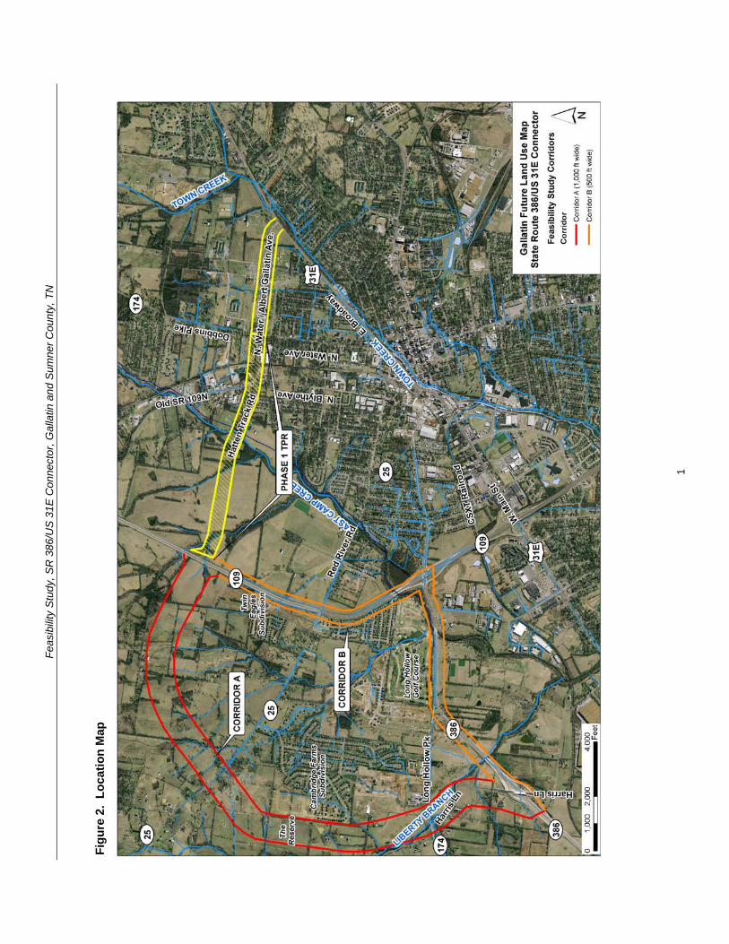
Feasibility Study SR 386US 31E Connector Gallatin and Sumner County TN
30 STUDY AREA PROFILE 31 Community Characteristics The study area for this Feasibility Study includes land within the incorporated city limits of the City of Gallatin land within the unincorporated area of the Gallatin Municipal Planning Region as well as land within the Gallatin Urban Growth Boundary Area Figure 3 depicts these planning and political boundaries in relation to the study area limits As shown the Gallatin Municipal Planning Region covers the eastern portion of the study area The planning region limits expand north of the study area toward Old Douglas Road but in the western portion of the study area the planning region limits do not extend west beyond the Twin Eagles subdivision (just west of SR 109) or the Cambridge Farms subdivision The extreme northwestern portion of the study area includes unincorporated land outside of the Gallatin Municipal Planning Region but within the Urban Growth Boundary Area which is under the jurisdiction of Sumner County
Population and Growth In 2008 Gallatin had a population of 29343 people For comparison purposes the populations for both Sumner County and the State of Tennessee are shown in Table 1 Between 1990 and 2008 Gallatin experienced a 561 percent increase in population as compared to 505 percent for Sumner County and 274 percent in Tennessee as a whole Between 2000 and 2008 Gallatin grew by 263 percent
Table 1 Population Growth
Population Percent Change
1990-2008Location 1990 2000 2008
(2009)
Tennessee 4877185 5689283 6214888 (6296254) 274
Sumner County 103281 130449 155474 (158759) 505
City of Gallatin 18794 23230 29343 561
Source US Census 1990 and 2000 and 2008 US Census Population Estimates Estimates as available
As reflected in the above statistics the City of Gallatin and Sumner County as a whole have faced a tremendous amount of growth pressure in recent years due to population growth as compared to the State of Tennessee The growth rate accelerated in the midshy1990s when the City of Gallatin adopted a major update to the General Development and Transportation Plan and a new Zoning Ordinance in 1998 that helped implement the plan According to the Gallatin Economic Development Agency the population of Gallatin is forecasted to grow by six (6) percent to 31073 by 2013 and is projected to continue to have a steady growth rate over the next twenty (20) years The SR 386 and SR 109 corridors have been identified by the City as emerging areas of future growth
3
Feas
ibili
ty S
tudy
SR
386
US
31E
Con
nect
or G
alla
tin a
nd S
umne
r Cou
nty
TN
Figu
re 3
Pl
anni
ng a
nd P
oliti
cal B
ound
arie
s
Sou
rce
Ada
pted
from
Gal
latin
on
the
Mov
e 20
20
4
Feasibility Study SR 386US 31E Connector Gallatin and Sumner County TN
Major Employers and Traffic Generators The largest employment sectors in Gallatin include management professional and related occupations sales and office occupations production transportation and material moving occupations Combined these occupation categories represent roughly 75 percent of the labor force
The largest employment sector in the Gallatin area is industrial and manufacturing which provides an estimated 7500 jobs Twenty-two major industrial manufacturers and distributors are located in existing industrial parks or commercial centers Gallatin has planned for several new industrial centers which is an objective in Gallatin On the Move 2020 the Cityrsquos long-range growth land use and major thoroughfaretransportation plan
The major private employers and traffic generators in the general study area are listed in Table 2 and shown in Figure 4 Note that the list does not include the Sumner County Government which employs approximately 3900 workers that mostly work within the Sumner County School System
Sumner Regional Health Systems operates Sumner Regional Medical Center a 155shybed full-service hospital located east of Gallatin on SR 25Hartsville Pike Located on Gap Boulevard and fronting on US 31E northeast of the Volunteer State Community College (VSCC) is Gap Inc the Cityrsquos largest employer with approximately 1250 jobs
Volunteer State Community College is the Cityrsquos third largest employer and is located at 1480 Nashville Pike (US 31E) It is a two-year community college that offers associate degrees and technical certificates for over 70 programs to approximately 7500 students VSCC also offers classes for the community and area businesses through the Division of Continuing Education and Economic Development
Table 2 List of Major Employers Company Industry Employees
Sumner Regional Health Center Medical centerhospital admin corporate office 1326 Gap Inc Clothing distribution 1250 Volunteer State Community College EducationTwo-year public college 800 RR Donnelley amp Sons Binding 320 ABC Group Fuel Systems Automotive fuel systems 305 SERVPRO Industries Inc Cleaning and restorationcorporate headquarters 254 Hoeganaes Corporation Powdered metal products 197 Natural Industrial Concepts Industrial manufacturing 168 Charles C Parks Food distribution 150 ABC Technologies Plastic automotive parts 150
Source Forward Sumner Economic Council and Gallatin Economic Development Agency 2009
According to the 2035 Comprehensive Plan Sumner Countyrsquos Blueprint to the Future the retail industrial and office sectors are forecasted to increase at an annual rate of 160 to 180 percent in Sumner County through 2035 This is projected in part by the announcement by the Gallatin Economic Development Agency of a 207-acre expansion
5
Feasibility Study SR 386US 31E Connector Gallatin and Sumner County TN
of the Gallatin Industrial Center as well as plans for future office space development in the area near VSCC and the Sumner County Administration Building This industrial growth is enhanced by the CSXT railroad that has a line that runs north-south through Gallatin on the east side of the study area between North Blythe Avenue and North Water Avenue and then runs parallel to US 31E connecting to Nashville
In addition in June 2009 the Silver Eagle Bus Manufacturing company announced its relocation from Brownsville Texas to Gallatin Once fully operational the companyrsquos business plan anticipates hiring more than 500 people in its new 150000 square-foot facility which will be located well southeast of the study area and on the opposite side of US 31E from the study area
6
Feasibility Study SR 386US 31E Connector Gallatin and Sumner County TN
Figure 4 Major Employers and Traffic Generators
7
Feasibility Study SR 386US 31E Connector Gallatin and Sumner County TN
32 Existing and Future Land Use Existing land uses in the study area as shown in Gallatin on the Move 2020 are depicted in Figure 5 Within Corridors A and B the existing land use is ruralagricultural
Within Corridor A from the west side of SR 109 and southward toward Greenlea Boulevard development becomes sparse and the land is mostly utilized for ruralagricultural uses Scattered rural residential homes horse farms and barns are located within the corridor just south of its intersection with SR 25 and on the southern end near Greenlea Boulevard Existing low density residential subdivisions are scattered along the boundary of the corridor located near the corridorrsquos intersection with SR 109 on the north (Twin Eagles Subdivision) and to the southwest of the corridorrsquos intersection with SR 25 and along Greenlea Boulevard at the south end of the corridor (Cambridge Farms Subdivision)
The primary nature of the land use within Corridor B is ruralagricultural The large and expanding rural residentiallow density residential subdivision the Twin Eagles Subdivision is located on the northwest side of Corridor B near the intersection of SR 109 with Corridor A and B (proposed Hatten Track Road Extension) The Eagle Creek Development is a residential subdivision that lies to the northwest of the SR 109 intersection with SR 174Long Hollow Pike The Long Hollow Golf Course is the primary land use along Corridor B The golf course is located on the north side of SR 174Long Hollow Pike between its intersection with SR 386 and SR 109 On the southern side of Corridor B along SR 174Long Hollow Pike there is industrial development clustered along Belvedere Drive At the intersection of SR 174 and Belvedere Drive lies Thorntonrsquos Gas Station and a carpet outlet
Along SR 174Long Hollow Pike between Corridor A and B lies a John Deere retailer the entrance to the Stratford Park Subdivision the Cambridge Shopping Center and a Phillips 66 gas station
The Community Character Map from Gallatin on the Move 2020 incorporates categories that describe in detail the Cityrsquos vision for growth and development for the next 20 years The Community Character Map serves as a future land use map for the City A close-up of the Community Character Map that shows the study corridors is shown in Figure 6 Eleven major development areas are shown within the study corridors Neighborhood Center Regional Activity Center Suburban Neighborhood Emerging Suburban Neighborhood Established Town Neighborhood Revitalization Emerging Walkable Community Rural Community North Gallatin Emerging Business Park GreenLea Business Center Commercial Corridor and Parks and Open Space A brief summary of these categories are shown in Table 3
8
Feas
ibili
ty S
tudy
SR
386
US
31E
Con
nect
or G
alla
tin a
nd S
umne
r Cou
nty
TN
Figu
re 5
C
ity o
f Gal
latin
Exi
stin
g La
nd U
se M
ap
Sou
rce
Ada
pted
from
Gal
latin
on
the
Mov
e 20
20
9
Feas
ibili
ty S
tudy
SR
386
US
31E
Con
nect
or G
alla
tin a
nd S
umne
r Cou
nty
TN
Figu
re 6
C
ity o
f Gal
latin
Com
mun
ity C
hara
cter
Map
(Fut
ure
Land
Use
Map
)
Sou
rce
Ada
pted
from
Gal
latin
on
the
Mov
e 20
20
10
Feasibility Study SR 386US 31E Connector Gallatin and Sumner County TN
Table 3 City of Gallatin Community Character (Future Land Use) Map Categories Community Character Category
Community Character Map Areas
General Description Primary Land Uses Appropriate Density Intensity
Centers
Neighborhood Center
Neighborhood scale mixed-use centers that serve the surrounding neighborhood
Small and large scale apartments and townhomes vertical mixed-use neighborhood commercial
035 Floor Area Ratio
Regional Activity Center
Regional-scale mixed-use centers that include retail office and residential uses
Large-scale apartments and townhomes horizontal and vertical mixed-use commercialofficeretail big box retail hospitality publicinstitutional entertainment and cultural facilities
075 Floor Area Ratio
Neighborhoods
Suburban Neighborhood Emerging
Developable areas where conventional suburban neighborhood development is appropriate
Single family residential small and large-scale apartments and townhomes public Institutional
1-3 units per acre
Suburban Neighborhood Established
Stable neighborhoods developed with narrow smaller lots generally prior to 1950
Single family residential small and large scale apartments and townhomes
2-5 units per acre
Town Neighborhood Revitalization
Neighborhoods developed with narrow smaller lots generally prior to 1950 with a need for new investment and revitalization
Single family residential small-scale apartments and townhomes
5-8 units per acre
Emerging Walkable Community
Developable areas where walkable neighborhoods Traditional Neighborhood Development (TND) is appropriate and a variety of housing types
Single and multiple family residential office retail civic
Varies
Rural Community
Sparsely developed areas where agricultural use and character is common and expansion of urban services is not anticipated
Agricultural large lot and conservation subdivision single family residential passive recreation civic uses (rural scale)
1 unit per 2+ acres
Special Districts North Gallatin Emerging Business Park
A predominantly undeveloped area bound by SR 109 Bypass and Old Hwy 109 north of the City limits
Light industry business parks warehouse commercial hospitality transportation communicationutilities
050 Floor Area Ratio
11
Feasibility Study SR 386US 31E Connector Gallatin and Sumner County TN
Community Character Category
Community Character Map Areas
General Description Primary Land Uses Appropriate Density Intensity
GreenLea Business Center
Emerging special area that includes a mix of industrial and commercialoffice uses to diversify the Cityrsquos economic base
Light industry business parks warehouse commercial hospitality transportation communicationutilities single and multi-family residential (when part of an approved master plan)
050 Floor Area Ratio
Corridors Commercial Corridor
Stable commercial corridors where development is encouraged
Small and large-scale apartments and townhomes office vertical mixed use commercialretail
075 Floor Area Ratio
Preserve Parks and Open Space
Primarily public or privately-owned land intended to remain as open space for preservation and recreation needs and not suitable for development
Passive and active recreation undeveloped areas in natural state
Not applicable
Source Gallatin on the Move 2020
One of the objectives in Gallatin on the Move 2020 is to ldquoPromote desired development patterns with incentives and preparation of master plans for large undeveloped areas where growth is expected over the next 20 yearsrdquo The plan specifically refers to the Bowles property in the western portion of Corridor A and B It states ldquoAlong with the completion of new infrastructure such as the extension of the Hatten Track Road through the Bowles property the City should coordinate with property owners to establish a detailed visionrdquo (ie master plan) that is consistent with the overall City vision thus allowing the City to promote specific goals and objectivesrdquo
In 2007 the City of Gallatin approved a Preliminary Master Development Plan for Phases 6 through 12 of the Twin Eagles Subdivision If built this development expansion would be located to the north of the current subdivision west of SR 109 and within the Gallatin Municipal Planning Region In addition a Preliminary Master Development Plan for Phases 1 through 4 of The Reserve was approved by the City of Gallatin in 2010 The Reserve is designed as a 68 acre single-family residential development of 158 buildable lots to the southwest of SR 25 adjacent to Wentworth Drive on the west side of the Cambridge Farms subdivision Corridor A of the proposed project overlaps with these two proposed subdivision expansions It is recommended that the City of Gallatin Planning Commission preserve the right-of-way needed for the SR 386US 31E connector project
The GreenLea Business Center is described in Gallatin on the Move 2020 as ldquoan emerging employment and residential special area that includes a mix of industrial office residential and commercial uses that take advantage of the areasrsquo location adjacent to SR 386 and the CSXT Railroad Much of this area is currently undeveloped and presents an opportunity for commercial industrial and office growth adjacent to existing and emerging residential and commercial areasrdquo In addition the intent of the North Gallatin Emerging Business Park development pattern is to accommodate lessshy
12
Feasibility Study SR 386US 31E Connector Gallatin and Sumner County TN
intensive uses such as corporateregional headquarters call and data centers light manufacturing and ldquogreenrdquo companies with a relatively high-density mix of industrial and commercial uses in a campus-like setting
Another objective in Gallatin on the Move 2020 is to ldquoCoordinate with the Sumner County Planning Commission and Sumner County Commission to establish a process for adoption and implementation of the recommendations of the plan for areas within the Gallatin Urban Growth Boundary area outside of the Planning Regionrdquo This objective is applicable to the north and western portions of the study area that are located within unincorporated Sumner County but inside the Gallatin Urban Growth Boundary limits Figure 7 shows a close-up of the General Framework Map from the 2035 Comprehensive Plan Sumner Countyrsquos Blueprint to the Future that is intended to serve as a future land use plan for unincorporated Sumner County As illustrated the preferred land use patterns within the study corridors include a Regional Employment Center and Suburban development
The Regional Employment Center is shown in the same area as North Gallatin Emerging Business Park (between SR 109 and Old SR 109) in Gallatin on the Move 2020 The purpose of the Regional Employment Center designation is to locate office parks manufacturing centers corporate campuses or major universities near major transportation corridors that can provide basic jobs and keep people in the county during normal work hours The Suburban development pattern is consistent with the Suburban Neighborhood Emerging and Rural Community character categories shown in the Gallatin on the Move 2020 Community Character map and it is designated for low density residential land uses of one dwelling unit per acre or less The Conservation designations shown to the north of Corridors A and B are associated with conservation easements held by the Land Trust of Tennessee
13
Feas
ibili
ty S
tudy
SR
386
US
31E
Con
nect
or G
alla
tin a
nd S
umne
r Cou
nty
TN
Figu
re 7
Su
mne
r Cou
nty
Gen
eral
Fra
mew
ork
Map
(Fut
ure
Land
Use
Map
)
Sou
rce
Ada
pted
from
203
5 C
ompr
ehen
sive
Pla
n S
umne
r Cou
ntyrsquo
s B
luep
rint t
o th
e Fu
ture
14
Feasibility Study SR 386US 31E Connector Gallatin and Sumner County TN
33 Transportation Plans There are multiple transportation studies that cover the City of Gallatin and Sumner County The numerous recommended transportation improvements planned within the vicinity of the study area are listed in Appendix B The extensive list of projects in Appendix B are categorized under the following plans bull Gallatin on the Move 2020 City of Gallatin General Development and
Transportation Plan 2008-2020 bull 2035 Comprehensive Plan Sumner Countyrsquos Blueprint to the Future bull Nashville Metropolitan Planning Organizationrsquos 2030 Long Range Transportation
Plan bull Nashville Metropolitan Planning Organizationrsquos Transportation Improvement
Program Fiscal Years 2011-2015 (Draft ndash scheduled for adoption December 2010)
34 Bicycle and Pedestrian Plans Greenway multi-use paths branch greenway trails bicycle lanes and bicycle routes have been planned in Gallatin as part of the overall transportation system to serve as multi-modal community connectors and natural resources conservation areas For the Phase 1 Albert Gallatin AvenueHatten Track Road Extension bike lanes were designated between SR 109 and SR 174 (Dobbins Pike) Bike lanes are also being proposed as part of the Phase 2 SR 386US 31E Connector
Based on the projects shown in Gallatin on the Move 2020 the proposed bicycle and pedestrian projects within the study area are illustrated in Figure 8 Below is a detailed description from the plan of the projects that cross into or are within the study corridors
The City of Gallatin 2006 Greenways Master Plan organized the greenway multi-use paths into eight corridors prioritized according to their feasibility availability and level of connectivity The following two greenway projects are within the study corridors
bull Project 4 ndash Town Creek Trail A multi-use path 357 miles long that is expected to start at Triple Creek Park and generally follow Town Creek southwesterly and then end at a trail head near the SR 109 Bypass (near Ryan Avenue) This trail was ranked first (1) out of eight (8) on the priority list in the 2006 Greenways Master Plan
bull Project 9 - East Camp Creek Trail A trail 472 miles long that would start just south of US 31E and run in a northeasterly direction along the Camp Creek This trail was ranked six (6) out of eight (8) on the priority list in the 2006 Greenways Master Plan
The Plan also shows two greenway spurs to promote further connectivity between the greenways and bicycle and pedestrian facilities
bull Project 12 ndash East Camp Creek Spur ndash ldquoA trail spur extending up Camp Creek towards SR 386 to provide bicycle and pedestrian access into this future development areardquo
bull Project 13 - Hatten Track Trail Spur ldquoA trail spur extending into the Hatten Track from the East Camp Creek Trail to provide bicycle and pedestrian access into the development areardquo
15
Feasibility Study SR 386US 31E Connector Gallatin and Sumner County TN
Bike lanes are on-road facilities designated by striping signing and pavement markings that are for the preferential or exclusive use of bicycles whereas bike routes are on-road facilities indicated by directional and informational markers such as ldquoBike Routerdquo andor ldquoShare the Roadrdquo signs that utilize little or no striping The proposed bike lanes and bike routes in Figure 9 were originally proposed as part of the City of Gallatin Bicycle and Pedestrian Master Plan of 2000 (denoted by ldquoBrdquo) the 2000 Major Thoroughfare Plan (denoted by ldquoTrdquo) and the 2005 State Route 386 Area Study (denoted by ldquoASrdquo) The following bicycle lane and route projects are located within the study corridors
bull Project 14 ndash Long Hollow Pike Provide bike lanes ldquofrom the western boundary of the study area to Red River Road It is recommended that pedestrian and bike facilities are included when roadway improvements are planned including connections at a possible interchange with SR 386rdquo (B T AS)
bull Project 15 ndash US 31E (Nashville Pike) Currently there are no bike lanes along US 31E to accommodate bicyclists Project 15 is intended to provide bike lanes ldquofrom the western boundary of the study area through downtown to the eastern boundary of the study planning area US 31E west of SR 109 is marked as a bicycle route Further it is TDOTrsquos vision to have a continuous bike route from Nashville to Gallatin via US 31E (Nashville Pike) It is recommended that any development or redevelopment along Nashville Pike should include provisions to provide bike lanesrdquo (B AS)
bull Project 16 ndash GreenLea Boulevard Provide bike lanes from Long Hollow Pike to US 31 E (AS)
bull Project 18 ndash Bison Trail Extension Provide bike lanes ldquofrom GreenLea Boulevard to connect up with Saundersville Road in Hendersonville west of Lower Station Camp Creek Roadrdquo (AS)
bull Project 23 - Hatten Track Road Extension Provide bike lanes ldquobetween SR 109 Bypass to Dobbins PikeSR 174North Water Avenue These bike lanes would connect the SR 109 Bypass to other facilities Bike lanes are recommended east of North Water Avenue thus completing a bike system (Project 27)rdquo (B T)
bull Project 26 ndash Red River Road Provide bike lanes ldquofrom Bradford Drive to US 31EMain Street Bike lanes are recommended to connect to the Bradford Drive route to complete a multi-modal loop around the golf course and into downtownrdquo (B)
bull Project 27 ndash SR 174Albert Gallatin Avenue Provide bike lanes ldquofrom North Water Avenue to East Broadway AvenueUS 31E This bike route runs along the north side of Gallatin Municipal Park and would connect with multiple bike facilities Bike lanes are recommended west of North Water Avenue thus completing a bike system (Project 23)rdquo (B)
bull Project 31 ndash Old Highway 109 Provide bike routes ldquofrom Hatten Track Road to the northern planning boundary This planned bike route would provide multiple connections to other bike lanes andor routes connecting the northwest area to downtown Gallatinrdquo (B)
16
Feas
ibili
ty S
tudy
SR
386
US
31E
Con
nect
or G
alla
tin a
nd S
umne
r Cou
nty
TN
Figu
re 8
Pr
opos
ed B
ike
and
Pede
stria
n Pr
ojec
ts
Sou
rce
Ada
pted
from
City
of G
alla
tin 2
006
Gre
enw
ays
Mas
ter P
lan
17
Feasibility Study SR 386US 31E Connector Gallatin and Sumner County TN
Project 35 ndash Dobbins Pike Provide bike routes ldquobetween the northern planning boundary to Albert Gallatin Avenue This is an integral part of a bike route corridor through the heart of the City of Gallatin This section connects the northern portion to the Civic Center Bike Routes are recommended north of Broadway Avenue thus completing a bike system (Project 36 37)rdquo (B)
bull Project 43 (Blythe Avenue) is categorized as a ldquobike lanes and sidewalks projectrdquo that is recommended within the study corridors It is intended ldquoto provide an alternate to North Water and US 31E for access to the recreational areas on the north side of the City It is recommended to incorporate bike lanes and sidewalks with any future roadway wideningrdquo
bull Project 46 (Albert Gallatin Avenue) is categorized as a ldquosidewalks and pedestrian crossing projectrdquo that is recommended within the study corridors It is intended ldquobetween North Water Avenue and US 31E to serve the recreational users of the Gallatin Civic Centerrdquo
35 Other Multi-modal Facilities The Gallatin on the Move 2020 Plan recommends flexible bus service within the City of Gallatin The service would travel along a designated route but would be flexible enough to deviate off route to pick up or drop off passengers For instance if a route traveled from downtown to Volunteer State Community College the service could deviate off route for a certain distance (typically 34 mile) or to a certain boundary This type of service design addresses ADA requirements while expanding coverage to additional areas
Gallatin North-South Flex The north-south flexible bus service using one vehicle is proposed to operate along Albert Gallatin Avenue Blythe Avenue Eastland Street and Water Avenue Sites served include the Civic Center low-income housing along Blythe Avenue at Small Street the downtown square and homes and businesses along Water Avenue Deviations could also serve low-income housing along Lackey Circle low-income housing along Boyers Avenue at Hull Circle and other homes and businesses within a frac34 mile buffer of the route
36 Potential Future Coordination This study has involved local stakeholders including City Council representatives and business owners in early planning and development of the proposed project
A CSX Railroad line runs north-south through the study area of the Phase 1 Albert Gallatin AvenueHatten Track Road Extension which has been incorporated into this study The bridge on North Water Avenue crossing over the depressed railroad line will need to be replaced requiring coordination with the CSX Railroad A representative of CSX was invited to the stakeholder meeting for both the Phase 1 study and this study but did not attend
Coordination with the US Army Corps of Engineers will be required for the blue line stream crossings and possibly for wetland impacts The Tennessee Department of Environment and Conservation will also need to be coordinated with in regard to potential permitting and possibly for hazardous materials
18
Feasibility Study SR 386US 31E Connector Gallatin and Sumner County TN
In addition the City must coordinate with local developers proposing developments within or adjacent to the corridors under study to ensure that future implementation should the study become a project remains viable
40 PRELIMINARY PROJECT NEED This project is intended to address anticipated future transportation needs which have been identified through coordination with local officials and agencies The project area has been targeted as a prime area for future development and its success is dependent on a connected local and regional roadway system
41 Safety The following is a summary of the crash history on SR 109 and SR 174 for the latest three-year period for which data is available (2007 ndash 2009) Table 4 summarizes two segments of roadway and two major intersections in the project area showing the number of crashes and the comparison of the actual crash rate with the statewide average crash rate for the same functional classification The actual rate is derived from a formula that takes into account factors such as total number of crashes length of roadway and the time period over which the crashes occurred
The SR 174 intersection with Belvedere Drive and the SR 174 intersection with SR 109 have crash rates of approximately 15 to 17 times greater than the statewide rate for an intersection of its type thus indicating that safety is a concern along this segment of SR 174 The number of crashes suggests a need for an alternate route or intersection configuration to help separate through and local traffic
Table 4 Crash Summary
SectionIntersection Description Log Mile(s)
Crashes
Actual Crash Rate
State Average
Crash Rate
SR 109 from SR 174 (Long Hollow Pike) to Old Highway 109 421-760 28 035 201
SR 174 (Long Hollow Pike) from SR 386 to SR 109 1354-1459 13 016 275
SR 174 (Long Hollow Pike) intersection with Belvedere Drive 1428 22 156 099
SR 174 (Long Hollow Pike) intersection with ramps for southbound SR 109 1445-1451 24 170 099
SR 174 (Long Hollow Pike) intersection with ramps for northbound SR 109 1452-1449 15 107 099
for this type of roadway
A summary of the 2006-2008 crash data findings for each segment and intersection is as follows
19
Feasibility Study SR 386US 31E Connector Gallatin and Sumner County TN
bull SR 109 from SR 174 (Long Hollow Pike) to Old Highway 109 The statewide average crash rate for a roadway of the same functional classification (urban arterial four lane divided) is 201 while the actual rate is 035 for this segment of SR 109 The actual crash rate for this segment of roadway is well below the statewide average and therefore does not indicate a safety issue There were twenty-eight (28) documented crashes resulting in no fatalities no incapacitating injuries and nine (9) other injuries
bull SR 174 (Long Hollow Pike) from SR 386 to SR 109 The statewide average crash rate for a roadway of the same functional classification (urban minor arterial four lane with turn lane) is 275 while the actual rate is 016 for this segment of SR 174 The actual crash rate for this segment of roadway is well below the statewide average and therefore does not indicate a safety issue There were thirteen (13) documented crashes resulting in no fatalities no incapacitating injuries and four (4) non-incapacitating injuries
bull SR 174 (Long Hollow Pike) intersection with Belvedere Drive The statewide average crash rate for an intersection of this type is 099 The actual rate for the intersection is 156 which is slightly higher than the statewide average This intersection is the location of an existing industrial area that is slated for use in the future as the ldquoGreenlea Business Centerrdquo Of the twenty-two (22) crashes at the signalized intersection with Belvedere Drive ten (10) involved personal injury and thirteen (13) were rear end collisions
bull SR 174 (Long Hollow Pike) intersection with ramps for southbound SR 109 from Log Miles 1445 -1451 The statewide average crash rate for an intersection of this type is 099 while the actual rate for the intersection is 170 which is slightly higher than the statewide average There were twenty-four (24) documented crashes at this intersection resulting in no fatalities or incapacitating injuries but ten (10) non-incapacitating injuries Twelve (12) of the crashes occurred at log mile 1449 which is the signalized intersection for the right-turn ramp onto SB SR-109 and the left-turn ramp from SB SR-109
bull SR 174 (Long Hollow Pike) intersection with ramps for northbound SR 109 from Log Miles 1452 -1459 The statewide average crash rate for an intersection of this type is 099 while the actual rate for the intersection is 107 which is slightly higher than the statewide average There were fifteen (15) documented crashes at this intersection resulting in no fatalities or incapacitating injuries but four (4) non-incapacitating injuries Seven (7) of the crashes occurred at log mile 1458 which is the signalized intersection for the right-turn ramp from NB SR 109 lanes and the left-turn ramp to NB SR 109 lanes
42 System Linkage An alternate route between the southwest and northeast sides of Gallatin is desired The SR 386US 31E Connector will link SR 386 with SR 174 and US 31E north of downtown and provide ldquothroughrdquo traffic the ability to avoid the congested segment of US 31 E through downtown Gallatin
20
Feasibility Study SR 386US 31E Connector Gallatin and Sumner County TN
Furthermore construction of the SR 386US 31E Connector will create a more accessible and resilient transportation system by improving route options dispersing traffic over more roads and therefore reducing delays when a particular roadway segment is closed due to an incident construction or for other reasons
43 Level of Service Analysis To determine how well traffic operates under the No-Build and Build Conditions a level of service analysis was conducted A ldquoLevel of Servicerdquo (LOS) index was used to gauge the operational performance for each roadway segment The LOS is a qualitative measure that describes traffic conditions related to speed and travel time freedom to maneuver traffic interruptions etc There are six levels ranging from ldquoArdquo to ldquoFrdquo with ldquoFrdquo being the worst Each level represents a range of operating conditions Table 6 defines the traffic flow conditions and approximate driver comfort level at each level of service
LOS analysis was performed using the Highway Capacity Software (HCS+) for the No-Build and Build conditions for the base year of 2016 and the design year of 2036 Each roadway segment for Corridors A and B was analyzed using the multi-lane highways module in the HCS+ software The roadway characteristics that affect the LOS and were included in the analysis include free-flow speed lane width and lateral clearance median type access point density general terrain characteristics number of heavy vehicles in the traffic flow and the directional distribution of traffic The HCS+ results are included in Appendix C
It should be noted that the segments of US 31E and the segments where Corridors A and B are combined (Phase 1) were not analyzed using the HCS+ software because the speed limit on the roadway is lower than can be accommodated in the multi-lane highways module Furthermore the traffic signals along these segments will impact the LOS on the roadway segments and an arterial-level analysis is needed to properly determine the LOS In the absence of turning movement counts at the intersections the AADT volumes on these segments were equated to generally accepted volume thresholds to determine the arterial LOS
The results of the LOS analysis are summarized in Table 7
The LOS analysis indicates that under the 2036 No-Build and Build Conditions the segment of SR 386 from Greenlea Boulevard to SR 174 and then SR 174 to N Belvedere Drive operates at LOS E during peak periods Due to projected 2036 AADT volumes in the range of 54950 to 56250 vehicles per day these segments need to be widened by one (1) travel lane in each direction in order to accommodate the projected traffic A more detailed discussion of the improvements needed for these segments is included in Section 52
21
Feasibility Study SR 386US 31E Connector Gallatin and Sumner County TN
Table 5 Definition of Level of Service
Level of Service
Definition
A Free flow operations Vehicles are almost completely unimpeded in their ability to maneuver with the traffic stream The general level of physical and psychological comfort provided to the driver is high
B Reasonable free flow operations The ability to maneuver within the traffic stream is only slightly restricted and the general level of physical and psychological comfort provided to the driver is still high
C Flow with speeds at or near free flow speeds Freedom to maneuver within the traffic stream is noticeably restricted and lane changes require more vigilance on the part of the driver The driver notices an increase in tension
D Speeds decline with increasing traffic Freedom to maneuver within the traffic stream is more noticeably limited The driver experiences reduced physical and psychological comfort levels
E At lower boundary the facility is at capacity Operations are volatile because there are virtually no gaps in the traffic stream There is little room to maneuver The driver experiences poor levels of physical and psychological comfort
F Breakdowns in traffic flow The number of vehicles entering the highway section exceed the capacity or ability of the highway to accommodate that number of vehicles There is little room to maneuver The driver experiences poor levels of physical and psychological comfort
Source TDOT TPR Manual (2010)
Table 6 LOS for Base Year and Design Year Conditions
Roadway Segment
Level of Service 2016 2036
No-Build No-Build Build Corridor A ndash SR 109 Bypass to SR 25 - - A A Corridor A ndash SR 25 to SR 174 - - A A Corridor A ndash SR 174 to SR 386 - - A A Corridor B ndash SR 386 ndash Harris Ln to SR 174 C B E C E C Corridor B ndash SR 174 ndash SR 386 to N Belvedere Dr C B E C E C Corridor B ndash SR 174 ndash N Belvedere Dr to SR 109 Bypass C B D C D C
Corridor B ndash SR 109 Bypass ndash SR 174 to SR 25 A A B A B A Corridor B ndash SR 109 Bypass ndash SR 25 to Hatten Track Extension (phase 1) A A B A B A
Corridor AB (Phase 1) Hatten Track ndash SR 109 Bypass to Blythe Ave - - C
22
Feasibility Study SR 386US 31E Connector Gallatin and Sumner County TN
Roadway Segment Level of Service
2016 2036 No-Build No-Build Build
Corridor AB (Phase 1) Old State Highway 109 ndash Blythe Ave to N Water Ave B B B
Corridor AB (Phase 1) Albert Gallatin Ave ndash N Water Ave to US 31E A B B
US 31E ndash SR 109 to River Rd E F F US 31E ndash River Rd to Eastland St D E D US 31E ndash Eastland St to N Water Ave E F E US 31E ndash N Water Ave to SR 174 B D C
Direction 1Direction 2
44 Capacity As stated in the Transportation Improvement Plan (TIP) for Albert Gallatin AvenueHatten Track Road Extension (Phase 1) the construction of the Extension is anticipated to ldquoaddress congestion occurring on SR 6 [US 31E] and provide an alternative route to access SR 109 and SR 386rdquo The existing traffic on US 31E (SR 6West Main StreetEast Broadway) in downtown Gallatin has a projected 2016 Average Annual Daily Traffic (AADT) volume of approximately 31600 vehiclesday which exceeds the capacity of a five (5) lane urban arterial resulting in LOS E
The construction of both the Phase 1 Extension of SR 174Albert Gallatin Avenue and Hatten Track Road and the Phase 2 SR 386US 31E Connector is anticipated to divert approximately twenty-five (25) percent of the traffic away from US 31E in the downtown area This traffic reduction is anticipated to reduce the AADT on US 31E to a level that can be better accommodated by the existing roadway resulting in LOS C
By reducing the AADT on the most heavily congested segments of US 31E the levels of service at the signalized intersections and associated vehicular delay is anticipated to improve Generally speaking the arterial levels of service improve on US 31E between River Road (SR 25) and SR 174 in the Build Condition More detailed information on the capacity analysis is provided later in this section
Traffic Projections Traffic volumes for the No-Build and Build Conditions were projected in support of this Feasibility Study TDOT provided AADT volumes on roadways within the study area for a base year of 2016 and design year 2036 which were determined using the Nashville MPO travel demand model as well as TDOT 24-hour counts The AADT volumes for the No-Build and Build Conditions for the base and design years are presented in Table 5 The traffic diagrams provided by TDOT is provided in Appendix C
In order to accommodate the projected 2036 Build Condition AADT volumes ranging from 14710 to 17120 vehicles per day a four-lane typical section is needed for Corridor A A more detailed discussion of the proposed typical section for Corridor A is included in Section 52
23
Feasibility Study SR 386US 31E Connector Gallatin and Sumner County TN
Table 7 AADT for Base Year and Design Year Conditions
Roadway Segment
AADT 2016 2036
No-Build No-Build Build Corridor A ndash SR 109 Bypass to SR 25 - - 14710 Corridor A ndash SR 25 to SR 174 - - 16020 Corridor A ndash SR 174 to SR 386 - - 17120 Corridor B ndash SR 386 ndash Harris Ln to SR 174 32300 51680 54950 Corridor B ndash SR 174 ndash SR 386 to N Belvedere Dr 36250 52900 56250
Corridor B ndash SR 174 ndash N Belvedere Dr to SR 109 Bypass 35000 45500 48380
Corridor B ndash SR 109 Bypass ndash SR 174 to SR 25 16500 27400 23290 Corridor B ndash SR 109 Bypass ndash SR 25 to HattenTrack Extension (Phase 1) 13100 22250 21100
Corridor AB (Phase 1) Hatten Track ndash SR 109 Bypass to Blythe Ave - - 10700
Corridor AB (Phase 1) Old Highway 109 ndash Blythe Ave to N Water Ave 7050 8950 15370
Corridor AB (Phase 1) Albert Gallatin Ave ndash NWater Ave to US 31E 5800 8550 11450
US 31E ndash SR 109 to River Rd 31600 41100 39030 US 31E ndash River Rd to Eastland St 20600 28020 22330 US 31E ndash Eastland St to N Water Ave 25000 33250 26500 US 31E ndash N Water Ave to SR 174 14450 19050 15180
Source Tennessee Department of Transportation (2011)
45 Economic Development As discussed in Section 32 and depicted in Figure 6 the Gallatin on the Move 2020 plan specifies more intensive land uses than those currently present in the study area Along Phase 1 of the proposed Albert Gallatin AvenueHatten Track Road the land on the west side of the project adjacent to SR 109 is slated as the North Gallatin Emerging Business Park
In the current study area which includes the above segment but also includes land in and adjacent to the northwest quadrant of the SR 386 and SR 109 intersection the future land use plan specifies land along SR 174 (Long Hollow Pike) and SR 386 for future development as 1) a Regional Activity Center and 2) Greenlea Business Center (includes some existing industrial uses)
Adequate roadway connectivity to and from these areas is essential for the City to realize their future plans for economic development
24
Feasibility Study SR 386US 31E Connector Gallatin and Sumner County TN
50 OPTIONS FOR IMPROVEMENT 51 No-Build Option The No-Build Option provides a baseline for evaluating the benefits and costs created by the Build Options and is defined as the roadway conditions as they currently exist The No-Build Option examines the impacts to the transportation system if the transportation improvements identified as the Build Options are not constructed
Together SR 386 and SR 174 currently serve as the roadway link between Greenlea Boulevard and the SR 109 Bypass Within the study area SR 386 is classified as a freeway with a four (4)-lane divided typical section Between SR 386 and the SR 109 Bypass SR 174 is classified as an urban minor arterial and consists of a five (5)-lane section with a center left turn lane SR 109 Bypass between SR 174 and the proposed Hatten Track extension is classified as an urban principal arterial and consists of four (4)-lane divided typical section US 31E is classified as an urban principal arterial and consists of a five (5)-lane section through downtown Gallatin transitions to a four (4)shylane divided typical section north of River Road then to a two (2)-lane divided section north or N Boyers Avenue and then to a three (3)-lane typical section south of JoAnn Street which continues to the intersection with Albert Gallatin Avenue
As indicated in the LOS analysis in Section 43 the segment of SR 386 from Greenlea Boulevard to SR 174 and then on to N Belvedere Drive operates at LOS E under the No-Build Option Additionally the segments of US 31E from SR 109 Bypass to N Water Avenue operate at either LOS E or F which does not meet minimum operational requirements
25
Feasibility Study SR 386US 31E Connector Gallatin and Sumner County TN
52 Build Options As stated previously and illustrated in Figure 9 there are two corridor options under the Build Condition Corridor A and Corridor B Phase 1 consists of the Albert Gallatin AvenueSR 174 Extension which is proposed to end at an interchange with SR 109 Phase 2 consists of either Corridor A or Corridor B which both utilize the Phase 1 extension from SR 109 to US 31E A description of each Build Option follows
Appendix D contains the typical sections and layout sheets for Phase 2 A description of the roadway segment for each feature follows
Corridor A
bull Corridor A is on new alignment from the SR 386Green Lea interchange and travels north along the east side of Liberty Branch Creek intersecting with SR 25 continues northeast and intersects with Douglas Lane and then continues east to SR 109 at which point it intersects the Phase 1 Albert Gallatin AvenueHatten Track Road extension east to US 31E Corridor A is approximately 39 miles in length
bull The typical section includes four twelve (12)-foot lanes (two (2) in each direction) a 48-foot depressed median six (6)-foot inside shoulders and twelve (12)-foot shared use outside shoulders (to accommodate bike lanes) within 200 feet of proposed right-of-way
bull The widening of SR 386 and SR 174 as described under the Corridor B option must be completed in addition to the building of Corridor A in order to ensure adequate traffic flow and operations on the surrounding roadway network
Corridor B
bull Corridor B follows SR 386 from the interchange with Greenlea Boulevard east to the intersection with Long Hollow Pike at which point the state routing designation changes to SR 174 Corridor B then follows SR 174 to the interchange with SR 109 it then travels north on SR 109 until it intersects with the Phase 1 Albert Gallatin AvenueHatten Track Road extension Corridor B is approximately 34 miles in length
bull Under the Corridor B option SR 386 and SR 174 between Greenlea Boulevard and the SR 109 Bypass will be widened for approximately 14 miles to account for future projected traffic growth
o SR 386 will be widened from four (4) to six (6) lanes (three (3) in each direction) each having a width of twelve (12) feet with twelve (12)-foot shoulders and a 64-foot wide depressed median The present right-ofshyway width for this section is 260 feet with additional right-of-way and easements to be obtained as needed for construction
o The typical section for the improved segment of SR 174 will be widened from five (5) to seven (7) twelve (12)-foot travel lanes (three (3) in each direction and a twelve (12)-foot center turn lane) with twelve (12)-foot shared use outside shoulders (to accommodate bike lanes) This widened section would require a minimum right-of-way of 180 feet
26
Feas
ibili
ty S
tudy
SR
386
US
31E
Con
nect
or G
alla
tin a
nd S
umne
r Cou
nty
TN
Figu
re 9
B
uild
Opt
ions
27
Feasibility Study SR 386US 31E Connector Gallatin and Sumner County TN
bull In addition to widening the identified segments of SR 386 and SR 174 several signalized intersections and two bridges will need to be improved so that the additional lanes can be accommodated The intersections that will require improvements include the following
- SR 386 at SR 174 - SR 174 at Belvedere Drive - SR 174 interchange with SR 109 Bypass
bull While all three of these intersections will require upgrades associated with the roadway widening improvements the SR 174 interchange with the SR 109 Bypass will also require geometric alterations so that traffic can smoothly transition from one route to the other The southbound off-ramp from SR 109 Bypass will need to be extended to form the third westbound lane of SR 174 The third eastbound lane of SR 174 will become a right-turn-only lane onto SR 109 Bypass
bull In addition to the intersection improvements the bridge over East Camp Creek as well as the westbound bridge over Liberty Branch Creek will both need to be widened to accommodate the future widening and meet traffic demands
bull If Corridor B is selected without Corridor A an eastbound to northbound SR 109 clover leaf loop will be needed to accommodate future left turn volumes This would require re-alignment of the ramps on the east side of SR 109 and widening of the bridge on SR 109 at East Camp Creek
Costs TDOT planning level base per mile costs were used to develop estimates for the corridor options and are summarized in Table 8 It should be noted that even if Corridor A is constructed Corridor B will need to be widened along SR 386 and SR 174 to accommodate the future traffic volumes The interchange improvements at SR 109 however would not be needed as motorists travelling north to SR 109 would utilize Corridor A The widening cost for SR 386 and SR 174 is approximately $10000000
Also a two (2) lane depressed median section could be constructed as an interim phase for Corridor A allowing future build out to four (4) lanes which would reduce the interim phase construction cost approximately $11000000
Table 8 Planning Level Costs for Build Options
Item Corridor A (39 Miles)
Corridor B (34 Miles)
Right-of-Way $3608400 $2229675 Total Construction $30490980 $17252905 Preliminary Engineering $3049098 $1725291 Total Cost $37148478 $21207871
53 Possible Modifications to the State Route System During the NEPA phase when the preferred alignment is selected TDOT may review the current state route system for possible modification For example possible changes to the state routing system could include designating SR 174 to follow Long Hollow Pike to
28
Feasibility Study SR 386US 31E Connector Gallatin and Sumner County TN
Greenlea Boulevard and then follow Corridor A to SR 109 continue across SR 109 along Albert Gallatin AvenueHatten Track Road Extension (Phase 1) and reconnect with the existing SR 174 at Dobbins Pike (see Figure 10) Accordingly the SR 174 designation would be removed from Greenlea Boulevard through downtown to Dobbins Pike Based on these possible changes approximately 26 miles would be removed and 54 miles would be added resulting in a net gain of 294 miles to the state route system
29
Feas
ibili
ty S
tudy
SR
386
US
31E
Con
nect
or G
alla
tin a
nd S
umne
r Cou
nty
TN
Figu
re 1
0 P
ropo
sed
Cha
nges
to S
tate
Rou
ting
Syst
em
30
Feasibility Study SR 386US 31E Connector Gallatin and Sumner County TN
54 Control of Access The City of Gallatin Zoning Ordinance (amended October 20 2009) establishes access management standards in Section 1306 for driveways providing vehicular access from arterial collector and local streets (roads in the study area are classified as arterials and collector streets) In addition Gallatin on the Move 2020 outlines additional access management policies that should be applied to the Cityrsquos arterial road system (including long range planning project planning and design right-of-way acquisition redesign of existing arterial corridors and driveway permitting)
Within the study area SR 174 between SR 386 and SR 109 is currently not access controlled and is subject to future development SR 109 is access controlled between SR 25 and Old Highway 109 The proposed extension will ultimately not require a break in the access control on SR 109 because an interchange is planned to allow access between SR 109 and the Albert Gallatin AvenueHatten Track Road Extension (Phase 1) and the SR 386US 31E Connector
In addition the project will be designed to provide limited access along the proposed Build Option ndash Corridor A as well as along the Hatten Track extension (Phase 1) from SR 109 to the east For an at-grade intersection the access control distance will be a minimum of 100 feet from any intersection For an interchange the access control will be 300 feet from the ramp terminals treating each side of the cross road independently
55 Environmental Constraints The environmental screening presented in this Feasibility Study has been provided by the TDOT Early Environmental Screening (EES) reports A detailed environmental study of the corridors identified in this Feasibility Study would occur during future project phases in compliance with National Environmental Policy Act provisions Environmental screening maps produced in support of the analysis in this report are found in Appendix E A full copy of the TDOT EES reports can be found in Appendix F The TDOT EES reports revealed the following
Impacts Evaluated within 1000 feet of the Project Area bull Community ResourceInstitution
The project area is home to one public school Joe Shafer Middle School is located at 240 Albert Gallatin Avenue which is to the north of Corridors A and B
bull Minority Population of over 24 Percent Appendix E Map 1 illustrates the minority population in the project area by Census Block for the 2000 US Census The average percentage of minority populations for the City of Gallatin in 2000 was 217 percent The county-wide minority population for Sumner County was 85 percent The City of Gallatin average is comparable to the statewide average of 198 percent but the Sumner County average is considerably lower than the statewide average Among the census blocks encompassing the project area one has a minority population higher than the City of Gallatin as a whole This Census Block is identified as Census Tract 205 Block Group 1 Block 1014 and is contained within Corridor B
31
Feasibility Study SR 386US 31E Connector Gallatin and Sumner County TN
The percentage of the population that identified themselves as a minority in this Census Block is 33 percent (or 7 out of 21 persons)
bull Sensitive Community Population Linguistically Isolated Populations Linguistically isolated populations are located within 1000 feet of the project area
bull Population living Below Poverty above the State Average of 135 Percent Appendix E Map 2 shows the percentage of the population living below poverty in the project area by Census Block Group The project area is encompassed by four Census Block Groups The percent of the population living below poverty in 2000 (based on 1999 income) within the City of Gallatin averaged 144 percent This is higher than the County and statewide averages of 81 and 135 percent respectively One Census Block Group within the project area has a percent of the population below poverty that is higher than the City County and statewide averages This Block Group is Census Tract 208 Block Group 2 and has 159 percent of the population in the Block Group living below poverty (or 289 out of 1807 persons) This Block Group is crossed by Corridor B (as highlighted in Appendix E Map 2)
bull Possible Substantial Impact on the Endangered Bat Species There is a known occurrence of Indiana or grey bats within four (4) miles of the project area It is anticipated that a) avoidanceminimization of potential impacts to species will be needed b) surveys for the species for the project may be required c) coordination with USFWS will be needed to establish Section 7 biological conclusions for the project and d) seasonal construction limitations will likely be necessary
bull Impact on Railroads A railroad exists within the project study area It is anticipated that impacts to the railroad can be avoided since the proposed project will be greater than 200 feet from the railroad There is the remote possibility of minor involvement on railroad property to accommodate drainage but there will be no grade crossing
bull Cemetery Sites and Properties There are no known cemetery sites within or abutting the project area
Impacts Evaluated within 2000 feet of the Project Area
bull TWRA Lakes and Other Public Lands No TWRA lake property is found within the project area but it is anticipated that a medium impact on the project is anticipated as a public park (city owned little league park) lies within the project area It is possible to locate the proposed project in such a way that it avoids any impacts or taking of the park property A moderate level of effort and time will be required to resolve the projectrsquos environmental impact on the park and to move forward with project development Indirect impacts (audible and visual) to the park may occur and need to be studied If there is indirect impact additional design would be needed to design the appropriate mitigation measures
32
Feasibility Study SR 386US 31E Connector Gallatin and Sumner County TN
bull National Register Sites No impacts are anticipated to any National Register of Historic Place (NRHP) listed properties as there are no properties abutting or within the project area
According to the State Historic Preservation Office (SHPO) records approximately ten (10) properties in Sumner County have been surveyed within the project area although none of which were deemed eligible for the NRHP by the surveyor Additional survey work is needed in future project phases to determine NRHP eligibility for the resources that are within the projectrsquos Area of Potential Effect (APE)
bull Superfund Sites No impacts are anticipated as there are no known contaminated land tracts abutting or within the project area
bull Pyritic Rock Pyritic rock is not known to occur in the project area and thus the project does not involve exaction Limestone and dolomite are present
Impacts Evaluated within 4000 feet of the Project Area
bull Terrestrial Species A minimal impact on the project is predicated as there is a known rare or state protected terrestrial species (the Thryomanes bewickii) located within the project area A survey for the species may be required
bull Wetland and Floodplain Impacts Substantial impacts to wetlands within the project area are probable A total of 33 acres of wetlands exists within 4000 feet of the project area Compensatory mitigation will be required Design effort will be needed to avoid and minimize impacts to wetlands to the maximum extent practicable
According to Federal Emergency Management Association (FEMA) Flood Insurance Rate Maps (FIRM) the project area is bisected by the 100-year floodplain Areas along East Camp Creek and Liberty Branch fall within this flood zone FIRMs depicting the 100-year floodplains within the project area were digitized and are included in Appendix E Map 3 Both Corridor A and Corridor B cross the 100-year floodplain
bull TDEC Conservation Sites and TDEC Scenic Waterways No TDEC Conservation Sites or scenic waterways are within the project area
bull Tennessee Natural Areas Program The project area does not include a Natural Area
bull Wildlife Management Area No impacts are anticipated to any Wildlife Management Areas as there are none that abut or are located within the project area
33
Feasibility Study SR 386US 31E Connector Gallatin and Sumner County TN
Impacts Evaluated within 10000 feet of the Project Area
bull Caves The Lackey Cave is present within 10000 feet of the project area and thus a medium project impact is anticipated It is possible to avoid impacts to the cave in future design phases of the project With the presence of a cave there are likely concerns involving the federally and state protected Indiana grey bat Additional design will be needed to avoid impacts to cave passages or entrances to develop access to the cave (if required) to conduct stability analysis of the project to determine right of way acquisition development and coordination of corrective actions for environmental effects (ie mitigation etc) associated with project construction in this terrain and to design water quality treatment measures Construction time will likely be affected either by requiring an extended contract period or strategic placement of the project in the let schedule to maximize the contractors time to construct the project
bull Aquatic Species There is no known occurrence of a rare state or federally-protected aquatic species within the project area
60 ASSESSMENT OF CORRIDOR OPTIONS TDOT has developed a set of seven guiding principles by which all transportation projects are to be evaluated These guiding principles address concerns for system management mobility economic growth safety community environmental stewardship and fiscal responsibility This section includes a discussion of each guiding principle as it pertains to the options evaluated in this Feasibility Study
Guiding Principle 1 Preserve and Manage the Existing Transportation System When the construction of SR 386 (Vietnam Veterans Boulevard) was completed SR 386 became a major asset to the City of Gallatin acting as a corridor to accommodate both local and through traffic and providing access to Gallatinrsquos downtown commercial core via SR 174Long Hollow Pike and US 31E Over time the section of US 31E through downtown has become congested The function of the SR 386US 31E Connector will be to provide the second phase of an east-west connector between SR 386 and US 31ESR 6East Broadway on the north side of the City thereby diverting some of the traffic away from US 31E from the most congested segments through downtown The proposed improvements as part of the Phase 2 project will provide a new connection between SR 386 and SR 109 which will result in preservation of the existing transportation system in the City of Gallatin
SR 109 SR 174 and US 31E are critical travel corridors for the City of Gallatin US 31E is not only a key commercial corridor for area residents and truck traffic but it also connects Gallatin to the towns of Bethpage and Westmoreland in Tennessee and Scottsville in Kentucky to the north and Nashville to the south SR 174 connects Gallatin to Oak Grove Tennessee and Scottsville Kentucky to the north and SR 109 connects Gallatin to Portland to the north The Build Option presented as Corridor A involves construction of a roadway on new location which can help extend the life of these
34
Feasibility Study SR 386US 31E Connector Gallatin and Sumner County TN
important existing routes by diverting some regional traffic andor lessening the future growth of traffic on these roads as indicated under the Build Scenario
Guiding Principle 2 Move a Growing Diverse and Active Population As discussed in Section 31 of this Feasibility Study the population of the City of Gallatin grew by 561 percent between 1990 and 2008 and Sumner County grew by 505 percent figures higher than the State of Tennessee as a whole (274 percent) The options presented in this study are intended to provide improved traffic conditions to support the arearsquos growing population and increasing amounts of externally generated traffic as well as support recommended future land use for the area which is outlined in Gallatin on the Move 2020
The SR 386US 31E Connector is anticipated to divert some traffic away from US 31E through downtown potentially reducing congestion and creating a safer and more hospitable environment for local traffic pedestrians and bicyclists
Guiding Principle 3 Support the Statersquos Economy Both SR 109 and US 31E are regional roadways that facilitate the movement of goods and services The SR 386US 31E Connector will provide better access to and support development in the area to the west of East Camp Creek which supports the vision of the City of Gallatin to promote the area as an emerging business park
Guiding Principle 4 Maximize Safety and Security The proposed project will create opportunities for the separation of through and local traffic alleviating traffic congestion in the downtown area especially on US 31E The proposed project will also eliminate the need for some tractor trailers and other large trucks to travel though the City which will potentially reduce crashes with local traffic which typically turns and stops frequently
Guiding Principle 5 Build Partnerships for Livable Communities A stakeholder meeting was held in support of this Feasibility Study in order to obtain input on transportation problems and other issues in the study area During the TPR development process additional coordination will be undertaken Additionally in keeping with TDOTrsquos Public Involvement Process the provisions of NEPA and Safe Accountable Flexible Efficient Transportation Equity Act ndash A Legacy for Users (SAFETEA-LU) and the provisions of the Tennessee Environmental Streamlining Agreement (TESA) if warranted this project will be coordinated with the public and additional governmental agencies beginning in the NEPA project phase
35
Feasibility Study SR 386US 31E Connector Gallatin and Sumner County TN
Guiding Principle 6 Promote Stewardship of the Environment Potential adverse environmental impacts were identified in the TDOT Environmental Screening and were considered in the development of the corridors included in this study Detailed technical environmental studies are needed to fully address the impacts
Should federal funding be obtained for the project a NEPA document will be prepared in future phases of the project The NEPA document will assess the projectrsquos impacts on the natural social and built environment and all efforts will be made to avoid adverse impacts during design development If impacts cannot be avoided they will be minimized and mitigated Early and continuous coordination will continue to take place with the appropriate federal state and local agencies and the public This coordination will assist with the identification of important resources early in the planning process and will help ensure the proposed project promotes stewardship of the environment
Guiding Principle 7 Emphasize Financial Responsibility The cost estimates presented in this study are offered for planning comparison purposes only and will fluctuate with inflation and any unexpected conditions It is TDOTrsquos goal to follow a comprehensive transportation planning process promote coordination among public and private operators of transportation systems and support efforts to provide stable funding for the public component of the transportation system This entails exercising financial responsibility in the development and implementation of roadway projects and minimizing cost to taxpayers
36
Feasibility Study SR 386US 31E Connector Gallatin and Sumner County TN
70 SUMMARY In summary this project is needed to address anticipated future transportation needs which have been identified through coordination with local officials and agencies The project area has been targeted as a prime area for future development and its success is dependent on a connected local and regional roadway system The project is needed based on the following
bull Improve Safety ndash Both the SR 174 intersection with Belvedere Drive and with SR 109 have crash rates of approximately 15 to 17 times greater than the statewide rate for an intersection of its type thus indicating that safety is a concern along this segment of SR 174
bull Promote System Linkage ndash An alternate route is desired between the southwest and northeast sides of town The SR 386US 31E Connector will provide the desired connectivity by linking SR 386 with SR 174 and US 31E north of downtown
bull Address Capacity Issues ndash By allowing travelers to use the SR 386US 31E Connector to access points northeast of downtown this project may reduce future congestion on US 31E through downtown Gallatin which will improve the traffic operations and safety along this segment of roadway It should also be noted that it is not cost beneficial to widen US 31E through downtown Gallatin
bull Meet Economic Development Demands ndash The Gallatin on the Move 2020 plan specifies more intensive land uses than those currently present in the study area
As stated previously there are two corridor options under the Build Condition for the SR 386US 31E Connector (Phase 2) Corridor A and Corridor B Planning level cost estimates for the corridor options were developed and are summarized in Table 9 It should be noted that even if Corridor A is constructed Corridor B will need to be widened along SR 386 and SR 174 to accommodate the future traffic volumes The interchange improvements at SR 109 however would not be needed as motorists travelling north to SR 109 would utilize Corridor A The widening cost for SR 386 and SR 174 is approximately $10000000
Also a two (2) lane depressed median section could be constructed as an interim phase for Corridor A allowing future build out to four (4) lanes which reduce the interim phase construction cost approximately $11000000
Table 9 Planning Level Costs for Build Options
Item Corridor A (39 Miles)
Corridor B (34 Miles)
Right-of-Way $3608400 $2229675 Total Construction $30490980 $17252905 Preliminary Engineering $3049098 $1725291 Total Cost $37148478 $21207871
If federal funding is utilized for this proposed project a TPR and NEPA document will be undertaken
37

Feas
ibili
ty S
tudy
SR
386
US
31E
Con
nect
or G
alla
tin a
nd S
umne
r Cou
nty
TN
Figu
re 3
Pl
anni
ng a
nd P
oliti
cal B
ound
arie
s
Sou
rce
Ada
pted
from
Gal
latin
on
the
Mov
e 20
20
4
Feasibility Study SR 386US 31E Connector Gallatin and Sumner County TN
Major Employers and Traffic Generators The largest employment sectors in Gallatin include management professional and related occupations sales and office occupations production transportation and material moving occupations Combined these occupation categories represent roughly 75 percent of the labor force
The largest employment sector in the Gallatin area is industrial and manufacturing which provides an estimated 7500 jobs Twenty-two major industrial manufacturers and distributors are located in existing industrial parks or commercial centers Gallatin has planned for several new industrial centers which is an objective in Gallatin On the Move 2020 the Cityrsquos long-range growth land use and major thoroughfaretransportation plan
The major private employers and traffic generators in the general study area are listed in Table 2 and shown in Figure 4 Note that the list does not include the Sumner County Government which employs approximately 3900 workers that mostly work within the Sumner County School System
Sumner Regional Health Systems operates Sumner Regional Medical Center a 155shybed full-service hospital located east of Gallatin on SR 25Hartsville Pike Located on Gap Boulevard and fronting on US 31E northeast of the Volunteer State Community College (VSCC) is Gap Inc the Cityrsquos largest employer with approximately 1250 jobs
Volunteer State Community College is the Cityrsquos third largest employer and is located at 1480 Nashville Pike (US 31E) It is a two-year community college that offers associate degrees and technical certificates for over 70 programs to approximately 7500 students VSCC also offers classes for the community and area businesses through the Division of Continuing Education and Economic Development
Table 2 List of Major Employers Company Industry Employees
Sumner Regional Health Center Medical centerhospital admin corporate office 1326 Gap Inc Clothing distribution 1250 Volunteer State Community College EducationTwo-year public college 800 RR Donnelley amp Sons Binding 320 ABC Group Fuel Systems Automotive fuel systems 305 SERVPRO Industries Inc Cleaning and restorationcorporate headquarters 254 Hoeganaes Corporation Powdered metal products 197 Natural Industrial Concepts Industrial manufacturing 168 Charles C Parks Food distribution 150 ABC Technologies Plastic automotive parts 150
Source Forward Sumner Economic Council and Gallatin Economic Development Agency 2009
According to the 2035 Comprehensive Plan Sumner Countyrsquos Blueprint to the Future the retail industrial and office sectors are forecasted to increase at an annual rate of 160 to 180 percent in Sumner County through 2035 This is projected in part by the announcement by the Gallatin Economic Development Agency of a 207-acre expansion
5
Feasibility Study SR 386US 31E Connector Gallatin and Sumner County TN
of the Gallatin Industrial Center as well as plans for future office space development in the area near VSCC and the Sumner County Administration Building This industrial growth is enhanced by the CSXT railroad that has a line that runs north-south through Gallatin on the east side of the study area between North Blythe Avenue and North Water Avenue and then runs parallel to US 31E connecting to Nashville
In addition in June 2009 the Silver Eagle Bus Manufacturing company announced its relocation from Brownsville Texas to Gallatin Once fully operational the companyrsquos business plan anticipates hiring more than 500 people in its new 150000 square-foot facility which will be located well southeast of the study area and on the opposite side of US 31E from the study area
6
Feasibility Study SR 386US 31E Connector Gallatin and Sumner County TN
Figure 4 Major Employers and Traffic Generators
7
Feasibility Study SR 386US 31E Connector Gallatin and Sumner County TN
32 Existing and Future Land Use Existing land uses in the study area as shown in Gallatin on the Move 2020 are depicted in Figure 5 Within Corridors A and B the existing land use is ruralagricultural
Within Corridor A from the west side of SR 109 and southward toward Greenlea Boulevard development becomes sparse and the land is mostly utilized for ruralagricultural uses Scattered rural residential homes horse farms and barns are located within the corridor just south of its intersection with SR 25 and on the southern end near Greenlea Boulevard Existing low density residential subdivisions are scattered along the boundary of the corridor located near the corridorrsquos intersection with SR 109 on the north (Twin Eagles Subdivision) and to the southwest of the corridorrsquos intersection with SR 25 and along Greenlea Boulevard at the south end of the corridor (Cambridge Farms Subdivision)
The primary nature of the land use within Corridor B is ruralagricultural The large and expanding rural residentiallow density residential subdivision the Twin Eagles Subdivision is located on the northwest side of Corridor B near the intersection of SR 109 with Corridor A and B (proposed Hatten Track Road Extension) The Eagle Creek Development is a residential subdivision that lies to the northwest of the SR 109 intersection with SR 174Long Hollow Pike The Long Hollow Golf Course is the primary land use along Corridor B The golf course is located on the north side of SR 174Long Hollow Pike between its intersection with SR 386 and SR 109 On the southern side of Corridor B along SR 174Long Hollow Pike there is industrial development clustered along Belvedere Drive At the intersection of SR 174 and Belvedere Drive lies Thorntonrsquos Gas Station and a carpet outlet
Along SR 174Long Hollow Pike between Corridor A and B lies a John Deere retailer the entrance to the Stratford Park Subdivision the Cambridge Shopping Center and a Phillips 66 gas station
The Community Character Map from Gallatin on the Move 2020 incorporates categories that describe in detail the Cityrsquos vision for growth and development for the next 20 years The Community Character Map serves as a future land use map for the City A close-up of the Community Character Map that shows the study corridors is shown in Figure 6 Eleven major development areas are shown within the study corridors Neighborhood Center Regional Activity Center Suburban Neighborhood Emerging Suburban Neighborhood Established Town Neighborhood Revitalization Emerging Walkable Community Rural Community North Gallatin Emerging Business Park GreenLea Business Center Commercial Corridor and Parks and Open Space A brief summary of these categories are shown in Table 3
8
Feas
ibili
ty S
tudy
SR
386
US
31E
Con
nect
or G
alla
tin a
nd S
umne
r Cou
nty
TN
Figu
re 5
C
ity o
f Gal
latin
Exi
stin
g La
nd U
se M
ap
Sou
rce
Ada
pted
from
Gal
latin
on
the
Mov
e 20
20
9
Feas
ibili
ty S
tudy
SR
386
US
31E
Con
nect
or G
alla
tin a
nd S
umne
r Cou
nty
TN
Figu
re 6
C
ity o
f Gal
latin
Com
mun
ity C
hara
cter
Map
(Fut
ure
Land
Use
Map
)
Sou
rce
Ada
pted
from
Gal
latin
on
the
Mov
e 20
20
10
Feasibility Study SR 386US 31E Connector Gallatin and Sumner County TN
Table 3 City of Gallatin Community Character (Future Land Use) Map Categories Community Character Category
Community Character Map Areas
General Description Primary Land Uses Appropriate Density Intensity
Centers
Neighborhood Center
Neighborhood scale mixed-use centers that serve the surrounding neighborhood
Small and large scale apartments and townhomes vertical mixed-use neighborhood commercial
035 Floor Area Ratio
Regional Activity Center
Regional-scale mixed-use centers that include retail office and residential uses
Large-scale apartments and townhomes horizontal and vertical mixed-use commercialofficeretail big box retail hospitality publicinstitutional entertainment and cultural facilities
075 Floor Area Ratio
Neighborhoods
Suburban Neighborhood Emerging
Developable areas where conventional suburban neighborhood development is appropriate
Single family residential small and large-scale apartments and townhomes public Institutional
1-3 units per acre
Suburban Neighborhood Established
Stable neighborhoods developed with narrow smaller lots generally prior to 1950
Single family residential small and large scale apartments and townhomes
2-5 units per acre
Town Neighborhood Revitalization
Neighborhoods developed with narrow smaller lots generally prior to 1950 with a need for new investment and revitalization
Single family residential small-scale apartments and townhomes
5-8 units per acre
Emerging Walkable Community
Developable areas where walkable neighborhoods Traditional Neighborhood Development (TND) is appropriate and a variety of housing types
Single and multiple family residential office retail civic
Varies
Rural Community
Sparsely developed areas where agricultural use and character is common and expansion of urban services is not anticipated
Agricultural large lot and conservation subdivision single family residential passive recreation civic uses (rural scale)
1 unit per 2+ acres
Special Districts North Gallatin Emerging Business Park
A predominantly undeveloped area bound by SR 109 Bypass and Old Hwy 109 north of the City limits
Light industry business parks warehouse commercial hospitality transportation communicationutilities
050 Floor Area Ratio
11
Feasibility Study SR 386US 31E Connector Gallatin and Sumner County TN
Community Character Category
Community Character Map Areas
General Description Primary Land Uses Appropriate Density Intensity
GreenLea Business Center
Emerging special area that includes a mix of industrial and commercialoffice uses to diversify the Cityrsquos economic base
Light industry business parks warehouse commercial hospitality transportation communicationutilities single and multi-family residential (when part of an approved master plan)
050 Floor Area Ratio
Corridors Commercial Corridor
Stable commercial corridors where development is encouraged
Small and large-scale apartments and townhomes office vertical mixed use commercialretail
075 Floor Area Ratio
Preserve Parks and Open Space
Primarily public or privately-owned land intended to remain as open space for preservation and recreation needs and not suitable for development
Passive and active recreation undeveloped areas in natural state
Not applicable
Source Gallatin on the Move 2020
One of the objectives in Gallatin on the Move 2020 is to ldquoPromote desired development patterns with incentives and preparation of master plans for large undeveloped areas where growth is expected over the next 20 yearsrdquo The plan specifically refers to the Bowles property in the western portion of Corridor A and B It states ldquoAlong with the completion of new infrastructure such as the extension of the Hatten Track Road through the Bowles property the City should coordinate with property owners to establish a detailed visionrdquo (ie master plan) that is consistent with the overall City vision thus allowing the City to promote specific goals and objectivesrdquo
In 2007 the City of Gallatin approved a Preliminary Master Development Plan for Phases 6 through 12 of the Twin Eagles Subdivision If built this development expansion would be located to the north of the current subdivision west of SR 109 and within the Gallatin Municipal Planning Region In addition a Preliminary Master Development Plan for Phases 1 through 4 of The Reserve was approved by the City of Gallatin in 2010 The Reserve is designed as a 68 acre single-family residential development of 158 buildable lots to the southwest of SR 25 adjacent to Wentworth Drive on the west side of the Cambridge Farms subdivision Corridor A of the proposed project overlaps with these two proposed subdivision expansions It is recommended that the City of Gallatin Planning Commission preserve the right-of-way needed for the SR 386US 31E connector project
The GreenLea Business Center is described in Gallatin on the Move 2020 as ldquoan emerging employment and residential special area that includes a mix of industrial office residential and commercial uses that take advantage of the areasrsquo location adjacent to SR 386 and the CSXT Railroad Much of this area is currently undeveloped and presents an opportunity for commercial industrial and office growth adjacent to existing and emerging residential and commercial areasrdquo In addition the intent of the North Gallatin Emerging Business Park development pattern is to accommodate lessshy
12
Feasibility Study SR 386US 31E Connector Gallatin and Sumner County TN
intensive uses such as corporateregional headquarters call and data centers light manufacturing and ldquogreenrdquo companies with a relatively high-density mix of industrial and commercial uses in a campus-like setting
Another objective in Gallatin on the Move 2020 is to ldquoCoordinate with the Sumner County Planning Commission and Sumner County Commission to establish a process for adoption and implementation of the recommendations of the plan for areas within the Gallatin Urban Growth Boundary area outside of the Planning Regionrdquo This objective is applicable to the north and western portions of the study area that are located within unincorporated Sumner County but inside the Gallatin Urban Growth Boundary limits Figure 7 shows a close-up of the General Framework Map from the 2035 Comprehensive Plan Sumner Countyrsquos Blueprint to the Future that is intended to serve as a future land use plan for unincorporated Sumner County As illustrated the preferred land use patterns within the study corridors include a Regional Employment Center and Suburban development
The Regional Employment Center is shown in the same area as North Gallatin Emerging Business Park (between SR 109 and Old SR 109) in Gallatin on the Move 2020 The purpose of the Regional Employment Center designation is to locate office parks manufacturing centers corporate campuses or major universities near major transportation corridors that can provide basic jobs and keep people in the county during normal work hours The Suburban development pattern is consistent with the Suburban Neighborhood Emerging and Rural Community character categories shown in the Gallatin on the Move 2020 Community Character map and it is designated for low density residential land uses of one dwelling unit per acre or less The Conservation designations shown to the north of Corridors A and B are associated with conservation easements held by the Land Trust of Tennessee
13
Feas
ibili
ty S
tudy
SR
386
US
31E
Con
nect
or G
alla
tin a
nd S
umne
r Cou
nty
TN
Figu
re 7
Su
mne
r Cou
nty
Gen
eral
Fra
mew
ork
Map
(Fut
ure
Land
Use
Map
)
Sou
rce
Ada
pted
from
203
5 C
ompr
ehen
sive
Pla
n S
umne
r Cou
ntyrsquo
s B
luep
rint t
o th
e Fu
ture
14
Feasibility Study SR 386US 31E Connector Gallatin and Sumner County TN
33 Transportation Plans There are multiple transportation studies that cover the City of Gallatin and Sumner County The numerous recommended transportation improvements planned within the vicinity of the study area are listed in Appendix B The extensive list of projects in Appendix B are categorized under the following plans bull Gallatin on the Move 2020 City of Gallatin General Development and
Transportation Plan 2008-2020 bull 2035 Comprehensive Plan Sumner Countyrsquos Blueprint to the Future bull Nashville Metropolitan Planning Organizationrsquos 2030 Long Range Transportation
Plan bull Nashville Metropolitan Planning Organizationrsquos Transportation Improvement
Program Fiscal Years 2011-2015 (Draft ndash scheduled for adoption December 2010)
34 Bicycle and Pedestrian Plans Greenway multi-use paths branch greenway trails bicycle lanes and bicycle routes have been planned in Gallatin as part of the overall transportation system to serve as multi-modal community connectors and natural resources conservation areas For the Phase 1 Albert Gallatin AvenueHatten Track Road Extension bike lanes were designated between SR 109 and SR 174 (Dobbins Pike) Bike lanes are also being proposed as part of the Phase 2 SR 386US 31E Connector
Based on the projects shown in Gallatin on the Move 2020 the proposed bicycle and pedestrian projects within the study area are illustrated in Figure 8 Below is a detailed description from the plan of the projects that cross into or are within the study corridors
The City of Gallatin 2006 Greenways Master Plan organized the greenway multi-use paths into eight corridors prioritized according to their feasibility availability and level of connectivity The following two greenway projects are within the study corridors
bull Project 4 ndash Town Creek Trail A multi-use path 357 miles long that is expected to start at Triple Creek Park and generally follow Town Creek southwesterly and then end at a trail head near the SR 109 Bypass (near Ryan Avenue) This trail was ranked first (1) out of eight (8) on the priority list in the 2006 Greenways Master Plan
bull Project 9 - East Camp Creek Trail A trail 472 miles long that would start just south of US 31E and run in a northeasterly direction along the Camp Creek This trail was ranked six (6) out of eight (8) on the priority list in the 2006 Greenways Master Plan
The Plan also shows two greenway spurs to promote further connectivity between the greenways and bicycle and pedestrian facilities
bull Project 12 ndash East Camp Creek Spur ndash ldquoA trail spur extending up Camp Creek towards SR 386 to provide bicycle and pedestrian access into this future development areardquo
bull Project 13 - Hatten Track Trail Spur ldquoA trail spur extending into the Hatten Track from the East Camp Creek Trail to provide bicycle and pedestrian access into the development areardquo
15
Feasibility Study SR 386US 31E Connector Gallatin and Sumner County TN
Bike lanes are on-road facilities designated by striping signing and pavement markings that are for the preferential or exclusive use of bicycles whereas bike routes are on-road facilities indicated by directional and informational markers such as ldquoBike Routerdquo andor ldquoShare the Roadrdquo signs that utilize little or no striping The proposed bike lanes and bike routes in Figure 9 were originally proposed as part of the City of Gallatin Bicycle and Pedestrian Master Plan of 2000 (denoted by ldquoBrdquo) the 2000 Major Thoroughfare Plan (denoted by ldquoTrdquo) and the 2005 State Route 386 Area Study (denoted by ldquoASrdquo) The following bicycle lane and route projects are located within the study corridors
bull Project 14 ndash Long Hollow Pike Provide bike lanes ldquofrom the western boundary of the study area to Red River Road It is recommended that pedestrian and bike facilities are included when roadway improvements are planned including connections at a possible interchange with SR 386rdquo (B T AS)
bull Project 15 ndash US 31E (Nashville Pike) Currently there are no bike lanes along US 31E to accommodate bicyclists Project 15 is intended to provide bike lanes ldquofrom the western boundary of the study area through downtown to the eastern boundary of the study planning area US 31E west of SR 109 is marked as a bicycle route Further it is TDOTrsquos vision to have a continuous bike route from Nashville to Gallatin via US 31E (Nashville Pike) It is recommended that any development or redevelopment along Nashville Pike should include provisions to provide bike lanesrdquo (B AS)
bull Project 16 ndash GreenLea Boulevard Provide bike lanes from Long Hollow Pike to US 31 E (AS)
bull Project 18 ndash Bison Trail Extension Provide bike lanes ldquofrom GreenLea Boulevard to connect up with Saundersville Road in Hendersonville west of Lower Station Camp Creek Roadrdquo (AS)
bull Project 23 - Hatten Track Road Extension Provide bike lanes ldquobetween SR 109 Bypass to Dobbins PikeSR 174North Water Avenue These bike lanes would connect the SR 109 Bypass to other facilities Bike lanes are recommended east of North Water Avenue thus completing a bike system (Project 27)rdquo (B T)
bull Project 26 ndash Red River Road Provide bike lanes ldquofrom Bradford Drive to US 31EMain Street Bike lanes are recommended to connect to the Bradford Drive route to complete a multi-modal loop around the golf course and into downtownrdquo (B)
bull Project 27 ndash SR 174Albert Gallatin Avenue Provide bike lanes ldquofrom North Water Avenue to East Broadway AvenueUS 31E This bike route runs along the north side of Gallatin Municipal Park and would connect with multiple bike facilities Bike lanes are recommended west of North Water Avenue thus completing a bike system (Project 23)rdquo (B)
bull Project 31 ndash Old Highway 109 Provide bike routes ldquofrom Hatten Track Road to the northern planning boundary This planned bike route would provide multiple connections to other bike lanes andor routes connecting the northwest area to downtown Gallatinrdquo (B)
16
Feas
ibili
ty S
tudy
SR
386
US
31E
Con
nect
or G
alla
tin a
nd S
umne
r Cou
nty
TN
Figu
re 8
Pr
opos
ed B
ike
and
Pede
stria
n Pr
ojec
ts
Sou
rce
Ada
pted
from
City
of G
alla
tin 2
006
Gre
enw
ays
Mas
ter P
lan
17
Feasibility Study SR 386US 31E Connector Gallatin and Sumner County TN
Project 35 ndash Dobbins Pike Provide bike routes ldquobetween the northern planning boundary to Albert Gallatin Avenue This is an integral part of a bike route corridor through the heart of the City of Gallatin This section connects the northern portion to the Civic Center Bike Routes are recommended north of Broadway Avenue thus completing a bike system (Project 36 37)rdquo (B)
bull Project 43 (Blythe Avenue) is categorized as a ldquobike lanes and sidewalks projectrdquo that is recommended within the study corridors It is intended ldquoto provide an alternate to North Water and US 31E for access to the recreational areas on the north side of the City It is recommended to incorporate bike lanes and sidewalks with any future roadway wideningrdquo
bull Project 46 (Albert Gallatin Avenue) is categorized as a ldquosidewalks and pedestrian crossing projectrdquo that is recommended within the study corridors It is intended ldquobetween North Water Avenue and US 31E to serve the recreational users of the Gallatin Civic Centerrdquo
35 Other Multi-modal Facilities The Gallatin on the Move 2020 Plan recommends flexible bus service within the City of Gallatin The service would travel along a designated route but would be flexible enough to deviate off route to pick up or drop off passengers For instance if a route traveled from downtown to Volunteer State Community College the service could deviate off route for a certain distance (typically 34 mile) or to a certain boundary This type of service design addresses ADA requirements while expanding coverage to additional areas
Gallatin North-South Flex The north-south flexible bus service using one vehicle is proposed to operate along Albert Gallatin Avenue Blythe Avenue Eastland Street and Water Avenue Sites served include the Civic Center low-income housing along Blythe Avenue at Small Street the downtown square and homes and businesses along Water Avenue Deviations could also serve low-income housing along Lackey Circle low-income housing along Boyers Avenue at Hull Circle and other homes and businesses within a frac34 mile buffer of the route
36 Potential Future Coordination This study has involved local stakeholders including City Council representatives and business owners in early planning and development of the proposed project
A CSX Railroad line runs north-south through the study area of the Phase 1 Albert Gallatin AvenueHatten Track Road Extension which has been incorporated into this study The bridge on North Water Avenue crossing over the depressed railroad line will need to be replaced requiring coordination with the CSX Railroad A representative of CSX was invited to the stakeholder meeting for both the Phase 1 study and this study but did not attend
Coordination with the US Army Corps of Engineers will be required for the blue line stream crossings and possibly for wetland impacts The Tennessee Department of Environment and Conservation will also need to be coordinated with in regard to potential permitting and possibly for hazardous materials
18
Feasibility Study SR 386US 31E Connector Gallatin and Sumner County TN
In addition the City must coordinate with local developers proposing developments within or adjacent to the corridors under study to ensure that future implementation should the study become a project remains viable
40 PRELIMINARY PROJECT NEED This project is intended to address anticipated future transportation needs which have been identified through coordination with local officials and agencies The project area has been targeted as a prime area for future development and its success is dependent on a connected local and regional roadway system
41 Safety The following is a summary of the crash history on SR 109 and SR 174 for the latest three-year period for which data is available (2007 ndash 2009) Table 4 summarizes two segments of roadway and two major intersections in the project area showing the number of crashes and the comparison of the actual crash rate with the statewide average crash rate for the same functional classification The actual rate is derived from a formula that takes into account factors such as total number of crashes length of roadway and the time period over which the crashes occurred
The SR 174 intersection with Belvedere Drive and the SR 174 intersection with SR 109 have crash rates of approximately 15 to 17 times greater than the statewide rate for an intersection of its type thus indicating that safety is a concern along this segment of SR 174 The number of crashes suggests a need for an alternate route or intersection configuration to help separate through and local traffic
Table 4 Crash Summary
SectionIntersection Description Log Mile(s)
Crashes
Actual Crash Rate
State Average
Crash Rate
SR 109 from SR 174 (Long Hollow Pike) to Old Highway 109 421-760 28 035 201
SR 174 (Long Hollow Pike) from SR 386 to SR 109 1354-1459 13 016 275
SR 174 (Long Hollow Pike) intersection with Belvedere Drive 1428 22 156 099
SR 174 (Long Hollow Pike) intersection with ramps for southbound SR 109 1445-1451 24 170 099
SR 174 (Long Hollow Pike) intersection with ramps for northbound SR 109 1452-1449 15 107 099
for this type of roadway
A summary of the 2006-2008 crash data findings for each segment and intersection is as follows
19
Feasibility Study SR 386US 31E Connector Gallatin and Sumner County TN
bull SR 109 from SR 174 (Long Hollow Pike) to Old Highway 109 The statewide average crash rate for a roadway of the same functional classification (urban arterial four lane divided) is 201 while the actual rate is 035 for this segment of SR 109 The actual crash rate for this segment of roadway is well below the statewide average and therefore does not indicate a safety issue There were twenty-eight (28) documented crashes resulting in no fatalities no incapacitating injuries and nine (9) other injuries
bull SR 174 (Long Hollow Pike) from SR 386 to SR 109 The statewide average crash rate for a roadway of the same functional classification (urban minor arterial four lane with turn lane) is 275 while the actual rate is 016 for this segment of SR 174 The actual crash rate for this segment of roadway is well below the statewide average and therefore does not indicate a safety issue There were thirteen (13) documented crashes resulting in no fatalities no incapacitating injuries and four (4) non-incapacitating injuries
bull SR 174 (Long Hollow Pike) intersection with Belvedere Drive The statewide average crash rate for an intersection of this type is 099 The actual rate for the intersection is 156 which is slightly higher than the statewide average This intersection is the location of an existing industrial area that is slated for use in the future as the ldquoGreenlea Business Centerrdquo Of the twenty-two (22) crashes at the signalized intersection with Belvedere Drive ten (10) involved personal injury and thirteen (13) were rear end collisions
bull SR 174 (Long Hollow Pike) intersection with ramps for southbound SR 109 from Log Miles 1445 -1451 The statewide average crash rate for an intersection of this type is 099 while the actual rate for the intersection is 170 which is slightly higher than the statewide average There were twenty-four (24) documented crashes at this intersection resulting in no fatalities or incapacitating injuries but ten (10) non-incapacitating injuries Twelve (12) of the crashes occurred at log mile 1449 which is the signalized intersection for the right-turn ramp onto SB SR-109 and the left-turn ramp from SB SR-109
bull SR 174 (Long Hollow Pike) intersection with ramps for northbound SR 109 from Log Miles 1452 -1459 The statewide average crash rate for an intersection of this type is 099 while the actual rate for the intersection is 107 which is slightly higher than the statewide average There were fifteen (15) documented crashes at this intersection resulting in no fatalities or incapacitating injuries but four (4) non-incapacitating injuries Seven (7) of the crashes occurred at log mile 1458 which is the signalized intersection for the right-turn ramp from NB SR 109 lanes and the left-turn ramp to NB SR 109 lanes
42 System Linkage An alternate route between the southwest and northeast sides of Gallatin is desired The SR 386US 31E Connector will link SR 386 with SR 174 and US 31E north of downtown and provide ldquothroughrdquo traffic the ability to avoid the congested segment of US 31 E through downtown Gallatin
20
Feasibility Study SR 386US 31E Connector Gallatin and Sumner County TN
Furthermore construction of the SR 386US 31E Connector will create a more accessible and resilient transportation system by improving route options dispersing traffic over more roads and therefore reducing delays when a particular roadway segment is closed due to an incident construction or for other reasons
43 Level of Service Analysis To determine how well traffic operates under the No-Build and Build Conditions a level of service analysis was conducted A ldquoLevel of Servicerdquo (LOS) index was used to gauge the operational performance for each roadway segment The LOS is a qualitative measure that describes traffic conditions related to speed and travel time freedom to maneuver traffic interruptions etc There are six levels ranging from ldquoArdquo to ldquoFrdquo with ldquoFrdquo being the worst Each level represents a range of operating conditions Table 6 defines the traffic flow conditions and approximate driver comfort level at each level of service
LOS analysis was performed using the Highway Capacity Software (HCS+) for the No-Build and Build conditions for the base year of 2016 and the design year of 2036 Each roadway segment for Corridors A and B was analyzed using the multi-lane highways module in the HCS+ software The roadway characteristics that affect the LOS and were included in the analysis include free-flow speed lane width and lateral clearance median type access point density general terrain characteristics number of heavy vehicles in the traffic flow and the directional distribution of traffic The HCS+ results are included in Appendix C
It should be noted that the segments of US 31E and the segments where Corridors A and B are combined (Phase 1) were not analyzed using the HCS+ software because the speed limit on the roadway is lower than can be accommodated in the multi-lane highways module Furthermore the traffic signals along these segments will impact the LOS on the roadway segments and an arterial-level analysis is needed to properly determine the LOS In the absence of turning movement counts at the intersections the AADT volumes on these segments were equated to generally accepted volume thresholds to determine the arterial LOS
The results of the LOS analysis are summarized in Table 7
The LOS analysis indicates that under the 2036 No-Build and Build Conditions the segment of SR 386 from Greenlea Boulevard to SR 174 and then SR 174 to N Belvedere Drive operates at LOS E during peak periods Due to projected 2036 AADT volumes in the range of 54950 to 56250 vehicles per day these segments need to be widened by one (1) travel lane in each direction in order to accommodate the projected traffic A more detailed discussion of the improvements needed for these segments is included in Section 52
21
Feasibility Study SR 386US 31E Connector Gallatin and Sumner County TN
Table 5 Definition of Level of Service
Level of Service
Definition
A Free flow operations Vehicles are almost completely unimpeded in their ability to maneuver with the traffic stream The general level of physical and psychological comfort provided to the driver is high
B Reasonable free flow operations The ability to maneuver within the traffic stream is only slightly restricted and the general level of physical and psychological comfort provided to the driver is still high
C Flow with speeds at or near free flow speeds Freedom to maneuver within the traffic stream is noticeably restricted and lane changes require more vigilance on the part of the driver The driver notices an increase in tension
D Speeds decline with increasing traffic Freedom to maneuver within the traffic stream is more noticeably limited The driver experiences reduced physical and psychological comfort levels
E At lower boundary the facility is at capacity Operations are volatile because there are virtually no gaps in the traffic stream There is little room to maneuver The driver experiences poor levels of physical and psychological comfort
F Breakdowns in traffic flow The number of vehicles entering the highway section exceed the capacity or ability of the highway to accommodate that number of vehicles There is little room to maneuver The driver experiences poor levels of physical and psychological comfort
Source TDOT TPR Manual (2010)
Table 6 LOS for Base Year and Design Year Conditions
Roadway Segment
Level of Service 2016 2036
No-Build No-Build Build Corridor A ndash SR 109 Bypass to SR 25 - - A A Corridor A ndash SR 25 to SR 174 - - A A Corridor A ndash SR 174 to SR 386 - - A A Corridor B ndash SR 386 ndash Harris Ln to SR 174 C B E C E C Corridor B ndash SR 174 ndash SR 386 to N Belvedere Dr C B E C E C Corridor B ndash SR 174 ndash N Belvedere Dr to SR 109 Bypass C B D C D C
Corridor B ndash SR 109 Bypass ndash SR 174 to SR 25 A A B A B A Corridor B ndash SR 109 Bypass ndash SR 25 to Hatten Track Extension (phase 1) A A B A B A
Corridor AB (Phase 1) Hatten Track ndash SR 109 Bypass to Blythe Ave - - C
22
Feasibility Study SR 386US 31E Connector Gallatin and Sumner County TN
Roadway Segment Level of Service
2016 2036 No-Build No-Build Build
Corridor AB (Phase 1) Old State Highway 109 ndash Blythe Ave to N Water Ave B B B
Corridor AB (Phase 1) Albert Gallatin Ave ndash N Water Ave to US 31E A B B
US 31E ndash SR 109 to River Rd E F F US 31E ndash River Rd to Eastland St D E D US 31E ndash Eastland St to N Water Ave E F E US 31E ndash N Water Ave to SR 174 B D C
Direction 1Direction 2
44 Capacity As stated in the Transportation Improvement Plan (TIP) for Albert Gallatin AvenueHatten Track Road Extension (Phase 1) the construction of the Extension is anticipated to ldquoaddress congestion occurring on SR 6 [US 31E] and provide an alternative route to access SR 109 and SR 386rdquo The existing traffic on US 31E (SR 6West Main StreetEast Broadway) in downtown Gallatin has a projected 2016 Average Annual Daily Traffic (AADT) volume of approximately 31600 vehiclesday which exceeds the capacity of a five (5) lane urban arterial resulting in LOS E
The construction of both the Phase 1 Extension of SR 174Albert Gallatin Avenue and Hatten Track Road and the Phase 2 SR 386US 31E Connector is anticipated to divert approximately twenty-five (25) percent of the traffic away from US 31E in the downtown area This traffic reduction is anticipated to reduce the AADT on US 31E to a level that can be better accommodated by the existing roadway resulting in LOS C
By reducing the AADT on the most heavily congested segments of US 31E the levels of service at the signalized intersections and associated vehicular delay is anticipated to improve Generally speaking the arterial levels of service improve on US 31E between River Road (SR 25) and SR 174 in the Build Condition More detailed information on the capacity analysis is provided later in this section
Traffic Projections Traffic volumes for the No-Build and Build Conditions were projected in support of this Feasibility Study TDOT provided AADT volumes on roadways within the study area for a base year of 2016 and design year 2036 which were determined using the Nashville MPO travel demand model as well as TDOT 24-hour counts The AADT volumes for the No-Build and Build Conditions for the base and design years are presented in Table 5 The traffic diagrams provided by TDOT is provided in Appendix C
In order to accommodate the projected 2036 Build Condition AADT volumes ranging from 14710 to 17120 vehicles per day a four-lane typical section is needed for Corridor A A more detailed discussion of the proposed typical section for Corridor A is included in Section 52
23
Feasibility Study SR 386US 31E Connector Gallatin and Sumner County TN
Table 7 AADT for Base Year and Design Year Conditions
Roadway Segment
AADT 2016 2036
No-Build No-Build Build Corridor A ndash SR 109 Bypass to SR 25 - - 14710 Corridor A ndash SR 25 to SR 174 - - 16020 Corridor A ndash SR 174 to SR 386 - - 17120 Corridor B ndash SR 386 ndash Harris Ln to SR 174 32300 51680 54950 Corridor B ndash SR 174 ndash SR 386 to N Belvedere Dr 36250 52900 56250
Corridor B ndash SR 174 ndash N Belvedere Dr to SR 109 Bypass 35000 45500 48380
Corridor B ndash SR 109 Bypass ndash SR 174 to SR 25 16500 27400 23290 Corridor B ndash SR 109 Bypass ndash SR 25 to HattenTrack Extension (Phase 1) 13100 22250 21100
Corridor AB (Phase 1) Hatten Track ndash SR 109 Bypass to Blythe Ave - - 10700
Corridor AB (Phase 1) Old Highway 109 ndash Blythe Ave to N Water Ave 7050 8950 15370
Corridor AB (Phase 1) Albert Gallatin Ave ndash NWater Ave to US 31E 5800 8550 11450
US 31E ndash SR 109 to River Rd 31600 41100 39030 US 31E ndash River Rd to Eastland St 20600 28020 22330 US 31E ndash Eastland St to N Water Ave 25000 33250 26500 US 31E ndash N Water Ave to SR 174 14450 19050 15180
Source Tennessee Department of Transportation (2011)
45 Economic Development As discussed in Section 32 and depicted in Figure 6 the Gallatin on the Move 2020 plan specifies more intensive land uses than those currently present in the study area Along Phase 1 of the proposed Albert Gallatin AvenueHatten Track Road the land on the west side of the project adjacent to SR 109 is slated as the North Gallatin Emerging Business Park
In the current study area which includes the above segment but also includes land in and adjacent to the northwest quadrant of the SR 386 and SR 109 intersection the future land use plan specifies land along SR 174 (Long Hollow Pike) and SR 386 for future development as 1) a Regional Activity Center and 2) Greenlea Business Center (includes some existing industrial uses)
Adequate roadway connectivity to and from these areas is essential for the City to realize their future plans for economic development
24
Feasibility Study SR 386US 31E Connector Gallatin and Sumner County TN
50 OPTIONS FOR IMPROVEMENT 51 No-Build Option The No-Build Option provides a baseline for evaluating the benefits and costs created by the Build Options and is defined as the roadway conditions as they currently exist The No-Build Option examines the impacts to the transportation system if the transportation improvements identified as the Build Options are not constructed
Together SR 386 and SR 174 currently serve as the roadway link between Greenlea Boulevard and the SR 109 Bypass Within the study area SR 386 is classified as a freeway with a four (4)-lane divided typical section Between SR 386 and the SR 109 Bypass SR 174 is classified as an urban minor arterial and consists of a five (5)-lane section with a center left turn lane SR 109 Bypass between SR 174 and the proposed Hatten Track extension is classified as an urban principal arterial and consists of four (4)-lane divided typical section US 31E is classified as an urban principal arterial and consists of a five (5)-lane section through downtown Gallatin transitions to a four (4)shylane divided typical section north of River Road then to a two (2)-lane divided section north or N Boyers Avenue and then to a three (3)-lane typical section south of JoAnn Street which continues to the intersection with Albert Gallatin Avenue
As indicated in the LOS analysis in Section 43 the segment of SR 386 from Greenlea Boulevard to SR 174 and then on to N Belvedere Drive operates at LOS E under the No-Build Option Additionally the segments of US 31E from SR 109 Bypass to N Water Avenue operate at either LOS E or F which does not meet minimum operational requirements
25
Feasibility Study SR 386US 31E Connector Gallatin and Sumner County TN
52 Build Options As stated previously and illustrated in Figure 9 there are two corridor options under the Build Condition Corridor A and Corridor B Phase 1 consists of the Albert Gallatin AvenueSR 174 Extension which is proposed to end at an interchange with SR 109 Phase 2 consists of either Corridor A or Corridor B which both utilize the Phase 1 extension from SR 109 to US 31E A description of each Build Option follows
Appendix D contains the typical sections and layout sheets for Phase 2 A description of the roadway segment for each feature follows
Corridor A
bull Corridor A is on new alignment from the SR 386Green Lea interchange and travels north along the east side of Liberty Branch Creek intersecting with SR 25 continues northeast and intersects with Douglas Lane and then continues east to SR 109 at which point it intersects the Phase 1 Albert Gallatin AvenueHatten Track Road extension east to US 31E Corridor A is approximately 39 miles in length
bull The typical section includes four twelve (12)-foot lanes (two (2) in each direction) a 48-foot depressed median six (6)-foot inside shoulders and twelve (12)-foot shared use outside shoulders (to accommodate bike lanes) within 200 feet of proposed right-of-way
bull The widening of SR 386 and SR 174 as described under the Corridor B option must be completed in addition to the building of Corridor A in order to ensure adequate traffic flow and operations on the surrounding roadway network
Corridor B
bull Corridor B follows SR 386 from the interchange with Greenlea Boulevard east to the intersection with Long Hollow Pike at which point the state routing designation changes to SR 174 Corridor B then follows SR 174 to the interchange with SR 109 it then travels north on SR 109 until it intersects with the Phase 1 Albert Gallatin AvenueHatten Track Road extension Corridor B is approximately 34 miles in length
bull Under the Corridor B option SR 386 and SR 174 between Greenlea Boulevard and the SR 109 Bypass will be widened for approximately 14 miles to account for future projected traffic growth
o SR 386 will be widened from four (4) to six (6) lanes (three (3) in each direction) each having a width of twelve (12) feet with twelve (12)-foot shoulders and a 64-foot wide depressed median The present right-ofshyway width for this section is 260 feet with additional right-of-way and easements to be obtained as needed for construction
o The typical section for the improved segment of SR 174 will be widened from five (5) to seven (7) twelve (12)-foot travel lanes (three (3) in each direction and a twelve (12)-foot center turn lane) with twelve (12)-foot shared use outside shoulders (to accommodate bike lanes) This widened section would require a minimum right-of-way of 180 feet
26
Feas
ibili
ty S
tudy
SR
386
US
31E
Con
nect
or G
alla
tin a
nd S
umne
r Cou
nty
TN
Figu
re 9
B
uild
Opt
ions
27
Feasibility Study SR 386US 31E Connector Gallatin and Sumner County TN
bull In addition to widening the identified segments of SR 386 and SR 174 several signalized intersections and two bridges will need to be improved so that the additional lanes can be accommodated The intersections that will require improvements include the following
- SR 386 at SR 174 - SR 174 at Belvedere Drive - SR 174 interchange with SR 109 Bypass
bull While all three of these intersections will require upgrades associated with the roadway widening improvements the SR 174 interchange with the SR 109 Bypass will also require geometric alterations so that traffic can smoothly transition from one route to the other The southbound off-ramp from SR 109 Bypass will need to be extended to form the third westbound lane of SR 174 The third eastbound lane of SR 174 will become a right-turn-only lane onto SR 109 Bypass
bull In addition to the intersection improvements the bridge over East Camp Creek as well as the westbound bridge over Liberty Branch Creek will both need to be widened to accommodate the future widening and meet traffic demands
bull If Corridor B is selected without Corridor A an eastbound to northbound SR 109 clover leaf loop will be needed to accommodate future left turn volumes This would require re-alignment of the ramps on the east side of SR 109 and widening of the bridge on SR 109 at East Camp Creek
Costs TDOT planning level base per mile costs were used to develop estimates for the corridor options and are summarized in Table 8 It should be noted that even if Corridor A is constructed Corridor B will need to be widened along SR 386 and SR 174 to accommodate the future traffic volumes The interchange improvements at SR 109 however would not be needed as motorists travelling north to SR 109 would utilize Corridor A The widening cost for SR 386 and SR 174 is approximately $10000000
Also a two (2) lane depressed median section could be constructed as an interim phase for Corridor A allowing future build out to four (4) lanes which would reduce the interim phase construction cost approximately $11000000
Table 8 Planning Level Costs for Build Options
Item Corridor A (39 Miles)
Corridor B (34 Miles)
Right-of-Way $3608400 $2229675 Total Construction $30490980 $17252905 Preliminary Engineering $3049098 $1725291 Total Cost $37148478 $21207871
53 Possible Modifications to the State Route System During the NEPA phase when the preferred alignment is selected TDOT may review the current state route system for possible modification For example possible changes to the state routing system could include designating SR 174 to follow Long Hollow Pike to
28
Feasibility Study SR 386US 31E Connector Gallatin and Sumner County TN
Greenlea Boulevard and then follow Corridor A to SR 109 continue across SR 109 along Albert Gallatin AvenueHatten Track Road Extension (Phase 1) and reconnect with the existing SR 174 at Dobbins Pike (see Figure 10) Accordingly the SR 174 designation would be removed from Greenlea Boulevard through downtown to Dobbins Pike Based on these possible changes approximately 26 miles would be removed and 54 miles would be added resulting in a net gain of 294 miles to the state route system
29
Feas
ibili
ty S
tudy
SR
386
US
31E
Con
nect
or G
alla
tin a
nd S
umne
r Cou
nty
TN
Figu
re 1
0 P
ropo
sed
Cha
nges
to S
tate
Rou
ting
Syst
em
30
Feasibility Study SR 386US 31E Connector Gallatin and Sumner County TN
54 Control of Access The City of Gallatin Zoning Ordinance (amended October 20 2009) establishes access management standards in Section 1306 for driveways providing vehicular access from arterial collector and local streets (roads in the study area are classified as arterials and collector streets) In addition Gallatin on the Move 2020 outlines additional access management policies that should be applied to the Cityrsquos arterial road system (including long range planning project planning and design right-of-way acquisition redesign of existing arterial corridors and driveway permitting)
Within the study area SR 174 between SR 386 and SR 109 is currently not access controlled and is subject to future development SR 109 is access controlled between SR 25 and Old Highway 109 The proposed extension will ultimately not require a break in the access control on SR 109 because an interchange is planned to allow access between SR 109 and the Albert Gallatin AvenueHatten Track Road Extension (Phase 1) and the SR 386US 31E Connector
In addition the project will be designed to provide limited access along the proposed Build Option ndash Corridor A as well as along the Hatten Track extension (Phase 1) from SR 109 to the east For an at-grade intersection the access control distance will be a minimum of 100 feet from any intersection For an interchange the access control will be 300 feet from the ramp terminals treating each side of the cross road independently
55 Environmental Constraints The environmental screening presented in this Feasibility Study has been provided by the TDOT Early Environmental Screening (EES) reports A detailed environmental study of the corridors identified in this Feasibility Study would occur during future project phases in compliance with National Environmental Policy Act provisions Environmental screening maps produced in support of the analysis in this report are found in Appendix E A full copy of the TDOT EES reports can be found in Appendix F The TDOT EES reports revealed the following
Impacts Evaluated within 1000 feet of the Project Area bull Community ResourceInstitution
The project area is home to one public school Joe Shafer Middle School is located at 240 Albert Gallatin Avenue which is to the north of Corridors A and B
bull Minority Population of over 24 Percent Appendix E Map 1 illustrates the minority population in the project area by Census Block for the 2000 US Census The average percentage of minority populations for the City of Gallatin in 2000 was 217 percent The county-wide minority population for Sumner County was 85 percent The City of Gallatin average is comparable to the statewide average of 198 percent but the Sumner County average is considerably lower than the statewide average Among the census blocks encompassing the project area one has a minority population higher than the City of Gallatin as a whole This Census Block is identified as Census Tract 205 Block Group 1 Block 1014 and is contained within Corridor B
31
Feasibility Study SR 386US 31E Connector Gallatin and Sumner County TN
The percentage of the population that identified themselves as a minority in this Census Block is 33 percent (or 7 out of 21 persons)
bull Sensitive Community Population Linguistically Isolated Populations Linguistically isolated populations are located within 1000 feet of the project area
bull Population living Below Poverty above the State Average of 135 Percent Appendix E Map 2 shows the percentage of the population living below poverty in the project area by Census Block Group The project area is encompassed by four Census Block Groups The percent of the population living below poverty in 2000 (based on 1999 income) within the City of Gallatin averaged 144 percent This is higher than the County and statewide averages of 81 and 135 percent respectively One Census Block Group within the project area has a percent of the population below poverty that is higher than the City County and statewide averages This Block Group is Census Tract 208 Block Group 2 and has 159 percent of the population in the Block Group living below poverty (or 289 out of 1807 persons) This Block Group is crossed by Corridor B (as highlighted in Appendix E Map 2)
bull Possible Substantial Impact on the Endangered Bat Species There is a known occurrence of Indiana or grey bats within four (4) miles of the project area It is anticipated that a) avoidanceminimization of potential impacts to species will be needed b) surveys for the species for the project may be required c) coordination with USFWS will be needed to establish Section 7 biological conclusions for the project and d) seasonal construction limitations will likely be necessary
bull Impact on Railroads A railroad exists within the project study area It is anticipated that impacts to the railroad can be avoided since the proposed project will be greater than 200 feet from the railroad There is the remote possibility of minor involvement on railroad property to accommodate drainage but there will be no grade crossing
bull Cemetery Sites and Properties There are no known cemetery sites within or abutting the project area
Impacts Evaluated within 2000 feet of the Project Area
bull TWRA Lakes and Other Public Lands No TWRA lake property is found within the project area but it is anticipated that a medium impact on the project is anticipated as a public park (city owned little league park) lies within the project area It is possible to locate the proposed project in such a way that it avoids any impacts or taking of the park property A moderate level of effort and time will be required to resolve the projectrsquos environmental impact on the park and to move forward with project development Indirect impacts (audible and visual) to the park may occur and need to be studied If there is indirect impact additional design would be needed to design the appropriate mitigation measures
32
Feasibility Study SR 386US 31E Connector Gallatin and Sumner County TN
bull National Register Sites No impacts are anticipated to any National Register of Historic Place (NRHP) listed properties as there are no properties abutting or within the project area
According to the State Historic Preservation Office (SHPO) records approximately ten (10) properties in Sumner County have been surveyed within the project area although none of which were deemed eligible for the NRHP by the surveyor Additional survey work is needed in future project phases to determine NRHP eligibility for the resources that are within the projectrsquos Area of Potential Effect (APE)
bull Superfund Sites No impacts are anticipated as there are no known contaminated land tracts abutting or within the project area
bull Pyritic Rock Pyritic rock is not known to occur in the project area and thus the project does not involve exaction Limestone and dolomite are present
Impacts Evaluated within 4000 feet of the Project Area
bull Terrestrial Species A minimal impact on the project is predicated as there is a known rare or state protected terrestrial species (the Thryomanes bewickii) located within the project area A survey for the species may be required
bull Wetland and Floodplain Impacts Substantial impacts to wetlands within the project area are probable A total of 33 acres of wetlands exists within 4000 feet of the project area Compensatory mitigation will be required Design effort will be needed to avoid and minimize impacts to wetlands to the maximum extent practicable
According to Federal Emergency Management Association (FEMA) Flood Insurance Rate Maps (FIRM) the project area is bisected by the 100-year floodplain Areas along East Camp Creek and Liberty Branch fall within this flood zone FIRMs depicting the 100-year floodplains within the project area were digitized and are included in Appendix E Map 3 Both Corridor A and Corridor B cross the 100-year floodplain
bull TDEC Conservation Sites and TDEC Scenic Waterways No TDEC Conservation Sites or scenic waterways are within the project area
bull Tennessee Natural Areas Program The project area does not include a Natural Area
bull Wildlife Management Area No impacts are anticipated to any Wildlife Management Areas as there are none that abut or are located within the project area
33
Feasibility Study SR 386US 31E Connector Gallatin and Sumner County TN
Impacts Evaluated within 10000 feet of the Project Area
bull Caves The Lackey Cave is present within 10000 feet of the project area and thus a medium project impact is anticipated It is possible to avoid impacts to the cave in future design phases of the project With the presence of a cave there are likely concerns involving the federally and state protected Indiana grey bat Additional design will be needed to avoid impacts to cave passages or entrances to develop access to the cave (if required) to conduct stability analysis of the project to determine right of way acquisition development and coordination of corrective actions for environmental effects (ie mitigation etc) associated with project construction in this terrain and to design water quality treatment measures Construction time will likely be affected either by requiring an extended contract period or strategic placement of the project in the let schedule to maximize the contractors time to construct the project
bull Aquatic Species There is no known occurrence of a rare state or federally-protected aquatic species within the project area
60 ASSESSMENT OF CORRIDOR OPTIONS TDOT has developed a set of seven guiding principles by which all transportation projects are to be evaluated These guiding principles address concerns for system management mobility economic growth safety community environmental stewardship and fiscal responsibility This section includes a discussion of each guiding principle as it pertains to the options evaluated in this Feasibility Study
Guiding Principle 1 Preserve and Manage the Existing Transportation System When the construction of SR 386 (Vietnam Veterans Boulevard) was completed SR 386 became a major asset to the City of Gallatin acting as a corridor to accommodate both local and through traffic and providing access to Gallatinrsquos downtown commercial core via SR 174Long Hollow Pike and US 31E Over time the section of US 31E through downtown has become congested The function of the SR 386US 31E Connector will be to provide the second phase of an east-west connector between SR 386 and US 31ESR 6East Broadway on the north side of the City thereby diverting some of the traffic away from US 31E from the most congested segments through downtown The proposed improvements as part of the Phase 2 project will provide a new connection between SR 386 and SR 109 which will result in preservation of the existing transportation system in the City of Gallatin
SR 109 SR 174 and US 31E are critical travel corridors for the City of Gallatin US 31E is not only a key commercial corridor for area residents and truck traffic but it also connects Gallatin to the towns of Bethpage and Westmoreland in Tennessee and Scottsville in Kentucky to the north and Nashville to the south SR 174 connects Gallatin to Oak Grove Tennessee and Scottsville Kentucky to the north and SR 109 connects Gallatin to Portland to the north The Build Option presented as Corridor A involves construction of a roadway on new location which can help extend the life of these
34
Feasibility Study SR 386US 31E Connector Gallatin and Sumner County TN
important existing routes by diverting some regional traffic andor lessening the future growth of traffic on these roads as indicated under the Build Scenario
Guiding Principle 2 Move a Growing Diverse and Active Population As discussed in Section 31 of this Feasibility Study the population of the City of Gallatin grew by 561 percent between 1990 and 2008 and Sumner County grew by 505 percent figures higher than the State of Tennessee as a whole (274 percent) The options presented in this study are intended to provide improved traffic conditions to support the arearsquos growing population and increasing amounts of externally generated traffic as well as support recommended future land use for the area which is outlined in Gallatin on the Move 2020
The SR 386US 31E Connector is anticipated to divert some traffic away from US 31E through downtown potentially reducing congestion and creating a safer and more hospitable environment for local traffic pedestrians and bicyclists
Guiding Principle 3 Support the Statersquos Economy Both SR 109 and US 31E are regional roadways that facilitate the movement of goods and services The SR 386US 31E Connector will provide better access to and support development in the area to the west of East Camp Creek which supports the vision of the City of Gallatin to promote the area as an emerging business park
Guiding Principle 4 Maximize Safety and Security The proposed project will create opportunities for the separation of through and local traffic alleviating traffic congestion in the downtown area especially on US 31E The proposed project will also eliminate the need for some tractor trailers and other large trucks to travel though the City which will potentially reduce crashes with local traffic which typically turns and stops frequently
Guiding Principle 5 Build Partnerships for Livable Communities A stakeholder meeting was held in support of this Feasibility Study in order to obtain input on transportation problems and other issues in the study area During the TPR development process additional coordination will be undertaken Additionally in keeping with TDOTrsquos Public Involvement Process the provisions of NEPA and Safe Accountable Flexible Efficient Transportation Equity Act ndash A Legacy for Users (SAFETEA-LU) and the provisions of the Tennessee Environmental Streamlining Agreement (TESA) if warranted this project will be coordinated with the public and additional governmental agencies beginning in the NEPA project phase
35
Feasibility Study SR 386US 31E Connector Gallatin and Sumner County TN
Guiding Principle 6 Promote Stewardship of the Environment Potential adverse environmental impacts were identified in the TDOT Environmental Screening and were considered in the development of the corridors included in this study Detailed technical environmental studies are needed to fully address the impacts
Should federal funding be obtained for the project a NEPA document will be prepared in future phases of the project The NEPA document will assess the projectrsquos impacts on the natural social and built environment and all efforts will be made to avoid adverse impacts during design development If impacts cannot be avoided they will be minimized and mitigated Early and continuous coordination will continue to take place with the appropriate federal state and local agencies and the public This coordination will assist with the identification of important resources early in the planning process and will help ensure the proposed project promotes stewardship of the environment
Guiding Principle 7 Emphasize Financial Responsibility The cost estimates presented in this study are offered for planning comparison purposes only and will fluctuate with inflation and any unexpected conditions It is TDOTrsquos goal to follow a comprehensive transportation planning process promote coordination among public and private operators of transportation systems and support efforts to provide stable funding for the public component of the transportation system This entails exercising financial responsibility in the development and implementation of roadway projects and minimizing cost to taxpayers
36
Feasibility Study SR 386US 31E Connector Gallatin and Sumner County TN
70 SUMMARY In summary this project is needed to address anticipated future transportation needs which have been identified through coordination with local officials and agencies The project area has been targeted as a prime area for future development and its success is dependent on a connected local and regional roadway system The project is needed based on the following
bull Improve Safety ndash Both the SR 174 intersection with Belvedere Drive and with SR 109 have crash rates of approximately 15 to 17 times greater than the statewide rate for an intersection of its type thus indicating that safety is a concern along this segment of SR 174
bull Promote System Linkage ndash An alternate route is desired between the southwest and northeast sides of town The SR 386US 31E Connector will provide the desired connectivity by linking SR 386 with SR 174 and US 31E north of downtown
bull Address Capacity Issues ndash By allowing travelers to use the SR 386US 31E Connector to access points northeast of downtown this project may reduce future congestion on US 31E through downtown Gallatin which will improve the traffic operations and safety along this segment of roadway It should also be noted that it is not cost beneficial to widen US 31E through downtown Gallatin
bull Meet Economic Development Demands ndash The Gallatin on the Move 2020 plan specifies more intensive land uses than those currently present in the study area
As stated previously there are two corridor options under the Build Condition for the SR 386US 31E Connector (Phase 2) Corridor A and Corridor B Planning level cost estimates for the corridor options were developed and are summarized in Table 9 It should be noted that even if Corridor A is constructed Corridor B will need to be widened along SR 386 and SR 174 to accommodate the future traffic volumes The interchange improvements at SR 109 however would not be needed as motorists travelling north to SR 109 would utilize Corridor A The widening cost for SR 386 and SR 174 is approximately $10000000
Also a two (2) lane depressed median section could be constructed as an interim phase for Corridor A allowing future build out to four (4) lanes which reduce the interim phase construction cost approximately $11000000
Table 9 Planning Level Costs for Build Options
Item Corridor A (39 Miles)
Corridor B (34 Miles)
Right-of-Way $3608400 $2229675 Total Construction $30490980 $17252905 Preliminary Engineering $3049098 $1725291 Total Cost $37148478 $21207871
If federal funding is utilized for this proposed project a TPR and NEPA document will be undertaken
37
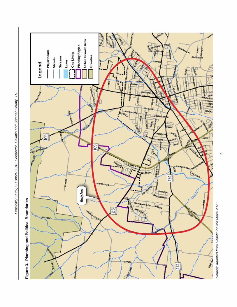
Feasibility Study SR 386US 31E Connector Gallatin and Sumner County TN
32 Existing and Future Land Use Existing land uses in the study area as shown in Gallatin on the Move 2020 are depicted in Figure 5 Within Corridors A and B the existing land use is ruralagricultural
Within Corridor A from the west side of SR 109 and southward toward Greenlea Boulevard development becomes sparse and the land is mostly utilized for ruralagricultural uses Scattered rural residential homes horse farms and barns are located within the corridor just south of its intersection with SR 25 and on the southern end near Greenlea Boulevard Existing low density residential subdivisions are scattered along the boundary of the corridor located near the corridorrsquos intersection with SR 109 on the north (Twin Eagles Subdivision) and to the southwest of the corridorrsquos intersection with SR 25 and along Greenlea Boulevard at the south end of the corridor (Cambridge Farms Subdivision)
The primary nature of the land use within Corridor B is ruralagricultural The large and expanding rural residentiallow density residential subdivision the Twin Eagles Subdivision is located on the northwest side of Corridor B near the intersection of SR 109 with Corridor A and B (proposed Hatten Track Road Extension) The Eagle Creek Development is a residential subdivision that lies to the northwest of the SR 109 intersection with SR 174Long Hollow Pike The Long Hollow Golf Course is the primary land use along Corridor B The golf course is located on the north side of SR 174Long Hollow Pike between its intersection with SR 386 and SR 109 On the southern side of Corridor B along SR 174Long Hollow Pike there is industrial development clustered along Belvedere Drive At the intersection of SR 174 and Belvedere Drive lies Thorntonrsquos Gas Station and a carpet outlet
Along SR 174Long Hollow Pike between Corridor A and B lies a John Deere retailer the entrance to the Stratford Park Subdivision the Cambridge Shopping Center and a Phillips 66 gas station
The Community Character Map from Gallatin on the Move 2020 incorporates categories that describe in detail the Cityrsquos vision for growth and development for the next 20 years The Community Character Map serves as a future land use map for the City A close-up of the Community Character Map that shows the study corridors is shown in Figure 6 Eleven major development areas are shown within the study corridors Neighborhood Center Regional Activity Center Suburban Neighborhood Emerging Suburban Neighborhood Established Town Neighborhood Revitalization Emerging Walkable Community Rural Community North Gallatin Emerging Business Park GreenLea Business Center Commercial Corridor and Parks and Open Space A brief summary of these categories are shown in Table 3
8
Feas
ibili
ty S
tudy
SR
386
US
31E
Con
nect
or G
alla
tin a
nd S
umne
r Cou
nty
TN
Figu
re 5
C
ity o
f Gal
latin
Exi
stin
g La
nd U
se M
ap
Sou
rce
Ada
pted
from
Gal
latin
on
the
Mov
e 20
20
9
Feas
ibili
ty S
tudy
SR
386
US
31E
Con
nect
or G
alla
tin a
nd S
umne
r Cou
nty
TN
Figu
re 6
C
ity o
f Gal
latin
Com
mun
ity C
hara
cter
Map
(Fut
ure
Land
Use
Map
)
Sou
rce
Ada
pted
from
Gal
latin
on
the
Mov
e 20
20
10
Feasibility Study SR 386US 31E Connector Gallatin and Sumner County TN
Table 3 City of Gallatin Community Character (Future Land Use) Map Categories Community Character Category
Community Character Map Areas
General Description Primary Land Uses Appropriate Density Intensity
Centers
Neighborhood Center
Neighborhood scale mixed-use centers that serve the surrounding neighborhood
Small and large scale apartments and townhomes vertical mixed-use neighborhood commercial
035 Floor Area Ratio
Regional Activity Center
Regional-scale mixed-use centers that include retail office and residential uses
Large-scale apartments and townhomes horizontal and vertical mixed-use commercialofficeretail big box retail hospitality publicinstitutional entertainment and cultural facilities
075 Floor Area Ratio
Neighborhoods
Suburban Neighborhood Emerging
Developable areas where conventional suburban neighborhood development is appropriate
Single family residential small and large-scale apartments and townhomes public Institutional
1-3 units per acre
Suburban Neighborhood Established
Stable neighborhoods developed with narrow smaller lots generally prior to 1950
Single family residential small and large scale apartments and townhomes
2-5 units per acre
Town Neighborhood Revitalization
Neighborhoods developed with narrow smaller lots generally prior to 1950 with a need for new investment and revitalization
Single family residential small-scale apartments and townhomes
5-8 units per acre
Emerging Walkable Community
Developable areas where walkable neighborhoods Traditional Neighborhood Development (TND) is appropriate and a variety of housing types
Single and multiple family residential office retail civic
Varies
Rural Community
Sparsely developed areas where agricultural use and character is common and expansion of urban services is not anticipated
Agricultural large lot and conservation subdivision single family residential passive recreation civic uses (rural scale)
1 unit per 2+ acres
Special Districts North Gallatin Emerging Business Park
A predominantly undeveloped area bound by SR 109 Bypass and Old Hwy 109 north of the City limits
Light industry business parks warehouse commercial hospitality transportation communicationutilities
050 Floor Area Ratio
11
Feasibility Study SR 386US 31E Connector Gallatin and Sumner County TN
Community Character Category
Community Character Map Areas
General Description Primary Land Uses Appropriate Density Intensity
GreenLea Business Center
Emerging special area that includes a mix of industrial and commercialoffice uses to diversify the Cityrsquos economic base
Light industry business parks warehouse commercial hospitality transportation communicationutilities single and multi-family residential (when part of an approved master plan)
050 Floor Area Ratio
Corridors Commercial Corridor
Stable commercial corridors where development is encouraged
Small and large-scale apartments and townhomes office vertical mixed use commercialretail
075 Floor Area Ratio
Preserve Parks and Open Space
Primarily public or privately-owned land intended to remain as open space for preservation and recreation needs and not suitable for development
Passive and active recreation undeveloped areas in natural state
Not applicable
Source Gallatin on the Move 2020
One of the objectives in Gallatin on the Move 2020 is to ldquoPromote desired development patterns with incentives and preparation of master plans for large undeveloped areas where growth is expected over the next 20 yearsrdquo The plan specifically refers to the Bowles property in the western portion of Corridor A and B It states ldquoAlong with the completion of new infrastructure such as the extension of the Hatten Track Road through the Bowles property the City should coordinate with property owners to establish a detailed visionrdquo (ie master plan) that is consistent with the overall City vision thus allowing the City to promote specific goals and objectivesrdquo
In 2007 the City of Gallatin approved a Preliminary Master Development Plan for Phases 6 through 12 of the Twin Eagles Subdivision If built this development expansion would be located to the north of the current subdivision west of SR 109 and within the Gallatin Municipal Planning Region In addition a Preliminary Master Development Plan for Phases 1 through 4 of The Reserve was approved by the City of Gallatin in 2010 The Reserve is designed as a 68 acre single-family residential development of 158 buildable lots to the southwest of SR 25 adjacent to Wentworth Drive on the west side of the Cambridge Farms subdivision Corridor A of the proposed project overlaps with these two proposed subdivision expansions It is recommended that the City of Gallatin Planning Commission preserve the right-of-way needed for the SR 386US 31E connector project
The GreenLea Business Center is described in Gallatin on the Move 2020 as ldquoan emerging employment and residential special area that includes a mix of industrial office residential and commercial uses that take advantage of the areasrsquo location adjacent to SR 386 and the CSXT Railroad Much of this area is currently undeveloped and presents an opportunity for commercial industrial and office growth adjacent to existing and emerging residential and commercial areasrdquo In addition the intent of the North Gallatin Emerging Business Park development pattern is to accommodate lessshy
12
Feasibility Study SR 386US 31E Connector Gallatin and Sumner County TN
intensive uses such as corporateregional headquarters call and data centers light manufacturing and ldquogreenrdquo companies with a relatively high-density mix of industrial and commercial uses in a campus-like setting
Another objective in Gallatin on the Move 2020 is to ldquoCoordinate with the Sumner County Planning Commission and Sumner County Commission to establish a process for adoption and implementation of the recommendations of the plan for areas within the Gallatin Urban Growth Boundary area outside of the Planning Regionrdquo This objective is applicable to the north and western portions of the study area that are located within unincorporated Sumner County but inside the Gallatin Urban Growth Boundary limits Figure 7 shows a close-up of the General Framework Map from the 2035 Comprehensive Plan Sumner Countyrsquos Blueprint to the Future that is intended to serve as a future land use plan for unincorporated Sumner County As illustrated the preferred land use patterns within the study corridors include a Regional Employment Center and Suburban development
The Regional Employment Center is shown in the same area as North Gallatin Emerging Business Park (between SR 109 and Old SR 109) in Gallatin on the Move 2020 The purpose of the Regional Employment Center designation is to locate office parks manufacturing centers corporate campuses or major universities near major transportation corridors that can provide basic jobs and keep people in the county during normal work hours The Suburban development pattern is consistent with the Suburban Neighborhood Emerging and Rural Community character categories shown in the Gallatin on the Move 2020 Community Character map and it is designated for low density residential land uses of one dwelling unit per acre or less The Conservation designations shown to the north of Corridors A and B are associated with conservation easements held by the Land Trust of Tennessee
13
Feas
ibili
ty S
tudy
SR
386
US
31E
Con
nect
or G
alla
tin a
nd S
umne
r Cou
nty
TN
Figu
re 7
Su
mne
r Cou
nty
Gen
eral
Fra
mew
ork
Map
(Fut
ure
Land
Use
Map
)
Sou
rce
Ada
pted
from
203
5 C
ompr
ehen
sive
Pla
n S
umne
r Cou
ntyrsquo
s B
luep
rint t
o th
e Fu
ture
14
Feasibility Study SR 386US 31E Connector Gallatin and Sumner County TN
33 Transportation Plans There are multiple transportation studies that cover the City of Gallatin and Sumner County The numerous recommended transportation improvements planned within the vicinity of the study area are listed in Appendix B The extensive list of projects in Appendix B are categorized under the following plans bull Gallatin on the Move 2020 City of Gallatin General Development and
Transportation Plan 2008-2020 bull 2035 Comprehensive Plan Sumner Countyrsquos Blueprint to the Future bull Nashville Metropolitan Planning Organizationrsquos 2030 Long Range Transportation
Plan bull Nashville Metropolitan Planning Organizationrsquos Transportation Improvement
Program Fiscal Years 2011-2015 (Draft ndash scheduled for adoption December 2010)
34 Bicycle and Pedestrian Plans Greenway multi-use paths branch greenway trails bicycle lanes and bicycle routes have been planned in Gallatin as part of the overall transportation system to serve as multi-modal community connectors and natural resources conservation areas For the Phase 1 Albert Gallatin AvenueHatten Track Road Extension bike lanes were designated between SR 109 and SR 174 (Dobbins Pike) Bike lanes are also being proposed as part of the Phase 2 SR 386US 31E Connector
Based on the projects shown in Gallatin on the Move 2020 the proposed bicycle and pedestrian projects within the study area are illustrated in Figure 8 Below is a detailed description from the plan of the projects that cross into or are within the study corridors
The City of Gallatin 2006 Greenways Master Plan organized the greenway multi-use paths into eight corridors prioritized according to their feasibility availability and level of connectivity The following two greenway projects are within the study corridors
bull Project 4 ndash Town Creek Trail A multi-use path 357 miles long that is expected to start at Triple Creek Park and generally follow Town Creek southwesterly and then end at a trail head near the SR 109 Bypass (near Ryan Avenue) This trail was ranked first (1) out of eight (8) on the priority list in the 2006 Greenways Master Plan
bull Project 9 - East Camp Creek Trail A trail 472 miles long that would start just south of US 31E and run in a northeasterly direction along the Camp Creek This trail was ranked six (6) out of eight (8) on the priority list in the 2006 Greenways Master Plan
The Plan also shows two greenway spurs to promote further connectivity between the greenways and bicycle and pedestrian facilities
bull Project 12 ndash East Camp Creek Spur ndash ldquoA trail spur extending up Camp Creek towards SR 386 to provide bicycle and pedestrian access into this future development areardquo
bull Project 13 - Hatten Track Trail Spur ldquoA trail spur extending into the Hatten Track from the East Camp Creek Trail to provide bicycle and pedestrian access into the development areardquo
15
Feasibility Study SR 386US 31E Connector Gallatin and Sumner County TN
Bike lanes are on-road facilities designated by striping signing and pavement markings that are for the preferential or exclusive use of bicycles whereas bike routes are on-road facilities indicated by directional and informational markers such as ldquoBike Routerdquo andor ldquoShare the Roadrdquo signs that utilize little or no striping The proposed bike lanes and bike routes in Figure 9 were originally proposed as part of the City of Gallatin Bicycle and Pedestrian Master Plan of 2000 (denoted by ldquoBrdquo) the 2000 Major Thoroughfare Plan (denoted by ldquoTrdquo) and the 2005 State Route 386 Area Study (denoted by ldquoASrdquo) The following bicycle lane and route projects are located within the study corridors
bull Project 14 ndash Long Hollow Pike Provide bike lanes ldquofrom the western boundary of the study area to Red River Road It is recommended that pedestrian and bike facilities are included when roadway improvements are planned including connections at a possible interchange with SR 386rdquo (B T AS)
bull Project 15 ndash US 31E (Nashville Pike) Currently there are no bike lanes along US 31E to accommodate bicyclists Project 15 is intended to provide bike lanes ldquofrom the western boundary of the study area through downtown to the eastern boundary of the study planning area US 31E west of SR 109 is marked as a bicycle route Further it is TDOTrsquos vision to have a continuous bike route from Nashville to Gallatin via US 31E (Nashville Pike) It is recommended that any development or redevelopment along Nashville Pike should include provisions to provide bike lanesrdquo (B AS)
bull Project 16 ndash GreenLea Boulevard Provide bike lanes from Long Hollow Pike to US 31 E (AS)
bull Project 18 ndash Bison Trail Extension Provide bike lanes ldquofrom GreenLea Boulevard to connect up with Saundersville Road in Hendersonville west of Lower Station Camp Creek Roadrdquo (AS)
bull Project 23 - Hatten Track Road Extension Provide bike lanes ldquobetween SR 109 Bypass to Dobbins PikeSR 174North Water Avenue These bike lanes would connect the SR 109 Bypass to other facilities Bike lanes are recommended east of North Water Avenue thus completing a bike system (Project 27)rdquo (B T)
bull Project 26 ndash Red River Road Provide bike lanes ldquofrom Bradford Drive to US 31EMain Street Bike lanes are recommended to connect to the Bradford Drive route to complete a multi-modal loop around the golf course and into downtownrdquo (B)
bull Project 27 ndash SR 174Albert Gallatin Avenue Provide bike lanes ldquofrom North Water Avenue to East Broadway AvenueUS 31E This bike route runs along the north side of Gallatin Municipal Park and would connect with multiple bike facilities Bike lanes are recommended west of North Water Avenue thus completing a bike system (Project 23)rdquo (B)
bull Project 31 ndash Old Highway 109 Provide bike routes ldquofrom Hatten Track Road to the northern planning boundary This planned bike route would provide multiple connections to other bike lanes andor routes connecting the northwest area to downtown Gallatinrdquo (B)
16
Feas
ibili
ty S
tudy
SR
386
US
31E
Con
nect
or G
alla
tin a
nd S
umne
r Cou
nty
TN
Figu
re 8
Pr
opos
ed B
ike
and
Pede
stria
n Pr
ojec
ts
Sou
rce
Ada
pted
from
City
of G
alla
tin 2
006
Gre
enw
ays
Mas
ter P
lan
17
Feasibility Study SR 386US 31E Connector Gallatin and Sumner County TN
Project 35 ndash Dobbins Pike Provide bike routes ldquobetween the northern planning boundary to Albert Gallatin Avenue This is an integral part of a bike route corridor through the heart of the City of Gallatin This section connects the northern portion to the Civic Center Bike Routes are recommended north of Broadway Avenue thus completing a bike system (Project 36 37)rdquo (B)
bull Project 43 (Blythe Avenue) is categorized as a ldquobike lanes and sidewalks projectrdquo that is recommended within the study corridors It is intended ldquoto provide an alternate to North Water and US 31E for access to the recreational areas on the north side of the City It is recommended to incorporate bike lanes and sidewalks with any future roadway wideningrdquo
bull Project 46 (Albert Gallatin Avenue) is categorized as a ldquosidewalks and pedestrian crossing projectrdquo that is recommended within the study corridors It is intended ldquobetween North Water Avenue and US 31E to serve the recreational users of the Gallatin Civic Centerrdquo
35 Other Multi-modal Facilities The Gallatin on the Move 2020 Plan recommends flexible bus service within the City of Gallatin The service would travel along a designated route but would be flexible enough to deviate off route to pick up or drop off passengers For instance if a route traveled from downtown to Volunteer State Community College the service could deviate off route for a certain distance (typically 34 mile) or to a certain boundary This type of service design addresses ADA requirements while expanding coverage to additional areas
Gallatin North-South Flex The north-south flexible bus service using one vehicle is proposed to operate along Albert Gallatin Avenue Blythe Avenue Eastland Street and Water Avenue Sites served include the Civic Center low-income housing along Blythe Avenue at Small Street the downtown square and homes and businesses along Water Avenue Deviations could also serve low-income housing along Lackey Circle low-income housing along Boyers Avenue at Hull Circle and other homes and businesses within a frac34 mile buffer of the route
36 Potential Future Coordination This study has involved local stakeholders including City Council representatives and business owners in early planning and development of the proposed project
A CSX Railroad line runs north-south through the study area of the Phase 1 Albert Gallatin AvenueHatten Track Road Extension which has been incorporated into this study The bridge on North Water Avenue crossing over the depressed railroad line will need to be replaced requiring coordination with the CSX Railroad A representative of CSX was invited to the stakeholder meeting for both the Phase 1 study and this study but did not attend
Coordination with the US Army Corps of Engineers will be required for the blue line stream crossings and possibly for wetland impacts The Tennessee Department of Environment and Conservation will also need to be coordinated with in regard to potential permitting and possibly for hazardous materials
18
Feasibility Study SR 386US 31E Connector Gallatin and Sumner County TN
In addition the City must coordinate with local developers proposing developments within or adjacent to the corridors under study to ensure that future implementation should the study become a project remains viable
40 PRELIMINARY PROJECT NEED This project is intended to address anticipated future transportation needs which have been identified through coordination with local officials and agencies The project area has been targeted as a prime area for future development and its success is dependent on a connected local and regional roadway system
41 Safety The following is a summary of the crash history on SR 109 and SR 174 for the latest three-year period for which data is available (2007 ndash 2009) Table 4 summarizes two segments of roadway and two major intersections in the project area showing the number of crashes and the comparison of the actual crash rate with the statewide average crash rate for the same functional classification The actual rate is derived from a formula that takes into account factors such as total number of crashes length of roadway and the time period over which the crashes occurred
The SR 174 intersection with Belvedere Drive and the SR 174 intersection with SR 109 have crash rates of approximately 15 to 17 times greater than the statewide rate for an intersection of its type thus indicating that safety is a concern along this segment of SR 174 The number of crashes suggests a need for an alternate route or intersection configuration to help separate through and local traffic
Table 4 Crash Summary
SectionIntersection Description Log Mile(s)
Crashes
Actual Crash Rate
State Average
Crash Rate
SR 109 from SR 174 (Long Hollow Pike) to Old Highway 109 421-760 28 035 201
SR 174 (Long Hollow Pike) from SR 386 to SR 109 1354-1459 13 016 275
SR 174 (Long Hollow Pike) intersection with Belvedere Drive 1428 22 156 099
SR 174 (Long Hollow Pike) intersection with ramps for southbound SR 109 1445-1451 24 170 099
SR 174 (Long Hollow Pike) intersection with ramps for northbound SR 109 1452-1449 15 107 099
for this type of roadway
A summary of the 2006-2008 crash data findings for each segment and intersection is as follows
19
Feasibility Study SR 386US 31E Connector Gallatin and Sumner County TN
bull SR 109 from SR 174 (Long Hollow Pike) to Old Highway 109 The statewide average crash rate for a roadway of the same functional classification (urban arterial four lane divided) is 201 while the actual rate is 035 for this segment of SR 109 The actual crash rate for this segment of roadway is well below the statewide average and therefore does not indicate a safety issue There were twenty-eight (28) documented crashes resulting in no fatalities no incapacitating injuries and nine (9) other injuries
bull SR 174 (Long Hollow Pike) from SR 386 to SR 109 The statewide average crash rate for a roadway of the same functional classification (urban minor arterial four lane with turn lane) is 275 while the actual rate is 016 for this segment of SR 174 The actual crash rate for this segment of roadway is well below the statewide average and therefore does not indicate a safety issue There were thirteen (13) documented crashes resulting in no fatalities no incapacitating injuries and four (4) non-incapacitating injuries
bull SR 174 (Long Hollow Pike) intersection with Belvedere Drive The statewide average crash rate for an intersection of this type is 099 The actual rate for the intersection is 156 which is slightly higher than the statewide average This intersection is the location of an existing industrial area that is slated for use in the future as the ldquoGreenlea Business Centerrdquo Of the twenty-two (22) crashes at the signalized intersection with Belvedere Drive ten (10) involved personal injury and thirteen (13) were rear end collisions
bull SR 174 (Long Hollow Pike) intersection with ramps for southbound SR 109 from Log Miles 1445 -1451 The statewide average crash rate for an intersection of this type is 099 while the actual rate for the intersection is 170 which is slightly higher than the statewide average There were twenty-four (24) documented crashes at this intersection resulting in no fatalities or incapacitating injuries but ten (10) non-incapacitating injuries Twelve (12) of the crashes occurred at log mile 1449 which is the signalized intersection for the right-turn ramp onto SB SR-109 and the left-turn ramp from SB SR-109
bull SR 174 (Long Hollow Pike) intersection with ramps for northbound SR 109 from Log Miles 1452 -1459 The statewide average crash rate for an intersection of this type is 099 while the actual rate for the intersection is 107 which is slightly higher than the statewide average There were fifteen (15) documented crashes at this intersection resulting in no fatalities or incapacitating injuries but four (4) non-incapacitating injuries Seven (7) of the crashes occurred at log mile 1458 which is the signalized intersection for the right-turn ramp from NB SR 109 lanes and the left-turn ramp to NB SR 109 lanes
42 System Linkage An alternate route between the southwest and northeast sides of Gallatin is desired The SR 386US 31E Connector will link SR 386 with SR 174 and US 31E north of downtown and provide ldquothroughrdquo traffic the ability to avoid the congested segment of US 31 E through downtown Gallatin
20
Feasibility Study SR 386US 31E Connector Gallatin and Sumner County TN
Furthermore construction of the SR 386US 31E Connector will create a more accessible and resilient transportation system by improving route options dispersing traffic over more roads and therefore reducing delays when a particular roadway segment is closed due to an incident construction or for other reasons
43 Level of Service Analysis To determine how well traffic operates under the No-Build and Build Conditions a level of service analysis was conducted A ldquoLevel of Servicerdquo (LOS) index was used to gauge the operational performance for each roadway segment The LOS is a qualitative measure that describes traffic conditions related to speed and travel time freedom to maneuver traffic interruptions etc There are six levels ranging from ldquoArdquo to ldquoFrdquo with ldquoFrdquo being the worst Each level represents a range of operating conditions Table 6 defines the traffic flow conditions and approximate driver comfort level at each level of service
LOS analysis was performed using the Highway Capacity Software (HCS+) for the No-Build and Build conditions for the base year of 2016 and the design year of 2036 Each roadway segment for Corridors A and B was analyzed using the multi-lane highways module in the HCS+ software The roadway characteristics that affect the LOS and were included in the analysis include free-flow speed lane width and lateral clearance median type access point density general terrain characteristics number of heavy vehicles in the traffic flow and the directional distribution of traffic The HCS+ results are included in Appendix C
It should be noted that the segments of US 31E and the segments where Corridors A and B are combined (Phase 1) were not analyzed using the HCS+ software because the speed limit on the roadway is lower than can be accommodated in the multi-lane highways module Furthermore the traffic signals along these segments will impact the LOS on the roadway segments and an arterial-level analysis is needed to properly determine the LOS In the absence of turning movement counts at the intersections the AADT volumes on these segments were equated to generally accepted volume thresholds to determine the arterial LOS
The results of the LOS analysis are summarized in Table 7
The LOS analysis indicates that under the 2036 No-Build and Build Conditions the segment of SR 386 from Greenlea Boulevard to SR 174 and then SR 174 to N Belvedere Drive operates at LOS E during peak periods Due to projected 2036 AADT volumes in the range of 54950 to 56250 vehicles per day these segments need to be widened by one (1) travel lane in each direction in order to accommodate the projected traffic A more detailed discussion of the improvements needed for these segments is included in Section 52
21
Feasibility Study SR 386US 31E Connector Gallatin and Sumner County TN
Table 5 Definition of Level of Service
Level of Service
Definition
A Free flow operations Vehicles are almost completely unimpeded in their ability to maneuver with the traffic stream The general level of physical and psychological comfort provided to the driver is high
B Reasonable free flow operations The ability to maneuver within the traffic stream is only slightly restricted and the general level of physical and psychological comfort provided to the driver is still high
C Flow with speeds at or near free flow speeds Freedom to maneuver within the traffic stream is noticeably restricted and lane changes require more vigilance on the part of the driver The driver notices an increase in tension
D Speeds decline with increasing traffic Freedom to maneuver within the traffic stream is more noticeably limited The driver experiences reduced physical and psychological comfort levels
E At lower boundary the facility is at capacity Operations are volatile because there are virtually no gaps in the traffic stream There is little room to maneuver The driver experiences poor levels of physical and psychological comfort
F Breakdowns in traffic flow The number of vehicles entering the highway section exceed the capacity or ability of the highway to accommodate that number of vehicles There is little room to maneuver The driver experiences poor levels of physical and psychological comfort
Source TDOT TPR Manual (2010)
Table 6 LOS for Base Year and Design Year Conditions
Roadway Segment
Level of Service 2016 2036
No-Build No-Build Build Corridor A ndash SR 109 Bypass to SR 25 - - A A Corridor A ndash SR 25 to SR 174 - - A A Corridor A ndash SR 174 to SR 386 - - A A Corridor B ndash SR 386 ndash Harris Ln to SR 174 C B E C E C Corridor B ndash SR 174 ndash SR 386 to N Belvedere Dr C B E C E C Corridor B ndash SR 174 ndash N Belvedere Dr to SR 109 Bypass C B D C D C
Corridor B ndash SR 109 Bypass ndash SR 174 to SR 25 A A B A B A Corridor B ndash SR 109 Bypass ndash SR 25 to Hatten Track Extension (phase 1) A A B A B A
Corridor AB (Phase 1) Hatten Track ndash SR 109 Bypass to Blythe Ave - - C
22
Feasibility Study SR 386US 31E Connector Gallatin and Sumner County TN
Roadway Segment Level of Service
2016 2036 No-Build No-Build Build
Corridor AB (Phase 1) Old State Highway 109 ndash Blythe Ave to N Water Ave B B B
Corridor AB (Phase 1) Albert Gallatin Ave ndash N Water Ave to US 31E A B B
US 31E ndash SR 109 to River Rd E F F US 31E ndash River Rd to Eastland St D E D US 31E ndash Eastland St to N Water Ave E F E US 31E ndash N Water Ave to SR 174 B D C
Direction 1Direction 2
44 Capacity As stated in the Transportation Improvement Plan (TIP) for Albert Gallatin AvenueHatten Track Road Extension (Phase 1) the construction of the Extension is anticipated to ldquoaddress congestion occurring on SR 6 [US 31E] and provide an alternative route to access SR 109 and SR 386rdquo The existing traffic on US 31E (SR 6West Main StreetEast Broadway) in downtown Gallatin has a projected 2016 Average Annual Daily Traffic (AADT) volume of approximately 31600 vehiclesday which exceeds the capacity of a five (5) lane urban arterial resulting in LOS E
The construction of both the Phase 1 Extension of SR 174Albert Gallatin Avenue and Hatten Track Road and the Phase 2 SR 386US 31E Connector is anticipated to divert approximately twenty-five (25) percent of the traffic away from US 31E in the downtown area This traffic reduction is anticipated to reduce the AADT on US 31E to a level that can be better accommodated by the existing roadway resulting in LOS C
By reducing the AADT on the most heavily congested segments of US 31E the levels of service at the signalized intersections and associated vehicular delay is anticipated to improve Generally speaking the arterial levels of service improve on US 31E between River Road (SR 25) and SR 174 in the Build Condition More detailed information on the capacity analysis is provided later in this section
Traffic Projections Traffic volumes for the No-Build and Build Conditions were projected in support of this Feasibility Study TDOT provided AADT volumes on roadways within the study area for a base year of 2016 and design year 2036 which were determined using the Nashville MPO travel demand model as well as TDOT 24-hour counts The AADT volumes for the No-Build and Build Conditions for the base and design years are presented in Table 5 The traffic diagrams provided by TDOT is provided in Appendix C
In order to accommodate the projected 2036 Build Condition AADT volumes ranging from 14710 to 17120 vehicles per day a four-lane typical section is needed for Corridor A A more detailed discussion of the proposed typical section for Corridor A is included in Section 52
23
Feasibility Study SR 386US 31E Connector Gallatin and Sumner County TN
Table 7 AADT for Base Year and Design Year Conditions
Roadway Segment
AADT 2016 2036
No-Build No-Build Build Corridor A ndash SR 109 Bypass to SR 25 - - 14710 Corridor A ndash SR 25 to SR 174 - - 16020 Corridor A ndash SR 174 to SR 386 - - 17120 Corridor B ndash SR 386 ndash Harris Ln to SR 174 32300 51680 54950 Corridor B ndash SR 174 ndash SR 386 to N Belvedere Dr 36250 52900 56250
Corridor B ndash SR 174 ndash N Belvedere Dr to SR 109 Bypass 35000 45500 48380
Corridor B ndash SR 109 Bypass ndash SR 174 to SR 25 16500 27400 23290 Corridor B ndash SR 109 Bypass ndash SR 25 to HattenTrack Extension (Phase 1) 13100 22250 21100
Corridor AB (Phase 1) Hatten Track ndash SR 109 Bypass to Blythe Ave - - 10700
Corridor AB (Phase 1) Old Highway 109 ndash Blythe Ave to N Water Ave 7050 8950 15370
Corridor AB (Phase 1) Albert Gallatin Ave ndash NWater Ave to US 31E 5800 8550 11450
US 31E ndash SR 109 to River Rd 31600 41100 39030 US 31E ndash River Rd to Eastland St 20600 28020 22330 US 31E ndash Eastland St to N Water Ave 25000 33250 26500 US 31E ndash N Water Ave to SR 174 14450 19050 15180
Source Tennessee Department of Transportation (2011)
45 Economic Development As discussed in Section 32 and depicted in Figure 6 the Gallatin on the Move 2020 plan specifies more intensive land uses than those currently present in the study area Along Phase 1 of the proposed Albert Gallatin AvenueHatten Track Road the land on the west side of the project adjacent to SR 109 is slated as the North Gallatin Emerging Business Park
In the current study area which includes the above segment but also includes land in and adjacent to the northwest quadrant of the SR 386 and SR 109 intersection the future land use plan specifies land along SR 174 (Long Hollow Pike) and SR 386 for future development as 1) a Regional Activity Center and 2) Greenlea Business Center (includes some existing industrial uses)
Adequate roadway connectivity to and from these areas is essential for the City to realize their future plans for economic development
24
Feasibility Study SR 386US 31E Connector Gallatin and Sumner County TN
50 OPTIONS FOR IMPROVEMENT 51 No-Build Option The No-Build Option provides a baseline for evaluating the benefits and costs created by the Build Options and is defined as the roadway conditions as they currently exist The No-Build Option examines the impacts to the transportation system if the transportation improvements identified as the Build Options are not constructed
Together SR 386 and SR 174 currently serve as the roadway link between Greenlea Boulevard and the SR 109 Bypass Within the study area SR 386 is classified as a freeway with a four (4)-lane divided typical section Between SR 386 and the SR 109 Bypass SR 174 is classified as an urban minor arterial and consists of a five (5)-lane section with a center left turn lane SR 109 Bypass between SR 174 and the proposed Hatten Track extension is classified as an urban principal arterial and consists of four (4)-lane divided typical section US 31E is classified as an urban principal arterial and consists of a five (5)-lane section through downtown Gallatin transitions to a four (4)shylane divided typical section north of River Road then to a two (2)-lane divided section north or N Boyers Avenue and then to a three (3)-lane typical section south of JoAnn Street which continues to the intersection with Albert Gallatin Avenue
As indicated in the LOS analysis in Section 43 the segment of SR 386 from Greenlea Boulevard to SR 174 and then on to N Belvedere Drive operates at LOS E under the No-Build Option Additionally the segments of US 31E from SR 109 Bypass to N Water Avenue operate at either LOS E or F which does not meet minimum operational requirements
25
Feasibility Study SR 386US 31E Connector Gallatin and Sumner County TN
52 Build Options As stated previously and illustrated in Figure 9 there are two corridor options under the Build Condition Corridor A and Corridor B Phase 1 consists of the Albert Gallatin AvenueSR 174 Extension which is proposed to end at an interchange with SR 109 Phase 2 consists of either Corridor A or Corridor B which both utilize the Phase 1 extension from SR 109 to US 31E A description of each Build Option follows
Appendix D contains the typical sections and layout sheets for Phase 2 A description of the roadway segment for each feature follows
Corridor A
bull Corridor A is on new alignment from the SR 386Green Lea interchange and travels north along the east side of Liberty Branch Creek intersecting with SR 25 continues northeast and intersects with Douglas Lane and then continues east to SR 109 at which point it intersects the Phase 1 Albert Gallatin AvenueHatten Track Road extension east to US 31E Corridor A is approximately 39 miles in length
bull The typical section includes four twelve (12)-foot lanes (two (2) in each direction) a 48-foot depressed median six (6)-foot inside shoulders and twelve (12)-foot shared use outside shoulders (to accommodate bike lanes) within 200 feet of proposed right-of-way
bull The widening of SR 386 and SR 174 as described under the Corridor B option must be completed in addition to the building of Corridor A in order to ensure adequate traffic flow and operations on the surrounding roadway network
Corridor B
bull Corridor B follows SR 386 from the interchange with Greenlea Boulevard east to the intersection with Long Hollow Pike at which point the state routing designation changes to SR 174 Corridor B then follows SR 174 to the interchange with SR 109 it then travels north on SR 109 until it intersects with the Phase 1 Albert Gallatin AvenueHatten Track Road extension Corridor B is approximately 34 miles in length
bull Under the Corridor B option SR 386 and SR 174 between Greenlea Boulevard and the SR 109 Bypass will be widened for approximately 14 miles to account for future projected traffic growth
o SR 386 will be widened from four (4) to six (6) lanes (three (3) in each direction) each having a width of twelve (12) feet with twelve (12)-foot shoulders and a 64-foot wide depressed median The present right-ofshyway width for this section is 260 feet with additional right-of-way and easements to be obtained as needed for construction
o The typical section for the improved segment of SR 174 will be widened from five (5) to seven (7) twelve (12)-foot travel lanes (three (3) in each direction and a twelve (12)-foot center turn lane) with twelve (12)-foot shared use outside shoulders (to accommodate bike lanes) This widened section would require a minimum right-of-way of 180 feet
26
Feas
ibili
ty S
tudy
SR
386
US
31E
Con
nect
or G
alla
tin a
nd S
umne
r Cou
nty
TN
Figu
re 9
B
uild
Opt
ions
27
Feasibility Study SR 386US 31E Connector Gallatin and Sumner County TN
bull In addition to widening the identified segments of SR 386 and SR 174 several signalized intersections and two bridges will need to be improved so that the additional lanes can be accommodated The intersections that will require improvements include the following
- SR 386 at SR 174 - SR 174 at Belvedere Drive - SR 174 interchange with SR 109 Bypass
bull While all three of these intersections will require upgrades associated with the roadway widening improvements the SR 174 interchange with the SR 109 Bypass will also require geometric alterations so that traffic can smoothly transition from one route to the other The southbound off-ramp from SR 109 Bypass will need to be extended to form the third westbound lane of SR 174 The third eastbound lane of SR 174 will become a right-turn-only lane onto SR 109 Bypass
bull In addition to the intersection improvements the bridge over East Camp Creek as well as the westbound bridge over Liberty Branch Creek will both need to be widened to accommodate the future widening and meet traffic demands
bull If Corridor B is selected without Corridor A an eastbound to northbound SR 109 clover leaf loop will be needed to accommodate future left turn volumes This would require re-alignment of the ramps on the east side of SR 109 and widening of the bridge on SR 109 at East Camp Creek
Costs TDOT planning level base per mile costs were used to develop estimates for the corridor options and are summarized in Table 8 It should be noted that even if Corridor A is constructed Corridor B will need to be widened along SR 386 and SR 174 to accommodate the future traffic volumes The interchange improvements at SR 109 however would not be needed as motorists travelling north to SR 109 would utilize Corridor A The widening cost for SR 386 and SR 174 is approximately $10000000
Also a two (2) lane depressed median section could be constructed as an interim phase for Corridor A allowing future build out to four (4) lanes which would reduce the interim phase construction cost approximately $11000000
Table 8 Planning Level Costs for Build Options
Item Corridor A (39 Miles)
Corridor B (34 Miles)
Right-of-Way $3608400 $2229675 Total Construction $30490980 $17252905 Preliminary Engineering $3049098 $1725291 Total Cost $37148478 $21207871
53 Possible Modifications to the State Route System During the NEPA phase when the preferred alignment is selected TDOT may review the current state route system for possible modification For example possible changes to the state routing system could include designating SR 174 to follow Long Hollow Pike to
28
Feasibility Study SR 386US 31E Connector Gallatin and Sumner County TN
Greenlea Boulevard and then follow Corridor A to SR 109 continue across SR 109 along Albert Gallatin AvenueHatten Track Road Extension (Phase 1) and reconnect with the existing SR 174 at Dobbins Pike (see Figure 10) Accordingly the SR 174 designation would be removed from Greenlea Boulevard through downtown to Dobbins Pike Based on these possible changes approximately 26 miles would be removed and 54 miles would be added resulting in a net gain of 294 miles to the state route system
29
Feas
ibili
ty S
tudy
SR
386
US
31E
Con
nect
or G
alla
tin a
nd S
umne
r Cou
nty
TN
Figu
re 1
0 P
ropo
sed
Cha
nges
to S
tate
Rou
ting
Syst
em
30
Feasibility Study SR 386US 31E Connector Gallatin and Sumner County TN
54 Control of Access The City of Gallatin Zoning Ordinance (amended October 20 2009) establishes access management standards in Section 1306 for driveways providing vehicular access from arterial collector and local streets (roads in the study area are classified as arterials and collector streets) In addition Gallatin on the Move 2020 outlines additional access management policies that should be applied to the Cityrsquos arterial road system (including long range planning project planning and design right-of-way acquisition redesign of existing arterial corridors and driveway permitting)
Within the study area SR 174 between SR 386 and SR 109 is currently not access controlled and is subject to future development SR 109 is access controlled between SR 25 and Old Highway 109 The proposed extension will ultimately not require a break in the access control on SR 109 because an interchange is planned to allow access between SR 109 and the Albert Gallatin AvenueHatten Track Road Extension (Phase 1) and the SR 386US 31E Connector
In addition the project will be designed to provide limited access along the proposed Build Option ndash Corridor A as well as along the Hatten Track extension (Phase 1) from SR 109 to the east For an at-grade intersection the access control distance will be a minimum of 100 feet from any intersection For an interchange the access control will be 300 feet from the ramp terminals treating each side of the cross road independently
55 Environmental Constraints The environmental screening presented in this Feasibility Study has been provided by the TDOT Early Environmental Screening (EES) reports A detailed environmental study of the corridors identified in this Feasibility Study would occur during future project phases in compliance with National Environmental Policy Act provisions Environmental screening maps produced in support of the analysis in this report are found in Appendix E A full copy of the TDOT EES reports can be found in Appendix F The TDOT EES reports revealed the following
Impacts Evaluated within 1000 feet of the Project Area bull Community ResourceInstitution
The project area is home to one public school Joe Shafer Middle School is located at 240 Albert Gallatin Avenue which is to the north of Corridors A and B
bull Minority Population of over 24 Percent Appendix E Map 1 illustrates the minority population in the project area by Census Block for the 2000 US Census The average percentage of minority populations for the City of Gallatin in 2000 was 217 percent The county-wide minority population for Sumner County was 85 percent The City of Gallatin average is comparable to the statewide average of 198 percent but the Sumner County average is considerably lower than the statewide average Among the census blocks encompassing the project area one has a minority population higher than the City of Gallatin as a whole This Census Block is identified as Census Tract 205 Block Group 1 Block 1014 and is contained within Corridor B
31
Feasibility Study SR 386US 31E Connector Gallatin and Sumner County TN
The percentage of the population that identified themselves as a minority in this Census Block is 33 percent (or 7 out of 21 persons)
bull Sensitive Community Population Linguistically Isolated Populations Linguistically isolated populations are located within 1000 feet of the project area
bull Population living Below Poverty above the State Average of 135 Percent Appendix E Map 2 shows the percentage of the population living below poverty in the project area by Census Block Group The project area is encompassed by four Census Block Groups The percent of the population living below poverty in 2000 (based on 1999 income) within the City of Gallatin averaged 144 percent This is higher than the County and statewide averages of 81 and 135 percent respectively One Census Block Group within the project area has a percent of the population below poverty that is higher than the City County and statewide averages This Block Group is Census Tract 208 Block Group 2 and has 159 percent of the population in the Block Group living below poverty (or 289 out of 1807 persons) This Block Group is crossed by Corridor B (as highlighted in Appendix E Map 2)
bull Possible Substantial Impact on the Endangered Bat Species There is a known occurrence of Indiana or grey bats within four (4) miles of the project area It is anticipated that a) avoidanceminimization of potential impacts to species will be needed b) surveys for the species for the project may be required c) coordination with USFWS will be needed to establish Section 7 biological conclusions for the project and d) seasonal construction limitations will likely be necessary
bull Impact on Railroads A railroad exists within the project study area It is anticipated that impacts to the railroad can be avoided since the proposed project will be greater than 200 feet from the railroad There is the remote possibility of minor involvement on railroad property to accommodate drainage but there will be no grade crossing
bull Cemetery Sites and Properties There are no known cemetery sites within or abutting the project area
Impacts Evaluated within 2000 feet of the Project Area
bull TWRA Lakes and Other Public Lands No TWRA lake property is found within the project area but it is anticipated that a medium impact on the project is anticipated as a public park (city owned little league park) lies within the project area It is possible to locate the proposed project in such a way that it avoids any impacts or taking of the park property A moderate level of effort and time will be required to resolve the projectrsquos environmental impact on the park and to move forward with project development Indirect impacts (audible and visual) to the park may occur and need to be studied If there is indirect impact additional design would be needed to design the appropriate mitigation measures
32
Feasibility Study SR 386US 31E Connector Gallatin and Sumner County TN
bull National Register Sites No impacts are anticipated to any National Register of Historic Place (NRHP) listed properties as there are no properties abutting or within the project area
According to the State Historic Preservation Office (SHPO) records approximately ten (10) properties in Sumner County have been surveyed within the project area although none of which were deemed eligible for the NRHP by the surveyor Additional survey work is needed in future project phases to determine NRHP eligibility for the resources that are within the projectrsquos Area of Potential Effect (APE)
bull Superfund Sites No impacts are anticipated as there are no known contaminated land tracts abutting or within the project area
bull Pyritic Rock Pyritic rock is not known to occur in the project area and thus the project does not involve exaction Limestone and dolomite are present
Impacts Evaluated within 4000 feet of the Project Area
bull Terrestrial Species A minimal impact on the project is predicated as there is a known rare or state protected terrestrial species (the Thryomanes bewickii) located within the project area A survey for the species may be required
bull Wetland and Floodplain Impacts Substantial impacts to wetlands within the project area are probable A total of 33 acres of wetlands exists within 4000 feet of the project area Compensatory mitigation will be required Design effort will be needed to avoid and minimize impacts to wetlands to the maximum extent practicable
According to Federal Emergency Management Association (FEMA) Flood Insurance Rate Maps (FIRM) the project area is bisected by the 100-year floodplain Areas along East Camp Creek and Liberty Branch fall within this flood zone FIRMs depicting the 100-year floodplains within the project area were digitized and are included in Appendix E Map 3 Both Corridor A and Corridor B cross the 100-year floodplain
bull TDEC Conservation Sites and TDEC Scenic Waterways No TDEC Conservation Sites or scenic waterways are within the project area
bull Tennessee Natural Areas Program The project area does not include a Natural Area
bull Wildlife Management Area No impacts are anticipated to any Wildlife Management Areas as there are none that abut or are located within the project area
33
Feasibility Study SR 386US 31E Connector Gallatin and Sumner County TN
Impacts Evaluated within 10000 feet of the Project Area
bull Caves The Lackey Cave is present within 10000 feet of the project area and thus a medium project impact is anticipated It is possible to avoid impacts to the cave in future design phases of the project With the presence of a cave there are likely concerns involving the federally and state protected Indiana grey bat Additional design will be needed to avoid impacts to cave passages or entrances to develop access to the cave (if required) to conduct stability analysis of the project to determine right of way acquisition development and coordination of corrective actions for environmental effects (ie mitigation etc) associated with project construction in this terrain and to design water quality treatment measures Construction time will likely be affected either by requiring an extended contract period or strategic placement of the project in the let schedule to maximize the contractors time to construct the project
bull Aquatic Species There is no known occurrence of a rare state or federally-protected aquatic species within the project area
60 ASSESSMENT OF CORRIDOR OPTIONS TDOT has developed a set of seven guiding principles by which all transportation projects are to be evaluated These guiding principles address concerns for system management mobility economic growth safety community environmental stewardship and fiscal responsibility This section includes a discussion of each guiding principle as it pertains to the options evaluated in this Feasibility Study
Guiding Principle 1 Preserve and Manage the Existing Transportation System When the construction of SR 386 (Vietnam Veterans Boulevard) was completed SR 386 became a major asset to the City of Gallatin acting as a corridor to accommodate both local and through traffic and providing access to Gallatinrsquos downtown commercial core via SR 174Long Hollow Pike and US 31E Over time the section of US 31E through downtown has become congested The function of the SR 386US 31E Connector will be to provide the second phase of an east-west connector between SR 386 and US 31ESR 6East Broadway on the north side of the City thereby diverting some of the traffic away from US 31E from the most congested segments through downtown The proposed improvements as part of the Phase 2 project will provide a new connection between SR 386 and SR 109 which will result in preservation of the existing transportation system in the City of Gallatin
SR 109 SR 174 and US 31E are critical travel corridors for the City of Gallatin US 31E is not only a key commercial corridor for area residents and truck traffic but it also connects Gallatin to the towns of Bethpage and Westmoreland in Tennessee and Scottsville in Kentucky to the north and Nashville to the south SR 174 connects Gallatin to Oak Grove Tennessee and Scottsville Kentucky to the north and SR 109 connects Gallatin to Portland to the north The Build Option presented as Corridor A involves construction of a roadway on new location which can help extend the life of these
34
Feasibility Study SR 386US 31E Connector Gallatin and Sumner County TN
important existing routes by diverting some regional traffic andor lessening the future growth of traffic on these roads as indicated under the Build Scenario
Guiding Principle 2 Move a Growing Diverse and Active Population As discussed in Section 31 of this Feasibility Study the population of the City of Gallatin grew by 561 percent between 1990 and 2008 and Sumner County grew by 505 percent figures higher than the State of Tennessee as a whole (274 percent) The options presented in this study are intended to provide improved traffic conditions to support the arearsquos growing population and increasing amounts of externally generated traffic as well as support recommended future land use for the area which is outlined in Gallatin on the Move 2020
The SR 386US 31E Connector is anticipated to divert some traffic away from US 31E through downtown potentially reducing congestion and creating a safer and more hospitable environment for local traffic pedestrians and bicyclists
Guiding Principle 3 Support the Statersquos Economy Both SR 109 and US 31E are regional roadways that facilitate the movement of goods and services The SR 386US 31E Connector will provide better access to and support development in the area to the west of East Camp Creek which supports the vision of the City of Gallatin to promote the area as an emerging business park
Guiding Principle 4 Maximize Safety and Security The proposed project will create opportunities for the separation of through and local traffic alleviating traffic congestion in the downtown area especially on US 31E The proposed project will also eliminate the need for some tractor trailers and other large trucks to travel though the City which will potentially reduce crashes with local traffic which typically turns and stops frequently
Guiding Principle 5 Build Partnerships for Livable Communities A stakeholder meeting was held in support of this Feasibility Study in order to obtain input on transportation problems and other issues in the study area During the TPR development process additional coordination will be undertaken Additionally in keeping with TDOTrsquos Public Involvement Process the provisions of NEPA and Safe Accountable Flexible Efficient Transportation Equity Act ndash A Legacy for Users (SAFETEA-LU) and the provisions of the Tennessee Environmental Streamlining Agreement (TESA) if warranted this project will be coordinated with the public and additional governmental agencies beginning in the NEPA project phase
35
Feasibility Study SR 386US 31E Connector Gallatin and Sumner County TN
Guiding Principle 6 Promote Stewardship of the Environment Potential adverse environmental impacts were identified in the TDOT Environmental Screening and were considered in the development of the corridors included in this study Detailed technical environmental studies are needed to fully address the impacts
Should federal funding be obtained for the project a NEPA document will be prepared in future phases of the project The NEPA document will assess the projectrsquos impacts on the natural social and built environment and all efforts will be made to avoid adverse impacts during design development If impacts cannot be avoided they will be minimized and mitigated Early and continuous coordination will continue to take place with the appropriate federal state and local agencies and the public This coordination will assist with the identification of important resources early in the planning process and will help ensure the proposed project promotes stewardship of the environment
Guiding Principle 7 Emphasize Financial Responsibility The cost estimates presented in this study are offered for planning comparison purposes only and will fluctuate with inflation and any unexpected conditions It is TDOTrsquos goal to follow a comprehensive transportation planning process promote coordination among public and private operators of transportation systems and support efforts to provide stable funding for the public component of the transportation system This entails exercising financial responsibility in the development and implementation of roadway projects and minimizing cost to taxpayers
36
Feasibility Study SR 386US 31E Connector Gallatin and Sumner County TN
70 SUMMARY In summary this project is needed to address anticipated future transportation needs which have been identified through coordination with local officials and agencies The project area has been targeted as a prime area for future development and its success is dependent on a connected local and regional roadway system The project is needed based on the following
bull Improve Safety ndash Both the SR 174 intersection with Belvedere Drive and with SR 109 have crash rates of approximately 15 to 17 times greater than the statewide rate for an intersection of its type thus indicating that safety is a concern along this segment of SR 174
bull Promote System Linkage ndash An alternate route is desired between the southwest and northeast sides of town The SR 386US 31E Connector will provide the desired connectivity by linking SR 386 with SR 174 and US 31E north of downtown
bull Address Capacity Issues ndash By allowing travelers to use the SR 386US 31E Connector to access points northeast of downtown this project may reduce future congestion on US 31E through downtown Gallatin which will improve the traffic operations and safety along this segment of roadway It should also be noted that it is not cost beneficial to widen US 31E through downtown Gallatin
bull Meet Economic Development Demands ndash The Gallatin on the Move 2020 plan specifies more intensive land uses than those currently present in the study area
As stated previously there are two corridor options under the Build Condition for the SR 386US 31E Connector (Phase 2) Corridor A and Corridor B Planning level cost estimates for the corridor options were developed and are summarized in Table 9 It should be noted that even if Corridor A is constructed Corridor B will need to be widened along SR 386 and SR 174 to accommodate the future traffic volumes The interchange improvements at SR 109 however would not be needed as motorists travelling north to SR 109 would utilize Corridor A The widening cost for SR 386 and SR 174 is approximately $10000000
Also a two (2) lane depressed median section could be constructed as an interim phase for Corridor A allowing future build out to four (4) lanes which reduce the interim phase construction cost approximately $11000000
Table 9 Planning Level Costs for Build Options
Item Corridor A (39 Miles)
Corridor B (34 Miles)
Right-of-Way $3608400 $2229675 Total Construction $30490980 $17252905 Preliminary Engineering $3049098 $1725291 Total Cost $37148478 $21207871
If federal funding is utilized for this proposed project a TPR and NEPA document will be undertaken
37

Feas
ibili
ty S
tudy
SR
386
US
31E
Con
nect
or G
alla
tin a
nd S
umne
r Cou
nty
TN
Figu
re 5
C
ity o
f Gal
latin
Exi
stin
g La
nd U
se M
ap
Sou
rce
Ada
pted
from
Gal
latin
on
the
Mov
e 20
20
9
Feas
ibili
ty S
tudy
SR
386
US
31E
Con
nect
or G
alla
tin a
nd S
umne
r Cou
nty
TN
Figu
re 6
C
ity o
f Gal
latin
Com
mun
ity C
hara
cter
Map
(Fut
ure
Land
Use
Map
)
Sou
rce
Ada
pted
from
Gal
latin
on
the
Mov
e 20
20
10
Feasibility Study SR 386US 31E Connector Gallatin and Sumner County TN
Table 3 City of Gallatin Community Character (Future Land Use) Map Categories Community Character Category
Community Character Map Areas
General Description Primary Land Uses Appropriate Density Intensity
Centers
Neighborhood Center
Neighborhood scale mixed-use centers that serve the surrounding neighborhood
Small and large scale apartments and townhomes vertical mixed-use neighborhood commercial
035 Floor Area Ratio
Regional Activity Center
Regional-scale mixed-use centers that include retail office and residential uses
Large-scale apartments and townhomes horizontal and vertical mixed-use commercialofficeretail big box retail hospitality publicinstitutional entertainment and cultural facilities
075 Floor Area Ratio
Neighborhoods
Suburban Neighborhood Emerging
Developable areas where conventional suburban neighborhood development is appropriate
Single family residential small and large-scale apartments and townhomes public Institutional
1-3 units per acre
Suburban Neighborhood Established
Stable neighborhoods developed with narrow smaller lots generally prior to 1950
Single family residential small and large scale apartments and townhomes
2-5 units per acre
Town Neighborhood Revitalization
Neighborhoods developed with narrow smaller lots generally prior to 1950 with a need for new investment and revitalization
Single family residential small-scale apartments and townhomes
5-8 units per acre
Emerging Walkable Community
Developable areas where walkable neighborhoods Traditional Neighborhood Development (TND) is appropriate and a variety of housing types
Single and multiple family residential office retail civic
Varies
Rural Community
Sparsely developed areas where agricultural use and character is common and expansion of urban services is not anticipated
Agricultural large lot and conservation subdivision single family residential passive recreation civic uses (rural scale)
1 unit per 2+ acres
Special Districts North Gallatin Emerging Business Park
A predominantly undeveloped area bound by SR 109 Bypass and Old Hwy 109 north of the City limits
Light industry business parks warehouse commercial hospitality transportation communicationutilities
050 Floor Area Ratio
11
Feasibility Study SR 386US 31E Connector Gallatin and Sumner County TN
Community Character Category
Community Character Map Areas
General Description Primary Land Uses Appropriate Density Intensity
GreenLea Business Center
Emerging special area that includes a mix of industrial and commercialoffice uses to diversify the Cityrsquos economic base
Light industry business parks warehouse commercial hospitality transportation communicationutilities single and multi-family residential (when part of an approved master plan)
050 Floor Area Ratio
Corridors Commercial Corridor
Stable commercial corridors where development is encouraged
Small and large-scale apartments and townhomes office vertical mixed use commercialretail
075 Floor Area Ratio
Preserve Parks and Open Space
Primarily public or privately-owned land intended to remain as open space for preservation and recreation needs and not suitable for development
Passive and active recreation undeveloped areas in natural state
Not applicable
Source Gallatin on the Move 2020
One of the objectives in Gallatin on the Move 2020 is to ldquoPromote desired development patterns with incentives and preparation of master plans for large undeveloped areas where growth is expected over the next 20 yearsrdquo The plan specifically refers to the Bowles property in the western portion of Corridor A and B It states ldquoAlong with the completion of new infrastructure such as the extension of the Hatten Track Road through the Bowles property the City should coordinate with property owners to establish a detailed visionrdquo (ie master plan) that is consistent with the overall City vision thus allowing the City to promote specific goals and objectivesrdquo
In 2007 the City of Gallatin approved a Preliminary Master Development Plan for Phases 6 through 12 of the Twin Eagles Subdivision If built this development expansion would be located to the north of the current subdivision west of SR 109 and within the Gallatin Municipal Planning Region In addition a Preliminary Master Development Plan for Phases 1 through 4 of The Reserve was approved by the City of Gallatin in 2010 The Reserve is designed as a 68 acre single-family residential development of 158 buildable lots to the southwest of SR 25 adjacent to Wentworth Drive on the west side of the Cambridge Farms subdivision Corridor A of the proposed project overlaps with these two proposed subdivision expansions It is recommended that the City of Gallatin Planning Commission preserve the right-of-way needed for the SR 386US 31E connector project
The GreenLea Business Center is described in Gallatin on the Move 2020 as ldquoan emerging employment and residential special area that includes a mix of industrial office residential and commercial uses that take advantage of the areasrsquo location adjacent to SR 386 and the CSXT Railroad Much of this area is currently undeveloped and presents an opportunity for commercial industrial and office growth adjacent to existing and emerging residential and commercial areasrdquo In addition the intent of the North Gallatin Emerging Business Park development pattern is to accommodate lessshy
12
Feasibility Study SR 386US 31E Connector Gallatin and Sumner County TN
intensive uses such as corporateregional headquarters call and data centers light manufacturing and ldquogreenrdquo companies with a relatively high-density mix of industrial and commercial uses in a campus-like setting
Another objective in Gallatin on the Move 2020 is to ldquoCoordinate with the Sumner County Planning Commission and Sumner County Commission to establish a process for adoption and implementation of the recommendations of the plan for areas within the Gallatin Urban Growth Boundary area outside of the Planning Regionrdquo This objective is applicable to the north and western portions of the study area that are located within unincorporated Sumner County but inside the Gallatin Urban Growth Boundary limits Figure 7 shows a close-up of the General Framework Map from the 2035 Comprehensive Plan Sumner Countyrsquos Blueprint to the Future that is intended to serve as a future land use plan for unincorporated Sumner County As illustrated the preferred land use patterns within the study corridors include a Regional Employment Center and Suburban development
The Regional Employment Center is shown in the same area as North Gallatin Emerging Business Park (between SR 109 and Old SR 109) in Gallatin on the Move 2020 The purpose of the Regional Employment Center designation is to locate office parks manufacturing centers corporate campuses or major universities near major transportation corridors that can provide basic jobs and keep people in the county during normal work hours The Suburban development pattern is consistent with the Suburban Neighborhood Emerging and Rural Community character categories shown in the Gallatin on the Move 2020 Community Character map and it is designated for low density residential land uses of one dwelling unit per acre or less The Conservation designations shown to the north of Corridors A and B are associated with conservation easements held by the Land Trust of Tennessee
13
Feas
ibili
ty S
tudy
SR
386
US
31E
Con
nect
or G
alla
tin a
nd S
umne
r Cou
nty
TN
Figu
re 7
Su
mne
r Cou
nty
Gen
eral
Fra
mew
ork
Map
(Fut
ure
Land
Use
Map
)
Sou
rce
Ada
pted
from
203
5 C
ompr
ehen
sive
Pla
n S
umne
r Cou
ntyrsquo
s B
luep
rint t
o th
e Fu
ture
14
Feasibility Study SR 386US 31E Connector Gallatin and Sumner County TN
33 Transportation Plans There are multiple transportation studies that cover the City of Gallatin and Sumner County The numerous recommended transportation improvements planned within the vicinity of the study area are listed in Appendix B The extensive list of projects in Appendix B are categorized under the following plans bull Gallatin on the Move 2020 City of Gallatin General Development and
Transportation Plan 2008-2020 bull 2035 Comprehensive Plan Sumner Countyrsquos Blueprint to the Future bull Nashville Metropolitan Planning Organizationrsquos 2030 Long Range Transportation
Plan bull Nashville Metropolitan Planning Organizationrsquos Transportation Improvement
Program Fiscal Years 2011-2015 (Draft ndash scheduled for adoption December 2010)
34 Bicycle and Pedestrian Plans Greenway multi-use paths branch greenway trails bicycle lanes and bicycle routes have been planned in Gallatin as part of the overall transportation system to serve as multi-modal community connectors and natural resources conservation areas For the Phase 1 Albert Gallatin AvenueHatten Track Road Extension bike lanes were designated between SR 109 and SR 174 (Dobbins Pike) Bike lanes are also being proposed as part of the Phase 2 SR 386US 31E Connector
Based on the projects shown in Gallatin on the Move 2020 the proposed bicycle and pedestrian projects within the study area are illustrated in Figure 8 Below is a detailed description from the plan of the projects that cross into or are within the study corridors
The City of Gallatin 2006 Greenways Master Plan organized the greenway multi-use paths into eight corridors prioritized according to their feasibility availability and level of connectivity The following two greenway projects are within the study corridors
bull Project 4 ndash Town Creek Trail A multi-use path 357 miles long that is expected to start at Triple Creek Park and generally follow Town Creek southwesterly and then end at a trail head near the SR 109 Bypass (near Ryan Avenue) This trail was ranked first (1) out of eight (8) on the priority list in the 2006 Greenways Master Plan
bull Project 9 - East Camp Creek Trail A trail 472 miles long that would start just south of US 31E and run in a northeasterly direction along the Camp Creek This trail was ranked six (6) out of eight (8) on the priority list in the 2006 Greenways Master Plan
The Plan also shows two greenway spurs to promote further connectivity between the greenways and bicycle and pedestrian facilities
bull Project 12 ndash East Camp Creek Spur ndash ldquoA trail spur extending up Camp Creek towards SR 386 to provide bicycle and pedestrian access into this future development areardquo
bull Project 13 - Hatten Track Trail Spur ldquoA trail spur extending into the Hatten Track from the East Camp Creek Trail to provide bicycle and pedestrian access into the development areardquo
15
Feasibility Study SR 386US 31E Connector Gallatin and Sumner County TN
Bike lanes are on-road facilities designated by striping signing and pavement markings that are for the preferential or exclusive use of bicycles whereas bike routes are on-road facilities indicated by directional and informational markers such as ldquoBike Routerdquo andor ldquoShare the Roadrdquo signs that utilize little or no striping The proposed bike lanes and bike routes in Figure 9 were originally proposed as part of the City of Gallatin Bicycle and Pedestrian Master Plan of 2000 (denoted by ldquoBrdquo) the 2000 Major Thoroughfare Plan (denoted by ldquoTrdquo) and the 2005 State Route 386 Area Study (denoted by ldquoASrdquo) The following bicycle lane and route projects are located within the study corridors
bull Project 14 ndash Long Hollow Pike Provide bike lanes ldquofrom the western boundary of the study area to Red River Road It is recommended that pedestrian and bike facilities are included when roadway improvements are planned including connections at a possible interchange with SR 386rdquo (B T AS)
bull Project 15 ndash US 31E (Nashville Pike) Currently there are no bike lanes along US 31E to accommodate bicyclists Project 15 is intended to provide bike lanes ldquofrom the western boundary of the study area through downtown to the eastern boundary of the study planning area US 31E west of SR 109 is marked as a bicycle route Further it is TDOTrsquos vision to have a continuous bike route from Nashville to Gallatin via US 31E (Nashville Pike) It is recommended that any development or redevelopment along Nashville Pike should include provisions to provide bike lanesrdquo (B AS)
bull Project 16 ndash GreenLea Boulevard Provide bike lanes from Long Hollow Pike to US 31 E (AS)
bull Project 18 ndash Bison Trail Extension Provide bike lanes ldquofrom GreenLea Boulevard to connect up with Saundersville Road in Hendersonville west of Lower Station Camp Creek Roadrdquo (AS)
bull Project 23 - Hatten Track Road Extension Provide bike lanes ldquobetween SR 109 Bypass to Dobbins PikeSR 174North Water Avenue These bike lanes would connect the SR 109 Bypass to other facilities Bike lanes are recommended east of North Water Avenue thus completing a bike system (Project 27)rdquo (B T)
bull Project 26 ndash Red River Road Provide bike lanes ldquofrom Bradford Drive to US 31EMain Street Bike lanes are recommended to connect to the Bradford Drive route to complete a multi-modal loop around the golf course and into downtownrdquo (B)
bull Project 27 ndash SR 174Albert Gallatin Avenue Provide bike lanes ldquofrom North Water Avenue to East Broadway AvenueUS 31E This bike route runs along the north side of Gallatin Municipal Park and would connect with multiple bike facilities Bike lanes are recommended west of North Water Avenue thus completing a bike system (Project 23)rdquo (B)
bull Project 31 ndash Old Highway 109 Provide bike routes ldquofrom Hatten Track Road to the northern planning boundary This planned bike route would provide multiple connections to other bike lanes andor routes connecting the northwest area to downtown Gallatinrdquo (B)
16
Feas
ibili
ty S
tudy
SR
386
US
31E
Con
nect
or G
alla
tin a
nd S
umne
r Cou
nty
TN
Figu
re 8
Pr
opos
ed B
ike
and
Pede
stria
n Pr
ojec
ts
Sou
rce
Ada
pted
from
City
of G
alla
tin 2
006
Gre
enw
ays
Mas
ter P
lan
17
Feasibility Study SR 386US 31E Connector Gallatin and Sumner County TN
Project 35 ndash Dobbins Pike Provide bike routes ldquobetween the northern planning boundary to Albert Gallatin Avenue This is an integral part of a bike route corridor through the heart of the City of Gallatin This section connects the northern portion to the Civic Center Bike Routes are recommended north of Broadway Avenue thus completing a bike system (Project 36 37)rdquo (B)
bull Project 43 (Blythe Avenue) is categorized as a ldquobike lanes and sidewalks projectrdquo that is recommended within the study corridors It is intended ldquoto provide an alternate to North Water and US 31E for access to the recreational areas on the north side of the City It is recommended to incorporate bike lanes and sidewalks with any future roadway wideningrdquo
bull Project 46 (Albert Gallatin Avenue) is categorized as a ldquosidewalks and pedestrian crossing projectrdquo that is recommended within the study corridors It is intended ldquobetween North Water Avenue and US 31E to serve the recreational users of the Gallatin Civic Centerrdquo
35 Other Multi-modal Facilities The Gallatin on the Move 2020 Plan recommends flexible bus service within the City of Gallatin The service would travel along a designated route but would be flexible enough to deviate off route to pick up or drop off passengers For instance if a route traveled from downtown to Volunteer State Community College the service could deviate off route for a certain distance (typically 34 mile) or to a certain boundary This type of service design addresses ADA requirements while expanding coverage to additional areas
Gallatin North-South Flex The north-south flexible bus service using one vehicle is proposed to operate along Albert Gallatin Avenue Blythe Avenue Eastland Street and Water Avenue Sites served include the Civic Center low-income housing along Blythe Avenue at Small Street the downtown square and homes and businesses along Water Avenue Deviations could also serve low-income housing along Lackey Circle low-income housing along Boyers Avenue at Hull Circle and other homes and businesses within a frac34 mile buffer of the route
36 Potential Future Coordination This study has involved local stakeholders including City Council representatives and business owners in early planning and development of the proposed project
A CSX Railroad line runs north-south through the study area of the Phase 1 Albert Gallatin AvenueHatten Track Road Extension which has been incorporated into this study The bridge on North Water Avenue crossing over the depressed railroad line will need to be replaced requiring coordination with the CSX Railroad A representative of CSX was invited to the stakeholder meeting for both the Phase 1 study and this study but did not attend
Coordination with the US Army Corps of Engineers will be required for the blue line stream crossings and possibly for wetland impacts The Tennessee Department of Environment and Conservation will also need to be coordinated with in regard to potential permitting and possibly for hazardous materials
18
Feasibility Study SR 386US 31E Connector Gallatin and Sumner County TN
In addition the City must coordinate with local developers proposing developments within or adjacent to the corridors under study to ensure that future implementation should the study become a project remains viable
40 PRELIMINARY PROJECT NEED This project is intended to address anticipated future transportation needs which have been identified through coordination with local officials and agencies The project area has been targeted as a prime area for future development and its success is dependent on a connected local and regional roadway system
41 Safety The following is a summary of the crash history on SR 109 and SR 174 for the latest three-year period for which data is available (2007 ndash 2009) Table 4 summarizes two segments of roadway and two major intersections in the project area showing the number of crashes and the comparison of the actual crash rate with the statewide average crash rate for the same functional classification The actual rate is derived from a formula that takes into account factors such as total number of crashes length of roadway and the time period over which the crashes occurred
The SR 174 intersection with Belvedere Drive and the SR 174 intersection with SR 109 have crash rates of approximately 15 to 17 times greater than the statewide rate for an intersection of its type thus indicating that safety is a concern along this segment of SR 174 The number of crashes suggests a need for an alternate route or intersection configuration to help separate through and local traffic
Table 4 Crash Summary
SectionIntersection Description Log Mile(s)
Crashes
Actual Crash Rate
State Average
Crash Rate
SR 109 from SR 174 (Long Hollow Pike) to Old Highway 109 421-760 28 035 201
SR 174 (Long Hollow Pike) from SR 386 to SR 109 1354-1459 13 016 275
SR 174 (Long Hollow Pike) intersection with Belvedere Drive 1428 22 156 099
SR 174 (Long Hollow Pike) intersection with ramps for southbound SR 109 1445-1451 24 170 099
SR 174 (Long Hollow Pike) intersection with ramps for northbound SR 109 1452-1449 15 107 099
for this type of roadway
A summary of the 2006-2008 crash data findings for each segment and intersection is as follows
19
Feasibility Study SR 386US 31E Connector Gallatin and Sumner County TN
bull SR 109 from SR 174 (Long Hollow Pike) to Old Highway 109 The statewide average crash rate for a roadway of the same functional classification (urban arterial four lane divided) is 201 while the actual rate is 035 for this segment of SR 109 The actual crash rate for this segment of roadway is well below the statewide average and therefore does not indicate a safety issue There were twenty-eight (28) documented crashes resulting in no fatalities no incapacitating injuries and nine (9) other injuries
bull SR 174 (Long Hollow Pike) from SR 386 to SR 109 The statewide average crash rate for a roadway of the same functional classification (urban minor arterial four lane with turn lane) is 275 while the actual rate is 016 for this segment of SR 174 The actual crash rate for this segment of roadway is well below the statewide average and therefore does not indicate a safety issue There were thirteen (13) documented crashes resulting in no fatalities no incapacitating injuries and four (4) non-incapacitating injuries
bull SR 174 (Long Hollow Pike) intersection with Belvedere Drive The statewide average crash rate for an intersection of this type is 099 The actual rate for the intersection is 156 which is slightly higher than the statewide average This intersection is the location of an existing industrial area that is slated for use in the future as the ldquoGreenlea Business Centerrdquo Of the twenty-two (22) crashes at the signalized intersection with Belvedere Drive ten (10) involved personal injury and thirteen (13) were rear end collisions
bull SR 174 (Long Hollow Pike) intersection with ramps for southbound SR 109 from Log Miles 1445 -1451 The statewide average crash rate for an intersection of this type is 099 while the actual rate for the intersection is 170 which is slightly higher than the statewide average There were twenty-four (24) documented crashes at this intersection resulting in no fatalities or incapacitating injuries but ten (10) non-incapacitating injuries Twelve (12) of the crashes occurred at log mile 1449 which is the signalized intersection for the right-turn ramp onto SB SR-109 and the left-turn ramp from SB SR-109
bull SR 174 (Long Hollow Pike) intersection with ramps for northbound SR 109 from Log Miles 1452 -1459 The statewide average crash rate for an intersection of this type is 099 while the actual rate for the intersection is 107 which is slightly higher than the statewide average There were fifteen (15) documented crashes at this intersection resulting in no fatalities or incapacitating injuries but four (4) non-incapacitating injuries Seven (7) of the crashes occurred at log mile 1458 which is the signalized intersection for the right-turn ramp from NB SR 109 lanes and the left-turn ramp to NB SR 109 lanes
42 System Linkage An alternate route between the southwest and northeast sides of Gallatin is desired The SR 386US 31E Connector will link SR 386 with SR 174 and US 31E north of downtown and provide ldquothroughrdquo traffic the ability to avoid the congested segment of US 31 E through downtown Gallatin
20
Feasibility Study SR 386US 31E Connector Gallatin and Sumner County TN
Furthermore construction of the SR 386US 31E Connector will create a more accessible and resilient transportation system by improving route options dispersing traffic over more roads and therefore reducing delays when a particular roadway segment is closed due to an incident construction or for other reasons
43 Level of Service Analysis To determine how well traffic operates under the No-Build and Build Conditions a level of service analysis was conducted A ldquoLevel of Servicerdquo (LOS) index was used to gauge the operational performance for each roadway segment The LOS is a qualitative measure that describes traffic conditions related to speed and travel time freedom to maneuver traffic interruptions etc There are six levels ranging from ldquoArdquo to ldquoFrdquo with ldquoFrdquo being the worst Each level represents a range of operating conditions Table 6 defines the traffic flow conditions and approximate driver comfort level at each level of service
LOS analysis was performed using the Highway Capacity Software (HCS+) for the No-Build and Build conditions for the base year of 2016 and the design year of 2036 Each roadway segment for Corridors A and B was analyzed using the multi-lane highways module in the HCS+ software The roadway characteristics that affect the LOS and were included in the analysis include free-flow speed lane width and lateral clearance median type access point density general terrain characteristics number of heavy vehicles in the traffic flow and the directional distribution of traffic The HCS+ results are included in Appendix C
It should be noted that the segments of US 31E and the segments where Corridors A and B are combined (Phase 1) were not analyzed using the HCS+ software because the speed limit on the roadway is lower than can be accommodated in the multi-lane highways module Furthermore the traffic signals along these segments will impact the LOS on the roadway segments and an arterial-level analysis is needed to properly determine the LOS In the absence of turning movement counts at the intersections the AADT volumes on these segments were equated to generally accepted volume thresholds to determine the arterial LOS
The results of the LOS analysis are summarized in Table 7
The LOS analysis indicates that under the 2036 No-Build and Build Conditions the segment of SR 386 from Greenlea Boulevard to SR 174 and then SR 174 to N Belvedere Drive operates at LOS E during peak periods Due to projected 2036 AADT volumes in the range of 54950 to 56250 vehicles per day these segments need to be widened by one (1) travel lane in each direction in order to accommodate the projected traffic A more detailed discussion of the improvements needed for these segments is included in Section 52
21
Feasibility Study SR 386US 31E Connector Gallatin and Sumner County TN
Table 5 Definition of Level of Service
Level of Service
Definition
A Free flow operations Vehicles are almost completely unimpeded in their ability to maneuver with the traffic stream The general level of physical and psychological comfort provided to the driver is high
B Reasonable free flow operations The ability to maneuver within the traffic stream is only slightly restricted and the general level of physical and psychological comfort provided to the driver is still high
C Flow with speeds at or near free flow speeds Freedom to maneuver within the traffic stream is noticeably restricted and lane changes require more vigilance on the part of the driver The driver notices an increase in tension
D Speeds decline with increasing traffic Freedom to maneuver within the traffic stream is more noticeably limited The driver experiences reduced physical and psychological comfort levels
E At lower boundary the facility is at capacity Operations are volatile because there are virtually no gaps in the traffic stream There is little room to maneuver The driver experiences poor levels of physical and psychological comfort
F Breakdowns in traffic flow The number of vehicles entering the highway section exceed the capacity or ability of the highway to accommodate that number of vehicles There is little room to maneuver The driver experiences poor levels of physical and psychological comfort
Source TDOT TPR Manual (2010)
Table 6 LOS for Base Year and Design Year Conditions
Roadway Segment
Level of Service 2016 2036
No-Build No-Build Build Corridor A ndash SR 109 Bypass to SR 25 - - A A Corridor A ndash SR 25 to SR 174 - - A A Corridor A ndash SR 174 to SR 386 - - A A Corridor B ndash SR 386 ndash Harris Ln to SR 174 C B E C E C Corridor B ndash SR 174 ndash SR 386 to N Belvedere Dr C B E C E C Corridor B ndash SR 174 ndash N Belvedere Dr to SR 109 Bypass C B D C D C
Corridor B ndash SR 109 Bypass ndash SR 174 to SR 25 A A B A B A Corridor B ndash SR 109 Bypass ndash SR 25 to Hatten Track Extension (phase 1) A A B A B A
Corridor AB (Phase 1) Hatten Track ndash SR 109 Bypass to Blythe Ave - - C
22
Feasibility Study SR 386US 31E Connector Gallatin and Sumner County TN
Roadway Segment Level of Service
2016 2036 No-Build No-Build Build
Corridor AB (Phase 1) Old State Highway 109 ndash Blythe Ave to N Water Ave B B B
Corridor AB (Phase 1) Albert Gallatin Ave ndash N Water Ave to US 31E A B B
US 31E ndash SR 109 to River Rd E F F US 31E ndash River Rd to Eastland St D E D US 31E ndash Eastland St to N Water Ave E F E US 31E ndash N Water Ave to SR 174 B D C
Direction 1Direction 2
44 Capacity As stated in the Transportation Improvement Plan (TIP) for Albert Gallatin AvenueHatten Track Road Extension (Phase 1) the construction of the Extension is anticipated to ldquoaddress congestion occurring on SR 6 [US 31E] and provide an alternative route to access SR 109 and SR 386rdquo The existing traffic on US 31E (SR 6West Main StreetEast Broadway) in downtown Gallatin has a projected 2016 Average Annual Daily Traffic (AADT) volume of approximately 31600 vehiclesday which exceeds the capacity of a five (5) lane urban arterial resulting in LOS E
The construction of both the Phase 1 Extension of SR 174Albert Gallatin Avenue and Hatten Track Road and the Phase 2 SR 386US 31E Connector is anticipated to divert approximately twenty-five (25) percent of the traffic away from US 31E in the downtown area This traffic reduction is anticipated to reduce the AADT on US 31E to a level that can be better accommodated by the existing roadway resulting in LOS C
By reducing the AADT on the most heavily congested segments of US 31E the levels of service at the signalized intersections and associated vehicular delay is anticipated to improve Generally speaking the arterial levels of service improve on US 31E between River Road (SR 25) and SR 174 in the Build Condition More detailed information on the capacity analysis is provided later in this section
Traffic Projections Traffic volumes for the No-Build and Build Conditions were projected in support of this Feasibility Study TDOT provided AADT volumes on roadways within the study area for a base year of 2016 and design year 2036 which were determined using the Nashville MPO travel demand model as well as TDOT 24-hour counts The AADT volumes for the No-Build and Build Conditions for the base and design years are presented in Table 5 The traffic diagrams provided by TDOT is provided in Appendix C
In order to accommodate the projected 2036 Build Condition AADT volumes ranging from 14710 to 17120 vehicles per day a four-lane typical section is needed for Corridor A A more detailed discussion of the proposed typical section for Corridor A is included in Section 52
23
Feasibility Study SR 386US 31E Connector Gallatin and Sumner County TN
Table 7 AADT for Base Year and Design Year Conditions
Roadway Segment
AADT 2016 2036
No-Build No-Build Build Corridor A ndash SR 109 Bypass to SR 25 - - 14710 Corridor A ndash SR 25 to SR 174 - - 16020 Corridor A ndash SR 174 to SR 386 - - 17120 Corridor B ndash SR 386 ndash Harris Ln to SR 174 32300 51680 54950 Corridor B ndash SR 174 ndash SR 386 to N Belvedere Dr 36250 52900 56250
Corridor B ndash SR 174 ndash N Belvedere Dr to SR 109 Bypass 35000 45500 48380
Corridor B ndash SR 109 Bypass ndash SR 174 to SR 25 16500 27400 23290 Corridor B ndash SR 109 Bypass ndash SR 25 to HattenTrack Extension (Phase 1) 13100 22250 21100
Corridor AB (Phase 1) Hatten Track ndash SR 109 Bypass to Blythe Ave - - 10700
Corridor AB (Phase 1) Old Highway 109 ndash Blythe Ave to N Water Ave 7050 8950 15370
Corridor AB (Phase 1) Albert Gallatin Ave ndash NWater Ave to US 31E 5800 8550 11450
US 31E ndash SR 109 to River Rd 31600 41100 39030 US 31E ndash River Rd to Eastland St 20600 28020 22330 US 31E ndash Eastland St to N Water Ave 25000 33250 26500 US 31E ndash N Water Ave to SR 174 14450 19050 15180
Source Tennessee Department of Transportation (2011)
45 Economic Development As discussed in Section 32 and depicted in Figure 6 the Gallatin on the Move 2020 plan specifies more intensive land uses than those currently present in the study area Along Phase 1 of the proposed Albert Gallatin AvenueHatten Track Road the land on the west side of the project adjacent to SR 109 is slated as the North Gallatin Emerging Business Park
In the current study area which includes the above segment but also includes land in and adjacent to the northwest quadrant of the SR 386 and SR 109 intersection the future land use plan specifies land along SR 174 (Long Hollow Pike) and SR 386 for future development as 1) a Regional Activity Center and 2) Greenlea Business Center (includes some existing industrial uses)
Adequate roadway connectivity to and from these areas is essential for the City to realize their future plans for economic development
24
Feasibility Study SR 386US 31E Connector Gallatin and Sumner County TN
50 OPTIONS FOR IMPROVEMENT 51 No-Build Option The No-Build Option provides a baseline for evaluating the benefits and costs created by the Build Options and is defined as the roadway conditions as they currently exist The No-Build Option examines the impacts to the transportation system if the transportation improvements identified as the Build Options are not constructed
Together SR 386 and SR 174 currently serve as the roadway link between Greenlea Boulevard and the SR 109 Bypass Within the study area SR 386 is classified as a freeway with a four (4)-lane divided typical section Between SR 386 and the SR 109 Bypass SR 174 is classified as an urban minor arterial and consists of a five (5)-lane section with a center left turn lane SR 109 Bypass between SR 174 and the proposed Hatten Track extension is classified as an urban principal arterial and consists of four (4)-lane divided typical section US 31E is classified as an urban principal arterial and consists of a five (5)-lane section through downtown Gallatin transitions to a four (4)shylane divided typical section north of River Road then to a two (2)-lane divided section north or N Boyers Avenue and then to a three (3)-lane typical section south of JoAnn Street which continues to the intersection with Albert Gallatin Avenue
As indicated in the LOS analysis in Section 43 the segment of SR 386 from Greenlea Boulevard to SR 174 and then on to N Belvedere Drive operates at LOS E under the No-Build Option Additionally the segments of US 31E from SR 109 Bypass to N Water Avenue operate at either LOS E or F which does not meet minimum operational requirements
25
Feasibility Study SR 386US 31E Connector Gallatin and Sumner County TN
52 Build Options As stated previously and illustrated in Figure 9 there are two corridor options under the Build Condition Corridor A and Corridor B Phase 1 consists of the Albert Gallatin AvenueSR 174 Extension which is proposed to end at an interchange with SR 109 Phase 2 consists of either Corridor A or Corridor B which both utilize the Phase 1 extension from SR 109 to US 31E A description of each Build Option follows
Appendix D contains the typical sections and layout sheets for Phase 2 A description of the roadway segment for each feature follows
Corridor A
bull Corridor A is on new alignment from the SR 386Green Lea interchange and travels north along the east side of Liberty Branch Creek intersecting with SR 25 continues northeast and intersects with Douglas Lane and then continues east to SR 109 at which point it intersects the Phase 1 Albert Gallatin AvenueHatten Track Road extension east to US 31E Corridor A is approximately 39 miles in length
bull The typical section includes four twelve (12)-foot lanes (two (2) in each direction) a 48-foot depressed median six (6)-foot inside shoulders and twelve (12)-foot shared use outside shoulders (to accommodate bike lanes) within 200 feet of proposed right-of-way
bull The widening of SR 386 and SR 174 as described under the Corridor B option must be completed in addition to the building of Corridor A in order to ensure adequate traffic flow and operations on the surrounding roadway network
Corridor B
bull Corridor B follows SR 386 from the interchange with Greenlea Boulevard east to the intersection with Long Hollow Pike at which point the state routing designation changes to SR 174 Corridor B then follows SR 174 to the interchange with SR 109 it then travels north on SR 109 until it intersects with the Phase 1 Albert Gallatin AvenueHatten Track Road extension Corridor B is approximately 34 miles in length
bull Under the Corridor B option SR 386 and SR 174 between Greenlea Boulevard and the SR 109 Bypass will be widened for approximately 14 miles to account for future projected traffic growth
o SR 386 will be widened from four (4) to six (6) lanes (three (3) in each direction) each having a width of twelve (12) feet with twelve (12)-foot shoulders and a 64-foot wide depressed median The present right-ofshyway width for this section is 260 feet with additional right-of-way and easements to be obtained as needed for construction
o The typical section for the improved segment of SR 174 will be widened from five (5) to seven (7) twelve (12)-foot travel lanes (three (3) in each direction and a twelve (12)-foot center turn lane) with twelve (12)-foot shared use outside shoulders (to accommodate bike lanes) This widened section would require a minimum right-of-way of 180 feet
26
Feas
ibili
ty S
tudy
SR
386
US
31E
Con
nect
or G
alla
tin a
nd S
umne
r Cou
nty
TN
Figu
re 9
B
uild
Opt
ions
27
Feasibility Study SR 386US 31E Connector Gallatin and Sumner County TN
bull In addition to widening the identified segments of SR 386 and SR 174 several signalized intersections and two bridges will need to be improved so that the additional lanes can be accommodated The intersections that will require improvements include the following
- SR 386 at SR 174 - SR 174 at Belvedere Drive - SR 174 interchange with SR 109 Bypass
bull While all three of these intersections will require upgrades associated with the roadway widening improvements the SR 174 interchange with the SR 109 Bypass will also require geometric alterations so that traffic can smoothly transition from one route to the other The southbound off-ramp from SR 109 Bypass will need to be extended to form the third westbound lane of SR 174 The third eastbound lane of SR 174 will become a right-turn-only lane onto SR 109 Bypass
bull In addition to the intersection improvements the bridge over East Camp Creek as well as the westbound bridge over Liberty Branch Creek will both need to be widened to accommodate the future widening and meet traffic demands
bull If Corridor B is selected without Corridor A an eastbound to northbound SR 109 clover leaf loop will be needed to accommodate future left turn volumes This would require re-alignment of the ramps on the east side of SR 109 and widening of the bridge on SR 109 at East Camp Creek
Costs TDOT planning level base per mile costs were used to develop estimates for the corridor options and are summarized in Table 8 It should be noted that even if Corridor A is constructed Corridor B will need to be widened along SR 386 and SR 174 to accommodate the future traffic volumes The interchange improvements at SR 109 however would not be needed as motorists travelling north to SR 109 would utilize Corridor A The widening cost for SR 386 and SR 174 is approximately $10000000
Also a two (2) lane depressed median section could be constructed as an interim phase for Corridor A allowing future build out to four (4) lanes which would reduce the interim phase construction cost approximately $11000000
Table 8 Planning Level Costs for Build Options
Item Corridor A (39 Miles)
Corridor B (34 Miles)
Right-of-Way $3608400 $2229675 Total Construction $30490980 $17252905 Preliminary Engineering $3049098 $1725291 Total Cost $37148478 $21207871
53 Possible Modifications to the State Route System During the NEPA phase when the preferred alignment is selected TDOT may review the current state route system for possible modification For example possible changes to the state routing system could include designating SR 174 to follow Long Hollow Pike to
28
Feasibility Study SR 386US 31E Connector Gallatin and Sumner County TN
Greenlea Boulevard and then follow Corridor A to SR 109 continue across SR 109 along Albert Gallatin AvenueHatten Track Road Extension (Phase 1) and reconnect with the existing SR 174 at Dobbins Pike (see Figure 10) Accordingly the SR 174 designation would be removed from Greenlea Boulevard through downtown to Dobbins Pike Based on these possible changes approximately 26 miles would be removed and 54 miles would be added resulting in a net gain of 294 miles to the state route system
29
Feas
ibili
ty S
tudy
SR
386
US
31E
Con
nect
or G
alla
tin a
nd S
umne
r Cou
nty
TN
Figu
re 1
0 P
ropo
sed
Cha
nges
to S
tate
Rou
ting
Syst
em
30
Feasibility Study SR 386US 31E Connector Gallatin and Sumner County TN
54 Control of Access The City of Gallatin Zoning Ordinance (amended October 20 2009) establishes access management standards in Section 1306 for driveways providing vehicular access from arterial collector and local streets (roads in the study area are classified as arterials and collector streets) In addition Gallatin on the Move 2020 outlines additional access management policies that should be applied to the Cityrsquos arterial road system (including long range planning project planning and design right-of-way acquisition redesign of existing arterial corridors and driveway permitting)
Within the study area SR 174 between SR 386 and SR 109 is currently not access controlled and is subject to future development SR 109 is access controlled between SR 25 and Old Highway 109 The proposed extension will ultimately not require a break in the access control on SR 109 because an interchange is planned to allow access between SR 109 and the Albert Gallatin AvenueHatten Track Road Extension (Phase 1) and the SR 386US 31E Connector
In addition the project will be designed to provide limited access along the proposed Build Option ndash Corridor A as well as along the Hatten Track extension (Phase 1) from SR 109 to the east For an at-grade intersection the access control distance will be a minimum of 100 feet from any intersection For an interchange the access control will be 300 feet from the ramp terminals treating each side of the cross road independently
55 Environmental Constraints The environmental screening presented in this Feasibility Study has been provided by the TDOT Early Environmental Screening (EES) reports A detailed environmental study of the corridors identified in this Feasibility Study would occur during future project phases in compliance with National Environmental Policy Act provisions Environmental screening maps produced in support of the analysis in this report are found in Appendix E A full copy of the TDOT EES reports can be found in Appendix F The TDOT EES reports revealed the following
Impacts Evaluated within 1000 feet of the Project Area bull Community ResourceInstitution
The project area is home to one public school Joe Shafer Middle School is located at 240 Albert Gallatin Avenue which is to the north of Corridors A and B
bull Minority Population of over 24 Percent Appendix E Map 1 illustrates the minority population in the project area by Census Block for the 2000 US Census The average percentage of minority populations for the City of Gallatin in 2000 was 217 percent The county-wide minority population for Sumner County was 85 percent The City of Gallatin average is comparable to the statewide average of 198 percent but the Sumner County average is considerably lower than the statewide average Among the census blocks encompassing the project area one has a minority population higher than the City of Gallatin as a whole This Census Block is identified as Census Tract 205 Block Group 1 Block 1014 and is contained within Corridor B
31
Feasibility Study SR 386US 31E Connector Gallatin and Sumner County TN
The percentage of the population that identified themselves as a minority in this Census Block is 33 percent (or 7 out of 21 persons)
bull Sensitive Community Population Linguistically Isolated Populations Linguistically isolated populations are located within 1000 feet of the project area
bull Population living Below Poverty above the State Average of 135 Percent Appendix E Map 2 shows the percentage of the population living below poverty in the project area by Census Block Group The project area is encompassed by four Census Block Groups The percent of the population living below poverty in 2000 (based on 1999 income) within the City of Gallatin averaged 144 percent This is higher than the County and statewide averages of 81 and 135 percent respectively One Census Block Group within the project area has a percent of the population below poverty that is higher than the City County and statewide averages This Block Group is Census Tract 208 Block Group 2 and has 159 percent of the population in the Block Group living below poverty (or 289 out of 1807 persons) This Block Group is crossed by Corridor B (as highlighted in Appendix E Map 2)
bull Possible Substantial Impact on the Endangered Bat Species There is a known occurrence of Indiana or grey bats within four (4) miles of the project area It is anticipated that a) avoidanceminimization of potential impacts to species will be needed b) surveys for the species for the project may be required c) coordination with USFWS will be needed to establish Section 7 biological conclusions for the project and d) seasonal construction limitations will likely be necessary
bull Impact on Railroads A railroad exists within the project study area It is anticipated that impacts to the railroad can be avoided since the proposed project will be greater than 200 feet from the railroad There is the remote possibility of minor involvement on railroad property to accommodate drainage but there will be no grade crossing
bull Cemetery Sites and Properties There are no known cemetery sites within or abutting the project area
Impacts Evaluated within 2000 feet of the Project Area
bull TWRA Lakes and Other Public Lands No TWRA lake property is found within the project area but it is anticipated that a medium impact on the project is anticipated as a public park (city owned little league park) lies within the project area It is possible to locate the proposed project in such a way that it avoids any impacts or taking of the park property A moderate level of effort and time will be required to resolve the projectrsquos environmental impact on the park and to move forward with project development Indirect impacts (audible and visual) to the park may occur and need to be studied If there is indirect impact additional design would be needed to design the appropriate mitigation measures
32
Feasibility Study SR 386US 31E Connector Gallatin and Sumner County TN
bull National Register Sites No impacts are anticipated to any National Register of Historic Place (NRHP) listed properties as there are no properties abutting or within the project area
According to the State Historic Preservation Office (SHPO) records approximately ten (10) properties in Sumner County have been surveyed within the project area although none of which were deemed eligible for the NRHP by the surveyor Additional survey work is needed in future project phases to determine NRHP eligibility for the resources that are within the projectrsquos Area of Potential Effect (APE)
bull Superfund Sites No impacts are anticipated as there are no known contaminated land tracts abutting or within the project area
bull Pyritic Rock Pyritic rock is not known to occur in the project area and thus the project does not involve exaction Limestone and dolomite are present
Impacts Evaluated within 4000 feet of the Project Area
bull Terrestrial Species A minimal impact on the project is predicated as there is a known rare or state protected terrestrial species (the Thryomanes bewickii) located within the project area A survey for the species may be required
bull Wetland and Floodplain Impacts Substantial impacts to wetlands within the project area are probable A total of 33 acres of wetlands exists within 4000 feet of the project area Compensatory mitigation will be required Design effort will be needed to avoid and minimize impacts to wetlands to the maximum extent practicable
According to Federal Emergency Management Association (FEMA) Flood Insurance Rate Maps (FIRM) the project area is bisected by the 100-year floodplain Areas along East Camp Creek and Liberty Branch fall within this flood zone FIRMs depicting the 100-year floodplains within the project area were digitized and are included in Appendix E Map 3 Both Corridor A and Corridor B cross the 100-year floodplain
bull TDEC Conservation Sites and TDEC Scenic Waterways No TDEC Conservation Sites or scenic waterways are within the project area
bull Tennessee Natural Areas Program The project area does not include a Natural Area
bull Wildlife Management Area No impacts are anticipated to any Wildlife Management Areas as there are none that abut or are located within the project area
33
Feasibility Study SR 386US 31E Connector Gallatin and Sumner County TN
Impacts Evaluated within 10000 feet of the Project Area
bull Caves The Lackey Cave is present within 10000 feet of the project area and thus a medium project impact is anticipated It is possible to avoid impacts to the cave in future design phases of the project With the presence of a cave there are likely concerns involving the federally and state protected Indiana grey bat Additional design will be needed to avoid impacts to cave passages or entrances to develop access to the cave (if required) to conduct stability analysis of the project to determine right of way acquisition development and coordination of corrective actions for environmental effects (ie mitigation etc) associated with project construction in this terrain and to design water quality treatment measures Construction time will likely be affected either by requiring an extended contract period or strategic placement of the project in the let schedule to maximize the contractors time to construct the project
bull Aquatic Species There is no known occurrence of a rare state or federally-protected aquatic species within the project area
60 ASSESSMENT OF CORRIDOR OPTIONS TDOT has developed a set of seven guiding principles by which all transportation projects are to be evaluated These guiding principles address concerns for system management mobility economic growth safety community environmental stewardship and fiscal responsibility This section includes a discussion of each guiding principle as it pertains to the options evaluated in this Feasibility Study
Guiding Principle 1 Preserve and Manage the Existing Transportation System When the construction of SR 386 (Vietnam Veterans Boulevard) was completed SR 386 became a major asset to the City of Gallatin acting as a corridor to accommodate both local and through traffic and providing access to Gallatinrsquos downtown commercial core via SR 174Long Hollow Pike and US 31E Over time the section of US 31E through downtown has become congested The function of the SR 386US 31E Connector will be to provide the second phase of an east-west connector between SR 386 and US 31ESR 6East Broadway on the north side of the City thereby diverting some of the traffic away from US 31E from the most congested segments through downtown The proposed improvements as part of the Phase 2 project will provide a new connection between SR 386 and SR 109 which will result in preservation of the existing transportation system in the City of Gallatin
SR 109 SR 174 and US 31E are critical travel corridors for the City of Gallatin US 31E is not only a key commercial corridor for area residents and truck traffic but it also connects Gallatin to the towns of Bethpage and Westmoreland in Tennessee and Scottsville in Kentucky to the north and Nashville to the south SR 174 connects Gallatin to Oak Grove Tennessee and Scottsville Kentucky to the north and SR 109 connects Gallatin to Portland to the north The Build Option presented as Corridor A involves construction of a roadway on new location which can help extend the life of these
34
Feasibility Study SR 386US 31E Connector Gallatin and Sumner County TN
important existing routes by diverting some regional traffic andor lessening the future growth of traffic on these roads as indicated under the Build Scenario
Guiding Principle 2 Move a Growing Diverse and Active Population As discussed in Section 31 of this Feasibility Study the population of the City of Gallatin grew by 561 percent between 1990 and 2008 and Sumner County grew by 505 percent figures higher than the State of Tennessee as a whole (274 percent) The options presented in this study are intended to provide improved traffic conditions to support the arearsquos growing population and increasing amounts of externally generated traffic as well as support recommended future land use for the area which is outlined in Gallatin on the Move 2020
The SR 386US 31E Connector is anticipated to divert some traffic away from US 31E through downtown potentially reducing congestion and creating a safer and more hospitable environment for local traffic pedestrians and bicyclists
Guiding Principle 3 Support the Statersquos Economy Both SR 109 and US 31E are regional roadways that facilitate the movement of goods and services The SR 386US 31E Connector will provide better access to and support development in the area to the west of East Camp Creek which supports the vision of the City of Gallatin to promote the area as an emerging business park
Guiding Principle 4 Maximize Safety and Security The proposed project will create opportunities for the separation of through and local traffic alleviating traffic congestion in the downtown area especially on US 31E The proposed project will also eliminate the need for some tractor trailers and other large trucks to travel though the City which will potentially reduce crashes with local traffic which typically turns and stops frequently
Guiding Principle 5 Build Partnerships for Livable Communities A stakeholder meeting was held in support of this Feasibility Study in order to obtain input on transportation problems and other issues in the study area During the TPR development process additional coordination will be undertaken Additionally in keeping with TDOTrsquos Public Involvement Process the provisions of NEPA and Safe Accountable Flexible Efficient Transportation Equity Act ndash A Legacy for Users (SAFETEA-LU) and the provisions of the Tennessee Environmental Streamlining Agreement (TESA) if warranted this project will be coordinated with the public and additional governmental agencies beginning in the NEPA project phase
35
Feasibility Study SR 386US 31E Connector Gallatin and Sumner County TN
Guiding Principle 6 Promote Stewardship of the Environment Potential adverse environmental impacts were identified in the TDOT Environmental Screening and were considered in the development of the corridors included in this study Detailed technical environmental studies are needed to fully address the impacts
Should federal funding be obtained for the project a NEPA document will be prepared in future phases of the project The NEPA document will assess the projectrsquos impacts on the natural social and built environment and all efforts will be made to avoid adverse impacts during design development If impacts cannot be avoided they will be minimized and mitigated Early and continuous coordination will continue to take place with the appropriate federal state and local agencies and the public This coordination will assist with the identification of important resources early in the planning process and will help ensure the proposed project promotes stewardship of the environment
Guiding Principle 7 Emphasize Financial Responsibility The cost estimates presented in this study are offered for planning comparison purposes only and will fluctuate with inflation and any unexpected conditions It is TDOTrsquos goal to follow a comprehensive transportation planning process promote coordination among public and private operators of transportation systems and support efforts to provide stable funding for the public component of the transportation system This entails exercising financial responsibility in the development and implementation of roadway projects and minimizing cost to taxpayers
36
Feasibility Study SR 386US 31E Connector Gallatin and Sumner County TN
70 SUMMARY In summary this project is needed to address anticipated future transportation needs which have been identified through coordination with local officials and agencies The project area has been targeted as a prime area for future development and its success is dependent on a connected local and regional roadway system The project is needed based on the following
bull Improve Safety ndash Both the SR 174 intersection with Belvedere Drive and with SR 109 have crash rates of approximately 15 to 17 times greater than the statewide rate for an intersection of its type thus indicating that safety is a concern along this segment of SR 174
bull Promote System Linkage ndash An alternate route is desired between the southwest and northeast sides of town The SR 386US 31E Connector will provide the desired connectivity by linking SR 386 with SR 174 and US 31E north of downtown
bull Address Capacity Issues ndash By allowing travelers to use the SR 386US 31E Connector to access points northeast of downtown this project may reduce future congestion on US 31E through downtown Gallatin which will improve the traffic operations and safety along this segment of roadway It should also be noted that it is not cost beneficial to widen US 31E through downtown Gallatin
bull Meet Economic Development Demands ndash The Gallatin on the Move 2020 plan specifies more intensive land uses than those currently present in the study area
As stated previously there are two corridor options under the Build Condition for the SR 386US 31E Connector (Phase 2) Corridor A and Corridor B Planning level cost estimates for the corridor options were developed and are summarized in Table 9 It should be noted that even if Corridor A is constructed Corridor B will need to be widened along SR 386 and SR 174 to accommodate the future traffic volumes The interchange improvements at SR 109 however would not be needed as motorists travelling north to SR 109 would utilize Corridor A The widening cost for SR 386 and SR 174 is approximately $10000000
Also a two (2) lane depressed median section could be constructed as an interim phase for Corridor A allowing future build out to four (4) lanes which reduce the interim phase construction cost approximately $11000000
Table 9 Planning Level Costs for Build Options
Item Corridor A (39 Miles)
Corridor B (34 Miles)
Right-of-Way $3608400 $2229675 Total Construction $30490980 $17252905 Preliminary Engineering $3049098 $1725291 Total Cost $37148478 $21207871
If federal funding is utilized for this proposed project a TPR and NEPA document will be undertaken
37
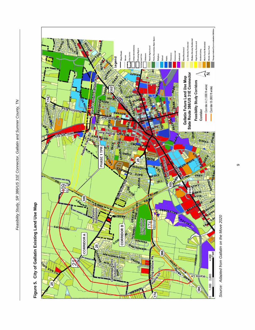
Feas
ibili
ty S
tudy
SR
386
US
31E
Con
nect
or G
alla
tin a
nd S
umne
r Cou
nty
TN
Figu
re 6
C
ity o
f Gal
latin
Com
mun
ity C
hara
cter
Map
(Fut
ure
Land
Use
Map
)
Sou
rce
Ada
pted
from
Gal
latin
on
the
Mov
e 20
20
10
Feasibility Study SR 386US 31E Connector Gallatin and Sumner County TN
Table 3 City of Gallatin Community Character (Future Land Use) Map Categories Community Character Category
Community Character Map Areas
General Description Primary Land Uses Appropriate Density Intensity
Centers
Neighborhood Center
Neighborhood scale mixed-use centers that serve the surrounding neighborhood
Small and large scale apartments and townhomes vertical mixed-use neighborhood commercial
035 Floor Area Ratio
Regional Activity Center
Regional-scale mixed-use centers that include retail office and residential uses
Large-scale apartments and townhomes horizontal and vertical mixed-use commercialofficeretail big box retail hospitality publicinstitutional entertainment and cultural facilities
075 Floor Area Ratio
Neighborhoods
Suburban Neighborhood Emerging
Developable areas where conventional suburban neighborhood development is appropriate
Single family residential small and large-scale apartments and townhomes public Institutional
1-3 units per acre
Suburban Neighborhood Established
Stable neighborhoods developed with narrow smaller lots generally prior to 1950
Single family residential small and large scale apartments and townhomes
2-5 units per acre
Town Neighborhood Revitalization
Neighborhoods developed with narrow smaller lots generally prior to 1950 with a need for new investment and revitalization
Single family residential small-scale apartments and townhomes
5-8 units per acre
Emerging Walkable Community
Developable areas where walkable neighborhoods Traditional Neighborhood Development (TND) is appropriate and a variety of housing types
Single and multiple family residential office retail civic
Varies
Rural Community
Sparsely developed areas where agricultural use and character is common and expansion of urban services is not anticipated
Agricultural large lot and conservation subdivision single family residential passive recreation civic uses (rural scale)
1 unit per 2+ acres
Special Districts North Gallatin Emerging Business Park
A predominantly undeveloped area bound by SR 109 Bypass and Old Hwy 109 north of the City limits
Light industry business parks warehouse commercial hospitality transportation communicationutilities
050 Floor Area Ratio
11
Feasibility Study SR 386US 31E Connector Gallatin and Sumner County TN
Community Character Category
Community Character Map Areas
General Description Primary Land Uses Appropriate Density Intensity
GreenLea Business Center
Emerging special area that includes a mix of industrial and commercialoffice uses to diversify the Cityrsquos economic base
Light industry business parks warehouse commercial hospitality transportation communicationutilities single and multi-family residential (when part of an approved master plan)
050 Floor Area Ratio
Corridors Commercial Corridor
Stable commercial corridors where development is encouraged
Small and large-scale apartments and townhomes office vertical mixed use commercialretail
075 Floor Area Ratio
Preserve Parks and Open Space
Primarily public or privately-owned land intended to remain as open space for preservation and recreation needs and not suitable for development
Passive and active recreation undeveloped areas in natural state
Not applicable
Source Gallatin on the Move 2020
One of the objectives in Gallatin on the Move 2020 is to ldquoPromote desired development patterns with incentives and preparation of master plans for large undeveloped areas where growth is expected over the next 20 yearsrdquo The plan specifically refers to the Bowles property in the western portion of Corridor A and B It states ldquoAlong with the completion of new infrastructure such as the extension of the Hatten Track Road through the Bowles property the City should coordinate with property owners to establish a detailed visionrdquo (ie master plan) that is consistent with the overall City vision thus allowing the City to promote specific goals and objectivesrdquo
In 2007 the City of Gallatin approved a Preliminary Master Development Plan for Phases 6 through 12 of the Twin Eagles Subdivision If built this development expansion would be located to the north of the current subdivision west of SR 109 and within the Gallatin Municipal Planning Region In addition a Preliminary Master Development Plan for Phases 1 through 4 of The Reserve was approved by the City of Gallatin in 2010 The Reserve is designed as a 68 acre single-family residential development of 158 buildable lots to the southwest of SR 25 adjacent to Wentworth Drive on the west side of the Cambridge Farms subdivision Corridor A of the proposed project overlaps with these two proposed subdivision expansions It is recommended that the City of Gallatin Planning Commission preserve the right-of-way needed for the SR 386US 31E connector project
The GreenLea Business Center is described in Gallatin on the Move 2020 as ldquoan emerging employment and residential special area that includes a mix of industrial office residential and commercial uses that take advantage of the areasrsquo location adjacent to SR 386 and the CSXT Railroad Much of this area is currently undeveloped and presents an opportunity for commercial industrial and office growth adjacent to existing and emerging residential and commercial areasrdquo In addition the intent of the North Gallatin Emerging Business Park development pattern is to accommodate lessshy
12
Feasibility Study SR 386US 31E Connector Gallatin and Sumner County TN
intensive uses such as corporateregional headquarters call and data centers light manufacturing and ldquogreenrdquo companies with a relatively high-density mix of industrial and commercial uses in a campus-like setting
Another objective in Gallatin on the Move 2020 is to ldquoCoordinate with the Sumner County Planning Commission and Sumner County Commission to establish a process for adoption and implementation of the recommendations of the plan for areas within the Gallatin Urban Growth Boundary area outside of the Planning Regionrdquo This objective is applicable to the north and western portions of the study area that are located within unincorporated Sumner County but inside the Gallatin Urban Growth Boundary limits Figure 7 shows a close-up of the General Framework Map from the 2035 Comprehensive Plan Sumner Countyrsquos Blueprint to the Future that is intended to serve as a future land use plan for unincorporated Sumner County As illustrated the preferred land use patterns within the study corridors include a Regional Employment Center and Suburban development
The Regional Employment Center is shown in the same area as North Gallatin Emerging Business Park (between SR 109 and Old SR 109) in Gallatin on the Move 2020 The purpose of the Regional Employment Center designation is to locate office parks manufacturing centers corporate campuses or major universities near major transportation corridors that can provide basic jobs and keep people in the county during normal work hours The Suburban development pattern is consistent with the Suburban Neighborhood Emerging and Rural Community character categories shown in the Gallatin on the Move 2020 Community Character map and it is designated for low density residential land uses of one dwelling unit per acre or less The Conservation designations shown to the north of Corridors A and B are associated with conservation easements held by the Land Trust of Tennessee
13
Feas
ibili
ty S
tudy
SR
386
US
31E
Con
nect
or G
alla
tin a
nd S
umne
r Cou
nty
TN
Figu
re 7
Su
mne
r Cou
nty
Gen
eral
Fra
mew
ork
Map
(Fut
ure
Land
Use
Map
)
Sou
rce
Ada
pted
from
203
5 C
ompr
ehen
sive
Pla
n S
umne
r Cou
ntyrsquo
s B
luep
rint t
o th
e Fu
ture
14
Feasibility Study SR 386US 31E Connector Gallatin and Sumner County TN
33 Transportation Plans There are multiple transportation studies that cover the City of Gallatin and Sumner County The numerous recommended transportation improvements planned within the vicinity of the study area are listed in Appendix B The extensive list of projects in Appendix B are categorized under the following plans bull Gallatin on the Move 2020 City of Gallatin General Development and
Transportation Plan 2008-2020 bull 2035 Comprehensive Plan Sumner Countyrsquos Blueprint to the Future bull Nashville Metropolitan Planning Organizationrsquos 2030 Long Range Transportation
Plan bull Nashville Metropolitan Planning Organizationrsquos Transportation Improvement
Program Fiscal Years 2011-2015 (Draft ndash scheduled for adoption December 2010)
34 Bicycle and Pedestrian Plans Greenway multi-use paths branch greenway trails bicycle lanes and bicycle routes have been planned in Gallatin as part of the overall transportation system to serve as multi-modal community connectors and natural resources conservation areas For the Phase 1 Albert Gallatin AvenueHatten Track Road Extension bike lanes were designated between SR 109 and SR 174 (Dobbins Pike) Bike lanes are also being proposed as part of the Phase 2 SR 386US 31E Connector
Based on the projects shown in Gallatin on the Move 2020 the proposed bicycle and pedestrian projects within the study area are illustrated in Figure 8 Below is a detailed description from the plan of the projects that cross into or are within the study corridors
The City of Gallatin 2006 Greenways Master Plan organized the greenway multi-use paths into eight corridors prioritized according to their feasibility availability and level of connectivity The following two greenway projects are within the study corridors
bull Project 4 ndash Town Creek Trail A multi-use path 357 miles long that is expected to start at Triple Creek Park and generally follow Town Creek southwesterly and then end at a trail head near the SR 109 Bypass (near Ryan Avenue) This trail was ranked first (1) out of eight (8) on the priority list in the 2006 Greenways Master Plan
bull Project 9 - East Camp Creek Trail A trail 472 miles long that would start just south of US 31E and run in a northeasterly direction along the Camp Creek This trail was ranked six (6) out of eight (8) on the priority list in the 2006 Greenways Master Plan
The Plan also shows two greenway spurs to promote further connectivity between the greenways and bicycle and pedestrian facilities
bull Project 12 ndash East Camp Creek Spur ndash ldquoA trail spur extending up Camp Creek towards SR 386 to provide bicycle and pedestrian access into this future development areardquo
bull Project 13 - Hatten Track Trail Spur ldquoA trail spur extending into the Hatten Track from the East Camp Creek Trail to provide bicycle and pedestrian access into the development areardquo
15
Feasibility Study SR 386US 31E Connector Gallatin and Sumner County TN
Bike lanes are on-road facilities designated by striping signing and pavement markings that are for the preferential or exclusive use of bicycles whereas bike routes are on-road facilities indicated by directional and informational markers such as ldquoBike Routerdquo andor ldquoShare the Roadrdquo signs that utilize little or no striping The proposed bike lanes and bike routes in Figure 9 were originally proposed as part of the City of Gallatin Bicycle and Pedestrian Master Plan of 2000 (denoted by ldquoBrdquo) the 2000 Major Thoroughfare Plan (denoted by ldquoTrdquo) and the 2005 State Route 386 Area Study (denoted by ldquoASrdquo) The following bicycle lane and route projects are located within the study corridors
bull Project 14 ndash Long Hollow Pike Provide bike lanes ldquofrom the western boundary of the study area to Red River Road It is recommended that pedestrian and bike facilities are included when roadway improvements are planned including connections at a possible interchange with SR 386rdquo (B T AS)
bull Project 15 ndash US 31E (Nashville Pike) Currently there are no bike lanes along US 31E to accommodate bicyclists Project 15 is intended to provide bike lanes ldquofrom the western boundary of the study area through downtown to the eastern boundary of the study planning area US 31E west of SR 109 is marked as a bicycle route Further it is TDOTrsquos vision to have a continuous bike route from Nashville to Gallatin via US 31E (Nashville Pike) It is recommended that any development or redevelopment along Nashville Pike should include provisions to provide bike lanesrdquo (B AS)
bull Project 16 ndash GreenLea Boulevard Provide bike lanes from Long Hollow Pike to US 31 E (AS)
bull Project 18 ndash Bison Trail Extension Provide bike lanes ldquofrom GreenLea Boulevard to connect up with Saundersville Road in Hendersonville west of Lower Station Camp Creek Roadrdquo (AS)
bull Project 23 - Hatten Track Road Extension Provide bike lanes ldquobetween SR 109 Bypass to Dobbins PikeSR 174North Water Avenue These bike lanes would connect the SR 109 Bypass to other facilities Bike lanes are recommended east of North Water Avenue thus completing a bike system (Project 27)rdquo (B T)
bull Project 26 ndash Red River Road Provide bike lanes ldquofrom Bradford Drive to US 31EMain Street Bike lanes are recommended to connect to the Bradford Drive route to complete a multi-modal loop around the golf course and into downtownrdquo (B)
bull Project 27 ndash SR 174Albert Gallatin Avenue Provide bike lanes ldquofrom North Water Avenue to East Broadway AvenueUS 31E This bike route runs along the north side of Gallatin Municipal Park and would connect with multiple bike facilities Bike lanes are recommended west of North Water Avenue thus completing a bike system (Project 23)rdquo (B)
bull Project 31 ndash Old Highway 109 Provide bike routes ldquofrom Hatten Track Road to the northern planning boundary This planned bike route would provide multiple connections to other bike lanes andor routes connecting the northwest area to downtown Gallatinrdquo (B)
16
Feas
ibili
ty S
tudy
SR
386
US
31E
Con
nect
or G
alla
tin a
nd S
umne
r Cou
nty
TN
Figu
re 8
Pr
opos
ed B
ike
and
Pede
stria
n Pr
ojec
ts
Sou
rce
Ada
pted
from
City
of G
alla
tin 2
006
Gre
enw
ays
Mas
ter P
lan
17
Feasibility Study SR 386US 31E Connector Gallatin and Sumner County TN
Project 35 ndash Dobbins Pike Provide bike routes ldquobetween the northern planning boundary to Albert Gallatin Avenue This is an integral part of a bike route corridor through the heart of the City of Gallatin This section connects the northern portion to the Civic Center Bike Routes are recommended north of Broadway Avenue thus completing a bike system (Project 36 37)rdquo (B)
bull Project 43 (Blythe Avenue) is categorized as a ldquobike lanes and sidewalks projectrdquo that is recommended within the study corridors It is intended ldquoto provide an alternate to North Water and US 31E for access to the recreational areas on the north side of the City It is recommended to incorporate bike lanes and sidewalks with any future roadway wideningrdquo
bull Project 46 (Albert Gallatin Avenue) is categorized as a ldquosidewalks and pedestrian crossing projectrdquo that is recommended within the study corridors It is intended ldquobetween North Water Avenue and US 31E to serve the recreational users of the Gallatin Civic Centerrdquo
35 Other Multi-modal Facilities The Gallatin on the Move 2020 Plan recommends flexible bus service within the City of Gallatin The service would travel along a designated route but would be flexible enough to deviate off route to pick up or drop off passengers For instance if a route traveled from downtown to Volunteer State Community College the service could deviate off route for a certain distance (typically 34 mile) or to a certain boundary This type of service design addresses ADA requirements while expanding coverage to additional areas
Gallatin North-South Flex The north-south flexible bus service using one vehicle is proposed to operate along Albert Gallatin Avenue Blythe Avenue Eastland Street and Water Avenue Sites served include the Civic Center low-income housing along Blythe Avenue at Small Street the downtown square and homes and businesses along Water Avenue Deviations could also serve low-income housing along Lackey Circle low-income housing along Boyers Avenue at Hull Circle and other homes and businesses within a frac34 mile buffer of the route
36 Potential Future Coordination This study has involved local stakeholders including City Council representatives and business owners in early planning and development of the proposed project
A CSX Railroad line runs north-south through the study area of the Phase 1 Albert Gallatin AvenueHatten Track Road Extension which has been incorporated into this study The bridge on North Water Avenue crossing over the depressed railroad line will need to be replaced requiring coordination with the CSX Railroad A representative of CSX was invited to the stakeholder meeting for both the Phase 1 study and this study but did not attend
Coordination with the US Army Corps of Engineers will be required for the blue line stream crossings and possibly for wetland impacts The Tennessee Department of Environment and Conservation will also need to be coordinated with in regard to potential permitting and possibly for hazardous materials
18
Feasibility Study SR 386US 31E Connector Gallatin and Sumner County TN
In addition the City must coordinate with local developers proposing developments within or adjacent to the corridors under study to ensure that future implementation should the study become a project remains viable
40 PRELIMINARY PROJECT NEED This project is intended to address anticipated future transportation needs which have been identified through coordination with local officials and agencies The project area has been targeted as a prime area for future development and its success is dependent on a connected local and regional roadway system
41 Safety The following is a summary of the crash history on SR 109 and SR 174 for the latest three-year period for which data is available (2007 ndash 2009) Table 4 summarizes two segments of roadway and two major intersections in the project area showing the number of crashes and the comparison of the actual crash rate with the statewide average crash rate for the same functional classification The actual rate is derived from a formula that takes into account factors such as total number of crashes length of roadway and the time period over which the crashes occurred
The SR 174 intersection with Belvedere Drive and the SR 174 intersection with SR 109 have crash rates of approximately 15 to 17 times greater than the statewide rate for an intersection of its type thus indicating that safety is a concern along this segment of SR 174 The number of crashes suggests a need for an alternate route or intersection configuration to help separate through and local traffic
Table 4 Crash Summary
SectionIntersection Description Log Mile(s)
Crashes
Actual Crash Rate
State Average
Crash Rate
SR 109 from SR 174 (Long Hollow Pike) to Old Highway 109 421-760 28 035 201
SR 174 (Long Hollow Pike) from SR 386 to SR 109 1354-1459 13 016 275
SR 174 (Long Hollow Pike) intersection with Belvedere Drive 1428 22 156 099
SR 174 (Long Hollow Pike) intersection with ramps for southbound SR 109 1445-1451 24 170 099
SR 174 (Long Hollow Pike) intersection with ramps for northbound SR 109 1452-1449 15 107 099
for this type of roadway
A summary of the 2006-2008 crash data findings for each segment and intersection is as follows
19
Feasibility Study SR 386US 31E Connector Gallatin and Sumner County TN
bull SR 109 from SR 174 (Long Hollow Pike) to Old Highway 109 The statewide average crash rate for a roadway of the same functional classification (urban arterial four lane divided) is 201 while the actual rate is 035 for this segment of SR 109 The actual crash rate for this segment of roadway is well below the statewide average and therefore does not indicate a safety issue There were twenty-eight (28) documented crashes resulting in no fatalities no incapacitating injuries and nine (9) other injuries
bull SR 174 (Long Hollow Pike) from SR 386 to SR 109 The statewide average crash rate for a roadway of the same functional classification (urban minor arterial four lane with turn lane) is 275 while the actual rate is 016 for this segment of SR 174 The actual crash rate for this segment of roadway is well below the statewide average and therefore does not indicate a safety issue There were thirteen (13) documented crashes resulting in no fatalities no incapacitating injuries and four (4) non-incapacitating injuries
bull SR 174 (Long Hollow Pike) intersection with Belvedere Drive The statewide average crash rate for an intersection of this type is 099 The actual rate for the intersection is 156 which is slightly higher than the statewide average This intersection is the location of an existing industrial area that is slated for use in the future as the ldquoGreenlea Business Centerrdquo Of the twenty-two (22) crashes at the signalized intersection with Belvedere Drive ten (10) involved personal injury and thirteen (13) were rear end collisions
bull SR 174 (Long Hollow Pike) intersection with ramps for southbound SR 109 from Log Miles 1445 -1451 The statewide average crash rate for an intersection of this type is 099 while the actual rate for the intersection is 170 which is slightly higher than the statewide average There were twenty-four (24) documented crashes at this intersection resulting in no fatalities or incapacitating injuries but ten (10) non-incapacitating injuries Twelve (12) of the crashes occurred at log mile 1449 which is the signalized intersection for the right-turn ramp onto SB SR-109 and the left-turn ramp from SB SR-109
bull SR 174 (Long Hollow Pike) intersection with ramps for northbound SR 109 from Log Miles 1452 -1459 The statewide average crash rate for an intersection of this type is 099 while the actual rate for the intersection is 107 which is slightly higher than the statewide average There were fifteen (15) documented crashes at this intersection resulting in no fatalities or incapacitating injuries but four (4) non-incapacitating injuries Seven (7) of the crashes occurred at log mile 1458 which is the signalized intersection for the right-turn ramp from NB SR 109 lanes and the left-turn ramp to NB SR 109 lanes
42 System Linkage An alternate route between the southwest and northeast sides of Gallatin is desired The SR 386US 31E Connector will link SR 386 with SR 174 and US 31E north of downtown and provide ldquothroughrdquo traffic the ability to avoid the congested segment of US 31 E through downtown Gallatin
20
Feasibility Study SR 386US 31E Connector Gallatin and Sumner County TN
Furthermore construction of the SR 386US 31E Connector will create a more accessible and resilient transportation system by improving route options dispersing traffic over more roads and therefore reducing delays when a particular roadway segment is closed due to an incident construction or for other reasons
43 Level of Service Analysis To determine how well traffic operates under the No-Build and Build Conditions a level of service analysis was conducted A ldquoLevel of Servicerdquo (LOS) index was used to gauge the operational performance for each roadway segment The LOS is a qualitative measure that describes traffic conditions related to speed and travel time freedom to maneuver traffic interruptions etc There are six levels ranging from ldquoArdquo to ldquoFrdquo with ldquoFrdquo being the worst Each level represents a range of operating conditions Table 6 defines the traffic flow conditions and approximate driver comfort level at each level of service
LOS analysis was performed using the Highway Capacity Software (HCS+) for the No-Build and Build conditions for the base year of 2016 and the design year of 2036 Each roadway segment for Corridors A and B was analyzed using the multi-lane highways module in the HCS+ software The roadway characteristics that affect the LOS and were included in the analysis include free-flow speed lane width and lateral clearance median type access point density general terrain characteristics number of heavy vehicles in the traffic flow and the directional distribution of traffic The HCS+ results are included in Appendix C
It should be noted that the segments of US 31E and the segments where Corridors A and B are combined (Phase 1) were not analyzed using the HCS+ software because the speed limit on the roadway is lower than can be accommodated in the multi-lane highways module Furthermore the traffic signals along these segments will impact the LOS on the roadway segments and an arterial-level analysis is needed to properly determine the LOS In the absence of turning movement counts at the intersections the AADT volumes on these segments were equated to generally accepted volume thresholds to determine the arterial LOS
The results of the LOS analysis are summarized in Table 7
The LOS analysis indicates that under the 2036 No-Build and Build Conditions the segment of SR 386 from Greenlea Boulevard to SR 174 and then SR 174 to N Belvedere Drive operates at LOS E during peak periods Due to projected 2036 AADT volumes in the range of 54950 to 56250 vehicles per day these segments need to be widened by one (1) travel lane in each direction in order to accommodate the projected traffic A more detailed discussion of the improvements needed for these segments is included in Section 52
21
Feasibility Study SR 386US 31E Connector Gallatin and Sumner County TN
Table 5 Definition of Level of Service
Level of Service
Definition
A Free flow operations Vehicles are almost completely unimpeded in their ability to maneuver with the traffic stream The general level of physical and psychological comfort provided to the driver is high
B Reasonable free flow operations The ability to maneuver within the traffic stream is only slightly restricted and the general level of physical and psychological comfort provided to the driver is still high
C Flow with speeds at or near free flow speeds Freedom to maneuver within the traffic stream is noticeably restricted and lane changes require more vigilance on the part of the driver The driver notices an increase in tension
D Speeds decline with increasing traffic Freedom to maneuver within the traffic stream is more noticeably limited The driver experiences reduced physical and psychological comfort levels
E At lower boundary the facility is at capacity Operations are volatile because there are virtually no gaps in the traffic stream There is little room to maneuver The driver experiences poor levels of physical and psychological comfort
F Breakdowns in traffic flow The number of vehicles entering the highway section exceed the capacity or ability of the highway to accommodate that number of vehicles There is little room to maneuver The driver experiences poor levels of physical and psychological comfort
Source TDOT TPR Manual (2010)
Table 6 LOS for Base Year and Design Year Conditions
Roadway Segment
Level of Service 2016 2036
No-Build No-Build Build Corridor A ndash SR 109 Bypass to SR 25 - - A A Corridor A ndash SR 25 to SR 174 - - A A Corridor A ndash SR 174 to SR 386 - - A A Corridor B ndash SR 386 ndash Harris Ln to SR 174 C B E C E C Corridor B ndash SR 174 ndash SR 386 to N Belvedere Dr C B E C E C Corridor B ndash SR 174 ndash N Belvedere Dr to SR 109 Bypass C B D C D C
Corridor B ndash SR 109 Bypass ndash SR 174 to SR 25 A A B A B A Corridor B ndash SR 109 Bypass ndash SR 25 to Hatten Track Extension (phase 1) A A B A B A
Corridor AB (Phase 1) Hatten Track ndash SR 109 Bypass to Blythe Ave - - C
22
Feasibility Study SR 386US 31E Connector Gallatin and Sumner County TN
Roadway Segment Level of Service
2016 2036 No-Build No-Build Build
Corridor AB (Phase 1) Old State Highway 109 ndash Blythe Ave to N Water Ave B B B
Corridor AB (Phase 1) Albert Gallatin Ave ndash N Water Ave to US 31E A B B
US 31E ndash SR 109 to River Rd E F F US 31E ndash River Rd to Eastland St D E D US 31E ndash Eastland St to N Water Ave E F E US 31E ndash N Water Ave to SR 174 B D C
Direction 1Direction 2
44 Capacity As stated in the Transportation Improvement Plan (TIP) for Albert Gallatin AvenueHatten Track Road Extension (Phase 1) the construction of the Extension is anticipated to ldquoaddress congestion occurring on SR 6 [US 31E] and provide an alternative route to access SR 109 and SR 386rdquo The existing traffic on US 31E (SR 6West Main StreetEast Broadway) in downtown Gallatin has a projected 2016 Average Annual Daily Traffic (AADT) volume of approximately 31600 vehiclesday which exceeds the capacity of a five (5) lane urban arterial resulting in LOS E
The construction of both the Phase 1 Extension of SR 174Albert Gallatin Avenue and Hatten Track Road and the Phase 2 SR 386US 31E Connector is anticipated to divert approximately twenty-five (25) percent of the traffic away from US 31E in the downtown area This traffic reduction is anticipated to reduce the AADT on US 31E to a level that can be better accommodated by the existing roadway resulting in LOS C
By reducing the AADT on the most heavily congested segments of US 31E the levels of service at the signalized intersections and associated vehicular delay is anticipated to improve Generally speaking the arterial levels of service improve on US 31E between River Road (SR 25) and SR 174 in the Build Condition More detailed information on the capacity analysis is provided later in this section
Traffic Projections Traffic volumes for the No-Build and Build Conditions were projected in support of this Feasibility Study TDOT provided AADT volumes on roadways within the study area for a base year of 2016 and design year 2036 which were determined using the Nashville MPO travel demand model as well as TDOT 24-hour counts The AADT volumes for the No-Build and Build Conditions for the base and design years are presented in Table 5 The traffic diagrams provided by TDOT is provided in Appendix C
In order to accommodate the projected 2036 Build Condition AADT volumes ranging from 14710 to 17120 vehicles per day a four-lane typical section is needed for Corridor A A more detailed discussion of the proposed typical section for Corridor A is included in Section 52
23
Feasibility Study SR 386US 31E Connector Gallatin and Sumner County TN
Table 7 AADT for Base Year and Design Year Conditions
Roadway Segment
AADT 2016 2036
No-Build No-Build Build Corridor A ndash SR 109 Bypass to SR 25 - - 14710 Corridor A ndash SR 25 to SR 174 - - 16020 Corridor A ndash SR 174 to SR 386 - - 17120 Corridor B ndash SR 386 ndash Harris Ln to SR 174 32300 51680 54950 Corridor B ndash SR 174 ndash SR 386 to N Belvedere Dr 36250 52900 56250
Corridor B ndash SR 174 ndash N Belvedere Dr to SR 109 Bypass 35000 45500 48380
Corridor B ndash SR 109 Bypass ndash SR 174 to SR 25 16500 27400 23290 Corridor B ndash SR 109 Bypass ndash SR 25 to HattenTrack Extension (Phase 1) 13100 22250 21100
Corridor AB (Phase 1) Hatten Track ndash SR 109 Bypass to Blythe Ave - - 10700
Corridor AB (Phase 1) Old Highway 109 ndash Blythe Ave to N Water Ave 7050 8950 15370
Corridor AB (Phase 1) Albert Gallatin Ave ndash NWater Ave to US 31E 5800 8550 11450
US 31E ndash SR 109 to River Rd 31600 41100 39030 US 31E ndash River Rd to Eastland St 20600 28020 22330 US 31E ndash Eastland St to N Water Ave 25000 33250 26500 US 31E ndash N Water Ave to SR 174 14450 19050 15180
Source Tennessee Department of Transportation (2011)
45 Economic Development As discussed in Section 32 and depicted in Figure 6 the Gallatin on the Move 2020 plan specifies more intensive land uses than those currently present in the study area Along Phase 1 of the proposed Albert Gallatin AvenueHatten Track Road the land on the west side of the project adjacent to SR 109 is slated as the North Gallatin Emerging Business Park
In the current study area which includes the above segment but also includes land in and adjacent to the northwest quadrant of the SR 386 and SR 109 intersection the future land use plan specifies land along SR 174 (Long Hollow Pike) and SR 386 for future development as 1) a Regional Activity Center and 2) Greenlea Business Center (includes some existing industrial uses)
Adequate roadway connectivity to and from these areas is essential for the City to realize their future plans for economic development
24
Feasibility Study SR 386US 31E Connector Gallatin and Sumner County TN
50 OPTIONS FOR IMPROVEMENT 51 No-Build Option The No-Build Option provides a baseline for evaluating the benefits and costs created by the Build Options and is defined as the roadway conditions as they currently exist The No-Build Option examines the impacts to the transportation system if the transportation improvements identified as the Build Options are not constructed
Together SR 386 and SR 174 currently serve as the roadway link between Greenlea Boulevard and the SR 109 Bypass Within the study area SR 386 is classified as a freeway with a four (4)-lane divided typical section Between SR 386 and the SR 109 Bypass SR 174 is classified as an urban minor arterial and consists of a five (5)-lane section with a center left turn lane SR 109 Bypass between SR 174 and the proposed Hatten Track extension is classified as an urban principal arterial and consists of four (4)-lane divided typical section US 31E is classified as an urban principal arterial and consists of a five (5)-lane section through downtown Gallatin transitions to a four (4)shylane divided typical section north of River Road then to a two (2)-lane divided section north or N Boyers Avenue and then to a three (3)-lane typical section south of JoAnn Street which continues to the intersection with Albert Gallatin Avenue
As indicated in the LOS analysis in Section 43 the segment of SR 386 from Greenlea Boulevard to SR 174 and then on to N Belvedere Drive operates at LOS E under the No-Build Option Additionally the segments of US 31E from SR 109 Bypass to N Water Avenue operate at either LOS E or F which does not meet minimum operational requirements
25
Feasibility Study SR 386US 31E Connector Gallatin and Sumner County TN
52 Build Options As stated previously and illustrated in Figure 9 there are two corridor options under the Build Condition Corridor A and Corridor B Phase 1 consists of the Albert Gallatin AvenueSR 174 Extension which is proposed to end at an interchange with SR 109 Phase 2 consists of either Corridor A or Corridor B which both utilize the Phase 1 extension from SR 109 to US 31E A description of each Build Option follows
Appendix D contains the typical sections and layout sheets for Phase 2 A description of the roadway segment for each feature follows
Corridor A
bull Corridor A is on new alignment from the SR 386Green Lea interchange and travels north along the east side of Liberty Branch Creek intersecting with SR 25 continues northeast and intersects with Douglas Lane and then continues east to SR 109 at which point it intersects the Phase 1 Albert Gallatin AvenueHatten Track Road extension east to US 31E Corridor A is approximately 39 miles in length
bull The typical section includes four twelve (12)-foot lanes (two (2) in each direction) a 48-foot depressed median six (6)-foot inside shoulders and twelve (12)-foot shared use outside shoulders (to accommodate bike lanes) within 200 feet of proposed right-of-way
bull The widening of SR 386 and SR 174 as described under the Corridor B option must be completed in addition to the building of Corridor A in order to ensure adequate traffic flow and operations on the surrounding roadway network
Corridor B
bull Corridor B follows SR 386 from the interchange with Greenlea Boulevard east to the intersection with Long Hollow Pike at which point the state routing designation changes to SR 174 Corridor B then follows SR 174 to the interchange with SR 109 it then travels north on SR 109 until it intersects with the Phase 1 Albert Gallatin AvenueHatten Track Road extension Corridor B is approximately 34 miles in length
bull Under the Corridor B option SR 386 and SR 174 between Greenlea Boulevard and the SR 109 Bypass will be widened for approximately 14 miles to account for future projected traffic growth
o SR 386 will be widened from four (4) to six (6) lanes (three (3) in each direction) each having a width of twelve (12) feet with twelve (12)-foot shoulders and a 64-foot wide depressed median The present right-ofshyway width for this section is 260 feet with additional right-of-way and easements to be obtained as needed for construction
o The typical section for the improved segment of SR 174 will be widened from five (5) to seven (7) twelve (12)-foot travel lanes (three (3) in each direction and a twelve (12)-foot center turn lane) with twelve (12)-foot shared use outside shoulders (to accommodate bike lanes) This widened section would require a minimum right-of-way of 180 feet
26
Feas
ibili
ty S
tudy
SR
386
US
31E
Con
nect
or G
alla
tin a
nd S
umne
r Cou
nty
TN
Figu
re 9
B
uild
Opt
ions
27
Feasibility Study SR 386US 31E Connector Gallatin and Sumner County TN
bull In addition to widening the identified segments of SR 386 and SR 174 several signalized intersections and two bridges will need to be improved so that the additional lanes can be accommodated The intersections that will require improvements include the following
- SR 386 at SR 174 - SR 174 at Belvedere Drive - SR 174 interchange with SR 109 Bypass
bull While all three of these intersections will require upgrades associated with the roadway widening improvements the SR 174 interchange with the SR 109 Bypass will also require geometric alterations so that traffic can smoothly transition from one route to the other The southbound off-ramp from SR 109 Bypass will need to be extended to form the third westbound lane of SR 174 The third eastbound lane of SR 174 will become a right-turn-only lane onto SR 109 Bypass
bull In addition to the intersection improvements the bridge over East Camp Creek as well as the westbound bridge over Liberty Branch Creek will both need to be widened to accommodate the future widening and meet traffic demands
bull If Corridor B is selected without Corridor A an eastbound to northbound SR 109 clover leaf loop will be needed to accommodate future left turn volumes This would require re-alignment of the ramps on the east side of SR 109 and widening of the bridge on SR 109 at East Camp Creek
Costs TDOT planning level base per mile costs were used to develop estimates for the corridor options and are summarized in Table 8 It should be noted that even if Corridor A is constructed Corridor B will need to be widened along SR 386 and SR 174 to accommodate the future traffic volumes The interchange improvements at SR 109 however would not be needed as motorists travelling north to SR 109 would utilize Corridor A The widening cost for SR 386 and SR 174 is approximately $10000000
Also a two (2) lane depressed median section could be constructed as an interim phase for Corridor A allowing future build out to four (4) lanes which would reduce the interim phase construction cost approximately $11000000
Table 8 Planning Level Costs for Build Options
Item Corridor A (39 Miles)
Corridor B (34 Miles)
Right-of-Way $3608400 $2229675 Total Construction $30490980 $17252905 Preliminary Engineering $3049098 $1725291 Total Cost $37148478 $21207871
53 Possible Modifications to the State Route System During the NEPA phase when the preferred alignment is selected TDOT may review the current state route system for possible modification For example possible changes to the state routing system could include designating SR 174 to follow Long Hollow Pike to
28
Feasibility Study SR 386US 31E Connector Gallatin and Sumner County TN
Greenlea Boulevard and then follow Corridor A to SR 109 continue across SR 109 along Albert Gallatin AvenueHatten Track Road Extension (Phase 1) and reconnect with the existing SR 174 at Dobbins Pike (see Figure 10) Accordingly the SR 174 designation would be removed from Greenlea Boulevard through downtown to Dobbins Pike Based on these possible changes approximately 26 miles would be removed and 54 miles would be added resulting in a net gain of 294 miles to the state route system
29
Feas
ibili
ty S
tudy
SR
386
US
31E
Con
nect
or G
alla
tin a
nd S
umne
r Cou
nty
TN
Figu
re 1
0 P
ropo
sed
Cha
nges
to S
tate
Rou
ting
Syst
em
30
Feasibility Study SR 386US 31E Connector Gallatin and Sumner County TN
54 Control of Access The City of Gallatin Zoning Ordinance (amended October 20 2009) establishes access management standards in Section 1306 for driveways providing vehicular access from arterial collector and local streets (roads in the study area are classified as arterials and collector streets) In addition Gallatin on the Move 2020 outlines additional access management policies that should be applied to the Cityrsquos arterial road system (including long range planning project planning and design right-of-way acquisition redesign of existing arterial corridors and driveway permitting)
Within the study area SR 174 between SR 386 and SR 109 is currently not access controlled and is subject to future development SR 109 is access controlled between SR 25 and Old Highway 109 The proposed extension will ultimately not require a break in the access control on SR 109 because an interchange is planned to allow access between SR 109 and the Albert Gallatin AvenueHatten Track Road Extension (Phase 1) and the SR 386US 31E Connector
In addition the project will be designed to provide limited access along the proposed Build Option ndash Corridor A as well as along the Hatten Track extension (Phase 1) from SR 109 to the east For an at-grade intersection the access control distance will be a minimum of 100 feet from any intersection For an interchange the access control will be 300 feet from the ramp terminals treating each side of the cross road independently
55 Environmental Constraints The environmental screening presented in this Feasibility Study has been provided by the TDOT Early Environmental Screening (EES) reports A detailed environmental study of the corridors identified in this Feasibility Study would occur during future project phases in compliance with National Environmental Policy Act provisions Environmental screening maps produced in support of the analysis in this report are found in Appendix E A full copy of the TDOT EES reports can be found in Appendix F The TDOT EES reports revealed the following
Impacts Evaluated within 1000 feet of the Project Area bull Community ResourceInstitution
The project area is home to one public school Joe Shafer Middle School is located at 240 Albert Gallatin Avenue which is to the north of Corridors A and B
bull Minority Population of over 24 Percent Appendix E Map 1 illustrates the minority population in the project area by Census Block for the 2000 US Census The average percentage of minority populations for the City of Gallatin in 2000 was 217 percent The county-wide minority population for Sumner County was 85 percent The City of Gallatin average is comparable to the statewide average of 198 percent but the Sumner County average is considerably lower than the statewide average Among the census blocks encompassing the project area one has a minority population higher than the City of Gallatin as a whole This Census Block is identified as Census Tract 205 Block Group 1 Block 1014 and is contained within Corridor B
31
Feasibility Study SR 386US 31E Connector Gallatin and Sumner County TN
The percentage of the population that identified themselves as a minority in this Census Block is 33 percent (or 7 out of 21 persons)
bull Sensitive Community Population Linguistically Isolated Populations Linguistically isolated populations are located within 1000 feet of the project area
bull Population living Below Poverty above the State Average of 135 Percent Appendix E Map 2 shows the percentage of the population living below poverty in the project area by Census Block Group The project area is encompassed by four Census Block Groups The percent of the population living below poverty in 2000 (based on 1999 income) within the City of Gallatin averaged 144 percent This is higher than the County and statewide averages of 81 and 135 percent respectively One Census Block Group within the project area has a percent of the population below poverty that is higher than the City County and statewide averages This Block Group is Census Tract 208 Block Group 2 and has 159 percent of the population in the Block Group living below poverty (or 289 out of 1807 persons) This Block Group is crossed by Corridor B (as highlighted in Appendix E Map 2)
bull Possible Substantial Impact on the Endangered Bat Species There is a known occurrence of Indiana or grey bats within four (4) miles of the project area It is anticipated that a) avoidanceminimization of potential impacts to species will be needed b) surveys for the species for the project may be required c) coordination with USFWS will be needed to establish Section 7 biological conclusions for the project and d) seasonal construction limitations will likely be necessary
bull Impact on Railroads A railroad exists within the project study area It is anticipated that impacts to the railroad can be avoided since the proposed project will be greater than 200 feet from the railroad There is the remote possibility of minor involvement on railroad property to accommodate drainage but there will be no grade crossing
bull Cemetery Sites and Properties There are no known cemetery sites within or abutting the project area
Impacts Evaluated within 2000 feet of the Project Area
bull TWRA Lakes and Other Public Lands No TWRA lake property is found within the project area but it is anticipated that a medium impact on the project is anticipated as a public park (city owned little league park) lies within the project area It is possible to locate the proposed project in such a way that it avoids any impacts or taking of the park property A moderate level of effort and time will be required to resolve the projectrsquos environmental impact on the park and to move forward with project development Indirect impacts (audible and visual) to the park may occur and need to be studied If there is indirect impact additional design would be needed to design the appropriate mitigation measures
32
Feasibility Study SR 386US 31E Connector Gallatin and Sumner County TN
bull National Register Sites No impacts are anticipated to any National Register of Historic Place (NRHP) listed properties as there are no properties abutting or within the project area
According to the State Historic Preservation Office (SHPO) records approximately ten (10) properties in Sumner County have been surveyed within the project area although none of which were deemed eligible for the NRHP by the surveyor Additional survey work is needed in future project phases to determine NRHP eligibility for the resources that are within the projectrsquos Area of Potential Effect (APE)
bull Superfund Sites No impacts are anticipated as there are no known contaminated land tracts abutting or within the project area
bull Pyritic Rock Pyritic rock is not known to occur in the project area and thus the project does not involve exaction Limestone and dolomite are present
Impacts Evaluated within 4000 feet of the Project Area
bull Terrestrial Species A minimal impact on the project is predicated as there is a known rare or state protected terrestrial species (the Thryomanes bewickii) located within the project area A survey for the species may be required
bull Wetland and Floodplain Impacts Substantial impacts to wetlands within the project area are probable A total of 33 acres of wetlands exists within 4000 feet of the project area Compensatory mitigation will be required Design effort will be needed to avoid and minimize impacts to wetlands to the maximum extent practicable
According to Federal Emergency Management Association (FEMA) Flood Insurance Rate Maps (FIRM) the project area is bisected by the 100-year floodplain Areas along East Camp Creek and Liberty Branch fall within this flood zone FIRMs depicting the 100-year floodplains within the project area were digitized and are included in Appendix E Map 3 Both Corridor A and Corridor B cross the 100-year floodplain
bull TDEC Conservation Sites and TDEC Scenic Waterways No TDEC Conservation Sites or scenic waterways are within the project area
bull Tennessee Natural Areas Program The project area does not include a Natural Area
bull Wildlife Management Area No impacts are anticipated to any Wildlife Management Areas as there are none that abut or are located within the project area
33
Feasibility Study SR 386US 31E Connector Gallatin and Sumner County TN
Impacts Evaluated within 10000 feet of the Project Area
bull Caves The Lackey Cave is present within 10000 feet of the project area and thus a medium project impact is anticipated It is possible to avoid impacts to the cave in future design phases of the project With the presence of a cave there are likely concerns involving the federally and state protected Indiana grey bat Additional design will be needed to avoid impacts to cave passages or entrances to develop access to the cave (if required) to conduct stability analysis of the project to determine right of way acquisition development and coordination of corrective actions for environmental effects (ie mitigation etc) associated with project construction in this terrain and to design water quality treatment measures Construction time will likely be affected either by requiring an extended contract period or strategic placement of the project in the let schedule to maximize the contractors time to construct the project
bull Aquatic Species There is no known occurrence of a rare state or federally-protected aquatic species within the project area
60 ASSESSMENT OF CORRIDOR OPTIONS TDOT has developed a set of seven guiding principles by which all transportation projects are to be evaluated These guiding principles address concerns for system management mobility economic growth safety community environmental stewardship and fiscal responsibility This section includes a discussion of each guiding principle as it pertains to the options evaluated in this Feasibility Study
Guiding Principle 1 Preserve and Manage the Existing Transportation System When the construction of SR 386 (Vietnam Veterans Boulevard) was completed SR 386 became a major asset to the City of Gallatin acting as a corridor to accommodate both local and through traffic and providing access to Gallatinrsquos downtown commercial core via SR 174Long Hollow Pike and US 31E Over time the section of US 31E through downtown has become congested The function of the SR 386US 31E Connector will be to provide the second phase of an east-west connector between SR 386 and US 31ESR 6East Broadway on the north side of the City thereby diverting some of the traffic away from US 31E from the most congested segments through downtown The proposed improvements as part of the Phase 2 project will provide a new connection between SR 386 and SR 109 which will result in preservation of the existing transportation system in the City of Gallatin
SR 109 SR 174 and US 31E are critical travel corridors for the City of Gallatin US 31E is not only a key commercial corridor for area residents and truck traffic but it also connects Gallatin to the towns of Bethpage and Westmoreland in Tennessee and Scottsville in Kentucky to the north and Nashville to the south SR 174 connects Gallatin to Oak Grove Tennessee and Scottsville Kentucky to the north and SR 109 connects Gallatin to Portland to the north The Build Option presented as Corridor A involves construction of a roadway on new location which can help extend the life of these
34
Feasibility Study SR 386US 31E Connector Gallatin and Sumner County TN
important existing routes by diverting some regional traffic andor lessening the future growth of traffic on these roads as indicated under the Build Scenario
Guiding Principle 2 Move a Growing Diverse and Active Population As discussed in Section 31 of this Feasibility Study the population of the City of Gallatin grew by 561 percent between 1990 and 2008 and Sumner County grew by 505 percent figures higher than the State of Tennessee as a whole (274 percent) The options presented in this study are intended to provide improved traffic conditions to support the arearsquos growing population and increasing amounts of externally generated traffic as well as support recommended future land use for the area which is outlined in Gallatin on the Move 2020
The SR 386US 31E Connector is anticipated to divert some traffic away from US 31E through downtown potentially reducing congestion and creating a safer and more hospitable environment for local traffic pedestrians and bicyclists
Guiding Principle 3 Support the Statersquos Economy Both SR 109 and US 31E are regional roadways that facilitate the movement of goods and services The SR 386US 31E Connector will provide better access to and support development in the area to the west of East Camp Creek which supports the vision of the City of Gallatin to promote the area as an emerging business park
Guiding Principle 4 Maximize Safety and Security The proposed project will create opportunities for the separation of through and local traffic alleviating traffic congestion in the downtown area especially on US 31E The proposed project will also eliminate the need for some tractor trailers and other large trucks to travel though the City which will potentially reduce crashes with local traffic which typically turns and stops frequently
Guiding Principle 5 Build Partnerships for Livable Communities A stakeholder meeting was held in support of this Feasibility Study in order to obtain input on transportation problems and other issues in the study area During the TPR development process additional coordination will be undertaken Additionally in keeping with TDOTrsquos Public Involvement Process the provisions of NEPA and Safe Accountable Flexible Efficient Transportation Equity Act ndash A Legacy for Users (SAFETEA-LU) and the provisions of the Tennessee Environmental Streamlining Agreement (TESA) if warranted this project will be coordinated with the public and additional governmental agencies beginning in the NEPA project phase
35
Feasibility Study SR 386US 31E Connector Gallatin and Sumner County TN
Guiding Principle 6 Promote Stewardship of the Environment Potential adverse environmental impacts were identified in the TDOT Environmental Screening and were considered in the development of the corridors included in this study Detailed technical environmental studies are needed to fully address the impacts
Should federal funding be obtained for the project a NEPA document will be prepared in future phases of the project The NEPA document will assess the projectrsquos impacts on the natural social and built environment and all efforts will be made to avoid adverse impacts during design development If impacts cannot be avoided they will be minimized and mitigated Early and continuous coordination will continue to take place with the appropriate federal state and local agencies and the public This coordination will assist with the identification of important resources early in the planning process and will help ensure the proposed project promotes stewardship of the environment
Guiding Principle 7 Emphasize Financial Responsibility The cost estimates presented in this study are offered for planning comparison purposes only and will fluctuate with inflation and any unexpected conditions It is TDOTrsquos goal to follow a comprehensive transportation planning process promote coordination among public and private operators of transportation systems and support efforts to provide stable funding for the public component of the transportation system This entails exercising financial responsibility in the development and implementation of roadway projects and minimizing cost to taxpayers
36
Feasibility Study SR 386US 31E Connector Gallatin and Sumner County TN
70 SUMMARY In summary this project is needed to address anticipated future transportation needs which have been identified through coordination with local officials and agencies The project area has been targeted as a prime area for future development and its success is dependent on a connected local and regional roadway system The project is needed based on the following
bull Improve Safety ndash Both the SR 174 intersection with Belvedere Drive and with SR 109 have crash rates of approximately 15 to 17 times greater than the statewide rate for an intersection of its type thus indicating that safety is a concern along this segment of SR 174
bull Promote System Linkage ndash An alternate route is desired between the southwest and northeast sides of town The SR 386US 31E Connector will provide the desired connectivity by linking SR 386 with SR 174 and US 31E north of downtown
bull Address Capacity Issues ndash By allowing travelers to use the SR 386US 31E Connector to access points northeast of downtown this project may reduce future congestion on US 31E through downtown Gallatin which will improve the traffic operations and safety along this segment of roadway It should also be noted that it is not cost beneficial to widen US 31E through downtown Gallatin
bull Meet Economic Development Demands ndash The Gallatin on the Move 2020 plan specifies more intensive land uses than those currently present in the study area
As stated previously there are two corridor options under the Build Condition for the SR 386US 31E Connector (Phase 2) Corridor A and Corridor B Planning level cost estimates for the corridor options were developed and are summarized in Table 9 It should be noted that even if Corridor A is constructed Corridor B will need to be widened along SR 386 and SR 174 to accommodate the future traffic volumes The interchange improvements at SR 109 however would not be needed as motorists travelling north to SR 109 would utilize Corridor A The widening cost for SR 386 and SR 174 is approximately $10000000
Also a two (2) lane depressed median section could be constructed as an interim phase for Corridor A allowing future build out to four (4) lanes which reduce the interim phase construction cost approximately $11000000
Table 9 Planning Level Costs for Build Options
Item Corridor A (39 Miles)
Corridor B (34 Miles)
Right-of-Way $3608400 $2229675 Total Construction $30490980 $17252905 Preliminary Engineering $3049098 $1725291 Total Cost $37148478 $21207871
If federal funding is utilized for this proposed project a TPR and NEPA document will be undertaken
37

Feasibility Study SR 386US 31E Connector Gallatin and Sumner County TN
intensive uses such as corporateregional headquarters call and data centers light manufacturing and ldquogreenrdquo companies with a relatively high-density mix of industrial and commercial uses in a campus-like setting
Another objective in Gallatin on the Move 2020 is to ldquoCoordinate with the Sumner County Planning Commission and Sumner County Commission to establish a process for adoption and implementation of the recommendations of the plan for areas within the Gallatin Urban Growth Boundary area outside of the Planning Regionrdquo This objective is applicable to the north and western portions of the study area that are located within unincorporated Sumner County but inside the Gallatin Urban Growth Boundary limits Figure 7 shows a close-up of the General Framework Map from the 2035 Comprehensive Plan Sumner Countyrsquos Blueprint to the Future that is intended to serve as a future land use plan for unincorporated Sumner County As illustrated the preferred land use patterns within the study corridors include a Regional Employment Center and Suburban development
The Regional Employment Center is shown in the same area as North Gallatin Emerging Business Park (between SR 109 and Old SR 109) in Gallatin on the Move 2020 The purpose of the Regional Employment Center designation is to locate office parks manufacturing centers corporate campuses or major universities near major transportation corridors that can provide basic jobs and keep people in the county during normal work hours The Suburban development pattern is consistent with the Suburban Neighborhood Emerging and Rural Community character categories shown in the Gallatin on the Move 2020 Community Character map and it is designated for low density residential land uses of one dwelling unit per acre or less The Conservation designations shown to the north of Corridors A and B are associated with conservation easements held by the Land Trust of Tennessee
13
Feas
ibili
ty S
tudy
SR
386
US
31E
Con
nect
or G
alla
tin a
nd S
umne
r Cou
nty
TN
Figu
re 7
Su
mne
r Cou
nty
Gen
eral
Fra
mew
ork
Map
(Fut
ure
Land
Use
Map
)
Sou
rce
Ada
pted
from
203
5 C
ompr
ehen
sive
Pla
n S
umne
r Cou
ntyrsquo
s B
luep
rint t
o th
e Fu
ture
14
Feasibility Study SR 386US 31E Connector Gallatin and Sumner County TN
33 Transportation Plans There are multiple transportation studies that cover the City of Gallatin and Sumner County The numerous recommended transportation improvements planned within the vicinity of the study area are listed in Appendix B The extensive list of projects in Appendix B are categorized under the following plans bull Gallatin on the Move 2020 City of Gallatin General Development and
Transportation Plan 2008-2020 bull 2035 Comprehensive Plan Sumner Countyrsquos Blueprint to the Future bull Nashville Metropolitan Planning Organizationrsquos 2030 Long Range Transportation
Plan bull Nashville Metropolitan Planning Organizationrsquos Transportation Improvement
Program Fiscal Years 2011-2015 (Draft ndash scheduled for adoption December 2010)
34 Bicycle and Pedestrian Plans Greenway multi-use paths branch greenway trails bicycle lanes and bicycle routes have been planned in Gallatin as part of the overall transportation system to serve as multi-modal community connectors and natural resources conservation areas For the Phase 1 Albert Gallatin AvenueHatten Track Road Extension bike lanes were designated between SR 109 and SR 174 (Dobbins Pike) Bike lanes are also being proposed as part of the Phase 2 SR 386US 31E Connector
Based on the projects shown in Gallatin on the Move 2020 the proposed bicycle and pedestrian projects within the study area are illustrated in Figure 8 Below is a detailed description from the plan of the projects that cross into or are within the study corridors
The City of Gallatin 2006 Greenways Master Plan organized the greenway multi-use paths into eight corridors prioritized according to their feasibility availability and level of connectivity The following two greenway projects are within the study corridors
bull Project 4 ndash Town Creek Trail A multi-use path 357 miles long that is expected to start at Triple Creek Park and generally follow Town Creek southwesterly and then end at a trail head near the SR 109 Bypass (near Ryan Avenue) This trail was ranked first (1) out of eight (8) on the priority list in the 2006 Greenways Master Plan
bull Project 9 - East Camp Creek Trail A trail 472 miles long that would start just south of US 31E and run in a northeasterly direction along the Camp Creek This trail was ranked six (6) out of eight (8) on the priority list in the 2006 Greenways Master Plan
The Plan also shows two greenway spurs to promote further connectivity between the greenways and bicycle and pedestrian facilities
bull Project 12 ndash East Camp Creek Spur ndash ldquoA trail spur extending up Camp Creek towards SR 386 to provide bicycle and pedestrian access into this future development areardquo
bull Project 13 - Hatten Track Trail Spur ldquoA trail spur extending into the Hatten Track from the East Camp Creek Trail to provide bicycle and pedestrian access into the development areardquo
15
Feasibility Study SR 386US 31E Connector Gallatin and Sumner County TN
Bike lanes are on-road facilities designated by striping signing and pavement markings that are for the preferential or exclusive use of bicycles whereas bike routes are on-road facilities indicated by directional and informational markers such as ldquoBike Routerdquo andor ldquoShare the Roadrdquo signs that utilize little or no striping The proposed bike lanes and bike routes in Figure 9 were originally proposed as part of the City of Gallatin Bicycle and Pedestrian Master Plan of 2000 (denoted by ldquoBrdquo) the 2000 Major Thoroughfare Plan (denoted by ldquoTrdquo) and the 2005 State Route 386 Area Study (denoted by ldquoASrdquo) The following bicycle lane and route projects are located within the study corridors
bull Project 14 ndash Long Hollow Pike Provide bike lanes ldquofrom the western boundary of the study area to Red River Road It is recommended that pedestrian and bike facilities are included when roadway improvements are planned including connections at a possible interchange with SR 386rdquo (B T AS)
bull Project 15 ndash US 31E (Nashville Pike) Currently there are no bike lanes along US 31E to accommodate bicyclists Project 15 is intended to provide bike lanes ldquofrom the western boundary of the study area through downtown to the eastern boundary of the study planning area US 31E west of SR 109 is marked as a bicycle route Further it is TDOTrsquos vision to have a continuous bike route from Nashville to Gallatin via US 31E (Nashville Pike) It is recommended that any development or redevelopment along Nashville Pike should include provisions to provide bike lanesrdquo (B AS)
bull Project 16 ndash GreenLea Boulevard Provide bike lanes from Long Hollow Pike to US 31 E (AS)
bull Project 18 ndash Bison Trail Extension Provide bike lanes ldquofrom GreenLea Boulevard to connect up with Saundersville Road in Hendersonville west of Lower Station Camp Creek Roadrdquo (AS)
bull Project 23 - Hatten Track Road Extension Provide bike lanes ldquobetween SR 109 Bypass to Dobbins PikeSR 174North Water Avenue These bike lanes would connect the SR 109 Bypass to other facilities Bike lanes are recommended east of North Water Avenue thus completing a bike system (Project 27)rdquo (B T)
bull Project 26 ndash Red River Road Provide bike lanes ldquofrom Bradford Drive to US 31EMain Street Bike lanes are recommended to connect to the Bradford Drive route to complete a multi-modal loop around the golf course and into downtownrdquo (B)
bull Project 27 ndash SR 174Albert Gallatin Avenue Provide bike lanes ldquofrom North Water Avenue to East Broadway AvenueUS 31E This bike route runs along the north side of Gallatin Municipal Park and would connect with multiple bike facilities Bike lanes are recommended west of North Water Avenue thus completing a bike system (Project 23)rdquo (B)
bull Project 31 ndash Old Highway 109 Provide bike routes ldquofrom Hatten Track Road to the northern planning boundary This planned bike route would provide multiple connections to other bike lanes andor routes connecting the northwest area to downtown Gallatinrdquo (B)
16
Feas
ibili
ty S
tudy
SR
386
US
31E
Con
nect
or G
alla
tin a
nd S
umne
r Cou
nty
TN
Figu
re 8
Pr
opos
ed B
ike
and
Pede
stria
n Pr
ojec
ts
Sou
rce
Ada
pted
from
City
of G
alla
tin 2
006
Gre
enw
ays
Mas
ter P
lan
17
Feasibility Study SR 386US 31E Connector Gallatin and Sumner County TN
Project 35 ndash Dobbins Pike Provide bike routes ldquobetween the northern planning boundary to Albert Gallatin Avenue This is an integral part of a bike route corridor through the heart of the City of Gallatin This section connects the northern portion to the Civic Center Bike Routes are recommended north of Broadway Avenue thus completing a bike system (Project 36 37)rdquo (B)
bull Project 43 (Blythe Avenue) is categorized as a ldquobike lanes and sidewalks projectrdquo that is recommended within the study corridors It is intended ldquoto provide an alternate to North Water and US 31E for access to the recreational areas on the north side of the City It is recommended to incorporate bike lanes and sidewalks with any future roadway wideningrdquo
bull Project 46 (Albert Gallatin Avenue) is categorized as a ldquosidewalks and pedestrian crossing projectrdquo that is recommended within the study corridors It is intended ldquobetween North Water Avenue and US 31E to serve the recreational users of the Gallatin Civic Centerrdquo
35 Other Multi-modal Facilities The Gallatin on the Move 2020 Plan recommends flexible bus service within the City of Gallatin The service would travel along a designated route but would be flexible enough to deviate off route to pick up or drop off passengers For instance if a route traveled from downtown to Volunteer State Community College the service could deviate off route for a certain distance (typically 34 mile) or to a certain boundary This type of service design addresses ADA requirements while expanding coverage to additional areas
Gallatin North-South Flex The north-south flexible bus service using one vehicle is proposed to operate along Albert Gallatin Avenue Blythe Avenue Eastland Street and Water Avenue Sites served include the Civic Center low-income housing along Blythe Avenue at Small Street the downtown square and homes and businesses along Water Avenue Deviations could also serve low-income housing along Lackey Circle low-income housing along Boyers Avenue at Hull Circle and other homes and businesses within a frac34 mile buffer of the route
36 Potential Future Coordination This study has involved local stakeholders including City Council representatives and business owners in early planning and development of the proposed project
A CSX Railroad line runs north-south through the study area of the Phase 1 Albert Gallatin AvenueHatten Track Road Extension which has been incorporated into this study The bridge on North Water Avenue crossing over the depressed railroad line will need to be replaced requiring coordination with the CSX Railroad A representative of CSX was invited to the stakeholder meeting for both the Phase 1 study and this study but did not attend
Coordination with the US Army Corps of Engineers will be required for the blue line stream crossings and possibly for wetland impacts The Tennessee Department of Environment and Conservation will also need to be coordinated with in regard to potential permitting and possibly for hazardous materials
18
Feasibility Study SR 386US 31E Connector Gallatin and Sumner County TN
In addition the City must coordinate with local developers proposing developments within or adjacent to the corridors under study to ensure that future implementation should the study become a project remains viable
40 PRELIMINARY PROJECT NEED This project is intended to address anticipated future transportation needs which have been identified through coordination with local officials and agencies The project area has been targeted as a prime area for future development and its success is dependent on a connected local and regional roadway system
41 Safety The following is a summary of the crash history on SR 109 and SR 174 for the latest three-year period for which data is available (2007 ndash 2009) Table 4 summarizes two segments of roadway and two major intersections in the project area showing the number of crashes and the comparison of the actual crash rate with the statewide average crash rate for the same functional classification The actual rate is derived from a formula that takes into account factors such as total number of crashes length of roadway and the time period over which the crashes occurred
The SR 174 intersection with Belvedere Drive and the SR 174 intersection with SR 109 have crash rates of approximately 15 to 17 times greater than the statewide rate for an intersection of its type thus indicating that safety is a concern along this segment of SR 174 The number of crashes suggests a need for an alternate route or intersection configuration to help separate through and local traffic
Table 4 Crash Summary
SectionIntersection Description Log Mile(s)
Crashes
Actual Crash Rate
State Average
Crash Rate
SR 109 from SR 174 (Long Hollow Pike) to Old Highway 109 421-760 28 035 201
SR 174 (Long Hollow Pike) from SR 386 to SR 109 1354-1459 13 016 275
SR 174 (Long Hollow Pike) intersection with Belvedere Drive 1428 22 156 099
SR 174 (Long Hollow Pike) intersection with ramps for southbound SR 109 1445-1451 24 170 099
SR 174 (Long Hollow Pike) intersection with ramps for northbound SR 109 1452-1449 15 107 099
for this type of roadway
A summary of the 2006-2008 crash data findings for each segment and intersection is as follows
19
Feasibility Study SR 386US 31E Connector Gallatin and Sumner County TN
bull SR 109 from SR 174 (Long Hollow Pike) to Old Highway 109 The statewide average crash rate for a roadway of the same functional classification (urban arterial four lane divided) is 201 while the actual rate is 035 for this segment of SR 109 The actual crash rate for this segment of roadway is well below the statewide average and therefore does not indicate a safety issue There were twenty-eight (28) documented crashes resulting in no fatalities no incapacitating injuries and nine (9) other injuries
bull SR 174 (Long Hollow Pike) from SR 386 to SR 109 The statewide average crash rate for a roadway of the same functional classification (urban minor arterial four lane with turn lane) is 275 while the actual rate is 016 for this segment of SR 174 The actual crash rate for this segment of roadway is well below the statewide average and therefore does not indicate a safety issue There were thirteen (13) documented crashes resulting in no fatalities no incapacitating injuries and four (4) non-incapacitating injuries
bull SR 174 (Long Hollow Pike) intersection with Belvedere Drive The statewide average crash rate for an intersection of this type is 099 The actual rate for the intersection is 156 which is slightly higher than the statewide average This intersection is the location of an existing industrial area that is slated for use in the future as the ldquoGreenlea Business Centerrdquo Of the twenty-two (22) crashes at the signalized intersection with Belvedere Drive ten (10) involved personal injury and thirteen (13) were rear end collisions
bull SR 174 (Long Hollow Pike) intersection with ramps for southbound SR 109 from Log Miles 1445 -1451 The statewide average crash rate for an intersection of this type is 099 while the actual rate for the intersection is 170 which is slightly higher than the statewide average There were twenty-four (24) documented crashes at this intersection resulting in no fatalities or incapacitating injuries but ten (10) non-incapacitating injuries Twelve (12) of the crashes occurred at log mile 1449 which is the signalized intersection for the right-turn ramp onto SB SR-109 and the left-turn ramp from SB SR-109
bull SR 174 (Long Hollow Pike) intersection with ramps for northbound SR 109 from Log Miles 1452 -1459 The statewide average crash rate for an intersection of this type is 099 while the actual rate for the intersection is 107 which is slightly higher than the statewide average There were fifteen (15) documented crashes at this intersection resulting in no fatalities or incapacitating injuries but four (4) non-incapacitating injuries Seven (7) of the crashes occurred at log mile 1458 which is the signalized intersection for the right-turn ramp from NB SR 109 lanes and the left-turn ramp to NB SR 109 lanes
42 System Linkage An alternate route between the southwest and northeast sides of Gallatin is desired The SR 386US 31E Connector will link SR 386 with SR 174 and US 31E north of downtown and provide ldquothroughrdquo traffic the ability to avoid the congested segment of US 31 E through downtown Gallatin
20
Feasibility Study SR 386US 31E Connector Gallatin and Sumner County TN
Furthermore construction of the SR 386US 31E Connector will create a more accessible and resilient transportation system by improving route options dispersing traffic over more roads and therefore reducing delays when a particular roadway segment is closed due to an incident construction or for other reasons
43 Level of Service Analysis To determine how well traffic operates under the No-Build and Build Conditions a level of service analysis was conducted A ldquoLevel of Servicerdquo (LOS) index was used to gauge the operational performance for each roadway segment The LOS is a qualitative measure that describes traffic conditions related to speed and travel time freedom to maneuver traffic interruptions etc There are six levels ranging from ldquoArdquo to ldquoFrdquo with ldquoFrdquo being the worst Each level represents a range of operating conditions Table 6 defines the traffic flow conditions and approximate driver comfort level at each level of service
LOS analysis was performed using the Highway Capacity Software (HCS+) for the No-Build and Build conditions for the base year of 2016 and the design year of 2036 Each roadway segment for Corridors A and B was analyzed using the multi-lane highways module in the HCS+ software The roadway characteristics that affect the LOS and were included in the analysis include free-flow speed lane width and lateral clearance median type access point density general terrain characteristics number of heavy vehicles in the traffic flow and the directional distribution of traffic The HCS+ results are included in Appendix C
It should be noted that the segments of US 31E and the segments where Corridors A and B are combined (Phase 1) were not analyzed using the HCS+ software because the speed limit on the roadway is lower than can be accommodated in the multi-lane highways module Furthermore the traffic signals along these segments will impact the LOS on the roadway segments and an arterial-level analysis is needed to properly determine the LOS In the absence of turning movement counts at the intersections the AADT volumes on these segments were equated to generally accepted volume thresholds to determine the arterial LOS
The results of the LOS analysis are summarized in Table 7
The LOS analysis indicates that under the 2036 No-Build and Build Conditions the segment of SR 386 from Greenlea Boulevard to SR 174 and then SR 174 to N Belvedere Drive operates at LOS E during peak periods Due to projected 2036 AADT volumes in the range of 54950 to 56250 vehicles per day these segments need to be widened by one (1) travel lane in each direction in order to accommodate the projected traffic A more detailed discussion of the improvements needed for these segments is included in Section 52
21
Feasibility Study SR 386US 31E Connector Gallatin and Sumner County TN
Table 5 Definition of Level of Service
Level of Service
Definition
A Free flow operations Vehicles are almost completely unimpeded in their ability to maneuver with the traffic stream The general level of physical and psychological comfort provided to the driver is high
B Reasonable free flow operations The ability to maneuver within the traffic stream is only slightly restricted and the general level of physical and psychological comfort provided to the driver is still high
C Flow with speeds at or near free flow speeds Freedom to maneuver within the traffic stream is noticeably restricted and lane changes require more vigilance on the part of the driver The driver notices an increase in tension
D Speeds decline with increasing traffic Freedom to maneuver within the traffic stream is more noticeably limited The driver experiences reduced physical and psychological comfort levels
E At lower boundary the facility is at capacity Operations are volatile because there are virtually no gaps in the traffic stream There is little room to maneuver The driver experiences poor levels of physical and psychological comfort
F Breakdowns in traffic flow The number of vehicles entering the highway section exceed the capacity or ability of the highway to accommodate that number of vehicles There is little room to maneuver The driver experiences poor levels of physical and psychological comfort
Source TDOT TPR Manual (2010)
Table 6 LOS for Base Year and Design Year Conditions
Roadway Segment
Level of Service 2016 2036
No-Build No-Build Build Corridor A ndash SR 109 Bypass to SR 25 - - A A Corridor A ndash SR 25 to SR 174 - - A A Corridor A ndash SR 174 to SR 386 - - A A Corridor B ndash SR 386 ndash Harris Ln to SR 174 C B E C E C Corridor B ndash SR 174 ndash SR 386 to N Belvedere Dr C B E C E C Corridor B ndash SR 174 ndash N Belvedere Dr to SR 109 Bypass C B D C D C
Corridor B ndash SR 109 Bypass ndash SR 174 to SR 25 A A B A B A Corridor B ndash SR 109 Bypass ndash SR 25 to Hatten Track Extension (phase 1) A A B A B A
Corridor AB (Phase 1) Hatten Track ndash SR 109 Bypass to Blythe Ave - - C
22
Feasibility Study SR 386US 31E Connector Gallatin and Sumner County TN
Roadway Segment Level of Service
2016 2036 No-Build No-Build Build
Corridor AB (Phase 1) Old State Highway 109 ndash Blythe Ave to N Water Ave B B B
Corridor AB (Phase 1) Albert Gallatin Ave ndash N Water Ave to US 31E A B B
US 31E ndash SR 109 to River Rd E F F US 31E ndash River Rd to Eastland St D E D US 31E ndash Eastland St to N Water Ave E F E US 31E ndash N Water Ave to SR 174 B D C
Direction 1Direction 2
44 Capacity As stated in the Transportation Improvement Plan (TIP) for Albert Gallatin AvenueHatten Track Road Extension (Phase 1) the construction of the Extension is anticipated to ldquoaddress congestion occurring on SR 6 [US 31E] and provide an alternative route to access SR 109 and SR 386rdquo The existing traffic on US 31E (SR 6West Main StreetEast Broadway) in downtown Gallatin has a projected 2016 Average Annual Daily Traffic (AADT) volume of approximately 31600 vehiclesday which exceeds the capacity of a five (5) lane urban arterial resulting in LOS E
The construction of both the Phase 1 Extension of SR 174Albert Gallatin Avenue and Hatten Track Road and the Phase 2 SR 386US 31E Connector is anticipated to divert approximately twenty-five (25) percent of the traffic away from US 31E in the downtown area This traffic reduction is anticipated to reduce the AADT on US 31E to a level that can be better accommodated by the existing roadway resulting in LOS C
By reducing the AADT on the most heavily congested segments of US 31E the levels of service at the signalized intersections and associated vehicular delay is anticipated to improve Generally speaking the arterial levels of service improve on US 31E between River Road (SR 25) and SR 174 in the Build Condition More detailed information on the capacity analysis is provided later in this section
Traffic Projections Traffic volumes for the No-Build and Build Conditions were projected in support of this Feasibility Study TDOT provided AADT volumes on roadways within the study area for a base year of 2016 and design year 2036 which were determined using the Nashville MPO travel demand model as well as TDOT 24-hour counts The AADT volumes for the No-Build and Build Conditions for the base and design years are presented in Table 5 The traffic diagrams provided by TDOT is provided in Appendix C
In order to accommodate the projected 2036 Build Condition AADT volumes ranging from 14710 to 17120 vehicles per day a four-lane typical section is needed for Corridor A A more detailed discussion of the proposed typical section for Corridor A is included in Section 52
23
Feasibility Study SR 386US 31E Connector Gallatin and Sumner County TN
Table 7 AADT for Base Year and Design Year Conditions
Roadway Segment
AADT 2016 2036
No-Build No-Build Build Corridor A ndash SR 109 Bypass to SR 25 - - 14710 Corridor A ndash SR 25 to SR 174 - - 16020 Corridor A ndash SR 174 to SR 386 - - 17120 Corridor B ndash SR 386 ndash Harris Ln to SR 174 32300 51680 54950 Corridor B ndash SR 174 ndash SR 386 to N Belvedere Dr 36250 52900 56250
Corridor B ndash SR 174 ndash N Belvedere Dr to SR 109 Bypass 35000 45500 48380
Corridor B ndash SR 109 Bypass ndash SR 174 to SR 25 16500 27400 23290 Corridor B ndash SR 109 Bypass ndash SR 25 to HattenTrack Extension (Phase 1) 13100 22250 21100
Corridor AB (Phase 1) Hatten Track ndash SR 109 Bypass to Blythe Ave - - 10700
Corridor AB (Phase 1) Old Highway 109 ndash Blythe Ave to N Water Ave 7050 8950 15370
Corridor AB (Phase 1) Albert Gallatin Ave ndash NWater Ave to US 31E 5800 8550 11450
US 31E ndash SR 109 to River Rd 31600 41100 39030 US 31E ndash River Rd to Eastland St 20600 28020 22330 US 31E ndash Eastland St to N Water Ave 25000 33250 26500 US 31E ndash N Water Ave to SR 174 14450 19050 15180
Source Tennessee Department of Transportation (2011)
45 Economic Development As discussed in Section 32 and depicted in Figure 6 the Gallatin on the Move 2020 plan specifies more intensive land uses than those currently present in the study area Along Phase 1 of the proposed Albert Gallatin AvenueHatten Track Road the land on the west side of the project adjacent to SR 109 is slated as the North Gallatin Emerging Business Park
In the current study area which includes the above segment but also includes land in and adjacent to the northwest quadrant of the SR 386 and SR 109 intersection the future land use plan specifies land along SR 174 (Long Hollow Pike) and SR 386 for future development as 1) a Regional Activity Center and 2) Greenlea Business Center (includes some existing industrial uses)
Adequate roadway connectivity to and from these areas is essential for the City to realize their future plans for economic development
24
Feasibility Study SR 386US 31E Connector Gallatin and Sumner County TN
50 OPTIONS FOR IMPROVEMENT 51 No-Build Option The No-Build Option provides a baseline for evaluating the benefits and costs created by the Build Options and is defined as the roadway conditions as they currently exist The No-Build Option examines the impacts to the transportation system if the transportation improvements identified as the Build Options are not constructed
Together SR 386 and SR 174 currently serve as the roadway link between Greenlea Boulevard and the SR 109 Bypass Within the study area SR 386 is classified as a freeway with a four (4)-lane divided typical section Between SR 386 and the SR 109 Bypass SR 174 is classified as an urban minor arterial and consists of a five (5)-lane section with a center left turn lane SR 109 Bypass between SR 174 and the proposed Hatten Track extension is classified as an urban principal arterial and consists of four (4)-lane divided typical section US 31E is classified as an urban principal arterial and consists of a five (5)-lane section through downtown Gallatin transitions to a four (4)shylane divided typical section north of River Road then to a two (2)-lane divided section north or N Boyers Avenue and then to a three (3)-lane typical section south of JoAnn Street which continues to the intersection with Albert Gallatin Avenue
As indicated in the LOS analysis in Section 43 the segment of SR 386 from Greenlea Boulevard to SR 174 and then on to N Belvedere Drive operates at LOS E under the No-Build Option Additionally the segments of US 31E from SR 109 Bypass to N Water Avenue operate at either LOS E or F which does not meet minimum operational requirements
25
Feasibility Study SR 386US 31E Connector Gallatin and Sumner County TN
52 Build Options As stated previously and illustrated in Figure 9 there are two corridor options under the Build Condition Corridor A and Corridor B Phase 1 consists of the Albert Gallatin AvenueSR 174 Extension which is proposed to end at an interchange with SR 109 Phase 2 consists of either Corridor A or Corridor B which both utilize the Phase 1 extension from SR 109 to US 31E A description of each Build Option follows
Appendix D contains the typical sections and layout sheets for Phase 2 A description of the roadway segment for each feature follows
Corridor A
bull Corridor A is on new alignment from the SR 386Green Lea interchange and travels north along the east side of Liberty Branch Creek intersecting with SR 25 continues northeast and intersects with Douglas Lane and then continues east to SR 109 at which point it intersects the Phase 1 Albert Gallatin AvenueHatten Track Road extension east to US 31E Corridor A is approximately 39 miles in length
bull The typical section includes four twelve (12)-foot lanes (two (2) in each direction) a 48-foot depressed median six (6)-foot inside shoulders and twelve (12)-foot shared use outside shoulders (to accommodate bike lanes) within 200 feet of proposed right-of-way
bull The widening of SR 386 and SR 174 as described under the Corridor B option must be completed in addition to the building of Corridor A in order to ensure adequate traffic flow and operations on the surrounding roadway network
Corridor B
bull Corridor B follows SR 386 from the interchange with Greenlea Boulevard east to the intersection with Long Hollow Pike at which point the state routing designation changes to SR 174 Corridor B then follows SR 174 to the interchange with SR 109 it then travels north on SR 109 until it intersects with the Phase 1 Albert Gallatin AvenueHatten Track Road extension Corridor B is approximately 34 miles in length
bull Under the Corridor B option SR 386 and SR 174 between Greenlea Boulevard and the SR 109 Bypass will be widened for approximately 14 miles to account for future projected traffic growth
o SR 386 will be widened from four (4) to six (6) lanes (three (3) in each direction) each having a width of twelve (12) feet with twelve (12)-foot shoulders and a 64-foot wide depressed median The present right-ofshyway width for this section is 260 feet with additional right-of-way and easements to be obtained as needed for construction
o The typical section for the improved segment of SR 174 will be widened from five (5) to seven (7) twelve (12)-foot travel lanes (three (3) in each direction and a twelve (12)-foot center turn lane) with twelve (12)-foot shared use outside shoulders (to accommodate bike lanes) This widened section would require a minimum right-of-way of 180 feet
26
Feas
ibili
ty S
tudy
SR
386
US
31E
Con
nect
or G
alla
tin a
nd S
umne
r Cou
nty
TN
Figu
re 9
B
uild
Opt
ions
27
Feasibility Study SR 386US 31E Connector Gallatin and Sumner County TN
bull In addition to widening the identified segments of SR 386 and SR 174 several signalized intersections and two bridges will need to be improved so that the additional lanes can be accommodated The intersections that will require improvements include the following
- SR 386 at SR 174 - SR 174 at Belvedere Drive - SR 174 interchange with SR 109 Bypass
bull While all three of these intersections will require upgrades associated with the roadway widening improvements the SR 174 interchange with the SR 109 Bypass will also require geometric alterations so that traffic can smoothly transition from one route to the other The southbound off-ramp from SR 109 Bypass will need to be extended to form the third westbound lane of SR 174 The third eastbound lane of SR 174 will become a right-turn-only lane onto SR 109 Bypass
bull In addition to the intersection improvements the bridge over East Camp Creek as well as the westbound bridge over Liberty Branch Creek will both need to be widened to accommodate the future widening and meet traffic demands
bull If Corridor B is selected without Corridor A an eastbound to northbound SR 109 clover leaf loop will be needed to accommodate future left turn volumes This would require re-alignment of the ramps on the east side of SR 109 and widening of the bridge on SR 109 at East Camp Creek
Costs TDOT planning level base per mile costs were used to develop estimates for the corridor options and are summarized in Table 8 It should be noted that even if Corridor A is constructed Corridor B will need to be widened along SR 386 and SR 174 to accommodate the future traffic volumes The interchange improvements at SR 109 however would not be needed as motorists travelling north to SR 109 would utilize Corridor A The widening cost for SR 386 and SR 174 is approximately $10000000
Also a two (2) lane depressed median section could be constructed as an interim phase for Corridor A allowing future build out to four (4) lanes which would reduce the interim phase construction cost approximately $11000000
Table 8 Planning Level Costs for Build Options
Item Corridor A (39 Miles)
Corridor B (34 Miles)
Right-of-Way $3608400 $2229675 Total Construction $30490980 $17252905 Preliminary Engineering $3049098 $1725291 Total Cost $37148478 $21207871
53 Possible Modifications to the State Route System During the NEPA phase when the preferred alignment is selected TDOT may review the current state route system for possible modification For example possible changes to the state routing system could include designating SR 174 to follow Long Hollow Pike to
28
Feasibility Study SR 386US 31E Connector Gallatin and Sumner County TN
Greenlea Boulevard and then follow Corridor A to SR 109 continue across SR 109 along Albert Gallatin AvenueHatten Track Road Extension (Phase 1) and reconnect with the existing SR 174 at Dobbins Pike (see Figure 10) Accordingly the SR 174 designation would be removed from Greenlea Boulevard through downtown to Dobbins Pike Based on these possible changes approximately 26 miles would be removed and 54 miles would be added resulting in a net gain of 294 miles to the state route system
29
Feas
ibili
ty S
tudy
SR
386
US
31E
Con
nect
or G
alla
tin a
nd S
umne
r Cou
nty
TN
Figu
re 1
0 P
ropo
sed
Cha
nges
to S
tate
Rou
ting
Syst
em
30
Feasibility Study SR 386US 31E Connector Gallatin and Sumner County TN
54 Control of Access The City of Gallatin Zoning Ordinance (amended October 20 2009) establishes access management standards in Section 1306 for driveways providing vehicular access from arterial collector and local streets (roads in the study area are classified as arterials and collector streets) In addition Gallatin on the Move 2020 outlines additional access management policies that should be applied to the Cityrsquos arterial road system (including long range planning project planning and design right-of-way acquisition redesign of existing arterial corridors and driveway permitting)
Within the study area SR 174 between SR 386 and SR 109 is currently not access controlled and is subject to future development SR 109 is access controlled between SR 25 and Old Highway 109 The proposed extension will ultimately not require a break in the access control on SR 109 because an interchange is planned to allow access between SR 109 and the Albert Gallatin AvenueHatten Track Road Extension (Phase 1) and the SR 386US 31E Connector
In addition the project will be designed to provide limited access along the proposed Build Option ndash Corridor A as well as along the Hatten Track extension (Phase 1) from SR 109 to the east For an at-grade intersection the access control distance will be a minimum of 100 feet from any intersection For an interchange the access control will be 300 feet from the ramp terminals treating each side of the cross road independently
55 Environmental Constraints The environmental screening presented in this Feasibility Study has been provided by the TDOT Early Environmental Screening (EES) reports A detailed environmental study of the corridors identified in this Feasibility Study would occur during future project phases in compliance with National Environmental Policy Act provisions Environmental screening maps produced in support of the analysis in this report are found in Appendix E A full copy of the TDOT EES reports can be found in Appendix F The TDOT EES reports revealed the following
Impacts Evaluated within 1000 feet of the Project Area bull Community ResourceInstitution
The project area is home to one public school Joe Shafer Middle School is located at 240 Albert Gallatin Avenue which is to the north of Corridors A and B
bull Minority Population of over 24 Percent Appendix E Map 1 illustrates the minority population in the project area by Census Block for the 2000 US Census The average percentage of minority populations for the City of Gallatin in 2000 was 217 percent The county-wide minority population for Sumner County was 85 percent The City of Gallatin average is comparable to the statewide average of 198 percent but the Sumner County average is considerably lower than the statewide average Among the census blocks encompassing the project area one has a minority population higher than the City of Gallatin as a whole This Census Block is identified as Census Tract 205 Block Group 1 Block 1014 and is contained within Corridor B
31
Feasibility Study SR 386US 31E Connector Gallatin and Sumner County TN
The percentage of the population that identified themselves as a minority in this Census Block is 33 percent (or 7 out of 21 persons)
bull Sensitive Community Population Linguistically Isolated Populations Linguistically isolated populations are located within 1000 feet of the project area
bull Population living Below Poverty above the State Average of 135 Percent Appendix E Map 2 shows the percentage of the population living below poverty in the project area by Census Block Group The project area is encompassed by four Census Block Groups The percent of the population living below poverty in 2000 (based on 1999 income) within the City of Gallatin averaged 144 percent This is higher than the County and statewide averages of 81 and 135 percent respectively One Census Block Group within the project area has a percent of the population below poverty that is higher than the City County and statewide averages This Block Group is Census Tract 208 Block Group 2 and has 159 percent of the population in the Block Group living below poverty (or 289 out of 1807 persons) This Block Group is crossed by Corridor B (as highlighted in Appendix E Map 2)
bull Possible Substantial Impact on the Endangered Bat Species There is a known occurrence of Indiana or grey bats within four (4) miles of the project area It is anticipated that a) avoidanceminimization of potential impacts to species will be needed b) surveys for the species for the project may be required c) coordination with USFWS will be needed to establish Section 7 biological conclusions for the project and d) seasonal construction limitations will likely be necessary
bull Impact on Railroads A railroad exists within the project study area It is anticipated that impacts to the railroad can be avoided since the proposed project will be greater than 200 feet from the railroad There is the remote possibility of minor involvement on railroad property to accommodate drainage but there will be no grade crossing
bull Cemetery Sites and Properties There are no known cemetery sites within or abutting the project area
Impacts Evaluated within 2000 feet of the Project Area
bull TWRA Lakes and Other Public Lands No TWRA lake property is found within the project area but it is anticipated that a medium impact on the project is anticipated as a public park (city owned little league park) lies within the project area It is possible to locate the proposed project in such a way that it avoids any impacts or taking of the park property A moderate level of effort and time will be required to resolve the projectrsquos environmental impact on the park and to move forward with project development Indirect impacts (audible and visual) to the park may occur and need to be studied If there is indirect impact additional design would be needed to design the appropriate mitigation measures
32
Feasibility Study SR 386US 31E Connector Gallatin and Sumner County TN
bull National Register Sites No impacts are anticipated to any National Register of Historic Place (NRHP) listed properties as there are no properties abutting or within the project area
According to the State Historic Preservation Office (SHPO) records approximately ten (10) properties in Sumner County have been surveyed within the project area although none of which were deemed eligible for the NRHP by the surveyor Additional survey work is needed in future project phases to determine NRHP eligibility for the resources that are within the projectrsquos Area of Potential Effect (APE)
bull Superfund Sites No impacts are anticipated as there are no known contaminated land tracts abutting or within the project area
bull Pyritic Rock Pyritic rock is not known to occur in the project area and thus the project does not involve exaction Limestone and dolomite are present
Impacts Evaluated within 4000 feet of the Project Area
bull Terrestrial Species A minimal impact on the project is predicated as there is a known rare or state protected terrestrial species (the Thryomanes bewickii) located within the project area A survey for the species may be required
bull Wetland and Floodplain Impacts Substantial impacts to wetlands within the project area are probable A total of 33 acres of wetlands exists within 4000 feet of the project area Compensatory mitigation will be required Design effort will be needed to avoid and minimize impacts to wetlands to the maximum extent practicable
According to Federal Emergency Management Association (FEMA) Flood Insurance Rate Maps (FIRM) the project area is bisected by the 100-year floodplain Areas along East Camp Creek and Liberty Branch fall within this flood zone FIRMs depicting the 100-year floodplains within the project area were digitized and are included in Appendix E Map 3 Both Corridor A and Corridor B cross the 100-year floodplain
bull TDEC Conservation Sites and TDEC Scenic Waterways No TDEC Conservation Sites or scenic waterways are within the project area
bull Tennessee Natural Areas Program The project area does not include a Natural Area
bull Wildlife Management Area No impacts are anticipated to any Wildlife Management Areas as there are none that abut or are located within the project area
33
Feasibility Study SR 386US 31E Connector Gallatin and Sumner County TN
Impacts Evaluated within 10000 feet of the Project Area
bull Caves The Lackey Cave is present within 10000 feet of the project area and thus a medium project impact is anticipated It is possible to avoid impacts to the cave in future design phases of the project With the presence of a cave there are likely concerns involving the federally and state protected Indiana grey bat Additional design will be needed to avoid impacts to cave passages or entrances to develop access to the cave (if required) to conduct stability analysis of the project to determine right of way acquisition development and coordination of corrective actions for environmental effects (ie mitigation etc) associated with project construction in this terrain and to design water quality treatment measures Construction time will likely be affected either by requiring an extended contract period or strategic placement of the project in the let schedule to maximize the contractors time to construct the project
bull Aquatic Species There is no known occurrence of a rare state or federally-protected aquatic species within the project area
60 ASSESSMENT OF CORRIDOR OPTIONS TDOT has developed a set of seven guiding principles by which all transportation projects are to be evaluated These guiding principles address concerns for system management mobility economic growth safety community environmental stewardship and fiscal responsibility This section includes a discussion of each guiding principle as it pertains to the options evaluated in this Feasibility Study
Guiding Principle 1 Preserve and Manage the Existing Transportation System When the construction of SR 386 (Vietnam Veterans Boulevard) was completed SR 386 became a major asset to the City of Gallatin acting as a corridor to accommodate both local and through traffic and providing access to Gallatinrsquos downtown commercial core via SR 174Long Hollow Pike and US 31E Over time the section of US 31E through downtown has become congested The function of the SR 386US 31E Connector will be to provide the second phase of an east-west connector between SR 386 and US 31ESR 6East Broadway on the north side of the City thereby diverting some of the traffic away from US 31E from the most congested segments through downtown The proposed improvements as part of the Phase 2 project will provide a new connection between SR 386 and SR 109 which will result in preservation of the existing transportation system in the City of Gallatin
SR 109 SR 174 and US 31E are critical travel corridors for the City of Gallatin US 31E is not only a key commercial corridor for area residents and truck traffic but it also connects Gallatin to the towns of Bethpage and Westmoreland in Tennessee and Scottsville in Kentucky to the north and Nashville to the south SR 174 connects Gallatin to Oak Grove Tennessee and Scottsville Kentucky to the north and SR 109 connects Gallatin to Portland to the north The Build Option presented as Corridor A involves construction of a roadway on new location which can help extend the life of these
34
Feasibility Study SR 386US 31E Connector Gallatin and Sumner County TN
important existing routes by diverting some regional traffic andor lessening the future growth of traffic on these roads as indicated under the Build Scenario
Guiding Principle 2 Move a Growing Diverse and Active Population As discussed in Section 31 of this Feasibility Study the population of the City of Gallatin grew by 561 percent between 1990 and 2008 and Sumner County grew by 505 percent figures higher than the State of Tennessee as a whole (274 percent) The options presented in this study are intended to provide improved traffic conditions to support the arearsquos growing population and increasing amounts of externally generated traffic as well as support recommended future land use for the area which is outlined in Gallatin on the Move 2020
The SR 386US 31E Connector is anticipated to divert some traffic away from US 31E through downtown potentially reducing congestion and creating a safer and more hospitable environment for local traffic pedestrians and bicyclists
Guiding Principle 3 Support the Statersquos Economy Both SR 109 and US 31E are regional roadways that facilitate the movement of goods and services The SR 386US 31E Connector will provide better access to and support development in the area to the west of East Camp Creek which supports the vision of the City of Gallatin to promote the area as an emerging business park
Guiding Principle 4 Maximize Safety and Security The proposed project will create opportunities for the separation of through and local traffic alleviating traffic congestion in the downtown area especially on US 31E The proposed project will also eliminate the need for some tractor trailers and other large trucks to travel though the City which will potentially reduce crashes with local traffic which typically turns and stops frequently
Guiding Principle 5 Build Partnerships for Livable Communities A stakeholder meeting was held in support of this Feasibility Study in order to obtain input on transportation problems and other issues in the study area During the TPR development process additional coordination will be undertaken Additionally in keeping with TDOTrsquos Public Involvement Process the provisions of NEPA and Safe Accountable Flexible Efficient Transportation Equity Act ndash A Legacy for Users (SAFETEA-LU) and the provisions of the Tennessee Environmental Streamlining Agreement (TESA) if warranted this project will be coordinated with the public and additional governmental agencies beginning in the NEPA project phase
35
Feasibility Study SR 386US 31E Connector Gallatin and Sumner County TN
Guiding Principle 6 Promote Stewardship of the Environment Potential adverse environmental impacts were identified in the TDOT Environmental Screening and were considered in the development of the corridors included in this study Detailed technical environmental studies are needed to fully address the impacts
Should federal funding be obtained for the project a NEPA document will be prepared in future phases of the project The NEPA document will assess the projectrsquos impacts on the natural social and built environment and all efforts will be made to avoid adverse impacts during design development If impacts cannot be avoided they will be minimized and mitigated Early and continuous coordination will continue to take place with the appropriate federal state and local agencies and the public This coordination will assist with the identification of important resources early in the planning process and will help ensure the proposed project promotes stewardship of the environment
Guiding Principle 7 Emphasize Financial Responsibility The cost estimates presented in this study are offered for planning comparison purposes only and will fluctuate with inflation and any unexpected conditions It is TDOTrsquos goal to follow a comprehensive transportation planning process promote coordination among public and private operators of transportation systems and support efforts to provide stable funding for the public component of the transportation system This entails exercising financial responsibility in the development and implementation of roadway projects and minimizing cost to taxpayers
36
Feasibility Study SR 386US 31E Connector Gallatin and Sumner County TN
70 SUMMARY In summary this project is needed to address anticipated future transportation needs which have been identified through coordination with local officials and agencies The project area has been targeted as a prime area for future development and its success is dependent on a connected local and regional roadway system The project is needed based on the following
bull Improve Safety ndash Both the SR 174 intersection with Belvedere Drive and with SR 109 have crash rates of approximately 15 to 17 times greater than the statewide rate for an intersection of its type thus indicating that safety is a concern along this segment of SR 174
bull Promote System Linkage ndash An alternate route is desired between the southwest and northeast sides of town The SR 386US 31E Connector will provide the desired connectivity by linking SR 386 with SR 174 and US 31E north of downtown
bull Address Capacity Issues ndash By allowing travelers to use the SR 386US 31E Connector to access points northeast of downtown this project may reduce future congestion on US 31E through downtown Gallatin which will improve the traffic operations and safety along this segment of roadway It should also be noted that it is not cost beneficial to widen US 31E through downtown Gallatin
bull Meet Economic Development Demands ndash The Gallatin on the Move 2020 plan specifies more intensive land uses than those currently present in the study area
As stated previously there are two corridor options under the Build Condition for the SR 386US 31E Connector (Phase 2) Corridor A and Corridor B Planning level cost estimates for the corridor options were developed and are summarized in Table 9 It should be noted that even if Corridor A is constructed Corridor B will need to be widened along SR 386 and SR 174 to accommodate the future traffic volumes The interchange improvements at SR 109 however would not be needed as motorists travelling north to SR 109 would utilize Corridor A The widening cost for SR 386 and SR 174 is approximately $10000000
Also a two (2) lane depressed median section could be constructed as an interim phase for Corridor A allowing future build out to four (4) lanes which reduce the interim phase construction cost approximately $11000000
Table 9 Planning Level Costs for Build Options
Item Corridor A (39 Miles)
Corridor B (34 Miles)
Right-of-Way $3608400 $2229675 Total Construction $30490980 $17252905 Preliminary Engineering $3049098 $1725291 Total Cost $37148478 $21207871
If federal funding is utilized for this proposed project a TPR and NEPA document will be undertaken
37

Feas
ibili
ty S
tudy
SR
386
US
31E
Con
nect
or G
alla
tin a
nd S
umne
r Cou
nty
TN
Figu
re 7
Su
mne
r Cou
nty
Gen
eral
Fra
mew
ork
Map
(Fut
ure
Land
Use
Map
)
Sou
rce
Ada
pted
from
203
5 C
ompr
ehen
sive
Pla
n S
umne
r Cou
ntyrsquo
s B
luep
rint t
o th
e Fu
ture
14
Feasibility Study SR 386US 31E Connector Gallatin and Sumner County TN
33 Transportation Plans There are multiple transportation studies that cover the City of Gallatin and Sumner County The numerous recommended transportation improvements planned within the vicinity of the study area are listed in Appendix B The extensive list of projects in Appendix B are categorized under the following plans bull Gallatin on the Move 2020 City of Gallatin General Development and
Transportation Plan 2008-2020 bull 2035 Comprehensive Plan Sumner Countyrsquos Blueprint to the Future bull Nashville Metropolitan Planning Organizationrsquos 2030 Long Range Transportation
Plan bull Nashville Metropolitan Planning Organizationrsquos Transportation Improvement
Program Fiscal Years 2011-2015 (Draft ndash scheduled for adoption December 2010)
34 Bicycle and Pedestrian Plans Greenway multi-use paths branch greenway trails bicycle lanes and bicycle routes have been planned in Gallatin as part of the overall transportation system to serve as multi-modal community connectors and natural resources conservation areas For the Phase 1 Albert Gallatin AvenueHatten Track Road Extension bike lanes were designated between SR 109 and SR 174 (Dobbins Pike) Bike lanes are also being proposed as part of the Phase 2 SR 386US 31E Connector
Based on the projects shown in Gallatin on the Move 2020 the proposed bicycle and pedestrian projects within the study area are illustrated in Figure 8 Below is a detailed description from the plan of the projects that cross into or are within the study corridors
The City of Gallatin 2006 Greenways Master Plan organized the greenway multi-use paths into eight corridors prioritized according to their feasibility availability and level of connectivity The following two greenway projects are within the study corridors
bull Project 4 ndash Town Creek Trail A multi-use path 357 miles long that is expected to start at Triple Creek Park and generally follow Town Creek southwesterly and then end at a trail head near the SR 109 Bypass (near Ryan Avenue) This trail was ranked first (1) out of eight (8) on the priority list in the 2006 Greenways Master Plan
bull Project 9 - East Camp Creek Trail A trail 472 miles long that would start just south of US 31E and run in a northeasterly direction along the Camp Creek This trail was ranked six (6) out of eight (8) on the priority list in the 2006 Greenways Master Plan
The Plan also shows two greenway spurs to promote further connectivity between the greenways and bicycle and pedestrian facilities
bull Project 12 ndash East Camp Creek Spur ndash ldquoA trail spur extending up Camp Creek towards SR 386 to provide bicycle and pedestrian access into this future development areardquo
bull Project 13 - Hatten Track Trail Spur ldquoA trail spur extending into the Hatten Track from the East Camp Creek Trail to provide bicycle and pedestrian access into the development areardquo
15
Feasibility Study SR 386US 31E Connector Gallatin and Sumner County TN
Bike lanes are on-road facilities designated by striping signing and pavement markings that are for the preferential or exclusive use of bicycles whereas bike routes are on-road facilities indicated by directional and informational markers such as ldquoBike Routerdquo andor ldquoShare the Roadrdquo signs that utilize little or no striping The proposed bike lanes and bike routes in Figure 9 were originally proposed as part of the City of Gallatin Bicycle and Pedestrian Master Plan of 2000 (denoted by ldquoBrdquo) the 2000 Major Thoroughfare Plan (denoted by ldquoTrdquo) and the 2005 State Route 386 Area Study (denoted by ldquoASrdquo) The following bicycle lane and route projects are located within the study corridors
bull Project 14 ndash Long Hollow Pike Provide bike lanes ldquofrom the western boundary of the study area to Red River Road It is recommended that pedestrian and bike facilities are included when roadway improvements are planned including connections at a possible interchange with SR 386rdquo (B T AS)
bull Project 15 ndash US 31E (Nashville Pike) Currently there are no bike lanes along US 31E to accommodate bicyclists Project 15 is intended to provide bike lanes ldquofrom the western boundary of the study area through downtown to the eastern boundary of the study planning area US 31E west of SR 109 is marked as a bicycle route Further it is TDOTrsquos vision to have a continuous bike route from Nashville to Gallatin via US 31E (Nashville Pike) It is recommended that any development or redevelopment along Nashville Pike should include provisions to provide bike lanesrdquo (B AS)
bull Project 16 ndash GreenLea Boulevard Provide bike lanes from Long Hollow Pike to US 31 E (AS)
bull Project 18 ndash Bison Trail Extension Provide bike lanes ldquofrom GreenLea Boulevard to connect up with Saundersville Road in Hendersonville west of Lower Station Camp Creek Roadrdquo (AS)
bull Project 23 - Hatten Track Road Extension Provide bike lanes ldquobetween SR 109 Bypass to Dobbins PikeSR 174North Water Avenue These bike lanes would connect the SR 109 Bypass to other facilities Bike lanes are recommended east of North Water Avenue thus completing a bike system (Project 27)rdquo (B T)
bull Project 26 ndash Red River Road Provide bike lanes ldquofrom Bradford Drive to US 31EMain Street Bike lanes are recommended to connect to the Bradford Drive route to complete a multi-modal loop around the golf course and into downtownrdquo (B)
bull Project 27 ndash SR 174Albert Gallatin Avenue Provide bike lanes ldquofrom North Water Avenue to East Broadway AvenueUS 31E This bike route runs along the north side of Gallatin Municipal Park and would connect with multiple bike facilities Bike lanes are recommended west of North Water Avenue thus completing a bike system (Project 23)rdquo (B)
bull Project 31 ndash Old Highway 109 Provide bike routes ldquofrom Hatten Track Road to the northern planning boundary This planned bike route would provide multiple connections to other bike lanes andor routes connecting the northwest area to downtown Gallatinrdquo (B)
16
Feas
ibili
ty S
tudy
SR
386
US
31E
Con
nect
or G
alla
tin a
nd S
umne
r Cou
nty
TN
Figu
re 8
Pr
opos
ed B
ike
and
Pede
stria
n Pr
ojec
ts
Sou
rce
Ada
pted
from
City
of G
alla
tin 2
006
Gre
enw
ays
Mas
ter P
lan
17
Feasibility Study SR 386US 31E Connector Gallatin and Sumner County TN
Project 35 ndash Dobbins Pike Provide bike routes ldquobetween the northern planning boundary to Albert Gallatin Avenue This is an integral part of a bike route corridor through the heart of the City of Gallatin This section connects the northern portion to the Civic Center Bike Routes are recommended north of Broadway Avenue thus completing a bike system (Project 36 37)rdquo (B)
bull Project 43 (Blythe Avenue) is categorized as a ldquobike lanes and sidewalks projectrdquo that is recommended within the study corridors It is intended ldquoto provide an alternate to North Water and US 31E for access to the recreational areas on the north side of the City It is recommended to incorporate bike lanes and sidewalks with any future roadway wideningrdquo
bull Project 46 (Albert Gallatin Avenue) is categorized as a ldquosidewalks and pedestrian crossing projectrdquo that is recommended within the study corridors It is intended ldquobetween North Water Avenue and US 31E to serve the recreational users of the Gallatin Civic Centerrdquo
35 Other Multi-modal Facilities The Gallatin on the Move 2020 Plan recommends flexible bus service within the City of Gallatin The service would travel along a designated route but would be flexible enough to deviate off route to pick up or drop off passengers For instance if a route traveled from downtown to Volunteer State Community College the service could deviate off route for a certain distance (typically 34 mile) or to a certain boundary This type of service design addresses ADA requirements while expanding coverage to additional areas
Gallatin North-South Flex The north-south flexible bus service using one vehicle is proposed to operate along Albert Gallatin Avenue Blythe Avenue Eastland Street and Water Avenue Sites served include the Civic Center low-income housing along Blythe Avenue at Small Street the downtown square and homes and businesses along Water Avenue Deviations could also serve low-income housing along Lackey Circle low-income housing along Boyers Avenue at Hull Circle and other homes and businesses within a frac34 mile buffer of the route
36 Potential Future Coordination This study has involved local stakeholders including City Council representatives and business owners in early planning and development of the proposed project
A CSX Railroad line runs north-south through the study area of the Phase 1 Albert Gallatin AvenueHatten Track Road Extension which has been incorporated into this study The bridge on North Water Avenue crossing over the depressed railroad line will need to be replaced requiring coordination with the CSX Railroad A representative of CSX was invited to the stakeholder meeting for both the Phase 1 study and this study but did not attend
Coordination with the US Army Corps of Engineers will be required for the blue line stream crossings and possibly for wetland impacts The Tennessee Department of Environment and Conservation will also need to be coordinated with in regard to potential permitting and possibly for hazardous materials
18
Feasibility Study SR 386US 31E Connector Gallatin and Sumner County TN
In addition the City must coordinate with local developers proposing developments within or adjacent to the corridors under study to ensure that future implementation should the study become a project remains viable
40 PRELIMINARY PROJECT NEED This project is intended to address anticipated future transportation needs which have been identified through coordination with local officials and agencies The project area has been targeted as a prime area for future development and its success is dependent on a connected local and regional roadway system
41 Safety The following is a summary of the crash history on SR 109 and SR 174 for the latest three-year period for which data is available (2007 ndash 2009) Table 4 summarizes two segments of roadway and two major intersections in the project area showing the number of crashes and the comparison of the actual crash rate with the statewide average crash rate for the same functional classification The actual rate is derived from a formula that takes into account factors such as total number of crashes length of roadway and the time period over which the crashes occurred
The SR 174 intersection with Belvedere Drive and the SR 174 intersection with SR 109 have crash rates of approximately 15 to 17 times greater than the statewide rate for an intersection of its type thus indicating that safety is a concern along this segment of SR 174 The number of crashes suggests a need for an alternate route or intersection configuration to help separate through and local traffic
Table 4 Crash Summary
SectionIntersection Description Log Mile(s)
Crashes
Actual Crash Rate
State Average
Crash Rate
SR 109 from SR 174 (Long Hollow Pike) to Old Highway 109 421-760 28 035 201
SR 174 (Long Hollow Pike) from SR 386 to SR 109 1354-1459 13 016 275
SR 174 (Long Hollow Pike) intersection with Belvedere Drive 1428 22 156 099
SR 174 (Long Hollow Pike) intersection with ramps for southbound SR 109 1445-1451 24 170 099
SR 174 (Long Hollow Pike) intersection with ramps for northbound SR 109 1452-1449 15 107 099
for this type of roadway
A summary of the 2006-2008 crash data findings for each segment and intersection is as follows
19
Feasibility Study SR 386US 31E Connector Gallatin and Sumner County TN
bull SR 109 from SR 174 (Long Hollow Pike) to Old Highway 109 The statewide average crash rate for a roadway of the same functional classification (urban arterial four lane divided) is 201 while the actual rate is 035 for this segment of SR 109 The actual crash rate for this segment of roadway is well below the statewide average and therefore does not indicate a safety issue There were twenty-eight (28) documented crashes resulting in no fatalities no incapacitating injuries and nine (9) other injuries
bull SR 174 (Long Hollow Pike) from SR 386 to SR 109 The statewide average crash rate for a roadway of the same functional classification (urban minor arterial four lane with turn lane) is 275 while the actual rate is 016 for this segment of SR 174 The actual crash rate for this segment of roadway is well below the statewide average and therefore does not indicate a safety issue There were thirteen (13) documented crashes resulting in no fatalities no incapacitating injuries and four (4) non-incapacitating injuries
bull SR 174 (Long Hollow Pike) intersection with Belvedere Drive The statewide average crash rate for an intersection of this type is 099 The actual rate for the intersection is 156 which is slightly higher than the statewide average This intersection is the location of an existing industrial area that is slated for use in the future as the ldquoGreenlea Business Centerrdquo Of the twenty-two (22) crashes at the signalized intersection with Belvedere Drive ten (10) involved personal injury and thirteen (13) were rear end collisions
bull SR 174 (Long Hollow Pike) intersection with ramps for southbound SR 109 from Log Miles 1445 -1451 The statewide average crash rate for an intersection of this type is 099 while the actual rate for the intersection is 170 which is slightly higher than the statewide average There were twenty-four (24) documented crashes at this intersection resulting in no fatalities or incapacitating injuries but ten (10) non-incapacitating injuries Twelve (12) of the crashes occurred at log mile 1449 which is the signalized intersection for the right-turn ramp onto SB SR-109 and the left-turn ramp from SB SR-109
bull SR 174 (Long Hollow Pike) intersection with ramps for northbound SR 109 from Log Miles 1452 -1459 The statewide average crash rate for an intersection of this type is 099 while the actual rate for the intersection is 107 which is slightly higher than the statewide average There were fifteen (15) documented crashes at this intersection resulting in no fatalities or incapacitating injuries but four (4) non-incapacitating injuries Seven (7) of the crashes occurred at log mile 1458 which is the signalized intersection for the right-turn ramp from NB SR 109 lanes and the left-turn ramp to NB SR 109 lanes
42 System Linkage An alternate route between the southwest and northeast sides of Gallatin is desired The SR 386US 31E Connector will link SR 386 with SR 174 and US 31E north of downtown and provide ldquothroughrdquo traffic the ability to avoid the congested segment of US 31 E through downtown Gallatin
20
Feasibility Study SR 386US 31E Connector Gallatin and Sumner County TN
Furthermore construction of the SR 386US 31E Connector will create a more accessible and resilient transportation system by improving route options dispersing traffic over more roads and therefore reducing delays when a particular roadway segment is closed due to an incident construction or for other reasons
43 Level of Service Analysis To determine how well traffic operates under the No-Build and Build Conditions a level of service analysis was conducted A ldquoLevel of Servicerdquo (LOS) index was used to gauge the operational performance for each roadway segment The LOS is a qualitative measure that describes traffic conditions related to speed and travel time freedom to maneuver traffic interruptions etc There are six levels ranging from ldquoArdquo to ldquoFrdquo with ldquoFrdquo being the worst Each level represents a range of operating conditions Table 6 defines the traffic flow conditions and approximate driver comfort level at each level of service
LOS analysis was performed using the Highway Capacity Software (HCS+) for the No-Build and Build conditions for the base year of 2016 and the design year of 2036 Each roadway segment for Corridors A and B was analyzed using the multi-lane highways module in the HCS+ software The roadway characteristics that affect the LOS and were included in the analysis include free-flow speed lane width and lateral clearance median type access point density general terrain characteristics number of heavy vehicles in the traffic flow and the directional distribution of traffic The HCS+ results are included in Appendix C
It should be noted that the segments of US 31E and the segments where Corridors A and B are combined (Phase 1) were not analyzed using the HCS+ software because the speed limit on the roadway is lower than can be accommodated in the multi-lane highways module Furthermore the traffic signals along these segments will impact the LOS on the roadway segments and an arterial-level analysis is needed to properly determine the LOS In the absence of turning movement counts at the intersections the AADT volumes on these segments were equated to generally accepted volume thresholds to determine the arterial LOS
The results of the LOS analysis are summarized in Table 7
The LOS analysis indicates that under the 2036 No-Build and Build Conditions the segment of SR 386 from Greenlea Boulevard to SR 174 and then SR 174 to N Belvedere Drive operates at LOS E during peak periods Due to projected 2036 AADT volumes in the range of 54950 to 56250 vehicles per day these segments need to be widened by one (1) travel lane in each direction in order to accommodate the projected traffic A more detailed discussion of the improvements needed for these segments is included in Section 52
21
Feasibility Study SR 386US 31E Connector Gallatin and Sumner County TN
Table 5 Definition of Level of Service
Level of Service
Definition
A Free flow operations Vehicles are almost completely unimpeded in their ability to maneuver with the traffic stream The general level of physical and psychological comfort provided to the driver is high
B Reasonable free flow operations The ability to maneuver within the traffic stream is only slightly restricted and the general level of physical and psychological comfort provided to the driver is still high
C Flow with speeds at or near free flow speeds Freedom to maneuver within the traffic stream is noticeably restricted and lane changes require more vigilance on the part of the driver The driver notices an increase in tension
D Speeds decline with increasing traffic Freedom to maneuver within the traffic stream is more noticeably limited The driver experiences reduced physical and psychological comfort levels
E At lower boundary the facility is at capacity Operations are volatile because there are virtually no gaps in the traffic stream There is little room to maneuver The driver experiences poor levels of physical and psychological comfort
F Breakdowns in traffic flow The number of vehicles entering the highway section exceed the capacity or ability of the highway to accommodate that number of vehicles There is little room to maneuver The driver experiences poor levels of physical and psychological comfort
Source TDOT TPR Manual (2010)
Table 6 LOS for Base Year and Design Year Conditions
Roadway Segment
Level of Service 2016 2036
No-Build No-Build Build Corridor A ndash SR 109 Bypass to SR 25 - - A A Corridor A ndash SR 25 to SR 174 - - A A Corridor A ndash SR 174 to SR 386 - - A A Corridor B ndash SR 386 ndash Harris Ln to SR 174 C B E C E C Corridor B ndash SR 174 ndash SR 386 to N Belvedere Dr C B E C E C Corridor B ndash SR 174 ndash N Belvedere Dr to SR 109 Bypass C B D C D C
Corridor B ndash SR 109 Bypass ndash SR 174 to SR 25 A A B A B A Corridor B ndash SR 109 Bypass ndash SR 25 to Hatten Track Extension (phase 1) A A B A B A
Corridor AB (Phase 1) Hatten Track ndash SR 109 Bypass to Blythe Ave - - C
22
Feasibility Study SR 386US 31E Connector Gallatin and Sumner County TN
Roadway Segment Level of Service
2016 2036 No-Build No-Build Build
Corridor AB (Phase 1) Old State Highway 109 ndash Blythe Ave to N Water Ave B B B
Corridor AB (Phase 1) Albert Gallatin Ave ndash N Water Ave to US 31E A B B
US 31E ndash SR 109 to River Rd E F F US 31E ndash River Rd to Eastland St D E D US 31E ndash Eastland St to N Water Ave E F E US 31E ndash N Water Ave to SR 174 B D C
Direction 1Direction 2
44 Capacity As stated in the Transportation Improvement Plan (TIP) for Albert Gallatin AvenueHatten Track Road Extension (Phase 1) the construction of the Extension is anticipated to ldquoaddress congestion occurring on SR 6 [US 31E] and provide an alternative route to access SR 109 and SR 386rdquo The existing traffic on US 31E (SR 6West Main StreetEast Broadway) in downtown Gallatin has a projected 2016 Average Annual Daily Traffic (AADT) volume of approximately 31600 vehiclesday which exceeds the capacity of a five (5) lane urban arterial resulting in LOS E
The construction of both the Phase 1 Extension of SR 174Albert Gallatin Avenue and Hatten Track Road and the Phase 2 SR 386US 31E Connector is anticipated to divert approximately twenty-five (25) percent of the traffic away from US 31E in the downtown area This traffic reduction is anticipated to reduce the AADT on US 31E to a level that can be better accommodated by the existing roadway resulting in LOS C
By reducing the AADT on the most heavily congested segments of US 31E the levels of service at the signalized intersections and associated vehicular delay is anticipated to improve Generally speaking the arterial levels of service improve on US 31E between River Road (SR 25) and SR 174 in the Build Condition More detailed information on the capacity analysis is provided later in this section
Traffic Projections Traffic volumes for the No-Build and Build Conditions were projected in support of this Feasibility Study TDOT provided AADT volumes on roadways within the study area for a base year of 2016 and design year 2036 which were determined using the Nashville MPO travel demand model as well as TDOT 24-hour counts The AADT volumes for the No-Build and Build Conditions for the base and design years are presented in Table 5 The traffic diagrams provided by TDOT is provided in Appendix C
In order to accommodate the projected 2036 Build Condition AADT volumes ranging from 14710 to 17120 vehicles per day a four-lane typical section is needed for Corridor A A more detailed discussion of the proposed typical section for Corridor A is included in Section 52
23
Feasibility Study SR 386US 31E Connector Gallatin and Sumner County TN
Table 7 AADT for Base Year and Design Year Conditions
Roadway Segment
AADT 2016 2036
No-Build No-Build Build Corridor A ndash SR 109 Bypass to SR 25 - - 14710 Corridor A ndash SR 25 to SR 174 - - 16020 Corridor A ndash SR 174 to SR 386 - - 17120 Corridor B ndash SR 386 ndash Harris Ln to SR 174 32300 51680 54950 Corridor B ndash SR 174 ndash SR 386 to N Belvedere Dr 36250 52900 56250
Corridor B ndash SR 174 ndash N Belvedere Dr to SR 109 Bypass 35000 45500 48380
Corridor B ndash SR 109 Bypass ndash SR 174 to SR 25 16500 27400 23290 Corridor B ndash SR 109 Bypass ndash SR 25 to HattenTrack Extension (Phase 1) 13100 22250 21100
Corridor AB (Phase 1) Hatten Track ndash SR 109 Bypass to Blythe Ave - - 10700
Corridor AB (Phase 1) Old Highway 109 ndash Blythe Ave to N Water Ave 7050 8950 15370
Corridor AB (Phase 1) Albert Gallatin Ave ndash NWater Ave to US 31E 5800 8550 11450
US 31E ndash SR 109 to River Rd 31600 41100 39030 US 31E ndash River Rd to Eastland St 20600 28020 22330 US 31E ndash Eastland St to N Water Ave 25000 33250 26500 US 31E ndash N Water Ave to SR 174 14450 19050 15180
Source Tennessee Department of Transportation (2011)
45 Economic Development As discussed in Section 32 and depicted in Figure 6 the Gallatin on the Move 2020 plan specifies more intensive land uses than those currently present in the study area Along Phase 1 of the proposed Albert Gallatin AvenueHatten Track Road the land on the west side of the project adjacent to SR 109 is slated as the North Gallatin Emerging Business Park
In the current study area which includes the above segment but also includes land in and adjacent to the northwest quadrant of the SR 386 and SR 109 intersection the future land use plan specifies land along SR 174 (Long Hollow Pike) and SR 386 for future development as 1) a Regional Activity Center and 2) Greenlea Business Center (includes some existing industrial uses)
Adequate roadway connectivity to and from these areas is essential for the City to realize their future plans for economic development
24
Feasibility Study SR 386US 31E Connector Gallatin and Sumner County TN
50 OPTIONS FOR IMPROVEMENT 51 No-Build Option The No-Build Option provides a baseline for evaluating the benefits and costs created by the Build Options and is defined as the roadway conditions as they currently exist The No-Build Option examines the impacts to the transportation system if the transportation improvements identified as the Build Options are not constructed
Together SR 386 and SR 174 currently serve as the roadway link between Greenlea Boulevard and the SR 109 Bypass Within the study area SR 386 is classified as a freeway with a four (4)-lane divided typical section Between SR 386 and the SR 109 Bypass SR 174 is classified as an urban minor arterial and consists of a five (5)-lane section with a center left turn lane SR 109 Bypass between SR 174 and the proposed Hatten Track extension is classified as an urban principal arterial and consists of four (4)-lane divided typical section US 31E is classified as an urban principal arterial and consists of a five (5)-lane section through downtown Gallatin transitions to a four (4)shylane divided typical section north of River Road then to a two (2)-lane divided section north or N Boyers Avenue and then to a three (3)-lane typical section south of JoAnn Street which continues to the intersection with Albert Gallatin Avenue
As indicated in the LOS analysis in Section 43 the segment of SR 386 from Greenlea Boulevard to SR 174 and then on to N Belvedere Drive operates at LOS E under the No-Build Option Additionally the segments of US 31E from SR 109 Bypass to N Water Avenue operate at either LOS E or F which does not meet minimum operational requirements
25
Feasibility Study SR 386US 31E Connector Gallatin and Sumner County TN
52 Build Options As stated previously and illustrated in Figure 9 there are two corridor options under the Build Condition Corridor A and Corridor B Phase 1 consists of the Albert Gallatin AvenueSR 174 Extension which is proposed to end at an interchange with SR 109 Phase 2 consists of either Corridor A or Corridor B which both utilize the Phase 1 extension from SR 109 to US 31E A description of each Build Option follows
Appendix D contains the typical sections and layout sheets for Phase 2 A description of the roadway segment for each feature follows
Corridor A
bull Corridor A is on new alignment from the SR 386Green Lea interchange and travels north along the east side of Liberty Branch Creek intersecting with SR 25 continues northeast and intersects with Douglas Lane and then continues east to SR 109 at which point it intersects the Phase 1 Albert Gallatin AvenueHatten Track Road extension east to US 31E Corridor A is approximately 39 miles in length
bull The typical section includes four twelve (12)-foot lanes (two (2) in each direction) a 48-foot depressed median six (6)-foot inside shoulders and twelve (12)-foot shared use outside shoulders (to accommodate bike lanes) within 200 feet of proposed right-of-way
bull The widening of SR 386 and SR 174 as described under the Corridor B option must be completed in addition to the building of Corridor A in order to ensure adequate traffic flow and operations on the surrounding roadway network
Corridor B
bull Corridor B follows SR 386 from the interchange with Greenlea Boulevard east to the intersection with Long Hollow Pike at which point the state routing designation changes to SR 174 Corridor B then follows SR 174 to the interchange with SR 109 it then travels north on SR 109 until it intersects with the Phase 1 Albert Gallatin AvenueHatten Track Road extension Corridor B is approximately 34 miles in length
bull Under the Corridor B option SR 386 and SR 174 between Greenlea Boulevard and the SR 109 Bypass will be widened for approximately 14 miles to account for future projected traffic growth
o SR 386 will be widened from four (4) to six (6) lanes (three (3) in each direction) each having a width of twelve (12) feet with twelve (12)-foot shoulders and a 64-foot wide depressed median The present right-ofshyway width for this section is 260 feet with additional right-of-way and easements to be obtained as needed for construction
o The typical section for the improved segment of SR 174 will be widened from five (5) to seven (7) twelve (12)-foot travel lanes (three (3) in each direction and a twelve (12)-foot center turn lane) with twelve (12)-foot shared use outside shoulders (to accommodate bike lanes) This widened section would require a minimum right-of-way of 180 feet
26
Feas
ibili
ty S
tudy
SR
386
US
31E
Con
nect
or G
alla
tin a
nd S
umne
r Cou
nty
TN
Figu
re 9
B
uild
Opt
ions
27
Feasibility Study SR 386US 31E Connector Gallatin and Sumner County TN
bull In addition to widening the identified segments of SR 386 and SR 174 several signalized intersections and two bridges will need to be improved so that the additional lanes can be accommodated The intersections that will require improvements include the following
- SR 386 at SR 174 - SR 174 at Belvedere Drive - SR 174 interchange with SR 109 Bypass
bull While all three of these intersections will require upgrades associated with the roadway widening improvements the SR 174 interchange with the SR 109 Bypass will also require geometric alterations so that traffic can smoothly transition from one route to the other The southbound off-ramp from SR 109 Bypass will need to be extended to form the third westbound lane of SR 174 The third eastbound lane of SR 174 will become a right-turn-only lane onto SR 109 Bypass
bull In addition to the intersection improvements the bridge over East Camp Creek as well as the westbound bridge over Liberty Branch Creek will both need to be widened to accommodate the future widening and meet traffic demands
bull If Corridor B is selected without Corridor A an eastbound to northbound SR 109 clover leaf loop will be needed to accommodate future left turn volumes This would require re-alignment of the ramps on the east side of SR 109 and widening of the bridge on SR 109 at East Camp Creek
Costs TDOT planning level base per mile costs were used to develop estimates for the corridor options and are summarized in Table 8 It should be noted that even if Corridor A is constructed Corridor B will need to be widened along SR 386 and SR 174 to accommodate the future traffic volumes The interchange improvements at SR 109 however would not be needed as motorists travelling north to SR 109 would utilize Corridor A The widening cost for SR 386 and SR 174 is approximately $10000000
Also a two (2) lane depressed median section could be constructed as an interim phase for Corridor A allowing future build out to four (4) lanes which would reduce the interim phase construction cost approximately $11000000
Table 8 Planning Level Costs for Build Options
Item Corridor A (39 Miles)
Corridor B (34 Miles)
Right-of-Way $3608400 $2229675 Total Construction $30490980 $17252905 Preliminary Engineering $3049098 $1725291 Total Cost $37148478 $21207871
53 Possible Modifications to the State Route System During the NEPA phase when the preferred alignment is selected TDOT may review the current state route system for possible modification For example possible changes to the state routing system could include designating SR 174 to follow Long Hollow Pike to
28
Feasibility Study SR 386US 31E Connector Gallatin and Sumner County TN
Greenlea Boulevard and then follow Corridor A to SR 109 continue across SR 109 along Albert Gallatin AvenueHatten Track Road Extension (Phase 1) and reconnect with the existing SR 174 at Dobbins Pike (see Figure 10) Accordingly the SR 174 designation would be removed from Greenlea Boulevard through downtown to Dobbins Pike Based on these possible changes approximately 26 miles would be removed and 54 miles would be added resulting in a net gain of 294 miles to the state route system
29
Feas
ibili
ty S
tudy
SR
386
US
31E
Con
nect
or G
alla
tin a
nd S
umne
r Cou
nty
TN
Figu
re 1
0 P
ropo
sed
Cha
nges
to S
tate
Rou
ting
Syst
em
30
Feasibility Study SR 386US 31E Connector Gallatin and Sumner County TN
54 Control of Access The City of Gallatin Zoning Ordinance (amended October 20 2009) establishes access management standards in Section 1306 for driveways providing vehicular access from arterial collector and local streets (roads in the study area are classified as arterials and collector streets) In addition Gallatin on the Move 2020 outlines additional access management policies that should be applied to the Cityrsquos arterial road system (including long range planning project planning and design right-of-way acquisition redesign of existing arterial corridors and driveway permitting)
Within the study area SR 174 between SR 386 and SR 109 is currently not access controlled and is subject to future development SR 109 is access controlled between SR 25 and Old Highway 109 The proposed extension will ultimately not require a break in the access control on SR 109 because an interchange is planned to allow access between SR 109 and the Albert Gallatin AvenueHatten Track Road Extension (Phase 1) and the SR 386US 31E Connector
In addition the project will be designed to provide limited access along the proposed Build Option ndash Corridor A as well as along the Hatten Track extension (Phase 1) from SR 109 to the east For an at-grade intersection the access control distance will be a minimum of 100 feet from any intersection For an interchange the access control will be 300 feet from the ramp terminals treating each side of the cross road independently
55 Environmental Constraints The environmental screening presented in this Feasibility Study has been provided by the TDOT Early Environmental Screening (EES) reports A detailed environmental study of the corridors identified in this Feasibility Study would occur during future project phases in compliance with National Environmental Policy Act provisions Environmental screening maps produced in support of the analysis in this report are found in Appendix E A full copy of the TDOT EES reports can be found in Appendix F The TDOT EES reports revealed the following
Impacts Evaluated within 1000 feet of the Project Area bull Community ResourceInstitution
The project area is home to one public school Joe Shafer Middle School is located at 240 Albert Gallatin Avenue which is to the north of Corridors A and B
bull Minority Population of over 24 Percent Appendix E Map 1 illustrates the minority population in the project area by Census Block for the 2000 US Census The average percentage of minority populations for the City of Gallatin in 2000 was 217 percent The county-wide minority population for Sumner County was 85 percent The City of Gallatin average is comparable to the statewide average of 198 percent but the Sumner County average is considerably lower than the statewide average Among the census blocks encompassing the project area one has a minority population higher than the City of Gallatin as a whole This Census Block is identified as Census Tract 205 Block Group 1 Block 1014 and is contained within Corridor B
31
Feasibility Study SR 386US 31E Connector Gallatin and Sumner County TN
The percentage of the population that identified themselves as a minority in this Census Block is 33 percent (or 7 out of 21 persons)
bull Sensitive Community Population Linguistically Isolated Populations Linguistically isolated populations are located within 1000 feet of the project area
bull Population living Below Poverty above the State Average of 135 Percent Appendix E Map 2 shows the percentage of the population living below poverty in the project area by Census Block Group The project area is encompassed by four Census Block Groups The percent of the population living below poverty in 2000 (based on 1999 income) within the City of Gallatin averaged 144 percent This is higher than the County and statewide averages of 81 and 135 percent respectively One Census Block Group within the project area has a percent of the population below poverty that is higher than the City County and statewide averages This Block Group is Census Tract 208 Block Group 2 and has 159 percent of the population in the Block Group living below poverty (or 289 out of 1807 persons) This Block Group is crossed by Corridor B (as highlighted in Appendix E Map 2)
bull Possible Substantial Impact on the Endangered Bat Species There is a known occurrence of Indiana or grey bats within four (4) miles of the project area It is anticipated that a) avoidanceminimization of potential impacts to species will be needed b) surveys for the species for the project may be required c) coordination with USFWS will be needed to establish Section 7 biological conclusions for the project and d) seasonal construction limitations will likely be necessary
bull Impact on Railroads A railroad exists within the project study area It is anticipated that impacts to the railroad can be avoided since the proposed project will be greater than 200 feet from the railroad There is the remote possibility of minor involvement on railroad property to accommodate drainage but there will be no grade crossing
bull Cemetery Sites and Properties There are no known cemetery sites within or abutting the project area
Impacts Evaluated within 2000 feet of the Project Area
bull TWRA Lakes and Other Public Lands No TWRA lake property is found within the project area but it is anticipated that a medium impact on the project is anticipated as a public park (city owned little league park) lies within the project area It is possible to locate the proposed project in such a way that it avoids any impacts or taking of the park property A moderate level of effort and time will be required to resolve the projectrsquos environmental impact on the park and to move forward with project development Indirect impacts (audible and visual) to the park may occur and need to be studied If there is indirect impact additional design would be needed to design the appropriate mitigation measures
32
Feasibility Study SR 386US 31E Connector Gallatin and Sumner County TN
bull National Register Sites No impacts are anticipated to any National Register of Historic Place (NRHP) listed properties as there are no properties abutting or within the project area
According to the State Historic Preservation Office (SHPO) records approximately ten (10) properties in Sumner County have been surveyed within the project area although none of which were deemed eligible for the NRHP by the surveyor Additional survey work is needed in future project phases to determine NRHP eligibility for the resources that are within the projectrsquos Area of Potential Effect (APE)
bull Superfund Sites No impacts are anticipated as there are no known contaminated land tracts abutting or within the project area
bull Pyritic Rock Pyritic rock is not known to occur in the project area and thus the project does not involve exaction Limestone and dolomite are present
Impacts Evaluated within 4000 feet of the Project Area
bull Terrestrial Species A minimal impact on the project is predicated as there is a known rare or state protected terrestrial species (the Thryomanes bewickii) located within the project area A survey for the species may be required
bull Wetland and Floodplain Impacts Substantial impacts to wetlands within the project area are probable A total of 33 acres of wetlands exists within 4000 feet of the project area Compensatory mitigation will be required Design effort will be needed to avoid and minimize impacts to wetlands to the maximum extent practicable
According to Federal Emergency Management Association (FEMA) Flood Insurance Rate Maps (FIRM) the project area is bisected by the 100-year floodplain Areas along East Camp Creek and Liberty Branch fall within this flood zone FIRMs depicting the 100-year floodplains within the project area were digitized and are included in Appendix E Map 3 Both Corridor A and Corridor B cross the 100-year floodplain
bull TDEC Conservation Sites and TDEC Scenic Waterways No TDEC Conservation Sites or scenic waterways are within the project area
bull Tennessee Natural Areas Program The project area does not include a Natural Area
bull Wildlife Management Area No impacts are anticipated to any Wildlife Management Areas as there are none that abut or are located within the project area
33
Feasibility Study SR 386US 31E Connector Gallatin and Sumner County TN
Impacts Evaluated within 10000 feet of the Project Area
bull Caves The Lackey Cave is present within 10000 feet of the project area and thus a medium project impact is anticipated It is possible to avoid impacts to the cave in future design phases of the project With the presence of a cave there are likely concerns involving the federally and state protected Indiana grey bat Additional design will be needed to avoid impacts to cave passages or entrances to develop access to the cave (if required) to conduct stability analysis of the project to determine right of way acquisition development and coordination of corrective actions for environmental effects (ie mitigation etc) associated with project construction in this terrain and to design water quality treatment measures Construction time will likely be affected either by requiring an extended contract period or strategic placement of the project in the let schedule to maximize the contractors time to construct the project
bull Aquatic Species There is no known occurrence of a rare state or federally-protected aquatic species within the project area
60 ASSESSMENT OF CORRIDOR OPTIONS TDOT has developed a set of seven guiding principles by which all transportation projects are to be evaluated These guiding principles address concerns for system management mobility economic growth safety community environmental stewardship and fiscal responsibility This section includes a discussion of each guiding principle as it pertains to the options evaluated in this Feasibility Study
Guiding Principle 1 Preserve and Manage the Existing Transportation System When the construction of SR 386 (Vietnam Veterans Boulevard) was completed SR 386 became a major asset to the City of Gallatin acting as a corridor to accommodate both local and through traffic and providing access to Gallatinrsquos downtown commercial core via SR 174Long Hollow Pike and US 31E Over time the section of US 31E through downtown has become congested The function of the SR 386US 31E Connector will be to provide the second phase of an east-west connector between SR 386 and US 31ESR 6East Broadway on the north side of the City thereby diverting some of the traffic away from US 31E from the most congested segments through downtown The proposed improvements as part of the Phase 2 project will provide a new connection between SR 386 and SR 109 which will result in preservation of the existing transportation system in the City of Gallatin
SR 109 SR 174 and US 31E are critical travel corridors for the City of Gallatin US 31E is not only a key commercial corridor for area residents and truck traffic but it also connects Gallatin to the towns of Bethpage and Westmoreland in Tennessee and Scottsville in Kentucky to the north and Nashville to the south SR 174 connects Gallatin to Oak Grove Tennessee and Scottsville Kentucky to the north and SR 109 connects Gallatin to Portland to the north The Build Option presented as Corridor A involves construction of a roadway on new location which can help extend the life of these
34
Feasibility Study SR 386US 31E Connector Gallatin and Sumner County TN
important existing routes by diverting some regional traffic andor lessening the future growth of traffic on these roads as indicated under the Build Scenario
Guiding Principle 2 Move a Growing Diverse and Active Population As discussed in Section 31 of this Feasibility Study the population of the City of Gallatin grew by 561 percent between 1990 and 2008 and Sumner County grew by 505 percent figures higher than the State of Tennessee as a whole (274 percent) The options presented in this study are intended to provide improved traffic conditions to support the arearsquos growing population and increasing amounts of externally generated traffic as well as support recommended future land use for the area which is outlined in Gallatin on the Move 2020
The SR 386US 31E Connector is anticipated to divert some traffic away from US 31E through downtown potentially reducing congestion and creating a safer and more hospitable environment for local traffic pedestrians and bicyclists
Guiding Principle 3 Support the Statersquos Economy Both SR 109 and US 31E are regional roadways that facilitate the movement of goods and services The SR 386US 31E Connector will provide better access to and support development in the area to the west of East Camp Creek which supports the vision of the City of Gallatin to promote the area as an emerging business park
Guiding Principle 4 Maximize Safety and Security The proposed project will create opportunities for the separation of through and local traffic alleviating traffic congestion in the downtown area especially on US 31E The proposed project will also eliminate the need for some tractor trailers and other large trucks to travel though the City which will potentially reduce crashes with local traffic which typically turns and stops frequently
Guiding Principle 5 Build Partnerships for Livable Communities A stakeholder meeting was held in support of this Feasibility Study in order to obtain input on transportation problems and other issues in the study area During the TPR development process additional coordination will be undertaken Additionally in keeping with TDOTrsquos Public Involvement Process the provisions of NEPA and Safe Accountable Flexible Efficient Transportation Equity Act ndash A Legacy for Users (SAFETEA-LU) and the provisions of the Tennessee Environmental Streamlining Agreement (TESA) if warranted this project will be coordinated with the public and additional governmental agencies beginning in the NEPA project phase
35
Feasibility Study SR 386US 31E Connector Gallatin and Sumner County TN
Guiding Principle 6 Promote Stewardship of the Environment Potential adverse environmental impacts were identified in the TDOT Environmental Screening and were considered in the development of the corridors included in this study Detailed technical environmental studies are needed to fully address the impacts
Should federal funding be obtained for the project a NEPA document will be prepared in future phases of the project The NEPA document will assess the projectrsquos impacts on the natural social and built environment and all efforts will be made to avoid adverse impacts during design development If impacts cannot be avoided they will be minimized and mitigated Early and continuous coordination will continue to take place with the appropriate federal state and local agencies and the public This coordination will assist with the identification of important resources early in the planning process and will help ensure the proposed project promotes stewardship of the environment
Guiding Principle 7 Emphasize Financial Responsibility The cost estimates presented in this study are offered for planning comparison purposes only and will fluctuate with inflation and any unexpected conditions It is TDOTrsquos goal to follow a comprehensive transportation planning process promote coordination among public and private operators of transportation systems and support efforts to provide stable funding for the public component of the transportation system This entails exercising financial responsibility in the development and implementation of roadway projects and minimizing cost to taxpayers
36
Feasibility Study SR 386US 31E Connector Gallatin and Sumner County TN
70 SUMMARY In summary this project is needed to address anticipated future transportation needs which have been identified through coordination with local officials and agencies The project area has been targeted as a prime area for future development and its success is dependent on a connected local and regional roadway system The project is needed based on the following
bull Improve Safety ndash Both the SR 174 intersection with Belvedere Drive and with SR 109 have crash rates of approximately 15 to 17 times greater than the statewide rate for an intersection of its type thus indicating that safety is a concern along this segment of SR 174
bull Promote System Linkage ndash An alternate route is desired between the southwest and northeast sides of town The SR 386US 31E Connector will provide the desired connectivity by linking SR 386 with SR 174 and US 31E north of downtown
bull Address Capacity Issues ndash By allowing travelers to use the SR 386US 31E Connector to access points northeast of downtown this project may reduce future congestion on US 31E through downtown Gallatin which will improve the traffic operations and safety along this segment of roadway It should also be noted that it is not cost beneficial to widen US 31E through downtown Gallatin
bull Meet Economic Development Demands ndash The Gallatin on the Move 2020 plan specifies more intensive land uses than those currently present in the study area
As stated previously there are two corridor options under the Build Condition for the SR 386US 31E Connector (Phase 2) Corridor A and Corridor B Planning level cost estimates for the corridor options were developed and are summarized in Table 9 It should be noted that even if Corridor A is constructed Corridor B will need to be widened along SR 386 and SR 174 to accommodate the future traffic volumes The interchange improvements at SR 109 however would not be needed as motorists travelling north to SR 109 would utilize Corridor A The widening cost for SR 386 and SR 174 is approximately $10000000
Also a two (2) lane depressed median section could be constructed as an interim phase for Corridor A allowing future build out to four (4) lanes which reduce the interim phase construction cost approximately $11000000
Table 9 Planning Level Costs for Build Options
Item Corridor A (39 Miles)
Corridor B (34 Miles)
Right-of-Way $3608400 $2229675 Total Construction $30490980 $17252905 Preliminary Engineering $3049098 $1725291 Total Cost $37148478 $21207871
If federal funding is utilized for this proposed project a TPR and NEPA document will be undertaken
37
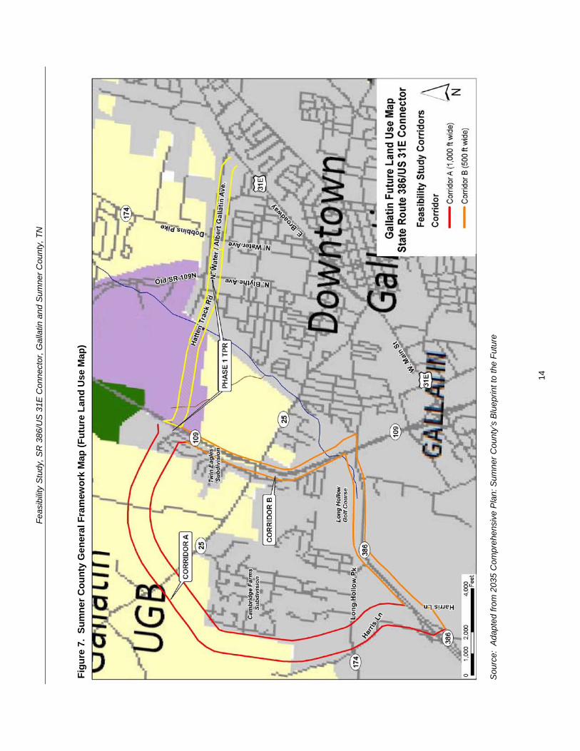
Feasibility Study SR 386US 31E Connector Gallatin and Sumner County TN
33 Transportation Plans There are multiple transportation studies that cover the City of Gallatin and Sumner County The numerous recommended transportation improvements planned within the vicinity of the study area are listed in Appendix B The extensive list of projects in Appendix B are categorized under the following plans bull Gallatin on the Move 2020 City of Gallatin General Development and
Transportation Plan 2008-2020 bull 2035 Comprehensive Plan Sumner Countyrsquos Blueprint to the Future bull Nashville Metropolitan Planning Organizationrsquos 2030 Long Range Transportation
Plan bull Nashville Metropolitan Planning Organizationrsquos Transportation Improvement
Program Fiscal Years 2011-2015 (Draft ndash scheduled for adoption December 2010)
34 Bicycle and Pedestrian Plans Greenway multi-use paths branch greenway trails bicycle lanes and bicycle routes have been planned in Gallatin as part of the overall transportation system to serve as multi-modal community connectors and natural resources conservation areas For the Phase 1 Albert Gallatin AvenueHatten Track Road Extension bike lanes were designated between SR 109 and SR 174 (Dobbins Pike) Bike lanes are also being proposed as part of the Phase 2 SR 386US 31E Connector
Based on the projects shown in Gallatin on the Move 2020 the proposed bicycle and pedestrian projects within the study area are illustrated in Figure 8 Below is a detailed description from the plan of the projects that cross into or are within the study corridors
The City of Gallatin 2006 Greenways Master Plan organized the greenway multi-use paths into eight corridors prioritized according to their feasibility availability and level of connectivity The following two greenway projects are within the study corridors
bull Project 4 ndash Town Creek Trail A multi-use path 357 miles long that is expected to start at Triple Creek Park and generally follow Town Creek southwesterly and then end at a trail head near the SR 109 Bypass (near Ryan Avenue) This trail was ranked first (1) out of eight (8) on the priority list in the 2006 Greenways Master Plan
bull Project 9 - East Camp Creek Trail A trail 472 miles long that would start just south of US 31E and run in a northeasterly direction along the Camp Creek This trail was ranked six (6) out of eight (8) on the priority list in the 2006 Greenways Master Plan
The Plan also shows two greenway spurs to promote further connectivity between the greenways and bicycle and pedestrian facilities
bull Project 12 ndash East Camp Creek Spur ndash ldquoA trail spur extending up Camp Creek towards SR 386 to provide bicycle and pedestrian access into this future development areardquo
bull Project 13 - Hatten Track Trail Spur ldquoA trail spur extending into the Hatten Track from the East Camp Creek Trail to provide bicycle and pedestrian access into the development areardquo
15
Feasibility Study SR 386US 31E Connector Gallatin and Sumner County TN
Bike lanes are on-road facilities designated by striping signing and pavement markings that are for the preferential or exclusive use of bicycles whereas bike routes are on-road facilities indicated by directional and informational markers such as ldquoBike Routerdquo andor ldquoShare the Roadrdquo signs that utilize little or no striping The proposed bike lanes and bike routes in Figure 9 were originally proposed as part of the City of Gallatin Bicycle and Pedestrian Master Plan of 2000 (denoted by ldquoBrdquo) the 2000 Major Thoroughfare Plan (denoted by ldquoTrdquo) and the 2005 State Route 386 Area Study (denoted by ldquoASrdquo) The following bicycle lane and route projects are located within the study corridors
bull Project 14 ndash Long Hollow Pike Provide bike lanes ldquofrom the western boundary of the study area to Red River Road It is recommended that pedestrian and bike facilities are included when roadway improvements are planned including connections at a possible interchange with SR 386rdquo (B T AS)
bull Project 15 ndash US 31E (Nashville Pike) Currently there are no bike lanes along US 31E to accommodate bicyclists Project 15 is intended to provide bike lanes ldquofrom the western boundary of the study area through downtown to the eastern boundary of the study planning area US 31E west of SR 109 is marked as a bicycle route Further it is TDOTrsquos vision to have a continuous bike route from Nashville to Gallatin via US 31E (Nashville Pike) It is recommended that any development or redevelopment along Nashville Pike should include provisions to provide bike lanesrdquo (B AS)
bull Project 16 ndash GreenLea Boulevard Provide bike lanes from Long Hollow Pike to US 31 E (AS)
bull Project 18 ndash Bison Trail Extension Provide bike lanes ldquofrom GreenLea Boulevard to connect up with Saundersville Road in Hendersonville west of Lower Station Camp Creek Roadrdquo (AS)
bull Project 23 - Hatten Track Road Extension Provide bike lanes ldquobetween SR 109 Bypass to Dobbins PikeSR 174North Water Avenue These bike lanes would connect the SR 109 Bypass to other facilities Bike lanes are recommended east of North Water Avenue thus completing a bike system (Project 27)rdquo (B T)
bull Project 26 ndash Red River Road Provide bike lanes ldquofrom Bradford Drive to US 31EMain Street Bike lanes are recommended to connect to the Bradford Drive route to complete a multi-modal loop around the golf course and into downtownrdquo (B)
bull Project 27 ndash SR 174Albert Gallatin Avenue Provide bike lanes ldquofrom North Water Avenue to East Broadway AvenueUS 31E This bike route runs along the north side of Gallatin Municipal Park and would connect with multiple bike facilities Bike lanes are recommended west of North Water Avenue thus completing a bike system (Project 23)rdquo (B)
bull Project 31 ndash Old Highway 109 Provide bike routes ldquofrom Hatten Track Road to the northern planning boundary This planned bike route would provide multiple connections to other bike lanes andor routes connecting the northwest area to downtown Gallatinrdquo (B)
16
Feas
ibili
ty S
tudy
SR
386
US
31E
Con
nect
or G
alla
tin a
nd S
umne
r Cou
nty
TN
Figu
re 8
Pr
opos
ed B
ike
and
Pede
stria
n Pr
ojec
ts
Sou
rce
Ada
pted
from
City
of G
alla
tin 2
006
Gre
enw
ays
Mas
ter P
lan
17
Feasibility Study SR 386US 31E Connector Gallatin and Sumner County TN
Project 35 ndash Dobbins Pike Provide bike routes ldquobetween the northern planning boundary to Albert Gallatin Avenue This is an integral part of a bike route corridor through the heart of the City of Gallatin This section connects the northern portion to the Civic Center Bike Routes are recommended north of Broadway Avenue thus completing a bike system (Project 36 37)rdquo (B)
bull Project 43 (Blythe Avenue) is categorized as a ldquobike lanes and sidewalks projectrdquo that is recommended within the study corridors It is intended ldquoto provide an alternate to North Water and US 31E for access to the recreational areas on the north side of the City It is recommended to incorporate bike lanes and sidewalks with any future roadway wideningrdquo
bull Project 46 (Albert Gallatin Avenue) is categorized as a ldquosidewalks and pedestrian crossing projectrdquo that is recommended within the study corridors It is intended ldquobetween North Water Avenue and US 31E to serve the recreational users of the Gallatin Civic Centerrdquo
35 Other Multi-modal Facilities The Gallatin on the Move 2020 Plan recommends flexible bus service within the City of Gallatin The service would travel along a designated route but would be flexible enough to deviate off route to pick up or drop off passengers For instance if a route traveled from downtown to Volunteer State Community College the service could deviate off route for a certain distance (typically 34 mile) or to a certain boundary This type of service design addresses ADA requirements while expanding coverage to additional areas
Gallatin North-South Flex The north-south flexible bus service using one vehicle is proposed to operate along Albert Gallatin Avenue Blythe Avenue Eastland Street and Water Avenue Sites served include the Civic Center low-income housing along Blythe Avenue at Small Street the downtown square and homes and businesses along Water Avenue Deviations could also serve low-income housing along Lackey Circle low-income housing along Boyers Avenue at Hull Circle and other homes and businesses within a frac34 mile buffer of the route
36 Potential Future Coordination This study has involved local stakeholders including City Council representatives and business owners in early planning and development of the proposed project
A CSX Railroad line runs north-south through the study area of the Phase 1 Albert Gallatin AvenueHatten Track Road Extension which has been incorporated into this study The bridge on North Water Avenue crossing over the depressed railroad line will need to be replaced requiring coordination with the CSX Railroad A representative of CSX was invited to the stakeholder meeting for both the Phase 1 study and this study but did not attend
Coordination with the US Army Corps of Engineers will be required for the blue line stream crossings and possibly for wetland impacts The Tennessee Department of Environment and Conservation will also need to be coordinated with in regard to potential permitting and possibly for hazardous materials
18
Feasibility Study SR 386US 31E Connector Gallatin and Sumner County TN
In addition the City must coordinate with local developers proposing developments within or adjacent to the corridors under study to ensure that future implementation should the study become a project remains viable
40 PRELIMINARY PROJECT NEED This project is intended to address anticipated future transportation needs which have been identified through coordination with local officials and agencies The project area has been targeted as a prime area for future development and its success is dependent on a connected local and regional roadway system
41 Safety The following is a summary of the crash history on SR 109 and SR 174 for the latest three-year period for which data is available (2007 ndash 2009) Table 4 summarizes two segments of roadway and two major intersections in the project area showing the number of crashes and the comparison of the actual crash rate with the statewide average crash rate for the same functional classification The actual rate is derived from a formula that takes into account factors such as total number of crashes length of roadway and the time period over which the crashes occurred
The SR 174 intersection with Belvedere Drive and the SR 174 intersection with SR 109 have crash rates of approximately 15 to 17 times greater than the statewide rate for an intersection of its type thus indicating that safety is a concern along this segment of SR 174 The number of crashes suggests a need for an alternate route or intersection configuration to help separate through and local traffic
Table 4 Crash Summary
SectionIntersection Description Log Mile(s)
Crashes
Actual Crash Rate
State Average
Crash Rate
SR 109 from SR 174 (Long Hollow Pike) to Old Highway 109 421-760 28 035 201
SR 174 (Long Hollow Pike) from SR 386 to SR 109 1354-1459 13 016 275
SR 174 (Long Hollow Pike) intersection with Belvedere Drive 1428 22 156 099
SR 174 (Long Hollow Pike) intersection with ramps for southbound SR 109 1445-1451 24 170 099
SR 174 (Long Hollow Pike) intersection with ramps for northbound SR 109 1452-1449 15 107 099
for this type of roadway
A summary of the 2006-2008 crash data findings for each segment and intersection is as follows
19
Feasibility Study SR 386US 31E Connector Gallatin and Sumner County TN
bull SR 109 from SR 174 (Long Hollow Pike) to Old Highway 109 The statewide average crash rate for a roadway of the same functional classification (urban arterial four lane divided) is 201 while the actual rate is 035 for this segment of SR 109 The actual crash rate for this segment of roadway is well below the statewide average and therefore does not indicate a safety issue There were twenty-eight (28) documented crashes resulting in no fatalities no incapacitating injuries and nine (9) other injuries
bull SR 174 (Long Hollow Pike) from SR 386 to SR 109 The statewide average crash rate for a roadway of the same functional classification (urban minor arterial four lane with turn lane) is 275 while the actual rate is 016 for this segment of SR 174 The actual crash rate for this segment of roadway is well below the statewide average and therefore does not indicate a safety issue There were thirteen (13) documented crashes resulting in no fatalities no incapacitating injuries and four (4) non-incapacitating injuries
bull SR 174 (Long Hollow Pike) intersection with Belvedere Drive The statewide average crash rate for an intersection of this type is 099 The actual rate for the intersection is 156 which is slightly higher than the statewide average This intersection is the location of an existing industrial area that is slated for use in the future as the ldquoGreenlea Business Centerrdquo Of the twenty-two (22) crashes at the signalized intersection with Belvedere Drive ten (10) involved personal injury and thirteen (13) were rear end collisions
bull SR 174 (Long Hollow Pike) intersection with ramps for southbound SR 109 from Log Miles 1445 -1451 The statewide average crash rate for an intersection of this type is 099 while the actual rate for the intersection is 170 which is slightly higher than the statewide average There were twenty-four (24) documented crashes at this intersection resulting in no fatalities or incapacitating injuries but ten (10) non-incapacitating injuries Twelve (12) of the crashes occurred at log mile 1449 which is the signalized intersection for the right-turn ramp onto SB SR-109 and the left-turn ramp from SB SR-109
bull SR 174 (Long Hollow Pike) intersection with ramps for northbound SR 109 from Log Miles 1452 -1459 The statewide average crash rate for an intersection of this type is 099 while the actual rate for the intersection is 107 which is slightly higher than the statewide average There were fifteen (15) documented crashes at this intersection resulting in no fatalities or incapacitating injuries but four (4) non-incapacitating injuries Seven (7) of the crashes occurred at log mile 1458 which is the signalized intersection for the right-turn ramp from NB SR 109 lanes and the left-turn ramp to NB SR 109 lanes
42 System Linkage An alternate route between the southwest and northeast sides of Gallatin is desired The SR 386US 31E Connector will link SR 386 with SR 174 and US 31E north of downtown and provide ldquothroughrdquo traffic the ability to avoid the congested segment of US 31 E through downtown Gallatin
20
Feasibility Study SR 386US 31E Connector Gallatin and Sumner County TN
Furthermore construction of the SR 386US 31E Connector will create a more accessible and resilient transportation system by improving route options dispersing traffic over more roads and therefore reducing delays when a particular roadway segment is closed due to an incident construction or for other reasons
43 Level of Service Analysis To determine how well traffic operates under the No-Build and Build Conditions a level of service analysis was conducted A ldquoLevel of Servicerdquo (LOS) index was used to gauge the operational performance for each roadway segment The LOS is a qualitative measure that describes traffic conditions related to speed and travel time freedom to maneuver traffic interruptions etc There are six levels ranging from ldquoArdquo to ldquoFrdquo with ldquoFrdquo being the worst Each level represents a range of operating conditions Table 6 defines the traffic flow conditions and approximate driver comfort level at each level of service
LOS analysis was performed using the Highway Capacity Software (HCS+) for the No-Build and Build conditions for the base year of 2016 and the design year of 2036 Each roadway segment for Corridors A and B was analyzed using the multi-lane highways module in the HCS+ software The roadway characteristics that affect the LOS and were included in the analysis include free-flow speed lane width and lateral clearance median type access point density general terrain characteristics number of heavy vehicles in the traffic flow and the directional distribution of traffic The HCS+ results are included in Appendix C
It should be noted that the segments of US 31E and the segments where Corridors A and B are combined (Phase 1) were not analyzed using the HCS+ software because the speed limit on the roadway is lower than can be accommodated in the multi-lane highways module Furthermore the traffic signals along these segments will impact the LOS on the roadway segments and an arterial-level analysis is needed to properly determine the LOS In the absence of turning movement counts at the intersections the AADT volumes on these segments were equated to generally accepted volume thresholds to determine the arterial LOS
The results of the LOS analysis are summarized in Table 7
The LOS analysis indicates that under the 2036 No-Build and Build Conditions the segment of SR 386 from Greenlea Boulevard to SR 174 and then SR 174 to N Belvedere Drive operates at LOS E during peak periods Due to projected 2036 AADT volumes in the range of 54950 to 56250 vehicles per day these segments need to be widened by one (1) travel lane in each direction in order to accommodate the projected traffic A more detailed discussion of the improvements needed for these segments is included in Section 52
21
Feasibility Study SR 386US 31E Connector Gallatin and Sumner County TN
Table 5 Definition of Level of Service
Level of Service
Definition
A Free flow operations Vehicles are almost completely unimpeded in their ability to maneuver with the traffic stream The general level of physical and psychological comfort provided to the driver is high
B Reasonable free flow operations The ability to maneuver within the traffic stream is only slightly restricted and the general level of physical and psychological comfort provided to the driver is still high
C Flow with speeds at or near free flow speeds Freedom to maneuver within the traffic stream is noticeably restricted and lane changes require more vigilance on the part of the driver The driver notices an increase in tension
D Speeds decline with increasing traffic Freedom to maneuver within the traffic stream is more noticeably limited The driver experiences reduced physical and psychological comfort levels
E At lower boundary the facility is at capacity Operations are volatile because there are virtually no gaps in the traffic stream There is little room to maneuver The driver experiences poor levels of physical and psychological comfort
F Breakdowns in traffic flow The number of vehicles entering the highway section exceed the capacity or ability of the highway to accommodate that number of vehicles There is little room to maneuver The driver experiences poor levels of physical and psychological comfort
Source TDOT TPR Manual (2010)
Table 6 LOS for Base Year and Design Year Conditions
Roadway Segment
Level of Service 2016 2036
No-Build No-Build Build Corridor A ndash SR 109 Bypass to SR 25 - - A A Corridor A ndash SR 25 to SR 174 - - A A Corridor A ndash SR 174 to SR 386 - - A A Corridor B ndash SR 386 ndash Harris Ln to SR 174 C B E C E C Corridor B ndash SR 174 ndash SR 386 to N Belvedere Dr C B E C E C Corridor B ndash SR 174 ndash N Belvedere Dr to SR 109 Bypass C B D C D C
Corridor B ndash SR 109 Bypass ndash SR 174 to SR 25 A A B A B A Corridor B ndash SR 109 Bypass ndash SR 25 to Hatten Track Extension (phase 1) A A B A B A
Corridor AB (Phase 1) Hatten Track ndash SR 109 Bypass to Blythe Ave - - C
22
Feasibility Study SR 386US 31E Connector Gallatin and Sumner County TN
Roadway Segment Level of Service
2016 2036 No-Build No-Build Build
Corridor AB (Phase 1) Old State Highway 109 ndash Blythe Ave to N Water Ave B B B
Corridor AB (Phase 1) Albert Gallatin Ave ndash N Water Ave to US 31E A B B
US 31E ndash SR 109 to River Rd E F F US 31E ndash River Rd to Eastland St D E D US 31E ndash Eastland St to N Water Ave E F E US 31E ndash N Water Ave to SR 174 B D C
Direction 1Direction 2
44 Capacity As stated in the Transportation Improvement Plan (TIP) for Albert Gallatin AvenueHatten Track Road Extension (Phase 1) the construction of the Extension is anticipated to ldquoaddress congestion occurring on SR 6 [US 31E] and provide an alternative route to access SR 109 and SR 386rdquo The existing traffic on US 31E (SR 6West Main StreetEast Broadway) in downtown Gallatin has a projected 2016 Average Annual Daily Traffic (AADT) volume of approximately 31600 vehiclesday which exceeds the capacity of a five (5) lane urban arterial resulting in LOS E
The construction of both the Phase 1 Extension of SR 174Albert Gallatin Avenue and Hatten Track Road and the Phase 2 SR 386US 31E Connector is anticipated to divert approximately twenty-five (25) percent of the traffic away from US 31E in the downtown area This traffic reduction is anticipated to reduce the AADT on US 31E to a level that can be better accommodated by the existing roadway resulting in LOS C
By reducing the AADT on the most heavily congested segments of US 31E the levels of service at the signalized intersections and associated vehicular delay is anticipated to improve Generally speaking the arterial levels of service improve on US 31E between River Road (SR 25) and SR 174 in the Build Condition More detailed information on the capacity analysis is provided later in this section
Traffic Projections Traffic volumes for the No-Build and Build Conditions were projected in support of this Feasibility Study TDOT provided AADT volumes on roadways within the study area for a base year of 2016 and design year 2036 which were determined using the Nashville MPO travel demand model as well as TDOT 24-hour counts The AADT volumes for the No-Build and Build Conditions for the base and design years are presented in Table 5 The traffic diagrams provided by TDOT is provided in Appendix C
In order to accommodate the projected 2036 Build Condition AADT volumes ranging from 14710 to 17120 vehicles per day a four-lane typical section is needed for Corridor A A more detailed discussion of the proposed typical section for Corridor A is included in Section 52
23
Feasibility Study SR 386US 31E Connector Gallatin and Sumner County TN
Table 7 AADT for Base Year and Design Year Conditions
Roadway Segment
AADT 2016 2036
No-Build No-Build Build Corridor A ndash SR 109 Bypass to SR 25 - - 14710 Corridor A ndash SR 25 to SR 174 - - 16020 Corridor A ndash SR 174 to SR 386 - - 17120 Corridor B ndash SR 386 ndash Harris Ln to SR 174 32300 51680 54950 Corridor B ndash SR 174 ndash SR 386 to N Belvedere Dr 36250 52900 56250
Corridor B ndash SR 174 ndash N Belvedere Dr to SR 109 Bypass 35000 45500 48380
Corridor B ndash SR 109 Bypass ndash SR 174 to SR 25 16500 27400 23290 Corridor B ndash SR 109 Bypass ndash SR 25 to HattenTrack Extension (Phase 1) 13100 22250 21100
Corridor AB (Phase 1) Hatten Track ndash SR 109 Bypass to Blythe Ave - - 10700
Corridor AB (Phase 1) Old Highway 109 ndash Blythe Ave to N Water Ave 7050 8950 15370
Corridor AB (Phase 1) Albert Gallatin Ave ndash NWater Ave to US 31E 5800 8550 11450
US 31E ndash SR 109 to River Rd 31600 41100 39030 US 31E ndash River Rd to Eastland St 20600 28020 22330 US 31E ndash Eastland St to N Water Ave 25000 33250 26500 US 31E ndash N Water Ave to SR 174 14450 19050 15180
Source Tennessee Department of Transportation (2011)
45 Economic Development As discussed in Section 32 and depicted in Figure 6 the Gallatin on the Move 2020 plan specifies more intensive land uses than those currently present in the study area Along Phase 1 of the proposed Albert Gallatin AvenueHatten Track Road the land on the west side of the project adjacent to SR 109 is slated as the North Gallatin Emerging Business Park
In the current study area which includes the above segment but also includes land in and adjacent to the northwest quadrant of the SR 386 and SR 109 intersection the future land use plan specifies land along SR 174 (Long Hollow Pike) and SR 386 for future development as 1) a Regional Activity Center and 2) Greenlea Business Center (includes some existing industrial uses)
Adequate roadway connectivity to and from these areas is essential for the City to realize their future plans for economic development
24
Feasibility Study SR 386US 31E Connector Gallatin and Sumner County TN
50 OPTIONS FOR IMPROVEMENT 51 No-Build Option The No-Build Option provides a baseline for evaluating the benefits and costs created by the Build Options and is defined as the roadway conditions as they currently exist The No-Build Option examines the impacts to the transportation system if the transportation improvements identified as the Build Options are not constructed
Together SR 386 and SR 174 currently serve as the roadway link between Greenlea Boulevard and the SR 109 Bypass Within the study area SR 386 is classified as a freeway with a four (4)-lane divided typical section Between SR 386 and the SR 109 Bypass SR 174 is classified as an urban minor arterial and consists of a five (5)-lane section with a center left turn lane SR 109 Bypass between SR 174 and the proposed Hatten Track extension is classified as an urban principal arterial and consists of four (4)-lane divided typical section US 31E is classified as an urban principal arterial and consists of a five (5)-lane section through downtown Gallatin transitions to a four (4)shylane divided typical section north of River Road then to a two (2)-lane divided section north or N Boyers Avenue and then to a three (3)-lane typical section south of JoAnn Street which continues to the intersection with Albert Gallatin Avenue
As indicated in the LOS analysis in Section 43 the segment of SR 386 from Greenlea Boulevard to SR 174 and then on to N Belvedere Drive operates at LOS E under the No-Build Option Additionally the segments of US 31E from SR 109 Bypass to N Water Avenue operate at either LOS E or F which does not meet minimum operational requirements
25
Feasibility Study SR 386US 31E Connector Gallatin and Sumner County TN
52 Build Options As stated previously and illustrated in Figure 9 there are two corridor options under the Build Condition Corridor A and Corridor B Phase 1 consists of the Albert Gallatin AvenueSR 174 Extension which is proposed to end at an interchange with SR 109 Phase 2 consists of either Corridor A or Corridor B which both utilize the Phase 1 extension from SR 109 to US 31E A description of each Build Option follows
Appendix D contains the typical sections and layout sheets for Phase 2 A description of the roadway segment for each feature follows
Corridor A
bull Corridor A is on new alignment from the SR 386Green Lea interchange and travels north along the east side of Liberty Branch Creek intersecting with SR 25 continues northeast and intersects with Douglas Lane and then continues east to SR 109 at which point it intersects the Phase 1 Albert Gallatin AvenueHatten Track Road extension east to US 31E Corridor A is approximately 39 miles in length
bull The typical section includes four twelve (12)-foot lanes (two (2) in each direction) a 48-foot depressed median six (6)-foot inside shoulders and twelve (12)-foot shared use outside shoulders (to accommodate bike lanes) within 200 feet of proposed right-of-way
bull The widening of SR 386 and SR 174 as described under the Corridor B option must be completed in addition to the building of Corridor A in order to ensure adequate traffic flow and operations on the surrounding roadway network
Corridor B
bull Corridor B follows SR 386 from the interchange with Greenlea Boulevard east to the intersection with Long Hollow Pike at which point the state routing designation changes to SR 174 Corridor B then follows SR 174 to the interchange with SR 109 it then travels north on SR 109 until it intersects with the Phase 1 Albert Gallatin AvenueHatten Track Road extension Corridor B is approximately 34 miles in length
bull Under the Corridor B option SR 386 and SR 174 between Greenlea Boulevard and the SR 109 Bypass will be widened for approximately 14 miles to account for future projected traffic growth
o SR 386 will be widened from four (4) to six (6) lanes (three (3) in each direction) each having a width of twelve (12) feet with twelve (12)-foot shoulders and a 64-foot wide depressed median The present right-ofshyway width for this section is 260 feet with additional right-of-way and easements to be obtained as needed for construction
o The typical section for the improved segment of SR 174 will be widened from five (5) to seven (7) twelve (12)-foot travel lanes (three (3) in each direction and a twelve (12)-foot center turn lane) with twelve (12)-foot shared use outside shoulders (to accommodate bike lanes) This widened section would require a minimum right-of-way of 180 feet
26
Feas
ibili
ty S
tudy
SR
386
US
31E
Con
nect
or G
alla
tin a
nd S
umne
r Cou
nty
TN
Figu
re 9
B
uild
Opt
ions
27
Feasibility Study SR 386US 31E Connector Gallatin and Sumner County TN
bull In addition to widening the identified segments of SR 386 and SR 174 several signalized intersections and two bridges will need to be improved so that the additional lanes can be accommodated The intersections that will require improvements include the following
- SR 386 at SR 174 - SR 174 at Belvedere Drive - SR 174 interchange with SR 109 Bypass
bull While all three of these intersections will require upgrades associated with the roadway widening improvements the SR 174 interchange with the SR 109 Bypass will also require geometric alterations so that traffic can smoothly transition from one route to the other The southbound off-ramp from SR 109 Bypass will need to be extended to form the third westbound lane of SR 174 The third eastbound lane of SR 174 will become a right-turn-only lane onto SR 109 Bypass
bull In addition to the intersection improvements the bridge over East Camp Creek as well as the westbound bridge over Liberty Branch Creek will both need to be widened to accommodate the future widening and meet traffic demands
bull If Corridor B is selected without Corridor A an eastbound to northbound SR 109 clover leaf loop will be needed to accommodate future left turn volumes This would require re-alignment of the ramps on the east side of SR 109 and widening of the bridge on SR 109 at East Camp Creek
Costs TDOT planning level base per mile costs were used to develop estimates for the corridor options and are summarized in Table 8 It should be noted that even if Corridor A is constructed Corridor B will need to be widened along SR 386 and SR 174 to accommodate the future traffic volumes The interchange improvements at SR 109 however would not be needed as motorists travelling north to SR 109 would utilize Corridor A The widening cost for SR 386 and SR 174 is approximately $10000000
Also a two (2) lane depressed median section could be constructed as an interim phase for Corridor A allowing future build out to four (4) lanes which would reduce the interim phase construction cost approximately $11000000
Table 8 Planning Level Costs for Build Options
Item Corridor A (39 Miles)
Corridor B (34 Miles)
Right-of-Way $3608400 $2229675 Total Construction $30490980 $17252905 Preliminary Engineering $3049098 $1725291 Total Cost $37148478 $21207871
53 Possible Modifications to the State Route System During the NEPA phase when the preferred alignment is selected TDOT may review the current state route system for possible modification For example possible changes to the state routing system could include designating SR 174 to follow Long Hollow Pike to
28
Feasibility Study SR 386US 31E Connector Gallatin and Sumner County TN
Greenlea Boulevard and then follow Corridor A to SR 109 continue across SR 109 along Albert Gallatin AvenueHatten Track Road Extension (Phase 1) and reconnect with the existing SR 174 at Dobbins Pike (see Figure 10) Accordingly the SR 174 designation would be removed from Greenlea Boulevard through downtown to Dobbins Pike Based on these possible changes approximately 26 miles would be removed and 54 miles would be added resulting in a net gain of 294 miles to the state route system
29
Feas
ibili
ty S
tudy
SR
386
US
31E
Con
nect
or G
alla
tin a
nd S
umne
r Cou
nty
TN
Figu
re 1
0 P
ropo
sed
Cha
nges
to S
tate
Rou
ting
Syst
em
30
Feasibility Study SR 386US 31E Connector Gallatin and Sumner County TN
54 Control of Access The City of Gallatin Zoning Ordinance (amended October 20 2009) establishes access management standards in Section 1306 for driveways providing vehicular access from arterial collector and local streets (roads in the study area are classified as arterials and collector streets) In addition Gallatin on the Move 2020 outlines additional access management policies that should be applied to the Cityrsquos arterial road system (including long range planning project planning and design right-of-way acquisition redesign of existing arterial corridors and driveway permitting)
Within the study area SR 174 between SR 386 and SR 109 is currently not access controlled and is subject to future development SR 109 is access controlled between SR 25 and Old Highway 109 The proposed extension will ultimately not require a break in the access control on SR 109 because an interchange is planned to allow access between SR 109 and the Albert Gallatin AvenueHatten Track Road Extension (Phase 1) and the SR 386US 31E Connector
In addition the project will be designed to provide limited access along the proposed Build Option ndash Corridor A as well as along the Hatten Track extension (Phase 1) from SR 109 to the east For an at-grade intersection the access control distance will be a minimum of 100 feet from any intersection For an interchange the access control will be 300 feet from the ramp terminals treating each side of the cross road independently
55 Environmental Constraints The environmental screening presented in this Feasibility Study has been provided by the TDOT Early Environmental Screening (EES) reports A detailed environmental study of the corridors identified in this Feasibility Study would occur during future project phases in compliance with National Environmental Policy Act provisions Environmental screening maps produced in support of the analysis in this report are found in Appendix E A full copy of the TDOT EES reports can be found in Appendix F The TDOT EES reports revealed the following
Impacts Evaluated within 1000 feet of the Project Area bull Community ResourceInstitution
The project area is home to one public school Joe Shafer Middle School is located at 240 Albert Gallatin Avenue which is to the north of Corridors A and B
bull Minority Population of over 24 Percent Appendix E Map 1 illustrates the minority population in the project area by Census Block for the 2000 US Census The average percentage of minority populations for the City of Gallatin in 2000 was 217 percent The county-wide minority population for Sumner County was 85 percent The City of Gallatin average is comparable to the statewide average of 198 percent but the Sumner County average is considerably lower than the statewide average Among the census blocks encompassing the project area one has a minority population higher than the City of Gallatin as a whole This Census Block is identified as Census Tract 205 Block Group 1 Block 1014 and is contained within Corridor B
31
Feasibility Study SR 386US 31E Connector Gallatin and Sumner County TN
The percentage of the population that identified themselves as a minority in this Census Block is 33 percent (or 7 out of 21 persons)
bull Sensitive Community Population Linguistically Isolated Populations Linguistically isolated populations are located within 1000 feet of the project area
bull Population living Below Poverty above the State Average of 135 Percent Appendix E Map 2 shows the percentage of the population living below poverty in the project area by Census Block Group The project area is encompassed by four Census Block Groups The percent of the population living below poverty in 2000 (based on 1999 income) within the City of Gallatin averaged 144 percent This is higher than the County and statewide averages of 81 and 135 percent respectively One Census Block Group within the project area has a percent of the population below poverty that is higher than the City County and statewide averages This Block Group is Census Tract 208 Block Group 2 and has 159 percent of the population in the Block Group living below poverty (or 289 out of 1807 persons) This Block Group is crossed by Corridor B (as highlighted in Appendix E Map 2)
bull Possible Substantial Impact on the Endangered Bat Species There is a known occurrence of Indiana or grey bats within four (4) miles of the project area It is anticipated that a) avoidanceminimization of potential impacts to species will be needed b) surveys for the species for the project may be required c) coordination with USFWS will be needed to establish Section 7 biological conclusions for the project and d) seasonal construction limitations will likely be necessary
bull Impact on Railroads A railroad exists within the project study area It is anticipated that impacts to the railroad can be avoided since the proposed project will be greater than 200 feet from the railroad There is the remote possibility of minor involvement on railroad property to accommodate drainage but there will be no grade crossing
bull Cemetery Sites and Properties There are no known cemetery sites within or abutting the project area
Impacts Evaluated within 2000 feet of the Project Area
bull TWRA Lakes and Other Public Lands No TWRA lake property is found within the project area but it is anticipated that a medium impact on the project is anticipated as a public park (city owned little league park) lies within the project area It is possible to locate the proposed project in such a way that it avoids any impacts or taking of the park property A moderate level of effort and time will be required to resolve the projectrsquos environmental impact on the park and to move forward with project development Indirect impacts (audible and visual) to the park may occur and need to be studied If there is indirect impact additional design would be needed to design the appropriate mitigation measures
32
Feasibility Study SR 386US 31E Connector Gallatin and Sumner County TN
bull National Register Sites No impacts are anticipated to any National Register of Historic Place (NRHP) listed properties as there are no properties abutting or within the project area
According to the State Historic Preservation Office (SHPO) records approximately ten (10) properties in Sumner County have been surveyed within the project area although none of which were deemed eligible for the NRHP by the surveyor Additional survey work is needed in future project phases to determine NRHP eligibility for the resources that are within the projectrsquos Area of Potential Effect (APE)
bull Superfund Sites No impacts are anticipated as there are no known contaminated land tracts abutting or within the project area
bull Pyritic Rock Pyritic rock is not known to occur in the project area and thus the project does not involve exaction Limestone and dolomite are present
Impacts Evaluated within 4000 feet of the Project Area
bull Terrestrial Species A minimal impact on the project is predicated as there is a known rare or state protected terrestrial species (the Thryomanes bewickii) located within the project area A survey for the species may be required
bull Wetland and Floodplain Impacts Substantial impacts to wetlands within the project area are probable A total of 33 acres of wetlands exists within 4000 feet of the project area Compensatory mitigation will be required Design effort will be needed to avoid and minimize impacts to wetlands to the maximum extent practicable
According to Federal Emergency Management Association (FEMA) Flood Insurance Rate Maps (FIRM) the project area is bisected by the 100-year floodplain Areas along East Camp Creek and Liberty Branch fall within this flood zone FIRMs depicting the 100-year floodplains within the project area were digitized and are included in Appendix E Map 3 Both Corridor A and Corridor B cross the 100-year floodplain
bull TDEC Conservation Sites and TDEC Scenic Waterways No TDEC Conservation Sites or scenic waterways are within the project area
bull Tennessee Natural Areas Program The project area does not include a Natural Area
bull Wildlife Management Area No impacts are anticipated to any Wildlife Management Areas as there are none that abut or are located within the project area
33
Feasibility Study SR 386US 31E Connector Gallatin and Sumner County TN
Impacts Evaluated within 10000 feet of the Project Area
bull Caves The Lackey Cave is present within 10000 feet of the project area and thus a medium project impact is anticipated It is possible to avoid impacts to the cave in future design phases of the project With the presence of a cave there are likely concerns involving the federally and state protected Indiana grey bat Additional design will be needed to avoid impacts to cave passages or entrances to develop access to the cave (if required) to conduct stability analysis of the project to determine right of way acquisition development and coordination of corrective actions for environmental effects (ie mitigation etc) associated with project construction in this terrain and to design water quality treatment measures Construction time will likely be affected either by requiring an extended contract period or strategic placement of the project in the let schedule to maximize the contractors time to construct the project
bull Aquatic Species There is no known occurrence of a rare state or federally-protected aquatic species within the project area
60 ASSESSMENT OF CORRIDOR OPTIONS TDOT has developed a set of seven guiding principles by which all transportation projects are to be evaluated These guiding principles address concerns for system management mobility economic growth safety community environmental stewardship and fiscal responsibility This section includes a discussion of each guiding principle as it pertains to the options evaluated in this Feasibility Study
Guiding Principle 1 Preserve and Manage the Existing Transportation System When the construction of SR 386 (Vietnam Veterans Boulevard) was completed SR 386 became a major asset to the City of Gallatin acting as a corridor to accommodate both local and through traffic and providing access to Gallatinrsquos downtown commercial core via SR 174Long Hollow Pike and US 31E Over time the section of US 31E through downtown has become congested The function of the SR 386US 31E Connector will be to provide the second phase of an east-west connector between SR 386 and US 31ESR 6East Broadway on the north side of the City thereby diverting some of the traffic away from US 31E from the most congested segments through downtown The proposed improvements as part of the Phase 2 project will provide a new connection between SR 386 and SR 109 which will result in preservation of the existing transportation system in the City of Gallatin
SR 109 SR 174 and US 31E are critical travel corridors for the City of Gallatin US 31E is not only a key commercial corridor for area residents and truck traffic but it also connects Gallatin to the towns of Bethpage and Westmoreland in Tennessee and Scottsville in Kentucky to the north and Nashville to the south SR 174 connects Gallatin to Oak Grove Tennessee and Scottsville Kentucky to the north and SR 109 connects Gallatin to Portland to the north The Build Option presented as Corridor A involves construction of a roadway on new location which can help extend the life of these
34
Feasibility Study SR 386US 31E Connector Gallatin and Sumner County TN
important existing routes by diverting some regional traffic andor lessening the future growth of traffic on these roads as indicated under the Build Scenario
Guiding Principle 2 Move a Growing Diverse and Active Population As discussed in Section 31 of this Feasibility Study the population of the City of Gallatin grew by 561 percent between 1990 and 2008 and Sumner County grew by 505 percent figures higher than the State of Tennessee as a whole (274 percent) The options presented in this study are intended to provide improved traffic conditions to support the arearsquos growing population and increasing amounts of externally generated traffic as well as support recommended future land use for the area which is outlined in Gallatin on the Move 2020
The SR 386US 31E Connector is anticipated to divert some traffic away from US 31E through downtown potentially reducing congestion and creating a safer and more hospitable environment for local traffic pedestrians and bicyclists
Guiding Principle 3 Support the Statersquos Economy Both SR 109 and US 31E are regional roadways that facilitate the movement of goods and services The SR 386US 31E Connector will provide better access to and support development in the area to the west of East Camp Creek which supports the vision of the City of Gallatin to promote the area as an emerging business park
Guiding Principle 4 Maximize Safety and Security The proposed project will create opportunities for the separation of through and local traffic alleviating traffic congestion in the downtown area especially on US 31E The proposed project will also eliminate the need for some tractor trailers and other large trucks to travel though the City which will potentially reduce crashes with local traffic which typically turns and stops frequently
Guiding Principle 5 Build Partnerships for Livable Communities A stakeholder meeting was held in support of this Feasibility Study in order to obtain input on transportation problems and other issues in the study area During the TPR development process additional coordination will be undertaken Additionally in keeping with TDOTrsquos Public Involvement Process the provisions of NEPA and Safe Accountable Flexible Efficient Transportation Equity Act ndash A Legacy for Users (SAFETEA-LU) and the provisions of the Tennessee Environmental Streamlining Agreement (TESA) if warranted this project will be coordinated with the public and additional governmental agencies beginning in the NEPA project phase
35
Feasibility Study SR 386US 31E Connector Gallatin and Sumner County TN
Guiding Principle 6 Promote Stewardship of the Environment Potential adverse environmental impacts were identified in the TDOT Environmental Screening and were considered in the development of the corridors included in this study Detailed technical environmental studies are needed to fully address the impacts
Should federal funding be obtained for the project a NEPA document will be prepared in future phases of the project The NEPA document will assess the projectrsquos impacts on the natural social and built environment and all efforts will be made to avoid adverse impacts during design development If impacts cannot be avoided they will be minimized and mitigated Early and continuous coordination will continue to take place with the appropriate federal state and local agencies and the public This coordination will assist with the identification of important resources early in the planning process and will help ensure the proposed project promotes stewardship of the environment
Guiding Principle 7 Emphasize Financial Responsibility The cost estimates presented in this study are offered for planning comparison purposes only and will fluctuate with inflation and any unexpected conditions It is TDOTrsquos goal to follow a comprehensive transportation planning process promote coordination among public and private operators of transportation systems and support efforts to provide stable funding for the public component of the transportation system This entails exercising financial responsibility in the development and implementation of roadway projects and minimizing cost to taxpayers
36
Feasibility Study SR 386US 31E Connector Gallatin and Sumner County TN
70 SUMMARY In summary this project is needed to address anticipated future transportation needs which have been identified through coordination with local officials and agencies The project area has been targeted as a prime area for future development and its success is dependent on a connected local and regional roadway system The project is needed based on the following
bull Improve Safety ndash Both the SR 174 intersection with Belvedere Drive and with SR 109 have crash rates of approximately 15 to 17 times greater than the statewide rate for an intersection of its type thus indicating that safety is a concern along this segment of SR 174
bull Promote System Linkage ndash An alternate route is desired between the southwest and northeast sides of town The SR 386US 31E Connector will provide the desired connectivity by linking SR 386 with SR 174 and US 31E north of downtown
bull Address Capacity Issues ndash By allowing travelers to use the SR 386US 31E Connector to access points northeast of downtown this project may reduce future congestion on US 31E through downtown Gallatin which will improve the traffic operations and safety along this segment of roadway It should also be noted that it is not cost beneficial to widen US 31E through downtown Gallatin
bull Meet Economic Development Demands ndash The Gallatin on the Move 2020 plan specifies more intensive land uses than those currently present in the study area
As stated previously there are two corridor options under the Build Condition for the SR 386US 31E Connector (Phase 2) Corridor A and Corridor B Planning level cost estimates for the corridor options were developed and are summarized in Table 9 It should be noted that even if Corridor A is constructed Corridor B will need to be widened along SR 386 and SR 174 to accommodate the future traffic volumes The interchange improvements at SR 109 however would not be needed as motorists travelling north to SR 109 would utilize Corridor A The widening cost for SR 386 and SR 174 is approximately $10000000
Also a two (2) lane depressed median section could be constructed as an interim phase for Corridor A allowing future build out to four (4) lanes which reduce the interim phase construction cost approximately $11000000
Table 9 Planning Level Costs for Build Options
Item Corridor A (39 Miles)
Corridor B (34 Miles)
Right-of-Way $3608400 $2229675 Total Construction $30490980 $17252905 Preliminary Engineering $3049098 $1725291 Total Cost $37148478 $21207871
If federal funding is utilized for this proposed project a TPR and NEPA document will be undertaken
37
Feasibility Study SR 386US 31E Connector Gallatin and Sumner County TN
Bike lanes are on-road facilities designated by striping signing and pavement markings that are for the preferential or exclusive use of bicycles whereas bike routes are on-road facilities indicated by directional and informational markers such as ldquoBike Routerdquo andor ldquoShare the Roadrdquo signs that utilize little or no striping The proposed bike lanes and bike routes in Figure 9 were originally proposed as part of the City of Gallatin Bicycle and Pedestrian Master Plan of 2000 (denoted by ldquoBrdquo) the 2000 Major Thoroughfare Plan (denoted by ldquoTrdquo) and the 2005 State Route 386 Area Study (denoted by ldquoASrdquo) The following bicycle lane and route projects are located within the study corridors
bull Project 14 ndash Long Hollow Pike Provide bike lanes ldquofrom the western boundary of the study area to Red River Road It is recommended that pedestrian and bike facilities are included when roadway improvements are planned including connections at a possible interchange with SR 386rdquo (B T AS)
bull Project 15 ndash US 31E (Nashville Pike) Currently there are no bike lanes along US 31E to accommodate bicyclists Project 15 is intended to provide bike lanes ldquofrom the western boundary of the study area through downtown to the eastern boundary of the study planning area US 31E west of SR 109 is marked as a bicycle route Further it is TDOTrsquos vision to have a continuous bike route from Nashville to Gallatin via US 31E (Nashville Pike) It is recommended that any development or redevelopment along Nashville Pike should include provisions to provide bike lanesrdquo (B AS)
bull Project 16 ndash GreenLea Boulevard Provide bike lanes from Long Hollow Pike to US 31 E (AS)
bull Project 18 ndash Bison Trail Extension Provide bike lanes ldquofrom GreenLea Boulevard to connect up with Saundersville Road in Hendersonville west of Lower Station Camp Creek Roadrdquo (AS)
bull Project 23 - Hatten Track Road Extension Provide bike lanes ldquobetween SR 109 Bypass to Dobbins PikeSR 174North Water Avenue These bike lanes would connect the SR 109 Bypass to other facilities Bike lanes are recommended east of North Water Avenue thus completing a bike system (Project 27)rdquo (B T)
bull Project 26 ndash Red River Road Provide bike lanes ldquofrom Bradford Drive to US 31EMain Street Bike lanes are recommended to connect to the Bradford Drive route to complete a multi-modal loop around the golf course and into downtownrdquo (B)
bull Project 27 ndash SR 174Albert Gallatin Avenue Provide bike lanes ldquofrom North Water Avenue to East Broadway AvenueUS 31E This bike route runs along the north side of Gallatin Municipal Park and would connect with multiple bike facilities Bike lanes are recommended west of North Water Avenue thus completing a bike system (Project 23)rdquo (B)
bull Project 31 ndash Old Highway 109 Provide bike routes ldquofrom Hatten Track Road to the northern planning boundary This planned bike route would provide multiple connections to other bike lanes andor routes connecting the northwest area to downtown Gallatinrdquo (B)
16
Feas
ibili
ty S
tudy
SR
386
US
31E
Con
nect
or G
alla
tin a
nd S
umne
r Cou
nty
TN
Figu
re 8
Pr
opos
ed B
ike
and
Pede
stria
n Pr
ojec
ts
Sou
rce
Ada
pted
from
City
of G
alla
tin 2
006
Gre
enw
ays
Mas
ter P
lan
17
Feasibility Study SR 386US 31E Connector Gallatin and Sumner County TN
Project 35 ndash Dobbins Pike Provide bike routes ldquobetween the northern planning boundary to Albert Gallatin Avenue This is an integral part of a bike route corridor through the heart of the City of Gallatin This section connects the northern portion to the Civic Center Bike Routes are recommended north of Broadway Avenue thus completing a bike system (Project 36 37)rdquo (B)
bull Project 43 (Blythe Avenue) is categorized as a ldquobike lanes and sidewalks projectrdquo that is recommended within the study corridors It is intended ldquoto provide an alternate to North Water and US 31E for access to the recreational areas on the north side of the City It is recommended to incorporate bike lanes and sidewalks with any future roadway wideningrdquo
bull Project 46 (Albert Gallatin Avenue) is categorized as a ldquosidewalks and pedestrian crossing projectrdquo that is recommended within the study corridors It is intended ldquobetween North Water Avenue and US 31E to serve the recreational users of the Gallatin Civic Centerrdquo
35 Other Multi-modal Facilities The Gallatin on the Move 2020 Plan recommends flexible bus service within the City of Gallatin The service would travel along a designated route but would be flexible enough to deviate off route to pick up or drop off passengers For instance if a route traveled from downtown to Volunteer State Community College the service could deviate off route for a certain distance (typically 34 mile) or to a certain boundary This type of service design addresses ADA requirements while expanding coverage to additional areas
Gallatin North-South Flex The north-south flexible bus service using one vehicle is proposed to operate along Albert Gallatin Avenue Blythe Avenue Eastland Street and Water Avenue Sites served include the Civic Center low-income housing along Blythe Avenue at Small Street the downtown square and homes and businesses along Water Avenue Deviations could also serve low-income housing along Lackey Circle low-income housing along Boyers Avenue at Hull Circle and other homes and businesses within a frac34 mile buffer of the route
36 Potential Future Coordination This study has involved local stakeholders including City Council representatives and business owners in early planning and development of the proposed project
A CSX Railroad line runs north-south through the study area of the Phase 1 Albert Gallatin AvenueHatten Track Road Extension which has been incorporated into this study The bridge on North Water Avenue crossing over the depressed railroad line will need to be replaced requiring coordination with the CSX Railroad A representative of CSX was invited to the stakeholder meeting for both the Phase 1 study and this study but did not attend
Coordination with the US Army Corps of Engineers will be required for the blue line stream crossings and possibly for wetland impacts The Tennessee Department of Environment and Conservation will also need to be coordinated with in regard to potential permitting and possibly for hazardous materials
18
Feasibility Study SR 386US 31E Connector Gallatin and Sumner County TN
In addition the City must coordinate with local developers proposing developments within or adjacent to the corridors under study to ensure that future implementation should the study become a project remains viable
40 PRELIMINARY PROJECT NEED This project is intended to address anticipated future transportation needs which have been identified through coordination with local officials and agencies The project area has been targeted as a prime area for future development and its success is dependent on a connected local and regional roadway system
41 Safety The following is a summary of the crash history on SR 109 and SR 174 for the latest three-year period for which data is available (2007 ndash 2009) Table 4 summarizes two segments of roadway and two major intersections in the project area showing the number of crashes and the comparison of the actual crash rate with the statewide average crash rate for the same functional classification The actual rate is derived from a formula that takes into account factors such as total number of crashes length of roadway and the time period over which the crashes occurred
The SR 174 intersection with Belvedere Drive and the SR 174 intersection with SR 109 have crash rates of approximately 15 to 17 times greater than the statewide rate for an intersection of its type thus indicating that safety is a concern along this segment of SR 174 The number of crashes suggests a need for an alternate route or intersection configuration to help separate through and local traffic
Table 4 Crash Summary
SectionIntersection Description Log Mile(s)
Crashes
Actual Crash Rate
State Average
Crash Rate
SR 109 from SR 174 (Long Hollow Pike) to Old Highway 109 421-760 28 035 201
SR 174 (Long Hollow Pike) from SR 386 to SR 109 1354-1459 13 016 275
SR 174 (Long Hollow Pike) intersection with Belvedere Drive 1428 22 156 099
SR 174 (Long Hollow Pike) intersection with ramps for southbound SR 109 1445-1451 24 170 099
SR 174 (Long Hollow Pike) intersection with ramps for northbound SR 109 1452-1449 15 107 099
for this type of roadway
A summary of the 2006-2008 crash data findings for each segment and intersection is as follows
19
Feasibility Study SR 386US 31E Connector Gallatin and Sumner County TN
bull SR 109 from SR 174 (Long Hollow Pike) to Old Highway 109 The statewide average crash rate for a roadway of the same functional classification (urban arterial four lane divided) is 201 while the actual rate is 035 for this segment of SR 109 The actual crash rate for this segment of roadway is well below the statewide average and therefore does not indicate a safety issue There were twenty-eight (28) documented crashes resulting in no fatalities no incapacitating injuries and nine (9) other injuries
bull SR 174 (Long Hollow Pike) from SR 386 to SR 109 The statewide average crash rate for a roadway of the same functional classification (urban minor arterial four lane with turn lane) is 275 while the actual rate is 016 for this segment of SR 174 The actual crash rate for this segment of roadway is well below the statewide average and therefore does not indicate a safety issue There were thirteen (13) documented crashes resulting in no fatalities no incapacitating injuries and four (4) non-incapacitating injuries
bull SR 174 (Long Hollow Pike) intersection with Belvedere Drive The statewide average crash rate for an intersection of this type is 099 The actual rate for the intersection is 156 which is slightly higher than the statewide average This intersection is the location of an existing industrial area that is slated for use in the future as the ldquoGreenlea Business Centerrdquo Of the twenty-two (22) crashes at the signalized intersection with Belvedere Drive ten (10) involved personal injury and thirteen (13) were rear end collisions
bull SR 174 (Long Hollow Pike) intersection with ramps for southbound SR 109 from Log Miles 1445 -1451 The statewide average crash rate for an intersection of this type is 099 while the actual rate for the intersection is 170 which is slightly higher than the statewide average There were twenty-four (24) documented crashes at this intersection resulting in no fatalities or incapacitating injuries but ten (10) non-incapacitating injuries Twelve (12) of the crashes occurred at log mile 1449 which is the signalized intersection for the right-turn ramp onto SB SR-109 and the left-turn ramp from SB SR-109
bull SR 174 (Long Hollow Pike) intersection with ramps for northbound SR 109 from Log Miles 1452 -1459 The statewide average crash rate for an intersection of this type is 099 while the actual rate for the intersection is 107 which is slightly higher than the statewide average There were fifteen (15) documented crashes at this intersection resulting in no fatalities or incapacitating injuries but four (4) non-incapacitating injuries Seven (7) of the crashes occurred at log mile 1458 which is the signalized intersection for the right-turn ramp from NB SR 109 lanes and the left-turn ramp to NB SR 109 lanes
42 System Linkage An alternate route between the southwest and northeast sides of Gallatin is desired The SR 386US 31E Connector will link SR 386 with SR 174 and US 31E north of downtown and provide ldquothroughrdquo traffic the ability to avoid the congested segment of US 31 E through downtown Gallatin
20
Feasibility Study SR 386US 31E Connector Gallatin and Sumner County TN
Furthermore construction of the SR 386US 31E Connector will create a more accessible and resilient transportation system by improving route options dispersing traffic over more roads and therefore reducing delays when a particular roadway segment is closed due to an incident construction or for other reasons
43 Level of Service Analysis To determine how well traffic operates under the No-Build and Build Conditions a level of service analysis was conducted A ldquoLevel of Servicerdquo (LOS) index was used to gauge the operational performance for each roadway segment The LOS is a qualitative measure that describes traffic conditions related to speed and travel time freedom to maneuver traffic interruptions etc There are six levels ranging from ldquoArdquo to ldquoFrdquo with ldquoFrdquo being the worst Each level represents a range of operating conditions Table 6 defines the traffic flow conditions and approximate driver comfort level at each level of service
LOS analysis was performed using the Highway Capacity Software (HCS+) for the No-Build and Build conditions for the base year of 2016 and the design year of 2036 Each roadway segment for Corridors A and B was analyzed using the multi-lane highways module in the HCS+ software The roadway characteristics that affect the LOS and were included in the analysis include free-flow speed lane width and lateral clearance median type access point density general terrain characteristics number of heavy vehicles in the traffic flow and the directional distribution of traffic The HCS+ results are included in Appendix C
It should be noted that the segments of US 31E and the segments where Corridors A and B are combined (Phase 1) were not analyzed using the HCS+ software because the speed limit on the roadway is lower than can be accommodated in the multi-lane highways module Furthermore the traffic signals along these segments will impact the LOS on the roadway segments and an arterial-level analysis is needed to properly determine the LOS In the absence of turning movement counts at the intersections the AADT volumes on these segments were equated to generally accepted volume thresholds to determine the arterial LOS
The results of the LOS analysis are summarized in Table 7
The LOS analysis indicates that under the 2036 No-Build and Build Conditions the segment of SR 386 from Greenlea Boulevard to SR 174 and then SR 174 to N Belvedere Drive operates at LOS E during peak periods Due to projected 2036 AADT volumes in the range of 54950 to 56250 vehicles per day these segments need to be widened by one (1) travel lane in each direction in order to accommodate the projected traffic A more detailed discussion of the improvements needed for these segments is included in Section 52
21
Feasibility Study SR 386US 31E Connector Gallatin and Sumner County TN
Table 5 Definition of Level of Service
Level of Service
Definition
A Free flow operations Vehicles are almost completely unimpeded in their ability to maneuver with the traffic stream The general level of physical and psychological comfort provided to the driver is high
B Reasonable free flow operations The ability to maneuver within the traffic stream is only slightly restricted and the general level of physical and psychological comfort provided to the driver is still high
C Flow with speeds at or near free flow speeds Freedom to maneuver within the traffic stream is noticeably restricted and lane changes require more vigilance on the part of the driver The driver notices an increase in tension
D Speeds decline with increasing traffic Freedom to maneuver within the traffic stream is more noticeably limited The driver experiences reduced physical and psychological comfort levels
E At lower boundary the facility is at capacity Operations are volatile because there are virtually no gaps in the traffic stream There is little room to maneuver The driver experiences poor levels of physical and psychological comfort
F Breakdowns in traffic flow The number of vehicles entering the highway section exceed the capacity or ability of the highway to accommodate that number of vehicles There is little room to maneuver The driver experiences poor levels of physical and psychological comfort
Source TDOT TPR Manual (2010)
Table 6 LOS for Base Year and Design Year Conditions
Roadway Segment
Level of Service 2016 2036
No-Build No-Build Build Corridor A ndash SR 109 Bypass to SR 25 - - A A Corridor A ndash SR 25 to SR 174 - - A A Corridor A ndash SR 174 to SR 386 - - A A Corridor B ndash SR 386 ndash Harris Ln to SR 174 C B E C E C Corridor B ndash SR 174 ndash SR 386 to N Belvedere Dr C B E C E C Corridor B ndash SR 174 ndash N Belvedere Dr to SR 109 Bypass C B D C D C
Corridor B ndash SR 109 Bypass ndash SR 174 to SR 25 A A B A B A Corridor B ndash SR 109 Bypass ndash SR 25 to Hatten Track Extension (phase 1) A A B A B A
Corridor AB (Phase 1) Hatten Track ndash SR 109 Bypass to Blythe Ave - - C
22
Feasibility Study SR 386US 31E Connector Gallatin and Sumner County TN
Roadway Segment Level of Service
2016 2036 No-Build No-Build Build
Corridor AB (Phase 1) Old State Highway 109 ndash Blythe Ave to N Water Ave B B B
Corridor AB (Phase 1) Albert Gallatin Ave ndash N Water Ave to US 31E A B B
US 31E ndash SR 109 to River Rd E F F US 31E ndash River Rd to Eastland St D E D US 31E ndash Eastland St to N Water Ave E F E US 31E ndash N Water Ave to SR 174 B D C
Direction 1Direction 2
44 Capacity As stated in the Transportation Improvement Plan (TIP) for Albert Gallatin AvenueHatten Track Road Extension (Phase 1) the construction of the Extension is anticipated to ldquoaddress congestion occurring on SR 6 [US 31E] and provide an alternative route to access SR 109 and SR 386rdquo The existing traffic on US 31E (SR 6West Main StreetEast Broadway) in downtown Gallatin has a projected 2016 Average Annual Daily Traffic (AADT) volume of approximately 31600 vehiclesday which exceeds the capacity of a five (5) lane urban arterial resulting in LOS E
The construction of both the Phase 1 Extension of SR 174Albert Gallatin Avenue and Hatten Track Road and the Phase 2 SR 386US 31E Connector is anticipated to divert approximately twenty-five (25) percent of the traffic away from US 31E in the downtown area This traffic reduction is anticipated to reduce the AADT on US 31E to a level that can be better accommodated by the existing roadway resulting in LOS C
By reducing the AADT on the most heavily congested segments of US 31E the levels of service at the signalized intersections and associated vehicular delay is anticipated to improve Generally speaking the arterial levels of service improve on US 31E between River Road (SR 25) and SR 174 in the Build Condition More detailed information on the capacity analysis is provided later in this section
Traffic Projections Traffic volumes for the No-Build and Build Conditions were projected in support of this Feasibility Study TDOT provided AADT volumes on roadways within the study area for a base year of 2016 and design year 2036 which were determined using the Nashville MPO travel demand model as well as TDOT 24-hour counts The AADT volumes for the No-Build and Build Conditions for the base and design years are presented in Table 5 The traffic diagrams provided by TDOT is provided in Appendix C
In order to accommodate the projected 2036 Build Condition AADT volumes ranging from 14710 to 17120 vehicles per day a four-lane typical section is needed for Corridor A A more detailed discussion of the proposed typical section for Corridor A is included in Section 52
23
Feasibility Study SR 386US 31E Connector Gallatin and Sumner County TN
Table 7 AADT for Base Year and Design Year Conditions
Roadway Segment
AADT 2016 2036
No-Build No-Build Build Corridor A ndash SR 109 Bypass to SR 25 - - 14710 Corridor A ndash SR 25 to SR 174 - - 16020 Corridor A ndash SR 174 to SR 386 - - 17120 Corridor B ndash SR 386 ndash Harris Ln to SR 174 32300 51680 54950 Corridor B ndash SR 174 ndash SR 386 to N Belvedere Dr 36250 52900 56250
Corridor B ndash SR 174 ndash N Belvedere Dr to SR 109 Bypass 35000 45500 48380
Corridor B ndash SR 109 Bypass ndash SR 174 to SR 25 16500 27400 23290 Corridor B ndash SR 109 Bypass ndash SR 25 to HattenTrack Extension (Phase 1) 13100 22250 21100
Corridor AB (Phase 1) Hatten Track ndash SR 109 Bypass to Blythe Ave - - 10700
Corridor AB (Phase 1) Old Highway 109 ndash Blythe Ave to N Water Ave 7050 8950 15370
Corridor AB (Phase 1) Albert Gallatin Ave ndash NWater Ave to US 31E 5800 8550 11450
US 31E ndash SR 109 to River Rd 31600 41100 39030 US 31E ndash River Rd to Eastland St 20600 28020 22330 US 31E ndash Eastland St to N Water Ave 25000 33250 26500 US 31E ndash N Water Ave to SR 174 14450 19050 15180
Source Tennessee Department of Transportation (2011)
45 Economic Development As discussed in Section 32 and depicted in Figure 6 the Gallatin on the Move 2020 plan specifies more intensive land uses than those currently present in the study area Along Phase 1 of the proposed Albert Gallatin AvenueHatten Track Road the land on the west side of the project adjacent to SR 109 is slated as the North Gallatin Emerging Business Park
In the current study area which includes the above segment but also includes land in and adjacent to the northwest quadrant of the SR 386 and SR 109 intersection the future land use plan specifies land along SR 174 (Long Hollow Pike) and SR 386 for future development as 1) a Regional Activity Center and 2) Greenlea Business Center (includes some existing industrial uses)
Adequate roadway connectivity to and from these areas is essential for the City to realize their future plans for economic development
24
Feasibility Study SR 386US 31E Connector Gallatin and Sumner County TN
50 OPTIONS FOR IMPROVEMENT 51 No-Build Option The No-Build Option provides a baseline for evaluating the benefits and costs created by the Build Options and is defined as the roadway conditions as they currently exist The No-Build Option examines the impacts to the transportation system if the transportation improvements identified as the Build Options are not constructed
Together SR 386 and SR 174 currently serve as the roadway link between Greenlea Boulevard and the SR 109 Bypass Within the study area SR 386 is classified as a freeway with a four (4)-lane divided typical section Between SR 386 and the SR 109 Bypass SR 174 is classified as an urban minor arterial and consists of a five (5)-lane section with a center left turn lane SR 109 Bypass between SR 174 and the proposed Hatten Track extension is classified as an urban principal arterial and consists of four (4)-lane divided typical section US 31E is classified as an urban principal arterial and consists of a five (5)-lane section through downtown Gallatin transitions to a four (4)shylane divided typical section north of River Road then to a two (2)-lane divided section north or N Boyers Avenue and then to a three (3)-lane typical section south of JoAnn Street which continues to the intersection with Albert Gallatin Avenue
As indicated in the LOS analysis in Section 43 the segment of SR 386 from Greenlea Boulevard to SR 174 and then on to N Belvedere Drive operates at LOS E under the No-Build Option Additionally the segments of US 31E from SR 109 Bypass to N Water Avenue operate at either LOS E or F which does not meet minimum operational requirements
25
Feasibility Study SR 386US 31E Connector Gallatin and Sumner County TN
52 Build Options As stated previously and illustrated in Figure 9 there are two corridor options under the Build Condition Corridor A and Corridor B Phase 1 consists of the Albert Gallatin AvenueSR 174 Extension which is proposed to end at an interchange with SR 109 Phase 2 consists of either Corridor A or Corridor B which both utilize the Phase 1 extension from SR 109 to US 31E A description of each Build Option follows
Appendix D contains the typical sections and layout sheets for Phase 2 A description of the roadway segment for each feature follows
Corridor A
bull Corridor A is on new alignment from the SR 386Green Lea interchange and travels north along the east side of Liberty Branch Creek intersecting with SR 25 continues northeast and intersects with Douglas Lane and then continues east to SR 109 at which point it intersects the Phase 1 Albert Gallatin AvenueHatten Track Road extension east to US 31E Corridor A is approximately 39 miles in length
bull The typical section includes four twelve (12)-foot lanes (two (2) in each direction) a 48-foot depressed median six (6)-foot inside shoulders and twelve (12)-foot shared use outside shoulders (to accommodate bike lanes) within 200 feet of proposed right-of-way
bull The widening of SR 386 and SR 174 as described under the Corridor B option must be completed in addition to the building of Corridor A in order to ensure adequate traffic flow and operations on the surrounding roadway network
Corridor B
bull Corridor B follows SR 386 from the interchange with Greenlea Boulevard east to the intersection with Long Hollow Pike at which point the state routing designation changes to SR 174 Corridor B then follows SR 174 to the interchange with SR 109 it then travels north on SR 109 until it intersects with the Phase 1 Albert Gallatin AvenueHatten Track Road extension Corridor B is approximately 34 miles in length
bull Under the Corridor B option SR 386 and SR 174 between Greenlea Boulevard and the SR 109 Bypass will be widened for approximately 14 miles to account for future projected traffic growth
o SR 386 will be widened from four (4) to six (6) lanes (three (3) in each direction) each having a width of twelve (12) feet with twelve (12)-foot shoulders and a 64-foot wide depressed median The present right-ofshyway width for this section is 260 feet with additional right-of-way and easements to be obtained as needed for construction
o The typical section for the improved segment of SR 174 will be widened from five (5) to seven (7) twelve (12)-foot travel lanes (three (3) in each direction and a twelve (12)-foot center turn lane) with twelve (12)-foot shared use outside shoulders (to accommodate bike lanes) This widened section would require a minimum right-of-way of 180 feet
26
Feas
ibili
ty S
tudy
SR
386
US
31E
Con
nect
or G
alla
tin a
nd S
umne
r Cou
nty
TN
Figu
re 9
B
uild
Opt
ions
27
Feasibility Study SR 386US 31E Connector Gallatin and Sumner County TN
bull In addition to widening the identified segments of SR 386 and SR 174 several signalized intersections and two bridges will need to be improved so that the additional lanes can be accommodated The intersections that will require improvements include the following
- SR 386 at SR 174 - SR 174 at Belvedere Drive - SR 174 interchange with SR 109 Bypass
bull While all three of these intersections will require upgrades associated with the roadway widening improvements the SR 174 interchange with the SR 109 Bypass will also require geometric alterations so that traffic can smoothly transition from one route to the other The southbound off-ramp from SR 109 Bypass will need to be extended to form the third westbound lane of SR 174 The third eastbound lane of SR 174 will become a right-turn-only lane onto SR 109 Bypass
bull In addition to the intersection improvements the bridge over East Camp Creek as well as the westbound bridge over Liberty Branch Creek will both need to be widened to accommodate the future widening and meet traffic demands
bull If Corridor B is selected without Corridor A an eastbound to northbound SR 109 clover leaf loop will be needed to accommodate future left turn volumes This would require re-alignment of the ramps on the east side of SR 109 and widening of the bridge on SR 109 at East Camp Creek
Costs TDOT planning level base per mile costs were used to develop estimates for the corridor options and are summarized in Table 8 It should be noted that even if Corridor A is constructed Corridor B will need to be widened along SR 386 and SR 174 to accommodate the future traffic volumes The interchange improvements at SR 109 however would not be needed as motorists travelling north to SR 109 would utilize Corridor A The widening cost for SR 386 and SR 174 is approximately $10000000
Also a two (2) lane depressed median section could be constructed as an interim phase for Corridor A allowing future build out to four (4) lanes which would reduce the interim phase construction cost approximately $11000000
Table 8 Planning Level Costs for Build Options
Item Corridor A (39 Miles)
Corridor B (34 Miles)
Right-of-Way $3608400 $2229675 Total Construction $30490980 $17252905 Preliminary Engineering $3049098 $1725291 Total Cost $37148478 $21207871
53 Possible Modifications to the State Route System During the NEPA phase when the preferred alignment is selected TDOT may review the current state route system for possible modification For example possible changes to the state routing system could include designating SR 174 to follow Long Hollow Pike to
28
Feasibility Study SR 386US 31E Connector Gallatin and Sumner County TN
Greenlea Boulevard and then follow Corridor A to SR 109 continue across SR 109 along Albert Gallatin AvenueHatten Track Road Extension (Phase 1) and reconnect with the existing SR 174 at Dobbins Pike (see Figure 10) Accordingly the SR 174 designation would be removed from Greenlea Boulevard through downtown to Dobbins Pike Based on these possible changes approximately 26 miles would be removed and 54 miles would be added resulting in a net gain of 294 miles to the state route system
29
Feas
ibili
ty S
tudy
SR
386
US
31E
Con
nect
or G
alla
tin a
nd S
umne
r Cou
nty
TN
Figu
re 1
0 P
ropo
sed
Cha
nges
to S
tate
Rou
ting
Syst
em
30
Feasibility Study SR 386US 31E Connector Gallatin and Sumner County TN
54 Control of Access The City of Gallatin Zoning Ordinance (amended October 20 2009) establishes access management standards in Section 1306 for driveways providing vehicular access from arterial collector and local streets (roads in the study area are classified as arterials and collector streets) In addition Gallatin on the Move 2020 outlines additional access management policies that should be applied to the Cityrsquos arterial road system (including long range planning project planning and design right-of-way acquisition redesign of existing arterial corridors and driveway permitting)
Within the study area SR 174 between SR 386 and SR 109 is currently not access controlled and is subject to future development SR 109 is access controlled between SR 25 and Old Highway 109 The proposed extension will ultimately not require a break in the access control on SR 109 because an interchange is planned to allow access between SR 109 and the Albert Gallatin AvenueHatten Track Road Extension (Phase 1) and the SR 386US 31E Connector
In addition the project will be designed to provide limited access along the proposed Build Option ndash Corridor A as well as along the Hatten Track extension (Phase 1) from SR 109 to the east For an at-grade intersection the access control distance will be a minimum of 100 feet from any intersection For an interchange the access control will be 300 feet from the ramp terminals treating each side of the cross road independently
55 Environmental Constraints The environmental screening presented in this Feasibility Study has been provided by the TDOT Early Environmental Screening (EES) reports A detailed environmental study of the corridors identified in this Feasibility Study would occur during future project phases in compliance with National Environmental Policy Act provisions Environmental screening maps produced in support of the analysis in this report are found in Appendix E A full copy of the TDOT EES reports can be found in Appendix F The TDOT EES reports revealed the following
Impacts Evaluated within 1000 feet of the Project Area bull Community ResourceInstitution
The project area is home to one public school Joe Shafer Middle School is located at 240 Albert Gallatin Avenue which is to the north of Corridors A and B
bull Minority Population of over 24 Percent Appendix E Map 1 illustrates the minority population in the project area by Census Block for the 2000 US Census The average percentage of minority populations for the City of Gallatin in 2000 was 217 percent The county-wide minority population for Sumner County was 85 percent The City of Gallatin average is comparable to the statewide average of 198 percent but the Sumner County average is considerably lower than the statewide average Among the census blocks encompassing the project area one has a minority population higher than the City of Gallatin as a whole This Census Block is identified as Census Tract 205 Block Group 1 Block 1014 and is contained within Corridor B
31
Feasibility Study SR 386US 31E Connector Gallatin and Sumner County TN
The percentage of the population that identified themselves as a minority in this Census Block is 33 percent (or 7 out of 21 persons)
bull Sensitive Community Population Linguistically Isolated Populations Linguistically isolated populations are located within 1000 feet of the project area
bull Population living Below Poverty above the State Average of 135 Percent Appendix E Map 2 shows the percentage of the population living below poverty in the project area by Census Block Group The project area is encompassed by four Census Block Groups The percent of the population living below poverty in 2000 (based on 1999 income) within the City of Gallatin averaged 144 percent This is higher than the County and statewide averages of 81 and 135 percent respectively One Census Block Group within the project area has a percent of the population below poverty that is higher than the City County and statewide averages This Block Group is Census Tract 208 Block Group 2 and has 159 percent of the population in the Block Group living below poverty (or 289 out of 1807 persons) This Block Group is crossed by Corridor B (as highlighted in Appendix E Map 2)
bull Possible Substantial Impact on the Endangered Bat Species There is a known occurrence of Indiana or grey bats within four (4) miles of the project area It is anticipated that a) avoidanceminimization of potential impacts to species will be needed b) surveys for the species for the project may be required c) coordination with USFWS will be needed to establish Section 7 biological conclusions for the project and d) seasonal construction limitations will likely be necessary
bull Impact on Railroads A railroad exists within the project study area It is anticipated that impacts to the railroad can be avoided since the proposed project will be greater than 200 feet from the railroad There is the remote possibility of minor involvement on railroad property to accommodate drainage but there will be no grade crossing
bull Cemetery Sites and Properties There are no known cemetery sites within or abutting the project area
Impacts Evaluated within 2000 feet of the Project Area
bull TWRA Lakes and Other Public Lands No TWRA lake property is found within the project area but it is anticipated that a medium impact on the project is anticipated as a public park (city owned little league park) lies within the project area It is possible to locate the proposed project in such a way that it avoids any impacts or taking of the park property A moderate level of effort and time will be required to resolve the projectrsquos environmental impact on the park and to move forward with project development Indirect impacts (audible and visual) to the park may occur and need to be studied If there is indirect impact additional design would be needed to design the appropriate mitigation measures
32
Feasibility Study SR 386US 31E Connector Gallatin and Sumner County TN
bull National Register Sites No impacts are anticipated to any National Register of Historic Place (NRHP) listed properties as there are no properties abutting or within the project area
According to the State Historic Preservation Office (SHPO) records approximately ten (10) properties in Sumner County have been surveyed within the project area although none of which were deemed eligible for the NRHP by the surveyor Additional survey work is needed in future project phases to determine NRHP eligibility for the resources that are within the projectrsquos Area of Potential Effect (APE)
bull Superfund Sites No impacts are anticipated as there are no known contaminated land tracts abutting or within the project area
bull Pyritic Rock Pyritic rock is not known to occur in the project area and thus the project does not involve exaction Limestone and dolomite are present
Impacts Evaluated within 4000 feet of the Project Area
bull Terrestrial Species A minimal impact on the project is predicated as there is a known rare or state protected terrestrial species (the Thryomanes bewickii) located within the project area A survey for the species may be required
bull Wetland and Floodplain Impacts Substantial impacts to wetlands within the project area are probable A total of 33 acres of wetlands exists within 4000 feet of the project area Compensatory mitigation will be required Design effort will be needed to avoid and minimize impacts to wetlands to the maximum extent practicable
According to Federal Emergency Management Association (FEMA) Flood Insurance Rate Maps (FIRM) the project area is bisected by the 100-year floodplain Areas along East Camp Creek and Liberty Branch fall within this flood zone FIRMs depicting the 100-year floodplains within the project area were digitized and are included in Appendix E Map 3 Both Corridor A and Corridor B cross the 100-year floodplain
bull TDEC Conservation Sites and TDEC Scenic Waterways No TDEC Conservation Sites or scenic waterways are within the project area
bull Tennessee Natural Areas Program The project area does not include a Natural Area
bull Wildlife Management Area No impacts are anticipated to any Wildlife Management Areas as there are none that abut or are located within the project area
33
Feasibility Study SR 386US 31E Connector Gallatin and Sumner County TN
Impacts Evaluated within 10000 feet of the Project Area
bull Caves The Lackey Cave is present within 10000 feet of the project area and thus a medium project impact is anticipated It is possible to avoid impacts to the cave in future design phases of the project With the presence of a cave there are likely concerns involving the federally and state protected Indiana grey bat Additional design will be needed to avoid impacts to cave passages or entrances to develop access to the cave (if required) to conduct stability analysis of the project to determine right of way acquisition development and coordination of corrective actions for environmental effects (ie mitigation etc) associated with project construction in this terrain and to design water quality treatment measures Construction time will likely be affected either by requiring an extended contract period or strategic placement of the project in the let schedule to maximize the contractors time to construct the project
bull Aquatic Species There is no known occurrence of a rare state or federally-protected aquatic species within the project area
60 ASSESSMENT OF CORRIDOR OPTIONS TDOT has developed a set of seven guiding principles by which all transportation projects are to be evaluated These guiding principles address concerns for system management mobility economic growth safety community environmental stewardship and fiscal responsibility This section includes a discussion of each guiding principle as it pertains to the options evaluated in this Feasibility Study
Guiding Principle 1 Preserve and Manage the Existing Transportation System When the construction of SR 386 (Vietnam Veterans Boulevard) was completed SR 386 became a major asset to the City of Gallatin acting as a corridor to accommodate both local and through traffic and providing access to Gallatinrsquos downtown commercial core via SR 174Long Hollow Pike and US 31E Over time the section of US 31E through downtown has become congested The function of the SR 386US 31E Connector will be to provide the second phase of an east-west connector between SR 386 and US 31ESR 6East Broadway on the north side of the City thereby diverting some of the traffic away from US 31E from the most congested segments through downtown The proposed improvements as part of the Phase 2 project will provide a new connection between SR 386 and SR 109 which will result in preservation of the existing transportation system in the City of Gallatin
SR 109 SR 174 and US 31E are critical travel corridors for the City of Gallatin US 31E is not only a key commercial corridor for area residents and truck traffic but it also connects Gallatin to the towns of Bethpage and Westmoreland in Tennessee and Scottsville in Kentucky to the north and Nashville to the south SR 174 connects Gallatin to Oak Grove Tennessee and Scottsville Kentucky to the north and SR 109 connects Gallatin to Portland to the north The Build Option presented as Corridor A involves construction of a roadway on new location which can help extend the life of these
34
Feasibility Study SR 386US 31E Connector Gallatin and Sumner County TN
important existing routes by diverting some regional traffic andor lessening the future growth of traffic on these roads as indicated under the Build Scenario
Guiding Principle 2 Move a Growing Diverse and Active Population As discussed in Section 31 of this Feasibility Study the population of the City of Gallatin grew by 561 percent between 1990 and 2008 and Sumner County grew by 505 percent figures higher than the State of Tennessee as a whole (274 percent) The options presented in this study are intended to provide improved traffic conditions to support the arearsquos growing population and increasing amounts of externally generated traffic as well as support recommended future land use for the area which is outlined in Gallatin on the Move 2020
The SR 386US 31E Connector is anticipated to divert some traffic away from US 31E through downtown potentially reducing congestion and creating a safer and more hospitable environment for local traffic pedestrians and bicyclists
Guiding Principle 3 Support the Statersquos Economy Both SR 109 and US 31E are regional roadways that facilitate the movement of goods and services The SR 386US 31E Connector will provide better access to and support development in the area to the west of East Camp Creek which supports the vision of the City of Gallatin to promote the area as an emerging business park
Guiding Principle 4 Maximize Safety and Security The proposed project will create opportunities for the separation of through and local traffic alleviating traffic congestion in the downtown area especially on US 31E The proposed project will also eliminate the need for some tractor trailers and other large trucks to travel though the City which will potentially reduce crashes with local traffic which typically turns and stops frequently
Guiding Principle 5 Build Partnerships for Livable Communities A stakeholder meeting was held in support of this Feasibility Study in order to obtain input on transportation problems and other issues in the study area During the TPR development process additional coordination will be undertaken Additionally in keeping with TDOTrsquos Public Involvement Process the provisions of NEPA and Safe Accountable Flexible Efficient Transportation Equity Act ndash A Legacy for Users (SAFETEA-LU) and the provisions of the Tennessee Environmental Streamlining Agreement (TESA) if warranted this project will be coordinated with the public and additional governmental agencies beginning in the NEPA project phase
35
Feasibility Study SR 386US 31E Connector Gallatin and Sumner County TN
Guiding Principle 6 Promote Stewardship of the Environment Potential adverse environmental impacts were identified in the TDOT Environmental Screening and were considered in the development of the corridors included in this study Detailed technical environmental studies are needed to fully address the impacts
Should federal funding be obtained for the project a NEPA document will be prepared in future phases of the project The NEPA document will assess the projectrsquos impacts on the natural social and built environment and all efforts will be made to avoid adverse impacts during design development If impacts cannot be avoided they will be minimized and mitigated Early and continuous coordination will continue to take place with the appropriate federal state and local agencies and the public This coordination will assist with the identification of important resources early in the planning process and will help ensure the proposed project promotes stewardship of the environment
Guiding Principle 7 Emphasize Financial Responsibility The cost estimates presented in this study are offered for planning comparison purposes only and will fluctuate with inflation and any unexpected conditions It is TDOTrsquos goal to follow a comprehensive transportation planning process promote coordination among public and private operators of transportation systems and support efforts to provide stable funding for the public component of the transportation system This entails exercising financial responsibility in the development and implementation of roadway projects and minimizing cost to taxpayers
36
Feasibility Study SR 386US 31E Connector Gallatin and Sumner County TN
70 SUMMARY In summary this project is needed to address anticipated future transportation needs which have been identified through coordination with local officials and agencies The project area has been targeted as a prime area for future development and its success is dependent on a connected local and regional roadway system The project is needed based on the following
bull Improve Safety ndash Both the SR 174 intersection with Belvedere Drive and with SR 109 have crash rates of approximately 15 to 17 times greater than the statewide rate for an intersection of its type thus indicating that safety is a concern along this segment of SR 174
bull Promote System Linkage ndash An alternate route is desired between the southwest and northeast sides of town The SR 386US 31E Connector will provide the desired connectivity by linking SR 386 with SR 174 and US 31E north of downtown
bull Address Capacity Issues ndash By allowing travelers to use the SR 386US 31E Connector to access points northeast of downtown this project may reduce future congestion on US 31E through downtown Gallatin which will improve the traffic operations and safety along this segment of roadway It should also be noted that it is not cost beneficial to widen US 31E through downtown Gallatin
bull Meet Economic Development Demands ndash The Gallatin on the Move 2020 plan specifies more intensive land uses than those currently present in the study area
As stated previously there are two corridor options under the Build Condition for the SR 386US 31E Connector (Phase 2) Corridor A and Corridor B Planning level cost estimates for the corridor options were developed and are summarized in Table 9 It should be noted that even if Corridor A is constructed Corridor B will need to be widened along SR 386 and SR 174 to accommodate the future traffic volumes The interchange improvements at SR 109 however would not be needed as motorists travelling north to SR 109 would utilize Corridor A The widening cost for SR 386 and SR 174 is approximately $10000000
Also a two (2) lane depressed median section could be constructed as an interim phase for Corridor A allowing future build out to four (4) lanes which reduce the interim phase construction cost approximately $11000000
Table 9 Planning Level Costs for Build Options
Item Corridor A (39 Miles)
Corridor B (34 Miles)
Right-of-Way $3608400 $2229675 Total Construction $30490980 $17252905 Preliminary Engineering $3049098 $1725291 Total Cost $37148478 $21207871
If federal funding is utilized for this proposed project a TPR and NEPA document will be undertaken
37

Feas
ibili
ty S
tudy
SR
386
US
31E
Con
nect
or G
alla
tin a
nd S
umne
r Cou
nty
TN
Figu
re 8
Pr
opos
ed B
ike
and
Pede
stria
n Pr
ojec
ts
Sou
rce
Ada
pted
from
City
of G
alla
tin 2
006
Gre
enw
ays
Mas
ter P
lan
17
Feasibility Study SR 386US 31E Connector Gallatin and Sumner County TN
Project 35 ndash Dobbins Pike Provide bike routes ldquobetween the northern planning boundary to Albert Gallatin Avenue This is an integral part of a bike route corridor through the heart of the City of Gallatin This section connects the northern portion to the Civic Center Bike Routes are recommended north of Broadway Avenue thus completing a bike system (Project 36 37)rdquo (B)
bull Project 43 (Blythe Avenue) is categorized as a ldquobike lanes and sidewalks projectrdquo that is recommended within the study corridors It is intended ldquoto provide an alternate to North Water and US 31E for access to the recreational areas on the north side of the City It is recommended to incorporate bike lanes and sidewalks with any future roadway wideningrdquo
bull Project 46 (Albert Gallatin Avenue) is categorized as a ldquosidewalks and pedestrian crossing projectrdquo that is recommended within the study corridors It is intended ldquobetween North Water Avenue and US 31E to serve the recreational users of the Gallatin Civic Centerrdquo
35 Other Multi-modal Facilities The Gallatin on the Move 2020 Plan recommends flexible bus service within the City of Gallatin The service would travel along a designated route but would be flexible enough to deviate off route to pick up or drop off passengers For instance if a route traveled from downtown to Volunteer State Community College the service could deviate off route for a certain distance (typically 34 mile) or to a certain boundary This type of service design addresses ADA requirements while expanding coverage to additional areas
Gallatin North-South Flex The north-south flexible bus service using one vehicle is proposed to operate along Albert Gallatin Avenue Blythe Avenue Eastland Street and Water Avenue Sites served include the Civic Center low-income housing along Blythe Avenue at Small Street the downtown square and homes and businesses along Water Avenue Deviations could also serve low-income housing along Lackey Circle low-income housing along Boyers Avenue at Hull Circle and other homes and businesses within a frac34 mile buffer of the route
36 Potential Future Coordination This study has involved local stakeholders including City Council representatives and business owners in early planning and development of the proposed project
A CSX Railroad line runs north-south through the study area of the Phase 1 Albert Gallatin AvenueHatten Track Road Extension which has been incorporated into this study The bridge on North Water Avenue crossing over the depressed railroad line will need to be replaced requiring coordination with the CSX Railroad A representative of CSX was invited to the stakeholder meeting for both the Phase 1 study and this study but did not attend
Coordination with the US Army Corps of Engineers will be required for the blue line stream crossings and possibly for wetland impacts The Tennessee Department of Environment and Conservation will also need to be coordinated with in regard to potential permitting and possibly for hazardous materials
18
Feasibility Study SR 386US 31E Connector Gallatin and Sumner County TN
In addition the City must coordinate with local developers proposing developments within or adjacent to the corridors under study to ensure that future implementation should the study become a project remains viable
40 PRELIMINARY PROJECT NEED This project is intended to address anticipated future transportation needs which have been identified through coordination with local officials and agencies The project area has been targeted as a prime area for future development and its success is dependent on a connected local and regional roadway system
41 Safety The following is a summary of the crash history on SR 109 and SR 174 for the latest three-year period for which data is available (2007 ndash 2009) Table 4 summarizes two segments of roadway and two major intersections in the project area showing the number of crashes and the comparison of the actual crash rate with the statewide average crash rate for the same functional classification The actual rate is derived from a formula that takes into account factors such as total number of crashes length of roadway and the time period over which the crashes occurred
The SR 174 intersection with Belvedere Drive and the SR 174 intersection with SR 109 have crash rates of approximately 15 to 17 times greater than the statewide rate for an intersection of its type thus indicating that safety is a concern along this segment of SR 174 The number of crashes suggests a need for an alternate route or intersection configuration to help separate through and local traffic
Table 4 Crash Summary
SectionIntersection Description Log Mile(s)
Crashes
Actual Crash Rate
State Average
Crash Rate
SR 109 from SR 174 (Long Hollow Pike) to Old Highway 109 421-760 28 035 201
SR 174 (Long Hollow Pike) from SR 386 to SR 109 1354-1459 13 016 275
SR 174 (Long Hollow Pike) intersection with Belvedere Drive 1428 22 156 099
SR 174 (Long Hollow Pike) intersection with ramps for southbound SR 109 1445-1451 24 170 099
SR 174 (Long Hollow Pike) intersection with ramps for northbound SR 109 1452-1449 15 107 099
for this type of roadway
A summary of the 2006-2008 crash data findings for each segment and intersection is as follows
19
Feasibility Study SR 386US 31E Connector Gallatin and Sumner County TN
bull SR 109 from SR 174 (Long Hollow Pike) to Old Highway 109 The statewide average crash rate for a roadway of the same functional classification (urban arterial four lane divided) is 201 while the actual rate is 035 for this segment of SR 109 The actual crash rate for this segment of roadway is well below the statewide average and therefore does not indicate a safety issue There were twenty-eight (28) documented crashes resulting in no fatalities no incapacitating injuries and nine (9) other injuries
bull SR 174 (Long Hollow Pike) from SR 386 to SR 109 The statewide average crash rate for a roadway of the same functional classification (urban minor arterial four lane with turn lane) is 275 while the actual rate is 016 for this segment of SR 174 The actual crash rate for this segment of roadway is well below the statewide average and therefore does not indicate a safety issue There were thirteen (13) documented crashes resulting in no fatalities no incapacitating injuries and four (4) non-incapacitating injuries
bull SR 174 (Long Hollow Pike) intersection with Belvedere Drive The statewide average crash rate for an intersection of this type is 099 The actual rate for the intersection is 156 which is slightly higher than the statewide average This intersection is the location of an existing industrial area that is slated for use in the future as the ldquoGreenlea Business Centerrdquo Of the twenty-two (22) crashes at the signalized intersection with Belvedere Drive ten (10) involved personal injury and thirteen (13) were rear end collisions
bull SR 174 (Long Hollow Pike) intersection with ramps for southbound SR 109 from Log Miles 1445 -1451 The statewide average crash rate for an intersection of this type is 099 while the actual rate for the intersection is 170 which is slightly higher than the statewide average There were twenty-four (24) documented crashes at this intersection resulting in no fatalities or incapacitating injuries but ten (10) non-incapacitating injuries Twelve (12) of the crashes occurred at log mile 1449 which is the signalized intersection for the right-turn ramp onto SB SR-109 and the left-turn ramp from SB SR-109
bull SR 174 (Long Hollow Pike) intersection with ramps for northbound SR 109 from Log Miles 1452 -1459 The statewide average crash rate for an intersection of this type is 099 while the actual rate for the intersection is 107 which is slightly higher than the statewide average There were fifteen (15) documented crashes at this intersection resulting in no fatalities or incapacitating injuries but four (4) non-incapacitating injuries Seven (7) of the crashes occurred at log mile 1458 which is the signalized intersection for the right-turn ramp from NB SR 109 lanes and the left-turn ramp to NB SR 109 lanes
42 System Linkage An alternate route between the southwest and northeast sides of Gallatin is desired The SR 386US 31E Connector will link SR 386 with SR 174 and US 31E north of downtown and provide ldquothroughrdquo traffic the ability to avoid the congested segment of US 31 E through downtown Gallatin
20
Feasibility Study SR 386US 31E Connector Gallatin and Sumner County TN
Furthermore construction of the SR 386US 31E Connector will create a more accessible and resilient transportation system by improving route options dispersing traffic over more roads and therefore reducing delays when a particular roadway segment is closed due to an incident construction or for other reasons
43 Level of Service Analysis To determine how well traffic operates under the No-Build and Build Conditions a level of service analysis was conducted A ldquoLevel of Servicerdquo (LOS) index was used to gauge the operational performance for each roadway segment The LOS is a qualitative measure that describes traffic conditions related to speed and travel time freedom to maneuver traffic interruptions etc There are six levels ranging from ldquoArdquo to ldquoFrdquo with ldquoFrdquo being the worst Each level represents a range of operating conditions Table 6 defines the traffic flow conditions and approximate driver comfort level at each level of service
LOS analysis was performed using the Highway Capacity Software (HCS+) for the No-Build and Build conditions for the base year of 2016 and the design year of 2036 Each roadway segment for Corridors A and B was analyzed using the multi-lane highways module in the HCS+ software The roadway characteristics that affect the LOS and were included in the analysis include free-flow speed lane width and lateral clearance median type access point density general terrain characteristics number of heavy vehicles in the traffic flow and the directional distribution of traffic The HCS+ results are included in Appendix C
It should be noted that the segments of US 31E and the segments where Corridors A and B are combined (Phase 1) were not analyzed using the HCS+ software because the speed limit on the roadway is lower than can be accommodated in the multi-lane highways module Furthermore the traffic signals along these segments will impact the LOS on the roadway segments and an arterial-level analysis is needed to properly determine the LOS In the absence of turning movement counts at the intersections the AADT volumes on these segments were equated to generally accepted volume thresholds to determine the arterial LOS
The results of the LOS analysis are summarized in Table 7
The LOS analysis indicates that under the 2036 No-Build and Build Conditions the segment of SR 386 from Greenlea Boulevard to SR 174 and then SR 174 to N Belvedere Drive operates at LOS E during peak periods Due to projected 2036 AADT volumes in the range of 54950 to 56250 vehicles per day these segments need to be widened by one (1) travel lane in each direction in order to accommodate the projected traffic A more detailed discussion of the improvements needed for these segments is included in Section 52
21
Feasibility Study SR 386US 31E Connector Gallatin and Sumner County TN
Table 5 Definition of Level of Service
Level of Service
Definition
A Free flow operations Vehicles are almost completely unimpeded in their ability to maneuver with the traffic stream The general level of physical and psychological comfort provided to the driver is high
B Reasonable free flow operations The ability to maneuver within the traffic stream is only slightly restricted and the general level of physical and psychological comfort provided to the driver is still high
C Flow with speeds at or near free flow speeds Freedom to maneuver within the traffic stream is noticeably restricted and lane changes require more vigilance on the part of the driver The driver notices an increase in tension
D Speeds decline with increasing traffic Freedom to maneuver within the traffic stream is more noticeably limited The driver experiences reduced physical and psychological comfort levels
E At lower boundary the facility is at capacity Operations are volatile because there are virtually no gaps in the traffic stream There is little room to maneuver The driver experiences poor levels of physical and psychological comfort
F Breakdowns in traffic flow The number of vehicles entering the highway section exceed the capacity or ability of the highway to accommodate that number of vehicles There is little room to maneuver The driver experiences poor levels of physical and psychological comfort
Source TDOT TPR Manual (2010)
Table 6 LOS for Base Year and Design Year Conditions
Roadway Segment
Level of Service 2016 2036
No-Build No-Build Build Corridor A ndash SR 109 Bypass to SR 25 - - A A Corridor A ndash SR 25 to SR 174 - - A A Corridor A ndash SR 174 to SR 386 - - A A Corridor B ndash SR 386 ndash Harris Ln to SR 174 C B E C E C Corridor B ndash SR 174 ndash SR 386 to N Belvedere Dr C B E C E C Corridor B ndash SR 174 ndash N Belvedere Dr to SR 109 Bypass C B D C D C
Corridor B ndash SR 109 Bypass ndash SR 174 to SR 25 A A B A B A Corridor B ndash SR 109 Bypass ndash SR 25 to Hatten Track Extension (phase 1) A A B A B A
Corridor AB (Phase 1) Hatten Track ndash SR 109 Bypass to Blythe Ave - - C
22
Feasibility Study SR 386US 31E Connector Gallatin and Sumner County TN
Roadway Segment Level of Service
2016 2036 No-Build No-Build Build
Corridor AB (Phase 1) Old State Highway 109 ndash Blythe Ave to N Water Ave B B B
Corridor AB (Phase 1) Albert Gallatin Ave ndash N Water Ave to US 31E A B B
US 31E ndash SR 109 to River Rd E F F US 31E ndash River Rd to Eastland St D E D US 31E ndash Eastland St to N Water Ave E F E US 31E ndash N Water Ave to SR 174 B D C
Direction 1Direction 2
44 Capacity As stated in the Transportation Improvement Plan (TIP) for Albert Gallatin AvenueHatten Track Road Extension (Phase 1) the construction of the Extension is anticipated to ldquoaddress congestion occurring on SR 6 [US 31E] and provide an alternative route to access SR 109 and SR 386rdquo The existing traffic on US 31E (SR 6West Main StreetEast Broadway) in downtown Gallatin has a projected 2016 Average Annual Daily Traffic (AADT) volume of approximately 31600 vehiclesday which exceeds the capacity of a five (5) lane urban arterial resulting in LOS E
The construction of both the Phase 1 Extension of SR 174Albert Gallatin Avenue and Hatten Track Road and the Phase 2 SR 386US 31E Connector is anticipated to divert approximately twenty-five (25) percent of the traffic away from US 31E in the downtown area This traffic reduction is anticipated to reduce the AADT on US 31E to a level that can be better accommodated by the existing roadway resulting in LOS C
By reducing the AADT on the most heavily congested segments of US 31E the levels of service at the signalized intersections and associated vehicular delay is anticipated to improve Generally speaking the arterial levels of service improve on US 31E between River Road (SR 25) and SR 174 in the Build Condition More detailed information on the capacity analysis is provided later in this section
Traffic Projections Traffic volumes for the No-Build and Build Conditions were projected in support of this Feasibility Study TDOT provided AADT volumes on roadways within the study area for a base year of 2016 and design year 2036 which were determined using the Nashville MPO travel demand model as well as TDOT 24-hour counts The AADT volumes for the No-Build and Build Conditions for the base and design years are presented in Table 5 The traffic diagrams provided by TDOT is provided in Appendix C
In order to accommodate the projected 2036 Build Condition AADT volumes ranging from 14710 to 17120 vehicles per day a four-lane typical section is needed for Corridor A A more detailed discussion of the proposed typical section for Corridor A is included in Section 52
23
Feasibility Study SR 386US 31E Connector Gallatin and Sumner County TN
Table 7 AADT for Base Year and Design Year Conditions
Roadway Segment
AADT 2016 2036
No-Build No-Build Build Corridor A ndash SR 109 Bypass to SR 25 - - 14710 Corridor A ndash SR 25 to SR 174 - - 16020 Corridor A ndash SR 174 to SR 386 - - 17120 Corridor B ndash SR 386 ndash Harris Ln to SR 174 32300 51680 54950 Corridor B ndash SR 174 ndash SR 386 to N Belvedere Dr 36250 52900 56250
Corridor B ndash SR 174 ndash N Belvedere Dr to SR 109 Bypass 35000 45500 48380
Corridor B ndash SR 109 Bypass ndash SR 174 to SR 25 16500 27400 23290 Corridor B ndash SR 109 Bypass ndash SR 25 to HattenTrack Extension (Phase 1) 13100 22250 21100
Corridor AB (Phase 1) Hatten Track ndash SR 109 Bypass to Blythe Ave - - 10700
Corridor AB (Phase 1) Old Highway 109 ndash Blythe Ave to N Water Ave 7050 8950 15370
Corridor AB (Phase 1) Albert Gallatin Ave ndash NWater Ave to US 31E 5800 8550 11450
US 31E ndash SR 109 to River Rd 31600 41100 39030 US 31E ndash River Rd to Eastland St 20600 28020 22330 US 31E ndash Eastland St to N Water Ave 25000 33250 26500 US 31E ndash N Water Ave to SR 174 14450 19050 15180
Source Tennessee Department of Transportation (2011)
45 Economic Development As discussed in Section 32 and depicted in Figure 6 the Gallatin on the Move 2020 plan specifies more intensive land uses than those currently present in the study area Along Phase 1 of the proposed Albert Gallatin AvenueHatten Track Road the land on the west side of the project adjacent to SR 109 is slated as the North Gallatin Emerging Business Park
In the current study area which includes the above segment but also includes land in and adjacent to the northwest quadrant of the SR 386 and SR 109 intersection the future land use plan specifies land along SR 174 (Long Hollow Pike) and SR 386 for future development as 1) a Regional Activity Center and 2) Greenlea Business Center (includes some existing industrial uses)
Adequate roadway connectivity to and from these areas is essential for the City to realize their future plans for economic development
24
Feasibility Study SR 386US 31E Connector Gallatin and Sumner County TN
50 OPTIONS FOR IMPROVEMENT 51 No-Build Option The No-Build Option provides a baseline for evaluating the benefits and costs created by the Build Options and is defined as the roadway conditions as they currently exist The No-Build Option examines the impacts to the transportation system if the transportation improvements identified as the Build Options are not constructed
Together SR 386 and SR 174 currently serve as the roadway link between Greenlea Boulevard and the SR 109 Bypass Within the study area SR 386 is classified as a freeway with a four (4)-lane divided typical section Between SR 386 and the SR 109 Bypass SR 174 is classified as an urban minor arterial and consists of a five (5)-lane section with a center left turn lane SR 109 Bypass between SR 174 and the proposed Hatten Track extension is classified as an urban principal arterial and consists of four (4)-lane divided typical section US 31E is classified as an urban principal arterial and consists of a five (5)-lane section through downtown Gallatin transitions to a four (4)shylane divided typical section north of River Road then to a two (2)-lane divided section north or N Boyers Avenue and then to a three (3)-lane typical section south of JoAnn Street which continues to the intersection with Albert Gallatin Avenue
As indicated in the LOS analysis in Section 43 the segment of SR 386 from Greenlea Boulevard to SR 174 and then on to N Belvedere Drive operates at LOS E under the No-Build Option Additionally the segments of US 31E from SR 109 Bypass to N Water Avenue operate at either LOS E or F which does not meet minimum operational requirements
25
Feasibility Study SR 386US 31E Connector Gallatin and Sumner County TN
52 Build Options As stated previously and illustrated in Figure 9 there are two corridor options under the Build Condition Corridor A and Corridor B Phase 1 consists of the Albert Gallatin AvenueSR 174 Extension which is proposed to end at an interchange with SR 109 Phase 2 consists of either Corridor A or Corridor B which both utilize the Phase 1 extension from SR 109 to US 31E A description of each Build Option follows
Appendix D contains the typical sections and layout sheets for Phase 2 A description of the roadway segment for each feature follows
Corridor A
bull Corridor A is on new alignment from the SR 386Green Lea interchange and travels north along the east side of Liberty Branch Creek intersecting with SR 25 continues northeast and intersects with Douglas Lane and then continues east to SR 109 at which point it intersects the Phase 1 Albert Gallatin AvenueHatten Track Road extension east to US 31E Corridor A is approximately 39 miles in length
bull The typical section includes four twelve (12)-foot lanes (two (2) in each direction) a 48-foot depressed median six (6)-foot inside shoulders and twelve (12)-foot shared use outside shoulders (to accommodate bike lanes) within 200 feet of proposed right-of-way
bull The widening of SR 386 and SR 174 as described under the Corridor B option must be completed in addition to the building of Corridor A in order to ensure adequate traffic flow and operations on the surrounding roadway network
Corridor B
bull Corridor B follows SR 386 from the interchange with Greenlea Boulevard east to the intersection with Long Hollow Pike at which point the state routing designation changes to SR 174 Corridor B then follows SR 174 to the interchange with SR 109 it then travels north on SR 109 until it intersects with the Phase 1 Albert Gallatin AvenueHatten Track Road extension Corridor B is approximately 34 miles in length
bull Under the Corridor B option SR 386 and SR 174 between Greenlea Boulevard and the SR 109 Bypass will be widened for approximately 14 miles to account for future projected traffic growth
o SR 386 will be widened from four (4) to six (6) lanes (three (3) in each direction) each having a width of twelve (12) feet with twelve (12)-foot shoulders and a 64-foot wide depressed median The present right-ofshyway width for this section is 260 feet with additional right-of-way and easements to be obtained as needed for construction
o The typical section for the improved segment of SR 174 will be widened from five (5) to seven (7) twelve (12)-foot travel lanes (three (3) in each direction and a twelve (12)-foot center turn lane) with twelve (12)-foot shared use outside shoulders (to accommodate bike lanes) This widened section would require a minimum right-of-way of 180 feet
26
Feas
ibili
ty S
tudy
SR
386
US
31E
Con
nect
or G
alla
tin a
nd S
umne
r Cou
nty
TN
Figu
re 9
B
uild
Opt
ions
27
Feasibility Study SR 386US 31E Connector Gallatin and Sumner County TN
bull In addition to widening the identified segments of SR 386 and SR 174 several signalized intersections and two bridges will need to be improved so that the additional lanes can be accommodated The intersections that will require improvements include the following
- SR 386 at SR 174 - SR 174 at Belvedere Drive - SR 174 interchange with SR 109 Bypass
bull While all three of these intersections will require upgrades associated with the roadway widening improvements the SR 174 interchange with the SR 109 Bypass will also require geometric alterations so that traffic can smoothly transition from one route to the other The southbound off-ramp from SR 109 Bypass will need to be extended to form the third westbound lane of SR 174 The third eastbound lane of SR 174 will become a right-turn-only lane onto SR 109 Bypass
bull In addition to the intersection improvements the bridge over East Camp Creek as well as the westbound bridge over Liberty Branch Creek will both need to be widened to accommodate the future widening and meet traffic demands
bull If Corridor B is selected without Corridor A an eastbound to northbound SR 109 clover leaf loop will be needed to accommodate future left turn volumes This would require re-alignment of the ramps on the east side of SR 109 and widening of the bridge on SR 109 at East Camp Creek
Costs TDOT planning level base per mile costs were used to develop estimates for the corridor options and are summarized in Table 8 It should be noted that even if Corridor A is constructed Corridor B will need to be widened along SR 386 and SR 174 to accommodate the future traffic volumes The interchange improvements at SR 109 however would not be needed as motorists travelling north to SR 109 would utilize Corridor A The widening cost for SR 386 and SR 174 is approximately $10000000
Also a two (2) lane depressed median section could be constructed as an interim phase for Corridor A allowing future build out to four (4) lanes which would reduce the interim phase construction cost approximately $11000000
Table 8 Planning Level Costs for Build Options
Item Corridor A (39 Miles)
Corridor B (34 Miles)
Right-of-Way $3608400 $2229675 Total Construction $30490980 $17252905 Preliminary Engineering $3049098 $1725291 Total Cost $37148478 $21207871
53 Possible Modifications to the State Route System During the NEPA phase when the preferred alignment is selected TDOT may review the current state route system for possible modification For example possible changes to the state routing system could include designating SR 174 to follow Long Hollow Pike to
28
Feasibility Study SR 386US 31E Connector Gallatin and Sumner County TN
Greenlea Boulevard and then follow Corridor A to SR 109 continue across SR 109 along Albert Gallatin AvenueHatten Track Road Extension (Phase 1) and reconnect with the existing SR 174 at Dobbins Pike (see Figure 10) Accordingly the SR 174 designation would be removed from Greenlea Boulevard through downtown to Dobbins Pike Based on these possible changes approximately 26 miles would be removed and 54 miles would be added resulting in a net gain of 294 miles to the state route system
29
Feas
ibili
ty S
tudy
SR
386
US
31E
Con
nect
or G
alla
tin a
nd S
umne
r Cou
nty
TN
Figu
re 1
0 P
ropo
sed
Cha
nges
to S
tate
Rou
ting
Syst
em
30
Feasibility Study SR 386US 31E Connector Gallatin and Sumner County TN
54 Control of Access The City of Gallatin Zoning Ordinance (amended October 20 2009) establishes access management standards in Section 1306 for driveways providing vehicular access from arterial collector and local streets (roads in the study area are classified as arterials and collector streets) In addition Gallatin on the Move 2020 outlines additional access management policies that should be applied to the Cityrsquos arterial road system (including long range planning project planning and design right-of-way acquisition redesign of existing arterial corridors and driveway permitting)
Within the study area SR 174 between SR 386 and SR 109 is currently not access controlled and is subject to future development SR 109 is access controlled between SR 25 and Old Highway 109 The proposed extension will ultimately not require a break in the access control on SR 109 because an interchange is planned to allow access between SR 109 and the Albert Gallatin AvenueHatten Track Road Extension (Phase 1) and the SR 386US 31E Connector
In addition the project will be designed to provide limited access along the proposed Build Option ndash Corridor A as well as along the Hatten Track extension (Phase 1) from SR 109 to the east For an at-grade intersection the access control distance will be a minimum of 100 feet from any intersection For an interchange the access control will be 300 feet from the ramp terminals treating each side of the cross road independently
55 Environmental Constraints The environmental screening presented in this Feasibility Study has been provided by the TDOT Early Environmental Screening (EES) reports A detailed environmental study of the corridors identified in this Feasibility Study would occur during future project phases in compliance with National Environmental Policy Act provisions Environmental screening maps produced in support of the analysis in this report are found in Appendix E A full copy of the TDOT EES reports can be found in Appendix F The TDOT EES reports revealed the following
Impacts Evaluated within 1000 feet of the Project Area bull Community ResourceInstitution
The project area is home to one public school Joe Shafer Middle School is located at 240 Albert Gallatin Avenue which is to the north of Corridors A and B
bull Minority Population of over 24 Percent Appendix E Map 1 illustrates the minority population in the project area by Census Block for the 2000 US Census The average percentage of minority populations for the City of Gallatin in 2000 was 217 percent The county-wide minority population for Sumner County was 85 percent The City of Gallatin average is comparable to the statewide average of 198 percent but the Sumner County average is considerably lower than the statewide average Among the census blocks encompassing the project area one has a minority population higher than the City of Gallatin as a whole This Census Block is identified as Census Tract 205 Block Group 1 Block 1014 and is contained within Corridor B
31
Feasibility Study SR 386US 31E Connector Gallatin and Sumner County TN
The percentage of the population that identified themselves as a minority in this Census Block is 33 percent (or 7 out of 21 persons)
bull Sensitive Community Population Linguistically Isolated Populations Linguistically isolated populations are located within 1000 feet of the project area
bull Population living Below Poverty above the State Average of 135 Percent Appendix E Map 2 shows the percentage of the population living below poverty in the project area by Census Block Group The project area is encompassed by four Census Block Groups The percent of the population living below poverty in 2000 (based on 1999 income) within the City of Gallatin averaged 144 percent This is higher than the County and statewide averages of 81 and 135 percent respectively One Census Block Group within the project area has a percent of the population below poverty that is higher than the City County and statewide averages This Block Group is Census Tract 208 Block Group 2 and has 159 percent of the population in the Block Group living below poverty (or 289 out of 1807 persons) This Block Group is crossed by Corridor B (as highlighted in Appendix E Map 2)
bull Possible Substantial Impact on the Endangered Bat Species There is a known occurrence of Indiana or grey bats within four (4) miles of the project area It is anticipated that a) avoidanceminimization of potential impacts to species will be needed b) surveys for the species for the project may be required c) coordination with USFWS will be needed to establish Section 7 biological conclusions for the project and d) seasonal construction limitations will likely be necessary
bull Impact on Railroads A railroad exists within the project study area It is anticipated that impacts to the railroad can be avoided since the proposed project will be greater than 200 feet from the railroad There is the remote possibility of minor involvement on railroad property to accommodate drainage but there will be no grade crossing
bull Cemetery Sites and Properties There are no known cemetery sites within or abutting the project area
Impacts Evaluated within 2000 feet of the Project Area
bull TWRA Lakes and Other Public Lands No TWRA lake property is found within the project area but it is anticipated that a medium impact on the project is anticipated as a public park (city owned little league park) lies within the project area It is possible to locate the proposed project in such a way that it avoids any impacts or taking of the park property A moderate level of effort and time will be required to resolve the projectrsquos environmental impact on the park and to move forward with project development Indirect impacts (audible and visual) to the park may occur and need to be studied If there is indirect impact additional design would be needed to design the appropriate mitigation measures
32
Feasibility Study SR 386US 31E Connector Gallatin and Sumner County TN
bull National Register Sites No impacts are anticipated to any National Register of Historic Place (NRHP) listed properties as there are no properties abutting or within the project area
According to the State Historic Preservation Office (SHPO) records approximately ten (10) properties in Sumner County have been surveyed within the project area although none of which were deemed eligible for the NRHP by the surveyor Additional survey work is needed in future project phases to determine NRHP eligibility for the resources that are within the projectrsquos Area of Potential Effect (APE)
bull Superfund Sites No impacts are anticipated as there are no known contaminated land tracts abutting or within the project area
bull Pyritic Rock Pyritic rock is not known to occur in the project area and thus the project does not involve exaction Limestone and dolomite are present
Impacts Evaluated within 4000 feet of the Project Area
bull Terrestrial Species A minimal impact on the project is predicated as there is a known rare or state protected terrestrial species (the Thryomanes bewickii) located within the project area A survey for the species may be required
bull Wetland and Floodplain Impacts Substantial impacts to wetlands within the project area are probable A total of 33 acres of wetlands exists within 4000 feet of the project area Compensatory mitigation will be required Design effort will be needed to avoid and minimize impacts to wetlands to the maximum extent practicable
According to Federal Emergency Management Association (FEMA) Flood Insurance Rate Maps (FIRM) the project area is bisected by the 100-year floodplain Areas along East Camp Creek and Liberty Branch fall within this flood zone FIRMs depicting the 100-year floodplains within the project area were digitized and are included in Appendix E Map 3 Both Corridor A and Corridor B cross the 100-year floodplain
bull TDEC Conservation Sites and TDEC Scenic Waterways No TDEC Conservation Sites or scenic waterways are within the project area
bull Tennessee Natural Areas Program The project area does not include a Natural Area
bull Wildlife Management Area No impacts are anticipated to any Wildlife Management Areas as there are none that abut or are located within the project area
33
Feasibility Study SR 386US 31E Connector Gallatin and Sumner County TN
Impacts Evaluated within 10000 feet of the Project Area
bull Caves The Lackey Cave is present within 10000 feet of the project area and thus a medium project impact is anticipated It is possible to avoid impacts to the cave in future design phases of the project With the presence of a cave there are likely concerns involving the federally and state protected Indiana grey bat Additional design will be needed to avoid impacts to cave passages or entrances to develop access to the cave (if required) to conduct stability analysis of the project to determine right of way acquisition development and coordination of corrective actions for environmental effects (ie mitigation etc) associated with project construction in this terrain and to design water quality treatment measures Construction time will likely be affected either by requiring an extended contract period or strategic placement of the project in the let schedule to maximize the contractors time to construct the project
bull Aquatic Species There is no known occurrence of a rare state or federally-protected aquatic species within the project area
60 ASSESSMENT OF CORRIDOR OPTIONS TDOT has developed a set of seven guiding principles by which all transportation projects are to be evaluated These guiding principles address concerns for system management mobility economic growth safety community environmental stewardship and fiscal responsibility This section includes a discussion of each guiding principle as it pertains to the options evaluated in this Feasibility Study
Guiding Principle 1 Preserve and Manage the Existing Transportation System When the construction of SR 386 (Vietnam Veterans Boulevard) was completed SR 386 became a major asset to the City of Gallatin acting as a corridor to accommodate both local and through traffic and providing access to Gallatinrsquos downtown commercial core via SR 174Long Hollow Pike and US 31E Over time the section of US 31E through downtown has become congested The function of the SR 386US 31E Connector will be to provide the second phase of an east-west connector between SR 386 and US 31ESR 6East Broadway on the north side of the City thereby diverting some of the traffic away from US 31E from the most congested segments through downtown The proposed improvements as part of the Phase 2 project will provide a new connection between SR 386 and SR 109 which will result in preservation of the existing transportation system in the City of Gallatin
SR 109 SR 174 and US 31E are critical travel corridors for the City of Gallatin US 31E is not only a key commercial corridor for area residents and truck traffic but it also connects Gallatin to the towns of Bethpage and Westmoreland in Tennessee and Scottsville in Kentucky to the north and Nashville to the south SR 174 connects Gallatin to Oak Grove Tennessee and Scottsville Kentucky to the north and SR 109 connects Gallatin to Portland to the north The Build Option presented as Corridor A involves construction of a roadway on new location which can help extend the life of these
34
Feasibility Study SR 386US 31E Connector Gallatin and Sumner County TN
important existing routes by diverting some regional traffic andor lessening the future growth of traffic on these roads as indicated under the Build Scenario
Guiding Principle 2 Move a Growing Diverse and Active Population As discussed in Section 31 of this Feasibility Study the population of the City of Gallatin grew by 561 percent between 1990 and 2008 and Sumner County grew by 505 percent figures higher than the State of Tennessee as a whole (274 percent) The options presented in this study are intended to provide improved traffic conditions to support the arearsquos growing population and increasing amounts of externally generated traffic as well as support recommended future land use for the area which is outlined in Gallatin on the Move 2020
The SR 386US 31E Connector is anticipated to divert some traffic away from US 31E through downtown potentially reducing congestion and creating a safer and more hospitable environment for local traffic pedestrians and bicyclists
Guiding Principle 3 Support the Statersquos Economy Both SR 109 and US 31E are regional roadways that facilitate the movement of goods and services The SR 386US 31E Connector will provide better access to and support development in the area to the west of East Camp Creek which supports the vision of the City of Gallatin to promote the area as an emerging business park
Guiding Principle 4 Maximize Safety and Security The proposed project will create opportunities for the separation of through and local traffic alleviating traffic congestion in the downtown area especially on US 31E The proposed project will also eliminate the need for some tractor trailers and other large trucks to travel though the City which will potentially reduce crashes with local traffic which typically turns and stops frequently
Guiding Principle 5 Build Partnerships for Livable Communities A stakeholder meeting was held in support of this Feasibility Study in order to obtain input on transportation problems and other issues in the study area During the TPR development process additional coordination will be undertaken Additionally in keeping with TDOTrsquos Public Involvement Process the provisions of NEPA and Safe Accountable Flexible Efficient Transportation Equity Act ndash A Legacy for Users (SAFETEA-LU) and the provisions of the Tennessee Environmental Streamlining Agreement (TESA) if warranted this project will be coordinated with the public and additional governmental agencies beginning in the NEPA project phase
35
Feasibility Study SR 386US 31E Connector Gallatin and Sumner County TN
Guiding Principle 6 Promote Stewardship of the Environment Potential adverse environmental impacts were identified in the TDOT Environmental Screening and were considered in the development of the corridors included in this study Detailed technical environmental studies are needed to fully address the impacts
Should federal funding be obtained for the project a NEPA document will be prepared in future phases of the project The NEPA document will assess the projectrsquos impacts on the natural social and built environment and all efforts will be made to avoid adverse impacts during design development If impacts cannot be avoided they will be minimized and mitigated Early and continuous coordination will continue to take place with the appropriate federal state and local agencies and the public This coordination will assist with the identification of important resources early in the planning process and will help ensure the proposed project promotes stewardship of the environment
Guiding Principle 7 Emphasize Financial Responsibility The cost estimates presented in this study are offered for planning comparison purposes only and will fluctuate with inflation and any unexpected conditions It is TDOTrsquos goal to follow a comprehensive transportation planning process promote coordination among public and private operators of transportation systems and support efforts to provide stable funding for the public component of the transportation system This entails exercising financial responsibility in the development and implementation of roadway projects and minimizing cost to taxpayers
36
Feasibility Study SR 386US 31E Connector Gallatin and Sumner County TN
70 SUMMARY In summary this project is needed to address anticipated future transportation needs which have been identified through coordination with local officials and agencies The project area has been targeted as a prime area for future development and its success is dependent on a connected local and regional roadway system The project is needed based on the following
bull Improve Safety ndash Both the SR 174 intersection with Belvedere Drive and with SR 109 have crash rates of approximately 15 to 17 times greater than the statewide rate for an intersection of its type thus indicating that safety is a concern along this segment of SR 174
bull Promote System Linkage ndash An alternate route is desired between the southwest and northeast sides of town The SR 386US 31E Connector will provide the desired connectivity by linking SR 386 with SR 174 and US 31E north of downtown
bull Address Capacity Issues ndash By allowing travelers to use the SR 386US 31E Connector to access points northeast of downtown this project may reduce future congestion on US 31E through downtown Gallatin which will improve the traffic operations and safety along this segment of roadway It should also be noted that it is not cost beneficial to widen US 31E through downtown Gallatin
bull Meet Economic Development Demands ndash The Gallatin on the Move 2020 plan specifies more intensive land uses than those currently present in the study area
As stated previously there are two corridor options under the Build Condition for the SR 386US 31E Connector (Phase 2) Corridor A and Corridor B Planning level cost estimates for the corridor options were developed and are summarized in Table 9 It should be noted that even if Corridor A is constructed Corridor B will need to be widened along SR 386 and SR 174 to accommodate the future traffic volumes The interchange improvements at SR 109 however would not be needed as motorists travelling north to SR 109 would utilize Corridor A The widening cost for SR 386 and SR 174 is approximately $10000000
Also a two (2) lane depressed median section could be constructed as an interim phase for Corridor A allowing future build out to four (4) lanes which reduce the interim phase construction cost approximately $11000000
Table 9 Planning Level Costs for Build Options
Item Corridor A (39 Miles)
Corridor B (34 Miles)
Right-of-Way $3608400 $2229675 Total Construction $30490980 $17252905 Preliminary Engineering $3049098 $1725291 Total Cost $37148478 $21207871
If federal funding is utilized for this proposed project a TPR and NEPA document will be undertaken
37

Feasibility Study SR 386US 31E Connector Gallatin and Sumner County TN
Table 5 Definition of Level of Service
Level of Service
Definition
A Free flow operations Vehicles are almost completely unimpeded in their ability to maneuver with the traffic stream The general level of physical and psychological comfort provided to the driver is high
B Reasonable free flow operations The ability to maneuver within the traffic stream is only slightly restricted and the general level of physical and psychological comfort provided to the driver is still high
C Flow with speeds at or near free flow speeds Freedom to maneuver within the traffic stream is noticeably restricted and lane changes require more vigilance on the part of the driver The driver notices an increase in tension
D Speeds decline with increasing traffic Freedom to maneuver within the traffic stream is more noticeably limited The driver experiences reduced physical and psychological comfort levels
E At lower boundary the facility is at capacity Operations are volatile because there are virtually no gaps in the traffic stream There is little room to maneuver The driver experiences poor levels of physical and psychological comfort
F Breakdowns in traffic flow The number of vehicles entering the highway section exceed the capacity or ability of the highway to accommodate that number of vehicles There is little room to maneuver The driver experiences poor levels of physical and psychological comfort
Source TDOT TPR Manual (2010)
Table 6 LOS for Base Year and Design Year Conditions
Roadway Segment
Level of Service 2016 2036
No-Build No-Build Build Corridor A ndash SR 109 Bypass to SR 25 - - A A Corridor A ndash SR 25 to SR 174 - - A A Corridor A ndash SR 174 to SR 386 - - A A Corridor B ndash SR 386 ndash Harris Ln to SR 174 C B E C E C Corridor B ndash SR 174 ndash SR 386 to N Belvedere Dr C B E C E C Corridor B ndash SR 174 ndash N Belvedere Dr to SR 109 Bypass C B D C D C
Corridor B ndash SR 109 Bypass ndash SR 174 to SR 25 A A B A B A Corridor B ndash SR 109 Bypass ndash SR 25 to Hatten Track Extension (phase 1) A A B A B A
Corridor AB (Phase 1) Hatten Track ndash SR 109 Bypass to Blythe Ave - - C
22
Feasibility Study SR 386US 31E Connector Gallatin and Sumner County TN
Roadway Segment Level of Service
2016 2036 No-Build No-Build Build
Corridor AB (Phase 1) Old State Highway 109 ndash Blythe Ave to N Water Ave B B B
Corridor AB (Phase 1) Albert Gallatin Ave ndash N Water Ave to US 31E A B B
US 31E ndash SR 109 to River Rd E F F US 31E ndash River Rd to Eastland St D E D US 31E ndash Eastland St to N Water Ave E F E US 31E ndash N Water Ave to SR 174 B D C
Direction 1Direction 2
44 Capacity As stated in the Transportation Improvement Plan (TIP) for Albert Gallatin AvenueHatten Track Road Extension (Phase 1) the construction of the Extension is anticipated to ldquoaddress congestion occurring on SR 6 [US 31E] and provide an alternative route to access SR 109 and SR 386rdquo The existing traffic on US 31E (SR 6West Main StreetEast Broadway) in downtown Gallatin has a projected 2016 Average Annual Daily Traffic (AADT) volume of approximately 31600 vehiclesday which exceeds the capacity of a five (5) lane urban arterial resulting in LOS E
The construction of both the Phase 1 Extension of SR 174Albert Gallatin Avenue and Hatten Track Road and the Phase 2 SR 386US 31E Connector is anticipated to divert approximately twenty-five (25) percent of the traffic away from US 31E in the downtown area This traffic reduction is anticipated to reduce the AADT on US 31E to a level that can be better accommodated by the existing roadway resulting in LOS C
By reducing the AADT on the most heavily congested segments of US 31E the levels of service at the signalized intersections and associated vehicular delay is anticipated to improve Generally speaking the arterial levels of service improve on US 31E between River Road (SR 25) and SR 174 in the Build Condition More detailed information on the capacity analysis is provided later in this section
Traffic Projections Traffic volumes for the No-Build and Build Conditions were projected in support of this Feasibility Study TDOT provided AADT volumes on roadways within the study area for a base year of 2016 and design year 2036 which were determined using the Nashville MPO travel demand model as well as TDOT 24-hour counts The AADT volumes for the No-Build and Build Conditions for the base and design years are presented in Table 5 The traffic diagrams provided by TDOT is provided in Appendix C
In order to accommodate the projected 2036 Build Condition AADT volumes ranging from 14710 to 17120 vehicles per day a four-lane typical section is needed for Corridor A A more detailed discussion of the proposed typical section for Corridor A is included in Section 52
23
Feasibility Study SR 386US 31E Connector Gallatin and Sumner County TN
Table 7 AADT for Base Year and Design Year Conditions
Roadway Segment
AADT 2016 2036
No-Build No-Build Build Corridor A ndash SR 109 Bypass to SR 25 - - 14710 Corridor A ndash SR 25 to SR 174 - - 16020 Corridor A ndash SR 174 to SR 386 - - 17120 Corridor B ndash SR 386 ndash Harris Ln to SR 174 32300 51680 54950 Corridor B ndash SR 174 ndash SR 386 to N Belvedere Dr 36250 52900 56250
Corridor B ndash SR 174 ndash N Belvedere Dr to SR 109 Bypass 35000 45500 48380
Corridor B ndash SR 109 Bypass ndash SR 174 to SR 25 16500 27400 23290 Corridor B ndash SR 109 Bypass ndash SR 25 to HattenTrack Extension (Phase 1) 13100 22250 21100
Corridor AB (Phase 1) Hatten Track ndash SR 109 Bypass to Blythe Ave - - 10700
Corridor AB (Phase 1) Old Highway 109 ndash Blythe Ave to N Water Ave 7050 8950 15370
Corridor AB (Phase 1) Albert Gallatin Ave ndash NWater Ave to US 31E 5800 8550 11450
US 31E ndash SR 109 to River Rd 31600 41100 39030 US 31E ndash River Rd to Eastland St 20600 28020 22330 US 31E ndash Eastland St to N Water Ave 25000 33250 26500 US 31E ndash N Water Ave to SR 174 14450 19050 15180
Source Tennessee Department of Transportation (2011)
45 Economic Development As discussed in Section 32 and depicted in Figure 6 the Gallatin on the Move 2020 plan specifies more intensive land uses than those currently present in the study area Along Phase 1 of the proposed Albert Gallatin AvenueHatten Track Road the land on the west side of the project adjacent to SR 109 is slated as the North Gallatin Emerging Business Park
In the current study area which includes the above segment but also includes land in and adjacent to the northwest quadrant of the SR 386 and SR 109 intersection the future land use plan specifies land along SR 174 (Long Hollow Pike) and SR 386 for future development as 1) a Regional Activity Center and 2) Greenlea Business Center (includes some existing industrial uses)
Adequate roadway connectivity to and from these areas is essential for the City to realize their future plans for economic development
24
Feasibility Study SR 386US 31E Connector Gallatin and Sumner County TN
50 OPTIONS FOR IMPROVEMENT 51 No-Build Option The No-Build Option provides a baseline for evaluating the benefits and costs created by the Build Options and is defined as the roadway conditions as they currently exist The No-Build Option examines the impacts to the transportation system if the transportation improvements identified as the Build Options are not constructed
Together SR 386 and SR 174 currently serve as the roadway link between Greenlea Boulevard and the SR 109 Bypass Within the study area SR 386 is classified as a freeway with a four (4)-lane divided typical section Between SR 386 and the SR 109 Bypass SR 174 is classified as an urban minor arterial and consists of a five (5)-lane section with a center left turn lane SR 109 Bypass between SR 174 and the proposed Hatten Track extension is classified as an urban principal arterial and consists of four (4)-lane divided typical section US 31E is classified as an urban principal arterial and consists of a five (5)-lane section through downtown Gallatin transitions to a four (4)shylane divided typical section north of River Road then to a two (2)-lane divided section north or N Boyers Avenue and then to a three (3)-lane typical section south of JoAnn Street which continues to the intersection with Albert Gallatin Avenue
As indicated in the LOS analysis in Section 43 the segment of SR 386 from Greenlea Boulevard to SR 174 and then on to N Belvedere Drive operates at LOS E under the No-Build Option Additionally the segments of US 31E from SR 109 Bypass to N Water Avenue operate at either LOS E or F which does not meet minimum operational requirements
25
Feasibility Study SR 386US 31E Connector Gallatin and Sumner County TN
52 Build Options As stated previously and illustrated in Figure 9 there are two corridor options under the Build Condition Corridor A and Corridor B Phase 1 consists of the Albert Gallatin AvenueSR 174 Extension which is proposed to end at an interchange with SR 109 Phase 2 consists of either Corridor A or Corridor B which both utilize the Phase 1 extension from SR 109 to US 31E A description of each Build Option follows
Appendix D contains the typical sections and layout sheets for Phase 2 A description of the roadway segment for each feature follows
Corridor A
bull Corridor A is on new alignment from the SR 386Green Lea interchange and travels north along the east side of Liberty Branch Creek intersecting with SR 25 continues northeast and intersects with Douglas Lane and then continues east to SR 109 at which point it intersects the Phase 1 Albert Gallatin AvenueHatten Track Road extension east to US 31E Corridor A is approximately 39 miles in length
bull The typical section includes four twelve (12)-foot lanes (two (2) in each direction) a 48-foot depressed median six (6)-foot inside shoulders and twelve (12)-foot shared use outside shoulders (to accommodate bike lanes) within 200 feet of proposed right-of-way
bull The widening of SR 386 and SR 174 as described under the Corridor B option must be completed in addition to the building of Corridor A in order to ensure adequate traffic flow and operations on the surrounding roadway network
Corridor B
bull Corridor B follows SR 386 from the interchange with Greenlea Boulevard east to the intersection with Long Hollow Pike at which point the state routing designation changes to SR 174 Corridor B then follows SR 174 to the interchange with SR 109 it then travels north on SR 109 until it intersects with the Phase 1 Albert Gallatin AvenueHatten Track Road extension Corridor B is approximately 34 miles in length
bull Under the Corridor B option SR 386 and SR 174 between Greenlea Boulevard and the SR 109 Bypass will be widened for approximately 14 miles to account for future projected traffic growth
o SR 386 will be widened from four (4) to six (6) lanes (three (3) in each direction) each having a width of twelve (12) feet with twelve (12)-foot shoulders and a 64-foot wide depressed median The present right-ofshyway width for this section is 260 feet with additional right-of-way and easements to be obtained as needed for construction
o The typical section for the improved segment of SR 174 will be widened from five (5) to seven (7) twelve (12)-foot travel lanes (three (3) in each direction and a twelve (12)-foot center turn lane) with twelve (12)-foot shared use outside shoulders (to accommodate bike lanes) This widened section would require a minimum right-of-way of 180 feet
26
Feas
ibili
ty S
tudy
SR
386
US
31E
Con
nect
or G
alla
tin a
nd S
umne
r Cou
nty
TN
Figu
re 9
B
uild
Opt
ions
27
Feasibility Study SR 386US 31E Connector Gallatin and Sumner County TN
bull In addition to widening the identified segments of SR 386 and SR 174 several signalized intersections and two bridges will need to be improved so that the additional lanes can be accommodated The intersections that will require improvements include the following
- SR 386 at SR 174 - SR 174 at Belvedere Drive - SR 174 interchange with SR 109 Bypass
bull While all three of these intersections will require upgrades associated with the roadway widening improvements the SR 174 interchange with the SR 109 Bypass will also require geometric alterations so that traffic can smoothly transition from one route to the other The southbound off-ramp from SR 109 Bypass will need to be extended to form the third westbound lane of SR 174 The third eastbound lane of SR 174 will become a right-turn-only lane onto SR 109 Bypass
bull In addition to the intersection improvements the bridge over East Camp Creek as well as the westbound bridge over Liberty Branch Creek will both need to be widened to accommodate the future widening and meet traffic demands
bull If Corridor B is selected without Corridor A an eastbound to northbound SR 109 clover leaf loop will be needed to accommodate future left turn volumes This would require re-alignment of the ramps on the east side of SR 109 and widening of the bridge on SR 109 at East Camp Creek
Costs TDOT planning level base per mile costs were used to develop estimates for the corridor options and are summarized in Table 8 It should be noted that even if Corridor A is constructed Corridor B will need to be widened along SR 386 and SR 174 to accommodate the future traffic volumes The interchange improvements at SR 109 however would not be needed as motorists travelling north to SR 109 would utilize Corridor A The widening cost for SR 386 and SR 174 is approximately $10000000
Also a two (2) lane depressed median section could be constructed as an interim phase for Corridor A allowing future build out to four (4) lanes which would reduce the interim phase construction cost approximately $11000000
Table 8 Planning Level Costs for Build Options
Item Corridor A (39 Miles)
Corridor B (34 Miles)
Right-of-Way $3608400 $2229675 Total Construction $30490980 $17252905 Preliminary Engineering $3049098 $1725291 Total Cost $37148478 $21207871
53 Possible Modifications to the State Route System During the NEPA phase when the preferred alignment is selected TDOT may review the current state route system for possible modification For example possible changes to the state routing system could include designating SR 174 to follow Long Hollow Pike to
28
Feasibility Study SR 386US 31E Connector Gallatin and Sumner County TN
Greenlea Boulevard and then follow Corridor A to SR 109 continue across SR 109 along Albert Gallatin AvenueHatten Track Road Extension (Phase 1) and reconnect with the existing SR 174 at Dobbins Pike (see Figure 10) Accordingly the SR 174 designation would be removed from Greenlea Boulevard through downtown to Dobbins Pike Based on these possible changes approximately 26 miles would be removed and 54 miles would be added resulting in a net gain of 294 miles to the state route system
29
Feas
ibili
ty S
tudy
SR
386
US
31E
Con
nect
or G
alla
tin a
nd S
umne
r Cou
nty
TN
Figu
re 1
0 P
ropo
sed
Cha
nges
to S
tate
Rou
ting
Syst
em
30
Feasibility Study SR 386US 31E Connector Gallatin and Sumner County TN
54 Control of Access The City of Gallatin Zoning Ordinance (amended October 20 2009) establishes access management standards in Section 1306 for driveways providing vehicular access from arterial collector and local streets (roads in the study area are classified as arterials and collector streets) In addition Gallatin on the Move 2020 outlines additional access management policies that should be applied to the Cityrsquos arterial road system (including long range planning project planning and design right-of-way acquisition redesign of existing arterial corridors and driveway permitting)
Within the study area SR 174 between SR 386 and SR 109 is currently not access controlled and is subject to future development SR 109 is access controlled between SR 25 and Old Highway 109 The proposed extension will ultimately not require a break in the access control on SR 109 because an interchange is planned to allow access between SR 109 and the Albert Gallatin AvenueHatten Track Road Extension (Phase 1) and the SR 386US 31E Connector
In addition the project will be designed to provide limited access along the proposed Build Option ndash Corridor A as well as along the Hatten Track extension (Phase 1) from SR 109 to the east For an at-grade intersection the access control distance will be a minimum of 100 feet from any intersection For an interchange the access control will be 300 feet from the ramp terminals treating each side of the cross road independently
55 Environmental Constraints The environmental screening presented in this Feasibility Study has been provided by the TDOT Early Environmental Screening (EES) reports A detailed environmental study of the corridors identified in this Feasibility Study would occur during future project phases in compliance with National Environmental Policy Act provisions Environmental screening maps produced in support of the analysis in this report are found in Appendix E A full copy of the TDOT EES reports can be found in Appendix F The TDOT EES reports revealed the following
Impacts Evaluated within 1000 feet of the Project Area bull Community ResourceInstitution
The project area is home to one public school Joe Shafer Middle School is located at 240 Albert Gallatin Avenue which is to the north of Corridors A and B
bull Minority Population of over 24 Percent Appendix E Map 1 illustrates the minority population in the project area by Census Block for the 2000 US Census The average percentage of minority populations for the City of Gallatin in 2000 was 217 percent The county-wide minority population for Sumner County was 85 percent The City of Gallatin average is comparable to the statewide average of 198 percent but the Sumner County average is considerably lower than the statewide average Among the census blocks encompassing the project area one has a minority population higher than the City of Gallatin as a whole This Census Block is identified as Census Tract 205 Block Group 1 Block 1014 and is contained within Corridor B
31
Feasibility Study SR 386US 31E Connector Gallatin and Sumner County TN
The percentage of the population that identified themselves as a minority in this Census Block is 33 percent (or 7 out of 21 persons)
bull Sensitive Community Population Linguistically Isolated Populations Linguistically isolated populations are located within 1000 feet of the project area
bull Population living Below Poverty above the State Average of 135 Percent Appendix E Map 2 shows the percentage of the population living below poverty in the project area by Census Block Group The project area is encompassed by four Census Block Groups The percent of the population living below poverty in 2000 (based on 1999 income) within the City of Gallatin averaged 144 percent This is higher than the County and statewide averages of 81 and 135 percent respectively One Census Block Group within the project area has a percent of the population below poverty that is higher than the City County and statewide averages This Block Group is Census Tract 208 Block Group 2 and has 159 percent of the population in the Block Group living below poverty (or 289 out of 1807 persons) This Block Group is crossed by Corridor B (as highlighted in Appendix E Map 2)
bull Possible Substantial Impact on the Endangered Bat Species There is a known occurrence of Indiana or grey bats within four (4) miles of the project area It is anticipated that a) avoidanceminimization of potential impacts to species will be needed b) surveys for the species for the project may be required c) coordination with USFWS will be needed to establish Section 7 biological conclusions for the project and d) seasonal construction limitations will likely be necessary
bull Impact on Railroads A railroad exists within the project study area It is anticipated that impacts to the railroad can be avoided since the proposed project will be greater than 200 feet from the railroad There is the remote possibility of minor involvement on railroad property to accommodate drainage but there will be no grade crossing
bull Cemetery Sites and Properties There are no known cemetery sites within or abutting the project area
Impacts Evaluated within 2000 feet of the Project Area
bull TWRA Lakes and Other Public Lands No TWRA lake property is found within the project area but it is anticipated that a medium impact on the project is anticipated as a public park (city owned little league park) lies within the project area It is possible to locate the proposed project in such a way that it avoids any impacts or taking of the park property A moderate level of effort and time will be required to resolve the projectrsquos environmental impact on the park and to move forward with project development Indirect impacts (audible and visual) to the park may occur and need to be studied If there is indirect impact additional design would be needed to design the appropriate mitigation measures
32
Feasibility Study SR 386US 31E Connector Gallatin and Sumner County TN
bull National Register Sites No impacts are anticipated to any National Register of Historic Place (NRHP) listed properties as there are no properties abutting or within the project area
According to the State Historic Preservation Office (SHPO) records approximately ten (10) properties in Sumner County have been surveyed within the project area although none of which were deemed eligible for the NRHP by the surveyor Additional survey work is needed in future project phases to determine NRHP eligibility for the resources that are within the projectrsquos Area of Potential Effect (APE)
bull Superfund Sites No impacts are anticipated as there are no known contaminated land tracts abutting or within the project area
bull Pyritic Rock Pyritic rock is not known to occur in the project area and thus the project does not involve exaction Limestone and dolomite are present
Impacts Evaluated within 4000 feet of the Project Area
bull Terrestrial Species A minimal impact on the project is predicated as there is a known rare or state protected terrestrial species (the Thryomanes bewickii) located within the project area A survey for the species may be required
bull Wetland and Floodplain Impacts Substantial impacts to wetlands within the project area are probable A total of 33 acres of wetlands exists within 4000 feet of the project area Compensatory mitigation will be required Design effort will be needed to avoid and minimize impacts to wetlands to the maximum extent practicable
According to Federal Emergency Management Association (FEMA) Flood Insurance Rate Maps (FIRM) the project area is bisected by the 100-year floodplain Areas along East Camp Creek and Liberty Branch fall within this flood zone FIRMs depicting the 100-year floodplains within the project area were digitized and are included in Appendix E Map 3 Both Corridor A and Corridor B cross the 100-year floodplain
bull TDEC Conservation Sites and TDEC Scenic Waterways No TDEC Conservation Sites or scenic waterways are within the project area
bull Tennessee Natural Areas Program The project area does not include a Natural Area
bull Wildlife Management Area No impacts are anticipated to any Wildlife Management Areas as there are none that abut or are located within the project area
33
Feasibility Study SR 386US 31E Connector Gallatin and Sumner County TN
Impacts Evaluated within 10000 feet of the Project Area
bull Caves The Lackey Cave is present within 10000 feet of the project area and thus a medium project impact is anticipated It is possible to avoid impacts to the cave in future design phases of the project With the presence of a cave there are likely concerns involving the federally and state protected Indiana grey bat Additional design will be needed to avoid impacts to cave passages or entrances to develop access to the cave (if required) to conduct stability analysis of the project to determine right of way acquisition development and coordination of corrective actions for environmental effects (ie mitigation etc) associated with project construction in this terrain and to design water quality treatment measures Construction time will likely be affected either by requiring an extended contract period or strategic placement of the project in the let schedule to maximize the contractors time to construct the project
bull Aquatic Species There is no known occurrence of a rare state or federally-protected aquatic species within the project area
60 ASSESSMENT OF CORRIDOR OPTIONS TDOT has developed a set of seven guiding principles by which all transportation projects are to be evaluated These guiding principles address concerns for system management mobility economic growth safety community environmental stewardship and fiscal responsibility This section includes a discussion of each guiding principle as it pertains to the options evaluated in this Feasibility Study
Guiding Principle 1 Preserve and Manage the Existing Transportation System When the construction of SR 386 (Vietnam Veterans Boulevard) was completed SR 386 became a major asset to the City of Gallatin acting as a corridor to accommodate both local and through traffic and providing access to Gallatinrsquos downtown commercial core via SR 174Long Hollow Pike and US 31E Over time the section of US 31E through downtown has become congested The function of the SR 386US 31E Connector will be to provide the second phase of an east-west connector between SR 386 and US 31ESR 6East Broadway on the north side of the City thereby diverting some of the traffic away from US 31E from the most congested segments through downtown The proposed improvements as part of the Phase 2 project will provide a new connection between SR 386 and SR 109 which will result in preservation of the existing transportation system in the City of Gallatin
SR 109 SR 174 and US 31E are critical travel corridors for the City of Gallatin US 31E is not only a key commercial corridor for area residents and truck traffic but it also connects Gallatin to the towns of Bethpage and Westmoreland in Tennessee and Scottsville in Kentucky to the north and Nashville to the south SR 174 connects Gallatin to Oak Grove Tennessee and Scottsville Kentucky to the north and SR 109 connects Gallatin to Portland to the north The Build Option presented as Corridor A involves construction of a roadway on new location which can help extend the life of these
34
Feasibility Study SR 386US 31E Connector Gallatin and Sumner County TN
important existing routes by diverting some regional traffic andor lessening the future growth of traffic on these roads as indicated under the Build Scenario
Guiding Principle 2 Move a Growing Diverse and Active Population As discussed in Section 31 of this Feasibility Study the population of the City of Gallatin grew by 561 percent between 1990 and 2008 and Sumner County grew by 505 percent figures higher than the State of Tennessee as a whole (274 percent) The options presented in this study are intended to provide improved traffic conditions to support the arearsquos growing population and increasing amounts of externally generated traffic as well as support recommended future land use for the area which is outlined in Gallatin on the Move 2020
The SR 386US 31E Connector is anticipated to divert some traffic away from US 31E through downtown potentially reducing congestion and creating a safer and more hospitable environment for local traffic pedestrians and bicyclists
Guiding Principle 3 Support the Statersquos Economy Both SR 109 and US 31E are regional roadways that facilitate the movement of goods and services The SR 386US 31E Connector will provide better access to and support development in the area to the west of East Camp Creek which supports the vision of the City of Gallatin to promote the area as an emerging business park
Guiding Principle 4 Maximize Safety and Security The proposed project will create opportunities for the separation of through and local traffic alleviating traffic congestion in the downtown area especially on US 31E The proposed project will also eliminate the need for some tractor trailers and other large trucks to travel though the City which will potentially reduce crashes with local traffic which typically turns and stops frequently
Guiding Principle 5 Build Partnerships for Livable Communities A stakeholder meeting was held in support of this Feasibility Study in order to obtain input on transportation problems and other issues in the study area During the TPR development process additional coordination will be undertaken Additionally in keeping with TDOTrsquos Public Involvement Process the provisions of NEPA and Safe Accountable Flexible Efficient Transportation Equity Act ndash A Legacy for Users (SAFETEA-LU) and the provisions of the Tennessee Environmental Streamlining Agreement (TESA) if warranted this project will be coordinated with the public and additional governmental agencies beginning in the NEPA project phase
35
Feasibility Study SR 386US 31E Connector Gallatin and Sumner County TN
Guiding Principle 6 Promote Stewardship of the Environment Potential adverse environmental impacts were identified in the TDOT Environmental Screening and were considered in the development of the corridors included in this study Detailed technical environmental studies are needed to fully address the impacts
Should federal funding be obtained for the project a NEPA document will be prepared in future phases of the project The NEPA document will assess the projectrsquos impacts on the natural social and built environment and all efforts will be made to avoid adverse impacts during design development If impacts cannot be avoided they will be minimized and mitigated Early and continuous coordination will continue to take place with the appropriate federal state and local agencies and the public This coordination will assist with the identification of important resources early in the planning process and will help ensure the proposed project promotes stewardship of the environment
Guiding Principle 7 Emphasize Financial Responsibility The cost estimates presented in this study are offered for planning comparison purposes only and will fluctuate with inflation and any unexpected conditions It is TDOTrsquos goal to follow a comprehensive transportation planning process promote coordination among public and private operators of transportation systems and support efforts to provide stable funding for the public component of the transportation system This entails exercising financial responsibility in the development and implementation of roadway projects and minimizing cost to taxpayers
36
Feasibility Study SR 386US 31E Connector Gallatin and Sumner County TN
70 SUMMARY In summary this project is needed to address anticipated future transportation needs which have been identified through coordination with local officials and agencies The project area has been targeted as a prime area for future development and its success is dependent on a connected local and regional roadway system The project is needed based on the following
bull Improve Safety ndash Both the SR 174 intersection with Belvedere Drive and with SR 109 have crash rates of approximately 15 to 17 times greater than the statewide rate for an intersection of its type thus indicating that safety is a concern along this segment of SR 174
bull Promote System Linkage ndash An alternate route is desired between the southwest and northeast sides of town The SR 386US 31E Connector will provide the desired connectivity by linking SR 386 with SR 174 and US 31E north of downtown
bull Address Capacity Issues ndash By allowing travelers to use the SR 386US 31E Connector to access points northeast of downtown this project may reduce future congestion on US 31E through downtown Gallatin which will improve the traffic operations and safety along this segment of roadway It should also be noted that it is not cost beneficial to widen US 31E through downtown Gallatin
bull Meet Economic Development Demands ndash The Gallatin on the Move 2020 plan specifies more intensive land uses than those currently present in the study area
As stated previously there are two corridor options under the Build Condition for the SR 386US 31E Connector (Phase 2) Corridor A and Corridor B Planning level cost estimates for the corridor options were developed and are summarized in Table 9 It should be noted that even if Corridor A is constructed Corridor B will need to be widened along SR 386 and SR 174 to accommodate the future traffic volumes The interchange improvements at SR 109 however would not be needed as motorists travelling north to SR 109 would utilize Corridor A The widening cost for SR 386 and SR 174 is approximately $10000000
Also a two (2) lane depressed median section could be constructed as an interim phase for Corridor A allowing future build out to four (4) lanes which reduce the interim phase construction cost approximately $11000000
Table 9 Planning Level Costs for Build Options
Item Corridor A (39 Miles)
Corridor B (34 Miles)
Right-of-Way $3608400 $2229675 Total Construction $30490980 $17252905 Preliminary Engineering $3049098 $1725291 Total Cost $37148478 $21207871
If federal funding is utilized for this proposed project a TPR and NEPA document will be undertaken
37
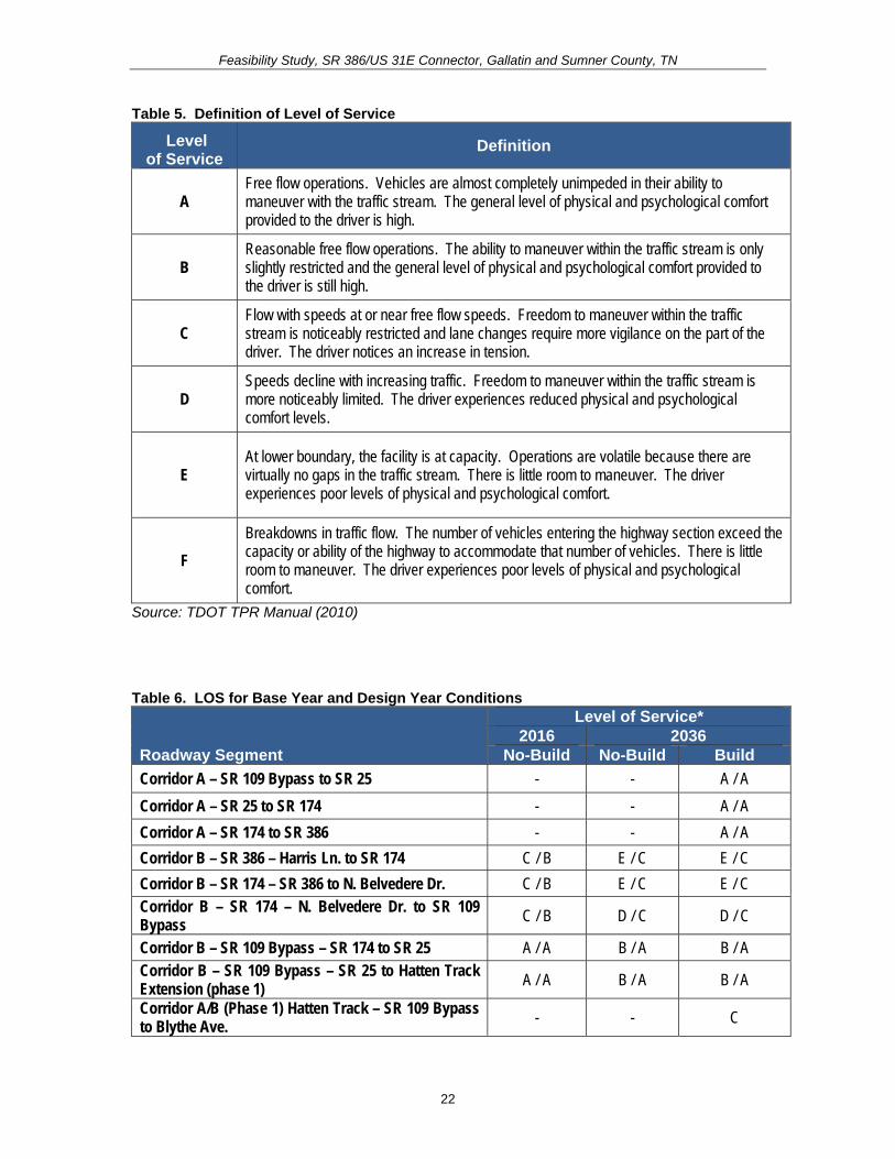
Feasibility Study SR 386US 31E Connector Gallatin and Sumner County TN
52 Build Options As stated previously and illustrated in Figure 9 there are two corridor options under the Build Condition Corridor A and Corridor B Phase 1 consists of the Albert Gallatin AvenueSR 174 Extension which is proposed to end at an interchange with SR 109 Phase 2 consists of either Corridor A or Corridor B which both utilize the Phase 1 extension from SR 109 to US 31E A description of each Build Option follows
Appendix D contains the typical sections and layout sheets for Phase 2 A description of the roadway segment for each feature follows
Corridor A
bull Corridor A is on new alignment from the SR 386Green Lea interchange and travels north along the east side of Liberty Branch Creek intersecting with SR 25 continues northeast and intersects with Douglas Lane and then continues east to SR 109 at which point it intersects the Phase 1 Albert Gallatin AvenueHatten Track Road extension east to US 31E Corridor A is approximately 39 miles in length
bull The typical section includes four twelve (12)-foot lanes (two (2) in each direction) a 48-foot depressed median six (6)-foot inside shoulders and twelve (12)-foot shared use outside shoulders (to accommodate bike lanes) within 200 feet of proposed right-of-way
bull The widening of SR 386 and SR 174 as described under the Corridor B option must be completed in addition to the building of Corridor A in order to ensure adequate traffic flow and operations on the surrounding roadway network
Corridor B
bull Corridor B follows SR 386 from the interchange with Greenlea Boulevard east to the intersection with Long Hollow Pike at which point the state routing designation changes to SR 174 Corridor B then follows SR 174 to the interchange with SR 109 it then travels north on SR 109 until it intersects with the Phase 1 Albert Gallatin AvenueHatten Track Road extension Corridor B is approximately 34 miles in length
bull Under the Corridor B option SR 386 and SR 174 between Greenlea Boulevard and the SR 109 Bypass will be widened for approximately 14 miles to account for future projected traffic growth
o SR 386 will be widened from four (4) to six (6) lanes (three (3) in each direction) each having a width of twelve (12) feet with twelve (12)-foot shoulders and a 64-foot wide depressed median The present right-ofshyway width for this section is 260 feet with additional right-of-way and easements to be obtained as needed for construction
o The typical section for the improved segment of SR 174 will be widened from five (5) to seven (7) twelve (12)-foot travel lanes (three (3) in each direction and a twelve (12)-foot center turn lane) with twelve (12)-foot shared use outside shoulders (to accommodate bike lanes) This widened section would require a minimum right-of-way of 180 feet
26
Feas
ibili
ty S
tudy
SR
386
US
31E
Con
nect
or G
alla
tin a
nd S
umne
r Cou
nty
TN
Figu
re 9
B
uild
Opt
ions
27
Feasibility Study SR 386US 31E Connector Gallatin and Sumner County TN
bull In addition to widening the identified segments of SR 386 and SR 174 several signalized intersections and two bridges will need to be improved so that the additional lanes can be accommodated The intersections that will require improvements include the following
- SR 386 at SR 174 - SR 174 at Belvedere Drive - SR 174 interchange with SR 109 Bypass
bull While all three of these intersections will require upgrades associated with the roadway widening improvements the SR 174 interchange with the SR 109 Bypass will also require geometric alterations so that traffic can smoothly transition from one route to the other The southbound off-ramp from SR 109 Bypass will need to be extended to form the third westbound lane of SR 174 The third eastbound lane of SR 174 will become a right-turn-only lane onto SR 109 Bypass
bull In addition to the intersection improvements the bridge over East Camp Creek as well as the westbound bridge over Liberty Branch Creek will both need to be widened to accommodate the future widening and meet traffic demands
bull If Corridor B is selected without Corridor A an eastbound to northbound SR 109 clover leaf loop will be needed to accommodate future left turn volumes This would require re-alignment of the ramps on the east side of SR 109 and widening of the bridge on SR 109 at East Camp Creek
Costs TDOT planning level base per mile costs were used to develop estimates for the corridor options and are summarized in Table 8 It should be noted that even if Corridor A is constructed Corridor B will need to be widened along SR 386 and SR 174 to accommodate the future traffic volumes The interchange improvements at SR 109 however would not be needed as motorists travelling north to SR 109 would utilize Corridor A The widening cost for SR 386 and SR 174 is approximately $10000000
Also a two (2) lane depressed median section could be constructed as an interim phase for Corridor A allowing future build out to four (4) lanes which would reduce the interim phase construction cost approximately $11000000
Table 8 Planning Level Costs for Build Options
Item Corridor A (39 Miles)
Corridor B (34 Miles)
Right-of-Way $3608400 $2229675 Total Construction $30490980 $17252905 Preliminary Engineering $3049098 $1725291 Total Cost $37148478 $21207871
53 Possible Modifications to the State Route System During the NEPA phase when the preferred alignment is selected TDOT may review the current state route system for possible modification For example possible changes to the state routing system could include designating SR 174 to follow Long Hollow Pike to
28
Feasibility Study SR 386US 31E Connector Gallatin and Sumner County TN
Greenlea Boulevard and then follow Corridor A to SR 109 continue across SR 109 along Albert Gallatin AvenueHatten Track Road Extension (Phase 1) and reconnect with the existing SR 174 at Dobbins Pike (see Figure 10) Accordingly the SR 174 designation would be removed from Greenlea Boulevard through downtown to Dobbins Pike Based on these possible changes approximately 26 miles would be removed and 54 miles would be added resulting in a net gain of 294 miles to the state route system
29
Feas
ibili
ty S
tudy
SR
386
US
31E
Con
nect
or G
alla
tin a
nd S
umne
r Cou
nty
TN
Figu
re 1
0 P
ropo
sed
Cha
nges
to S
tate
Rou
ting
Syst
em
30
Feasibility Study SR 386US 31E Connector Gallatin and Sumner County TN
54 Control of Access The City of Gallatin Zoning Ordinance (amended October 20 2009) establishes access management standards in Section 1306 for driveways providing vehicular access from arterial collector and local streets (roads in the study area are classified as arterials and collector streets) In addition Gallatin on the Move 2020 outlines additional access management policies that should be applied to the Cityrsquos arterial road system (including long range planning project planning and design right-of-way acquisition redesign of existing arterial corridors and driveway permitting)
Within the study area SR 174 between SR 386 and SR 109 is currently not access controlled and is subject to future development SR 109 is access controlled between SR 25 and Old Highway 109 The proposed extension will ultimately not require a break in the access control on SR 109 because an interchange is planned to allow access between SR 109 and the Albert Gallatin AvenueHatten Track Road Extension (Phase 1) and the SR 386US 31E Connector
In addition the project will be designed to provide limited access along the proposed Build Option ndash Corridor A as well as along the Hatten Track extension (Phase 1) from SR 109 to the east For an at-grade intersection the access control distance will be a minimum of 100 feet from any intersection For an interchange the access control will be 300 feet from the ramp terminals treating each side of the cross road independently
55 Environmental Constraints The environmental screening presented in this Feasibility Study has been provided by the TDOT Early Environmental Screening (EES) reports A detailed environmental study of the corridors identified in this Feasibility Study would occur during future project phases in compliance with National Environmental Policy Act provisions Environmental screening maps produced in support of the analysis in this report are found in Appendix E A full copy of the TDOT EES reports can be found in Appendix F The TDOT EES reports revealed the following
Impacts Evaluated within 1000 feet of the Project Area bull Community ResourceInstitution
The project area is home to one public school Joe Shafer Middle School is located at 240 Albert Gallatin Avenue which is to the north of Corridors A and B
bull Minority Population of over 24 Percent Appendix E Map 1 illustrates the minority population in the project area by Census Block for the 2000 US Census The average percentage of minority populations for the City of Gallatin in 2000 was 217 percent The county-wide minority population for Sumner County was 85 percent The City of Gallatin average is comparable to the statewide average of 198 percent but the Sumner County average is considerably lower than the statewide average Among the census blocks encompassing the project area one has a minority population higher than the City of Gallatin as a whole This Census Block is identified as Census Tract 205 Block Group 1 Block 1014 and is contained within Corridor B
31
Feasibility Study SR 386US 31E Connector Gallatin and Sumner County TN
The percentage of the population that identified themselves as a minority in this Census Block is 33 percent (or 7 out of 21 persons)
bull Sensitive Community Population Linguistically Isolated Populations Linguistically isolated populations are located within 1000 feet of the project area
bull Population living Below Poverty above the State Average of 135 Percent Appendix E Map 2 shows the percentage of the population living below poverty in the project area by Census Block Group The project area is encompassed by four Census Block Groups The percent of the population living below poverty in 2000 (based on 1999 income) within the City of Gallatin averaged 144 percent This is higher than the County and statewide averages of 81 and 135 percent respectively One Census Block Group within the project area has a percent of the population below poverty that is higher than the City County and statewide averages This Block Group is Census Tract 208 Block Group 2 and has 159 percent of the population in the Block Group living below poverty (or 289 out of 1807 persons) This Block Group is crossed by Corridor B (as highlighted in Appendix E Map 2)
bull Possible Substantial Impact on the Endangered Bat Species There is a known occurrence of Indiana or grey bats within four (4) miles of the project area It is anticipated that a) avoidanceminimization of potential impacts to species will be needed b) surveys for the species for the project may be required c) coordination with USFWS will be needed to establish Section 7 biological conclusions for the project and d) seasonal construction limitations will likely be necessary
bull Impact on Railroads A railroad exists within the project study area It is anticipated that impacts to the railroad can be avoided since the proposed project will be greater than 200 feet from the railroad There is the remote possibility of minor involvement on railroad property to accommodate drainage but there will be no grade crossing
bull Cemetery Sites and Properties There are no known cemetery sites within or abutting the project area
Impacts Evaluated within 2000 feet of the Project Area
bull TWRA Lakes and Other Public Lands No TWRA lake property is found within the project area but it is anticipated that a medium impact on the project is anticipated as a public park (city owned little league park) lies within the project area It is possible to locate the proposed project in such a way that it avoids any impacts or taking of the park property A moderate level of effort and time will be required to resolve the projectrsquos environmental impact on the park and to move forward with project development Indirect impacts (audible and visual) to the park may occur and need to be studied If there is indirect impact additional design would be needed to design the appropriate mitigation measures
32
Feasibility Study SR 386US 31E Connector Gallatin and Sumner County TN
bull National Register Sites No impacts are anticipated to any National Register of Historic Place (NRHP) listed properties as there are no properties abutting or within the project area
According to the State Historic Preservation Office (SHPO) records approximately ten (10) properties in Sumner County have been surveyed within the project area although none of which were deemed eligible for the NRHP by the surveyor Additional survey work is needed in future project phases to determine NRHP eligibility for the resources that are within the projectrsquos Area of Potential Effect (APE)
bull Superfund Sites No impacts are anticipated as there are no known contaminated land tracts abutting or within the project area
bull Pyritic Rock Pyritic rock is not known to occur in the project area and thus the project does not involve exaction Limestone and dolomite are present
Impacts Evaluated within 4000 feet of the Project Area
bull Terrestrial Species A minimal impact on the project is predicated as there is a known rare or state protected terrestrial species (the Thryomanes bewickii) located within the project area A survey for the species may be required
bull Wetland and Floodplain Impacts Substantial impacts to wetlands within the project area are probable A total of 33 acres of wetlands exists within 4000 feet of the project area Compensatory mitigation will be required Design effort will be needed to avoid and minimize impacts to wetlands to the maximum extent practicable
According to Federal Emergency Management Association (FEMA) Flood Insurance Rate Maps (FIRM) the project area is bisected by the 100-year floodplain Areas along East Camp Creek and Liberty Branch fall within this flood zone FIRMs depicting the 100-year floodplains within the project area were digitized and are included in Appendix E Map 3 Both Corridor A and Corridor B cross the 100-year floodplain
bull TDEC Conservation Sites and TDEC Scenic Waterways No TDEC Conservation Sites or scenic waterways are within the project area
bull Tennessee Natural Areas Program The project area does not include a Natural Area
bull Wildlife Management Area No impacts are anticipated to any Wildlife Management Areas as there are none that abut or are located within the project area
33
Feasibility Study SR 386US 31E Connector Gallatin and Sumner County TN
Impacts Evaluated within 10000 feet of the Project Area
bull Caves The Lackey Cave is present within 10000 feet of the project area and thus a medium project impact is anticipated It is possible to avoid impacts to the cave in future design phases of the project With the presence of a cave there are likely concerns involving the federally and state protected Indiana grey bat Additional design will be needed to avoid impacts to cave passages or entrances to develop access to the cave (if required) to conduct stability analysis of the project to determine right of way acquisition development and coordination of corrective actions for environmental effects (ie mitigation etc) associated with project construction in this terrain and to design water quality treatment measures Construction time will likely be affected either by requiring an extended contract period or strategic placement of the project in the let schedule to maximize the contractors time to construct the project
bull Aquatic Species There is no known occurrence of a rare state or federally-protected aquatic species within the project area
60 ASSESSMENT OF CORRIDOR OPTIONS TDOT has developed a set of seven guiding principles by which all transportation projects are to be evaluated These guiding principles address concerns for system management mobility economic growth safety community environmental stewardship and fiscal responsibility This section includes a discussion of each guiding principle as it pertains to the options evaluated in this Feasibility Study
Guiding Principle 1 Preserve and Manage the Existing Transportation System When the construction of SR 386 (Vietnam Veterans Boulevard) was completed SR 386 became a major asset to the City of Gallatin acting as a corridor to accommodate both local and through traffic and providing access to Gallatinrsquos downtown commercial core via SR 174Long Hollow Pike and US 31E Over time the section of US 31E through downtown has become congested The function of the SR 386US 31E Connector will be to provide the second phase of an east-west connector between SR 386 and US 31ESR 6East Broadway on the north side of the City thereby diverting some of the traffic away from US 31E from the most congested segments through downtown The proposed improvements as part of the Phase 2 project will provide a new connection between SR 386 and SR 109 which will result in preservation of the existing transportation system in the City of Gallatin
SR 109 SR 174 and US 31E are critical travel corridors for the City of Gallatin US 31E is not only a key commercial corridor for area residents and truck traffic but it also connects Gallatin to the towns of Bethpage and Westmoreland in Tennessee and Scottsville in Kentucky to the north and Nashville to the south SR 174 connects Gallatin to Oak Grove Tennessee and Scottsville Kentucky to the north and SR 109 connects Gallatin to Portland to the north The Build Option presented as Corridor A involves construction of a roadway on new location which can help extend the life of these
34
Feasibility Study SR 386US 31E Connector Gallatin and Sumner County TN
important existing routes by diverting some regional traffic andor lessening the future growth of traffic on these roads as indicated under the Build Scenario
Guiding Principle 2 Move a Growing Diverse and Active Population As discussed in Section 31 of this Feasibility Study the population of the City of Gallatin grew by 561 percent between 1990 and 2008 and Sumner County grew by 505 percent figures higher than the State of Tennessee as a whole (274 percent) The options presented in this study are intended to provide improved traffic conditions to support the arearsquos growing population and increasing amounts of externally generated traffic as well as support recommended future land use for the area which is outlined in Gallatin on the Move 2020
The SR 386US 31E Connector is anticipated to divert some traffic away from US 31E through downtown potentially reducing congestion and creating a safer and more hospitable environment for local traffic pedestrians and bicyclists
Guiding Principle 3 Support the Statersquos Economy Both SR 109 and US 31E are regional roadways that facilitate the movement of goods and services The SR 386US 31E Connector will provide better access to and support development in the area to the west of East Camp Creek which supports the vision of the City of Gallatin to promote the area as an emerging business park
Guiding Principle 4 Maximize Safety and Security The proposed project will create opportunities for the separation of through and local traffic alleviating traffic congestion in the downtown area especially on US 31E The proposed project will also eliminate the need for some tractor trailers and other large trucks to travel though the City which will potentially reduce crashes with local traffic which typically turns and stops frequently
Guiding Principle 5 Build Partnerships for Livable Communities A stakeholder meeting was held in support of this Feasibility Study in order to obtain input on transportation problems and other issues in the study area During the TPR development process additional coordination will be undertaken Additionally in keeping with TDOTrsquos Public Involvement Process the provisions of NEPA and Safe Accountable Flexible Efficient Transportation Equity Act ndash A Legacy for Users (SAFETEA-LU) and the provisions of the Tennessee Environmental Streamlining Agreement (TESA) if warranted this project will be coordinated with the public and additional governmental agencies beginning in the NEPA project phase
35
Feasibility Study SR 386US 31E Connector Gallatin and Sumner County TN
Guiding Principle 6 Promote Stewardship of the Environment Potential adverse environmental impacts were identified in the TDOT Environmental Screening and were considered in the development of the corridors included in this study Detailed technical environmental studies are needed to fully address the impacts
Should federal funding be obtained for the project a NEPA document will be prepared in future phases of the project The NEPA document will assess the projectrsquos impacts on the natural social and built environment and all efforts will be made to avoid adverse impacts during design development If impacts cannot be avoided they will be minimized and mitigated Early and continuous coordination will continue to take place with the appropriate federal state and local agencies and the public This coordination will assist with the identification of important resources early in the planning process and will help ensure the proposed project promotes stewardship of the environment
Guiding Principle 7 Emphasize Financial Responsibility The cost estimates presented in this study are offered for planning comparison purposes only and will fluctuate with inflation and any unexpected conditions It is TDOTrsquos goal to follow a comprehensive transportation planning process promote coordination among public and private operators of transportation systems and support efforts to provide stable funding for the public component of the transportation system This entails exercising financial responsibility in the development and implementation of roadway projects and minimizing cost to taxpayers
36
Feasibility Study SR 386US 31E Connector Gallatin and Sumner County TN
70 SUMMARY In summary this project is needed to address anticipated future transportation needs which have been identified through coordination with local officials and agencies The project area has been targeted as a prime area for future development and its success is dependent on a connected local and regional roadway system The project is needed based on the following
bull Improve Safety ndash Both the SR 174 intersection with Belvedere Drive and with SR 109 have crash rates of approximately 15 to 17 times greater than the statewide rate for an intersection of its type thus indicating that safety is a concern along this segment of SR 174
bull Promote System Linkage ndash An alternate route is desired between the southwest and northeast sides of town The SR 386US 31E Connector will provide the desired connectivity by linking SR 386 with SR 174 and US 31E north of downtown
bull Address Capacity Issues ndash By allowing travelers to use the SR 386US 31E Connector to access points northeast of downtown this project may reduce future congestion on US 31E through downtown Gallatin which will improve the traffic operations and safety along this segment of roadway It should also be noted that it is not cost beneficial to widen US 31E through downtown Gallatin
bull Meet Economic Development Demands ndash The Gallatin on the Move 2020 plan specifies more intensive land uses than those currently present in the study area
As stated previously there are two corridor options under the Build Condition for the SR 386US 31E Connector (Phase 2) Corridor A and Corridor B Planning level cost estimates for the corridor options were developed and are summarized in Table 9 It should be noted that even if Corridor A is constructed Corridor B will need to be widened along SR 386 and SR 174 to accommodate the future traffic volumes The interchange improvements at SR 109 however would not be needed as motorists travelling north to SR 109 would utilize Corridor A The widening cost for SR 386 and SR 174 is approximately $10000000
Also a two (2) lane depressed median section could be constructed as an interim phase for Corridor A allowing future build out to four (4) lanes which reduce the interim phase construction cost approximately $11000000
Table 9 Planning Level Costs for Build Options
Item Corridor A (39 Miles)
Corridor B (34 Miles)
Right-of-Way $3608400 $2229675 Total Construction $30490980 $17252905 Preliminary Engineering $3049098 $1725291 Total Cost $37148478 $21207871
If federal funding is utilized for this proposed project a TPR and NEPA document will be undertaken
37
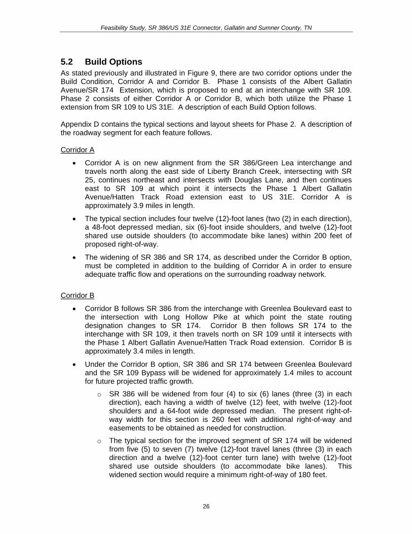
Feas
ibili
ty S
tudy
SR
386
US
31E
Con
nect
or G
alla
tin a
nd S
umne
r Cou
nty
TN
Figu
re 9
B
uild
Opt
ions
27
Feasibility Study SR 386US 31E Connector Gallatin and Sumner County TN
bull In addition to widening the identified segments of SR 386 and SR 174 several signalized intersections and two bridges will need to be improved so that the additional lanes can be accommodated The intersections that will require improvements include the following
- SR 386 at SR 174 - SR 174 at Belvedere Drive - SR 174 interchange with SR 109 Bypass
bull While all three of these intersections will require upgrades associated with the roadway widening improvements the SR 174 interchange with the SR 109 Bypass will also require geometric alterations so that traffic can smoothly transition from one route to the other The southbound off-ramp from SR 109 Bypass will need to be extended to form the third westbound lane of SR 174 The third eastbound lane of SR 174 will become a right-turn-only lane onto SR 109 Bypass
bull In addition to the intersection improvements the bridge over East Camp Creek as well as the westbound bridge over Liberty Branch Creek will both need to be widened to accommodate the future widening and meet traffic demands
bull If Corridor B is selected without Corridor A an eastbound to northbound SR 109 clover leaf loop will be needed to accommodate future left turn volumes This would require re-alignment of the ramps on the east side of SR 109 and widening of the bridge on SR 109 at East Camp Creek
Costs TDOT planning level base per mile costs were used to develop estimates for the corridor options and are summarized in Table 8 It should be noted that even if Corridor A is constructed Corridor B will need to be widened along SR 386 and SR 174 to accommodate the future traffic volumes The interchange improvements at SR 109 however would not be needed as motorists travelling north to SR 109 would utilize Corridor A The widening cost for SR 386 and SR 174 is approximately $10000000
Also a two (2) lane depressed median section could be constructed as an interim phase for Corridor A allowing future build out to four (4) lanes which would reduce the interim phase construction cost approximately $11000000
Table 8 Planning Level Costs for Build Options
Item Corridor A (39 Miles)
Corridor B (34 Miles)
Right-of-Way $3608400 $2229675 Total Construction $30490980 $17252905 Preliminary Engineering $3049098 $1725291 Total Cost $37148478 $21207871
53 Possible Modifications to the State Route System During the NEPA phase when the preferred alignment is selected TDOT may review the current state route system for possible modification For example possible changes to the state routing system could include designating SR 174 to follow Long Hollow Pike to
28
Feasibility Study SR 386US 31E Connector Gallatin and Sumner County TN
Greenlea Boulevard and then follow Corridor A to SR 109 continue across SR 109 along Albert Gallatin AvenueHatten Track Road Extension (Phase 1) and reconnect with the existing SR 174 at Dobbins Pike (see Figure 10) Accordingly the SR 174 designation would be removed from Greenlea Boulevard through downtown to Dobbins Pike Based on these possible changes approximately 26 miles would be removed and 54 miles would be added resulting in a net gain of 294 miles to the state route system
29
Feas
ibili
ty S
tudy
SR
386
US
31E
Con
nect
or G
alla
tin a
nd S
umne
r Cou
nty
TN
Figu
re 1
0 P
ropo
sed
Cha
nges
to S
tate
Rou
ting
Syst
em
30
Feasibility Study SR 386US 31E Connector Gallatin and Sumner County TN
54 Control of Access The City of Gallatin Zoning Ordinance (amended October 20 2009) establishes access management standards in Section 1306 for driveways providing vehicular access from arterial collector and local streets (roads in the study area are classified as arterials and collector streets) In addition Gallatin on the Move 2020 outlines additional access management policies that should be applied to the Cityrsquos arterial road system (including long range planning project planning and design right-of-way acquisition redesign of existing arterial corridors and driveway permitting)
Within the study area SR 174 between SR 386 and SR 109 is currently not access controlled and is subject to future development SR 109 is access controlled between SR 25 and Old Highway 109 The proposed extension will ultimately not require a break in the access control on SR 109 because an interchange is planned to allow access between SR 109 and the Albert Gallatin AvenueHatten Track Road Extension (Phase 1) and the SR 386US 31E Connector
In addition the project will be designed to provide limited access along the proposed Build Option ndash Corridor A as well as along the Hatten Track extension (Phase 1) from SR 109 to the east For an at-grade intersection the access control distance will be a minimum of 100 feet from any intersection For an interchange the access control will be 300 feet from the ramp terminals treating each side of the cross road independently
55 Environmental Constraints The environmental screening presented in this Feasibility Study has been provided by the TDOT Early Environmental Screening (EES) reports A detailed environmental study of the corridors identified in this Feasibility Study would occur during future project phases in compliance with National Environmental Policy Act provisions Environmental screening maps produced in support of the analysis in this report are found in Appendix E A full copy of the TDOT EES reports can be found in Appendix F The TDOT EES reports revealed the following
Impacts Evaluated within 1000 feet of the Project Area bull Community ResourceInstitution
The project area is home to one public school Joe Shafer Middle School is located at 240 Albert Gallatin Avenue which is to the north of Corridors A and B
bull Minority Population of over 24 Percent Appendix E Map 1 illustrates the minority population in the project area by Census Block for the 2000 US Census The average percentage of minority populations for the City of Gallatin in 2000 was 217 percent The county-wide minority population for Sumner County was 85 percent The City of Gallatin average is comparable to the statewide average of 198 percent but the Sumner County average is considerably lower than the statewide average Among the census blocks encompassing the project area one has a minority population higher than the City of Gallatin as a whole This Census Block is identified as Census Tract 205 Block Group 1 Block 1014 and is contained within Corridor B
31
Feasibility Study SR 386US 31E Connector Gallatin and Sumner County TN
The percentage of the population that identified themselves as a minority in this Census Block is 33 percent (or 7 out of 21 persons)
bull Sensitive Community Population Linguistically Isolated Populations Linguistically isolated populations are located within 1000 feet of the project area
bull Population living Below Poverty above the State Average of 135 Percent Appendix E Map 2 shows the percentage of the population living below poverty in the project area by Census Block Group The project area is encompassed by four Census Block Groups The percent of the population living below poverty in 2000 (based on 1999 income) within the City of Gallatin averaged 144 percent This is higher than the County and statewide averages of 81 and 135 percent respectively One Census Block Group within the project area has a percent of the population below poverty that is higher than the City County and statewide averages This Block Group is Census Tract 208 Block Group 2 and has 159 percent of the population in the Block Group living below poverty (or 289 out of 1807 persons) This Block Group is crossed by Corridor B (as highlighted in Appendix E Map 2)
bull Possible Substantial Impact on the Endangered Bat Species There is a known occurrence of Indiana or grey bats within four (4) miles of the project area It is anticipated that a) avoidanceminimization of potential impacts to species will be needed b) surveys for the species for the project may be required c) coordination with USFWS will be needed to establish Section 7 biological conclusions for the project and d) seasonal construction limitations will likely be necessary
bull Impact on Railroads A railroad exists within the project study area It is anticipated that impacts to the railroad can be avoided since the proposed project will be greater than 200 feet from the railroad There is the remote possibility of minor involvement on railroad property to accommodate drainage but there will be no grade crossing
bull Cemetery Sites and Properties There are no known cemetery sites within or abutting the project area
Impacts Evaluated within 2000 feet of the Project Area
bull TWRA Lakes and Other Public Lands No TWRA lake property is found within the project area but it is anticipated that a medium impact on the project is anticipated as a public park (city owned little league park) lies within the project area It is possible to locate the proposed project in such a way that it avoids any impacts or taking of the park property A moderate level of effort and time will be required to resolve the projectrsquos environmental impact on the park and to move forward with project development Indirect impacts (audible and visual) to the park may occur and need to be studied If there is indirect impact additional design would be needed to design the appropriate mitigation measures
32
Feasibility Study SR 386US 31E Connector Gallatin and Sumner County TN
bull National Register Sites No impacts are anticipated to any National Register of Historic Place (NRHP) listed properties as there are no properties abutting or within the project area
According to the State Historic Preservation Office (SHPO) records approximately ten (10) properties in Sumner County have been surveyed within the project area although none of which were deemed eligible for the NRHP by the surveyor Additional survey work is needed in future project phases to determine NRHP eligibility for the resources that are within the projectrsquos Area of Potential Effect (APE)
bull Superfund Sites No impacts are anticipated as there are no known contaminated land tracts abutting or within the project area
bull Pyritic Rock Pyritic rock is not known to occur in the project area and thus the project does not involve exaction Limestone and dolomite are present
Impacts Evaluated within 4000 feet of the Project Area
bull Terrestrial Species A minimal impact on the project is predicated as there is a known rare or state protected terrestrial species (the Thryomanes bewickii) located within the project area A survey for the species may be required
bull Wetland and Floodplain Impacts Substantial impacts to wetlands within the project area are probable A total of 33 acres of wetlands exists within 4000 feet of the project area Compensatory mitigation will be required Design effort will be needed to avoid and minimize impacts to wetlands to the maximum extent practicable
According to Federal Emergency Management Association (FEMA) Flood Insurance Rate Maps (FIRM) the project area is bisected by the 100-year floodplain Areas along East Camp Creek and Liberty Branch fall within this flood zone FIRMs depicting the 100-year floodplains within the project area were digitized and are included in Appendix E Map 3 Both Corridor A and Corridor B cross the 100-year floodplain
bull TDEC Conservation Sites and TDEC Scenic Waterways No TDEC Conservation Sites or scenic waterways are within the project area
bull Tennessee Natural Areas Program The project area does not include a Natural Area
bull Wildlife Management Area No impacts are anticipated to any Wildlife Management Areas as there are none that abut or are located within the project area
33
Feasibility Study SR 386US 31E Connector Gallatin and Sumner County TN
Impacts Evaluated within 10000 feet of the Project Area
bull Caves The Lackey Cave is present within 10000 feet of the project area and thus a medium project impact is anticipated It is possible to avoid impacts to the cave in future design phases of the project With the presence of a cave there are likely concerns involving the federally and state protected Indiana grey bat Additional design will be needed to avoid impacts to cave passages or entrances to develop access to the cave (if required) to conduct stability analysis of the project to determine right of way acquisition development and coordination of corrective actions for environmental effects (ie mitigation etc) associated with project construction in this terrain and to design water quality treatment measures Construction time will likely be affected either by requiring an extended contract period or strategic placement of the project in the let schedule to maximize the contractors time to construct the project
bull Aquatic Species There is no known occurrence of a rare state or federally-protected aquatic species within the project area
60 ASSESSMENT OF CORRIDOR OPTIONS TDOT has developed a set of seven guiding principles by which all transportation projects are to be evaluated These guiding principles address concerns for system management mobility economic growth safety community environmental stewardship and fiscal responsibility This section includes a discussion of each guiding principle as it pertains to the options evaluated in this Feasibility Study
Guiding Principle 1 Preserve and Manage the Existing Transportation System When the construction of SR 386 (Vietnam Veterans Boulevard) was completed SR 386 became a major asset to the City of Gallatin acting as a corridor to accommodate both local and through traffic and providing access to Gallatinrsquos downtown commercial core via SR 174Long Hollow Pike and US 31E Over time the section of US 31E through downtown has become congested The function of the SR 386US 31E Connector will be to provide the second phase of an east-west connector between SR 386 and US 31ESR 6East Broadway on the north side of the City thereby diverting some of the traffic away from US 31E from the most congested segments through downtown The proposed improvements as part of the Phase 2 project will provide a new connection between SR 386 and SR 109 which will result in preservation of the existing transportation system in the City of Gallatin
SR 109 SR 174 and US 31E are critical travel corridors for the City of Gallatin US 31E is not only a key commercial corridor for area residents and truck traffic but it also connects Gallatin to the towns of Bethpage and Westmoreland in Tennessee and Scottsville in Kentucky to the north and Nashville to the south SR 174 connects Gallatin to Oak Grove Tennessee and Scottsville Kentucky to the north and SR 109 connects Gallatin to Portland to the north The Build Option presented as Corridor A involves construction of a roadway on new location which can help extend the life of these
34
Feasibility Study SR 386US 31E Connector Gallatin and Sumner County TN
important existing routes by diverting some regional traffic andor lessening the future growth of traffic on these roads as indicated under the Build Scenario
Guiding Principle 2 Move a Growing Diverse and Active Population As discussed in Section 31 of this Feasibility Study the population of the City of Gallatin grew by 561 percent between 1990 and 2008 and Sumner County grew by 505 percent figures higher than the State of Tennessee as a whole (274 percent) The options presented in this study are intended to provide improved traffic conditions to support the arearsquos growing population and increasing amounts of externally generated traffic as well as support recommended future land use for the area which is outlined in Gallatin on the Move 2020
The SR 386US 31E Connector is anticipated to divert some traffic away from US 31E through downtown potentially reducing congestion and creating a safer and more hospitable environment for local traffic pedestrians and bicyclists
Guiding Principle 3 Support the Statersquos Economy Both SR 109 and US 31E are regional roadways that facilitate the movement of goods and services The SR 386US 31E Connector will provide better access to and support development in the area to the west of East Camp Creek which supports the vision of the City of Gallatin to promote the area as an emerging business park
Guiding Principle 4 Maximize Safety and Security The proposed project will create opportunities for the separation of through and local traffic alleviating traffic congestion in the downtown area especially on US 31E The proposed project will also eliminate the need for some tractor trailers and other large trucks to travel though the City which will potentially reduce crashes with local traffic which typically turns and stops frequently
Guiding Principle 5 Build Partnerships for Livable Communities A stakeholder meeting was held in support of this Feasibility Study in order to obtain input on transportation problems and other issues in the study area During the TPR development process additional coordination will be undertaken Additionally in keeping with TDOTrsquos Public Involvement Process the provisions of NEPA and Safe Accountable Flexible Efficient Transportation Equity Act ndash A Legacy for Users (SAFETEA-LU) and the provisions of the Tennessee Environmental Streamlining Agreement (TESA) if warranted this project will be coordinated with the public and additional governmental agencies beginning in the NEPA project phase
35
Feasibility Study SR 386US 31E Connector Gallatin and Sumner County TN
Guiding Principle 6 Promote Stewardship of the Environment Potential adverse environmental impacts were identified in the TDOT Environmental Screening and were considered in the development of the corridors included in this study Detailed technical environmental studies are needed to fully address the impacts
Should federal funding be obtained for the project a NEPA document will be prepared in future phases of the project The NEPA document will assess the projectrsquos impacts on the natural social and built environment and all efforts will be made to avoid adverse impacts during design development If impacts cannot be avoided they will be minimized and mitigated Early and continuous coordination will continue to take place with the appropriate federal state and local agencies and the public This coordination will assist with the identification of important resources early in the planning process and will help ensure the proposed project promotes stewardship of the environment
Guiding Principle 7 Emphasize Financial Responsibility The cost estimates presented in this study are offered for planning comparison purposes only and will fluctuate with inflation and any unexpected conditions It is TDOTrsquos goal to follow a comprehensive transportation planning process promote coordination among public and private operators of transportation systems and support efforts to provide stable funding for the public component of the transportation system This entails exercising financial responsibility in the development and implementation of roadway projects and minimizing cost to taxpayers
36
Feasibility Study SR 386US 31E Connector Gallatin and Sumner County TN
70 SUMMARY In summary this project is needed to address anticipated future transportation needs which have been identified through coordination with local officials and agencies The project area has been targeted as a prime area for future development and its success is dependent on a connected local and regional roadway system The project is needed based on the following
bull Improve Safety ndash Both the SR 174 intersection with Belvedere Drive and with SR 109 have crash rates of approximately 15 to 17 times greater than the statewide rate for an intersection of its type thus indicating that safety is a concern along this segment of SR 174
bull Promote System Linkage ndash An alternate route is desired between the southwest and northeast sides of town The SR 386US 31E Connector will provide the desired connectivity by linking SR 386 with SR 174 and US 31E north of downtown
bull Address Capacity Issues ndash By allowing travelers to use the SR 386US 31E Connector to access points northeast of downtown this project may reduce future congestion on US 31E through downtown Gallatin which will improve the traffic operations and safety along this segment of roadway It should also be noted that it is not cost beneficial to widen US 31E through downtown Gallatin
bull Meet Economic Development Demands ndash The Gallatin on the Move 2020 plan specifies more intensive land uses than those currently present in the study area
As stated previously there are two corridor options under the Build Condition for the SR 386US 31E Connector (Phase 2) Corridor A and Corridor B Planning level cost estimates for the corridor options were developed and are summarized in Table 9 It should be noted that even if Corridor A is constructed Corridor B will need to be widened along SR 386 and SR 174 to accommodate the future traffic volumes The interchange improvements at SR 109 however would not be needed as motorists travelling north to SR 109 would utilize Corridor A The widening cost for SR 386 and SR 174 is approximately $10000000
Also a two (2) lane depressed median section could be constructed as an interim phase for Corridor A allowing future build out to four (4) lanes which reduce the interim phase construction cost approximately $11000000
Table 9 Planning Level Costs for Build Options
Item Corridor A (39 Miles)
Corridor B (34 Miles)
Right-of-Way $3608400 $2229675 Total Construction $30490980 $17252905 Preliminary Engineering $3049098 $1725291 Total Cost $37148478 $21207871
If federal funding is utilized for this proposed project a TPR and NEPA document will be undertaken
37

Feasibility Study SR 386US 31E Connector Gallatin and Sumner County TN
bull In addition to widening the identified segments of SR 386 and SR 174 several signalized intersections and two bridges will need to be improved so that the additional lanes can be accommodated The intersections that will require improvements include the following
- SR 386 at SR 174 - SR 174 at Belvedere Drive - SR 174 interchange with SR 109 Bypass
bull While all three of these intersections will require upgrades associated with the roadway widening improvements the SR 174 interchange with the SR 109 Bypass will also require geometric alterations so that traffic can smoothly transition from one route to the other The southbound off-ramp from SR 109 Bypass will need to be extended to form the third westbound lane of SR 174 The third eastbound lane of SR 174 will become a right-turn-only lane onto SR 109 Bypass
bull In addition to the intersection improvements the bridge over East Camp Creek as well as the westbound bridge over Liberty Branch Creek will both need to be widened to accommodate the future widening and meet traffic demands
bull If Corridor B is selected without Corridor A an eastbound to northbound SR 109 clover leaf loop will be needed to accommodate future left turn volumes This would require re-alignment of the ramps on the east side of SR 109 and widening of the bridge on SR 109 at East Camp Creek
Costs TDOT planning level base per mile costs were used to develop estimates for the corridor options and are summarized in Table 8 It should be noted that even if Corridor A is constructed Corridor B will need to be widened along SR 386 and SR 174 to accommodate the future traffic volumes The interchange improvements at SR 109 however would not be needed as motorists travelling north to SR 109 would utilize Corridor A The widening cost for SR 386 and SR 174 is approximately $10000000
Also a two (2) lane depressed median section could be constructed as an interim phase for Corridor A allowing future build out to four (4) lanes which would reduce the interim phase construction cost approximately $11000000
Table 8 Planning Level Costs for Build Options
Item Corridor A (39 Miles)
Corridor B (34 Miles)
Right-of-Way $3608400 $2229675 Total Construction $30490980 $17252905 Preliminary Engineering $3049098 $1725291 Total Cost $37148478 $21207871
53 Possible Modifications to the State Route System During the NEPA phase when the preferred alignment is selected TDOT may review the current state route system for possible modification For example possible changes to the state routing system could include designating SR 174 to follow Long Hollow Pike to
28
Feasibility Study SR 386US 31E Connector Gallatin and Sumner County TN
Greenlea Boulevard and then follow Corridor A to SR 109 continue across SR 109 along Albert Gallatin AvenueHatten Track Road Extension (Phase 1) and reconnect with the existing SR 174 at Dobbins Pike (see Figure 10) Accordingly the SR 174 designation would be removed from Greenlea Boulevard through downtown to Dobbins Pike Based on these possible changes approximately 26 miles would be removed and 54 miles would be added resulting in a net gain of 294 miles to the state route system
29
Feas
ibili
ty S
tudy
SR
386
US
31E
Con
nect
or G
alla
tin a
nd S
umne
r Cou
nty
TN
Figu
re 1
0 P
ropo
sed
Cha
nges
to S
tate
Rou
ting
Syst
em
30
Feasibility Study SR 386US 31E Connector Gallatin and Sumner County TN
54 Control of Access The City of Gallatin Zoning Ordinance (amended October 20 2009) establishes access management standards in Section 1306 for driveways providing vehicular access from arterial collector and local streets (roads in the study area are classified as arterials and collector streets) In addition Gallatin on the Move 2020 outlines additional access management policies that should be applied to the Cityrsquos arterial road system (including long range planning project planning and design right-of-way acquisition redesign of existing arterial corridors and driveway permitting)
Within the study area SR 174 between SR 386 and SR 109 is currently not access controlled and is subject to future development SR 109 is access controlled between SR 25 and Old Highway 109 The proposed extension will ultimately not require a break in the access control on SR 109 because an interchange is planned to allow access between SR 109 and the Albert Gallatin AvenueHatten Track Road Extension (Phase 1) and the SR 386US 31E Connector
In addition the project will be designed to provide limited access along the proposed Build Option ndash Corridor A as well as along the Hatten Track extension (Phase 1) from SR 109 to the east For an at-grade intersection the access control distance will be a minimum of 100 feet from any intersection For an interchange the access control will be 300 feet from the ramp terminals treating each side of the cross road independently
55 Environmental Constraints The environmental screening presented in this Feasibility Study has been provided by the TDOT Early Environmental Screening (EES) reports A detailed environmental study of the corridors identified in this Feasibility Study would occur during future project phases in compliance with National Environmental Policy Act provisions Environmental screening maps produced in support of the analysis in this report are found in Appendix E A full copy of the TDOT EES reports can be found in Appendix F The TDOT EES reports revealed the following
Impacts Evaluated within 1000 feet of the Project Area bull Community ResourceInstitution
The project area is home to one public school Joe Shafer Middle School is located at 240 Albert Gallatin Avenue which is to the north of Corridors A and B
bull Minority Population of over 24 Percent Appendix E Map 1 illustrates the minority population in the project area by Census Block for the 2000 US Census The average percentage of minority populations for the City of Gallatin in 2000 was 217 percent The county-wide minority population for Sumner County was 85 percent The City of Gallatin average is comparable to the statewide average of 198 percent but the Sumner County average is considerably lower than the statewide average Among the census blocks encompassing the project area one has a minority population higher than the City of Gallatin as a whole This Census Block is identified as Census Tract 205 Block Group 1 Block 1014 and is contained within Corridor B
31
Feasibility Study SR 386US 31E Connector Gallatin and Sumner County TN
The percentage of the population that identified themselves as a minority in this Census Block is 33 percent (or 7 out of 21 persons)
bull Sensitive Community Population Linguistically Isolated Populations Linguistically isolated populations are located within 1000 feet of the project area
bull Population living Below Poverty above the State Average of 135 Percent Appendix E Map 2 shows the percentage of the population living below poverty in the project area by Census Block Group The project area is encompassed by four Census Block Groups The percent of the population living below poverty in 2000 (based on 1999 income) within the City of Gallatin averaged 144 percent This is higher than the County and statewide averages of 81 and 135 percent respectively One Census Block Group within the project area has a percent of the population below poverty that is higher than the City County and statewide averages This Block Group is Census Tract 208 Block Group 2 and has 159 percent of the population in the Block Group living below poverty (or 289 out of 1807 persons) This Block Group is crossed by Corridor B (as highlighted in Appendix E Map 2)
bull Possible Substantial Impact on the Endangered Bat Species There is a known occurrence of Indiana or grey bats within four (4) miles of the project area It is anticipated that a) avoidanceminimization of potential impacts to species will be needed b) surveys for the species for the project may be required c) coordination with USFWS will be needed to establish Section 7 biological conclusions for the project and d) seasonal construction limitations will likely be necessary
bull Impact on Railroads A railroad exists within the project study area It is anticipated that impacts to the railroad can be avoided since the proposed project will be greater than 200 feet from the railroad There is the remote possibility of minor involvement on railroad property to accommodate drainage but there will be no grade crossing
bull Cemetery Sites and Properties There are no known cemetery sites within or abutting the project area
Impacts Evaluated within 2000 feet of the Project Area
bull TWRA Lakes and Other Public Lands No TWRA lake property is found within the project area but it is anticipated that a medium impact on the project is anticipated as a public park (city owned little league park) lies within the project area It is possible to locate the proposed project in such a way that it avoids any impacts or taking of the park property A moderate level of effort and time will be required to resolve the projectrsquos environmental impact on the park and to move forward with project development Indirect impacts (audible and visual) to the park may occur and need to be studied If there is indirect impact additional design would be needed to design the appropriate mitigation measures
32
Feasibility Study SR 386US 31E Connector Gallatin and Sumner County TN
bull National Register Sites No impacts are anticipated to any National Register of Historic Place (NRHP) listed properties as there are no properties abutting or within the project area
According to the State Historic Preservation Office (SHPO) records approximately ten (10) properties in Sumner County have been surveyed within the project area although none of which were deemed eligible for the NRHP by the surveyor Additional survey work is needed in future project phases to determine NRHP eligibility for the resources that are within the projectrsquos Area of Potential Effect (APE)
bull Superfund Sites No impacts are anticipated as there are no known contaminated land tracts abutting or within the project area
bull Pyritic Rock Pyritic rock is not known to occur in the project area and thus the project does not involve exaction Limestone and dolomite are present
Impacts Evaluated within 4000 feet of the Project Area
bull Terrestrial Species A minimal impact on the project is predicated as there is a known rare or state protected terrestrial species (the Thryomanes bewickii) located within the project area A survey for the species may be required
bull Wetland and Floodplain Impacts Substantial impacts to wetlands within the project area are probable A total of 33 acres of wetlands exists within 4000 feet of the project area Compensatory mitigation will be required Design effort will be needed to avoid and minimize impacts to wetlands to the maximum extent practicable
According to Federal Emergency Management Association (FEMA) Flood Insurance Rate Maps (FIRM) the project area is bisected by the 100-year floodplain Areas along East Camp Creek and Liberty Branch fall within this flood zone FIRMs depicting the 100-year floodplains within the project area were digitized and are included in Appendix E Map 3 Both Corridor A and Corridor B cross the 100-year floodplain
bull TDEC Conservation Sites and TDEC Scenic Waterways No TDEC Conservation Sites or scenic waterways are within the project area
bull Tennessee Natural Areas Program The project area does not include a Natural Area
bull Wildlife Management Area No impacts are anticipated to any Wildlife Management Areas as there are none that abut or are located within the project area
33
Feasibility Study SR 386US 31E Connector Gallatin and Sumner County TN
Impacts Evaluated within 10000 feet of the Project Area
bull Caves The Lackey Cave is present within 10000 feet of the project area and thus a medium project impact is anticipated It is possible to avoid impacts to the cave in future design phases of the project With the presence of a cave there are likely concerns involving the federally and state protected Indiana grey bat Additional design will be needed to avoid impacts to cave passages or entrances to develop access to the cave (if required) to conduct stability analysis of the project to determine right of way acquisition development and coordination of corrective actions for environmental effects (ie mitigation etc) associated with project construction in this terrain and to design water quality treatment measures Construction time will likely be affected either by requiring an extended contract period or strategic placement of the project in the let schedule to maximize the contractors time to construct the project
bull Aquatic Species There is no known occurrence of a rare state or federally-protected aquatic species within the project area
60 ASSESSMENT OF CORRIDOR OPTIONS TDOT has developed a set of seven guiding principles by which all transportation projects are to be evaluated These guiding principles address concerns for system management mobility economic growth safety community environmental stewardship and fiscal responsibility This section includes a discussion of each guiding principle as it pertains to the options evaluated in this Feasibility Study
Guiding Principle 1 Preserve and Manage the Existing Transportation System When the construction of SR 386 (Vietnam Veterans Boulevard) was completed SR 386 became a major asset to the City of Gallatin acting as a corridor to accommodate both local and through traffic and providing access to Gallatinrsquos downtown commercial core via SR 174Long Hollow Pike and US 31E Over time the section of US 31E through downtown has become congested The function of the SR 386US 31E Connector will be to provide the second phase of an east-west connector between SR 386 and US 31ESR 6East Broadway on the north side of the City thereby diverting some of the traffic away from US 31E from the most congested segments through downtown The proposed improvements as part of the Phase 2 project will provide a new connection between SR 386 and SR 109 which will result in preservation of the existing transportation system in the City of Gallatin
SR 109 SR 174 and US 31E are critical travel corridors for the City of Gallatin US 31E is not only a key commercial corridor for area residents and truck traffic but it also connects Gallatin to the towns of Bethpage and Westmoreland in Tennessee and Scottsville in Kentucky to the north and Nashville to the south SR 174 connects Gallatin to Oak Grove Tennessee and Scottsville Kentucky to the north and SR 109 connects Gallatin to Portland to the north The Build Option presented as Corridor A involves construction of a roadway on new location which can help extend the life of these
34
Feasibility Study SR 386US 31E Connector Gallatin and Sumner County TN
important existing routes by diverting some regional traffic andor lessening the future growth of traffic on these roads as indicated under the Build Scenario
Guiding Principle 2 Move a Growing Diverse and Active Population As discussed in Section 31 of this Feasibility Study the population of the City of Gallatin grew by 561 percent between 1990 and 2008 and Sumner County grew by 505 percent figures higher than the State of Tennessee as a whole (274 percent) The options presented in this study are intended to provide improved traffic conditions to support the arearsquos growing population and increasing amounts of externally generated traffic as well as support recommended future land use for the area which is outlined in Gallatin on the Move 2020
The SR 386US 31E Connector is anticipated to divert some traffic away from US 31E through downtown potentially reducing congestion and creating a safer and more hospitable environment for local traffic pedestrians and bicyclists
Guiding Principle 3 Support the Statersquos Economy Both SR 109 and US 31E are regional roadways that facilitate the movement of goods and services The SR 386US 31E Connector will provide better access to and support development in the area to the west of East Camp Creek which supports the vision of the City of Gallatin to promote the area as an emerging business park
Guiding Principle 4 Maximize Safety and Security The proposed project will create opportunities for the separation of through and local traffic alleviating traffic congestion in the downtown area especially on US 31E The proposed project will also eliminate the need for some tractor trailers and other large trucks to travel though the City which will potentially reduce crashes with local traffic which typically turns and stops frequently
Guiding Principle 5 Build Partnerships for Livable Communities A stakeholder meeting was held in support of this Feasibility Study in order to obtain input on transportation problems and other issues in the study area During the TPR development process additional coordination will be undertaken Additionally in keeping with TDOTrsquos Public Involvement Process the provisions of NEPA and Safe Accountable Flexible Efficient Transportation Equity Act ndash A Legacy for Users (SAFETEA-LU) and the provisions of the Tennessee Environmental Streamlining Agreement (TESA) if warranted this project will be coordinated with the public and additional governmental agencies beginning in the NEPA project phase
35
Feasibility Study SR 386US 31E Connector Gallatin and Sumner County TN
Guiding Principle 6 Promote Stewardship of the Environment Potential adverse environmental impacts were identified in the TDOT Environmental Screening and were considered in the development of the corridors included in this study Detailed technical environmental studies are needed to fully address the impacts
Should federal funding be obtained for the project a NEPA document will be prepared in future phases of the project The NEPA document will assess the projectrsquos impacts on the natural social and built environment and all efforts will be made to avoid adverse impacts during design development If impacts cannot be avoided they will be minimized and mitigated Early and continuous coordination will continue to take place with the appropriate federal state and local agencies and the public This coordination will assist with the identification of important resources early in the planning process and will help ensure the proposed project promotes stewardship of the environment
Guiding Principle 7 Emphasize Financial Responsibility The cost estimates presented in this study are offered for planning comparison purposes only and will fluctuate with inflation and any unexpected conditions It is TDOTrsquos goal to follow a comprehensive transportation planning process promote coordination among public and private operators of transportation systems and support efforts to provide stable funding for the public component of the transportation system This entails exercising financial responsibility in the development and implementation of roadway projects and minimizing cost to taxpayers
36
Feasibility Study SR 386US 31E Connector Gallatin and Sumner County TN
70 SUMMARY In summary this project is needed to address anticipated future transportation needs which have been identified through coordination with local officials and agencies The project area has been targeted as a prime area for future development and its success is dependent on a connected local and regional roadway system The project is needed based on the following
bull Improve Safety ndash Both the SR 174 intersection with Belvedere Drive and with SR 109 have crash rates of approximately 15 to 17 times greater than the statewide rate for an intersection of its type thus indicating that safety is a concern along this segment of SR 174
bull Promote System Linkage ndash An alternate route is desired between the southwest and northeast sides of town The SR 386US 31E Connector will provide the desired connectivity by linking SR 386 with SR 174 and US 31E north of downtown
bull Address Capacity Issues ndash By allowing travelers to use the SR 386US 31E Connector to access points northeast of downtown this project may reduce future congestion on US 31E through downtown Gallatin which will improve the traffic operations and safety along this segment of roadway It should also be noted that it is not cost beneficial to widen US 31E through downtown Gallatin
bull Meet Economic Development Demands ndash The Gallatin on the Move 2020 plan specifies more intensive land uses than those currently present in the study area
As stated previously there are two corridor options under the Build Condition for the SR 386US 31E Connector (Phase 2) Corridor A and Corridor B Planning level cost estimates for the corridor options were developed and are summarized in Table 9 It should be noted that even if Corridor A is constructed Corridor B will need to be widened along SR 386 and SR 174 to accommodate the future traffic volumes The interchange improvements at SR 109 however would not be needed as motorists travelling north to SR 109 would utilize Corridor A The widening cost for SR 386 and SR 174 is approximately $10000000
Also a two (2) lane depressed median section could be constructed as an interim phase for Corridor A allowing future build out to four (4) lanes which reduce the interim phase construction cost approximately $11000000
Table 9 Planning Level Costs for Build Options
Item Corridor A (39 Miles)
Corridor B (34 Miles)
Right-of-Way $3608400 $2229675 Total Construction $30490980 $17252905 Preliminary Engineering $3049098 $1725291 Total Cost $37148478 $21207871
If federal funding is utilized for this proposed project a TPR and NEPA document will be undertaken
37
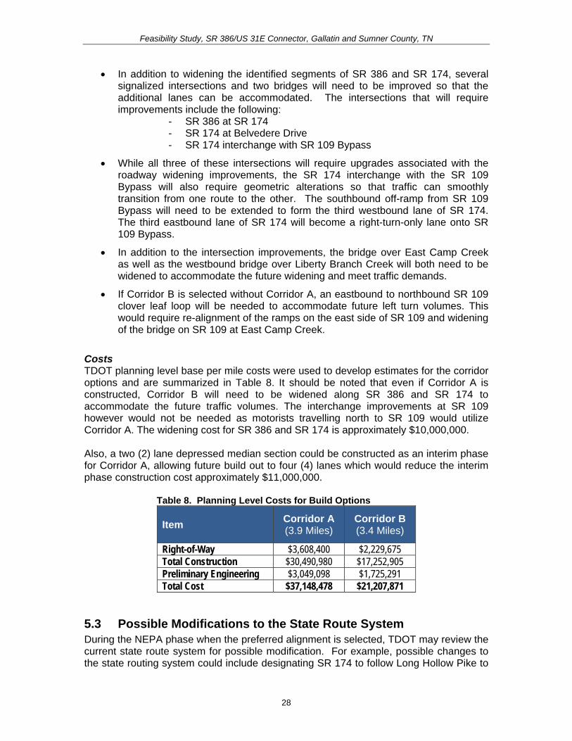
Feasibility Study SR 386US 31E Connector Gallatin and Sumner County TN
Greenlea Boulevard and then follow Corridor A to SR 109 continue across SR 109 along Albert Gallatin AvenueHatten Track Road Extension (Phase 1) and reconnect with the existing SR 174 at Dobbins Pike (see Figure 10) Accordingly the SR 174 designation would be removed from Greenlea Boulevard through downtown to Dobbins Pike Based on these possible changes approximately 26 miles would be removed and 54 miles would be added resulting in a net gain of 294 miles to the state route system
29
Feas
ibili
ty S
tudy
SR
386
US
31E
Con
nect
or G
alla
tin a
nd S
umne
r Cou
nty
TN
Figu
re 1
0 P
ropo
sed
Cha
nges
to S
tate
Rou
ting
Syst
em
30
Feasibility Study SR 386US 31E Connector Gallatin and Sumner County TN
54 Control of Access The City of Gallatin Zoning Ordinance (amended October 20 2009) establishes access management standards in Section 1306 for driveways providing vehicular access from arterial collector and local streets (roads in the study area are classified as arterials and collector streets) In addition Gallatin on the Move 2020 outlines additional access management policies that should be applied to the Cityrsquos arterial road system (including long range planning project planning and design right-of-way acquisition redesign of existing arterial corridors and driveway permitting)
Within the study area SR 174 between SR 386 and SR 109 is currently not access controlled and is subject to future development SR 109 is access controlled between SR 25 and Old Highway 109 The proposed extension will ultimately not require a break in the access control on SR 109 because an interchange is planned to allow access between SR 109 and the Albert Gallatin AvenueHatten Track Road Extension (Phase 1) and the SR 386US 31E Connector
In addition the project will be designed to provide limited access along the proposed Build Option ndash Corridor A as well as along the Hatten Track extension (Phase 1) from SR 109 to the east For an at-grade intersection the access control distance will be a minimum of 100 feet from any intersection For an interchange the access control will be 300 feet from the ramp terminals treating each side of the cross road independently
55 Environmental Constraints The environmental screening presented in this Feasibility Study has been provided by the TDOT Early Environmental Screening (EES) reports A detailed environmental study of the corridors identified in this Feasibility Study would occur during future project phases in compliance with National Environmental Policy Act provisions Environmental screening maps produced in support of the analysis in this report are found in Appendix E A full copy of the TDOT EES reports can be found in Appendix F The TDOT EES reports revealed the following
Impacts Evaluated within 1000 feet of the Project Area bull Community ResourceInstitution
The project area is home to one public school Joe Shafer Middle School is located at 240 Albert Gallatin Avenue which is to the north of Corridors A and B
bull Minority Population of over 24 Percent Appendix E Map 1 illustrates the minority population in the project area by Census Block for the 2000 US Census The average percentage of minority populations for the City of Gallatin in 2000 was 217 percent The county-wide minority population for Sumner County was 85 percent The City of Gallatin average is comparable to the statewide average of 198 percent but the Sumner County average is considerably lower than the statewide average Among the census blocks encompassing the project area one has a minority population higher than the City of Gallatin as a whole This Census Block is identified as Census Tract 205 Block Group 1 Block 1014 and is contained within Corridor B
31
Feasibility Study SR 386US 31E Connector Gallatin and Sumner County TN
The percentage of the population that identified themselves as a minority in this Census Block is 33 percent (or 7 out of 21 persons)
bull Sensitive Community Population Linguistically Isolated Populations Linguistically isolated populations are located within 1000 feet of the project area
bull Population living Below Poverty above the State Average of 135 Percent Appendix E Map 2 shows the percentage of the population living below poverty in the project area by Census Block Group The project area is encompassed by four Census Block Groups The percent of the population living below poverty in 2000 (based on 1999 income) within the City of Gallatin averaged 144 percent This is higher than the County and statewide averages of 81 and 135 percent respectively One Census Block Group within the project area has a percent of the population below poverty that is higher than the City County and statewide averages This Block Group is Census Tract 208 Block Group 2 and has 159 percent of the population in the Block Group living below poverty (or 289 out of 1807 persons) This Block Group is crossed by Corridor B (as highlighted in Appendix E Map 2)
bull Possible Substantial Impact on the Endangered Bat Species There is a known occurrence of Indiana or grey bats within four (4) miles of the project area It is anticipated that a) avoidanceminimization of potential impacts to species will be needed b) surveys for the species for the project may be required c) coordination with USFWS will be needed to establish Section 7 biological conclusions for the project and d) seasonal construction limitations will likely be necessary
bull Impact on Railroads A railroad exists within the project study area It is anticipated that impacts to the railroad can be avoided since the proposed project will be greater than 200 feet from the railroad There is the remote possibility of minor involvement on railroad property to accommodate drainage but there will be no grade crossing
bull Cemetery Sites and Properties There are no known cemetery sites within or abutting the project area
Impacts Evaluated within 2000 feet of the Project Area
bull TWRA Lakes and Other Public Lands No TWRA lake property is found within the project area but it is anticipated that a medium impact on the project is anticipated as a public park (city owned little league park) lies within the project area It is possible to locate the proposed project in such a way that it avoids any impacts or taking of the park property A moderate level of effort and time will be required to resolve the projectrsquos environmental impact on the park and to move forward with project development Indirect impacts (audible and visual) to the park may occur and need to be studied If there is indirect impact additional design would be needed to design the appropriate mitigation measures
32
Feasibility Study SR 386US 31E Connector Gallatin and Sumner County TN
bull National Register Sites No impacts are anticipated to any National Register of Historic Place (NRHP) listed properties as there are no properties abutting or within the project area
According to the State Historic Preservation Office (SHPO) records approximately ten (10) properties in Sumner County have been surveyed within the project area although none of which were deemed eligible for the NRHP by the surveyor Additional survey work is needed in future project phases to determine NRHP eligibility for the resources that are within the projectrsquos Area of Potential Effect (APE)
bull Superfund Sites No impacts are anticipated as there are no known contaminated land tracts abutting or within the project area
bull Pyritic Rock Pyritic rock is not known to occur in the project area and thus the project does not involve exaction Limestone and dolomite are present
Impacts Evaluated within 4000 feet of the Project Area
bull Terrestrial Species A minimal impact on the project is predicated as there is a known rare or state protected terrestrial species (the Thryomanes bewickii) located within the project area A survey for the species may be required
bull Wetland and Floodplain Impacts Substantial impacts to wetlands within the project area are probable A total of 33 acres of wetlands exists within 4000 feet of the project area Compensatory mitigation will be required Design effort will be needed to avoid and minimize impacts to wetlands to the maximum extent practicable
According to Federal Emergency Management Association (FEMA) Flood Insurance Rate Maps (FIRM) the project area is bisected by the 100-year floodplain Areas along East Camp Creek and Liberty Branch fall within this flood zone FIRMs depicting the 100-year floodplains within the project area were digitized and are included in Appendix E Map 3 Both Corridor A and Corridor B cross the 100-year floodplain
bull TDEC Conservation Sites and TDEC Scenic Waterways No TDEC Conservation Sites or scenic waterways are within the project area
bull Tennessee Natural Areas Program The project area does not include a Natural Area
bull Wildlife Management Area No impacts are anticipated to any Wildlife Management Areas as there are none that abut or are located within the project area
33
Feasibility Study SR 386US 31E Connector Gallatin and Sumner County TN
Impacts Evaluated within 10000 feet of the Project Area
bull Caves The Lackey Cave is present within 10000 feet of the project area and thus a medium project impact is anticipated It is possible to avoid impacts to the cave in future design phases of the project With the presence of a cave there are likely concerns involving the federally and state protected Indiana grey bat Additional design will be needed to avoid impacts to cave passages or entrances to develop access to the cave (if required) to conduct stability analysis of the project to determine right of way acquisition development and coordination of corrective actions for environmental effects (ie mitigation etc) associated with project construction in this terrain and to design water quality treatment measures Construction time will likely be affected either by requiring an extended contract period or strategic placement of the project in the let schedule to maximize the contractors time to construct the project
bull Aquatic Species There is no known occurrence of a rare state or federally-protected aquatic species within the project area
60 ASSESSMENT OF CORRIDOR OPTIONS TDOT has developed a set of seven guiding principles by which all transportation projects are to be evaluated These guiding principles address concerns for system management mobility economic growth safety community environmental stewardship and fiscal responsibility This section includes a discussion of each guiding principle as it pertains to the options evaluated in this Feasibility Study
Guiding Principle 1 Preserve and Manage the Existing Transportation System When the construction of SR 386 (Vietnam Veterans Boulevard) was completed SR 386 became a major asset to the City of Gallatin acting as a corridor to accommodate both local and through traffic and providing access to Gallatinrsquos downtown commercial core via SR 174Long Hollow Pike and US 31E Over time the section of US 31E through downtown has become congested The function of the SR 386US 31E Connector will be to provide the second phase of an east-west connector between SR 386 and US 31ESR 6East Broadway on the north side of the City thereby diverting some of the traffic away from US 31E from the most congested segments through downtown The proposed improvements as part of the Phase 2 project will provide a new connection between SR 386 and SR 109 which will result in preservation of the existing transportation system in the City of Gallatin
SR 109 SR 174 and US 31E are critical travel corridors for the City of Gallatin US 31E is not only a key commercial corridor for area residents and truck traffic but it also connects Gallatin to the towns of Bethpage and Westmoreland in Tennessee and Scottsville in Kentucky to the north and Nashville to the south SR 174 connects Gallatin to Oak Grove Tennessee and Scottsville Kentucky to the north and SR 109 connects Gallatin to Portland to the north The Build Option presented as Corridor A involves construction of a roadway on new location which can help extend the life of these
34
Feasibility Study SR 386US 31E Connector Gallatin and Sumner County TN
important existing routes by diverting some regional traffic andor lessening the future growth of traffic on these roads as indicated under the Build Scenario
Guiding Principle 2 Move a Growing Diverse and Active Population As discussed in Section 31 of this Feasibility Study the population of the City of Gallatin grew by 561 percent between 1990 and 2008 and Sumner County grew by 505 percent figures higher than the State of Tennessee as a whole (274 percent) The options presented in this study are intended to provide improved traffic conditions to support the arearsquos growing population and increasing amounts of externally generated traffic as well as support recommended future land use for the area which is outlined in Gallatin on the Move 2020
The SR 386US 31E Connector is anticipated to divert some traffic away from US 31E through downtown potentially reducing congestion and creating a safer and more hospitable environment for local traffic pedestrians and bicyclists
Guiding Principle 3 Support the Statersquos Economy Both SR 109 and US 31E are regional roadways that facilitate the movement of goods and services The SR 386US 31E Connector will provide better access to and support development in the area to the west of East Camp Creek which supports the vision of the City of Gallatin to promote the area as an emerging business park
Guiding Principle 4 Maximize Safety and Security The proposed project will create opportunities for the separation of through and local traffic alleviating traffic congestion in the downtown area especially on US 31E The proposed project will also eliminate the need for some tractor trailers and other large trucks to travel though the City which will potentially reduce crashes with local traffic which typically turns and stops frequently
Guiding Principle 5 Build Partnerships for Livable Communities A stakeholder meeting was held in support of this Feasibility Study in order to obtain input on transportation problems and other issues in the study area During the TPR development process additional coordination will be undertaken Additionally in keeping with TDOTrsquos Public Involvement Process the provisions of NEPA and Safe Accountable Flexible Efficient Transportation Equity Act ndash A Legacy for Users (SAFETEA-LU) and the provisions of the Tennessee Environmental Streamlining Agreement (TESA) if warranted this project will be coordinated with the public and additional governmental agencies beginning in the NEPA project phase
35
Feasibility Study SR 386US 31E Connector Gallatin and Sumner County TN
Guiding Principle 6 Promote Stewardship of the Environment Potential adverse environmental impacts were identified in the TDOT Environmental Screening and were considered in the development of the corridors included in this study Detailed technical environmental studies are needed to fully address the impacts
Should federal funding be obtained for the project a NEPA document will be prepared in future phases of the project The NEPA document will assess the projectrsquos impacts on the natural social and built environment and all efforts will be made to avoid adverse impacts during design development If impacts cannot be avoided they will be minimized and mitigated Early and continuous coordination will continue to take place with the appropriate federal state and local agencies and the public This coordination will assist with the identification of important resources early in the planning process and will help ensure the proposed project promotes stewardship of the environment
Guiding Principle 7 Emphasize Financial Responsibility The cost estimates presented in this study are offered for planning comparison purposes only and will fluctuate with inflation and any unexpected conditions It is TDOTrsquos goal to follow a comprehensive transportation planning process promote coordination among public and private operators of transportation systems and support efforts to provide stable funding for the public component of the transportation system This entails exercising financial responsibility in the development and implementation of roadway projects and minimizing cost to taxpayers
36
Feasibility Study SR 386US 31E Connector Gallatin and Sumner County TN
70 SUMMARY In summary this project is needed to address anticipated future transportation needs which have been identified through coordination with local officials and agencies The project area has been targeted as a prime area for future development and its success is dependent on a connected local and regional roadway system The project is needed based on the following
bull Improve Safety ndash Both the SR 174 intersection with Belvedere Drive and with SR 109 have crash rates of approximately 15 to 17 times greater than the statewide rate for an intersection of its type thus indicating that safety is a concern along this segment of SR 174
bull Promote System Linkage ndash An alternate route is desired between the southwest and northeast sides of town The SR 386US 31E Connector will provide the desired connectivity by linking SR 386 with SR 174 and US 31E north of downtown
bull Address Capacity Issues ndash By allowing travelers to use the SR 386US 31E Connector to access points northeast of downtown this project may reduce future congestion on US 31E through downtown Gallatin which will improve the traffic operations and safety along this segment of roadway It should also be noted that it is not cost beneficial to widen US 31E through downtown Gallatin
bull Meet Economic Development Demands ndash The Gallatin on the Move 2020 plan specifies more intensive land uses than those currently present in the study area
As stated previously there are two corridor options under the Build Condition for the SR 386US 31E Connector (Phase 2) Corridor A and Corridor B Planning level cost estimates for the corridor options were developed and are summarized in Table 9 It should be noted that even if Corridor A is constructed Corridor B will need to be widened along SR 386 and SR 174 to accommodate the future traffic volumes The interchange improvements at SR 109 however would not be needed as motorists travelling north to SR 109 would utilize Corridor A The widening cost for SR 386 and SR 174 is approximately $10000000
Also a two (2) lane depressed median section could be constructed as an interim phase for Corridor A allowing future build out to four (4) lanes which reduce the interim phase construction cost approximately $11000000
Table 9 Planning Level Costs for Build Options
Item Corridor A (39 Miles)
Corridor B (34 Miles)
Right-of-Way $3608400 $2229675 Total Construction $30490980 $17252905 Preliminary Engineering $3049098 $1725291 Total Cost $37148478 $21207871
If federal funding is utilized for this proposed project a TPR and NEPA document will be undertaken
37

Feasibility Study SR 386US 31E Connector Gallatin and Sumner County TN
The percentage of the population that identified themselves as a minority in this Census Block is 33 percent (or 7 out of 21 persons)
bull Sensitive Community Population Linguistically Isolated Populations Linguistically isolated populations are located within 1000 feet of the project area
bull Population living Below Poverty above the State Average of 135 Percent Appendix E Map 2 shows the percentage of the population living below poverty in the project area by Census Block Group The project area is encompassed by four Census Block Groups The percent of the population living below poverty in 2000 (based on 1999 income) within the City of Gallatin averaged 144 percent This is higher than the County and statewide averages of 81 and 135 percent respectively One Census Block Group within the project area has a percent of the population below poverty that is higher than the City County and statewide averages This Block Group is Census Tract 208 Block Group 2 and has 159 percent of the population in the Block Group living below poverty (or 289 out of 1807 persons) This Block Group is crossed by Corridor B (as highlighted in Appendix E Map 2)
bull Possible Substantial Impact on the Endangered Bat Species There is a known occurrence of Indiana or grey bats within four (4) miles of the project area It is anticipated that a) avoidanceminimization of potential impacts to species will be needed b) surveys for the species for the project may be required c) coordination with USFWS will be needed to establish Section 7 biological conclusions for the project and d) seasonal construction limitations will likely be necessary
bull Impact on Railroads A railroad exists within the project study area It is anticipated that impacts to the railroad can be avoided since the proposed project will be greater than 200 feet from the railroad There is the remote possibility of minor involvement on railroad property to accommodate drainage but there will be no grade crossing
bull Cemetery Sites and Properties There are no known cemetery sites within or abutting the project area
Impacts Evaluated within 2000 feet of the Project Area
bull TWRA Lakes and Other Public Lands No TWRA lake property is found within the project area but it is anticipated that a medium impact on the project is anticipated as a public park (city owned little league park) lies within the project area It is possible to locate the proposed project in such a way that it avoids any impacts or taking of the park property A moderate level of effort and time will be required to resolve the projectrsquos environmental impact on the park and to move forward with project development Indirect impacts (audible and visual) to the park may occur and need to be studied If there is indirect impact additional design would be needed to design the appropriate mitigation measures
32
Feasibility Study SR 386US 31E Connector Gallatin and Sumner County TN
bull National Register Sites No impacts are anticipated to any National Register of Historic Place (NRHP) listed properties as there are no properties abutting or within the project area
According to the State Historic Preservation Office (SHPO) records approximately ten (10) properties in Sumner County have been surveyed within the project area although none of which were deemed eligible for the NRHP by the surveyor Additional survey work is needed in future project phases to determine NRHP eligibility for the resources that are within the projectrsquos Area of Potential Effect (APE)
bull Superfund Sites No impacts are anticipated as there are no known contaminated land tracts abutting or within the project area
bull Pyritic Rock Pyritic rock is not known to occur in the project area and thus the project does not involve exaction Limestone and dolomite are present
Impacts Evaluated within 4000 feet of the Project Area
bull Terrestrial Species A minimal impact on the project is predicated as there is a known rare or state protected terrestrial species (the Thryomanes bewickii) located within the project area A survey for the species may be required
bull Wetland and Floodplain Impacts Substantial impacts to wetlands within the project area are probable A total of 33 acres of wetlands exists within 4000 feet of the project area Compensatory mitigation will be required Design effort will be needed to avoid and minimize impacts to wetlands to the maximum extent practicable
According to Federal Emergency Management Association (FEMA) Flood Insurance Rate Maps (FIRM) the project area is bisected by the 100-year floodplain Areas along East Camp Creek and Liberty Branch fall within this flood zone FIRMs depicting the 100-year floodplains within the project area were digitized and are included in Appendix E Map 3 Both Corridor A and Corridor B cross the 100-year floodplain
bull TDEC Conservation Sites and TDEC Scenic Waterways No TDEC Conservation Sites or scenic waterways are within the project area
bull Tennessee Natural Areas Program The project area does not include a Natural Area
bull Wildlife Management Area No impacts are anticipated to any Wildlife Management Areas as there are none that abut or are located within the project area
33
Feasibility Study SR 386US 31E Connector Gallatin and Sumner County TN
Impacts Evaluated within 10000 feet of the Project Area
bull Caves The Lackey Cave is present within 10000 feet of the project area and thus a medium project impact is anticipated It is possible to avoid impacts to the cave in future design phases of the project With the presence of a cave there are likely concerns involving the federally and state protected Indiana grey bat Additional design will be needed to avoid impacts to cave passages or entrances to develop access to the cave (if required) to conduct stability analysis of the project to determine right of way acquisition development and coordination of corrective actions for environmental effects (ie mitigation etc) associated with project construction in this terrain and to design water quality treatment measures Construction time will likely be affected either by requiring an extended contract period or strategic placement of the project in the let schedule to maximize the contractors time to construct the project
bull Aquatic Species There is no known occurrence of a rare state or federally-protected aquatic species within the project area
60 ASSESSMENT OF CORRIDOR OPTIONS TDOT has developed a set of seven guiding principles by which all transportation projects are to be evaluated These guiding principles address concerns for system management mobility economic growth safety community environmental stewardship and fiscal responsibility This section includes a discussion of each guiding principle as it pertains to the options evaluated in this Feasibility Study
Guiding Principle 1 Preserve and Manage the Existing Transportation System When the construction of SR 386 (Vietnam Veterans Boulevard) was completed SR 386 became a major asset to the City of Gallatin acting as a corridor to accommodate both local and through traffic and providing access to Gallatinrsquos downtown commercial core via SR 174Long Hollow Pike and US 31E Over time the section of US 31E through downtown has become congested The function of the SR 386US 31E Connector will be to provide the second phase of an east-west connector between SR 386 and US 31ESR 6East Broadway on the north side of the City thereby diverting some of the traffic away from US 31E from the most congested segments through downtown The proposed improvements as part of the Phase 2 project will provide a new connection between SR 386 and SR 109 which will result in preservation of the existing transportation system in the City of Gallatin
SR 109 SR 174 and US 31E are critical travel corridors for the City of Gallatin US 31E is not only a key commercial corridor for area residents and truck traffic but it also connects Gallatin to the towns of Bethpage and Westmoreland in Tennessee and Scottsville in Kentucky to the north and Nashville to the south SR 174 connects Gallatin to Oak Grove Tennessee and Scottsville Kentucky to the north and SR 109 connects Gallatin to Portland to the north The Build Option presented as Corridor A involves construction of a roadway on new location which can help extend the life of these
34
Feasibility Study SR 386US 31E Connector Gallatin and Sumner County TN
important existing routes by diverting some regional traffic andor lessening the future growth of traffic on these roads as indicated under the Build Scenario
Guiding Principle 2 Move a Growing Diverse and Active Population As discussed in Section 31 of this Feasibility Study the population of the City of Gallatin grew by 561 percent between 1990 and 2008 and Sumner County grew by 505 percent figures higher than the State of Tennessee as a whole (274 percent) The options presented in this study are intended to provide improved traffic conditions to support the arearsquos growing population and increasing amounts of externally generated traffic as well as support recommended future land use for the area which is outlined in Gallatin on the Move 2020
The SR 386US 31E Connector is anticipated to divert some traffic away from US 31E through downtown potentially reducing congestion and creating a safer and more hospitable environment for local traffic pedestrians and bicyclists
Guiding Principle 3 Support the Statersquos Economy Both SR 109 and US 31E are regional roadways that facilitate the movement of goods and services The SR 386US 31E Connector will provide better access to and support development in the area to the west of East Camp Creek which supports the vision of the City of Gallatin to promote the area as an emerging business park
Guiding Principle 4 Maximize Safety and Security The proposed project will create opportunities for the separation of through and local traffic alleviating traffic congestion in the downtown area especially on US 31E The proposed project will also eliminate the need for some tractor trailers and other large trucks to travel though the City which will potentially reduce crashes with local traffic which typically turns and stops frequently
Guiding Principle 5 Build Partnerships for Livable Communities A stakeholder meeting was held in support of this Feasibility Study in order to obtain input on transportation problems and other issues in the study area During the TPR development process additional coordination will be undertaken Additionally in keeping with TDOTrsquos Public Involvement Process the provisions of NEPA and Safe Accountable Flexible Efficient Transportation Equity Act ndash A Legacy for Users (SAFETEA-LU) and the provisions of the Tennessee Environmental Streamlining Agreement (TESA) if warranted this project will be coordinated with the public and additional governmental agencies beginning in the NEPA project phase
35
Feasibility Study SR 386US 31E Connector Gallatin and Sumner County TN
Guiding Principle 6 Promote Stewardship of the Environment Potential adverse environmental impacts were identified in the TDOT Environmental Screening and were considered in the development of the corridors included in this study Detailed technical environmental studies are needed to fully address the impacts
Should federal funding be obtained for the project a NEPA document will be prepared in future phases of the project The NEPA document will assess the projectrsquos impacts on the natural social and built environment and all efforts will be made to avoid adverse impacts during design development If impacts cannot be avoided they will be minimized and mitigated Early and continuous coordination will continue to take place with the appropriate federal state and local agencies and the public This coordination will assist with the identification of important resources early in the planning process and will help ensure the proposed project promotes stewardship of the environment
Guiding Principle 7 Emphasize Financial Responsibility The cost estimates presented in this study are offered for planning comparison purposes only and will fluctuate with inflation and any unexpected conditions It is TDOTrsquos goal to follow a comprehensive transportation planning process promote coordination among public and private operators of transportation systems and support efforts to provide stable funding for the public component of the transportation system This entails exercising financial responsibility in the development and implementation of roadway projects and minimizing cost to taxpayers
36
Feasibility Study SR 386US 31E Connector Gallatin and Sumner County TN
70 SUMMARY In summary this project is needed to address anticipated future transportation needs which have been identified through coordination with local officials and agencies The project area has been targeted as a prime area for future development and its success is dependent on a connected local and regional roadway system The project is needed based on the following
bull Improve Safety ndash Both the SR 174 intersection with Belvedere Drive and with SR 109 have crash rates of approximately 15 to 17 times greater than the statewide rate for an intersection of its type thus indicating that safety is a concern along this segment of SR 174
bull Promote System Linkage ndash An alternate route is desired between the southwest and northeast sides of town The SR 386US 31E Connector will provide the desired connectivity by linking SR 386 with SR 174 and US 31E north of downtown
bull Address Capacity Issues ndash By allowing travelers to use the SR 386US 31E Connector to access points northeast of downtown this project may reduce future congestion on US 31E through downtown Gallatin which will improve the traffic operations and safety along this segment of roadway It should also be noted that it is not cost beneficial to widen US 31E through downtown Gallatin
bull Meet Economic Development Demands ndash The Gallatin on the Move 2020 plan specifies more intensive land uses than those currently present in the study area
As stated previously there are two corridor options under the Build Condition for the SR 386US 31E Connector (Phase 2) Corridor A and Corridor B Planning level cost estimates for the corridor options were developed and are summarized in Table 9 It should be noted that even if Corridor A is constructed Corridor B will need to be widened along SR 386 and SR 174 to accommodate the future traffic volumes The interchange improvements at SR 109 however would not be needed as motorists travelling north to SR 109 would utilize Corridor A The widening cost for SR 386 and SR 174 is approximately $10000000
Also a two (2) lane depressed median section could be constructed as an interim phase for Corridor A allowing future build out to four (4) lanes which reduce the interim phase construction cost approximately $11000000
Table 9 Planning Level Costs for Build Options
Item Corridor A (39 Miles)
Corridor B (34 Miles)
Right-of-Way $3608400 $2229675 Total Construction $30490980 $17252905 Preliminary Engineering $3049098 $1725291 Total Cost $37148478 $21207871
If federal funding is utilized for this proposed project a TPR and NEPA document will be undertaken
37
Feasibility Study SR 386US 31E Connector Gallatin and Sumner County TN
Impacts Evaluated within 10000 feet of the Project Area
bull Caves The Lackey Cave is present within 10000 feet of the project area and thus a medium project impact is anticipated It is possible to avoid impacts to the cave in future design phases of the project With the presence of a cave there are likely concerns involving the federally and state protected Indiana grey bat Additional design will be needed to avoid impacts to cave passages or entrances to develop access to the cave (if required) to conduct stability analysis of the project to determine right of way acquisition development and coordination of corrective actions for environmental effects (ie mitigation etc) associated with project construction in this terrain and to design water quality treatment measures Construction time will likely be affected either by requiring an extended contract period or strategic placement of the project in the let schedule to maximize the contractors time to construct the project
bull Aquatic Species There is no known occurrence of a rare state or federally-protected aquatic species within the project area
60 ASSESSMENT OF CORRIDOR OPTIONS TDOT has developed a set of seven guiding principles by which all transportation projects are to be evaluated These guiding principles address concerns for system management mobility economic growth safety community environmental stewardship and fiscal responsibility This section includes a discussion of each guiding principle as it pertains to the options evaluated in this Feasibility Study
Guiding Principle 1 Preserve and Manage the Existing Transportation System When the construction of SR 386 (Vietnam Veterans Boulevard) was completed SR 386 became a major asset to the City of Gallatin acting as a corridor to accommodate both local and through traffic and providing access to Gallatinrsquos downtown commercial core via SR 174Long Hollow Pike and US 31E Over time the section of US 31E through downtown has become congested The function of the SR 386US 31E Connector will be to provide the second phase of an east-west connector between SR 386 and US 31ESR 6East Broadway on the north side of the City thereby diverting some of the traffic away from US 31E from the most congested segments through downtown The proposed improvements as part of the Phase 2 project will provide a new connection between SR 386 and SR 109 which will result in preservation of the existing transportation system in the City of Gallatin
SR 109 SR 174 and US 31E are critical travel corridors for the City of Gallatin US 31E is not only a key commercial corridor for area residents and truck traffic but it also connects Gallatin to the towns of Bethpage and Westmoreland in Tennessee and Scottsville in Kentucky to the north and Nashville to the south SR 174 connects Gallatin to Oak Grove Tennessee and Scottsville Kentucky to the north and SR 109 connects Gallatin to Portland to the north The Build Option presented as Corridor A involves construction of a roadway on new location which can help extend the life of these
34
Feasibility Study SR 386US 31E Connector Gallatin and Sumner County TN
important existing routes by diverting some regional traffic andor lessening the future growth of traffic on these roads as indicated under the Build Scenario
Guiding Principle 2 Move a Growing Diverse and Active Population As discussed in Section 31 of this Feasibility Study the population of the City of Gallatin grew by 561 percent between 1990 and 2008 and Sumner County grew by 505 percent figures higher than the State of Tennessee as a whole (274 percent) The options presented in this study are intended to provide improved traffic conditions to support the arearsquos growing population and increasing amounts of externally generated traffic as well as support recommended future land use for the area which is outlined in Gallatin on the Move 2020
The SR 386US 31E Connector is anticipated to divert some traffic away from US 31E through downtown potentially reducing congestion and creating a safer and more hospitable environment for local traffic pedestrians and bicyclists
Guiding Principle 3 Support the Statersquos Economy Both SR 109 and US 31E are regional roadways that facilitate the movement of goods and services The SR 386US 31E Connector will provide better access to and support development in the area to the west of East Camp Creek which supports the vision of the City of Gallatin to promote the area as an emerging business park
Guiding Principle 4 Maximize Safety and Security The proposed project will create opportunities for the separation of through and local traffic alleviating traffic congestion in the downtown area especially on US 31E The proposed project will also eliminate the need for some tractor trailers and other large trucks to travel though the City which will potentially reduce crashes with local traffic which typically turns and stops frequently
Guiding Principle 5 Build Partnerships for Livable Communities A stakeholder meeting was held in support of this Feasibility Study in order to obtain input on transportation problems and other issues in the study area During the TPR development process additional coordination will be undertaken Additionally in keeping with TDOTrsquos Public Involvement Process the provisions of NEPA and Safe Accountable Flexible Efficient Transportation Equity Act ndash A Legacy for Users (SAFETEA-LU) and the provisions of the Tennessee Environmental Streamlining Agreement (TESA) if warranted this project will be coordinated with the public and additional governmental agencies beginning in the NEPA project phase
35
Feasibility Study SR 386US 31E Connector Gallatin and Sumner County TN
Guiding Principle 6 Promote Stewardship of the Environment Potential adverse environmental impacts were identified in the TDOT Environmental Screening and were considered in the development of the corridors included in this study Detailed technical environmental studies are needed to fully address the impacts
Should federal funding be obtained for the project a NEPA document will be prepared in future phases of the project The NEPA document will assess the projectrsquos impacts on the natural social and built environment and all efforts will be made to avoid adverse impacts during design development If impacts cannot be avoided they will be minimized and mitigated Early and continuous coordination will continue to take place with the appropriate federal state and local agencies and the public This coordination will assist with the identification of important resources early in the planning process and will help ensure the proposed project promotes stewardship of the environment
Guiding Principle 7 Emphasize Financial Responsibility The cost estimates presented in this study are offered for planning comparison purposes only and will fluctuate with inflation and any unexpected conditions It is TDOTrsquos goal to follow a comprehensive transportation planning process promote coordination among public and private operators of transportation systems and support efforts to provide stable funding for the public component of the transportation system This entails exercising financial responsibility in the development and implementation of roadway projects and minimizing cost to taxpayers
36
Feasibility Study SR 386US 31E Connector Gallatin and Sumner County TN
70 SUMMARY In summary this project is needed to address anticipated future transportation needs which have been identified through coordination with local officials and agencies The project area has been targeted as a prime area for future development and its success is dependent on a connected local and regional roadway system The project is needed based on the following
bull Improve Safety ndash Both the SR 174 intersection with Belvedere Drive and with SR 109 have crash rates of approximately 15 to 17 times greater than the statewide rate for an intersection of its type thus indicating that safety is a concern along this segment of SR 174
bull Promote System Linkage ndash An alternate route is desired between the southwest and northeast sides of town The SR 386US 31E Connector will provide the desired connectivity by linking SR 386 with SR 174 and US 31E north of downtown
bull Address Capacity Issues ndash By allowing travelers to use the SR 386US 31E Connector to access points northeast of downtown this project may reduce future congestion on US 31E through downtown Gallatin which will improve the traffic operations and safety along this segment of roadway It should also be noted that it is not cost beneficial to widen US 31E through downtown Gallatin
bull Meet Economic Development Demands ndash The Gallatin on the Move 2020 plan specifies more intensive land uses than those currently present in the study area
As stated previously there are two corridor options under the Build Condition for the SR 386US 31E Connector (Phase 2) Corridor A and Corridor B Planning level cost estimates for the corridor options were developed and are summarized in Table 9 It should be noted that even if Corridor A is constructed Corridor B will need to be widened along SR 386 and SR 174 to accommodate the future traffic volumes The interchange improvements at SR 109 however would not be needed as motorists travelling north to SR 109 would utilize Corridor A The widening cost for SR 386 and SR 174 is approximately $10000000
Also a two (2) lane depressed median section could be constructed as an interim phase for Corridor A allowing future build out to four (4) lanes which reduce the interim phase construction cost approximately $11000000
Table 9 Planning Level Costs for Build Options
Item Corridor A (39 Miles)
Corridor B (34 Miles)
Right-of-Way $3608400 $2229675 Total Construction $30490980 $17252905 Preliminary Engineering $3049098 $1725291 Total Cost $37148478 $21207871
If federal funding is utilized for this proposed project a TPR and NEPA document will be undertaken
37

Feasibility Study SR 386US 31E Connector Gallatin and Sumner County TN
70 SUMMARY In summary this project is needed to address anticipated future transportation needs which have been identified through coordination with local officials and agencies The project area has been targeted as a prime area for future development and its success is dependent on a connected local and regional roadway system The project is needed based on the following
bull Improve Safety ndash Both the SR 174 intersection with Belvedere Drive and with SR 109 have crash rates of approximately 15 to 17 times greater than the statewide rate for an intersection of its type thus indicating that safety is a concern along this segment of SR 174
bull Promote System Linkage ndash An alternate route is desired between the southwest and northeast sides of town The SR 386US 31E Connector will provide the desired connectivity by linking SR 386 with SR 174 and US 31E north of downtown
bull Address Capacity Issues ndash By allowing travelers to use the SR 386US 31E Connector to access points northeast of downtown this project may reduce future congestion on US 31E through downtown Gallatin which will improve the traffic operations and safety along this segment of roadway It should also be noted that it is not cost beneficial to widen US 31E through downtown Gallatin
bull Meet Economic Development Demands ndash The Gallatin on the Move 2020 plan specifies more intensive land uses than those currently present in the study area
As stated previously there are two corridor options under the Build Condition for the SR 386US 31E Connector (Phase 2) Corridor A and Corridor B Planning level cost estimates for the corridor options were developed and are summarized in Table 9 It should be noted that even if Corridor A is constructed Corridor B will need to be widened along SR 386 and SR 174 to accommodate the future traffic volumes The interchange improvements at SR 109 however would not be needed as motorists travelling north to SR 109 would utilize Corridor A The widening cost for SR 386 and SR 174 is approximately $10000000
Also a two (2) lane depressed median section could be constructed as an interim phase for Corridor A allowing future build out to four (4) lanes which reduce the interim phase construction cost approximately $11000000
Table 9 Planning Level Costs for Build Options
Item Corridor A (39 Miles)
Corridor B (34 Miles)
Right-of-Way $3608400 $2229675 Total Construction $30490980 $17252905 Preliminary Engineering $3049098 $1725291 Total Cost $37148478 $21207871
If federal funding is utilized for this proposed project a TPR and NEPA document will be undertaken
37