Embed Size (px)
Citation preview

Feasibility Report Downpatrick Eastern Distributor Road Feasibility Study CO401425-Rep-01 Revision 07
March 2018

Project Name Downpatrick Eastern Distributor Road
Document Title Feasibility Study
Document Control Sheet
Project Name: Downpatrick Eastern Distributor Road – Feasibility Study
Project Number: CO401425
Report Title: Feasibility Report
Report Number: Rep-01 Rev 07
Issue Status / Amendment
Prepared Reviewed Approved
Rev 03 – Updated as
of DfI suggestions
dated 23rd of Oct 2017.
Name: Andrew Ferguson
Name: James Redmond
Name: Michael Bell
Signature:
Date: 24/10/2017
Signature:
Date: 25/10/2017
Signature:
Date: 25/10/2017
Rev 04 – New
Forecast and
Development Scenarios
have been included in this revision. Requested
Dec 2017.
Name: Andrew Ferguson
Name: James Redmond
Name: Michael Bell
Signature:
Date: 16/01/2018
Signature:
Date: 17/01/2018
Signature:
Date: 18/01/2018
Rev 05 – Report
updated with minor changes from DfI
comments dated 23-01-2018
Name: Andrew Ferguson
Name: James Redmond
Name: Michael Bell
Signature:
Date: 23/01/2018
Signature:
Date: 24/01/2018
Signature:
Date: 24/01/2018
Rev 06 – Junction
flow diagrams updated as of 27th Feb 2018
Name: Andrew Ferguson
Name: James Redmond
Name: Michael Bell
Signature:
Date: 02/03/2018
Signature:
Date: 05/03/2018
Signature:
Date: 05/03/2018
Rev 07 – Report
updated with DfI comments dated
07/03/2018
Name: Andrew Ferguson
Name: James Redmond
Name: Michael Bell
Signature:
Date: 07/03/2018
Signature:
Date: 07/03/2018
Signature:
Date: 07/03/2018

Project Name Downpatrick Eastern Distributor Road
Document Title Feasibility Study
Doc. Ref.:CO401425/Rep-01 Rev 07 i Issued: March 2018
TABLE OF CONTENTS
1 EXECUTIVE SUMMARY ....................................................................................... 1
2 INTRODUCTION ................................................................................................. 3
2.1 Background ....................................................................................................... 3
2.2 Project Brief ...................................................................................................... 3
2.3 Methodology ..................................................................................................... 4
2.4 Study Area ........................................................................................................ 4
2.5 Report Structure ................................................................................................ 7
3 STAGE 1– INITIAL DATA COLLECTION AND ANALYSIS ...................................... 8
3.1 Traffic Survey Overview ..................................................................................... 8
3.2 Classified Junction Turning Counts ...................................................................... 9
3.3 ANPR Origin-Destination Surveys ...................................................................... 15
3.4 Automatic Traffic Counts .................................................................................. 27
3.5 Journey Time Surveys ...................................................................................... 30
4 STAGE 2 – PRELIMINARY ENGINEERING ANALYSIS ....................................... 35
4.1 Proposed Road Alignment ................................................................................ 35
4.2 Construction Cost Estimate ............................................................................... 38
4.3 Desktop Geotechnical Assessment .................................................................... 39
4.4 Desktop Environmental Study ........................................................................... 41
5 STAGE 3 – TRAFFIC MODELLING AND ASSESSMENT ........................................ 42
5.1 SATURN Traffic Modelling – Base Model ............................................................ 42
5.2 SATURN Traffic Modelling – Do-Minimum Model ................................................. 50
5.3 SATURN Traffic Modelling – Do-Something Tests ............................................... 51
5.4 Economic Assessment ...................................................................................... 70
6 STAGE 4: FUTURE FORECAST TRAFFIC MODELLING AND ASSESSMENT .......... 75
6.1 SATURN Traffic Modelling– 2030 Forecast ......................................................... 75
6.2 SATURN Traffic– 2030 Forecast Models +Development ....................................... 79
6.4 Economic Assessment ...................................................................................... 85
7 CONCLUSION ................................................................................................... 91
7.1 Existing Traffic Conditions Summary ................................................................. 91
7.2 Eastern Distributor Route Summary .................................................................. 92
7.3 Traffic Re-Assignment & SATURN modelling ...................................................... 93

Project Name Downpatrick Eastern Distributor Road
Document Title Feasibility Study
Doc. Ref.:CO401425/Rep-01 Rev 07 ii Issued: March 2018
7.4 Economic Summary - Cost Benefit .................................................................... 94
TABLE OF APPENDICES
APPENDIX A: DATA COLLECTION INFORMATION .......................................................................
APPENDIX B: ORIGIN-DESTINATION INFORMATION ..................................................................
APPENDIX C: DESIGN LAYOUTS & ENGINEERING ANALYSIS ......................................................
APPENDIX D: SCHEME COST ESTIMATE ....................................................................................
APPENDIX E: GEOTECHNICAL ASSESSMENT REPORT .................................................................
APPENDIX F: ENVIRONMENTAL CONSTRAINTS REPORT ............................................................
APPENDIX G: SATURN MODEL VALIDATION ..............................................................................
APPENDIX H: TUBA MODELLING OUTPUTS ...............................................................................
APPENDIX I: FUTURE FORECAST MATRICES .............................................................................
APPENDIX J: ARDS & DOWN AREA PLAN EXTRACTS ..................................................................
TABLE OF FIGURES
Figure 2-1: Proposed Eastern Distributor Road Route ................................................................ 6
Figure 3-1 Junction Count Turning Location ............................................................................ 10
Figure 3-2.: A7 Belfast Road Travel Patterns ........................................................................... 18
Figure 3-3: A22 Killyleagh Road Travel Patterns ...................................................................... 19
Figure 3-4: Strangford Road Travel Patterns ........................................................................... 20
Figure 3-5: Saul Road Travel Patterns .................................................................................... 21
Figure 3-6: Ballyhornan Road Travel Patterns ......................................................................... 22
Figure 3-7: Ardglass Road Travel Patterns .............................................................................. 23
Figure 3-8: Killough Road Travel Patterns ............................................................................... 24
Figure 3-9: Vianstown Road Travel Patterns ........................................................................... 25
Figure 3-10: Ballydugan Road Travel Patterns ......................................................................... 26
Figure 3-11: Downpatrick Journey Time Route ........................................................................ 32
Figure 4-1: Section 1 – Strangford Road to Saul Road Route .................................................... 36
Figure 4-2: Section 2 – Saul Road to Ballyhornan Road ............................................................ 36
Figure 4-3: Sections 3 - 4 – Ballyhornan Road to Struell Wells .................................................. 37
Figure 5-1: Downpatrick Study Area - 42 Zones ...................................................................... 45
Figure 5-2: Downpatrick SATURN Model - Base Model Network ................................................ 46
Figure 5-3: SATURN Network – ‘Do Something’ Model ............................................................. 52
Figure 5-4: Eastern Distributor Road – Test 1 – AM Peak SATURN Re-assignment ...................... 55
Figure 5-5: Eastern Distributor Road – Test 1 – PM Peak SATURN Re-assignment ...................... 56
Project Name Downpatrick Eastern Distributor Road
Document Title Feasibility Study
Doc. Ref.:CO401425/Rep-01 Rev 07 iii Issued: March 2018
Figure 5-6: Eastern Distributor Road – Test 2 – AM Peak SATURN Re-assignment ...................... 60
Figure 5-7: Eastern Distributor Road – Test 2 – PM Peak SATURN Re-assignment ...................... 61
Figure 5-8: Eastern Distributor Road – Test 3 – AM Peak SATURN Re-assignment ...................... 65
Figure 5-9: Eastern Distributor Road – Test 3 – PM Peak SATURN Re-assignment ...................... 66
Figure 5-10: Eastern Distributor Road – Test 3 – AM Peak SATURN Re-assignment in Town
Centre ................................................................................................................ 67
Figure 5-11: Eastern Distributor Road – Test 3 – PM Peak SATURN Re-assignment in Town
Centre ................................................................................................................ 68
Figure 6-1: Eastern Distributor Road – Forecast Year 2030 – AM Peak SATURN Re-
assignment ......................................................................................................... 76
Figure 6-2: Eastern Distributor Road – Forecast Year 2030 – PM Peak SATURN Re-
assignment ......................................................................................................... 77
Figure 6-3: Downpatrick Study Area – Development Housing Zones ......................................... 80
Figure 6-4: Eastern Distributor Road – Forecast Year 2030 +Development – AM Peak
SATURN Re-assignment ....................................................................................... 82
Figure 6-5: Eastern Distributor Road – Forecast Year 2030 +Development – PM Peak
SATURN Re-assignment ....................................................................................... 83
TABLE OF TABLES
Table 1-1: Economic Summary ................................................................................................ 2
Table 3-1: Downpatrick Junction Turning Count Summary ....................................................... 12
Table 3-2: Downpatrick Junction - Maximum Queues............................................................... 14
Table 3-3: ANPR Journey Time Pattern Summary (External Cordon Points) ............................... 17
Table 3-4: ATC Data – 12Hr / 24Hr Traffic Data over 24hr Period ............................................. 29
Table 3-5: ATC – Recorded Traffic Speeds .............................................................................. 30
Table 3-6: ATC – Average Journey Times Per Route – AM Peak (Direction 1) ............................. 33
Table 3-7: ATC – Average Journey Times Per Route – AM Peak (Direction 2) ............................. 33
Table 3-8: ATC – Average Journey Times Per Route – PM Peak (Direction 1) ............................. 34
Table 3-9: ATC – Average Journey Times Per Route – PM Peak (Direction 2) ............................. 34
Table 4-1: Construction Cost Estimate Breakdown ................................................................... 38
Table 5-1: AM and PM Peak Highway Model Calibration Flow Validation .................................... 48
Table 5-2: AM and PM Peak Highway Model Flow Validation ..................................................... 49
Table 5-3: AM and PM Journey Time Validation ....................................................................... 50
Table 5-4: Trip Matrix Conversion Factors for TUBA................................................................ 71
Table 5-5: TUBA Summary of User Benefits ............................................................................ 72
Project Name Downpatrick Eastern Distributor Road
Document Title Feasibility Study
Doc. Ref.:CO401425/Rep-01 Rev 07 iv Issued: March 2018
Table 5-6: Overall Economic Summary ................................................................................... 73
Table 6-1: New Housing Development Trips – TRICS database ................................................ 81
Table 6-2: TUBA Summary of User Benefits ............................................................................ 85
Table 6-3: Overall Economic Summary ................................................................................... 87
Table 6-4: TUBA Summary of User Benefits ............................................................................ 88
Table 6-5: Overall Economic Summary ................................................................................... 89
Table 7-1: Economic Summary .............................................................................................. 94

Project Name Downpatrick Eastern Distributor Road
Document Title Feasibility Study
Doc. Ref.:CO401425/Rep-01 Rev 07 1 Issued: March 2018
1 EXECUTIVE SUMMARY
Amey was commissioned by TransportNI (now Department for Infrastructure – Roads) to
undertake a feasibility study of a proposed Eastern Distributor Road in Downpatrick. The aim
of this study was to gather existing traffic conditions, establish the potential traffic usage of
the proposed distributor road if constructed, and determine what relief it would provide to
Downpatrick Town Centre. This information has all been presented in this report. In addition,
this feasibility report provides an engineering constraints review of a preliminary route in
order to provide a cost estimate that would assist DfI-Roads in future discussions with key
stakeholders.
In the Ards and Down Area Plan 2015 the proposed alignment of the Eastern Distributor Road
is only indicative, due to land zonings and further land investigations being required. For this
study, a preliminary Eastern Distributor Road route has been developed by using the
descriptions provided in the Area Plan. The route has been designed off-line in an eastern
direction from the Strangford Road towards the Saul Road and then south towards the
upgraded Struell Wells section of road towards the Ardglass Road.
The proposed route is approximately 2.9km in length with the carriageway cross-section
accommodating a 7.3m single carriageway route with 2 metre footways and verges provided
along either side of the route. The single carriageway route has been designed to a DMRB
70kph design speed. Three new roundabout junctions, a priority junction and a staggered
cross-road junction have been proposed at the new route intersections. The estimated project
cost (at 2017 prices) for this preliminary design and alignment is £18.3M. This estimate
includes £4.25M of optimism bias (approximately 44% for works and 10% for land costs). To
assist with the cost estimate exercise for the scheme, engineering analysis and a desk based
geotechnical and environmental constraints assessment have been undertaken.
To help determine the potential traffic usage of the proposed Eastern Distributor Road if
constructed, and what relief it would provide to the town centre, a be-spoke SATURN
transport highway model was constructed for the Downpatrick study area. The AM and PM
network peaks modelled in the study were 08:15-09:15 and 17:00-18:00, these network
peaks were identified from the traffic surveys undertaken in Downpatrick. A validated base
2017 model was constructed and a 2030 forecast year and a forecast ‘2030 + development’,
was modelled.

Project Name Downpatrick Eastern Distributor Road
Document Title Feasibility Study
Doc. Ref.:CO401425/Rep-01 Rev 07 2 Issued: March 2018
A net difference comparison has been undertaken comparing the ‘Do Minimum’ and ‘Do
Something’ network models for each of the 2017 base and forecasted traffic scenarios. This
net comparison of vehicles has been displayed, highlighting the resultant re-assignment of
traffic in Downpatrick following the full construction of the Eastern Distributor Road from the
Strangford Road to the Saul Road and to the Ardglass Road.
Using the latest version of TUBA software (Version 1.9.9) an economic assessment for the
proposed full construction of the Eastern Distributor Road has been undertaken as part of
this study for the 2030 forecast scenario and ‘2030 + development’ traffic scenarios. The
results of the economic analysis indicate that the scheme is predicted to provide poor value
for money, with predicted benefits lower than overall scheme costs.
Table 1-1 summarises the economics summary for each of the forecast scenarios. The study’s
economic results indicate that the Eastern Distributor Road construction will generate more
user benefits for new development users from land zonings DK-07, DK-08, DK-12 and DK- 13
compared to strategic Downpatrick background traffic.
Table 1-1: Economic Summary
Value (£000s) 2030 Forecast Scenario
No Development
2030 Forecast Scenario +
development (1630 dwellings)
Net Present Value (PVB-PVC)
-10,838 -1,347
Benefit/Cost Ratio (PVB/PVC)
0.300 0.913

Project Name Downpatrick Eastern Distributor Road
Document Title Feasibility Study
Doc. Ref.:CO401425/Rep-01 Rev 07 3 Issued: March 2018
2 INTRODUCTION
2.1 Background
In November 2016, TransportNI (now Department for Infrastructure-Roads (DfI-Roads))
appointed Amey to undertake a feasibility study of an Eastern Distributor Road in
Downpatrick. The key objective of this study is to provide information to assist DfI-Roads in
discussions with key stakeholders on the possibility of providing this road in the future.
2.2 Project Brief
The project brief from DfI-Roads requested the examination into the feasibility of an Eastern
Distributor Road in Downpatrick. The aims of this study are to gather existing traffic
conditions, establish the potential traffic usage of the proposed distributor road if constructed,
and determine what relief it would provide to the town centre. It was also requested that the
assessment should provide an engineering constraints review of a preliminary route with the
aim to provide a cost estimate that would assist DfI-Roads in future discussions with key
stakeholders.
It was agreed in the project scoping stage that this study would be undertaken in three stages
as outlined below:
• Stage 1: Initial Data Collection and Analysis
• Stage 2: Preliminary Engineering Analysis
• Stage 3: Traffic Modelling and Assessment
In December 2017 DfI-Roads requested that additional forecast traffic modelling and
assessment was undertaken for the proposed Eastern Distributor Road. This forecast
modelling and assessment is presented in this updated Feasibility Study Report and described
as Stage 4.
• Stage 4: Future Forecast Traffic Modelling and Assessment
This report sets out the methodology and processes used for each stage of the study.

Project Name Downpatrick Eastern Distributor Road
Document Title Feasibility Study
Doc. Ref.:CO401425/Rep-01 Rev 07 4 Issued: March 2018
2.3 Methodology
This study is a feasibility investigation of the traffic, infrastructure and environmental issues
associated with the potential construction of the proposed Eastern Distributor Road. As such,
the investigation is principally a desk based assessment, supported by new traffic survey data,
future traffic forecasts, traffic modelling and site visits. The desk based assessments have
been undertaken in accordance with standard best practice and information that is readily
available for the study area.
2.4 Study Area
Downpatrick is located approximately 35 kilometres from Belfast, 16 kilometres from
Ballynahinch and 19 kilometres from Newcastle. The town is connected to Belfast by the A7,
which is designated in the Regional Development Strategy as a Link Corridor.
The town is described in the Regional Development Strategy as a “main hub” in rural Northern
Ireland, with a strategic role as a centre of employment and services for both its urban and
rural populations, providing its rural hinterland with a range of administrative, employment,
health, education, shopping and recreational services.
For this study, all key radial routes travelling into Downpatrick and around the Town Centre
have been considered. The eight radial routes include the A7 Belfast Road, A25 Ballydugan
Road, Vianstown Road, Killough Road, Ardglass Road, Ballyhornan Road, Saul/Mearne Road,
Strangford Road and A22 Killyleagh Road.
The line of the proposed Eastern Distributor Road is only indicative in the Ards and Down
Area Plan 2015, since certain parts of the route are still uncertain as they are reliant on land
zonings and further detailed studies being undertaken.
Figure 2.1 illustrates a preliminary route that has been used for this feasibility study and has
been developed in accordance with the descriptions provided in the Area Plan.
For ease of reference and description the Eastern Distributor Road is divided into four
sections:
• Section 1: Strangford Road to Saul Road, proposed to upgrade a small stretch
of Rathkeltair Road and then construction of a new link to Saul Road, meeting it just
east of Ardfern Road residential access.
• Section 2: Saul Road to Ballyhornan Road, requiring construction of a new link

Project Name Downpatrick Eastern Distributor Road
Document Title Feasibility Study
Doc. Ref.:CO401425/Rep-01 Rev 07 5 Issued: March 2018
• Section 3: Ballyhornan Road to Struell Wells Road, requiring construction of a
new link.
• Section 4: Struell Wells Road to Ardglass Road. This route is proposed to
upgrade the current Struell Wells Road and will connect into the existing roundabout
at the Ardglass Road.

Project Name Downpatrick Eastern Distributor Road
Document Title Feasibility Study
Doc. Ref.:CO401425/Rep-01 Rev 07 6 Issued: March 2018
Figure 2-1: Proposed Eastern Distributor Road Route

Project Name Downpatrick Eastern Distributor Road
Document Title Feasibility Study
Doc. Ref.: CO401425/Rep-01 Rev 07 7 Issued: March 2018
2.5 Report Structure
This feasibility report is structured as follows:
• Chapter 3 – Stage 1: Initial Data Collection and Analysis
➢ Traffic Survey Overview
➢ Classified Junction Turning Counts
➢ ANPR Origin-Destination Surveys
➢ Automatic Traffic Counts
➢ Journey Time Surveys
• Chapter 4 – Stage 2: Preliminary Engineering Analysis
➢ Proposed Road Alignment
➢ Construction Cost Estimate
➢ Desktop Geotechnical Assessment
➢ Desktop Environmental Assessment
• Chapter 5 – Stage 3: 2017 Traffic Modelling and Assessment
➢ SATURN Traffic Modelling - Base model
➢ SATURN Traffic Modelling - Do-Minimum model
➢ SATURN Traffic Modelling - Do-Something test
➢ Economic Assessment
• Chapter 6 – Stage 4: Future Forecast Traffic Modelling and Assessment
➢ SATURN Traffic Modelling – 2030 Forecast
➢ SATURN Traffic Modelling – 2030 Forecast + Development Traffic
➢ Economic Assessment
• Chapter 7 – Conclusion
➢ Existing Traffic Conditions Summary
➢ Eastern Distributor Summary
➢ Traffic Re-Assignment & SATURN Modelling
➢ Economics Summary - Cost Benefit

Project Name Downpatrick Eastern Distributor Road
Document Title Feasibility Study
Doc. Ref.: CO401425/Rep-01 Rev 07 8 Issued: March 2018
3 STAGE 1– INITIAL DATA COLLECTION AND ANALYSIS
3.1 Traffic Survey Overview
A programme of data collection was undertaken within the study area to assist in
establishing current traffic conditions and support the building of a transport model. Traffic
volumes, vehicle proportions at key junctions within the study area, vehicle speeds and
journey times along key routes were collected to estimate vehicle trip patterns in the area.
Through the collection and analysis of this survey information, the prevailing traffic
demand and operating conditions in the study area have been established.
Before collecting new traffic data, a review of all recent traffic surveys revealed the traffic
data used in the previous Downpatrick Transport Studies pre-dated 2014 and therefore
considered inappropriate to use within this study. Only four junction sites had been
surveyed in 2016 and only these have been used in this study.
New traffic surveys undertaken for this study includes:
• Classified Junction Turning counts (10 junction locations);
• Origin-Destination Surveys using Automatic Number Plate Recognition
cameras (27 site locations);
• Automatic Traffic Counters (11 site locations); and
• Journey Times Surveys.
To assist with the development of the base model in SATURN, the Automatic Number Plate
Recognition (ANPR) cameras surveys, the classified turning counts and journey time
surveys were all undertaken on the same weekday, Wednesday 8th March 2017. The ATC
surveys were undertaken over a one-week period, from Monday 6th March 2017 to Sunday
12th March 2017.
Due to the scale and nature of the traffic surveys, it was necessary to engage a specialist
transport survey company to undertake the ANPR camera surveys, Junction Turning Count
(JTC) surveys and Automatic Traffic Counter (ATC) surveys. Tracsis was the appointed
survey company for the Downpatrick traffic surveys and these were carried out in-line with
a survey specification devised by Amey.

Project Name Downpatrick Eastern Distributor Road
Document Title Feasibility Study
Doc. Ref.: CO401425/Rep-01 Rev 07 9 Issued: March 2018
3.2 Classified Junction Turning Counts
Overview
Classified Junction Turning Counts (JTCs) were undertaken at 10 locations between the
hours of 07:00 and 19:00 on Wednesday 8th March 2017.
The surveys were carried out using temporary CCTV recording equipment and in line with
an agreed survey specification.
The junction surveys were undertaken at the following locations:
• Junction 1: Killyleagh Road/ Strangford Road;
• Junction 2: Ardglass Road/ Edward Street/ Ballyhornan Road;
• Junction 3: Belfast Road Roundabout;
• Junction 4: Killough Road/ Ardglass Road;
• Junction 5: Ardglass Road/ Flying Horse Road;
• Junction 6: Killough Road/ Flying Horse Road/ Ballynoe Road;
• Junction 7: Vianstown Road/ Bishops Brae;
• Junction 8: Saul Street/ Scotch Street;
• Junction 9: Quoile Brae/ Strangford Road/ Rathkeltair Road; and
• Junction 10: Ardglass Road/ Struell Wells Road.
As mentioned previously, four JTC surveys existed from a previous 2016 study and
therefore this data has been used as part of this study also. These four JTC were located
at:
• Site 11: Market Street/ Irish Street/ Church Street;
• Site 12: Market Street/ St Patricks Avenue;
• Site 13: Church Street/ Saul Way; and
• Site 14: Stream Street/ Killough Road/ Pound Lane/ St Patricks
Avenue (referred in this report as Collins Corner).
Figure 3.Error! Reference source not found. illustrates the locations of junction turning c
ounts carried out in March 2017 and November 2016.

Project Name Downpatrick Eastern Distributor Road
Document Title Feasibility Study
Doc. Ref.: CO401425/Rep-01 Rev 07 10 Issued: March 2018
Figure 3-1 Junction Count Turning Location

Project Name Downpatrick Eastern Distributor Road
Document Title Feasibility Study
Doc. Ref.: CO401425/Rep-01 Rev 07 11 Issued: March 2018
Peak Hours Assessment
The JTC survey data has been analysed and the AM and PM peak weekday hours identified,
i.e. the single hour in which traffic flows on the network where the highest traffic flow was
recorded. The resulting network peaks have been identified as:
• AM Peak: 08:15 – 09:15
• PM Peak: 17:00 – 18:00
The survey data for all 14 sites were collected in 15-minute intervals between 07:00 and
19:00 over the survey period to provide a 12-hour record of turning movements.
Junction Turning Count Summary
The industry standard COBA 5-vehicle classification was adopted for the surveys, which
includes the following vehicle types:
• Cars;
• Light Goods Vehicles (LGV);
• Other Goods Vehicles 1 (OGV1);
• Other Goods Vehicles 2 (OGV2); and
• Buses and Coaches (PSV).
A summary of the peak hour two-way traffic data collected and vehicle breakdown at each
junction is summarised in Table 3.1. The table summarises the two-way traffic volume on
each approach at the junctions in the AM and PM peak and also summarises the traffic
breakdown. For presentation in Table 3.1 the vehicle classifications OGV1 and OGV2 have
been considered as HGV.
The junction survey data highlights that the A7 Belfast Road roundabout junction
accommodates the greatest traffic during both the AM and PM peaks. A total of 3984 traffic
movements were recorded during the AM peak and 4422 traffic movements were recorded
in the PM peak.
The peak hour junction traffic volumes indicate that the Church Street to Market Street
route from the A7 Belfast Road roundabout junction to the Market Street/ St Patricks
Avenue signalised junction is the busiest. This route includes the junctions of Church
Street/ Saul Way and Market Street/ Irish Street/ Church Street. Traffic movements at all
these junctions are more than 2700 vehicles in both the AM and PM peaks.

Project Name Downpatrick Eastern Distributor Road
Document Title Feasibility Study
Doc. Ref.: CO401425/Rep-01 Rev 07 12 Issued: March 2018
The vehicle breakdown highlights that the private car is the dominant travel mode through
all Downpatrick junctions with car proportions all greater than 95%. The surveys indicate
the proportions of HGVs travelling to/through Downpatrick are very low (less than 1%).
The public transport mode, Ulsterbus and School buses, is the second highest proportion;
a bus proportion of between 1-4% is registered throughout the Downpatrick junctions.
Traffic flow diagrams illustrating the peak junction flows is provided in Appendix A.
Table 3-1: Downpatrick Junction Turning Count Summary
Junction Location Junction Arms
AM Peak (0815-0915)
Two-way Traffic
PM Peak (1700-1800)
Two-way Traffic
Vehicle Breakdown
Ju
ncti
on
1
Killyleagh Road/
Strangford Road
A22 Killyleagh Road (N)
Strangford Road
A22 Killyleagh Road (S)
507
334
825
533
379
848
Car – 98.33%
Bus – 1.1%
HGV – 0.57%
Ju
ncti
on
2
Ardglass Road/
Edward Street/
Ballyhornan
Road
Edward Street
Ballyhornan Road
Ardglass Road (Hosp)
Ardglass Road (W)
641
480
936
663
663
333
849
481
Car – 98.36%
Bus – 1.06%
HGV – 0.58%
Ju
ncti
on
3
Belfast Road Roundabout
Killyleagh Road
A7 Belfast Road
Church Street
873
1089
1844
920
1074
1836
Car – 97.64%
Bus – 1.44%
HGV – 0.92%
Ju
ncti
on
4
Killough Road/
Ardglass Road
Killough Road
Ardglass Road
Killough Road (South)
686
789
879
702
663
793
Car – 97.46%
Bus – 1.43%
HGV – 1.11%
Ju
ncti
on
5
Ardglass Road/ Flying
Horse Road
Ardglass Road (Nth)
Flying Horse Road
Ardglass Road (Sth)
727
534
655
623
483
652
Car – 98.42%
Bus – 1.16%
HGV – 0.42%
Ju
ncti
on
6
Killough Road/ Flying
Horse Road/ Ballynoe
Road
Killough Road (Nth)
Flying Horse Road
Killough Road (Killough Vil)
Ballynoe Road
760
550
219
609
753
522
229
584
Car – 97.4%
Bus – 1.11%
HGV – 1.49%
Ju
ncti
on
7
Vianstown
Road/ Bishops Brae
Vianstown Road (urban side)
Bishops Brae
Vianstown Road (rural)
196
332
340
236
369
377
Car – 98.35%
Bus – 1.24%
HGV – 0.41%

Project Name Downpatrick Eastern Distributor Road
Document Title Feasibility Study
Doc. Ref.: CO401425/Rep-01 Rev 07 13 Issued: March 2018
Junction Location Junction Arms
AM Peak (0815-0915)
Two-way Traffic
PM Peak (1700-1800)
Two-way Traffic
Vehicle Breakdown
Ju
ncti
on
8
Saul Street/
Scotch Street
Saul Street
Scotch Street
Saul Way
661
1112
979
487
785
992
Car – 98.85%
Bus – 0.9%
HGV – 0.25%
Ju
ncti
on
9
Strangford
Road/ Rathkeltair
Road/ Quoile Brae
Quoile Brae
Strangford Road (E)
Rathkeltair Road
Strangford Road (West)
142
231
285
296
76
242
98
272
Car – 98.87%
Bus – 0.87%
HGV – 0.26%
Ju
ncti
on
10
Ardglass Road/
Struell Wells Road
Roundabout
Ardglass Road (Nth)
Struell Wells Road
Ardglass Road (Sth)
646
380
322
641
337
346
Car – 98.47%
Bus – 1.03%
HGV – 0.5%
Ju
ncti
on
11
Market
Street/ Irish Street/
Church Street
Church Street
Market Street
Irish Street
1332
969
495
1267
984
409
Car – 97.35%
Bus – 1.85%
HGV – 0.8%
Ju
ncti
on
12
Market
Street/ St
Patricks Avenue
Market Street
St Patricks Avenue
Market Street
961
755
1362
961
788
1437
Car – 97.28%
Bus – 2.15%
HGV – 0.57%
Ju
ncti
on
13
Church
Street / Saul
Way
Church Street (Nth)
Saul Way
Church Street (Sth)
Timber Yard
1687
986
1096
35
1739
998
1193
2
Car – 95.68%
Bus – 3.58%
HGV – 0.74%
Ju
ncti
on
14
Collins
Corner 5-arm junction
Stream Street (Nth)
Pound Lane
Killough Road
Stream Street (Sth)
St Patricks Avenue
459
274
735
210
883
214
204
652
179
533
Car – 95.23%
Bus – 3.64%
HGV – 1.13%
Junction Queuing Patterns
At each of the surveyed junctions, queues were recorded on the junction approaches at 5
minute intervals. A queue is defined as those vehicles at a junction which are stationary
or which have slowed down to a walking speed or less. The queue was recorded on each
approach on a lane by lane basis.

Project Name Downpatrick Eastern Distributor Road
Document Title Feasibility Study
Doc. Ref.: CO401425/Rep-01 Rev 07 14 Issued: March 2018
Table 3.2 summarises the maximum queues recorded on the approaches of junctions that
generated queues during the AM and PM peaks. Junction approach arms with queues less
than 3 vehicles have not been included in Table 3.2.
Layouts illustrating the queuing trends presented in Table 3.2 are provided in Appendix A
for reference.
The busy junctions highlighted along the Church Street and Market Street route generated
significant queuing for periods in both peak hours; this is consistent with the congested
conditions recorded during the surveys in Downpatrick.
Other surveyed junctions that recorded queuing for periods during the peak hours were
the priority junctions at Saul Way/ Scotch Street, Killough Road/Flying Horse Road/
Ballynoe Road, Strangford Road/ Killyleagh Road/ New Bridge Street and Ardglass Road/
Edward Street/ Ballyhornan Road. Queuing at these junctions only occurred during the AM
peak, coinciding with the school drops off at the Downpatrick Primary School on Edward
Street; St Colmcilles Primary School on the Killough Road; Blackwater Integrated
Secondary School on the Killyleagh Road; St Mary’s High School on the Ardglass Road and
St Patrick’s Grammar School on the Saul Road.
Table 3-2: Downpatrick Junction - Maximum Queues
Junction Location Junction Arms
AM Peak (0815-0915)
Maximum Queue
PM Peak (1700-1800)
Maximum Queue
Ju
ncti
on
2
Ardglass Road/
Edward Street/ Ballyhornan
Road
Edward Street
Ballyhornan Road
Ardglass Road (Hosp)
Ardglass Road (W)
12
2
11
0
2
0
2
0
Ju
ncti
on
3 Belfast Road
Roundabout
Killyleagh Road
A7 Belfast Road
Church Street
10+
16+
-
5
8
-
Ju
ncti
on
6
Killough Road/
Flying Horse Road/ Ballynoe
Road
Killough Road (Nth)
Flying Horse Road
Killough Road (Killough Vil)
Ballynoe Road
0
6
11
0
0
2
0
0
Ju
ncti
on
8 Saul Street/
Scotch Street
Saul Street
Scotch Street
Saul Way
10+
2
0
2
0
0

Project Name Downpatrick Eastern Distributor Road
Document Title Feasibility Study
Doc. Ref.: CO401425/Rep-01 Rev 07 15 Issued: March 2018
Junction Location Junction Arms
AM Peak (0815-0915)
Maximum Queue
PM Peak (1700-1800)
Maximum Queue Ju
ncti
on
11
Market Street/
Irish Street/ Church Street
Church Street
Market Street
Irish Street
6
9
7
6
20
7
Ju
ncti
on
12
Market Street/
St Patricks Avenue
Market Street
St Patricks Avenue
Market Street
20
11
12
11
11
25+
Ju
ncti
on
13
Church Street /
Saul Way
Church Street (Nth)
Saul Way
Church Street (Sth)
Timber Yard
25+
15
8
0
25+
10
12
0
Ju
ncti
on
14
Collins Corner 5-
arm junction
Stream Street (Nth)
Pound Lane
Killough Road
Stream Street (Sth)
St Patricks Avenue
8
7
16
4
8
8
5
8
4
8
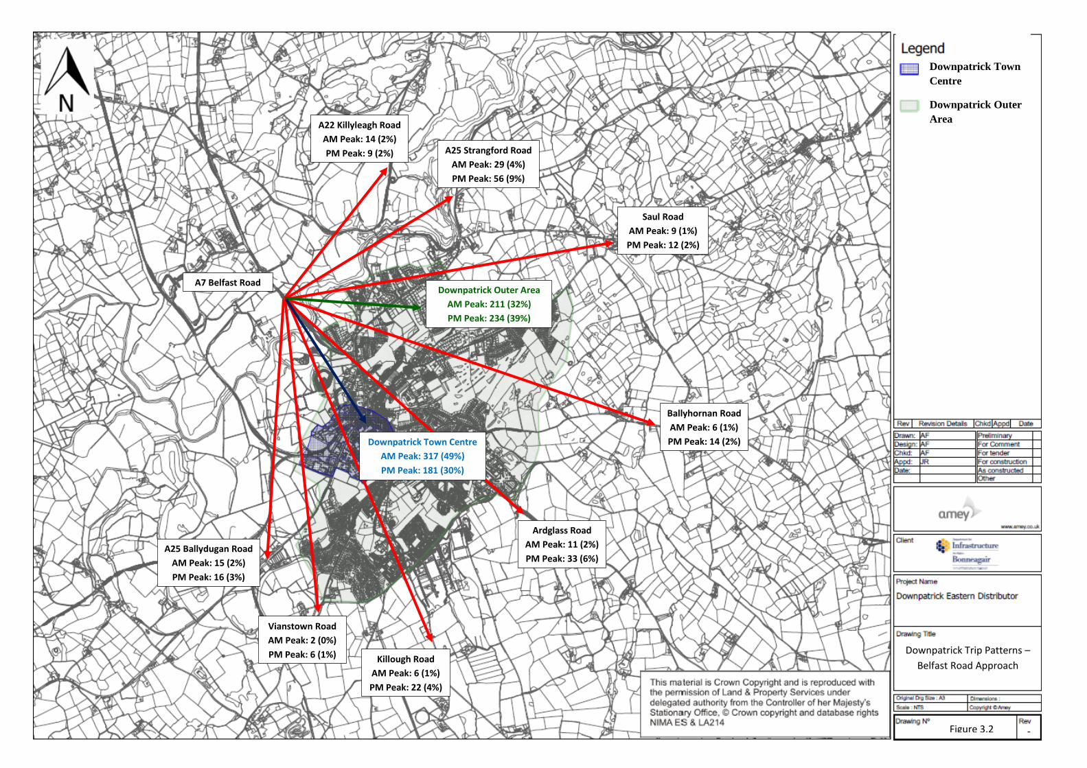
3.3 ANPR Origin-Destination Surveys
Overview
Automatic Number Plate Recognition (ANPR) surveys were undertaken at 27 site locations
around Downpatrick on Wednesday 8th March 2017 for a period of 12 hours from 07:00
to 19:00.
By using the ANPR technology to match the vehicle registrations at the different site
locations, trip patterns between strategic points on the Downpatrick network were defined.
A map illustrating the camera locations and cordons is provided in Appendix A. The three
Downpatrick cordons are described as the Inner Town Centre, Intermediate and External
and these cordons assisted in defining the journey purpose. The Inner Town Centre cordon
covers the main retail and office areas of the Town Centre; the Intermediate cordon
encompasses mainly the residential areas and schools; and the External cordon covers the
main approach routes into Downpatrick.
The ANPR cameras were located on the key routes entering and exiting the cordon areas.

Project Name Downpatrick Eastern Distributor Road
Document Title Feasibility Study
Doc. Ref.: CO401425/Rep-01 Rev 07 16 Issued: March 2018
Journey Patterns
Summary matrix tables describing the weekday journey patterns between key routes and
cordon zones are provided in Appendix B.
Table 3.3 summarises the route patterns highlighted from the ANPR data during the
weekday. For each of the key routes the data has been analysed to determine what
proportion of traffic has a destination in Downpatrick town centre or outer area and what
traffic travels straight through Downpatrick (external site to external site). The traffic
numbers displayed in Table 3.3 relate to the recorded inbound traffic with a destination in
Downpatrick.
For reference, the peak hour journey volumes for the individual routes have been
illustrated on Figures 3-2 to 3-10.
The ANPR data highlights that during the peak traffic periods, Downpatrick (town centre
or outer area) is, in most cases, a journey destination for all the traffic travelling on the
radial approaches to Downpatrick. For example, in the AM peak 49% of the inbound traffic
recorded on the A7 Belfast Road have an end destination in Downpatrick Town Centre,
32% in the Downpatrick Outer Area, with only 19% travelling through it. In the PM peak
the pass-through traffic proportions increases; for example, on the same route in the PM
peak, the traffic travelling through Downpatrick has increased to 31% with only 30% of
in-bound traffic having an end destination in Downpatrick Town Centre and 39% in the
Downpatrick Outer Area.
A traffic matrix displaying the origin destination matrix during the assessment peaks is
provided in Appendix B. For reference, zones 2, 4, 5 and 6 relate to Downpatrick Town
Centre and zones 1, 3, 7 and 8 relate to the Downpatrick Outer Area.

Project Name Downpatrick Eastern Distributor Road
Document Title Feasibility Study
Doc. Ref.: CO401425/Rep-01 Rev 07 17 Issued: March 2018
Table 3-3: ANPR Journey Time Pattern Summary (External Cordon Points)
AM Peak PM Peak
Total Vehicles
(inbound)
Downpatrick
Town Centre
Downpatrick Outer Area
Through Traffic
Total Vehicles
(inbound)
Downpatrick
Town Centre
Downpatrick Outer Area
Through Traffic
A7 Belfast Road 651 vehicles 317 vehicles
49%
211 vehicles
32%
123 vehicles
19%
599 vehicles 181 vehicles
30%
234 vehicles
39%
184 vehicles
31%
A22 Killyleagh Road
207 vehicles 92 vehicles
44%
53 vehicles
26%
62 vehicles
30%
223 vehicles 54 vehicles
24%
62 vehicles
28%
108 vehicles
48%
A25 Strangford Road
96 vehicles 33 vehicles
34%
4 vehicles
4%
59 vehicles
62%
63 vehicles 12 vehicles
19%
9 vehicles
14%
42 vehicles
67%
Saul Road 120 vehicles 38 vehicles
32%
38 vehicles
32%
44 vehicles
37%
48 vehicles 15 vehicles
31%
19 vehicles
40%
14 vehicles
29%
Ballyhornan Road 152 vehicles 59 vehicles
39%
33 vehicles
22%
60 vehicles
39%
41 vehicles 8 vehicles
20%
14 vehicles
34%
19 vehicles
46%
Ardglass Road 158 vehicles 75 vehicles
47%
26 vehicles
16%
57 vehicles
36%
88 vehicles 23 vehicles
26%
32 vehicles
36%
33 vehicles
38%
Killough Road 116 vehicles 48 vehicles
41%
17 vehicles
15%
51 vehicles
44%
73 vehicles 27 vehicles
37%
14 vehicles
19%
32 vehicles
42%
Vianstown Road 128 vehicles 30 vehicles
23%
70 vehicles
55%
28 vehicles
22%
79 vehicles 14 vehicles
18%
25 vehicles
32%
39 vehicles
49%
A25 Ballydugan Road
325 vehicles 118 vehicles
36%
89 vehicles
27%
115 vehicles
35%
167 vehicles 30 vehicles
18%
50 vehicles
30%
87 vehicles
52%
A7 Belfast Road
A22 Killyleagh Road
AM Peak: 14 (2%)
PM Peak: 9 (2%)
Saul Road
AM Peak: 9 (1%)
PM Peak: 12 (2%)
A25 Strangford Road
AM Peak: 29 (4%)
PM Peak: 56 (9%)
Ballyhornan Road
AM Peak: 6 (1%)
PM Peak: 14 (2%)
Ardglass Road
AM Peak: 11 (2%)
PM Peak: 33 (6%)
Killough Road
AM Peak: 6 (1%)
PM Peak: 22 (4%)
Vianstown Road
AM Peak: 2 (0%)
PM Peak: 6 (1%)
A25 Ballydugan Road
AM Peak: 15 (2%)
PM Peak: 16 (3%)
Downpatrick Trip Patterns –
Belfast Road Approach
Downpatrick Outer Area
AM Peak: 211 (32%)
PM Peak: 234 (39%)
Figure 3.2
Downpatrick Town Centre
AM Peak: 317 (49%)
PM Peak: 181 (30%)
Downpatrick Town
Centre
Downpatrick Outer
Area

A7 Belfast Road
AM Peak: 10 (5%)
PM Peak: 12 (5%)
A22 Killyleagh Road
Saul Road
AM Peak: 2 (1%)
PM Peak: 5 (2%)
A25 Strangford Road
AM Peak: 4 (2%)
PM Peak: 10 (4%)
Ballyhornan Road
AM Peak: 0 (0%)
PM Peak: 1 (0%)
Ardglass Road
AM Peak: 3 (1%)
PM Peak: 14 (6%)
Killough Road
AM Peak: 0 (0%)
PM Peak: 9 (4%)
Vianstown Road
AM Peak: 2 (1%)
PM Peak: 4 (2%)
A25 Ballydugan Road
AM Peak: 21 (10%)
PM Peak: 49 (22%)
Downpatrick Trip Patterns –
Killyleagh Road Approach
Figure 3.3
Downpatrick Outer Area
AM Peak: 53 (26%)
PM Peak: 62 (28%)
Downpatrick Town Centre
AM Peak: 92 (44%)
PM Peak: 54 (24%)
Downpatrick Town
Centre
Downpatrick Outer
Area

A7 Belfast Road
AM Peak: 32 (33%)
PM Peak: 19 (30%)
A22 Killyleagh Road
AM Peak: 14 (15%)
PM Peak: 12 (19%)
Saul Road
AM Peak: 2 (2%)
PM Peak: 0 (0%)
A25 Strangford Road
Ballyhornan Road
AM Peak: 0 (0%)
PM Peak: 0 (0%)
Ardglass Road
AM Peak: 0 (0%)
PM Peak: 0 (0%)
Killough Road
AM Peak: 0 (0%)
PM Peak: 0 (0%)
Vianstown Road
AM Peak: 0 (0%)
PM Peak: 3 (5%)
A25 Ballydugan Road
AM Peak: 7 (7%)
PM Peak: 7 (11%)
Downpatrick Trip Patterns –
Strangford Road Approach
Figure 3.4
Downpatrick Outer Area
AM Peak: 4 (4%)
PM Peak: 9 (14%) Downpatrick Town Centre
AM Peak: 33 (34%)
PM Peak: 12 (19%)
Downpatrick Town
Centre
Downpatrick Outer
Area

A7 Belfast Road
AM Peak: 20 (17%)
PM Peak: 4 (8%)
A22 Killyleagh Road
AM Peak: 8 (7%)
PM Peak: 2 (4%)
Saul Road
A25 Strangford Road
AM Peak: 2 (2%)
PM Peak: 2 (4%)
Ballyhornan Road
AM Peak: 2 (2%)
PM Peak: 1 (2%)
Ardglass Road
AM Peak: 1 (1%)
PM Peak: 1 (2%)
Killough Road
AM Peak: 0 (0%)
PM Peak: 0 (0%)
Vianstown Road
AM Peak: 2 (2%)
PM Peak: 0 (0%)
A25 Ballydugan Road
AM Peak: 4 (3%)
PM Peak: 1 (2%)
Downpatrick Trip Patterns –
Saul Road Approach
Figure 3.5
Downpatrick Outer Area
AM Peak: 4 (4%)
PM Peak: 9 (14%)
Downpatrick Town Centre
AM Peak: 38 (32%)
PM Peak: 15 (31%)
Downpatrick Town
Centre
Downpatrick Outer
Area

A7 Belfast Road
AM Peak: 20 (13%)
PM Peak: 8 (20%)
A22 Killyleagh Road
AM Peak: 5 (3%)
PM Peak: 1 (2%)
Saul Road
AM Peak: 6 (4%)
PM Peak: 0 (0%)
A25 Strangford Road
AM Peak: 1 (1%)
PM Peak: 0 (0%)
Ballyhornan Road
Ardglass Road
AM Peak: 1 (1%)
PM Peak: 0 (0%)
Killough Road
AM Peak: 1 (1%)
PM Peak: 0 (0%)
Vianstown Road
AM Peak: 5 (3%)
PM Peak: 2 (5%)
A25 Ballydugan Road
AM Peak: 8 (5%)
PM Peak: 3 (7%)
Downpatrick Trip Patterns –
Ballyhornan Road Approach
Figure 3.6
Downpatrick Outer Area
AM Peak: 33 (22%)
PM Peak: 14 (34%)
Downpatrick Town Centre
AM Peak: 59 (39%)
PM Peak: 8 (20%)
Downpatrick Town
Centre
Downpatrick Outer
Area

A7 Belfast Road
AM Peak: 26 (16%)
PM Peak: 17 (19%)
A22 Killyleagh Road
AM Peak: 8 (5%)
PM Peak: 2 (2%)
Saul Road
AM Peak: 3 (2%)
PM Peak: 1 (1%)
A25 Strangford Road
AM Peak: 0 (0%)
PM Peak: 0 (0%)
Ballyhornan Road
AM Peak: 3 (2%)
PM Peak: 1 (1%)
Ardglass Road
Killough Road
AM Peak: 0 (0%)
PM Peak: 0 (0%)
Vianstown Road
AM Peak: 8 (5%)
PM Peak: 5 (6%)
A25 Ballydugan Road
AM Peak: 1 (1%)
PM Peak: 4 (5%)
Downpatrick Trip Patterns –
Ardglass Road Approach
Figure 3.7
Downpatrick Outer Area
AM Peak: 26 (16%)
PM Peak: 32 (36%)
Downpatrick Town Centre
AM Peak: 75 (47%)
PM Peak: 23 (26%)
Downpatrick Town
Centre
Downpatrick Outer
Area

A7 Belfast Road
AM Peak: 28 (24%)
PM Peak: 17 (23%)
A22 Killyleagh Road
AM Peak: 6 (5%)
PM Peak: 2 (3%)
Saul Road
AM Peak: 0 (0%)
PM Peak: 1 (1%)
A25 Strangford Road
AM Peak: 0 (0%)
PM Peak: 0 (0%)
Ballyhornan Road
AM Peak: 0 (0%)
PM Peak: 0 (0%)
Ardglass Road
AM Peak: 4 (3%)
PM Peak: 0 (0%)
Killough Road Vianstown Road
AM Peak: 7 (6%)
PM Peak: 6 (8%)
A25 Ballydugan Road
AM Peak: 2 (2%)
PM Peak: 0 (0%)
Downpatrick Trip Patterns –
Killough Road Approach
Figure 3.8
Downpatrick Outer Area
AM Peak: 17 (15%)
PM Peak: 14 (19%)
Downpatrick Town Centre
AM Peak: 48 (41%)
PM Peak: 27 (37%)
Downpatrick Town
Centre
Downpatrick Outer
Area

A7 Belfast Road
AM Peak: 7 (5%)
PM Peak: 2 (3%)
A22 Killyleagh Road
AM Peak: 1 (1%)
PM Peak: 3 (4%)
Saul Road
AM Peak: 0 (0%)
PM Peak: 2 (3%)
A25 Strangford Road
AM Peak: 3 (2%)
PM Peak: 1 (1%)
Ballyhornan Road
AM Peak: 1 (1%)
PM Peak: 6 (8%)
Ardglass Road
AM Peak: 3 (2%)
PM Peak: 17 (22%)
Killough Road
AM Peak: 4 (3%)
PM Peak: 3 (4%)
Vianstown Road
A25 Ballydugan Road
AM Peak: 1 (1%)
PM Peak: 2 (3%)
Downpatrick Trip Patterns –
Vianstown Road Approach
Figure 3.9
Downpatrick Outer Area
AM Peak: 70 (55%)
PM Peak: 25 (32%)
Downpatrick Town Centre
AM Peak: 30 (23%)
PM Peak: 14 (18%)
Downpatrick Town
Centre
Downpatrick Outer
Area

A7 Belfast Road
AM Peak: 24 (7%)
PM Peak: 19 (11%)
A22 Killyleagh Road
AM Peak: 42 (13%)
PM Peak: 29 (17%)
Saul Road
AM Peak: 1 (0%)
PM Peak: 2 (1%)
A25 Strangford Road
AM Peak: 13 (4%)
PM Peak: 13 (8%)
Ballyhornan Road
AM Peak: 8 (2%)
PM Peak: 6 (4%)
Ardglass Road
AM Peak: 1 (0%)
PM Peak: 3 (2%)
Killough Road
AM Peak: 1 (0%)
PM Peak: 3 (2%)
Vianstown Road
AM Peak: 1 (0%)
PM Peak: 1 (1%)
A25 Ballydugan Road
Downpatrick Trip Patterns –
Ballydugan Road Approach
Figure 3.10
Downpatrick Outer Area
AM Peak: 89 (27%)
PM Peak: 50 (30%)
Downpatrick Town Centre
AM Peak: 118 (36%)
PM Peak: 30 (18%)
Downpatrick Town
Centre
Downpatrick Outer
Area

Project Name Downpatrick Eastern Distributor Road
Document Title Feasibility Study
Doc. Ref.: CO401425/Rep-01 Rev 07 27 Issued: March 2018
3.4 Automatic Traffic Counts
Overview
Automatic Traffic Count (ATC) data was collected at 11 temporary sites to
provide a record of traffic flows within the study area over a typical one-
week neutral period between Monday 6th March 2017 and Sunday 12th
March 2017.
The temporary ATCs were laid on eight main radial approaches to
Downpatrick and three key links within Downpatrick Town Centre. The
chosen site locations are described as follows:
• ATC Site 1 – New Bridge Street;
• ATC Site 2 – Mearne Road;
• ATC Site 3 – Ballyhornan Road;
• ATC Site 4 – Killyleagh Road;
• ATC Site 5 – Strangford Road;
• ATC Site 6 – Saul Road;
• ATC Site 7 – Ardglass Road;
• ATC Site 8 – Killough Road;
• ATC Site 9 – Vianstown Road;
• ATC Site 10 – Ballydugan Road; and
• ATC Site 11 – St Patrick’s Avenue.
Data from the ATCs were recorded in 15-minute intervals for each direction
of travel. The locations of the temporary ATC sites are illustrated on a layout
in Appendix A.
The two-way 12-hour and 24-hour traffic flows recorded by the ATCs across
the survey week is summarised in Table 3.4. This ATC data is presented
graphically in Appendix A.

Project Name Downpatrick Eastern Distributor Road
Document Title Feasibility Study
Doc. Ref.: CO401425/Rep-01 Rev 07 28 Issued: March 2018
Examination of the ATC summary table highlights that the 12hr and 24hr
traffic recorded on Wednesday 8th March 2017 is comparable to the typical
weekday average for traffic volumes in Downpatrick. Wednesday 8th March
is the day when the ANPR and junction turning counts were undertaken for
this study; this confirms that this was a suitable survey day for weekday
data collection.

Project Name Downpatrick Eastern Distributor Road
Document Title Feasibility Study
Doc. Ref.: CO401425/Rep-01 Rev 07 29 Issued: March 2018
Table 3-4: ATC Data – 12Hr / 24Hr Traffic Data over 24hr Period
Week 1 Mon 6th Tues 7th Wed 8th Thurs 9th Fri 10th Sat 11th Sun 12th 5-Day Avg 7-Day Avg
Busiest Weekday during Survey
Period
Site 1 – A22 New
Bridge Street
12 Hour 8309 8392 8604 8472 8485 7285 6578 8452 8018 Wednesday 8th March 2017
24 Hour 9906 9941 10492 10368 10374 9092 8029 10216 9743 Wednesday 8th March 2017
Site 2 – Mearne
Road
12 Hour 1489 1422 1581 1524 1501 1317 1243 1503 1440 Wednesday 8th March 2017
24 Hour 1753 1713 1864 1832 1819 1591 1472 1796 1721 Wednesday 8th March 2017
Site 3 –
Ballyhornan Road
12 Hour 2499 2520 2679 2618 2627 2738 1683 2589 2481 Wednesday 8th March 2017
24 Hour 2987 3008 3265 3234 3225 3382 2117 3144 3031 Wednesday 8th March 2017
Site 4 – Killyleagh
Road
12 Hour 4659 4791 4790 4960 4861 3794 3494 4812 4478 Thursday 9th March 2017
24 Hour 5399 5568 5636 5811 5684 4635 4148 5620 5269 Thursday 9th March 2017
Site 5 – Strangford
Road
12 Hour 2494 2355 2536 2373 2556 2652 2702 2463 2524 Friday 10th March 2017
24 Hour 2849 2766 3007 2855 3039 3037 3114 2903 2953 Friday 10th March 2017
Site 6 – Saul Road 12 Hour 1647 1654 1734 1673 1670 1482 1429 1675 1613 Wednesday 8th March 2017
24 Hour 1987 2023 2115 2053 2056 1914 1755 2047 1986 Wednesday 8th March 2017
Site 7 – Ardglass
Road
12 Hour 3081 3084 3262 3453 3400 2979 2228 3256 3069 Thursday 9th March 2017
24 Hour 3776 3800 4073 4337 4230 3784 2862 4043 3837 Thursday 9th March 2017
Site 8 – Killough
Road
12 Hour 1876 1906 1975 1957 2142 1729 1262 1971 1835 Friday 10th March 2017
24 Hour 2287 2342 2431 2440 2659 2174 1644 2432 2282 Friday 10th March 2017
Site 9 – Vianstown
Road
12 Hour 2786 2835 2935 3004 3089 2437 1575 2930 2666 Friday 10th March 2017
24 Hour 3183 3179 3347 3415 3534 2862 1886 3332 3058 Friday 10th March 2017
Site 10 –
Ballydugan Road
12 Hour 7370 7316 7519 7486 7973 7400 5972 7533 7291 Friday 10th March 2017
24 Hour 8729 8759 9065 9052 9736 9086 7226 9068 8808 Friday 10th March 2017
Site 11 – St
Patricks Avenue
12 Hour 5276 4761 5103 5381 5472 4893 3803 5199 4956 Friday 10th March 2017
24 Hour 6132 5794 6198 6518 6731 6188 4705 6275 6038 Friday 10th March 2017
TOTAL ACROSS 11
SITES
12 Hour 41486 41036 42718 42901 43776 38706 31969 42383 40371 Friday 10th March 2017
24 Hour 48988 48893 51493 51915 53087 47745 38958 50876 48726 Friday 10th March 2017

Project Name Downpatrick Eastern Distributor Road
Document Title Feasibility Study
Doc. Ref.: CO401425/Rep-01 Rev 07 30 Issued: March 2018
Table 3.5 summarises the two-way traffic speeds recorded across the ATC sites during the
7-day survey period. Note that the ATCs have been positioned on routes where free-
flowing traffic conditions are experienced. The speed data was used to inform the
Downpatrick Traffic Model. The Killyleagh Road recorded the highest 85th percentile speed
of 51.8mph with the St Patrick’s Avenue route in the Town Centre the lowest at 27.4mph.
Table 3-5: ATC – Recorded Traffic Speeds
Speed (mph)
2 Week Average Average
Speed
85th %
Speed Min Speed Max Speed
Site 1: New Bridge Street 28.4 31.3 11.3 44.5
Site 2: Mearne Road 37.7 42.5 20.0 55.1
Site 3: Ballyhornan Road 46.0 51.4 27.5 65.7
Site 4: Killyleagh Road 46.9 51.8 24.7 69.6
Site 5: Strangford Road 37.5 42.8 20.1 55.7
Site 6: Saul Road 32.5 35.8 19.5 43.4
Site 7: Ardglass Road 41.2 45.9 24.9 59.0
Site 8: Killough Road 44.9 49.5 25.6 63.5
Site 9: Vianstown Road 30.4 34.7 16.6 51.4
Site 10: Ballydugan Road 45.8 49.8 25.5 70.5
Site 11: St Patricks Avenue 25.2 27.4 11.0 39.0
3.5 Journey Time Surveys
Overview
Journey Time surveys were undertaken on the Downpatrick local network to assist in
defining current operating conditions within the study area.
The journey time surveys were carried out across four pre-identified routes, on the same
day as the ANPR and junction turning count surveys (Wednesday 8th March 2017). The
four routes and their way-side locations are illustrated in Figure 3-6. The routes were
measured in both directions and are described as:

Project Name Downpatrick Eastern Distributor Road
Document Title Feasibility Study
Doc. Ref.: CO401425/Rep-01 Rev 07 31 Issued: March 2018
Route 1 (yellow) – A7 Belfast Road to Bishop’s Brae via Irish Street and Vianstown
Road.
Route 2 (red) - A7 Belfast Road to Ardglass Road roundabout via Edward Street,
Fountain Street and Saul Way.
Route 3 (green) – A25 Ballydugan Road to Ardfern residential access via Market
Street, Church Street, Saul Way and Scotch Street.
Route 4 (blue) - A7 Belfast Road to Ballyhornan Road via Church Street, Market
Street, St Patrick’s Avenue, Killough Road and Ardglass Road.
The survey was based on the standard moving observer technique to record journey times
at each of the predefined measurement points along the route.
Various runs in both directions were carried out for each of the four routes between 07:00
– 09:30 and 15:30 - 18:30.
No inclement weather conditions were experienced during the surveys. Delays were
recorded at various times on each route during the hours of survey.
The average route journey time surveys (cumulative average in minutes and seconds) are
shown in Tables 3.6 to 3.9.

Project Name Downpatrick Eastern Distributor Road
Document Title Feasibility Study
Doc. Ref.: CO401425/Rep-01 Rev 07 32 Issued: March 2018
Figure 3-11: Downpatrick Journey Time Route

Project Name Downpatrick Eastern Distributor Road
Document Title Feasibility Study
Doc. Ref.: CO401425/Rep-01 Rev 07 33 Issued: March 2018
Table 3-6: ATC – Average Journey Times Per Route – AM Peak (Direction 1)
Cumulative time (mm: ss)
Start JT 1 2 3 4
Ro
ute
1
(Ye
llo
w) Bishops
Brae Jct
Collins
Corner Jct
Church St /
Market St Jct
Belfast Rd
Rbt Jct
Finnebrogue
Jct
00:00 02:53 03:34 04:59 06:46
Ro
ute
2
(Re
d) Ardglass
Rbt Jct
Ballyhornan
Rd Jct
Fountain St
Jct
Saul Way
Jct
Finnebrogue
Jct
00:00 00:57 02:26 03:19 07:12
Ro
ute
3
(Gre
en
) Ballydugan
Rd Jct
St Pats
Avenue
Saul Way Jct Scotch St /
Saul Rd
Ardfern Jct
00:00 01:05 02:33 03:21 05:39
Ro
ute
4
(Blu
e)
Ballyhornan
Rd Jct
Ardglass Rd
/ Killough
Rd Jct
Collins Corner
Jct
St Pats
Avenue
Finnebrogue
Jct
00:00 03:27 04:10 06:02 11:19
Table 3-7: ATC – Average Journey Times Per Route – AM Peak (Direction 2)
Cumulative time (mm: ss)
Start JT 1 2 3 4
Ro
ute
1
(Ye
llo
w) Finnebrogue
Jct
Belfast
Rd Rbt
Jct
Church St /
Market St Jct
Collins Corner
Jct
Bishops
Brae Jct
00:00 01:46 03:12 04:50 08:24
Ro
ute
2
(Re
d)
Finnebrogue
Jct
Saul
Way Jct
Fountain St Jct Ballyhornan
Rd Jct
Ardglass
Rbt Jct
00:00 02:22 03:33 05:01 06:26
Ro
ute
3
(Gre
en
)
Ardfern Jct Scotch
St /
Saul Rd
Saul Way Jct St Pats
Avenue
Ballydugan
Rd Jct
00:00 02:15 03:48 05:29 07:00
Ro
ute
4
(Blu
e)
Finnebrogue
Jct
St Pats
Avenue
Collins Corner
Jct
Ardglass Rd /
Killough Rd
Jct
Ballyhornan
Rd Jct
00:00 04:31 05:47 06:44 10:15

Project Name Downpatrick Eastern Distributor Road
Document Title Feasibility Study
Doc. Ref.: CO401425/Rep-01 Rev 07 34 Issued: March 2018
Table 3-8: ATC – Average Journey Times Per Route – PM Peak (Direction 1)
Cumulative time (mm: ss)
Start JT 1 2 3 4 R
ou
te 1
(Ye
llo
w) Bishops
Brae Jct
Collins
Corner Jct
Church St /
Market St Jct
Belfast Rd
Rbt Jct
Finnebrogue
Jct
00:00 02:29 04:08 06:50 08:45
Ro
ute
2
(Re
d)
Ardglass
Rbt Jct
Ballyhornan
Rd Jct Fountain St Jct
Saul Way
Jct
Finnebrogue
Jct
00:00 00:58 02:41 04:16 08:05
Ro
ute
3
(Gre
en
) Ballydugan
Rd Jct
St Pats
Avenue Saul Way Jct
Scotch St /
Saul Rd Ardfern Jct
00:00 01:31 03:18 04:06 06:30
Ro
ute
4
(Blu
e) Ballyhornan
Rd Jct
Ardglass Rd
/ Killough
Rd Jct
Collins Corner
Jct
St Pats
Avenue
Finnebrogue
Jct
00:00 03:29 04:14 06:08 11:45
Table 3-9: ATC – Average Journey Times Per Route – PM Peak (Direction 2)
Cumulative time (mm: ss)
Start JT 1 2 3 4
Ro
ute
1
(Ye
llo
w) Finnebrogue
Jct
Belfast Rd
Rbt Jct
Church St /
Market St Jct
Collins
Corner Jct
Bishops
Brae Jct
00:00 01:47 04:14 05:17 08:50
Ro
ute
2
(Re
d)
Finnebrogue
Jct
Saul Way
Jct
Fountain St Jct Ballyhornan
Rd Jct
Ardglass Rbt
Jct
00:00 02:44 04:25 06:06 07:31
Ro
ute
3
(Gre
en
) Ardfern Jct Scotch St /
Saul Rd
Saul Way Jct St Pats
Avenue
Ballydugan
Rd Jct
00:00 02:20 03:19 05:22 07:38
Ro
ute
4
(Blu
e)
Finnebrogue
Jct
St Pats
Avenue
Collins Corner
Jct
Ardglass Rd
/ Killough
Rd Jct
Ballyhornan
Rd Jct
00:00 05:03 06:19 07:13 10:43

Project Name Downpatrick Eastern Distributor Road
Document Title Feasibility Study
Doc. Ref.: CO401425/Rep-01 Rev 07 35 Issued: March 2018
4 STAGE 2 – PRELIMINARY ENGINEERING ANALYSIS
This chapter summarises the findings from the preliminary analysis of the engineering
constraints associated with the proposed Eastern Distributor Road.
For ease of reference this chapter is split up into the following:
• Proposed alignment and identification of potential topography issues,
• Cost estimate;
• Desktop geotechnical study; and
• Desktop environmental study.
4.1 Proposed Road Alignment
As outlined in Section 2, the proposed Eastern Distributor Road route is only described
indicatively in the Ards and Down Area Plan 2015 as parts of the route corridor are
uncertain as they are reliant on land zonings and further detailed studies being undertaken.
For this study, a preliminary route alignment and engineering analysis has been designed
in accordance with the descriptions provided in the Area Plan.
Figures 4-1 to 4-3 illustrates the main sections of the preliminary Eastern Distributor Road
route. The scaled design layout illustrating the route alignment and its engineering analysis
is provided in Appendix C.
For this study, the proposed Eastern Distributor Road route has been designed off-line in
an eastern direction from the Strangford Road towards the Saul Road (approximately 1.1
km in length) and then south towards the upgraded Struell Wells section of road towards
the Ardglass Road (approximately 1.8 km in length).
The main line has been designed to a DMRB 70kph design speed. The carriageway cross-
section accommodates a 7.3m single carriageway route with 2 metre footways and verges
provided along either side of the route. This gives an overall link road width of 11.3 metres.

Project Name Downpatrick Eastern Distributor Road
Document Title Feasibility Study
Doc. Ref.: CO401425/Rep-01 Rev 07 36 Issued: March 2018
Figure 4-1: Section 1 – Strangford Road to Saul Road Route
Figure 4-2: Section 2 – Saul Road to Ballyhornan Road
Strangford
Road
Saul Road
Proposed Section 1 EDR
Saul Road
Proposed Section 2 EDR

Project Name Downpatrick Eastern Distributor Road
Document Title Feasibility Study
Doc. Ref.: CO401425/Rep-01 Rev 07 37 Issued: March 2018
Figure 4-3: Sections 3 - 4 – Ballyhornan Road to Struell Wells
Ardglass Road
Ballyhornan Road
Proposed Section 3 & 4 EDR

Project Name Downpatrick Eastern Distributor Road
Document Title Feasibility Study
Doc. Ref.: CO401425/Rep-01 Rev 07 38 Issued: March 2018
New junctions are proposed at the locations along the route where the proposed Eastern
Distributor Road crosses the existing roads. The following new junction arrangements are
proposed along the route;
1. A four-armed roundabout junction at the Strangford Road / Rathkeltair Road
(minimum 28 metre diameter).
2. A three-armed priority junction at Saul Road (East)/ Eastern Distributor Road.
3. A three-armed roundabout junction at Saul Road (West) / Eastern Distributor Road
(minimum 28 metre diameter).
4. A four-armed roundabout junction at the Ballyhornan Road / Rathkeltair Road
(minimum 28 metre diameter)
5. Staggered cross-road junction at the Struell Wells/ Ballysallagh Road.
4.2 Construction Cost Estimate
At this pre-feasibility study stage, it is not possible to provide detailed construction costs.
However, for the purposes of this report, a preliminary cost estimate has been prepared
and its breakdown summarised in Table 4.1. The cost estimate has been based on previous
project experience, using Northern Ireland highway construction costs and SPONS
Construction Rates.
At this preliminary stage, the construction scheme cost for this proposed Eastern
Distributor Road is estimated at £18.3M.
Table 4-1: Construction Cost Estimate Breakdown
Item Estimate (£)
Construction Costs: £6,927,896
Land Costs: £5,513,250
Works for Statutory Bodies: £750,000
Preliminaries: £831,348
Subtotal: £14,022,494
Optimum Bias applied to Works £3,744,067
Optimum Bias applied to Lands £551,325
Project Estimate £18,317,886

Project Name Downpatrick Eastern Distributor Road
Document Title Feasibility Study
Doc. Ref.: CO401425/Rep-01 Rev 07 39 Issued: March 2018
The estimates presented in Table 4.1 are for construction only and are based on the
following:
• 2017 prices with no inflation allowance.
• Costs exclude any remediation of contaminated land.
• £0.75M estimate has been allowed for accommodation works and service
diversions.
• £0.36M estimate has been allowed for landscape and ecology.
• A £4.25M risk contingency figure (approximately 44% for works and 10% for land
costs) has been included.
A breakdown of the cost estimate is provided in Appendix D.
4.3 Desktop Geotechnical Assessment
A desktop geotechnical feasibility assessment has been undertaken by Amey to identify
the ground engineering constraints relating to the carriageway alignment option discussed
in Section 4.1.
The desktop geotechnical assessment report is provided in Appendix E to this report.
Headline construction points from this report include:
• An examination of the ground conditions has been provided in the assessment report.
This has been referenced from the published geology maps - GSNI Geoindex
geological 1:250 000 scale maps.
• The preliminary engineering geotechnical assessment has identified that the subgrade
conditions directly underlying the proposed pavement construction will predominately
comprise of Glacial Till material. Glacial Till will generally provide a suitable
formation/founding material for the construction of pavement without the requirement
of ground improvement. Ground improvement to improve subgrade conditions is where
recent deposits of fluvial material are present.
It is recommended at the preliminary design stage the sub-grade levels should be
confirmed and an allowance should be made for removal of soft or loose material from
the subgrade formation level.

Project Name Downpatrick Eastern Distributor Road
Document Title Feasibility Study
Doc. Ref.: CO401425/Rep-01 Rev 07 40 Issued: March 2018
• Existing drainage channels have been identified along the scheme area. These surface
water courses may require the land around them to be raised and culverted to allow
the proposed carriageway to bridge them.
The firm to stiff clay (Glacial Till deposits) should largely provide a suitable
formation/foundation stratum for any proposed culverts, headwalls and wingwalls. It is
not envisaged that a chemically aggressive environment is present within the scheme
area. However, sulphate testing to assess levels of chemical attack for concrete design
will be required during the design stage.
• Earthworks in the form of cuttings and embankments will be required to cater for the
significant difference in ground levels along the proposed alignment. The material
classification and acceptability of the Glacial Till deposits will be of great importance
during construction as they are likely to form new cut slopes and be used as a source
of fill in the construction of embankments.
All material to be excavated and re-used for earthworks material will require
classification in accordance with Series 600 of MCHW Vol 1. Confirmatory geotechnical
testing and a full earthworks specification will be required prior to construction.
• The recommendations from this feasibility assessment highlight that if the design of the
proposed Eastern Distributor Road was to be considered further, the requirements of
DRMB Volume 1 Section 1 Part 1 HD 22/08 [ref 7] be followed at every key stage, with
further investigation and assessment undertaken as appropriate.

Project Name Downpatrick Eastern Distributor Road
Document Title Feasibility Study
Doc. Ref.: CO401425/Rep-01 Rev 07 41 Issued: March 2018
4.4 Desktop Environmental Study
A desk based environmental assessment has been carried out by Amey to identify the
constraints within 50m of the proposed carriageway alignment option discussed in Section
4.1.
The environmental constraints report is provided in Appendix F to this report. A general
constraints map has been included in the report.
In summary, the key headline points from this report include:
• The scheme does not lie within or close to an Air Quality Management Area. However
sensitive receptors have been identified along Rathkeltair Road, Saul Road and
Ballyhornan Road which will require an air quality assessment being undertaken at.
• The desktop review indicates that there are no scheduled monuments or listed
buildings located within 50m of the proposed alignment. The Department for
Communities Historic Environment Division should still be consulted at the next design
stage.
• The scheme is located within Strangford and Lecale Area of Outstanding Natural
Beauty (AONB). Due to the scale of this scheme and the greenfield nature of the
scheme location, a Landscape and Visual Impact Assessment should be undertaken in
accordance with DMRB Volume 11 Section 3 Part 5 to explore the impacts on the
landscape and visual receptors.
• Due to the rural location of the proposed scheme, there is a high potential for the
study area to impact protected habitats and species. An ecological assessment will be
required to identify these.
• According to the Rivers Agency, the area is not affected by present day or future
predicted (climate change) river or sea flooding. The area is affected by small areas of
present day surface water flooding. Given potential impacts on surface water and
groundwater features within the study area, it is recommended that a simple
assessment is undertaken in accordance with DMRB HD45/09.
Project Name Downpatrick Eastern Distributor Road
Document Title Feasibility Study
Doc. Ref.: CO401425/Rep-01 Rev 07 42 Issued: March 2018
5 STAGE 3 – TRAFFIC MODELLING AND ASSESSMENT
5.1 SATURN Traffic Modelling – Base Model
To help determine potential traffic usage of the proposed Eastern Distributor Road if
constructed, and what relief it would provide to the town centre, a transport model has
been constructed for the Downpatrick study area.
The modelling software selected to construct this Downpatrick Transport Model is
SATURN, a ‘congested assignment’ software suite widely used for the evaluation of all
kinds of highway systems and proposals. It is recognised as an “industry standard” traffic
assignment model that satisfies the requirements for modelling highway networks as set
out in WebTAG (transport analysis guidance published by Department for Transport).
One of the key features of SATURN is its ability to simulate the operation of junctions in
some detail, including the prediction of queues and delays, the effect of queues blocking
back on adjacent junctions, and the influence of congestion at specific points in the
network on route choice.
The basic inputs to the SATURN model are the transport demands, in the form of a matrix
of trip movements between zones, and the ‘supply’ in the form of a detailed description of
the road network.
Base Year
The key requirement of the transport model is that it represents accurately the base year
traffic patterns on the road network and therefore forms a robust basis on which to
forecast future year network conditions, both with and without changes to the transport
network in the area.
The Downpatrick Traffic Model has been calibrated to a base year of 2017.
Model Data Sources
The principal sources of data used in the traffic model building process consisted of origin
destination survey data carried out using ANPR cameras and junction turning counts. This
survey data was collected in March 2017 and its analysis described as part of Stage 1 of
this feasibility study.

Project Name Downpatrick Eastern Distributor Road
Document Title Feasibility Study
Doc. Ref.: CO401425/Rep-01 Rev 07 43 Issued: March 2018
Model Time Periods
The network peaks identified from the data analysis in Chapter 3 identified the following
peaks hours in Downpatrick:
• AM peak hour – 08:15 to 09:15
• PM peak hour – 17:00 to 18:00
Trip Matrices
AM and PM trip matrices have been estimated from the ANPR matching survey counts
undertaken as part of Stage 1 of this study. The survey counts were analysed and
converted to PCUs before matrix assignment.
The term PCU stands for Passenger Car Unit and is a metric used to assess traffic-flow
rate on a highway. A PCU is essentially the impact that a mode of transport has on traffic
variables (such as headway, speed, density) compared to a single car.
Initially the ANPR camera locations were set up in Downpatrick to inform a coarse eight
zone study area. The eight zones were derived from the External, Intermediate and Inner
Town Centre cordons. The eight-zone matrix was then derived from matching vehicle data
and is summarised in Appendix B.
To develop a comprehensive coverage of vehicles through the Downpatrick study area,
the eight-zones area have been expanded to 42 zones, by identifying the key land use
plots in each zone and then calculating typical land zone arrival and departure profile
(derived from TRICS). For example, land uses specific to a type of journey purpose such
as schools, ASDA, Hospitals etc. have been designated separate zones with their own
vehicle arrival and departure profiles.
Figure 5-1 illustrates the 42-zone created across the study area and the base AM and PM
matrix is provided in Appendix B.

Project Name Downpatrick Eastern Distributor Road
Document Title Feasibility Study
Doc. Ref.: CO401425/Rep-01 Rev 07 44 Issued: March 2018
5.1.2 Modelled area
The entire Downpatrick study area is included in the traffic model and modelled as a
simulation network comprising of links and junction attributes. In this software mode, the
journey times and delays at junctions can be fully assessed. The highway network
constructed in SATURN represents the main strategic and local road network links
identified within the Downpatrick study area. The modelled network also includes any local
roads that are used as alternative routes for traffic during peak hours e.g. Knocknashinna
Road and Ardmore Avenue.
Figure 5-2 presents the Downpatrick Traffic Model constructed in SATURN.
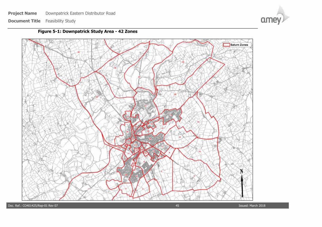
Project Name Downpatrick Eastern Distributor Road
Document Title Feasibility Study
Doc. Ref.: CO401425/Rep-01 Rev 07 45 Issued: March 2018
Figure 5-1: Downpatrick Study Area - 42 Zones

Project Name Downpatrick Eastern Distributor Road
Document Title Feasibility Study
Doc. Ref.: CO401425/Rep-01 Rev 07 46 Issued: March 2018
Figure 5-2: Downpatrick SATURN Model - Base Model Network

Project Name Downpatrick Eastern Distributor Road
Document Title Feasibility Study
Doc. Ref.: CO401425/Rep-01 Rev 07 47 Issued: March 2018
Calibration, Validation and Realism
The SATURN highway assignment model for the AM and PM peaks has been calibrated
and validated using the industry WebTAG Unit M3.1 guidance. Also, the vehicle routing
through the modelled network has been subject to sensitivity testing to ensure that realistic
journeys are taking place in the model.
The WebTAG Unit M3.1 unit contains guidance regarding the use of specific highway
survey data for the calibration and validation of highway models.
The validation of the highway assignment model has focused on the following three
criteria:
• Network validation;
• Count validation; and
• Journey time validation.
Network Validation
In the model development, coding of the highway assignment network was systematically
checked and validated in areas such as link speeds, number of lanes at stop lines, junction
type, priority and signal timing, and saturation flow. This ensured the characteristics of
each link and junction fell within the ranges appropriate to their respective classification.
Routing analysis was also undertaken between selected zones based on the converged
assignment results in all time periods. It was found that the routes chosen were in
accordance with common sense and local knowledge.
Junction Count Validation
The purpose of junction count validation is to ensure that modelled flows are compatible
with observed traffic survey data.
The model validation and calibration process has been carried out with reference to
acceptability guidelines, as stated in WebTAG Unit 3.19 for flow and journey time
validation/calibration.
Assigned flow validation/calibration is a comparison of modelled outputs with observed
values, according to the following criteria:
• >85% flows to have GEH <5.0;
• >85% flows (<700pcu/h) to be within 100pcu/h;

Project Name Downpatrick Eastern Distributor Road
Document Title Feasibility Study
Doc. Ref.: CO401425/Rep-01 Rev 07 48 Issued: March 2018
• >85% flows (700-2,700pcu/h) to be within 15%; and
• >85% flows (>2,700pcu/h) to be within 400pcu/h.
Table 5.1 outlines the results of the calibration count validation for the AM and PM Peaks
in Downpatrick. The junction turning movements validate within the acceptability guidance
and therefore there is a good degree of fit between the modelled flows and the observed
traffic flows in the AM and PM peaks.
For reference, model validation tables comparing the highway modelled flows and the
observed flows are available in Appendix G.
Table 5-1: AM and PM Peak Highway Model Calibration Flow Validation
Validation Criteria
AM Peak PM Peak
Target
Value
Achieved
Value
Target
Value
Achieved
Value
Flows to have GEH <5.0 >85% 86% >85% 93%
Flows (<700pcu/h) to be within
100pcu/h of observed >85% 99% >85% 99%
Flows (700-2,700pcu/h) to be within
15% of observed >85% 100% >85% 100%
Flows (>2,700pcu/h) to be within
400pcu/h of observed >85% n/a >85% n/a
Independent Cordon Link Flow Validation
A series of independent link flow counts was selected to give a reliable indication of model
flow accuracy for movements towards and away from Downpatrick. The ATC survey data
information was used in this exercise. Table 5.2 indicate that the base model performs
very reliably in both the AM and PM Peaks, achieving a high degree of accuracy in
comparison with the guidance.
For reference, model validation tables comparing the highway modelled flows and the
observed flows are available in Appendix G.

Project Name Downpatrick Eastern Distributor Road
Document Title Feasibility Study
Doc. Ref.: CO401425/Rep-01 Rev 07 49 Issued: March 2018
Table 5-2: AM and PM Peak Highway Model Flow Validation
Validation Criteria
AM Peak PM Peak
Target
Value
Achieved
Value
Target
Value
Achieved
Value
Flows to have GEH <5.0 >85% 95% >85% 95%
Flows (<700pcu/h) to be within
100pcu/h of observed >85% 95% >85% 95%
Flows (700-2,700pcu/h) to be within
15% of observed >85% n/a >85% n/a
Flows (>2,700pcu/h) to be within
400pcu/h of observed >85% n/a >85% n/a
Journey Time Validation
Journey time validation is a comparison of modelled outputs with observed values,
according to the following criteria:
• >85% routes to be within 15%; and
• >85% routes (modelled time > observed) to be within 1 minute.
Journey times in each highway model have been analysed on four key routes as described
in Chapter 2.
Accurate modelling of the delays across the journey time routes is a key factor in the
routeing/assignment of vehicles across the network and as such the model represents the
2017 base situation.
Performance of the peak hour models with respect to journey time validation is
summarised in Table 5.3. It can be seen from Table 5.3 that the model journey time
accuracy is acceptable and satisfies the threshold criteria.

Project Name Downpatrick Eastern Distributor Road
Document Title Feasibility Study
Doc. Ref.: CO401425/Rep-01 Rev 07 50 Issued: March 2018
Table 5-3: AM and PM Journey Time Validation
Journey Time
Route Validation Criteria Target Value
Value
Achieved in
Model
AM Peak
Times to be within 15% of observed >85% 76%
Times (if modelled time > observed) to be within 1
minute of observed >85% 94%
PM Peak
Times to be within 15% of observed >85% 100%
Times (if modelled time > observed) to be within 1
minute of observed >85% 79%
In conclusion, the validation and calibration achieved in the Downpatrick SATURN Highway
model confirms the AM and PM base models are a good platform for testing future
scenarios.
5.2 SATURN Traffic Modelling – Do-Minimum Model
For the Do-Minimum SATURN highway model, DfI-Roads have confirmed that the
following schemes are committed and funding has been allocated over the next 5 years;
• Collins Corner junction improvement, which includes localised widening on the
Killough Road approach – for delivery in 2017/18 – 2018/19
• Fountain Street road widening to accommodate parking and traffic progression –
Completed July 2017.
• MOVA to be introduced at the signalised junctions - Market Street / St Patrick’s
Avenue, Market Street / Irish Street / English Street; Collins Corner; and Saul
Way/Church Street– to be completed within the next 3 years.
The base SATURN model has been changed to reflect these proposed infrastructure
changes. The introduction of these proposed schemes did not result in major changes to
the SATURN network. The highway structure in the Downpatrick base model remains the
same. The only changes to the model related to junction recoding, speed changes and
saturation flow increases.
In summary, the model changes applied to the Do-Minimum model are:
Project Name Downpatrick Eastern Distributor Road
Document Title Feasibility Study
Doc. Ref.: CO401425/Rep-01 Rev 07 51 Issued: March 2018
• Collins Corner junction improvement – Junction has been recoded. The Killough
Road approach was widened to a lane plus a flare.
• Fountain Street road widening – To reflect the improvement for traffic progression,
the average speeds along Fountain Street have been improved by 5% from the
base model.
• MOVA provided at all signalised junctions – To reflect MOVA improvement at all
the signalised junctions, saturation flows on all approaches have been increased
by 10% from the base model.
The impact of these changes to this Do-Minimum model compared to the base, did not
result in any significant re-routing of traffic; traffic outputs were predominantly the same
as the base outputs. Junction performance did slightly improve across all the signalised
junctions, which improved journey times through the model.
5.3 SATURN Traffic Modelling – Do-Something Tests
The ‘Do Something’ network has been developed by editing the ‘Do Minimum’ network to
incorporate the proposed Eastern Distributor Road. Figure 5-3 illustrates the ‘Do
Something’ SATURN network. Th
To establish potential traffic usage of the proposed Eastern Distributor Road if constructed,
the route has been modelled in three separate tests in SATURN:
• Test 1: Section 1 of the proposed Eastern Distributor Road is the construction of
the route between Strangford Road and Saul Road only;
• Test 2: Sections 2, 3 and 4 of the proposed Eastern Distributor Road is the
construction of the route between Saul Road and the Ardglass Road roundabout
only; and
• Test 3: Is the full construction of the proposed Eastern Distributor Road between
the Strangford Road and the Ardglass Road roundabout.
AM and PM Traffic has been re-assigned onto the highway network and modelled for each
of the test scenarios using the model simulation. No additional development traffic has
been loaded onto this network, only the 2017 adjusted traffic has been re-assessed as
part of the Do-Something tests.
The resulting traffic re-assignment for each of the sensitivity tests are presented in Figures
5-4 to 5-11.

Project Name Downpatrick Eastern Distributor Road
Document Title Feasibility Study
Doc. Ref.: CO401425/Rep-01 Rev 07 52 Issued: March 2018
Figure 5-3: SATURN Network – ‘Do Something’ Model

Project Name Downpatrick Eastern Distributor Road
Document Title Feasibility Study
Doc. Ref.: CO401425/Rep-01 Rev 07 53 Issued: March 2018
Eastern Distributor Road Test 1
In this test, the ‘Do Minimum’ network has been modified to include section 1 of the
proposed Eastern Distributor Road, which includes the construction of a new two-way link
between the Strangford Road and the Saul Road only. This new section proposes three
new junction arrangements. The ‘Do Something’ Test 1 SATURN model has coded a four-
armed roundabout junction at the Strangford Road side, a priority T-junction and a three-
armed roundabout junction at the Saul Road connection (refer to design layout in Appendix
C).
Figures 5-4 and 5-5 present the AM and PM traffic reassignment on the Downpatrick
highway resulting from the construction of the route between Strangford Road and Saul
Road.
Note: the values illustrated in the figures are not absolute volumes, they are the net
comparison between the ‘Do Minimum’ and the ‘Do-Something’ models.
In summary, the SATURN ‘Do Something’ model Test 1 indicates:
In both peak hours, traffic moving between the east and north of the study areas is
reassigned to the proposed Eastern Distributor Road. Commuter traffic and school bound
traffic are likely to be key contributors to these movements. For reference, the east of the
study area includes the residential area along the Saul Road and the villages of Saul and
Raholp; also along the Saul Road, secondary schools and the golf club are located. The
northern part of the study area includes the radial routes to Belfast, Killyleagh,
Ballynahinch, etc.
In the AM peak, a total of 101 PCUs are re-assigned to this section of the proposed
Eastern Distributor Road; 86 PCUs head north bound and 15 PCUs south bound.
• The Saul Road benefits from this section of the proposed Eastern Distributor Road.
Traffic flows are reduced by 80 PCUs in the AM peak; of which 70 PCUs are
Downpatrick bound. Currently queuing and delay is experienced at the Saul Road/
Scotch Street junction and Saul Way/ Market Street junction in the AM peak. For
journeys between the eastern and northern parts of the study area, this route
provides a journey time saving.
• This section appears to divert movement via the Finnebrogue Road at a benefit to
the Belfast Road. The Finnebrogue Road would appear to compliment the new link
and is a more direct connection with less delay. 51 less PCUs are travelling to the

Project Name Downpatrick Eastern Distributor Road
Document Title Feasibility Study
Doc. Ref.: CO401425/Rep-01 Rev 07 54 Issued: March 2018
A7 Belfast Road via the Belfast Road roundabout junction and instead travelling
via the Finnebrogue Road. This trend also applies to vehicles travelling from the
A7 Belfast Road.
• Vehicles travelling to/from the Raholp and Saul village areas (20 PCUs) are diverted
to the new link via Saul Brae instead of travelling via the rural Mearne Road. The
new link would appear to offer a more direct route and journey time saving
compared to the Mearne Road.
In the PM peak, a total of 73 PCUs has been re-assigned to this section of the proposed
Eastern Distributor Road. On the link road, the reverse trend of the AM appears to occur;
11 PCUs heading north bound and 62 PCUs south bound are attracted to the link.
• PM peak traffic conditions in Downpatrick differ from the AM, mainly due to the PM
peak not coinciding with the school traffic drop off and pick-ups. Therefore, the
same delay experienced at junctions close to schools such as Saul Road/ Scotch
Street and Strangford Road/ New Bridge Street in the AM peak does not occur in
the PM.
• In the PM peak the proposed Eastern Distributor Road section will benefit the
Rathkeltair Road; a reduction of 76 PCUs (two-way). In the ‘Do-Minimum’ scenario,
traffic with a destination on the Saul Road use the Strangford Road – Rathkeltair
Road route to avoid the queuing and delay along Church Street that can extend
back to the Belfast Road roundabout. In the ‘Do Something’ model the new link is
deemed more attractive than Rathkeltair Road and therefore traffic uses the new
link road from the Strangford Road.
• The difference in traffic volumes calculated on the A7 Belfast Road and
Finnebrogue approaches indicate that the presence of the proposed Eastern
Distributor Road will not change driver travel behaviour in the PM peak. To avoid
the Church Street delay, Saul Road bound traffic will travel to the Strangford Road
and use the new link road instead of the narrow Rathkeltair Road route.

Project Name Downpatrick Eastern Distributor Road
Document Title Feasibility Study
Doc. Ref.: CO401425/Rep-01 Rev 07 55 Issued: March 2018
Figure 5-4: Eastern Distributor Road – Test 1 – AM Peak SATURN Re-assignment

Project Name Downpatrick Eastern Distributor Road
Document Title Feasibility Study
Doc. Ref.: CO401425/Rep-01 Rev 07 56 Issued: March 2018
Figure 5-5: Eastern Distributor Road – Test 1 – PM Peak SATURN Re-assignment

Project Name Downpatrick Eastern Distributor Road
Document Title Feasibility Study
Doc. Ref.: CO401425/Rep-01 Rev 07 57 Issued: March 2018
In summary for Test 1 -new two-way link between the Strangford Road and the Saul
Road:
• In both peak hours, traffic moving between the east and north of the study areas
is reassigned to the proposed Eastern Distributor Road. Commuter traffic and
school bound traffic are likely to be key contributors to these movements.
• In the AM peak, a total of 101 PCUs are re-assigned to this section of the proposed
Eastern Distributor Road and in the PM peak, a total of 73 PCUs has been re-
assigned.
• Key routes that benefit from the re-assignment of Test 1are:
o Saul Road – 80 less PCUs in AM peak and 71 less in the PM peak.
o Belfast Road - 71 less PCUs in the AM peak
o Rathkeltair Road - 76 less PCUs in the PM peak
o Town Centre (Market Street) – No re-assigned traffic along Market
Street in the AM or PM peaks
o Ballydugan Road - No re-assigned traffic along Ballydugan Road in the
AM or PM peaks
Eastern Distributor Road - Test 2
In this test, the ‘Do Minimum’ network has been modified to include sections 2, 3 and 4 of
the proposed Eastern Distributor Road, which introduces the construction of a new two-
way link between the Saul Road and the Ardglass Road roundabout. This new section also
includes three new junction arrangements. A three-armed roundabout is proposed at the
Saul Road end and the southern end ties into the Struell Wells approach arm of the
Ardglass Road roundabout. Also, as the route crosses the existing Ballyhornan Road and
Struell Wells Road, a four-armed roundabout and a staggered cross-road junction is
proposed at each respective location (refer to design layout in Appendix C). These
junctions have been coded into the SATURN model for the ‘Do Something’ Test 2 scenario.
Figures 5-6 and 5-7 present the AM and PM traffic reassignment on the Downpatrick
highway resulting from the construction of the route between Saul Road, Ballyhornan Road
and the Ardglass Road roundabout
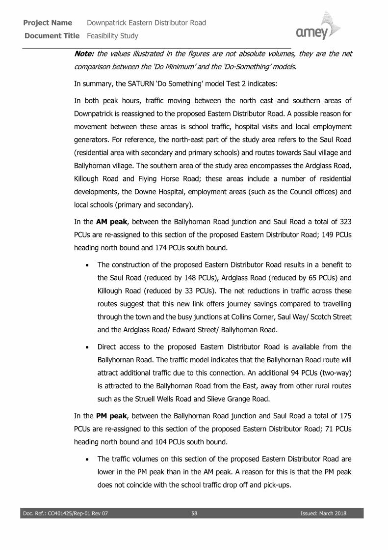
Project Name Downpatrick Eastern Distributor Road
Document Title Feasibility Study
Doc. Ref.: CO401425/Rep-01 Rev 07 58 Issued: March 2018
Note: the values illustrated in the figures are not absolute volumes, they are the net
comparison between the ‘Do Minimum’ and the ‘Do-Something’ models.
In summary, the SATURN ‘Do Something’ model Test 2 indicates:
In both peak hours, traffic moving between the north east and southern areas of
Downpatrick is reassigned to the proposed Eastern Distributor Road. A possible reason for
movement between these areas is school traffic, hospital visits and local employment
generators. For reference, the north-east part of the study area refers to the Saul Road
(residential area with secondary and primary schools) and routes towards Saul village and
Ballyhornan village. The southern area of the study area encompasses the Ardglass Road,
Killough Road and Flying Horse Road; these areas include a number of residential
developments, the Downe Hospital, employment areas (such as the Council offices) and
local schools (primary and secondary).
In the AM peak, between the Ballyhornan Road junction and Saul Road a total of 323
PCUs are re-assigned to this section of the proposed Eastern Distributor Road; 149 PCUs
heading north bound and 174 PCUs south bound.
• The construction of the proposed Eastern Distributor Road results in a benefit to
the Saul Road (reduced by 148 PCUs), Ardglass Road (reduced by 65 PCUs) and
Killough Road (reduced by 33 PCUs). The net reductions in traffic across these
routes suggest that this new link offers journey savings compared to travelling
through the town and the busy junctions at Collins Corner, Saul Way/ Scotch Street
and the Ardglass Road/ Edward Street/ Ballyhornan Road.
• Direct access to the proposed Eastern Distributor Road is available from the
Ballyhornan Road. The traffic model indicates that the Ballyhornan Road route will
attract additional traffic due to this connection. An additional 94 PCUs (two-way)
is attracted to the Ballyhornan Road from the East, away from other rural routes
such as the Struell Wells Road and Slieve Grange Road.
In the PM peak, between the Ballyhornan Road junction and Saul Road a total of 175
PCUs are re-assigned to this section of the proposed Eastern Distributor Road; 71 PCUs
heading north bound and 104 PCUs south bound.
• The traffic volumes on this section of the proposed Eastern Distributor Road are
lower in the PM peak than in the AM peak. A reason for this is that the PM peak
does not coincide with the school traffic drop off and pick-ups.

Project Name Downpatrick Eastern Distributor Road
Document Title Feasibility Study
Doc. Ref.: CO401425/Rep-01 Rev 07 59 Issued: March 2018
• The net traffic comparison trend presented on the Ardglass Road and Saul Road in
the AM peak is the same in the PM peak. On construction of this section of the
proposed Eastern Distributor Road, 57 fewer PCUs (two-way) are predicted to
travel along the Ardglass Road and 135 fewer PCUs (two way) on the Saul Road.
• Along the Killough Road and Ballyhornan Road routes only northbound traffic
appears to be attracted to the proposed Eastern Distributor Road. 21 fewer PCUs
travel northbound via the Killough Road and Collins Corner; and 17 northbound
PCUs access the proposed Eastern Distributor Road from the Ballyhornan Road.

Project Name Downpatrick Eastern Distributor Road
Document Title Feasibility Study
Doc. Ref.: CO401425/Rep-01 Rev 07 60 Issued: March 2018
Figure 5-6: Eastern Distributor Road – Test 2 – AM Peak SATURN Re-assignment

Project Name Downpatrick Eastern Distributor Road
Document Title Feasibility Study
Doc. Ref.: CO401425/Rep-01 Rev 07 61 Issued: March 2018
Figure 5-7: Eastern Distributor Road – Test 2 – PM Peak SATURN Re-assignment
Project Name Downpatrick Eastern Distributor Road
Document Title Feasibility Study
Doc. Ref.: CO401425/Rep-01 Rev 07 62 Issued: March 2018
In summary for Test 2 - new two-way link between the Saul Road and Ardglass Road
roundabout:
• In both peak hours, traffic moving between the north east and southern areas of
Downpatrick is reassigned to the proposed Eastern Distributor Road section. A
possible reason for movement between these areas is school traffic, hospital visits
and local employment generators.
• In the AM peak, a total of 323 PCUs are re-assigned to this section of the proposed
Eastern Distributor Road and in the PM peak, a total of 175 PCUs has been re-
assigned.
• Key routes that benefit from the re-assignment of Test 2 are:
o Saul Road – 148 less PCUs in AM peak and 135 less in the PM peak.
o Ardglass Road - 65 less PCUs in the AM peak and 57 less in the PM peak
o Killough Road - 33 less PCUs in the AM peak and 15 less in the PM peak
o Town Centre (Market Street) – No re-assigned traffic along Market
Street in the AM or PM peaks.
o Ballydugan Road - No re-assigned traffic along Ballydugan Road in the
AM or PM peaks.
Eastern Distributor Road - Test 3
In this test, the ‘Do Minimum’ network has been modified to include the entire proposed
Eastern Distributor Road which includes the construction of a new two-way link between
the Strangford Road, the Saul Road, the Ballyhornan Road and the Ardglass Road
roundabout. This Test 3 combines the infrastructure discussed in Tests 1 and 2. As well
as the entire new link, the same junction arrangements discussed at each intersection has
been coded in the ‘Do-something’ Test 3 model scenario. The design presented in
Appendix C outlines the alignment and junction arrangements along the route.
Figures 5-8 and 5-9 present the AM and PM traffic reassignment on the Downpatrick
highway resulting from the construction of the entire route between Strangford Road, Saul
Road, Ballyhornan Road and the Ardglass Road roundabout.
Note: the values illustrated in the figures are not absolute volumes, they are the relative
comparison between the ‘Do Minimum’ and the ‘Do-Something’ models.

Project Name Downpatrick Eastern Distributor Road
Document Title Feasibility Study
Doc. Ref.: CO401425/Rep-01 Rev 07 63 Issued: March 2018
In summary, the SATURN ‘Do Something’ model Test 3 suggests:
In both peak hours, the re-assignment and net changes to the Downpatrick network
described for Tests 1 and 2 are combined. The construction of the entire proposed Eastern
Distributor Road provides an alternative route for traffic travelling between the northern,
southern and eastern areas of Downpatrick. Connection to the proposed Eastern
Distributor Road is available from all these areas and facilitates movement for commuters,
school traffic (primary and secondary), local employment, health and leisure.
In the AM peak, between the Strangford Road junction and Saul Road a total of 241 PCUs
(two-way) are re-assigned to this section of the proposed Eastern Distributor Road. On
the section between the Saul Road and Ballyhornan Road 427 PCUs (two-way) are re-
assigned.
• According to the SATURN ‘Do Something’ Test 3 model, the construction of the
proposed Eastern Distributor Road results in a benefit to the A7 Belfast Road
(reduced by 91 PCUs), Saul Road (reduced by 227 PCUs), Mearne Road (reduced
by 20 PCUs), Ardglass Road (reduced by 117 PCUs) and Killough Road (reduced
by 33 PCUs). The net reductions in traffic across these routes suggest that this full
link offers journey savings compared to travelling through the town and the
junctions at Collins Corner, Saul Way/ Scotch Street, Strangford Road/ New Bridge
Street, Church Street/ Irish Street and the Ardglass Road/ Edward Street/
Ballyhornan Road.
To highlight the impact on the Town Centre junctions following construction of the
proposed Eastern Distributor Road, Figure 5-10 has been derived to illustrate the AM peak
net PCU volume difference. The figures illustrated in red highlight the relief (net reduction)
that the Town Centre routes will experience following construction of the proposed Eastern
Distributor Road.
In the PM peak, between the Strangford Road junction and Saul Road a total of 199 PCUs
(two-way) are re-assigned to this section of the proposed Eastern Distributor Road. On
the section between the Saul Road and Ballyhornan Road 288 PCUs (two-way) are re-
assigned.

Project Name Downpatrick Eastern Distributor Road
Document Title Feasibility Study
Doc. Ref.: CO401425/Rep-01 Rev 07 64 Issued: March 2018
• According to the SATURN ‘Do Something’ Test 3 model, the construction of the
proposed Eastern Distributor Road results in a benefit to the Saul Road (reduced
by 188 PCUs), Ardglass Road (reduced by 124 PCUs) and Killough Road (reduced
by 31 PCUs). The net reductions in traffic across these routes suggest that this full
link offers journey savings compared to travelling through the town and the
junctions at Collins Corner, Saul Way/ Scotch Street, Church Street/ Irish Street
and the Ardglass Road/ Edward Street/ Ballyhornan Road.
To highlight the impact on the Town Centre junctions following construction of the
proposed Eastern Distributor Road, Figure 5-11 has been derived to illustrate the PM peak
net PCU difference. The figures illustrated in red highlight the relief (net reduction) that
the Town Centre routes will experience following construction of the proposed Eastern
Distributor Road.

Project Name Downpatrick Eastern Distributor Road
Document Title Feasibility Study
Doc. Ref.: CO401425/Rep-01 Rev 07 65 Issued: March 2018
Figure 5-8: Eastern Distributor Road – Test 3 – AM Peak SATURN Re-assignment

Project Name Downpatrick Eastern Distributor Road
Document Title Feasibility Study
Doc. Ref.: CO401425/Rep-01 Rev 07 66 Issued: March 2018
Figure 5-9: Eastern Distributor Road – Test 3 – PM Peak SATURN Re-assignment

Project Name Downpatrick Eastern Distributor Road
Document Title Feasibility Study
Doc. Ref.: CO401425/Rep-01 Rev 07 67 Issued: March 2018
Figure 5-10: Eastern Distributor Road – Test 3 – AM Peak SATURN Re-assignment in Town Centre

Project Name Downpatrick Eastern Distributor Road
Document Title Feasibility Study
Doc. Ref.: CO401425/Rep-01 Rev 07 68 Issued: March 2018
Figure 5-11: Eastern Distributor Road – Test 3 – PM Peak SATURN Re-assignment in Town Centre

Project Name Downpatrick Eastern Distributor Road
Document Title Feasibility Study
Doc. Ref.: CO401425/Rep-01 Rev 07 69 Issued: March 2018
In summary for Test 3 – The construction of a new two-way link between the Strangford
Road, Saul Road and Ardglass Road roundabout:
• In both peak hours, traffic moving between the northern, southern and eastern
areas will benefit from the construction of the full Eastern Distributor Road. This
test offers the most benefit to the Downpatrick study area regarding the volume
of re-assigned traffic.
• In the AM peak, a maximum total of 427 PCUs are re-assigned to the proposed
Eastern Distributor Road and in the PM peak, a maximum total of 288 PCUs has
been re-assigned.
• Key routes that benefit from the re-assignment of Test 3 are:
o Saul Road – In the AM peak, 227 less PCUs will travel on Saul Road and
188 less PCUs in the PM peak.
o Ardglass Road - In the AM peak, 117 less PCUs will travel on the Ardglass
Road and 124 less PCUs in the PM peak.
o Killough Road - In the AM peak, 33 less PCUs will travel on the Killough
Road and 31 less PCUs in the PM peak.
o Edward Street- In the AM peak, 169 less PCUs will travel on Edward
Street and 152 less PCUs in the PM peak.
o Belfast Road - In the AM peak, 71 less PCUs will travel on the Belfast
Road and 16 less PCUs in the PM peak.
o Town Centre (Church Street) - In the AM peak, 221 less PCUs will travel
on Church Street and 189 less PCUs in the PM peak.
o Town Centre (St Patricks Avenue) - - In the AM peak, 48 less PCUs
will travel on St Patricks Avenue and 60 less PCUs in the PM peak.
o Town Centre (Fountain Street) - In the AM peak, 104 less PCUs will
travel on Fountain Street and 134 less PCUs in the PM peak.
o Town Centre (Market Street) – No re-assigned traffic along Market
Street in the AM or PM peaks.
o Ballydugan Road - No re-assigned traffic along Ballydugan Road in the
AM or PM peaks

Project Name Downpatrick Eastern Distributor Road
Document Title Feasibility Study
Doc. Ref.: CO401425/Rep-01 Rev 07 70 Issued: March 2018
5.4 Economic Assessment
5.4.1 Introduction
Transport economic efficiency impacts from the proposed Eastern Distributor Road scheme
and ‘no-scheme’ situations have been assessed using the latest version of the DfT’s TUBA
software program (Version 1.9.9). The appraisal calculates the net user benefit, in terms
of travel time and vehicle operating cost, of introducing the proposed Eastern Distributor
Road, when compared with the do-minimum.
This section gives details of the TUBA approach and the results from the analysis. The
TUBA modelling presented in this section assumes the Eastern Distributor Road is
constructed from the Strangford Road to the Saul Road to the Ardglass Roundabout.
5.4.2 TUBA Appraisal Method
Main Appraisal Components
In common with the rest of the economic appraisal, TUBA calculates economic efficiency
impacts over 60 years. User costs and benefits are discounted to 2010 present values.
Impacts are calculated for a single mode (i.e. road) taking outputs from the Downpatrick
Traffic Model. Impacts are also assessed in TUBA according to two user groups, namely
consumer users and business users. Different economic values are applied to the two user
groups in accordance with WebTAG Unit A1.3 (‘User and Provider Impacts’).
Economic Parameters
In accordance with WebTAG guidance, the standard TUBA economics file was used. This
file provides details of tax rates, values of time (VOT) and vehicle operating cost (VOC)
parameters and growth forecasts for VOT and VOC.
Traffic Model Outputs
TUBA assesses the economic benefits of each of the schemes by using data output from
the SATURN model and calculating the difference in travel time and distance between
each origin and destination pair in the model. It then monetises these changes with
respect to the number of trips between each origin and destination pair and the value of
time and operating cost for each type of user.
The following information has been extracted from the SATURN model for each time
period, future year and scenario and input into TUBA:

Project Name Downpatrick Eastern Distributor Road
Document Title Feasibility Study
Doc. Ref.: CO401425/Rep-01 Rev 07 71 Issued: March 2018
• Travel time between each modelled origin/destination pair;
• Travel distance between each modelled origin/destination pair; and
• Travel demand (trips) between each modelled origin/destination pair.
Trip matrix inputs to TUBA were specified as total PCU (Passenger Car Units)
movements. These were split into four vehicle categories, by time period, in accordance
with locally observed proportions. The TUBA input proportions were as shown in Table
5.4.
Table 5-4: Trip Matrix Conversion Factors for TUBA
Time Period Car LGV OGV1 OGV2 Total
(i.e. PCU to Vehicle)
AM Peak 0.895 0.074 0.012 0.004 0.985
PM Peak 0.891 0.097 0.005 0.003 0.996
Notes:
LGV = Light Goods Vehicles, (small van, Transit van)
OGV1 = Other Goods Vehicles 1 (2 axle vehicles 3.5 to 7.5 tonne, 3 axle vehicles)
OGV2 = Other Goods Vehicles 2 (4 axle vehicles, any other goods vehicles)
5.4.3 Results from the TUBA Appraisal
A detailed breakdown of the appraisal outputs from TUBA is given in Table 5.5. These
TUBA results relate to the Test 3 SATURN model, when the Eastern Distributor Road is
constructed between Strangford Road, Saul Road and the Ardglass Roundabout.

Project Name Downpatrick Eastern Distributor Road
Document Title Feasibility Study
Doc. Ref.: CO401425/Rep-01 Rev 07 72 Issued: March 2018
Table 5-5: TUBA Summary of User Benefits
Value (£000s) Discounted to 2010
Benefits
Consumer
Commuting Travel Time 1,766
Commuting Vehicle Operating Cost
100
Commuting Overall 1,865
Other Travel Time 1,263
Other Vehicle Operating Cost 100
Other Overall 1,363
Business
Travel Time 1,574
Vehicle Operating Cost 180
Business Overall 1,754
All Users Overall 4,982
Indirect Tax Revenue -171
Greenhouse Gases 39
Overall Impact 4,850
The proposed Downpatrick Eastern Distributor Road would provide a net user economic
benefit of £4.982M, in terms of travel time and vehicle operation. This benefit would be
increased by means of a saving in carbon emissions of £0.039M and a reduction in indirect
tax contribution to Government of £0.171M. The overall transport user impact would
therefore amount to £4.850M.
5.4.4 Results of the Economic Assessment
Economic Appraisal Summary
An assessment has been made of the economic impact of the proposed Eastern Distributor
Road upon transport users and Government. The assessment compares the net worth of
the scheme with that of the no-scheme alternative. Economic worth has been evaluated
in terms of the following:
• Public Accounts – (capital cost to central government);
• Transport Economic Efficiency – (travel time and vehicle operation);
• Impacts upon carbon emissions; and
• Indirect tax expenditure.
Transport inputs to the economic appraisal have been extracted from the SATURN Model.
The model has produced forecast flows and network performance details for weekday AM
peak and PM peak conditions.

Project Name Downpatrick Eastern Distributor Road
Document Title Feasibility Study
Doc. Ref.: CO401425/Rep-01 Rev 07 73 Issued: March 2018
Economic performance has been evaluated over 60 years from 2020 to 2069 inclusive.
Costs and benefits have been discounted back from year of occurrence to a present value
year of 2010.
At this preliminary stage, the construction scheme cost for this proposed Eastern
Distributor Road is estimated at £18.3M in 2017 prices, the breakdown of this cost is
provided in Table 4.1 of Section 4 of this report. The current capital cost estimate for the
scheme at 2010 prices is £15.493M. Capital cost mainly comprises design and
implementation, land, preparation and supervision, and optimism bias.
Net economic impacts for transport users during scheme operation have been assessed
using TUBA (Version 1.9.9). The outputs of the TUBA modelling are available in Appendix
H. The scheme will provide a user benefit, in terms of travel time and vehicle operation,
of £4.982M. The majority, £4.603M, of this benefit will arise from time savings, whilst
£0.380M will be attributable to vehicle operating cost savings.
Further user operational impacts will arise, comprising a saving of £0.039M in carbon
emissions and a benefit of £0.171M in reduced indirect tax expenditure.
Overall Economic Outcome
The overall net economic performance of the proposed Eastern Distributor Road, over 60
years, is summarised in Table 5.6.
Table 5-6: Overall Economic Summary
Value (£000s) Discounted to 2010
Appraisal Item
User Benefits
Road User Travel Time/Vehicle Operation Impact (TUBA Table 6) 4,982
Carbon Emissions (TUBA Table 6) 39
Indirect Taxation (TUBA Table 6) -171
Present Value of Benefits (PVB) 4,850
Do-Something
Capital Costs
Central Government Funding Investment Costs 15,493
Present Value of Costs (PVC) 15,493
Overall Impact
Net Present Value (PVB-PVC) -10,643
Benefit/Cost Ratio (PVB/PVC) 0.313

Project Name Downpatrick Eastern Distributor Road
Document Title Feasibility Study
Doc. Ref.: CO401425/Rep-01 Rev 07 74 Issued: March 2018
The economic assessment indicates that there is no economic justification for proceeding
with the Eastern Distributor Road, for the reasons outlined below:
• The scheme will show a negative Net Present Value (NPV) over 60
years, with road user benefits significantly lower than capital costs;
• The scheme is predicted to provide poor value for money, with a 60-
year Benefit / Cost Ratio (BCR) of 0.313.

Project Name Downpatrick Eastern Distributor Road
Document Title Feasibility Study
Doc. Ref.: CO401425/Rep-01 Rev 07 75 Issued: March 2018
6 STAGE 4: FUTURE FORECAST TRAFFIC MODELLING AND
ASSESSMENT
Following on from the 2017 base year assessment presented in Chapter 5, this chapter
presents further assessment for a 2030 forecast year and a 2030 forecast year with future
housing development traffic. The aim of this assessment is to establish the potential traffic
usage of the proposed distributor road for both forecast scenarios and determine their
transport economic efficiency impacts.
This chapter describes how the future forecast matrices (2030 with and without
development) have been generated and tested in the Do-Minimum and Do-Something
network scenarios.
For reference; the Do-Minimum SATURN network only includes the Downpatrick
committed highway schemes confirmed by DfI-Roads and the Do-Something highway
model includes the committed schemes and the Eastern Distributor Road constructed from
the Strangford Road to the Saul Road and to the Ardglass Roundabout.
6.1 SATURN Traffic Modelling– 2030 Forecast
The peak hour forecasts for future design year 2030 have been derived by applying NRTF
low growth, equating to an increase of 8.14%.
NRTF low growth was selected as when compared against local growth factors derived
from previous Downpatrick studies the NRTF low growth forecast rates were comparable.
The forecast traffic matrix for forecast year 2030 was generated by applying the low
growth factor to the 2017 AM and PM traffic matrix presented in Appendix B. The origin
of the 2017 AM and PM peak hour matrices and its 42 zones is discussed in Section 5.1 of
this report.
The forecasted AM and PM traffic matrices have been tested for the Do-Minimum SATURN
highway model and the Do- Something highway model.
The 2030 AM and PM forecasted matrices are provided in Appendix I for reference.
Figures 6-1 and 6-2 compares the 2030 AM and PM traffic reassignment on the
Downpatrick highway resulting from the construction of the entire route between
Strangford Road, Saul Road, Ballyhornan Road and the Ardglass Road roundabout.

Project Name Downpatrick Eastern Distributor Road
Document Title Feasibility Study
Doc. Ref.: CO401425/Rep-01 Rev 07 76 Issued: March 2018
Figure 6-1: Eastern Distributor Road – Forecast Year 2030 – AM Peak SATURN Re-assignment

Project Name Downpatrick Eastern Distributor Road
Document Title Feasibility Study
Doc. Ref.: CO401425/Rep-01 Rev 07 77 Issued: March 2018
Figure 6-2: Eastern Distributor Road – Forecast Year 2030 – PM Peak SATURN Re-assignment

Project Name Downpatrick Eastern Distributor Road
Document Title Feasibility Study
Doc. Ref.: CO401425/Rep-01 Rev 07 78 Issued: March 2018
As was described for Test 3 in Chapter 5, the traffic re-assignment forecast in 2030
demonstrates the same trends. As outlined previously, the construction of the entire
Eastern Distributor Road provides an alternative route for traffic travelling between the
northern, southern and eastern areas of Downpatrick and appears to ease traffic volumes
on existing routes such as Saul Road and Ardglass Road. Connection to the proposed
Eastern Distributor Road is available from all these areas and facilitates movement for
commuters, school traffic (primary and secondary), local employment, health and leisure.
In the AM peak, between the Strangford Road junction and Saul Road a total of 261 PCUs
(two-way) are re-assigned to this section of the proposed Eastern Distributor Road; an
increase of 20 PCUs when compared to the base 2017 year. On the section between the
Saul Road and Ballyhornan Road 465 PCUs (two-way) are re-assigned; an increase of 38
PCUs when compared to the base 2017 year.
In the PM peak, between the Strangford Road junction and Saul Road a total of 211 PCUs
(two-way) are re-assigned to this section of the proposed Eastern Distributor Road; an
increase of 12 PCUs when compared to the base 2017 year. On the section between the
Saul Road and Ballyhornan Road 302 (two-way) are re-assigned; an increase of 14 PCUs
when compared to the base 2017 year.
In Section 6.3 the transport economic efficiency impacts from the proposed Eastern
Distributor Road scheme and ‘no-scheme’ situations have been calculated using this 2030
forecast year.
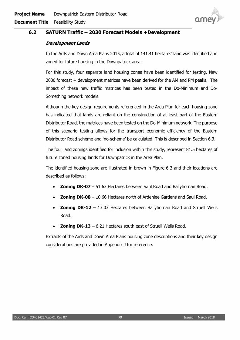
Project Name Downpatrick Eastern Distributor Road
Document Title Feasibility Study
Doc. Ref.: CO401425/Rep-01 Rev 07 79 Issued: March 2018
6.2 SATURN Traffic – 2030 Forecast Models +Development
Development Lands
In the Ards and Down Area Plans 2015, a total of 141.41 hectares’ land was identified and
zoned for future housing in the Downpatrick area.
For this study, four separate land housing zones have been identified for testing. New
2030 forecast + development matrices have been derived for the AM and PM peaks. The
impact of these new traffic matrices has been tested in the Do-Minimum and Do-
Something network models.
Although the key design requirements referenced in the Area Plan for each housing zone
has indicated that lands are reliant on the construction of at least part of the Eastern
Distributor Road, the matrices have been tested on the Do-Minimum network. The purpose
of this scenario testing allows for the transport economic efficiency of the Eastern
Distributor Road scheme and ‘no-scheme’ be calculated. This is described in Section 6.3.
The four land zonings identified for inclusion within this study, represent 81.5 hectares of
future zoned housing lands for Downpatrick in the Area Plan.
The identified housing zone are illustrated in brown in Figure 6-3 and their locations are
described as follows:
• Zoning DK-07 – 51.63 Hectares between Saul Road and Ballyhornan Road.
• Zoning DK-08 – 10.66 Hectares north of Ardenlee Gardens and Saul Road.
• Zoning DK-12 – 13.03 Hectares between Ballyhornan Road and Struell Wells
Road.
• Zoning DK-13 – 6.21 Hectares south east of Struell Wells Road.
Extracts of the Ards and Down Area Plans housing zone descriptions and their key design
considerations are provided in Appendix J for reference.

Project Name Downpatrick Eastern Distributor Road
Document Title Feasibility Study
Doc. Ref.: CO401425/Rep-01 Rev 07 80 Issued: March 2018
Figure 6-3: Downpatrick Study Area – Development Housing Zones

Project Name Downpatrick Eastern Distributor Road
Document Title Feasibility Study
Doc. Ref.: CO401425/Rep-01 Rev 07 81 Issued: March 2018
Development Trips
Using a housing density of 20 dwellings per hectare (Reference: key design requirement
density quoted in the Ards and Down Area Plan), the traffic impact associated with an
additional 1630 new housing units (81.5 hectares) on the Downpatrick study area has
been tested for both the Do- Minimum and Do-Something networks.
The associated development vehicular trips have been generated using the multi-modal
trip generating software package TRICS -version 7.4.3. Mean vehicular trip rates have
been derived using the land-use reference ‘Residential- Privately Owned Houses (03A)’.
Table 6-1 summarises the predicted arrival and departure trips generated for the 1630
residential units. In the AM peak it is predicted that for the zoned lands, 892 vehicles will
be added to the Downpatrick network (233 arrivals and 659 departures) and in the PM
peak 945 vehicles will be added to the network (611 arrivals and 334 departures).
Table 6-1: New Housing Development Trips – TRICS database
Vehicle Trip Rates per dwelling
(derived from TRICS)
Vehicle Trip Generation
(for 1630 dwellings)
Arrival Departure Total Arrival Departure Total
AM Peak 0.143 0.404 0.547 233 659 892
PM Peak 0.375 0.205 0.580 611 334 945
For this assessment, it is assumed by future year 2030 all 1630 housing units are
constructed and occupied, therefore generating the vehicle trips displayed in Table 6-1.
These generated trips have been added to the 2030 forecast matrix to provide a ‘with
development’ scenario matrix for testing in SATURN. This matrix is presented in Appendix
I.
The new development trips (arrivals and departures) have been loaded onto the 2030
network from Zone 14 in both network models. In the Do-Something scenario this zone
accesses directly onto the Eastern Distributor Road.
Figures 6-4 and 6-5 presents the ‘2030 with development’ AM and PM traffic reassignment
on the Downpatrick highway.

Project Name Downpatrick Eastern Distributor Road
Document Title Feasibility Study
Doc. Ref.: CO401425/Rep-01 Rev 07 82 Issued: March 2018
Figure 6-4: Eastern Distributor Road – Forecast Year 2030 +Development – AM Peak SATURN Re-assignment

Project Name Downpatrick Eastern Distributor Road
Document Title Feasibility Study
Doc. Ref.: CO401425/Rep-01 Rev 07 83 Issued: March 2018
Figure 6-5: Eastern Distributor Road – Forecast Year 2030 +Development – PM Peak SATURN Re-assignment

Project Name Downpatrick Eastern Distributor Road
Document Title Feasibility Study
Doc. Ref.: CO401425/Rep-01 Rev 07 84 Issued: March 2018
The traffic flows displayed in Figures 6-4 and 6-5 illustrate the re-assignment of traffic in
the 2030 plus development scenario on the Downpatrick network as a result of the full
construction of the distributor road.
In the AM peak, between the Strangford Road junction and Saul Road a total of 385 PCUs
(two-way) are re-assigned to this section of the proposed Eastern Distributor Road. On
the section between the Saul Road and Ballyhornan Road 757 PCUs (two-way) are re-
assigned. This is a significant increase in traffic on the distributor road compared to the
2017 and 2030 without development forecast scenario.
In the PM peak, between the Strangford Road junction and Saul Road a total of 482 PCUs
(two-way) are re-assigned to this section of the proposed Eastern Distributor Road. On
the section This is a significant increase in traffic on the distributor road compared to the
2017 and 2030 forecast scenarios. Between the Saul Road and Ballyhornan Road 767 PCUs
(two-way) are re-assigned.
For this forecast year ‘2030 + development’ scenario, the key routes that benefit from the
distributor road being constructed in full are;
o Saul Road – In the AM peak, 397 less PCUs will travel on Saul Road and
568 less PCUs in the PM peak.
o Ardglass Road - In the AM peak, 161 less PCUs will travel on the Ardglass
Road and 76 less PCUs in the PM peak.
o Killough Road - In the AM peak, 82 less PCUs will travel on the Killough
Road and 101 less PCUs in the PM peak.
o Mearne Road - In the AM peak, 260 less PCUs will travel on the Mearne
Road and 307 less PCUs in the PM peak.
o Saul Brae - In the AM peak, 219 less PCUs will travel on Saul Brae and
336 less PCUs in the PM peak.
For this forecast year ‘2030 + development’ scenario, the traffic volume comparison
indicates that there will also be a significant increase in traffic volumes (values in green)
on the Ballyhornan Road, Quoile Road and Flying Horse Road. Highway upgrades and
junction improvements may be required along these routes to accommodate this projected
increase in traffic.

Project Name Downpatrick Eastern Distributor Road
Document Title Feasibility Study
Doc. Ref.: CO401425/Rep-01 Rev 07 85 Issued: March 2018
6.4 Economic Assessment
As was presented in Section 5.4 of this report, transport economic efficiency impacts from
the proposed Eastern Distributor Road scheme and ‘no-scheme’ situations have been
assessed using the latest version of the DfT’s TUBA software program (Version 1.9.9).
This section details the TUBA analysis carried out for the two forecast traffic scenarios
discussed earlier in this chapter.
• 2030 Forecast Year; and
• 2030 Forecast Year + Development
The same conservative appraisal method approach discussed previously has been applied
for these forecast scenarios.
6.4.1 Results from the 2030 Forecast Year TUBA Appraisal
A detailed breakdown of the appraisal outputs from TUBA is given in Table 6.2. These
TUBA results relate to the future 2030 forecast SATURN model, when the Eastern
Distributor Road is constructed between Strangford Road, Saul Road and the Ardglass
Roundabout.
Table 6-2: TUBA Summary of User Benefits
Value (£000s) Discounted to 2010
Benefits
Consumer
Commuting Travel Time 1,704
Commuting Vehicle Operating Cost
82
Commuting Overall 1,786
Other Travel Time 1,194
Other Vehicle Operating Cost 81
Other Overall 1,275
Business
Travel Time 1,531
Vehicle Operating Cost 140
Business Overall 1,670
All Users Overall 4,731
Indirect Tax Revenue -131
Greenhouse Gases 55
Overall Impact 4,655

Project Name Downpatrick Eastern Distributor Road
Document Title Feasibility Study
Doc. Ref.: CO401425/Rep-01 Rev 07 86 Issued: March 2018
In the 2030 forecast scenario, the proposed Downpatrick Eastern Distributor Road would
provide a net user economic benefit of £4.731M, in terms of travel time and vehicle
operation. This benefit would be increased by means of a saving in carbon emissions of
£0.055M and a reduction in indirect tax contribution to the Government of £0.131M. The
overall transport user impact would therefore amount to £4.655M.
Comparison with the 2017 base economics results in Chapter 5 indicate that the overall
net economic benefits decrease from £4.982M to £4.713M as more traffic is loaded onto
the network. These results indicate that as traffic increases on the Downpatrick network,
overall network performance decreases resulting in less journey time benefit for users,
with the distributor road only offering some benefit to certain users.
Economic Appraisal Summary- 2030 Forecast Year
An assessment has been made of the economic impact of the proposed Eastern Distributor
Road upon transport users and Government using the forecast scenario SATURN modelling
outputs. The assessment compares the net worth of the scheme with that of the no-
scheme alternative.
The outputs of the TUBA modelling for the forecast scenario is available in Appendix H.
The scheme will provide a user benefit, in terms of travel time and vehicle operation, of
£4.731M. The majority, £4.510M, of this benefit will arise from time savings, whilst
£0.221M will be attributable to vehicle operating cost savings.
Further user operational impacts will arise, comprising a saving of £0.055M in carbon
emissions and a benefit of £0.131M in reduced indirect tax expenditure.
The overall net economic performance of the proposed Eastern Distributor Road, over 60
years, is summarised in Table 6.3.

Project Name Downpatrick Eastern Distributor Road
Document Title Feasibility Study
Doc. Ref.: CO401425/Rep-01 Rev 07 87 Issued: March 2018
Table 6-3: Overall Economic Summary
Value (£000s) Discounted to 2010
Appraisal Item
User Benefits
Road User Travel Time/Vehicle Operation Impact (TUBA Table 6) 4,731
Carbon Emissions (TUBA Table 6) 55
Indirect Taxation (TUBA Table 6) -131
Present Value of Benefits (PVB) 4,655
Do-Something
Capital Costs
Central Government Funding Investment Costs 15,493
Present Value of Costs (PVC) 15,493
Overall Impact
Net Present Value (PVB-PVC) -10,838
Benefit/Cost Ratio (PVB/PVC) 0.300
The overall economic assessment indicates that for the 2030 forecast scenario there is no
economic justification for proceeding with the Eastern Distributor Road, for the reasons
outlined below:
• The scheme will show a negative Net Present Value (NPV) over 60
years, with road user benefits significantly lower than capital costs;
• The scheme is predicted to provide poor value for money, with a 60-
year Benefit / Cost Ratio (BCR) of 0.300.
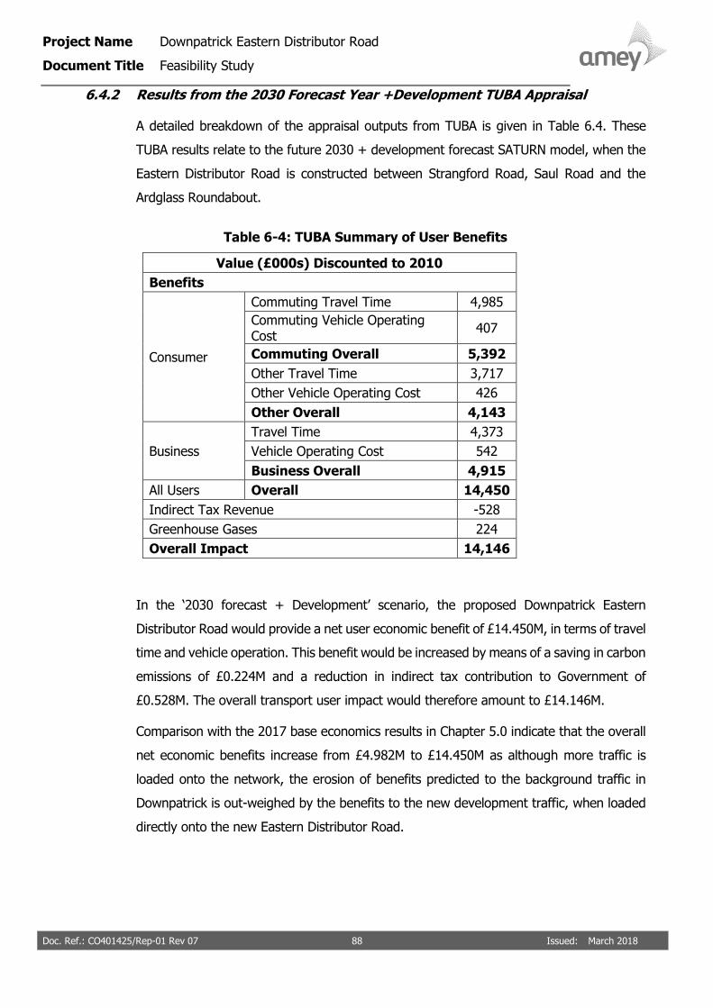
Project Name Downpatrick Eastern Distributor Road
Document Title Feasibility Study
Doc. Ref.: CO401425/Rep-01 Rev 07 88 Issued: March 2018
6.4.2 Results from the 2030 Forecast Year +Development TUBA Appraisal
A detailed breakdown of the appraisal outputs from TUBA is given in Table 6.4. These
TUBA results relate to the future 2030 + development forecast SATURN model, when the
Eastern Distributor Road is constructed between Strangford Road, Saul Road and the
Ardglass Roundabout.
Table 6-4: TUBA Summary of User Benefits
Value (£000s) Discounted to 2010
Benefits
Consumer
Commuting Travel Time 4,985
Commuting Vehicle Operating Cost
407
Commuting Overall 5,392
Other Travel Time 3,717
Other Vehicle Operating Cost 426
Other Overall 4,143
Business
Travel Time 4,373
Vehicle Operating Cost 542
Business Overall 4,915
All Users Overall 14,450
Indirect Tax Revenue -528
Greenhouse Gases 224
Overall Impact 14,146
In the ‘2030 forecast + Development’ scenario, the proposed Downpatrick Eastern
Distributor Road would provide a net user economic benefit of £14.450M, in terms of travel
time and vehicle operation. This benefit would be increased by means of a saving in carbon
emissions of £0.224M and a reduction in indirect tax contribution to Government of
£0.528M. The overall transport user impact would therefore amount to £14.146M.
Comparison with the 2017 base economics results in Chapter 5.0 indicate that the overall
net economic benefits increase from £4.982M to £14.450M as although more traffic is
loaded onto the network, the erosion of benefits predicted to the background traffic in
Downpatrick is out-weighed by the benefits to the new development traffic, when loaded
directly onto the new Eastern Distributor Road.

Project Name Downpatrick Eastern Distributor Road
Document Title Feasibility Study
Doc. Ref.: CO401425/Rep-01 Rev 07 89 Issued: March 2018
Economic Appraisal Summary – 2030 Forecast Year
An assessment has been made of the economic impact of the proposed Eastern Distributor
Road upon transport users and the Government using the forecast scenario SATURN
modelling outputs. The assessment compares the net worth of the scheme with that of
the no-scheme alternative.
The outputs of the TUBA modelling for the forecast scenario is available in Appendix H.
The scheme will provide a user benefit, in terms of travel time and vehicle operation, of
£14.450M. The majority, £13.075M, of this benefit will arise from time savings, whilst
£1.375M will be attributable to vehicle operating cost savings.
Further user operational impacts will arise, comprising a saving of £0.224M in carbon
emissions and a benefit of £0.528M in reduced indirect tax expenditure.
The overall net economic performance of the proposed Eastern Distributor Road, over 60
years, is summarised in Table 6-5.
Table 6-5: Overall Economic Summary
Value (£000s) Discounted to 2010
Appraisal Item
User Benefits
Road User Travel Time/Vehicle Operation Impact (TUBA Table 6) 14,450
Carbon Emissions (TUBA Table 6) 224
Indirect Taxation (TUBA Table 6) -528
Present Value of Benefits (PVB) 14,146
Do-Something
Capital Costs
Central Government Funding Investment Costs 15,493
Present Value of Costs (PVC) 15,493
Overall Impact
Net Present Value (PVB-PVC) -1,347
Benefit/Cost Ratio (PVB/PVC) 0.913
The economic assessment indicates that in for this forecast ‘2030 + development’ scenario
the present value of benefits is approaching it present value of costs over a 60-year period.
The benefits to the new development traffic (associated with 1630 housing units) out-
weigh the erosion of benefits experienced by users in Downpatrick as a result of increased
background traffic.

Project Name Downpatrick Eastern Distributor Road
Document Title Feasibility Study
Doc. Ref.: CO401425/Rep-01 Rev 07 90 Issued: March 2018
Although the scheme at this stage is predicted to provide poor value for money, with a
60-year Benefit / Cost Ratio (BCR) of 0.913, further assessment such as a refinement of
scheme costs, increased housing density and model annualization figures in the TUBA
modelling could return a BCR value greater than 1.0 for the ‘2030 forecast + development’
scenario.

Project Name Downpatrick Eastern Distributor Road
Document Title Feasibility Study
Doc. Ref.: CO401425/Rep-01 Rev 07 91 Issued: March 2018
7 CONCLUSION
To assist DfI-Roads with future discussions regarding the potential Eastern Distributor
Road and its construction, Amey has completed a feasibility study.
Through this study, existing traffic conditions have been determined through
• New traffic surveys;
• A preliminary road alignment and engineering constraints review has
been undertaken to provide a scheme cost estimate;
• A bespoke SATURN traffic model has been constructed to determine
potential traffic usage of the proposed Eastern Distributor Road if
constructed for base 2017, forecasted 2030 traffic and forecasted
2030 + development traffic scenarios; and
• An exercise has been undertaken to determine what relief it would
provide to the town centre.
7.1 Existing Traffic Conditions Summary
Traffic surveys have been undertaken within the Downpatrick Study area on the 8th of
March 2017. These surveys were undertaken as part of Stage 1 in this Feasibility
Assessment. The surveys identified:
• The weekday AM and PM peak has been identified as 08:15-09:15 and 17:00-
18:00.
• The private car is the dominant travel mode with the private vehicle proportions
being in excess of 95% throughout all the surveyed junctions.
• Junctions located along the route corridor between the Belfast Road roundabout
junction and signalised junction of Market Street/ St Patrick’s Avenue
accommodate the greatest levels of traffic in both peak hours. Queuing and delay
is experienced along this corridor in both directions during the AM and PM peaks.
• In the AM peak, priority junctions at Saul Street/ Scotch Street, Strangford Road/
Killyleagh Road, Ardglass Road/ Edward Street/ Ballyhornan Road and the Flying
Horse Road/ Killough Road all experience queuing and delay. This queuing and
delay coincides with the school drop offs at the local primary and secondary
schools that are situated close to these junctions.

Project Name Downpatrick Eastern Distributor Road
Document Title Feasibility Study
Doc. Ref.: CO401425/Rep-01 Rev 07 92 Issued: March 2018
• Origin-destination surveys have revealed that during the peak traffic periods,
Downpatrick is a journey destination for predominantly all the routes travelling on
the radial approaches. For instance, in the AM peak 81% of the traffic travelling
from the A7 Belfast Road is heading to Downpatrick with only 19% travelling
through it. In the PM peak the pass-through traffic proportions increases to 31% in
the PM with only 69% of traffic having an end destination within the town.
7.2 Eastern Distributor Route Summary
For this study, a preliminary route alignment has been designed for the proposed Eastern
Distributor Road in accordance with its descriptions provided in the Ards and Down Area
Plan 2015. To assist with the cost estimate exercise for the scheme, engineering analysis
and a desk based geotechnical and environmental constraints assessment have been
undertaken.
• The preliminary Eastern Distributor Road is approximately 2.9km in length with the
carriageway cross-section accommodating a 7.3m single carriageway route with 2
metre footways and verges provided along either side of the route.
• The proposed Eastern Distributor Road has been designed to a DMRB 70kph design
speed. Three new roundabout junctions, a priority junction and a staggered cross-
road junction have been proposed at the new route intersections.
• For reference the preliminary design layout is available in Appendix C.
• The estimated project cost (at 2017 prices) for this preliminary design and
alignment is £18.3M. This estimate includes £4.25M of optimism bias
(approximately 44% for works and 10% for land costs).
• A desktop geotechnical feasibility assessment has been undertaken for this
preliminary design (Appendix E). The recommendations from this assessment
highlight that if the design of the proposed Eastern Distributor Road was to be
considered further, the requirements of DRMB Volume 1 Section 1 Part 1 HD 22/08
[ref 7] be followed at every key stage.
• A desk-based environmental constraints report has been undertaken for this
preliminary design (Appendix F). The report recommends that at the next design
stages, an air quality assessment; a landscape and visual impact assessment;
ecological assessment; and ground water assessment should all be undertaken.
Also, the Department for Communities Historic Environment Division and Rivers
Agency need to be consulted.

Project Name Downpatrick Eastern Distributor Road
Document Title Feasibility Study
Doc. Ref.: CO401425/Rep-01 Rev 07 93 Issued: March 2018
Key environmental considerations regarding the proposed Eastern Distributor Road
is that the route is within the Strangford and Lecale Area of Outstanding Natural
Beauty; there is high potential for the study area to include protected habitats and
species; and that some areas (between Strangford Road and Saul Road) is affected
by present day surface water flooding. Further investigation and assessment would
be required if the project is progressed to the next stage.
7.3 Traffic Re-Assignment & SATURN modelling
To determine potential traffic usage of the proposed Eastern Distributor Road if
constructed, a bespoke SATURN traffic model has been constructed and validated for
Downpatrick.
Do-minimum and Do-Something network models have been constructed and the following
traffic demand scenarios tested in SATURN. Traffic re-assignments have been modelled
and presented for all three scenarios.
AM and PM 2017 base traffic scenario (discussed in chapter 5);
AM and PM 2030 forecast traffic scenario. (discussed in chapter 6).
AM and PM forecast ‘2030 + new development’ traffic scenario. Generated by
adding NRTF traffic growth and new development traffic associated with 1630
residential units (land zonings DK-07, DK-08, DK-12 and DK- 13). Discussed in
chapter 6.
The future year 2030 forecast traffic scenarios with and without new development (land
zonings DK-07, DK-08, DK-12 and DK- 13) only considered the Eastern Distributor Road
in its full construction.
Three Do-something sensitivity tests were undertaken for the 2017 base traffic scenario
to determine the benefits to partial and full construction of the Eastern Distributor Road.
The conclusion of this assessment suggested that this Eastern Distributor Route will offer
some journey savings compared to travelling through the town and the junctions at Collins
Corner, Saul Way/ Scotch Street, Strangford Road/ New Bridge Street, Church Street/ Irish
Street and the Ardglass Road/ Edward Street/ Ballyhornan Road. This re-assignment trend
was also experienced and modelled in the AM and PM 2030 forecast scenarios.
Project Name Downpatrick Eastern Distributor Road
Document Title Feasibility Study
Doc. Ref.: CO401425/Rep-01 Rev 07 93 Issued: March 2018
Key environmental considerations regarding the proposed Eastern Distributor Road
is that the route is within the Strangford and Lecale Area of Outstanding Natural
Beauty; there is high potential for the study area to include protected habitats and
species; and that some areas (between Strangford Road and Saul Road) is affected
by present day surface water flooding. Further investigation and assessment would
be required if the project is progressed to the next stage.
7.3 Traffic Re-Assignment & SATURN modelling
To determine potential traffic usage of the proposed Eastern Distributor Road if
constructed, a bespoke SATURN traffic model has been constructed and validated for
Downpatrick.
Do-minimum and Do-Something network models have been constructed and the following
traffic demand scenarios tested in SATURN. Traffic re-assignments have been modelled
and presented for all three scenarios.
AM and PM 2017 base traffic scenario (discussed in chapter 5).
AM and PM 2030 forecast traffic scenario (discussed in chapter 6).
AM and PM forecast ‘2030 + new development’ traffic scenario. Generated by
adding NRTF traffic growth and new development traffic associated with 1630
residential units (land zonings DK-07, DK-08, DK-12 and DK- 13). Discussed in
chapter 6.
The future year 2030 forecast traffic scenarios with and without new development (land
zonings DK-07, DK-08, DK-12 and DK- 13) only considered the Eastern Distributor Road
in its full construction.
Three Do-something sensitivity tests were undertaken for the 2017 base traffic scenario
to determine the benefits to partial and full construction of the Eastern Distributor Road.
The conclusion of this assessment suggested that this Eastern Distributor Route will offer
some journey savings compared to travelling through the town and the junctions at Collins
Corner, Saul Way/ Scotch Street, Strangford Road/ New Bridge Street, Church Street/ Irish
Street and the Ardglass Road/ Edward Street/ Ballyhornan Road. This re-assignment trend
was also experienced and modelled in the AM and PM 2030 forecast scenarios.

Project Name Downpatrick Eastern Distributor Road
Document Title Feasibility Study
Doc. Ref.: CO401425/Rep-01 Rev 07 94 Issued: March 2018
On average, at the priority junction of Saul Road/ Scotch Street there is a 15% and 11%
reduction in traffic movements for the AM and PM peak hours; at Edward Street/
Ballyhornan Road there is a 10% and 11% reduction; at the Saul Way/ Church Street
junction there is an 11% and 7% reduction; at Church Street/ Market Street/ Irish Street
there is an 11% and 9% reduction and at Collins Corner a 2% and 6% reduction.
For the ‘2030+ development’ traffic scenario the new development traffic in the Do-
Something model accesses directly onto the Eastern Distributor Road. The results for this
scenario demonstrate significant traffic re-assignment benefits compared to the Do-
Minimum scenario, particularly on the Saul Road, Ardglass Road and Mearne Road. 750+
(two-way) vehicles have been modelled on the Eastern Distributor Road in the AM and PM
peaks.
7.4 Economic Summary - Cost Benefit
An economic assessment for the proposed Eastern Distributor Road has been undertaken
using the latest TUBA software (Version 1.9.9) for the three.
The three traffic scenarios (Base 2017, Forecast 2030 and Forecast 2030+ Development
traffic) have been assessed.
Table 7-1 summarises the overall economic summary results for each scenario.
Table 7-1: Economic Summary
Value (£000s) 2017 Base Scenario
2030 Forecast Scenario
(No development)
2030 Forecast
Scenario+ Development traffic
Present Value of Benefits (PVB)
4,850 4,655 14,146
Present Value of Costs (PVC)
15,493 15,493 15,493
Net Present Value (PVB-PVC)
-10,643 -10,838 -1,347
Benefit/Cost Ratio (PVB/PVC)
0.313 0.300 0.913

Project Name Downpatrick Eastern Distributor Road
Document Title Feasibility Study
Doc. Ref.: CO401425/Rep-01 Rev 07 95 Issued: March 2018
The results of the economic analysis indicate that as background traffic increases on the
Downpatrick network in 2030, the overall network performance decreases as journey times
and delay increases for users in Downpatrick Town Centre. The results indicate that the
Eastern Distributor Road will provide only limited benefit to these Town Centre users as
the present value of benefits decrease with more background traffic on the network.
Therefore, for the 2030 forecast traffic scenario there is no economic justification (very
low BCR’s) for proceeding with the Eastern Distributor Road.
In the case of the forecast ‘2030 year + development’ traffic scenario the results indicate
that the overall benefits to the new development traffic outweighs the erosion of benefits
experienced by the background traffic users in the Downpatrick Town Centre. Although
the scheme at this stage predicted to provide poor value for money, with a 60-year Benefit
/ Cost Ratio (BCR) of 0.913, further assessment such as a refinement of scheme costs,
increased housing density and model annualization figures in the TUBA modelling could
return a BCR value greater than 1.0 for the ‘2030 forecasted + development’ scenario.
The study’s economic results indicate that the Eastern Distributor Road construction will
generate more user benefits for new development users from land zonings DK-07, DK-08,
DK-12 and DK- 13 compared to strategic Downpatrick background traffic.