Embed Size (px)
Citation preview
© 2010 The Royal Statistical Society
“I will show you fear in a handful of dust.” T. S. Eliot’s poem did not anticipate the effects that a volcano erupt-ing in Iceland would have on European aviation in April 2010. But the decision to ground most of Europe’s flights for several days did reflect a great deal about the fear of the risks posed by volcanic ash. What was the statistical evidence for the safety decisions that were made?
Readers who found themselves stranded, and others, should perhaps note that the implementation of “no fly” zones by the UK’s air traffic control provider, National Air Traffic Services1, the performance of safety decision-makers, and the legal consequences of their decisions for airlines and passengers are different issues. They are not examined here.
The starting point must be the volcano itself. There are some common terms that vulcanologists are familiar with but that the rest of us may not know. Tephra is a general term for fragments of volcanic rock and lava blasted into the air by explosions or carried upward by hot gases. A key volcanic gas is sulphur dioxide. The
Fear in a handful of dust: aviation and the Icelandic volcano
The eruption of Eyjafjallajökull in April 2010 closed airports throughout Europe, stranded thousands of passengers, and enraged airlines and cost them millions. Was the grounding justified? Peter Brooker finds that planes stopped flying because of gaps in the statistical and test data needed to establish safe levels of ash concentration.
Eruption of the volcano Eyjafjallajökull in Iceland. © iStockphoto.com/Jochen Scheffl
112 september2010
113september2010
vertical pillar of tephra and gases rising directly above a volcanic vent is an eruption column, which may rise to altitudes of over 100 000 ft. The tephra and gases that form downwind of an erupting volcano are an eruption cloud, an ash cloud or a plume. Ash is tephra less than 2 millimetres in diameter. Ash persists in the cloud for a long time (the fall velocity in laminar flow conditions is proportional to the cube of the particle diameter; so obviously the smaller particles of ash stay up there much, much longer). Drifting ash clouds become more diluted and difficult to distinguish visu-ally from meteorological clouds.
Volcanoes and aviation are a very bad combination. Their first significant meeting was a wartime one, on March 22nd, 1944, when Mount Vesuvius erupted. Tephra falling on Pompeii airfield wrote off an entire US Air Force fleet of 88 B-25 bombers. This was the USA’s largest single loss of aircraft in World War II – 64 were destroyed at Pearl Harbor.
The next kind of problem arose with the increasing number of long-range flights in areas affected by volcanic ash clouds. The area most affected is the Pacific Rim. Two incidents were especially disturbing.
In 1982, two eruptions of Galunggung Volcano in Java, Indonesia, seriously affected two Boeing 747 passenger jets. In one case, a British Airways 747 encountered ash that had erupted an hour earlier. All four engines lost power at about 37 000 ft. The crew restarted one engine by the time the plane had descended to 13 000 ft and later two more. The crew could not see through the ash-blasted windscreens and the engines sustained significant erosion damage.
In 1989, Alaska’s Mount Redoubt erupted causing a KLM 747 to lose all four engines at 25 000 ft. Two engines were restarted by the time the aircraft had descended to 13 000 ft.
There are a variety of ways that volcanic emissions can damage aircraft in flight. Sulphur dioxide absorbs water vapour and converts into
sulphuric acid. This corrosion damage may not be immediately apparent, so it requires continued inspections. Sharp ash fragments – such as volcanic glass and quartz – produce the immediate damage in major incidents. They damage external glass, plastic and metals on the aircraft. The ash can get through tiny openings in the aircraft exterior, which affects the air supply and instrument systems. Moving parts in the engines erode, and partially melted ash accumulates there. Of most concern, ash deposits in the fuel nozzles, combustor and turbine restrict air flow through the engine, which leads to the loss of engine thrust.
The detailed nature of the range of acute damage to aircraft when flying through an ash cloud is well documented2. This damage hap-pens quickly – the aircraft in the two famous incidents were in ash clouds for only a few minutes. The costs of repairing such damage are huge: the Redoubt encounter cost $80 mil-lion (at 1990 prices). The price of a new Boeing 747 in 2010 is in the region of $250 million.
These major incidents were key factors in concerted international efforts to tackle the safety issues raised by volcanic emissions. Because of the concerns raised by the Redoubt
encounter, several US bodies sponsored the First International Symposium on Volcanic Ash and Aviation Safety, held in 1991. Insti-tutionally, volcanic ash effects on aviation fall under the remit of the International Civil Aviation Organization (ICAO), which in 2004 produced a Manual on Volcanic Ash, Radioac-tive Material and Toxic Chemical Clouds3. This is the only guidance material available globally.
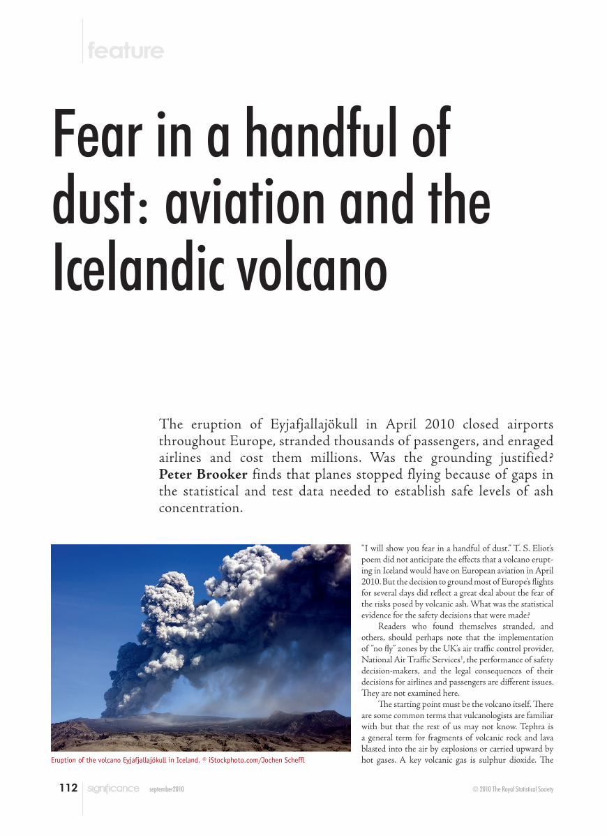
The ICAO has made considerable efforts to gather evidence about ash cloud encoun-ters. The encounter database uses an Ash-Encounter Severity Index with five classes. Table 1 shows a slightly simplified version of the class criteria. In the period 1953–2008, there were 126 encounters of aircraft with ash clouds from eruptions at 38 volcanoes; all but three encounters occurred from 1975 onwards. Table 2 shows the breakdown by class where there was sufficient information to categorise. Note that there were no Class 5 incidents – and there are no recorded deaths from volcanic ash. In only one of the ten Class 4 incidents was ash cloud not observable by the crew – this was a Gulf Stream survey aircraft
Table 1. ICAO Ash-Encounter Severity Index
Class Selected criteria
0 Acrid sulphurous odour, electrostatic discharge1 Light cabin dust, exhaust gas temperature fluctuations2 Heavy cabin dust, abrasion damage, window frosting3 Engine vibration, erroneous instrument readings (e.g. pitot-static system), damage
to engine and electrical systems4 Engine failure requiring in-flight restart5 Engine failure or other damage leading to crash
Note: the pitot-static system is a system of pressure-sensitive instruments used to determine an aircraft’s airspeed, altitude etc.
Table 2. Data on 126 encounters of aircraft with ash clouds from volcanic eruptions, 1953–2008. There was insufficient data to assign severity for 17 incidents. Class 0 encounters are undercounted because pilot reports of sulphur smells are not comprehensively collected and disseminated
Class Incidents
0 211 102 513 174 105 0
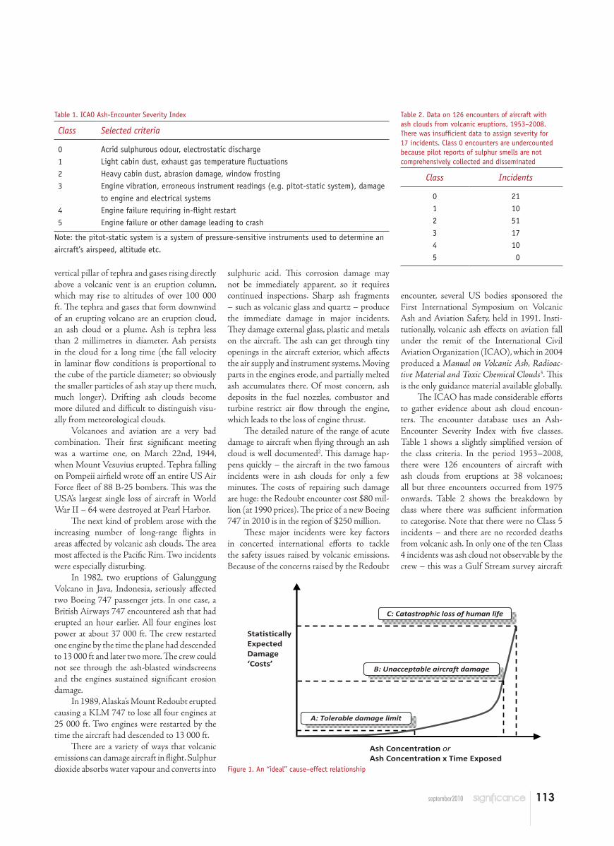
Ash Concentration or Ash Concentration x Time Exposed
Statistically Expected Damage ‘Costs’
C: Catastrophic loss of human life
B: Unacceptable aircraft damage
A: Tolerable damage limit
Figure 1. An “ideal” cause–effect relationship
114 september2010
rather than the long-range wide-body aircraft in the other incidents.
How does this data help in carrying out risk assessments to support policy guidelines? The answer is that it is of limited value. Table 2 is simply about effects. It does not correlate effects to causal criteria. Aviation risk assess-ment requires this kind of relationship to be established. The consensus view of researchers is that the key metric is either ash concentration (often termed the “mass loading”), which would be measured in milligrams per cubic metre, or perhaps ash concentration multiplied by time exposed (on the argument that ash effects are cumulative). There are few incidents with this kind of estimated data. However, from engine inspections, the Redoubt encounter was esti-mated to be at a concentration of 2000 mg/m3.
Ideally, a cause–effect relationship graph such as Figure 1 should exist. The x-axis measures a key causal parameter related to ash concentration. The y-axis is an estimate for the value of the damage “costs” of a flight. This would be some kind of statistical expectation, perhaps taking into account variations in dam-age. The word “costs” is in inverted commas because the high range effects would include catastrophic loss of human life (C) – a Class 5 incident. However, below that would be a level of costs corresponding to unacceptable aircraft damage, such as the Redoubt incident costs noted earlier (B). At the bottom of the curve is the tolerable damage limit (A). Thus, operations for ash levels below the A point are safe for passengers and economically sensible. A might represent the highest cause value for which damage was barely detectable by engine analyses – but what happens if testing equip-ment improves? Or it could be at a damage level, in terms of testing and maintenance, that costs markedly less than avoiding a cloud by changing to a less direct routing (with its extra fuel and passenger costs). However, knowledge of B or C does not help specify the location of A – severe incidents do not provide evidence for tolerable cause criteria. The standard way of estimating A would be to get good meas-ured data for a wide range of points below A, coupled with a sufficient understanding of damage mechanisms for extrapolation to A.
But an accurate Figure 1 does not exist – or rather, there is nothing like it in the open technical literature. This issue was noted as vital at the first International Symposium in 1991:
engine and (or) combustor tests should be sponsored by the Federal Aviation Administration (FAA) to establish threshold values for “safe” levels of ash
concentration and the “safe” range of combustor temperature. This informa-tion, combined with updated disper-sion and theoretical fallout models (and with improved cloud tracking) can establish when an ash cloud ceases to be a flight hazard2.
But, at the 5th International Workshop in March 2010, after being raised many times in the intervening years, the issue was still unresolved internationally:
There continues to remain no defini-tion of a “safe concentration” of ash for different aircraft, engine types or power settings. In order to give a reliable and justifiable “all clear” once a plume has dispersed enough to be undetectable, clear limits of ash content are required from both the manufacturers and avia-tion licensing authorities…4
Hindsight tells us that the March Workshop had focused on a vital issue. The plume from Eyjafjallajökull erupted on April 14th.
Manufacturers build commercial air-frames and engines to very exacting environ-mental specifications, but these do not cover flight in volcanic ash-laden atmosphere. This is in contrast to bird strikes, for example, where there are requirements that engines can safely be shut down when impacted by a standard weight pseudo-bird. (Birds are a worldwide problem: aviation safety databases record many such accidents, several with fatalities, and near tragedies – the Hudson River incident in early 2009 is one.)
So, without something like Figure 1, what is the guidance about volcanic ash? It is that “Complete avoidance of volcanic ash by aircraft and the quick exit of an eruption cloud if ash is encountered are the only courses of action for flight crews and dispatchers that guarantee flight safety”5. But what does “encounter” mean? If the cloud is visible to aircrew, this is obviously an encounter. But it is also usually as-sumed that ash identifiable on satellite images (usually from infrared detectors) continues to present a hazard.
The UK Meteorological Office (Met Office), which is one of nine regional volcanic ash advisory centres (VAACs), is tasked by the World Meteorological Organization with the detection, tracking, and forecasting of the movement of eruption clouds for Northern Europe. Its forecast uses a computer model – ”NAME III” – of the dispersion of atmospheric pollutants, using input parameters such as the
height of the eruptive column, how much ash has erupted, and current and forecast wind fields. The model then outputs the expected future location of an ash cloud. Comparative studies6 have shown that five VAAC models, despite having different structures and using different meteorology, all produce very similar results. Analysing an earlier volcano eruption in Iceland, the “locations of the eruption plume simulated by the different models are almost identical to those predicted by the London VAAC”.
But the boundary of the ash cloud presented to aviation is not well defined. As the VAACs have no guidance from aviation about threshold concentration values, they have adopted a variety of different – and generally cautious – criteria to set the forecast boundary:
The terms “visible” and “visual” (imply-ing detectable) ash cloud have been previously used to describe areas of volcanic ash to the aviation community. These slightly ambiguous terms should be used with care, as the ash cloud may be neither visible to the eye nor detect-able by remote sensing. There is cur-rently no consistency in the way that the participant VAACs define the ash-cloud boundary … with thresholds de-pending variously on the source release rate used, availability of satellite data, for comparison and forecaster judge-ment. The London VAAC, for example, uses a visual ash-cloud look-up table to determine hazardous ash concentra-
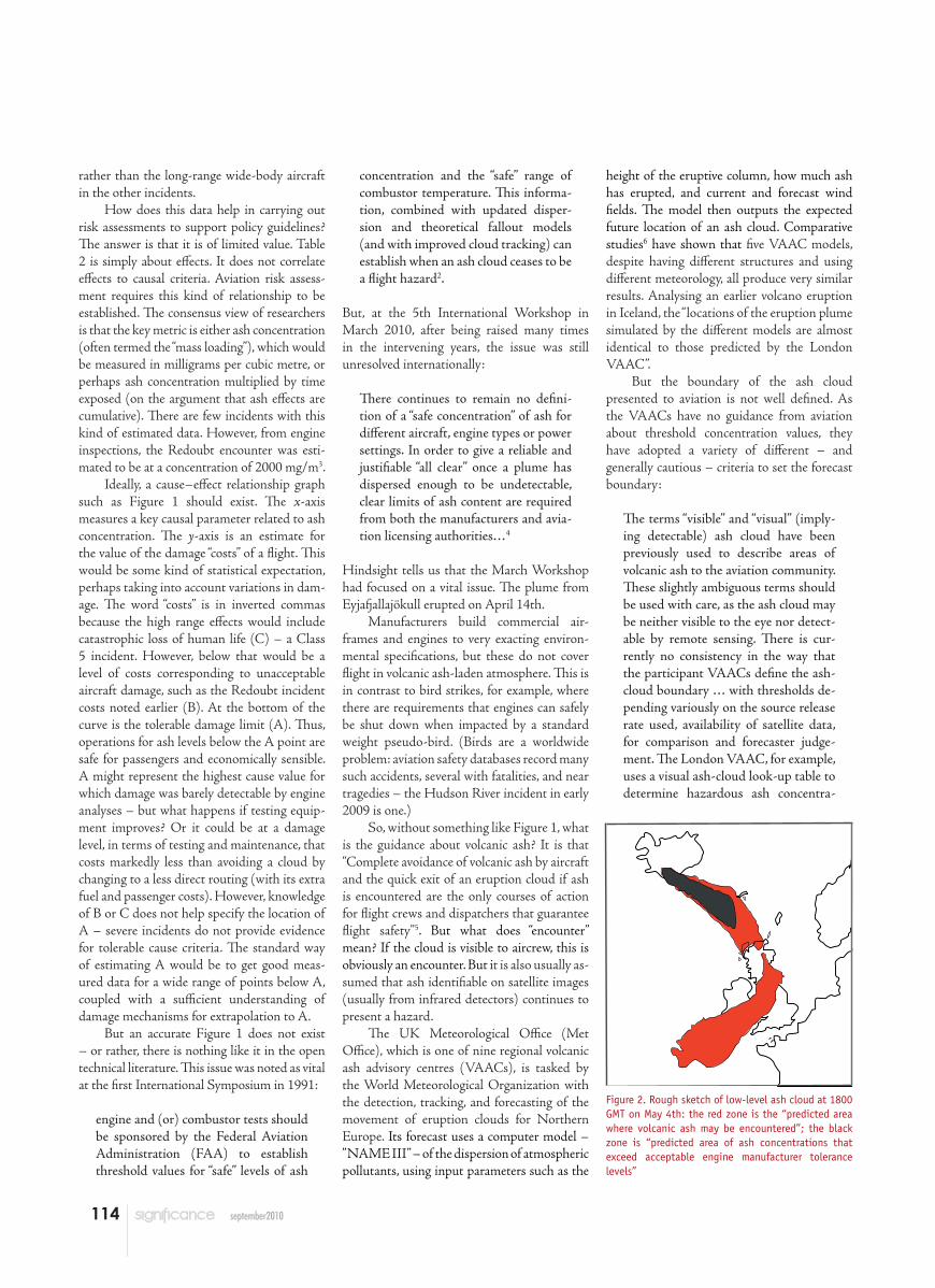
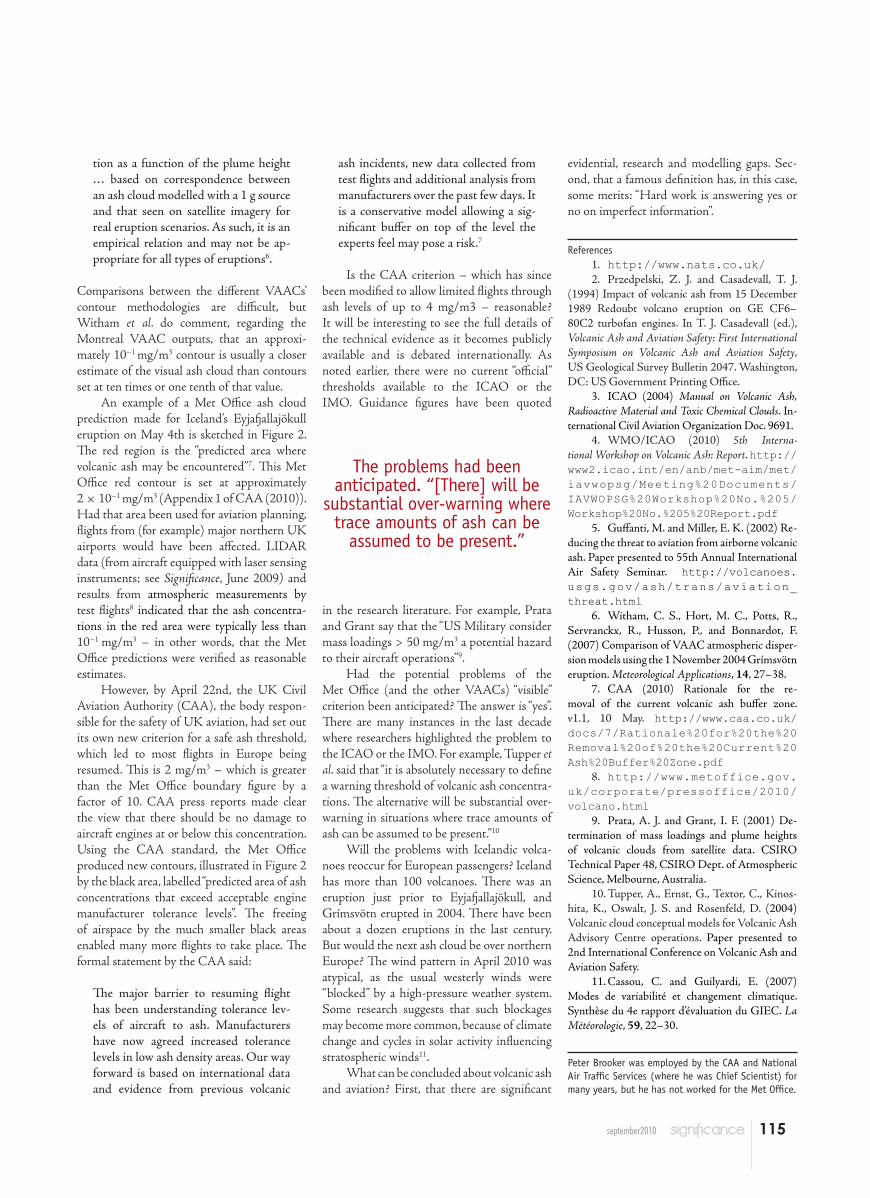
Figure 2. Rough sketch of low-level ash cloud at 1800 GMT on May 4th: the red zone is the “predicted area where volcanic ash may be encountered”; the black zone is “predicted area of ash concentrations that exceed acceptable engine manufacturer tolerance levels”
115september2010
tion as a function of the plume height … based on correspondence between an ash cloud modelled with a 1 g source and that seen on satellite imagery for real eruption scenarios. As such, it is an empirical relation and may not be ap-propriate for all types of eruptions6.
Comparisons between the different VAACs’ contour methodologies are difficult, but Witham et al. do comment, regarding the Montreal VAAC outputs, that an approxi-mately 10−1 mg/m3 contour is usually a closer estimate of the visual ash cloud than contours set at ten times or one tenth of that value.
An example of a Met Office ash cloud prediction made for Iceland’s Eyjafjallajökull eruption on May 4th is sketched in Figure 2. The red region is the “predicted area where volcanic ash may be encountered”7. This Met Office red contour is set at approximately 2 × 10⁻¹ mg/m3 (Appendix 1 of CAA (2010)). Had that area been used for aviation planning, flights from (for example) major northern UK airports would have been affected. LIDAR data (from aircraft equipped with laser sensing instruments; see Significance, June 2009) and results from atmospheric measurements by test flights8 indicated that the ash concentra-tions in the red area were typically less than 10−1 mg/m3 – in other words, that the Met Office predictions were verified as reasonable estimates.
However, by April 22nd, the UK Civil Aviation Authority (CAA), the body respon-sible for the safety of UK aviation, had set out its own new criterion for a safe ash threshold, which led to most flights in Europe being resumed. This is 2 mg/m3 – which is greater than the Met Office boundary figure by a factor of 10. CAA press reports made clear the view that there should be no damage to aircraft engines at or below this concentration. Using the CAA standard, the Met Office produced new contours, illustrated in Figure 2 by the black area, labelled “predicted area of ash concentrations that exceed acceptable engine manufacturer tolerance levels”. The freeing of airspace by the much smaller black areas enabled many more flights to take place. The formal statement by the CAA said:
The major barrier to resuming flight has been understanding tolerance lev-els of aircraft to ash. Manufacturers have now agreed increased tolerance levels in low ash density areas. Our way forward is based on international data and evidence from previous volcanic
ash incidents, new data collected from test flights and additional analysis from manufacturers over the past few days. It is a conservative model allowing a sig-nificant buffer on top of the level the experts feel may pose a risk.7
Is the CAA criterion – which has since been modified to allow limited flights through ash levels of up to 4 mg/m3 – reasonable? It will be interesting to see the full details of the technical evidence as it becomes publicly available and is debated internationally. As noted earlier, there were no current “official” thresholds available to the ICAO or the IMO. Guidance figures have been quoted
in the research literature. For example, Prata and Grant say that the “US Military consider mass loadings > 50 mg/m3 a potential hazard to their aircraft operations”9.
Had the potential problems of the Met Office (and the other VAACs) “visible” criterion been anticipated? The answer is “yes”. There are many instances in the last decade where researchers highlighted the problem to the ICAO or the IMO. For example, Tupper et al. said that “it is absolutely necessary to define a warning threshold of volcanic ash concentra-tions. The alternative will be substantial over-warning in situations where trace amounts of ash can be assumed to be present.”10
Will the problems with Icelandic volca-noes reoccur for European passengers? Iceland has more than 100 volcanoes. There was an eruption just prior to Eyjafjallajökull, and Grímsvötn erupted in 2004. There have been about a dozen eruptions in the last century. But would the next ash cloud be over northern Europe? The wind pattern in April 2010 was atypical, as the usual westerly winds were “blocked” by a high-pressure weather system. Some research suggests that such blockages may become more common, because of climate change and cycles in solar activity influencing stratospheric winds11.
What can be concluded about volcanic ash and aviation? First, that there are significant
evidential, research and modelling gaps. Sec-ond, that a famous definition has, in this case, some merits: “Hard work is answering yes or no on imperfect information”.
References1. http://www.nats.co.uk/2. Przedpelski, Z. J. and Casadevall, T. J.
(1994) Impact of volcanic ash from 15 December 1989 Redoubt volcano eruption on GE CF6–80C2 turbofan engines. In T. J. Casadevall (ed.), Volcanic Ash and Aviation Safety: First International Symposium on Volcanic Ash and Aviation Safety, US Geological Survey Bulletin 2047. Washington, DC: US Government Printing Office.
3. ICAO (2004) Manual on Volcanic Ash, Radioactive Material and Toxic Chemical Clouds. In-ternational Civil Aviation Organization Doc. 9691.
4. WMO/ICAO (2010) 5th Interna-tional Workshop on Volcanic Ash: Report. http://www2.icao.int/en/anb/met-aim/met/iavwopsg/Meeting%20Documents/ IAVWOPSG%20Workshop%20No.%205/Workshop%20No.%205%20Report.pdf
5. Guffanti, M. and Miller, E. K. (2002) Re-ducing the threat to aviation from airborne volcanic ash. Paper presented to 55th Annual International Air Safety Seminar. http:// volcanoes.usgs.gov/ash/trans/aviation_threat.html
6. Witham, C. S., Hort, M. C., Potts, R., Servranckx, R., Husson, P., and Bonnardot, F. (2007) Comparison of VAAC atmospheric disper-sion models using the 1 November 2004 Grímsvötn eruption. Meteorological Applications, 14, 27–38.
7. CAA (2010) Rationale for the re-moval of the current volcanic ash buffer zone. v1.1, 10 May. http://www.caa.co.uk/docs/7/Rationale%20for%20the%20 Removal%20of%20the%20Current%20Ash%20Buffer%20Zone.pdf
8. http://www.metoffice.gov.uk/corporate/pressoffice/2010/ volcano.html
9. Prata, A. J. and Grant, I. F. (2001) De-termination of mass loadings and plume heights of volcanic clouds from satellite data. CSIRO Technical Paper 48, CSIRO Dept. of Atmospheric Science, Melbourne, Australia.
10. Tupper, A., Ernst, G., Textor, C., Kinos-hita, K., Oswalt, J. S. and Rosenfeld, D. (2004) Volcanic cloud conceptual models for Volcanic Ash Advisory Centre operations. Paper presented to 2nd International Conference on Volcanic Ash and Aviation Safety.
11. Cassou, C. and Guilyardi, E. (2007) Modes de variabilité et changement climatique. Synthèse du 4e rapport d’évaluation du GIEC. La Météorologie, 59, 22–30.
Peter Brooker was employed by the CAA and National Air Traffic Services (where he was Chief Scientist) for many years, but he has not worked for the Met Office.
The problems had been anticipated. “[There] will be
substantial over-warning where trace amounts of ash can be
assumed to be present.”