Embed Size (px)
Citation preview
GEOPHYSICAL RESEARCH LETTERS, VOL. ???, XXXX, DOI:10.1002/,
Faulting structure above the Main Himalayan Thrust1
as shown by relocated aftershocks of the 2015 MW7.82
Gorkha, Nepal earthquake3
Ling Bai1, Hongbing Liu
1, Jeroen Ritsema
2, James Mori
3, Tianzhong Zhang
4,
Yuzo Ishikawa5, and Guohui Li
1
Three key points:4
(1) We relocate the 2015 Gorkha earthquakes using teleseismic and regional waveforms.5
(2) The mainshock is located on the horizontal Main Himalaya Thrust (MHT) at a depth of6
18.5 km.7
(3) Aftershocks show faulting structure in the hanging wall above the MHT.8
D R A F T December 28, 2015, 9:20am D R A F T
This article is protected by copyright. All rights reserved.
This is the author manuscript accepted for publication and has undergone full peer review but hasnot been through the copyediting, typesetting, pagination and proofreading process, which maylead to differences between this version and the Version of Record. Please cite this article as doi:10.1002/2015GL066473
X - 2 BAI ET AL.: FAULTING STRUCTURE ABOVE MHT
1Key Laboratory of Continental Collision
and Plateau Uplift, Institute of Tibetan
Plateau Research, Chinese Academy of
Sciences, Beijing, China.
2Department of Earth and Environmental
Sciences, University of Michigan, Ann
Arbor, Michigan, USA.
3Disaster Prevention Research Institute,
Kyoto University, Uji, Kyoto, Japan.
4Institute of Geophysics, China
Earthquake Administration, Beijing, China.
5National Institute of Advanced Industrial
Science and technology, Tsukuba, Japan.
D R A F T December 28, 2015, 9:20am D R A F T
This article is protected by copyright. All rights reserved.
BAI ET AL.: FAULTING STRUCTURE ABOVE MHT X - 3
The 25 April 2015, MW 7.8 Gorkha, Nepal earthquake ruptured a shallow9
section of the Indian-Eurasian plate boundary by reverse faulting with NNE-10
SSW compression, consistent with the direction of current Indian-Eurasian11
continental collision. The Ghorka mainshock and aftershocks were recorded12
by permanent global and regional arrays and by a temporary local broad-13
band array near the China-Nepal border deployed prior to the Ghorka main-14
shock. We relocate 272 earthquakes with MW > 3.5 by applying a multi-15
scale double-difference earthquake relocation technique to arrival times of16
direct and depth phases recorded globally and locally. We determined a well-17
constrained depth of 18.5 km for the mainshock hypocenter which places it18
on the Main Himalayan Thrust (MHT). Many of the aftershocks at shallower19
depths illuminate faulting structure in the hanging wall with dip angles that20
are steeper than the MHT. This system of thrust faults of the Lesser Himalaya21
may accommodate most of the elastic strain of the Himalayan orogeny.22
D R A F T December 28, 2015, 9:20am D R A F T
This article is protected by copyright. All rights reserved.
X - 4 BAI ET AL.: FAULTING STRUCTURE ABOVE MHT
1. Introduction
The collision between the Indian and Eurasian continental plates formed the Himalaya23
mountain range, the highest orogenic belt on Earth with widespread continental seis-24
micity. The region is classically divided into four tectonic units from south to north:25
sub-Himalaya, Lesser Himalaya, Higher Himalaya and Tethyan Himalaya [?] (Figure 1).26
The Main Frontal Thrust (MFT), Main Boundary Thrust (MBT), Main Central Thrust27
(MCT), and South Tibet Detachment (STD) separate the four tectonic units. They con-28
verge at the Main Himalaya Thrust (MHT), the detachment along which the Indian plate29
subducts beneath the Himalayan mountains [???].30
The potential for devastating earthquakes in the Himalaya has long been recognized.31
Historical documents since the 10th century show evidence for great Himalayan earth-32
quakes with a recurrence interval of about 800 years [??]. Nearly 500 earthquakes of33
MW ≥ 4.5 have occurred along the Himalayas orogen since 1964. The Gorkha, Nepal34
earthquake has heightened concern for large earthquakes along the Himalayan front [??].35
This is the first well-recorded earthquake and aftershock sequence on the shallowest por-36
tion of the MHT. The seismic data will provide new constraints on the fault zone structure37
of the Indian-Eurasian plate boundary at shallow depth and insight into seismic hazard38
in the region.39
In this study, we relocate aftershock hypocenters to infer the structure of the Gorkha40
earthquake fault zone. Our data come from the Global Seismic Network, the China41
National Seismic Network, and a temporary array of 15 broadband seismic stations that42
we deployed at the China-Nepal border in December 2014. The combination of teleseimic43
D R A F T December 28, 2015, 9:20am D R A F T
This article is protected by copyright. All rights reserved.
BAI ET AL.: FAULTING STRUCTURE ABOVE MHT X - 5
(30–90◦) P waveforms and regional Pg, Sg, Pn and Sn signals is optimal for precise44
hypocenter determinations.45
2. The Main Himalayan Thrust
The MHT is defined as the detachment that separates the underthrusting Indian plate46
from the overriding Himalaya orogeny. The concept of the MHT was proposed by ? based47
on the locations and fault plane solutions of moderate earthquakes at 10–20 km depths.48
A similar concept of Main Detachment Fault was put forward by ? from a tectonic49
reconstruction of eastern Nepal. The MHT was imaged at a depth of 30–40 km by ? with50
a deep seismic reflection profile in southeastern Tibet. In the past decade, broadband51
seismic arrays have been deployed to constrain the structure of the MHT in the central52
[???], eastern [??] and western [??] Himalaya, respectively.53
Subduction of the Indian continental lithosphere beneath the Himalaya has been shallow54
and nearly horizontal since initiation of the Indo-Asian collision. The dip angle increases55
with depth from the MCT to the Indus-Tsangpo suture (ITS). The deeper sections of the56
MHT are constrained best [e.g., ?]. However, the shallow structure of the MHT remains57
uncertain because the interpretation of shallow seismic wave refraction is difficult [??].58
3. Waveform modeling and Multi-DD relocations
We relocated a total of 272 earthquakes, including the Gorkha mainshock, 233 after-59
shocks within one month and 38 earthquakes that occurred before the Gorkha earthquake60
since 1980 (Figure 1, and Table S2). Our estimates are based on five data sets: (1) bul-61
letins from the National Earthquake Information Center (NEIC) of the U.S. Geological62
Survey (USGS) for 234 earthquakes of MW > 3.5 that occurred within one month after63
D R A F T December 28, 2015, 9:20am D R A F T
This article is protected by copyright. All rights reserved.
X - 6 BAI ET AL.: FAULTING STRUCTURE ABOVE MHT
the mainshock, (2) bulletins from the National Seismic Network of Nepal and the Inter-64
national Seismological Centre (ISC) for 38 earthquakes of MW > 3.5 that occurred in65
the source region during three decades prior to the Ghorka earthquake, (3) seismic and66
waveform data from the China Earthquake Data Center (CEDC) and the China National67
Seismic Network (CNSN), (4) teleseismic P waveforms from the Global Seismic Network,68
and (5) waveform data from a temporary array of 15 broadband seismic stations along69
the China-Nepal border, deployed by the Institute of Tibetan Plateau Research, Chinese70
Academy of Sciences prior to the Gorkha earthquake. Our local temporary array recorded71
many of the aftershocks at epicentral distances less than 100 km (Figure 2 (a)), including72
the MW > 7.3 Kodari earthquake [?]. Permanent seismic stations in the Tibetan region73
at epicentral distances of 2–7◦ recorded clear Pn and Sn head waves and Pg and Sg waves74
(Figure 2 (b)). At teleseismic distances, surface reflections pP and sP phases for moderate75
earthquakes (Figure 3) provide constraints on focal depths.76
Our analysis comprises three steps. First we determine hypocenters for the Gorkha77
earthquake and its 233 aftershocks based on the HYPOSAT methodology [?]. Absolute78
traveltimes and traveltime differences at common stations are modeled using a layered79
velocity structure in the source region, representing the Himalayan orogenic prism, the80
Indian upper and lower crust, and the Indian mantle, respectively [???] (Table S1). We81
constrain the absolute focal depths of moderate aftershocks (MW 5.5 to MW 6.3, Table82
S2) by modeling the teleseismic waveforms of the direct P and the surface reflections83
pP and sP (Figure 3) following ?. Using the depths determined by HYPOSAT and84
by waveform modeling, we calculate hypocenters of all earthquakes using a multi-scale85
D R A F T December 28, 2015, 9:20am D R A F T
This article is protected by copyright. All rights reserved.
BAI ET AL.: FAULTING STRUCTURE ABOVE MHT X - 7
double-difference earthquake relocation method (Multi-DD) [?], which is modified from86
the hypoDD programs [?] to include phases recorded by regional and teleseismic networks.87
Since differential traveltimes do not depend strongly on the assumed velocity models along88
the whole raypath [??], the joint analysis of local, regional and teleseismic data and the89
precise measurements of differential phase arrival times via waveform cross correction90
for the China-Nepal array ((Figure S1)) improve the relative focal depth determinations91
considerably. The focal depths for earthquakes determined by waveform modeling are92
held fixed during the Multi-DD processing to constrain the absolute focal depths of all93
earthquakes. We calculate differential traveltimes between each event and up to eight of94
its nearest neighbors. Each event pair has 8–32 commonly observed phases within a 1595
km distance between the two events. The data include 9,690 Pg and Sg, 5,288 Pn and96
Sn, 174 pP and sP, and 17,664 teleseismic P and S arrival times.97
4. Results
We estimated the uncertainty of the relocations by a bootstrap analysis [?] using 10098
sampling iterations (Figure S2). This analysis indicates that epicenters are estimated with99
an accuracy of ±3.5 km, which is two times smaller than the average uncertainty of ±7.0100
km reported in the NEIC catalog. The uncertainty in the focal depth estimate is ±2.0101
km, in agreement with the estimates of focal depth uncertainty based on waveform fits102
(Figure 3). The differential time residuals are reduced substantially from ±5 s before to103
±1.5 s after relocations (Figure S3). The weighted L1 and L2 norm residuals decreased104
from 1.10 s and 1.58 s to 0.46 s and 0.60 s after relocations, respectively, demonstrating105
that the earthquakes are better relocated.106
D R A F T December 28, 2015, 9:20am D R A F T
This article is protected by copyright. All rights reserved.
X - 8 BAI ET AL.: FAULTING STRUCTURE ABOVE MHT
On average, the epicenters have been relocated by 6.2 km. The average focal depth107
after relocation is 14.7 km below the surface, deeper than the default value of 10 km in108
the NEIC catalog for most of the aftershocks. Almost all aftershocks occurred to the109
southeast of the mainshock. Few aftershocks occurred northeast of Kathmandu, where110
coseismic slip is large [?????]. The MW 7.3 Kodari earthquake occurred on the eastern111
edge of the aftershock zone. We estimate the focal depth of the mainshock to be 18.5±2112
km (Figure 3), consistent with the depth of the MHT [?] and the locking line at the113
source region [??]. The focal depths of the MW 7.3 and MW 6.7 aftershocks (events 150114
and 86 in Table S2) are 21 km, slightly deeper than the depth of MHT near a patch of115
large slip below the plate surface [?].116
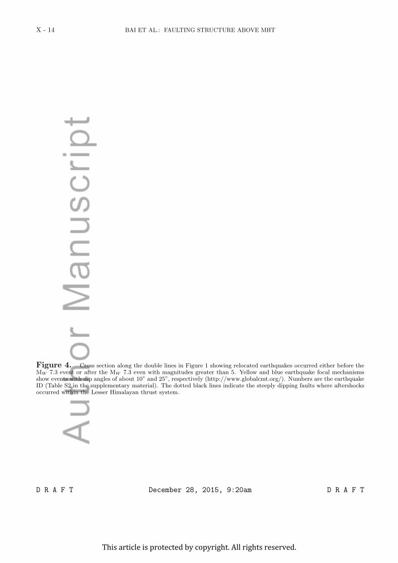
Figure 4 shows relocated hypocenters of the mainshock and major aftershocks along117
a N20◦E cross-section perpendicular to the strike of the Ghorka mainshock fault plane.118
Most aftershocks are shallower than the mainshock and located in the hanging wall. They119
line up as clear north-dipping structures with dip angles of about 25◦, which is 15◦ steeper120
than the dip of the MHT [?] and the shallow nodal plane of the mainshock [?]. The steeper121
dips are in good agreement with the focal mechanisms solutions of aftershocks 12, 76, 98,122
156, and 222 (Table S2) reported in the global Centroid Moment Tensor (gCMT) catalog.123
5. Discussion and conclusions
The 2015 Ghorka earthquake sequence on a shallow section of the MHT has been124
recorded extremely well by local, regional, and global seismic arrays. From precise re-125
locations, we infer that the Gorkha aftershocks (Figure 1) are distributed above the an-126
ticlinorium system of the MCT. The southern edge of the aftershock zone is very close127
D R A F T December 28, 2015, 9:20am D R A F T
This article is protected by copyright. All rights reserved.
BAI ET AL.: FAULTING STRUCTURE ABOVE MHT X - 9
to the MBT [?], which is the thrust placing the lesser Himalaya over Tertiary sedimen-128
tary strata. ? suggested that earthquakes along Himalaya orogeny are mostly parallel129
to the MBT. These observations indicate that the MBT may be important in controlling130
earthquake occurrence along the frontal edge of the Himalaya.131
While the mainshock ruptured a section of the MHT, most of the aftershocks with132
MW 3.5 or larger have shallower focal depths and the northward dipping nodal planes of133
the largest aftershocks have larger dip angles. We infer therefore that the aftershocks are134
mainly distributed on steeper dipping structures within the hanging wall of the Lesser135
Himalaya (Figure 4).136
Northward motion on the Indian plate was associated with development of a thrust137
system that consists of both the near horizontal MHT and more steeply dipping faults138
above. ? and ? suggested such Lesser Himalayan duplex system to exist in the western139
Himalaya and to cause folding of the MCT and STD at deeper depth. The Ghorka140
aftershock locations indicates that this thrust system is also present in central Nepal.141
Active faults exist throughout the Kathmandu basin [?]. However, strike-slip earth-142
quakes on these near-vertical faults have not been recorded in the past fifty years [?].143
Great earthquakes in the past 200 years include the August 26, 1833 MW 8.0 event [?],144
and the January 15, 1934 MW 8.0 Bihar-Nepal event [?] (Figure 1), which have been at-145
tributed to slip on the MHT. Many of the historical large earthquakes along the Himalaya146
orogeny were located beneath the Lesser Himalaya [?]. We infer that the Lesser Himalaya147
thrust system is the most seismically active region along the Himalaya convergence and148
accommodates most of the elastic strain accumulation of the region.149
D R A F T December 28, 2015, 9:20am D R A F T
This article is protected by copyright. All rights reserved.
X - 10 BAI ET AL.: FAULTING STRUCTURE ABOVE MHT
Acknowledgments. This research is funded by the grants of National Nature Science150
Foundation of China (41274086, 41490615) and the Chinese Academy of Sciences (CAS:151
L. Bai) to LB, the grant of National Nature Science Foundation of China (41174069) to152
HL, and the grant of National Science Foundation of U.S. (EAR-1416695) to JR. We used153
Earthquake catalogs from the reviewed ISC bulletin, CEDC, and NEIC, and waveform154
data from the Data Management Center of IRIS and CNSN at Institute of Geophysics,155
China Earthquake Administration (SEISDMC, doi: 10.7914/SN/CB, [?]), respectively.156
We are grateful to the China-Nepal array team for conducting the field work.157
D R A F T December 28, 2015, 9:20am D R A F T
This article is protected by copyright. All rights reserved.

BAI ET AL.: FAULTING STRUCTURE ABOVE MHT X - 11
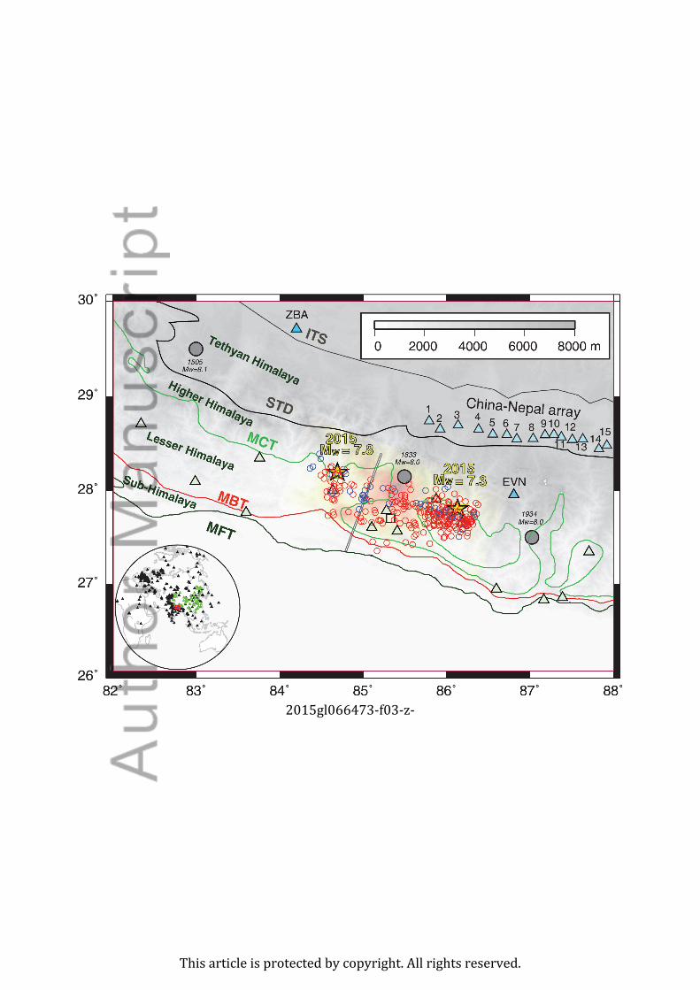
Figure 1. The study region showing the relocations of the MW 7.8 Gorkha, MW 7.3 Kodari earthquakes (yellowstarts), aftershocks (red circles) and earthquakes that occurred before the Gorkha earthquake since 1980 (blue circles)superposed on a slip model [?]. Historic seismicity of MW > 7.0 since 1000 is shown with large black circles. Blue trianglesshow the 15 stations of the China-Nepal seismograph array deployed before the Gorkha earthquake. Green triangles showthe short period seismic stations of the National Seismic Network of Nepal. Station EVN and ZBA belong to the IO andCEDC networks, respectively. The black square shows the location of Nepal’s capital city, Kathmandu. The double linesindicate the location and the direction N20◦E of the cross section shown in Figure 4. The inset at the lower left cornershows seismic stations from the China National Seismic Network (green triangles) and the Global Seismic Network (blacktriangles) used in this study.
D R A F T December 28, 2015, 9:20am D R A F T
This article is protected by copyright. All rights reserved.

X - 12 BAI ET AL.: FAULTING STRUCTURE ABOVE MHT
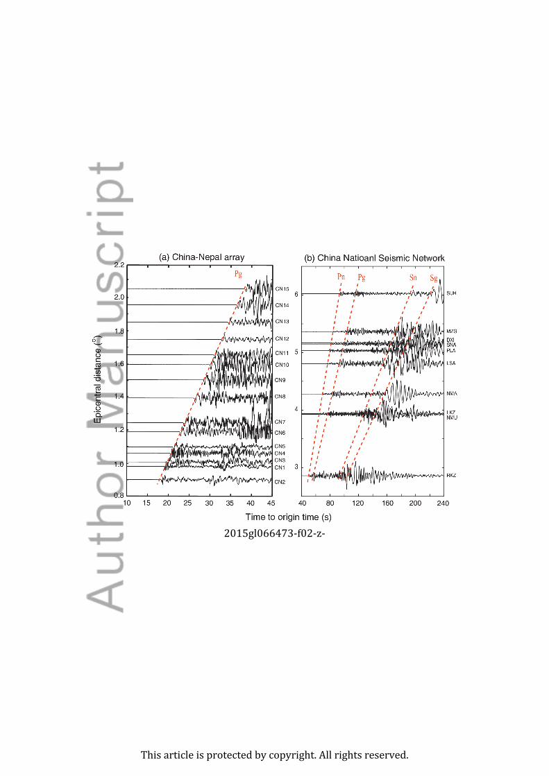
Figure 2. Record section of vertical-component seismograms for event 222 (Table S2) recorded by the (a) China-Nepalarray and (b) China National Seismic Network. Dotted red lines are observed arrival times of each phase.
D R A F T December 28, 2015, 9:20am D R A F T
This article is protected by copyright. All rights reserved.
BAI ET AL.: FAULTING STRUCTURE ABOVE MHT X - 13
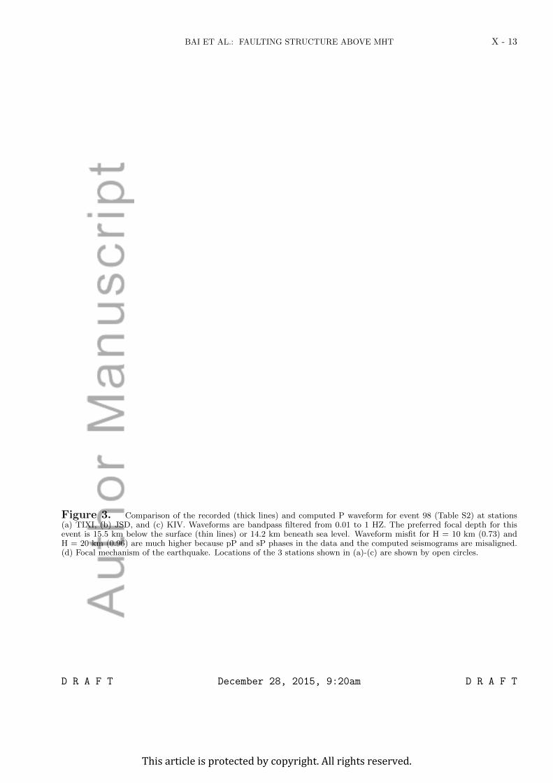
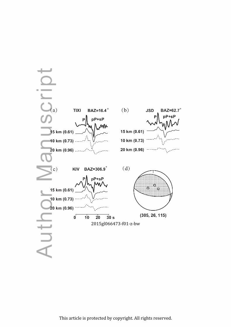
Figure 3. Comparison of the recorded (thick lines) and computed P waveform for event 98 (Table S2) at stations(a) TIXI, (b) JSD, and (c) KIV. Waveforms are bandpass filtered from 0.01 to 1 HZ. The preferred focal depth for thisevent is 15.5 km below the surface (thin lines) or 14.2 km beneath sea level. Waveform misfit for H = 10 km (0.73) andH = 20 km (0.96) are much higher because pP and sP phases in the data and the computed seismograms are misaligned.(d) Focal mechanism of the earthquake. Locations of the 3 stations shown in (a)-(c) are shown by open circles.
D R A F T December 28, 2015, 9:20am D R A F T
This article is protected by copyright. All rights reserved.
X - 14 BAI ET AL.: FAULTING STRUCTURE ABOVE MHT
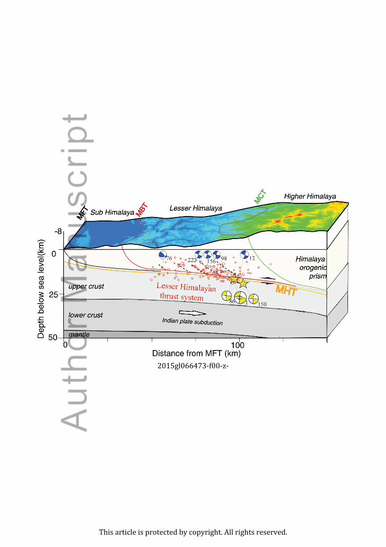
Figure 4. Cross section along the double lines in Figure 1 showing relocated earthquakes occurred either before theMW 7.3 event or after the MW 7.3 even with magnitudes greater than 5. Yellow and blue earthquake focal mechanismsshow events with dip angles of about 10◦ and 25◦, respectively (http://www.globalcmt.org/). Numbers are the earthquakeID (Table S2 in the supplementary material). The dotted black lines indicate the steeply dipping faults where aftershocksoccurred within the Lesser Himalayan thrust system.
D R A F T December 28, 2015, 9:20am D R A F T
This article is protected by copyright. All rights reserved.
2015gl066473-f00-z-
This article is protected by copyright. All rights reserved.
2015gl066473-f01-z-bw
This article is protected by copyright. All rights reserved.
2015gl066473-f02-z-
This article is protected by copyright. All rights reserved.
2015gl066473-f03-z-
This article is protected by copyright. All rights reserved.