Embed Size (px)
Citation preview
Landscape ArchitectureMasterplanning
Ecology
August 2018
Issue 03
hankinson duckett associatestelephone: 01491 838175 email: [email protected] website: www.hda-enviro.co.uk post: The Stables, Howbery Park, Benson Lane, Wallingford, Oxfordshire, OX10 8BA Hankinson Duckett Associates Limited Registered in England & Wales 3462810 Registered Office: The Stables, Howbery Park, Benson Lane, Wallingford, OX10 8BA
Farnham Landscape Character Assessment
ACKNOWLEDGEMENTS
This Landscape Character Assessment was prepared by Hankinson Duckett Associates (HDA). The study was commissioned and funded by Farnham Town Council.
CONTENTS PAGE NUMBER
1 Introduction 1
2 Methodology 2
3 Designations and Policy Context 4
4 Farnham Landscape Structural Analysis 6
5 Parish Landscape Character Areas 13
6 Summary 34
1
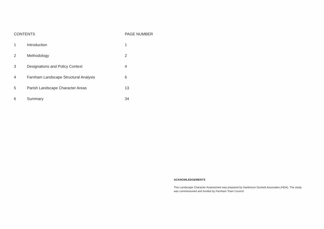
1. Introduction1.1 This Landscape Character Assessment has been commissioned by Farnham
Town Council to inform an update to the Farnham Neighbourhood Plan. The brief for the assessment seeks to assess the landscape character within Farnham Town Council boundary (the study area) and to determine its local landscape value and sensitivity.
1.2 This Landscape Character Assessment is based on current good practice and recognised methodology. It identifies character areas within Farnham Town Council boundary (the study area), which have been assessed so as to define the character of the landscape and setting to the town.
1.3 Natural England describes landscape character as the landscape features which make an area unique. It is defined as “a distinct, recognisable and consistent pattern of elements, be it natural (soil, landform) and/or human (for example settlement and development) in the landscape that makes one landscape different from another“ (An Approach to Landscape Character Assessment, 2014).
1.4 The report divides the landscape into areas of common landscape character, listing the key landscape characteristics, landscape sensitivity and value of each area. This analysis will highlight areas of the Parish which are sensitive, have a high value and where future development would be inappropriate. Landscape sensitivity and value may not be completely uniform across an entire Character Area and, where relevant, this has been referred to in the Key Characteristics of the character area.
Figure 1: Farnham Town Council boundary

2
2. METHOD STATEMENT2.1 Introduction2.1.1 The approach to this study followed best practice promoted by Natural
England, as set out in the Landscape Character Assessment Guidance for England and Scotland (2002) and Topic Paper 6, and reaffirmed by Natural England’s 2014 ‘An Approach to Landscape Character Assessment’.
2.2 Baseline2.2.1 Baseline data has been be collated and analysed and mapped in zones to
cover all the sites to the considered, in order to identify existing landscape features, views and the main elements which contribute to the character, structure and setting of each site.
Mapping has included: ▪ Geology and soils; ▪ Topography; ▪ Land use and landscape features (based initially on aerial photography and OS mapping);
▪ Regional and county landscape character types and areas, and associated guidelines;
▪ Local and Neighbourhood Plan designations including local landscape, nature conservation, and heritage designation;
▪ Extent of existing built development (settlement); ▪ Listed buildings, Conservation Areas, registered parks/gardens, Scheduled Monuments;
▪ Public rights of way (including long distance footpaths etc) and notable view points;
▪ Areas at risk of flooding; ▪ Outstanding assets, which for the purposes of this report are: Farnham Castle, Farnham Park, Waverley Abbey and the North Downs Way; and
▪ Any known cultural associations.
2.2.2 Data was overlaid to create a baseline structural analysis for the study area, providing a context for field work and the detailed analysis and assessment to follow, helping to identify:
▪ The nature of the settlement edge and relationship to existing built form; ▪ Settlement morphology (including form and setting); ▪ Settlement visual envelope and intervisibility; ▪ Setting of the outstanding assets; ▪ The location/extent of major constraints to future development.
2.3 Field Assessment2.4 Field survey work was undertaken in May and June 2018 to confirm and refine
the baseline desk study, recording characteristics that cannot be recorded via the desk study alone, and informing the analysis and assessment set out in Stage 4. Findings were recorded onto survey sheets, OS mapping and annotated copies of the structural analysis overlays. Subsequent visits to the Parish were undertaken, to test/confirm initial assessment work.
2.4 IdentificationofCharacterAreas2.4.1 Drawing on the baseline work, field assessment and landscape structure
analysis, the study area is then divided into Parish-scale Landscape Character Areas, which possess consistent characteristics. Character Area boundaries are defined by recognisable landscape features.
2.4.2 Summary descriptions of each Character Area were compiled in accordance with the guidelines.
2.5 Analysis and Assessment2.5.1 Drawing together the desk studies and field assessment, and taking
into account the guidance set out in Natural England’s Topic Paper 6, the Landscape sensitivity and value of each of the Character Areas were assessed. Landscape sensitivity and landscape value are defined within the glossary of Natural England’s ‘An Approach to Landscape Character Assessment’(October 2014).
Landscape Sensitivity: ‘The extent to which a landscape can accept change of a particular type and scale without unacceptable adverse effects on its character.’

3
Landscape value: ‘The relative value or importance attached to a landscape (often as a basis for designation or recognition), which expresses national or local consensus, because of it’s quality, special qualities including perceptual aspects such as scenic beauty, tranquility or wildness, cultural associations or other conservation issues.’
2.5.2 Landscape sensitivity was then assessed, for each Character Area taking into account the following elements in tabulated form:
Inherentlandscape
quality(intactness
andcondition)
Inconsistencywith existingsettlement
form/pattern
Contributionto separation
betweensettlements
Contributionto the setting
of surroundinglandscape/settlement
Visualsensitivity
Potential formitigation
Overallsensitivityjudgement
2.5.3 Landscape value was then assessed, for each Character Area taking into account the following elements in tabulated form:
Landscapedesignations
Ecologicaland other
designations(eg heritage,flood zone
etc)
Localdistinctiveness
Any historic/cultural/literary
associations
Contributionto setting of‘outstanding
assests’
Recreationand public
access/locallyvaluedspaces
Perceptual aspects (eg.
scenicquality,
tranquility,and
remoteness)
Overallvalue
judgement
2.5.4 For each area, the elements within the landscape sensitivity and landscape value tables were graded on their degree of sensitivity or value, ranging from 1 (negligible) to 5 (major). The sensitivity and value assessment criteria used to make these judgements are provided in Appendix 1.
2.5.5 The scores for each element within the landscape sensitivity and landscape value tables are summed to give overall sensitivity and value scores for each Character Area. These are rated on a five point scale as follows:
1: Negligible 2: Slight
3 Moderate 4: Substantial 5: Major
2.5.6 As a final stage, the overall sensitivity and value ratings were reviewed to assess whether a specific or overriding aspect of sensitivity or value has been under or over weighted in the consolidation of the profile into a single overall rating. If necessary, ratings could then be adjusted up or down to reflect individual situations, ensuring that professional judgement is the final arbiter in the assessment process rather than relying solely on an arithmetic system. Sensitivity and value ratings for each Character Area are provided within Appendix 2
2.5.7 In order to be able to correlate this character assessment with the Waverley Character Assessment carried out by AMEC, the five point scale will be consolidated into a three point scale as follows: ▪ High - Substantial and Major ▪ Medium - Moderate ▪ Low - Slight and Negligible
2.5.8 Each character area is described within the document, containing information
on: ▪ Designations and policy; ▪ Key characteristics; ▪ Landscape sensitivity (including the corresponding High / Medium / Low judgement); and
▪ Landscape value (including the corresponding High / Medium / Low judgement);
Maps and photographs illustrating the character area are also provided.
2.5.9 The character of the landscape surrounding Farnham will then be summarised and recommendations for the Farnham Neighbourhood Plan will be made.

4
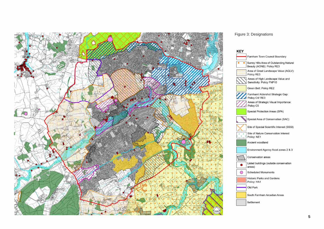
3. DESIGNATIONS AND POLICY CONTEXT3.1 The landscape within Farnham Town Council boundary contains designated
areas and features, which are protected by legislation and / or National and Local planning policy. The map opposite (Figure 2) identifies designations and other restrictions affecting the potential for development (e.g. floodplain) within the land surrounding Farnham.
Landscape designations3.2 Surrey Hills Area of Outstanding Natural Beauty (AONB) lies to the south-east
of Farnham and is a nationally protected landscape. Much of the remaining land to the south and west of the town lies within an Area of Great Landscape Value (AGLV), which is protected by local planning policy.
3.3 The adopted Neighbourhood Plan has policies, which recognise some of the special qualities of Farnham. This includes: ▪ South Farnham Arcadian Areas - areas of the town where landscape is ‘the dominant visual element’ (Policy FNP8);
▪ Old Park - The location of the original Deer Park for Farnham Castle, which has reverted to agricultural use, but retains some landscape characteristics, which link to it’s historic use (Policy FNP10); and
▪ Areas of High Landscape Value and Sensitivity (Policy FNP10).
Spatial planning3.4 Land to the south-east of the study area is protected by Green Belt, which
is covered by national planning policy and local policy. Waverley Borough Council have a Strategic Gap policy, which covers land to the north east of the study area, to protect the separation between Farnham and Aldershot. Waverley Borough have another policy in place to protect Areas of Strategic Visual Importance (ASVI), which are designated for their role in ‘preventing the coalescence of settlements or because they are areas of open land that stretch into the urban area’ (Waverley Local Plan Part 1, para 13.44).
3.5 Areas of flood risk are identified as they are restrictive to development.
Ecological designations3.6 The study area is rich in ecological interest, which is reflected in the breadth
and frequency of designations surrounding the town. Key designations include: ▪ Thames Basin Heaths Special Protection Area (SPA), an internationally important designation, which covers the woodland to the north of the study area.
▪ Sites of Special Scientific Interest (SSSI) ▪ Ancient Woodland ▪ Sites of Nature Conservation Interest, a local designation protected by local planning policy.
Heritage3.7 Farnham contains a large number of heritage assets including Farnham
Castle Scheduled Monument, five Conservation Areas and numerous listed buildings. Farnham Park is on the register of Parks and Gardens. Within the remainder of the study area there are other Scheduled Monuments (notably at Caeser’s Camp to the north and Waverley Abbey.
Figure 2: Copy of Map D from the Farnham Neighbourhood Plan, showing potential extensions to the AONB within the Neighbourhood Plan Area.
5
Figure 3: Designations
6
Figure 4: Surrey Landscape Character Areas
4 FARNHAM LANDSCAPE STRUCTURE ANALYSIS4.1 Introduction4.1.1 The aim of landscape structure analysis is to identify the main elements
which contribute to the character, structure and setting of settlement and the AONB. This section includes an evaluation of the existing Landscape Character Context and the local landscape context of the Parish, which looks at the study area in detail and sets out our initial analysis of the area.
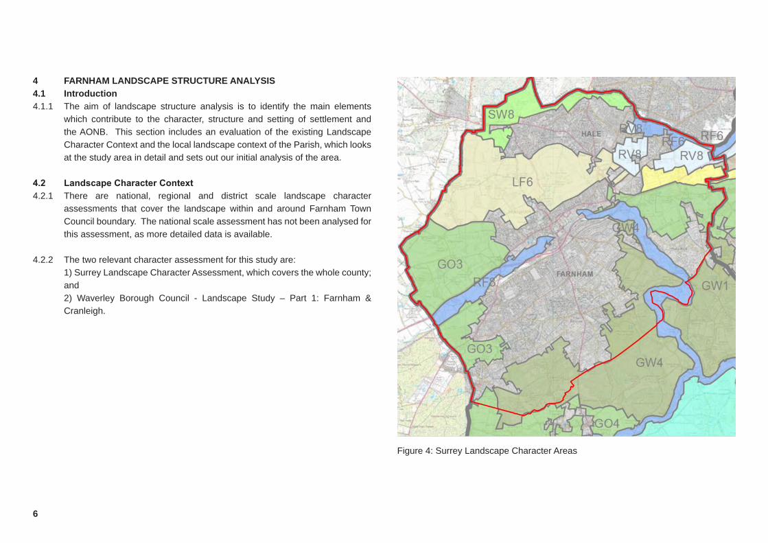
4.2 LandscapeCharacterContext4.2.1 There are national, regional and district scale landscape character
assessments that cover the landscape within and around Farnham Town Council boundary. The national scale assessment has not been analysed for this assessment, as more detailed data is available.
4.2.2 The two relevant character assessment for this study are: 1) Surrey Landscape Character Assessment, which covers the whole county;
and 2) Waverley Borough Council - Landscape Study – Part 1: Farnham &
Cranleigh.
7
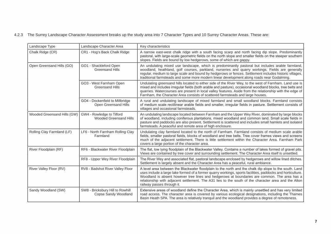
4.2.3 The Surrey Landscape Character Assessment breaks up the study area into 7 Character Types and 10 Surrey Character Areas. These are:
Landscape Type Landscape Character Area Key characteristicsChalk Ridge (CR) CR1 - Hog’s Back Chalk Ridge A narrow east-west chalk ridge with a south facing scarp and north facing dip slope. Predominantly
pastoral, with large-scale geometric fields on the north slope and smaller fields on the steeper southern slopes. Fields are bound by low hedgerows, some of which are gappy.
Open Greensand Hills (GO) GO1 - Shackleford Open Greensand Hills
An undulating mixed use landscape, which is predominantly pastoral but includes arable farmland, woodland, heathland, golf courses, parkland, nurseries and quarry workings. Fields are generally regular, medium to large scale and bound by hedgerows or fences. Settlement includes historic villages, traditional farmsteads and some more modern linear development along roads near Godalming.
GO3 - West Farnham Open Greensand Hills
Undulating greensand hills located to either side of the River Wey, to the west of Farnham. Land use is mixed and includes irregular fields (both arable and pasture), occasional woodland blocks, tree belts and quarries. Watercourses are present in local valley features. Aside from the relationship with the edge of Farnham, the Character Area consists of scattered farmsteads and large houses.
GO4 - Dockenfield to Millbridge Open Greensand Hills
A rural and undulating landscape of mixed farmland and small woodland blocks. Farmland consists of medium scale rectilinear arable fields and smaller, irregular fields in pasture. Settlement consists of villages and occasional farmsteads.
Wooded Greensand Hills (GW) GW4 - Rowledge to Tilford Wooded Greensand Hills
An undulating landscape located between Farnham and the Upper Wey River, dominated by large blocks of woodland, including coniferous plantations, mixed woodland and common land. Small scale fields in pasture and paddocks are also present. Settlement is scattered and includes small hamlets and isolated farmsteads. A peaceful and remote area of high enclosure.
Rolling Clay Farmland (LF) LF6 - North Farnham Rolling Clay Farmland
Undulating clay farmland located to the north of Farnham. Farmland consists of medium scale arable fields, smaller pastoral fields, blocks of woodland and tree belts. Tree cover frames views and screens much of the adjacent settlement. There is little settlement within the Character Area. Farnham Park covers a large portion of the character area.
River Floodplain (RF) RF6 - Blackwater River Floodplain The flat, low lying floodplain of the Blackwater Valley. Contains a number of lakes formed of gravel pits. Views are contained by tree cover and surrounding settlement. The Character Area itself is unsettled.
RF8 - Upper Wey River Floodplain The River Wey and associated flat, pastoral landscape enclosed by hedgerows and willow lined ditches. Settlement is largely absent and the Character Area has a peaceful, rural ambiance.
River Valley Floor (RV) RV8 - Badshot River Valley Floor A level area between the Blackwater floodplain to the north and the chalk dip slope to the south. Land uses include a large lake formed of a former quarry workings, sports facilities, paddocks and horticulture. Woodland is absent however tree lines and hedgerows at boundaries are common. The area has a relationship with adjacent settlement. The A31 lies to the south of the character area and the Alton railway passes through it.
Sandy Woodland (SW) SW8 - Bricksbury Hill to Rowhill Copse Sandy Woodland
Extensive areas of woodland define the Character Area, which is mainly unsettled and has very limited road access. The character area is covered by various ecological designations, including the Thames Basin Heath SPA. The area is relatively tranquil and the woodland provides a degree of remoteness.

8
This page has been left intentionally blank
9
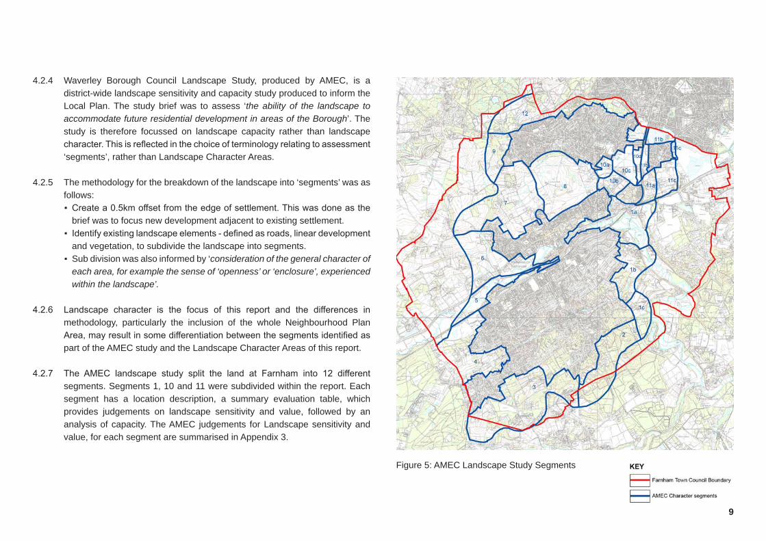
4.2.4 Waverley Borough Council Landscape Study, produced by AMEC, is a district-wide landscape sensitivity and capacity study produced to inform the Local Plan. The study brief was to assess ‘the ability of the landscape to accommodate future residential development in areas of the Borough’. The study is therefore focussed on landscape capacity rather than landscape character. This is reflected in the choice of terminology relating to assessment ‘segments’, rather than Landscape Character Areas.
4.2.5 The methodology for the breakdown of the landscape into ‘segments’ was as follows: ▪ Create a 0.5km offset from the edge of settlement. This was done as the brief was to focus new development adjacent to existing settlement.
▪ Identify existing landscape elements - defined as roads, linear development and vegetation, to subdivide the landscape into segments.
▪ Sub division was also informed by ‘consideration of the general character of each area, for example the sense of ‘openness’ or ‘enclosure’, experienced within the landscape’.
4.2.6 Landscape character is the focus of this report and the differences in methodology, particularly the inclusion of the whole Neighbourhood Plan Area, may result in some differentiation between the segments identified as part of the AMEC study and the Landscape Character Areas of this report.
4.2.7 The AMEC landscape study split the land at Farnham into 12 different segments. Segments 1, 10 and 11 were subdivided within the report. Each segment has a location description, a summary evaluation table, which provides judgements on landscape sensitivity and value, followed by an analysis of capacity. The AMEC judgements for Landscape sensitivity and value, for each segment are summarised in Appendix 3.
Figure 5: AMEC Landscape Study Segments
10
4.3 Farnhamandthelocallandscapecontext4.3.1 Farnham Town Council boundary (the study area) is located in Waverley
Borough in Surrey. Farnham is the main settlement within the study area and covers a large portion of the study area. The historic core of Farnham centres on the River Wey. Approximately one third of the town’s area is located to the north of the river and the remainder is located to the south of the river. The northern edge of the town is densely settled and is separated from Hale and Heath End (to the north), by a green wedge, which includes the historic landscape of Farnham Park and Old Park.
4.3.2 The southern edge of Farnham is very low density and merges with the rural, wooded landscape to the south. Many of the low density dwellings are associated with large gardens and woodland. These dominate within the two ‘Arcadian Areas’ that the town council has recognised within the Neighbourhood Plan. A third Arcadian Area, Moor Park, is located to the east of Farnham and is separated from the main settlement by the River Wey and it’s associated valley.
4.3.3 Hale and Heath End are located approximately 600m to the north of Farnham at its nearest point. The area of Badshot Lea is located approximately 250m to the north-east of Farnham and approximately 150m to the east of Weybourne. Aldershot is located to the north-east of Hale and Heath End, Weybourne, and Badshot Lea, with little intervening landscape.
4.3.4 The Surrey Hills AONB lies to the south-east of the study area. This is a national designation with policies set out in the National Planning Policy Framework that protects the landscape within the AONB for its landscape and scenic beauty. Any development within the AONB would need to demonstrate that it is in the public interest and would conserve and enhance the character or natural beauty of the landscape or its setting. Farnham is also surrounded by three Areas of Great Landscape Value (AGLV), which are protected through local planning policy. These are located to the north-west, south-west and east of the town. There is little land surrounding Farnham that is not designated as AONB or AGLV. Three areas of AGLV (Shown on Map D
within the Farnham Neighbourhood Plan) have been proposed as candidate AONB. This includes the river valley at Moor Park and two small areas to the south-west of the plan area, south-east of Rowledge.
4.3.5 The study area contains a number of heritage assets including scheduled monuments, Conservation Areas, Listed buildings and two parks which are on the Register of Parks and Gardens, including: ▪ Farnham Castle - a Sheduled Monument within a Conservation Area on the northern edge of Farnham;
▪ Farnham Park - a large public park on the Register of Parks and Gardens, which lies to the north-east of Farnham Castle, between Farnham and Hale;
▪ Waverley Abbey - a Scheduled Monument within a Conservation Area, located to the south-east of the study area; and
▪ Caeser’s Camp - a Scheduled Monument to the north of the study area, north of Hale.
▪ The garden at Moor Park is also on the register of Parks and Gardens.
4.3.6 The landscape to the north and south of Farnham is undulating and has a complex topography, incised by steep valleys with small streams. To the east of the town, around Badshot Lea, the land is much flatter. To the far east of the study area, the land starts to rise again, forming the westernmost part of the Hogs Back chalk escarpment. The land to the north of the study area (north-west of Upper Hale) is associated with a plateau of high land, which falls away to the south and east. The landform and drainage of the study area are an integral part of the local landscape character and provide a unique sense of place.
4.3.7 Watercourses and landscape features contribute substantially to the local landscape character. The River Wey and its associated valley winds around the eastern edge of Farnham and through the centre of the town. The small valley associated with the Blackwater River, and man made water features (associated with old quarry works), form the separation between Aldershot and Badshot Lea, to the north-east of the study area. Further minerals sites are located to the east and west of Farnham, adjacent to the river valleys. The

11
settlement at Farnham is located on the valley side slopes of the River Wey and the Bourne Stream, which flows from west to east through the southern part of the town. Two local ridges run through the town to the north and south of the Bourne Stream.
4.3.8 The land use within the study area is predominantly pastoral, with some arable agriculture to the west of the study area. Fields are generally small scale, with some larger scale fields associated with the arable fields to the west of the study area. Large blocks of woodland are located to the north and south of the study area, with smaller woodland blocks forming a frequent landscape feature within the remainder of the area. The woodland, hedgerows and hedgerow trees within the study area contribute to an enclosed or semi enclosed landscape, which is often intimate with framed views.
4.3.9 Numerous public rights of way cross the study area, allowing public access and enjoyment of the countryside. The North Downs Way National Trail crosses the eastern part of the site and St Swithun’s Way is a popular long distance route, which passes through the north-western part of the study area. Farnham Park is accessible to the public. The woodland to the north of the study area is MOD land which allows public access and Bourne Wood, a Forestry Commission woodland to the south-east of Farnham, is publicly accessible. Public rights of way located on the high ground to the north-west of the study area afford some long views over the surrounding countryside, however many routes are enclosed by hedgerows or woodland, which contains views to the immediate surroundings.
4.3.10 Sports facilities within the study area are either located within settlement areas, or are located within the flat land located between Farnham, Hale and Badshot Lea. This area also contains a number of allotment sites. Some additional sports facilities are located within Farnham Park, along with equipped play areas and informal open space.
Figure 6: Landscape structure analysis
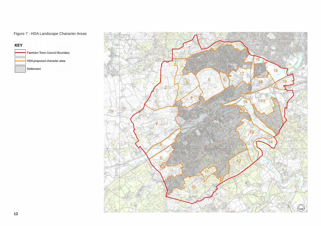
Figure 7 : HDA Landscape Character Areas
12
13
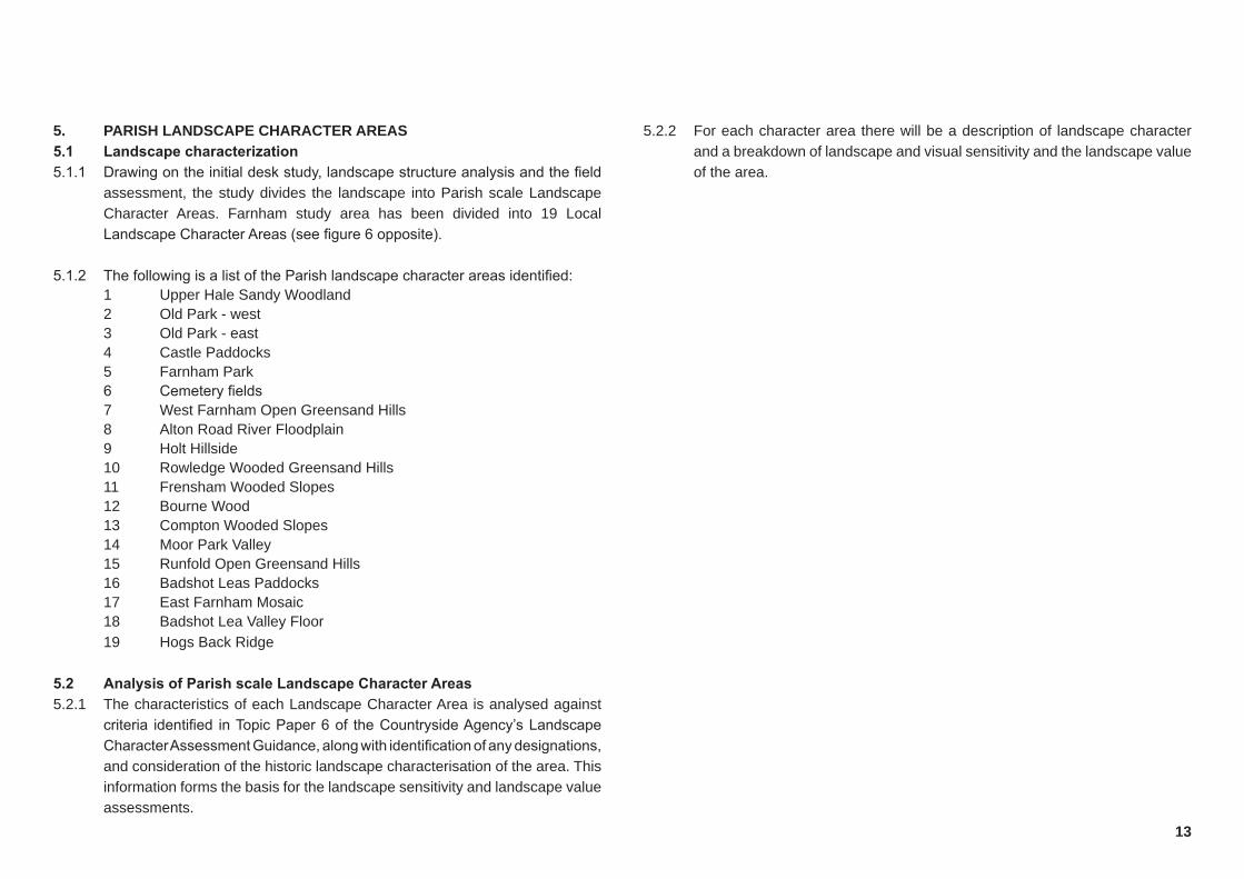
5. PARISH LANDSCAPE CHARACTER AREAS5.1 Landscapecharacterization5.1.1 Drawing on the initial desk study, landscape structure analysis and the field
assessment, the study divides the landscape into Parish scale Landscape Character Areas. Farnham study area has been divided into 19 Local Landscape Character Areas (see figure 6 opposite).
5.1.2 The following is a list of the Parish landscape character areas identified: 1 Upper Hale Sandy Woodland 2 Old Park - west 3 Old Park - east 4 Castle Paddocks 5 Farnham Park 6 Cemetery fields 7 West Farnham Open Greensand Hills 8 Alton Road River Floodplain 9 Holt Hillside 10 Rowledge Wooded Greensand Hills 11 Frensham Wooded Slopes 12 Bourne Wood 13 Compton Wooded Slopes 14 Moor Park Valley 15 Runfold Open Greensand Hills 16 Badshot Leas Paddocks 17 East Farnham Mosaic 18 Badshot Lea Valley Floor 19 Hogs Back Ridge
5.2 AnalysisofParishscaleLandscapeCharacterAreas5.2.1 The characteristics of each Landscape Character Area is analysed against
criteria identified in Topic Paper 6 of the Countryside Agency’s Landscape Character Assessment Guidance, along with identification of any designations, and consideration of the historic landscape characterisation of the area. This information forms the basis for the landscape sensitivity and landscape value assessments.
5.2.2 For each character area there will be a description of landscape character and a breakdown of landscape and visual sensitivity and the landscape value of the area.

Character Area
Designations and policy
Key Characteristics Landscape sensitivity Landscape value
Parish character area Photograph/s showing key characteristics Designations
14 Photograph 1a
1
Upper Hale Sandy Woodland
Part of the Thames Heaths SPA (Policy NE3) and also covered by a SSSI, SNCI and Local Nature reserve. Caesars Camp Scheduled Monument is located to the north of the character area.
The area forms part of the Farnham / Aldershot Strategic Gap (Policy RE3/ C5) and is designated as an Area of High Landscape Value and Sensitivity (Policy FNP 10).
A small part of the Character Area is in the Flood Zone.
The Character Area is dominated by mixed woodland, with areas of heathland. The eastern part of the character area comprises Ancient Woodland.
The woodland provides a very rural and natural setting to the north of the town and forms a strong separating feature between Upper Hale and Aldershot. The area is unsettled and has no internal road access.
The Character Area is accessible and is well used by local residents. The woodland is natural and peaceful, although the traffic from nearby roads adversely affects the tranquility of the area.
The wooded character is consistent across the area and is a unifying feature. The area sits on a plateau of high ground and, for the most part, is relatively flat.
This is an intact and high quality landscape, which contains key features associated with the character type. It has a high contribution to the rurality of the surrounding landscape.
There is a strong edge to adjacent settlement, defined by local roads. The edge of the character area is well treed, which reinforces the edge of the character area. Development within the Character Area would break up this definition. The eastern part of the character area forms the separation between Upper Hale and Aldershot.
The woodland at the boundary of the character area are a strong containing feature and limit intervisibility within the Character Area. There are open views of the area from the permissive routes within it. It would be difficult to mitigate for the feature loss that development within the character area would cause.
Landscape Sensitivity = High
The Character Area is not subject to any landscape designations, however it is covered by both international, national and local ecological designations, as well as containing a notable heritage asset. Caesar’s Camp is a Scheduled Monument and has strong historic associations for the local area.
The woodland and heathland within the character is unique within the study area. Remaining woodland has a different underlying geology and consequently supports different species.
The woodland to the west is owned by the MOD and is accessible to the public for the majority of the time. The eastern woodland is a nature reserve and is also open to the public. The area is natural rather than obviously managed and the intimacy created by the woodland makes the character area secluded and peaceful.
Landscape Value = High
Plans not to scale. Photograph 1b
1a
1b
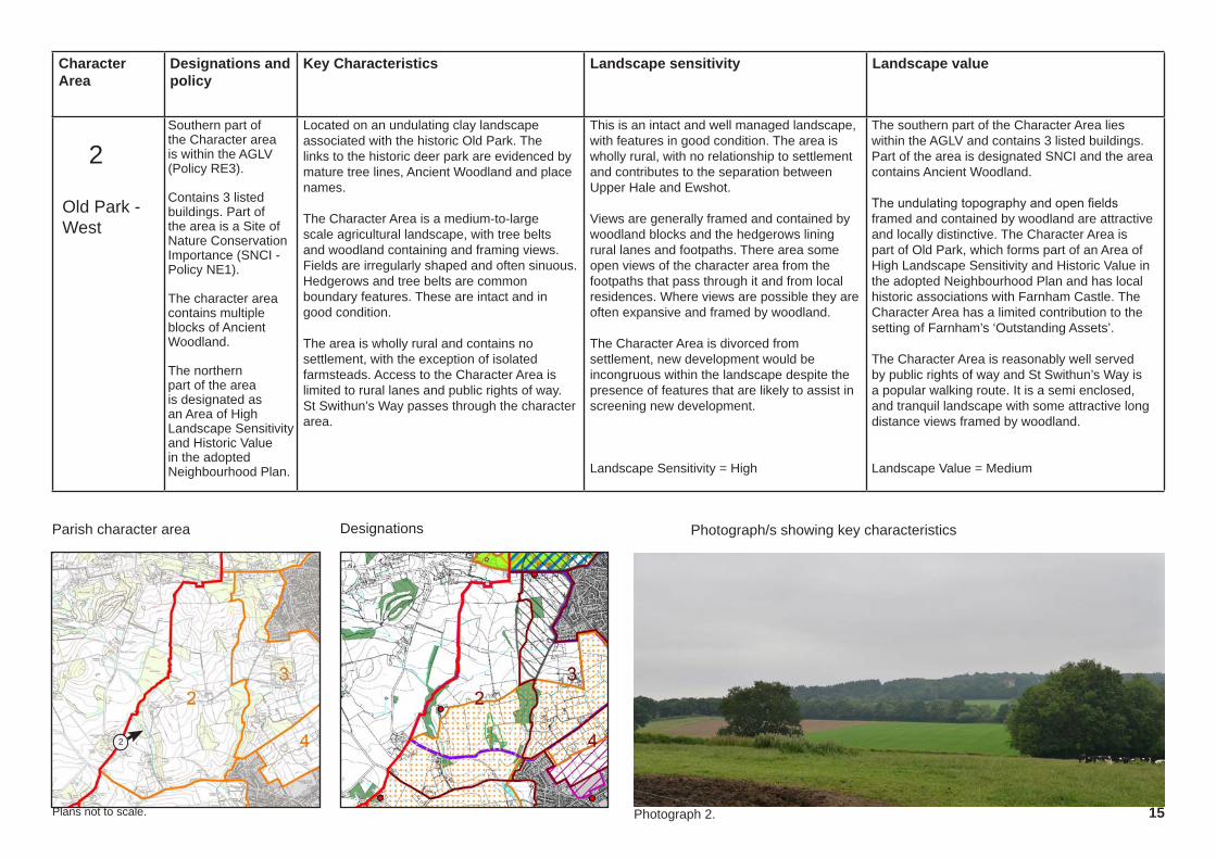
Character Area
Designations and policy
Key Characteristics Landscape sensitivity Landscape value
Parish character area Photograph/s showing key characteristics Designations
15Photograph 2.
2Southern part of the Character area is within the AGLV (Policy RE3).
Contains 3 listed buildings. Part of the area is a Site of Nature Conservation Importance (SNCI - Policy NE1).
The character area contains multiple blocks of Ancient Woodland.
The northern part of the area is designated as an Area of High Landscape Sensitivity and Historic Value in the adopted Neighbourhood Plan.
Located on an undulating clay landscape associated with the historic Old Park. The links to the historic deer park are evidenced by mature tree lines, Ancient Woodland and place names.
The Character Area is a medium-to-large scale agricultural landscape, with tree belts and woodland containing and framing views. Fields are irregularly shaped and often sinuous. Hedgerows and tree belts are common boundary features. These are intact and in good condition.
The area is wholly rural and contains no settlement, with the exception of isolated farmsteads. Access to the Character Area is limited to rural lanes and public rights of way. St Swithun’s Way passes through the character area.
This is an intact and well managed landscape, with features in good condition. The area is wholly rural, with no relationship to settlement and contributes to the separation between Upper Hale and Ewshot.
Views are generally framed and contained by woodland blocks and the hedgerows lining rural lanes and footpaths. There area some open views of the character area from the footpaths that pass through it and from local residences. Where views are possible they are often expansive and framed by woodland.
The Character Area is divorced from settlement, new development would be incongruous within the landscape despite the presence of features that are likely to assist in screening new development.
Landscape Sensitivity = High
The southern part of the Character Area lies within the AGLV and contains 3 listed buildings. Part of the area is designated SNCI and the area contains Ancient Woodland.
The undulating topography and open fields framed and contained by woodland are attractive and locally distinctive. The Character Area is part of Old Park, which forms part of an Area of High Landscape Sensitivity and Historic Value in the adopted Neighbourhood Plan and has local historic associations with Farnham Castle. The Character Area has a limited contribution to the setting of Farnham’s ‘Outstanding Assets’.
The Character Area is reasonably well served by public rights of way and St Swithun’s Way is a popular walking route. It is a semi enclosed, and tranquil landscape with some attractive long distance views framed by woodland.
Landscape Value = Medium
Old Park - West
Plans not to scale.
2
Character Area
Designations and policy
Key Characteristics Landscape sensitivity Landscape value
Parish character area Photograph/s showing key characteristics Designations
16
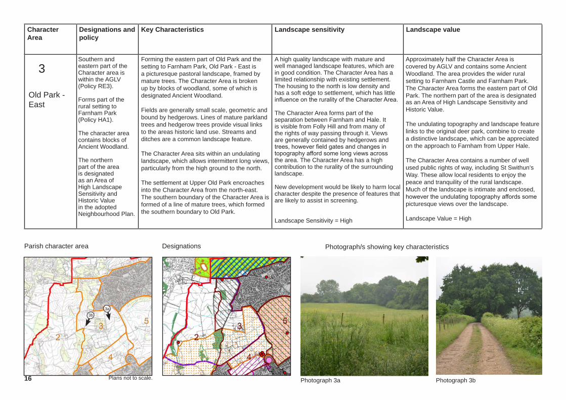
3Southern and eastern part of the Character area is within the AGLV (Policy RE3).
Forms part of the rural setting to Farnham Park (Policy HA1).
The character area contains blocks of Ancient Woodland.
The northern part of the area is designated as an Area of High Landscape Sensitivity and Historic Value in the adopted Neighbourhood Plan.
Forming the eastern part of Old Park and the setting to Farnham Park, Old Park - East is a picturesque pastoral landscape, framed by mature trees. The Character Area is broken up by blocks of woodland, some of which is designated Ancient Woodland.
Fields are generally small scale, geometric and bound by hedgerows. Lines of mature parkland trees and hedgerow trees provide visual links to the areas historic land use. Streams and ditches are a common landscape feature.
The Character Area sits within an undulating landscape, which allows intermittent long views, particularly from the high ground to the north.
The settlement at Upper Old Park encroaches into the Character Area from the north-east. The southern boundary of the Character Area is formed of a line of mature trees, which formed the southern boundary to Old Park.
A high quality landscape with mature and well managed landscape features, which are in good condition. The Character Area has a limited relationship with existing settlement. The housing to the north is low density and has a soft edge to settlement, which has little influence on the rurality of the Character Area.
The Character Area forms part of the separation between Farnham and Hale. It is visible from Folly Hill and from many of the rights of way passing through it. Views are generally contained by hedgerows and trees, however field gates and changes in topography afford some long views across the area. The Character Area has a high contribution to the rurality of the surrounding landscape.
New development would be likely to harm local character despite the presence of features that are likely to assist in screening.
Landscape Sensitivity = High
Approximately half the Character Area is covered by AGLV and contains some Ancient Woodland. The area provides the wider rural setting to Farnham Castle and Farnham Park. The Character Area forms the eastern part of Old Park. The northern part of the area is designated as an Area of High Landscape Sensitivity and Historic Value.
The undulating topography and landscape feature links to the original deer park, combine to create a distinctive landscape, which can be appreciated on the approach to Farnham from Upper Hale.
The Character Area contains a number of well used public rights of way, including St Swithun’s Way. These allow local residents to enjoy the peace and tranquility of the rural landscape. Much of the landscape is intimate and enclosed, however the undulating topography affords some picturesque views over the landscape.
Landscape Value = High
Old Park - East
Plans not to scale. Photograph 3a Photograph 3b
3a3b

Character Area
Designations and policy
Key Characteristics Landscape sensitivity Landscape value
Parish character area Photograph/s showing key characteristics Designations
17Photograph 4b.Photograph 4a.
4The northern part of the Character Area is within AGLV (Policy RE3). The southern Part lies within an Area of Strategic Visual Importance (ASVI - Policy RE3)
Forms part of the rural setting to Farnham Castle and Farnham Park (Policy HA1).
The Character Area lies adjacent to a Conservation Area and there are a number of listed buildings on Old Park Road.
The Character Area comprises small, rectilinear, fields in pasture, located on undulating landform. There is a general south-facing slope towards the town.
Farnham is located to the south of the Character Area, however there is a soft edge to the settlement, which filters views of the town and maintains the rural character of the landscape.
Farnham Castle is located to the south-east of the Character Area and Farnham Park is located to the east, beyond the A287, which forms the eastern boundary. The northern boundary is defined by a tree line associated with the historic southern boundary of Old Park.
The Character Area abuts settlement to the south, however the only settlement within the Character Area are the low density houses on Old Park Lane.
The landscape is of moderate quality, with many intact features, but some feature loss associated with agricultural intensification. The Character Area forms a small part of the separation between Farnham and Upper Hale.
Numerous rights of way cross the Character Area, affording open views over the landscape within. There are partial and glimpsed views of the area from Folly Hill, to the north-east and from the car parks within Farnham Park.
The Character Area abuts existing settlement to the south and west, but is open to the countryside to the north and contributes to the rurality of the landscape. The Character Area contains some existing features, which could be built upon to mitigate development, particularly to the west of the area.
Landscape Sensitivity = Medium
The northern half of the Character Area is covered by AGLV, with the southern half designated as ASVI.
The south-eastern corner abuts Farnham Castle Scheduled Monument and a conservation area. A number of the properties on Old Park Lane are Listed Buildings. The eastern part of the Character Area contributes to the setting of Farnham Castle and Farnham Park.
The rights of way crossing the Character Area provide opportunities for informal recreation and good access to the countryside. The landscape is small scale and peaceful, with few detractors.
Landscape Value = High
Castle Paddocks
Plans not to scale.
4a
4b
Character Area
Designations and policy
Key Characteristics Landscape sensitivity Landscape value
Parish character area Photograph/s showing key characteristics Designations
18 Photograph 5a.
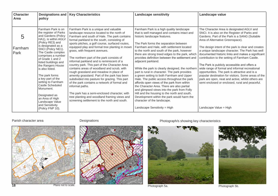
5Farnham Park is on the register of Parks and Gardens (Policy HA1), is within AGLV (Policy RE3) and is designated as a SNCI (Policy NE1). The Castle complex comprises a number of Grade 1 and 2 listed buildings and the Rangers House is also listed.
The park forms a key part of the setting to Farnham Castle Scheduled Monument.
Designated as an Area of High Landscape Value and Sensitivity (Policy FNP 10).
Farnham Park is a unique and valuable landscape resource located to the north of Farnham and south of Hale. The park contains formal parkland to the south, consisting of sports pitches, a golf course, surfaced routes, equipped play and formal tree planting in mown grass, with frequent avenues.
The northern part of the park consists of informal parkland and is reminiscent of a country park. This part of the Character Area contains areas of woodland and scrub, with rough grassland and meadow in place of amenity grassland. Part of the park has been subdivided into pasture for grazing. This part of the park contains a network of formal and informal paths.
The park has a semi-enclosed character, with tree planting and woodland framing views and screening settlement to the north and south.
Farnham Park is a high quality landscape that is well managed and contains intact and historic landscape features.
The Park forms the separation between Farnham and Hale, with settlement located to the north and south of the park, however there are strong treed edges to the park, which provides definition between the settlement and adjacent parkland.
While the park is clearly designed, the northern part is rural in character. The park provides a green setting to both Farnham and Upper Hale. The public access throughout the park affords open views of the park from within the Character Area. There are also partial and glimpsed views into the park from Folly Hill and the housing to the north and south. Development within the park would harm the character of the landscape.
Landscape Sensitivity = High
The Character Area is designated AGLV and SNCI. It is also on the Register of Parks and Gardens. Part of the Park is a SANG (Suitable Area of Alternative Greenspace).
The design intent of the park is clear and creates a unique landscape character. The Park has well documented historic links and makes a significant contribution to the setting of Farnham Castle.
The Park is publicly accessible and offers a wide range of formal and informal recreational opportunities. The park is attractive and is a popular destination for visitors. Some areas of the park are open, neat and active, whilst others are semi enclosed or enclosed, rural and peaceful.
Landscape Value = High
Farnham Park
Plans not to scale. Photograph 5b.
5a
5b

Character Area
Designations and policy
Key Characteristics Landscape sensitivity Landscape value
Parish character area Photograph/s showing key characteristics Designations
19
6The whole area is covered by AGLV (Policy RE3).
The Character Area contains two Listed Buildings, including the Church of St John the Evangelist, and has a number of additional Listed Buildings adjacent to the north-eastern boundary (Policy HA1).
Designated as an Area of High Landscape Value and Sensitivity (Policy FNP 10).
Located on a south-east facing slope, with long views available from the high ground to the north-west.
The Character Area consists of small fields in pasture bound by hedgerows of varying ages. Established hedgerows contain mature hedgerow trees. A thick belt of mature trees abuts the western boundary of the area and other mature tree belts are located to the south and south-east of the area.
The cemetery for the Church of St John the Evangelist forms part of the Character Area. The Character Area is bound by settlement to the north and south and by the A325 to the east. Settlement within the Character Area is limited to the occasional large, detached dwelling. The settlement does not affect the perception of rurality within the Character Area.
The Character Area is generally in good condition, although some areas appear unmanaged. New and characteristic hedgerow planting has been undertaken.
The Character Area forms a critical part of the separation between Farnham and Hale. There is a strong treed edge to the southern boundary, which provides definition between the settlement and adjacent countryside.
The north-eastern part of the site has a strong visual connection with the wider rural landscape and the Character Area forms a rural setting to adjacent settlement. The Character Area contains some existing features, which could be built upon to mitigate development, however new development would be likely to harm local character. There are open views from the cemetery. There are glimpsed views from Farnham Park.
Landscape Sensitivity = High
The Character Area lies within the AGLV and an Area of High Landscape Value and Sensitivity. It is a peaceful and attractive rural landscape and is small scale and enclosed. Parts of the area contribute towards the setting to Listed Buildings, in particular the Church of St John the Evangelist and the cottages which constituted the original hamlet of Hale. There are historic links in ownership between the Character Area and Farnham Park and the area forms the eastern rural setting to the park, linking it to its historic rural surroundings.
The Character Area forms part of the distinctive rolling clay farmland, which forms a green wedge between Farnham and Hale. The cemetery has public access and a public right of way runs along the southern boundary of the area, connecting to Farnham Park. The churchyard is well used by the public and is actively managed for wildlife conservation.
Landscape Value = High
Plans not to scale. Photograph 5b. Photograph 6a. Photograph 6b.
Cemetery Fields
6a
6b

Character Area
Designations and policy
Key Characteristics Landscape sensitivity Landscape value
Parish character area Photograph/s showing key characteristics Designations
20
7 The whole area is covered by AGLV (Policy RE3).
The Character Area contains a number of Listed Buildings (Policy HA1).
There are a number of blocks of Ancient Woodland within the Character Area and a small area on the eastern edge, falls within floodplain (Policy CC4).
The Character Area consists of undulating greensand hills located to the north of the River Wey, to the west of Farnham. Tree belts and woodland are generally located within valleys or side slopes, with a lack of landscape structure on the ridgetops, leading to some long views across the Character Area.
Land use is predominantly pasture and includes irregular fields which vary in size and enclosure. Fields are often bound by hedgerows, although some feature loss has occured. There are occasional woodland blocks and tree belts. Watercourses are present in local valley features within the Character Area, at Dippenhall and to the west of Farnham, which separates the Character Area from the main settlement.
Settlement within the Character Area consists of scattered farmsteads and large houses, with a small business park located to the south-east of the area.
The condition of the landscape is generally good, although there is some feature loss. The eastern boundary of the Character Area abuts the settlement edge of Farnham, however the two are separated by a stream and associated narrow valley. The landscape is part of the wider countryside and forms a rural outlook for settlement. The area has little contribution to the separation between settlements.
There are open views of the Character Area from the footpaths within it, particularly those located on the open high ground. There is some intervisibility with adjacent settlement, but views into the Character Area from local roads are limited, due to the hedgerows lining the rural lanes.
New development would be likely to harm the rural character of this area despite the presence of features that are likely to assist in screening.
Landscape Sensitivity = High
The Character Area is designated AGLV and contains Listed Buildings and blocks of Ancient Woodland. The area is typical of the Character Type.
The Character Area has no known literary / cultural associations and has no relationship with any of Farnham’s ‘Outstanding assets’. The area contains public rights of way, which contribute to informal recreation.
The long ranging views available from the high ground are panoramic and add to the scenic beauty of the Character Area. Within the valley features, the landscape is more enclosed and intimate.
Landscape Value = Medium
Plans not to scale.
West Farnham Open Greensand Hills
Photograph 7a. Photograph 7b.
7a 7b

Character Area
Designations and policy
Key Characteristics Landscape sensitivity Landscape value
Parish character area Photograph/s showing key characteristics Designations
21
8Almost the entire Character Area lies within the floodplain (Policy CC4), and the whole area is covered by AGLV (policy RE3).
The Character Area contains two Listed Buildings (Policy HA1).
The river corridor is designated as SNCI (Policy NE1).
The Character Area is defined by the valley and associated floodplain of the River Wey. The topography is generally flat with a shallow slope towards the river, which runs through the centre of the area. The Character Area is bound to the north by the busy A31 and to the south by the railway line.
Land use is dominated by sinuous, medium-sized fields in pasture or water meadows. Fields are bound by hedgerows and riparian vegetation, which provides a semi-enclosed landscape.
Settlement is limited to the northern edge of the Character Area and consists of isolated dwellings. Only one road crosses the Character Area, although there is a vehicular access to the quarry located within the adjacent Character Area, to the south of the railway line.
The landscape is generally intact and in good condition. It’s location within the floodplain means that development within the area would be wholly inconsistent with the existing settlement pattern, despite existing settlement to the north-east and south-east. It has a strong contribution to the rurality of the surrounding landscape.
The Character Area has a limited contribution to the separation between settlements.
There are open views into the Character Area from rights of way, however views from roads and properties are limited - largely due to their absence within the Character Area. The lack of settlement within the area would result in new development being incongruous within the landscape, despite the presence of features that are likely to assist in screening it.
Landscape Sensitivity = High
A pleasant rural landscape within the AGLV. The valley feature is distinct from much of the landscape surrounding Farnham. The area lies almost entirely within floodplain and the river corridor is an SNCI. Listed buildings are located to the north of the Character Area.
The Character Area has no known literary / cultural associations and has no relationship with any of Farnham’s ‘Outstanding assets’. The area contains public rights of way, which contribute to informal recreation.
The tranquility of the Character Area is affected by the noise associated with the road to the north and railway to the south. Otherwise the area is peaceful and pleasant, with little urban influence. The meadows within the Character Area, along with the willow trees, provide texture and movement.
Landscape Value = Medium
Plans not to scale.
Alton Road River Floodplain
Photograph 8a. Photograph 8b.
8b8a
Character Area
Designations and policy
Key Characteristics Landscape sensitivity Landscape value
Parish character area Photograph/s showing key characteristics Designations
22
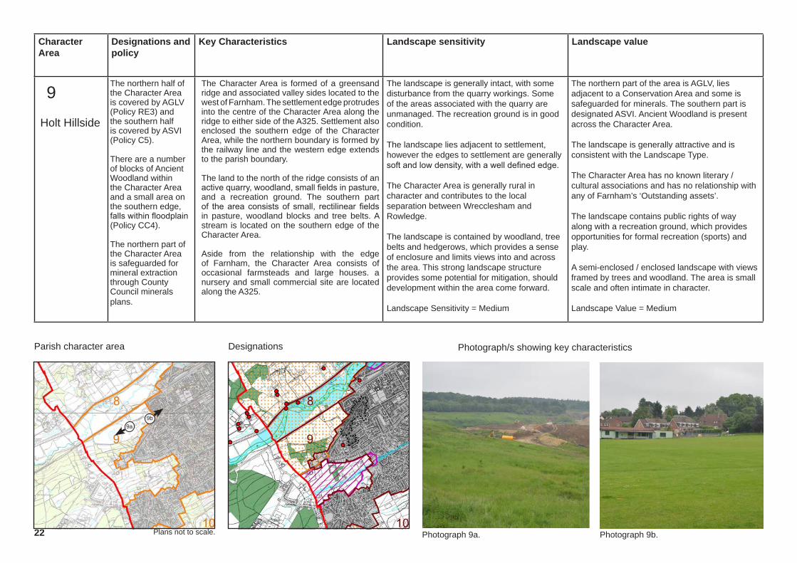
9The northern half of the Character Area is covered by AGLV (Policy RE3) and the southern half is covered by ASVI (Policy C5).
There are a number of blocks of Ancient Woodland within the Character Area and a small area on the southern edge, falls within floodplain (Policy CC4).
The northern part of the Character Area is safeguarded for mineral extraction through County Council minerals plans.
The Character Area is formed of a greensand ridge and associated valley sides located to the west of Farnham. The settlement edge protrudes into the centre of the Character Area along the ridge to either side of the A325. Settlement also enclosed the southern edge of the Character Area, while the northern boundary is formed by the railway line and the western edge extends to the parish boundary.
The land to the north of the ridge consists of an active quarry, woodland, small fields in pasture, and a recreation ground. The southern part of the area consists of small, rectilinear fields in pasture, woodland blocks and tree belts. A stream is located on the southern edge of the Character Area.
Aside from the relationship with the edge of Farnham, the Character Area consists of occasional farmsteads and large houses. a nursery and small commercial site are located along the A325.
The landscape is generally intact, with some disturbance from the quarry workings. Some of the areas associated with the quarry are unmanaged. The recreation ground is in good condition.
The landscape lies adjacent to settlement, however the edges to settlement are generally soft and low density, with a well defined edge.
The Character Area is generally rural in character and contributes to the local separation between Wrecclesham and Rowledge.
The landscape is contained by woodland, tree belts and hedgerows, which provides a sense of enclosure and limits views into and across the area. This strong landscape structure provides some potential for mitigation, should development within the area come forward.
Landscape Sensitivity = Medium
The northern part of the area is AGLV, lies adjacent to a Conservation Area and some is safeguarded for minerals. The southern part is designated ASVI. Ancient Woodland is present across the Character Area.
The landscape is generally attractive and is consistent with the Landscape Type.
The Character Area has no known literary / cultural associations and has no relationship with any of Farnham’s ‘Outstanding assets’.
The landscape contains public rights of way along with a recreation ground, which provides opportunities for formal recreation (sports) and play.
A semi-enclosed / enclosed landscape with views framed by trees and woodland. The area is small scale and often intimate in character.
Landscape Value = Medium
Plans not to scale.
Holt Hillside
Photograph 9a. Photograph 9b.
9a9b
Character Area
Designations and policy
Key Characteristics Landscape sensitivity Landscape value
Parish character area Photograph/s showing key characteristics Designations
23
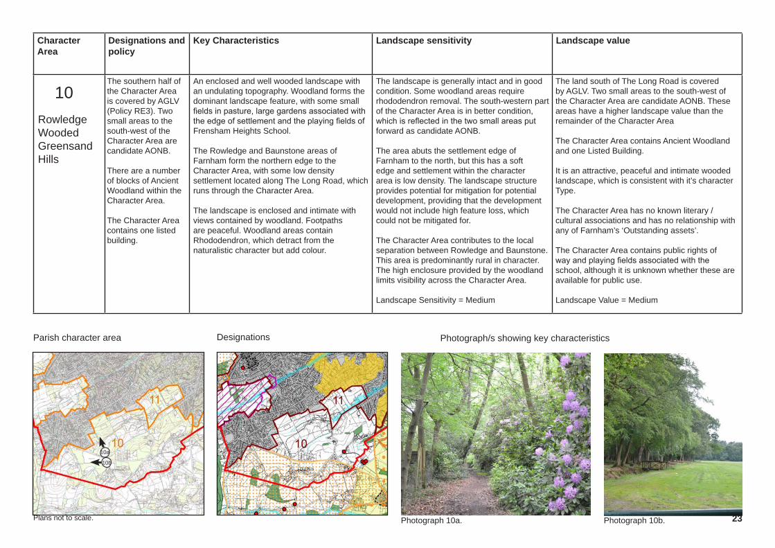
10The southern half of the Character Area is covered by AGLV (Policy RE3). Two small areas to the south-west of the Character Area are candidate AONB.
There are a number of blocks of Ancient Woodland within the Character Area.
The Character Area contains one listed building.
An enclosed and well wooded landscape with an undulating topography. Woodland forms the dominant landscape feature, with some small fields in pasture, large gardens associated with the edge of settlement and the playing fields of Frensham Heights School.
The Rowledge and Baunstone areas of Farnham form the northern edge to the Character Area, with some low density settlement located along The Long Road, which runs through the Character Area.
The landscape is enclosed and intimate with views contained by woodland. Footpaths are peaceful. Woodland areas contain Rhododendron, which detract from the naturalistic character but add colour.
The landscape is generally intact and in good condition. Some woodland areas require rhododendron removal. The south-western part of the Character Area is in better condition, which is reflected in the two small areas put forward as candidate AONB.
The area abuts the settlement edge of Farnham to the north, but this has a soft edge and settlement within the character area is low density. The landscape structure provides potential for mitigation for potential development, providing that the development would not include high feature loss, which could not be mitigated for.
The Character Area contributes to the local separation between Rowledge and Baunstone.This area is predominantly rural in character. The high enclosure provided by the woodland limits visibility across the Character Area.
Landscape Sensitivity = Medium
The land south of The Long Road is covered by AGLV. Two small areas to the south-west of the Character Area are candidate AONB. These areas have a higher landscape value than the remainder of the Character Area
The Character Area contains Ancient Woodland and one Listed Building.
It is an attractive, peaceful and intimate wooded landscape, which is consistent with it’s character Type.
The Character Area has no known literary / cultural associations and has no relationship with any of Farnham’s ‘Outstanding assets’.
The Character Area contains public rights of way and playing fields associated with the school, although it is unknown whether these are available for public use.
Landscape Value = Medium
Plans not to scale.
Rowledge Wooded Greensand Hills
Photograph 10a. Photograph 10b.
10a
10b

Character Area
Designations and policy
Key Characteristics Landscape sensitivity Landscape value
Parish character area Photograph/s showing key characteristics Designations
24
11The southern edge of the Character Area falls within floodplain (Policy CC4).
The northern edge lies adjacent to on of Farnham’s ‘Arcadian Areas’.
This is a small scale Character Area containing isolated dwellings set within extensive land holdings. These include areas of woodland, small scale paddocks or meadows and landscaped gardens. Woodland is the dominant land cover.
The Character Area has a relatively rural character and is well contained. There are few views of or into the Character Area. Access is limited to one rural lane. The area is located on a south-facing slope, with a small watercourse located adjacent to the southern boundary.
The Character Area is intact and is well maintained. Features are generally well managed and in good condition. Formal landscaped gardens bleed out into the more rural paddocks and woodland.
The Character Area has associations with settlement to the north, however this settlement is very low density and is dominated by landscape features. The area is a transitionary landscape between Farnham and the wider rural landscape. The area has a limited contribution to the separation between settlement.
Views of the Character Area are extremely limited. The landscape structure provides potential for mitigation for potential development, providing that the development would not include high feature loss, which could not be mitigated for.
Landscape Sensitivity = Medium
There are no landscape designations covering the area. Floodplain covers the southern part of the Character Area and one of Farnham’s ‘Arcadian Areas’ lies to the north.
The area displays some of the key characteristics of the landscape Type.
The Character Area has no known literary / cultural associations and has no relationship with any of Farnham’s ‘Outstanding assets’. There are no public rights of way or recreational facilities within the Character Area.
The area is quiet, with a high degree of enclosure and the woodland obscures most urban influences.
Landscape Value = Low
Plans not to scale.
Frensham Wooded Slopes
Photograph 11a. Photograph 11b.
11b11a
Character Area
Designations and policy
Key Characteristics Landscape sensitivity Landscape value
Parish character area Photograph/s showing key characteristics Designations
25
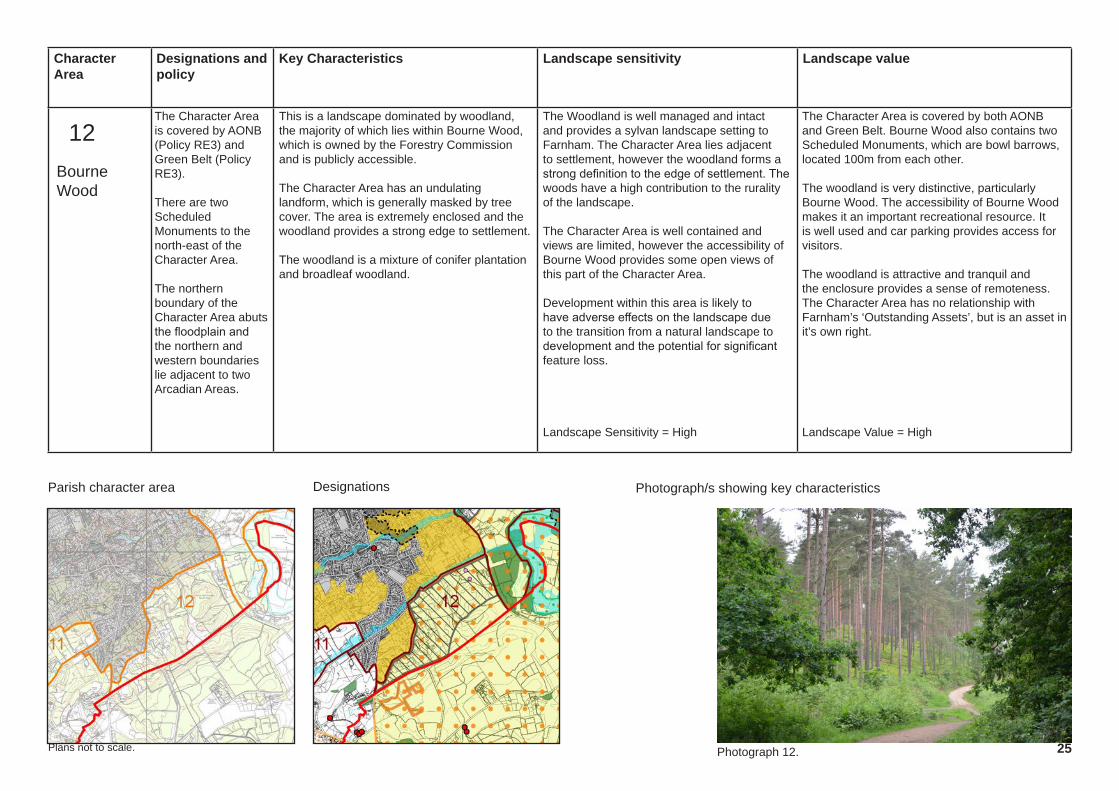
12The Character Area is covered by AONB (Policy RE3) and Green Belt (Policy RE3).
There are two Scheduled Monuments to the north-east of the Character Area.
The northern boundary of the Character Area abuts the floodplain and the northern and western boundaries lie adjacent to two Arcadian Areas.
This is a landscape dominated by woodland, the majority of which lies within Bourne Wood, which is owned by the Forestry Commission and is publicly accessible.
The Character Area has an undulating landform, which is generally masked by tree cover. The area is extremely enclosed and the woodland provides a strong edge to settlement.
The woodland is a mixture of conifer plantation and broadleaf woodland.
The Woodland is well managed and intact and provides a sylvan landscape setting to Farnham. The Character Area lies adjacent to settlement, however the woodland forms a strong definition to the edge of settlement. The woods have a high contribution to the rurality of the landscape.
The Character Area is well contained and views are limited, however the accessibility of Bourne Wood provides some open views of this part of the Character Area.
Development within this area is likely to have adverse effects on the landscape due to the transition from a natural landscape to development and the potential for significant feature loss.
Landscape Sensitivity = High
The Character Area is covered by both AONB and Green Belt. Bourne Wood also contains two Scheduled Monuments, which are bowl barrows, located 100m from each other.
The woodland is very distinctive, particularly Bourne Wood. The accessibility of Bourne Wood makes it an important recreational resource. It is well used and car parking provides access for visitors.
The woodland is attractive and tranquil and the enclosure provides a sense of remoteness. The Character Area has no relationship with Farnham’s ‘Outstanding Assets’, but is an asset in it’s own right.
Landscape Value = High
Plans not to scale.
Bourne Wood
Photograph 12.

Character Area
Designations and policy
Key Characteristics Landscape sensitivity Landscape value
Parish character area Photograph/s showing key characteristics Designations
26
13The majority of the Character Area is covered by AONB and Green Belt. The northern part of the Character Area lies within AGLV and is designated an Area of High Landscape Value and Sensitivity (Policy FNP10).
There are a number of blocks of Ancient Woodland within the Character Area.
The south-eastern corner is within a Conservation Area (Policy HA1). The southern boundary of the Character Area abuts the floodplain (Policy CC4).
An undulating landscape located between Farnham and the Upper Wey River. A stream crosses the Character Area, set within a narrow valley. Black Lake is located to the south of the Character Area.
Land use includes small fields in pasture interspersed with blocks of woodland and tree belts. Hedgerows line the lanes that run through and adjacent to the Character Area. The tree and vegetation cover provides a strong sense of enclosure and intimacy.
While the Character Area is bound to the north and west by Farnham, settlement within the area is restricted to farms and large houses set within substantial formal gardens.
An intact landscape in good condition, with a large number of landscape features. The northern and western edges of the Character Area are formed by the settlement of Farnham, however these edges are generally low density with soft, landscaped edges.
The southern and eastern edges of the Character Area are open to the wider countryside. The whole area feels rural in character. The Character Area forms the landscape setting to one of Farnham’s Arcadian Areas.
The high enclosure provided by the woodland limits visibility across the Character Area. Any new development would be likely to harm local character despite the presence of features that are likely to assist in screening.
Landscape Sensitivity = High
The southern half of the Character Area lies within the AONB and Green Belt. Some of the northern areas lie within AGLV and is designatied an Area of High Landscape Value and Sensitivity. Ancient Woodland is present across the Character Area and the stream has a narrow area of associated floodplain.
The eastern corner of the Character Area, contains Waverley Abbey House, which is associated with Waverley Abbey Scheduled Monument and is within the same Conservation Area.
It is an attractive, tranquil and intimate wooded landscape, which is consistent with it’s character Type. The Character Area contains public rights of way, including a stretch of the North Downs Way, within the northern part of the area.
Landscape Value = High
Plans not to scale.
Compton Wooded Slopes
Photograph 13a. Photograph 13b.
13a
13b

Character Area
Designations and policy
Key Characteristics Landscape sensitivity Landscape value
Parish character area Photograph/s showing key characteristics Designations
27
14The southern part of the Character Area is covered by AONB (Policy RE3) and Green Belt (Policy RE3). The northern part lies within AGLV and is an Area of High Landscape Value and Sensitivity.
The Character Area contains a Conservation Area (Policy HA1), Scheduled Monument, Historic Park and Garden and four listed buildings.
The river corridor lies within floodplain (Policy CC4) and is designated as SNCI (Policy NE1).
The Character Area is defined by the valley and associated floodplain of the River Wey. The topography is generally flat.
Land use is dominated by sinuous, medium-sized fields in pasture or meadows. Fields are bound by hedgerows and riparian vegetation, which provides a semi-enclosed landscape. There are small blocks of woodland associated with the Character Area.
Settlement is limited to isolated dwellings, which are frequently Listed Buildings, with associated formal gardens or parkland. Only two roads cross the Character Area.
The Character Area is wholly rural and has a picturesque and peaceful ambiance.
This is a high quality landscape with intact features and a consistently good condition. The Character Area is generally unsettled and has no associations with the built up area of Farnham. It has some contribution to the separation between Farnham and Moor Park Arcadian Area. It has a high contribution to the rurality of the surrounding landscape.
The character area is open to view from the footpaths associated with it and from the publicly accessible land at Waverley Abbey. There are also views from the road and bridge crossings. There are some long and attractive views along the river corridor.
New development would be likely to harm the character of the river valley, despite the presence of features that are likely to assist in screening.
Landscape Sensitivity = High
The Character Area is covered by AONB, AGLV and is one of the candidate AONB areas under consideration by Natural England. The northern part is an Area of High Landscape Value and Sensitivity. The majority of the area is covered by floodplain and the river corridor is designated as an SNCI. The area also contains a number of Heritage Assets including listed buildings, a Conservation Area, registered park and Scheduled Monument. The Character Area forms the setting to Waverley Abbey, one of Farnham’s outstanding assets.
The character of the river corridor stands out within the local landscape and forms a distinctive part of the countryside surrounding Farnham.
The area is accessible to the public and contains a stretch of the Greensand Hills long distance walking route, in additional to informal access at the Abbey and within SANG land.
Landscape Value = High
Plans not to scale.
Moor Park Valley
Photograph 14a. Photograph 14b.
14b
14a

Character Area
Designations and policy
Key Characteristics Landscape sensitivity Landscape value
Parish character area Photograph/s showing key characteristics Designations
28
15The eastern part of the Character Area is covered by AONB and Green Belt. The western part is covered by AGLV and the northern part is designated an Area of High Landscape Value and Sensitivity (Policy FNP10).
The land to the north of Guildford Road lies within the Farnham / Aldershot Strategic Gap (Policy C4 / RE3).
There are two Listed Buildings in the north-west corner of the Character Area.
A mosaic of arable and pastoral landscape with blocks of woodland. There is currently a large amount of quarrying activity within the Character Area, which is likely to result in a changing landscape in the short term. The area contains a number of lakes.
The Character Area is located on a gentle north-facing slope on the edge of the greensand hills. It is bound to the north by the A31, which is a source of noise. The activity of the quarry sites is also locally disruptive at present. Moor Park Arcadian Area lies to the south of the area.
Settlement within the area consists of ribbon development along local roads and occasional farmsteads.
The area is crossed by the North Downs Way National Route.
The landscape is generally intact, with some disturbance from the quarry workings. The unaffected countryside is in good condition.
The landscape has little relationship with settlement. It has some association with Moor Park Arcadian Area, however this is a low density form of settlement, with a dominance of landscape features, which limit the intrusion of the development into the surrounding rural landscape.
The Character Area has some contribution to the separation between Moor Park Arcadian Area and Farnham.
The landscape is framed by woodland, tree belts and hedgerows, which provides a sense of enclosure, however there are some long views from the higher ground to the south of the Character Area.
Landscape Sensitivity = High
The Character Area is covered by a number of designations including AONB, AGLV, the northern an Area of High Landscape Value and Sensitivity,Green Belt and Strategic Gap.
The landscape is in a state of change, but is likely to improve once the quarry workings have been restored. The landscape forms the immediate setting to the North Downs Way, one of Farnham’s ‘Outstanding Assets’. Other rights of way cross the area, providing a link from Farnham to the wider AONB.
The Character Area is generally peaceful and scenic (reflected by the landscape designations), however the areas currently being quarried are disturbed and have a higher level of activity.
Landscape Value = High
Plans not to scale.
Runfold Open Greensand Hills
Photograph 15a. Photograph 15b.
15b15a

Character Area
Designations and policy
Key Characteristics Landscape sensitivity Landscape value
Parish character area Photograph/s showing key characteristics Designations
29
16The whole Character Area falls within the Farnham / Aldershot Strategic Gap (Policy C4 / RE3).
The Character Area contains a number of Listed Buildings (Policy HA1).
The area is typified by small fields in pasture, which have been subdivided with fencing to form paddocks grazed by horses. Fields are rectilinear and consistent in shape and size. The area contains linear landscape features including hedgerows and tree lines and there are areas of scrub and woodland at the edges of the Character Area. The northern part of the Character Area is a plant nursery.
The topography of the Character Area is relatively flat with a local high point to the north-west of the area.
The area is bound by the settlement of Badshot Lea to the north, by the railway to the west and by the busy A31 to the south. The noise from the road affects the tranquility of the character area. There is some settlement within the centre of the site, off Badshot Farm, and low density ribbon development along Runfold St George.
The Character Area displays some feature loss and the assortment of fencing types subdividing the paddocks, detracts from the overall landscape quality of the area. The northern edge of the Character Area abuts Badshot Lea and additional development within this area would be consistent with the existing settlement pattern.
The western part of the Character Area makes a significant contribution towards the separation between Badshot Lea and Farnham. The area makes some contribution towards the rurality of Badshot Lea. The Character Area is visible from the footpaths that run through it, however intervening vegetations screens views from the A31, railway. The existing landscape structure could be built upon to mitigate a proposed development.
Landscape Sensitivity = Medium
The Character Area contains no landscape designations. The whole area is currently designated Strategic Gap. The area contains a number of Listed buildings, located at the centre and south-east of the Character Area.
The Character Area is an ordinary landscape with no known literary / cultural associations and has no relationship with any of Farnham’s ‘Outstanding assets’.
The area is well served by public rights of way, which provide informal recreation. The riding stables within the character area also provides recreational opportunities.
The Character Area consists of average countryside, however the feature loss and noise from adjacent busy transport routes, adversely effects the perceptual aspects of the area.
Landscape Value = Low
Plans not to scale.
Badshot Lea Paddocks
Photograph 16a. Photograph 16b.
16a16b

Character Area
Designations and policy
Key Characteristics Landscape sensitivity Landscape value
Parish character area Photograph/s showing key characteristics Designations
30
17Approximately half of Character Area falls within Strategic Gap (Policy C4 / RE3). Much of the remaining area lies within ASVI (Policy C5).
The Character Area contains one Listed Building (Policy HA1). The north-eastern corner falls within floodplain (Policy CC4).
The Character Area contains a number of formal sports facilities, which are protected through policy LRC1.
This Character Area is notable for it’s abundance of sports facilities and playing fields which cover approximately half of the area. The remainder of the Character Area is a mosaic of small fields in pasture, blocks of woodland, areas of scrub, allotments and urban edge land uses including a substation and sewage treatment works.
The landscape is generally small / medium scale and is rectilinear in pattern. Trees, hedgerows and scrub provide containment within the area and prevent long views. The land is relatively flat.
There is little settlement within the Character Area, however it is surrounded by settlement and contains some large buildings associated with the sports facilities.
The condition of the Character Area varies with land use. The sports facilities are generally in very good condition, whereas some of the fields in pasture and areas of scrub are unmanaged and a little unkempt.
The area is surrounded by settlement and forms the critical separation between Farnham, Aldershot, Weybourne and Badshot Lea. New development is likely to be consistent with the existing settlement pattern,but is also likely to impact ont he separation between settlement. The Character Area has a limited contribution to the rurality of the surrounding landscape.
The area is visible from footpaths which run through it and from the publicly accessible sports pitches, however the landscape structure of trees and hedgerows limits visibility and provides a potential basis for mitigation planting.
Landscape Sensitivity = Medium
The Character Area contains no landscape designations. The northern part of the area is designated Strategic Gap and the southern part is an ASVI. The area contains one Listed Building. The sports facilities are protected through planning policy LRC1.
The Character Area has no known literary / cultural associations and has no relationship with any of Farnham’s ‘Outstanding assets’.
The Character Area contains numerous opportunities for recreation including formal sports, informal recreation on rights of way and through use of the allotments. One of the woodland areas to the north has permissive access.
The perceptual aspects of the area vary with land use and proximity to settlement.
Landscape Value = Medium
Plans not to scale.
East Farnham Mosaic
Photograph 17a. Photograph 17b.
17b 17a

Character Area
Designations and policy
Key Characteristics Landscape sensitivity Landscape value
Parish character area Photograph/s showing key characteristics Designations
31
18The Character Area falls within the Farnham / Aldershot Strategic Gap (Policy C4 / RE3).
The majority of the Character Area lies within floodplain.
One of the lakes is now a local nature reserve.
The Character Area consists of the flat, low lying floodplain of the Blackwater Valley.
The area contains two lakes formed through the restoration of gravel pits. The Blackwater River is located to the north of the lakes and is also within the Character Area. One lake is now a private fishing lake and the other is now part of a nature reserve, with routes accessible to the public.
The area is bound to the north by the settlement edge of Aldershot and to the south by Badshot Lea and the A31. Views into and across the Character Area are contained by tree cover and surrounding settlement. The Character Area itself is unsettled.
The character area is rural and attractive.
Both restored landscapes are established and in good condition. Both are in active management and the lakes are high quality landscape features.
The Character Area abuts settlement, but is very distinct. New settlement within the area would be inconsistent with the existing settlement pattern. The area also forms the critical separation between Aldershot and Badshot Lea.
The watercourse and lakes make a high contribution to the setting of adjacent settlement and contribute to the rurality of the local landscape. Both lakes are used for informal recreation. The lakes are attractive landscape features, set within a strong landscape framework. There is a mixture of openness and enclosure.
Landscape Sensitivity = High
The Character Area contains no landscape designations. The whole area is currently designated Strategic Gap and the majority of the area is also within floodplain. Part of the area is a nature reserve.
The lakes are a distinctive and attractive local feature. The eastern lake in particular is naturalistic and is complemented by the adjacent woodland and Blackwater River.
The Character Area has no known literary / cultural associations and has no relationship with any of Farnham’s ‘Outstanding assets’.
The Character Area contains a number of opportunities for informal recreation.
Landscape Value = Medium
Plans not to scale.
Badshot Lea Valley Floor
Photograph 18.
18

Character Area
Designations and policy
Key Characteristics Landscape sensitivity Landscape value
Parish character area Photograph/s showing key characteristics Designations
32
19The Character Area falls within the Farnham / Aldershot Strategic Gap (Policy C4 / RE3).
The Character Area contains a number of Listed Buildings (Policy HA1).
The western end of a narrow chalk ridge that runs east, aligned with the A31, along Hogs Back. The ridge has a south-facing escarpment and a north-facing dip slope. The area is bound to the north by the A31 and extends east to the Parish boundary.
Land use is predominantly fields in pasture, which are small scale and geometric. There are some larger-scale arable fields to the east of the area.
The area contains linear landscape features including hedgerows and tree lines and a small copse of woodland. Some of the hedgerow features are gappy or in decline.
The noise from the busy A31 affects the tranquility of the area. Settlement is limited to occasional dwellings / farmsteads and a caravan site at The Willows. The area also contains a pub and some small businesses.
The landscape is attractive, but is showing some signs of hedgerow deterioration. It is divorced from large settlement and only isolated dwellings are associated with the area.
The area forms part of the separation between Aldershot and the villages to the south and east of the Character Area. The area contributes to the rurality of the surrounding landscape.
The high ground of the northern slopes are open to view from the A31 and is likely to be visible in long views from the north. Views from local footpaths are limited. The landscape structure affords some potential for mitigation on the lower slopes of the Character Area. Development on the high ground would harm local character, would be visually sensitive and would be difficult to mitigate.
Landscape Sensitivity = High
The Character Area contains no landscape designations. The whole area is designated Strategic Gap. The area contains a number of Listed Buildings, located at the centre and south-east of the Character Area. The western boundary lies adjacent to floodplain.
The Character Area is an ordinary landscape, has no known literary / cultural associations and has no relationship with any of Farnham’s ‘Outstanding assets’. Recreational opportunities within the area are limited.
The high ground within the Character Area affords some long views across the countryside and the area is rural in character. There is little influence from settlement, however the noise from adjacent busy transport routes, adversely effects the tranquility of the area.
Landscape Value = Low
Plans not to scale.
Hogs Back Ridge
19

33
This page has been left intentionally blank
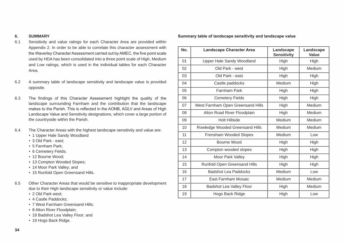
34
6. SUMMARY6.1 Sensitivity and value ratings for each Character Area are provided within
Appendix 2. In order to be able to correlate this character assessment with the Waverley Character Assessment carried out by AMEC, the five point scale used by HDA has been consolidated into a three point scale of High, Medium and Low ratings, which is used in the individual tables for each Character Area.
6.2 A summary table of landscape sensitivity and landscape value is provided opposite.
6.3 The findings of this Character Assessment highlight the quality of the landscape surrounding Farnham and the contribution that the landscape makes to the Parish. This is reflected in the AONB, AGLV and Areas of High Landscape Value and Sensitivity designations, which cover a large portion of the countryside within the Parish.
6.4 The Character Areas with the highest landscape sensitivity and value are: ▪ 1 Upper Hale Sandy Woodland ▪ 3 Old Park - east; ▪ 5 Farnham Park; ▪ 6 Cemetery Fields; ▪ 12 Bourne Wood; ▪ 13 Compton Wooded Slopes; ▪ 14 Moor Park Valley; and ▪ 15 Runfold Open Greensand Hills.
6.5 Other Character Areas that would be sensitive to inappropriate development due to their High landscape sensitivity or value include: ▪ 2 Old Park west; ▪ 4 Castle Paddocks; ▪ 7 West Farnham Greensand Hills; ▪ 8 Alton River Floodplain; ▪ 18 Badshot Lea Valley Floor; and ▪ 19 Hogs Back Ridge.
No. LandscapeCharacterArea Landscape Sensitivity
Landscape Value
01 Upper Hale Sandy Woodland High High
02 Old Park - west High Medium
03 Old Park - east High High
04 Castle paddocks Medium High
05 Farnham Park High High
06 Cemetery Fields High High
07 West Farnham Open Greensand Hills High Medium
08 Alton Road River Floodplain High Medium
09 Holt Hillside Medium Medium
10 Rowledge Wooded Greensand Hills Medium Medium
11 Frensham Wooded Slopes Medium Low
12 Bourne Wood High High
13 Compton wooded slopes High High
14 Moor Park Valley High High
15 Runfold Open Greensand Hills High High
16 Badshot Lea Paddocks Medium Low
17 East Farnham Mosaic Medium Medium
18 Badshot Lea Valley Floor High Medium
19 Hogs Back Ridge High Low
Summarytableoflandscapesensitivityandlandscapevalue

35
6.6 HDA recommends that Character Areas with a High Landscape Sensitivity or Value should be protected from inappropriate development. Character Areas with High value and sensitivity have the potential to be incorporated into the Areas of High Landscape Value and sensitivity shown in Map E of the Farnham Neighbourhood Plan.
6.7 Character Area 1 represents an intact landscape with a high ecological sensitivity and a high contribution to settlement separation. Character Areas 2-6 represent a high quality landscape which forms an important green wedge between Farnham and Hale / Heath End. This landscape forms the setting to both settlements and has a number of important historical links. This green wedge is met to the east, by the lowland character areas 16-18, which maintain the separation between Farnham, Aldershot and Hale; and Farnham, Badshot Lea and Weybourne.
6.8 The Character Areas which have a particularly high contribution towards the separation to settlement within the parish include: ▪ 1 Upper Hale Sandy Woodland; ▪ 5 Farnham Park; ▪ 6 Cemetery Fields; ▪ 16 Badshot Lea Paddocks; ▪ 17 East Farnham Mosaic; and ▪ 18 Badshot Lea Valley Floor.
6.9 Two further Character Areas (9 and 10), have some contribution to local
separation as defined by Neighbourhood Plan Policy FNP 11.
6.10 The eastern and western sections of Old Park (Character Areas 2 and 3) have many consistent characteristics, however differences in scale, land use and field pattern have led to the differentiation of the two Character Areas. Both Character Areas are sensitive to development.
6.11 Character Area 7 is another high sensitivity rural landscape, with strong links to the countryside to the west. Areas 8 and 14 are associated with the floodplain of the River Wey, which runs through the centre of Farnham and creates and important green corridor across the whole parish. Character
Area 18, links to area 1, which form another green corridor of open space on the southern edge of Aldershot.
6.12 Character Areas 12-15 form a distinctive and highly attractive landscape to the south-east of Farnham, which is reflected in the AONB and AGLV designations that cover them. Area 19 links into this rural landscape and abuts the AONB.
6.13 Character Areas assessed as having a Medium landscape sensitivity and value include 9 Holt Hillside, 10 Rowledge Wooded Greensand Hills and 17 East Farnham Mosaic. There are no Character Areas that have been assessed as having a Low landscape sensitivity, however areas 11 Frensham Wooded Slopes and 16 Badshot Lea Paddocks have been assessed as having a Medium sensitivity and Low value.
6.14 The assessments of landscape sensitivity and value are given for each Character Area, however it is noted that there may be minor variations within a Character Area. These variations have been addressed within the accompanying text for each Character Area.
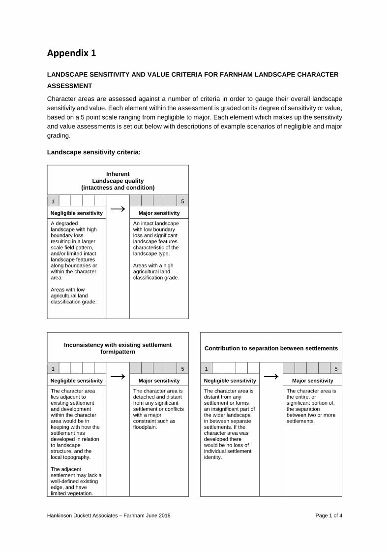
Hankinson Duckett Associates – Farnham June 2018 Page 1 of 4
Appendix 1
LANDSCAPE SENSITIVITY AND VALUE CRITERIA FOR FARNHAM LANDSCAPE CHARACTER ASSESSMENT
Character areas are assessed against a number of criteria in order to gauge their overall landscape sensitivity and value. Each element within the assessment is graded on its degree of sensitivity or value, based on a 5 point scale ranging from negligible to major. Each element which makes up the sensitivity and value assessments is set out below with descriptions of example scenarios of negligible and major grading. Landscape sensitivity criteria:
Inherent Landscape quality
(intactness and condition)
1 → 5
Negligible sensitivity Major sensitivity
A degraded landscape with high boundary loss resulting in a larger scale field pattern, and/or limited intact landscape features along boundaries or within the character area. Areas with low agricultural land classification grade.
An intact landscape with low boundary loss and significant landscape features characteristic of the landscape type. Areas with a high agricultural land classification grade.
Inconsistency with existing settlement form/pattern
Contribution to separation between settlements
1 → 5 1 →
5
Negligible sensitivity Major sensitivity Negligible sensitivity Major sensitivity
The character area lies adjacent to existing settlement and development within the character area would be in keeping with how the settlement has developed in relation to landscape structure, and the local topography. The adjacent settlement may lack a well-defined existing edge, and have limited vegetation.
The character area is detached and distant from any significant settlement or conflicts with a major constraint such as floodplain.
The character area is distant from any settlement or forms an insignificant part of the wider landscape in between separate settlements. If the character area was developed there would be no loss of individual settlement identity.
The character area is the entire, or significant portion of, the separation between two or more settlements.

Hankinson Duckett Associates – Farnham June 2018 Page 2 of 4
Contribution to the setting of surrounding landscape/settlement
Views
(visual sensitivity)
1 → 5 1 →
5
Negligible sensitivity Major sensitivity Negligible sensitivity Major sensitivity
The character area is inward looking, it forms a very small part of a wider landscape. It is distant from any significant settlement.
The character area is a prominent part of the wider landscape continuum, it provides the immediate open aspect to a settlement.
The character area is visible from a very limited number of locations and is difficult to perceive from publicly accessible viewpoints or from a nearby settlement.
The character area is open and forms the dominant part of many views, including views from sensitive viewpoint locations such as the AONB or an Outstanding Asset*.
Potential for mitigation
(inverse score i.e. high potential for mitigation
= low sensitivity, therefore low score)
Overall
sensitivity judgement 01-07 = Negligible
08-14 = Slight 15-21 = Moderate
22-28 = Substantial 29-35 = Major
1 → 5 1 →
35
Negligible sensitivity Major sensitivity Negligible sensitivity Major sensitivity
The character area has a good existing landscape structure which could be enhanced to eliminate or significantly reduce the effects of development, or features characteristic of the area could be introduced to mitigate for a proposed development, within a reasonable timescale.
Character areas where development would have effects which cannot be mitigated against, such as the loss of separation between settlements.
The scores for each element within the sensitivity assessment are summed to give an overall landscape sensitivity score for the character area. This is followed by a final review to consider whether a specific or overriding aspect of sensitivity has been under or over weighted in the consolidation of the profile into a single overall rating. If necessary, ratings can then be adjusted up or down to reflect individual situations, ensuring that professional judgement is the final arbiter in the assessment process rather than relying solely on an arithmetic system.
*For the purposes of this assessment the Outstanding Assets of Farnham are: Farnham Castle, Farnham Park, Waverley Abbey and the North Downs Way
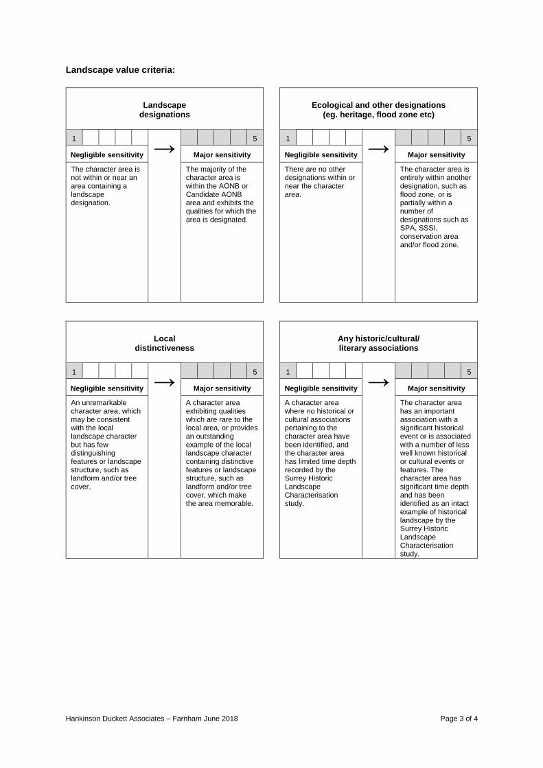
Hankinson Duckett Associates – Farnham June 2018 Page 3 of 4
Landscape value criteria:
Landscape designations
Ecological and other designations
(eg. heritage, flood zone etc)
1 → 5 1 →
5
Negligible sensitivity Major sensitivity Negligible sensitivity Major sensitivity
The character area is not within or near an area containing a landscape designation.
The majority of the character area is within the AONB or Candidate AONB area and exhibits the qualities for which the area is designated.
There are no other designations within or near the character area.
The character area is entirely within another designation, such as flood zone, or is partially within a number of designations such as SPA, SSSI, conservation area and/or flood zone.
Local distinctiveness
Any historic/cultural/ literary associations
1 → 5 1 →
5
Negligible sensitivity Major sensitivity Negligible sensitivity Major sensitivity
An unremarkable character area, which may be consistent with the local landscape character but has few distinguishing features or landscape structure, such as landform and/or tree cover.
A character area exhibiting qualities which are rare to the local area, or provides an outstanding example of the local landscape character containing distinctive features or landscape structure, such as landform and/or tree cover, which make the area memorable.
A character area where no historical or cultural associations pertaining to the character area have been identified, and the character area has limited time depth recorded by the Surrey Historic Landscape Characterisation study.
The character area has an important association with a significant historical event or is associated with a number of less well known historical or cultural events or features. The character area has significant time depth and has been identified as an intact example of historical landscape by the Surrey Historic Landscape Characterisation study.

Hankinson Duckett Associates – Farnham June 2018 Page 4 of 4
Contribution to setting of ‘outstanding assets’*
Recreation and public access/
locally valued spaces
1 → 5 1 →
5
Negligible sensitivity Major sensitivity Negligible sensitivity Major sensitivity
There are no outstanding assets* near the character area, or the character area is imperceivable from the outstanding asset due to its size or containment.
The character area is prominent in views to or from an outstanding asset, such that it forms the entire, or a significant part of, the setting (either open or enclosed) to an outstanding asset.
The character area is private land not used for recreational purposes and has no locally recognisable visual amenity.
The character area has significant well used unimpeded public access, such as common land or a network of public rights of way, and/or is used specifically for recreation.
Perceptual aspects (eg. scenic quality, tranquillity, and
remoteness)
Overall
value judgement 01-07 = Negligible
08-14 = Slight 15-21 = Moderate
22-28 = Substantial 29-35 = Major
1 → 5 1 →
35
Negligible sensitivity Major sensitivity Negligible sensitivity Major sensitivity
The character area is disturbed by significant urban influence such as development and/or road/aircraft noise.
The character area has limited signs of human influence either through its existence as a relatively undisturbed landscape, or as a result of surrounding enclosure, such as woodland, which obscures urban influence.
The scores for each element within the value assessment are summed to give an overall landscape value score for the character area. This is followed by a final review to consider whether a specific or overriding aspect of value has been under or over weighted in the consolidation of the profile into a single overall rating. If necessary, ratings can then be adjusted up or down to reflect individual situations, ensuring that professional judgement is the final arbiter in the assessment process rather than relying solely on an arithmetic system.
*For the purposes of this assessment the Outstanding Assets of Farnham are: Farnham Castle, Farnham Park, Waverley Abbey and the North Downs Way
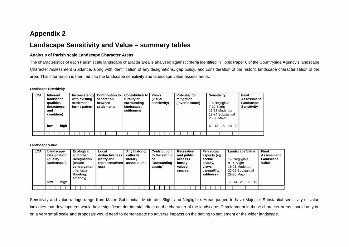
Appendix 2 Landscape Sensitivity and Value – summary tables Analysis of Parish scale Landscape Character Areas The characteristics of each Parish scale landscape character area is analysed against criteria identified in Topic Paper 6 of the Countryside Agency’s landscape
Character Assessment Guidance, along with identification of any designations, gap policy, and consideration of the historic landscape characterisation of the
area. This information is then fed into the landscape sensitivity and landscape value assessments. Landscape Sensitivity
LCA Inherent landscape qualities (intactness and condition) low high
Inconsistency with existing settlement form / pattern
Contribution to separation between settlements
Contribution to rurality of surrounding landscape / settlement
Views (visual sensitivity)
Potential for mitigation (inverse score)
Sensitivity 1-6 Negligible 7-12 Slight 13-18 Moderate 19-24 Substantial 25-30 Major 6 12 18 24 30
Final Assessment Landscape Sensitivity
Landscape Value
LCA Landscape Designation (quality landscapes) low high
Ecological and other Designation (nature conservation, heritage, flooding, amenity)
Local distinctiveness (rarity and representativeness)
Any historic/ cultural/ literary associations
Contribution to the setting of ‘Outstanding assets’
Recreation and public access / locally valued spaces.
Perceptual aspects (eg. scenic beauty, views, tranquillity, wildness)
Landscape Value 1-7 Negligible 8-14 Slight 15-21 Moderate 22-28 Substantial 29-35 Major 7 14 21 28 35
Final Assessment Landscape Value
Sensitivity and value ratings range from Major, Substantial, Moderate, Slight and Negligible. Areas judged to have Major or Substantial sensitivity or value
indicates that development would have significant detrimental effect on the character of the landscape. Development in these character areas should only be
on a very small scale and proposals would need to demonstrate no adverse impacts on the setting to settlement or the wider landscape.
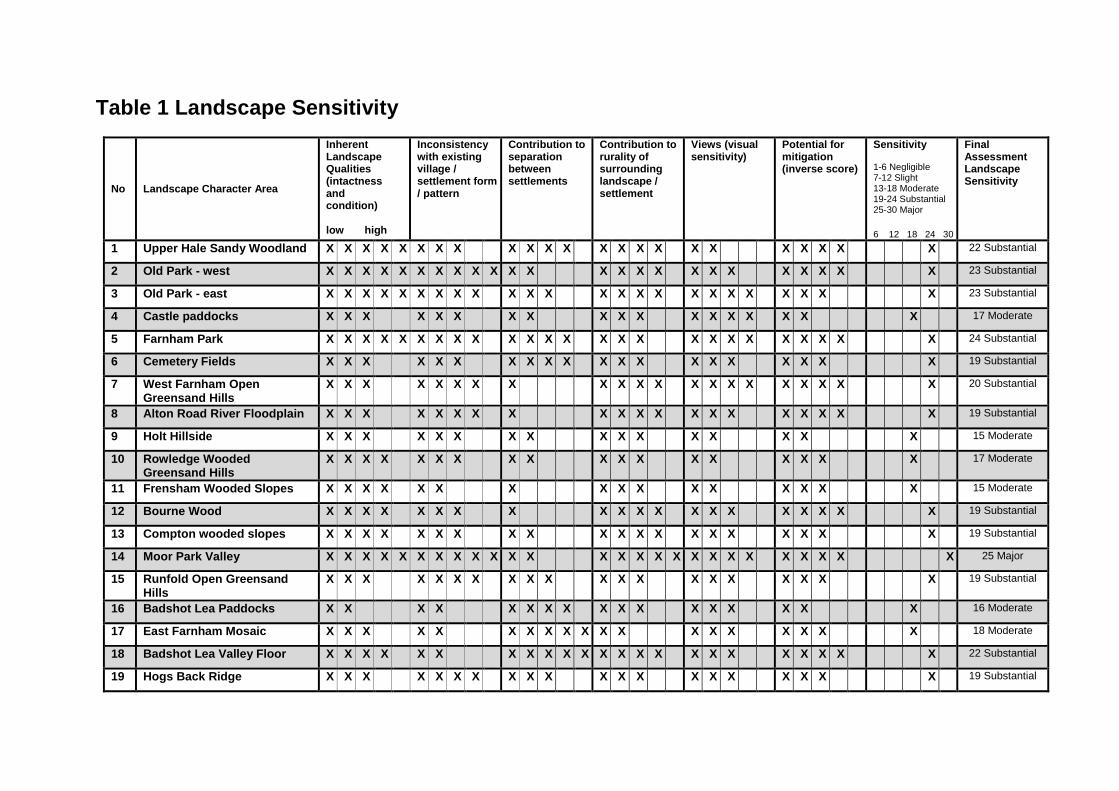
Table 1 Landscape Sensitivity
No Landscape Character Area
Inherent Landscape Qualities (intactness and condition) low high
Inconsistency with existing village / settlement form / pattern
Contribution to separation between settlements
Contribution to rurality of surrounding landscape / settlement
Views (visual sensitivity)
Potential for mitigation (inverse score)
Sensitivity 1-6 Negligible 7-12 Slight 13-18 Moderate 19-24 Substantial 25-30 Major 6 12 18 24 30
Final Assessment Landscape Sensitivity
1 Upper Hale Sandy Woodland X X X X X X X X X X X X X X X X X X X X X X X 22 Substantial
2 Old Park - west X X X X X X X X X X X X X X X X X X X X X X X X 23 Substantial
3 Old Park - east X X X X X X X X X X X X X X X X X X X X X X X X 23 Substantial
4 Castle paddocks X X X X X X X X X X X X X X X X X X 17 Moderate
5 Farnham Park X X X X X X X X X X X X X X X X X X X X X X X X X 24 Substantial
6 Cemetery Fields X X X X X X X X X X X X X X X X X X X X 19 Substantial
7 West Farnham Open Greensand Hills
X X X X X X X X X X X X X X X X X X X X X 20 Substantial
8 Alton Road River Floodplain X X X X X X X X X X X X X X X X X X X X 19 Substantial
9 Holt Hillside X X X X X X X X X X X X X X X X 15 Moderate
10 Rowledge Wooded Greensand Hills
X X X X X X X X X X X X X X X X X X 17 Moderate
11 Frensham Wooded Slopes X X X X X X X X X X X X X X X X 15 Moderate
12 Bourne Wood X X X X X X X X X X X X X X X X X X X X 19 Substantial
13 Compton wooded slopes X X X X X X X X X X X X X X X X X X X X 19 Substantial
14 Moor Park Valley X X X X X X X X X X X X X X X X X X X X X X X X X X 25 Major
15 Runfold Open Greensand Hills
X X X X X X X X X X X X X X X X X X X X 19 Substantial
16 Badshot Lea Paddocks X X X X X X X X X X X X X X X X X 16 Moderate
17 East Farnham Mosaic X X X X X X X X X X X X X X X X X X X 18 Moderate
18 Badshot Lea Valley Floor X X X X X X X X X X X X X X X X X X X X X X X 22 Substantial
19 Hogs Back Ridge X X X X X X X X X X X X X X X X X X X X 19 Substantial

Table 2 Landscape Value
No Landscape Character Area
Landscape Designation low high
Ecological and other Designation (nature conservation, heritage, flooding, amenity)
Local distinctiveness
Any historic/ cultural/ literary associations
Contribution to the setting of ‘Outstanding assets’
Recreation and public access / locally valued spaces.
Perceptual aspects (eg. scenic beauty, views, tranquillity, wildness)
Landscape Value 1-7 Negligible 8-14 Slight 15-21 Moderate 22-28 Substantial 29-35 Major 7 14 21 28 35
Final Assessment Landscape Value
1 Upper Hale Sandy Woodland
X X X X X X X X X X X X X X X X X X X X X X X X 23 Substantial
2 Old Park - west X X X X X X X X X X X X X X X X X X X X X 20 Moderate
3 Old Park - east X X X X X X X X X X X X X X X X X X X X X X X 22 Substantial
4 Castle paddocks X X X X X X X X X X X X X X X X X X X X X X X 22 Substantial
5 Farnham Park X X X X X X X X X X X X X X X X X X X X X X X X X X X X X X X X X X 33 Major
6 Cemetery Fields X X X X X X X X X X X X X X X X X X X X X X X 22 Substantial
7 West Farnham Open Greensand Hills
X X X X X X X X X X X X X X X X X X X 18 Moderate
8 Alton Road River Floodplain
X X X X X X X X X X X X X X X X X X X X X 20 Moderate
9 Holt Hillside X X X X X X X X X X X X X X X X X X X 18 Moderate
10 Rowledge Wooded Greensand Hills
X X X X X X X X X X X X X X X X X X 17 Moderate
11 Frensham Wooded Slopes
X X X X X X X X X X X X X 12 Slight
12 Bourne Wood X X X X X X X X X X X X X X X X X X X X X X X X X X 25 Substantial
13 Compton wooded slopes
X X X X X X X X X X X X X X X X X X X X X X X X 23 Substantial

No Landscape Character Area
Landscape Designation low high
Ecological and other Designation (nature conservation, heritage, flooding, amenity)
Local distinctiveness
Any historic/ cultural/ literary associations
Contribution to the setting of ‘Outstanding assets’
Recreation and public access / locally valued spaces.
Perceptual aspects (eg. scenic beauty, views, tranquillity, wildness)
Landscape Value 1-7 Negligible 8-14 Slight 15-21 Moderate 22-28 Substantial 29-35 Major 7 14 21 28 35
Final Assessment Landscape Value
14 Moor Park Valley X X X X X X X X X X X X X X X X X X X X X X X X X X X X X X X X 31 Major
15 Runfold Open Greensand Hills
X X X X X X X X X X X X X X X X X X X X X X X 22 Substantial
16 Badshot Lea Paddocks
X X X X X X X X X X X X X X X 14 Slight
17 East Farnham Mosaic X X X X X X X X X X X X X X X X X 16 Moderate
18 Badshot Lea Valley Floor
X X X X X X X X X X X X X X X X X X X X X 20 Moderate
19 Hogs Back Ridge X X X X X X X X X X X X X X X 14 Slight

The landscape sensitivity and value assessments of each Parish scale character area are summarised in tabulated form in Table 3 below. Landscape sensitivity and value may not be completely uniform across an entire character area.
Table 3 Landscape Sensitivity and Value Summary
No Landscape Character Area Landscape Sensitivity
Landscape Value
01 Upper Hale Sandy Woodland 22 Substantial 23 Substantial
02 Old Park - west 23 Substantial 20 Moderate
03 Old Park - east 23 Substantial 22 Substantial
04 Castle paddocks 17 Moderate 22 Substantial
05 Farnham Park 24 Substantial 33 Major
06 Cemetery Fields 19 Substantial 22 Substantial
07 West Farnham Open Greensand Hills 20 Substantial 18 Moderate
08 Alton Road River Floodplain 19 Substantial 20 Moderate
09 Holt Hillside 14 Moderate 18 Moderate
10 Rowledge Wooded Greensand Hills 16 Moderate 17 Moderate
11 Frensham Wooded Slopes 15 Moderate 12 Slight
12 Bourne Wood 19 Substantial 25 Substantial
13 Compton wooded slopes 19 Substantial 23 Substantial
14 Moor Park Valley 25 Major 31 Major
15 Runfold Open Greensand Hills 19 Substantial 22 Substantial
16 Badshot Lea Paddocks 16 Moderate 14 Slight

No Landscape Character Area Landscape Sensitivity
Landscape Value
17 East Farnham Mosaic 18 Moderate 16 Moderate
18 Badshot Lea Valley Floor 22 Substantial 20 Moderate
19 Hogs Back Ridge 19 Substantial 14 Slight

Segmentreference Sensitivity Value
FN 1a High High
FN 1b High High
FN 1c Moderate Medium
FN 2 High High
FN 3 Moderate Medium
FN 4 High Medium
FN 5 Moderate Medium
FN 6 High Medium
FN 7 High Medium
FN 8 High High
FN 9 Moderate Medium
FN 10a Low Low
FN 10b Low Low
FN 10c Low Medium
FN 10d Low Low
FN 11a Low Low
FN 11b Low Low
FN 11c Low Low
FN 12 High High
4.2.8 The AMEC judgements for landscape sensitivity and value, for each segment are summarised in the table below:
AMEC Landscape Study Segments
APPENDIX3:AMECJudgementsforLandscapeSensitivityandValue


![CORNWALL AND ISLES OF SCILLY LANDSCAPE CHARACTER STUDY … · 2014. 1. 6. · character to policy in District Local Development Documents] • Landscape Character Supplementary Planning](https://img.pdfslide.us/doc/110x75/5fdaa366f8a2db6a851b9817/cornwall-and-isles-of-scilly-landscape-character-study-2014-1-6-character-to.jpg)