Embed Size (px)
Citation preview
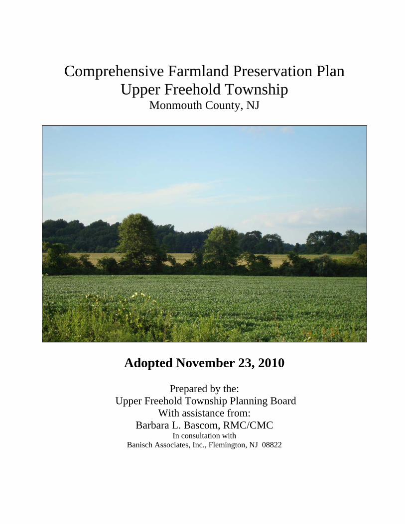
Comprehensive Farmland Preservation Plan
Upper Freehold Township Monmouth County, NJ
Adopted November 23, 2010
Prepared by the: Upper Freehold Township Planning Board
With assistance from: Barbara L. Bascom, RMC/CMC
In consultation with Banisch Associates, Inc., Flemington, NJ 08822
TABLE OF CONTENTS
INTRODUCTION............................................................................................................. 1
I. UPPER FREEHOLD TOWNSHIP’S AGRICULTURAL LAND BASE ........... 5
A. LOCATION AND SIZE OF AGRICULTURAL LAND BASE.............................................. 5 B. DISTRIBUTION OF SOIL TYPES AND THEIR CHARACTERISTICS ................................... 7 C. NUMBER OF IRRIGATED ACRES AND AVAILABLE WATER RESOURCES .................. 12 D. FARMLAND ASSESSMENT AND CENSUS OF AGRICULTURE STATISTICS AND TRENDS. ............................................................................................................................... 13
II. UPPER FREEHOLD AGRICULTURAL INDUSTRY...................................... 15
A. TRENDS IN MARKET VALUE OF AGRICULTURAL PRODUCTS.................................. 15 B. CROP/PRODUCTION TRENDS OVER THE LAST 20 YEARS ......................................... 16 C& D. SUPPORT SERVICES WITHIN MARKET REGION AND OTHER AGRICULTURALLY
RELATED INDUSTRY ...................................................................................................... 19
III. LAND USE PLANNING .................................................................................... 20
A. STATE DEVELOPMENT AND REDEVELOPMENT PLAN ............................................. 20 B. SPECIAL RESOURCE AREAS.................................................................................... 23 C. UPPER FREEHOLD TOWNSHIP MASTER PLAN AND DEVELOPMENT REGULATIONS. 23 D. CURRENT LAND USE AND TRENDS ........................................................................ 25 E. SEWER SERVICE AREAS AND PUBLIC WATER SUPPLY ........................................... 25 F. UPPER FREEHOLD MASTER PLAN AND ZONING OVERVIEW ................................... 26 G. TDR OPPORTUNITIES............................................................................................. 31
IV. UPPER FREEHOLD TOWNSHIP’S PLAN TO PRESERVE FARMLAND 33
A. MONMOUTH COUNTY AGRICULTURAL DEVELOPMENT AREAS.............................. 33 B. UPPER FREEHOLD TOWNSHIP PRESERVED FARMLAND .......................................... 33 C. CONSISTENCY WITH THE SADC STRATEGIC TARGETING PROJECT ........................ 37 D. EIGHT YEAR PROGRAMS........................................................................................ 37 E. COORDINATION WITH OPEN SPACE PRESERVATION INITIATIVES ........................... 38 F. FARMLAND PRESERVATION PROGRAM FUNDING EXPENDED TO DATE .................. 39 G. MONITORING OF FARMLAND PRESERVATION ........................................................ 39 H. COORDINATION WITH TRANSFER OF DEVELOPMENT RIGHTS PROGRAMS .............. 40
V. FUTURE FARMLAND PRESERVATION PROGRAM................................... 41
A. PRESERVATION GOALS (1, 5 AND 10 YEAR ACREAGE TARGETS) ............................ 41 B. UPPER FREEHOLD PROJECT AREA SUMMARY ........................................................ 41 C. MUNICIPAL AND COUNTY MINIMUM ELIGIBILITY CRITERIA COORDINATION........ 43 D. MUNICIPAL AND COUNTY RANKING CRITERIA USED TO PRIORITIZE FARMS......... 43 E. MUNICIPAL AND COUNTY POLICIES RELATED TO FARMLAND PRESERVATION
APPLICATIONS ............................................................................................................... 44 F. FUNDING PLAN ...................................................................................................... 46 G. FARMLAND PRESERVATION PROGRAM AND AAC RESOURCES.............................. 50 H. FACTORS LIMITING FARMLAND PRESERVATION IMPLEMENTATION....................... 51
i
ii
VI. ECONOMIC DEVELOPMENT ....................................................................... 52
A. CONSISTENCY WITH N.J. DEPARTMENT OF AGRICULTURE ECONOMIC
DEVELOPMENT STRATEGIES .......................................................................................... 52 B. AGRICULTURAL INDUSTRY RETENTION, EXPANSION AND RECRUITMENT STRATEGIES
....................................................................................................................................... 54
VII. NATURAL RESOURCE CONSERVATION................................................. 64
A. NATURAL RESOURCE PROTECTION COORDINATION .............................................. 64 B. NATURAL RESOURCE PROTECTION PROGRAMS ..................................................... 65 C. WATER RESOURCES............................................................................................... 67 D. WASTE MANAGEMENT AND RECYCLING ............................................................... 69 E. ENERGY CONSERVATION ....................................................................................... 70 F. OUTREACH AND INCENTIVES ................................................................................. 72
VIII. AGRICULTURAL INDUSTRY SUSTAINABILITY, RETENTION AND PROMOTION................................................................................................................. 74
A. EXISTING AGRICULTURAL INDUSTRY SUPPORT ..................................................... 74 B. ADDITIONAL STRATEGIES ...................................................................................... 75
CONCLUSION ............................................................................................................... 77
APPENDIX A.................................................................................................................. 78
APPENDIX B .................................................................................................................. 81
APPENDIX C:................................................................................................................. 84
UPPER FREEHOLD TOWNSHIP, MONMOUTH COUNTY FARMLAND PRESERVATION PLAN
Introduction
Upper Freehold Township is located in the western panhandle of Monmouth County (Figure 1). The Township is at the heart of an interconnected agricultural center in New Jersey where active farmland still dominates the landscape (Figure 2). Upper Freehold Township strives to retain active agriculture in the Township and promote agricultural preservation, activities and businesses to continue to grow the vital industry. Preservation efforts in the Township are among the highest in New Jersey and the Township actively seeks to continue these efforts. The primary reason Upper Freehold Township has maintained its rural agricultural character is that most of its land is not merely “undeveloped”, but is actively used for bona fide agricultural purposes. The natural suitability of Upper Freehold Township for farming is dependant on the rich agricultural soils and favorable conditions for agriculture. In compliance with the Planning Incentive Grant Program Statute (N.J.S.A. 4:1C-43.1) and new State Agriculture Development Committee (SADC) rules (N.J.A.C. 2:76-17A), Upper Freehold Township has prepared this “Comprehensive Farmland Preservation Plan”, updating the Farmland Preservation Plan adopted by the Upper Freehold Township Planning Board on July 13, 2000. That Plan Element became a formal part of the Township’s Master Plan when the reexamination report of November 2001 was adopted. Upper Freehold Township has been a leader in the preservation of farmland and the agricultural industry in the Garden State for many years. On October 12, 1995, the Upper Freehold Township Planning Board adopted the “1994-1995” Land Use Plan Element portion of the Township’s Master Plan. At that time the overall mission of the adopted “Land Use Plan Element” was to accomplish the following:
Maintain the rural and country atmosphere which prevails throughout most of Upper Freehold Township;
Preserve Farmland to the maximum extent possible and in a manner that is reasonable, achievable and equitable to the farmer;
Provide sufficient amounts of open space areas and appropriate facilities for a variety of passive and active recreational needs as part of all residential developments;
Prevent the homogenous spread of suburban type development throughout the Township; and
Consider a responsible approach to addressing the mandate of the “Mr. Laurel II” New Jersey Supreme Court Decision and the requirements of the New Jersey Council on Affordable Housing (COAH).1
The Reexamination Report to the Master Plan in 2001 reinforced the continued goals of the Township by further stating the following:
1 Upper Freehold Township, Master Plan adopted 1995 – Land Use Element prepared by Coppola & Coppola Associates
1
UPPER FREEHOLD TOWNSHIP, MONMOUTH COUNTY FARMLAND PRESERVATION PLAN
The following are specific objectives for farmland preservation within the Township of Upper Freehold. It should be noted and emphasized that it is the philosophy and intent of Upper Freehold Township to accomplish these objectives with the voluntary cooperation of the landowners, and without detriment to the otherwise right of the landowner to develop the subject lands. Moreover, the Township will continue to explore zoning provisions and other mechanisms that will encourage landowners to preserve farmland.
Farmland Preservation Objectives
Support existing farming activities and, to the extend possible, protect the prime
agricultural lands within the Township. Preserve farmland to the maximum extent possible and in a manner that is
reasonable, achievable and equitable to the farmer. Encourage both private and public support and participation in the New Jersey
State Farmland Preservation Program. Publicize the fact that Upper Freehold Township is a “right-to-farm” community,
and that the following ordinance provisions are in effect: Recognition of Right The Township of Upper Freehold recognizes that the industry of farming is a natural right and that this industry has been the main source of income and occupation since the founding of our Republic and State. Where Applicable This right to farm exists throughout the Township of Upper Freehold except where specifically prohibited by duly enacted zoning ordinances. Equipment This right to farm includes all manner and means of physical labor and mechanical equipment now available, including but not limited to irrigation pumps and equipment, aerial and ground seeding and spraying tractors and their attachments, use and application of recognized fertilizers, approved pesticides and approved herbicides. Methods Farming shall include all recognized methods and types as pertains to the growing of crops and the raising of animals or fowl, throughout the country as a whole. Acceptable Practices The right to farm includes the uses, methods and activities that have been proven effective in the past, that are acceptable in the present and that are considered reasonable and necessary in the industry throughout the country as a whole and which are conducted in accordance with generally accepted agricultural practices.
2
UPPER FREEHOLD TOWNSHIP, MONMOUTH COUNTY FARMLAND PRESERVATION PLAN
Times The right to farm and the acceptable practices theretobefore set forth may have to occur on holidays, Sundays, weekends, at night as well as during normal working hours, and such working conditions are recognized as incident to farming. Noise, Odors, Dust and Fumes It is also recognized that reasonably incident to farming is the creation of noise, odors, dust and fumes, and it is recognized that these incidents of farming are specifically permitted as a part of the right to farm. Inconvenience to Public It is specifically recognized that any inconveniences to the public caused by the above mentioned incidents to farming is more than compensated by the inherent benefits derived from farming, benefits to the public at large by providing wholesome and fresh foods and farm products, to the community as a source of legitimate income and employment, and to future generations by the preservation of open space and the benefits to be derived there from.2
This Comprehensive Farmland Preservation Plan is prepared as a result of recent rule changes under N.J.A.C. 2:76-17A. The criteria under this regulation require Farmland Preservation Plans to include a description of the:
Municipality’s Agricultural Land Base An overview of the Municipality’s Agricultural Industry Land Use Planning Context An overview of the Municipality’s current Farmland Preservation Program Municipality’s Future Farmland Preservation Program Agricultural Economic Development Natural Resource Conservation Coordination Agricultural Industry Sustainability, Retention and Promotion
2 Upper Freehold Township Master Plan as amended 2001.
3
UPPER FREEHOLD TOWNSHIP, MONMOUTH COUNTY FARMLAND PRESERVATION PLAN
The Plan also contains all the necessary criteria set out in Paragraph (13) of section 19 of P.L. 1975, c.291(C.40:55D-28), which requires:
1. An inventory of farm properties in the entire municipality and a map illustrating significant areas of agricultural lands;
2. A detailed statement showing that municipal plans and ordinances support and promote agriculture as a business;
3. A plan for preserving as much farmland as possible in the short-term by leveraging monies made available by the Garden State Preservation Trust Act, N.J.S.A. 13:8-1 et seq., P.L. 1999, c. 152 through a variety of mechanisms including but not limited to utilizing:
i. Option agreements; ii. Installment purchases; and iii. Encouraging donations for permanent development easements.
4. A statement of farming trends, characterizing the type(s) of agricultural production in the municipality; and
5. A discussion of plans to develop the agricultural industry in the municipality. Upper Freehold’s Farmland Preservation Plan Element identifies the Township’s agricultural resources and outlines efforts and funding opportunities to ensure that farming, both traditional and non-traditional, has a continued place in the community. Land preservation efforts will strive to preserve strategically located parcels utilizing local funding to leverage available funding from the County and State.
4
UPPER FREEHOLD TOWNSHIP, MONMOUTH COUNTY FARMLAND PRESERVATION PLAN
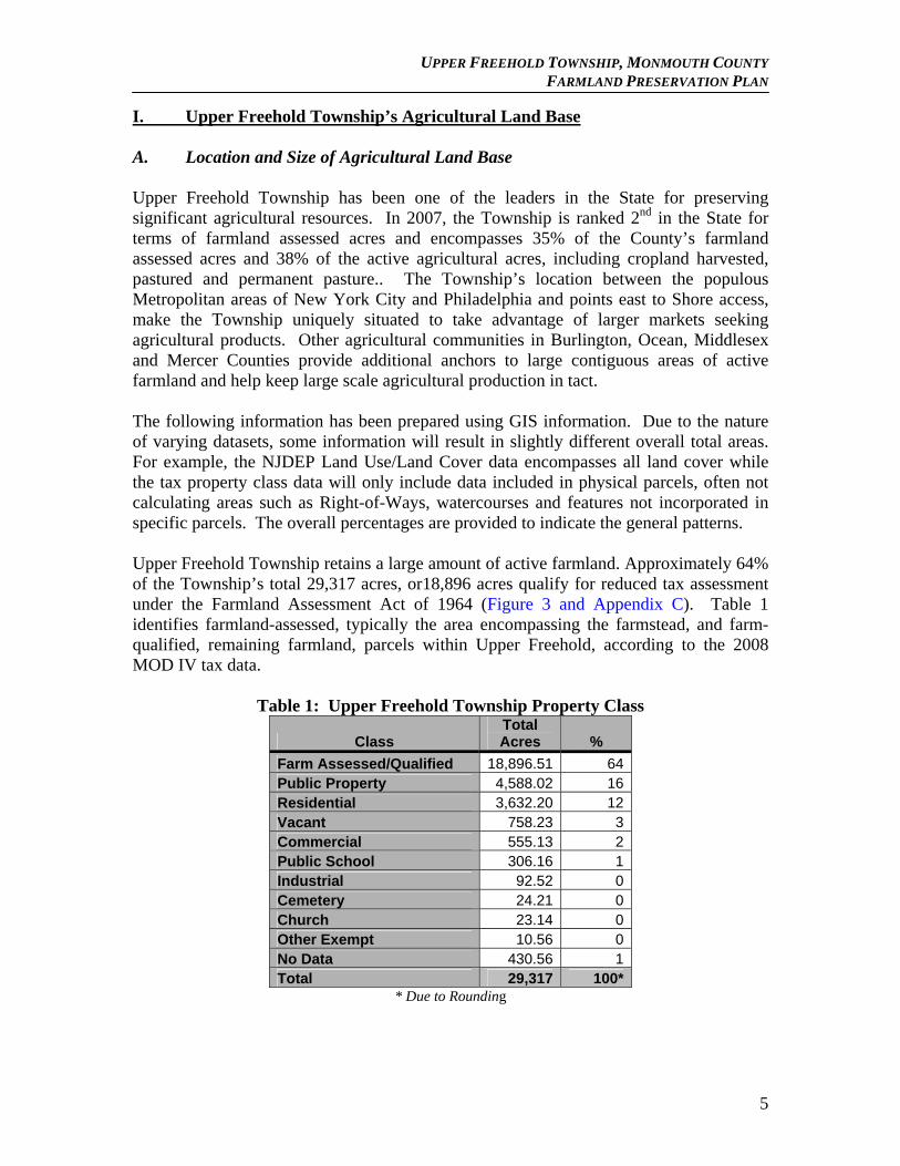
I. Upper Freehold Township’s Agricultural Land Base A. Location and Size of Agricultural Land Base Upper Freehold Township has been one of the leaders in the State for preserving significant agricultural resources. In 2007, the Township is ranked 2nd in the State for terms of farmland assessed acres and encompasses 35% of the County’s farmland assessed acres and 38% of the active agricultural acres, including cropland harvested, pastured and permanent pasture.. The Township’s location between the populous Metropolitan areas of New York City and Philadelphia and points east to Shore access, make the Township uniquely situated to take advantage of larger markets seeking agricultural products. Other agricultural communities in Burlington, Ocean, Middlesex and Mercer Counties provide additional anchors to large contiguous areas of active farmland and help keep large scale agricultural production in tact. The following information has been prepared using GIS information. Due to the nature of varying datasets, some information will result in slightly different overall total areas. For example, the NJDEP Land Use/Land Cover data encompasses all land cover while the tax property class data will only include data included in physical parcels, often not calculating areas such as Right-of-Ways, watercourses and features not incorporated in specific parcels. The overall percentages are provided to indicate the general patterns. Upper Freehold Township retains a large amount of active farmland. Approximately 64% of the Township’s total 29,317 acres, or18,896 acres qualify for reduced tax assessment under the Farmland Assessment Act of 1964 (Figure 3 and Appendix C). Table 1 identifies farmland-assessed, typically the area encompassing the farmstead, and farm-qualified, remaining farmland, parcels within Upper Freehold, according to the 2008 MOD IV tax data.
Table 1: Upper Freehold Township Property Class
Class Total Acres %
Farm Assessed/Qualified 18,896.51 64Public Property 4,588.02 16Residential 3,632.20 12Vacant 758.23 3Commercial 555.13 2Public School 306.16 1Industrial 92.52 0Cemetery 24.21 0Church 23.14 0Other Exempt 10.56 0No Data 430.56 1Total 29,317 100*
* Due to Rounding
5
UPPER FREEHOLD TOWNSHIP, MONMOUTH COUNTY FARMLAND PRESERVATION PLAN
The Township has identified a proposed project area which totals 27,358 acres and encompasses the majority of the Township excluding the more developed areas. This proposed project area correlates to the Monmouth County Project Area and Agricultural Development Area (ADA) area called the Upper Freehold Project Area (identified on Figure 6). The project area is predominantly comprised of farm assessed/qualified land and public property (Table 2). Of the total 27,358 acres, 67% (17,859 acres) are farm assessed/qualified and 17% (4,422 acres) are public property. This totals 84% of the project area as farm and preserved lands.
Table 2: Property Class for Upper Freehold Township Proposed Project Area Property Class Acres %
Farm Assessed/Qualified 17,862.23 67 Public Property 4,422.65 17
Residential 2,700.74 10 Vacant 459.63 2
Commercial 395.71 1 No Data 296.44 1
Public School 250.07 1 Industrial 91.85 0 Cemetery 24.21 0
Other Exempt 10.56 0 Church 2.8 0
TOTAL 26,516.90 100*
* Due to Rounding The nature of the Township is further highlighted by the 2002 NJDEP Land Use/Land Cover data (Figure 4). Table 3 identifies the Land Use/Land Cover for the entire Township. There are 14,894 acres (49%) of the Township that are classified as Agricultural.
Table 3: 2002 Land Use/Land Cover for Upper Freehold Township Type Acres %
Agriculture 14,894 49 Wetlands 6,337 21
Forest 4,830 16 Urban 3,331 11 Water 496 2
Barren Land 245 1 TOTAL 30,133 100
6
UPPER FREEHOLD TOWNSHIP, MONMOUTH COUNTY FARMLAND PRESERVATION PLAN
When the 2002 Land Use/Land Cover data is focused on the Township’s proposed project area, the agricultural land totals 52% (14,356 acres) of the area.
Table 4: 2002 Land Use/Land Cover for Upper Freehold Proposed Project Area Type Total %
Agriculture 14,356 52 Wetlands 6,018 22
Forest 3,935 14 Urban 2,513 9 Water 467 2
Barren Land 69 0 TOTAL 27,358 100*
*Due to Rounding Table 5 identifies the amount of cropland and pastureland identified by the 2002 Land Use/Land Cover for both the entire Township and the Proposed Project Area (Figure 5). Agricultural land in the Township is primarily classified as cropland/pastureland (60%), orchard/horticultural (30%), and generalized as “other” (10%). As witnessed above, the total area of cropland is concentrated in the proposed project area.
Table 5: 2002 Land Use/Land Cover Cropland and Pastureland
Category Acres Percentage
of Area Township Wide Cropland and Pasture Land 8,888 29% Township Project Area Cropland and Pasture Land 8,452 31%
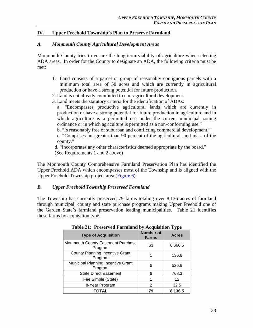
Finally, it is important to note the amount of existing preserved farmland in the Township. To date (May 2010), there are 8,136 acres of farmland preserved through SADC, the County and Municipal Funding as outlined in Table 6 (Figure 6) (See Appendix B for full listing).
Table 6: Preserved Farmland by Agency Type of Acquisition Acres
Monmouth County Easement Purchase Program 6,660.5
Municipal Planning Incentive Grant Program 526.6
County Planning Incentive Grant Program 136.3
State Direct Easement 768.3
Fee Simple (State) 12
8-Year Program 32.5
TOTAL 8.136.2 B. Distribution of soil types and their characteristics Upper Freehold Township has a predominance of prime soils. Most of the productive farmland in the County is on land having less than five percent slope with series names such as Adelphia, Collington, Downer, Hammonton, Holmdel, Keyport, Marlton, Sassafras, Woodstown, and Freehold loamy soil. According to the United States Department of
7
UPPER FREEHOLD TOWNSHIP, MONMOUTH COUNTY FARMLAND PRESERVATION PLAN
Agriculture – Natural Resources Conservation Service (USDA – NRCS) the three highest rated soil types in the County are Collington Loam, Freehold loam and Sassafras loam. Figure 7 Soils Map for Upper Freehold Township demonstrates the concentration of these soils suitable for farming. The USDA-NRCS classifies land capability from Roman numerals I to VII. As numbers rise the land has progressively greater limitations and narrower choices for practical use. Soils of statewide importance may produce a high yield of crops if treated and managed according to acceptable farming methods. In fact, yields may be as high as those of prime agricultural soils if conditions are right. Soils of Statewide importance include soils of 5-20% slopes and 0 to 5% loamy sands with same series names as above; plus other loams and loamy sands such as Elkton, Evesboro, Fallsington, Fort Mott, Klej, Kresson, Pemberton, and Tinton. Soils of statewide importance are interspersed with prime agricultural soils. Upper Freehold Township, due to its predominance of prime soils scores well in the County’s Land Evaluation, a rating used to rank prospective easement purchases. According to the “New Jersey Important Farmlands Inventory”, prepared by the State Agriculture Development Committee in 1990, soil classifications are defined as:
Prime Farmlands - Prime Farmlands include all those soils in Land Capability Class I and selected soils from Land Capability Class II. Prime Farmland is land that has the best combination of physical and chemical characteristics for producing food, feed, forage, fiber and oilseed crops and is also available for these uses. It has the soil quality, growing season, and moisture supply needed to economically produce sustained high yields of crops when treated and managed according to acceptable farming methods. Prime Farmlands are not excessively erodible or saturated with water for a long period of time, and they either do not flood frequently or are protected from flooding.
Soils of Statewide Importance - Farmlands of statewide importance include those soils in Land Capability Classes II and III that do not meet the criteria as Prime Farmland. These soils are nearly Prime Farmland and economically produce high yields of crops when treated and managed according to acceptable farming methods. Some may produce yields as high as Prime Farmland if conditions are favorable.
Farmland of Local Importance - Farmland of local importance includes those soils that are not prime or statewide importance and are used for the production of high value food, fiber or horticultural crops. Farmland of Unique Importance - Farmland of unique importance includes those soils that are not of prime or statewide importance and are used for the production of specialty crops.
The soils that are found in Upper Freehold are suitable for farmland production (Figure 7). Overall, 80% (23,946 acres) of the Township has farmland capable soils (Table 7).
8
UPPER FREEHOLD TOWNSHIP, MONMOUTH COUNTY FARMLAND PRESERVATION PLAN
In addition, 30% (8,192 acres) of farmland capable soils are located in cropland and pastureland areas excluding over 4,200 acres in nursery production as identified in the 2002 Land Use/Land Cover.
Table 7: Farm Capable Soils for Upper Freehold Township
Soil Acres %
Acres in Cropland
/Pastureland Areas
% in Cropland
/Pastureland Areas
Prime Soils 16,242 54 6,236 70 Statewide Important 7,523 25 1951 22 Locally Important Soils 7 0 0 0 Unique Importance 174 1 5 0 Other 6,187 21 696 8 Total 30,133 101* 8,888 100
*due to rounding The proposed project area also contains a high amount of farmland capable soils with 81% (22,023 acres) rated as Prime soils, Statewide Important soils or locally important soils (Table 8). Further, the agricultural areas in the project area are comprised of 28% (7,785 acres) of farmland capable soils.
Table 8: Farm Capable Soils for Upper Freehold Proposed Project Area
Soil Acres % Acres in
Agricultural Areas
% in Agricultural
Areas Prime Soils 14,982 55 5,918 70 Statewide Important 6,870 25 1,862 22 Locally Important Soils 5 0 0 0 Unique Importance 166 1 5 0 Other 5,333 20 667 8 Total 27,356 101* 8,452 100
*due to rounding Soils descriptions3 The following is a brief description of the soils located in Upper Freehold Township. Adelphia Series – Consists of moderately well to somewhat poorly drained soils on upland areas. Adelphia soils are suited well for field crops, hay, sod and vegetables. Atsion Series – Consists of poorly drained soils. These soils are suitable for specialty crops such as blueberries. 3 Soil Survey of Monmouth County, USDA Soil Conservation Service, 1989.
9
UPPER FREEHOLD TOWNSHIP, MONMOUTH COUNTY FARMLAND PRESERVATION PLAN
Colemantown Series – Consists of deep poorly drained soils. These soils are typically suitable for crops, hay and vegetables. Collington Series – Consists of gently sloping well-drained soils. These soils are well suited for a variety of common field crops, sod and vegetables. Colts Series – These soils are typically well drained and are suitable for common field crops, hay, sod and vegetables as well as for pasture. Downer Series – These soils are well drained and often located on nearly level to gently sloping areas. Downer soils are well suited for common field crops, hay, sod and vegetables as well as for pasture. Elkton Series – Consists of poorly drained soils located in depressional areas. These soils are well suited for common field crops, hay, sod and vegetables as well as for pasture but may be located in areas with a seasonal high water table preventing proper drainage. Evesboro Series – The Evesboro series soils are deep and poorly drained. They are often found in depressions in the stream terraces. If the soils are drained they are suitable for corn, soybeans, grasses and legumes that can tolerate wetness. Fallsington Series – These soils consist of poorly drained soils on upland flats. They are typically found on broad flats, especially in depressional areas and along drainage ways. The soil is suited to common field crops, hay and vegetables. Freehold Series – Consists of well-drained soils on uplands that are nearly level to gently sloping. Most areas of this soil are farmed as common field crops, hay and vegetables. These soils are also suitable for woodlands and pasture. Hammonton Series – This series consists of moderately well-drained or somewhat poorly-drained soils on uplands. These soils can be found in depressional areas and on low divides. Most areas of this soil are farmed, while a small acreage is woodlands and a few acres are pasture. Holmdel Series – This series is a nearly level, moderately well-drained and somewhat poorly-drained soil in depressional areas and on low divides. This soil is suited to common field crops, hay, sod, and vegetables. Humaquepts Series – Consists of nearly level, somewhat poorly drained to very poorly drained soils. They are located on flood plains along perennial and intermittent streams. Most of these soils are idle or are wooded due to the many limitations. They are poorly suited to farming. Keyport Series – These soils are nearly level, moderately well drained soils in depressional areas and on low divides. Most areas of these soils are farmed, while a small
10
UPPER FREEHOLD TOWNSHIP, MONMOUTH COUNTY FARMLAND PRESERVATION PLAN
acreage is used for pasture and a few acres are woodland. This soil is suited to common field crops, hay and vegetables. Klej Series – This is a nearly level and moderately well drained and somewhat poorly drained soil in depressional areas and on low divides. Most areas of this soil are wooded and a few acres are used for farming and pasture. Kresson Series – These soils are nearly level and gently sloping, somewhat poorly drained on low divides and in depressional areas. Most areas of this soil are farmed, while a small acreage is used for pasture and a few acres are woodland. This soil is suited to common field crops, hay, and vegetables. Manahawkin Series – Also referred to as Manahawkin muck. This is a nearly level and very poorly drained soil in wide depressional areas and on broad flats. Nearly all the acreage of this soil is wooded. This soil, if properly managed and if proper drainage and flood control measures are in place, is suited to cranberry or blueberry production. Marlton Series – This is a moderately sloping, well drained and moderately well drained soil on side slopes. Most areas of this soil are farmed, while it is also suited to pasture or commercial woodland production. Erosion is a hazard. Pemberton Series – This is a nearly level and gently sloping, moderately well drained and somewhat poorly drained soil on low divides and in depressional areas. Most areas of this soils are farmed while it is also suited to pasture or commercial woodland production. Phalanx Series – This series consists of soils that are well drained on uplands. Most areas of this soil are farmed, while a small acreage is used for pasture and a few acres for woodland. These soils are well suited to common field crops, hay, sod, and vegetables. Sassafras Series – Consists of well drained soils on uplands. Most areas of this soil are farmed, while a small acreage is used for pasture and a few acres are woodland. This soil is well suited to common field crops, hay, sod, and vegetables. Shrewsbury Series – Poorly drained soils on upland flats, these soils are nearly level and can also be found in depressional areas along drainage ways. About half of the acreage of this soil is woodland. Some areas have been cleared and drained and are farmed. A small acreage is used for pasture. This soil is suited to common field crops, hay and vegetables. Tinton Series – Consists of well drained soils on uplands and terraces. Most areas of this soil are farmed while a small acreage is used for pasture and few acres for woodland. Udorthents Series – Consists of well drained to somewhat poorly drained soils that have no horizonation. These soils formed in stratified or graded, sandy or loamy fill materials that has as much as 3% gravel, by volume. The properties and characteristics of these
11
UPPER FREEHOLD TOWNSHIP, MONMOUTH COUNTY FARMLAND PRESERVATION PLAN
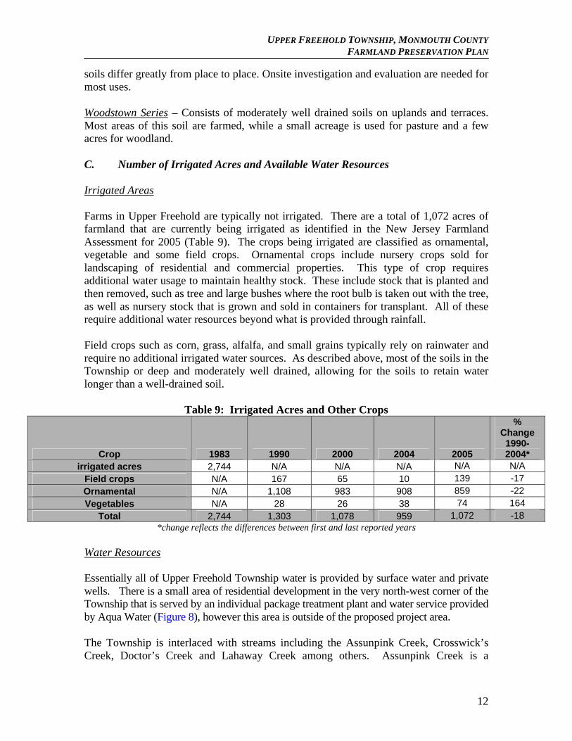
soils differ greatly from place to place. Onsite investigation and evaluation are needed for most uses. Woodstown Series – Consists of moderately well drained soils on uplands and terraces. Most areas of this soil are farmed, while a small acreage is used for pasture and a few acres for woodland. C. Number of Irrigated Acres and Available Water Resources Irrigated Areas Farms in Upper Freehold are typically not irrigated. There are a total of 1,072 acres of farmland that are currently being irrigated as identified in the New Jersey Farmland Assessment for 2005 (Table 9). The crops being irrigated are classified as ornamental, vegetable and some field crops. Ornamental crops include nursery crops sold for landscaping of residential and commercial properties. This type of crop requires additional water usage to maintain healthy stock. These include stock that is planted and then removed, such as tree and large bushes where the root bulb is taken out with the tree, as well as nursery stock that is grown and sold in containers for transplant. All of these require additional water resources beyond what is provided through rainfall. Field crops such as corn, grass, alfalfa, and small grains typically rely on rainwater and require no additional irrigated water sources. As described above, most of the soils in the Township or deep and moderately well drained, allowing for the soils to retain water longer than a well-drained soil.
Table 9: Irrigated Acres and Other Crops
Crop 1983 1990 2000 2004 2005
% Change
1990-2004*
irrigated acres 2,744 N/A N/A N/A N/A N/A
Field crops N/A 167 65 10 139 -17
Ornamental N/A 1,108 983 908 859 -22
Vegetables N/A 28 26 38 74 164
Total 2,744 1,303 1,078 959 1,072 -18 *change reflects the differences between first and last reported years
Water Resources Essentially all of Upper Freehold Township water is provided by surface water and private wells. There is a small area of residential development in the very north-west corner of the Township that is served by an individual package treatment plant and water service provided by Aqua Water (Figure 8), however this area is outside of the proposed project area. The Township is interlaced with streams including the Assunpink Creek, Crosswick’s Creek, Doctor’s Creek and Lahaway Creek among others. Assunpink Creek is a
12
UPPER FREEHOLD TOWNSHIP, MONMOUTH COUNTY FARMLAND PRESERVATION PLAN
Category C-1 Stream where associated with the State Park. The rest of the streams in the Township are not classified as C-1 but they have retained a level of water quality which allows for a variety of recreational and non-recreational purposes. The Township, and the AAC, feel preservation and consideration of water supply, quality and quantity are vital to the health of the Township and the environment. Aquifer recharge rates in the Township, as identified by the New Jersey Geologic Survey Aquifer Recharge Potential data, range from less than 25 to 500 gallons per minute which is a moderate range for aquifer recharge. Additionally, groundwater recharge rates for the Township range between 9 to 16 inches per year, which, like the aquifer recharge rates, are moderate rates. This combination results in an adequate supply of groundwater for agricultural purposes given a normal rainfall period. However, with fluctuating rainfall patterns and possible drought cycles, adequate water supply may become variable. The agricultural community in the Township has long practiced water conservation strategies in order to maintain productive crop yield while conserving water (which is discussed in later sections). D. Farmland Assessment and Census of Agriculture Statistics and Trends
1. Number of Farms and Farms by Size 2. Average and Median Farm Size
The Upper Freehold Township Assessor’s 2007 property list includes 371 farms with an average acreage of 49.49. The median size farm in the Township is 15.7 acres based on farm assessment forms.
The Township’s average and median size farm correlates to Monmouth County’s farm size. The County’s average farm size in 2007, based on the 2007 Census of Agriculture, was 47 acres with a median of 11 acres. The Township’s average is also more than triple the median farm size.
13
UPPER FREEHOLD TOWNSHIP, MONMOUTH COUNTY FARMLAND PRESERVATION PLAN
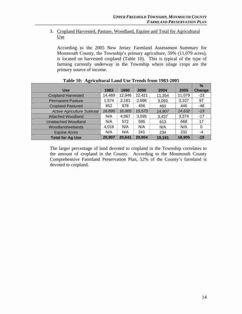
3. Cropland Harvested, Pasture, Woodland, Equine and Total for Agricultural Use
According to the 2005 New Jersey Farmland Assessment Summary for Monmouth County, the Township’s primary agriculture, 59% (11,079 acres), is located on harvested cropland (Table 10). This is typical of the type of farming currently underway in the Township where silage crops are the primary source of income.
Table 10: Agricultural Land Use Trends from 1983-2005
Use 1983 1990 2000 2004 2005 %
ChangeCropland Harvested 14,469 12,946 12,421 11,354 11,079 -23 Permanent Pasture 1,574 2,181 2,696 3,093 3,107 97 Cropland Pastured 852 878 456 460 446 -48
Active Agriculture Subtotal 16,895 16,005 15,573 14,907 14,632 -13 Attached Woodland N/A 4,067 3,595 3,437 3,374 -17
Unattached Woodland N/A 572 595 613 668 17 Woodland/wetlands 4,018 N/A N/A N/A N/A 0
Equine Acres N/A N/A 241 234 231 -4
Total for Ag Use 20,907 20,641 20,004 19,191 18,905 -10
The larger percentage of land devoted to cropland in the Township correlates to the amount of cropland in the County. According to the Monmouth County Comprehensive Farmland Preservation Plan, 52% of the County’s farmland is devoted to cropland.
14
UPPER FREEHOLD TOWNSHIP, MONMOUTH COUNTY FARMLAND PRESERVATION PLAN
II. Upper Freehold Agricultural Industry A. Trends in Market Value of Agricultural Products The USDA Census of Agriculture trends in Monmouth County identify market value of agricultural products sold in 1987 at $56.6 million, in 1992 this value decreased to $50.9 million, and in 1997 values began to increase to $68.8 million. The values continue to increase in 2002 at $81.6 million and then in 2007, this number increased to $105.4 million, or a 86% increase over 20 years. The total amounts of revenue generated by farms in Upper Freehold Township are hard to identify. The United States Department of Agriculture’s National Agriculture Statistics Service (NASS) is tabulated annually with certain crop yields recorded in recent years that were not preciously recorded. Additionally, trends in the market value are not compiled annually at the County level, but rather reported every five years as part of the National Census of Agriculture. The next Census report will be available at the beginning of 2008. While these statistics are available at the County level, they are not typically available at the municipal level. However, much of the trending witnessed in at the County level correlates to the Township level.
According to the 2002 USDA Census of Agriculture, as identified in the Monmouth County Plan, County sales from nursery and greenhouse and floriculture accounted for 73% of the total sales, with vegetables, melons and potatoes accounting for 11% and horses for 7%. In addition, the County Plan identified that in 2002 70.6% of the County’s farmland assessed agricultural land was in active agriculture consisting of harvested cropland, cropland pasture and permanent pasture. The Township’s active agricultural areas, as identified in the previous section, total 77% of the agricultural land base. Using Farmland Assessment statistics for the Township and the County, the value of agricultural products in Upper Freehold can be interpreted as a reasonable estimate of roughly $40 million per year, based on the 2007 Center of Agriculture statistics for Monmouth County. Upper Freehold Township had 14,239 active agricultural acres (cropland harvested, cropland Pastured, and permanent pasture) in the 2007/2008 Farmland Assessment Summary. Monmouth County had 37,542 active agricultural acres in the 2007/2008 Farmland Assessment Summary. Therefore Upper Freehold Township represents 37.9% of the County’s total active agricultural acres. Using the $105.4 million figure (from the 2007 Census of Agriculture) for the official market value of agricultural products for the County times 37.9% equals $39.976 million as an estimate of the value of agricultural products in Upper Freehold Township. Because the Township has a higher percentage of the County’s nursery acreage (4,369/8003 = 55%), that estimate is probably low.
15
UPPER FREEHOLD TOWNSHIP, MONMOUTH COUNTY FARMLAND PRESERVATION PLAN
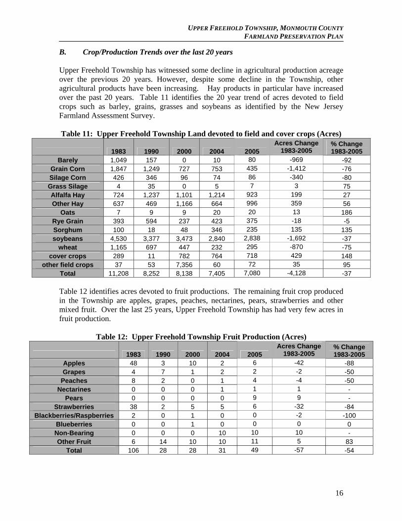
B. Crop/Production Trends over the last 20 years Upper Freehold Township has witnessed some decline in agricultural production acreage over the previous 20 years. However, despite some decline in the Township, other agricultural products have been increasing. Hay products in particular have increased over the past 20 years. Table 11 identifies the 20 year trend of acres devoted to field crops such as barley, grains, grasses and soybeans as identified by the New Jersey Farmland Assessment Survey. Table 11: Upper Freehold Township Land devoted to field and cover crops (Acres)
1983 1990 2000 2004 2005 Acres Change
1983-2005 % Change 1983-2005
Barely 1,049 157 0 10 80 -969 -92 Grain Corn 1,847 1,249 727 753 435 -1,412 -76 Silage Corn 426 346 96 74 86 -340 -80 Grass Silage 4 35 0 5 7 3 75 Alfalfa Hay 724 1,237 1,101 1,214 923 199 27 Other Hay 637 469 1,166 664 996 359 56
Oats 7 9 9 20 20 13 186 Rye Grain 393 594 237 423 375 -18 -5 Sorghum 100 18 48 346 235 135 135 soybeans 4,530 3,377 3,473 2,840 2,838 -1,692 -37
wheat 1,165 697 447 232 295 -870 -75 cover crops 289 11 782 764 718 429 148
other field crops 37 53 7,356 60 72 35 95 Total 11,208 8,252 8,138 7,405 7,080 -4,128 -37 Table 12 identifies acres devoted to fruit productions. The remaining fruit crop produced in the Township are apples, grapes, peaches, nectarines, pears, strawberries and other mixed fruit. Over the last 25 years, Upper Freehold Township has had very few acres in fruit production.
Table 12: Upper Freehold Township Fruit Production (Acres)
1983 1990 2000 2004 2005 Acres Change
1983-2005 % Change 1983-2005
Apples 48 3 10 2 6 -42 -88 Grapes 4 7 1 2 2 -2 -50
Peaches 8 2 0 1 4 -4 -50 Nectarines 0 0 0 1 1 1 -
Pears 0 0 0 0 9 9 - Strawberries 38 2 5 5 6 -32 -84
Blackberries/Raspberries 2 0 1 0 0 -2 -100 Blueberries 0 0 1 0 0 0 0 Non-Bearing 0 0 0 10 10 10 - Other Fruit 6 14 10 10 11 5 83
Total 106 28 28 31 49 -57 -54
16
UPPER FREEHOLD TOWNSHIP, MONMOUTH COUNTY FARMLAND PRESERVATION PLAN
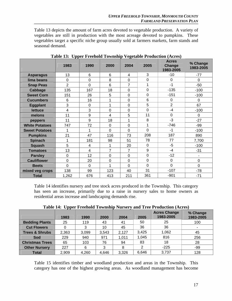
Table 13 depicts the amount of farm acres devoted to vegetable production. A variety of vegetables are still in production with the most acreage devoted to pumpkins. These vegetables target a specific niche group usually sold at farmers markets, farm stands and seasonal demand.
Table 13: Upper Freehold Township Vegetable Production (Acres)
1983 1990 2000 2004 2005
Acres Change
1983-2005
% Change 1983-2005
Asparagus 13 6 6 4 3 -10 -77 lima beans 0 0 8 0 0 0 0 Snap Peas 2 0 6 7 1 -1 -50 Cabbage 135 167 18 0 0 -135 -100
Sweet Corn 151 26 5 0 0 -151 -100 Cucumbers 6 16 1 0 6 0 0
Eggplant 3 0 1 0 5 2 67 lettuce 4 3 0 0 0 -4 -100 melons 11 9 4 5 11 0 0 peppers 11 9 18 1 8 -3 -27
White Potatoes 747 72 0 0 1 -746 -99 Sweet Potatoes 1 1 0 0 0 -1 -100
Pumpkins 21 47 116 73 208 187 890 Spinach 1 181 98 51 78 77 7,700 Squash 5 4 1 20 0 -5 -100
Tomatoes 13 4 7 7 9 -4 -31 Parsley 0 12 0 0 0 -12 -
Cauliflower 0 20 0 0 0 0 0 Beets 0 0 1 0 0 0 0
mixed veg crops 138 99 123 40 31 -107 -78 Total 1,262 676 413 211 361 -901 -71 Table 14 identifies nursery and tree stock acres produced in the Township. This category has seen an increase, primarily due to a raise in nursery sales to home owners as residential areas increase and landscaping demands rise.
Table 14: Upper Freehold Township Nursery and Tree Production (Acres)
1983 1990 2000 2004 2005 Acres Change
1983-2005 % Change 1983-2005
Bedding Plants 25 119 43 41 50 25 100 Cut Flowers 0 3 10 45 36 36 -
Trees & Shrubs 2,363 3,099 3,543 2,127 3,425 1,062 45 Sod 229 940 971 1,011 1,045 816 256
Christmas Trees 65 103 76 94 83 18 28 Other Nursery 227 6 3 8 2 -225 -99
Total 2,909 4,260 4,646 3,326 6,646 3,737 128 Table 15 identifies timber and woodland production and areas in the Township. This category has one of the highest growing areas. As woodland management has become
17
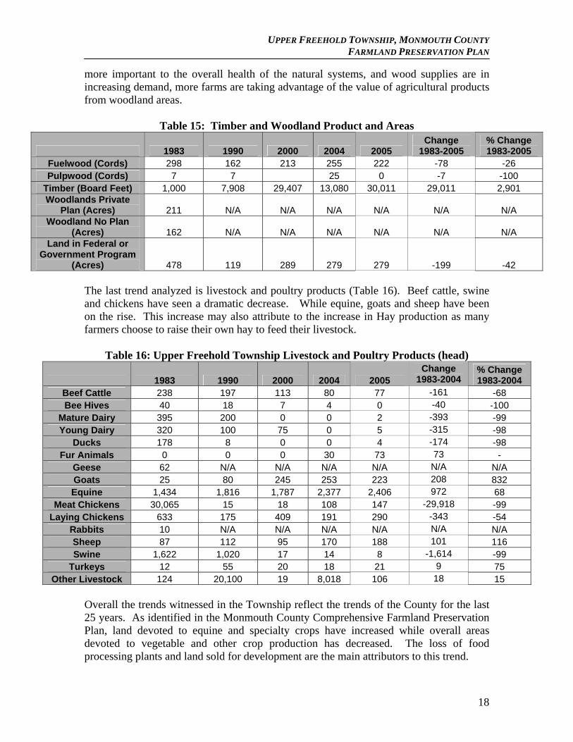
UPPER FREEHOLD TOWNSHIP, MONMOUTH COUNTY FARMLAND PRESERVATION PLAN
more important to the overall health of the natural systems, and wood supplies are in increasing demand, more farms are taking advantage of the value of agricultural products from woodland areas.
Table 15: Timber and Woodland Product and Areas
1983 1990 2000 2004 2005 Change
1983-2005 % Change 1983-2005
Fuelwood (Cords) 298 162 213 255 222 -78 -26 Pulpwood (Cords) 7 7 25 0 -7 -100
Timber (Board Feet) 1,000 7,908 29,407 13,080 30,011 29,011 2,901 Woodlands Private
Plan (Acres) 211 N/A N/A N/A N/A N/A N/A Woodland No Plan
(Acres) 162 N/A N/A N/A N/A N/A N/A Land in Federal or
Government Program (Acres) 478 119 289 279 279 -199 -42
The last trend analyzed is livestock and poultry products (Table 16). Beef cattle, swine and chickens have seen a dramatic decrease. While equine, goats and sheep have been on the rise. This increase may also attribute to the increase in Hay production as many farmers choose to raise their own hay to feed their livestock.
Table 16: Upper Freehold Township Livestock and Poultry Products (head)
1983 1990 2000 2004 2005 Change
1983-2004 % Change 1983-2004
Beef Cattle 238 197 113 80 77 -161 -68 Bee Hives 40 18 7 4 0 -40 -100
Mature Dairy 395 200 0 0 2 -393 -99 Young Dairy 320 100 75 0 5 -315 -98
Ducks 178 8 0 0 4 -174 -98 Fur Animals 0 0 0 30 73 73 -
Geese 62 N/A N/A N/A N/A N/A N/A Goats 25 80 245 253 223 208 832 Equine 1,434 1,816 1,787 2,377 2,406 972 68
Meat Chickens 30,065 15 18 108 147 -29,918 -99 Laying Chickens 633 175 409 191 290 -343 -54
Rabbits 10 N/A N/A N/A N/A N/A N/A Sheep 87 112 95 170 188 101 116 Swine 1,622 1,020 17 14 8 -1,614 -99
Turkeys 12 55 20 18 21 9 75 Other Livestock 124 20,100 19 8,018 106 18 15
Overall the trends witnessed in the Township reflect the trends of the County for the last 25 years. As identified in the Monmouth County Comprehensive Farmland Preservation Plan, land devoted to equine and specialty crops have increased while overall areas devoted to vegetable and other crop production has decreased. The loss of food processing plants and land sold for development are the main attributors to this trend.
18
UPPER FREEHOLD TOWNSHIP, MONMOUTH COUNTY FARMLAND PRESERVATION PLAN
C& D. Support Services within Market Region and Other Agriculturally Related Industry Upper Freehold Township Committee created an Economic Development Committee in 2004 and has put a considerable effort into the support of Agri-Business. The Township has seen the expansion of Rick’s Saddle Shop, an equipment and supply store that supports local farmers. There is also an application before the Planning Board for an equipment and service dealer. The Township’s equine industry and farms that support that industry have grown considerably. Several of the small farms along with the large nurseries and horticulture farms are active in such seasonal events such as Christmas Tree sales, Pumpkin Picking, Hay Rides, Mazes and other forms of Ag-tourism
Several Upper Freehold Township Farmers participate in scheduled farmer’s markets in surrounding municipalities as well as participating in special fairs and events. The Cream Ridge Winery is open to the public and advertises several festivals throughout the year. According to the Monmouth County Comprehensive Plan, there are a variety of local and regional business which cater to the agricultural community. The Farmer’s Brokerage and Supply (FB&S) is located in the Township and serves a larger regional area from Mullica Hill to Baptistown. The store sells seed, hardware, parts for tillage equipment, chemicals and fertilizers as well as provides a custom application business. In terms of equipment and machinery, dealers in Cumberland or Salem Counties such as Farm Rite, Pole Tavern Equipment or Leslie G. Fogg Inc. are often called upon. In some cases local farmers will travel to Lancaster County, Pennsylvania to dealers such as Hoober Inc., Messick Farm Equipment, or Wengers. Many also buy used equipment advertised in regional farm journals and on the Internet. For new barns and stables, many county farmers work with the Amish community in Pennsylvania. According to the Monmouth County Plan, the County is located in the New York-Philadelphia corridor which provides for additional market forces that create demand for fresh produce and seafood as well as plant materials for landscaping and garden use. Many regional farmers take advantage of their location by providing on-site farm stands and selling to local supermarkets, specialty markets, and restaurants. Some farmers have taken advantage of producing value-added products such as pies, wine, spirits, non-alcoholic cider, and sorbet. Local farmers also take advantage of agricultural organizations such as the Monmouth County Board of Agriculture and Agriculture Development Board, the New Jersey Farm Bureau, Rutgers Cooperative Extension “Green Pages” resource guide (http://salem.rutgers.edu/greenpages/services.pdf), Rutgers Cooperative Extension of Monmouth County, Monmouth 4-H Club, Soil Conservation District, and the Natural Resource Conservation Service. These type of agricultural organizations can help farmers in a variety of ways.
19
UPPER FREEHOLD TOWNSHIP, MONMOUTH COUNTY FARMLAND PRESERVATION PLAN
III. Land Use Planning A. State Development and Redevelopment Plan The State Development and Redevelopment Plan (SDRP) offers guidance in the formulation of land management and natural resource conservation policy (Figure 9). The SDRP provides a balance between growth and conservation by designating planning areas that share common conditions with regard to development and environmental features:
Areas for Growth: Metropolitan Planning Areas (Planning Area 1), Suburban Planning Areas (Planning Area 2) and Designated Centers in any planning area.
Areas for Limited Growth: Fringe Planning Areas (Planning Area 3), Rural Planning Areas (Planning Areas 4 and 4B), and Environmentally Sensitive Planning Areas (Planning Area 5). In these planning areas, planning should promote a balance of conservation and limited growth and development should be focused in areas of existing development or designated Centers. Environmental constraints affect development and preservation is encouraged in large contiguous tracts.
Areas for Conservation: Fringe Planning Area (Planning Area 3), Rural Planning Areas (Planning Areas 4 and 4B), and Environmentally Sensitive Planning Areas (Planning Area 5). In these planning areas, where infrastructure is not available and critical environmental constraints and resources exist, conservation is preferred over inappropriate types and patterns of development.
Description of SDRP Planning Areas The Planning Areas outlined in the SDRP provide a regional framework for infrastructure development decisions, including the designation of Centers, areas to which growth should be focused, and areas where growth and development should not be encouraged and where resource protection, such as farmland preservation, should be focused. The SDRP includes seven (7) Planning Area (PA) designations including Centers, as explained below.
PA1 – Metropolitan Planning Area characterized by areas with densities of more than 1,000 persons/sq mile; population clusters of greater than 25,000 persons; land area greater than 1 square mile; existing public water and sewer systems; and access to public transit.
PA2 – Suburban Planning Area is characterized by areas with densities of less than 1,000 persons/sq mile; are contiguous with PA1; land area greater than 1 square mile; and has existing or planned infrastructure with capacity to support development.
20
UPPER FREEHOLD TOWNSHIP, MONMOUTH COUNTY FARMLAND PRESERVATION PLAN
PA3 – Fringe Planning Area is characterized by areas with densities of less than 1,000 persons/sq mile; served by rural roadways and utilities; generally lacking wastewater systems except in centers; land area greater than 1 square mile; lands not meeting criteria for PA4 or PA5.
PA4 – Rural Planning Area is characterized by areas with densities of less than 1,000 persons/sq mile; land area greater than 1 square mile; generally served by on-site water and wastewater systems; and are generally characterized by agricultural production, woodlands or other vacant lands.
PA4B – Rural /Environmentally Sensitive Planning Area is characterized by areas with densities of less than 1,000 persons/sq mile; land area greater than 1 square mile; generally served by on-site water and wastewater systems; generally characterized by agricultural production, and woodlands or other vacant lands. Land satisfying the delineation criteria for PA4 that also meets the delineation criteria for the Environmentally Sensitive Planning Area (PA5) is designated as Rural/Environmentally Sensitive (PA4B)
PA5 – Environmentally Sensitive Planning Area is characterized by areas with densities of less than 1,000 persons/sq mile outside of centers; land area greater than 1 square mile, exclusive of centers; includes environmental features such as: trout production/maintenance waters; pristine non-tidal watersheds feeding Category 1 waters; Threatened & Endangered species habitat; coastal wetlands; significant features such as slopes, ridgelines, unique ecosystems; and Prime forest.
Centers are the State Plan’s preferred vehicle for accommodating growth. Center-based development patterns are superior to sprawl for a number of reasons. A Center is compact and considerably more efficient than sprawl, providing opportunities for cost savings across a wide range of factors. Compact form also translates into significant land savings which affords a community greater opportunity to preserve lands of importance, such as lands in active agriculture. The SDRP categorizes a hierarchy of Centers as Urban, Regional, Town, Village and Hamlet, and are described as follows:
Urban Generally the largest Centers, offering the most diverse mix of industry, commerce, services, residences and cultural facilities.
Regional A compact mix of residential, commercial and public uses, serving a large surrounding area and developed at an intensity that makes public transportation feasible.
21
UPPER FREEHOLD TOWNSHIP, MONMOUTH COUNTY FARMLAND PRESERVATION PLAN
Town Traditional Centers of commerce or government throughout New Jersey, with diverse residential neighborhoods served by a mixed-use Core offering locally oriented goods and services.
Village Primarily residential places that offer a small Core with limited public facilities, consumer services and community activities.
Hamlet Small-scale, compact residential settlements organized around a community focal point, such as a house of worship, luncheonette, small park or a civic building.
Upper Freehold contains exclusively the Rural (PA4) and Rural Environmentally Sensitive (PA4B) Planning Areas. These designations recognize the valuable agricultural resources that Upper Freehold Township seeks to protect from development pressure within the region that can transform valued agricultural areas. SDRP guidance for management of the Rural Planning Area has been provided, as follows:
“Prudent land development practices are required to protect these resources and retain large contiguous areas of agricultural land. If a viable agricultural industry is to be sustained in the future, the conversion of some of the lands to non-farm uses must be sensitive to the areas predominant rural character and agricultural land base. Throughout New Jersey, some Rural Planning Areas are subject to greater development pressure than other areas. Without greater attention to maintaining and enhancing our rural areas, these economic activities are at risk. Tools and techniques need to be tailored to address the distinctive situation. In particular, new development may require additional attention in areas with environmentally sensitive features.”
The SDRP promotes the retention of large open land areas in PA4B & 5, and the Plan defines “large contiguous area”.
“When applied to habitat, (large contiguous area) means the area of undisturbed land required to maintain a desired community of plants and animals”, and “when applied to farmland, large contiguous area means the amount of contiguous farmland usually considered necessary to permit normal farm operations to take place on a sustained basis.”
The Township is endowed with large contiguous land areas with valuable ecosystems, geological features and wildlife habitats that support critical habitat. Whether it is the maintenance of large contiguous areas for farmland or to protect environmentally-sensitive areas, Upper Freehold’s stewardship of these areas requires policies and
22
UPPER FREEHOLD TOWNSHIP, MONMOUTH COUNTY FARMLAND PRESERVATION PLAN
management techniques to sustain the landscape in such a way that the long-term viability and function of these lands and natural systems may be assured. SDRP Policies seek to maintain the viability of agricultural areas and the function of natural systems through strategies aimed at the protection of these resources and coordinated growth policies that orient new development adjacent to either Centers, or existing developed areas with infrastructure capable of supporting development. Development should be compact, and innovative development approaches, such as clustering or open lands zoning will be needed to discourage sprawl-type patterns of development that would fragment and destroy the very resources that the Rural and Environmentally Sensitive Planning Area designations seek to protect. The SDRP supports municipalities in their efforts to provide for sound long term planning processes. Plan Endorsement encourages municipalities to engage in cooperative regional planning. It ensures that municipal, county, regional and State Agency plans are consistent with the State Development and Redevelopment Plan and with each other. An endorsed plan entitles municipalities and counties to a higher priority for available funding, streamlined permit reviews, and coordinated state agency services. Priority is given to county and regional strategic plans. The creation and adoption of Master Plan Elements, such as the Farmland Preservation Plan, is one task required to enter Plan Endorsement. B. Special Resource Areas Upper Freehold Township does not contain any special resource areas such as the Highlands, Pinelands or CAFRA. C. Upper Freehold Township Master Plan and Development Regulations
Upper Freehold Township has long recognized the value of Agricultural resources. The “1994-1995 Land Use Plan Element” of the Township’s Master Plan, provided the following guiding principles related to farmland and agricultural retention in the Township:
Maintain the rural and country atmosphere which prevails throughout most of Upper Freehold Township.
Preserve farmland to the maximum extent possible and in a manner that is reasonable, achievable and equitable to the farmer.
Prevent the homogenous spread of suburban type development throughout the Township.
These goals and objectives were further supported and reiterated in the Township’s 2001 and 2007 Reexamination Reports and the 2007 Land Use Plan Element.
23
UPPER FREEHOLD TOWNSHIP, MONMOUTH COUNTY FARMLAND PRESERVATION PLAN
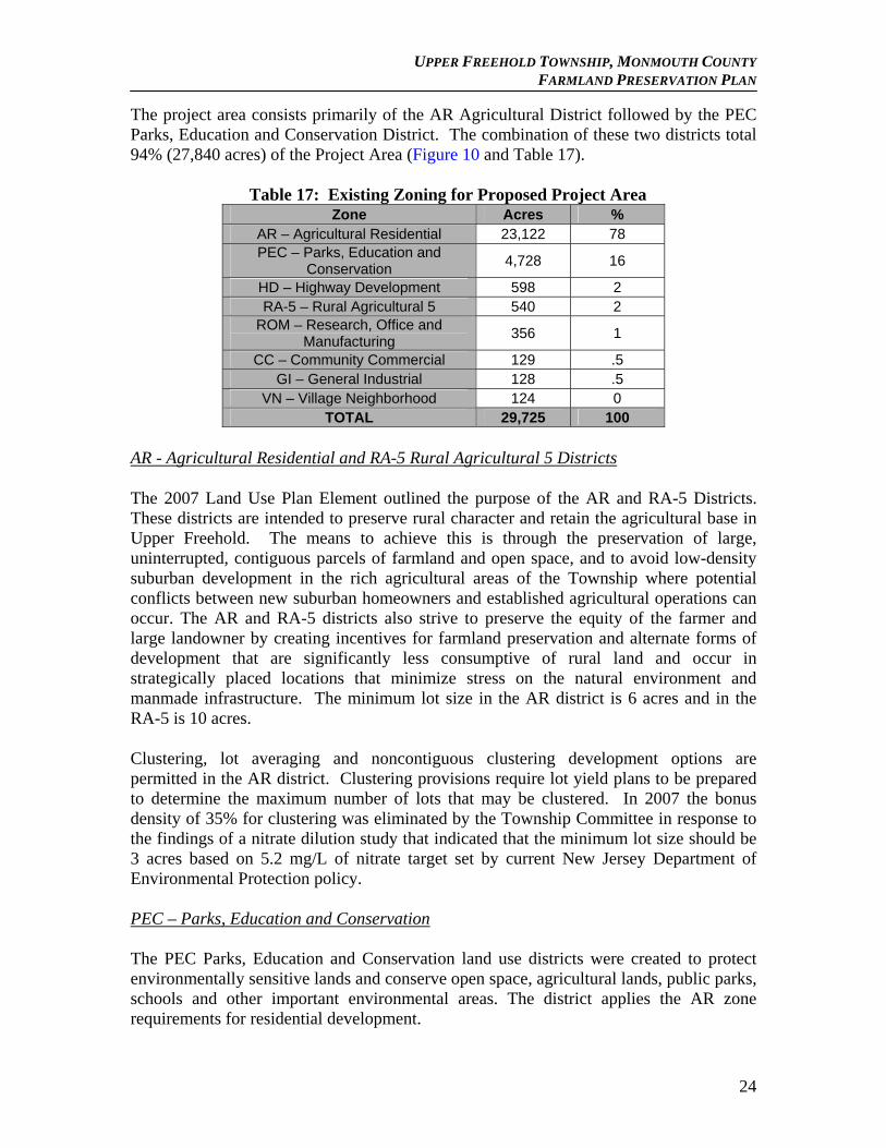
The project area consists primarily of the AR Agricultural District followed by the PEC Parks, Education and Conservation District. The combination of these two districts total 94% (27,840 acres) of the Project Area (Figure 10 and Table 17).
Table 17: Existing Zoning for Proposed Project Area
Zone Acres % AR – Agricultural Residential 23,122 78 PEC – Parks, Education and
Conservation 4,728 16
HD – Highway Development 598 2 RA-5 – Rural Agricultural 5 540 2
ROM – Research, Office and Manufacturing
356 1
CC – Community Commercial 129 .5 GI – General Industrial 128 .5
VN – Village Neighborhood 124 0 TOTAL 29,725 100
AR - Agricultural Residential and RA-5 Rural Agricultural 5 Districts
The 2007 Land Use Plan Element outlined the purpose of the AR and RA-5 Districts. These districts are intended to preserve rural character and retain the agricultural base in Upper Freehold. The means to achieve this is through the preservation of large, uninterrupted, contiguous parcels of farmland and open space, and to avoid low-density suburban development in the rich agricultural areas of the Township where potential conflicts between new suburban homeowners and established agricultural operations can occur. The AR and RA-5 districts also strive to preserve the equity of the farmer and large landowner by creating incentives for farmland preservation and alternate forms of development that are significantly less consumptive of rural land and occur in strategically placed locations that minimize stress on the natural environment and manmade infrastructure. The minimum lot size in the AR district is 6 acres and in the RA-5 is 10 acres.
Clustering, lot averaging and noncontiguous clustering development options are permitted in the AR district. Clustering provisions require lot yield plans to be prepared to determine the maximum number of lots that may be clustered. In 2007 the bonus density of 35% for clustering was eliminated by the Township Committee in response to the findings of a nitrate dilution study that indicated that the minimum lot size should be 3 acres based on 5.2 mg/L of nitrate target set by current New Jersey Department of Environmental Protection policy. PEC – Parks, Education and Conservation The PEC Parks, Education and Conservation land use districts were created to protect environmentally sensitive lands and conserve open space, agricultural lands, public parks, schools and other important environmental areas. The district applies the AR zone requirements for residential development.
24
UPPER FREEHOLD TOWNSHIP, MONMOUTH COUNTY FARMLAND PRESERVATION PLAN
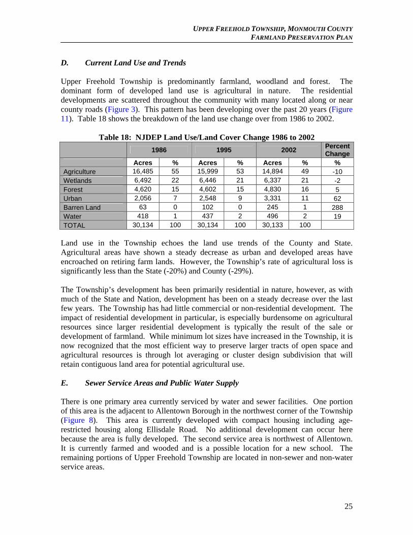
D. Current Land Use and Trends Upper Freehold Township is predominantly farmland, woodland and forest. The dominant form of developed land use is agricultural in nature. The residential developments are scattered throughout the community with many located along or near county roads (Figure 3). This pattern has been developing over the past 20 years (Figure 11). Table 18 shows the breakdown of the land use change over from 1986 to 2002.
Table 18: NJDEP Land Use/Land Cover Change 1986 to 2002
1986 1995 2002
Percent Change
Acres % Acres % Acres % % Agriculture 16,485 55 15,999 53 14,894 49 -10 Wetlands 6,492 22 6,446 21 6,337 21 -2 Forest 4,620 15 4,602 15 4,830 16 5 Urban 2,056 7 2,548 9 3,331 11 62 Barren Land 63 0 102 0 245 1 288 Water 418 1 437 2 496 2 19 TOTAL 30,134 100 30,134 100 30,133 100
Land use in the Township echoes the land use trends of the County and State. Agricultural areas have shown a steady decrease as urban and developed areas have encroached on retiring farm lands. However, the Township’s rate of agricultural loss is significantly less than the State (-20%) and County (-29%). The Township’s development has been primarily residential in nature, however, as with much of the State and Nation, development has been on a steady decrease over the last few years. The Township has had little commercial or non-residential development. The impact of residential development in particular, is especially burdensome on agricultural resources since larger residential development is typically the result of the sale or development of farmland. While minimum lot sizes have increased in the Township, it is now recognized that the most efficient way to preserve larger tracts of open space and agricultural resources is through lot averaging or cluster design subdivision that will retain contiguous land area for potential agricultural use. E. Sewer Service Areas and Public Water Supply There is one primary area currently serviced by water and sewer facilities. One portion of this area is the adjacent to Allentown Borough in the northwest corner of the Township (Figure 8). This area is currently developed with compact housing including age-restricted housing along Ellisdale Road. No additional development can occur here because the area is fully developed. The second service area is northwest of Allentown. It is currently farmed and wooded and is a possible location for a new school. The remaining portions of Upper Freehold Township are located in non-sewer and non-water service areas.
25
UPPER FREEHOLD TOWNSHIP, MONMOUTH COUNTY FARMLAND PRESERVATION PLAN
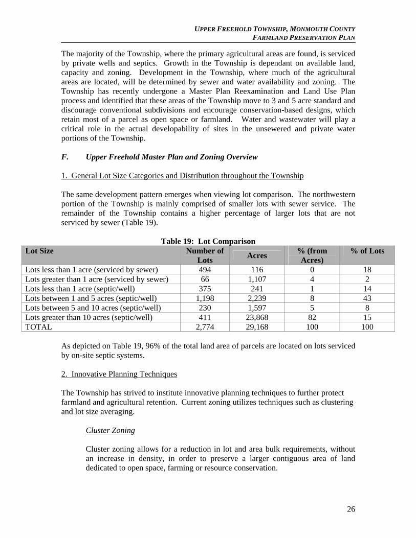
The majority of the Township, where the primary agricultural areas are found, is serviced by private wells and septics. Growth in the Township is dependant on available land, capacity and zoning. Development in the Township, where much of the agricultural areas are located, will be determined by sewer and water availability and zoning. The Township has recently undergone a Master Plan Reexamination and Land Use Plan process and identified that these areas of the Township move to 3 and 5 acre standard and discourage conventional subdivisions and encourage conservation-based designs, which retain most of a parcel as open space or farmland. Water and wastewater will play a critical role in the actual developability of sites in the unsewered and private water portions of the Township. F. Upper Freehold Master Plan and Zoning Overview 1. General Lot Size Categories and Distribution throughout the Township The same development pattern emerges when viewing lot comparison. The northwestern portion of the Township is mainly comprised of smaller lots with sewer service. The remainder of the Township contains a higher percentage of larger lots that are not serviced by sewer (Table 19).
Table 19: Lot Comparison Lot Size Number of
Lots Acres
% (from Acres)
% of Lots
Lots less than 1 acre (serviced by sewer) 494 116 0 18 Lots greater than 1 acre (serviced by sewer) 66 1,107 4 2 Lots less than 1 acre (septic/well) 375 241 1 14 Lots between 1 and 5 acres (septic/well) 1,198 2,239 8 43 Lots between 5 and 10 acres (septic/well) 230 1,597 5 8 Lots greater than 10 acres (septic/well) 411 23,868 82 15 TOTAL 2,774 29,168 100 100
As depicted on Table 19, 96% of the total land area of parcels are located on lots serviced by on-site septic systems. 2. Innovative Planning Techniques The Township has strived to institute innovative planning techniques to further protect farmland and agricultural retention. Current zoning utilizes techniques such as clustering and lot size averaging.
Cluster Zoning Cluster zoning allows for a reduction in lot and area bulk requirements, without an increase in density, in order to preserve a larger contiguous area of land dedicated to open space, farming or resource conservation.
26
UPPER FREEHOLD TOWNSHIP, MONMOUTH COUNTY FARMLAND PRESERVATION PLAN
The Township currently has a cluster provision included in the AR zone. This district is the largest district encompassing most of the Township’s land area. The ordinance specifically states:
“Farmland/Open Space Conservation Clusters” (Section 35-611) – This technique requires a lot yield plan (schematic test plan) be prepared to establish the maximum number of lots. At least 70 percent of the tract must be preserved as farmland or open space. Clustered lots having at least one acre in area may be developed on the balance of the tract. For more detail see the zoning ordinance.”
Non-contiguous cluster zoning
Non-contiguous cluster zoning is a method that allows one parcel to be preserved in its entirety for farming or open space and transferring that parcels development rights to another parcel. This option allows for a higher density on the developable parcel. The Township permits non-contiguous cluster zoning provision in the AR District in order to provide and encourage the preservation of environmentally sensitive areas and agricultural lands.
Section 35-613 - The basic purpose of permitting the development of "Noncontiguous Clustering" is to provide and encourage a method of creating single-family residential environments which, at the same time, preserve and safeguard desirable and appropriate agricultural lands, open spaces, steep slopes, flood plains, wetlands, wetlands transitional areas and scenic vistas.
Lot Averaging Lot averaging allows for the reduction of lot area and bulk requirements provided the overall density remains the same. Lot averaging is another development option allowed in the AR district. This technique is permitted when a tract of land contains at least ten acres and the residential lot sizes have a minimum of two acres, a maximum of ten acres (the maximum considered for averaging even if the lots are larger) and the average is six acres. The ordinance states:
Agricultural Preservation Subdivision
The Township permits agricultural preservation subdivisions in the AR and R-5 Districts. (Section 35-608) – This technique requires 75 percent of the tract area be preserved as part of the New Jersey State Farmland Preservation Program of which no more than 30 percent is critical area
27
UPPER FREEHOLD TOWNSHIP, MONMOUTH COUNTY FARMLAND PRESERVATION PLAN
(wetlands, floodplains and steep slopes). No more than 50 percent of the total lot yield can be developed with lot averaging where the minimum lot area is one acre, the maximum lot area is three acres (the maximum considered for averaging even if the lots are larger) and the average lot area is two acres.”
Equine Community Option
Section 35-601 I - "An Equine Community Option is a permitted conditional use within the "AR" Agricultural Residential District in accordance with the following conditions and standards such as consisting of a required mix of clustered minimum one-acre residential lots and an equine center for the residents of the development. 30% of the tract area may consist of clustered minimum one-acre residential lots, 70% of the tract area is to be preserved as an equestrian center consisting of barns, paddocks, riding arena (indoor and outdoor), pastures, riding trails, parking and a community center that covers no more than 1 % of the area set aside for the equine center. The maximum number of lots on which dwellings are located should be determined by a lot yield plan that is compliant with the minimum lot size and bulk and area requirements for AR (6 acre lots) District, and has no variances, waivers and design exceptions. Parcels need to be a minimum of 100 acres in size. Single family lots must adhere to the area and yard requirements as found in Section 35-611D (3). The Equine Community development must adhere to all of the general provisions and design standards as set forth in Section 35-500.
Transfer of Development Rights
Transfer of development rights (TDR) removes the right to develop or build on land in a designated sending zone and transfers that right to land in a receiving zone. This is typically done to preserve valuable resources that would be otherwise lost and transfers development to more appropriate locations. The Township currently does not have a TDR program. To date, the Township has not identified a feasible TDR program but continues to investigate the possibility.
Use of Mandatory vs. Voluntary Options
The Township requires the use of the either the cluster zoning, lot averaging or noncontiguous clustering provisions for development in the AR district. The Planning Board can only permit a request for a conventional subdivision based upon an applicant’s request and providing the Board how the use of a conventional subdivision will meet the objectives of the Land Use Element. These planning techniques are intended to allow for appropriate development levels while maintaining a large portion of viable and contiguous farmland.
28
UPPER FREEHOLD TOWNSHIP, MONMOUTH COUNTY FARMLAND PRESERVATION PLAN
3. Description of Buffer Requirements The Township does require a densely landscaped buffer between new residential development, using the cluster provisions in the AR district, and the proposed farmland parcel to be retained. Under “Farmland/Open Space Conservation Clusters” (Section 35-611) provisions, a 25-foot wide, heavily landscaped buffer is required for AR clustering. In addition, the Township is aware of potential problems between the two uses and adheres to the Right – to – Farm Act protecting the continued rights of Farmers to undertake agricultural activities. In addition, the Township’s Country Code (Section 23-2.1), further seeks to educate new residents, and non-farming residents, to the overall nature of the Township and the active agricultural practices that occur in the Township. The Township has waged a very public educational program throughout the Township to support agricultural activities and avoid conflicts between residential and agricultural uses. Through the Right-to-Farm and Country Code ordinances and public education, the Township has not needed additional buffer requirements, however the Township is not averse to investigating any further need to create a buffer standard in the future if issues should arise. 4. Discussion of Development Pressures and Land Value Trends As identified in the previous sections, development pressures have resulted in a net loss of farmland in the Township. As undeveloped land in the State, and the Township, becomes more and more scarce, farmland becomes an attractive opportunity for further development. The combination of these factors has resulted in an increase in land value. There has been a noticeable loss of farms to developments in recent years. There are several farms that have final subdivision approval, however, the slow down in the real estate market has brought a significant reduction in the number of building permits issued since 2004. During the 2004 and 2005 year property values were significantly higher and the appraisals done on proposed farmland easements showed an increase. The increase in easement values encouraged the applications for the program; resulting in a meaningful increase of applicants.
29
UPPER FREEHOLD TOWNSHIP, MONMOUTH COUNTY FARMLAND PRESERVATION PLAN
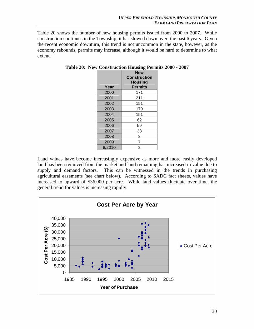
Table 20 shows the number of new housing permits issued from 2000 to 2007. While construction continues in the Township, it has slowed down over the past 6 years. Given the recent economic downturn, this trend is not uncommon in the state, however, as the economy rebounds, permits may increase, although it would be hard to determine to what extent.
Table 20: New Construction Housing Permits 2000 - 2007
Year
New Construction
Housing Permits
2000 171 2001 211 2002 151 2003 179 2004 151 2005 62 2006 59 2007 33 2008 8 2009 7
8/2010 3 Land values have become increasingly expensive as more and more easily developed land has been removed from the market and land remaining has increased in value due to supply and demand factors. This can be witnessed in the trends in purchasing agricultural easements (see chart below). According to SADC fact sheets, values have increased to upward of $36,000 per acre. While land values fluctuate over time, the general trend for values is increasing rapidly.
Cost Per Acre by Year
0
5,000
10,000
15,000
20,000
25,000
30,000
35,000
40,000
1985 1990 1995 2000 2005 2010 2015
Year of Purchase
Co
st
Pe
r A
cre
($
)
Cost Per Acre
30
UPPER FREEHOLD TOWNSHIP, MONMOUTH COUNTY FARMLAND PRESERVATION PLAN
G. TDR Opportunities Transfer of Development Rights (TDR) is a planning tool that allows the movement of development rights from an area where development is not suitable or encouraged (sending area) to an area where development is more compatible (receiving area). TDR programs allow land owners to profit from the sale of the right to develop their land while moving that development to more suitable areas. The goal of a TDR program is to channel development away from valuable resource areas to areas where development is more suitable. There are currently three TDR programs in place on the State level: through the State TDR Program and through the Highlands and Pinelands regulations. The Monmouth County Farmland Plan states that the New Jersey State Transfer of Development Rights Act (N.J.S.A. 40:55D-140) authorizes the transfer of development rights by municipalities and outlines procedures to adopt or amend a TDR ordinance. As mentioned previously, the Township continues to investigate the possibility of creating a TDR program but to date has not found an appropriate level on which to create a TDR program. To create such opportunities would require a significant investment in educating the public and elected officials about TDR and its benefits. Such an investment would have to be supported by state, county and municipal entities, with no guarantee that effort would result in the acceptance of TDR. An inter-municipal TDR may prove to be more palatable in Upper Freehold where development is transferred out of the municipality to a receiving municipal; however, while statutes permit inter-municipal TDR, no such programs exist in the region. Assistance from the state and Monmouth County is needed to help establish such a program. The NJ Pinelands Comprehensive Management Plan includes a Pinelands Development Credit (PDC) program, which functions as a TDR program. PDCs are development rights which are allocated to certain lands (“sending areas”) that can be transferred to increase the amount of residential development permitted on other lands (“receiving areas”). PDC’s originate in the Pinelands Preservation Areas, Special Production Agricultural Areas, and Agriculture Production Areas. When severed from these lands, PDC’s are redeemable in infrastructure-supported “Regional Growth Areas”. Each credit is worth four residential units and can be used to increase development densities in the Regional Growth Areas. The Pinelands PDCs program has been in existence for approximately 25 years. During the first several years of the program, PDC activity was almost non-existent and PDC values were very low. In more recent years, as the use of PDC became common and in some cases necessary for development, PDC values rapidly increased and voluntary landowner participation in the sale of their PDC’s increased dramatically with 50,855 acres preserved as of 2009. Other recent TDR programs are beginning to show increased momentum for the program. Chesterfield and Lumberton have also been participating under the Burlington County TDR Demonstration Act and Woolwich in Gloucester County has enacted a TDR ordinance under the State’s TDR Act.
31
UPPER FREEHOLD TOWNSHIP, MONMOUTH COUNTY FARMLAND PRESERVATION PLAN
The Township has not been able to gather interest at this time for a TDR program. The Township’s large agricultural base and willingness of farmers to enter the farmland preservation program has been able to secure valuable agricultural resources without the need for local expenditures to make such a program viable. However, as land values rebound and resources become limited, the use of a TDR program may be able to augment current patterns of preservation.
32
UPPER FREEHOLD TOWNSHIP, MONMOUTH COUNTY FARMLAND PRESERVATION PLAN
IV. Upper Freehold Township’s Plan to Preserve Farmland A. Monmouth County Agricultural Development Areas Monmouth County tries to ensure the long-term viability of agriculture when selecting ADA areas. In order for the County to designate an ADA, the following criteria must be met:
1. Land consists of a parcel or group of reasonably contiguous parcels with a minimum total area of 50 acres and which are currently in agricultural production or have a strong potential for future production.
2. Land is not already committed to non-agricultural development. 3. Land meets the statutory criteria for the identification of ADAs:
a. “Encompasses productive agricultural lands which are currently in production or have a strong potential for future production in agriculture and in which agriculture is a permitted use under the current municipal zoning ordinance or in which agriculture is permitted as a non-conforming use.” b. “Is reasonably free of suburban and conflicting commercial development.” c. “Comprises not greater than 90 percent of the agricultural land mass of the county.”
d. “Incorporates any other characteristics deemed appropriate by the board.” (See Requirements 1 and 2 above)
The Monmouth County Comprehensive Farmland Preservation Plan has identified the Upper Freehold ADA which encompasses most of the Township and is aligned with the Upper Freehold Township project area (Figure 6). B. Upper Freehold Township Preserved Farmland The Township has currently preserved 79 farms totaling over 8,136 acres of farmland through municipal, county and state purchase programs making Upper Freehold one of the Garden State’s farmland preservation leading municipalities. Table 21 identifies these farms by acquisition type.
Table 21: Preserved Farmland by Acquisition Type
Type of Acquisition Number of
Farms Acres
Monmouth County Easement Purchase Program
63 6,660.5
County Planning Incentive Grant Program
1 136.6
Municipal Planning Incentive Grant Program
6 526.6
State Direct Easement 6 768.3
Fee Simple (State) 1 12
8-Year Program 2 32.5
TOTAL 79 8,136.5
33
UPPER FREEHOLD TOWNSHIP, MONMOUTH COUNTY FARMLAND PRESERVATION PLAN
The following sections will identify the various types of farmland preservation programs and those utilized by the Township. 1. County Easement Purchase The County Easement Purchase Program allows a farmer to sell their development rights to the County but retains ownership of the farm and is able to continue to farm the land and even sell the property at any time with a deed restriction preventing any future development. In order to enter into the program a landowner must submit and application to the County Agriculture Development Board where it is reviewed and submitted to SADC. Two independent appraisals of the property are conducted to determine the land’s fair market value. The SADC Cost Share generally ranges from 60% to 80% (based on a “sliding scale” that decreases SADC cost share as easement prices increase (N.J.A.C. 2:76-6.11(d)1) based on a before and after appraisal process. Once the SADC certifies the development easement values, landowners have 30 days to submit their offers. This has been the most widely used approach to farmland preservation in Upper Freehold Township. As seen on the previous Table 21, 63 farms totaling 6,660 acres have been preserved using this method. 2. County Planning Incentive Grants The goal of County Planning Incentive Grants (PIGs) is to protect and preserve large pieces of contiguous farmland through the purchase of development easements. This program was created by legislation (N.J.S.A. 4:1C-43.1) on August 12, 1999 and revised by a comprehensive regulatory amendment on July 2, 2007 in an effort to revamp the process of preserving farms at the county level. The State Agriculture Development Committee (SADC) has updated their rules (NJAC 2:76-6.3 through 2:76-17A.17) to promote County PIGs to streamline and expand the farmland preservation program throughout the state. Monmouth County adopted the Monmouth County Comprehensive Farmland Preservation Plan in 2008 and funding became available as a result of the November, 2007 and November 2009 State bond referenda. This program is operated in a similar way to the Municipal Planning Incentive Grant Program in that it gives the county more flexibility to preserve those farms that meet the specific preservation needs and goals of the county in promoting the long term viability of agriculture as an industry in the county. The County Planning Incentive Grant program encourages a comprehensive planning process for farmland preservation at the county level. The program enables counties to accept and process farmland preservation applications year-round, rather than once a year; reducing the timeframe from landowner application to closing; and rewarding counties that complete transactions in a timely manner with the potential for additional funding. In order to qualify for County PIGs, the County must create an agricultural development board and must also maintain a dedicated funding source to purchase farmland. County PIG’s require that the County and Township applications correlate
34
UPPER FREEHOLD TOWNSHIP, MONMOUTH COUNTY FARMLAND PRESERVATION PLAN
with county comprehensive farmland preservation plans. Upper Freehold is developing this Comprehensive Farmland Preservation Plan in order to conform to these regulations. To date, the Township has preserved 136.6 acres through the County PIG program. 3. Municipal Planning Incentive Grants The Municipal Planning Incentive Grants (PIG’s), like the County PIG’s program, have similar requirements. Municipal PIG’s require the adoption of a Farmland Preservation Plan, an Agricultural Advisory Committee and a standing financial commitment for preserving farmland. Grants for a municipal PIG are provided by the SADC to purchase development easements. As identified in this Plan, several target farms have been identified by the Township for future preservation efforts. These targets will continue to be updated as farmer interest changes and farms are either preserved or removed for ineligibility. Monmouth County provides matching funding based on the SADC cost share percentage (e.g. if the SADC pays 60% of the easement cost, the County pays 60% of the remaining 40% or 24% and the municipality pays the balance or 16% of the total cost) between the County and the municipality, as part of a municipal PIG. In addition, this program requires a dedicated source of funding or a demonstrated funding commitment. The Township has preserved 526 acres through the Municipal PIG program to date. One of those farms was the approximately 50 acre former Hudler farm. The Township pre-acquired this farm in fee, placed an agriculture development easement over the land and then auctioned off the farm to a local farmer. The Municipal PIG program was used by the Township to obtain a grant from the SADC for 60% of the value of the development rights to the Hudler Farm. 4. SADC State Acquisition
SADC Direct Easement Purchase Another option for farmland preservation is the SADC Direct Easement Program. The SADC purchases development rights or farmland outright for preservation purposes under its state acquisition program. Landowners can either sell the development rights to their land and continue to own and farm the land, or sell their land outright. In both cases, the land is permanently deed-restricted for agricultural use. The SADC provides direct cost share funding to purchase farms and development easements from landowners. In most cases, the State will pay up to 100% of the certified appraised easement value or a negotiated value in the direct easement and the fee simple purchase programs. Applications will be accepted year-round. An applicant farm that is strategically located and meets or exceeds the minimum criteria for size and quality score will qualify for immediate consideration for preservation. The SADC and landowner will enter into a 120-day option agreement in which the landowner agrees not to market the property for that time period. This provides time for two independent appraisers to evaluate the land. Based on the findings of those appraisers and the recommendations of its own review appraiser, the SADC will certify a fair-market value and make an offer. If the offer is accepted, the landowner and SADC will enter into a sale agreement. The SADC will order a survey and title search and work directly with the landowner through closing. The landowners can sell development rights directly to SADC and farms must be eligible
35
UPPER FREEHOLD TOWNSHIP, MONMOUTH COUNTY FARMLAND PRESERVATION PLAN
for Farmland Assessment and should typically be in an ADA. Farms should be of superior quality, or of statewide significance, and have a threat of development. Once verification of the farms significance is determined two independent appraisals are conducted and reviewed by the state. The Township has preserved 768 acres using the Direct Easement purchase. 5. SADC Fee Simple The SADC fee simple acquisition program involves an entire property being purchased directly by the state. The SADC pays the survey and title costs, the landowner is exempt from paying rollback taxes for farmland assessment and the transaction can be completed in a matter of months. The SADC negotiates a purchase price subject to recommendations of two independent appraisers and review by a state review appraiser. The land becomes restricted so that it becomes permanently preserved for agriculture. In this type of acquisition, the landowner does not retain any rights. In most cases, the SADC resells the deed-restricted the property at auction. To qualify to participate in this program, the farmland must be within an ADA and be eligible for Farmland Assessment. There has been one farm (12 acres) purchased using this program in the Township. 6. Nonprofit The (SADC) provides grants to nonprofit organizations to fund up to 50 percent of the fee simple or development easement values on farms to ensure their permanent preservation. Nonprofit organizations should apply to the SADC. Notice of available funds will be published in the New Jersey Register. Applications must be submitted within 90 days of that notice. Nonprofit groups also must publish a notice that an application has been filed and notify the municipality and county agriculture development board. The SADC reviews and ranks applications based on the following criteria: percentage of high-quality soils; percentage of tillable acres; suitable boundaries and buffers, such as other nearby preserved farms and open space; the local commitment to agriculture (e.g., right to farm ordinances, community financial support); size of the farm; agricultural density of the area, and imminence of development. Upper Freehold Township has contracted with Monmouth Conservation Foundation (MCF) and D&R Greenway for their assistance in the preservation of lands through Farmland Preservation and other programs. Monmouth Conservation Foundation assists on a day to day basis in contacting interested property owners and negotiating with applicants. In order to expedite projects the non-profits work with the applicants to obtain their applications, order appraisals, and surveys. Monmouth Conservation Foundation has also worked with the Township to provide information on tax and financial options for those considering preservation of their land. Monmouth Conservation Foundation has also hosted several sessions on use of the Installment Purchase Agreement as a method of land preservation. To date, no farms have been preserved through this program in Upper Freehold, but MCF is working closely with the township to generate eligible applications for the program.
36
UPPER FREEHOLD TOWNSHIP, MONMOUTH COUNTY FARMLAND PRESERVATION PLAN
7. Transfer of Development Rights The transfer of development rights is a growth management tool that transfers development rights from one location, a preservation area, to another, an identified growth area. The development rights are used to allow for development at a higher density than what the previous zoning of the receiving area allowed. To date, this program has not been used to preserve farmland in the Township. C. Consistency with the SADC Strategic Targeting Project The purpose of the SADC Strategic Targeting Project is to prioritize farmland to be preserved by targeting farms for preservation based on specific criteria, including the prioritization of prime and statewide soils in agricultural production outside sewer service areas. According to the SADC, the Strategic Targeting Project has three primary goals. These are as follows:
The coordination of farmland preservation and retention of agricultural practices “with proactive planning initiatives.”
To update and create maps which serve as a tool for more accurate preservation targets.
To coordinate different preservation efforts, such as open space, with farmland preservation.
Through the use of the Strategic Targeting Program, the SADC hopes to more efficiently target and designate farmland for preservation and, by doing so, boost the State’s agricultural industry. Upper Freehold Township has identified target farms that meet the SADC primary goals (Figure 6). In addition, the Township continues to update all available information, through GIS, statistical data and the like, in order to maintain a data base of potential target farms for preservation efforts. Upper Freehold Township, through the AAC, has maintained a strong relationship with the County Agriculture Development Board and SADC through continuous updates of the municipal PIG and efforts to preserve farmland. The Township’s successful efforts with both the County and State have led to the successful preservation of farmland. The Township, through the AAC, continues their efforts to preserve as much of the remaining farmland in the Township as possible. Continued support and outreach to the CADB and SADC is a mainstay of the Township’s plan to preserve farmland. D. Eight Year Programs
The 8-Year Farmland Preservation Program is a temporary preservation program option that provides eligibility to soil and water conservation cost share grants and other benefits. Farmland owners agree to voluntarily restrict nonagricultural development for a period of eight years in exchange for certain benefits. There are two types of eight-year programs: municipally approved programs, which require a formal agreement among the landowner, county and municipality, and non-municipally approved programs, which require an agreement between only the landowner and county.
37
UPPER FREEHOLD TOWNSHIP, MONMOUTH COUNTY FARMLAND PRESERVATION PLAN
Landowners apply to their county agriculture development board. Land must be located in an Agricultural Development Area, be eligible for Farmland Assessment and meet local and/or county program criteria. Landowners enrolled in both municipally and non-municipally approved programs receive no direct compensation for participating but are eligible to apply to the State Agriculture Development Committee (SADC) for grants that fund up to 50 percent of the costs of approved soil and water conservation projects. Additionally, those in municipally approved programs enjoy greater protections from nuisance complaints, emergency fuel and water rationing, zoning changes and eminent domain actions. An eight-year agreement is recorded with the county clerk in the same manner as a deed. The Township has preserved two farms (32 acres) using this method. E. Coordination with Open Space Preservation Initiatives Upper Freehold Township has partnered with Green Acres and Monmouth County to preserve key properties in the Township. Partnering with a variety of agencies allows the Township to leverage funds from various sources to help achieve open space preservation. As seen on Figure 6, Monmouth County and the State both hold the rights to a number of large parcels in the Township. These parcels help to create larger contiguous tracts of land along the stream corridors, such as Crosswicks, and help to maintain the rural character that is cherished by Township Residents. These areas also help to promote agriculture by preserving large areas along side actively farmed lands, creating a larger buffer between farms and more developed regions. The Township will continue to support the preservation of open space, especially if it is able to compliment farmland preservation efforts. The Township also created the Upper Freehold Vision/Scenic Byway Committee that submitted a nomination package to the New Jersey Scenic Byway Program for the Upper Freehold Historic Farmland Byway in July of 2006. The Monmouth County Planning Board helped prepare the document and accompanying maps. The goal of the scenic byway is to showcase the historic and agricultural heritage of Allentown and Upper Freehold to the public. The main route starts in Allentown, traverses portions of Route 524, Rues Road, Route 526, Burlington Path Road, Holmes Mill Road, and Hill Road, and ends at Historic Walnford which would wind travelers through the historic, scenic and cultural areas of the Township and highlight the valuable attributes cherished by Township residents. At this time, the Historic Farmland Byway is still in conceptual phase but the Township continues its endeavor to create the byway. Also in 2004, Upper Freehold Township Open Space Committee prepared a study to examine establishing a unified trail system. The goals and objectives of a multi-use trail system were to:
1. Identify, promote and preserve a network of shared use trails in Upper Freehold Township, which will interconnect municipal, county and state recreation areas and provide pedestrian access to historical landmarks and natural resources within and around the Township
38
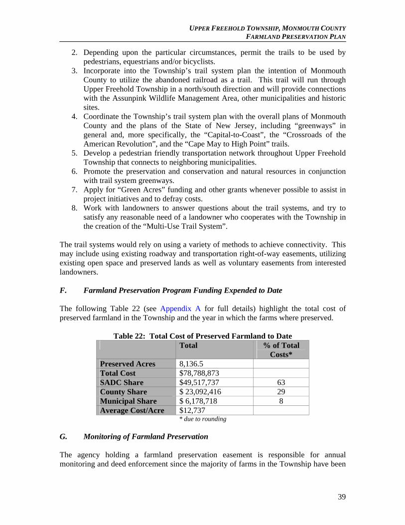
UPPER FREEHOLD TOWNSHIP, MONMOUTH COUNTY FARMLAND PRESERVATION PLAN
2. Depending upon the particular circumstances, permit the trails to be used by pedestrians, equestrians and/or bicyclists.
3. Incorporate into the Township’s trail system plan the intention of Monmouth County to utilize the abandoned railroad as a trail. This trail will run through Upper Freehold Township in a north/south direction and will provide connections with the Assunpink Wildlife Management Area, other municipalities and historic sites.
4. Coordinate the Township’s trail system plan with the overall plans of Monmouth County and the plans of the State of New Jersey, including “greenways” in general and, more specifically, the “Capital-to-Coast”, the “Crossroads of the American Revolution”, and the “Cape May to High Point” trails.
5. Develop a pedestrian friendly transportation network throughout Upper Freehold Township that connects to neighboring municipalities.
6. Promote the preservation and conservation and natural resources in conjunction with trail system greenways.
7. Apply for “Green Acres” funding and other grants whenever possible to assist in project initiatives and to defray costs.
8. Work with landowners to answer questions about the trail systems, and try to satisfy any reasonable need of a landowner who cooperates with the Township in the creation of the “Multi-Use Trail System”.
The trail systems would rely on using a variety of methods to achieve connectivity. This may include using existing roadway and transportation right-of-way easements, utilizing existing open space and preserved lands as well as voluntary easements from interested landowners. F. Farmland Preservation Program Funding Expended to Date The following Table 22 (see Appendix A for full details) highlight the total cost of preserved farmland in the Township and the year in which the farms where preserved.
Table 22: Total Cost of Preserved Farmland to Date Total % of Total
Costs* Preserved Acres 8,136.5 Total Cost $78,788,873 SADC Share $49,517,737 63 County Share $ 23,092,416 29 Municipal Share $ 6,178,718 8 Average Cost/Acre $12,737
* due to rounding G. Monitoring of Farmland Preservation The agency holding a farmland preservation easement is responsible for annual monitoring and deed enforcement since the majority of farms in the Township have been
39

UPPER FREEHOLD TOWNSHIP, MONMOUTH COUNTY FARMLAND PRESERVATION PLAN
preserved through the County Programs, the County conducts annual monitoring of property preserved through the County programs including the Municipal PIG program, if the County is a funding partner. If the Township receives reports or suspects that a property is in violation, notification to the County, or the appropriate agency, will be filed. For lands preserved through the State Acquisition Program options (SADC Direct Easement or Fee Simple), the SADC monitors the properties. The Monmouth County Agriculture Development Board staff is in charge of performing annual inspections of County preserved property. During inspections the inspector notes:
change in ownership since the previous inspection evidence of non-agricultural development (approved or otherwise) use of the premises for agricultural activities presence of expansion of non-agricultural activity since the previous inspection if the non-agricultural practice has been abandoned evidence of mining or removing of materials such as sand, gravel, rock, etc. evidence of dumping whether or not the farm has an approved conservation plan any improvements to farm buildings and residences any new agricultural buildings erected
H. Coordination with Transfer of Development Rights Programs
Transfer of Development Rights (TDR) may be used in conjunction with the traditional Purchase of Development Rights (PDR) program; these two programs are not mutually exclusive. Township has researched the feasibility of TDR in Upper Freehold, but has determined it to not be feasible at this time.
40
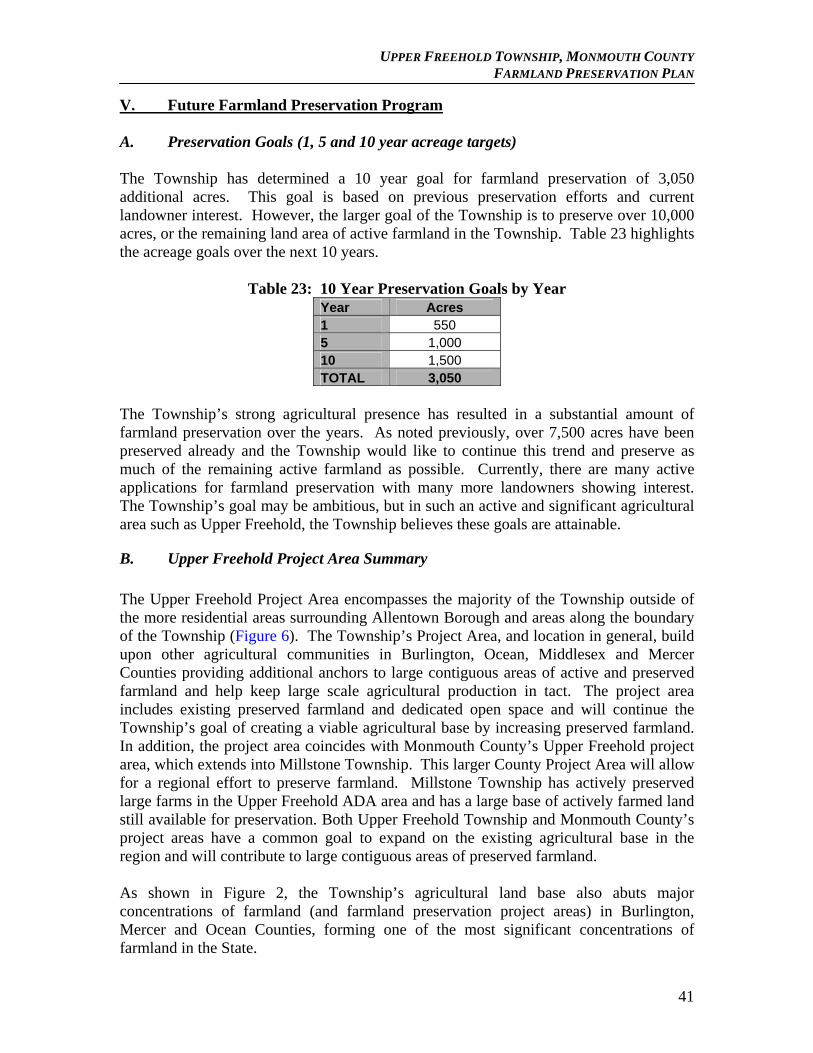
UPPER FREEHOLD TOWNSHIP, MONMOUTH COUNTY FARMLAND PRESERVATION PLAN
V. Future Farmland Preservation Program A. Preservation Goals (1, 5 and 10 year acreage targets) The Township has determined a 10 year goal for farmland preservation of 3,050 additional acres. This goal is based on previous preservation efforts and current landowner interest. However, the larger goal of the Township is to preserve over 10,000 acres, or the remaining land area of active farmland in the Township. Table 23 highlights the acreage goals over the next 10 years.
Table 23: 10 Year Preservation Goals by Year
Year Acres 1 550 5 1,000 10 1,500 TOTAL 3,050
The Township’s strong agricultural presence has resulted in a substantial amount of farmland preservation over the years. As noted previously, over 7,500 acres have been preserved already and the Township would like to continue this trend and preserve as much of the remaining active farmland as possible. Currently, there are many active applications for farmland preservation with many more landowners showing interest. The Township’s goal may be ambitious, but in such an active and significant agricultural area such as Upper Freehold, the Township believes these goals are attainable.
B. Upper Freehold Project Area Summary
The Upper Freehold Project Area encompasses the majority of the Township outside of the more residential areas surrounding Allentown Borough and areas along the boundary of the Township (Figure 6). The Township’s Project Area, and location in general, build upon other agricultural communities in Burlington, Ocean, Middlesex and Mercer Counties providing additional anchors to large contiguous areas of active and preserved farmland and help keep large scale agricultural production in tact. The project area includes existing preserved farmland and dedicated open space and will continue the Township’s goal of creating a viable agricultural base by increasing preserved farmland. In addition, the project area coincides with Monmouth County’s Upper Freehold project area, which extends into Millstone Township. This larger County Project Area will allow for a regional effort to preserve farmland. Millstone Township has actively preserved large farms in the Upper Freehold ADA area and has a large base of actively farmed land still available for preservation. Both Upper Freehold Township and Monmouth County’s project areas have a common goal to expand on the existing agricultural base in the region and will contribute to large contiguous areas of preserved farmland. As shown in Figure 2, the Township’s agricultural land base also abuts major concentrations of farmland (and farmland preservation project areas) in Burlington, Mercer and Ocean Counties, forming one of the most significant concentrations of farmland in the State.
41
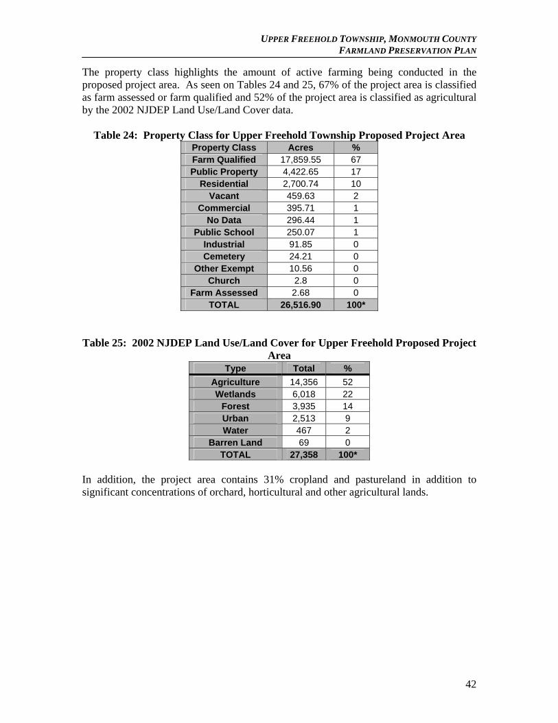
UPPER FREEHOLD TOWNSHIP, MONMOUTH COUNTY FARMLAND PRESERVATION PLAN
The property class highlights the amount of active farming being conducted in the proposed project area. As seen on Tables 24 and 25, 67% of the project area is classified as farm assessed or farm qualified and 52% of the project area is classified as agricultural by the 2002 NJDEP Land Use/Land Cover data.
Table 24: Property Class for Upper Freehold Township Proposed Project Area Property Class Acres % Farm Qualified 17,859.55 67 Public Property 4,422.65 17
Residential 2,700.74 10 Vacant 459.63 2
Commercial 395.71 1 No Data 296.44 1
Public School 250.07 1 Industrial 91.85 0 Cemetery 24.21 0
Other Exempt 10.56 0 Church 2.8 0
Farm Assessed 2.68 0 TOTAL 26,516.90 100*
Table 25: 2002 NJDEP Land Use/Land Cover for Upper Freehold Proposed Project
Area Type Total %
Agriculture 14,356 52 Wetlands 6,018 22
Forest 3,935 14 Urban 2,513 9 Water 467 2
Barren Land 69 0 TOTAL 27,358 100*
In addition, the project area contains 31% cropland and pastureland in addition to significant concentrations of orchard, horticultural and other agricultural lands.
42
UPPER FREEHOLD TOWNSHIP, MONMOUTH COUNTY FARMLAND PRESERVATION PLAN
Soils located in the project area are very conducive to agricultural activity. The project area is comprised of 81% farm capable soils (Table 26).
Table 26: Farm Capable Soils for Upper Freehold Proposed Project Area
Soil Acres % Acres in
Agricultural Areas
% in Agricultural
Areas Prime Soils 14,982 55 5,918 70 Statewide Important 6,870 25 1,862 22 Locally Important Soils 5 0 0 0 Unique Importance 166 1 5 0 Other 5,333 20 667 8 Total 27,356 101* 8,452 100
There are also 8,136 acres of preserved farmland located in the Project Area and 4,588 acres of public property, totaling 12,724 acres of preserved lands or 47% of the Project Area. The combination of these factors results in the Township’s focus on the Upper Freehold Project Area for future farmland preservation efforts. C. Municipal and County Minimum Eligibility Criteria Coordination Monmouth County and Upper Freehold Township utilize the same minimum eligibility criteria as the State. The State regulations (N.J.A.C. 2:76-6.20) set minimum eligibility criteria that all farms participating in farmland preservation must satisfy in order to obtain SADC funding. The criteria differentiate between farms that are less than or equal to 10 acres in size and farms that are greater than 10 acres in size. For lands less than or equal to 10 acres in size, the land must produce agricultural or horticultural products of at least $ 2,500 annually; at least 75 percent of the land must be tillable or a minimum of five acres, whichever is less; at least 75 percent of the land, or a minimum of five acres, whichever is less, must consist of soils that are capable of supporting agricultural or horticultural production; and the land must exhibit development potential based on certain standards. For lands greater than 10 acres in size, at least 50 percent of the land or a minimum of 25 acres, whichever is less, must be tillable; at least 50 percent of the land, or a minimum of 25 acres, whichever is less, must consist of soils that are capable of supporting agricultural or horticultural production; and the land must exhibit development potential based on standards set forth in the rule. Lands that do not meet the minimum criteria are not eligible for a State cost share grant for farmland preservation purposes. In addition to the above criteria, the County PIG requires that there be a minimum of 25 acres, or a location adjacent to preserved farmland, and a land evaluation score of at least 55 points to be eligible for the program. D. Municipal and County Ranking Criteria Used to Prioritize Farms Monmouth County and Upper Freehold utilize the SADC Ranking as outlined in the state regulations § 2:76-6.16 – Criteria for evaluating development easement applications. The evaluation is based on the merits of the individual application with a weighted factor
43
UPPER FREEHOLD TOWNSHIP, MONMOUTH COUNTY FARMLAND PRESERVATION PLAN
assigned to each criteria. These include soil quality, tillable acres, boundaries and buffers, local commitment, size of farm and density of lands dedicated to farmland preservation, local factors encouraging agriculture and threat of development. Upper Freehold Township has participated in various programs and has followed the criteria set by the State and County for each particular program. The Township will follow the State’s minimum eligibility requirements and ranking policies. In an effort to complete project areas and coordinate with the MCADB the Township may pursue some of the smaller farms that are adjacent to those already preserved and those the County has targeted. Since Monmouth County has established a minimum lot size of 25 acres; the Township will consider those between 10 and 25 acres if they connect project areas and the larger farms that did not appear on the County’s targeted list. Given current budget restrictions on State, County and local levels, prudent spending choices are necessary to ensure that funding is channeled in such a way as to provide for the greatest preservation effort. E. Municipal and County Policies Related to Farmland Preservation Applications The Township, as stated previously, abides by the SADC’s policies, including those regarding housing opportunities, division of premises and approval of exceptions. In general the Township has encouraged land owners seeking preservation to carefully consider future use in the event that the land owner may wish to build a new home or provide a lot for a family member. Providing for these areas prior to the farmland preservation application reduces future burden on the land owner in the event they decide to build a home or sell a residential lot. The Farmland Preservation deed restrictions do not allow for the non-agricultural development on preserved farmland after preservation has occurred. Also the Township does not generally encourage division of preserved farms, keeping in line with SADC and County policies. To date, land owners entering preservation have gone before the planning board to subdivide a portion of the existing farm lot in order to retain an area for future non-farm or housing opportunity. The remaining area has then entered into preservation. Approval of Housing Opportunities Housing opportunities needed on farms generally relate to the use of agricultural labor. Farms that raise vegetable crops that rely on manual harvest or equine farms where caretakers tend to horses are two areas where the need to have onsite housing maybe be needed on a seasonal or permanent basis. Agricultural labor housing is not currently protected in the State of New Jersey under the Right to Farm Act, but is recognized as a need by SADC. The SADC does have a policy that a landowner may refer to in order to construct labor housing. These applications are reviewed by the State Agriculture Development Committee and the County Agriculture Development Board. As identified previously, the primary farming activities in the Township are field crops such as grain, corn and hay and horse farms. Typically, the production of field crops does not require additional labor other than the land owner or the tenant. However, larger
44
UPPER FREEHOLD TOWNSHIP, MONMOUTH COUNTY FARMLAND PRESERVATION PLAN
horse farms may require permanent housing. Agricultural housing opportunities are permitted as an accessory use in the AR, RA-5 and Village Neighborhood districts.
House replacement Requests for replacement of a residence on permanently preserved land must be reviewed and approved on an individual basis by the CADB and the SADC. The Township would welcome review of any proposed house replacement and would encourage house replacement in order to further the long term farming activities on site. This may include the location of replacement houses that would reduce negative impacts to agricultural practices. Residual dwelling site opportunity allocation Residual Dwelling Site Opportunities (RDSOs) are potential housing sites located within a deed-restricted farm. A designated RDSO allows the landowner to identify a potential site for a future residential unit or other structure as referred to in N.J.A.C. 2:76-6.17. Residential units can be allocated to parcels that are over 100 acres in size and the density may not exceed 1 unit per 100 acres, including existing dwellings, and must be designated prior to preservation. The site must be for “single-family residential housing and its appurtenant uses.” To qualify as an RDSO, the SADC requires that the use of the residential unit be for agricultural purposes and “at least one person residing in the residential unit shall be regularly engaged in common farm site practices.” The Township encourages the use RDSO’s if the applicant intends at any time to provide for additional housing to a family member or themselves into the futures. Division of the Premises The goal of the SADC is to preserve large tracts of farmland and, therefore, a division of the premises is not an encouraged practice. A landowner wishing to divide permanently preserved farmland must submit a written request. SADC regulations require that the division must be for agricultural purpose and result in parcels that will support a variety of viable agricultural land uses. The application must be approved, in writing, by both the State Agriculture Development Committee and the CADB. To date, the Township has not witnessed this type of activity and would follow the SADC’s opinion and generally discourage a division of existing preserved farmland. Approval of Exception Exceptions are defined by the SADC as “acres within a farm being preserved” which are “not subject to the terms of the deed of easement.” When an exception is made, the landowner does not receive any compensation in the excepted area. Exceptions are not a practice that is generally encouraged by the SADC and, when they occur, it is recommended that they should be as small as possible with limited impact on the farming operation. The Township does not encourage this activity in general. There are two types of exceptions that can occur; severable and non-severable.
45
UPPER FREEHOLD TOWNSHIP, MONMOUTH COUNTY FARMLAND PRESERVATION PLAN
Severable: A severable exception is defined by the SADC as an “area which is part of an existing Block and Lot owned by the applicant which will be excluded from the restrictions of the Deed of Easement and may be sold as a separate lot in the future.” A severable exception is made “if a landowner wants to be able to sell the excepted area separate from the deed-restricted farm.”
Non-severable: Non-severable exceptions are defined by the SADC as an “area which is part of an existing Block and Lot owned by the applicant that will not be subject to the restrictions of the Deed of Easement but cannot be sold separately from the remaining premises.” Unlike a severable exception, a nonseverable exception is “always attached to the protected farm.” Exceptions made to farmland have the potential to impact the value of the property. When an appraisal occurs, both severable and non-severable exceptions are considered in the determination of the restricted/ after value of the property.”
F. Funding Plan 1. Description of Municipal and County Funding Sources The Township has funded the preservation of farmland using a variety of methods. The most important and stable source is the money leveraged from the Township’s adopted Open Space and Farmland Preservation tax which is currently $0.04 per $100 of assessed value. The tax leveraged $528,207.25 in 2007.
Table 27: Funds Leveraged from Open Space Tax
Year Amount
Realized in Cash ($)
2001 154,366 2002 176,492 2003 201,676 2004 237,884 2005 260,528 2006 526,017 2007 528,207
This fund has often been used to preserve both farmland and other open space and cultural parcels and will continue to fund preservation efforts.
46
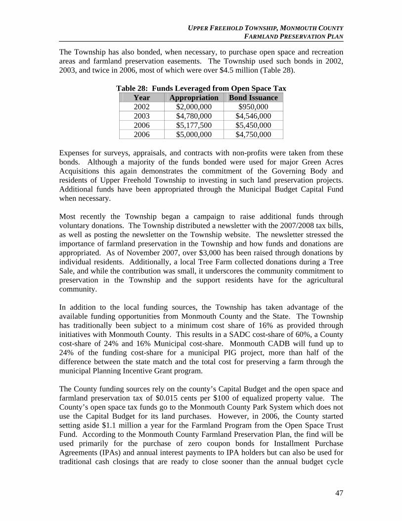
UPPER FREEHOLD TOWNSHIP, MONMOUTH COUNTY FARMLAND PRESERVATION PLAN
The Township has also bonded, when necessary, to purchase open space and recreation areas and farmland preservation easements. The Township used such bonds in 2002, 2003, and twice in 2006, most of which were over $4.5 million (Table 28).
Table 28: Funds Leveraged from Open Space Tax Year Appropriation Bond Issuance 2002 $2,000,000 $950,000 2003 $4,780,000 $4,546,000 2006 $5,177,500 $5,450,000 2006 $5,000,000 $4,750,000
Expenses for surveys, appraisals, and contracts with non-profits were taken from these bonds. Although a majority of the funds bonded were used for major Green Acres Acquisitions this again demonstrates the commitment of the Governing Body and residents of Upper Freehold Township to investing in such land preservation projects. Additional funds have been appropriated through the Municipal Budget Capital Fund when necessary.
Most recently the Township began a campaign to raise additional funds through voluntary donations. The Township distributed a newsletter with the 2007/2008 tax bills, as well as posting the newsletter on the Township website. The newsletter stressed the importance of farmland preservation in the Township and how funds and donations are appropriated. As of November 2007, over $3,000 has been raised through donations by individual residents. Additionally, a local Tree Farm collected donations during a Tree Sale, and while the contribution was small, it underscores the community commitment to preservation in the Township and the support residents have for the agricultural community.
In addition to the local funding sources, the Township has taken advantage of the available funding opportunities from Monmouth County and the State. The Township has traditionally been subject to a minimum cost share of 16% as provided through initiatives with Monmouth County. This results in a SADC cost-share of 60%, a County cost-share of 24% and 16% Municipal cost-share. Monmouth CADB will fund up to 24% of the funding cost-share for a municipal PIG project, more than half of the difference between the state match and the total cost for preserving a farm through the municipal Planning Incentive Grant program. The County funding sources rely on the county’s Capital Budget and the open space and farmland preservation tax of $0.015 cents per $100 of equalized property value. The County’s open space tax funds go to the Monmouth County Park System which does not use the Capital Budget for its land purchases. However, in 2006, the County started setting aside $1.1 million a year for the Farmland Program from the Open Space Trust Fund. According to the Monmouth County Farmland Preservation Plan, the find will be used primarily for the purchase of zero coupon bonds for Installment Purchase Agreements (IPAs) and annual interest payments to IPA holders but can also be used for traditional cash closings that are ready to close sooner than the annual budget cycle
47
UPPER FREEHOLD TOWNSHIP, MONMOUTH COUNTY FARMLAND PRESERVATION PLAN
allows. In addition, Monmouth County periodically bonds for open space projects. The County Farmland Program hopes to jointly coordinate with the Monmouth County Park System for the next bond, which is several years away. The amount of funding available from the County is dependant on the overall size of the farm and the location of the farm in relation to other preserved farmland or other preserved open space areas. SADC also employs a sliding scale funding policy on a per acre easement value, which depends on the overall cost per acre easement value, farm size and criteria ranking. The Township will continue to partner with the County to leverage funds for the preservation of farmland. In the event funding is not available from the County, the Township may consider covering the County’s share if deemed necessary and will utilize dedicated sources of funding to do so, such as the Open Space Tax and bonding. However, this would be done only on a case by case basis.
Finally, the Township has been working with the Office of Smart Growth and with NJ Association of Environmental Commissions to explore a Transfer of Development Rights Program that would support and encourage the preservation of the Township’s remaining large farms. The Township participated in a study commissioned by the Monmouth Conservation Foundation in 1998 and completed by the American Farmland Trust. The finding of this study proved that farms and open land are good for the local tax base; the farms in particular continue to contribute taxes while requiring very little in costly municipal services. The report demonstrates that at the 1997 tax rate, farmland cost the municipality only 35¢ of every dollar collected. If the preservation of Upper Freehold Township is slowed down because of either a lack of funding or lack of interested property owners; the land will eventually be developed. As the study demonstrated both commercial and residential development will have a severe impact on the fiscal stability of this community, demanding more in public services than the taxes paid. Along with such development will come the increase in traffic, pollution, need for additional emergency services, schools, and public accommodations. 2. Financial Policies
Upper Freehold Township's plan for farmland preservation for the Project Area will combine a variety of techniques to encourage as many landowners as possible to preserve their farms. These efforts will include encouraging farmers to enter their farms into Municipally Approved Eight-Year Farmland Preservation Programs, entering into option agreements for easement purchase with landowners, installment purchase agreements and direct development easement purchase. Preservation of all farms in the Project Area is being sought for this application. Assuming inclusion in the PIG budget, including local, county and state contributions, it is hoped that the majority of parcels identified can be preserved. This total amount can be expanded through the use of option agreements and installment purchases, which will be determined after negotiations with landowners.
48
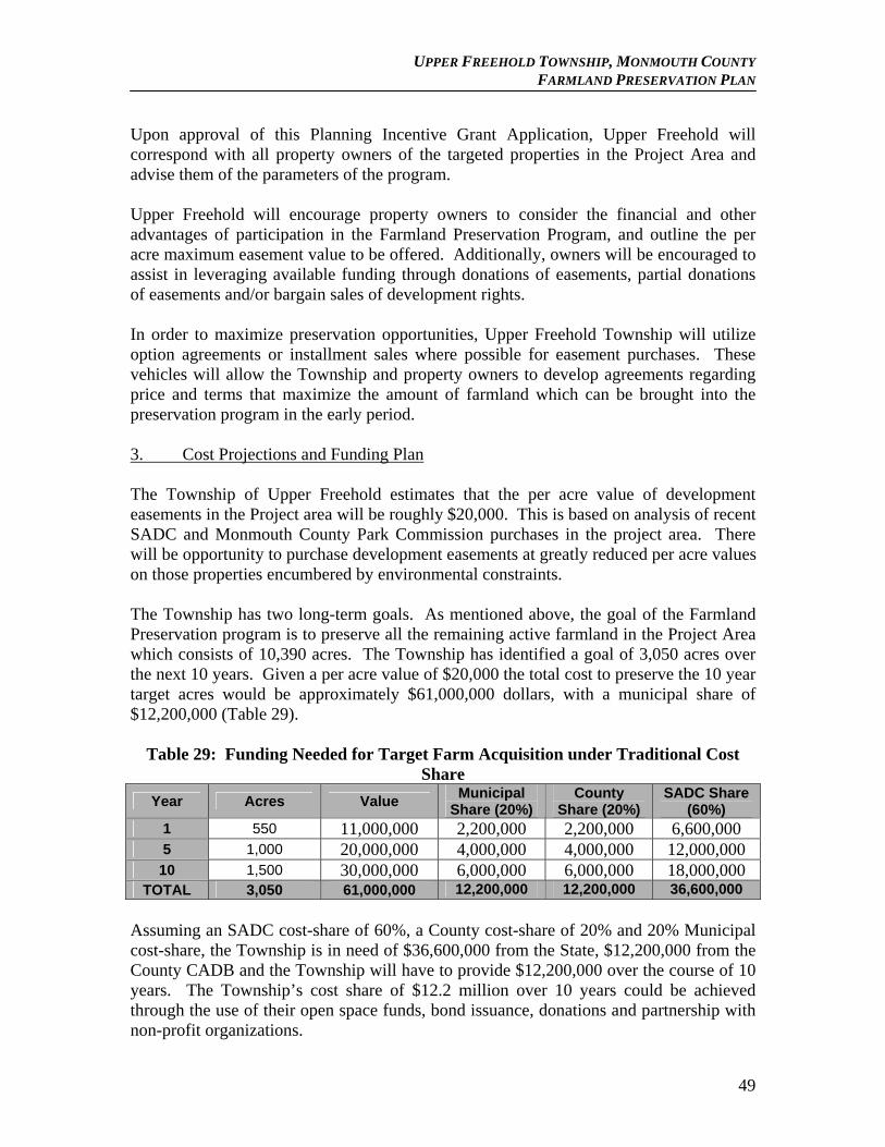
UPPER FREEHOLD TOWNSHIP, MONMOUTH COUNTY FARMLAND PRESERVATION PLAN
Upon approval of this Planning Incentive Grant Application, Upper Freehold will correspond with all property owners of the targeted properties in the Project Area and advise them of the parameters of the program. Upper Freehold will encourage property owners to consider the financial and other advantages of participation in the Farmland Preservation Program, and outline the per acre maximum easement value to be offered. Additionally, owners will be encouraged to assist in leveraging available funding through donations of easements, partial donations of easements and/or bargain sales of development rights. In order to maximize preservation opportunities, Upper Freehold Township will utilize option agreements or installment sales where possible for easement purchases. These vehicles will allow the Township and property owners to develop agreements regarding price and terms that maximize the amount of farmland which can be brought into the preservation program in the early period. 3. Cost Projections and Funding Plan The Township of Upper Freehold estimates that the per acre value of development easements in the Project area will be roughly $20,000. This is based on analysis of recent SADC and Monmouth County Park Commission purchases in the project area. There will be opportunity to purchase development easements at greatly reduced per acre values on those properties encumbered by environmental constraints. The Township has two long-term goals. As mentioned above, the goal of the Farmland Preservation program is to preserve all the remaining active farmland in the Project Area which consists of 10,390 acres. The Township has identified a goal of 3,050 acres over the next 10 years. Given a per acre value of $20,000 the total cost to preserve the 10 year target acres would be approximately $61,000,000 dollars, with a municipal share of $12,200,000 (Table 29).
Table 29: Funding Needed for Target Farm Acquisition under Traditional Cost Share
Year Acres Value Municipal
Share (20%) County
Share (20%) SADC Share
(60%) 1 550 11,000,000 2,200,000 2,200,000 6,600,000 5 1,000 20,000,000 4,000,000 4,000,000 12,000,000
10 1,500 30,000,000 6,000,000 6,000,000 18,000,000 TOTAL 3,050 61,000,000 12,200,000 12,200,000 36,600,000
Assuming an SADC cost-share of 60%, a County cost-share of 20% and 20% Municipal cost-share, the Township is in need of $36,600,000 from the State, $12,200,000 from the County CADB and the Township will have to provide $12,200,000 over the course of 10 years. The Township’s cost share of $12.2 million over 10 years could be achieved through the use of their open space funds, bond issuance, donations and partnership with non-profit organizations.
49
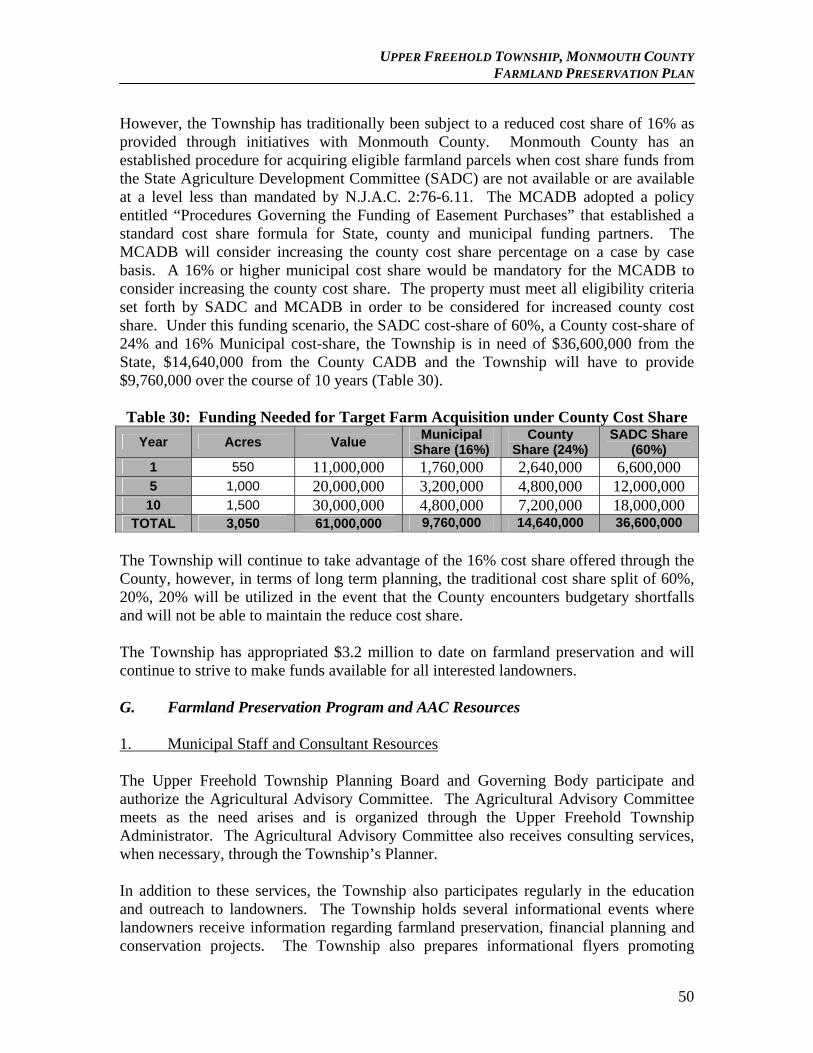
UPPER FREEHOLD TOWNSHIP, MONMOUTH COUNTY FARMLAND PRESERVATION PLAN
However, the Township has traditionally been subject to a reduced cost share of 16% as provided through initiatives with Monmouth County. Monmouth County has an established procedure for acquiring eligible farmland parcels when cost share funds from the State Agriculture Development Committee (SADC) are not available or are available at a level less than mandated by N.J.A.C. 2:76-6.11. The MCADB adopted a policy entitled “Procedures Governing the Funding of Easement Purchases” that established a standard cost share formula for State, county and municipal funding partners. The MCADB will consider increasing the county cost share percentage on a case by case basis. A 16% or higher municipal cost share would be mandatory for the MCADB to consider increasing the county cost share. The property must meet all eligibility criteria set forth by SADC and MCADB in order to be considered for increased county cost share. Under this funding scenario, the SADC cost-share of 60%, a County cost-share of 24% and 16% Municipal cost-share, the Township is in need of $36,600,000 from the State, $14,640,000 from the County CADB and the Township will have to provide $9,760,000 over the course of 10 years (Table 30). Table 30: Funding Needed for Target Farm Acquisition under County Cost Share
Year Acres Value Municipal
Share (16%) County
Share (24%) SADC Share
(60%) 1 550 11,000,000 1,760,000 2,640,000 6,600,000 5 1,000 20,000,000 3,200,000 4,800,000 12,000,000
10 1,500 30,000,000 4,800,000 7,200,000 18,000,000 TOTAL 3,050 61,000,000 9,760,000 14,640,000 36,600,000
The Township will continue to take advantage of the 16% cost share offered through the County, however, in terms of long term planning, the traditional cost share split of 60%, 20%, 20% will be utilized in the event that the County encounters budgetary shortfalls and will not be able to maintain the reduce cost share. The Township has appropriated $3.2 million to date on farmland preservation and will continue to strive to make funds available for all interested landowners. G. Farmland Preservation Program and AAC Resources 1. Municipal Staff and Consultant Resources The Upper Freehold Township Planning Board and Governing Body participate and authorize the Agricultural Advisory Committee. The Agricultural Advisory Committee meets as the need arises and is organized through the Upper Freehold Township Administrator. The Agricultural Advisory Committee also receives consulting services, when necessary, through the Township’s Planner. In addition to these services, the Township also participates regularly in the education and outreach to landowners. The Township holds several informational events where landowners receive information regarding farmland preservation, financial planning and conservation projects. The Township also prepares informational flyers promoting
50
UPPER FREEHOLD TOWNSHIP, MONMOUTH COUNTY FARMLAND PRESERVATION PLAN
farmland preservation and encourages landowners to contact the Township Administrator for more information. 2. Legal support Legal support for the Township’s farmland preservation program is provided by the Township’s Attorney, Granville D. Magee, Esq. 3. Database Development and Geographic Information System Resources The Township’s Planning Consultant, currently provide database management, mapping and GIS resources for the Township. The Township also has GIS capability through the County Planning Department if needed. H. Factors Limiting Farmland Preservation Implementation 1. Funding Funding for the Farmland Preservation Program is the only limiting factor for future preservation efforts in the Township. The goals for the Township to reach 10,500 acres in ten (10) years are dependent upon the funding sources. With the ability of both the Municipality, County, and Non-Profits to submit PIG applications it would appear to be a realistic goal. The State share on each of these programs rests with the continued funding of the Garden State Preservation Trust. Residents of Upper Freehold Township are being asked to support State Funding, County Open Space taxes, local bond ordinances, and a local tax levy and they have continually supported these measures, however, the tide has been turning and the overwhelming numbers supporting these actions has been declining. At the present time the Township is covering State funds that are unavailable at this time to ensure the preservation of several “at risk” farms. 2. Projected Costs The Township has been able to identify a reasonable per acre value that can be projected out through the 10 year funding cycle. Given the estimated $20,000 per acre easement value and the amount of income generated in the Township for preservation efforts, the Township should be able to meet its preservation goals. 3. Land Supply The Township retains a healthy and viable agricultural community. Large scale farms still dominate the landscape. The Township is ranked 2nd in the state for farm assessed acres with over 19,000 acres in active farmland and pasture. Land Supply is not a limiting factor for farmland preservation in the Township.
51
UPPER FREEHOLD TOWNSHIP, MONMOUTH COUNTY FARMLAND PRESERVATION PLAN
4. Landowner Interest Upper Freehold is fortunate to still have actively farmed areas with land owners dedicated to the promotion of farmland preservation and agricultural retention. The Township continues to have land owners display interest in placing their land in farmland preservation. This constant interest in local farmers has resulted in a large amount of lands being entered into the preservation program. Landowner interest in not a limiting factor in the preservation program. 5. Administrative Resources The Agricultural Advisory Committee and Township Administrator have been extremely helpful in the promotion and execution of the farmland preservation program. Land owners have been able to contact the AAC and Township Administrator for assistance in preparing applications for farmland preservation. Administrative resources are not a limiting factor to the Township’s preservation efforts. VI. Economic Development
A. Consistency with N.J. Department of Agriculture Economic Development Strategies
The NJ Department of Agriculture Economic Development Strategies for 2007 highlights several strategies for economic development that the Township supports. The Township has used the support services provided by the State and will continue to look to the State for guidance on ways to retain and promote agricultural production. The primary agricultural activities in the Township center around field crop production, nursery sales, and the equine industry. The following section has been provided by the Economic Development Strategies for 2007 as it relates to the efforts of Upper Freehold Township.
Field and Forage Crops Strategies to consider include:
Educate farmers about any improved management practices and ways to improve yield per acre;
Alert farmers to any available workshops on pasture and cropland management;
Encourage diversification to row crops that meet newly emerging markets or markets with increasing demand (such as spelt as a dietary substitute for wheat) or lend themselves to value-added marketing opportunities;
Encourage transition to certified organic or naturally grown bean and grain crops to increase their value;
Engage and promote initiatives in Biofuel production and processing; Inform producers about the role of crop insurance in mitigating marketing
risk.
52
UPPER FREEHOLD TOWNSHIP, MONMOUTH COUNTY FARMLAND PRESERVATION PLAN
Ornamental Horticulture Industry Ornamental horticulture, includes greenhouse, sod, nursery and floriculture operations. This is one of the leading agricultural industries in the State. Some of the strategies identified by the SADC to ensure the health and viability for the industry include:
Work to ensure plant health through continued plant inspection, new pest control and beneficial insects, seed certification and control and encourage the NJAES to continue research efforts in new agricultural products that are resistant to pests and disease.
Continue to strengthen the “Jersey Grown” brand name
Equine Industry
Work with horse owners to assure awareness of disease threats and animal safety. Continue working to protect the health of horses from the immediate threat of devastating and economically damaging diseases.
Work with Rutgers University’s Cook College to continue development of a state- of-the-art research facility for its Equine Science Center. As an example the Center is developing cost-effective techniques for nutrient and waste management to ensure the compatible co-existence of horse farms in urban and suburban environments.
Work to implement the recommendations of the Department’s “Focus on New Jersey’s Horse Racing Industry” report and seek to augment purse values, increase track attendance, and improve the industry’s supportive infrastructure.
Continue to host Olympic caliber events and to promote the state’s many quality venues and prestige events.
In 2007, in addition to training clinics, horse shows, festivals and industry meetings the Horse Park of New Jersey will continue to host auction sales.
Continue to improve the New Jersey equine website highlighting the sectors of New Jersey’s Equine Industry activities. The website will improve coordination of all equine activities in the state and feature schedules of events, horseback riding trails and other industry related activities.
Bolster promotion and education of the pleasure horse and racing industries to increase interest and work to stimulate new owners and create career opportunities.
Continue working with 4-H to establish new clubs that will expand the interest in standard bred racing.
Work on developing and strengthening the promotion of the Jersey Bred brand and logo.
53
UPPER FREEHOLD TOWNSHIP, MONMOUTH COUNTY FARMLAND PRESERVATION PLAN
Develop, propose and adopt the Equine AMP (Agricultural Management Practices) to allow for increased right-to-farm protection for New Jersey’s equine industry.
The AAC promotes the continuation of these forms of agricultural development in the Township. These three forms of agriculture are the predominate activities currently practiced in the Township and are the most appropriate. The AAC and Township will continue to encourage and support a variety of economic strategies to support a diverse and healthy agricultural industry. B. Agricultural Industry Retention, Expansion and Recruitment Strategies The Monmouth County Comprehensive Farmland Preservation Plan provided an extensive wealth of information on agricultural retention, expansion and recruitment strategies. The Township promotes and encourages these strategies in an effort to maintain and expand the Township’s agricultural base. Providing support services for farmers who seek to encourage younger farmers to enter into the agricultural activities is a mainstay to farming in general. Mentoring, outreach and support from the AAC to any interested existing or potential farmers are key to the future continuation of agriculture in Upper Freehold. Equally important is to raise awareness to agricultural activities in the Township and region. The more local residents and visitors are made aware of the large variety of farming practices undertaken in the Township, and the goods available on a local level, the greater the promotion of agriculture in the Township. Many people are beginning to see the value of locally raised products as good for the local economy, their health and the environment. Farmers markets that provide locally grown products are becoming more popular as the demand for these type of local goods increase. The AAC and Township encourages the outreach and informational networking to increase awareness and provide for the sustainability and expansion of agricultural activities. 1. Institutional
The following sections, Farmer’s Support through Community Supported Agriculture, have been taken from the County’s Plan as it relates to Upper Freehold Township, for additional information refer to the County’s Plan.
Farmer Support
Persons interested in purchasing farms are referred to the Farm Link Program through the SADC website (www.state.nj.us/agriculture/sadc/farmlink.htm). The Farm Link Program is “a resource and referral center for new farmers seeking access to land and farming opportunities, landowners seeking farmers, and farmers working on estate and farm transfer plans.” The web site lists farming opportunities available and sought such as farms for sale or lease, internships, and relocation and expansion options.
54
UPPER FREEHOLD TOWNSHIP, MONMOUTH COUNTY FARMLAND PRESERVATION PLAN
In addition, new farmers or those interested in entering the agricultural industry, seeking educational opportunities related to the farming profession, converting an operation from one type to another, or assuming responsibility for an inherited farm are referred to many sites. The Northeast Organic Farmers Association of New Jersey (NOFA-NJ) periodically offers workshops entitled Exploring the Small Farm Dream, based on materials from the New England Small Farm Institute, and helped organize a full course at Mercer County Community College. Rutgers Cooperative Extension also offered a new farmers course in 2006 using a similar curriculum. In addition, there are a wealth of Internet resources available to aspiring farmers including the web sites Growing New Farmers, www.growingnewfarmers.org and The New Farm, www.newfarm.org. Aside from offering courses, Rutgers Cooperative Extension will deploy its agents to work with landowners to select crops and livestock suited to the soils of a particular site.
Farmers seeking information regarding financing can seek information from a range of sources. First Pioneer Farm Credit provides loans and financial services to new and established farmers. The USDA-Farm Service Agency coordinates various conservation and loan programs for which area farmers are eligible. Whole Foods Market has instituted a privately funded loan program. It has set aside $10 million for low interest loans to farmers and plans to host a conference in New Jersey later this year. Monmouth County’s Community Development Program, in conjunction with the Monmouth County Economic Development and Tourism office, used to offer a Small Business Loan Program for which farmers could apply. However, the program spent down its available funds and is not currently active. Potential applicants have instead been taking advantage of relatively cheap home equity loans for business-related needs.
The county and its nonprofit and municipal partners periodically offer workshops on topics related to estate planning. For example, in April 2007 the MCADB and Monmouth Conservation Foundation sponsored a seminar on tax incentives and installment purchase agreements (IPAs). MCADB staff also directs many landowners to the SADC’s December 2004 publication Transferring the Family Farm: What Worked, What Didn’t for 10 NJ Families. The report offers case studies on the orderly – and not so orderly – intergenerational transfer of farmland and farm assets, and includes a profile of Monmouth County’s Heritage Hill Farm.
Marketing / Advertising / Public Relation Support On several occasions the Monmouth County Planning Board has undertaken initiatives to market local farms. In some cases it teamed with the County’s Department of Economic Development and Tourism on these projects; in other instances it worked with local governments and citizen groups. For example, in 1993 the Monmouth County Planning Board published A Directory of Farm Products and Services for the County. The guide contains 142 entries and includes the contact information for and directions to each farm, and the main products and
55

UPPER FREEHOLD TOWNSHIP, MONMOUTH COUNTY FARMLAND PRESERVATION PLAN
services offered by each. The farms are then indexed by Farm Products, Calendar of Availability, Farm Services, and Municipality. The County has been planning to update the directory, although much of the information is now available online on the NJ Department of Agriculture’s and other web sites. In 2000, the Monmouth County Planning Board and the Department of Economic Development and Tourism published a Farmland and Scenic Preservation tour guide for western Monmouth County. The flyer maps a 60-mile driving route through Freehold, Millstone, Upper Freehold, Roosevelt, and Manalapan while highlighting eighteen farms and nearby parks. In 2003, the Monmouth County Department of Economic Development and Tourism and the Monmouth County Planning Board published “Touring Monmouth County New Jersey,” a full- color map of and guide to ecological, historical, cultural and tourism sites in the region. The map highlights twenty-six farms and related facilities in the County including pick-your-own fruit and vegetable farms, cut-your-own Christmas tree operations, and wineries. In July 2006, the Upper Freehold Vision/Scenic Byway Committee submitted a nomination package to the New Jersey Scenic Byway Program for the Upper Freehold Historic Farmland Byway. The Monmouth County Planning Board helped prepare the document and accompanying maps. The goal of the scenic byway is to showcase the historic and agricultural heritage of Allentown and Upper Freehold to the public. The main route starts in Allentown, traverses portions of Route 524, Rues Road, Route 526, Burlington Path Road, Holmes Mill Road, and Hill Road, and ends at Historic Walnford. The New Jersey Department of Agriculture instituted the Jersey Fresh promotional campaign over 20 years ago to increase awareness of locally grown produce and food products. Numerous farmers and venues use the Jersey Fresh logo. In recent years the program has expanded to include the designations Jersey Bred (for horses and lambs), Jersey Seafood and Jersey Grown (for horticulture). The NJ Department of Agriculture also maintains a web site, www.state.nj.us/jerseyfresh/index.htm, which is a great place to locate roadside stands, community farmer’s markets and pick-your-own facilities.
Community Farmers Markets Community farmers markets enable farmers to sell their products directly to the public. These markets are usually held weekly in a pre-determined location and invite vendors and farmers to set up stalls. Most markets establish rules about what can be sold and how much product must be locally grown. Aside from fresh produce, many vendors offer value-added items such as baked goods and jams. The Freehold Center Partnership recently organized a farmer’s market in front of the Hall of Records in Freehold Borough that is held on Tuesdays throughout the growing season. Casola Farms is among the participants. Asbury Park, Belmar, Englishtown, Highlands, and Red Bank are other communities in Monmouth
56
UPPER FREEHOLD TOWNSHIP, MONMOUTH COUNTY FARMLAND PRESERVATION PLAN
County that sponsor farmers markets.
Other area farmers venture outside the County to weekly suburban and urban markets. E&R Farms of Colts Neck sells organic produce in Madison, Chatham and Highland Park. K&S Farms of Upper Freehold (and East Windsor) also attends north Jersey farmers markets.
Millstone Township is exploring the possibility of starting a farmers market in a central location in the municipality for either an individual or group of vendors. Consumer demand is high so there are strong opportunities for the growth of farmers markets in the County and region.
Community Supported Agriculture With a CSA, the consumer pre-pays for a season’s “share” and receives a weekly supply of produce. Organizing a CSA enables the farmer to predetermine his/her customer base, reduce risk, and avoid having to go into debt at the beginning of the season. There are two organic CSAs among Monmouth County’s preserved farms: Merrick Farm and Roosevelt Community Supported Agriculture. Merrick Farm provides organic produce to CSA participants in the Howell area. The selection includes cilantro, basil, raspberries, peaches, lettuce, peppers, and 35 varieties of tomatoes. The Roosevelt CSA services the Roosevelt/Millstone area. From late May until November, the CSA offers herbs, flowers and vegetables – including heirloom varieties. The manager likes to point out the rewards of dealing directly with his customers plus the importance of consumers understanding where food comes from and how it is grown. CSAs are an area of potential growth in the local agricultural economy.
Agricultural Education and Market Research Coordination Farmers need to keep up to date with the latest information on agricultural practices and new market opportunities, as they strive to maximize their profitability and achieve their farming goals. Several agencies can help toward this end. They include:
New Jersey Agricultural Experiment Station (NJAES) and Rutgers Cooperative Research and Extension
According to the NJAES website Jersey Fresh Information Exchange,
Rutgers Cooperative Extension launched an innovative produce distribution and merchandising pilot project in 2004 to help New Jersey farmers get their products into new retail locations, such as white-table restaurants and grocery chains. Less than a month after a kickoff meeting that brought New Jersey growers face-to-face with noted New Jersey chefs, national chain grocers and multi-state distributors, these new relationships had already turned into critically needed new sales.
In addition, the NJAES website offers a wealth of information relating to animal
57
UPPER FREEHOLD TOWNSHIP, MONMOUTH COUNTY FARMLAND PRESERVATION PLAN
agriculture, farm management and safety, pest management, plant agriculture and other elements of interest to those involved in commercial agriculture. The Monmouth County RCRE traditionally has been a sponsor of workshops and a helpful resource for local farmers.
The Monmouth County Farmland Preservation Plan included additional information on the RCE and NJAES. The following was excerpted from the Plan: “Rutgers University and its affiliated programs are the backbone of agricultural education in the state. Rutgers Cooperative Extension (RCE), which falls under the umbrella of the New Jersey Agriculture Experiment Station (NJAES), provides technical assistance and recommendations related to crops and livestock. RCE works to sustain and enhance agricultural production. The agency runs educational and research programs in all 21 NJ counties. Producers contact RCE agents for assistance with issues such as soil fertility, water quality and supply (including drought and irrigation management), integrated pest management, and crop management. Two local agricultural agents are based in the Monmouth County agricultural building on Kozloski Road in Freehold Township. They work not only with commercial agriculture, horticulture and aquaculture operations but also homeowners, school groups, and government agencies.
Rutgers University operates two New Jersey Agriculture Experiment Stations in Monmouth County. The Rutgers Fruit and Ornamental Research Extension Center, in Cream Ridge (Upper Freehold Township), conducts and disperses research related to the production of tree and small fruits such as apples, peaches, apricots, nectarines, brambles, and strawberries and ornamental nursery crops. Rutgers Plant Science Research and Extension Farm in Adelphia (Howell Township) supports research on fine turf and athletic field turf. NJAES manages several other stations in the State. The Cream Ridge research station places a lot of emphasis on plant breeding. Research at the station focuses on increasing quality and yields, protecting plants from diseases and biological hazards, and decreasing production costs and pesticide use. Researchers work on adapting products to local climate and conditions. Locally bred fruit, for instance, is less susceptible to disease and environmental stresses thereby reducing the need for chemical inputs. Other scientists affiliated with the center research growing medias, irrigation and fertility management practices.”
Rutgers School of Environmental and Biological Sciences The Rutgers University educational system offers many courses and degrees related to agriculture. Rutgers School of Environmental and Biological Sciences (formerly Cook College) offers undergraduate degrees in agricultural science, animal science, and plant science among others. Cook College Office of Continuing Education offers a number of courses related to the equine, horticulture and sod industries.
58
UPPER FREEHOLD TOWNSHIP, MONMOUTH COUNTY FARMLAND PRESERVATION PLAN
The municipality can touch base periodically with Rutgers regarding any opportunities for farm research, test/experimental projects that might be appropriate for local farms. The RCRE in Monmouth County can keep farmers abreast, through the Green and Growing newsletter and the RCRE website, of any upcoming special workshops or information or appropriate continuing education curriculum.
Future Farmers of America
The Upper Freehold Regional School District has an active Future Farmers of America (FFA) Program; it is known as the Allentown FFA Chapter. The FFA program combines classroom instruction with hands-on supervised agricultural experience (SAE) programs and curriculum-enhancing activities, such as State and National contests. The Allentown FFA Chapter has been in existence for more than 60 years and has been given national honors. Many graduates of this program have continued their education and work in related fields within our community. Courses in agricultural science provide the necessary knowledge and skills need for students who plan to enter college or start a career in agriculture. There are hands-on opportunities for students to work at local farms and nurseries. Students from this program have been employed by Rutgers Fruit Research, located in Upper Freehold Township on Route 539; Princeton Nurseries, and Keris Tree Farm (SAE).
2. Businesses
As previously noted in Section Two regarding support services, most of the Township farms purchase products and supplies from larger agricultural centers or online, as described in the County Plan outlined below. However there are some local services available for specialty items. If the farming community begins to provide more specialty products, the Township may be able to help create informational and educational information on where local suppliers and distributors of specialty products can find and exchange items. This could be a goal of the AAC to provide this type of information service to expand and a growing specialty market. Input Suppliers and Services (from Monmouth County Comprehensive Farmland Preservation Plan)
Monmouth County plays in important part at all aspects of the nursery business including the supply level. For example, Kube Pak, of Upper Freehold, sells 3000 varieties of annual, perennial, and vegetable plugs to greenhouses throughout the country. It focuses on herbaceous not woody plants and sells plugs in three sizes to those who don’t have the ability or facilities to do their own propagation. Seventy-five percent of Kube Pak’s business is within a four hour truck drive. The rest of its merchandise is shipped. As a complement to its
59
UPPER FREEHOLD TOWNSHIP, MONMOUTH COUNTY FARMLAND PRESERVATION PLAN
plug business, Kube Pak also has a nursery wholesale operation.
Aside from herbaceous plant growers, there are a number of wholesale nurseries in Monmouth County that specialize in woody plants. Purveyors include Four Seasons Nursery (Manalapan), F&F Nursery (Holmdel and Marlboro), Halka Nursery (statewide), and Princeton Nurseries (Central New Jersey). Most clients are spread throughout the East Coast.
Product Distributors and Processors (from Monmouth County Comprehensive Farmland Preservation Plan)
There are no major grain or vegetable processing facilities in Monmouth County. However, there are some smaller venues. For instance, Slope Brook Farm in Colts Neck operates a processing and packaging facility. The facility is located on a 6-acres track but the operation encompasses approximately 900 acres of leased land in Colts Neck and the surrounding area. Puglisi Egg Farms, of Howell, is another processor and distributor. It sells eggs to supermarkets, farm markets, and restaurants. And Hinck Turkey Farm, in Wall, operates a USDA-approved meat processing facility. It processes 20,000 free range turkeys a year and sells the output in its retail delicatessen store.
The County possesses a number of seafood distributors. Belford Seafood Coop in Middletown distributes marine fish, blue crab, lobsters, and whole squid. Brooks Seafood Distributors, of Sea Bright, distributes catfish, rainbow and brook trout, marine fish and shellfish, fish cakes, frog legs, and roe caviar. Brooks operates one of the two clam purification plants in the county. Other distributors are located in Highlands, Neptune, and Long Branch.
Processing often adds value to agricultural products and expands market opportunities. For instance, pies and baked goods are sold to countless customers at Delicious Orchards, Wemrock Orchards and Battleview Orchards. Blackwell’s Organics, located in Red Bank, produces organic sorbets and gelatos that are sold to stores such as Whole Foods and Sickles Market. Cream Ridge Winery in Upper Freehold is a local vintner. It harvests some of its own grapes and buys the rest from New Jersey, New York, and even California growers. Its specialty wines depend on fruit from South Jersey. Four JG’s Vineyard, of Colts Neck, processes grapes and apples grown on-site into wine, grape juice and cider.
Colts Neck also houses Laird & Company. At 227 years old, the facility is the oldest licensed distillery in the country. It processes locally and nationally grown apples into Applejack and apple brandy. According to Laird’s web site, it takes 7000 pounds of apples to produce one barrel of apple brandy.
60
UPPER FREEHOLD TOWNSHIP, MONMOUTH COUNTY FARMLAND PRESERVATION PLAN
3. Anticipated Agricultural Trends (from Monmouth County Comprehensive Farmland Preservation Plan)
With such high land prices, only certain sectors of the agricultural economy can afford to remain in Monmouth County. Horses should continue to be a key component of Monmouth agriculture. However, if racing declines that sector will give way to more sport and show horses, boarding, lessons and recreational use. As long as the equine industry remains stable, hay and forage operations will retain their place in the region’s economy.
Nursery and sod should continue to be large component of Monmouth County’s agricultural industry based on the high demand from homeowners and landscapers. However, it is difficult for many small greenhouse and nursery operators to stay in business given high fuel, insurance and other costs. There is also significant competition from South Jersey and elsewhere which puts even large operations under pressure. Princeton Nurseries, the biggest player in the county’s nursery industry (and the biggest landowner in county) is going out of business in 2010. The ramifications of this closure are sure to be felt for many years.
The overall trend in Monmouth County is towards diversification. For example, farmers may supplement vegetables with herbs and cut flowers. Direct market sales, i.e. selling directly to consumer or retail outlets, are increasingly important as farmers can garner better prices by eliminating the middleman.
The MCADB anticipates more organic operations and CSAs on the horizon. Organics are the fastest growing agricultural industry in the US. Also, the rise of the slow foods movement means greater interest among consumers in buying and eating local produce.
Upper Freehold can take advantage of the new movement to grow and buy locally and take advantage of niche markets in which diverse agricultural products are in demand. The equine presence in the Township may also play a large role in the development of agricultural support through the use of local farmers for feed and hay. The Township can work with the County in implementing more regional influence and promote the Township’s agricultural base to those in the region in search of local goods and services.
4. Agricultural Support Needs
In general the Township, with the support of the AAC and Monmouth County initiatives, have encouraged and promoted agricultural activities in the Township. However, there are areas that may be strengthened within the Township that may better support the agricultural community. Providing for streamline permitting and applications which would help farmers take advantage of changing market conditions could be useful. Additionally, providing increased ACC involvement
61
UPPER FREEHOLD TOWNSHIP, MONMOUTH COUNTY FARMLAND PRESERVATION PLAN
to help farmers navigate and understand County and State regulations would also be valuable in the supporting the agricultural community. The AAC may look into outlining some of these issues for future support services. The Township may be able to support these types of activities by appropriating funds to the production of informational flyers or postings on the Township’s website on the farming community, not only locally but regionally, to expand awareness. The Township may also be able to supply additional support services through using in-house staff to provide administrative support for farmers seeking funding opportunities and grants made available through the County or State. These items should be further explored to identify all the areas the Township may be able to provide additional support services to the agricultural community. The Monmouth County Plan states that initiatives that are led by trade groups and associations such as the Commercial Vegetable Growers Association or the Thoroughbred Breeders Association may be better equipped to understand and promote the needs of their specific industry.
Agricultural Facilities and Infrastructure
The infrastructure the farmers most need is on the regulatory and technical assistance side: getting municipalities, residents and consumers to look favorably on agriculture and understand the economic and quality of life advantages it brings to the County, getting municipal support through flexible land use regulations and ordinances that take into consideration the special needs of the agricultural operations, and getting help with financial and planning matters through workshops and other educational and counseling services provided by the state, RCRE, the CADB and the federal government.
Additional support could come from a concerted effort to promote agritourism through signage, publications, website and media promotion.
Flexible Land Use Regulations
Flexible land use regulations can help municipalities secure and expand the agricultural industry. It is important to understand that agriculture is key to the economy of the County and the importance of an agriculture-friendly environment at the municipal level in support of the agricultural sector of the community. Right to Farm and accommodations for agricultural vehicle movement and the building of an awareness of and provisions supportive of agriculture into municipal master plans and zoning ordinances go a long way towards the kind of support agriculture needs in order to be an economically viable sector.
Other areas where municipal sensitivity to the land use needs of agriculture can be helpful include consideration of the following issues when creating municipal ordinances and regulations:
62
UPPER FREEHOLD TOWNSHIP, MONMOUTH COUNTY FARMLAND PRESERVATION PLAN
Setting specific buffer standards for non-farm development adjacent to
working farms that help to limit trespassing and littering and also protect the residential landowner from dust and spray materials spread during farming activities, thus minimizing potential Right to Farm conflicts;
Code or ordinance provisions requiring developers to notify purchasers of the proximate existence of active agriculture;
Exemptions for certain farm structures from building height restrictions; Allowing additional principal dwelling units on farms in order to meet the
needs of farmers for additional housing for their children or for farm managers;
Exemptions from setback requirements when farmers seek to expand an existing nonconforming structure;
Flexible fencing ordinances that make allowances for types of fencing on farms that might not be desirable in residential zones, in consideration of the farmers needs to prevent wildlife damage; and
Construction fee reduction for agricultural buildings.
Agricultural Support Implementation
Suggestions for future agricultural support include workshops and other educational opportunities at the state and county level that may require funding through the many grant opportunities available from state and federal programs. In addition, support for the implementation and monitoring of farmland preservation, one of the chief ways to protect and ensure the continued presence of agriculture in the County, comes from the County’s open space trust fund, local contributions from municipalities, SADC dollars through programs such as Planning Incentive Grants and soil and water conservation grants and federal dollars from federal programs such as the Farm and Ranch Lands Protection Program.
63
UPPER FREEHOLD TOWNSHIP, MONMOUTH COUNTY FARMLAND PRESERVATION PLAN
VII. Natural Resource Conservation A. Natural Resource Protection Coordination The Monmouth County Plan provided information on various services involved in farmland preservation and natural resources protection. The following section has been provided by the County Plan. The Township seeks to increase its communication with the Natural Resources Conservation Service (NRCS) and the Monmouth County Soil Conservation District to encourage agricultural retention and best management practices by local farmers. Please refer to the full County Plan for additional information.
1. Natural Resource Conservation Service
The United States Department of Agriculture-Natural Resources Conservation Service (NRCS) assists landowners and managers with conserving soil, water and other natural resources. The agency has a field office at the County’s agricultural building in Freehold Township and offers technical and financial assistance. NRCS staff prepares conservation plans for preserved and non-preserved farm owners and then helps landowners secure funds through Farm Bill programs to implement the plans. Preserved farm owners are required by their Deeds of Easement to prepare a conservation plan. The Monmouth County Agriculture Development Board staff refers these landowners to the USDA-NRCS who customizes a conservation plan for each preserved farm. Conservation plans are a written record of management decisions and conservation practices to be used on a farm. The plans are intended to help protect soil fertility and productivity, improve water quality, and attract desirable wildlife. Aside from assisting the County’s farmers with the development of conservation plans, the Freehold office of the NRCS has been very helpful with providing professional expertise for Monmouth County’s right-to-farm cases.
2. Monmouth County Soil Conservation District
The Freehold Soil Conservation District (SCD) handles Monmouth County. The office administers the Soil Erosion and Sediment Control Act (P.L. 1975, Chapter 251) as part of New Jersey State policy. According Freehold SCD’s web site, www.freeholdscd.org, the aim of the act is “to reduce the danger from storm water runoff, to retard non point source pollution from sediment and to conserve and protect the land, water and other natural resources of the State.” Construction, grading and demolition projects that disturb more than 5000 square feet of the surface area of the land require soil erosion and sediment control plans. Commercial farms may be required to prepare such a plan for parking lot installation, soil grading, and the erection of agricultural structures. Cultivation of farmland for food, fiber or animals is typically exempt.
64
UPPER FREEHOLD TOWNSHIP, MONMOUTH COUNTY FARMLAND PRESERVATION PLAN
B. Natural Resource Protection Programs The following section is taken from the Monmouth County Comprehensive Farmland Preservation Plan. The Township and local farmers are encouraged to use any available grant program to retain agricultural production in the Township. The Township will seek to provide additional support to local farmers in educating and outreach to ensure that land owners are aware of all the support opportunities available to them The follow is an outline of some of the grant opportunities provided by the State and Federal programs.
SADC Soil and Water Conservation Grants
The SADC Soil and Water Conservation Grant Program provides grants, up to 50% of a project’s costs, to owners of permanently preserved farms and 8-year Program participants. Irrigation, erosion control, and stream corridor enhancement projects are among those that are eligible. Many Monmouth County farmers have obtained Soil and Water Conservation grant money over the years.
Conservation Reserve Enhancement Program (CREP) and Conservation Reserve Program (CRP)
The Conservation Reserve Program (CRP) is administered through the Farm Service Agency. According to the USDA’s web site (www.nrcs.usda.gov/programs/crp/), the program “encourages farmers to convert highly erodible cropland or other environmentally sensitive acreage to vegetative cover, such as tame or native grasses, wildlife plantings, trees, filter strips, or riparian buffers.” Landowners enroll in either the general (a.k.a. traditional) or continuous CRP program. Each have slightly different rules. There are two traditional, 10-year CRP contracts within Monmouth County. Both protect highly erodible soils through tree plantings in the first case and grass in the second. Another continuous CRP contract, also for 10 years, protects water quality through the establishment of filter strips. The CREP program falls under the umbrella of the continuous CRP program. It focuses on four stewardship practices and offers a higher cost share than some other Farm Bill programs. CREP is intended to reduce agricultural water runoff and improve water quality by paying farmers to remove highly erodible pastureland and cropland from production. Participants must meet strict eligibility standards. There is one active contract in Mercer County but none in Monmouth. Conservation Innovation Grant Program (CIG)
The aim of the CIG program is to stimulate the development and adoption of conservation approaches and technologies which are innovative, in conjunction with agricultural production. Funds are awarded as competitive 50-50 match grants to non-governmental organizations, tribes, or individuals. At present,
65
UPPER FREEHOLD TOWNSHIP, MONMOUTH COUNTY FARMLAND PRESERVATION PLAN
CIG is not being used in Monmouth County.
Environmental Quality Incentive Program (EQIP)
EQIP is a conservation program to encourage agricultural production and environmental quality standards that are compatible with national goals. The program provides assistance to eligible applicants to carry out structural and management practices on agricultural lands. The program offers contracts with a maximum term of ten years that provide incentive payments and cost shares to farmers to execute approved practices. Monmouth County farmers have used EQIP money for irrigation projects, manure management, composting facilities, prescribed grazing systems, agrichemical handling facilities, and conversion of gas engines to diesel. There are 21 active EQIP contracts in Monmouth County. Farm and Ranch Land Protection Program (FRPP)
The Farm and Ranchland Protection Program (FRPP) provides cost share funding for the purchase of development easements. From 1996-2004, eight farms in Monmouth County were preserved with the help of FRPP funds. Impervious coverage restrictions associated with these funds have become more stringent in recent years ranging from 6% to 2%. The impervious coverage eligibility requirements pose a challenge for Monmouth County farms where the nursery and equine industry compromise a large percentage of the agricultural operations. Properties devoted to equine or nursery operations require large barns, greenhouses and similar structures that often make it difficult to stay within the impervious coverage restrictions that are required in the FRPP deed of easement. Therefore, FRPP is a great program for field crop and similar operations that require few structures, but it can be a challenge to take advantage of the FRPP funds in Upper Freehold where the nursery and equine industries are prevalent. Grassland Reserve Program (GRP)
The Grasslands Reserve Program (GRP) offers landowners the opportunity to protect, restore, and enhance grasslands on their property. The Grasslands Reserve Program has two current participants in Upper Freehold Township, Monmouth County. With an enrollment of 214 acres in the program, the County meets the acreage cap set at the national level so no new applications are being accepted. Wetlands Reserve Program (WRP)
The Wetlands Reserve Program (WRP) pays farmers for restoring and protecting wetlands on their property. These wetland areas are considered marginal farmland. They may currently be farmed or used as pasture or may have been previously drained for agricultural use. The land must be restorable
66
UPPER FREEHOLD TOWNSHIP, MONMOUTH COUNTY FARMLAND PRESERVATION PLAN
and suitable for wildlife. Through the WRP program, there is one permanent easement at Sunnyside Recreation Area, a Monmouth County park.
Wildlife Habitat Incentives Program (WHIP)
The WHIP program is designed for non-federal landowners who wish to improve or develop fish and wildlife habitat on their property. Priority is placed on habitat for species with declining populations. The program provides monetary and technical assistance for the creation of suitable habitat for a wide range of species. The NRCS works with the landowner to create a wildlife habitat development plan, which becomes the basis for the cost share agreement. Participation in the program requires a property owner to limit use of his or her land for a period of time. There are currently eight contracts in Monmouth County. Projects focus on creating and enhancing wildlife habitat with warm season grass plantings or native tree and shrub plantings, controlling invasive species, and creating and restoring wetlands. Landowner Incentive Program (LIP) New Jersey’s Landowner Incentive Program provides technical and financial assistance to private landowners interested in conserving threatened and endangered plant and animal species on their property. Potential projects include vernal pool restoration, prescribed burns, and stream fencing. The State is particularly focused on grassland within regional priority areas and lands adjacent to Wildlife Management Areas and other permanently protected areas.
C. Water Resources Water conservation is an important issue for local farmers. Much of the active farmland in the Township relies on groundwater and rain water recharge. Prudent use of water helps to maintain aquifer recharge and groundwater supplies. Sensible use of water resources has become progressively more important, not only in the Township, but for the entire State. Increased development, and uncertain climatic conditions, has resulted in more sporadic cycles of wet and dry periods, placing higher demand on water resources. Over the past decade, the State has witnessed severe droughts, such as in 2002, as well as very wet seasons. Proper management of water resources, which conserves water to the maximum extent, will allow for greater long-term water resources and the ability to allocate water resources efficiently. Conflict over water resources can occur if groundwater is removed for residential purposes, depleting groundwater resources often drawn upon for agricultural uses. Based on 2005 Farmland Assessment Statistics, there are a total of 1,072 acres of farmland in the Township that are currently being irrigated, or 6% of the Township’s farmland assessed land area The irrigated crops are typically classified as ornamental, vegetable and some field crops. The majority of farms producing field crops do not require additional water resources and rely on rainwater.
67
UPPER FREEHOLD TOWNSHIP, MONMOUTH COUNTY FARMLAND PRESERVATION PLAN
The following section is a brief description of the local water supply characteristics and conservation strategies relevant to the Township as provided by the Monmouth County Plan.
Supply Characteristics
The county is underlain by the New Jersey Coastal Plain aquifer. The major aquifers in this system are the Potomac-Raritan-Magothy, Englishtown, Wenonah-Mt. Laurel, Kirkwood Cohansey, Red Bank and Vincetown aquifers. Several of the aquifers in the western and central portions of the County are considered depleted and thus have limitations on withdrawals. These sections of the County are known as the Critical Aquifer Water Supply Area 1. More than 50 percent of the drinking water supply in the New Jersey Coastal Plain aquifer comes from groundwater; thus, it is known as a Sole Source Aquifer under the Federal Safe Drinking Water Act.
To counter increases in population and corresponding water demand in the Middlesex- Monmouth-Ocean County region, there have been several reservoirs built in the region in recent decades. For instance, the Manasquan Reservoir in Howell has helped homeowners and landowners in parts of Monmouth County shift from a reliance on groundwater to surface water.
Some of Monmouth County’s farms rely solely on precipitation and, for less intensive operations, a property’s residential water supply. However, many require some type of irrigation system that necessitates a water allocation permit. According to the 2002 US Census of Agriculture, there are 228 irrigated farms in Monmouth County that comprise 5,409 acres. In contrast, the Farmland Assessment data from 2004 lists 1,282 irrigated acres (out of 55,770) total farmland assessed acres. One doubts that the number of irrigated acres decreased so dramatically in two years. The decline probably stems from different reporting methods.
There are a number of ways to irrigate a farm. Surface water from the local watershed can be collected and stored in a pond and then used to supply agricultural water needs. This method is often used for irrigation during periods of lower than normal precipitation. If the area to be irrigated is near a stream, it may be possible to withdraw water without building a pond.
Groundwater is also a source of irrigation water. It may be removed by drilling a well and installing a pump, a potentially expensive proposition. On properties with a high water table, a farmer may be able tap groundwater to create a pond without having to drill. To get some idea of scale, Albert Jarrett of Penn State estimates that irrigating cropland by sprinkler requires supply rates as high as 10 gallons per minute (gpm) per acre. Drip irrigation requires 3 to 7 gpm per acre. Farm ponds can lose 40-60% of volume to seepage and evaporation. Such ponds
68
UPPER FREEHOLD TOWNSHIP, MONMOUTH COUNTY FARMLAND PRESERVATION PLAN
require about 4 acres of upland watershed to supply one acre-foot of usable water per year.
The NJ DEP’s Bureau of Water Allocation requires farmers to obtain water use registration or certification papers to withdraw large quantities of surface water or groundwater. An operation needs water use registration if it withdraws less than 70 gallons per minute or less than 3.1 million gallons per month. A farm must obtain water use certification if it withdraws greater than 70 gallons per minute or greater than 3.1 million gallons per month. Forms are available on the NJ DEP’s web site. They are submitted to and processed by Rutgers Cooperative Extension and then forwarded to NJ DEP.
Water diversions were once considered routine but because of increasingly strict environmental regulations and growing competition from other land uses, it’s getting harder to obtain permission for water withdrawals. It is very important not to let certifications lapse. In the coming years it will be ever more valuable to have existing farm ponds, irrigation systems, and water rights.
Water Conservation Strategies
The Sustainable Agriculture Network, an affiliate of the United State Department of Agriculture, published a very useful guide to water conservation entitled, “Smart Water Use on Your Farm or Ranch.” The guide focuses on three main aspects of conserving water on agricultural lands: managing soil to increase water availability, plant management, and water management.
There are several techniques to better manage soil for water conservation. The goal is to increase the organic content of the soil to improve water holding capacity. This can be done by spreading manure, applying composts, using cover crops between or amid cash crops, and reducing tillage.
When managing plants for water conservation, farmers should select species adapted to local conditions. Native and drought tolerant plants can help reduce water needs. Crop rotation is often a beneficial practice.
Finally, water conservation can be accomplished by adjusting water delivery systems, lining ditches with impermeable materials, and better timing water applications. Terraces and swales can help control drainage flows to give water more time to infiltrate.
D. Waste Management and Recycling Waste management for the Township exists on several levels. Field crop production and nursery stock can create a large amount of agricultural byproducts. Additionally livestock production creates a great deal of organic waste by-products that need to be carefully disposed of to avoid pollution issues. The following section, as provided by the
69
UPPER FREEHOLD TOWNSHIP, MONMOUTH COUNTY FARMLAND PRESERVATION PLAN
Monmouth County Plan, highlights the current strategies employed by the County that are also subscribed to by the Township.
Farm waste may vary from animal by-products to solid waste. Animal waste has the potential to impact ground and surface water quality. If poorly managed, such waste products may introduce unwanted bacteria into water supplies. To prevent these problems many equine and livestock owners in the county work with the NRCS to develop manure management plans. Also, depending on their scale, animal feeding operations that exceed certain livestock population thresholds are required by the State to obtain New Jersey Pollutant Discharge Elimination System (NJPDES) permits and develop animal waste management plans. Animal waste is also regulated under N.J.A.C. 2:91 Criteria and Standards for Animal Waste Management. More information can be found at http://www.state.nj.us/agriculture/divisions/anr/agriassist/animalwaste.html.
Waste management and recycling practices vary. With its thousands of laying hens, Puglisi Egg Farms has implemented an elaborate manure management system and regularly trucks waste offsite. For smaller farms, operations such as Slope Brook Farms collect manure, mix it with topsoil, and apply the result as a soil additive on other cropland. On the other side of the waste recycling equation, Reed Sod Farm in Upper Freehold uses coffee grinds and other food waste to enhance the soil on its land.
The SADC has been working to adopt an animal waste Agricultural Management Practice (AMP) under the Right-to-Farm Act. Such a document would provide guidance for managing livestock waste. If the AMP is adopted as currently proposed, more Monmouth County farms would need to prepare formal waste management plans to be eligible for right-to-farm protection.
The region has no current plastic mulch recycling program. The MCADB receives occasional calls from neighbors of farms that use plastic groundcover since the material photodegrades over the course of the season and small pieces may blow away in the wind.
The Monmouth County Planning Board has a solid waste management section. Staff members provide advice and resources for farmers looking to recycle tires and wood palettes and remove old farm dumps and newer construction debris. The County publishes a recycling guide that lists various solid waste management vendors and landfills.
E. Energy Conservation Energy conservation has wide ranging implications, not only on the local environment but on a global scale. Climate change has been on the forefront of the world stage and strategies to combat the resulting issues have been promoted and encouraged. One such strategy is to conserve energy and find alternative energy production that does not further
70
UPPER FREEHOLD TOWNSHIP, MONMOUTH COUNTY FARMLAND PRESERVATION PLAN
degrade the environment. SADC has an informal policy that encourages energy generation on preserved farms but limits such activities to the needs of agricultural production and that the generation does not have any negative impacts on agricultural practices. To date the Township has not amended or created new policies directly related to energy conservation. Solar Energy Solar energy can be harnessed via the installation of solar panels. This harnessed or stored energy can then be used to create electricity and provide heat. If excess electricity is generated, it can be sold back to the electric grid for a profit. The overall use of solar panels has greatly increased in New Jersey. EQIP does provide some funding for solar panels, and farmers interested in using this alternate energy source can contact the local NRCS office for more information. Wind Energy The power of a strong wind can be captured by turbines or windmills, turning such power into electricity. Expanding and evolving technology is making this option more attractive to farmers as a way to cut energy costs. There has been a movement toward wind energy in the County in areas along the coast, where coastal winds make wind power feasible in that area. One possible roadblock to use of wind turbines, is that few, if any, municipal ordinances allow the use of wind turbines. Ethanol Ethanol is a renewable fuel “made by distilling the starch and sugar in a variety of plants.” It can then be blended into gasoline as an “oxygenate”, reducing air pollution. Its use may also reduce dependence on foreign oil, and the harmful environmental effects of oil drilling. Also, unlike the gasoline additive MTBE, ethanol will not contaminate groundwater. Corn, hay and soybeans, could provide additional revenue sources for local farmers. New studies nationally and locally would need to be done on whether this would be profitable for County farmers, and how it would affect other local agriculture industries (for instance, how it would affect the dairy industry’s supply of, and price for, feed corn). Renewable Energy Grant Programs The NJDA provides the following information on renewable energy grant programs, which can help encourage the use of these energy sources:
New Jersey’s Clean Energy Program: Administered by the New Jersey Board of Public Utilities, this program provides financial incentives to install clean energy systems, including fuel cells, solar energy, small wind and sustainable biomass equipment. Financial incentives are in the form of rebates, grants and loans. Additional information is at www.njcep.com/.
71
UPPER FREEHOLD TOWNSHIP, MONMOUTH COUNTY FARMLAND PRESERVATION PLAN
Renewable Energy Systems and Energy Efficiency Improvements Program: As part of the 2002 Federal Farm Bill, this program “funds grants and loan guarantees to agricultural producers for assistance with purchasing renewable energy systems and making energy efficiency improvements”. Final rules for loans and grants were adopted by the U.S. Department of Agriculture in July 2005. The proposed 2007 Farm Bill would reportedly continue this funding. Additional information can be found at the following website: www.rurdev.usda.gov/rbs/farmbill/index.html.
Biomass Research and Development Initiative Grants: The United States Departments of Agriculture and Energy support development of biomass energy. Grants are available for research, development and demonstrations on bio-based products, bio-energy, bio-fuels, bio-power and additional related processes. In the recent past, grants have focused on development and demonstration projects that lead to greater commercialization. Additional information is available at the following website: http://www.state.nj.us/agriculture/news/hottopics/topics060222.html.
F. Outreach and Incentives Upper Freehold has been active in promoting and assisting the agricultural community while preserving the valuable natural resources that have made agriculture a viable option in the Township and the region. The Township has often reached out to farmers to promote sustainable practices as identified by the SADC and the CADB, as well as supporting practices that are consistent with local objectives to preserve agricultural and the environment. The conservation and preservation of resources is invaluable to the Township and the region. For these reasons the Township encourages the use of best management practices and sustainable agriculture. In addition, the County is active in promoting sustainable practices. In the Comprehensive Farmland Preservation Plan the County states:
MCADB staff regularly dispenses information and advice to farmers of preserved and nonpreserved land throughout the County in response to phone and email inquiries about natural resource conservation. This information encompasses literature as well as Internet addresses of various resources.
In addition, annual monitoring of preserved farms offers an opportunity for the landowner and MCADB staff to identify and discuss potential conservation issues on preserved properties. This provides an occasion to remind preserved farm owners of the various natural resource conservation programs available to them. Staff routinely distributes literature on conservation plans and Federal programs such as CREP.
The NRCS’s Freehold Service Center also conducts extensive outreach. Employees produce newsletters, attend Board of Agriculture meetings, forward
72
UPPER FREEHOLD TOWNSHIP, MONMOUTH COUNTY FARMLAND PRESERVATION PLAN
information to the MCADB and the Freehold Soil Conservation District Board, and set up booths at the Monmouth County Fair as well as municipal fairs. Staff members also give talks such as one at a recent Central New Jersey Vegetable Growers meeting and a February 2008 seminar sponsored by the Millstone Township Agricultural Advisory Committee.
73
UPPER FREEHOLD TOWNSHIP, MONMOUTH COUNTY FARMLAND PRESERVATION PLAN
VIII. Agricultural Industry Sustainability, Retention and Promotion A. Existing Agricultural Industry Support 1. Right to Farm New Jersey has enacted a strong right-to-farm statute, which applies statewide. New Jersey’s Right-to-Farm Act provides commercial farm owners or operators with certain protections from restrictive municipal ordinances and public and private nuisance actions. Protected agricultural activities include production, processing and packaging of agricultural products, farm market sales and agriculture-related educational and farm-based recreational activities. Commercial farms are also protected from unduly restrictive municipal regulations and public and private nuisance lawsuits. These protections are available to commercial farms which: are operated in conformance with federal and state laws, agricultural
management practices recommended by the New Jersey State Agriculture Development Committee (SADC) or site specific agricultural management practices;
are not a direct threat to public health and safety; and are located in an area where agriculture was a permitted use under
municipal zoning ordinance; or were operating as of December 13, 1997
The SADC seeks to preserve agricultural viability, an individual parcel's ability to sustain “a variety of agricultural operations that yield a reasonable economic return under normal conditions. . .”. Both the SADC and the State Planning Commission seek to retain large masses of viable agricultural land. While the New Jersey right-to-farm statutes extends protection to all farms in the State, incorporating right-to-farm language into the municipal ordinance makes a strong statement to those developing lands within the Township. Continuing development will undoubtedly be at odds with existing agricultural operations and nuisance conflicts will arise. The Township adopted a right to farm ordinance that was modeled on the SADC example. The Township’s right to farm ordinance uses the same definitions and regulations as identified in the SADC model ordinance and strives to remain consistent with SADC regulations. Upper Freehold’s right to farm ordinance, like that of SADC, strives to encourage and promote farming activities and minimize conflicts between residential neighborhoods and farming practices. In addition, the Township has adopted a “Right to Rural Life” ordinance that describes the virtues of rural life, and characteristics of the agricultural industry that it supports. New residents, not accustomed to rural life, are instructed to expect daily farming operations. SADC seeks to resolve conflicts in a timely and beneficial manner through the Agricultural Mediation Program. This voluntary program offers mediation in which a
74
UPPER FREEHOLD TOWNSHIP, MONMOUTH COUNTY FARMLAND PRESERVATION PLAN
trained, impartial mediator helps disputing parties examine their mutual problems, identify and consider options, and determine if they can agree on a solution. A mediator has no decision-making authority. Successful mediation is based on the voluntary cooperation and participation of all the parties. Mediation can save landowners both time and costly legal fees. It is a free service, is confidential and generally takes only a few meetings to complete. Mediation can be used to resolve right-to-farm disputes, credit disputes with the Farm Service Agency or private lenders, and other conflicts involving U.S. Department of Agriculture programs. More information can be found at: http://www.state.nj.us/agriculture/sadc/rtfprogram/conflictres/agmediation/ 2. Farmland Assessment The Farmland Assessment Act of 1964 purpose is identified as, “The Farmland Assessment program is a tax incentive which reduces property taxes on active commercial farmed land, thereby assisting farmers with a critical financial aspect in helping to keep land in farms. This tax incentive is made possible by the Farmland Assessment Act of 1964, N.J.S.A. 54:4-23.1 et seq.” The County further identifies the eligibility requirements as:
The applicant must own the land; Land must consist of at least five contiguous farmed and/or woodland
management plan acres. Land under or adjoining a farmhouse is not counted towards the minimum five acres;
Gross sales of products from the land must average at least $500 per year for the first five acres, plus an average of $5.00 per acre for each acre over five. In the case of woodland or wetland, the income requirement is $.50 per acre for any acreage over five. Dependent on the agricultural or horticultural products being produced, the farmer can also offer clear evidence of anticipated yearly gross sales, payments, or fees within a reasonable period of time; and,
The property owner must represent that the land will continue in agricultural or horticultural use to the end of the tax year.
The Township uses the 1964 Farmland Assessment Act and subscribes to the eligibility standards it uses. As mentioned in previous sections, the Township currently has 18,897 acres under farmland assessment. B. Additional Strategies 1. Permit Streamlining The Township should consider reducing costs of building permits for structures associated with agricultural use. This allows farmers to construct necessary facilities without the high costs associated with permitting. In addition land use regulations should be reviewed and updated to minimize deterrents to agricultural activity, and provide increased opportunities for agricultural expansion. This may include expanded
75
UPPER FREEHOLD TOWNSHIP, MONMOUTH COUNTY FARMLAND PRESERVATION PLAN
opportunities for direct marketing of locally grown produce, which eliminates the middleman and makes agricultural activities more rewarding to the farmer. 2. Agriculture vehicle movement The Township protects all agricultural activities as outlined under §23-1 of the Right-To-Farm ordinance. However, the transportation of slow-moving equipment over roads within the municipality is not specifically stated. Some actively farmed sites where farm vehicles are routinely moved along the public way have road signage indicating farm machinery movement. However, many of the routes where farm equipment has to be moved on a public road do not have signage warning passenger vehicles about slow moving equipment. Additionally, roadway shoulders along much of the rural roads of the Township are narrow and do not provide much clearance for safe passing of slow moving machinery by passenger vehicles. As development has moved closer to active farm sites, conflicts between farm and passenger vehicles may become more predominate. Additionally, farm equipment such as tractors have become increasingly large as more area is devoted to farming field crops. The Township may consider reviewing areas where these conflicts are likely to occur and determine better solutions to alert vehicles to slow moving equipment. This could mean increasing the number of signs, placing signs in more prominent viewing areas and providing gravel shoulder areas where feasible to allow tractors to occasionally be able to move to the side to allow vehicles to pass safely. 3. Farm Labor Housing/Training The Township’s zoning ordinance allows for accessory dwellings for farm workers (§35-405.B.5) in the AR and RA-5 districts. Agricultural labor is typically associated with crops requiring manual harvesting and livestock farms, where additional farm labor is required for the care of animals. The Township contains both types of farms and farm labor is necessary for the continuation of agricultural industries. 4. Wildlife Management Strategies The Township supports wildlife management strategies and will look to partner with the County and State in the future. Management of nuisance and crop damaging wildlife, such as deer, is critical to the short and long term sustainability of Monmouth County’s agriculture industry. Crop damage from wildlife leads to economic loss for the farmer and/or land owner, and is a serious problem in Monmouth County, with significant crop loss in certain instances. It is important, not only to control and manage damage to crops, but also to do it in a manner which causes the least amount of collateral natural resource damage (i.e. limit pesticide use to the greatest extent possible, using natural pest control). State, county, and local government units must be sensitive to the negative economic impacts caused by crop damage, and support efforts to control it through education, technical and financial assistance, and regulatory flexibility.
76
UPPER FREEHOLD TOWNSHIP, MONMOUTH COUNTY FARMLAND PRESERVATION PLAN
77
4. Agriculture Education and Training The Township does not currently offer any agricultural education but does support the efforts of the County. The following is an outline provided by the County on their efforts:
Provision of technical assistance to farmers on right-to-farm and zoning matters. Referral of farmers to appropriate agricultural agencies and professionals for
stewardship and management issues. Organization of educational forums and presentations on agricultural issues and
farmland preservation opportunities. Recent events have focused on Installment Purchase Agreements and the Right to Farm Act.
Coordination of the Monmouth County Greentable, a quarterly forum for open space and farmland topics.
Promotion of comprehensive and coordinated planning that balances the need for growth with the needs of the agricultural industry.
Review of municipal master plans and zoning ordinances for both positive and negative agricultural impacts.
Preparation and distribution of a series of planning concept brochures during the last cross-acceptance of the New Jersey State Development and Redevelopment Plan that emphasized many of the key concepts of the State Plan. One brochure promoted the importance of farmland preservation in the County.
Conclusion Upper Freehold Township has a long agricultural history which can still be witnessed in the large preserved and actively farmed agricultural areas throughout the Township. In fact the Township is ranked second in the State for Farmland Assessed property. Upper Freehold has supported and preserved highly prized agricultural areas for continued use and the planning policy has encouraged agriculture in an effort to allow agricultural business to flourish. Upper Freehold seeks to preserve and encourage as many agricultural operations as possible by utilizing a variety of land preservation techniques, economic strategies, and educational activities to support future generations of farms and farmers. Upper Freehold seeks to expand the base of preserved farmland and actively farmed areas throughout the Township. The goal of the Township in the project area is to create as much contiguous farmland as possible. The Township recognized the value and importance of preserved farms. By expanding on core areas of preserved farmland, agriculture can be sustained into the future assuring that the precious remaining pieces of the Township’s rural fabric are not lost forever.
UPPER FREEHOLD TOWNSHIP, MONMOUTH COUNTY FARMLAND PRESERVATION PLAN
Appendix A Preserved Farmland by Original Owner Name as of 2009
Original Owner Year Acres Paid
Per Acre Cost
Total Cost State Cost County Cost Municipal
Cost Blanda, Wayne and Irene 2007 48.908 $28,500.00 $1,393,878.00 $836,326.80 $334,530.72 $223,020.48 Blaso, Peter & Michelle 2006 20.64 $22,000.00 $454,080.00 $272,448.00 $108,979.20 $72,652.80
Bullock, Martin, Lorraine and Janet 1989 105.449 $10,000.00 $1,054,490.00 $674,873.60 $379,616.40 $0.00 Campanella Family Limited Partnership 2009 96.770 $26,000.00 $2,516,020.00 $1,509,612.00 $603,844.80 $402,563.20
Carlson, Toby & Haley 2008 41.825 $24,000.00 $1,003,800.00 $602,280.00 $240,912.00 $160,608.00 Collins, Edward and Mary 1993 270.2264 $4,056.49 $1,096,171.07 $712,511.20 $383,659.87 $0.00 Concorde Stud Farms Inc. 1999 240 $4,992.00 $1,172,945.29 $797,753.17 $375,192.13 $0.00
Credith Shelter Bypass Trust 2007 11.497 $17,000.00 $195,449.00 $117,269.40 $46,907.76 $31,271.84
Dey, S Perrine & Elizabeth 2003 83.5765 $5,000.00 $417,882.50 $284,160.10 $127,036.28 $6,686.12
Dey, S Perrine II and Elizabeth 1999 126.4343 $6,040.00 $763,663.17 $495,622.46 $268,040.72 $0.00
Dey, Stephen P. II, Elizabeth Smith, Stephen P. Dey III & Gregory Sl Dey
1997 127.1978 $5,811.32 $739,186.80 $480,471.42 $258,715.38 $0.00
DiPiero, Domenic & Rosera 2000 114.976 $4,729.53 $543,782.40 $370,659.84 $164,466.43 $8,656.13 Ernst, Roger and Laurie 2007 130.654 $27,000.00 $3,527,658.00 $2,116,594.80 $846,637.92 $564,425.28
Estate of Mary Hendrickson 1995 111.132 $5,952.74 $661,540.10 $427,188.85 $222,633.69 $11,717.56 Estate of Richard Satterthwait 2003 208.767 $9,798.05 $2,045,510.00 $2,045,510.00 $0.00 $0.00 Estate of Stuart L. Reed Sr. 1995 143.468 $5,000.00 $717,340.00 $487,791.20 $229,548.80 $0.00
Faber, Robert & Patricia 1996 175.8402 $5,500.00 $967,121.10 $641,816.73 $325,304.37 $0.00 Fair Winds Farm Inc. 1996 136 $5,613.44 $763,427.50 $501,206.75 $262,220.75 $0.00
Fatigati, Cathy 2009 31.255 $20,500.00 $640,727.50 $384,436.50 $153,774.60 $102,516.40 Freiberger Farms Inc. 1997 85.345 $2,800.00 $238,966.00 $175,810.70 $59,997.54 $3,157.77 Freiberger Farms Inc. 2000 129.34 $5,500.00 $711,370.00 $472,091.00 $227,315.05 $11,963.95
Freiberger, Rupert and Kathleen 2000 112.138 $8,700.00 $975,600.60 $588,724.50 $386,876.10 $0.00 Fretz, Dorthea 1988 121.242 $4,200.00 $509,216.40 $254,608.20 $254,608.20 $0.00
Gerath, Frank & Anna 1996 85.482 $5,700.00 $487,247.40 $320,557.50 $166,689.90 $0.00 Gower, Walter G. & Mary Louise 1989 87.878 $11,000.00 $966,658.00 $483,329.00 $483,329.00 $0.00
Gravatt, Carlton and Barbara 1994 91.7981 $2,500.00 $229,495.25 $137,697.15 $91,798.10 $0.00
Gravatt, Carlton, Barbara, Roger & Linda 1994 132.062 $2,500.00 $330,155.00 $183,105.28 $147,049.72 $0.00 Helmlinger, Walter 2007 19.08 $25,500.00 $486,540.00 $291,924.00 $116,769.60 $77,846.40
Helt, Brenda 2007 11.334 $18,000.00 $204,012.00 $122,407.20 $48,962.88 $32,641.92
Herbert, Marie #1 2008 49.080 $31,500.00 $1,546,020.00 $927,612.00 $371,044.80 $247,363.20
Herbert, Marie (2) 2008 49.107 $20,000.00 $982,140.00 $589,284.00 $235,713.60 $157,142.40
78
UPPER FREEHOLD TOWNSHIP, MONMOUTH COUNTY FARMLAND PRESERVATION PLAN
Original Owner Year Acres Paid
Per Acre Cost
Total Cost State Cost County Cost Municipal
Cost Herbert, Marie (3) 2008 32.383 $36,500.00 $1,181,979.50 $709,187.70 $283,675.08 $189,116.72
Herbst, John & Joan 2002 19.336 $7,000.00 $135,352.00 $81,211.20 $51,433.76 $2,707.04 Herenchak, Alexander & Lyudmyla 2006 136.14 $20,000.00 $2,722,800.00 $2,722,800.00 $0.00 $0.00
Hock, Dorothy 2007 28.118 $30,000.00 $843,540.00 $506,124.00 $202,449.60 $134,966.40
Hofling, August and Shirley ** 2008 35.980 $31,000.00 $1,115,380.00 $0.00 $847,688.80 $267,691.20
Honadle, Harold E. & Ruth H. 2006 13.415 $12,400.00 $166,346.00 $99,807.60 $39,923.04 $26,615.36 James Lamb & Son Inc. 1989 183.191 $7,868.55 $1,441,448.00 $31,789.82 $1,409,658.18 $0.00
Jannuzzelli, Judith and Joseph 2007 46.399 $36,000.00 $1,670,364.00 $946,539.60 $434,294.64 $289,529.76
Jennings, Joseph & Karin 2006 75.292 $26,500.00 $1,995,238.00 $1,197,142.80 $478,857.12 $319,238.08
Jovich, Walter 2009 39.827 $35,000.00 $1,393,945.00 $836,367.00 $334,546.80 $223,031.20 Kizis, Michael & Barbara 2004 11.028 $6,000.00 $66,168.00 $43,009.20 $15,053.22 $8,105.58
Kossatz, Mary 1989 94.207 $9,800.00 $923,228.60 $590,866.30 $332,362.30 $0.00 Lahaway Creek Farm 1989 69.877 $8,100.00 $566,003.70 $0.00 $566,003.70 $0.00
Lamb, Elizabeth 1999 66.789 $6,290.00 $420,102.81 $273,066.83 $147,035.98 $0.00 Leister, Alfred and Kathleen 2002 14.48 $14,147.10 $204,850.00 $204,850.00 $0.00 $0.00
Lemack, Edward and Bernice 2007 33.175 $25,000.00 $829,375.00 $497,625.00 $199,050.00 $132,700.00 Meirs, Elizabeth & Richard Wright 1989 234.2165 $8,000.00 $1,873,732.00 $1,199,188.48 $674,543.52 $0.00
Monmouth Conservation Foundation 1995 111.473 $3,928.78 $437,952.48 $328,464.36 $109,488.12 $0.00 Monmouth Conservation Foundation 1992 165.341 $7,025.81 $1,161,655.20 $813,158.64 $348,496.56 $0.00 New Jersey Conservation Foundation 1987 125.212 $5,100.00 $638,581.20 $319,290.60 $319,290.60 $0.00
O'Hare, Martin J. & Deborah 2004 18.7498 $3,500.00 $65,624.30 $46,874.50 $13,312.36 $5,437.44 Osborn, Leslie & Evelyn 1996 139.3266 $6,000.00 $835,959.60 $543,373.74 $292,585.86 $0.00
Perretti, William 1996 372 $5,750.00 $2,139,000.00 $1,404,300.00 $734,700.00 $0.00 Potter, Frank and Joan Gordon 1999 64.277 $4,794.00 $308,143.94 $210,597.16 $97,546.78 $0.00
Punk, Albert and Dorothy 1996 186.7208 $5,739.83 $1,071,745.43 $701,606.55 $370,138.88 $0.00
Reed Family RELP 2004 92.479 $15,603.54 $1,443,000.00 $1,009,666.67 $216,666.67 $216,666.67
Reed Family RELP 2004 200.289 $15,804.66 $3,165,500.00 $2,732,166.66 $216,666.67 $216,666.67
Reed, Stuart Jr. and Carole 1995 69.877 $4,400.00 $307,458.80 $212,426.08 $95,032.72 $0.00
Reed, Stuart Jr. and Carole 1995 97.003 $4,600.00 $446,213.80 $306,529.48 $139,684.32 $0.00
Reed, Stuart, Carole & David 2004 115.099 $16,433.68 $1,891,500.00 $1,458,166.67 $216,666.67 $216,666.67
Reese, Walter & Cynthia 2002 62.05 $5,700.00 $353,685.00 $232,687.50 $114,947.63 $6,049.88
Rose Danielle, as Executrix for Serafina Infante, Rocco Infante, Jr., Carmine
Infante and Joseph Infante… 2008 55.252 $33,500.00 $1,850,942.00 $1,110,565.20 $444,226.08 $296,150.72
Rue Brothers, Inc. 1996 321.025 $6,499.54 $2,086,516.25 $1,332,160.38 $754,355.87 $0.00
79
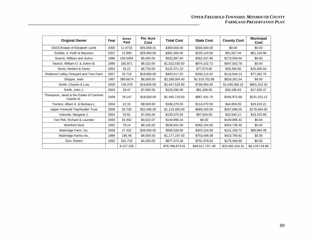
UPPER FREEHOLD TOWNSHIP, MONMOUTH COUNTY FARMLAND PRESERVATION PLAN
80
Original Owner Year Acres Paid
Per Acre Cost
Total Cost State Cost County Cost Municipal
Cost
SADC/Estate of Elizabeth Lamb 2000 11.9716 $25,059.31 $300,000.00 $300,000.00 $0.00 $0.00
Scibilia, A. Keith & Maureen 2007 12.990 $29,400.00 $381,906.00 $229,143.60 $91,657.44 $61,104.96
Search, William and JoAnn 1996 106.5994 $5,000.00 $532,997.00 $362,437.96 $170,559.04 $0.00
Search, William O. & JoAnn B. 1989 182.871 $8,323.00 $1,522,035.50 $974,102.72 $547,932.78 $0.00
Sensi, Herbert & Karen 2004 18.21 $6,720.00 $122,371.20 $77,574.60 $28,396.56 $16,400.04
Sheltered Valley Vineyard and Tree Farm 2007 25.719 $18,800.00 $483,517.20 $290,110.32 $116,044.13 $77,362.75
Shipper, Irwin 1997 389.6674 $6,000.00 $2,338,004.40 $1,519,702.86 $818,301.54 $0.00
Smith, Charles & Lois 2008 135.078 $19,600.00 $2,647,528.80 $796,950.45 $1,049,268.15 $801,310.20
Smith, John J. 2004 18.47 $7,000.00 $129,290.00 $81,268.00 $30,186.63 $17,835.37
Thompson, Janet & the Estate of Carmine Casola Sr.
2009 78.147 $18,500.00 $1,445,719.50 $867,431.70 $346,972.68 $231,315.12
Trenton, Albert A. & Barbara L. 2004 22.15 $8,500.00 $188,275.00 $114,072.50 $44,959.29 $29,243.21
Upper Freehold Twp/Hudler Trust 2008 50.700 $22,000.00 $1,115,400.00 $669,240.00 $267,696.00 $178,464.00
Valnoski, Margaret J. 2004 19.91 $7,000.00 $139,370.00 $87,604.00 $32,540.11 $19,225.89
Van Pelt, Richard & Laurette 2000 32.452 $4,622.07 $149,995.42 $0.00 $149,995.42 $0.00
Walnford Stud 1992 78.14 $8,150.00 $636,841.00 $382,104.60 $254,736.40 $0.00
Walnridge Farm, Inc. 2008 17.432 $29,000.00 $505,528.00 $303,316.80 $121,326.72 $80,884.48
Walnridge Farms Inc. 1989 196.48 $6,000.00 $1,177,197.00 $753,406.08 $423,790.92 $0.00
Zion, Robert 1992 201.718 $4,350.00 $877,473.30 $701,978.64 $175,494.66 $0.00
8,127.235 $78,788,873.01 $49,517,737,.90 $23,092,416.31 $6,178,718.86
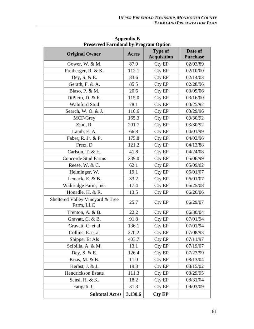
UPPER FREEHOLD TOWNSHIP, MONMOUTH COUNTY FARMLAND PRESERVATION PLAN
Appendix B
Preserved Farmland by Program Option
Original Owner Acres Type of
Acquisition Date of
Purchase
Gower, W. & M. 87.9 Cty EP 02/03/89 Freiberger, R. & K. 112.1 Cty EP 02/10/00
Dey, S. & E. 83.6 Cty EP 02/14/03 Gerath, F. & A. 85.5 Cty EP 02/28/96 Blaso, P. & M. 20.6 Cty EP 03/09/06
DiPiero, D. & R. 115.0 Cty EP 03/16/00 Walnford Stud 78.1 Cty EP 03/25/92
Search, W. O. & J. 110.6 Cty EP 03/29/96 MCF/Grey 165.3 Cty EP 03/30/92
Zion, R. 201.7 Cty EP 03/30/92 Lamb, E. A. 66.8 Cty EP 04/01/99
Faber, R. Jr. & P. 175.8 Cty EP 04/03/96 Fretz, D 121.2 Cty EP 04/13/88
Carlson, T. & H. 41.8 Cty EP 04/24/08 Concorde Stud Farms 239.0 Cty EP 05/06/99
Reese, W. & C. 62.1 Cty EP 05/09/02 Helminger, W. 19.1 Cty EP 06/01/07
Lemack, E. & B. 33.2 Cty EP 06/01/07 Walnridge Farm, Inc. 17.4 Cty EP 06/25/08
Honadle, H. & R. 13.5 Cty EP 06/26/06
Sheltered Valley Vineyard & Tree Farm, LLC
25.7 Cty EP 06/29/07
Trenton, A. & B. 22.2 Cty EP 06/30/04 Gravatt, C. & B. 91.8 Cty EP 07/01/94 Gravatt, C. et al 136.1 Cty EP 07/01/94 Collins, E. et al 270.2 Cty EP 07/08/93 Shipper Et Als 403.7 Cty EP 07/11/97
Scibilia, A. & M. 13.1 Cty EP 07/19/07 Dey, S. & E. 126.4 Cty EP 07/23/99
Kizis, M. & B. 11.0 Cty EP 08/13/04 Herbst, J. & J. 19.3 Cty EP 08/15/02
Hendrickson Estate 111.3 Cty EP 08/29/95 Sensi, H. & K. 18.2 Cty EP 08/31/04
Fatigati, C. 31.3 Cty EP 09/03/09
Subtotal Acres 3,130.6 Cty EP
81
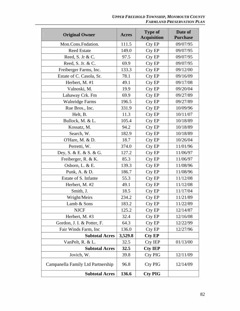
UPPER FREEHOLD TOWNSHIP, MONMOUTH COUNTY FARMLAND PRESERVATION PLAN
Type of Date of Original Owner Acres
Acquisition Purchase
Mon.Cons.Fndation. 111.5 Cty EP 09/07/95 Reed Estate 149.0 Cty EP 09/07/95
Reed, S. Jr & C. 97.5 Cty EP 09/07/95 Reed, S. Jr. & C. 69.9 Cty EP 09/07/95
Freiberger Farms, Inc. 133.3 Cty EP 09/12/00 Estate of C. Casola, Sr. 78.1 Cty EP 09/16/09
Herbert, M. #1 49.1 Cty EP 09/17/08 Valnoski, M. 19.9 Cty EP 09/20/04
Lahaway Crk. Fm 69.9 Cty EP 09/27/89 Walnridge Farms 196.5 Cty EP 09/27/89 Rue Bros., Inc. 331.9 Cty EP 10/09/96
Helt, B. 11.3 Cty EP 10/11/07 Bullock, M. & L. 105.4 Cty EP 10/18/89
Kossatz, M. 94.2 Cty EP 10/18/89 Search, W. 182.9 Cty EP 10/18/89
O'Hare, M. & D. 18.7 Cty EP 10/26/04 Perretti, W. 374.0 Cty EP 11/01/96
Dey, S. & E. & S. & G. 127.2 Cty EP 11/06/97 Freiberger, R. & K. 85.3 Cty EP 11/06/97
Osborn, L. & E. 139.3 Cty EP 11/08/96 Punk, A. & D. 186.7 Cty EP 11/08/96
Estate of S. Infante 55.3 Cty EP 11/12/08 Herbert, M. #2 49.1 Cty EP 11/12/08
Smith, J. 18.5 Cty EP 11/17/04 Wright/Meirs 234.2 Cty EP 11/21/89 Lamb & Sons 183.2 Cty EP 11/22/89
NJCF 125.2 Cty EP 12/14/87 Herbert, M. #3 32.4 Cty EP 12/16/08
Gordon, J. I. & Potter, F. 64.3 Cty EP 12/22/99 Fair Winds Farm, Inc 136.0 Cty EP 12/27/96
Subtotal Acres 3,529.8 Cty EP VanPelt, R. & L. 32.5 Cty IEP 01/13/00
Subtotal Acres 32.5 Cty IEP Jovich, W. 39.8 Cty PIG 12/11/09
Campanella Family Ltd Partnership 96.8 Cty PIG 12/14/09
Subtotal Acres 136.6 Cty PIG
82
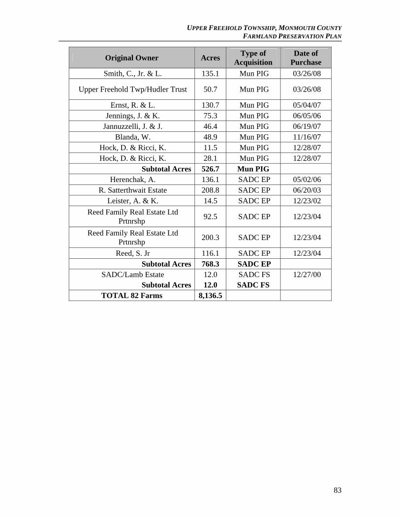
UPPER FREEHOLD TOWNSHIP, MONMOUTH COUNTY FARMLAND PRESERVATION PLAN
Type of Date of Original Owner Acres
Acquisition Purchase
Smith, C., Jr. & L. 135.1 Mun PIG 03/26/08
Upper Freehold Twp/Hudler Trust 50.7 Mun PIG 03/26/08
Ernst, R. & L. 130.7 Mun PIG 05/04/07 Jennings, J. & K. 75.3 Mun PIG 06/05/06
Jannuzzelli, J. & J. 46.4 Mun PIG 06/19/07 Blanda, W. 48.9 Mun PIG 11/16/07
Hock, D. & Ricci, K. 11.5 Mun PIG 12/28/07 Hock, D. & Ricci, K. 28.1 Mun PIG 12/28/07
Subtotal Acres 526.7 Mun PIG Herenchak, A. 136.1 SADC EP 05/02/06
R. Satterthwait Estate 208.8 SADC EP 06/20/03 Leister, A. & K. 14.5 SADC EP 12/23/02
Reed Family Real Estate Ltd Prtnrshp
92.5 SADC EP 12/23/04
Reed Family Real Estate Ltd Prtnrshp
200.3 SADC EP 12/23/04
Reed, S. Jr 116.1 SADC EP 12/23/04 Subtotal Acres 768.3 SADC EP
SADC/Lamb Estate 12.0 SADC FS 12/27/00 Subtotal Acres 12.0 SADC FS
TOTAL 82 Farms 8,136.5
83
UPPER FREEHOLD TOWNSHIP, MONMOUTH COUNTY FARMLAND PRESERVATION PLAN
Appendix C:
Farmland Assessed Parcels as of 2010 Block Lot Qual Property Location
8 3.04 86 EAST BRANCH RD 8 3.04 QFARM 86 EAST BRANCH RD 8 4 93 IMLAYSTWN-HIGHTSTWN RD 8 4 QFARM 93 IMLAYSTWN-HIGHTSTWN RD 8 4.011 102 EAST BRANCH RD 8 4.011 QFARM 102 EAST BRANCH RD 8 4.014 QFARM IMLAYSTWN-HIGHTSTWN RD 9 3.01 110 IMLAYSTWN-HIGHTSTWN 9 3.01 QFARM 110 IMLAYSTWN-HIGHTSTWN 9 5.01 QFARM HERBERT RD 9 6 51 HERBERT RD 9 6 QFARM 51 HERBERT RD 9 6.01 QFARM HERBERT RD 9 9.01 61 HERBERT RD 9 9.01 QFARM 61 HERBERT RD 9 9.02 67 HERBERT RD 9 9.02 QFARM 67 HERBERT RD 9 9.03 3 EGGLINGTON ROAD 9 9.03 QFARM 3 EGGLINGTON ROAD
10 8 QFARM HERBERT RD 11 1 QFARM SHARON STATION RD 11 2 QFARM SHARON STATION RD 11 4.02 1285 OLD YORK RD 11 4.02 QFARM 1285 OLD YORK RD 11 4.08 QFARM HLUCHY RD 11 4.09 24 HLUCHY RD 11 4.09 QFARM 24 HLUCHY RD 11 4.16 10 HLUCHY RD 11 4.16 QFARM 10 HLUCHY RD 11 6 1277 OLD YORK RD 11 6 QFARM 1277 OLD YORK RD 11 11 QFARM OLD YORK RD 11 12 76 HERBERT RD 11 12 QFARM 76 HERBERT RD 12 4 142 SHARON STATION RD 12 4 QFARM 142 SHARON STATION RD 12 5.02 786 ROUTE 524 12 5.02 QFARM 786 ROUTE 524 12 5.03 QFARM XXX ROUTE 524 12 6 796 ROUTE 524 12 6 QFARM 796 ROUTE 524 12 6.02 798 ROUTE 524 12 6.02 QFARM 798 ROUTE 524 12 7 QFARM 1335 OLD YORK RD
84
UPPER FREEHOLD TOWNSHIP, MONMOUTH COUNTY FARMLAND PRESERVATION PLAN
Block Lot Qual Property Location 12 8 QFARM 848 ROUTE 524 12 8.01 840 ROUTE 524 12 8.01 QFARM 840 ROUTE 524 12 8.05 842 ROUTE 524 12 8.05 QFARM 842 ROUTE 524 12 10 1305 OLD YORK RD 12 10 QFARM 1305 OLD YORK RD 12 11 11 HLUCHY RD 12 11 QFARM 11 HLUCHY RD 12 11.06 17 HLUCHY RD 12 11.06 QFARM 17 HLUCHY RD 12 11.07 QFARM HLUCHY RD 12 11.08 QFARM HLUCHY RD 12 11.09 QFARM HLUCHY RD 13 1 QFARM IMLAYSTWN-HIGHTSTWN RD 13 1.01 90 IMLAYSTWN-HIGHTSTWN RD 13 1.01 QFARM 90 IMLAYSTWN-HIGHTSTWN RD 13 3.01 QFARM 740 ROUTE 524 13 6 758 ROUTE 524 13 6 QFARM 758 ROUTE 524 13 11.06 QFARM SHARON STATION RD 13 12 QFARM SHARON STATION RD 13 13 135 SHARON STATION RD 13 13 QFARM 135 SHARON STATION RD 13 14 QFARM SHARON STATION RD 13 15 QFARM SHARON STATION RD 13 16 QFARM SHARON STATION RD 13 17.01 163 SHARON STATION RD 13 17.01 QFARM 163 SHARON STATION RD 13 18 QFARM SHARON STATION RD 13 19 QFARM SHARON STATION RD 13 21 QFARM HERBERT RD 13 22 QFARM HERBERT RD 13 22.01 QFARM HERBERT RD 13 23.01 24 HERBERT RD 13 23.01 QFARM 24 HERBERT RD 13 23.02 BLDG XX HERBERT RD 13 23.02 QFARM XX HERBERT RD 13 24.05 QFARM HERBERT RD
13.02 6 22 BABBITT WAY 13.02 6 QFARM 22 BABBITT WAY 13.02 19 QFARM IMLAYSTWN-HIGHTSTWN RD
14 4 678 ROUTE 524 14 4 QFARM 678 ROUTE 524 14 7.02 QFARM IMLAYSTWN-HIGHTSTWN RD 14 7.03 53 IMLAYSTWN-HIGHTSTWN RD 14 7.03 QFARM 53 IMLAYSTWN-HIGHTSTWN RD
85
UPPER FREEHOLD TOWNSHIP, MONMOUTH COUNTY FARMLAND PRESERVATION PLAN
Block Lot Qual Property Location 14 7.06 45 IMLAYSTWN-HIGHTSTWN RD 14 7.06 QFARM 45 IMLAYSTWN-HIGHTSTWN RD 14 7.07 QFARM 45 IMLAYSTWN-HIGHTSTWN RD 14 7.12 QFARM XXX ROUTE 524 14 7.13 684 ROUTE 524 14 7.13 QFARM 684 ROUTE 524 14 7.14 QFARM XXX ROUTE 524 14 8.01 BLDG IMLAYSTWN-HIGHTSTWN RD 14 8.01 QFARM IMLAYSTWN-HIGHTSTWN RD 14 8.06 71 IMLAYSTWN-HIGHTSTWN RD 14 8.06 QFARM 71 IMLAYSTWN-HIGHTSTWN RD 14 8.08 81 EAST BRANCH RD 14 8.08 QFARM 81 EAST BRANCH RD 14 8.1 QFARM EAST BRANCH RD 14 8.11 69 EAST BRANCH RD 14 8.11 QFARM 69 EAST BRANCH RD 15 5 20 RUES RD 15 5 QFARM 20 RUES RD 15 5.05 RUES RD 15 5.05 QFARM RUES RD 15 14 BLDG 50 RUES RD 15 14 QFARM 50 RUES RD 15 14.02 RUES RD 15 14.02 QFARM RUES RD 15 14.16 QFARM RUES RD 15 17.02 QFARM 86 RUES RD 15 36.01 QFARM ROUTE 524 15 37.01 683 ROUTE 524 15 37.01 QFARM 683 ROUTE 524 15 37.03 QFARM 10 ALLYSON WAY 15 37.04 QFARM 8 ALLYSON WAY 15 37.05 QFARM 4 ALLYSON WAY 15 37.06 QFARM 2 ALLYSON WAY 15 38 QFARM ROUTE 524 15 38.01 QFARM ROUTE 524 15 41 BLDG ROUTE 524 15 41 QFARM ROUTE 524 15 41.04 QFARM ROUTE 524 15 41.09 619 ROUTE 524 15 41.09 QFARM 619 ROUTE 524 15 42 QFARM 20 HARMONY HILL RD 15 42.02 QFARM HARMONY HILL RD 15 42.09 QFARM HARMONY HILL RD 15 44 7 HARMONY HILL RD 15 44 QFARM 7 HARMONY HILL RD 15 44.03 10 HARMONY HILL RD 15 44.03 QFARM 10 HARMONY HILL RD
86
UPPER FREEHOLD TOWNSHIP, MONMOUTH COUNTY FARMLAND PRESERVATION PLAN
Block Lot Qual Property Location 15 44.06 22 STONE HILL RD 15 44.06 QFARM 22 STONE HILL RD 15 46 QFARM 616 ROUTE 524 15 46.01 QFARM 616 ROUTE 524
15.01 17 86 RUES RD 15.01 17 QFARM 86 RUES RD 15.01 18 98 RUES RD 15.01 18 QFARM 98 RUES RD 15.01 27 BLDG ROUTE 526 15.01 27 QFARM ROUTE 526 15.01 36.01 BLDG 23 IMLAYSTWN-HIGHTSTWN RD 15.01 36.01 QFARM 23 IMLAYSTWN-HIGHTSTWN RD 15.02 1 QFARM 1 ALLYSON WAY 15.02 2 QFARM 11 ALLYSON WAY 15.02 3 QFARM 9 ALLYSON WAY 15.02 4 QFARM 7 ALLYSON WAY 15.02 6 QFARM 3 ALLYSON WAY
16 4 68 YELLOW MEETING HSE RD 16 4 QFARM 68 YELLOW MEETING HSE RD 16 9.02 QFARM ROUTE 526 16 9.03 344 ROUTE 526 16 9.03 QFARM 344 ROUTE 526 16 10 BLDG 306 ROUTE 526 16 10 QFARM 306 ROUTE 526 16 12 73 RUES RD 16 12 QFARM 73 RUES RD 16 13.01 QFARM RUES RD 16 14.01 QFARM INTERSTATE 195
16.01 3 21 CHAMBERS RD 16.01 3 QFARM 21 CHAMBERS RD 16.01 3.01 25 CHAMBERS ROAD 16.01 3.01 QFARM 25 CHAMBERS ROAD 16.01 3.02 19 CHAMBERS RD 16.01 3.02 QFARM 19 CHAMBERS RD 16.01 4.02 QFARM INFANTE WAY 16.01 13.02 43 RUES ROAD 16.01 13.02 QFARM 43 RUES ROAD 16.01 13.04 47 RUES ROAD 16.01 13.04 QFARM 47 RUES ROAD 16.01 13.05 49 RUES ROAD 16.01 13.05 QFARM 49 RUES ROAD 16.01 13.06 QFARM 51 RUES ROAD 16.01 13.07 55 RUES ROAD 16.01 13.07 QFARM 55 RUES ROAD 16.01 14 35 RUES RD 16.01 14 QFARM 35 RUES RD 16.01 15.01 33 RUES RD
87
UPPER FREEHOLD TOWNSHIP, MONMOUTH COUNTY FARMLAND PRESERVATION PLAN
Block Lot Qual Property Location 16.01 15.01 QFARM 33 RUES RD 16.01 15.05 QFARM RUES RD 16.01 19 31 CHAMBERS RD 16.01 19 QFARM CHAMBERS RD
17 1 62 CHAMBERS RD 17 1 QFARM 62 CHAMBERS RD 17 8.01 BLDG 32 CHAMBERS RD 17 8.01 QFARM 32 CHAMBERS RD 17 9 BLDG 18 CHAMBERS RD 17 9 QFARM 18 CHAMBERS RD 18 2 QFARM 337 ROUTE 526 18 3 388 ROUTE 526 18 3 QFARM 388 ROUTE 526 18 3.01 QFARM 388 ROUTE 526 18 4 QFARM YELLOW MEETING HSE RD 18 4.01 77 YELLOW MEETING HSE RD 18 4.01 QFARM 77 YELLOW MEETING HSE RD 18 4.02 380 ROUTE 526 18 4.02 QFARM 380 ROUTE 526 18 4.04 QFARM YELLOW MEETING HSE RD 18 4.05 QFARM YELLOW MEETING HSE RD 18 6 67 YELLOW MEETING HSE RD 18 6 QFARM 67 YELLOW MEETING HSE RD 19 1 343 ROUTE 526 19 1 QFARM 343 ROUTE 526 19 2 QFARM ROUTE 526 19 6 43 MILLERS MILL RD 19 6 QFARM 43 MILLERS MILL RD 19 9 BLDG 53 MILLERS MILL RD 19 9 QFARM 53 MILLERS MILL RD 19 9.02 51 MILLERS MILL RD 19 9.02 QFARM 51 MILLERS MILL RD 19 11 QFARM RED VALLEY RD 19 11.01 69 RED VALLEY RD 19 11.01 QFARM 69 RED VALLEY RD 19 11.03 65 RED VALLEY RD 19 11.03 QFARM 65 RED VALLEY RD 19 11.04 63 RED VALLEY RD 19 11.04 QFARM 63 RED VALLEY RD 19 11.05 QFARM 63 RED VALLEY RD 19 11.202 73 RED VALLEY RD 19 11.202 QFARM 73 RED VALLEY RD 20 2 327 ROUTE 526 20 2 QFARM 327 ROUTE 526 20 3 74 RED VALLEY RD 20 3 QFARM 74 RED VALLEY RD 20 5.01 28 BURLINGTON PATH
88
UPPER FREEHOLD TOWNSHIP, MONMOUTH COUNTY FARMLAND PRESERVATION PLAN
Block Lot Qual Property Location 20 5.01 QFARM 28 BURLINGTON PATH 20 7 83 EMLEYS HILL RD 20 7 QFARM 83 EMLEYS HILL RD 20 7.02 85 EMLEYS HILL RD 20 7.02 QFARM 85 EMLEYS HILL RD 20 8.01 EMLEYS HILL RD 20 8.01 QFARM EMLEYS HILL RD 20 9 QFARM 129 EMLEYS HILL RD 20 11 133 EMLEYS HILL RD 20 11 QFARM 133 EMLEYS HILL RD 20 33.01 263 ROUTE 526 20 33.01 QFARM 263 ROUTE 526 20 33.02 QFARM ROUTE 526 20 35 267 ROUTE 526 20 35 QFARM 267 ROUTE 526 20 57 QFARM ROUTE 526 21 4 22 IMLAYSTOWN RD 21 4 QFARM 22 IMLAYSTOWN RD 22 2 24 IMLAYSTWN-HIGHTSTWN RD 22 2 QFARM 24 IMLAYSTWN-HIGHTSTWN RD 22 2.01 QFARM IMLAYSTWN-HIGHTSTWN RD 22 4 214 ROUTE 526 22 4 QFARM 214 ROUTE 526 22 5 QFARM ROUTE 526 22 11 194 ROUTE 526 22 11 QFARM 194 ROUTE 526 22 24.01 QFARM I-195
22.01 1.02 QFARM ROUTE 524 22.01 5.01 QFARM I-195 22.01 11.03 QFARM I-195 22.01 12 781 ROUTE 524 22.01 12 QFARM 781 ROUTE 524 22.01 12.01 QFARM ROUTE 524 22.01 13 QFARM ROUTE 524 22.01 16 757 ROUTE 524 22.01 16 QFARM 757 ROUTE 524 22.01 22 BLDG 743 ROUTE 524 22.01 22 QFARM 743 ROUTE 524 22.01 24 725 ROUTE 524 22.01 24 QFARM 725 ROUTE 524
23 1.01 88 SHARON STATION RD 23 1.01 QFARM 88 SHARON STATION RD 23 2 170 ROUTE 526 23 2 QFARM 170 ROUTE 526 23 4 162 ROUTE 526 23 4 QFARM 162 ROUTE 526 23 4.01 QFARM 160 ROUTE 526
89
UPPER FREEHOLD TOWNSHIP, MONMOUTH COUNTY FARMLAND PRESERVATION PLAN
Block Lot Qual Property Location 23 5.01 QFARM 154 ROUTE 526 23 6 156 ROUTE 526 23 6 QFARM 156 ROUTE 526 23 8 ROUTE 526 23 8 QFARM ROUTE 526 23 13 BLDG 100 ROUTE 526 23 13 QFARM 100 ROUTE 526 23 13.03 100 ROUTE 526 23 13.03 QFARM 100 ROUTE 526 23 16.01 QFARM ROUTE 526 23 21.02 QFARM OLD YORK RD 23 22.01 OLD YORK RD 23 22.01 QFARM OLD YORK RD 23 23.01 QFARM I 195 23 25.01 QFARM I 195 23 26.01 QFARM I 195
23.01 1 98 SHARON STATION RD 23.01 1 QFARM 98 SHARON STATION RD 23.01 22 QFARM ROUTE 524 23.01 23 835 ROUTE 524 23.01 23 QFARM 835 ROUTE 524 23.01 23.03 QFARM ROUTE 524 23.01 25 QFARM ROUTE 524 23.01 25.02 QFARM ROUTE 524 23.01 26 803 ROUTE 524 23.01 26 QFARM 803 ROUTE 524 23.01 26.01 QFARM ROUTE 524 23.02 21.01 QFARM OLD YORK RD
24 1 QFARM 70 SHARON STATION RD 24 2.18 48 SHARON STATION ROAD 24 2.18 QFARM 48 SHARON STATION ROAD 24 4 222 ROUTE 539 24 4 QFARM 222 ROUTE 539 24 7 QFARM ROUTE 539 24 8.01 16 SHARON STATION RD 24 8.01 QFARM 16 SHARON STATION RD 24 9.01 QFARM ROUTE 539 24 9.03 150 ROUTE 539 24 9.03 QFARM 150 ROUTE 539 24 9.04 152 ROUTE 539 24 9.04 QFARM 152 ROUTE 539 24 9.05 154 ROUTE 539 24 9.05 QFARM 154 ROUTE 539 24 9.07 158 ROUTE 539 24 9.07 QFARM 158 ROUTE 539 24 9.08 160 ROUTE 539 24 9.08 QFARM 160 ROUTE 539
90
UPPER FREEHOLD TOWNSHIP, MONMOUTH COUNTY FARMLAND PRESERVATION PLAN
Block Lot Qual Property Location 24 10 ROUTE 539 24 10 QFARM ROUTE 539 24 11 136 ROUTE 539 24 11 QFARM 136 ROUTE 539 24 11.01 148 ROUTE 539 24 11.01 QFARM 148 ROUTE 539 24 12 116 ROUTE 539 24 12 QFARM 116 ROUTE 539 24 12.02 108 ROUTE 539 24 12.02 QFARM 108 ROUTE 539 24 13 QFARM ROUTE 539 24 13.01 102 ROUTE 539 24 13.01 QFARM 102 ROUTE 539 24 14 90 ROUTE 539 24 14 QFARM 90 ROUTE 539 24 16 QFARM ROUTE 539 24 22.01 QFARM ROUTE 526 24 23 BLDG 115 ROUTE 526 24 23 QFARM 115 ROUTE 526 24 26 131 ROUTE 526 24 26 QFARM 131 ROUTE 526 24 27 137 ROUTE 526 24 27 QFARM 137 ROUTE 526 24 34 153 ROUTE 526 24 34 QFARM 153 ROUTE 526 26 1 QFARM OLD YORK RD 26 3 QFARM OLD YORK RD 27 22 172 DAVIS STATION RD 27 22 QFARM 172 DAVIS STATION RD 27 23 144 DAVIS STATION RD 27 23 QFARM 144 DAVIS STATION RD 27 24 132 DAVIS STATION RD 27 24 QFARM 132 DAVIS STATION RD 27 25 118 DAVIS STATION RD 27 25 QFARM 118 DAVIS STATION RD 27 26 QFARM 118 DAVIS STATION RD 27 28 43 SHARON STATION RD 27 28 QFARM 43 SHARON STATION RD 27 29 QFARM 43 SHARON STATION RD 27 30.01 57 SHARON STATION RD 27 30.01 QFARM SHARON STATION RD 27 30.02 QFARM SHARON STATION RD 27 31 QFARM SHARON STATION RD 27 38.01 QFARM DAVIS STATION RD 27 42.02 199 ROUTE 526 27 42.02 QFARM 199 ROUTE 526 27 43 QFARM 213 ROUTE 526
91
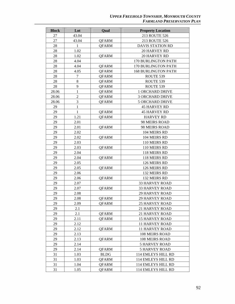
UPPER FREEHOLD TOWNSHIP, MONMOUTH COUNTY FARMLAND PRESERVATION PLAN
Block Lot Qual Property Location 27 43.04 213 ROUTE 526 27 43.04 QFARM 213 ROUTE 526 28 1 QFARM DAVIS STATION RD 28 1.02 20 HARVEY RD 28 1.02 QFARM 20 HARVEY RD 28 4.04 170 BURLINGTON PATH 28 4.04 QFARM 170 BURLINGTON PATH 28 4.05 QFARM 168 BURLINGTON PATH 28 7 QFARM ROUTE 539 28 8 QFARM ROUTE 539 28 9 QFARM ROUTE 539
28.06 1 QFARM 1 ORCHARD DRIVE 28.06 2 QFARM 3 ORCHARD DRIVE 28.06 3 QFARM 5 ORCHARD DRIVE
29 1 45 HARVEY RD 29 1 QFARM 45 HARVEY RD 29 1.21 QFARM HARVEY RD 29 2.01 98 MEIRS ROAD 29 2.01 QFARM 98 MEIRS ROAD 29 2.02 104 MEIRS RD 29 2.02 QFARM 104 MEIRS RD 29 2.03 110 MEIRS RD 29 2.03 QFARM 110 MEIRS RD 29 2.04 118 MEIRS RD 29 2.04 QFARM 118 MEIRS RD 29 2.05 126 MEIRS RD 29 2.05 QFARM 126 MEIRS RD 29 2.06 132 MEIRS RD 29 2.06 QFARM 132 MEIRS RD 29 2.07 33 HARVEY ROAD 29 2.07 QFARM 33 HARVEY ROAD 29 2.08 29 HARVEY ROAD 29 2.08 QFARM 29 HARVEY ROAD 29 2.09 QFARM 25 HARVEY ROAD 29 2.1 21 HARVEY ROAD 29 2.1 QFARM 21 HARVEY ROAD 29 2.11 QFARM 15 HARVEY ROAD 29 2.12 11 HARVEY ROAD 29 2.12 QFARM 11 HARVEY ROAD 29 2.13 108 MEIRS ROAD 29 2.13 QFARM 108 MEIRS ROAD 29 2.14 5 HARVEY ROAD 29 2.14 QFARM 5 HARVEY ROAD 31 1.03 BLDG 114 EMLEYS HILL RD 31 1.03 QFARM 114 EMLEYS HILL RD 31 1.04 QFARM 114 EMLEYS HILL RD 31 1.05 QFARM 114 EMLEYS HILL RD
92
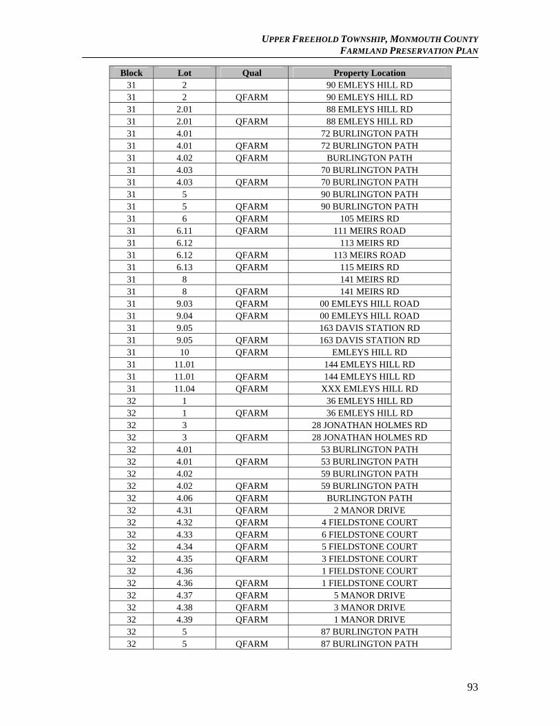
UPPER FREEHOLD TOWNSHIP, MONMOUTH COUNTY FARMLAND PRESERVATION PLAN
Block Lot Qual Property Location 31 2 90 EMLEYS HILL RD 31 2 QFARM 90 EMLEYS HILL RD 31 2.01 88 EMLEYS HILL RD 31 2.01 QFARM 88 EMLEYS HILL RD 31 4.01 72 BURLINGTON PATH 31 4.01 QFARM 72 BURLINGTON PATH 31 4.02 QFARM BURLINGTON PATH 31 4.03 70 BURLINGTON PATH 31 4.03 QFARM 70 BURLINGTON PATH 31 5 90 BURLINGTON PATH 31 5 QFARM 90 BURLINGTON PATH 31 6 QFARM 105 MEIRS RD 31 6.11 QFARM 111 MEIRS ROAD 31 6.12 113 MEIRS RD 31 6.12 QFARM 113 MEIRS ROAD 31 6.13 QFARM 115 MEIRS RD 31 8 141 MEIRS RD 31 8 QFARM 141 MEIRS RD 31 9.03 QFARM 00 EMLEYS HILL ROAD 31 9.04 QFARM 00 EMLEYS HILL ROAD 31 9.05 163 DAVIS STATION RD 31 9.05 QFARM 163 DAVIS STATION RD 31 10 QFARM EMLEYS HILL RD 31 11.01 144 EMLEYS HILL RD 31 11.01 QFARM 144 EMLEYS HILL RD 31 11.04 QFARM XXX EMLEYS HILL RD 32 1 36 EMLEYS HILL RD 32 1 QFARM 36 EMLEYS HILL RD 32 3 28 JONATHAN HOLMES RD 32 3 QFARM 28 JONATHAN HOLMES RD 32 4.01 53 BURLINGTON PATH 32 4.01 QFARM 53 BURLINGTON PATH 32 4.02 59 BURLINGTON PATH 32 4.02 QFARM 59 BURLINGTON PATH 32 4.06 QFARM BURLINGTON PATH 32 4.31 QFARM 2 MANOR DRIVE 32 4.32 QFARM 4 FIELDSTONE COURT 32 4.33 QFARM 6 FIELDSTONE COURT 32 4.34 QFARM 5 FIELDSTONE COURT 32 4.35 QFARM 3 FIELDSTONE COURT 32 4.36 1 FIELDSTONE COURT 32 4.36 QFARM 1 FIELDSTONE COURT 32 4.37 QFARM 5 MANOR DRIVE 32 4.38 QFARM 3 MANOR DRIVE 32 4.39 QFARM 1 MANOR DRIVE 32 5 87 BURLINGTON PATH 32 5 QFARM 87 BURLINGTON PATH
93
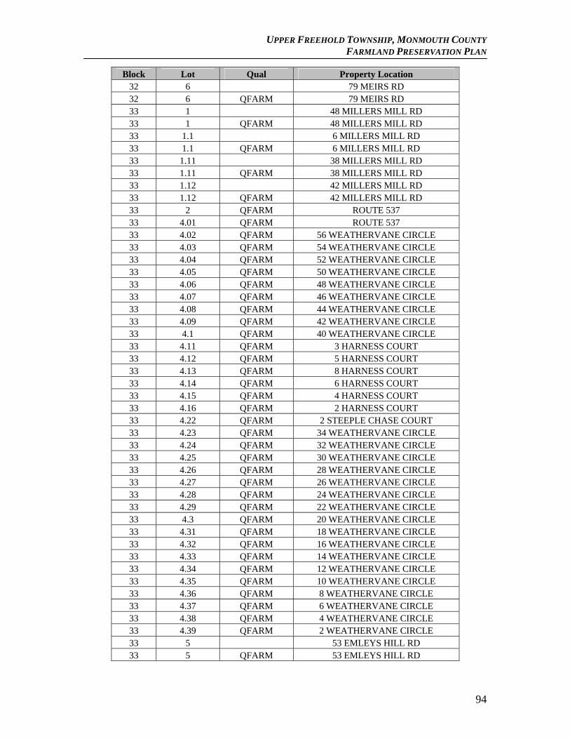
UPPER FREEHOLD TOWNSHIP, MONMOUTH COUNTY FARMLAND PRESERVATION PLAN
Block Lot Qual Property Location 32 6 79 MEIRS RD 32 6 QFARM 79 MEIRS RD 33 1 48 MILLERS MILL RD 33 1 QFARM 48 MILLERS MILL RD 33 1.1 6 MILLERS MILL RD 33 1.1 QFARM 6 MILLERS MILL RD 33 1.11 38 MILLERS MILL RD 33 1.11 QFARM 38 MILLERS MILL RD 33 1.12 42 MILLERS MILL RD 33 1.12 QFARM 42 MILLERS MILL RD 33 2 QFARM ROUTE 537 33 4.01 QFARM ROUTE 537 33 4.02 QFARM 56 WEATHERVANE CIRCLE 33 4.03 QFARM 54 WEATHERVANE CIRCLE 33 4.04 QFARM 52 WEATHERVANE CIRCLE 33 4.05 QFARM 50 WEATHERVANE CIRCLE 33 4.06 QFARM 48 WEATHERVANE CIRCLE 33 4.07 QFARM 46 WEATHERVANE CIRCLE 33 4.08 QFARM 44 WEATHERVANE CIRCLE 33 4.09 QFARM 42 WEATHERVANE CIRCLE 33 4.1 QFARM 40 WEATHERVANE CIRCLE 33 4.11 QFARM 3 HARNESS COURT 33 4.12 QFARM 5 HARNESS COURT 33 4.13 QFARM 8 HARNESS COURT 33 4.14 QFARM 6 HARNESS COURT 33 4.15 QFARM 4 HARNESS COURT 33 4.16 QFARM 2 HARNESS COURT 33 4.22 QFARM 2 STEEPLE CHASE COURT 33 4.23 QFARM 34 WEATHERVANE CIRCLE 33 4.24 QFARM 32 WEATHERVANE CIRCLE 33 4.25 QFARM 30 WEATHERVANE CIRCLE 33 4.26 QFARM 28 WEATHERVANE CIRCLE 33 4.27 QFARM 26 WEATHERVANE CIRCLE 33 4.28 QFARM 24 WEATHERVANE CIRCLE 33 4.29 QFARM 22 WEATHERVANE CIRCLE 33 4.3 QFARM 20 WEATHERVANE CIRCLE 33 4.31 QFARM 18 WEATHERVANE CIRCLE 33 4.32 QFARM 16 WEATHERVANE CIRCLE 33 4.33 QFARM 14 WEATHERVANE CIRCLE 33 4.34 QFARM 12 WEATHERVANE CIRCLE 33 4.35 QFARM 10 WEATHERVANE CIRCLE 33 4.36 QFARM 8 WEATHERVANE CIRCLE 33 4.37 QFARM 6 WEATHERVANE CIRCLE 33 4.38 QFARM 4 WEATHERVANE CIRCLE 33 4.39 QFARM 2 WEATHERVANE CIRCLE 33 5 53 EMLEYS HILL RD 33 5 QFARM 53 EMLEYS HILL RD
94
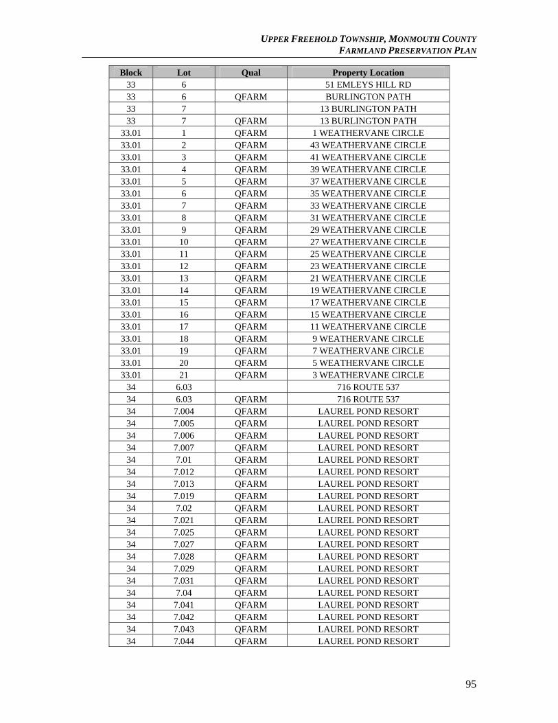
UPPER FREEHOLD TOWNSHIP, MONMOUTH COUNTY FARMLAND PRESERVATION PLAN
Block Lot Qual Property Location 33 6 51 EMLEYS HILL RD 33 6 QFARM BURLINGTON PATH 33 7 13 BURLINGTON PATH 33 7 QFARM 13 BURLINGTON PATH
33.01 1 QFARM 1 WEATHERVANE CIRCLE 33.01 2 QFARM 43 WEATHERVANE CIRCLE 33.01 3 QFARM 41 WEATHERVANE CIRCLE 33.01 4 QFARM 39 WEATHERVANE CIRCLE 33.01 5 QFARM 37 WEATHERVANE CIRCLE 33.01 6 QFARM 35 WEATHERVANE CIRCLE 33.01 7 QFARM 33 WEATHERVANE CIRCLE 33.01 8 QFARM 31 WEATHERVANE CIRCLE 33.01 9 QFARM 29 WEATHERVANE CIRCLE 33.01 10 QFARM 27 WEATHERVANE CIRCLE 33.01 11 QFARM 25 WEATHERVANE CIRCLE 33.01 12 QFARM 23 WEATHERVANE CIRCLE 33.01 13 QFARM 21 WEATHERVANE CIRCLE 33.01 14 QFARM 19 WEATHERVANE CIRCLE 33.01 15 QFARM 17 WEATHERVANE CIRCLE 33.01 16 QFARM 15 WEATHERVANE CIRCLE 33.01 17 QFARM 11 WEATHERVANE CIRCLE 33.01 18 QFARM 9 WEATHERVANE CIRCLE 33.01 19 QFARM 7 WEATHERVANE CIRCLE 33.01 20 QFARM 5 WEATHERVANE CIRCLE 33.01 21 QFARM 3 WEATHERVANE CIRCLE
34 6.03 716 ROUTE 537 34 6.03 QFARM 716 ROUTE 537 34 7.004 QFARM LAUREL POND RESORT 34 7.005 QFARM LAUREL POND RESORT 34 7.006 QFARM LAUREL POND RESORT 34 7.007 QFARM LAUREL POND RESORT 34 7.01 QFARM LAUREL POND RESORT 34 7.012 QFARM LAUREL POND RESORT 34 7.013 QFARM LAUREL POND RESORT 34 7.019 QFARM LAUREL POND RESORT 34 7.02 QFARM LAUREL POND RESORT 34 7.021 QFARM LAUREL POND RESORT 34 7.025 QFARM LAUREL POND RESORT 34 7.027 QFARM LAUREL POND RESORT 34 7.028 QFARM LAUREL POND RESORT 34 7.029 QFARM LAUREL POND RESORT 34 7.031 QFARM LAUREL POND RESORT 34 7.04 QFARM LAUREL POND RESORT 34 7.041 QFARM LAUREL POND RESORT 34 7.042 QFARM LAUREL POND RESORT 34 7.043 QFARM LAUREL POND RESORT 34 7.044 QFARM LAUREL POND RESORT
95

UPPER FREEHOLD TOWNSHIP, MONMOUTH COUNTY FARMLAND PRESERVATION PLAN
Block Lot Qual Property Location 34 7.045 QFARM LAUREL POND RESORT 34 7.046 QFARM LAUREL POND RESORT 34 7.047 QFARM LAUREL POND RESORT 34 7.048 QFARM LAUREL POND RESORT 34 7.049 QFARM LAUREL POND RESORT 34 7.05 QFARM LAUREL POND RESORT 34 7.053 QFARM LAUREL POND RESORT 34 7.054 QFARM LAUREL POND RESORT 34 7.055 QFARM LAUREL POND RESORT 34 7.056 QFARM LAUREL POND RESORT 34 7.057 QFARM LAUREL POND RESORT 34 7.058 QFARM LAUREL POND RESORT 34 7.059 QFARM LAUREL POND RESORT 34 7.06 QFARM LAUREL POND RESORT 34 7.061 QFARM LAUREL POND RESORT 34 7.062 QFARM LAUREL POND RESORT 34 7.063 QFARM LAUREL POND RESORT 34 7.064 QFARM LAUREL POND RESORT 34 7.065 QFARM LAUREL POND RESORT 34 7.066 QFARM LAUREL POND RESORT 34 7.067 QFARM LAUREL POND RESORT 34 7.068 QFARM LAUREL POND RESORT 34 7.07 QFARM LAUREL POND RESORT 34 7.071 QFARM LAUREL POND RESORT 34 7.072 QFARM LAUREL POND RESORT 34 7.073 QFARM LAUREL POND RESORT 34 7.074 QFARM LAUREL POND RESORT 34 7.075 QFARM LAUREL POND RESORT 34 7.076 QFARM LAUREL POND RESORT 34 7.077 QFARM LAUREL POND RESORT 34 7.078 QFARM LAUREL POND RESORT 34 7.079 QFARM LAUREL POND RESORT 34 7.08 QFARM LAUREL POND RESORT 34 7.081 QFARM LAUREL POND RESORT 34 7.082 QFARM LAUREL POND RESORT 34 7.083 QFARM LAUREL POND RESORT 34 7.084 QFARM LAUREL POND RESORT 34 7.085 QFARM LAUREL POND RESORT 34 7.086 QFARM LAUREL POND RESORT 34 7.087 QFARM LAUREL POND RESORT 34 7.088 QFARM LAUREL POND RESORT 34 7.089 QFARM LAUREL POND RESORT 34 7.09 QFARM LAUREL POND RESORT 34 7.091 QFARM LAUREL POND RESORT 34 7.092 QFARM LAUREL POND RESORT 34 7.093 QFARM LAUREL POND RESORT 34 7.094 QFARM LAUREL POND RESORT
96
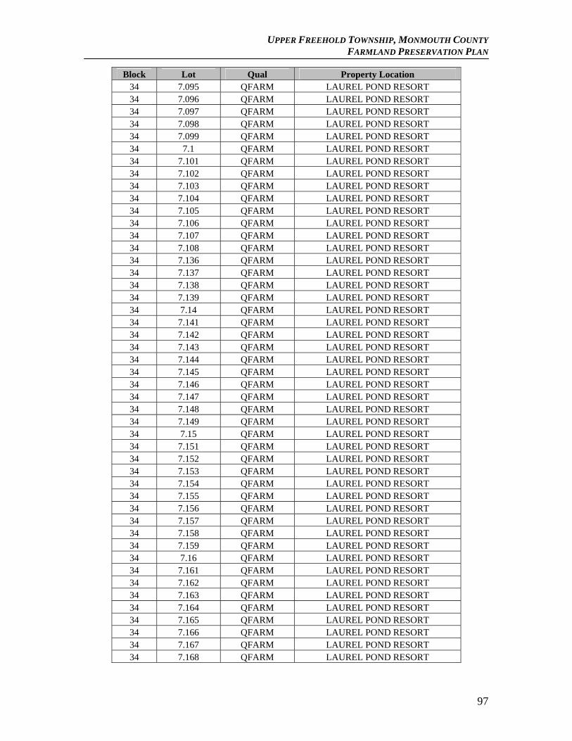
UPPER FREEHOLD TOWNSHIP, MONMOUTH COUNTY FARMLAND PRESERVATION PLAN
Block Lot Qual Property Location 34 7.095 QFARM LAUREL POND RESORT 34 7.096 QFARM LAUREL POND RESORT 34 7.097 QFARM LAUREL POND RESORT 34 7.098 QFARM LAUREL POND RESORT 34 7.099 QFARM LAUREL POND RESORT 34 7.1 QFARM LAUREL POND RESORT 34 7.101 QFARM LAUREL POND RESORT 34 7.102 QFARM LAUREL POND RESORT 34 7.103 QFARM LAUREL POND RESORT 34 7.104 QFARM LAUREL POND RESORT 34 7.105 QFARM LAUREL POND RESORT 34 7.106 QFARM LAUREL POND RESORT 34 7.107 QFARM LAUREL POND RESORT 34 7.108 QFARM LAUREL POND RESORT 34 7.136 QFARM LAUREL POND RESORT 34 7.137 QFARM LAUREL POND RESORT 34 7.138 QFARM LAUREL POND RESORT 34 7.139 QFARM LAUREL POND RESORT 34 7.14 QFARM LAUREL POND RESORT 34 7.141 QFARM LAUREL POND RESORT 34 7.142 QFARM LAUREL POND RESORT 34 7.143 QFARM LAUREL POND RESORT 34 7.144 QFARM LAUREL POND RESORT 34 7.145 QFARM LAUREL POND RESORT 34 7.146 QFARM LAUREL POND RESORT 34 7.147 QFARM LAUREL POND RESORT 34 7.148 QFARM LAUREL POND RESORT 34 7.149 QFARM LAUREL POND RESORT 34 7.15 QFARM LAUREL POND RESORT 34 7.151 QFARM LAUREL POND RESORT 34 7.152 QFARM LAUREL POND RESORT 34 7.153 QFARM LAUREL POND RESORT 34 7.154 QFARM LAUREL POND RESORT 34 7.155 QFARM LAUREL POND RESORT 34 7.156 QFARM LAUREL POND RESORT 34 7.157 QFARM LAUREL POND RESORT 34 7.158 QFARM LAUREL POND RESORT 34 7.159 QFARM LAUREL POND RESORT 34 7.16 QFARM LAUREL POND RESORT 34 7.161 QFARM LAUREL POND RESORT 34 7.162 QFARM LAUREL POND RESORT 34 7.163 QFARM LAUREL POND RESORT 34 7.164 QFARM LAUREL POND RESORT 34 7.165 QFARM LAUREL POND RESORT 34 7.166 QFARM LAUREL POND RESORT 34 7.167 QFARM LAUREL POND RESORT 34 7.168 QFARM LAUREL POND RESORT
97
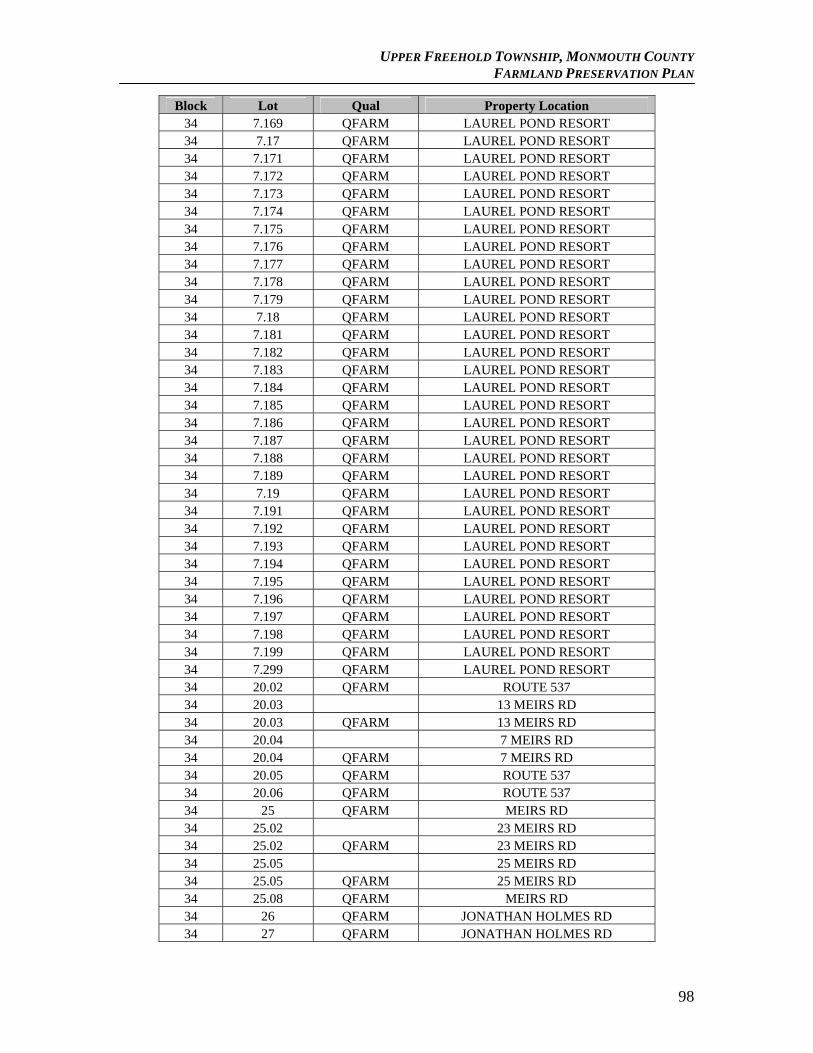
UPPER FREEHOLD TOWNSHIP, MONMOUTH COUNTY FARMLAND PRESERVATION PLAN
Block Lot Qual Property Location 34 7.169 QFARM LAUREL POND RESORT 34 7.17 QFARM LAUREL POND RESORT 34 7.171 QFARM LAUREL POND RESORT 34 7.172 QFARM LAUREL POND RESORT 34 7.173 QFARM LAUREL POND RESORT 34 7.174 QFARM LAUREL POND RESORT 34 7.175 QFARM LAUREL POND RESORT 34 7.176 QFARM LAUREL POND RESORT 34 7.177 QFARM LAUREL POND RESORT 34 7.178 QFARM LAUREL POND RESORT 34 7.179 QFARM LAUREL POND RESORT 34 7.18 QFARM LAUREL POND RESORT 34 7.181 QFARM LAUREL POND RESORT 34 7.182 QFARM LAUREL POND RESORT 34 7.183 QFARM LAUREL POND RESORT 34 7.184 QFARM LAUREL POND RESORT 34 7.185 QFARM LAUREL POND RESORT 34 7.186 QFARM LAUREL POND RESORT 34 7.187 QFARM LAUREL POND RESORT 34 7.188 QFARM LAUREL POND RESORT 34 7.189 QFARM LAUREL POND RESORT 34 7.19 QFARM LAUREL POND RESORT 34 7.191 QFARM LAUREL POND RESORT 34 7.192 QFARM LAUREL POND RESORT 34 7.193 QFARM LAUREL POND RESORT 34 7.194 QFARM LAUREL POND RESORT 34 7.195 QFARM LAUREL POND RESORT 34 7.196 QFARM LAUREL POND RESORT 34 7.197 QFARM LAUREL POND RESORT 34 7.198 QFARM LAUREL POND RESORT 34 7.199 QFARM LAUREL POND RESORT 34 7.299 QFARM LAUREL POND RESORT 34 20.02 QFARM ROUTE 537 34 20.03 13 MEIRS RD 34 20.03 QFARM 13 MEIRS RD 34 20.04 7 MEIRS RD 34 20.04 QFARM 7 MEIRS RD 34 20.05 QFARM ROUTE 537 34 20.06 QFARM ROUTE 537 34 25 QFARM MEIRS RD 34 25.02 23 MEIRS RD 34 25.02 QFARM 23 MEIRS RD 34 25.05 25 MEIRS RD 34 25.05 QFARM 25 MEIRS RD 34 25.08 QFARM MEIRS RD 34 26 QFARM JONATHAN HOLMES RD 34 27 QFARM JONATHAN HOLMES RD
98
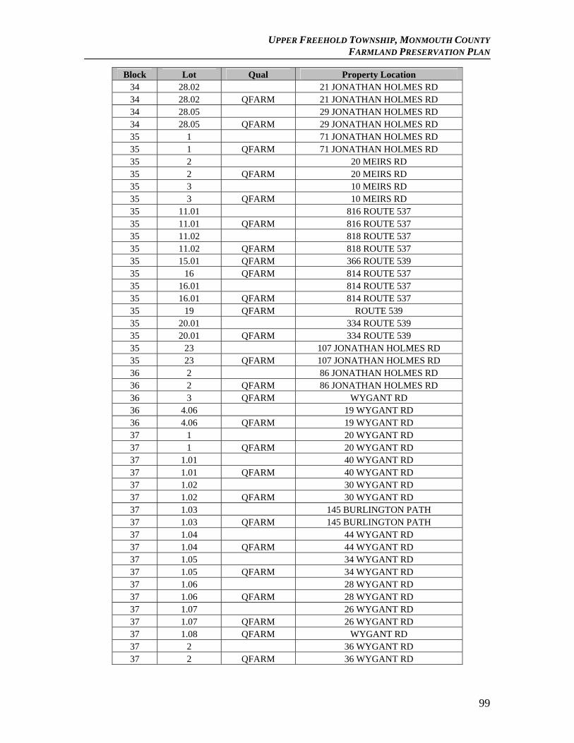
UPPER FREEHOLD TOWNSHIP, MONMOUTH COUNTY FARMLAND PRESERVATION PLAN
Block Lot Qual Property Location 34 28.02 21 JONATHAN HOLMES RD 34 28.02 QFARM 21 JONATHAN HOLMES RD 34 28.05 29 JONATHAN HOLMES RD 34 28.05 QFARM 29 JONATHAN HOLMES RD 35 1 71 JONATHAN HOLMES RD 35 1 QFARM 71 JONATHAN HOLMES RD 35 2 20 MEIRS RD 35 2 QFARM 20 MEIRS RD 35 3 10 MEIRS RD 35 3 QFARM 10 MEIRS RD 35 11.01 816 ROUTE 537 35 11.01 QFARM 816 ROUTE 537 35 11.02 818 ROUTE 537 35 11.02 QFARM 818 ROUTE 537 35 15.01 QFARM 366 ROUTE 539 35 16 QFARM 814 ROUTE 537 35 16.01 814 ROUTE 537 35 16.01 QFARM 814 ROUTE 537 35 19 QFARM ROUTE 539 35 20.01 334 ROUTE 539 35 20.01 QFARM 334 ROUTE 539 35 23 107 JONATHAN HOLMES RD 35 23 QFARM 107 JONATHAN HOLMES RD 36 2 86 JONATHAN HOLMES RD 36 2 QFARM 86 JONATHAN HOLMES RD 36 3 QFARM WYGANT RD 36 4.06 19 WYGANT RD 36 4.06 QFARM 19 WYGANT RD 37 1 20 WYGANT RD 37 1 QFARM 20 WYGANT RD 37 1.01 40 WYGANT RD 37 1.01 QFARM 40 WYGANT RD 37 1.02 30 WYGANT RD 37 1.02 QFARM 30 WYGANT RD 37 1.03 145 BURLINGTON PATH 37 1.03 QFARM 145 BURLINGTON PATH 37 1.04 44 WYGANT RD 37 1.04 QFARM 44 WYGANT RD 37 1.05 34 WYGANT RD 37 1.05 QFARM 34 WYGANT RD 37 1.06 28 WYGANT RD 37 1.06 QFARM 28 WYGANT RD 37 1.07 26 WYGANT RD 37 1.07 QFARM 26 WYGANT RD 37 1.08 QFARM WYGANT RD 37 2 36 WYGANT RD 37 2 QFARM 36 WYGANT RD
99
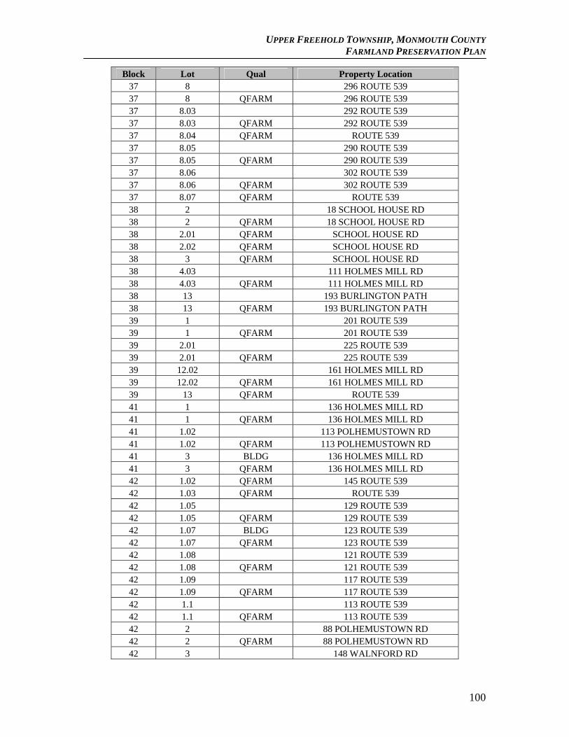
UPPER FREEHOLD TOWNSHIP, MONMOUTH COUNTY FARMLAND PRESERVATION PLAN
Block Lot Qual Property Location 37 8 296 ROUTE 539 37 8 QFARM 296 ROUTE 539 37 8.03 292 ROUTE 539 37 8.03 QFARM 292 ROUTE 539 37 8.04 QFARM ROUTE 539 37 8.05 290 ROUTE 539 37 8.05 QFARM 290 ROUTE 539 37 8.06 302 ROUTE 539 37 8.06 QFARM 302 ROUTE 539 37 8.07 QFARM ROUTE 539 38 2 18 SCHOOL HOUSE RD 38 2 QFARM 18 SCHOOL HOUSE RD 38 2.01 QFARM SCHOOL HOUSE RD 38 2.02 QFARM SCHOOL HOUSE RD 38 3 QFARM SCHOOL HOUSE RD 38 4.03 111 HOLMES MILL RD 38 4.03 QFARM 111 HOLMES MILL RD 38 13 193 BURLINGTON PATH 38 13 QFARM 193 BURLINGTON PATH 39 1 201 ROUTE 539 39 1 QFARM 201 ROUTE 539 39 2.01 225 ROUTE 539 39 2.01 QFARM 225 ROUTE 539 39 12.02 161 HOLMES MILL RD 39 12.02 QFARM 161 HOLMES MILL RD 39 13 QFARM ROUTE 539 41 1 136 HOLMES MILL RD 41 1 QFARM 136 HOLMES MILL RD 41 1.02 113 POLHEMUSTOWN RD 41 1.02 QFARM 113 POLHEMUSTOWN RD 41 3 BLDG 136 HOLMES MILL RD 41 3 QFARM 136 HOLMES MILL RD 42 1.02 QFARM 145 ROUTE 539 42 1.03 QFARM ROUTE 539 42 1.05 129 ROUTE 539 42 1.05 QFARM 129 ROUTE 539 42 1.07 BLDG 123 ROUTE 539 42 1.07 QFARM 123 ROUTE 539 42 1.08 121 ROUTE 539 42 1.08 QFARM 121 ROUTE 539 42 1.09 117 ROUTE 539 42 1.09 QFARM 117 ROUTE 539 42 1.1 113 ROUTE 539 42 1.1 QFARM 113 ROUTE 539 42 2 88 POLHEMUSTOWN RD 42 2 QFARM 88 POLHEMUSTOWN RD 42 3 148 WALNFORD RD
100
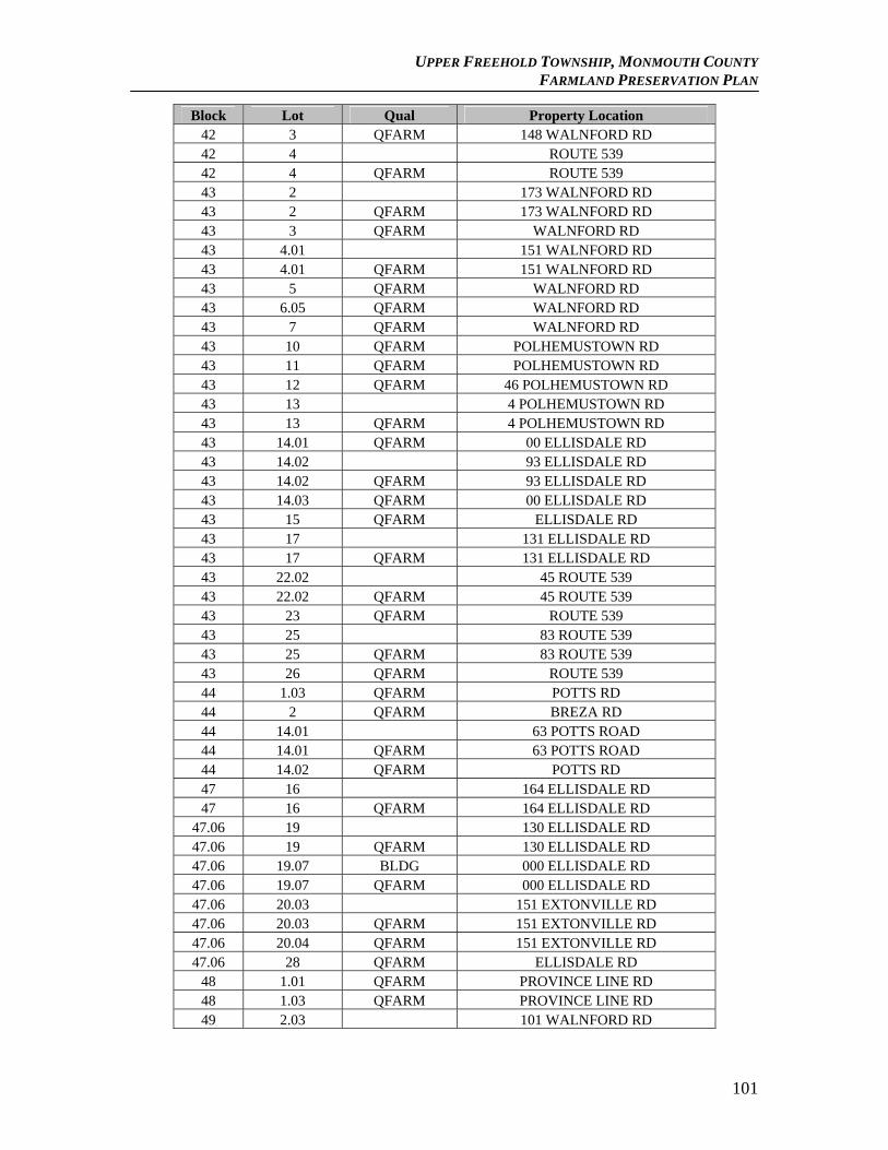
UPPER FREEHOLD TOWNSHIP, MONMOUTH COUNTY FARMLAND PRESERVATION PLAN
Block Lot Qual Property Location 42 3 QFARM 148 WALNFORD RD 42 4 ROUTE 539 42 4 QFARM ROUTE 539 43 2 173 WALNFORD RD 43 2 QFARM 173 WALNFORD RD 43 3 QFARM WALNFORD RD 43 4.01 151 WALNFORD RD 43 4.01 QFARM 151 WALNFORD RD 43 5 QFARM WALNFORD RD 43 6.05 QFARM WALNFORD RD 43 7 QFARM WALNFORD RD 43 10 QFARM POLHEMUSTOWN RD 43 11 QFARM POLHEMUSTOWN RD 43 12 QFARM 46 POLHEMUSTOWN RD 43 13 4 POLHEMUSTOWN RD 43 13 QFARM 4 POLHEMUSTOWN RD 43 14.01 QFARM 00 ELLISDALE RD 43 14.02 93 ELLISDALE RD 43 14.02 QFARM 93 ELLISDALE RD 43 14.03 QFARM 00 ELLISDALE RD 43 15 QFARM ELLISDALE RD 43 17 131 ELLISDALE RD 43 17 QFARM 131 ELLISDALE RD 43 22.02 45 ROUTE 539 43 22.02 QFARM 45 ROUTE 539 43 23 QFARM ROUTE 539 43 25 83 ROUTE 539 43 25 QFARM 83 ROUTE 539 43 26 QFARM ROUTE 539 44 1.03 QFARM POTTS RD 44 2 QFARM BREZA RD 44 14.01 63 POTTS ROAD 44 14.01 QFARM 63 POTTS ROAD 44 14.02 QFARM POTTS RD 47 16 164 ELLISDALE RD 47 16 QFARM 164 ELLISDALE RD
47.06 19 130 ELLISDALE RD 47.06 19 QFARM 130 ELLISDALE RD 47.06 19.07 BLDG 000 ELLISDALE RD 47.06 19.07 QFARM 000 ELLISDALE RD 47.06 20.03 151 EXTONVILLE RD 47.06 20.03 QFARM 151 EXTONVILLE RD 47.06 20.04 QFARM 151 EXTONVILLE RD 47.06 28 QFARM ELLISDALE RD
48 1.01 QFARM PROVINCE LINE RD 48 1.03 QFARM PROVINCE LINE RD 49 2.03 101 WALNFORD RD
101
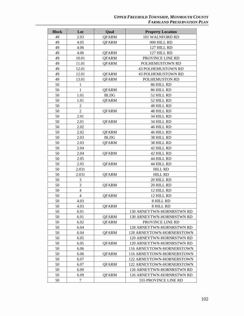
UPPER FREEHOLD TOWNSHIP, MONMOUTH COUNTY FARMLAND PRESERVATION PLAN
Block Lot Qual Property Location 49 2.03 QFARM 101 WALNFORD RD 49 4.05 QFARM 000 HILL RD 49 4.06 127 HILL RD 49 4.06 QFARM 127 HILL RD 49 10.01 QFARM PROVINCE LINE RD 49 11.01 QFARM POLHEMUSTOWN RD 49 12.01 43 POLHEMUSTOWN RD 49 12.01 QFARM 43 POLHEMUSTOWN RD 49 13.01 QFARM POLHEMUSTON RD 50 1 86 HILL RD 50 1 QFARM 86 HILL RD 50 1.01 BLDG 52 HILL RD 50 1.01 QFARM 52 HILL RD 50 2 48 HILL RD 50 2 QFARM 48 HILL RD 50 2.01 34 HILL RD 50 2.01 QFARM 34 HILL RD 50 2.02 46 HILL RD 50 2.02 QFARM 46 HILL RD 50 2.03 BLDG 38 HILL RD 50 2.03 QFARM 38 HILL RD 50 2.04 42 HILL RD 50 2.04 QFARM 42 HILL RD 50 2.05 44 HILL RD 50 2.05 QFARM 44 HILL RD 50 2.031 HILL RD 50 2.031 QFARM HILL RD 50 3 20 HILL RD 50 3 QFARM 20 HILL RD 50 4 12 HILL RD 50 4 QFARM 12 HILL RD 50 4.03 8 HILL RD 50 4.03 QFARM 8 HILL RD 50 6.01 130 ARNEYTWN-HORNRSTWN RD 50 6.01 QFARM 130 ARNEYTWN-HORNRSTWN RD 50 6.02 QFARM PROVINCE LINE RD 50 6.04 128 ARNEYTWN-HORNRSTWN RD 50 6.04 QFARM 128 ARNEYTOWN-HORNERSTOWN 50 6.05 120 ARNEYTWN-HORNRSTWN RD 50 6.05 QFARM 120 ARNEYTWN-HORNRSTWN RD 50 6.06 116 ARNEYTOWN-HORNERSTOWN 50 6.06 QFARM 116 ARNEYTOWN-HORNERSTOWN 50 6.07 122 ARNEYTOWN-HORNERSTOWN 50 6.07 QFARM 122 ARNEYTOWN-HORNERSTOWN 50 6.09 126 ARNEYTWN-HORNRSTWN RD 50 6.09 QFARM 126 ARNEYTWN-HORNRSTWN RD 50 7 555 PROVINCE LINE RD
102
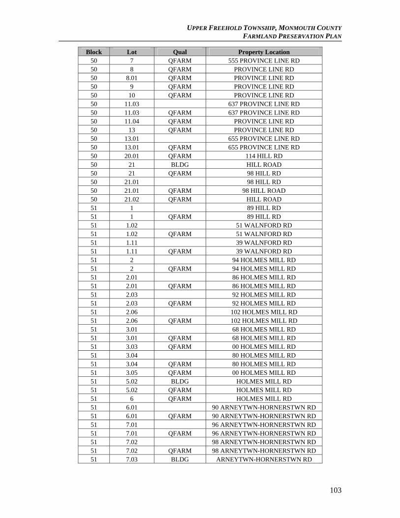
UPPER FREEHOLD TOWNSHIP, MONMOUTH COUNTY FARMLAND PRESERVATION PLAN
Block Lot Qual Property Location 50 7 QFARM 555 PROVINCE LINE RD 50 8 QFARM PROVINCE LINE RD 50 8.01 QFARM PROVINCE LINE RD 50 9 QFARM PROVINCE LINE RD 50 10 QFARM PROVINCE LINE RD 50 11.03 637 PROVINCE LINE RD 50 11.03 QFARM 637 PROVINCE LINE RD 50 11.04 QFARM PROVINCE LINE RD 50 13 QFARM PROVINCE LINE RD 50 13.01 655 PROVINCE LINE RD 50 13.01 QFARM 655 PROVINCE LINE RD 50 20.01 QFARM 114 HILL RD 50 21 BLDG HILL ROAD 50 21 QFARM 98 HILL RD 50 21.01 98 HILL RD 50 21.01 QFARM 98 HILL ROAD 50 21.02 QFARM HILL ROAD 51 1 89 HILL RD 51 1 QFARM 89 HILL RD 51 1.02 51 WALNFORD RD 51 1.02 QFARM 51 WALNFORD RD 51 1.11 39 WALNFORD RD 51 1.11 QFARM 39 WALNFORD RD 51 2 94 HOLMES MILL RD 51 2 QFARM 94 HOLMES MILL RD 51 2.01 86 HOLMES MILL RD 51 2.01 QFARM 86 HOLMES MILL RD 51 2.03 92 HOLMES MILL RD 51 2.03 QFARM 92 HOLMES MILL RD 51 2.06 102 HOLMES MILL RD 51 2.06 QFARM 102 HOLMES MILL RD 51 3.01 68 HOLMES MILL RD 51 3.01 QFARM 68 HOLMES MILL RD 51 3.03 QFARM 00 HOLMES MILL RD 51 3.04 80 HOLMES MILL RD 51 3.04 QFARM 80 HOLMES MILL RD 51 3.05 QFARM 00 HOLMES MILL RD 51 5.02 BLDG HOLMES MILL RD 51 5.02 QFARM HOLMES MILL RD 51 6 QFARM HOLMES MILL RD 51 6.01 90 ARNEYTWN-HORNERSTWN RD 51 6.01 QFARM 90 ARNEYTWN-HORNERSTWN RD 51 7.01 96 ARNEYTWN-HORNERSTWN RD 51 7.01 QFARM 96 ARNEYTWN-HORNERSTWN RD 51 7.02 98 ARNEYTWN-HORNERSTWN RD 51 7.02 QFARM 98 ARNEYTWN-HORNERSTWN RD 51 7.03 BLDG ARNEYTWN-HORNERSTWN RD
103
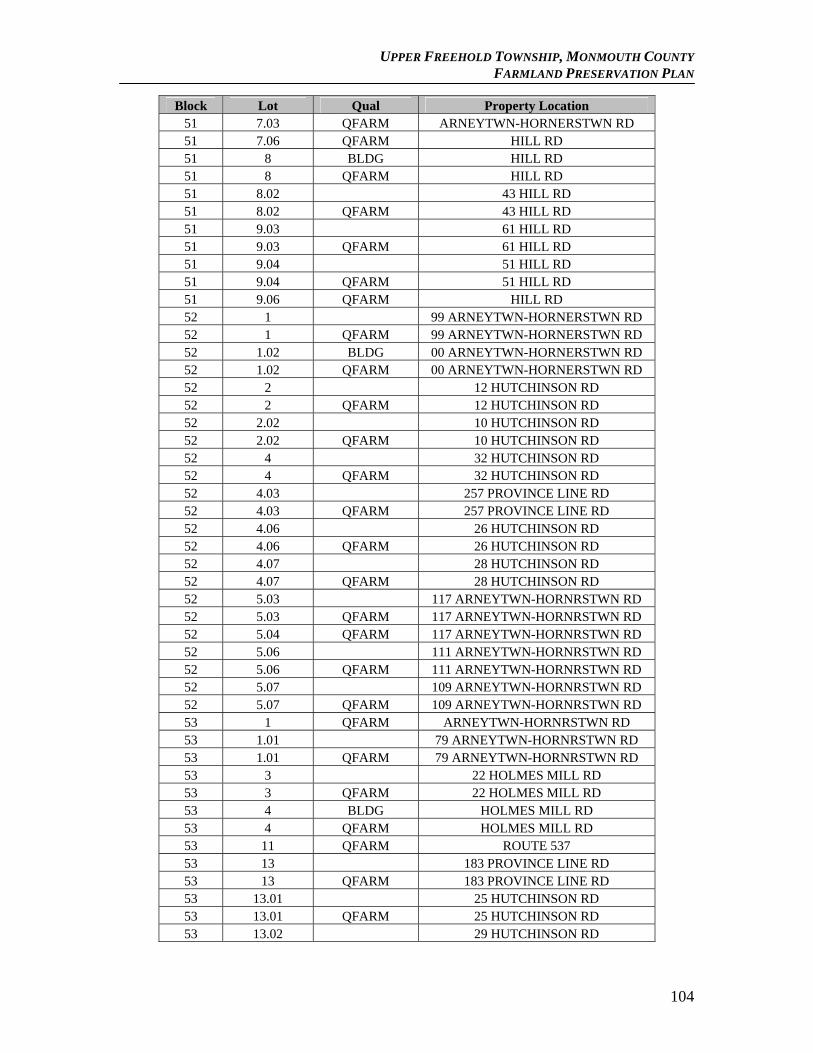
UPPER FREEHOLD TOWNSHIP, MONMOUTH COUNTY FARMLAND PRESERVATION PLAN
Block Lot Qual Property Location 51 7.03 QFARM ARNEYTWN-HORNERSTWN RD 51 7.06 QFARM HILL RD 51 8 BLDG HILL RD 51 8 QFARM HILL RD 51 8.02 43 HILL RD 51 8.02 QFARM 43 HILL RD 51 9.03 61 HILL RD 51 9.03 QFARM 61 HILL RD 51 9.04 51 HILL RD 51 9.04 QFARM 51 HILL RD 51 9.06 QFARM HILL RD 52 1 99 ARNEYTWN-HORNERSTWN RD 52 1 QFARM 99 ARNEYTWN-HORNERSTWN RD 52 1.02 BLDG 00 ARNEYTWN-HORNERSTWN RD 52 1.02 QFARM 00 ARNEYTWN-HORNERSTWN RD 52 2 12 HUTCHINSON RD 52 2 QFARM 12 HUTCHINSON RD 52 2.02 10 HUTCHINSON RD 52 2.02 QFARM 10 HUTCHINSON RD 52 4 32 HUTCHINSON RD 52 4 QFARM 32 HUTCHINSON RD 52 4.03 257 PROVINCE LINE RD 52 4.03 QFARM 257 PROVINCE LINE RD 52 4.06 26 HUTCHINSON RD 52 4.06 QFARM 26 HUTCHINSON RD 52 4.07 28 HUTCHINSON RD 52 4.07 QFARM 28 HUTCHINSON RD 52 5.03 117 ARNEYTWN-HORNRSTWN RD 52 5.03 QFARM 117 ARNEYTWN-HORNRSTWN RD 52 5.04 QFARM 117 ARNEYTWN-HORNRSTWN RD 52 5.06 111 ARNEYTWN-HORNRSTWN RD 52 5.06 QFARM 111 ARNEYTWN-HORNRSTWN RD 52 5.07 109 ARNEYTWN-HORNRSTWN RD 52 5.07 QFARM 109 ARNEYTWN-HORNRSTWN RD 53 1 QFARM ARNEYTWN-HORNRSTWN RD 53 1.01 79 ARNEYTWN-HORNRSTWN RD 53 1.01 QFARM 79 ARNEYTWN-HORNRSTWN RD 53 3 22 HOLMES MILL RD 53 3 QFARM 22 HOLMES MILL RD 53 4 BLDG HOLMES MILL RD 53 4 QFARM HOLMES MILL RD 53 11 QFARM ROUTE 537 53 13 183 PROVINCE LINE RD 53 13 QFARM 183 PROVINCE LINE RD 53 13.01 25 HUTCHINSON RD 53 13.01 QFARM 25 HUTCHINSON RD 53 13.02 29 HUTCHINSON RD
104
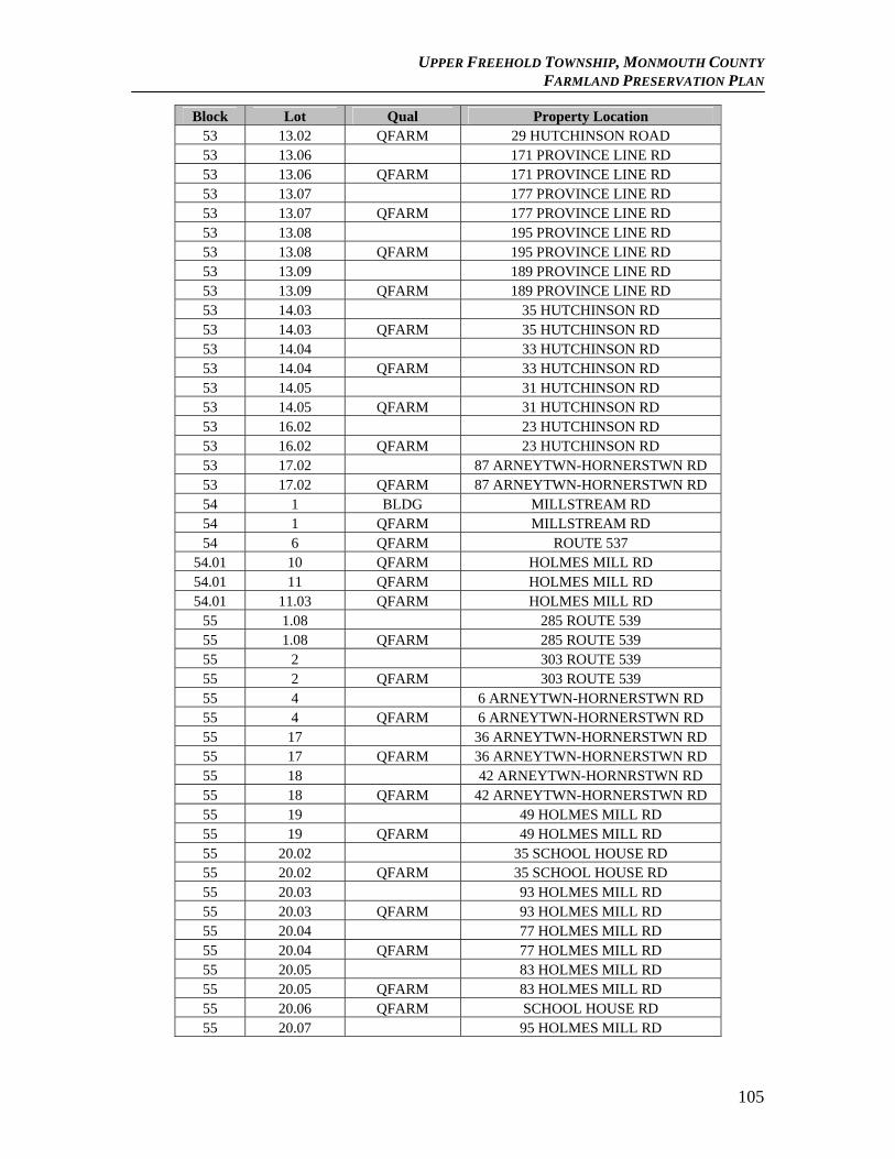
UPPER FREEHOLD TOWNSHIP, MONMOUTH COUNTY FARMLAND PRESERVATION PLAN
Block Lot Qual Property Location 53 13.02 QFARM 29 HUTCHINSON ROAD 53 13.06 171 PROVINCE LINE RD 53 13.06 QFARM 171 PROVINCE LINE RD 53 13.07 177 PROVINCE LINE RD 53 13.07 QFARM 177 PROVINCE LINE RD 53 13.08 195 PROVINCE LINE RD 53 13.08 QFARM 195 PROVINCE LINE RD 53 13.09 189 PROVINCE LINE RD 53 13.09 QFARM 189 PROVINCE LINE RD 53 14.03 35 HUTCHINSON RD 53 14.03 QFARM 35 HUTCHINSON RD 53 14.04 33 HUTCHINSON RD 53 14.04 QFARM 33 HUTCHINSON RD 53 14.05 31 HUTCHINSON RD 53 14.05 QFARM 31 HUTCHINSON RD 53 16.02 23 HUTCHINSON RD 53 16.02 QFARM 23 HUTCHINSON RD 53 17.02 87 ARNEYTWN-HORNERSTWN RD 53 17.02 QFARM 87 ARNEYTWN-HORNERSTWN RD 54 1 BLDG MILLSTREAM RD 54 1 QFARM MILLSTREAM RD 54 6 QFARM ROUTE 537
54.01 10 QFARM HOLMES MILL RD 54.01 11 QFARM HOLMES MILL RD 54.01 11.03 QFARM HOLMES MILL RD
55 1.08 285 ROUTE 539 55 1.08 QFARM 285 ROUTE 539 55 2 303 ROUTE 539 55 2 QFARM 303 ROUTE 539 55 4 6 ARNEYTWN-HORNERSTWN RD 55 4 QFARM 6 ARNEYTWN-HORNERSTWN RD 55 17 36 ARNEYTWN-HORNERSTWN RD 55 17 QFARM 36 ARNEYTWN-HORNERSTWN RD 55 18 42 ARNEYTWN-HORNRSTWN RD 55 18 QFARM 42 ARNEYTWN-HORNERSTWN RD 55 19 49 HOLMES MILL RD 55 19 QFARM 49 HOLMES MILL RD 55 20.02 35 SCHOOL HOUSE RD 55 20.02 QFARM 35 SCHOOL HOUSE RD 55 20.03 93 HOLMES MILL RD 55 20.03 QFARM 93 HOLMES MILL RD 55 20.04 77 HOLMES MILL RD 55 20.04 QFARM 77 HOLMES MILL RD 55 20.05 83 HOLMES MILL RD 55 20.05 QFARM 83 HOLMES MILL RD 55 20.06 QFARM SCHOOL HOUSE RD 55 20.07 95 HOLMES MILL RD
105
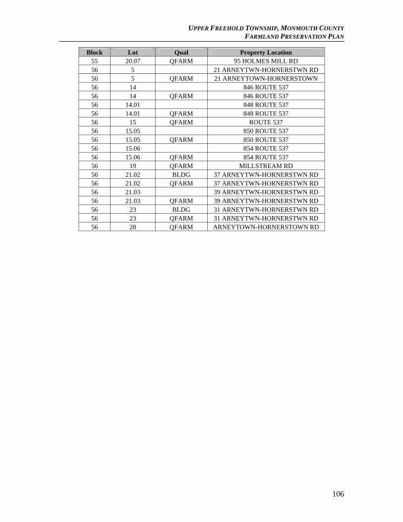
UPPER FREEHOLD TOWNSHIP, MONMOUTH COUNTY FARMLAND PRESERVATION PLAN
106
Block Lot Qual Property Location 55 20.07 QFARM 95 HOLMES MILL RD 56 5 21 ARNEYTWN-HORNERSTWN RD 56 5 QFARM 21 ARNEYTOWN-HORNERSTOWN 56 14 846 ROUTE 537 56 14 QFARM 846 ROUTE 537 56 14.01 848 ROUTE 537 56 14.01 QFARM 848 ROUTE 537 56 15 QFARM ROUTE 537 56 15.05 850 ROUTE 537 56 15.05 QFARM 850 ROUTE 537 56 15.06 854 ROUTE 537 56 15.06 QFARM 854 ROUTE 537 56 19 QFARM MILLSTREAM RD 56 21.02 BLDG 37 ARNEYTWN-HORNERSTWN RD 56 21.02 QFARM 37 ARNEYTWN-HORNERSTWN RD 56 21.03 39 ARNEYTWN-HORNERSTWN RD 56 21.03 QFARM 39 ARNEYTWN-HORNERSTWN RD 56 23 BLDG 31 ARNEYTWN-HORNERSTWN RD 56 23 QFARM 31 ARNEYTWN-HORNERSTWN RD 56 28 QFARM ARNEYTOWN-HORNERSTOWN RD
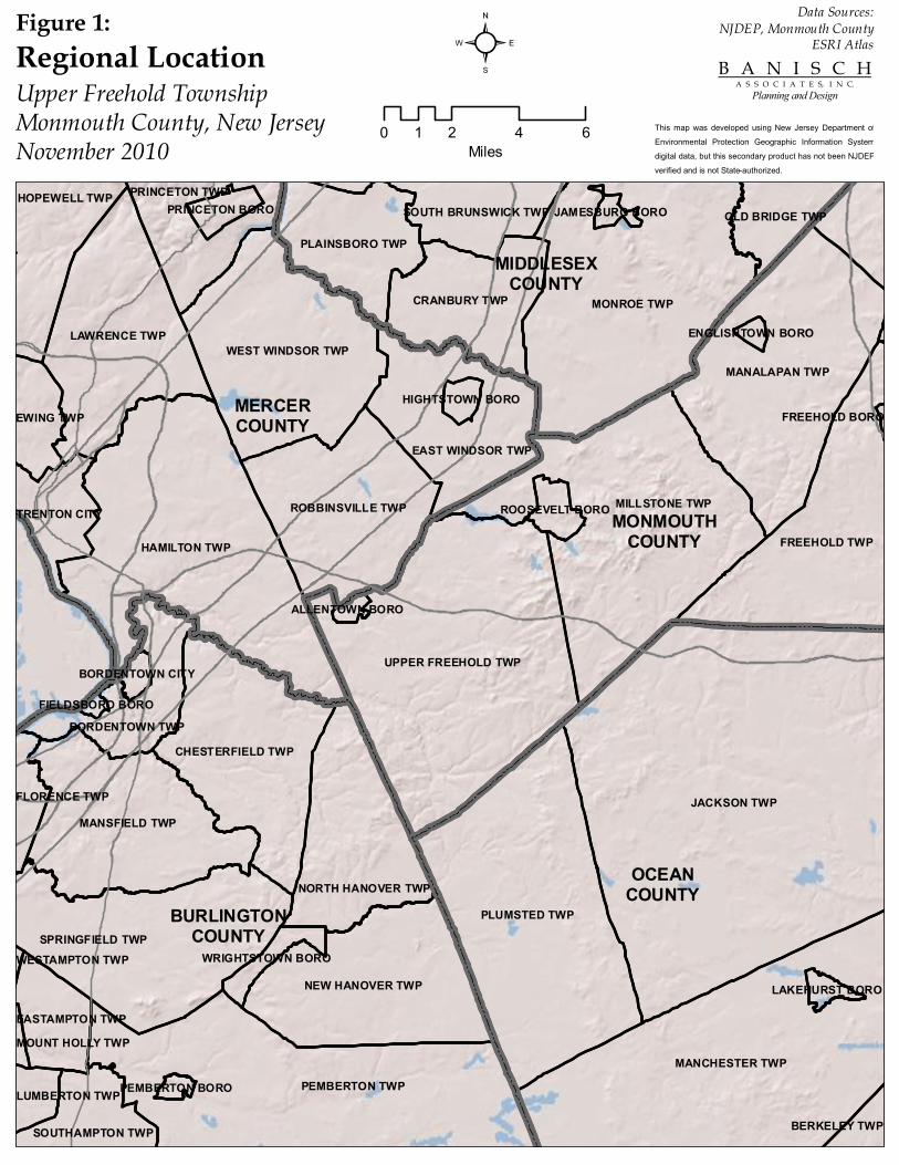
OCEANCOUNTY
MERCERCOUNTY
BURLINGTONCOUNTY
MONMOUTHCOUNTY
MIDDLESEXCOUNTY
JACKSON TWP
MONROE TWP
HAMILTON TWP
PLUMSTED TWP
MANCHESTER TWPPEMBERTON TWP
MILLSTONE TWP
UPPER FREEHOLD TWP
MANALAPAN TWP
FREEHOLD TWP
SPRINGFIELD TWP
LAWRENCE TWP
MANSFIELD TWP
WEST WINDSOR TWP
NEW HANOVER TWP
CHESTERFIELD TWP
ROBBINSVILLE TWP
EAST WINDSOR TWP
CRANBURY TWP
NORTH HANOVER TWP
PLAINSBORO TWP
HOPEWELL TWP
SOUTHAMPTON TWP
PRINCETON TWP
BORDENTOWN TWP
TRENTON CITY
EWING TWP
OLD BRIDGE TWP
EASTAMPTON TWP
SOUTH BRUNSWICK TWP
FLORENCE TWP
LUMBERTON TWP
BERKELEY TWP
ROOSEVELT BORO
PRINCETON BORO
WRIGHTSTOWN BORO
HIGHTSTOWN BORO
LAKEHURST BORO
BORDENTOWN CITY
JAMESBURG BORO
ALLENTOWN BORO
PEMBERTON BORO
ENGLISHTOWN BORO
FIELDSBORO BORO
MOUNT HOLLY TWP
WESTAMPTON TWP
FREEHOLD BORO
²Regional LocationUpper Freehold TownshipMonmouth County, New JerseyNovember 2010 0 2 4 61
Miles
B A N I S C H A S S O C I A T E S, I N C.
Planning and Design
This map was developed using New Jersey Department of Environmental Protection Geographic Information System digital data, but this secondary product has not been NJDEP verified and is not State-authorized.
Data Sources:NJDEP, Monmouth County
ESRI AtlasFigure 1:
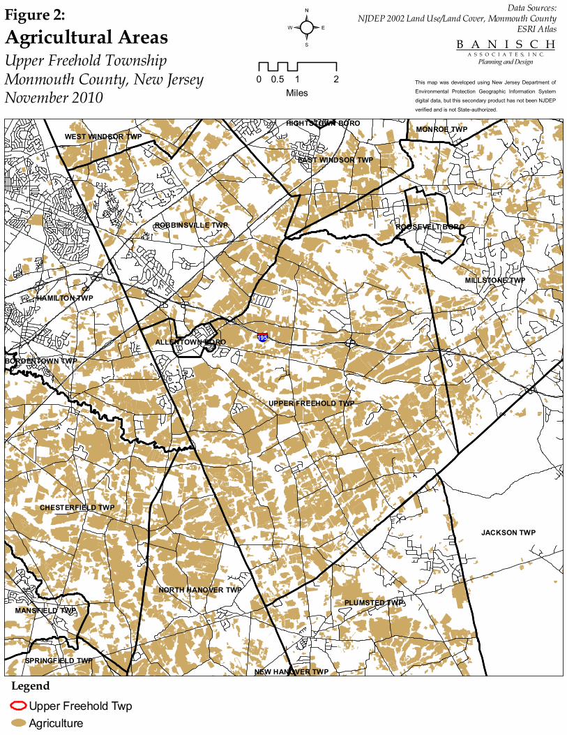
UPPER FREEHOLD TWP
MILLSTONE TWP
HAMILTON TWP
JACKSON TWP
PLUMSTED TWP
ROBBINSVILLE TWP
CHESTERFIELD TWP
NORTH HANOVER TWP
EAST WINDSOR TWP
MANSFIELD TWP
WEST WINDSOR TWP
SPRINGFIELD TWP
MONROE TWP
ROOSEVELT BORO
ALLENTOWN BORO
BORDENTOWN TWP
HIGHTSTOWN BORO
NEW HANOVER TWPLegend
Upper Freehold TwpAgriculture
²
§̈¦195
Agricultural AreasUpper Freehold TownshipMonmouth County, New JerseyNovember 2010
0 1 20.5Miles
B A N I S C H A S S O C I A T E S, I N C.
Planning and Design
This map was developed using New Jersey Department of Environmental Protection Geographic Information System digital data, but this secondary product has not been NJDEP verified and is not State-authorized.
Data Sources:NJDEP 2002 Land Use/Land Cover, Monmouth County
ESRI AtlasFigure 2:
526
539
539
524
537
Hill Road
Holmes Mill Road
Meirs Road
§̈¦195
Burlington Path Road
LegendVacantResidentialFarm AssessedFarm QualifiedCommercialIndustrialPublic SchoolPublic PropertyChurchCemeteryOther ExemptNo Data
²Property Tax ClassUpper Freehold TownshipMonmouth County, New JerseyNovember 2010
0 10.5Miles
B A N I S C H A S S O C I A T E S, I N C.
Planning and Design
This map was developed using New Jersey Department of Environmental Protection Geographic Information System digital data, but this secondary product has not been NJDEP verified and is not State-authorized.
Data Sources:NJDEP, Monmouth County,
New Jersey Association of County Tax BoardsFigure 3:
526
539
539
524
537
Hill Road
Holmes Mill Road
Meirs Road
§̈¦195
Burlington Path Road
LegendProject AreaAgricultureBarren LandForestUrbanWaterWetlands
²2002 Land Use/Land CoverUpper Freehold TownshipMonmouth County, New JerseyNovember 2010
0 10.5Miles
B A N I S C H A S S O C I A T E S, I N C.
Planning and Design
This map was developed using New Jersey Department of Environmental Protection Geographic Information System digital data, but this secondary product has not been NJDEP verified and is not State-authorized.
Data Sources:NJDEP, Monmouth CountyFigure 4:
526
539
539
524
537
Hill Road Holmes Mill Road
Meirs Road
§̈¦195
Burlington Path Road
LegendCropland and PasturelandParcel
²Cropland and PasturelandUpper Freehold TownshipMonmouth County, New JerseyNovember 2010 0 21
Miles
B A N I S C H A S S O C I A T E S, I N C.
Planning and Design
This map was developed using New Jersey Department of Environmental Protection Geographic Information System digital data, but this secondary product has not been NJDEP verified and is not State-authorized.
Data Sources:NJDEP 2002 LU/LC, Monmouth County
ESRI AtlasFigure 5:
*Orchard and nursery acreage are not shown on this map
UPPER FREEHOLD TWP
PLUMSTED TWP
ROBBINSVILLE TWP
NORTH HANOVER TWP
MILLSTONE TWP
HAMILTON TWP
JACKSON TWP
CHESTERFIELD TWP
MILLSTONE TWPROOSEVELT BORO
ALLENTOWN BORO
EAST WINDSOR TWP
LegendCounty Target FarmsUpper Freehold Target FarmsUpper Freehold Project AreaCounty ADAPreserved FarmPublic Property
²Monmouth CADB Agricultural DevelopmentArea, Proposed Township Project Areas,Target Farms and Preserved FarmsUpper Freehold TownshipMonmouth County, New JerseyNovember 2010 0 21
Miles
B A N I S C H A S S O C I A T E S, I N C.
Planning and Design
This map was developed using New Jersey Department of Environmental Protection Geographic Information System digital data, but this secondary product has not been NJDEP verified and is not State-authorized.
Data Sources:NJDEP, Monmouth County Planning Dept.,
ESRI AtlasFigure 6:
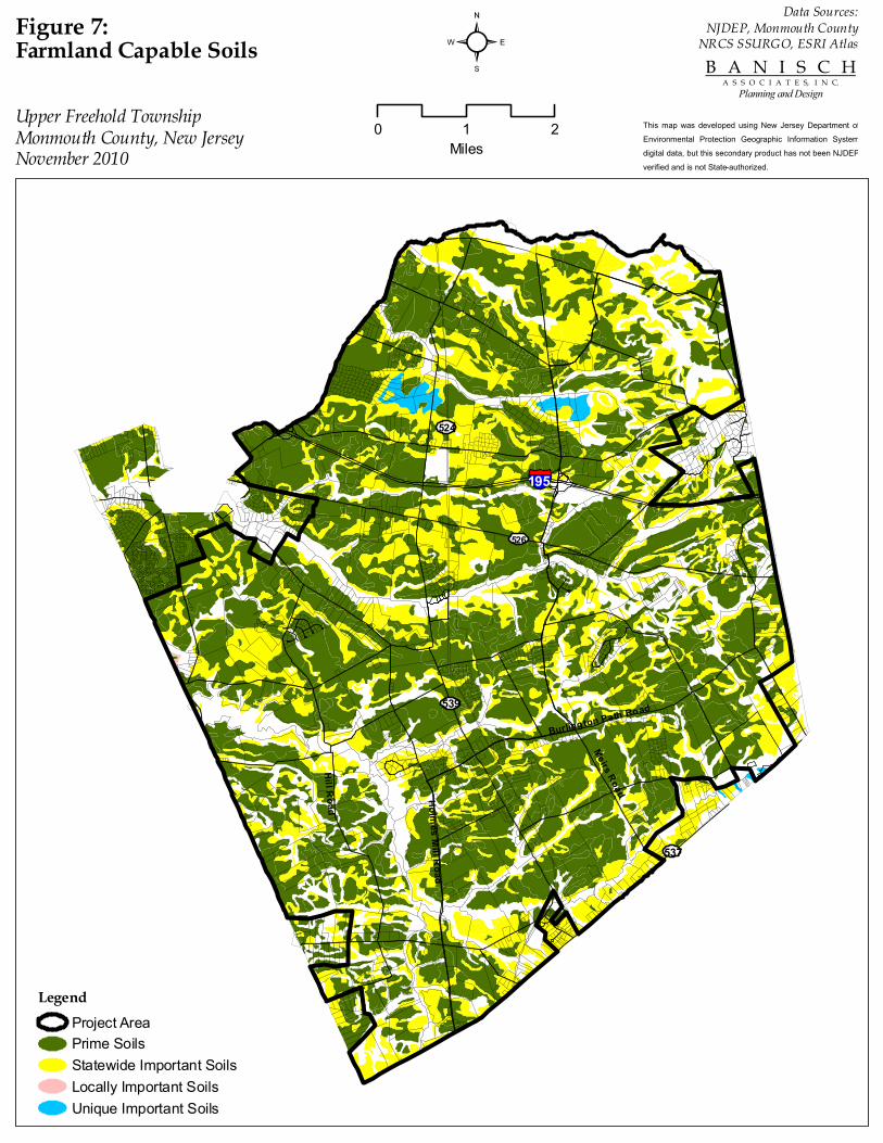
Hill Road
Holmes Mill Road
Meirs Road
Burlington Path Road
§̈¦195
537
524
539
526
²Farmland Capable Soils
Upper Freehold TownshipMonmouth County, New JerseyNovember 2010
0 21Miles
B A N I S C H A S S O C I A T E S, I N C.
Planning and Design
This map was developed using New Jersey Department of Environmental Protection Geographic Information System digital data, but this secondary product has not been NJDEP verified and is not State-authorized.
Data Sources:NJDEP, Monmouth County
NRCS SSURGO, ESRI AtlasFigure 7:
LegendProject AreaPrime SoilsStatewide Important SoilsLocally Important SoilsUnique Important Soils
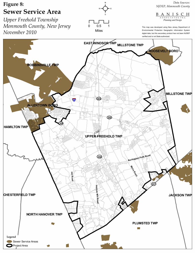
526
539
539
524
537
Hill Road
Holmes Mill Road
Meirs Road
§̈¦195
Burlington Path Road
UPPER FREEHOLD TWP
PLUMSTED TWP
ROBBINSVILLE TWP
NORTH HANOVER TWP
MILLSTONE TWP
HAMILTON TWP
MILLSTONE TWP
JACKSON TWPCHESTERFIELD TWP
ROOSEVELT BORO
ALLENTOWN BORO
EAST WINDSOR TWP
LegendSewer Service AreasProject Area
²Sewer Service AreaUpper Freehold TownshipMonmouth County, New JerseyNovember 2010
0 10.5Miles
B A N I S C H A S S O C I A T E S, I N C.
Planning and Design
This map was developed using New Jersey Department of Environmental Protection Geographic Information System digital data, but this secondary product has not been NJDEP verified and is not State-authorized.
Data Sources:NJDEP, Monmouth CountyFigure 8:
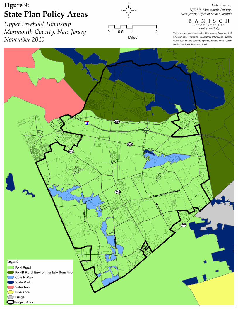
526
539
539
524
537
Hill Road
Holmes Mill Road
Meirs Road
§̈¦195
Burlington Path Road
LegendPA 4 RuralPA 4B Rural Environmentally SensitiveCounty ParkState ParkSuburbanPinelandsFringeProject Area
²State Plan Policy AreasUpper Freehold TownshipMonmouth County, New JerseyNovember 2010
0 1 20.5Miles
B A N I S C H A S S O C I A T E S, I N C.
Planning and Design
This map was developed using New Jersey Department of Environmental Protection Geographic Information System digital data, but this secondary product has not been NJDEP verified and is not State-authorized.
Data Sources:NJDEP, Monmouth County,
New Jersey Office of Smart GrowthFigure 9:
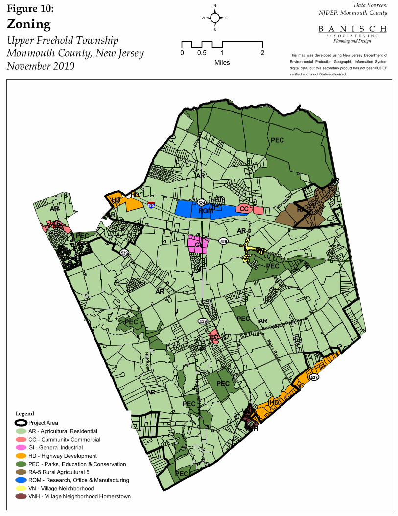
526
539
539
524
537
Hill Road
Holmes Mill Road
Meirs Road
§̈¦195
Burlington Path Road
AR
AR
AR
AR
AR
PEC
HD
AR RA-5
PEC
PEC
ROM
PEC
GI
HDCC
PEC
PEC
PEC
VN
CC
CC
AR
PEC
VNH
AR
VNH
HD
LegendProject AreaAR - Agricultural ResidentialCC - Community CommercialGI - General IndustrialHD - Highway DevelopmentPEC - Parks, Education & ConservationRA-5 Rural Agricultural 5ROM - Research, Office & ManufacturingVN - Village NeighborhoodVNH - Village Neighborhood Hornerstown
²ZoningUpper Freehold TownshipMonmouth County, New JerseyNovember 2010
0 1 20.5Miles
B A N I S C H A S S O C I A T E S, I N C.
Planning and Design
This map was developed using New Jersey Department of Environmental Protection Geographic Information System digital data, but this secondary product has not been NJDEP verified and is not State-authorized.
Data Sources:NJDEP, Monmouth CountyFigure 10:
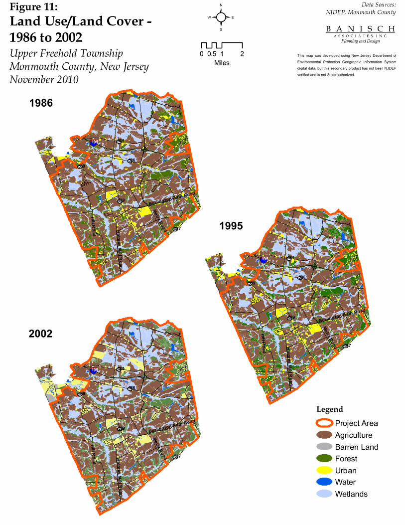
526539
539
524
537
Hill Road Holmes Mill Road
Meirs Road
§̈¦195
Burlington Path Road
LegendProject AreaAgricultureBarren LandForestUrbanWaterWetlands
²Land Use/Land Cover - 1986 to 2002Upper Freehold TownshipMonmouth County, New JerseyNovember 2010
0 1 20.5Miles
B A N I S C H A S S O C I A T E S, I N C.
Planning and Design
This map was developed using New Jersey Department of Environmental Protection Geographic Information System digital data, but this secondary product has not been NJDEP verified and is not State-authorized.
Data Sources:NJDEP, Monmouth CountyFigure 11:
526539
539
524
537
Hill Road Holmes Mill Road
Meirs Road
§̈¦195
Burlington Path Road
526539
539
524
537
Hill Road Holmes Mill Road
Meirs Road
§̈¦195
Burlington Path Road
2002
1995
1986