Embed Size (px)
Citation preview
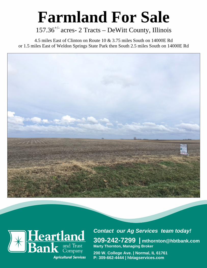
Farmland For Sale 157.36+/- acres- 2 Tracts – DeWitt County, Illinois
4.5 miles East of Clinton on Route 10 & 3.75 miles South on 14000E Rd or 1.5 miles East of Weldon Springs State Park then South 2.5 miles South on 14000E Rd
Contact our Ag Services team today!
309-242-7299 | [email protected] Marty Thornton, Managing Broker
200 W. College Ave. | Normal, IL 61761 P: 309-662-4444 | hbtagservices.com

2
Farmland For Sale – DeWitt County, Illinois
Acres1 Price/Acre Soil PI3 Major Soil Types3 PIN #’s 1 80+/- $ 11,250.00 139.7 Sable, Catlin, Ipava 13-28-300-003
$4,779.02 (2014) 77.36+/- $ 10,950.00 136.8 Catlin, Sable, Ipava
Farm5 # Program5 Corn Base Ac.5 SB Base Ac.5 HEL5 or CRP5
3991 ARC-CO 78.30 78.20 None
Sale Terms6: Yield History*:
* Yield Information part of a larger farm operation
Year Corn* SB* 2015 204 69 2014 244 70 2013 189 57 2012 130 58 2011 189 54 2010 161 64 2009 182 56 2008 207 52 2007 186 56 2006 178 55
Average 187 59.1
Terms6: Ten percent (10%) down payment will be required from Buyer at execution of the purchase contract. Balance will be due seller at closing. Closing will be scheduled within 30 days of the signing of the contract.
Title6: Seller will furnish Buyer a title policy in the amount of the purchase price subject to the usual and customary exceptions. Mineral rights if any will be conveyed with the land unless otherwise specified in the contract.
Taxes6: 2015 Real estate taxes, due in 2016, may be given as a credit to the Buyer at the time of closing. All subsequent year taxes shall be the responsibility of the Buyer.
Possession6: Seller will give possession after closing and following harvest subject to the Tenant’s 2015 lease.
Agency6: Marty Thornton, Managing Broker, is the designated agent with Heartland Bank and Trust Co., licensed Real Estate Broker Corp, represents the Seller of the subject property.
Disclosure6: 6While the information contained in the brochure is considered accurate; it is subject to the Buyer’s own verification. The Seller, and Heartland Bank and Trust Co, assumes no liability for errors or omissions and reserves the right to alter terms of the listing.
1. Acres are taxable acres; 157.36+/-
acres. 2. Locations are approximate 3. Soils data provided by USDA, NRCS and Surety Maps are approximate 4. Property borders are approximate, and do NOT reflect an actual boundary line 5. Data provided by USDA , DeWitt County FSA 6. Disclosures

12
RYAN UTTERBACKManaging Broker
Cell: (217) 620-5332
Business: (217) 935-8182 - Fax: (217) 935-4481Email: [email protected]
www.utterbackrealestate.com211 W. VAN BUREN - CLINTON, ILLINOIS 61727
UTTERBACKR E A L E S T A T E
• RESIDENTIAL• COMMERCIAL
• FARM
RD
WE
L DO
NR
D
RD
D
a
0
DAMLAKE
y
WELDON
SPRINGS
STATE
PARK
CLINTON
A 42
l &0
7
vessley14
A
A
SE
TTIN
GS
UN
3
RD
DOVE RD
Geo
rge
A&
Virg
inia
J Tr
s 40
Rog
er &
Deb
ra 8
8Roger LTr 66
Peter G
III
& Merr
ibeth
40
Constance80
Jackson &Rosemary
40
JohnsonMinnie &
MillerJohn Tr
40
Cathy &Hearn
Michael PEtal 80
Cat
hy &
Hea
rnM
icha
el P
Etal
40
LLC 40
ThomasJ Trust
78
Russell &JaniceTr 40
Richard A& Huth
Janet Tr40
Russell &JaniceTr 40
RichardA & HuthJanet Tr
40
LANE
CLINTON LAKE
:910
:910
OSPURRD
LAKEFORK
RDBR
US
HC
OLL
EG
ER
D
WH
ITE
PIG
EO
NRD
LEG
HO
RN
RD
SHILOHRD
CO
NN
OR
SR
D
CE
NTR
AL
RD
RD
CE
ME
TE
RY
RD
SP
RIN
GS
RE
DTA
ILH
AW
KR
D
JEFFERSON
AIRPORT RD
TAFT
RD
BROADWAY RD
MIDDLE CREEK RD
AIRPORT RD
FALCON
RD
LAKESHORE RD
W
EST S I DE
RD
SA L T
CR
FRIEN DSCR
123456
121110987
131415161718
242322212019
252627282930
363534333231
CLINTON
Wan
tland
R&
D E
tal 1
10
UtterbackRussell &
Janice Tr 113
MoberlyFarm
Trust 40MayallRalphP 78
MayallRalph& AliceTrust
83
Har
bach
Virg
ilTr
ust 7
8 CurlHelen
MTrust
60
Wan
tland
Rog
er &
Deb
ra 7
8
UtterbackRussell &
Janice Tr 78
Thayer Kevin L &Debbie J 62
PremiereFarmProp
LLC 41
PenseMarcia K
150
Koyak
Heartland Pathways 44
HarbachEuniceTrust 38
HarbachEuniceK 74
Will
isTe
rry
L &
Wilm
a 34
State ofIL 125
NorthMarilynJ Trust
67DouglasRichard
L 61
CunninghamJD & EC 322
Vann
ice
Dav
id L
& S
haro
nK
47
Har
bach
Eun
ice
K 7
0GravesWesleyR 162 Blue
JuneG 156
ArnoldDonna KTrust 68
ArnoldClarene
80
WantlandR&D
Etal 40
Schm
idJe
sse
162
JohnstonLillian R
Trust33
Finfrock Marvin E Jr& Shelley R 190
Exelon162
Wantland W
antla
nd
Exelon 445
Ward
HuisingaJohn G 100
City of DecaturFarm 120
BolsBernard
K &Deborah
40
Bols Bernard &Deborah Etal 227
Age
eR
icha
rd R
& V
iola
MTr
ust 1
08
SloanThomasG 117
Lang
ley
Don
ald
A 40
GuthrieCharlesW Jr 80
Bols Bernard Etal 320
BidnerBrentR &
Lisa 79
Ward
Utterback
TottenAlbert &Vanessa
40
RobertsDaniel E& Shelly
A 40
Ree
d &
Hug
hes
Trus
t 80
Kau
fman
Mer
le 4
0
KaufmanFay 40
Johnson Orville &Muellner Donald R 120
GrovesHelenH 80
FugateDonald
40
Ellis TrustEtal 80Voorhees
William 100
ShoemakerWillard DTrust 140
PfcgLLC80
HaysDavid &Pamela
136
GiesekeEmagene
E 80
Cus
hing
M &
Day
R E
tal 8
0
Waller Helen BTrust 150
UtterbackRyan R& Audra
J 36
ShoemakerWillard DTrust 80
IL MasonicHome 160
Hoffm
anTerry K& C
indyA 50
Hoffman Kyle J 50
BrownHerman
E &Sharon
L 40
92131LLC 54
Waller Helen BTrust 320
Sprague PA &RE Etal 190
Smith Patricia 98
Brown Herman E &Sharon L 73
YagowDonnaJ 73
Sch
mid
Jess
e36
FosnaughEtal 40
Curl ThomasJ Trust 80
Busey First Natl Bank 404
Exelon 552
AdcockRobert
F &LauraL 35
Global Ag PropUsa LLC 320
Curl Helen MTrust 318
TuggleGladysE 200
SchultzRoger S &Vida M 157
Sch
lupp
&S
emke
80
Ford DoloresTrust 80
Day
Woo
lum
s &
Car
olus
80
ComerJerry L& Kathy
A 40
Utte
rbac
kW
ayne
&S
hirle
y 76
HepperlenHelen H
Trust 320 EllisTrustEtal120
ClarkVirginia
L 80
AtteberryLynn 40
WarnerJohn IV 82 Totten Albert &
Vanessa 158
Titus FrancisM Trust 159
State Bank ofGraymontTr 77
MasseyDavid L &
Roger W 80
BobbycoLLC 80
Voorhees Clara W Trust 320
StrohRamona
80
Connett Martha M Trust 238
WarnerJohn IV 162
StrohRamona
118
GobleGordon
160
CurlThomas
J &HelenM 40
Blue JuneG 160
WarnerJohn IV 328
GobleGordon &Wilma 160
EricksonNancy J
40EricksonDavid C& Nancy
J 120
WarnerJohnIV 81
Utterback
Tugg
leS
teph
enR
38
TuggleRichard
R &Marjorie
L 80
MillerPaulD 40
LisenbyElwin120
JohnsonOrvilleEtal 80
CurlTuggle Richard R
&M
arjor ie L 80
Spr
ingt
ime
LLLP
80
Sch
i ck
Dan
nyL
Trus
t 108
MillerStevenD 80
MasseyDonaldE 100
BurtonM &
ReinholdE 180
Atc
haso
nLy
nda
K 8
0
L
Monarch Farms
LisenbyElwin
81
LarsonKaren 80
Iwu-RaneyFarm 40
Getz Douglas S& Carol R 80
Ford
Dol
ores
Trus
t40
EO
Mar
tinLa
nd C
o 19
9
CaravelasIL Inc 80
Titu
s Fr
anci
sM
Tru
st 9
9
Moo
dy E
rnes
t D &
Pris
cilla
L 8
7
Exelon 284
DewittCounty 35
BlueJohn U& JuneG Trust
76
MonarchFarms
LLC 158
Hooker Jered& Jane 200
Heartland Bank& Trust 269
WienekeBob D 50
Rog
ers
Rod
ney
L &
Pam
ela
D 6
8
Primmer DJ &Trummel GM 98
Oakley RJacobson
L &Tooley 72
Molitoris ERandolph &Sandra 48
Hooker Jered& Jane 118
Harrold VObera
Trust 84
Stro
h R
&C
hast
ain
Bro
s 58
Prie
stM
ary
WTr
ust 4
0
PremiereFarmProp
LLC 46
Jone
sHarrold VObera
Trust 80
HarbachVirgil T 82
FergusonDanny R 98
CurlHelen
MTrust100
ArmstrongCharles 30
Wan
tland
Dix
ie L
80
Jones
EllisMarcellaEst 80
Curl Thomas JTrust 275
CurlThomas
J &Helen M
Tr 40
Blue John U &June G Trust 80
WarnerJohnIV 80
Oda
ffer
Fam
ilyP
tnsp
40
Oak
ley
Cus
hing
& D
ay 4
0
Nickelson
Phyllis J 40
MillerPaulD &
StevenD 80
LisenbyElwin
40
John
son
Orv
ille
Etal
40
FugateDonald
40
DayJessieM 80
ConnellMW &
ShusterPA 40
Blue John U& June GTrust 80
WiseViola
78
WarnerJohnIV 82
OdafferHarrietG Trust
78Nichols H
Martin WilliamE Etal 140
FugateDonald 80
Connell MW &Shuster PA 80
AndersonWesley
R 40
WantlandRoger L
Tr 40
TottenRobert KTrust 58
TottenEdna J 62
SwartzJamesW 78
NewbergJL & Blue
W J 75
Little RobertA & Jane R
Trust 80
Goble Gordon& Wilma 80
Blue June G 160
Wan
tland
Rog
er L
Tr 7
7
McI
ntos
h La
chic
Farm
s LL
C 1
20Jenkins
GobleRodney
G &Karen
76
EO MartinLand Co 153
Augsburg William J& Kathryn A 66
Augsburg Kathryn A Trust 54
RiddleLorin E &
Rita RTrusts 40
Nic
kels
onP
hylli
s J
79
New
berg
JL
&D
avid
J E
tal 7
8
LisenbyElwin
80
Exelon34
EO MartinLand Co 146
Blue John U& June GTrust 132
Tugg
leS
tanl
eyR
56 Riddle Lorin
E & Rita RTrusts 89
MerriellJoseph
A 40
LhmFarms
75
JohnsonOrville
Etal 157
Fritts T& Lynch-Gardner
M 40
WarnerHeritageLLC 80
Tool
SchlesingerDonald JTrust 119
JohnsonStanford
H 120
Exelon 102DavenportFloyd Est 31
Bak
er C
LTr
ust
Eta
k 40
C
A
BE
BA
D
CB
C
B
A
C B
A
DA
CDB
A
A
A
A
C B
A
B
A
A
B
C AB
E
F
A
C
D B
C
B
A
A
A
B
A
B
E
D
AC
C
A
D
B
63
4
5
5
5
6
5
4 4
4
33
6
4
3
4
4
34
4
4
5
4
3
4
3
4
4
5
6 55
6
5
5
5
55
5
6
5
5
4
34
4
555
6 4
6
6
SH
Sax
er
M
P
BriAr
K
A
5
38
LAKE STATE
RECREATION
AREA
AREA
WE
MARINA RDLILA
y42
K Trust 169E
88° 55' 88° 54' 88° 53' 88° 52' 88° 51' 88° 50' 88° 49'
40° 0
4'40
° 05'
40° 0
6'40
° 07'
40° 0
8'
SEE PAGE 22
MACON COUNTY
SE
E
PA
GE
1
0
SE
E
PA
GE
1
4
2015 Rockford Map Publs., Inc.cDe Witt County, IL
T.19N.-R.3E.CREEK
13000E12000E 14000E 15000E 16000E 17000E 18000E
1000
N00
0N20
00N
3000
N40
00N
5000
N60
00N
Refer to page 41 for keyed parcels

De Witt CountyIllinois
11/23/2015
map center: 40° 4' 20.02, 88° 52' 28.91
Aerial Map
28-19N-3E
0ft 512ft 1024ft
Field borders provided by Farm Service Agency as of 5/21/2008. Soils data provided by University of Illinois at Champaign-Urbana.
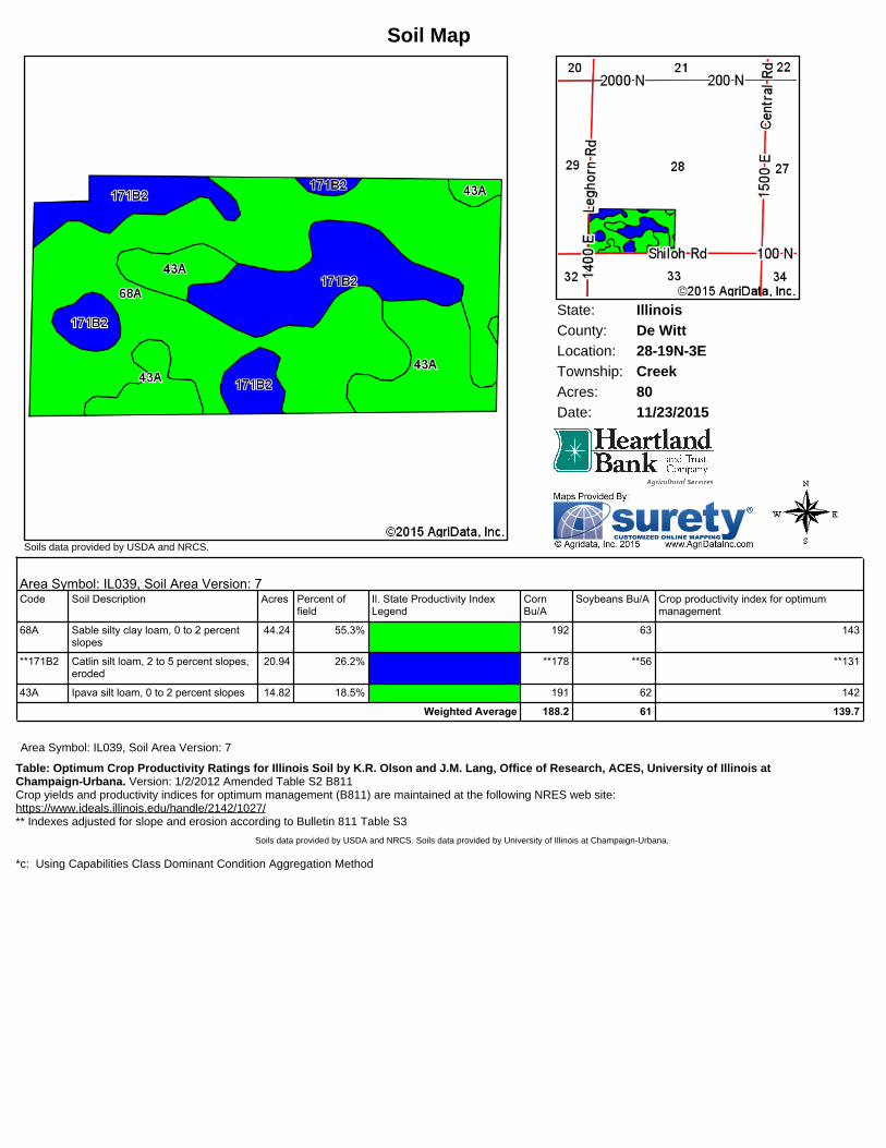
State: IllinoisDe WittCounty:28-19N-3ELocation:
Township: CreekAcres: 80Date: 11/23/2015
Soils data provided by USDA and NRCS.
Soil Map
Area Symbol: IL039, Soil Area Version: 7Code Soil Description Acres Percent of
fieldIl. State Productivity IndexLegend
CornBu/A
Soybeans Bu/A Crop productivity index for optimummanagement
68A Sable silty clay loam, 0 to 2 percentslopes
44.24 55.3% 192 63 143
**171B2 Catlin silt loam, 2 to 5 percent slopes,eroded
20.94 26.2% **178 **56 **131
43A Ipava silt loam, 0 to 2 percent slopes 14.82 18.5% 191 62 142
Weighted Average 188.2 61 139.7
Area Symbol: IL039, Soil Area Version: 7
Table: Optimum Crop Productivity Ratings for Illinois Soil by K.R. Olson and J.M. Lang, Office of Research, ACES, University of Illinois atChampaign-Urbana. Version: 1/2/2012 Amended Table S2 B811Crop yields and productivity indices for optimum management (B811) are maintained at the following NRES web site:https://www.ideals.illinois.edu/handle/2142/1027/** Indexes adjusted for slope and erosion according to Bulletin 811 Table S3
Soils data provided by USDA and NRCS. Soils data provided by University of Illinois at Champaign-Urbana.
*c: Using Capabilities Class Dominant Condition Aggregation Method

De Witt CountyIllinois
11/23/2015
map center: 40° 4' 20.02, 88° 52' 28.91
Aerial Map
28-19N-3E
0ft 512ft 1024ft
Field borders provided by Farm Service Agency as of 5/21/2008. Soils data provided by University of Illinois at Champaign-Urbana.
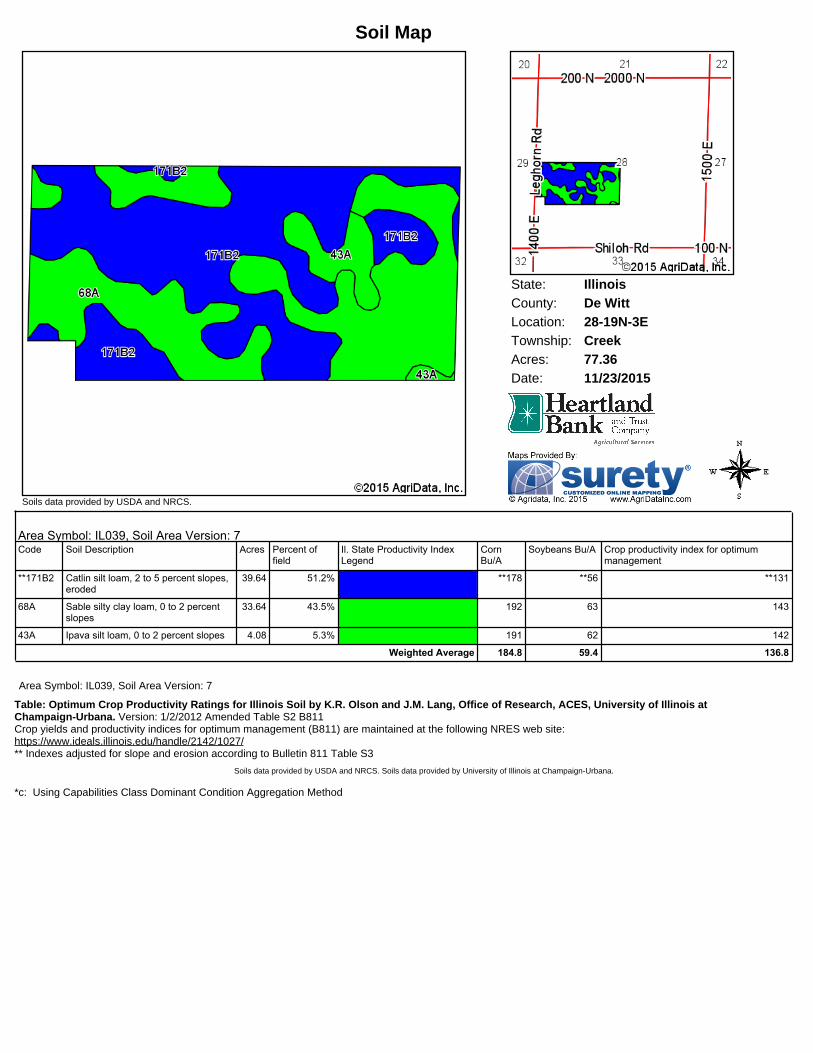
State: IllinoisDe WittCounty:28-19N-3ELocation:
Township: CreekAcres: 77.36Date: 11/23/2015
Soils data provided by USDA and NRCS.
Soil Map
Area Symbol: IL039, Soil Area Version: 7Code Soil Description Acres Percent of
fieldIl. State Productivity IndexLegend
CornBu/A
Soybeans Bu/A Crop productivity index for optimummanagement
**171B2 Catlin silt loam, 2 to 5 percent slopes,eroded
39.64 51.2% **178 **56 **131
68A Sable silty clay loam, 0 to 2 percentslopes
33.64 43.5% 192 63 143
43A Ipava silt loam, 0 to 2 percent slopes 4.08 5.3% 191 62 142
Weighted Average 184.8 59.4 136.8
Area Symbol: IL039, Soil Area Version: 7
Table: Optimum Crop Productivity Ratings for Illinois Soil by K.R. Olson and J.M. Lang, Office of Research, ACES, University of Illinois atChampaign-Urbana. Version: 1/2/2012 Amended Table S2 B811Crop yields and productivity indices for optimum management (B811) are maintained at the following NRES web site:https://www.ideals.illinois.edu/handle/2142/1027/** Indexes adjusted for slope and erosion according to Bulletin 811 Table S3
Soils data provided by USDA and NRCS. Soils data provided by University of Illinois at Champaign-Urbana.
*c: Using Capabilities Class Dominant Condition Aggregation Method