Embed Size (px)
Citation preview
Fall 2007/Spring 2008 Fire Weather Operations Plan
for Eastern
Kentucky
National Weather Service Forecast Office
Jackson, KY
TABLE OF CONTENTS
PAGE Table of Contents 2 Service Area and Fire Weather Organizational Directory 4 National Weather Service Offices (NWS) 4 Participating Agencies/User Contact Information 8 Services Provided by the National Weather Service (NWS) 17 Basic Services 17 Fire Weather Planning Forecast (FWF) 17 Individual Station Forecasts (Fire Weather Matrices-FWM) 22 Fire Season 31 Red Flag Forecasts 31 Verification of Red Flag Forecasts 31 NOAA All Hazards Radio 33 Participation in Interagency Groups 37 Special Services 37 Incident Meteorologists (IMETs) 37 Fire Weather Station Visits 41 Training 41
1
Wildland Fire Agency Responsibilities 41 Joint Responsibilities 42 Backup Procedures 42 Signature Page 42 Appendices: 43 1: Fire Weather Zones 43 2: Example of an FWF 44 3: Example of an FWM 47 4: Example of an RFW 48 5: Example of an FWS 50 6: Memorandum of Agreement 51
2
I. INTRODUCTION This Annual Operating Plans identifies services provided by the National Weather Service (NWS) Office in Jackson, KY. The area of responsibility or County Warning Area (CWA) includes 33 counties in the eastern portion of KY. This includes nearly the entire Daniel Boone National Forest as well as a very small section of the Jefferson National Forest lying right along the VA/KY border in Pike and Letcher counties. Portions of the Cumberland Gap National Historical Park and the Big South Fork National River and Recreation Area also lie in the area of responsibility. The Jackson CWA is covered by the Southern Area Geographic Coordination Center. The Southern Area Cache is located within the CWA at London, KY.
The National Weather Service's Fire Weather Program is designed to provide forecasts, warnings, and consultation services for the prevention, suppression, and management of forest and rangeland fires and for a host of land management activities. These meteorological services are built to meet the weather requirements of federal and state wild land managers. Hazmat forecasts issued for county, city, or other local government officials are also considered part of the Fire Weather Program.
The program is customer-oriented and is not limited to just wild fire management, but also includes all forest and range management weather support (such as prescribed burns and spot forecasts). Weather support is available throughout the year, 24/7. Services fall into two categories, basic and special.
This Operations Plan complements the Georgraphic Area Coordinating Center Memorandum of Understanding (MOU), by defining the services provided by the Jackson, KY National Weather Forecast Office. The plan covers how special weather services can be requested, such as weather-related courses or an on-site Incident Meteorologist (IMET), how they will be provided, and how compensation will be rendered if need be. Please refer to the Geographic Area Mobilization Guide and/or the National Mobilization Guide for further details about these special services. This plan will be reviewed annually by all parties. Any intermediate changes or amendments will be coordinated with all parties involved before the changes are incorporated.
II. Service Area and Organizational Directory A. National Weather Service Offices 1. National Weather Service Office, Jackson
1329 Airport Rd. Jackson, KY 41339 Phone:
3
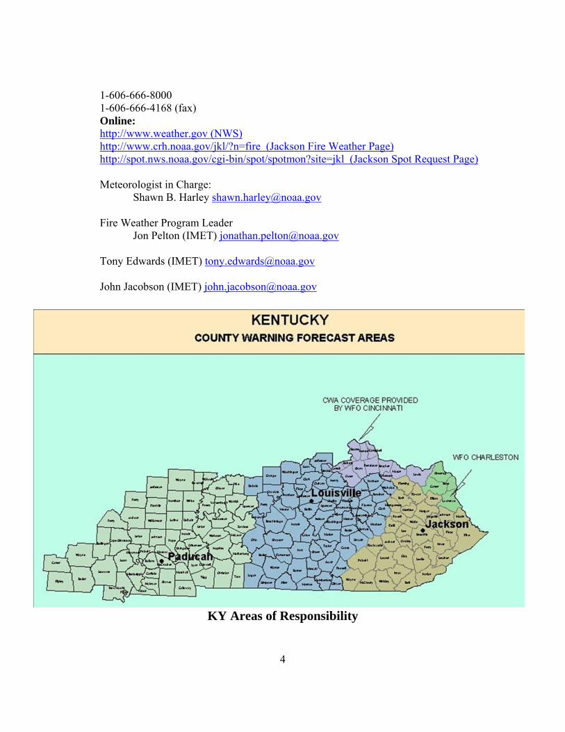
1-606-666-8000 1-606-666-4168 (fax) Online: http://www.weather.gov (NWS)
http://www.crh.noaa.gov/jkl/?n=fire (Jackson Fire Weather Page) http://spot.nws.noaa.gov/cgi-bin/spot/spotmon?site=jkl (Jackson Spot Request Page)
Meteorologist in Charge: Shawn B. Harley [email protected] Fire Weather Program Leader Jon Pelton (IMET) [email protected] Tony Edwards (IMET) [email protected] John Jacobson (IMET) [email protected]
KY Areas of Responsibility
4
2. Surrounding Offices a. National Weather Service, Louisville 6201 Theiler Lane Louisville, KY 40229 Phone: 1-502-989-8842 1-502-968-5663 (fax) Online: http://www.crh.noaa.gov/lmk/?n=fireweather (Fire Weather Page)
http://spot.nws.noaa.gov/cgi-bin/spot/spotmon?site=lmk (Spot Requests) Meteorologist in Charge John Gordon [email protected] Fire Weather Program Leader Joe Ammerman [email protected] b. National Weather Service, Paducah 8250 U.S. Highway 60 West Paducah, KY 42086 Phone: 1-270-744-6440 1-270-744-3828 (fax) Online: http://www.crh.noaa.gov/pah/?n=firewx (Fire Weather Page) http://spot.nws.noaa.gov/cgi-bin/spot/spotmon?site=pah (Spot Requests) Meteorologist in Charge Beverly Poole [email protected] Fire Weather Program Leader Kelly Hooper (IMET) [email protected] Greg Meffert (IMET) [email protected] c. National Weather Service, Wilmington
5
6
1901 South State Route 134 Wilmington, OH 45177 Phone: 1-937-383-0031 1-937-383-0033 (fax) Online: http://www.nws.noaa.gov/er/iln/fireweather.htm (Fire Weather Page) http://spot.nws.noaa.gov/cgi-bin/spot/spotmon?site=iln (Spot Requests) Meteorologist in Charge Kenneth Haydu [email protected] Fire Weather Program Leader John J. Franks (IMET) [email protected] d. National Weather Service, Charleston 400 Parkway Road Charleston, WV 25309 Phone: 1-304-746-0189? 1-304-746-0193 (fax) Online: http://www.erh.noaa.gov/rlx/firewx.html http://spot.nws.noaa.gov/cgi-bin/spot/spotmon?site=rlx (Spot Requests) Meteorologist in Charge Alan Rezek [email protected] Fire Weather Program Leader Mark Pellerito (IMET) [email protected] Assistant Fire Weather Program Leader Jeffrey Hovis [email protected]
e. National Weather Service, Morristown 5974 Commerce Boulevard Morristown, Tennessee 37814 Phone:
1-423-586-3771 1-423-586-4931 (fax) Online: http://www.srh.noaa.gov/mrx/firewx.php http://spot.nws.noaa.gov/cgi-bin/spot/spotmon?site=mrx (Spot Requests) Meteorologist in Charge George Mathews [email protected] Fire Weather Program Leader David Gaffin [email protected] B. Participating Agencies/User Contact Information: 1. Daniel Boone National Forest Supervisors Office/Kentucky
Interagency Coordination Center a. Contact Information: 1700 Bypass Road Winchester, KY 40391 859-745-3171 859-745-7086 (fax) http://www.fs.fed.us/r8/boone/ (Daniel Boone NF) http://www.fs.fed.us/r8/boonefire (KICC Page) b. Personnel
Mike Catron, Acting Assistant Forest Fire Management Officer and Center Manager
EJ Bunzendahl, Assistant Forest Fire Management Officer and Center Manager (effective 10/15/2007) Bonny Truett, Interagency Assistant Center Manager Mitch Gandy, Fire Management Officer Robin Acciardo, Forest Dispatcher Jeff Smith, Forest Technician III/Coordination Center State Liaison
7
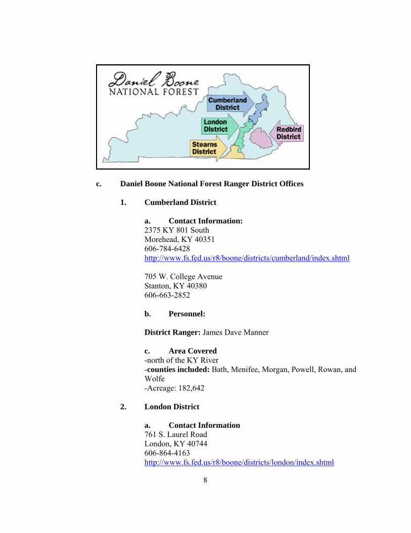
c. Daniel Boone National Forest Ranger District Offices 1. Cumberland District a. Contact Information:
2375 KY 801 South Morehead, KY 40351 606-784-6428
http://www.fs.fed.us/r8/boone/districts/cumberland/index.shtml 705 W. College Avenue Stanton, KY 40380 606-663-2852
b. Personnel:
District Ranger: James Dave Manner c. Area Covered -north of the KY River
-counties included: Bath, Menifee, Morgan, Powell, Rowan, and Wolfe -Acreage: 182,642
2. London District a. Contact Information
761 S. Laurel Road London, KY 40744 606-864-4163
http://www.fs.fed.us/r8/boone/districts/london/index.shtml
8
b. Personnel:
District Ranger: John Strojan c. Area Covered: -north of the Cumberland River and south of the KY River
-Counties included: Estill, Jackson, Laurel, Lee, Owsley, Pulaski, Rockcastle, and Whitley -Acreage: 184,386
3. Stearns District a. Contact Information
3320 US 27 North Whitley City, KY 42653 606-376-5323
http://www.fs.fed.us/r8/boone/districts/stearns/index.shtml b. Personnel: District Ranger: Fred Noack c. Area Covered: -north of the TN line to south of the Cumberland River -Counties included: McCreary, Wayne, and Whitley -Acreage: 114,860
4. Redbird District a. Contact Information
91 Peabody Road Big Creek, KY 40914 606-598-2192
http://www.fs.fed.us/r8/boone/districts/redbird/index.shtml b. Personnel: District Ranger: John Kinney
c. Area Covered
9
- Counties Included: Clay, Harlan, Knox, Leslie, Owsley, and Perry -Acreage: 145,840
2. Southern Area Interagency Fire Cache a. Contact Information: 788 Sublimity School Road London, KY 40744 606-878-7430 Fax: 606-864-9559 b. Personnel: Ken Huff, Cache Manager Angela Taulbee Graham, Cache Clerk 3. Kentucky Division of Forestry a. Contact Information: 627 Comanche Trail Frankfort, KY 40601-1798 502-564-4496 Fax: 502-564-6553 b. Personnel: Bernie Anderson, Fire Management Chief
10
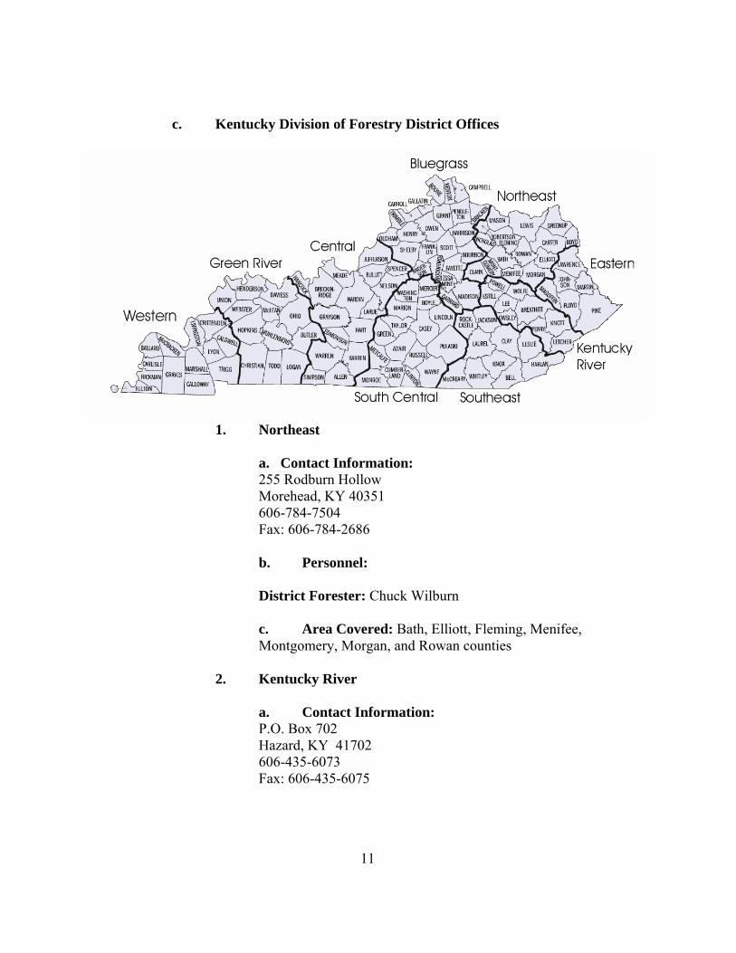
c. Kentucky Division of Forestry District Offices
1. Northeast
a. Contact Information: 255 Rodburn Hollow Morehead, KY 40351 606-784-7504 Fax: 606-784-2686
b. Personnel: District Forester: Chuck Wilburn c. Area Covered: Bath, Elliott, Fleming, Menifee,
Montgomery, Morgan, and Rowan counties
2. Kentucky River
a. Contact Information: P.O. Box 702 Hazard, KY 41702 606-435-6073 Fax: 606-435-6075
11
b. Personnel:
District Forester: Herman Slone c. Area Covered: Breathitt, Estill, Knott, Lee, Letcher,
Owsley, Perry, Powell, and Wolfe counties.
3. Eastern
a. Contact Information: P.O. Box 189 Betsy Layne, KY 41605 606-478-4495 Fax: 606-478-4491
b. Personnel:
District Forester: Dexter Conley
c. Area Covered: Floyd, Johnson, Magoffin, Martin and Pike counties
4. South-Central
a. Contact Information:
120 Gaines Drive Campbellsville, KY 42718 270-465-5071 Fax: 270-465-3575
b. Personnel:
District Forester: Brian Yager c. Area Covered: Pulaski and Wayne counties
5. Southeastern
a. Contact Information:
P.O. Box 130 Pineville, KY 40977 606-337-3011 Fax: 606-337-1630
12
b. Personnel:
District Forester: Harold Williams
c. Area Covered: Bell, Clay, Harlan, Jackson, Knox, Laurel, Leslie, McCreary, Rockcastle, and Whitley counties
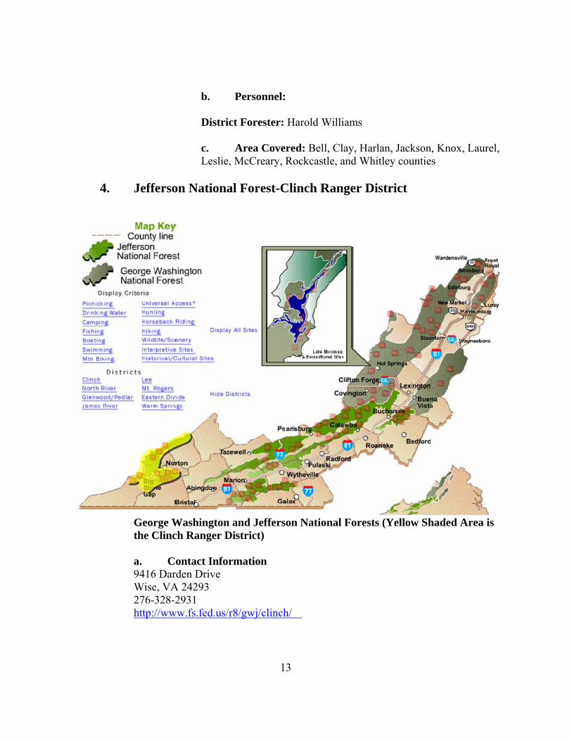
4. Jefferson National Forest-Clinch Ranger District
George Washington and Jefferson National Forests (Yellow Shaded Area is the Clinch Ranger District)
a. Contact Information 9416 Darden Drive
Wise, VA 24293 276-328-2931
http://www.fs.fed.us/r8/gwj/clinch/
13
b. Personnel: District Ranger: Ron Bush c. Area Covered:
Small Portions of Pike and Letcher Counties in the vicinity of Pine Mountain along the VA/KY borders
5. National Park Service
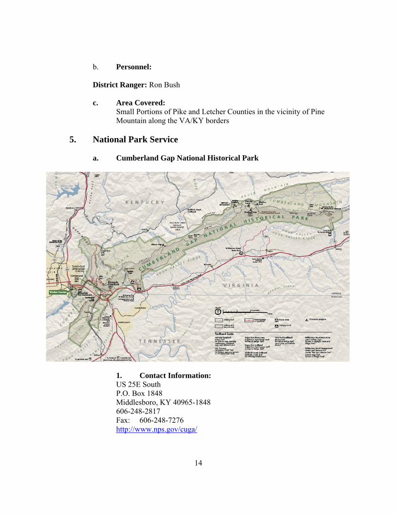
a. Cumberland Gap National Historical Park
1. Contact Information: US 25E South P.O. Box 1848 Middlesboro, KY 40965-1848 606-248-2817 Fax: 606-248-7276
http://www.nps.gov/cuga/
14
2. Personnel: Mark Woods, Superintendent 606-248-2817 Ext. 1050 Shane Sturgill, Park Ranger 606-248-2817
Dirk Wiley, Park Ranger 606-248-2817 Ext. 1054 or 606-246-1054
3. Area Covered: -tri state area of TN, VA and KY (Bell County) b. Big South Fork National River and Recreation Area
Superintendent Big South Fork NRRA 4564 Leatherwood Road Oneida, TN 37841 423-569-9778 Fax: 423-569-5505 http://www.nps.gov/biso 2. Personnel: Reed Detring, Superintendent 423-569-9778 Frank Graham, Chief Ranger 423-569-9778 Tommy Barnes, Ranger 3. Area Covered: -TN and KY (McCreary County)
6. Southern Area Coordination Center a. Contact Information: 1200 Ashwood Parkway, Suite 230, Atlanta, GA 30338 678-320-3000
15
Fax: 678-320-3036 http://gacc.nifc.gov/sacc/ b. Personnel: Predictive Services Program Manager/Meteorologist - Denver Ingram [email protected] Assistant/Meteorologist - Kevin Scasny [email protected]
III. Services Provided by the National Weather Service (NWS)
A. Basic Services 1. Fire Weather Planning Forecast (FWF) a. Issuance Time:
The narrative forecast will normally be issued daily by 700 AM Eastern Time, seven days a week and updated as warranted outside of the fire seasons. During the fire seasons, the narrative forecast will be issued twice daily around 700 AM Eastern Time and 400 PM Eastern Time and updated as necessary. b. Viewing the Forecast
Forecasts will be available through the Weather Information Management System (WIMS) and online from our website at: http://www.crh.noaa.gov/jkl/fire.php Experimental fire weather forecast images are posted at:
http://www.crh.noaa.gov/ndfd/graphical/sectors/jklFireDay.php#tabs c. Content:
A headline may be added to the top of the forecast, denoting significant weather, or for the issuance of a Red Flag Warning or Fire Weather Watch. The synopsis will briefly cover locations of fronts and systems which produce the weather along with highlighting significant trends or changes that the forecaster anticipates.
16
The near term forecast will cover specific weather elements mentioned below. The Morning Issuance will contain the next three periods in the near term portion (today, tonight, and tomorrow) in detail. The afternoon issuance will contain four periods in the near term period (tonight, tomorrow, tomorrow night, and the following day) in detail. An extended forecast out to seven days will be included at the end of the forecast. The extended forecast portion of the narrative forecast will pick up where the short term left off and continue out through day seven. The extended portion is a general forecast which mentions the possibility of precipitation, expected high and low temperatures for each day, and afternoon winds for days 1 through 5.
d. Forecast Elements: 1. SKY COVER
A. Clear (or Sunny) -- < 1/8th cloud cover. B. Mostly Clear/Mostly Sunny -- 1/8th to 2/8ths of cloud cover. C. Partly Cloudy/Partly Sunny-- 3/8ths to 5/8ths of cloud cover. D. Mostly Cloudy -- 6/8ths to 7/8ths cloud cover. E. Cloudy -- 8/8ths cloud cover. F. Increasing Cloudiness -- the clouds are increasing in amount (this
also implies thickening of clouds). G. Decreasing Cloudiness-- A progressive decrease in the amount of
sky covered with clouds. H. Variable Cloudiness-- A constant variation in the amount of clouds
covering the sky with respect to time and space. 2. PRECIPITATION TYPE
A. Rain--General, not showery, usually in a stable atmosphere. Small
to medium sized water droplets. B. Drizzle--General precipitation in a stable atmosphere. Very small
water droplets that appear to float in the atmosphere. C. Freezing Rain/Drizzle-- Liquid precipitation that freezes upon
impact with the ground or vegetation. D. Sleet--Precipitation that falls in the form of frozen rain or partially
frozen rain. E. Snow--Frozen precipitation of relatively long duration, general or
patchy, not showery. F. Snow Flurries--Light snowfall of short duration with some clearing
between occurrences. Accumulation, if any, is slight.
17
G. Showers--Rain/snowfall of short duration and varying intensity, usually beginning and ending abruptly.
H. Thundershowers--Same as a shower but accompanied by thunder. I. Thunderstorms--Downpour of rain, often with strong gusty winds.
Small hail may also be present. J. Severe Thunderstorm-- Heavy downpours of rain, accompanied by
wind gusts to 50 Knots (58 mph) or greater, hailstones of 3/4 inch or larger, and/or a tornado.
3. TEMPERATURE
The temperature will be in degrees Fahrenheit. The maximum and minimum temperatures are forecast for the day and night time periods, respectively. Local variations due to terrain (e.g. ridge/valley temperature splits) will be mentioned in the narrative.
4. RELATIVE HUMIDITY
The Relative Humidity (RH) is the ratio, in percent, of the amount of moisture in the air compared to the amount the air could hold if fully saturated (100%). The range of RH is from 0% to 100%. Usually, the minimum RH occurs at the time of the maximum temperature and the maximum RH occurs at the time of the minimum temperature.
Because of the dependency of the relative humidity upon temperature, it should be noted that if the temperature is under forecast (the actual temperature is higher than forecast), then the forecasted relative humidity will likely will be too high.
5. WIND - DIRECTION AND SPEED
The wind direction applies to the direction from which the wind will blow. The direction will be listed using the 16 point compass (e.g. NE, S, WSW, etc.). Any significant changes expected during the forecast period will be mentioned in the narrative.
The wind speed will be in miles per hour (mph). The speed is the forecast for the 20-foot level. Speeds pertain to the two minute averages while gusts pertain to the maximum instantaneous value expected.
6. Wind Shift
If a shift in wind direction associated with a frontal passage is expected during the period, the new direction and wind speed will be forecast. Wind shifts may also be mentioned in the synopsis.
18
Because a front may take several hours to move through a zone, the approximate time of the wind shift will be encoded (i.e. Northeast 10 to 15 mph after midnight).
7. Lightning Activity Level
A single digit (1 through 6) will be used. The meaning of each number is as follows:
1 No thunderstorms.
2 Few building cumulus with isolated thunderstorms. Occasional light rain reaching the ground.
3 Widely scattered thunderstorms with much building cumulus. Light to moderate rain reaching the ground.
4 Scattered thunderstorms, not obscuring the sky. Moderate rain reaching the ground.
5 Numerous thunderstorms, occasionally obscuring the sky. Moderate to heavy rain reaching the ground.
6 Same as 3 above, but dry, no rain. 8. Haines Index
The Haines Index that the Jackson National Weather Service Forecast Office will compute for the Fire Weather Planning Forecast is the mid elevation Haines Index. The mid elevation Haines Index is normally used for locations with elevations between 1,000 and 3,000 feet above sea level. Values of the Haines Index range from 2 to 6. The Haines index correlates large plume dominated fire growth.
Interpreting the Haines Index 2 Very Low Potential (Moist and Stable Lower Atmosphere) 3 Very Low Potential 4 Low Potential 5 Moderate Potential 6 High Potential (Dry Unstable Lower Atmosphere)
9. POPS and Type (CWR ≥ 0.01)
The probability of precipitation, or POP, expresses the chance that measurable rainfall will occur at any given point within a county zone group. Measurable rainfall is 0.01 inches or greater. Probability is expressed in percent. A forecast of the predominate type of precipitation will accompany a probability of precipitation
19
forecast (i.e. 40 percent chance of showers, 60 percent chance of rain, 90 percent chance of light snow).
10. Smoke Management Forecast Parameters
Note: One consequence of the Clean Air Act, is that land managers must practice principles of careful smoke management. This is done by combining favorable meteorological conditions with a variety of prescribed fire techniques so that smoke will be readily dispersed.
A. Afternoon Mixing Height
Mixing height is the extent or depth to which smoke will be dispersed by means of turbulence and diffusion. The forecast of mixing height is expressed in feet above ground level (AGL). The Jackson office will normally express this value as the average over the entire zone. Deviations from this can be computed upon request.
B. Transport Wind
Transport wind is the average wind speed in miles/hour (MPH) in the mixing depth above the surface. These winds are a good indication of the horizontal dispersion of suspended particles. The transport wind is the forecast wind at the time of maximum mixing of the atmosphere, normally during the mid afternoon. Usually a wind of less than 3 mph restricts an agency from burning. Transport wind directions are typically given to eight compass points (e.g. northeast, east southwest, etc.)
Note: Transport winds are not encoded for the nighttime
portion of the forecast.
C. Dispersion Index The Dispersion Index is a number that gives a relative indication of how well smoke will disperse in the atmosphere. It is calculated by taking the Mixing Height divided by 1000 and then multiplying the result by the transport winds in knots. See the table on the following page for how to interpret a given Dispersion Index value.
20
Dispersion Index Interpretation > 100 Very Good 60-100 Good 41-60 Fair to Good 21-40 Fair 13-20 Poor to Fair 7-12 Poor 1-6 Very Poor
D. Vent Rate The Vent Rate is a number that gives a relative indication of how well smoke will disperse in the atmosphere. It is calculated by taking the Mixing Height(in FT AGL) multiplied by the transport winds in knots. Units are in KNOT-FT. The table below gives and interpretation for a given value of Vent Rate:
Vent Rate Interpretation < 29,000 Poor ≥ 29,000 & < 38,000 Marginal ≥ 38,000 & < 50,000 Fair ≥ 50,000 & < 95,000 Good ≥ 95,000 Excellent
11. QFF The average amount of rain that is expected if precipitation occurs.
d. Example: An example of the FWF can be found in Appendix 2.
2. INDIVIDUAL STATION FORECASTS (FWM)
The point forecast will be issued by 3:15 PM daily during the fire weather season. The National Fire Danger Rating System (NFDRS) is a quantitative means for evaluating the fire danger across a vast area such as a forest. This complex model of fuel and weather parameters processes daily weather observations and fuel moisture as input, and fire managers receive numeric output that suggest the severity of fire danger over a large area.
21
Maps and tables showing the locations and descriptions of NFDRS stations are on the following page:
Name Station
ID County Elev. (ft) Lat. Lon.
Crittenden 150703 Grant 935 38:46:09 -84:36:07
Greenville 151191 Muhlenberg 552 37:16:02 -87:12:10
Triangle Mountain* 152001 Rowan 1360 38:10:30 -83:24:30
Koomer Ridge* 154401 Wolfe 1300 37:46:08 -83:38:00
Big Sandy* 154801 Martin 1180 37:45:00 -82.37:58
Jackson* 156001 Breathitt 1388 37:35:31 -83.19:04
Mammoth Cave 156502 Edmonson 766 37:07:51 -86:08:52
Somerset* 157002 Pulaski 927 37:03:18 -84:36:54
Cherry Tree/ Peabody* 157201 Clay 1475 37:08:00 -83:34:00
Alpine 189501 Cumberland 853 36:47:44 -85:22:49
Yellow Creek* 159801 Bell 1090 36:36:55 -83:45:45
KYLBL 159901 Trigg 649 36:46:35 -88.03:47
Big South 400902 Scott, TN 1445 36:28:30 -84:39:15
22
Name Station
ID County Modem Number Modem Type Baud Rate
Crittenden 150703 Grant 859-428-1565 TM Ultra 9600
Greenville 151191 Muhlenberg 502-607-7426 TM Ultra 9600
Triangle Mountain* 152001 Rowan 606-784-9365 TM4000 1200
Koomer Ridge* 154401 Wolfe 606-668-7234 TM Ultra 9600
Big Sandy* 154801 Martin 606-298-6710 TM Ultra 1200
Jackson* 156001 Breathitt 606-666-9625 TM4000 1200
Mammoth Cave 156502 Edmonson 270-597-2376 TM Ultra 2400
Somerset* 157002 Pulaski 606-677-9186 TM4000 1200
Cherry Tree/ Peabody* 157201 Clay 606-847-4095 TM4000 1200
Alpine 189501 Cumberland 270-864-9105 TM Ultra 9600
Yellow Creek* 159801 Bell DAPS download Not Available Not Available
KYLBL 159901 Trigg DAPS download Not Available Not Available
Big South* 400902 Scott, TN DAPS download Not Available Not Available * = WFO JKL Forecast Point Note: All fire weather stations have been assigned numbers to be used as the
identification number when entering into the Weather Information Management System (WIMS). If a new station is established, or a present Station is moved, a new identification number should be requested from the GACC Meteorologists. Also, please notify the Jackson NWS Office Fire Weather
Program Manager of this change. Point Forecast Terminology A. STATION NAME
Each location will have a name. This name will be provided by the agency requesting the observation site.
B. STATION NUMBER
Before a forecast will be made for a station, it must have a valid station number in WIMS.
C. VALID DATE The valid date will be the next day in the order: YYMMDD
23
24
D. VALID TIME The valid time will be 1300 (1:00 PM LST) E. State of the Weather A single digit number from 0 to 9. 0 Clear (Less than 1/10th of sky is cloud covered). 1 Scattered Clouds (1/10th to 5/10ths of sky cloud covered). 2 Broken Clouds (6/10ths to 9/10ths of sky cloud covered). 3 Overcast (More than 9/10ths of sky cloud covered). 4 Foggy 5 Drizzle 6 Rain 7 Snow or Sleet 8 Showers (In sight or at station and reaching the ground). 9 Thunderstorms/Hail E. TEMPERATURES Temperature forecast for 1:00 PM the next day. F. RELATIVE HUMIDITY Relative Humidity forecast for 1:00 PM the next day. G. LIGHTNING ACTIVITY
1. Period 1 (L1) is from 2 PM until midnight that night (a 10 hour period).
2. Period 2 (L2) is from midnight the night of the forecast until
midnight the next night (24 hour period.)
3. A single digit (1 through 6) will be used. The meaning of each number is as follows:
1 No thunderstorms 2 Few building cumulus with isolated thunderstorms
3 Much building cumulus with scattered thunderstorms, light to moderate rain reaches the ground.
4 Thunderstorms common but do not obscure the sky, moderate rain reaches the ground. 5 Thunderstorms common and occasionally obscure
the sky, moderate to heavy rain reaches the ground.
6 Same as 3 above but dry, no rain H. WIND DIRECTION AND SPEED
Wind forecast at 1 PM the next day. The wind speed is a 10 minute average at 20 feet above the ground measured to 16 compass points (e.g. WSW, NW, NNE, E, etc).
I TEN HOUR TIME LAG FUEL MOISTURE
Since the fire weather meteorologist does not typically have access to fuel moisture information, an M will be entered for missing.
J. TEMPERATURE
The 24 hour maximum and minimum temperature forecast from 1:00 PM the day of the forecast until 1:00 PM the next day. This will typically be the maximum temperature of the current day and the overnight low expected in the next 12 to 16 hours.
The temperature in the maximum temperature column must be at least equal to or higher than the temperature given in part (6) above. If not, WIMS will not process a forecast for that station. K. RELATIVE HUMIDITY
The 24 hour maximum and minimum Relative Humidity forecast from 1:00 PM the day of the forecast until 1:00 PM the next day.
The maximum RH value listed must equal or exceed the value given in part (7.) above. Similarly, the minimum RH value must equal or be less than the value in part (7) above. Either error will cause WIMS to not process a forecast for that station.
25
L. PRECIPITATION DURATION
The number of hours for which precipitation is forecast. Period 1 is from 1:00 PM the day of the forecast until 5:00 AM the next day (16 hours). Period 2 runs from 5:00 AM the next day until 1:00 PM that same day (8 hours). M. WET FLAG
Wet flag is used to indicate "fuels wet". All indices will be forced to zero if Y=yes is used. NOTE: in most cases a N=no will be used unless there is snow on the ground or the ground is extremely wet. If the duration of precipitation is 3 hours or greater between 500 am to 100 pm of the next day, the Wet Flag should be tripped to a Y value. Also if rain or snow is expected to be occurring at 1300, the Wet Flag should be tripped to a Y value.
3. Site-Specific Wildland Fire Forecasts/Prescribed Burn Forecats (FWS) SPOT forecasts are issued when requested by Interagency Wildland Fire Agencies for wildland fires or planned burn operations or by federal, state, or local officials or agencies responding to hazardous material releases. They are available 24 hours a day. They differ from routine fire weather forecasts by incorporating greater detail in timing, higher resolution of terrain influences, as well as other small-scale weather influences impacting the site. They should be requested within 18 hours of a prescribed burn. Beyond 18 hours, the Fire Weather Planning Forecast (FWF) should be utilized
NWS offices will not provide spot forecasts to private citizens or commercial entities not acting as an agent of a government agency.
a. Criteria
Federal or state agencies requesting prescribed burn or spot forecasts should provide as much information as possible about the location and nature of the site. This should include the following information about the prescribed burn or wildland fire site: 1. location 2. elevation 3. slope
26
4. aspect 5. Whenever possible, it is requested that agencies
provide maps of the prescribed burn area from the prescribed burn plan. This information will aid the forecaster in providing a more specific forecast tailored to the local terrain.
6. A current observation at the time a wildfire forecast is requested. For prescribed burn forecast, an observation or observations around 1300 from the previous afternoon is requested.
b. Contents All Spot or Prescribed burn forecasts will contain at least items 1 through 5
1. sky condition 2. weather 3. temperature 4. relative humidity 5. 20 foot wind and significant/sudden changes in wind
speed or direction 6. mixing heights 7. transport winds shall be provided.
c. Procedure
1. Requests for Spot or Prescribed Burn forecasts will be made using the internet based NWSSPOT request form (instructions are below).
2. As a courtesy, land management agencies are requested to call the National Weather Service Office in Jackson, KY, to confirm receipt of the spot or prescribed burn forecast request.
3. Once the forecast is completed, it will be available on the NWSSPOT website.
4. If the NWSSPOT server is down, requests for a spot
forecast should be called in or faxed to the forecast office. Faxed requests should be made using WS Form D-1 in Appendix D or available online at http://nimbo.wrh.noaa.gov/pih/firewx/D1-V2005.pdf. In this case, the Jackson Weather office will send the forecast by fax or may give it verbally over the phone
27
upon request (i.e., when only a few weather elements are necessary by the user).
5. The National Weather Service Headquarters has
directed that NWS forecasts should not be forecasting eye-level winds. Forecasters don't know exact sheltering, vegetation or exposure at the forecast location and thus don't know what conversion factors to use. It is better to let land management agencies take the forecast 20-ft winds and do the conversion themselves to get a better value for eye level winds.
6. Instructions for requesting a forecast:
a. Spot or Prescribed Burn Forecasts can be requested at the following website:
http://spot.nws.noaa.gov/cgi- bin/spot/spotmon?site=jkl
b. Fill in as much information as possible (items in
red are required) an example of the web entry form is on the following page:
1. Project Name: (Name of fire or prescribed burn) 2. Select Wildfire or Prescribed Burn, etc.
as appropriate 3. Input your agency 4. Requesting Official (Your Name) 5. Phone number 6. Select “Wildfire” or “Non Wildfire” as
appropriate 7. Input your Lat and Lon 8. Input Elevation (highest and lowest if
available) 9. Input Aspect (valley, ridgetop, North,
South etc. as appropriate) 10. Hit “Submit Request” at the bottom of the page. Once your request is submitted, it will alarm on the computer system at the Jackson National Weather Service office and the National Weather Service will put together a weather
28
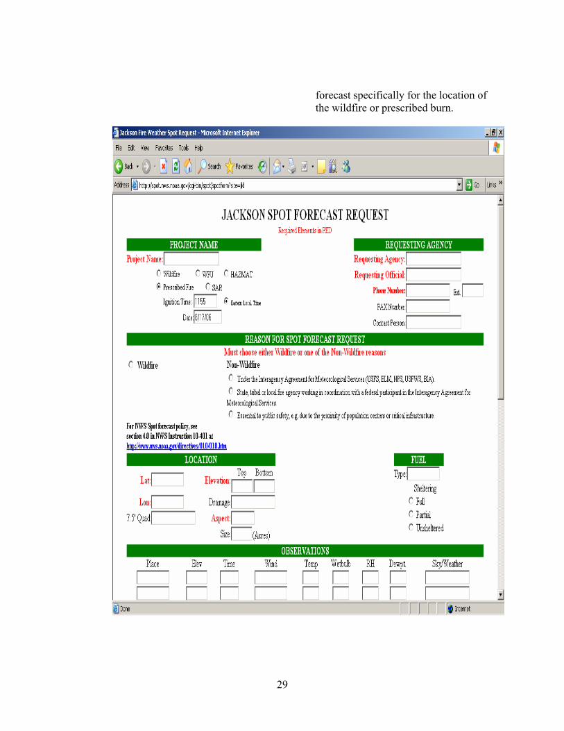
forecast specifically for the location of the wildfire or prescribed burn.
29
4. FIRE SEASON
The normal fire season will be broken into two separate periods. The spring fire season will run from February 1 through May 15. The fall fire season will begin on October 1 and end on December 15. These dates may be changed depending on the severity of the fire season and the needs of the users per coordination. Normally, the KICC/USDA Forest Service will notify the office of any extensions to the fire weather season(s) that they require.
5. RED FLAG FORECASTS
Specific conditions must be met for a Fire Weather Watch and/or a Red
Flag Warning to be issued. These conditions are as follows: a. Ten hour fuel moisture values must be 8% or less. In addition
to this fuel moisture criterion, both of the following must occur or have a high probability of occurring:
b. Afternoon relative humidity levels are expected to fall to 25% or lower c. 20 foot sustained winds are expected to reach or exceed 15 mph. If the forecast office issues a Fire Weather Watch or Red Flag Warning
for a specific forest or national park, the fire weather forecaster will highlight the watch or warning in the narrative forecast by using a headline and will also call the KICC.
A "Fire Weather Watch" is used to alert the user to the possible
development of a Red Flag event in the near future. This could be up to 72 hours in advance.
A "Red Flag Warning" will be issued to warn the user of an impending
or ongoing Red Flag event. A Red Flag Warning will be issued immediately when Red Flag Conditions are occurring. Otherwise, it will be issued for impending Red Flag Conditions when there is a high degree of confidence that conditions will develop.
6. VERIFICATION OF RED FLAG FORECASTS
Verification of Red Flag Warnings and Fire Weather Watches will be conducted. The methodology is devised in accordance with The National
30
Weather Service Central Region Policy and in coordination with the KICC/USFS.
a. Methodology of CR Verification for Red Flag Warnings and
Fire Weather Watches
The Red Flag Warning/Fire Weather Watch Verification program is divided into four parts:
1. Red Flag Warnings/events for dry thunderstorms. 2. Red Flag Warnings/events for synoptic-scale (i.e.
strong winds and low humidity and dry fuels 3. The Total of both 1 and 2. 4. Fire Weather Watch Forecasts/events.
Verification of Red Flag Warnings and Fire Weather Watches will be “tracked” for each fire weather zone (or county). For example, if a Red Flag Warning is issued for an area comprised of five fire weather zones, it will count as five Red Flag Warnings – one for each zone (or county).
A Red Flag Warning issued at the request of a land management agency will NOT be considered for verification purposes. However, such warnings issued will be tallied separately and, for the purpose of workload indication, will be included in the number of total warnings issued by the office.
Data/information from surface observations (ASOS, RAWS, AWOS, etc.), supplementary and complementary weather sources, satellite and radar imagery, etc. may be used to verify (or to not verify) Red Flag Warnings and Fire Weather Watches. Experience, judgment, objectivity, consistency, and ethics will be used in verifying.
The Jackson Weather Forecast Office (WFO) will establish, with coordination of local users its locally-specific criteria and procedures to verify the red flag warnings/events. The local verification methodology will be included in the Annual Fire Weather Operations Plan.
After coordination with users, the Jackson Weather Office will define a “Red Flag Event” where all of the following occur for one hour (one observation) or more:
1. Ten hour fuel moisture of 8% or less.
31
2. Afternoon relative humidity levels of 25% or less. 3. 20 foot sustained winds are 15 mph or higher.
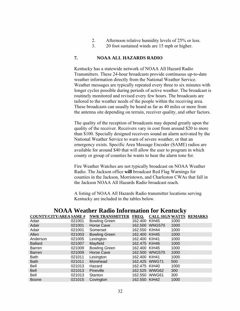
7. NOAA ALL HAZARDS RADIO
Kentucky has a statewide network of NOAA All Hazard Radio Transmitters. These 24-hour broadcasts provide continuous up-to-date weather information directly from the National Weather Service. Weather messages are typically repeated every three to six minutes with longer cycles possible during periods of active weather. The broadcast is routinely monitored and revised every few hours. The broadcasts are tailored to the weather needs of the people within the receiving area. These broadcasts can usually be heard as far as 40 miles or more from the antenna site depending on terrain, receiver quality, and other factors.
The quality of the reception of broadcasts may depend greatly upon the quality of the receiver. Receivers vary in cost from around $20 to more than $100. Specially designed receivers sound an alarm activated by the National Weather Service to warn of severe weather, or that an emergency exists. Specific Area Message Encoder (SAME) radios are available for around $40 that will allow the user to program in which county or group of counties he wants to hear the alarm tone for.
Fire Weather Watches are not typically broadcast on NOAA Weather Radio. The Jackson office will broadcast Red Flag Warnings for counties in the Jackson, Morristown, and Charleston CWAs that fall in the Jackson NOAA All Hazards Radio broadcast reach.
A listing of NOAA All Hazards Radio transmitter locations serving Kentucky are included in the tables below.
NOAA Weather Radio Information for Kentucky
COUNTY/CITY/AREA SAME # NWR TRANSMITTER FREQ. CALL SIGN WATTS REMARKS
Adair 021001 Bowling Green 162.400 KIH45 1000 Adair 021001 Horse Cave 162.500 WNG570 1000 Adair 021001 Somerset 162.550 KIH44 1000 Allen 021003 Bowling Green 162.400 KIH45 1000 Anderson 021005 Lexington 162.400 KIH41 1000 Ballard 021007 Mayfield 162.475 KIH46 1000 Barren 021009 Bowling Green 162.400 KIH45 1000 Barren 021009 Horse Cave 162.500 WNG570 1000 Bath 021011 Lexington 162.400 KIH41 1000 Bath 021011 Morehead 162.425 WWG71 500 Bell 021013 Hazard 162.475 KIH40 1000 Bell 021013 Pineville 162.525 WWG62 300 Bell 021013 Stanton 162.550 WWG61 300 Boone 021015 Covington 162.550 KIH42 1000
32
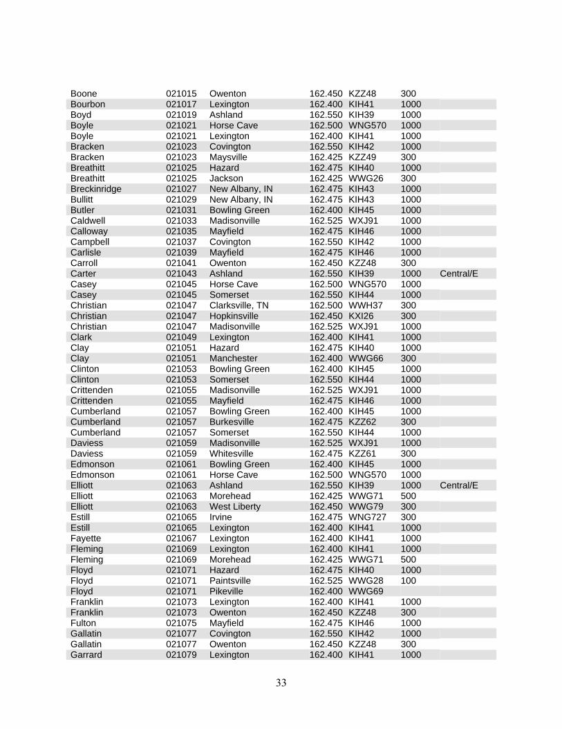
Boone 021015 Owenton 162.450 KZZ48 300 Bourbon 021017 Lexington 162.400 KIH41 1000 Boyd 021019 Ashland 162.550 KIH39 1000 Boyle 021021 Horse Cave 162.500 WNG570 1000 Boyle 021021 Lexington 162.400 KIH41 1000 Bracken 021023 Covington 162.550 KIH42 1000 Bracken 021023 Maysville 162.425 KZZ49 300 Breathitt 021025 Hazard 162.475 KIH40 1000 Breathitt 021025 Jackson 162.425 WWG26 300 Breckinridge 021027 New Albany, IN 162.475 KIH43 1000 Bullitt 021029 New Albany, IN 162.475 KIH43 1000 Butler 021031 Bowling Green 162.400 KIH45 1000 Caldwell 021033 Madisonville 162.525 WXJ91 1000 Calloway 021035 Mayfield 162.475 KIH46 1000 Campbell 021037 Covington 162.550 KIH42 1000 Carlisle 021039 Mayfield 162.475 KIH46 1000 Carroll 021041 Owenton 162.450 KZZ48 300 Carter 021043 Ashland 162.550 KIH39 1000 Central/E Casey 021045 Horse Cave 162.500 WNG570 1000 Casey 021045 Somerset 162.550 KIH44 1000 Christian 021047 Clarksville, TN 162.500 WWH37 300 Christian 021047 Hopkinsville 162.450 KXI26 300 Christian 021047 Madisonville 162.525 WXJ91 1000 Clark 021049 Lexington 162.400 KIH41 1000 Clay 021051 Hazard 162.475 KIH40 1000 Clay 021051 Manchester 162.400 WWG66 300 Clinton 021053 Bowling Green 162.400 KIH45 1000 Clinton 021053 Somerset 162.550 KIH44 1000 Crittenden 021055 Madisonville 162.525 WXJ91 1000 Crittenden 021055 Mayfield 162.475 KIH46 1000 Cumberland 021057 Bowling Green 162.400 KIH45 1000 Cumberland 021057 Burkesville 162.475 KZZ62 300 Cumberland 021057 Somerset 162.550 KIH44 1000 Daviess 021059 Madisonville 162.525 WXJ91 1000 Daviess 021059 Whitesville 162.475 KZZ61 300 Edmonson 021061 Bowling Green 162.400 KIH45 1000 Edmonson 021061 Horse Cave 162.500 WNG570 1000 Elliott 021063 Ashland 162.550 KIH39 1000 Central/E Elliott 021063 Morehead 162.425 WWG71 500 Elliott 021063 West Liberty 162.450 WWG79 300 Estill 021065 Irvine 162.475 WNG727 300 Estill 021065 Lexington 162.400 KIH41 1000 Fayette 021067 Lexington 162.400 KIH41 1000 Fleming 021069 Lexington 162.400 KIH41 1000 Fleming 021069 Morehead 162.425 WWG71 500 Floyd 021071 Hazard 162.475 KIH40 1000 Floyd 021071 Paintsville 162.525 WWG28 100 Floyd 021071 Pikeville 162.400 WWG69 Franklin 021073 Lexington 162.400 KIH41 1000 Franklin 021073 Owenton 162.450 KZZ48 300 Fulton 021075 Mayfield 162.475 KIH46 1000 Gallatin 021077 Covington 162.550 KIH42 1000 Gallatin 021077 Owenton 162.450 KZZ48 300 Garrard 021079 Lexington 162.400 KIH41 1000
33
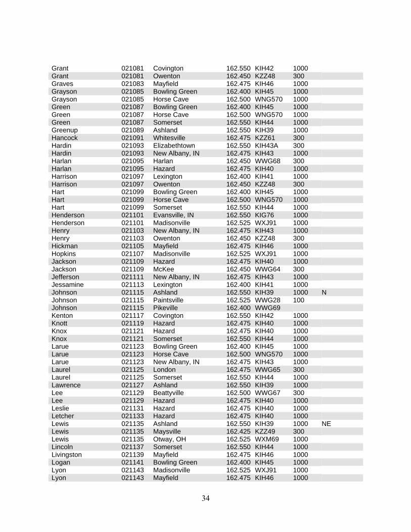
Grant 021081 Covington 162.550 KIH42 1000 Grant 021081 Owenton 162.450 KZZ48 300 Graves 021083 Mayfield 162.475 KIH46 1000 Grayson 021085 Bowling Green 162.400 KIH45 1000 Grayson 021085 Horse Cave 162.500 WNG570 1000 Green 021087 Bowling Green 162.400 KIH45 1000 Green 021087 Horse Cave 162.500 WNG570 1000 Green 021087 Somerset 162.550 KIH44 1000 Greenup 021089 Ashland 162.550 KIH39 1000 Hancock 021091 Whitesville 162.475 KZZ61 300 Hardin 021093 Elizabethtown 162.550 KIH43A 300 Hardin 021093 New Albany, IN 162.475 KIH43 1000 Harlan 021095 Harlan 162.450 WWG68 300 Harlan 021095 Hazard 162.475 KIH40 1000 Harrison 021097 Lexington 162.400 KIH41 1000 Harrison 021097 Owenton 162.450 KZZ48 300 Hart 021099 Bowling Green 162.400 KIH45 1000 Hart 021099 Horse Cave 162.500 WNG570 1000 Hart 021099 Somerset 162.550 KIH44 1000 Henderson 021101 Evansville, IN 162.550 KIG76 1000 Henderson 021101 Madisonville 162.525 WXJ91 1000 Henry 021103 New Albany, IN 162.475 KIH43 1000 Henry 021103 Owenton 162.450 KZZ48 300 Hickman 021105 Mayfield 162.475 KIH46 1000 Hopkins 021107 Madisonville 162.525 WXJ91 1000 Jackson 021109 Hazard 162.475 KIH40 1000 Jackson 021109 McKee 162.450 WWG64 300 Jefferson 021111 New Albany, IN 162.475 KIH43 1000 Jessamine 021113 Lexington 162.400 KIH41 1000 Johnson 021115 Ashland 162.550 KIH39 1000 N Johnson 021115 Paintsville 162.525 WWG28 100 Johnson 021115 Pikeville 162.400 WWG69 Kenton 021117 Covington 162.550 KIH42 1000 Knott 021119 Hazard 162.475 KIH40 1000 Knox 021121 Hazard 162.475 KIH40 1000 Knox 021121 Somerset 162.550 KIH44 1000 Larue 021123 Bowling Green 162.400 KIH45 1000 Larue 021123 Horse Cave 162.500 WNG570 1000 Larue 021123 New Albany, IN 162.475 KIH43 1000 Laurel 021125 London 162.475 WWG65 300 Laurel 021125 Somerset 162.550 KIH44 1000 Lawrence 021127 Ashland 162.550 KIH39 1000 Lee 021129 Beattyville 162.500 WWG67 300 Lee 021129 Hazard 162.475 KIH40 1000 Leslie 021131 Hazard 162.475 KIH40 1000 Letcher 021133 Hazard 162.475 KIH40 1000 Lewis 021135 Ashland 162.550 KIH39 1000 NE Lewis 021135 Maysville 162.425 KZZ49 300 Lewis 021135 Otway, OH 162.525 WXM69 1000 Lincoln 021137 Somerset 162.550 KIH44 1000 Livingston 021139 Mayfield 162.475 KIH46 1000 Logan 021141 Bowling Green 162.400 KIH45 1000 Lyon 021143 Madisonville 162.525 WXJ91 1000 Lyon 021143 Mayfield 162.475 KIH46 1000
34
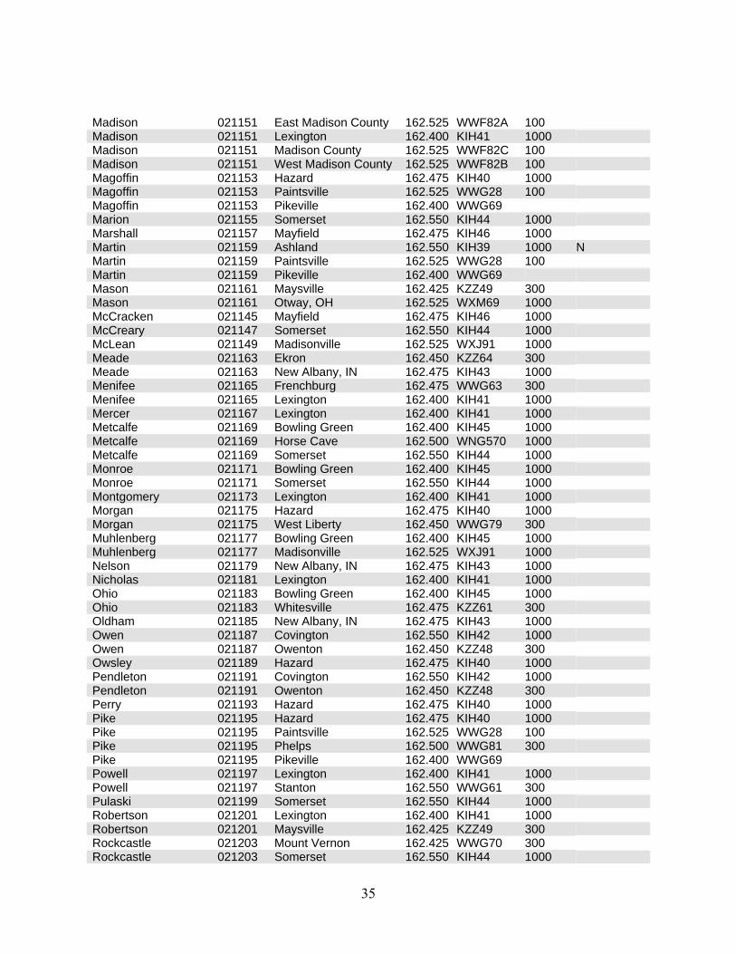
Madison 021151 East Madison County 162.525 WWF82A 100 Madison 021151 Lexington 162.400 KIH41 1000 Madison 021151 Madison County 162.525 WWF82C 100 Madison 021151 West Madison County 162.525 WWF82B 100 Magoffin 021153 Hazard 162.475 KIH40 1000 Magoffin 021153 Paintsville 162.525 WWG28 100 Magoffin 021153 Pikeville 162.400 WWG69 Marion 021155 Somerset 162.550 KIH44 1000 Marshall 021157 Mayfield 162.475 KIH46 1000 Martin 021159 Ashland 162.550 KIH39 1000 N Martin 021159 Paintsville 162.525 WWG28 100 Martin 021159 Pikeville 162.400 WWG69 Mason 021161 Maysville 162.425 KZZ49 300 Mason 021161 Otway, OH 162.525 WXM69 1000 McCracken 021145 Mayfield 162.475 KIH46 1000 McCreary 021147 Somerset 162.550 KIH44 1000 McLean 021149 Madisonville 162.525 WXJ91 1000 Meade 021163 Ekron 162.450 KZZ64 300 Meade 021163 New Albany, IN 162.475 KIH43 1000 Menifee 021165 Frenchburg 162.475 WWG63 300 Menifee 021165 Lexington 162.400 KIH41 1000 Mercer 021167 Lexington 162.400 KIH41 1000 Metcalfe 021169 Bowling Green 162.400 KIH45 1000 Metcalfe 021169 Horse Cave 162.500 WNG570 1000 Metcalfe 021169 Somerset 162.550 KIH44 1000 Monroe 021171 Bowling Green 162.400 KIH45 1000 Monroe 021171 Somerset 162.550 KIH44 1000 Montgomery 021173 Lexington 162.400 KIH41 1000 Morgan 021175 Hazard 162.475 KIH40 1000 Morgan 021175 West Liberty 162.450 WWG79 300 Muhlenberg 021177 Bowling Green 162.400 KIH45 1000 Muhlenberg 021177 Madisonville 162.525 WXJ91 1000 Nelson 021179 New Albany, IN 162.475 KIH43 1000 Nicholas 021181 Lexington 162.400 KIH41 1000 Ohio 021183 Bowling Green 162.400 KIH45 1000 Ohio 021183 Whitesville 162.475 KZZ61 300 Oldham 021185 New Albany, IN 162.475 KIH43 1000 Owen 021187 Covington 162.550 KIH42 1000 Owen 021187 Owenton 162.450 KZZ48 300 Owsley 021189 Hazard 162.475 KIH40 1000 Pendleton 021191 Covington 162.550 KIH42 1000 Pendleton 021191 Owenton 162.450 KZZ48 300 Perry 021193 Hazard 162.475 KIH40 1000 Pike 021195 Hazard 162.475 KIH40 1000 Pike 021195 Paintsville 162.525 WWG28 100 Pike 021195 Phelps 162.500 WWG81 300 Pike 021195 Pikeville 162.400 WWG69 Powell 021197 Lexington 162.400 KIH41 1000 Powell 021197 Stanton 162.550 WWG61 300 Pulaski 021199 Somerset 162.550 KIH44 1000 Robertson 021201 Lexington 162.400 KIH41 1000 Robertson 021201 Maysville 162.425 KZZ49 300 Rockcastle 021203 Mount Vernon 162.425 WWG70 300 Rockcastle 021203 Somerset 162.550 KIH44 1000
35
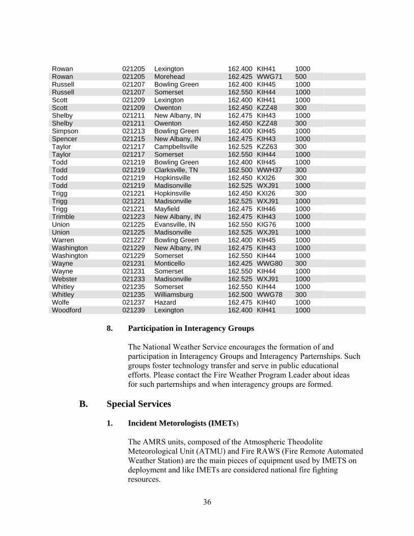
Rowan 021205 Lexington 162.400 KIH41 1000 Rowan 021205 Morehead 162.425 WWG71 500 Russell 021207 Bowling Green 162.400 KIH45 1000 Russell 021207 Somerset 162.550 KIH44 1000 Scott 021209 Lexington 162.400 KIH41 1000 Scott 021209 Owenton 162.450 KZZ48 300 Shelby 021211 New Albany, IN 162.475 KIH43 1000 Shelby 021211 Owenton 162.450 KZZ48 300 Simpson 021213 Bowling Green 162.400 KIH45 1000 Spencer 021215 New Albany, IN 162.475 KIH43 1000 Taylor 021217 Campbellsville 162.525 KZZ63 300 Taylor 021217 Somerset 162.550 KIH44 1000 Todd 021219 Bowling Green 162.400 KIH45 1000 Todd 021219 Clarksville, TN 162.500 WWH37 300 Todd 021219 Hopkinsville 162.450 KXI26 300 Todd 021219 Madisonville 162.525 WXJ91 1000 Trigg 021221 Hopkinsville 162.450 KXI26 300 Trigg 021221 Madisonville 162.525 WXJ91 1000 Trigg 021221 Mayfield 162.475 KIH46 1000 Trimble 021223 New Albany, IN 162.475 KIH43 1000 Union 021225 Evansville, IN 162.550 KIG76 1000 Union 021225 Madisonville 162.525 WXJ91 1000 Warren 021227 Bowling Green 162.400 KIH45 1000 Washington 021229 New Albany, IN 162.475 KIH43 1000 Washington 021229 Somerset 162.550 KIH44 1000 Wayne 021231 Monticello 162.425 WWG80 300 Wayne 021231 Somerset 162.550 KIH44 1000 Webster 021233 Madisonville 162.525 WXJ91 1000 Whitley 021235 Somerset 162.550 KIH44 1000 Whitley 021235 Williamsburg 162.500 WWG78 300 Wolfe 021237 Hazard 162.475 KIH40 1000 Woodford 021239 Lexington 162.400 KIH41 1000 8. Participation in Interagency Groups The National Weather Service encourages the formation of and participation in Interagency Groups and Interagency Parternships. Such groups foster technology transfer and serve in public educational efforts. Please contact the Fire Weather Program Leader about ideas for such parternships and when interagency groups are formed. B. Special Services
1. Incident Metorologists (IMETs)
The AMRS units, composed of the Atmospheric Theodolite Meteorological Unit (ATMU) and Fire RAWS (Fire Remote Automated Weather Station) are the main pieces of equipment used by IMETS on deployment and like IMETs are considered national fire fighting resources.
36
These units are intended for use by a trained Incident Meteorologist (IMET). All costs incurred by the National Weather Service to have an IMET at a fire (overtime, travel, per diem, tolls, vehicle rental, motels, etc.) will be billed to the requesting agency. This cost generally runs from $300 to $400 a day. If Satellite Communications are used by the IMET a daily charge ($236.42 for FY 2006) will be billed also. These units can be used anywhere in the United States. The ATMU provides the equipment and supplies for field meteorological operations. The success of these operations depends on the user agency providing a relatively clean and dry working environment as well as a normal and reliable supply of electrical power.
Most of these units are stored in the western United States. However, two units are stored in London, Kentucky at the US Forest Service's Southern Area (Region 8) CACHE site.
Federal agencies desiring the use of the ATMU should request it through their normal local or regional dispatch channels. If the request reaches the regional headquarters level it will then normally relay the request back to NIFC in Boise, ID.
State agencies that have a need for the ATMU will request it through the federal agency in their state. If a state asks for the ATMU, all National Weather Service costs will be charged to the Forest Service, who will then charge the state agency.
The IMET will receive his normal pay based on his fixed schedule at the home office; including Sunday, night, and holiday differentials; from the NWS. The requesting agency will be billed for any overtime incurred and for any hazard differentials due the IMET while dispatched to an incident.
a. REQUEST AND DISPATCH OF AN INCIDENT
METEOROLOGIST (IMET)
National Weather Service Instruction 10-402 (NWSI 10-402) outlines the procedures and policies of Mobile Unit Services. The following provides a summary of section 2 of this Instruction relating to the procedure that land management agencies should follow when requesting an IMET.
Request and dispatch of IMETs and the equipment they use to provide their services (ATMUs and FireRaws) should be accomplished through the National
37
Resource Coordination System.
b. National Resource Coordination System
The major elements of the National Resource Coordination System as related to support of land management consists of:
1. Incidents: Orders for NWS assets are generated at the incident and
forwarded to the local dispatch center.
2. Dispatch Centers: Dispatch centers are responsible for providing logistical support to initial attack and project fires at the unit level. A dispatch center requests support from a Geographic Area Coordination Center (GACC) when resources on a unit are unavailable or are exhausted.
3. Expanded Dispatch: During periods of increased fire
activity, an expanded dispatch center may be established to provide enhanced support to large or complex incidents.
4. Geographic Area Coordination Centers: GACCs act as
focal points for internal and external requests not filled at the local dispatch centers. If the resource is not available within their geographic area, the resource request is forwarded to the National Interagency Coordination Center (NICC) at Boise, ID.
5. National Interagency Coordination Center: NICC is
responsible for coordination movement of all resources between GACCs. NICC is located on the campus of the National Interagency Fire Center (NIFC).
c. Procedure for requests for IMETS from Land Management Agencies
Resource orders for an IMET in support of a wildland fire incident will follow a similar path as the one presented above. The only difference is that the GACC will not try to fill the order if the IMET cannot be found at the dispatch (WFO) level. The GACC will forward the order immediately to the NICC
38
and the Staff Meteorologist to NIFC (SMN). The process is as follows:
1. An incident will request an IMET from the WFO with fire weather service responsibility for the area. The request will be handled by a dispatch or expanded dispatch center. (If an IMET is not assigned to the local WFO, the dispatch center will send the order directly to the GACC and part 3 below is followed).
2. Meteorologists In Charge (MICs) are responsible for responding to all user agency requests for IMETs to support wildland fires within his/her area of responsibility. Hence, the MIC will either promptly dispatch his/her IMET or notify the dispatch center that he/she is unable to fill the order. 3. In the case where the MIC is unable to dispatch an assigned IMET, the dispatch center will forward the request to the GACC. The GACC will notify the SMN who will try to locate an available IMET within the GACC’s area of responsibility. If an IMET is located, the GACC will then initiate the order for the IMET. If no IMET can be located, the order will be sent by the GACC to the NICC. The NICC will contact the SMN to find an available IMET outside of the GACC’s area.
Note: If the NICC is at National Preparedness Level 5, then all orders will go straight to NICC and the SMN. Note: Requests for IMET/ATMU support for non- wildland fire events (e.g., insect eradication or seeding projects, etc,) are left to the discretion of the local MIC. The SMN can be contacted if assistance is needed in filling these requests from outside the fire weather service area. d. Procedure for requests for IMETS from Non-Land Management Agencies Since IMETs, ATMUs, and FireRaws are all national resources, requests from non-land management personnel (such as emergency managers in a HAZMAT incident) should be handled in a manner similar to the procedure described above. In the case of an emergency manager, the dispatch
39
center may be a city, county, or state center. Requests may be received at the closest WFO. Since only a portion of the WFOs have IMETs, the WFO should coordinate with their these type of requests. If the closest WFO cannot fill the request, the MIC will contact the responsible Region and the SMN should be notified of the dispatch as soon as possible. 2. FIRE WEATHER STATION VISITS
A fire weather forecaster may be requested to accompany an official on a fire weather station visitation. A letter or email message requesting the meteorologist should be mailed or emailed to WFO about 2-3 weeks in advance of the planned trip. The letter does not need to be specific about dates, this can be arranged over the phone. If the trip involves an overnight stay, the letter should state that the requesting agency will pay travel expenses. A one day trip will not incur any costs to the requesting agency.
Supplies, equipment, and maintenance of the fire weather station are the responsibility of the land management agency.
C. TRAINING When the land management agency wishes for a fire weather forecaster to attend a course or be an instructor for a course, the same procedure for requesting a forecaster to a station visitation should be followed, except that specific dates should be given in the letter. The letter or email request will be forwarded to NWS Central Region Headquarters so that a reimbursable task code can be assigned for the trip. IV. Wildland Fire Agency Responsibilities Further Information and details can be found in Section 5.0 B of the Interagency Agreement for Meteorological Services. Responsibilities consist of Operational support and predictive services. A. Program Management B. Monitoring, feedback and improvement C. Technology Transfer D. Agency Computer Systems E. Fire Weather Observations F. On-site support G. Training
40
V. Joint Responsibilities Service boundaries, fire weather zones, fire weather forecast areas and groupings may be negotiated to meet customer and forecaster need. Further information can be found in Section 6.0 of the Interagency Agreement for Meteorological Services. VI. BACKUP PROCEDURES (for users) From time to time NWS offices need to go into backup mode. This is usually during a period of software or hardware upgrading or perhaps a power or communications failure. If forecasters are unable to be reached, our primary backup office is Wilmington, OH (ILN). The secondary backup office is Charleston, WV (RLX). Phone numbers and additional information on these offices are located near the front of this AOP. VII. Signature Page
Signature Page
This Operating Plan becomes effective when all parties have signed the approval letters and will be effective until superseded by the 2007 Operating Plan.
An approval letter will be sent to the agency listed below. Copies of these letters will be kept on file at the National Weather Service Forecast Office (Jackson).
National Weather Service Office Approving Authority Date Signed
NWS Jackson, KY MIC Central Region Headquarters
Kansas City, MO
Regional Operations Services
Meteorologist
User Agencies: The Kentucky Coordination Center represents federal and state users such as the Department of Agriculture (USFS), National Park Service and Kentucky Division of Forestry.
41
Office Approving Authority Date Signed
KICC Winchester, KY
KICC Center Manager or designee
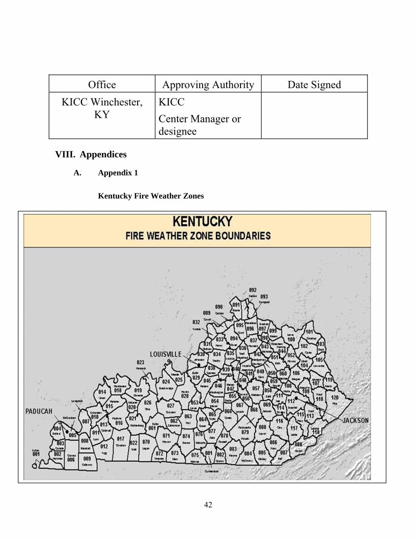
VIII. Appendices A. Appendix 1 Kentucky Fire Weather Zones
42
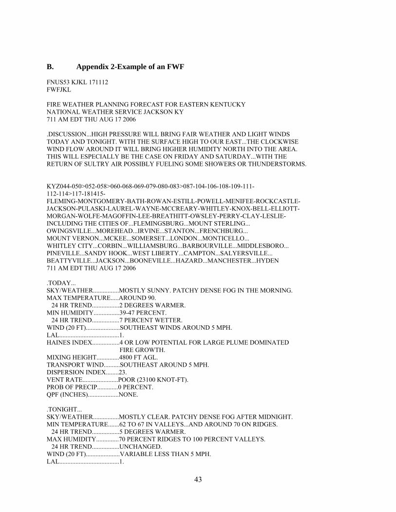
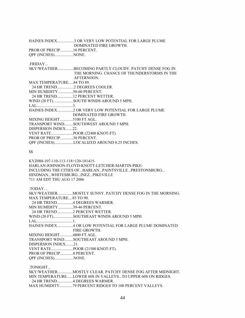
B. Appendix 2-Example of an FWF FNUS53 KJKL 171112 FWFJKL FIRE WEATHER PLANNING FORECAST FOR EASTERN KENTUCKY NATIONAL WEATHER SERVICE JACKSON KY 711 AM EDT THU AUG 17 2006 .DISCUSSION...HIGH PRESSURE WILL BRING FAIR WEATHER AND LIGHT WINDS TODAY AND TONIGHT. WITH THE SURFACE HIGH TO OUR EAST...THE CLOCKWISE WIND FLOW AROUND IT WILL BRING HIGHER HUMIDITY NORTH INTO THE AREA. THIS WILL ESPECIALLY BE THE CASE ON FRIDAY AND SATURDAY...WITH THE RETURN OF SULTRY AIR POSSIBLY FUELING SOME SHOWERS OR THUNDERSTORMS. KYZ044-050>052-058>060-068-069-079-080-083>087-104-106-108-109-111- 112-114>117-181415- FLEMING-MONTGOMERY-BATH-ROWAN-ESTILL-POWELL-MENIFEE-ROCKCASTLE- JACKSON-PULASKI-LAUREL-WAYNE-MCCREARY-WHITLEY-KNOX-BELL-ELLIOTT- MORGAN-WOLFE-MAGOFFIN-LEE-BREATHITT-OWSLEY-PERRY-CLAY-LESLIE- INCLUDING THE CITIES OF...FLEMINGSBURG...MOUNT STERLING... OWINGSVILLE...MOREHEAD...IRVINE...STANTON...FRENCHBURG... MOUNT VERNON...MCKEE...SOMERSET...LONDON...MONTICELLO... WHITLEY CITY...CORBIN...WILLIAMSBURG...BARBOURVILLE...MIDDLESBORO... PINEVILLE...SANDY HOOK...WEST LIBERTY...CAMPTON...SALYERSVILLE... BEATTYVILLE...JACKSON...BOONEVILLE...HAZARD...MANCHESTER...HYDEN 711 AM EDT THU AUG 17 2006 .TODAY... SKY/WEATHER................MOSTLY SUNNY. PATCHY DENSE FOG IN THE MORNING. MAX TEMPERATURE.....AROUND 90. 24 HR TREND.................2 DEGREES WARMER. MIN HUMIDITY................39-47 PERCENT. 24 HR TREND.................7 PERCENT WETTER. WIND (20 FT).....................SOUTHEAST WINDS AROUND 5 MPH. LAL.....................................1. HAINES INDEX.................4 OR LOW POTENTIAL FOR LARGE PLUME DOMINATED FIRE GROWTH. MIXING HEIGHT..............4800 FT AGL. TRANSPORT WIND..........SOUTHEAST AROUND 5 MPH. DISPERSION INDEX........23. VENT RATE......................POOR (23100 KNOT-FT). PROB OF PRECIP.............0 PERCENT. QPF (INCHES)...................NONE. .TONIGHT... SKY/WEATHER................MOSTLY CLEAR. PATCHY DENSE FOG AFTER MIDNIGHT. MIN TEMPERATURE.......62 TO 67 IN VALLEYS...AND AROUND 70 ON RIDGES. 24 HR TREND.................5 DEGREES WARMER. MAX HUMIDITY..............70 PERCENT RIDGES TO 100 PERCENT VALLEYS. 24 HR TREND.................UNCHANGED. WIND (20 FT).....................VARIABLE LESS THAN 5 MPH. LAL.....................................1.
43
HAINES INDEX.................3 OR VERY LOW POTENTIAL FOR LARGE PLUME DOMINATED FIRE GROWTH. PROB OF PRECIP.............10 PERCENT. QPF (INCHES)...................NONE. .FRIDAY... SKY/WEATHER................BECOMING PARTLY CLOUDY. PATCHY DENSE FOG IN THE MORNING. CHANCE OF THUNDERSTORMS IN THE AFTERNOON. MAX TEMPERATURE.....84 TO 89. 24 HR TREND.................2 DEGREES COOLER. MIN HUMIDITY...............50-60 PERCENT. 24 HR TREND................12 PERCENT WETTER. WIND (20 FT)....................SOUTH WINDS AROUND 5 MPH. LAL....................................3. HAINES INDEX................2 OR VERY LOW POTENTIAL FOR LARGE PLUME DOMINATED FIRE GROWTH. MIXING HEIGHT.............5100 FT AGL. TRANSPORT WIND.........SOUTHWEST AROUND 5 MPH. DISPERSION INDEX.......22. VENT RATE......................POOR (22400 KNOT-FT). PROB OF PRECIP.............30 PERCENT. QPF (INCHES)...................LOCALIZED AROUND 0.25 INCHES. $$ KYZ088-107-110-113-118>120-181415- HARLAN-JOHNSON-FLOYD-KNOTT-LETCHER-MARTIN-PIKE- INCLUDING THE CITIES OF...HARLAN...PAINTSVILLE...PRESTONSBURG... HINDMAN...WHITESBURG...INEZ...PIKEVILLE 711 AM EDT THU AUG 17 2006 .TODAY... SKY/WEATHER...............MOSTLY SUNNY. PATCHY DENSE FOG IN THE MORNING. MAX TEMPERATURE....85 TO 90. 24 HR TREND................4 DEGREES WARMER. MIN HUMIDITY...............39-46 PERCENT. 24 HR TREND................2 PERCENT WETTER. WIND (20 FT)....................SOUTHEAST WINDS AROUND 5 MPH. LAL....................................1. HAINES INDEX................4 OR LOW POTENTIAL FOR LARGE PLUME DOMINATED FIRE GROWTH. MIXING HEIGHT.............4800 FT AGL. TRANSPORT WIND.........SOUTHEAST AROUND 5 MPH. DISPERSION INDEX........21. VENT RATE......................POOR (21500 KNOT-FT). PROB OF PRECIP.............0 PERCENT. QPF (INCHES)...................NONE. .TONIGHT... SKY/WEATHER...............MOSTLY CLEAR. PATCHY DENSE FOG AFTER MIDNIGHT. MIN TEMPERATURE......LOWER 60S IN VALLEYS...TO UPPER 60S ON RIDGES. 24 HR TREND................4 DEGREES WARMER. MAX HUMIDITY.............79 PERCENT RIDGES TO 100 PERCENT VALLEYS.
44
24 HR TREND...............15 PERCENT DRIER. WIND (20 FT)...................SOUTHEAST WINDS AROUND 5 MPH. LAL...................................1. HAINES INDEX...............4 OR LOW POTENTIAL FOR LARGE PLUME DOMINATED FIRE GROWTH. PROB OF PRECIP............0 PERCENT. QPF (INCHES)..................NONE. .FRIDAY... SKY/WEATHER...............BECOMING PARTLY CLOUDY. PATCHY DENSE FOG IN THE MORNING. SLIGHT CHANCE OF THUNDERSTORMS IN THE AFTERNOON. MAX TEMPERATURE....84 TO 89. 24 HR TREND...............UNCHANGED. MIN HUMIDITY..............43-51 PERCENT. 24 HR TREND...............5 PERCENT WETTER. WIND (20 FT)...................SOUTH WINDS AROUND 5 MPH. LAL...................................2. HAINES INDEX...............2 OR VERY LOW POTENTIAL FOR LARGE PLUME DOMINATED FIRE GROWTH. MIXING HEIGHT............5100 FT AGL. TRANSPORT WIND........SOUTH AROUND 5 MPH. DISPERSION INDEX......16. VENT RATE.....................POOR (16300 KNOT-FT). PROB OF PRECIP...........20 PERCENT. QPF (INCHES).................LOCALIZED AROUND 0.25 INCHES. $$ .FORECAST DAYS 3 THROUGH 7... .SATURDAY...PARTLY CLOUDY WITH A CHANCE OF THUNDERSTORMS. PATCHY DENSE FOG. LOWS IN THE UPPER 60S. HIGHS IN THE MID 80S. SOUTH WINDS AROUND 5 MPH. .SUNDAY...MOSTLY CLOUDY WITH A CHANCE OF THUNDERSTORMS. LOWS IN THE UPPER 60S. HIGHS IN THE MID 80S. WEST WINDS AROUND 5 MPH. .MONDAY...PARTLY CLOUDY. LOWS IN THE UPPER 60S. HIGHS IN THE MID 80S. LIGHT WINDS. .TUESDAY...PARTLY CLOUDY WITH A SLIGHT CHANCE OF THUNDERSTORMS. LOWS IN THE MID 60S. HIGHS IN THE MID 80S. .WEDNESDAY...PARTLY CLOUDY WITH A SLIGHT CHANCE OF THUNDERSTORMS. LOWS IN THE MID 60S. HIGHS IN THE MID 80S. $$
45
C. Appendix 3-Example of an FWM FNUS83 KJKL 131900 FWMJKL FCST,154401,010214,13,6,58,78,1,1,SW,10,M,58,48,93,83,5,6,N FCST,157002,010214,13,6,61,67,1,1,SW,12,M,61,47,99,72,8,5,N FCST,157201,010214,13,6,58,78,1,1,SW,13,M,58,49,93,88,6,6,N FCST,159801,010214,13,6,59,75,1,1,SW,09,M,59,47,99,72,7,5,N FCST,152001,010214,13,6,57,80,1,1,SW,12,M,57,48,93,67,5,6,N FCST,154801,010214,13,6,58,78,1,1,SW,10,M,58,47,99,71,5,6,N FCST,156001,010214,13,6,58,78,1,1,SW,10,M,58,48,97,77,6,6,N
46
D. Appendix 4-Example of an RFW WWUS83 KJKL 092040 RFWJKL RED FLAG WARNING NATIONAL WEATHER SERVICE JACKSON KY 340 PM EST THU MAR 9 2006 ...RED FLAG WARNING REMAINS IN EFFECT UNTIL 8 PM EST THIS EVENING FOR STRONG WINDS AND LOW RELATIVE HUMIDITIES ACROSS PORTIONS OF EASTERN KENTUCKY... .SUSTAINED SOUTHERLY WINDS OF 20 TO 30 MPH...WITH HIGHER GUSTS WILL CONTINUE ACROSS PORTIONS OF EAST KENTUCKY THROUGH THE EARLY EVENING HOURS. DRIER AIR FROM ALOFT WILL CONTINUE TO MIX DOWN TO THE SURFACE...RESULTING IN RELATIVE HUMIDITIES BELOW 25 PERCENT ACROSS THE AREA...CREATING HAZARDOUS FIRE WEATHER CONDITIONS THROUGH THIS EVENING. BY 8 PM...THE ATMOSPHERE WILL MOISTEN UP...ALLOWING RELATIVE HUMIDITIES TO RECOVER TO ABOVE 25 PERCENT. KYZ086-087-107-109-112-116-100100- /O.EXA.KJKL.FW.W.0002.000000T0000Z-060310T0100Z/ KNOX-BELL-JOHNSON-MAGOFFIN-BREATHITT-CLAY- 340 PM EST THU MAR 9 2006 ...RED FLAG WARNING IN EFFECT UNTIL 8 PM EST THIS EVENING... THE NATIONAL WEATHER SERVICE IN JACKSON HAS ISSUED A RED FLAG WARNING FOR STRONG WINDS AND LOW RELATIVE HUMIDITIES...WHICH IS IN EFFECT UNTIL 8 PM EST THIS EVENING. A RED FLAG WARNING MEANS THAT CRITICAL FIRE WEATHER CONDITIONS ARE EITHER OCCURRING NOW...OR WILL SHORTLY. A COMBINATION OF STRONG WINDS...LOW RELATIVE HUMIDITY...AND WARM TEMPERATURES WILL CREATE EXPLOSIVE FIRE GROWTH POTENTIAL. $$ KYZ088-110-113-115-117>120-100100- /O.CON.KJKL.FW.W.0002.000000T0000Z-060310T0100Z/ HARLAN-FLOYD-KNOTT-PERRY-LESLIE-LETCHER-MARTIN-PIKE- 340 PM EST THU MAR 9 2006 ...RED FLAG WARNING REMAINS IN EFFECT UNTIL 8 PM EST THIS EVENING... A RED FLAG WARNING REMAINS IN EFFECT FOR STRONG WINDS AND LOW RELATIVE HUMIDITIES UNTIL 8 PM EST THIS EVENING. A RED FLAG WARNING MEANS THAT CRITICAL FIRE WEATHER CONDITIONS ARE EITHER OCCURRING NOW...OR WILL SHORTLY. A COMBINATION OF STRONG WINDS...LOW RELATIVE HUMIDITY...AND WARM TEMPERATURES WILL
47

CREATE EXPLOSIVE FIRE GROWTH POTENTIAL. $$
48
E. Appendix 5-Example of an FWS FNUS73 KJKL 171224 FWSJKL SPOT FORECAST FOR BECKETT...USDA FOREST SERVICE NATIONAL WEATHER SERVICE JACKSON KY 824 AM EDT FRI AUG 17 2007 ...LOW RELATIVE HUMIDITY ON SATURDAY... FORECAST IS BASED ON REQUEST TIME OF 0712 EDT ON AUGUST 17. IF CONDITIONS BECOME UNREPRESENTATIVE, CONTACT THE NATIONAL WEATHER SERVICE. .DISCUSSION...A COLD FRONT MOVING THROUGH KENTUCKY WILL PUSH SOUTH OF THE AREA BY EARLY AFTERNOON. EXPECT GRADUALLY CLEARING SKIES THROUGH EARLY AFTERNOON. HIGH PRESSURE WILL BE CENTERED OVER THE GREAT LAKES REGION ON SATURDAY...BRINGING DRY AIR AND RELATIVE HUMIDITY LEVELS BELOW 30 PERCENT. .TODAY... SKY/WEATHER.........MOSTLY SUNNY. MAX TEMPERATURE.....88-90. MIN HUMIDITY........32-34 PERCENT. WIND (20 FT)........EAST 3-5 MPH THROUGH 1100...OTHERWISE...NORTHWEST WINDS AROUND 8 MPH. SURROUNDING RIDGE...NORTHWEST 8 TO 10 MPH. RIDGETOP WIND.......NORTHWEST 8 TO 10 MPH. POP.................10 PERCENT. LAL.................1. HAINES INDEX........4 OR A LOW POTENTIAL FOR LARGE PLUME DOMINATED FIRE GROWTH. MIXING HEIGHT.......5400-5800 FT AGL. TRANSPORT WINDS.....NORTHWEST 12-14 MPH. DISPERSION INDEX....73. .TONIGHT... SKY/WEATHER.........MOSTLY CLEAR. PATCHY FOG EARLY IN THE MORNING. MIN TEMPERATURE.....56 BOTTOM...60 TOP. MAX HUMIDITY........98 PERCENT BOTTOM...86 PERCENT TOP. WIND (20 FT)........CALM BOTTOM...NORTH 5 MPH...SHIFTING TO NORTHEAST 3 TO 5 MPH TOP. SURROUNDING RIDGE...NORTH 5 MPH...SHIFTING TO NORTHEAST 3 TO 5 MPH TOP. RIDGETOP WIND.......NORTH 5 MPH...SHIFTING TO NORTHEAST 3 TO 5 MPH TOP. POP.................0 PERCENT. LAL.................1. HAINES INDEX........6 OR HIGH POTENTIAL FOR LARGE PLUME DOMINATED FIRE GROWTH. .SATURDAY... SKY/WEATHER.........SUNNY.
49
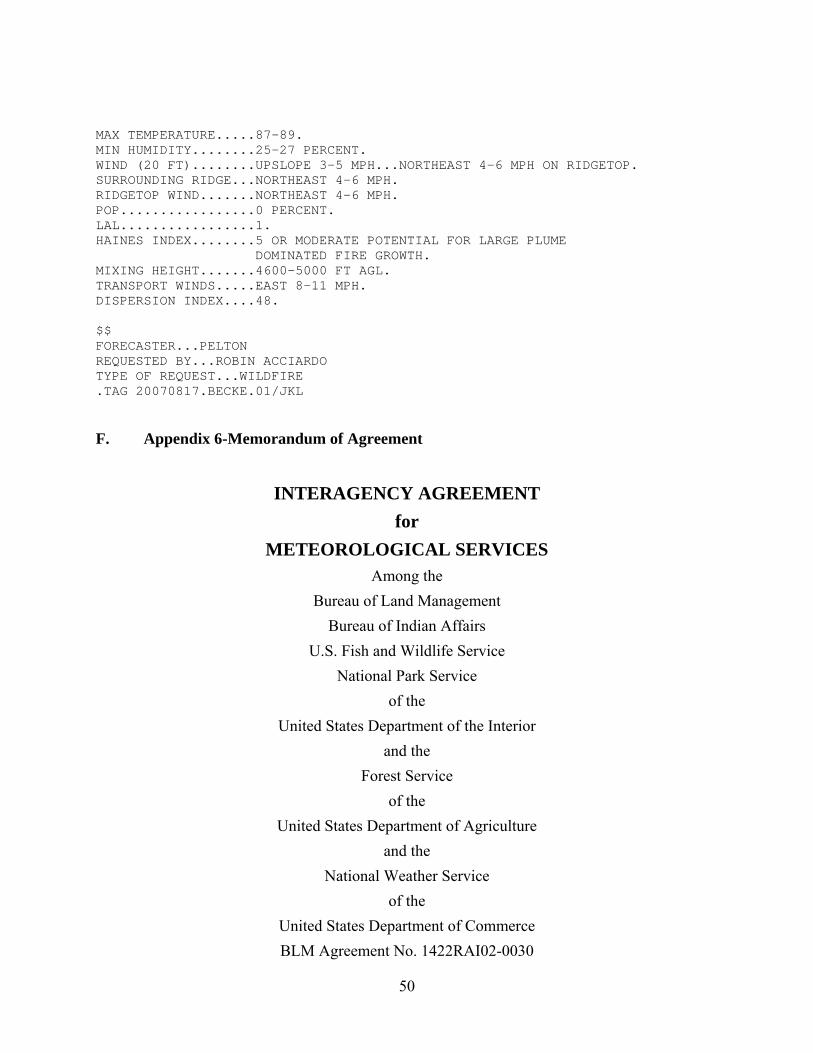
MAX TEMPERATURE.....87-89. MIN HUMIDITY........25-27 PERCENT. WIND (20 FT)........UPSLOPE 3-5 MPH...NORTHEAST 4-6 MPH ON RIDGETOP. SURROUNDING RIDGE...NORTHEAST 4-6 MPH. RIDGETOP WIND.......NORTHEAST 4-6 MPH. POP.................0 PERCENT. LAL.................1. HAINES INDEX........5 OR MODERATE POTENTIAL FOR LARGE PLUME DOMINATED FIRE GROWTH. MIXING HEIGHT.......4600-5000 FT AGL. TRANSPORT WINDS.....EAST 8-11 MPH. DISPERSION INDEX....48. $$ FORECASTER...PELTON REQUESTED BY...ROBIN ACCIARDO TYPE OF REQUEST...WILDFIRE .TAG 20070817.BECKE.01/JKL F. Appendix 6-Memorandum of Agreement
INTERAGENCY AGREEMENT
for METEOROLOGICAL SERVICES
Among the Bureau of Land Management
Bureau of Indian Affairs U.S. Fish and Wildlife Service
National Park Service of the
United States Department of the Interior and the
Forest Service of the
United States Department of Agriculture and the
National Weather Service of the
United States Department of Commerce BLM Agreement No. 1422RAI02-0030
50
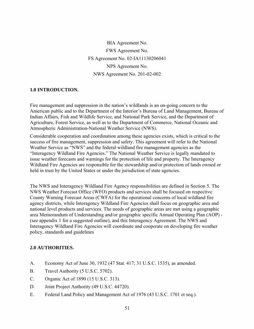
BIA Agreement No. FWS Agreement No.
FS Agreement No. 02-IA11130206041 NPS Agreement No.
NWS Agreement No. 201-02-002 1.0 INTRODUCTION. Fire management and suppression in the nation’s wildlands is an on-going concern to the American public and to the Department of the Interior’s Bureau of Land Management, Bureau of Indian Affairs, Fish and Wildlife Service, and National Park Service, and the Department of Agriculture, Forest Service, as well as to the Department of Commerce, National Oceanic and Atmospheric Administration-National Weather Service (NWS). Considerable cooperation and coordination among these agencies exists, which is critical to the success of fire management, suppression and safety. This agreement will refer to the National Weather Service as “NWS” and the federal wildland fire management agencies as the “Interagency Wildland Fire Agencies.” The National Weather Service is legally mandated to issue weather forecasts and warnings for the protection of life and property. The Interagency Wildland Fire Agencies are responsible for the stewardship and/or protection of lands owned or held in trust by the United States or under the jurisdiction of state agencies. The NWS and Interagency Wildland Fire Agency responsibilities are defined in Section 5. The NWS Weather Forecast Office (WFO) products and services shall be focused on respective County Warning Forecast Areas (CWFA) for the operational concerns of local wildland fire agency districts, while Interagency Wildland Fire Agencies shall focus on geographic area and national level products and services. The needs of geographic areas are met using a geographic area Memorandum of Understanding and/or geographic specific Annual Operating Plan (AOP) - (see appendix 1 for a suggested outline), and this Interagency Agreement. The NWS and Interagency Wildland Fire Agencies will coordinate and cooperate on developing fire weather policy, standards and guidelines 2.0 AUTHORITIES. A. Economy Act of June 30, 1932 (47 Stat. 417; 31 U.S.C. 1535), as amended. B. Travel Authority (5 U.S.C. 5702). C. Organic Act of 1890 (15 U.S.C. 313). D. Joint Project Authority (49 U.S.C. 44720). E. Federal Land Policy and Management Act of 1976 (43 U.S.C. 1701 et seq.).
51
F. National Park Service Organic Act of August 1916 (16 U.S.C. 1). G. National Wildlife Refuge Administration Act of June 27, 1998 (16 U.S.C. 668dd) H. Disaster Relief Act of 1974 (42 U.S.C. 5147). I. National Indian Forest Resources Management Act of 1990 (25 U.S.C. 3101 et seq.). J. Cooperative Forestry Assistance Act of 1978 (P.L. 95-313, 92 Stat. 365 as amended; 16
U.S.C. 2101 (note), 2101-2103, 2103a, 2103b, 2104-2105). K. Federal Fire Prevention and Control Act of October 29, 1974, (P.L. 93-498, 15 U.S.C. 2201 et seq., 88 Stat 1535.) 3.0 PURPOSE. The purpose of this Inter-Agency Agreement is to combine resources and provide complementary services without duplication to best serve the needs of the public and all agencies for the protection of life, property and resource values to enhance ecosystem health. Accurate and timely meteorological and fire danger information is required to manage these resources effectively and efficiently. It is also the purpose of this Agreement to set forth the terms and conditions under which the NWS will continue to provide meteorological services to support these efforts as requested by the Interagency Wildland Fire Agencies. It is with this knowledge that this Inter-Agency Agreement is entered into. This Agreement supersedes the “National Agreement for Meteorological Services in Support of Agencies with Land Management and Fire Protection Responsibilities” among the six participating agencies, as listed above, that was effective June 1983. 4.0 OBJECTIVES. The objectives of this Agreement are: A. To identify meteorological services to be provided; B. Establish interagency relationships; and B. C. Define obligations of the NWS and Interagency Wildland Fire Agencies. 5.0 RESPONSIBILITIES.
52
The responsibilities listed are not all-inclusive, but are meant to provide the overall scope of services provided by the respective agencies. A. The National Weather Service agrees to: All obligations undertaken by the NWS under this Agreement are subject to the availability of appropriated funds. 1. Provide Basic Meteorological Services: Basic Meteorological Services will be provided
in accordance with the Annual Operating Plan (AOP) for Fire Weather Service for designated NWS offices. These services will be made available without cost to Interagency Wildland Fire Agencies and will include:
a. Routine fire weather forecast and updates during the designated period outlined in the AOP. b. Extended and long-range weather and climate outlooks. c. NWS weather observations. d. Fire Weather Watch and Red Flag Warning program. e. Site-specific forecasts for wildland fires or special federal projects (i.e. spraying, seeding, fuels management, or search and rescue operations). f. Provide consultation and technical advice in support of basic services to Interagency Wildland Fire Agencies. g. Provide weather information to a central communication gateway and the internet for Interagency Wildland Fire Agencies’ use and further distribution.
h. Provide a cadre of Incident Meteorologists (IMET) in support of the fire weather program.
i. Maintain a current list of offices providing basic meteorological services. j. National scale short-range fire weather outlooks.
53
2. Non-Routine Services: These services will be provided by designated NWS offices. Expenses above planned salary and operating costs will be borne by the benefiting agency. a. Weather Observer training. b. Weather observation station visits. c. Participation in Wildland Fire Agency training. 1. Course development. 2. Classroom instruction. d. On-site meteorological services. 3. Fire Weather Training: The NWS recognizes the need for specialized training in fire
weather meteorology for forecasters. Costs associated with training NWS staff will be borne by NWS. The NWS will meet this need as follows:
a. The NWS will ensure all meteorologists producing fire weather products have met the minimum fire weather forecaster training requirements. b. The NWS will provide specialized training for the purpose of qualifying NWS IMETs. 4. Participation in interagency groups: All NWS costs will be borne by NWS. 5. Wildland fire suppression related activities: The NWS will not charge an administrative
surcharge or any other expenditure that is not authorized under the Wildland Fire Agencies’ Appropriation Acts related to these activities.
B. Interagency Wildland Fire Agencies Wildland Fire Agencies’ programs provide Geographic Area and national products for the strategic role of resource prioritization and utilization. Specific responsibilities of Wildland Fire Agencies are listed below.
54
1. Operational Support and Predictive Services
a. Geographic Area and national level fire weather products, services and assessments will be provided for resource allocation and prioritization.
b. Integration of weather and climatic sciences into Geographic Area Coordination Center (GACC) operations. c. Develop value-added products to enhance short and long-range outlooks and projections. d. Provide weather briefings to GACC and NIFC Coordinators and Multiagency Coordinating Groups. e. Manage weather and climatology portions of GACC web site. f. Manage agency fire weather infrastructure. g. Smoke management. 2. Program Management Program management of federal land management and fire agencies’ fire weather responsibilities, which includes: a. Program coordination with state agencies. b. Programmatic guidance, evaluation and certification. c. Advice and staff support to Fire Directorate d. Manage weather station network. e. Liaison between field users and service providers. f. Participation in activity reviews.
55
3. Monitoring, Feedback and Improvement a. Transmit feedback to product and service providers. b. Suggest improvements to providers of products and services received. c. Advise agencies on quality control of weather observations. d. Coordination with NWS and users in assessment and evaluation of program effectiveness. e. Fire weather expertise in accident/incident investigations. 4. Technology Transfer a. Transfer meteorology and climatology knowledge to field level personnel. b. Promote proper usage by agency personnel of weather and climate products and services. c. Conduct training/expertise needs assessment. d. Coordinate data and technology acquisition. e. Participation on training cadre. 5. Agency Computer Systems Where fire management computer systems are locally available, access to the systems will be granted to NWS to provide services, as needed. Costs will be borne by the Interagency Wildland Fire Agencies for requirements that are beyond the distribution of weather information through a central communications gateway.
56
6. Fire Weather Observations: a. Provide routine surface weather observations to NWS. b. Provide all equipment, equipment maintenance, inspection of weather observation sites, and data quality control. c. Pay all travel and per diem costs associated with Interagency Wildland Fire Agencies’ requests for visits of NWS personnel to weather observing sites. d. Provide for collection, storage and retrieval of remote automatic weather stations (RAWS) data. e. Provide observations for site specific and other special forecasts. 7. On-Site Meteorological Support: a. Pay costs directly associated with on-site meteorological support by NWS personnel. This includes costs incurred by the NWS IMET duty station. b. Provide logistical and weather observation support to NWS personnel at onsite operations. c. Provide and pay costs associated with telecommunication services. 8. Training: a. Pay per diem and travel costs for NWS personnel instructing and providing course development in Wildland Fire Agency training. b. Provide technical assistance, instruction, and supporting material for NWS sponsored fire weather training sessions. 9. Other Non-Routine Services Interagency Wildland Fire Agencies will provide logistics support and pay all overtime, travel, and per diem costs of NWS personnel associated with the provision of all other
57
special fire meteorological services, including Wildland Fire agency approved wildland fire familiarization for NWS personnel. 6.0 JOINT RESPONSIBILITIES: NWS and Interagency Wildland Fire Agencies shall jointly prepare national and Geographic Area specific MOUs and/or AOPs for Fire Weather Services that will set policy and procedures at GACC, NIFC, state or forecast office level, and shall include: A. Shared responsibilities of all participants shall include, but not limited to weather briefings, training, research, product/service verification as outlined in Geographic Area specific AOPs. B. Provision for monitoring, feedback and improvement. C. Procedure for documenting, monitoring and evaluating fire weather products, briefings and services delivered. D. Provision for monitoring and evaluating advances in science and technology. E. Provision for efficient means for technology transfer. F. Provision for participation in fire weather research activities. G. Provision that on-site IMET services may be provided by Interagency Fire Weather Meteorologist meeting NWS standards only when NWS IMETs are not available to meet Wildland Fire Agency resource requests on a national basis. The coordination for Interagency Fire Weather Meteorologists will be done between the NWS IMET coordinator and the National Interagency Coordination Center. H. Provision that NWS meteorologists and Interagency Wildland Fire Agency meteorologists stationed at GACCs and at NIFC will work together to ensure fire agency decision makers receive consistent and coordinated fire weather products and services. I. Provision that the NWS and Interagency Wildland Fire Agencies will jointly develop and share technology including meteorological software and data, Advanced Technology
58
Meteorological Units, portable weather stations, etc. to improve abilities and performance. J. The NWS and Wildland Fire Agency meteorologists shall work closely in all phases of the fire weather forecast and warning program to resolve concerns and avoid potential inconsistencies in products and services prior to delivery to fire agency customers. The goal of all agencies is to maximize firefighter and public safety through a coordinated delivery of consistent services. K. The Parties recognize that, given the current administrative process for payments for fire suppression activities, it is not feasible to obligate the full amount of funds that may be required by this Agreement, because the Agreement does not constitute a binding obligation under 31 U.S.C. § 1501 since it cannot anticipate the specific goods or services for which payment will be requested, or the individual payment amounts, in each future case. This information can only be provided by Resource Orders executed when the goods or services are requested. At the same time, the Parties recognize that Resource Orders are insufficient to constitute a binding obligation under the statute because there is no evidence of intent to be bound, no authorized signatures are present, and no legal authorities are cited. However, these requirements are satisfied by the Agreement. The two documents, when taken together, contain all the elements required for an obligation under the statute. Hence, the Parties agree that this Agreement shall automatically be incorporated by reference into any Resource Orders issued under it, and that nobligation of funds will occur at the time the NWS presents a copy of this Agreement and the Resource Orders for payment. The parties also agree to work toward a more efficient resolution of this administrative process for obligation and payment of fire suppression funds. 7.0 STATEMENT OF WORK. Procedures for notification of and obtaining services from the NWS will be prepared and specified in the Annual Operating Plans (AOP) and/or in the MOUs for the Geographic Area Coordinating Centers, and in the Geographical Area and National Mobilization Guides. An electronic copy of the National Mobilization Guide can be viewed via www.nifc.gov - select “National Interagency Coordination Center” – select “References” link to National Mobilization Guide. 8.0 TRANSFER OF FUNDS. A. Billing and collection procedures will follow the Intra-governmental Payment and Collection (IPAC) system process.
59
B. Wildland Fire Suppression Activities: Transfers under this subsection are under the Disaster Relief Act, 42 U.S.C. § 5147. Reimbursable costs are estimated not to exceed a maximum of $2,000,000.00 per fiscal year. In the event this amount is insufficient for a particular fiscal year, this Agreement may be modified to increase the amount of funding, subject to the availability of funds. This Agreement is automatically incorporated by reference into any Resource Order that is issued under it, constituting a binding obligation. The Interagency Wildland Fire Agencies warrant that they will administratively reserve these funds to ensure that the funds will be available when the obligations are recorded. The recording of the obligations will occur upon the receipt of the billings from the NWS by the applicable Interagency Wildland Fire Agency. The billings, inclusive of copies of this Agreement, the Resource Order(s), and expenditure documentation, will define the specific services, supplied goods and costs for each order, and subsequent obligation and payment. 1. Reimbursement payments for suppression-related activities will be accomplished by
submission of billings, which are inclusive of copies of the Resource Orders that define the requested services and goods, and the expenditure back-up documentation. The NWS will not charge an administrative surcharge or any other expenditure that is not authorized under the Wildland Fire Agencies’ Appropriation Acts related to these activities
2. It is the responsibility of the requesting agency/office to provide billing instructions to the
NWS office that provided the service, which includes the items listed below. It is also the responsibility of the requesting agency/office to conduct any required verification of costs, authorization of expenditures and reconciliation of payment.
a) The fire name, jurisdictional unit, and incident number (The copy of the Resource Order generally includes this information);
b) Applicable support documentation requirements; c) A copy of this Agreement complete with signatures; d) Identification (name and phone number) of NWS financial contact; e) Provide information to NWS regarding which payment center to send the billings for processing; and f) Billings and support documentation are to be submitted to the appropriate
payment center by the NWS within sixty-days of completion of service. C. Non-Wildland Fire Suppression Activities: Obligation of funds and payments for non-wildland fire suppression activities that are included in the Annual Operating Plan (AOP) shall be accomplished by Task Orders against this Agreement between the concerned agencies by the responsible officers at the appropriate level operating within their authority.
60
1. All funding obligations must be placed against the individual agency/office’s Task Order number and not against this Agreement number.
2. Task Orders to this Agreement may be approved and signed for the NWS by the Director, Office of Climate, Water and Weather Services. 3. Each federal agency shall make direct settlement from its own funds for all liabilities it
incurs under this Agreement. 4. The NWS will not charge any agency that is signatory to this Agreement an indirect
administrative surcharges for activities addressed in the respective Annual Operating Plan(s) and Geographical Area MOUs, and are requested through Task Orders or Resource Orders under the National Mobilization Guide. 5. Task Orders may be prepared in any format acceptable to the agencies involved in each
project. At a minimum, each Task Order written in support of this Agreement will include the following items:
a) Detailed description of services to be done or supplies to be delivered; b) Description of the deliverables; c) Performance period for completion; d) Cost estimates; e) Identify responsible project officials for each Task Order agency; f) Payment procedures (applicable billing procedures, identification of codes,
method of payment—advance/reimbursement; and Signature(s) by authorized personnel for each Task Order agency.
g) Signature(s) by authorized personnel for each Task Order agency. 9.0 TERM OF AGREEMENT. The terms of this Inter-agency Agreement shall become effective with and upon execution by NWS and any or all Interagency Wildland Fire Agencies and shall remain in effect for a period of five-years from the date the last signature was placed on the signatory section, or until such time as the Inter-agency Agreement is terminated by mutual agreement. Any signatory may terminate their participation in this Agreement by written notice to all other signatories provided that such notice shall be given between the dates of October 1 of any year and February 1 of the following year. Full credit shall be allowed for each party’s expense and all non-cancelable obligations properly incurred up to the effective date of termination. The remaining signatories may continue the provisions of this Agreement as long as the NWS remains a signatory.
61
10.0 RESOLUTION OF DISAGREEMENT. Should disagreement arise on the interpretation of the provisions of this Agreement, or modifications thereto, that cannot be resolved at the operating level, the area(s) of disagreement shall be stated in writing by each party and presented to the other party for consideration. If agreement on interpretation is not reached within thirty-days, the parties shall forward the written presentation of the disagreement to respective higher officials for appropriate resolution. Conflicts and/or disagreements that cannot be resolved at the regional (GACC) level will be elevated to the National Fire Weather Program Managers for the NWS and Interagency Wildland Fire Agencies. If the conflict cannot be resolved at the National Program Managers level, the conflict will be elevated to the Agency Director level (NWS and applicable Wildland Fire Agency Director) for final resolution. 11.0 GENERAL PROVISIONS. A. Parties to this Agreement are not obligated to make expenditures of funds or provide services under terms of this Agreement unless such funds are appropriated or services are authorized by either the State Legislatures or the Congress of the United States, or are otherwise available under Section 101 and 102 of the Annual Appropriations Act for Interior and Related Agencies. B. The points of contact listed in Section 13 will review this Agreement annually. C. Modifications to this Agreement may be initiated by any signatory agency. The modifications shall not take effect until documented and signed by all signatory agencies. 1. The BLM is designated as the agency responsible for all administrative oversight of modifications to this agreement. 2. Modifications to this Agreement may be approved for the NWS and signed by the Director, Office of Climate, Water and Weather Services, or pursuant to NWS protocol. D. The signatory Interagency Wildland Fire Agencies agree to consider expansion of this Agreement to cover areas of mutual concern, e.g., changing technology and improved procedures, as opportunities for such cooperation become available. 12.0 WAIVER.
62
Each party to this agreement does hereby expressly waive all claims against the other party for compensation for any loss, damage, personal injury or death occurring in consequence of the performance of this agreement. 13.0 PRINCIPAL CONTACTS. The Points of Contact are responsible for coordinating an annual review of the currency and adequacy of this Agreement among the signatories, and/or their designees. National Weather Service: National Fire Weather Program Manager Rusty Billingsley National Weather Service 3833 South Development Ave. Boise, ID 83705 208/334-9824 – Office [email protected] Interagency Wildland Fire Agencies: NIFC Fire Weather Program Manager Rick Ochoa National Interagency Fire Center 3833 South Development Ave. Boise, ID 83705 208/387-5451-Office [email protected] 14.0 DEFINITIONS. When the following terms are used in this Agreement, or in an AOP, such terms will have the meanings stated below.
63
A. Annual Operation Plan for Fire Weather Services (AOP): A procedural guide, based on the National Interagency MOU and applicable Geographic Area MOUs, which describes fire meteorological services provided within the Geographic Area of responsibility, including NIFC. At a minimum the AOP will include the items in Appendix 1, Annual Operating Plan - Required Elements and Suggested Format. B. Assessment: Fire weather and/or fire danger product based on a thorough evaluation of all pertinent sources of meteorological and fire danger information. C. Basic Meteorological Services: Basic meteorological services are those state-of-the-science meteorological forecasts, warnings, observations and statements produced at a designated NWS office. D. Fire Weather Watch: Fire Weather Watch is issued to advise of conditions, which could
result in extensive wildfire occurrence or extreme fire behavior, which are expected to develop in the next 12 to 48 hours, but not more than 72 hours. In cases of dry lightning, a Fire Weather Watch may be issued for the next 12 hours. Fire Weather Watch meteorological and fuel criteria will be defined in the AOP.
E. Geographic Area: A geographic boundary designated by Interagency Wildland Fire
Agencies, where these agencies work together in the coordination and effective utilization of resources within their boundaries. The National Interagency Mobilization Guide identifies the areas encompassed by the eleven Geographic Areas.
F. Geographic Area Memorandum of Understanding (MOU): A document, based on the
National Interagency Memorandum of Understanding for Meteorological Services, which establishes local policy to meet unique needs of a Geographic Area.
G. Incident Meteorologist (IMET): A meteorologist specially trained to provide on-site meteorological support of Wildland Fire Agency designated incidents. H. Non-Routine Services: Meteorological services uniquely required by interagency Wildland
Fire Agencies, which usually are not provided from a designated NWS office. I. On-Site Meteorological Services: Special service which dedicates an IMET to an incident so
that they are removed from their normal duties.
64
65
J. Predictive Services: Those Geographic Area/national level fire weather and/or fire danger services and products produced by Wildland Fire Agency meteorologists in support of resource allocation and prioritization.
K. Red Flag Warning: Red Flag Warning is used to warn of impending or actually occurring
critical weather conditions that could result in extensive wildland fire activity. A warning will be issued when the forecast time of onset is less than 24 hours. Red Flag Warning meteorological and fuel criteria will be defined in the AOP.
L. Routine Fire Weather Forecasts: A Routine Fire Weather Forecast is a scheduled narrative and/or matrix forecast of weather parameters pertinent fire management activities in support of protection of life, property, and resources at risk in a given area. The number of parameters may vary due to regional weather requirements, but normally include a brief weather synopsis, expected weather and clouds, duration of precipitation, maximum and minimum temperature/relative humidity, wind direction and speed, transport and stability parameters, and lightning activity level. These forecasts normally cover the next 48 hours and may include input for the computation of National Fire Danger Rating System indices. These forecasts may also include long-range outlooks. M. Site Specific Forecasts: Site-specific forecasts are issued when requested by Interagency Wildland Fire Agencies for wildland fires. These forecasts differ from routine fire weather forecasts by incorporating greater detail in timing, higher resolution of terrain influences, and incorporate meso-scale and sometimes micro-scale weather influences impacting the site. These may be generated from an office with Wildland Fire supplied information (i.e., location, weather observations, objectives) or generated by an IMET assigned to the incident. Forecast formats may vary but all are highly tailored to satisfy requirements of the incident objectives. N. Wildland Fires: All ignitions that occur on wildlands.