Embed Size (px)
Citation preview
JK Geotechnics GEOTECHNICAL & ENVIRONMENTAL ENGINEERS
PO Box 976, North Ryde BC NSW 1670 Tel: 02 9888 5000 Fax: 02 9888 5001 www.jkgeotechnics.com.au
Jeffery & Katauskas Pty Ltd, trading as JK Geotechnics ABN 17 003 550 801
FACTUAL GEOTECHNICAL REPORT
TO
URBANGROWTH NSW
ON
GEOTECHNICAL INVESTIGATION
FOR
BANK STREET COMMERCIAL WHARF
AT
5-11 BANK STREET, PYRMONT, NSW
18 May 2017
Ref: 28974SPrptRev2
28974SPRev2 Factual Page ii
Date: 18 May 2017 Report No: 28974SPrpt Revision No: 2
Report prepared by: Peter Wright Senior Associate | Geotechnical Engineer
Report reviewed by: Paul Stubbs Principal | Geotechnical Engineer For and on behalf of
JK GEOTECHNICS
PO Box 976
NORTH RYDE BC NSW 1670
Document Copyright of JK Geotechnics.
This Report (which includes all attachments and annexures) has been prepared by JK Geotechnics (JK) for its Client, and is intended for the use only by that Client. This Report has been prepared pursuant to a contract between JK and its Client and is therefore subject to:
a) JK’s proposal in respect of the work covered by the Report;
b) the limitations defined in the Client’s brief to JK;
c) the terms of contract between JK and the Client, including terms limiting the liability of JK.
If the Client, or any person, provides a copy of this Report to any third party, such third party must not rely on this Report, except with the express written consent of JK which, if given, will be deemed to be upon the same terms, conditions, restrictions and limitations as apply by virtue of (a), (b), and (c) above. Any third party who seeks to rely on this Report without the express written consent of JK does so entirely at their own risk and to the fullest extent permitted by law, JK accepts no liability whatsoever, in respect of any loss or damage suffered by any such third party.
28974SPRev2 Factual Page iii
TABLE OF CONTENTS
1 INTRODUCTION 1
2 INVESTIGATION PROCEDURE 1
3 RESULTS OF INVESTIGATION 4
3.1 Site Description 4
3.2 Subsurface Conditions 5
3.3 Laboratory Test Results 7
4 GENERAL COMMENTS 8
STS TABLE A: MOISTURE CONTENT, ATTERBERG LIMITS & LINEAR SHRINKAGE TEST REPORT
STS TABLE B: PARTICLE SIZE DISTRIBUTION AND HYDROMETER TEST REPORT
STS TABLE C: EMERSON CLASS NUMBER TEST REPORT
STS TABLE D: POINT LOAD STRENGTH INDEX TEST REPORT
ENVIROLAB SERVICES REPORT NO: 140037
BOREHOLE LOGS 1 TO 19 INCLUDING CORE PHOTOGRAPHS
FIGURES 1 AND 2: BOREHOLE LOCATION PLANS
FIGURE 3: INFERRED GEOTECHNICAL SECTION A-A
FIGURE 4: INFERRED GEOTECHNICAL SECTION B-B
FIGURE 5: INFERRED GEOTECHNICAL SECTION C-C
FIGURE 6: INFERRED GEOTECHNICAL SECTION D-D
FIGURE 7: INFERRED GEOTECHNICAL SECTION E-E
REPORT EXPLANATION NOTES
28974SPRev2 Factual Page 1
1 INTRODUCTION
UrbanGrowth NSW is preparing a modification application in relation to the earlier Part 3A approval
for Sydney Heritage Fleet facilities at 5 Bank Street, Pyrmont (MP 11_0001). The proposal involves
the relocation of a RMS licensed Commercial Operator from Pyrmont Bridge Road, Glebe to the
Bank Street, Pyrmont site to enable the development of the New Sydney Fish Market. The proposal
is in effect a decanting of water-based operations within Blackwattle Bay and allows a working
harbour use to continue in generally the same location with similar operational parameters to its
current use.
This factual report presents the results of a geotechnical investigation for the proposed Commercial
Wharf at 5-11 Bank Street, Pyrmont, NSW. The report is to address the requirements for
‘Document 7 – Geotechnical Report’ in accordance with the Secretary’s Environmental Assessment
Requirements (SEAR’s) attached to the letter from the Department of Planning & Environment,
Ref MP11_0001 MOD3 dated 12 April 2017.
2 INVESTIGATION PROCEDURE
The fieldwork for the investigation was carried out during December 2015 and January 2016, and
comprised the drilling of nineteen boreholes to depths ranging between 5.1 metres (m) and 29.0m
below the existing surface levels.
Prior to the commencement of the fieldwork, the on-shore boreholes were scanned for buried
services by a specialist service location consultant utilising both electromagnetic scanning and
ground penetrating radar equipment. The bed of the bay in the vicinity of the over-water borehole
locations was visually scanned by commercial divers to check for the presence of services,
obstructions or potentially contaminating materials prior to the establishment of the drilling rig to
those locations.
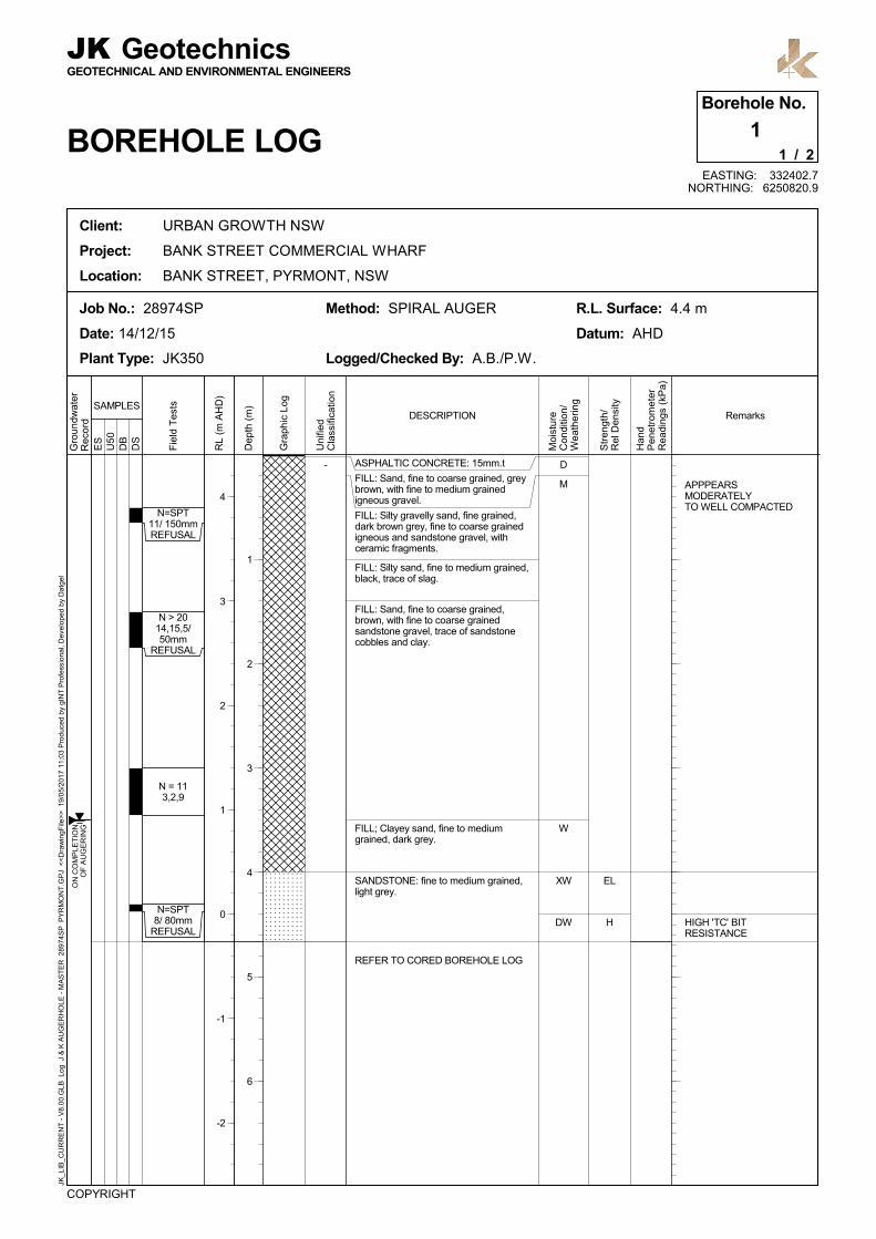
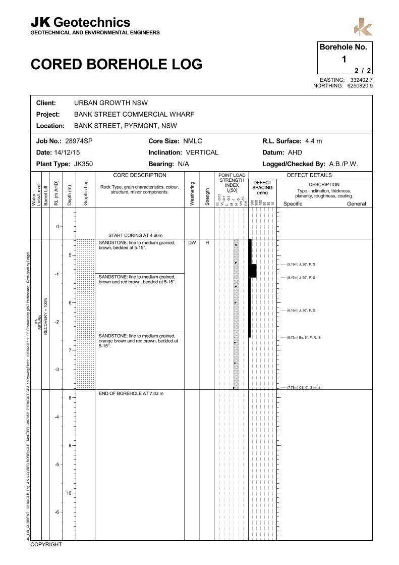
Borehole 1 (BH1) to BH4 were drilled on-shore using a truck mounted drilling rig and spiral auger
techniques to minor penetration into the bedrock. These boreholes were then extended to their
termination depths using diamond coring techniques with an NMLC triple tube core barrel and water
flush.
BH5 to BH19, excluding BH11, were drilled using a track mounted drilling rig mounted on a 25m
unpowered floating barge. The soil in these boreholes was drilled using wash-boring techniques
generally to minor penetration into the bedrock.
28974SPRev2 Factual Page 2
All boreholes were then extended to their termination depths using diamond coring techniques with
an NMLC triple tube core barrel and water flush. In several of the boreholes, such as BH5, diamond
coring was commenced prematurely due to the drilling resistance encountered within boulders
suggesting the presence of bedrock.
Borehole 11 was drilled on the low side of the seawall to the east of the existing dragon-boat
launching ramp. This location was drilled using a small track mounted drilling rig supported
immediately behind the seawall, with a scaffold platform supported on the bed of the bay providing
the working room behind the rig. This borehole was drilled using spiral auger techniques to minor
penetration into the bedrock, and was then extended using NMLC diamond coring techniques.
During the wash boring and augering of the soils, Standard Penetration Tests were completed,
together with the collection of “undisturbed” (U50) tube samples of the clayey soils.
The borehole locations were initially set out using a combination of triangulation and laser range
finder measurements from on shore structures and features. During the drilling of each borehole,
the location of the drill string was determined by a registered surveyor using theodolite
measurements. The reduced level of the surface at each borehole location was determined using
the survey results combined with tape measurements of the water depth. The surveyor also used
previous survey data provided by UrbanGrowth NSW, together with new on-land survey, to prepare
a contour plan of the property, including boundary locations and lot labels.
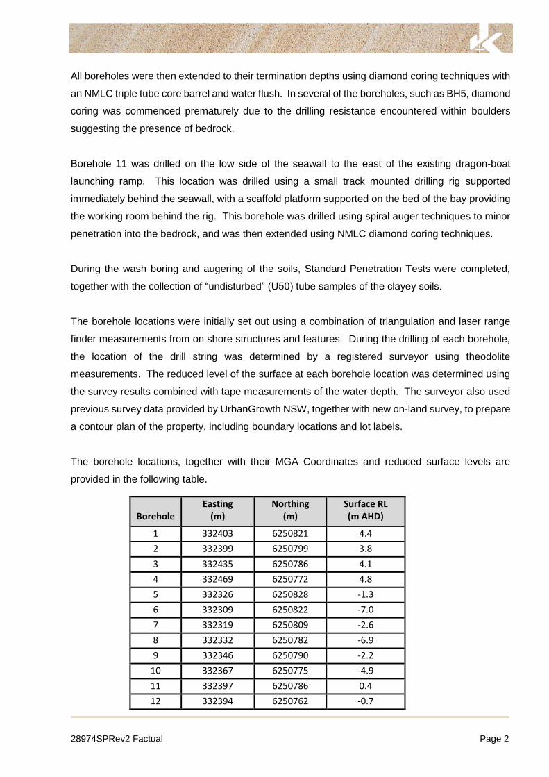
The borehole locations, together with their MGA Coordinates and reduced surface levels are
provided in the following table.
Borehole
Easting (m)
Northing (m)
Surface RL (m AHD)
1 332403 6250821 4.4
2 332399 6250799 3.8
3 332435 6250786 4.1
4 332469 6250772 4.8
5 332326 6250828 -1.3
6 332309 6250822 -7.0
7 332319 6250809 -2.6
8 332332 6250782 -6.9
9 332346 6250790 -2.2
10 332367 6250775 -4.9
11 332397 6250786 0.4
12 332394 6250762 -0.7
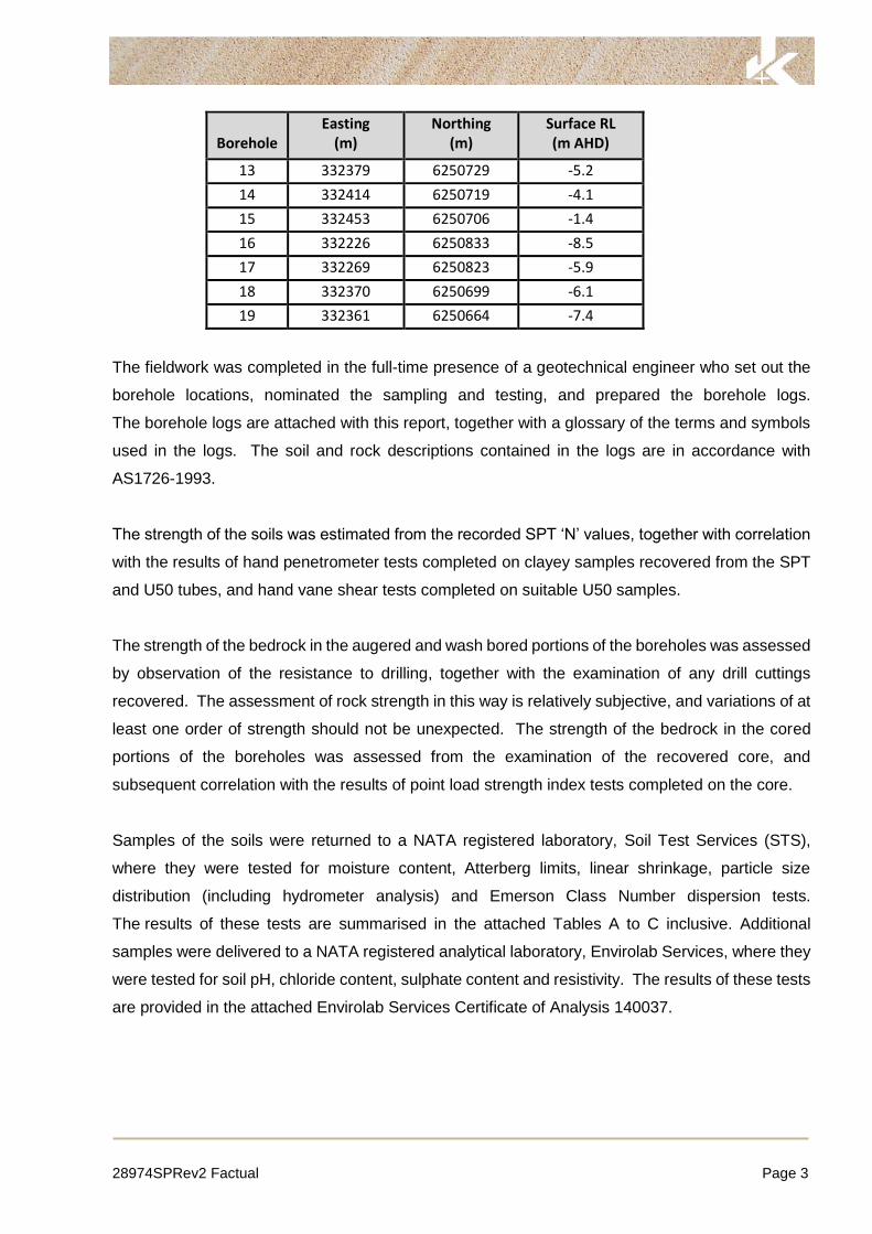
28974SPRev2 Factual Page 3
Borehole
Easting (m)
Northing (m)
Surface RL (m AHD)
13 332379 6250729 -5.2
14 332414 6250719 -4.1
15 332453 6250706 -1.4
16 332226 6250833 -8.5
17 332269 6250823 -5.9
18 332370 6250699 -6.1
19 332361 6250664 -7.4
The fieldwork was completed in the full-time presence of a geotechnical engineer who set out the
borehole locations, nominated the sampling and testing, and prepared the borehole logs.
The borehole logs are attached with this report, together with a glossary of the terms and symbols
used in the logs. The soil and rock descriptions contained in the logs are in accordance with
AS1726-1993.
The strength of the soils was estimated from the recorded SPT ‘N’ values, together with correlation
with the results of hand penetrometer tests completed on clayey samples recovered from the SPT
and U50 tubes, and hand vane shear tests completed on suitable U50 samples.
The strength of the bedrock in the augered and wash bored portions of the boreholes was assessed
by observation of the resistance to drilling, together with the examination of any drill cuttings
recovered. The assessment of rock strength in this way is relatively subjective, and variations of at
least one order of strength should not be unexpected. The strength of the bedrock in the cored
portions of the boreholes was assessed from the examination of the recovered core, and
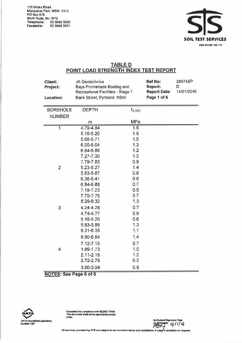
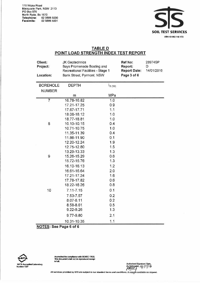
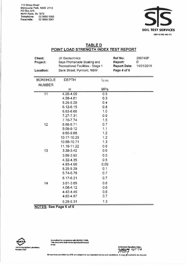
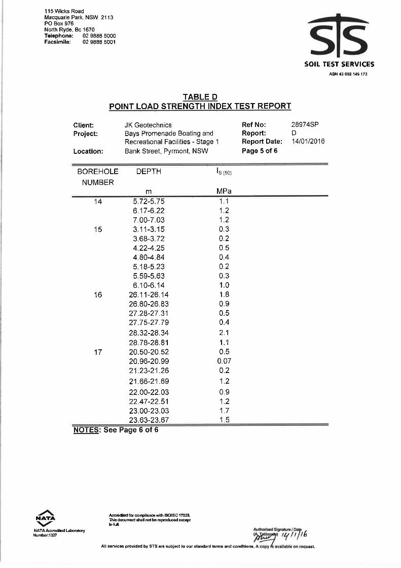
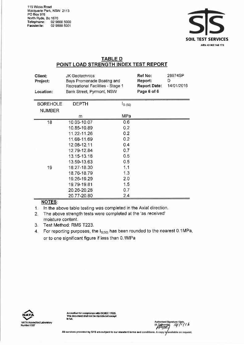
subsequent correlation with the results of point load strength index tests completed on the core.
Samples of the soils were returned to a NATA registered laboratory, Soil Test Services (STS),
where they were tested for moisture content, Atterberg limits, linear shrinkage, particle size
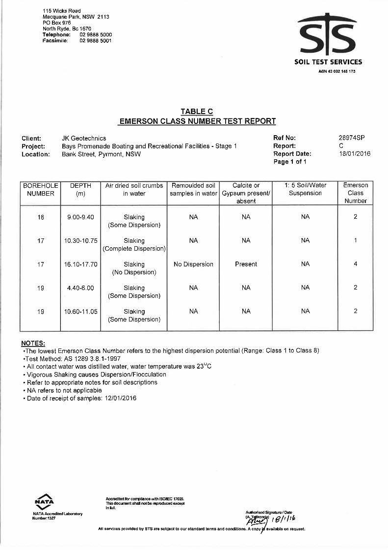
distribution (including hydrometer analysis) and Emerson Class Number dispersion tests.
The results of these tests are summarised in the attached Tables A to C inclusive. Additional
samples were delivered to a NATA registered analytical laboratory, Envirolab Services, where they
were tested for soil pH, chloride content, sulphate content and resistivity. The results of these tests
are provided in the attached Envirolab Services Certificate of Analysis 140037.
28974SPRev2 Factual Page 4
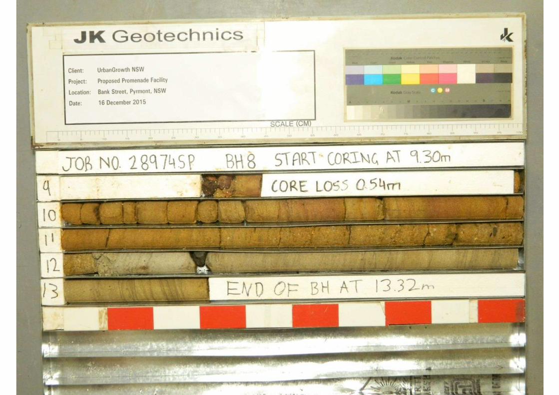
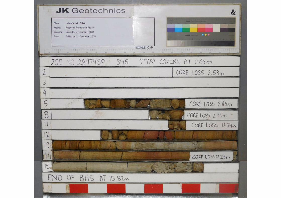
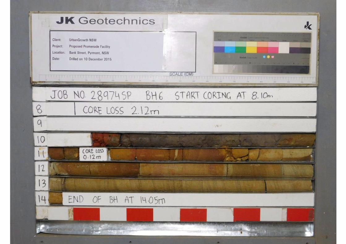
The recovered core of the bedrock was placed in steel boxes and returned to STS where it was
colour photographed and point load strength index tests were carried out. Copies of the
photographs are provided with the borehole logs, while the point load strength test results are
summarised in Table D and are shown graphically on the cored borehole logs.
For further details of the investigation techniques adopted, and their limitations, reference should
be made to the attached Report Explanation Notes.
3 RESULTS OF INVESTIGATION
3.1 Site Description
The subject site is located on the south-western corner of the Pyrmont peninsula, below the
approach and eastern pylon of the ANZAC Bridge, on land sloping down to the south and south-
west towards Blackwattle Bay. Bank Street is located along the north-eastern side of the property,
and has been excavated into the hillside, resulting in near vertical sandstone cliff faces on the
northern side of the road. The subject site is a foreshore area bound to the north-east by Bank
Street, and the 30m to 40m of the site closest to Bank Street is relatively level. This relatively level
area is substantially gravel covered and contains carparking, boat storage and boat maintenance
facilities associated with the Blackwattle Bay Dragon Boat Club at the eastern end, and a partially
sealed Roads and Maritime Services compound at the western end.
The south-western part of the site slopes down to the south and west at approximately 15 degrees
with various grass covered embankments, sandstone rubble fill embankments and asphaltic
concrete surfaced ramps. Toward the south-eastern end of the site this embankment slope reduces
to between 5 and 15 degrees.
The southern foreshore is formed by 1.0m concrete and 1.5m to 2.0m high sandstone block
seawalls that appear to be in good condition. On the low side of the seawall, sandstone rubble
appears to have been placed to provide erosion protection to the toe of the wall. Over the central
and western portions of the seawall, there is a near level terrace of several metres width behind the
seawall. It appears that the site has been levelled, and that the western end of the site has been
reclaimed from Blackwattle Bay, probably during the construction of the ANZAC Bridge. Columns
supporting the approach to the ANZAC Bridge are located toward the eastern end of the site, while
the eastern pylon of the Bridge is located toward the western end of the site. A 1.8m high concrete
block retaining wall is located around the northern and eastern (high) sides of this eastern pylon.
28974SPRev2 Factual Page 5
At approximately mid-length of the seawall, a metal framed plastic mesh covered boat ramp
supported on concrete piers extends into Blackwattle Bay. An asphaltic concrete surfaced driveway
leads from the top of the ramp to the previously described boat storage level.
Several trees were located along the eastern boundary and eastern end of the southern boundary.
The hydrographic survey supplied by UrbanGrowth NSW shows the bed level of Blackwattle Bay
on the low side of the seawall to slope down to the south-west to a lowest level of -8m AHD.
To the north-west of the site is a dilapidated single storey brick warehouse, which appears to be
associated with an electricity substation, with a 2m high sandstone block seawall along its south-
western foreshore boundary. To the east of the site is a partially AC paved car parking area
associated with the neighbouring commercial premises.
3.2 Subsurface Conditions
The 1:100,000 Geological Series Sheet for Sydney 9130 shows the site to be underlain by
Hawkesbury Sandstone. In general terms, the on-shore portion of the site is underlain by fill
overlying sandstone bedrock, while the off-shore area contains both sands and clays over
sandstone bedrock. Many of the boreholes closer to the shore have disclosed significant amounts
of sandstone rubble of cobble and boulder size, within a matrix of clay and sand; this layer is
assumed to be from the reclamation of the site with sandstone rubble being pushed into the bay,
and at least some of the lower strength soil being displaced.
The subsurface conditions encountered during this investigation comprise five main units, including
one unit, Unit 4, which is split into two sub-units, Units 4A and 4B. Some of the characteristic
features of the materials encountered are described below. For further details of these strata,
reference should be made to the attached borehole logs.
UNIT 1
Unit 1 comprises granular terrestrial fill, mostly sand and gravelly sand with varying proportions of
silt, clay and sometimes sandstone cobbles. The fill was mostly moist, with the upper material
usually being assessed as well compacted, but reducing to moderately or poorly compacted with
depth. This unit had a maximum thickness of about 4.5m in the boreholes.
28974SPRev2 Factual Page 6
UNIT 2
Unit 2 comprises predominantly granular marine fill material, often comprising clayey sand or
gravelly sand, though in places comprises a significant proportion of sandstone cobbles and
boulders with an infill of sand or clayey sand. This material was assessed to be poorly compacted,
and likely comprises fill material pushed into the bay which has largely displaced the very soft clayey
soil from the near shore area. These soils had a maximum thickness of about 9m in the boreholes.
UNIT 3
The recent marine deposits comprise silty clay of high plasticity with high and very high moisture
contents and these have been termed Unit 3. These soils are of very soft strength and range in
thickness to about 5m.
UNIT 4
Unit 4 is a less consistent unit comprising both sands and clays, and has been subdivided into two
sub-units. Unit 4A comprises mostly silty sands and clayey sands which are of very loose or loose
relative density, but with bands of very soft to stiff silty clay. In the boreholes more remote from the
shore, this unit comprises predominantly clayey material. In the areas further offshore where there
are considerable thicknesses of clay soils there seems to be an inversion in the strength profile with
stiffer clays overlying softer clays; this may be due to dessication effects during deposition where
surface layers became exposed at some stage. Toward the base of Unit 4, the strength of the
clayey soils often reduces, and is as low as very soft or soft strength in the lower several metres of
the silty clay.
Unit 4B is a sub-unit within Unit 4 in which the sandy soils are generally of medium dense relative
density, and the clays are of stiff or very stiff strength.
UNIT 5
Unit 5 comprises sandstone bedrock, and was encountered from depths ranging between 1.2m and
25.4m below the existing surface levels. The majority of the sandstone was of medium or high
strength, though there were several boreholes where the sandstone was of much lower strength,
such as BH5, and others where there were bands of lower strength rock between layers of medium
or high strength sandstone, such as BH13 and BH18.
There were generally relatively few defects in the sandstone, and these comprised thin near
horizontal bedding partings, clay seams and extremely weathered seams, as well as steeply
inclined joints. There were also several boreholes where there were significantly more defects or
clusters of defects such as BH5, BH15, BH16, BH17 and BH18. There were also significant core
28974SPRev2 Factual Page 7
losses within the sandstone in several of the boreholes which usually represent extremely
weathered seams eroded by the water flush.
3.3 Laboratory Test Results
Soil
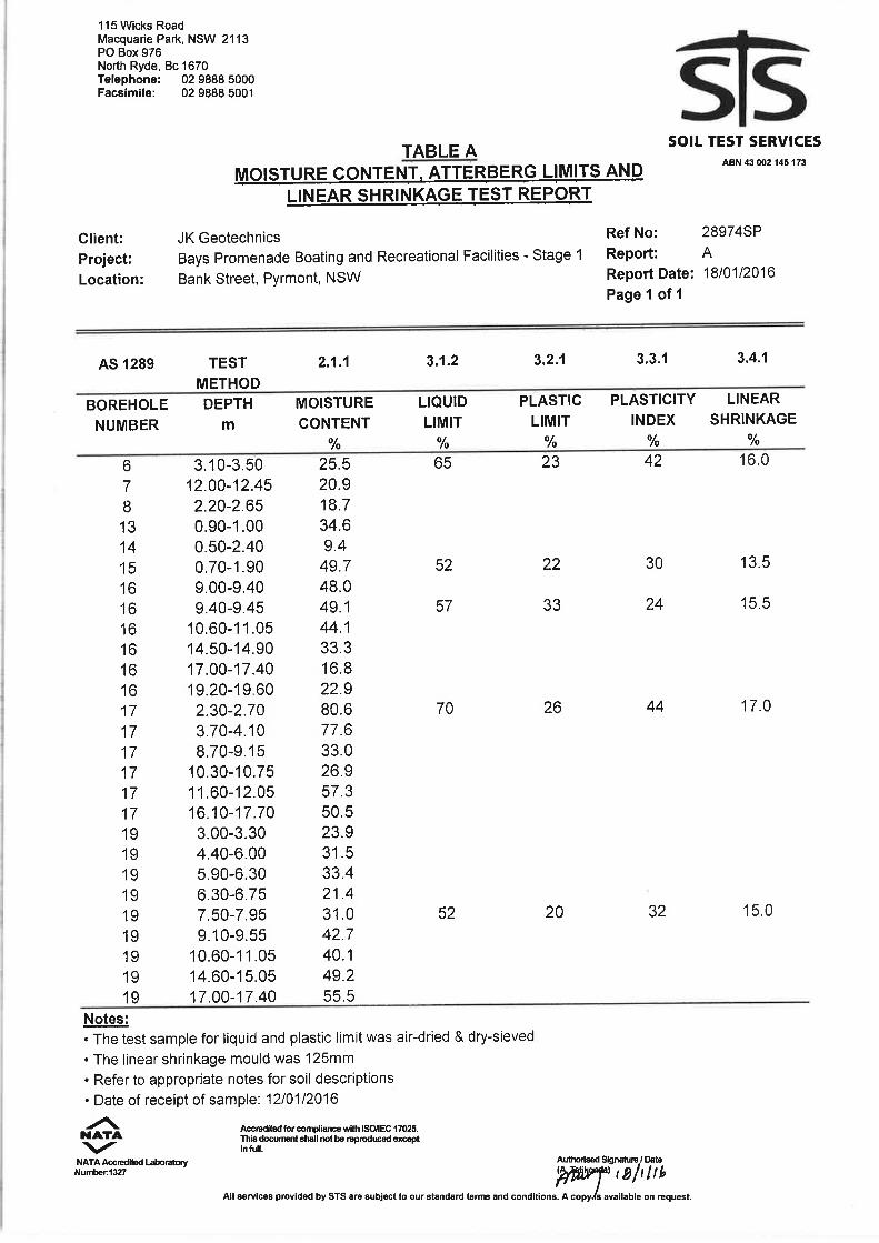
The moisture content test results returned values as high as 80% in the very soft clays, with many
results above 30%; moisture contents of this magnitude reflect the very low strength of these soils.
The Atterberg limits tests show the clayey soils are of high plasticity, with liquid limits ranging
between 52% and 70%, with linear shrinkage values ranging between 13.5% and 17.0%.
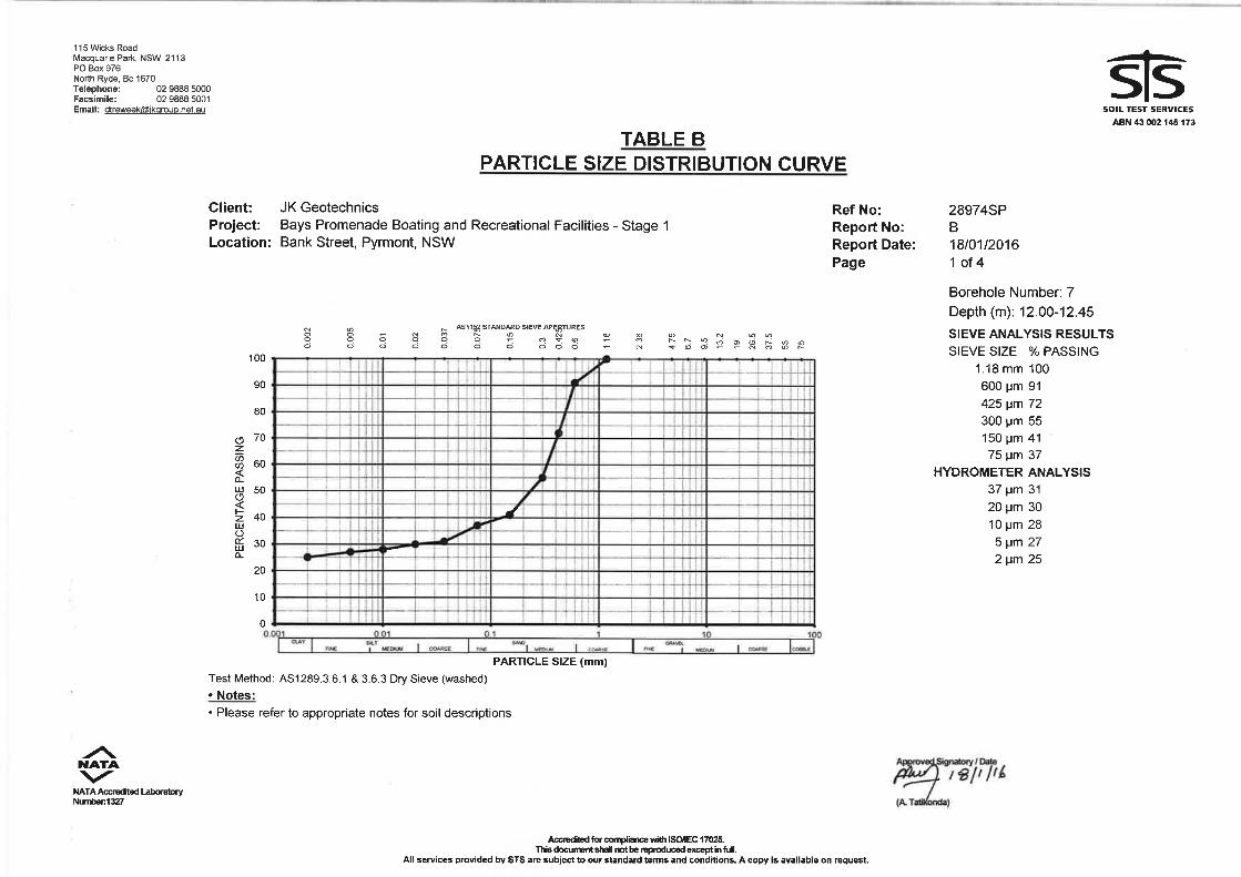
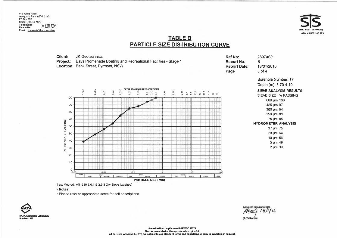
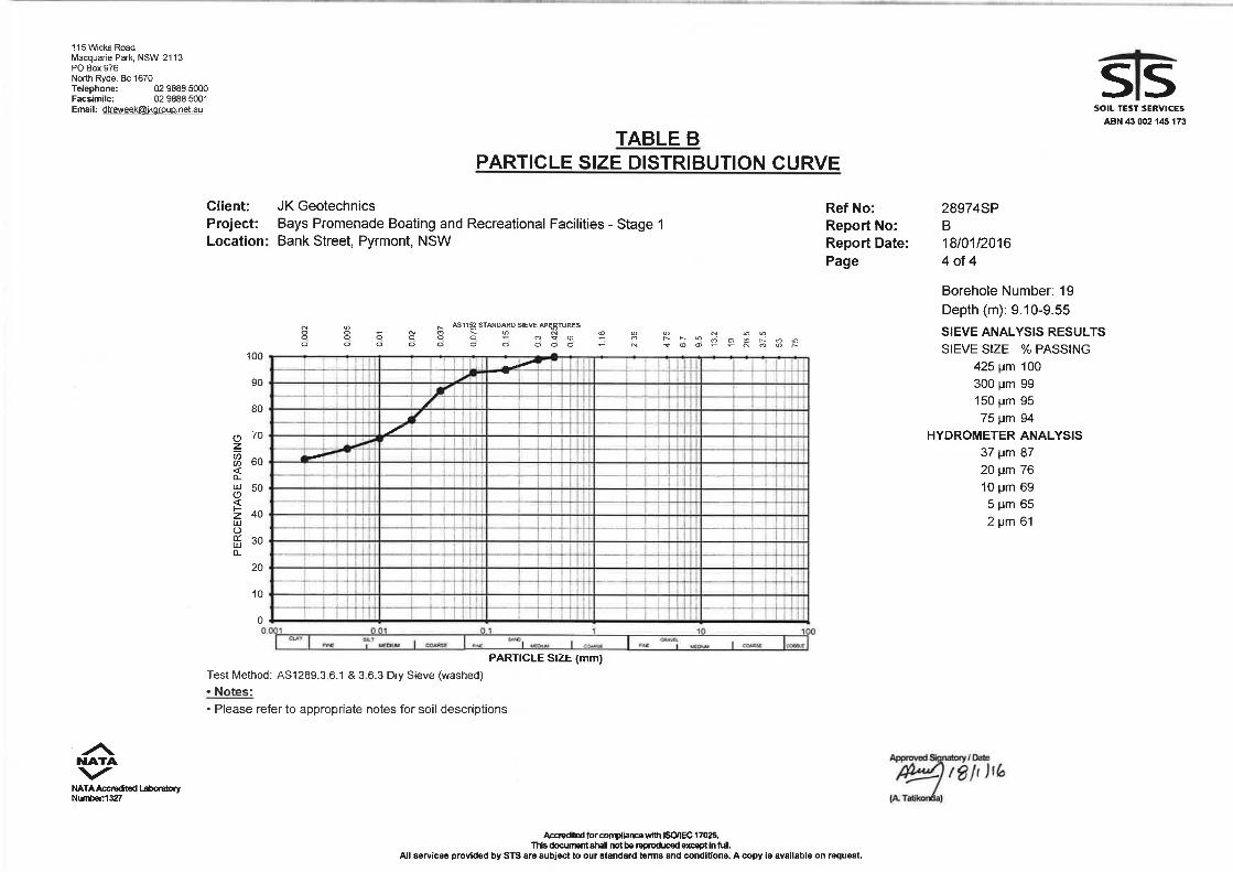
The particle size distribution tests, including the hydrometer analysis, confirm the soils to range
from silty clay, with up to 61% clay, to clayey sand and silty clayey sand.
The Emerson Class Number tests returned values of Class 1 or 2 for most of the samples tested
with fresh water, indicating a high potential for dispersion/erosion (refer to Table C). However Table
C1 presents the results of the same samples tested in ‘seawater’ prepared in the laboratory
returned values of Class 4, indicating a low to moderate dispersion potential for salt water
environments.
Soil Aggression
The samples tested for soil aggression returned results comprising soil pH ranging between 6.3
and 8.3, with sulphate contents between 22 and 2,600mg/kg and chloride contents between 69 and
9,900mg/kg. The resistivity values varied between 140 and 2,900 ohm.cm. These values, and the
presence of structures within the splash zone of seawater combine to produce a ‘severe’ exposure
classification.
Rock
The point load strength test results summarised in Table D correlate well with the field logging
assessment of rock strength. Correlations from the point load strength index tests suggest the
sandstone strength range up to about 48MPa, but with an average value of about 16MPa.
28974SPRev2 Factual Page 8
4 GENERAL COMMENTS
Occasionally, the subsurface conditions between the completed boreholes may be found to be
different (or may be interpreted to be different) from those expected. Variation can also occur with
groundwater conditions, especially after climatic changes. If such differences appear to exist, we
recommend that you immediately contact this office.
This report has been prepared for the particular project described and no responsibility is accepted
for the use of any part of this report in any other context or for any other purpose. If there is any
change in the proposed development described in this report then all recommendations should be
reviewed. Copyright in this report is the property of JK Geotechnics. We have used a degree of
care, skill and diligence normally exercised by consulting engineers in similar circumstances and
locality. No other warranty expressed or implied is made or intended. Subject to payment of all
fees due for the investigation, the client alone shall have a licence to use this report. The report
shall not be reproduced except in full.


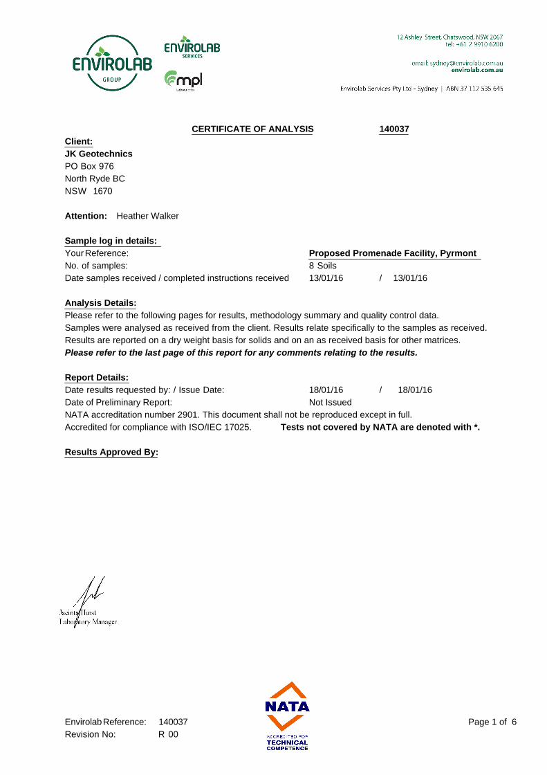
CERTIFICATE OF ANALYSIS 140037
Client:
JK Geotechnics
PO Box 976
North Ryde BC
NSW 1670
Attention: Heather Walker
Sample log in details:
Your Reference: Proposed Promenade Facility, Pyrmont
No. of samples: 8 Soils
Date samples received / completed instructions received 13/01/16 / 13/01/16
Analysis Details:
Please refer to the following pages for results, methodology summary and quality control data.
Samples were analysed as received from the client. Results relate specifically to the samples as received.
Results are reported on a dry weight basis for solids and on an as received basis for other matrices.
Please refer to the last page of this report for any comments relating to the results.
Report Details:
Date results requested by: / Issue Date: 18/01/16 / 18/01/16
Date of Preliminary Report: Not Issued
NATA accreditation number 2901. This document shall not be reproduced except in full.
Accredited for compliance with ISO/IEC 17025. Tests not covered by NATA are denoted with *.
Results Approved By:
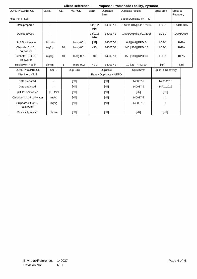
Page 1 of 6Envirolab Reference: 140037
Revision No: R 00
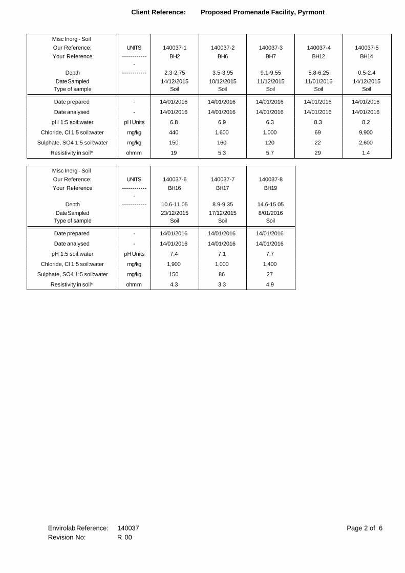
Client Reference: Proposed Promenade Facility, Pyrmont
Misc Inorg - Soil
Our Reference: UNITS 140037-1 140037-2 140037-3 140037-4 140037-5
Your Reference ------------
-
BH2 BH6 BH7 BH12 BH14
Depth ------------ 2.3-2.75 3.5-3.95 9.1-9.55 5.8-6.25 0.5-2.4
Date Sampled
Type of sample
14/12/2015
Soil
10/12/2015
Soil
11/12/2015
Soil
11/01/2016
Soil
14/12/2015
Soil
Date prepared - 14/01/2016 14/01/2016 14/01/2016 14/01/2016 14/01/2016
Date analysed - 14/01/2016 14/01/2016 14/01/2016 14/01/2016 14/01/2016
pH 1:5 soil:water pH Units 6.8 6.9 6.3 8.3 8.2
Chloride, Cl 1:5 soil:water mg/kg 440 1,600 1,000 69 9,900
Sulphate, SO4 1:5 soil:water mg/kg 150 160 120 22 2,600
Resistivity in soil* ohm m 19 5.3 5.7 29 1.4
Misc Inorg - Soil
Our Reference: UNITS 140037-6 140037-7 140037-8
Your Reference ------------
-
BH16 BH17 BH19
Depth ------------ 10.6-11.05 8.9-9.35 14.6-15.05
Date Sampled
Type of sample
23/12/2015
Soil
17/12/2015
Soil
8/01/2016
Soil
Date prepared - 14/01/2016 14/01/2016 14/01/2016
Date analysed - 14/01/2016 14/01/2016 14/01/2016
pH 1:5 soil:water pH Units 7.4 7.1 7.7
Chloride, Cl 1:5 soil:water mg/kg 1,900 1,000 1,400
Sulphate, SO4 1:5 soil:water mg/kg 150 86 27
Resistivity in soil* ohm m 4.3 3.3 4.9
Page 2 of 6Envirolab Reference: 140037
Revision No: R 00

Client Reference: Proposed Promenade Facility, Pyrmont
Method ID Methodology Summary
Inorg-001 pH - Measured using pH meter and electrode in accordance with APHA latest edition, 4500-H+. Please note
that the results for water analyses are indicative only, as analysis outside of the APHA storage times.
Inorg-081 Anions - a range of Anions are determined by Ion Chromatography, in accordance with APHA latest edition,
4110-B. Alternatively determined by colourimetry/turbidity using Discrete Analyer.
Inorg-002 Conductivity and Salinity - measured using a conductivity cell at 25oC in accordance with APHA 22nd ED 2510
and Rayment & Lyons. Resistivity is calculated from Conductivity.
Page 3 of 6Envirolab Reference: 140037
Revision No: R 00
Client Reference: Proposed Promenade Facility, Pyrmont
QUALITY CONTROL UNITS PQL METHOD Blank Duplicate
Sm#
Duplicate results Spike Sm# Spike %
Recovery
Misc Inorg - Soil Base ll Duplicate ll %RPD
Date prepared - 14/01/2
016
140037-1 14/01/2016 || 14/01/2016 LCS-1 14/01/2016
Date analysed - 14/01/2
016
140037-1 14/01/2016 || 14/01/2016 LCS-1 14/01/2016
pH 1:5 soil:water pH Units Inorg-001 [NT] 140037-1 6.8 || 6.8 || RPD: 0 LCS-1 101%
Chloride, Cl 1:5
soil:water
mg/kg 10 Inorg-081 <10 140037-1 440 || 380 || RPD: 15 LCS-1 101%
Sulphate, SO4 1:5
soil:water
mg/kg 10 Inorg-081 <10 140037-1 150 || 110 || RPD: 31 LCS-1 108%
Resistivity in soil* ohm m 1 Inorg-002 <1.0 140037-1 19 || 21 || RPD: 10 [NR] [NR]
QUALITY CONTROL UNITS Dup. Sm# Duplicate Spike Sm# Spike % Recovery
Misc Inorg - Soil Base + Duplicate + %RPD
Date prepared - [NT] [NT] 140037-2 14/01/2016
Date analysed - [NT] [NT] 140037-2 14/01/2016
pH 1:5 soil:water pH Units [NT] [NT] [NR] [NR]
Chloride, Cl 1:5 soil:water mg/kg [NT] [NT] 140037-2 #
Sulphate, SO4 1:5
soil:water
mg/kg [NT] [NT] 140037-2 #
Resistivity in soil* ohm m [NT] [NT] [NR] [NR]
Page 4 of 6Envirolab Reference: 140037
Revision No: R 00

Client Reference: Proposed Promenade Facility, Pyrmont
Report Comments:
# Percent recovery is not possible to report due to the high concentration
of the element/s in the sample/s. However an acceptable recovery was
obtained for the LCS.
Asbestos ID was analysed by Approved Identifier: Not applicable for this job
Asbestos ID was authorised by Approved Signatory: Not applicable for this job
INS: Insufficient sample for this test PQL: Practical Quantitation Limit NT: Not tested
NR: Test not required RPD: Relative Percent Difference NA: Test not required
<: Less than >: Greater than LCS: Laboratory Control Sample
Page 5 of 6Envirolab Reference: 140037
Revision No: R 00
Client Reference: Proposed Promenade Facility, Pyrmont
Quality Control Definitions
Blank: This is the component of the analytical signal which is not derived from the sample but from reagents,
glassware etc, can be determined by processing solvents and reagents in exactly the same manner as for samples.
Duplicate : This is the complete duplicate analysis of a sample from the process batch. If possible, the sample
selected should be one where the analyte concentration is easily measurable.
Matrix Spike : A portion of the sample is spiked with a known concentration of target analyte. The purpose of the matrix
spike is to monitor the performance of the analytical method used and to determine whether matrix interferences exist.
LCS (Laboratory Control Sample) : This comprises either a standard reference material or a control matrix (such as a blank
sand or water) fortified with analytes representative of the analyte class. It is simply a check sample.
Surrogate Spike: Surrogates are known additions to each sample, blank, matrix spike and LCS in a batch, of compounds
which are similar to the analyte of interest, however are not expected to be found in real samples.
Laboratory Acceptance Criteria
Duplicate sample and matrix spike recoveries may not be reported on smaller jobs, however, were analysed at a frequency
to meet or exceed NEPM requirements. All samples are tested in batches of 20. The duplicate sample RPD and matrix
spike recoveries for the batch were within the laboratory acceptance criteria.
Filters, swabs, wipes, tubes and badges will not have duplicate data as the whole sample is generally extracted
during sample extraction.
Spikes for Physical and Aggregate Tests are not applicable.
For VOCs in water samples, three vials are required for duplicate or spike analysis.
Duplicates: <5xPQL - any RPD is acceptable; >5xPQL - 0-50% RPD is acceptable.
Matrix Spikes, LCS and Surrogate recoveries: Generally 70-130% for inorganics/metals; 60-140%
for organics (+/-50% surrogates) and 10-140% for labile SVOCs (including labile surrogates), ultra trace organics
and speciated phenols is acceptable.
In circumstances where no duplicate and/or sample spike has been reported at 1 in 10 and/or 1 in 20 samples
respectively, the sample volume submitted was insufficient in order to satisfy laboratory QA/QC protocols.
When samples are received where certain analytes are outside of recommended technical holding times (THTs),
the analysis has proceeded. Where analytes are on the verge of breaching THTs, every effort will be made to analyse
within the THT or as soon as practicable.
Where sampling dates are not provided, Envirolab are not in a position to comment on the validity
of the analysis where recommended technical holding times may have been breached.
Page 6 of 6Envirolab Reference: 140037
Revision No: R 00
ES
U50
DB
DS
APPPEARSMODERATELYTO WELL COMPACTED
HIGH 'TC' BITRESISTANCE
EL
H
D
M
W
XW
DW
N=SPT11/ 150mmREFUSAL
N > 2014,15,5/50mm
REFUSAL
N = 113,2,9
N=SPT8/ 80mm
REFUSAL
ON
CO
MP
LET
ION
OF
AU
GE
RIN
G
- ASPHALTIC CONCRETE: 15mm.t
FILL: Sand, fine to coarse grained, greybrown, with fine to medium grainedigneous gravel.
FILL: Silty gravelly sand, fine grained,dark brown grey, fine to coarse grainedigneous and sandstone gravel, withceramic fragments.
FILL: Silty sand, fine to medium grained,black, trace of slag.
FILL: Sand, fine to coarse grained,brown, with fine to coarse grainedsandstone gravel, trace of sandstonecobbles and clay.
FILL; Clayey sand, fine to mediumgrained, dark grey.
SANDSTONE: fine to medium grained,light grey.
REFER TO CORED BOREHOLE LOG
Gro
undw
ater
Rec
ord
RL
(m A
HD
)
Str
engt
h/R
el D
ensi
ty
Han
dP
enet
rom
ete
rR
eadi
ngs
(kP
a)
Remarks
Moi
stu
reC
ondi
tion/
Wea
ther
ing
Fie
ld T
ests
COPYRIGHT
Logged/Checked By: A.B./P.W.
Method: SPIRAL AUGERJob No.: 28974SP
Date: 14/12/15
Plant Type: JK350
R.L. Surface: 4.4 m
Datum: AHD
1 / 2
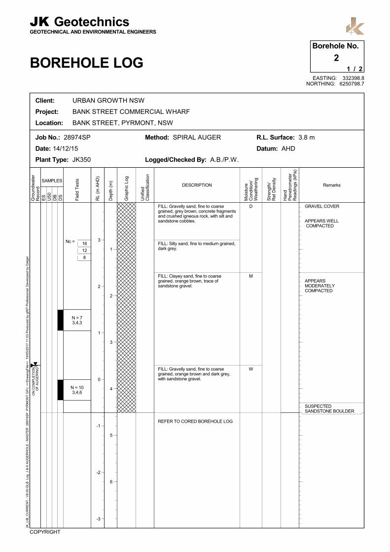
1Borehole No.
BOREHOLE LOG
JKGEOTECHNICAL AND ENVIRONMENTAL ENGINEERS
Geotechnics
Client: URBAN GROWTH NSW
Project: BANK STREET COMMERCIAL WHARF
Location: BANK STREET, PYRMONT, NSW
JK_L
IB_C
UR
RE
NT
- V
8.00
.GLB
Log
J &
K A
UG
ER
HO
LE -
MA
ST
ER
289
74S
P P
YR
MO
NT
.GP
J <
<D
raw
ingF
ile>
> 1
9/05
/201
7 11
:03
Pro
duc
ed b
y gI
NT
Pro
fess
iona
l, D
evel
oped
by
Dat
gel
EASTING: 332402.7NORTHING: 6250820.9
Gra
phic
Log
Uni
fied
Cla
ssifi
catio
n
DESCRIPTIONSAMPLES
4
3
2
1
0
-1
-2
Dep
th (
m)
1
2
3
4
5
6
RE
CO
VE
RY
= 1
00%
0%
RE
TU
RN
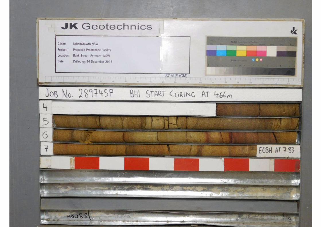
SANDSTONE: fine to medium grained,brown, bedded at 5-15°.
SANDSTONE: fine to medium grained,brown and red brown, bedded at 5-15°.
SANDSTONE: fine to medium grained,orange brown and red brown, bedded at5-15°.
START CORING AT 4.66m
END OF BOREHOLE AT 7.83 m
HDW
Wat
erLo
ss\L
evel
Bar
rel L
ift
RL
(m A
HD
)
JK_L
IB_C
UR
RE
NT
- V
8.00
.GLB
Log
J &
K C
OR
ED
BO
RE
HO
LE -
MA
ST
ER
289
74S
P P
YR
MO
NT
.GP
J <
<D
raw
ingF
ile>
> 1
9/05
/201
7 11
:03
Pro
duc
ed b
y gI
NT
Pro
fess
iona
l, D
evel
oped
by
Dat
gel
Client: URBAN GROWTH NSW
Project: BANK STREET COMMERCIAL WHARF
Location: BANK STREET, PYRMONT, NSW
COPYRIGHT
Core Size: NMLC
Inclination: VERTICAL
Bearing: N/A
Job No.: 28974SP
Date: 14/12/15
Plant Type: JK350
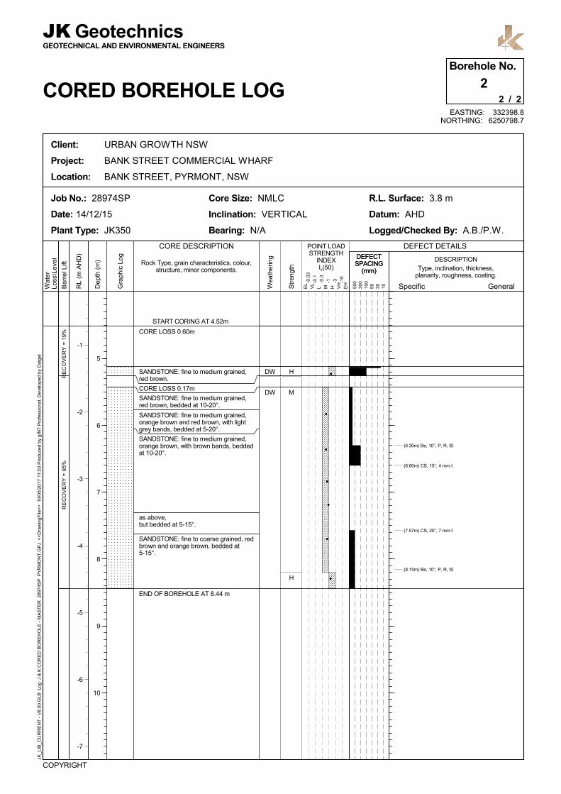
GEOTECHNICAL AND ENVIRONMENTAL ENGINEERS
JK Geotechnics
CORED BOREHOLE LOG
R.L. Surface: 4.4 m
Datum: AHD
Logged/Checked By: A.B./P.W.
2 / 2
1Borehole No.
EASTING: 332402.7NORTHING: 6250820.9
General
DESCRIPTION
EL
VL
L M H VH
EH
POINT LOADSTRENGTH
INDEXIs(50)
CORE DESCRIPTION
Specific500
300
100
50 30 10
DEFECT DETAILS
Gra
phic
Log
-0.0
3
-0.1
-0.3
-1 -3 -10
Rock Type, grain characteristics, colour,structure, minor components. Type, inclination, thickness,
planarity, roughness, coating.
Str
engt
h
Wea
ther
ing
(5.19m) J, 20°, P, S
(5.47m) J, 90°, P, S
(6.16m) J, 90°, P, S
(6.73m) Be, 5°, P, R, IS
(7.78m) CS, 0°, 3 mm.t
0
-1
-2
-3
-4
-5
-6
Dep
th (
m)
5
6
7
8
9
10
DEFECTSPACING
(mm)
DEFECTSPACING
(mm)
ES
U50
DB
DS
GRAVEL COVER
APPEARS WELL COMPACTED
APPEARSMODERATELYCOMPACTED
SUSPECTEDSANDSTONE BOULDER
Nc =
D
M
W
N = 73,4,3
N = 103,4,6O
N C
OM
PLE
TIO
NO
F A
UG
ER
ING
FILL: Gravelly sand, fine to coarsegrained, grey brown, concrete fragmentsand crushed igneous rock, with silt andsandstone cobbles.
FILL: Silty sand, fine to medium grained,dark grey.
FILL: Clayey sand, fine to coarsegrained, orange brown, trace ofsandstone gravel.
FILL: Gravelly sand, fine to coarsegrained, orange brown and dark grey,with sandstone gravel.
REFER TO CORED BOREHOLE LOG
Gro
undw
ater
Rec
ord
RL
(m A
HD
)
Str
engt
h/R
el D
ensi
ty
Han
dP
enet
rom
ete
rR
eadi
ngs
(kP
a)
Remarks
Moi
stu
reC
ondi
tion/
Wea
ther
ing
Fie
ld T
ests
COPYRIGHT
Logged/Checked By: A.B./P.W.
Method: SPIRAL AUGERJob No.: 28974SP
Date: 14/12/15
Plant Type: JK350
R.L. Surface: 3.8 m
Datum: AHD
1 / 2
2Borehole No.
BOREHOLE LOG
JKGEOTECHNICAL AND ENVIRONMENTAL ENGINEERS
Geotechnics
Client: URBAN GROWTH NSW
Project: BANK STREET COMMERCIAL WHARF
Location: BANK STREET, PYRMONT, NSW
JK_L
IB_C
UR
RE
NT
- V
8.00
.GLB
Log
J &
K A
UG
ER
HO
LE -
MA
ST
ER
289
74S
P P
YR
MO
NT
.GP
J <
<D
raw
ingF
ile>
> 1
9/05
/201
7 11
:03
Pro
duc
ed b
y gI
NT
Pro
fess
iona
l, D
evel
oped
by
Dat
gel
EASTING: 332398.8NORTHING: 6250798.7
Gra
phic
Log
Uni
fied
Cla
ssifi
catio
n
DESCRIPTIONSAMPLES
16
12
8
3
2
1
0
-1
-2
-3
Dep
th (
m)
1
2
3
4
5
6
RE
CO
VE
RY
= 1
9%R
EC
OV
ER
Y =
95%
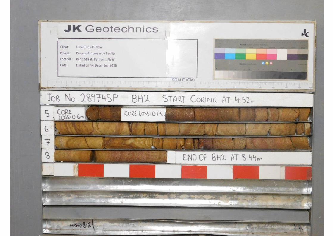
CORE LOSS 0.60m
SANDSTONE: fine to medium grained,red brown.
CORE LOSS 0.17m
SANDSTONE: fine to medium grained,red brown, bedded at 10-20°.
SANDSTONE: fine to medium grained,orange brown and red brown, with lightgrey bands, bedded at 5-20°.
SANDSTONE: fine to medium grained,orange brown, with brown bands, beddedat 10-20°.
as above,but bedded at 5-15°.
SANDSTONE: fine to coarse grained, redbrown and orange brown, bedded at5-15°.
START CORING AT 4.52m
END OF BOREHOLE AT 8.44 m
H
M
H
DW
DW
Wat
erLo
ss\L
evel
Bar
rel L
ift
RL
(m A
HD
)
JK_L
IB_C
UR
RE
NT
- V
8.00
.GLB
Log
J &
K C
OR
ED
BO
RE
HO
LE -
MA
ST
ER
289
74S
P P
YR
MO
NT
.GP
J <
<D
raw
ingF
ile>
> 1
9/05
/201
7 11
:03
Pro
duc
ed b
y gI
NT
Pro
fess
iona
l, D
evel
oped
by
Dat
gel
Client: URBAN GROWTH NSW
Project: BANK STREET COMMERCIAL WHARF
Location: BANK STREET, PYRMONT, NSW
COPYRIGHT
Core Size: NMLC
Inclination: VERTICAL
Bearing: N/A
Job No.: 28974SP
Date: 14/12/15
Plant Type: JK350
GEOTECHNICAL AND ENVIRONMENTAL ENGINEERS
JK Geotechnics
CORED BOREHOLE LOG
R.L. Surface: 3.8 m
Datum: AHD
Logged/Checked By: A.B./P.W.
2 / 2
2Borehole No.
EASTING: 332398.8NORTHING: 6250798.7
General
DESCRIPTION
EL
VL
L M H VH
EH
POINT LOADSTRENGTH
INDEXIs(50)
CORE DESCRIPTION
Specific500
300
100
50 30 10
DEFECT DETAILS
Gra
phic
Log
-0.0
3
-0.1
-0.3
-1 -3 -10
Rock Type, grain characteristics, colour,structure, minor components. Type, inclination, thickness,
planarity, roughness, coating.
Str
engt
h
Wea
ther
ing
(6.30m) Be, 10°, P, R, IS
(6.60m) CS, 15°, 4 mm.t
(7.57m) CS, 20°, 7 mm.t
(8.15m) Be, 10°, P, R, IS
-1
-2
-3
-4
-5
-6
-7
Dep
th (
m)
5
6
7
8
9
10
DEFECTSPACING
(mm)
DEFECTSPACING
(mm)
ES
U50
DB
DS
APPEARSWELLCOMPACTED
APPEARSPOORLYCOMPACTED
VERY LOW 'TC' BITRESISTANCE
LOW RESISTANCE
EL
VL
D
M
XW
DW
N=SPT15/ 40mmREFUSAL
N = 228,10,12
N = 63,3,3
DR
Y O
NC
OM
PLE
TIO
N O
F A
UG
ER
ING
-
FILL: Silty gravelly sand, fine to coarsegrained, grey brown, fine to coarsegrained igneous and sandstone gravel,with ceramic fragments, trace ofconcrete fragments and ash.
FILL: Silty sand, fine to coarse grained,grey, with fine to medium grainedigneous and sandstone gravel.
FILL: Silty sand, fine to coarse grained,dark grey, with fine to medium grainedigneous gravel, trace of slag.
FILL: Sand, fine to medium grained,grey brown and brown, with fine tocoarse grained sandstone and igneousgravel, trace of ash and clay.
FILL: Clayey silty sand, fine to mediumgrained, brown and grey, with fine tomedium grained sandstone gravel, traceof ash.
SANDSTONE: fine to medium grained,light grey and brown.
REFER TO CORED BOREHOLE LOG
Gro
undw
ater
Rec
ord
RL
(m A
HD
)
Str
engt
h/R
el D
ensi
ty
Han
dP
enet
rom
ete
rR
eadi
ngs
(kP
a)
Remarks
Moi
stu
reC
ondi
tion/
Wea
ther
ing
Fie
ld T
ests
COPYRIGHT
Logged/Checked By: A.B./P.W.
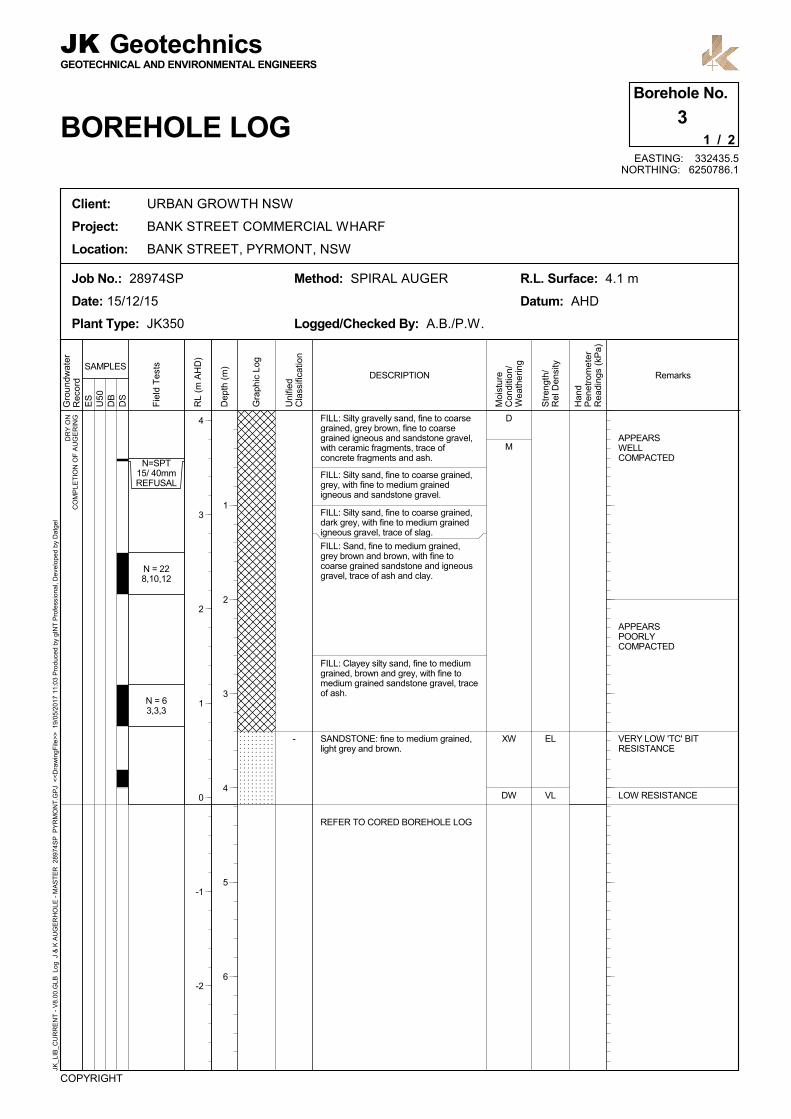
Method: SPIRAL AUGERJob No.: 28974SP
Date: 15/12/15
Plant Type: JK350
R.L. Surface: 4.1 m
Datum: AHD
1 / 2
3Borehole No.
BOREHOLE LOG
JKGEOTECHNICAL AND ENVIRONMENTAL ENGINEERS
Geotechnics
Client: URBAN GROWTH NSW
Project: BANK STREET COMMERCIAL WHARF
Location: BANK STREET, PYRMONT, NSW
JK_L
IB_C
UR
RE
NT
- V
8.00
.GLB
Log
J &
K A
UG
ER
HO
LE -
MA
ST
ER
289
74S
P P
YR
MO
NT
.GP
J <
<D
raw
ingF
ile>
> 1
9/05
/201
7 11
:03
Pro
duc
ed b
y gI
NT
Pro
fess
iona
l, D
evel
oped
by
Dat
gel
EASTING: 332435.5NORTHING: 6250786.1
Gra
phic
Log
Uni
fied
Cla
ssifi
catio
n
DESCRIPTIONSAMPLES
4
3
2
1
0
-1
-2
Dep
th (
m)
1
2
3
4
5
6
RE
CO
VE
RY
= 1
00%
100
%R
ET
UR
N
SANDSTONE: fine to medium grained,light grey, bedded at 0-10°.
SANDSTONE: fine to medium grained,light grey, with grey bands, bedded at0-10°.
as above,but fine to coarse grained, bedded at10-15°.
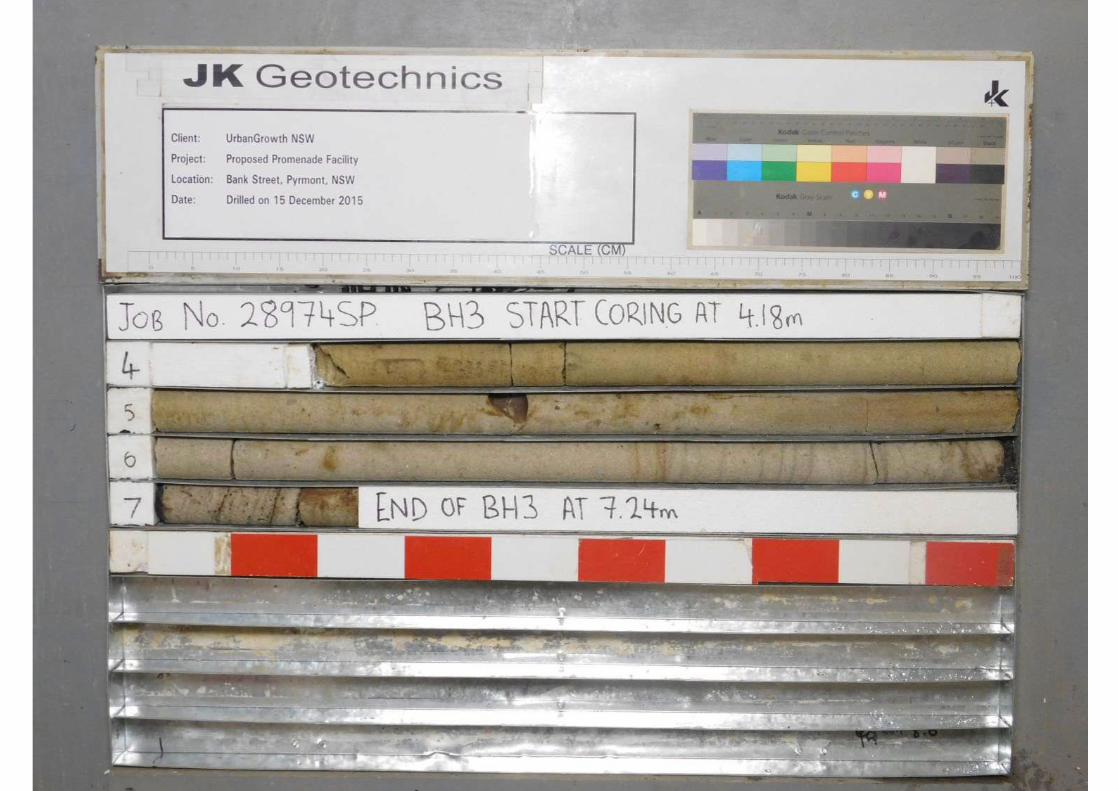
START CORING AT 4.18m
END OF BOREHOLE AT 7.24 m
M
H
SW
Wat
erLo
ss\L
evel
Bar
rel L
ift
RL
(m A
HD
)
JK_L
IB_C
UR
RE
NT
- V
8.00
.GLB
Log
J &
K C
OR
ED
BO
RE
HO
LE -
MA
ST
ER
289
74S
P P
YR
MO
NT
.GP
J <
<D
raw
ingF
ile>
> 1
9/05
/201
7 11
:03
Pro
duc
ed b
y gI
NT
Pro
fess
iona
l, D
evel
oped
by
Dat
gel
Client: URBAN GROWTH NSW
Project: BANK STREET COMMERCIAL WHARF
Location: BANK STREET, PYRMONT, NSW
COPYRIGHT
Core Size: NMLC
Inclination: VERTICAL
Bearing: N/A
Job No.: 28974SP
Date: 15/12/15
Plant Type: JK350
GEOTECHNICAL AND ENVIRONMENTAL ENGINEERS
JK Geotechnics
CORED BOREHOLE LOG
R.L. Surface: 4.1 m
Datum: AHD
Logged/Checked By: A.B./P.W.
2 / 2
3Borehole No.
EASTING: 332435.5NORTHING: 6250786.1
General
DESCRIPTION
EL
VL
L M H VH
EH
POINT LOADSTRENGTH
INDEXIs(50)
CORE DESCRIPTION
Specific500
300
100
50 30 10
DEFECT DETAILS
Gra
phic
Log
-0.0
3
-0.1
-0.3
-1 -3 -10
Rock Type, grain characteristics, colour,structure, minor components. Type, inclination, thickness,
planarity, roughness, coating.
Str
engt
h
Wea
ther
ing
(6.99m) CS, 0°, 20 mm.t
(7.14m) XWS, 5°, 1 mm.t
1
0
-1
-2
-3
-4
-5
Dep
th (
m)
4
5
6
7
8
9
DEFECTSPACING
(mm)
DEFECTSPACING
(mm)

ES
U50
DB
DS
APPEARSWELLCOMPACTED
HIGH 'TC' BITRESISTANCE
EL - VL
H
D
M
XW - DW
DW
N = 158,7,8
N=SPT12/ 20mmREFUSAL
DR
Y O
NC
OM
PLE
TIO
N O
F A
UG
ER
ING
-
FILL: Silty gravelly sand, fine to coarsegrained, grey brown, fine to coarsegrained igneous and sandstone gravel,with ceramic fragments, trace of igneousand sandstone cobbles.
FILL: Silty sand, fine to medium grained,dark grey, with fine to coarse grainedigneous and sandstone gravel, trace offine to medium grained ironstone gravel,slag and ash.
SANDSTONE: fine to medium grained,light grey, with iron indurated bands.
REFER TO CORED BOREHOLE LOG
Gro
undw
ater
Rec
ord
RL
(m A
HD
)
Str
engt
h/R
el D
ensi
ty
Han
dP
enet
rom
ete
rR
eadi
ngs
(kP
a)
Remarks
Moi
stu
reC
ondi
tion/
Wea
ther
ing
Fie
ld T
ests
COPYRIGHT
Logged/Checked By: A.B./P.W.
Method: SPIRAL AUGERJob No.: 28974SP
Date: 15/12/15
Plant Type: JK350
R.L. Surface: 4.8 m
Datum: AHD
1 / 2
4Borehole No.
BOREHOLE LOG
JKGEOTECHNICAL AND ENVIRONMENTAL ENGINEERS
Geotechnics
Client: URBAN GROWTH NSW
Project: BANK STREET COMMERCIAL WHARF
Location: BANK STREET, PYRMONT, NSW
JK_L
IB_C
UR
RE
NT
- V
8.00
.GLB
Log
J &
K A
UG
ER
HO
LE -
MA
ST
ER
289
74S
P P
YR
MO
NT
.GP
J <
<D
raw
ingF
ile>
> 1
9/05
/201
7 11
:03
Pro
duc
ed b
y gI
NT
Pro
fess
iona
l, D
evel
oped
by
Dat
gel
EASTING: 332468.8NORTHING: 6250772.2
Gra
phic
Log
Uni
fied
Cla
ssifi
catio
n
DESCRIPTIONSAMPLES
4
3
2
1
0
-1
-2
Dep
th (
m)
1
2
3
4
5
6
RE
CO
VE
RY
= 7
6%R
EC
OV
ER
Y =
100
%R
EC
OV
ER
Y =
100
%
100
%R
ET
UR
N
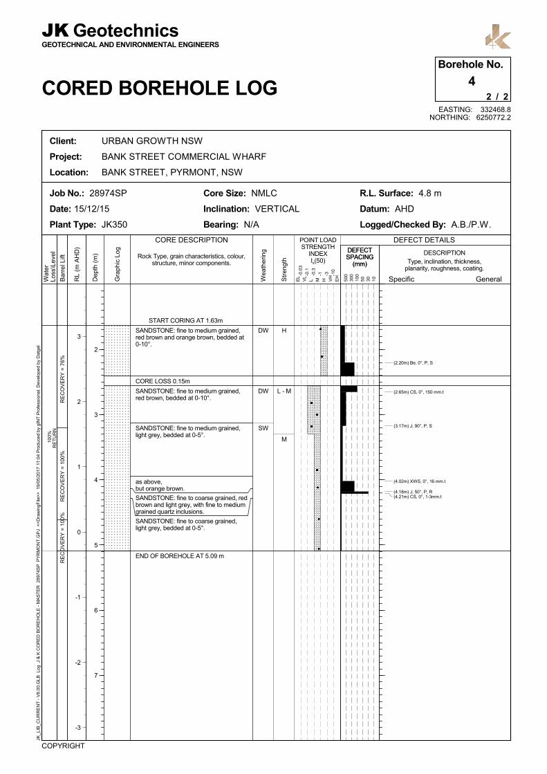
SANDSTONE: fine to medium grained,red brown and orange brown, bedded at0-10°.
CORE LOSS 0.15m
SANDSTONE: fine to medium grained,red brown, bedded at 0-10°.
SANDSTONE: fine to medium grained,light grey, bedded at 0-5°.
as above,but orange brown.
SANDSTONE: fine to coarse grained, redbrown and light grey, with fine to mediumgrained quartz inclusions.
SANDSTONE: fine to coarse grained,light grey, bedded at 0-5°.
START CORING AT 1.63m
END OF BOREHOLE AT 5.09 m
H
L - M
M
DW
DW
SW
Wat
erLo
ss\L
evel
Bar
rel L
ift
RL
(m A
HD
)
JK_L
IB_C
UR
RE
NT
- V
8.00
.GLB
Log
J &
K C
OR
ED
BO
RE
HO
LE -
MA
ST
ER
289
74S
P P
YR
MO
NT
.GP
J <
<D
raw
ingF
ile>
> 1
9/05
/201
7 11
:04
Pro
duc
ed b
y gI
NT
Pro
fess
iona
l, D
evel
oped
by
Dat
gel
Client: URBAN GROWTH NSW
Project: BANK STREET COMMERCIAL WHARF
Location: BANK STREET, PYRMONT, NSW
COPYRIGHT
Core Size: NMLC
Inclination: VERTICAL
Bearing: N/A
Job No.: 28974SP
Date: 15/12/15
Plant Type: JK350
GEOTECHNICAL AND ENVIRONMENTAL ENGINEERS
JK Geotechnics
CORED BOREHOLE LOG
R.L. Surface: 4.8 m
Datum: AHD
Logged/Checked By: A.B./P.W.
2 / 2
4Borehole No.
EASTING: 332468.8NORTHING: 6250772.2
General
DESCRIPTION
EL
VL
L M H VH
EH
POINT LOADSTRENGTH
INDEXIs(50)
CORE DESCRIPTION
Specific500
300
100
50 30 10
DEFECT DETAILS
Gra
phic
Log
-0.0
3
-0.1
-0.3
-1 -3 -10
Rock Type, grain characteristics, colour,structure, minor components. Type, inclination, thickness,
planarity, roughness, coating.
Str
engt
h
Wea
ther
ing
(2.20m) Be, 0°, P, S
(2.65m) CS, 0°, 150 mm.t
(3.17m) J, 90°, P, S
(4.02m) XWS, 0°, 16 mm.t
(4.18m) J, 50°, P, R(4.21m) CS, 0°, 1-3mm.t
3
2
1
0
-1
-2
-3
Dep
th (
m)
2
3
4
5
6
7
DEFECTSPACING
(mm)
DEFECTSPACING
(mm)

ES
U50
DB
DS
RESISTANCE ON CASINGADVANCER
HIGH RESISTANCE ONCASING ADVANCER
-W
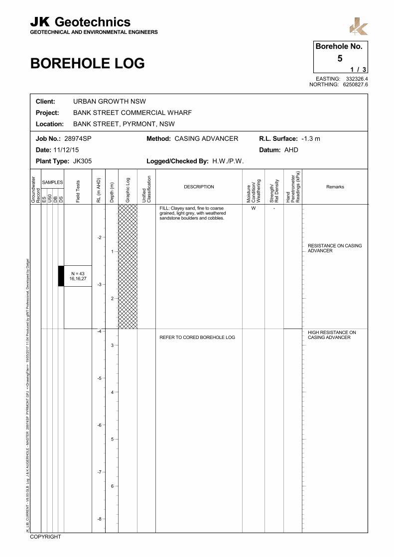
N = 4316,16,27
FILL: Clayey sand, fine to coarsegrained, light grey, with weatheredsandstone boulders and cobbles.
REFER TO CORED BOREHOLE LOG
Gro
undw
ater
Rec
ord
RL
(m A
HD
)
Str
engt
h/R
el D
ensi
ty
Han
dP
enet
rom
ete
rR
eadi
ngs
(kP
a)
Remarks
Moi
stu
reC
ondi
tion/
Wea
ther
ing
Fie
ld T
ests
COPYRIGHT
Logged/Checked By: H.W./P.W.
Method: CASING ADVANCERJob No.: 28974SP
Date: 11/12/15
Plant Type: JK305
R.L. Surface: -1.3 m
Datum: AHD
1 / 3
5Borehole No.
BOREHOLE LOG
JKGEOTECHNICAL AND ENVIRONMENTAL ENGINEERS
Geotechnics
Client: URBAN GROWTH NSW
Project: BANK STREET COMMERCIAL WHARF
Location: BANK STREET, PYRMONT, NSW
JK_L
IB_C
UR
RE
NT
- V
8.00
.GLB
Log
J &
K A
UG
ER
HO
LE -
MA
ST
ER
289
74S
P P
YR
MO
NT
.GP
J <
<D
raw
ingF
ile>
> 1
9/05
/201
7 11
:04
Pro
duc
ed b
y gI
NT
Pro
fess
iona
l, D
evel
oped
by
Dat
gel
EASTING: 332326.4NORTHING: 6250827.6
Gra
phic
Log
Uni
fied
Cla
ssifi
catio
n
DESCRIPTIONSAMPLES
-2
-3
-4
-5
-6
-7
-8
Dep
th (
m)
1
2
3
4
5
6
RE
CO
VE
RY
= 1
8%R
EC
OV
ER
Y =
5%
CORE LOSS 2.53m
FILL: Sandstone gravel, cobbles andboulders, light grey and red brown.
CORE LOSS 2.85m
FILL: Sandstone gravel, cobbles andboulders, light grey and red brown.
CORE LOSS 2.90m
START CORING AT 2.65m
M
M
DW
DW
Wat
erLo
ss\L
evel
Bar
rel L
ift
RL
(m A
HD
)
JK_L
IB_C
UR
RE
NT
- V
8.00
.GLB
Log
J &
K C
OR
ED
BO
RE
HO
LE -
MA
ST
ER
289
74S
P P
YR
MO
NT
.GP
J <
<D
raw
ingF
ile>
> 1
9/05
/201
7 11
:04
Pro
duc
ed b
y gI
NT
Pro
fess
iona
l, D
evel
oped
by
Dat
gel
Client: URBAN GROWTH NSW
Project: BANK STREET COMMERCIAL WHARF
Location: BANK STREET, PYRMONT, NSW
COPYRIGHT
Core Size: NMLC
Inclination: VERTICAL
Bearing: N/A
Job No.: 28974SP
Date: 11/12/15
Plant Type: JK305
GEOTECHNICAL AND ENVIRONMENTAL ENGINEERS
JK Geotechnics
CORED BOREHOLE LOG
R.L. Surface: -1.3 m
Datum: AHD
Logged/Checked By: H.W./P.W.
2 / 3
5Borehole No.
EASTING: 332326.4NORTHING: 6250827.6
General
DESCRIPTION
EL
VL
L M H VH
EH
POINT LOADSTRENGTH
INDEXIs(50)
CORE DESCRIPTION
Specific500
300
100
50 30 10
DEFECT DETAILS
Gra
phic
Log
-0.0
3
-0.1
-0.3
-1 -3 -10
Rock Type, grain characteristics, colour,structure, minor components. Type, inclination, thickness,
planarity, roughness, coating.
Str
engt
h
Wea
ther
ing
-4
-5
-6
-7
-8
-9
-10
Dep
th (
m)
3
4
5
6
7
8
DEFECTSPACING
(mm)
DEFECTSPACING
(mm)
RE
CO
VE
RY
= 5
%R
EC
OV
ER
Y =
82%
RE
CO
VE
RY
= 7
6%
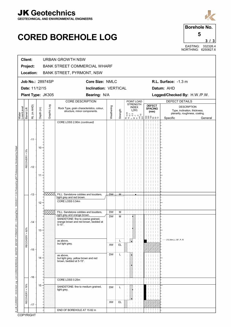
CORE LOSS 2.90m (continued)
FILL: Sandstone cobbles and boulders,light grey and red brown.
CORE LOSS 0.54m
FILL: Sandstone cobbles and boulders,light grey and orange brown.
SANDSTONE: fine to coarse grained,orange brown and red brown, bedded at5-15°.
as above,but light grey.
as above,but light grey, yellow brown and redbrown, bedded at 5-15°.
CORE LOSS 0.25m
SANDSTONE: fine to medium grained,light grey.
END OF BOREHOLE AT 15.82 m
M
M
M
L
EL
L
L
EL
DW
DW
DW
XW
DW
DW
XW
Wat
erLo
ss\L
evel
Bar
rel L
ift
RL
(m A
HD
)
JK_L
IB_C
UR
RE
NT
- V
8.00
.GLB
Log
J &
K C
OR
ED
BO
RE
HO
LE -
MA
ST
ER
289
74S
P P
YR
MO
NT
.GP
J <
<D
raw
ingF
ile>
> 1
9/05
/201
7 11
:04
Pro
duc
ed b
y gI
NT
Pro
fess
iona
l, D
evel
oped
by
Dat
gel
Client: URBAN GROWTH NSW
Project: BANK STREET COMMERCIAL WHARF
Location: BANK STREET, PYRMONT, NSW
COPYRIGHT
Core Size: NMLC
Inclination: VERTICAL
Bearing: N/A
Job No.: 28974SP
Date: 11/12/15
Plant Type: JK305
GEOTECHNICAL AND ENVIRONMENTAL ENGINEERS
JK Geotechnics
CORED BOREHOLE LOG
R.L. Surface: -1.3 m
Datum: AHD
Logged/Checked By: H.W./P.W.
3 / 3
5Borehole No.
EASTING: 332326.4NORTHING: 6250827.6
General
DESCRIPTION
EL
VL
L M H VH
EH
POINT LOADSTRENGTH
INDEXIs(50)
CORE DESCRIPTION
Specific500
300
100
50 30 10
DEFECT DETAILS
Gra
phic
Log
-0.0
3
-0.1
-0.3
-1 -3 -10
Rock Type, grain characteristics, colour,structure, minor components. Type, inclination, thickness,
planarity, roughness, coating.
Str
engt
h
Wea
ther
ing
(13.34m) J, 30°, P, R
-11
-12
-13
-14
-15
-16
-17
Dep
th (
m)
10
11
12
13
14
15
DEFECTSPACING
(mm)
DEFECTSPACING
(mm)

ES
U50
DB
DS
NOTE: LOGGING TO 2.5mBASED UPON LIMITEDSAMPLE RETURN
MARINE
PROBABLY RESIDUAL
St - VSt
L / VSt
L
100200190
300110220
W
MC>PL
W /MC>PL
N=01,0,0
N = 93,4,5
N = 73,3,4
N = 52,2,3
CH
CL / SC
SC
FILL: Silty clay, medium plasticity, darkgrey, with fine to medium grainedsandstone gravel, trace of cobbles andboulders.
SILTY CLAY: high plasticity, light greyand yellow brown.
as above,but with sand.
SANDY CLAY/CLAYEY SAND: fine tomedium grained, medium plasticity, lightgrey and yellow brown, with red browniron indurated pockets.
SILTY CLAYEY SAND: fine to coarsegrained, light grey and yellow brown,trace of medium grained sandstonegravel.
Gro
undw
ater
Rec
ord
RL
(m A
HD
)
Str
engt
h/R
el D
ensi
ty
Han
dP
enet
rom
ete
rR
eadi
ngs
(kP
a)
Remarks
Moi
stu
reC
ondi
tion/
Wea
ther
ing
Fie
ld T
ests
COPYRIGHT
Logged/Checked By: H.W./P.W.
Method: CASING ADVANCERJob No.: 28974SP
Date: 10/12/15
Plant Type: JK305
R.L. Surface: -7 m
Datum: AHD
1 / 3
6Borehole No.
BOREHOLE LOG
JKGEOTECHNICAL AND ENVIRONMENTAL ENGINEERS
Geotechnics
Client: URBAN GROWTH NSW
Project: BANK STREET COMMERCIAL WHARF
Location: BANK STREET, PYRMONT, NSW
JK_L
IB_C
UR
RE
NT
- V
8.00
.GLB
Log
J &
K A
UG
ER
HO
LE -
MA
ST
ER
289
74S
P P
YR
MO
NT
.GP
J <
<D
raw
ingF
ile>
> 1
9/05
/201
7 11
:04
Pro
duc
ed b
y gI
NT
Pro
fess
iona
l, D
evel
oped
by
Dat
gel
EASTING: 332309.5NORTHING: 6250821.9
Gra
phic
Log
Uni
fied
Cla
ssifi
catio
n
DESCRIPTIONSAMPLES
-8
-9
-10
-11
-12
-13
Dep
th (
m)
1
2
3
4
5
6

ES
U50
DB
DS
RESISTANCE ON CASINGADVANCER
(L - MD)WSC SILTY CLAYEY SAND: fine to coarsegrained, light grey and yellow brown,with bands of hard clay, trace of mediumgrained sandstone gravel.
REFER TO CORED BOREHOLE LOG
Gro
undw
ater
Rec
ord
RL
(m A
HD
)
Str
engt
h/R
el D
ensi
ty
Han
dP
enet
rom
ete
rR
eadi
ngs
(kP
a)
Remarks
Moi
stu
reC
ondi
tion/
Wea
ther
ing
Fie
ld T
ests
COPYRIGHT
Logged/Checked By: H.W./P.W.
Method: CASING ADVANCERJob No.: 28974SP
Date: 10/12/15
Plant Type: JK305
R.L. Surface: -7 m
Datum: AHD
2 / 3
6Borehole No.
BOREHOLE LOG
JKGEOTECHNICAL AND ENVIRONMENTAL ENGINEERS
Geotechnics
Client: URBAN GROWTH NSW
Project: BANK STREET COMMERCIAL WHARF
Location: BANK STREET, PYRMONT, NSW
JK_L
IB_C
UR
RE
NT
- V
8.00
.GLB
Log
J &
K A
UG
ER
HO
LE -
MA
ST
ER
289
74S
P P
YR
MO
NT
.GP
J <
<D
raw
ingF
ile>
> 1
9/05
/201
7 11
:04
Pro
duc
ed b
y gI
NT
Pro
fess
iona
l, D
evel
oped
by
Dat
gel
EASTING: 332309.5NORTHING: 6250821.9
Gra
phic
Log
Uni
fied
Cla
ssifi
catio
n
DESCRIPTIONSAMPLES
-15
-16
-17
-18
-19
-20
Dep
th (
m)
8
9
10
11
12
13
RE
CO
VE
RY
= 2
9%R
EC
OV
ER
Y =
96%
CORE LOSS 2.12m
SANDY CLAY: high plasticity, light greyand red brown.
CLAYEY SAND: fine to coarse grained,grey.
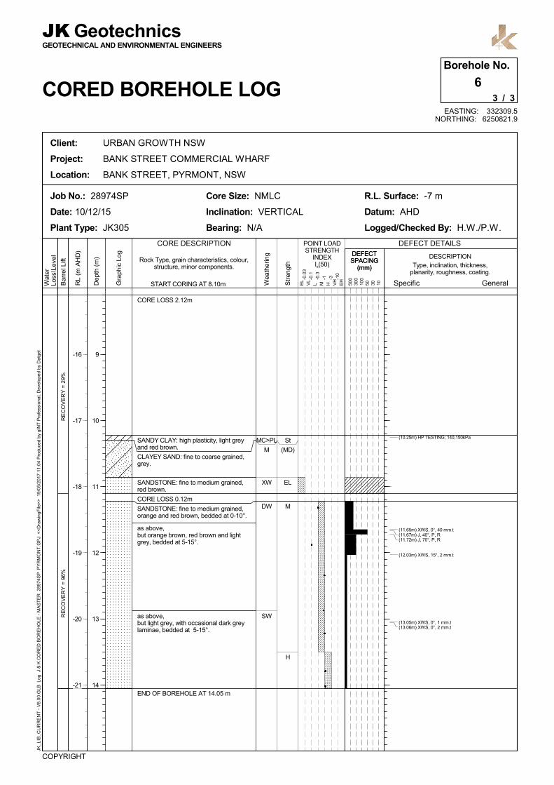
SANDSTONE: fine to medium grained,red brown.
CORE LOSS 0.12m
SANDSTONE: fine to medium grained,orange and red brown, bedded at 0-10°.
as above,but orange brown, red brown and lightgrey, bedded at 5-15°.
as above,but light grey, with occasional dark greylaminae, bedded at 5-15°.
START CORING AT 8.10m
END OF BOREHOLE AT 14.05 m
St
(MD)
EL
M
H
MC>PL
M
XW
DW
SW
Wat
erLo
ss\L
evel
Bar
rel L
ift
RL
(m A
HD
)
JK_L
IB_C
UR
RE
NT
- V
8.00
.GLB
Log
J &
K C
OR
ED
BO
RE
HO
LE -
MA
ST
ER
289
74S
P P
YR
MO
NT
.GP
J <
<D
raw
ingF
ile>
> 1
9/05
/201
7 11
:04
Pro
duc
ed b
y gI
NT
Pro
fess
iona
l, D
evel
oped
by
Dat
gel
Client: URBAN GROWTH NSW
Project: BANK STREET COMMERCIAL WHARF
Location: BANK STREET, PYRMONT, NSW
COPYRIGHT
Core Size: NMLC
Inclination: VERTICAL
Bearing: N/A
Job No.: 28974SP
Date: 10/12/15
Plant Type: JK305
GEOTECHNICAL AND ENVIRONMENTAL ENGINEERS
JK Geotechnics
CORED BOREHOLE LOG
R.L. Surface: -7 m
Datum: AHD
Logged/Checked By: H.W./P.W.
3 / 3
6Borehole No.
EASTING: 332309.5NORTHING: 6250821.9
General
DESCRIPTION
EL
VL
L M H VH
EH
POINT LOADSTRENGTH
INDEXIs(50)
CORE DESCRIPTION
Specific500
300
100
50 30 10
DEFECT DETAILS
Gra
phic
Log
-0.0
3
-0.1
-0.3
-1 -3 -10
Rock Type, grain characteristics, colour,structure, minor components. Type, inclination, thickness,
planarity, roughness, coating.
Str
engt
h
Wea
ther
ing
(10.25m) HP TESTING; 140,150kPa
(11.65m) XWS, 0°, 40 mm.t(11.67m) J, 40°, P, R(11.72m) J, 70°, P, R
(12.03m) XWS, 15°, 2 mm.t
(13.05m) XWS, 0°, 1 mm.t(13.06m) XWS, 0°, 2 mm.t
-16
-17
-18
-19
-20
-21
Dep
th (
m)
9
10
11
12
13
14
DEFECTSPACING
(mm)
DEFECTSPACING
(mm)

ES
U50
DB
DS
RESISTANCE OF CASINGADVANCER
SMALL SPT SAMPLE
RESISTANCE ON CASINGBOULDERS ANDCOBBLES
APPEARS POORLYCOMPACTED
LOW RESISTANCE ONCASING ADVANCER
APPEARS MODERATELYCOMPACTED
BANDS OF RESISTANCEON CASING ADVANCER
RESISTANCE OF CASINGADVANCER
W
N = 184,3,15
N = 44,2,2
N = 153,5,10
N = 1512,8,7
FILL: Sandstone cobbles, fine tomedium grained, light grey, in clayeysand matrix.
FILL: Sand, fine to coarse grained, lightgrey, with medium to coarse grainedsandstone gravel.
FILL: Sandstone boulders and cobbles,in a clayey sand matrix.
FILL: Sand, fine to coarse grained, lightgrey, with medium to coarse grainedsandstone gravel, trace of silt fines.
as above,but with sandstone cobbles an boulders.
FILL: Gravelly sand, fine to coarsegrained, grey, fine to coarse grainedsandstone gravel, trace of clay and siltfines.
FILL: Sandstone boulders and cobblesin a clayey sand matrix.
Gro
undw
ater
Rec
ord
RL
(m A
HD
)
Str
engt
h/R
el D
ensi
ty
Han
dP
enet
rom
ete
rR
eadi
ngs
(kP
a)
Remarks
Moi
stu
reC
ondi
tion/
Wea
ther
ing
Fie
ld T
ests
COPYRIGHT
Logged/Checked By: H.W./P.W.
Method: CASING ADVANCERJob No.: 28974SP
Date: 11/12/15
Plant Type: JK305
R.L. Surface: -2.6 m
Datum: AHD
1 / 4
7Borehole No.
BOREHOLE LOG
JKGEOTECHNICAL AND ENVIRONMENTAL ENGINEERS
Geotechnics
Client: URBAN GROWTH NSW
Project: BANK STREET COMMERCIAL WHARF
Location: BANK STREET, PYRMONT, NSW
JK_L
IB_C
UR
RE
NT
- V
8.00
.GLB
Log
J &
K A
UG
ER
HO
LE -
MA
ST
ER
289
74S
P P
YR
MO
NT
.GP
J <
<D
raw
ingF
ile>
> 1
9/05
/201
7 11
:04
Pro
duc
ed b
y gI
NT
Pro
fess
iona
l, D
evel
oped
by
Dat
gel
EASTING: 332319.4NORTHING: 6250808.6
Gra
phic
Log
Uni
fied
Cla
ssifi
catio
n
DESCRIPTIONSAMPLES
-3
-4
-5
-6
-7
-8
-9
Dep
th (
m)
1
2
3
4
5
6
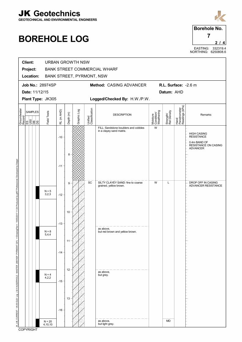
ES
U50
DB
DS
HIGH CASINGRESISTANCE
0.4m BAND OFRESISTANCE ON CASINGADVANCER
DROP OFF IN CASINGADVANCER RESISTANCE
L
MD
W
W
N = 53,2,3
N = 85,4,4
N = 44,2,2
N = 204,10,10
SC
FILL: Sandstone boulders and cobblesin a clayey sand matrix.
SILTY CLAYEY SAND: fine to coarsegrained, yellow brown.
as above,but red brown and yellow brown.
as above,but grey.
as above,but light grey.
Gro
undw
ater
Rec
ord
RL
(m A
HD
)
Str
engt
h/R
el D
ensi
ty
Han
dP
enet
rom
ete
rR
eadi
ngs
(kP
a)
Remarks
Moi
stu
reC
ondi
tion/
Wea
ther
ing
Fie
ld T
ests
COPYRIGHT
Logged/Checked By: H.W./P.W.
Method: CASING ADVANCERJob No.: 28974SP
Date: 11/12/15
Plant Type: JK305
R.L. Surface: -2.6 m
Datum: AHD
2 / 4
7Borehole No.
BOREHOLE LOG
JKGEOTECHNICAL AND ENVIRONMENTAL ENGINEERS
Geotechnics
Client: URBAN GROWTH NSW
Project: BANK STREET COMMERCIAL WHARF
Location: BANK STREET, PYRMONT, NSW
JK_L
IB_C
UR
RE
NT
- V
8.00
.GLB
Log
J &
K A
UG
ER
HO
LE -
MA
ST
ER
289
74S
P P
YR
MO
NT
.GP
J <
<D
raw
ingF
ile>
> 1
9/05
/201
7 11
:04
Pro
duc
ed b
y gI
NT
Pro
fess
iona
l, D
evel
oped
by
Dat
gel
EASTING: 332319.4NORTHING: 6250808.6
Gra
phic
Log
Uni
fied
Cla
ssifi
catio
n
DESCRIPTIONSAMPLES
-10
-11
-12
-13
-14
-15
-16
Dep
th (
m)
8
9
10
11
12
13
ES
U50
DB
DS
RESISTANCE ON CASINGADVANCER
MD
(M)
W
DW
SC
-
SILTY CLAYEY SAND: fine to coarsegrained, light grey.
SANDSTONE: fine to medium grained,red brown.
REFER TO CORED BOREHOLE LOG
Gro
undw
ater
Rec
ord
RL
(m A
HD
)
Str
engt
h/R
el D
ensi
ty
Han
dP
enet
rom
ete
rR
eadi
ngs
(kP
a)
Remarks
Moi
stu
reC
ondi
tion/
Wea
ther
ing
Fie
ld T
ests
COPYRIGHT
Logged/Checked By: H.W./P.W.
Method: CASING ADVANCERJob No.: 28974SP
Date: 11/12/15
Plant Type: JK305
R.L. Surface: -2.6 m
Datum: AHD
3 / 4
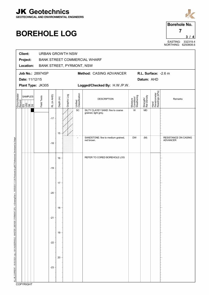
7Borehole No.
BOREHOLE LOG
JKGEOTECHNICAL AND ENVIRONMENTAL ENGINEERS
Geotechnics
Client: URBAN GROWTH NSW
Project: BANK STREET COMMERCIAL WHARF
Location: BANK STREET, PYRMONT, NSW
JK_L
IB_C
UR
RE
NT
- V
8.00
.GLB
Log
J &
K A
UG
ER
HO
LE -
MA
ST
ER
289
74S
P P
YR
MO
NT
.GP
J <
<D
raw
ingF
ile>
> 1
9/05
/201
7 11
:04
Pro
duc
ed b
y gI
NT
Pro
fess
iona
l, D
evel
oped
by
Dat
gel
EASTING: 332319.4NORTHING: 6250808.6
Gra
phic
Log
Uni
fied
Cla
ssifi
catio
n
DESCRIPTIONSAMPLES
-17
-18
-19
-20
-21
-22
-23
Dep
th (
m)
15
16
17
18
19
20
RE
CO
VE
RY
= 1
00%
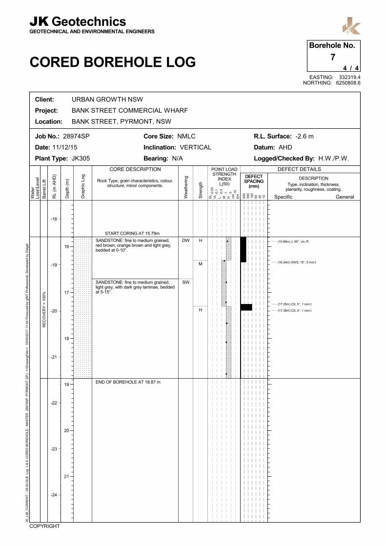
SANDSTONE: fine to medium grained,red brown, orange brown and light grey,bedded at 0-10°.
SANDSTONE: fine to medium grained,light grey, with dark grey laminae, beddedat 5-15°.
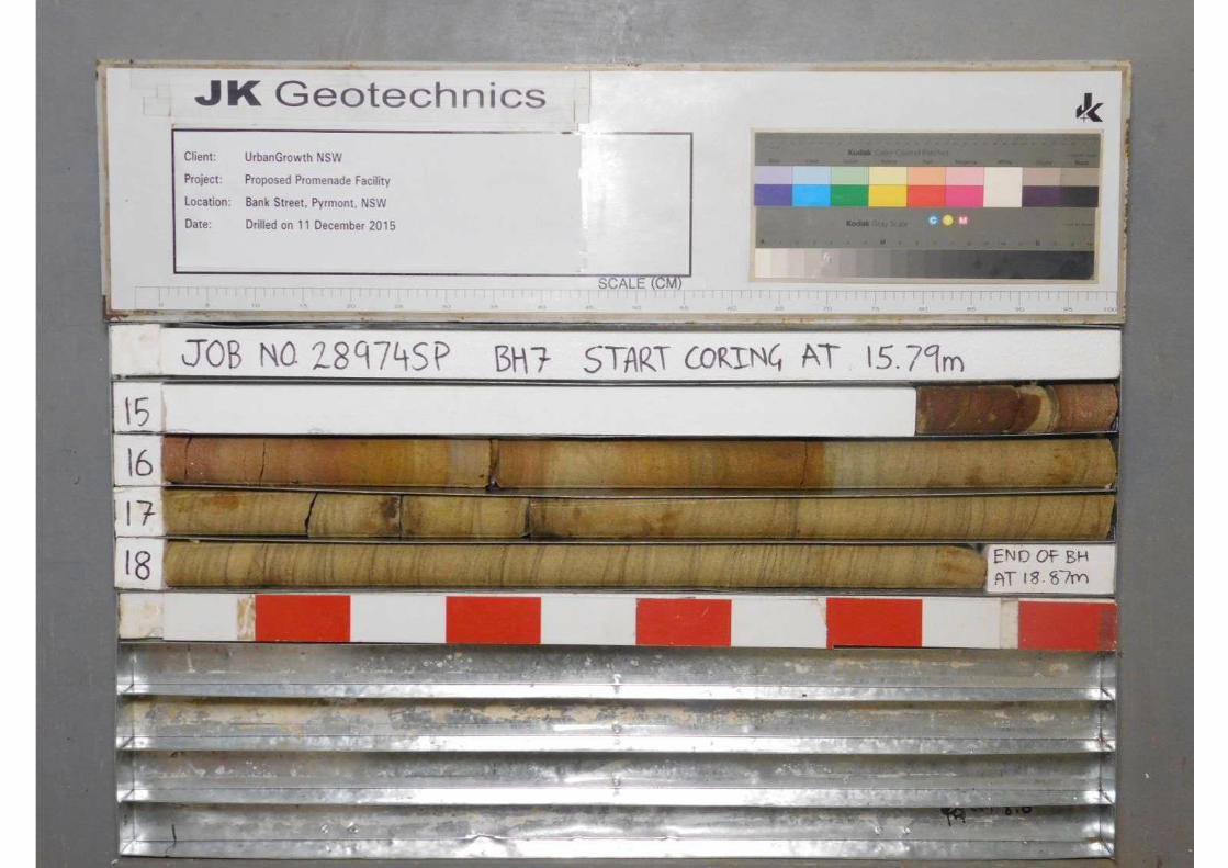
START CORING AT 15.79m
END OF BOREHOLE AT 18.87 m
H
M
H
DW
SW
Wat
erLo
ss\L
evel
Bar
rel L
ift
RL
(m A
HD
)
JK_L
IB_C
UR
RE
NT
- V
8.00
.GLB
Log
J &
K C
OR
ED
BO
RE
HO
LE -
MA
ST
ER
289
74S
P P
YR
MO
NT
.GP
J <
<D
raw
ingF
ile>
> 1
9/05
/201
7 11
:04
Pro
duc
ed b
y gI
NT
Pro
fess
iona
l, D
evel
oped
by
Dat
gel
Client: URBAN GROWTH NSW
Project: BANK STREET COMMERCIAL WHARF
Location: BANK STREET, PYRMONT, NSW
COPYRIGHT
Core Size: NMLC
Inclination: VERTICAL
Bearing: N/A
Job No.: 28974SP
Date: 11/12/15
Plant Type: JK305
GEOTECHNICAL AND ENVIRONMENTAL ENGINEERS
JK Geotechnics
CORED BOREHOLE LOG
R.L. Surface: -2.6 m
Datum: AHD
Logged/Checked By: H.W./P.W.
4 / 4
7Borehole No.
EASTING: 332319.4NORTHING: 6250808.6
General
DESCRIPTION
EL
VL
L M H VH
EH
POINT LOADSTRENGTH
INDEXIs(50)
CORE DESCRIPTION
Specific500
300
100
50 30 10
DEFECT DETAILS
Gra
phic
Log
-0.0
3
-0.1
-0.3
-1 -3 -10
Rock Type, grain characteristics, colour,structure, minor components. Type, inclination, thickness,
planarity, roughness, coating.
Str
engt
h
Wea
ther
ing
(15.89m) J, 90°, Un, R
(16.34m) XWS, 15°, 5 mm.t
(17.25m) CS, 0°, 1 mm.t
(17.39m) CS, 0°, 1 mm.t
-18
-19
-20
-21
-22
-23
-24
Dep
th (
m)
16
17
18
19
20
21
DEFECTSPACING
(mm)
DEFECTSPACING
(mm)
ES
U50
DB
DS
MARINE
LITTLE SAMPLE IN SPT
LITTLE SAMPLE IN SPT
VL
L
VL
L
W
N=01,0,0
N = 82,4,4
N = 31,2,1
N = 86,5,3
N = 61,3,3
SP
SC
SP
SC
SAND: fine to medium grained, grey,with clay and silt fines.
CLAYEY SAND: fine to coarse grained,yellow brown, with silt.
SAND: fine to medium grained, grey andbrown.
SAND: fine to medium grained, grey andbrown, with shells, trace of fine tomedium grained ironstone gravel.
CLAYEY SAND: fine to coarse grained,grey.
Gro
undw
ater
Rec
ord
RL
(m A
HD
)
Str
engt
h/R
el D
ensi
ty
Han
dP
enet
rom
ete
rR
eadi
ngs
(kP
a)
Remarks
Moi
stu
reC
ondi
tion/
Wea
ther
ing
Fie
ld T
ests
COPYRIGHT
Logged/Checked By: H.W./P.W.
Method: CASING ADVANCERJob No.: 28974SP
Date: 16/12/15
Plant Type: JK305
R.L. Surface: -6.9 m
Datum: AHD
1 / 3
8Borehole No.
BOREHOLE LOG
JKGEOTECHNICAL AND ENVIRONMENTAL ENGINEERS
Geotechnics
Client: URBAN GROWTH NSW
Project: BANK STREET COMMERCIAL WHARF
Location: BANK STREET, PYRMONT, NSW
JK_L
IB_C
UR
RE
NT
- V
8.00
.GLB
Log
J &
K A
UG
ER
HO
LE -
MA
ST
ER
289
74S
P P
YR
MO
NT
.GP
J <
<D
raw
ingF
ile>
> 1
9/05
/201
7 11
:04
Pro
duc
ed b
y gI
NT
Pro
fess
iona
l, D
evel
oped
by
Dat
gel
EASTING: 332331.9NORTHING: 6250781.7
Gra
phic
Log
Uni
fied
Cla
ssifi
catio
n
DESCRIPTIONSAMPLES
-7
-8
-9
-10
-11
-12
-13
Dep
th (
m)
1
2
3
4
5
6

ES
U50
DB
DS
BANDED RESISTANCEON CASING ADVANCER
L
VL
M
W
DW
N = 33,1,2
SC
-
CLAYEY SAND: fine to coarse grained,grey.
as above,but with medium to coarse grainedsandstone gravel.
SANDSTONE: fine to coarse grained,yellow brown, with XW bands.
REFER TO CORED BOREHOLE LOG
Gro
undw
ater
Rec
ord
RL
(m A
HD
)
Str
engt
h/R
el D
ensi
ty
Han
dP
enet
rom
ete
rR
eadi
ngs
(kP
a)
Remarks
Moi
stu
reC
ondi
tion/
Wea
ther
ing
Fie
ld T
ests
COPYRIGHT
Logged/Checked By: H.W./P.W.
Method: CASING ADVANCERJob No.: 28974SP
Date: 16/12/15
Plant Type: JK305
R.L. Surface: -6.9 m
Datum: AHD
2 / 3
8Borehole No.
BOREHOLE LOG
JKGEOTECHNICAL AND ENVIRONMENTAL ENGINEERS
Geotechnics
Client: URBAN GROWTH NSW
Project: BANK STREET COMMERCIAL WHARF
Location: BANK STREET, PYRMONT, NSW
JK_L
IB_C
UR
RE
NT
- V
8.00
.GLB
Log
J &
K A
UG
ER
HO
LE -
MA
ST
ER
289
74S
P P
YR
MO
NT
.GP
J <
<D
raw
ingF
ile>
> 1
9/05
/201
7 11
:04
Pro
duc
ed b
y gI
NT
Pro
fess
iona
l, D
evel
oped
by
Dat
gel
EASTING: 332331.9NORTHING: 6250781.7
Gra
phic
Log
Uni
fied
Cla
ssifi
catio
n
DESCRIPTIONSAMPLES
-14
-15
-16
-17
-18
-19
-20
Dep
th (
m)
8
9
10
11
12
13
RE
CO
VE
RY
= 8
2%R
EC
OV
ER
Y =
100
%
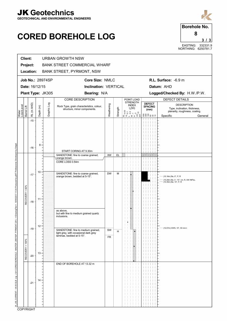
SANDSTONE: fine to coarse grained,orange brown.
CORE LOSS 0.54m
SANDSTONE: fine to coarse grained,orange brown, bedded at 5-15°.
as above,but with fine to medium grained quartzinclusions.
SANDSTONE: fine to medium grained,light grey, with occasional dark greylaminae, bedded at 5-15°.
START CORING AT 9.30m
END OF BOREHOLE AT 13.32 m
EL
M
H
XW
DW
SW
FR
Wat
erLo
ss\L
evel
Bar
rel L
ift
RL
(m A
HD
)
JK_L
IB_C
UR
RE
NT
- V
8.00
.GLB
Log
J &
K C
OR
ED
BO
RE
HO
LE -
MA
ST
ER
289
74S
P P
YR
MO
NT
.GP
J <
<D
raw
ingF
ile>
> 1
9/05
/201
7 11
:04
Pro
duc
ed b
y gI
NT
Pro
fess
iona
l, D
evel
oped
by
Dat
gel
Client: URBAN GROWTH NSW
Project: BANK STREET COMMERCIAL WHARF
Location: BANK STREET, PYRMONT, NSW
COPYRIGHT
Core Size: NMLC
Inclination: VERTICAL
Bearing: N/A
Job No.: 28974SP
Date: 16/12/15
Plant Type: JK305
GEOTECHNICAL AND ENVIRONMENTAL ENGINEERS
JK Geotechnics
CORED BOREHOLE LOG
R.L. Surface: -6.9 m
Datum: AHD
Logged/Checked By: H.W./P.W.
3 / 3
8Borehole No.
EASTING: 332331.9NORTHING: 6250781.7
General
DESCRIPTION
EL
VL
L M H VH
EH
POINT LOADSTRENGTH
INDEXIs(50)
CORE DESCRIPTION
Specific500
300
100
50 30 10
DEFECT DETAILS
Gra
phic
Log
-0.0
3
-0.1
-0.3
-1 -3 -10
Rock Type, grain characteristics, colour,structure, minor components. Type, inclination, thickness,
planarity, roughness, coating.
Str
engt
h
Wea
ther
ing
(10.16m) Be, 0°, P, R
(10.29m) Be, 0 - 10°, Un, R, XW INFILL(10.35m) Be, 10°, P, R
(12.07m) XWS, 10°, 50 mm.t
-15
-16
-17
-18
-19
-20
-21
Dep
th (
m)
9
10
11
12
13
14
DEFECTSPACING
(mm)
DEFECTSPACING
(mm)