Embed Size (px)
Citation preview

Project Description of Multiklient Invest’s Seismic Program Offshore Nova Scotia
Prepared by
Prepared for
Multiklient Invest AS
&
TGS‐NOPEC Geophysical Company ASA
3 August 2018
LGL Project No. FA0164

Project Description of Multiklient Invest’s Seismic Program Offshore Nova Scotia
Prepared by
LGL Limited
environmental research associates
388 Kenmount Road, P.O. Box 13248, Stn. A St. John’s, NL A1B 4A5
Prepared for
Multiklient Invest AS
Lilleakerveien 4C, P.O. Box 251 Lilleaker, 0216, Oslo, Norway
and
TGS-NOPEC Geophysical Company ASA
1051 Clay Road Houston, Texas, 77043, USA
3 August 2018
LGL Project No. FA0164

Suggested format for citation:
LGL Limited. 2018. Project Description of Multiklient Invest’s Seismic Program Offshore Nova Scotia. LGL Rep. FA0164. Rep. by LGL Limited, St. John’s, NL for Multiklient Invest AS, Oslo, Norway, and TGS-NOPEC Geophysical Company ASA, Houston, Texas, USA. 12 p.

ii
Table of Contents Page Table of Contents .......................................................................................................................................... ii List of Figures ................................................................................................................................................ iii List of Tables ................................................................................................................................................. iii 1.0 Introduction ...................................................................................................................................... 1
1.1 Operator .............................................................................................................................. 2 1.1.1 Roles and Contact Information .............................................................................. 2
2.0 Regulatory Context .......................................................................................................................... 3 2.1 Canada-Nova Scotia Benefits Plan ..................................................................................... 3 2.2 Stakeholder Engagement ................................................................................................... 4
3.0 Project Description ........................................................................................................................... 4 3.1 Spatial and Temporal Boundaries ....................................................................................... 4 3.3 Seismic Surveys .................................................................................................................. 5
3.3.1 Narrow Azimuth Acquisition ................................................................................... 6 3.3.2 Wide Azimuth Acquisition ...................................................................................... 6 3.3.3 Seismic Vessel(s)................................................................................................... 7 3.3.4 Seismic Source ...................................................................................................... 9 3.3.5 Seismic Streamers ................................................................................................. 9
3.4 Logistics and Support ......................................................................................................... 9 3.4.1 Vessels ................................................................................................................... 9 3.4.2 Crew Change ......................................................................................................... 9 3.4.3 Shore Base, Support and Staging ....................................................................... 10
4.0 Health, Safety, and Environment ................................................................................................... 10 4.1 Waste Management .......................................................................................................... 10 4.2 Accidental Events .............................................................................................................. 11 4.3 Environmental Features and Species at Risk ................................................................... 11 4.4 Mitigation and Monitoring .................................................................................................. 13
5.0 Literature Cited ............................................................................................................................... 13
iii
List of Figures Page
Figure 1.1 MKI’s Proposed Project Area offshore Nova Scotia. ............................................................. 1 Figure 3.1 MPAs, North Atlantic right whale critical habitat, and northern bottlenose whale
critical habitat relative to the MKI Project Area. ..................................................................... 5 Figure 3.2 A narrow azimuth (NAZ) towing configuration showing a single vessel towing both
streamers and source (airgun arrays). ................................................................................... 6 Figure 3.3 A wide azimuth (WAZ) towing configuration showing two source vessels and a single
vessel towing streamers. ........................................................................................................ 7 Figure 3.4 M/V Ramform Tethys. ............................................................................................................ 8 Figure 3.5 M/V Sanco Atlantic. ................................................................................................................ 8
List of Tables Page
Table 4.1 SARA Schedule 1-marine species with reasonable likelihood of occurrence in and
near the Project Area. .......................................................................................................... 11

Multiklient Invest/TGS-NOPEC Seismic Program Offshore Nova Scotia 1 Project Description
1.0 Introduction Multiklient Invest AS (MKI) and TGS-NOPEC Geophysical Company ASA (TGS) are proposing to conduct two-dimensional (2D) and three-dimensional (3D) seismic surveys offshore Nova Scotia (the Project) in any given year from 2019-2028. MKI will serve as the Operator. This Project Description (PD) document constitutes the initial step in the Canada-Nova Scotia Offshore Petroleum Board’s (CNSOPB) environmental assessment (EA) process. MKI is proposing a maximum of 15,000 km2 of 3D seismic data acquisition and 10,000 linear km of 2D seismic survey lines per year within the Project Area shown in Figure 1.1. Specific data acquisition plans for 2D and 3D surveys during 2019–2028 are not yet determined and will depend on industry demand. The Project Area is approximately 259,400 km2.
Figure 1.1. MKI’s Proposed Project Area offshore Nova Scotia.

Multiklient Invest/TGS-NOPEC Seismic Program Offshore Nova Scotia 2 Project Description
1.1 Operator The Operator, Multiklient Invest AS (MKI), is a wholly-owned subsidiary of Petroleum Geo-Services ASA (PGS). PGS has entered into a cooperative agreement with TGS-NOPEC Geophysical Company AS to conduct this work. PGS is a focused marine geophysical company that provides a broad range of seismic and reservoir services, including acquisition, imaging, interpretation, and field evaluation. The Company multi-client data library is among the largest in the seismic industry, with modern 3D coverage in all significant offshore hydrocarbon provinces of the world. The Company operates on a worldwide basis with headquarters in Oslo, Norway. TGS provides multi-client geoscience data to oil and gas Exploration and Production companies worldwide. In addition to extensive global geophysical and geological data libraries that include multi-client seismic data, magnetic and gravity data, digital well logs, production data and directional surveys, TGS also offers advanced processing and imaging services, interpretation products, and data integration solutions. MKI will comply with applicable laws and regulations, and adhere to the requirements of guidelines and Project commitments made during the EA process for which this PD is submitted.
1.1.1 Roles and Contact Information 1.1.1.1 Project Manager Mr. Jerry Witney New Ventures Manager, New Ventures North and South America Petroleum Geo-Services Inc. 15375 Memorial Drive, Suite 100 Houston, Texas 77079 Phone: 1-281-509-8000 E-mail: [email protected] 1.1.1.2 Regulatory/Environment Mr. Neil Paddy New Ventures Manager, New Ventures North and South America Petroleum Geo-Services Inc. 15375 Memorial Drive, Suite 100 Houston, Texas 77079 Phone: 1-281-509-8000 E-mail: [email protected]

Multiklient Invest/TGS-NOPEC Seismic Program Offshore Nova Scotia 3 Project Description
Mr. Magnus Christiansen Vice President, Operations & Technology/HSEQ Petroleum Geo-Services P.O. Box 251 Lilleaker 0216 Oslo, Norway Phone: +47 6752 6400 E-mail: [email protected] 1.1.1.3 Environmental Assessment Valerie Moulton (LGL Limited) Project Manager 388 Kenmount Road, PO Box 13248 Stn. A St. John’s, NL A1B 4A5 Phone: 1-709-754-1992 E-mail: [email protected]
2.0 Regulatory Context The CNSOPB has confirmed that an EA is required before a geophysical authorization can be issued under paragraph 142(1)(b) of the Canada-Nova Scotia Offshore Petroleum Resources Accord Implementation Act. As with recent seismic EAs undertaken for projects offshore Nova Scotia (i.e., Shell: LGL 2013; BP: LGL 2014), the EA for the proposed Project will follow a process that is like a screening level EA previously undertaken under the former Canadian Environmental Assessment Act (CEAA). Other legislation that is relevant to the environmental aspects of this project include:
Species at Risk Act (SARA) Migratory Birds Convention Act Oceans Act Fisheries Act Navigable Waters Protection Act Canada Shipping Act
This PD is intended to assist the CNSOPB in identifying the appropriate government departments or agencies that possess expert environmental or fishery-related knowledge relevant to the evaluation of potential Project effects. This PD will also assist the CNSOPB in developing the Scoping Document for the EA. The Department of National Defence will be contacted to acquire information on the locations of shipwrecks and unexploded munitions as well as plans for naval training exercises in and near the Project Area. 2.1 Canada-Nova Scotia Benefits Plan MKI is committed to the industrial and employment benefits objectives of the Canada-Nova Scotia Offshore Petroleum Resources Accord Implementation Act and CNSOPB guidelines including full and fair opportunity and first consideration for companies from Canada and Nova Scotia in particular.

Multiklient Invest/TGS-NOPEC Seismic Program Offshore Nova Scotia 4 Project Description
MKI will strive to enhance the participation of individuals and organizations from Nova Scotia and elsewhere in Canada in offshore oil and gas activity offshore Nova Scotia. In addition, MKI will encourage its suppliers and service providers to implement these principles. A Benefits Plan will be submitted for review by the Benefits Review Committee of which the CNSOPB is a member. 2.2 Stakeholder Engagement MKI understands the importance of stakeholder engagement. Early and ongoing stakeholder engagement is a key component of the planning and implementation of the seismic survey. MKI’s approach to stakeholder engagement on marine seismic projects is to, whenever possible, consult (primarily through in-person meetings) with relevant agencies, stakeholders, and Indigenous groups during the pre-survey and survey stages. MKI will initiate meetings and respond to requests for meetings with the interested groups throughout this period. After the survey is complete MKI will conduct follow-up communications. The same approach would be followed before, during and after any seismic survey work conducted in 2019–2028.
3.0 Project Description The Project is designated the Multiklient Invest AS Nova Scotia Offshore Seismic Program, 2019-2028. MKI is proposing to conduct a multi-vessel geophysical program offshore Nova Scotia on the Scotian Shelf and Scotian Slope that may include up to 15,000 km2 of 3D seismic data acquisition and potentially up to 10,000 km of linear 2D seismic survey lines per year. Specific data acquisition plans for 2D and 3D seismic surveys during 2019-2028 have not yet been determined and are dependent on industry demand. The Project Area is 259,400 km2 and encompasses the majority of the CNSOPB jurisdictional area originating approximately 40 km from the southern coastline of Nova Scotia to 350 km offshore (see Figure 1.1). The survey design and details on equipment and vessels for the seismic survey have not yet been determined. In 2019, MKI is planning on a Wide Azimuth (WAZ) 3D seismic program using a single streamer vessel and two separate source vessels. Further details will be provided in the EA. 3.1 Spatial and Temporal Boundaries Project activities, including seismic surveying and vessel turning, will occur in the Project Area (Figure 3.1). Water depths within the Project Area range from ~100–4500 m. At this stage, the survey area(s), i.e., areas where seismic data will be acquired, in a given year including 2019, have not been determined. The locations of proposed survey areas for 2019 will be delineated in the coming months as details about the Project are refined and will be presented in the EA. The Study Area will be presented in the EA and will consider the propagation of seismic survey sound that could potentially affect marine biota. The Project Area excludes the Gully Marine Protected Area (MPA), St. Anns Bank MPA, Georges Bank Moratorium Area and is located a minimum distance of 40 km from the Roseway Basin North Atlantic right whale (Eubalaena glacialis) critical habitat (Figure 3.1). The temporal boundaries of the Project include the 1 May–30 November period in each year from 2019-2028. The duration of the survey will depend on the acquisition methodology, survey size and design and is anticipated to take between one and five months. The survey will run continuously, subject to weather and equipment delays.

Multiklient Invest/TGS-NOPEC Seismic Program Offshore Nova Scotia 5 Project Description
Figure 3.1. MPAs, North Atlantic right whale critical habitat, and northern bottlenose whale critical habitat relative to the MKI Project Area.
3.3 Seismic Surveys MKI may employ separate 2D and 3D seismic acquisition programs in any one year. Currently, MKI intends to use a Narrow Azimuth (NAZ) 3D acquisition method in areas with less complex geological structures. This has been standard practise for industry and academic seismic surveys for more than 30 years and involves a single seismic vessel towing both the source (airgun array) and receivers (seismic cables or streamers). However, experience has shown that NAZ acquisition and processing is unable to resolve the challenging background noise issues in salt provinces that are prevalent offshore Nova Scotia. The solution is Wide Azimuth (WAZ) multi-vessel acquisition and this will typically be the primary survey methodology employed by MKI. MKI may also acquire gravity and/or magnetic data (both collected passively, i.e., without using a source) using equipment on board and/or towed by the seismic vessel. The collection of gravity and magnetic data is a standard industry and academic methodology that has been safely practised in offshore surveys for more than 50 years. Gravity data are collected with instrumentation on board the seismic ship. Magnetic

Multiklient Invest/TGS-NOPEC Seismic Program Offshore Nova Scotia 6 Project Description
data are measured using a tow fish that is typically deployed behind the seismic vessel (i.e., between the stern of the vessel and the airgun arrays at a depth of ~5 m). In addition, vessels will operate standard navigational, operational and safety equipment such as echo sounders and multi-beam sonars (e.g., side scan sonar). Details will be provided in the EA.
3.3.1 Narrow Azimuth Acquisition The majority of 3D seismic surveys conducted offshore Nova Scotia have been NAZ surveys. A single seismic vessel is used to tow the source (airgun arrays) and multiple receiver cables (streamers) in a Narrow Azimuth configuration (Figure 3.2). Additional vessels and helicopters are used for re-supply, crew changes and other logistical reasons and are described in § 3.4. Typically, the seismic vessel acquires seismic data in straight, parallel lines over the pre-defined seismic survey area at a constant speed of 7.8–9.3 km/h, and turns on a radius of 4–6 km at the end of each survey line. MKI may continue to collect seismic data (i.e., operate the full airgun array) during line turns to maximize data collection in the survey area without increasing the overall footprint of the survey area.
Figure 3.2. A narrow azimuth (NAZ) towing configuration showing a single vessel towing both streamers and source (airgun arrays).
3.3.2 Wide Azimuth Acquisition WAZ surveys historically use two or more vessels acquiring 3D seismic data over the same survey area, typically with one survey azimuth, but with two or more different relative vessel configurations (see Figure 3.3 as an example). Data in the survey area is acquired two or more times; each with a different lateral separation between the streamer and the source vessels as the source vessel trajectories are repeated. In addition to the possible WAZ configuration depicted in Figure 3.3., MKI may use other multiple

Multiklient Invest/TGS-NOPEC Seismic Program Offshore Nova Scotia 7 Project Description
vessel configurations using up to two streamer vessels and four source vessels depending on the specific challenges of a survey area. Details on survey methods and design will be provided in the EA.
Figure 3.3. A wide azimuth (WAZ) towing configuration showing two source vessels and a single vessel towing streamers.
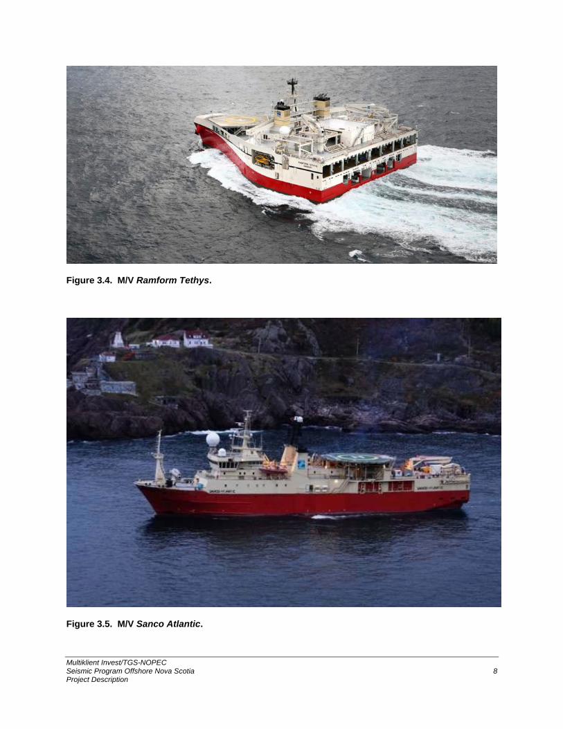
3.3.3 Seismic Vessel(s) It is anticipated that PGS vessels similar to the M/V Ramform Tethys (Figure 3.4) will be used to acquire 3D data. For multi-vessel WAZ operations, source vessels such as PGS’ M/V Sanco Atlantic will be used (Figure 3.5). The M/V Sanco Atlantic or a similar vessel will be used for 2D data acquisition. Each seismic vessel will have the necessary equipment, crew, and spare parts to conduct the program without having to go to port during the program. Crew change and re-supply will be carried out offshore, most likely using a supply vessel. In general, each seismic vessel will be around 80–110 m long and 30–70 m wide, have an at-sea endurance of 40–80 days, and a crew of 55–75 individuals. All personnel will have the required certifications as specified by relevant Canadian legislation and the CNSOPB.
Multiklient Invest/TGS-NOPEC Seismic Program Offshore Nova Scotia 8 Project Description
Figure 3.4. M/V Ramform Tethys.
Figure 3.5. M/V Sanco Atlantic.

Multiklient Invest/TGS-NOPEC Seismic Program Offshore Nova Scotia 9 Project Description
3.3.4 Seismic Source The seismic source for the proposed 2D/3D survey program will consist of one, two or three airgun arrays. For any source that consists of either two or three airgun arrays, the arrays will be discharged alternately (i.e., multiple airgun arrays will not be discharged simultaneously). For NAZ 3D seismic surveys, two or more airgun arrays, each consisting of 1-3 subarrays will be used. The total volume of an airgun array may range from 2,000–6,000 in3. The airgun array(s) will be deployed at depths ranging from 6–15 m, and the airguns will be operated with compressed air at pressures ranging from 2,000–2,500 psi. The maximum peak-to-peak sound source level will be ~100–200 bar-m (~260–266 dB re 1 µPa · m p-p). Airgun array specifics (e.g., volume, source level) will be provided in the EA.
3.3.5 Seismic Streamers The maximum streamer length in a given year is anticipated to be 12 km, and they will be towed at depths ranging from 9–25 m. The 2D seismic vessel will tow one streamer. Although the current maximum number of streamers for a single 3D survey vessel is 16, during the period of the EA, vessels may tow up to 24 streamers with a maximum streamer footprint width of 2 km. The distance between adjacent streamers is 200 m. The forward end of each cable is weighted to submerge the cable to the required depth, and the aft end of the cable is marked with a tail buoy. The data collected by the receivers is transmitted to the seismic vessel for quality control and initial processing of the seismic image. Seismic streamer specifics (e.g., length, number, overall spread) will be provided in the EA. MKI will only use solid streamers.
3.4 Logistics and Support Several vessels and a helicopter are typically used to support a seismic program, as described below.
3.4.1 Vessels MKI’s primary support and supply will be provided by either the PGS vessel M/V Thor Magni or a similar vessel. In addition, it is anticipated that at least one local escort vessel will accompany each operating seismic vessel. When necessary (i.e., when fishing vessels and gear or other hazards such as floating debris are thought to be in the immediate path of the seismic vessel), escort vessels will be used to scout ahead of the seismic vessels.
3.4.2 Crew Change MKI plans to use a supply vessel or helicopter to conduct crew changes given the large Project Area expanse. The supply vessel will be capable of safely carrying 30–40 passengers from port and transferring them to/from the seismic vessel offshore. It is anticipated that the majority of crew changes will occur via supply vessel. However, helicopters may be used for crew change and helicopters will also be available for Medevac, and Search and Rescue (SAR) missions if necessary. The helideck of the seismic vessels(s) will be rated for Sikorsky S-92 helicopters or equivalent.

Multiklient Invest/TGS-NOPEC Seismic Program Offshore Nova Scotia 10 Project Description
3.4.3 Shore Base, Support and Staging It is anticipated that vessel mobilization/demobilization and resupply will occur in Halifax. MKI will have a shore representative based in Halifax for the duration of the seismic program. No new shore base facilities will be established as part of the Project.
4.0 Health, Safety, and Environment
The Health, Safety and Environment (HSE) ambition and commitment of PGS, which underlies their core values, are summarized in the schematic below.
4.1 Waste Management Waste management will be consistent with industry best practices in offshore Nova Scotia. Any garbage generated will be collected and separated into items that are either dischargeable to the sea, non-dischargeable to the sea or reusable according to MARPOL 73/78 Annex IV: Pollution by Sewage from Ships, and Annex V: Pollution by Garbage from Ships. Some waste will be incinerated at sea. According to MARPOL 73/78 Annex V, liquid waste discharge is not considered to be ‘garbage’.

Multiklient Invest/TGS-NOPEC Seismic Program Offshore Nova Scotia 11 Project Description
4.2 Accidental Events There is potential for accidental events to occur during the proposed Project, including damage to the source and streamer gear, entanglement with fishing gear, spills of fluids (e.g., fuel), collision with other vessels and potential ship strikes of marine mammals. These potential events will have response plans outlined in more detail in the EA. Response plans (including Spill Response and Emergency Response plans) will be reviewed and will require approval by the CNSOPB.
4.3 Environmental Features and Species at Risk Given the spatial extent of the proposed MKI Project Area, all seven Strategic Environmental Assessments (SEAs) of oil and gas activities offshore Nova Scotia, which were prepared on behalf of the CNSOPB, correspond to a portion of the MKI Project Area. Of primary note is the proximity to Georges Bank and critical habitat for the North Atlantic right whale and northern bottlenose whale (see Figure 3.1). The SEAs address the physical and biological conditions of MKI’s Project Area and provides an overview of the effects of seismic surveys on the marine environment. MKI’s EA will draw upon the SEAs to the extent possible but will also provide a detailed assessment that addresses the Scoping Document, which will be issued by the CNSOPB. Marine species listed on Schedule 1 of SARA that have a reasonable likelihood of occurring in and near the Project Area are provided in Table 4.1. Table 4.1 SARA Schedule 1-marine species with reasonable likelihood of occurrence in and near the Project Area.
Species SARA Schedule 1a
Common Name Scientific Name Endangered Threatened Special Concern
Blue Whale (Atlantic population) Balaenoptera musculus
X
North Atlantic Right Whale Eubalaena glacialis X Northern Bottlenose Whale (Scotian Shelf population)
Hyperoodon ampullatus
X
Leatherback Sea Turtle (Atlantic population)
Dermochelys coriacea X
Loggerhead Sea Turtle Caretta caretta X Roseate Tern Sterna dougallii X Red Knot rufa subspecies Calidris canutus rufa X
White Shark (Atlantic population) Carcharodon carcharias
X
Northern Wolffish Anarhichas denticulatus
X
Spotted Wolffish Anarhichas minor X
Fin Whale (Atlantic population) Balaenoptera physalus
X
Sowerby’s Beaked Whale Mesoplodon bidens XAtlantic Wolffish Anarhichas lupus X
Source: a SARA website (https://www.sararegistry.gc.ca/species/schedules_e.cfm?id=1) (as of 31 July 2018).

Multiklient Invest/TGS-NOPEC Seismic Program Offshore Nova Scotia 12 Project Description

Multiklient Invest/TGS-NOPEC Seismic Program Offshore Nova Scotia 13 Project Description
4.4 Mitigation and Monitoring MKI is committed to minimizing the effects of the Project on the environment, including potential effects on other offshore users in the area. All mitigation and monitoring that will be conducted during the seismic survey will be detailed in the EA. Some key mitigation measures and monitoring that will be implemented are noted here. MKI will follow the requirements as outlined in the “Statement of Canadian Practice with respect to the Mitigation of Seismic Sound in the Marine Environment”. Dedicated and qualified Marine Mammal Observers (MMOs) and Seabird Observers (SBOs) will be on board the seismic vessel(s) throughout the survey to monitor effects and implement mitigation measures for marine mammals, sea turtles, and birds. A Fisheries Liaison Officer (FLO) will be onboard the seismic vessel to assist if fisheries concerns arise during the seismic surveys. A FLO will assist with communication between parties operating in the Project Area and help to avoid interactions between the seismic survey and fishing activity.
5.0 Literature Cited LGL Limited. 2013. Environmental assessment of Shell Canada Ltd.’s Shelburne Basin 3-D Seismic
Survey. LGL Rep. SA1175. Rep. by LGL Limited, St. John’s, NL and Mahone Bay, NS, for Shell Canada Limited, Calgary, AB. 127 p + appendices.
LGL Limited. 2014. Final environmental assessment of BP Exploration (Canada) Limited’s Tangier 3-D
Seismic Survey. BP Document NS-HS-REP-BP-01-000 and LGL Rep. SA1222. Rep. by LGL Limited, Mahone Bay, NS and St. John’s, NL for BP Exploration Canada Limited, Calgary, AB. 177 p. + appendices.