Embed Size (px)
Citation preview

STATE OF UTAHDEPARTMENT OF NATURAL RESOURCES
DIVISION OF OIL, GAS AND MINING
APPLICATION FOR PERMIT TO DRILL 1. WELL NAME and NUMBER
Cane Creek Unit 19-2
2. TYPE OF WORK
DRILL NEW WELL REENTER P&A WELL DEEPEN WELL 3. FIELD OR WILDCAT
UNDESIGNATED
4. TYPE OF WELLOil Well Coalbed Methane Well: NO
5. UNIT or COMMUNITIZATION AGREEMENT NAMECANE CREEK
6. NAME OF OPERATORFIDELITY E&P COMPANY
7. OPERATOR PHONE303 893-3133
8. ADDRESS OF OPERATOR2585 Heartland Drive, Sheridan, WY, 82801
9. OPERATOR [email protected]
10. MINERAL LEASE NUMBER(FEDERAL, INDIAN, OR STATE)
UTU53626
11. MINERAL OWNERSHIP
FEDERAL INDIAN STATE FEE 12. SURFACE OWNERSHIP
FEDERAL INDIAN STATE FEE
13. NAME OF SURFACE OWNER (if box 12 = 'fee')
14. SURFACE OWNER PHONE (if box 12 = 'fee')
15. ADDRESS OF SURFACE OWNER (if box 12 = 'fee')
16. SURFACE OWNER E-MAIL (if box 12 = 'fee')
17. INDIAN ALLOTTEE OR TRIBE NAME(if box 12 = 'INDIAN')
18. INTEND TO COMMINGLE PRODUCTION FROMMULTIPLE FORMATIONS
YES (Submit Commingling Application) NO
19. SLANT
VERTICAL DIRECTIONAL HORIZONTAL
20. LOCATION OF WELL FOOTAGES QTR-QTR SECTION TOWNSHIP RANGE MERIDIAN
LOCATION AT SURFACE 491 FNL 1172 FWL NWNW 19 26.0 S 20.0 E S
Top of Uppermost Producing Zone 491 FNL 1172 FWL NWNW 19 26.0 S 20.0 E S
At Total Depth 491 FNL 1172 FWL NWNW 19 26.0 S 20.0 E S
21. COUNTYGRAND
22. DISTANCE TO NEAREST LEASE LINE (Feet)1172
23. NUMBER OF ACRES IN DRILLING UNIT1951
25. DISTANCE TO NEAREST WELL IN SAME POOL(Applied For Drilling or Completed)
0
26. PROPOSED DEPTHMD: 7500 TVD: 7500
27. ELEVATION - GROUND LEVEL
6012
28. BOND NUMBER
CO1395
29. SOURCE OF DRILLING WATER /WATER RIGHTS APPROVAL NUMBER IF APPLICABLE
Municipal
Hole, Casing, and Cement Information
String Hole Size Casing Size Length Weight Grade & Thread Max Mud Wt. Cement Sacks Yield Weight
Cond 26 20 0 - 60 94.0 J-55 ST&C 15.0 Class G 81 1.17 15.0
Surf 17.5 13.375 0 - 1500 54.5 J-55 ST&C 13.5 Type II 200 3.48 11.0
Type II 193 1.8 13.5
I1 12.25 9.625 0 - 4604 40.0 HCN-80 LT&C 15.8 Halliburton Premium , Type Unknown 334 2.16 12.5
Halliburton Premium , Type Unknown 255 1.23 15.8
Prod 8.75 7 0 - 4604 29.0 N-80 LT&C 16.5 Halliburton Premium , Type Unknown 352 1.3 16.5
4604 - 7500 35.0 P-110 LT&C 16.5 None
ATTACHMENTS
VERIFY THE FOLLOWING ARE ATTACHED IN ACCORDANCE WITH THE UTAH OIL AND GAS CONSERVATION GENERAL RULES
WELL PLAT OR MAP PREPARED BY LICENSED SURVEYOR OR ENGINEER COMPLETE DRILLING PLAN
AFFIDAVIT OF STATUS OF SURFACE OWNER AGREEMENT (IF FEE SURFACE) FORM 5. IF OPERATOR IS OTHER THAN THE LEASE OWNER
DIRECTIONAL SURVEY PLAN (IF DIRECTIONALLY OR HORIZONTALLY
DRILLED)
TOPOGRAPHICAL MAP
NAME Stephanie Masters TITLE Operations Tech PHONE 307 675-4924
SIGNATURE DATE 05/17/2011 EMAIL [email protected]
API NUMBER ASSIGNED
43019500130000
Permit Manager
APPROVAL
FORM 3
AMENDED REPORT
API Well Number: 43019500130000
FORM 3STATE OF UTAH
DEPARTMENT OF NATURAL RESOURCES AMENDED REPORTDIVISION OF OIL, GAS AND MINING
APPLICATION FOR PERMIT TO DRILL 1. WELL NAME anCdaNe reEkRUnit19-2
2. TYPE OF WORK 3. FIELD OR WILDCATDRILL NEW WELLI REENTER P&A WELL DEEPEN WELL I UNDESIGNATED
4. TYPE OF WELL 5. UNIT or COMMUNITIZATION AGREEMENT NAMEOil Well Coalbed Methane Well: NO CANE CREEK
6. NAME OF OPERATOR 7. OPERATOR PHONEFIDELITY E&P COMPANY 303 893-3133
8. ADDRESS OF OPERATOR 9. OPERATOR E-MAIL2585 Heartland Drive, Sheridan, WY, 82801 [email protected]
10. MINERAL LEASE NUMBER 11. MINERAL OWNERSHIP 12. SURFACE OWNERSHIP(FEDERAL,INDIAN,ORUSTU66 FEDERAL I INDIAN I STATE FEE FEDERAL INDIAN STATEI FEEl
13. NAME OF SURFACE OWNER (if box 12 = 'fee') 14. SURFACE OWNER PHONE (if box 12 = 'fee')
15. ADDRESS OF SURFACE OWNER (if box 12 = 'fee') 16. SURFACE OWNER E-MAIL (if box 12 = 'fee')
17. INDIAN ALLOTTEE OR TRIBE NAME 18. INTEND TO COMMINGLE PRODUCTION FROM 19. SLANT
(if box 12 = 'INDIAN')MULTIPLE FORMATIONS
YES (Submit Commingling Application) NO VERTICAL DIRECTIONAL HORIZONTAL I
20. LOCATION OF WELL FOOTAGES QTR-QTR SECTION TOWNSHIP RANGE MERIDIAN
LOCATION AT SURFACE 491 FNL 1172 FWL NWNW 19 26.0 S 20.0 E S
Top of Uppermost Producing Zone 491 FNL 1172 FWL NWNW 19 26.0 S 20.0 E S
At Total Depth 491 FNL 1172 FWL NWNW 19 26.0 S 20.0 E S
21. COUNTY 22. DISTANCE TO NEAREST LEASE LINE (Feet) 23. NUMBER OF ACRES IN DRILLING UNITGRAND 1172 1951
25. DISTANCE TO NEAREST WELL IN SAME POOL 26. PROPOSED DEPTH(Applied For Drilling or Completed) MD: 7500 TVD: 75000
27. ELEVATION - GROUND LEVEL 28. BOND NUMBER 29. SOURCE OF DRILLING WATER /WATER RIGHTS APPROVAL NUMBER IF APPLICABLE
6012 CO1395 Municipal
Hole, Casing, and Cement Information
Hole Size Casing Size Length Weight Grade & Thread Max Mud Wt. Cement Sacks Yield Weight
26 20 0 - 60 94.0 J-55 ST&C 15.0 Class G 81 1.17 15.0
17.5 13.375 0 - 1500 54.5 J-55 ST&C 13.5 Type II 200 3.48 11.0
Type II 193 1.8 13.5
12.25 9.625 0 - 4604 40.0 HCN-80 LT&C 15.8 Halliburton Premium , Type Unknown 334 2.16 12.5
Halliburton Premium , Type Unknown 255 1.23 15.8
8.75 7 0 - 4604 29.0 N-80 LT&C 16.5 Halliburton Premium , Type Unknown 352 1.3 16.5
4604 - 7500 35.0 P-110 LT&C 16.5 None
ATTACHMENTS
VERIFY THE FOLLOWING ARE ATTACHED IN ACCORDANCE WITH THE UTAH OIL AND GAS CONSERVATION GENERAL RULES
WELL PLAT OR MAP PREPARED BY LICENSED SURVEYOR OR ENGINEER COMPLETE DRILLING PLAN
AFFIDAVIT OF STATUS OF SURFACE OWNER AGREEMENT (IF FEE SURFACE) FORM 5. IF OPERATOR IS OTHER THAN THE LEASE OWNER
DIRECTIONAL SURVEY PLAN (IF DIRECTIONALLY OR HORIZONTALLY TOPOGRAPHICAL MAP
DRILLED)
NAME Stephanie Masters TITLE Operations Tech PHONE 307 675-4924
SIGNATURE DATE 05/17/2011 EMAIL [email protected]
API NUMBER ASSIGNED APPROVAL
43019500130000 I
Permit

API Well Number: 43019500130000
ONSHOREORDERNO.1 FIDENTIAL- TIGHTHOLEFidelityExploration&ProductionCompanyCane CreekUnit#19-2 Lease No. UTU-53626491' FNLand 1172'FWLLot1 (NWNW)Section19,T26S- R20E DRILLINGPROGRAMGrandCounty,Utah Page 1
ONSHOREOIL&GASORDERNO.1Approvalof Operationson Onshore
FederalandIndianOiland Gas Leases
Allleaseand/orunitoperationswillbeconductedinsuchamannerthatfullcomplianceismadewithappIlcablelaws,regulations(43CFR3100),OnshoreOilandGasOrderNo.1,andtheapprovedplanofoperations.Theoperatoris fullyresponsiblefortheactionsofhissubcontractors.Acopyoftheseconditionswillbe furnishedthefieldrepresentativetoinsurecompliance.
1. ESTIMATEDTOPSOFALLGEOLOGICGROUPS,FORMATIONS,MEMBERS,ORZONES
Theestimatedtopsofimportantgeologicmarkersareas follows:
Formation MeasuredDepth Subsea
NavajoSand Surface - - -
WingateSand 345' +5,694'
Chinie 702' +5,337'
Moenkopi 1,051' +4,988'
Cutler 1,518' +4,521'
HonakerTrail 2,924' +3,115'
Paradox 4,253' +1,786'
CaneCreekShale 7,299' -1,260'
T.D. 7,500' -1,461'
2. ESTIIWATEDDEPTHANDTHICKNESSOFOIL,GAS,WATER&OTHERMINERALZONES
Theestimateddepthsatwhichthetopandbottomoftheanticipatedwater,oil,gasorothermineralbearingformationsare expectedtobe encotinteredare as follows:
Substance Formation Depth Thickness
Brine 16Salt 4,449' 60' à
Oil CaneCreek 7,299' 60'
API Well Number: 43019500130000
ONSHOREORDERNO.1 FlDENTlAL- TIGHTHOLEFidelityExploration&ProductionCompanyCaneCreekUnit#19-2 Lease No. UTU-53626491'FNLand1172'FWLLot1 (NWNW)Section19,T26S- R20E DRILLINGPROGRAMGrandCounty,Utah Page2
AIIfreshwaterandprospectivelyvaluablemineralsencounteredduringdrilling,willbe recordedbydepthand willbe cased and cemented. Whenpossible,waterflowrateswillbe measuredandsampleswillbetakenandanalyzedwiththeresultsbeingsubmittedtotheBLM.Alloilandgasshowswillbe testedtodeterminecommercialpotential.
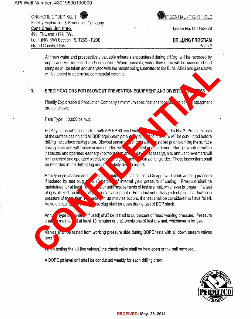
3. SPECIFICATIONSFORBLOWOUTPREVENTIONEQUIPMENTANDDIVERTERSYSTEMS
FidelityExploration&ProductionCompany'sminimumspecificationsforpressurecontrolequipmentareas follows:
RamType: 10,000psiw.p.
BOPsystemswillbeconsistentwithAPIRP53andOnshoreOilandGasOrderNo.2. Pressure testsofthesurfacecasingandallBOPequipmentpotentiallysubjecttopressurewillbeconductedbeforedrillingthesurfacecasingshoe. Blowoutpreventercontrolswillbe installedpriortodrillingthesurfacecasingshoe andwillremaininuse untilthewelliscompletedorabandoned. Rampreventerswillbeinspectedand operatedeachtrip(nomorethanoncea dayisnecessary),andannularpreventerswillbe inspectedandoperatedweeklytoensuregoodmechanicalworkingorder.These inspectionsshallbe recordedinthedrillinglogand inthedailydrillingreport.
Ramtypepreventersandassociatedequipmentshallbetestedtoapprovedstackworkingpressureif isolatedby testplugor to 70 percentof internalyieldpressureof casing. Pressureshallbemaintainedforat least10minutesoruntilrequirementsoftestaremet,whicheverislonger.Ifa testplugis utilized,nobleed-offpressureisacceptable.Fora testnot utilizinga testplug,ifa declineinpressureof morethan10percentin30 minutesoccurs,thetestshallbe consideredtohavefailed.Valveoncasingheadbelowtestplugshallbe openduringtestofBOPstack.
Annulartypepreventers(ifused)shallbe testedto50 percentofratedworkingpressure.Pressureshallbe maintainedat least10minutesoruntilprovisionsoftestaremet,whicheveris longer.
Valvesshallbe testedfromworkingpressuresideduringBOPEtestswithalldownstreamvalvesopen.
When testingthekilllinevalve(s)thecheckvalveshallbe heldopenortheballremoved.
A BOPEpitleveldrillshallbeconductedweeklyforeachdrillingcrew.
PERMITC0

API Well Number: 43019500130000
ONSHOREORDERNO.1 FIDENTIAL- TIGHTHOLEFidelityExploration&ProductionCompanyCaneCreekUnit#19-2 Lease No.UTU-53626491' FNLand 1172'FWLLoti (NWNW)Section19,T26S- R20E DRILLINGPROGRAMGrandCounty,Utah Page3
TheBOPandrelatedequipmentshallmeettheminimumrequirementsofOnshoreOilandGasOrderNo.2 forequipmentandtestingrequirements,procedures,etc.,andindividualcomponentsshallbeoperableas designed.Chartrecordersshallbe used forallpressuretests.
Pressure testsshallapplytoallrelatedwellcontrolequipment
Alloftheabovedescribedtestsand/ordrillsshallbe recordedinthedrillinglog. Testcharts,withindividualtest resultsidentified,shallbe maintainedon locationwhiledrillingand shall be madeavailabletoa BLMrepresentativeuponrequest.Pressuretestsshallapplytoallrelatedwellcontrolequipment,
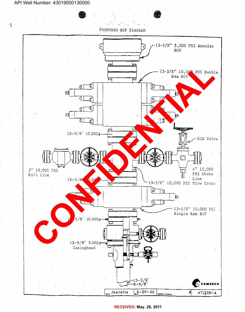
a. ThesizeandratingoftheBOPstackisshownontheattacheddiagram.Althougha righasnotbeenchosentodrillthiswell,mostoftheequipmentforthisdepthof holeinthearea usea 1Fje10,000psiworkingpressureblowoutpreventor.
b. Achokelineanda killlineare tobe properlyinstalled.The killlineis not tobe used as afill-upline.
c. Theaccumulatorsystemshallhavea pressurecapacitytoprovideforrepeatedoperationofhydraulicpreventers.
d. Drillstringsafetyvalve(s),tofitalltoolsinthedrillstring,are tobemaintainedon therigfloorwhiledrillingoperationsare inprogress.
4. PROPOSEDCASINGPROGRAM
a, Theproposedcasingandcementingprogramshallbe conductedas approvedto protectand/orisolate allusablewaterzones,potentiallyproductivezones, lostcirculationzones,abnormallypressuredzones, and any prospectivelyvaluable depositsof minerals.Anyisolatingmediumotherthancementshallreceiveapprovalpriortouse. Thecasingsettingdepthshallbe calculatedtopositionthecasingseat oppositea competentformationwhichwillcontainthe maximumpressureto whichit willbe exposed duringnormaldrillingoperations. Determinationofcasingsettingdepthshallbe based on all relevantfactors,including;presencelabsenceof hydrocarbons;fracturegradients;usable water zones;formationpressures;lostcirculationzones;otherminerals;orotherunusualcharacteristics.Allindicationsofusable watershallbe

API Well Number: 43019500130000
ONSHOREORDERNO.1 FIDENTIAL- TiGHTHOLEFidelityExploration&ProductionCompanyCaneCreekUnit#19-2 Lease No.UTU-53626491'FNLand1172'FWLLot1 (NWNW)Section19,T26S- R20E DRILUNGPROGRAMGrandCounty,Utah Page4
b. Casingcollarsshallhavea minimumclearanceof0.422inchesofallsidesinthehole/casingannulus,withrecognitionthatvariancescan be grantedforjustifiedexceptions.
c. Allwaitingoncementtimesshallbeadequatetoachievea minimumof500 psicompressivestrengthat thecasingshoepriortodrillingout.
d. Allcasingexcepttheconductorcasing,shallbeneworreconditionedandtestedusedcasingthatmeetsorexceedsAPIstandardsfornewcasing.
e. Thesudacecasingshallbe cementedbacktosurfaceeitherduringtheprimarycementjoborbyremedialcementing,
f. Allindicationsofusable watershallbe reportedtotheauthorizedofficerpriortorunningthenextstringofcasingorbeforepluggingordersare requested,whicheveroccursfirst.
g. Three centralizerswillbe runonthebottomthreejointsofsurfacecasingwitha minimumofonecentralizerperjointstartingwiththeshoejoint.
h. Topplugsshallbe usedtoreducecontaminationofcementbydisplacementfluid.Abottomplugor otheracceptabletechnique,such as a suitablepreflushfluid,innerstringcementmethod,etc.shallbe utilizedtohelp isolatethecementfromcontaminationby themudfluidbeingdisplacedaheadofthecementslurry.
i. Allcasing stringsbelowtheconductorshall be pressuretestedto022 psiperfootofcasingstringlengthor1500psi,whicheverisgreater,but nottoexceed70 percentoftheminimuminternalyield.Ifpressuredeclinesmorethan10percentin30 minutes,correctiveactionshallbetaken,
j. Onallexploratorywells,andonthatportionofanywellapprovedfora 5MBOPEsystemorgreater,a pressureintegritytestofeachcasingshoe shallbe performed.Formationat theshoe shallbe testedtoa minimumofthemudweightequivalentanticipatedtocontroltheformationpressuretothenextcasingdepthor at totaldepthofthewell. Thistestshall beperformedbeforedrillingmorethan20 feetofnewhole.
PElk
API Well Number: 43019500130000
ONSHOREORDERNO.1 CONFIDENTIAL- TlGHTHOLEFidelityExploration&ProductionCompanyCane CreekUnit#19-2 Lease No.UTU-53626491' FNLand 1172'FWLLot1 (NWNW)Section19,T26S - R20E DRILLINGPROGRAMGrandCounty,Utah Paqe 5
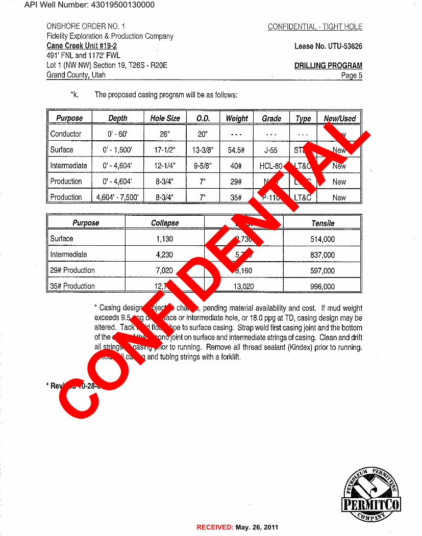
*k. Theproposedcasingprogramwillbe as follows:
Purpose Depth HoleSize 0.D. Weight Grade Type New/Used
Conductor 0' - 60' 26" 20" - - - - - - - - - New
Surface 0' - 1,500' 17-1/2" 13-3/8" 54.5# J-55 ST&C New
Intermediate 0' - 4,604' 12-1/4" 9-5/8" 40# HCL-80 LT&C New
Production O'- 4,604' 8-3/4" 7" 29# N-80 LT&C New
Production 4,604'-7,500' 8-3/4" 7" 35# P-110 LT&C New
Purpose Collapse Burst Tensile
Surface 1,130 2,730 514,000
Intermediate 4,230 5,750 837,000
29#Production 7,020 8,160 597,000
35#Production 12,700 13,020 996,000
* Casingdesignsubjecttochange,pendingmaterialavailabilityandcost. Ifmudweightexceeds 9.5 ppgonsurfaceorintermediatehole,or18.0ppgatTD,casingdesignmaybealtered. Tackweldfloatshoetosurfacecasing. Strapweldfirstcasingjointandthebottomofthecollarofthesecondjointonsurfaceandintermediatestringsofcasing. Cleananddriftallstringsofcasingpriorto running. Removeallthreadsealant (Kindex)priorto running.Unloadallcasingand tubingstringswitha forklift.
* Revised

API Well Number: 43019500130000
ONSHOREORDERNO.1 CONFlDENTIAL- T1GHTHOLEFidelityExploration&ProductionCompanyCane Creek Unit#19-2 Lease No.UTU-53626491' FNLand1172'FWLLot1 (NWNW)Section19,T26S - R20E DRILLINGPROGRAMGrandCounty,Utah Page 6
5. PROPOSEDCEMENTINGPROGRAM
*a. Thecementprogramwillbe as follows:
Surface TypeandAmount
TOC@Surface Lead:200sxSanJuanPRBli,3.48ft3/sk,11ppg.Tail:193sx SanJuanPRBll, 1.80ft3/sk,13.5ppg.
Intermediate Typeand Amount
TOC@200'above Lead:334sxHalliburtonLightPremium,0.8%HaladR-322(LowFluidLosssurfacecasingshoe Control),0.2%WG-17(AdditiveMaterial),0.125lbm/skPoly-E-Flake(Lost
CirculationAdditive),0.2%HR-5(Retarder),15%Salt,2.16ft3/sk,12.5ppg.Tail:255sx PremiumCement,94 1bm/skPremiumCement,0.6%HaladR-413(LowFluidLossControl),0.3%SuperCBL(Gas MigrationControl),0.45%HR-5 (Retarder),418%Salt,0.3%D-AIR3000(Defoamer),0.3%Versaset(ThixotropicAdditive),1.23 ft3/sk,15.81bm/gal.
Production TypeandAmount
TOC@4,404' 352sxPremiumCement,94 lbm/skPremiumCement,15% Salt,0.6%HaladR-413(LowFluidLossControl),0.2%HaladR-344(LowFluidLossControl),0.2%SuperCBL(Expander),0.4%D-AIR3000(Defoamer),6%WellLife665 (AdditiveMaterial),0.4%HR-5(Retarder),0.3%CFR-3(Dispersant),15%HI-Dense#4 (HeavyWeightAdditive),1.30 ft3/sk,16.5ppg.
* Surface,Intermediateand Productioncementcalculatedwith0% excess. However,sufficientexcesscementwillbe onlocationtobringcementtocalculateddepths.
b. Aftercementingbutbeforecommencinganytest,thecasingstringshallstandcementeduntilthecementhas reacheda compressivestrengthofat least500psiat theshoe. WOCtimeshallberecordedinthedriller'slog.
c. Thefollowingreportsshallbe filedwiththeDistrictManagerwithin30 daysaftertheworkiscompleted.
1. Progress reports,Form3160-5(formerly9-331) 'SundryNoticesand ReportsonWells",mustincludecompleteinformationconcerning:
* Revised 10-28-08 ¢* ©¾

API Well Number: 43019500130000
ONSHOREORDERNO.1 FIDENTIAL- TlGHTHOLEFidelityExploration&ProductionCompanyCaneCreekUnit#19-2 Lease No.UTU-53626491' FNLand1172'FWLLot1 (NWNW)Section19,T26S-R20E DRILLINGPROGRAMGrandCounty,Utah Page7
a. Settingofeachstringofcasing,showingthesize,grade,weightofcasingset, holesize,settingdepth,amountsand typeofcenientused,whethercementcirculatedor the topof thecementbehind the casing,depthofcementingtoolsused,casingtestmethodand results,and thedate workwasdone. Showthespuddateonthefirstreportssubmitted.
b. Temperatureorbond logsmustbe submittedforeach wellwherethecasingcementwasnotcirculatedtothesulface.
d. Auxiliaryequipmenttobe usedisas follows:
1. Kellycock2. Nobitfloatisdeemednecessary.3. Asubwitha fullopeningvalve.
6. PROPOSEDCIRCULATINGMEDIUMORMEDIUMS
a. . The proposedcirculatingmediumstobe employedindrillingare as follows:
Interval MudType MudWt. Visc. F/L
O' 1,500' AirMist - - - - - - - -
1,500' - 4,604' AirMist/AeratedWater - - - - - - - - -
4,604¾7,500' OilBasedMud 15.5-16.5ppg 50-55 5.0
Sufficientmudmaterialswillbe storedon locationtornaintainwellcontrolandcombatlostcirculationproblemsthatmightreasonablybe expected,
b. Duetopotentialforcontaminationofusablequalitywateraquifers,chromatesare bannedfromFederalleases.
c. HazardoussubstancesspecificallylistedbytheEPAas a hazardouswaste ordemonstratinga characteristicof a hazardouswastewillnot be used in drilling,testingor completionoperations.

API Well Number: 43019500130000
ONSHOREORDERNO.1 CO NTIAL- TIGHTHOLEFidelityExploration&ProductionCompanyCaneCreekUnit#19-2 Lease No.UTU-53626491'FNLand1172' FWLLot1 (NWNW)Section19,T26S- R20E DRILLINGPROGRAMGrandCounty,Utah Page8
7. PROPOSEDTESTING,LOGGING,ANDCORING
Theanticipatedtypeandamountoftesting,loggingandcoringare as follows:
a. Nodrillstemtestsareanticipated.However,if DST'sare run,thefollowingrecluirementswillbeadhered to:
Initialopeningof drillstem testtoolsshallbe restrictedto daylighthoursunlessspecificapprovaltostartduringotherhoursisobtainedfromtheauthorizedoffícer.However,DST'smaybeallowedtocontinueat nightifthetestwasinitiatedduringdaylighthoursandtherateofflowis stabilizedand ifadequatelightingis available(i.e.lightingwhichis adequateforvisibilityandvapor-proofforsafeoperations).Packerscanbe released,buttrippingshallnotbeginbeforedaylight,unlesspriorapprovalis obtainedfromtheauthorizedofficer..ClosedchamberDSTsmaybe accomplisheddayornight.
ADSTthatflowstothesurfacewithevidenceofhydrocarbonsshall be either reversedoutofthetestingstringundercontrolledsurfaceconditions.Thiswouldinvolveprovidedsomemeans forreversecirculation.
Separationequipmentrequiredfortheanticipatedrecoveryshallbeproperlyinstalledbeforea teststarts.
Allengineswithin100feetofthewellborethatarerequiredto"run"duringthetestshallhavespark arrestersorwatercooledexhausts,
b. Theloggingprogramwillconsistofthefollowing:AGR-SP-DIL-SFL-ML,GR-CALl-FDC/CNL,Sonic(BHC)andMudLogtobe runfromSurfaceCasingto4,604'and a GR-SP-DIL-SFL-ML,GR-CALl-FDC/CNL,Sonic(Dipole),BoreholeImager(CBIL),andMudLogtoberunfrom4,604' toTD.
c. Nocoresare anticipated.
d. Whether the well is completedas a dry hole or as a producer,"WellCompletionandRecompletionReportandLog"(Form3160-4)willbesubmittednotlaterthan30 daysaftercompletionofthewelloraftercompletionofoperationsbeingperformed,inaccordancewith43 CFR 3164. Two copiesof all logs,core descriptions,core analyses,well-testdata,geologicsummaries,sampledescription,andallothersurveysordataobtainedandcompiled
API Well Number: 43019500130000
ONSHOREORDERNO.1 FlDENTIAL- TiGHTHOLEFidelityExploration&ProductionCompanyCaneCreekUnit#19-2 LeaseNo.UTU-53626491'FNLand 1172'FWLLot1 (NWNW)Section19,T26S- R20E DRILLINGPROGRAMGrandCounty,Utah Page9
duringthedrilling,workover,and/orcompletionoperations,willbe filedwithform3160-4.Samples(cuttings,fluids,and/orgases)willbesubmittedwhenrequestedbytheauthorizedofficer(AO).
e. The anticipatedcompletionprogramis as follows:
Perforatezones ofinterestandplaceon production.
8. EXPECTEDBOTTOMHOLEPRESSURE
a. Theexpectedmaximumbottomholepressureis +/- 7000 psi.
b. Nohydrogensulfidegas isanticipated.
c. As perOnshoreOrder No. 6, Ill,A,2.b.,if hydrogen sulfide is presentthe "operatorshallinitiallytesttheH2Sconcentrationof thegas streamfor each wellor productionfacility..."Submitthe resultsof thistestwithin30 days of filingForm3160-4, "WellCompletionorRecompletionReportandLog".
9. OTHERINFORMATIONANDNOTIFICATIONREQUIREMENTS
a. Shouldthewellbe successfullycompletedforproduction,theAOwillbe notifiedwhenthewellisplacedina producingstatus.Suchnotificationwillbesentbytelegramorotherwrittencommunications,not laterthan5 daysfollowingthe date on whichthewellis placedonproduction.
b. Productiondata shallbe reportedto the MMSpursuantto 30 CFR216.5 usingformMMS/3160,
c. Thedateonwhichproductioniscommencedorresumedwillbeconstruedforoilwellsas thedateonwhichliquidhydrocarbonsarefirstsoldorshippedfroma temporarystoragefacility,suchas a testtank,andforwhicha runticketis requiredtobe generatedor, thedate onwhichliquidhydrocarbonsarefirstproducedintoa permanentstoragefacility,whicheverfirstoccurs;and,forgaswellsas thedateonwhichassociatedliquidhydrocarbonsarefirst

API Well Number: 43019500130000
ONSHOREORDERNO.1 FIDENTIAL- TIGHTHOLEFidelityExploration&ProductionCompanyCaneCreekUnit#19-2 Lease No.UTU-53626491'FNLand1172'FWLLet1 (NWNW)Section19,T26S- R20E DRILLINGPROGRAMGrandCounty,Utah Page10
or shipped froma temporarystoragefacility,suchas a testtank,andforwhicha runticketis requiredtobe generatedorthedateon whichgas is firstmeasuredthroughpermanentmeteringfacilities,whicheverfirstoccurs.
d. PursuanttoNTL-4A,lesseesoroperatorsareauthorizedtovent/flaregas duringinitialwellevaluationtests,notexceedinga periodof30 days or theproductionof50 MMCFofgas,whicheveroccursfirst.AnapplicationmustbefiledwiththeDistrictEngineerandapprovalreceived,foranyventing/flaringofgas beyondtheinitial30dayorauthorizedtestperiod.
e. Gas producedfromthiswellmaynotbe vented or flaredbeyondan initialauthorizedtestperiodof30 days or 50 MMCFfollowingitscompletion,whicheveroccursfirst,withoutthepriorwrittenapprovalof the AuthorizedOfficer.Shouldgas be ventedor flaredwithoutapprovalbeyondtheauthorizedtestperiod,theoperatormaybedirectedtoshut-inthewelluntilthegas can becapturedortheoperatorshallbe requiredtocompensatethelessorforthatportionofthegas ventedorflaredwithoutapprovalwhichisdeterminedtohavebeenavoidablylost.
f. Aschematicfacilitiesdiagramas requiredby43 CFR3162.7-2,3162.7-3and3162.7-4shallbesubmittedtotheappropriateDistrictOfficewithin30 daysofinstallationorfirstproduction,whicheveroccursfirst. Allsite securityregulationsas specifiedin 43 CFR3162.7 andOnshoreOrderNo.3shall be adheredto.AllproductIlnesenteringandleavinghydrocarbonstoragetankswillbe effectivelysealedinaccordancewith43 CFR3162.7-4.
g. Section 102(b)(3)of the FederalOiland Gas RoyaltyManagementAct of 1982, asimplementedbytheapplicableprovisionsoftheoperatingregulationsatTitle43 CFR3162.4-
1(c),requiresthat"notlaterthanthe5thbusiness dayafter anywellbeginsproductiononwhichroyaltyis due anywhereon a lease site or allocatedto a lease site,or resumesproductionin thecase ofa wellwhichhas beenoffproductionformorethan90 days,theoperatorshallnotifytheauthorizedofficerbyletterorsundrynotice,Forn13160-5,ororallytobe followedby a letterorsundrynotice,ofthedateonwhichsuchproductionhas begunorresumed."
Ifyoufailtocomplywiththisrequirernentinthemannerandtimeallowed,youshallbe liableforacivilpenaltyofupto$10,000perviolationforeachdaysuchviolationcontinues,nottoexceeda maximumof20 days. See Section109(c)(3)ofthe.FederalOiland GasRoyaltyManagementActof1982andtheimplementingregulationsatTitle43CFR

API Well Number: 43019500130000
ONŠHOREORDERNO.1 AFlDENTIAL- TIGHTHOLEFidelityExploration&ProductionCompanyCaneCreekUnit#19-2 Lease No.UTU-53626491' FNLand 1172' FWLLot1 (NWNW)Section19,T26S- R20E DRILLINGPROGRAMGrandCounty,Utah Page 11
h. Drillingoperationsareplannedtocommence uponapprovalofthisapplication,
i. Itis anticipatedthatthedrillingofthiswellwilltakeapproximately25 days.
J. Nolocationwillbeconstructedormoved,nowellwillbe plugged,andnodrillingorworkoverequipmentwillbe removedfroma wellto be placedina suspendedstatuswithoutpriorapprovalof theAO. Ifoperationsare tobe suspended,priorapprovaloftheAOwillbeobtainedandnotificationgivenbeforeresumptionofoperations.
k. ImmediateReport:Spills,blowouts,fires,leaks,accidents,oranyotherunusualoccurrencesshallbe promptlyreportedinaccordance withtherequirementsofNTL-3Aor its revision.
l. Ifa replacementrigiscontemplatedforcompletionoperations,a "SundryNotice"Form3160-5 tothateffectwillbe filed,forpriorapprovaloftheAO,andallconditionsofthisapprovedplanareapplicableduringalloperationsconductedwiththereplacementrig.
m. PursuanttoOnshoreOrderNo.7,withtheapprovaloftheDistrictEngineer,producedwatermaybe temporarilydisposedofintounlinedpitsfora periodofupto90 days. Duringtheperiodso authorized,an applicationforapprovalofthepermanentdisposalmethod,alongwiththe requiredwateranalysisand otherinformation,mustbe submittedto the DistrictEngineer.
n. Nowellabandonmentoperationswillbe commencedwithoutthepriorapprovaloftheAO.Inthecase ofnewlydrilleddryholesorfailures,andinemergencysituations,oralapprovalwillbe obtainedfromtheSO. A"SubsequentReportofAbandonment"Form3160-5,willbefiledwiththeAOwithin30daysfollowingcompletionofthewellforabandonment.Thisreportwillindicatewhereplugswereplacedandthecurrentstatusof surfacerestoration.Finalabandonmentwillnot be approveduntilthe surface reclamationwork requiredby theapprovedAPDorapprovedabandonmentnoticehas beencompletedtothesatisfactionoftheAOorhisrepresentative,ortheappropriateSurfaceManaging

T26S
,R
20E,
S.L.
B.&
M.
FID
ELIT
YEX
PLR
.&
PRO
D.
CO
.W
ell l
ocat
ion,
CA
NE
CR
EEK
UN
IT#1
9-2,
ress
eras
slo
cate
das
show
nin
the
LOT
1of
Sect
ion
19,
cap,
t.o'
m3
SB9¯
50'2
1T-
2606
61'
(Meo
s.)S8
9°52
'E-
2640
.00'
(C.L
.O.)
T26S
,R
20E,
S.L.
B.&
M.,
Gra
ndC
ount
y,U
toh.
I°"
"""
^B
ASI
SO
FEL
EVA
TIO
NC
AN
EC
REE
KU
N/T
/19-
211
72'
PLA
TEA
UA
ZIM
UTH
TRIA
NG
ULA
TIO
NST
ATI
ON
LOC
ATE
DIN
THE
Elev
.U
ngra
ded
Gro
und
=60
12SW
1/4
SE1/
4O
FSE
CTI
ON
17,
T26S
,R
20E,
S.L.
B.&
M, T
AK
ENLO
T1
FRO
MTH
EG
OLD
BA
RC
AN
YO
NQ
UA
DR
AN
GLE
, UTA
H,G
RA
ND
CO
UN
TY7.
5M
INU
TEQ
UA
D. (
TOPO
GR
APH
ICM
AP)
PUB
LISH
EDB
YTH
EU
NIT
EDST
ATE
SD
EPA
RTM
ENTO
FTH
ElN
TER
lOR
,G
EOLO
GIC
ALS
UR
VEY
.SA
IDEL
EVA
TIO
NIS
MA
RK
EDA
SB
ElN
Go
6114
FEET
.
oo
LOT
2-i o
No
1919
26B
rass
Cap
,1.
J'H
igh
^o
oo
"oo
oo
o-
oLO
T3
'o
SCA
LEo g
-C
ERT1
FIC
ATE
THIS
ISTO
CER
TlFY
THA
TTH
EA
BO
VE
PLA
TW
AS
PREP
AR
EDFR
OM
FIEL
DN
OTE
SO
FA
CTU
AL S
UR
VEY
S MA
DE
¶lU
Wig
RM
YSU
PER
VIS
ION A
ND
THA
TTH
ESA
ME
ATO
THE
LOT
4B
ASI
SO
FB
EAR
ING
SB
EST
OF
MY
KN
OW
LED
GE A
ND
BEL
BA
SIS
OF
BEA
RIN
GS
ISA
G.P
.S.
OB
SER
VA
TIO
N.
1297
.56'
1320
.00'
00
yS8
9°51
'E-
2617
.56'
(G.L
.O.)
SB9
51'E
-
2640
,00'
(G.L
.O.)
UIN
TAH
ENG
INEE
RIN
G&
(AU
TON
OM
OU
SN
AD
83)
86SO
UTH
200
EAST
-'
H84
078
LATI
TUD
E=
3831
'58.
02"
(38.
5327
83)
(435
)78
9-10
17LE
GEN
D:
LON
GIT
UD
E=10
9°45
'36.
02"
(109
.760
006)
SCA
LED
ATE
SUR
VEY
ED:
DA
TED
RA
WN
:=
90SY
MB
OL
(AU
TON
OM
OU
SN
AD
27)
1"=
1000
'10
-25-
0711
-02-
07
LATI
TUD
E=
38°3
1'58
.08"
(38.
5328
00)
PAR
TYR
EFER
ENC
ES=
PRO
POSE
DW
ELL
HEA
D,
D.K
.G
.O.
S.L.
G.L
.O.
PLA
TLO
NG
ITU
DE=
109°
45'3
3.59
"(1
09.7
5933
1)W
EATH
ERFI
LEA
=SE
CTI
ON
CO
RN
ERS
LOC
ATE
D.
WA
RM
FID
ELIT
YEX
PLR
,&PR
OD
.

API Well Number: 43019500130000
FIDELITY EXPLR. & PROD. CO.CANE CREEK NTT A19-2
LOCATED IN GRAND COUNTY, UTARSECTION 19, T26S, R20E, S.L.B.&M.
LOCATION STAKE|
c
PHOTO: VIEW FROM CORNER #5 TO LO N RTH VESTKRLYI
I
PHOTO: VIEW FROM BEGINNING OF PROPOSED ACCESS CAMERA ANGLE: WESTERLY
UintahEngineering & Land Surveying LOCATIONPROTOS 10 30 07 ruo-ro85 South 200 East Vernal, Utah 84078 M NTS DE VIME
435-789-1017 [email protected] TAKENBY:D.K. DRAWNBY:CC REVISED:

API Well Number: 43019500130000
SE OPO "
PROPOSED LOCATION:CANE CREEK UNIT #19-2
R I R19 i20E E S
LEGEND: FIDELITY EXPLR. & PROD. CO.
PROPOSED LOCATION N CANE CREEK UNIT #19-2SECTION 19, T26S, R20E, S.L.B.&M.
491' FNL 1172' FWL
UUϯ¯Ïi¯Ëngineering& Land SurnyÏng. TOP
O¯ÜË A PH I c 10 3 07¯
85 South 200 East Vernal, Utah 84078 M A P MONTH DAY YEAR(435) 789-1017 * FAX (435) 789-1813
SCALE:1:100000 DRAWNBY:C.C. REVISED:

API Well Number: 43019500130000
R R19 20E E
L
RO2
T26SLEGEND: FIDELITY EXPLR. & PRÖD. CO.
EXlSTING ROAD N CANE CREEK UNIT #19-2----------- PROPOSEDACCFSSROAD SECTION19 T26S R20E S.L.B.&M.-- -------- EXISTING 2-TRACK NEEDS UPGRADED
491' FNL 1172'

API Well Number: 43019500130000
PROP SEÐ LOCATION:CANE DREEK UNIT #19-2
SAT
L A
26SLEGEND: FIDELITY EXPLR. & PROD. C1.pf DISPOSAL WELLS gf WKTËR WELLs N CANE CREEK UNIT #19-2
PRODUCING WELLS ABANDONED WELLS SECTION 19, T26S, R20E, S.L.B.&M.extervN wELLS # TEMPORARILY ABANDONED 491' FNL 1172' FWL
Uintah Engineering & Land Surveying TOPOGR A PH I c 10 30 0785 Sou.th 200 East Veirunl, Utah $4078 ÑÍ Á ONT DAY YÉAR
(435) 189-1017 * FAX (435) 789-1813SCALE:1.".=2000' DRAWNBY:CL REVISED:W-0

API Well Number: 43019500130000
ONSHOREORDERNO.1 FlDENTIAL- TIGHTHOLEFidelityExploration&ProductionCompanyCaneCreekUnit#19-2 Lease No.UTU-53626491' FNLand 1172' FWLLot1 (NWNW)Section19,T26S- R20E SURFACEUSEPLANGrandCounty,Utah Page1
ONSHOREOIL&GASORDERNO.1ThirteenPointSurfaceUsePlan
Anonsiteinspectionofthesubjectwellwasconductedon Monday,November19,2007 at approximately12:30p.m. Weatherconditionswereclear,coolandwindy.Inattendanceat theonsiteinspectíonwerethefollowingindividuals:
JeffBrown PETINRS BLM- MonticelloBonnieCarson EnvironmentalEngineer SmilingLakeConsultingScottCarson Geologist SmilingLakeConsultingCharlieHarrison DirtContractor HarrisonOilfieldServicesJoe Icenogle DirectorofEnv.Affairs FidelityE &PMikeKeller EnvironmentalEngineer FidelityE&PRandySmith FieldAssistant PermitcoInc.
1. EXISTINGROADS
a. Theproposedwellsiteis locatedapproximately28.5 mileswestofMoab,UT.
b. Directionstothe locationfromMoab,Utahareas follows:
Proceed northweston Highway163for 11.2 miles.Turn leftontoHighway313 andproceedsouthwest14.5 miles.Turnleftat theforkintheroadandproceedsoutheast1.4miles.Turnleftandproceedsoutheast1.2 miles.Turnrightontotheproposedaccessandproceedwest0.3 milesuntílreachingtheproposedlocation.
c. Forlocationofaccessroads,seeMapsA&B.
d. Improvementtotheexistingaccess willnotbe necessarysinceallroadsare maintainedbytheGrandCountyRoad Departmentor UtahStateHighwayDepartment.
e. Allexistingroadswillbe maintainedandkeptingoodrepairduringalldrillingandcompletionoperationsassociatedwiththiswell.
PER IITC0%fP

API Well Number: 43019500130000
ONSHOREORDERNO.1 FiDENTIAL- TIGHTHOLEFidelityExploration&ProductionCompanyCaneCreekUnit#19-2 Lease No.UTU-53626491'FNLand117ŽFWLLot1 (NWNW)Section19,T26S- R20E SURFACEUSEPLANGrandCounty,Utah Page2
f. ExistingroadsandnewlyconstructedroadsonsurfaceunderthejurisdictionofanySurfaceManagingAgencyshallbe maintainedinaccordancewiththestandardsoftheSMA.
2. NEWOR RECONSTRUCTEDACCESSROADS
a. Therewillbe 0.3 milesofnewaccesstobe constructed.Theroadwillbe constructedinaccordancewithGoldBookstandards,
b. Analternateroadhas alsobeenconsideredand isshownonMapB.
c. Theroadwillbe flat-bladed{minimaldisturbance)witha runningsudaceof14 feet.
d. Themaximumgradeof thenewaccesswillbe approximately2%.
e. Noturnoutswillbe necessary,
f. Noculvertsor lowwatercrossingswillbe installed.
g. Theproposedaccess roadwascenterlineflaggedat thetimeofstaking.
h. Surfacingofthepadandnewaccess maybe necessary,dependingontheweatherconditionsat thetimeofdrilling,
i. Nogatesorcattleguardswillbe necessary.
j. Surfacedisturbanceandvehiculartravelwillbe limitedtotheapprovedlocationandapprovedaccess route. Anyadditionalarea neededwillbe approvedbytheFieldManagerinadvance.
k. Ifat anytimethe facilitieslocatedonpubliclandsauthorizedbythetermsofthelease arenolongerincludedin thelease (duetoa contractionintheunitorotherleaseorunitboundarychange)theBLMwillprocessa changeinauthorizationtotheappropriatestatute. Theauthorizationwillbe subjecttoappropriaterental,orotherfinancialobligationsdeterminedbytheauthorizedofficer.
I. Noroadrightofwaywillbe

API Well Number: 43019500130000
ONSHOREORDERNO.1 FIDENTIAL- TIGHTHOLEFidelityExploration&ProductionCompanyCanaCreekUnit#19-2 Lease No.UTU-5362649f FNLand1172'FWLLot1 (NWNW)Section19,T26S- R20E SURFACEUSEPLANGrandCounty,Utah Page3
3. LOCATIONOFEXISTINGWELLSWITHINA1-MILERADIUSOFTHEPROPOSEDLOCATION
a. Waterwells- none
b. Injectionwells- none
c. Producingwells- none
d. Drillingwells- none
e. Shutinwells- none
f. . Abandonedwells- two
g. DP¡Holes-none
4. LOCATIONOFEXISTINGANDIORPROPOSEDPRODUCTIONFACILITIES
a. Productionfacilitieswillbe locatedonthewellpad. Allareas notneededforproductionandwork-overoperationswillbe reclaimed.Ifproductionisestablished,a productionfacilitieslayoutwillbe submittedvia sundrynotice.
b. Ifa pumpingunitis installed,itwillbe equipped witha noisereducingmuffler(similartoaDP-60).
c. AIIpermanentstructures(onsiteforsixmonthsor longer)constructedor installed(includingoilwellpumpjacks)willbe painteda flat,nonreflectivecolortomatchthestandardenvironmentalcolors,asdeterminedbytheRockyMountainFive-StateInteragencyCommittee.Allfacilitieswillbe paintedwithinsixmonthsofinstallation.FacilitiesrequiredtocomplywiththeOccupationalSafetyand HealthAct(OSHA)maybeexcluded.Colorswillmatchtheadjacentvegetation.Theactualcolorwillbe specifiedbytheBureauofLandManagement.
d. Allsitesecurityguidelinesidentifiedin43 CFR3162.7-5andOnshoreOilandGasOrderNo.3 shallbe followed:
PEIL

API Well Number: 43019500130000
ONSHOREORDERNO.1 FIDENTIAL- TIGHTHOLEFidelityExploration&ProductionCompanyCaneCreekUnit#19-2 LeaseNo.UTU-536264911FNLand1172'FWLLot1 (NWNW)Section19,T26S- R20E SURFACEUSEPLANGrandCounty,Utah Page4
e. Ifa gas meterrunisconstructed,itwillbe locatedwithin500feetofthewellhead.Thegas flowlinewillbe buriedfromthewellheadtothemeterandwillbe burieddownstreamofthemeteruntilitleavesthepad. Meterrunswillbe housedand/orfenced.Thegas metershallbecalibratedpriortofirstsalesandshallbe calibratedquarterlythereafter,Allgasproductionandmeasurementshallcomplywiththeprovisionof43 CFR3162.7-3,OnshoreOrderNo.5 and AmericanGasAssociation(AGA)ReportNo.3.
f. Thetankbatterywillbe surroundedbya bermofsufficientcapacitytocontain1-1/2timesthestoragecapacityofthelargesttank.Allloadinglinesandvalveswillbe placedinsidethebermsurroundingthetankbattery.Alloilproductionandmeasurementshallconformtotheprovisionsof43CFR3162.7-3andOnshoreOilandGasOrderNo.4.
g. Productionfacilitiesonlocationmayincludea linedorunlinedproducedwaterpitasspecifiedin OnshoreOrderNo.7. Ifwaterisproducedfromthewell,an OnshoreOrderNo.7 applicationmustbe submitted.
h. Anynecessarypitswillbe properlyfencedtopreventanywildlifeentry.
i. Alloff-leasestorage,off-leasemeasurement,orcomminglingon-leaseoroff-leasewillhavepriorwrittenapprovatfromtheAuthorizedOfficer.
j. Allaccess roads willbe maintainedas necessarytopreventerosionandaccommodateyear-roundtraffic.
k. Theroadwillbe maintainedina safe useablecondition.
5. LOCATIONANDTYPEOFWATERSUPPLY
a. Allwaterneededfordrillingpurposeswillbe obtainedfromthemunicipalwatersupplyinMoab,Utah.
b. Waterwillbe hauledtolocationovertheroadsmarkedon MapsAand B.
c. Nowater wellis tobe drilledon thislease.
d. Thewaterhaulerwillnotifytheappropriateauthoritiespriortoutilizingthemunicipalwater

API Well Number: 43019500130000
ONSHOREORDERNO,1 C IDENTIAL-TlGHTHOLEFidelityExploration&ProductionCompanyCaneCreekUnit#19-2 Lease No. UTU-53626491' FNLand 1172'FWLLot1 (NWNW)Section19,T26S- R20E SURFACEUSE PLANGrandCounty,Utah Page5
6. .CONSTRUCTIONMATERIALS
a. Padconstructionmaterialwillbe native(thatfoundinthewellpad).
b. Nativematerialfoundinthepadmayalsobe usedforroadupgrading,
c. Theuse ofmaterialsunderBLMjurisdictionwillconformwith43 CFR3610.2-3.
d. Noconstructionmaterialswillbe removedfromFederalland.
7. METHODSOFHANDLINGWASTE
a. Allfluidscontainedwithinthereservepitwillbe allowedtoevaporateand thepitwillbebackfilled.The reservepitwillbe linedwitha feltlinerunderneatha 12milplasticliner.
b. Burningwillnotbe allowed.Alltrashwillbecontainedina trashcageand itscontentsremovedat theendofdrillingoperationsandhauled toan approveddisposalsight.Trashwillbe hauledas necessary,butnotlaterthanat thecompletionofdrillingoperations.
c. Anysaltsand/orchemicalswhichare anintegralpartofthedrillingsystemwillbedisposedof in thesame manneras thedrillingfluid.
d. Sewagewillbe placedina portablechemicaltoiletorholdingtankanddisposedof inaccordancewithstateandcountyregulations.
e. Theproducedfluids(otherthanwater)willbe producedintoa testtankuntilsuchtirneasconstructionofproductionfacilitiesiscompleted.Anyspillsofoil,gas saltwaterorotherproducedfluidswillbecleanedupandremoved.
8. ANCILLARYFACILITIES
Thereare noairstrips,camps,orotherfacilitiesplannedduringthedrillingoftheproposedwell.
PER

API Well Number: 43019500130000
ONSHOREORDERNO,1 FIDENTIAL- TIGHTHOLEFidelityExploration&ProductionCompanyCaneCreekUnit#19-2 Lease No.UTU-53626491'FNLand 1172'FWLLot1 (NWNW)Section19,T26S- R20E SURFACEUSEPLANGrandCounty,Utah Page 6
9. WELLSITELAYOUT
a. See LocationLayoutandTypicalCrossSectionsfororientationofrig,crosssectionofdrillpadand cuts and filis,
b. Sixinches oftopsoil(orthemaximumavailable)willbe salvagedduringconstructionandreservedforuse inreclamation.
c. Anybrushwillbe stockpiledseparatelyfromthetopsoil.
d. Thelocationofmudtanks;reservepit,trashcage;piperacks;livingfacilitiesandsoilstockpilesis shownontheTypicalRigLayout.
e. Theflarepitwillbe locateda minimumof30feetfromtheedgeofthereservepitandaminimurnof100 feetfromthewellhead.
f. Theresemepitwillbefencedonthreesideswith3 strands ofbarbedwireduringdrilling.Thefourthsidewillbefenceduponrigrelease.
g. Anypitscontainingfluidwillbefencedtopreventwildlifeentry.
h. Anyburiedpipelineswillbe seededwiththesameseed rriixturetobe specifiedbytheBLM.
i. Allwells,whetherdrilling,producing,suspended, or abandoned, willbe identifiedinaccordance with43 CFR3162.6
10. PLANSFORSURFACERECLAMAT10N
a. Immediatelyuponcompletionofdrilling,allequipmentthatis not necessary forproductionshallbe removed.
b. Thereservepitwillbe allowedtodryandwillthenbe backfilled.
c. Immediatelyuponwellcompletion,thelocationandsurroundingarea willbe clearedofallunusedtubing,equipment,debris,materials,trashandjunknotrequiredforproduction.
d. Seedingwillbedone inthefallas requiredby theBLM.
PERi

API Well Number: 43019500130000
ONSHOREORDERNO.1 FIDENTIAL- TIGHTHOLEFidelityExploration&ProductionCompanyCaneCreekUnit#19-2 Lease No.UTU-53626491' FNLand 1172' FWLLot1 (NWNW)Section19,T26S- R20E SURFACEUSEPLANGrandCounty,Utah Page7
e. Theabandonmentmarkerwillbe at leastfourfeetabovegroundlevelandwillbe inscribedwiththefollowing:operatorname,leasenumber,wellnameandsurveyeddescription(township,range, sectionandeitherquarter-quarterorfootages).
f. Atsuchtimeas thewellispluggedandabandoned,theoperatorshallsubmitasubsequentreportofabandonment.
11. SURFACEOWNERSHIP
Access Roads - Allaccess roadsare maintainedbytheBLMor theCountyRoadDepartment.
Wellpad - Thewellpad is locatedon BureauofLandManagement.
12. OTHERINFORMATION
a. AClassIllarcheologicalhas beenconductedbySWCA.Acopyofthisreporthas beensubmittedtotheBLMdirectlybySWCA.
b. Theoperatoris responsibleforinformingallpersonsintheareas whoareassociatedwiththisprojectthattheywillbe subjecttoprosecutionforknowinglydisturbinghistoricor .
archaeologicalsites,orforcollectingartifacts.Ifhistoricorarchaeologicalmaterialsareuncoveredduringconstruction,theoperatoris to immediatelystopworkthatmightfurtherdisturbsuchmaterials,andcontacttheauthorizedofficer(AO).WithinfiveworkingdaystheAOwillinformtheoperatoras to:
-whether thematerialsappeareligiblefortheNationalRegisterofHistoricPlaces;
-the mitigationmeasurestheoperatorwilllikelyhavetoundertakebeforethesitecan beused(assuminginsitupreservationisnotnecessary);and
-a timeframefortheAOtocompleteandexpeditedreviewunder36 CFR800.11toconfirm,throughtheStateHistoricPresentatíonOfficer,thatthefindingsoftheAOarecorrectandthatmitigationis appropriate.

API Well Number: 43019500130000
ONSHOREORDERNO.1 FlDENTIAL- TIGHTHOLEFidelityExploration&ProductionCompanyCaneCreekUnit#19-2 Lease No.UTU-53626491'FNLand1172'FWLLot1 (NWNW)Section19,T26S- R20E SURFACEUSEPLANGrandCounty,Utah Page 8
Iftheoperatorwishes,at anytime,torelocateactivitiestoavoidtheexpenseof mitigation. and/orthedelaysassociatedwiththisprocess,theAOwillassumeresponsibilityforwhateverrecordationandstabilizationoftheexposedmaterialsmaybe required.Otherwise,theoperatorwillbe responsibleformitigationcosts. TheAOwillprovidetechnicalandproceduralguidelinesfortheconductofmitigation.UponverificationfromtheAOthatrequiredmitigationhas beencompleted,theoperatorwillthenbe allowedtoresumeconstruction.
c. AIIleaseand/or unitoperationswillbe conducted insucha mannerthatfullcomplianceismadewithallapplicablelaws,regulations,OnshoreOilandGasOrders,theapprovedplanof operations,and any applicableNoticetoLessees. The operatoris fullyresponsiblefortheactionsofhissubcontractors.Acopyoftheseconditionswillbefurnishedthe fieldrepresentativetoinsurecompliance.
d. AcompletecopyoftheapprovedAPDshallbe on locationduringconstructionofthelocationanddrillingactivities.
e. Therewillbe nodeviationfromtheproposeddrillingand/orworkoverprogramwithoutpriorapprovalfromtheAO. Safedrillingandoperatingpracticesmustbe observed.Allwells,whetherdrilling,producing,suspended,orabandonedwillbe identifiedinaccordancewith43 CFR3162.h.
f. "SundryNoticeand ReportonWells"(From3160-5)willbe filedforapprovalforallchangesofplansandother operations inaccordancewith43 CFR3162.3-2.
g. Thispermitwillbe validfora period-oftwoyearsfromthedateofapproval.Anextensionperiodmaybe granted,ifrequested,priortotheexpirationoftheoriginalapprovalperiod.
h. The operatoror hiscontractorshallcontacttheBLMOfficesat435/259-611148 hourspriortoconstructionactivities.
AGENTANDOPERATOR'SCONTACTINFORMATION
Drillina&ComoletionMattersFidelityExploration&ProductionCompany1700Lincoln,Suite2800Denver,CO80202HarveyDunham720/956-5769(Office)303/893-1964
API Well Number: 43019500130000
AII
PROPOSED BOP DIAGRAM
13-5/8" 5,000 PSI AnnularBOP
13-5/8" 10, 000 PSI DoubleRam EOP
13-5/8 10 000HCR Valve
4" 10,0003" 10,000 PSIPSI ChokaKill Line
13-5/8 [0,00013-5/8" 10 000 SI Cross
13-5/8" 10,000 PSISingle Ram BOP
13-5/8" 10.000
13-5/6 5,000Casinghead
13-3/8~
-5/8" cAassae
Jeanette 6-20-00
API Well Number: 43019500130000
FID L TYExploration&ProductionCompany
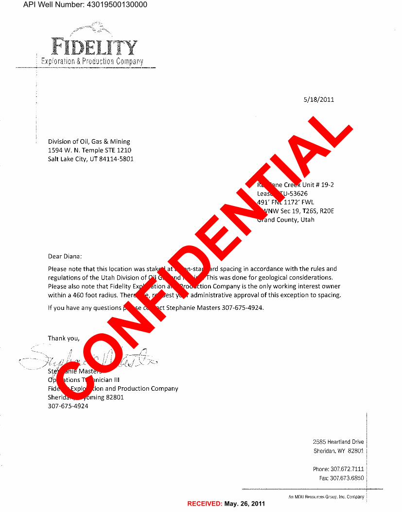
5/18/2011
Division of Oil, Gas & Mining1594 W. N. Temple STE 1210Salt Lake City, UT84114-5801
RE:Cane Creek Unit #19-2Lease UTU-53626
491' FNL1172' FWLNWNW Sec 19, T265, R20EGrand County, Utah
Dear Diana:
Please note that this location was staked at a non-standard spacing in accordance with the rules andregulations of the Utah Division of Oil Gas and Mining. This was done for geological considerations.Please also note that Fidelity Exploration and Production Company is the only working interest ownerwithin a 460 foot radius. Therefore, request your administrative approval of this exception to spacing,
If you have any questions please contact Stephanie Masters 307-675-4924.
Thank you,
Ste'phanie MastersO'perations Technician IllFidelity Exploration and Production CompanySheridan, Wyoming 82801307-675-4924
2585 Heartland DriveSheridan, WY 82801
Phone: 307.672.7111Fax:307.673.6850
An MDUResources Group, Inc.

API Well Number: 43019500130000
I FIDELITY EXPLR & PROD. CO F'ÏGURE #iLOCATIONLAYOUT FOR
CANECREEK UNIT #19-2SECTFON 19. T26S, R20E, S.L.B.&M.
491' FNL 1172' FWL //
SCALE: 1" - 50'DATE: 11-02-07
Drawn By S.L.
7.1'. 6004
170 Sta. 5¥006
E-0.1' E-3.2' Round CornersE/. 6017.4' EL 6006.7 as Needed
Approx.Toe ofFin Slope
NOTEF/are Pit is tobe located a min.of 100' from theWell Head
P2PETUBS
PE RACKSC-0.6' o
6012.1' i i
C1 '
70' 20¢ Sta. 2+75
F-2. 7C-11.1 C-1.O'- il Et sooa4'(Sim. Pif) - EL 60125uoHT PLANT
RESEPH P/75BGLER(10' Deep)
WATER
HOUSE TANK
Tote eu capocuyWy of Freeboant- 2 150 Bus ±rota RM Votume
El 60
E SH
ApproxTop ofCut Slope
PROPANEC-8.J'
C¯¯¯)8 6017-8' Sta. 0+00 l
II ||| lillllltiC-6.7'El. 6018.2' C-13
E7. 6014.8'
opdosed Access
NOTES:Elev. Ungraded Ground Al Loc. Stoke = §Qf j S'
UINTAH ENGINEERING & LAND SURVEYINGF/N/SHED GRADE ELEV A7 LOC. STAxe - 6011.5 es s.. zoo z..s - r.r==l.ut.« awara• rass>

API Well Number: 43019500130000
FIDELITY EXPLR & PROD. CO. FIGURE #2TYPICAL CROSS SECT10NSFORX-Section
scale CANECREEK UNIT #19-2SECTLON19. T26S, R20E, S,L.B,&M.
Y = 50' 491' FNL 1172' FWLDATE: 11-02-07 tilig
Drawn By S.L.
170 200Preconstructi
Fm/shed Grade
STA 5+00
100 200
10 100 70 200
I ---
-------____ CUTI
cur STA 1+25
'000 200'
ilemiminiellaisimiimisiimisiisiassiiraisiin
STA 0+00
NOTE:Topsoil should not beStripped Below FinishedGrade on Substructure Arec
* NOTOF/LL QUAN177YINCLUDES5X FOR COMPAC7/ON
APPROXIMATE YARDAGESCUT(6") Topsoil Stripping = 1500 Cu. Yds. EXCESS MATERIAL = 8,JJO Cu. Yds,Remaining Location = 12,520 Cu. Yds. Topscil & Pit Beckfill - 6,270 Co. Yds.
(1/2 Pit VoL)TOTAL CUT = 16,020 CU.YDS EXCESS UNBALANCE = 2,060 Co. Yds.FILL = 7690 CU.YDS. (After Interim Rehabilltatîon)
UINTAH ENCINEERING & LAND SURVEYlNGas sa zoo noe - vemeu, Utaa store * (485)

ª
ª
ª
ª
Nª'
N
'
N
N
N
N!
!Cane Creek Unit #13-1 4301950014
Cane Creek Unit 19-2 4301950013
Cane Creek Unit #18-1 4301950012
CANE CREEK U 19-2 4301931590
CANE CREEK U 13-1 4301931588
CANE CREEK U 20-1 4301931587
CANE CREEK U 18-1 4301931585
CANE CREEK 24-1 4301931447
CANE CREEK 30-1 4301931365
KANE SPRINGS FED 19-1A 4301931324
KANE SPRINGS 19-1 4301931319
DEAD HORSE FED 20-1 4301931062
KING OIL COMPANY 1 RUBY 4301920409
BIG FLAT UNIT 3 4301915778
BIG FLAT UNIT 3 4301911579
HOBSON USA 1 4301911336
P A R K R O A D F I E L DP A R K R O A D F I E L D
B I G F L A T F I E L DB I G F L A T F I E L D
C A N E C R E E K U N I TC A N E C R E E K U N I T
19
18
24
13 17
20
3025
7
23
29
14
812
26
11
T 26 S R 20 E
T 26 S R 19 E
Map Produced by Diana MasonMap Prepared:
Well Name: Cane Creek Unit 19-2API Number: 4301950013
Township T2.6 . Section 19Range R2.0 .Meridian: SLBM
F1,600 0 1,600800 Feet
1:15,781
UnitsSTATUS
ACTIVE
EXPLORATORY
GAS STORAGE
NF PP OIL
NF SECONDARY
PI OIL
PP GAS
PP GEOTHERML
PP OIL
SECONDARY
TERMINATED
FieldsSTATUS
Unknown
ABANDONED
ACTIVE
COMBINED
INACTIVE
STORAGE
TERMINATED
Sections
Township
Wells QueryStatus
APD - Aproved Permit
H DRL - Spuded (Drilling Commenced)
4 GIW - Gas Injection
!* GS - Gas Storage
N LA - Location Abandoned
! LOC - New Location
7 OPS - Operation Suspended
ª PA - Plugged Abandoned
* PGW - Producing Gas Well
' POW - Producing Oil Well
O RET - Returned APD
¸ SGW - Shut-in Gas Well
· SOW - Shut-in Oil Well
6 TA - Temp. Abandoned
" TW - Test Well
¸ WDW - Water Disposal
¸ WIW - Water Injection Well
=* WSW - Water Supply Well
Tooele
Millard
Iron
San Juan
Kane
Juab
Uintah
Box Elder
Emery
Garfield
Grand
Utah
Beaver Wayne
Duchesne
Sevier
Summit
Rich
Washington
Carbon
Sanpete
Cache
Piute
Davis
Wasatch
Weber
DaggettSalt Lake
Morgan
Location Map
Operator: FIDELITY E&P COMPANY
API Well Number: 43019500130000
*KING 01 COMPANY 1 RUBY430192 09 12 API Number: 4301950013
11 BIG FLAT UNIT 34301911579 Well Name: Cane Creek Unit 19-2
Cane Creek Unit#18-1 Township T2.6 . Range R2.0 . Section 194301950012 Meridian: SLBM
CANE 8E5EKU18 Operator: FIDELITY E&P COMPANY
Map Prepared:Map Produced by Diana Mason
Cane Creek Unit#13-14301950014 units weilscuery
CANE CREEK U 13-1 ST^
NFPPaiL as GasstoragNF sEcaNDARY
PPGAs e Lac-NewLocatio
PPGEaTHERr1L
BI FLAT FIELD sso 6^63,6 6
sEcaNDARY u Pow-Producingcasweii
TERrviiNATEDPow-Producingaliweii
FieldsRET-ReturnedAPD
STAlus - - sow-shutincasweii
unknown saw-shutin oliweii
BANoaNED TA Ternp Abando
c NED ta s a
Cane Creek Unit 19-2
BIG FLAT NIT 3 CANE CREEK 24-1 4301950013 veo
43019157 8 4301931447 NANE CREEK U 19-24301931590
CANE CREEK UNIT
BoxElderCacheRich
Location MapWeb
avis or
Sum Da
23 24 19 P A RK RO A D F I ELD 20 alt La
satc Duchesne
CANE CREEK U 20-1Utah Uintah
4301931587 Juab Carbon
SanpeteMillard Emery Grand
1E S1PRINGS FED 19-1ADEAD HORSE FED 20-1
PutSevier
Wayne4301931062
KANESPRINGS19-14301931319
iron Garfeld
CANE CREEK 30-1
Washington Kane
San Juan
4301931385HOBSONUSA14301911336
26 25 30 29 N1600 800 0 1,600Feet

United States Department of the Interior BUREAU OF LAND MANAGEMENT Utah State Office P.O. Box 45155 Salt Lake City, Utah 84145-0155 IN REPLY REFER TO: 3160 (UT-922) May 20, 2011 Memorandum To: Assistant Field Office Manager Resources, Moab District From: Michael Coulthard, Petroleum Engineer Subject: 2011 Plan of Development Cane Creek Unit,
Grand and San Juan Counties, Utah. Pursuant to email between Diana Whitney, Division of Oil, Gas and Mining, and Mickey Coulthard, Utah State Office, Bureau of Land Management, the following wells are planned for calendar year 2011 within the Cane Creek Unit, Grand and San Juan Counties, Utah. API # WELL NAME LOCATION (Proposed PZ Cane Creek Shale) 43-019-50013 Cane Creek Unit 19-2 Sec 19 T26S R20E 0491 FNL 1172 FWL 43-019-50014 Cane Creek Unit 13-1 Sec 13 T26S R19E 2071 FNL 0880 FEL These wells are currently pending approval by the BLM. The wells are currently being permitted under API number 43-019-31590 and 43-019-31588 (please refer to the 2008 Plan of Development for more details). This office has no objection to permitting the well at this time. bcc: File – Cane Creek Unit Division of Oil Gas and Mining Central Files Agr. Sec. Chron Fluid Chron MCoulthard:mc:5-20-11
Division of Oil Gas and Mining
Michael L. CoulthardDigitally signed by Michael L. Coulthard DN: cn=Michael L. Coulthard, o=Bureau of Land Management, ou=Branch of Minerals, [email protected], c=US Date: 2011.05.20 14:41:57 -06'00'
API Well Number: 43019500130000
United States Department of the Interior
BUREAU OF LAND MANAGEMENTUtah State Office
P.O. Box 45155Salt Lake City, Utah 84145-0155
IN FŒPLY FŒFER TO:3160(UT-922)
May 20, 2011
Memorandum
To: Assistant Field Office Manager Resources, Moab District
From: Michael Coulthard, Petroleum Engineer
Subject: 2011 Plan of Development Cane Creek Unit,Grand and San Juan Counties, Utah.
Pursuant to email between Diana Whitney, Division of Oil, Gas andMining, and Mickey Coulthard, Utah State Office, Bureau of LandManagement, the following wells are planned for calendar year2011 within the Cane Creek Unit, Grand and San Juan Counties,Utah.
API# WELLNAME LOCATION
(Proposed PZ Cane Creek Shale)
43-019-50013 Cane Creek Unit 19-2 Sec 19 T26S R20E 0491 FNL 1172 FWL43-019-50014 Cane Creek Unit 13-1 Sec 13 T26S R19E 2071 FNL 0880 FEL
These wells are currently pending approval by the BLM. The wellsare currently being permitted under API number 43-019-31590 and43-019-31588 (please refer to the 2008 Plan of Development formore details).
This office has no objection to permitting the well at this time.
DigitallysignedbyMichaelLCoulthard
h | IthdMi Lae OU af DN:cn=MichaelLCoulthard,o=BureauofLandManagement,C .ou=BranchofMinerals,[email protected],c=USDate:2011.05.2014:41:57-0600
bcc: File - Cane Creek UnitDivision of Oil Gas and MiningCentral FilesAgr. Sec. ChronFluid Chron

WORKSHEETAPPLICATION FOR PERMIT TO DRILL
APD RECEIVED: 5/17/2011 API NO. ASSIGNED: 43019500130000
WELL NAME: Cane Creek Unit 19-2
OPERATOR: FIDELITY E&P COMPANY (N3155) PHONE NUMBER: 307 675-4924
CONTACT: Stephanie Masters
PROPOSED LOCATION: NWNW 19 260S 200E Permit Tech Review:
SURFACE: 0491 FNL 1172 FWL Engineering Review:
BOTTOM: 0491 FNL 1172 FWL Geology Review:
COUNTY: GRAND
LATITUDE: 38.53275 LONGITUDE: -109.75932
UTM SURF EASTINGS: 608140.00 NORTHINGS: 4265449.00
FIELD NAME: UNDESIGNATED
LEASE TYPE: 1 - Federal
LEASE NUMBER: UTU53626 PROPOSED PRODUCING FORMATION(S): CANE CREEK
SURFACE OWNER: 1 - Federal COALBED METHANE: NO
RECEIVED AND/OR REVIEWED: LOCATION AND SITING:
PLAT R649-2-3.
Bond: FEDERAL - CO1395 Unit: CANE CREEK
Potash R649-3-2. General
Oil Shale 190-5
Oil Shale 190-3 R649-3-3. Exception
Oil Shale 190-13 Drilling Unit
Water Permit: Municipal Board Cause No: R649-3-3
RDCC Review: Effective Date:
Fee Surface Agreement Siting:
Intent to Commingle R649-3-11. Directional Drill
Commingling Approved
Comments: Presite Completed
Stipulations: 1 - Exception Location - bhill 4 - Federal Approval - dmason 23 - Spacing - dmason
API Well Number: 43019500130000
WORKSHEETAPPLICATION FOR PERMIT TO DRILL
I
I
APD RECEIVED: 5/17/2011 API NO. ASSIGNED: 43019500130000
WELL NAME: Cane Creek Unit 19-2
OPERATOR: FIDELITY E&P COMPANY (N3155) PHONE NUMBER: 307 675-4924
CONTACT: Stephanie Masters
PROPOSED LOCATION: NWNW 19 260S 200E Permit Tech Review:
SURFACE: 0491 FNL 1172 FWL Engineering Review:
BOTTOM: 0491 FNL 1172 FWL Geology Review:
COUNTY: GRAND
LATITUDE: 38.53275 LONGITUDE: -109.75932
UTM SURF EASTINGS: 608140.00 NORTHINGS: 4265449.00
FIELD NAME: UNDESIGNATED
LEASE TYPE: 1 - Federal
LEASE NUMBER: UTU53626 PROPOSED PRODUCING FORMATION(S): CANE CREEK
SURFACE OWNER: 1 - Federal COALBED METHANE: NO
I
RECEIVED AND/OR REVIEWED: LOCATION AND SITING:
PLAT R649-2-3.
Bond: FEDERAL - CO1395 Unit: CANE CREEK
Potash R649-3-2. General
Oil Shale 190-5
Oil Shale 190-3 R649-3-3. Exception
Oil Shale 190-13 Drilling Unit
Water Permit: Municipal Board Cause No: R649-3-3
RDCC Review: Effective Date:
Fee Surface Agreement Siting:
Intent to Commingle R649-3-11. Directional Drill
Commingling Approved
I
Comments: Presite Completed
Stipulations: 1 - Exception Location - bhill4 - Federal Approval - dmason23 - Spacing -

Permit To Drill
******************Well Name: Cane Creek Unit 19-2
API Well Number: 43019500130000
Lease Number: UTU53626
Surface Owner: FEDERAL
Approval Date: 5/26/2011
Issued to:FIDELITY E&P COMPANY, 2585 Heartland Drive, Sheridan, WY 82801
Authority:Pursuant to Utah Code Ann. §40-6-1 et seq., and Utah Administrative Code R649-3-1 et seq., theUtah Division of Oil, Gas and Mining issues conditions of approval, and permit to drill the listedwell. This permit is issued in accordance with the requirements of R649-3-3. The expected producingformation or pool is the CANE CREEK Formation(s), completion into any other zones will requirefiling a Sundry Notice (Form 9). Completion and commingling of more than one pool will requireapproval in accordance with R649-3-22.
Duration:This approval shall expire one year from the above date unless substantial and continuous operationis underway, or a request for extension is made prior to the expiration date
Exception Location:Appropriate information has been submitted to DOGM and administrative approval of the requestedexception location is hereby granted.
General:Compliance with the requirements of Utah Admin. R. 649-1 et seq., the Oil and Gas ConservationGeneral Rules, and the applicable terms and provisions of the approved Application for permit to drill.
Conditions of Approval:State approval of this well does not supercede the required federal approval, which must be obtainedprior to drilling.
This proposed well is located in an area for which drilling units (well spacing patterns) have not beenestablished through an order of the Board of Oil, Gas and Mining (the “Board”). In order to avoid thepossibility of waste or injury to correlative rights, the operator is requested, once the well has beendrilled, completed, and has produced, to analyze geological and engineering data generatedtherefrom, as well as any similar data from surrounding areas if available. As soon as is practicableafter completion of its analysis, and if the analysis suggests an area larger than the quarter-quartersection upon which the well is located is being drained, the operator is requested to seek anappropriate order from the Board establishing drilling and spacing units in conformance with suchanalysis by filing a Request for Agency Action with the Board.
API Well No: 43019500130000API Well No: 43019500130000
State of UtahDEPARTMENT OF NATURAL RESOURCES
-/ MICHAEL R. STYLER
GAR . H BE RTExoutim Drotor
comrmr Division of Oil, Gas and MiningGREGORY S. BELL JOHN R. BAZALieuterant Gowrær Busion Director
Permit To Drillkkkkkkkkkkkkkkkkkk
Well Name: Cane Creek Unit 19-2API Well Number: 43019500130000
Lease Number: UTU53626Surface Owner: FEDERALApproval Date: 5/26/2011
Issued to:FIDELITY E&P COMPANY, 2585 Heartland Drive, Sheridan, WY 82801
Authority:Pursuant to Utah Code Ann. §40-6-1et seq., and Utah Administrative Code R649-3-1 et seq., theUtah Division of Oil, Gas and Mining issues conditions of approval, and permit to drill the listedwell. This permit is issued in accordance with the requirements of R649-3-3. The expected producingformation or pool is the CANE CREEK Formation(s), completion into any other zones will requirefiling a Sundry Notice (Form 9). Completion and commingling of more than one pool will requireapproval in accordance with R649-3-22.
Duration:This approval shall expire one year from the above date unless substantial and continuous operationis underway, or a request for extension is made prior to the expiration date
Exception Location:Appropriate information has been submitted to DOGM and administrative approval of the requestedexception location is hereby granted.
General:Compliance with the requirements of Utah Admin. R. 649-1 et seq., the Oil and Gas ConservationGeneral Rules, and the applicable terms and provisions of the approved Application for permit to drill.
Conditions of Approval:State approval of this well does not supercede the required federal approval, which must be obtainedprior to drilling.
This proposed well is located in an area for which drilling units (well spacing patterns) have not beenestablished through an order of the Board of Oil, Gas and Mining (the "Board"). In order to avoid thepossibility of waste or injury to correlative rights, the operator is requested, once the well has beendrilled, completed, and has produced, to analyze geological and engineering data generatedtherefrom, as well as any similar data from surrounding areas if available. As soon as is practicableafter completion of its analysis, and if the analysis suggests an area larger than the quarter-quartersection upon which the well is located is being drained, the operator is requested to seek anappropriate order from the Board establishing drilling and spacing units in conformance with suchanalysis by filing a Request for Agency Action with the

Notification Requirements:The operator is required to notify the Division of Oil, Gas and Mining of the following actions duringdrilling of this well: • Within 24 hours following the spudding of the well – contact Carol Daniels at 801-538-5284 (please leave a voicemail message if not available) OR submit an electronic sundry notice (pre-registration required) via the Utah Oil & Gas website at http://oilgas.ogm.utah.gov
Reporting Requirements:All reports, forms and submittals as required by the Utah Oil and Gas Conservation General Ruleswill be promptly filed with the Division of Oil, Gas and Mining, including but not limited to: • Entity Action Form (Form 6) – due within 5 days of spudding the well • Monthly Status Report (Form 9) – due by 5th day of the following calendar month • Requests to Change Plans (Form 9) – due prior to implementation • Written Notice of Emergency Changes (Form 9) – due within 5 days • Notice of Operations Suspension or Resumption (Form 9) – due prior to implementation • Report of Water Encountered (Form 7) – due within 30 days after completion • Well Completion Report (Form 8) – due within 30 days after completion or plugging
Approved By:
For John RogersAssociate Director, Oil & Gas
API Well No: 43019500130000API Well No: 43019500130000
Notification Requirements:The operator is required to notify the Division of Oil, Gas and Mining of the following actions duringdrilling of this well:
• Within 24 hours following the spudding of the well- contact Carol Daniels at 801-538-5284(please leave a voicemail message if not available)ORsubmit an electronic sundry notice (pre-registration required) via the Utah Oil & Gas websiteat http://oilgas.ogm.utah.gov
Reporting Requirements:All reports, forms and submittals as required by the Utah Oil and Gas Conservation General Ruleswill be promptly filed with the Division of Oil, Gas and Mining, including but not limited to:
• Entity Action Form (Form 6) - due within 5 days of spudding the well• Monthly Status Report (Form 9) - due by 5th day of the following calendar month• Requests to Change Plans (Form 9) - due prior to implementation• Written Notice of Emergency Changes (Form 9) - due within 5 days• Notice of Operations Suspension or Resumption (Form 9) - due prior to implementation• Report of Water Encountered (Form 7) - due within 30 days after completion• Well Completion Report (Form 8) - due within 30 days after completion or plugging
Approved By:
For John RogersAssociate Director, Oil &

State of Utah, DEPARTMENT OF NATURAL RESOURCES
MICHAEL R. STYLERGARY R. IfERBERT Executive Director
Govereur Division of Oil, Gas and MiningGREG BELL JOHN R. BAZA
Lieutenant Governor Division Director
July 27, 2012
Fidelity E&P Company2585 Heartland DriveSheridan, WY 82801
Re: APD Rescinded - Cane Creek U 19-2, Sec. 19, T. 26S, R. 20E,Grand County, Utah API No. 43-019-50013
Ladies and Gentlemen:
The Application for Permit to Drill (APD) for the subject well wasapproved by the Division of Oil, Gas and Mining (Division) on May 26, 2011. Nodrilling activity at this location has been reported to the division. Therefore,approval to drill the well is hereby rescinded, effective July 27, 2012.
A new APD must be filed with this office for approval prior to thecommencement of any future work on the subject location.
If any previously unreported operations have been performed on this welllocation, it is imperative that you notify the Division immediately.
Sincerely,
Di na MasonEnvironmental Scientist
ec: Well FileBureau of Land Management, Moab
U FAH
DNR
1594 West North Temple, Suite 1210, PO Box 145801, Salt Lake City, UT 84114-5801telephone (801) 538-5340 • facsimile (801) 359-3940 • TTY (801) 538-7458 . www.ogm.utah.gov en r as a