Embed Size (px)
Citation preview

STATE OF UTAHDEPARTMENT OF NATURAL RESOURCES
DIVISION OF OIL, GAS AND MINING
APPLICATION FOR PERMIT TO DRILL 1. WELL NAME and NUMBER
Tidewater State 2-12-2219
2. TYPE OF WORK
DRILL NEW WELL REENTER P&A WELL DEEPEN WELL 3. FIELD OR WILDCAT
WILDCAT
4. TYPE OF WELLOil Well Coalbed Methane Well: NO
5. UNIT or COMMUNITIZATION AGREEMENT NAME
6. NAME OF OPERATORTIDEWATER OIL & GAS COMPANY, LLC
7. OPERATOR PHONE303 468-0656 201
8. ADDRESS OF OPERATOR110 16th St Ste 1220, Denver, CO, 80202
9. OPERATOR [email protected]
10. MINERAL LEASE NUMBER(FEDERAL, INDIAN, OR STATE)
ML-51885 OBA
11. MINERAL OWNERSHIP
FEDERAL INDIAN STATE FEE 12. SURFACE OWNERSHIP
FEDERAL INDIAN STATE FEE
13. NAME OF SURFACE OWNER (if box 12 = 'fee')
14. SURFACE OWNER PHONE (if box 12 = 'fee')
15. ADDRESS OF SURFACE OWNER (if box 12 = 'fee')
16. SURFACE OWNER E-MAIL (if box 12 = 'fee')
17. INDIAN ALLOTTEE OR TRIBE NAME(if box 12 = 'INDIAN')
18. INTEND TO COMMINGLE PRODUCTION FROMMULTIPLE FORMATIONS
YES (Submit Commingling Application) NO
19. SLANT
VERTICAL DIRECTIONAL HORIZONTAL
20. LOCATION OF WELL FOOTAGES QTR-QTR SECTION TOWNSHIP RANGE MERIDIAN
LOCATION AT SURFACE 2465 FNL 710 FWL SWNW 2 22.0 S 19.0 E S
Top of Uppermost Producing Zone 2465 FNL 710 FWL SWNW 2 22.0 S 19.0 E S
At Total Depth 2465 FNL 710 FWL SWNW 2 22.0 S 19.0 E S
21. COUNTYGRAND
22. DISTANCE TO NEAREST LEASE LINE (Feet)710
23. NUMBER OF ACRES IN DRILLING UNIT40
25. DISTANCE TO NEAREST WELL IN SAME POOL(Applied For Drilling or Completed)
6000
26. PROPOSED DEPTHMD: 7900 TVD: 7900
27. ELEVATION - GROUND LEVEL
4799
28. BOND NUMBER
394312648337
29. SOURCE OF DRILLING WATER /WATER RIGHTS APPROVAL NUMBER IF APPLICABLE
Dalbo, Inc.
Hole, Casing, and Cement Information
String Hole Size Casing Size Length Weight Grade & Thread Max Mud Wt. Cement Sacks Yield Weight
Surf 12.25 8.625 0 - 790 24.0 J-55 ST&C 9.3 Rockies Lite 100 2.08 12.8
Premium Plus 100 1.17 15.8
Prod 7.875 5.5 0 - 7900 17.0 N-80 LT&C 9.5 Rockies Lite 308 2.08 12.8
Premium Plus 75 1.17 15.8
Rockies Lite 269 2.08 12.8
Premium Plus 75 1.17 15.8
ATTACHMENTS
VERIFY THE FOLLOWING ARE ATTACHED IN ACCORDANCE WITH THE UTAH OIL AND GAS CONSERVATION GENERAL RULES
WELL PLAT OR MAP PREPARED BY LICENSED SURVEYOR OR ENGINEER COMPLETE DRILLING PLAN
AFFIDAVIT OF STATUS OF SURFACE OWNER AGREEMENT (IF FEE SURFACE) FORM 5. IF OPERATOR IS OTHER THAN THE LEASE OWNER
DIRECTIONAL SURVEY PLAN (IF DIRECTIONALLY OR HORIZONTALLY
DRILLED)
TOPOGRAPHICAL MAP
NAME Walter Lowry TITLE Engineer PHONE 303 884-5505
SIGNATURE DATE 12/10/2009 EMAIL [email protected]
API NUMBER ASSIGNED
43019500080000
Permit Manager
APPROVAL
FORM 3
AMENDED REPORT
API Well Number: 43019500080000
FORM 3STATE OF UTAH
DEPARTMENT OF NATURAL RESOURCES AMENDED REPORTDIVISION OF OIL, GAS AND MINING
APPLICATION FOR PERMIT TO DRILL 1. WELL NAME NaUeMBSEaRe2-12-2219
2. TYPE OF WORK 3. FIELD OR WILDCATDRILL NEW WELL I REENTER P&A WELL DEEPEN WELL I WILDCAT
4. TYPE OF WELL 5. UNIT or COMMUNITIZATION AGREEMENT NAMEOil Well Coalbed Methane Well: NO
6. NAME OF OPERATOR 7. OPERATOR PHONETIDEWATER OIL & GAS COMPANY, LLC 303 468-0656 201
8. ADDRESS OF OPERATOR 9. OPERATOR E-MAIL110 16th St Ste 1220, Denver, CO, 80202 [email protected]
10. MINERAL LEASE NUMBER 11. MINERAL OWNERSHIP 12. SURFACE OWNERSHIP(FEDERAL,INDIAN,OMRL-S51ASOBA
FEDERAL I INDIAN I STATE FEE FEDERAL INDIAN STATEI FEEl
13. NAME OF SURFACE OWNER (if box 12 = 'fee') 14. SURFACE OWNER PHONE (if box 12 = 'fee')
15. ADDRESS OF SURFACE OWNER (if box 12 = 'fee') 16. SURFACE OWNER E-MAIL (if box 12 = 'fee')
17. INDIAN ALLOTTEE OR TRIBE NAME 18. INTEND TO COMMINGLE PRODUCTION FROM 19. SLANT
(if box 12 = 'INDIAN') MULTIPLE FORMATIONS
YES (Submit Commingling Application) NO VERTICAL DIRECTIONAL HORIZONTAL I
20. LOCATION OF WELL FOOTAGES QTR-QTR SECTION TOWNSHIP RANGE MERIDIAN
LOCATION AT SURFACE 2465 FNL 710 FWL SWNW 2 22.0 S 19.0 E S
Top of Uppermost Producing Zone 2465 FNL 710 FWL SWNW 2 22.0 S 19.0 E S
At Total Depth 2465 FNL 710 FWL SWNW 2 22.0 S 19.0 E S
21. COUNTY 22. DISTANCE TO NEAREST LEASE LINE (Feet) 23. NUMBER OF ACRES IN DRILLING UNITGRAND 710 40
25. DISTANCE TO NEAREST WELL IN SAME POOL 26. PROPOSED DEPTH(Applied For Drilling or Completed) MD: 7900 TVD: 7900
6000
27. ELEVATION - GROUND LEVEL 28. BOND NUMBER 29. SOURCE OF DRILLING WATER /WATER RIGHTS APPROVAL NUMBER IF APPLICABLE
4799 394312648337 Dalbo, Inc.
Hole, Casing, and Cement Information
String Hole Size Casing Size Length Weight Grade & Thread Max Mud Wt. Cement Sacks Yield Weight
Surf 12.25 8.625 0 - 790 24.0 J-55 ST&C 9.3 Rockies Lite 100 2.08 12.8
Premium Plus 100 1.17 15.8
Prod 7.875 5.5 0 - 7900 17.0 N-80 LT&C 9.5 Rockies Lite 308 2.08 12.8
Premium Plus 75 1.17 15.8
Rockies Lite 269 2.08 12.8
Premium Plus 75 1.17 15.8
ATTACHMENTS
VERIFY THE FOLLOWING ARE ATTACHED IN ACCORDANCE WITH THE UTAH OIL AND GAS CONSERVATION GENERAL RULES
WELL PLAT OR MAP PREPARED BY LICENSED SURVEYOR OR ENGINEER COMPLETE DRILLING PLAN
AFFIDAVIT OF STATUS OF SURFACE OWNER AGREEMENT (IF FEE SURFACE) FORM 5. IF OPERATOR IS OTHER THAN THE LEASE OWNER
DIRECTIONAL SURVEY PLAN (IF DIRECTIONALLY OR HORIZONTALLY TOPOGRAPHICAL MAPDRILLED)
NAME Walter Lowry TITLE Engineer PHONE 303 884-5505
SIGNATURE DATE 12/10/2009 EMAIL [email protected]
API NUMBER ASSIGNED APPROVAL43019500080000
Permit
API Well Number: 43019500080000
FORM 3STATE OF UTAH
DEPARTMENT OF NATURAL RESOURCES AMENDED REPORTDIVISION OF OIL, GAS AND MINING
APPLICATION FOR PERMIT TO DRILL 1. WELL NAME a NaUeMBSEaRe2-12-2219
2. TYPE OF WORK
DRILL NEW WELLI REENTER P&A WELL DEEPEN WELL I3. FIELD OR WILDCATWILDCAT
4. TYPE OF WELL 5. UNIT or COMMUNITIZATION AGREEMENT NAMEOil Well Coalbed Methane Well: NO
6. NAME OF OPERATOR 7. OPERATOR PHONETIDEWATER OIL & GAS COMPANY, LLC 303 468-0656 201
8. ADDRESS OF OPERATOR 9. OPERATOR E-MAIL110 16th St Ste 1220, Denver, CO, 80202 [email protected]
10. MINERAL LEASE NUMBER 11. MINERAL OWNERSHIP 12. SURFACE OWNERSHIP(FEDERAL,INDIAN,OMRL-S51A8OBA FEDERAL I INDIAN I STATE FEE FEDERAL INDIAN STATEI FEEl
13. NAME OF SURFACE OWNER (if box 12 = 'fee') 14. SURFACE OWNER PHONE (if box 12 = 'fee')
15. ADDRESS OF SURFACE OWNER (if box 12 = 'fee') 16. SURFACE OWNER E-MAIL (if box 12 = 'fee')
17. INDIAN ALLOTTEE OR TRIBE NAME 18. INTEND TO COMMINGLE PRODUCTION FROM 19. SLANT
(if box 12 = 'INDIAN')MULTIPLE FORMATIONS
YES (Submit Commingling Application) NO VERTICAL DIRECTIONAL HORIZONTAL I
20. LOCATION OF WELL FOOTAGES QTR-QTR SECTION TOWNSHIP RANGE MERIDIAN
LOCATION AT SURFACE 2465 FNL 710 FWL SWNW 2 22.0 S 19.0 E S
Top of Uppermost Producing Zone 2465 FNL 710 FWL SWNW 2 22.0 S 19.0 E S
At Total Depth 2465 FNL 710 FWL SWNW 2 22.0 S 19.0 E S
21. COUNTY 22. DISTANCE TO NEAREST LEASE LINE (Feet) 23. NUMBER OF ACRES IN DRILLING UNITGRAND 710 40
25. DISTANCE TO NEAREST WELL IN SAME POOL 26. PROPOSED DEPTH(Applied For Drilling or Completed) MD: 7900 TVD: 79006000
27. ELEVATION - GROUND LEVEL 28. BOND NUMBER 29. SOURCE OF DRILLING WATER /WATER RIGHTS APPROVAL NUMBER IF APPLICABLE
4799 394312648337 Dalbo, Inc.
Hole, Casing, and Cement Information
String Hole Size Casing Size Length Weight Grade & Thread Max Mud Wt. Cement Sacks Yield Weight
Surf 12.25 8.625 0 - 790 24.0 J-55 ST&C 9.3 Rockies Lite 100 2.08 12.8
Premium Plus 100 1.17 15.8
Prod 7.875 5.5 0 - 7900 17.0 N-80 LT&C 9.5 Rockies Lite 308 2.08 12.8
Premium Plus 75 1.17 15.8
Rockies Lite 269 2.08 12.8
Premium Plus 75 1.17 15.8
ATTACHMENTS
VERIFY THE FOLLOWING ARE ATTACHED IN ACCORDANCE WITH THE UTAH OIL AND GAS CONSERVATION GENERAL RULES
WELL PLAT OR MAP PREPARED BY LICENSED SURVEYOR OR ENGINEER COMPLETE DRILLING PLAN
AFFIDAVIT OF STATUS OF SURFACE OWNER AGREEMENT (IF FEE SURFACE) FORM 5. IF OPERATOR IS OTHER THAN THE LEASE OWNER
DIRECTIONAL SURVEY PLAN (IF DIRECTIONALLY OR HORIZONTALLY TOPOGRAPHICAL MAP
DRILLED)
NAME Walter Lowry TITLE Engineer PHONE 303 884-5505
SIGNATURE DATE 12/10/2009 EMAIL [email protected]
API NUMBER ASSIGNED APPROVAL
43019500080000
Permit
API Well Number: 43019500080000
FORM 3STATE OF UTAH
DEPARTMENT OF NATURAL RESOURCES AMENDED REPORTDIVISION OF OIL, GAS AND MINING
APPLICATION FOR PERMIT TO DRILL 1. WELL NAME NaUeMBSEaRe2-12-2219
2. TYPE OF WORK 3. FIELD OR WILDCATDRILL NEW WELL I REENTER P&A WELL DEEPEN WELL I WILDCAT
4. TYPE OF WELL 5. UNIT or COMMUNITIZATION AGREEMENT NAMEOil Well Coalbed Methane Well: NO
6. NAME OF OPERATOR 7. OPERATOR PHONETIDEWATER OIL & GAS COMPANY, LLC 303 468-0656 201
8. ADDRESS OF OPERATOR 9. OPERATOR E-MAIL110 16th St Ste 1220, Denver, CO, 80202 [email protected]
10. MINERAL LEASE NUMBER 11. MINERAL OWNERSHIP 12. SURFACE OWNERSHIP(FEDERAL,INDIAN,OMRL-S51ASOBA
FEDERAL I INDIAN I STATE FEE FEDERAL INDIAN STATEI FEEl
13. NAME OF SURFACE OWNER (if box 12 = 'fee') 14. SURFACE OWNER PHONE (if box 12 = 'fee')
15. ADDRESS OF SURFACE OWNER (if box 12 = 'fee') 16. SURFACE OWNER E-MAIL (if box 12 = 'fee')
17. INDIAN ALLOTTEE OR TRIBE NAME 18. INTEND TO COMMINGLE PRODUCTION FROM 19. SLANT
(if box 12 = 'INDIAN') MULTIPLE FORMATIONS
YES (Submit Commingling Application) NO VERTICAL DIRECTIONAL HORIZONTAL I
20. LOCATION OF WELL FOOTAGES QTR-QTR SECTION TOWNSHIP RANGE MERIDIAN
LOCATION AT SURFACE 2465 FNL 710 FWL SWNW 2 22.0 S 19.0 E S
Top of Uppermost Producing Zone 2465 FNL 710 FWL SWNW 2 22.0 S 19.0 E S
At Total Depth 2465 FNL 710 FWL SWNW 2 22.0 S 19.0 E S
21. COUNTY 22. DISTANCE TO NEAREST LEASE LINE (Feet) 23. NUMBER OF ACRES IN DRILLING UNITGRAND 710 40
25. DISTANCE TO NEAREST WELL IN SAME POOL 26. PROPOSED DEPTH(Applied For Drilling or Completed) MD: 7900 TVD: 7900
6000
27. ELEVATION - GROUND LEVEL 28. BOND NUMBER 29. SOURCE OF DRILLING WATER /WATER RIGHTS APPROVAL NUMBER IF APPLICABLE
4799 394312648337 Dalbo, Inc.
Hole, Casing, and Cement Information
String Hole Size Casing Size Length Weight Grade & Thread Max Mud Wt. Cement Sacks Yield Weight
Surf 12.25 8.625 0 - 790 24.0 J-55 ST&C 9.3 Rockies Lite 100 2.08 12.8
Premium Plus 100 1.17 15.8
Prod 7.875 5.5 0 - 7900 17.0 N-80 LT&C 9.5 Rockies Lite 308 2.08 12.8
Premium Plus 75 1.17 15.8
Rockies Lite 269 2.08 12.8
Premium Plus 75 1.17 15.8
ATTACHMENTS
VERIFY THE FOLLOWING ARE ATTACHED IN ACCORDANCE WITH THE UTAH OIL AND GAS CONSERVATION GENERAL RULES
WELL PLAT OR MAP PREPARED BY LICENSED SURVEYOR OR ENGINEER COMPLETE DRILLING PLAN
AFFIDAVIT OF STATUS OF SURFACE OWNER AGREEMENT (IF FEE SURFACE) FORM 5. IF OPERATOR IS OTHER THAN THE LEASE OWNER
DIRECTIONAL SURVEY PLAN (IF DIRECTIONALLY OR HORIZONTALLY TOPOGRAPHICAL MAPDRILLED)
NAME Walter Lowry TITLE Engineer PHONE 303 884-5505
SIGNATURE DATE 12/10/2009 EMAIL [email protected]
API NUMBER ASSIGNED APPROVAL43019500080000
Permit

TIDEWATER OIL & GAS COMPANY LLC
Application for Permit to Drill- Drilling Plan Page 1 Tidewater State 2-12-2219 rev 3 2465’ FNL & 710’ FWL CONFIDENTIAL TIGHT-HOLE 03 March 2011 SWNW Sec 2-T22S-R19E, Grand County, UT
DRILLING PLAN FOR
TIDEWATER STATE 2-12-2219
Surface Location: 2465’ FNL, 710’ FWL SWNW Section 2-T22S-R19E
Grand County, Utah
Prepared By: Walter Lowry
API Well Number: 43019500080000
TIDEWATER OIL & GAS COMPANY LLC
DRILLING PLANFOR
TIDEWATER STATE 2-12-2219
Surface Location: 2465' FNL, 710' FWLSWNW Section 2-T22S-R19E
Grand County, Utah
Prepared By:Walter Lowry
Application for Permit to Drill-Drilling Plan Page 1Tidewater State 2-12-2219 rev 32465' FNL & 710' FWL CONFIDENTIAL TIGHT-HOLE 03 March 2011SWNW Sec 2-T22S-R19E, Grand County,

TIDEWATER OIL & GAS COMPANY LLC
Application for Permit to Drill- Drilling Plan Page 2 Tidewater State 2-12-2219 rev 3 2465’ FNL & 710’ FWL CONFIDENTIAL TIGHT-HOLE 03 March 2011 SWNW Sec 2-T22S-R19E, Grand County, UT
* The proposed wellsite is located on State Surface & State Minerals
1. ESTIMATED TOPS/ GEOLOGIC MARKERS Formation Tops (est RKB @ 12’): TVD Depth Cretaceous Mancos Shale Surface Dakota Sandstone 790’ Moab Member of Curtis Formation 1680’ Slick Rock Member of Entrada Sandstone 1790’ Carmel 2060’ Navajo 2220’ Kayenta 2840’ Wingate 3120’ Chinle 3600’ White Rim 6490’ Cutler 7100’ Proposed Total Depth 7900’ Permitted Total Depth 7900’
2. ESTIMATED DEPTHS OF ANTICIPATED OIL, GAS & WATER OR OTHER
MINERAL BEARING FORMATIONS All zones listed above have the chance of producing oil, gas, and/or water. No other producible minerals are expected to be encountered in this wellbore.
3. WELL CONTROL EQUIPMENT & TESTING PROCEDURES Tidewater Oil & Gas Company LLC’s minimum specifications for pressure control equipment are as follows:
• Ram Type: 11” 3M BOPE consisting of 2 sets of rams (1 pipe ram and 1 blind ram) and an 11” 3M annular preventer.
• Tidewater will comply with all requirements pertaining to well control as outlined in Rule R649-3-7 of the Utah Division of Oil, Gas & Mining oil & gas regulations.
• Refer to the attached BOPE and choke manifold diagram for more detail.
4. CASING PROGRAM: The proposed casing program is as follows:
Interval Size Hole Size Weight Grade Thread 0-60' 16” 20” 0.25" w.t. H40 PE Welded
60'-790' 8-5/8" 12-1/4” 24.0 #/ft J55 STC 790'-7900' 5-1/2" 7-7/8” 17.0 #/ft N80 LTC
API Well Number: 43019500080000
TIDEWATER OIL & GAS COMPANY LLC* The proposed wellsite is located on State Surface & State Minerals
1. ESTIMATED TOPSI GEOLOGIC MARKERS
Formation Tops (est RKB @ 12'): TVD Depth
Cretaceous Mancos Shale SurfaceDakota Sandstone 790'Moab Member of Curtis Formation 1680'Slick Rock Member of Entrada Sandstone 1790'Carmel 2060'Navajo 2220'Kayenta 2840'Wingate 3120'Chinle 3600'White Rim 6490'Cutler 7100'Proposed Total Depth 7900'Permitted Total Depth 7900'
2. ESTIMATED DEPTHS OF ANTICIPATED OIL, GAS & WATER OR OTHERMINERAL BEARING FORMATIONS
Allzones listed above have the chance of producing oil, gas, and/or water. Noother producible minerals are expected to be encountered in this wellbore.
3. WELL CONTROL EQUIPMENT & TESTING PROCEDURES
Tidewater Oil & Gas Company LLC's minimum specifications for pressure controlequipment are as follows:
• Ram Type: 11" 3M BOPE consisting of 2 sets of rams (1 pipe ram and 1blind ram) and an 11" 3M annular preventer.
• Tidewater will comply with all requirements pertaining to well control asoutlined in Rule R649-3-7 of the Utah Division of Oil, Gas & Mining oil &gas regulations.
• Refer to the attached BOPE and choke manifold diagram for more detail.
4. CASING PROGRAM: The proposed casing program is as follows:
Interval Size Hole Size Weight Grade Thread0-60' 16" 20" 0.25" w.t. H40 PE Welded
60'-790' 8-5/8" 12-1/4" 24.0 #lft J55 STC790'-7900' 5-1/2" 7-7/8" 17.0 #lft N80 LTC
Application for Permit to Drill-Drilling Plan Page 2Tidewater State 2-12-2219 rev 32465' FNL & 710' FWL CONFIDENTIAL TIGHT-HOLE 03 March 2011SWNW Sec 2-T22S-R19E, Grand County,

TIDEWATER OIL & GAS COMPANY LLC
Application for Permit to Drill- Drilling Plan Page 3 Tidewater State 2-12-2219 rev 3 2465’ FNL & 710’ FWL CONFIDENTIAL TIGHT-HOLE 03 March 2011 SWNW Sec 2-T22S-R19E, Grand County, UT
5. CEMENT PROGRAM
Surface Type & Amount
TOC @ Surface Lead: 100 sx Rockies LT + 0.125 lbm/sx Poly-E-Flake, 12.8 ppg, 2.08 ft3/sx (top at surface in gauge hole) Tail: 100 sx Premium Cement (94 lbm/sx) + 2% CaCl2, 15.8 ppg, 1.17 ft3/sx (top at ~490’ in gauge hole)
Production Type & Amount (DV Tool @ ~3700’) 7,900’ – 3,700’ Stage 1: Lead: 308 sx Rockies LT + 0.125 lbm/sx Poly-E-
Flake, 12.8 ppg, 2.08 cf/sx (1700’ fill, top at 3700’ in gauge hole) Tail: 75 sx Premium Cement (94 lbm/sx) + 2% CaCl2, 15.8 ppg, 1.17 lbm/sx (500’ fill, top at 7400’ in gauge hole)
3,700’ – 500’ Stage 2: Lead: 269 sx Rockies LT + 0.125 lbm/sx Poly-E-Flake, 12.8 ppg, 2.08 ft3/sx (3200’ fill, top at 500’- 290’ inside surface casing shoe)
• All volumes are calculated based upon a gauge hole. Actual volumes will
be calculated based upon caliper log plus 20% excess.
6. DRILLING FLUIDS
Interval Fluid Type Mud Wt. Viscosity Fluid Loss pH 0-790’ FW Spud Mud 8.4-9.3 ppg 28-35 sec/qt NC 9.0
790’-3,000’ FW w/ hi-vis sweeps 8.8-9.5 ppg 28-38 sec/qt NC 9.0 3,000’-7,900’ FW LSND 8.8-9.5 ppg 28-38 sec/qt <10 ml/30 min
• The surface hole and the production hole down to a depth of ~3,000’ will be
drilled using fresh water circulated through a lined reserve pit. High viscosity sweeps with FW gel will be circulated as needed for hole cleaning.
• From ~3,000’ to TD of 7,900’, the drilling fluids will be circulated through the steel tanks, with the drill cuttings removed by a shale shaker and deposited in the lined reserve pit.
7. TESTING, LOGGING & CORING
• Tidewater will consider running a bottomhole Drill Stem Test in the White
Rim and/or Cutler Formations if favorable geologic conditions exist. A detailed DST procedure will be prepared and presented to the UDOGM for approval via Sundry Notice if Tidewater elects to run any DSTs.
• Tidewater will consider running sidewall cores, and/or other pressure and fluid sampling tools, if geologic and hole conditions are favorable. A detailed procedure will be prepared and presented to the UDOGM for approval via Sundry Notice if Tidewater elects to run any sidewall cores or other openhole pressure/fluid sampling tools.
API Well Number: 43019500080000
TIDEWATER OIL & GAS COMPANY LLC
5. CEMENT PROGRAM
Surface Type & AmountTOC @Surface Lead: 100 sx Rockies LT + 0.125 lbm/sx Poly-E-Flake, 12.8
ppg, 2.08 ft3/sx (topat surface in gauge hole)Tai_I: 100 sx Premium Cement (94 lbm/sx) + 2% CaCl2, 15.8ppg, 1.17 ft3/sx (topat ~490' in gauge hole)
Production Type & Amount (DV Tool @~3700')
7,900' - 3,700' Stage 1: Lead: 308 sx Rockies LT + 0.125 lbm/sx Poly-E-Flake, 12.8 ppg, 2.08 cf/sx (1700' fill,top at 3700' in gauge hole)Tail: 75 sx Premium Cement (94 lbm/sx) + 2% CaCl2, 15.8 ppg,1.17 lbm/sx (500' fill,top at 7400' in gauge hole)
3,700' - 500' Stage 2: Lead: 269 sx Rockies LT + 0.125 lbm/sx Poly-E-Flake, 12.8 ppg, 2.08 ft3/sx (3200' fill,top at 500'- 290' insidesurface casing shoe)
• All volumes are calculated based upon a gauge hole. Actual volumes willbe calculated based upon caliper log plus 20% excess.
6. DRILLING FLUIDS
Interval Fluid Type Mud Wt. Viscosity Fluid Loss pH0-790' FW Spud Mud 8.4-9.3 ppg 28-35 sec/qt NC 9.0
790'-3,000' FW w/ hi-vis sweeps 8.8-9.5 ppg 28-38 sec/qt NC 9.03,000'-7,900' FW LSND 8.8-9.5 ppg 28-38 sec/qt <10 ml/30 min
• The surface hole and the production hole down to a depth of ~3,000' will bedrilled using fresh water circulated througha lined reserve pit. Highviscosity sweeps with FW gel will be circulated as needed for holecleaning.
• From ~3,000' to TD of 7,900', the drilling fluids will be circulated throughthe steel tanks, with the drill cuttings removed by a shale shaker anddeposited in the lined reserve pit.
7. TESTING, LOGGING & CORING
• Tidewater will consider running a bottomhole DrillStem Test in the WhiteRim and/or Cutler Formations if favorable geologic conditions exist. Adetailed DST procedure will be prepared and presented to the UDOGM forapproval via Sundry Notice ifTidewater elects to run any DSTs.
• Tidewater will consider running sidewall cores, and/or other pressure andfluid sampling tools, if geologic and hole conditions are favorable. Adetailed procedure will be prepared and presented to the UDOGM forapproval via Sundry Notice if Tidewater elects to run any sidewall cores orother openhole pressure/fluid sampling tools.
Application for Permit to Drill-Drilling Plan Page 3Tidewater State 2-12-2219 rev 32465' FNL & 710' FWL CONFIDENTIAL TIGHT-HOLE 03 March 2011SWNW Sec 2-T22S-R19E, Grand County,

TIDEWATER OIL & GAS COMPANY LLC
Application for Permit to Drill- Drilling Plan Page 4 Tidewater State 2-12-2219 rev 3 2465’ FNL & 710’ FWL CONFIDENTIAL TIGHT-HOLE 03 March 2011 SWNW Sec 2-T22S-R19E, Grand County, UT
• No full cores are anticipated at this time. • The production hole will be logged with a neutron/density porosity tool,
gamma-ray, induction log, caliper, and a sonic log from 7,900’ TD to the base of ther surface casing at 790’. The GR tool will be run to surface. Additional logging runs may be considered depending upon geologic conditions, hole conditions, and mud log shows. If such additional logs are run, Tidewater will notify the UDOGM in a timely manner of its intent to do so via Sundry Notice.
8. ANTICIPATED PRESSURES and H2S
• The presence of H2S is not expected in this well. The well is expected to
be subnormally pressured, and the maximum bottomhole pressure is expected to be 0.375 psi per foot, or 2963 psi (7.2 ppg EMW)
9. WATER SOURCE
• Tidewater plans on using Dalbo, Inc. to acquire and haul fresh water for
drilling and completion operations. The water source is expected to be city water from the town of Mack, Colorado. Dalbo’s customer number is R018 and their assigned water filling station is Station #5.
10. OTHER INFORMATION
a. Drilling is expected to commence on or about April 15, 2011. b. It is anticipated the drilling of this well will take approximately 17 days. c. Tidewater plans to line the reserve pit with a typical oilfield pit liner prior to
commencing drilling operations.
d. Subsequent to completion operations the drilling location will be reclaimed and reseeded as required by the UDOGM.
e. Surface ownership is the State of Utah.
API Well Number: 43019500080000
TIDEWATER OIL & GAS COMPANY LLC• No full cores are anticipated at this time.• The production hole will be logged with a neutron/density porosity tool,
gamma-ray, induction log, caliper, and a sonic log from 7,900' TD to thebase of ther surface casing at 790'. The GR toolwill be run to surface.Additional logging runs may be considered depending upon geologicconditions, hole conditions, and mud log shows. If such additional logs arerun, Tidewater will notify the UDOGM in a timelymanner of its intent to doso via Sundry Notice.
8. ANTICIPATED PRESSURES and H2S
• The presence of H2S is not expected in thiswell. The well is expected tobe subnormally pressured, and the maximum bottomhole pressure isexpected to be 0.375 psi per foot, or 2963 psi (7.2 ppg EMW)
9. WATER SOURCE
• Tidewater plans on using Dalbo, Inc. to acquire and haul fresh water fordrilling and completion operations. The water source is expected to be citywater from the townof Mack, Colorado. Dalbo's customer number is RO18and theirassigned water filling station is Station #5.
10. OTHER INFORMATION
a. Drilling is expected to commence on or about April 15, 2011.
b. It is anticipated the drilling of thiswell will take approximately 17 days.
c. Tidewater plans to line the reserve pit with a typicaloilfield pit liner prior tocommencing drilling operations.
d. Subsequent to completion operations the drilling location will be reclaimedand reseeded as required by the UDOGM.
e. Surface ownership is the State of Utah.
Application for Permit to Drill-Drilling Plan Page 4Tidewater State 2-12-2219 rev 32465' FNL & 710' FWL CONFIDENTIAL TIGHT-HOLE 03 March 2011SWNW Sec 2-T22S-R19E, Grand County,

TIDEWATER OIL & GAS LLCT22S, Ri9E, S.L.B.&M.1979 aross cop, Well location, TIDEWATERSTATE #2-12-2219, -o
1 'High, set NB9°58'12"W - 2642.96' (Meas.) EAST - 2640.00' (G.L.O.) T21S located as shown in the SW 1/4 NW 1/4 of' [_ "ters s,oss cop, T22S Section 2, T22S, R19E, S.L.B.&M., Grand County, o
1.2' High, scattered Ut a h .st°""" BASIS OF ELEVATION
SPOT ELEVATION LOCATED AT THE SOUTHWEST CORNER OF oSECTION 14, T22S, R19E, S.L.B.&M. TAKEN FROM THE
Lot 4 Lot J Lot 2 Lot 1 CRESCENT JUNCTION QUADRANGLE, UTAH, GRAND COUNTY,7.5 MINUTE SERIES (TOPOGRAPHICAL MAP) PUBLISHED BYTHE UNITED STATES DEPARTMENT OF THE INTERIOR,GEOLOGICAL SURVEY. SAID ELEVATION IS MARKED AS BEING4692 FEET.
BASIS OF BEARINGSBASIS OF BEARINGS IS A G.P.S. OBSERVATION. 00
710 77DEWA7ER S72 7E /2-12-2219E/ev. Ungraded Ground = 4799'
Set h/crked Stone,P//e of Stones
SCALE
CERTIFICATELAND
THIS IS TO CERTIFY THAT THE ABOVE DFIELD NOTES OF ACTUAL SURVEYS M OR UNDESUPERVISION AND THAT THE SAME A OBEST OF MY KNOWLEDGE AND BEL
R GIST DL DS ORREGISTRSTATE O
Revised: 12-09-09
S89°51'W - 5278.68' (G.L.O.)UINTAH ENGINEERING & LAND SURVEYING
85 SOUTH 200 EAST - VERNAL, UTAH 84078
(435) 789-1017
LEGEND: (NAD 83)SCALE DATE SURVEYED: DATE DRAWN:
LATITUDE =38°55'42.89" (38.928581) 1" = 1000' 12-04-09 12-08-09
=90° SYMBOL LONGITUDE=
109°47'39.94" (109.794428)PARTY REFERENCES
A = PROPOSED WELL HEAD. LATITUDE =
38N° 4229" (38.928608)
D.R. C.R. K.G. G.L.O. PLAT
A = SECTION CORNERS LOCATED. LONGITUDE=109°47'37.49" (109.793747)
WEATHER
COLDFILETIDEWATER
OIL & GAS,
TIDEWATER OIL & GAS LLCT22S, Ri9E, S.L.B.&M.1979 aross cop, Well location, TIDEWATERSTATE #2-12-2219, -o
' **9*' ""' NB9°58'12"W - 2642.96' (Meas.) EAST - 2640.00' (G.L.O.) T21S located as shown in the SW 1/4 NW 1/4 of' [_ "ters s,oss cop, T22S Section 2, T22S, R19E, S.L.B.&M., Grand County, o
1.2' tugh, scattered Ut a h .st°""" BASIS OF ELEVATION
SPOT ELEVATION LOCATED AT THE SOUTHWEST CORNER OFSECTION 14, T22S, R19E, S.L.B.&M. TAKEN FROM THE
Lot 4 Lot J Lot 2 Lot 1 CRESCENT JUNCTION QUADRANGLE, UTAH, GRAND COUNTY, A7.5 MINUTE SERIES (TOPOGRAPHICAL MAP) PUBLISHED BY 63THE UNITED STATES DEPARTMENT OF THE INTERIOR,GEOLOGICAL SURVEY. SAID ELEVATION IS MARKED AS BEING e4692 FEET. En
BASIS OF BEARINGS oBASIS OF BEARINGS IS A G.P.S. OBSERVATION. O3oo
710 77DEWA7ER S72 7E /2-12-2219E/ev. Ungraded Ground = 4799'
Set h/crked Stone,P//e of Stones
SCALE
CERTIFICATELAND
THIS IS TO CERTIFY THAT THE ABOVE DFIELD NOTES OF ACTUAL SURVEYS M OR UNDESUPERVISION AND THAT THE SAME A OBEST OF MY KNOWLEDGE AND BEL
R GIST DL DS ORREGISTRSTATE O
Revised: 12-09-09
S89°51'W - 5278.68' (G.L.O.)UINTAH ENGINEERING & LAND SURVEYING
85 SOUTH 200 EAST - VERNAL, UTAH 84078
(435) 789-1017
LEGEND: (NAD 83)SCALE DATE SURVEYED: DATE DRAWN:
LATITUDE =38°55'42.89" (38.928581) 1" = 1000' 12-04-09 12-08-09
=90° SYMBOL LONGITUDE=
109°47'39.94" (109.794428)PARTY REFERENCES
A = PROPOSED WELL HEAD. LATITUDE =
38N° 4229" (38.928608)
D.R. C.R. K.G. G.L.O. PLAT
A = SECTION CORNERS LOCATED. LONGITUDE=109°47'37.49" (109.793747)
WEATHER
COLDFILETIDEWATER
OIL & GAS,

API Well Number: 43019500080000
TIDEWATER OIL & GAS, LLCTIDEWATER STATE #2-12-2219
LOCATED IN GRAND COUNTY, UTAHSECTION 2, T22S, R19E, S.L.B.&M.
PHOTO: VIEW FROM CORNER #5 TO LOCATION STAKE CAMERA ANGLE: SOUTHEASTERLY
PHOTO: VIEW FROM BEGINNING OF PROPOSED ACCESS CAMERA ANGLE: NORTHEASTERLY
Uintah Engineering & Land Surveying LOCATIONPHOTos 12 0 09 PHOTO85 South 200 East Vemal, Utah 84078 ONT DAY YEAR
-Since 1964 - (435) 789-1017 * FAX (435) 789-1813 TAKENBY:D.R. DRAWNBY:Z.L. EVISED:

API Well Number: 43019500080000
TIDEWATER OIL & GAS, LLC FIGURE #iLOCATION LAYOUT FOR '
TIDEWATERSTATE #2-12-2219 INSECTION 2, T22S, R19E, S.L.B.&M. LAND
2465' FNL 710' FWLNo. 16131am O as
Lu Om
SCALE: 1" = 50' TE OFDATE: 12-08-09 ggDRAWN BY: K.G. C-2.5' F-0.6'
Ð. 801. J' 8 B. 798.2'
Approx. 90'7 C-0.7' 75
Top of Ð. 799.5'Cut Slope
NO TE:F/ore P/t is tobe /ocated a m/n. REPT ÛUÉ FÎ//of 100' from the Transition Line \We// Head.
C-11.9' C-1. J'B. 800.7' Ð. 800.1'(Btm. P/
C D C-0.2 y50' o
'B. 799.0'
C 150' St +25
- Ð. 800
C- 0. 7'Û-. Ð. 799.5' Sto._ 0+50
B. 801.4'(Btm. P/O b Approx.
RESERVE P/TS TOe OfOO' Deep) Fill Slope
Ð. 798 8'Toto/ Pit Copocity
C-4.4' 7 6.7'
I
Dev. Ungraded Ground At Loc. Stoke = 4799.0' UINTAH ENGINEERING & LAND SURVEYINGF/N/SHED GRADE ELEV A T LOC. STAKE = 4798.8' 85 So. 200 East * Vemal, Utah 84078 * (435)
API Well Number: 43019500080000
TIDEWATER OIL & GAS, LLC FIGURE #iLOCATION LAYOUT FOR '
TIDEWATERSTATE #2-12-2219 INSECTION 2, T22S, R19E, S.L.B.&M. LAND
2465' FNL 710' FWLNo. 16131am O as
Lu Om
SCALE: 1" = 50' TE OFDATE: 12-08-09 ggDRAWN BY: K.G. C-2.5' F-0.6'
Ð. 801. J' 8 B. 798.2'
Approx. 90'7 C-0.7' 75
Top of Ð. 799.5'Cut Slope
NO TE:F/ore P/t is tobe /ocated a m/n.
REPT ÛUÉ FÎ//of 100' from the Transition Line \We// Head.
C-11.9' C-1. J'B. 800.7' Ð. 800.1'(Btm. P/
C D C-0.2 y50' o
'B. 799.0'
C 150' St +25
- Ð. 800
C- 0. 7'Û-. Ð. 799.5' Sto._ 0+50
B. 801.4'(Btm. P/O b Approx.
RESERVE P/TS TOe OfOO' Deep) Fill Slope
Ð. 798 8'Toto/ Pit Copocity
C-4.4' 7 6.7'
I
Dev. Ungraded Ground At Loc. Stoke = 4799.0' UINTAH ENGINEERING & LAND SURVEYINGF/N/SHED GRADE ELEV A T LOC. STAKE = 4798.8' 85 So. 200 East * Vemal, Utah 84078 * (435)
API Well Number: 43019500080000
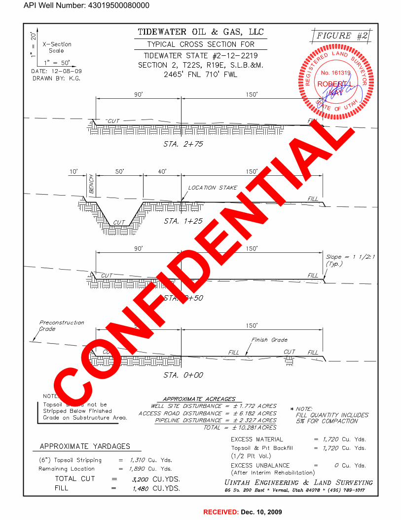
TIDEWATER OIL & GAS, LLC FIGURE #2×-section TYPICAL CROSS SECTION FOR gggScale
TIDEWATERSTATE #2-12-2219 LAND
1" = So'. SECTION 2, T22S, R19E, S.L.B.&M.DATE: 12-08-09
2465' FNL 710' FWL ... J No. 161319DRAWN BY: K.G. mu
90' 150'
SM. 2+75
10 50 40' 150'
LOCA T/ON STAKE
90 150'S/ope=112:1
SM. 0+50
Prec ons truc tion 9 0 150'Gm
Einish Grade
SM. 0+00
NOTE : APPROX/MATE ACREAGES
ITopsoil should not be WELL S/TE D/STURBANCE = ± 1.772 ACRESStripped Below Finished ACCESS ROAD D/STURBANCE = ± 6.182 ACRES
¡OLUANT/TY /NCLUDESGrade on Substructure Area. P/PEL/NED/STURBANCE= ±2.J27ACRES 5%EOR COMPACT/ON
TOTAL = ±10.281ACRES
EXCESS MATERIAL = 1,720 Cu. Yds.APPROXIMATE YARDAGES Topsoil & Pit Backfill = 1,720 Cu. Yds.
(1/2 Pit Vol.)(6") Topsoil Stripping = 1,310 Cu. Yds.
EXCESS UNBALANCE = 0 Cu. Yds.Rernaining Location = 1,890 Cu. Yds.(After Interirn Rehabilitation)
TOTAL CUT = 3,200 CU.YDS. UINTAH ENGINEERING & LAND SURVEYINGFILL = 1,480 CU.YDS. 85 So. 200 East * Vemal, Utah 84078 * (435)
API Well Number: 43019500080000
TIDEWATER OIL & GAS, LLC FIGURE #2×-section TYPICAL CROSS SECTION FOR ggg
ScaleTIDEWATERSTATE #2-12-2219 LAND
1" =
So'. SECTION 2, T22S, R19E, S.L.B.&M.DATE: 12-08-09
2465' FNL 710' FWL ... J No. 161319DRAWN BY: K.G. mu
90' 150'
SM. 2+75
10 50 40' 150'
LOCA T/ON STAKE
90 150'S/ope=112:1
SM. 0+50
Prec ons truc tion 9 0 150'Gm
Einish Grade
SM. 0+00
NOTE : APPROX/MATE ACREAGES
ITopsoil should not be WELL S/TE D/STURBANCE = ± 1.772 ACRESStripped Below Finished ACCESS ROAD D/STURBANCE = ± 6.182 ACRES
¡OLUANT/TY /NCLUDESGrade on Substructure Area. P/PEL/NED/STURBANCE= ±2.J27ACRES 5%EOR COMPACT/ON
TOTAL = ±10.281ACRES
EXCESS MATERIAL = 1,720 Cu. Yds.APPROXIMATE YARDAGES Topsoil & Pit Backfill = 1,720 Cu. Yds.
(1/2 Pit Vol.)(6") Topsoil Stripping = 1,310 Cu. Yds.
EXCESS UNBALANCE = 0 Cu. Yds.Rernaining Location = 1,890 Cu. Yds.(After Interirn Rehabilitation)
TOTAL CUT = 3,200 CU.YDS. UINTAH ENGINEERING & LAND SURVEYINGFILL = 1,480 CU.YDS. 85 So. 200 East * Vemal, Utah 84078 * (435)

API Well Number: 43019500080000
TIDEWATER OIL & GAS, LLC FIGURE #3TYPICAL RIG LAYOUT FOR ' '
TIDEWATERSTATE #2-12-2219SECTION 2, T22S, R19E, S.L.B.&M.
,, , 2465' FNL 710' FWL UNSCALE: 1 = 50 LANDDATE: 12-08-09DRAWN BY: K.G.
No. 161319
90'
NOTERRE RT
E/ore Pit /s tobe /ocated a min.of 100' frorn theWe// Head
PIPE RACKS
|||||
| DOG HOUSE¯E 40 | 150
PU TOILET
MUD SHED
HOPPER
POWERSTORAGE
RESERVE P/TS TANKTRASH TOOLS(10' Deep)
Toto/ Pit CopocityW/2' of Ereeboord :( i FUEL
= 2,670 Bb/s.±Toto/ Pit Volurne
= 810 Cu. Yds
UINTAH ENGINEERING & LAND SURVEYING85 So. 200 East * Vernal, Utah 84078 * (435)
API Well Number: 43019500080000
TIDEWATER OIL & GAS, LLC FIGURE #3TYPICAL RIG LAYOUT FOR ' '
TIDEWATERSTATE #2-12-2219SECTION 2, T22S, R19E, S.L.B.&M.
,, , 2465' FNL 710' FWL UNSCALE: 1 = 50 LANDDATE: 12-08-09
DRAWN BY: K.G.No. 161319
90'
NOTERRE RT
E/ore Pit /s tobe /ocated a min.of 100' frorn theWe// Head
PIPE RACKS
|||||
| DOG HOUSE¯E 40 | 150
PU TOILET
MUD SHED
HOPPER
POWERSTORAGE
RESERVE P/TS TANKTRASH TOOLS(10' Deep)
Toto/ Pit CopocityW/2' of Ereeboord :( i FUEL
= 2,670 Bb/s.±Toto/ Pit Volurne
= 810 Cu. Yds
UINTAH ENGINEERING & LAND SURVEYING85 So. 200 East * Vernal, Utah 84078 * (435)

API Well Number: 43019500080000
19 20'
DE T R ST TE 2-2219
4 MI. +l-
LEGEND: TIDEWATER OIL & GAS, LLC
O PROPOSED LOCATION N TIDEWATER STATE #2-12-2219SECTION 2, T22S, R19E, S.L.B.&M.
-2465' FNL 710' FWL
Uintah Engineering & Land Surveying TOPOGR A PH I C 12 0 0985 South 200 East Vernal, Utah 24078 g.I À Ÿ DAY YEAR(43 789-1017 * EAX (43 789--1813
SCALE:1:100,000 DRAWNBY:Z.L. REVISED:00-00-00

API Well Number: 43019500080000
34 35 36
IT21S4827
PROPOSED LOCATION:TD 2
477|
iliPROPosED ACCESS FOR THE TIDEWATERSTATE #3-24-22 19 0.5 MI. +A
10 1 1 12
Drdloles
475 -I
[GREEN RIVER 28.2 MI. +A [R19
LEGEND: TIDEWATER OIL & GAS, LLCEXISTINGROAD N TIDEWATER STATE #2-12-2219
----------- PROPOSEDACCESSROAD SECTION 2 T22S R19E S.L.B.&M.------ EXISTING2-TRACK NEEDS UPGRADED

API Well Number: 43019500080000
34 35 36
Juncuan
PROPOSED LOCATION:TIDEWATER STATE #2-12-2219 T21S
T22S
10 1 1 12
D I
R19 "
E I
LEGEND: TIDEWATER OIL & GAS, LLCpf DISPOSALETLLS WATERMTLLS N TIDEWATER STATE #2-12-2219O PRODUCINGWELLS ABANDONED WELLS SECTION 2, T22S, R19E, S.L.B.&M.g SHUT INWELLS - - TEMPORARILY ABANDONED 2465' FNL 710'

API Well Number: 43019500080000
IT22S PROPOSED LOCATION:TIDEWATER STATE #2-12-2219
STATE#3··24-2219
10 1 1
APPROXIMATE TOTAL PIPELINE DISTANCE = 3,379' +/-
LEGEND: TIDEWATER OIL & GAS, LLCos» N TIDEWATER STATE #2-12-2219
EDSUPGRADEI) SECTION 2, T22S, R19E,
API Well Number: 43019500080000
IT22S I PROPOSED LOCATION:TIDEWATER STATE #2-12-2219
TIDEWATERSTATE83··24-2219
APPROXIMATE TOTAL PIPELINE DISTANCE = 3,379' +/-
LEGEND: TIDEWATER OIL & GAS, LLC----------- Tig;
os» N TIDEWATER STATE #2-12-2219ITII:niEDSUPGRADFI) SECTION 2, T22S, R19E,
API Well Number: 43019500080000
IT22S PROPOSED LOCATION:TIDEWATER STATE #2-12-2219
STATE#3··24-2219
10 1 1
APPROXIMATE TOTAL PIPELINE DISTANCE = 3,379' +/-
LEGEND: TIDEWATER OIL & GAS, LLCos» N TIDEWATER STATE #2-12-2219
EDSUPGRADEI) SECTION 2, T22S, R19E,

ª
ª
O!
!Tidewater State 2-12-2219 4301950008
TIDEWATER ST 3-24-2219 4301931625
SVA 24-3-2219 4301931601
POTASH CO OF AMERICA 1 4301911571
UTAH OIL REFINING CO 1 4301911497
S A L T V A L L Y A N T I C L I N E U N I TS A L T V A L L Y A N T I C L I N E U N I T23
1
3534
1110
36
12
T 22 S R 19 E
T 21 S R 19 E
Map Produced by Diana MasonMap Prepared:
Well Name: Tidewater State 2-12-2219API Number: 4301950008
Township 22.0 S Section 2 Range 19.0 EMeridian: SLBM
F1,250 0 1,250625 Feet
1:12,253
UnitsSTATUS
ACTIVE
EXPLORATORY
GAS STORAGE
NF PP OIL
NF SECONDARY
PI OIL
PP GAS
PP GEOTHERML
PP OIL
SECONDARY
TERMINATED
FieldsSTATUS
Unknown
ABANDONED
ACTIVE
COMBINED
INACTIVE
STORAGE
TERMINATED
Sections
Township
Wells Query
D <all other values>
StatusAPD - Aproved Permit
H DRL - Spuded (Drilling Commenced)
4 GIW - Gas Injection
!* GS - Gas Storage
N LA - Location Abandoned
! LOC - New Location
7 OPS - Operation Suspended
ª PA - Plugged Abandoned
* PGW - Producing Gas Well
' POW - Producing Oil Well
O RET - Returned APD
¸ SGW - Shut-in Gas Well
· SOW - Shut-in Oil Well
6 TA - Temp. Abandoned
" TW - Test Well
¸ WDW - Water Disposal
¸ WIW - Water Injection Well
=* WSW - Water Supply Well
Tooele
Millard
Iron
San Juan
Kane
Juab
Uintah
Box Elder
Emery
Garfield
Grand
Utah
Beaver Wayne
Duchesne
Sevier
Summit
Rich
Washington
Carbon
Sanpete
Cache
Piute
Davis
Wasatch
Weber
DaggettSalt Lake
Morgan
Location Map
Operator: TIDEWATER OIL & GAS COMPANY, LLC
API Well Number: 43019500080000
API Number: 4301950008Well Name: Tidewater State 2-12-2219Township 22.0 S Range 19.0 E Section 2
Meridian: SLBM
34 35 36 Operator: TIDEWATER OIL & GAS COMPANY, LLC
Map Prepared:Map Produced by Diana Mason
Units Wells QuerySTAlus <aiiothervaiue
PiaiL
PPaiL aPs opera
TERrviiNATED Producingcasweii
Fields Pow Producingaliweii
STAlus RET Returned
unknown sow-shutincasweii
Neo sow-snatinaliweii
cTivE TA-Temp.Abandoned
carleiNED O Tw Testwell
E wow-wateroisposa
UTAH OIL REFINING CO 1 Tidewater State 2-12-2219 ST wiw waterinjectionweii
4301911497 e4301950008
SALT VALLY ANTICLINE UNIT I¯I-
3 2 1
chreRichLocation Map
visSum Da
alt LakTaœ\e
Utasate Duchesn
Uintah
Juab Grban
SV0A1 -3 2219 DEW ER ST 3-24-2219rd
San teEmery grand
Beaver Piute
GarfeldSan Juan
Washington Kane
10 430TAS1H5C10OF AMERICA 1
N250 625 o 125eFeet
API Well Number: 43019500080000
API Number: 4301950008Well Name: Tidewater State 2-12-2219Township 22.0 S Range 19.0 E Section 2
Meridian: SLBM
34 35 36 Operator: TIDEWATER OIL & GAS COMPANY, LLC
Map Prepared:Map Produced by Diana Mason
Units Wells QuerySTAlus <aiiothervaiue
PiaiL
TERrviiNATED Producingcasweii
Fields Pow Producingaliweii
STAlus @ RET Returned
unknown -t - sow-shut-inoasweii
NED saw-shut-inaliweii
cTivE TA-Temp.Abandoned
carleiNED O TW TestWell
E wow-wateroisposa
UTAH OIL REFINING CO 1 Tidewater State 2-12-2219 ST wiw waterinjectionweii
4301911497 4301950008
SALT VALLY ANTICLINE UNIT I¯I-
3 2 1
chreRichLocation Map
visSum Da
alt LakTaœ\e
Utasate Duchesn
Uintah
JuabGrban
SV0A1 -3 19 DEW ER ST 3-24-2219rd
San teEmery grand
Beaver Piute
GarfeldSan Juan
Washington Kane
10 430TAS1H5C10OF AMERICA 1
N
250 625 o 125eFeet

There are no features in the query area.
Click on the back button to try again
Please direct questions and comments regarding the map server to: [email protected].
back close
API Well Number: 43019500080000
Utah Division of Water Rights
There are no features in the query area.
Click on the back button to try again
Please direct questions and comments regarding the map server to: leeeschler
API Well Number: 43019500080000
Utah Division of Water Rights
There are no features in the query area.
Click on the back button to try again
Please direct questions and comments regarding the map server to: leeeschler
API Well Number: 43019500080000
Utah Division of Water Rights
There are no features in the query area.
Click on the back button to try again
Please direct questions and comments regarding the map server to: leeeschler

Tidewater State # 2-12-22192465 FNL 710 FWLSWNW Sec 2 T225 - R19EGrand County, UT
FRDMMUD ......PUIIlI'S
API Well Number: 43019500080000
Tidewater State # 2-12-22192465 FNL 710 FWLSWNW Sec 2 T22S - R19EGrand County, UT
MinimumsinadardsforWdicenkalliaalninent40M'tamWAPISMahAeralsRA
Awaliconheidegmshn11bekataled at(hesurfacethalIscapableetoonipielectosureofiliaWallbore.ThiedeWeashanbaciosedAPrBUMNBEMIiHTutmassertiloWalllaunallendeasitA
Ef0Minutplauenior and falsteg emiþfflenttihallbe fin1alled,used,
w ilppariteilgoo0k¾aivo witNhbudleavatabtevelegandaubsin11tandrßistdagainuse
VAL¥E LEGINID Allvalvas(exceptchokes)laiboldrue,chokeCHECKVALVEmanfrald,and choksanoshallbe a Igle thatdoesnotambiattneitow(Alli
STMM2IPEbe a type designed forREGBUREdlllilag1IuldseMea,
CHOMENANIPOLDPREESuREGAUSE
AIMUGTABL.E0110%E
smansmunPuMPS
8chakeinnathaaba lines unlessbons use tuoblockser aregoal cliassins
d leas shalibaanchomdtoprovantwhipend
b pecha cËngunnliott us CastnDshellhaset toa nimbaumof30lfðr 10%af lolal deper at wette ciosineenitgggs aleWil bast inastano manualisereneachof Bie boiem threejoitisone lhelndependantpowersoscas el .Allseg ad be
Sacha $$ closi ualtshallbe ofope die Bieranacasingshallin carasatedbUcÍttosmiaceelihardudng

Tidewater State # 2-12-22192465 FNL 710 FWLSWNW Sec 2 T22S - R19EGrand County, UT
sUrface casing set and cemented to 500 WUllSOI8te atJd Protect any potential fresh _ zonesencountered. Any other w~ter or hydrocarbon bearing zones below 500' 'Will be isolated withcasing and cementwhen the well is eased. .
7 - Pressure Con. EquipBleDt .Well will utilize a 3000 psi BOP. ~BOP will have a pipe rams, blind rams and a hydril. Arotatin8 head will be utilized while drilling with ait:. All BOPs will be tested ~o 3000 psi whenthe equipment.is instaUed and itthe integrity ofthe pressure control system is CODlp;omisedduring c1riUing operations.
!1M CHOKE MANIFOLD eOUIPtl.ENT - CONFtGl.IP.ATIOi\i J.1AY VAJi,V.' .
API Well Number: 43019500080000
Tidewater State # 2-12-22192465 FNL 710 FWLSWNW Sec 2 T22S - R19EGrand County, UT
Stn·faceseg set and he rotectanypotential freshwaterzonesencountered. Any other water at hydrocarbonbearingzones below 500' will be isolated withcasing and oementwhen thewellis cased.
7 - Pressure Control EenionnentWellwillutilizea 3000 psi BOP. The BOP will havea pipe rams, blind rams and a hydril. Arotating head will be utilized while drillingwith air. All BOPs will be tested to 3000 psi whenthe equipment.is installedandif the integrity of thepressure controlsystem is compromisedduring drillingoperations,
BM CucKE NIANIFOLDEÓutPMENT - CONFIGURATION MAY

Tidewater State # 2-12-22192465 FNL 710 FWLSWNW Sec 2 T228 - R19EGrand County, UT
API Well Number: 43019500080000
Tidewater State # 2-12-22192465 FNL 710 FWLSWNW Sec 2 T22S - Ri9EGrand County, UT
ul pŠventera *
Doubleramwith blindnimaand·pipe Tams * ' '
-Drilling apool, or blowentpreventerwith a side outlets (choke.bideshaß.be e3-inch minimumdiameter, kiftsideahållbe at least 2-inäh diametpr)*
-KilHibi(iipah minhausg) '
. GAwamumpf'schõ¾llns y ps'ý
- Attacliment 1)- ressuresangeon chokemankold
r keny cockkalve with h,andig
--Safety talve and subato ht-aßarinstäng .connectioni in nee°
-A11·BOPRtoonention aabjektådlàwon presiere sliètl be flainge¾welded,«- 11,$u above theipp ogtprevèrtan . .
ViolationiMirfoi [all (temavnÏeaamarked b2 asterisik).
oorrection

From: Jim DavisTo: Bonner, Ed; Mason, DianaCC: [email protected]: 2/2/2011 1:52 PMSubject: APD approvals
The following APDs have been approved by SITLA including arch and paleo clearance.
Tidewater State 2-12-2219 (4301950008)
KC 15-32E UINTAH (4304751354)
-Jim
Jim DavisUtah Trust Lands [email protected]: (801) 538-5156
API Well Number: 43019500080000
From: Jim DavisTo: Bonner, Ed; Mason, DianaCC: [email protected]: 2/2/2011 1:52 PMSubject: APD approvals
The following APDs have been approved by SITLA including arch and paleo clearance.
Tidewater State 2-12-2219 (4301950008)
KC 15-32E UINTAH (4304751354)
-Jim
Jim DavisUtah Trust Lands [email protected]: (801)
BOPE REVIEW TIDEWATER OIL & GAS COMPANY, LLC Tidewater State 2-12-2219 43019500080000
Well Name TIDEWATER OIL & GAS COMPANY, LLC Tidewater State 2-12-2219 43019500080000
String Surf Prod
Casing Size(") 8.625 5.500
Setting Depth (TVD) 790 7900
Previous Shoe Setting Depth (TVD) 0 790
Max Mud Weight (ppg) 9.1 9.5
BOPE Proposed (psi) 0 3000
Casing Internal Yield (psi) 2950 7740
Operators Max Anticipated Pressure (psi) 2963 7.2
Calculations Surf String 8.625 "
Max BHP (psi) .052*Setting Depth*MW= 374
BOPE Adequate For Drilling And Setting Casing at Depth?
MASP (Gas) (psi) Max BHP-(0.12*Setting Depth)= 279 NO Air drill
MASP (Gas/Mud) (psi) Max BHP-(0.22*Setting Depth)= 200 NO OK
*Can Full Expected Pressure Be Held At Previous Shoe?
Pressure At Previous Shoe Max BHP-.22*(Setting Depth - Previous Shoe Depth)= 200 NO
Required Casing/BOPE Test Pressure= 790 psi
*Max Pressure Allowed @ Previous Casing Shoe= 0 psi *Assumes 1psi/ft frac gradient
Calculations Prod String 5.500 "
Max BHP (psi) .052*Setting Depth*MW= 3903
BOPE Adequate For Drilling And Setting Casing at Depth?
MASP (Gas) (psi) Max BHP-(0.12*Setting Depth)= 2955 YES
MASP (Gas/Mud) (psi) Max BHP-(0.22*Setting Depth)= 2165 YES OK
*Can Full Expected Pressure Be Held At Previous Shoe?
Pressure At Previous Shoe Max BHP-.22*(Setting Depth - Previous Shoe Depth)= 2339 NO
Required Casing/BOPE Test Pressure= 3000 psi
*Max Pressure Allowed @ Previous Casing Shoe= 790 psi *Assumes 1psi/ft frac gradient
Calculations String "
Max BHP (psi) .052*Setting Depth*MW=
BOPE Adequate For Drilling And Setting Casing at Depth?
MASP (Gas) (psi) Max BHP-(0.12*Setting Depth)= NO
MASP (Gas/Mud) (psi) Max BHP-(0.22*Setting Depth)= NO
*Can Full Expected Pressure Be Held At Previous Shoe?
Pressure At Previous Shoe Max BHP-.22*(Setting Depth - Previous Shoe Depth)= NO
Required Casing/BOPE Test Pressure= psi
*Max Pressure Allowed @ Previous Casing Shoe= psi *Assumes 1psi/ft frac gradient
Calculations String "
Max BHP (psi) .052*Setting Depth*MW=
BOPE Adequate For Drilling And Setting Casing at Depth?
MASP (Gas) (psi) Max BHP-(0.12*Setting Depth)= NO
MASP (Gas/Mud) (psi) Max BHP-(0.22*Setting Depth)= NO
*Can Full Expected Pressure Be Held At Previous Shoe?
Pressure At Previous Shoe Max BHP-.22*(Setting Depth - Previous Shoe Depth)= NO
Required Casing/BOPE Test Pressure= psi
API Well Number: 43019500080000
BOPE REVIEW TIDEWATER OIL & GAS COMPANY, LLC Tidewater State 2-12-2219 43019500080000
Well Name TIDEWATER OIL & GAS COMPANY, LLCTidewater State 2-1
String surf Prod
Casing Size(") 8.625 5.500
Setting Depth (TVD) 790 7900
Previous Shoe Setting Depth (TVD) 79e
Max Mud Weight (ppg) 9.1 9.5
BOPE Proposed (psi) 0 3000
Casing Internal Yield (psi) 2950 7740
Operators Max Anticipated Pressure (psi) 2963 7.2
Calculations Surf String 8.625 "
Max BHP (psi) .052*Setting Depth*MW=374
BOPE Adequate For Drilling And Setting Casing at Depth?
MASP (Gas) (psi) Max BHP-(0.12*Setting Depth)= 279 NO Air drill
MASP (Gas/Mud) (psi) Max BHP-(0.22*Setting Depth)= 200 NO OK
*Can Full Expected Pressure Be Held At Previous Shoe?
Pressure At Previous Shoe Max BHP-.22*(Setting Depth - Previous Shoe Depth)=200 NO
Required Casing/BOPE Test Pressure= 790 psi
*Max Pressure Allowed @ Previous Casing Shoe- psi *Assumes 1psi/ft frac gradient
Calculations Prod String 5.500 "
Max BHP (psi) .052*Setting Depth*MW=3903
BOPE Adequate For Drilling And Setting Casing at Depth?
MASP (Gas) (psi) Max BHP-(0.12*Setting Depth)= 2955 YES
MASP (Gas/Mud) (psi) Max BHP-(0.22*Setting Depth)= 2165 YES OK
*Can Full Expected Pressure Be Held At Previous Shoe?
Pressure At Previous Shoe Max BHP-.22*(Setting Depth - Previous Shoe Depth)= 2339 NO
Required Casing/BOPE Test Pressure= 3000 PS
*Max Pressure Allowed @ Previous Casing Shoe-790 psi *Assumes 1psi/ft frac gradient
Calculations String "
Max BHP (psi) .052*Setting Depth*MW=
BOPE Adequate For Drilling And Setting Casing at Depth?
MASP (Gas) (psi) Max BHP-(0.12*Setting Depth)=NO
MASP (Gas/Mud) (psi) Max BHP-(0.22*Setting Depth)= NO
*Can Full Expected Pressure Be Held At Previous Shoe?
Pressure At Previous Shoe Max BHP-.22*(Setting Depth - Previous Shoe Depth)= NO
Required Casing/BOPE Test Pressure= psi
*Max Pressure Allowed @ Previous Casing Shoe- psi *Assumes 1psi/ft frac gradient
Calculations String "
Max BHP (psi) .052*Setting Depth*MW=
BOPE Adequate For Drilling And Setting Casing at Depth?
MASP (Gas) (psi) Max BHP-(0.12*Setting Depth)=NO
MASP (Gas/Mud) (psi) Max BHP-(0.22*Setting Depth)= NO
*Can Full Expected Pressure Be Held At Previous Shoe?
Pressure At Previous Shoe Max BHP-.22*(Setting Depth - Previous Shoe Depth)= NO
Required Casing/BOPE Test Pressure=
API Well Number: 43019500080000
BOPE REVIEW TIDEWATER OIL & GAS COMPANY, LLC Tidewater State 2-12-2219 43019500080000
Well Name TIDEWATER OIL & GAS COMPANY, LLC Tidewater State 2-1
String surf Prod
Casing Size(") 8.625 5.500
Setting Depth (TVD) 790 7900
Previous Shoe Setting Depth (TVD) 79e
Max Mud Weight (ppg) 9 9.5
BOPE Proposed (psi) 0 300
Casing Internal Yield (psi) 2950 7740
Operators Max Anticipated Pressure (psi) 2963 7.2
Calculations Surf String 8.625 "
Max BHP (psi) .052*Setting Depth*MW=374
BOPE Adequate For Drilling And Setting Casing at Depth?
MASP (Gas) (psi) Max BHP-(0.12*Setting Depth)= 279 NO Air drill
MASP (Gas/Mud) (psi) Max BHP-(0.22*Setting Depth)= 200 NO OK
*Can Full Expected Pressure Be Held At Previous Shoe?
Pressure At Previous Shoe Max BHP-.22*(Setting Depth - Previous Shoc Depth)= 200 NO
Required Casing/BOPE Test Pressure= ygg psi
*Max Pressure Allowed @Previous Casing Shoe= psi *Assumes lpsi/ft frac gradient
Calculations Prod String 5.500 "
Max BHP (psi) .052*Setting Depth*MW=3903
BOPE Adequate For Drilling And Setting Casing at Depth?
MASP (Gas) (psi) Max BHP-(0.12*Setting Depth)= 2955 YES
MASP (Gas/Mud) (psi) Max BHP-(0.22*Setting Depth)=2165 YES OK
*Can Full Expected Pressure Be Held At Previous Shoe?
Pressure At Previous Shoe Max BHP-.22*(Setting Depth - Previous Shoe Depth)= 2339 NO
Required Casing/BOPE Test Pressure= 3000 pSi
*Max Pressure Allowed @Previous Casing Shoe= 790 psi *Assumes 1psi/ft frac gradient
Calculations String "
Max BHP (psi) .052*Setting Depth*MW=
BOPE Adequate For Drilling And Setting Casing at Depth?
MASP (Gas) (psi) Max BHP-(0.12*Setting Depth)= NO
MASP (Gas/Mud) (psi) Max BHP-(0.22*Setting Depth)= NO
*Can Full Expected Pressure Be Held At Previous Shoe?
Pressure At Previous Shoe Max BHP-.22*(Setting Depth - Previous Shoe Depth)= NO
Required Casing/BOPE Test Pressure= psi
*Max Pressure Allowed @Previous Casing Shoe= psi *Assumes 1psi/ft frac gradient
Calculations String "
Max BHP (psi) .052*Setting Depth*MW=
BOPE Adequate For Drilling And Setting Casing at Depth?
MASP (Gas) (psi) Max BHP-(0.12*Setting Depth)= NO
MASP (Gas/Mud) (psi) Max BHP-(0.22*Setting Depth)= NO
*Can Full Expected Pressure Be Held At Previous Shoe?
Pressure At Previous Shoe Max BHP-.22*(Setting Depth - Previous Shoe Depth)= NO
Required Casing/BOPE Test Pressure=
API Well Number: 43019500080000
BOPE REVIEW TIDEWATER OIL & GAS COMPANY, LLC Tidewater State 2-12-2219 43019500080000
Well Name TIDEWATER OIL & GAS COMPANY, LLCTidewater State 2-1
String surf Prod
Casing Size(") 8.625 5.500
Setting Depth (TVD) 790 7900
Previous Shoe Setting Depth (TVD) 79e
Max Mud Weight (ppg) 9.1 9.5
BOPE Proposed (psi) 0 3000
Casing Internal Yield (psi) 2950 7740
Operators Max Anticipated Pressure (psi) 2963 7.2
Calculations Surf String 8.625 "
Max BHP (psi) .052*Setting Depth*MW=374
BOPE Adequate For Drilling And Setting Casing at Depth?
MASP (Gas) (psi) Max BHP-(0.12*Setting Depth)= 279 NO Air drill
MASP (Gas/Mud) (psi) Max BHP-(0.22*Setting Depth)= 200 NO OK
*Can Full Expected Pressure Be Held At Previous Shoe?
Pressure At Previous Shoe Max BHP-.22*(Setting Depth - Previous Shoe Depth)=200 NO
Required Casing/BOPE Test Pressure= 790 psi
*Max Pressure Allowed @ Previous Casing Shoe- psi *Assumes 1psi/ft frac gradient
Calculations Prod String 5.500 "
Max BHP (psi) .052*Setting Depth*MW=3903
BOPE Adequate For Drilling And Setting Casing at Depth?
MASP (Gas) (psi) Max BHP-(0.12*Setting Depth)= 2955 YES
MASP (Gas/Mud) (psi) Max BHP-(0.22*Setting Depth)= 2165 YES OK
*Can Full Expected Pressure Be Held At Previous Shoe?
Pressure At Previous Shoe Max BHP-.22*(Setting Depth - Previous Shoe Depth)= 2339 NO
Required Casing/BOPE Test Pressure= 3000 PS
*Max Pressure Allowed @ Previous Casing Shoe-790 psi *Assumes 1psi/ft frac gradient
Calculations String "
Max BHP (psi) .052*Setting Depth*MW=
BOPE Adequate For Drilling And Setting Casing at Depth?
MASP (Gas) (psi) Max BHP-(0.12*Setting Depth)=NO
MASP (Gas/Mud) (psi) Max BHP-(0.22*Setting Depth)= NO
*Can Full Expected Pressure Be Held At Previous Shoe?
Pressure At Previous Shoe Max BHP-.22*(Setting Depth - Previous Shoe Depth)= NO
Required Casing/BOPE Test Pressure= psi
*Max Pressure Allowed @ Previous Casing Shoe- psi *Assumes 1psi/ft frac gradient
Calculations String "
Max BHP (psi) .052*Setting Depth*MW=
BOPE Adequate For Drilling And Setting Casing at Depth?
MASP (Gas) (psi) Max BHP-(0.12*Setting Depth)=NO
MASP (Gas/Mud) (psi) Max BHP-(0.22*Setting Depth)= NO
*Can Full Expected Pressure Be Held At Previous Shoe?
Pressure At Previous Shoe Max BHP-.22*(Setting Depth - Previous Shoe Depth)= NO
Required Casing/BOPE Test Pressure=

*Max Pressure Allowed @ Previous Casing Shoe= psi *Assumes 1psi/ft frac gradient
API Well Number: 43019500080000*Max Pressure Allowed @ Previous Casing Shoe-- psi *Assumes 1psi/ft frac
API Well Number: 43019500080000*Max Pressure Allowed @Previous Casing Shoe= psi *Assumes 1psi/ft frac
API Well Number: 43019500080000*Max Pressure Allowed @ Previous Casing Shoe-- psi *Assumes 1psi/ft frac

From: Earlene RussellTo: Diana MasonCC: Tom Johnson; Walter LowryDate: 3/16/2011 4:10 PMSubject: Fwd: Re: Revised Bond Info
Diana, Please change the lease number to ML-51885 OBA.Thanks.Earlene>>> Earlene Russell 3/14/2011 3:19 PM >>>Hi Tom,Please send an original Form 4B. I can work from these copies until the original gets here. SITLA's records show a different lease number for the Tidewater State 2-12-2219. Please have Walt submit a correction on the lease number ML-51885 OBA and bond number 394312648337.Thanks.Earlene>>> "Tom Johnson" <[email protected]> 3/14/2011 2:21 PM >>>
Earlene,Please review the attached. Do you only need the original Form 4B?Or would you like anything additional.Thank you Tom JohnsonTidewater Oil & Gas Company, LLC720-881-7344
Tom JohnsonOffice Manager Tidewater Oil & Gas Company, LLC.110 16th StreetSuite 405Denver CO 80202
Tel: 303-468-0656 x204Fax: 303-534-1022
[email protected] message contains confidential information and is intended only for the individual named. If you are not the named addressee you should not disseminate, distribute or copy this e-mail. Please notify the sender immediately by e-mail if you have received this e-mail by mistake and delete this e-mail from your system. E-mail transmission cannot be guaranteed to be secure or error-free as information could be
API Well Number: 43019500080000
From: Earlene RussellTo: Diana MasonCC: Tom Johnson; Walter LowryDate: 3/16/2011 4:10 PMSubject: Fwd: Re: Revised Bond Info
Diana,Please change the lease number to ML-51885 OBA.Thanks.Earlene>>> Earlene Russell 3/14/2011 3:19 PM >>>
Hi Tom,Please send an original Form 4B. I can work from these copies until the original gets here.
SITLA's records show a different lease number for the Tidewater State 2-12-2219.
Please have Walt submit a correction on the lease number ML-51885 OBA and bond number394312648337.Thanks.Earlene>>> "Tom Johnson" <[email protected]> 3/14/2011 2:21 PM >>>
Earlene,Please review the attached. Do you only need the original Form 4B?Or would you like anything additional.Thank you
Tom JohnsonTidewater Oil & Gas Company, LLC720-881-7344
Tom JohnsonOffice Manager
Tidewater Oil & Gas Company, LLC.110 16th StreetSuite 405Denver CO 80202
Tel: 303-468-0656 x204Fax: 303-534-1022
[email protected] message contains confidential information and is intended only for the individual named. Ifyou arenot the named addressee you should not disseminate, distribute or copy this e-mail. Please notify thesender immediately by e-mail ifyou have received this e-mail by mistake and delete this e-mail from yoursystem. E-mail transmission cannot be guaranteed to be secure or error-free as information could

intercepted, corrupted, lost, destroyed, arrive late or incomplete, or contain viruses. The sender therefore does not accept liability for any errors or omissions in the contents of this message, which arise as a result of e-mail transmission. If verification is required please request a hard-copy version.
API Well Number: 43019500080000
intercepted, corrupted, lost, destroyed, arrive late or incomplete, or contain viruses. The sender thereforedoes not accept liabilityfor any errors or omissions in the contents of this message, which arise as aresult of e-mail transmission. If verification is required please request a hard-copy

API Well Number: 43019500080000
43019500080000 Tide vater State 2-12-2219Casing Schem p 6
Surface \
8-$/8" Sur eMW 9.3 790. MDFrac 19.3
5-1/2" ProductionMW 9.5 7900.
API Well Number: 43019500080000
43019500080000 Tide vater State 2-12-2219Casing Schem p 6
Surface \
8-$/8" Sur eMW 9.3 790. MDFrac 19.3
5-1/2" ProductionMW 9.5 7900.
API Well Number: 43019500080000
43019500080000 Tide vater State 2-12-2219Casing Schem p 6
Surface \
8-$/8" Sur eMW 9.3 790. MDFrac 19.3
5-1/2" ProductionMW 9.5 7900.

API Well Number: 43019500080000
Well name: 43019500080000 Tidewater State 2-12-2219operator: TIDEWATER OIL & GAS COMPANY, LLCString type: Surface Project ID:
43-019-50008Location: GRAND COUNTY
Design parameters: Minimum design factors: Environment:Collapse Collapse: H2S considered? No
Mud weight: 9.300 ppg Design factor 1.125 Surface temperature: 74 °F
Design is based on evacuated pipe. Bottom hole temperature: 85 °FTemperature gradient: 1.40 °F/100ftMinimum section length: 100 ft
Burst:Design factor 1.00 Cement top: 347 ft
BurstMax anticipated surface
pressure: 695 psiInternal gradient: 0.120 psilft Tension: Non-directional string.Calculated BHP 790 psi 8 Round STC: 1.80 (J)
8 Round LTC: 1.70 (J)No backup mud specified. Buttress: 1.60 (J)
Premium: 1.50 (J)Body yield: 1.50 (B) Re subsequent strings:
Next setting depth: 7,900 ftTension is based on air weight. Next mud weight: 9.500 ppgNeutral point: 680 ft Next setting BHP: 3,899 psi
Fracture mud wt: 19.250 ppgFracture depth: 790 ftInjection pressure: 790 psi
Run Segment Nominal End True Vert Measured D ift Est.Seq Length Size Weight Grade Finish Depth Depth Diameter Cost
(ft) (in) (Ibs/ft) (ft) (ft) (in) ($)1 790 8.625 24.00 J-55 ST&C 790 790 7.972 4067
Run Collapse Collapse Collapse Burst Burst Burst Tension Tension TensionSeq Load Strength Design Load Strength Design Load Strength Design
(psi) (psi) Factor (psi) (psi) Factor (kips) (kips) Factor1 382 1370 3.590 790 2950 3.73 19 244 12.87 J
Prepared Helen Sadik-Macdonald Phone: 801 538-5357 Date: March 3,2011by: Div of Oil,Gas & Mining FAX: 801-359-3940 Salt Lake City, Utah
Remarks:Collapse is based on a vertical depth of 790 ft, a mud weight of 9.3 ppg The casing is considered to be evacuated for collapse purposesCollapse strength is based on the Westcott, Dunlop & Kemler method of biaxial correction for tension.
Burst strength is not adjusted for tension.
Engineering responsibility for use of thisdesign willbe thatof the

API Well Number: 43019500080000
weiiname: 43019500080000 Tidewater State 2-12-2219Operator: TIDEWATER OIL & GAS COMPANY, LLCString type: Production Project ID:
43-019-50008Location: GRAND COUNTY
Design parameters: Minimum design factors: Environment:Collapse Collapse: H2S considered? No
Mud weight: 9.500 ppg Design factor 1.125 Surface temperature: 74 °F
Design is based on evacuated pipe. Bottom hole temperature: 185 °FTemperature gradient: 1.40 °F/100ftMinimum section length: 100 ft
Burst:Design factor 1.00 Cement top: 1,543 ft
BurstMax anticipated surface
pressure: 2,161 psiInternal gradient: 0.220 psilft Tension: Non-directional string.Calculated BHP 3,899 psi 8 Round STC: 1.80 (J)
8 Round LTC: 1.80 (J)No backup mud specified. Buttress: 1.60 (J)
Premium: 1.50 (J)Body yield: 1.60 (B)
Tension is based on air weight.Neutral point: 6,762 ft
Run Segment Nominal End True Vert Measured Drift Est.Seq Length Size Weight Grade Finish Depth Depth Diameter Cost
(ft) (in) (Ibs/ft) (ft) (ft) (in) ($)1 7900 5.5 17.00 N-80 LT&C 7900 7900 4.767 44526
Run Collapse Collapse Collapse Burst Burst Burst Tension Tension TensionSeq Load Strength Design Load Strength Design Load Strength Design
(psi) (psi) Factor (psi) (psi) Factor (kips) (kips) Factor1 3899 6290 1.613 3899 7740 1.99 134.3 348 2.59 J
Prepared Helen Sadik-Macdonald Phone: 801 538-5357 Date: March 3,2011by: Div of Oil,Gas &Mining FAX: 801-359-3940 Salt Lake City, Utah
Remarks:Collapse is based on a vertical depth of 7900 ft, a mud weight of 9.5 ppg The casing is considered to be evacuated for collapse purposes.Collapse strength is based on the Westcott, Dunlop & Kemler method of biaxial correction for tension.
Burst strength is not adjusted for tension.
Engineering responsibility for use of thisdesign wi/Ibe thatof the

API Well Number: 43019500080000
Page 1 of 1
Helen Sadik-Macdonald - Re: Application For Permit to Drill Sent Back for Revisions
From: <[email protected]>To: <[email protected]>
Date: 6/22/2010 8:19 PMSubject: Re: ApplicationFor Permit to DrillSent Back for Revisions
Thank you for the notification. We are no longer working for Tidewater.
Lisa Smith
PermitCo Inc.PO Box 99Eastlake, CO 80614
303-857-9999 × 10 (work)303-450-9200 (fa×)303-324-9350 (cell)
file://C:\Documents and Settings\OGMUSER\Local Settings\Temp\XPgrpwise\4C211ACO... 6/23/20

API Well Number: 43019500080000
(6/23/2010) Helen Sadik-Macdonald - Application For Permit to DrillSent Back Page 1
From: <[email protected]>
To: <[email protected]>CC: <[email protected]>, <[email protected]>, <[email protected]>
Date: 6/22/2010 5:41 PMSubject: Application For Permit to DrillSent Back for Revisions
APD Number: 2225Well Name: Tidewater State 2-12-2219Operator: TIDEWATER OIL & GAS COMPANY, LLCProblems: Surf csg depth
On April 21, 2010 I e-mailed a request to deepen surface csg to 790\' to be 10% of TD. I have not had aresponse from your

ON-SITE PREDRILL EVALUATIONUtah Division of Oil, Gas and Mining
Operator TIDEWATER OIL & GAS COMPANY, LLC
Well Name Tidewater State 2-12-2219
API Number 43019500080000 APD No 2225 Field/Unit WILDCAT
Location: 1/4,1/4 SWNW Sec 2 Tw 22.0S Rng 19.0E 2465 FNL 710 FWL
GPS Coord (UTM) Surface Owner
Participants
Bart Kettle-Division of Oil, Gas and Mining (DOGM), Ed Bonner-Trust Lands Administration (SITLA), Nicole
Nielson-Division of Wildlife Resources (DWR) and Walt Lowery-Tidewater Oil and Gas LLC
Regional/Local Setting & Topography
Proposed project site is located roughly 5 miles southwest of the town of Thompson Springs, in Grand County
Utah. Annual precipitation is 6-8", vegetation is sparse at the project site, but would be described as salt scrub
rangelands. Topography immediately adjacent to the project site is gently rolling clay flats. Drainage is to the south
entering the Green River within 20 miles. No perennial water was observed in close proximity to the proposed
project site. Drainages in the immediate area are ephemeral in nature, being dry throughout a majority of the year.
On a regional setting the project is located in the Cisco Desert at the base of the Bookcliffs, a region known for it's
harsh growing conditions due to low precipitation, and poorly developed salty soils. I-70, Hwy 191, east bound
Crescent Junction rest area, DOE uranium tailings transfer site and Union Pacific train tracks are all located in close
proximity to the proposed project.
Surface Use Plan
Current Surface Use
Grazing
Wildlfe Habitat
New Road Miles Well Pad Src Const Material Surface Formation
1.7 Width 250 Length 275 MNCS
Ancillary Facilities
Waste Management Plan Adequate?
Environmental Parameters
Affected Floodplains and/or Wetlands N
Flora / Fauna
Flora
Grass: Curly galleta, Indian Rice grass
Forbs: Globe mallow, desert plantain, halogeton, Russian thistle
Shrubs: Spiny hopsage, black greasewood, Mormon tea, broom snakeweed, four wing salt brush.
Soil Type and Characteristics
Light brown Sandy Loam
Erosion Issues Y
Soils prone to accelerated erosion form overland water flows
4/7/2011 Page 1
API Well Number: 43019500080000
ON-SITE PREDRILL EVALUATIONUtah Division of Oil, Gas and Mining
Operator TIDEWATER OIL & GAS COMPANY, LLCWell Name Tidewater State 2-12-2219
API Number 43019500080000 APD No 2225 Field/Unit WILDCATLocation: 1/4,1/4 SWNW Sec 2 Tw 22.0S Rng 19.0E 2465 FNL 710 FWLGPS Coord (UTM) Surface Owner
ParticipantsBart Kettle-Division of Oil, Gas and Mining (DOGM), Ed Bonner-Trust Lands Administration (SITLA), NicoleNielson-Division of Wildlife Resources (DWR) and Walt Lowery-Tidewater Oil and Gas LLC
Regional/Local Setting & TopographyProposed project site is located roughly 5 miles southwest of the town of Thompson Springs, in Grand CountyUtah. Annual precipitation is 6-8", vegetation is sparse at the project site, but would be described as salt scrubrangelands. Topography immediately adjacent to the project site is gently rolling clay flats. Drainage is to the southentering the Green River within 20 miles. No perennial water was observed in close proximity to the proposedproject site. Drainages in the immediate area are ephemeral in nature, being dry throughout a majority of the year.On a regional setting the project is located in the Cisco Desert at the base of the Bookcliffs, a region known for it'sharsh growing conditions due to low precipitation, and poorly developed salty soils. I-70, Hwy 191, east boundCrescent Junction rest area, DOE uranium tailings transfer site and Union Pacific train tracks are all located in closeproximity to the proposed project.
Surface Use PlanCurrent Surface UseGrazingWildlfe Habitat
New Road Miles Well Pad Src Const Material Surface Formation1.7 Width 250 Length 275 MNCS
Ancillary Facilities
Waste Management Plan Adequate?
Environmental ParametersAffected Floodplains and/or Wetlands N
Flora / FaunaFloraGrass: Curly galleta, Indian Rice grassForbs: Globe mallow, desert plantain, halogeton, Russian thistleShrubs: Spiny hopsage, black greasewood, Mormon tea, broom snakeweed, four wing salt brush.
Soil Type and CharacteristicsLight brown Sandy Loam
Erosion Issues YSoils prone to accelerated erosion form overland water flows
I
4/7/2011 Page

Sedimentation Issues N
Site Stability Issues N
Drainage Diverson Required? N
Berm Required? N
Erosion Sedimentation Control Required? N
Reseeding following construction should be sufficient to stabilize site.
Paleo Survey Run? Y Paleo Potental Observed? N Cultural Survey Run? Y Cultural Resources? N
Reserve Pit
Site-Specific Factors Site Ranking
Distance to Groundwater (feet) >200 0
Distance to Surface Water (feet) >1000 0
Dist. Nearest Municipal Well (ft) >5280 0
Distance to Other Wells (feet) >1320 0
Native Soil Type Mod permeability 10
Fluid Type Fresh Water 5
Drill Cuttings Normal Rock 0
Annual Precipitation (inches) 0
Affected Populations
Presence Nearby Utility Conduits Not Present 0
Final Score 15 2 Sensitivity Level
Characteristics / Requirements
Closed Loop Mud Required? N Liner Required? Y Liner Thickness 12 Pit Underlayment Required? N
Other Observations / Comments
Farm out exploration due to expire in June 2010 per conversation with company representatives.
Bart Kettle 12/22/2009
Evaluator Date / Time
4/7/2011 Page 2
API Well Number: 43019500080000
Sedimentation Issues N
Site Stability Issues N
Drainage Diverson Required? N
Berm Required? N
Erosion Sedimentation Control Required? NReseeding following construction should be sufficient to stabilize site.
Paleo Survey Run? Y Paleo Potental Observed? N Cultural Survey Run? Y Cultural Resources? N
Reserve Pit
Site-Specific Factors Site Ranking
Distance to Groundwater (feet) >200 0Distance to Surface Water (feet) >1000 0Dist. Nearest Municipal Well (ft) >5280 0
Distance to Other Wells (feet) >1320 0Native Soil Type Mod permeability 10
Fluid Type Fresh Water 5Drill Cuttings Normal Rock 0
Annual Precipitation (inches) 0Affected Populations
Presence Nearby Utility Conduits Not Present 0Final Score 15 2 Sensitivity Level
Characteristics / Requirements
Closed Loop Mud Required? N Liner Required? Y Liner Thickness 12 Pit Underlayment Required? N
Other Observations / CommentsFarm out exploration due to expire in June 2010 per conversation with company representatives.
Bart Kettle 12/22/2009Evaluator Date / Time
I
4/7/2011 Page

APD No API WellNo Status Well Type Surf Owner CBM
2225 43019500080000 LOCKED OW S No
Operator TIDEWATER OIL & GAS COMPANY, LLC Surface Owner-APD
Well Name Tidewater State 2-12-2219 Unit
Field WILDCAT Type of Work DRILL
Location SWNW 2 22S 19E S 2465 FNL 710 FWL GPS Coord (UTM) 604575E 4309340N
Geologic Statement of Basis
Significant volumes of high quality ground water are unlikely to be encountered in the bedrock at this location.
A poorly permeable soil is likely to be developed on the Quaternary Alluvium covering the Upper Portion of
the Blue Gate Member of the Mancos Shale. It is uncertain what quality water is likely to be encountered in
permeable Mesozoic and upper Paleozoic sandstones found below the Mancos Shale. These are prognosticated
to be rather close to the surface - the uppermost at about 500' TD. It is possible that some of the connate waters
could be of high quality because of recharge on the Salt Valley Anticline, which is about two to three miles
south, although most likely they are saline as documented in the area of the old Crescent Junction Oil Field. The
area is significantly faulted. The proposed casing and cementing program should adequately isolate any zones
of fresh water that may be penetrated. No underground water rights are filed inside the one mile search radius.
Chris Kierst
APD Evaluator
1/14/2010
Date / Time
Surface Statement of Basis
Presite evaluation completed December 22, 2009. In attendance: Bart Kettle-Division of Oil, Gas and Mining
(DOGM), Ed Bonner-Trust Lands Administration (SITLA), Nicole Nielson-Division of Wildlife Resources
(DWR) and Walt Lowery-Tidewater Oil and Gas LLC. Invited and choosing not to attend: Liz
Thomas-Southern Utah Wilderness Alliance (SUWA), Bill Jackson-Grand County Roads.
Per DWR proposed project area is located within antelope fawning grounds. One small group of antelope where
observed at the time of presite evaluation. DWR is recommending drilling operations not occur between April
15-June 15. A single Ferruginous Hawk nest is located over a mile north of the proposed project site.
Burrowing Owls have been observed in proximity to the proposed project site. Whitetail prairie dog mounds
where observed within the project area.
Several intermittent wash crossing were observed along proposed access road. Per standards found in SITLA's
Standards for Construction of Oil & Gas Roads on Utah Trust Lands "for intermittent drainages, low water
crossings are preferred to culverts. As such, wash crossings shall be low water crossings with the discharge
portions of crossings rip rapped with rock sufficient in size to dissipate energy flows of a ten year storm event.
Soils observed along the access road will require frequent fresh water applications to prevent break up of road
surface and powdering of soils in periods of hot dry conditions. In the event drilling activates are planned
during the spring break up period from February 15-April 15 it is recommended that a 2% crown be built
according to road Standards for the Exploration Phase for Utah Trust Lands.
Drilling activities will be visible from both I-70 and Us 191, as such it is reasonable to expect scrutiny form the
general public. Operations should be maintained in a workmen like manner to prevent unnecessary negative
perception towards oil and gas exploration.
Application for Permit to Drill
Statement of Basis
4/7/2011 Utah Division of Oil, Gas and Mining Page 1
API Well Number: 43019500080000I
Application for Permit to DrillStatement of Basis
4/7/2011 Utah Division of Oil, Gas and Mining Page lI
APD No API WellNo Status Well Type Surf Owner CBM2225 43019500080000 LOCKED OW S NoOperator TIDEWATER OIL & GAS COMPANY, LLC Surface Owner-APD
Well Name Tidewater State 2-12-2219 UnitField WILDCAT Type of Work DRILLLocation SWNW 2 22S 19E S 2465 FNL 710 FWL GPS Coord (UTM) 604575E 4309340NGeologic Statement of Rasis
Significant volumes of high quality ground water are unlikely to be encountered in the bedrock at this location.A poorly permeable soil is likely to be developed on the QuaternaryAlluvium covering the Upper Portion ofthe Blue Gate Member of the Mancos Shale. It is uncertain what quality water is likely to be encountered inpermeable Mesozoic and upper Paleozoic sandstones found below the Mancos Shale. These are prognosticatedto be rather close to the surface - the uppermost at about 500' TD. It is possible that some of the connate waterscould be of high quality because of recharge on the Salt Valley Anticline, which is about two to three milessouth, although most likely they are saline as documented in the area of the old Crescent Junction Oil Field. Thearea is significantly faulted. The proposed casing and cementing program should adequately isolate any zonesof fresh water that may be penetrated. No underground water rights are filed inside the one mile search radius.
Chris Kierst 1/14/2010APD Evaluator Date / Time
Surface Statement of BasisPresite evaluation completed December 22, 2009. In attendance: Bart Kettle-Division of Oil, Gas and Mining(DOGM), Ed Bonner-Trust Lands Administration (SITLA), Nicole Nielson-Division of Wildlife Resources(DWR) and Walt Lowery-Tidewater Oil and Gas LLC. Invited and choosing not to attend: LizThomas-Southern Utah Wilderness Alliance (SUWA), Bill Jackson-Grand County Roads.
Per DWR proposed project area is located within antelope fawning grounds. One small group of antelope whereobserved at the time of presite evaluation. DWR is recommending drilling operations not occur between April15-June 15. A single Ferruginous Hawk nest is located over a mile north of the proposed project site.Burrowing Owls have been observed in proximity to the proposed project site. Whitetail prairie dog moundswhere observed within the project area.
Several intermittent wash crossing were observed along proposed access road. Per standards found in SITLA'sStandards for Construction of Oil & Gas Roads on Utah Trust Lands "for intermittent drainages, low watercrossings are preferred to culverts. As such, wash crossings shall be low water crossings with the dischargeportions of crossings rip rapped with rock sufficient in size to dissipate energy flows of a ten year storm event.
Soils observed along the access road will require frequent fresh water applications to prevent break up of roadsurface and powdering of soils in periods of hot dry conditions. In the event drilling activates are plannedduring the spring break up period from February 15-April 15 it is recommended that a 2% crown be builtaccording to road Standards for the Exploration Phase for Utah Trust Lands.
Drilling activities will be visible from both I-70 and Us 191, as such it is reasonable to expect scrutiny form thegeneral public. Operations should be maintained in a workmen like manner to prevent unnecessary negativeperception towards oil and gas
API Well Number: 43019500080000I
Application for Permit to DrillStatement of Basis
4/7/2011 Utah Division of Oil, Gas and Mining rage iI
APD No API WellNo Status Well Type Surf Owner CBM2225 43019500080000 LOCKED OW S NoOperator TIDEWATER OIL & GAS COMPANY, LLC Surface Owner-APD
Well Name Tidewater State 2-12-2219 UnitField WILDCAT Type of Work DRILLLocation SWNW 2 22S 19E S 2465 FNL 710 FWL GPS Coord (UTM) 604575E 4309340NGeologic Statement of Rasis
Significant volumes of high quality ground water are unlikely to be encountered in the bedrock at this location.A poorly permeable soil is likely to be developed on the QuaternaryAlluvium covering the Upper Portion ofthe Blue Gate Member of the Mancos Shale. It is uncertain what quality water is likely to be encountered inpermeable Mesozoic and upper Paleozoic sandstones found below the Mancos Shale. These are prognosticatedto be rather close to the surface - the uppermost at about 500' TD. It is possible that some of the connate waterscould be of high quality because of recharge on the Salt Valley Anticline, which is about two to three milessouth, although most likely they are saline as documented in the area of the old Crescent Junction Oil Field. Thearea is significantly faulted. The proposed casing and cementing program should adequately isolate any zonesof fresh water that may be penetrated. No underground water rights are filed inside the one mile search radius.
Chris Kierst 1/14/2010APD Evaluator Date / Time
Surface Statement of BasisPresite evaluation completed December 22, 2009. In attendance: Bart Kettle-Division of Oil, Gas and Mining(DOGM), Ed Bonner-Trust Lands Administration (SITLA), Nicole Nielson-Division of Wildlife Resources(DWR) and Walt Lowery-Tidewater Oil and Gas LLC. Invited and choosing not to attend: LizThomas-Southern Utah Wilderness Alliance (SUWA), Bill Jackson-Grand County Roads.
Per DWR proposed project area is located within antelope fawning grounds. One small group of antelope whereobserved at the time of presite evaluation. DWR is recommending drilling operations not occur between April15-June 15. A single Ferruginous Hawk nest is located over a mile north of the proposed project site.Burrowing Owls have been observed in proximity to the proposed project site. Whitetail prairie dog moundswhere observed within the project area.
Several intermittent wash crossing were observed along proposed access road. Per standards found in SITLA'sStandards for Construction of Oil & Gas Roads on Utah Trust Lands "for intermittent drainages, low watercrossings are preferred to culverts. As such, wash crossings shall be low water crossings with the dischargeportions of crossings rip rapped with rock sufficient in size to dissipate energy flows of a ten year storm event.
Soils observed along the access road will require frequent fresh water applications to prevent break up of roadsurface and powdering of soils in periods of hot dry conditions. In the event drilling activates are plannedduring the spring break up period from February 15-April 15 it is recommended that a 2% crown be builtaccording to road Standards for the Exploration Phase for Utah Trust Lands.
Drilling activities will be visible from both I-70 and Us 191, as such it is reasonable to expect scrutiny form thegeneral public. Operations should be maintained in a worlanen like manner to prevent unnecessary negativeperception towards oil and gas
API Well Number: 43019500080000I
Application for Permit to DrillStatement of Basis
4/7/2011 Utah Division of Oil, Gas and Mining Page lI
APD No API WellNo Status Well Type Surf Owner CBM2225 43019500080000 LOCKED OW S NoOperator TIDEWATER OIL & GAS COMPANY, LLC Surface Owner-APD
Well Name Tidewater State 2-12-2219 UnitField WILDCAT Type of Work DRILLLocation SWNW 2 22S 19E S 2465 FNL 710 FWL GPS Coord (UTM) 604575E 4309340NGeolooic Statement of Basis
Significant volumes of high quality ground water are unlikely to be encountered in the bedrock at this location.A poorly permeable soil is likely to be developed on the QuaternaryAlluvium covering the Upper Portion ofthe Blue Gate Member of the Mancos Shale. It is uncertain what quality water is likely to be encountered inpermeable Mesozoic and upper Paleozoic sandstones found below the Mancos Shale. These are prognosticatedto be rather close to the surface - the uppermost at about 500' TD. It is possible that some of the connate waterscould be of high quality because of recharge on the Salt Valley Anticline, which is about two to three milessouth, although most likely they are saline as documented in the area of the old Crescent Junction Oil Field. Thearea is significantly faulted. The proposed casing and cementing program should adequately isolate any zonesof fresh water that may be penetrated. No underground water rights are filed inside the one mile search radius.
Chris Kierst 1/14/2010APD Evaluator Date / Time
Surface Statement of BasisPresite evaluation completed December 22, 2009. In attendance: Bart Kettle-Division of Oil, Gas and Mining(DOGM), Ed Bonner-Trust Lands Administration (SITLA), Nicole Nielson-Division of Wildlife Resources(DWR) and Walt Lowery-Tidewater Oil and Gas LLC. Invited and choosing not to attend: LizThomas-Southern Utah Wilderness Alliance (SUWA), Bill Jackson-Grand County Roads.
Per DWR proposed project area is located within antelope fawning grounds. One small group of antelope whereobserved at the time of presite evaluation. DWR is recommending drilling operations not occur between April15-June 15. A single Ferruginous Hawk nest is located over a mile north of the proposed project site.Burrowing Owls have been observed in proximity to the proposed project site. Whitetail prairie dog moundswhere observed within the project area.
Several intermittent wash crossing were observed along proposed access road. Per standards found in SITLA'sStandards for Construction of Oil & Gas Roads on Utah Trust Lands "for intermittent drainages, low watercrossings are preferred to culverts. As such, wash crossings shall be low water crossings with the dischargeportions of crossings rip rapped with rock sufficient in size to dissipate energy flows of a ten year storm event.
Soils observed along the access road will require frequent fresh water applications to prevent break up of roadsurface and powdering of soils in periods of hot dry conditions. In the event drilling activates are plannedduring the spring break up period from February 15-April 15 it is recommended that a 2% crown be builtaccording to road Standards for the Exploration Phase for Utah Trust Lands.
Drilling activities will be visible from both I-70 and Us 191, as such it is reasonable to expect scrutiny form thegeneral public. Operations should be maintained in a workmen like manner to prevent unnecessary negativeperception towards oil and gas

Bart Kettle
Onsite Evaluator
12/22/2009
Date / Time
Conditions of Approval / Application for Permit to Drill
Category Condition
Pits A synthetic liner with a minimum thickness of 16 mils shall be properly installed and maintained in the reserve pit.
Surface The reserve pit shall be fenced upon completion of drilling operations.
Surface Access road shall be built per requirements found in Standards for Construction of Oil & Gas Roads on Utah Trust Lands
Application for Permit to Drill
Statement of Basis
4/7/2011 Utah Division of Oil, Gas and Mining Page 2
API Well Number: 43019500080000I
Application for Permit to DrillStatement of Basis
4/7/2011 Utah Division of Oil, Gas and Mining Page 2I
Bart Kettle 12/22/2009Onsite Evaluator Date / Time
Conditions of Approval / Appliçation for Permit to DrillCategory ConditionPits A synthetic liner with a minimum thickness of 16 mils shall be properly installed and maintained in the reserve pit.Surface The reserve pit shall be fenced upon completion of drilling operations.Surface Access road shall be built per requirements found in Standards for Construction of Oil & Gas Roads on Utah Trust
API Well Number: 43019500080000I
Application for Permit to DrillStatement of Basis
4/7/2011 Utah Division of Oil, Gas and Mining Page 2I
Bart Kettle 12/22/2009Onsite Evaluator Date / Time
Conditions of Approval / Application for Permit to DrillCategory ConditionPits A synthetic liner with a minimum thickness of 16 mils shall be properly installed and maintained in the reserve pit.Surface The reserve pit shall be fenced upon completion of drilling operations.Surface Access road shall be built per requirements found in Standards for Construction of Oil & Gas Roads on Utah Trust

WORKSHEETAPPLICATION FOR PERMIT TO DRILL
APD RECEIVED: 12/10/2009 API NO. ASSIGNED: 43019500080000
WELL NAME: Tidewater State 2-12-2219
OPERATOR: TIDEWATER OIL & GAS COMPANY, LLC (N3000) PHONE NUMBER: 303 884-5505
CONTACT: Walter Lowry
PROPOSED LOCATION: SWNW 02 220S 190E Permit Tech Review:
SURFACE: 2465 FNL 0710 FWL Engineering Review:
BOTTOM: 2465 FNL 0710 FWL Geology Review:
COUNTY: GRAND
LATITUDE: 38.92862 LONGITUDE: -109.79359
UTM SURF EASTINGS: 604575.00 NORTHINGS: 4309340.00
FIELD NAME: WILDCAT
LEASE TYPE: 3 - State
LEASE NUMBER: ML-51885 OBA PROPOSED PRODUCING FORMATION(S): CUTLER
SURFACE OWNER: 3 - State COALBED METHANE: NO
RECEIVED AND/OR REVIEWED: LOCATION AND SITING:
PLAT R649-2-3.
Bond: STATE/FEE - 394312648337 Unit:
Potash R649-3-2. General
Oil Shale 190-5
Oil Shale 190-3 R649-3-3. Exception
Oil Shale 190-13 Drilling Unit
Water Permit: Dalbo, Inc. Board Cause No: R649-3-2
RDCC Review: Effective Date:
Fee Surface Agreement Siting:
Intent to Commingle R649-3-11. Directional Drill
Commingling Approved
Comments: Presite Completed SALT VLY ANTICLINE U NON COMMITTED:
Stipulations: 5 - Statement of Basis - bhill 9 - Cement casing to Surface - hmacdonald 23 - Spacing - dmason 25 - Surface Casing - hmacdonald
API Well Number: 43019500080000
WORKSHEETAPPLICATION FOR PERMIT TO DRILL
I
I
APD RECEIVED: 12/10/2009 API NO. ASSIGNED: 43019500080000
WELL NAME: Tidewater State 2-12-2219
OPERATOR: TIDEWATER OIL & GAS COMPANY, LLC (N3000) PHONE NUMBER: 303 884-5505
CONTACT: Walter Lowry
PROPOSED LOCATION: SWNW 02 220S 190E Permit Tech Review:
SURFACE: 2465 FNL 0710 FWL Engineering Review:
BOTTOM: 2465 FNL 0710 FWL Geology Review:
COUNTY: GRAND
LATITUDE: 38.92862 LONGITUDE: -109.79359
UTM SURF EASTINGS: 604575.00 NORTHINGS: 4309340.00
FIELD NAME: WILDCAT
LEASE TYPE: 3 - State
LEASE NUMBER: ML-51885 OBA PROPOSED PRODUCING FORMATION(S): CUTLER
SURFACE OWNER: 3 - State COALBED METHANE: NO
I
RECEIVED AND/OR REVIEWED: LOCATION AND SITING:
PLAT R649-2-3.
Bond: STATE/FEE - 394312648337 Unit:
Potash R649-3-2. General
Oil Shale 190-5
Oil Shale 190-3 R649-3-3. Exception
Oil Shale 190-13 Drilling Unit
Water Permit: Dalbo, Inc. Board Cause No: R649-3-2
RDCC Review: Effective Date:
Fee Surface Agreement Siting:
Intent to Commingle R649-3-11. Directional Drill
Commingling Approved
I
Comments: Presite CompletedSALT VLY ANTICLINE U NON COMMITTED:
Stipulations: 5 - Statement of Basis - bhill9 - Cement casing to Surface - hmacdonald23 - Spacing - dmason25 - Surface Casing -

Permit To Drill
******************Well Name: Tidewater State 2-12-2219
API Well Number: 43019500080000
Lease Number: ML-51885 OBA
Surface Owner: STATE
Approval Date: 4/7/2011
Issued to:TIDEWATER OIL & GAS COMPANY, LLC, 110 16th St Ste 1220, Denver, CO 80202
Authority:Pursuant to Utah Code Ann. §40-6-1 et seq., and Utah Administrative Code R649-3-1 et seq., theUtah Division of Oil, Gas and Mining issues conditions of approval, and permit to drill the listedwell. This permit is issued in accordance with the requirements of R649-3-2. The expected producingformation or pool is the CUTLER Formation(s), completion into any other zones will require filing aSundry Notice (Form 9). Completion and commingling of more than one pool will require approvalin accordance with R649-3-22.
Duration:This approval shall expire one year from the above date unless substantial and continuous operationis underway, or a request for extension is made prior to the expiration date
General:Compliance with the requirements of Utah Admin. R. 649-1 et seq., the Oil and Gas ConservationGeneral Rules, and the applicable terms and provisions of the approved Application for permit to drill.
Conditions of Approval:This proposed well is located in an area for which drilling units (well spacing patterns) have not beenestablished through an order of the Board of Oil, Gas and Mining (the “Board”). In order to avoid thepossibility of waste or injury to correlative rights, the operator is requested, once the well has beendrilled, completed, and has produced, to analyze geological and engineering data generatedtherefrom, as well as any similar data from surrounding areas if available. As soon as is practicableafter completion of its analysis, and if the analysis suggests an area larger than the quarter-quartersection upon which the well is located is being drained, the operator is requested to seek anappropriate order from the Board establishing drilling and spacing units in conformance with suchanalysis by filing a Request for Agency Action with the Board.
The cement volumes for the 5 1/2" casing shall be determined from actual hole conditions and thesetting depth of the casing in order to place cement from the pipe setting depth back to the surface asstated in drill plan.
Surface casing shall be cemented to the surface.
Compliance with the Conditions of Approval/Application for Permit to Drill outlined in theStatement of Basis (copy attached).
API Well No: 43019500080000API Well No: 43019500080000
State of UtahDEPARTMENT OF NATURAL RESOURCES
-/ MICHAEL R. STYLER
GAR . H BE RTExoutim Drotor
comrmr Division of Oil, Gas and MiningGREGORY S. BELL JOHN R. BAZALieuterant Gowrær Busion Director
Permit To Drillkkkkkkkkkkkkkkkkkk
Well Name: Tidewater State 2-12-2219API Well Number: 43019500080000
Lease Number: ML-51885 OBASurface Owner: STATEApproval Date: 4/7/2011
Issued to:TIDEWATER OIL & GAS COMPANY, LLC, l10 16th St Ste 1220, Denver, CO 80202
Authority:Pursuant to Utah Code Ann. §40-6-1et seq., and Utah Administrative Code R649-3-1 et seq., theUtah Division of Oil, Gas and Mining issues conditions of approval, and permit to drill the listedwell. This permit is issued in accordance with the requirements of R649-3-2. The expected producingformation or pool is the CUTLER Formation(s), completion into any other zones will require filing aSundry Notice (Form 9). Completion and commingling of more than one pool will require approvalin accordance with R649-3-22.
Duration:This approval shall expire one year from the above date unless substantial and continuous operationis underway, or a request for extension is made prior to the expiration date
General:Compliance with the requirements of Utah Admin. R. 649-1 et seq., the Oil and Gas ConservationGeneral Rules, and the applicable terms and provisions of the approved Application for permit to drill.
Conditions of Approval:This proposed well is located in an area for which drilling units (well spacing patterns) have not beenestablished through an order of the Board of Oil, Gas and Mining (the "Board"). In order to avoid thepossibility of waste or injury to correlative rights, the operator is requested, once the well has beendrilled, completed, and has produced, to analyze geological and engineering data generatedtherefrom, as well as any similar data from surrounding areas if available. As soon as is practicableafter completion of its analysis, and if the analysis suggests an area larger than the quarter-quartersection upon which the well is located is being drained, the operator is requested to seek anappropriate order from the Board establishing drilling and spacing units in conformance with suchanalysis by filing a Request for Agency Action with the Board.
The cement volumes for the 5 1/2" casing shall be determined from actual hole conditions and thesetting depth of the casing in order to place cement from the pipe setting depth back to the surface asstated in drill plan.
Surface casing shall be cemented to the surface.
Compliance with the Conditions of Approval/Application for Permit to Drill outlined in theStatement of Basis (copy
API Well No: 43019500080000
State of UtahDEPARTMENT OF NATURAL RESOURCES
- -/ MICHAELR.STYLER
GAR'R H BERTExoutimDrotor
comrmr Division of Oil, Gas and MiningGREGORY S. BELL JOHN R. BAZALieuterant Gowrær Busion Director
Permit To Drillkkkkkkkkkkkkkkkkkk
Well Name: Tidewater State 2-12-2219API Well Number: 43019500080000
Lease Number: ML-51885 OBASurface Owner: STATEApproval Date: 4/7/2011
Issued to:TIDEWATER OIL & GAS COMPANY, LLC, 110 16th St Ste 1220, Denver, CO 80202
Authority:Pursuant to Utah Code Ann. §40-6-1et seq., and Utah Administrative Code R649-3-1 et seq., theUtah Division of Oil, Gas and Mining issues conditions of approval, and permit to drill the listedwell. This permit is issued in accordance with the requirements of R649-3-2. The expected producingformation or pool is the CUTLER Formation(s), completion into any other zones will require filing aSundry Notice (Form 9). Completion and commingling of more than one pool will require approvalin accordance with R649-3-22.
Duration:This approval shall expire one year from the above date unless substantial and continuous operationis underway, or a request for extension is made prior to the expiration date
General:Compliance with the requirements of Utah Admin. R. 649-1 et seq., the Oil and Gas ConservationGeneral Rules, and the applicable terms and provisions of the approved Application for permit to drill.
Conditions of Approval:This proposed well is located in an area for which drilling units (well spacing patterns) have not beenestablished through an order of the Board of Oil, Gas and Mining (the "Board"). In order to avoid thepossibility of waste or injury to correlative rights, the operator is requested, once the well has beendrilled, completed, and has produced, to analyze geological and engineering data generatedtherefrom, as well as any similar data from surrounding areas if available. As soon as is practicableafter completion of its analysis, and if the analysis suggests an area larger than the quarter-quartersection upon which the well is located is being drained, the operator is requested to seek anappropriate order from the Board establishing drilling and spacing units in conformance with suchanalysis by filing a Request for Agency Action with the Board.
The cement volumes for the 5 1/2" casing shall be determined from actual hole conditions and thesetting depth of the casing in order to place cement from the pipe setting depth back to the surface asstated in drill plan.
Surface casing shall be cemented to the surface.
Compliance with the Conditions of Approval/Application for Permit to Drill outlined in theStatement of Basis (copy

Additional Approvals:The operator is required to obtain approval from the Division of Oil, Gas and mining beforeperforming any of the following actions during the drilling of this well: • Any changes to the approved drilling plan – contact Dustin Doucet • Significant plug back of the well – contact Dustin Doucet • Plug and abandonment of the well – contact Dustin Doucet
Notification Requirements:The operator is required to notify the Division of Oil, Gas and Mining of the following actions duringdrilling of this well: • Within 24 hours following the spudding of the well – contact Carol Daniels OR submit an electronic sundry notice (pre-registration required) via the Utah Oil & Gas website at http://oilgas.ogm.utah.gov • 24 hours prior to testing blowout prevention equipment - contact Dan Jarvis • 24 hours prior to cementing or testing casing – contact Dan Jarvis • Within 24 hours of making any emergency changes to the approved drilling program – contact Dustin Doucet • 24 hours prior to commencing operations to plug and abandon the well – contact Dan Jarvis
Contact Information:The following are Division of Oil, Gas and Mining contacts and their telephone numbers (pleaseleave a voicemail message if the person is not available to take the call): • Carol Daniels 801-538-5284 - office • Dustin Doucet 801-538-5281 - office 801-733-0983 - after office hours • Dan Jarvis 801-538-5338 - office 801-231-8956 - after office hours
Reporting Requirements:All reports, forms and submittals as required by the Utah Oil and Gas Conservation General Ruleswill be promptly filed with the Division of Oil, Gas and Mining, including but not limited to: • Entity Action Form (Form 6) – due within 5 days of spudding the well • Monthly Status Report (Form 9) – due by 5th day of the following calendar month • Requests to Change Plans (Form 9) – due prior to implementation • Written Notice of Emergency Changes (Form 9) – due within 5 days • Notice of Operations Suspension or Resumption (Form 9) – due prior to implementation • Report of Water Encountered (Form 7) – due within 30 days after completion • Well Completion Report (Form 8) – due within 30 days after completion or plugging
Approved By:
For John RogersAssociate Director, Oil & Gas
API Well No: 43019500080000API Well No: 43019500080000
Additional Approvals:The operator is required to obtain approval from the Division of Oil, Gas and mining beforeperforming any of the following actions during the drilling of this well:
• Any changes to the approved drilling plan - contact Dustin Doucet• Significant plug back of the well - contact Dustin Doucet• Plug and abandonment of the well - contact Dustin Doucet
Notification Requirements:The operator is required to notify the Division of Oil, Gas and Mining of the following actions duringdrilling of this well:
• Within 24 hours following the spudding of the well - contact Carol DanielsORsubmit an electronic sundry notice (pre-registration required) via the Utah Oil & Gas websiteat http://oilgas.ogm.utah.gov
• 24 hours prior to testing blowout prevention equipment - contact Dan Jarvis• 24 hours prior to cementing or testing casing - contact Dan Jarvis• Within 24 hours of making any emergency changes to the approved drilling program
- contact Dustin Doucet• 24 hours prior to commencing operations to plug and abandon the well - contact Dan Jarvis
Contact Information:The following are Division of Oil, Gas and Mining contacts and their telephone numbers (pleaseleave a voicemail message if the person is not available to take the call):
• Carol Daniels 801-538-5284 - office•Dustin Doucet 801-538-5281 - office
801-733-0983 - after office hours• Dan Jarvis 801-538-5338 - office
801-231-8956 - after office hours
Reporting Requirements:All reports, forms and submittals as required by the Utah Oil and Gas Conservation General Ruleswill be promptly filed with the Division of Oil, Gas and Mining, including but not limited to:
• Entity Action Form (Form 6) - due within 5 days of spudding the well• Monthly Status Report (Form 9) - due by 5th day of the following calendar month• Requests to Change Plans (Form 9) - due prior to implementation• Written Notice of Emergency Changes (Form 9) - due within 5 days• Notice of Operations Suspension or Resumption (Form 9) - due prior to implementation• Report of Water Encountered (Form 7) - due within 30 days after completion• Well Completion Report (Form 8) - due within 30 days after completion or plugging
Approved By:
For John RogersAssociate Director, Oil &
API Well No: 43019500080000
Additional Approvals:The operator is required to obtain approval from the Division of Oil, Gas and mining beforeperforming any of the following actions during the drilling of this well:
• Any changes to the approved drilling plan - contact Dustin Doucet• Significant plug back of the well - contact Dustin Doucet• Plug and abandonment of the well - contact Dustin Doucet
Notification Requirements:The operator is required to notify the Division of Oil, Gas and Mining of the following actions duringdrilling of this well:
• Within 24 hours following the spudding of the well - contact Carol DanielsORsubmit an electronic sundry notice (pre-registration required) via the Utah Oil & Gas websiteat http://oilgas.ogm.utah.gov
•24 hours prior to testing blowout prevention equipment - contact Dan Jarvis•24 hours prior to cementing or testing casing - contact Dan Jarvis• Within 24 hours of making any emergency changes to the approved drilling program
- contact Dustin Doucet•24 hours prior to commencing operations to plug and abandon the well - contact Dan Jarvis
Contact Information:The following are Division of Oil, Gas and Mining contacts and their telephone numbers (pleaseleave a voicemail message if the person is not available to take the call):
• Carol Daniels 801-538-5284 - office• Dustin Doucet 801-538-5281 - office
801-733-0983 - after office hours• Dan Jarvis 801-538-5338 - office
801-231-8956 - after office hours
Reporting Requirements:All reports, forms and submittals as required by the Utah Oil and Gas Conservation General Ruleswill be promptly filed with the Division of Oil, Gas and Mining, including but not limited to:
• Entity Action Form (Form 6) - due within 5 days of spudding the well• Monthly Status Report (Form 9) - due by 5th day of the following calendar month• Requests to Change Plans (Form 9) - due prior to implementation• Written Notice of Emergency Changes (Form 9) - due within 5 days• Notice of Operations Suspension or Resumption (Form 9) - due prior to implementation• Report of Water Encountered (Form 7) - due within 30 days after completion• Well Completion Report (Form 8) - due within 30 days after completion or plugging
Approved By:
For John RogersAssociate Director, Oil &

CONFllENTIAL
DIVISION OF OIL, GAS AND MINING
SPUDDING INFORMATION
Name of Company: TIDEWATER OIL & GAS COMPANY, LLC
Well Name: TIDEWATER STATE 2-12-2219
Api No: 43-019-50008 Lease Type STATE
Section 02 Township 22S Range 19E County GRAND
Drilling Contractor PETE MARTIN DRLG RIG # BUCKET
SPUDDED:Date 04/25/2011
Time 01:45 PM
How DRY
Drilling will Commence:
Reported by WALT LOWRY
Telephone # (303) 884-5505
Date 04/27/2011 Signed

4/26/'11 TUE 00:57 (3035341022 )18013593940 # 2/ 2STATE OF UTAN FORM 6DEPARTMENTOFNATURALRESOURCES
DIVISIONOF OIL,GASAND MINING
ENTITYACTION FORM
Operator: Tidewater Oil &Gas Company LLC Operator Account Number: N 3000
Address: 110 - 16th St Suite #405
city Denver
state CO zip 80202 Phone Number: (720) 881-7344
Well 1
API Number Well Name OO sec Twp Rng County4301950008 Tidewater state #2-12-2219 SWNW 2 22S 19E Grand
Action Code Current Entity New Entity Spud Date EntityAssignmentNumber Number EWectiveDate
A 99999 4/29/2011 //Comments:
Well2APINumber Well Name OG Sec Twp Rng County
Action Code Current Entity NewEntity Spud Date Entity AssignmentNumber Number Effective Date
Comments:
Wen:APINumber Well Name QQ Sec Twp Rng County
Action Code Current Entity New Entity Spud Date Entity AssignmentNumber Number Efective Date
Comments:
RECEIVFOAPR26 2011ACTION CODES:
A - Establish new entityfor new well (single wellonly) WalterLo yB - Addnew welltoe×istingentity (groupor unitwell) ame r t)C - Re-assign well from one existing entity to another existing entityD - Re-assign well from one existing entity to a newentity SignatureE - Other (Explain in 'comments' section) Agent 4/26/2011
Title Date
4/26/'11 TUE 00:57 (3035341022 )18013593940 # 2/ 2STATE OF UTAN FORM 6
DEPARTMENTOFNATURALRESOURCESDIVISIONOF OIL,GASAND MINING
ENTITYACTION FORM
Operator: Tidewater Oil &Gas Company LLC Operator Account Number: N 3000
Address: 110 - 16th St Suite #405
city Denver
state CO zip 80202 Phone Number: (720) 881-7344
Well 1
API Number Well Name OO sec Twp Rng County4301950008 Tidewater state #2-12-2219 SWNW 2 22S 19E Grand
Action Code Current Entity New Entity Spud Date EntityAssignmentNumber Number EWectiveDate
A 99999 4/29/2011 //Comments:
Well2APINumber Well Name OG Sec Twp Rng County
Action Code Current Entity NewEntity Spud Date Entity AssignmentNumber Number Effective Date
Comments:
Wen:APINumber Well Name QQ Sec Twp Rng County
Action Code Current Entity New Entity Spud Date Entity AssignmentNumber Number Efective Date
Comments:
RECEIVFOAPR26 2011ACTION CODES:
A - Establish new entityfor new well (single wellonly) WalterLo yB - Addnew welltoe×istingentity (groupor unitwell) ame r t)C - Re-assign well from one existing entity to another existing entityD - Re-assign well from one existing entity to a newentity SignatureE - Other (Explain in 'comments' section) Agent 4/26/2011
Title Date

00NFilEN1ALs,ian
Carol Daniels - Re: Request for approval to weld temporary plate over top ofsurface casing on Tidewater State 2-12-2219
From: Dustin DoucetTo: Daniels, Carol; Jarvis, Dan; Kettle, Bart; Lowry, WaltDate: 4/27/2011 5:45 PMSubject: Re: Request for approval to weld temporaryplate over top of surface casing on Tidewater State 2-
12-2219CC: Johnson, Tom; Jones, James
223 l¾ 2I don't see any problem with your request from my end of things.
Dustin K. DoucetPetroleum EngineerUtah Division of Oil, Gas and MiningOil and Gas Program1594 West North Temple, Suite 1210Salt Lake City, UT 84116
Phone: (801) 538-5281fax: (801) 359-3940email: dustindoucet@utalLgov
>>> "Walt Lowry" <[email protected]> 4/27/2011 1:06 AM >>>
Good Morning-
The purpose of this email communication is two-fold.
First, Tidewater desires to inform you of its intent to release the Leon Ross brilling surfacehole drilling equipment from the referenced well after 790' of surface casing has beensuccessfully set and cemented to surface. Once the rig is released, Tidewater intends to leavethe well and location in its "as is" condition until a larger drillingrig can be contracted to drillthe 7-7/8" production hole from 790' to the permitted Tb of 7900°. Pursuant to Tidewater'sOBA agreement with the State &Institutional Trust LandsAdministration, it is Tidewater'sunderstanding that operations with a drillingrig capable of drilling the referenced well to itspermitted depth must be commenced on or before July 29, 2011. It is Tidewater's intent tocommence such operations with a suitable drillingrig as soonas it is able to procure such a rig,but not later than the aforementioned date.
Second, since the well will be sealed with cement in the 12-1/4" x 8-5/8" annulus from TD of thesurface hole (~790'BGL)to surface, and willfurther be sealed on the inside of the surfacecasing by a float shoe, a shoe joint full of cement, a float collar, and a columnof fresh waterabove the float collar to surface, Tidewater seeks the UbOGM's approval to weld a steel plate
file://C:\Documents and Settings\OGMUSER\Local Settings\Temp\XPgrpwise\4DB85638...

Page 2 of 2
over the top of the 8-5/8" casing, in lieuof installing and welding on a bradenhead, until asuitable drillingrig is contracted to drill the well to TD. Once a drilling rig is contracted and aMIRU date is set. Tidewater will remove the steel plate and weld on and test the appropriatebradenhead at the depth required for the selected rig's BOPEconfiguration and height.Tidewater is confident that this request meets or exceeds all safety requirements andconcerns, as the well is normally pressured. In addition, since a rig has not been selected, thesetting depth of the top flange of the bradenhead is uncertain, and it would be difficult tomodifyonce the head has been welded on.
Since Tidewater is anticipating spud of the referenced well later this morning,and running andcementing surface casing on the well for later this evening, time is of the essence in obtainingyour approval of this proposal. I willplace a call to the appropriate UDOGMpersonnel (bustinboucet, I presume) later this morningin order to discuss Tidewater's request and to seek yourverbal approval. Once verbal approval of Tidewater's request, or a modificationthereof, isgranted, we will timely prepare the appropriate Sundry Notice(s), Monthly Status Report(s), andReguest to Change Plans forms (if required) to documentthe approved request.
Thank youfor your timeand consideration on this matter.
Regards,
Walt Lowry
Walt LowryEngineer
Tidewater Oil & Gas Company, LLC.110 16th StreetSuite 405Denver CO 80202
Tel: (303) 884-5505Fax: 303-534-1022
www.tidewater-oil.com
this message contains confidential information and is intended only for the individual named. If you are not the named addresseeyou should not disseminate, distribute or copy this e-mail. Please notify the sender immediately by e-mail if you have receivedthis e-mail by mistake and delete this e-mail from your system. E-mail transmission cannot be guaranteed to be secure or error-free as information could be intercepted, corrupted, lost, destroyed, arrive late or incomplete, or contain viruses. The sendertherefore does not accept liability for any errors or omissions in the contents of this message, which arise as a result of e-mailtransmission.If verification is required please request a hard-copy version.
file://C:\Documents and Settings\OGMUSER\Local Settings\Temp\XPgrpwise\4DB85638...

Page 1 of 2
Carol Daniels - Request for approval to weld temporary plate over top of surface casing onTidewater State 2-12-2219
From: "Walt Lowry"To: , , "Carol Daniels" ,
Date: 4/27/2011 1:03 AMSubject: Request for approval to weld temporary plate over top of surface casing on Tidewater State 2-
12-2219CC: "James Jones" , "Tom Johnson" , "Walt Lowry"
RECEIVEDGood Morning- ÄPR2 7 201]
The purpose of this email communication is two-fold. DIV.0FOIL,GAS&MINING
First, Tidewater desires to inform you of its intent to release the Leon Ross brilling surface holedrilling eguipment from the referenced well after 790' of surface casing has been successfullyset and cemented to surface. Once the rig is released, Tidewater intends to leave the well andlocation in its "as is" condition until a larger drillingrig can be contracted to drill the 7-7/8"productionhole from 790' to the permitted TD of 7900'. Pursuant to Tidewater's OBAagreement with the State &Institutional Trust Lands Administration, it is Tidewater'sunderstanding that operations with a drilling rig capable of drillingthe referenced well to itspermitted depth must be commenced on or before July 29, 2011. It is Tidewater's intent tocommence such operations with a suitable drillingrig as soonas it is able to procure such a rig,but not later than the aforementioned date.
Second, since the well will be sealed with cement in the 12-1/4" x 8-5/8" annulus fromTb of thesurface hole (~790'BGL)to surface, and willfurther be sealed on the inside of the surfacecasing by a float shoe, a shoe joint full of cement, a float collar, and a column of fresh waterabove the float collar to surface, Tidewater seeks the UbOGM's approval to weld a steel plateover the top of the 8-5/8" casing, in lieuof installing and welding on a bradenhead, until a suitabledrilling rig is contracted to drill the well to TD. Once a drilling rig is contracted and a MIRU dateis set, Tidewater will remove the steel plate and weldon and test the appropriate bradenhead atthe depth reguired for the selected rig's BOPEconfiguration and height. Tidewater is confidentthat this request meets or exceeds all safety requirements and concerns, as the well is normallypressured. In addition, since a rig has not been selected, the setting depth of the top flange ofthe bradenhead is uncertain, and it would be difficult to modifyonce the head has been weldedon.
Since Tidewater is anticipating spud of the referenced well later this morning,and running andcementing surface casing on the well for later this evening, time is of the essence in obtainingyour approval of this proposal. I willplace a call to the appropriate UDOGMpersonnel (bustinboucet, I presume) later this morning in order to discuss Tidewater's reguest and to seek yourverbal approval. Once verbal approval of Tidewater's request, or a modificationthereof, isgranted, we willtimely prepare the appropriate Sundry Notice(s), Monthly Status Report(s), and
file://C:\Documents and Settings\OGMUSER\Local Settings\Temp\XPgrpwise\4DB76B5F...
Page 2 of 2
Request to Change Plansforms (if required) to documentthe approved reguest.
Thank you for your time and consideration on this matter.
Regards,
Walt Lowry
Walt LowryEngineer
TIdewater 011 & Gas Company, LLC.110 16th StreetSuite 405Denver CO 80202
Tel: (303) 884-5505Fax:303-534-1022
wlowry@tidewahr-Oilagom
www.ticlewater-oll.com
this message contains confidential information and is intended only for the individual named. If you are not the named addresseeyou should not disseminate, distribute or copy this e-mail. Please notify the sender Immediately by e-mail if you have received thise-mail by mistake and delete this e-mail from your system. E-mail transmission cannot be guaranteed to be secure or error-free asinformation could be Intercepted, corrupted, lost, destroyed, arrive late or incomplete, or contain viruses. The sender thereforedoes not accept liability for any errors or omissions in the contents of this message, which arise as a result of e-mail transmission.If verification is required please request a hard-copy version.
file://C:\Documents and Settings\OGMUSER\Local Settings\Temp\XPgrpwise\4DB76B5F...

STATE OF UTAHDEPARTMENT OF NATURAL RESOURCES
DIVISION OF OIL, GAS, AND MINING
FORM 9
5.LEASE DESIGNATION AND SERIAL NUMBER: ML-51885 OBA
SUNDRY NOTICES AND REPORTS ON WELLSDo not use this form for proposals to drill new wells, significantly deepen existing wells below currentbottom-hole depth, reenter plugged wells, or to drill horizontal laterals. Use APPLICATION FOR PERMIT TODRILL form for such proposals.
6. IF INDIAN, ALLOTTEE OR TRIBE NAME:
7.UNIT or CA AGREEMENT NAME:
1. TYPE OF WELL Oil Well
8. WELL NAME and NUMBER: TIDEWATER STATE 2-12-2219
2. NAME OF OPERATOR: TIDEWATER OIL & GAS COMPANY, LLC
9. API NUMBER: 43019500080000
3. ADDRESS OF OPERATOR: PHONE NUMBER: 110 16th St Ste 1220 , Denver, CO, 80202 303 468-0656 Ext 201
9. FIELD and POOL or WILDCAT: WILDCAT
4. LOCATION OF WELL FOOTAGES AT SURFACE: 2465 FNL 0710 FWL QTR/QTR, SECTION, TOWNSHIP, RANGE, MERIDIAN: Qtr/Qtr: SWNW Section: 02 Township: 22.0S Range: 19.0E Meridian: S
COUNTY: GRAND
STATE: UTAH
11.
CHECK APPROPRIATE BOXES TO INDICATE NATURE OF NOTICE, REPORT, OR OTHER DATA
TYPE OF SUBMISSION TYPE OF ACTION
NOTICE OF INTENTApproximate date work will start:
8/31/2011
SUBSEQUENT REPORTDate of Work Completion:
SPUD REPORTDate of Spud:
DRILLING REPORTReport Date:
ACIDIZE ALTER CASING CASING REPAIR
CHANGE TO PREVIOUS PLANS CHANGE TUBING CHANGE WELL NAME
CHANGE WELL STATUS COMMINGLE PRODUCING FORMATIONS CONVERT WELL TYPE
DEEPEN FRACTURE TREAT NEW CONSTRUCTION
OPERATOR CHANGE PLUG AND ABANDON PLUG BACK
PRODUCTION START OR RESUME RECLAMATION OF WELL SITE RECOMPLETE DIFFERENT FORMATION
REPERFORATE CURRENT FORMATION SIDETRACK TO REPAIR WELL TEMPORARY ABANDON
TUBING REPAIR VENT OR FLARE WATER DISPOSAL
WATER SHUTOFF SI TA STATUS EXTENSION APD EXTENSION
WILDCAT WELL DETERMINATION OTHER OTHER: Modify prod csg depth
12. DESCRIBE PROPOSED OR COMPLETED OPERATIONS. Clearly show all pertinent details including dates, depths, volumes, etc.
Pursuant to analysis of openhole logs, it is Tidewater's intent to plug this wellback to a depth of 3500' and run 5-1/2" 17.0 ppf HCP-110 LTC production
casing to a depth of 3400' MD. MD. The well reached a total depth of 6502' at1100 hrs on 08/29/2011. The well was subsequently logged. Based on loganalysis and geo;oging interp[retation Tidewater decided to abandon thelower portion of the well from 3400' to 6502'. As such Tidewater hereby
submits its NOI to plug back as follows: Plug #1- Tidewater proposes a 300'cement plug from 6502'- 6200' using Howco PlugCem mixed at 15.8 ppg &1.15 cf/sx yield. Volume to be calc @ 10% over caliper. Plug #2: 250' plug
(100' below & 150' above Wingate top @ 3652') f/ 3750'-3500' using Howco PlugCem mixed at 15.8 ppg &1.15 cf/sx yield. Volume to be calc @ 10% over caliper. Verbal approval from D. Doucet at 1811 hrs on
08-30-2011.
NAME (PLEASE PRINT) PHONE NUMBER Walter Lowry 303 884-5505
TITLE Engineer
SIGNATURE N/A
DATE 8/31/2011
09/20/2011
Aug. 31, 2011
Sundry Number: 18008 API Well Number: 43019500080000
FORM 9STATE OF UTAH
DEPARTMENT OF NATURAL RESOURCESDIVISION OF OIL, GAS, AND MINING EA51E D5ESILNATION AND SERIAL NUMBER:
SUNDRY NOTICES AND REPORTS ON WELLS 6. IF INDIAN, ALLOTTEE OR TRIBE NAME:
Do not use this form for proposals to drill new wells, significantly deepen existing wells below currentbottom-hole depth, reenter plugged wells, or to drill horizontal laterals. Use APPLICATION FOR PERMIT TO 7.UNIT or CA AGREEMENT NAME:
DRILL form for such proposals.
1. TYPE OF WELL 8. WELL NAME and NUMBER:Oil Well TIDEWATER STATE 2-12-2219
2. NAME OF OPERATOR: 9. API NUMBER:TIDEWATER OIL & GAS COMPANY, LLC 43019500080000
3. ADDRESS OF OPERATOR: PHONE NUMBER: 9. FIELD and POOL or WILDCAT:110 16th St Ste 1220 , Denver, CO, 80202 303 468-0656 Ext 201 WILDCAT
4.LOCATIONOFVVELL COUNTY:FOOTAGES AT SURFACE: GRAND
2465 FNL 0710 FWLQTR/QTR, SECTION, TOWNSHIP, RANGE, MERIDIAN: STATE:
Qtr/Qtr: SWNW Section: 02 Township: 22.05 Range: 19.0E Meridian: S UTAH
11.CHECK APPROPRIATE BOXES TO INDICATE NATURE OF NOTICE, REPORT, OR OTHER DATA
TYPE OF SUBMISSION TYPE OF ACTION
ACIDIZE ALTER CASING CASING REPAIR
/ NOTICE OF INTENTApproximate date work will start: CHANGE TO PREVIOUS PLANS CHANGE TUBING CHANGE WELL NAME
8/31/2011CHANGE WELL STATUS COMMINGLE PRODUCING FORMATIONS CONVERT WELL TYPE
SUBSEQUENT REPORT DEEPEN FRACTURE TREAT NEW CONSTRUCTIONDate of Work Completion:
OPERATOR CHANGE PLUG AND ABANDON PLUG BACK
PRODUCTION START OR RESUME RECLAMATION OF WELL SITE RECOMPLETE DIFFERENT FORMATION
SPUD REPORTDate of Spud: REPERFORATE CURRENT FORMATION SIDETRACK TO REPAIR WELL TEMPORARY ABANDON
TUBING REPAIR VENT OR FLARE WATER DISPOSAL
DRILLING REPORT WATER SHUTOFF SI TA STATUS EXTENSION APD EXTENSIONReport Date:
WILDCAT WELL DETERMINATION OTHER OTHER: Modify prod csg depth
12. DESCRIBE PROPOSED OR C( MPLETED OPERATIONS. Clearly show all pertinent details including dates, depths, volumes, etc.
Pursuant to analysis of openhole logs, it is Tidewater's intent to plug this wellback to a depth of 3500' and run 5-1/2" 17.0 ppf HCP-110 LTC production
casing to a depth of 3400' MD. MD. The well reached a total depth of 6502' at Approved by the1100 hrs on 08/29/2011. The well was subsequently logged. Based on log Utah Division ofanalysis and geo;oging interp[retation Tidewater decided to abandon the Oil, Gas and Mininglower portion of the well from 3400' to 6502'. As such Tidewater hereby r 09/20/2 1submits its NOI to plug back as follows: Plug #1- Tidewater proposes a 30Sate:
cement plug from 6502'- 6200' using Howco PlugCem mixed at 15.8 ppg &1.15 cf/sx yield. Volume to be calc @ 10% over caliper. Plug #2: 250' plugly:
(100' below & 150' above Wingate top @ 3652') f/ 3750'-3500' using Howco PlugCem mixed at 15.8 ppg &1.15 cf/sx yield. Volume to be calc @ 10% over caliper. Verbal approval from D. Doucet at 1811 hrs on
08-30-2011.
NAME (PLEASE PRINT) PHONE NUMBER TITLEWalter Lowry 303 884-5505 Engineer
SIGNATURE DATEN/A
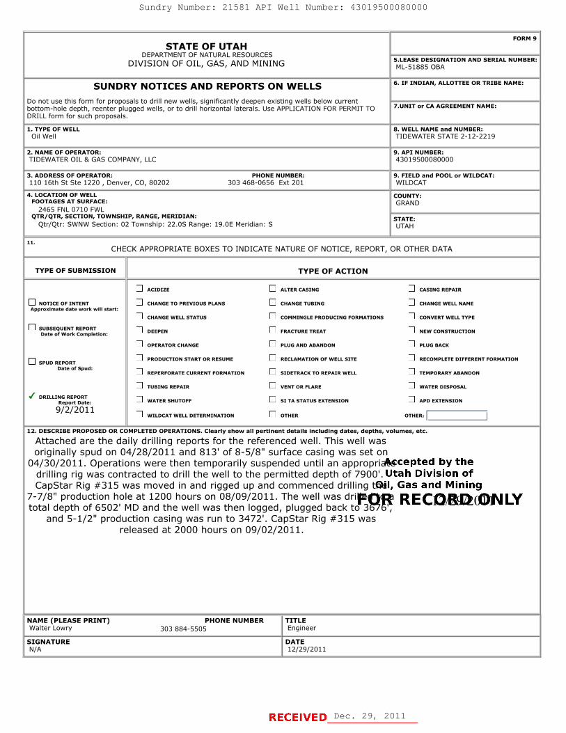
STATE OF UTAHDEPARTMENT OF NATURAL RESOURCES
DIVISION OF OIL, GAS, AND MINING
FORM 9
5.LEASE DESIGNATION AND SERIAL NUMBER: ML-51885 OBA
SUNDRY NOTICES AND REPORTS ON WELLSDo not use this form for proposals to drill new wells, significantly deepen existing wells below currentbottom-hole depth, reenter plugged wells, or to drill horizontal laterals. Use APPLICATION FOR PERMIT TODRILL form for such proposals.
6. IF INDIAN, ALLOTTEE OR TRIBE NAME:
7.UNIT or CA AGREEMENT NAME:
1. TYPE OF WELL Oil Well
8. WELL NAME and NUMBER: TIDEWATER STATE 2-12-2219
2. NAME OF OPERATOR: TIDEWATER OIL & GAS COMPANY, LLC
9. API NUMBER: 43019500080000
3. ADDRESS OF OPERATOR: PHONE NUMBER: 110 16th St Ste 1220 , Denver, CO, 80202 303 468-0656 Ext 201
9. FIELD and POOL or WILDCAT: WILDCAT
4. LOCATION OF WELL FOOTAGES AT SURFACE: 2465 FNL 0710 FWL QTR/QTR, SECTION, TOWNSHIP, RANGE, MERIDIAN: Qtr/Qtr: SWNW Section: 02 Township: 22.0S Range: 19.0E Meridian: S
COUNTY: GRAND
STATE: UTAH
11.
CHECK APPROPRIATE BOXES TO INDICATE NATURE OF NOTICE, REPORT, OR OTHER DATA
TYPE OF SUBMISSION TYPE OF ACTION
NOTICE OF INTENTApproximate date work will start:
SUBSEQUENT REPORTDate of Work Completion:
SPUD REPORTDate of Spud:
DRILLING REPORTReport Date:
9/2/2011
ACIDIZE ALTER CASING CASING REPAIR
CHANGE TO PREVIOUS PLANS CHANGE TUBING CHANGE WELL NAME
CHANGE WELL STATUS COMMINGLE PRODUCING FORMATIONS CONVERT WELL TYPE
DEEPEN FRACTURE TREAT NEW CONSTRUCTION
OPERATOR CHANGE PLUG AND ABANDON PLUG BACK
PRODUCTION START OR RESUME RECLAMATION OF WELL SITE RECOMPLETE DIFFERENT FORMATION
REPERFORATE CURRENT FORMATION SIDETRACK TO REPAIR WELL TEMPORARY ABANDON
TUBING REPAIR VENT OR FLARE WATER DISPOSAL
WATER SHUTOFF SI TA STATUS EXTENSION APD EXTENSION
WILDCAT WELL DETERMINATION OTHER OTHER:
12. DESCRIBE PROPOSED OR COMPLETED OPERATIONS. Clearly show all pertinent details including dates, depths, volumes, etc.
Attached are the daily drilling reports for the referenced well. This well wasoriginally spud on 04/28/2011 and 813' of 8-5/8" surface casing was set on
04/30/2011. Operations were then temporarily suspended until an appropriatedrilling rig was contracted to drill the well to the permitted depth of 7900'.CapStar Rig #315 was moved in and rigged up and commenced drilling the
7-7/8" production hole at 1200 hours on 08/09/2011. The well was drilled to atotal depth of 6502' MD and the well was then logged, plugged back to 3676',
and 5-1/2" production casing was run to 3472'. CapStar Rig #315 wasreleased at 2000 hours on 09/02/2011.
NAME (PLEASE PRINT) PHONE NUMBER Walter Lowry 303 884-5505
TITLE Engineer
SIGNATURE N/A
DATE 12/29/2011
12/29/2011
Dec. 29, 2011
Sundry Number: 21581 API Well Number: 43019500080000
FORM 9STATE OF UTAH
DEPARTMENT OF NATURAL RESOURCESDIVISION OF OIL, GAS, AND MINING EA51E D5ESILNATION AND SERIAL NUMBER:
SUNDRY NOTICES AND REPORTS ON WELLS 6. IF INDIAN, ALLOTTEE OR TRIBE NAME:
Do not use this form for proposals to drill new wells, significantly deepen existing wells below currentbottom-hole depth, reenter plugged wells, or to drill horizontal laterals. Use APPLICATION FOR PERMIT TO 7.UNIT or CA AGREEMENT NAME:
DRILL form for such proposals.
1.TYPE OF VVELL 8.VVELLNAMEand NUMBER:Oil Well TIDEWATER STATE 2-12-2219
2. NAME OF OPERATOR: 9. API NUMBER:TIDEWATER OIL & GAS COMPANY, LLC 43019500080000
3. ADDRESS OF OPERATOR: PHONE NUMBER: 9. FIELD and POOL or WILDCAT:110 16th St Ste 1220 , Denver, CO, 80202 303 468-0656 Ext 201 WILDCAT
4.LOCATIONOFVVELL COUNTY:FOOTAGES AT SURFACE: GRAND
2465 FNL 0710 FWLQTR/QTR, SECTION, TOWNSHIP, RANGE, MERIDIAN: STATE:
Qtr/Qtr: SWNW Section: 02 Township: 22.05 Range: 19.0E Meridian: S UTAH
11.CHECK APPROPRIATE BOXES TO INDICATE NATURE OF NOTICE, REPORT, OR OTHER DATA
TYPE OF SUBMISSION TYPE OF ACTION
ACIDIZE ALTER CASING CASING REPAIR
NOTICE OF INTENT CHANGE TO PREVIOUS PLANS CHANGE TUBING CHANGE WELL NAMEApproximate date work will start:
CHANGE WELL STATUS COMMINGLE PRODUCING FORMATIONS CONVERT WELL TYPE
SDUat ofUWENrkRCEPmOption: DEEPEN FRACTURE TREAT NEW CONSTRUCTION
OPERATOR CHANGE PLUG AND ABANDON PLUG BACK
SPUD REPORTPRODUCTION START OR RESUME RECLAMATION OF WELL SITE RECOMPLETE DIFFERENT FORMATION
Date of Spud:REPERFORATE CURRENT FORMATION SIDETRACK TO REPAIR WELL TEMPORARY ABANDON
TUBING REPAIR VENT OR FLARE WATER DISPOSAL
DRILLINRLRENDe. WATER SHUTOFF SI TA STATUS EXTENSION APD EXTENSION
9/2/2011WILDCAT WELL DETERMINATION OTHER OTHER:
12. DESCRIBE PROPOSED OR C( MPLETED OPERATIONS. Clearly show all pertinent details including dates, depths, volumes, etc.
Attached are the daily drilling reports for the referenced well. This well wasoriginally spud on 04/28/2011 and 813' of 8-5/8" surface casing was set on
04/30/2011. Operations were then temporarily suspended until an appropriatscepted by thedrilling rig was contracted to drill the well to the permitted depth of 7900'. Utah Division ofCapStar Rig #315 was moved in and rigged up and commenced drilling tOil, Gas and Mining
7-7/8" production hole at 1200 hours on 08/09/2011. The well was driPOR RE CORWOIN LYtotal depth of 6502' MD and the well was then logged, plugged back to 36¯7b',and 5-1/2" production casing was run to 3472'. CapStar Rig #315 was
released at 2000 hours on 09/02/2011.
NAME (PLEASE PRINT) PHONE NUMBER TITLEWalter Lowry 303 884-5505 Engineer
SIGNATURE DATEN/A

TIDEWATER OIL & GAS COMPANY LLC
DAILY DRILLING REPORT Report Date: 04/21/11
Report Time: 1700 hrs
Operator: TIDEWATER OIL & GAS COMPANY LLCState Lease:
ML51885OBA Field: Wildcat
Well Name: Tidewater State 2-12-2219 API 43-019-50008 Location: 2465' FSL, 710' FWLContractor: K-SUE Type: Vertical Elev 4799' graded SWNW Sec 2, T22S, R19ERig #:: Target: White Rim- Cutler Grand County, Utah
Current Operation: Days From Spud: Current Depth: 24 Hour Footage: Hole Condition: Hole Problems:
Building road and location NA 0 NA NASummary:
Walt Lowry (Engineer/Company Man): 303-884-5505 Cum Cost:
Mud Depth: Weight: Viscosity: Water Loss: Filter Cake: pH:Chlorides
PPM:Calcium
PPM: Solids %: Sand %:
Properties:
Mud Number: Mnfctr: Model: Liner ("):Rod Size
("): Number: Mnfctr: Model: Stroke ("): Liner ("):Rod Size
("):Pump:
DrillingDepth
Interval:Weight on
Bit:RPM: Pump
Press(PSI):SPM. Average Drill
Rate:Ave. FPM.
DP.:Ave. FPM.
DC.:FPS.: Hydr. Hp.:
Parameters:
No./Size Mnfctr: Type: IADC Serial #:Jets (# / 32nds):
Depth In (ft):
Depth Out (ft): Footage: FPH: Rotating Hours: Condition:
Bit: Cum.
Bit Record:
Surveys: Depth: (ft.) Degrees: Azimuth Depth: (ft) Degrees Azimuth Depth: (ft.) Degrees: Azimuth TVD Build Assmbly
To Time: Hours: OPERATIONS COST: Today: Cum.:
Rig:
Mud:
Chemicals/ Water/ Air:
Bit/ Rmr:
Rentals:
Geologist & Mudlogger:
Supr:
Fuel/ Lube:
Logs:
Back Off
Mob/Dmob
Directional
Trucking:
Fishing
Road/Location
Total 0 Total:BG: Conn.: Trip: Gas Chromatograph Formation %: Shows:
Mud Gas C1 C2 C3 C4 C5 Shale: Sand: Chalk:Units:
Hours: DRLG: Trip: Rig Serv: Clean Pit Ream/ Wash: Circ:Log/ Csg
Run: Other: Downtime Totals:Repair: Other: Footage: Daywork:
Today: 0Cum.:
Commence building access road and location. Prepare to level location tomorrow. Anticipate completion of road, location, and reserve pit by Monday afternoon (4/25/2011). K-Sue Construction out of Moab, Utah was the successful bidder for location construction. Their bid is a lump sum bid of $26,000 not including the pit liner. Mike Davis out of Green River is supervising the location construction. A 500 bbl frac tank has been ordered. 850' of 8-5/8" 24.0 ppf J55 STC surface casing to be delivered next week. The conductor hole will be drilled Monday and conductor casing will be set Tuesday 4/26/2011. The surface casing rig will road on Wednesday 4/27/2011 and spud the 12-1/4" surface hole on Thursday 4/28/2011. The surface casing should be cemented by Saturday morning 04/30/2011. Cost of State Bond- $30,000. Permit costs- Permitco & Uintah: $5310
Miscellaneous
Cmt & Cmtg:
Wellhead, Tbg & Csg
Gel Strength:
Stroke ("):
Torque:
Dec. 29, 2011
Sundry Number: 21581 API Well Number: 43019500080000
TIDEWATER OIL & GAS COMPANY LLC
DAILY DRILLING REPORT Report Date: 04/21/11
Report Time: 1700 hrsState ML51885Operator: TIDEWATER OIL & GAS COMPANY LLC Lease OBA Field: Wildcat
Well Name: Tidewater State 2-12-2219 API 43-019-50008 Location: 2465' FSL, 710' FWLContractor: K-SUE Type: Vertical Elev 4799' araded SWNW Sec 2, T22S, R19ERig #:: Target: White Rim- Cutler Grand County, Utah
Current Operation: Days From Spud: Current Depth: 24 Hour Footage Hole Condition: Hole Problems:
Building road and location NA O NA NASummary: Commence building access road and location. Prepare to level location tomorrow. Anticipate completion of road, location, and reserve pit by
Monday afternoon (4/25/2011). K-Sue Construction out of Moab, Utah was the successful bidder for location construction. Their bid is a lumpsum bid of $26,000 not including the pit liner. Mike Davis out of Green River is supervising the location construction. A 500 bbl frac tank hasbeen ordered. 850' of 8-5/8" 24.0 ppf J55 STC surface casing to be delivered next week. The conductor hole will be drilled Monday andconductor casing will be set Tuesday 4/26/2011. The surface casing rig will road on Wednesday 4/27/2011 and spud the 12-1/4" surface holeon Thursday 4/28/2011. The surface casing should be cemented by Saturday morning 04/30/2011. Cost of State Bond- $30,000. Permitcosts- Permitco & Uintah: $5310
Walt Lowry (Engineerl3ompany Vlan): 303-384-5505 Cum Cost:Chlorides Calcium
Mud Depth: Weight Viscosity: Gel Strength: Water Loss: Filter Cake: pH:PPM: PPM:
Solids %: Sand %
Properties:Rod Size Rod Size
Mud Number Mnfctr Model Stroke("): Liner(") Number Mnfctr Model Stroke("): Liner(") ,
Pump:
Depth Weight onRPM Torque Pump SPM. Average Drill Ave. FPM. Ave. FPM.
FPS.: Hydr. HpDrilling Interval Bit Press(PSI): Rate: DP.: DC.
Parameters:Jets (#/ Depth In Depth Out
No./Size Mnfctr Type IADC Serial#: Footage: FPH RotatingHours: Condition:32nds): (ft): (ft)
Bit: Cum.
BitRecord:
Su rveys: Depth: (ft.) Degrees Azimuth Jepth: (ft) Degrees Azimuth Depth (ft.) Degrees: Azimuth TVD Build Assmbly
To Time: Hours: OPERATIONS coST: Today: Cum.:
Rig:
Mud:
Chemicals/ Waterl Air:
Bit/ Rmr:
Rentals:
Geologist& Mudlogger:
Supr:
Fuell Lube:
Logs:
Wellhead, Tbg & Csg
Cmt & Cmtg:
Back Off
MoblDmob
Directional
Trucking:
Fishing
Road/Location
Miscellaneous
Total 0 Total:BG: Conn. Trip: Gas Chromatograph Formation%. Shows:
Mud Gas c1 c2 c3 c4 c5 Shale: Sand Chalk:Units:
Log/ CsgHours: DRLG Trip: Rig Selv Clean Pit Ream/Wash Circ: Run: Other Downtime Totals:
Repair Other Footage: Daywork:Today: O

TIDEWATER OIL & GAS COMPANY LLC
DAILY DRILLING REPORT Report Date: 04/22/11
Report Time: 1700 hrs
Operator: TIDEWATER OIL & GAS COMPANY LLCState Lease:
ML51885OBA Field: Wildcat
Well Name: Tidewater State 2-12-2219 API 43-019-50008 Location: 2465' FSL, 710' FWLContractor: K-SUE Type: Vertical Elev 4799' graded SWNW Sec 2, T22S, R19ERig #:: Target: White Rim- Cutler Grand County, Utah
Current Operation: Days From Spud: Current Depth: 24 Hour Footage: Hole Condition: Hole Problems:
Building road and location NA 0 NA NASummary:
Walt Lowry (Engineer/Company Man): 303-884-5505 Cum Cost: $0
Mud Depth: Weight: Viscosity: Water Loss: Filter Cake: pH:Chlorides
PPM:Calcium
PPM: Solids %: Sand %:
Properties:
Mud Number: Mnfctr: Model: Liner ("):Rod Size
("): Number: Mnfctr: Model: Stroke ("): Liner ("):Rod Size
("):Pump:
DrillingDepth
Interval:Weight on
Bit:RPM: Torqu
e:Pump
Press(PSI):SPM. Average Drill
Rate:Ave. FPM.
DP.:Ave. FPM.
DC.:FPS.: Hydr. Hp.:
Parameters:
No./Size Mnfctr: Type: IADC Serial #:Jets (# / 32nds):
Depth In (ft):
Depth Out (ft): Footage: FPH: Rotating Hours: Condition:
Bit: Cum.
Bit Record:
Building access road & location.
Gel Strength:
Stroke ("):
Surveys: Depth: (ft.) Degrees: Azimuth Depth: (ft) Degrees Azimuth Depth: (ft.) Degrees: Azimuth TVD Build Assmbly
To Time: Hours: OPERATIONS COST: Today: Cum.:
Rig:
Mud:
Chemicals/ Water/ Air:
Bit/ Rmr:
Rentals:
Geologist & Mudlogger:
Supr:
Fuel/ Lube:
Logs:
Wellhead, Tbg & Csg
Back Off
Mob/Dmob
Directional
Trucking:
Fishing
Road/Location
Total 0 Total:BG: Conn.: Trip: Gas Chromatograph Formation %: Shows:
Mud Gas C1 C2 C3 C4 C5 Shale: Sand: Chalk:Units:
Hours: DRLG: Trip: Rig Serv: Clean Pit Ream/ Wash: Circ:Log/ Csg
Run: Other: Downtime Totals:Repair: Other: Footage: Daywork:
Today: 0Cum.:
Cmt & Cmtg:
Miscellaneous
Dec. 29, 2011
Sundry Number: 21581 API Well Number: 43019500080000
TIDEWATER OIL & GAS COMPANY LLC
DAILY DRILLING REPORT Report Date: 04/22/11
Report Time: 1700 hrsState ML51885Operator: TIDEWATER OIL & GAS COMPANY LLC Lease OBA Field: Wildcat
Well Name: Tidewater State 2-12-2219 API 43-019-50008 Location: 2465' FSL, 710' FWLContractor: K-SUE Type: Vertical Elev 4799' araded SWNW Sec 2, T22S, R19ERig #:: Target: White Rim- Cutler Grand County, Utah
Current Operation: Days From Spud: Current Depth: 24 Hour Footage Hole Condition: Hole Problems:
Building road and location NA O NA NASummary: Building access road &location.
Walt Lowry (Engineerl3ompany dan): 303-E84-5505 Cum Cost: $0Chlorides Calcium
Mud Depth: Weight Viscosity: Gel Strength: Water Loss: Filter Cake pH:PPM: PPM:
Solids %: Sand %
Properties:Rod Size Rod Size
Mud Number Mnfctr Model Stroke ("): Liner(") Number Mnfctr Model Stroke ("): Liner(") ,
Pump:
Depth Weight onRPM
Torqu PumpSPM.
Average Drill Ave. FPM. Ave. FPM.FPS.: Hydr. Hp.Drilling Intemal Bit: e: Press(PSI): Rate: DP.: DC.
Parameters:Jets (#/ Depth In Depth Out
No./Size Mnfctr Type IADC Serial #: Footage: FPH Rotating Hours: Condition:32nds): (#): (ft)
Bit: Cum.
BitRecord:
Surveys: Depth: (ft.) Degrees: Azimuth lepth: (ft) Degrees Azimuth Depth (ft.) Degrees: Azimuth TVD Build Assmbly
To Time: Hours: OPERATIONS coST: Today: Cum.:
Rig:
Mud:
Chemicals/ Waterl Air:
Bit/ Rmr:
Rentals:
Geologist & Mudlogger:
Supr:
Fuell Lube:
Logs:
Wellhead, Tbg & Csg
Cmt & Cmtg:
BackOff
MoblDmob
Directional
Trucking:
Fishing
Road/Location
MiscellaneousTotal O Total:
BG: Conn. Trip: Gas Chromatograph Formation% Shows:Mud Gas c1 c2 c3 c4 c5 Shale Sand Chalk:
Units:Log/ Csg
Hours: DRLG Trip: RigSem CleanPit Ream/Wash Circ: Run: Other Downtime Totals:Repair Other Footage: Daywork:
Today: O
TIDEWATER OIL & GAS COMPANY LLC
DAILY DRILLING REPORT Report Date: 04/22/11
Report Time: 1700 hrsState ML51885Operator: TIDEWATER OIL & GAS COMPANY LLC Lease OBA Field: Wildcat
Well Name: Tidewater State 2-12-2219 API 43-019-50008 Location: 2465' FSL, 710' FWLContractor: K-SUE Type: Vertical Elev 4799' araded SWNW Sec 2, T22S, R19ERig #:: Target: White Rim- Cutler Grand County, Utah
Current Operation: Days From Spud: Current Depth: 24 Hour Footage Hole Condition: Hole Problems:
Building road and location NA O NA NASummary: Building access road &location.
Walt Lowry (Engineerl3ompany dan): 303-E84-5505 Cum Cost: $0Chlorides Calcium
Mud Depth: Weight Viscosity: Gel Strength: Water Loss: Filter Cake pH:PPM: PPM:
Solids %: Sand %
Properties:Rod Size Rod Size
Mud Number Mnfctr Model Stroke ("): Liner(") Number Mnfctr Model Stroke ("): Liner(") ,
Pump:
Depth Weight onRPM
Torqu PumpSPM.
Average Drill Ave. FPM. Ave. FPM.FPS.: Hydr. Hp.
Drilling Intemal Bit: e: Press(PSI): Rate: DP.: DC.
Parameters:Jets (#/ Depth In Depth Out
No./Size Mnfctr Type IADC Serial #: Footage: FPH Rotating Hours: Condition:32nds): (#): (ft)
Bit: Cum.
BitRecord:
Surveys: Depth: (ft.) Degrees: Azimuth lepth: (ft) Degrees Azimuth Depth (ft.) Degrees: Azimuth TVD Build Assmbly
To Time: Hours: OPERATIONS coST: Today: Cum.:
Rig:
Mud:
Chemicals/ Waterl Air:
Bit/ Rmr:
Rentals:
Geologist & Mudlogger:
Supr:
Fuell Lube:
Logs:
Wellhead, Tbg & Csg
Cmt & Cmtg:
BackOff
MoblDmob
Directional
Trucking:
Fishing
Road/Location
Miscellaneous
Total O Total:BG: Conn. Trip: Gas Chromatograph Formation% Shows:
Mud Gas c1 c2 c3 c4 c5 Shale Sand Chalk:Units:
Log/ CsgHours: DRLG Trip: RigSem CleanPit Ream/Wash Circ: Run: Other Downtime Totals:
Repair Other Footage: Daywork:
Today: O

TIDEWATER OIL & GAS COMPANY LLC
DAILY DRILLING REPORT Report Date: 04/23/11
Report Time: 1700 hrs
Operator: TIDEWATER OIL & GAS COMPANY, LLCState Lease:
ML51885OBA Field: Wildcat
Well Name: Tidewater State 2-12-2219 API 43-019-50008 Location: 2465' FSL, 710' FWLContractor: K-SUE Type: Vertical Elev 4799' graded SWNW Sec 2, T22S, R19ERig #:: Target: White Rim- Cutler Grand County, Utah
Current Operation: Days From Spud: Current Depth: 24 Hour Footage: Hole Condition: Hole Problems:
Building road and location NA 0 NA NASummary:
Walt Lowry (Engineer/Company Man): 303-884-5505 Cum Cost: $0
Mud Depth: Weight: Viscosity: Water Loss: Filter Cake: pH:Chlorides
PPM:Calcium
PPM: Solids %: Sand %:
Properties:
Mud Number: Mnfctr: Model: Liner ("):Rod Size
("): Number: Mnfctr: Model: Stroke ("): Liner ("):Rod Size
("):Pump:
DrillingDepth
Interval:Weight on
Bit:RPM: Torqu
e:Pump
Press(PSI):SPM. Average Drill
Rate:Ave. FPM.
DP.:Ave. FPM.
DC.:FPS.: Hydr. Hp.:
Parameters:
No./Size Mnfctr: Type: IADC Serial #:Jets (# / 32nds):
Depth In (ft):
Depth Out (ft): Footage: FPH: Rotating Hours: Condition:
Bit: Cum.
Bit Record:
Building access road & location.
Gel Strength:
Stroke ("):
Surveys: Depth: (ft.) Degrees: Azimuth Depth: (ft) Degrees Azimuth Depth: (ft.) Degrees: Azimuth TVD Build Assmbly
To Time: Hours: OPERATIONS COST: Today: Cum.:
Rig:
Mud:
Chemicals/ Water/ Air:
Bit/ Rmr:
Rentals:
Geologist & Mudlogger:
Supr:
Fuel/ Lube:
Logs:
Wellhead, Tbg & Csg
Back Off
Mob/Dmob
Directional
Trucking:
Fishing
Road/Location
Total 0 Total:BG: Conn.: Trip: Gas Chromatograph Formation %: Shows:
Mud Gas C1 C2 C3 C4 C5 Shale: Sand: Chalk:Units:
Hours: DRLG: Trip: Rig Serv: Clean Pit Ream/ Wash: Circ:Log/ Csg
Run: Other: Downtime Totals:Repair: Other: Footage: Daywork:
Today: 0Cum.:
Cmt & Cmtg:
Miscellaneous
Dec. 29, 2011
Sundry Number: 21581 API Well Number: 43019500080000
TIDEWATER OIL & GAS COMPANY LLC
DAILY DRILLING REPORT Report Date: 04/23/11
Report Time: 1700 hrsState ML51885Operator: TIDEWATER OIL & GAS COMPANY, LLC Lease OBA Field: Wildcat
Well Name: Tidewater State 2-12-2219 API 43-019-50008 Location: 2465' FSL, 710' FWLContractor: K-SUE Type: Vertical Elev 4799' araded SWNW Sec 2, T22S, R19ERig #:: Target: White Rim- Cutler Grand County, Utah
Current Operation: Days From Spud: Current Depth: 24 Hour Footage: Hole Condition: Hole Problems:
Building road and location NA O NA NASummary: Building access road &location.
Walt Lowry (Engineerl3ompany dan): 303-E84-5505 Cum Cost: $0Chlorides Calcium
Mud Depth: Weight: Viscosity: Gel Strength: Water Loss: Filter Cake: pH:PPM: PPM:
Solids %: Sand %:
Properties:Rod Size Rod Size
Mud Number Mnfctr Model Stroke ("): Liner("): Number Mnfctr Model: Stroke ("): Liner(")
Pump:
Depth Weight onRPM
Torqu PumpSPM.
Average Drill Ave. FPM. Ave. FPM.FPS.: Hydr. Hp.Drilling Intemal: Bit: e: Press(PSI): Rate: DP.: DC.:
Parameters:Jets (#/ Depth In Depth Out
No./Size Mnfctr Type IADC Serial #: Footage: FPH: Rotating Hours: Condition:32nds): (#): (ft)
Bit: Cum.
BitRecord:
ISurveys: Depth: (ft.) Degrees: Azimuth Jepth: (ft) Degrees Azimuth Depth: (ft.) Degrees: Azimuth TVD Build Assmbly
To Time: Hours: OPERATIONS cosT: Today: Cum.:
Rig:
Mud:
Chemicals/ Water/ Air:
Bit/ Rmr:
Rentals:
Geologist & Mudlogger:
Supr:
Fuell Lube:
Logs:
Wellhead, Tbg & Csg
Cmt & Cmtg:
Back Off
Mob/Dmob
Directional
Trucking:
Fishing
Road/Location
Miscellaneous
Total O Total:BG: Conn.: Trip: Gas Chromatograph Formation %. Shows:
Mud Gas c1 c2 c3 c4 c5 Shale: Sand: Chalk:Units:
Log/ CsgHours: DRLG: Trip: Rig Sem: Clean Pit Ream/Wash: Circ: Run: Other Downtime Totals:
Repair Other Footage: Daywork:
Today: O
TIDEWATER OIL & GAS COMPANY LLC
DAILY DRILLING REPORT Report Date: 04/23/11
Report Time: 1700 hrsState ML51885Operator: TIDEWATER OIL & GAS COMPANY, LLC Lease OBA Field: Wildcat
Well Name: Tidewater State 2-12-2219 API 43-019-50008 Location: 2465' FSL, 710' FWLContractor: K-SUE Type: Vertical Elev 4799' araded SWNW Sec 2, T22S, R19ERig #:: Target: White Rim- Cutler Grand County, Utah
Current Operation: Days From Spud: Current Depth: 24 Hour Footage: Hole Condition: Hole Problems:
Building road and location NA O NA NASummary: Building access road &location.
Walt Lowry (Engineerl3ompany dan): 303-E84-5505 Cum Cost: $0Chlorides Calcium
Mud Depth: Weight: Viscosity: Gel Strength: Water Loss: Filter Cake: pH:PPM: PPM:
Solids %: Sand %:
Properties:Rod Size Rod Size
Mud Number Mnfctr Model Stroke ("): Liner("): Number Mnfctr Model: Stroke ("): Liner(")
Pump:
Depth Weight onRPM
Torqu PumpSPM.
Average Drill Ave. FPM. Ave. FPM.FPS.: Hydr. Hp.
Drilling Intemal: Bit: e: Press(PSI): Rate: DP.: DC.:
Parameters:Jets (#/ Depth In Depth Out
No./Size Mnfctr Type IADC Serial #: Footage: FPH: Rotating Hours: Condition:32nds): (#): (ft)
Bit: Cum.
BitRecord:
ISurveys: Depth: (ft.) Degrees: Azimuth Jepth: (ft) Degrees Azimuth Depth: (ft.) Degrees: Azimuth TVD Build Assmbly
To Time: Hours: OPERATIONS cosT: Today: Cum.:
Rig:
Mud:
Chemicals/ Water/ Air:
Bit/ Rmr:
Rentals:
Geologist & Mudlogger:
Supr:
Fuell Lube:
Logs:
Wellhead, Tbg & Csg
Cmt & Cmtg:
Back Off
Mob/Dmob
Directional
Trucking:
Fishing
Road/Location
Miscellaneous
Total O Total:BG: Conn.: Trip: Gas Chromatograph Formation %. Shows:
Mud Gas c1 c2 c3 c4 c5 Shale: Sand: Chalk:Units:
Log/ CsgHours: DRLG: Trip: Rig Sem: Clean Pit Ream/Wash: Circ: Run: Other Downtime Totals:
Repair Other Footage: Daywork:
Today: O

TIDEWATER OIL & GAS COMPANY LLC
DAILY DRILLING REPORT Report Date: 04/24/11
Report Time: 1700 hrs
Operator: TIDEWATER OIL & GAS COMPANY LLCState Lease:
ML51885OBA Field: Wildcat
Well Name: Tidewater State 2-12-2219 API 43-019-50008 Location: 2465' FSL, 710' FWLContractor: K-SUE Type: Vertical Elev 4799' graded SWNW Sec 2, T22S, R19ERig #:: Target: White Rim- Cutler Grand County, Utah
Current Operation: Days From Spud: Current Depth: 24 Hour Footage: Hole Condition: Hole Problems:
Building road and location NA 0 NA NASummary:
Walt Lowry (Engineer/Company Man): 303-884-5505 Cum Cost: $0
Mud Depth: Weight: Viscosity: Water Loss: Filter Cake: pH: Chlorides PPM:
Calcium PPM: Solids %: Sand %:
Properties:
Mud Number: Mnfctr: Model: Liner ("): Rod Size ("): Number: Mnfctr: Model: Stroke ("): Liner ("): Rod Size
("):Pump:
DrillingDepth
Interval:Weight on
Bit: RPM: Torque:
Pump Press(PSI): SPM. Average Drill
Rate:Ave. FPM.
DP.:Ave. FPM.
DC.: FPS.: Hydr. Hp.:
Parameters:
No./Size Mnfctr: Type: IADC Serial #: Jets (# / 32nds):
Depth In (ft):
Depth Out (ft): Footage: FPH: Rotating Hours: Condition:
Bit: Cum.
Bit Record:
Easter Sunday- No Activity.
Gel Strength:
Stroke ("):
Surveys: Depth: (ft.) Degrees: Azimuth Depth: (ft) Degrees Azimuth Depth: (ft.) Degrees: Azimuth TVD Build Assmbly
To Time: Hours: OPERATIONS COST: Today: Cum.:
Rig:
Mud:
Chemicals/ Water/ Air:
Bit/ Rmr:
Rentals:
Geologist & Mudlogger:
Supr:
Fuel/ Lube:
Logs:
Wellhead, Tbg & Csg
Back Off
Mob/Dmob
Directional
Trucking:
Fishing
Road/Location
Total 0 Total:BG: Conn.: Trip: Gas Chromatograph Formation %: Shows:
Mud Gas C1 C2 C3 C4 C5 Shale: Sand: Chalk:Units:
Hours: DRLG: Trip: Rig Serv: Clean Pit Ream/ Wash: Circ:Log/ Csg
Run: Other: Downtime Totals:Repair: Other: Footage: Daywork:
Today: 0Cum.:
Cmt & Cmtg:
Miscellaneous
Dec. 29, 2011
Sundry Number: 21581 API Well Number: 43019500080000
TIDEWATER OIL & GAS COMPANY LLC
DAILY DRILLING REPORT Report Date: 04/24/11
Report Time: 1700 hrsState ML51885Operator: TIDEWATER OIL & GAS COMPANY LLC Lease OBA Field: Wildcat
Well Name: Tidewater State 2-12-2219 API 43-019-50008 Location: 2465' FSL, 710' FWLContractor: K-SUE Type: Vertical Elev 4799' araded SWNW Sec 2, T22S, R19ERig #:: Target: White Rim- Cutler Grand County, Utah
Current Operation: Days From Spud: Current Depth: 24 Hour Footage: Hole Condition: Hole Problems:
Building road and location NA O NA NASummary: Easter Sunday- No Activity.
Walt Lowry (Engineer/Company Vlan): 303-884-5505 Cum Cost: $0Chlorides Calcium
Mud Depth: Weight: Viscosity Gel Strength: Water Loss: Filter Cake: pH: Solids %: Sand %:
Properties:Rod Size Rod Size
Mud Number Mnfctr Model: Stroke ("): Liner ("): Number Mnfctr Model: Stroke ("): Liner (")Pump:
Depth Weight on RPM Torqu Pump SPM Average Drill Ave. FPM Ave. FPM FPS Hydr. HpDrilling Interval: Bit: e: Press(PSI): Rate: DP.: DC.
Parameters:
No./Size Mnfctr Type: lADC Serial #: Jets (#/ Depth In Depth Out Footage: FPH Rotating Hours: Condition:32nds): (ft): (ft):Bit: Cum.
BitRecord:
ISurveys: Depth: (ft.) Degrees: Azimuth Jepth: (ft) Degrees Azimuth Depth: (it.) Degrees: Azimuth TVD Build Assmbly
To Time: Hours: OPERATIONS COST: Today: Cum.:
Rig:
Mud:
Chemicals/ Water/ Air:
Bit/ Rmr:
Rentals:
Geologist & Mudlogger:
Supr:
Fuell Lube:
Logs:
Wellhead, Tbg & Csg
Cmt & Cmtg:
Back Off
Mob/Dmob
Directional
Trucking:
Fishing
Road/Location
Miscellaneous
Total O Total:BG: Conn.: Trip: Gas Chromatograph Formation %. Shows:
Mud Gas C1 C2 C3 C4 C5 Shale: Sand: Chalk:Units:
Log/ CsgHours: DRLG: Trip: Rig Serv Clean Pit Ream/Wash: Circ: Run: Other Downtime Totals:
Repair Other Footage: Daywork:Today: O

TIDEWATER OIL & GAS COMPANY LLC
DAILY DRILLING REPORT Report Date: 04/25/11
Report Time: 1700 hrs
Operator: TIDEWATER OIL & GAS COMPANY LLCState Lease:
ML51885OBA Field: Wildcat
Well Name: Tidewater State 2-12-2219 API 43-019-50008 Location: 2465' FSL, 710' FWLContractor: Pete Martin Drillig Type: Vertical Elev 4799' graded SWNW Sec 2, T22S, R19ERig #:: Target: White Rim- Cutler Grand County, Utah
Current Operation: Days From Spud: Current Depth: 24 Hour Footage: Hole Condition: Hole Problems:
Drill 24" conductor hole. NA 0 NA NASummary:
Walt Lowry (Engineer/Company Man): 303-884-5505 Cum Cost: $0
Mud Depth: Weight: Viscosity: Water Loss: Filter Cake: pH:Chlorides
PPM:Calcium
PPM: Solids %: Sand %:
Properties:
Mud Number: Mnfctr: Model: Liner ("):Rod Size
("): Number: Mnfctr: Model: Stroke ("): Liner ("):Rod Size
("):Pump:
DrillingDepth
Interval:Weight on
Bit:RPM: Torqu
e:Pump
Press(PSI):SPM. Average Drill
Rate:Ave. FPM.
DP.:Ave. FPM.
DC.:FPS.: Hydr. Hp.:
Parameters:
No./Size Mnfctr: Type: IADC Serial #:Jets (# / 32nds):
Depth In (ft):
Depth Out (ft): Footage: FPH: Rotating Hours: Condition:
Bit: Cum.
Bit Record:
Finish building access road & location. Dig reserve pit. Build fence along 3 sides of reserve pit. MIRU Pete Martin Drilling and drill 24" conductor hole to 60' BGL with air & mist. No water encountered. Waiting on pit liner.
Gel Strength:
Stroke ("):
Surveys: Depth: (ft.) Degrees: Azimuth Depth: (ft) Degrees Azimuth Depth: (ft.) Degrees: Azimuth TVD Build Assmbly
To Time: Hours: OPERATIONS COST: Today: Cum.:
Rig:
Mud:
Chemicals/ Water/ Air:
Bit/ Rmr:
Rentals:
Geologist & Mudlogger:
Supr:
Fuel/ Lube:
Logs:
Wellhead, Tbg & Csg
Back Off
Mob/Dmob
Directional
Trucking:
Fishing
Road/Location
Total 0 Total:BG: Conn.: Trip: Gas Chromatograph Formation %: Shows:
Mud Gas C1 C2 C3 C4 C5 Shale: Sand: Chalk:Units:
Hours: DRLG: Trip: Rig Serv: Clean Pit Ream/ Wash: Circ:Log/ Csg
Run: Other: Downtime Totals:Repair: Other: Footage: Daywork:
Today: 0Cum.:
Cmt & Cmtg:
Miscellaneous
Dec. 29, 2011
Sundry Number: 21581 API Well Number: 43019500080000
TIDEWATER OIL & GAS COMPANY LLC
DAILY DRILLING REPORT Report Date: 04/25/11
Report Time: 1700 hrsState ML51885Operator: TIDEWATER OIL & GAS COMPANY LLC Lease OBA Field: Wildcat
Well Name: Tidewater State 2-12-2219 API 43-019-50008 Location: 2465' FSL, 710' FWLContractor: Pete Martin Drillia Type: Vertical Elev 4799' araded SWNW Sec 2, T22S, R19ERig #:: Target: White Rim- Cutler Grand County, Utah
Current Operation: Days From Spud: Current Depth: 24 Hour Footage Hole Condition: Hole Problems:
Drill24" conductor hole. NA O NA NASummary: Finish building access road &location. Dig reserve pit. Build fence along 3 sides of reserve pit. MIRU Pete Martin Drillingand drill24"
conductor hole to 60' BGL with air &mist. No water encountered. Waiting on pit liner.
Walt Lowry (Engineerl3ompany Wan): 303-E84-5505 Cum Cost: $0Chlorides Calcium
Mud Depth: Weight Viscosity: Gel Strength: Water Loss: Filter Cake: pH:PPM: PPM:
Solids %: Sand %
Properties:Rod Size Rod Size
Mud Number Mnfctr Model Stroke ("): Liner(") Number Mnfctr Model Stroke ("): Liner(") ,
Pump:
Depth Weight onRPM
Torqu PumpSPM.
Average Drill Ave. FPM. Ave. FPM.FPS.: Hydr. HpDrilling Intemal Bit e: Press(PSI): Rate: DP.: DC.
Parameters:Jets (#/ Depth In Depth Out
No./Size Mnfctr Type IADC Serial #: Footage: FPH Rotating Hours: Condition:32nds): (#): (ft)
Bit: Cum.
BitRecord:
Surveys: Depth: (ft.) Degrees: Azimuth lepth: (ft) Degrees Azimuth Depth (ft.) Degrees: Azimuth TVD Build Assmbly
To Time: Hours: OPERATIONS coST: Today: Cum.:
Rig:
Mud:
Chemicals/ Waterl Air:
Bit/ Rmr:
Rentals:
Geologist & Mudlogger:
Supr:
Fuell Lube:
Logs:
Wellhead, Tbg & Csg
Cmt & Cmtg:
BackOff
MoblDmob
Directional
Trucking:
Fishing
Road/Location
Miscellaneous
Total O Total:BG: Conn. Trip: Gas Chromatograph Formation%. Shows:
Mud Gas c1 c2 c3 c4 c5 Shale Sand Chalk:Units:
Log/ CsgHours: DRLG Trip: RigSem CleanPit Ream/Wash Circ: Run: Other Downtime Totals:
Repair Other Footage: Daywork:
Today: O
TIDEWATER OIL & GAS COMPANY LLC
DAILY DRILLING REPORT Report Date: 04/25/11
Report Time: 1700 hrsState ML51885Operator: TIDEWATER OIL & GAS COMPANY LLC Lease OBA Field: Wildcat
Well Name: Tidewater State 2-12-2219 API 43-019-50008 Location: 2465' FSL, 710' FWLContractor: Pete Martin Drillia Type: Vertical Elev 4799' araded SWNW Sec 2, T22S, R19ERig #:: Target: White Rim- Cutler Grand County, Utah
Current Operation: Days From Spud: Current Depth: 24 Hour Footage Hole Condition: Hole Problems:
Drill24" conductor hole. NA O NA NASummary: Finish building access road &location. Dig reserve pit. Build fence along 3 sides of reserve pit. MIRU Pete Martin Drillingand drill24"
conductor hole to 60' BGL with air &mist. No water encountered. Waiting on pit liner.
Walt Lowry (Engineerl3ompany Wan): 303-E84-5505 Cum Cost: $0Chlorides Calcium
Mud Depth: Weight Viscosity: Gel Strength: Water Loss: Filter Cake: pH:PPM: PPM:
Solids %: Sand %
Properties:Rod Size Rod Size
Mud Number Mnfctr Model Stroke ("): Liner(") Number Mnfctr Model Stroke ("): Liner(") ,
Pump:
Depth Weight onRPM
Torqu PumpSPM.
Average Drill Ave. FPM. Ave. FPM.FPS.: Hydr. Hp
Drilling Intemal Bit e: Press(PSI): Rate: DP.: DC.
Parameters:Jets (#/ Depth In Depth Out
No./Size Mnfctr Type IADC Serial #: Footage: FPH Rotating Hours: Condition:32nds): (#): (ft)
Bit: Cum.
BitRecord:
Surveys: Depth: (ft.) Degrees: Azimuth lepth: (ft) Degrees Azimuth Depth (ft.) Degrees: Azimuth TVD Build Assmbly
To Time: Hours: OPERATIONS coST: Today: Cum.:
Rig:
Mud:
Chemicals/ Waterl Air:
Bit/ Rmr:
Rentals:
Geologist & Mudlogger:
Supr:
Fuell Lube:
Logs:
Wellhead, Tbg & Csg
Cmt & Cmtg:
BackOff
MoblDmob
Directional
Trucking:
Fishing
Road/Location
Miscellaneous
Total O Total:BG: Conn. Trip: Gas Chromatograph Formation%. Shows:
Mud Gas c1 c2 c3 c4 c5 Shale Sand Chalk:Units:
Log/ CsgHours: DRLG Trip: RigSem CleanPit Ream/Wash Circ: Run: Other Downtime Totals:
Repair Other Footage: Daywork:
Today: O

TIDEWATER OIL & GAS COMPANY LLC
DAILY DRILLING REPORT Report Date: 04/26/11
Report Time: 1700 hrs
Operator: TIDEWATER OIL & GAS COMPANY LLCState Lease:
ML51885OBA Field: Wildcat
Well Name: Tidewater State 2-12-2219 API 43-019-50008 Location: 2465' FSL, 710' FWLContractor: Pete Martin Drilling Type: Vertical Elev 4799' graded SWNW Sec 2, T22S, R19ERig #:: Target: White Rim- Cutler Grand County, Utah
Current Operation: Days From Spud: Current Depth: 24 Hour Footage: Hole Condition: Hole Problems:
Run & cement conductor casing 60' 60' NA NASummary:
Walt Lowry (Engineer/Company Man): 303-884-5505 Cum Cost: $0
Mud Depth: Weight: Viscosity: Water Loss: Filter Cake: pH:Chlorides
PPM:Calcium
PPM: Solids %: Sand %:
Properties:
Mud Number: Mnfctr: Model: Liner ("):Rod Size
("): Number: Mnfctr: Model: Stroke ("): Liner ("):Rod Size
("):Pump:
DrillingDepth
Interval:Weight on
Bit:RPM: Pump
Press(PSI):SPM. Average Drill
Rate:Ave. FPM.
DP.:Ave. FPM.
DC.:FPS.: Hydr. Hp.:
Parameters:
No./Size Mnfctr: Type: IADC Serial #:Jets (# / 32nds):
Depth In (ft):
Depth Out (ft): Footage: FPH: Rotating Hours: Condition:
Bit: Cum.
Bit Record:
Install pit liner. Weld & run 60' of 16" conductor casing to 60' BGL. Cement with 6 cu yards of redi-mix cement. Cement to surface and stayed at surface. Release Pete Martin Drilling (Pete Martin Cost- $9795) Tack weld cap on conductor casing. Bart Kettle with UDOGM on location and approved all operations.
Gel Strength:
Stroke ("):
Torque:
Surveys: Depth: (ft.) Degrees: Azimuth Depth: (ft) Degrees Azimuth Depth: (ft.) Degrees: Azimuth TVD Build Assmbly
To Time: Hours: OPERATIONS COST: Today: Cum.:
Rig:
Mud:
Chemicals/ Water/ Air:
Bit/ Rmr:
Rentals:
Geologist & Mudlogger:
Supr:
Fuel/ Lube:
Logs:
Wellhead, Tbg & Csg
Back Off
Mob/Dmob
Directional
Trucking:
Fishing
Road/Location
Total 0 Total:BG: Conn.: Trip: Gas Chromatograph Formation %: Shows:
Mud Gas C1 C2 C3 C4 C5 Shale: Sand: Chalk:Units:
Hours: DRLG: Trip: Rig Serv: Clean Pit Ream/ Wash: Circ:Log/ Csg
Run: Other: Downtime Totals:Repair: Other: Footage: Daywork:
Today: 0Cum.:
Cmt & Cmtg:
Miscellaneous
Dec. 29, 2011
Sundry Number: 21581 API Well Number: 43019500080000
TIDEWATER OIL & GAS COMPANY LLC
DAILY DRILLING REPORT Report Date: 04/26/11
Report Time: 1700 hrsState ML51885Operator: TIDEWATER OIL & GAS COMPANY LLC Lease OBA Field: Wildcat
Well Name: Tidewater State 2-12-2219 API 43-019-50008 Location: 2465' FSL, 710' FWLContractor: Pete Martin Drillina Type: Vertical Elev 4799' araded SWNW Sec 2, T22S, R19ERig #:: Target: White Rim- Cutler Grand County, Utah
Current Operation: Days From Spud: Current Depth: 24 Hour Footage Hole Condition: Hole Problems:
Run &cement conductor casing 60' 60' NA NASummary: Install pit liner. Weld & run 60' of 16" conductor casing to 60' BGL. Cement with 6 cu yards of redi-mix cement. Cement to surface and
stayed at surface. Release Pete Martin Drilling(Pete Martin Cost- $9795) Tack weld cap on conductor casing. Bart Kettle with UDOGM onlocation and approved all operations.
Walt Lowry (Engineerl3ompany Wan): 303-E84-5505 Cum Cost: $0Chlorides Calcium
Mud Depth: Weight Viscosity: Gel Strength: Water Loss: Filter Cake: pH:PPM: PPM:
Solids %: Sand %
Properties:Rod Size Rod Size
Mud Number Mnfctr Model: Stroke ("): Liner(") Number Mnfctr Model Stroke ("): Liner(") ,
Pump:
Depth Weight on Pump Average Drill Ave. FPM. Ave. FPM.RPM: Torque: SPM. FPS.: Hydr. HpDrilling Intemal Bit: Press(PSI): Rate: DP.: DC.
Parameters:Jets (#/ Depth In Depth Out
No./Size Mnfctr Type: lADC Serial #: Footage: FPH Rotating Hours: Condition:32nds): (#): (ft)
Bit: Cum.
BitRecord:
Surveys: Depth: (ft.) Degrees: Azimuth lepth: (ft) Degrees Azimuth Depth (ft.) Degrees: Azimuth TVD Build Assmbly
To Time: Hours: OPERATIONS coST: Today: Cum.:
Rig:
Mud:
Chemicals/ Waterl Air:
Bit/ Rmr:
Rentals:
Geologist & Mudlogger:
Supr:
Fuell Lube:
Logs:
Wellhead, Tbg & Csg
Cmt & Cmtg:
BackOff
MoblDmob
Directional
Trucking:
Fishing
Road/Location
Miscellaneous
Total O Total:BG: Conn. Trip: Gas Chromatograph Formation%. Shows:
Mud Gas c1 c2 c3 c4 c5 Shale Sand Chalk:Units:
Log/ CsgHours: DRLG Trip: RigSem CleanPit Ream/Wash Circ: Run: Other Downtime Totals:
Repair Other Footage: Daywork:
Today: O
TIDEWATER OIL & GAS COMPANY LLC
DAILY DRILLING REPORT Report Date: 04/26/11
Report Time: 1700 hrsState ML51885Operator: TIDEWATER OIL & GAS COMPANY LLC Lease OBA Field: Wildcat
Well Name: Tidewater State 2-12-2219 API 43-019-50008 Location: 2465' FSL, 710' FWLContractor: Pete Martin Drillina Type: Vertical Elev 4799' araded SWNW Sec 2, T22S, R19ERig #:: Target: White Rim- Cutler Grand County, Utah
Current Operation: Days From Spud: Current Depth: 24 Hour Footage Hole Condition: Hole Problems:
Run &cement conductor casing 60' 60' NA NASummary: Install pit liner. Weld & run 60' of 16" conductor casing to 60' BGL. Cement with 6 cu yards of redi-mix cement. Cement to surface and
stayed at surface. Release Pete Martin Drilling(Pete Martin Cost- $9795) Tack weld cap on conductor casing. Bart Kettle with UDOGM onlocation and approved all operations.
Walt Lowry (Engineerl3ompany Wan): 303-E84-5505 Cum Cost: $0Chlorides Calcium
Mud Depth: Weight Viscosity: Gel Strength: Water Loss: Filter Cake: pH:PPM: PPM:
Solids %: Sand %
Properties:Rod Size Rod Size
Mud Number Mnfctr Model: Stroke ("): Liner(") Number Mnfctr Model Stroke ("): Liner(") ,
Pump:
Depth Weight on Pump Average Drill Ave. FPM. Ave. FPM.RPM: Torque: SPM. FPS.: Hydr. Hp
Drilling Intemal Bit: Press(PSI): Rate: DP.: DC.
Parameters:Jets (#/ Depth In Depth Out
No./Size Mnfctr Type: lADC Serial #: Footage: FPH Rotating Hours: Condition:32nds): (#): (ft)
Bit: Cum.
BitRecord:
Surveys: Depth: (ft.) Degrees: Azimuth lepth: (ft) Degrees Azimuth Depth (ft.) Degrees: Azimuth TVD Build Assmbly
To Time: Hours: OPERATIONS coST: Today: Cum.:
Rig:
Mud:
Chemicals/ Waterl Air:
Bit/ Rmr:
Rentals:
Geologist & Mudlogger:
Supr:
Fuell Lube:
Logs:
Wellhead, Tbg & Csg
Cmt & Cmtg:
BackOff
MoblDmob
Directional
Trucking:
Fishing
Road/Location
Miscellaneous
Total O Total:BG: Conn. Trip: Gas Chromatograph Formation%. Shows:
Mud Gas c1 c2 c3 c4 c5 Shale Sand Chalk:Units:
Log/ CsgHours: DRLG Trip: RigSem CleanPit Ream/Wash Circ: Run: Other Downtime Totals:
Repair Other Footage: Daywork:
Today: O

TIDEWATER OIL & GAS COMPANY LLC
DAILY DRILLING REPORT Report Date: 04/27/11
Report Time: 1700 hrs
Operator: TIDEWATER OIL & GAS COMPANY LLCState Lease:
ML51885OBA Field: Wildcat
Well Name: Tidewater State 2-12-2219 API 43-019-50008 Location: 2465' FSL, 710' FWLContractor: Leon Ross Drilling Type: Vertical Elev 4799' graded SWNW Sec 2, T22S, R19ERig #:: Target: White Rim- Cutler Grand County, Utah
Current Operation: Days From Spud: Current Depth: 24 Hour Footage: Hole Condition: Hole Problems:
MIRU Leon Ross Drilling 60' 0 NA NASummary:
Walt Lowry (Engineer/Company Man): 303-884-5505 Cum Cost: $0
Mud Depth: Weight: Viscosity: Water Loss: Filter Cake: pH:Chlorides
PPM:Calcium
PPM: Solids %: Sand %:
Properties:
Mud Number: Mnfctr: Model: Liner ("):Rod Size
("): Number: Mnfctr: Model: Stroke ("): Liner ("):Rod Size
("):Pump:
DrillingDepth
Interval:Weight on
Bit:RPM: Pump
Press(PSI):SPM. Average Drill
Rate:Ave. FPM.
DP.:Ave. FPM.
DC.:FPS.: Hydr. Hp.:
Parameters:
No./Size Mnfctr: Type: IADC Serial #:Jets (# / 32nds):
Depth In (ft):
Depth Out (ft): Footage: FPH: Rotating Hours: Condition:
Bit: Cum.
Bit Record:
Blade and water access road. Fork lift delivered (Delivery & Return Trucking- $440; Rental- $1188; Cleaning- $107). Receive 850' of 8-5/8" 24.0# J55 STC casing (trucking charge- $780). Receive 500 bbl frac tank from JD Field Services (delivery charge- $1063; Rental charge 5 day min: $175). Spot frac tank. Fill frac tank with fresh water from the City of Thompson Springs (KSUE water & hauling cost- $2125). Make and weld cap on casing- $390). Move in Leon Ross Drilling to drill surface hole. Install pit liner (cost- $2100).
Gel Strength:
Stroke ("):
Torque:
Surveys: Depth: (ft.) Degrees: Azimuth Depth: (ft) Degrees Azimuth Depth: (ft.) Degrees: Azimuth TVD Build Assmbly
To Time: Hours: OPERATIONS COST: Today: Cum.:
Rig:
Mud:
Chemicals/ Water/ Air:
Bit/ Rmr:
Rentals:
Geologist & Mudlogger:
Supr:
Fuel/ Lube:
Logs:
Wellhead, Tbg & Csg
Mob/Dmob
Directional
Trucking:
Fishing
Road/Location
Total 0 Total:BG: Conn.: Trip: Gas Chromatograph Formation %: Shows:
Mud Gas C1 C2 C3 C4 C5 Shale: Sand: Chalk:Units:
Hours: DRLG: Trip: Rig Serv: Clean Pit Ream/ Wash: Circ:Log/ Csg
Run: Other: Downtime Totals:Repair: Other: Footage: Daywork:
Today: 0Cum.:
Miscellaneous
Cmt & Cmtg:
Contract Labor
Dec. 29, 2011
Sundry Number: 21581 API Well Number: 43019500080000
TIDEWATER OIL & GAS COMPANY LLC
DAILY DRILLING REPORT Report Date: 04/27/11
Report Time: 1700 hrsState ML51885Operator: TIDEWATER OIL & GAS COMPANY LLC Lease OBA Field: Wildcat
Well Name: Tidewater State 2-12-2219 API 43-019-50008 Location: 2465' FSL, 710' FWLContractor: Leon Ross Drillina Type: Vertical Elev 4799' araded SWNW Sec 2, T22S, R19ERig #:: Target: White Rim- Cutler Grand County, Utah
Current Operation: Days From Spud: Current Depth: 24 Hour Footage Hole Condition: Hole Problems:
MIRU Leon Ross Drilling 60' O NA NASummary: Blade and water access road. Fork liftdelivered (Delivery & Return Trucking- $440; Rental- $1188; Cleaning- $107). Receive 850' of 8-5/8"
24.0# J55 STC casing (truckingcharge- $780). Receive 500 bbl frac tank from JD Field Services (delivery charge- $1063; Rental charge 5day min: $175). Spot frac tank. Fillfrac tank with fresh water from the City of Thompson Springs (KSUE water & hauling cost- $2125). Makeand weld cap on casing- $390). Move in Leon Ross Drillingto drill surface hole. Install pit liner (cost- $2100).
Walt Lowry (Engineerl3ompany Wan): 303-E84-5505 Cum Cost: $0Chlorides Calcium
Mud Depth: Weight Viscosity: Gel Strength: Water Loss: Filter Cake: pH: PPM: PPM:Solids %: Sand %
Properties:Rod Size Rod Size
Mud Number Mnfctr Model: Stroke ("): Liner(") Number Mnfctr Model Stroke ("): Liner(") ,
Pump:
Depth Weight on Pump Average Drill Ave. FPM. Ave. FPM.RPM: Torque: SPM. FPS.: Hydr. HpDrilling Intemal Bit: Press(PSI): Rate: DP.: DC.
Parameters:Jets (#/ Depth In Depth Out
No./Size Mnfctr Type: lADC Serial #: Footage: FPH Rotating Hours: Condition:32nds): (#): (ft)
Bit: Cum.
BitRecord:
Surveys: Depth: (ft.) Degrees: Azimuth lepth: (ft) Degrees Azimuth Depth (ft.) Degrees: Azimuth TVD Build Assmbly
To Time: Hours: OPERATIONS coST: Today: Cum.:
Rig:
Mud:
Chemicals/ Waterl Air:
Bit/ Rmr:
Rentals:
Geologist & Mudlogger:
Supr:
Fuell Lube:
Logs:
Wellhead, Tbg & Csg
Cmt & Cmtg:
Contract Labor
MoblDmob
Directional
Trucking:
Fishing
Road/Location
Miscellaneous
Total O Total:BG: Conn. Trip: Gas Chromatograph Formation%. Shows:
Mud Gas c1 c2 c3 c4 c5 Shale Sand Chalk:Units:
Log/ CsgHours: DRLG Trip: RigSem CleanPit Ream/Wash Circ: Run: Other Downtime Totals:
Repair Other Footage: Daywork:
Today: O
TIDEWATER OIL & GAS COMPANY LLC
DAILY DRILLING REPORT Report Date: 04/27/11
Report Time: 1700 hrsState ML51885Operator: TIDEWATER OIL & GAS COMPANY LLC Lease OBA Field: Wildcat
Well Name: Tidewater State 2-12-2219 API 43-019-50008 Location: 2465' FSL, 710' FWLContractor: Leon Ross Drillina Type: Vertical Elev 4799' araded SWNW Sec 2, T22S, R19ERig #:: Target: White Rim- Cutler Grand County, Utah
Current Operation: Days From Spud: Current Depth: 24 Hour Footage Hole Condition: Hole Problems:
MIRU Leon Ross Drilling 60' O NA NASummary: Blade and water access road. Fork liftdelivered (Delivery & Return Trucking- $440; Rental- $1188; Cleaning- $107). Receive 850' of 8-5/8"
24.0# J55 STC casing (truckingcharge- $780). Receive 500 bbl frac tank from JD Field Services (delivery charge- $1063; Rental charge 5day min: $175). Spot frac tank. Fillfrac tank with fresh water from the City of Thompson Springs (KSUE water & hauling cost- $2125). Makeand weld cap on casing- $390). Move in Leon Ross Drillingto drill surface hole. Install pit liner (cost- $2100).
Walt Lowry (Engineerl3ompany Wan): 303-E84-5505 Cum Cost: $0Chlorides Calcium
Mud Depth: Weight Viscosity: Gel Strength: Water Loss: Filter Cake: pH: PPM: PPM:Solids %: Sand %
Properties:Rod Size Rod Size
Mud Number Mnfctr Model: Stroke ("): Liner(") Number Mnfctr Model Stroke ("): Liner(") ,
Pump:
Depth Weight on Pump Average Drill Ave. FPM. Ave. FPM.RPM: Torque: SPM. FPS.: Hydr. Hp
Drilling Intemal Bit: Press(PSI): Rate: DP.: DC.
Parameters:Jets (#/ Depth In Depth Out
No./Size Mnfctr Type: lADC Serial #: Footage: FPH Rotating Hours: Condition:32nds): (#): (ft)
Bit: Cum.
BitRecord:
Surveys: Depth: (ft.) Degrees: Azimuth lepth: (ft) Degrees Azimuth Depth (ft.) Degrees: Azimuth TVD Build Assmbly
To Time: Hours: OPERATIONS coST: Today: Cum.:
Rig:
Mud:
Chemicals/ Waterl Air:
Bit/ Rmr:
Rentals:
Geologist & Mudlogger:
Supr:
Fuell Lube:
Logs:
Wellhead, Tbg & Csg
Cmt & Cmtg:
Contract Labor
MoblDmob
Directional
Trucking:
Fishing
Road/Location
Miscellaneous
Total O Total:BG: Conn. Trip: Gas Chromatograph Formation%. Shows:
Mud Gas c1 c2 c3 c4 c5 Shale Sand Chalk:Units:
Log/ CsgHours: DRLG Trip: RigSem CleanPit Ream/Wash Circ: Run: Other Downtime Totals:
Repair Other Footage: Daywork:
Today: O

TIDEWATER OIL & GAS COMPANY LLC
DAILY DRILLING REPORT Report Date: 04/28/11
Report Time: 1700 hrs
Operator: TIDEWATER OIL & GAS COMPANY LLCState Lease:
ML51885OBA Field: Wildcat
Well Name: Tidewater State 2-12-2219 API 43-019-50008 Location: 2465' FSL, 710' FWLContractor: Leon Ross Drilling Type: Vertical Elev 4799' graded SWNW Sec 2, T22S, R19ERig #:: Target: White Rim- Cutler Grand County, Utah
Current Operation: Days From Spud: Current Depth: 24 Hour Footage: Hole Condition: Lost Time Accidents
Drilling 12.25" surface hole 0 240' 180' Good NoneSummary:
Walt Lowry (Engineer/Company Man): 303-884-5505 Cum Cost: $0
Mud Depth: Weight: Viscosity: Water Loss: Filter Cake: pH:Chlorides
PPM:Calcium
PPM: Solids %: Sand %:
Properties: 0-240' AIR
Mud Number: Mnfctr: Model: Liner ("):Rod Size
("): Number: Mnfctr: Model: Stroke ("): Liner ("):Rod Size
("):Pump:
DrillingDepth
Interval:Weight on
Bit:RPM: Pump
Press(PSI):SPM. Average Drill
Rate:Ave. FPM.
DP.:Ave. FPM.
DC.:FPS.: Hydr. Hp.:
Parameters:
No./Size Mnfctr: Type: IADC Serial #:Jets (# / 32nds):
Depth In (ft):
Depth Out (ft): Footage: FPH: Rotating Hours: Condition:
Bit: Cum.
Bit Record:
Rig up Leon Ross Drilling to drill surface hole. Spud surface hole with air at 1430 hrs 04/28/2011. Drill 12.25" surface hole from 60' to 240'. Wireline survey: 200'- 2.0 degrees. No oil, gas or water encountered. Secure well and SDFN.
Gel Strength:
Stroke ("):
Torque:
Surveys: Depth: (ft.) Degrees: Azimuth Depth: (ft) Degrees Azimuth Depth: (ft.) Degrees: Azimuth TVD Build Assmbly
To Time: Hours: OPERATIONS COST: Today: Cum.:
Rig:
Mud:
Chemicals/ Water/ Air:
Bit/ Rmr:
Rentals:
Geologist & Mudlogger:
Supr:
Fuel/ Lube:
Logs:
Wellhead, Tbg & Csg
Mob/Dmob
Directional
Trucking:
Fishing
Road/Location
Total 0 Total:BG: Conn.: Trip: Gas Chromatograph Formation %: Shows:
Mud Gas C1 C2 C3 C4 C5 Shale: Sand: Chalk:Units:
Hours: DRLG: Trip: Rig Serv: Clean Pit Ream/ Wash: Circ:Log/ Csg
Run: Other: Downtime Totals:Repair: Other: Footage: Daywork:
Today: 0Cum.:
Miscellaneous
Cmt & Cmtg:
Contract Labor
Dec. 29, 2011
Sundry Number: 21581 API Well Number: 43019500080000
TIDEWATER OIL & GAS COMPANY LLC
DAILY DRILLING REPORT Report Date: 04/28/11
Report Time: 1700 hrsState ML51885Operator: TIDEWATER OIL & GAS COMPANY LLC Lease OBA Field: Wildcat
Well Name: Tidewater State 2-12-2219 API 43-019-50008 Location: 2465' FSL, 710' FWLContractor: Leon Ross Drillina Type: Vertical Elev 4799' araded SWNW Sec 2, T22S, R19ERig #:: Target: White Rim- Cutler Grand County, Utah
Current Operation: Days From Spud: Current Depth: 24 Hour Footage Hole Condition: Lost Time Accidents
Drilling12.25" surface hole 0 240' 180' Good NoneSummary: Rig up Leon Ross Drillingto drill surface hole. Spud surface hole with air at 1430 hrs 04/28/2011. Drill12.25" surface hole from 60' to 240'.
Wireline survey: 200'- 2.0 degrees. No oil, gas or water encountered. Secure well and SDFN.
Walt Lowry (Engineerl3ompany Wan): 303-E84-5505 Cum Cost: $0Chlorides Calcium
Mud Depth: Weight Viscosity: Gel Strength: Water Loss: Filter Cake: pH:PPM: PPM:
Solids %: Sand %
Properties: 0-240' AIRRod Size Rod Size
Mud Number Mnfctr Model: Stroke ("): Liner(") Number Mnfctr Model Stroke ("): Liner(") ,
Pump:
Depth Weight on Pump Average Drill Ave. FPM. Ave. FPM.RPM: Torque: SPM. FPS.: Hydr. HpDrilling Intemal Bit: Press(PSI): Rate: DP.: DC.
Parameters:Jets (#/ Depth In Depth Out
No./Size Mnfctr Type: lADC Serial #: Footage: FPH Rotating Hours: Condition:32nds): (ft): (ft)
Bit: Cum.
BitRecord:
Surveys: Depth: (ft.) Degrees: Azimuth Depth: (ft) Degrees Azimuth Depth (ft.) Degrees: Azimuth TVD Build Assmbly
To Time: Hours: OPERATIONS coST: Today: Cum.:
Rig:
Mud:
Chemicals/ Waterl Air:
Bit/ Rmr:
Rentals:
Geologist & Mudlogger:
Supr:
Fuell Lube:
Logs:
Wellhead, Tbg & Csg
Cmt & Cmtg:
Contract Labor
MoblDmob
Directional
Trucking:
Fishing
Road/Location
Miscellaneous
Total O Total:BG: Conn. Trip: Gas Chromatograph Formation%. Shows:
Mud Gas c1 c2 c3 c4 c5 Shale Sand Chalk:Units:
Log/ CsgHours: DRLG Trip: RigSem CleanPit Ream/Wash Circ: Run: Other Downtime Totals:
Repair Other Footage: Daywork:
Today: O
TIDEWATER OIL & GAS COMPANY LLC
DAILY DRILLING REPORT Report Date: 04/28/11
Report Time: 1700 hrsState ML51885Operator: TIDEWATER OIL & GAS COMPANY LLC Lease OBA Field: Wildcat
Well Name: Tidewater State 2-12-2219 API 43-019-50008 Location: 2465' FSL, 710' FWLContractor: Leon Ross Drillina Type: Vertical Elev 4799' araded SWNW Sec 2, T22S, R19ERig #:: Target: White Rim- Cutler Grand County, Utah
Current Operation: Days From Spud: Current Depth: 24 Hour Footage Hole Condition: Lost Time Accidents
Drilling12.25" surface hole 0 240' 180' Good NoneSummary: Rig up Leon Ross Drillingto drill surface hole. Spud surface hole with air at 1430 hrs 04/28/2011. Drill12.25" surface hole from 60' to 240'.
Wireline survey: 200'- 2.0 degrees. No oil, gas or water encountered. Secure well and SDFN.
Walt Lowry (Engineerl3ompany Wan): 303-E84-5505 Cum Cost: $0Chlorides Calcium
Mud Depth: Weight Viscosity: Gel Strength: Water Loss: Filter Cake: pH:PPM: PPM:
Solids %: Sand %
Properties: 0-240' AIRRod Size Rod Size
Mud Number Mnfctr Model: Stroke ("): Liner(") Number Mnfctr Model Stroke ("): Liner(") ,
Pump:
Depth Weight on Pump Average Drill Ave. FPM. Ave. FPM.RPM: Torque: SPM. FPS.: Hydr. Hp
Drilling Intemal Bit: Press(PSI): Rate: DP.: DC.
Parameters:Jets (#/ Depth In Depth Out
No./Size Mnfctr Type: lADC Serial #: Footage: FPH Rotating Hours: Condition:32nds): (ft): (ft)
Bit: Cum.
BitRecord:
Surveys: Depth: (ft.) Degrees: Azimuth Depth: (ft) Degrees Azimuth Depth (ft.) Degrees: Azimuth TVD Build Assmbly
To Time: Hours: OPERATIONS coST: Today: Cum.:
Rig:
Mud:
Chemicals/ Waterl Air:
Bit/ Rmr:
Rentals:
Geologist & Mudlogger:
Supr:
Fuell Lube:
Logs:
Wellhead, Tbg & Csg
Cmt & Cmtg:
Contract Labor
MoblDmob
Directional
Trucking:
Fishing
Road/Location
Miscellaneous
Total O Total:BG: Conn. Trip: Gas Chromatograph Formation%. Shows:
Mud Gas c1 c2 c3 c4 c5 Shale Sand Chalk:Units:
Log/ CsgHours: DRLG Trip: RigSem CleanPit Ream/Wash Circ: Run: Other Downtime Totals:
Repair Other Footage: Daywork:
Today: O

TIDEWATER OIL & GAS COMPANY LLC
DAILY DRILLING REPORT Report Date: 04/29/11
Report Time: 1700 hrs
Operator: TIDEWATER OIL & GAS COMPANY LLCState Lease:
ML51885OBA Field: Wildcat
Well Name: Tidewater State 2-12-2219 API 43-019-50008 Location: 2465' FSL, 710' FWLContractor: Leon Ross Drilling Type: Vertical Elev 4799' graded SWNW Sec 2, T22S, R19ERig #:: Target: White Rim- Cutler Grand County, Utah
Current Operation: Days From Spud: Current Depth: 24 Hour Footage: Hole Condition: Lost Time Accidents
Running 8-5/8" surface casing 1 822' 582' Good NoneSummary:
Walt Lowry (Engineer/Company Man): 303-884-5505 Cum Cost: $0
Mud Depth: Weight: Viscosity: Water Loss: Filter Cake: pH:Chlorides
PPM:Calcium
PPM: Solids %: Sand %:
Properties: 822' AIR
Mud Number: Mnfctr: Model: Liner ("):Rod Size
("): Number: Mnfctr: Model: Stroke ("): Liner ("):Rod Size
("):Pump:
DrillingDepth
Interval:Weight on
Bit:RPM: Pump
Press(PSI):SPM. Average Drill
Rate:Ave. FPM.
DP.:Ave. FPM.
DC.:FPS.: Hydr. Hp.:
Parameters:
No./Size Mnfctr: Type: IADC Serial #:Jets (# / 32nds):
Depth In (ft):
Depth Out (ft): Footage: FPH: Rotating Hours: Condition:
Bit: Cum.
Bit Record:
Notify Dan Jarvis (UDOGM) with 24 hrs notice of cementing surface casing. Drill 12.25" surface hole from 240' to 822'. Wireline surveys: 400'- 3.75 degrees; 600'- 3.5 degrees; 800'- 3.50 degrees. No oil, gas or water encountered. POOH to run surface casing. RU and run 821' of new 8-5/8" 24.0# J55 STC surface casing with float shoe, shoe joint, float collar, and 18 joints casing. Place bowspring centralizers on middle of shoe joint w/casing clamp, and every other casing collar for total of 5 centralizers. Tag bottom at 822' RKB. Prepare to cement surface casing. Bart Kettle with UDOGM called Walt Lowry w/ Tidewater at 1350 hrs on 04/29/2011. Mr. Kettle indicated he had been to the wellsite and was satisfied with the operations to date. He requested that Tidewater place some water on the access road as it was very dry and dusty. Tidewater complied with his request.
Gel Strength:
Stroke ("):
Torque:
Surveys: Depth: (ft.) Degrees: Azimuth Depth: (ft) Degrees Azimuth Depth: (ft.) Degrees: Azimuth TVD Build Assmbly
400' 3.75 600' 3.5 800' 3.5 To Time: Hours: OPERATIONS COST: Today: Cum.:
Rig:
Mud:
Chemicals/ Water/ Air:
Bit/ Rmr:
Rentals:
Geologist & Mudlogger:
Supr:
Fuel/ Lube:
Logs:
Wellhead, Tbg & Csg
Mob/Dmob
Directional
Trucking:
Fishing
Road/Location
Total 0 Total:BG: Conn.: Trip: Gas Chromatograph Formation %: Shows:
Mud Gas C1 C2 C3 C4 C5 Shale: Sand: Chalk:Units:
Hours: DRLG: Trip: Rig Serv: Clean Pit Ream/ Wash: Circ:Log/ Csg
Run: Other: Downtime Totals:Repair: Other: Footage: Daywork:
Today: 0Cum.:
Miscellaneous
Cmt & Cmtg:
Contract Labor
Dec. 29, 2011
Sundry Number: 21581 API Well Number: 43019500080000
TIDEWATER OIL & GAS COMPANY LLC
DAILY DRILLING REPORT Report Date: 04/29/11
Report Time: 1700 hrsState ML51885Operator: TIDEWATER OIL & GAS COMPANY LLC Lease OBA Field: Wildcat
Well Name: Tidewater State 2-12-2219 API 43-019-50008 Location: 2465' FSL, 710' FWLContractor: Leon Ross Drillina Type: Vertical Elev 4799' araded SWNW Sec 2, T22S, R19ERig #:: Target: White Rim- Cutler Grand County, Utah
Current Operation: Days From Spud: Current Depth: 24 Hour Footage Hole Condition: Lost Time Accidents
Running 8-5/8" surface casing 1 822' 582' Good NoneSummary: NotifyDan Jarvis (UDOGM) with 24 hrs notice of cementing surface casing. Drill12.25" surface hole from 240' to 822'. Wireline surveys:
400'- 3.75 degrees; 600'- 3.5 degrees; 800'- 3.50 degrees. No oil, gas or water encountered. POOH to run surface casing. RU and run 821'of new 8-5/8" 24.0# J55 STC surface casing with float shoe, shoe joint,float collar, and 18 jointscasing. Place bowspring centralizers onmiddle of shoe jointwlcasing clamp, and every other casing collar for totalof 5 centralizers. Tag bottom at 822' RKB. Prepare to cementsurface casing. Bart Kettle with UDOGM called Walt Lowrywl Tidewater at 1350 hrs on 04/29/2011. Mr. Kettle indicated he had been to thewellsite and was satisfied with the operations to date. He requested that Tidewater place some water on the access road as it was very dryand dusty. Tidewater complied with his request.
Walt Lowry (Engineerl3ompany Wan): 303-E84-5505 Cum Cost: $0Chlorides Calcium
Mud Depth: Weight Viscosity: Gel Strength: Water Loss: Filter Cake: pH:PPM: PPM:
Solids %: Sand %
Properties: 822' AIRRod Size Rod Size
Mud Number Mnfctr Model: Stroke ("): Liner(") Number Mnfctr Model Stroke ("): Liner(") ,
Pump:
Depth Weight on Pump Average Drill Ave. FPM. Ave. FPM.RPM: Torque: SPM. FPS.: Hydr. HpDrilling Intemal Bit: Press(PSI): Rate: DP.: DC.
Parameters:Jets (#/ Depth In Depth Out
No./Size Mnfctr Type: lADC Serial #: Footage: FPH Rotating Hours: Condition:32nds): (ft): (ft)
Bit: Cum.
BitRecord:
Surveys: Depth: (ft.) Degrees: Azimuth Depth: (ft) Degrees Azimuth Depth (ft.) Degrees: Azimuth TVD Build Assmbly
400' 3.75 600' 3.5 800' 3.5To Time: Hours: OPERATIONS coST: Today: Cum.:
Rig:
Mud:
Chemicals/ Waterl Air:
Bit/ Rmr:
Rentals:
Geologist & Mudlogger:
Supr:
Fuell Lube:
Logs:
Wellhead, Tbg & Csg
Cmt & Cmtg:
Contract Labor
MoblDmob
Directional
Trucking:
Fishing
Road/Location
Miscellaneous
Total 0 Total:BG: Conn. Trip: Gas Chromatograph Formation%. Shows:
Mud Gas c1 c2 c3 c4 c5 Shale Sand Chalk:Units:
Log/ CsgHours: DRLG Trip: RigSem CleanPit Ream/Wash Circ: Run: Other Downtime Totals:
Repair Other Footage: Daywork:
Today: O
TIDEWATER OIL & GAS COMPANY LLC
DAILY DRILLING REPORT Report Date: 04/29/11
Report Time: 1700 hrsState ML51885Operator: TIDEWATER OIL & GAS COMPANY LLC Lease OBA Field: Wildcat
Well Name: Tidewater State 2-12-2219 API 43-019-50008 Location: 2465' FSL, 710' FWLContractor: Leon Ross Drillina Type: Vertical Elev 4799' araded SWNW Sec 2, T22S, R19ERig #:: Target: White Rim- Cutler Grand County, Utah
Current Operation: Days From Spud: Current Depth: 24 Hour Footage Hole Condition: Lost Time Accidents
Running 8-5/8" surface casing 1 822' 582' Good NoneSummary: NotifyDan Jarvis (UDOGM) with 24 hrs notice of cementing surface casing. Drill12.25" surface hole from 240' to 822'. Wireline surveys:
400'- 3.75 degrees; 600'- 3.5 degrees; 800'- 3.50 degrees. No oil, gas or water encountered. POOH to run surface casing. RU and run 821'of new 8-5/8" 24.0# J55 STC surface casing with float shoe, shoe joint,float collar, and 18 jointscasing. Place bowspring centralizers onmiddle of shoe jointwlcasing clamp, and every other casing collar for totalof 5 centralizers. Tag bottom at 822' RKB. Prepare to cementsurface casing. Bart Kettle with UDOGM called Walt Lowrywl Tidewater at 1350 hrs on 04/29/2011. Mr. Kettle indicated he had been to thewellsite and was satisfied with the operations to date. He requested that Tidewater place some water on the access road as it was very dryand dusty. Tidewater complied with his request.
Walt Lowry (Engineerl3ompany Wan): 303-E84-5505 Cum Cost: $0Chlorides Calcium
Mud Depth: Weight Viscosity: Gel Strength: Water Loss: Filter Cake: pH:PPM: PPM:
Solids %: Sand %
Properties: 822' AIRRod Size Rod Size
Mud Number Mnfctr Model: Stroke ("): Liner(") Number Mnfctr Model Stroke ("): Liner(") ,
Pump:
Depth Weight on Pump Average Drill Ave. FPM. Ave. FPM.RPM: Torque: SPM. FPS.: Hydr. Hp
Drilling Intemal Bit: Press(PSI): Rate: DP.: DC.
Parameters:Jets (#/ Depth In Depth Out
No./Size Mnfctr Type: lADC Serial #: Footage: FPH Rotating Hours: Condition:32nds): (ft): (ft)
Bit: Cum.
BitRecord:
Surveys: Depth: (ft.) Degrees: Azimuth Depth: (ft) Degrees Azimuth Depth (ft.) Degrees: Azimuth TVD Build Assmbly
400' 3.75 600' 3.5 800' 3.5To Time: Hours: OPERATIONS coST: Today: Cum.:
Rig:
Mud:
Chemicals/ Waterl Air:
Bit/ Rmr:
Rentals:
Geologist & Mudlogger:
Supr:
Fuell Lube:
Logs:
Wellhead, Tbg & Csg
Cmt & Cmtg:
Contract Labor
MoblDmob
Directional
Trucking:
Fishing
Road/Location
Miscellaneous
Total 0 Total:BG: Conn. Trip: Gas Chromatograph Formation%. Shows:
Mud Gas c1 c2 c3 c4 c5 Shale Sand Chalk:Units:
Log/ CsgHours: DRLG Trip: RigSem CleanPit Ream/Wash Circ: Run: Other Downtime Totals:
Repair Other Footage: Daywork:
Today: O
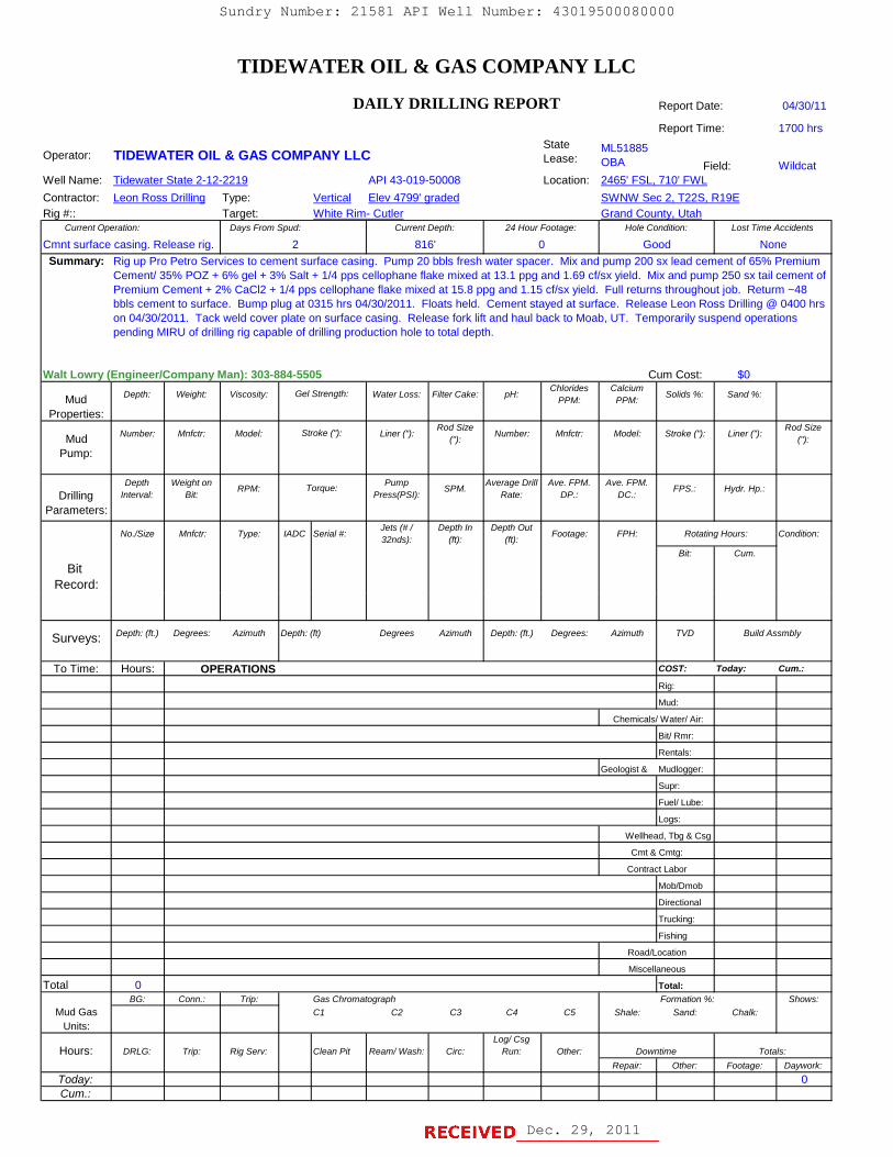
TIDEWATER OIL & GAS COMPANY LLC
DAILY DRILLING REPORT Report Date: 04/30/11
Report Time: 1700 hrs
Operator: TIDEWATER OIL & GAS COMPANY LLCState Lease:
ML51885OBA Field: Wildcat
Well Name: Tidewater State 2-12-2219 API 43-019-50008 Location: 2465' FSL, 710' FWLContractor: Leon Ross Drilling Type: Vertical Elev 4799' graded SWNW Sec 2, T22S, R19ERig #:: Target: White Rim- Cutler Grand County, Utah
Current Operation: Days From Spud: Current Depth: 24 Hour Footage: Hole Condition: Lost Time Accidents
Cmnt surface casing. Release rig. 2 816' 0 Good NoneSummary:
Walt Lowry (Engineer/Company Man): 303-884-5505 Cum Cost: $0
Mud Depth: Weight: Viscosity: Water Loss: Filter Cake: pH:Chlorides
PPM:Calcium
PPM: Solids %: Sand %:
Properties:
Mud Number: Mnfctr: Model: Liner ("):Rod Size
("): Number: Mnfctr: Model: Stroke ("): Liner ("):Rod Size
("):Pump:
DrillingDepth
Interval:Weight on
Bit:RPM: Pump
Press(PSI):SPM. Average Drill
Rate:Ave. FPM.
DP.:Ave. FPM.
DC.:FPS.: Hydr. Hp.:
Parameters:
No./Size Mnfctr: Type: IADC Serial #:Jets (# / 32nds):
Depth In (ft):
Depth Out (ft): Footage: FPH: Rotating Hours: Condition:
Bit: Cum.
Bit Record:
Rig up Pro Petro Services to cement surface casing. Pump 20 bbls fresh water spacer. Mix and pump 200 sx lead cement of 65% Premium Cement/ 35% POZ + 6% gel + 3% Salt + 1/4 pps cellophane flake mixed at 13.1 ppg and 1.69 cf/sx yield. Mix and pump 250 sx tail cement of Premium Cement + 2% CaCl2 + 1/4 pps cellophane flake mixed at 15.8 ppg and 1.15 cf/sx yield. Full returns throughout job. Returm ~48 bbls cement to surface. Bump plug at 0315 hrs 04/30/2011. Floats held. Cement stayed at surface. Release Leon Ross Drilling @ 0400 hrs on 04/30/2011. Tack weld cover plate on surface casing. Release fork lift and haul back to Moab, UT. Temporarily suspend operations pending MIRU of drilling rig capable of drilling production hole to total depth.
Gel Strength:
Stroke ("):
Torque:
Surveys: Depth: (ft.) Degrees: Azimuth Depth: (ft) Degrees Azimuth Depth: (ft.) Degrees: Azimuth TVD Build Assmbly
To Time: Hours: OPERATIONS COST: Today: Cum.:
Rig:
Mud:
Chemicals/ Water/ Air:
Bit/ Rmr:
Rentals:
Geologist & Mudlogger:
Supr:
Fuel/ Lube:
Logs:
Wellhead, Tbg & Csg
Mob/Dmob
Directional
Trucking:
Fishing
Road/Location
Total 0 Total:BG: Conn.: Trip: Gas Chromatograph Formation %: Shows:
Mud Gas C1 C2 C3 C4 C5 Shale: Sand: Chalk:Units:
Hours: DRLG: Trip: Rig Serv: Clean Pit Ream/ Wash: Circ:Log/ Csg
Run: Other: Downtime Totals:Repair: Other: Footage: Daywork:
Today: 0Cum.:
Miscellaneous
Cmt & Cmtg:
Contract Labor
Dec. 29, 2011
Sundry Number: 21581 API Well Number: 43019500080000
TIDEWATER OIL & GAS COMPANY LLC
DAILY DRILLING REPORT Report Date: 04/30/11
Report Time: 1700 hrsState ML51885Operator: TIDEWATER OIL & GAS COMPANY LLC Lease OBA Field: Wildcat
Well Name: Tidewater State 2-12-2219 API 43-019-50008 Location: 2465' FSL, 710' FWLContractor: Leon Ross Drillina Type: Vertical Elev 4799' araded SWNW Sec 2, T22S, R19ERig #:: Target: White Rim- Cutler Grand County, Utah
Current Operation: Days From Spud: Current Depth: 24 Hour Footage Hole Condition: Lost Time Accidents
Cmnt surface casing. Release rig. 2 816' O Good NoneSummary: Rig up Pro Petro Services to cement surface casing. Pump 20 bbls fresh water spacer. Mixand pump 200 sx lead cement of 65% Premium
Cement/ 35% POZ + 6% gel + 3% Salt + 1/4 pps cellophane flake mixed at 13.1 ppg and 1.69 cflsx yield. Mixand pump 250 sx tailcement ofPremium Cement + 2% CaCl2 + 1/4 pps cellophane flake mixed at 15.8 ppg and 1.15 cflsx yield. Full returns throughoutjob. Returm ~48
bbls cement to surface. Bump plug at 0315 hrs 04/30/2011. Floats held. Cement stayed at surface. Release Leon Ross Drilling@0400hrson 04/30/2011. Tack weld cover plate on surface casing. Release fork liftand haul back to Moab, UT. Temporarily suspend operationspending MIRUof drilling rig capable of drilling production hole to totaldepth.
Walt Lowry (Engineerl3ompany Wan): 303-E84-5505 Cum Cost: $0Chlorides Calcium
Mud Depth: Weight Viscosity: Gel Strength: Water Loss: Filter Cake: pH:PPM: PPM:
Solids %: Sand %
Properties:Rod Size Rod Size
Mud Number Mnfctr Model: Stroke ("): Liner(") Number Mnfctr Model Stroke ("): Liner(") ,
Pump:
Depth Weight on Pump Average Drill Ave. FPM. Ave. FPM.RPM: Torque: SPM. FPS.: Hydr. HpDrilling Intemal Bit: Press(PSI): Rate: DP.: DC.
Parameters:Jets (#/ Depth In Depth Out
No./Size Mnfctr Type: lADC Serial #: Footage: FPH Rotating Hours: Condition:32nds): (ft): (ft)
Bit: Cum.
BitRecord:
Surveys: Depth: (ft.) Degrees: Azimuth Depth: (ft) Degrees Azimuth Depth (ft.) Degrees: Azimuth TVD Build Assmbly
To Time: Hours: OPERATIONS coST: Today: Cum.:
Rig:
Mud:
Chemicals/ Waterl Air:
Bit/ Rmr:
Rentals:
Geologist & Mudlogger:
Supr:
Fuell Lube:
Logs:
Wellhead, Tbg & Csg
Cmt & Cmtg:
Contract Labor
MoblDmob
Directional
Trucking:
Fishing
Road/Location
Miscellaneous
Total 0 Total:BG: Conn. Trip: Gas Chromatograph Formation%. Shows:
Mud Gas c1 c2 c3 c4 c5 Shale Sand Chalk:Units:
Log/ CsgHours: DRLG Trip: RigSem CleanPit Ream/Wash Circ: Run: Other Downtime Totals:
Repair Other Footage: Daywork:
Today: O
TIDEWATER OIL & GAS COMPANY LLC
DAILY DRILLING REPORT Report Date: 04/30/11
Report Time: 1700 hrsState ML51885Operator: TIDEWATER OIL & GAS COMPANY LLC Lease OBA Field: Wildcat
Well Name: Tidewater State 2-12-2219 API 43-019-50008 Location: 2465' FSL, 710' FWLContractor: Leon Ross Drillina Type: Vertical Elev 4799' araded SWNW Sec 2, T22S, R19ERig #:: Target: White Rim- Cutler Grand County, Utah
Current Operation: Days From Spud: Current Depth: 24 Hour Footage Hole Condition: Lost Time Accidents
Cmnt surface casing. Release rig. 2 816' O Good NoneSummary: Rig up Pro Petro Services to cement surface casing. Pump 20 bbls fresh water spacer. Mixand pump 200 sx lead cement of 65% Premium
Cement/ 35% POZ + 6% gel + 3% Salt + 1/4 pps cellophane flake mixed at 13.1 ppg and 1.69 cflsx yield. Mixand pump 250 sx tailcement ofPremium Cement + 2% CaCl2 + 1/4 pps cellophane flake mixed at 15.8 ppg and 1.15 cflsx yield. Full returns throughoutjob. Returm ~48
bbls cement to surface. Bump plug at 0315 hrs 04/30/2011. Floats held. Cement stayed at surface. Release Leon Ross Drilling@0400hrson 04/30/2011. Tack weld cover plate on surface casing. Release fork liftand haul back to Moab, UT. Temporarily suspend operationspending MIRUof drilling rig capable of drilling production hole to totaldepth.
Walt Lowry (Engineerl3ompany Wan): 303-E84-5505 Cum Cost: $0Chlorides Calcium
Mud Depth: Weight Viscosity: Gel Strength: Water Loss: Filter Cake: pH:PPM: PPM:
Solids %: Sand %
Properties:Rod Size Rod Size
Mud Number Mnfctr Model: Stroke ("): Liner(") Number Mnfctr Model Stroke ("): Liner(") ,
Pump:
Depth Weight on Pump Average Drill Ave. FPM. Ave. FPM.RPM: Torque: SPM. FPS.: Hydr. Hp
Drilling Intemal Bit: Press(PSI): Rate: DP.: DC.
Parameters:Jets (#/ Depth In Depth Out
No./Size Mnfctr Type: lADC Serial #: Footage: FPH Rotating Hours: Condition:32nds): (ft): (ft)
Bit: Cum.
BitRecord:
Surveys: Depth: (ft.) Degrees: Azimuth Depth: (ft) Degrees Azimuth Depth (ft.) Degrees: Azimuth TVD Build Assmbly
To Time: Hours: OPERATIONS coST: Today: Cum.:
Rig:
Mud:
Chemicals/ Waterl Air:
Bit/ Rmr:
Rentals:
Geologist & Mudlogger:
Supr:
Fuell Lube:
Logs:
Wellhead, Tbg & Csg
Cmt & Cmtg:
Contract Labor
MoblDmob
Directional
Trucking:
Fishing
Road/Location
Miscellaneous
Total 0 Total:BG: Conn. Trip: Gas Chromatograph Formation%. Shows:
Mud Gas c1 c2 c3 c4 c5 Shale Sand Chalk:Units:
Log/ CsgHours: DRLG Trip: RigSem CleanPit Ream/Wash Circ: Run: Other Downtime Totals:
Repair Other Footage: Daywork:
Today: O

TIDEWATER OIL & GAS COMPANY LLC
DAILY DRILLING REPORT Report Date: 08/06/11
Report Time: 0600 hrs
Operator: TIDEWATER OIL & GAS COMPANY LLCState Lease:
ML51885OBA Field: Wildcat
Well Name: Tidewater State 2-12-2219 Location: 2465' FSL, 710' FWLContractor: CapStar Drilling Type: Vertical SWNW Sec 2, T22S, R19ERig #:: 315 Target: White Rim- Cutler Grand County, Utah
Current Operation: DOL (2) DFSS (2) DFS (2) Current Depth: 24 Hour Footage: Hole Condition: Lost Time Accidents
Movig rig from Meteesee, WY 1 2 0 816' 0 Good NoneSummary:
Walt Lowry (Engineer/ Wellsite Supervisor): 303-884-5505 Cum Cost: $0
Mud Depth: Weight: Viscosity: Water Loss: Filter Cake: pH:Chlorides
PPM:Calcium
PPM: Solids %: Sand %:
Properties:
Mud Number: Mnfctr: Model: Liner ("):Rod Size
("): Number: Mnfctr: Model: Stroke ("): Liner ("):Rod Size
("):Pump:
DrillingDepth
Interval:Weight on
Bit:RPM: Pump
Press(PSI):SPM. Average Drill
Rate:Ave. FPM.
DP.:Ave. FPM.
DC.:FPS.: Hydr. Hp.:
Parameters:
No./Size Mnfctr: Type: IADC Serial #:Jets (# / 32nds):
Depth In (ft):
Depth Out (ft): Footage: FPH: Rotating Hours: Condition:
Bit: Cum.
Bit Record:
API # 43-019-50008Elev 4799' graded
Moving CapStar Rig #315 from Meteetsee, WY to Crescent Junction, UT (~600 miles). L&S Trucking was selected company for rig move. MIRU CapStar Rig #315. Set in rig and rig up rig equipment. Three rig move loads have not made it to the TW ST 2-12-2219 locatiion as of report time. The delayed loads contain the choke line, the pump to standpipe hose, the Pason satellite dish,and tubs of drill pipe. NU BOPE. WO Pipe trailer with choke line. NOTE: Walt Lowry w/ Tidewater placed a call and left message for Dan Jarvis with the UDOGM at 1636 hours on 8/5/11 to give required 24-hour notice of BOPE test. Mr. Lowry informed Dan Javis that the BOPE test was expected to occur onSunday 8/7/11. Repair washouts in lease road. Prep location to accept rig. Dig cellar and install cellar ring around conductor and surface casing. Cut off 8-5/8" 24# J55 STC surface casing and conductor casing. Weld on 8-5/8" SOW X 9" 3M casing head with flange at ground level. Test weld. Held OK.
Gel Strength:
Stroke ("):
Torque:
Surveys: Depth: (ft.) Degrees: Azimuth Depth: (ft) Degrees Azimuth Depth: (ft.) Degrees: Azimuth TVD Build Assmbly
To Time: Hours: OPERATIONS COST: Today: Cum.:
Rig:
Mud:
Chemicals/ Water/ Air:
Bit/ Rmr:
Rentals:
Geologist & Mudlogger:
Supr:
Fuel/ Lube:
Logs:
Wellhead, Tbg & Csg
Mob/Dmob
Directional
Trucking:
Fishing
Road/Location
Total 0 Total:BG: Conn.: Trip: Gas Chromatograph Formation %: Shows:
Mud Gas C1 C2 C3 C4 C5 Shale: Sand: Chalk:Units:
Hours: DRLG: Trip: Rig Serv: Clean Pit Ream/ Wash: Circ:Log/ Csg
Run: Other: Downtime Totals:Repair: Other: Footage: Daywork:
Today: 0Cum.:
Miscellaneous
Cmt & Cmtg:
Contract Labor
Dec. 29, 2011
Sundry Number: 21581 API Well Number: 43019500080000
TIDEWATER OIL & GAS COMPANY LLC
DAILY DRILLING REPORT Report Date: 08/06/11
Report Time: 0600 hrsState ML51885Operator: TIDEWATER OIL & GAS COMPANY LLC Lease OBA Field: Wildcat
Well Name: Tidewater State 2-12-2219 API # 43-019-50008 Location: 2465' FSL, 710' FWLContractor: CapStar Drilling Type: Vertical Elev 4799' graded SWNW Sec 2, T22S, R19ERig #:: 315 Target: White Rim- Cutler Grand County, Utah
Current Operation: DOL (2) DFSS (2) DFS (2) Current Depth: 24 Hour Footage Hole Condition: Lost Time Accidents
Movig rig from Meteesee, WY 1 2 0 816' O Good NoneSummary: Moving CapStar Rig #315 from Meteetsee, WY to Crescent Junction, UT (~600miles). L&STrucking was selected company for rig move.
MIRUCapStar Rig #315. Set in rig and rig up rig equipment. Three rig move loads have not made it to the TW ST 2-12-2219 locatiion as ofreport time. The delayed loads contain the choke line, the pump to standpipe hose, the Pason satellite dish,and tubs of drill pipe. NU BOPE.WO Pipe trailerwith choke line. NOTE: Walt Lowry wl Tidewater placed a call and left message for Dan Jarvis with the UDOGM at1636 hours on 8/5/11 to give required 24-hour notice of BOPE test. Mr. Lowry informed Dan Javis that the BOPE test was expected tooccur onSunday 8/7/11. Repair washouts in lease road. Prep location to accept rig. Dig cellar and install cellar ring around conductor andsurface casing. Cut off 8-5/8" 24# J55 STC surface casing and conductor casing. Weld on 8-5/8" SOW X 9" 3M casing head with flange atground level. Test weld. Held OK.
Walt Lowry (Engineerl Wellsite Supervisor): 303-884-5505 Cum Cost: $0Chlorides Calcium
Mud Depth: Weight Viscosity: Gel Strength: Water Loss: Filter Cake: pH:PPM: PPM:
Solids %: Sand %
Properties:Rod Size Rod Size
Mud Number Mnfctr Model: Stroke ("): Liner(") Number Mnfctr Model Stroke ("): Liner(") ,
Pump:
Depth Weight on Pump Average Drill Ave. FPM. Ave. FPM.RPM: Torque: SPM. FPS.: Hydr. HpDrilling Intemal Bit: Press(PSI): Rate: DP.: DC.
Parameters:Jets (#/ Depth In Depth Out
No./Size Mnfctr Type: lADC Serial#: Footage: FPH RotatingHours: Condition:32nds): (ft): (ft)
Bit: Cum.
BitRecord:
Surveys: Depth: (ft.) Degrees: Azimuth Depth: (ft) Degrees Azimuth Depth (ft.) Degrees: Azimuth TVD Build Assmbly
To Time: Hours: OPERATIONE coST: Today: Cum.:
Rig:
Mud:
Chemicals/ Waterl Air:
Bit/ Rmr:
Rentals:
Geologist & Mudlogger:
Supr:
Fuell Lube:
Logs:
Wellhead, Tbg & Csg
Cmt & Cmtg:
Contract Labor
MoblDmob
Directional
Trucking:
Fishing
Road/Location
Miscellaneous
Total 0 Total:BG: Conn. Trip: Gas Chromatograph Formation%. Shows:
Mud Gas c1 c2 c3 c4 c5 Shale Sand Chalk:Units:
Log/ CsgHours: DRLG Trip: RigSem CleanPit Ream/Wash Circ: Run: Other Downtime Totals:
Repair Other Footage: Daywork:
Today: O
TIDEWATER OIL & GAS COMPANY LLC
DAILY DRILLING REPORT Report Date: 08/06/11
Report Time: 0600 hrsState ML51885
Operator: TIDEWATER OIL & GAS COMPANY LLC Lease OBA Field: WildcatWell Name: Tidewater State 2-12-2219 API # 43-019-50008 Location: 2465' FSL, 710' FWLContractor: CapStar Drilling Type: Vertical Elev 4799' graded SWNW Sec 2, T22S, R19ERig #:: 315 Target: White Rim- Cutler Grand County, Utah
Current Operation: DOL (2) DFSS (2) DFS (2) Current Depth: 24 Hour Footage Hole Condition: Lost Time Accidents
Movig rig from Meteesee, WY 1 2 0 816' O Good NoneSummary: Moving CapStar Rig #315 from Meteetsee, WY to Crescent Junction, UT (~600miles). L&STrucking was selected company for rig move.
MIRUCapStar Rig #315. Set in rig and rig up rig equipment. Three rig move loads have not made it to the TW ST 2-12-2219 locatiion as ofreport time. The delayed loads contain the choke line, the pump to standpipe hose, the Pason satellite dish,and tubs of drill pipe. NU BOPE.WO Pipe trailerwith choke line. NOTE: Walt Lowry wl Tidewater placed a call and left message for Dan Jarvis with the UDOGM at1636 hours on 8/5/11 to give required 24-hour notice of BOPE test. Mr. Lowry informed Dan Javis that the BOPE test was expected tooccur onSunday 8/7/11. Repair washouts in lease road. Prep location to accept rig. Dig cellar and install cellar ring around conductor andsurface casing. Cut off 8-5/8" 24# J55 STC surface casing and conductor casing. Weld on 8-5/8" SOW X 9" 3M casing head with flange atground level. Test weld. Held OK.
Walt Lowry (Engineerl Wellsite Supervisor): 303-884-5505 Cum Cost: $0Chlorides Calcium
Mud Depth: Weight Viscosity: Gel Strength: Water Loss: Filter Cake: pH:PPM: PPM:
Solids %: Sand %
Properties:Rod Size Rod Size
Mud Number Mnfctr Model: Stroke ("): Liner(") Number Mnfctr Model Stroke ("): Liner(") ,
Pump:
Depth Weight on Pump Average Drill Ave. FPM. Ave. FPM.RPM: Torque: SPM. FPS.: Hydr. Hp
Drilling Intemal Bit: Press(PSI): Rate: DP.: DC.
Parameters:Jets (#/ Depth In Depth Out
No./Size Mnfctr Type: lADC Serial#: Footage: FPH RotatingHours: Condition:32nds): (ft): (ft)
Bit: Cum.
BitRecord:
Surveys: Depth: (ft.) Degrees: Azimuth Depth: (ft) Degrees Azimuth Depth (ft.) Degrees: Azimuth TVD Build Assmbly
To Time: Hours: OPERATIONE coST: Today: Cum.:
Rig:
Mud:
Chemicals/ Waterl Air:
Bit/ Rmr:
Rentals:
Geologist & Mudlogger:
Supr:
Fuell Lube:
Logs:
Wellhead, Tbg & Csg
Cmt & Cmtg:
Contract Labor
MoblDmob
Directional
Trucking:
Fishing
Road/Location
Miscellaneous
Total 0 Total:BG: Conn. Trip: Gas Chromatograph Formation%. Shows:
Mud Gas c1 c2 c3 c4 c5 Shale Sand Chalk:Units:
Log/ CsgHours: DRLG Trip: RigSem CleanPit Ream/Wash Circ: Run: Other Downtime Totals:
Repair Other Footage: Daywork:
Today: O

TIDEWATER OIL & GAS COMPANY LLC
DAILY DRILLING REPORT Report Date: 08/07/11
Report Time: 0600 hrs
Operator: TIDEWATER OIL & GAS COMPANY LLCState Lease:
ML51885OBA Field: Wildcat
Well Name: Tidewater State 2-12-2219 Location: 2465' FSL, 710' FWLContractor: CapStar Drilling Type: Vertical SWNW Sec 2, T22S, R19ERig #:: 315 Target: White Rim- Cutler Grand County, Utah
Current Operation: DOL (2) DFS DFS (2) Current Depth: 24 Hour Footage: Hole Condition: Lost Time Accidents
Movig rig from Meteesee, WY 2 2 0 816' 0 Good NoneSummary:
Walt Lowry (Engineer/ Wellsite Supervisor): 303-884-5505 Cum Cost: $0
Mud Depth: Weight: Viscosity: Water Loss: Filter Cake: pH:Chlorides
PPM:Calcium
PPM: Solids %: Sand %:
Properties:
Mud Number: Mnfctr: Model: Liner ("):Rod Size
("): Number: Mnfctr: Model: Stroke ("): Liner ("):Rod Size
("):Pump:
DrillingDepth
Interval:Weight on
Bit:RPM: Pump
Press(PSI):SPM. Average Drill
Rate:Ave. FPM.
DP.:Ave. FPM.
DC.:FPS.: Hydr. Hp.:
Parameters:
No./Size Mnfctr: Type: IADC Serial #:Jets (# / 32nds):
Depth In (ft):
Depth Out (ft): Footage: FPH: Rotating Hours: Condition:
Bit: Cum.
Bit Record:
API # 43-019-50008Elev 4799' graded
Continue on contractor time as pipe trailer with choke line have still not arrived. Perform rig maintenance. Restring blocks and flush radiator on rig motor. Install new electric bridle connectors on motors. Rig up premix tank and install valve on rig's steel mud pit. Rig up pipe trailers that had arrived on location. RU BOPE and install rig hardline and manifold. Test pipe and blind rams to 3000 psi. Did not hold. Change out BOP rubber elements on pipe and blind rams. Test pipe and blind rams to 3000 psi high and 250 pswi low for 10 minutes each. WO pipe trailer with BOP hardline. Held OK.
Gel Strength:
Stroke ("):
Torque:
Surveys: Depth: (ft.) Degrees: Azimuth Depth: (ft) Degrees Azimuth Depth: (ft.) Degrees: Azimuth TVD Build Assmbly
To Time: Hours: OPERATIONS COST: Today: Cum.:
Not on Daywork yet, as choke line, pump hose & Pason satellite dish not yet arrived. Rig
Mud
Bit/ Rmr
Rentals
Supervisor
Fuel/ Lube
Logs
Wellhead, Tbg & Csg
Mob/Dmob
Directional
Trucking
Fishing
Total 0 Total:BG: Conn.: Trip: Gas Chromatograph Formation %: Shows:
Mud Gas C1 C2 C3 C4 C5 Shale: Sand: Chalk:Units:
Hours: DRLG: Trip: Rig Serv: Clean Pit Ream/ Wash: Circ:Log/ Csg
Run: Other: Downtime Totals:Repair: Other: Footage: Daywork:
Today: 0Cum.:
Cement & Cementing:
Contract Labor
Miscellaneous
Chemicals/ Water/ Air
Geologist & Mudlogger
Road/Location
Dec. 29, 2011
Sundry Number: 21581 API Well Number: 43019500080000
TIDEWATER OIL & GAS COMPANY LLC
DAILY DRILLING REPORT Report Date: 08/07/11
Report Time: 0600 hrsState ML51885Operator: TIDEWATER OIL & GAS COMPANY LLC Lease OBA Field: Wildcat
Well Name: Tidewater State 2-12-2219 API # 43-019-50008 Location: 2465' FSL, 710' FWLContractor: CapStar Drilling Type: Vertical Elev 4799' graded SWNW Sec 2, T22S, R19ERig #:: 315 Target: White Rim- Cutler Grand County, Utah
Current Operation: DOL (2) DFS DFS (2) Current Depth: 24 Hour Footage Hole Condition: Lost Time Accidents
Movig rig from Meteesee, WY 2 2 0 816' O Good NoneSummary: Continue on contractor timeas pipe trailerwith choke line have still not arrived. Perform rig maintenance. Restring blocks and flush radiator
on rig motor. Install new electric bridle connectors on motors. Rig up premix tank and install valve on rig's steel mud pit. Rig up pipe trailersthat had arrived on location. RU BOPE and install rig hardline and manifold. Test pipe and blind rams to 3000 psi. Did not hold. Change outBOP rubber elements on pipe and blind rams. Test pipe and blind rams to 3000 psi high and 250 pswi low for 10 minutes each. WO pipetrailerwith BOP hardline. Held OK.
Walt Lowry (Engineerl Wellsite Supervisor): 303-884-5505 Cum Cost: $0Chlorides Calcium
Mud Depth: Weight Viscosity: Gel Strength: Water Loss: Filter Cake: pH:PPM: PPM:
Solids %: Sand %
Properties:Rod Size Rod Size
Mud Number Mnfctr Model: Stroke ("): Liner(") Number Mnfctr Model Stroke ("): Liner(") ,
Pump:
Depth Weight on Pump Average Drill Ave. FPM. Ave. FPM.RPM: Torque: SPM. FPS.: Hydr. HpDrilling Intemal Bit: Press(PSI): Rate: DP.: DC.
Parameters:Jets (#/ Depth In Depth Out
No./Size Mnfctr Type: lADC Serial #: Footage: FPH Rotating Hours: Condition:32nds): (ft): (ft)
Bit: Cum.
BitRecord:
Surveys: Depth: (ft.) Degrees: Azimuth Depth: (ft) Degrees Azimuth Depth (ft.) Degrees: Azimuth TVD Build Assmbly
To Time: Hours: OPERATIONS coST: Today: Cum.:
Not on Daywork yet, as choke line, pump hose & Pason satellite dish not yet arrived. Rig
Mud
Chemicals/ Waterl Air
Bit/ Rmr
Rentals
Geologist& Mudlogger
Supervisor
Fuell Lube
Logs
Wellhead, Tbg & Csg
Cement & Cementing:
Contract Labor
MoblDmob
Directional
Trucking
Fishing
Road/Location
Miscellaneous
Total 0 Total:BG: Conn. Trip: Gas Chromatograph Formation%. Shows:
Mud Gas c1 c2 c3 c4 c5 Shale Sand Chalk:Units:
Log/ CsgHours: DRLG Trip: RigSem CleanPit Ream/Wash Circ: Run: Other Downtime Totals:
Repair Other Footage: Daywork:
Today: O
TIDEWATER OIL & GAS COMPANY LLC
DAILY DRILLING REPORT Report Date: 08/07/11
Report Time: 0600 hrsState ML51885
Operator: TIDEWATER OIL & GAS COMPANY LLC Lease OBA Field: WildcatWell Name: Tidewater State 2-12-2219 API # 43-019-50008 Location: 2465' FSL, 710' FWLContractor: CapStar Drilling Type: Vertical Elev 4799' graded SWNW Sec 2, T22S, R19ERig #:: 315 Target: White Rim- Cutler Grand County, Utah
Current Operation: DOL (2) DFS DFS (2) Current Depth: 24 Hour Footage Hole Condition: Lost Time Accidents
Movig rig from Meteesee, WY 2 2 0 816' O Good NoneSummary: Continue on contractor timeas pipe trailerwith choke line have still not arrived. Perform rig maintenance. Restring blocks and flush radiator
on rig motor. Install new electric bridle connectors on motors. Rig up premix tank and install valve on rig's steel mud pit. Rig up pipe trailersthat had arrived on location. RU BOPE and install rig hardline and manifold. Test pipe and blind rams to 3000 psi. Did not hold. Change outBOP rubber elements on pipe and blind rams. Test pipe and blind rams to 3000 psi high and 250 pswi low for 10 minutes each. WO pipetrailerwith BOP hardline. Held OK.
Walt Lowry (Engineerl Wellsite Supervisor): 303-884-5505 Cum Cost: $0Chlorides Calcium
Mud Depth: Weight Viscosity: Gel Strength: Water Loss: Filter Cake: pH:PPM: PPM:
Solids %: Sand %
Properties:Rod Size Rod Size
Mud Number Mnfctr Model: Stroke ("): Liner(") Number Mnfctr Model Stroke ("): Liner(") ,
Pump:
Depth Weight on Pump Average Drill Ave. FPM. Ave. FPM.RPM: Torque: SPM. FPS.: Hydr. Hp
Drilling Intemal Bit: Press(PSI): Rate: DP.: DC.
Parameters:Jets (#/ Depth In Depth Out
No./Size Mnfctr Type: lADC Serial #: Footage: FPH Rotating Hours: Condition:32nds): (ft): (ft)
Bit: Cum.
BitRecord:
Surveys: Depth: (ft.) Degrees: Azimuth Depth: (ft) Degrees Azimuth Depth (ft.) Degrees: Azimuth TVD Build Assmbly
To Time: Hours: OPERATIONS coST: Today: Cum.:
Not on Daywork yet, as choke line, pump hose & Pason satellite dish not yet arrived. Rig
Mud
Chemicals/ Waterl Air
Bit/ Rmr
Rentals
Geologist& Mudlogger
Supervisor
Fuell Lube
Logs
Wellhead, Tbg & Csg
Cement & Cementing:
Contract Labor
MoblDmob
Directional
Trucking
Fishing
Road/Location
Miscellaneous
Total 0 Total:BG: Conn. Trip: Gas Chromatograph Formation%. Shows:
Mud Gas c1 c2 c3 c4 c5 Shale Sand Chalk:Units:
Log/ CsgHours: DRLG Trip: RigSem CleanPit Ream/Wash Circ: Run: Other Downtime Totals:
Repair Other Footage: Daywork:
Today: O

TIDEWATER OIL & GAS COMPANY LLC
DAILY DRILLING REPORT Report Date: 08/08/11
Report Time: 0600 hrs
Operator: TIDEWATER OIL & GAS COMPANY LLCState Lease:
ML51885OBA Field: Wildcat
Well Name: Tidewater State 2-12-2219 Location: 2465' FSL, 710' FWLContractor: CapStar Drilling Type: Vertical SWNW Sec 2, T22S, R19ERig #:: 315 Target: White Rim- Cutler Grand County, Utah
Current Operation: DOL (2) DFSS DFS (2) Current Depth: 24 Hour Footage: Hole Condition: Lost Time Accidents
3 2 0 816' 0 Good NoneSummary:
Walt Lowry (Engineer/Wellsite Supervisor): 303-884-5505 Cum Cost: $0
Mud Depth: Weight: Viscosity: Water Loss: Filter Cake: pH:Chlorides
PPM:Calcium
PPM: Solids %: Sand %:
Properties:
Mud Number: Mnfctr: Model: Liner ("):Rod Size
("): Number: Mnfctr: Model: Stroke ("): Liner ("):Rod Size
("):Pump:
DrillingDepth
Interval:Weight on
Bit:RPM: Pump
Press(PSI):SPM. Average Drill
Rate:Ave. FPM.
DP.:Ave. FPM.
DC.:FPS.: Hydr. Hp.:
Parameters:
No./Size Mnfctr: Type: IADC Serial #:Jets (# / 32nds):
Depth In (ft):
Depth Out (ft): Footage: FPH: Rotating Hours: Condition:
Bit: Cum.
Bit Record:
Move in CapStar Rig #315
API 43-019-50008Elev 4799' graded
Test annular preventer. Did not hold. ND rotating head and annular. WO annular preventer from CapStar in Casper. NU annular preventer. RU BOPE tester. Test annular preventer to 1500 psi. Rig repair. Break top of annular preventer. Work on rubber. Third ammular preventer on its way from CapStar in Casper, WY. Install annular preventer. RU Single Jack Testers. Test annular preventer to 1500 psi. Turn up accumulator pressure to 1900 psi. Bag blew. WO 3rd annular preventer from CapStar yard in Casper, WY.
Gel Strength:
Stroke ("):
Torque:
Surveys: Depth: (ft.) Degrees: Azimuth Depth: (ft) Degrees Azimuth Depth: (ft.) Degrees: Azimuth TVD Build Assmbly
To Time: Hours: OPERATIONS COST: Today: Cum.:
0600-0600 24.00 Rig
Mud
Water
Bit/ Rmr
Rentals
Supervisor
Fuel/ Lube
Logs
Mob/Dmob
Directional
Trucking
Fishing
Total 24 TotalBG: Conn.: Trip: Gas Chromatograph Formation %: Shows:
Mud Gas C1 C2 C3 C4 C5 Shale: Sand: Chalk:Units:
Hours: DRLG: Trip: Rig Serv: Clean Pit Ream/ Wash: Circ:Log/ Csg
Run: Other: Downtime Totals:Repair: Other: Footage: Daywork:
Today: 0Cum.:
Cement & Cementing
Contract Labor
Miscellaneous
Access Road & Location
MIRU CapStar Rig #315. Waiting on 3 loads due to 3rd Party truck breakdowns.
Geologist & Mudlogger
Wellhead, Tbg & Csg
Missing choke line, pump hose, Pason satellite dish.
Dec. 29, 2011
Sundry Number: 21581 API Well Number: 43019500080000
TIDEWATER OIL & GAS COMPANY LLC
DAILY DRILLING REPORT Report Date: 08/08/11
Report Time: 0600 hrsState ML51885Operator: TIDEWATER OIL & GAS COMPANY LLC Lease OBA Field: Wildcat
Well Name: Tidewater State 2-12-2219 API 43-019-50008 Location: 2465' FSL, 710' FWLContractor: CapStar Drilling Type: Vertical Elev 4799' graded SWNW Sec 2, T22S, R19ERig #:: 315 Target: White Rim- Cutler Grand County, Utah
Current Operation: DOL (2) DFSS DFS (2) Current Depth: 24 Hour Footage Hole Condition: Lost Time Accidents
Move in CapStar Rig #315 3 2 0 816' O Good NoneSummary: Test annular preventer. Did not hold. ND rotating head and annular. WO annular preventer from CapStar in Casper. NU annular
preventer. RU BOPE tester. Test annular preventer to 1500 psi. Rig repair. Break top of annular preventer. Work on rubber. Thirdammular preventer on its way from CapStar in Casper, WY. Install annular preventer. RU Single Jack Testers. Test annularpreventer to 1500 psi. Turn up accumulator pressure to 1900 psi. Bag blew. WO 3rd annular preventer from CapStar yard inCasper, WY.
Walt Lowry (Engineer/Nellsite Supervisor): 303-884-5505 Cum Cost: $0Chlorides Calcium
Mud Depth: Weight Viscosity Gel Strength Water Loss Filter Cake: pHPPM: PPM
Solids %: Sand %
Properties:Rod Size Rod Size
Mud Number Mnfctr Model Stroke (") Liner(") Number Mnfctr Model Stroke ("): Liner(") ,
Pump:
Depth Weight on Pump Average Drill Ave. FPM. Ave. FPM.RPM: Torque SPM. FPS.: Hydr HpDrilling Intemal Bit Press(PSI) Rate: DP.: DC.
Parameters:Jets (#/ Depth In Depth Out
No./Size Mnfctr Type: lADC Serial # Footage: FPH Rotating Hours Condition:32nds): (ft): (ft)
Bit Cum.
BitRecord:
Surveys: Depth: (ft) Degrees: Azimuth Depth: (ft) Degrees Azimuth Depth (ft.) Degrees: Azimuth TVD Build Assmbly
To Time: Hours: OPERATIONS coST: Today: Cum.:
0600-0600 24.00 MIRUCapStar Rig #315. Waiting on 3 loads due to 3rd Party truckbreakdowns. Rig
Missing choke line, pump hose, Pason satellite dish. Mud
Water
Bit/ Rmr
Rentals
Geologist& Mudlogger
Supervisor
Fuell Lube
Logs
Wellhead, Tbg & Csg
Cement & Cementing
Contract Labor
MoblDmob
Directional
Trucking
Fishing
Access Road & Location
Miscellaneous
Total 24 TotalBG: Conn. Trip: Gas Chromatograph Formation%. Shows:
Mud Gas c1 c2 c3 c4 c5 Shale Sand ChalkUnits:
Log/ CsgHours: DRLG Trip: RigSem CleanPit Ream/Wash Circ: Run: Other Downtime Totals:
Repair Other Footage: Daywork
Today: O
TIDEWATER OIL & GAS COMPANY LLC
DAILY DRILLING REPORT Report Date: 08/08/11
Report Time: 0600 hrsState ML51885
Operator: TIDEWATER OIL & GAS COMPANY LLC Lease OBA Field: WildcatWell Name: Tidewater State 2-12-2219 API 43-019-50008 Location: 2465' FSL, 710' FWLContractor: CapStar Drilling Type: Vertical Elev 4799' graded SWNW Sec 2, T22S, R19ERig #:: 315 Target: White Rim- Cutler Grand County, Utah
Current Operation: DOL (2) DFSS DFS (2) Current Depth: 24 Hour Footage Hole Condition: Lost Time Accidents
Move in CapStar Rig #315 3 2 0 816' O Good NoneSummary: Test annular preventer. Did not hold. ND rotating head and annular. WO annular preventer from CapStar in Casper. NU annular
preventer. RU BOPE tester. Test annular preventer to 1500 psi. Rig repair. Break top of annular preventer. Work on rubber. Thirdammular preventer on its way from CapStar in Casper, WY. Install annular preventer. RU Single Jack Testers. Test annularpreventer to 1500 psi. Turn up accumulator pressure to 1900 psi. Bag blew. WO 3rd annular preventer from CapStar yard inCasper, WY.
Walt Lowry (Engineer/Nellsite Supervisor): 303-884-5505 Cum Cost: $0Chlorides Calcium
Mud Depth: Weight Viscosity Gel Strength Water Loss Filter Cake: pHPPM: PPM
Solids %: Sand %
Properties:Rod Size Rod Size
Mud Number Mnfctr Model Stroke (") Liner(") Number Mnfctr Model Stroke ("): Liner(") ,
Pump:
Depth Weight on Pump Average Drill Ave. FPM. Ave. FPM.RPM: Torque SPM. FPS.: Hydr Hp
Drilling Intemal Bit Press(PSI) Rate: DP.: DC.
Parameters:Jets (#/ Depth In Depth Out
No./Size Mnfctr Type: lADC Serial # Footage: FPH Rotating Hours Condition:32nds): (ft): (ft)
Bit Cum.
BitRecord:
Surveys: Depth: (ft) Degrees: Azimuth Depth: (ft) Degrees Azimuth Depth (ft.) Degrees: Azimuth TVD Build Assmbly
To Time: Hours: OPERATIONS coST: Today: Cum.:
0600-0600 24.00 MIRUCapStar Rig #315. Waiting on 3 loads due to 3rd Party truckbreakdowns. Rig
Missing choke line, pump hose, Pason satellite dish. Mud
Water
Bit/ Rmr
Rentals
Geologist& Mudlogger
Supervisor
Fuell Lube
Logs
Wellhead, Tbg & Csg
Cement & Cementing
Contract Labor
MoblDmob
Directional
Trucking
Fishing
Access Road & Location
Miscellaneous
Total 24 TotalBG: Conn. Trip: Gas Chromatograph Formation%. Shows:
Mud Gas c1 c2 c3 c4 c5 Shale Sand ChalkUnits:
Log/ CsgHours: DRLG Trip: RigSem CleanPit Ream/Wash Circ: Run: Other Downtime Totals:
Repair Other Footage: Daywork
Today: O

TIDEWATER OIL & GAS COMPANY LLC
DAILY DRILLING REPORT Report Date: 08/09/11
Report Time: 0600 hrs
Operator: TIDEWATER OIL & GAS COMPANY LLCState Lease:
ML51885OBA Field: Wildcat
Well Name: Tidewater State 2-12-2219 Location: 2465' FSL, 710' FWLContractor: CapStar Drilling Type: Vertical SWNW Sec 2, T22S, R19ERig #:: 315 Target: White Rim- Cutler Grand County, Utah
Current Operation: DOL (2) DFSS DFS (2) Current Depth: 24 Hour Footage: Hole Condition: Lost Time Accidents
4 2 0 303' NoneSummary:
Walt Lowry (Engineer/ Wellsite Supervisor): 303-884-5505 Cum Cost: $0
Mud Depth: Weight: Viscosity: Water Loss: Filter Cake: pH:Chlorides
PPM:Calcium
PPM: Solids %: Sand %:
Properties: 1119 9.1 39 8 2/32 9.5 300 40 4.0 TR
Mud Number: Mnfctr: Model: Liner ("):Rod Size
("): Number: Mnfctr: Model: Stroke ("): Liner ("):Rod Size
("):Pump: 1 Gardner-
Denver PZ-8 6 1/.4
DrillingDepth
Interval:Weight on
Bit:RPM: Pump
Press(PSI):SPM. Average Drill
Rate:Ave. FPM.
DP.:Ave. FPM.
DC.:FPS.: Jet Velocity
Parameters: 957-1119 5-7M 88/60 650 129 67.3 92 135 210 115
No./Size Mnfctr: Type: IADC Serial #:Jets (# / 32nds):
Depth In (ft):
Depth Out (ft): Footage: FPH: Rotating Hours: Condition:
Bit: Cum.
Bit 1- 7.875" Smith MS616 PDC JD4357 6 x 16s 816 1119 303 67.3 4.50 4.50 NARecord:
API # 43-019-50008Elev 4799' graded
Drilling 7-7/8" hole @ 1119'WO annular prevener to arrive. NU annular preventer. Test annular preventer to 1500 psi for 10 min. Held OK. NOTE: By agreement between Rafael Ruiz (CapStar Toolpusher) and Walter Lowry (Tidewater Company Man) responsibility for rig charges transferred to Tidewater Oil & Gas as Operator at 1200 hrs on 8/9/2011 when daywork operations for the production hole commenced. Nipple down bottom flange of BOPE and retreive test plug and nipple up bottom flange once again. Test 8-5/8" 24# J55 STC surface casing and bottom flange of BOPE stack to 2000 psi (including hydrostatic head of 9.0 ppg drilling mud inside casing). Held OK. NU rotating head, install flowline. Pick up bit and BHA. TIH. Tag cement at 720' inside 8-5/8" surface casing. Drill float collar, cement in shoe joint, and float shoe with fresh water. Fill mud tanks with fresh water. Drill 7-7/8" production hole from 816' to 957'. Well began to flow due to excessive formation prerssure at 957'. Circ kick out thru choke. Resume drilling to 1119'.
Gel Strength:
Stroke ("):
1119' Good
5/10/-
129 @ 95% eff
1200
Torque (On btm/ Off btm)
Surveys: Depth: (ft.) Degrees: Azimuth Depth: (ft) Degrees Azimuth Depth: (ft.) Degrees: Azimuth TVD Build Assmbly
To Time: Hours: OPERATIONS COST: Today: Cum.:
0600-1200 6.00 Rig
Mud
BY AGREEMENT W/ RAFAEL RUIZ (TP)- COMMENCE DAYWORK AT 1200 HRS 8/9/11 Water
1200-1500 3.00 ND bottom flnge of mud cross on BOPE. Retrieve test plug. NU bottom flange. Bit/ Rmr
Test 8-5/8" casing and flange between mud cross & wellhead to 80% of internal yield Rentals
pressure of surface casing (2950 psi) or 2360 psi. Held OK.1500-1700 2.00 NU rotating head,install flowline,install fill line,chain down stack. Supervisor
1700-1800 1.00 MU BHA (7-7/8" STC M616 PDC bit, Hunting mud motor, 8-6 1/4" DCs, hydraulic driling jars, Fuel/ Lube
3 x 6 1/4" DCs, 4-1/2" XH drill pipe Logs
1800-1900 1.00 TIH w/ BHA & drill ppe and tag cement inside 8-5/8" surface casing at 728'.1900-1930 0.50 Install rotating head rubber.1930-2030 1.00 Drill float collar, shoe joint, float shoe and 10' new formation.2030-2200 1.50 Fill mud tanks. Manifold pre-mix tank to working pits. Pre-mix tank will pump into active system. Mob/Dmob
2200-2330 1.50 Drill new 7-7/8" hole from 826'-957'. Directional
2330-0300 3.50 Well kicked at 957' with 8.4 ppg water in hole. Trucking
Circulate through choke holding 75 psi casing pressure at 46 spm while mixing mud. Fishing
Open annular & check for flow. Well flowing with 8.9 ppg mud.0300-0600 3.00 Drill 7-7/8" hole from 957'-1119'
Total 24 TotalBG: Conn.: Trip: Gas Chromatograph Formation %: Shows:
Mud Gas C1 C2 C3 C4 C5 Shale: Sand: Chalk:Units:
Hours: DRLG: Trip: Rig Serv: Clean Pit Ream/ Wash: Circ:Log/ Csg
Run: Other: Downtime Totals:Repair: Other: Footage: Daywork:
Today: 4.50 1.50 6.00 6.00 18.00Cum.: 4.50 1.50 6.00 6.00 18.00
Wellhead, Tbg & Csg
Cement & Cementing
Contract Labor
Access Road & Location
Miscellaneous
WO annular preventer from CapStar. NU annular preventer and test to 1500 psi. Held ok.NU annular preventer. Test to 1500 psi high & 250 psi low for 10 min. Held OK.
Geologist & Mudlogger
Dec. 29, 2011
Sundry Number: 21581 API Well Number: 43019500080000
TIDEWATER OIL & GAS COMPANY LLC
DAILY DRILLING REPORT Report Date: 08/09/11
Report Time: 0600 hrsState ML51885Operator: TIDEWATER OIL & GAS COMPANY LLC Lease OBA Field: Wildcat
Well Name: Tidewater State 2-12-2219 API # 43-019-50008 Location: 2465' FSL, 710' FWLContractor: CapStar Drilling Type: Vertical Elev 4799' graded SWNW Sec 2, T22S, R19ERig #:: 315 Target: White Rim- Cutler Grand County, Utah
Current Operation DOL (2) DFSS DFS (2) Current Depth 24 Hour Footage Hole Condition Lost Time Accidents
Drilling7-7/8" hole @ 1119' 4 2 0 1119' 303' Good NoneSummary: WO annular prevener to arrive. NU annular preventer. Test annular preventer to 1500 psi for 10 min. Held OK. NOTE: By agreement
between Rafael Ruiz (CapStar Toolpusher) and Walter Lowry (Tidewater Company Man) responsibility for rig charges transferred toTidewater Oil & Gas as Operator at 1200 hrs on 8/9/2011 when daywork operations for the production hole commenced. Nippledown bottom flange of BOPE and retreive test plug and nipple up bottom flange once again. Test 8-5/8" 24# J55 STC surface casing andbottom flange of BOPE stack to 2000 psi (including hydrostatic head of 9.0 ppg drilling mud inside casing). Held OK. NU rotating head, installflowline. Pick up bit and BHA. TlH. Tag cement at 720' inside 8-5/8" surface casing. Drillfloat collar, cement in shoe joint,and float shoewith fresh water. Fillmud tanks with fresh water. Drill7-7/8" production hole from 816' to 957'. Well began to flow due to excessive formationDrerssure at 957'. Circ kick out thru choke. Resume drillina to 1119'.
Walt Lowry (Engineerl Wollsite Sup trvisor): 303-884-5505 Cum Cost: $0Chlorides Calcium
Mud Depth Weight Viscosity Gel Strength Water Loss Filter Cake pHPPM PPM
Solids % Sand %
Properties: 1119 9.1 39 5/10/- 8 2/32 9.5 300 40 4.0 TRRod Size Rod Size
Mud Number Mnfctr Model Stroke (") Liner(") Number Mnfctr Model Stroke (") Liner(") ,
Pump: 1Gardner- PZ-8 129 @95% eff 6 1/.4Denver
Depth Weight onRPM
Torque PumpSPM
Average Drill Ave. FPM Ave. FPM.FPS. Jet VelocityDrilling Interval Bit (Onbtm/Offbtm) Press(PSI) Rate DP. DC.
Parameters: 957-1119 5-7M 88/60 1200 650 129 67.3 92 135 210 115Jets (#/ Depth In Depth Out
No./Size Mnfctr Type IADC Serial # Footage FPH Rotating Hours Condition:32nds) (ft) (ft)
Bit Cum.
Bit 1- 7.875" Smith MS616 PDC JD4357 6 x 16s 816 1119 303 67.3 4.50 4.50 NARecord:
Surveys: Depth (ft.) Degrees Azimuth Depth (ft) Degrees Azimuth Depth (ft.) Degrees Azimuth TVD Build Assmbly
To Time: Hours: OPERATIONS coST: Today: Cum.:
0600-1200 6.00 WO annular preventer from CapStar. NU annular preventerand test to 1500 psi. Held ok. Rig
NU annular preventer. Test to 1500 psi high &250 psi low for 10 min. Held OK. Mud
BY AGREEMENT WI RAFAEL RUIZ(TP)- COMMENCE DAYWORKAT 1200 HRS 8/9/11 water1200-1500 3.00 ND bottom flnge of mud cross on BOPE. Retrieve test plug. NU bottom flange. Bit/ Rmr
Test 8-5/8" casing and flange between mud cross &wellhead to 80% of internal yield Rentals
pressure of surface casing (2950 psi) or 2360 psi. Held OK. Geologist& Mudlogger1500-1700 2.00 NU rotating head,install flowline,install fillline,chain down stack. Supervisor1700-1800 1.00 MU BHA (7-7/8" STC M616 PDC bit, Huntinq mud motor, 8-6 1/4" DCs, hydraulic driling |ars, Fuel/Lube
3 x 6 1/4" DCs, 4-1/2" XH drill pipe Logs1800-1900 1.00 TlH wl BHA &drill ppe and tag cement inside 8-5/8" surface casing at 728'. Wellhead, Tbg & Csg1900-1930 0.50 Install rotating head rubber. cement& Cementing1930-2030 1.00 Drillfloat collar, shoe |oint,float shoe and 10' new formation. Contract Labor2030-2200 1.50 Fillmud tanks. Manifold pre-mixtank to working pits. Pre-mix tankwillpump into active system. MoblDmob2200-2330 1.50 Drillnew 7-7/8" hole from 826'-957'. Directional2330-0300 3.50 Well kicked at 957' with 8.4 ppgwater in hole. Trucking
Circulate throughchoke holding 75 psi casing pressure at 46 spm while mixing mud. Fishing
Open annular &check for flow. Well flowing with 8.9 ppg mud. Access Road & Location0300-0600 3.00 Drill7-7/8" hole from 957'-1119' Miscellaneous
Total 24 TotalBG Conn. Trip Gas Chromatograph Formation%. Shows:
Mud Gas c1 c2 c3 c4 c5 Shale Sand ChalkUnits:
Log/ CsgHours: DRLG Trip RigSelv CleanPit Ream/Wash Circ Run Other Downtime Totals:
Repair Other Footage Daywork
Today: 4.50 1.50 6.00 6.00 18.00Cum.: 4.50 1.50 6.00 6.00
TIDEWATER OIL & GAS COMPANY LLC
DAILY DRILLING REPORT Report Date: 08/09/11
Report Time: 0600 hrsState ML51885
Operator: TIDEWATER OIL & GAS COMPANY LLC Lease OBA Field: WildcatWell Name: Tidewater State 2-12-2219 API # 43-019-50008 Location: 2465' FSL, 710' FWLContractor: CapStar Drilling Type: Vertical Elev 4799' graded SWNW Sec 2, T22S, R19ERig #:: 315 Target: White Rim- Cutler Grand County, Utah
Current Operation DOL (2) DFSS DFS (2) Current Depth 24 Hour Footage Hole Condition Lost Time Accidents
Drilling7-7/8" hole @ 1119' 4 2 0 1119' 303' Good NoneSummary: WO annular prevener to arrive. NU annular preventer. Test annular preventer to 1500 psi for 10 min. Held OK. NOTE: By agreement
between Rafael Ruiz (CapStar Toolpusher) and Walter Lowry (Tidewater Company Man) responsibility for rig charges transferred toTidewater Oil & Gas as Operator at 1200 hrs on 8/9/2011 when daywork operations for the production hole commenced. Nippledown bottom flange of BOPE and retreive test plug and nipple up bottom flange once again. Test 8-5/8" 24# J55 STC surface casing andbottom flange of BOPE stack to 2000 psi (including hydrostatic head of 9.0 ppg drilling mud inside casing). Held OK. NU rotating head, installflowline. Pick up bit and BHA. TlH. Tag cement at 720' inside 8-5/8" surface casing. Drillfloat collar, cement in shoe joint,and float shoewith fresh water. Fillmud tanks with fresh water. Drill7-7/8" production hole from 816' to 957'. Well began to flow due to excessive formationDrerssure at 957'. Circ kick out thru choke. Resume drillina to 1119'.
Walt Lowry (Engineerl Wollsite Sup trvisor): 303-884-5505 Cum Cost: $0Chlorides Calcium
Mud Depth Weight Viscosity Gel Strength Water Loss Filter Cake pHPPM PPM
Solids % Sand %
Properties: 1119 9.1 39 5/10/- 8 2/32 9.5 300 40 4.0 TRRod Size Rod Size
Mud Number Mnfctr Model Stroke (") Liner(") Number Mnfctr Model Stroke (") Liner(") ,
Pump: 1Gardner- PZ-8 129 @95% eff 6 1/.4Denver
Depth Weight onRPM
Torque PumpSPM
Average Drill Ave. FPM Ave. FPM.FPS. Jet Velocity
Drilling Interval Bit (Onbtm/Offbtm) Press(PSI) Rate DP. DC.
Parameters: 957-1119 5-7M 88/60 1200 650 129 67.3 92 135 210 115Jets (#/ Depth In Depth Out
No./Size Mnfctr Type IADC Serial # Footage FPH Rotating Hours Condition:32nds) (ft) (ft)
Bit Cum.
Bit 1- 7.875" Smith MS616 PDC JD4357 6 x 16s 816 1119 303 67.3 4.50 4.50 NARecord:
Surveys: Depth (ft.) Degrees Azimuth Depth (ft) Degrees Azimuth Depth (ft.) Degrees Azimuth TVD Build Assmbly
To Time: Hours: OPERATIONS coST: Today: Cum.:
0600-1200 6.00 WO annular preventer from CapStar. NU annular preventerand test to 1500 psi. Held ok. Rig
NU annular preventer. Test to 1500 psi high &250 psi low for 10 min. Held OK. Mud
BY AGREEMENT WI RAFAEL RUIZ(TP)- COMMENCE DAYWORKAT 1200 HRS 8/9/11 water1200-1500 3.00 ND bottom flnge of mud cross on BOPE. Retrieve test plug. NU bottom flange. Bit/ Rmr
Test 8-5/8" casing and flange between mud cross &wellhead to 80% of internal yield Rentals
pressure of surface casing (2950 psi) or 2360 psi. Held OK. Geologist& Mudlogger1500-1700 2.00 NU rotating head,install flowline,install fillline,chain down stack. Supervisor1700-1800 1.00 MU BHA (7-7/8" STC M616 PDC bit, Huntinq mud motor, 8-6 1/4" DCs, hydraulic driling |ars, Fuel/Lube
3 x 6 1/4" DCs, 4-1/2" XH drill pipe Logs1800-1900 1.00 TlH wl BHA &drill ppe and tag cement inside 8-5/8" surface casing at 728'. Wellhead, Tbg & Csg1900-1930 0.50 Install rotating head rubber. cement& Cementing1930-2030 1.00 Drillfloat collar, shoe |oint,float shoe and 10' new formation. Contract Labor2030-2200 1.50 Fillmud tanks. Manifold pre-mixtank to working pits. Pre-mix tankwillpump into active system. MoblDmob2200-2330 1.50 Drillnew 7-7/8" hole from 826'-957'. Directional2330-0300 3.50 Well kicked at 957' with 8.4 ppgwater in hole. Trucking
Circulate throughchoke holding 75 psi casing pressure at 46 spm while mixing mud. Fishing
Open annular &check for flow. Well flowing with 8.9 ppg mud. Access Road & Location0300-0600 3.00 Drill7-7/8" hole from 957'-1119' Miscellaneous
Total 24 TotalBG Conn. Trip Gas Chromatograph Formation%. Shows:
Mud Gas c1 c2 c3 c4 c5 Shale Sand ChalkUnits:
Log/ CsgHours: DRLG Trip RigSelv CleanPit Ream/Wash Circ Run Other Downtime Totals:
Repair Other Footage Daywork
Today: 4.50 1.50 6.00 6.00 18.00Cum.: 4.50 1.50 6.00 6.00

TIDEWATER OIL & GAS COMPANY LLC
DAILY DRILLING REPORT Report Date: 08/10/11
Report Time: 0600 hrs
Operator: TIDEWATER OIL & GAS COMPANY LLCState Lease:
ML51885OBA Field: Wildcat
Well Name: Tidewater State 2-12-2219 Location: 2465' FSL, 710' FWLContractor: CapStar Drilling Type: Vertical SWNW Sec 2, T22S, R19ERig #:: 315 Target: White Rim- Cutler Grand County, Utah
Current Operation: DOL (2) DFSS DFS (2) Current Depth: 24 Hour Footage: Hole Condition: Lost Time Accidents
5 2 1 Good NoneSummary:
Walt Lowry (Engineer/ Wellsite Supervisor): 303-884-5505 Cum Cost: $0
Mud Depth: Weight: Viscosity: Water Loss: Filter Cake: pH:Chlorides
PPM:Calcium
PPM: Solids %: Sand %:
Properties: 1221' 8.6 38 8 2/32mds 10 300 40 4.0 TR
Mud Number: Mnfctr: Model: Liner ("):Rod Size
("): Number: Mnfctr: Model: Stroke ("): Liner ("):Rod Size
("):Pump: 1 Gardner-
Denver PZ-8 6 1/.4
DrillingDepth
Interval:Weight on
Bit:RPM: Pump
Press(PSI):SPM. Average Drill
Rate:Ave. FPM.
DP.:Ave. FPM.
DC.:FPS.: Hydr. Hp.:
Parameters: 1119-1681 4-6K 88/60 650 129 30.4
No./Size Mnfctr: Type: IADC Serial #:Jets (# / 32nds):
Depth In (ft):
Depth Out (ft): Footage: FPH: Rotating Hours: Condition:
Bit: Cum.
Bit 1 STC M616M PDC JD4357 6 x 16's 1119 1681 562 30.3 18.5 23.0Record: 31.5 fph cum
Gel Strength:
5/10/-Stroke ("):
129 @ 95% eff
Torque:
1200
API # 43-019-50008Elev 4799' graded
TOOH to pick up 7-5/8" Spiral IBS 1681' 562'Drill f/ 1119'- 1400'. Lubricate Rig. Drill f/ 1400'-1681'. Send fluid/gas stream down choke line to pit. Pason gas chromatograph registers mostly methane. Well dead. Drop deviation survey and TOOH. Remove rotating head rubber. LD BHA and mud motors. Bit was in excellent condition. Review geology and determine a directional correction was prudent to stay away from salt wall. PU 7-5/8" spiral integral blade string stabilizer and place 70' from bit to provide pendulum BHA in an attempt to bring well back from 6 deg inclination. while waiting on directional tools & crew.
Surveys: Depth: (ft.) Degrees: Azimuth Depth: (ft) Degrees Azimuth Depth: (ft.) Degrees: Azimuth TVD Build Assmbly
816' 3.75 deg NA 5.0 deg UNK 1335' 6.0 deg susp S45W To Time: Hours: OPERATIONS COST: Today: Cum.:
0600-1500 9.00 Rig
1500-1530 0.50 Mud
1530-0100 9.50 MIRU
0100-0200 1.00 Pit gain- kick in progress at 957'. Check flow. Well flowing 1.5" to 2" stream. Shut in well. Bit/ Rmr
Raise weight in active pits to 9.1 ppg with 40+ vis. Rentals
Circ 9.1 ppg kill fluid around well and take returns through choke line. Well flowing 1/2" stream. Supervisor
9.1 ppg fluid circulated around wellbore. Raise mud weight to 9.3+ ppg with 45 vis Fuel/ Lube
and circulate around well. Well is dead. Logs
0200-0230 0.50 Drop inclination survey (6.0 deg @ 1641'). Pump slug.0230-0330 1.00 TOOH w/ drill string.0330-0430 1.00 Remove rotating head rubber.0430-0530 1.00 LD BHA. Change out mud motors. Mob/Dmob
0530-0600 0.50 TIH with new mud motor and 7-5/8" IBS spiral blade at 70' from bit for pendulum Directional
assembly to assist in bringing inclination back while waiting on directional tools and personnel. Trucking
Fishing
Total 24 TotalBG: Conn.: Trip: Gas Chromatograph Formation %: Shows:
Mud Gas C1 C2 C3 C4 C5 Shale: Sand: Chalk:Units:
Hours: DRLG: Trip: Rig Serv: Clean Pit Ream/ Wash: Circ:Log/ Csg
Run: Other: Downtime Totals:Repair: Other: Footage: Daywork:
Today: 18.5 0.5 0.5 1.00 3.5 24Cum.: 23 2 6.5 1.00 3.5 6.0 42
Wellhead, Tbg & Csg
Cement & Cementing
Contract Labor
Access Road & Location
Miscellaneous
1147'
Drill 7-7/8" hole from 1119'- 1400'Lubricate rig.Drill 7-7/8" hole from 1400'- 1681'
Geologist & Mudlogger
Dec. 29, 2011
Sundry Number: 21581 API Well Number: 43019500080000
TIDEWATER OIL & GAS COMPANY LLC
DAILY DRILLING REPORT Report Date: 08/10/11
Report Time: 0600 hrsState ML51885Operator: TIDEWATER OIL & GAS COMPANY LLC Lease OBA Field: Wildcat
Well Name: Tldewater State 2-12-2219 API # 43-019-50008 Location: 2465' FSL, 710' FWLContractor: CapStar Drilling Type: Vertical Elev 4799' graded SWNW Sec 2, T22S, R19ERig #:: 315 Target: White Rim- Cutler Grand County, Utah
Current Operation DOL (2) DFSS DFS (2) Current Depth 24 Hour Footage Hole Condition Lost Time Accidents
TOOH to pick up 7-5/8" Spiral IBS 5 2 1 1681' 562' Good NoneSummary: Drill fl 1119'- 1400'. Lubricate Rig. Drill fl 1400'-1681'. Send fluid/gas stream down choke line to pit. Pason gas chromatograph
registers mostly methane. Well dead. Drop deviation survey and TOOH. Remove rotating head rubber. LD BHA and mud motors.Bit was in excellent condition. Review geology and determine a directional correction was prudent to stay away from salt wall. PU 7-5/8" spiral integral blade string stabilizer and place 70' from bit to provide pendulum BHA in an attempt to bring well back from 6 deginclination. while waiting on directional tools & crew.
Walt Lowry (Engineerl'Nellsite St pervisor): 303-884-5505 Cum Cost: $0Chlorides Calcium
Mud Depth Weight Viscosity Gel Strength Water Loss Filter Cake pHPPM PPM
Solids % Sand %
Properties: 1221' 8.6 38 5/10/- 8 2/32mds 10 300 40 4.0 TR
Mud Number Mnfctr Model Stroke (") Liner(")Rod Size Number Mnfctr Model Stroke (') Liner(")
Rod Size
Pump: 1Gardner- PZ-8 129 @95% eff 6 1/.4Denver
Depth Weight on Pump Average Drill Ave. FPM Ave. FPM.RPM Torque SPM. FPS. Hydr HpDrilling Interval Bit Press(PSI) Rate DP. DC.
Parameters: 1119-1681 4-6K 88/60 1200 650 129 30.4Jets (#/ Depth In Depth Out
No./Size Mnfctr Type IADC Serial # Footage FPH Rotating Hours Condition32nds) (ft) (ft)
Bit Cum.
Bit 1 STC M616M PDC JD4357 6 x 16's 1119 1681 562 30.3 18.5 23.0Record: 31.5 fph cum
Surveys: Depth (ft.) Degrees Azimuth Depth (ft) Degrees Azimuth Depth (ft.) Degrees Azimuth TVD BuildAssmbly
816' 3.75 deg NA 1147' 5.0 deq UNK 1335' 6.0 deg susp S45V\To Time: Hours: OPERATIONS coST: Today: Cum.:
0600-1500 9.00 Drill7-7/8" hole from 1119'- 1400' Rig1500-1530 0.50 Lubricate rig. Mud1530-0100 9.50 Drill7-7/8" hole from 1400'- 1681' MIRU0100-0200 1.00 Pit gain- kick in progress at 957'. Check flow. Well flowing 1.5" to 2" stream. Shut in well. Bit/ Rmr
Raise weight in active pits to 9.1 ppg with 40+ vis. Rentals
Circ 9.1 ppg killfluid around well and take returns throughchoke line. Geologist & Mudlogger
Well flowing 1/2" stream. Supervisor
9.1 ppg fluid circulated around wellbore. Raise mud weight to 9.3+ ppg with 45 vis Fuell Lube
and circulate around well. Well is dead. Logs0200-0230 0.50 Drop inclination survey (6.0 deg @ 1641'). Pump slug. Wellhead, Tbg & Csg0230-0330 1.00 TOOH wl drill string. cement& Cementing0330-0430 1.00 Remove rotating head rubber. Contract Labor0430-0530 1.00 LD BHA. Change out mud motors. MoblDmob0530-0600 0.50 TlH with new mud motor and 7-5/8" IBS spiral blade at 70' from bit for pendulum Directional
assembly to assist in bringing inclination back while waitinq on directional toolsand personnel. Trucking
Fishing
Access Road & Location
Miscellaneous
Total 24 TotaiBG Conn. Tnp Gas Chromatograph Formation %. Shows:
Mud Gas c1 c2 c3 C4 c5 | Shale Sand chalkUnits:
Log/ CsgHours: DRLG Trip Rig Serv Clean Pit Ream/Wash Circ Run Other Downtime Totals:
Repair Other Footage DayworkToday: 18.5 0.5 0.5 1.00 3.5 24Cum.: 23 2 6.5 1.00 3.5 6.0
TIDEWATER OIL & GAS COMPANY LLC
DAILY DRILLING REPORT Report Date: 08/10/11
Report Time: 0600 hrsState ML51885
Operator: TIDEWATER OIL & GAS COMPANY LLC Lease OBA Field: WildcatWell Name: Tldewater State 2-12-2219 API # 43-019-50008 Location: 2465' FSL, 710' FWLContractor: CapStar Drilling Type: Vertical Elev 4799' graded SWNW Sec 2, T22S, R19ERig #:: 315 Target: White Rim- Cutler Grand County, Utah
Current Operation DOL (2) DFSS DFS (2) Current Depth 24 Hour Footage Hole Condition Lost Time Accidents
TOOH to pick up 7-5/8" Spiral IBS 5 2 1 1681' 562' Good NoneSummary: Drill fl 1119'- 1400'. Lubricate Rig. Drill fl 1400'-1681'. Send fluid/gas stream down choke line to pit. Pason gas chromatograph
registers mostly methane. Well dead. Drop deviation survey and TOOH. Remove rotating head rubber. LD BHA and mud motors.Bit was in excellent condition. Review geology and determine a directional correction was prudent to stay away from salt wall. PU 7-5/8" spiral integral blade string stabilizer and place 70' from bit to provide pendulum BHA in an attempt to bring well back from 6 deginclination. while waiting on directional tools & crew.
Walt Lowry (Engineerl'Nellsite St pervisor): 303-884-5505 Cum Cost: $0Chlorides Calcium
Mud Depth Weight Viscosity Gel Strength Water Loss Filter Cake pHPPM PPM
Solids % Sand %
Properties: 1221' 8.6 38 5/10/- 8 2/32mds 10 300 40 4.0 TR
Mud Number Mnfctr Model Stroke (") Liner(")Rod Size Number Mnfctr Model Stroke (') Liner(")
Rod Size
Pump: 1Gardner- PZ-8 129 @95% eff 6 1/.4Denver
Depth Weight on Pump Average Drill Ave. FPM Ave. FPM.RPM Torque SPM. FPS. Hydr Hp
Drilling Interval Bit Press(PSI) Rate DP. DC.
Parameters: 1119-1681 4-6K 88/60 1200 650 129 30.4Jets (#/ Depth In Depth Out
No./Size Mnfctr Type IADC Serial # Footage FPH Rotating Hours Condition32nds) (ft) (ft)
Bit Cum.
Bit 1 STC M616M PDC JD4357 6 x 16's 1119 1681 562 30.3 18.5 23.0Record: 31.5 fph cum
Surveys: Depth (ft.) Degrees Azimuth Depth (ft) Degrees Azimuth Depth (ft.) Degrees Azimuth TVD BuildAssmbly
816' 3.75 deg NA 1147' 5.0 deq UNK 1335' 6.0 deg susp S45V\To Time: Hours: OPERATIONS coST: Today: Cum.:
0600-1500 9.00 Drill7-7/8" hole from 1119'- 1400' Rig1500-1530 0.50 Lubricate rig. Mud1530-0100 9.50 Drill7-7/8" hole from 1400'- 1681' MIRU0100-0200 1.00 Pit gain- kick in progress at 957'. Check flow. Well flowing 1.5" to 2" stream. Shut in well. Bit/ Rmr
Raise weight in active pits to 9.1 ppg with 40+ vis. Rentals
Circ 9.1 ppg killfluid around well and take returns throughchoke line. Geologist & Mudlogger
Well flowing 1/2" stream. Supervisor
9.1 ppg fluid circulated around wellbore. Raise mud weight to 9.3+ ppg with 45 vis Fuell Lube
and circulate around well. Well is dead. Logs0200-0230 0.50 Drop inclination survey (6.0 deg @ 1641'). Pump slug. Wellhead, Tbg & Csg0230-0330 1.00 TOOH wl drill string. cement& Cementing0330-0430 1.00 Remove rotating head rubber. Contract Labor0430-0530 1.00 LD BHA. Change out mud motors. MoblDmob0530-0600 0.50 TlH with new mud motor and 7-5/8" IBS spiral blade at 70' from bit for pendulum Directional
assembly to assist in bringing inclination back while waitinq on directional toolsand personnel. Trucking
Fishing
Access Road & Location
Miscellaneous
Total 24 TotaiBG Conn. Tnp Gas Chromatograph Formation %. Shows:
Mud Gas c1 c2 c3 C4 c5 | Shale Sand chalkUnits:
Log/ CsgHours: DRLG Trip Rig Serv Clean Pit Ream/Wash Circ Run Other Downtime Totals:
Repair Other Footage DayworkToday: 18.5 0.5 0.5 1.00 3.5 24Cum.: 23 2 6.5 1.00 3.5 6.0

TIDEWATER OIL & GAS COMPANY LLC
DAILY DRILLING REPORT Report Date: 08/11/11
Report Time: 0600 hrs
Operator: TIDEWATER OIL & GAS COMPANY LLCState Lease:
ML51885OBA Field: Wildcat
Well Name: Tidewater State 2-12-2219 Location: 2465' FSL, 710' FWLContractor: CapStar Drilling Type: Vertical SWNW Sec 2, T22S, R19ERig #:: 315 Target: White Rim- Cutler Grand County, Utah
Current Operation: DOL (2) DFSS DFS (2) Current Depth: 24 Hour Footage: Hole Condition: Lost Time Accidents
6 2 2 Good NoneSummary:
Walt Lowry (Engineer/ Wellsite Supervisor): 303-884-5505 Cum Cost: $0
Mud Depth: Weight: Viscosity: Water Loss: Filter Cake: pH:Chlorides
PPM:Calcium
PPM: Solids %: Sand %:
Properties: 1681' 9.1+ 43 6.4 2/32mds 9.7 850 40 8.0 TR
Mud Number: Mnfctr: Model: Liner ("):Rod Size
("): Number: Mnfctr: Model: Stroke ("): Liner ("):Rod Size
("):Pump: 1 Gardner-
Denver PZ-8 6 1/.4
DrillingDepth
Interval:Weight on
Bit:RPM: Pump
Press(PSI):SPM. Average Drill
Rate:Ave. FPM.
DP.:Ave. FPM.
DC.:FPS.: Hydr. Hp.:
Parameters: 1681-1965 5K 88/60 770 129 30.4
No./Size Mnfctr: Type: IADC Serial #:Jets (# / 32nds):
Depth In (ft):
Depth Out (ft): Footage: FPH: Rotating Hours: Condition:
Bit: Cum.
Bit 1 STC M616M PDC JD4357 6 x 16's 1681 1965 284 21.0 13.5 36.5Record: 31.5 fph cum
Gel Strength:
10/12/-Stroke ("):
129 @ 95% eff
Torque:
1200 On/450 Off
API # 43-019-50008Elev 4799' graded
TIH w/ Directional Tools-svy 90' inc 1965' 284'Finish TIH with pendulum drilling assembly. Drill from 1681'- 1840'. Service rig & run slickline deviation survey at 1775' (6 deg). Drill 7-7/8" hole to 1965'. CCM. Trip out of hole and LD BHA & mud motor. PU Hunting 1.5 deg bent mud motor (2.1 revs/gal), monel drill collar, 8 x 6-1/4"steel DCs, hydraulic drilling jars, 3 x 6-1/4" DCs. TIH w/ directional BHA, taking surveys every 90'.
Surveys: Depth: (ft.) Degrees: Azimuth Depth: (ft) Degrees Azimuth Depth: (ft.) Degrees: Azimuth TVD Build Assmbly
To Time: Hours: OPERATIONS COST: Today: Cum.:
0600-0830 2.50 Rig
0830-1600 7.50 Mud
1600-1630 0.50 MIRU
1630-2230 6.00 Drill 7-7/8"hole from 1877'- 1965'. Bit/ Rmr
2230-2300 0.50 CCM for trip to PU directional tools. Rentals
2300-2330 0.50 Drop inclination survey (6.0 deg @ 1641'). Pump slug.2330-0100 1.50 TOOH w/ drill string. LD IBS stabilizer & straight hole motor. Supervisor
0100-0400 3.00 Make up directional BHA (PDC bit, 1.5 deg bent mud motor, UBHO Sub, Monel DC for Fuel/ Lube
MWD, 8 DCs, Drilling jars, 3 DCs, DP). Logs
0400-0430 0.50 Install rotating head rubber.0430-0600 1.50 TIH with MWD tool, surveying every 90'.
Gas Buster delivered from Kristy's Rentals in Vernal, UT. Rig up gas buster. Mob/Dmob
Directional
Trucking
Fishing
Total 24 TotalBG: Conn.: Trip: Gas Chromatograph Formation %: Shows:
Mud Gas C1 C2 C3 C4 C5 Shale: Sand: Chalk:Units:
Hours: DRLG: Trip: Rig Serv: Clean Pit Ream/ Wash: Circ:Log/ Csg
Run: Other: Downtime Totals:Repair: Other: Footage: Daywork:
Today: 13.5 9.0 0.5 1.0 24.0Cum.: 36.5 11.0 7.0 2.0 3.5 6.0 66.0
Miscellaneous
See attached survey sheet.
Finish TIH with pendulum drilling assembly (PDC bit, mud motor, 8 x 6-1/4"DCs, Jrs, 3 x 6-1/4" DCDrill 7-7/8"hole from 1681'- 1840'Lubricate rig. Run slickline deviatiion survey at 1775'- 6 degrees
Geologist & Mudlogger
Wellhead, Tbg & Csg
Cement & Cementing
Contract Labor
Access Road & Location
Dec. 29, 2011
Sundry Number: 21581 API Well Number: 43019500080000
TIDEWATER OIL & GAS COMPANY LLC
DAILY DRILLING REPORT Report Date: 08/11/11
Report Time: 0600 hrsState ML51885Operator: TIDEWATER OIL & GAS COMPANY LLC Lease OBA Field: Wildcat
Well Name: Tldewater State 2-12-2219 API # 43-019-50008 Location: 2465' FSL, 710' FWLContractor: CapStar Drilling Type: Vertical Elev 4799' graded SWNW Sec 2, T22S, R19ERig #:: 315 Target: White Rim- Cutler Grand County, Utah
Current Operation DOL (2) DFSS DFS (2) Current Depth 24 Hour Footage Hole Condition Lost Time Accidents
TlH wl Directional Tools-svy 90' inc 6 2 2 1965' 284' Good NoneSummary: Finish TIH with pendulum drilling assembly. Drill from 1681'-1840'. Service rig & run slickline deviation survey at 1775' (6 deg). Drill
7-7/8" hole to 1965'. CCM. Trip out of hole and LD BHA & mud motor. PU Hunting 1.5 deg bent mud motor (2.1 revs/gal), monel drillcollar, 8 x 6-1/4"steel DCs, hydraulic drilling jars, 3 x 6-1/4" DCs. TIHwl directional BHA, taking surveys every 90'.
Walt Lowry (Engineerl'Nellsite St pervisor): 303-884-5505 Cum Cost: $0Chlorides Calcium
Mud Depth Weight Viscosity Gel Strength Water Loss Filter Cake pHPPM PPM
Solids % Sand %
Properties: 1681' 9.1+ 43 10/12/- 6.4 2/32mds 9.7 850 40 8.0 TRRod Size Rod Size
Mud Number Mnfctr Model Stroke(") Liner("),
Number Mnfctr Model Stroke(') Liner(") ,
Pump: 1Gardner- PZ-8 129 @95% eff 6 1/.4Denver
Depth Weight on Pump Average Drill Ave. FPM Ave. FPM.RPM Torque SPM. FPS. Hydr HpDrilling Interval Bit Press(PSI) Rate DP. DC.
Parameters: 1681-1965 5K 88/60 1200 Onl450 Oft 770 129 30.4Jets (#/ Depth In Depth Out
No./Size Mnfctr Type IADC Serial # Footage FPH Rotating Hours Condition:32nds) (ft) (ft)
Bit Cum.
Bit 1 STC M616M PDC JD4357 6 x 16's 1681 1965 284 21.0 13.5 36.5Record: 31.5 fph cum
Surveys: Depth (ft.) Degrees Azimuth Depth (ft) Degrees Azimuth Depth (ft.) Degrees Azimuth TVD BuildAssmbly
See attached survey sheet.To Time: Hours: OPERATIONS coST: Today: Cum.:
0600-0830 2.50 Finish TlH with pendulumdrillingassembly (PDC bit, mud motor, 8 x 6-1/4"DCs, Jrs, 3 x 6-1/4" Di Rig0830-1600 7.50 Drill7-7/8"hole from 1681'- 1840' Mud1600-1630 0.50 Lubricate rig. Run slickline deviatiion survey at 1775'- 6 degreeS MIRU1630-2230 6.00 Drill7-7/8"hole from 1877'- 1965'. Bit/ Rmr2230-2300 0.50 CCM for tripto PU directional tools. Rentals2300-2330 0.50 Drop inclination survey (6.0 deg @ 1641'). Pump slug. Geologist& Mudlogger2330-0100 1.50 TOOH wl drill string. LD IBS stabilizer &straight hole motor. Supervisor0100-0400 3.00 Make up directional BHA(PDC bit, 1.5 deg bent mud motor, UBHO Sub, Monel DC for Fuell Lube
MWD, 8 DCs, Drilling|ars,3 DCs, DP). Logs0400-0430 0.50 Install rotating head rubber. Wellhead, Tbg & Csg0430-0600 1.50 TlH with MWD tool,surveying every 90'. cement&Cementing
Contract Labor
Gas Buster delivered from Kristy's Rentals in Vernal, UT. Rig up gas buster. MoblDmob
Directional
Trucking
Fishing
Access Road & Location
Miscellaneous
Total 24 TotaiBG Conn Trip Gas Chromatograph Formation %. Shows:
Mud Gas | c1 c2 c3 C4 c5 | Shale Sand chalkUnits:
Log/ CsgHours: DRLG Trip Rig Serv Clean Pit Ream/Wash Circ Run Other Downtime Totals:
Repair Other Footage DayworkToday: 13.5 9.0 0.5 1.0 24.0Cum.: 36.5 11.0 7.0 2.0 3.5 6.0
TIDEWATER OIL & GAS COMPANY LLC
DAILY DRILLING REPORT Report Date: 08/11/11
Report Time: 0600 hrsState ML51885
Operator: TIDEWATER OIL & GAS COMPANY LLC Lease OBA Field: WildcatWell Name: Tldewater State 2-12-2219 API # 43-019-50008 Location: 2465' FSL, 710' FWLContractor: CapStar Drilling Type: Vertical Elev 4799' graded SWNW Sec 2, T22S, R19ERig #:: 315 Target: White Rim- Cutler Grand County, Utah
Current Operation DOL (2) DFSS DFS (2) Current Depth 24 Hour Footage Hole Condition Lost Time Accidents
TlH wl Directional Tools-svy 90' inc 6 2 2 1965' 284' Good NoneSummary: Finish TIH with pendulum drilling assembly. Drill from 1681'-1840'. Service rig & run slickline deviation survey at 1775' (6 deg). Drill
7-7/8" hole to 1965'. CCM. Trip out of hole and LD BHA & mud motor. PU Hunting 1.5 deg bent mud motor (2.1 revs/gal), monel drillcollar, 8 x 6-1/4"steel DCs, hydraulic drilling jars, 3 x 6-1/4" DCs. TIHwl directional BHA, taking surveys every 90'.
Walt Lowry (Engineerl'Nellsite St pervisor): 303-884-5505 Cum Cost: $0Chlorides Calcium
Mud Depth Weight Viscosity Gel Strength Water Loss Filter Cake pHPPM PPM
Solids % Sand %
Properties: 1681' 9.1+ 43 10/12/- 6.4 2/32mds 9.7 850 40 8.0 TRRod Size Rod Size
Mud Number Mnfctr Model Stroke(") Liner("),
Number Mnfctr Model Stroke(') Liner(") ,
Pump: 1Gardner- PZ-8 129 @95% eff 6 1/.4Denver
Depth Weight on Pump Average Drill Ave. FPM Ave. FPM.RPM Torque SPM. FPS. Hydr Hp
Drilling Interval Bit Press(PSI) Rate DP. DC.
Parameters: 1681-1965 5K 88/60 1200 Onl450 Oft 770 129 30.4Jets (#/ Depth In Depth Out
No./Size Mnfctr Type IADC Serial # Footage FPH Rotating Hours Condition:32nds) (ft) (ft)
Bit Cum.
Bit 1 STC M616M PDC JD4357 6 x 16's 1681 1965 284 21.0 13.5 36.5Record: 31.5 fph cum
Surveys: Depth (ft.) Degrees Azimuth Depth (ft) Degrees Azimuth Depth (ft.) Degrees Azimuth TVD BuildAssmbly
See attached survey sheet.To Time: Hours: OPERATIONS coST: Today: Cum.:
0600-0830 2.50 Finish TlH with pendulumdrillingassembly (PDC bit, mud motor, 8 x 6-1/4"DCs, Jrs, 3 x 6-1/4" Di Rig0830-1600 7.50 Drill7-7/8"hole from 1681'- 1840' Mud1600-1630 0.50 Lubricate rig. Run slickline deviatiion survey at 1775'- 6 degreeS MIRU1630-2230 6.00 Drill7-7/8"hole from 1877'- 1965'. Bit/ Rmr2230-2300 0.50 CCM for tripto PU directional tools. Rentals2300-2330 0.50 Drop inclination survey (6.0 deg @ 1641'). Pump slug. Geologist& Mudlogger2330-0100 1.50 TOOH wl drill string. LD IBS stabilizer &straight hole motor. Supervisor0100-0400 3.00 Make up directional BHA(PDC bit, 1.5 deg bent mud motor, UBHO Sub, Monel DC for Fuell Lube
MWD, 8 DCs, Drilling|ars,3 DCs, DP). Logs0400-0430 0.50 Install rotating head rubber. Wellhead, Tbg & Csg0430-0600 1.50 TlH with MWD tool,surveying every 90'. cement&Cementing
Contract Labor
Gas Buster delivered from Kristy's Rentals in Vernal, UT. Rig up gas buster. MoblDmob
Directional
Trucking
Fishing
Access Road & Location
Miscellaneous
Total 24 TotaiBG Conn Trip Gas Chromatograph Formation %. Shows:
Mud Gas | c1 c2 c3 C4 c5 | Shale Sand chalkUnits:
Log/ CsgHours: DRLG Trip Rig Serv Clean Pit Ream/Wash Circ Run Other Downtime Totals:
Repair Other Footage DayworkToday: 13.5 9.0 0.5 1.0 24.0Cum.: 36.5 11.0 7.0 2.0 3.5 6.0

TIDEWATER OIL & GAS COMPANY LLC
DAILY DRILLING REPORT Report Date: 08/12/11
Report Time: 0600 hrs
Operator: TIDEWATER OIL & GAS COMPANY LLCState Lease:
ML51885OBA Field: Wildcat
Well Name: Tidewater State 2-12-2219 Location: 2465' FSL, 710' FWLContractor: CapStar Drilling Type: Vertical SWNW Sec 2, T22S, R19ERig #:: 315 Target: White Rim- Cutler Grand County, Utah
Current Operation: DOL (2) DFSS DFS (2) Current Depth: 24 Hour Footage: Hole Condition: Lost Time Accidents
7 2 3 Good NoneSummary:
Walt Lowry (Engineer/ Wellsite Supervisor): 303-884-5505 Cum Cost: $0
Mud Depth: Weight: Viscosity: Water Loss: Filter Cake: pH:Chlorides
PPM:Calcium
PPM: Solids %: Sand %:
Properties: 1922' 9.4 42 6.4 1/32nds 9.3 1100 80 10.0 TR
Mud Number: Mnfctr: Model: Liner ("):Rod Size
("): Number: Mnfctr: Model: Stroke ("): Liner ("):Rod Size
("):Pump: 1 Gardner-
Denver PZ-8 6 1/.4
DrillingDepth
Interval:Weight on
Bit:RPM: Pump
Press(PSI):SPM. Average Drill
Rate:Ave. FPM.
DP.:Ave. FPM.
DC.:FPS.: Hydr. Hp.:
Parameters: 1965-2882 15K 88/45 1250 129 42.7
No./Size Mnfctr: Type: IADC Serial #:Jets (# / 32nds):
Depth In (ft):
Depth Out (ft): Footage: FPH: Rotating Hours: Condition:
Bit: Cum.
Bit 1 STC M616M PDC JD4357 6 x 16's 1965 2882 917 42.7 21.5 58.0Record: 35.6 fph cumulative
Gel Strength:
9/11/-Stroke ("):
129 @ 95% eff
Torque:
1900 On/450 Off
API # 43-019-50008Elev 4799' graded
Drilling @ 2882' 2882' 917'Finish surveying in the hole every 90' with the Crescent Directional MWD tool. Contol drill the 7-7/8" wellbore from 1965'- 2882' (917') to keep it from walking upedip toward the salt wall to the SW of the surface loction. Directionally drill the wellbore to keep it in the NW 1/2 of a 200' radius half circle with a centerpoint of this wellbore.
Surveys: Depth: (ft.) Degrees: Azimuth Depth: (ft) Degrees Azimuth Depth: (ft.) Degrees: Azimuth TVD Build Assmbly
To Time: Hours: OPERATIONS COST: Today: Cum.:
0600-0800 2.00 Rig
Mud
0800-0930 1.50 MIRU
0930-1000 0.50 Lubricate rig. Bit/ Rmr
1000-0600 20.00 Drill 7-7/8"hole from 2021'- 2882'. Rentals
Supervisor
Fuel/ Lube
Logs
Mob/Dmob
Directional
Trucking
Fishing
Total 24 TotalBG: Conn.: Trip: Gas Chromatograph Formation %: Shows:
Mud Gas C1 C2 C3 C4 C5 Shale: Sand: Chalk:Units:
Hours: DRLG: Trip: Rig Serv: Clean Pit Ream/ Wash: Circ:Log/ Csg
Run: Other: Downtime Totals:Repair: Other: Footage: Daywork:
Today: 21.5 2.0 0.5 24.0Cum.: 58.0 13.0 7.5 2.0 3.5 6.0 90.0
Wellhead, Tbg & Csg
Cement & Cementing
Contract Labor
Access Road & Location
Miscellaneous
See attached survey sheet.
Finish TIH w/ MWD drilling assembly surveying every 90' going in the hole (PDC bit, mud motor, 8 x 6-1/4"DCs, Jars, 3 x 6-1/4" DCs)Drill 7-7/8"hole from 1965'-2021'
Geologist & Mudlogger
Dec. 29, 2011
Sundry Number: 21581 API Well Number: 43019500080000
TIDEWATER OIL & GAS COMPANY LLC
DAILY DRILLING REPORT Report Date: 08/12/11
Report Time: 0600 hrsState ML51885Operator: TIDEWATER OIL & GAS COMPANY LLC Lease OBA Field: Wildcat
Well Name: Tldewater State 2-12-2219 API # 43-019-50008 Location: 2465' FSL, 710' FWLContractor: CapStar Drilling Type: Vertical Elev 4799' graded SWNW Sec 2, T22S, R19ERig #:: 315 Target: White Rim- Cutler Grand County, Utah
Current Operation: DOL (2) DFSS DFS (2) Current Depth: 24 Hour Footage Hole Condition: Lost Time Accidents
Drilling@2882' 7 2 3 2882' 917' Good NoneSummary: Finish surveying in the hole every 90' with the Crescent Directional MWDtool. Contol drill the 7-7/8" wellbore from 1965'- 2882' (917')
to keep it from walking upedip toward the salt wall to the SW of the surface loction. Directionally drill the wellbore to keep it in theNW 1/2 of a 200' radius half circle with a centerpoint of this wellbore.
Walt Lowry (Engineerl'Nellsite St pervisor): 303-884-5505 Cum Cost: $0Chlorides Calcium
Mud Depth: Weight Viscosity: Gel Strength Water Loss Filter Cake: pHPPM PPM:
Solids % Sand %:
Properties: 1922' 9.4 42 9/11/- 6.4 1/32nds 9.3 1100 80 10.0 TR
Mud Number Mnfctr Model: Stroke (") Liner("):Rod Size Number Mnfctr Model Stroke (') Liner("):
Rod Size
Pump: 1Gardner- PZ-8 129 @95% eff 6 1/.4Denver
Depth Weight on Pump Average Drill Ave. FPM. Ave. FPM.RPM: Torque SPM. FPS.: Hydr Hp.Drilling Interval Bit Press(PSI) Rate: DP.: DC.
Parameters: 1965-2882 15K 88/45 1900 Onl450 Oft 1250 129 42.7Jets (#/ Depth In Depth Out
No./Size Mnfctr Type: lADC Serial #: Footage: FPH Rotating Hours Condition:32nds): (ft): (ft)
Bit Cum.
Bit 1 STC M616M PDC JD4357 6 x 16's 1965 2882 917 42.7 21.5 58.0Record: 35.6 fph cumulative
Surveys: Depth: (ft.) Degrees: Azimuth Depth: (ft) Degrees Azimuth Depth: (ft.) Degrees: Azimuth TVD Build Assmbly
See attached survey sheet.To Time: Hours: OPERATIONS coST: Today: Cum.:
0600-0800 2.00 Finish TlH wl MWDdrilling assembly surveying every 90'going in the hole (PDC bit, mud motor, Rig
8 x 6-1/4"DCs, Jars, 3 x 6-1/4" DCs) Mud0800-0930 1.50 Drill7-7/8"hole from 1965'-2021' MIRU0930-1000 0.50 Lubricate rig. Bit/ Rmr1000-0600 20.00 Drill7-7/8"hole from 2021'- 2882'. Rentals
Geologist & Mudlogger
Supervisor
Fuell Lube
Logs
Wellhead, Tbg & Csg
Cement & Cementing
Contract Labor
MoblDmob
Directional
Trucking
Fishing
Access Road & Location
Miscellaneous
Total 24 TotaiBG: Conn. Trip: Gas Chromatograph Formation %. Shows:
Mud Gas | c1 c2 c3 C4 c5 Shale Sand chalk:Units:
Log/ CsgHours: DRLG: Trip: Rig Serv Clean Pit Ream/Wash Circ: Run: Other Downtime Totals:
Repair Other Footage: DayworkToday: 21.5 2.0 0.5 24.0Cum.: 58.0 13.0 7.5 2.0 3.5 6.0
TIDEWATER OIL & GAS COMPANY LLC
DAILY DRILLING REPORT Report Date: 08/12/11
Report Time: 0600 hrsState ML51885
Operator: TIDEWATER OIL & GAS COMPANY LLC Lease OBA Field: WildcatWell Name: Tldewater State 2-12-2219 API # 43-019-50008 Location: 2465' FSL, 710' FWLContractor: CapStar Drilling Type: Vertical Elev 4799' graded SWNW Sec 2, T22S, R19ERig #:: 315 Target: White Rim- Cutler Grand County, Utah
Current Operation: DOL (2) DFSS DFS (2) Current Depth: 24 Hour Footage Hole Condition: Lost Time Accidents
Drilling@2882' 7 2 3 2882' 917' Good NoneSummary: Finish surveying in the hole every 90' with the Crescent Directional MWDtool. Contol drill the 7-7/8" wellbore from 1965'- 2882' (917')
to keep it from walking upedip toward the salt wall to the SW of the surface loction. Directionally drill the wellbore to keep it in theNW 1/2 of a 200' radius half circle with a centerpoint of this wellbore.
Walt Lowry (Engineerl'Nellsite St pervisor): 303-884-5505 Cum Cost: $0Chlorides Calcium
Mud Depth: Weight Viscosity: Gel Strength Water Loss Filter Cake: pHPPM PPM:
Solids % Sand %:
Properties: 1922' 9.4 42 9/11/- 6.4 1/32nds 9.3 1100 80 10.0 TR
Mud Number Mnfctr Model: Stroke (") Liner("):Rod Size Number Mnfctr Model Stroke (') Liner("):
Rod Size
Pump: 1Gardner- PZ-8 129 @95% eff 6 1/.4Denver
Depth Weight on Pump Average Drill Ave. FPM. Ave. FPM.RPM: Torque SPM. FPS.: Hydr Hp.
Drilling Interval Bit Press(PSI) Rate: DP.: DC.
Parameters: 1965-2882 15K 88/45 1900 Onl450 Oft 1250 129 42.7Jets (#/ Depth In Depth Out
No./Size Mnfctr Type: lADC Serial #: Footage: FPH Rotating Hours Condition:32nds): (ft): (ft)
Bit Cum.
Bit 1 STC M616M PDC JD4357 6 x 16's 1965 2882 917 42.7 21.5 58.0Record: 35.6 fph cumulative
Surveys: Depth: (ft.) Degrees: Azimuth Depth: (ft) Degrees Azimuth Depth: (ft.) Degrees: Azimuth TVD Build Assmbly
See attached survey sheet.To Time: Hours: OPERATIONS coST: Today: Cum.:
0600-0800 2.00 Finish TlH wl MWDdrilling assembly surveying every 90'going in the hole (PDC bit, mud motor, Rig
8 x 6-1/4"DCs, Jars, 3 x 6-1/4" DCs) Mud0800-0930 1.50 Drill7-7/8"hole from 1965'-2021' MIRU0930-1000 0.50 Lubricate rig. Bit/ Rmr1000-0600 20.00 Drill7-7/8"hole from 2021'- 2882'. Rentals
Geologist & Mudlogger
Supervisor
Fuell Lube
Logs
Wellhead, Tbg & Csg
Cement & Cementing
Contract Labor
MoblDmob
Directional
Trucking
Fishing
Access Road & Location
Miscellaneous
Total 24 TotaiBG: Conn. Trip: Gas Chromatograph Formation %. Shows:
Mud Gas | c1 c2 c3 C4 c5 Shale Sand chalk:Units:
Log/ CsgHours: DRLG: Trip: Rig Serv Clean Pit Ream/Wash Circ: Run: Other Downtime Totals:
Repair Other Footage: DayworkToday: 21.5 2.0 0.5 24.0Cum.: 58.0 13.0 7.5 2.0 3.5 6.0

TIDEWATER OIL & GAS COMPANY LLC
DAILY DRILLING REPORT Report Date: 08/13/11
Report Time: 0600 hrs
Operator: TIDEWATER OIL & GAS COMPANY LLCState Lease:
ML51885OBA Field: Wildcat
Well Name: Tidewater State 2-12-2219 Location: 2465' FSL, 710' FWLContractor: CapStar Drilling Type: Vertical SWNW Sec 2, T22S, R19ERig #:: 315 Target: White Rim- Cutler Grand County, Utah
Current Operation: DOL (2) DFSS DFS (2) Current Depth: 24 Hour Footage: Hole Condition: Lost Time Accidents
8 2 4 NoneSummary:
Walt Lowry (Engineer/ Wellsite Supervisor): 303-884-5505 Cum Cost: $0
Mud Depth: Weight: Viscosity: Water Loss: Filter Cake: pH:Chlorides
PPM:Calcium
PPM: Solids %: Sand %:
Properties: 3812 9.4 40 7.2 1/32nds 9.3 1100 80 10.0 TR
Mud Number: Mnfctr: Model: Liner ("):Rod Size
("): Number: Mnfctr: Model: Stroke ("): Liner ("):Rod Size
("):Pump: 1 Gardner-
Denver PZ-8 6 1/.4
DrillingDepth
Interval:Weight on
Bit:RPM: Pump
Press(PSI):SPM. Average Drill
Rate:Ave. FPM.
DP.:Ave. FPM.
DC.:FPS.: Hydr. Hp.:
Parameters: 2882-3178 15-20K 88/50 1200 129 42.7
No./Size Mnfctr: Type: IADC Serial #:Jets (# / 32nds):
Depth In (ft):
Depth Out (ft): Footage: FPH: Rotating Hours: Condition:
Bit: Cum.
Bit 1 STC M616M PDC JD4357 6 x 16's 2882 3178 296' 29.6 10.0 68.0Record: 34.7 fph cumulative
Gel Strength:
7/16/--Stroke ("):
129 @ 95% eff
Torque:
1900 On/450 Off
API # 43-019-50008Elev 4799' graded
Rigging up Gas Buster 3178' 213'Directionally control drill 7-7/8" hole from 2882'-3178'. Repair mud pump. CCM. Raise MW to 9.6+ for trip. Hole very tight with significant swabbing and sloughing present. Work pipe free several times. Raise MW to 10.0 ppg with 44 viscosity. TOOH and LD BHA. Change out MWD tool. TIH to 968' to test tool. Pull up into shoe and shut-in well for welding on gas-buster.
Good
Surveys: Depth: (ft.) Degrees: Azimuth Depth: (ft) Degrees Azimuth Depth: (ft.) Degrees: Azimuth TVD Build Assmbly
To Time: Hours: OPERATIONS COST: Today: Cum.:
0600-1600 10.00 Rig
1600-1630 0.50 Mud
1630-1700 0.50 MIRU
1700-2400 7.00 Circulate & condition mud. Raise MW to 9.6 ppg and 45 vis. TIH. Hole still tite. POOH Bit/ Rmr
to 2400'. Circulate & condition mud and raiose MW to 10.0 ppg with 45 vis. Rentals
2400-0530 5.50 Finish POOH and change out MWD probe. Significant hole trouble through sloughing "rubble zone.Now concerned about differential sticking,. Supervisor
0530-0600 0.50 Welding connections for gas-buster. Fuel/ Lube
Logs
Mob/Dmob
Directional
Trucking
Fishing
Total 24 TotalBG: Conn.: Trip: Gas Chromatograph Formation %: Shows:
Mud Gas C1 C2 C3 C4 C5 Shale: Sand: Chalk:Units:
Hours: DRLG: Trip: Rig Serv: Clean Pit Ream/ Wash: Circ:Log/ Csg
Run: Other: Downtime Totals:Repair: Other: Footage: Daywork:
Today: 10.0 5.5 0.5 7.5 0.5 24.0Cum.: 68.0 18.5 8.0 9.5 3.5 0.5 6.0 114.0
Wellhead, Tbg & Csg
Cement & Cementing
Contract Labor
Access Road & Location
Miscellaneous
See attached survey sheet.
Directionally control drill 7-7/8" hole from 2882'- 3178'Lubricate rig.Repair mud pump.
Geologist & Mudlogger
Dec. 29, 2011
Sundry Number: 21581 API Well Number: 43019500080000
TIDEWATER OIL & GAS COMPANY LLC
DAILY DRILLING REPORT Report Date: 08/13/11
Report Time: 0600 hrsState ML51885Operator: TIDEWATER OIL & GAS COMPANY LLC Lease OBA Field: Wildcat
Well Name: Tldewater State 2-12-2219 API # 43-019-50008 Location: 2465' FSL, 710' FWLContractor: CapStar Drilling Type: Vertical Elev 4799' graded SWNW Sec 2, T22S, R19ERig #:: 315 Target: White Rim- Cutler Grand County, Utah
Current Operation DOL (2) DFSS DFS (2) Current Depth 24 Hour Footage Hole Condition Lost Time Accidents
Rigging up Gas Buster 8 2 4 3178' 213' Good NoneSummary: Directionally control drill 7-7/8" hole from 2882'-3178'. Repair mud pump. CCM. Raise MW to 9.6+ for trip. Hole very tight with
significant swabbing and sloughing present. Work pipe free several times. Raise MWto 10.0 ppg with 44 viscosity. TOOH and LDBHA. Change out MWD tool. TIH to 968' to test tool. Pull up into shoe and shut-in well for welding on gas-buster.
Walt Lowry (Engineerl'Nellsite St pervisor): 303-884-5505 Cum Cost: $0
Mud Depth Weight Viscosity Gel Strength Water Loss Filter Cake pHChlorides Calcium
Solids % Sand %
Properties: 3812 9.4 40 7/16/-- 7.2 1/32nds 9.3 1100 80 10.0 TRRod Size Rod Size
Mud Number Mnfctr Model Stroke(") Liner("), Number Mnfctr Model Stroke(') Liner(") ,
Pump: 1Gardner- PZ-8 129 @95% eff 6 1/.4Denver
Depth Weight on Pump Average Drill Ave. FPM. Ave. FPM.RPM Torque SPM. FPS. Hydr HpDrilling Interval Bit Press(PSI) Rate DP. DC.
Parameters: 2882-3178 15-20K 88/50 1900 Onl450 Oft 1200 129 42.7Jets (#/ Depth In Depth Out
No./Size Mnfctr Type IADC Serial # Footage: FPH Rotating Hours Condition:32nds) (ft) (ft)
Bit Cum.
Bit 1 STC M616M PDC JD4357 6 x 16's 2882 3178 296' 29.6 10.0 68.0Record: 34.7 fph cumulative
Surveys: Depth (ft.) Degrees Azimuth Depth (ft) Degrees Azimuth Depth (ft.) Degrees: Azimuth TVD BuildAssmbly
See attached survey sheet.To Time: Hours: OPERATIONS coST: Today: Cum.:
0600-1600 10.00 Directionally control drill 7-7/8" hole from 2882'- 3178' Rig1600-1630 0.50 Lubricate rig. Mud1630-1700 0.50 Repair mud pump. MIRU1700-2400 7.00 Circulate &condition mud. Raise MW to 9.6 ppg and 45 vis. TlH. Hole still tite. POOH Bit/ Rmr
to 2400'. Circulate &condition mud and raiose MW to 10.0 ppg with 45 vis. Rentals2400-0530 5.50 Finish POOH and change out MWD probe. Significant hole troublethroughsloughing Geologist & Mudlogger
"rubble zone.Now concerned about differential stickinq,. Supervisor0530-0600 0.50 Weldinq connections for qas-buster. Fuell Lube
Logs
Wellhead, Tbg & Csg
Cement & Cementing
Contract Labor
MoblDmob
Directional
Trucking
Fishing
Access Road & Location
Miscellaneous
Total 24 TotalBG Conn Trip Gas Chromatograph Formation %. Shows:
Mud Gas | c1 c2 c3 c4 c5 Shale Sand ChalkUnits:
Log/ CsgHours: DRLG Trip Rig Serv Clean Pit Ream/Wash Circ Run Other Downtime Totals:
Repair Other Footage DayworkToday: 10.0 5.5 0.5 7.5 0.5 24.0Cum.: 68.0 18.5 8.0 9.5 3.5 0.5 6.0
TIDEWATER OIL & GAS COMPANY LLC
DAILY DRILLING REPORT Report Date: 08/13/11
Report Time: 0600 hrsState ML51885
Operator: TIDEWATER OIL & GAS COMPANY LLC Lease OBA Field: WildcatWell Name: Tldewater State 2-12-2219 API # 43-019-50008 Location: 2465' FSL, 710' FWLContractor: CapStar Drilling Type: Vertical Elev 4799' graded SWNW Sec 2, T22S, R19ERig #:: 315 Target: White Rim- Cutler Grand County, Utah
Current Operation DOL (2) DFSS DFS (2) Current Depth 24 Hour Footage Hole Condition Lost Time Accidents
Rigging up Gas Buster 8 2 4 3178' 213' Good NoneSummary: Directionally control drill 7-7/8" hole from 2882'-3178'. Repair mud pump. CCM. Raise MW to 9.6+ for trip. Hole very tight with
significant swabbing and sloughing present. Work pipe free several times. Raise MWto 10.0 ppg with 44 viscosity. TOOH and LDBHA. Change out MWD tool. TIH to 968' to test tool. Pull up into shoe and shut-in well for welding on gas-buster.
Walt Lowry (Engineerl'Nellsite St pervisor): 303-884-5505 Cum Cost: $0
Mud Depth Weight Viscosity Gel Strength Water Loss Filter Cake pHChlorides Calcium
Solids % Sand %
Properties: 3812 9.4 40 7/16/-- 7.2 1/32nds 9.3 1100 80 10.0 TRRod Size Rod Size
Mud Number Mnfctr Model Stroke(") Liner("), Number Mnfctr Model Stroke(') Liner(") ,
Pump: 1Gardner- PZ-8 129 @95% eff 6 1/.4Denver
Depth Weight on Pump Average Drill Ave. FPM. Ave. FPM.RPM Torque SPM. FPS. Hydr Hp
Drilling Interval Bit Press(PSI) Rate DP. DC.
Parameters: 2882-3178 15-20K 88/50 1900 Onl450 Oft 1200 129 42.7Jets (#/ Depth In Depth Out
No./Size Mnfctr Type IADC Serial # Footage: FPH Rotating Hours Condition:32nds) (ft) (ft)
Bit Cum.
Bit 1 STC M616M PDC JD4357 6 x 16's 2882 3178 296' 29.6 10.0 68.0Record: 34.7 fph cumulative
Surveys: Depth (ft.) Degrees Azimuth Depth (ft) Degrees Azimuth Depth (ft.) Degrees: Azimuth TVD BuildAssmbly
See attached survey sheet.To Time: Hours: OPERATIONS coST: Today: Cum.:
0600-1600 10.00 Directionally control drill 7-7/8" hole from 2882'- 3178' Rig1600-1630 0.50 Lubricate rig. Mud1630-1700 0.50 Repair mud pump. MIRU1700-2400 7.00 Circulate &condition mud. Raise MW to 9.6 ppg and 45 vis. TlH. Hole still tite. POOH Bit/ Rmr
to 2400'. Circulate &condition mud and raiose MW to 10.0 ppg with 45 vis. Rentals2400-0530 5.50 Finish POOH and change out MWD probe. Significant hole troublethroughsloughing Geologist & Mudlogger
"rubble zone.Now concerned about differential stickinq,. Supervisor0530-0600 0.50 Weldinq connections for qas-buster. Fuell Lube
Logs
Wellhead, Tbg & Csg
Cement & Cementing
Contract Labor
MoblDmob
Directional
Trucking
Fishing
Access Road & Location
Miscellaneous
Total 24 TotalBG Conn Trip Gas Chromatograph Formation %. Shows:
Mud Gas | c1 c2 c3 c4 c5 Shale Sand ChalkUnits:
Log/ CsgHours: DRLG Trip Rig Serv Clean Pit Ream/Wash Circ Run Other Downtime Totals:
Repair Other Footage DayworkToday: 10.0 5.5 0.5 7.5 0.5 24.0Cum.: 68.0 18.5 8.0 9.5 3.5 0.5 6.0

TIDEWATER OIL & GAS COMPANY LLC
DAILY DRILLING REPORT Report Date: 08/14/11
Report Time: 0600 hrs
Operator: TIDEWATER OIL & GAS COMPANY LLCState Lease:
ML51885OBA Field: Wildcat
Well Name: Tidewater State 2-12-2219 Location: 2465' FSL, 710' FWLContractor: CapStar Drilling Type: Vertical SWNW Sec 2, T22S, R19ERig #:: 315 Target: White Rim- Cutler Grand County, Utah
Current Operation: DOL (2) DFSS DFS (2) Current Depth: 24 Hour Footage: Hole Condition: Lost Time Accidents
9 2 5 NoneSummary:
Walt Lowry (Engineer/ Wellsite Supervisor): 303-884-5505 Cum Cost: $0
Mud Depth: Weight: Viscosity: Water Loss: Filter Cake: pH:Chlorides
PPM:Calcium
PPM: Solids %: Sand %:
Properties: 3391 9.7 43 7.2 1/32nds 9.6 1300 80 9.0 TR
Mud Number: Mnfctr: Model: Liner ("):Rod Size
("): Number: Mnfctr: Model: Stroke ("): Liner ("):Rod Size
("):Pump: 1 Gardner-
Denver PZ-8 6 1/.4
DrillingDepth
Interval:Weight on
Bit:RPM: Pump
Press(PSI):SPM. Average Drill
Rate:Ave. FPM.
DP.:Ave. FPM.
DC.:FPS.: Hydr. Hp.:
Parameters: 3178-3361 18-20K 88/60 1350 129 42.7
No./Size Mnfctr: Type: IADC Serial #:Jets (# / 32nds):
Depth In (ft):
Depth Out (ft): Footage: FPH: Rotating Hours: Condition:
Bit: Cum.
Bit 1 STC M616M PDC JD4357 6 x 16's 3178 3361 183 26.1 7.0 75.0Record:
1800 On/650 Off
33.9 fph cumulative
Welding flare lines for gas buster,gas trap in possum belly and flare/choke lines. TIH and circulate bottoms up at 1600'. Wash & ream from 1600'- 2300. TIH circulate and work on gas sniffer. Redpair swab on mud pump. Wash 40' to bottom. Directionally drill 7-7/8" hole from 3178'-3361'. Rig Repair- Front swivel motor.
Gel Strength:
9/20/-Stroke ("):
129 @ 95% eff
Torque:
API # 43-019-50008Elev 4799' graded
Rig repair- swivel motor 3361' 183' Good
Surveys: Depth: (ft.) Degrees: Azimuth Depth: (ft) Degrees Azimuth Depth: (ft.) Degrees: Azimuth TVD Build Assmbly
k To Time: Hours: OPERATIONS COST: Today: Cum.:
0600-1700 11.00 Rig
1700-1800 1.00 Mud
1800-2000 2.00 MIRU
2000-2030 0.50 Work on Pason gas trap and make modifications. Bit/ Rmr
2030-2100 0.50 Rig Repair- swab on mud pump. Rentals
2100-2130 0.50 Rig Repqair- Swab on pump.c2130-2200 0.50 Wash 40' to bottom. Supervisor
2200-0500 7.00 Directionally drilll from 3178'-3361' Fuel/ Lube
0500-0600 1.00 Rig Repair - front swival bottom. Logs
Mob/Dmob
Directional
Trucking
Fishing
Total 24 TotalBG: Conn.: Trip: Gas Chromatograph Formation %: Shows:
Mud Gas C1 C2 C3 C4 C5 Shale: Sand: Chalk:Units:
Hours: DRLG: Trip: Rig Serv: Clean Pit Ream/ Wash: Circ:Log/ Csg
Run: Other: Downtime Totals:Repair: Other: Footage: Daywork:
Today: 10.0 5.5 0.5 7.5 0.5 24.0Cum.: 78.0 24.0 8.5 17.0 3.5 1.0 6.0 138.0
Geologist & Mudlogger
Wellhead, Tbg & Csg
Cement & Cementing
Contract Labor
Access Road & Location
Miscellaneous
See attached survey sheet.
Welding pre-fab pieces for gas buster and flare lines.TIH. Circulate bottoms up at 1600'Trip in hole.
Dec. 29, 2011
Sundry Number: 21581 API Well Number: 43019500080000
TIDEWATER OIL & GAS COMPANY LLC
DAILY DRILLING REPORT Report Date: 08/14/11
Report Time: 0600 hrsState ML51885Operator: TIDEWATER OIL & GAS COMPANY LLC Lease OBA Field: Wildcat
Well Name: Tldewater State 2-12-2219 API # 43-019-50008 Location: 2465' FSL, 710' FWLContractor: CapStar Drilling Type: Vertical Elev 4799' graded SWNW Sec 2, T22S, R19ERig #:: 315 Target: White Rim- Cutler Grand County, Utah
Current Operation: DOL (2) DFSS DFS (2) Current Depth: 24 Hour Footage Hole Condition: Lost Time Accidents
Rig repair- swivel motor 9 2 5 3361' 183' Good NoneSummary: Welding flare lines for gas buster,gas trap in possum belly and flare/choke lines. TIH and circulate bottoms up at 1600'. Wash &
ream from 1600'- 2300. TIH circulate and work on gas sniffer. Redpair swab on mud pump. Wash 40' to bottom. Directionally drill 7-7/8" hole from 3178'-3361'. Rig Repair- Front swivel motor.
Walt Lowry (Engineerl'Nellsite St pervisor): 303-884-5505 Cum Cost: $0Chlorides Calcium
Mud Depth: Weight Viscosity Gel Strength Water Loss Filter Cake: pHPPM PPM:
Solids %: Sand %
Properties: 3391 9.7 43 9/20/- 7.2 1/32nds 9.6 1300 80 9.0 TRRod Size Rod Size
Mud Number Mnfctr Model Stroke(") Liner("),
Number Mnfctr Model Stroke('): Liner(") ,
Pump: 1Gardner- PZ-8 129 @95% eff 6 1/.4Denver
Depth Weight on Pump Average Drill Ave. FPM. Ave. FPM.RPM Torque SPM. FPS.: Hydr HpDrilling Interval Bit Press(PSI) Rate: DP.: DC.
Parameters: 3178-3361 18-20K 88/60 1800 Onl650 Oft 1350 129 42.7Jets (#/ Depth In Depth Out
No./Size Mnfctr Type IADC Serial # Footage: FPH Rotating Hours Condition:32nds): (ft): (ft)
Bit Cum.
Bit 1 STC M616M PDC JD4357 6 x 16's 3178 3361 183 26.1 7.0 75.0Record: 33.9 fph cumulative
Surveys: Depth: (ft.) Degrees: Azimuth Depth: (ft) Degrees Azimuth Depth: (ft.) Degrees: Azimuth TVD Build Assmbly
k See attached survey sheet.To Time: Hours: OPERATIONS coST: Today: Cum.:
0600-1700 11.00 Welding pre-fabpieces for gas buster and flare lines. Rig1700-1800 1.00 TlH. Circulate bottoms up at 1600' Mud1800-2000 2.00 Trip in hole. MIRU2000-2030 0.50 Work on Pason gas trap and make modifications. Bit/ Rmr2030-2100 0.50 Rig Repair- swab on mud pump. Rentals2100-2130 0.50 Rig Repqair- Swab on pump.c Geologist& Mudlogger2130-2200 0.50 Wash 40' to bottom. Supervisor2200-0500 7.00 Directionally drilllfrom 3178'-3361' Fuell Lube0500-0600 1.00 Rig Repair - front swival bottom. Logs
Wellhead, Tbg & Csg
Cement & Cementing
Contract Labor
MoblDmob
Directional
Trucking
Fishing
Access Road & Location
Miscellaneous
Total 24 TotaiBG: Conn. Trip: Gas Chromatograph Formation %. Shows:
Mud Gas | c1 c2 c3 C4 c5 Shale Sand chalk:Units:
Log/ CsgHours: DRLG: Trip: Rig Serv Clean Pit Ream/Wash Circ: Run: Other Downtime Totals:
Repair Other Footage: DayworkToday: 10.0 5.5 0.5 7.5 0.5 24.0Cum.: 78.0 24.0 8.5 17.0 3.5 1.0 6.0
TIDEWATER OIL & GAS COMPANY LLC
DAILY DRILLING REPORT Report Date: 08/14/11
Report Time: 0600 hrsState ML51885
Operator: TIDEWATER OIL & GAS COMPANY LLC Lease OBA Field: WildcatWell Name: Tldewater State 2-12-2219 API # 43-019-50008 Location: 2465' FSL, 710' FWLContractor: CapStar Drilling Type: Vertical Elev 4799' graded SWNW Sec 2, T22S, R19ERig #:: 315 Target: White Rim- Cutler Grand County, Utah
Current Operation: DOL (2) DFSS DFS (2) Current Depth: 24 Hour Footage Hole Condition: Lost Time Accidents
Rig repair- swivel motor 9 2 5 3361' 183' Good NoneSummary: Welding flare lines for gas buster,gas trap in possum belly and flare/choke lines. TIH and circulate bottoms up at 1600'. Wash &
ream from 1600'- 2300. TIH circulate and work on gas sniffer. Redpair swab on mud pump. Wash 40' to bottom. Directionally drill 7-7/8" hole from 3178'-3361'. Rig Repair- Front swivel motor.
Walt Lowry (Engineerl'Nellsite St pervisor): 303-884-5505 Cum Cost: $0Chlorides Calcium
Mud Depth: Weight Viscosity Gel Strength Water Loss Filter Cake: pHPPM PPM:
Solids %: Sand %
Properties: 3391 9.7 43 9/20/- 7.2 1/32nds 9.6 1300 80 9.0 TRRod Size Rod Size
Mud Number Mnfctr Model Stroke(") Liner("),
Number Mnfctr Model Stroke('): Liner(") ,
Pump: 1Gardner- PZ-8 129 @95% eff 6 1/.4Denver
Depth Weight on Pump Average Drill Ave. FPM. Ave. FPM.RPM Torque SPM. FPS.: Hydr Hp
Drilling Interval Bit Press(PSI) Rate: DP.: DC.
Parameters: 3178-3361 18-20K 88/60 1800 Onl650 Oft 1350 129 42.7Jets (#/ Depth In Depth Out
No./Size Mnfctr Type IADC Serial # Footage: FPH Rotating Hours Condition:32nds): (ft): (ft)
Bit Cum.
Bit 1 STC M616M PDC JD4357 6 x 16's 3178 3361 183 26.1 7.0 75.0Record: 33.9 fph cumulative
Surveys: Depth: (ft.) Degrees: Azimuth Depth: (ft) Degrees Azimuth Depth: (ft.) Degrees: Azimuth TVD Build Assmbly
k See attached survey sheet.To Time: Hours: OPERATIONS coST: Today: Cum.:
0600-1700 11.00 Welding pre-fabpieces for gas buster and flare lines. Rig1700-1800 1.00 TlH. Circulate bottoms up at 1600' Mud1800-2000 2.00 Trip in hole. MIRU2000-2030 0.50 Work on Pason gas trap and make modifications. Bit/ Rmr2030-2100 0.50 Rig Repair- swab on mud pump. Rentals2100-2130 0.50 Rig Repqair- Swab on pump.c Geologist& Mudlogger2130-2200 0.50 Wash 40' to bottom. Supervisor2200-0500 7.00 Directionally drilllfrom 3178'-3361' Fuell Lube0500-0600 1.00 Rig Repair - front swival bottom. Logs
Wellhead, Tbg & Csg
Cement & Cementing
Contract Labor
MoblDmob
Directional
Trucking
Fishing
Access Road & Location
Miscellaneous
Total 24 TotaiBG: Conn. Trip: Gas Chromatograph Formation %. Shows:
Mud Gas | c1 c2 c3 C4 c5 Shale Sand chalk:Units:
Log/ CsgHours: DRLG: Trip: Rig Serv Clean Pit Ream/Wash Circ: Run: Other Downtime Totals:
Repair Other Footage: DayworkToday: 10.0 5.5 0.5 7.5 0.5 24.0Cum.: 78.0 24.0 8.5 17.0 3.5 1.0 6.0

TIDEWATER OIL & GAS COMPANY LLC
DAILY DRILLING REPORT Report Date: 08/15/11
Report Time: 0600 hrs
Operator: TIDEWATER OIL & GAS COMPANY LLCState Lease:
ML51885OBA Field: Wildcat
Well Name: Tidewater State 2-12-2219 Location: 2465' FSL, 710' FWLContractor: CapStar Drilling Type: Vertical SWNW Sec 2, T22S, R19ERig #:: 315 Target: White Rim- Cutler Grand County, Utah
Current Operation: DOL (2) DFSS DFS (2) Current Depth: 24 Hour Footage: Hole Condition: Lost Time Accidents
10 2 6 NoneSummary:
Walt Lowry (Engineer/ Wellsite Supervisor): 303-884-5505 Cum Cost: $0
Mud Depth: Weight: Viscosity: Water Loss: Filter Cake: pH:Chlorides
PPM:Calcium
PPM: Solids %: Sand %:
Properties: 3750 9.7 43 7.2 1/32nds 9.6 1300 80 9.0 0.3
Mud Number: Mnfctr: Model: Liner ("):Rod Size
("): Number: Mnfctr: Model: Stroke ("): Liner ("):Rod Size
("):Pump: 1 Gardner-
Denver PZ-8 6 1/.4
DrillingDepth
Interval:Weight on
Bit:RPM: Pump
Press(PSI):SPM. Average Drill
Rate:Ave. FPM.
DP.:Ave. FPM.
DC.:FPS.: Hydr. Hp.:
Parameters: 3371-3750 18-20K 88/50 1250 129 42.7
No./Size Mnfctr: Type: IADC Serial #:Jets (# / 32nds):
Depth In (ft):
Depth Out (ft): Footage: FPH: Rotating Hours: Condition:
Bit: Cum.
Bit 1 STC M616M PDC JD4357 6 x 16's 3361 3750 389 16.2 24.0 99.0Record:
API # 43-019-50008Elev 4799' graded
Drilling at 3750' 3750' 389' GoodDirectionally drill 7-7/8" hole 3361'-3750'
Gel Strength:
9/20/-Stroke ("):
129 @ 95% eff
Torque:
1850 On/650 Off
29.6 fph cumulative
Surveys: Depth: (ft.) Degrees: Azimuth Depth: (ft) Degrees Azimuth Depth: (ft.) Degrees: Azimuth TVD Build Assmbly
To Time: Hours: OPERATIONS COST: Today: Cum.:
0600-0600 24.00 Rig
Mud
MIRU
Bit/ Rmr
Rentals
Supervisor
Fuel/ Lube
Logs
Mob/Dmob
Directional
Trucking
Fishing
Total 24 TotalBG: Conn.: Trip: Gas Chromatograph Formation %: Shows:
Mud Gas C1 C2 C3 C4 C5 Shale: Sand: Chalk:Units:
Hours: DRLG: Trip: Rig Serv: Clean Pit Ream/ Wash: Circ:Log/ Csg
Run: Other: Downtime Totals:Repair: Other: Footage: Daywork:
Today: 24.0 24.0Cum.: 102.0 24.0 8.5 17.0 3.5 1.0 6.0 162.0
See attached survey sheet.
Directional drill 7-7/8" hole from 3361'-3750'. Directionally drilling to minimize doglegs and to keepwell on approximate verrtical target path
Geologist & Mudlogger
Wellhead, Tbg & Csg
Cement & Cementing
Contract Labor
Access Road & Location
Miscellaneous
Dec. 29, 2011
Sundry Number: 21581 API Well Number: 43019500080000
TIDEWATER OIL & GAS COMPANY LLC
DAILY DRILLING REPORT Report Date: 08/15/11
Report Time: 0600 hrsState ML51885Operator: TIDEWATER OIL & GAS COMPANY LLC Lease OBA Field: Wildcat
Well Name: Tidewater State 2-12-2219 API #43-019-50008 Location: 2465' FSL, 710' FWLContractor: CapStar Drilling Type: Vertical Elev 4799' graded SWNW Sec 2, T22S, R19ERig #:: 315 Target: White Rim- Cutler Grand County, Utah
Current Operation: DOL (2) DFSS DFS (2) Current Depth: 24 Hour Footage Hole Condition: Lost Time Accidents
Drillingat 3750' 10 2 6 3750' 389' Good NoneSummary: Directionally drill 7-7/8" hole 3361'-3750'
Walt Lowry (Engineerl'Nellsite St pervisor): 303-884-5505 Cum Cost: $0Chlorides Calcium
Mud Depth: Weight Viscosity: Gel Strength: Water Loss: Filter Cake: pH:PPM: PPM:
Solids %: Sand %
Properties: 3750 9.7 43 9/20/- 7.2 1/32nds 9.6 1300 80 9.0 0.3Rod Size Rod Size
Mud Number Mnfctr Model: Stroke("): Liner("),
Number Mnfctr Model Stroke('): Liner(") ,
Pump: 1Gardner- PZ-8 129 @95% eff 6 1/.4Denver
Depth Weight on Pump Average Drill Ave. FPM. Ave. FPM.RPM: Torque: SPM. FPS.: Hydr. HpDrilling Interval Bit: Press(PSI): Rate: DP.: DC.
Parameters: 3371-3750 18-20K 88/50 1850 Onl650 Oft 1250 129 42.7Jets (#/ Depth In Depth Out
No./Size Mnfctr Type: lADC Serial #: Footage: FPH Rotating Hours: Condition:32nds): (ft): (ft)
Bit: Cum.
Bit 1 STC M616M PDC JD4357 6 x 16's 3361 3750 389 16.2 24.0 99.0Record: 29.6 fph cumulative
Surveys: Depth: (ft.) Degrees: Azimuth Depth: (ft) Degrees Azimuth Depth: (ft.) Degrees: Azimuth TVD Build Assmbly
See attached survey sheet.To Time: Hours: OPERATIONS coST: Today: Cum.:
0600-0600 24.00 Directional drill 7-7/8" hole from 3361'-3750'. Directionally drilling to minimize doglegs and to keel Rig
well on approximate verrtical target path Mud
MIRU
Bit/ Rmr
Rentals
Geologist & Mudlogger
Supervisor
Fuell Lube
Logs
Wellhead, Tbg & Csg
Cement & Cementing
Contract Labor
MoblDmob
Directional
Trucking
Fishing
Access Road & Location
Miscellaneous
Total 24 TotaiBG: Conn. Trip: Gas Chromatograph Formation %. Shows:
Mud Gas | c1 c2 c3 C4 c5 Shale Sand chalk:Units:
Log/ CsgHours: DRLG: Trip: Rig Serv Clean Pit Ream/Wash Circ: Run: Other Downtime Totals:
Repair Other Footage: DayworkToday: 24.0 24.0Cum.: 102.0 24.0 8.5 17.0 3.5 1.0 6.0
TIDEWATER OIL & GAS COMPANY LLC
DAILY DRILLING REPORT Report Date: 08/15/11
Report Time: 0600 hrsState ML51885
Operator: TIDEWATER OIL & GAS COMPANY LLC Lease OBA Field: WildcatWell Name: Tidewater State 2-12-2219 API #43-019-50008 Location: 2465' FSL, 710' FWLContractor: CapStar Drilling Type: Vertical Elev 4799' graded SWNW Sec 2, T22S, R19ERig #:: 315 Target: White Rim- Cutler Grand County, Utah
Current Operation: DOL (2) DFSS DFS (2) Current Depth: 24 Hour Footage Hole Condition: Lost Time Accidents
Drillingat 3750' 10 2 6 3750' 389' Good NoneSummary: Directionally drill 7-7/8" hole 3361'-3750'
Walt Lowry (Engineerl'Nellsite St pervisor): 303-884-5505 Cum Cost: $0Chlorides Calcium
Mud Depth: Weight Viscosity: Gel Strength: Water Loss: Filter Cake: pH:PPM: PPM:
Solids %: Sand %
Properties: 3750 9.7 43 9/20/- 7.2 1/32nds 9.6 1300 80 9.0 0.3Rod Size Rod Size
Mud Number Mnfctr Model: Stroke("): Liner("),
Number Mnfctr Model Stroke('): Liner(") ,
Pump: 1Gardner- PZ-8 129 @95% eff 6 1/.4Denver
Depth Weight on Pump Average Drill Ave. FPM. Ave. FPM.RPM: Torque: SPM. FPS.: Hydr. Hp
Drilling Interval Bit: Press(PSI): Rate: DP.: DC.
Parameters: 3371-3750 18-20K 88/50 1850 Onl650 Oft 1250 129 42.7Jets (#/ Depth In Depth Out
No./Size Mnfctr Type: lADC Serial #: Footage: FPH Rotating Hours: Condition:32nds): (ft): (ft)
Bit: Cum.
Bit 1 STC M616M PDC JD4357 6 x 16's 3361 3750 389 16.2 24.0 99.0Record: 29.6 fph cumulative
Surveys: Depth: (ft.) Degrees: Azimuth Depth: (ft) Degrees Azimuth Depth: (ft.) Degrees: Azimuth TVD Build Assmbly
See attached survey sheet.To Time: Hours: OPERATIONS coST: Today: Cum.:
0600-0600 24.00 Directional drill 7-7/8" hole from 3361'-3750'. Directionally drilling to minimize doglegs and to keel Rig
well on approximate verrtical target path Mud
MIRU
Bit/ Rmr
Rentals
Geologist & Mudlogger
Supervisor
Fuell Lube
Logs
Wellhead, Tbg & Csg
Cement & Cementing
Contract Labor
MoblDmob
Directional
Trucking
Fishing
Access Road & Location
Miscellaneous
Total 24 TotaiBG: Conn. Trip: Gas Chromatograph Formation %. Shows:
Mud Gas | c1 c2 c3 C4 c5 Shale Sand chalk:Units:
Log/ CsgHours: DRLG: Trip: Rig Serv Clean Pit Ream/Wash Circ: Run: Other Downtime Totals:
Repair Other Footage: DayworkToday: 24.0 24.0Cum.: 102.0 24.0 8.5 17.0 3.5 1.0 6.0

TIDEWATER OIL & GAS COMPANY LLC
DAILY DRILLING REPORT Report Date: 08/16/11
Report Time: 0600 hrs
Operator: TIDEWATER OIL & GAS COMPANY LLCState Lease:
ML51885OBA Field: Wildcat
Well Name: Tidewater State 2-12-2219 Location: 2465' FSL, 710' FWLContractor: CapStar Drilling Type: Vertical SWNW Sec 2, T22S, R19ERig #:: 315 Target: White Rim- Cutler Grand County, Utah
Current Operation: DOL (2) DFSS DFS (2) Current Depth: 24 Hour Footage: Hole Condition: Lost Time Accidents
11 2 7 NoneSummary:
Walt Lowry (Ops Mgr/Engineer): 303-884-5505 Joe Valencia (Wellsite Supervisor): 505-419-8904 Cum Cost: $0
Mud Depth: Weight: Viscosity: Water Loss: Filter Cake: pH:Chlorides
PPM:Calcium
PPM: Solids %: Sand %:
Properties: 4137 9.4+ 43 8 1/32nds 9.8 1300 80 11.0 0.3
Mud Number: Mnfctr: Model: Liner ("):Rod Size
("): Number: Mnfctr: Model: Stroke ("): Liner ("):Rod Size
("):Pump: 1 Gardner-
Denver PZ-8 6 1/.4
DrillingDepth
Interval:Weight on
Bit:RPM: Pump
Press(PSI):SPM. Average Drill
Rate:Ave. FPM.
DP.:Ave. FPM.
DC.:FPS.: Hydr. Hp.:
Parameters: 3750-4137 18-20K 88/50 1300 129 16.8
No./Size Mnfctr: Type: IADC Serial #:Jets (# / 32nds):
Depth In (ft):
Depth Out (ft): Footage: FPH: Rotating Hours: Condition:
Bit: Cum.
Bit 1 STC M616M PDC JD4357 6 x 16's 3750 4137 387 16.8 23.0 122.0Record:
API # 43-019-50008Elev 4799' graded
Drilling at 4137' 4137' 387' GoodDirectionally drill 7-7/8" hole 3750'-4137'. Made 387' of new hole in 23 rotating/sliding hours for an average daily rate of penetration of 16.8 fph. The PDC bit overall has drilled 3,321' in a total of 122 rotating/ sliding hours for an average bit penetration rate of 27.2 fph. The bit should be pulled within the next 24-48 hours and a sharp STC 7-7/8" M6i6 bit will be run in its place.
Gel Strength:
11/18/-Stroke ("):
129 @ 95% eff
Torque:
1850 On/650 Off
27.2 fph cumulative
Surveys: Depth: (ft.) Degrees: Azimuth Depth: (ft) Degrees Azimuth Depth: (ft.) Degrees: Azimuth TVD Build Assmbly
To Time: Hours: OPERATIONS COST: Today: Cum.:
0600-0900 3.00 Rig
0900-0930 0.50 Mud
0930-1000 0.50 MIRU
1000-0600 20.00 Directionally drill 7-7/8" hole from 3832'- 4137'. Bit/ Rmr
Rentals
Supervisor
Fuel/ Lube
Logs
Mob/Dmob
Directional
Trucking
Fishing
Total 24 TotalBG: Conn.: Trip: Gas Chromatograph Formation %: Shows:
Mud Gas C1 C2 C3 C4 C5 Shale: Sand: SiltstoneUnits: 50% 50%
Hours: DRLG: Trip: Rig Serv: Clean Pit Ream/ Wash: Circ:Log/ Csg
Run: Other: Downtime Totals:Repair: Other: Footage: Daywork:
Today: 23.0 0.5 0.5 24.0Cum.: 125.0 24.0 9.0 17.0 3.5 1.5 6.0 186.0
See attached survey sheet.
Directionally drill 7-7/8" hole from 3750'-3832'. Lubricate rig.Rig Repair- Mud Pump
Geologist & Mudlogger
Wellhead, Tbg & Csg
Cement & Cementing
Contract Labor
Access Road & Location
Miscellaneous
Dec. 29, 2011
Sundry Number: 21581 API Well Number: 43019500080000
TIDEWATER OIL & GAS COMPANY LLC
DAILY DRILLING REPORT Report Date: 08/16/11
Report Time: 0600 hrsState ML51885Operator: TIDEWATER OIL & GAS COMPANY LLC Lease OBA Field: Wildcat
Well Name: Tldewater State 2-12-2219 API # 43-019-50008 Location: 2465' FSL, 710' FWLContractor: CapStar Drilling Type: Vertical Elev 4799' graded SWNW Sec 2, T22S, R19ERig #:: 315 Target: White Rim- Cutler Grand County, Utah
Current Operation: DOL (2) DFSS DFS (2) Current Depth: 24 Hour Footage Hole Condition: Lost Time Accidents
Drillingat 4137' 11 2 7 4137' 387' Good NoneSummary: Directionally drill 7-7/8" hole 3750'-4137'. Made 387' of new hole in 23 rotating/sliding hours for an average daily rate of penetration
of 16.8 fph. The PDC bit overall has drilled 3,321'in a total of 122 rotating/ sliding hours for an average bit penetration rate of 27.2fph. The bit should be pulled within the next 24-48 hours and a sharp STC 7-7/8" M6i6 bit will be run in its place.
Walt Lowry (Ops Mgr/Engineer): 103-884-55C5 Joe ValenciE (Wellsite Supervisor): 505-419-E904 Cum Cost: $0Chlorides Calcium
Mud Depth: Weight Viscosity Gel Strength Water Loss Filter Cake: pHPPM PPM:
Solids % Sand %:
Properties: 4137 9.4+ 43 11/18/- 8 1/32nds 9.8 1300 80 11.0 0.3
Mud Number Mnfctr Model Stroke (") Liner("):Rod Size Number Mnfctr Model Stroke (') Liner("):
Rod Size
Pump: 1Gardner- PZ-8 129 @95% eff 6 1/.4Denver
Depth Weight on Pump Average Drill Ave. FPM. Ave. FPM.RPM Torque SPM. FPS.: Hydr Hp.Drilling Interval Bit Press(PSI) Rate: DP.: DC.
Parameters: 3750-4137 18-20K 88/50 1850 Onl650 Oft 1300 129 16.8Jets (#/ Depth In Depth Out
No./Size Mnfctr Type IADC Serial # Footage: FPH Rotating Hours Condition:32nds): (ft): (ft)
Bit Cum.
Bit 1 STC M616M PDC JD4357 6 x 16's 3750 4137 387 16.8 23.0 122.0Record: 27.2 fph cumulative
Surveys: Depth: (ft.) Degrees: Azimuth Depth: (ft) Degrees Azimuth Depth: (ft.) Degrees: Azimuth TVD Build Assmbly
See attached survey sheet.To Time: Hours: OPERATIONS coST: Today: Cum.:
0600-0900 3.00 Directionally drill 7-7/8" hole from 3750'-3832'. Rig0900-0930 0.50 Lubricate rig. Mud0930-1000 0.50 Rig Repair- Mud Pump MIRU1000-0600 20.00 Directionally drill 7-7/8" hole from 3832'- 4137'. Bit/ Rmr
Rentals
Geologist & Mudlogger
Supervisor
Fuell Lube
Logs
Wellhead, Tbg & Csg
Cement & Cementing
Contract Labor
MoblDmob
Directional
Trucking
Fishing
Access Road & Location
Miscellaneous
Total 24 TotaiBG: Conn. Trip: Gas Chromatograph Formation %. Shows:
Mud Gas | c1 c2 c3 C4 c5 Shale: Sand SiltstoneUnits: 50% 50%
Log/ CsgHours: DRLG: Trip: Rig Serv Clean Pit Ream/Wash Circ: Run: Other Downtime Totals:
Repair Other Footage: DayworkToday: 23.0 0.5 0.5 24.0Cum.: 125.0 24.0 9.0 17.0 3.5 1.5 6.0
TIDEWATER OIL & GAS COMPANY LLC
DAILY DRILLING REPORT Report Date: 08/16/11
Report Time: 0600 hrsState ML51885
Operator: TIDEWATER OIL & GAS COMPANY LLC Lease OBA Field: WildcatWell Name: Tldewater State 2-12-2219 API # 43-019-50008 Location: 2465' FSL, 710' FWLContractor: CapStar Drilling Type: Vertical Elev 4799' graded SWNW Sec 2, T22S, R19ERig #:: 315 Target: White Rim- Cutler Grand County, Utah
Current Operation: DOL (2) DFSS DFS (2) Current Depth: 24 Hour Footage Hole Condition: Lost Time Accidents
Drillingat 4137' 11 2 7 4137' 387' Good NoneSummary: Directionally drill 7-7/8" hole 3750'-4137'. Made 387' of new hole in 23 rotating/sliding hours for an average daily rate of penetration
of 16.8 fph. The PDC bit overall has drilled 3,321'in a total of 122 rotating/ sliding hours for an average bit penetration rate of 27.2fph. The bit should be pulled within the next 24-48 hours and a sharp STC 7-7/8" M6i6 bit will be run in its place.
Walt Lowry (Ops Mgr/Engineer): 103-884-55C5 Joe ValenciE (Wellsite Supervisor): 505-419-E904 Cum Cost: $0Chlorides Calcium
Mud Depth: Weight Viscosity Gel Strength Water Loss Filter Cake: pHPPM PPM:
Solids % Sand %:
Properties: 4137 9.4+ 43 11/18/- 8 1/32nds 9.8 1300 80 11.0 0.3
Mud Number Mnfctr Model Stroke (") Liner("):Rod Size Number Mnfctr Model Stroke (') Liner("):
Rod Size
Pump: 1Gardner- PZ-8 129 @95% eff 6 1/.4Denver
Depth Weight on Pump Average Drill Ave. FPM. Ave. FPM.RPM Torque SPM. FPS.: Hydr Hp.
Drilling Interval Bit Press(PSI) Rate: DP.: DC.
Parameters: 3750-4137 18-20K 88/50 1850 Onl650 Oft 1300 129 16.8Jets (#/ Depth In Depth Out
No./Size Mnfctr Type IADC Serial # Footage: FPH Rotating Hours Condition:32nds): (ft): (ft)
Bit Cum.
Bit 1 STC M616M PDC JD4357 6 x 16's 3750 4137 387 16.8 23.0 122.0Record: 27.2 fph cumulative
Surveys: Depth: (ft.) Degrees: Azimuth Depth: (ft) Degrees Azimuth Depth: (ft.) Degrees: Azimuth TVD Build Assmbly
See attached survey sheet.To Time: Hours: OPERATIONS coST: Today: Cum.:
0600-0900 3.00 Directionally drill 7-7/8" hole from 3750'-3832'. Rig0900-0930 0.50 Lubricate rig. Mud0930-1000 0.50 Rig Repair- Mud Pump MIRU1000-0600 20.00 Directionally drill 7-7/8" hole from 3832'- 4137'. Bit/ Rmr
Rentals
Geologist & Mudlogger
Supervisor
Fuell Lube
Logs
Wellhead, Tbg & Csg
Cement & Cementing
Contract Labor
MoblDmob
Directional
Trucking
Fishing
Access Road & Location
Miscellaneous
Total 24 TotaiBG: Conn. Trip: Gas Chromatograph Formation %. Shows:
Mud Gas | c1 c2 c3 C4 c5 Shale: Sand SiltstoneUnits: 50% 50%
Log/ CsgHours: DRLG: Trip: Rig Serv Clean Pit Ream/Wash Circ: Run: Other Downtime Totals:
Repair Other Footage: DayworkToday: 23.0 0.5 0.5 24.0Cum.: 125.0 24.0 9.0 17.0 3.5 1.5 6.0

TIDEWATER OIL & GAS COMPANY LLC
DAILY DRILLING REPORT Report Date: 08/17/11
Report Time: 0600 hrs
Operator: TIDEWATER OIL & GAS COMPANY LLCState Lease:
ML51885OBA Field: Wildcat
Well Name: Tidewater State 2-12-2219 Location: 2465' FSL, 710' FWLContractor: CapStar Drilling Type: Vertical SWNW Sec 2, T22S, R19ERig #:: 315 Target: White Rim- Cutler Grand County, Utah
Current Operation: DOL (2) DFSS DFS (2) Current Depth: 24 Hour Footage: Hole Condition: Lost Time Accidents
12 2 8 NoneSummary:
Walt Lowry (Ops Mgr/Engineer): 303-884-5505 Joe Valencia (Wellsite Supervisor): 505-419-8904 Cum Cost: $0
Mud Depth: Weight: Viscosity: Water Loss: Filter Cake: pH:Chlorides
PPM:Calcium
PPM: Solids %: Sand %:
Properties: 4473 9.5 44 8 cc/30 min 1/32nds 9.9 1500 80 11.0 0.3
Mud Number: Mnfctr: Model: Liner ("):Rod Size
("): Number: Mnfctr: Model: Stroke ("): Liner ("):Rod Size
("):Pump: 1 Gardner-
Denver PZ-8 6 1/.4
DrillingDepth
Interval:Weight on
Bit:RPM: Pump
Press(PSI):SPM. Average Drill
Rate:Ave. FPM.
DP.:Ave. FPM.
DC.:FPS.: Hydr. Hp.:
Parameters: 4137-4407 20-22K 88/75 1340 129 11.5
No./Size Mnfctr: Type: IADC Serial #:Jets (# / 32nds):
Depth In (ft):
Depth Out (ft): Footage: FPH: Rotating Hours: Condition:
Bit: Cum.
Bit 1 STC M616M PDC JD4357 6 x 16's 4137 4407 270 11.5 23.5 145.5Record:
API # 43-019-50008Elev 4799' graded
Drilling at 4407' 4407' 270' GoodDirectionally drill 7-7/8" hole 4137'- 4407'. Strongly suspecting cutter wear and potentially loss of gauge on the bit are significant contributors to abnormally slow P-Rates and the inability to consistently steer the wellbore. This bit should be pulled within the next 24 hours and a sharp STC 7-7/8" Msi616 bit will be run in its place.
Gel Strength:
11/22/-Stroke ("):
129 @ 95% eff
Torque:
1850 On/650 Off
24.7 fph cumulative
Surveys: Depth: (ft.) Degrees: Azimuth Depth: (ft) Degrees Azimuth Depth: (ft.) Degrees: Azimuth TVD Build Assmbly
To Time: Hours: OPERATIONS COST: Today: Cum.:
0600-1130 5.50 Rig
1130-1200 0.50 Mud
1200-0600 18.00 MIRU
Bit/ Rmr
Rentals
Supervisor
Fuel/ Lube
Logs
Mob/Dmob
Directional
Trucking
Fishing
Total 24 TotalBG: Conn.: Trip: Gas Chromatograph Formation %: Shows:
Mud Gas C1 C2 C3 C4 C5 Shale: Sand: Limestone NAUnits: 50% 50%
Hours: DRLG: Trip: Rig Serv: Clean Pit Ream/ Wash: Circ:Log/ Csg
Run: Other: DowntimeRepair: Other: Footage: Daywork:
Today: 23.5 0.5 24.0Cum.: 148.5 24.0 9.5 17.0 3.5 1.5 6.0 210.0
See attached survey sheet.
Directionally drill 7-7/8" hole from 4137'- 4205'. Lubricate rig.Directionally drill 7-7/8" hole from 4205'-4407'.
Geologist & Mudlogger
Wellhead, Tbg & Csg
Cement & Cementing
Contract Labor
Access Road & Location
Miscellaneous
Dec. 29, 2011
Sundry Number: 21581 API Well Number: 43019500080000
TIDEWATER OIL & GAS COMPANY LLC
DAILY DRILLING REPORT Report Date: 08/17/11
Report Time: 0600 hrsState ML51885Operator: TIDEWATER OIL & GAS COMPANY LLC Lease OBA Field: Wildcat
Well Name: Tldewater State 2-12-2219 API # 43-019-50008 Location: 2465' FSL, 710' FWLContractor: CapStar Drilling Type: Vertical Elev 4799' graded SWNW Sec 2, T22S, R19ERig #:: 315 Target: White Rim- Cutler Grand County, Utah
Current Operation: DOL (2) DFSS DFS (2) Current Depth: 24 Hour Footage Hole Condition: Lost Time Accidents
Drillingat 4407' 12 2 8 4407' 270' Good NoneSummary: Directionally drill 7-7/8" hole 4137'- 4407'. Strongly suspecting cutter wear and potentially loss of gauge on the bit are significant
contributors to abnormally slow P-Rates and the inability to consistently steer the wellbore. This bit should be pulled within the next24 hours and a sharp STC 7-7/8" Msi616 bit will be run in its place.
Walt Lowry (Ops Mgr/Engineer): 103-884-55C5 Joe ValenciE (Wellsite Supervisor): 505-419-E904 Cum Cost: $0Chlorides Calcium
Mud Depth: Weight Viscosity: Gel Strength Water Loss Filter Cake: pH:PPM: PPM:
Solids %: Sand %
Properties: 4473 9.5 44 11/22/- 8 ccl30 min 1/32nds 9.9 1500 80 11.0 0.3Rod Size Rod Size
Mud Number Mnfctr Model: Stroke(") Liner("),
Number Mnfctr Model Stroke('): Liner(") ,
Pump: 1Gardner- PZ-8 129 @95% eff 6 1/.4Denver
Depth Weight on Pump Average Drill Ave. FPM. Ave. FPM.RPM: Torque SPM. FPS.: Hydr HpDrilling Interval Bit: Press(PSI) Rate: DP.: DC.
Parameters: 4137-4407 20-22K 88/75 1850 Onl650 Oft 1340 129 11.5Jets (#/ Depth In Depth Out
No./Size Mnfctr Type: lADC Serial #: Footage: FPH Rotating Hours Condition:32nds): (ft): (ft)
Bit: Cum.
Bit 1 STC M616M PDC JD4357 6 x 16's 4137 4407 270 11.5 23.5 145.5Record: 24.7 fph cumulative
Surveys: Depth: (ft.) Degrees: Azimuth Depth: (ft) Degrees Azimuth Depth: (ft.) Degrees: Azimuth TVD Build Assmbly
See attached survey sheet.To Time: Hours: OPERATIONS coST: Today: Cum.:
0600-1130 5.50 Directionally drill 7-7/8" hole from 4137'- 4205'. Rig1130-1200 0.50 Lubricate rig. Mud1200-0600 18.00 Directionally drill 7-7/8" hole from 4205'-4407'. MIRU
Bit/ Rmr
Rentals
Geologist & Mudlogger
Supervisor
Fuell Lube
Logs
Wellhead, Tbg & Csg
Cement & Cementing
Contract Labor
MoblDmob
Directional
Trucking
Fishing
Access Road & Location
Miscellaneous
Total 24 TotaiBG: Conn. Trip: Gas Chromatograph Formation %. Shows:
Mud Gas | c1 c2 c3 C4 c5 Shale Sand Limestone NAUnits: 50% 50%
Log/ CsgHours: DRLG: Trip: Rig Serv Clean Pit Ream/Wash Circ: Run: Other Downtime
Repair Other Footage: Daywork:Today: 23.5 0.5 24.0Cum.: 148.5 24.0 9.5 17.0 3.5 1.5 6.0
TIDEWATER OIL & GAS COMPANY LLC
DAILY DRILLING REPORT Report Date: 08/17/11
Report Time: 0600 hrsState ML51885
Operator: TIDEWATER OIL & GAS COMPANY LLC Lease OBA Field: WildcatWell Name: Tldewater State 2-12-2219 API # 43-019-50008 Location: 2465' FSL, 710' FWLContractor: CapStar Drilling Type: Vertical Elev 4799' graded SWNW Sec 2, T22S, R19ERig #:: 315 Target: White Rim- Cutler Grand County, Utah
Current Operation: DOL (2) DFSS DFS (2) Current Depth: 24 Hour Footage Hole Condition: Lost Time Accidents
Drillingat 4407' 12 2 8 4407' 270' Good NoneSummary: Directionally drill 7-7/8" hole 4137'- 4407'. Strongly suspecting cutter wear and potentially loss of gauge on the bit are significant
contributors to abnormally slow P-Rates and the inability to consistently steer the wellbore. This bit should be pulled within the next24 hours and a sharp STC 7-7/8" Msi616 bit will be run in its place.
Walt Lowry (Ops Mgr/Engineer): 103-884-55C5 Joe ValenciE (Wellsite Supervisor): 505-419-E904 Cum Cost: $0Chlorides Calcium
Mud Depth: Weight Viscosity: Gel Strength Water Loss Filter Cake: pH:PPM: PPM:
Solids %: Sand %
Properties: 4473 9.5 44 11/22/- 8 ccl30 min 1/32nds 9.9 1500 80 11.0 0.3Rod Size Rod Size
Mud Number Mnfctr Model: Stroke(") Liner("),
Number Mnfctr Model Stroke('): Liner(") ,
Pump: 1Gardner- PZ-8 129 @95% eff 6 1/.4Denver
Depth Weight on Pump Average Drill Ave. FPM. Ave. FPM.RPM: Torque SPM. FPS.: Hydr Hp
Drilling Interval Bit: Press(PSI) Rate: DP.: DC.
Parameters: 4137-4407 20-22K 88/75 1850 Onl650 Oft 1340 129 11.5Jets (#/ Depth In Depth Out
No./Size Mnfctr Type: lADC Serial #: Footage: FPH Rotating Hours Condition:32nds): (ft): (ft)
Bit: Cum.
Bit 1 STC M616M PDC JD4357 6 x 16's 4137 4407 270 11.5 23.5 145.5Record: 24.7 fph cumulative
Surveys: Depth: (ft.) Degrees: Azimuth Depth: (ft) Degrees Azimuth Depth: (ft.) Degrees: Azimuth TVD Build Assmbly
See attached survey sheet.To Time: Hours: OPERATIONS coST: Today: Cum.:
0600-1130 5.50 Directionally drill 7-7/8" hole from 4137'- 4205'. Rig1130-1200 0.50 Lubricate rig. Mud1200-0600 18.00 Directionally drill 7-7/8" hole from 4205'-4407'. MIRU
Bit/ Rmr
Rentals
Geologist & Mudlogger
Supervisor
Fuell Lube
Logs
Wellhead, Tbg & Csg
Cement & Cementing
Contract Labor
MoblDmob
Directional
Trucking
Fishing
Access Road & Location
Miscellaneous
Total 24 TotaiBG: Conn. Trip: Gas Chromatograph Formation %. Shows:
Mud Gas | c1 c2 c3 C4 c5 Shale Sand Limestone NAUnits: 50% 50%
Log/ CsgHours: DRLG: Trip: Rig Serv Clean Pit Ream/Wash Circ: Run: Other Downtime
Repair Other Footage: Daywork:Today: 23.5 0.5 24.0Cum.: 148.5 24.0 9.5 17.0 3.5 1.5 6.0

TIDEWATER OIL & GAS COMPANY LLC
DAILY DRILLING REPORT Report Date: 08/18/11
Report Time: 0600 hrs
Operator: TIDEWATER OIL & GAS COMPANY LLCState Lease:
ML51885OBA Field: Wildcat
Well Name: Tidewater State 2-12-2219 Location: 2465' FSL, 710' FWLContractor: CapStar Drilling Type: Vertical SWNW Sec 2, T22S, R19ERig #:: 315 Target: White Rim- Cutler Grand County, Utah
Current Operation: DOL (2) DFSS DFS (2) Current Depth: 24 Hour Footage: Hole Condition: Lost Time Accidents
13 2 9 NoneSummary:
Walt Lowry (Ops Mgr/Engineer): 303-884-5505 Joe Valencia (Wellsite Supervisor): 505-419-8904 Cum Cost: $0
Mud Depth: Weight: Viscosity: Water Loss: Filter Cake: pH:Chlorides
PPM:Calcium
PPM: Solids %: Sand %:
Properties: 4551 9.6 46 7.6 cc 1/32nds 9.7 1500 120 11.0 0.3
Mud Number: Mnfctr: Model: Liner ("):Rod Size
("): Number: Mnfctr: Model: Stroke ("): Liner ("):Rod Size
("):Pump: 1 Gardner-
Denver PZ-8 6 1/.4
DrillingDepth
Interval:Weight on
Bit:RPM: Pump
Press(PSI):SPM. Average Drill
Rate:Ave. FPM.
DP.:Ave. FPM.
DC.:FPS.: Hydr. Hp.:
Parameters: 4407-4551 20-22K 88/75 1340 129 11.5
No./Size Mnfctr: Type: IADC Serial #:Jets (# / 32nds):
Depth In (ft):
Depth Out (ft): Footage: FPH: Rotating Hours: Condition:
Bit: Cum.
Bit 1 STC Mi616 PDC JD4357 6 x 16's 816 4551 3735 23.6 12.5 158.0Record:
1850 On/650 Off
Directionally drill 7-7/8" hole 4407'- 4551'. Circulate and condition mud and get 9.6 ppg 45 vis mud evenly all around. Trip for new bit. No problems getting out of hole. Keep hole full and periodically check for flow. Bit was well worn but in gauge. Change out bit and directional motor. TIH to casing shoe at 744'. Check mud motor & MWD. OK. Resume TIH to 1057'. Circulate and recourd 4665 units of trip gas. Resume TIH. Hole tite at 1700'. Circulate and ream through sloughing shale at 1700'- 1750'.
Gel Strength:
11/22/-Stroke ("):
129 @ 95% eff
Torque:
API # 43-019-50008Elev 4799' graded
TIH w/ new bit & directional assbly 4551' 144' Sloughing shale
2 STC MSi616 PDC JY3750 6 X 16s 4551
Surveys: Depth: (ft.) Degrees: Azimuth Depth: (ft) Degrees Azimuth Depth: (ft.) Degrees: Azimuth TVD Build Assmbly
To Time: Hours: OPERATIONS COST: Today: Cum.:
0600-1730 11.50 Rig
1730-1800 0.50 Mud
1800-1900 1.00 MIRU
1900-0600 11.00 Circulate & condition mud with 9.6 ppg & 45 vis even around hole. Trip for new bit. Bit/ Rmr
Keep hole full at all times. No problems coming out of hole. Change out bit & mud motor. Rentals
TIH with new bit. Stop a casing shoe and test motor & MWD. OK. Circulate at 1057' with 9.6 ppg 45 vis mud. Supervisor
Hole tite at 1700' with sloughing shale, similar to problems encountered on previous trips. Fuel/ Lube
Working through sloughing shale at 1700'-1750'. Logs
Mob/Dmob
Directional
Trucking
Fishing
Total 24 TotalBG: Conn.: Trip: Gas Chromatograph Formation %: Shows:
Mud Gas C1 C2 C3 C4 C5 Shale: Sand: LimestoneUnits:
Hours: DRLG: Trip: Rig Serv: Clean Pit Ream/ Wash: Circ:Log/ Csg
Run: Other: Downtime Totals:Repair: Other: Footage: Daywork:
Today: 12.5 11.0 0.5 24.0Cum.: 161.0 35.0 10.0 17.0 3.5 1.5 6.0 234.0
Geologist & Mudlogger
Wellhead, Tbg & Csg
Cement & Cementing
Contract Labor
Access Road & Location
Miscellaneous
See attached survey sheet.
Directionally drill 7-7/8" hole from 4407'- 4537'. Lubricate rig.Directionally drill 7-7/8" hole from 4537'- 4551'.
Dec. 29, 2011
Sundry Number: 21581 API Well Number: 43019500080000
TIDEWATER OIL & GAS COMPANY LLC
DAILY DRILLING REPORT Report Date: 08/18/11
Report Time: 0600 hrsState ML51885Operator: TIDEWATER OIL & GAS COMPANY LLC Lease OBA Field: Wildcat
Well Name: Tldewater State 2-12-2219 API # 43-019-50008 Location: 2465' FSL, 710' FWLContractor: CapStar Drilling Type: Vertical Elev 4799' graded SWNW Sec 2, T22S, R19ERig #:: 315 Target: White Rim- Cutler Grand County, Utah
Current Operation DOL (2) DFSS DFS (2) Current Depth 24 Hour Footage Hole Condition Lost Time Accidents
TlH wl new bit &directional assbly 13 2 9 4551' 144' Sloughing shale NoneSummary: Directionally drill 7-7/8" hole 4407'-4551'. Circulate and condition mud and get 9.6 ppg 45 vis mud evenly all around. Trip for new
bit. No problems getting out of hole. Keep hole full and periodically check for flow. Bit was well worn but in gauge. Change out bitand directional motor. TIH to casing shoe at 744'. Check mud motor & MWD. OK. Resume TIH to 1057'. Circulate and recourd 4665units of trip gas. Resume TIH. Hole tite at 1700'. Circulate and ream through sloughing shale at 1700'- 1750'.
Walt Lowry (Ops Mgr/Engineer): 103-884-55C5 Joe ValenciE (Wellsite Supervisor): 505-419-E904 Cum Cost: $0Chlorides Calcium
Mud Depth Weight Viscosity Gel Strength Water Loss Filter Cake pHPPM PPM
Solids % Sand %
Properties: 4551 9.6 46 11/22/- 7.6 cc 1/32nds 9.7 1500 120 11.0 0.3
Mud Number Mnfctr Model Stroke (") Liner(")Rod Size Number Mnfctr Model Stroke (') Liner(")
Rod Size
Pump: 1Gardner- PZ-8 129 @95% eff 6 1/.4Denver
Depth Weight on Pump Average Drill Ave. FPM Ave. FPM.RPM Torque SPM. FPS Hydr HpDrilling Interval Bit Press(PSI) Rate DP. DC.
Parameters: 4407-4551 20-22K 88/75 1850 Onl650 Oft 1340 129 11.5Jets (#/ Depth In Depth Out
No./Size Mnfctr Type IADC Serial # Footage FPH Rotating Hours Condition:32nds) (ft) (ft)
Bit Cum.
Bit 1 STC Mi616 PDC JD4357 6 x 16's 816 4551 3735 23.6 12.5 158.0Record:
2 STC MSi616 PDC JY3750 6 X 16s 4551
Surveys: Depth (ft.) Degrees Azimuth Depth (ft) Degrees Azimuth Depth (ft.) Degrees Azimuth TVD BuildAssmbly
See attached survey sheet.To Time: Hours: OPERATIONS coST: Today: Cum.:
0600-1730 11.50 Directionally drill 7-7/8" hole from 4407'- 4537'. Rig1730-1800 0.50 Lubricate rig. Mud1800-1900 1.00 Directionally drill 7-7/8" hole from 4537'- 4551'. MIRU1900-0600 11.00 Circulate &condition mud with 9.6 ppg &45 vis even around hole. Trip for new bit. Bit/ Rmr
Keep hole full at all times. No problemscoming out of hole. Change out bit & mud motor. Rentals
TlH with new bit. Stop a casing shoe and test motor &MWD. OK. Geologist& Mudlogger
Circulate at 1057' with 9.6 ppg 45 vis mud. Supervisor
Hole tite at 1700' with sloughing shale, similar to problemsencountered on previoustrips. Fuell Lube
Working throughsloughing shale at 1700'-1750'. Logs
Wellhead, Tbg & Csg
Cement & Cementing
Contract Labor
MoblDmob
Directional
Trucking
Fishing
Access Road & Location
Miscellaneous
Total 24 TotalBG Conn Trip Gas Chromatograph Formation %. Shows:
Mud Gas | c1 c2 c3 c4 c5 Shale Sand LimestoneUnits:
Log/ CsgHours: DRLG Trip Rig Serv Clean Pit Ream/Wash Circ Run Other Downtime Totals:
Repair Other Footage DayworkToday: 12.5 11.0 0.5 24.0Cum.: 161.0 35.0 10.0 17.0 3.5 1.5 6.0
TIDEWATER OIL & GAS COMPANY LLC
DAILY DRILLING REPORT Report Date: 08/18/11
Report Time: 0600 hrsState ML51885
Operator: TIDEWATER OIL & GAS COMPANY LLC Lease OBA Field: WildcatWell Name: Tldewater State 2-12-2219 API # 43-019-50008 Location: 2465' FSL, 710' FWLContractor: CapStar Drilling Type: Vertical Elev 4799' graded SWNW Sec 2, T22S, R19ERig #:: 315 Target: White Rim- Cutler Grand County, Utah
Current Operation DOL (2) DFSS DFS (2) Current Depth 24 Hour Footage Hole Condition Lost Time Accidents
TlH wl new bit &directional assbly 13 2 9 4551' 144' Sloughing shale NoneSummary: Directionally drill 7-7/8" hole 4407'-4551'. Circulate and condition mud and get 9.6 ppg 45 vis mud evenly all around. Trip for new
bit. No problems getting out of hole. Keep hole full and periodically check for flow. Bit was well worn but in gauge. Change out bitand directional motor. TIH to casing shoe at 744'. Check mud motor & MWD. OK. Resume TIH to 1057'. Circulate and recourd 4665units of trip gas. Resume TIH. Hole tite at 1700'. Circulate and ream through sloughing shale at 1700'- 1750'.
Walt Lowry (Ops Mgr/Engineer): 103-884-55C5 Joe ValenciE (Wellsite Supervisor): 505-419-E904 Cum Cost: $0Chlorides Calcium
Mud Depth Weight Viscosity Gel Strength Water Loss Filter Cake pHPPM PPM
Solids % Sand %
Properties: 4551 9.6 46 11/22/- 7.6 cc 1/32nds 9.7 1500 120 11.0 0.3
Mud Number Mnfctr Model Stroke (") Liner(")Rod Size Number Mnfctr Model Stroke (') Liner(")
Rod Size
Pump: 1Gardner- PZ-8 129 @95% eff 6 1/.4Denver
Depth Weight on Pump Average Drill Ave. FPM Ave. FPM.RPM Torque SPM. FPS Hydr Hp
Drilling Interval Bit Press(PSI) Rate DP. DC.
Parameters: 4407-4551 20-22K 88/75 1850 Onl650 Oft 1340 129 11.5Jets (#/ Depth In Depth Out
No./Size Mnfctr Type IADC Serial # Footage FPH Rotating Hours Condition:32nds) (ft) (ft)
Bit Cum.
Bit 1 STC Mi616 PDC JD4357 6 x 16's 816 4551 3735 23.6 12.5 158.0Record:
2 STC MSi616 PDC JY3750 6 X 16s 4551
Surveys: Depth (ft.) Degrees Azimuth Depth (ft) Degrees Azimuth Depth (ft.) Degrees Azimuth TVD BuildAssmbly
See attached survey sheet.To Time: Hours: OPERATIONS coST: Today: Cum.:
0600-1730 11.50 Directionally drill 7-7/8" hole from 4407'- 4537'. Rig1730-1800 0.50 Lubricate rig. Mud1800-1900 1.00 Directionally drill 7-7/8" hole from 4537'- 4551'. MIRU1900-0600 11.00 Circulate &condition mud with 9.6 ppg &45 vis even around hole. Trip for new bit. Bit/ Rmr
Keep hole full at all times. No problemscoming out of hole. Change out bit & mud motor. Rentals
TlH with new bit. Stop a casing shoe and test motor &MWD. OK. Geologist& Mudlogger
Circulate at 1057' with 9.6 ppg 45 vis mud. Supervisor
Hole tite at 1700' with sloughing shale, similar to problemsencountered on previoustrips. Fuell Lube
Working throughsloughing shale at 1700'-1750'. Logs
Wellhead, Tbg & Csg
Cement & Cementing
Contract Labor
MoblDmob
Directional
Trucking
Fishing
Access Road & Location
Miscellaneous
Total 24 TotalBG Conn Trip Gas Chromatograph Formation %. Shows:
Mud Gas | c1 c2 c3 c4 c5 Shale Sand LimestoneUnits:
Log/ CsgHours: DRLG Trip Rig Serv Clean Pit Ream/Wash Circ Run Other Downtime Totals:
Repair Other Footage DayworkToday: 12.5 11.0 0.5 24.0Cum.: 161.0 35.0 10.0 17.0 3.5 1.5 6.0

TIDEWATER OIL & GAS COMPANY LLC
DAILY DRILLING REPORT Report Date: 08/19/11
Report Time: 0600 hrs
Operator: TIDEWATER OIL & GAS COMPANY LLCState Lease:
ML51885OBA Field: Wildcat
Well Name: Tidewater State 2-12-2219 Location: 2465' FSL, 710' FWLContractor: CapStar Drilling Type: Vertical SWNW Sec 2, T22S, R19ERig #:: 315 Target: White Rim- Cutler Grand County, Utah
Current Operation: DOL (2) DFSS DFS (2) Current Depth: 24 Hour Footage: Hole Condition: Lost Time Accidents
14 2 10 NoneSummary:
Walt Lowry (Ops Mgr/Engineer): 303-884-5505 Joe Valencia (Wellsite Supervisor): 505-419-8904 Cum Cost: $0
Mud Depth: Weight: Viscosity: Water Loss: Filter Cake: pH:Chlorides
PPM:Calcium
PPM: Solids %: Sand %:
Properties: 4888 9.5+ 46 8.4 1/32nds 9.4 1600 120 11.0 0.3
Mud Number: Mnfctr: Model: Liner ("):Rod Size
("): Number: Mnfctr: Model: Stroke ("): Liner ("):Rod Size
("):Pump: 1 Gardner-
Denver PZ-8 6 1/.4
DrillingDepth
Interval:Weight on
Bit:RPM: Pump
Press(PSI):SPM. Average Drill
Rate:Ave. FPM.
DP.:Ave. FPM.
DC.:FPS.: Hydr. Hp.:
Parameters: 4551-4862 20-22K 88/75 1420 129
No./Size Mnfctr: Type: IADC Serial #:Jets (# / 32nds):
Depth In (ft):
Depth Out (ft): Footage: FPH: Rotating Hours: Condition:
Bit: Cum.
Bit 1 STC M616M PDC JD4357 6 x 16's 816 4551 3735 23.6 12.5 158.0Record:
2 STC MSi616 PDC JY3750 6 X 16s 4551 4862 311 20.1 15.5 15.5
Surveys: Depth: (ft.) Degrees: Azimuth Depth: (ft) Degrees Azimuth Depth: (ft.) Degrees: Azimuth TVD Build Assmbly
To Time: Hours: OPERATIONS COST: Today: Cum.:
0600-1100 5.00 Rig
1100-1300 2.00 Mud
1300-1430 1.50 MIRU
1430-0600 15.50 Directionally drill from 4551'-4862'. Abnormally high torque and drag inhibiting ability to get Bit/ Rmr
weight on bit,especially when sliding. Rentals
Potential Causes of Abmormally High Torgue & Drag: Supervisor
1. Doglegs of 2.08 to 4.65 deg/100' in hole from 1967'-2341' Fuel/ Lube
2. Sloughing Mancos Shale from 1675'- 1900'. Logs
3. Differential sticking caused by abnormally high MWs to control shallow gas zones wcould be sucking the collars against the borehole wall increasing torque & drag
Potential Solutions: Mob/Dmob
1. Replace 6-1/4" DCs with Spiral-Weight Drill Pipe (locating and shipping to rig now) Directional
2. Raise MW to 10.0 ppg with vis of 48-50 sec/qt for trips. (Works against # 3.) Trucking
3. Add lubricants to mud and keep MW as low as possile while drilling. Use gas buster. Fishing
MW while drilling needs to be high enough to hold back sloughing shales with but as llight as possible to prevent differential sticking, Lubricants on the way to wellsite.
Total 24 TotalBG: Conn.: Trip: Gas Chromatograph Formation %: Shows:
Mud Gas C1 C2 C3 C4 C5 Shale: Sand: LimestoneUnits:
Hours: DRLG: Trip: Rig Serv: Clean Pit Ream/ Wash: Circ:Log/ Csg
Run: Other: Downtime Totals:Repair: Other: Footage: Daywork:
Today: 15.5 3.0 5.5 24.0Cum.: 176.5 38.0 10.0 5.5 17.0 3.5 1.5 6.0 258.0
Geologist & Mudlogger
Wellhead, Tbg & Csg
Cement & Cementing
Contract Labor
Access Road & Location
Miscellaneous
2300 On/850 Off
See attached survey sheet.
TIH. Ream bridge f/ 1665'- 2140'. Heavy sloughing with large shale cavings.Continue TIH tag up at 4506'.Wash & Ream from 4506-4551'.
TIH. Hit bridge at 1665'. Ream bridges from 1665'- 2140' and 4506'-4551. Directionally drill from 4551' to 4862'. Abnormally high torque evident.
Gel Strength:
15/27/-Stroke ("):
129 @ 95% eff
Torque:
API # 43-019-50008Elev 4799' graded
TIH w/ new bit & directional assbly 4862' 311' Sloughing shale
Dec. 29, 2011
Sundry Number: 21581 API Well Number: 43019500080000
TIDEWATER OIL & GAS COMPANY LLC
DAILY DRILLING REPORT Report Date: 08/19/11
Report Time: 0600 hrsState ML51885Operator: TIDEWATER OIL & GAS COMPANY LLC Lease OBA Field: Wildcat
Well Name: Tidewater State 2-12-2219 API # 43-019-50008 Location: 2465' FSL, 710' FWLContractor: CapStar Drilling Type: Vertical Elev 4799' graded SWNW Sec 2, T22S, R19ERig #:: 315 Target: White Rim- Cutler Grand County, Utah
Current Operation DOL (2) DFSS DFS (2) Current Depth 24 Hour Footage Hole Condition Lost Time Accidents
TlH wl new bit &directional assbly 14 2 10 4862' 311' Sloughing shale NoneSummary: TIH. Hit bridge at 1665'. Ream bridges from 1665'- 2140' and 4506'-4551. Directionally drill from 4551' to 4862'. Abnormally high
torque evident.
Walt Lowry (Ops Mgr/Eigineer)::03-884-5505 Joe Valencia (Wellsite Supervisor': 505-419-0904 Cum Cost: $0Chlorides Calcium
Mud Depth Weight Viscosity Gel Strength Water Loss Filter Cake pHPPM PPM
Solids % Sand %
Properties: 4888 9.5+ 46 15/27/- 8.4 1/32nds 9.4 1600 120 11.0 0.3
Mud Number Mnfctr Model Stroke (") Liner(")Rod Size Number Mnfctr Model Stroke (") Liner(")
Rod Size
Pump: 1Gardner- PZ-8 129 @95% eff 6 1/.4Denver
Depth Weight on Pump Average Drill Ave. FPM Ave. FPM.RPM Torque SPM. FPS. Hydr HpDrilling Interval Bit Press(PSI) Rate DP. DC.
Parameters: 4551-4862 20-22K 88/75 2300 Onl850 Ofi 1420 129Jets (#/ Depth In Depth Out
No./Size Mnfctr Type IADC Serial # Footage FPH Rotating Hours Condition:32nds) (ft) (ft)
Bit Cum.
Bit 1 STC M616M PDC JD4357 6 x 16's 816 4551 3735 23.6 12.5 158.0Record:
2 STC MSi616 PDC JY3750 6 X 16s 4551 4862 311 20.1 15.5 15.5
Surveys: Depth (ft.) Degrees Azimuth Depth (ft) Degrees Azimuth Depth (ft.) Degrees Azimuth TVD Build Assmbly
See attached survey sheet.To Time: Hours: OPERATlONS coST: Today: Cum.:
0600-1100 5.00 TlH. Ream bridge fl 1665'-2140'. Heavy sloughing with large shale cavings. Rig1100-1300 2.00 Continue TlH tag up at 4506'. Mud1300-1430 1.50 Wash & Ream from 4506-4551'. MIRU1430-0600 15.50 Directionally drill from 4551'-4862'. Abnormally high torque and drag inhibiting ability to get Bit/ Rmr
weight on bit,especially when sliding. Rentals
Geologist & Mudlogger
Potential Causes of Abmormally High Torgue & Drag: Supervisor
1. Doglegs of 2.08 to 4.65 deg/100' in hole from 1967'-2341' Fuell Lube
2. Sloughing Mancos Shale from 1675'- 1900'. Logs
3. Differential sticking caused by abnormally high MWs to control shallow gas zones \ Wellhead, Tbg & Csg
could be sucking the collars against the borehole wall increasing torque &drag cement& Cementing
Contract Labor
Potential Solutions: MoblDmob
1. Replace 6-1/4" DCs with Spiral-Weight DrillPipe (locating and shipping to rig now) Directional
2. Raise MW to 10.0 ppg with vis of 48-50 sec/qt for trips. (Works against # 3.) Trucking
3. Add lubricants to mud and keep MWas low as possilewhile drilling. Use gas buster. Fishing
MWwhile drilling needs to be high enough to hold back sloughing shales with but as Access Road & Location
light as possible to preventdifferential stickinq, Lubricants on the way to wellsite. Miscellaneous
Total 24 TotalBG Conn Trip Gas Chromatograph Formation % Shows:
Mud Gas | c1 c2 c3 c4 c5 Shale Sand LimestoneUnits:
Log/ CsgHours: DRLG Trip Rig Serv Clean Pit Ream/Wash Circ Run Other Downtime Totals:
Repair Other Footage Daywork
Today: 15.5 3.0 5.5 24.0Cum.: 176.5 38.0 10.0 5.5 17.0 3.5 1.5 6.0
TIDEWATER OIL & GAS COMPANY LLC
DAILY DRILLING REPORT Report Date: 08/19/11
Report Time: 0600 hrsState ML51885
Operator: TIDEWATER OIL & GAS COMPANY LLC Lease OBA Field: WildcatWell Name: Tidewater State 2-12-2219 API # 43-019-50008 Location: 2465' FSL, 710' FWLContractor: CapStar Drilling Type: Vertical Elev 4799' graded SWNW Sec 2, T22S, R19ERig #:: 315 Target: White Rim- Cutler Grand County, Utah
Current Operation DOL (2) DFSS DFS (2) Current Depth 24 Hour Footage Hole Condition Lost Time Accidents
TlH wl new bit &directional assbly 14 2 10 4862' 311' Sloughing shale NoneSummary: TIH. Hit bridge at 1665'. Ream bridges from 1665'- 2140' and 4506'-4551. Directionally drill from 4551' to 4862'. Abnormally high
torque evident.
Walt Lowry (Ops Mgr/Eigineer)::03-884-5505 Joe Valencia (Wellsite Supervisor': 505-419-0904 Cum Cost: $0Chlorides Calcium
Mud Depth Weight Viscosity Gel Strength Water Loss Filter Cake pHPPM PPM
Solids % Sand %
Properties: 4888 9.5+ 46 15/27/- 8.4 1/32nds 9.4 1600 120 11.0 0.3
Mud Number Mnfctr Model Stroke (") Liner(")Rod Size Number Mnfctr Model Stroke (") Liner(")
Rod Size
Pump: 1Gardner- PZ-8 129 @95% eff 6 1/.4Denver
Depth Weight on Pump Average Drill Ave. FPM Ave. FPM.RPM Torque SPM. FPS. Hydr Hp
Drilling Interval Bit Press(PSI) Rate DP. DC.
Parameters: 4551-4862 20-22K 88/75 2300 Onl850 Ofi 1420 129Jets (#/ Depth In Depth Out
No./Size Mnfctr Type IADC Serial # Footage FPH Rotating Hours Condition:32nds) (ft) (ft)
Bit Cum.
Bit 1 STC M616M PDC JD4357 6 x 16's 816 4551 3735 23.6 12.5 158.0Record:
2 STC MSi616 PDC JY3750 6 X 16s 4551 4862 311 20.1 15.5 15.5
Surveys: Depth (ft.) Degrees Azimuth Depth (ft) Degrees Azimuth Depth (ft.) Degrees Azimuth TVD Build Assmbly
See attached survey sheet.To Time: Hours: OPERATlONS coST: Today: Cum.:
0600-1100 5.00 TlH. Ream bridge fl 1665'-2140'. Heavy sloughing with large shale cavings. Rig1100-1300 2.00 Continue TlH tag up at 4506'. Mud1300-1430 1.50 Wash & Ream from 4506-4551'. MIRU1430-0600 15.50 Directionally drill from 4551'-4862'. Abnormally high torque and drag inhibiting ability to get Bit/ Rmr
weight on bit,especially when sliding. Rentals
Geologist & Mudlogger
Potential Causes of Abmormally High Torgue & Drag: Supervisor
1. Doglegs of 2.08 to 4.65 deg/100' in hole from 1967'-2341' Fuell Lube
2. Sloughing Mancos Shale from 1675'- 1900'. Logs
3. Differential sticking caused by abnormally high MWs to control shallow gas zones \ Wellhead, Tbg & Csg
could be sucking the collars against the borehole wall increasing torque &drag cement& Cementing
Contract Labor
Potential Solutions: MoblDmob
1. Replace 6-1/4" DCs with Spiral-Weight DrillPipe (locating and shipping to rig now) Directional
2. Raise MW to 10.0 ppg with vis of 48-50 sec/qt for trips. (Works against # 3.) Trucking
3. Add lubricants to mud and keep MWas low as possilewhile drilling. Use gas buster. Fishing
MWwhile drilling needs to be high enough to hold back sloughing shales with but as Access Road & Location
light as possible to preventdifferential stickinq, Lubricants on the way to wellsite. Miscellaneous
Total 24 TotalBG Conn Trip Gas Chromatograph Formation % Shows:
Mud Gas | c1 c2 c3 c4 c5 Shale Sand LimestoneUnits:
Log/ CsgHours: DRLG Trip Rig Serv Clean Pit Ream/Wash Circ Run Other Downtime Totals:
Repair Other Footage Daywork
Today: 15.5 3.0 5.5 24.0Cum.: 176.5 38.0 10.0 5.5 17.0 3.5 1.5 6.0

TIDEWATER OIL & GAS COMPANY LLC
DAILY DRILLING REPORT Report Date: 08/20/11
Report Time: 0600 hrs
Operator: TIDEWATER OIL & GAS COMPANY LLCState Lease:
ML51885OBA Field: Wildcat
Well Name: Tidewater State 2-12-2219 Location: 2465' FSL, 710' FWLContractor: CapStar Drilling Type: Vertical SWNW Sec 2, T22S, R19ERig #:: 315 Target: White Rim- Cutler Grand County, Utah
Current Operation: DOL (2) DFSS DFS (2) Current Depth: 24 Hour Footage: Hole Condition: Lost Time Accidents
15 2 11 NoneSummary:
Walt Lowry (Ops Mgr/Engineer): 303-884-5505 Joe Valencia (Wellsite Supervisor): 505-419-8904 Cum Cost: $0
Mud Depth: Weight: Viscosity: Water Loss: Filter Cake: pH:Chlorides
PPM:Calcium
PPM: Solids %: Sand %:
Properties: 5155 10.0 62 8.0 3/32nds 10.2 1700 120 11.0 0.3
Mud Number: Mnfctr: Model: Liner ("):Rod Size
("): Number: Mnfctr: Model: Stroke ("): Liner ("):Rod Size
("):Pump: 1 Gardner-
Denver PZ-8 6 1/.4
DrillingDepth
Interval:Weight on
Bit:RPM: Pump
Press(PSI):SPM. Average Drill
Rate:Ave. FPM.
DP.:Ave. FPM.
DC.:FPS.: Hydr. Hp.:
Parameters: 4862-5155 22-24K 88/70 1500 129
No./Size Mnfctr: Type: IADC Serial #:Jets (# / 32nds):
293' in 23.0 hrs @
Depth Out (ft): Footage: FPH: Rotating Hours: Condition:
Bit: Cum.
Bit 1 STC M616M PDC JD4357 6 x 16's 816 4551 3735 23.6 12.5 158.0Record: 2 STC MSi616 PDC JY3750 6 X 16s 4882 5155 273 11.9 23.0 38.5
Surveys: Depth: (ft.) Degrees: Azimuth Depth: (ft) Degrees Azimuth Depth: (ft.) Degrees: Azimuth TVD Build Assmbly
To Time: Hours: OPERATIONS COST: Today: Cum.:
0600-1600 10.00 Rig
1600-1630 0.50 Mud
1630-0530 13.00 MIRU
0530-0600 0.50 Circulate & condition mud for TOOH to PU reamers to try and eleiminate torque & drag. Bit/ Rmr
Rentals
24-Hour Plan: PU 3 X 3-PT roller reamers in string as follows:Reed 521 tricone bit, near bit reamer, 10' x 6-1/4" pony collar, 3-pt roller reamer , 2- 6-1/4" Supervisor
DCs, 3-pt roller reamer, 6 DCs, Jars, 3 Dcs, DP Fuel/ Lube
Logs
Run reamer assembly to wipe doglegs and other obstructions from wellbore in an effoto reduce torge and drag.
Mob/Dmob
Directional
Trucking
Fishing
Total 24 TotalBG: Conn.: Trip: Gas Chromatograph Formation %: Shows:
Mud Gas C1 C2 C3 C4 C5 Shale: Sand: Limestone NAUnits:
Hours: DRLG: Trip: Rig Serv: Clean Pit Ream/ Wash: Circ:Log/ Csg
Run: Other: Downtime Totals:Repair: Other: Footage: Daywork:
Today: 23.0 0.5 0.5 24.0Cum.: 203.0 41.5 9.5 5.5 10.0 9.5 1.0 6.0 286.0
Good while drilling
Torque:
API # 43-019-50008Elev 4799' graded
PU string stabs to wipe hole. 5155' 293'
2300 On/850 Off
See attached survey sheet.
Directionallty drill 7-7/8: hole from 4862'-4954'Lubricate rigDirectionally drill 7-7/8" hole from 4954'- 5155'. Hole turning hard to S45E. Sliding more.
Directionally drill 7-7/8" hole from 4862'- 5155' (293' in 23 hours @ 12.7 fph). Circulate and condition mud. TOOH to pick up string reamers to ream hole and wipe sections of hole which continue to be problematic during trips: 1) the deepest persistent hole problem area is from approximately 1950'-2400' where doglegs of 2.00 - 4.65 degrees per 100' are calculated; and, 2) the area between 875' and 1200' the first shows of gas were experienced. Mud weight of 9.4ppg or less contolled the shales effectively for trips at 1681' and 2882', however 10.0 ppg was necessary to hold shales back during trip for MWD at 3178'
Gel Strength:
13/45/-Stroke ("):
129 @ 95% eff
584' in 38.5 hrs= 15.2 fph
Geologist & Mudlogger
Wellhead, Tbg & Csg
Cement & Cementing
Contract Labor
Access Road & Location
Miscellaneous
Dec. 29, 2011
Sundry Number: 21581 API Well Number: 43019500080000
TIDEWATER OIL & GAS COMPANY LLC
DAILY DRILLING REPORT Report Date: 08/20/11
Report Time: 0600 hrsState ML51885Operator: TIDEWATER OIL & GAS COMPANY LLC Lease OBA Field: Wildcat
Well Name: Tidewater State 2-12-2219 API # 43-019-50008 Location: 2465' FSL, 710' FWLContractor: CapStar Drilling Type: Vertical Elev 4799' graded SWNW Sec 2, T22S, R19ERig #:: 315 Target: White Rim- Cutler Grand County, Utah
Current Operation DOL (2) DFSS DFS (2) Current Depth 24 Hour Footage Hole Condition Lost Time Accidents
PU string stabs to wipe hole. 15 2 11 5155' 293' Good while drilling NoneSummary: Directionally drill 7-7/8" hole from 4862'- 5155' (293' in 23 hours @12.7 fph). Circulate and condition mud. TOOH to pick up string
reamers to ream hole and wipe sections of hole which continue to be problematic during trips: 1) the deepest persistent holeproblem area is from approximately 1950'-2400' where doglegs of 2.00 - 4.65 degrees per 100' are calculated; and, 2) the areabetween 875' and 1200' the first shows of gas were experienced. Mud weight of 9.4ppg or less contolled the shales effectively fortrips at 1681' and 2882', however 10.0 ppg was necessary to hold shales back during trip for MWDat 3178'
Walt Lowry (Ops Mgr/Eigineer)::03-884-5505 Joe Valencia (Wellsite Supervisor': 505-419-0904 Cum Cost: $0Chlorides Calcium
Mud Depth Weight Viscosity Gel Strength Water Loss Filter Cake pHPPM PPM
Solids % Sand %
Properties: 5155 10.0 62 13/45/- 8.0 3/32nds 10.2 1700 120 11.0 0.3
Mud Number Mnfctr Model Stroke (") Liner(")Rod Size
Number Mnfctr Model Stroke (") Liner(")Rod Size
Pump: 1Gardner- PZ-8 129 @95% eff 6 1/.4Denver
Depth Weight onRPM Torque Pump
SPM.Average Drill Ave. FPM. Ave. FPM.
FPS. Hydr HpDrilling Interval Bit Press(PSI) Rate DP. DC.
Parameters: 4862-5155 22-24K 88/70 2300 Onl850 Ofi 1500 129Jets (#/ 293' in 23.0 Depth Out
No./Size Mnfctr Type IADC Serial # Footage FPH Rotating Hours Condition:32nds) hrs @ (ft)
Bit Cum.
Bit 1 STC M616M PDC JD4357 6 x 16's 816 4551 3735 23.6 12.5 158.0Record: 2 STC MSi616 PDC JY3750 6 X 16s 4882 5155 273 11.9 23.0 38.5
584' in 38.5 hrs= 15.2 fph| |
Surveys: Depth (ft.) Degrees Azimuth Depth (ft) Degrees Azimuth Depth (ft.) Degrees Azimuth TVD Build Assmbly
See attached survey sheet.To Time: Hours: OPERATlONS coST: Today: Cum.:
0600-1600 10.00 Directionallty drill 7-7/8: hole from 4862'-4954' Rig1600-1630 0.50 Lubricate rig Mud1630-0530 13.00 Directionally drill 7-7/8" hole from 4954'- 5155'. Hole turninghard to S45E. Sliding more. MIRU0530-0600 0.50 Circulate &condition mud for TOOH to PU reamers to tryand eleiminate torque &drag. Bit/ Rmr
Rentals
24-Hour Plan: PU 3 X 3-PT roller reamers in string as follows: Geologist & Mudlogger
Reed 521 triconebit, near bit reamer, 10' x 6-1/4" ponycollar, 3-pt roller reamer ,2- 6-1/4" Supervisor
DCs, 3-pt roller reamer, 6 DCs, Jars, 3 Dcs, DP Fuell Lube
Logs
Run reamer assembly to wipe doglegs and other obstructions from wellbore in an effo Wellhead, Tbg & Csg
to reduce torge and drag. cement& Cementing
Contract Labor
MoblDmob
Directional
Trucking
Fishing
Access Road & Location
Miscellaneous
Total 24 TotalBG Conn Trip Gas Chromatograph Formation % Shows:
Mud Gas | c1 c2 c3 c4 c5 Shale Sand Limestone NAUnits:
Log/ CsgHours: DRLG Trip Rig Serv Clean Pit Ream/Wash Circ Run Other Downtime Totals:
Repair Other Footage Daywork
Today: 23.0 0.5 0.5 24.0Cum.: 203.0 41.5 9.5 5.5 10.0 9.5 1.0 6.0
TIDEWATER OIL & GAS COMPANY LLC
DAILY DRILLING REPORT Report Date: 08/20/11
Report Time: 0600 hrsState ML51885
Operator: TIDEWATER OIL & GAS COMPANY LLC Lease OBA Field: WildcatWell Name: Tidewater State 2-12-2219 API # 43-019-50008 Location: 2465' FSL, 710' FWLContractor: CapStar Drilling Type: Vertical Elev 4799' graded SWNW Sec 2, T22S, R19ERig #:: 315 Target: White Rim- Cutler Grand County, Utah
Current Operation DOL (2) DFSS DFS (2) Current Depth 24 Hour Footage Hole Condition Lost Time Accidents
PU string stabs to wipe hole. 15 2 11 5155' 293' Good while drilling NoneSummary: Directionally drill 7-7/8" hole from 4862'- 5155' (293' in 23 hours @12.7 fph). Circulate and condition mud. TOOH to pick up string
reamers to ream hole and wipe sections of hole which continue to be problematic during trips: 1) the deepest persistent holeproblem area is from approximately 1950'-2400' where doglegs of 2.00 - 4.65 degrees per 100' are calculated; and, 2) the areabetween 875' and 1200' the first shows of gas were experienced. Mud weight of 9.4ppg or less contolled the shales effectively fortrips at 1681' and 2882', however 10.0 ppg was necessary to hold shales back during trip for MWDat 3178'
Walt Lowry (Ops Mgr/Eigineer)::03-884-5505 Joe Valencia (Wellsite Supervisor': 505-419-0904 Cum Cost: $0Chlorides Calcium
Mud Depth Weight Viscosity Gel Strength Water Loss Filter Cake pHPPM PPM
Solids % Sand %
Properties: 5155 10.0 62 13/45/- 8.0 3/32nds 10.2 1700 120 11.0 0.3
Mud Number Mnfctr Model Stroke (") Liner(")Rod Size
Number Mnfctr Model Stroke (") Liner(")Rod Size
Pump: 1Gardner- PZ-8 129 @95% eff 6 1/.4Denver
Depth Weight onRPM Torque Pump
SPM.Average Drill Ave. FPM. Ave. FPM.
FPS. Hydr HpDrilling Interval Bit Press(PSI) Rate DP. DC.
Parameters: 4862-5155 22-24K 88/70 2300 Onl850 Ofi 1500 129Jets (#/ 293' in 23.0 Depth Out
No./Size Mnfctr Type IADC Serial # Footage FPH Rotating Hours Condition:32nds) hrs @ (ft)
Bit Cum.
Bit 1 STC M616M PDC JD4357 6 x 16's 816 4551 3735 23.6 12.5 158.0Record: 2 STC MSi616 PDC JY3750 6 X 16s 4882 5155 273 11.9 23.0 38.5
584' in 38.5 hrs= 15.2 fph| |
Surveys: Depth (ft.) Degrees Azimuth Depth (ft) Degrees Azimuth Depth (ft.) Degrees Azimuth TVD Build Assmbly
See attached survey sheet.To Time: Hours: OPERATlONS coST: Today: Cum.:
0600-1600 10.00 Directionallty drill 7-7/8: hole from 4862'-4954' Rig1600-1630 0.50 Lubricate rig Mud1630-0530 13.00 Directionally drill 7-7/8" hole from 4954'- 5155'. Hole turninghard to S45E. Sliding more. MIRU0530-0600 0.50 Circulate &condition mud for TOOH to PU reamers to tryand eleiminate torque &drag. Bit/ Rmr
Rentals
24-Hour Plan: PU 3 X 3-PT roller reamers in string as follows: Geologist & Mudlogger
Reed 521 triconebit, near bit reamer, 10' x 6-1/4" ponycollar, 3-pt roller reamer ,2- 6-1/4" Supervisor
DCs, 3-pt roller reamer, 6 DCs, Jars, 3 Dcs, DP Fuell Lube
Logs
Run reamer assembly to wipe doglegs and other obstructions from wellbore in an effo Wellhead, Tbg & Csg
to reduce torge and drag. cement& Cementing
Contract Labor
MoblDmob
Directional
Trucking
Fishing
Access Road & Location
Miscellaneous
Total 24 TotalBG Conn Trip Gas Chromatograph Formation % Shows:
Mud Gas | c1 c2 c3 c4 c5 Shale Sand Limestone NAUnits:
Log/ CsgHours: DRLG Trip Rig Serv Clean Pit Ream/Wash Circ Run Other Downtime Totals:
Repair Other Footage Daywork
Today: 23.0 0.5 0.5 24.0Cum.: 203.0 41.5 9.5 5.5 10.0 9.5 1.0 6.0

TIDEWATER OIL & GAS COMPANY LLC
DAILY DRILLING REPORT Report Date: 08/21/11
Report Time: 0600 hrs
Operator: TIDEWATER OIL & GAS COMPANY LLCState Lease:
ML51885OBA Field: Wildcat
Well Name: Tidewater State 2-12-2219 Location: 2465' FSL, 710' FWLContractor: CapStar Drilling Type: Vertical SWNW Sec 2, T22S, R19ERig #:: 315 Target: White Rim- Cutler Grand County, Utah
Current Operation: DOL (2) DFSS DFS (2) Current Depth: 24 Hour Footage: Hole Condition: Lost Time Accidents
16 2 12 NoneSummary:
Walt Lowry (Ops Mgr/Engineer): 303-884-5505 Joe Valencia (Wellsite Supervisor): 505-419-8904 Cum Cost: $0
Mud Depth: Weight: Viscosity: Water Loss: Filter Cake: pH:Chlorides
PPM:Calcium
PPM: Solids %: Sand %:
Properties: 5155 9.8+ 55 8.0 3/32nds 10.2 1700 220 11.0 0.3
Mud Number: Mnfctr: Model: Liner ("):Rod Size
("): Number: Mnfctr: Model: Stroke ("): Liner ("):Rod Size
("):Pump: 1 Gardner-
Denver PZ-8 6 1/.4
DrillingDepth
Interval:Weight on
Bit:RPM: Pump
Press(PSI):SPM. Average Drill
Rate:Ave. FPM.
DP.:Ave. FPM.
DC.:FPS.: Hydr. Hp.:
Parameters: 5155 2-6k 88/70 1650 129
No./Size Mnfctr: Type: IADC Serial #:Jets (# / 32nds):
293' in 23.0 hrs @
Depth Out (ft): Footage: FPH: Rotating Hours: Condition:
Bit: Cum.
Bit 1 STC M616M PDC JD4357 6 x 16's 816 4551 3735 23.6 12.5 158.0Record: 2 STC MSi616 PDC JY3750 6 X 16s 5155 0 0.0 38.5
Surveys: Depth: (ft.) Degrees: Azimuth Depth: (ft) Degrees Azimuth Depth: (ft.) Degrees: Azimuth TVD Build Assmbly
To Time: Hours: OPERATIONS COST: Today: Cum.:
0600-0730 1.50 Rig
0730-1400 6.50 Mud
1400-1730 3.50 MIRU
1730--2130 4.00 Wash & ream from 1520'-2700'. Many bridges & tight spots. Bit/ Rmr
2130-2200 0.50 Circulate bottoms up from 2700'. Rentals
2200-0215 4.25 TIH and tag at 4700'. Wash & ream to TD (5155')0215-0600 3.75 Mix pill, pump slug, and POOH. Supervisor
Fuel/ Lube
24-Hour Plan: PU 3 X 3-PT roller reamers in string as follows: Logs
Reed 521 tricone bit, near bit reamer, 10' x 6-1/4" pony collar, 3-pt roller reamer , 2- 6-DCs, 3-pt roller reamer, 6 DCs, Jars, 3 Dcs, DP
BHA: Reed 521 tricone bit, near bit reamer, 10' x 6-1/4" pony collar, 3-pt roller reamer ,1/4" Mob/Dmob
2xDCs 6-1/4" Directional
Trucking
Fishing
Total 24 TotalBG: Conn.: Trip: Gas Chromatograph Formation %: Shows:
Mud Gas C1 C2 C3 C4 C5 Shale: Sand: LimestoneUnits:
Hours: DRLG: Trip: Rig Serv: Clean Pit Ream/ Wash: Circ:Log/ Csg
Run: Other: Downtime Totals:Repair: Other: Footage: Daywork:
Today: 6.5 5.5 4.5 7.5 24.0Cum.: 203.0 48.0 9.5 11.0 14.5 17.0 1.0 6.0 310.0
API # 43-019-50008Elev 4799' graded
POOH to PU directional tools 5155' 0' Bad hole: 1950-2600'Circulate & condition mud. TOOH & LD directional tools & PDC bit. Build reamer assembly and TIH. Commence reaming at 1520' and ream to 2700'. Heavy "chip-like" cavings coming over shaker along with some round marble sized rock. POOH.
Gel Strength:
13/45/-Stroke ("):
129 @ 95% eff
Torque:
584' in 38.5 hrs= 15.2 fph
See attached survey sheet.
Circulate & condition mud. Mix pill for trip out of holeLD directional tools & PU/MU reamer assembly. Check c flow. Well not flowing. Shut in well. MU bit and reamer BHA. TIH to 1520'.
Geologist & Mudlogger
Wellhead, Tbg & Csg
Cement & Cementing
Contract Labor
Access Road & Location
Miscellaneous
Dec. 29, 2011
Sundry Number: 21581 API Well Number: 43019500080000
TIDEWATER OIL & GAS COMPANY LLC
DAILY DRILLING REPORT Report Date: 08/21/11
Report Time: 0600 hrsState ML51885Operator: TIDEWATER OIL & GAS COMPANY LLC Lease OBA Field: Wildcat
Well Name: Tidewater State 2-12-2219 API # 43-019-50008 Location: 2465' FSL, 710' FWLContractor: CapStar Drilling Type: Vertical Elev 4799' graded SWNW Sec 2, T22S, R19ERig #:: 315 Target: White Rim- Cutler Grand County, Utah
Current Operation: DOL (2) DFSS DFS (2) Current Depth: 24 Hour Footage Hole Condition: Lost Time Accidents
POOH to PU directional tools 16 2 12 5155' O' Bad hole: 1950-2600' NoneSummary: Circulate & condition mud. TOOH & LD directional tools & PDC bit. Build reamer assembly and TIH. Commence reaming at 1520'
and ream to 2700'. Heavy "chip-like" cavings coming over shaker along with some round marble sized rock. POOH.
Walt Lowry (Ops Mgr/Eigineer)::03-884-5505 Joe Valencia (Wellsite Supervisor': 505-419-0904 Cum Cost: $0Chlorides Calcium
Mud Depth: Weight Viscosity Gel Strength Water Loss Filter Cake: pHPPM PPM:
Solids %: Sand %
Properties: 5155 9.8+ 55 13/45/- 8.0 3/32nds 10.2 1700 220 11.0 0.3RodSize RodSize
Mud Number Mnfctr Model Stroke(") Liner(") Number Mnfctr Model Stroke("): Liner(") ,
Pump: 1Gardner- PZ-8 129 @95% eff 6 1/.4Denver
Depth Weight on Pump Average Drill Ave. FPM. Ave. FPM.RPM: Torque SPM. FPS.: Hydr HpDrilling Interval Bit Press(PSI) Rate: DP.: DC.
Parameters: 5155 2-6k 88/70 1650 129Jets (#/ 293' in 23.0 Depth Out
No./Size Mnfctr Type: lADC Serial # Footage: FPH Rotating Hours Condition:32nds): hrs @ (ft)
Bit Cum.
Bit 1 STC M616M PDC JD4357 6 x 16's 816 4551 3735 23.6 12.5 158.0Record: 2 STC MSi616 PDC JY3750 6 X 16s 5155 0 0.0 38.5
584' in 38.5 hrs= 15.2 fph| |
Surveys: Depth: (ft.) Degrees Azimuth Depth: (ft) Degrees Azimuth Depth: (ft.) Degrees: Azimuth TVD Build Assmbly
See attached survey sheet.To Time: Hours: OPERATlONS coST: Today: Cum.:
0600-0730 1.50 Circulate &condition mud. Mixpillfor tripout of hole Rig0730-1400 6.50 LDdirectional tools & PUIMU reamer assembly. Mud1400-1730 3.50 Check c flow. Well not flowing. Shut in well. MU bit and reamer BHA. TlH to 1520'. MIRU1730--2130 4.00 Wash & ream from 1520'-2700'. Many bridges & tightspots. Bit/ Rmr2130-2200 0.50 Circulate bottoms up from 2700'. Rentals2200-0215 4.25 TlH and tag at 4700'. Wash & ream to TD (5155') Geologist & Mudlogger0215-0600 3.75 Mix pill,pumpslug, and POOH. Supervisor
Fuell Lube24-Hour Plan: PU 3 X 3-PT roller reamers in string as follows: Logs
Reed 521 triconebit, near bit reamer, 10' x 6-1/4" ponycollar, 3-pt roller reamer ,2- 6 Wellhead, Tbg & Csg
DCs, 3-pt roller reamer, 6 DCs, Jars, 3 Dcs, DP cement&Cementing
Contract Labor
B: Reed 521 triconebit, near bit reamer, 10' x 6-1/4" ponycollar, 3-pt roller reamer ,1/4" MoblDmob
2xDCs 6-1/4" Directional
Trucking
Fishing
Access Road & Location
Miscellaneous
Total 24 TotalBG: Conn. Trip: Gas Chromatograph Formation % Shows:
Mud Gas | c1 c2 c3 c4 c5 Shale Sand LimestoneUnits:
Log/ CsgHours: DRLG: Trip: Rig Serv Clean Pit Ream/Wash: Circ: Run: Other Downtime Totals:
Repair Other Footage: Daywork
Today: 6.5 5.5 4.5 7.5 24.0Cum.: 203.0 48.0 9.5 11.0 14.5 17.0 1.0 6.0
TIDEWATER OIL & GAS COMPANY LLC
DAILY DRILLING REPORT Report Date: 08/21/11
Report Time: 0600 hrsState ML51885
Operator: TIDEWATER OIL & GAS COMPANY LLC Lease OBA Field: WildcatWell Name: Tidewater State 2-12-2219 API # 43-019-50008 Location: 2465' FSL, 710' FWLContractor: CapStar Drilling Type: Vertical Elev 4799' graded SWNW Sec 2, T22S, R19ERig #:: 315 Target: White Rim- Cutler Grand County, Utah
Current Operation: DOL (2) DFSS DFS (2) Current Depth: 24 Hour Footage Hole Condition: Lost Time Accidents
POOH to PU directional tools 16 2 12 5155' O' Bad hole: 1950-2600' NoneSummary: Circulate & condition mud. TOOH & LD directional tools & PDC bit. Build reamer assembly and TIH. Commence reaming at 1520'
and ream to 2700'. Heavy "chip-like" cavings coming over shaker along with some round marble sized rock. POOH.
Walt Lowry (Ops Mgr/Eigineer)::03-884-5505 Joe Valencia (Wellsite Supervisor': 505-419-0904 Cum Cost: $0Chlorides Calcium
Mud Depth: Weight Viscosity Gel Strength Water Loss Filter Cake: pHPPM PPM:
Solids %: Sand %
Properties: 5155 9.8+ 55 13/45/- 8.0 3/32nds 10.2 1700 220 11.0 0.3RodSize RodSize
Mud Number Mnfctr Model Stroke(") Liner(") Number Mnfctr Model Stroke("): Liner(") ,
Pump: 1Gardner- PZ-8 129 @95% eff 6 1/.4Denver
Depth Weight on Pump Average Drill Ave. FPM. Ave. FPM.RPM: Torque SPM. FPS.: Hydr Hp
Drilling Interval Bit Press(PSI) Rate: DP.: DC.
Parameters: 5155 2-6k 88/70 1650 129Jets (#/ 293' in 23.0 Depth Out
No./Size Mnfctr Type: lADC Serial # Footage: FPH Rotating Hours Condition:32nds): hrs @ (ft)
Bit Cum.
Bit 1 STC M616M PDC JD4357 6 x 16's 816 4551 3735 23.6 12.5 158.0Record: 2 STC MSi616 PDC JY3750 6 X 16s 5155 0 0.0 38.5
584' in 38.5 hrs= 15.2 fph| |
Surveys: Depth: (ft.) Degrees Azimuth Depth: (ft) Degrees Azimuth Depth: (ft.) Degrees: Azimuth TVD Build Assmbly
See attached survey sheet.To Time: Hours: OPERATlONS coST: Today: Cum.:
0600-0730 1.50 Circulate &condition mud. Mixpillfor tripout of hole Rig0730-1400 6.50 LDdirectional tools & PUIMU reamer assembly. Mud1400-1730 3.50 Check c flow. Well not flowing. Shut in well. MU bit and reamer BHA. TlH to 1520'. MIRU1730--2130 4.00 Wash & ream from 1520'-2700'. Many bridges & tightspots. Bit/ Rmr2130-2200 0.50 Circulate bottoms up from 2700'. Rentals2200-0215 4.25 TlH and tag at 4700'. Wash & ream to TD (5155') Geologist & Mudlogger0215-0600 3.75 Mix pill,pumpslug, and POOH. Supervisor
Fuell Lube24-Hour Plan: PU 3 X 3-PT roller reamers in string as follows: Logs
Reed 521 triconebit, near bit reamer, 10' x 6-1/4" ponycollar, 3-pt roller reamer ,2- 6 Wellhead, Tbg & Csg
DCs, 3-pt roller reamer, 6 DCs, Jars, 3 Dcs, DP cement&Cementing
Contract Labor
B: Reed 521 triconebit, near bit reamer, 10' x 6-1/4" ponycollar, 3-pt roller reamer ,1/4" MoblDmob
2xDCs 6-1/4" Directional
Trucking
Fishing
Access Road & Location
Miscellaneous
Total 24 TotalBG: Conn. Trip: Gas Chromatograph Formation % Shows:
Mud Gas | c1 c2 c3 c4 c5 Shale Sand LimestoneUnits:
Log/ CsgHours: DRLG: Trip: Rig Serv Clean Pit Ream/Wash: Circ: Run: Other Downtime Totals:
Repair Other Footage: Daywork
Today: 6.5 5.5 4.5 7.5 24.0Cum.: 203.0 48.0 9.5 11.0 14.5 17.0 1.0 6.0

TIDEWATER OIL & GAS COMPANY LLC
DAILY DRILLING REPORT Report Date: 08/22/11
Report Time: 0600 hrs
Operator: TIDEWATER OIL & GAS COMPANY LLCState Lease:
ML51885OBA Field: Wildcat
Well Name: Tidewater State 2-12-2219 Location: 2465' FSL, 710' FWLContractor: CapStar Drilling Type: Vertical SWNW Sec 2, T22S, R19ERig #:: 315 Target: White Rim- Cutler Grand County, Utah
Current Operation: DOL (2) DFSS DFS (2) Current Depth: 24 Hour Footage: Hole Condition: Lost Time Accidents
17 2 13 NoneSummary:
Walt Lowry (Ops Mgr/Engineer): 303-884-5505 Joe Valencia (Wellsite Supervisor): 505-419-8904 Cum Cost: $0
Mud Depth: Weight: Viscosity: Water Loss: Filter Cake: pH:Chlorides
PPM:Calcium
PPM: Solids %: Sand %:
Properties: 5256 9.8+ 51 8.0 3/32nds 10.2 1700 220 11.0 0.3
Mud Number: Mnfctr: Model: Liner ("):Rod Size
("): Number: Mnfctr: Model: Stroke ("): Liner ("):Rod Size
("):Pump: 1 Gardner-
Denver PZ-8 6 1/.4
DrillingDepth
Interval:Weight on
Bit:RPM: Pump
Press(PSI):SPM. Average Drill
Rate:Ave. FPM.
DP.:Ave. FPM.
DC.:FPS.: Hydr. Hp.:
Parameters: 5155 2-6k 88/70 1650 129
No./Size Mnfctr: Type: IADC Serial #:Jets (# / 32nds): Depth In Depth Out Footage: FPH: Rotating Hours: Condition:
Bit: Cum.
Bit 1 STC M616M PDC JD4357 6 x 16's 816 4551 3735 23.6 12.5 158.0Record: 2 STC MSi616 PDC JY3750 6 X 16s 5155 5256 101 0.0 38.5
Surveys: Depth: (ft.) Degrees: Azimuth Depth: (ft) Degrees Azimuth Depth: (ft.) Degrees: Azimuth TVD Build Assmbly
To Time: Hours: OPERATIONS COST: Today: Cum.:
0600-1300 7.00 Rig
Mud
MIRU
1300-1330 0.50 Test MWD Tool. Bit/ Rmr
1330-1700 3.50 TIH. Tag bridge at 1673'. Ream bridge from 1673'-2143' Rentals
1700-2130 4.50 Continue TIH. Tag at 5128' Wash to 5155'.2130-0600 8.50 Directionally drill 5155'-5256' Supervisor
Fuel/ Lube
Logs
Mob/Dmob
Directional
Trucking
Fishing
Total 24 TotalBG: Conn.: Trip: Gas Chromatograph Formation %: Shows:
Mud Gas C1 C2 C3 C4 C5 Shale: Sand: LimestoneUnits:
Hours: DRLG: Trip: Rig Serv: Clean Pit Ream/ Wash: Circ:Log/ Csg
Run: Other: Downtime Totals:Repair: Other: Footage: Daywork:
Today: 8.5 10.5 5.0 24.0Cum.: 211.5 58.5 9.5 11.0 14.5 17.0 1.0 6.0 329.0
API # 43-019-50008Elev 4799' graded
Directionally drilling at 5256' 5256' 101' Bad hole: 1950-2600'TOOH and laydown reamer assembly. Move and strap HWDP and LD 11 6-1/4" DCs. PU Bit #2, bent mud motor, UBHO sub, Monel DC w/ MWD, 785' of HWPD, Jars, 150' HWDP. TIH. Tstest MWD tool. TIH and hit bridge at 1673'. MW is 9.9+ ppg, and vis is 48. Ream bridge from 1673'-2143'. Continue in hole with out incident. Directionally drill 7-7/8" hole from 5155'-5256' with 9.7-9.8 ppg MW and 48-50 vis.
Gel Strength:
13/27/--Stroke ("):
129 @ 95% eff
Torque:
584' in 38.5 hrs= 15.2 fph
See attached survey sheet.
Fin POOH. LD reamers. PU bit and directional assembly, LD 6-1/4" DCs. PU 35 jttsHWDP. TIH w/ PDC Bit #2, bent directional mud motor, monel DC w/ MWD, 30 jts HWDP,Jars, 5 jts HWDP. BHA length= 1015.37'.
Geologist & Mudlogger
Wellhead, Tbg & Csg
Cement & Cementing
Contract Labor
Access Road & Location
Miscellaneous
Dec. 29, 2011
Sundry Number: 21581 API Well Number: 43019500080000
TIDEWATER OIL & GAS COMPANY LLC
DAILY DRILLING REPORT Report Date: 08/22/11
Report Time: 0600 hrsState ML51885Operator: TIDEWATER OIL & GAS COMPANY LLC Lease OBA Field: Wildcat
Well Name: Tidewater State 2-12-2219 API # 43-019-50008 Location: 2465' FSL, 710' FWLContractor: CapStar Drilling Type: Vertical Elev 4799' graded SWNW Sec 2, T22S, R19ERig #:: 315 Target: White Rim- Cutler Grand County, Utah
Current Operation DOL (2) DFSS DFS (2) Current Depth: 24 Hour Footage Hole Condition Lost Time Accidents
Directionally drillingat 5256' 17 2 13 5256' 101' Bad hole: 1950-2600' NoneSummary: TOOH and laydown reamer assembly. Move and strap HWDP and LD 11 6-1/4" DCs. PU Bit #2, bent mud motor, UBHO sub, Monel
DC wl MWD, 785' of HWPD, Jars, 150' HWDP. TIH. Tstest MWDtool. TIH and hit bridge at 1673'. MWis 9.9+ ppg, and vis is 48.Ream bridge from 1673'-2143'. Continue in hole with out incident. Directionally drill 7-7/8" hole from 5155'-5256' with 9.7-9.8 ppg MWand 48-50 vis.
Walt Lowry (Ops Mgr/Eigineer)::03-884-5505 Joe Valencia (Wellsite Supervisor': 505-419-0904 Cum Cost: $0Chlorides Calcium
Mud Depth Weight Viscosity Gel Strength Water Loss Filter Cake: pHPPM PPM
Solids % Sand %
Properties: 5256 9.8+ 51 13/27/-- 8.0 3/32nds 10.2 1700 220 11.0 0.3RodSize RodSize
Mud Number Mnfctr Model Stroke(") Liner(") Number Mnfctr Model Stroke(") Liner(") ,
Pump: 1Gardner- PZ-8 129 @95% eff 6 1/.4Denver
Depth Weight on Pump Average Drill Ave. FPM. Ave. FPM.RPM Torque SPM. FPS. Hydr HpDrilling Interval Bit Press(PSI) Rate DP. DC.
Parameters: 5155 2-6k 88/70 1650 129Jets (#/
No./Size Mnfctr Type IADC Serial #32nds) Depth In Depth Out Footage FPH Rotating Hours Condition:
Bit Cum.
Bit 1 STC M616M PDC JD4357 6 x 16's 816 4551 3735 23.6 12.5 158.0Record: 2 STC MSi616 PDC JY3750 6 X 16s 5155 5256 101 0.0 38.5
584' in 38.5 hrs= 15.2 fph| |
Surveys: Depth (ft.) Degrees Azimuth Depth (ft) Degrees Azimuth Depth (ft.) Degrees Azimuth TVD Build Assmbly
See attached survey sheet.To Time: Hours: OPERATlONS coST: Today: Cum.:
0600-1300 7.00 Fin POOH. LD reamers. PU bit and directional assembly, LD6-1/4" DCs. PU 35 |tts Rig
HWDP. TlH wl PDC Bit#2, bent directional mud motor, monel DC wl MWD, 30 |ts HWDP, Mud
Jars, 5 jts HWDP. BHA length= 1015.37'. MIRU1300-1330 0.50 Test MWDTool. Bit/ Rmr1330-1700 3.50 TlH. Tag bridge at 1673'. Ream bridge from 1673'-2143' Rentals1700-2130 4.50 Continue TlH. Tag at 5128' Wash to 5155'. Geologist & Mudlogger2130-0600 8.50 Directionally drill 5155'-5256' Supervisor
Fuell Lube
Logs
Wellhead, Tbg & Csg
Cement & Cementing
Contract Labor
MoblDmob
Directional
Trucking
Fishing
Access Road & Location
Miscellaneous
Total 24 TotalBG Conn Trip Gas Chromatograph Formation % Shows:
Mud Gas | c1 c2 c3 c4 c5 Shale Sand LimestoneUnits:
Log/ CsgHours: DRLG Trip Rig Serv Clean Pit Ream/Wash Circ: Run Other Downtime Totals:
Repair Other Footage Daywork
Today: 8.5 10.5 5.0 24.0Cum.: 211.5 58.5 9.5 11.0 14.5 17.0 1.0 6.0
TIDEWATER OIL & GAS COMPANY LLC
DAILY DRILLING REPORT Report Date: 08/22/11
Report Time: 0600 hrsState ML51885
Operator: TIDEWATER OIL & GAS COMPANY LLC Lease OBA Field: WildcatWell Name: Tidewater State 2-12-2219 API # 43-019-50008 Location: 2465' FSL, 710' FWLContractor: CapStar Drilling Type: Vertical Elev 4799' graded SWNW Sec 2, T22S, R19ERig #:: 315 Target: White Rim- Cutler Grand County, Utah
Current Operation DOL (2) DFSS DFS (2) Current Depth: 24 Hour Footage Hole Condition Lost Time Accidents
Directionally drillingat 5256' 17 2 13 5256' 101' Bad hole: 1950-2600' NoneSummary: TOOH and laydown reamer assembly. Move and strap HWDP and LD 11 6-1/4" DCs. PU Bit #2, bent mud motor, UBHO sub, Monel
DC wl MWD, 785' of HWPD, Jars, 150' HWDP. TIH. Tstest MWDtool. TIH and hit bridge at 1673'. MWis 9.9+ ppg, and vis is 48.Ream bridge from 1673'-2143'. Continue in hole with out incident. Directionally drill 7-7/8" hole from 5155'-5256' with 9.7-9.8 ppg MWand 48-50 vis.
Walt Lowry (Ops Mgr/Eigineer)::03-884-5505 Joe Valencia (Wellsite Supervisor': 505-419-0904 Cum Cost: $0Chlorides Calcium
Mud Depth Weight Viscosity Gel Strength Water Loss Filter Cake: pHPPM PPM
Solids % Sand %
Properties: 5256 9.8+ 51 13/27/-- 8.0 3/32nds 10.2 1700 220 11.0 0.3RodSize RodSize
Mud Number Mnfctr Model Stroke(") Liner(") Number Mnfctr Model Stroke(") Liner(") ,
Pump: 1Gardner- PZ-8 129 @95% eff 6 1/.4Denver
Depth Weight on Pump Average Drill Ave. FPM. Ave. FPM.RPM Torque SPM. FPS. Hydr Hp
Drilling Interval Bit Press(PSI) Rate DP. DC.
Parameters: 5155 2-6k 88/70 1650 129Jets (#/
No./Size Mnfctr Type IADC Serial #32nds) Depth In Depth Out Footage FPH Rotating Hours Condition:
Bit Cum.
Bit 1 STC M616M PDC JD4357 6 x 16's 816 4551 3735 23.6 12.5 158.0Record: 2 STC MSi616 PDC JY3750 6 X 16s 5155 5256 101 0.0 38.5
584' in 38.5 hrs= 15.2 fph| |
Surveys: Depth (ft.) Degrees Azimuth Depth (ft) Degrees Azimuth Depth (ft.) Degrees Azimuth TVD Build Assmbly
See attached survey sheet.To Time: Hours: OPERATlONS coST: Today: Cum.:
0600-1300 7.00 Fin POOH. LD reamers. PU bit and directional assembly, LD6-1/4" DCs. PU 35 |tts Rig
HWDP. TlH wl PDC Bit#2, bent directional mud motor, monel DC wl MWD, 30 |ts HWDP, Mud
Jars, 5 jts HWDP. BHA length= 1015.37'. MIRU1300-1330 0.50 Test MWDTool. Bit/ Rmr1330-1700 3.50 TlH. Tag bridge at 1673'. Ream bridge from 1673'-2143' Rentals1700-2130 4.50 Continue TlH. Tag at 5128' Wash to 5155'. Geologist & Mudlogger2130-0600 8.50 Directionally drill 5155'-5256' Supervisor
Fuell Lube
Logs
Wellhead, Tbg & Csg
Cement & Cementing
Contract Labor
MoblDmob
Directional
Trucking
Fishing
Access Road & Location
Miscellaneous
Total 24 TotalBG Conn Trip Gas Chromatograph Formation % Shows:
Mud Gas | c1 c2 c3 c4 c5 Shale Sand LimestoneUnits:
Log/ CsgHours: DRLG Trip Rig Serv Clean Pit Ream/Wash Circ: Run Other Downtime Totals:
Repair Other Footage Daywork
Today: 8.5 10.5 5.0 24.0Cum.: 211.5 58.5 9.5 11.0 14.5 17.0 1.0 6.0

TIDEWATER OIL & GAS COMPANY LLC
DAILY DRILLING REPORT Report Date: 08/23/11
Report Time: 0600 hrs
Operator: TIDEWATER OIL & GAS COMPANY LLCState Lease:
ML51885OBA Field: Wildcat
Well Name: Tidewater State 2-12-2219 Location: 2465' FSL, 710' FWLContractor: CapStar Drilling Type: Vertical SWNW Sec 2, T22S, R19ERig #:: 315 Target: White Rim- Cutler Grand County, Utah
Current Operation: DOL (2) DFSS DFS (2) Current Depth: 24 Hour Footage: Hole Condition: Lost Time Accidents
18 2 14 NoneSummary:
Walt Lowry (Ops Mgr/Engineer): 303-884-5505 Joe Valencia (Wellsite Supervisor): 505-419-8904 Cum Cost: $0
Mud Depth: Weight: Viscosity: Water Loss: Filter Cake: pH:Chlorides
PPM:Calcium
PPM: Solids %: Sand %:
Properties: 5631 9.5+ 47 8.0 2/32 9.8 1700 220 11.0 0.3
Mud Number: Mnfctr: Model: Liner ("):Rod Size
("): Number: Mnfctr: Model: Stroke ("): Liner ("):Rod Size
("):Pump: 1 Gardner-
Denver PZ-8 6 1/.4
DrillingDepth
Interval:Weight on
Bit:RPM: Pump
Press(PSI):SPM. Average Drill
Rate:Ave. FPM.
DP.:Ave. FPM.
DC.:FPS.: Hydr. Hp.:
Parameters: 5631 12-15K 88/75 1600 129
No./Size Mnfctr: Type: IADC Serial #:Jets (# / 32nds): Depth In Depth Out Footage: FPH: Rotating Hours: Condition:
Bit: Cum.
Bit 1 STC M616M PDC JD4357 6 x 16's 816 4551 3735 23.6 12.5 158.0Record: 2 STC MSi616 PDC JY3750 6 X 16s 5356 5631 375 23.5 62.0
Surveys: Depth: (ft.) Degrees: Azimuth Depth: (ft) Degrees Azimuth Depth: (ft.) Degrees: Azimuth TVD Build Assmbly
To Time: Hours: OPERATIONS COST: Today: Cum.:
0600-1730 11.50 Rig
1730-1800 0.50 Mud
1800-0600 12.00 MIRU
Bit/ Rmr
Rentals
Supervisor
Fuel/ Lube
Logs
Mob/Dmob
Directional
Trucking
Fishing
Total 24 TotalBG: Conn.: Trip: Gas Chromatograph Formation %: Shows:
Mud Gas C1 C2 C3 C4 C5 Shale: Sand: LimestoneUnits:
Hours: DRLG: Trip: Rig Serv: Clean Pit Ream/ Wash: Circ:Log/ Csg
Run: Other: Downtime Totals:Repair: Other: Footage: Daywork:
Today: 23.5 0.5 24.0Cum.: 235.0 58.5 10.0 11.0 14.5 17.0 1.0 6.0 353.0
Geologist & Mudlogger
Wellhead, Tbg & Csg
Cement & Cementing
Contract Labor
Access Road & Location
Miscellaneous
2500 On/ 2150 Off
959' in 62.0 hrs= 15.5 fph
See attached survey sheet.
Directionally drill 5256'-5460'Lubricate rigDirectionally drill 5460'- 5631'
Directionally drill 7-7/8" hole from 5256'-5631' with 9.7-9.8 ppg MW and 48-50 vis.
Gel Strength:
13/27/--Stroke ("):
129 @ 95% eff
Torque:
API # 43-019-50008Elev 4799' graded
Directionally drilling at 5256' 5631' 375' Bad hole: 1950-2600'
Dec. 29, 2011
Sundry Number: 21581 API Well Number: 43019500080000
TIDEWATER OIL & GAS COMPANY LLC
DAILY DRILLING REPORT Report Date: 08/23/11
Report Time: 0600 hrsState ML51885Operator: TIDEWATER OIL & GAS COMPANY LLC Lease OBA Field: Wildcat
Well Name: Tidewater State 2-12-2219 API # 43-019-50008 Location: 2465' FSL, 710' FWLContractor: CapStar Drilling Type: Vertical Elev 4799' graded SWNW Sec 2, T22S, R19ERig #:: 315 Target: White Rim- Cutler Grand County, Utah
Current Operation: DOL (2) DFSS DFS (2) Current Depth: 24 Hour Footage Hole Condition: Lost Time Accidents
Directionally drillingat 5256' 18 2 14 5631' 375' Bad hole: 1950-2600' NoneSummary: Directionally drill 7-7/8" hole from 5256'-5631' with 9.7-9.8 ppg MWand 48-50 vis.
Walt Lowry (Ops Mgr/Eigineer)::03-884-5505 Joe Valencia (Wellsite Supervisor': 505-419-0904 Cum Cost: $0Chlorides Calcium
Mud Depth: Weight Viscosity: Gel Strength: Water Loss: Filter Cake: pH:PPM: PPM:
Solids %: Sand %
Properties: 5631 9.5+ 47 13/27/-- 8.0 2/32 9.8 1700 220 11.0 0.3Rod Size Rod Size
Mud Number Mnfctr Model: Stroke("): Liner(") Number Mnfctr Model Stroke("): Liner(") ,
Pump: 1Gardner- PZ-8 129 @95% eff 6 1/.4Denver
Depth Weight on Pump Average Drill Ave. FPM. Ave. FPM.RPM: Torque: SPM. FPS.: Hydr. HpDrilling Interval Bit: Press(PSI): Rate: DP.: DC.
Parameters: 5631 12-15K 88/75 2500 On/ 2150 Oft 1600 129Jets(#/
No./Size Mnfctr Type: lADC Serial #:32nds): Depth In Depth Out Footage: FPH Rotating Hours: Condition:
Bit: Cum.
Bit 1 STC M616M PDC JD4357 6 x 16's 816 4551 3735 23.6 12.5 158.0Record: 2 STC MSi616 PDC JY3750 6 X 16s 5356 5631 375 23.5 62.0
959' in 62.0 hrs= 15.5 fph| |
Surveys: Depth: (ft.) Degrees Azimuth Depth: (ft) Degrees Azimuth Depth: (ft.) Degrees: Azimuth TVD Build Assmbly
See attached survey sheet.To Time: Hours: OPERATlONS coST: Today: Cum.:
0600-1730 11.50 Directionally drill 5256'-5460' Rig1730-1800 0.50 Lubricate rig Mud1800-0600 12.00 Directionally drill 5460'- 5631' MIRU
Bit/ Rmr
Rentals
Geologist & Mudlogger
Supervisor
Fuell Lube
Logs
Wellhead, Tbg & Csg
Cement & Cementing
Contract Labor
MoblDmob
Directional
Trucking
Fishing
Access Road & Location
Miscellaneous
Total 24 TotalBG: Conn. Trip: Gas Chromatograph Formation % Shows:
Mud Gas | c1 c2 c3 c4 c5 Shale Sand LimestoneUnits:
Log/ CsgHours: DRLG: Trip: Rig Serv Clean Pit Ream/Wash Circ: Run: Other Downtime Totals:
Repair Other Footage: Daywork
Today: 23.5 0.5 24.0Cum.: 235.0 58.5 10.0 11.0 14.5 17.0 1.0 6.0
TIDEWATER OIL & GAS COMPANY LLC
DAILY DRILLING REPORT Report Date: 08/23/11
Report Time: 0600 hrsState ML51885
Operator: TIDEWATER OIL & GAS COMPANY LLC Lease OBA Field: WildcatWell Name: Tidewater State 2-12-2219 API # 43-019-50008 Location: 2465' FSL, 710' FWLContractor: CapStar Drilling Type: Vertical Elev 4799' graded SWNW Sec 2, T22S, R19ERig #:: 315 Target: White Rim- Cutler Grand County, Utah
Current Operation: DOL (2) DFSS DFS (2) Current Depth: 24 Hour Footage Hole Condition: Lost Time Accidents
Directionally drillingat 5256' 18 2 14 5631' 375' Bad hole: 1950-2600' NoneSummary: Directionally drill 7-7/8" hole from 5256'-5631' with 9.7-9.8 ppg MWand 48-50 vis.
Walt Lowry (Ops Mgr/Eigineer)::03-884-5505 Joe Valencia (Wellsite Supervisor': 505-419-0904 Cum Cost: $0Chlorides Calcium
Mud Depth: Weight Viscosity: Gel Strength: Water Loss: Filter Cake: pH:PPM: PPM:
Solids %: Sand %
Properties: 5631 9.5+ 47 13/27/-- 8.0 2/32 9.8 1700 220 11.0 0.3Rod Size Rod Size
Mud Number Mnfctr Model: Stroke("): Liner(") Number Mnfctr Model Stroke("): Liner(") ,
Pump: 1Gardner- PZ-8 129 @95% eff 6 1/.4Denver
Depth Weight on Pump Average Drill Ave. FPM. Ave. FPM.RPM: Torque: SPM. FPS.: Hydr. Hp
Drilling Interval Bit: Press(PSI): Rate: DP.: DC.
Parameters: 5631 12-15K 88/75 2500 On/ 2150 Oft 1600 129Jets(#/
No./Size Mnfctr Type: lADC Serial #:32nds): Depth In Depth Out Footage: FPH Rotating Hours: Condition:
Bit: Cum.
Bit 1 STC M616M PDC JD4357 6 x 16's 816 4551 3735 23.6 12.5 158.0Record: 2 STC MSi616 PDC JY3750 6 X 16s 5356 5631 375 23.5 62.0
959' in 62.0 hrs= 15.5 fph| |
Surveys: Depth: (ft.) Degrees Azimuth Depth: (ft) Degrees Azimuth Depth: (ft.) Degrees: Azimuth TVD Build Assmbly
See attached survey sheet.To Time: Hours: OPERATlONS coST: Today: Cum.:
0600-1730 11.50 Directionally drill 5256'-5460' Rig1730-1800 0.50 Lubricate rig Mud1800-0600 12.00 Directionally drill 5460'- 5631' MIRU
Bit/ Rmr
Rentals
Geologist & Mudlogger
Supervisor
Fuell Lube
Logs
Wellhead, Tbg & Csg
Cement & Cementing
Contract Labor
MoblDmob
Directional
Trucking
Fishing
Access Road & Location
Miscellaneous
Total 24 TotalBG: Conn. Trip: Gas Chromatograph Formation % Shows:
Mud Gas | c1 c2 c3 c4 c5 Shale Sand LimestoneUnits:
Log/ CsgHours: DRLG: Trip: Rig Serv Clean Pit Ream/Wash Circ: Run: Other Downtime Totals:
Repair Other Footage: Daywork
Today: 23.5 0.5 24.0Cum.: 235.0 58.5 10.0 11.0 14.5 17.0 1.0 6.0

TIDEWATER OIL & GAS COMPANY LLC
DAILY DRILLING REPORT Report Date: 08/24/11
Report Time: 0600 hrs
Operator: TIDEWATER OIL & GAS COMPANY LLCState Lease:
ML51885OBA Field: Wildcat
Well Name: Tidewater State 2-12-2219 Location: 2465' FSL, 710' FWLContractor: CapStar Drilling Type: Vertical SWNW Sec 2, T22S, R19ERig #:: 315 Target: White Rim- Cutler Grand County, Utah
Current Operation: DOL (2) DFSS DFS (2) Current Depth: 24 Hour Footage: Hole Condition: Lost Time Accidents
19 2 15 NoneSummary:
Walt Lowry (Ops Mgr/Engineer): 303-884-5505 Joe Valencia (Wellsite Supervisor): 505-419-8904 Cum Cost: $0
Mud Depth: Weight: Viscosity: Water Loss: Filter Cake: pH:Chlorides
PPM:Calcium
PPM: Solids %: Sand %:
Properties: 5861 9.5 47 8.0 2/32 9.8 1700 220 11.0 0.3
Mud Number: Mnfctr: Model: Liner ("):Rod Size
("): Number: Mnfctr: Model: Stroke ("): Liner ("):Rod Size
("):Pump: 1 Gardner-
Denver PZ-8 6 1/.4
DrillingDepth
Interval:Weight on
Bit:RPM: Pump
Press(PSI):SPM. Average Drill
Rate:Ave. FPM.
DP.:Ave. FPM.
DC.:FPS.: Hydr. Hp.:
Parameters: 5861 18-20K 88/75 1600 129
No./Size Mnfctr: Type: IADC Serial #:Jets (# / 32nds): Depth In Depth Out Footage: FPH: Rotating Hours: Condition:
Bit: Cum.
Bit 1 STC M616M PDC JD4357 6 x 16's 816 4551 3735 23.6 12.5 158.0Record: 2 STC MSi616 PDC JY3750 6 X 16s 5631 5861 230 24.0 86.0
Surveys: Depth: (ft.) Degrees: Azimuth Depth: (ft) Degrees Azimuth Depth: (ft.) Degrees: Azimuth TVD Build Assmbly
To Time: Hours: OPERATIONS COST: Today: Cum.:
0600-0600 24.00 Rig
Mud
MIRU
Bit/ Rmr
Rentals
Supervisor
Fuel/ Lube
Logs
Mob/Dmob
Directional
Trucking
Fishing
Total 24 TotalBG: Conn.: Trip: Gas Chromatograph Formation %: Shows:
Mud Gas C1 C2 C3 C4 C5 Shale: Sand: LimestoneUnits: 100%
Hours: DRLG: Trip: Rig Serv: Clean Pit Ream/ Wash: Circ:Log/ Csg
Run: Other: Downtime Totals:Repair: Other: Footage: Daywork:
Today: 24.0 24.0Cum.: 259.0 58.5 10.0 11.0 14.5 17.0 1.0 6.0 377.0
Geologist & Mudlogger
Wellhead, Tbg & Csg
Cement & Cementing
Contract Labor
Access Road & Location
Miscellaneous
2800 On/ 2450 Off
1189' in 86.0 hrs= 13.8fph
See attached survey sheet.
Directionally drill 5631'- 5861'
Directionally drill 7-7/8" hole from 5631'- 5861' with 9.4-9.5 ppg MW and 45-47 vis.
Gel Strength:
13/27/--Stroke ("):
129 @ 95% eff
Torque:
API # 43-019-50008Elev 4799' graded
Directionally drilling at 5861' 5861' 230' Good
Dec. 29, 2011
Sundry Number: 21581 API Well Number: 43019500080000
TIDEWATER OIL & GAS COMPANY LLC
DAILY DRILLING REPORT Report Date: 08/24/11
Report Time: 0600 hrsState ML51885Operator: TIDEWATER OIL & GAS COMPANY LLC Lease OBA Field: Wildcat
Well Name: Tidewater State 2-12-2219 API # 43-019-50008 Location: 2465' FSL, 710' FWLContractor: CapStar Drilling Type: Vertical Elev 4799' graded SWNW Sec 2, T22S, R19ERig #:: 315 Target: White Rim- Cutler Grand County, Utah
Current Operation: DOL (2) DFSS DFS (2) Current Depth: 24 Hour Footage Hole Condition: Lost Time Accidents
Directionally drillingat 5861' 19 2 15 5861' 230' Good NoneSummary: Directionally drill 7-7/8" hole from 5631'- 5861' with 9.4-9.5 ppg MWand 45-47 vis.
Walt Lowry (Ops Mgr/Eigineer)::03-884-5505 Joe Valencia (Wellsite Supervisor': 505-419-0904 Cum Cost: $0Chlorides Calcium
Mud Depth: Weight Viscosity: Gel Strength: Water Loss: Filter Cake: pH:PPM: PPM:
Solids %: Sand %
Properties: 5861 9.5 47 13/27/-- 8.0 2/32 9.8 1700 220 11.0 0.3Rod Size Rod Size
Mud Number Mnfctr Model: Stroke("): Liner(") Number Mnfctr Model Stroke("): Liner(") ,
Pump: 1Gardner- PZ-8 129 @95% eff 6 1/.4Denver
Depth Weight on Pump Average Drill Ave. FPM. Ave. FPM.RPM: Torque: SPM. FPS.: Hydr. HpDrilling Interval Bit: Press(PSI): Rate: DP.: DC.
Parameters: 5861 18-20K 88/75 2800 On/ 2450 Oft 1600 129Jets(#/
No./Size Mnfctr Type: lADC Serial #:32nds): Depth In Depth Out Footage: FPH Rotating Hours: Condition:
Bit: Cum.
Bit 1 STC M616M PDC JD4357 6 x 16's 816 4551 3735 23.6 12.5 158.0Record: 2 STC MSi616 PDC JY3750 6 X 16s 5631 5861 230 24.0 86.0
1189' in 86.0 hrs= 13.8fph| |
Surveys: Depth: (ft.) Degrees Azimuth Depth: (ft) Degrees Azimuth Depth: (ft.) Degrees: Azimuth TVD Build Assmbly
See attached survey sheet.To Time: Hours: OPERATlONS coST: Today: Cum.:
0600-0600 24.00 Directionally drill 5631'- 5861' Rig
Mud
MIRU
Bit/ Rmr
Rentals
Geologist & Mudlogger
Supervisor
Fuell Lube
Logs
Wellhead, Tbg & Csg
Cement & Cementing
Contract Labor
MoblDmob
Directional
Trucking
Fishing
Access Road & Location
Miscellaneous
Total 24 TotalBG: Conn. Trip: Gas Chromatograph Formation % Shows:
Mud Gas | c1 c2 c3 c4 c5 Shale: Sand LimestoneUnits: 100%
Log/ CsgHours: DRLG: Trip: Rig Serv Clean Pit Ream/Wash Circ: Run: Other Downtime Totals:
Repair Other Footage: Daywork
Today: 24.0 24.0Cum.: 259.0 58.5 10.0 11.0 14.5 17.0 1.0 6.0
TIDEWATER OIL & GAS COMPANY LLC
DAILY DRILLING REPORT Report Date: 08/24/11
Report Time: 0600 hrsState ML51885
Operator: TIDEWATER OIL & GAS COMPANY LLC Lease OBA Field: WildcatWell Name: Tidewater State 2-12-2219 API # 43-019-50008 Location: 2465' FSL, 710' FWLContractor: CapStar Drilling Type: Vertical Elev 4799' graded SWNW Sec 2, T22S, R19ERig #:: 315 Target: White Rim- Cutler Grand County, Utah
Current Operation: DOL (2) DFSS DFS (2) Current Depth: 24 Hour Footage Hole Condition: Lost Time Accidents
Directionally drillingat 5861' 19 2 15 5861' 230' Good NoneSummary: Directionally drill 7-7/8" hole from 5631'- 5861' with 9.4-9.5 ppg MWand 45-47 vis.
Walt Lowry (Ops Mgr/Eigineer)::03-884-5505 Joe Valencia (Wellsite Supervisor': 505-419-0904 Cum Cost: $0Chlorides Calcium
Mud Depth: Weight Viscosity: Gel Strength: Water Loss: Filter Cake: pH:PPM: PPM:
Solids %: Sand %
Properties: 5861 9.5 47 13/27/-- 8.0 2/32 9.8 1700 220 11.0 0.3Rod Size Rod Size
Mud Number Mnfctr Model: Stroke("): Liner(") Number Mnfctr Model Stroke("): Liner(") ,
Pump: 1Gardner- PZ-8 129 @95% eff 6 1/.4Denver
Depth Weight on Pump Average Drill Ave. FPM. Ave. FPM.RPM: Torque: SPM. FPS.: Hydr. Hp
Drilling Interval Bit: Press(PSI): Rate: DP.: DC.
Parameters: 5861 18-20K 88/75 2800 On/ 2450 Oft 1600 129Jets(#/
No./Size Mnfctr Type: lADC Serial #:32nds): Depth In Depth Out Footage: FPH Rotating Hours: Condition:
Bit: Cum.
Bit 1 STC M616M PDC JD4357 6 x 16's 816 4551 3735 23.6 12.5 158.0Record: 2 STC MSi616 PDC JY3750 6 X 16s 5631 5861 230 24.0 86.0
1189' in 86.0 hrs= 13.8fph| |
Surveys: Depth: (ft.) Degrees Azimuth Depth: (ft) Degrees Azimuth Depth: (ft.) Degrees: Azimuth TVD Build Assmbly
See attached survey sheet.To Time: Hours: OPERATlONS coST: Today: Cum.:
0600-0600 24.00 Directionally drill 5631'- 5861' Rig
Mud
MIRU
Bit/ Rmr
Rentals
Geologist & Mudlogger
Supervisor
Fuell Lube
Logs
Wellhead, Tbg & Csg
Cement & Cementing
Contract Labor
MoblDmob
Directional
Trucking
Fishing
Access Road & Location
Miscellaneous
Total 24 TotalBG: Conn. Trip: Gas Chromatograph Formation % Shows:
Mud Gas | c1 c2 c3 c4 c5 Shale: Sand LimestoneUnits: 100%
Log/ CsgHours: DRLG: Trip: Rig Serv Clean Pit Ream/Wash Circ: Run: Other Downtime Totals:
Repair Other Footage: Daywork
Today: 24.0 24.0Cum.: 259.0 58.5 10.0 11.0 14.5 17.0 1.0 6.0

TIDEWATER OIL & GAS COMPANY LLC
DAILY DRILLING REPORT Report Date: 08/25/11
Report Time: 0600 hrs
Operator: TIDEWATER OIL & GAS COMPANY LLCState Lease:
ML51885OBA Field: Wildcat
Well Name: Tidewater State 2-12-2219 Location: 2465' FSL, 710' FWLContractor: CapStar Drilling Type: Vertical SWNW Sec 2, T22S, R19ERig #:: 315 Target: White Rim- Cutler Grand County, Utah
Current Operation: DOL (2) DFSS DFS (2) Current Depth: 24 Hour Footage: Hole Condition: Lost Time Accidents
20 2 16 NoneSummary:
Walt Lowry (Ops Mgr/Engineer): 303-884-5505 Joe Valencia (Wellsite Supervisor): 505-419-8904 Cum Cost: $0
Mud Depth: Weight: Viscosity: Water Loss: Filter Cake: pH:Chlorides
PPM:Calcium
PPM: Solids %: Sand %:
Properties: 5974 9.5 52 7.6 2/32 10 1700 220 11.0 0.3
Mud Number: Mnfctr: Model: Liner ("):Rod Size
("): Number: Mnfctr: Model: Stroke ("): Liner ("):Rod Size
("):Pump: 1 Gardner-
Denver PZ-8 6 1/.4
DrillingDepth
Interval:Weight on
Bit:RPM: Pump
Press(PSI):SPM. Average Drill
Rate:Ave. FPM.
DP.:Ave. FPM.
DC.:FPS.: Hydr. Hp.:
Parameters: 5974 18-20K 88/75 1700 129 8.2
No./Size Mnfctr: Type: IADC Serial #:Jets (# / 32nds): Depth In Depth Out Footage: FPH: Rotating Hours: Condition:
Bit: Cum.
Bit 1 STC M616M PDC JD4357 6 x 16's 816 4551 3735 23.6 12.5 158.0Record: 2 STC MSi616 PDC JY3750 6 X 16s 5861 5974 113 8.2 13.75 99.75
Surveys: Depth: (ft.) Degrees: Azimuth Depth: (ft) Degrees Azimuth Depth: (ft.) Degrees: Azimuth TVD Build Assmbly
To Time: Hours: OPERATIONS COST: Today: Cum.:
0600-1300 7.00 Rig
1300-1330 0.50 Mud
1330-1400 0.50 MIRU
1400-1945 5.75 Directionally drill 5880'- 5972' Bit/ Rmr
1945-0445 9.00 Rig Repair- replace hydraulic system compenents, swivel filters, front pump block Rentals
0445-0500 0.25 Wash & Ream to bottom.0500-0600 1.00 Directionally drill 5972'- 5974' Supervisor
Fuel/ Lube
Note: Added 4% Mix All to mud system to help reduce torque. Mix All is Logs
a mineral oil based product.
Note: Dump shale pit to reduce solids content in mud. Mob/Dmob
Directional
Trucking
Fishing
Total 24 TotalBG: Conn.: Trip: Gas Chromatograph Formation %: Shows:
Mud Gas C1 C2 C3 C4 C5 Shale: Sand: LimestoneUnits:
Hours: DRLG: Trip: Rig Serv: Clean Pit Ream/ Wash: Circ:Log/ Csg
Run: Other: Downtime Totals:Repair: Other: Footage: Daywork:
Today: 13.75 0.5 0.25 9.5 24.00Cum.: 272.75 58.5 10.5 11.25 14.5 17.0 10.5 6.0 401.00
API # 43-019-50008Elev 4799' graded
Directionally drilling at 5974' 5974' 113' GoodDirectionally drill 7-7/8" hole from 5861'- 5974' with 9.2- 9.5 ppg MW and 46-52 vis. Rig Repair- mud pump & power swivel. Add 4% Mix All to mud system in an effort to reduce torque.
Gel Strength:
13/27/--Stroke ("):
129 @ 95% eff
Torque:
2800 On/ 2500 Off
1302' in 99.75 hrs= 13.1 fph
See attached survey sheet.
Directionally drill 5861'- 5880'Lubricate RigRig Repair- drive line on mud pump
Geologist & Mudlogger
Wellhead, Tbg & Csg
Cement & Cementing
Contract Labor
Access Road & Location
Miscellaneous
Dec. 29, 2011
Sundry Number: 21581 API Well Number: 43019500080000
TIDEWATER OIL & GAS COMPANY LLC
DAILY DRILLING REPORT Report Date: 08/25/11
Report Time: 0600 hrsState ML51885Operator: TIDEWATER OIL & GAS COMPANY LLC Lease OBA Field: Wildcat
Well Name: Tidewater State 2-12-2219 API # 43-019-50008 Location: 2465' FSL, 710' FWLContractor: CapStar Drilling Type: Vertical Elev 4799' graded SWNW Sec 2, T22S, R19ERig #:: 315 Target: White Rim- Cutler Grand County, Utah
Current Operation: DOL (2) DFSS DFS (2) Current Depth: 24 Hour Footage Hole Condition: Lost Time Accidents
Directionally drillingat 5974' 20 2 16 5974' 113' Good NoneSummary: Directionally drill 7-7/8" hole from 5861'- 5974' with 9.2-9.5 ppg MWand 46-52 vis. Rig Repair- mud pump & power swivel. Add 4%
Mix AII to mud system in an effort to reduce torque.
Walt Lowry (Ops Mgr/Eigineer)::03-884-5505 Joe Valencia (Wellsite Supervisor': 505-419-0904 Cum Cost: $0Chlorides Calcium
Mud Depth: Weight Viscosity Gel Strength Water Loss Filter Cake: pHPPM PPM:
Solids %: Sand %
Properties: 5974 9.5 52 13/27/-- 7.6 2/32 10 1700 220 11.0 0.3RodSize RodSize
Mud Number Mnfctr Model Stroke(") Liner(") Number Mnfctr Model Stroke("): Liner(") ,
Pump: 1Gardner- PZ-8 129 @95% eff 6 1/.4Denver
Depth Weight on Pump Average Drill Ave. FPM. Ave. FPM.RPM: Torque SPM. FPS.: Hydr HpDrilling Interval Bit Press(PSI) Rate: DP.: DC.
Parameters: 5974 18-20K 88/75 2800 On/ 2500 Oft 1700 129 8.2Jets (#/
No./Size Mnfctr Type: lADC Serial #32nds): Depth In Depth Out Footage: FPH Rotating Hours Condition:
Bit Cum.
Bit 1 STC M616M PDC JD4357 6 x 16's 816 4551 3735 23.6 12.5 158.0Record: 2 STC MSi616 PDC JY3750 6 X 16s 5861 5974 113 8.2 13.75 99.75
1302' in 99.75 hrs= 13.1 fph| |
Surveys: Depth: (ft.) Degrees Azimuth Depth: (ft) Degrees Azimuth Depth: (ft.) Degrees: Azimuth TVD Build Assmbly
See attached survey sheet.To Time: Hours: OPERATlONS coST: Today: Cum.:
0600-1300 7.00 Directionally drill 5861'- 5880' Rig1300-1330 0.50 Lubricate Rig Mud1330-1400 0.50 Rig Repair- drive line on mud pump MIRU1400-1945 5.75 Directionally drill 5880'- 5972' Bit/ Rmr1945-0445 9.00 Rig Repair- replace hydraulic system compenents, swivel filters, front pump block Rentals0445-0500 0.25 Wash & Ream to bottom. Geologist & Mudlogger0500-0600 1.00 Directionally drill 5972'- 5974' Supervisor
Fuell Lube
B: Added 4% Mix AII to mud system to help reduce torque. Mix Ali is Logs
a mineral oil based product. Wellhead, Tbg & Csg
Cement & Cementing
M: Dump shale pit to reduce solids content in mud. Contract Labor
MoblDmob
Directional
Trucking
Fishing
Access Road & Location
Miscellaneous
Total 24 TotalBG: Conn. Trip: Gas Chromatograph Formation % Shows:
Mud Gas | c1 c2 c3 c4 c5 Shale Sand LimestoneUnits:
Log/ CsgHours: DRLG: Trip: Rig Serv Clean Pit Ream/Wash: Circ: Run: Other Downtime Totals:
Repair Other Footage: Daywork:
Today: 13.75 0.5 0.25 9.5 24.00Cum.: 272.75 58.5 10.5 11.25 14.5 17.0 10.5 6.0
TIDEWATER OIL & GAS COMPANY LLC
DAILY DRILLING REPORT Report Date: 08/25/11
Report Time: 0600 hrsState ML51885
Operator: TIDEWATER OIL & GAS COMPANY LLC Lease OBA Field: WildcatWell Name: Tidewater State 2-12-2219 API # 43-019-50008 Location: 2465' FSL, 710' FWLContractor: CapStar Drilling Type: Vertical Elev 4799' graded SWNW Sec 2, T22S, R19ERig #:: 315 Target: White Rim- Cutler Grand County, Utah
Current Operation: DOL (2) DFSS DFS (2) Current Depth: 24 Hour Footage Hole Condition: Lost Time Accidents
Directionally drillingat 5974' 20 2 16 5974' 113' Good NoneSummary: Directionally drill 7-7/8" hole from 5861'- 5974' with 9.2-9.5 ppg MWand 46-52 vis. Rig Repair- mud pump & power swivel. Add 4%
Mix AII to mud system in an effort to reduce torque.
Walt Lowry (Ops Mgr/Eigineer)::03-884-5505 Joe Valencia (Wellsite Supervisor': 505-419-0904 Cum Cost: $0Chlorides Calcium
Mud Depth: Weight Viscosity Gel Strength Water Loss Filter Cake: pHPPM PPM:
Solids %: Sand %
Properties: 5974 9.5 52 13/27/-- 7.6 2/32 10 1700 220 11.0 0.3RodSize RodSize
Mud Number Mnfctr Model Stroke(") Liner(") Number Mnfctr Model Stroke("): Liner(") ,
Pump: 1Gardner- PZ-8 129 @95% eff 6 1/.4Denver
Depth Weight on Pump Average Drill Ave. FPM. Ave. FPM.RPM: Torque SPM. FPS.: Hydr Hp
Drilling Interval Bit Press(PSI) Rate: DP.: DC.
Parameters: 5974 18-20K 88/75 2800 On/ 2500 Oft 1700 129 8.2Jets (#/
No./Size Mnfctr Type: lADC Serial #32nds): Depth In Depth Out Footage: FPH Rotating Hours Condition:
Bit Cum.
Bit 1 STC M616M PDC JD4357 6 x 16's 816 4551 3735 23.6 12.5 158.0Record: 2 STC MSi616 PDC JY3750 6 X 16s 5861 5974 113 8.2 13.75 99.75
1302' in 99.75 hrs= 13.1 fph| |
Surveys: Depth: (ft.) Degrees Azimuth Depth: (ft) Degrees Azimuth Depth: (ft.) Degrees: Azimuth TVD Build Assmbly
See attached survey sheet.To Time: Hours: OPERATlONS coST: Today: Cum.:
0600-1300 7.00 Directionally drill 5861'- 5880' Rig1300-1330 0.50 Lubricate Rig Mud1330-1400 0.50 Rig Repair- drive line on mud pump MIRU1400-1945 5.75 Directionally drill 5880'- 5972' Bit/ Rmr1945-0445 9.00 Rig Repair- replace hydraulic system compenents, swivel filters, front pump block Rentals0445-0500 0.25 Wash & Ream to bottom. Geologist & Mudlogger0500-0600 1.00 Directionally drill 5972'- 5974' Supervisor
Fuell Lube
B: Added 4% Mix AII to mud system to help reduce torque. Mix Ali is Logs
a mineral oil based product. Wellhead, Tbg & Csg
Cement & Cementing
M: Dump shale pit to reduce solids content in mud. Contract Labor
MoblDmob
Directional
Trucking
Fishing
Access Road & Location
Miscellaneous
Total 24 TotalBG: Conn. Trip: Gas Chromatograph Formation % Shows:
Mud Gas | c1 c2 c3 c4 c5 Shale Sand LimestoneUnits:
Log/ CsgHours: DRLG: Trip: Rig Serv Clean Pit Ream/Wash: Circ: Run: Other Downtime Totals:
Repair Other Footage: Daywork:
Today: 13.75 0.5 0.25 9.5 24.00Cum.: 272.75 58.5 10.5 11.25 14.5 17.0 10.5 6.0

TIDEWATER OIL & GAS COMPANY LLC
DAILY DRILLING REPORT Report Date: 08/26/11
Report Time: 0600 hrs
Operator: TIDEWATER OIL & GAS COMPANY LLCState Lease:
ML51885OBA Field: Wildcat
Well Name: Tidewater State 2-12-2219 Location: 2465' FSL, 710' FWLContractor: CapStar Drilling Type: Vertical SWNW Sec 2, T22S, R19ERig #:: 315 Target: White Rim- Cutler Grand County, Utah
Current Operation: DOL (2) DFSS DFS (2) Current Depth: 24 Hour Footage: Hole Condition: Lost Time Accidents
21 2 17 NoneSummary:
Walt Lowry (Ops Mgr/Engineer): 303-884-5505 Joe Valencia (Wellsite Supervisor): 505-419-8904 Cum Cost: $0
Mud Depth: Weight: Viscosity: Water Loss: Filter Cake: pH:Chlorides
PPM:Calcium
PPM: Solids %: Sand %:
Properties: 6124 10.0 48 6.8 1/32 9.2 1700 220 11.0 0.3
Mud Number: Mnfctr: Model: Liner ("):Rod Size
("): Number: Mnfctr: Model: Stroke ("): Liner ("):Rod Size
("):Pump: 1 Gardner-
Denver PZ-8 6 1/.4
DrillingDepth
Interval:Weight on
Bit:RPM: Pump
Press(PSI):SPM. Average Drill
Rate:Ave. FPM.
DP.:Ave. FPM.
DC.:FPS.: Hydr. Hp.:
Parameters: 6124 15-18K 88/75 1700 129 9.4
No./Size Mnfctr: Type: IADC Serial #:Jets (# / 32nds): Depth In Depth Out Footage: FPH: Rotating Hours: Condition:
Bit: Cum.
Bit 1 STC M616M PDC JD4357 6 x 16's 816 4551 3735 23.6 12.5 158.0Record: 2 STC MSi616 PDC JY3750 6 X 16s 5974 6124 150 9.4 16.00 115.75
Surveys: Depth: (ft.) Degrees: Azimuth Depth: (ft) Degrees Azimuth Depth: (ft.) Degrees: Azimuth TVD Build Assmbly
To Time: Hours: OPERATIONS COST: Today: Cum.:
0600-1630 10.50 Rig
1630-1700 0.50 Mud
1700-1800 1.00 MIRU
1800-2330 5.50 Directionally drill 6069'- 6124'' Bit/ Rmr
2330-0030 1.00 Circulate & condition mud in preparation of TOOH. Raise MW to 10.0 ppg Vis to 50. Rentals
0030- 0400 3.50 Pump slug and TOOH.0400-0600 2.00 Stop TOOH at HWDP & check for flow. No flow. Continue TOOH. Supervisor
Fuel/ Lube
Note: 4% Mix All in mud system had no notieable effect on reducing the torque Logs
in the well.
Mob/Dmob
Directional
Trucking
Fishing
Total 24 TotalBG: Conn.: Trip: Gas Chromatograph Formation %: Shows:
Mud Gas C1 C2 C3 C4 C5 Shale: Sand: LimestoneUnits:
Hours: DRLG: Trip: Rig Serv: Clean Pit Ream/ Wash: Circ:Log/ Csg
Run: Other: Downtime Totals:Repair: Other: Footage: Daywork:
Today: 16.00 5.5 0.5 1.0 1.0 24.00Cum.: 288.75 64.0 11.0 11.25 15.5 17.0 12.5 6.0 426.00
API # 43-019-50008Elev 4799' graded
Directionally drilling at 6124' 6124' 150' GoodDirectionally drill 7-7/8" hole from 5974'- 6069' with 9.4+ ppg MW and 45-58 vis. Rig Repair- replace solenoid on light plant. Directionally drioll 6069'- 6124'. Circulate and confdition mud. Raise mud weight to 10.0 ppg to TOOH. POOH to HWDP and check for flow. Mo flow. Continue to POOH with BHA.
Gel Strength:
14/35/--Stroke ("):
129 @ 95% eff
Torque:
2800 On/ 2300 Off
1573' in 115.75 hrs= 13.6 fph
See attached survey sheet.
Directionally drill 5974'- 6069'Lubricate RigRig Repair- Replace alternator & solenoid in light plant. Replace swab in pump.
Geologist & Mudlogger
Wellhead, Tbg & Csg
Cement & Cementing
Contract Labor
Access Road & Location
Water
Dec. 29, 2011
Sundry Number: 21581 API Well Number: 43019500080000
TIDEWATER OIL & GAS COMPANY LLC
DAILY DRILLING REPORT Report Date: 08/26/11
Report Time: 0600 hrsState ML51885Operator: TIDEWATER OIL & GAS COMPANY LLC Lease OBA Field: Wildcat
Well Name: Tidewater State 2-12-2219 API # 43-019-50008 Location: 2465' FSL, 710' FWLContractor: CapStar Drilling Type: Vertical Elev 4799' graded SWNW Sec 2, T22S, R19ERig #:: 315 Target: White Rim- Cutler Grand County, Utah
Current Operation DOL (2) DFSS DFS (2) Current Depth 24 Hour Footage Hole Condition Lost Time Accidents
Directionally drillingat 6124' 21 2 17 6124' 150' Good NoneSummary: Directionally drill 7-7/8" hole from 5974'- 6069' with 9.4+ ppg MWand 45-58 vis. Rig Repair- replace solenoid on light plant.
Directionally drioll 6069'- 6124'. Circulate and confdition mud. Raise mud weight to 10.0 ppg to TOOH. POOH to HWDP and checkfor flow. Mo flow. Continue to POOH with BHA.
Walt Lowry (Ops Mgr/Eigineer)::03-884-5505 Joe Valencia (Wellsite Supervisor': 505-419-0904 Cum Cost: $0Chlorides Calcium
Mud Depth Weight Viscosity Gel Strength Water Loss Filter Cake pHPPM PPM
Solids % Sand %
Properties: 6124 10.0 48 14/35/-- 6.8 1/32 9.2 1700 220 11.0 0.3
Mud Number Mnfctr Model Stroke (") Liner(")Rod Size
Number Mnfctr Model Stroke (") Liner(")Rod Size
Pump: 1Gardner- PZ-8 129 @95% eff 6 1/.4Denver
Depth Weight onRPM Torque Pump
SPM.Average Drill Ave. FPM. Ave. FPM.
FPS. Hydr HpDrilling Interval Bit Press(PSI) Rate DP. DC.
Parameters: 6124 15-18K 88/75 2800 On/ 2300 Oft 1700 129 9.4Jets (#/
No./Size Mnfctr Type IADC Serial #32nds) Depth In Depth Out Footage: FPH Rotating Hours Condition:
Bit Cum.
Bit 1 STC M616M PDC JD4357 6 x 16's 816 4551 3735 23.6 12.5 158.0Record: 2 STC MSi616 PDC JY3750 6 X 16s 5974 6124 150 9.4 16.00 115.75
1573' in 115.75 hrs= 13.6 fph| |
Surveys: Depth (ft.) Degrees Azimuth Depth (ft) Degrees Azimuth Depth (ft.) Degrees: Azimuth TVD Build Assmbly
See attached survey sheet.To Time: Hours: OPERATlONS coST: Today: Cum.:
0600-1630 10.50 Directionally drill 5974'- 6069' Rig1630-1700 0.50 Lubricate Rig Mud1700-1800 1.00 Rig Repair- Replace alternator &solenoid in light plant. Replace swab in pump. MIRU1800-2330 5.50 Directionally drill 6069'- 6124" Bit/ Rmr2330-0030 1.00 Circulate &condition mud in preparationof TOOH. Raise MW to 10.0 ppg Vis to 50. Rentals0030- 0400 3.50 Pump slug and TOOH. Geologist & Mudlogger0400-0600 2.00 Stop TOOH at HWDP &check for flow. No flow. Continue TOOH. Supervisor
Fuell Lube
K: 4% Mix AII in mud system had no notieable effect on reducing the torque Logs
in the well. Wellhead, Tbg & Csg
Cement & Cementing
Contract Labor
MoblDmob
Directional
Trucking
Fishing
Access Road & Location
Water
Total 24 TotalBG Conn Trip Gas Chromatograph Formation % Shows:
Mud Gas | c1 c2 c3 c4 c5 Shale Sand LimestoneUnits:
Log/ CsgHours: DRLG Trip Rig Serv Clean Pit Ream/Wash Circ Run Other Downtime Totals:
Repair Other Footage Daywork:
Today: 16.00 5.5 0.5 1.0 1.0 24.00Cum.: 288.75 64.0 11.0 11.25 15.5 17.0 12.5 6.0
TIDEWATER OIL & GAS COMPANY LLC
DAILY DRILLING REPORT Report Date: 08/26/11
Report Time: 0600 hrsState ML51885
Operator: TIDEWATER OIL & GAS COMPANY LLC Lease OBA Field: WildcatWell Name: Tidewater State 2-12-2219 API # 43-019-50008 Location: 2465' FSL, 710' FWLContractor: CapStar Drilling Type: Vertical Elev 4799' graded SWNW Sec 2, T22S, R19ERig #:: 315 Target: White Rim- Cutler Grand County, Utah
Current Operation DOL (2) DFSS DFS (2) Current Depth 24 Hour Footage Hole Condition Lost Time Accidents
Directionally drillingat 6124' 21 2 17 6124' 150' Good NoneSummary: Directionally drill 7-7/8" hole from 5974'- 6069' with 9.4+ ppg MWand 45-58 vis. Rig Repair- replace solenoid on light plant.
Directionally drioll 6069'- 6124'. Circulate and confdition mud. Raise mud weight to 10.0 ppg to TOOH. POOH to HWDP and checkfor flow. Mo flow. Continue to POOH with BHA.
Walt Lowry (Ops Mgr/Eigineer)::03-884-5505 Joe Valencia (Wellsite Supervisor': 505-419-0904 Cum Cost: $0Chlorides Calcium
Mud Depth Weight Viscosity Gel Strength Water Loss Filter Cake pHPPM PPM
Solids % Sand %
Properties: 6124 10.0 48 14/35/-- 6.8 1/32 9.2 1700 220 11.0 0.3
Mud Number Mnfctr Model Stroke (") Liner(")Rod Size
Number Mnfctr Model Stroke (") Liner(")Rod Size
Pump: 1Gardner- PZ-8 129 @95% eff 6 1/.4Denver
Depth Weight onRPM Torque Pump
SPM.Average Drill Ave. FPM. Ave. FPM.
FPS. Hydr HpDrilling Interval Bit Press(PSI) Rate DP. DC.
Parameters: 6124 15-18K 88/75 2800 On/ 2300 Oft 1700 129 9.4Jets (#/
No./Size Mnfctr Type IADC Serial #32nds) Depth In Depth Out Footage: FPH Rotating Hours Condition:
Bit Cum.
Bit 1 STC M616M PDC JD4357 6 x 16's 816 4551 3735 23.6 12.5 158.0Record: 2 STC MSi616 PDC JY3750 6 X 16s 5974 6124 150 9.4 16.00 115.75
1573' in 115.75 hrs= 13.6 fph| |
Surveys: Depth (ft.) Degrees Azimuth Depth (ft) Degrees Azimuth Depth (ft.) Degrees: Azimuth TVD Build Assmbly
See attached survey sheet.To Time: Hours: OPERATlONS coST: Today: Cum.:
0600-1630 10.50 Directionally drill 5974'- 6069' Rig1630-1700 0.50 Lubricate Rig Mud1700-1800 1.00 Rig Repair- Replace alternator &solenoid in light plant. Replace swab in pump. MIRU1800-2330 5.50 Directionally drill 6069'- 6124" Bit/ Rmr2330-0030 1.00 Circulate &condition mud in preparationof TOOH. Raise MW to 10.0 ppg Vis to 50. Rentals0030- 0400 3.50 Pump slug and TOOH. Geologist & Mudlogger0400-0600 2.00 Stop TOOH at HWDP &check for flow. No flow. Continue TOOH. Supervisor
Fuell Lube
K: 4% Mix AII in mud system had no notieable effect on reducing the torque Logs
in the well. Wellhead, Tbg & Csg
Cement & Cementing
Contract Labor
MoblDmob
Directional
Trucking
Fishing
Access Road & Location
Water
Total 24 TotalBG Conn Trip Gas Chromatograph Formation % Shows:
Mud Gas | c1 c2 c3 c4 c5 Shale Sand LimestoneUnits:
Log/ CsgHours: DRLG Trip Rig Serv Clean Pit Ream/Wash Circ Run Other Downtime Totals:
Repair Other Footage Daywork:
Today: 16.00 5.5 0.5 1.0 1.0 24.00Cum.: 288.75 64.0 11.0 11.25 15.5 17.0 12.5 6.0

TIDEWATER OIL & GAS COMPANY LLC
DAILY DRILLING REPORT Report Date: 08/27/11
Report Time: 0600 hrs
Operator: TIDEWATER OIL & GAS COMPANY LLCState Lease:
ML51885OBA Field: Wildcat
Well Name: Tidewater State 2-12-2219 Location: 2465' FSL, 710' FWLContractor: CapStar Drilling Type: Vertical SWNW Sec 2, T22S, R19ERig #:: 315 Target: White Rim- Cutler Grand County, Utah
Current Operation: DOL (2) DFSS DFS (2) Current Depth: 24 Hour Footage: Hole Condition: Lost Time Accidents
22 2 18 NoneSummary:
Walt Lowry (Ops Mgr/Engineer): 303-884-5505 Joe Valencia (Wellsite Supervisor): 505-419-8904 Cum Cost:
Mud Depth: Weight: Viscosity: Water Loss: Filter Cake: pH:Chlorides
PPM:Calcium
PPM: Solids %: Sand %:
Properties: 6262 9.7 43 8.8 2/32 9.7 2300 120 13.0 0.3
Mud Number: Mnfctr: Model: Liner ("):Rod Size
("): Number: Mnfctr: Model: Stroke ("): Liner ("): Rod Size ("):
Pump: 1 Gardner-Denver PZ-8 6 1/.4
DrillingDepth
Interval:Weight on
Bit:RPM: Pump
Press(PSI):SPM. Average Drill
Rate:Ave. FPM.
DP.:Ave. FPM.
DC.:FPS.: Hydr. Hp.:
Parameters: 6240 15-18K 88/75 1680 129 10.5
No./Size Mnfctr: Type: IADC Serial #:Jets (# / 32nds): Depth In Depth Out Footage: FPH: Rotating Hours: Condition:
Bit: Cum.
Bit 1 STC M616M PDC JD4357 6 x 16s 816 4551 3735 23.6 12.5 158.0Record: 2 STC MSi616 PDC JY3750 6 x 16s 5974 6124 150 9.4 16.00 115.75
3 STC MSi616 PDC JD0604 6 x 16s 6124 6240 116 10.5 11.0 11.0
Surveys: Depth: (ft.) Degrees: Azimuth Depth: (ft) Degrees Azimuth Depth: (ft.) Degrees: Azimuth TVD Build Assmbly
To Time: Hours: OPERATIONS COST: Today: Cum.:
0600-0830 2.50 Rig
0830-0900 0.50 Mud
0900-1630 7.50 MIRU
1630-0030 8.00 Drill 7-7/8" production hole f/ 6124'-6218'. Bit/ Rmr
0030-0300 2.50 Rig Repair- Repair/replace front hydraulic pump & alternator on power swivel hyd pump Rentals
0300-0600 3.00 Drill 7-7/8" production hole f/ 6218'- 6240'.Supervisor
Fuel/ Lube
Logs
Mob/Dmob
Directional
Trucking
Fishing
Total 24 TotalBG: Conn.: Trip: Gas Chromatograph Formation %: Shows:
Mud Gas C1 C2 C3 C4 C5 Shale: Sand: LimestoneUnits:
Hours: DRLG: Trip: Rig Serv: Clean Pit Ream/ Wash: Circ:Log/ Csg
Run: Other: Downtime Totals:Repair: Other: Footage: Daywork:
Today: 11.00 10.0 0.5 2.5 24.00Cum.: 299.75 74.0 11.0 11.25 15.5 17.5 15.0 6.0 450.00
API # 43-019-50008Elev 4799' graded
Straight hole drilling at 6240'' 6240' 116' GoodContinue TOOH to LD directional tools and evaluate bit. LD directional tools and release directional drilling crew. Function test BOPE. PU and strap new straight hole mud motor. TIH with new PDC bit, straight hole mud motor, 4-6.25" DCs, 21 jts HWDP, Jars, 9 jts HWDP. Wash 30' to bottom as precaution. Drill 7-7/8" production hole from 6124'- 6240'. Rig Repair on power swivel (2.5 hrs).
Gel Strength:
9/17/-Stroke ("):
129 @ 95% eff
Torque:
2750 On/ 2350 Off
See attached survey sheet.
Continue POOH. LD directional tools.Function test BOPE.PU and strap straight hole BHA (PDC bit, motor, 4-DC, 21-HWDP, Jars, 9 HW)
$0
Geologist & Mudlogger
Wellhead, Tbg & Csg
Cement & Cementing
Contract Labor
Access Road & Location
Water
Dec. 29, 2011
Sundry Number: 21581 API Well Number: 43019500080000
TIDEWATER OIL & GAS COMPANY LLC
DAILY DRILLING REPORT Report Date: 08/27/11
Report Time: 0600 hrsState ML51885Operator: TIDEWATER OIL & GAS COMPANY LLC Lease OBA Field: Wildcat
Well Name: Tldewater State 2-12-2219 API #43-019-50008 Location: 2465' FSL, 710' FWLContractor: CapStar Drilling Type: Vertical Elev 4799'graded SWNW Sec 2, T22S, R19ERig #:: 315 Target: White Rim- Cutler Grand County, Utah
Current Operation: DOL (2) DFSS DFS (2) Current Depth: 24 Hour Footage Hole Condition: Lost Time Accidents
Straight hole drilling at 6240" 22 2 18 6240' 116' Good NoneSummary: Continue TOOH to LD directional tools and evaluate bit. LD directional tools and release directional drilling crew. Function test
BOPE. PU and strap new straight hole mud motor. TIH with new PDC bit, straight hole mud motor, 4-6.25" DCs, 21 jts HWDP, Jars, 9jts HWDP. Wash 30' to bottom as precaution. Drill 7-7/8" production hole from 6124'- 6240'. Rig Repair on power swivel (2.5 hrs).
Walt Lowry (Ops Mgr/E igineer): 103-884-55C5 Joe Valencia (Wellsite Supervisor : 505-419-[904 Cum Cost: 00Chlorides Calcium
Mud Depth: Weight Viscosity Gel Strength Water Loss: Filter Cake: pHPPM: PPM
Solids %: Sand %:
Properties: 6262 9.7 43 9/17/- 8.8 2/32 9.7 2300 120 13.0 0.3Rod Size
Mud Number Mnfctr Model Stroke (") Liner(") Number Mnfctr Model Stroke ("): Liner("): Rod Size (")Pump: 1
Gardner- PZ-8 129 @95% eff 6 1/.4DenverDepth Weight on
RPM Torque: PumpSPM.
Average Drill Ave. FPM. Ave. FPM.FPS.: Hydr Hp.Drilling Interval Bit Press(PSI): Rate: DP.: DC.
Parameters: 6240 15-18K 88/75 2750 On/ 2350 Ofi 1680 129 10.5Jets (#/
No./Size Mnfctr Type IADC Serial#:32nds):
Depth In Depth Out Footage: FPH Rotating Hours Condition:
Bit Cum.
Bit 1 STC M616M PDC JD4357 6 x 16s 816 4551 3735 23.6 12.5 158.0Record: 2 STC MSi616 PDC JY3750 6 x 16s 5974 6124 150 9.4 16.00 115.75
3 STC MSi616 PDC JDO604 6 x 16s 6124 6240 116 10.5 11.0 11.0
Su rveys: Depth: (ft.) Degrees Azimuth Depth: (ft) Degrees Azimuth Depth: (ft.) Degrees: Azimuth TVD Build Assmbly
See attached survey sheet.To Time: Hours: OPERATIONS coST: Today: Cum.:
0600-0830 2.50 Continue POOH. LDdirectional tools. Rig0830-0900 0.50 Function test BOPE. Mud0900-1630 7.50 PU and strap straight hole BHA (PDC bit, motor, 4-DC, 21-HWDP, Jars, 9 HW) MIRU1630-0030 8.00 Drill7-7/8" productionhole fl 6124'-6218'. Bit/ Rmr0030-0300 2.50 Rig Repair- Repair/replace front hydraulic pump &alternator on powerswivel hyd pump Rentals0300-0600 3.00 Drill7-7/8" productionhole fl 6218'- 6240'. Geologist & Mudlogger
Supervisor
Fuell Lube
Logs
Wellhead, Tbg & Csg
Cement & Cementing
Contract Labor
MoblDmob
Directional
Trucking
Fishing
Access Road & Locatior
Water
Total 24 TotalBG: Conn. Trip: Gas Chromatograph Formation %: Shows:
Mud Gas | c1 c2 c3 c4 c5 Shale: Sand LimestoneUnits:
Log/ CsgHours: DRLG: Trip: Rig Selv Clean Pit Ream/Wash Circ: Run: Other Downtime Totals:
Repair Other Footage: Daywork:
Today: 11.00 10.0 0.5 2.5 24.00Cum.: 299.75 74.0 11.0 11.25 15.5 17.5 15.0 6.0
TIDEWATER OIL & GAS COMPANY LLC
DAILY DRILLING REPORT Report Date: 08/27/11
Report Time: 0600 hrsState ML51885
Operator: TIDEWATER OIL & GAS COMPANY LLC Lease OBA Field: WildcatWell Name: Tldewater State 2-12-2219 API #43-019-50008 Location: 2465' FSL, 710' FWLContractor: CapStar Drilling Type: Vertical Elev 4799'graded SWNW Sec 2, T22S, R19ERig #:: 315 Target: White Rim- Cutler Grand County, Utah
Current Operation: DOL (2) DFSS DFS (2) Current Depth: 24 Hour Footage Hole Condition: Lost Time Accidents
Straight hole drilling at 6240" 22 2 18 6240' 116' Good NoneSummary: Continue TOOH to LD directional tools and evaluate bit. LD directional tools and release directional drilling crew. Function test
BOPE. PU and strap new straight hole mud motor. TIH with new PDC bit, straight hole mud motor, 4-6.25" DCs, 21 jts HWDP, Jars, 9jts HWDP. Wash 30' to bottom as precaution. Drill 7-7/8" production hole from 6124'- 6240'. Rig Repair on power swivel (2.5 hrs).
Walt Lowry (Ops Mgr/E igineer): 103-884-55C5 Joe Valencia (Wellsite Supervisor : 505-419-[904 Cum Cost: 00Chlorides Calcium
Mud Depth: Weight Viscosity Gel Strength Water Loss: Filter Cake: pHPPM: PPM
Solids %: Sand %:
Properties: 6262 9.7 43 9/17/- 8.8 2/32 9.7 2300 120 13.0 0.3Rod Size
Mud Number Mnfctr Model Stroke (") Liner(") Number Mnfctr Model Stroke ("): Liner("): Rod Size (")Pump: 1
Gardner- PZ-8 129 @95% eff 6 1/.4DenverDepth Weight on
RPM Torque: PumpSPM.
Average Drill Ave. FPM. Ave. FPM.FPS.: Hydr Hp.
Drilling Interval Bit Press(PSI): Rate: DP.: DC.
Parameters: 6240 15-18K 88/75 2750 On/ 2350 Ofi 1680 129 10.5Jets (#/
No./Size Mnfctr Type IADC Serial#:32nds):
Depth In Depth Out Footage: FPH Rotating Hours Condition:
Bit Cum.
Bit 1 STC M616M PDC JD4357 6 x 16s 816 4551 3735 23.6 12.5 158.0Record: 2 STC MSi616 PDC JY3750 6 x 16s 5974 6124 150 9.4 16.00 115.75
3 STC MSi616 PDC JDO604 6 x 16s 6124 6240 116 10.5 11.0 11.0
Su rveys: Depth: (ft.) Degrees Azimuth Depth: (ft) Degrees Azimuth Depth: (ft.) Degrees: Azimuth TVD Build Assmbly
See attached survey sheet.To Time: Hours: OPERATIONS coST: Today: Cum.:
0600-0830 2.50 Continue POOH. LDdirectional tools. Rig0830-0900 0.50 Function test BOPE. Mud0900-1630 7.50 PU and strap straight hole BHA (PDC bit, motor, 4-DC, 21-HWDP, Jars, 9 HW) MIRU1630-0030 8.00 Drill7-7/8" productionhole fl 6124'-6218'. Bit/ Rmr0030-0300 2.50 Rig Repair- Repair/replace front hydraulic pump &alternator on powerswivel hyd pump Rentals0300-0600 3.00 Drill7-7/8" productionhole fl 6218'- 6240'. Geologist & Mudlogger
Supervisor
Fuell Lube
Logs
Wellhead, Tbg & Csg
Cement & Cementing
Contract Labor
MoblDmob
Directional
Trucking
Fishing
Access Road & Locatior
Water
Total 24 TotalBG: Conn. Trip: Gas Chromatograph Formation %: Shows:
Mud Gas | c1 c2 c3 c4 c5 Shale: Sand LimestoneUnits:
Log/ CsgHours: DRLG: Trip: Rig Selv Clean Pit Ream/Wash Circ: Run: Other Downtime Totals:
Repair Other Footage: Daywork:
Today: 11.00 10.0 0.5 2.5 24.00Cum.: 299.75 74.0 11.0 11.25 15.5 17.5 15.0 6.0

TIDEWATER OIL & GAS COMPANY LLC
DAILY DRILLING REPORT Report Date: 08/28/11
Report Time: 0600 hrs
Operator: TIDEWATER OIL & GAS COMPANY LLCState Lease:
ML51885OBA Field: Wildcat
Well Name: Tidewater State 2-12-2219 Location: 2465' FSL, 710' FWLContractor: CapStar Drilling Type: Vertical SWNW Sec 2, T22S, R19ERig #:: 315 Target: White Rim- Cutler Grand County, Utah
Current Operation: DOL (2) DFSS DFS (2) Current Depth: 24 Hour Footage: Hole Condition: Lost Time Accidents
23 2 19 NoneSummary:
Walt Lowry (Ops Mgr/Engineer): 303-884-5505 Joe Valencia (Wellsite Supervisor): 505-419-8904 Cum Cost:
Mud Depth: Weight: Viscosity: Water Loss: Filter Cake: pH:Chlorides
PPM:Calcium
PPM: Solids %: Sand %:
Properties: 6484 9.6 47 7.2 2/32 9.4 2000 140 13.0 0.3
Mud Number: Mnfctr: Model: Liner ("):Rod Size
("): Number: Mnfctr: Model: Stroke ("): Liner ("): Rod Size ("):
Pump: 1 Gardner-Denver PZ-8 6 1/.4
DrillingDepth
Interval:Weight on
Bit:RPM: Pump
Press(PSI):SPM. Average Drill
Rate:Ave. FPM.
DP.:Ave. FPM.
DC.:FPS.: Hydr. Hp.:
Parameters: 6461 12-24K 88/65 1550 129 10.5
No./Size Mnfctr: Type: IADC Serial #:Jets (# / 32nds): Depth In Depth Out Footage: FPH: Rotating Hours: Condition:
Bit: Cum.
Bit 1 STC M616M PDC JD4357 6 x 16s 816 4551 3735 23.6 12.5 158.0Record: 2 STC MSi616 PDC JY3750 6 x 16s 5974 6124 150 9.4 16.00 115.75
3 STC MSi616 PDC JD0604 6 x 16s 6240 6461 221 9.4 23.5 34.5
Surveys: Depth: (ft.) Degrees: Azimuth Depth: (ft) Degrees Azimuth Depth: (ft.) Degrees: Azimuth TVD Build Assmbly
To Time: Hours: OPERATIONS COST: Today: Cum.:
0600-0930 3.50 Rig
0930-1000 0.50 Mud
1000-0600 20.00 MIRU
Bit/ Rmr
Rentals
Supervisor
Fuel/ Lube
Logs
Mob/Dmob
Directional
Trucking
Fishing
Total 24 TotalBG: Conn.: Trip: Gas Chromatograph Formation %: Shows:
Mud Gas C1 C2 C3 C4 C5 Dolomite Sand: Anhydrite 6370-74Units: 20% 60% 10% 125u
Hours: DRLG: Trip: Rig Serv: Clean Pit Ream/ Wash: Circ:Log/ Csg
Run: Other: Downtime Totals:Repair: Other: Footage: Daywork:
Today: 23.50 0.5 24.00Cum.: 323.25 74.0 11.5 11.25 15.5 17.5 15.0 6.0 474.00
API # 43-019-50008Elev 4799' graded
Straight hole drilling at 6461' 6461' 221' GoodDrill 7-7/8" production hole f/ 6240'- 6461'.
$0Gel Strength:
10/22/-Stroke ("):
129 @ 95% eff
Torque:
2850 On/ 2550 Off
See attached survey sheet.
Drill 7-7/8" production hole f/ 6240'-6262'.Lubricate rig.Drill 7-7/8" production hole f/ 6262'-6461'.
Geologist & Mudlogger
Wellhead, Tbg & Csg
Cement & Cementing
Contract Labor
Access Road & Location
Water
Dec. 29, 2011
Sundry Number: 21581 API Well Number: 43019500080000
TIDEWATER OIL & GAS COMPANY LLC
DAILY DRILLING REPORT Report Date: 08/28/11
Report Time: 0600 hrsState ML51885Operator: TIDEWATER OIL & GAS COMPANY LLC Lease OBA Field: Wildcat
Well Name: Tldewater State 2-12-2219 API #43-019-50008 Location: 2465' FSL, 710' FWLContractor: CapStar Drilling Type: Vertical Elev 4799'graded SWNW Sec 2, T22S, R19ERig #:: 315 Target: White Rim- Cutler Grand County, Utah
Current Operation: DOL (2) DFSS DFS (2) Current Depth: 24 Hour Footage Hole Condition: Lost Time Accidents
Straight hole drilling at 6461' 23 2 19 6461' 221' Good NoneSummary: Drill 7-7/8" production hole fl 6240'- 6461'.
Walt Lowry (Ops Mgr/E igineer): 103-884-55C5 Joe Valencia (Wellsite Supervisor : 505-419-[904 Cum Cost: 00Chlorides Calcium
Mud Depth: Weight Viscosity: Gel Strength: Water Loss: Filter Cake: pH:PPM: PPM:
Solids %: Sand %:
Properties: 6484 9.6 47 10/22/- 7.2 2/32 9.4 2000 140 13.0 0.3
Mud Number Mnfctr Model: Stroke ("): Liner("):Rod Size Number Mnfctr Model Stroke ("): Liner("): Rod Size (")
Pump: 1Gardner- PZ-8 129 @95% eff 6 1/.4Denver
Depth Weight on Pump Average Drill Ave. FPM. Ave. FPM.RPM: Torque: SPM. FPS.: Hydr. Hp.Drilling Interval Bit: Press(PSI): Rate: DP.: DC.
Parameters: 6461 12-24K 88/65 2850 On/ 2550 Ofi 1550 129 10.5Jets (#/
No./Size Mnfctr Type: lADC Serial #:32nds): Depth In Depth Out Footage: FPH Rotating Hours: Condition:
Bit: Cum.
Bit 1 STC M616M PDC JD4357 6 x 16s 816 4551 3735 23.6 12.5 158.0Record: 2 STC MSi616 PDC JY3750 6 x 16s 5974 6124 150 9.4 16.00 115.75
3 STC MSi616 PDC JDO604 6 x 16s 6240 6461 221 9.4 23.5 34.5
Su rveys: Depth: (ft.) Degrees Azimuth Depth: (ft) Degrees Azimuth Depth: (ft.) Degrees: Azimuth TVD Build Assmbly
See attached survey sheet.To Time: Hours: OPERATIONS coST: Today: Cum.:
0600-0930 3.50 Drill7-7/8" productionhole fl 6240'-6262'. Rig0930-1000 0.50 Lubricate rig. Mud1000-0600 20.00 Drill7-7/8" productionhole fl 6262'-6461'. MIRU
Bit/ Rmr
Rentals
Geologist & Mudlogger
Supervisor
Fuell Lube
Logs
Wellhead, Tbg & Csg
Cement & Cementing
Contract Labor
MoblDmob
Directional
Trucking
Fishing
Access Road & Locatior
Water
Total 24 TotalBG: Conn. Trip: Gas Chromatograph Formation %: Shows:
Mud Gas | c1 c2 c3 c4 c5 Dolomite Sand Anhydrite 6370-74Units: 20% 60% 10% 125u
Log/ CsgHours: DRLG: Trip: Rig Selv Clean Pit Ream/Wash Circ: Run: Other Downtime Totals:
Repair Other Footage: Daywork:
Today: 23.50 0.5 24.00Cum.: 323.25 74.0 11.5 11.25 15.5 17.5 15.0 6.0
TIDEWATER OIL & GAS COMPANY LLC
DAILY DRILLING REPORT Report Date: 08/28/11
Report Time: 0600 hrsState ML51885
Operator: TIDEWATER OIL & GAS COMPANY LLC Lease OBA Field: WildcatWell Name: Tldewater State 2-12-2219 API #43-019-50008 Location: 2465' FSL, 710' FWLContractor: CapStar Drilling Type: Vertical Elev 4799'graded SWNW Sec 2, T22S, R19ERig #:: 315 Target: White Rim- Cutler Grand County, Utah
Current Operation: DOL (2) DFSS DFS (2) Current Depth: 24 Hour Footage Hole Condition: Lost Time Accidents
Straight hole drilling at 6461' 23 2 19 6461' 221' Good NoneSummary: Drill 7-7/8" production hole fl 6240'- 6461'.
Walt Lowry (Ops Mgr/E igineer): 103-884-55C5 Joe Valencia (Wellsite Supervisor : 505-419-[904 Cum Cost: 00Chlorides Calcium
Mud Depth: Weight Viscosity: Gel Strength: Water Loss: Filter Cake: pH:PPM: PPM:
Solids %: Sand %:
Properties: 6484 9.6 47 10/22/- 7.2 2/32 9.4 2000 140 13.0 0.3
Mud Number Mnfctr Model: Stroke ("): Liner("):Rod Size Number Mnfctr Model Stroke ("): Liner("): Rod Size (")
Pump: 1Gardner- PZ-8 129 @95% eff 6 1/.4Denver
Depth Weight on Pump Average Drill Ave. FPM. Ave. FPM.RPM: Torque: SPM. FPS.: Hydr. Hp.
Drilling Interval Bit: Press(PSI): Rate: DP.: DC.
Parameters: 6461 12-24K 88/65 2850 On/ 2550 Ofi 1550 129 10.5Jets (#/
No./Size Mnfctr Type: lADC Serial #:32nds): Depth In Depth Out Footage: FPH Rotating Hours: Condition:
Bit: Cum.
Bit 1 STC M616M PDC JD4357 6 x 16s 816 4551 3735 23.6 12.5 158.0Record: 2 STC MSi616 PDC JY3750 6 x 16s 5974 6124 150 9.4 16.00 115.75
3 STC MSi616 PDC JDO604 6 x 16s 6240 6461 221 9.4 23.5 34.5
Su rveys: Depth: (ft.) Degrees Azimuth Depth: (ft) Degrees Azimuth Depth: (ft.) Degrees: Azimuth TVD Build Assmbly
See attached survey sheet.To Time: Hours: OPERATIONS coST: Today: Cum.:
0600-0930 3.50 Drill7-7/8" productionhole fl 6240'-6262'. Rig0930-1000 0.50 Lubricate rig. Mud1000-0600 20.00 Drill7-7/8" productionhole fl 6262'-6461'. MIRU
Bit/ Rmr
Rentals
Geologist & Mudlogger
Supervisor
Fuell Lube
Logs
Wellhead, Tbg & Csg
Cement & Cementing
Contract Labor
MoblDmob
Directional
Trucking
Fishing
Access Road & Locatior
Water
Total 24 TotalBG: Conn. Trip: Gas Chromatograph Formation %: Shows:
Mud Gas | c1 c2 c3 c4 c5 Dolomite Sand Anhydrite 6370-74Units: 20% 60% 10% 125u
Log/ CsgHours: DRLG: Trip: Rig Selv Clean Pit Ream/Wash Circ: Run: Other Downtime Totals:
Repair Other Footage: Daywork:
Today: 23.50 0.5 24.00Cum.: 323.25 74.0 11.5 11.25 15.5 17.5 15.0 6.0

TIDEWATER OIL & GAS COMPANY LLC
DAILY DRILLING REPORT Report Date: 08/29/11
Report Time: 0600 hrs
Operator: TIDEWATER OIL & GAS COMPANY LLCState Lease:
ML51885OBA Field: Wildcat
Well Name: Tidewater State 2-12-2219 Location: 2465' FSL, 710' FWLContractor: CapStar Drilling Type: Vertical SWNW Sec 2, T22S, R19ERig #:: 315 Target: White Rim- Cutler Grand County, Utah
Current Operation: DOL (2) DFSS DFS (2) Current Depth: 24 Hour Footage: Hole Condition: Lost Time Accidents
24 2 20 NoneSummary:
Walt Lowry (Ops Mgr/Engineer): 303-884-5505 Joe Valencia (Wellsite Supervisor): 505-419-8904 Cum Cost:
Mud Depth: Weight: Viscosity: Water Loss: Filter Cake: pH:Chlorides
PPM:Calcium
PPM: Solids %: Sand %:
Properties: 6484 9.6 47 7.2 2/32 9.4 2000 140 13.0 0.3
Mud Number: Mnfctr: Model: Liner ("):Rod Size
("): Number: Mnfctr: Model: Stroke ("): Liner ("): Rod Size ("):
Pump: 1 Gardner-Denver PZ-8 6 1/.4
DrillingDepth
Interval:Weight on
Bit:RPM: Pump
Press(PSI):SPM. Average Drill
Rate:Ave. FPM.
DP.:Ave. FPM.
DC.:FPS.: Hydr. Hp.:
Parameters: 6500 20-25K 88/65 1612 129
No./Size Mnfctr: Type: IADC Serial #:Jets (# / 32nds): Depth In Depth Out Footage: FPH: Rotating Hours: Condition:
Bit: Cum.
Bit 1 STC M616M PDC JD4357 6 x 16s 816 4551 3735 23.6 12.5 158.0Record: 2 STC MSi616 PDC JY3750 6 x 16s 5974 6124 150 9.4 16.00 115.75
3 STC MSi616 PDC JD0604 6 x 16s 6461 6502 41 8.2 5.0 39.5
Surveys: Depth: (ft.) Degrees: Azimuth Depth: (ft) Degrees Azimuth Depth: (ft.) Degrees: Azimuth TVD Build Assmbly
To Time: Hours: OPERATIONS COST: Today: Cum.:
0600-1100 5.00 Rig
1100-1300 2.00 Mud
1300-1600 3.00 MIRU
1600-1930 3.50 Trip back in hole to TD (6502'). Had 3' fill. CCM. Bit/ Rmr
1930-0200 6.50 POOH to run openhole logs. Rentals
0200-0600 4.00 RU Halliburton logging crew and equipment. TIH with quad-combo loggingsuite. (Induction/Resistivity/GR/CAL/Neutron/Density/ SP/PE/BHC Sonic). Loggers Supervisor
depth is 6505'. Fuel/ Lube
Logs
Mob/Dmob
Directional
Trucking
Fishing
Total 24 TotalBG: Conn.: Trip: Gas Chromatograph Formation %: Shows:
Mud Gas C1 C2 C3 C4 C5 Dolomite Sand: AnhydriteUnits: 10% 60% 20%
Hours: DRLG: Trip: Rig Serv: Clean Pit Ream/ Wash: Circ:Log/ Csg
Run: Other: Downtime Totals:Repair: Other: Footage: Daywork:
Today: 5.00 13.0 2.0 4.0 24.00Cum.: 328.25 87.0 11.5 11.25 17.5 4.0 17.5 15.0 6.0 498.00
Geologist & Mudlogger
Wellhead, Tbg & Csg
Cement & Cementing
Contract Labor
Access Road & Location
Miscellaneous
Torque:
2880 On/ 2550 Off
See attached survey sheet.
Drill 7-7/8" production hole f/ 6461'- 6502' TD.Circulte & condition mud for logs. Bring weight to 10.0 ppg and vis to 60 sec/qt.Make wiper trip to surface casing shoe at 816'. Check for flow. No flow.
Drill 7-7/8" production hole f/ 6461'- 6502' TD. Circulate and condition mud and bring weight to 10.0 ppg and vis to 60 sec/qt. Make wiper trip to surface casing shoe at 816'. Check for flow. No flow. TIH to 6502 and had 3' fill. Circulate & condition mud. TOOH. RU Halliburton logging crew and TIH with logs. Log on down pass. Loggers TD is 6505'. No fill. Commence logging uphole.
$0Gel Strength:
10/22/-Stroke ("):
129 @ 95% eff
API # 43-019-50008Elev 4799' graded
Running openhole logs. 6502' 41 Good
Dec. 29, 2011
Sundry Number: 21581 API Well Number: 43019500080000
TIDEWATER OIL & GAS COMPANY LLC
DAILY DRILLING REPORT Report Date: 08/29/11
Report Time: 0600 hrsState ML51885Operator: TIDEWATER OIL & GAS COMPANY LLC Lease OBA Field: Wildcat
Well Name: Tldewater State 2-12-2219 API #43-019-50008 Location: 2465' FSL, 710' FWLContractor: CapStar Drilling Type: Vertical Elev 4799'graded SWNW Sec 2, T22S, R19ERig #:: 315 Target: White Rim- Cutler Grand County, Utah
Current Operation: DOL (2) DFSS DFS (2) Current Depth 24 Hour Footage Hole Condition: Lost Time Accidents
Running openhole logs. 24 2 20 6502' 41 Good NoneSummary: Drill 7-7/8" production hole fl 6461'- 6502' TD. Circulate and condition mud and bring weight to 10.0 ppg and vis to 60 seclqt. Make
wiper trip to surface casing shoe at 816'. Check for flow. No flow. TlH to 6502 and had 3' fill. Circulate & condition mud. TOOH. RUHalliburton logging crew and TIH with logs. Log on down pass. Loggers TD is 6505'. No fill. Commence logging uphole.
Walt Lowry (Ops Mgr/E igineer): 103-884-55C5 Joe Valencia (Wellsite Supervisor : 505-419-[904 Cum Cost: 00Chlorides Calcium
Mud Depth Weight Viscosity Gel Strength Water Loss: Filter Cake: pHPPM: PPM
Solids %: Sand %:
Properties: 6484 9.6 47 10/22/- 7.2 2/32 9.4 2000 140 13.0 0.3Rod Size
Mud Number Mnfctr Model Stroke (") Liner(") Number Mnfctr Model Stroke ("): Liner("): Rod Size (")Pump: 1
Gardner- PZ-8 129 @95% eff 6 1/.4DenverDepth Weight on
RPM Torque PumpSPM.
Average Drill Ave. FPM. Ave. FPM.FPS. Hydr Hp.Drilling Interval Bit Press(PSI): Rate: DP.: DC.
Parameters: 6500 20-25K 88/65 2880 On/ 2550 Ofi 1612 129Jets (#/
No./Size Mnfctr Type IADC Serial#:32nds): Depth In Depth Out Footage: FPH Rotating Hours Condition:
Bit Cum.
Bit 1 STC M616M PDC JD4357 6 x 16s 816 4551 3735 23.6 12.5 158.0Record: 2 STC MSi616 PDC JY3750 6 x 16s 5974 6124 150 9.4 16.00 115.75
3 STC MSi616 PDC JDO604 6 x 16s 6461 6502 41 8.2 5.0 39.5
Su rveys: Depth: (ft.) Degrees Azimuth Depth: (ft) Degrees Azimuth Depth: (ft.) Degrees: Azimuth TVD Build Assmbly
See attached survey sheet.To Time: Hours: OPERATIONS coST: Today: Cum.:
0600-1100 5.00 Drill7-7/8" productionhole fl 6461'- 6502' TD. Rig1100-1300 2.00 Circulte &condition mud for logs. Bring weight to 10.0 ppg and vis to 60 sec/qt. Mud1300-1600 3.00 Make wiper tripto surface casing shoe at 816'. Check for flow. No flow. MIRU1600-1930 3.50 Trip back in hole to TD (6502'). Had 3' fill. CCM. Bit/ Rmr1930-0200 6.50 POOH to run openhole logs. Rentals0200-0600 4.00 RU Halliburton logging crew and equipment. TlH with quad-combo logging Geologist& Mudlogger
suite. (Induction/Resistivity/GR/CALINeutron/Densityl SP/PE/BHC Sonic). Loggers Supervisor
depth is 6505'. Fuell Lube
Logs
Wellhead, Tbg & Csg
Cement & Cementing
Contract Labor
MoblDmob
Directional
Trucking
Fishing
Access Road & Locatior
Miscellaneous
Total 24 TotalBG: Conn. Trip: Gas Chromatograph Formation %: Shows:
Mud Gas | c1 c2 c3 c4 c5 Dolomite Sand AnhydriteUnits: 10% 60% 20%
Log/ CsgHours: DRLG: Trip: Rig Selv Clean Pit Ream/Wash Circ: Run: Other Downtime Totals:
Repair Other Footage Daywork:
Today: 5.00 13.0 2.0 4.0 24.00Cum.: 328.25 87.0 11.5 11.25 17.5 4.0 17.5 15.0 6.0
TIDEWATER OIL & GAS COMPANY LLC
DAILY DRILLING REPORT Report Date: 08/29/11
Report Time: 0600 hrsState ML51885
Operator: TIDEWATER OIL & GAS COMPANY LLC Lease OBA Field: WildcatWell Name: Tldewater State 2-12-2219 API #43-019-50008 Location: 2465' FSL, 710' FWLContractor: CapStar Drilling Type: Vertical Elev 4799'graded SWNW Sec 2, T22S, R19ERig #:: 315 Target: White Rim- Cutler Grand County, Utah
Current Operation: DOL (2) DFSS DFS (2) Current Depth 24 Hour Footage Hole Condition: Lost Time Accidents
Running openhole logs. 24 2 20 6502' 41 Good NoneSummary: Drill 7-7/8" production hole fl 6461'- 6502' TD. Circulate and condition mud and bring weight to 10.0 ppg and vis to 60 seclqt. Make
wiper trip to surface casing shoe at 816'. Check for flow. No flow. TlH to 6502 and had 3' fill. Circulate & condition mud. TOOH. RUHalliburton logging crew and TIH with logs. Log on down pass. Loggers TD is 6505'. No fill. Commence logging uphole.
Walt Lowry (Ops Mgr/E igineer): 103-884-55C5 Joe Valencia (Wellsite Supervisor : 505-419-[904 Cum Cost: 00Chlorides Calcium
Mud Depth Weight Viscosity Gel Strength Water Loss: Filter Cake: pHPPM: PPM
Solids %: Sand %:
Properties: 6484 9.6 47 10/22/- 7.2 2/32 9.4 2000 140 13.0 0.3Rod Size
Mud Number Mnfctr Model Stroke (") Liner(") Number Mnfctr Model Stroke ("): Liner("): Rod Size (")Pump: 1
Gardner- PZ-8 129 @95% eff 6 1/.4DenverDepth Weight on
RPM Torque PumpSPM.
Average Drill Ave. FPM. Ave. FPM.FPS. Hydr Hp.
Drilling Interval Bit Press(PSI): Rate: DP.: DC.
Parameters: 6500 20-25K 88/65 2880 On/ 2550 Ofi 1612 129Jets (#/
No./Size Mnfctr Type IADC Serial#:32nds): Depth In Depth Out Footage: FPH Rotating Hours Condition:
Bit Cum.
Bit 1 STC M616M PDC JD4357 6 x 16s 816 4551 3735 23.6 12.5 158.0Record: 2 STC MSi616 PDC JY3750 6 x 16s 5974 6124 150 9.4 16.00 115.75
3 STC MSi616 PDC JDO604 6 x 16s 6461 6502 41 8.2 5.0 39.5
Su rveys: Depth: (ft.) Degrees Azimuth Depth: (ft) Degrees Azimuth Depth: (ft.) Degrees: Azimuth TVD Build Assmbly
See attached survey sheet.To Time: Hours: OPERATIONS coST: Today: Cum.:
0600-1100 5.00 Drill7-7/8" productionhole fl 6461'- 6502' TD. Rig1100-1300 2.00 Circulte &condition mud for logs. Bring weight to 10.0 ppg and vis to 60 sec/qt. Mud1300-1600 3.00 Make wiper tripto surface casing shoe at 816'. Check for flow. No flow. MIRU1600-1930 3.50 Trip back in hole to TD (6502'). Had 3' fill. CCM. Bit/ Rmr1930-0200 6.50 POOH to run openhole logs. Rentals0200-0600 4.00 RU Halliburton logging crew and equipment. TlH with quad-combo logging Geologist& Mudlogger
suite. (Induction/Resistivity/GR/CALINeutron/Densityl SP/PE/BHC Sonic). Loggers Supervisor
depth is 6505'. Fuell Lube
Logs
Wellhead, Tbg & Csg
Cement & Cementing
Contract Labor
MoblDmob
Directional
Trucking
Fishing
Access Road & Locatior
Miscellaneous
Total 24 TotalBG: Conn. Trip: Gas Chromatograph Formation %: Shows:
Mud Gas | c1 c2 c3 c4 c5 Dolomite Sand AnhydriteUnits: 10% 60% 20%
Log/ CsgHours: DRLG: Trip: Rig Selv Clean Pit Ream/Wash Circ: Run: Other Downtime Totals:
Repair Other Footage Daywork:
Today: 5.00 13.0 2.0 4.0 24.00Cum.: 328.25 87.0 11.5 11.25 17.5 4.0 17.5 15.0 6.0

TIDEWATER OIL & GAS COMPANY LLC
DAILY DRILLING REPORT Report Date: 08/30/11
Report Time: 0600 hrs
Operator: TIDEWATER OIL & GAS COMPANY LLCState Lease:
ML51885OBA Field: Wildcat
Well Name: Tidewater State 2-12-2219 Location: 2465' FSL, 710' FWLContractor: CapStar Drilling Type: Vertical SWNW Sec 2, T22S, R19ERig #:: 315 Target: White Rim- Cutler Grand County, Utah
Current Operation: DOL (2) DFSS DFS (2) Current Depth: 24 Hour Footage: Hole Condition: Lost Time Accidents
25 2 21 NoneSummary:
Walt Lowry (Ops Mgr/Engineer): 303-884-5505 Joe Valencia (Wellsite Supervisor): 505-419-8904 Cum Cost:
Mud Depth: Weight: Viscosity: Water Loss: Filter Cake: pH:Chlorides
PPM:Calcium
PPM: Solids %: Sand %:
Properties: 6502 10.0 56 7.2 2/32 9.6 2100 140 13.0 0.3
Mud Number: Mnfctr: Model: Liner ("):Rod Size
("): Number: Mnfctr: Model: Stroke ("): Liner ("): Rod Size ("):
Pump: 1 Gardner-Denver PZ-8 6 1/.4
DrillingDepth
Interval:Weight on
Bit:RPM: Pump
Press(PSI):SPM. Average Drill
Rate:Ave. FPM.
DP.:Ave. FPM.
DC.:FPS.: Hydr. Hp.:
Parameters: 6502
No./Size Mnfctr: Type: IADC Serial #:Jets (# / 32nds): Depth In Depth Out Footage: FPH: Rotating Hours: Condition:
Bit: Cum.
Bit 1 STC M616M PDC JD4357 6 x 16s 816 4551 3735 23.6 12.5 158.0Record: 2 STC MSi616 PDC JY3750 6 x 16s 5974 6124 150 9.4 16.00 115.75
3 STC MSi616 PDC JD0604 6 x 16s 6461 6502 41 8.2 5.0 39.5
Surveys: Depth: (ft.) Degrees: Azimuth Depth: (ft) Degrees Azimuth Depth: (ft.) Degrees: Azimuth TVD Build Assmbly
To Time: Hours: OPERATIONS COST: Today: Cum.:
0600-1030 4.50 Rig
1030-1500 4.50 Mud
1500-2100 6.00 MIRU
2100-2130 0.50 Rig service. Bit/ Rmr
2130-2200 0.50 Rig repair. Change out hydraulic filters. Rentals
2200-0000 2.00 Set in casing racks. Transfer mud and mix barite slug for trip to plug bottom hole.0000-0600 6.00 TOOH to LD BHA and prep to TIH open-ended to set cement plugs over bottom 1/2 of hole. Supervisor
Fuel/ Lube
Logs
Received orders from J. Jones to P&A bottom 1/2 of hole f/ 3500'-TD.
Mob/Dmob
Directional
Trucking
Fishing
Total 24 TotalBG: Conn.: Trip: Gas Chromatograph Formation %: Shows:
Mud Gas C1 C2 C3 C4 C5 Dolomite Sand: AnhydriteUnits:
Hours: DRLG: Trip: Rig Serv: Clean Pit Ream/ Wash: Circ:Log/ Csg
Run: Other: Downtime Totals:Repair: Other: Footage: Daywork:
Today: 10.5 0.5 8.0 4.5 0.5 24.00Cum.: 328.25 97.5 12.0 11.25 23.5 8.5 17.5 15.5 6.0 520.00
API # 43-019-50008Elev 4799' graded
TOOH. Prep to set btm cmt plugs 6502' 0 GoodFinish running wireline logs. TIH to condition hole & mud for plugging of lower 1/2 of hole and running production casing to 3400'. No hole problems tripping in hole. Tag btm at 6502'. No fill. CCM. Place production casing on racks and measure, drift and clean threads on casing. TOOH to prep for setting 2 cement plugs in bottom 1/2 of hole.
$0Gel Strength:
12/27/-Stroke ("):
129 @ 95% eff
Torque:
See attached survey sheet.
Finish running openhole logs. Logger's TD- 6505'TIH to 6502' No hole problems. No fill.Circulate & condition hole. WO orders.
Geologist & Mudlogger
Wellhead, Tbg & Csg
Cement & Cementing
Contract Labor
Access Road & Location
Miscellaneous
Dec. 29, 2011
Sundry Number: 21581 API Well Number: 43019500080000
TIDEWATER OIL & GAS COMPANY LLC
DAILY DRILLING REPORT Report Date: 08/30/11
Report Time: 0600 hrsState ML51885Operator: TIDEWATER OIL & GAS COMPANY LLC Lease OBA Field: Wildcat
Well Name: Tldewater State 2-12-2219 API #43-019-50008 Location: 2465' FSL, 710' FWLContractor: CapStar Drilling Type: Vertical Elev 4799'graded SWNW Sec 2, T22S, R19ERig #:: 315 Target: White Rim- Cutler Grand County, Utah
Current Operation: DOL (2) DFSS DFS (2) Current Depth: 24 Hour Footage Hole Condition: Lost Time Accidents
TOOH. Prep to set btm cmt plugs 25 2 21 6502' O Good NoneSummary: Finish running wireline logs. TIH to condition hole & mud for plugging of lower 1/2 of hole and running production casing to 3400'.
No hole problems tripping in hole. Tag btm at 6502'. No fill. CCM. Place production casing on racks and measure, drift and cleanthreads on casing. TOOH to prep for setting 2 cement plugs in bottom 1/2 of hole.
Walt Lowry (Ops Mgr/E igineer): 103-884-55C5 Joe Valencia (Wellsite Supervisor : 505-419-[904 Cum Cost: 00Chlorides Calcium
Mud Depth Weight Viscosity Gel Strength Water Loss Filter Cake: pHPPM: PPM
Solids %: Sand %:
Properties: 6502 10.0 56 12/27/- 7.2 2/32 9.6 2100 140 13.0 0.3
Mud Number Mnfctr Model Stroke (") Liner("):Rod Size Number Mnfctr Model Stroke ("): Liner("): Rod Size (")
Pump: 1Gardner- PZ-8 129 @95% eff 6 1/.4Denver
Depth Weight on Pump Average Drill Ave. FPM. Ave. FPM.RPM Torque SPM. FPS. Hydr Hp.Drilling Interval Bit Press(PSI) Rate: DP. DC.
Parameters: 6502Jets (#/
No./Size Mnfctr Type IADC Serial#32nds): Depth In Depth Out Footage: FPH Rotating Hours Condition:
Bit Cum.
Bit 1 STC M616M PDC JD4357 6 x 16s 816 4551 3735 23.6 12.5 158.0Record: 2 STC MSi616 PDC JY3750 6 x 16s 5974 6124 150 9.4 16.00 115.75
3 STC MSi616 PDC JDO604 6 x 16s 6461 6502 41 8.2 5.0 39.5
Su rveys: Depth: (ft.) Degrees Azimuth Depth: (ft) Degrees Azimuth Depth: (ft.) Degrees: Azimuth TVD Build Assmbly
See attached survey sheet.To Time: Hours: OPERATIONS coST: Today: Cum.:
0600-1030 4.50 Finish running openhole logs. Logger's TD- 6505' Rig1030-1500 4.50 TlH to 6502' No hole problems. No fill. Mud1500-2100 6.00 Circulate &condition hole. WO orders. MIRU2100-2130 0.50 Rig service. Bit/ Rmr2130-2200 0.50 Rig repair. Change out hydraulic filters. Rentals2200-0000 2.00 Set in casing racks. Transfer mud and mix barite slug for tripto plugbottom hole. Geologist & Mudlogger0000-0600 6.00 TOOH to LD BHAand prep to TlH open-ended to set cement plugs over bottom 1/2 of hole. Supervisor
Fuell Lube
Logs
Received orders from J. Jones to P&A bottom 1/2 of hole fl 3500'-TD. Wellhead, Tbg & Csg
Cement & Cementing
Contract Labor
MoblDmob
Directional
Trucking
Fishing
Access Road & Locatior
Miscellaneous
Total 24 TotaiBG Conn. Trip: Gas Chromatograph Formation %: Shows:
Mud Gas | c1 c2 c3 c4 c5 Dolomite Sand AnhydriteUnits:
Log/ CsgHours: DRLG: Trip: Rig Selv Clean Pit Ream/Wash Circ: Run: Other Downtime Totals:
Repair Other Footage Daywork:
Today: 10.5 0.5 8.0 4.5 0.5 24.00Cum.: 328.25 97.5 12.0 11.25 23.5 8.5 17.5 15.5 6.0
TIDEWATER OIL & GAS COMPANY LLC
DAILY DRILLING REPORT Report Date: 08/30/11
Report Time: 0600 hrsState ML51885
Operator: TIDEWATER OIL & GAS COMPANY LLC Lease OBA Field: WildcatWell Name: Tldewater State 2-12-2219 API #43-019-50008 Location: 2465' FSL, 710' FWLContractor: CapStar Drilling Type: Vertical Elev 4799'graded SWNW Sec 2, T22S, R19ERig #:: 315 Target: White Rim- Cutler Grand County, Utah
Current Operation: DOL (2) DFSS DFS (2) Current Depth: 24 Hour Footage Hole Condition: Lost Time Accidents
TOOH. Prep to set btm cmt plugs 25 2 21 6502' O Good NoneSummary: Finish running wireline logs. TIH to condition hole & mud for plugging of lower 1/2 of hole and running production casing to 3400'.
No hole problems tripping in hole. Tag btm at 6502'. No fill. CCM. Place production casing on racks and measure, drift and cleanthreads on casing. TOOH to prep for setting 2 cement plugs in bottom 1/2 of hole.
Walt Lowry (Ops Mgr/E igineer): 103-884-55C5 Joe Valencia (Wellsite Supervisor : 505-419-[904 Cum Cost: 00Chlorides Calcium
Mud Depth Weight Viscosity Gel Strength Water Loss Filter Cake: pHPPM: PPM
Solids %: Sand %:
Properties: 6502 10.0 56 12/27/- 7.2 2/32 9.6 2100 140 13.0 0.3
Mud Number Mnfctr Model Stroke (") Liner("):Rod Size Number Mnfctr Model Stroke ("): Liner("): Rod Size (")
Pump: 1Gardner- PZ-8 129 @95% eff 6 1/.4Denver
Depth Weight on Pump Average Drill Ave. FPM. Ave. FPM.RPM Torque SPM. FPS. Hydr Hp.
Drilling Interval Bit Press(PSI) Rate: DP. DC.
Parameters: 6502Jets (#/
No./Size Mnfctr Type IADC Serial#32nds): Depth In Depth Out Footage: FPH Rotating Hours Condition:
Bit Cum.
Bit 1 STC M616M PDC JD4357 6 x 16s 816 4551 3735 23.6 12.5 158.0Record: 2 STC MSi616 PDC JY3750 6 x 16s 5974 6124 150 9.4 16.00 115.75
3 STC MSi616 PDC JDO604 6 x 16s 6461 6502 41 8.2 5.0 39.5
Su rveys: Depth: (ft.) Degrees Azimuth Depth: (ft) Degrees Azimuth Depth: (ft.) Degrees: Azimuth TVD Build Assmbly
See attached survey sheet.To Time: Hours: OPERATIONS coST: Today: Cum.:
0600-1030 4.50 Finish running openhole logs. Logger's TD- 6505' Rig1030-1500 4.50 TlH to 6502' No hole problems. No fill. Mud1500-2100 6.00 Circulate &condition hole. WO orders. MIRU2100-2130 0.50 Rig service. Bit/ Rmr2130-2200 0.50 Rig repair. Change out hydraulic filters. Rentals2200-0000 2.00 Set in casing racks. Transfer mud and mix barite slug for tripto plugbottom hole. Geologist & Mudlogger0000-0600 6.00 TOOH to LD BHAand prep to TlH open-ended to set cement plugs over bottom 1/2 of hole. Supervisor
Fuell Lube
Logs
Received orders from J. Jones to P&A bottom 1/2 of hole fl 3500'-TD. Wellhead, Tbg & Csg
Cement & Cementing
Contract Labor
MoblDmob
Directional
Trucking
Fishing
Access Road & Locatior
Miscellaneous
Total 24 TotaiBG Conn. Trip: Gas Chromatograph Formation %: Shows:
Mud Gas | c1 c2 c3 c4 c5 Dolomite Sand AnhydriteUnits:
Log/ CsgHours: DRLG: Trip: Rig Selv Clean Pit Ream/Wash Circ: Run: Other Downtime Totals:
Repair Other Footage Daywork:
Today: 10.5 0.5 8.0 4.5 0.5 24.00Cum.: 328.25 97.5 12.0 11.25 23.5 8.5 17.5 15.5 6.0

TIDEWATER OIL & GAS COMPANY LLC
DAILY DRILLING REPORT Report Date: 08/31/11
Report Time: 0600 hrs
Operator: TIDEWATER OIL & GAS COMPANY LLCState Lease:
ML51885OBA Field: Wildcat
Well Name: Tidewater State 2-12-2219 Location: 2465' FSL, 710' FWLContractor: CapStar Drilling Type: Vertical SWNW Sec 2, T22S, R19ERig #:: 315 Target: White Rim- Cutler Grand County, Utah
Current Operation: DOL (2) DFSS DFS (2) Current Depth: 24 Hour Footage: Hole Condition: Lost Time Accidents
26 2 22 NoneSummary:
Walt Lowry (Ops Mgr/Engineer): 303-884-5505 Joe Valencia (Wellsite Supervisor): 505-419-8904 Cum Cost:
Mud Depth: Weight: Viscosity: Water Loss: Filter Cake: pH:Chlorides
PPM:Calcium
PPM: Solids %: Sand %:
Properties: 6502 10.0 56 7.2 2/32 9.6 2100 140 13.0 0.3
Mud Number: Mnfctr: Model: Liner ("):Rod Size
("): Number: Mnfctr: Model: Stroke ("): Liner ("): Rod Size ("):
Pump: 1 Gardner-Denver PZ-8 6 1/.4
DrillingDepth
Interval:Weight on
Bit:RPM: Pump
Press(PSI):SPM. Average Drill
Rate:Ave. FPM.
DP.:Ave. FPM.
DC.:FPS.: Hydr. Hp.:
Parameters: 6502
No./Size Mnfctr: Type: IADC Serial #:Jets (# / 32nds): Depth In Depth Out Footage: FPH: Rotating Hours: Condition:
Bit: Cum.
Bit 1 STC M616M PDC JD4357 6 x 16s 816 4551 3735 23.6 12.5 158.0Record: 2 STC MSi616 PDC JY3750 6 x 16s 5974 6124 150 9.4 16.00 115.75
3 STC MSi616 PDC JD0604 6 x 16s 6461 6502 41 8.2 5.0 39.5
Surveys: Depth: (ft.) Degrees: Azimuth Depth: (ft) Degrees Azimuth Depth: (ft.) Degrees: Azimuth TVD Build Assmbly
To Time: Hours: OPERATIONS COST: Today: Cum.:
0600-0700 1.00 Rig
0700-1030 3.50 Mud
1030-0000 13.50 MIRU
0000-0100 1.00 Hold pre-job safety meeting. RU Halliburton. Pump 1st cement plug f/ 6502'- 6200' with Bit/ Rmr
110 sx Howco PlugCem Class G + 0.3% Halad 322 + 0.2% CFR-3 + 0.1% Versaset Rentals
mixed at 15.8 ppg and yield of 1.15 cf/sx.0100-0400 3.00 POOH laying down DP to 3878' Supervisor
0400-0500 1.00 Hold pre-job safety meeting. Pump 2nd cement plug f/ 3500'- 3750' over top of Wingate. Fuel/ Lube
Cement with 110 sx of Howco PlugCem Class G + 0.3% Halad 322 + 0.2% CFR-3 + 0.1% Versas Logs
Versaset mixed at 15.8 ppg and yield of 1.15 cf/sx.0500-0600 1.00 POOH with 14 joints of DP. Circulate 2x bottms up. No cement contamination.
Mob/Dmob
Directional
Trucking
Fishing
Total 24 TotalBG: Conn.: Trip: Gas Chromatograph Formation %: Shows:
Mud Gas C1 C2 C3 C4 C5 Dolomite Sand: AnhydriteUnits:
Hours: DRLG: Trip: Rig Serv: P&A Clean Pit Ream/ Wash: Circ:Log/ Csg
Run: Other: Downtime Totals:Repair: Other: Footage: Daywork:
Today: 10.5 0.5 8.0 4.5 0.5 24.00Cum.: 328.25 97.5 12.0 24.0 11.25 23.5 8.5 17.5 15.5 6.0 544.00
API # 43-019-50008Elev 4799' graded
Finish setting 2nd cmt plug 3500' 6502' 0 GoodFinish TOOH. LD BHA. TIH open-ended to in preparation for setting cement plugs at 6300'-6502' and from 3500'-3750'. Spoke with Dustin Doucet with the UDOGM and receive verbal plugging orders for above mentioned plugs and to revise production casing setting depth to 3400'.
$0Gel Strength:
12/27/-Stroke ("):
129 @ 95% eff
Torque:
See attached survey sheet.
Finish TOOH and LD BHA.TIH open-ended in preparation to set plugs over bottom 1/2 of hole.CCM while WO Halliburton cement crew to plug bottom 1/2 of hole
Geologist & Mudlogger
Wellhead, Tbg & Csg
Cement & Cementing
Contract Labor
Access Road & Location
Miscellaneous
Dec. 29, 2011
Sundry Number: 21581 API Well Number: 43019500080000
TIDEWATER OIL & GAS COMPANY LLC
DAILY DRILLING REPORT Report Date: 08/31/11
Report Time: 0600 hrsState ML51885Operator: TIDEWATER OIL & GAS COMPANY LLC Lease OBA Field: Wildcat
Well Name: Tldewater State 2-12-2219 API #43-019-50008 Location: 2465' FSL, 710' FWLContractor: CapStar Drilling Type: Vertical Elev 4799'graded SWNW Sec 2, T22S, R19ERig #:: 315 Target: White Rim- Cutler Grand County, Utah
Current Operation: DOL (2) DFSS DFS (2) Current Depth: 24 Hour Footage Hole Condition: Lost Time Accidents
Finish setting 2nd cmt plug 3500' 26 2 22 6502' O Good NoneSummary: Finish TOOH. LD BHA. TIH open-ended to in preparation for setting cement plugs at 6300'-6502' and from 3500'-3750'. Spoke with
Dustin Doucet with the UDOGM and receive verbal plugging orders for above mentioned plugs and to revise production casingsetting depth to 3400'.
Walt Lowry (Ops Mgr/E igineer): 103-884-55C5 Joe Valencia (Wellsite Supervisor : 505-419-[904 Cum Cost: 00Chlorides Calcium
Mud Depth: Weight Viscosity: Gel Strength Water Loss Filter Cake: pHPPM: PPM
Solids %: Sand %:
Properties: 6502 10.0 56 12/27/- 7.2 2/32 9.6 2100 140 13.0 0.3
Mud Number Mnfctr Model: Stroke (") Liner("):Rod Size Number Mnfctr Model Stroke ("): Liner("): Rod Size (")
Pump: 1Gardner- PZ-8 129 @95% eff 6 1/.4Denver
Depth Weight on Pump Average Drill Ave. FPM. Ave. FPM.RPM: Torque SPM. FPS.: Hydr Hp.Drilling Interval Bit Press(PSI) Rate: DP.: DC.
Parameters: 6502Jets (#/
No./Size Mnfctr Type: lADC Serial #32nds): Depth In Depth Out Footage: FPH Rotating Hours Condition:
Bit Cum.
Bit 1 STC M616M PDC JD4357 6 x 16s 816 4551 3735 23.6 12.5 158.0Record: 2 STC MSi616 PDC JY3750 6 x 16s 5974 6124 150 9.4 16.00 115.75
3 STC MSi616 PDC JDO604 6 x 16s 6461 6502 41 8.2 5.0 39.5
Su rveys: Depth: (ft.) Degrees Azimuth Depth: (ft) Degrees Azimuth Depth: (ft.) Degrees: Azimuth TVD Build Assmbly
See attached survey sheet.To Time: Hours: OPERATIONS coST: Today: Cum.:
0600-0700 1.00 Finish TOOH and LD BHA. Rig0700-1030 3.50 TlH open-ended in preparationto set plugs over bottom 1/2 of hole. Mud1030-0000 13.50 CCM while WO Halliburton cement crew to plugbottom 1/2 of hole MIRU0000-0100 1.00 Hold pre-|obsafety meeting. RU Halliburton. Pump 1st cement plugfl 6502'- 6200' with Bit/ Rmr
110 sx Howco PluqCem Class G + 0.3% Halad 322 + 0.2% CFR-3 + 0.1% Versaset Rentals
mixed at 15.8 ppg and yield of 1.15 cflsx. Geologist & Mudlogger0100-0400 3.00 POOH laying down DP to 3878' Supervisor0400-0500 1.00 Hold pre-|obsafety meeting. Pump 2nd cement plugfl 3500'- 3750' over top of Wingate. Fuell Lube
Cement with 110 sx of Howco PlugCem Class G + 0.3% Halad 322 + 0.2% CFR-3 + 0.1% Versa Logs
Versaset mixed at 15.8 ppg and yield of 1.15 cflsx. Wellhead, Tbg & Csg0500-0600 1.00 POOH with 14 |ointsof DP. Circulate 2x bottms up. No cement contamination. cement&Cementing
Contract Labor
MoblDmob
Directional
Trucking
Fishing
Access Road & Locatior
Miscellaneous
Total 24 TotalBG: Conn.: Trip: Gas Chromatograph Formation %: Shows:
Mud Gas c1 c2 c3 c4 c5 Dolomite Sand AnhydriteUnits:
Log/ CsgHours: DRLG: Trip: Rig Selv P&A Clean Pit Ream/Wash: Circ: Run: Other Downtime Totals:
Repair Other Footage: Daywork:
Today: 10.5 0.5 8.0 4.5 0.5 24.00Cum.: 328.25 97.5 12.0 24.0 11.25 23.5 8.5 17.5 15.5 6.0
TIDEWATER OIL & GAS COMPANY LLC
DAILY DRILLING REPORT Report Date: 08/31/11
Report Time: 0600 hrsState ML51885
Operator: TIDEWATER OIL & GAS COMPANY LLC Lease OBA Field: WildcatWell Name: Tldewater State 2-12-2219 API #43-019-50008 Location: 2465' FSL, 710' FWLContractor: CapStar Drilling Type: Vertical Elev 4799'graded SWNW Sec 2, T22S, R19ERig #:: 315 Target: White Rim- Cutler Grand County, Utah
Current Operation: DOL (2) DFSS DFS (2) Current Depth: 24 Hour Footage Hole Condition: Lost Time Accidents
Finish setting 2nd cmt plug 3500' 26 2 22 6502' O Good NoneSummary: Finish TOOH. LD BHA. TIH open-ended to in preparation for setting cement plugs at 6300'-6502' and from 3500'-3750'. Spoke with
Dustin Doucet with the UDOGM and receive verbal plugging orders for above mentioned plugs and to revise production casingsetting depth to 3400'.
Walt Lowry (Ops Mgr/E igineer): 103-884-55C5 Joe Valencia (Wellsite Supervisor : 505-419-[904 Cum Cost: 00Chlorides Calcium
Mud Depth: Weight Viscosity: Gel Strength Water Loss Filter Cake: pHPPM: PPM
Solids %: Sand %:
Properties: 6502 10.0 56 12/27/- 7.2 2/32 9.6 2100 140 13.0 0.3
Mud Number Mnfctr Model: Stroke (") Liner("):Rod Size Number Mnfctr Model Stroke ("): Liner("): Rod Size (")
Pump: 1Gardner- PZ-8 129 @95% eff 6 1/.4Denver
Depth Weight on Pump Average Drill Ave. FPM. Ave. FPM.RPM: Torque SPM. FPS.: Hydr Hp.
Drilling Interval Bit Press(PSI) Rate: DP.: DC.
Parameters: 6502Jets (#/
No./Size Mnfctr Type: lADC Serial #32nds): Depth In Depth Out Footage: FPH Rotating Hours Condition:
Bit Cum.
Bit 1 STC M616M PDC JD4357 6 x 16s 816 4551 3735 23.6 12.5 158.0Record: 2 STC MSi616 PDC JY3750 6 x 16s 5974 6124 150 9.4 16.00 115.75
3 STC MSi616 PDC JDO604 6 x 16s 6461 6502 41 8.2 5.0 39.5
Su rveys: Depth: (ft.) Degrees Azimuth Depth: (ft) Degrees Azimuth Depth: (ft.) Degrees: Azimuth TVD Build Assmbly
See attached survey sheet.To Time: Hours: OPERATIONS coST: Today: Cum.:
0600-0700 1.00 Finish TOOH and LD BHA. Rig0700-1030 3.50 TlH open-ended in preparationto set plugs over bottom 1/2 of hole. Mud1030-0000 13.50 CCM while WO Halliburton cement crew to plugbottom 1/2 of hole MIRU0000-0100 1.00 Hold pre-|obsafety meeting. RU Halliburton. Pump 1st cement plugfl 6502'- 6200' with Bit/ Rmr
110 sx Howco PluqCem Class G + 0.3% Halad 322 + 0.2% CFR-3 + 0.1% Versaset Rentals
mixed at 15.8 ppg and yield of 1.15 cflsx. Geologist & Mudlogger0100-0400 3.00 POOH laying down DP to 3878' Supervisor0400-0500 1.00 Hold pre-|obsafety meeting. Pump 2nd cement plugfl 3500'- 3750' over top of Wingate. Fuell Lube
Cement with 110 sx of Howco PlugCem Class G + 0.3% Halad 322 + 0.2% CFR-3 + 0.1% Versa Logs
Versaset mixed at 15.8 ppg and yield of 1.15 cflsx. Wellhead, Tbg & Csg0500-0600 1.00 POOH with 14 |ointsof DP. Circulate 2x bottms up. No cement contamination. cement&Cementing
Contract Labor
MoblDmob
Directional
Trucking
Fishing
Access Road & Locatior
Miscellaneous
Total 24 TotalBG: Conn.: Trip: Gas Chromatograph Formation %: Shows:
Mud Gas c1 c2 c3 c4 c5 Dolomite Sand AnhydriteUnits:
Log/ CsgHours: DRLG: Trip: Rig Selv P&A Clean Pit Ream/Wash: Circ: Run: Other Downtime Totals:
Repair Other Footage: Daywork:
Today: 10.5 0.5 8.0 4.5 0.5 24.00Cum.: 328.25 97.5 12.0 24.0 11.25 23.5 8.5 17.5 15.5 6.0

TIDEWATER OIL & GAS COMPANY LLC
DAILY DRILLING REPORT Report Date: 09/01/11
Report Time: 0600 hrs
Operator: TIDEWATER OIL & GAS COMPANY LLCState Lease:
ML51885OBA Field: Wildcat
Well Name: Tidewater State 2-12-2219 Location: 2465' FSL, 710' FWLContractor: CapStar Drilling Type: Vertical SWNW Sec 2, T22S, R19ERig #:: 315 Target: White Rim- Cutler Grand County, Utah
Current Operation: DOL (2) DFSS DFS (2) Current Depth: 24 Hour Footage: Hole Condition: Lost Time Accidents
27 2 23 NoneSummary:
Walt Lowry (Ops Mgr/Engineer): 303-884-5505 Joe Valencia (Wellsite Supervisor): 505-419-8904 Cum Cost:
Mud Depth: Weight: Viscosity: Water Loss: Filter Cake: pH:Chlorides
PPM:Calcium
PPM: Solids %: Sand %:
Properties: 6502 10.0 45 7.1 2/32 9.7 2100 140 13.0 0.3
Mud Number: Mnfctr: Model: Liner ("):Rod Size
("): Number: Mnfctr: Model: Stroke ("): Liner ("): Rod Size ("):
Pump: 1 Gardner-Denver PZ-8 6 1/.4
DrillingDepth
Interval:Weight on
Bit:RPM: Pump
Press(PSI):SPM. Average Drill
Rate:Ave. FPM.
DP.:Ave. FPM.
DC.:FPS.: Hydr. Hp.:
Parameters: 6502
No./Size Mnfctr: Type: IADC Serial #:Jets (# / 32nds): Depth In Depth Out Footage: FPH: Rotating Hours: Condition:
Bit: Cum.
Bit 1 STC M616M PDC JD4357 6 x 16s 816 4551 3735 23.6 12.5 158.0Record: 2 STC MSi616 PDC JY3750 6 x 16s 5974 6124 150 9.4 16.00 115.75
API # 43-019-50008Elev 4799' graded
Run 5-1/2"prod csg to 3400'. 6502' 0 GoodFinish TOOH. PU DCs and button bit and TIH. Tag 2nd cement plug at 3676' (24' below top of Wingate and 176' below proposed top of cement plug #2). Call Dustin Doucet with UDOGM and obtain verbal approval to leave top of cement plug #2 at 3676'. Circulate and condition mud. TOOH and LDDP. Load out HWDP. RU to run casing. MU float shoe, shoe joint and float collar. Run 56 joints new 5-1/2" 17.0 ppf HCP-110 LTC casing (the obvious overdesign of the production casing is due to the availability of 15.5 ppf K55 and 17.0 ppf N80, and the fact that both of those products would have taken over 24 hours to deliver and cost $3.00 to $6.00 per foot more F.O.B. location). Run DV tool at 1295.4' and external casing packer at 1309.46' (to middle of ECP). Run 35 bow spring centralizers at 1 every other joint starting with the middle of the shoe joint.
$0Gel Strength:
10/19/-Stroke ("):
129 @ 95% eff
Torque:
3 STC MSi616 PDC JD0604 6 x 16s 6461 6502 41 8.2 5.0 39.5
Surveys: Depth: (ft.) Degrees: Azimuth Depth: (ft) Degrees Azimuth Depth: (ft.) Degrees: Azimuth TVD Build Assmbly
To Time: Hours: OPERATIONS COST: Today: Cum.:
0600-0830 2.50 Rig
0830-1230 4.00 Mud
MIRU
1230-1330 1.00 CCM. Bit/ Rmr
1330-2100 7.50 TOOH laying down drill pipe. Load out HWDP. Rentals
2100-2300 2.00 RU Halliburton to run 5-1/2" production casing. Arrange casing order to fit ECP.2300-0600 7.00 MU float shoe, shoe joint, and float collar. Place bow spring centralizer on center of shoe Supervisor
joint. Run 34 additional centralizers every other casing collar. Run external casing pkr Fuel/ Lube
at 1297.93' (to the top) and 1309.46' to middle of ECP just below DV tool at 1295.4'. Logs
Run total of 91 joints of 5-1/2" 17.0 ppf HCP-110 LTC production casing to 3472.31' RKB. Top of Float collar inside casing is 3434'.
Mob/Dmob
Directional
Trucking
ECP
Total 24 TotalBG: Conn.: Trip: Gas Chromatograph Formation %: Shows:
Mud Gas C1 C2 C3 C4 C5 Dolomite Sand: AnhydriteUnits:
Hours: DRLG: Trip: Rig Serv: P&A Clean Pit Ream/ Wash: Circ:Log/ Csg
Run: Other: Downtime Totals:Repair: Other: Footage: Daywork:
Today: 14.0 3.0 7.0 24.00Cum.: 328.25 111.5 12.0 24.0 11.25 26.5 15.5 17.5 15.5 6.0 568.00
See attached survey sheet.
TOOH laying down drillpipe to run casing.PU insert pit and DCs and TIH. Tag cement plug #2 at 3676' w 30K# (176' low to plan)Receive verbal approval from Dustin Doucet of UDOGM to leave top of plug at 3676'.
Geologist & Mudlogger
Wellhead, Tbg & Csg
Cement & Cementing
Contract Labor
Access Road & Location
Miscellaneous
Dec. 29, 2011
Sundry Number: 21581 API Well Number: 43019500080000
TIDEWATER OIL & GAS COMPANY LLC
DAILY DRILLING REPORT Report Date: 09/01/11
Report Time: 0600 hrsState ML51885Operator: TIDEWATER OIL & GAS COMPANY LLC Lease OBA Field: Wildcat
Well Name: Tidewater State 2-12-2219 API # 43-019-50008 Location: 2465' FSL, 710' FWLContractor: CapStar Drilling Type: Vertical Elev 4799' graded SWNW Sec 2, T22S, R19ERig #:: 315 Target: White Rim- Cutler Grand County, Utah
Current Operation DOL (2) DFSS DFS (2) Current Depth 24 Hour Footage Hole Condition Lost Time Accidents
Run 5-1/2"prod csg to 3400'. 27 2 23 6502' O Good NoneSummary: Finish TOOH. PU DCs and button bit and TIH. Tag 2nd cement plug at 3676' (24' below top of Wingate and 176' below proposed top
of cement plug #2). Call Dustin Doucet with UDOGM and obtain verbal approval to leave top of cement plug #2 at 3676'. Circulateand condition mud. TOOH and LDDP. Load out HWDP. RU to run casing. MU float shoe, shoe joint and float collar. Run 56 jointsnew 5-1/2" 17.0 ppf HCP-110 LTC casing (the obvious overdesign of the production casing is due to the availability of 15.5 ppf K55and 17.0 ppf N80, and the fact that both of those products would have taken over 24 hours to deliver and cost $3.00 to $6.00 per footmore F.O.B. location). Run DV tool at 1295.4' and external casing packer at 1309.46' (to middle of ECP). Run 35 bow springcentralizers at i every other joint starting with the middle of the shoe joint.
Walt Lowry(')ps Mgr/Eigineer):103-884-55C5 Joe ValenciE (Wellsite Supervisor): 505-419-E904 Cum Cost: $0Chlorides Calcium
Mud Depth Weight Viscosity Gel Strength Water Loss Filter Cake pHPPM PPM
Solids % Sand %
Properties: 6502 10.0 45 10/19/- 7.1 2/32 9.7 2100 140 13.0 0.3Rod Size
Mud Number Mnfctr Model Stroke (") Liner(") Number Mnfctr Model Stroke (") Liner(") Rod Size (Pump: 1
Gardner- PZ-8 129 @95% eff 6 1/.4DenverDepth Weight on
RPM Torque PumpSPM.
Average Drill Ave. FPM Ave. FPM.FPS Hydr HpDrilling Interval Bit Press(PSI) Rate DP. DC.
Parameters: 6502Jets (#/
No./Size Mnfctr Type IADC Serial #32nds) Depth In Depth Out Footage FPH Rotating Hours Condition:
Bit Cum.
Bit 1 STC M616M PDC JD4357 6 x 16s 816 4551 3735 23.6 12.5 158.0Record: 2 STC MSi616 PDC JY3750 6 x 16s 5974 6124 150 9.4 16.00 115.75
3 STC MSi616 PDC JDO604 6 x 16s 6461 6502 41 8.2 5.0 39.5
Surveys: Depth (ft) Degrees Azimuth Depth (ft) Degrees Azimuth Depth (ft.) Degrees Azimuth TVD BuildAssmbly
See attached survey sheet.To Time: Hours: OPERATIONS coST: Today: Cum.:
0600-0830 2.50 TOOH laying down drillpipe to run casing. Rig0830-1230 4.00 PU insert pitand DCs and TlH. Tag cement plug#2 at 3676' w 30K# (176' low to plan) Mud
Receive verbal approval from Dustin Doucet of UDOGM to leave top of plugat 3676'. MIRU1230-1330 1.00 CCM. Bit/ Rmr1330-2100 7.50 TOOH laying down drill pipe. Load out HWDP. Rentals2100-2300 2.00 RU Halliburton to run 5-1/2" productioncasing. Arrange casing order to fit ECP. Geologist& Mudlogger2300-0600 7.00 MU float shoe, shoe |oint,and float collar. Place bow spring centralizer on center of shoe Supervisor
|oint.Run 34 additional centralizers every other casing collar. Run external casing pkr Fuell Lube
at 1297.93' (to the top) and 1309.46' to middle of ECP|ust below DV toolat 1295.4'. Logs
Run totalof 91 |ointsof 5-1/2" 17.0 ppf HCP-110 LTC productioncasing to Wellhead, Tbg & Csg
3472.31' RKB. Top of Float collar inside casinq is 3434'. cement& Cementing
Contract Labor
MoblDmob
Directional
Trucking
ECP
Access Road & Location
Miscellaneous
Total 24 TotalBG Conn Trip Gas Chromatograph Formation % Shows:
Mud Gas | c1 c2 c3 c4 c5 Dolomite Sand AnhydriteUnits:
Log/ CsgHours: DRLG Trip RigSelv P&A CleanPit Ream/Wash Circ Run Other Downtime Totals:
Repair Other Footage DayworkToday: 14.0 3.0 7.0 24.00Cum.: 328.25 111.5 12.0 24.0 11.25 26.5 15.5 17.5 15.5 6.0
TIDEWATER OIL & GAS COMPANY LLC
DAILY DRILLING REPORT Report Date: 09/01/11
Report Time: 0600 hrsState ML51885
Operator: TIDEWATER OIL & GAS COMPANY LLC Lease OBA Field: WildcatWell Name: Tidewater State 2-12-2219 API # 43-019-50008 Location: 2465' FSL, 710' FWLContractor: CapStar Drilling Type: Vertical Elev 4799' graded SWNW Sec 2, T22S, R19ERig #:: 315 Target: White Rim- Cutler Grand County, Utah
Current Operation DOL (2) DFSS DFS (2) Current Depth 24 Hour Footage Hole Condition Lost Time Accidents
Run 5-1/2"prod csg to 3400'. 27 2 23 6502' O Good NoneSummary: Finish TOOH. PU DCs and button bit and TIH. Tag 2nd cement plug at 3676' (24' below top of Wingate and 176' below proposed top
of cement plug #2). Call Dustin Doucet with UDOGM and obtain verbal approval to leave top of cement plug #2 at 3676'. Circulateand condition mud. TOOH and LDDP. Load out HWDP. RU to run casing. MU float shoe, shoe joint and float collar. Run 56 jointsnew 5-1/2" 17.0 ppf HCP-110 LTC casing (the obvious overdesign of the production casing is due to the availability of 15.5 ppf K55and 17.0 ppf N80, and the fact that both of those products would have taken over 24 hours to deliver and cost $3.00 to $6.00 per footmore F.O.B. location). Run DV tool at 1295.4' and external casing packer at 1309.46' (to middle of ECP). Run 35 bow springcentralizers at i every other joint starting with the middle of the shoe joint.
Walt Lowry(')ps Mgr/Eigineer):103-884-55C5 Joe ValenciE (Wellsite Supervisor): 505-419-E904 Cum Cost: $0Chlorides Calcium
Mud Depth Weight Viscosity Gel Strength Water Loss Filter Cake pHPPM PPM
Solids % Sand %
Properties: 6502 10.0 45 10/19/- 7.1 2/32 9.7 2100 140 13.0 0.3Rod Size
Mud Number Mnfctr Model Stroke (") Liner(") Number Mnfctr Model Stroke (") Liner(") Rod Size (Pump: 1
Gardner- PZ-8 129 @95% eff 6 1/.4DenverDepth Weight on
RPM Torque PumpSPM.
Average Drill Ave. FPM Ave. FPM.FPS Hydr Hp
Drilling Interval Bit Press(PSI) Rate DP. DC.
Parameters: 6502Jets (#/
No./Size Mnfctr Type IADC Serial #32nds) Depth In Depth Out Footage FPH Rotating Hours Condition:
Bit Cum.
Bit 1 STC M616M PDC JD4357 6 x 16s 816 4551 3735 23.6 12.5 158.0Record: 2 STC MSi616 PDC JY3750 6 x 16s 5974 6124 150 9.4 16.00 115.75
3 STC MSi616 PDC JDO604 6 x 16s 6461 6502 41 8.2 5.0 39.5
Surveys: Depth (ft) Degrees Azimuth Depth (ft) Degrees Azimuth Depth (ft.) Degrees Azimuth TVD BuildAssmbly
See attached survey sheet.To Time: Hours: OPERATIONS coST: Today: Cum.:
0600-0830 2.50 TOOH laying down drillpipe to run casing. Rig0830-1230 4.00 PU insert pitand DCs and TlH. Tag cement plug#2 at 3676' w 30K# (176' low to plan) Mud
Receive verbal approval from Dustin Doucet of UDOGM to leave top of plugat 3676'. MIRU1230-1330 1.00 CCM. Bit/ Rmr1330-2100 7.50 TOOH laying down drill pipe. Load out HWDP. Rentals2100-2300 2.00 RU Halliburton to run 5-1/2" productioncasing. Arrange casing order to fit ECP. Geologist& Mudlogger2300-0600 7.00 MU float shoe, shoe |oint,and float collar. Place bow spring centralizer on center of shoe Supervisor
|oint.Run 34 additional centralizers every other casing collar. Run external casing pkr Fuell Lube
at 1297.93' (to the top) and 1309.46' to middle of ECP|ust below DV toolat 1295.4'. Logs
Run totalof 91 |ointsof 5-1/2" 17.0 ppf HCP-110 LTC productioncasing to Wellhead, Tbg & Csg
3472.31' RKB. Top of Float collar inside casinq is 3434'. cement& Cementing
Contract Labor
MoblDmob
Directional
Trucking
ECP
Access Road & Location
Miscellaneous
Total 24 TotalBG Conn Trip Gas Chromatograph Formation % Shows:
Mud Gas | c1 c2 c3 c4 c5 Dolomite Sand AnhydriteUnits:
Log/ CsgHours: DRLG Trip RigSelv P&A CleanPit Ream/Wash Circ Run Other Downtime Totals:
Repair Other Footage DayworkToday: 14.0 3.0 7.0 24.00Cum.: 328.25 111.5 12.0 24.0 11.25 26.5 15.5 17.5 15.5 6.0

TIDEWATER OIL & GAS COMPANY LLC
DAILY DRILLING REPORT Report Date: 09/02/11
Report Time: 0600 hrs
Operator: TIDEWATER OIL & GAS COMPANY LLCState Lease:
ML51885OBA Field: Wildcat
Well Name: Tidewater State 2-12-2219 Location: 2465' FSL, 710' FWLContractor: CapStar Drilling Type: Vertical SWNW Sec 2, T22S, R19ERig #:: 315 Revised Target: Navajo-Morrison-Mancos Shale Grand County, Utah
Current Operation: DOL (2) DFSS DFS (2) Current Depth: 24 Hour Footage: Hole Condition: Lost Time Accidents
28 2 24 NoneSummary:
Walt Lowry (Ops Mgr/Engineer): 303-884-5505 Joe Valencia (Wellsite Supervisor): 505-419-8904 Cum Cost:
Mud Depth: Weight: Viscosity: Water Loss: Filter Cake: pH:Chlorides
PPM:Calcium
PPM: Solids %: Sand %:
Properties: 3676 10.1 45 7.1 2/32 9.7 2100 140 13.0 0.3
Mud Number: Mnfctr: Model: Liner ("):Rod Size
("): Number: Mnfctr: Model: Stroke ("): Liner ("): Rod Size ("):
Pump: 1 Gardner-Denver PZ-8 6 1/.4
DrillingDepth
Interval:Weight on
Bit:RPM: Pump
Press(PSI):SPM. Average Drill
Rate:Ave. FPM.
DP.:Ave. FPM.
DC.:FPS.: Hydr. Hp.:
Parameters: 3676
No./Size Mnfctr: Type: IADC Serial #:Jets (# / 32nds): Depth In Depth Out Footage: FPH: Rotating Hours: Condition:
Bit: Cum.
Bit 1 STC M616M PDC JD4357 6 x 16s 816 4551 3735 23.6 12.5 158.0Record: 2 STC MSi616 PDC JY3750 6 x 16s 5974 6124 150 9.4 16.00 115.75
API # 43-019-50008Elev 4799' graded
Release Rig at 2000 hrs 9/2/11 PBTD: 3676' 0 GoodFinish running 5-1/2" 17.0 ppf HCP-110 LTC production casing to 3472'. DV tool at 1295.4' and external casing packer at 1309.76' to center of element. Top of float collar is 3434'. Cement in 2 stages as described below. Good circulation throughout both stages. Inflate ECP after opening DV Tool in prep for second stage. Bump plug on second stage at approximately 1500 hrs on 09-02-11. ND BOPE. Clean mud tanks. Release CapStar 315 at 2000 hours 09-02-11.
$0Gel Strength:
10/19/-Stroke ("):
129 @ 95% eff
Torque:
3 STC MSi616 PDC JD0604 6 x 16s 6461 6502 41 8.2 5.0 39.5
Surveys: Depth: (ft.) Degrees: Azimuth Depth: (ft) Degrees Azimuth Depth: (ft.) Degrees: Azimuth TVD Build Assmbly
To Time: Hours: OPERATIONS COST: Today: Cum.:
0600-2000 14.00 Rig
Mud
MIRU
throughout both stages. Inflate ECP after opening DV Tool in prep for second stage. Bit/ Rmr
ND BOPE. Clean mud tanks. Release Rig at 2000 hours on 09-02-11. Rentals
Supervisor
Fuel/ Lube
Logs
Mob/Dmob
Directional
Trucking
ECP
Total 14.00 TotalBG: Conn.: Trip: Gas Chromatograph Formation %: Shows:
Mud Gas C1 C2 C3 C4 C5 Dolomite Sand: AnhydriteUnits:
Hours: DRLG: Trip: Rig Serv: P&A Clean Pit Ream/ Wash: Circ:Log/ Csg
Run: Other: Downtime Totals:Repair: Other: Footage: Daywork:
Today: 14.0 14.00Cum.: 328.25 111.5 12.0 24.0 11.25 26.5 29.5 17.5 15.5 6.0 582.00
See attached survey sheet.
Finish running 5-1/2" 17.0 ppf HCP-110 LTC production casing to 3472'. DV tool at 1295.4' and external casing packer at 1309.76' to center of element. Top of float collaris 3434'. Casing shoe @ 3472'. Cement in 2 stages as described below. Good circ
Geologist & Mudlogger
Wellhead, Tbg & Csg
Cement & Cementing
Contract Labor
Access Road & Location
Miscellaneous
5-1/2" 17 ppf HCP-110 LTC PRODUCTION CASING CEMENTED in two stages as follows: 1st Stage- Pmp 20 bbl mudflush spacer followed by 10 bbl FW. Mix & pump 585 sx Howco Expandacem mixed at 13.1 ppg w/ yield of 1.56 cf/sx w/ 7.7 gal/sx mix water displaced w/ 52 bbl FW and 27 bbl mud. Plug bumped 10 bbl prior to calculated. Floats held. Pressure up to 2500 psi hold for 5 min to set ECP. Drop bomb to open stage collar. Circ 25 bbls cement to surface. 2nd Stage-Pump 10 bbl FW, 20 bbl mudflush, 10 bbl FW. Mix & pump 235 Expandacem mixed at 13.1 ppg w/ 1.56 cf.sx yield and mixed w/ 7.7 gal/sx water. Good returns throughout job. Return 26 bbls cement to surface. Drop bomb. & press up to 2100 psi to close DV Tool. Bump plug at 1500 hrs 09-02-11.
FINAL DAILY DRILLING REPORT.TURN WELL OVER TO COMPLETION OPERATIONS.
Dec. 29, 2011
Sundry Number: 21581 API Well Number: 43019500080000
TIDEWATER OIL & GAS COMPANY LLC
DAILY DRILLING REPORT Report Date: 09/02/11
Report Time: 0600 hrsState ML51885Operator: TIDEWATER OIL & GAS COMPANY LLC Lease OBA Field: Wildcat
Well Name: Tidewater State 2-12-2219 API # 43-019-50008 Location: 2465' FSL, 710' FWLContractor: CapStar Drilling Type: Vertical Elev 4799' graded SWNW Sec 2, T22S, R19ERig #:: 315 Revised Target: Navalo-Morrison-Mancos Shale Grand County, Utah
Current Operation DOL (2) DFSS DFS (2) Current Depth 24 Hour Footage Hole Condition Lost Time Accidents
Release Rig at 2000 hrs 9/2/11 28 2 24 PBTD: 3676' O Good NoneSummary: Finish running 5-1/2" 17.0 ppf HCP-110 LTC production casing to 3472'. DV tool at 1295.4' and external casing packer at 1309.76' to
center of element. Top of float collar is 3434'. Cement in 2 stages as described below. Good circulation throughout both stages.Inflate ECP after opening DV Tool in prep for second stage. Bump plug on second stage at approximately 1500 hrs on 09-02-11. NDBOPE. Clean mud tanks. Release CapStar 315 at 2000 hours 09-02-11.
Walt Lowry (3ps Mgr/Eigineer): (03-884-55C5 Joe Valencii (Wellsite Supervisor': 505-419-E904 Cum Cost: $0Chlorides Calcium
Mud Depth Weight Viscosity Gel Strength Water Loss Filter Cake pHPPM PPM
Solids % Sand %
Properties: 3676 10.1 45 10/19/- 7.1 2/32 9.7 2100 140 13.0 0.3Rod Size
Mud Number Mnfctr Model Stroke (") Liner(") Number Mnfctr Model Stroke (") Liner(") Rod Size (Pump: 1
Gardner- PZ-8 129 @95% eff 6 1/.4DenverDepth Weight on
RPM Torque PumpSPM.
Average Drill Ave. FPM Ave. FPM.FPS Hydr HpDrilling Interval Bit Press(PSI) Rate DP. DC.
Parameters: 3676Jets (#/
No./Size Mnfctr Type IADC Serial #32nds) Depth In Depth Out Footage FPH Rotating Hours Condition
Bit Cum.
Bit 1 STC M616M PDC JD4357 6 x 16s 816 4551 3735 23.6 12.5 158.0Record: 2 STC MSi616 PDC JY3750 6 x 16s 5974 6124 150 9.4 16.00 115.75
3 STC MSi616 PDC JDO604 6 x 16s 6461 6502 41 8.2 5.0 39.5
Surveys: Depth (ft) Degrees Azimuth Depth (ft) Degrees Azimuth Depth (ft.) Degrees Azimuth TVD BuildAssmbly
See attached survey sheet.To Time: Hours: OPERATIONS coST: Today: Cum.:
0600-2000 14.00 Finish running 5-1/2" 17.0 ppf HCP-110 LTC productioncasing to 3472'. DV toolat Rig
1295.4' and external casing packer at 1309.76' to center of element. Top of float collar Mud
is 3434'. Casing shoe @3472'. Cement in 2 stages as described below. Good circ MIRU
throughoutboth stages. Inflate ECP after opening DVTool in prep for second stage. Bit/ Rmr
ND BOPE. Clean mud tanks. Release Rig at 2000 hours on 09-02-11. Rentals
| Geologist& Mudlogger
5-1/2" 17 ppf HCP-110 LTC PRODUCTION CASING Supervisor
CEMENTED in two stages as follows: 1st Staqe- Pmp 20 bbl Fuel/Lube
mudflush spacer followed by 10 bbl FW. Mix & pump 585 sx Logs
Howco Expandacem mixed at 13.1 ppg wl yield of 1.56 cflsx wl Wellhead, Tbg & Csg
7.7 gallsx mix water displaced wl52 bbl FW and 27 bbl mud. cementacementingPlug bumped 10 bbl prior to calculated. Floats held. Pressure ContractLabor
up to 2500 psi hold for 5 min to set ECP. Drop bomb to open MoblDmob
stage collar. Circ 25 bbis cement to surface. 2nd Staqe- Directional
Pump 10 bbl FW, 20 bbl mudflush, 10 bbl FW. Mix & pump 235 TruckingExpandacem mixed at 13.1 ppg wl1.56 cf.sx yield and mixed ECPwl7.7 gallsx water. Good returns throughout job. Return 26 Access Road & Locationbbis cement to surface. Drop bomb. & press up to 2100 psi to Miscellaneous
Total 14.00 close DV Tool. Bump plug at 1500 hrs 09-02-11.Totai
BG Formation % ShowsMud Gas -.- Sand Anhydrite
units: FINAL DAILY DRILLINGREPORT.
Hours: DRLG TURN WELL OVER TO COMPLETIONOPERATIONS• Downtime TotalsRepair Other Footage Daywork
Today: 14.0 14.00Cum.: 328.25 111.5 12.0 24.0 11.25 26.5 29.5 17.5 15.5 6.0
TIDEWATER OIL & GAS COMPANY LLC
DAILY DRILLING REPORT Report Date: 09/02/11
Report Time: 0600 hrsState ML51885Operator: TIDEWATER OIL & GAS COMPANY LLC Lease OBA Field: Wildcat
Well Name: Tidewater State 2-12-2219 API # 43-019-50008 Location: 2465' FSL, 710' FWLContractor: CapStar Drilling Type: Vertical Elev 4799' graded SWNW Sec 2, T22S, R19ERig #:: 315 Revised Target: Navalo-Morrison-Mancos Shale Grand County, Utah
Current Operation DOL (2) DFSS DFS (2) Current Depth 24 Hour Footage Hole Condition Lost Time Accidents
Release Rig at 2000 hrs 9/2/11 28 2 24 PBTD: 3676' O Good NoneSummary: Finish running 5-1/2" 17.0 ppf HCP-110 LTC production casing to 3472'. DV tool at 1295.4' and external casing packer at 1309.76' to
center of element. Top of float collar is 3434'. Cement in 2 stages as described below. Good circulation throughout both stages.Inflate ECP after opening DV Tool in prep for second stage. Bump plug on second stage at approximately 1500 hrs on 09-02-11. NDBOPE. Clean mud tanks. Release CapStar 315 at 2000 hours 09-02-11.
Walt Lowry (3ps Mgr/Eigineer): (03-884-55C5 Joe Valencii (Wellsite Supervisor': 505-419-E904 Cum Cost: $0Chlorides Calcium
Mud Depth Weight Viscosity Gel Strength Water Loss Filter Cake pHPPM PPM
Solids % Sand %
Properties: 3676 10.1 45 10/19/- 7.1 2/32 9.7 2100 140 13.0 0.3Rod Size
Mud Number Mnfctr Model Stroke (") Liner(") Number Mnfctr Model Stroke (") Liner(") Rod Size (Pump: 1
Gardner- PZ-8 129 @95% eff 6 1/.4DenverDepth Weight on
RPM Torque PumpSPM.
Average Drill Ave. FPM Ave. FPM.FPS Hydr HpDrilling Interval Bit Press(PSI) Rate DP. DC.
Parameters: 3676Jets (#/
No./Size Mnfctr Type IADC Serial #32nds) Depth In Depth Out Footage FPH Rotating Hours Condition
Bit Cum.
Bit 1 STC M616M PDC JD4357 6 x 16s 816 4551 3735 23.6 12.5 158.0Record: 2 STC MSi616 PDC JY3750 6 x 16s 5974 6124 150 9.4 16.00 115.75
3 STC MSi616 PDC JDO604 6 x 16s 6461 6502 41 8.2 5.0 39.5
Surveys: Depth (ft) Degrees Azimuth Depth (ft) Degrees Azimuth Depth (ft.) Degrees Azimuth TVD BuildAssmbly
See attached survey sheet.To Time: Hours: OPERATIONS coST: Today: Cum.:
0600-2000 14.00 Finish running 5-1/2" 17.0 ppf HCP-110 LTC productioncasing to 3472'. DV toolat Rig
1295.4' and external casing packer at 1309.76' to center of element. Top of float collar Mud
is 3434'. Casing shoe @3472'. Cement in 2 stages as described below. Good circ MIRU
throughoutboth stages. Inflate ECP after opening DVTool in prep for second stage. Bit/ Rmr
ND BOPE. Clean mud tanks. Release Rig at 2000 hours on 09-02-11. Rentals
| Geologist& Mudlogger
5-1/2" 17 ppf HCP-110 LTC PRODUCTION CASING Supervisor
CEMENTED in two stages as follows: 1st Staqe- Pmp 20 bbl Fuel/Lube
mudflush spacer followed by 10 bbl FW. Mix & pump 585 sx Logs
Howco Expandacem mixed at 13.1 ppg wl yield of 1.56 cflsx wl Wellhead, Tbg & Csg
7.7 gallsx mix water displaced wl52 bbl FW and 27 bbl mud. cementacementingPlug bumped 10 bbl prior to calculated. Floats held. Pressure ContractLabor
up to 2500 psi hold for 5 min to set ECP. Drop bomb to open MoblDmob
stage collar. Circ 25 bbis cement to surface. 2nd Staqe- Directional
Pump 10 bbl FW, 20 bbl mudflush, 10 bbl FW. Mix & pump 235 TruckingExpandacem mixed at 13.1 ppg wl1.56 cf.sx yield and mixed ECPwl7.7 gallsx water. Good returns throughout job. Return 26 Access Road & Locationbbis cement to surface. Drop bomb. & press up to 2100 psi to Miscellaneous
Total 14.00 close DV Tool. Bump plug at 1500 hrs 09-02-11.Totai
BG Formation % ShowsMud Gas -.- Sand Anhydrite
units: FINAL DAILYDRILLINGREPORT.
Hours: DRLG TURN WELL OVER TO COMPLETIONOPERATIONS. Downtime TotalsRepair Other Footage Daywork
Today: 14.0 14.00Cum.: 328.25 111.5 12.0 24.0 11.25 26.5 29.5 17.5 15.5 6.0
TIDEWATER OIL & GAS COMPANY LLC
DAILY DRILLING REPORT Report Date: 09/02/11
Report Time: 0600 hrsState ML51885
Operator: TIDEWATER OIL & GAS COMPANY LLC Lease OBA Field: WildcatWell Name: Tidewater State 2-12-2219 API # 43-019-50008 Location: 2465' FSL, 710' FWLContractor: CapStar Drilling Type: Vertical Elev 4799' graded SWNW Sec 2, T22S, R19ERig #:: 315 Revised Target: Navalo-Morrison-Mancos Shale Grand County, Utah
Current Operation DOL (2) DFSS DFS (2) Current Depth 24 Hour Footage Hole Condition Lost Time Accidents
Release Rig at 2000 hrs 9/2/11 28 2 24 PBTD: 3676' O Good NoneSummary: Finish running 5-1/2" 17.0 ppf HCP-110 LTC production casing to 3472'. DV tool at 1295.4' and external casing packer at 1309.76' to
center of element. Top of float collar is 3434'. Cement in 2 stages as described below. Good circulation throughout both stages.Inflate ECP after opening DV Tool in prep for second stage. Bump plug on second stage at approximately 1500 hrs on 09-02-11. NDBOPE. Clean mud tanks. Release CapStar 315 at 2000 hours 09-02-11.
Walt Lowry (3ps Mgr/Eigineer): (03-884-55C5 Joe Valencii (Wellsite Supervisor': 505-419-E904 Cum Cost: $0Chlorides Calcium
Mud Depth Weight Viscosity Gel Strength Water Loss Filter Cake pHPPM PPM
Solids % Sand %
Properties: 3676 10.1 45 10/19/- 7.1 2/32 9.7 2100 140 13.0 0.3Rod Size
Mud Number Mnfctr Model Stroke (") Liner(") Number Mnfctr Model Stroke (") Liner(") Rod Size (Pump: 1
Gardner- PZ-8 129 @95% eff 6 1/.4DenverDepth Weight on
RPM Torque PumpSPM.
Average Drill Ave. FPM Ave. FPM.FPS Hydr Hp
Drilling Interval Bit Press(PSI) Rate DP. DC.
Parameters: 3676Jets (#/
No./Size Mnfctr Type IADC Serial #32nds) Depth In Depth Out Footage FPH Rotating Hours Condition
Bit Cum.
Bit 1 STC M616M PDC JD4357 6 x 16s 816 4551 3735 23.6 12.5 158.0Record: 2 STC MSi616 PDC JY3750 6 x 16s 5974 6124 150 9.4 16.00 115.75
3 STC MSi616 PDC JDO604 6 x 16s 6461 6502 41 8.2 5.0 39.5
Surveys: Depth (ft) Degrees Azimuth Depth (ft) Degrees Azimuth Depth (ft.) Degrees Azimuth TVD BuildAssmbly
See attached survey sheet.To Time: Hours: OPERATIONS coST: Today: Cum.:
0600-2000 14.00 Finish running 5-1/2" 17.0 ppf HCP-110 LTC productioncasing to 3472'. DV toolat Rig
1295.4' and external casing packer at 1309.76' to center of element. Top of float collar Mud
is 3434'. Casing shoe @3472'. Cement in 2 stages as described below. Good circ MIRU
throughoutboth stages. Inflate ECP after opening DVTool in prep for second stage. Bit/ Rmr
ND BOPE. Clean mud tanks. Release Rig at 2000 hours on 09-02-11. Rentals
| Geologist& Mudlogger
5-1/2" 17 ppf HCP-110 LTC PRODUCTION CASING Supervisor
CEMENTED in two stages as follows: 1st Staqe- Pmp 20 bbl Fuel/Lube
mudflush spacer followed by 10 bbl FW. Mix & pump 585 sx Logs
Howco Expandacem mixed at 13.1 ppg wl yield of 1.56 cflsx wl Wellhead, Tbg & Csg
7.7 gallsx mix water displaced wl52 bbl FW and 27 bbl mud. cementacementingPlug bumped 10 bbl prior to calculated. Floats held. Pressure ContractLabor
up to 2500 psi hold for 5 min to set ECP. Drop bomb to open MoblDmob
stage collar. Circ 25 bbis cement to surface. 2nd Staqe- Directional
Pump 10 bbl FW, 20 bbl mudflush, 10 bbl FW. Mix & pump 235 TruckingExpandacem mixed at 13.1 ppg wl1.56 cf.sx yield and mixed ECPwl7.7 gallsx water. Good returns throughout job. Return 26 Access Road & Locationbbis cement to surface. Drop bomb. & press up to 2100 psi to Miscellaneous
Total 14.00 close DV Tool. Bump plug at 1500 hrs 09-02-11.Totai
BG Formation % ShowsMud Gas -.- Sand Anhydrite
units: FINAL DAILY DRILLINGREPORT.
Hours: DRLG TURN WELL OVER TO COMPLETIONOPERATIONS• Downtime TotalsRepair Other Footage Daywork
Today: 14.0 14.00Cum.: 328.25 111.5 12.0 24.0 11.25 26.5 29.5 17.5 15.5 6.0

TIDEWATER OIL & GAS COMPANY LLC
DAILY DRILLING REPORT Report Date: xxxxxxx
Report Time: 0600 hrs
Operator: TIDEWATER OIL & GAS COMPANY LLCState Lease:
ML51885OBA Field: Wildcat
Well Name: Tidewater State 2-12-2219 Location: 2465' FSL, 710' FWLContractor: CapStar Type: Vertical SWNW Sec 2, T22S, R19ERig #:: 315 Target: White Rim- Cutler Grand County, Utah
Current Operation: Days From Spud: Current Depth: 24 Hour Footage: Hole Condition: Lost Time Accidents
NoneSummary:
Walt Lowry (Engineer/Company Man): 303-884-5505 Cum Cost: $0
Mud Depth: Weight: Viscosity: Water Loss: Filter Cake: pH:Chlorides
PPM:Calcium
PPM: Solids %: Sand %:
Properties:
Mud Number: Mnfctr: Model: Liner ("):Rod Size
("): Number: Mnfctr: Model: Stroke ("): Liner ("):Rod Size
("):Pump:
DrillingDepth
Interval:Weight on
Bit:RPM: Pump
Press(PSI):SPM. Average Drill
Rate:Ave. FPM.
DP.:Ave. FPM.
DC.:FPS.: Hydr. Hp.:
Parameters:
No./Size Mnfctr: Type: IADC Serial #:Jets (# / 32nds):
Depth In (ft):
Depth Out (ft): Footage: FPH: Rotating Hours: Condition:
Bit: Cum.
Bit Record:
API No. 43-019-50008Elev 4799' graded
END OF DAILY DRILLING REPORTS
Gel Strength:
Stroke ("):
Torque:
Surveys: Depth: (ft.) Degrees: Azimuth Depth: (ft) Degrees Azimuth Depth: (ft.) Degrees: Azimuth TVD Build Assmbly
To Time: Hours: OPERATIONS COST: Today: Cum.:
Rig:
Mud:
Chemicals/ Water/ Air:
Bit/ Rmr:
Rentals:
Geologist & Mudlogger:
Supr:
Fuel/ Lube:
Logs:
Wellhead, Tbg & Csg
Mob/Dmob
Directional
Trucking:
Fishing
Road/Location
Total 0 Total: 0BG: Conn.: Trip: Gas Chromatograph Formation %: Shows:
Mud Gas C1 C2 C3 C4 C5 Shale: Sand: Chalk:Units:
Hours: DRLG: Trip: Rig Serv: Clean Pit Ream/ Wash: Circ:Log/ Csg
Run: Other: Downtime Totals:Repair: Other: Footage: Daywork:
Today: 0Cum.:
Miscellaneous
Cmt & Cmtg:
Contract Labor
Dec. 29, 2011
Sundry Number: 21581 API Well Number: 43019500080000
TIDEWATER OIL & GAS COMPANY LLC
DAILY DRILLING REPORT Report Date: xxxxxxx
Report Time: 0600 hrsState ML51885Operator: TIDEWATER OIL & GAS COMPANY LLC Lease OBA Field: Wildcat
Well Name: Tidewater State 2-12-2219 API No. 43-019-50008 Location: 2465' FSL, 710' FWLContractor: CapStar Type: Vertical Elev 4799' araded SWNW Sec 2, T22S, R19ERig #:: M_5 Target: White Rim- Cutler Grand County, Utah
Current Operation: Days From Spud: Current Depth: 24 Hour Footage Hole Condition: Lost Time Accidents
NoneSummary:
END OF DAILY DRILLING REPORTS
Walt Lowry (Engineer/Company Man): 303-884-5505 Cum Cost: $0Chlorides Calcium
Mud Depth Weight Viscosity Gel Strength Water Loss Filter Cake: pHPPM: PPM:
Solids %: Sand %:
Number Mnfctr ModelRo r fcp Stroke ("): Liner("):
Rod Size
Pa aengers:
Depth t Av M. Ave. FPS.: Hydr Hp.
Jets (#/ Depth In Depth Out
Bit
No e r
S"olAD I # Foo PH. Rotating HouCrs Condition:
Record:
Surveys: Depth (ft.) Degrees Azimuth Depth (ft) Deg s Azimuth Depth (ft.) grees Azi uth TVD Build Assmbly
OTo Time: Hours: OPERATIONS . a coST: Today: Cum.:
Rig:
Mud:
Chemicals/ Waterl Air:
Bit/ Rmr:
Rentals:
Geologist & Mudlogger:
Supr:
Fuell Lube:
Logs:
Wellhead, Tbg & Csg
Cmt & Cmtg:
Contract Labor
MoblDmob
Directional
Trucking:
Fishing
Road/Location
Miscellaneous
Total 0 Total: 0BG: Conn. Trip: Gas Chromatograph Formation%. Shows:
Mud Gas c1 c2 c3 c4 c5 Shale Sand Chalk:Units:
Log/ CsgHours: DRLG Trip: RigSelv CleanPit Ream/Wash Circ: Run: Other Downtime Totals:
Repair Other Footage: Daywork:
Today: O
TIDEWATER OIL & GAS COMPANY LLC
DAILY DRILLING REPORT Report Date: xxxxxxx
Report Time: 0600 hrsState ML51885Operator: TIDEWATER OIL & GAS COMPANY LLC Lease OBA Field: Wildcat
Well Name: Tidewater State 2-12-2219 API No. 43-019-50008 Location: 2465' FSL, 710' FWLContractor: CapStar Type: Vertical Elev 4799' araded SWNW Sec 2, T22S, R19ERig #:: M_5 Target: White Rim- Cutler Grand County, Utah
Current Operation: Days From Spud: Current Depth: 24 Hour Footage Hole Condition: Lost Time Accidents
NoneSummary:
END OF DAILY DRILLING REPORTS
Walt Lowry (Engineer/Company Man): 303-884-5505 Cum Cost: $0Chlorides Calcium
Mud Depth Weight Viscosity Gel Strength Water Loss Filter Cake: pHPPM: PPM:
Solids %: Sand %:
Number Mnfctr ModelRo r fcp Stroke ("): Liner("):
Rod Size
Pa aengers:
Depth t Av M. Ave. FPS.: Hydr Hp.
Jets (#/ Depth In Depth Out
Bit
No e r
S"olAD I # Foo PH. Rotating HouCrs Condition:
Record:
Surveys: Depth (ft.) Degrees Azimuth Depth (ft) Deg s Azimuth Depth (ft.) grees Azi uth TVD Build Assmbly
O
To Time: Hours: OPERATIONS . a coST: Today: Cum.:
Rig:
Mud:
Chemicals/ Waterl Air:
Bit/ Rmr:
Rentals:
Geologist & Mudlogger:
Supr:
Fuell Lube:
Logs:
Wellhead, Tbg & Csg
Cmt & Cmtg:
Contract Labor
MoblDmob
Directional
Trucking:
Fishing
Road/Location
Miscellaneous
Total 0 Total: 0BG: Conn. Trip: Gas Chromatograph Formation%. Shows:
Mud Gas c1 c2 c3 c4 c5 Shale Sand Chalk:Units:
Log/ CsgHours: DRLG Trip: RigSelv CleanPit Ream/Wash Circ: Run: Other Downtime Totals:
Repair Other Footage: Daywork:
Today: O

STATE OF UTAHDEPARTMENT OF NATURAL RESOURCES
DIVISION OF OIL, GAS, AND MINING
FORM 9
5.LEASE DESIGNATION AND SERIAL NUMBER: ML-51885 OBA
SUNDRY NOTICES AND REPORTS ON WELLSDo not use this form for proposals to drill new wells, significantly deepen existing wells below currentbottom-hole depth, reenter plugged wells, or to drill horizontal laterals. Use APPLICATION FOR PERMIT TODRILL form for such proposals.
6. IF INDIAN, ALLOTTEE OR TRIBE NAME:
7.UNIT or CA AGREEMENT NAME:
1. TYPE OF WELL Oil Well
8. WELL NAME and NUMBER: TIDEWATER STATE 2-12-2219
2. NAME OF OPERATOR: TIDEWATER OIL & GAS COMPANY, LLC
9. API NUMBER: 43019500080000
3. ADDRESS OF OPERATOR: PHONE NUMBER: 110 16th St Ste 1220 , Denver, CO, 80202 303 468-0656 Ext 201
9. FIELD and POOL or WILDCAT: WILDCAT
4. LOCATION OF WELL FOOTAGES AT SURFACE: 2465 FNL 0710 FWL QTR/QTR, SECTION, TOWNSHIP, RANGE, MERIDIAN: Qtr/Qtr: SWNW Section: 02 Township: 22.0S Range: 19.0E Meridian: S
COUNTY: GRAND
STATE: UTAH
11.
CHECK APPROPRIATE BOXES TO INDICATE NATURE OF NOTICE, REPORT, OR OTHER DATA
TYPE OF SUBMISSION TYPE OF ACTION
NOTICE OF INTENTApproximate date work will start:
SUBSEQUENT REPORTDate of Work Completion:
9/2/2011
SPUD REPORTDate of Spud:
DRILLING REPORTReport Date:
ACIDIZE ALTER CASING CASING REPAIR
CHANGE TO PREVIOUS PLANS CHANGE TUBING CHANGE WELL NAME
CHANGE WELL STATUS COMMINGLE PRODUCING FORMATIONS CONVERT WELL TYPE
DEEPEN FRACTURE TREAT NEW CONSTRUCTION
OPERATOR CHANGE PLUG AND ABANDON PLUG BACK
PRODUCTION START OR RESUME RECLAMATION OF WELL SITE RECOMPLETE DIFFERENT FORMATION
REPERFORATE CURRENT FORMATION SIDETRACK TO REPAIR WELL TEMPORARY ABANDON
TUBING REPAIR VENT OR FLARE WATER DISPOSAL
WATER SHUTOFF SI TA STATUS EXTENSION APD EXTENSION
WILDCAT WELL DETERMINATION OTHER OTHER:
12. DESCRIBE PROPOSED OR COMPLETED OPERATIONS. Clearly show all pertinent details including dates, depths, volumes, etc.
NAME (PLEASE PRINT) PHONE NUMBER Walter Lowry 303 884-5505
TITLE Engineer
SIGNATURE N/A
DATE 12/28/2011
12/29/2011
Dec. 28, 2011
Sundry Number: 21575 API Well Number: 43019500080000
FORM 9STATE OF UTAH
DEPARTMENT OF NATURAL RESOURCESDIVISION OF OIL, GAS, AND MINING EA51E D5ESILNATION AND SERIAL NUMBER:
SUNDRY NOTICES AND REPORTS ON WELLS 6. IF INDIAN, ALLOTTEE OR TRIBE NAME:
Do not use this form for proposals to drill new wells, significantly deepen existing wells below currentbottom-hole depth, reenter plugged wells, or to drill horizontal laterals. Use APPLICATION FOR PERMIT TO 7.UNIT or CA AGREEMENT NAME:
DRILL form for such proposals.
1. TYPE OF WELL 8. WELL NAME and NUMBER:Oil Well TIDEWATER STATE 2-12-2219
2. NAME OF OPERATOR: 9. API NUMBER:TIDEWATER OIL & GAS COMPANY, LLC 43019500080000
3. ADDRESS OF OPERATOR: PHONE NUMBER: 9. FIELD and POOL or WILDCAT:110 16th St Ste 1220 , Denver, CO, 80202 303 468-0656 Ext 201 WILDCAT
4.LOCATIONOFVVELL COUNTY:FOOTAGES AT SURFACE: GRAND
2465 FNL 0710 FWLQTR/QTR, SECTION, TOWNSHIP, RANGE, MERIDIAN: STATE:
Qtr/Qtr: SWNW Section: 02 Township: 22.05 Range: 19.0E Meridian: S UTAH
11.CHECK APPROPRIATE BOXES TO INDICATE NATURE OF NOTICE, REPORT, OR OTHER DATA
TYPE OF SUBMISSION TYPE OF ACTION
ACIDIZE ALTER CASING CASING REPAIR
NOTICE OF INTENT CHANGE TO PREVIOUS PLANS CHANGE TUBING CHANGE WELL NAMEApproximate date work will start:
CHANGE WELL STATUS COMMINGLE PRODUCING FORMATIONS CONVERT WELL TYPE
SDUat ofUWENrkRCEPmOption: DEEPEN FRACTURE TREAT NEW CONSTRUCTION
9/2/2011 OPERATOR CHANGE PLUG AND ABANDON PLUG BACK
SPUD REPORTPRODUCTION START OR RESUME RECLAMATION OF WELL SITE RECOMPLETE DIFFERENT FORMATION
Date of Spud:REPERFORATE CURRENT FORMATION SIDETRACK TO REPAIR WELL TEMPORARY ABANDON
TUBING REPAIR VENT OR FLARE WATER DISPOSAL
DRILLINR RErtD e. WATER SHUTOFF SI TA STATUS EXTENSION APD EXTENSION
WILDCAT WELL DETERMINATION OTHER OTHER:
12. DESCRIBE PROPOSED OR C( MPLETED OPERATIONS. Clearly show all pertinent details including dates, depths, volumes, etc.
Accepted by theUtah Division of
Oil, Gas and Mining
FOR RECORD(GINLY
NAME (PLEASE PRINT) PHONE NUMBER TITLEWalter Lowry 303 884-5505 Engineer
SIGNATURE DATEN/A

Please refer to the attached “As‐Built Wellbore Construction Diagram” for more specific information regarding the drilling and completion of the Tidewater State 2‐12‐2219 well. On August 31, 2011 Walter Lowry with Tidewater Oil & Gas Company LLC received verbal approval from Dustin Doucet with the UDOGM to plug back the open hole from a driller’s TD of 6502’ MD to a depth of 3500’ MD (above the top of the Wingate formation). Tidewater did not encounter any oil, gas or water shows from 3500’ through TD of 6502’. The well was plugged back via setting of 2 open hole cement plugs from 6000’‐6502’ and from 3676’‐3926’. The second cement plug fell below the originally agreed upon setting depth. Subsequent discussions with Mr. Doucet on September 1, 2011 resulted in his approval of the plug’s sufficient setting depth. Both plugs were set using Howco PlugCem Class G cement + 0.3% Halad 322 + 0.2% CFR‐3 + 0.1% Versaset mixed at 15.8 ppg with 1.15 cf/sx yield. 5‐1/2” 17.0 ppf HCP‐110 LTC production casing was set at 3472 with a float shoe, 1 shoe joint and float collar. Top of float collar at 3434’. A MSC (multi‐stage cementing tool) was placed in the string at 1295’ with an external casing packer (ECP) at 1310’. The production casing was cemented in two stages as follows: 1st Stage: Pump 10 bbl FW, 20 bbl mudflush, and 10 bbl FW as spacer. Mix & pump 585 sx Howco Expandacem cement mixed at 13.1 ppg with 1.56 cf/sx yield using 7.7 gal/sx mix water. Displace with 52 bbls FW & 27 bbls mud. Bump plug. Floats held. Good returns throughout. Pressure up to 2500 psi to set ECP @ 1310’. Open MSC tool. Pump 80 bbls mud & return 25 bbls cement to surface on 1st Stage. 2nd Stage: Pump 10 bbls FW, 20 bbls mudflush, 10 bbls FW as spacer. Mix & pump 235 sx Howco Expandacem cement mixed at 13.1 ppg w/ 1.56 cf/sx yield using 7.7 gal/sx mix water. Bump plug and return 26 bbls cement to surface. Good returns throughout job. Pressure up to 2100 psi to close MSC tool. Release CapStar Rig #315 at 2000 hours on 09/02/2011. Additional Sundry Notices will follow with regard to completion operations on well.
Dec. 28, 2011
Sundry Number: 21575 API Well Number: 43019500080000
Please refer to the attached "As-Built Wellbore Construction Diagram" for more specific information
regarding the drilling and completion of the Tidewater State 2-12-2219 well. On August 31, 2011 Walter
Lowry with Tidewater Oil & Gas Company LLCreceived verbal approval from Dustin Doucet with theUDOGM to plug back the open hole from a driller's TD of 6502' MD to a depth of 3500' MD (above thetop of the Wingate formation). Tidewater did not encounter any oil, gas or water shows from 3500'
through TD of 6502'. The well was plugged back via setting of 2 open hole cement plugs from 6000'-
6502' and from 3676'-3926'. The second cement plug fell below the originally agreed upon setting
depth. Subsequent discussions with Mr. Doucet on September 1, 2011 resulted in his approval of theplug's sufficient setting depth. Both plugs were set using Howco PlugCem Class G cement + 0.3% Halad
322 + 0.2% CFR-3 + 0.1% Versaset mixed at 15.8 ppg with 1.15 cf/sx yield. 5-1/2" 17.0 ppf HCP-110 LTC
production casing was set at 3472 with a float shoe, 1shoe joint and float collar. Top of float collar at
3434'. A MSC (multi-stage cementing tool) was placed in the string at 1295' with an external casing
packer (ECP) at 1310'. The production casing was cemented in two stages as follows: 1" Stage: Pump
10 bbl FW, 20 bbl mudflush, and 10 bbl FW as spacer. Mix & pump 585 sx Howco Expandacem cement
mixed at 13.1 ppg with 1.56 cf/sx yield using 7.7 gal/sx mix water. Displace with 52 bbls FW & 27 bblsmud. Bump plug. Floats held. Good returns throughout. Pressure up to 2500 psi to set ECP @ 1310'.
Open MSC tool. Pump 80 bbls mud & return 25 bbls cement to surface on 1st Stage. 2" Stage: Pump 10
bbls FW, 20 bbls mudflush, 10 bbls FW as spacer. Mix & pump 235 sx Howco Expandacem cement
mixed at 13.1 ppg w/ 1.56 cf/sx yield using 7.7 gal/sx mix water. Bump plug and return 26 bbls cement
to surface. Good returns throughout job. Pressure up to 2100 psi to close MSC tool. Release CapStar
Rig #315 at 2000 hours on 09/02/2011. Additional Sundry Notices will follow with regard to completion
operations on
Please refer to the attached "As-Built Wellbore Construction Diagram" for more specific informationregarding the drilling and completion of the Tidewater State 2-12-2219 well. On August 31, 2011 Walter
Lowry with Tidewater Oil & Gas Company LLCreceived verbal approval from Dustin Doucet with theUDOGM to plug back the open hole from a driller's TD of 6502' MD to a depth of 3500' MD (above thetop of the Wingate formation). Tidewater did not encounter any oil, gas or water shows from 3500'through TD of 6502'. The well was plugged back via setting of 2 open hole cement plugs from 6000'-6502' and from 3676'-3926'. The second cement plug fell below the originally agreed upon settingdepth. Subsequent discussions with Mr. Doucet on September 1, 2011resulted in his approval of theplug's sufficient setting depth. Both plugs were set using Howco PlugCem Class G cement + 0.3% Halad
322 + 0.2% CFR-3 + 0.1% Versaset mixed at 15.8 ppg with 1.15 cf/sx yield. 5-1/2" 17.0 ppf HCP-110 LTC
production casing was set at 3472 with a float shoe, 1shoe joint and float collar. Top of float collar at3434'. A MSC (multi-stage cementing tool) was placed in the string at 1295' with an external casingpacker (ECP) at 1310'. The production casing was cemented in two stages as follows: 16 Stage: Pump
10 bbl FW, 20 bbl mudflush, and 10 bbl FW as spacer. Mix & pump 585 sx Howco Expandacem cementmixed at 13.1 ppg with 1.56 cf/sx yield using 7.7 gal/sx mix water. Displace with 52 bbls FW & 27 bblsmud. Bump plug. Floats held. Good returns throughout. Pressure up to 2500 psi to set ECP @ 1310'.
Open MSCtool. Pump 80 bbls mud & return 25 bbls cement to surface on 1st Stage. 2nd Stage: Pump 10
bbls FW, 20 bbls mudflush, 10 bbls FW as spacer. Mix & pump 235 sx Howco Expandacem cementmixed at 13.1 ppg w/ 1.56 cf/sx yield using 7.7 gal/sx mix water. Bump plug and return 26 bbls cementto surface. Good returns throughout job. Pressure up to 2100 psi to close MSCtool. Release CapStarRig #315 at 2000 hours on 09/02/2011. Additional Sundry Notices will follow with regard to completionoperations on
Please refer to the attached "As-Built Wellbore Construction Diagram" for more specific information
regarding the drilling and completion of the Tidewater State 2-12-2219 well. On August 31, 2011 Walter
Lowry with Tidewater Oil & Gas Company LLCreceived verbal approval from Dustin Doucet with theUDOGM to plug back the open hole from a driller's TD of 6502' MD to a depth of 3500' MD (above thetop of the Wingate formation). Tidewater did not encounter any oil, gas or water shows from 3500'
through TD of 6502'. The well was plugged back via setting of 2 open hole cement plugs from 6000'-
6502' and from 3676'-3926'. The second cement plug fell below the originally agreed upon setting
depth. Subsequent discussions with Mr. Doucet on September 1, 2011 resulted in his approval of theplug's sufficient setting depth. Both plugs were set using Howco PlugCem Class G cement + 0.3% Halad
322 + 0.2% CFR-3 + 0.1% Versaset mixed at 15.8 ppg with 1.15 cf/sx yield. 5-1/2" 17.0 ppf HCP-110 LTC
production casing was set at 3472 with a float shoe, 1shoe joint and float collar. Top of float collar at
3434'. A MSC (multi-stage cementing tool) was placed in the string at 1295' with an external casing
packer (ECP) at 1310'. The production casing was cemented in two stages as follows: 1" Stage: Pump
10 bbl FW, 20 bbl mudflush, and 10 bbl FW as spacer. Mix & pump 585 sx Howco Expandacem cement
mixed at 13.1 ppg with 1.56 cf/sx yield using 7.7 gal/sx mix water. Displace with 52 bbls FW & 27 bblsmud. Bump plug. Floats held. Good returns throughout. Pressure up to 2500 psi to set ECP @ 1310'.
Open MSC tool. Pump 80 bbls mud & return 25 bbls cement to surface on 1st Stage. 2" Stage: Pump 10
bbls FW, 20 bbls mudflush, 10 bbls FW as spacer. Mix & pump 235 sx Howco Expandacem cement
mixed at 13.1 ppg w/ 1.56 cf/sx yield using 7.7 gal/sx mix water. Bump plug and return 26 bbls cement
to surface. Good returns throughout job. Pressure up to 2100 psi to close MSC tool. Release CapStar
Rig #315 at 2000 hours on 09/02/2011. Additional Sundry Notices will follow with regard to completion
operations on

Tidewater State 2-12-2219"As-Built" Construction Diagram
Well: Tidewater State 2-12-2219 Field: WildcatWell Type: Vertical API Well Number: 43-019-50008
Surface Location: 2465' FNL & 710' FWL Sec 2-T22S-R19E GL Elevation (ft): 4799'Latitude / Longitude: Lat: 38.928581°, Long: -109.794428° KB to GL (ft): ~11'
Bottom Hole Location: 2465' FNL & 710' FWL Sec 2-T22S-R19E Original Completion Objectives: Evaluate Cutler & White Rim FormationsPlug Back TD: 3465' MD/ 3456' TVD (5-1/2" production casing shoe depth) Revised Completion Obective: Mancos Shale gas
Actual TD: 6502' MD/ 6490' TVD driller (6505' MD/ 6493' TVD logger) Author-Version-Date: WDL - ver 3 - 28 December 2011Permitted TD; 7900' MD/TVD
Casing Strings &Plug Information
60' BGL of 16" 0.25" w.t. conductor in 20" hole with 6' diameter x 4' deep cellar
12 1/4" Hole
7-7/8" HoleDakota Silt @ 1160'
DV Tool @ 1295'
8 5/8" 24.0# J55 STC (0-816')
Geologic Tops HoleSize
Depth(ft, MD)
Cementing & Miscellaneous
.
Surface is the Mancos Shale (Cretaceous)
Bit #2
STC MSi616 816'-4551'
Bit #1 12.25"
Retip bit
Bit Run Perforation Intervals and Comments & Notes
8.625" 3M Cameron bradenhead
CapStar Rig #315
Excessive hole deviation encountered at 1000'. Pick up directional tools at 1966' to "steer" the well back to vertical and then maintain vertical. LD directional tools @ 6124'. See attached Survey Report.
• Well was spud on April 25, 2011 with Pete Martin Rathole drilling conductor hole & running & cementing 60' BGL of 16"conductor in a 24" hole. Conductor was cemented with 6 cu yds of redi-mix concrete.
• MIRU Leon Ross Drilling on April 27, 2011 Line reserve pit. Spud 12.25" surface hole @ 1430 hrs April 28, 2011. Drill surface hole to 821' with air. Inclination surveys at : 400'- 3.75 deg; 600'- 3.5 deg; 800'- 3.5 deg.
• Run 8-5/8" 24# J55 STC surface casing to 816'. RU Pro Petro & cement surface casing as described herein. Full returns throughout job. Return ~48 bbls cement to surface. Bump plug @ 0315 hrs on April 30, 2011. Release Leon Ross at 0400 hrs on April 30, 2011.
• MIRU CapStar Rig #315 and spud production hole @ 1200 hrs on August 9, 2011.
Took 10.0 ppg gas kick in Mancos Shale while drilling with fresh water at a depth of 947'. Mud up to control well.
December 10-11, 2011: Perform nitrified foam fracs on MancosShale perforations from 1160'-1170'and 947'-960' using Baker Hughes. Screened out perfs 1160'-1170', no sand placed. Placed 72,000# 20/40 brown sand in perfs f/ 947'-960'.
Surface Casing Cement: Run 8-5/8" casing to 816' with float shoe,shoe joint, float collar and 10 bow spring centralizers on middle ofshoe joint, and every other collar for next 20 joints. Pump 10 bblwater spacer. RU Pro-Petro Services. Mix & pump 200 sx litecement (2.08 cf/sx) mixed @ 12.8 ppg Rockies LT cement + 0.125#/sx Poly-E-Flake + 1% CaCl2 + 0.5% salt followed by 250 sxPremium cement (1.15 cf/sx) mixed at 15.1 ppg. Mix & pump100% excess over gauge hole. Return approximately 48 bblscement to surface. Cement remained at surface.
External Casing Packer @ 1310'Dakota Sandstone @ 1367'
Morrison (Brushy Basin Member) @ 1532'
Morrison (Salt Wash Member) @ 1816'
Entrada Sandstone (Moab Tongue SS) @ 2182'Entrada Sandstone (Slick Rock Member) @ 2284'
Carmel Formation @ 2666'
Page Tongue Sandstone @ 2750'
Navajo Sandstone @ 2905'
Kayenta @ 3342' Top of Float Collar @ 3434'Production Casing 5-1/2" 17.0# HCP-110 LTC (0'-3472' TD)
Wingate @ 3652'P&A Plug #2 f/ 3676'-3926'
Bit #3Chinle Formation @ 3964' STC MSi616
4551'-6124'
Moenkopi Formation @ 4610'
Top of White Rim @ 6250' P&A Plug #1 f/ 6200'-6502'TD in Lower White RimActual TD (Driller): 6502' MD, 6494'TVD (Permitted TD 7900')
.
Prepared By: Approved By:Date Date
December 28, 2011
Bit #4 STC MSi616 6124'-6502'
APPROVALS
DV tool drilledout on 11/02/11
Perf Navajo Fmt f/ 3050'-3060'.Swab test. Set CIBP at 3000'.Dump 3' of cement on top of CIBP.
Perf Curtis Shale f/ 2264'-2268'& f/ 2276'-2286'. Swab test. Set CIBP @ 2200'. Dump 3' cement on top of CIBP.
Perf Basal Morrison f/ 2052'-2064'.Swab test. Set CIBP @ 2020'.Dump 3' cement on top of CIBP.
PRODUCTION CASING CEMENT: Pump 10 bbl FW, 20 bbl MudflushSpacer, and 10 bbl FW. 1st Stage: Mix & pump 585 sx Howco Expandacem cement mixed at 13.1 ppg w/ 1.56 cf/sx yield, 7.7 gal/sx water. Displace w/ 52 bbls water + 27 bbls mud. Bump plug. Floats held. Good returns throughout Stage 1. Pressure up to 2500 psi & set ECP @ 1310'. Open DV tool. pump 80 bbls mud & returned 25 bbls cmt to surface f/ 1st stage. 2nd Stage: Pump 10 bbls FW, 20 bbl Mudflush, 10 bbls FW as spacer. Mix & pump 235 sx Expandacem cement mixed at 13.1 ppg w/ 1.56 cf/sx yield & 7.7 gal/sx water. Bump plug & return 26 bbls cement to pit. Pressure up to 2100 psi to close MSC tool which was placed at 1295'.
Set CIBP at 1280' to isolate DV tool from fracoperations. Test to 4000 psi. Held OK.
Dec. 28, 2011
Sundry Number: 21575 API Well Number: 43019500080000
Tidewater State 2-12-2219"As-Built" Construction Diagram
CapStar Rig #315Well: Tidewater State 2-12-2219 Field: Wildcat
Well Type: Vertical API Well Number: 43-019-50008Surface Location: 2465' FNL & 710' FWL Sec 2-T22S-R19E GL Elevation (ft): 4799'
Latitude I Longitude: Lat: 38.928581°, Long: -109.794428° KB to GL (ft): ~11'
Bottom Hole Location: 2465' FNL & 710' FWL Sec 2-T22S-R19E Original Completion Objectives: Evaluate Cutler & White Rim FormationsPlug Back TD: 3465' MDI3456' TVD (5-1/2" production casing shoe depth) Revised Completion Obective: Mancos Shale gas
Actual TD: 6502' MDI 6490' TVD driller (6505' MDI 6493' TVD logger) Author-Version-Date: WDL - ver 3 -28 December 2011Permitted TD; 7900' MDITVD
Cementing & Casing Strings & Depth Hole BitGeologic Tops Perforation Intervals and Comments & NotesMiscellaneous Plug Information (ft, MD) Size Run
8.625" 3M Cameron
Surface is the Mancos Shale (Cretaceous) bradenhead 60' BGL of 16" 0.25" w t. conductor in 20" hole with 6' diameter x 4' deep cellar• Well was spud on April 25, 2011 with Pete MartinRathole drilling conductor hole & running & cementing 60'
12 1/4" Hole BGL of 16"conductor in a 24" hole. Conductor wascemented with 6 cu yds of redi-mix concrete.
Surface Casing Cement: Run 8-5/8" casing to 816' with float shoe'• MIRU Leon Ross Drilling on April 27, 2011 Line reserveo o fanoatecoellaroa r10 bowsrpri c2e0ntorizers on pmid0dleof pDrillSspurfda1c2e.2h5oesuoSa2c1ehw
r ci ntopn
ue2y0s
:
eerns c0e8rcfRsUP -Peed s.RMock
ese2 nsx lit0e125
, 400'- 3.75 deg; 600'- 3.5 deg; 800'- 3.5 deg.
#/sx Poly-E-Flake + 1% CaCl2 + 0.5% salt followed by 250 sx Retip bit• Run 8-5/8" 24#J55 STC surface casing to 816'. RU ProcPrerniumoecsesmeanc 1 e5cf/sx)eem ed arna1a
oac 8 Petro & chemen ur aoœ eAbspbcrib3e0dhe0ereLn.Full
Release Leon Ross at 0400 hrs on April 30, 2011.
• MIRU CapStar Rig #315 and spud production hole @8 5/8" 24.0# J55 STC (0-816') ) 1200 hrs on August 9, 2011.
December 10-11, 2011: Perform - Took 10.0 ppg gas kick in Mancos Shale while drillingnitrified foam fracs on Mancos with fresh water at a depth of 947'. Mud up to controlShale perforations from 1160'-1170' well.and 947'-960' using Baker Hughes.Screened out perfs 1160'-1170', no
7-7/8" HoleDakota Silt @1160' sand placed. Placed 72,000#20/40 _ _ _ Bit#2 Excessive hole deviation encountered at 1000'. Pick
brown sand in perfs fl947'-960'. - - - STC MSi616 up directional tools at 1966'to "steer" the well backto816'-4551' vertical and then maintain vertical. LD directional tools
DV Tool @1295. @6124'. See attached Survey Report.
Dakota Sandstone @1367'External casing Packer @1310'
oDVtoonol11 Set CIBP at 1280' to isolate DV tool from frac
operations. Test to 4000 psi. Held OK.
Morrison (Brushy Basin Member) @1532'Perf Basal Morrison fl 2052'-2064'.
Morrison (Salt Wash Member) @1816' Swab test. Set CIBP @2020'.
Entrada Sandstone (Moab Tongue SS) @ 2182'- - - Dump 3' cement on top of CIBP.
Entrada Sandstone (Slick Rock Member) @ 2284' - -Perf Curtis Shale fl 2264'-2268'
, & fl 2276'-2286'. Swab test.Carmel Formation @2666Set CIBP @2200'. Dump 3'
Page Tongue Sandstone @2750. cementon top of CIBP.
Navajo Sandstone @2905'¯ - Perf Navajo Fmt fl 3050'-3060'.
Swab test. Set CIBP at 3000'.Kayenta @3342' Top of Float collar@3434. - Dump 3' of cement on top of
Production Casing 5-1/2" 17.0# HCP-110 LTC (O'-3472' TD)
Wingate @3652• PRODUCT10N CASING CEMENT: Pump 10 bbl FW, 20
P&A Plug #2 fl3676'-3926 bbl MudflushSpacer, and 10 bbl FW. 1st Stage: Mix &pump 585 sx Howco Expandacem cement mixed at13.1 ppg w/ 1.56 cf/sx yield, 7.7 gallsx water. Displace
Bit#3 w/ 52 bbis water + 27 bbis mud. Bump plug. FloatsChinle Formation @3964' STC MSi616 held. Good returns throughout Stage 1. Pressure up
4551'-6124' to 2500 psi & set ECP @1310'. Open DV tool. pump80 bbis mud & returned 25 bbis cmt to surface f/ 1st
Moenkopi Formation @4610· stage. 2nd Stage: Pump 10 bbis FW, 20 bbl Mudflush,10 bbis FW as spacer. Mix & pump 235 sx
Bit#4 Expandacemcement mixed at 13.1 ppg w/ 1.56 cf/sx
Top of White Rim @6250' P&A Plug #1 fl6200'-6502'S6
4 02 oo w i h a
sp
a ed t 12900
troetcIrons2e6Mbs
TD in Lower White RimActual TD (Driller): 6502' MD, 6494'TVD (Permitted TD 7900')
APPROVALS
Prepared By: .9 December 28, 2011 Approved By:
Date
Tidewater State 2-12-2219"As-Built" Construction Diagram
CapStar Rig #315Well: Tidewater State 2-12-2219 Field: Wildcat
Well Type: Vertical API Well Number: 43-019-50008Surface Location: 2465' FNL & 710' FWL Sec 2-T22S-R19E GL Elevation (ft): 4799'
Latitude I Longitude: Lat: 38.928581°, Long: -109.794428° KB to GL (ft): ~11'
Bottom Hole Location: 2465' FNL & 710' FWL Sec 2-T22S-R19E Original Completion Objectives: Evaluate Cutler & White Rim FormationsPlug Back TD: 3465' MDI3456' TVD (5-1/2" production casing shoe depth) Revised Completion Obective: Mancos Shale gas
Actual TD: 6502' MDI 6490' TVD driller (6505' MDI 6493' TVD logger) Author-Version-Date: WDL - ver 3 -28 December 2011Permitted TD; 7900' MDITVD
Cementing & Casing Strings & Depth Hole BitGeologic Tops Perforation Intervals and Comments & NotesMiscellaneous Plug Information (ft, MD) Size Run
8.625" 3M Cameron
Surface is the Mancos Shale (Cretaceous) bradenhead 60' BGL of 16" 0.25" w t. conductor in 20" hole with 6' diameter x 4' deep cellar• Well was spud on April 25, 2011 with Pete MartinRathole drilling conductor hole & running & cementing 60'
12 1/4" Hole BGL of 16"conductor in a 24" hole. Conductor wascemented with 6 cu yds of redi-mix concrete.
Surface Casing Cement: Run 8-5/8" casing to 816' with float shoe'• MIRU Leon Ross Drilling on April 27, 2011 Line reserveo o fanoatecoellaroa r10 bowsrpri c2e0ntorizers on pmid0dleof pDrillSspurfda1c2e.2h5oesuoSa2c1ehw
r ci ntopn
ue2y0s
:
eerns c0e8rcfRsUP -Peed s.RMock
ese2 nsx lit0e125
, 400'- 3.75 deg; 600'- 3.5 deg; 800'- 3.5 deg.
#/sx Poly-E-Flake + 1% CaCl2 + 0.5% salt followed by 250 sx Retip bit• Run 8-5/8" 24#J55 STC surface casing to 816'. RU ProcPrerniumoecsesmeanc 1 e5cf/sx)eem ed arna1a
oac 8 Petro & chemen ur aoœ eAbspbcrib3e0dhe0ereLn.Full
Release Leon Ross at 0400 hrs on April 30, 2011.
• MIRU CapStar Rig #315 and spud production hole @8 5/8" 24.0# J55 STC (0-816') ) 1200 hrs on August 9, 2011.
December 10-11, 2011: Perform - Took 10.0 ppg gas kick in Mancos Shale while drillingnitrified foam fracs on Mancos with fresh water at a depth of 947'. Mud up to controlShale perforations from 1160'-1170' well.and 947'-960' using Baker Hughes.Screened out perfs 1160'-1170', no
7-7/8" HoleDakota Silt @1160' sand placed. Placed 72,000#20/40 _ _ _ Bit#2 Excessive hole deviation encountered at 1000'. Pick
brown sand in perfs fl947'-960'. - - - STC MSi616 up directional tools at 1966'to "steer" the well backto816'-4551' vertical and then maintain vertical. LD directional tools
DV Tool @1295. @6124'. See attached Survey Report.
Dakota Sandstone @1367'External casing Packer @1310'
oDVtoonol11 Set CIBP at 1280' to isolate DV tool from frac
operations. Test to 4000 psi. Held OK.
Morrison (Brushy Basin Member) @1532'Perf Basal Morrison fl 2052'-2064'.
Morrison (Salt Wash Member) @1816' Swab test. Set CIBP @2020'.
Entrada Sandstone (Moab Tongue SS) @ 2182'- - - Dump 3' cement on top of CIBP.
Entrada Sandstone (Slick Rock Member) @ 2284' - -Perf Curtis Shale fl 2264'-2268'
, & fl 2276'-2286'. Swab test.Carmel Formation @2666Set CIBP @2200'. Dump 3'
Page Tongue Sandstone @2750. cementon top of CIBP.
Navajo Sandstone @2905'¯ - Perf Navajo Fmt fl 3050'-3060'.
Swab test. Set CIBP at 3000'.
Kayenta @3342' Top of Float collar@3434. - Dump 3' of cement on top of
Production Casing 5-1/2" 17.0# HCP-110 LTC (O'-3472' TD)
Wingate @3652• PRODUCT10N CASING CEMENT: Pump 10 bbl FW, 20
P&A Plug #2 fl3676'-3926 bbl MudflushSpacer, and 10 bbl FW. 1st Stage: Mix &pump 585 sx Howco Expandacem cement mixed at13.1 ppg w/ 1.56 cf/sx yield, 7.7 gallsx water. Displace
Bit#3 w/ 52 bbis water + 27 bbis mud. Bump plug. FloatsChinle Formation @3964' STC MSi616 held. Good returns throughout Stage 1. Pressure up
4551'-6124' to 2500 psi & set ECP @1310'. Open DV tool. pump80 bbis mud & returned 25 bbis cmt to surface f/ 1st
Moenkopi Formation @4610· stage. 2nd Stage: Pump 10 bbis FW, 20 bbl Mudflush,10 bbis FW as spacer. Mix & pump 235 sx
Bit#4 Expandacemcement mixed at 13.1 ppg w/ 1.56 cf/sx
Top of White Rim @6250' P&A Plug #1 fl6200'-6502'S6
4 02 oo w i h a
sp
a ed t 12900
troetcIrons2e6Mbs
TD in Lower White RimActual TD (Driller): 6502' MD, 6494'TVD (Permitted TD 7900')
APPROVALS
Prepared By: .9 December 28, 2011 Approved By:
Date
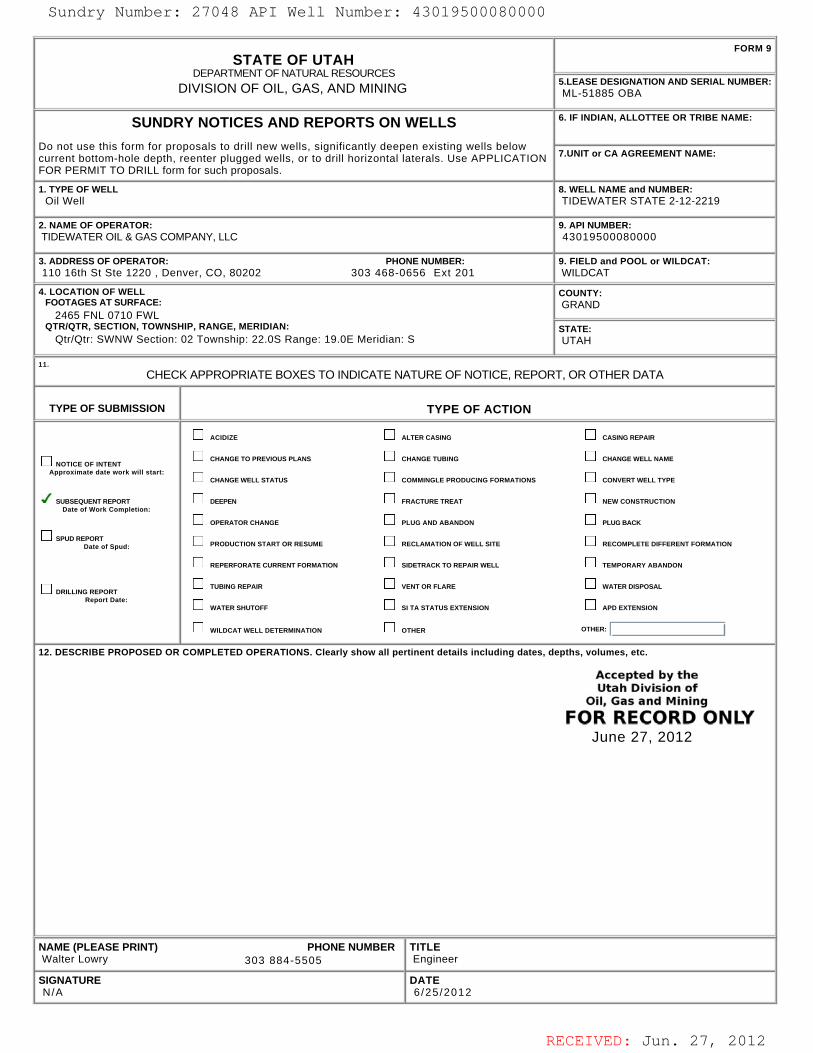
RECEIVED: Jun. 27, 2012
STATE OF UTAHDEPARTMENT OF NATURAL RESOURCES
DIVISION OF OIL, GAS, AND MINING
FORM 9
5.LEASE DESIGNATION AND SERIAL NUMBER: ML-51885 OBA
SUNDRY NOTICES AND REPORTS ON WELLS
Do not use this form for proposals to drill new wells, significantly deepen existing wells belowcurrent bottom-hole depth, reenter plugged wells, or to drill horizontal laterals. Use APPLICATIONFOR PERMIT TO DRILL form for such proposals.
6. IF INDIAN, ALLOTTEE OR TRIBE NAME:
7.UNIT or CA AGREEMENT NAME:
1. TYPE OF WELL Oil Well
8. WELL NAME and NUMBER: TIDEWATER STATE 2-12-2219
2. NAME OF OPERATOR: TIDEWATER OIL & GAS COMPANY, LLC
9. API NUMBER: 43019500080000
3. ADDRESS OF OPERATOR: PHONE NUMBER: 110 16th St Ste 1220 , Denver, CO, 80202 303 468-0656 Ext 201
9. FIELD and POOL or WILDCAT: WILDCAT
4. LOCATION OF WELL FOOTAGES AT SURFACE: 2465 FNL 0710 FWL QTR/QTR, SECTION, TOWNSHIP, RANGE, MERIDIAN: Qtr/Qtr: SWNW Section: 02 Township: 22.0S Range: 19.0E Meridian: S
COUNTY: GRAND
STATE: UTAH
11.
CHECK APPROPRIATE BOXES TO INDICATE NATURE OF NOTICE, REPORT, OR OTHER DATA
TYPE OF SUBMISSION TYPE OF ACTION
NOTICE OF INTENTApproximate date work will start:
SUBSEQUENT REPORTDate of Work Completion:
SPUD REPORTDate of Spud:
DRILLING REPORTReport Date:
ACIDIZE ALTER CASING CASING REPAIR
CHANGE TO PREVIOUS PLANS CHANGE TUBING CHANGE WELL NAME
CHANGE WELL STATUS COMMINGLE PRODUCING FORMATIONS CONVERT WELL TYPE
DEEPEN FRACTURE TREAT NEW CONSTRUCTION
OPERATOR CHANGE PLUG AND ABANDON PLUG BACK
PRODUCTION START OR RESUME RECLAMATION OF WELL SITE RECOMPLETE DIFFERENT FORMATION
REPERFORATE CURRENT FORMATION SIDETRACK TO REPAIR WELL TEMPORARY ABANDON
TUBING REPAIR VENT OR FLARE WATER DISPOSAL
WATER SHUTOFF SI TA STATUS EXTENSION APD EXTENSION
WILDCAT WELL DETERMINATION OTHER OTHER:
12. DESCRIBE PROPOSED OR COMPLETED OPERATIONS. Clearly show all pertinent details including dates, depths, volumes, etc.
NAME (PLEASE PRINT) PHONE NUMBER Walter Lowry 303 884-5505
TITLE Engineer
SIGNATURE N/A
DATE 6 /25 /2012
June 27, 2012
Sundry Number: 27048 API Well Number: 43019500080000Sundry Number: 27048 API Well Number: 43019500080000
FORM 9STATE OF UTAH
DEPARTMENTOF NATURALRESOURCES5.LEASE DESIGNATION AND SERIAL NUMBER:DIVISION OF OIL, GAS, AND MINING ML-51885 OBA
SUNDRY NOTICES AND REPORTS ON WELLS 6. IF INDIAN, ALLOTTEE OR TRIBE NAME:
Do not use this form for proposals to drill new wells, significantly deepen existing wells belowcurrent bottom-hole depth, reenter plugged wells, or to drill horizontal laterals. Use APPLICATION 7.UNITor CA AGREEMENT NAME:
FOR PERMIT TO DRILL form for such proposals.
1. TYPE OF WELL 8. WELL NAME and NUMBER:Oil Well TIDEWATER STATE 2-12-2219
2. NAME OF OPERATOR: 9. API NUMBER:TIDEWATER OIL & GAS COMPANY, LLC 43019500080000
3. ADDRESS OF OPERATOR: PHONE NUMBER: 9. FIELD and POOL or WILDCAT:110 16th St Ste 1220 , Denver, CO, 80202 303 468-0656 Ext 201 WILDCAT
4. LOCATION OF WELL COUNTY:FOOTAGES AT SURFACE: GRAND
2465 FNL 0710 FWLQTRIQTR, SECTION, TOWNSHIP, RANGE, MERIDIAN: STATE:
QtrlQtr: SWNW Section: 02 Township: 22.0S Range: 19.0E Meridian: S UTAH
CHECK APPROPRIATE BOXES TO INDICATENATURE OF NOTICE, REPORT, OR OTHER DATA
TYPE OF SUBMISSION TYPE OF ACTION
ACI DIZE ALTER CASING CASING REPAIR
CHANGE TO PREVIOUS PLANS CHANGE TUBING CHANGE WELL NAMENOTICE OF INTENT
Approximate date work will start:CHANGE WELL STATUS COMMINGLE PRODUCING FORMATIONS CONVERT WELL TYPE
SUBSEQUENTREPORT DEEPEN FRACTURETREAT NEWCONSTRUCTIONDate of Work Completion:
OPERATOR CHANGE PLUG AND ABANDON PLUG BACK
SPUD REDatof Spud: PRODUCTION START OR RESUME RECLAMATION OF WELL SITE RECOMPLETE DIFFERENT FORMATION
REPERFORATE CURRENT FORMATION SIDETRACK TO REPAIR WELL TEMPORARY ABANDON
TUBING REPAIR VENT OR FLARE WATER DISPOSALDRILLING REPORT
Report Date:WATER SHUTOFF SI TA STATUS EXTENSION APD EXTENSION
WILDCAT WELL DETERMINATION OTHER OTHER:
12. DESCRIBE PROPOSED OR COMPLETED OPERATIONS. Clearly show all pertinent details including dates, depths, volumes, etc.
Accepted by theutah Division of
Oil, Gas and Mining
FOR RECORD ONLYJune 27, 2012
NAME (PLEASE PRINT) PHONE NUMBER TITLEWalter Lowry 303 884-5505 Engineer
SIGNATURE DATEN/A 6/25/2012
RECEIVED: Jun. 27,
Sundry Number: 27048 API Well Number: 43019500080000
FORM 9STATE OF UTAH
DEPARTMENTOF NATURALRESOURCES5.LEASE DESIGNATION AND SERIAL NUMBER:DIVISION OF OIL, GAS, AND MINING ML-51885 OBA
SUNDRY NOTICES AND REPORTS ON WELLS 6. IF INDIAN, ALLOTTEE OR TRIBE NAME:
Do not use this form for proposals to drill new wells, significantly deepen existing wells belowcurrent bottom-hole depth, reenter plugged wells, or to drill horizontal laterals. Use APPLICATION 7.UNITor CA AGREEMENT NAME:
FOR PERMIT TO DRILL form for such proposals.
1. TYPE OF WELL 8. WELL NAME and NUMBER:Oil Well TIDEWATER STATE 2-12-2219
2. NAME OF OPERATOR: 9. API NUMBER:TIDEWATER OIL & GAS COMPANY, LLC 43019500080000
3. ADDRESS OF OPERATOR: PHONE NUMBER: 9. FIELD and POOL or WILDCAT:110 16th St Ste 1220 , Denver, CO, 80202 303 468-0656 Ext 201 WILDCAT
4. LOCATION OF WELL COUNTY:FOOTAGES AT SURFACE: GRAND
2465 FNL 0710 FWLQTRIQTR, SECTION, TOWNSHIP, RANGE, MERIDIAN: STATE:
QtrlQtr: SWNW Section: 02 Township: 22.0S Range: 19.0E Meridian: S UTAH
CHECK APPROPRIATE BOXES TO INDICATENATURE OF NOTICE, REPORT, OR OTHER DATA
TYPE OF SUBMISSION TYPE OF ACTION
ACI DIZE ALTER CASING CASING REPAIR
CHANGE TO PREVIOUS PLANS CHANGE TUBING CHANGE WELL NAMENOTICE OF INTENT
Approximate date work will start:CHANGE WELL STATUS COMMINGLE PRODUCING FORMATIONS CONVERT WELL TYPE
SUBSEQUENTREPORT DEEPEN FRACTURETREAT NEWCONSTRUCTIONDate of Work Completion:
OPERATOR CHANGE PLUG AND ABANDON PLUG BACK
SPUD REDatof Spud: PRODUCTION START OR RESUME RECLAMATION OF WELL SITE RECOMPLETE DIFFERENT FORMATION
REPERFORATE CURRENT FORMATION SIDETRACK TO REPAIR WELL TEMPORARY ABANDON
TUBING REPAIR VENT OR FLARE WATER DISPOSALDRILLING REPORT
Report Date:WATER SHUTOFF SI TA STATUS EXTENSION APD EXTENSION
WILDCAT WELL DETERMINATION OTHER OTHER:
12. DESCRIBE PROPOSED OR COMPLETED OPERATIONS. Clearly show all pertinent details including dates, depths, volumes, etc.
Accepted by theutah Division of
Oil, Gas and Mining
FOR RECORD ONLYJune 27, 2012
NAME (PLEASE PRINT) PHONE NUMBER TITLEWalter Lowry 303 884-5505 Engineer
SIGNATURE DATEN/A 6/25/2012
RECEIVED: Jun. 27,

RECEIVED: Jun. 25, 2012
TIDEWATER OIL and GAS COMPANY LLCDrilling Operations Summary for
Tidewater State 2‐12‐2219
Date Continuous Drilling, Completions, and Workover Operations
April 21, 2011 Begin building location and access road in to Tidewater State 2‐12‐2219.April 22, 2011 Work on access road and location.April 23, 2011 Work on access road and location.April 24, 2011 Easter Sunday. No activity.April 25, 2011 Finish location and access road construction. Dig reserve pit. Wait on pit liner. Build fence around 3 sides of reserve pit. MIRU Pete Martin Drilling to drill 20" conductor hole to 60' BGL.
April 26, 2011 Weld and run 60' of 16" conductor casing in well and cement with redi‐mix cement down backside. Cement stayed at surface.
April 27, 2011Blade and water access road. Have 850' of 8‐5/8" 24.0 ppf J55 STC casing delivered to location. Have 500 bbl frac tank delivered to location. Spot same. Fill tank with fresh water. Move in Leon Ross Drilling's small surface rig.
April 28, 2011 Rig up Leon Ross Drilling's surface setting rig. Spud 12‐1/4" surface hole with air at approximately 1430 hrs.
April 29, 2011Drill 12‐1/4" surface hole to 826' (with KB of 5') using air & air/mist. No shows of oil, gas, or water during entire operation. Surveys taken @ 200'‐ 2.0 deg; 400'‐ 3.75 deg; 600'‐ 3.50 deg; 800'‐ 3.50 deg. Run 821' of 8‐5/8" 24.0 ppf J55 STC surface casing and set at 816' KB (KB = 5').
April 30, 2011Cement casing with: Lead: 200 sx 65% Premium Cement / 35% POZ + 6% gel + 3% salt + 0.2% CFL‐117 + 1/4 pps Flocele mixed at 13.1 ppg and 1.69 cu ft/sx yield. Tail: 250 sx Premium Cement + 2% CaCl2 + 1/4 pps Flocele mixed at 15.8 ppg and 1.15 cu ft/sx yield. Return 48 bbls cement to surface. Bump plug at 0315 hrs 4/30/2011. Floats held. Cement at surface. Release surface rig @ 0400 hrs 04/30/2011.
May 1, 2011 Weld plate on top of surface casing until big rig moves in casing to prevent debris from falling in hole.through Grade location and prepare for drilling rig. Repair road.May 31, 2011
June 1, 2011 Place plastic pit liner from edge of reserve pit to approximately throughJune 30, 2011
July 1, 2011through Water road to assist in packing for heavy loads and dust control.July 21, 2011
July 22,2011 Grade road to prepare for rig move.July 23, 2011 Deliver gravel and spread over low spots.July 24, 2011 Fix low spot in road with rock to get rig in, and repair washouts. Forklift delivered to location.July 25, 2011 Wellhead located and procured. Deliver wellhead.July 26, 2011 Dig cellar around conductor casing and install cellar ring. Prepare to cit‐off conductor and surface casing strings BGL.July 27, 2011 Fix low spot in road with rock to get rig in, and repair washouts. Place portable toilets. Weld and test bradenhead.July 28, 2011 Commence moving in CapStar Rig #315 rig equipment. Mud motors, jars, and rotating head.July 29, 2011 Road work‐ place additional rock in washed out portions of road. MIRU CapStar Rig 315 equipment.July 30, 2011 Drilling equipment (drilling jars, PDC bits) delivered to site. Prepare location for delivery of camps.July 31, 2011 Company camps delivered to drilling site. Spot camps and install water & sewer systems. August 1, 2011 Hook up generators and electric panels for company camps. Prep electrical for pushers camp. Clean company camps.August 2, 2011 Low water crossing partially washed out due to excessive rain. Repair lease road for moving in rig. Work on pre‐mix tank to manifold to rig tank.August 3, 2011 Finish building up low water crossing. Prepare location for rig move. Finish preparation of pre‐mix mud tank to manifold with rig tank.August 4, 2011 Fill frac tank with fresh water. Place fresh water from drilling fluid in reserve pit. Spot pre‐mix tank. Modify reserve pit to accommodate CapStar #315. August 5, 2011 Final preparation of access road & well location. Place FW in reserve pit. Fill frac tank with FW. CapStar #315 is on the road to Tidewater location to resume drilling production hole.August 6, 2011 Begin moving MIRU rig equipment for CapStar Rig #315. Modify reserve pit to accommodate 2 surface pit system. Work on manifolding pits. WO rig equipment.
August 7, 2011MIRU CapStar Rig #315. RU Pason well monitoring equipment. NU BOPE. Modify catwalk. RU centrifuge. WO missing equipment to finish RU of Rig #315. Trucks broke down during rig move from Worland, WY.
August 8, 2011WO choke line & pump hose which were on a broken down truck during rig move. Nipple up choke line. Test BOPE. Did not hold. Repair rams and tighten studs & nuts on flanges. Test pipe & blind rams to 3000 psi for high test and 250psi for low test. Held tite. Test annular preventer to 1500 psi, would not hold. WO replacement annular preventer. RU annular, test to 1500 psi, would not hold. WO annular preventer from CapStar. Plan to go on company time after annular passes pressure test. Annular preventer scheduled to arrive on location at 0900 hrs 08‐09‐11.
August 9, 2011 Test new annular to 1500 psi. MU BHA. Install rotating head. Drill surface casing float collar, shoe jt, float shoe. Drill new 7‐7/8" production hole f/ 826'‐957'. Check flow. Mud up. Drill to 1119'.
August 10, 2011 Drill 7‐7/8" production hole from 1119'‐1681'. POOH. PU IBS stabilizer at 70' above bit to control direction. TIH.August 11, 2011 Drill f/ 1681'‐1965'. POOH. LD IBS. PU bent motor and MWD tool to directionally drill and correct well back to vertical. TIH.
1
'June 25, 2012v12
wlowry
Sundry Number: 27048 API Well Number: 43019500080000Sundry Number: 27048 API Well Number: 43019500080000TIDEWATER OIL and GAS COMPANY LLC
Drilling Operations Summary forTidewater State 2-12-2219
Date Continuous Drilling, Completions, and Workover Operations
April 21, 2011 Begin building location and access road in to Tidewater State 2-12-2219.
April 22, 2011 Work on access road and location.April 23, 2011 Work on access road and location.April 24, 2011 Easter Sunday. No activity.April 25, 2011 Finish location and access road construction. Dig reserve pit. Walt on pit liner. Build fence around 3 sides of reserve pit. MIRU Pete Martin Drilling to drill 20" conductor hole to 60' BGL.
April 26, 2011 Weld and run 60' of 16" conductor casing in well and cement with redi-mix cement down backside. Cement stayed at surface.
Blade and water access road. Have 850' of 8-5/8" 24.0 ppf J55 STC casing delivered to location. Have 500 bbl frac tank delivered to location. Spot same. Fill tank with fresh water. Move in Leon Ross Drilling'sApril 27, 2011 .
small surface rig.
April 28, 2011 Rig up Leon Ross Drilling's surface setting rig. Spud 12-1/4" surface hole with air at approximately 1430 hrs.
April 29, 2011Drill 12-1/4" surface hole to 826' (with KBof 5') using air & air/mist. No shows of oil, gas, or water during entire operation. Surveys taken @ 200'- 2.0 deg; 400'- 3.75 deg; 600'- 3.50 deg; 800'- 3.50 deg. Run 821'of 8-5/8" 24.0 ppf J55 STC surface casing and set at 816' KB (KB = 5').
April 30, 2011Cement casing with: Lead: 200 sx 65% Premium Cement / 35% POZ + 6% gel + 3% salt + 0.2% CFL-117 + 1/4 pps Flocele mixed at 13.1 ppg and 1.69 cu ft/sx yield. Tail: 250 sx Premium Cement + 2% CaCl2 + 1/4pps Flocele mixed at 15.8 ppg and 1.15 cu ft/sx yield. Return 48 bbls cement to surface. Bump plug at 0315 hrs 4/30/2011. Floats held. Cement at surface. Release surface rig @ 0400 hrs 04/30/2011.
May 1, 2011 Weld plate on top of surface casing until big rig moves in casing to prevent debris from falling in hole.through Grade location and prepare for drilling rig. Repair road.May 31, 2011
June 1, 2011 Place plastic pit liner from edge of reserve pit to approximatelythroughJune 30, 2011
July 1, 2011through Water road to assist in packing for heavy loads and dust control.July 21, 2011
July 22,2011 Grade road to prepare for rig move.July 23, 2011 Deliver gravel and spread over low spots.July 24, 2011 Fix low spot in road with rock to get rig in, and repair washouts. Forklift delivered to location.July 25, 2011 Wellhead located and procured. Deliver wellhead.July 26, 2011 Dig cellar around conductor casing and install cellar ring. Prepare to cit-off conductor and surface casing strings BGL.July 27, 2011 Fix low spot in road with rock to get rig in, and repair washouts. Place portable toilets. Weld and test bradenhead.July 28, 2011 Commence moving in CapStar Rig#315 rig equipment. Mud motors, Jars,and rotating head.July 29, 2011 Road work- place additional rock in washed out portions of road. MIRU CapStar Rig 315 equipment.July 30, 2011 Drilling equipment (drilling jars, PDC bits) delivered to site. Prepare location for delivery of camps.July 31, 2011 Company camps delivered to drilling site. Spot camps and install water & sewer systems.August 1, 2011 Hook up generators and electric panels for company camps. Prep electrical for pushers camp. Clean company camps.August 2, 2011 Low water crossing partially washed out due to excessive rain. Repair lease road for moving in rig. Work on pre-mix tank to manifold to rig tank.August 3, 2011 Finish building up low water crossing. Prepare location for rig move. Finish preparation of pre-mix mud tankto manifold with rig tank.August 4, 2011 Fill frac tank with fresh water. Place fresh water from drilling fluid in reserve pit. Spot pre-mix tank. Modify reserve pit to accommodate CapStar #315.August 5, 2011 Final preparation of access road & well location. Place FW in reserve pit. Fill frac tank with FW. CapStar #315 is on the road to Tidewater location to resume drilling production hole.August 6, 2011 Begin moving MIRU rig equipment for CapStar Rig #315. Modify reserve pit to accommodate 2 surface pit system. Work on manifolding pits. WO rig equipment.
MIRU CapStar Rig #315. RU Pason well monitoring equipment. NU BOPE. Modify catwalk. RU centrifuge. WO missing equipment to finish RU of Rig #315. Trucks broke down during rig move from Worland,August 7, 2011
WY.WO choke line & pump hose which were on a broken down truck during rig move. Nipple up choke line. Test BOPE. Did not hold. Repair rams and tighten studs & nuts on flanges. Test pipe & blind rams to
August 8, 2011 3000 psi for high test and 250psi for low test. Held tite. Test annular preventer to 1500 psi, would not hold. WO replacement annular preventer. RU annular, test to 1500 psi, would not hold. WO annularpreventer from CacStar. Plan to go on companv time after annular passes pressure test. Annular preventer scheduled to arrive on location at 0900 hrs 08-09-11.
August 9, 2011 Test new annular to 1500 psi. MU BHA. Install rotating head. Drill surface casing float collar, shoe Jt,float shoe. Drill new 7-7/8" production hole f/ 826'-95T. Check flow. Mud up. Drill to 1119'.
August 10, 2011 Drill 7-7/8" production hole from 1119'-1681'. POOH. PU IBS stabilizer at 70' above bit to control direction. TIH.August 11, 2011 Drill f/ 1681'-1965'. POOH. LD IBS. PU bent motor and MWD tool to directionally drill and correct well back to vertical. TIH.
June 5, 2012v12
1 wlowry
RECEIVED: Jun. 25,
Sundry Number: 27048 API Well Number: 43019500080000TIDEWATER OIL and GAS COMPANY LLC
Drilling Operations Summary forTidewater State 2-12-2219
Date Continuous Drilling, Completions, and Workover Operations
April 21, 2011 Begin building location and access road in to Tidewater State 2-12-2219.
April 22, 2011 Work on access road and location.April 23, 2011 Work on access road and location.April 24, 2011 Easter Sunday. No activity.April 25, 2011 Finish location and access road construction. Dig reserve pit. Wait on pit liner. Build fence around 3 sides of reserve pit. MIRU Pete Martin Drilling to drill 20" conductor hole to 60' BGL.
April 26, 2011 Weld and run 60'of 16" conductor casing in well and cement with redi-mix cement down backside. Cement stayed at surface.
Blade and water access road. Have 850'of8-5/8" 24.0 ppf J55 STC casing delivered to location. Have 500 bbl frac tank delivered to location. Spot same. Fill tank with fresh water. Move in Leon Ross Drilling'sApril 27, 2011
small surface rig.
April 28, 2011 Rig up Leon Ross Drilling's surface setting rig. Spud 12-1/4" surface hole with air at approximately 1430 hrs.
Drill 12-1/4" surface hole to 826' (with KBof 5') using air & air/mist. No shows of oil, gas, or water during entire operation. Surveys taken @ 200'- 2.0 deg; 400'- 3.75 deg; 600'- 3.50 deg; 800'- 3.50 deg. Run 821'April 29, 2011
of 8-5/8" 24.0 ppf J55 STC surface casing and set at 816' KB (KB = 5').
April 30, 2011Cement casing with: Lead: 200 sx 65% Premium Cement / 35% POZ + 6% gel + 3% salt + 0.2% CFL-117 + 1/4 pps Flocele mixed at 13.1 ppg and 1.69 cu ft/sx yield. Tail: 250 sx Premium Cement + 2% CaCl2 + 1/4pps Flocele mixed at 15.8 ppg and 1.15 cu ft/sx yield. Return 48 bbis cement to surface. Bump plug at 0315 hrs 4/30/2011. Floats held. Cement at surface. Release surface rig @ 0400 hrs 04/30/2011.
May 1, 2011 Weld plate on top of surface casing until big rig moves in casing to prevent debris from falling in hole.through Grade location and prepare for drilling rig. Repair road.May 31, 2011
June 1, 2011 Place plastic pit liner from edge of reserve pit to approximatelythroughJune 30, 2011
July 1, 2011through Water road to assist in packing for heavy loads and dust control.July 21, 2011
July 22,2011 Grade road to prepare for rig move.July 23, 2011 Deliver gravel and spread over low spots.July 24, 2011 Fix low spot in road with rock to get rig in, and repair washouts. Forklift delivered to location.July 25, 2011 Wellhead located and procured. Deliver wellhead.July 26, 2011 Dig cellar around conductor casing and install cellar ring. Prepare to cit-off conductor and surface casing strings BGL.July 27, 2011 Fix low spot in road with rock to get rig in, and repair washouts. Place portable toilets. Weld and test bradenhead.July 28, 2011 Commence moving in CapStar Rig #315 rig equipment. Mud motors, jars, and rotating head.July 29, 2011 Road work- place additional rock in washed out portions of road. MIRU CapStar Rig 315 equipment.July 30, 2011 Drilling equipment (drilling jars, PDC bits) delivered to site. Prepare location for delivery of camps.July 31, 2011 Company camps delivered to drilling site. Spot camps and install water & sewer systems.August 1, 2011 Hook up generators and electric panels for company camps. Prep electrical for pushers camp. Clean company camps.August 2, 2011 Low water crossing partially washed out due to excessive rain. Repair lease road for moving in rig. Work on pre-mix tank to manifold to rig tank.August 3, 2011 Finish building up low water crossing. Prepare location for rig move. Finish preparation of pre-mix mud tank to manifold with rig tank.August 4, 2011 Fill frac tank with fresh water. Place fresh water from drilling fluid in reserve pit. Spot pre-mix tank. Modify reserve pit to accommodate CapStar #315.August 5, 2011 Final preparation of access road & well location. Place FW in reserve pit. Fill frac tank with FW. CapStar #315 is on the road to Tidewater location to resume drilling production hole.August 6, 2011 Begin moving MIRU rig equipment for CapStar Rig #315. Modify reserve pit to accommodate 2 surface pit system. Work on manifolding pits. WO rig equipment.
MIRU CapStar Rig #315. RU Pason well monitoring equipment. NU BOPE. Modify catwalk. RU centrifuge. WO missing equipment to finish RU of Rig #315. Trucks broke down during rig move from Worland,August 7, 2011
WY.WO choke line & pump hose which were on a broken down truck during rig move. Nipple up choke line. Test BOPE. Did not hold. Repair rams and tighten studs & nuts on flanges. Test pipe & blind rams to
August 8, 2011 3000 psi for high test and 250psi for low test. Held tite. Test annular preventer to 1500 psi, would not hold. WO replacement annular preventer. RU annular, test to 1500 psi, would not hold. WO annularpreventer from CapStar. Plan to go on company time after annular passes pressure test. Annular preventer scheduled to arrive on location at 0900 hrs 08-09-11.
August 9, 2011 Test new annular to 1500 psi. MU BHA. Install rotating head. Drill surface casing float collar, shoe jt, float shoe. Drill new 7-7/8" production hole f/ 826'-957'. Check flow. Mud up. Drill to 1119'.
August 10, 2011 Drill 7-7/8" production hole from 1119'-1681'. POOH. PU IBS stabilizer at 70' above bit to control direction. TlH.August 11, 2011 Drill f/ 1681'-1965'. POOH. LD IBS. PU bent motor and MWD tool to directionally drill and correct well back to vertical. TlH.
June 5, 2012v12
1 wlowry
RECEIVED: Jun. 25,

RECEIVED: Jun. 25, 2012
TIDEWATER OIL and GAS COMPANY LLCDrilling Operations Summary for
Tidewater State 2‐12‐2219
August 12, 2011 Finish TIH. Directionally drill 7‐7/8" production hole f/ 1965'‐2882'.August 13, 2011 Directionally drill 7‐7/8" production hole f/ 2882'‐3178'. RU gas buster.August 14, 2011 Directionally drill 7‐7/8" production hole f/ 3178'‐ 3361'.August 15, 2011 Directionally drill 7‐7/8" production hole f/ 3361'‐ 3750'.August 16, 2011 Directionally drill 7‐7/8" production hole f/ 3750'‐ 4407'.August 17, 2011 Directionally drill 7‐7/8" production hole f/ 4407'‐ 4551'. Circulate and trip for new bit.August 18, 2011 TIH & ream thru bridges to 4551'. Directionally drill 7‐7/8" production hole f/ 4551'‐ 4862'.August 19, 2011 Directionally drill 7‐7/8" production hole f/ 4862'‐ 5155'. POOH to PU reaming assembly.August 20, 2011 PU reamers and wash & ream from 1500' to 5155'. Condition hole.August 21, 2011 Wash & ream tite spots in wellbore. TOOH to PU directional tools.August 22, 2011 LD DCs. PU HWDP. TIH. Ream f/ 1673'‐2143'. Directionally drill 7‐7/8" production hole f/ 5155'‐ 5256'.August 23, 2011 Directionally drill 7‐7/8" production hole f/ 5256'‐ 5631'.August 24, 2011 Directionally drill 7‐7/8" production hole f/ 5631'‐ 5861'.August 25, 2011 Directionally drill 7‐7/8" production hole f/ 5861' 5974'.August 26, 2011 Directionally drill 7‐7/8" production hole f/ 5974' ‐ 6124'. Trip out of hole to LD directional tools.August 27, 2011 Finish TOOH. LD directional drilling tools Function test BOPE, Pick up non‐directional BHA. TIH. Drill straight f/ 6135' to 6240'.August 28, 2011 Drill 7‐7/8" production hole f/ 6240'‐ ' 6461'.August 29, 2011 Drill 7‐7/8" production hole f/ 6461'‐ 6502' (Driller's TD). Prepare to run electric logs.
August 30, 2011Run openhole electric logs with Halliburton (Logger's TD= 6505'). TIH to 6502' TD. Circulate and condition mud & hole . Wait on Orders. Rig service & rig repair. Set casing racks in place. TOOH to LD BHA and prep to TIH open‐ended to set cement P&A plugs or plugs.
August 31, 2011
Finish TOOH & LD BHA. TIH open‐ended in preparation of setting plugs over bottom 1/2 of wellbore. Decision made to abandon lower portion of hole from 3400' to 6502'. (NOTE: At this time there is not a sufficient expectation of advancing production of the Leased Substances in paying quantities from under the Leased Premises. However, Tidewater will continue to investigate enhanced evaluation technology and state‐of‐the‐art production techniques in an effort to establish production of Leased Substances in paying quantities from this well on the Leased Premises.) Circulate & condition mud and WO Howco. RU Howco. Set P&A plug #1 from 6502'‐6200' w/ 110 sx PlugCem cement at 15.8 ppg. POOH laying down DP to 3878'. Pump and set P&A Plug #2 f/ 3750'‐3600' (over top Wingate formation) using 110 sx PlugCem cement plus additives mixed at 15.8 ppg. POOH w/ 14 jts DP. Circ btms up, no cement contamination.
September 1, 2011TOOH laying down DP leaving sufficient DP to make conditioning run with bit and BHA in preparation for running casing. PU DCs and TIH. Tag top of P&A plug #2 at 3676' . Circulate & condition mud while contacting UDOGM. Receive verbal approval of establishing a lower top of P&A plug #2 than designed from D. Doucet w/ UDOGM. Resume TOOH laying down drill string. RU Halliburton. Run float shoe, shoe joint, float collar and 90 jts of 5‐1/2" 17.0 ppf HCP‐110 LTC production casing to 3472' RKB. Run DV tool at 1295' and external casing packer at 1309.5' (to middle of pkr). Top of FC at 3431'.
September 2, 2011
Finish running 5‐1/2' production casing to 3472'. Circulate and condition mud. Cement casing in two stages with good returns throughout job on both stages. After pumping first stage and verifying the floats held,, open DV tool and set external casing packer at 1310' with 2500 psi pressure.. Circulate out excess cement. Mix & pump second stage cement. Bump second plug and close DV tool. WOC. While WOC begin nipple down BOPE. Set 5‐1/2" casing slips. Cut off surface casing and make rough and final cuts on 5‐1/2" casing. NU tubing head and place cap on tubing head. Clean mud tanks. Release rig at 2000 hrs on 9/2/2011.
September 3, 2011 Tear down rig and load out on trucks. Clean up location.September 4, 2011 Evaluate electric logs and recompute based upon new information. Begin identifying specific zones of interest for completion operations.September 5, 2011 Evaluate electric logs in conjunction with mud log. Design completion procedure.September 6, 2011 Design completion procedure and solicit bids and recommendations from appropriate vendors. Prepare completion well cost estimate. Begin search for appropriate completion rig.September 7, 2011 Design completion procedure and solicit bids and recommendations from appropriate vendors. Prepare completion well cost estimate. Begin search for appropriate completion rig.September 8, 2011 Design completion procedure and solicit bids and recommendations from appropriate vendors. Prepare completion well cost estimate. Begin search for appropriate completion rig.September 9, 2011 Design completion procedure and solicit bids and recommendations from appropriate vendors. Prepare completion well cost estimate. Begin search for appropriate completion rig.September 10, 2011 Design completion procedure and solicit bids and recommendations from appropriate vendors. Prepare completion well cost estimate. Begin search for appropriate completion rig.September 11, 2011 Design completion procedure and solicit bids and recommendations from appropriate vendors. Prepare completion well cost estimate. Begin search for appropriate completion rig.September 12, 2011 Design completion procedure and solicit bids and recommendations from appropriate vendors. Prepare completion well cost estimate. Begin search for appropriate completion rig.September 13, 2011 Design completion procedure and solicit bids and recommendations from appropriate vendors. Prepare completion well cost estimate. Begin search for appropriate completion rig.September 14, 2011 Design completion procedure and solicit bids and recommendations from appropriate vendors. Prepare completion well cost estimate. Begin search for appropriate completion rig.September 15, 2011 Design completion procedure and solicit bids and recommendations from appropriate vendors. Prepare completion well cost estimate. Begin search for appropriate completion rig.September 16, 2011 Design completion procedure and solicit bids and recommendations from appropriate vendors. Prepare completion well cost estimate. Begin search for appropriate completion rig.September 17, 2011 Design completion procedure and solicit bids and recommendations from appropriate vendors. Prepare completion well cost estimate. Begin search for appropriate completion rig.September 18, 2011 Design completion procedure and solicit bids and recommendations from appropriate vendors. Prepare completion well cost estimate. Begin search for appropriate completion rig.September 19, 2011 Design completion procedure and solicit bids and recommendations from appropriate vendors. Prepare completion well cost estimate. Begin search for appropriate completion rig.September 20, 2011 Design completion procedure and solicit bids and recommendations from appropriate vendors. Prepare completion well cost estimate. Begin search for appropriate completion rig.September 21, 2011 Design completion procedure and solicit bids and recommendations from appropriate vendors. Prepare completion well cost estimate. Begin search for appropriate completion rig.
2
'June 25, 2012v12
wlowry
Sundry Number: 27048 API Well Number: 43019500080000Sundry Number: 27048 API Well Number: 43019500080000TIDEWATER OIL and GAS COMPANY LLC
Drilling Operations Summary forTidewater State 2-12-2219
August 12, 2011 Finish TlH. Directionally drill 7-7/8" production hole f/ 1965'-2882'.August 13, 2011 Directionally drill 7-7/8" production hole f/ 2882'-3178'. RU gas buster.August 14, 2011 Directionally drill 7-7/8" production hole f/ 3178'- 3361'.August 15, 2011 Directionally drill 7-7/8" production hole f/ 3361'- 3750'.August 16, 2011 Directionally drill 7-7/8" production hole f/ 3750'- 4407'.August 17, 2011 Directionally drill 7-7/8" production hole f/ 4407'- 4551'. Circulate and trip for new bit.August 18, 2011 TlH & ream thru bridges to 4551'. Directionally drill 7-7/8" production hole f/ 4551'- 4862'.August 19, 2011 Directionally drill 7-7/8" production hole f/ 4862'- 5155'. POOH to PU reaming assembly.August 20, 2011 PU reamers and wash & ream from 1500' to 5155'. Condition hole.August 21, 2011 Wash & ream tite spots in wellbore. TOOH to PU directional tools.August 22, 2011 LD DCs. PU HWDP. TlH. Ream f/ 1673'-2143'. Directionally drill 7-7/8" production hole f/ 5155'- 5256'.August 23, 2011 Directionally drill 7-7/8" production hole f/ 5256'- 5631'.August 24, 2011 Directionally drill 7-7/8" production hole f/ 5631'- 5861'.August 25, 2011 Directionally drill 7-7/8" production hole f/ 5861' 5974'.August 26, 2011 Directionally drill 7-7/8" production hole f/ 5974'- 6124'. Trip out of hole to LD directional tools.August 27, 2011 Finish TOOH. LD directional drilling tools Function test BOPE, Pick up non-directional BHA. TlH. Drill straight f/ 6135' to 6240'.August 28, 2011 Drill 7-7/8" production hole f/ 6240'-' 6461'.August 29, 2011 Drill 7-7/8" production hole f/ 6461'- 6502' (Driller's TD). Prepare to run electric logs.
Run openhole electric logs with Halliburton (Logger's TD= 6505'). TlH to 6502' TD. Circulate and condition mud & hole . Wait on Orders. Rig service & rig repair. Set casing racks in place. TOOH to LD BHA andAugust 30, 2011
prep to TlH open-ended to set cement P&A plugs or plugs.
Finish TOOH & LD BHA. TlH open-ended in preparation of setting plugs over bottom 1/2 of wellbore. Decision made to abandon lower portion of hole from 3400' to 6502'. (NOTE: At this time there is not asufficient expectation of advancing production of the Leased Substances in paying quantities from under the Leased Premises. However, Tidewater will continue to investigate enhanced evaluation technology
August 31, 2011 and state-of-the-art production techniques in an effort to establish production of Leased Substances in paying quantities from this well on the Leased Premises.) Circulate & condition mud and WO Howco. RUHowco. Set P&A plug #1 from 6502'-6200' w/ 110 sx PlugCem cement at 15.8 ppg. POOH laying down DP to 3878'. Pump and set P&A Plug #2 f/ 3750'-3600' (over top Wingate formation) using 110 sx PlugCemcement plus additives mixed at 15.8 ppg. POOH w/ 14 jts DP. Circ btms up, no cement contamination.
TOOH laying down DP leaving sufficient DP to make conditioning run with bit and BHA in preparation for running casing. PU DCs and TlH. Tag top of P&A plug #2 at 3676'. Circulate & condition mud whileSeptember 1, 2011 contacting UDOGM. Receive verbal approval of establishing a lower top of P&A plug #2 than designed from D. Doucet w/ UDOGM. Resume TOOH laying down drill string. RU Halliburton. Run float shoe, shoe
joint, float collar and 90 jts of 5-1/2" 17.0 ppf HCP-110 LTCproduction casing to 3472' RKB. Run DV tool at 1295' and external casing packer at 1309.5' (to middle of pkr). Top of FC at 3431'.
Finish running 5-1/2' production casing to 3472'. Circulate and condition mud. Cement casing in two stages with good returns throughout job on both stages. After pumping first stage and verifying the floats
September 2, 2011held,, open DV tool and set external casing packer at 1310' with 2500 psi pressure.. Circulate out excess cement. Mix & pump second stage cement. Bump second plug and close DV tool. WOC. While WOCbegin nipple down BOPE. Set 5-1/2" casing slips. Cut off surface casing and make rough and final cuts on 5-1/2" casing. NU tubing head and place cap on tubing head. Clean mud tanks. Release rig at 2000 hrson 9/2/2011.
September 3, 2011 Tear down rig and load out on trucks. Clean up location.September 4, 2011 Evaluate electric logs and recompute based upon new information. Begin identifying specific zones of interest for completion operations.September 5, 2011 Evaluate electric logs in conjunction with mud log. Design completion procedure.September 6, 2011 Design completion procedure and solicit bids and recommendations from appropriate vendors. Prepare completion well cost estimate. Begin search for appropriate completion rig.September 7, 2011 Design completion procedure and solicit bids and recommendations from appropriate vendors. Prepare completion well cost estimate. Begin search for appropriate completion rig.September 8, 2011 Design completion procedure and solicit bids and recommendations from appropriate vendors. Prepare completion well cost estimate. Begin search for appropriate completion rig.September 9, 2011 Design completion procedure and solicit bids and recommendations from appropriate vendors. Prepare completion well cost estimate. Begin search for appropriate completion rig.September 10, 2011 Design completion procedure and solicit bids and recommendations from appropriate vendors. Prepare completion well cost estimate. Begin search for appropriate completion rig.September 11, 2011 Design completion procedure and solicit bids and recommendations from appropriate vendors. Prepare completion well cost estimate. Begin search for appropriate completion rig.September 12, 2011 Design completion procedure and solicit bids and recommendations from appropriate vendors. Prepare completion well cost estimate. Begin search for appropriate completion rig.September 13, 2011 Design completion procedure and solicit bids and recommendations from appropriate vendors. Prepare completion well cost estimate. Begin search for appropriate completion rig.September 14, 2011 Design completion procedure and solicit bids and recommendations from appropriate vendors. Prepare completion well cost estimate. Begin search for appropriate completion rig.September 15, 2011 Design completion procedure and solicit bids and recommendations from appropriate vendors. Prepare completion well cost estimate. Begin search for appropriate completion rig.September 16, 2011 Design completion procedure and solicit bids and recommendations from appropriate vendors. Prepare completion well cost estimate. Begin search for appropriate completion rig.September 17, 2011 Design completion procedure and solicit bids and recommendations from appropriate vendors. Prepare completion well cost estimate. Begin search for appropriate completion rig.September 18, 2011 Design completion procedure and solicit bids and recommendations from appropriate vendors. Prepare completion well cost estimate. Begin search for appropriate completion rig.September 19, 2011 Design completion procedure and solicit bids and recommendations from appropriate vendors. Prepare completion well cost estimate. Begin search for appropriate completion rig.September 20, 2011 Design completion procedure and solicit bids and recommendations from appropriate vendors. Prepare completion well cost estimate. Begin search for appropriate completion rig.September 21, 2011 Design completion procedure and solicit bids and recommendations from appropriate vendors. Prepare completion well cost estimate. Begin search for appropriate completion rig.
June 5, 2012v12
2 wlowry
RECEIVED: Jun. 25,
Sundry Number: 27048 API Well Number: 43019500080000TIDEWATER OIL and GAS COMPANY LLC
Drilling Operations Summary forTidewater State 2-12-2219
August 12, 2011 Finish TlH. Directionally drill 7-7/8" production hole f/ 1965'-2882'.August 13, 2011 Directionally drill 7-7/8" production hole f/ 2882'-3178'. RU gas buster.August 14, 2011 Directionally drill 7-7/8" production hole f/ 3178'- 3361'.August 15, 2011 Directionally drill 7-7/8" production hole f/ 3361'- 3750'.August 16, 2011 Directionally drill 7-7/8" production hole f/ 3750'- 440T.August 17, 2011 Directionally drill 7-7/8" production hole f/ 4407'- 4551'. Circulate and trip for new bit.August 18, 2011 TlH & ream thru bridges to 4551'. Directionally drill 7-7/8" production hole f/ 4551'-4862'.August 19, 2011 Directionally drill 7-7/8" production hole f/ 4862'- 5155'. POOH to PU reaming assembly.August 20, 2011 PU reamers and wash & ream from 1500' to 5155'. Condition hole.August 21, 2011 Wash & ream tite spots in wellbore. TOOH to PU directional tools.August 22, 2011 LD DCs. PU HWDP. TlH. Ream f/ 1673'-2143'. Directionally drill 7-7/8" production hole f/ 5155'- 5256'.August 23, 2011 Directionally drill 7-7/8" production hole f/ 5256'- 5631'.August 24, 2011 Directionally drill 7-7/8" production hole f/ 5631'- 5861'.August 25, 2011 Directionally drill 7-7/8" production hole f/ 5861' 5974'.August 26, 2011 Directionally drill 7-7/8" production hole f/ 5974' -6124'. Trip out of hole to LD directional tools.August 27, 2011 Finish TOOH. LD directional drilling tools Function test BOPE, Plck up non-directional BHA. TlH. Drill straight f/ 6135' to 6240'.August 28, 2011 Drill 7-7/8" production hole f/ 6240'-' 6461'.August 29, 2011 Drill 7-7/8" production hole f/ 6461'- 6502' (Driller's TD). Prepare to run electric logs.
Run openhole electric logs with Halliburton (Logger's TD= 6505'). TlH to 6502' TD. Circulate and condition mud & hole . Wait on Orders. Rig service & rig repair. Set casing racks in place. TOOH to LD BHA andAugust 30, 2011
prep to TlH open-ended to set cement P&A plugs or plugs.
Finish TOOH & LD BHA. TlH open-ended in preparation of setting plugs over bottom 1/2 of wellbore. Decision made to abandon lower portion of hole from 3400' to 6502'. (NOTE: At this time there is not asufficient expectation of advancing production of the Leased Substances in paying quantities from under the Leased Premises. However, Tidewater will continue to investigate enhanced evaluation technology
August 31, 2011 and state-of-the-art production techniques in an effort to establish production of Leased Substances in paying quantities from this well on the Leased Premises.) Circulate & condition mud and WO Howco. RUHowco. Set P&A plug #1 from 6502'-6200' w/ 110 sx PlugCem cement at 15.8 ppg. POOH laying down DP to 3878'. Pump and set P&A Plug #2 f/ 3750'-3600' (over top Wingate formation) using 110 sx PlugCemcement plus additives mixed at 15.8 ppg. POOH w/ 14 JtsDP. Circ btms up, no cement contamination.
TOOH laying down DP leaving sufficient DP to make conditioning run with bit and BHA in preparation for running casing. PU DCs and TlH. Tag top of P&A plug #2 at 3676'. Circulate & condition mud whileSeptember 1, 2011 contacting UDOGM. Receive verbal approval of establishing a lower top of P&A plug #2 than designed from D. Doucet w/ UDOGM. Resume TOOH laying down drill string. RU Halliburton. Run float shoe, shoe
joint, float collar and 90 Jtsof 5-1/2" 17.0 ppf HCP-110 LTCproduction casing to 3472' RKB. Run DV tool at 1295' and external casing packer at 1309.5' (to middle of pkr). Top of FC at 3431'.
Finish running 5-1/2' production casing to 3472'. Circulate and condition mud. Cement casing in two stages with good returns throughout job on both stages. After pumping first stage and verifying the floats
September 2, 2011held,, open DV tool and set external casing packer at 1310'with 2500 psi pressure.. Circulate out excess cement. Mix & pump second stage cement. Bump second plug and close DV tool. WOC. While WOCbegin nipple down BOPE. Set 5-1/2" casing slips. Cut off surface casing and make rough and final cuts on 5-1/2" casing. NU tubing head and place cap on tubing head. Clean mud tanks. Release rig at 2000 hrson 9/2/2011.
September 3, 2011 Tear down rig and load out on trucks. Clean up location.September 4, 2011 Evaluate electric logs and recompute based upon new information. Begin identifying specific zones of interest for completion operations.September 5, 2011 Evaluate electric logs in conjunction with mud log. Design completion procedure.September 6, 2011 Design completion procedure and solicit bids and recommendations from appropriate vendors. Prepare completion well cost estimate. Begin search for appropriate completion rig.September 7, 2011 Design completion procedure and solicit bids and recommendations from appropriate vendors. Prepare completion well cost estimate. Begin search for appropriate completion rig.September 8, 2011 Design completion procedure and solicit bids and recommendations from appropriate vendors. Prepare completion well cost estimate. Begin search for appropriate completion rig.September 9, 2011 Design completion procedure and solicit bids and recommendations from appropriate vendors. Prepare completion well cost estimate. Begin search for appropriate completion rig.September 10, 2011 Design completion procedure and solicit bids and recommendations from appropriate vendors. Prepare completion well cost estimate. Begin search for appropriate completion rig.September 11, 2011 Design completion procedure and solicit bids and recommendations from appropriate vendors. Prepare completion well cost estimate. Begin search for appropriate completion rig.September 12, 2011 Design completion procedure and solicit bids and recommendations from appropriate vendors. Prepare completion well cost estimate. Begin search for appropriate completion rig.September 13, 2011 Design completion procedure and solicit bids and recommendations from appropriate vendors. Prepare completion well cost estimate. Begin search for appropriate completion rig.September 14, 2011 Design completion procedure and solicit bids and recommendations from appropriate vendors. Prepare completion well cost estimate. Begin search for appropriate completion rig.September 15, 2011 Design completion procedure and solicit bids and recommendations from appropriate vendors. Prepare completion well cost estimate. Begin search for appropriate completion rig.September 16, 2011 Design completion procedure and solicit bids and recommendations from appropriate vendors. Prepare completion well cost estimate. Begin search for appropriate completion rig.September 17, 2011 Design completion procedure and solicit bids and recommendations from appropriate vendors. Prepare completion well cost estimate. Begin search for appropriate completion rig.September 18, 2011 Design completion procedure and solicit bids and recommendations from appropriate vendors. Prepare completion well cost estimate. Begin search for appropriate completion rig.September 19, 2011 Design completion procedure and solicit bids and recommendations from appropriate vendors. Prepare completion well cost estimate. Begin search for appropriate completion rig.September 20, 2011 Design completion procedure and solicit bids and recommendations from appropriate vendors. Prepare completion well cost estimate. Begin search for appropriate completion rig.September 21, 2011 Design completion procedure and solicit bids and recommendations from appropriate vendors. Prepare completion well cost estimate. Begin search for appropriate completion rig.
June 5, 2012v12
2 wlowry
RECEIVED: Jun. 25,
Sundry Number: 27048 API Well Number: 43019500080000TIDEWATER OIL and GAS COMPANY LLC
Drilling Operations Summary forTidewater State 2-12-2219
August 12, 2011 Finish TlH. Directionally drill 7-7/8" production hole f/ 1965'-2882'.August 13, 2011 Directionally drill 7-7/8" production hole f/ 2882'-3178'. RU gas buster.August 14, 2011 Directionally drill 7-7/8" production hole f/ 3178'- 3361'.August 15, 2011 Directionally drill 7-7/8" production hole f/ 3361'- 3750'.August 16, 2011 Directionally drill 7-7/8" production hole f/ 3750'- 4407'.August 17, 2011 Directionally drill 7-7/8" production hole f/ 4407'- 4551'. Circulate and trip for new bit.August 18, 2011 TlH & ream thru bridges to 4551'. Directionally drill 7-7/8" production hole f/ 4551'- 4862'.August 19, 2011 Directionally drill 7-7/8" production hole f/ 4862'- 5155'. POOH to PU reaming assembly.August 20, 2011 PU reamers and wash & ream from 1500' to 5155'. Condition hole.August 21, 2011 Wash & ream tite spots in wellbore. TOOH to PU directional tools.August 22, 2011 LD DCs. PU HWDP. TlH. Ream f/ 1673'-2143'. Directionally drill 7-7/8" production hole f/ 5155'- 5256'.August 23, 2011 Directionally drill 7-7/8" production hole f/ 5256'- 5631'.August 24, 2011 Directionally drill 7-7/8" production hole f/ 5631'- 5861'.August 25, 2011 Directionally drill 7-7/8" production hole f/ 5861' 5974'.August 26, 2011 Directionally drill 7-7/8" production hole f/ 5974'- 6124'. Trip out of hole to LD directional tools.August 27, 2011 Finish TOOH. LD directional drilling tools Function test BOPE, Pick up non-directional BHA. TlH. Drill straight f/ 6135' to 6240'.August 28, 2011 Drill 7-7/8" production hole f/ 6240'-' 6461'.August 29, 2011 Drill 7-7/8" production hole f/ 6461'- 6502' (Driller's TD). Prepare to run electric logs.
Run openhole electric logs with Halliburton (Logger's TD= 6505'). TlH to 6502' TD. Circulate and condition mud & hole . Wait on Orders. Rig service & rig repair. Set casing racks in place. TOOH to LD BHA andAugust 30, 2011
prep to TlH open-ended to set cement P&A plugs or plugs.
Finish TOOH & LD BHA. TlH open-ended in preparation of setting plugs over bottom 1/2 of wellbore. Decision made to abandon lower portion of hole from 3400' to 6502'. (NOTE: At this time there is not asufficient expectation of advancing production of the Leased Substances in paying quantities from under the Leased Premises. However, Tidewater will continue to investigate enhanced evaluation technology
August 31, 2011 and state-of-the-art production techniques in an effort to establish production of Leased Substances in paying quantities from this well on the Leased Premises.) Circulate & condition mud and WO Howco. RUHowco. Set P&A plug #1 from 6502'-6200' w/ 110 sx PlugCem cement at 15.8 ppg. POOH laying down DP to 3878'. Pump and set P&A Plug #2 f/ 3750'-3600' (over top Wingate formation) using 110 sx PlugCemcement plus additives mixed at 15.8 ppg. POOH w/ 14 jts DP. Circ btms up, no cement contamination.
TOOH laying down DP leaving sufficient DP to make conditioning run with bit and BHA in preparation for running casing. PU DCs and TlH. Tag top of P&A plug #2 at 3676'. Circulate & condition mud whileSeptember 1, 2011 contacting UDOGM. Receive verbal approval of establishing a lower top of P&A plug #2 than designed from D. Doucet w/ UDOGM. Resume TOOH laying down drill string. RU Halliburton. Run float shoe, shoe
joint, float collar and 90 jts of 5-1/2" 17.0 ppf HCP-110 LTCproduction casing to 3472' RKB. Run DV tool at 1295' and external casing packer at 1309.5' (to middle of pkr). Top of FC at 3431'.
Finish running 5-1/2' production casing to 3472'. Circulate and condition mud. Cement casing in two stages with good returns throughout job on both stages. After pumping first stage and verifying the floats
September 2, 2011held,, open DV tool and set external casing packer at 1310' with 2500 psi pressure.. Circulate out excess cement. Mix & pump second stage cement. Bump second plug and close DV tool. WOC. While WOCbegin nipple down BOPE. Set 5-1/2" casing slips. Cut off surface casing and make rough and final cuts on 5-1/2" casing. NU tubing head and place cap on tubing head. Clean mud tanks. Release rig at 2000 hrson 9/2/2011.
September 3, 2011 Tear down rig and load out on trucks. Clean up location.September 4, 2011 Evaluate electric logs and recompute based upon new information. Begin identifying specific zones of interest for completion operations.September 5, 2011 Evaluate electric logs in conjunction with mud log. Design completion procedure.September 6, 2011 Design completion procedure and solicit bids and recommendations from appropriate vendors. Prepare completion well cost estimate. Begin search for appropriate completion rig.September 7, 2011 Design completion procedure and solicit bids and recommendations from appropriate vendors. Prepare completion well cost estimate. Begin search for appropriate completion rig.September 8, 2011 Design completion procedure and solicit bids and recommendations from appropriate vendors. Prepare completion well cost estimate. Begin search for appropriate completion rig.September 9, 2011 Design completion procedure and solicit bids and recommendations from appropriate vendors. Prepare completion well cost estimate. Begin search for appropriate completion rig.September 10, 2011 Design completion procedure and solicit bids and recommendations from appropriate vendors. Prepare completion well cost estimate. Begin search for appropriate completion rig.September 11, 2011 Design completion procedure and solicit bids and recommendations from appropriate vendors. Prepare completion well cost estimate. Begin search for appropriate completion rig.September 12, 2011 Design completion procedure and solicit bids and recommendations from appropriate vendors. Prepare completion well cost estimate. Begin search for appropriate completion rig.September 13, 2011 Design completion procedure and solicit bids and recommendations from appropriate vendors. Prepare completion well cost estimate. Begin search for appropriate completion rig.September 14, 2011 Design completion procedure and solicit bids and recommendations from appropriate vendors. Prepare completion well cost estimate. Begin search for appropriate completion rig.September 15, 2011 Design completion procedure and solicit bids and recommendations from appropriate vendors. Prepare completion well cost estimate. Begin search for appropriate completion rig.September 16, 2011 Design completion procedure and solicit bids and recommendations from appropriate vendors. Prepare completion well cost estimate. Begin search for appropriate completion rig.September 17, 2011 Design completion procedure and solicit bids and recommendations from appropriate vendors. Prepare completion well cost estimate. Begin search for appropriate completion rig.September 18, 2011 Design completion procedure and solicit bids and recommendations from appropriate vendors. Prepare completion well cost estimate. Begin search for appropriate completion rig.September 19, 2011 Design completion procedure and solicit bids and recommendations from appropriate vendors. Prepare completion well cost estimate. Begin search for appropriate completion rig.September 20, 2011 Design completion procedure and solicit bids and recommendations from appropriate vendors. Prepare completion well cost estimate. Begin search for appropriate completion rig.September 21, 2011 Design completion procedure and solicit bids and recommendations from appropriate vendors. Prepare completion well cost estimate. Begin search for appropriate completion rig.
June 5, 2012v12
2 wlowry
RECEIVED: Jun. 25,

RECEIVED: Jun. 25, 2012
TIDEWATER OIL and GAS COMPANY LLCDrilling Operations Summary for
Tidewater State 2‐12‐2219
September 22, 2011 Design completion procedure and solicit bids and recommendations from appropriate vendors. Prepare completion well cost estimate. Begin search for appropriate completion rig.September 23, 2011 Design completion procedure and solicit bids and recommendations from appropriate vendors. Prepare completion well cost estimate. Begin search for appropriate completion rig.September 24, 2011 Design completion procedure and solicit bids and recommendations from appropriate vendors. Prepare completion well cost estimate. Begin search for appropriate completion rig.September 25, 2011 Design completion procedure and solicit bids and recommendations from appropriate vendors. Prepare completion well cost estimate. Begin search for appropriate completion rig.September 26, 2011 Receive and analyze bids for perforating & acidizing services, and downhole plugs and packers.September 27, 2011 Solicit and analyze bids for tubulars. September 28, 2011 Work with service and equipment suppliers to refine bids for work and tangible equipment for completion of the Tidewater State 2‐12‐2219 well.September 29, 2011 Work with service and equipment suppliers to refine bids for work and tangible equipment for completion of the Tidewater State 2‐12‐2219 well.September 30, 2011 Work with service and equipment suppliers to refine bids for work and tangible equipment for completion of the Tidewater State 2‐12‐2219 well.October 1, 2011October 2, 2011 Final Recommended Completion Procedure distributed to working interest owners and partners.
October 3, 2011Waiting on elections to participate from Partners and working interest owners. Finish completion rig canvas and select Key Energy Services as completion rig contractor. Rig is currently working for Stone Energy near Moab and is expected to begin working for Tidewater on or about October 17, 2011.
October 4, 2011Waiting on elections to participate from Partners and working interest owners. Finish completion rig canvas and select Key Energy Services as completion rig contractor. Rig is currently working for Stone Energy near Moab and is expected to begin working for Tidewater on or about October 17, 2011.
October 5, 2011Waiting on elections to participate from Partners and working interest owners. Finish completion rig canvas and select Key Energy Services as completion rig contractor. Rig is currently working for Stone Energy near Moab and is expected to begin working for Tidewater on or about October 17, 2011.
October 6, 2011Waiting on elections to participate from Partners and working interest owners. Finish completion rig canvas and select Key Energy Services as completion rig contractor. Rig is currently working for Stone Energy near Moab and is expected to begin working for Tidewater on or about October 17, 2011.
October 7, 2011Waiting on elections to participate from Partners and working interest owners. Finish completion rig canvas and select Key Energy Services as completion rig contractor. Rig is currently working for Stone Energy near Moab and is expected to begin working for Tidewater on or about October 17, 2011.
October 8, 2011October 9, 2011 Begin awarding work for services and equipment for Tidewater State 2‐12‐2219 well.October 10, 2011 Begin awarding work for services and equipment for Tidewater State 2‐12‐2219 well.October 11, 2011 Pull cellar ring fill cellar in anticipation of completion rig moving in.October 12, 2011 Set anchors for completion rig on Tidewater State 2‐12‐2219 well.October 13, 2011 Refine completion procedure based upon new developments regarding availability of equipment and the fact that hydraulic fracturing crews and equipment are in short supply (high demand).October 14, 2011 Informed by Key Energy Services that rig was delayed trying to retrieve a packer with pressure built up underneath on a Stone Energy well near Moab.October 15, 2011
October 16, 2011 Confirmed with Key Energy Services that completion rig would likely be delayed one week. New MIRU date for the Tidewater State 2‐12‐2219 well is estimated to be the week of October 24, 2011.
October 17 2011 Key Energy update looks like a full week delay for MIRU completion rig Expect rig on or about October 24 2011October 17, 2011 Key Energy update looks like a full week delay for MIRU completion rig. Expect rig on or about October 24, 2011.October 18, 2011 Wait on Key Energy Services completion rig which has been delayed on another job.October 19, 2011 Wait on Key Energy Services completion rig which has been delayed on another job.October 20, 2011 Wait on Key Energy Services completion rig which has been delayed on another job.October 21, 2011 Wait on Key Energy Services completion rig which has been delayed on another job.October 22, 2011 Wait on Key Energy Services completion rig which has been delayed on another job.October 23, 2011 Wait on Key Energy Services completion rig which has been delayed on another job.
October 24, 2011
On October 17,2011 the estimated date for MIRU Key Energy Services completion rig was 10/24/11. Stone Energy now involved in fishing operation with 1400 psi on well. Using snubbing unit for trips. Tidewater questioning whether Rig 232 will be finished with Stone in a timely manner. Begin search for a replacement rig in case Key Energy is tied up any longer. New date for Key Energy to move to Tidewater State 2‐12‐2219 is October 28, 2011, and appears optimistic. Tidewater ordered tubing for well, and tubing is to be delivered Monday, October 31, 2011. Tidewater orders additional 500 bbl frac tanks and schedules for delivery Monday, October 31, 2011.
3
'June 25, 2012v12
wlowry
Sundry Number: 27048 API Well Number: 43019500080000Sundry Number: 27048 API Well Number: 43019500080000TIDEWATER OIL and GAS COMPANY LLC
Drilling Operations Summary forTidewater State 2-12-2219
September 22, 2011 Design completion procedure and solicit bids and recommendations from appropriate vendors. Prepare completion well cost estimate. Begin search for appropriate completion rig.September 23, 2011 Design completion procedure and solicit bids and recommendations from appropriate vendors. Prepare completion well cost estimate. Begin search for appropriate completion rig.September 24, 2011 Design completion procedure and solicit bids and recommendations from appropriate vendors. Prepare completion well cost estimate. Begin search for appropriate completion rig.September 25, 2011 Design completion procedure and solicit bids and recommendations from appropriate vendors. Prepare completion well cost estimate. Begin search for appropriate completion rig.September 26, 2011 Receive and analyze bids for perforating & acidizing services, and downhole plugs and packers.September 27, 2011 Solicit and analyze bids for tubulars.September 28, 2011 Work with service and equipment suppliers to refine bids for work and tangible equipment for completion of the Tidewater State 2-12-2219 well.September 29, 2011 Work with service and equipment suppliers to refine bids for work and tangible equipment for completion of the Tidewater State 2-12-2219 well.September 30, 2011 Work with service and equipment suppliers to refine bids for work and tangible equipment for completion of the Tidewater State 2-12-2219 well.October 1, 2011October 2, 2011 Final Recommended Completion Procedure distributed to working interest owners and partners.
October 3, 2011Waiting on elections to participate from Partners and working interest owners. Finish completion rig canvas and select Key Energy Services as completion rig contractor. Rig is currently working for StoneEnergy near Moab and is expected to begin working for Tidewater on or about October 17, 2011.Waiting on elections to participate from Partners and working interest owners. Finish completion rig canvas and select Key Energy Services as completion rig contractor. Rig is currently working for Stone
October 4, 2011Energy near Moab and is expected to begin working for Tidewater on or about October 17, 2011.
October 5, 2011Waiting on elections to participate from Partners and working interest owners. Finish completion rig canvas and select Key Energy Services as completion rig contractor. Rig is currently working for StoneEnergy near Moab and is expected to begin working for Tidewater on or about October 17, 2011.Waiting on elections to participate from Partners and working interest owners. Finish completion rig canvas and select Key Energy Services as completion rig contractor. Rig is currently working for Stone
October 6, 2011Energy near Moab and is expected to begin working for Tidewater on or about October 17, 2011.
October 7, 2011Waiting on elections to participate from Partners and working interest owners. Finish completion rig canvas and select Key Energy Services as completion rig contractor. Rig is currently working for StoneEnergy near Moab and is expected to begin working for Tidewater on or about October 17, 2011.
October 8, 2011October 9, 2011 Begin awarding work for services and equipment for Tidewater State 2-12-2219 well.October 10, 2011 Begin awarding work for services and equipment for Tidewater State 2-12-2219 well.October 11, 2011 Pull cellar ring fillcellar in anticipation of completion rig moving in.October 12, 2011 Set anchors for completion rig on Tidewater State 2-12-2219 well.October 13, 2011 Refine completion procedure based upon new developments regarding availability of equipment and the fact that hydraulic fracturing crews and equipment are in short supply (high demand).October 14, 2011 Informed by Key Energy Services that rig was delayed trying to retrieve a packer with pressure built up underneath on a Stone Energy well near Moab.October 15, 2011
October 16, 2011 Confirmed with Key Energy Services that completion rig would likely be delayed one week. New MIRU date for the Tidewater State 2-12-2219 well is estimated to be the week of October 24, 2011.
October 17, 2011 Key Energy update looks like a full week delay for MIRU completion rig. Expect rig on or about October 24, 2011.October 18, 2011 Wait on Key Energy Services completion rig which has been delayed on another job.October 19, 2011 Walt on Key Energy Services completion rig which has been delayed on another job.October 20, 2011 Wait on Key Energy Services completion rig which has been delayed on another job.October 21, 2011 Walt on Key Energy Services completion rig which has been delayed on another job.October 22, 2011 Wait on Key Energy Services completion rig which has been delayed on another job.October 23, 2011 Walt on Key Energy Services completion rig which has been delayed on another job.
On October 17,2011the estimated date for MIRU Key Energy Services completion rig was 10/24/11. Stone Energy now involved in fishing operation with 1400 psi on well. Using snubbing unit for trips.
October 24, 2011Tidewater questioning whether Rig 232 will be finished with Stone in a timely manner. Begin search for a replacement rig in case Key Energy is tied up any longer. New date for Key Energy to move toTidewater State 2-12-2219 is October 28, 2011, and appears optimistic. Tidewater ordered tubing for well, and tubing is to be delivered Monday, October 31, 2011. Tidewater orders additional 500 bbl fractanks and schedules for delivery Monday, October 31, 2011.
June 25, 2012v12
3 wlowry
RECEIVED: Jun. 25,
Sundry Number: 27048 API Well Number: 43019500080000TIDEWATER OIL and GAS COMPANY LLC
Drilling Operations Summary forTidewater State 2-12-2219
September 22, 2011 Design completion procedure and solicit bids and recommendations from appropriate vendors. Prepare completion well cost estimate. Begin search for appropriate completion rig.September 23, 2011 Design completion procedure and solicit bids and recommendations from appropriate vendors. Prepare completion well cost estimate. Begin search for appropriate completion rig.September 24, 2011 Design completion procedure and solicit bids and recommendations from appropriate vendors. Prepare completion well cost estimate. Begin search for appropriate completion rig.September 25, 2011 Design completion procedure and solicit bids and recommendations from appropriate vendors. Prepare completion well cost estimate. Begin search for appropriate completion rig.September 26, 2011 Receive and analyze bids for perforating & acidizing services, and downhole plugs and packers.September 27, 2011 Solicit and analyze bids for tubulars.September 28, 2011 Work with service and equipment suppliers to refine bids for work and tangible equipment for completion of the Tidewater State 2-12-2219 well.September 29, 2011 Work with service and equipment suppliers to refine bids for work and tangible equipment for completion of the Tidewater State 2-12-2219 well.September 30, 2011 Work with service and equipment suppliers to refine bids for work and tangible equipment for completion of the Tidewater State 2-12-2219 well.October 1, 2011October 2, 2011 Final Recommended Completion Procedure distributed to working interest owners and partners.
Waiting on elections to participate from Partners and working interest owners. Finish completion rig canvas and select Key Energy Services as completion rig contractor. Rig is currently working for StoneOctober 3, 2011
Energy near Moab and is expected to begin working for Tidewater on or about October 17, 2011.Waiting on elections to participate from Partners and working interest owners. Finish completion rig canvas and select Key Energy Services as completion rig contractor. Rig is currently working for Stone
October 4, 2011Energy near Moab and is expected to begin working for Tidewater on or about October 17, 2011.Waiting on elections to participate from Partners and working interest owners. Finish completion rig canvas and select Key Energy Services as completion rig contractor. Rig is currently working for Stone
October 5, 2011Energy near Moab and is expected to begin working for Tidewater on or about October 17, 2011.Waiting on elections to participate from Partners and working interest owners. Finish completion rig canvas and select Key Energy Services as completion rig contractor. Rig is currently working for Stone
October 6, 2011Energy near Moab and is expected to begin working for Tidewater on or about October 17, 2011.Waiting on elections to participate from Partners and working interest owners. Finish completion rig canvas and select Key Energy Services as completion rig contractor. Rig is currently working for Stone
October 7, 2011Energy near Moab and is expected to begin working for Tidewater on or about October 17, 2011.
October 8, 2011October 9, 2011 Begin awarding work for services and equipment for Tidewater State 2-12-2219 well.October 10, 2011 Begin awarding work for services and equipment for Tidewater State 2-12-2219 well.October 11, 2011 Pull cellar ring fill cellar in anticipation of completion rig moving in.October 12, 2011 Set anchors for completion rig on Tidewater State 2-12-2219 well.October 13, 2011 Refine completion procedure based upon new developments regarding availability of equipment and the fact that hydraulic fracturing crews and equipment are in short supply (high demand).October 14, 2011 Informed by Key Energy Services that rig was delayed trying to retrieve a packer with pressure built up underneath on a Stone Energy well near Moab.October 15, 2011
October 16, 2011 Confirmed with Key Energy Services that completion rig would likely be delayed one week. New MIRU date for the Tidewater State 2-12-2219 well is estimated to be the week of October 24, 2011.
October 17, 2011 Key Energy update looks like a full week delay for MIRU completion rig. Expect rig on or about October 24, 2011.October 18, 2011 Wait on Key Energy Services completion rig which has been delayed on another job.October 19, 2011 Wait on Key Energy Services completion rig which has been delayed on another job.October 20, 2011 Wait on Key Energy Services completion rig which has been delayed on another job.October 21, 2011 Wait on Key Energy Services completion rig which has been delayed on another job.October 22, 2011 Wait on Key Energy Services completion rig which has been delayed on another job.October 23, 2011 Wait on Key Energy Services completion rig which has been delayed on another job.
On October 17,2011 the estimated date for MIRU Key Energy Services completion rig was 10/24/11. Stone Energy now involved in fishing operation with 1400 psi on well. Using snubbing unit for trips.
October 24, 2011Tidewater questioning whether Rig 232 will be finished with Stone in a timely manner. Begin search for a replacement rig in case Key Energy is tied up any longer. New date for Key Energy to move toTidewater State 2-12-2219 is October 28, 2011, and appears optimistic. Tidewater ordered tubing for well, and tubing is to be delivered Monday, October 31, 2011. Tidewater orders additional 500 bbl fractanks and schedules for delivery Monday, October 31, 2011.
June 25, 2012v12
wlowy
RECEIVED: Jun. 25,

RECEIVED: Jun. 25, 2012
TIDEWATER OIL and GAS COMPANY LLCDrilling Operations Summary for
Tidewater State 2‐12‐2219
October 25, 2011
October 26, 2011Tidewater has Cameron field service personnel deliver and install 11" 3M X 7‐1/16" 5M tubing head and install same in preparation of moving in completion rig. Tidewater calls to Key Energy Services personnel for updates on rig status not returned for nearly 24 hours. Tidewater begins finalizing negotiations with Basic Energy Services for replacement rig. Tidewater continues awarding bids to various service and equipment providers.
October 27, 2011Key Energy contact calls Tidewater with update. Key Rig 232 is going to be delayed up to another week. Tidewater firms up agreement with Basic Energy Services and replacement rig scheduled to be on Tidewater State 2‐12‐2219 location on Tuesday, November 1, 2011 or Wednesday , November 2, 2011 to commence completion operations on well.
October 28, 2011 Tidewater attempting to accelerate MIRU time for Basic Energy Services completion rig to Monday, October 31,2011. No decision re: accelerated MIRU at the time of this report.
October 29, 2011 No Activity.October 30, 2011 No Activity.October 31 2011 Gather crew in Rifle CO for Basic Energy Services Completion Rig #1551 Road rig to Crescent Junction UT and park overnight
Perform secondary completion rig canvas for back‐up rig to Key Energy Services Rig #232. Initial contacts produced a lead on a rig with potential for immediate availability. Found Basic Energy Rig available east of Grand Junction headed back to the Rangely Field.
1. Temples Well Service, Vernal, UT: Chris (435) 790‐1211Chris (Vernal) (435) 790‐1211. May have rig in 2‐3 weeks depending on contract renegotiations with the Ute (?) Tribal Council.
2. Stuart Mortensen, (435) 823‐2065 (former Basic Energy Services, own consulting for El Paso Natural Gas)Found Basic Energy Services rig based out of Rangely, CO but temporarily working just east of Grand Junction.Mike Sexton (Parachute): (970) 260‐3856 cell or (970) 941‐6029 officeBob Staley (Area Manager) (970) 574‐7158 cell or (970) 675‐2380 Gary Staley (Yard Manager) (970) 675‐2380
3. Key Energy Services, Grand Junction, CO (check for availability of any other rigs)Baxter Powell (District Manager) (435) 828‐7848Chris Blake (Rig #232 pusher) (970) 589‐6039
4. Nabors, Roosevelt, UT: Ray (Manager) (435) 823‐6753 (on a tip from Stuart Mortensen) May have a rig available approx 11/04/11.5. Bob Beeman Drilling Moab, UT (435) 259‐7281 Left Message. No call back.6. Aztec Well Service, Farmington, NM Jason Sandel (505) 334‐6194 Left Message.
Commence negotiations with Basic Energy Services for work on Tidewater State 2‐12‐2219 as soon as they can get their crews and rig together.
October 31, 2011 Gather crew in Rifle, CO for Basic Energy Services Completion Rig #1551. Road rig to Crescent Junction, UT and park overnight.November 1, 2011 MIRU Basic Energy Services Rig #1551. Unload, rabbit, and tally tubing. NU BOPE.
November 2, 2011WO water. Test BOPE to 1500 psi w/ rig pump. PU 4‐3/4" DCs and bit. TIH to top ofv DVTool at 1295'. RU powerswivel. Drill out DV Tool. TIH and tag Float Collar @ 3434'. POOH. LD but. PU casing scraper. Scrape casing to 1 joint above FC. POOH. LD scrasper. SDFN.
November 3, 2011Displace hole w/ 2% KCl. RU Schlumberger and run Radial CBL. TIH w/ tubing & swab well down to 2200'. RU Schlumberger. TIH and perforate f/ 3050'‐3060' w/ 4 spf 90 deg phasing.No blow or sign of hydrocarbons. RD wireline. SDFN.
November 4, 2011 Swab well. Recover 60 bbls. Obtain fluid sample. Fluid entry rate‐ 9 bfph. Leave FL at 1200'. SDFN.
November 5, 2011Check No pressure, no gas. TIH w/ CIBP and set at 3000'. Dump 2 sx cement on top of CIBP. Fill hole w/ 2% KCl water. Test CIBP to 1500 psi. TIH and perforate f/ 2264'‐2268' & 2276'‐2286'. No blow, no gas. No rise in fluid level. TIH w. tubing. Swab well down to top perf at 2264'. Secure well. SD until Monday.
November 6, 2011 No Activity. No pressure on well.
November 7, 2011POOH w/ tubing. TIH w/ CIBP & set at 2200'. Dump 2 sx cement on top of CIBP. TIH w/ tubing. Swab FL down to 1800. TIH w/ perforating guns and perf from 2052'‐ 2064' w/ 4 spf at 90 deg hasing. No initial bliow. No gas. Swab well. No signs of gas. Secure well & SDFN.
November 8, 2011 Swab well. Break down formation w 2% KCl water Establish pump‐in rates. Swab well. Rev=cover 44 bbl fluid. Obtain water sample from formation.
November 9, 2011Swab well. Minimal fluid entry. TIH w/ CIBP and set at 2025'. Dump 2 sx cedment on top of CIBP. ND BOPE. Install tubing hanger in tubing head. Install plate on top of tubing head. RD Basic Enerfgy Services Rig #1551. Release rig. Sevcure well. SD waiting on frac day for Mancos Shale.
November 10, 2011 Well shut in waiting on frac date for Mancos Shale.November 11, 2011 Obtain frac date from Baker Hughes of December 10, 2011. Design and model Mancos frac treatment.November 12, 2011 No Activity.November 13, 2011 No Activity.November 14, 2011 WO frac date of Baker Hughes of December 10, 2011. Design and model Mancos frac treatment.November 15, 2011 WO frac date of Baker Hughes of December 10, 2011. Design and model Mancos frac treatment.November 16, 2011 Identify ancillary services, equipment & personnel necessary to support & effectuate nitrified foam fracture treatment of two porosity zones within the Mancos Shale.November 17, 2011 Identify ancillary services, equipment & personnel necessary to support & effectuate nitrified foam fracture treatment of two porosity zones within the Mancos Shale.November 18, 2011 Obtain quotes/bids for ancillary service & equipment providers. Begin analyzing bids.November 19, 2011 No Activity.
4
'June 25, 2012v12
wlowry
Sundry Number: 27048 API Well Number: 43019500080000Sundry Number: 27048 API Well Number: 43019500080000TIDEWATER OIL and GAS COMPANY LLC
Drilling Operations Summary forTidewater State 2-12-2219
Perform secondary completion rig canvas for back-up rigto Key Energy Services Rig#232. Initial contacts produced a lead on a rig with potential forimmediate availability. Found Basic Energy Rig available east of Grand Junction headed back to the Rangely Field.
1. Temples Well Service, Vernal, UT: Chris (435) 790-1211
Chris {Vernal) (435) 790-1211. May have rig in 2-3 weeks depending on contract renegotiations with the Ute {?)Tribal Council.
2. Stuart Mortensen, (435) 823-2065 (former Basic Energy Services, own consulting for El Paso Natural Gas)Found Basic Energy Services rig based out of Rangely, CO but temporarily working just east of Grand Junction.Mike Sexton (Parachute): (970) 260-3856 cell or (970) 941-6029 office
October 25, 2011Bob Staley (Area Manager) (970) 574-7158 cell or (970) 675-2380Gary Staley (Yard Manager) (970) 675-2380
3. Key Energy Services, Grand Junction, CO (check for availabilityof any other rigs)Baxter Powell (District Manager) (435) 828-7848Chris Blake (Rig #232 pusher) (970) 589-6039
4. Nabors, Roosevelt, UT: Ray (Manager) (435) 823-6753 (on a tip from Stuart Mortensen) May have a rig available approx 11/04/11.5. Bob Beeman Drilling Moab, UT (435) 259-7281 Left Message. No call back.6. Aztec Well Service, Farmington, NM Jason Sandel (505) 334-6194 Left Message.
Commence negotiations with Basic Energy Services for work on Tidewater State 2-12-2219 as soon as they can get their crews and rig together.
Tidewater has Cameron field service personnel deliver and install 11" 3M X 7-1/16" 5M tubing head and install same in preparation of moving in completion rig. Tidewater calls to Key Energy Services personnelOctober 26, 2011 for updates on rig status not returned for nearly 24 hours. Tidewater begins finalizing negotiations with Basic Energy Services for replacement rig. Tidewater continues awarding bids to various service and
equipment providers.
October 27, 2011Key Energy contact calls Tidewater with update. Key Rig 232 is going to be delayed up to another week. Tidewater firms up agreement with Basic Energy Services and replacement rig scheduled to be onTidewater State 2-12-2219 location on Tuesday, November 1, 20110r Wednesday, November 2, 2011to commence completion operations on well.
October 28, 2011 Tidewater attempting to accelerate MIRU time for Basic Energy Services completion rig to Monday, October 31,2011. No decision re: accelerated MIRU at the time of this report.
October 29, 2011 No Activity.October 30, 2011 No Activity.October 31, 2011 Gather crew in Rifle, CO for Basic Energy Services Completion Rig #1551. Road rig to Crescent Junction, UT and park overnight.November 1, 2011 MIRU Basic Energy Services Rig#1551. Unload, rabbit, and tally tubing. NU BOPE.
WO water. Test BOPE to 1500 psi w/ rig pump. PU 4-3/4" DCs and bit. TIH to top ofv DVTool at 1295'. RU powerswivel. Drill out DV Tool. TIH and tag Float Collar @ 3434'. POOH. LD but. PU casing scraper.November 2, 2011
Scrape casing to 1 iointabove FC. POOH. LD scrasper. SDFN.
November 3, 2011Displace hole w/ 2% KCI. RU Schlumberger and run Radial CBL. TlH w/ tubing & swab well down to 2200'. RU Schlumberger. TlH and perforate f/ 3050'-3060' w/ 4 spf 90 deg phasing.No blow or sign ofhydrocarbons. RD wireline. SDFN.
November 4, 2011 Swab well. Recover 60 bbls. Obtain fluid sample. Fluid entry rate-9 bfph. Leave FLat 1200'. SDFN.
November 5, 2011Check No pressure, no gas. TlH w/ CIBP and set at 3000'. Dump 2 sx cement on top of CIBP. Fill hole w/ 2% KCIwater. Test CIBP to 1500 psi. TlH and perforate f/ 2264'-2268' & 2276'-2286'. No blow, no gas.No rise in fluid level. TIH w. tubing. Swab well down to top perf at 2264'. Secure well. SD until Monday.
November 6, 2011 No Activity. No pressure on well.
November 7, 2011POOH w/ tubing. TlH w/ CIBP & set at 2200'. Dump 2 sx cement on top of CIBP. TlH w/ tubing. Swab FL down to 1800. TIH w/ perforating guns and perf from 2052'- 2064' w/ 4 spf at 90 deg hasing. No initialbliow. No gas. Swab well. No signs of gas. Secure well & SDFN.
November 8, 2011 Swab well. Break down formation w 2% KCIwater Establish pump-in rates. Swab well. Rev=cover 44 bbl fluid. Obtain water sample from formation.
November 9, 2011Swab well. Minimal fluid entry. TlH w/ CIBP and set at 2025'. Dump 2 sx cedment on top of CIBP. ND BOPE. Install tubing hanger in tubing head. Install plate on top of tubing head. RD Basic Enerfgy ServicesRig #1551. Release rig. Sevcure well. SD waiting on frac day for Mancos Shale.
November 10, 2011 Well shut in waiting on frac date for Mancos Shale.November 11, 2011 Obtain frac date from Baker Hughes of December 10, 2011. Design and model Mancos frac treatment.November 12, 2011 No Activity.November 13, 2011 No Activity.November 14, 2011 WO frac date of Baker Hughes of December 10, 2011. Design and model Mancos frac treatment.November 15, 2011 WO frac date of Baker Hughes of December 10, 2011. Design and model Mancos frac treatment.November 16, 2011 Identify ancillary services, equipment & personnel necessary to support & effectuate nitrified foam fracture treatment of two porosity zones within the Mancos Shale.November 17, 2011 Identify ancillary services, equipment & personnel necessary to support & effectuate nitrified foam fracture treatment of two porosity zones within the Mancos Shale.November 18, 2011 Obtain quotes/bids for ancillary service & equipment providers. Begin analyzing bids.November 19, 2011 No Activity. ,Jurie 5, 2012
v124 wlowry
RECEIVED: Jun. 25,
Sundry Number: 27048 API Well Number: 43019500080000TIDEWATER OIL and GAS COMPANY LLC
Drilling Operations Summary forTidewater State 2-12-2219
Perform secondary completion rig canvas for back-up rigto Key Energy Services Rig#232. Initial contacts produced a lead on a rig with potential forimmediate availability. Found Basic Energy Rigavailable east of Grand Junction headed back tothe Rangely Field.
1. Temples Well Service, Vernal, UT: Chris (435)790-1211Chris (Vernal) (435)790-1211. May have rig in 2-3 weeks depending on contract renegotiations with the Ute (?)Tribal Council.
2. Stuart Mortensen, (435) 823-2065 (former Basic Energy Services, own consulting for ElPaso Natural Gas)Found Basic Energy Services rig based out of Rangely, CO but temporarily working just east of Grand Junction.Mike Sexton (Parachute): (970) 260-3856 cell or (970) 941-6029 office
October 25, 2011 Bob Staley (Area Manager) (970) 574-7158 cell or (970) 675-2380Gary Staley (Yard Manager) (970) 675-2380
3. Key Energy Services, Grand Junction, CO (check for availability of any other rigs)Baxter Powell (District Manager) (435) 828-7848Chris Blake (Rig #232 pusher) (970) 589-6039
4. Nabors, Roosevelt, UT: Ray (Manager) (435) 823-6753 (on a tip from Stuart Mortensen) May have a rig available approx 11/04/11.5. Bob Beeman Drilling Moab, UT (435) 259-7281 Left Message. No call back.6. Aztec Well Service, Farmington, NM Jason Sandel (505) 334-6194 Left Message.
Commence negotiations with Basic Energy Services for work on Tidewater State 2-12-2219 as soon as they can get their crews and rig together.
Tidewater has Cameron field service personnel deliver and install 11" 3MX 7-1/16" 5M tubing head and install same in preparation of moving in completion rig. Tidewater calls to Key Energy Services personnelOctober 26, 2011 for updates on rig status not returned for nearly 24 hours. Tidewater begins finalizing negotiations with Basic Energy Services for replacement rig. Tidewater continues awarding bids to various service and
equipment providers.
Key Energy contact calls Tidewater with update. Key Rig 232 is going to be delayed up to another week. Tidewater firms up agreement with Basic Energy Services and replacement rig scheduled to be onOctober 27, 2011
Tidewater State 2-12-2219 location on Tuesday, November 1, 2011or Wednesday , November 2, 2011 to commence completion operations on well.
October 28, 2011 Tidewater attempting to accelerate MIRU time for Basic Energy Services completion rig to Monday, October 31,2011. No decision re: accelerated MIRU at the time of this report.
October 29, 2011 No Activity.October 30, 2011 No Activity.October 31, 2011 Gather crew in Rifle, CO for Basic Energy Services Completion Rig #1551. Road rig to Crescent Junction, UT and park overnight.November 1, 2011 MIRU Basic Energy Services Rig #1551. Unload, rabbit, and tally tubing. NU BOPE.
November 2, 2011WO water. Test BOPE to 1500 psi w/ rig pump. PU 4-3/4" DCs and bit. TlH to top ofv DVTool at 1295'. RU powerswivel. Drill out DV Tool. TlH and tag Float Collar @ 3434'. POOH. LD but. PU casing scraper.Scrape casing to 1|oint above FC. POOH. LDscrasper. SDFN.
November 3, 2011Displace hole w/ 2% KCI. RU Schlumberger and run Radial CBL. TlH w/ tubing & swab well down to 2200'. RU Schlumberger. TlH and perforate f/ 3050'-3060' w/ 4 spf 90 deg phasing.No blow or sign ofhydrocarbons. RD wireline. SDFN.
November 4, 2011 Swab well. Recover 60 bbis. Obtain fluid sample. Fluid entry rate-9 bfph. Leave FLat 1200'. SDFN.
November 5, 2011Check No pressure, no gas. TlH w/ CIBP and set at 3000'. Dump 2 sx cement on top of CIBP. Fill hole w/ 2% KCIwater. Test CIBP to 1500 psi. TlH and perforate f/ 2264'-2268' & 2276'-2286'. No blow, no gas.No rise in fluid level. TlH w. tubing. Swab well down to top perf at 2264'. Secure well. SD until Monday.
November 6, 2011 No Activity. No pressure on well.
November 7, 2011POOH w/ tubing. TlH w/ CIBP & set at 2200'. Dump 2 sx cement on top of CIBP. TlH w/ tubing. Swab FLdown to 1800. TlH w/ perforating guns and perf from 2052'- 2064' w/ 4 spf at 90 deg hasing. No initialbliow. No gas. Swab well. No signs of gas. Secure well & SDFN.
November 8, 2011 Swab well. Break down formation w 2% KCIwater Establish pump-in rates. Swab well. Rev=cover 44 bbl fluid. Obtain water sample from formation.
November 9, 2011Swab well. Minimal fluid entry. TlH w/ CIBP and set at 2025'. Dump 2 sx cedment on top of CIBP. ND BOPE. Install tubing hanger in tubing head. Install plate on top of tubing head. RD Basic Enerfgy ServicesRig #1551. Release rig. Sevcure well. SD waiting on frac day for Mancos Shale.
November 10, 2011 Well shut in waiting on frac date for Mancos Shale.November 11, 2011 Obtain frac date from Baker Hughes of December 10, 2011. Design and model Mancos frac treatment.November 12, 2011 No Activity.November 13, 2011 No Activity.November 14, 2011 WO frac date of Baker Hughes of December 10, 2011. Design and model Mancos frac treatment.November 15, 2011 WO frac date of Baker Hughes of December 10, 2011. Design and model Mancos frac treatment.November 16, 2011 Identify ancillary services, equipment & personnel necessary to support & effectuate nitrified foam fracture treatment of two porosity zones within the Mancos Shale.November 17, 2011 Identify ancillary services, equipment & personnel necessary to support & effectuate nitrified foam fracture treatment of two porosity zones within the Mancos Shale.November 18, 2011 Obtain quotes/bids for ancillary service & equipment providers. Begin analyzing bids.November 19, 2011 No Activity. ,Ja..c 5, 2012
v124 wlowry
RECEIVED: Jun. 25,

RECEIVED: Jun. 25, 2012
TIDEWATER OIL and GAS COMPANY LLCDrilling Operations Summary for
Tidewater State 2‐12‐2219
November 20, 2011 No Activity.November 21, 2011 Analyze quotes/bids for equipment & services and refine Mncos Shale hydraulic fracturing procedure.November 22, 2011 Analyze quotes/bids for equipment & services and refine Mncos Shale hydraulic fracturing procedure.November 23, 2011 Analyze quotes/bids for equipment & services and refine Mncos Shale hydraulic fracturing procedure.November 24, 2011 Analyze quotes/bids for equipment & services and refine Mncos Shale hydraulic fracturing procedure.November 25, 2011 Analyze quotes/bids for equipment & services and refine Mncos Shale hydraulic fracturing procedure.November 26, 2011 No Activity.November 27, 2011 No Activity.November 28, 2011 Award work to various service & equipment providers & begin scheduling same.November 29, 2011 Award work to various service & equipment providers & begin scheduling same.November 30, 2011 Award work to various service & equipment providers & begin scheduling same.December 1, 2011 Award work to various service & equipment providers & begin scheduling same.December 2, 2011 Award work to various service & equipment providers & begin scheduling same.December 3, 2011 No Activity.December 4, 2011 No Activity.December 5, 2011 Refine completion procedure based upon new information and availability of equipment.December 6, 2011 Make final preparations for frac. Frac date moved up to 12/09/11. Will perforate first zone on 12/08/11. Rigging up well testers on 12/08/11.December 7, 2011 MIRU Weatherford Well Testers equipment. Fill frac tanks with 4% KCl water. Deliver, install & test Cameron 5M frac valve.
December 8, 2011 Deliver & install Weatherford test separator.RMWS sets CIBP at 1280' above MSC tool.Deliver and spot baker Hughes Sandmaster. Deliver forklift and light plants. Perforate Mancos Shale from 1160'‐1170'.
December 9, 2011 Deliver 80,000# 20/40 brown frac sand. MIRU remainder of Baker Hughes frac equipment. Heat 4% KCl makeup water to 100 deg F. Finish rigginbg up Weatherford testers and Baker Hughes frac equipment.
December 10, 2011 Break down and frac Mancos perfs from 1160'‐1170'. Perfs sanded up immediately. Circ out sand. Sert flow through packer at 1090'. Perf upper mancos Shale interval from 947'‐960'.December 11, 2011 Frac Upper mancos Shale interval and put away 70,000#'s 20/40 brown frac sand. RD Baker Hughes. Begin flowing back and testing well.December 12, 2011 Flowback and test well.December 13, 2011 Flowback and test well. RD Weatherford well testers. Shut in well for pressure build up.December 14, 2011 Monitor pressure build up of well and commence reservoir and potential reserve analysisDecember 15, 2011 Monitor well.December 16, 2011 Monitor well.December 17, 2011 Monitor well.December 18, 2011 Monitor well.December 19, 2011 Monitor wellDecember 19, 2011 Monitor well.December 20, 2011 Monitor well.December 21, 2011 Monitor well.December 22, 2011 Monitor well.December 23, 2011 Monitor well.December 24, 2011 Monitor well.December 25, 2011 Monitor well.December 26, 2011 Monitor well.December 27, 2011 Monitor well.December 28, 2011 Monitor well.December 29, 2011 Monitor well.December 30, 2011 Monitor well.December 31, 2011 Monitor well.January 1, 2012 Monitor well.January 2, 2012 Monitor well.January 3, 2012 Monitor well.January 4, 2012 Monitor well.January 5, 2012 Monitor well.January 6, 2012 Monitor well.January 7, 2012 Monitor well.January 8, 2012 Monitor well.January 9, 2012 Monitor well.January 10, 2012 Monitor well.January 11, 2012 Monitor well.January 12, 2012 Monitor well.
5
'June 25, 2012v12
wlowry
Sundry Number: 27048 API Well Number: 43019500080000Sundry Number: 27048 API Well Number: 43019500080000TIDEWATER OIL and GAS COMPANY LLC
Drilling Operations Summary forTidewater State 2-12-2219
November 20, 2011 No Activity.November 21, 2011 Analyze quotes/bids for equipment & services and refine Mncos Shale hydraulic fracturing procedure.November 22, 2011 Analyze quotes/bids for equipment & services and refine Mncos Shale hydraulic fracturing procedure.November 23, 2011 Analyze quotes/bids for equipment & services and refine Mncos Shale hydraulic fracturing procedure.November 24, 2011 Analyze quotes/bids for equipment & services and refine Mncos Shale hydraulic fracturing procedure.November 25, 2011 Analyze quotes/bids for equipment & services and refine Mncos Shale hydraulic fracturing procedure.November 26, 2011 No Activity.November 27, 2011 No Activity.November 28, 2011 Award work to various service & equipment providers & begin scheduling same.November 29, 2011 Award work to various service & equipment providers & begin scheduling same.November 30, 2011 Award work to various service & equipment providers & begin scheduling same.December 1, 2011 Award work to various service & equipment providers & begin scheduling same.December 2, 2011 Award work to various service & equipment providers & begin scheduling same.December 3, 2011 No Activity.December 4, 2011 No Activity.December 5, 2011 Refine completion procedure based upon new information and availability of equipment.December 6, 2011 Make final preparations for frac. Frac date moved up to 12/09/11. Will perforate first zone on 12/08/11. Rigging up well testers on 12/08/11.December 7, 2011 MIRU Weatherford Well Testers equipment. Fill frac tanks with 4% KCIwater. Deliver, install & test Cameron 5M frac valve.
December 8, 2011 Deliver & install Weatherford test separator.RMWS sets CIBP at 1280' above MSC tool.Deliver and spot baker Hughes Sandmaster. Deliver forklift and light plants. Perforate Mancos Shale from 1160'-1170'.
December 9, 2011 Deliver 80,000# 20/40 brown frac sand. MIRU remainder of Baker Hughes frac equipment. Heat 4% KCImakeup water to 100 deg F. Finish rigginbg up Weatherford testers and Baker Hughes frac equipment.
December 10, 2011 Break down and frac Mancos perfs from 1160'-1170'. Perfs sanded up immediately. Circ out sand. Sert flow through packer at 1090'. Perf upper mancos Shale interval from 947'-960'.December 11, 2011 Frac Upper mancos Shale interval and put away 70,000#'s 20/40 brown frac sand. RD Baker Hughes. Begin flowing back and testing well.December 12, 2011 Flowback and test well.December 13, 2011 Flowback and test well. RD Weatherford well testers. Shut in well for pressure build up.December 14, 2011 Monitor pressure build up of well and commence reservoir and potential reserve analysisDecember 15, 2011 Monitor well.December 16, 2011 Monitor well.December 17, 2011 Monitor well.December 18, 2011 Monitor well.December 19, 2011 Monitor well.December 20, 2011 Monitor well.December 21, 2011 Monitor well.December 22, 2011 Monitor well.December 23, 2011 Monitor well.December 24, 2011 Monitor well.December 25, 2011 Monitor well.December 26, 2011 Monitor well.December 27, 2011 Monitor well.December 28, 2011 Monitor well.December 29, 2011 Monitor well.December 30, 2011 Monitor well.December 31, 2011 Monitor well.January 1, 2012 Monitor well.January 2, 2012 Monitor well.January 3, 2012 Monitor well.January 4, 2012 Monitor well.January 5, 2012 Monitor well.January 6, 2012 Monitor well.January 7, 2012 Monitor well.January 8, 2012 Monitor well.January 9, 2012 Monitor well.January 10, 2012 Monitor well.January 11, 2012 Monitor well.January 12, 2012 Monitor well.
June 5, 2Ü12v12
5 wlowry
RECEIVED: Jun. 25,
Sundry Number: 27048 API Well Number: 43019500080000TIDEWATER OIL and GAS COMPANY LLC
Drilling Operations Summary forTidewater State 2-12-2219
November 20, 2011 No Activity.November 21, 2011 Analyze quotes/bids for equipment & services and refine Mncos Shale hydraulic fracturing procedure.November 22, 2011 Analyze quotes/bids for equipment & services and refine Mncos Shale hydraulic fracturing procedure.November 23, 2011 Analyze quotes/bids for equipment & services and refine Mncos Shale hydraulic fracturing procedure.November 24, 2011 Analyze quotes/bids for equipment & services and refine Mncos Shale hydraulic fracturing procedure.November 25, 2011 Analyze quotes/bids for equipment & services and refine Mncos Shale hydraulic fracturing procedure.November 26, 2011 No Activity.November 27, 2011 No Activity.November 28, 2011 Award work to various service & equipment providers & begin scheduling same.November 29, 2011 Award work to various service & equipment providers & begin scheduling same.November 30, 2011 Award work to various service & equipment providers & begin scheduling same.December 1, 2011 Award work to various service & equipment providers & begin scheduling same.December 2, 2011 Award work to various service & equipment providers & begin scheduling same.December 3, 2011 No Activity.December 4, 2011 No Activity.December 5, 2011 Refine completion procedure based upon new information and availability of equipment.December 6, 2011 Make final preparations for frac. Frac date moved up to 12/09/11. Will perforate first zone on 12/08/11. Rigging up well testers on 12/08/11.December 7, 2011 MIRU Weatherford Well Testers equipment. Fill frac tanks with 4% KCIwater. Deliver, install & test Cameron 5M frac valve.
December 8, 2011 Deliver & install Weatherford test separator.RMWS sets CIBP at 1280' above MSC tool.Deliver and spot baker Hughes Sandmaster. Deliver forklift and light plants. Perforate Mancos Shale from 1160'-1170'.
December 9, 2011 Deliver 80,000#20/40 brown frac sand. MIRU remainder of Baker Hughes frac equipment. Heat 4% KCImakeup water to 100 deg F. Finish rigginbg up Weatherford testers and Baker Hughes frac equipment.
December 10, 2011 Break down and frac Mancos perfs from 1160'-1170'. Perfs sanded up immediately. Circ out sand. Sert flow through packer at 1090'. Perf upper mancos Shale interval from 947-960'.
December 11, 2011 Frac Upper mancos Shale interval and put away 70,000#'s 20/40 brown frac sand. RD Baker Hughes. Begin flowing back and testing well.December 12, 2011 Flowback and test well.December 13, 2011 Flowback and test well. RD Weatherford well testers. Shut in well for pressure build up.December 14, 2011 Monitor pressure build up of well and commence reservoir and potential reserve analysisDecember 15, 2011 Monitor well.December 16, 2011 Monitor well.December 17, 2011 Monitor well.December 18, 2011 Monitor well.December 19, 2011 Monitor well.December 20, 2011 Monitor well.December 21, 2011 Monitor well.December 22, 2011 Monitor well.December 23, 2011 Monitor well.December 24, 2011 Monitor well.December 25, 2011 Monitor well.December 26, 2011 Monitor well.December 27, 2011 Monitor well.December 28, 2011 Monitor well.December 29, 2011 Monitor well.December 30, 2011 Monitor well.December 31, 2011 Monitor well.January 1, 2012 Monitor well.January 2, 2012 Monitor well.January 3, 2012 Monitor well.January 4, 2012 Monitor well.January 5, 2012 Monitor well.January 6, 2012 Monitor well.January 7, 2012 Monitor well.January 8, 2012 Monitor well.January 9, 2012 Monitor well.January 10, 2012 Monitor well.January 11, 2012 Monitor well.January 12, 2012 Monitor well.
June 5, 2012v12
5 wlowry
RECEIVED: Jun. 25,
Sundry Number: 27048 API Well Number: 43019500080000TIDEWATER OIL and GAS COMPANY LLC
Drilling Operations Summary forTidewater State 2-12-2219
November 20, 2011 No Activity.November 21, 2011 Analyze quotes/bids for equipment & services and refine Mncos Shale hydraulic fracturing procedure.November 22, 2011 Analyze quotes/bids for equipment & services and refine Mncos Shale hydraulic fracturing procedure.November 23, 2011 Analyze quotes/bids for equipment & services and refine Mncos Shale hydraulic fracturing procedure.November 24, 2011 Analyze quotes/bids for equipment & services and refine Mncos Shale hydraulic fracturing procedure.November 25, 2011 Analyze quotes/bids for equipment & services and refine Mncos Shale hydraulic fracturing procedure.November 26, 2011 No Activity.November 27, 2011 No Activity.November 28, 2011 Award work to various service & equipment providers & begin scheduling same.November 29, 2011 Award work to various service & equipment providers & begin scheduling same.November 30, 2011 Award work to various service & equipment providers & begin scheduling same.December 1, 2011 Award work to various service & equipment providers & begin scheduling same.December 2, 2011 Award work to various service & equipment providers & begin scheduling same.December 3, 2011 No Activity.December 4, 2011 No Activity.December 5, 2011 Refine completion procedure based upon new information and availability of equipment.December 6, 2011 Make final preparations for frac. Frac date moved up to 12/09/11. Will perforate first zone on 12/08/11. Rigging up well testers on 12/08/11.December 7, 2011 MIRU Weatherford Well Testers equipment. Fill frac tanks with 4% KCIwater. Deliver, install & test Cameron 5M frac valve.
December 8, 2011 Deliver & install Weatherford test separator.RMWS sets CIBP at 1280' above MSC tool.Deliver and spot baker Hughes Sandmaster. Deliver forklift and light plants. Perforate Mancos Shale from 1160'-1170'.
December 9, 2011 Deliver 80,000# 20/40 brown frac sand. MIRU remainder of Baker Hughes frac equipment. Heat 4% KCImakeup water to 100 deg F. Finish rigginbg up Weatherford testers and Baker Hughes frac equipment.
December 10, 2011 Break down and frac Mancos perfs from 1160'-1170'. Perfs sanded up immediately. Circ out sand. Sert flow through packer at 1090'. Perf upper mancos Shale interval from 947'-960'.December 11, 2011 Frac Upper mancos Shale interval and put away 70,000#'s 20/40 brown frac sand. RD Baker Hughes. Begin flowing back and testing well.December 12, 2011 Flowback and test well.December 13, 2011 Flowback and test well. RD Weatherford well testers. Shut in well for pressure build up.December 14, 2011 Monitor pressure build up of well and commence reservoir and potential reserve analysisDecember 15, 2011 Monitor well.December 16, 2011 Monitor well.December 17, 2011 Monitor well.December 18, 2011 Monitor well.December 19, 2011 Monitor well.December 20, 2011 Monitor well.December 21, 2011 Monitor well.December 22, 2011 Monitor well.December 23, 2011 Monitor well.December 24, 2011 Monitor well.December 25, 2011 Monitor well.December 26, 2011 Monitor well.December 27, 2011 Monitor well.December 28, 2011 Monitor well.December 29, 2011 Monitor well.December 30, 2011 Monitor well.December 31, 2011 Monitor well.January 1, 2012 Monitor well.January 2, 2012 Monitor well.January 3, 2012 Monitor well.January 4, 2012 Monitor well.January 5, 2012 Monitor well.January 6, 2012 Monitor well.January 7, 2012 Monitor well.January 8, 2012 Monitor well.January 9, 2012 Monitor well.January 10, 2012 Monitor well.January 11, 2012 Monitor well.January 12, 2012 Monitor well.
June 5, 2Ü12v12
5 wlowry
RECEIVED: Jun. 25,

RECEIVED: Jun. 25, 2012
TIDEWATER OIL and GAS COMPANY LLCDrilling Operations Summary for
Tidewater State 2‐12‐2219
January 13, 2012 Monitor well.January 14, 2012 Monitor well.January 15, 2012 Monitor well.January 16, 2012 Monitor well.January 17, 2012 Monitor well.January 18, 2012 Monitor well.January 19, 2012 Monitor well.January 20, 2012 Monitor well.January 21, 2012 Monitor well.January 22, 2012 Monitor well.January 23, 2012 Monitor well.January 24, 2012 Monitor well.January 25, 2012 Monitor well.January 26, 2012 Monitor well.January 27, 2012 Monitor well.January 28, 2012 Monitor well.January 29, 2012 Monitor well.January 30, 2012 Monitor well.January 31, 2012 Monitor well.February 1, 2012 Monitor well.February 2, 2012 Monitor well.February 3, 2012 Monitor well.February 4, 2012 Monitor well.February 5, 2012 Monitor well.February 6, 2012 Monitor well.February 7, 2012 Monitor well.February 8, 2012 Monitor well.February 9, 2012 Monitor well.February 10, 2012 Monitor well.February 11, 2012 Monitor well.February 12, 2012 Monitor well.February 13, 2012 Lay blow down line from wellhead to reserve pit. Stake line. Consultant retained to check & record wellhead pressures and to blow down well.February 13, 2012 Lay blow down line from wellhead to reserve pit. Stake line. Consultant retained to check & record wellhead pressures and to blow down well.February 14, 2012 Monitor well.February 15, 2012 Monitor well.February 16, 2012 Consultant retained to check & record wellhead pressures and to blow down well.February 17, 2012 Monitor well.February 18, 2012 Monitor well.February 19, 2012 Monitor well.February 20, 2012 Monitor well.February 21, 2012 Monitor well.February 22, 2012 Monitor well.February 23, 2012 Monitor well.February 24, 2012 Monitor well.February 25, 2012 Monitor well.February 26, 2012 Monitor well.February 27, 2012 Monitor well.February 28, 2012 Monitor well.February 29, 2012 Remove fluid from frac tanks and move to Federal 29‐44‐2119 well. Release tank and load on truck for delivery to Grand Junction.March 1, 2012 Monitor well.March 2, 2012 Monitor well.March 3, 2012 Monitor well.March 4, 2012 Monitor well.March 5, 2012 Monitor well.March 6, 2012 Monitor well.March 7, 2012 Monitor well.March 8, 2012 Monitor well.
6
'June 25, 2012v12
wlowry
Sundry Number: 27048 API Well Number: 43019500080000Sundry Number: 27048 API Well Number: 43019500080000TIDEWATER OIL and GAS COMPANY LLC
Drilling Operations Summary forTidewater State 2-12-2219
January 13, 2012 Monitor well.January 14, 2012 Monitor well.January 15, 2012 Monitor well.January 16, 2012 Monitor well.January 17, 2012 Monitor well.January 18, 2012 Monitor well.January 19, 2012 Monitor well.January 20, 2012 Monitor well.January 21, 2012 Monitor well.January 22, 2012 Monitor well.January 23, 2012 Monitor well.January 24, 2012 Monitor well.January 25, 2012 Monitor well.January 26, 2012 Monitor well.January 27, 2012 Monitor well.January 28, 2012 Monitor well.January 29, 2012 Monitor well.January 30, 2012 Monitor well.January 31, 2012 Monitor well.February 1, 2012 Monitor well.February 2, 2012 Monitor well.February 3, 2012 Monitor well.February 4, 2012 Monitor well.February 5, 2012 Monitor well.February 6, 2012 Monitor well.February 7, 2012 Monitor well.February 8, 2012 Monitor well.February 9, 2012 Monitor well.February 10, 2012 Monitor well.February 11, 2012 Monitor well.February 12, 2012 Monitor well.February 13, 2012 Lay blow down line from wellhead to reserve pit. Stake line Consultant retained to check & record wellhead pressures and to blow down wellFebruary 14, 2012 Monitor well.February 15, 2012 Monitor well.February 16, 2012 Consultant retained to check & record wellhead pressures and to blow down well.February 17, 2012 Monitor well.February 18, 2012 Monitor well.February 19, 2012 Monitor well.February 20, 2012 Monitor well.February 21, 2012 Monitor well.February 22, 2012 Monitor well.February 23, 2012 Monitor well.February 24, 2012 Monitor well.February 25, 2012 Monitor well.February 26, 2012 Monitor well.February 27, 2012 Monitor well.February 28, 2012 Monitor well.February 29, 2012 Remove fluid from frac tanks and move to Federal 29-44-2119 well. Release tank and load on truck for delivery to Grand Junction.March 1, 2012 Monitor well.March 2, 2012 Monitor well.March 3, 2012 Monitor well.March 4, 2012 Monitor well.March 5, 2012 Monitor well.March 6, 2012 Monitor well.March 7, 2012 Monitor well.March 8, 2012 Monitor well.
June 5, 2012v12
6 wlowry
RECEIVED: Jun. 25,
Sundry Number: 27048 API Well Number: 43019500080000TIDEWATER OIL and GAS COMPANY LLC
Drilling Operations Summary forTidewater State 2-12-2219
January 13, 2012 Monitor well.January 14, 2012 Monitor well.January 15, 2012 Monitor well.January 16, 2012 Monitor well.January 17, 2012 Monitor well.January 18, 2012 Monitor well.January 19, 2012 Monitor well.January 20, 2012 Monitor well.January 21, 2012 Monitor well.January 22, 2012 Monitor well.January 23, 2012 Monitor well.January 24, 2012 Monitor well.January 25, 2012 Monitor well.January 26, 2012 Monitor well.January 27, 2012 Monitor well.January 28, 2012 Monitor well.January 29, 2012 Monitor well.January 30, 2012 Monitor well.January 31, 2012 Monitor well.February 1, 2012 Monitor well.February 2, 2012 Monitor well.February 3, 2012 Monitor well.February 4, 2012 Monitor well.February 5, 2012 Monitor well.February 6, 2012 Monitor well.February 7, 2012 Monitor well.February 8, 2012 Monitor well.February 9, 2012 Monitor well.February 10, 2012 Monitor well.February 11, 2012 Monitor well.February 12, 2012 Monitor well.February 13, 2012 Lay blow down line from wellhead to reserve pit. Stake line. Consultant retained to check & record wellhead pressures and to blow down wellFebruary 14, 2012 Monitor well.February 15, 2012 Monitor well.February 16, 2012 Consultant retained to check & record wellhead pressures and to blow down well.February 17, 2012 Monitor well.February 18, 2012 Monitor well.February 19, 2012 Monitor well.February 20, 2012 Monitor well.February 21, 2012 Monitor well.February 22, 2012 Monitor well.February 23, 2012 Monitor well.February 24, 2012 Monitor well.February 25, 2012 Monitor well.February 26, 2012 Monitor well.February 27, 2012 Monitor well.February 28, 2012 Monitor well.February 29, 2012 Remove fluid from frac tanks and move to Federal 29-44-2119 well. Release tank and load on truck for delivery to Grand Junction.March 1, 2012 Monitor well.March 2, 2012 Monitor well.March 3, 2012 Monitor well.March 4, 2012 Monitor well.March 5, 2012 Monitor well.March 6, 2012 Monitor well.March 7, 2012 Monitor well.March 8, 2012 Monitor well.
June 5, 2012v12
6 wlowry
RECEIVED: Jun. 25,
Sundry Number: 27048 API Well Number: 43019500080000TIDEWATER OIL and GAS COMPANY LLC
Drilling Operations Summary forTidewater State 2-12-2219
January 13, 2012 Monitor well.January 14, 2012 Monitor well.January 15, 2012 Monitor well.January 16, 2012 Monitor well.January 17, 2012 Monitor well.January 18, 2012 Monitor well.January 19, 2012 Monitor well.January 20, 2012 Monitor well.January 21, 2012 Monitor well.January 22, 2012 Monitor well.January 23, 2012 Monitor well.January 24, 2012 Monitor well.January 25, 2012 Monitor well.January 26, 2012 Monitor well.January 27, 2012 Monitor well.January 28, 2012 Monitor well.January 29, 2012 Monitor well.January 30, 2012 Monitor well.January 31, 2012 Monitor well.February 1, 2012 Monitor well.February 2, 2012 Monitor well.February 3, 2012 Monitor well.February 4, 2012 Monitor well.February 5, 2012 Monitor well.February 6, 2012 Monitor well.February 7, 2012 Monitor well.February 8, 2012 Monitor well.February 9, 2012 Monitor well.February 10, 2012 Monitor well.February 11, 2012 Monitor well.February 12, 2012 Monitor well.February 13, 2012 Lay blow down line from wellhead to reserve pit. Stake line Consultant retained to check & record wellhead pressures and to blow down wellFebruary 14, 2012 Monitor well.February 15, 2012 Monitor well.February 16, 2012 Consultant retained to check & record wellhead pressures and to blow down well.February 17, 2012 Monitor well.February 18, 2012 Monitor well.February 19, 2012 Monitor well.February 20, 2012 Monitor well.February 21, 2012 Monitor well.February 22, 2012 Monitor well.February 23, 2012 Monitor well.February 24, 2012 Monitor well.February 25, 2012 Monitor well.February 26, 2012 Monitor well.February 27, 2012 Monitor well.February 28, 2012 Monitor well.February 29, 2012 Remove fluid from frac tanks and move to Federal 29-44-2119 well. Release tank and load on truck for delivery to Grand Junction.March 1, 2012 Monitor well.March 2, 2012 Monitor well.March 3, 2012 Monitor well.March 4, 2012 Monitor well.March 5, 2012 Monitor well.March 6, 2012 Monitor well.March 7, 2012 Monitor well.March 8, 2012 Monitor well.
June 5, 2012v12
6 wlowry
RECEIVED: Jun. 25,

RECEIVED: Jun. 25, 2012
TIDEWATER OIL and GAS COMPANY LLCDrilling Operations Summary for
Tidewater State 2‐12‐2219
March 9, 2012 Monitor well.March 10, 2012 Monitor well.March 11, 2012 Consultant retained to check & record wellhead pressures and to blow down well.March 12, 2012 MIRU Basic Energy Services Rig #1448. RD tree. NU BOPE. Unload & strap tubing. TIH & swab test well.March 13, 2012 Monitor well.March 14, 2012 Monitor well.March 15, 2012 Monitor well.March 16, 2012 Monitor well.March 17, 2012 Monitor well.March 18, 2012 Monitor well.March 19, 2012 Monitor well.March 20, 2012 Monitor well.March 21, 2012 Repair fence around reserve pit and make stock tight.March 22, 2012 Monitor well.March 23, 2012 Monitor well.March 24, 2012 Monitor well.March 25, 2012 Monitor well.March 26, 2012 Clean up location and release tanks and porta‐potties.March 27, 2012 Monitor well.March 28, 2012 Monitor well.March 29, 2012 Monitor well.March 30, 2012 Monitor well.March 31, 2012 Monitor well.April 1, 2012 Monitor well.April 2, 2012 Monitor well.April 3, 2012 Monitor well.April 4, 2012 Monitor well.April 5, 2012 Monitor well.April 6, 2012 Monitor well.April 7, 2012 Monitor well.April 8, 2012 Monitor well.April 9, 2012 Monitor well.April 9, 2012 Monitor well.April 10, 2012 Monitor well.April 11, 2012 Monitor well.April 12, 2012 Monitor well.April 13, 2012 Monitor well.April 14, 2012 Monitor well.April 15, 2012 Monitor well.April 16, 2012 Monitor well.April 17, 2012 Monitor well.April 18, 2012 Monitor well.April 19, 2012 Monitor well.April 20, 2012 Monitor well.April 21, 2012 Monitor well.April 22, 2012 Monitor well.April 23, 2012 Monitor well.April 24, 2012 Monitor well.April 25, 2012 Monitor well.April 26, 2012 Monitor well.April 27, 2012 Monitor well.April 28, 2012 Monitor well.April 29, 2012 Monitor well.April 30, 2012 Monitor well.May 1, 2012 Monitor well.May 2, 2012 Monitor well.May 3, 2012 Monitor well.
7
'June 25, 2012v12
wlowry
Sundry Number: 27048 API Well Number: 43019500080000Sundry Number: 27048 API Well Number: 43019500080000TIDEWATER OIL and GAS COMPANY LLC
Drilling Operations Summary forTidewater State 2-12-2219
March 9, 2012 Monitor well.March 10, 2012 Monitor well.March 11, 2012 Consultant retained to check & record wellhead pressures and to blow down well.March 12, 2012 MIRU Basic Energy Services Rig #1448. RD tree. NU BOPE. Unload & strap tubing. TIH & swab test well.March 13, 2012 Monitor well.March 14, 2012 Monitor well.March 15, 2012 Monitor well.March 16, 2012 Monitor well.March 17, 2012 Monitor well.March 18, 2012 Monitor well.March 19, 2012 Monitor well.March 20, 2012 Monitor well.March 21, 2012 Repair fence around reserve pit and make stock tight.March 22, 2012 Monitor well.March 23, 2012 Monitor well.March 24, 2012 Monitor well.March 25, 2012 Monitor well.March 26, 2012 Clean up location and release tanks and porta-potties.
March 27, 2012 Monitor well.March 28, 2012 Monitor well.March 29, 2012 Monitor well.March 30, 2012 Monitor well.March 31, 2012 Monitor well.April 1, 2012 Monitor well.April 2, 2012 Monitor well.April 3, 2012 Monitor well.April 4, 2012 Monitor well.April 5, 2012 Monitor well.April 6, 2012 Monitor well.April 7, 2012 Monitor well.April 8, 2012 Monitor well.April 9, 2012 Monitor wellApril 10, 2012 Monitor well.April 11, 2012 Monitor well.April 12, 2012 Monitor well.April 13, 2012 Monitor well.April 14, 2012 Monitor well.April 15, 2012 Monitor well.April 16, 2012 Monitor well.April 17, 2012 Monitor well.April 18, 2012 Monitor well.April 19, 2012 Monitor well.April 20, 2012 Monitor well.April 21, 2012 Monitor well.April 22, 2012 Monitor well.April 23, 2012 Monitor well.April 24, 2012 Monitor well.April 25, 2012 Monitor well.April 26, 2012 Monitor well.April 27, 2012 Monitor well.April 28, 2012 Monitor well.April 29, 2012 Monitor well.April 30, 2012 Monitor well.May 1, 2012 Monitor well.May 2, 2012 Monitor well.May 3, 2012 Monitor well.
June 5, 2012v12
7 wlowry
RECEIVED: Jun. 25,
Sundry Number: 27048 API Well Number: 43019500080000TIDEWATER OIL and GAS COMPANY LLC
Drilling Operations Summary forTidewater State 2-12-2219
March 9, 2012 Monitor well.March 10, 2012 Monitor well.March 11, 2012 Consultant retained to check & record wellhead pressures and to blow down well.March 12, 2012 MIRU Basic Energy Services Rig #1448. RD tree. NU BOPE. Unload & strap tubing. TlH & swab test well.March 13, 2012 Monitor well.March 14, 2012 Monitor well.March 15, 2012 Monitor well.March 16, 2012 Monitor well.March 17, 2012 Monitor well.March 18, 2012 Monitor well.March 19, 2012 Monitor well.March 20, 2012 Monitor well.March 21, 2012 Repair fence around reserve pit and make stock tight.March 22, 2012 Monitor well.March 23, 2012 Monitor well.March 24, 2012 Monitor well.March 25, 2012 Monitor well.March 26, 2012 Clean up location and release tanks and porta-potties.
March 27, 2012 Monitor well.March 28, 2012 Monitor well.March 29, 2012 Monitor well.March 30, 2012 Monitor well.March 31, 2012 Monitor well.April 1, 2012 Monitor well.April 2, 2012 Monitor well.April 3, 2012 Monitor well.April 4, 2012 Monitor well.April 5, 2012 Monitor well.April 6, 2012 Monitor well.April 7, 2012 Monitor well.April 8, 2012 Monitor well.April 9, 2012 Monitor wellApril 10, 2012 Monitor well.April 11, 2012 Monitor well.April 12, 2012 Monitor well.April 13, 2012 Monitor well.April 14, 2012 Monitor well.April 15, 2012 Monitor well.April 16, 2012 Monitor well.April 17, 2012 Monitor well.April 18, 2012 Monitor well.April 19, 2012 Monitor well.April 20, 2012 Monitor well.April 21, 2012 Monitor well.April 22, 2012 Monitor well.April 23, 2012 Monitor well.April 24, 2012 Monitor well.April 25, 2012 Monitor well.April 26, 2012 Monitor well.April 27, 2012 Monitor well.April 28, 2012 Monitor well.April 29, 2012 Monitor well.April 30, 2012 Monitor well.May 1, 2012 Monitor well.May 2, 2012 Monitor well.May 3, 2012 Monitor well.
June 5, 2012v12
7 wlowry
RECEIVED: Jun. 25,

RECEIVED: Jun. 25, 2012
TIDEWATER OIL and GAS COMPANY LLCDrilling Operations Summary for
Tidewater State 2‐12‐2219
May 4, 2012 Monitor well.May 5, 2012 Monitor well.May 6, 2012 Monitor well.May 7, 2012 Monitor well.May 8, 2012 Monitor well.May 9, 2012 Monitor well.May 10, 2012 Monitor well.May 11, 2012 Monitor well.May 12, 2012 Monitor well.May 13, 2012 Monitor well.May 14, 2012 Monitor well.May 15, 2012 Monitor well.May 16, 2012 Monitor well.May 17, 2012 Monitor well.May 18, 2012 Monitor well.May 19, 2012 Monitor well.May 20, 2012 Monitor well.May 21, 2012 Monitor well.May 22, 2012 Monitor well.May 23, 2012 Monitor well.May 24, 2012 Monitor well.May 25, 2012 Monitor well.May 26, 2012 Monitor well.May 27, 2012 Monitor well.May 28, 2012 Monitor well.May 29, 2012 Monitor well.May 30, 2012 Monitor well.May 31, 2012 Monitor well.June 1, 2012 Monitor well.June 2, 2012 Monitor well.June 3, 2012 Monitor well.June 4, 2012 Monitor well.June 4, 2012 Monitor well.June 5, 2012 Monitor well.June 6, 2012 Monitor well.June 7, 2012 Monitor well.June 8, 2012 Monitor well.June 9, 2012 Monitor well.June 10, 2012 Monitor well.June 11, 2012 Monitor well.June 12, 2012 Monitor well.June 13, 2012 Monitor well.June 14, 2012 Monitor well.June 15, 2012 Monitor well.June 16, 2012 Monitor well.June 17, 2012 Monitor well.June 18, 2012 Monitor well.June 19, 2012 Monitor well.June 20, 2012 Monitor well.June 21, 2012 Monitor well.June 22, 2012 Monitor well.June 23, 2012 Monitor well.June 24, 2012 Monitor well.June 25, 2012 Monitor well.June 26, 2012June 27, 2012June 28, 2012
8
'June 25, 2012v12
wlowry
Sundry Number: 27048 API Well Number: 43019500080000Sundry Number: 27048 API Well Number: 43019500080000TIDEWATER OIL and GAS COMPANY LLC
Drilling Operations Summary forTidewater State 2-12-2219
May 4, 2012 Monitor well.May 5, 2012 Monitor well.May 6, 2012 Monitor well.May 7, 2012 Monitor well.May 8, 2012 Monitor well.May 9, 2012 Monitor well.May 10, 2012 Monitor well.May 11, 2012 Monitor well.May 12, 2012 Monitor well.May 13, 2012 Monitor well.May 14, 2012 Monitor well.May 15, 2012 Monitor well.May 16, 2012 Monitor well.May 17, 2012 Monitor well.May 18, 2012 Monitor well.May 19, 2012 Monitor well.May 20, 2012 Monitor well.May 21, 2012 Monitor well.May 22, 2012 Monitor well.May 23, 2012 Monitor well.May 24, 2012 Monitor well.May 25, 2012 Monitor well.May 26, 2012 Monitor well.May 27, 2012 Monitor well.May 28, 2012 Monitor well.May 29, 2012 Monitor well.May 30, 2012 Monitor well.May 31, 2012 Monitor well.June 1, 2012 Monitor well.June 2, 2012 Monitor well.June 3, 2012 Monitor well.June 4, 2012 Monitor wellJune 5, 2012 Monitor well.June 6, 2012 Monitor well.June 7, 2012 Monitor well.June 8, 2012 Monitor well.June 9, 2012 Monitor well.June 10, 2012 Monitor well.June 11, 2012 Monitor well.June 12, 2012 Monitor well.June 13, 2012 Monitor well.June 14, 2012 Monitor well.June 15, 2012 Monitor well.June 16, 2012 Monitor well.June 17, 2012 Monitor well.June 18, 2012 Monitor well.June 19, 2012 Monitor well.June 20, 2012 Monitor well.June 21, 2012 Monitor well.June 22, 2012 Monitor well.June 23, 2012 Monitor well.June 24, 2012 Monitor well.June 25, 2012 Monitor well.June 26, 2012June 27, 2012June 28, 2012
June 5 2012v12
8 wlowry
RECEIVED: Jun. 25,
Sundry Number: 27048 API Well Number: 43019500080000TIDEWATER OIL and GAS COMPANY LLC
Drilling Operations Summary forTidewater State 2-12-2219
May 4, 2012 Monitor well.May 5, 2012 Monitor well.May 6, 2012 Monitor well.May 7, 2012 Monitor well.May 8, 2012 Monitor well.May 9, 2012 Monitor well.May 10, 2012 Monitor well.May 11, 2012 Monitor well.May 12, 2012 Monitor well.May 13, 2012 Monitor well.May 14, 2012 Monitor well.May 15, 2012 Monitor well.May 16, 2012 Monitor well.May 17, 2012 Monitor well.May 18, 2012 Monitor well.May 19, 2012 Monitor well.May 20, 2012 Monitor well.May 21, 2012 Monitor well.May 22, 2012 Monitor well.May 23, 2012 Monitor well.May 24, 2012 Monitor well.May 25, 2012 Monitor well.May 26, 2012 Monitor well.May 27, 2012 Monitor well.May 28, 2012 Monitor well.May 29, 2012 Monitor well.May 30, 2012 Monitor well.May 31, 2012 Monitor well.June 1, 2012 Monitor well.June 2, 2012 Monitor well.June 3, 2012 Monitor well.June 4. 2012 Monitor wellJune 5, 2012 Monitor well.June 6, 2012 Monitor well.June 7, 2012 Monitor well.June 8, 2012 Monitor well.June 9, 2012 Monitor well.June 10, 2012 Monitor well.June 11, 2012 Monitor well.June 12, 2012 Monitor well.June 13, 2012 Monitor well.June 14, 2012 Monitor well.June 15, 2012 Monitor well.June 16, 2012 Monitor well.June 17, 2012 Monitor well.June 18, 2012 Monitor well.June 19, 2012 Monitor well.June 20, 2012 Monitor well.June 21, 2012 Monitor well.June 22, 2012 Monitor well.June 23, 2012 Monitor well.June 24, 2012 Monitor well.June 25, 2012 Monitor well.June 26, 2012June 27, 2012June 28, 2012
June 5, 2012v12
8 wlowry
RECEIVED: Jun. 25,

RECEIVED: Jun. 25, 2012
TIDEWATER OIL and GAS COMPANY LLCDrilling Operations Summary for
Tidewater State 2‐12‐2219
June 29, 2012June 30, 2012
9
'June 25, 2012v12
wlowry
Sundry Number: 27048 API Well Number: 43019500080000Sundry Number: 27048 API Well Number: 43019500080000TIDEWATER OIL and GAS COMPANY LLC
Drilling Operations Summary forTidewater State 2-12-2219
June 29, 2012June 30, 2012
June 25, 2012v12
9 wlowry
RECEIVED: Jun. 25,
Sundry Number: 27048 API Well Number: 43019500080000TIDEWATER OIL and GAS COMPANY LLC
Drilling Operations Summary forTidewater State 2-12-2219
June 29, 2012June 30, 2012
'June 25, 2012v12
9 wlowry
RECEIVED: Jun. 25,
Sundry Number: 27048 API Well Number: 43019500080000TIDEWATER OIL and GAS COMPANY LLC
Drilling Operations Summary forTidewater State 2-12-2219
June 29, 2012June 30, 2012
June 25, 2012v12
9 wlowry
RECEIVED: Jun. 25,

RECEIVED: Jun. 25, 2012
STATE OF UTAHDEPARTMENT OF NATURAL RESOURCES
DIVISION OF OIL, GAS, AND MINING
FORM 9
5.LEASE DESIGNATION AND SERIAL NUMBER: ML-51885 OBA
SUNDRY NOTICES AND REPORTS ON WELLS
Do not use this form for proposals to drill new wells, significantly deepen existing wells belowcurrent bottom-hole depth, reenter plugged wells, or to drill horizontal laterals. Use APPLICATIONFOR PERMIT TO DRILL form for such proposals.
6. IF INDIAN, ALLOTTEE OR TRIBE NAME:
7.UNIT or CA AGREEMENT NAME:
1. TYPE OF WELL Oil Well
8. WELL NAME and NUMBER: TIDEWATER STATE 2-12-2219
2. NAME OF OPERATOR: TIDEWATER OIL & GAS COMPANY, LLC
9. API NUMBER: 43019500080000
3. ADDRESS OF OPERATOR: PHONE NUMBER: 110 16th St Ste 1220 , Denver, CO, 80202 303 468-0656 Ext 201
9. FIELD and POOL or WILDCAT: WILDCAT
4. LOCATION OF WELL FOOTAGES AT SURFACE: 2465 FNL 0710 FWL QTR/QTR, SECTION, TOWNSHIP, RANGE, MERIDIAN: Qtr/Qtr: SWNW Section: 02 Township: 22.0S Range: 19.0E Meridian: S
COUNTY: GRAND
STATE: UTAH
11.
CHECK APPROPRIATE BOXES TO INDICATE NATURE OF NOTICE, REPORT, OR OTHER DATA
TYPE OF SUBMISSION TYPE OF ACTION
NOTICE OF INTENTApproximate date work will start:
SUBSEQUENT REPORTDate of Work Completion:
SPUD REPORTDate of Spud:
DRILLING REPORTReport Date:
6 /25 /2012
ACIDIZE ALTER CASING CASING REPAIR
CHANGE TO PREVIOUS PLANS CHANGE TUBING CHANGE WELL NAME
CHANGE WELL STATUS COMMINGLE PRODUCING FORMATIONS CONVERT WELL TYPE
DEEPEN FRACTURE TREAT NEW CONSTRUCTION
OPERATOR CHANGE PLUG AND ABANDON PLUG BACK
PRODUCTION START OR RESUME RECLAMATION OF WELL SITE RECOMPLETE DIFFERENT FORMATION
REPERFORATE CURRENT FORMATION SIDETRACK TO REPAIR WELL TEMPORARY ABANDON
TUBING REPAIR VENT OR FLARE WATER DISPOSAL
WATER SHUTOFF SI TA STATUS EXTENSION APD EXTENSION
WILDCAT WELL DETERMINATION OTHER OTHER:
12. DESCRIBE PROPOSED OR COMPLETED OPERATIONS. Clearly show all pertinent details including dates, depths, volumes, etc.
This well is temporarily shut-in pending evaluation of additional wellcompletion options in the Mancos Shale.
NAME (PLEASE PRINT) PHONE NUMBER Walter Lowry 303 884-5505
TITLE Engineer
SIGNATURE N/A
DATE 6 /25 /2012
June 27, 2012
Sundry Number: 27049 API Well Number: 43019500080000Sundry Number: 27049 API Well Number: 43019500080000
FORM 9STATE OF UTAH
DEPARTMENTOF NATURALRESOURCES5.LEASE DESIGNATION AND SERIAL NUMBER:DIVISION OF OIL, GAS, AND MINING ML-51885 OBA
SUNDRY NOTICES AND REPORTS ON WELLS 6. IF INDIAN, ALLOTTEE OR TRIBE NAME:
Do not use this form for proposals to drill new wells, significantly deepen existing wells belowcurrent bottom-hole depth, reenter plugged wells, or to drill horizontal laterals. Use APPLICATION 7.UNITor CA AGREEMENT NAME:
FOR PERMIT TO DRILL form for such proposals.
1. TYPE OF WELL 8. WELL NAME and NUMBER:Oil Well TIDEWATER STATE 2-12-2219
2. NAME OF OPERATOR: 9. API NUMBER:TIDEWATER OIL & GAS COMPANY, LLC 43019500080000
3. ADDRESS OF OPERATOR: PHONE NUMBER: 9. FIELD and POOL or WILDCAT:110 16th St Ste 1220 , Denver, CO, 80202 303 468-0656 Ext 201 WILDCAT
4. LOCATION OF WELL COUNTY:FOOTAGES AT SURFACE: GRAND
2465 FNL 0710 FWLQTRIQTR, SECTION, TOWNSHIP, RANGE, MERIDIAN: STATE:
QtrlQtr: SWNW Section: 02 Township: 22.0S Range: 19.0E Meridian: S UTAH
CHECK APPROPRIATE BOXES TO INDICATENATURE OF NOTICE, REPORT, OR OTHER DATA
TYPE OF SUBMISSION TYPE OF ACTION
ACIDIZE ALTER CASING CASING REPAIR
NOTICE OF INTENT CHANGE TO PREVIOUS PLANS CHANGE TUBING CHANGE WELL NAMEApproximate date work will start:
CHANGE WELL STATUS COMMINGLE PRODUCING FORMATIONS CONVERT WELL TYPE
SUBSEQUENT REPORTDate of Work Completion: DEEPEN FRACTURE TREAT NEW CONSTRUCTION
OPERATOR CHANGE PLUG AND ABANDON PLUG BACK
SPUD REPORT PRODUCTION START OR RESUME RECLAMATION OF WELL SITE RECOMPLETE DIFFERENT FORMATIONDate of Spud:
REPERFORATE CURRENT FORMATION SIDETRACK TO REPAIR WELL TEMPORARY ABANDON
TUBING REPAIR VENTOR FLARE WATER DISPOSAL
DRILLING REPORTReport Date: WATER SHUTOFF SI TA STATUS EXTENSION APD EXTENSION
6/25/2012WILDCAT WELL DETERMINATION OTHER OTHER:
12. DESCRIBE PROPOSED OR COMPLETED OPERATIONS. Clearly show all pertinent details including dates, depths, volumes, etc.
This well is temporarily shut-in pending evaluation of additional well Accepted by thecompletion options in the Mancos Shale. Utah Division of
Oil, Gas and Mining
FOR RECORD ONLYJune 27, 2012
NAME (PLEASE PRINT) PHONE NUMBER TITLEWalter Lowry 303 884-5505 Engineer
SIGNATURE DATEN/A 6/25/2012
RECEIVED: Jun. 25,
Sundry Number: 27049 API Well Number: 43019500080000
FORM 9STATE OF UTAH
DEPARTMENTOF NATURALRESOURCES5.LEASE DESIGNATION AND SERIAL NUMBER:DIVISION OF OIL, GAS, AND MINING ML-51885 OBA
SUNDRY NOTICES AND REPORTS ON WELLS 6. IF INDIAN, ALLOTTEE OR TRIBE NAME:
Do not use this form for proposals to drill new wells, significantly deepen existing wells belowcurrent bottom-hole depth, reenter plugged wells, or to drill horizontal laterals. Use APPLICATION 7.UNITor CA AGREEMENT NAME:
FOR PERMIT TO DRILL form for such proposals.
1. TYPE OF WELL 8. WELL NAME and NUMBER:Oil Well TIDEWATER STATE 2-12-2219
2. NAME OF OPERATOR: 9. API NUMBER:TIDEWATER OIL & GAS COMPANY, LLC 43019500080000
3. ADDRESS OF OPERATOR: PHONE NUMBER: 9. FIELD and POOL or WILDCAT:110 16th St Ste 1220 , Denver, CO, 80202 303 468-0656 Ext 201 WILDCAT
4. LOCATION OF WELL COUNTY:FOOTAGES AT SURFACE: GRAND
2465 FNL 0710 FWLQTRIQTR, SECTION, TOWNSHIP, RANGE, MERIDIAN: STATE:
QtrlQtr: SWNW Section: 02 Township: 22.0S Range: 19.0E Meridian: S UTAH
CHECK APPROPRIATE BOXES TO INDICATENATURE OF NOTICE, REPORT, OR OTHER DATA
TYPE OF SUBMISSION TYPE OF ACTION
ACIDIZE ALTER CASING CASING REPAIR
NOTICE OF INTENT CHANGE TO PREVIOUS PLANS CHANGE TUBING CHANGE WELL NAMEApproximate date work will start:
CHANGE WELL STATUS COMMINGLE PRODUCING FORMATIONS CONVERT WELL TYPE
SUBSEQUENT REPORTDate of Work Completion: DEEPEN FRACTURE TREAT NEW CONSTRUCTION
OPERATOR CHANGE PLUG AND ABANDON PLUG BACK
SPUD REPORT PRODUCTION START OR RESUME RECLAMATION OF WELL SITE RECOMPLETE DIFFERENT FORMATIONDate of Spud:
REPERFORATE CURRENT FORMATION SIDETRACK TO REPAIR WELL TEMPORARY ABANDON
TUBING REPAIR VENTOR FLARE WATER DISPOSAL
DRILLING REPORTReport Date: WATER SHUTOFF SI TA STATUS EXTENSION APD EXTENSION
6/25/2012WILDCAT WELL DETERMINATION OTHER OTHER:
12. DESCRIBE PROPOSED OR COMPLETED OPERATIONS. Clearly show all pertinent details including dates, depths, volumes, etc.
This well is temporarily shut-in pending evaluation of additional well Accepted by thecompletion options in the Mancos Shale. Utah Division of
Oil, Gas and Mining
FOR RECORD ONLYJune 27, 2012
NAME (PLEASE PRINT) PHONE NUMBER TITLEWalter Lowry 303 884-5505 Engineer
SIGNATURE DATEN/A 6/25/2012
RECEIVED: Jun. 25,

RECEIVED: Jun. 25, 2012
TIDEWATER OIL and GAS COMPANY LLCDrilling Operations Summary for
Tidewater State 2‐12‐2219
Date Continuous Drilling, Completions, and Workover Operations
April 21, 2011 Begin building location and access road in to Tidewater State 2‐12‐2219.April 22, 2011 Work on access road and location.April 23, 2011 Work on access road and location.April 24, 2011 Easter Sunday. No activity.April 25, 2011 Finish location and access road construction. Dig reserve pit. Wait on pit liner. Build fence around 3 sides of reserve pit. MIRU Pete Martin Drilling to drill 20" conductor hole to 60' BGL.
April 26, 2011 Weld and run 60' of 16" conductor casing in well and cement with redi‐mix cement down backside. Cement stayed at surface.
April 27, 2011Blade and water access road. Have 850' of 8‐5/8" 24.0 ppf J55 STC casing delivered to location. Have 500 bbl frac tank delivered to location. Spot same. Fill tank with fresh water. Move in Leon Ross Drilling's small surface rig.
April 28, 2011 Rig up Leon Ross Drilling's surface setting rig. Spud 12‐1/4" surface hole with air at approximately 1430 hrs.
April 29, 2011Drill 12‐1/4" surface hole to 826' (with KB of 5') using air & air/mist. No shows of oil, gas, or water during entire operation. Surveys taken @ 200'‐ 2.0 deg; 400'‐ 3.75 deg; 600'‐ 3.50 deg; 800'‐ 3.50 deg. Run 821' of 8‐5/8" 24.0 ppf J55 STC surface casing and set at 816' KB (KB = 5').
April 30, 2011Cement casing with: Lead: 200 sx 65% Premium Cement / 35% POZ + 6% gel + 3% salt + 0.2% CFL‐117 + 1/4 pps Flocele mixed at 13.1 ppg and 1.69 cu ft/sx yield. Tail: 250 sx Premium Cement + 2% CaCl2 + 1/4 pps Flocele mixed at 15.8 ppg and 1.15 cu ft/sx yield. Return 48 bbls cement to surface. Bump plug at 0315 hrs 4/30/2011. Floats held. Cement at surface. Release surface rig @ 0400 hrs 04/30/2011.
May 1, 2011 Weld plate on top of surface casing until big rig moves in casing to prevent debris from falling in hole.through Grade location and prepare for drilling rig. Repair road.May 31, 2011
June 1, 2011 Place plastic pit liner from edge of reserve pit to approximately throughJune 30, 2011
July 1, 2011through Water road to assist in packing for heavy loads and dust control.July 21, 2011
July 22,2011 Grade road to prepare for rig move.July 23, 2011 Deliver gravel and spread over low spots.July 24, 2011 Fix low spot in road with rock to get rig in, and repair washouts. Forklift delivered to location.July 25, 2011 Wellhead located and procured. Deliver wellhead.July 26, 2011 Dig cellar around conductor casing and install cellar ring. Prepare to cit‐off conductor and surface casing strings BGL.July 27, 2011 Fix low spot in road with rock to get rig in, and repair washouts. Place portable toilets. Weld and test bradenhead.July 28, 2011 Commence moving in CapStar Rig #315 rig equipment. Mud motors, jars, and rotating head.July 29, 2011 Road work‐ place additional rock in washed out portions of road. MIRU CapStar Rig 315 equipment.July 30, 2011 Drilling equipment (drilling jars, PDC bits) delivered to site. Prepare location for delivery of camps.July 31, 2011 Company camps delivered to drilling site. Spot camps and install water & sewer systems. August 1, 2011 Hook up generators and electric panels for company camps. Prep electrical for pushers camp. Clean company camps.August 2, 2011 Low water crossing partially washed out due to excessive rain. Repair lease road for moving in rig. Work on pre‐mix tank to manifold to rig tank.August 3, 2011 Finish building up low water crossing. Prepare location for rig move. Finish preparation of pre‐mix mud tank to manifold with rig tank.August 4, 2011 Fill frac tank with fresh water. Place fresh water from drilling fluid in reserve pit. Spot pre‐mix tank. Modify reserve pit to accommodate CapStar #315. August 5, 2011 Final preparation of access road & well location. Place FW in reserve pit. Fill frac tank with FW. CapStar #315 is on the road to Tidewater location to resume drilling production hole.August 6, 2011 Begin moving MIRU rig equipment for CapStar Rig #315. Modify reserve pit to accommodate 2 surface pit system. Work on manifolding pits. WO rig equipment.
August 7, 2011MIRU CapStar Rig #315. RU Pason well monitoring equipment. NU BOPE. Modify catwalk. RU centrifuge. WO missing equipment to finish RU of Rig #315. Trucks broke down during rig move from Worland, WY.
August 8, 2011WO choke line & pump hose which were on a broken down truck during rig move. Nipple up choke line. Test BOPE. Did not hold. Repair rams and tighten studs & nuts on flanges. Test pipe & blind rams to 3000 psi for high test and 250psi for low test. Held tite. Test annular preventer to 1500 psi, would not hold. WO replacement annular preventer. RU annular, test to 1500 psi, would not hold. WO annular preventer from CapStar. Plan to go on company time after annular passes pressure test. Annular preventer scheduled to arrive on location at 0900 hrs 08‐09‐11.
August 9, 2011 Test new annular to 1500 psi. MU BHA. Install rotating head. Drill surface casing float collar, shoe jt, float shoe. Drill new 7‐7/8" production hole f/ 826'‐957'. Check flow. Mud up. Drill to 1119'.
August 10, 2011 Drill 7‐7/8" production hole from 1119'‐1681'. POOH. PU IBS stabilizer at 70' above bit to control direction. TIH.August 11, 2011 Drill f/ 1681'‐1965'. POOH. LD IBS. PU bent motor and MWD tool to directionally drill and correct well back to vertical. TIH.
1
'June 25, 2012v12
wlowry
Sundry Number: 27049 API Well Number: 43019500080000Sundry Number: 27049 API Well Number: 43019500080000TIDEWATER OIL and GAS COMPANY LLC
Drilling Operations Summary forTidewater State 2-12-2219
Date Continuous Drilling, Completions, and Workover Operations
April 21, 2011 Begin building location and access road in to Tidewater State 2-12-2219.
April 22, 2011 Work on access road and location.April 23, 2011 Work on access road and location.April 24, 2011 Easter Sunday. No activity.April 25, 2011 Finish location and access road construction. Dig reserve pit. Walt on pit liner. Build fence around 3 sides of reserve pit. MIRU Pete Martin Drilling to drill 20" conductor hole to 60' BGL.
April 26, 2011 Weld and run 60' of 16" conductor casing in well and cement with redi-mix cement down backside. Cement stayed at surface.
Blade and water access road. Have 850' of 8-5/8" 24.0 ppf J55 STC casing delivered to location. Have 500 bbl frac tank delivered to location. Spot same. Fill tank with fresh water. Move in Leon Ross Drilling'sApril 27, 2011 .
small surface rig.
April 28, 2011 Rig up Leon Ross Drilling's surface setting rig. Spud 12-1/4" surface hole with air at approximately 1430 hrs.
April 29, 2011Drill 12-1/4" surface hole to 826' (with KBof 5') using air & air/mist. No shows of oil, gas, or water during entire operation. Surveys taken @ 200'- 2.0 deg; 400'- 3.75 deg; 600'- 3.50 deg; 800'- 3.50 deg. Run 821'of 8-5/8" 24.0 ppf J55 STC surface casing and set at 816' KB (KB = 5').
April 30, 2011Cement casing with: Lead: 200 sx 65% Premium Cement / 35% POZ + 6% gel + 3% salt + 0.2% CFL-117 + 1/4 pps Flocele mixed at 13.1 ppg and 1.69 cu ft/sx yield. Tail: 250 sx Premium Cement + 2% CaCl2 + 1/4pps Flocele mixed at 15.8 ppg and 1.15 cu ft/sx yield. Return 48 bbls cement to surface. Bump plug at 0315 hrs 4/30/2011. Floats held. Cement at surface. Release surface rig @ 0400 hrs 04/30/2011.
May 1, 2011 Weld plate on top of surface casing until big rig moves in casing to prevent debris from falling in hole.through Grade location and prepare for drilling rig. Repair road.May 31, 2011
June 1, 2011 Place plastic pit liner from edge of reserve pit to approximatelythroughJune 30, 2011
July 1, 2011through Water road to assist in packing for heavy loads and dust control.July 21, 2011
July 22,2011 Grade road to prepare for rig move.July 23, 2011 Deliver gravel and spread over low spots.July 24, 2011 Fix low spot in road with rock to get rig in, and repair washouts. Forklift delivered to location.July 25, 2011 Wellhead located and procured. Deliver wellhead.July 26, 2011 Dig cellar around conductor casing and install cellar ring. Prepare to cit-off conductor and surface casing strings BGL.July 27, 2011 Fix low spot in road with rock to get rig in, and repair washouts. Place portable toilets. Weld and test bradenhead.July 28, 2011 Commence moving in CapStar Rig#315 rig equipment. Mud motors, Jars,and rotating head.July 29, 2011 Road work- place additional rock in washed out portions of road. MIRU CapStar Rig 315 equipment.July 30, 2011 Drilling equipment (drilling jars, PDC bits) delivered to site. Prepare location for delivery of camps.July 31, 2011 Company camps delivered to drilling site. Spot camps and install water & sewer systems.August 1, 2011 Hook up generators and electric panels for company camps. Prep electrical for pushers camp. Clean company camps.August 2, 2011 Low water crossing partially washed out due to excessive rain. Repair lease road for moving in rig. Work on pre-mix tank to manifold to rig tank.August 3, 2011 Finish building up low water crossing. Prepare location for rig move. Finish preparation of pre-mix mud tankto manifold with rig tank.August 4, 2011 Fill frac tank with fresh water. Place fresh water from drilling fluid in reserve pit. Spot pre-mix tank. Modify reserve pit to accommodate CapStar #315.August 5, 2011 Final preparation of access road & well location. Place FW in reserve pit. Fill frac tank with FW. CapStar #315 is on the road to Tidewater location to resume drilling production hole.August 6, 2011 Begin moving MIRU rig equipment for CapStar Rig #315. Modify reserve pit to accommodate 2 surface pit system. Work on manifolding pits. WO rig equipment.
MIRU CapStar Rig #315. RU Pason well monitoring equipment. NU BOPE. Modify catwalk. RU centrifuge. WO missing equipment to finish RU of Rig #315. Trucks broke down during rig move from Worland,August 7, 2011
WY.WO choke line & pump hose which were on a broken down truck during rig move. Nipple up choke line. Test BOPE. Did not hold. Repair rams and tighten studs & nuts on flanges. Test pipe & blind rams to
August 8, 2011 3000 psi for high test and 250psi for low test. Held tite. Test annular preventer to 1500 psi, would not hold. WO replacement annular preventer. RU annular, test to 1500 psi, would not hold. WO annularpreventer from CacStar. Plan to go on companv time after annular passes pressure test. Annular preventer scheduled to arrive on location at 0900 hrs 08-09-11.
August 9, 2011 Test new annular to 1500 psi. MU BHA. Install rotating head. Drill surface casing float collar, shoe Jt,float shoe. Drill new 7-7/8" production hole f/ 826'-95T. Check flow. Mud up. Drill to 1119'.
August 10, 2011 Drill 7-7/8" production hole from 1119'-1681'. POOH. PU IBS stabilizer at 70' above bit to control direction. TIH.August 11, 2011 Drill f/ 1681'-1965'. POOH. LD IBS. PU bent motor and MWD tool to directionally drill and correct well back to vertical. TIH.
June 5, 2012v12
1 wlowry
RECEIVED: Jun. 25,
Sundry Number: 27049 API Well Number: 43019500080000TIDEWATER OIL and GAS COMPANY LLC
Drilling Operations Summary forTidewater State 2-12-2219
Date Continuous Drilling, Completions, and Workover Operations
April 21, 2011 Begin building location and access road in to Tidewater State 2-12-2219.
April 22, 2011 Work on access road and location.April 23, 2011 Work on access road and location.April 24, 2011 Easter Sunday. No activity.April 25, 2011 Finish location and access road construction. Dig reserve pit. Wait on pit liner. Build fence around 3 sides of reserve pit. MIRU Pete Martin Drilling to drill 20" conductor hole to 60' BGL.
April 26, 2011 Weld and run 60'of 16" conductor casing in well and cement with redi-mix cement down backside. Cement stayed at surface.
Blade and water access road. Have 850'of8-5/8" 24.0 ppf J55 STC casing delivered to location. Have 500 bbl frac tank delivered to location. Spot same. Fill tank with fresh water. Move in Leon Ross Drilling'sApril 27, 2011
small surface rig.
April 28, 2011 Rig up Leon Ross Drilling's surface setting rig. Spud 12-1/4" surface hole with air at approximately 1430 hrs.
Drill 12-1/4" surface hole to 826' (with KBof 5') using air & air/mist. No shows of oil, gas, or water during entire operation. Surveys taken @ 200'- 2.0 deg; 400'- 3.75 deg; 600'- 3.50 deg; 800'- 3.50 deg. Run 821'April 29, 2011
of 8-5/8" 24.0 ppf J55 STC surface casing and set at 816' KB (KB = 5').
April 30, 2011Cement casing with: Lead: 200 sx 65% Premium Cement / 35% POZ + 6% gel + 3% salt + 0.2% CFL-117 + 1/4 pps Flocele mixed at 13.1 ppg and 1.69 cu ft/sx yield. Tail: 250 sx Premium Cement + 2% CaCl2 + 1/4pps Flocele mixed at 15.8 ppg and 1.15 cu ft/sx yield. Return 48 bbis cement to surface. Bump plug at 0315 hrs 4/30/2011. Floats held. Cement at surface. Release surface rig @ 0400 hrs 04/30/2011.
May 1, 2011 Weld plate on top of surface casing until big rig moves in casing to prevent debris from falling in hole.through Grade location and prepare for drilling rig. Repair road.May 31, 2011
June 1, 2011 Place plastic pit liner from edge of reserve pit to approximatelythroughJune 30, 2011
July 1, 2011through Water road to assist in packing for heavy loads and dust control.July 21, 2011
July 22,2011 Grade road to prepare for rig move.July 23, 2011 Deliver gravel and spread over low spots.July 24, 2011 Fix low spot in road with rock to get rig in, and repair washouts. Forklift delivered to location.July 25, 2011 Wellhead located and procured. Deliver wellhead.July 26, 2011 Dig cellar around conductor casing and install cellar ring. Prepare to cit-off conductor and surface casing strings BGL.July 27, 2011 Fix low spot in road with rock to get rig in, and repair washouts. Place portable toilets. Weld and test bradenhead.July 28, 2011 Commence moving in CapStar Rig #315 rig equipment. Mud motors, jars, and rotating head.July 29, 2011 Road work- place additional rock in washed out portions of road. MIRU CapStar Rig 315 equipment.July 30, 2011 Drilling equipment (drilling jars, PDC bits) delivered to site. Prepare location for delivery of camps.July 31, 2011 Company camps delivered to drilling site. Spot camps and install water & sewer systems.August 1, 2011 Hook up generators and electric panels for company camps. Prep electrical for pushers camp. Clean company camps.August 2, 2011 Low water crossing partially washed out due to excessive rain. Repair lease road for moving in rig. Work on pre-mix tank to manifold to rig tank.August 3, 2011 Finish building up low water crossing. Prepare location for rig move. Finish preparation of pre-mix mud tank to manifold with rig tank.August 4, 2011 Fill frac tank with fresh water. Place fresh water from drilling fluid in reserve pit. Spot pre-mix tank. Modify reserve pit to accommodate CapStar #315.August 5, 2011 Final preparation of access road & well location. Place FW in reserve pit. Fill frac tank with FW. CapStar #315 is on the road to Tidewater location to resume drilling production hole.August 6, 2011 Begin moving MIRU rig equipment for CapStar Rig #315. Modify reserve pit to accommodate 2 surface pit system. Work on manifolding pits. WO rig equipment.
MIRU CapStar Rig #315. RU Pason well monitoring equipment. NU BOPE. Modify catwalk. RU centrifuge. WO missing equipment to finish RU of Rig #315. Trucks broke down during rig move from Worland,August 7, 2011
WY.WO choke line & pump hose which were on a broken down truck during rig move. Nipple up choke line. Test BOPE. Did not hold. Repair rams and tighten studs & nuts on flanges. Test pipe & blind rams to
August 8, 2011 3000 psi for high test and 250psi for low test. Held tite. Test annular preventer to 1500 psi, would not hold. WO replacement annular preventer. RU annular, test to 1500 psi, would not hold. WO annularpreventer from CapStar. Plan to go on company time after annular passes pressure test. Annular preventer scheduled to arrive on location at 0900 hrs 08-09-11.
August 9, 2011 Test new annular to 1500 psi. MU BHA. Install rotating head. Drill surface casing float collar, shoe jt, float shoe. Drill new 7-7/8" production hole f/ 826'-957'. Check flow. Mud up. Drill to 1119'.
August 10, 2011 Drill 7-7/8" production hole from 1119'-1681'. POOH. PU IBS stabilizer at 70' above bit to control direction. TlH.August 11, 2011 Drill f/ 1681'-1965'. POOH. LD IBS. PU bent motor and MWD tool to directionally drill and correct well back to vertical. TlH.
June 5, 2012v12
1 wlowry
RECEIVED: Jun. 25,

RECEIVED: Jun. 25, 2012
TIDEWATER OIL and GAS COMPANY LLCDrilling Operations Summary for
Tidewater State 2‐12‐2219
August 12, 2011 Finish TIH. Directionally drill 7‐7/8" production hole f/ 1965'‐2882'.August 13, 2011 Directionally drill 7‐7/8" production hole f/ 2882'‐3178'. RU gas buster.August 14, 2011 Directionally drill 7‐7/8" production hole f/ 3178'‐ 3361'.August 15, 2011 Directionally drill 7‐7/8" production hole f/ 3361'‐ 3750'.August 16, 2011 Directionally drill 7‐7/8" production hole f/ 3750'‐ 4407'.August 17, 2011 Directionally drill 7‐7/8" production hole f/ 4407'‐ 4551'. Circulate and trip for new bit.August 18, 2011 TIH & ream thru bridges to 4551'. Directionally drill 7‐7/8" production hole f/ 4551'‐ 4862'.August 19, 2011 Directionally drill 7‐7/8" production hole f/ 4862'‐ 5155'. POOH to PU reaming assembly.August 20, 2011 PU reamers and wash & ream from 1500' to 5155'. Condition hole.August 21, 2011 Wash & ream tite spots in wellbore. TOOH to PU directional tools.August 22, 2011 LD DCs. PU HWDP. TIH. Ream f/ 1673'‐2143'. Directionally drill 7‐7/8" production hole f/ 5155'‐ 5256'.August 23, 2011 Directionally drill 7‐7/8" production hole f/ 5256'‐ 5631'.August 24, 2011 Directionally drill 7‐7/8" production hole f/ 5631'‐ 5861'.August 25, 2011 Directionally drill 7‐7/8" production hole f/ 5861' 5974'.August 26, 2011 Directionally drill 7‐7/8" production hole f/ 5974' ‐ 6124'. Trip out of hole to LD directional tools.August 27, 2011 Finish TOOH. LD directional drilling tools Function test BOPE, Pick up non‐directional BHA. TIH. Drill straight f/ 6135' to 6240'.August 28, 2011 Drill 7‐7/8" production hole f/ 6240'‐ ' 6461'.August 29, 2011 Drill 7‐7/8" production hole f/ 6461'‐ 6502' (Driller's TD). Prepare to run electric logs.
August 30, 2011Run openhole electric logs with Halliburton (Logger's TD= 6505'). TIH to 6502' TD. Circulate and condition mud & hole . Wait on Orders. Rig service & rig repair. Set casing racks in place. TOOH to LD BHA and prep to TIH open‐ended to set cement P&A plugs or plugs.
August 31, 2011
Finish TOOH & LD BHA. TIH open‐ended in preparation of setting plugs over bottom 1/2 of wellbore. Decision made to abandon lower portion of hole from 3400' to 6502'. (NOTE: At this time there is not a sufficient expectation of advancing production of the Leased Substances in paying quantities from under the Leased Premises. However, Tidewater will continue to investigate enhanced evaluation technology and state‐of‐the‐art production techniques in an effort to establish production of Leased Substances in paying quantities from this well on the Leased Premises.) Circulate & condition mud and WO Howco. RU Howco. Set P&A plug #1 from 6502'‐6200' w/ 110 sx PlugCem cement at 15.8 ppg. POOH laying down DP to 3878'. Pump and set P&A Plug #2 f/ 3750'‐3600' (over top Wingate formation) using 110 sx PlugCem cement plus additives mixed at 15.8 ppg. POOH w/ 14 jts DP. Circ btms up, no cement contamination.
September 1, 2011TOOH laying down DP leaving sufficient DP to make conditioning run with bit and BHA in preparation for running casing. PU DCs and TIH. Tag top of P&A plug #2 at 3676' . Circulate & condition mud while contacting UDOGM. Receive verbal approval of establishing a lower top of P&A plug #2 than designed from D. Doucet w/ UDOGM. Resume TOOH laying down drill string. RU Halliburton. Run float shoe, shoe joint, float collar and 90 jts of 5‐1/2" 17.0 ppf HCP‐110 LTC production casing to 3472' RKB. Run DV tool at 1295' and external casing packer at 1309.5' (to middle of pkr). Top of FC at 3431'.
September 2, 2011
Finish running 5‐1/2' production casing to 3472'. Circulate and condition mud. Cement casing in two stages with good returns throughout job on both stages. After pumping first stage and verifying the floats held,, open DV tool and set external casing packer at 1310' with 2500 psi pressure.. Circulate out excess cement. Mix & pump second stage cement. Bump second plug and close DV tool. WOC. While WOC begin nipple down BOPE. Set 5‐1/2" casing slips. Cut off surface casing and make rough and final cuts on 5‐1/2" casing. NU tubing head and place cap on tubing head. Clean mud tanks. Release rig at 2000 hrs on 9/2/2011.
September 3, 2011 Tear down rig and load out on trucks. Clean up location.September 4, 2011 Evaluate electric logs and recompute based upon new information. Begin identifying specific zones of interest for completion operations.September 5, 2011 Evaluate electric logs in conjunction with mud log. Design completion procedure.September 6, 2011 Design completion procedure and solicit bids and recommendations from appropriate vendors. Prepare completion well cost estimate. Begin search for appropriate completion rig.September 7, 2011 Design completion procedure and solicit bids and recommendations from appropriate vendors. Prepare completion well cost estimate. Begin search for appropriate completion rig.September 8, 2011 Design completion procedure and solicit bids and recommendations from appropriate vendors. Prepare completion well cost estimate. Begin search for appropriate completion rig.September 9, 2011 Design completion procedure and solicit bids and recommendations from appropriate vendors. Prepare completion well cost estimate. Begin search for appropriate completion rig.September 10, 2011 Design completion procedure and solicit bids and recommendations from appropriate vendors. Prepare completion well cost estimate. Begin search for appropriate completion rig.September 11, 2011 Design completion procedure and solicit bids and recommendations from appropriate vendors. Prepare completion well cost estimate. Begin search for appropriate completion rig.September 12, 2011 Design completion procedure and solicit bids and recommendations from appropriate vendors. Prepare completion well cost estimate. Begin search for appropriate completion rig.September 13, 2011 Design completion procedure and solicit bids and recommendations from appropriate vendors. Prepare completion well cost estimate. Begin search for appropriate completion rig.September 14, 2011 Design completion procedure and solicit bids and recommendations from appropriate vendors. Prepare completion well cost estimate. Begin search for appropriate completion rig.September 15, 2011 Design completion procedure and solicit bids and recommendations from appropriate vendors. Prepare completion well cost estimate. Begin search for appropriate completion rig.September 16, 2011 Design completion procedure and solicit bids and recommendations from appropriate vendors. Prepare completion well cost estimate. Begin search for appropriate completion rig.September 17, 2011 Design completion procedure and solicit bids and recommendations from appropriate vendors. Prepare completion well cost estimate. Begin search for appropriate completion rig.September 18, 2011 Design completion procedure and solicit bids and recommendations from appropriate vendors. Prepare completion well cost estimate. Begin search for appropriate completion rig.September 19, 2011 Design completion procedure and solicit bids and recommendations from appropriate vendors. Prepare completion well cost estimate. Begin search for appropriate completion rig.September 20, 2011 Design completion procedure and solicit bids and recommendations from appropriate vendors. Prepare completion well cost estimate. Begin search for appropriate completion rig.September 21, 2011 Design completion procedure and solicit bids and recommendations from appropriate vendors. Prepare completion well cost estimate. Begin search for appropriate completion rig.
2
'June 25, 2012v12
wlowry
Sundry Number: 27049 API Well Number: 43019500080000Sundry Number: 27049 API Well Number: 43019500080000TIDEWATER OIL and GAS COMPANY LLC
Drilling Operations Summary forTidewater State 2-12-2219
August 12, 2011 Finish TlH. Directionally drill 7-7/8" production hole f/ 1965'-2882'.August 13, 2011 Directionally drill 7-7/8" production hole f/ 2882'-3178'. RU gas buster.August 14, 2011 Directionally drill 7-7/8" production hole f/ 3178'- 3361'.August 15, 2011 Directionally drill 7-7/8" production hole f/ 3361'- 3750'.August 16, 2011 Directionally drill 7-7/8" production hole f/ 3750'- 4407'.August 17, 2011 Directionally drill 7-7/8" production hole f/ 4407'- 4551'. Circulate and trip for new bit.August 18, 2011 TlH & ream thru bridges to 4551'. Directionally drill 7-7/8" production hole f/ 4551'- 4862'.August 19, 2011 Directionally drill 7-7/8" production hole f/ 4862'- 5155'. POOH to PU reaming assembly.August 20, 2011 PU reamers and wash & ream from 1500' to 5155'. Condition hole.August 21, 2011 Wash & ream tite spots in wellbore. TOOH to PU directional tools.August 22, 2011 LD DCs. PU HWDP. TlH. Ream f/ 1673'-2143'. Directionally drill 7-7/8" production hole f/ 5155'- 5256'.August 23, 2011 Directionally drill 7-7/8" production hole f/ 5256'- 5631'.August 24, 2011 Directionally drill 7-7/8" production hole f/ 5631'- 5861'.August 25, 2011 Directionally drill 7-7/8" production hole f/ 5861' 5974'.August 26, 2011 Directionally drill 7-7/8" production hole f/ 5974'- 6124'. Trip out of hole to LD directional tools.August 27, 2011 Finish TOOH. LD directional drilling tools Function test BOPE, Pick up non-directional BHA. TlH. Drill straight f/ 6135' to 6240'.August 28, 2011 Drill 7-7/8" production hole f/ 6240'-' 6461'.August 29, 2011 Drill 7-7/8" production hole f/ 6461'- 6502' (Driller's TD). Prepare to run electric logs.
Run openhole electric logs with Halliburton (Logger's TD= 6505'). TlH to 6502' TD. Circulate and condition mud & hole . Wait on Orders. Rig service & rig repair. Set casing racks in place. TOOH to LD BHA andAugust 30, 2011
prep to TlH open-ended to set cement P&A plugs or plugs.
Finish TOOH & LD BHA. TlH open-ended in preparation of setting plugs over bottom 1/2 of wellbore. Decision made to abandon lower portion of hole from 3400' to 6502'. (NOTE: At this time there is not asufficient expectation of advancing production of the Leased Substances in paying quantities from under the Leased Premises. However, Tidewater will continue to investigate enhanced evaluation technology
August 31, 2011 and state-of-the-art production techniques in an effort to establish production of Leased Substances in paying quantities from this well on the Leased Premises.) Circulate & condition mud and WO Howco. RUHowco. Set P&A plug #1 from 6502'-6200' w/ 110 sx PlugCem cement at 15.8 ppg. POOH laying down DP to 3878'. Pump and set P&A Plug #2 f/ 3750'-3600' (over top Wingate formation) using 110 sx PlugCemcement plus additives mixed at 15.8 ppg. POOH w/ 14 jts DP. Circ btms up, no cement contamination.
TOOH laying down DP leaving sufficient DP to make conditioning run with bit and BHA in preparation for running casing. PU DCs and TlH. Tag top of P&A plug #2 at 3676'. Circulate & condition mud whileSeptember 1, 2011 contacting UDOGM. Receive verbal approval of establishing a lower top of P&A plug #2 than designed from D. Doucet w/ UDOGM. Resume TOOH laying down drill string. RU Halliburton. Run float shoe, shoe
joint, float collar and 90 jts of 5-1/2" 17.0 ppf HCP-110 LTCproduction casing to 3472' RKB. Run DV tool at 1295' and external casing packer at 1309.5' (to middle of pkr). Top of FC at 3431'.
Finish running 5-1/2' production casing to 3472'. Circulate and condition mud. Cement casing in two stages with good returns throughout job on both stages. After pumping first stage and verifying the floats
September 2, 2011held,, open DV tool and set external casing packer at 1310' with 2500 psi pressure.. Circulate out excess cement. Mix & pump second stage cement. Bump second plug and close DV tool. WOC. While WOCbegin nipple down BOPE. Set 5-1/2" casing slips. Cut off surface casing and make rough and final cuts on 5-1/2" casing. NU tubing head and place cap on tubing head. Clean mud tanks. Release rig at 2000 hrson 9/2/2011.
September 3, 2011 Tear down rig and load out on trucks. Clean up location.September 4, 2011 Evaluate electric logs and recompute based upon new information. Begin identifying specific zones of interest for completion operations.September 5, 2011 Evaluate electric logs in conjunction with mud log. Design completion procedure.September 6, 2011 Design completion procedure and solicit bids and recommendations from appropriate vendors. Prepare completion well cost estimate. Begin search for appropriate completion rig.September 7, 2011 Design completion procedure and solicit bids and recommendations from appropriate vendors. Prepare completion well cost estimate. Begin search for appropriate completion rig.September 8, 2011 Design completion procedure and solicit bids and recommendations from appropriate vendors. Prepare completion well cost estimate. Begin search for appropriate completion rig.September 9, 2011 Design completion procedure and solicit bids and recommendations from appropriate vendors. Prepare completion well cost estimate. Begin search for appropriate completion rig.September 10, 2011 Design completion procedure and solicit bids and recommendations from appropriate vendors. Prepare completion well cost estimate. Begin search for appropriate completion rig.September 11, 2011 Design completion procedure and solicit bids and recommendations from appropriate vendors. Prepare completion well cost estimate. Begin search for appropriate completion rig.September 12, 2011 Design completion procedure and solicit bids and recommendations from appropriate vendors. Prepare completion well cost estimate. Begin search for appropriate completion rig.September 13, 2011 Design completion procedure and solicit bids and recommendations from appropriate vendors. Prepare completion well cost estimate. Begin search for appropriate completion rig.September 14, 2011 Design completion procedure and solicit bids and recommendations from appropriate vendors. Prepare completion well cost estimate. Begin search for appropriate completion rig.September 15, 2011 Design completion procedure and solicit bids and recommendations from appropriate vendors. Prepare completion well cost estimate. Begin search for appropriate completion rig.September 16, 2011 Design completion procedure and solicit bids and recommendations from appropriate vendors. Prepare completion well cost estimate. Begin search for appropriate completion rig.September 17, 2011 Design completion procedure and solicit bids and recommendations from appropriate vendors. Prepare completion well cost estimate. Begin search for appropriate completion rig.September 18, 2011 Design completion procedure and solicit bids and recommendations from appropriate vendors. Prepare completion well cost estimate. Begin search for appropriate completion rig.September 19, 2011 Design completion procedure and solicit bids and recommendations from appropriate vendors. Prepare completion well cost estimate. Begin search for appropriate completion rig.September 20, 2011 Design completion procedure and solicit bids and recommendations from appropriate vendors. Prepare completion well cost estimate. Begin search for appropriate completion rig.September 21, 2011 Design completion procedure and solicit bids and recommendations from appropriate vendors. Prepare completion well cost estimate. Begin search for appropriate completion rig.
June 5, 2012v12
2 wlowry
RECEIVED: Jun. 25,
Sundry Number: 27049 API Well Number: 43019500080000TIDEWATER OIL and GAS COMPANY LLC
Drilling Operations Summary forTidewater State 2-12-2219
August 12, 2011 Finish TlH. Directionally drill 7-7/8" production hole f/ 1965'-2882'.August 13, 2011 Directionally drill 7-7/8" production hole f/ 2882'-3178'. RU gas buster.August 14, 2011 Directionally drill 7-7/8" production hole f/ 3178'- 3361'.August 15, 2011 Directionally drill 7-7/8" production hole f/ 3361'- 3750'.August 16, 2011 Directionally drill 7-7/8" production hole f/ 3750'- 440T.August 17, 2011 Directionally drill 7-7/8" production hole f/ 4407'- 4551'. Circulate and trip for new bit.August 18, 2011 TlH & ream thru bridges to 4551'. Directionally drill 7-7/8" production hole f/ 4551'-4862'.August 19, 2011 Directionally drill 7-7/8" production hole f/ 4862'- 5155'. POOH to PU reaming assembly.August 20, 2011 PU reamers and wash & ream from 1500' to 5155'. Condition hole.August 21, 2011 Wash & ream tite spots in wellbore. TOOH to PU directional tools.August 22, 2011 LD DCs. PU HWDP. TlH. Ream f/ 1673'-2143'. Directionally drill 7-7/8" production hole f/ 5155'- 5256'.August 23, 2011 Directionally drill 7-7/8" production hole f/ 5256'- 5631'.August 24, 2011 Directionally drill 7-7/8" production hole f/ 5631'- 5861'.August 25, 2011 Directionally drill 7-7/8" production hole f/ 5861' 5974'.August 26, 2011 Directionally drill 7-7/8" production hole f/ 5974' -6124'. Trip out of hole to LD directional tools.August 27, 2011 Finish TOOH. LD directional drilling tools Function test BOPE, Plck up non-directional BHA. TlH. Drill straight f/ 6135' to 6240'.August 28, 2011 Drill 7-7/8" production hole f/ 6240'-' 6461'.August 29, 2011 Drill 7-7/8" production hole f/ 6461'- 6502' (Driller's TD). Prepare to run electric logs.
Run openhole electric logs with Halliburton (Logger's TD= 6505'). TlH to 6502' TD. Circulate and condition mud & hole . Wait on Orders. Rig service & rig repair. Set casing racks in place. TOOH to LD BHA andAugust 30, 2011
prep to TlH open-ended to set cement P&A plugs or plugs.
Finish TOOH & LD BHA. TlH open-ended in preparation of setting plugs over bottom 1/2 of wellbore. Decision made to abandon lower portion of hole from 3400' to 6502'. (NOTE: At this time there is not asufficient expectation of advancing production of the Leased Substances in paying quantities from under the Leased Premises. However, Tidewater will continue to investigate enhanced evaluation technology
August 31, 2011 and state-of-the-art production techniques in an effort to establish production of Leased Substances in paying quantities from this well on the Leased Premises.) Circulate & condition mud and WO Howco. RUHowco. Set P&A plug #1 from 6502'-6200' w/ 110 sx PlugCem cement at 15.8 ppg. POOH laying down DP to 3878'. Pump and set P&A Plug #2 f/ 3750'-3600' (over top Wingate formation) using 110 sx PlugCemcement plus additives mixed at 15.8 ppg. POOH w/ 14 JtsDP. Circ btms up, no cement contamination.
TOOH laying down DP leaving sufficient DP to make conditioning run with bit and BHA in preparation for running casing. PU DCs and TlH. Tag top of P&A plug #2 at 3676'. Circulate & condition mud whileSeptember 1, 2011 contacting UDOGM. Receive verbal approval of establishing a lower top of P&A plug #2 than designed from D. Doucet w/ UDOGM. Resume TOOH laying down drill string. RU Halliburton. Run float shoe, shoe
joint, float collar and 90 Jtsof 5-1/2" 17.0 ppf HCP-110 LTCproduction casing to 3472' RKB. Run DV tool at 1295' and external casing packer at 1309.5' (to middle of pkr). Top of FC at 3431'.
Finish running 5-1/2' production casing to 3472'. Circulate and condition mud. Cement casing in two stages with good returns throughout job on both stages. After pumping first stage and verifying the floats
September 2, 2011held,, open DV tool and set external casing packer at 1310'with 2500 psi pressure.. Circulate out excess cement. Mix & pump second stage cement. Bump second plug and close DV tool. WOC. While WOCbegin nipple down BOPE. Set 5-1/2" casing slips. Cut off surface casing and make rough and final cuts on 5-1/2" casing. NU tubing head and place cap on tubing head. Clean mud tanks. Release rig at 2000 hrson 9/2/2011.
September 3, 2011 Tear down rig and load out on trucks. Clean up location.September 4, 2011 Evaluate electric logs and recompute based upon new information. Begin identifying specific zones of interest for completion operations.September 5, 2011 Evaluate electric logs in conjunction with mud log. Design completion procedure.September 6, 2011 Design completion procedure and solicit bids and recommendations from appropriate vendors. Prepare completion well cost estimate. Begin search for appropriate completion rig.September 7, 2011 Design completion procedure and solicit bids and recommendations from appropriate vendors. Prepare completion well cost estimate. Begin search for appropriate completion rig.September 8, 2011 Design completion procedure and solicit bids and recommendations from appropriate vendors. Prepare completion well cost estimate. Begin search for appropriate completion rig.September 9, 2011 Design completion procedure and solicit bids and recommendations from appropriate vendors. Prepare completion well cost estimate. Begin search for appropriate completion rig.September 10, 2011 Design completion procedure and solicit bids and recommendations from appropriate vendors. Prepare completion well cost estimate. Begin search for appropriate completion rig.September 11, 2011 Design completion procedure and solicit bids and recommendations from appropriate vendors. Prepare completion well cost estimate. Begin search for appropriate completion rig.September 12, 2011 Design completion procedure and solicit bids and recommendations from appropriate vendors. Prepare completion well cost estimate. Begin search for appropriate completion rig.September 13, 2011 Design completion procedure and solicit bids and recommendations from appropriate vendors. Prepare completion well cost estimate. Begin search for appropriate completion rig.September 14, 2011 Design completion procedure and solicit bids and recommendations from appropriate vendors. Prepare completion well cost estimate. Begin search for appropriate completion rig.September 15, 2011 Design completion procedure and solicit bids and recommendations from appropriate vendors. Prepare completion well cost estimate. Begin search for appropriate completion rig.September 16, 2011 Design completion procedure and solicit bids and recommendations from appropriate vendors. Prepare completion well cost estimate. Begin search for appropriate completion rig.September 17, 2011 Design completion procedure and solicit bids and recommendations from appropriate vendors. Prepare completion well cost estimate. Begin search for appropriate completion rig.September 18, 2011 Design completion procedure and solicit bids and recommendations from appropriate vendors. Prepare completion well cost estimate. Begin search for appropriate completion rig.September 19, 2011 Design completion procedure and solicit bids and recommendations from appropriate vendors. Prepare completion well cost estimate. Begin search for appropriate completion rig.September 20, 2011 Design completion procedure and solicit bids and recommendations from appropriate vendors. Prepare completion well cost estimate. Begin search for appropriate completion rig.September 21, 2011 Design completion procedure and solicit bids and recommendations from appropriate vendors. Prepare completion well cost estimate. Begin search for appropriate completion rig.
June 5, 2012v12
2 wlowry
RECEIVED: Jun. 25,
Sundry Number: 27049 API Well Number: 43019500080000TIDEWATER OIL and GAS COMPANY LLC
Drilling Operations Summary forTidewater State 2-12-2219
August 12, 2011 Finish TlH. Directionally drill 7-7/8" production hole f/ 1965'-2882'.August 13, 2011 Directionally drill 7-7/8" production hole f/ 2882'-3178'. RU gas buster.August 14, 2011 Directionally drill 7-7/8" production hole f/ 3178'- 3361'.August 15, 2011 Directionally drill 7-7/8" production hole f/ 3361'- 3750'.August 16, 2011 Directionally drill 7-7/8" production hole f/ 3750'- 4407'.August 17, 2011 Directionally drill 7-7/8" production hole f/ 4407'- 4551'. Circulate and trip for new bit.August 18, 2011 TlH & ream thru bridges to 4551'. Directionally drill 7-7/8" production hole f/ 4551'- 4862'.August 19, 2011 Directionally drill 7-7/8" production hole f/ 4862'- 5155'. POOH to PU reaming assembly.August 20, 2011 PU reamers and wash & ream from 1500' to 5155'. Condition hole.August 21, 2011 Wash & ream tite spots in wellbore. TOOH to PU directional tools.August 22, 2011 LD DCs. PU HWDP. TlH. Ream f/ 1673'-2143'. Directionally drill 7-7/8" production hole f/ 5155'- 5256'.August 23, 2011 Directionally drill 7-7/8" production hole f/ 5256'- 5631'.August 24, 2011 Directionally drill 7-7/8" production hole f/ 5631'- 5861'.August 25, 2011 Directionally drill 7-7/8" production hole f/ 5861' 5974'.August 26, 2011 Directionally drill 7-7/8" production hole f/ 5974'- 6124'. Trip out of hole to LD directional tools.August 27, 2011 Finish TOOH. LD directional drilling tools Function test BOPE, Pick up non-directional BHA. TlH. Drill straight f/ 6135' to 6240'.August 28, 2011 Drill 7-7/8" production hole f/ 6240'-' 6461'.August 29, 2011 Drill 7-7/8" production hole f/ 6461'- 6502' (Driller's TD). Prepare to run electric logs.
Run openhole electric logs with Halliburton (Logger's TD= 6505'). TlH to 6502' TD. Circulate and condition mud & hole . Wait on Orders. Rig service & rig repair. Set casing racks in place. TOOH to LD BHA andAugust 30, 2011
prep to TlH open-ended to set cement P&A plugs or plugs.
Finish TOOH & LD BHA. TlH open-ended in preparation of setting plugs over bottom 1/2 of wellbore. Decision made to abandon lower portion of hole from 3400' to 6502'. (NOTE: At this time there is not asufficient expectation of advancing production of the Leased Substances in paying quantities from under the Leased Premises. However, Tidewater will continue to investigate enhanced evaluation technology
August 31, 2011 and state-of-the-art production techniques in an effort to establish production of Leased Substances in paying quantities from this well on the Leased Premises.) Circulate & condition mud and WO Howco. RUHowco. Set P&A plug #1 from 6502'-6200' w/ 110 sx PlugCem cement at 15.8 ppg. POOH laying down DP to 3878'. Pump and set P&A Plug #2 f/ 3750'-3600' (over top Wingate formation) using 110 sx PlugCemcement plus additives mixed at 15.8 ppg. POOH w/ 14 jts DP. Circ btms up, no cement contamination.
TOOH laying down DP leaving sufficient DP to make conditioning run with bit and BHA in preparation for running casing. PU DCs and TlH. Tag top of P&A plug #2 at 3676'. Circulate & condition mud whileSeptember 1, 2011 contacting UDOGM. Receive verbal approval of establishing a lower top of P&A plug #2 than designed from D. Doucet w/ UDOGM. Resume TOOH laying down drill string. RU Halliburton. Run float shoe, shoe
joint, float collar and 90 jts of 5-1/2" 17.0 ppf HCP-110 LTCproduction casing to 3472' RKB. Run DV tool at 1295' and external casing packer at 1309.5' (to middle of pkr). Top of FC at 3431'.
Finish running 5-1/2' production casing to 3472'. Circulate and condition mud. Cement casing in two stages with good returns throughout job on both stages. After pumping first stage and verifying the floats
September 2, 2011held,, open DV tool and set external casing packer at 1310' with 2500 psi pressure.. Circulate out excess cement. Mix & pump second stage cement. Bump second plug and close DV tool. WOC. While WOCbegin nipple down BOPE. Set 5-1/2" casing slips. Cut off surface casing and make rough and final cuts on 5-1/2" casing. NU tubing head and place cap on tubing head. Clean mud tanks. Release rig at 2000 hrson 9/2/2011.
September 3, 2011 Tear down rig and load out on trucks. Clean up location.September 4, 2011 Evaluate electric logs and recompute based upon new information. Begin identifying specific zones of interest for completion operations.September 5, 2011 Evaluate electric logs in conjunction with mud log. Design completion procedure.September 6, 2011 Design completion procedure and solicit bids and recommendations from appropriate vendors. Prepare completion well cost estimate. Begin search for appropriate completion rig.September 7, 2011 Design completion procedure and solicit bids and recommendations from appropriate vendors. Prepare completion well cost estimate. Begin search for appropriate completion rig.September 8, 2011 Design completion procedure and solicit bids and recommendations from appropriate vendors. Prepare completion well cost estimate. Begin search for appropriate completion rig.September 9, 2011 Design completion procedure and solicit bids and recommendations from appropriate vendors. Prepare completion well cost estimate. Begin search for appropriate completion rig.September 10, 2011 Design completion procedure and solicit bids and recommendations from appropriate vendors. Prepare completion well cost estimate. Begin search for appropriate completion rig.September 11, 2011 Design completion procedure and solicit bids and recommendations from appropriate vendors. Prepare completion well cost estimate. Begin search for appropriate completion rig.September 12, 2011 Design completion procedure and solicit bids and recommendations from appropriate vendors. Prepare completion well cost estimate. Begin search for appropriate completion rig.September 13, 2011 Design completion procedure and solicit bids and recommendations from appropriate vendors. Prepare completion well cost estimate. Begin search for appropriate completion rig.September 14, 2011 Design completion procedure and solicit bids and recommendations from appropriate vendors. Prepare completion well cost estimate. Begin search for appropriate completion rig.September 15, 2011 Design completion procedure and solicit bids and recommendations from appropriate vendors. Prepare completion well cost estimate. Begin search for appropriate completion rig.September 16, 2011 Design completion procedure and solicit bids and recommendations from appropriate vendors. Prepare completion well cost estimate. Begin search for appropriate completion rig.September 17, 2011 Design completion procedure and solicit bids and recommendations from appropriate vendors. Prepare completion well cost estimate. Begin search for appropriate completion rig.September 18, 2011 Design completion procedure and solicit bids and recommendations from appropriate vendors. Prepare completion well cost estimate. Begin search for appropriate completion rig.September 19, 2011 Design completion procedure and solicit bids and recommendations from appropriate vendors. Prepare completion well cost estimate. Begin search for appropriate completion rig.September 20, 2011 Design completion procedure and solicit bids and recommendations from appropriate vendors. Prepare completion well cost estimate. Begin search for appropriate completion rig.September 21, 2011 Design completion procedure and solicit bids and recommendations from appropriate vendors. Prepare completion well cost estimate. Begin search for appropriate completion rig.
June 5, 2012v12
2 wlowry
RECEIVED: Jun. 25,

RECEIVED: Jun. 25, 2012
TIDEWATER OIL and GAS COMPANY LLCDrilling Operations Summary for
Tidewater State 2‐12‐2219
September 22, 2011 Design completion procedure and solicit bids and recommendations from appropriate vendors. Prepare completion well cost estimate. Begin search for appropriate completion rig.September 23, 2011 Design completion procedure and solicit bids and recommendations from appropriate vendors. Prepare completion well cost estimate. Begin search for appropriate completion rig.September 24, 2011 Design completion procedure and solicit bids and recommendations from appropriate vendors. Prepare completion well cost estimate. Begin search for appropriate completion rig.September 25, 2011 Design completion procedure and solicit bids and recommendations from appropriate vendors. Prepare completion well cost estimate. Begin search for appropriate completion rig.September 26, 2011 Receive and analyze bids for perforating & acidizing services, and downhole plugs and packers.September 27, 2011 Solicit and analyze bids for tubulars. September 28, 2011 Work with service and equipment suppliers to refine bids for work and tangible equipment for completion of the Tidewater State 2‐12‐2219 well.September 29, 2011 Work with service and equipment suppliers to refine bids for work and tangible equipment for completion of the Tidewater State 2‐12‐2219 well.September 30, 2011 Work with service and equipment suppliers to refine bids for work and tangible equipment for completion of the Tidewater State 2‐12‐2219 well.October 1, 2011October 2, 2011 Final Recommended Completion Procedure distributed to working interest owners and partners.
October 3, 2011Waiting on elections to participate from Partners and working interest owners. Finish completion rig canvas and select Key Energy Services as completion rig contractor. Rig is currently working for Stone Energy near Moab and is expected to begin working for Tidewater on or about October 17, 2011.
October 4, 2011Waiting on elections to participate from Partners and working interest owners. Finish completion rig canvas and select Key Energy Services as completion rig contractor. Rig is currently working for Stone Energy near Moab and is expected to begin working for Tidewater on or about October 17, 2011.
October 5, 2011Waiting on elections to participate from Partners and working interest owners. Finish completion rig canvas and select Key Energy Services as completion rig contractor. Rig is currently working for Stone Energy near Moab and is expected to begin working for Tidewater on or about October 17, 2011.
October 6, 2011Waiting on elections to participate from Partners and working interest owners. Finish completion rig canvas and select Key Energy Services as completion rig contractor. Rig is currently working for Stone Energy near Moab and is expected to begin working for Tidewater on or about October 17, 2011.
October 7, 2011Waiting on elections to participate from Partners and working interest owners. Finish completion rig canvas and select Key Energy Services as completion rig contractor. Rig is currently working for Stone Energy near Moab and is expected to begin working for Tidewater on or about October 17, 2011.
October 8, 2011October 9, 2011 Begin awarding work for services and equipment for Tidewater State 2‐12‐2219 well.October 10, 2011 Begin awarding work for services and equipment for Tidewater State 2‐12‐2219 well.October 11, 2011 Pull cellar ring fill cellar in anticipation of completion rig moving in.October 12, 2011 Set anchors for completion rig on Tidewater State 2‐12‐2219 well.October 13, 2011 Refine completion procedure based upon new developments regarding availability of equipment and the fact that hydraulic fracturing crews and equipment are in short supply (high demand).October 14, 2011 Informed by Key Energy Services that rig was delayed trying to retrieve a packer with pressure built up underneath on a Stone Energy well near Moab.October 15, 2011
October 16, 2011 Confirmed with Key Energy Services that completion rig would likely be delayed one week. New MIRU date for the Tidewater State 2‐12‐2219 well is estimated to be the week of October 24, 2011.
October 17 2011 Key Energy update looks like a full week delay for MIRU completion rig Expect rig on or about October 24 2011October 17, 2011 Key Energy update looks like a full week delay for MIRU completion rig. Expect rig on or about October 24, 2011.October 18, 2011 Wait on Key Energy Services completion rig which has been delayed on another job.October 19, 2011 Wait on Key Energy Services completion rig which has been delayed on another job.October 20, 2011 Wait on Key Energy Services completion rig which has been delayed on another job.October 21, 2011 Wait on Key Energy Services completion rig which has been delayed on another job.October 22, 2011 Wait on Key Energy Services completion rig which has been delayed on another job.October 23, 2011 Wait on Key Energy Services completion rig which has been delayed on another job.
October 24, 2011
On October 17,2011 the estimated date for MIRU Key Energy Services completion rig was 10/24/11. Stone Energy now involved in fishing operation with 1400 psi on well. Using snubbing unit for trips. Tidewater questioning whether Rig 232 will be finished with Stone in a timely manner. Begin search for a replacement rig in case Key Energy is tied up any longer. New date for Key Energy to move to Tidewater State 2‐12‐2219 is October 28, 2011, and appears optimistic. Tidewater ordered tubing for well, and tubing is to be delivered Monday, October 31, 2011. Tidewater orders additional 500 bbl frac tanks and schedules for delivery Monday, October 31, 2011.
3
'June 25, 2012v12
wlowry
Sundry Number: 27049 API Well Number: 43019500080000Sundry Number: 27049 API Well Number: 43019500080000TIDEWATER OIL and GAS COMPANY LLC
Drilling Operations Summary forTidewater State 2-12-2219
September 22, 2011 Design completion procedure and solicit bids and recommendations from appropriate vendors. Prepare completion well cost estimate. Begin search for appropriate completion rig.September 23, 2011 Design completion procedure and solicit bids and recommendations from appropriate vendors. Prepare completion well cost estimate. Begin search for appropriate completion rig.September 24, 2011 Design completion procedure and solicit bids and recommendations from appropriate vendors. Prepare completion well cost estimate. Begin search for appropriate completion rig.September 25, 2011 Design completion procedure and solicit bids and recommendations from appropriate vendors. Prepare completion well cost estimate. Begin search for appropriate completion rig.September 26, 2011 Receive and analyze bids for perforating & acidizing services, and downhole plugs and packers.September 27, 2011 Solicit and analyze bids for tubulars.September 28, 2011 Work with service and equipment suppliers to refine bids for work and tangible equipment for completion of the Tidewater State 2-12-2219 well.September 29, 2011 Work with service and equipment suppliers to refine bids for work and tangible equipment for completion of the Tidewater State 2-12-2219 well.September 30, 2011 Work with service and equipment suppliers to refine bids for work and tangible equipment for completion of the Tidewater State 2-12-2219 well.October 1, 2011October 2, 2011 Final Recommended Completion Procedure distributed to working interest owners and partners.
October 3, 2011Waiting on elections to participate from Partners and working interest owners. Finish completion rig canvas and select Key Energy Services as completion rig contractor. Rig is currently working for StoneEnergy near Moab and is expected to begin working for Tidewater on or about October 17, 2011.Waiting on elections to participate from Partners and working interest owners. Finish completion rig canvas and select Key Energy Services as completion rig contractor. Rig is currently working for Stone
October 4, 2011Energy near Moab and is expected to begin working for Tidewater on or about October 17, 2011.
October 5, 2011Waiting on elections to participate from Partners and working interest owners. Finish completion rig canvas and select Key Energy Services as completion rig contractor. Rig is currently working for StoneEnergy near Moab and is expected to begin working for Tidewater on or about October 17, 2011.Waiting on elections to participate from Partners and working interest owners. Finish completion rig canvas and select Key Energy Services as completion rig contractor. Rig is currently working for Stone
October 6, 2011Energy near Moab and is expected to begin working for Tidewater on or about October 17, 2011.
October 7, 2011Waiting on elections to participate from Partners and working interest owners. Finish completion rig canvas and select Key Energy Services as completion rig contractor. Rig is currently working for StoneEnergy near Moab and is expected to begin working for Tidewater on or about October 17, 2011.
October 8, 2011October 9, 2011 Begin awarding work for services and equipment for Tidewater State 2-12-2219 well.October 10, 2011 Begin awarding work for services and equipment for Tidewater State 2-12-2219 well.October 11, 2011 Pull cellar ring fillcellar in anticipation of completion rig moving in.October 12, 2011 Set anchors for completion rig on Tidewater State 2-12-2219 well.October 13, 2011 Refine completion procedure based upon new developments regarding availability of equipment and the fact that hydraulic fracturing crews and equipment are in short supply (high demand).October 14, 2011 Informed by Key Energy Services that rig was delayed trying to retrieve a packer with pressure built up underneath on a Stone Energy well near Moab.October 15, 2011
October 16, 2011 Confirmed with Key Energy Services that completion rig would likely be delayed one week. New MIRU date for the Tidewater State 2-12-2219 well is estimated to be the week of October 24, 2011.
October 17, 2011 Key Energy update looks like a full week delay for MIRU completion rig. Expect rig on or about October 24, 2011.October 18, 2011 Wait on Key Energy Services completion rig which has been delayed on another job.October 19, 2011 Walt on Key Energy Services completion rig which has been delayed on another job.October 20, 2011 Wait on Key Energy Services completion rig which has been delayed on another job.October 21, 2011 Walt on Key Energy Services completion rig which has been delayed on another job.October 22, 2011 Wait on Key Energy Services completion rig which has been delayed on another job.October 23, 2011 Walt on Key Energy Services completion rig which has been delayed on another job.
On October 17,2011the estimated date for MIRU Key Energy Services completion rig was 10/24/11. Stone Energy now involved in fishing operation with 1400 psi on well. Using snubbing unit for trips.
October 24, 2011Tidewater questioning whether Rig 232 will be finished with Stone in a timely manner. Begin search for a replacement rig in case Key Energy is tied up any longer. New date for Key Energy to move toTidewater State 2-12-2219 is October 28, 2011, and appears optimistic. Tidewater ordered tubing for well, and tubing is to be delivered Monday, October 31, 2011. Tidewater orders additional 500 bbl fractanks and schedules for delivery Monday, October 31, 2011.
June 25, 2012v12
3 wlowry
RECEIVED: Jun. 25,
Sundry Number: 27049 API Well Number: 43019500080000TIDEWATER OIL and GAS COMPANY LLC
Drilling Operations Summary forTidewater State 2-12-2219
September 22, 2011 Design completion procedure and solicit bids and recommendations from appropriate vendors. Prepare completion well cost estimate. Begin search for appropriate completion rig.September 23, 2011 Design completion procedure and solicit bids and recommendations from appropriate vendors. Prepare completion well cost estimate. Begin search for appropriate completion rig.September 24, 2011 Design completion procedure and solicit bids and recommendations from appropriate vendors. Prepare completion well cost estimate. Begin search for appropriate completion rig.September 25, 2011 Design completion procedure and solicit bids and recommendations from appropriate vendors. Prepare completion well cost estimate. Begin search for appropriate completion rig.September 26, 2011 Receive and analyze bids for perforating & acidizing services, and downhole plugs and packers.September 27, 2011 Solicit and analyze bids for tubulars.September 28, 2011 Work with service and equipment suppliers to refine bids for work and tangible equipment for completion of the Tidewater State 2-12-2219 well.September 29, 2011 Work with service and equipment suppliers to refine bids for work and tangible equipment for completion of the Tidewater State 2-12-2219 well.September 30, 2011 Work with service and equipment suppliers to refine bids for work and tangible equipment for completion of the Tidewater State 2-12-2219 well.October 1, 2011October 2, 2011 Final Recommended Completion Procedure distributed to working interest owners and partners.
Waiting on elections to participate from Partners and working interest owners. Finish completion rig canvas and select Key Energy Services as completion rig contractor. Rig is currently working for StoneOctober 3, 2011
Energy near Moab and is expected to begin working for Tidewater on or about October 17, 2011.Waiting on elections to participate from Partners and working interest owners. Finish completion rig canvas and select Key Energy Services as completion rig contractor. Rig is currently working for Stone
October 4, 2011Energy near Moab and is expected to begin working for Tidewater on or about October 17, 2011.Waiting on elections to participate from Partners and working interest owners. Finish completion rig canvas and select Key Energy Services as completion rig contractor. Rig is currently working for Stone
October 5, 2011Energy near Moab and is expected to begin working for Tidewater on or about October 17, 2011.Waiting on elections to participate from Partners and working interest owners. Finish completion rig canvas and select Key Energy Services as completion rig contractor. Rig is currently working for Stone
October 6, 2011Energy near Moab and is expected to begin working for Tidewater on or about October 17, 2011.Waiting on elections to participate from Partners and working interest owners. Finish completion rig canvas and select Key Energy Services as completion rig contractor. Rig is currently working for Stone
October 7, 2011Energy near Moab and is expected to begin working for Tidewater on or about October 17, 2011.
October 8, 2011October 9, 2011 Begin awarding work for services and equipment for Tidewater State 2-12-2219 well.October 10, 2011 Begin awarding work for services and equipment for Tidewater State 2-12-2219 well.October 11, 2011 Pull cellar ring fill cellar in anticipation of completion rig moving in.October 12, 2011 Set anchors for completion rig on Tidewater State 2-12-2219 well.October 13, 2011 Refine completion procedure based upon new developments regarding availability of equipment and the fact that hydraulic fracturing crews and equipment are in short supply (high demand).October 14, 2011 Informed by Key Energy Services that rig was delayed trying to retrieve a packer with pressure built up underneath on a Stone Energy well near Moab.October 15, 2011
October 16, 2011 Confirmed with Key Energy Services that completion rig would likely be delayed one week. New MIRU date for the Tidewater State 2-12-2219 well is estimated to be the week of October 24, 2011.
October 17, 2011 Key Energy update looks like a full week delay for MIRU completion rig. Expect rig on or about October 24, 2011.October 18, 2011 Wait on Key Energy Services completion rig which has been delayed on another job.October 19, 2011 Wait on Key Energy Services completion rig which has been delayed on another job.October 20, 2011 Wait on Key Energy Services completion rig which has been delayed on another job.October 21, 2011 Wait on Key Energy Services completion rig which has been delayed on another job.October 22, 2011 Wait on Key Energy Services completion rig which has been delayed on another job.October 23, 2011 Wait on Key Energy Services completion rig which has been delayed on another job.
On October 17,2011 the estimated date for MIRU Key Energy Services completion rig was 10/24/11. Stone Energy now involved in fishing operation with 1400 psi on well. Using snubbing unit for trips.
October 24, 2011Tidewater questioning whether Rig 232 will be finished with Stone in a timely manner. Begin search for a replacement rig in case Key Energy is tied up any longer. New date for Key Energy to move toTidewater State 2-12-2219 is October 28, 2011, and appears optimistic. Tidewater ordered tubing for well, and tubing is to be delivered Monday, October 31, 2011. Tidewater orders additional 500 bbl fractanks and schedules for delivery Monday, October 31, 2011.
June 25, 2012v12
wlowy
RECEIVED: Jun. 25,

RECEIVED: Jun. 25, 2012
TIDEWATER OIL and GAS COMPANY LLCDrilling Operations Summary for
Tidewater State 2‐12‐2219
October 25, 2011
October 26, 2011Tidewater has Cameron field service personnel deliver and install 11" 3M X 7‐1/16" 5M tubing head and install same in preparation of moving in completion rig. Tidewater calls to Key Energy Services personnel for updates on rig status not returned for nearly 24 hours. Tidewater begins finalizing negotiations with Basic Energy Services for replacement rig. Tidewater continues awarding bids to various service and equipment providers.
October 27, 2011Key Energy contact calls Tidewater with update. Key Rig 232 is going to be delayed up to another week. Tidewater firms up agreement with Basic Energy Services and replacement rig scheduled to be on Tidewater State 2‐12‐2219 location on Tuesday, November 1, 2011 or Wednesday , November 2, 2011 to commence completion operations on well.
October 28, 2011 Tidewater attempting to accelerate MIRU time for Basic Energy Services completion rig to Monday, October 31,2011. No decision re: accelerated MIRU at the time of this report.
October 29, 2011 No Activity.October 30, 2011 No Activity.October 31 2011 Gather crew in Rifle CO for Basic Energy Services Completion Rig #1551 Road rig to Crescent Junction UT and park overnight
Perform secondary completion rig canvas for back‐up rig to Key Energy Services Rig #232. Initial contacts produced a lead on a rig with potential for immediate availability. Found Basic Energy Rig available east of Grand Junction headed back to the Rangely Field.
1. Temples Well Service, Vernal, UT: Chris (435) 790‐1211Chris (Vernal) (435) 790‐1211. May have rig in 2‐3 weeks depending on contract renegotiations with the Ute (?) Tribal Council.
2. Stuart Mortensen, (435) 823‐2065 (former Basic Energy Services, own consulting for El Paso Natural Gas)Found Basic Energy Services rig based out of Rangely, CO but temporarily working just east of Grand Junction.Mike Sexton (Parachute): (970) 260‐3856 cell or (970) 941‐6029 officeBob Staley (Area Manager) (970) 574‐7158 cell or (970) 675‐2380 Gary Staley (Yard Manager) (970) 675‐2380
3. Key Energy Services, Grand Junction, CO (check for availability of any other rigs)Baxter Powell (District Manager) (435) 828‐7848Chris Blake (Rig #232 pusher) (970) 589‐6039
4. Nabors, Roosevelt, UT: Ray (Manager) (435) 823‐6753 (on a tip from Stuart Mortensen) May have a rig available approx 11/04/11.5. Bob Beeman Drilling Moab, UT (435) 259‐7281 Left Message. No call back.6. Aztec Well Service, Farmington, NM Jason Sandel (505) 334‐6194 Left Message.
Commence negotiations with Basic Energy Services for work on Tidewater State 2‐12‐2219 as soon as they can get their crews and rig together.
October 31, 2011 Gather crew in Rifle, CO for Basic Energy Services Completion Rig #1551. Road rig to Crescent Junction, UT and park overnight.November 1, 2011 MIRU Basic Energy Services Rig #1551. Unload, rabbit, and tally tubing. NU BOPE.
November 2, 2011WO water. Test BOPE to 1500 psi w/ rig pump. PU 4‐3/4" DCs and bit. TIH to top ofv DVTool at 1295'. RU powerswivel. Drill out DV Tool. TIH and tag Float Collar @ 3434'. POOH. LD but. PU casing scraper. Scrape casing to 1 joint above FC. POOH. LD scrasper. SDFN.
November 3, 2011Displace hole w/ 2% KCl. RU Schlumberger and run Radial CBL. TIH w/ tubing & swab well down to 2200'. RU Schlumberger. TIH and perforate f/ 3050'‐3060' w/ 4 spf 90 deg phasing.No blow or sign of hydrocarbons. RD wireline. SDFN.
November 4, 2011 Swab well. Recover 60 bbls. Obtain fluid sample. Fluid entry rate‐ 9 bfph. Leave FL at 1200'. SDFN.
November 5, 2011Check No pressure, no gas. TIH w/ CIBP and set at 3000'. Dump 2 sx cement on top of CIBP. Fill hole w/ 2% KCl water. Test CIBP to 1500 psi. TIH and perforate f/ 2264'‐2268' & 2276'‐2286'. No blow, no gas. No rise in fluid level. TIH w. tubing. Swab well down to top perf at 2264'. Secure well. SD until Monday.
November 6, 2011 No Activity. No pressure on well.
November 7, 2011POOH w/ tubing. TIH w/ CIBP & set at 2200'. Dump 2 sx cement on top of CIBP. TIH w/ tubing. Swab FL down to 1800. TIH w/ perforating guns and perf from 2052'‐ 2064' w/ 4 spf at 90 deg hasing. No initial bliow. No gas. Swab well. No signs of gas. Secure well & SDFN.
November 8, 2011 Swab well. Break down formation w 2% KCl water Establish pump‐in rates. Swab well. Rev=cover 44 bbl fluid. Obtain water sample from formation.
November 9, 2011Swab well. Minimal fluid entry. TIH w/ CIBP and set at 2025'. Dump 2 sx cedment on top of CIBP. ND BOPE. Install tubing hanger in tubing head. Install plate on top of tubing head. RD Basic Enerfgy Services Rig #1551. Release rig. Sevcure well. SD waiting on frac day for Mancos Shale.
November 10, 2011 Well shut in waiting on frac date for Mancos Shale.November 11, 2011 Obtain frac date from Baker Hughes of December 10, 2011. Design and model Mancos frac treatment.November 12, 2011 No Activity.November 13, 2011 No Activity.November 14, 2011 WO frac date of Baker Hughes of December 10, 2011. Design and model Mancos frac treatment.November 15, 2011 WO frac date of Baker Hughes of December 10, 2011. Design and model Mancos frac treatment.November 16, 2011 Identify ancillary services, equipment & personnel necessary to support & effectuate nitrified foam fracture treatment of two porosity zones within the Mancos Shale.November 17, 2011 Identify ancillary services, equipment & personnel necessary to support & effectuate nitrified foam fracture treatment of two porosity zones within the Mancos Shale.November 18, 2011 Obtain quotes/bids for ancillary service & equipment providers. Begin analyzing bids.November 19, 2011 No Activity.
4
'June 25, 2012v12
wlowry
Sundry Number: 27049 API Well Number: 43019500080000Sundry Number: 27049 API Well Number: 43019500080000TIDEWATER OIL and GAS COMPANY LLC
Drilling Operations Summary forTidewater State 2-12-2219
Perform secondary completion rig canvas for back-up rigto Key Energy Services Rig#232. Initial contacts produced a lead on a rig with potential forimmediate availability. Found Basic Energy Rigavailable east of Grand Junction headed back tothe Rangely Field.
1. Temples Well Service, Vernal, UT: Chris (435)790-1211Chris (Vernal) (435)790-1211. May have rig in 2-3 weeks depending on contract renegotiations with the Ute (?)Tribal Council.
2. Stuart Mortensen, (435) 823-2065 (former Basic Energy Services, own consulting for ElPaso Natural Gas)Found Basic Energy Services rig based out of Rangely, CO but temporarily working just east of Grand Junction.Mike Sexton (Parachute): (970) 260-3856 cell or (970) 941-6029 office
October 25, 2011 Bob Staley (Area Manager) (970) 574-7158 cell or (970) 675-2380Gary Staley (Yard Manager) (970) 675-2380
3. Key Energy Services, Grand Junction, CO (check for availability of any other rigs)Baxter Powell (District Manager) (435) 828-7848Chris Blake (Rig #232 pusher) (970) 589-6039
4. Nabors, Roosevelt, UT: Ray (Manager) (435) 823-6753 (on a tip from Stuart Mortensen) May have a rig available approx 11/04/11.5. Bob Beeman Drilling Moab, UT (435) 259-7281 Left Message. No call back.6. Aztec Well Service, Farmington, NM Jason Sandel (505) 334-6194 Left Message.
Commence negotiations with Basic Energy Services for work on Tidewater State 2-12-2219 as soon as they can get their crews and rig together.
Tidewater has Cameron field service personnel deliver and install 11" 3MX 7-1/16" 5M tubing head and install same in preparation of moving in completion rig. Tidewater calls to Key Energy Services personnelOctober 26, 2011 for updates on rig status not returned for nearly 24 hours. Tidewater begins finalizing negotiations with Basic Energy Services for replacement rig. Tidewater continues awarding bids to various service and
equipment providers.
Key Energy contact calls Tidewater with update. Key Rig 232 is going to be delayed up to another week. Tidewater firms up agreement with Basic Energy Services and replacement rig scheduled to be onOctober 27, 2011
Tidewater State 2-12-2219 location on Tuesday, November 1, 2011or Wednesday , November 2, 2011 to commence completion operations on well.
October 28, 2011 Tidewater attempting to accelerate MIRU time for Basic Energy Services completion rig to Monday, October 31,2011. No decision re: accelerated MIRU at the time of this report.
October 29, 2011 No Activity.October 30, 2011 No Activity.October 31, 2011 Gather crew in Rifle, CO for Basic Energy Services Completion Rig #1551. Road rig to Crescent Junction, UT and park overnight.November 1, 2011 MIRU Basic Energy Services Rig #1551. Unload, rabbit, and tally tubing. NU BOPE.
November 2, 2011WO water. Test BOPE to 1500 psi w/ rig pump. PU 4-3/4" DCs and bit. TlH to top ofv DVTool at 1295'. RU powerswivel. Drill out DV Tool. TlH and tag Float Collar @ 3434'. POOH. LD but. PU casing scraper.Scrape casing to 1|oint above FC. POOH. LDscrasper. SDFN.
November 3, 2011Displace hole w/ 2% KCI. RU Schlumberger and run Radial CBL. TlH w/ tubing & swab well down to 2200'. RU Schlumberger. TlH and perforate f/ 3050'-3060' w/ 4 spf 90 deg phasing.No blow or sign ofhydrocarbons. RD wireline. SDFN.
November 4, 2011 Swab well. Recover 60 bbis. Obtain fluid sample. Fluid entry rate-9 bfph. Leave FLat 1200'. SDFN.
November 5, 2011Check No pressure, no gas. TlH w/ CIBP and set at 3000'. Dump 2 sx cement on top of CIBP. Fill hole w/ 2% KCIwater. Test CIBP to 1500 psi. TlH and perforate f/ 2264'-2268' & 2276'-2286'. No blow, no gas.No rise in fluid level. TlH w. tubing. Swab well down to top perf at 2264'. Secure well. SD until Monday.
November 6, 2011 No Activity. No pressure on well.
November 7, 2011POOH w/ tubing. TlH w/ CIBP & set at 2200'. Dump 2 sx cement on top of CIBP. TlH w/ tubing. Swab FLdown to 1800. TlH w/ perforating guns and perf from 2052'- 2064' w/ 4 spf at 90 deg hasing. No initialbliow. No gas. Swab well. No signs of gas. Secure well & SDFN.
November 8, 2011 Swab well. Break down formation w 2% KCIwater Establish pump-in rates. Swab well. Rev=cover 44 bbl fluid. Obtain water sample from formation.
November 9, 2011Swab well. Minimal fluid entry. TlH w/ CIBP and set at 2025'. Dump 2 sx cedment on top of CIBP. ND BOPE. Install tubing hanger in tubing head. Install plate on top of tubing head. RD Basic Enerfgy ServicesRig #1551. Release rig. Sevcure well. SD waiting on frac day for Mancos Shale.
November 10, 2011 Well shut in waiting on frac date for Mancos Shale.November 11, 2011 Obtain frac date from Baker Hughes of December 10, 2011. Design and model Mancos frac treatment.November 12, 2011 No Activity.November 13, 2011 No Activity.November 14, 2011 WO frac date of Baker Hughes of December 10, 2011. Design and model Mancos frac treatment.November 15, 2011 WO frac date of Baker Hughes of December 10, 2011. Design and model Mancos frac treatment.November 16, 2011 Identify ancillary services, equipment & personnel necessary to support & effectuate nitrified foam fracture treatment of two porosity zones within the Mancos Shale.November 17, 2011 Identify ancillary services, equipment & personnel necessary to support & effectuate nitrified foam fracture treatment of two porosity zones within the Mancos Shale.November 18, 2011 Obtain quotes/bids for ancillary service & equipment providers. Begin analyzing bids.November 19, 2011 No Activity. ,Ja..c 5, 2012
v124 wlowry
RECEIVED: Jun. 25,
Sundry Number: 27049 API Well Number: 43019500080000TIDEWATER OIL and GAS COMPANY LLC
Drilling Operations Summary forTidewater State 2-12-2219
Perform secondary completion rig canvas for back-up rigto Key Energy Services Rig#232. Initial contacts produced a lead on a rig with potential forimmediate availability. Found Basic Energy Rig available east of Grand Junction headed back to the Rangely Field.
1. Temples Well Service, Vernal, UT: Chris (435) 790-1211
Chris {Vernal) (435) 790-1211. May have rig in 2-3 weeks depending on contract renegotiations with the Ute {?)Tribal Council.
2. Stuart Mortensen, (435) 823-2065 (former Basic Energy Services, own consulting for El Paso Natural Gas)Found Basic Energy Services rig based out of Rangely, CO but temporarily working just east of Grand Junction.Mike Sexton (Parachute): (970) 260-3856 cell or (970) 941-6029 office
October 25, 2011Bob Staley (Area Manager) (970) 574-7158 cell or (970) 675-2380Gary Staley (Yard Manager) (970) 675-2380
3. Key Energy Services, Grand Junction, CO (check for availabilityof any other rigs)Baxter Powell (District Manager) (435) 828-7848Chris Blake (Rig #232 pusher) (970) 589-6039
4. Nabors, Roosevelt, UT: Ray (Manager) (435) 823-6753 (on a tip from Stuart Mortensen) May have a rig available approx 11/04/11.5. Bob Beeman Drilling Moab, UT (435) 259-7281 Left Message. No call back.6. Aztec Well Service, Farmington, NM Jason Sandel (505) 334-6194 Left Message.
Commence negotiations with Basic Energy Services for work on Tidewater State 2-12-2219 as soon as they can get their crews and rig together.
Tidewater has Cameron field service personnel deliver and install 11" 3M X 7-1/16" 5M tubing head and install same in preparation of moving in completion rig. Tidewater calls to Key Energy Services personnelOctober 26, 2011 for updates on rig status not returned for nearly 24 hours. Tidewater begins finalizing negotiations with Basic Energy Services for replacement rig. Tidewater continues awarding bids to various service and
equipment providers.
October 27, 2011Key Energy contact calls Tidewater with update. Key Rig 232 is going to be delayed up to another week. Tidewater firms up agreement with Basic Energy Services and replacement rig scheduled to be onTidewater State 2-12-2219 location on Tuesday, November 1, 20110r Wednesday, November 2, 2011to commence completion operations on well.
October 28, 2011 Tidewater attempting to accelerate MIRU time for Basic Energy Services completion rig to Monday, October 31,2011. No decision re: accelerated MIRU at the time of this report.
October 29, 2011 No Activity.October 30, 2011 No Activity.October 31, 2011 Gather crew in Rifle, CO for Basic Energy Services Completion Rig #1551. Road rig to Crescent Junction, UT and park overnight.November 1, 2011 MIRU Basic Energy Services Rig#1551. Unload, rabbit, and tally tubing. NU BOPE.
WO water. Test BOPE to 1500 psi w/ rig pump. PU 4-3/4" DCs and bit. TIH to top ofv DVTool at 1295'. RU powerswivel. Drill out DV Tool. TIH and tag Float Collar @ 3434'. POOH. LD but. PU casing scraper.November 2, 2011
Scrape casing to 1 iointabove FC. POOH. LD scrasper. SDFN.
November 3, 2011Displace hole w/ 2% KCI. RU Schlumberger and run Radial CBL. TlH w/ tubing & swab well down to 2200'. RU Schlumberger. TlH and perforate f/ 3050'-3060' w/ 4 spf 90 deg phasing.No blow or sign ofhydrocarbons. RD wireline. SDFN.
November 4, 2011 Swab well. Recover 60 bbls. Obtain fluid sample. Fluid entry rate-9 bfph. Leave FLat 1200'. SDFN.
November 5, 2011Check No pressure, no gas. TlH w/ CIBP and set at 3000'. Dump 2 sx cement on top of CIBP. Fill hole w/ 2% KCIwater. Test CIBP to 1500 psi. TlH and perforate f/ 2264'-2268' & 2276'-2286'. No blow, no gas.No rise in fluid level. TIH w. tubing. Swab well down to top perf at 2264'. Secure well. SD until Monday.
November 6, 2011 No Activity. No pressure on well.
November 7, 2011POOH w/ tubing. TlH w/ CIBP & set at 2200'. Dump 2 sx cement on top of CIBP. TlH w/ tubing. Swab FL down to 1800. TIH w/ perforating guns and perf from 2052'- 2064' w/ 4 spf at 90 deg hasing. No initialbliow. No gas. Swab well. No signs of gas. Secure well & SDFN.
November 8, 2011 Swab well. Break down formation w 2% KCIwater Establish pump-in rates. Swab well. Rev=cover 44 bbl fluid. Obtain water sample from formation.
November 9, 2011Swab well. Minimal fluid entry. TlH w/ CIBP and set at 2025'. Dump 2 sx cedment on top of CIBP. ND BOPE. Install tubing hanger in tubing head. Install plate on top of tubing head. RD Basic Enerfgy ServicesRig #1551. Release rig. Sevcure well. SD waiting on frac day for Mancos Shale.
November 10, 2011 Well shut in waiting on frac date for Mancos Shale.November 11, 2011 Obtain frac date from Baker Hughes of December 10, 2011. Design and model Mancos frac treatment.November 12, 2011 No Activity.November 13, 2011 No Activity.November 14, 2011 WO frac date of Baker Hughes of December 10, 2011. Design and model Mancos frac treatment.November 15, 2011 WO frac date of Baker Hughes of December 10, 2011. Design and model Mancos frac treatment.November 16, 2011 Identify ancillary services, equipment & personnel necessary to support & effectuate nitrified foam fracture treatment of two porosity zones within the Mancos Shale.November 17, 2011 Identify ancillary services, equipment & personnel necessary to support & effectuate nitrified foam fracture treatment of two porosity zones within the Mancos Shale.November 18, 2011 Obtain quotes/bids for ancillary service & equipment providers. Begin analyzing bids.November 19, 2011 No Activity. ,Jurie 5, 2012
v124 wlowry
RECEIVED: Jun. 25,
Sundry Number: 27049 API Well Number: 43019500080000TIDEWATER OIL and GAS COMPANY LLC
Drilling Operations Summary forTidewater State 2-12-2219
Perform secondary completion rig canvas for back-up rigto Key Energy Services Rig#232. Initial contacts produced a lead on a rig with potential forimmediate availability. Found Basic Energy Rigavailable east of Grand Junction headed back tothe Rangely Field.
1. Temples Well Service, Vernal, UT: Chris (435)790-1211Chris (Vernal) (435)790-1211. May have rig in 2-3 weeks depending on contract renegotiations with the Ute (?)Tribal Council.
2. Stuart Mortensen, (435) 823-2065 (former Basic Energy Services, own consulting for ElPaso Natural Gas)Found Basic Energy Services rig based out of Rangely, CO but temporarily working just east of Grand Junction.Mike Sexton (Parachute): (970) 260-3856 cell or (970) 941-6029 office
October 25, 2011 Bob Staley (Area Manager) (970) 574-7158 cell or (970) 675-2380Gary Staley (Yard Manager) (970) 675-2380
3. Key Energy Services, Grand Junction, CO (check for availability of any other rigs)Baxter Powell (District Manager) (435) 828-7848Chris Blake (Rig #232 pusher) (970) 589-6039
4. Nabors, Roosevelt, UT: Ray (Manager) (435) 823-6753 (on a tip from Stuart Mortensen) May have a rig available approx 11/04/11.5. Bob Beeman Drilling Moab, UT (435) 259-7281 Left Message. No call back.6. Aztec Well Service, Farmington, NM Jason Sandel (505) 334-6194 Left Message.
Commence negotiations with Basic Energy Services for work on Tidewater State 2-12-2219 as soon as they can get their crews and rig together.
Tidewater has Cameron field service personnel deliver and install 11" 3MX 7-1/16" 5M tubing head and install same in preparation of moving in completion rig. Tidewater calls to Key Energy Services personnelOctober 26, 2011 for updates on rig status not returned for nearly 24 hours. Tidewater begins finalizing negotiations with Basic Energy Services for replacement rig. Tidewater continues awarding bids to various service and
equipment providers.
Key Energy contact calls Tidewater with update. Key Rig 232 is going to be delayed up to another week. Tidewater firms up agreement with Basic Energy Services and replacement rig scheduled to be onOctober 27, 2011
Tidewater State 2-12-2219 location on Tuesday, November 1, 2011or Wednesday , November 2, 2011 to commence completion operations on well.
October 28, 2011 Tidewater attempting to accelerate MIRU time for Basic Energy Services completion rig to Monday, October 31,2011. No decision re: accelerated MIRU at the time of this report.
October 29, 2011 No Activity.October 30, 2011 No Activity.October 31, 2011 Gather crew in Rifle, CO for Basic Energy Services Completion Rig #1551. Road rig to Crescent Junction, UT and park overnight.November 1, 2011 MIRU Basic Energy Services Rig #1551. Unload, rabbit, and tally tubing. NU BOPE.
November 2, 2011WO water. Test BOPE to 1500 psi w/ rig pump. PU 4-3/4" DCs and bit. TlH to top ofv DVTool at 1295'. RU powerswivel. Drill out DV Tool. TlH and tag Float Collar @ 3434'. POOH. LD but. PU casing scraper.Scrape casing to 1|oint above FC. POOH. LDscrasper. SDFN.
November 3, 2011Displace hole w/ 2% KCI. RU Schlumberger and run Radial CBL. TlH w/ tubing & swab well down to 2200'. RU Schlumberger. TlH and perforate f/ 3050'-3060' w/ 4 spf 90 deg phasing.No blow or sign ofhydrocarbons. RD wireline. SDFN.
November 4, 2011 Swab well. Recover 60 bbis. Obtain fluid sample. Fluid entry rate-9 bfph. Leave FLat 1200'. SDFN.
November 5, 2011Check No pressure, no gas. TlH w/ CIBP and set at 3000'. Dump 2 sx cement on top of CIBP. Fill hole w/ 2% KCIwater. Test CIBP to 1500 psi. TlH and perforate f/ 2264'-2268' & 2276'-2286'. No blow, no gas.No rise in fluid level. TlH w. tubing. Swab well down to top perf at 2264'. Secure well. SD until Monday.
November 6, 2011 No Activity. No pressure on well.
November 7, 2011POOH w/ tubing. TlH w/ CIBP & set at 2200'. Dump 2 sx cement on top of CIBP. TlH w/ tubing. Swab FLdown to 1800. TlH w/ perforating guns and perf from 2052'- 2064' w/ 4 spf at 90 deg hasing. No initialbliow. No gas. Swab well. No signs of gas. Secure well & SDFN.
November 8, 2011 Swab well. Break down formation w 2% KCIwater Establish pump-in rates. Swab well. Rev=cover 44 bbl fluid. Obtain water sample from formation.
November 9, 2011Swab well. Minimal fluid entry. TlH w/ CIBP and set at 2025'. Dump 2 sx cedment on top of CIBP. ND BOPE. Install tubing hanger in tubing head. Install plate on top of tubing head. RD Basic Enerfgy ServicesRig #1551. Release rig. Sevcure well. SD waiting on frac day for Mancos Shale.
November 10, 2011 Well shut in waiting on frac date for Mancos Shale.November 11, 2011 Obtain frac date from Baker Hughes of December 10, 2011. Design and model Mancos frac treatment.November 12, 2011 No Activity.November 13, 2011 No Activity.November 14, 2011 WO frac date of Baker Hughes of December 10, 2011. Design and model Mancos frac treatment.November 15, 2011 WO frac date of Baker Hughes of December 10, 2011. Design and model Mancos frac treatment.November 16, 2011 Identify ancillary services, equipment & personnel necessary to support & effectuate nitrified foam fracture treatment of two porosity zones within the Mancos Shale.November 17, 2011 Identify ancillary services, equipment & personnel necessary to support & effectuate nitrified foam fracture treatment of two porosity zones within the Mancos Shale.November 18, 2011 Obtain quotes/bids for ancillary service & equipment providers. Begin analyzing bids.November 19, 2011 No Activity. ,Ja..c 5, 2012
v124 wlowry
RECEIVED: Jun. 25,

RECEIVED: Jun. 25, 2012
TIDEWATER OIL and GAS COMPANY LLCDrilling Operations Summary for
Tidewater State 2‐12‐2219
November 20, 2011 No Activity.November 21, 2011 Analyze quotes/bids for equipment & services and refine Mncos Shale hydraulic fracturing procedure.November 22, 2011 Analyze quotes/bids for equipment & services and refine Mncos Shale hydraulic fracturing procedure.November 23, 2011 Analyze quotes/bids for equipment & services and refine Mncos Shale hydraulic fracturing procedure.November 24, 2011 Analyze quotes/bids for equipment & services and refine Mncos Shale hydraulic fracturing procedure.November 25, 2011 Analyze quotes/bids for equipment & services and refine Mncos Shale hydraulic fracturing procedure.November 26, 2011 No Activity.November 27, 2011 No Activity.November 28, 2011 Award work to various service & equipment providers & begin scheduling same.November 29, 2011 Award work to various service & equipment providers & begin scheduling same.November 30, 2011 Award work to various service & equipment providers & begin scheduling same.December 1, 2011 Award work to various service & equipment providers & begin scheduling same.December 2, 2011 Award work to various service & equipment providers & begin scheduling same.December 3, 2011 No Activity.December 4, 2011 No Activity.December 5, 2011 Refine completion procedure based upon new information and availability of equipment.December 6, 2011 Make final preparations for frac. Frac date moved up to 12/09/11. Will perforate first zone on 12/08/11. Rigging up well testers on 12/08/11.December 7, 2011 MIRU Weatherford Well Testers equipment. Fill frac tanks with 4% KCl water. Deliver, install & test Cameron 5M frac valve.
December 8, 2011 Deliver & install Weatherford test separator.RMWS sets CIBP at 1280' above MSC tool.Deliver and spot baker Hughes Sandmaster. Deliver forklift and light plants. Perforate Mancos Shale from 1160'‐1170'.
December 9, 2011 Deliver 80,000# 20/40 brown frac sand. MIRU remainder of Baker Hughes frac equipment. Heat 4% KCl makeup water to 100 deg F. Finish rigginbg up Weatherford testers and Baker Hughes frac equipment.
December 10, 2011 Break down and frac Mancos perfs from 1160'‐1170'. Perfs sanded up immediately. Circ out sand. Sert flow through packer at 1090'. Perf upper mancos Shale interval from 947'‐960'.December 11, 2011 Frac Upper mancos Shale interval and put away 70,000#'s 20/40 brown frac sand. RD Baker Hughes. Begin flowing back and testing well.December 12, 2011 Flowback and test well.December 13, 2011 Flowback and test well. RD Weatherford well testers. Shut in well for pressure build up.December 14, 2011 Monitor pressure build up of well and commence reservoir and potential reserve analysisDecember 15, 2011 Monitor well.December 16, 2011 Monitor well.December 17, 2011 Monitor well.December 18, 2011 Monitor well.December 19, 2011 Monitor wellDecember 19, 2011 Monitor well.December 20, 2011 Monitor well.December 21, 2011 Monitor well.December 22, 2011 Monitor well.December 23, 2011 Monitor well.December 24, 2011 Monitor well.December 25, 2011 Monitor well.December 26, 2011 Monitor well.December 27, 2011 Monitor well.December 28, 2011 Monitor well.December 29, 2011 Monitor well.December 30, 2011 Monitor well.December 31, 2011 Monitor well.January 1, 2012 Monitor well.January 2, 2012 Monitor well.January 3, 2012 Monitor well.January 4, 2012 Monitor well.January 5, 2012 Monitor well.January 6, 2012 Monitor well.January 7, 2012 Monitor well.January 8, 2012 Monitor well.January 9, 2012 Monitor well.January 10, 2012 Monitor well.January 11, 2012 Monitor well.January 12, 2012 Monitor well.
5
'June 25, 2012v12
wlowry
Sundry Number: 27049 API Well Number: 43019500080000Sundry Number: 27049 API Well Number: 43019500080000TIDEWATER OIL and GAS COMPANY LLC
Drilling Operations Summary forTidewater State 2-12-2219
November 20, 2011 No Activity.November 21, 2011 Analyze quotes/bids for equipment & services and refine Mncos Shale hydraulic fracturing procedure.November 22, 2011 Analyze quotes/bids for equipment & services and refine Mncos Shale hydraulic fracturing procedure.November 23, 2011 Analyze quotes/bids for equipment & services and refine Mncos Shale hydraulic fracturing procedure.November 24, 2011 Analyze quotes/bids for equipment & services and refine Mncos Shale hydraulic fracturing procedure.November 25, 2011 Analyze quotes/bids for equipment & services and refine Mncos Shale hydraulic fracturing procedure.November 26, 2011 No Activity.November 27, 2011 No Activity.November 28, 2011 Award work to various service & equipment providers & begin scheduling same.November 29, 2011 Award work to various service & equipment providers & begin scheduling same.November 30, 2011 Award work to various service & equipment providers & begin scheduling same.December 1, 2011 Award work to various service & equipment providers & begin scheduling same.December 2, 2011 Award work to various service & equipment providers & begin scheduling same.December 3, 2011 No Activity.December 4, 2011 No Activity.December 5, 2011 Refine completion procedure based upon new information and availability of equipment.December 6, 2011 Make final preparations for frac. Frac date moved up to 12/09/11. Will perforate first zone on 12/08/11. Rigging up well testers on 12/08/11.December 7, 2011 MIRU Weatherford Well Testers equipment. Fill frac tanks with 4% KCIwater. Deliver, install & test Cameron 5M frac valve.
December 8, 2011 Deliver & install Weatherford test separator.RMWS sets CIBP at 1280' above MSC tool.Deliver and spot baker Hughes Sandmaster. Deliver forklift and light plants. Perforate Mancos Shale from 1160'-1170'.
December 9, 2011 Deliver 80,000#20/40 brown frac sand. MIRU remainder of Baker Hughes frac equipment. Heat 4% KCImakeup water to 100 deg F. Finish rigginbg up Weatherford testers and Baker Hughes frac equipment.
December 10, 2011 Break down and frac Mancos perfs from 1160'-1170'. Perfs sanded up immediately. Circ out sand. Sert flow through packer at 1090'. Perf upper mancos Shale interval from 947-960'.
December 11, 2011 Frac Upper mancos Shale interval and put away 70,000#'s 20/40 brown frac sand. RD Baker Hughes. Begin flowing back and testing well.December 12, 2011 Flowback and test well.December 13, 2011 Flowback and test well. RD Weatherford well testers. Shut in well for pressure build up.December 14, 2011 Monitor pressure build up of well and commence reservoir and potential reserve analysisDecember 15, 2011 Monitor well.December 16, 2011 Monitor well.December 17, 2011 Monitor well.December 18, 2011 Monitor well.December 19, 2011 Monitor well.December 20, 2011 Monitor well.December 21, 2011 Monitor well.December 22, 2011 Monitor well.December 23, 2011 Monitor well.December 24, 2011 Monitor well.December 25, 2011 Monitor well.December 26, 2011 Monitor well.December 27, 2011 Monitor well.December 28, 2011 Monitor well.December 29, 2011 Monitor well.December 30, 2011 Monitor well.December 31, 2011 Monitor well.January 1, 2012 Monitor well.January 2, 2012 Monitor well.January 3, 2012 Monitor well.January 4, 2012 Monitor well.January 5, 2012 Monitor well.January 6, 2012 Monitor well.January 7, 2012 Monitor well.January 8, 2012 Monitor well.January 9, 2012 Monitor well.January 10, 2012 Monitor well.January 11, 2012 Monitor well.January 12, 2012 Monitor well.
June 5, 2012v12
5 wlowry
RECEIVED: Jun. 25,
Sundry Number: 27049 API Well Number: 43019500080000TIDEWATER OIL and GAS COMPANY LLC
Drilling Operations Summary forTidewater State 2-12-2219
November 20, 2011 No Activity.November 21, 2011 Analyze quotes/bids for equipment & services and refine Mncos Shale hydraulic fracturing procedure.November 22, 2011 Analyze quotes/bids for equipment & services and refine Mncos Shale hydraulic fracturing procedure.November 23, 2011 Analyze quotes/bids for equipment & services and refine Mncos Shale hydraulic fracturing procedure.November 24, 2011 Analyze quotes/bids for equipment & services and refine Mncos Shale hydraulic fracturing procedure.November 25, 2011 Analyze quotes/bids for equipment & services and refine Mncos Shale hydraulic fracturing procedure.November 26, 2011 No Activity.November 27, 2011 No Activity.November 28, 2011 Award work to various service & equipment providers & begin scheduling same.November 29, 2011 Award work to various service & equipment providers & begin scheduling same.November 30, 2011 Award work to various service & equipment providers & begin scheduling same.December 1, 2011 Award work to various service & equipment providers & begin scheduling same.December 2, 2011 Award work to various service & equipment providers & begin scheduling same.December 3, 2011 No Activity.December 4, 2011 No Activity.December 5, 2011 Refine completion procedure based upon new information and availability of equipment.December 6, 2011 Make final preparations for frac. Frac date moved up to 12/09/11. Will perforate first zone on 12/08/11. Rigging up well testers on 12/08/11.December 7, 2011 MIRU Weatherford Well Testers equipment. Fill frac tanks with 4% KCIwater. Deliver, install & test Cameron 5M frac valve.
December 8, 2011 Deliver & install Weatherford test separator.RMWS sets CIBP at 1280' above MSC tool.Deliver and spot baker Hughes Sandmaster. Deliver forklift and light plants. Perforate Mancos Shale from 1160'-1170'.
December 9, 2011 Deliver 80,000# 20/40 brown frac sand. MIRU remainder of Baker Hughes frac equipment. Heat 4% KCImakeup water to 100 deg F. Finish rigginbg up Weatherford testers and Baker Hughes frac equipment.
December 10, 2011 Break down and frac Mancos perfs from 1160'-1170'. Perfs sanded up immediately. Circ out sand. Sert flow through packer at 1090'. Perf upper mancos Shale interval from 947'-960'.December 11, 2011 Frac Upper mancos Shale interval and put away 70,000#'s 20/40 brown frac sand. RD Baker Hughes. Begin flowing back and testing well.December 12, 2011 Flowback and test well.December 13, 2011 Flowback and test well. RD Weatherford well testers. Shut in well for pressure build up.December 14, 2011 Monitor pressure build up of well and commence reservoir and potential reserve analysisDecember 15, 2011 Monitor well.December 16, 2011 Monitor well.December 17, 2011 Monitor well.December 18, 2011 Monitor well.December 19, 2011 Monitor well.December 20, 2011 Monitor well.December 21, 2011 Monitor well.December 22, 2011 Monitor well.December 23, 2011 Monitor well.December 24, 2011 Monitor well.December 25, 2011 Monitor well.December 26, 2011 Monitor well.December 27, 2011 Monitor well.December 28, 2011 Monitor well.December 29, 2011 Monitor well.December 30, 2011 Monitor well.December 31, 2011 Monitor well.January 1, 2012 Monitor well.January 2, 2012 Monitor well.January 3, 2012 Monitor well.January 4, 2012 Monitor well.January 5, 2012 Monitor well.January 6, 2012 Monitor well.January 7, 2012 Monitor well.January 8, 2012 Monitor well.January 9, 2012 Monitor well.January 10, 2012 Monitor well.January 11, 2012 Monitor well.January 12, 2012 Monitor well.
June 5, 2Ü12v12
5 wlowry
RECEIVED: Jun. 25,

RECEIVED: Jun. 25, 2012
TIDEWATER OIL and GAS COMPANY LLCDrilling Operations Summary for
Tidewater State 2‐12‐2219
January 13, 2012 Monitor well.January 14, 2012 Monitor well.January 15, 2012 Monitor well.January 16, 2012 Monitor well.January 17, 2012 Monitor well.January 18, 2012 Monitor well.January 19, 2012 Monitor well.January 20, 2012 Monitor well.January 21, 2012 Monitor well.January 22, 2012 Monitor well.January 23, 2012 Monitor well.January 24, 2012 Monitor well.January 25, 2012 Monitor well.January 26, 2012 Monitor well.January 27, 2012 Monitor well.January 28, 2012 Monitor well.January 29, 2012 Monitor well.January 30, 2012 Monitor well.January 31, 2012 Monitor well.February 1, 2012 Monitor well.February 2, 2012 Monitor well.February 3, 2012 Monitor well.February 4, 2012 Monitor well.February 5, 2012 Monitor well.February 6, 2012 Monitor well.February 7, 2012 Monitor well.February 8, 2012 Monitor well.February 9, 2012 Monitor well.February 10, 2012 Monitor well.February 11, 2012 Monitor well.February 12, 2012 Monitor well.February 13, 2012 Lay blow down line from wellhead to reserve pit. Stake line. Consultant retained to check & record wellhead pressures and to blow down well.February 13, 2012 Lay blow down line from wellhead to reserve pit. Stake line. Consultant retained to check & record wellhead pressures and to blow down well.February 14, 2012 Monitor well.February 15, 2012 Monitor well.February 16, 2012 Consultant retained to check & record wellhead pressures and to blow down well.February 17, 2012 Monitor well.February 18, 2012 Monitor well.February 19, 2012 Monitor well.February 20, 2012 Monitor well.February 21, 2012 Monitor well.February 22, 2012 Monitor well.February 23, 2012 Monitor well.February 24, 2012 Monitor well.February 25, 2012 Monitor well.February 26, 2012 Monitor well.February 27, 2012 Monitor well.February 28, 2012 Monitor well.February 29, 2012 Remove fluid from frac tanks and move to Federal 29‐44‐2119 well. Release tank and load on truck for delivery to Grand Junction.March 1, 2012 Monitor well.March 2, 2012 Monitor well.March 3, 2012 Monitor well.March 4, 2012 Monitor well.March 5, 2012 Monitor well.March 6, 2012 Monitor well.March 7, 2012 Monitor well.March 8, 2012 Monitor well.
6
'June 25, 2012v12
wlowry
Sundry Number: 27049 API Well Number: 43019500080000Sundry Number: 27049 API Well Number: 43019500080000TIDEWATER OIL and GAS COMPANY LLC
Drilling Operations Summary forTidewater State 2-12-2219
January 13, 2012 Monitor well.January 14, 2012 Monitor well.January 15, 2012 Monitor well.January 16, 2012 Monitor well.January 17, 2012 Monitor well.January 18, 2012 Monitor well.January 19, 2012 Monitor well.January 20, 2012 Monitor well.January 21, 2012 Monitor well.January 22, 2012 Monitor well.January 23, 2012 Monitor well.January 24, 2012 Monitor well.January 25, 2012 Monitor well.January 26, 2012 Monitor well.January 27, 2012 Monitor well.January 28, 2012 Monitor well.January 29, 2012 Monitor well.January 30, 2012 Monitor well.January 31, 2012 Monitor well.February 1, 2012 Monitor well.February 2, 2012 Monitor well.February 3, 2012 Monitor well.February 4, 2012 Monitor well.February 5, 2012 Monitor well.February 6, 2012 Monitor well.February 7, 2012 Monitor well.February 8, 2012 Monitor well.February 9, 2012 Monitor well.February 10, 2012 Monitor well.February 11, 2012 Monitor well.February 12, 2012 Monitor well.February 13, 2012 Lay blow down line from wellhead to reserve pit. Stake line. Consultant retained to check & record wellhead pressures and to blow down wellFebruary 14, 2012 Monitor well.February 15, 2012 Monitor well.February 16, 2012 Consultant retained to check & record wellhead pressures and to blow down well.February 17, 2012 Monitor well.February 18, 2012 Monitor well.February 19, 2012 Monitor well.February 20, 2012 Monitor well.February 21, 2012 Monitor well.February 22, 2012 Monitor well.February 23, 2012 Monitor well.February 24, 2012 Monitor well.February 25, 2012 Monitor well.February 26, 2012 Monitor well.February 27, 2012 Monitor well.February 28, 2012 Monitor well.February 29, 2012 Remove fluid from frac tanks and move to Federal 29-44-2119 well. Release tank and load on truck for delivery to Grand Junction.March 1, 2012 Monitor well.March 2, 2012 Monitor well.March 3, 2012 Monitor well.March 4, 2012 Monitor well.March 5, 2012 Monitor well.March 6, 2012 Monitor well.March 7, 2012 Monitor well.March 8, 2012 Monitor well.
June 5, 2012v12
6 wlowry
RECEIVED: Jun. 25,
Sundry Number: 27049 API Well Number: 43019500080000TIDEWATER OIL and GAS COMPANY LLC
Drilling Operations Summary forTidewater State 2-12-2219
January 13, 2012 Monitor well.January 14, 2012 Monitor well.January 15, 2012 Monitor well.January 16, 2012 Monitor well.January 17, 2012 Monitor well.January 18, 2012 Monitor well.January 19, 2012 Monitor well.January 20, 2012 Monitor well.January 21, 2012 Monitor well.January 22, 2012 Monitor well.January 23, 2012 Monitor well.January 24, 2012 Monitor well.January 25, 2012 Monitor well.January 26, 2012 Monitor well.January 27, 2012 Monitor well.January 28, 2012 Monitor well.January 29, 2012 Monitor well.January 30, 2012 Monitor well.January 31, 2012 Monitor well.February 1, 2012 Monitor well.February 2, 2012 Monitor well.February 3, 2012 Monitor well.February 4, 2012 Monitor well.February 5, 2012 Monitor well.February 6, 2012 Monitor well.February 7, 2012 Monitor well.February 8, 2012 Monitor well.February 9, 2012 Monitor well.February 10, 2012 Monitor well.February 11, 2012 Monitor well.February 12, 2012 Monitor well.February 13, 2012 Lay blow down line from wellhead to reserve pit. Stake line Consultant retained to check & record wellhead pressures and to blow down wellFebruary 14, 2012 Monitor well.February 15, 2012 Monitor well.February 16, 2012 Consultant retained to check & record wellhead pressures and to blow down well.February 17, 2012 Monitor well.February 18, 2012 Monitor well.February 19, 2012 Monitor well.February 20, 2012 Monitor well.February 21, 2012 Monitor well.February 22, 2012 Monitor well.February 23, 2012 Monitor well.February 24, 2012 Monitor well.February 25, 2012 Monitor well.February 26, 2012 Monitor well.February 27, 2012 Monitor well.February 28, 2012 Monitor well.February 29, 2012 Remove fluid from frac tanks and move to Federal 29-44-2119 well. Release tank and load on truck for delivery to Grand Junction.March 1, 2012 Monitor well.March 2, 2012 Monitor well.March 3, 2012 Monitor well.March 4, 2012 Monitor well.March 5, 2012 Monitor well.March 6, 2012 Monitor well.March 7, 2012 Monitor well.March 8, 2012 Monitor well.
June 5, 2012v12
6 wlowry
RECEIVED: Jun. 25,

RECEIVED: Jun. 25, 2012
TIDEWATER OIL and GAS COMPANY LLCDrilling Operations Summary for
Tidewater State 2‐12‐2219
March 9, 2012 Monitor well.March 10, 2012 Monitor well.March 11, 2012 Consultant retained to check & record wellhead pressures and to blow down well.March 12, 2012 MIRU Basic Energy Services Rig #1448. RD tree. NU BOPE. Unload & strap tubing. TIH & swab test well.March 13, 2012 Monitor well.March 14, 2012 Monitor well.March 15, 2012 Monitor well.March 16, 2012 Monitor well.March 17, 2012 Monitor well.March 18, 2012 Monitor well.March 19, 2012 Monitor well.March 20, 2012 Monitor well.March 21, 2012 Repair fence around reserve pit and make stock tight.March 22, 2012 Monitor well.March 23, 2012 Monitor well.March 24, 2012 Monitor well.March 25, 2012 Monitor well.March 26, 2012 Clean up location and release tanks and porta‐potties.March 27, 2012 Monitor well.March 28, 2012 Monitor well.March 29, 2012 Monitor well.March 30, 2012 Monitor well.March 31, 2012 Monitor well.April 1, 2012 Monitor well.April 2, 2012 Monitor well.April 3, 2012 Monitor well.April 4, 2012 Monitor well.April 5, 2012 Monitor well.April 6, 2012 Monitor well.April 7, 2012 Monitor well.April 8, 2012 Monitor well.April 9, 2012 Monitor well.April 9, 2012 Monitor well.April 10, 2012 Monitor well.April 11, 2012 Monitor well.April 12, 2012 Monitor well.April 13, 2012 Monitor well.April 14, 2012 Monitor well.April 15, 2012 Monitor well.April 16, 2012 Monitor well.April 17, 2012 Monitor well.April 18, 2012 Monitor well.April 19, 2012 Monitor well.April 20, 2012 Monitor well.April 21, 2012 Monitor well.April 22, 2012 Monitor well.April 23, 2012 Monitor well.April 24, 2012 Monitor well.April 25, 2012 Monitor well.April 26, 2012 Monitor well.April 27, 2012 Monitor well.April 28, 2012 Monitor well.April 29, 2012 Monitor well.April 30, 2012 Monitor well.May 1, 2012 Monitor well.May 2, 2012 Monitor well.May 3, 2012 Monitor well.
7
'June 25, 2012v12
wlowry
Sundry Number: 27049 API Well Number: 43019500080000Sundry Number: 27049 API Well Number: 43019500080000TIDEWATER OIL and GAS COMPANY LLC
Drilling Operations Summary forTidewater State 2-12-2219
March 9, 2012 Monitor well.March 10, 2012 Monitor well.March 11, 2012 Consultant retained to check & record wellhead pressures and to blow down well.March 12, 2012 MIRU Basic Energy Services Rig #1448. RD tree. NU BOPE. Unload & strap tubing. TIH & swab test well.March 13, 2012 Monitor well.March 14, 2012 Monitor well.March 15, 2012 Monitor well.March 16, 2012 Monitor well.March 17, 2012 Monitor well.March 18, 2012 Monitor well.March 19, 2012 Monitor well.March 20, 2012 Monitor well.March 21, 2012 Repair fence around reserve pit and make stock tight.March 22, 2012 Monitor well.March 23, 2012 Monitor well.March 24, 2012 Monitor well.March 25, 2012 Monitor well.March 26, 2012 Clean up location and release tanks and porta-potties.
March 27, 2012 Monitor well.March 28, 2012 Monitor well.March 29, 2012 Monitor well.March 30, 2012 Monitor well.March 31, 2012 Monitor well.April 1, 2012 Monitor well.April 2, 2012 Monitor well.April 3, 2012 Monitor well.April 4, 2012 Monitor well.April 5, 2012 Monitor well.April 6, 2012 Monitor well.April 7, 2012 Monitor well.April 8, 2012 Monitor well.April 9, 2012 Monitor wellApril 10, 2012 Monitor well.April 11, 2012 Monitor well.April 12, 2012 Monitor well.April 13, 2012 Monitor well.April 14, 2012 Monitor well.April 15, 2012 Monitor well.April 16, 2012 Monitor well.April 17, 2012 Monitor well.April 18, 2012 Monitor well.April 19, 2012 Monitor well.April 20, 2012 Monitor well.April 21, 2012 Monitor well.April 22, 2012 Monitor well.April 23, 2012 Monitor well.April 24, 2012 Monitor well.April 25, 2012 Monitor well.April 26, 2012 Monitor well.April 27, 2012 Monitor well.April 28, 2012 Monitor well.April 29, 2012 Monitor well.April 30, 2012 Monitor well.May 1, 2012 Monitor well.May 2, 2012 Monitor well.May 3, 2012 Monitor well.
June 5, 2012v12
7 wlowry
RECEIVED: Jun. 25,
Sundry Number: 27049 API Well Number: 43019500080000TIDEWATER OIL and GAS COMPANY LLC
Drilling Operations Summary forTidewater State 2-12-2219
March 9, 2012 Monitor well.March 10, 2012 Monitor well.March 11, 2012 Consultant retained to check & record wellhead pressures and to blow down well.March 12, 2012 MIRU Basic Energy Services Rig #1448. RD tree. NU BOPE. Unload & strap tubing. TlH & swab test well.March 13, 2012 Monitor well.March 14, 2012 Monitor well.March 15, 2012 Monitor well.March 16, 2012 Monitor well.March 17, 2012 Monitor well.March 18, 2012 Monitor well.March 19, 2012 Monitor well.March 20, 2012 Monitor well.March 21, 2012 Repair fence around reserve pit and make stock tight.March 22, 2012 Monitor well.March 23, 2012 Monitor well.March 24, 2012 Monitor well.March 25, 2012 Monitor well.March 26, 2012 Clean up location and release tanks and porta-potties.
March 27, 2012 Monitor well.March 28, 2012 Monitor well.March 29, 2012 Monitor well.March 30, 2012 Monitor well.March 31, 2012 Monitor well.April 1, 2012 Monitor well.April 2, 2012 Monitor well.April 3, 2012 Monitor well.April 4, 2012 Monitor well.April 5, 2012 Monitor well.April 6, 2012 Monitor well.April 7, 2012 Monitor well.April 8, 2012 Monitor well.April 9, 2012 Monitor wellApril 10, 2012 Monitor well.April 11, 2012 Monitor well.April 12, 2012 Monitor well.April 13, 2012 Monitor well.April 14, 2012 Monitor well.April 15, 2012 Monitor well.April 16, 2012 Monitor well.April 17, 2012 Monitor well.April 18, 2012 Monitor well.April 19, 2012 Monitor well.April 20, 2012 Monitor well.April 21, 2012 Monitor well.April 22, 2012 Monitor well.April 23, 2012 Monitor well.April 24, 2012 Monitor well.April 25, 2012 Monitor well.April 26, 2012 Monitor well.April 27, 2012 Monitor well.April 28, 2012 Monitor well.April 29, 2012 Monitor well.April 30, 2012 Monitor well.May 1, 2012 Monitor well.May 2, 2012 Monitor well.May 3, 2012 Monitor well.
June 5, 2012v12
7 wlowry
RECEIVED: Jun. 25,
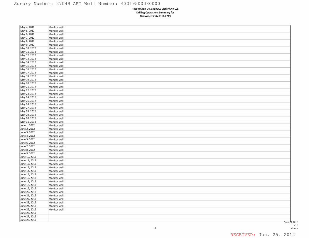
RECEIVED: Jun. 25, 2012
TIDEWATER OIL and GAS COMPANY LLCDrilling Operations Summary for
Tidewater State 2‐12‐2219
May 4, 2012 Monitor well.May 5, 2012 Monitor well.May 6, 2012 Monitor well.May 7, 2012 Monitor well.May 8, 2012 Monitor well.May 9, 2012 Monitor well.May 10, 2012 Monitor well.May 11, 2012 Monitor well.May 12, 2012 Monitor well.May 13, 2012 Monitor well.May 14, 2012 Monitor well.May 15, 2012 Monitor well.May 16, 2012 Monitor well.May 17, 2012 Monitor well.May 18, 2012 Monitor well.May 19, 2012 Monitor well.May 20, 2012 Monitor well.May 21, 2012 Monitor well.May 22, 2012 Monitor well.May 23, 2012 Monitor well.May 24, 2012 Monitor well.May 25, 2012 Monitor well.May 26, 2012 Monitor well.May 27, 2012 Monitor well.May 28, 2012 Monitor well.May 29, 2012 Monitor well.May 30, 2012 Monitor well.May 31, 2012 Monitor well.June 1, 2012 Monitor well.June 2, 2012 Monitor well.June 3, 2012 Monitor well.June 4, 2012 Monitor well.June 4, 2012 Monitor well.June 5, 2012 Monitor well.June 6, 2012 Monitor well.June 7, 2012 Monitor well.June 8, 2012 Monitor well.June 9, 2012 Monitor well.June 10, 2012 Monitor well.June 11, 2012 Monitor well.June 12, 2012 Monitor well.June 13, 2012 Monitor well.June 14, 2012 Monitor well.June 15, 2012 Monitor well.June 16, 2012 Monitor well.June 17, 2012 Monitor well.June 18, 2012 Monitor well.June 19, 2012 Monitor well.June 20, 2012 Monitor well.June 21, 2012 Monitor well.June 22, 2012 Monitor well.June 23, 2012 Monitor well.June 24, 2012 Monitor well.June 25, 2012 Monitor well.June 26, 2012June 27, 2012June 28, 2012
8
'June 25, 2012v12
wlowry
Sundry Number: 27049 API Well Number: 43019500080000Sundry Number: 27049 API Well Number: 43019500080000TIDEWATER OIL and GAS COMPANY LLC
Drilling Operations Summary forTidewater State 2-12-2219
May 4, 2012 Monitor well.May 5, 2012 Monitor well.May 6, 2012 Monitor well.May 7, 2012 Monitor well.May 8, 2012 Monitor well.May 9, 2012 Monitor well.May 10, 2012 Monitor well.May 11, 2012 Monitor well.May 12, 2012 Monitor well.May 13, 2012 Monitor well.May 14, 2012 Monitor well.May 15, 2012 Monitor well.May 16, 2012 Monitor well.May 17, 2012 Monitor well.May 18, 2012 Monitor well.May 19, 2012 Monitor well.May 20, 2012 Monitor well.May 21, 2012 Monitor well.May 22, 2012 Monitor well.May 23, 2012 Monitor well.May 24, 2012 Monitor well.May 25, 2012 Monitor well.May 26, 2012 Monitor well.May 27, 2012 Monitor well.May 28, 2012 Monitor well.May 29, 2012 Monitor well.May 30, 2012 Monitor well.May 31, 2012 Monitor well.June 1, 2012 Monitor well.June 2, 2012 Monitor well.June 3, 2012 Monitor well.June 4. 2012 Monitor wellJune 5, 2012 Monitor well.June 6, 2012 Monitor well.June 7, 2012 Monitor well.June 8, 2012 Monitor well.June 9, 2012 Monitor well.June 10, 2012 Monitor well.June 11, 2012 Monitor well.June 12, 2012 Monitor well.June 13, 2012 Monitor well.June 14, 2012 Monitor well.June 15, 2012 Monitor well.June 16, 2012 Monitor well.June 17, 2012 Monitor well.June 18, 2012 Monitor well.June 19, 2012 Monitor well.June 20, 2012 Monitor well.June 21, 2012 Monitor well.June 22, 2012 Monitor well.June 23, 2012 Monitor well.June 24, 2012 Monitor well.June 25, 2012 Monitor well.June 26, 2012June 27, 2012June 28, 2012
June 5, 2012v12
8 wlowry
RECEIVED: Jun. 25,
Sundry Number: 27049 API Well Number: 43019500080000TIDEWATER OIL and GAS COMPANY LLC
Drilling Operations Summary forTidewater State 2-12-2219
May 4, 2012 Monitor well.May 5, 2012 Monitor well.May 6, 2012 Monitor well.May 7, 2012 Monitor well.May 8, 2012 Monitor well.May 9, 2012 Monitor well.May 10, 2012 Monitor well.May 11, 2012 Monitor well.May 12, 2012 Monitor well.May 13, 2012 Monitor well.May 14, 2012 Monitor well.May 15, 2012 Monitor well.May 16, 2012 Monitor well.May 17, 2012 Monitor well.May 18, 2012 Monitor well.May 19, 2012 Monitor well.May 20, 2012 Monitor well.May 21, 2012 Monitor well.May 22, 2012 Monitor well.May 23, 2012 Monitor well.May 24, 2012 Monitor well.May 25, 2012 Monitor well.May 26, 2012 Monitor well.May 27, 2012 Monitor well.May 28, 2012 Monitor well.May 29, 2012 Monitor well.May 30, 2012 Monitor well.May 31, 2012 Monitor well.June 1, 2012 Monitor well.June 2, 2012 Monitor well.June 3, 2012 Monitor well.June 4, 2012 Monitor wellJune 5, 2012 Monitor well.June 6, 2012 Monitor well.June 7, 2012 Monitor well.June 8, 2012 Monitor well.June 9, 2012 Monitor well.June 10, 2012 Monitor well.June 11, 2012 Monitor well.June 12, 2012 Monitor well.June 13, 2012 Monitor well.June 14, 2012 Monitor well.June 15, 2012 Monitor well.June 16, 2012 Monitor well.June 17, 2012 Monitor well.June 18, 2012 Monitor well.June 19, 2012 Monitor well.June 20, 2012 Monitor well.June 21, 2012 Monitor well.June 22, 2012 Monitor well.June 23, 2012 Monitor well.June 24, 2012 Monitor well.June 25, 2012 Monitor well.June 26, 2012June 27, 2012June 28, 2012
June 5 2012v12
8 wlowry
RECEIVED: Jun. 25,
Sundry Number: 27049 API Well Number: 43019500080000TIDEWATER OIL and GAS COMPANY LLC
Drilling Operations Summary forTidewater State 2-12-2219
May 4, 2012 Monitor well.May 5, 2012 Monitor well.May 6, 2012 Monitor well.May 7, 2012 Monitor well.May 8, 2012 Monitor well.May 9, 2012 Monitor well.May 10, 2012 Monitor well.May 11, 2012 Monitor well.May 12, 2012 Monitor well.May 13, 2012 Monitor well.May 14, 2012 Monitor well.May 15, 2012 Monitor well.May 16, 2012 Monitor well.May 17, 2012 Monitor well.May 18, 2012 Monitor well.May 19, 2012 Monitor well.May 20, 2012 Monitor well.May 21, 2012 Monitor well.May 22, 2012 Monitor well.May 23, 2012 Monitor well.May 24, 2012 Monitor well.May 25, 2012 Monitor well.May 26, 2012 Monitor well.May 27, 2012 Monitor well.May 28, 2012 Monitor well.May 29, 2012 Monitor well.May 30, 2012 Monitor well.May 31, 2012 Monitor well.June 1, 2012 Monitor well.June 2, 2012 Monitor well.June 3, 2012 Monitor well.June 4. 2012 Monitor wellJune 5, 2012 Monitor well.June 6, 2012 Monitor well.June 7, 2012 Monitor well.June 8, 2012 Monitor well.June 9, 2012 Monitor well.June 10, 2012 Monitor well.June 11, 2012 Monitor well.June 12, 2012 Monitor well.June 13, 2012 Monitor well.June 14, 2012 Monitor well.June 15, 2012 Monitor well.June 16, 2012 Monitor well.June 17, 2012 Monitor well.June 18, 2012 Monitor well.June 19, 2012 Monitor well.June 20, 2012 Monitor well.June 21, 2012 Monitor well.June 22, 2012 Monitor well.June 23, 2012 Monitor well.June 24, 2012 Monitor well.June 25, 2012 Monitor well.June 26, 2012June 27, 2012June 28, 2012
June 5, 2012v12
8 wlowry
RECEIVED: Jun. 25,

RECEIVED: Jun. 25, 2012
TIDEWATER OIL and GAS COMPANY LLCDrilling Operations Summary for
Tidewater State 2‐12‐2219
June 29, 2012June 30, 2012
9
'June 25, 2012v12
wlowry
Sundry Number: 27049 API Well Number: 43019500080000Sundry Number: 27049 API Well Number: 43019500080000TIDEWATER OIL and GAS COMPANY LLC
Drilling Operations Summary forTidewater State 2-12-2219
June 29, 2012June 30, 2012
'June 25, 2012v12
9 wlowry
RECEIVED: Jun. 25,
Sundry Number: 27049 API Well Number: 43019500080000TIDEWATER OIL and GAS COMPANY LLC
Drilling Operations Summary forTidewater State 2-12-2219
June 29, 2012June 30, 2012
'June 25, 2012v12
9 wlowry
RECEIVED: Jun. 25,
Sundry Number: 27049 API Well Number: 43019500080000TIDEWATER OIL and GAS COMPANY LLC
Drilling Operations Summary forTidewater State 2-12-2219
June 29, 2012June 30, 2012
June 25, 2012v12
9 wlowry
RECEIVED: Jun. 25,
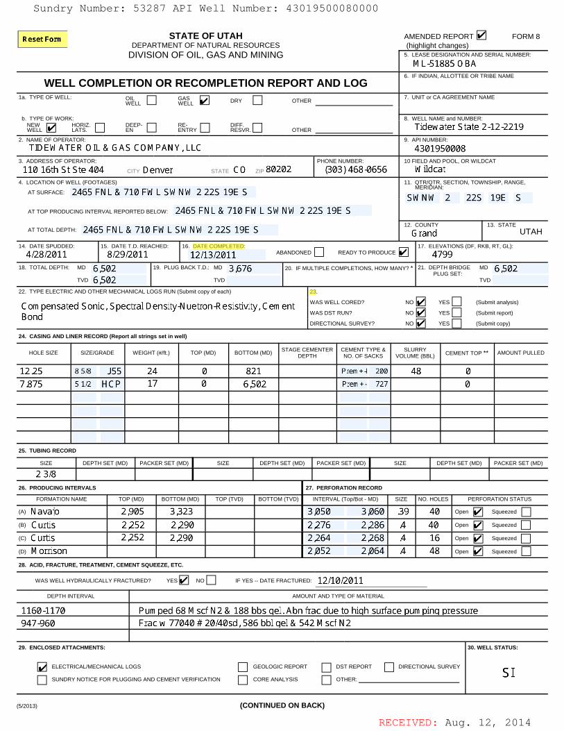
RECEIVED: Aug. 12, 2014
STATE OF UTAHDEPARTMENT OF NATURAL RESOURCES
DIVISION OF OIL, GAS AND MINING
AMENDED REPORT FORM 8 (highlight changes) 5. LEASE DESIGNATION AND SERIAL NUMBER:
WELL COMPLETION OR RECOMPLETION REPORT AND LOG6. IF INDIAN, ALLOTTEE OR TRIBE NAME
1a. TYPE OF WELL: OILWELL
GASWELL DRY OTHER
7. UNIT or CA AGREEMENT NAME
b. TYPE OF WORK: 8. WELL NAME and NUMBER:NEWWELL
HORIZ.LATS.
DEEP-EN
RE-ENTRY
DIFF.RESVR. OTHER
2. NAME OF OPERATOR: 9. API NUMBER:
3. ADDRESS OF OPERATOR:
CITY STATE ZIP
PHONE NUMBER: 10 FIELD AND POOL, OR WILDCAT
4. LOCATION OF WELL (FOOTAGES)
AT SURFACE:
11. QTR/QTR, SECTION, TOWNSHIP, RANGE, MERIDIAN:
AT TOP PRODUCING INTERVAL REPORTED BELOW:
AT TOTAL DEPTH:12. COUNTY 13. STATE
UTAH
14. DATE SPUDDED: 15. DATE T.D. REACHED: 16. DATE COMPLETED: ABANDONED READY TO PRODUCE
17. ELEVATIONS (DF, RKB, RT, GL):
18. TOTAL DEPTH: MD
TVD
19. PLUG BACK T.D.: MD
TVD
20. IF MULTIPLE COMPLETIONS, HOW MANY? * 21. DEPTH BRIDGE PLUG SET:
MD
TVD
22. TYPE ELECTRIC AND OTHER MECHANICAL LOGS RUN (Submit copy of each) 23.
WAS WELL CORED? NO YES (Submit analysis)
WAS DST RUN? NO YES (Submit report)
DIRECTIONAL SURVEY? NO YES (Submit copy)
24. CASING AND LINER RECORD (Report all strings set in well)
HOLE SIZE SIZE/GRADE WEIGHT (#/ft.) TOP (MD) BOTTOM (MD)STAGE CEMENTER
DEPTHCEMENT TYPE &NO. OF SACKS
SLURRYVOLUME (BBL) CEMENT TOP ** AMOUNT PULLED
25. TUBING RECORD
SIZE DEPTH SET (MD) PACKER SET (MD) SIZE DEPTH SET (MD) PACKER SET (MD) SIZE DEPTH SET (MD) PACKER SET (MD)
26. PRODUCING INTERVALS 27. PERFORATION RECORD
FORMATION NAME TOP (MD) BOTTOM (MD) TOP (TVD) BOTTOM (TVD) INTERVAL (Top/Bot - MD) SIZE NO. HOLES PERFORATION STATUS
(A) Open Squeezed
(B) Open Squeezed
(C) Open Squeezed
(D) Open Squeezed
28. ACID, FRACTURE, TREATMENT, CEMENT SQUEEZE, ETC.
WAS WELL HYDRAULICALLY FRACTURED? YES NO IF YES -- DATE FRACTURED: ____________________________________
DEPTH INTERVAL AMOUNT AND TYPE OF MATERIAL
29. ENCLOSED ATTACHMENTS:
ELECTRICAL/MECHANICAL LOGS GEOLOGIC REPORT DST REPORT DIRECTIONAL SURVEY
SUNDRY NOTICE FOR PLUGGING AND CEMENT VERIFICATION CORE ANALYSIS OTHER:
30. WELL STATUS:
(5/2013) (CONTINUED ON BACK)
Sundry Number: 53287 API Well Number: 43019500080000Sundry Number: 53287 API Well Number: 43019500080000
STATE OF UTAH AMENDED REPORT FORM 8DEPARTMENT OF NATURAL RESOURCES (highlight changes)
DIVISION OF OIL, GAS AND MINING 5. LEASE DESIGNATION AND SERIAL NUMBER:ML-51885 OBA
6. IF INDIAN,ALLOTTEE OR TRIBE NAMEWELL COMPLETION OR RECOMPLETION REPORT AND LOG
1a. TYPE OF WELL: OWELL GWAESLL DRY OTHER 7. UNIT or CA AGREEMENT NAME
b. TYPE OF WORK: 8. WELL NAME and NUMBER:W ORSZ. EEP- RNETRY EFSFŸR.
OTHER Tidewater State 2-12-22192. NAME OF OPERATOR: 9. API NUMBER:
TIDEWATER OIL & GAS COMPANY, LLC 43019500083. ADDRESS OF OPERATOR: PHONE NUMBER: 10 FIELD AND POOL, OR WILDCAT
110 16th St Ste 404 C TY Denver STATE CO ZP 80202 (303) 468-0656 Wildcat4. LOCATION OF WELL (FOOTAGES) 11. QTR/QTR, SECTION, TOWNSHIP, RANGE,
MERIDIAN:ATSURFACE: 2465 FNL & 710 FWL SWNW2 22S 19E S SWNW 2 22S 19E SAT TOP PRODUCING INTERVAL REPORTED BELOW: 2465 FNL & 710 FWL SWNW 2 22S 19E S
AT TOTAL DEPTH: 2465 FNL & 710 FWL SWNW 2 22S 19E S 12.GCOUNTdY 13. STATEUTAH
14. DATE SPUDDED: 15. DATE T.D. REACHED: 16. DATE COMPLETED: 17. ELEVATIONS (DF, RKB, RT, GL):
4/28/2011 8/29/2011 12/13/2011 ABANDONED READYTOPRODUCE 479918. TOTAL DEPTH: MD 6.502 19. PLUG BACK T.D.: MD 3,676 20. IF MULTIPLE COMPLETIONS, HOW MANY? * 21. DEPTH BRIDGE MD 6.502
PLUG SET:TVD 6.502 TVD TVD
22. TYPE ELECTRIC AND OTHER MECHANICAL LOGS RUN (Submit copy of each) 23.
Compensated Sonic, Spectral Density-Nuetron-Resistivity, Cement WASWELLCORED? NO YES (Submitanalysis)
Bond WAS DST RUN? NO YES (Submit report)
DIRECTIONAL SURVEY? NO YES (Submit copy)
24. CASING AND LINER RECORD (Report all strings set in well)
HOLE SIZE SIZE/GRADE WEIGHT (#lft.) TOP (MD) BOTTOM (MD) STAGE CEMHENTER CNEMENFSAYCKES VOSLUMREBL) CEMENT TOP ** AMOUNT PULLED
12.25 8 5/8 J55 24 0 821 Prem+-I 200 48 07.875 5 1/2 HCP 17 0 6,502 Prem+- 727 0
25. TUBING RECORD
SIZE DEPTH SET (MD) PACKER SET (MD) SIZE DEPTH SET (MD) PACKER SET (MD) SIZE DEPTH SET (MD) PACKER SET (MD)
2 3/826. PRODUCING INTERVALS 27. PERFORATION RECORD
FORMATION NAME TOP (MD) BOTTOM (MD) TOP (TVD) BOTTOM (TVD) INTERVAL (Top/Bot -MD) SIZE NO. HOLES PERFORATION STATUS
(A) Navaio 2.905 3.323 3.050 3.060 .39 40 open B Squeezed
(B) Curtis 2.252 2.290 2.276 2.286 .4 40 open Squeezed
(c) Curtis 2.252 2.290 2.264 2.268 .4 16 open Squeezed
(D) Morrison 2.052 2.064 .4 48 open Squeezed
28. ACID, FRACTURE, TREATMENT, CEMENT SQUEEZE, ETC.
WAS WELL HYDRAULICALLYFRACTURED? YES NO IF YES-- DATE FRACTURED: 12/10/2011DEPTH INTERVAL AMOUNT AND TYPE OF MATERIAL
1160-1170 Pumped 68 Mscf N2 & 188 bbs ael. Abn frac due to hiah surface Dumoina Dressure947-960 Frac w 77040 # 20/40sd. 586 bbl ael & 542 Mscf N2
29. ENCLOSED ATTACHMENTS: 30. WELL STATUS:
ELECTRICAL/MECHANICAL LOGS GEOLOGIC REPORT DST REPORT DIRECTIONAL SURVEY
SUNDRY NOTICE FOR PLUGGING AND CEMENT VERIFICATION CORE ANALYSIS OTHER:
(5/2013) (CONTINUED ON BACK)
RECEIVED: Aug. 12,
Sundry Number: 53287 API Well Number: 43019500080000
STATE OF UTAH AMENDED REPORT FORM 8DEPARTMENT OF NATURAL RESOURCES (highlight changes)
DIVISION OF OIL, GAS AND MINING 5. LEASE DESIGNATION AND SERIAL NUMBER:ML-51885 OBA
6. IF INDIAN,ALLOTTEE OR TRIBE NAMEWELL COMPLETION OR RECOMPLETION REPORT AND LOG
1a. TYPE OF WELL: OWELL GWAESLL DRY OTHER 7. UNIT or CA AGREEMENT NAME
b. TYPE OF WORK: 8. WELL NAME and NUMBER:W ORSZ. EEP- RNETRY EFSFŸR.
OTHER Tidewater State 2-12-22192. NAME OF OPERATOR: 9. API NUMBER:
TIDEWATER OIL & GAS COMPANY, LLC 43019500083. ADDRESS OF OPERATOR: PHONE NUMBER: 10 FIELD AND POOL, OR WILDCAT
110 16th St Ste 404 C TY Denver STATE CO ZP 80202 (303) 468-0656 Wildcat4. LOCATION OF WELL (FOOTAGES) 11. QTR/QTR, SECTION, TOWNSHIP, RANGE,
MERIDIAN:ATSURFACE: 2465 FNL & 710 FWL SWNW2 22S 19E S SWNW 2 22S 19E SAT TOP PRODUCING INTERVAL REPORTED BELOW: 2465 FNL & 710 FWL SWNW 2 22S 19E S
AT TOTAL DEPTH: 2465 FNL & 710 FWL SWNW 2 22S 19E S 12.GCOUNTdY 13. STATEUTAH
14. DATE SPUDDED: 15. DATE T.D. REACHED: 16. DATE COMPLETED: 17. ELEVATIONS (DF, RKB, RT, GL):
4/28/2011 8/29/2011 12/13/2011 ABANDONED READYTOPRODUCE 479918. TOTAL DEPTH: MD 6.502 19. PLUG BACK T.D.: MD 3,676 20. IF MULTIPLE COMPLETIONS, HOW MANY? * 21. DEPTH BRIDGE MD 6.502
PLUG SET:TVD 6.502 TVD TVD
22. TYPE ELECTRIC AND OTHER MECHANICAL LOGS RUN (Submit copy of each) 23.
Compensated Sonic, Spectral Density-Nuetron-Resistivity, Cement WASWELLCORED? NO YES (Submitanalysis)
Bond WAS DST RUN? NO YES (Submit report)
DIRECTIONAL SURVEY? NO YES (Submit copy)
24. CASING AND LINER RECORD (Report all strings set in well)
HOLE SIZE SIZE/GRADE WEIGHT (#lft.) TOP (MD) BOTTOM (MD) STAGE CEMHENTER CNEMENFSAYCKES VOSLUMREBL) CEMENT TOP ** AMOUNT PULLED
12.25 8 5/8 J55 24 0 821 Prem+-I 200 48 07.875 5 1/2 HCP 17 0 6,502 Prem+- 727 0
25. TUBING RECORD
SIZE DEPTH SET (MD) PACKER SET (MD) SIZE DEPTH SET (MD) PACKER SET (MD) SIZE DEPTH SET (MD) PACKER SET (MD)
2 3/826. PRODUCING INTERVALS 27. PERFORATION RECORD
FORMATION NAME TOP (MD) BOTTOM (MD) TOP (TVD) BOTTOM (TVD) INTERVAL (Top/Bot -MD) SIZE NO. HOLES PERFORATION STATUS
(A) Navaio 2.905 3.323 3.050 3.060 .39 40 open B Squeezed
(B) Curtis 2.252 2.290 2.276 2.286 .4 40 open Squeezed
(c) Curtis 2.252 2.290 2.264 2.268 .4 16 open Squeezed
(D) Morrison 2.052 2.064 .4 48 open Squeezed
28. ACID, FRACTURE, TREATMENT, CEMENT SQUEEZE, ETC.
WAS WELL HYDRAULICALLYFRACTURED? YES NO IF YES-- DATE FRACTURED: 12/10/2011DEPTH INTERVAL AMOUNT AND TYPE OF MATERIAL
1160-1170 Pumped 68 Mscf N2 & 188 bbs ael. Abn frac due to hiah surface Dumoina Dressure947-960 Frac w 77040 # 20/40sd. 586 bbl ael & 542 Mscf N2
29. ENCLOSED ATTACHMENTS: 30. WELL STATUS:
ELECTRICAL/MECHANICAL LOGS GEOLOGIC REPORT DST REPORT DIRECTIONAL SURVEY
SUNDRY NOTICE FOR PLUGGING AND CEMENT VERIFICATION CORE ANALYSIS OTHER:
(5/2013) (CONTINUED ON BACK)
RECEIVED: Aug. 12,
RECEIVED: Aug. 12, 2014
31. INITIAL PRODUCTION INTERVAL A (As shown in item #26)
DATE FIRST PRODUCED: TEST DATE: HOURS TESTED: TEST PRODUCTIONRATES: !
OIL – BBL: GAS – MCF: WATER – BBL: PROD. METHOD:
CHOKE SIZE: TBG. PRESS. CSG. PRESS. API GRAVITY BTU – GAS GAS/OIL RATIO 24 HR PRODUCTIONRATES: !
OIL – BBL: GAS – MCF: WATER – BBL: INTERVAL STATUS:
INTERVAL B (As shown in item #26)
DATE FIRST PRODUCED: TEST DATE: HOURS TESTED: TEST PRODUCTIONRATES: !
OIL – BBL: GAS – MCF: WATER – BBL: PROD. METHOD:
CHOKE SIZE: TBG. PRESS. CSG. PRESS. API GRAVITY BTU – GAS GAS/OIL RATIO 24 HR PRODUCTIONRATES: !
OIL – BBL: GAS – MCF: WATER – BBL: INTERVAL STATUS:
INTERVAL C (As shown in item #26)
DATE FIRST PRODUCED: TEST DATE: HOURS TESTED: TEST PRODUCTIONRATES: !
OIL – BBL: GAS – MCF: WATER – BBL: PROD. METHOD:
CHOKE SIZE: TBG. PRESS. CSG. PRESS. API GRAVITY BTU – GAS GAS/OIL RATIO 24 HR PRODUCTIONRATES: !
OIL – BBL: GAS – MCF: WATER – BBL: INTERVAL STATUS:
INTERVAL D (As shown in item #26)
DATE FIRST PRODUCED: TEST DATE: HOURS TESTED: TEST PRODUCTIONRATES: !
OIL – BBL: GAS – MCF: WATER – BBL: PROD. METHOD:
CHOKE SIZE: TBG. PRESS. CSG. PRESS. API GRAVITY BTU – GAS GAS/OIL RATIO 24 HR PRODUCTIONRATES: !
OIL – BBL: GAS – MCF: WATER – BBL: INTERVAL STATUS:
32. DISPOSITION OF GAS (Sold, Used for Fuel, Vented, Etc.)
33. SUMMARY OF POROUS ZONES (Include Aquifers):
Show all important zones of porosity and contents thereof: Cored intervals and all drill-stem tests, including depth interval tested,cushion used, time tool open, flowing and shut-in pressures and recoveries.
34. FORMATION (Log) MARKERS:
FormationTop(MD)
Bottom(MD)
Descriptions, Contents, etc. NameTop
(Measured Depth)
35. ADDITIONAL REMARKS (Include plugging procedure)
36. I hereby certify that the foregoing and attached information is complete and correct as determined from all available records.
NAME (PLEASE PRINT) TITLE
SIGNATURE DATE
This report must be submitted within 30 days of ! completing or plugging a new well ! reentering a previously plugged and abandoned well! drilling horizontal laterals from an existing well bore ! significantly deepening an existing well bore below the previous bottom-hole depth! recompleting to a different producing formation ! drilling hydrocarbon exploratory holes, such as core samples and stratigraphic tests
* ITEM 20: Show the number of completions if production is measured separately from two or more formations.
** ITEM 24: Cement Top – Show how reported top(s) of cement were determined (circulated (CIR), calculated (CAL), cement bond log (CBL), temperature survey (TS)).
Send to: Utah Division of Oil, Gas and Mining Phone: 801-538-53401594 West North Temple, Suite 1210Box 145801 Fax: 801-359-3940Salt Lake City, Utah 84114-5801
(5/2013)
Sundry Number: 53287 API Well Number: 43019500080000Sundry Number: 53287 API Well Number: 43019500080000
31. INITIALPRODUCTION INTERVAL A (As shown in item #26)
DATE FIRST PRODUCED: TEST DATE: HOURS TESTED: TEST PRODUCTION OIL - BBL: GAS- MCF: WATER - BBL: PROD. METHOD:
12/10/2011 17 RATES: * O 1 0CHOKE SIZE: TBG. PRESS. CSG. PRESS. API GRAVITY BTU - GAS GAS/OIL RATIO 24 HR PRODUCTION OIL - BBL: GAS- MCF: WATER - BBL: INTERVAL STATUS:
12/64 90 RATES: * OINTERVAL B (As shown in item #26)
DATE FIRST PRODUCED: TEST DATE: HOURS TESTED: TEST PRODUCTION OIL - BBL: GAS- MCF: WATER - BBL: PROD. METHOD:RATES: *
CHOKE SIZE: TBG. PRESS. CSG. PRESS. API GRAVITY BTU - GAS GAS/OIL RATIO 24 HR PRODUCTION OIL - BBL: GAS- MCF: WATER - BBL: INTERVAL STATUS:RATES: *
INTERVAL C (As shown in item #26)
DATE FIRST PRODUCED: TEST DATE: HOURS TESTED: TEST PRODUCTION OIL - BBL: GAS- MCF: WATER - BBL: PROD. METHOD:RATES: *
CHOKE SIZE: TBG. PRESS. CSG. PRESS. API GRAVITY BTU - GAS GAS/OIL RATIO 24 HR PRODUCTION OIL - BBL: GAS- MCF: WATER - BBL: INTERVAL STATUS:RATES: *
INTERVAL D (As shown in item #26)
DATE FIRST PRODUCED: TEST DATE: HOURS TESTED: TEST PRODUCTION OIL - BBL: GAS- MCF: WATER - BBL: PROD. METHOD:RATES: *
CHOKE SIZE: TBG. PRESS. CSG. PRESS. API GRAVITY BTU - GAS GAS/OIL RATIO 24 HR PRODUCTION OIL - BBL: GAS- MCF: WATER - BBL: INTERVAL STATUS:RATES: *
32. DISPOSITION OF GAS (Sold, Used for Fuel, Vented, Etc.)
33. SUMMARY OF POROUS ZONES (Include Aquifers): 34. FORMATION (Log) MARKERS:
Show all important zones of porosity and contents thereof: Cored intervals and all drill-stem tests, including depth interval tested,cushion used, time tool open, flowing and shut-in pressures and recoveries.
Formation Descriptions, Contents, etc. Name (MeasuedpDepth)
Dakota 1.344Navaio 2,905 3,323 swab well. Fluid emtry at 9 bfph Entrada 2.290
Carmel 2.665Navaio 2.905Kaventa 3.323Moenkopi 4,610
35. ADDITIONAL REMARKS (Include plugging procedure)
36. I hereby certify that the foregoing and attached information is complete and correct as determined from all available records.
NAME (PLEASE PRINT) Thomas Johnson (Submitted Electronically) TITLE Office Manager
SIGNATURE DATE 8/12/2014
This report must be submitted within 30 days of• completing or plugging a new well • reentering a previously plugged and abandoned well• drilling horizontal laterals from an existing well bore • significantly deepening an existing well bore below the previous bottom-hole depth• recompleting to a different producing formation • drilling hydrocarbon exploratory holes, such as core samples and stratigraphic tests
* ITEM 20: Show the number of completions if production is measured separately from two or more formations.
** ITEM24: Cement Top - Show how reported top(s) of cement were determined (circulated (CIR), calculated (CAL), cement bond log (CBL), temperature survey (TS)).
Send to: Utah Division of Oil, Gas and Mining Phone: 801-538-53401594 West North Temple, Suite 1210Box 145801 Fax: 801-359-3940Salt Lake City, Utah 84114-5801
(5/2013)
RECEIVED: Aug. 12,
Sundry Number: 53287 API Well Number: 43019500080000
31. INITIALPRODUCTION INTERVAL A (As shown in item #26)
DATE FIRST PRODUCED: TEST DATE: HOURS TESTED: TEST PRODUCTION OIL - BBL: GAS- MCF: WATER - BBL: PROD. METHOD:
12/10/2011 17 RATES: 0 1 0CHOKE SIZE: TBG. PRESS. CSG. PRESS. API GRAVITY BTU - GAS GAS/OIL RATIO 24 HR PRODUCTION OIL - BBL: GAS- MCF: WATER - BBL: INTERVAL STATUS:
12/64 90 RATES: 0INTERVAL B (As shown in item #26)
DATE FIRST PRODUCED: TEST DATE: HOURS TESTED: TEST PRODUCTION OIL - BBL: GAS- MCF: WATER - BBL: PROD. METHOD:RATES: a
CHOKE SIZE: TBG. PRESS. CSG. PRESS. API GRAVITY BTU - GAS GAS/OIL RATIO 24 HR PRODUCTION OIL - BBL: GAS- MCF: WATER - BBL: INTERVAL STATUS:RATES: *
INTERVAL C (As shown in item #26)
DATE FIRST PRODUCED: TEST DATE: HOURS TESTED: TEST PRODUCTION OIL - BBL: GAS- MCF: WATER - BBL: PROD. METHOD:RATES: a
CHOKE SIZE: TBG. PRESS. CSG. PRESS. API GRAVITY BTU - GAS GAS/OIL RATIO 24 HR PRODUCTION OIL - BBL: GAS- MCF: WATER - BBL: INTERVAL STATUS:RATES: *
INTERVAL D (As shown in item #26)
DATE FIRST PRODUCED: TEST DATE: HOURS TESTED: TEST PRODUCTION OIL - BBL: GAS- MCF: WATER - BBL: PROD. METHOD:RATES: a
CHOKE SIZE: TBG. PRESS. CSG. PRESS. API GRAVITY BTU - GAS GAS/OIL RATIO 24 HR PRODUCTION OIL - BBL: GAS- MCF: WATER - BBL: INTERVAL STATUS:RATES: 4
32. DISPOSITION OF GAS (Sold, Used for Fuel, Vented, Etc.)
33. SUMMARY OF POROUS ZONES (Include Aquifers): 34. FORMATION (Log) MARKERS:
Show all important zones of porosity and contents thereof: Cored intervals and all drill-stem tests, including depth interval tested,cushion used, time tool open, flowing and shut-in pressures and recoveries.
Formation Descriptions, Contents, etc. Name (MeasuedpDepth)
Dakota 1.344Navaio 2,905 3,323 swab well. Fluid emtry at 9 bfph Entrada 2.290
Carmel 2.665Navaio 2.905Kaventa 3.323Moenkopi 4,610
35. ADDITIONAL REMARKS (Include plugging procedure)
36. I hereby certify that the foregoing and attached information is complete and correct as determined from all available records.
NAME (PLEASE PRINT) Thomas Johnson (Submitted Electronically) TITLE Office Manager
SIGNATURE DATE 8/12/2014
This report must be submitted within 30 days of• completing or plugging a new well • reentering a previously plugged and abandoned well• drilling horizontal laterals from an existing well bore • significantly deepening an existing well bore below the previous bottom-hole depth• recompleting to a different producing formation • drilling hydrocarbon exploratory holes, such as core samples and stratigraphic tests
* ITEM 20: Show the number of completions if production is measured separately from two or more formations.
** ITEM24: Cement Top - Show how reported top(s) of cement were determined (circulated (CIR), calculated (CAL), cement bond log (CBL), temperature survey (TS)).
Send to: Utah Division of Oil, Gas and Mining Phone: 801-538-53401594 West North Temple, Suite 1210Box 145801 Fax: 801-359-3940Salt Lake City, Utah 84114-5801
(5/2013)
RECEIVED: Aug. 12,


![wisdomking.or.th file/b.d la]RJu... lo.d b.oo (Electronic Government Procurement: e - GP) (Electronic Government Procurement : e - GP) tj.tJ.¶. 19.0b iJ.tJ.ctJ. b.om 15u IJ.IJ.¶](https://img.pdfslide.us/doc/110x75/5cbe2b7388c993296d8c2082/larju-lod-boo-electronic-government-procurement-e-gp-electronic-government.jpg)