Embed Size (px)
Citation preview

£¤206
£¤1
ST518
ST514
ST533
ST569
ST522
OP91
OP27
Royc
e Broo
k
Six Mile Run
Delaware
and R
aritan
Canal
R o y c e B r o o kF I B I 0 1 4R o y c e B r o o kF I B I 0 1 4
N o r t h a n d S o u t hB r a n c h R a r i t a n
W M A 8N o r t h a n d S o u t hB r a n c h R a r i t a n
W M A 8
M i l l s t o n eW M A 1 0
M i l l s t o n eW M A 1 0
L o w e r R a r i t a n ,S o u t h R i v e r
a n d L a w r e n c eW M A 9
L o w e r R a r i t a n ,S o u t h R i v e r
a n d L a w r e n c eW M A 9
#Amwell
#Hillsborough
#Millstone
[¡
Stream OrderFIBI Rating
4th Order and Higher
1st, 2nd and 3rd Order
[¡ Poor[¡ Fair[¡ Excellent
[¡ Good B 0 73.5Miles
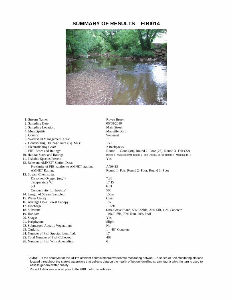
SUMMARY OF RESULTS – FIBI014
1. Stream Name: Royce Brook 2. Sampling Date: 06/08/2010 3. Sampling Location: Main Street 4. Municipality Manville Boro 5. County: Somerset 6. Watershed Management Area: 11 7. Contributing Drainage Area (Sq. Mi.): 15.8 8. Electrofishing Gear: 2 Backpacks 9. FIBI Score and Rating*: Round 1- Good (40), Round 2- Poor (26), Round 3- Fair (32)
10. Habitat Score and Rating: Round 1- Marginal (99), Round 2- Sub-Optimal (116), Round 3- Marginal (81) 11. Fishable Species Present: Yes 12. Relevant AMNET1 Station Data:
Proximity of FIBI station to AMNET station: AN0413 AMNET Rating: Round 1- Fair, Round 2- Poor, Round 3- Poor
13. Stream Chemistries: Dissolved Oxygen (mg/l) 7.26 Temperature 0C. 17.15 pH 6.81 Conductivity (μmhos/cm) 506
14. Length of Stream Sampled: 150m 15. Water Clarity: Clear 16. Average Open Forest Canopy: 1% 17. Discharge: 1.9 cfs 18. Substrate: 60% Gravel/Sand, 5% Cobble, 20% Silt, 15% Concrete 19. Habitat: 10% Riffle, 70% Run, 20% Pool 20. Snags: Yes 21. Periphyton: Slight 22. Submerged Aquatic Vegetation: No 23. Outfalls: 1 – 48” Concrete 24. Number of Fish Species Identified: 17 25. Total Number of Fish Collected: 468 26. Number of Fish With Anomalies: 6
1 AMNET is the acronym for the DEP’s ambient benthic macroinvertebrate monitoring network – a series of 820 monitoring stations
located throughout the state’s waterways that collects data on the health of bottom dwelling stream fauna which in turn is used to assess general water quality
* Round 1 data was scored prior to the FIBI metric recalibration.


FIBI014- Royce Brook @ Route 533 Excellent Good Fair PoorDate Sampled - 6/8/2010
Score# of Fish Species 5
# of Benthic Insectivorous Species (BI) 3(excluding White Suckers and Bullheads)
# of Trout and Centrarchid Species 5(excluding Green Sunfish and Bluegill)
# of Intolerant Species (IS) 1
Proportion of Tolerant Individuals 1
Proportion of Individuals as Generalists 3
Proportion of Individuals as Insectivorous Cyprinids 1
Proportion of Individuals as Trout *whichever gives better scoreORProportion of Individuals as Piscivores (excluding American Eel)* 3
# of Individuals in Sample 5(excluding Tolerant Species)
Proportion of Individuals w/disease/anomalies 5(excluding blackspot)
Total 32
45-50 Excellent37-44 Good29-36 Fair10-28 Poor
Stream Rating
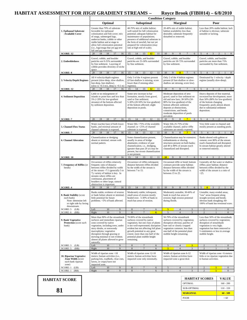
HABITAT ASSESSMENT FOR HIGH GRADIENT STREAMS – Royce Brook (FIBI014) – 6/8/2010 Condition Category
Optimal Suboptimal Marginal Poor 1. Epifaunal Substrate
/Available Cover
Greater than 70% of substrate favorable for epifaunal colonization and fish cover; mix of snags, submerged logs, undercut banks, cobble or other stable habitat and at stage to allow full colonization potential (i.e., logs/snags that are not new fall and not transient).
40-70% mix of stable habitat; well-suited for full colonization potential; adequate habitat for maintenance of populations; presence of additional substrate in the form of newfall, but not yet prepared for colonization (may rate at high end of scale).
20-40% mix of stable habitat; habitat availability less than desirable; substrate frequently disturbed or removed.
Less than 20% stable habitat; lack of habitat is obvious; substrate unstable or lacking.
SCORE: 12 20 19 18 17 16 15 14 13 12 11 10 9 8 7 6 5 4 3 2 1 0 2. Embeddedness
Gravel, cobble, and boulder particles are 0-25% surrounded by fine sediment. Layering of cobble provides diversity of niche space
Gravel, cobble, and boulder particles are 25-50% surrounded by fine sediment.
Gravel, cobble, and boulder particles are 50-75% surrounded by fine sediment.
Gravel, cobble, and boulder particles are more than 75% surrounded by fine sediment.
SCORE: 8 20 19 18 17 16 15 14 13 12 11 10 9 8 7 6 5 4 3 2 1 0 3. Velocity/Depth Regimes
All 4 velocity/depth regimes present (slow-deep, slow-shallow, fast-deep, fast-shallow). (slow is <0.3 m/s, deep is >0.5 m)
Only 3 of the 4 regimes present (if fast-shallow is missing, score lower than if missing other regimes).
Only 2 of the 4 habitat regimes present (if fast-shallow or slow-shallow are missing, score low).
Dominated by 1 velocity / depth regime (usually slow-deep).
SCORE: 12 20 19 18 17 16 15 14 13 12 11 10 9 8 7 6 5 4 3 2 1 0 4. Sediment Deposition
Little or no enlargement of islands or point bars and less than 5% (<20% for low-gradient streams) of the bottom affected by sediment deposition.
Some new increase in bar formation, mostly from gravel, sand or fine sediment; 5-30% (20-50% for low-gradient) of the bottom affected; slight deposition in pools.
Moderate deposition of new gravel, sand or fine sediment on old and new bars; 30-50% (50-80% for low-gradient) of the bottom affected; sediment deposits at obstructions, constrictions, and bends; moderate deposition of pools prevalent.
Heavy deposits of fine material, increased bar development; more than 50% (80% for low-gradient) of the bottom changing frequently; pools almost absent due to substantial sediment deposition.
SCORE: 7 20 19 18 17 16 15 14 13 12 11 10 9 8 7 6 5 4 3 2 1 0 5. Channel Flow Status
Water reaches base of both lower banks, and minimal amount of channel substrate is exposed.
Water fills >75% of the available channel; or <25% of channel substrate is exposed.
Water fills 25-75% of the available channel, and/or riffle substrates are mostly exposed.
Very little water in channel and mostly present as standing pools.
SCORE: 7 20 19 18 17 16 15 14 13 12 11 10 9 8 7 6 5 4 3 2 1 0 6. Channel Alteration
Channelization or dredging absent or minimal; stream with normal pattern.
Some channelization present, usually in areas of bridge abutments; evidence of past channelization, i.e., dredging, (greater than past 20 yr) may be present, but recent channelization is not present.
Channelization may be extensive; embankments or shoring structures present on both banks; and 40 to 80% of stream reach channelized and disrupted.
Banks shored with gabion or cement; over 80% of the stream reach channelized and disrupted. In stream habitat greatly altered or removed entirely.
SCORE: 10 20 19 18 17 16 15 14 13 12 11 10 9 8 7 6 5 4 3 2 1 0 7. Frequency of Riffles (or
bends)
Occurrence of riffles relatively frequent; ratio of distance between riffles divided by width of the stream <7:1 (generally 5 to 7); variety of habitat is key. In streams where riffles are continuous, placement of boulders or other large, natural obstruction is important.
Occurrence of riffles infrequent; distance between riffles divided by the width of the stream is between 7 to 15.
Occasional riffle or bend; bottom contours provide some habitat; distance between riffles divided by the width of the stream is between 15 to 25.
Generally all flat water or shallow riffles; poor habitat; distance between riffles divided by the width of the stream is a ratio of >25.
SCORE: 4 20 19 18 17 16 15 14 13 12 11 10 9 8 7 6 5 4 3 2 1 0 8. Bank Stability (score
each bank) Note: determine left or right side by facing downstream.
Banks stable; evidence of erosion or bank failure absent or minimal; little potential for future problems. <5% of bank affected.
Moderately stable; infrequent, small areas of erosion mostly healed over. 5-30% of bank in reach has areas of erosion.
Moderately unstable; 30-60% of bank in reach has areas of erosion; high erosion potential during floods.
Unstable; many eroded areas; "raw" areas frequent along straight sections and bends; obvious bank sloughing; 60-100% of bank has erosional scars.
SCORE: 5 (LB) Left 10 9 8 7 6 5 4 3 2 1 0 SCORE: 6 (RB) Right 10 9 8 7 6 5 4 3 2 1 0 9. Bank Vegetative
Protection (score each bank)
More than 90% of the streambank surfaces and immediate riparian zone covered by native vegetation, including trees, under story shrubs, or nonwoody macrophytes; vegetative disruption through grazing or mowing minimal or not evident; almost all plants allowed to grow naturally.
70-90% of the streambank surfaces covered by native vegetation, but one class of plants is not well-represented; disruption evident but not affecting full plant growth potential to any great extent; more than one-half of the potential plant stubble height remaining.
50-70% of the streambank surfaces covered by vegetation; disruption obvious; patches of bare soil or closely cropped vegetation common; less than one-half of the potential plant stubble height remaining.
Less than 50% of the streambank surfaces covered by vegetation; disruption of streambank vegetation is very high; vegetation has been removed to 5 centimeters or less in average stubble height.
SCORE: 3 (LB) Left 10 9 8 7 6 5 4 3 2 1 0 SCORE: 5 (RB) Right 10 9 8 7 6 5 4 3 2 1 0 10. Riparian Vegetative
Zone Width (score each bank riparian zone)
Width of riparian zone >18 meters; human activities (i.e., parking lots, roadbeds, clear-cuts, lawns, or crops) have not impacted zone.
Width of riparian zone 12-18 meters; human activities have impacted zone only minimally.
Width of riparian zone 6-12 meters; human activities have impacted zone a great deal.
Width of riparian zone <6 meters: little or no riparian vegetation due to human activities.
SCORE: 1 (LB) Left 10 9 8 7 6 5 4 3 2 1 0 SCORE: 1 (RB) Right 10 9 8 7 6 5 4 3 2 1 0
HABITAT SCORES VALUE HABITAT SCORE
OPTIMAL 160 - 200 SUB-OPTIMAL 110 - 159 81 MARGINAL 60 - 109
< 60 POOR

AbundanceCommon Name Scientific Name Size Range (inches)
FIBI014-R306/08/2010Royce Brook
148American Eel Anguilla rostrata -
87Tessellated Darter Etheostoma olmstedi -
70Fallfish Semotilus corporalis -
69Redbreast Sunfish Lepomis auritus 2.4 6.3-
23White Sucker Catostomus commersoni -
19Green Sunfish Lepomis cyanellus 2.3 4.6-
15Bluegill Lepomis macrochirus 2.1 6.3-
10Banded Killifish Fundulus diaphanus -
6Pumpkinseed Lepomis gibbosus 2.1 3.0-
4Rock Bass Ambloplites rupestris 4.7 5.9-
4Swallowtail Shiner Notropis procne -
4Chain Pickerel Esox niger 2.8 3.0-
3Smallmouth Bass Micropterus dolomieu 8.5 9.1-
2Eastern Mudminnow Umbra pygmaea -
2Yellow Bullhead Ameiurus natalis 6.1 9.4-
1Creek Chubsucker Erimyzon oblongus -
1Golden Shiner Notemigonus crysoleucas -

Bluegill
Rockbass White Sucker
FIBI014 - Royce Brook
American Eel Fallfish
Redbreast Sunfish

FIBI014 - Royce Brook
Banded Killifish Green Sunfish
Tessellated Darter Smallmouth Bass
Yellow Bullhead Pumpkinseed

Golden Shiner Swallowtail Shiner
Chain Pickerel Creek Chubsucker
FIBI014 - Royce Brook
Eastern Mudminnow