Embed Size (px)
Citation preview
F AD-A105 793 NEW YORK STATE DEPT OF ENVIRONMENTAL CONSERVATION ALBANY F/6 13/138NA TIONAL DAM SAFETY PROSRAM . STUMP POND DAM (INVENTORY NUMBER N--ETC(U)
MAR A K G OC H DAC 951-79-C-0001
UNCLASSIFIED NL1 Ef7-m hhhhhIDEEIImhshhmhIBEIoieIEommhhmmhuEEEEohmhhohhhEmEmmosoEEEEmoIr
LEV EL ET5
OC 2 18
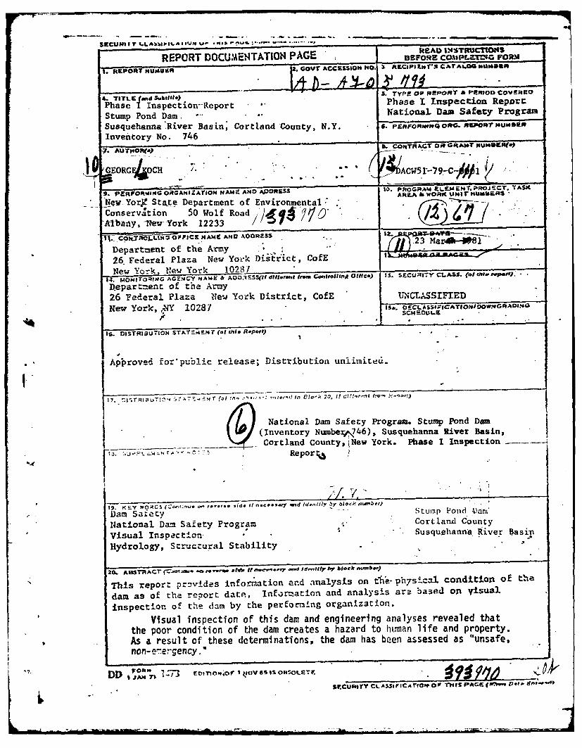
REPORT DOCUMENTATION PAGE BEFORE coMPLrCG FORM
1. REPORT NUMOkR 2. GOVT ACCEsIONH O. x RECiPS Kl.S xsTrAL--AG isumo
4. TITLE (and Swbitlls) 3. Type OP RePORT & PEN700 COVERED
Phase I Inspection-Report ." Phase T Inspection Reporr
Stump Pond Dam. N .ational, Dan Safa-y Program
Susquehanna River Basin, Cortland County, N.Y. s. prproRwoo oRO,.ORrT HUsDsa
Inventory No. 746
7. AUJTHOR(&>
10 GEORGC CH 44""Acw5r-79-c /
9. pERO'RONG ORGANaZATION NAME AND AODRESS j. PRoGRt ELEME14T.PRO J - CT. TASK
AREA & WORK UNI KUh~tERSNew YorX Stae Department of EnvironmentalC&onservation 50 Wolf Road ,; 'Albany, -New York 12233 /Ifj..C9%tRoJ.QW, OFFICS NAME AND ADDRESS2& F rl aa eYkfDepartment of the Army
It26. Federal Plaza New York DisItrict, ColE
New York New York 1028734. MoHITO NG .GZN Y NAmE & AO.ESS(It dlll..ngi from Caniolinrt Otlfce) IS SCJRIY CL-$- (of UeP.r.p.W).
Depart-=ent of the Army
26 Federal Plaza New York District, CofE IRNGLASSIFIED
New York, ,-NY 10287 s. a cLASSF1cATIoNI oW.GoADI.•~~~
SCH ~.F
1S. DISTRISUTION STATEmeNT' (of tL is Report)
Approved for'public release; Distribution unlimiced.
17. i' rI urTy. 7 T ; (,l :," .. ',::-- hnr , f l-; 20. I,
.'tf/!'r . f ." k o ".)~
___ ( National Dam Safety Program. Stump Pond Dam(Inventory Numbere.746), Susquehanna River Basin,Cortland County, iNew York. Phase I Inspection
r ~ Report3
if. V.
IS. KY WOC~ (~e.'~ ~' .. d. it~ n.coe.Iq wid Id-f1Iy y boc. - niLaIbe10
Dam Saity Stump Pond V)am'
National Da- Safety Program Cortland County
Visual Inspection . Susquehanna River Basin
Hydrology, Structural Stability
aO~ ASTRAt (~@t~M* anro,.~ ef. IiE~ce e -.lld.iy hr block "u.b*i)
This report pr3vides information and analysis on t1e-ph7sical conditLont of the
dam as of the report date, Information and analysis are based or% Visual
inspection o" the dam by the perfoLming organization.
Visual inspection of this dam and engineering analyses revealed thatthe poor condition of the dam creates a hazard to human life and property.As a result of these determinations, the dam has been assessed as "unsafe,non-e~ergency."
DD 1oh- -,3 evnoo..or I tiov sso.oer.
SECUPITY CL AS I rICA rrao OW TrtU PAGE (Wi, fe0 ,1 .
11
One of the spillway sections has failed completely, creating a largevoid in the dam. The other spillway channel is in poor condition, havingcracks in the concrete and several small voids. The earth fill upstreamof the dam completely blocks the failed spillway section and partiallyblocks the other section.
Using the Corps of Engineers' Screening Criteria for initial reviewof the spillway adequacy, it has been determined that the structure wouldbe overtopped for all storms exceeding 10% of the Probable Maximum Flood(PMF). Due to the condition of the structure, it is questionable as towhether it could withstand a substantial flow over the crest. Anotherlarge void on the left end of the dam would be a likely problem area ifovertopping were to occur. Since failure of the dam would increase thehazard from that which would exist just prior to the failure, the spillwayis adjudged to be seriously inadequate.
Due to the serious nature of the deficiencies, it is recommended thatwithin 30 days of the notification to the owner that the dam has beenassessed as unsafe, repair work on the structural deficiencies should becommenced. These repairs should be completed within 3 months.
Within 3 months of the notification of the owner, a detailed hydrologic/hydraulic investigation should be commenced. This investigation shouldaccurately define the site specific characteristics of the watershed and
I " determine appropriate mitigating measures to be taken in response to theseriously iradeqLte spillway capacity. These measures should be completedwithin I year .- the dae of notification.
Ot r de~_-ic.-es nct.-d L,2 i. L cr -. within 1 year. Plcrc
abutment tr,. --owin': ;:'o . -- " tce, concrete on te-a::utr,., t .. . ..- ,'*. 'i i. r&s ' ;, .:rn?.,n, and tL lack
of an e' rId Ictc Idl.
Accession For
NTIS GRA&IDTIC TAB . .Unannouncel F]Just ificat ion----.
IAvo t~ii Codes
IIA va l --tad l'o r - -
Dist 5 ca
PREFACE
This report is prepared under guidance contained in theRecomended Guidelines for Safety Inspection of Dams, for Phase IInvestigations. Copies of these guidelines may be obtained fromthe Office of Chief of Engineers, Washington, D.C. 20314. Thepurpose of a Phase I Investigation is to identify expeditiouslythose dams which may pose hazards to human life or property. Theassessment of the general condition of the dam is based upon availabledata and visual inspections. Detailed investigation, and analysesinvolving topographic mapping, subsurface investigations, testing,and detailed computational evaluations are beyond the scope of aPhase I Investigation; however, the investigation is intended toidentify any need for such studies.
In reviewing this report, it should be realized that the reportedcondition of the dam is based on observations of field conditionsat the time of inspection along with data available to the inspectionteam.. In cases where the reservoir was lowered or drained prior toinspection, such action, while improving the stability and safety ofthe dam, removes the normal load on the structure and may obscurecertain conditions which might otherwise be detectable if inspectedunder the normal operating environment of the structure.
It is important to note that the condition of a dam depends onnumerous arnd constantly changing internal and external conditions,and is evolutionary in nature. It would be incorrect to assume thatthe present condition of the dam will continue to represent thecondition of the dam at some point in the future. Only through frequentinspections can unsafe conditions be detected and only through continuedcare and maintenance can these conditions be prevented or corrected.
Phase I inspections are not intended to provide detailed hydrologicand hydraulic analyses. In accordance with the established Guidelines,the Spillway Test flood is based on the estimated "Probable MaximumFlood" for the region (greatest reasonably possible storm runoff), orfractions thereof. Because of the magnitude and rarity of such a stormevent, a finding that a spillway will not pass the test flood shouldnot be interpreted as necessarily posing a highly inadequate condition.The test flood provides a measure of relative spillway capacity andserves as an aide in determining the need for more detailed hydrologicand hydraulic studies, considering the size of the dam, its generalcondition and the downstream damage potential.
PHASE I INSPECTION REPORTNATIONAL DAM SAFETY PROGRAM
STUMP POND DAM1.D. No. NY 746
CORTLAND COUNTY, NEW YORK
TABLE OF CONTENTS
PAGE NO.
ASSESSMENT
OVERVIEW PHOTOGRAPH
1 PROJECT INFORMATION I
1.1 GENERAL 1
1.2 DESCRIPTION OF PROJECT 1
1.3 PERTINENT DATA 2
2 ENGINEERING DATA 3
2.1 GEOTECHNICAL DATA 3
2.2 DESIGN RECORDS 3
2.3 CONSTRUCTION RECORDS 3
2.4 OPERATION RECORD 3
2.5 EVALUATION OF DATA 3
3 VISUAL INSPECTION 4
3.1 FINDINGS 4
3.2 EVALUATION OF OBSERVATIONS 4
4 OPERATION AND MAINTENANCE PROCEDURES 6
4.1 PROCEDURE 6
4.2 MAINTENANCE OF DAM 6
4.3 WARNING SYSTEM IN EFFECT 6
4.4 EVALUATION 6

PAGE NO.
5 HYDROLOGIC/HYDRAULIC 7
5.1 DRAINAGE AREA CHARACTERISTICS 7
5.2 ANALYSIS CRITERIA 7
5.3 SPILLWAY CAPACITY 7
5.4 RESERVOIR CAPACITY 7
5.5 FLOODS OF RECORD 7
5.6 OVERTOPPING POTENTIAL 7
5.7 EVALUATION 8
6 STRUCTURAL STABILITY 9
6.1 EVALUATION OF STRUCTURAL STABILITY 9
7 ASSESSMENT/RECOMMENDATIONS 10
7.1 ASSESSMENT 10
7.2 RECOMMENDED MEASURES 10
APPENDIX
A. PHOTOGRAPHS
B. VISUAL INSPECTION CHECKLIST
C. HYDROLOGIC/HYDRAULIC ENGINEERING DATA AND COMPUTATIONS
D. REFERENCES
E. DRAWINGS

Phase I Inspection ReportNational Dam Safety Program
Name of Dam: Stump Pond Dam I.D. No. NY 746
State Located: New York
County Located: Cortland
Watershed: Susquehanna River Basin
Date of Inspection: October 23, 1980
ASSESSMENT
Visual inspection of this dam and engineering analyses revealed thatthe poor condition of the dam creates a hazard to human life and property.As a result of these determinations, the dam has been assessed as. 'unsafe,non-emergency."'
One of the spillway sections has failed completely, creating a largevoid in the dam. The other spillway channel is in poor condition, havingcracks in the concrete and several small voids. The earth fill upstreamof the dam completely blocks the failed spillway section and partiallyblocks the other section.)
Using the Corps of Engineers' Screening Criteria for initial reviewof the spillway adequacy, it has been determitied that the structure wouldbe overtopped for all storms exceeding 10% of the Probable Maximum Flood(PMF). Due to the condition of the structure, it is questionable as towhether it could withstand a substantial flow over the crest. Anotherlarge void on the left end of the dam would be a likely problem area ifIovertopping were to occur. Since failure of the dam would increase thehazard from that which would exist just prior to the failure, the spillway
is adjudged to be seriously inadequate.> Due to the serious nature of the deficiencies, it is recommended that
within 30 days of the notification to the owner that the dam has beenassessed as unsafe, repair work on the structural deficiencies should becommenced. These repairs should be completed within 3 months.
Within 3 months of the notification of the owner, a detailed hydrologic/hydraulic investigation should be commnenced. This investigation shouldaccurately define the site specific characteristics of the watershed anddetermine appropriate mitigating measures to be taken in response to theseriously inadequate spillway capacity. These measures should be completedwithin 1 year of the date of notification. -?
Other deficiencies noted should also be corrected within I year. Amongthese deficiencies are erosion along the downstream slopes of the rightabutment, trees growing at the downstream toe, cracked concrete on theabutments at the ends of the spillways, no reservoir drain, and the lackof an emergency action plan.
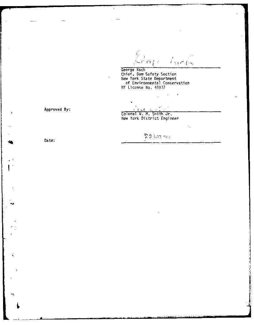
George KochChief, Darn Safety SectionNew York State Department
of Environmental ConservationNY License No. 45937
Approved By: ~Colonel W. M. Smith Jr.New York District Engineer
Date:
Il

V At
fills

PHASE I INSPECTION REPORTNATIONAL DAM SAFETY PROGRAM
--STUMP POND DAM I.D. NO. NY 746DEC #95A-4270 SUSQUEHANNA RIVER BASIN
CORTLAND COUNTY, NEW YORK
SECTION 1: PROJECT INFORMATION
1.1 GENERAL
a. AuthoritThe Phase I nspection reported herein was authorized by the Departmentof the Army, New York District, Corps of Engineers, to fulfill therequirements of the National Dam Inspection Act, Public Law 92-367.
b. Purpose of InspectionThis inspection was conducted to evaluate the existing conditions ofthe dam, to identify deficiencies and hazardous conditions, to determineif these deficiencies constitute hazards to life and property, and torecommend remedial measures where required.
1.2 DESCRIPTION OF PROJECT
a. Description of DamThe Stump Pond Dam is a laid up stone structure with an earth fill upstreamof the main dam.
The dam is approximately 100 feet long and a maximum of 15 feet high. The stonedam is exposed on the downstream face. The dam consists of two spillwaysections each about 15 feet wide. These spillway sections are in the centerof the structure. At either end there is a laid up stone segment which tiesinto natural ground. The laid up stone is founded on a concrete footingof unknown thickness. The earth fill segment, upstream of the main dam, wasapparently added sometime after the initial construction of the dam.
The spillway has two adjoining sections each approximately 15 feet wide.A 2.5 foot wide concrete corewall on the upstream face forms the spillwaycrest. The earth fill has partially blocked the left channel and completelyblocked the right channel.
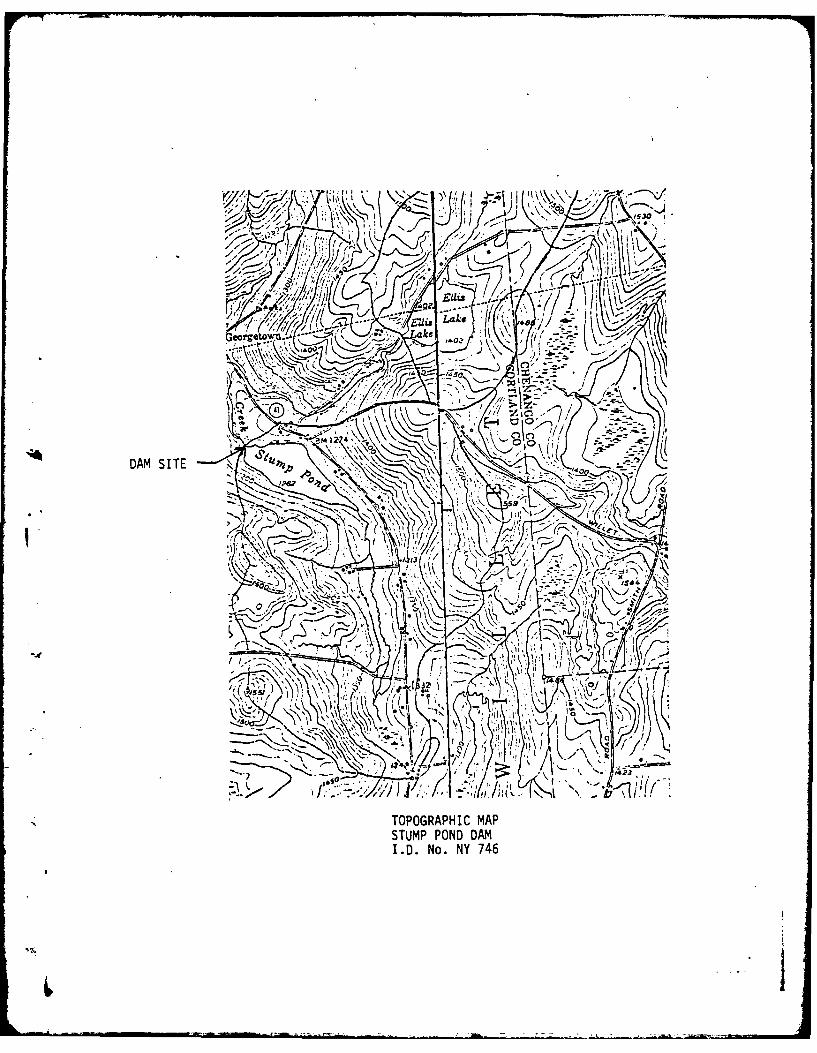
b. LocationThis dam is located in the Town of Willet, off New York State 41, approximately1 miles southeast of the Village of Willet. The dam is situated on WilletCreek.
c. Size ClassificationThe dam is 15 feet high and has a maximum storage capacity of 200 acre-feet.Therefore, the dam is in the small size capacity as defined by the "RecommendedGuidelines for Safety Inspection of Dams."
d. Hazard ClassificationsThis dam Is classified as "high" hazard due to the presence of several homesand trailers located downstream of the dam in the hamlet of Georgetown.
1,
BI

I e. Ownership
The dam isowned by Mr. William Sudbrink, P.O. Box 42, Willet, New York 13863.
f. Purpose of DamThe dam is used to maintain the water surface of Stump Pond for recreationalpurposes.
g. Design and Construction HistoryNo information was available concerning the design or construction of thisdam.
h. Normal Operating Procedures
There are no prescribed operating procedures for this structure.
1.3 PERTINENT DATA
a. Drainage Area (acres) 870
b. Discharge at Dam (cfs)Open Spillway Channel (W. S. at top of dam) 135
c. Elevation (USGS Datum)Top of Dam 1265Spillway Crest 1262
d. Reservoir-Surface Area (acres)Top of Dar' 59Spillway Crest 39
e. Storage Capacity (acre-feet)Top of Dam 260Spillway Crest 200
f. DamType: Laid up stone with earth fill on upstream side
Dam Length (ft.) 100Crest Width (ft.) 8.5
S. SpillwayType: Uncontrolled rectangular concrete weir. Crest formed by 2.5 foot
wide concrete core wall on upstream face.
Length:(ft.): Left Channel 15.2Right Channel (blocked) 15
h. Reservoir Drain - None
2
-- - + L + - • . . .+
SECTION 2: ENGINEERING DATA
2.1 GEOTECHNICAL DATA
a. Geology
The Stump Pond Dam is located in the Glaciated Allegheny Plateauphyslographic province of New York State. This plateau is underlainby a great thickness of sedimentary rocks from the Devonian Era whichlie almost horizontal. Severe trenching by streams and glacial erosionhas carved the upland into a rugged terrain. The Susquehanna Hills riseto elevations of 1,700 to 2,000 feet between the rolling, relativelynarrow valleys. The surficial soils and features of the area are theresult of glaciations during the Cenozoic Era, the last of which wasthe Wisconsin glaciation.
A review of the "Brittle Structures Map of the State of New York"indicated that there are no faults in the immiediate vicinity of thedam.
2.2 DESIGN RECORDS
No records were available concerning the design of this structure.
2.3 CONSTRUCTION RECORDS
No construction records were available.
2.4 OPERATION RECORDS
No operation records were available.
2.5 EVALUATION OF DATA
Data available for the preparation of this report was very limited. Mostof the information used was based on measurements made at the time of theinspection. The Phase I inspection report was prepared using the limiteddata plus certain qualifying assumptions.
3
SECTION 3: VISUAL INSPECTION
3.1 FINDINGS
a. General
Visual inspection of the Stump Pond Dam was conducted on October 23, 1980.The weather was clear and sunny with the temperature in the forties. Thewater surface at the time of the inspection was 4 inches above the spillwaycrest. Water was flowing over the spillway and debris was blocking theentrance to the channel at the upstream face of the damn.
b. Dam
A number of serious deficiencies were noted on this structure. Among thesedeficiencies were the following:
1. The right spillway section had failed completely. The concrete andstones which originally formed the crest were no longer in place anda large void extended across the 15 foot width of the channel (seephoto 1). Stones had been removed down to about 3 feet below theoriginal spillway crest. The void extended from the downstream faceto approximately 3 feet into the structure (see photo 2).
2. The left spillway section was in poor condition. The concrete on thecrest was cracked and deteriorated. The concrete slab on the upstreamapron was separated from the concrete on the crest (see photo 3). Atthe time of the inspection, the water was flowing into this crack anddown through the laid up stone rather than over the spillway. Therewere two small voids in this section, each approximately I foot deep.One void was near the center of the section and the other at the rightend. The pier which separates the two spillway channels was underminedand cracked (see photo 4).
3. The earth fill which had been placed upstream of the laid up stone section4 completely blocked the right spillway channel and partially blocked the
other (see photo 5). The opening in front of the right channel was about10 feet wide and 2 feet deep. The spillway capacity of this structurewas limited by this opening.
4. There was another large void in the laid up stone on the left end of thedam. This void was about 6 feet wide by 5 feet deep (see photo 6).At the crest, the width of the stone remaining in this area was about18 inches.
5. A bulge was noted in the laid up stone segment below the spillwaysection (see photo 1).
6. The stones at the right end of the dam were displaced upward above thehorizontal with respect to the remainder of the dam (see photo 8).
7. The right abutment slope on the downstream face of the dam was verysteep. There was a potential for surface runoff to cause erosion
4
problems in this area, further jeopardizing the stability of the dam.There were a number of trees and tree stumps along the downstream toeof the dam. Roots from these trees extended into the dam, creatingadditional stability problems.
9. There was apparently no reservoir drain. A 1 foot square opening wasnoted at the downstream toe, but this only extended a few feet intothe dam.
10. The concrete abutment at the left end of the left spillway was crackedand deteriorated (see photo 10). There were both horizontal andvertical cracks on this abutment.
c. Downstream Channel
The channel immediately downstream of the dam was narrow and tree lined.d. Reservoir
There was no indication of soil instability in the reservoir area. Thereappears to have been substantial sedimentation in the vicinity of the dam.
3.2 EVALUATION OF OBSERVATIONS
The overall condition of this dam is poor. A number of deficiencies existwhich pose a threat to the stability of the structure. The following itemswere the most serious deficiencies noted:
a. Large voids on the right spillway section and on the left end of the dam.
b. Overall deterioration of the left spillway section, including crackedconcrete and voids in the channel.
c. The earth fill severely limits spillway capacity.
d. A bulge in the laid up stone segment.
e. rrees and tree stumps along the downstream toe of the dam.
f. Deteriorated and cracked concrete on the left abutment of the left
spillway.
5

SECTION 4: OPERATION AND MAINTENANCE PROCEDURES
4.1 PROCEDURES
There are no operating procedures for this dam.
4.2 MAINTENANCE OF DAM
No regular maintenance is performed on this structure.
4.3 WARNING SYSTEM IN EFFECT
No apparent warning system for evacuation of downstream residents ispresent.
4.4 EVALUATION
The operation and maintenance procedures on this dam are unsatisfactory.The overall poor condition of the dam is evidence of the deficiency inthe maintenance procedures.
6
• t
SECTION 5: HYDRAULIC/HYDROLOGIC
5.1 DRAINAGE AREA CHARACTERISTICS
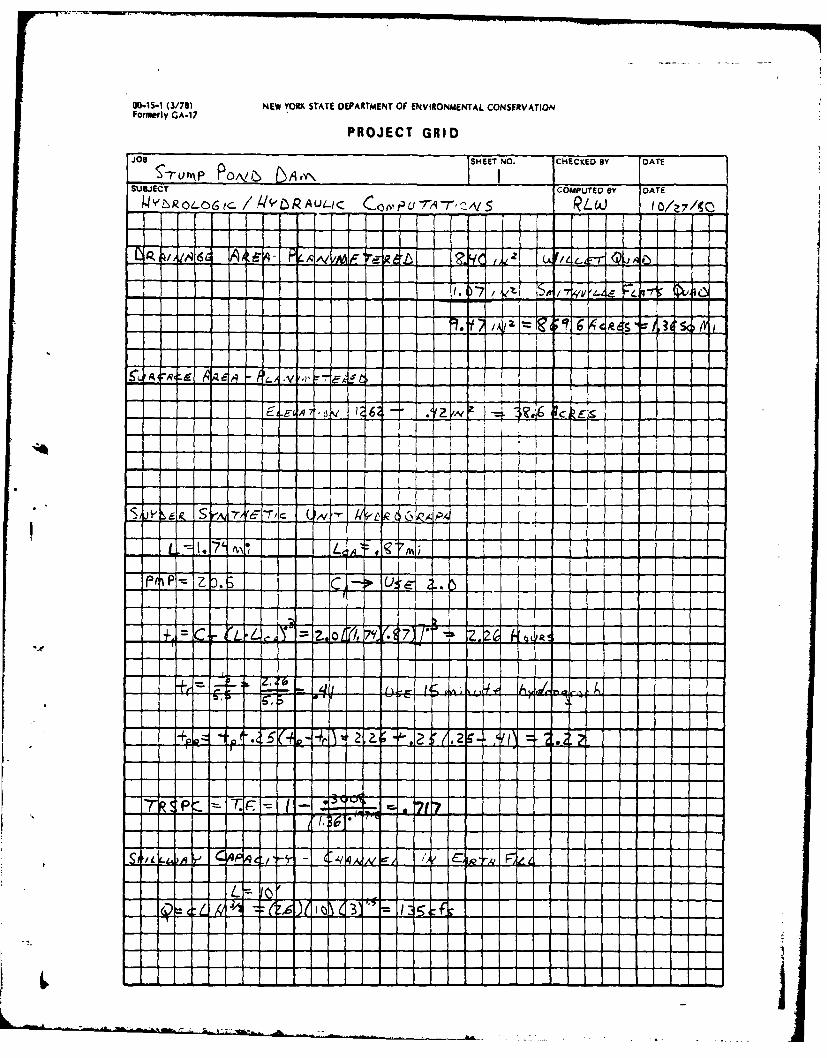
Delineation of the watershed draining into the reservoir pool area wasmade using the USGS 7h minute quadrangle sheets for Willet and SmlthvilleFlats, New York. The 870 acre drainage area consists of open fields andwooded lands. Relief in the drainage area is moderate to steep withslopes ranging from 8 to 31 percent.
5.2 ANALYSIS CRITERIA
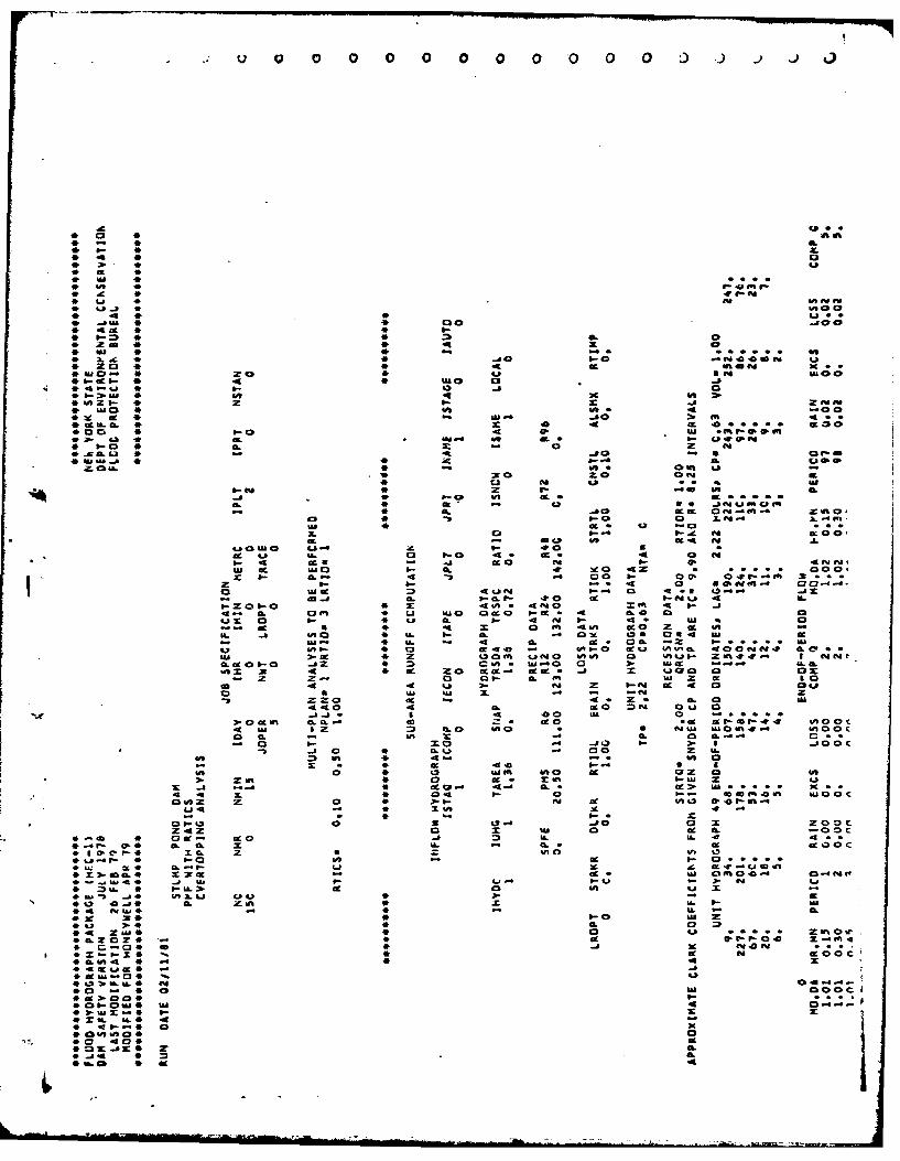
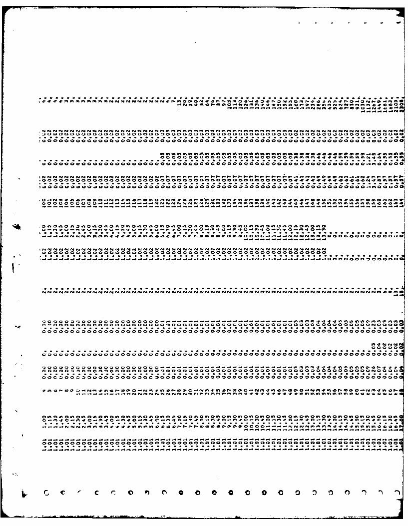
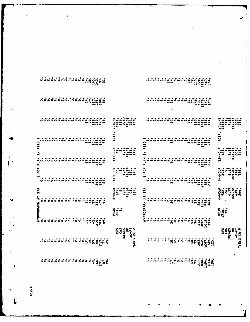
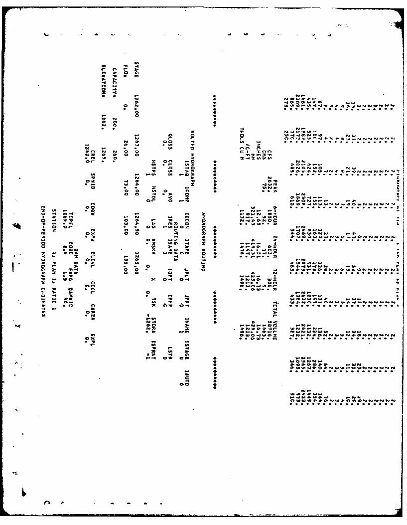
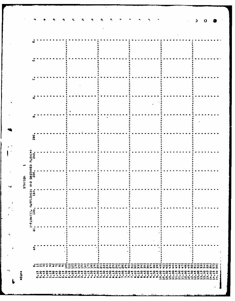
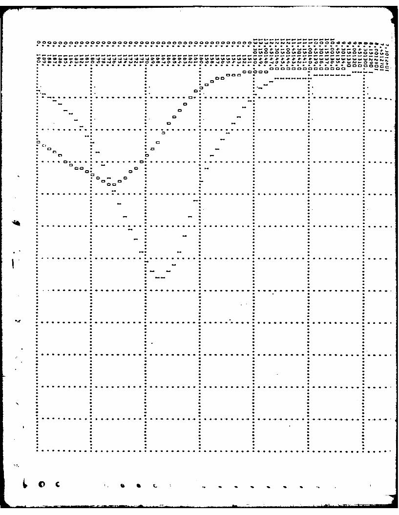
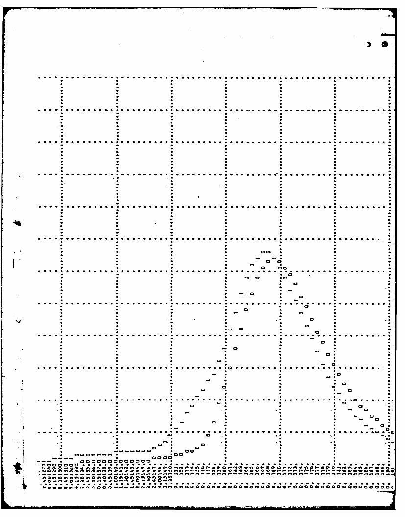
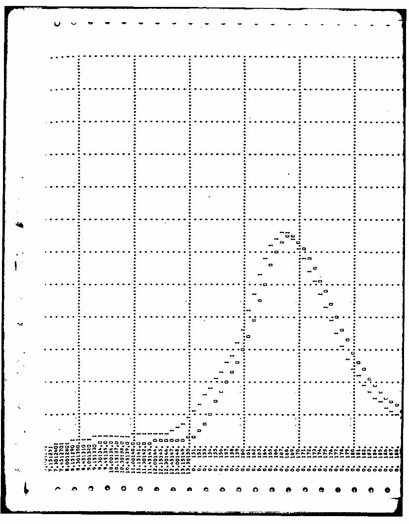
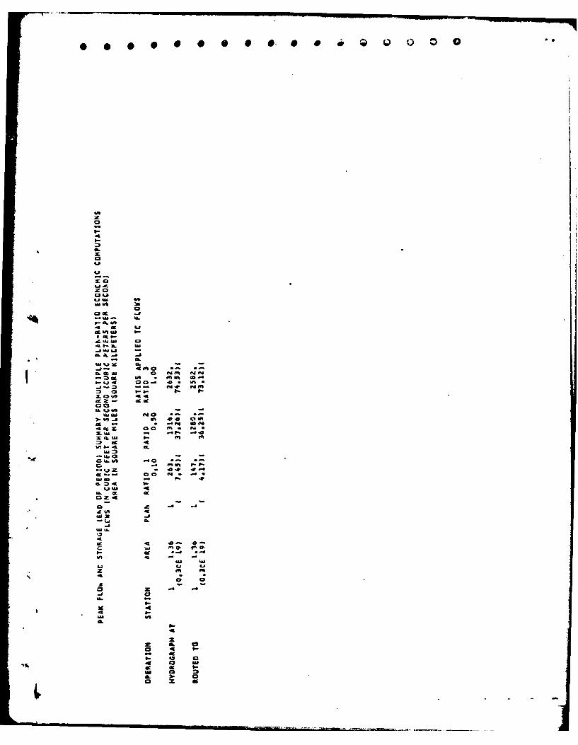
The analysis of the floodwater retarding capability of this dam wasperformed using the Corps of Engineers HEC-1 computer program, Dam Safetyversion. This program develops an inflow hydrograph using the "SnyderSynthetic Unit Hydrograph" method and then uses the "Modified Puls" floodrouting procedure. The spillway design flood selected was the PMF inaccordance with the Recommended Guidelines of the U.S. Army Corps ofEngineers.
5.3 SPILLWAY CAPACITY
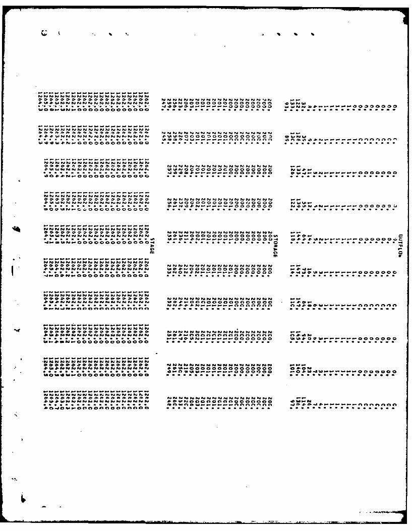
The dam has two ungated spillway channels. One of the spillway channelshas been completely blocked by the earth fill which has been placed onthe upstream face of the dam. The earth fill blocks a portion of theleft spillway channel as well. The result is that the spillway capacityis controlled by the 10 foot wide channel through the earth fill. Thespillway was analyzed as a broad crested weir with a discharge coefficient(c) of 2.6.
5.4 RESERVOIR CAPACITY
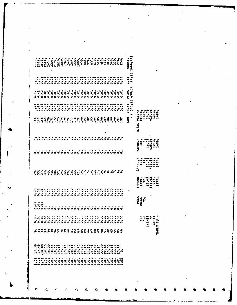
Normal storage capacity of the reservoir with the water surface at thespillway crest is 200 acre feet. Surcharge storage capacity between thespillway crest and the top of the dam is 60 acre feet, which is equivalentto a runoff depth of 0.83 inches over the drainage area.
5.5 FLOODS OF RECORD
* No information was available regarding the occurrence of the maximumknown flood.
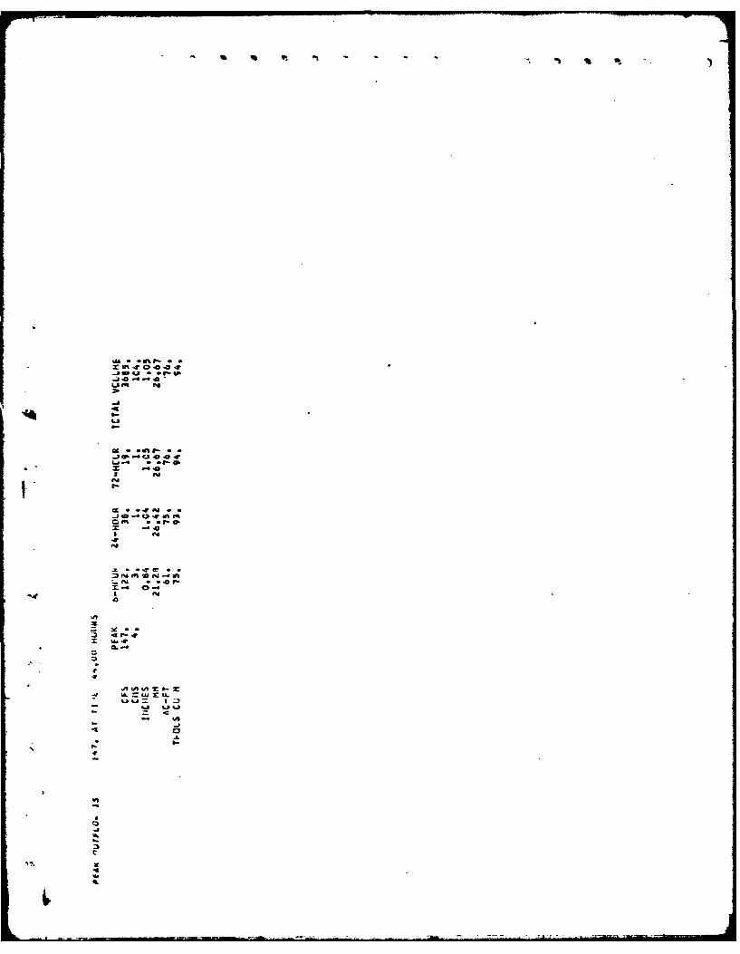
5.6 OVERTOPPING POTENTIAL
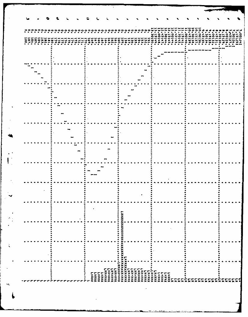
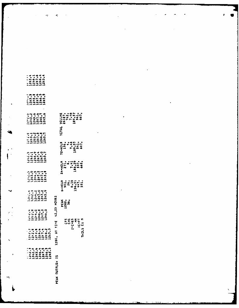
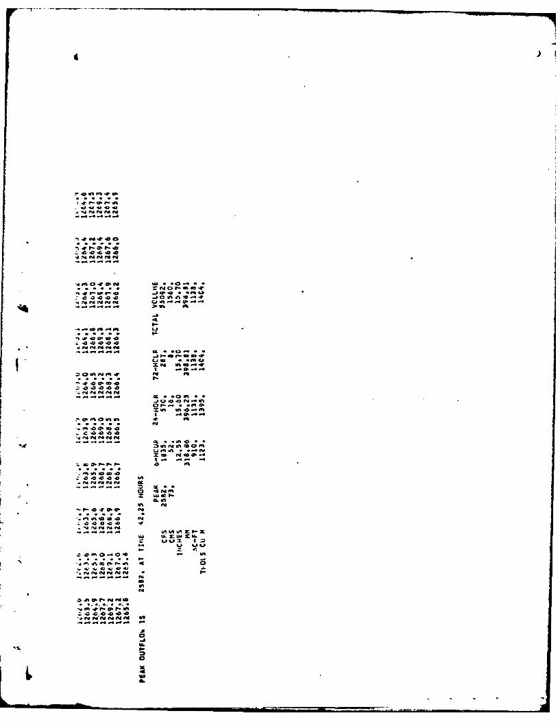
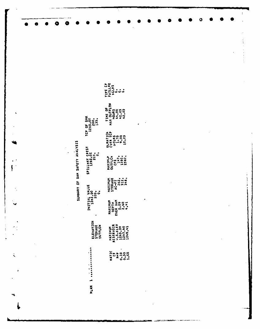
Analysis using the PMF and one-half the PMF indicates that the dam does nothave sufficient spillway capacity. The inflow from the PMF is 2632 cfs andfor one-half the PMF the inflow is 1316 cfs. For a P4F peak outflow of 252cfs, the dam would be overtopped to a computed depth of 4.4 feet. For thepeak outflow of one-half the PMF, the depth of overtopping would be2.6 feet. All storms exceeding 10% of the PMF will result in the dam beingovertopped. The spillway in its present configuration only has sufficientcapacity to discharge 135 cfs.
7

5.7 EVALUATION
Using the Corps of Engineers screening criteria for initial review ofspillway adequacy, it has been determined that the dam would be overtoppedby all storms exceeding 10% of the P?4F. Since a failure of the damwould increase the hazard to the downstream residents over that whichwould exist just prior to the failure, the spillway capacity is adjudged tobe seriously inadequate.
8
SECTION 6: STRUCTURAL STABILITY
6.1 EVALUATION OF STRUCTURAL STABILITY
a. Visual Observations
Visual observations revealed that the structure is in poor condition.There were two locations where substantial voids had developed in thestructure. These voids were caused by the structure unravelling,probably due to overtopping. There were also indications of distressat the right abutmnrt. The lines formed by the stones across the damwere no loniger horizontal but were displaced upward. A slight outwardbulge was noted in the lower portion of the structure near the centerof the spillway section.
b. Data Review and Stability Evaluation
There were no plans available from which information needed to performa stability arr lysis could be obtained. Due to this lack of informationand due to the type of structure, a stability analysis was notconsidered feasible.
9
SECTION 7: ASSESSMENT/RECOMMENDATIONS
7.1 -ASSESSMENT
a. Safety
The Phase I inspection of the Stump Pond Dam revealed the dam to be inpoor condition with several serious deficiencies. The right spillwaysection has failed, creating a large void in this part of the dam. Anotherlarge void exists on the left end of the dam. There were several smallervoids and overall deterioration on the left spillway channel. The earthfill on the upstream face has resulted in severely limited spillwaycapacity. Engineering investigations indicate that the spillway capacityis seriously inadequate (unable to discharge the outflow of 1/2 the P?4F).Due to the deficiencies which exist on this structure, the dami has beenassessed as "unsafe."
b. Adequacy of Information
There was very little information available for the preparation of thisreport. Most of the information used was obtained from observations andmeasurements made at the time of the inspection.
c. Need for Additional Investigations
A number of the deficiencies on this structure were related to the stabilityof the dam. Due to insufficient data, no stability analysis was performedfor this dam. An overall analysis of the stability of the structure isrequired to determine the cause of the bulge on the downstream face and ifmodifications to the dam are needed.
Since the spillway was assessed as seriously inadequate, additionalhydrologic/hydraulic investigations are required to more accurately determinethe site specific characteristics of the watershed. Remedial measures forincreasing the spillway capacity are then required.
d. Urgency
Due to the poor condition of this structure, it should be given immediateattention. Within 30 days of the notification to the owner that the damhas been classified as unsafe, repair work on the structural deficiencies(voids on spillway and dam, cracked concrete, etc.), should be commenced.These repairs should be completed within 3 months.
The additional detailed hydrologic/hydraulic investigations should becommenced within 3 months of the date of notification of the owner.A stability analysis for the structure should be commenced within 6 months.
Mitigating measures deemed necessary as a result of the investigations andrepairs required should be completed within 1 year of the date of notification.
7.2 RECOMMENDED MEASURES
a. Repair large voids which exist on the right spillway channel and on the
left end of the dam.
10
b. Repair the left spillway channel, including cracked concrete and voids
in the channel.
c. Remove the pier between the two spillway channels.
d. Remove the earth fill in front of spillway channels down to the levelof the spillway crest.
e. Provide additional spillway capacity as a result of detailed hydrologic/hydraulic investigations.
f. Direct surface runoff away from right abutment slope on downstream faceto prevent erosion of the slope.
g. Cut trees along downstream toe of the dam.
h. Make modifications to the sturcture deemed necessary as a result of thestability analysis.
i. Repair cracked concrete abutments on either end of the spillway.
j. Provide a reservoir drain to permit the controlled lowering of the impoundment.
k. Develop an emergency action plan for the notification of downstream
residents.
APPENDIX A
PHOTOGR.APHS
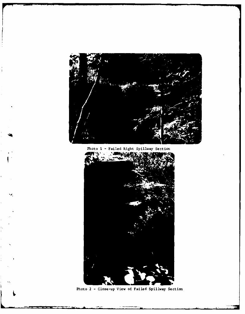
Photo 1 -Failed Right Spillway Section
Photo 2 -Close-up View of Failed Spillway Section

r
Photo 3 - Left Spillway Section; Note Separation Between
Concrete W. 11 and Spillway Slab
Photo 4 - Undermined Pier Between Spillway Sections
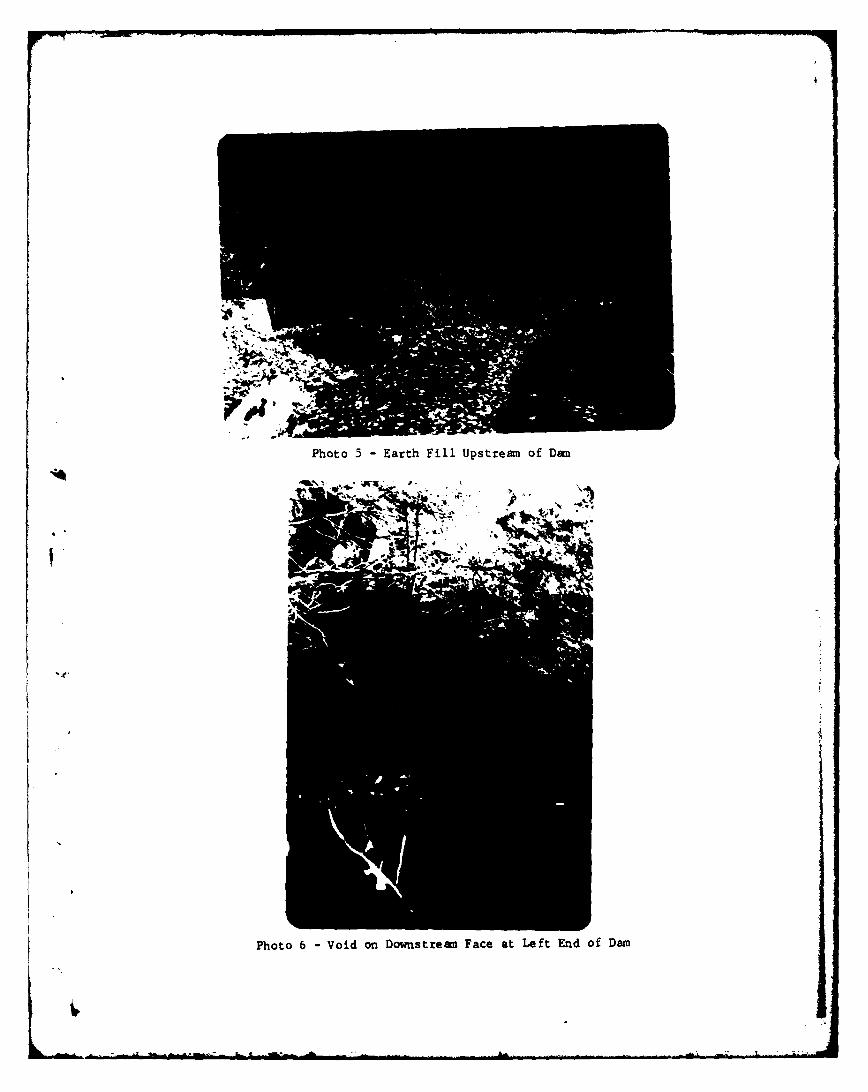
Photo 5 -Earth Fill Upstream of Dam
Photo 6 -Void on Downstream Face at Left End of Dam
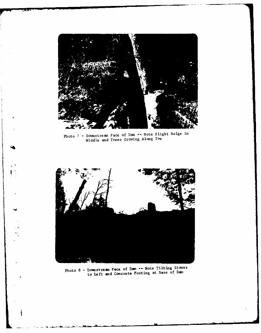
Photo 7 -Downstreaml Face of Dam -- Note Slight Bulge in
Middle and Trees Growing Along Toe
Photo 8 -Downistream Face of Dam~ N-Iote Tilting Stones
to Left and Concrete Footing at Base of Dam

Photo 9 - Downstream of Dan -- Trees Growing Along Toe
Photo 10 - Cracked Abutment at Left End of Spillway
APPENDIX B
VISUAL INSPECTION CHECLIST
93-15-3(9/8c)
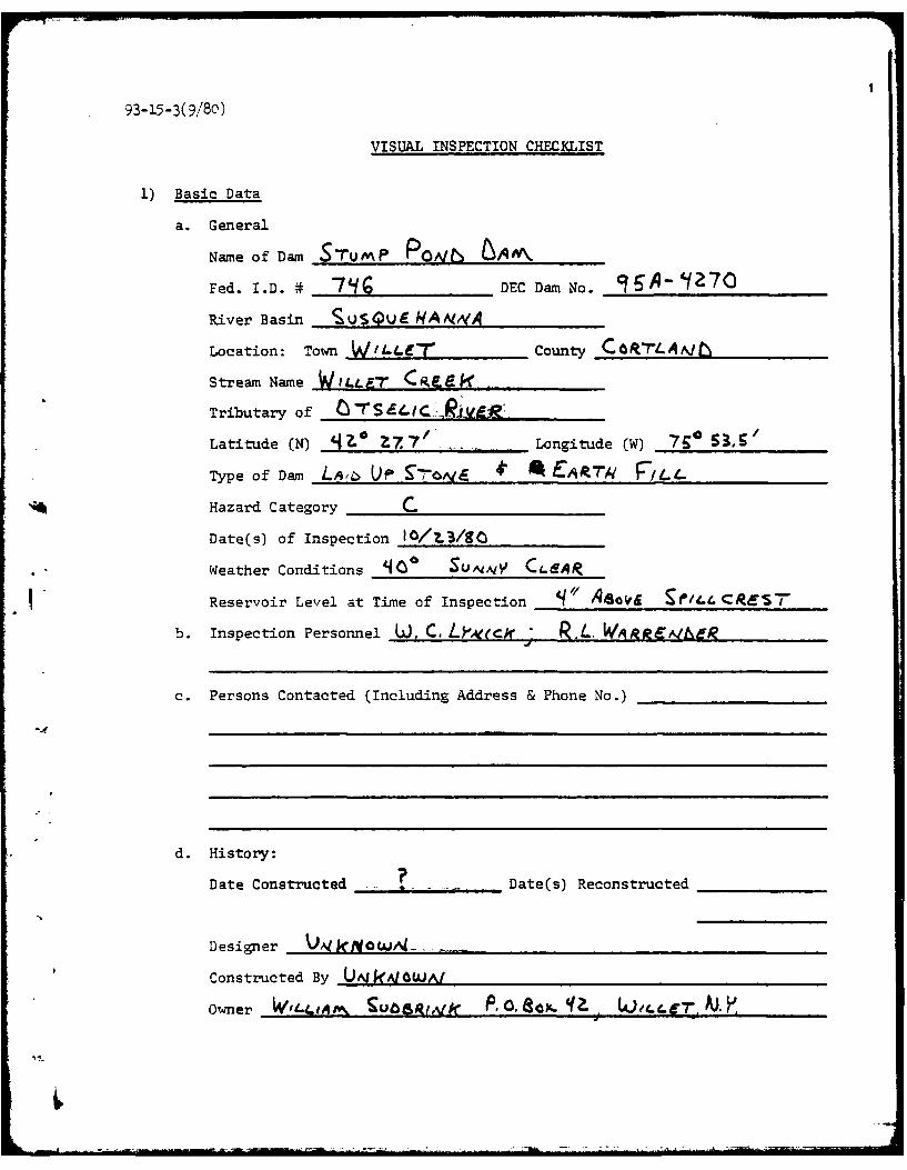
VISUAL INSPECTION CHECKLIST
1) Basic Data
a. General
Name of Dam S7uMP PQAtt, bAIV\.
Fed. I.D. # _7 G DEC Dam No. 9 6A- '170
River Basin SUS E 4 I94A AMIA
Location: Town W/LLir-r County C_ 'Lk pjtb
Stream Name W,LL-r Ce eb -
Tributary of C-rS-.i- ER
Latitude (N) 14.. .Z77. Longitude (W) 79 0 53 , 5
Type of Dam L.. UP 9 4N-I E R" .rq
Hazard Category C
Date(s) of Inspection 0/L3/Q
Weather Conditions 4 SuAiAtY C( A
Reservoir Level at Time of Inspection q // Aeos "/,L CRES7
b. Inspection Personnel U], C. L "ece R.L. WAirE eg
c. Persons Contacted (Including Address & Phone No.)
d. History:
Date Constructed - Date(s) Reconstructed
Designer AI t 0 W,..
Constructed By U[N ,qW 6/'J
Owner W,A,.,,, SUC8,IA P do. o x. q?- J,.,rfT Aj..
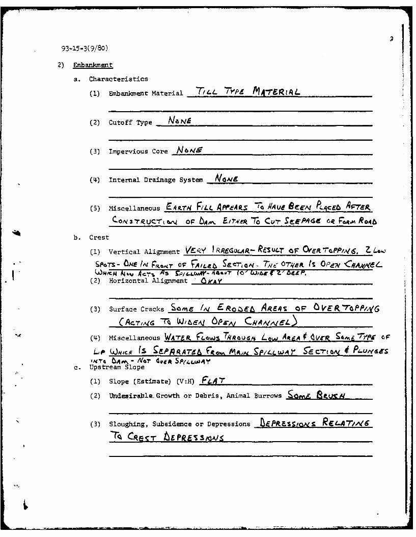
93-15-3(9/80)
2) Embankment
a. Characteristics
(1) Embankment Material t. /1- "PL M4-7"g(4qL
(2) Cutoff Type __a ___
(3) Impervious Core __6 ____
(4) Internal Drainage System NOAI
(5) Miscellaneous E4.rN F/4L APPeA S 7; RAu OCE, P4 4qcE AF7'pC 0N r RU C-r~ 0F EAP /7W L- 7o C v r e ~e P4 d , F64w'K Ro jq6
b. Crest
(1) Vertical Alignment V 9 RR6CGO-C4. PES 0- 7 OF OY &m -rP/A/6. ? . 4
S OTS W~ 17,t-wr OF 4uA Ite S~E raq - Tye 07q4,fA fS 0 ff CVA*-EL
(2) Horizontal Alignment ' 61fAy
(3) Surface Cracks SIZME /,V ERO Aqe-4S OF OVER7"OP,/vG
(A-TA1 -r khe 6 Pr~t CNmAvA-)
(4I) Miscellaneous WAIP Ti440''q~au LG$M A4t.q # d~-P -1KE7iit
LP Woqecs (S 9FPARA76J6 F~w MVAjN, 9p1 .I'is- rEC(a de1AIrG INqw\- Noar 4v& 5Pil.4r
c. Upstream Slope
(1) Slope (Estimate) (V:H) F*4 "7'
(2) Undesirable. Growth or Debris, Animal Burrows -Cgwi& 8 J.A4
(3) Sloughing, Subsidence or Depressions tPitas -rlov
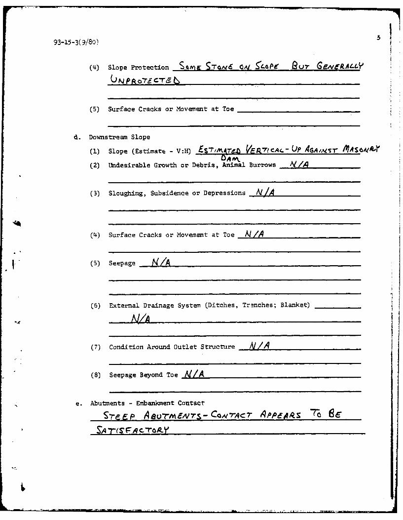
93-15-3(9/80)
(4) Slope Protection s=n S7'V6 0'V 54 e LP RQr G7 GENERA4.4Y
(5) Surface Cracks or Movement at Toe
d. Downstream Slope
(1) Slope (Estimate - V:H) £S7,MKrizb VE,71cAe- UP 4GA,,GA r IMASOAIIQ-CA M,
(2) Undesirable Growth or Debris, Animal Burrows AI/4
(3) Sloughing, Subsidence or Depressions N/A
(4) Surface Cracks or Movement at Toe A//
(5) Seepage _ /A
(6) External Drainage System (Ditches, Tre.nches; Blanket)
A /A
(7) Condition Around Outlet Structure A/A
(8) Seepage Beyond Toe A/A
e. Abutments - Embankment Contact
S-eE; Aeurmf -s-Caw-qcT 6APPfoks 7- 6
4I
93-15-3(9/80)
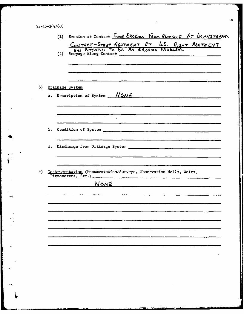
(1) Erosion at Contact Comf E-ROSImO Fka0 1 ku &w,& / reA~
CA'rr-S'?-r# 1480"MEA/r 47' 6, . Q a A 0 -r ENvTUNqs FPo-rfAmTA4 To Ba Aq Ckiam, Maa.E(2) Seepage Along Contact
3) Drainage System
a. Description of System ___A_
b. Condition of System
c. Discharge from Drainage System
4) Instrumentation (Momumentation/Surveys, Observation Wells, Weirs,Piezometers, Etc.)
'7.N
93-15-3(9/80)
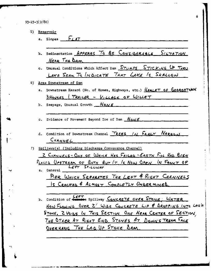
5) Reservoir
a. Slopes RLAT
b. Sedimentation Af'PpAgA -re l Ca~te.PAo&(.S 5t/Cr70A i
c. Unusual Conditions Which Affect Dam S-7umps -r c k Ai rs P 7-we u
Lko~re ea j7-a fA4,CAT8: 7 ,qA7- 4e /C 91I*I..44AJ
6) Area Downstream of Dam
a. Downstream Hazard (No. of Homes, Highways, etc.) (IAxL6T 09 (66k.rqhW
akausS ( 'PAILP - VILAci& OF GJ(4LC7'
b. Seepage, Unusual Growth N0Al-
c. Evidence of Movement Beyond Toe of Dam _NQ,.Ig
d. Condition of Downstream Channel 'rPCCS ,V jtY A MAqP.e~j
7) Spillw Aw(s) (Includinz Discharge Conveyance Channel)
Z C AIAqA .L S - Ove g 0F W.V c q W4 S R9,q 4. 464,Q 7-A F7 1 41At C G
FP4.AZ.4 7.G'rkAv' % OqlaR u,- (r ( Now~~~~ (Pg A I F*axd7 OF
a . G en eral _ _ _ _ _ _ _ _ _ _ _ _ _ _ _ _ _ _ _ _ _ _ _ _ _ _ _ _ _ _ _ _ _ _ _ _ _ _ _ _
RE' C jq~ek S*EA.4-rc rs C ZMP r7-v * RvIjp-
b. Condition of -Gmie Spillway CO~eCRE76 OVER :S*7oAf9- (JA-re=&
gloi& P~ow/Ag6 GerP. Z.' Wi&& Coy~cote'Ta LtP 0 AoZ4pP/,Al /N76Vr4S
N 'ToAcE, Z Vhq~s to, Th6(( S~TFroL ON( ,Ve,& CeNrre& Ia
Qy !4fAAM( 7 4E ( 4i UP 5-"& &q

93-15-3(9/8o)
c. Condition of Amm&Ia.!y spillway - Laek re 1r L4As ORIG/.AM4' 7 va
S~m As Lac-r ON - ANt Ibr 14s 9AI-gk 9ec(cqc
'/oit& AoaU7 I/ bEEP f V6 - 9-rAIrT OF- tN4 P. /I',~
ToT- PF-4.61. OFF- ! E PHOTOS C,4PsTS :/,L PRZV.EV-,S
d. Condition of Discharge Conveyance Channel ______________
8) Reservoir Drain/Outlet
No~ NtAlm APP4gev- - tq SI V A P.41~ 0PV(S WAS
P46TEL~ CAI F~4v c-eq SUT (7- ONLY EK 1M0b
A 9z Fre l~t-rcG Tqi ql~v 4*6r v IRe 4 ATcEAI'r-hs (-.Weag 6PLJ,%G 4'aUHwM /'V ;
TREg6.m ,..

-793-15-3(9/80)
9) Structural
a. Concrete Surfaces CRACKgyra 66TEPOP-et V01INS CAI CGALIr-jE7d
ON Lif "r SP4j...JAY' C1ANAIr4-
b. Structural Cracking ___________/ ________________________________WAY
N4AUX CajtAr-rA~( - CRACe~S 'OA P/e-AiY 4 s (4&Z
c. Movemenit - Horizontal & Vertical Alignment (Settlement) ONE 41-Stir
hq4.c d Ce-Arrei Ofr TTU-rk e-a~~u) Sple-LWAY 5'eeh-re.
Sram~E 5 4 ,iq-rrP1Y OA, G*7-,v EAs a 64m-*lot
STOaAI& /A CeAt7-eg Ir P~e-,i. .~QA.,61rr
e. Drains - Foundation, Joint, Face NoaI
f. Water Passages, Conduits, Sluices £Ef 9P/1L1jJAY tbECkP-rtwA
g. Seepage or Leakage NA.d Mo-rc - A C*Ad.Y gife s 7o Re -OAJ C0AIC-jT&' IRASF - OAIE Vk#.-ric'qe Coqclr 4M 8.4Sc A 7A sA rUrx aiscr tbAlkX- S0 5 EF &JAq7k t6(rPPE~VA1
(Arra tAmX Vems -r Cqi~ 7TNa/Rucy ke&E. UP6A' /A1AMs*'6~
J.aW OVEP, 9PiLWAYj PsGUJ UA1&ERf_ 4f 7-/*.bUA J Aa%, SeCcMA
To ERE~ qcos WJ1634tE4

93-15-3(9/80)
h. Joints -Construction, etc. IIN
i. Foundation C6&1 RTE 4 iht 26tROCK APPAPEA'~r A - t-A*%.
6k IN CNAA.ALAL
*j. Abutmients Ve'P-X !-eep Prsir- Aa-feq-SMr Suft U*PA(
k. Control Gates &_____________6m____________
1. Approach & Outlet Channels_______ ______________
M. Energy Dissipators (Plunge Pool, etc.) __________________
n. Intake Structures kozA1
o. Stability <Ques TiM44LE - 4-riM CNPfr hAvMr 4mo.4AS_
T#ATr TraE5. At SU7ReSA/( 6,qAiS - 7 ',Re Ra-r 6o Ga I&rG ftp. Miscellaneous Vo, A-r Lmr -, 05 4oEF L r P't ujWqt-
A a 6u,- 'tcap P C*amGE-r E ZL g- CamPL Ee 6otoAI-
O F VTONCS /N~ T# 9A A -0- Ae OIAh 0N4 A 1 4Ur 1T Wc6A- CpxsT. CAuE 6- 7qls V,4 /S (JAI CZLEAP
APPENDIX C
HYDROLOGIC/HYDRAULICENGINEERING DATA AND COMPUTATIONS
I
i-
[ ! I

CHECK LIST FOR DAMSHYDROLOGIC AND HYDRAULIC
ENGIN'EERING DATA
AREA-CAPACITY DATA:
Elevation Surface Area Storage Capacity(ft.) (acres) (acre-ft.)
1) Top of Dam____59______
2) Design High Water(Max. Design Pool) ___________
3) Auxiliary SpillwayCrest __ _ _ _
4) pool Level withFlashboards _____ ______ ________
5) Service SpillwayCre s t______
DISCHARGESVolume(cfs)
1) Average Daily
2) Spillway @ Maximum High Water ______
3) Spillway @ Design High Water_______
4) Spillway @ Auxiliary Spillway Crest Elevation ______
5) Low Level Outlet______
6) Total (of all facilities) @ Maximum High Water ______
7) Maximum Known Flood______
8) At Time of Inspection0
93-15-4~(9/80)
Z
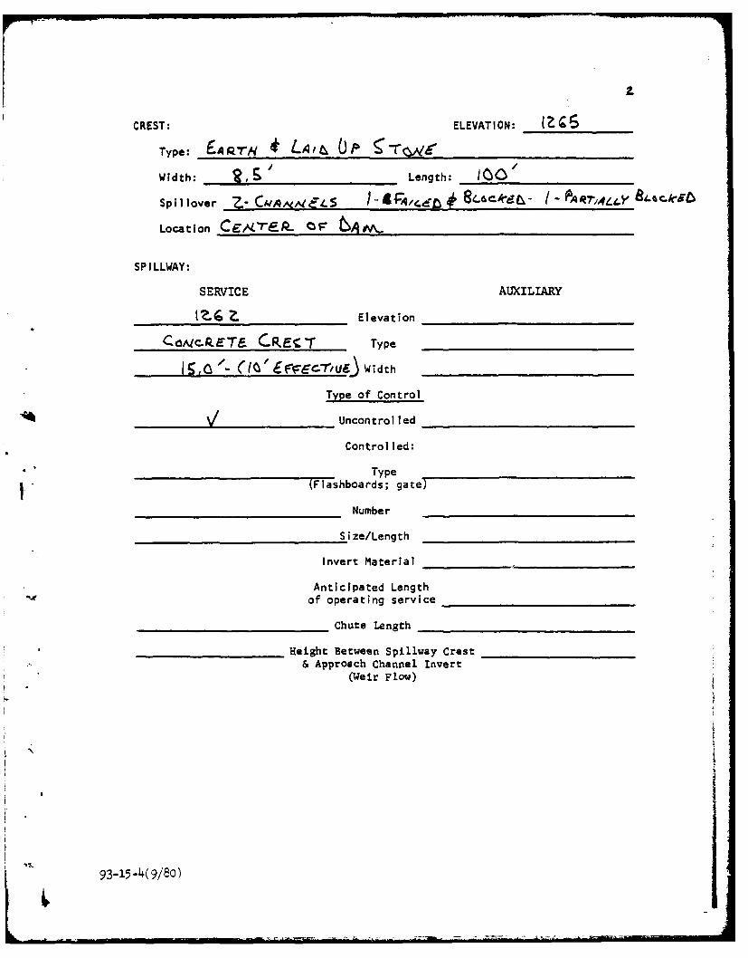
CREST: ELEVATION: _______
Type: 1q,'iq LAa OiWidth: _ !R __& Length: IGO'
Spillover Z- CNNV:L J4G.d ~ l 8CAd - P7,41-4Y 8A-r9
Location CC rF-P- 10F 66tA.
SPILLWAY:
SERVICE AUXILIARY
?. Z. Elevation
Co/cm.ET_ CREC r Type
I IQ /- (I ' £7,fr c u-J,6 Width
Type of Control
V Uncontrolled
Control led:
___TypeV -(Flashboards; gate)
Number
Size/Length
Invert Material
Anticipated Lengthof operating service
Chute Length
'_ _ Height Between Spillway Crest& Approach Channel Invert
(Weir Flow)
93-15-4(9/8o)
3
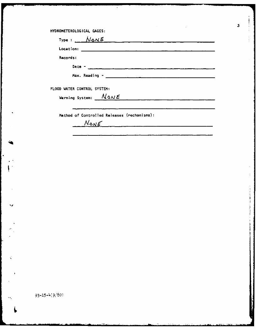
HYDROMETEROLOG ICAL GAGES:
Type : ,.z{ALS
Location:
Records:
Date -
Max. Reading -
FLOOD WATER CONTROL SYSTEM:
Warning System: ____ AJ__ _
Method of Controlled Releases (mnechanisms):
9
93-15-2K ,' ,80 )
41
DRAINAGE AREA: -70 AckeS
DRAINAGE BASIN RUNOFF CHARACTERISTICS:
Land Use - Type: FARwq tO__ U31:4r<t. LA.1&S
Terrain - Relief: ft Mct7ep. - T4 .5* '-,E6P
Surface - Soil: 9 AEA- RC.p-y
Runoff Potential (existing or planned extensive alterations to existing(surface or subsurface conditions)
Potential Sedimentation problem areas (natural or man-made; present or future)
Potential Backwater problem areas for levels at maximum storage capacityincluding surcharge storage:
Dikes - Floodwalls (overflow s non-overflow ) - Low reaches along theReservoir perimeter:
Location:
Elevation:
Reservoir:
Length @ Maximum Pool (Miles)
Length of Shoreline (§ Spillway Crest) (Miles)
93-1.5-4(9/8o)
0015-1 (3/78) NEW YORK STATE DEPARTMENT OF ENVIRONMENTAL CONSERVATION
Formerly CA-17
PROJECT GRID
JOB SEET NO. CHECKED By DATE
§rt)DMP PONVI bAY\ I__ _ _ _ _ __ _ _ _ _ _SUBJECT COMPUTED BY DATEPSULBoT 6t. / 4 R'RA uL_( C ,pu ' A'-c,,v5 /PL7.
:, iilzii -AI
I I T I -i I
LL
4: Ai I [
-- - - - - -- • ,
- -
- - _ _ . .. . . . -- ! { -
+o,: "- , ., ' , i D -/ ._ - - - - - .
.4 I _
f
1
--- 4 --. = 7
I'~ ----------
....... ...... ... .._o--- .- . . . . . . .
C,.. L G C o C ) •) % J .,.
l-i
- L *S 4* ,q 0* Zm 0 0,
U ,
V, zo S.owa- . *
*b3 0
c Lo - L .
-4-,
b- 00q '0
-r
N~ 0Dr
111 -,.. --- -4; 4 -
II
UE4 .4 0 0 4 .. 4 .4,0. N Eq N f• 0. Eq *€4 , ,- , -
gd- .4 , .
0--.0an 0 0Lo
, . t 4 4 I
Eq i -C I04 0
C- 0i uq tEq In pi Eq N 0 q in
C2, -8 ft a-a 10.E Cie - P u
0 *O'F. Z-dill
*XU0* inq N0 40 0 .0 4 .
$j .0.5
3e * 4 4 co 2f X 9 0. - 3 X 3C 3C I-. )1. 3. )1 0 Ob a0 V0 3c 4 .4 4
*4 ZUJI
*.11i deuo0 at U -0 0 IL kL*0 0 Q
* 3 1-- 0 us
3-- --
#Aq q04~q E 4A F- W@ 0o r N4 Eq em C4 rm fm. q -*0 x0 - 4-4 NNNN NNNE
- - v o v 0 0 0 0 0 0 '0 0 0 L) *)J .
4-
q* -a *a
I.0- :D2
x 4 *j 1: 4
o- 41 a ~.0~6- ne 1- 4' us N'm 4j D- Q -A
1. 1.u 40. 49 DC 2M, I-~ b. -0MM
r 20 *s .9 at a
6- T. ftN O
x9L -80 a 4-0 5
*I-~W S.31 44 ;
*43) -2 02 Q- C3 XJ 4
up OL. - C3 lih I4*0.4.. N b-" 9-. C 4;4..........0
w0 C4 UP0 4K 0. '4. 4-0 4U a. t. .- 0 a
b-0. 4 cc -A at0 p - S 0-4usaa. nt .2 4. -W .b 0 49 z
2.0W4 - 44* CU) 4 f 0 - .
X CL Nt cc44-' "I x M- 4 1- -1
I- 4-0 &- 4 .1: $- U.C3 C" W, C 0 Z S CC NL4O
M& ;: LL.x . 0. 0. 0 4 2 0.
>. n4 z o- 00 r" uP40 # W. W -t d%
'U x at 0 cca cx %oo2 0 -IL 4-" X 00to
2- - ft 44 p. c .4 N 0 .
z0 4 z 3 de :- 0 Ut A.W4- 4 a.3 cc aJ M. NA 4- 040- -1 WO 4-0 a.4 UO 4 0 0
0 a 0 0 -0 0- )- IU 4.24. 0 0
31 0 - 0 0 4 An e 4- . In 0A-- In U ce x W% us 64z4 . .
-A . -a up0 O* IL 4 .. 4 C .U Ua0 . U, x IL - 4 a ac I. 0L2 -Z -........
1.8 344 z 0 0.4 -r_- . 440 0 44 .
0..0- .J z 0 CU - A WO oe CL 'M00.4:10 am ft 0 a. 0 aLa. LLa a 43 . .30 00
a, x CL. 0c 04 0 44 4 2 a
a: A0 cc 1- N . 23w mZ 9- X. e. a w 0.
4 4 2b 0M 0.0 ut 0 0 0 n
p- ZI 4 '00 x0 - .F~u a.a~ co0 u z . a . -r )0z W% up i U N 4 3) 4
.4 0. w U) %1 - . C ..0 0, 4- 20 u' z2. - 2 3
J 0 Z M%4 4C 00 I
at4 ZA 00 4-N 4A0 0 P3.
04 0l 2 3 0 - o0- In oI- olo usj C;LIL
2'.- MA X. = ". IL- 0. .O
C . 4 0.102.4. owl. to a. 0 00- .
0 .&4* 3 410 .1434 - 2 N=x _ST_ IL-L .0 )4
*' 0 4 .2 &.2 'N3.I -'M.4 411 K -a -a
C;t 4 4,C;; QOO aq coo 0E 000 cc 0q 00000 N NN4 0 cc ON 0 a 0000000001i~0 aq 0 a 0 000 aq 0 a oN 00 0 00,01~
mt n n w,, cp 01a -4w O- I qE ~ qECE 1 qQE E ft q qE 4
0 00 In on mw W% W%- q ON4 0.
I fm ns 4- Nv m N r A N Nv N4 ft Nt " fm m N Nm N 4 N - I- r- r- Eq r- Eq r- 9- Eq Eq * -Eq r- r Eq r-- Eq Eq Eq Eq Eq Eq Eq a. a. a. N. N- N. P. I- N qEqNNN
CC.~~ 000000 aC, 000 00 a000 QC a 0 0q aq 0q a. 0q aq a 0 0 N eft0 aq 0q EqE
00M00000A000000009000000000040a-a 00000%0a000000000000000000000m0000m0 r n 4 r-r'sob .- i 4rin Eq 000004 i'V
-4 ------ -------------- ---- 44------ -.----- --- --- .-
*............................................................................................................. .ft f4 e4 "N4ClC tC mr lr 64 mAAC 4MM C M r MC&4 4 M NO I M Eq Eq Eq Eq M C-4 EC P4 M~ C4 .0M fM VM C4 CM CM CM0 CM M. 1 00 04 C4-- Nf N3 Np EqE E 00 0 20
c--- 0 300 a00a0- - ---- -- -- --- - - ----- -. 40 00000000000m m
E"q4 N N- Nt
C; C;1; C 1; ~c~c,; c~~c; JI; zjc~zj;0 00C.00a
00000~~~~ 0000 0m m000 0000 00 o000 000 0000 0in00a-00w00o00 -z
0 Eq 0 Eq 0 in 0 Eq 0'r EAq'0 Eq 0aEq 0 q 0t &% 0 En 0 Eq 0 Q. 0 E 0M EqM in 0 q0E fO q0E q0 Eq 0 Eq 0 EqV M r 0Wk 0 r- 00 Eq 0 Eq 0 4P 0n Eq 0 EC4 C4 cm CW r% Eqi 0. Eq '.. r.~ m~ Eq 01 "1.Eq. q C" t Eq "I- Eq V Eq -4 0 -T Eq i w% Eq i n nNNmW 40- Eq AP 0.4q -aE 40 C , A; E
--------- --------------
C c c a ) n0a0 00 0 0 0 '0 0
* ~ .i ~0fl0 WhMO0 0 Wv
-Ad
4444
.0 0 0 0 0 0 0 0 0 0 0 0 0 .~ . ... .. ... .. ...
e4
.. 0144~04b'00 **
C; 4; 1c C; C; 1; jC. C;C ;C;;0000
ft.O 0@4O~00f~t11O.Oi4 .00a fll 04 .1I
C; C; C C .; ------------
%A ;A 4An X .-
- 400 CO 0 0007-00000 0 M0^M0
0C ̂ 00 0 ,00000" 0 000O
0000 000 0000 000 '000 000
444 r4

0
. . .- .• . oo So~ l .~-~ o o So o o .o e e ,oo o o o*o ,
- . - . S
* S • .. •
* S . . .
* • .
%o -e e o o
O .~ . .. . . .S
. . . . ......... ......
c . . . . • .
0 C4o• . . . .
. .. . .
U . . . . .
*. .. . .
wo owo oeo onooe oo in oeenon qmoeemo~ o o inomoeoto wo i aTomoT *i q oa eono
I : gh . .
. o • : - :
a . S • . S" . " S
• S oSoo o oo o l Slo o o o o o o oo o oO o o o
a c0 S S C
* • . .
0*S . S ••a~ S
.500 0 5 .0 0 C 0 0 0 0 0 0 0 0
O000000O00000Q0000O000OO000OO00000000000WWWMNN.000444..md-J J
C" " " "C" Ldc %P "a-~W ~W 0J 0 £ W - 0 C o----- - --------- - - - - --- -- - -- - - - --- - --- ------- - - -
e" 9* • .*•
-j -4 -j a-a 9.0a .O9A f .F
*e? !.r r..9
o .. ..... .. .. .. . .......... o o .o ooaao oooo
I . . .* . ..
...........9 . . .
s a oeI ooo . . .6eo e ao e o o o o o o4 o oI o a o o o s 6e o ao o o o o 6 e oa o a a o o o e o 4
a o f m a
a ta aa ea o a m o e we a o o oo a00ooo o ao oo eoe
fto a o o o a aa e o o 0 o a o o w s o • oa
• o o 3.c
•~ '* ••S• •- 0 •
r- r- r- x * 9r-f -1
X X X X9 9XXXXW -f 'I
- 9 9c 9C9-o x o x 9 K o o X
•9 9 9IC X X C X W9 9 9 9 9 9 9 9 9 9 9 .x.x - X X X X
9oe o o e a 9 9oe o e 9 9o*e~ e o . e o oo . o9oo • 9 o o • e
9o .o 9 . 9
0 . .9oo e o loo h i 9oo o o o 9ol o o o o o oA. 9 9o *oo e~ hi .o9 o o . . o.9 . 9 9 . * ... 99• • .~ hi • • •.~ 9 9. . 9 9. . .99 9
9 9 hi 9 99 9 • g 9 . 9
* . o . 9 9
" ". hi.9
99 99 9 9 9o99 99 9 . h i ... 9*9** 9 9 9 9* * hi 9 9: 9h : :9 o o o9o 9 h io 9eo o o o ~ o o e o o o o o ~ o
9 9 hi . *9 o9 hi .* 9 * hi o
.. . . . : .. . . . .. 9 . . . .. . . . . . . . . . . . . . . . . . . . . . . .
* * hr . 9 9x~ xxx xx
* 9 hw ..
-in 4 4r CA on.
-4 C4 ft n .4
00 4; 0N q-@ C;C 1 ; ;w 44: : X zq~ ~ ~ .4 q .4 .4444 Ka4.O left-4 I~-mn~-.44*J.4wq - 2 -, .4qq. . CEq'in N4
z J AsM 6 . W% 4 U am
cm 4. ~ "-W0Q -Irv W% -
- N . . . . . . * CC~~~~~ m 4:8= 1% L& in4. JU- q( ~E a 4 4... 4 4UE pE
JC 4ME ~4~
. . .S . C4a 01...a.....S................m......T................ev pC
G i. =. 40oc 4" n #N
goN N.C4
C; jc C4l; 10 q N
4.... .... ..... 0 4.. ... ... .. 0 In
0 N-S- 0k
1; 1; C;1 ; ;4
4W a m 4;W 0 n a*e 0 .
in vs $A x I- x %n %n v XI.- xLL LU 2 UL U. XmUA X %L
% J C tj .j I z
I. -j zoc rr - oW IMr ndi n t4l .t. . . . . . . . .to-IV
e4t0q N ID.
,.PPi
. ~ ~ ~ 4 w ~ -~
, 4,
-3 '1 .
-D 0 x m=-M -4Z 44
* U *- 0* 4 F.,,o - * ** .. , e o
i'd ~ ~ 4 1-"0~ 0 'md 4v e l r4 •0O•*•
V ft oww,*...-
o~ Wto ftN N *" °""
N4"u n
Cl co W-
0ar-- 4 W 0%
7N 4-
0 -4 ,-, ,,
N U- A 0 EE .-.NX o O 00 tC O0, -
* A. -e I 0 4 "5" ,I" I#; I -
, - - -S.O
. :-
-4 ' -40 -V.D.-e,.
3 I'Jb.CI f, UI0N U .. JN.. .0N N N N NN""
I C2 .. .u b V. C, ft
3~ Nl ft Nr
0,* * Z -1 **, - U - l- N m,,I m-
CX m uo C. a oo ••eo•e
X ft
3a V0 - IA m D:;f
0 V m • w w e w 0 f o e go o0 o w x
3D oz N0 w 0 Ok.... ... ....
V. -4 ;aI V~ -
02 21 01.3 0- a, to %x4iib -0 In C. l l3 0 -l* @ 0
- 0 -ciS-z A. owl a"-a
0 ~ NO A wv to ".-* -A t AA - ""wmtvC2 . .0 . . . ...0 .
O ~ 1 4AI 0.
3m **-JWdN &-W mbFw l
m .3 . .0 . .3 .. .N
4, .0 -A fubaPDI .1' p Co -W Co.. .3 7
I- 0 4
K, 0.3 fw
C' . 0- C . a- (1(.0 a 4-a N N w- - N- N w h--Il
4-4 "W m0 ow PQ ?w-~ -w P4 0 0% 0 a M~J 0 0 0 0 0 0 0~S~e.-..0 N0 00.0.0.O0.0.
- ~ ~ z z-z-- - -- -0, N, 0N a. Nl N. 0 ) JwP N N4 N w N N N N N) N w Ni N N
4' w w . W WUN N M N N M M N %X:M~VVV VV.NN N NN N N V..Vv.00 .00000.. VmWNW
0,C,0 T % if .. w"fp"IW'pitN w hp0 0000w .
a. . 2NN),C, NNN- C N a p 1 &01C. .o-C (CC wO O 00 00 0 w w w "
f -- %a-p,-4--a-NN N VVVN N N N N NNNN
%".,.O O ~ N N NN ' NN N NN N N&UCWNNNNNNNNNNNNNMNN ~ ~c cogC00000000 NWN.f~N .. . N 0 000 .
43. M-a C. O ."0 0 0 0 *% md % nC
-- -- -- --- --- pi-- P
.. .. .V V :
"Pn PIW 0i1 ,WWl
- IV Ni N N Np N0 No No N I NpN N N Nw Ni ft 7 400 00 0 0 0 0 0 0 pa .. .. *. . 00 00.0.00. .. . .1
N N N N N N N N N N N N N0N NoNN N N
Ow., ~ e aepn*..o IVO0 mNNN1-NwONNiNwmN0NmwNwftwNw N-iwwwf, wa-& % IV4540 Nel 0InNs 0 ) a' 4 O C O O O O C
o V V V. ot nwrbe * -N 4 .- -NN- 0r0 0 - 4, mi n e% e% n n - fA.-N. 9W 40 I 0 0 Cb 10 0000 n n t o o.... ..
- - - *% ' ~ )
~A* * *U~f . .~ U' .tO'O~ .t
. .~sp~;a,. -. -4-L~ I~I
-J
Lh
a-.~ . *ma . .-.1 tP - CI.O .0 CI-,-. - *U'-U.
* z -,.* N
N
~ * *E'd * -~ .40 -t 4~
Om * *r-.z -,.* N
-C~1
*.t*~. *N ~ N -q U'
....E%& .z-* 0-.I N0
~:
'V
J, Ifl a~I ~ I- ~.~D ILW~U.- Li.i~ *~- ~.) ~
- WI..10
I-
'V
U'
a
-d
C
*7.
U.
* ~~. . . . . .. . . . . . .. . . .
0 a . a a
0 . . .. .
I o o I
a a .
o o. .
Cia-.. .. ... .0 a . a. a a . .... a. a. .. . . ~ . . . . *. -.
usu
0 -
o o . . . .
* e . a a
1 .. . . .
c 0 m a . o1
. a . .
o a a a a
- a a - -
• a
: •baj . . . a
InCoo o oo o . o ao a o.o~ eo o eo o oe o oo o oo e o
e e o e e o o e o o o e e o eo o o o e e o o e o o e o e e
o o0 ao *oo o o e oo o e om o o o oo o e o oo o o o
" a O a a a aOO . O O O O O O O O
4 - *4 . a .
U'| m f . . . . . " " "- . . .r - - L . . :k . x - - r - , _-
oooa00ooo000 o 000000 oo0000oooo0000 00oooo w Owm
. . .0.. . . . . . . . . .... . . .. . . . . . . . . . . . . . . . . . . . 0. . ...
-. - .--- - - - - - -CU * :, o0 :._C :. 0 :C.0 ,C ,Cu~0'0
-; Z; ; Z- - _ -
0 - 0 • - 00* . . . 000000000000000
•on : -------.* : - :or . • -
* * 00 - - - -
. . .. 0 - :.
on 0
0 : : -- 0. . •
* l 0
0 .
. ...- :0 - -
. . . . .
. . . .. . .. . . . . ... .. .. .... . ..
0 * * - . .
. . . . . . . . . . . . . . . . . . . . . ..... . . . . .
0 - - .a 0 * 0 . -.
0. 0 . . a a0 a . .. -
* A a • a
* A A . .a
* a • . . . a* . .. a
* . a . .
." : . . -oA . o o o A

ft CI M m M M m m No CN m N- r
r-mb p0 NO . - " te m mNN ~ N . . . m "0.0 No0."4f
00-4 4.4 V1.0 m:mm0. 4%.a e ^ w 1 f 0 0 C, I 0L (DL C> Li 1. P-4 LIl MI L4 mi r4 Ia 4m N4 N' e4N NN NCLI 0, c"NNNNNQNNNNNNNNMNN 000040 0.0 o.
LuU
W- 0 r4 0 .0 01.14000 fmN .-CI NN.N.N.N.N NI . 42 NN N NNN"NN N N .04 0 0 0 0.0
.4 0.
m e4 f -r4r m if m4. . 0 O 0 0 0 c Q A.4N4 ~ ~ ~ ~ ~ ~ ~ ~ ~ ~ ~ ~ ~ ~ ~ ~ - fm 0444-.4~ tIrf.~ 0 0 4 4 4~I%*,I-~@0
0 Lu
O4 4b4
-j .r 41 a 4 a
' ' .0A .0
* 41041441 1
*~C 10 me0U~U-M r
A0 4144
3EJ 'a -4 U 43 *'0
4Pd~d~d 0..- ~~. CD in - 1 P
to4
-,n
me tvr cc P
21-Z.- cc 9"
-0 *C0 *4a -C -d P.
maa
.O0.0 '0.Q09
40 -&. 4, 41t-
W, ~ 1 O'40i4ofEO
U.E
i'~"'dO~d0 '0us
. . . ... . . . . . . . . . .-.o. . .o.o. . .. . . . .. .
. . . . . . . . . . .. . .. . .
2 . . . . .
0..
• o
* . a.- *a.b * * * C-b*- . . .*. . a. . . . . . **. . . . a- . .. .. . .. . aa . . .* . . . . .a.. . .a. . . .*
00 0 0 9 9 9 9 9 9 9... ......... . . . . . .
4 . .. 4a m* tW ni noq ooo oV ,v -r r r
. . . . . .
*- coo a~wt .nO a.O mfr .n .o- G . .O(-w o - a O CN * * * * CD * S * * * C * * C a00 co 0 cc aoc c a cc c0 0 0 0 0 00 0
a• o* oC S a
* a 'b S .
* a..oo o o o o a oa . C e o C o *ooo ooCo o Coo o oo o o o * ooC
C .. o.
* .C .-C. a -. boo .o aa . .iiii . .il~ ::: . a i-'"..
oo o o*o o a~oo o oo o.o .oo o~ Cmo om o C
*oo bolo o .too o .o o o .~o o .oo e a ~ QI
*oo o o o el o o o o . . .o a o -- t a o •o .o o ~ oo e
0 0. .. . . . .. . . . . .. . ... . . . . .. . . ..-o '" " ' l
" a . /
" . .. . .. . . .. ... ... .. . ..0.. .. a -".* a a *be 0
eo ooo oe ae . ooao . oamm N 000 00 b00 0 OC 00 0 .O 00 00 0
• C .. . . ... . I Il.. .. . C 1 'C 1 ~ il 'li.. . - " = -
... . b IC

LI44.N.494.19)Na~ L#jCPP "Auf j ~ "mi t1.44. MNN~ ftD mO - d ftg m f t % m"f m 0 1 1 0 0a10.4~ 4* (%f*I~N 4 IA l 4 NNN P P.0N 144 4m 1411441)44
onjNNN~N
-- - --i~..
I- 3o n- nMn4 Q. a a a .0 0 Q 414* .0 v
.4-4m.4 P 04@~. OO ~ O O . 00 C 4 -r ob r "i
.4.4.j....4..4.
W6. . .. . . x .. . . .. . . . 00 O *U ,t. . . .. . ..O . .f. .4 .- 4444~~P4.OPP .
cc a - -v Oi m., li L C' i 1- 0:4; P w:0 ! C
w0 or 04,0. 21-1004 0
C;~~~~~ ~~~ 900 0. z zC 9 z49z1;z944ftMM
a.-~~~~. 'o 2-04. 43NN NN NPN .0 Q.1 .0 o .0.0P4 4. P4N NA ftN N4 N N N4 Nt 4 m
. .I .4 4 4.. 4 4 .~ . ........ ........
Im -tNQ14t4M P.O O.4.0.4.4.4.f-O041.0 f0041fO M 4a Af A mf
0 0
I ft
~ .- gr r- o
7- Ca % 40 . -o
.01.010 a0
'. r A C4PdPL ; 4n oC;-
cc-p
42 m0 .0 0 v
t; 0'
4~~ C*. .t 10 .ew ow dw M- th
* Ith th.0.4f0
Pd
. . . . . . . . . ... .- . . . . . . ............. .
. . .. . . .. .. ..... . . . . . . . .. . .. . . . . * * a . .. . . .. .
. . . . .
. . . . . .
. . . .o o
. . . .
* a * a -*. -** a. ** .o . . . .o . a. .o a- a . . .. o. .. . . . . . . . . o. . - . -. . . C *- . . a* •0
* .0
* .
. . . . . . . ... 0 . . . . . . . . . . . . . . . . .
*...oo..09999......... o.................... ...........no T me -
oo * o oo0 E n
* .
* .
* .* o o a ao o oo o o o o
oo o .o m o o .o ooa
* a* a
* a. a .a * * * * * * a a * * . * . . .* a * o
oo o o a . . ao m o o o o o m
* a* o
* .* .
4 . . . a*~ o o .o .o o a a o o oo o o m
* .
o .....
* o* a a a• a
*o o • • e e . a a o o e ~ o o o e o ¢
.oa a aoo o Q o ~ e o o t o o I
-- .
a.a 0
a- a . ...0
j,rzo
-a
.4
z: I
9 a.
at. z acCi
2: KL LI:31 U Ci
- O
.4 T -V
i-04 0 4*"
0 0 .4 U
X.CUI 4Lus
-M P40
0 up~ cc- a,
U. tu
-i OL Li
IL3-
0 II. In 0 M% oft
4. % -M
In I
a . JLJL
.4. 4!; -A a
W6A -A 3K 41i- AAt
40
IL. 4 i0 "1 0 -4
3. 2c.0q.
at .. 96~-4j ..4 4 ..X 4
4-.249 -1 -tC -
Ix ; l -N
us Z4 0 S
L., .4 do
406
at
vxu
APPENDIX D
.
F
APPENDIX 0
REFERENCES
1) U.S. Department of Commerce; Weather Bureau;Hydrometeoroloqical Report No. 33 - Seasonal Variation of the ProbableMaximum Precipitation East of the 105th Meridian for Areas from 10 to1,000 Square Miles and Durations of 6, 12, 24, and 48 Hours, April 1956.
2) H.W. King and E.F. Brater, Handbook of Hydraulics, 5th edition,McGraw-Hill, 1963.
3) University of the State of New York, Geology of New York, Education
Leaflet 20, Reprinted 1973.
4) Elwyn E. Seelye, Design, 3rd edition, John Wiley and Sons, Inc., 1960.
5) U.S. Department of the Interior, Bureau of Reclamations;Design of Small Dams, 2nd edition (rev. reprint), 1977.
I
APPENDIX E
DRAING
4
77t7 E
06M T I ca
9, 1
STUMP PONDw DAM 1 CI.D. No NY 74
zzQ~
~ .*/'A'
George t o ake \\\KW- '
V 10
'E-4
DAM SITE >\OO\I
'1;'

14
a~T
13,
Kz F
-~ IL'
'-4 I