Embed Size (px)
Citation preview
Visual Information Systems Pr. Robert Laurini
Chapter X: Image Extensions of ORACLE 1
Chapter X
Image Extensions of ORACLEhttp://www.csis.gvsu.edu/GeneralInfo/Oracle/appdev.920/a96630/toc.htm
http://www.infres.enst.fr/~dombd/Doc8i/inter.815/a67295/toc.htm
Extensions of ORACLE
• 10.1 – Spatial Concepts
• 10.2 – Indexing and querying
• 10.3 – Particular Functions
• 10.4 – Oracle Spatial 11g
• 10.5 – Example
• 10.6 – Final Remarks
Evolution 10.1 – Spatial Concepts
• Object-Relational
• Two dimensions (x, y)
• Tolerance
• Layers
• Indexing
Visual Information Systems Pr. Robert Laurini
Chapter X: Image Extensions of ORACLE 2
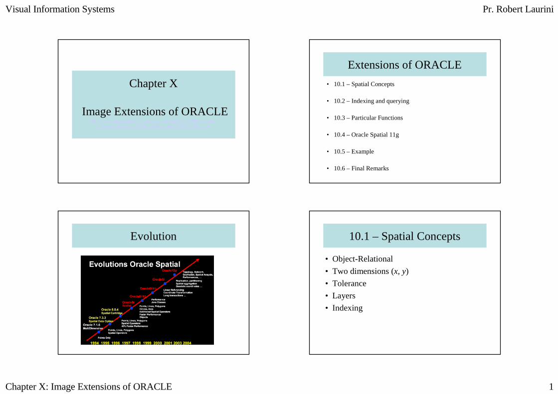
Geometric Types
• Points and sets of points
• Polyline
• Polygon
• Chain of arcs
• Compound Polygons
• Circles
• Optimized rectangles
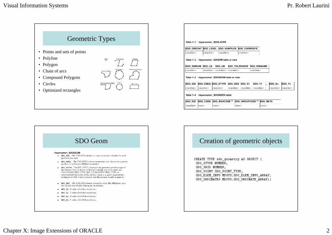
SDO Geom Creation of geometric objects
Visual Information Systems Pr. Robert Laurini
Chapter X: Image Extensions of ORACLE 3
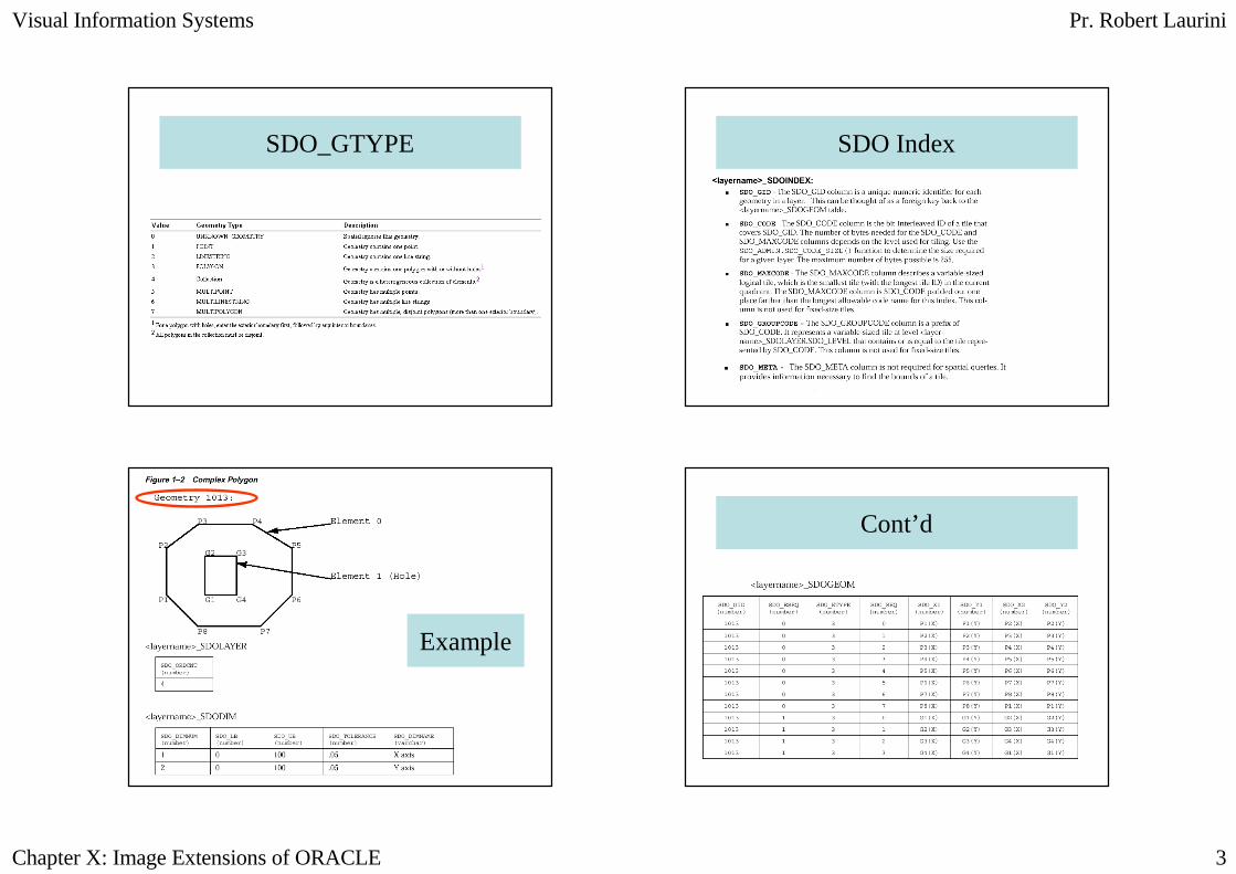
SDO_GTYPE SDO Index
Example
Cont’d
Visual Information Systems Pr. Robert Laurini
Chapter X: Image Extensions of ORACLE 4
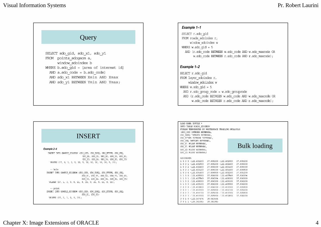
Query
INSERT
Bulk loading
Visual Information Systems Pr. Robert Laurini
Chapter X: Image Extensions of ORACLE 5
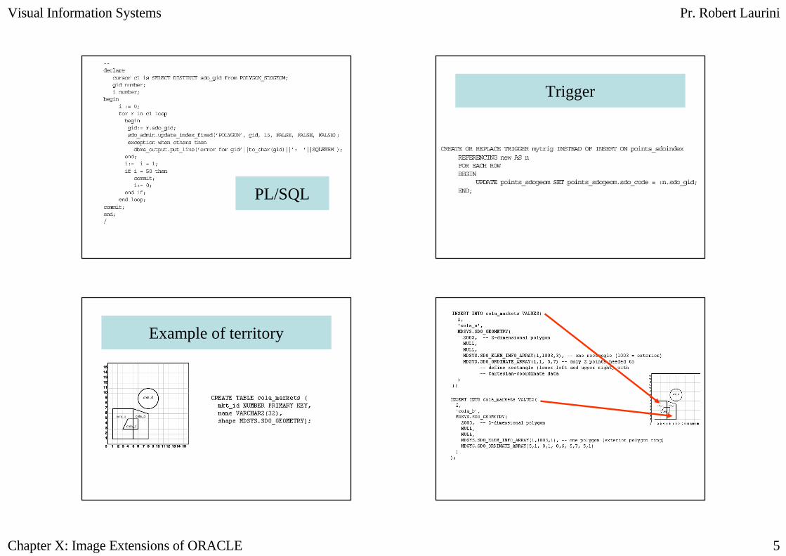
PL/SQL
Trigger
Example of territory
Visual Information Systems Pr. Robert Laurini
Chapter X: Image Extensions of ORACLE 6
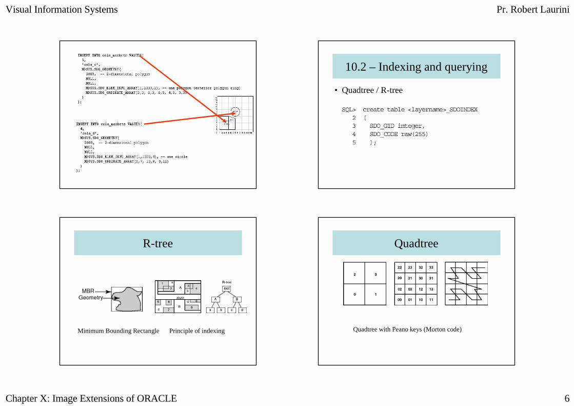
10.2 – Indexing and querying
• Quadtree / R-tree
R-tree
Minimum Bounding Rectangle Principle of indexing
Quadtree
Quadtree with Peano keys (Morton code)
Visual Information Systems Pr. Robert Laurini
Chapter X: Image Extensions of ORACLE 7
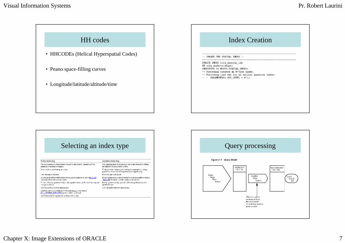
HH codes
• HHCODEs (Helical Hyperspatial Codes)
• Peano space-filling curves
• Longitude/latitude/altitude/time
Index Creation
Selecting an index type Query processing
Visual Information Systems Pr. Robert Laurini
Chapter X: Image Extensions of ORACLE 8
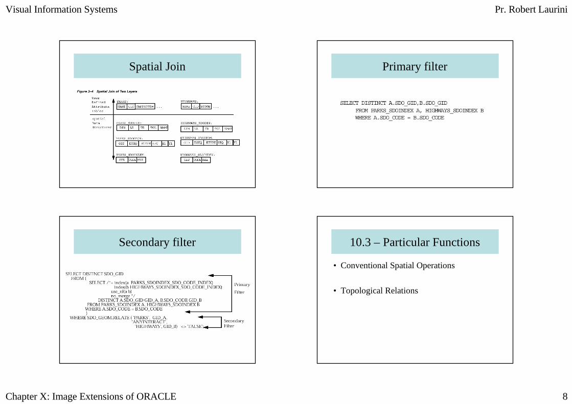
Spatial Join Primary filter
Secondary filter 10.3 – Particular Functions
• Conventional Spatial Operations
• Topological Relations
Visual Information Systems Pr. Robert Laurini
Chapter X: Image Extensions of ORACLE 9
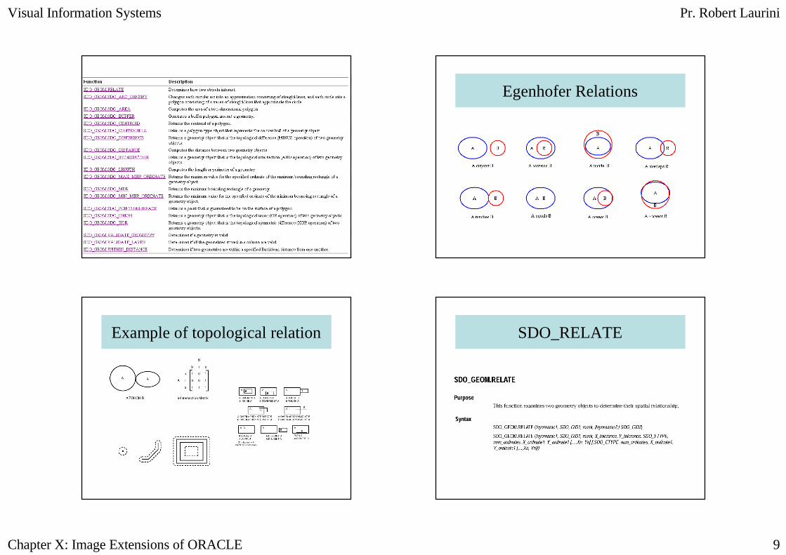
Egenhofer Relations
Example of topological relation SDO_RELATE
Visual Information Systems Pr. Robert Laurini
Chapter X: Image Extensions of ORACLE 10
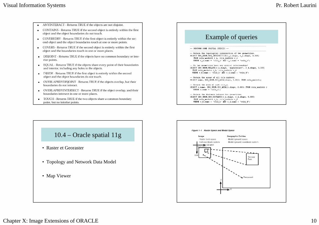
Example of queries
10.4 – Oracle spatial 11g
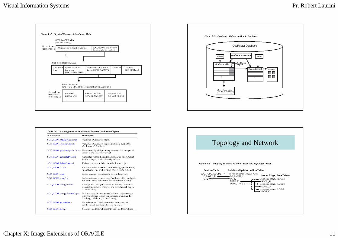
• Raster et Georaster
• Topology and Network Data Model
• Map Viewer
Visual Information Systems Pr. Robert Laurini
Chapter X: Image Extensions of ORACLE 11
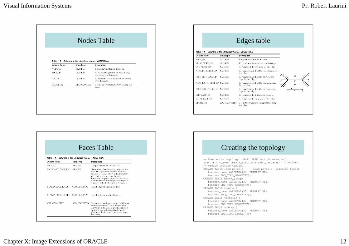
Topology and Network
Visual Information Systems Pr. Robert Laurini
Chapter X: Image Extensions of ORACLE 12
Nodes Table Edges table
Faces Table Creating the topology
-- Create the topology. (Null SRID in this example.)EXECUTE SDO_TOPO.CREATE_TOPOLOGY('LAND_USE_HIER', 0.00005);-- Create feature tables.CREATE TABLE land_parcels ( -- Land parcels (selected faces)
feature_name VARCHAR2(30) PRIMARY KEY,feature SDO_TOPO_GEOMETRY);
CREATE TABLE block_groups (feature_name VARCHAR2(30) PRIMARY KEY,feature SDO_TOPO_GEOMETRY);
CREATE TABLE tracts (feature_name VARCHAR2(30) PRIMARY KEY,feature SDO_TOPO_GEOMETRY);
CREATE TABLE counties (feature_name VARCHAR2(30) PRIMARY KEY,feature SDO_TOPO_GEOMETRY);
CREATE TABLE states (feature_name VARCHAR2(30) PRIMARY KEY,feature SDO_TOPO_GEOMETRY);
Visual Information Systems Pr. Robert Laurini
Chapter X: Image Extensions of ORACLE 13
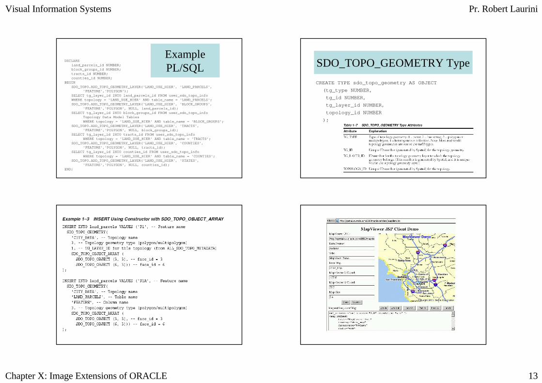
DECLAREland_parcels_id NUMBER;block_groups_id NUMBER;tracts_id NUMBER;counties_id NUMBER;
BEGINSDO_TOPO.ADD_TOPO_GEOMETRY_LAYER('LAND_USE_HIER', 'LAND_PARCELS',
'FEATURE','POLYGON');SELECT tg_layer_id INTO land_parcels_id FROM user_s do_topo_infoWHERE topology = 'LAND_USE_HIER' AND table_name = ' LAND_PARCELS';SDO_TOPO.ADD_TOPO_GEOMETRY_LAYER('LAND_USE_HIER', 'BLOCK_GROUPS',
'FEATURE','POLYGON', NULL, land_parcels_id);SELECT tg_layer_id INTO block_groups_id FROM user_s do_topo_info
Topology Data Model TablesWHERE topology = 'LAND_USE_HIER' AND table_name = ' BLOCK_GROUPS';
SDO_TOPO.ADD_TOPO_GEOMETRY_LAYER('LAND_USE_HIER', 'TRACTS','FEATURE','POLYGON', NULL, block_groups_id);
SELECT tg_layer_id INTO tracts_id FROM user_sdo_top o_infoWHERE topology = 'LAND_USE_HIER' AND table_name = ' TRACTS';
SDO_TOPO.ADD_TOPO_GEOMETRY_LAYER('LAND_USE_HIER', 'COUNTIES','FEATURE','POLYGON', NULL, tracts_id);
SELECT tg_layer_id INTO counties_id FROM user_sdo_t opo_infoWHERE topology = 'LAND_USE_HIER' AND table_name = ' COUNTIES';
SDO_TOPO.ADD_TOPO_GEOMETRY_LAYER('LAND_USE_HIER', 'STATES','FEATURE','POLYGON', NULL, counties_id);
END;
Example PL/SQL SDO_TOPO_GEOMETRY Type
CREATE TYPE sdo_topo_geometry AS OBJECT
(tg_type NUMBER,
tg_id NUMBER,
tg_layer_id NUMBER,
topology_id NUMBER
);
Visual Information Systems Pr. Robert Laurini
Chapter X: Image Extensions of ORACLE 14
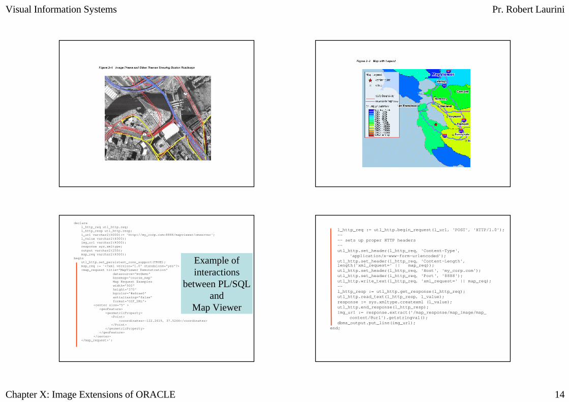
declarel_http_req utl_http.req;l_http_resp utl_http.resp;l_url varchar2(4000):= 'http://my_corp.com:8888/mapv iewer/omserver';l_value varchar2(4000);img_url varchar2(4000);response sys.xmltype;output varchar2(255);map_req varchar2(4000);
beginutl_http.set_persistent_conn_support(TRUE);map_req := '<?xml version="1.0" standalone="yes"?><map_request title="MapViewer Demonstration"
datasource="mvdemo"basemap="course_map"Map Request Exampleswidth="500"height="375"bgcolor="#a6cae0"antialiasing="false"format="GIF_URL">
<center size="5" ><geoFeature>
<geometricProperty><Point>
<coordinates>-122.2615, 37.5266</coordinates></Point>
</geometricProperty></geoFeature>
</center></map_request>';
Example ofinteractions
between PL/SQLand
Map Viewer
l_http_req := utl_http.begin_request(l_url, 'POST', 'HTTP/1.0');---- sets up proper HTTP headers--utl_http.set_header(l_http_req, 'Content-Type',
'application/x-www-form-urlencoded');utl_http.set_header(l_http_req, 'Content-Length', length('xml_request=' || map_req));utl_http.set_header(l_http_req, 'Host', 'my_corp.co m');utl_http.set_header(l_http_req, 'Port', '8888');utl_http.write_text(l_http_req, 'xml_request=' || m ap_req);--l_http_resp := utl_http.get_response(l_http_req);utl_http.read_text(l_http_resp, l_value);response := sys.xmltype.createxml (l_value);utl_http.end_response(l_http_resp);img_url := response.extract('/map_response/map_imag e/map_
content/@url').getstringval();dbms_output.put_line(img_url);
end;
Visual Information Systems Pr. Robert Laurini
Chapter X: Image Extensions of ORACLE 15
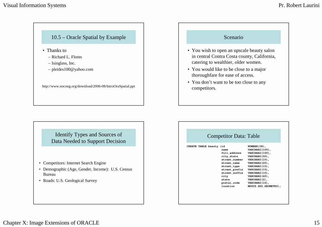
10.5 – Oracle Spatial by Example
• Thanks to – Richard L. Flores
– Isinglass, Inc.
http://www.nocoug.org/download/2006-08/IntroOraSpatial.ppt
Scenario
• You wish to open an upscale beauty salon in central Contra Costa county, California, catering to wealthier, older women.
• You would like to be close to a major thoroughfare for ease of access.
• You don’t want to be too close to any competitors.
Identify Types and Sources of Data Needed to Support Decision
• Competitors: Internet Search Engine
• Demographic (Age, Gender, Income): U.S. Census Bureau
• Roads: U.S. Geological Survey
Competitor Data: Table
CREATE TABLE beauty (id NUMBER(38),name VARCHAR2(100),full_address VARCHAR2(100),city_state VARCHAR2(50),street_number VARCHAR2(10),street_name VARCHAR2(20),street_type VARCHAR2(15),street_prefix VARCHAR2(10),street_suffix VARCHAR2(10),city VARCHAR2(40),state VARCHAR2(2),postal_code VARCHAR2(16),location MDSYS.SDO_GEOMETRY);
Visual Information Systems Pr. Robert Laurini
Chapter X: Image Extensions of ORACLE 16
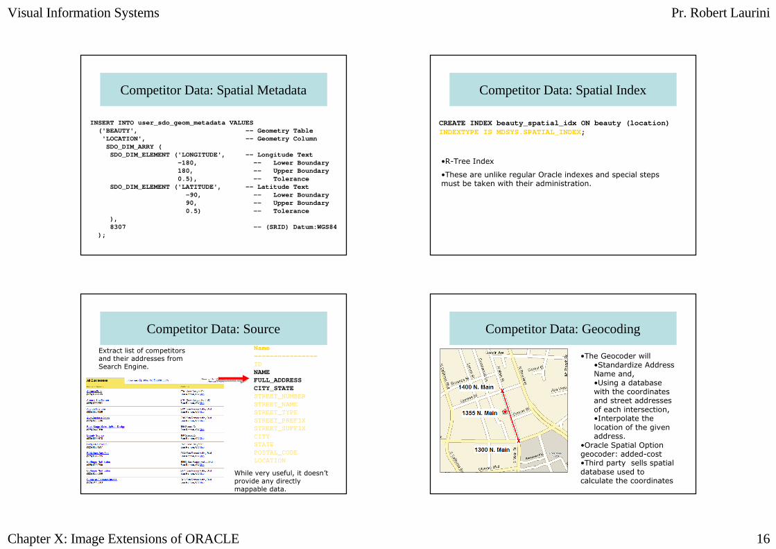
Competitor Data: Spatial Metadata
INSERT INTO user_sdo_geom_metadata VALUES ('BEAUTY', -- Geometry Tab le
'LOCATION', -- Geometry Colu mnSDO_DIM_ARRY (
SDO_DIM_ELEMENT ('LONGITUDE', -- Longitude Text-180, -- Lower Boundary180, -- Upper Boundary0.5), -- Tolerance
SDO_DIM_ELEMENT ('LATITUDE', -- Latitude Text-90, -- Lower Boundary90, -- Upper Boundary0.5) -- Tolerance
),8307 -- (SRID) Datum:WGS84
);
Competitor Data: Spatial Index
CREATE INDEX beauty_spatial_idx ON beauty (location )INDEXTYPE IS MDSYS.SPATIAL_INDEX ;
•R-Tree Index
•These are unlike regular Oracle indexes and special steps must be taken with their administration.
Competitor Data: SourceName ----------------IDNAMEFULL_ADDRESSCITY_STATESTREET_NUMBERSTREET_NAMESTREET_TYPESTREET_PREFIXSTREET_SUFFIXCITYSTATEPOSTAL_CODELOCATION
Extract list of competitors and their addresses from Search Engine.
While very useful, it doesn’t provide any directly mappable data.
Competitor Data: Geocoding
•The Geocoder will •Standardize Address Name and,•Using a database with the coordinates and street addresses of each intersection,•Interpolate the location of the given address.
•Oracle Spatial Option geocoder: added-cost •Third party sells spatial database used to calculate the coordinates

Visual Information Systems Pr. Robert Laurini
Chapter X: Image Extensions of ORACLE 17
Competitor Data: Geocoding
Solution: Use Perl Program against internet geocoding website.
#!/usr/local/bin/perl# simplest_xmlrpc.pluse XMLRPC::Lite;use Data::Dumper;use strict;use warnings;my $where = shift @ARGV
or die "Usage: $0 \"1 Main St, Anytown, KS\"\n";my $result = XMLRPC::Lite
-> proxy( 'http://rpc.geocoder.us/service/xmlrpc' )-> geocode ($where)-> result;
print Dumper $result;
From Mapping Hacks, Tips & Tools for Electronic Mapping
Competitor Data: Geocoding
simplest_xmlrpc.pl “1355 N. Main, Walnut Creek, CA"
$VAR1 = [{
'number' => '1355','street' => 'Main','lat' => '37.898365','state' => 'CA','city' => 'Walnut Creek','zip' => '94596','suffix' => '','long' => '-122.060445','type' => 'St','prefix' => 'N'
}];
Name ----------------
IDNAMEFULL_ADDRESSCITY_STATESTREET_NUMBER
STREET_NAMESTREET_TYPE
STREET_PREFIXSTREET_SUFFIX
CITYSTATE
POSTAL_CODELOCATION
Competitor Data: SDO_GEOMETRY Object-Relational Type
UPDATE beautySET location =
SDO_GEOMETRY(2001, -- Geometry Type: 2-D Point
8307, -- SRID, Datum: WGS84SDO_POINT_TYPE
(-122.060445, -- Longitude37.898365, -- LatitudeNULL),
NULL,NULL)
WHERE id = 430;
Competitor Data: Data Display
Martinez
Orinda
Dublin
Clayton
•eSpatial iSmartExplorer free on OTN
•OEM Spatial Index Advisor
•Oracle Mapviewer
•For serious users, many commercial products.
Visual Information Systems Pr. Robert Laurini
Chapter X: Image Extensions of ORACLE 18
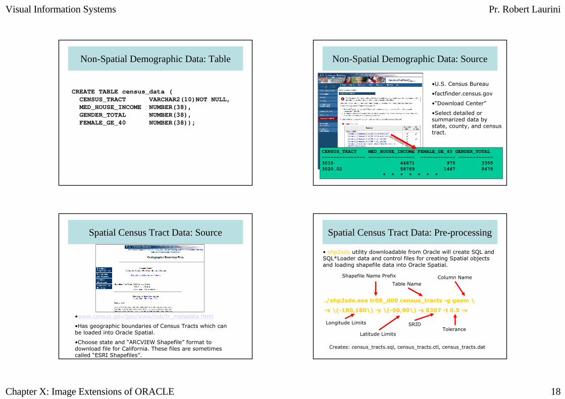
Non-Spatial Demographic Data: Table
CREATE TABLE census_data (CENSUS_TRACT VARCHAR2(10)NOT NULL,MED_HOUSE_INCOME NUMBER(38),GENDER_TOTAL NUMBER(38),FEMALE_GE_40 NUMBER(38));
Non-Spatial Demographic Data: Source
CENSUS_TRACT MED_HOUSE_INCOME FEMALE_GE_40 GENDER_TOTAL--------------- ---------------- ------------ -------- ----3010 44871 975 33553020.02 58769 1467 8475
* * * * * * *
•U.S. Census Bureau
•factfinder.census.gov
•“Download Center”
•Select detailed or summarized data by state, county, and census tract.
Spatial Census Tract Data: Source
•www.census.gov/geo/www/cob/tr_metadata.html
•Has geographic boundaries of Census Tracts which can be loaded into Oracle Spatial.
•Choose state and “ARCVIEW Shapefile” format to download file for California. These files are sometimes called “ESRI Shapefiles”.
Spatial Census Tract Data: Pre-processing
• shp2sdo utility downloadable from Oracle will create SQL and SQL*Loader data and control files for creating Spatial objects and loading shapefile data into Oracle Spatial.
./shp2sdo.exe tr06_d00 census_tracts -g geom \
-x \(-180,180\) -y \(-90,90\) -s 8307 -t 0.5 -v
Shapefile Name Prefix
Table Name
Column Name
Longitude Limits
Latitude Limits
SRIDTolerance
Creates: census_tracts.sql, census_tracts.ctl, census_tracts.dat
Visual Information Systems Pr. Robert Laurini
Chapter X: Image Extensions of ORACLE 19
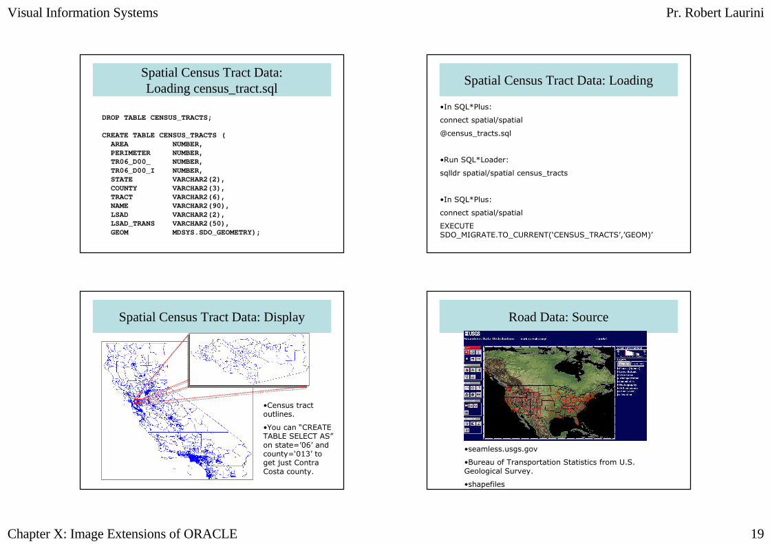
Spatial Census Tract Data: Loading census_tract.sql
DROP TABLE CENSUS_TRACTS;
CREATE TABLE CENSUS_TRACTS (AREA NUMBER,PERIMETER NUMBER,TR06_D00_ NUMBER,TR06_D00_I NUMBER,STATE VARCHAR2(2),COUNTY VARCHAR2(3),TRACT VARCHAR2(6),NAME VARCHAR2(90),LSAD VARCHAR2(2),LSAD_TRANS VARCHAR2(50),GEOM MDSYS.SDO_GEOMETRY);
Spatial Census Tract Data: Loading
•In SQL*Plus:
connect spatial/spatial
@census_tracts.sql
•Run SQL*Loader:
sqlldr spatial/spatial census_tracts
•In SQL*Plus:
connect spatial/spatial
EXECUTE SDO_MIGRATE.TO_CURRENT(‘CENSUS_TRACTS’,’GEOM)’
Spatial Census Tract Data: Display
•Census tract outlines.
•You can “CREATE TABLE SELECT AS”on state=’06’ and county=‘013’ to get just Contra Costa county.
Road Data: Source
•seamless.usgs.gov
•Bureau of Transportation Statistics from U.S. Geological Survey.
•shapefiles
Visual Information Systems Pr. Robert Laurini
Chapter X: Image Extensions of ORACLE 20
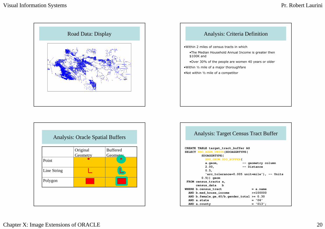
Road Data: Display Analysis: Criteria Definition
•Within 2 miles of census tracts in which
•The Median Household Annual Income is greater then $100K and
•Over 30% of the people are women 40 years or older
•Within ½ mile of a major thoroughfare
•Not within ½ mile of a competitor
Analysis: Oracle Spatial Buffers
Polygon
Line String
Point
Buffered Geometry
Original Geometry
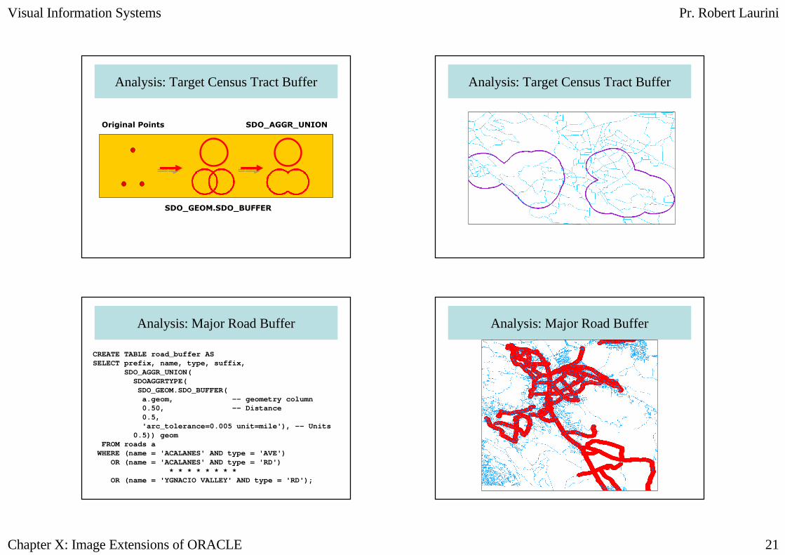
Analysis: Target Census Tract Buffer
CREATE TABLE target_tract_buffer ASSELECT SDO_AGGR_UNION(SDOAGGRTYPE(
SDOAGGRTYPE(SDO_GEOM.SDO_BUFFER(a.geom, -- geometry column2.00, -- Distance0.5,'arc_tolerance=0.005 unit=mile'), -- Units
0.5)) geomFROM census_tracts a,
census_data bWHERE b.census_tract = a.name
AND b.med_house_income >=100000AND b.female_ge_40/b.gender_total >= 0.30AND a.state = '06'AND a.county = '013';
Visual Information Systems Pr. Robert Laurini
Chapter X: Image Extensions of ORACLE 21
Analysis: Target Census Tract Buffer
SDO_GEOM.SDO_BUFFER
SDO_AGGR_UNIONOriginal Points
Analysis: Target Census Tract Buffer
Analysis: Major Road Buffer
CREATE TABLE road_buffer ASSELECT prefix, name, type, suffix,
SDO_AGGR_UNION(SDOAGGRTYPE(
SDO_GEOM.SDO_BUFFER(a.geom, -- geometry column0.50, -- Distance0.5,'arc_tolerance=0.005 unit=mile'), -- Units
0.5)) geomFROM roads a
WHERE (name = 'ACALANES' AND type = 'AVE')OR (name = 'ACALANES' AND type = 'RD')
* * * * * * * *OR (name = 'YGNACIO VALLEY' AND type = 'RD');
Analysis: Major Road Buffer
Visual Information Systems Pr. Robert Laurini
Chapter X: Image Extensions of ORACLE 22
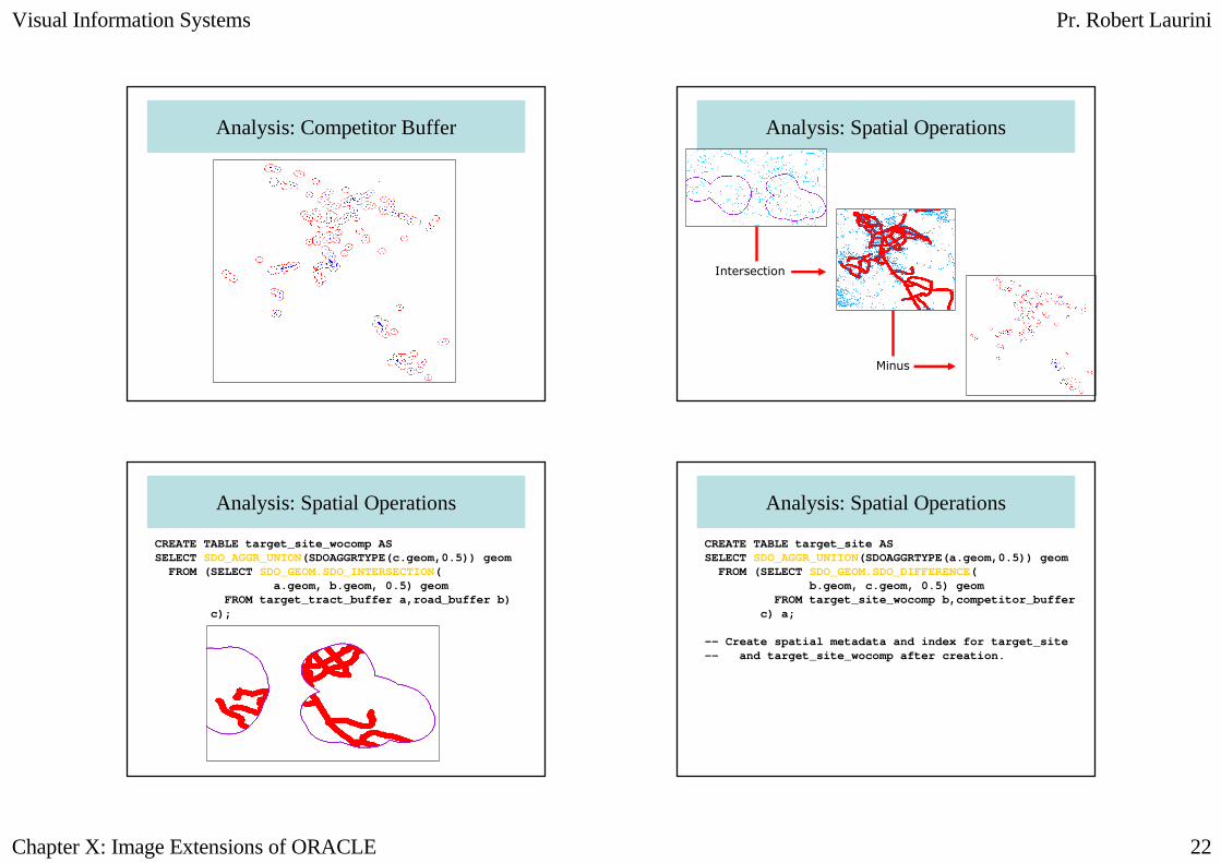
Analysis: Competitor Buffer Analysis: Spatial Operations
Intersection
Minus
Analysis: Spatial Operations
CREATE TABLE target_site_wocomp ASSELECT SDO_AGGR_UNION(SDOAGGRTYPE(c.geom,0.5)) geom
FROM (SELECT SDO_GEOM.SDO_INTERSECTION(a.geom, b.geom, 0.5) geom
FROM target_tract_buffer a,road_buffer b) c);
Analysis: Spatial Operations
CREATE TABLE target_site ASSELECT SDO_AGGR_UNIION(SDOAGGRTYPE(a.geom,0.5)) geom
FROM (SELECT SDO_GEOM.SDO_DIFFERENCE(b.geom, c.geom, 0.5) geom
FROM target_site_wocomp b,competitor_buffer c) a;
-- Create spatial metadata and index for target_site-- and target_site_wocomp after creation.
Visual Information Systems Pr. Robert Laurini
Chapter X: Image Extensions of ORACLE 23
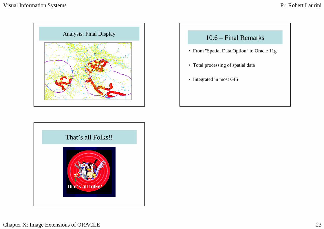
Analysis: Final Display10.6 – Final Remarks
• From "Spatial Data Option" to Oracle 11g
• Total processing of spatial data
• Integrated in most GIS
That’s all Folks!!


![Oracle Fusion Middleware Programming JSP Tag Extensions for Oracle WebLogic Server · 2015-12-17 · [1]Oracle® Fusion Middleware Developing JSP Tag Extensions for Oracle WebLogic](https://img.pdfslide.us/doc/110x75/5f0392e07e708231d409b8bb/oracle-fusion-middleware-programming-jsp-tag-extensions-for-oracle-weblogic-server.jpg)


![[1]Oracle® Fusion Middleware Java Persistence API (JPA ......Java Persistence API (JPA) Extensions Reference for Oracle TopLink 12c (12.2.1.2.0) E79114-01 October 2016 Oracle Fusion](https://img.pdfslide.us/doc/110x75/6140b6c52e263e64232a3e05/1oracle-fusion-middleware-java-persistence-api-jpa-java-persistence.jpg)