Embed Size (px)
Citation preview
ABSTRACT
This paper presents the interpretation of a set of seismic reflec-tion profiles, crossing the Auletta, Diano and Agri basins, in the axialzone of the Southern Apennines. Seismic data reveal that the genesisand evolution of the investigated basins have been controlled possi-bly since Late Pliocene by a system of NW-SE trending, normalfaults, bordering the basins, and related to SW-NE extension, stillactive in this region, as indicated by seismological (earthquake focalmechanisms), geological (stress indicators, active fault patterns) andgeodetic data.
KEY WORDS: Southern Apennines, Intermountain basins,seismotectonics, seismic reflection profiles.
RIASSUNTO
.......... ......... ........... ............ ....................... ..............................
I dati di sismicità storica e strumentale mostrano che i maggioriterremoti dell’Appennino meridionale si concentrano in una fascia,larga circa 50 km, orientata parallelamente alla catena; lungo la stes-sa fascia, si allinea una serie di bacini intramontani, bordati da fa-glie dirette, con direzione variabile da NNW-SSE a WNW-ESE.
Lo scopo di questo lavoro è di contribuire alla conoscenza diquesti bacini, nella convinzione che essi rappresentino un’impor-tante chiave di lettura per comprendere la tettonica attiva nella re-gione. I bacini di Auletta (parte della valle del Tanagro), del Vallo diDiano e dell’Alta Val d’Agri sono stati studiati attraverso l’interpre-tazione di profili sismici a riflessione, messi a disposizione da ENI-Agip. Pur non essendo stati acquisiti e processati per esplorarestrutture relativamente superficiali, i profili sismici si sono rivelatiuno strumento prezioso per investigare la geometria dei sedimentiche riempiono i bacini intermontani e delle faglie che li delimitano.Sei di questi profili, due per ciascun bacino, ritenuti rappresentatividelle linee sismiche utilizzate per questo studio, sono pubblicati nelpresente articolo.
La genesi e l’evoluzione del bacino di Auletta appaiono legate aduna faglia diretta immergente verso NE, con un rigetto di circa 2000 m,che corre lungo il suo bordo SW. Questa faglia sarebbe stata attivaalmeno tra il Pliocene superiore e il Pleistocene medio, intervallo ditempo corrispondente all’età dei sedimenti di riempimento, il cuispessore è di 600-800 m. Altre faglie, con andamento analogo, posso-no essere individuate sia ad W del bacino (Struttura dei M. Alburni)che verso E (Faglia dell’Irpinia, cui è legato il terremoto del 1980).
Il bacino del Vallo di Diano è stato generato e controllato da unset di faglie dirette principali, immergenti verso SW. L’attività di que-ste faglie a nostro avviso è iniziata almeno nel Pliocene superiore, edè continuata anche dopo il Pleistocene medio, e lo spessore della se-quenza sedimentaria di riempimento può raggiungere i 1000 m; i datinoti non consentono di escludere che tale struttura sia ancora attiva.
Il bacino dell’alta Val d’Agri mostra chiari caratteri di semi-gra-ben, controllato da faglie dirette principali immergenti sia verso SW
che verso NE, attive a partire dal Pleistocene inferiore e comune-mente considerate responsabili della sismicità attuale.
In conclusione, al di là delle differenti immersioni del piano difaglia principale, la genesi e l’intera storia evolutiva di tutti e tre i ba-cini studiati appare guidata da tettonica estensionale, con una dire-zione di massima estensione SW-NE, attiva a partire dal Pliocene su-periore. Un campo di sforzi con la stessa orientazione è ancoraattivo nella regione, come documentano i dati dei meccanismi focalie le deformazioni misurate nei pozzi profondi.
Questa storia deformativa semplice e coerente contrasta con lanotevole complessità della storia tettonica quaternaria, articolata innumerosi eventi, diversi per significato ed orientazione del campo disforzi, ricostruita da altri autori sulla base dei dati di analisi struttu-rale. Le complesse deformazioni osservate in superficie ed in parti-colare le faglie di tipo trascorrente, che dislocano in alcune aree i de-positi recenti, non costituiscono necessariamente indizi di fasideformative indipendenti, ma potrebbero essere spiegate, almeno inparte, come effetti di strutture di trasferimento tra segmenti diversidella zona in distensione, caratterizzati da diversa geometria edarticolazione dei piani di faglia principali.
TERMINI CHIAVE: Appennino Meridionale, Bacini inter-montani, sismotettonica, profili sismici a riflessione.
INTRODUCTION
Seismological data from both historical and recentearthquakes in the southern Apennines suggest that mostof the seismic deformation takes place in a relatively nar-row belt, approximately 50 km wide (see AMATO et alii,1997; SELVAGGI, 1998; GALADINI et alii, 2000a; VALENSISE
& PANTOSTI, 2001). Available data show a consistent pat-tern of, SW-NE oriented, present-day crustal extension, aswell evidenced by earthquake focal mechanisms (AMATO
& MONTONE, 1997; PONDRELLI et alii, 2002), stress indi-cators (MONTONE et alii, 1999), mapped fault patterns(CINQUE et alii, 2000; GALADINI et alii, 2000b; VALENSISE
& PANTOSTI, 2001) and geodetic data (ANZIDEI et alii,2001; D’AGOSTINO et alii, 2001; HUNSTAD et alii, 2002).
In this region, the historical seismicity occured in thesame areas where intermountain, continental and shal-low-marine basins are located, bordered by normal faults,with a pattern following the axial trend of the Apennines.This evidence suggests that the faults bordering thesebasins represent the main seismogenic faults of theregion, i.e. those responsible for the present day seismicextension. The occurrence of the extensional basins andtheir likely association with the seismicity is not a pecu-liar feature of the Southern Apennines, but can beobserved all along the mountain belt, from Northern Tus-cany (Mugello, Pontremoli), through Umbria andAbruzzo (e.g. Gubbio, Colfiorito, Norcia, Fucino), to thesouthern portion of the Apennines in Campania andBasilicata (Benevento-Mercure).
Boll. Soc. Geol. It., Volume Speciale n. 00 (2006), 00-00, 6 ff.
Extensional tectonics and seismicity in the axial zoneof the Southern Apennines
MASSIMILIANO BARCHI (*), ALESSANDRO AMATO (**), GIUSEPPE CIPPITELLI (***), SAVERIO MERLINI (***) & PAOLA MONTONE (**)
(*) Dipartimento di Scienze della Terra, Università degli Studidi Perugia.
(**) Istituto Nazionale di Geofisica e Vulcanologia, Roma.(***) ENI, Divisione Agip, San Donato Milanese (Mi).
SGI 05CR04-02 CROPQueste bozze, corrette e accompagnate dall’alle-gato preventivo firmato e dal buono d’ordine,debbono essere restituite immediatamente allaSegreteria della Società Geologica Italianac/o Dipartimento di Scienze della TerraPiazzale Aldo Moro, 5 – 00185 ROMA
Conversely, some of the studies on recent large earth-quakes have proposed that the active normal faults arevery young, as they slightly affect the topography and arenot related to well developed sedimentary basins (e.g.VALENSISE & PANTOSTI, 2001). According to theseAuthors the regional seismicity in Southern Apennines isassociated to a set of NE-dipping faults, mainly basing onthe Irpinia (1980) fault scarp (PANTOSTI & VALENSISE,1990), which is not related to significant basins and/ormorphological evidence.
The goal of this work is to contribute to understand theactive tectonics of the region by looking at the deep imagesof the intermountain basins obtained from commercialseismic reflection lines shot by ENI-AGIP in the past 20years. Seismic reflection data are compared and integratedwith available seismological and tectonic (surface geology)data, in order to highlight the geometry and timing of theongoing deformation in this highly hazardous area.
In particular, three intermountain basins (fig. 1) havebeen considered in this paper: the Auletta basin (corre-sponding to a segment of the present-day Tanagro rivervalley), the Diano basin (Vallo di Diano) and the Agribasin (corresponding to the high Agri river valley). Theshape and orientation of these basins are slightly differ-ent, spanning from WNW (e.g. Val d’Agri) to NNW (e.g.Vallo di Diano). However, they depict a general, NW-SEalignment, parallel to the Apennines mountain range.
Different interpretations have been proposed for thegenesis and evolution of these basins namely:
a) pull-apart basins, related to an important sinistralfault zone (TURCO & MALITO, 1988; KNOTT & TURCO,1991; MONACO et alii, 1998; CELLO et alii, 2000);
b) extensional basins (MENARDI NOGUERA & REA,2000);
c) basins originated as pull-apart depressions, andrecently evolved as extensional basins (ORTOLANI et alii,1992; SCHIATTARELLA et alii, 1997; GIANO et alii, 2000).
In the following sections, we first present a summaryof available seismological data; then we describe andinterpret six unpublished seismic reflection profiles,which are relevant to the geometry and kinematics ofAuletta, Diano and Agri Basins.
SEISMICITY
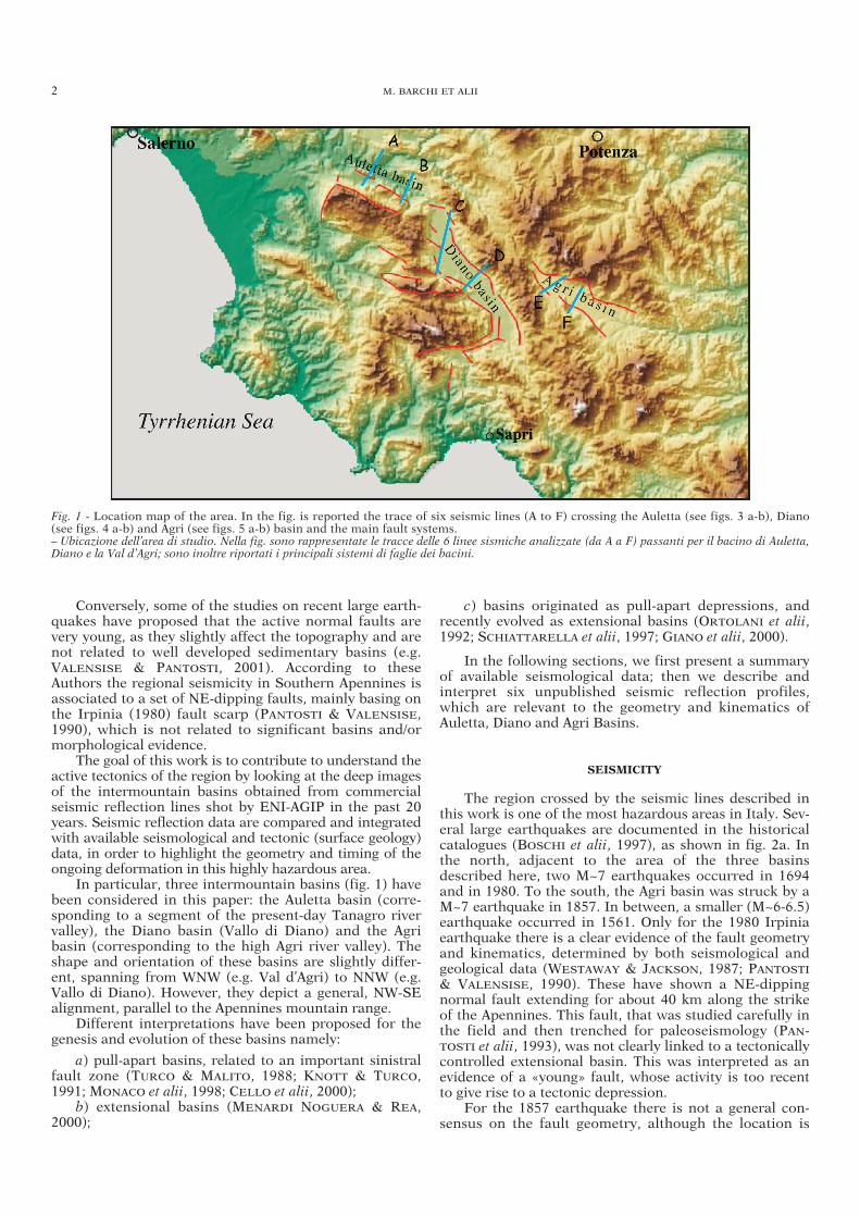
The region crossed by the seismic lines described inthis work is one of the most hazardous areas in Italy. Sev-eral large earthquakes are documented in the historicalcatalogues (BOSCHI et alii, 1997), as shown in fig. 2a. Inthe north, adjacent to the area of the three basinsdescribed here, two M~7 earthquakes occurred in 1694and in 1980. To the south, the Agri basin was struck by aM~7 earthquake in 1857. In between, a smaller (M~6-6.5)earthquake occurred in 1561. Only for the 1980 Irpiniaearthquake there is a clear evidence of the fault geometryand kinematics, determined by both seismological andgeological data (WESTAWAY & JACKSON, 1987; PANTOSTI
& VALENSISE, 1990). These have shown a NE-dippingnormal fault extending for about 40 km along the strikeof the Apennines. This fault, that was studied carefully inthe field and then trenched for paleoseismology (PAN-TOSTI et alii, 1993), was not clearly linked to a tectonicallycontrolled extensional basin. This was interpreted as anevidence of a «young» fault, whose activity is too recentto give rise to a tectonic depression.
For the 1857 earthquake there is not a general con-sensus on the fault geometry, although the location is
2 M. BARCHI ET ALII
Fig. 1 - Location map of the area. In the fig. is reported the trace of six seismic lines (A to F) crossing the Auletta (see figs. 3 a-b), Diano(see figs. 4 a-b) and Agri (see figs. 5 a-b) basin and the main fault systems.– Ubicazione dell’area di studio. Nella fig. sono rappresentate le tracce delle 6 linee sismiche analizzate (da A a F) passanti per il bacino di Auletta,Diano e la Val d’Agri; sono inoltre riportati i principali sistemi di faglie dei bacini.
well constrained by intensity data around the high Agribasin (fig. 2a). Two alternative hypotheses were proposed,with a SW- or NE-dipping normal fault by BENEDETTI etalii (1998) & VALENSISE & PANTOSTI (2001), respectively.Even more uncertain is the geometry and kinematics ofthe 1561 event: according to the DPS (Database of Poten-tial sources, VALENSISE & PANTOSTI, 2001) it could berelated either to a normal fault located between the 1980and the 1857 faults, or to a transverse structure, separat-ing normal fault segments. It is worth to note that in thesame Database, the Melandro-Pergola seismogenic sourceis not associated with any historical or instrumentalearthquake.
In general, all the data on fault plane solutions ofrecent earthquakes (fig. 2b), as well as those on in-situstress measurements in deep wells (fig. 2c) are indica-tive of a normal fault regime, with s3 trending ~NE-SW(AMATO & MONTONE, 1997). A key point for the seismo-tectonics and seismic hazard evaluation of the region iswhether the strong earthquakes of the region arerestricted to the few faults inferred from the most recentearthquakes, or if there are other potentially activefaults. In this study, we investigate if the normal faultsinferred from the seismic lines are consistent with thepast earthquakes and discuss the evidence of recentactivity.
EXTENSIONAL TECTONICS AND SEISMICITY IN THE AXIAL ZONE OF THE SOUTHERN APENNINES 3
Fig. 2 - A) Main historical earthquakes: in the table below, for the strongest events, is reported Year, Intensity and Equivalent Magnitude(BOSCHI et alii, 1997); B) focal mechanisms from Centroid Moment Solutions (PONDRELLI et alii, 2002 and references therein, GNDTproject) and relative minimum horizontal stress axis: period from 1980 to 2001; Magnitude >4.5, hypocentral depth between 8 and 25 km;C) Shmin directions (a and b represent best and worst quality for breakouts; c) indicates Shmin for fault data), inferred seismogenic sources(d) and Irpinia fault scarp trace (MONTONE et alii, 1999; VALENSISE & PANTOSTI, 2001).– A) Principali terremoti storici: nella tabella sottostante sono riportati Data, Intensità e Magnitudo Equivalente per i principali eventi (BOSCHI etalii, 1997). B) meccanismi focali da dati CMT (PONDRELLI et alii, 2002 e referenze all’interno, GNDT project «A. Amato»): periodo 1980-2001;Magnitudo >4.5, profondità ipocentrale tra 8 e 25 km; sono rappresentati anche gli assi di minimo sforzo orizzontale. C) direzione di Shmin (a e brappresentano le qualità migliori e peggiori per i dati di breakout; c) indica Shmin per i dati di faglia), probabili sorgenti sismogenetiche (d) e trac-cia in superficie della faglia irpina (MONTONE et alii, 1999; VALENSISE & PANTOSTI, 2001).
SEISMIC REFLECTION DATA
The oil companies have acquired several seismic reflec-tion profiles in this region during various exploration cam-paigns, using different acquisition and processing tech-niques, and resulting in different quality and signature.
In this study, we focused our observation onto thesegments of the profiles crossing the Quaternary basins,to get information about the internal geometry, the asym-metry and thickness of the sediments infilling the basinsand about the major faults bordering them.
Many profiles have been analysed and interpretedduring this study. Here we present six seismic profiles,two for each of the studied basins, representative of theirtectonic setting. The traces of the profiles, reported infig. 1, are oriented almost perpendicular to the basinsand to the related master faults.
Considering these data, it is important to keep inmind that:
– The seismic profiles were aimed at oil exploration:therefore, they were not acquired and processed with theaim of defining in detail the shallow structures; on thecontrary, the processing sequence has been focused to theresolution of the deeper reflections as, for example, thetop of the carbonatic platform at the footwall of theregional thrusts; consequently, the shallow reflectionsquality is often hardly acceptable;
– the quaternary continental overburden often pro-duces a seismic data impoverishment;
– the lithological homogeneity of the carbonaticrocks, which the main tectonic units of the region consistof, results in the lack of good, easily traceable reflectorswithin the bedrock.
Moreover, it is important to point out that seismicreflection data are not able to positively discriminate activefaults. Little amount of deformation and/or small offset ofthe recentmost outcropping strata could not be registered byseismic reflection profiles, being beyond the power of resolu-tion of the method: for the profiles presented in this paper,this limit can be assumed equal to about 50 m. In general,the sedimentation within these basins is not continuousuntil the present time: the sedimentary sequences infillingthe basins stop to Middle Pleistocene (Auletta and Dianobasins) or to Upper Pleistocene (Agri basin), consequentlythere is no sedimentary record of very recent deformation.
Beyond these limitations, the interpretation of seismicreflection profiles, integrated with surface geology data, isuseful for constraining the recent tectonic evolution of theregion and its seismotectonic setting, since seismic datahighlight the geometry at depth, and suggest the kinemat-ics of the structures responsible for the sedimentary evolu-tion of the recent basins, and consequently constrain thelong-term deformation throughout the Quaternary.
The following paragraphs are dedicated to the threebasins considered in this study. First, the stratigraphicand structural setting of each basin is summarised, asdepicted in the literature. Then, seismic reflection dataare illustrated in detail and commented.
THE AULETTA BASIN
The Auletta basin is a tectonic depression, trendingabout N120°, and presently hosting part of the valley of
the Tanagro River. It extends for about 20 km in lengthand 5 km in width (fig. 1).
The axial zone of the basin is infilled by the LatePliocene-Early Pleistocene continental «Auletta sequence»(LIPPMAN-PROVANSAL, 1987; ASCIONE et alii, 1992a), whichoverlies the Upper Pliocene marine deposits (AMATO etalii, 1992). The continental sequence consists of a 60 mthick clayey sequence (Argille di Auletta), followed by flu-vial conglomerates (Conglomerati di Auletta). Lower-Mid-dle Pleistocene conglomerates and travertines (Travertinidi Tufariello-Tempa Truiana) unconformably overlie theAuletta sequence.
The structural setting of the Auletta basin, as depictedby AMATO et alii (1992) & ASCIONE et alii (1992a), isasymmetric: the SW margin is characterized by sharpfault scarps, bordering the Alburni Mts. ridge, trendingabout NW-SE, whilst the NE flank shows a less markedcontact to the M. Marzano structure, trending about E-W.The main fault on the SW margin (Tanagro fault) isN120°-130° trending and is active after the deposition ofthe Conglomerati di Auletta. Other tectonic elements,mainly extensional faults and fractures, are interpreted astransfer faults between main NW-SE normal faults. TheMiddle Pleistocene deposits are slightly tilted towards SWand displaced by normal faults.
Two seismic profiles ‘A’ and ‘B’ (fig. 3) are presentedhere, crossing the Auletta basin in a SW-NE trend, almostperpendicular to the strike direction of the basin and ofthe faults bordering it.
The northermost ‘A’ profile (fig. 3a) shows the strong,westward asymmetry of the basin: the sedimentary stratainfilling the basin are tilted towards SW and draggedalong a major, NE-dipping normal fault, bordering it. Thereflectors within the underlying carbonatic rocks, at thefault hangingwall, are also tilted towards SW, possibly asa consequence of the fault activity. A second, NE-dippingnormal faults, located few km to the W of the main fault,could correspond to the eastern margin of the AlburniMts. The reflectors within the carbonates at the fault foot-wall are dragged into the fault. A set of SW-dipping, anti-thetic normal faults displaces the bottom of the sedimen-tary sequence, at the eastern flank of the basin. Thethickness of the basin infilling is about 600-700 m: thissequence can be referred to the outcropping UpperPliocene-Lower Pleistocene sequence (Auletta shales andconglomerates), followed by the Pleistocene continentalsequence, even if the deeper reflections could correspondto older Pliocene marine sediments.
The southern ‘B’ profile (fig. 3b) confirms the asym-metrical shape of the basin, as well as the average tiltingof the basinal sequence towards the NE-dipping, normal,master fault; a slight growth of the strata towards SW canbe also observed. The thickness of the syntectonicsequence is in the order of 800 m. The profile beautifullyshows the internal deformation of the basinal sequence,consisting of both synthetical (NE-dipping) and antitheti-cal (SW-dipping), minor normal faults.
These two profiles indicate that the genesis and evolu-tion of the Auletta basin is driven by a NE-dipping nor-mal fault, bordering its SW margin. The time interval ofactivity of the fault is not well constrained by availabledata. In fact, according to ASCIONE et alii (1992a), thedeposition of the Auletta sequence is not related to thebasin evolution: it was deposited in a wider area and sub-sequently downthrown into the basinal subsiding area by
4 M. BARCHI ET ALII
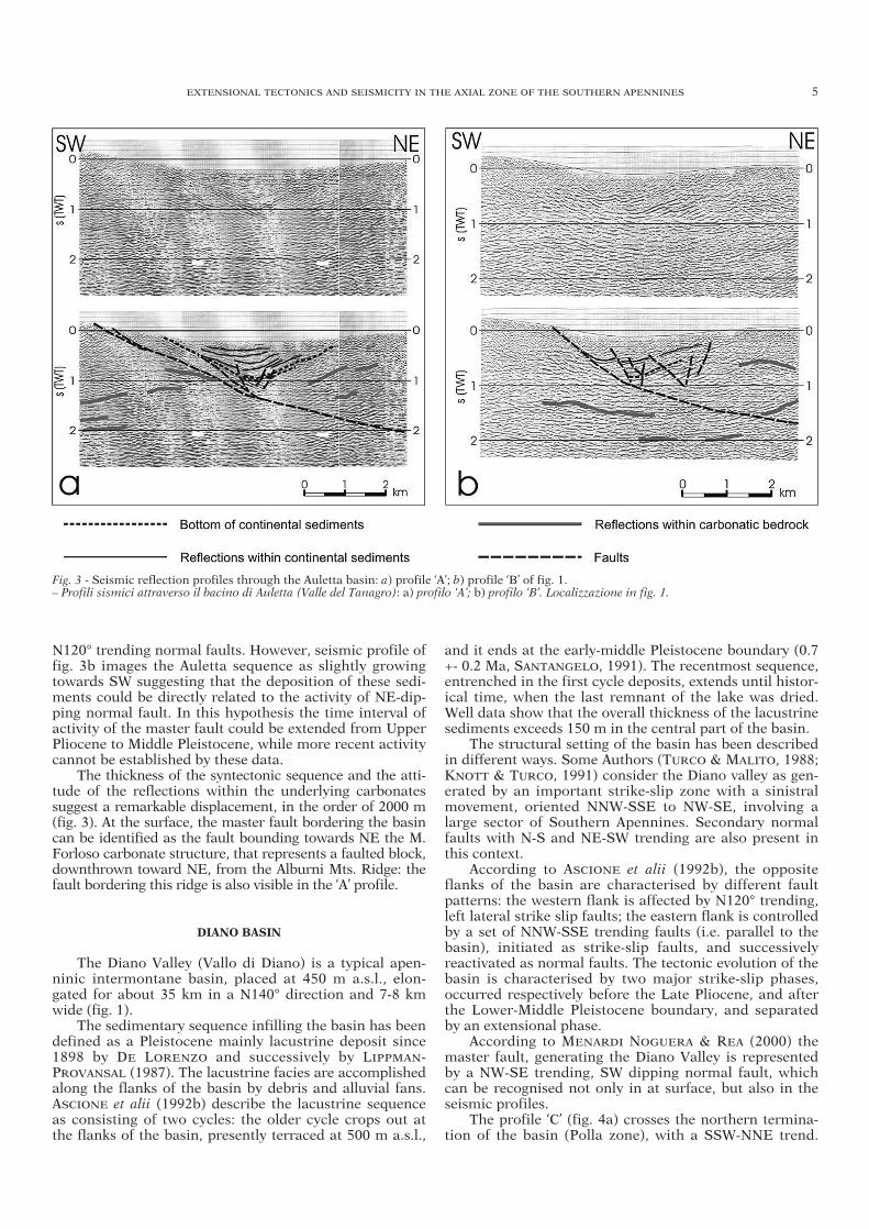
N120° trending normal faults. However, seismic profile offig. 3b images the Auletta sequence as slightly growingtowards SW suggesting that the deposition of these sedi-ments could be directly related to the activity of NE-dip-ping normal fault. In this hypothesis the time interval ofactivity of the master fault could be extended from UpperPliocene to Middle Pleistocene, while more recent activitycannot be established by these data.
The thickness of the syntectonic sequence and the atti-tude of the reflections within the underlying carbonatessuggest a remarkable displacement, in the order of 2000 m(fig. 3). At the surface, the master fault bordering the basincan be identified as the fault bounding towards NE the M.Forloso carbonate structure, that represents a faulted block,downthrown toward NE, from the Alburni Mts. Ridge: thefault bordering this ridge is also visible in the ‘A’ profile.
DIANO BASIN
The Diano Valley (Vallo di Diano) is a typical apen-ninic intermontane basin, placed at 450 m a.s.l., elon-gated for about 35 km in a N140° direction and 7-8 kmwide (fig. 1).
The sedimentary sequence infilling the basin has beendefined as a Pleistocene mainly lacustrine deposit since1898 by DE LORENZO and successively by LIPPMAN-PROVANSAL (1987). The lacustrine facies are accomplishedalong the flanks of the basin by debris and alluvial fans.ASCIONE et alii (1992b) describe the lacustrine sequenceas consisting of two cycles: the older cycle crops out atthe flanks of the basin, presently terraced at 500 m a.s.l.,
and it ends at the early-middle Pleistocene boundary (0.7+- 0.2 Ma, SANTANGELO, 1991). The recentmost sequence,entrenched in the first cycle deposits, extends until histor-ical time, when the last remnant of the lake was dried.Well data show that the overall thickness of the lacustrinesediments exceeds 150 m in the central part of the basin.
The structural setting of the basin has been describedin different ways. Some Authors (TURCO & MALITO, 1988;KNOTT & TURCO, 1991) consider the Diano valley as gen-erated by an important strike-slip zone with a sinistralmovement, oriented NNW-SSE to NW-SE, involving alarge sector of Southern Apennines. Secondary normalfaults with N-S and NE-SW trending are also present inthis context.
According to ASCIONE et alii (1992b), the oppositeflanks of the basin are characterised by different faultpatterns: the western flank is affected by N120° trending,left lateral strike slip faults; the eastern flank is controlledby a set of NNW-SSE trending faults (i.e. parallel to thebasin), initiated as strike-slip faults, and successivelyreactivated as normal faults. The tectonic evolution of thebasin is characterised by two major strike-slip phases,occurred respectively before the Late Pliocene, and afterthe Lower-Middle Pleistocene boundary, and separatedby an extensional phase.
According to MENARDI NOGUERA & REA (2000) themaster fault, generating the Diano Valley is representedby a NW-SE trending, SW dipping normal fault, whichcan be recognised not only in at surface, but also in theseismic profiles.
The profile ‘C’ (fig. 4a) crosses the northern termina-tion of the basin (Polla zone), with a SSW-NNE trend.
EXTENSIONAL TECTONICS AND SEISMICITY IN THE AXIAL ZONE OF THE SOUTHERN APENNINES 5
Fig. 3 - Seismic reflection profiles through the Auletta basin: a) profile ‘A’; b) profile ‘B’ of fig. 1.– Profili sismici attraverso il bacino di Auletta (Valle del Tanagro): a) profilo ‘A’; b) profilo ‘B’. Localizzazione in fig. 1.
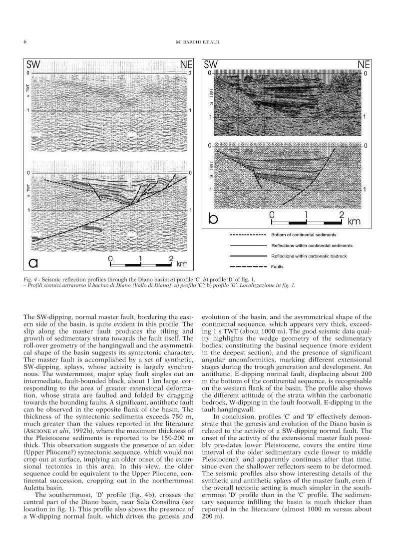
The SW-dipping, normal master fault, bordering the east-ern side of the basin, is quite evident in this profile. Theslip along the master fault produces the tilting andgrowth of sedimentary strata towards the fault itself. Theroll-over geometry of the hangingwall and the asymmetri-cal shape of the basin suggests its syntectonic character.The master fault is accomplished by a set of synthetic,SW-dipping, splays, whose activity is largely synchro-nous. The westernmost, major splay fault singles out anintermediate, fault-bounded block, about 1 km large, cor-responding to the area of greater extensional deforma-tion, whose strata are faulted and folded by draggingtowards the bounding faults. A significant, antithetic faultcan be observed in the opposite flank of the basin. Thethickness of the syntectonic sediments exceeds 750 m,much greater than the values reported in the literature(ASCIONE et alii, 1992b), where the maximum thickness ofthe Pleistocene sediments is reported to be 150-200 mthick. This observation suggests the presence of an older(Upper Pliocene?) syntectonic sequence, which would notcrop out at surface, implying an older onset of the exten-sional tectonics in this area. In this view, the oldersequence could be equivalent to the Upper Pliocene, con-tinental succession, cropping out in the northernmostAuletta basin.
The southernmost, ‘D’ profile (fig. 4b), crosses thecentral part of the Diano basin, near Sala Consilina (seelocation in fig. 1). This profile also shows the presence ofa W-dipping normal fault, which drives the genesis and
evolution of the basin, and the asymmetrical shape of thecontinental sequence, which appears very thick, exceed-ing 1 s TWT (about 1000 m). The good seismic data qual-ity highlights the wedge geometry of the sedimentarybodies, constituting the basinal sequence (more evidentin the deepest section), and the presence of significantangular unconformities, marking different extensionalstages during the trough generation and development. Anantithetic, E-dipping normal fault, displacing about 200m the bottom of the continental sequence, is recognisableon the western flank of the basin. The profile also showsthe different attitude of the strata within the carbonaticbedrock, W-dipping in the fault footwall, E-dipping in thefault hangingwall.
In conclusion, profiles ‘C’ and ‘D’ effectively demon-strate that the genesis and evolution of the Diano basin isrelated to the activity of a SW-dipping normal fault. Theonset of the activity of the extensional master fault possi-bly pre-dates lower Pleistocene, covers the entire timeinterval of the older sedimentary cycle (lower to middlePleistocene), and apparently continues after that time,since even the shallower reflectors seem to be deformed.The seismic profiles also show interesting details of thesynthetic and antithetic splays of the master fault, even ifthe overall tectonic setting is much simpler in the south-ernmost ‘D’ profile than in the ‘C’ profile. The sedimen-tary sequence infilling the basin is much thicker thanreported in the literature (almost 1000 m versus about200 m).
6 M. BARCHI ET ALII
Fig. 4 - Seismic reflection profiles through the Diano basin: a) profile ‘C’; b) profile ‘D’ of fig. 1.– Profili sismici attraverso il bacino di Diano (Vallo di Diano): a) profilo ‘C’; b) profilo ‘D’. Localizzazione in fig. 1.
THE AGRI BASIN
The Agri basin, corresponding to the high Agri rivervalley, is elongated about N120°; it is approximately 30km long and 5 km wide (fig. 1).
The Quaternary sediments of the basin are entirelyconstituted of continental clastics, represented by lowerto upper Pleistocene slope coarse-grained deposits, whichform coalescent fans along the flanks of the basin, and bymiddle Pleistocene alluvial deposits in the plain (GIANO etalii, 2000). Due to recent fluvial erosion, it is possible toobserve more than 100 m of the alluvial sequence, whichreaches a thickness of about 250m in the depocenter, asdocumented by unpublished well data (PIERDOMINICI etalii, 2002).
Some Authors (e.g. TURCO & MALITO, 1988; MONACO
et alii, 1998; CELLO et alii, 2000) refer the genesis of Agribasin to prevalent strike-slip tectonics. CELLO et alii(2000) recognize a fault system namely «Val d’Agri faultsystem» (VAFS) that crosses pre-existing, NW-SE trend-ing, tectonic structures, and would be the seismogenicstructure responsible of major seismicity of the area.The VAFS is composed by N120° left lateral faults, withassociate, transtensional and/or transpressional, minorfaults, oriented N20°-30° (right lateral) and N90°-110°(left lateral).
Other Authors (e.g. ASCIONE et alii, 1992b; ORTOLANI
et alii, 1992; SCHIATTARELLA et alii, 1997; GIANO et alii,2000) on the contrary refer the recent evolution of Agribasin to an extensional phase, reactivated since middlePleistocene times. Two different Quaternary tectonicstages are recognized: the first – lower Pleistocene – ischaracterized by strike-slip along N120° trending masterfaults; the second – since middle Pleistocene – by NW-SEtrending, normal master faults, related to a regional,extensional regime on a regional scale, with NE-SW ten-sional axis. The Quaternary, brittle faults cut the previ-ous, N-S trending, structures of the Southern Apenninesfold-and-thrust belt.
Active tectonics in the Agri basin area is documentedby both geological and seismological data. The continen-tal deposits, lower to middle Pleistocene in age, are fre-quently displaced; recent activity of tectonics is docu-mented also by 14C dating on faulted paleosoils, dated40-20 ka (GIANO et alii, 2000). Finally, the 1857 earth-quake is localized in the central part of the basin (BOSCHI
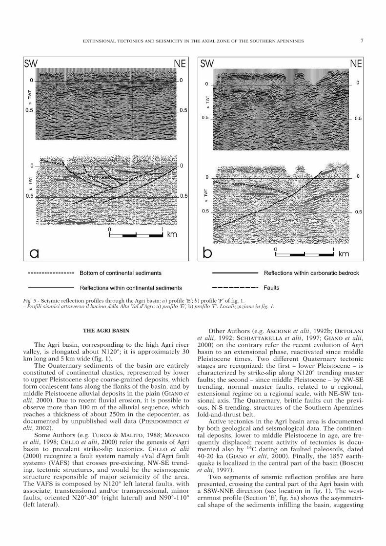
et alii, 1997). Two segments of seismic reflection profiles are here
presented, crossing the central part of the Agri basin witha SSW-NNE direction (see location in fig. 1). The west-ernmost profile (Section ‘E’, fig. 5a) shows the asymmetri-cal shape of the sediments infilling the basin, suggesting
EXTENSIONAL TECTONICS AND SEISMICITY IN THE AXIAL ZONE OF THE SOUTHERN APENNINES 7
Fig. 5 - Seismic reflection profiles through the Agri basin: a) profile ‘E’; b) profile ‘F’ of fig. 1.– Profili sismici attraverso il bacino della Alta Val d’Agri: a) profilo ‘E’; b) profilo ‘F’. Localizzazione in fig. 1.
the synsedimentary activity of a W-dipping normal fault.The maximum thickness of the continental sediments, atthe trough depocenter, is about 0.35 s TWT, roughly cor-responding to 300-400 m, comparable with surface geol-ogy observations, showing a maximum depth of about250 m (PIERDOMINICI et alii, 2002).
In the easternmost profile (Section ‘F’, fig. 5b), theinternal shape of the sediments is not recognisable, butwe can trace a well defined reflector, likely to corre-spond to the bottom of the sediments, bent toward theW-dipping master fault with a distinct roll-over geome-try: the maximum thickness of the sediments is about0.35 s TWT. The different attitude of the carbonaticbedrock, steeply W-dipping in the fault footwall, flat orgently E-dipping in the fault hangingwall, is also evi-dent.
In both profiles (fig. 5), the half-graben geometry ofthe continental basin suggests that the onset and evolu-tion of the Agri basin is related to the activity of a SW-dipping normal fault. The master fault borders the east-ern flank of the basin, and can be traced at depth tillabout 0.6 s TWT, where it tends to become slightly flatter.Some ~NE-dipping antithetic faults have been recog-nized, but their throw is negligible.
DEPTH CONVERSION OF THE PROFILES
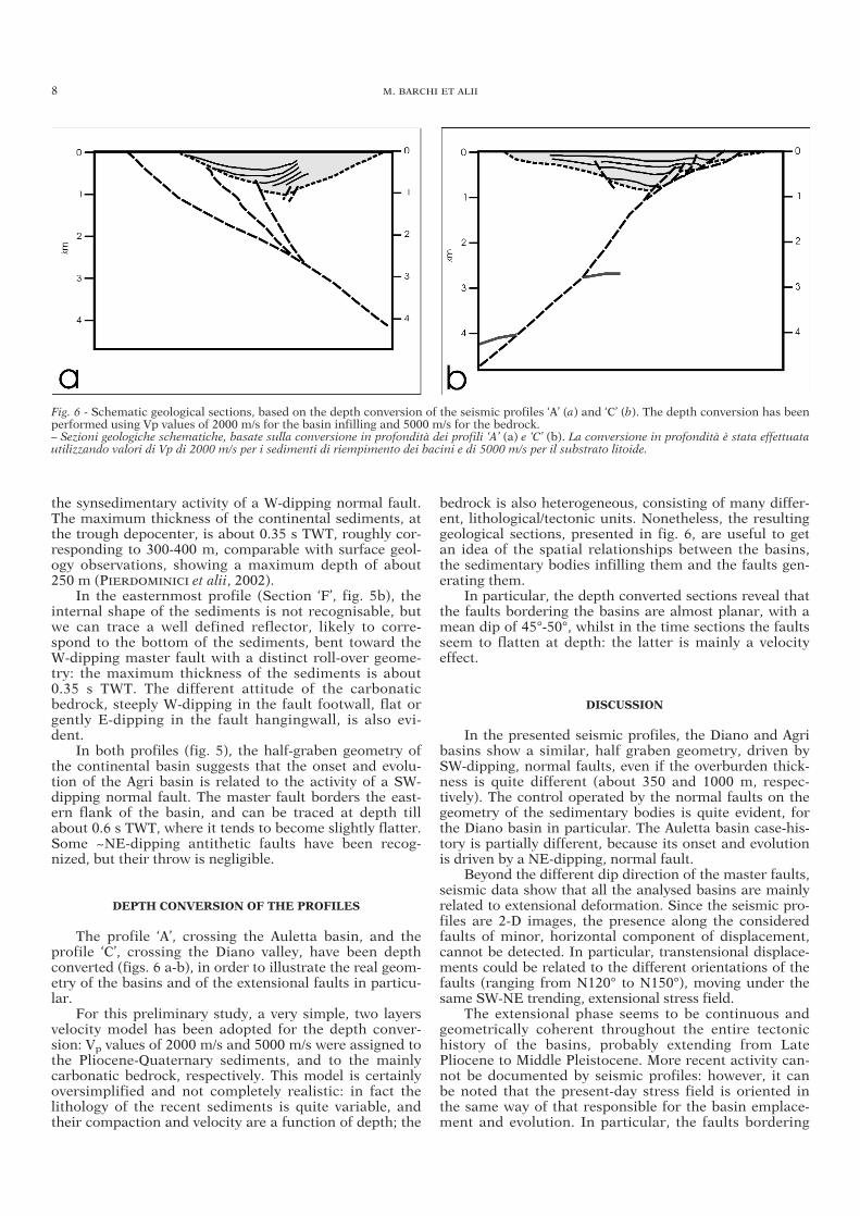
The profile ‘A’, crossing the Auletta basin, and theprofile ‘C’, crossing the Diano valley, have been depthconverted (figs. 6 a-b), in order to illustrate the real geom-etry of the basins and of the extensional faults in particu-lar.
For this preliminary study, a very simple, two layersvelocity model has been adopted for the depth conver-sion: Vp values of 2000 m/s and 5000 m/s were assigned tothe Pliocene-Quaternary sediments, and to the mainlycarbonatic bedrock, respectively. This model is certainlyoversimplified and not completely realistic: in fact thelithology of the recent sediments is quite variable, andtheir compaction and velocity are a function of depth; the
bedrock is also heterogeneous, consisting of many differ-ent, lithological/tectonic units. Nonetheless, the resultinggeological sections, presented in fig. 6, are useful to getan idea of the spatial relationships between the basins,the sedimentary bodies infilling them and the faults gen-erating them.
In particular, the depth converted sections reveal thatthe faults bordering the basins are almost planar, with amean dip of 45°-50°, whilst in the time sections the faultsseem to flatten at depth: the latter is mainly a velocityeffect.
DISCUSSION
In the presented seismic profiles, the Diano and Agribasins show a similar, half graben geometry, driven bySW-dipping, normal faults, even if the overburden thick-ness is quite different (about 350 and 1000 m, respec-tively). The control operated by the normal faults on thegeometry of the sedimentary bodies is quite evident, forthe Diano basin in particular. The Auletta basin case-his-tory is partially different, because its onset and evolutionis driven by a NE-dipping, normal fault.
Beyond the different dip direction of the master faults,seismic data show that all the analysed basins are mainlyrelated to extensional deformation. Since the seismic pro-files are 2-D images, the presence along the consideredfaults of minor, horizontal component of displacement,cannot be detected. In particular, transtensional displace-ments could be related to the different orientations of thefaults (ranging from N120° to N150°), moving under thesame SW-NE trending, extensional stress field.
The extensional phase seems to be continuous andgeometrically coherent throughout the entire tectonichistory of the basins, probably extending from LatePliocene to Middle Pleistocene. More recent activity can-not be documented by seismic profiles: however, it canbe noted that the present-day stress field is oriented inthe same way of that responsible for the basin emplace-ment and evolution. In particular, the faults bordering
8 M. BARCHI ET ALII
Fig. 6 - Schematic geological sections, based on the depth conversion of the seismic profiles ‘A’ (a) and ‘C’ (b). The depth conversion has beenperformed using Vp values of 2000 m/s for the basin infilling and 5000 m/s for the bedrock.– Sezioni geologiche schematiche, basate sulla conversione in profondità dei profili ‘A’ (a) e ‘C’ (b). La conversione in profondità è stata effettuatautilizzando valori di Vp di 2000 m/s per i sedimenti di riempimento dei bacini e di 5000 m/s per il substrato litoide.
the Agri basin are widely recognised as presently active(BENEDETTI et alii, 1998; CELLO et alii, 2000; VALENSISE
& PANTOSTI, 2001). The constant orientation of theextensional stress field in this sector of the SouthernApennines is in strong contrast with the very complextectonic history, proposed by different Authors, mainlybased on structural analysis of striated fault planes,invoking numerous, different tectonic events during theQuaternary.
A possible explanation of the kinematic complexitiesevidenced by the structural analysis data is that theycould be referred to the presence of transfer zones, link-ing different normal fault segments. For example, seismicdata show that the Auletta Basin is related to a NE-dip-ping fault, whilst the northern part of the Diano basin,few km farther to the South, is generated by a SW-dip-ping fault. The stratigraphy of the syntectonic sedimentsindicate that the activity of these two, opposite dippingfaults must be synchronous, at least for the Early-MiddlePleistocene time interval. Seismic data suggest that syn-chronous activity could have been longer, extending backtill the Late Pliocene. The synchronous activity impliesthe presence of a complex transfer zone between the twomaster faults, consisting of strike-slip and/or transten-sional faults, possibly accomplished by differently ori-ented normal fault. Another significant example is givenby the seismic profiles crossing the Diano basin, whichshow two distinct tectonic settings, even if both of themare dominated by a SW-dipping normal fault. The otherseismic profiles crossing the Diano Valley, not publishedin this study, confirm the presence of strong, along strikevariations of the fault pattern: these observations alsoclaim for the presence of transfer faults, linking the dif-ferent normal fault segments.
The interpretation of the seismic profiles is also use-ful to integrate information about the stratigraphy of thesediments within the Pliocene-Quaternary basins. Forexample, the thickness of clastic sedimentary infilling theDiano basin is much greater than that observed in theAgri river valley trough. The shallower thickness of thesediments in the Agri basin suggests a more recent onsetof extensional tectonics, as also indicated by stratigraphyand surface geology data. Along the same trend of theAgri basin, two other structures are present, namely Per-gola basin and Irpinia fault, both showing good evidenceof present day activity (seismicity and palaeoseismologi-cal data) and characterised by very shallow, recent sedi-ments.
From the data analyzed in this study at the moment,it is not clear whether the normal faults recognized in theseismic lines are still active, and can generate earth-quakes.
However, the existence of a suite of parallel contem-poraneously active normal faults in the region, ratherthan one single «characteristic» fault, is more consistentwith the extension rate measured by historical earth-quakes. These estimates range between ~2 and ~5 mm/yr(WESTAWAY, 1992; SELVAGGI, 1998; ANZIDEI et alii, 2001;HUNSTAD et alii, 2002) for the past centuries, whereas theextension rates measured from paleoseismology on indi-vidual faults are significantly lower (VALENSISE & PAN-TOSTI, 2001). It is therefore extremely important to con-strain the age of the most recent activity of the faults andtheir rate of activity, also in order to determine the seis-mic hazard of the region.
ACKNOWLEDGEMENTS
We wish to thank Eni, Divisione AGIP to permit the publicationof seismic lines and Dr. Claudio Pichi for the interesting discussionon Val d’Agri basin. Part of this work has been carried out in theframework of GNDT Project «Sviluppo e confronto di metodologieper la valutazione della pericolosità sismica in aree sismogenetiche:applicazione all’Appennino Centrale e Meridionale». and of GNDTProject «Terremoti probabili in Italia tra l’anno 2000 e il 2030: ele-menti per la definizione di priorità degli interventi di riduzione delrischio sismico».
REFERENCES
AMATO, A. & MONTONE P. (1997) - Present-day stress field and active tec-tonics in southern peninsular Italy, Geophys. J. Int., 130, 519-534.
AMATO A., CINQUE A., SANTANGELO N. & SANTO A. (1992) - Il bordomeridionale del Monte Marzano e la valle del Bianco: geologia e geomorfologia. Studi Geologici Camerti, volume speciale(1992/1), 191-200.
AMATO A., CHIARABBA C. & SELVAGGI G. (1997) - Crustal and deepseismicity in Italy (30 years after). Ann. Geofis., 40 (5), 981-994.
ANZIDEI M., BALDI P., CASULA G., GALVANI A., MANTOVANI E., PESCI
A., RIGUZZI F. & SERPELLONI E. (2001) - Insights into present-day crustal motion in the central Mediterranean area from GPSsurveys. Geophys. J. Int., 146, 98-110.
ASCIONE A., CINQUE A. & TOZZI M. (1992a) - La valle del Tanagro(Campania): una depressione strutturale ad evoluzione comples-sa. Studi Geologici Camerti, volume speciale (1992/1), 209-219.
ASCIONE A., CINQUE A., SANTANGELO N. & TOZZI M. (1992b) - Ilbacino del Vallo di Diano e la tettonica trascorrente Plio-Quater-naria: nuovi vincoli cronologici e cinematici. Studi GeologiciCamerti, volume speciale (1992/1), 201-208.
BENEDETTI L., TAPPONNIER P., KING G.C.P. & PICCARDI L. (1998) -Surface rupture of the 1857 southern Italian earthquake? TerraNova, 10, 206-210.
BOSCHI E., GUIDOBONI E., FERRARI G., VALENSISE G. & GASPERINI
P. (1997) - Catalogo dei forti terremoti in Italia dal 461 a.C. al1990. ING-SGA, Bologna, pp. 640.
CARBONE S., CATALANO S., LENTINI F., MONACO C. & LAZZARI S.(1991) - Presentazione della carta geologica del Bacino del FiumeAgri. Mem. Soc. Geol. It., 47, 129-143.
CELLO G., GAMBINI R., MAZZOLI S., READ A., TONDI E. & ZUCCONI V.(2000) - Fault zone characteristics and scaling properties of theVal d’Agri Fault system (southern Apennines, Italy). J. of Geody-namics, 29, 293-307.
CINQUE A., ASCIONE A. & CAIAZZO C. (2000) - Distribuzione spazio-temporale e caratterizzazione della fagliazione quaternaria in Ap-pennino meridionale. In Galadini F., Meletti C. & Rebez A. (Acura di). Le ricerche del GNDT nel campo della pericolosità sismi-ca (1996-1999). CNR-Gruppo Nazionale per la Difesa dei Terre-moti, Roma, 2000, 203-218.
D’AGOSTINO N., GIULIANI R., MATTONE M. & BONCI L. (2001) - Acti-ve crustal extension in the Central Apennines (Italy) inferred fromGPS measurements in the interval 1994-1999. Geophys. Res.,Lett., 28 (10), 2121-2124.
DE LORENZO G. (1898) - Reliquie di grandi laghi pleistocenici nell’Ita-lia meridionale. Atti Acc. Sc. Fis. e Mat., ser. 2, 9 (7), Napoli.
GALADINI F., MELETTI C. & REBEZ A. (A cura di) (2000a) - Le ricerchedel GNDT nel campo della pericolosità sismica (1996-1999).CNR-Gruppo Nazionale per la Difesa dei Terremoti, Roma,2000, 397 pp.
GALADINI F., MELETTI C. & VITTORI E. (2000b) - Major active faultsin Italy: available surficial data. Netherlands Journ., of Geoscien-ces, 80 (3/4), 273-296.
GIANO S.I., MASCHIO L., ALESSIO M., FERRANTI L., IMPRONTA S. &SCHIATTARELLA M. (2000) - Radiocarbon dating of active faultingin the Agri high valley, southern Italy. J. of Geodynamics, vol. 29,371-386.
HUNSTAD I., SELVAGGI G., D’AGOSTINO N., ENGLAND P., PARSONS B.& CLARKE P. (2002) - Geodetic determination of tectonic strain inpeninsular Italy between 1870 and 2001. XXVII EGS meetingNizza, 21-26 aprile 2002
EXTENSIONAL TECTONICS AND SEISMICITY IN THE AXIAL ZONE OF THE SOUTHERN APENNINES 9
KNOTT & TURCO E. (1991) - Late Cenozoic kinematics of the CalabrianArc, Southern Italy. Tectonics, 10 (6), 1164-1172.
LIPPMANN PROVANSAL M. (1987) - L’Apennin meridionale (Italie):etude geomorphologique. These de Doct., d’Etat en Geogr. Phys.,Univ. D’Aix, Marseille.
MELETTI C., PATACCA E. & SCANDONE P. (2000) - Construction of aSeismotectonic Model: the case of Italy. Pure appl. Geophys.,157, 11-35.
MENARDI NOGUERA A. & REA G. (2000) - Deep structure of the Campa-nian-Lucanian Arc (Southern Apennine, Italy). Tectonophysics,324, 239-265.
MONACO C., TORTORICI L. & PALTRINIERI W. (1998) - Structural evo-lution of the Lucanian Apennines Southern Italy. J. Struct. Geol.,20 (5), 617-638.
MONTONE P., AMATO A. & PONDRELLI S. (1999) - Active stress map ofItaly, J. Geophys. Res., 104, B11, 25595-25610.
ORTOLANI F., PAGLIUCA S., PEPE E., SCHIATTARELLA M. & TOCCA-CELI R.M. (1992) - Active tectonics in the Southern Apennines:relationships between cover geometries and basament structure.A hypothesis for a geodynamic model. IGCP 276, Newsletter, 5,413-419.
PANTOSTI D. & VALENSISE G. (1990) - Fault mechanism and com-plexity of the November, 23, 1980, Campania-Lucania earthquake,inferred from surface observations, J. Geophys. Res., 95, 15, 319-15, 341.
PANTOSTI D., SCHWARTZ D.P. & VALENSISE G. (1993) - Paleoseismo-logy along the 1980 Irpinia earthquake fault and implications forearthquake recurrence in the Southern Apennines, J. Geophys.Res., 98, 6561-6577.
PONDRELLI S., MORELLI A. & EKSTRÖM G. (1998) - Moment tensorsand seismotectonics of the Mediterranean region, Ann. Geophys.,16 suppl., C19.
PONDRELLI S., MORELLI A., EKSTRÖM G., MAZZA S., BOSCHI E. &DZIEWONSKI A.M. (2002) - European-Mediterranean regional cen-troid-moment tensors: 1997-2000, Phys. Earth Planet. Int., 130,71-101.
PIERDOMINICI S., CINTI F.R., MARIUCCI M.T. & MONTONE P. (2002) -Data from boreholes as a tool for active tectonics studies: exam-ples in Southern Apennines. International Workshop Activefaults: analysis, processes and monitoring, Camerino, 3-6/05/02.
SANTANGELO N. (1991) - Evoluzione geomorfologica e stratigrafica dialcuni bacini lacustri del confine campano-lucano (Italia meridio-nale). Tesi di Dottorato, Univ. «Federico II», Napoli.
SCHIATTARELLA M., DOGLIONI C., PROSSER G. & TRAMUTOLI M.(1997) - Large-scale geometry and kf the Southern Apennines.Riassunti EUG 9, Strasbourg, 23-27/03/1997. Terra Nova, 9,Abstract Suppl., 1, 109.
SELVAGGI, G. (1998) - Spatial distribution of horizontal seismic strainin the Apennines from historical earthquakes. Ann. Geofis., 41(2), 241-251.
TURCO E., MARESCA R. & CAPPADONA P. (1990) - La tettonica plio-pleistocenica del confine calabro-lucano: modello cinematico.Mem. Soc. Geol. It., 45, 519-529.
TURCO E. & MALITO (1988) - Formazione di bacini e rotazione diblocchi lungo faglie trascorrenti nell’Appennino meridionale.Riassunti 74° Congr. Soc. Geol. It., Sorrento, 1988.
VALENSISE G. & PANTOSTI D. (2001) - Database of potential sources forearthquakes larger than M5.5 in Italy. Ann. Geofis., suppl., 44, 4.
WESTAWAY R. (1992) - Seismic moment summation for historicalearthquakes in Italy: tectonic implications. J. Geophys. Res., 97,15437-15464.
WESTAWAY R. & JACKSON J.A. (1987) - The earthquake of 1980 Novem-ber 23 in Campania-Basilicata (southern Italy). J. of StructuralVolcanol. & Geotherm., 48, 127-137.
10 M. BARCHI ET ALII
Manoscritto pervenuto il 7 Aprile 2002; testo approvato per la stampa l’8 Febbraio 2006; ultime bozze restituite il 00 ............. 2006.


![Negotiating Acquisitions of Public Companies A Follow-Up acquisiti… · · 2013-03-21deal structure: rule 14e-5 and the “dual track” ... 2013] negotiating acquisitions of public](https://img.pdfslide.us/doc/110x75/5aa634147f8b9a7c1a8e65ec/negotiating-acquisitions-of-public-companies-a-follow-up-acquisiti2013-03-21deal.jpg)