Embed Size (px)
Citation preview
Extension of Consultancy Services for Sanitation Improvement in Kabul City
Solid Waste Management
Report of the Environmental Expert:
Environmental Impact Assessment for Contract KM 517 Construction of new landfill site # 2 in District 17
including composting facilities
November 2006
revised edition October 2007
Author: Prof. Dr. Hansjörg Oeltzschner ICON-Institute
Von-Groote-Straße 28 50968 Köln/ Germany
E1764 V1
Pub
lic D
iscl
osur
e A
utho
rized
Pub
lic D
iscl
osur
e A
utho
rized
Pub
lic D
iscl
osur
e A
utho
rized
Pub
lic D
iscl
osur
e A
utho
rized
Pub
lic D
iscl
osur
e A
utho
rized
Pub
lic D
iscl
osur
e A
utho
rized
Pub
lic D
iscl
osur
e A
utho
rized
Pub
lic D
iscl
osur
e A
utho
rized
Table of Contents:
Executive Summary
I Report
1. Introduction 1.1 Principle objectives 1.2 Programme of works (ToR) 1.3 Activities of the consultant 2. Environmental assessment (EIA)
2.1 Principles – basic elements of EIA 2.2 Sanitary landfill site (SLF) # 2 (Koh-e-Badasia) 2.2.1 Geographic and topographic situation 2.2.2 Concept of the landfill 2.2.3 Environmental impact Assessment 2.2.3.1 Geological and Hydro-geological situation 2.2.3.2 Soil quality and land use 2.2.3.3 Groundwater 2.2.3.4 Surface water 2.2.3.5 Air pollution and noise 2.2.3.6 Human environment 2.2.3.7 Environmental impact of the SLF – monitoring and mitigation measures 2.2.3.8 Composting of waste at the landfill 3. References 4. Acknowledgements II. Annex 1. Photo-documentation 2. Maps Map 2.1: Kabul and its environs, existing dump sites and proposed locations for a sanitary landfill and
transfer stations Map 2.2: Topographical map of the proposed site for a sanitary landfill # 2 (Koh-e-Badasia) Map 2.3: Location of the monitored wells # 62, 63, 64, 65 and 66 (operating since 2005) Map 2.4: Groundwater vulnerability map (source: Environmental Report, 2005)
3 Graphs and Tables Fig. 1: Climate of Kabul in 2004; blue area: precipitation, red line: mean temperature Fig. 2 and 3:: Lithology of the subsurface at the landfill site # 2 (borehole 1 and 2) Fig. 4 and 5: Methods of final capping of a landfill Fig. 6: System of a simple gas vent with flare Table 1: Climate in Kabul in 2005 (source: Meteorology Authority, Ministry of Transport and
Civil Aviation) Table 2: Prevailing wind directions in the Kabul Basin in the years from 1964 to 1977 (source:
Environmental Report 2005)
Table 3: Results of groundwater analysis (July 2006) of 5 wells in the Chamtala area; (Analysis by the Environmental Health Department, Ministry of Health, Kabul)
Executive Summary
The Short Term Expert (STE) has carried out a fourth mission in Kabul as Environmental/Geo-technical Expert and member of the team of Gauff Engineers, Frankfurt. He stayed in Kabul from October 30th until November10th, 2006. In accordance with the partners of the consultant team the STE has carried out (besides other tasks) the assessmentof environmental impacts caused by the planned new sanitary landfill site # 2 at
the Koh-e-Badasia mountain range The results of the STE’s investigations and evaluations are: The chosen area being part of the foot of the mountain slope has a natural incline, which allows the drainage of the surface water (and the collected leachate) very easily. Two ridges and some natural 1 – 2 m deep erosion ditches divide the whole area. The proposed SLF will be situated on a talus slope fan, which consists of “mixed” sediments i.e., a mixture of rocks of different size, bedded in sandy-silty material. The results of the excavation of 5 test pits made in the SLF area show that from the surface to a depth of almost 3 m (the test pits were not excavated deeper) a brown, dry sandy silt with gravel and rocks was found. The density / consistency of this material is rather high and as a consequence its permeability is rather low (< = 10-7
mm/s), so it can be regarded as a sufficiently good natural geological barrier. The SLS site # 2 can be defined as range-land i.e., very poor soils with grassland, forbs, low shrubs. It is of an extremely poor agricultural quality and not favorable for any crops, to be used only as (poor) pasture land for sheep and goat. The distance of the proposed area to the next settlements is about 1.2 km, which means there are no negative impacts caused by bad odors and noise possibly emitted from the SLS. There are 2 wells west at the Kundus- highway.
I. Report
1. Introduction
1.1 Principal Objectives The Environmental and Social Safeguards Framework provides general policies, guidelines, codes of
practice and procedures to be integrated into the implementation of World Bank supported emergency
reconstruction operations in Afghanistan. Consistent with existing national legislation, the objective of
the Framework is to help ensure that activities under the proposed reconstruction operations will:
• Protect human health; • Prevent or compensate any loss of livelihood; • Prevent environmental degradation as a result of either individual subprojects or their
cumulative effects; • Enhance positive environmental and social outcomes; and, • Ensure compliance with World Bank safeguard policies. The Kabul Sanitation component of the ARTF-financed Short-term support to the UWSS
sector mainly comprises interventions in Solid Waste Management and On-site Sanitation,
here especially the sub-component 3.1: “Engineering design and bidding documents for
ARTF-funded Kabul sanitation component”.
The Consultant will identify and assess the potential social and environmental impacts of the
proposed interventions, evaluate alternatives and as applicable, will propose and design
appropriate mitigation, management and monitoring measures in accordance with the
principles and guidelines of the Bank’s Social and Environmental Safeguards Framework
The Content of an Environmental Assessment Report for a Category A Project (see World
Bank’s Operational Manual BP/OP 4.01 concerning environmental impact assessment). is
defined as follows [26]:
“Environmental impact assessment (EIA) is an instrument to identify and assess the potential environmental impacts of a proposed project, evaluate alternatives, and design appropriate mitigation, management, and monitoring measures. Projects and subprojects need EIA to address important issues not covered by any applicable regional or sectoral EA.”. According to Annex B of the WB Operational Manual an environmental assessment (EA) for a
sanitary landfill defined as a Category A project (as well as other waste treatment facilities as
regarded in this investigation) has to be carried out.
“A proposed project is classified as Category A, if it is likely to have significant adverse environmental impacts that are sensitive, diverse, or unprecedented. These impacts may affect an area broader than the sites or facilities subject to physical works. EA for a Category A project examines the project's potential negative and positive environmental impacts, compares
them with those of feasible alternatives (including the "without project" situation), and recommends any measures needed to prevent, minimize, mitigate, or compensate for adverse impacts and improve environmental performance, focuses on the significant environmental issues of a project. The report’s scope and level of detail should be commensurate with the project's potential impacts”. An environmental assessment (EA) report for a Category A project focuses on the significant
environmental issues of a project. The report’s scope and level of detail should be commensurate with
the project’s potential impacts.
1.2 Program of works - ToR - (first tranche 2006-2007 of medium-term program)
Prof. Dr. Hansjoerg Oeltzschner is as “Environmental Expert”/Short Term Expert (STE) a
member of the team of Gauff Engineers, Frankfurt. He had already stayed in Kabul on three
missions: in March/April 2004, in October 2004 and in April 2005.
For his fourth mission the STE started from Munich on October 29th, 2006 and arrived in
Kabul on October 30th, 2006. He stayed in Kabul until November 10h, 2006 and arrived the
next day in Munich.
According to the contract with ICON –INSTITUTE, Cologne, Germany, with the date of
18.10.2006, and according to the Technical Proposal for the Extension of Consultancy
Services for Sanitation Improvements in Kabul [GAUFF 2006] the Consultant will proceed
and assess the social and environmental impacts of the proposed investments and propose
mitigation and management measures in accordance with the principles and guidelines of the
Bank’s Social and Environmental Safeguards Framework:
• Construction of the first stage of a new solid waste landfill (site No. 2), including improvement of the existing access road and supply of equipment, and preparatory works for a composting plant;
• Construction of a Sewage Sludge Treatment Plant in District 18, upon confirmation of approval of the selection of site by the Municipality.
• Construction of a waste transfer station
• Rehabilitation works on the Chamtala dumpsite, including gravel-paved access road, ditching and bordering dam, profiling of the operating cell and fencing.
A part of these tasks such as geo-technical investigations and environmental evaluation at
the proposed waste treatment sites has already been carried out by the STE during the
former missions (see annex 1 and Environmental Report 2005).
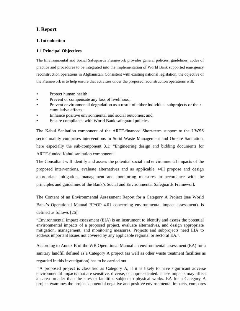
Fig. 1: Satellite photography of the Kabul Basin (source: Google Earth). The location of the planned
landfill site # 2 and of the planned sewage sludge treatment plant is marked with green arrows.
1.3 Activities of the consultant Table 1 is showing the schedule of the STE’s activities during his stay in Kabul from Oct.
29th, 2006, until November 10th, 2006.
Table 1: Work Report of the Environmental Expert, Oct./Nov.2006
day work Remarks
29-10-06 Start from Inning/Munich, flight to Kabul via Dubai; overnight stay Start from
residence 7 h.
30-10-06 Arrival at Kabul
Meeting with Mr. Schimanski and Mr. Schuhmacher at the office,
Site visit of Tarakhel (planned sewage treatment plant) and the site of
the planned waste transfer station near the Bagram Road
Arrival at guest-
house 11 h.
11 – 16 h site
visit. Office work
31-10-06 Site visit of the Chamtala dumpsites and 5 wells at the Kundus highway
and in the Chamtala area. Office work
8.30 –17.00 h
01-11-06 Visit of the Department of Public Health (well monitoring); office work 8.30 – 17.00 h
02-11-06 Weekly meeting at the municipality, project progress discussion;
Office work
8.30 -13.00 14.00
– 18.00 h
03-11-06 Friday (holiday); travel to the Salang Pass; preparation of the report in
the guesthouse
8.30 – 17.00 h
19.00 – 21.30 h
04-11-06 Collection of water samples from the wells near the new landfill site and
in the Chamtala area; meeting with the advisor of the Worldbank, Mr.
Ali Forouhar ; office work
8.30 – 11.00
11.00 – 13.00 h
14.30 – 18.00 h
05-11-06 Delivery of the draft of the present report to the representative of Gauff
Engineers. Visit of the row houses
8.15 – 17.00
14.30 – 16.30
06-11-06 Meeting with the representative of the drilling company, Mr.
Mohammad Eisa Sardar Zada (Drilling of test holes at site # 2) in the
office. Work on the evaluation of the Pilot Projects
8.15 – 17.00
07-11-06 Office work 8.15 – 17.00
08-11-06 Visit of new public toilets in district 9 and 16;
office work
9.00 – 110.30
8.15 – 17.00
09-11-06 Office work; visit of Gazak dump site
10-11-06 Office work
Flight back to Munich via Dubai. Start from Kabul 16.00 h
Start 13 h from
guesthouse;
11-11-06 Arrival at Munich. Travel back to residence Arrival at
residence
The final review of the collected material and the final preparation of the draft of this report
was carried out in Kabul in the time from 30th October to 5th of November, 2006. The draft
was delivered to the GAUFF – representative on November 5th, 2006.
From November 5th to November 10th, 2006 the STE worked on the evaluation of the pilot
project (see special report “Update of the Strategic Sanitation Plan – Assessment of the pilot
projects”). In January 2007 after receiving new informations a supplement of the draft report
was elaborated by the STE concerning the final closure and rehabilitation of the actual
Chamtala dumpsite.
2. Results of the Environmental assessment:
2.1 Principles / basic elements of EIA According to the principles of an environmental assessment (see 1.1) the following basic elements of
the environment and the environmental impact on these elements have to be regarded:
• Soil (Morphology, Geology, Geo-techniques, soil quality, land use) • Water ( Geo-hydrology, hydrology, surface water and groundwater) • Air (Climate, atmospheric conditions e.g., wind, precipitation, noise) • Human environment (social impact on housing areas etc.)
With regard to these principle elements at the concerned sites (landfill and dumping sites, waste transfer station and sludge treatment facility) the following conditions have to be investigated and assessed: − Topography / morphology − Geology, geotechnical situation − Geo-hydrology, groundwater − Hydrological, surface water conditions − Pedologic situation and land-use − Climatic/meteorological conditions, − Nature protection areas e.g., national parks, forests, nature monuments etc. − Cultural sites (religious, heritage etc.) − Military areas − Residential areas (settlements) − Distance to airports (danger of bird-strike) Furthermore there is to be regarded the: − Availability of land − Existing traffic links − Access to selected sites Criteria excluding an area from the site selection process are: • Existing or planned (i. e. already officially registered) drinking water-protection- and catchment-
areas • High-flood-areas • Karst and similar areas with soil conditions, which allow a fast permeation of contaminated water
or leachate to the nearest aquifer • Areas with unstable ground like swamps, moors and/or marshes • Areas with an extreme morphology (steep slopes, danger of landslides/avalanches etc.) • Areas endangered by sink holes, collapsible sites, deep excavations • Areas nearer than 300 m (minimum distance) to inhabited sites • National parks, nature protection areas and nature monuments, areas with precious biotopes • Areas close to religious and cultural sites (e. g., temples, graves, holy shrines etc.)
• Military areas
Civil aviation buffer zones: areas nearer than 3 km (10 000 feet) to an airport mainly concerning bird strike hazard (see [EPA 2003] documents: the US-Federal Aviation Administration (FAA), Order 5200.5A (Appendix I) prohibits the disposal of SMW within the distance of 10000 feet (3000 m) of any airport).
A general environmental assessment of the environmental conditions in the Kabul Basin and of the
proposed sites has been already carried out during former missions (see [04], [05], [06], [08], [09],
[10]).
In the following chapters the environmental impact, which may be caused by the proposed sites and
the Chamtala dumpsites will be discussed more in detail.
2.2 Sanitary landfill at site # 2 (Koh-e-Badasia)
2.2.1 Geographic and topographic situation
As a consequence of the first mission of the STE in 2004 it was found that according to the
comparative rating of potential sanitary landfill sites (SLF) there is a clear preference for site number 2
(Koh-e-Badasia). It had been evaluated as the best choice with minimum environmental impact and
good technical advantages.
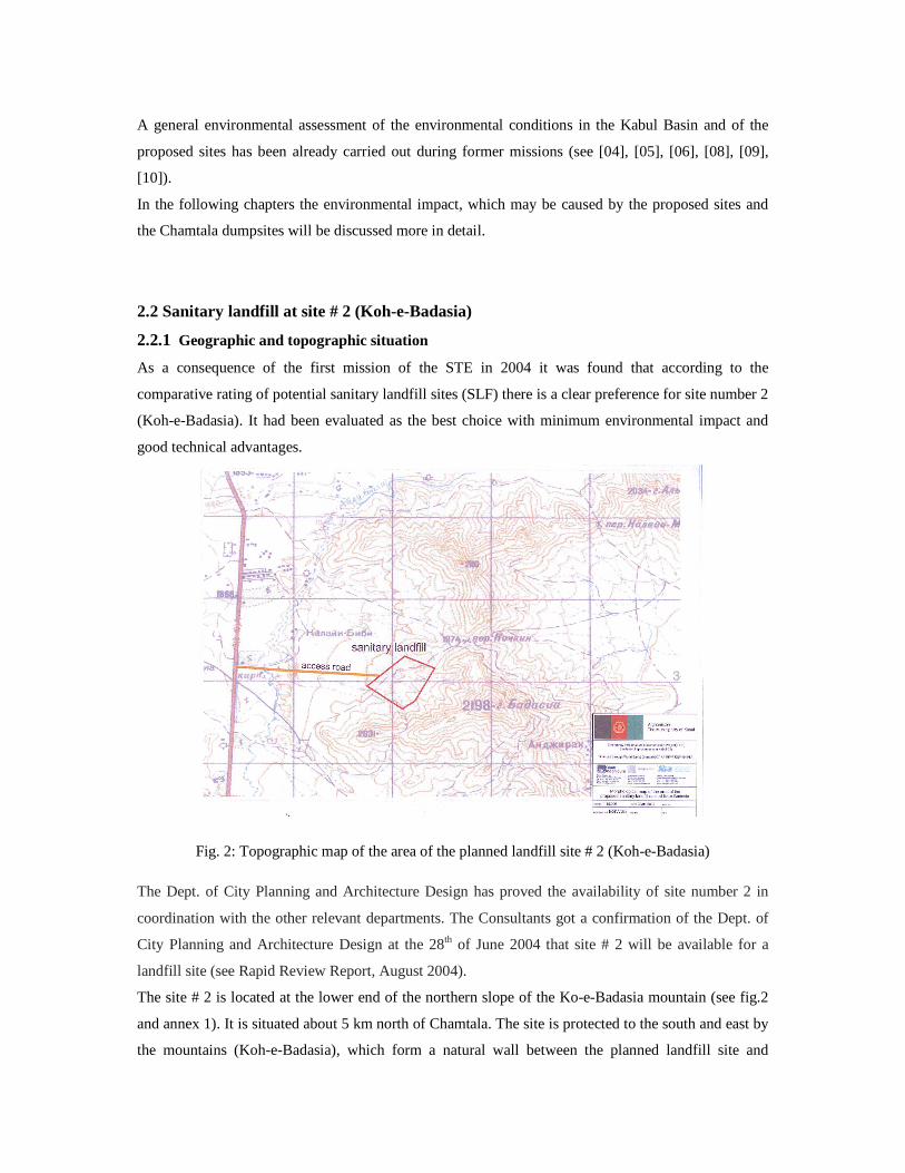
Fig. 2: Topographic map of the area of the planned landfill site # 2 (Koh-e-Badasia)
The Dept. of City Planning and Architecture Design has proved the availability of site number 2 in
coordination with the other relevant departments. The Consultants got a confirmation of the Dept. of
City Planning and Architecture Design at the 28th of June 2004 that site # 2 will be available for a
landfill site (see Rapid Review Report, August 2004).
The site # 2 is located at the lower end of the northern slope of the Ko-e-Badasia mountain (see fig.2
and annex 1). It is situated about 5 km north of Chamtala. The site is protected to the south and east by
the mountains (Koh-e-Badasia), which form a natural wall between the planned landfill site and

housing areas near Chamtala. West of the site the village of Karz-e Mir lies in a distance of about 4
km.
The distance from the highway to the site is about1,5km. The distance from this site to the Shar-e-Naw
Parc (Kabul centre) is about 13 km, the distance to the proposed transfer station east of the airport is
about 22 km. At the time being the access to site # 2 is a dust road of extremely poor quality from
Highway # 2 (Kundus Highway).
2.2.2 Technical concept of the landfill
The proposed site covers an area of about 25 ha, but may be enlarged by 5 ha when a part of the
(privately owned) flat area west of the dust road can be used for the SLF. The access to the area, where
the site is located, is partly very good: 4-lane asphalt paved Kundus-highway, but for the access from
the main road to the site itself (about 1.3 km) no existing roads can be used. Therefore the land for the
access road has to be acquired, and this access road has to be built completely new.
The chosen area being part of the foot of the mountain slope has a natural incline (see annex
1), which allows the drainage of the surface water (and the collected leachate). The altitude of
the site ranges from about 1915 m alongside the dust road to 1950 m a.s.l. on the elevated
parts of the slope. Two ridges and some erosion ditches, which form 1 – 2 m deep wadis in
the lower part of the site divide the whole area. During the stay of the STE the bottom of the
erosion ditches crossing the area was dry.
In order to have enough area for an extension of the landfill site, it is necessary to keep as a reserve
area the flat slope downhill of the passing gravel road, which may form the lower border of the landfill
site in the beginning. About 100 m to 150 m downhill with a length of about 400 m (see map) should
be kept as a reserve area. A problem will be, that this area is claimed as private property!
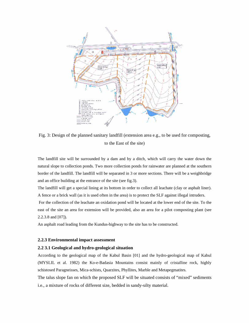
Fig. 3: Design of the planned sanitary landfill (extension area e.g., to be used for composting,
to the East of the site)
The landfill site will be surrounded by a dam and by a ditch, which will carry the water down the
natural slope to collection ponds. Two more collection ponds for rainwater are planned at the southern
border of the landfill. The landfill will be separated in 3 or more sections. There will be a weighbridge
and an office building at the entrance of the site (see fig.3).
The landfill will get a special lining at its bottom in order to collect all leachate (clay or asphalt liner).
A fence or a brick wall (as it is used often in the area) is to protect the SLF against illegal intruders.
For the collection of the leachate an oxidation pond will be located at the lower end of the site. To the
east of the site an area for extension will be provided, also an area for a pilot composting plant (see
2.2.3.8 and [07]).
An asphalt road leading from the Kundus-highway to the site has to be constructed.
2.2.3 Environmental impact assessment
2.2 3.1 Geological and hydro-geological situation
According to the geological map of the Kabul Basin [01] and the hydro-geological map of Kabul
(MYSLIL et al. 1982) the Ko-e-Badasia Mountains consist mainly of cristalline rock, highly
schistosed Paragneisses, Mica-schists, Quarzites, Phyllites, Marble and Metapegmatites.
The talus slope fan on which the proposed SLF will be situated consists of “mixed” sediments
i.e., a mixture of rocks of different size, bedded in sandy-silty material.
The results of the excavation of 5 test pits made in the relevant area show more or less the
same soil profile ( see Environmental Report 2005):
From surface to a depth of almost 3 m (the test pits were not excavated deeper) a brown, dry
sandy silt with gravel and rocks (according to grain size analysis), was found. The density /
consistency of this material is rather high and as a consequence its permeability is quite low
(< = 10-7 mm/s), so it can be regarded as a sufficiently good geological barrier.
In November/December 2006 two boreholes have been drilled until the depth of 15m and of
17 m at the lower border of the planned landfill next to the gravel road. As the drilling
protocol shows (see annex 3.4), until a depth of about 7m diluvial gravel with sand (50 %)
and clay (50 %) was excavated. From 7 – 9 m depth a stratum of sand with different grain size
was found. From 9 to 13 /16 m depth sandy argillite gravel had been hauled. At a depth of 13
m (borehole 1), respectively 16 m (borehole 2) the borer found rock. The boring was finished
after the drilling of 1, respectively 2 m in solid rock.
The drillings proved that there is no groundwater in the area of the proposed landfill and that
there the geological situation is a perfect barrier against pollution by leachate.
2.2.3.2 Soil quality and land use
According to a map edited by AIMS “Land-cover Classification 1993” the area in the north of
Kabul City, where the proposed landfill site # 2 is located is defined as range-land i.e., very
poor soils with grassland, forbs, low shrubs. By the excavation of the test pits in this area it
could be seen that the excavated soil – a sandy silt with rocks – is of an extremely poor
agricultural quality and not favorable for any crops.
Therefore it is quite understandable that the area of the proposed landfill site and its
surroundings never had been used for agricultural purpose, only as (poor) pastureland for
sheep and goats.
2.2.3.3 Groundwater
There are no indications of groundwater in the direct environment of the landfill site, but
about 1.5 km to the west of the proposed site directly there are 2 wells besides the Kundus
highway, which are already registered and monitored by the Environmental Health
Department of the Ministry of Health (see annex 1 and 3). Well # 66 is located in the
backyard of a (Shell) gasoline station east of the Kundus-highway, well # 65 is situated
besides a police station west of the highway (see annex 2 and 3). Both wells are about 25 m
deep and the water table is found about 16 -20 m below surface. The analysis of the water
quality (see annex 3) of well # 65 shows a light pollution by e.coli (6 colonies), well # 66 has
a drinking water quality.
The distance from the site to these wells and the very low permeability of the subsoil between
the landfill and the wells can be regarded as a good protection against a possible pollution of
the wells by the leachate of the landfill site. When groundwater is found at least 2 monitoring
wells should be established in the west of the landfill near the existing gravel road.
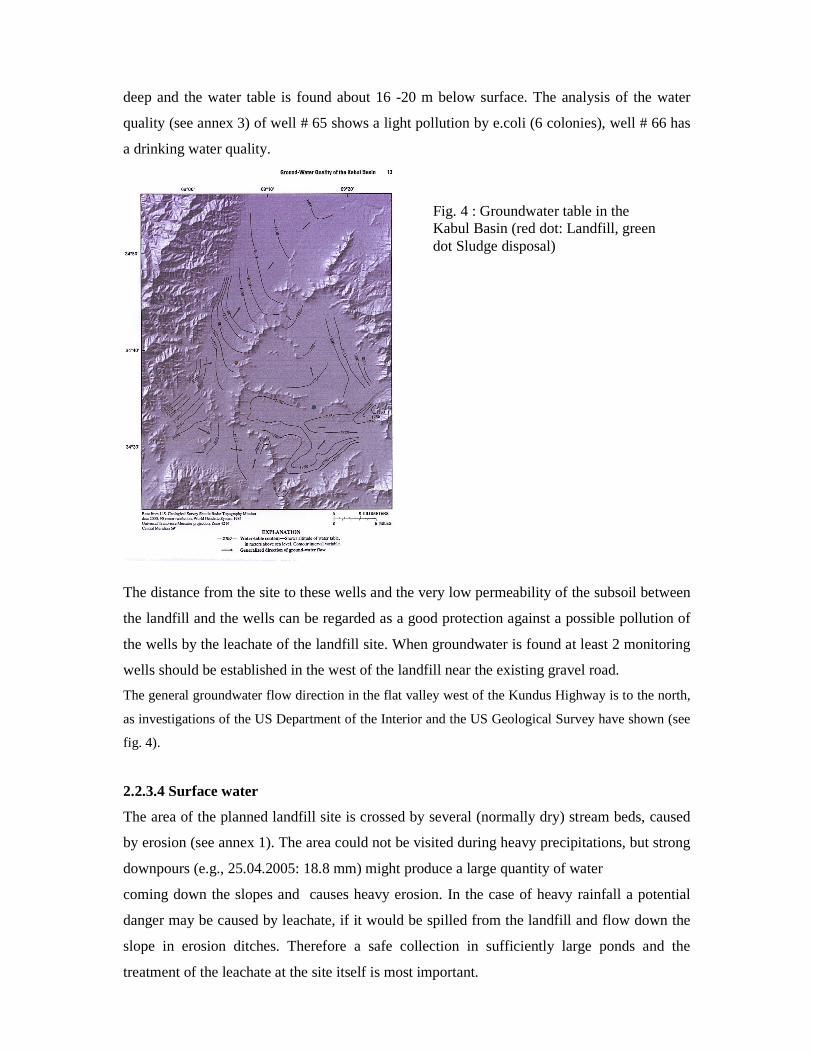
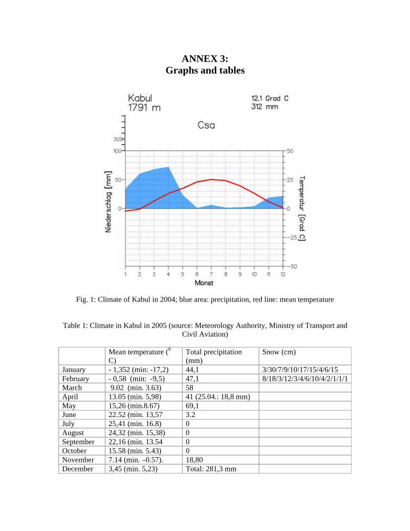
The general groundwater flow direction in the flat valley west of the Kundus Highway is to the north,
as investigations of the US Department of the Interior and the US Geological Survey have shown (see
fig. 4).
2.2.3.4 Surface water
The area of the planned landfill site is crossed by several (normally dry) stream beds, caused
by erosion (see annex 1). The area could not be visited during heavy precipitations, but strong
downpours (e.g., 25.04.2005: 18.8 mm) might produce a large quantity of water
coming down the slopes and causes heavy erosion. In the case of heavy rainfall a potential
danger may be caused by leachate, if it would be spilled from the landfill and flow down the
slope in erosion ditches. Therefore a safe collection in sufficiently large ponds and the
treatment of the leachate at the site itself is most important.
Fig. 4 : Groundwater table in the Kabul Basin (red dot: Landfill, green dot Sludge disposal)

The construction of a sanitary landfill at this site needs extensive excavation works to profile the
bottom of the operating area. To protect the landfill against storm-water from the mountain the
excavation of a ditch, ponds for intermediate rainwater storage and the construction of a bordering
dam as well as a fence or a brick wall surrounding the landfill area will be necessary (see 2.2.2).
2.2.3.5 Air pollution and noise
Even a sanitary landfill, which is operated according to the state of the art, will cause a certain amount
of air pollution: by dust, airborne litter, (which may be regarded as some kind of air pollution) and by
odor emissions (smells and landfill gas).
To reduce these emissions it is necessary to cover the disposed waste, if possible daily, at least once a
week, with a thin layer of sand. Movable fences should be provided and established around the
disposal area, in order to keep back the flying litter. Gas “wells” with simple flares are to be
constructed in the disposal area to catch and burn the landfill gas. After final closure of certain
sections of the site, the gas may be collected and, if not used for energy, burned in a central flare.
2.2.3.6 Human environment
According to the report of the Community Development Expert (see [11]) the construction of the
sanitary landfill at this location will have a minimal impact on the human environment:
“The access to the site is a dust road from Kundus highway (no. 2). The distance to the next
settlement area is 2,8 km, and 2 or 3 new but uninhabited houses lie in a distance of about
500 m to the site. During our field survey, a few nomads with tends and grazing cattle were
observed, but the Head of District and Wakil-e Gozar assured us that these were just nomads
passing by on their way from cooler to warmer areas. It is not a recognized pasturing area.
A new compound has been built just at the corner where the dust road leading to the dumpsite
turns off from the highway. Nobody lives there yet, but we were told this place would become
an orphans house. If possible, the road should take another – and more direct – way than the
present dust road.
The consultants got a confirmation of the Department of City Planning and Architecture
Design in 2004 that the site is available. MACA has not been working in the area, but the
people confirm that it is free of mines because no fighting has taken place there.”
2.2.3.7 Environmental impact of the landfill site – monitoring and mitigation measures
- Environmental impact
If the sanitary landfill should be established at the proposed site, the geological and hydro-
geological situation on site can be regarded as positive: no groundwater and a rather low
permeability of the soil. The natural incline of the slope is helping to lead the rainwater as
well as possible leachate easily downhill. After heavy precipitations the water flowing down
in the erosion ditches from the more elevated parts of the mountain slope may cause a
problem.
It is planned to collect the oncoming waters by 2 small dams in the upper (higher) part of the main
valley and to lead the water from there to another side valley. The whole landfill area has to be
surrounded by a ditch to keep away the water from the disposed waste (see fig. 4).
There is no groundwater at the site itself. The next wells are found in a distance of more than 1,5 km at
the Kundus Highway.
The natural division of the area considered for the landfill site by small ridges offers the opportunity
to establish the landfill site in several sections and to construct these sections
step by step.
The main wind direction in the area is northwest to northeast, so the mountain ridge south of
the landfill site is keeping away air pollution from the Kabul Basin. There are no settlements
in the vicinity of the site.
In table 2 an evaluation of the environmental impact [12], which may possibly be caused by
the planned sanitary landfill site # 2 (Koh-e-Badasia), shows, that there will be only a
minimal negative impact on the environment.
Table 2: Possible Environmental Impact (EI) caused by the sanitary landfill site
Regarded components – environmental impact on: Location / name of the site (or identification - no.) # 2 Neighbourhood/Settlements EI 0 Forests/Parks EI 0 Wildlife/Biotopes/Vegetation EI 0 Access to site/passing through settlements EI 1 Surface Water Quality EI 2 Groundwater Quality EI 2 Soil Quality EI 1 Air Quality EI 3 Noise EI 0 Agriculture/Farming EI 1 Aesthetic Aspects/Landscape EI 2 Others (bird strike danger) EI 0
Degree of environmental impact:
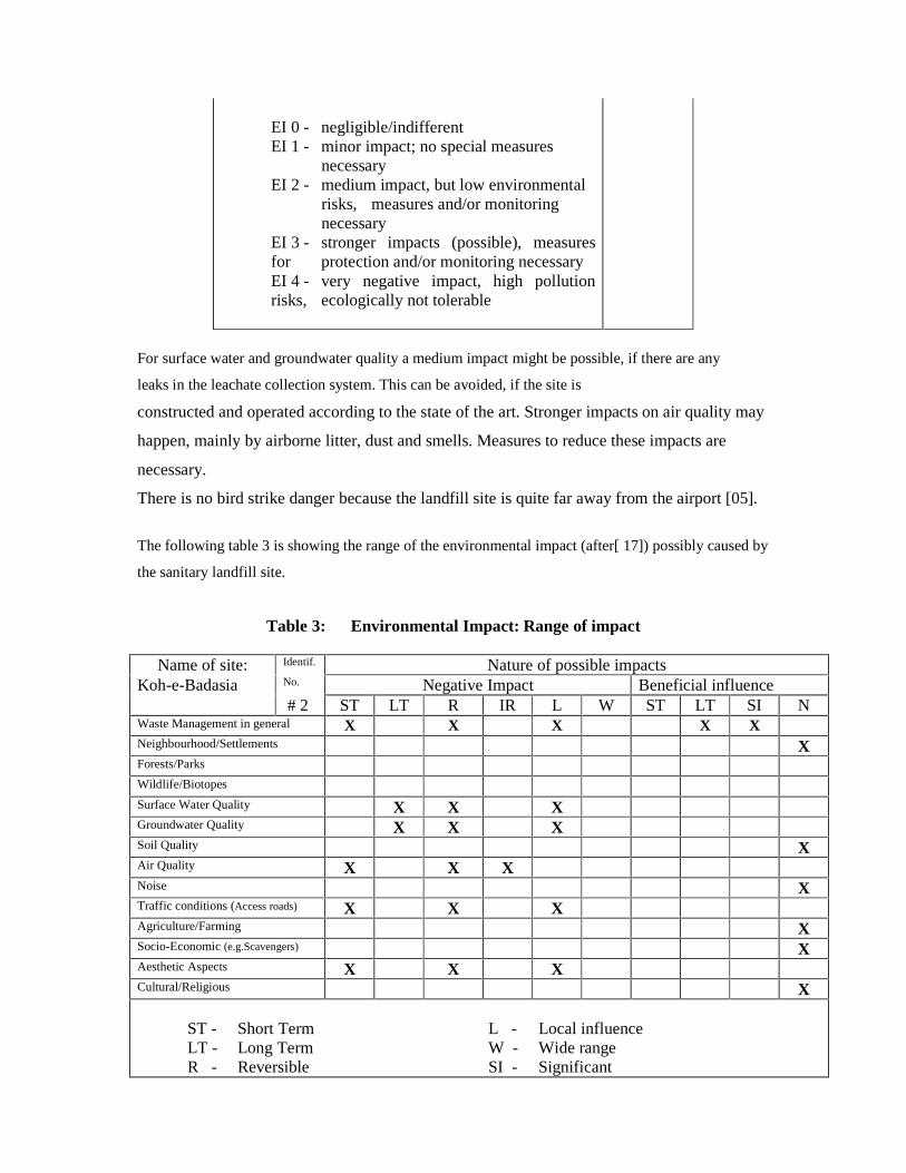
EI 0 - negligible/indifferent EI 1 - minor impact; no special measures necessary EI 2 - medium impact, but low environmental risks, measures and/or monitoring necessary EI 3 - stronger impacts (possible), measures for protection and/or monitoring necessary EI 4 - very negative impact, high pollution risks, ecologically not tolerable
For surface water and groundwater quality a medium impact might be possible, if there are any
leaks in the leachate collection system. This can be avoided, if the site is
constructed and operated according to the state of the art. Stronger impacts on air quality may
happen, mainly by airborne litter, dust and smells. Measures to reduce these impacts are
necessary.
There is no bird strike danger because the landfill site is quite far away from the airport [05].
The following table 3 is showing the range of the environmental impact (after[ 17]) possibly caused by
the sanitary landfill site.
Table 3: Environmental Impact: Range of impact
Name of site: Identif. Nature of possible impacts Koh-e-Badasia No. Negative Impact Beneficial influence
# 2 ST LT R IR L W ST LT SI N Waste Management in general X X X X XNeighbourhood/Settlements XForests/Parks Wildlife/Biotopes Surface Water Quality X X X Groundwater Quality X X X Soil Quality XAir Quality X X XNoise XTraffic conditions (Access roads) X X XAgriculture/Farming XSocio-Economic (e.g.Scavengers) XAesthetic Aspects X X XCultural/Religious X
ST - Short Term L - Local influence LT - Long Term W - Wide range R - Reversible SI - Significant
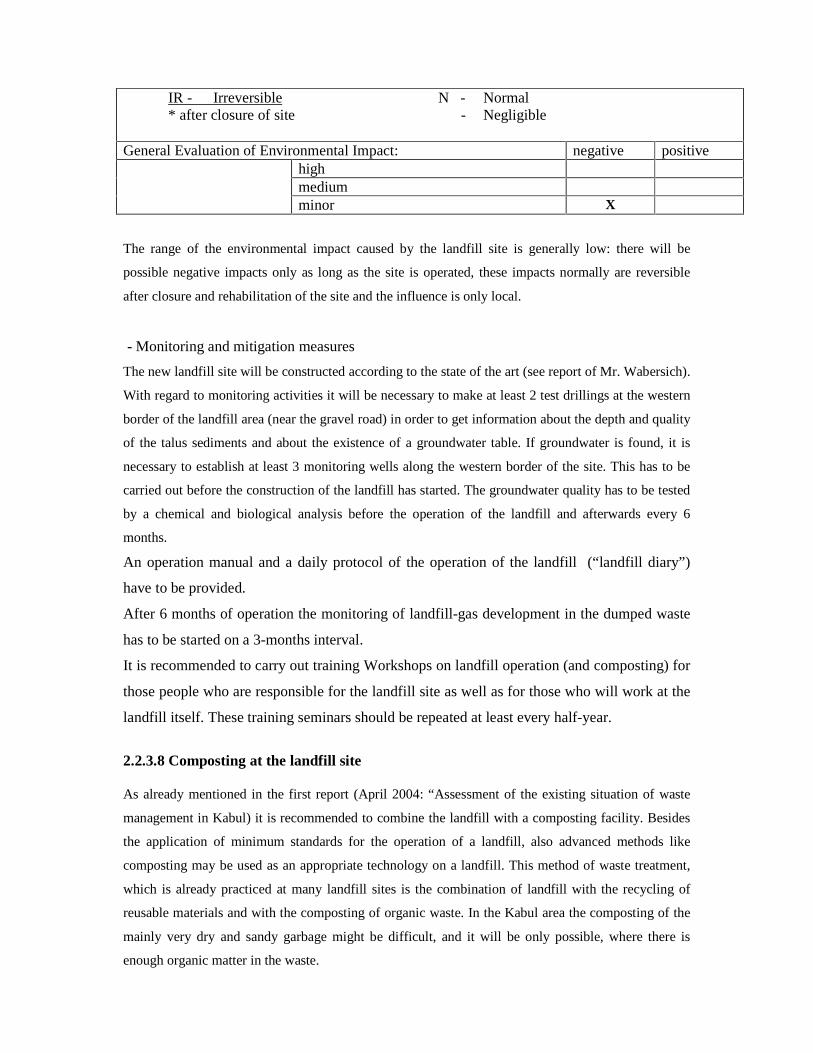
IR - Irreversible N - Normal * after closure of site - Negligible
General Evaluation of Environmental Impact: negative positive high medium minor X
The range of the environmental impact caused by the landfill site is generally low: there will be
possible negative impacts only as long as the site is operated, these impacts normally are reversible
after closure and rehabilitation of the site and the influence is only local.
- Monitoring and mitigation measures
The new landfill site will be constructed according to the state of the art (see report of Mr. Wabersich).
With regard to monitoring activities it will be necessary to make at least 2 test drillings at the western
border of the landfill area (near the gravel road) in order to get information about the depth and quality
of the talus sediments and about the existence of a groundwater table. If groundwater is found, it is
necessary to establish at least 3 monitoring wells along the western border of the site. This has to be
carried out before the construction of the landfill has started. The groundwater quality has to be tested
by a chemical and biological analysis before the operation of the landfill and afterwards every 6
months.
An operation manual and a daily protocol of the operation of the landfill (“landfill diary”)
have to be provided.
After 6 months of operation the monitoring of landfill-gas development in the dumped waste
has to be started on a 3-months interval.
It is recommended to carry out training Workshops on landfill operation (and composting) for
those people who are responsible for the landfill site as well as for those who will work at the
landfill itself. These training seminars should be repeated at least every half-year.
2.2.3.8 Composting at the landfill site As already mentioned in the first report (April 2004: “Assessment of the existing situation of waste
management in Kabul) it is recommended to combine the landfill with a composting facility. Besides
the application of minimum standards for the operation of a landfill, also advanced methods like
composting may be used as an appropriate technology on a landfill. This method of waste treatment,
which is already practiced at many landfill sites is the combination of landfill with the recycling of
reusable materials and with the composting of organic waste. In the Kabul area the composting of the
mainly very dry and sandy garbage might be difficult, and it will be only possible, where there is
enough organic matter in the waste.
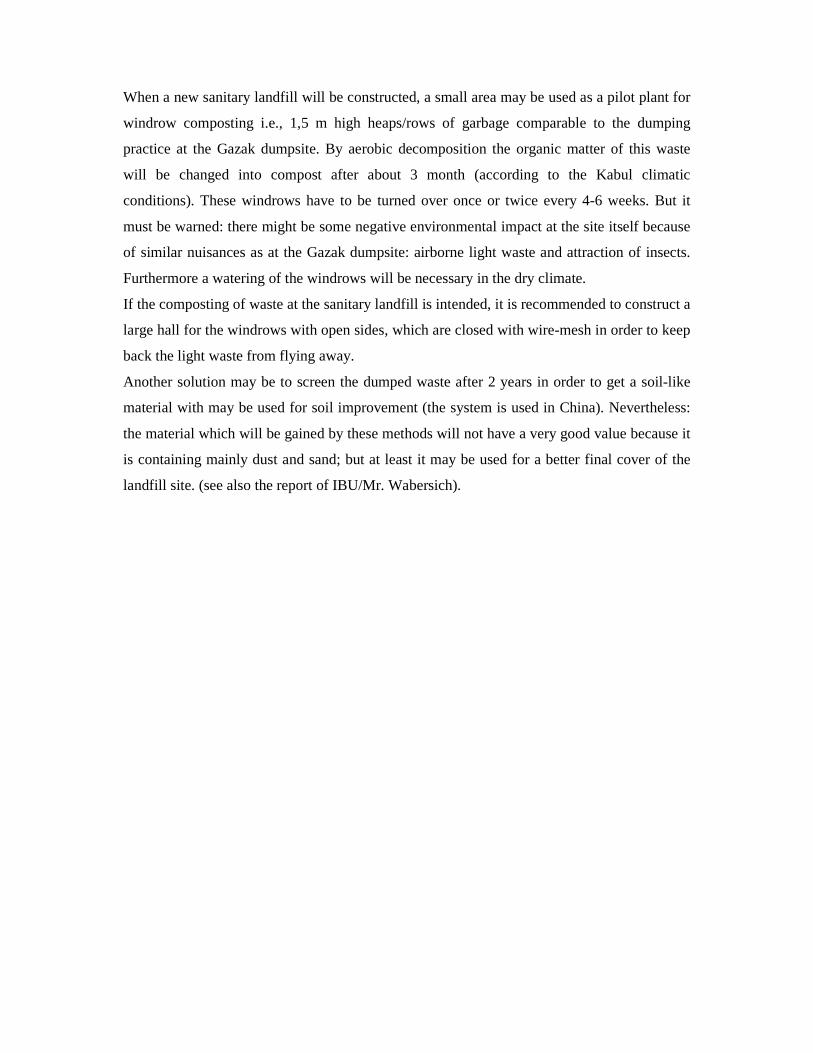
When a new sanitary landfill will be constructed, a small area may be used as a pilot plant for
windrow composting i.e., 1,5 m high heaps/rows of garbage comparable to the dumping
practice at the Gazak dumpsite. By aerobic decomposition the organic matter of this waste
will be changed into compost after about 3 month (according to the Kabul climatic
conditions). These windrows have to be turned over once or twice every 4-6 weeks. But it
must be warned: there might be some negative environmental impact at the site itself because
of similar nuisances as at the Gazak dumpsite: airborne light waste and attraction of insects.
Furthermore a watering of the windrows will be necessary in the dry climate.
If the composting of waste at the sanitary landfill is intended, it is recommended to construct a
large hall for the windrows with open sides, which are closed with wire-mesh in order to keep
back the light waste from flying away.
Another solution may be to screen the dumped waste after 2 years in order to get a soil-like
material with may be used for soil improvement (the system is used in China). Nevertheless:
the material which will be gained by these methods will not have a very good value because it
is containing mainly dust and sand; but at least it may be used for a better final cover of the
landfill site. (see also the report of IBU/Mr. Wabersich).
3. References
[01] DIETMAR, R.G. (1976): Zur Geologie des Kabul – Beckens, Afghanistan.-
Sonderveröffentl. Geol. Inst.Univ. Köln 29
[02] DGEG (German Geo-technical Society for the International Society of Soil and Mechanics
Foundation Engineering). Geotechnics on landfill design and remedial work-Technical
Recommendations (GLR); 110 p. Ernst & Sohn, Verlag für Architektur und technische
Wissenschaften, Berlin 1993
[03] EPA (Environmental Protection Agency USA): Final covers on hazardous waste landfills and
surface impoundments, technical guidance documents. 37 p. Washington D.C., 1989
[04]Federal Republic of Germany: Technical Guidance for Hazardous Waste Management (TA
Abfall), and: Technical Guidance for Solid Municipal Waste Management; Bek. d. BMU, Bonn
1991 und 1993
[05] EPA (2003): Federal Register Environmental Documents: Municipal Solid Waste
Location Restrictions for Airport Safety
www.epa.gov.fedrgstr/EPAWaste/2003/October/day-15
[06] EPA (2003): Location Criteria Standards
www.EPA.gov/garbage/Landfill/techman/subpart b
[07] GAUFF, ICON, IBU (2004): Emergency Infrastructure Reconstruction Project (EIRP)
Sanitation Improvements in Kabul : Rapid Review Report August 2004
[08] GAUFF, ICON, IBU (2004): Emergency Infrastructure Reconstruction Project (EIRP) –
Sanitation Improvements in Kabul : Environmental Report October 2004
[09] GAUFF ICON, IBU (2005): Environmental Report, Part I: Solid Waste (Emergency
Infrastructure Reconstruction Project (EIRP), Sanitation Improvements in Kabul City),
[10] GAUFF, ICON, IBU (2006): Extension of Consultant Services for Sanitation
Improvements in Kabul City, Technical Proposal,
[11] GAUFF, ICON, IBU (2006): Strategic Sanitation Plan. Final Draft Report, Solid Waste,
Kabul
[12] GAUFF, ICON, IBU (2006): Strategic Sanitation Plan. Final Draft Report, On-Site
Sanitation, Sewerage and Storm Water, Kabul
[13] GAUFF, ICON, IBU (2005): Sanitation Survey – Main Report. . Emergency Infrastructure
Reconstruction Project (EIRP), Sanitation Improvements in Kabul City, Kabul
[14] GEOPLAN / GTZ Kasdarli, Ch. U. Oeltzschner H. (2006): Réhabilitation et clôture finale
de la décharge intercommunale de Berka Zerga/Algérie.-Report for GTZ
[15] HARRIES, M. (2006) : Report (draft) on the 1st mission of the community development
expert: Assessment of the social impacts caused by four construction sites of the
project within the next two years.- Frankfurt
[16] OELTZSCHNER, H.: Geo-technical Aspects of Sanitary Landfill According to the State of the
Art in Germany - in: Boxball, J. Polmet 91 - Pollution in the Metropolitan Urban Environment;
HongKong Institution of Engineers, Vol. 2, 121 - 140, HongKong (1991)
[17] OELTZSCHNER, H. & MUTZ, D. (1996): Guidelines for an Appropriate Management of
Sanitary Landfill Sites (2nd ed.), ed. by Deutsche Gesellschaft fuer Technische
Zusammenarbeit (GTZ), Eschborn
[18] OELTZSCHNER, H. (2004): Kabul Sanitation Improvement (Waste Management) – Assessment
of the existing waste management situation in Kabul).-1. Report April 2004
[19] UN-HABITAT AFGHANISTAN (2003): Progress Report: Solid Waste Management for Kabul
(May 2003), Kabul
[20] UN-HABITAT AFGHANISTAN (2004): Municipal Solid Waste Institutional Study Kabul
Afghanistan (Municipality Solid Waste Management Support Project), Final Report January
2004, Kabul
[21] UNICEF & MINISTRY OF WATER & POWER (ed)/ MYSLIL, V., EQRAR,
N.,HAFISI, M. (1982): Hydrogeology of Kabul Basin
[22] US Department of the Interior, US Geological Survey (2005): Inventory of Groundwater
Resources in the Kabul Basin, Afghanistan.- Scientific Investigations Report 2005 -5090
[23] WORLD BANK (ed.)/ RUSHBROOK, Ph. % PUGH, M (1999): Solid Waste Landfills in
Middle- and Lower- Income Countries.- World Bank Technical Paper no. 426, Washington
D.C.
[24] WORLDBANK (2006): Environmental & Social Management Framework. Draft Final for
the Urban Water Sector Project of the Islamic Republic of Afghanistan, Kabul
[25] WORLDBANK (2006): Recommendations on Solid Waste Activities for Supervision of
ARTF-UWSS and Preparation of UWMP. Annex 2 of: Report of Mission of Solid Waste
Expert
[26] WORLD BANK (2004): The World Banks Operational Manual “Environmental Assessment” Operational Policies BP/OP 4.01, Washington DC, USA
4. Acknowledgements
During the 4th field mission in Kabul, outstanding assistance was provided by Mr. B. Schimanski, Mr.
B. Schumacher and Mr. Hausdorf of Gauff Engineers, Frankfurt. Support and information was also
provided by Mrs. Harries, Community Development Expert.
The staff of the Kabul Office of Gauff Engineers provided remarkable support for the
completion of this report.

The efforts of the above mentioned persons were invaluable to the development of this
study/investigation. I feel very much obliged to all mentioned above and want to say thanks to
everybody who has contributed to this report.
II. ANNEXES
1. Photo-documentation 2. Maps
3. Graphs and tables
Annex 1: Photo-documentation
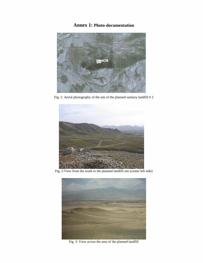
Fig. 1: Aerial photography of the site of the planned sanitary landfill # 2
Fig. 2:View from the south to the planned landfill site (center left side)
Fig. 3: View across the area of the planned landfill
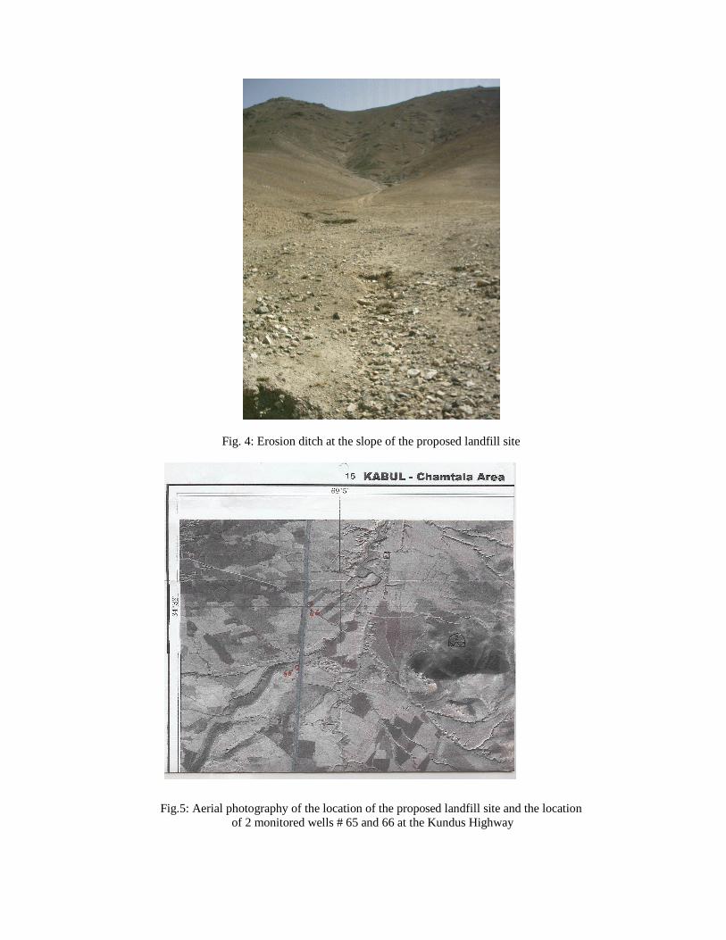
Fig. 4: Erosion ditch at the slope of the proposed landfill site
Fig.5: Aerial photography of the location of the proposed landfill site and the location of 2 monitored wells # 65 and 66 at the Kundus Highway
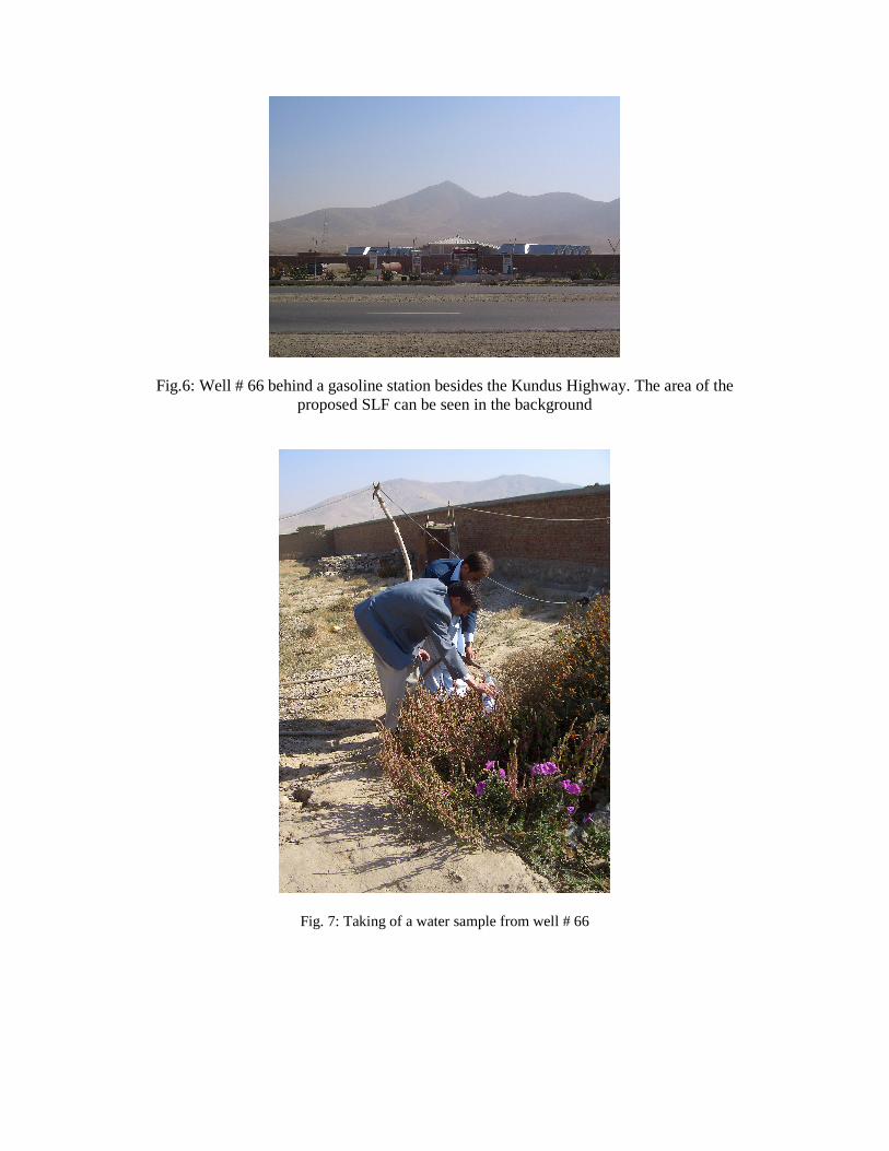
Fig.6: Well # 66 behind a gasoline station besides the Kundus Highway. The area of the proposed SLF can be seen in the background
Fig. 7: Taking of a water sample from well # 66
ANNEX 2: Maps
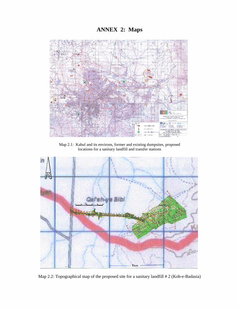
Map 2.1: Kabul and its environs, former and existing dumpsites, proposed locations for a sanitary landfill and transfer stations
Map 2.2: Topographical map of the proposed site for a sanitary landfill # 2 (Koh-e-Badasia)
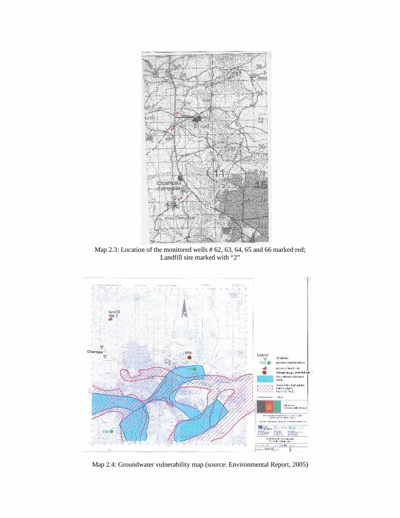
Map 2.3: Location of the monitored wells # 62, 63, 64, 65 and 66 marked red; Landfill site marked with “2”
Map 2.4: Groundwater vulnerability map (source: Environmental Report, 2005)
ANNEX 3: Graphs and tables
Fig. 1: Climate of Kabul in 2004; blue area: precipitation, red line: mean temperature
Table 1: Climate in Kabul in 2005 (source: Meteorology Authority, Ministry of Transport and Civil Aviation)
Mean temperature (0
C) Total precipitation (mm)
Snow (cm)
January - 1,352 (min: -17,2) 44,1 3/30/7/9/10/17/15/4/6/15 February - 0,58 (min: -9,5) 47,1 8/18/3/12/3/4/6/10/4/2/1/1/1March 9.02 (min. 3.63) 58 April 13.05 (min. 5,98) 41 (25.04.: 18,8 mm) May 15,26 (min.8.67) 69,1 June 22.52 (min. 13,57 3.2 July 25,41 (min. 16.8) 0 August 24,32 (min. 15,38) 0 September 22,16 (min. 13.54 0 October 15.58 (min. 5.43) 0 November 7.14 (min. –0.57). 18,80 December 3,45 (min. 5,23) Total: 281,3 mm
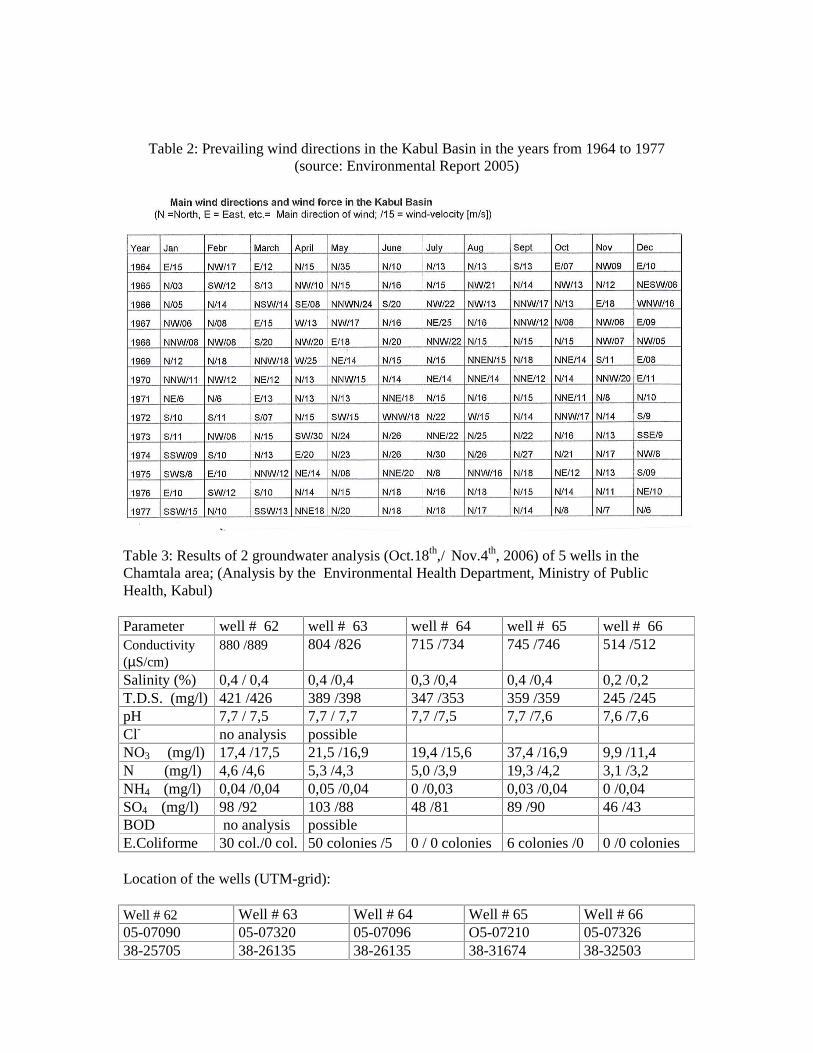
Table 2: Prevailing wind directions in the Kabul Basin in the years from 1964 to 1977 (source: Environmental Report 2005)
Table 3: Results of 2 groundwater analysis (Oct.18th,/ Nov.4th, 2006)of 5 wells in the Chamtala area; (Analysis by the Environmental Health Department, Ministry of Public Health, Kabul) Parameter well # 62 well # 63 well # 64 well # 65 well # 66 Conductivity (µS/cm)
880 /889 804 /826 715 /734 745 /746 514 /512
Salinity (%) 0,4 / 0,4 0,4 /0,4 0,3 /0,4 0,4 /0,4 0,2 /0,2 T.D.S. (mg/l) 421 /426 389 /398 347 /353 359 /359 245 /245 pH 7,7 / 7,5 7,7 / 7,7 7,7 /7,5 7,7 /7,6 7,6 /7,6 Cl- no analysis possible NO3 (mg/l) 17,4 /17,5 21,5 /16,9 19,4 /15,6 37,4 /16,9 9,9 /11,4 N (mg/l) 4,6 /4,6 5,3 /4,3 5,0 /3,9 19,3 /4,2 3,1 /3,2 NH4 (mg/l) 0,04 /0,04 0,05 /0,04 0 /0,03 0,03 /0,04 0 /0,04 SO4 (mg/l) 98 /92 103 /88 48 /81 89 /90 46 /43 BOD no analysis possible E.Coliforme 30 col./0 col.50 colonies /5 0 / 0 colonies 6 colonies /0 0 /0 colonies
Location of the wells (UTM-grid): Well # 62 Well # 63 Well # 64 Well # 65 Well # 66 05-07090 05-07320 05-07096 O5-07210 05-07326 38-25705 38-26135 38-26135 38-31674 38-32503
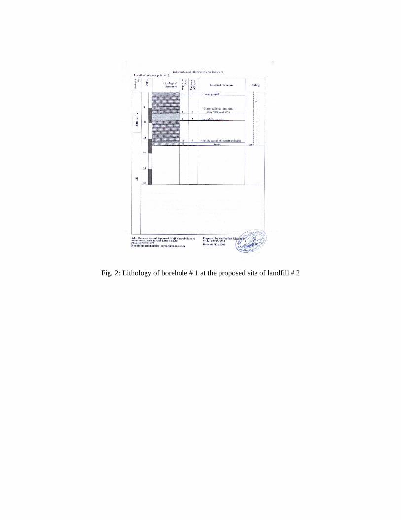
Fig. 2: Lithology of borehole # 1 at the proposed site of landfill # 2
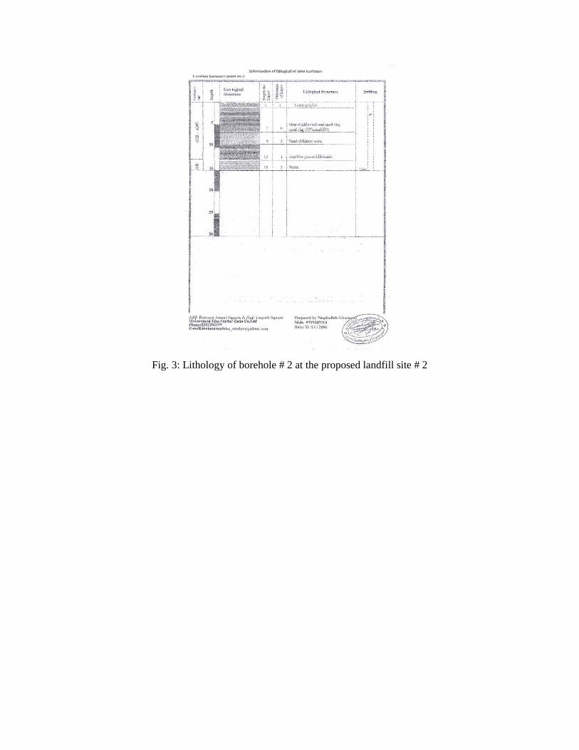
Fig. 3: Lithology of borehole # 2 at the proposed landfill site # 2