Embed Size (px)
Citation preview

Exploring Anasazi Origins;The Cedar Mesa Basketmaker II
Report on the 1991/2 Fieldwork
(Basketmaker II Pictograph, North Road C9-5)
R.G. Matson and Michael Brand, Editors.
June 30, 1995
Report toBureau of Land Management
Monticello, Utah
Laboratory of ArchaeologyDepartment of Anthropology and Sociology
University of British Columbia6303 N.W. Marine Drive
Vancouver, B.C.V6T 1Z1
Exploring Anasazi Origins;The Cedar Mesa Basketmaker II
Report on the 1991/2 Fieldwork
R.G. Matson and Michael Brand, Editors.
June 30, 1995
Report to
Bureau of Land Management
Monticello, Utah
Laboratory of ArchaeologyDepartment of Anthropology and Sociology
University of British Columbia6303 N.W. Marine Drive
Vancouver, B.C.V6T 1Z1
Table of Contents
PageChapter 1 Introduction: Exploring Anasazi Origins;
The Cedar Mesa Basketmaker II
R.G. Matson and Michael Brand.................1
Chapter 2 Anomalous Basketmaker II Sites on Cedar Mesa:Not so Anomalous After All
R.G. Matson...................................9
Chapter 3 Survey Evidence for Basketmaker II Villages
Karen Dohm...................................33
Chapter 4 Carbon and Nitrogen Isotopic Evidence onBasketmaker II Diet at Cedar Mesa Utah
Brian Chisholm and R.G. Matson...............55
Chapter 5 The Core of the Matter: Basketmaker II LithicTechnology and Mobility Patterns on CedarMesa, Southeast Utah
Reid Nelson..................................72
Chapter 6 Cedar Mesa Fauna Remains
Michael Brand................................92
Chapter 7 Lithic Analysis of the Rock Island Site(North Road C9-5)
Michael Brand...............................108
Chapter 8 Summary and Conclusion: Results of Exploring Anasazi Origins;The Cedar Mesa Basketmaker II
R.G. Matson.................................145
References Cited.........................................155
i

List of Figures and MapsPage
Fig. 1-1 Cedar Mesa and environs..............................3
Fig. 2-1 Cedar Mesa quadrats with BM II habitations andHS 4&5 designated...................................10
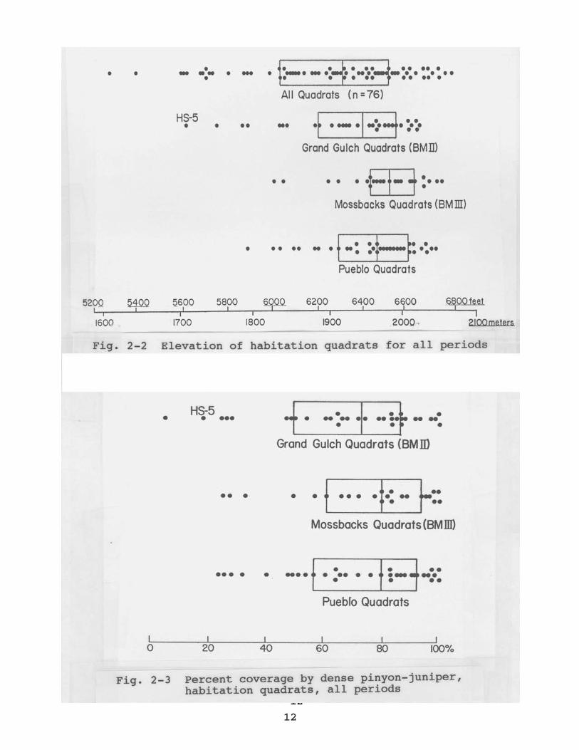
Fig. 2-2 Elevation of habitation quadrats for all periods....12
Fig. 2-3 Percent coverage by dense pinyon-juniper, habitation quadrats, all periods....................12
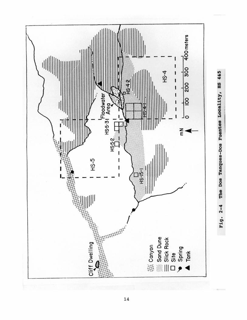
Fig. 2-4 The Dos Tanques-Dos Fuentes Locality, HS 4&5........14
Fig. 2-5 Probable floodwater farming location withinDos Tanques-Dos Fuentes.............................16
Fig. 2-6 Hardscrabble 5-2 (HS 5-2) Contour Map...............17
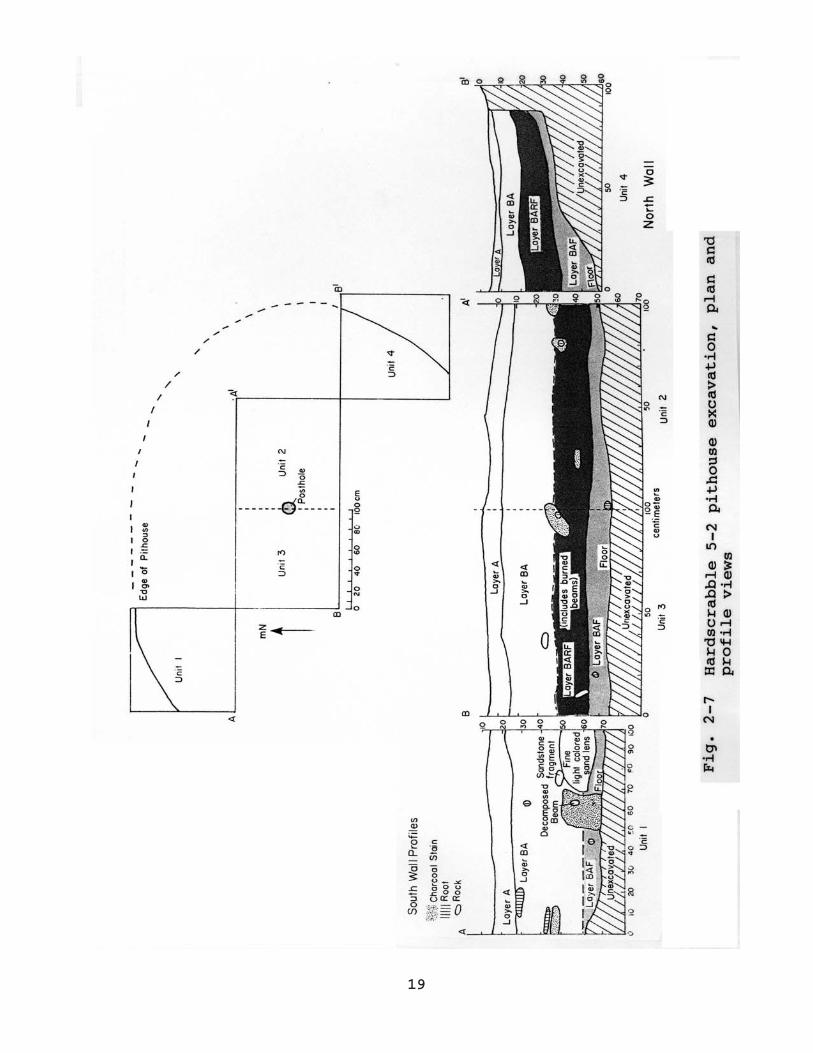
Fig. 2-7 Hardscrabble 5-2 pithouse excavation, plan andprofile views.......................................19
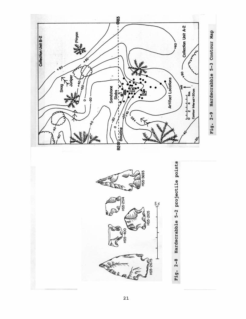
Fig. 2-8 Hardscrabble 5-2 projectile points..................21
Fig. 2-9 Hardscrabble 5-3 Contour Map........................21
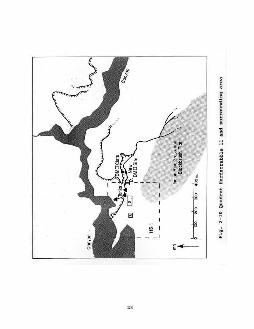
Fig. 2-10 Quadrat Hardscrabble 11 and surrounding area........23
Fig. 2-11 North Road C9-5 (Rock Island Site) and surroundingarea................................................25
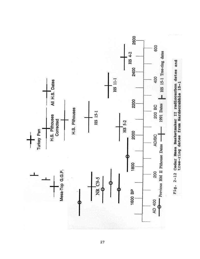
Fig. 2-12 Cedar Mesa Basketmaker II radiocarbon dates andtree-ring dates from Hardscrabble 15-1..............27
Fig. 3-1 Cedar Mesa quadrats with BM II habitations withNorth Road Drainage designated......................35
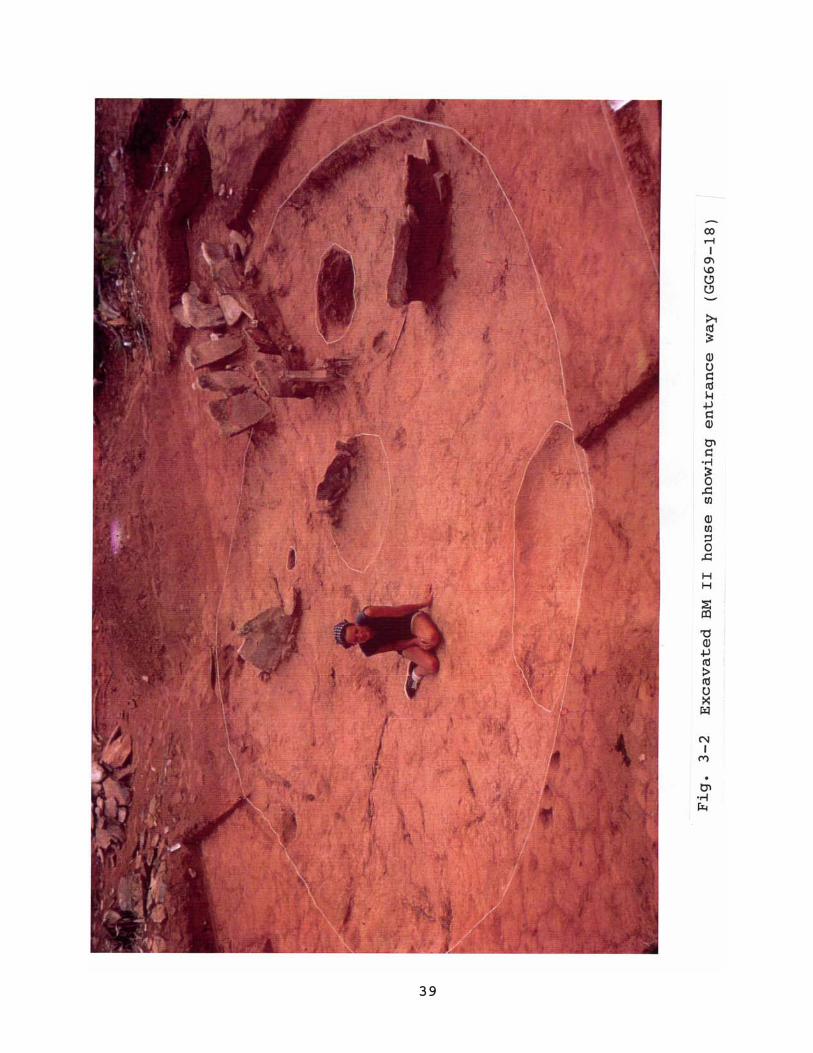
Fig. 3-2 Excavated BM II house showing entrance way(GG69-18).39
Fig. 3-3 Cedar Mesa BM II house forms........................40
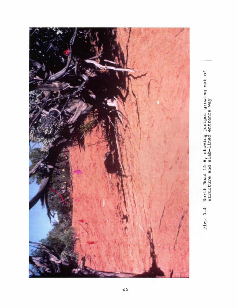
Fig. 3-4 North Road 15-6, showing juniper growing out ofstructure and slab-lined entrance way...............42
Fig. 3-5 North Road neighborhood, showing survey quadrats andprehistoric sites...................................46
Fig. 3-6 North Road 15 dwelling cluster. Plant and physiographic features are in gray, archaeologicalin black............................................48
Fig. 3-7 North Road 13 dwelling cluster. Plant and topographic features are in gray, prehistoric material in black..50
ii
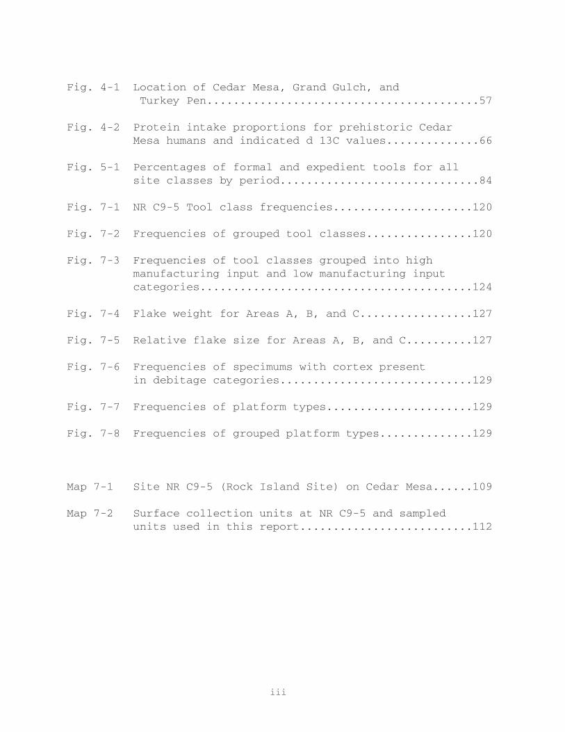
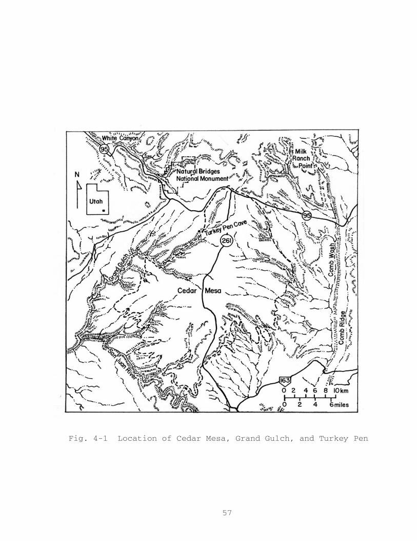
Fig. 4-1 Location of Cedar Mesa, Grand Gulch, and Turkey Pen.........................................57
Fig. 4-2 Protein intake proportions for prehistoric CedarMesa humans and indicated d 13C values..............66
Fig. 5-1 Percentages of formal and expedient tools for allsite classes by period..............................84
Fig. 7-1 NR C9-5 Tool class frequencies.....................120
Fig. 7-2 Frequencies of grouped tool classes................120
Fig. 7-3 Frequencies of tool classes grouped into highmanufacturing input and low manufacturing inputcategories.........................................124
Fig. 7-4 Flake weight for Areas A, B, and C.................127
Fig. 7-5 Relative flake size for Areas A, B, and C..........127
Fig. 7-6 Frequencies of specimums with cortex presentin debitage categories.............................129
Fig. 7-7 Frequencies of platform types......................129
Fig. 7-8 Frequencies of grouped platform types..............129
Map 7-1 Site NR C9-5 (Rock Island Site) on Cedar Mesa......109
Map 7-2 Surface collection units at NR C9-5 and sampledunits used in this report..........................112
iii
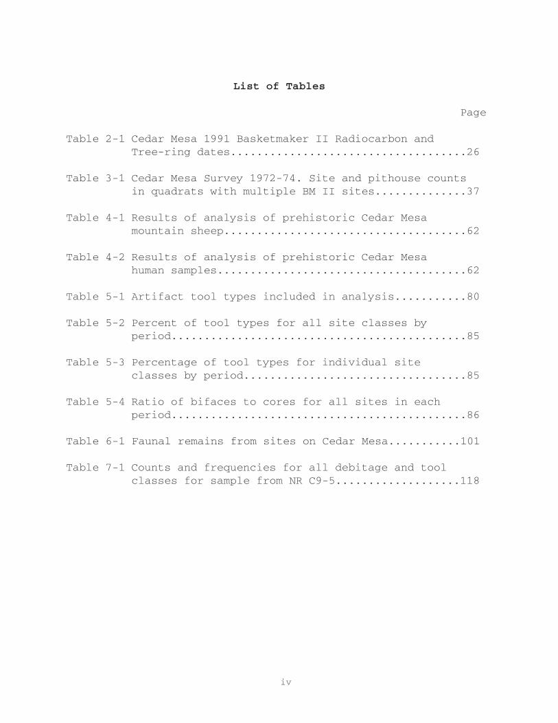
List of Tables
Page
Table 2-1 Cedar Mesa 1991 Basketmaker II Radiocarbon andTree-ring dates....................................26
Table 3-1 Cedar Mesa Survey 1972-74. Site and pithouse countsin quadrats with multiple BM II sites..............37
Table 4-1 Results of analysis of prehistoric Cedar Mesa mountain sheep.....................................62
Table 4-2 Results of analysis of prehistoric Cedar Mesa human samples......................................62
Table 5-1 Artifact tool types included in analysis...........80
Table 5-2 Percent of tool types for all site classes by period.............................................85
Table 5-3 Percentage of tool types for individual site classes by period..................................85
Table 5-4 Ratio of bifaces to cores for all sites in eachperiod.............................................86
Table 6-1 Faunal remains from sites on Cedar Mesa...........101
Table 7-1 Counts and frequencies for all debitage and tool classes for sample from NR C9-5...................118
iv

1
Exploring Anasazi Origins;
The Cedar Mesa Basketmaker II
Chapter 1
INTRODUCTION
R.G. Matson and Michael Brand
In 1990 the Cedar Mesa Project II (CMP II) was initiated to
further explore the origins of the Anasazi tradition on Cedar
Mesa, southeast Utah. Research focussed on the Basketmaker II
occupation of the mesa. As the initial members of the Anasazi
tradition, now represented by the modern Pueblo Indians, the
origins of the Basketmaker II remains a topic of debate (Matson
and Dohm 1990: 11; Matson 1991). Cedar Mesa has an abundance of
Basketmaker II material (Matson, Lipe, and Haase 1988), which
includes two variants (Matson 1991), canyon rockshelter sites
belonging to the White Dog Phase (500 BC - AD 50) and later mesa
top sites dating to the Grand Gulch Phase (AD 200 - 400). The
primary goal of the Cedar Mesa Project II is to develop a better
understanding of the Basketmaker II occupation of Cedar Mesa.
As such the project addressed a number of questions relating to
the early use of agriculture in the American Southwest. The
project also produced data relevant to the origins of the
Basketmaker II culture. To date two main competing theories
have been advanced, the Oshara Model and the San Pedro Migration
Model, respectively proposing an in situ development and a

2
northern migration of southern populations (Matson 1991:267-
268).
Fieldwork for the Cedar Mesa Project II was undertaken mainly
in July and August of 1991, with a much smaller component in
July 1992. The project consisted of three parts: (1) excavation
of Basketmaker II sites in the Hardscrabble drainage (CMP field
numbers HS 4-1, HS 4-2, HS 5-2, HS 5-3, HS 11-1, HS 11-2 and HS
15-1), (2) limited test excavations at site NR C9-5 in the North
Road drainage, and (3) block survey in the North Road drainage
(Matson and Dohm 1990:14-15). The sites selected for excavation,
all at elevations of approximately 1700m, are well below the
average elevation for mesa top Basketmaker II habitation sites
on Cedar Mesa. Excavations were undertaken to provide data which
could identify these sites as being related to the earlier White
Dog Phase Basketmaker II, the later Grand Gulch Phase
Basketmaker II occupation, or to a previously unrecognized Late
Archaic occupation. Test excavations at NR C9-5 were done to
obtain dates which would allow classification of this unique
site into one of the two Basketmaker II cultures. The purpose of
the block survey was to establish the extent of the Grand Gulch
Phase habitation site aggregations and to determine if dispersed
Basketmaker II villages existed.
Cedar Mesa is a highland area located in southeastern Utah
(Figure 1-1). The mesa has an area of approximately 800 square
kilometers and is bounded by Elk Ridge in the north, White
Canyon to the northwest and the Red House Cliffs in the west,
the San Juan Valley to the south, the Lime Creeks to the
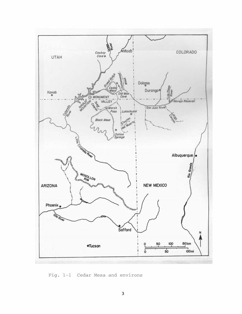
3
Fig. 1-1 Cedar Mesa and environs

4
southeast and Comb Ridge to the east (Matson, Lipe, and Haase
n.d.: I-5). A central divide runs north - south on the mesa at
an average elevation of 1980m. From here the mesa slopes to
Grand Gulch in the west and Comb Wash in the east, with lower
elevations of the mesa top at approximately 1700m. The surface
of Cedar Mesa is cut by a number of deeply entrenched canyons.
The only permanent sources of water on the mesa are found in
these canyons. The mesa is composed almost completely of Cedar
Mesa Sandstone which is a good aquifer, hence there are a number
of springs in many of the canyons (Matson, Lipe, and Haase n.d.:
I-7). Natural tanks in the slickrock on the mesa’s surface also
hold limited amounts of water after a rain shower.
Precipitation on Cedar Mesa increases with elevation. Annual
precipitation for the higher elevations averages approximately
32cm, whereas the lower areas of the mesa receive less than 25cm
annually (Matson, Lipe, and Haase 1988:247).
The mesa surface is covered by a fine sandy loam which can be
quite deep near the central divide (>3m), but thins
significantly towards the edges of the mesa (Matson, Lipe, and
Haase n.d.: I-8). The higher, deep soil areas of the mesa are
dominated by pinyon-juniper forest mixed with a few sage flats
near the heads of the canyons (Matson, Lipe and Haase 1988:247).
These deep aeolian sandy silts were important prehistorically
for dry-farming. The lower elevations of the mesa are
characterized by sage shrublands with occasional patches of
blackbrush and native grasses.
Archaeological research on Cedar Mesa began in the 1890’s; it

5
was during this period that Richard Wetherill recognized the
Basketmaker II culture (McNett 1968). The abundance of
Basketmaker II material lead Lipe (1978) to begin research on
Cedar Mesa in 1969 and 1970. In 1971 Lipe and Matson initiated
the original Cedar Mesa Project, a regionally based survey of
five selected drainages on the mesa. The project survey design
is described in Lipe and Matson (1971) and in Matson and Lipe
(1975;1978). Both mesa top quadrat and complete canyon surveys
were conducted resulting in a total of 340 mesa top sites and 90
canyon sites (Matson, Lipe, and Haase 1988: 248). The results
of the survey and the phase sequence which was developed for
Cedar Mesa are summarized in Matson, Lipe, and Haase (1988). The
Basketmaker II (BM II) period on Cedar Mesa is represented by
the Grand Gulch Phase, dated between A.D. 200 and A.D. 400.
Following a hiatus the Moss Backs Phase, a Basketmaker III
occupation, begins at A.D. 650 and lasts until approximately
A.D. 720. The next occupation of the mesa occurs in the late
Pueblo II period with the Windgate Phase, A.D. 1050 - 1100. The
following Clay Hills Phase, A.D. 1100 - 1150, is characterized
by the predominance of Kayenta ceramics. There is a possible
hiatus between the Pueblo II and Pueblo III occupations of Cedar
Mesa. The Pueblo III occupation is represented by the Woodenshoe
Phase, A.D. 1170 - 1220, and finally the Red House Phase, A.D.
1220 - 1270.
The Cedar Mesa Project quadrat survey recorded a total of 130
sites with Basketmaker II components. These sites were divided
into four different site types: habitations (52), limited

6
activity sites (38), campsites (36) and lithic reduction loci
(4) (Matson, Lipe, and Haase 1988:248-250). Basketmaker II sites
were identified by the following characteristics: the presence
of pit-structures with slab lined entrance ways, absence of
ceramics, abundant “manuported” limestone, presence of large
side- or corner notched projectile points and a relative
abundance of one hand manos. The four different types of sites
are differentiated on the basis of artifact and feature
profiles.
Habitation sites tend to have slab-lined hearths, cists, a
large number of artifacts and artifact types. Approximately half
of the Basketmaker II habitation sites located in the quadrat
survey had surface evidence of a pithouse, but only two such
“sites” had evidence of more than one. These sites were generally
located above the median elevation for the mesa. Although they
tend to occur in the higher areas of the mesa, they do not occur
in the highest areas, that is, above 2025m. Habitation sites are
generally located in areas of dense pinyon-juniper forest.
Non-habitation sites (campsites, limited activity sites and
lithic reduction loci) are believed to have served various short
term activities undertaken away from habitation sites. On the
basis of features present, such as hearths and slab-lined cists,
campsites are believed to have been used for activities which
required people to be away from their primary residential site
for more than a day. These sites tend to be found at elevations
below that of habitation sites and limited activity sites, in
areas with less trees. Limited activity sites generally lack
7
features and have small numbers of artifacts and a limited
number of artifact types. Although limited activity sites also
tend to be found in areas with a lower tree density, their
median elevation is slightly higher than that of the campsites.
Activities believed to have been undertaken at non-habitation
sites include gathering and processing wild plants, hunting or
tending agricultural fields.
The association of corn agriculture with the Basketmaker II
culture is well established (Matson and Chisholm 1991; Matson
1991). Recent research on the Cedar Mesa Basketmaker II material
has done much to demonstrate its importance in the diet of these
people. Analysis of settlement patterns have shown that
Basketmaker II habitation sites are commonly located in areas
with arable soil and higher levels of precipitation. The remains
of maize have been found in excavations on Cedar Mesa (Matson,
Lipe, and Haase 1988:248; Dohm 1988; Matson 1991:90-101), and
analysis of human coprolites from a Basketmaker II site in Grand
Gulch, found maize to be the most abundant class of food remains
(Aasen 1984). Recent stable carbon isotope analysis (Matson and
Chisholm 1986,1991; Chisholm and Matson 1994), has indicated
that the Basketmaker II populations on Cedar Mesa shared a
similar reliance on maize with the later Pueblo occupants.
The the mesa-top pithouse occupation is relatively securely
dated between A.D. 200 and A.D. 400. Prior to the 1991
fieldwork radiocarbon dates from three different pithouse sites
fell into this period and 26 tree-ring dates from four features,
only one of which was also radiocarbon dated, were also in this
8
period (Matson 1991:91-92). In addition four other tree-ring
dates from West Johns 12-6 are reported by Dohm (1988:194) for
this time period, adding another pithouse site. These seven
different sites are scattered over the mesa, indicating that the
mesa-top pithouse occupation dates everywhere to the same time
period between A.D. 200 and A.D. 400.
This report is organized into chapters, the first of which is
this introduction. The second chapter is a descriptive summary
of the 1991 testing of archaeological sites including a
discussion of their ages. The third is a report on the block
survey in the North Road Drainage and the evidence for BM II
habitation sites being aggregated into “Hamlets.” The fourth
chapter reports on recent analyses of stable carbon and nitrogen
isotope samples and their implications for BM II diets. The
fifth chapter is a comparison of BM II and later Anasazi lithic
technology as found on Cedar Mesa. The sixth chapter describes
the faunal material recovered during various investigations on
Cedar Mesa, including 1991. The seventh chapter is a report on
the lithic analysis of the Rock Island Site (NR C9-5). The last
chapter is a summary and synthesis of the 1991 project results
to date.
9
Chapter 2
ANOMALOUS BASKETMAKER II SITES ON CEDAR MESA: NOT SO ANOMALOUS AFTER ALL.
R.G. Matson
Introduction
If we are to understand the Origins of the Anasazi we need to
carefully examine the first Anasazi culture, the Basketmaker II.
The current evidence, as I review in Origins of Southwestern
Agriculture (Matson 1991), is consistent with a Basin and Range
San Pedro Cochise origin for the “Western” or San Juan BM II.
This inference arises partly from the lack of known late Archaic
remains in areas with substantial BM II remains such as Cedar
Mesa, Utah. The argument can be made–and is– that material
classified as BM II really includes non-BM II, that is, pre-BM
II material. During the summer of 1991 we investigated this
possibility for the mesa-top BM II on Cedar Mesa.
As reviewed in the introduction, five of the twenty drainages
on Cedar Mesa, located between the 5600 (1700m) and 6800 (1980)
ft contour intervals, which delimited about 800 square km, were
sampled in the original Cedar Mesa Project (Lipe and Matson
1971; Matson, Lipe, and Haase 1988). These, in turn, were
subsampled by 9 to 22 quadrats, and all sites were mapped and
completely collected in the survey portion of this project
(Matson, Lipe, and Haase 1988). During our quadrat survey (76
quadrats, 400m on a side) in the 1970’s we located and collected
123 sites having separable components (and seven BM II

10
Fig. 2-1 Cedar Mes quadrats with BM II habitations andSS 4&5 designaged

11
occupations without separable components) which we classified as
BM II, and we called the Grand Gulch Phase (Matson and Lipe
1975; 1978; Matson, Lipe, and Haase 1988). This amount
contrasts with the lack of any identified Archaic components and
only a half dozen Archaic points collected during the survey.
As reviewed in the previous chapter the Grand Gulch Phase is
dated on the basis of previous tree-ring and radiocarbon dates
from seven different pithouse sites to A.D. 200-400.
In investigating the possibility that significant amounts of
pre-BM II material are present in the material we previously
classified as BM II, we could not afford to excavate all 123
sites, nor would all sites be expected to yield useful dating
information. Thus our object was to test sites previously
classified as BM II that had the maximum potential to be Archaic
by differing significantly from the dated BM II sites, yet still
had a high probability that they would yield dates and
artifacts.
As it turns out, there is a single low lying area, in the
western portion of the survey area, which had sites that met
these two criteria, along with other attributes that made it a
likely Archaic location. Particularly, within the Hardscrabble
Quadrats 4 and 5 (HS 4 and HS 5) are a cluster of sites
identified as BM II that appeared to be anomalous (Fig. 2-1).
These included HS5-2, the lowest elevation site, by far,
classified as a habitation (Fig. 2- 2). Further, neither
quadrat had significant amounts of deep soil pinyon-juniper, our
proxy measure for arable dry farming land (Fig. 2-3) which is
12
highly
12
13
highly correlated with BM II habitations elsewhere on Cedar
Mesa. Nearby in an unlikely farming area is HS 11 which
contains three members, including the largest, of the BM II
“campsite” class (Matson 1991: 81-82). Since the campsite class
was undated, one could question whether this class of preceramic
sites were BM II.
Further, the HS 4 and 5 area is near the heads of canyons,
with a good spring noted during survey, and has the largest dune
field within the survey area–in short is the closest thing to
Arroyo Cuervo on Cedar Mesa (Irwin-Williams 1973). If we were
mistakenly classifying late Archaic material as BM II, these
sites have a high potential to be late Archaic (Fig. 2-4).
We thus have the alternative possibilities that this
material is part of the mesa-top BM II occupation, the Grand
Gulch Phase A.D. 200-400, as we classified it, or that it is
Archaic. There is also a third possibility, that the material
belongs not to the mesa-top Grand Gulch Phase, but instead is
related to the earlier, canyon rockshelter White Dog Cave
variant (Matson 1991:124). When Lipe and I first began the Cedar
Mesa Project, Lipe hypothesized that BM II habitations would be
located on the rims so as to have access both to mesa top and
canyons (Lipe and Matson 1971). This idea assumed that all BM
II material dated to the same period. We actually found that BM
II habitations tended to be located way from the canyon rims,
and on the mesa-top divides (Matson and Lipe 1978; Matson, Lipe,
and Haase 1988). Smiley et al. (1986) since then have
demonstrated that the Canyon Rockshelter BM II is more than 2000
14

15
years old and dates back to 500 B.C. Further, our dates from
Turkey Pen Cave in Grand Gulch confirm the priority of the
Rockshelter BM II for Cedar Mesa as well (Matson and Chisholm
1991). Thus, it might be that Lipe’s hypothesis could be
correct, not in general, but for mesa-top sites related to the
Canyon Rockshelter BM II.
Before turning to describing the archaeological information
recovered, I wish to reiterate the main point. That is, if all
these anomalous sites turn out to be good BM II, it is unlikely
that there is a significant amount of Archaic material mixed
with the sites classified as BM II on the basis of surface
collection on Cedar Mesa.
Summary of Archaeology.
Dos Tanques-Dos Fuentes Locality
Although the feature that struck the survey crews the most
about the HS 4 and 5 locality was the presence of large dunes, I
do not think this is actually the most important feature,
although the size and abundance of dunes is unique within the
survey area (Fig.2-4). Also noted in the survey was a good
spring in the canyon, to which this summer we located another
outside the quadrats resulting in the name Dos Fuentes, or two
springs. We also found two tanks, one of which I think had
water throughout the spring, and the other filled during the
summer monsoon, thus the Dos Tanques.
These tanks filled during the summer monsoon because of a
half moon of slickrock which collected the water into the main
wash. Between the two tanks is a 4725 square meter area

16
Fig. 2-5 Probable floodwater farming location with Dos Tanques

17
Fig. 2-6 Hardscrabble 5-2 (HS 5-2) Contour Map
18
(slightly more than one acre) with a rock sill and contains from
1 to 2m of soil. It is this potential floodwater farming area,
unique to my knowledge of Cedar Mesa, that I think is the most
important attribute of the Dos Tanques-Dos Fuentes locality
(Fig. 2-5). To be fair this slickrock rock located above the
dunes would also recharge the storage capacity of some of the
dunes as well. The abundant water sources, the plot with the
floodwater potential and the sand dunes might explain the
attractiveness of this very low area to farmers, if in fact that
is who produced the archaeological remains recovered.
At this locality we tested what I believe are the remains of
three different pithouses. HS 5-2 is the site identified from
the survey collections as a habitation, although no structural
remains were noted. Upon putting in 4 1x1m units we found a well
preserved pitstructure 4.2-5m in diameter cut 70 cm into the
caliche (Fig. 2-6). Interestingly enough, only a single
sandstone slab was found, possibly indicating that they were
robbed or that this structure varied from those found higher on
the mesa top in the Grand Gulch Phase. The structure appears to
have been burned sometime after abandonment (Fig. 2-7).
The artifacts present appear to correspond closely to Grand
Gulch Phase types, with the projectile points being
indistinguishable (Fig. 2-8). Of interest was the presence of
a bead industry based on a grey chert. HS 5-2, then, is a
pithouse, typologically BM II, confirming the “BM II habitation
site” inference made on the basis of surface collection.
19

20
About 250m across the wash, on top of a dune, and outsie of
the surveyed quadrat, was another site we infer was a BM II
pithouse habitation site. This site, denoted as HS 15-1, was
mapped collected, and tested with a single 1x1m unit. Besides
the numerous sandstone slabs on the surface, the test unit
showed that they outlined the walls, and curve to the flat
bottom of the pit. These slabs may simply be the result of
putting a pitstructure into loose dune sand. The abundant
sandstone slabs on the surface, along with burnt jacal, indicate
that substantial features are present here, along with at least
one pithouse. The lithic artifacts present are consistent with,
but not diagnostic of BM II.
The third site, HS 5-3, interpreted as the remains of
pithouse, did not have any intact cultural matrix remaining, at
least that was found with the two 1x1m units put into it (Fig.
2-9). The original surface appears to have been higher on the
dune, which had since eroded; thus the archaeological material
is now lying on a lower surface.
In addition to these three pithouse sites, 2 limited
activity sites were investigated in the Dos Tanques-Dos Fuentes
locality, both adjacent to the presumed floodwater farming area.
HS 4-1 is a site with a very small BM III loci, two small,
localized Pueblo II/III loci, and a much larger aceramic area
inferred to be BM II situated on and around a large dune. Three
1x1m units were placed near the crest of the dune, but no intact
cultural matrix with significant artifactual content were found
although one unit did show a fairly concentrated charcoal
21
22
colored area.
The final site (HS 4-2) had 2 features, one a sandstone slab
feature with a heavy concentration of charcoal but no lithic
artifacts. The second feature appears to be a slightly bell-
shaped pit about 70 cm deep and circa 1.5 meters in diameter,
and include both halves of a deep basin metate that had been
broken prior to being placed in the pit. No other lithic
artifacts, beyond a few flakes were present in the 1x1m unit
placed in this pit.
Hardscrabble 11
Quadrat HS 11 is 4 km to the northeast from the Dos
Tanques–Dos Fuentes locality and had three sites classified as BM
II campsites, including the the two largest of the campsite
class. This area is also low elevation (circa 5700ft (1740m)
and has no obvious arable characteristics, although today
abundant Indian Rice grass is found next to the quadrat. Upon
investigation some nice natural tanks were found adjacent to
these sites (Fig. 2-10) one of which was found to have water
present before the summer monsoon in late June of 1992. Further
a fourth site similar to the three inside HS 11 was found 150
meters to the east directly below a ledge with at least five
sandstone slab cists, complete with juniper bark tempered
mortar, a diagnostic BM II trait. This association suggests
that all the HS 11 sites are indeed BM II. HS 11-1 and 2 were
minimally tested for charcoal and float samples which yielded
maize.
North Road –The Rock Island Site
23

24
The third area which we investigated, was on the eastern
slope of the mesa, in the North Road drainage, near the area
block surveyed by Karen Dohm (this volume). During the Canyon
Inventory Survey portion of the Cedar Mesa Project, a BM II site
(NR C9-5) was noted on the promontory between the branches of
North Road Canyon. This side of the mesa, although relatively
low, is wetter than the west slope, because of its northeast
exposure. Be that as it may, there is no soil on this
promontory, nor any adjacent to it (Fig. 2-11).
When this site was first located and partially collected in
1974, we really did not know what to make of it. In 1991, upon
reinspection, Dr. Dohm and I concluded that it is a concentrated
pithouse village, with a minimum of 5 pithouses, including one
which had a floor partially exposed in one of the two small test
pits excavated in 1991. Since no other BM II concentrations of
such size were found during the quadrats survey, we previously
were unable to comprehend its nature. A collection of
approximately 40% of the area in 1974 produced 8800 catalogue
entries, suggesting that this site has as many–if not more–lithic
artifacts as any site on the mesa-top.
This site is in an obvious defensive location and may even
have the remains of a defensive wall, near the only point of
easy access. The interpretation of this as a defensive site –
hence the name of the Rock Island Site – fits with recent
interpretations of BM II rock art illustrating trophy heads
(Cole 1985;1990) and burial remains (Hurst and Turner 1990).
Dating

25
Fig. 2-11 North Road C9-5 (Rock Island site) and surrounding area

26
From the 1991 work we currently have five radiocarbon dates,
ranging from 1670+90 to 2490+80 BP, all within the broader BM II
period. No significant Archaic presence is noted, even among
these anomalous BM II sites. Inspection of the radiocarbon dates
(Table 2-1, Fig. 2-12) shows that the one date from North Road
C9-5 appears to be an outlier, and disjunct from the dates from
Hardscrabble. In fact, an F test results in 12.81 significant at
0.001, indicating that these five dates can not be considered to
be dating the same event. The remaining four Hardscrabble dates
have a F ratio of 5.41, not significant at 0.001 but is at 0.01.
These remaining four dates average 2265+43 BP, more in
accordance with the earlier canyon bottom, rockshelter White Dog
Cave BM II than the mesa-top pithouse Grand Gulch Phase which we
have dated to A.D. 200-400.
Table 2-1. Cedar Mesa 1991 Basketmaker II Radiocarbon andTree-ring dates
______________________________________________________________________
Site Field Sample Lab Number Date
HS 5-2 (#52) WSU 4342 2060 + 90 B.P.
HS 4-2 (#15) WSU 4343 2490 + 80 B.P.
HS 11-1 (#2) WSU 4344 2310 + 80 B.P.
HS 15-1 (#61) WSU 4346 2110 + 95 B.P.
NR C9-5 (#66) WSU 4345 1670 + 90 B.P.
HS 15-1 (#62) CML-448* A.D. 140-206vv
HS 15-1 (#63) CML-447* A.D. 150-241vv
•CML-447 and CML-448 are dendrochronological dates.
_____________________________________________________________________
27

28
If we plot all our Cedar Mesa mesa-top BM II radiocarbon
dates (Matson 1991:92-3), (Fig. 2-12) we find a relatively tight
group of dates for the non-Hardscrabble pithouses on the left,
and a relatively loose group of Hardscrabble dates on the right.
The North Road C9-5 date (WSU 4345) corresponds well with other
mesa-top pithouse dates. In fact if we run an F test on that
group of dates we find an value of 1.34, not significant at
0.05, and a group average of A.D. 276+35. This average fits well
within the expected A.D. 200-400 period argued elsewhere for the
dating of the mesa-top Grand Gulch Phase pithouse occupation,
(Matson, Lipe, and Haase 1988, Matson 1991) and only about 50
years younger than our 30 BM II tree-ring dates (Matson
1991:91,93). This figure suggests that structural wood from
pithouses on Cedar Mesa yields radiocarbon dates that add about
50 years to the actual calendrical dates.
The two sets of radiocarbon dates are clearly distinct
according to three procedures, visually comparing the two
average bars, using a two sample empirical test of the means
(.026), and the t test (0.001) (Fig. 2-12). Thus, we appear to
have two separate BM II phenomena on Cedar Mesa; the
Hardscrabble Dos Tanques–Dos Fuentes floodwater area dates
significantly earlier than the other mesa-top pithouses of the
Grand Gulch phase.
From Smiley’s (1985,1994) work it is clear that non-
structural wood increases the discrepancy between radiocarbon
and tree-ring dates. With this in mind, the non-pithouse dates
from HS 11-1 (2310 BP) and HS 4-2 (2490 BP) would be expected to
29
be older than the pithouse dates from HS 5-2 and HS 15-1, and
that is the case. Thus the best estimate of the Hardscrabble
occupation would be the average of the two Pithouse dates
(2084+65 BP or 134 BC) minus 50 years or 84+65 BC. This date is
still very different from the other mesa-top radiocarbon
pithouse dates (A.D. 326+35). The date of 84 BC, however, is
very close to the average of 17+25 BC I reported (Matson
1991:117) from Turkey Pen based on five maize and twig dates
(Fig. 2-12).
The close correspondence between the two sets of radiocarbon
dates from Hardscrabble pithouses and that from Turkey Pen, and
the difference between that set and the other mesa-top dates,
supports the notion that the Hardscrabble floodwater farming
locality is related to the earlier White Dog Cave occupation
rather than to the later mesa-top rainfall dry-farming Grand
Gulch Phase. This pattern would indicate that Lipe’s (1971)
hypothesis about the use of rim areas is correct for the White
Dog Cave Phase, although it is not for the dominant mesa-top BM
II Grand Gulch Phase. At the time this idea was put forward in
1971, though, as mentioned above, Smiley et al. (1986) had yet
to show that BM II was not a unitary temporal phenomena.
The caveat to this analysis is that Smiley (1985) has also
shown that radiocarbon dates can be many hundred years too old.
Although this does not appear to be the case with the previous
Grand Gulch pithouse dates, the lower elevation of the
Hardscrabble Dos Tanques-Dos Fuentes locality, may lead to
30
different results. And in fact this is the case. After the
foregoing analysis of radiocarbon dates was completed, the Tree
Ring laboratory reported that they were able to date two pinyon
charcoal samples from HS 15-1, at A.D. 140-206vv and 150-241vv,
(CML-448 and CML-447) clearly placing this site into the Grand
Gulch Phase of A.D. 200-400.
At least some of the BM II material at Dos Fuentes-Dos
Tanques dates to the dominant BM II mesa-top phase. One wonders
whether all the material does. One distinction between the
pithouse found at HS 5-2, and those at HS 5-3, HS 15-1 and all
other known mesa-top Cedar Mesa BM II pithouses is the lack of
sandstone slabs at the former. Since the pithouses found at
Black Mesa during the early BM II, also lack sandstone slabs–as
do the “Milagro” San Pedro pithouses–HS 5-2 may, indeed, date
prior to the Grand Gulch Phase.
Possible solutions to this unsatisfactory dating situation
are running more conventional dates or AMS dating of some of the
maize specimens reported in float samples from the excavations
now undergoing analysis (D. Lepofsky, L. Huckell, Pers. Comm.).
All the potential dendrosamples have been examined.
Conclusions
All the material recovered appears to be good
representatives of the BM II culture. North Road C9-5, the Rock
Island Site, appears to be concentrated BM II site in a
defensive location, and dates to the Grand Gulch mesa-top BM II
pithouse occupation.
31
The Hardscrabble material, both the HS 11 campsites, and the
Dos Tanques-Dos Fuentes sites are also good BM II. The
assignment of HS 5-2 to a habitation site class on the basis of
surface artifacts is confirmed by the presence of a pithouse
there. A second pithouse is definitely confirmed and dated, and
another probably present. The adaptation was almost certainly
oriented to floodwater and sand dune farming in this area,
unique in the Cedar Mesa area. Habitations in the White Dog
Cave variant are very scarce, with the Three Fir example (Smiley
et al. 1986) being the best known. If the HS 5-2 pithouse is
confirmed to date to this time, it will be the first to be found
away from the canyon-rockshelter environment, although Gilpin
(1994) also reports on two other likely candidates.
Although the conclusions that these sites fall well within
what has been predicted for the Cedar Mesa Grand Gulch BM II,
the Dos Tanques-Dos Fuentes varies in two ways. First the
emphasis on floodwater farming, and second, the possible
association with with earlier White Dog Cave BM II, rather than
the later Grand Gulch Phase.
So the anomalous BM II sites are in fact BM II sites, but
they do widen the range of known adaptation and site settings,
and lead to a potential better understanding of the development
of the Anasazi. The defensive nature of NR C9-5 agrees with
recent interpretations of conflict in the BM II period.
The Dos Tanques-Dos Fuentes occupation may represent an early
attempt at floodwater farming on the mesa tops, which is
followed by the Lolomai BM II floodwater farming adaptation on
32
Black Mesa, and which in turn was followed by the mesa-top dry-
farming of the Grand Gulch Phase on Cedar Mesa (Matson 1991).
Flood water farming continued to be practiced where practical,
such as at Durango, and in the Navajo Reservoir area (Eddy
1961), during the Los Pinos Phase. This pattern is consistent
with the San Pedro flood water farming Cochise (Huckell 1990)
expanding up onto the plateau (Berry and Berry 1986) by
utilizing potential floodwater farming areas, although it may
also fit other explanations as well.
33
Chapter 3
SURVEY EVIDENCE FOR BASKETMAKER IIVILLAGES
Karen DohmDepartment of AnthropologySmithsonian Institution
The Basketmaker II sometimes may have lived in villages,
or at least clustered communities, on Cedar Mesa, southeastern
Utah between A.D. 250 and A.D. 400. These communities contain
few houses, the houses are loosely clustered, and the duration
of occupations may have been brief. There is no evidence to
suggest long-term occupation nor to suggest hierarchical social
organization. I suggest that the house clusters represent
mostly contemporaneous occupations because individual household
areas within such communities have coherent spatial layouts.
The communities are themselves part of larger neighborhoods with
individual or isolated homesteads and other dwelling clusters.
Scale and circumstance of the small-scale house clusters may be
part of the origins of later Anasazi villages.
Basketmaker II (BM II) house clusters on Cedar Mesa would
not be the earliest aggregated communities in the Southwest.
Clustered Cedar Mesa BM II houses date between A.D. 250 and A.D.
400. Elsewhere, people constructed homes close together much
earlier. Early villages are known especially from southern
Arizona (Huckell 1984a; Huckell 1987; in [Matson 1991;:190-192,

34
202), but also from Colorado (Stiger 1991, personal
communication). Contemporaries of Cedar Mesa Basketmaker II
probably lived in villages in Colorado (e.g., Morris and Burgh
1954:43), New Mexico (Eddy 1961;; Dittert et al. 1963; Fritz
1974;), and Arizona (Haury and Sayles 1947;Smiley 1985:15, 22,
285). The immediate importance of Cedar Mesa communities, if
any can be verified through excavation as representing villages,
is especially in their corroboration of other finds pushing this
final characteristic of later periods of the Anasazi tradition
back to BM II times. Domestic architecture and layout of BM II
residential sites are already known to be part of the later
Anasazi tradition. It is likely that multi-household
organization is also part of the tradition. Second, their
importance is their implication of greater than previously
predicted regional population.
The Cedar Mesa Natural and Cultural Area
As briefly described in the introduction, Cedar Mesa is a
highland area in southeastern Utah, covered by pinyon-juniper
and cut by narrow canyons. Cedar Mesa is geographically near
the center of BM II culture (see Cummings 1910; Berry 1982;
Figure 19; McGregor 1965:173). Previous survey by William Lipe
and R.G. Matson records substantial BM II settlement on Cedar
Mesa, accounting some 123 BM II sites in the equivalent of 12.2
sq km (4.7 sq miles). Seventeen of the 76 surveyed quadrats
(400m on a side) included remains of two or more BM II sites of
some description. Thirty-two quadrats had remains of BM II

35
Fig. 3-1 Cedar Mesa quadrats with BM II habitations and with
North Road Drainage designated
36
habitations sites. They found as many as 8 BM II sites in one
400-by-400 meter quadrat (Table 3-1; Quadrat site and pithouse
counts). In total, they identified 123 BM II sites in 53 of
their 76 quadrats (Fig. 3-1).
Evidence for BM II Villages in the 1972-1974 Survey
The 1972-74 surveys showed that BM II sites cluster
together and that an important percent of dwellings are near
each other. Of the 49 probable BM II habitation sites identified
by the original Cedar Mesa Project (Matson 1991:80), between 31
and 33 are in quadrats with other BM II habitation sites. That
is, less than 1/3 of the BM II habitation sites are necessarily
isolated residences.
Of course, it is a jump to go from “not-isolated
residences” to “community,” much less to “village.” Further,
even if all BM II sites in any quadrat are absolutely
contemporaneous, “village” may be an extravagant description for
most. None of the Cedar Mesa BM II communities has houses even
so clustered as those in Eddy’s Valentine Village (see Eddy
1961). Still, some Cedar Mesa communities may have as many
contemporaneous houses aggregated together as do the Navajo
Reservoir District villages.
Of the 17 Lipe and Matson quadrats containing two or more
BM II sites, six quadrats enclosed three or four BM II
habitation sites (Table 3-1). The 1991 survey documented the
area between two of these quadrats with relatively numerous

37
dwelling sites: North Road 5 and North Road 6. The 1991 survey
was to find whether the North Road 5 and North Road 6 quadrat
sites are part of a larger “village.” We found that the
pithouse count does climb beyond the randomly selected quadrat
boundaries. However, the number of contemporaneous houses in
any 400-by-400m area may not be greater than in the North Road 5
or North Road 6 quadrats. Pithouses are in small clusters that
may be better described as “communities” than as “villages.”
Table 3-1. Cedar Mesa Survey 1972-1974. Site and Pithouse Counts in 400-by-400m Quadrats with Multiple BM II Sites.___________________________________________________________
Total Pure ProbableQuadrat BM II BM II BM II
Sites Sites PithousesBullet 5 3 2 2Bullet 9 3 3 0Bullet 10 7 7 4Bullet 20 3 3 2Bullet 21 6 6 4
Hardscrabble 5 3 3 2Hardscrabble 11 3 3 0
North Road 2 4 4 0North Road 5 6 4 2-3North Road 6 4 3 3North Road 8 3 3 2North Road 10 3 3 2
Upper Grand Gulch 7 8 8 3
West Johns 4 5 3 0-1West Johns 9 4 3 2West Johns 10 4 4 0West Johns 15 4 2 0West Johns 19 7 7 4
_______________________________________________________________

38
The 1991 Survey
The 1991 survey covered an 800m east-west by 500 north-
south area. We surveyed this area as though it was four partial
400m quadrats on the original Cedar Mesa Project. We mapped
every artifact, every sandstone or limestone cluster, every ash
concentration, and all the trees, drainages, and bedrock
exposures in the areas with Basketmaker II materials. With the
previous survey of North Road 5 and North Road 6, the total
intensively covered area is about 0.72 square km or 0.28 square
mile.
Within this area of slightly more than one-quarter square
mile, there are 24 BM II sites including 15 or 16 pithouse
dwellings. The 1991 survey subset was 14 BM II sites including
10 probable pithouses. If pithouses each have 15 residents and
all were contemporaneous (an unlikely scenario) we are
accounting 225 to 240 local residents in the North Road 5-to-6
area.
The Relation of Cedar Mesa Survey to Excavation Results
On survey, we identified BM II pithouses by presence of
sandstone slabs, a large ash concentration and, rarely, a
depression. The slabs that once lined an entryway (Fig.3-2;-3:
also see Lipe 1978:395-396) are often all but hidden by sediment
and buffaloberry bushes or juniper trees (Fig. 3-3;photo 1991).
We searched hard for an array of materials that would suggest a
pithouse when there was considerable limestone manuports
39

40
Fig. 3-3 Cedar Mesa BM II house forms
41
present on the site. We searched because I believe that
presence of substantial amounts of burned limestone is a good
indicator of BM II residential sites.
Basketmaker materials identified on the Cedar Mesa surveys
are a good, if conservative, proxy for architectural remains.
Excavation among the pithouse aggregations is likely to show
more substantial architecture, rather than less substantial.
Excavation in 1984 on a West John’s Basketmaker site showed that
every feature defined in the original Cedar Mesa Project survey
identified some activity area or architectural unit (Dohm
1988:191-197, 232-236). Therefore, I count even small or diffuse
scatters of sandstone, limestone, and artifacts as features.
The 1991 descriptions have slab or sandstone features, mixed
sandstone-and-limestone concentrations with artifacts (as
probable trash), limestone concentrations, ash spots as storage
or as hearths, and probable pithouses. In some general sense,
these correspond to hearths and cists, trash deposits of various
sorts, and pithouses.
Both the 1973-74 tests and the 1984 excavation revealed
more formal architectural remains than were recognizable by
survey. Simple decay, of course, accounts for invisibility of
some features. As well, microenvironmental aggradation hides
some features. Reuse of habitation site locations by later
Basketmakers and pueblos hides others.
Broadly speaking, Cedar Mesa probably is part of an
erosional environment with some local depositional environments
(Arrhenius and Bonatti 1965; Agenbroad 1975; Salkin 1975). At
42
43
the microenvironmental level, a common location for sediment
accumulation probably is within pithouses where trapped moisture
may aid tree growth. Increased tree roots might then trap
additional sediment that would otherwise be carried off by wind
or water. Ancient pithouses commonly boast a resident juniper
(Fig. 3-4;juniper growing out of pithouse on NR 15-5 or 15-7).
Microenvironmental aggradation, along with re-use of BM II site
locations by later Anasazi probably cause some under-
representation from survey. Together, they almost certainly
promise lowered representation of pithouses.
In previous study of BM II habitation sites, using isolated
residences, I noted a recognizable spatial layout. Pithouses
were generally in the northwest one- third of the artifact
distribution (Dohm 1981). Furniture was left immediately around
the BM II pithouses (Dohm 1988:269-270). Storage facilities
were predominantly north of the pithouse, but some places
extended northwest or northeast of the dwelling. In isolated
dwelling sites, at least, storage facilities are usually 8-10
meters from the north edge of the pithouse (Dohm 1988:245-250).
In contrast to furniture, trash, and storage, hearths had
unpredictable locations. Burnt limestone concentrations (which
I use as a proxy for hearths, thinking limestone was probably
not carried far from where it was used) have the same spatial
distribution around the pithouse as do slab-lined hearths or ash
hearths. All are sometimes recorded in storage areas or in
unspecified directions away from the pithouses.
Habitation sites may be rarely reused during the BM II

44
period on Cedar Mesa because the classic BM II time range is
brief. Five C-14 dates and 30 tree-ring dates from previous
Cedar Mesa excavations show mesa-top construction between A.D.
250 and A.D. 400 and most construction between A.D. 250 and A.D.
350 (Matson 1991:91-92). This 100-to-150 year period is too
brief for regeneration of local pinyon-juniper woodland, if
individual BM II dwellings were abandoned because of exhaustion
of wood resources (Haase 1983). It seems unlikely to me that
they would instead have been abandoned because of soil depletion
(Dohm 1988:59-61). Elsewhere in the Anasazi area, people are
known to have continued farming plots long after the best crop
yields declined (Hogan 1987:254). However, if residences were
abandoned either because of soil depletion (Matson et al. n.d.)
or because of short- term drought or a succession of too-brief
growing seasons (Haase 1983), house clusters may not identify
absolutely contemporaneous neighborhoods. We might expect
reoccupation in the BM II period. While returning homesteaders
and new residents need not reuse exactly earlier house locations
their archaeological remains might be confused (especially see
Camilli 1983 for a discussion of probable palimpsest problems
with Cedar Mesa BM II data).
Cedar Mesa BM II sites are not likely to be mistaken for
earlier or later occupations, although they may be hidden by
later occupations. There is little evidence for Archaic remains
or for earlier (pre-classic) BM II habitations in the usual BM
II mesa-top locations (Matson and Lipe 1978; Matson 1991; also
see Matson, this volume, on anomalous BM II remains on Cedar

45
Mesa). These would be the remains most likely confused with
classic BM II habitations. This is important to gage whether
sites, known only from survey, may be actually contemporaneous
instead of reflecting only within-period reoccupation or
architectural contemporaneity.
I have reviewed survey evidence for contemporaneity by
comparing the clustered 1991 surveyed homesteads with spatial
layouts of homesteads that are thought to be isolated single
component sites. In at least one house cluster recorded in 1991
(in North Road 15, described below), each pithouse and its
associated features and artifacts have the same spatial
organization as other previously described BM II homesteads.
Its clustered homesteads may have formed a neighborhood
(”village”). That is, its component homesteads may have been
truly contemporaneous. Homesteads in other aggregations have
apparently different spatial layouts than each other and than
layouts of isolated homesteads. Individually, their layouts
appear either confused or truncated. Two house groups that may
be argued as communities purely from survey evidence are
described; these are North Road 13 and North Road 151. This is a
preliminary and not a statistical or even formal review of site
spatial organization.
Review of Specific BM II Sites
In 1991 survey we identified three possible pithouse
clusters (Fig. 3-5). The best defined is in North Road 15. It
consists of three BM II homesteads, each with apparently well-
defined boundaries. The second is in North Road 13. It also

46
Fig. 3-5 North Road Neighborhood, showing survey quadrats
and prehistoric sites
47
includes three BM II homesteads but their boundaries are
partially obscured by numerous burnt limestone dumps and
artifact scatters that I infer may be from later occupations.
Some artifacts are from BM III and Pueblo use of the area and, I
believe, some artifacts and limestone are from later BM II re-
occupations. Boundaries of the homesteads are further obscured
by a modern dirt road and its historic antecedent (”Mormon
Trail” or “Emigrant Trail” on U.S.G.S. maps). The third
possible cluster, in North Road 14, is even less well defined.
There are only two well-defined pithouses. A third or fourth
dwelling may be implied by large burnt limestone dumps.
Boundaries and site layout are obscured both by post-BM II
occupation and by sediment cover. The North Road 15 and North
Road 13 house clusters are described below.
North Road 15 Quadrat Sites
Three possibly contemporaneous dwellings in North Road 15
have well-defined spatial layouts. The sites are side-by-side on
the south facing slope of a long, low ridge. The orientation of
each site is the same and distribution of artifacts and features
do not seem to overlap one-another. Their discovery is partly
due to their location on a slope dropping off to north Road
Canyon. That is, today they are in a wholly erosional
environment. Many architectural features are clearly visible.
Each North Road 15 site has spatial attributes expected on
BM II dwelling sites (Fig. 3-6). For instance, ash and
sandstone features are north of the pithouse. These possibly or
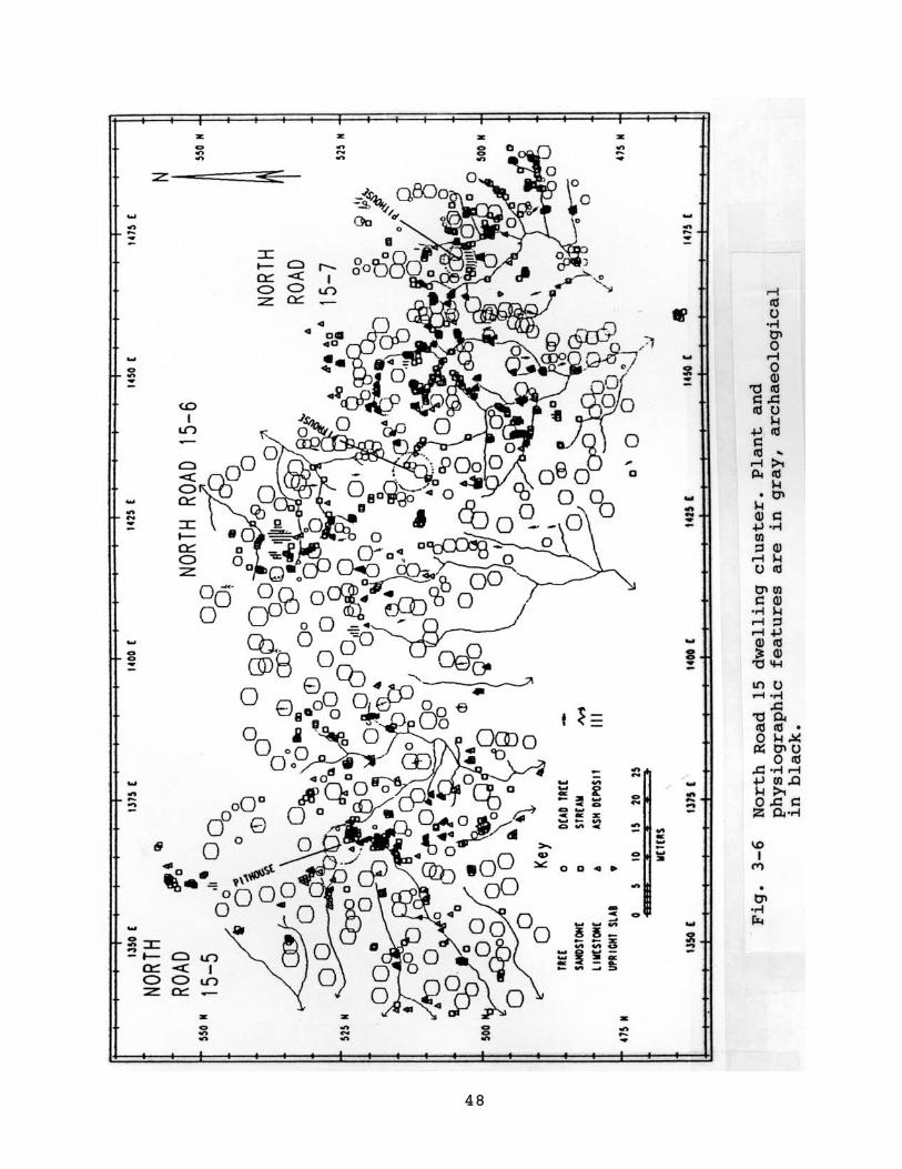
48

49
even probably mark storage units. Most artifacts are southeast
of the pithouse (Fig. 3-6). The pithouse is not in the center
of the distribution, although it is in the most dense part of
the distribution. Instead, the pithouse is in the northwest
third of the total artifact scatter. And, as with previously
reviewed dwellings, most “furniture” is very near the pithouse
(Fig. 3-6).
North Road site 15-5, furthest west on the “village plan,”
has essentially the same plan as site 15-7, if I am correct in
my pithouse attribution. Its artifact distribution is also
heaviest southeast of the possible pithouse. Furniture again
clusters near the pithouse.
Site 15-6 is similar; It is not the same. Some features
marked by intensely burned spots are unusually distant from the
pithouse. The burned spots are one- to-three meters in
diameter. Based on their size, these are probably either burned
storage facilities or very large hearths. Site 15-6 has another
distinction, as well. Its map shows an unusually large number
of features east of the pithouse. These may be partly
associated with site 15-7, immediately to the east.
Despite those differences in feature locations, the site
15-6 artifact distribution is the same as the distribution on
site 15-5 and site 15-7. The size of each is about 25-to-30m
East-West by 35-to-40m North- South.
North Road 13 Quadrat Sites
Together, two adjacent sites on North Road 13 have three
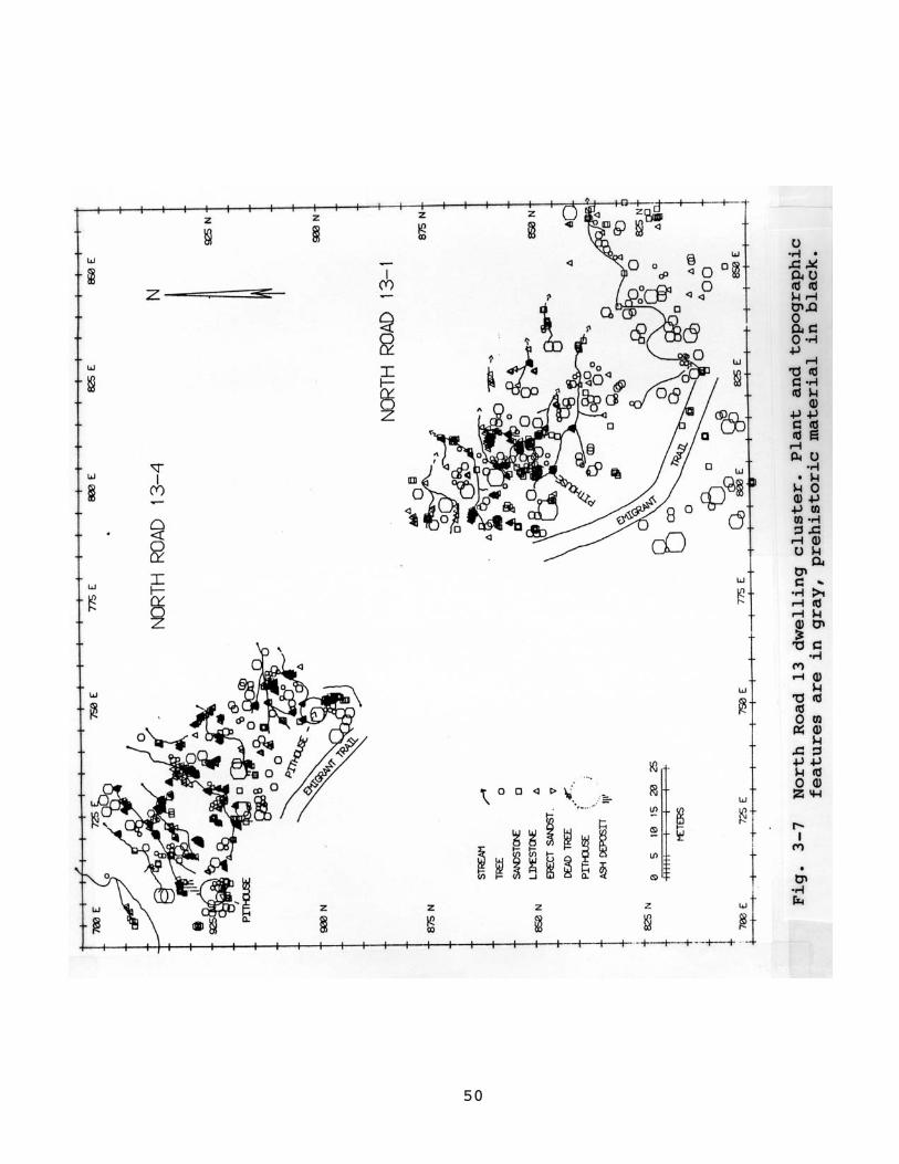
50
51
probable pithouses (Fig. 3-7). Site 13-4 has two well-defined
pithouses and site 13-1 has the third pithouse. None of the
homesteads has the expected distribution of either features or
artifacts. Construction or use of the road (the Emigrant Trail
on U.S.G.S. maps) probably has removed or obscured many
artifacts and features. Still, expected storage features north
and west of the pithouses are missing. On the one hand, they
could be partly buried; this site may be in a locally
aggradational environment because a nearby butte may be either a
sediment source or trap. On the other hand, there are far more
limestone dumps than are present on other apparently single
component BM II sites. These dumps argue for reoccupation. As
well, there is clear evidence of later Anasazi occupation,
including some pueblo construction and about two dozen potsherds
in the site 13-1 pithouse area. This quadrat is provisionally
addressed among the possible “villages” or neighborhoods because
of the proximity of the three homesteads. They are close
together and maintain the expected 25-to-30m east-west by 35-to-
40m north-south dimensions. While the plethora of limestone
supposes palimpsests, it is as likely that these postdate all of
the recognized homesteads as that any one is later than the
others.
Results
Cedar Mesa Basketmakers tended to homestead in some kind of
clustered communities. No neighborhood or community that we
have identified so far is as large as any “village” defined by

52
researchers in New Mexico or Arizona. Nor is there any evidence
for integrative structures in any Cedar Mesa BM II community.
All of the apparent pithouses are about the same size. However,
the simple fact of residential clustering may suggest supra-kin
group residence. This is the important point for discussing
depth of the Anasazi village tradition. Further, it is
unfounded to suppose that all clusters in the North Road 5 and
North Road 6 area represent temporally discrete occupations.
However, survey evidence can only support contemporaneity of
proximate residences. The survey argues well for
contemporaneity of North Road 15 homesteads; it argues less well
for contemporaneity of North Road 13 or North Road 14
homesteads.
In North Road 15, the three adjacent BM II sites are
oriented in the same direction and each has essentially the same
layout. This is partly caused by their location on a northwest-
southeast trending ridge (Fig. 3-7). Still, topographic
considerations in reoccupied sites would not account for the
absence of overlapping features. And, each is about the same
size.
It is possible that some noise is by palimpsests,
particularly north and west of the site 15-6 pithouse and
between the site 15-6 and site 15-7 pithouses. While they do not
have the shared midden that Navajo Nation Archaeological
Department (e.g., Werito 1989) expects for BM II villages2, they
present the appearance of a cohesive whole.
Homesteads in other site clusters identified during last
53
summer’s survey are less likely to be contemporaneous. The
North Road 13 sites are a good example. Like North Road 15, the
North Road 13 quadrat has at least three pithouses. However,
they may result from reoccupations or have overwhelming
palimpsest problems with other, unidentified occupations. Of the
three BM II components defined in North Road 13, only the site
13-1 Basketmaker homestead has the expected distribution of
features and artifacts.
The survey evidence for contemporaneous BM II “villages” on
Cedar Mesa is first that most pithouses are near other pithouses.
Second, some neighboring pithouses have a congruence of spatial
organization in which layout of dwelling, storage, and trash are
the same for all. These neighborhoods are small to be called
“villages.” Perhaps only two to five neighboring households were
occupied at once. Whether neighboring clusters – that is any of
those within the North Road 5 to North Road 6 area were
contemporaneous is less easily addressed by survey.

54
Acknowledgements The 1991 Cedar Mesa survey and excavation was funded wholly by a grant from Social Sciences Research Council of Canada to R.G. Matson and myself. I am especially grateful to S.S.R.C.C. and R.G. Matson. Our totally excellent crew was Grant Beattie, Mike Brand, Gordon Matson, Julian Matson, Reid Nelson, Paul Prince, and Lisa Rankin. Susan Matson fed us and managed us and the camp. I believe the season would have been impossible without her. Bruce Louthan and Dale Davidson, Bureau of Land Management, loaned a laser transit, which allowed us to make precise maps. Brian Chisholm, University of British Columbia, kindly loaned a portable computer. Analysis since the field work has been made possible by the efforts of Jane Sandoval, who has verified and transcribed transit coordinates and artifact notes and by Mark Nagel, who has produced the artifact density maps presented here. Mike Brand has been responsible for our IMACS forms. I am grateful to W.D. Lipe and R.G. Matson for freely providing access to their earlier survey and excavation data, and to Frank Michaels for his various assistance and kindness.
Footnotes
1) Site numbering is dependent on the quadrats. The quadrats are 400-by-400m areas. North Road quadrats 1- to-11 were part of the Cedar Mesa Project stratified random sample survey of 1972 to 1974 (Lipe and Matson 1975; Lipe and Matson 1978). Quadrats 12- to-15 were judgmentally chosen for the 1991 survey but otherwise use the same general survey technique. Especially, sites are numbered by survey sequence. Only habitation sites that form part of clusters or “villages” are described here.
2) Only NNAD has provided a descriptive definition for expected BM II villages.
A slightly different version of this chapter was published as “The Search for Anasazi Village Origins: Basketmaker II Dwelling Aggregation on Cedar Mesa” Kiva 90(2):257-276 (1994).
55
Chapter 4
CARBON AND NITROGEN ISOTOPIC EVIDENCE ON BASKETMAKER II DIET AT CEDAR MESA, UTAH
BRIAN CHISHOLMR.G. MATSON
Department of Anthropology and SociologyUniversity of British Columbia
Vancouver, B.C., Canada
The composition of Anasazi diets, particularly Basketmaker
II, is still not fully established, with interpretations ranging
from that of a mixed hunting-gathering and horticultural
economy, to that of a fully horticultural one (Berry 1982:31-
33). For example, Kidder and Guernsey (1919:154) stated that
the Basketmaker II people used corn, like their Pueblo
successors. Amsden (1949:97-105) saw the Basketmaker II as
transitional between a hunter-gatherer and an agricultural
Pueblo economy. Hough (1930:69) indicated that Basketmaker
people cultivated both maize and squash, as well as hunting and
collecting wild plants. He estimated the Pueblo peoples diet
as being 85% cereal, 5% animal and 9% vegetable. Berry
(1982:33) clearly views the Basketmaker II as committed to full
time agriculture.
These interpretations can be contrasted with one suggesting
that the Basketmaker II were mainly hunters and gatherers, who
also grew some corn, but were not heavily dependent on it
(Amsden 1949, Irwin Williams 1973). In this case we might

56
reasonably place the reliance on maize at about 30%. It is
perhaps noteworthy that Schiffer (1972) made an estimate of 50%
maize in the diet for the succeeding Basketmaker III period,
based on a theoretical discussion using a series of assumptions
and calculations involving the number of storage facilities, the
estimated population size etc. Minnis (1985), using
ethnographic analogy and coprolite data, also suggested a 50%
maize intake for the Anasazi.
While the degree of the Anasazis reliance on maize is not
yet clearly established, there is no doubt that maize was used
in Basketmaker II times, as it has been noted from the earliest
publications about that period (Kidder and Guernsey 1919, Pepper
1902). On Cedar Mesa maize has been found in storage cists
(Lipe and Matson 1971, 1975; Matson and Lipe 1975, 1978; Matson,
Lipe and Haase nd). A relatively recent analysis by Aasen
(1984) on Basketmaker II coprolites from Turkey Pen Cave in
Grand Gulch on Cedar Mesa (Fig. 4-1) showed both macrofossil and
pollen evidence of maize. The question is how much did it
contribute to the local diet?
In order to determine this, we collected Cedar Mesa
Basketmaker II and Pueblo human bone samples for isotopic
measurement and comparison. It would have been ideal to also
have Archaic samples from Cedar Mesa. However, since the
Archaic is so faint there as to be effectively absent, a sample
was obtained from Sand Dune Cave (Burial 2) near Navajo Mountain
(Lindsay et al 1968:42) (Fig. 1-1). These isotope ratio
measurements allow C4 plant intake to be estimated and compared
57
Fig. 4-1 Location of Cedar Mesa, Grand Gulch, and Turkey Pen

58
for the three time periods. In this area the major C4 plant
food to consider as a human food would be maize, but some carbon
that originated in C4 plants could make its way into humans via
herbivore meat.
The Isotope Technique
The stable isotope approach to diet reconstruction has now
been used archaeologically to determine the presence of maize in
prehistoric human diets in a number of cases (Bender et al 1981;
Bumsted 1984; Lynott et al 1985; Schwarcz et al 1985; van der
Merwe and Vogel 1978; van der Merwe et al 1981). The technique
has been described by a number of authors, and has been reviewed
by van der Merwe (1982) so only a few important details are
mentioned here.
We know that Carbon, from CO2 of measurable isotopic
ratio1, is incorporated into plant tissues via photosynthesis at
which time isotopic fractionation takes place, altering the
isotope ratio. Also, when animals eat, their metabolisms
recombine food-derived chemicals, containing Carbon and
Nitrogen, and respire CO2 and excrete urea, resulting in further
fractionation of the carbon and nitrogen isotopes. It has been
found that the difference between the isotope ratio for the
average diet and that for the bone collagen extract (gelatin) of
the consumers is about 4.5 (+0.4) per mil for lipid free samples
(Chisholm 1986; Chisholm and Nelson, unpublished data; Koike and
Chisholm 1988)2, and about 5 per mil for samples with lipids
left in (see van der Merwe 1982). As we now know this means
that consumers bone gelatin, which may be recovered from a

59
prehistoric context, may be used to determine the isotope ratio
for their average diet. Such gelatin-derived results may, in
some cases, then be interpolated between the values for the diet
alternatives that were available to the consumers, eg., C3 or C4
plants in order to estimate the relative proportion in which
each alternative provided protein in their diets. In the case
of nitrogen, the increment between diet and consumer gelatin is
not quite as well understood, but what is particularly useful
about nitrogen values is that the inter-trophic level difference
between similar tissues is about 3 per mil (Chisholm, Nelson and
Schwarcz, unpublished data, Minagawa and Wada 1984, Schoeninger
and DeNiro 1984, Schwarcz 1991), which provides for better
discrimination of trophic levels than does carbon, with its
inter-trophic level increment of about 1 or less per mil (Bender
et al 1981, DeNiro and Epstein 1978, Schoeninger 1985, Tieszen
et al 1983).
It is always possible that the values for both C3 and C4
plants may have been affected to some extent by geographical,
climatic or temporal differences in reservoir values, or by
differences between tissues. In fact, maize kernels appear to
be enriched in 13C compared to leaves and cobs (Bender 1968,
Creel and Long 1986, Lowdon and Dyck 1974 and Schwarcz et al
1985), with observed values for maize kernels of around -11 to -
9 per mil. Samples from the Southwest (Bender1968, Creel and
Long 1986), suggest that the correct value for at least the
maize component of a C4 diet in our study area may be about 1.5
2 per mil more enriched in 13C than the usual C4 value of about
60
-12.5 per mil indicates. Herbivores and carnivores would of
course reect such differences. Clearly more data must be
obtained on isotope ratios for the particular plant tissues that
were eaten by herbivores and humans.
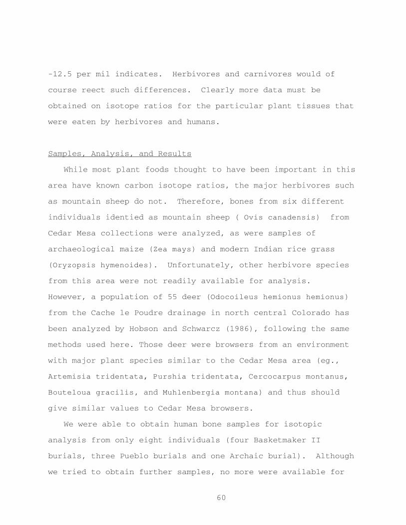
Samples, Analysis, and Results
While most plant foods thought to have been important in this
area have known carbon isotope ratios, the major herbivores such
as mountain sheep do not. Therefore, bones from six different
individuals identied as mountain sheep ( Ovis canadensis) from
Cedar Mesa collections were analyzed, as were samples of
archaeological maize (Zea mays) and modern Indian rice grass
(Oryzopsis hymenoides). Unfortunately, other herbivore species
from this area were not readily available for analysis.
However, a population of 55 deer (Odocoileus hemionus hemionus)
from the Cache le Poudre drainage in north central Colorado has
been analyzed by Hobson and Schwarcz (1986), following the same
methods used here. Those deer were browsers from an environment
with major plant species similar to the Cedar Mesa area (eg.,
Artemisia tridentata, Purshia tridentata, Cercocarpus montanus,
Bouteloua gracilis, and Muhlenbergia montana) and thus should
give similar values to Cedar Mesa browsers.
We were able to obtain human bone samples for isotopic
analysis from only eight individuals (four Basketmaker II
burials, three Pueblo burials and one Archaic burial). Although
we tried to obtain further samples, no more were available for
61
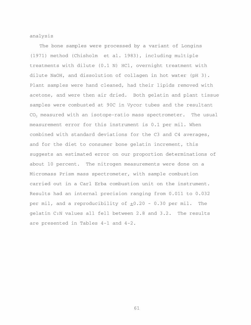
analysis
The bone samples were processed by a variant of Longins
(1971) method (Chisholm et al. 1983), including multiple
treatments with dilute (0.1 N) HCl, overnight treatment with
dilute NaOH, and dissolution of collagen in hot water (pH 3).
Plant samples were hand cleaned, had their lipids removed with
acetone, and were then air dried. Both gelatin and plant tissue
samples were combusted at 90C in Vycor tubes and the resultant
CO2 measured with an isotope-ratio mass spectrometer. The usual
measurement error for this instrument is 0.1 per mil. When
combined with standard deviations for the C3 and C4 averages,
and for the diet to consumer bone gelatin increment, this
suggests an estimated error on our proportion determinations of
about 10 percent. The nitrogen measurements were done on a
Micromass Prism mass spectrometer, with sample combustion
carried out in a Carl Erba combustion unit on the instrument.
Results had an internal precision ranging from 0.011 to 0.032
per mil, and a reproducibility of +0.20 - 0.30 per mil. The
gelatin C:N values all fell between 2.8 and 3.2. The results
are presented in Tables 4-1 and 4-2.

62
Table 4-1. Results of analysis of prehistoric Cedar Mesa ____________mountain sheep.
Measured Calculated diet EstimatedSample d15N%0 d13C%o d13C%0 %C4+5)*
________________________________________________________________NR C24.1 #8 5.0 -16.3 -20.8 23GG 69-33 #51-1 -18.7 -23.2 6UGG 4x site 3 #2 3.8 -16.5 -21.0 21B 10-7 unit 10 -16.2 -20.7 24UGG 9-6 #14 -19.2 -23.7 2B 3X-10a #42 -15.0 -19.5 32B FS2 BC16 4.8 -17.1 -21.6 15________________________________________________________________Average 4.5+0.64 -17.0+1.48 -21.5 18.0
* Based on values for C3 plants of -24.0 per mil and for C4 plants of -10.0 per mil.________________________________________________________________
Table 4-2: Results of analysis of prehistoric Cedar Mesa human samples.
________________________________________________________________ Measured Calculated diet
Period* Sample d15N(%0) d13C(%0)** d13C(%0)***________________________________________________________________P III Bu 3X-10a 10.5 -7.3 -11.8P II/III GG C12 -7.4 -11.9P II/III HS C3.1 #26 10.8 -7.1 -11.6
Average 10.7 -7.3+0.15 -11.8________________________________________________________________BM II Bu 9-6 -7.9 -12.4BM II B C35.2 -7.5 -12.0BM II NR C19.1 #18 9.5 -7.5 -12.0BM II NR C19.1 #17 10.4 -7.7 -12.2
Average 10.0 -7.7+0.19 -12.2________________________________________________________________Archaic NA 7523 8.4 -13.9 -18.4
(Navajo Mtn)________________________________________________________________* P = Pueblo, BM = Basketmaker.** C:N values are all between 2.8 and 3.1.*** Based on the extracted bone collagen of a consumer being 4.5 per mil more positive than the value for its average diet (see text).
63
Plant Values
The carbon isotope ratio for a modern lipid-free sample of
rice grass was -23.8 per mil (indicating that it is indeed a C3
species) and the nitrogen ratio was 1.4 per mil. This carbon
value is somewhat more positive than other values reported for
the Southwest, which average - 26.0+2.2 per mil in the Pecos
River Valley, New Mexico (Des Marais et al 1983) and -26.1+1.5
per mil near Oatman, Arizona (Ehleringer and Cooper 1988). The
difference in values may reect the removal of isotopically more
negative lipids from our sample, and not from the others, or it
may reect a drier environment on Cedar Mesa than in the other
sampled areas (c.f. Ehleringer and Cooper 1988). In the absence
of further data we will use a rounded off value of -24per mil to
represent C3 species in the Cedar Mesa area. Our archaeological
maize results were d13C = -9.9 per mil and d15N = 13.5 per mil
for the kernel, or edible, portion. The carbon value agrees
with those of Creel and Long (1986) for the southwest, so we
will use a value of -10.0 per mil for a C4 diet in the Cedar
Mesa area. Future measurements may lead to a modication of
these values, which could change the nal proportion
determinations for consumers, of up to perhaps 10 to 15%, but
which should not signicantly alter our temporal comparisons.
The maize N value, at 13.5 per mil is higher than those
previously reported for the southwest, at 7.0 per mil. This
brings about two different situations that will affect the nal
64
interpretations: 1) our value is incorrect, due perhaps to post
depositional effects, or, 2) our value is correct, but
represents an anomalous situation (such as the growing of maize
in bean elds).
Herbivore Values
An average bone gelatin carbon isotope ratio of -20.6+0.5 has
been reported for modern Colorado deer (Hobson and Schwarcz
1986), indicating a dietary average of -25.1. No nitrogen
results were reported. While their gelatin is 4.5 enriched
relative to their diet, muscle tissue should be enriched by only
about 1 per mil as it is for other consumers (Bender et al.
1981, DeNiro and Epstein 1978, Schoeninger 1985, Tieszen et al.
1983). Therefore, meat from these deer should have an average
carbon value of about -24.1 per mil, similar to the Indian Rice
Grass value from Cedar Mesa. Deer from Cedar Mesa should
exhibit similar values since their forage species were similar,
and could be combined with the rice grass to form a C3 diet
alternative group.
The prehistoric mountain sheep examined in this study (Table
4-1) gave an average carbon value of -17.0+1.6 per mil and a
nitrogen value of 4.5+ 0.6 per mil. This indicates a diet that
was higher in C4 plant material than that of the deer, averaging
about 18% C4. As the mountain sheep are grazers and the deer
are browsers, and as C4 species are grasses, these results are
not surprising. The meat value for the mountain sheep would
have been about -20.5 per mil.
Human diet alternatives and predicted human values
65
In this case there are three principal food categories
available for human consumption, each with different d13C average
values: C3 plants, C4 plants (primarily maize), and herbivore
esh. Since the deer, mountain sheep and the C3 plant values
are close, we may consider them as one diet alternative group
with an average value between -24.0 and -20.5 per mil. The C4
plant - maize group value used here is -10.0 per mil and may
also include meat from C4 eating species such as turkeys, that
may have been fed large quantities of maize. The presence of
herbivore meat in the diets may be evident from high nitrogen
ratios, which would indicate that the humans were eating from
higher trophic levels.
In addition to plant remains Aasen (1984:40) found small
unidentiable fragments of bone in the Turkey Pen coprolites.
If the animals were mountain sheep we would expect them to have
a meat value of -20.5 per mil, as discussed above. Other
grazing herbivores, such as rabbits and smaller rodents, should
have similar values. Wild turkeys could complicate things
somewhat as they are known to have been fed maize in some
quantity. Consumption of small amounts of such herbivore meat
might shift the results away from either of the C3 or C4
extremes, depending upon whether it was C3 or C4 species that
the animals ate, or that their meat replaced in the human diet,
particularly since meat is about 10 times as high in protein
content than an equivalent amount of plant material.
In the case of nitrogen, we would expect low values, in the
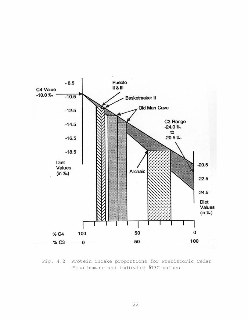
66
Fig. 4.2 Protein intake proportions for Prehistoric Cedar
Mesa humans and indicated d13C values

67
range of the mountain sheep, from humans that were primarily non
- C4 eating vegetarians. People who obtained much, or most, of
their protein by eating herbivore meat, such as mountain sheep
that ate mostly C3 plants, should yield nitrogen values around 7
- 8 per mil, i.e., about 3 per mil higher than their food
source(s). Further, people who obtained most of their protein
from maize, would be expected to have an even higher nitrogen
value, perhaps of around 16.5 per mil.
Human Results
Comparing the human average diet results (Table 4-2) to the
ranges of carbon values for the diet alternative combinations
suggests a C4 intake of about 83 to 87% for the Pueblo II / III
individuals, and of about 79 to 84% for the Basketmaker II
individuals (see Fig. 4-2). Their nitrogen average values, of
10.7 and 10.0 per mil, respectively, are both lower than our
nitrogen value for the maize, but higher than those for other
maize samples in the southwest, and than that for the mountain
sheep, and presumably for deer. If a maize value of 7.0 per
mil, as found by other researchers, is correct, then the human
nitrogen results support the carbon results in suggesting a high
maize intake by the Basketmaker II / Pueblo people. However, if
the nitrogen value of 13.5 per mil is the correct one then the
human values of 10 - 10.7 per mil suggest that a reasonable
proportion of the C4 carbon making its way into the humans
collagen was not derived directly from maize, but may have come
from herbivores that ate maize, or other C4 plants with lower
d15N values. One possible pathway for maize, is through wild
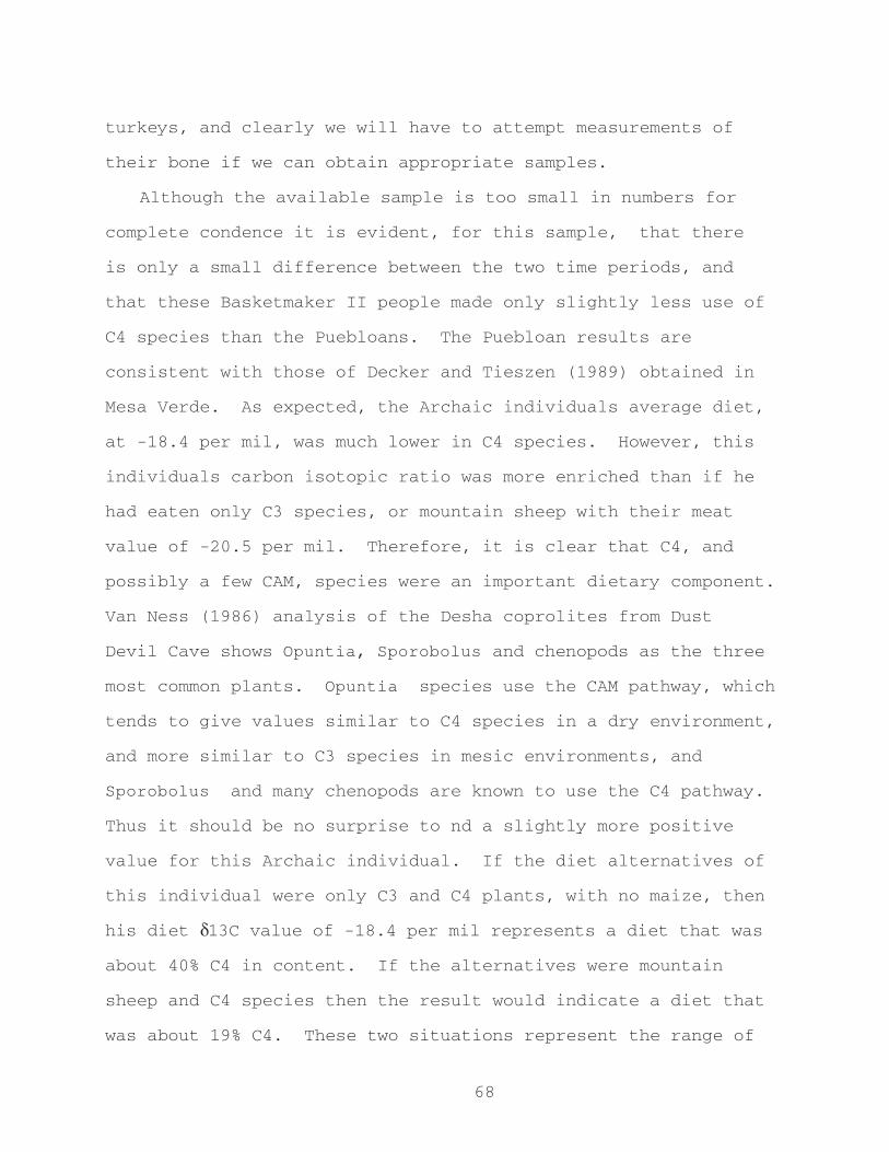
68
turkeys, and clearly we will have to attempt measurements of
their bone if we can obtain appropriate samples.
Although the available sample is too small in numbers for
complete condence it is evident, for this sample, that there
is only a small difference between the two time periods, and
that these Basketmaker II people made only slightly less use of
C4 species than the Puebloans. The Puebloan results are
consistent with those of Decker and Tieszen (1989) obtained in
Mesa Verde. As expected, the Archaic individuals average diet,
at -18.4 per mil, was much lower in C4 species. However, this
individuals carbon isotopic ratio was more enriched than if he
had eaten only C3 species, or mountain sheep with their meat
value of -20.5 per mil. Therefore, it is clear that C4, and
possibly a few CAM, species were an important dietary component.
Van Ness (1986) analysis of the Desha coprolites from Dust
Devil Cave shows Opuntia, Sporobolus and chenopods as the three
most common plants. Opuntia species use the CAM pathway, which
tends to give values similar to C4 species in a dry environment,
and more similar to C3 species in mesic environments, and
Sporobolus and many chenopods are known to use the C4 pathway.
Thus it should be no surprise to nd a slightly more positive
value for this Archaic individual. If the diet alternatives of
this individual were only C3 and C4 plants, with no maize, then
his diet d13C value of -18.4 per mil represents a diet that was
about 40% C4 in content. If the alternatives were mountain
sheep and C4 species then the result would indicate a diet that
was about 19% C4. These two situations represent the range of
69
C4 intake possible in this case. The Archaic individuals
nitrogen value, of 8.4 per mil, is closer to the value expected
for a consumer of mountain sheep than it is to a maize consumer,
suggesting that perhaps the latter interpretation, of ca. 19%
C4, is more appropriate. In all likelihood the diet would
contain elements of all three alternatives, although the
presence of edible C3 plants in the area appears low enough
(Aasen 1984) that the result is probably closer to a C4 plant -
herbivore mixture. A result of around 25 - 40 percent C4 would
not be unexpected, but that is only a guess. Further evidence
on Archaic diet alternatives in the study area will be necessary
for more accurate interpretation.
Conclusions
This paper further illustrates some of the difculties in
determining diet proportions when there are more than two diet
alternatives available. In such a situation it is only possible
to obtain a range of proportion possibilities. Use of nitrogen
isotope ratios helps to differentiate between meat and plant
foods in the diets and thus may allow more exact determinations.
In spite of the problems with isotope ratio differences in
plant tissues, and of multiple diet alternatives it is clear
that the Basketmaker II and Puebloan individuals from Cedar Mesa
analyzed here were obtaining nearly all of their protein forming
carbon from C4 species. This is an increase of about 40 - 60
percent from the Archaic and no doubt results from the
introduction of maize into local diets. There also appears to

70
be a slight increase (about 5 percent) in C4 use from
Basketmaker II to Pueblo II/III times. This is probably due to
an increase in maize consumption.
While it is clear that there are a number of unresolved
issues, it is equally clear that, at Cedar Mesa, the Basketmaker
II carbon isotope ratio is in close agreement with that of the
Pueblo and both are in accord with an extensive presence of
maize, as suggested by the analyses of Hough and Aasen. In
contrast, the single Archaic value is quite different, and does
not indicate as extensive C4 use. More detailed isotope ratios
for the particular plant and animal tissues are needed to obtain
more precise estimates of diets, but Basketmaker II reliance on
maize is strongly supported.
71
Acknowledgements Actual isotope measurements were provided by D. Erle Nelson
(Simon Fraser University), using facilities in the Centre des Faibles Radioactivits (C.N.R.S.) isotope laboratory in Gif sur Yvette, France; by the late C.E. Rees of the Geology Department, McMaster University, Hamilton, Ontario; and by T.F. Pedersen, Oceanography Department, University of British Columbia. Funding for this study was provided by the H.S.S. Committee, U.B.C. and the Cedar Mesa Project was supported by grants from N.S.F. We thank J. Richard Ambler and the Museum of Northern Arizona for the Navajo Mountain (NA 7523) sample, and Bill Lipe for doing the identication on the mountain sheep samples and for assisting with the burial samples, and much more. Errors of judgement remain our own.
Notes:1.) Sample measurement involves cleaning and purifying the sample, combusting it to obtain CO2, and measurement of the CO2 in an isotope-ratio mass spectrometer.
Results are expressed, in parts per mil (%o) as follows: d(%o ) = { [R sample / R standard ] - 1 } x 1000.Where R = (13C/12C) or (15N/14N). The carbon standard referred to is the internationally used PDB standard, while the nitrogen standard is AIR.
2.) The value of 5 used by van der Merwe (1982) and others is based on samples from which lipids have not been removed. The value of 4.5 is based on samples from which the lipids have been removed (Chisholm 1986, Chisholm and Koike 1988, Chisholm, Nelson and Howard n.d., Koike and Chisholm 1988). This latter value has been observed for a number of species now, including rodents (Chisholm 1986), cats (Chisholm 1986), ungulates (van der Merwe and Vogel 1978, and others), and monkeys (Koike and Chisholm 1988).
72
Chapter 5
THE CORE OF THE MATTER: BASKETMAKER II LITHIC TECHNOLOGY AND MOBILITY PATTERNS ON
CEDAR MESA, SOUTHEAST UTAH.
Reid J. NelsonDepartment of AnthropologyWashington State University
Introduction
One issue central to the question of Anasazi origins is
whether Basketmaker II adaptation and organization differed from
that of later Anasazi periods. I have chosen to isolate one
aspect of Basketmaker II organization - namely group mobility -
in order to see whether differences in mobility between
Basketmaker II and later Anasazi periods were reflected in
lithic assemblages. Such comparisons are important in our
attempt to understand the continuum of Anasazi adaptation and
organization, as well as to understand how well and where
Basketmaker II fits within this continuum.
Two models of Basketmaker II to Pueblo II-III mobility
change will be evaluated. The first model, which equates well
with most traditional views that see Basketmaker II as being
closely associated with late Archaic or as transitional between
the Archaic and the Formative Anasazi (see Irwin-Williams 1973;
Kidder 1962), is that there were substantial decreases in
mobility and/or subsistence catchment size from Basketmaker II
to Pueblo II-III. I will refer to this model as the Traditional
73
model. The second model, which fits well with some recent views
that see the Basketmaker II as more adaptationally similar to
later Formative Anasazi, is that there was little change in the
degree of mobility and/or the size of catchment areas from
Basketmaker II to Pueblo II-III because mobility and catchment
size had already been substantially reduced prior to Basketmaker
II. Because this model fits well with the recent works of
Matson (1991; Matson and Chisholm 1991) and Dohm (1988), I will
refer to it as the Matson-Dohm model.
Research Problem
This study utilized flaked stone data in order to identify
whether changes in degree of mobility are reflected in the
technological organization of chipped stone assemblages. It is
not the intent of this study to define the nature of Basketmaker
II mobility. Mobility is a loose and somewhat ambiguous term
encompassing a variety of often poorly defined phenomena. In
the case of the Cedar Mesa Anasazi, perhaps it is most useful to
consider the degree of mobility as a measurement of increasing
or decreasing catchment areas rather than a specific type of
movement, since the notion of catchment areas does not attempt
to define the specific type of mobility pattern in use but,
instead, defines the area in which these patterns occur. For
the purposes of this study a correlation can be made between
high mobility and large catchment areas and between low mobility
and small catchment areas.
It is also necessary to define technological organization.
A useful definition of technology has been given by Wiant and
74
Hassen (1985:101) as “the body of knowledge a society uses to
extract ..., collect ..., and fabricate implements.” Thus, as
Wiant and Hassen define it, the term technological organization
refers to the “methods and techniques involved in the
procurement, design, manufacture, and maintenance of implements,”
(1985:101).
In the last ten years, lithic analysts have spent a great
deal of time trying to isolate which factors influence the
organization of lithic technology (Andrefsky n. d., 1991;
Bamforth 1986, 1991; Binford 1979, 1986; Goodyear 1979; Henry
1989; Parry and Kelly 1988; Rolland and Dibble 1990; Wiant and
Hassen 1985). In 1988, a controversial article by Parry and
Kelly suggested that a shift to a more sedentary settlement
strategy is likely to be accompanied by a shift in the
organization of lithic technology. This shift includes a
decline in standardized core reduction and formal tool
production and an increase in unstandardized core reduction and
expedient flake tool production. In simpler terms, this is
often referred to as decrease in formality and an increase in
expediency.
Formality has been defined in various ways. Tools which
have undergone extra effort in production and maintenance are
usually considered formal, while tools which have had little
effort expended in their production or maintenance are
considered expedient. Formal tools are often characterized as
being flexible, multi-purpose tools which are often extensively
curated (Andrefsky 1986; Bamforth 1986; Goodyear 1979).

75
Bifaces, which usually exhibit a high degree of formality, have
been shown to have the potential for repeated re-use and to
function for use in a variety of tasks (Ahler 1971). Parry and
Kelly (1988), among others, suggest that formal tools are
associated with mobile groups which need multi-purpose tools
available for the wide variety of situations that they may
encounter (Andrefsky 1991). Binford (1979) would classify
formal tools as anticipatory gear which are produced in
anticipation of future needs.
Standardized cores are those which exhibit a patterned
removal of flakes and prepared platforms. Parry and Kelly
(1988) suggest that formal tools are usually struck from
standardized cores thus the presence of these cores in an
assemblage would indicate formal tool production. Bifacial
cores are good examples of standardized cores, whereas bipolar
cores are usually considered expedient.
Expedient tools are made, used, and discarded after little
or no modification and their production is thought to be based
on the need of the moment (Andrefsky n. d.). They are often
unstandardized and wasteful of lithic raw material. Binford
(1979) would classify expedient tools as situational gear which
are produced in response to a condition and not an anticipated
need. Parry and Kelly (1988) would argue that expedient tools
are associated with more sedentary groups which no longer
consider portability an important need.
Unstandardized cores generally show no patterned flake
removal, nor do they show signs of platform preparation. Parry
76
and Kelly (1988) have argued that unprepared cores and
specifically bipolar cores represent expedient technologies and
that expedient tools are usually struck from unstandardized
cores, thus the presence of these cores in an assemblage would
indicate expedient tool production.
If Parry and Kelly are correct in linking expedient tools
and unstandardized cores with sedentary groups and formal tools
and standardized cores with mobile groups, several expectations
can be developed for the two models I have proposed. In the
Traditional model, we would expect that those periods which
showed a higher percentage of expedient tools and unstandardized
cores would be more sedentary than those with lower percentages
of expedient tools and unstandardized cores. Thus, according to
the Traditional model, Basketmaker II would exhibit a lower
percentage of expedient tools than later periods because the
Basketmaker II were more mobile than later groups. Also there
would be a steady increase in the percentage of expedient tools
as later groups became even more sedentary than the Basketmaker
II. Likewise, core technology would become less standardized
and a ratio of standardized to unstandardized cores would
decrease between the Basketmaker II and later periods.
According to the Matson-Dohm model, however, there would be
little change in the percentage of expedient tools between
periods because the degree of mobility would have already been
reduced prior to Basketmaker II. Also, there would be
relatively little change in the percentage of expedient tools
afterward since the Basketmaker II had a degree of mobility

77
similar to that of later periods.
Most would agree that the organization of lithic technology
is not simply the result of one factor. Indeed, the picture is
much more complicated than that. Bamforth (1991:217) has
correctly pointed out that broad brush theories which attempt to
assign one factor as the overriding influence on the
organization of technology fail to recognize the complex set of
factors which influence this organization. Such may be the case
with the hypothesis proposed by Parry and Kelly (1988). The
complex set of factors which do effect the organization of
technology are certainly numerous and are almost always unique
to a specific environmental and cultural setting.
Two factors which are often cited as important influences
on the organization of technology are raw material availability
and quality. Many scholars have recently argued that the
availability and quality of raw material is as important if not
more important than the degree of mobility in determining
technological organization (Andrefsky n. d.; Henry 1989; Rolland
and Dibble 1990; Wiant and Hassen 1985). Limited supplies of
raw material might encourage the production of more general
purpose, formalized tools since the toolmaker would need to
conserve supplies by producing fewer tools which ultimately
would need to serve more purposes. Likewise, an abundant supply
might encourage the use of low investment disposable tools since
expedient tools often more accurately fit the task at hand when
compared to a generalized biface and take less time to
manufacture than a formal tool. Moreover, groups living with an
78
abundant supply of raw material might not need as much formal
anticipatory gear since any unexpected need can be filled with
an expedient tool from readily available raw material.
Small, low quality, materials may be used differently and
produce different end products than large, high quality,
materials (Rolland and Dibble 1990). High quality material may
be more important to any group desiring to invest more in a
given tool. Reduction strategies might vary according to
material size as well. For instance, bipolar reduction
strategies are often used on small cores.
Methods
The Cedar Mesa assemblages used in this analysis have the
advantage of all being from the same geologically homogeneous
area. Thus, differential access to raw materials through time
has been controlled for to a high degree. Because relatively
abundant raw material is still available there today, it seems
safe to assume that there were no major shortages through time
due to the exhaustion of local supplies. It is possible,
however, that larger raw material pieces may have become less
abundant through time due to exhaustion.
Technological characteristics of late Basketmaker II
assemblages were compared with those of Basketmaker III and
Pueblo II-III assemblages. Data were compiled from the analysis
of lithic materials done by Matson on surface collections made
from across the mesa top during the Cedar Mesa Project (Matson
and Lipe 1978; Matson et al. 1988, n.d.). The Cedar Mesa
79
collections represent three distinct cultural periods, each
separated by an occupational hiatus (Matson and Lipe 1978;
Matson et al. 1988). These periods are late Basketmaker II,
which spanned approximately A.D. 200 - 400, Basketmaker III,
which spanned approximately A.D. 650 - 720, and Pueblo II-III,
which spanned approximately A.D.1065 - 1270. This project
recorded 123 separable Basketmaker II components, 48 Basketmaker
III components, and 132 Pueblo II-III components on the mesa
top.
Using Cedar Mesa data, the total number of tools within 25
pre-established flaked stone categories were compiled for each
time period. Totals were also compiled for each functional
site type (as previously defined by Matson et al. [1988]) within
each time period. Sites which were clearly multi-component were
not used in this analysis. These tool types are fairly straight
forward morpho-use categories previously defined by Matson et
al. (n.d.). Table 5-1 provides a listing of these categories.
Note that all the tools listed as expedient are either utilized
and not retouched at all, or are minimally retouched unifacially
and, very rarely, bifacially. An inspection of a large sample
of these tools confirmed that all of them show minimal input.
In contrast, the formal tools are all bifacially worked and show
a high degree of input. These tools generally consist of
projectile points, knives, and drills. The total numbers of
cores were recorded for each period and site class as well.

80
Table 5-1. Artifact Tool Types Included in Analysis.________________________________________________________________Artifact Type Artifact Description
Expedient Flake ScraperRetouched FlakeSteep Angle Utilized FlakeNarrow Angle Utilized FlakeBifacially Retouched FlakeGraversSnapped DenticulatesFlaked DenticulatesCore Scrapers
Formal Biface FragmentsLarge Point FragmentsSmall Point FragmentsJumbo Corner-notchedLarge Corner-notched, Straight BaseLarge Corner-notched, Round BaseLarge Side-notched PointSmall Corner-notched BarbedSmall Corner-notched Broad BasedSmall Triangular PointsDesert Side-notched PointSmall Shallow Side-notched or StemmedLarge Knives and FragmentsSmall Knives and FragmentsT or Flanged DrillsOther or Plain Shaft Drills
_______________________________________________________________
Table 5-2. Percent of Tool Types for All Site Classes by Period.
________________________________________________________________Period % Expedient % Formal Total # Tools
Basketmaker II 89.2 (n=5,104) 10.8 (n=620) 5,724
Basketmaker III 87.5 (n=1,298) 12.5 (n=185) 1,483
Pueblo II-III 90.6 (n=2,759) 9.4 (n=287) 3,046
________________________________________________________________
81
It was necessary to develop criteria for recognizing the
morphological characteristics of formal and expedient tools.
While a number of measurements could be made to quantify the
formality of a given tool, the ones chosen here are thought to
be general attributes which are sensitive to changes in
technological organization. This analysis is not attempting to
measure every technological attribute from each assemblage in
each period. Its primary intent was to compare general changes
in a certain few attributes over time which I will argue
represent broader changes in the relative expediency and/or
formality of the given assemblages.
Bifacial manufacture strategies which remove the majority
of original flake surface and/or cortex during thinning and
shaping were considered more labor intensive and higher in
investment than unifacial manufacture strategies which usually
seek only to modify an edge. Likewise, tools which
substantially alter the original shape and form of the flake
blank (or other blank) were thought to show a higher degree of
input and thus a higher degree of formality than those tools
which retain the original form of the flake during use.
Projectile points are good examples of tools which, in their
manufacture, alter the shape of the flake blank and have most of
the original flake surface removed. Utilized flakes are good
examples of tools which, in their manufacture, do not alter this
basic shape, neither in plan view nor cross section. Bifacially
thinned tools obviously show a higher level of thinning and

82
shaping in plan view and cross section than utilized flakes.
Generally, the higher the input, the greater the degree of
formality. Curation and resharpening, which are practices
associated with formal tools (Ahler 1971; Andrefsky 1986;
Bamforth 1986), were relatively common in the samples of
bifacial tools inspected, but few expedient flake tools appeared
to have been resharpened or curated.
If we are to gage whether a causal relationship exists
between the degree of mobility and the organization of flaked
stone technology, we must first strive for an independent
measurement of one or the other. Several recent studies suggest
that the Basketmaker II may have been more similar to later
Puebloan groups than previously thought. The lack of diversity
(limited number of tool types relative to total number of tools)
and the predominance of vegetal processing tools within
Basketmaker II tool kits has been argued by Dohm (1988) to
represent an adaptation representing agricultural
intensification. Likewise, her work on Basketmaker villages
suggests that the origins of later Anasazi villages may have
been established by Basketmaker II. Formal village patterning,
though loosely arranged, appears to be evident by Basketmaker
II.
The probability that the Basketmaker II were farming maize
more intensively than previously thought is also supported by
the recent work of Matson and Chisholm (1991). Their analysis
of stable isotopes from human bone gelatin has shown that the
Basketmaker II diet may have included nearly the same amount of
83
maize as the later Pueblo II-III diet. If we consider these
three pieces of evidence together - that the Basketmaker II were
more than likely farming maize from loosely organized villages,
we get a picture more reminiscent of Puebloan life than
previously thought.
Results Tools:
The percentages of expedient versus formal tools show that
in general no trend toward a greater reliance on expedient tools
from Basketmaker II to Pueblo II-III can be noted on Cedar Mesa.
The percentage of tools classified as formal and the percentage
classified as expedient are shown in Table 5-2 and are
represented in Fig. 5-1. Note that from Basketmaker II to
Pueblo II-III an increase of only 1.4% was noted in expedient
tools. Interestingly, the percentage of expedient tools
actually decreased 1.7% from Basketmaker II to Basketmaker III.
These same observations were also made within the various
site types defined on Cedar Mesa. The percentages of expedient
and formal tools are listed in Table 5-3. Among habitational
sites, the changes in percentages of expedient and formal tools
between periods are even less variable than those in the over
all totals. An increase of only 1% was noted in the percentage
of expedient tools among habitational sites from Basketmaker II
to Pueblo II-III. This suggests that the range of activities
occurring at a habitation may have remained remarkably the same
through time. Limited activity sites also show a consistent

84
Fig. 5-1 Percentages of formal and expedient tools for allsite classes by period

85
proportion of expedient to formal tools through time with, once
again, the interesting exception of Basketmaker III, which shows
a slightly lower percentage of expedient tools. This statistic
may be the result of a somewhat low sample size for the
Basketmaker III in this given site category. Three other site
categories , namely problematic habitations, campsites, and
lithic reduction sites, show results that are individually
interesting but, because each one of these site classes has no
represented population for one or sometimes even two of the time
periods considered here, they will not be discussed. It is
interesting to note, however, that there is no significant
difference in the percentage of expedient tools between
Basketmaker II campsites and habitations.
Table 5-3. Percentage of Tool Types for Individual Site Classes by Period.________________________________________________________________Site Class Period % Expedient % Formal Total # Tools
Habitation BM II 89.2 (n=2,363) 10.8 (n=286) 2,649 BM III 86.9 (n=1,108) 13.1 (n=167) 1,275 P II-III 90.2 (n=2,237) 9.8 (n=242) 2,479
Problematic BM II ---- ---- -----Habitation BM III 93.7 (n=119) 6.3 (n=8) 127
P II-III 93.1 (n=255) 6.9 (n=19) 274
Limited BM II 91.3 (n=796) 8.7 (n=76) 872Activity BM III 87.7 (n=71) 12.3 (n=10) 81
P II-III 91.1 (n=293) 8.9 (n=26) 293
Campsites BM II 88.4 (n=1,795) 11.6 (n=236) 2,031 BM III ---- ---- ----- P II-III ---- ---- -----
Lithic BM II 87.2 (n=150) 12.8 (n=22) 172Reduction BM III ---- ---- -----
P II-III ---- ---- -----________________________________________________________________
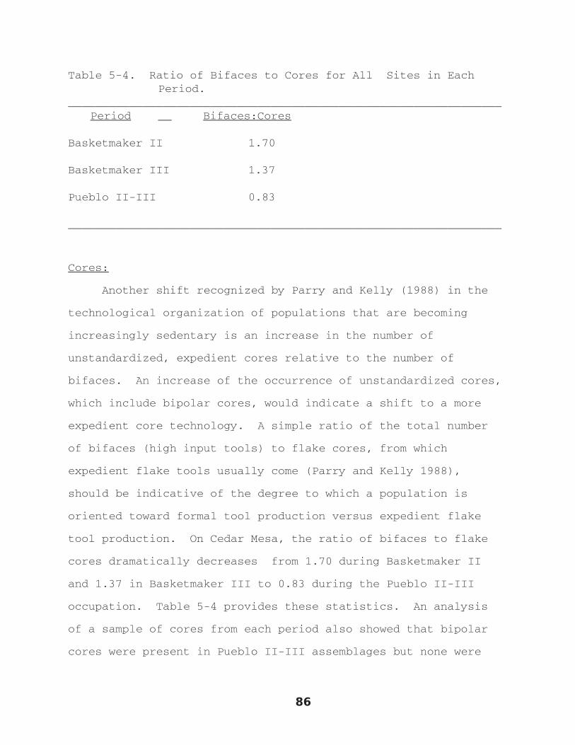
86
Table 5-4. Ratio of Bifaces to Cores for All Sites in Each Period.
________________________________________________________________Period Bifaces:Cores
Basketmaker II 1.70
Basketmaker III 1.37
Pueblo II-III 0.83
________________________________________________________________
Cores:
Another shift recognized by Parry and Kelly (1988) in the
technological organization of populations that are becoming
increasingly sedentary is an increase in the number of
unstandardized, expedient cores relative to the number of
bifaces. An increase of the occurrence of unstandardized cores,
which include bipolar cores, would indicate a shift to a more
expedient core technology. A simple ratio of the total number
of bifaces (high input tools) to flake cores, from which
expedient flake tools usually come (Parry and Kelly 1988),
should be indicative of the degree to which a population is
oriented toward formal tool production versus expedient flake
tool production. On Cedar Mesa, the ratio of bifaces to flake
cores dramatically decreases from 1.70 during Basketmaker II
and 1.37 in Basketmaker III to 0.83 during the Pueblo II-III
occupation. Table 5-4 provides these statistics. An analysis
of a sample of cores from each period also showed that bipolar
cores were present in Pueblo II-III assemblages but none were

87
observed in earlier assemblages. Interestingly, the average
weight of each core reduced about 8 % from Basketmaker II to
Pueblo II-III and the incidence of unstandardized cores
increased by 11%. Since our tool statistics (Tables 5-2 and 5-
3) suggest that the number of bifaces was not decreasing over
time, we can safely say that the number of expedient cores was
increasing.
Discussion
As noted, no significant increase in the use of expedient
tools with an accompanying decrease in the use of formal tools
can be observed from Basketmaker II to Pueblo II-III.
Observations made on cores, however, suggest that a reliance on
expedient core technology may have increased from Basketmaker II
and III to Pueblo II-III, as is evidenced by the increased
number of expedient cores. Also, it appears that cores were
becoming smaller through time. Seemingly an increased reliance
on unstandardized core reduction technology would be associated
with an increase in the abundance of expedient flake tools,
since it is these types of tools we assume are being made with
such a strategy. Yet, as the tool data show, there was no
significant increase in the percentage of expedient tools.
There are a two possible explanations for this. First,
between Basketmaker II and Basketmaker III, as happened
throughout the southwest, a switch was made from large dart
points for projectiles to small arrow points. The production of
small arrow points would obviously require a much smaller and
88
potentially less homogeneous core than that required for a large
dart point. This would suggest that Basketmaker III and Pueblo
II-III, which predominantly used small arrow points, would
require much smaller raw material pieces in order to produce the
small blanks necessary for arrow heads. They might then reduce
these cores to smaller proportions since smaller flake blanks
would suffice to produce an arrow head. This possibility is
supported not only by the fact that cores from Pueblo II-III
were found to be smaller than those from Basketmaker II, but
also that bipolar technology, which is often used on smaller
materials, was present in later assemblages (Pueblo II-III).
Thus a possible explanation for the shift in core technology may
have been more the result of a change in projectile forms rather
than a change in mobility.
Second, raw material must be considered. Raw material
types were not recorded for each item in the original analysis
of these materials. However, Keller (1979) did analyze a sample
of materials from these three periods and came up with a good
approximation of what materials were being utilized and where
they were being obtained. He found that most of the material
types used were local and that the vast majority of them were
moderate to high quality. Interestingly, Keller (1979) has
also shown that Basketmaker II utilized materials almost
entirely from Cedar Mesa, whereas in Basketmaker III and Pueblo
II-III materials from well to the east were being utilized, with
up to 21% being non-local during Basketmaker III and 17% being
non-local during the Pueblo II-III period. At this point, it is
89
not known what effect the introduction of non-local materials
may have had on the technological organization of the Cedar Mesa
Anasazi. Because the quality of these materials tends to be
similar to and usually no better than the quality of local
materials, it is likely that little change was introduced to
chipped stone assemblages due to a variance in raw material
quality.
It is important to note that raw material availability and
quality are two different factors. As more material was
exhausted on the mesa, available raw material pieces may have
become smaller, assuming that initially large pieces are
preferred. The occurrence of this phenomenon has not been
tested, however. A more sedentary population may have been
limited to smaller raw materials because of the exhaustion of
larger pieces in earlier periods and because of the diminished
need for large pieces which may have resulted from the switch to
arrow head technology between Basketmaker II and Basketmaker
III. Thus, the increased reliance on expedient reduction
strategies and the decrease in core size may reflect a minor
difference between periods in the immediate availability of
large raw materials due to relatively minor differences in raw
material availability.
The general availability of relatively good quality raw
materials on Cedar Mesa might suggest that an expedient
assemblage would have been evident for each period regardless of
mobility patterns. However, the consistency of these results
with the independent evidence from Matson and Chisholm (1991)
90
and Dohm (1988) suggests that these results are more likely due
to similarities between Basketmaker II adaptation and
Basketmaker III and Pueblo II-III adaptation. Thus, the
consistency in the proportion of expedient to formal tools is
more likely the product of similar adaptations rather than raw
material availability.
We are left with the possibility that the increased use of
unstandardized cores may be more the result of immediate raw
material availability and/or a change in projectile point
technology rather than of a significant change in the degree of
mobility. We cannot rule out the possibility that changes in
mobility may result in minor changes in technological
organization. It is with this somehow unfulfilling explanation
that we see the inability of the increased sedentism model to
provide meaningful answers to the immediate conditioners of
flaked stone technology. If a heavy reliance the use of
expedient tools can be linked with sedentary populations, then
these three groups are similarly sedentary.
Conclusion
The extent to which we can correlate the degree of mobility
and technological organization is questionable. Moreover, the
ability of this potential relationship to provide a meaningful
understanding of all the conditioners of technological
organization is limited. Despite these limitations, the data
still suggests that certain aspects of the technological
organization of these three groups stayed remarkably similar
91
through time.
To reiterate, the results of this analysis show that the
proportion of expedient tools versus formal tools stays
remarkably similar through all time periods observed. This
consistency would not be expected if we were to assume that a
shift on Cedar Mesa to a more sedentary settlement strategy did
occur from Basketmaker II to Pueblo II-III and that it was
accompanied by an increased usage of expedient tools (change in
the organization of lithic technology). Thus we are left with
either the conclusion that a shift in settlement strategy is not
strongly correlated with an increased reliance on expedient
flake tools or that the Matson-Dohm model is correct and the
similarity in technological organizations through time show that
a shift to a more sedentary settlement strategy had already
occurred prior to the Basketmaker II. Other lines of evidence,
including stable isotope analysis and survey data provided by
Karen Dohm, add further evidence to the suggestion that
Basketmaker II was adaptationally and organizationally similar
to later Puebloans. While these similarities cannot necessarily
act as gauges for the degree of sedentism, they do support the
notion that Basketmaker II adaptation was more similar to later
sedentary Puebloan adaptations than previously recognized.
92
Chapter 6
CEDAR MESA FAUNA REMAINS
Michael Brand
Introduction
This report presents the results of the identification of
faunal remains from twenty - two sites on Cedar Mesa,
southeastern Utah. Faunal assemblages were collected between
1969 and 1991 by the Cedar Mesa Project and the Cedar Mesa
Project II. The sites discussed in this report are found in and
around five drainages on Cedar Mesa: Bullet (B, BU), (Upper)
Grand Gulch (GG, UGG), Hardscrabble (HS), North Road (NR), and
West John’s (WJ). The project site numbers used in the text,
consist of the drainage abbreviation, the quadrat designation
and the number of that specific site within the quadrat.
Therefore site B - 10 - 7, is the seventh site found in quadrat
10, in the Bullet drainage area. Both mesa top and canyon sites
are present. A ‘C’ before the quadrat designation indicates a
canyon quadrat. The ‘x’ included in some project site numbers
designates excavation. Faunal assemblages from these sites range
in size from a single specimen to over seven hundred specimens.
The majority of assemblages are quite small.
Modern Cedar Mesa Fauna
93
The environment of Cedar Mesa today, with few exceptions, has
changed little over the last few thousand years (Matson et al.
1990: I-22). Small mammals observed in the area today include:
cottontail (Sylvilagus sp.), jackrabbit (Lepus sp.), woodrat
(Neotoma sp.), kangaroo rat (Dipodomys ordi), mice, and badger
(Taxidea taxus) (Matson et al. 1990: I-21). Carnivores known to
inhabit the area include the coyote (Canis latrans) and bobcat
(Lynx rufus). Sightings of mountain lions (Felis concolur) have
also been reported. Mule deer are the only large mammal known to
inhabit the mesa today, keeping primarily to the canyon heads,
they are seen only occasionally on the open mesa top (Matson et
al. 1990: I-21). Bighorn sheep (Ovis canadensis), present near
the San Juan River to the south of Cedar Mesa, do not inhabit
the mesa today, likely as a result of the use of the mesa for
grazing domestic livestock (Lipe and Matson 1974).
Birds are relatively abundant on Cedar Mesa today (Matson et
al. 1990: I-21). The golden eagle (Aquila chrysaetos), and a
variety of hawks and owls have been observed. Snakes, lizards
and amphibians are also commonly seen on the mesa.
Sites and Recovery Methods
The following subsections provide limited information on the
sites discussed in this report and the methods used to recover
the faunal assemblages. No information was presently available
for the following sites: GG69, GG69 - 30, GG70, UGGx4, UGG - 6 -
1, and UGG - C11 - 1.
94
BU 3-7 (42Sa4089)
Work on BU - 3 - 7 was conducted primarily in July of 1972.
At least two dwelling structures have been identified on the
site, these features date to the either the Woodenshoe or
Redhouse phase of the Pueblo III period. Faunal remains from
this site were recovered from test pits. It is not clear whether
back-dirt from the test pits was screen or not, likely no
screening was done (R.G. Matson, personal communication).
BU 3-10A (42Sa4092)
Work on BU 3-10A was conducted primarily in July of 1972. Two
occupations, a Basketmaker II and a late Pueblo II - early
Pueblo III, are evident at this site. Dwelling structures from
both occupations are present, however, the Pueblo period
structure has sustained some damage from the disservice of
pothunters. Faunal remains from BU - 3 - 10A were recovered from
test pits. As above, screening of back-dirt was likely not
undertaken.
B 10-7 (42Sa4133)
Work on B 10-7 was conducted during June of 1972. The site
was occupied during the Clay Hills phase. The faunal assemblage
from this site was recovered from excavations which utilized
screens, however, information on the mesh size is not presently
available.
95
HS 4-1
HS 4-1 was excavated in 1991 as part of the Cedar Mesa
Project II. Basketmaker II, Basketmaker III and Pueblo
occupations are all in evidence at this site. Excavation of
three 1m x 1m units centered on the Basketmaker II, or Grand
Gulch phase, occupation. Back-dirt was screened through 1/8 inch
mesh.
HS 5-2
HS 5-2 was excavated in 1991 as part of the Cedar Mesa
Project II. It is the lowest elevation Basketmaker II site on
Cedar Mesa (Matson, this volume). Four 1m x 1m excavation units
were put into a pithouse on the site revealing a structure
approximately 4.5m in diameter, which appears to have burned
following its abandonment. Back-dirt from the excavation units
was screened through 1/8 inch mesh.
HS 5-3
HS 5-3 was excavated in 1991 as part of the Cedar Mesa
Project II. Two 1m x 1m units were excavated into a Basketmaker
II pithouse, however, no intact cultural matrix was found
(Matson, this volume). Back-dirt was screened through 1/8 inch
mesh.
HS C12-3
HS C12-3 was recorded in August of 1973 during the Canyon
Inventory Survey made by the Cedar Mesa Project. Ceramics found
96
on the site place its occupation during the Pueblo II, Clay
Hills phase. The site consists of a relatively large masonry
room under an overhang of the canyon and was interpreted as
possibly a habitation site. The single faunal specimen from this
site appears to have been surface collected.
NR 11-4 (42Sa4034)
Work on NR 11-4 was conducted in June of 1973. The site was
inhabited during the Mossbacks phase (Basketmaker III), and
shows evidence of having been a habitation site with a large,
rectangular slab structure, a possible pithouse, a jacal
storage structure, hearths and relatively extensive midden. Ex
cavations were conducted in the pithouse and antechamber, as
well as in a trash area, slab lined hearth and a surface room
(Dohm 1988). Numerous bits of burned bone were observed around
one of the hearth features. Faunal remains from this site were
excavated from test pits. It is unknown if screening was done or
not.
NR C9-5, The Rock Island Site
NR C9-5 is a Basketmaker II site originally located by the
Cedar Mesa Project. At that time over eight thousand lithic
specimens were collected from about 40% of the surface of the
site (see Brand, this volume). NR C9-5 was revisited in 1991 by
members of the Cedar Mesa Project II. The site is located on a
promontory between branches of North Road Canyon, with access
from only the northwest. Sheer canyon walls reach straight down
97
over one hundred feet to the canyon floor on the north, east and
south sides of the promontory. Two 50cm x 50cm test pits were
excavated in 1991, one of which revealed the floor of a pithouse;
further reinspection of the site suggests that there are at
least five pithouses present on the site (Matson, this volume).
Back-dirt from these test pits was screened through 1/8 inch
mesh.
NR C22-4
NR C22-4 was recorded in July of 1974. The site was inhabited
during either the Pueblo II or Pueblo III period, it consists of
a rectangular structure with rounded corners built just below
the canyon rim in a deep overhang. Faunal remains from this site
were collected from the surface.
GG69 - 18
GG69-18, also known as the Pittman site (Dohm 1988) was
excavated by Lipe (1978). Excavations included a Basketmaker II
pithouse and two trenches, one of which was in trash deposits
(Dohm 1988:174). It is unknown whether screens were used during
the excavation, at any rate, only a single faunal specimen was
recovered.
GG69 - 20
GG69 - 20, also known as the Leicht Site (Dohm 1988:179) is a
Basketmaker II site excavated by Lipe (1978). Features present
at the site included a pithouse (excavated) and hearth.

98
Excavations consisted of a long trench with some expansion off
the trench in the area of a pithouse. A picture of the
excavations (Lipe 1978:393) suggests that screens may have been
used.
GG69 - 32
GG69 - 32 is located in a cave on the north side of Grand
Gulch near its confluence with Kane canyon. The site was occupied
during the Pueblo III period and has been interpreted as a
habitation. It is presently unknown whether the faunal material
present was excavated or collected from the surface.
UGG 4x-3
UGG 4x-3 is a duel component site excavated by the Cedar Mesa
Project, with both a Mossbacks and a Clay Hills occupation.
Faunal remains present for this site were recovered from
excavation, however, it is not presently known if the back-dirt
was screened.
WJ 12-6
Work on WJ 12-6 was conducted during July of 1973. The site
was occupied during the Mossbacks phase. Features present on the
site include a possible pithouse and a midden. Faunal remains
from this site were recovered by excavation, with the back-dirt
screened through 1/4 inch mesh. Excavations included the
pithouse and antechamber, a slab lined cist a storage pit and a
processing pit (Dohm 1988:233).
99
WJ C15-3
WJ C15-3 was recorded by the Cedar Mesa project in July of
1974. The site has been interpreted as a Clay Hills phase
storage location. A single bone awl was collected from the
surface of this site.
Identification Methods
Specimens from the twenty-two sites were identified and
recorded following the procedures described in Cedar Mesa
Manual for the Identification and Recording of Faunal Remains
(Brand 1992). The recording system used for the Cedar Mesa
faunal assemblages is largely based on Driver (1990), and as
such the results should be largely comparable. Briefly, each
specimen is treated individually and independently of all
others. Taxonomic identifications proceeded only when a specimen
could be identified to element (after Driver 1992). For each
specimen a minimum set of information is recorded, following the
system devised by Driver (1992). All specimens are given a three
letter code for Taxon, this may range from unidentifiable,
through general categories such as Large Mammal to species.
Element is recorded, with a two letter code, using standard
osteological terms. Part identifies the portion of the element
present, this is recorded with a numeric code which varies for
each element. Side obviously records the side of the body for
each element, these may be recorded as: Right (R), Left (L),
Unknown (U), or Irrelevant (I). Fusion records the state of

100
epiphysial fusion for both the proximal and distal end of an
element. Breakage is also recorded for both ends of an element.
Any Modification evident on a specimen is recorded, including
natural and modifications resulting from human activity. Any
specimen which has been modified as an artifact is sketched on
the back of the record form. The final two categories are Length
and Thickness. These data are on file at the Laboratory of
Archaeology, Department of Anthropology and Sociology, at the
University of British Columbia.
Identifications were done one provenience bag at a time, thus,
all specimens were returned to their original bag eliminating
any chance of accidental mixing. With appropriate caution each
specimen was identified to the highest taxonomic category
possible. In some cases it is possible to obtain a species
identification. In other cases, due to a variety of factors,
elements can only be identified to less formal taxonomic
categories, such as Large Mammal. Identifications were made using
the comparative collections at the Museum of Anthropology at The
University of British Columbia, and the Department of
Archaeology at Simon Fraser University. Published guides to
skeletal morphology, such as Lawrence (1951), were also used
when required.
Results of the Identifications
Identification results for each site are presented in
Table 6-1. The NISP for each taxon appears in the appropriate
cell within the table. The total NISP for each site appears at
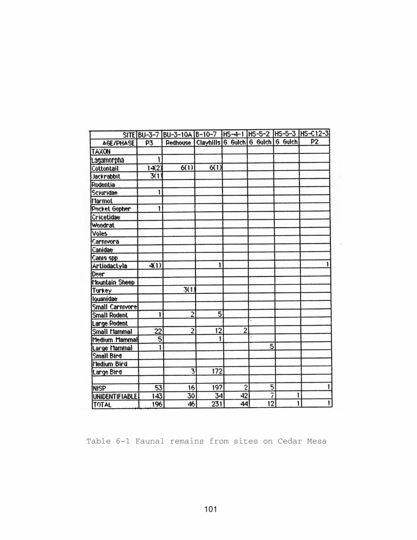
101
Table 6-1 Faunal remains from sites on Cedar Mesa

102
Table 6-1 Continued
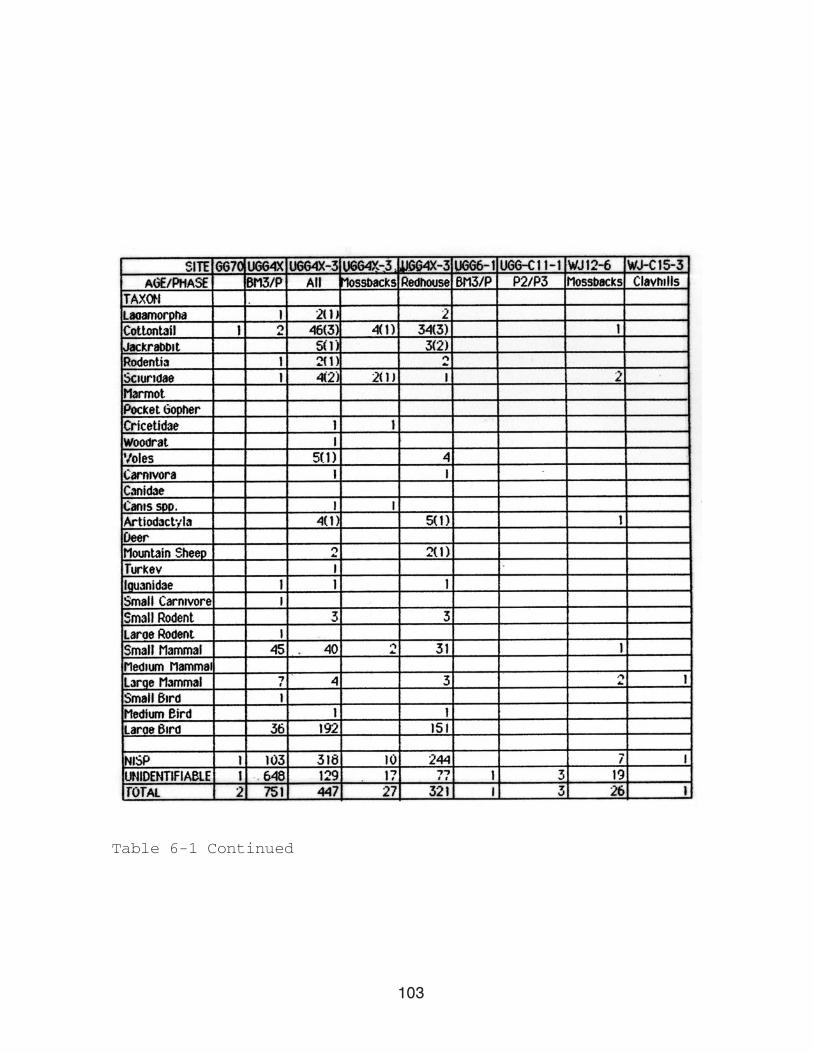
103
Table 6-1 Continued
104
the bottom of each column. The Minimum Number of Individuals
(MNI) was calculated for each of the formal taxonomic categories
(i.e., not for large mammal etc.) and appears in parentheses
behind the number of specimens. MNI was calculated using the
following procedure: using paired elements from individual taxa,
specimens are sorted as to side, when appropriate incomplete
elements of the same side are paired, for example a fragment of
a humerus with only a proximal end will be matched with a
specimen consisting of only a distal end; rights and lefts are
then paired, taking into account the relative age of each
element based on epiphysial fusion. The MNIs presented in this
report are calculated for the entire assemblage from each site,
at this time no divisions have been made on the basis of
provenience.
Unfortunately, very little faunal material was recovered from
the majority of these sites. The median number of specimens
recovered for the sites described in this report is fourteen. As
noted above, only five of these sites produced more than fifty
specimens. A total of twenty-seven taxa were identified in the
faunal remains from these sites. Nine of these taxa were less
formal categories such as small mammal, large bird etc.
Mammalian taxa dominate the assemblages, although birds and
reptiles are present in limited numbers. The mammalian taxa
identified include Lagamorpha, cottontail (Sylvilagus sp.),
jackrabbit (Lepus sp.), Rodentia, Sciuridae, Marmot (Marmota
sp.), Pocket Gopher (Geomyidae sp.), Cricetidae, woodrat
(Neotoma sp.), voles (Microtus sp.), carnivores, Canidae, Canis
105
sp., Artiodactyla, deer (Odocoileus sp., most likely O.
hemionus) and mountain sheep (Ovis canadensis). The majority of
these taxa are present in very limited numbers. Cottontail is
the most abundant taxa, both in terms of NISP and MNI. Mammals
are also represented in significant numbers at some sites in the
general categories of small and large mammal.
Avian remains are relatively rare in the faunal material
recovered from most of these sites. Of the specimens present
only turkey (Meleagris gallopavo) could be identified. The rest
of the avian material present was identified as medium or large
bird. It is possible that some of the other elements which could
only be identified as large bird are turkey as well. At a number
of sites the high values of the large bird category is somewhat
misleading as the majority of specimens in this taxa are
fragments of eggshell. At site B 10- 7 eighty-seven percent
(87%) of all identified specimens were eggshell fragments.
Likewise, at UGG 4X-3 eggshell fragments comprised sixty percent
(60%) of all identified specimens.
Only two reptile bones were present in these assemblages,
both from separate sites.
Modification
Three types of modification are present in varying degrees
among the specimens in these assemblages: (1) rodent gnawing,
(2) burning, and (3) modification into artifacts. Direct
evidence of the destruction of faunal material by the activity
of rodents is slight in the present assemblages. Only four
106
specimens, from three different sites, had been gnawed by
rodents. No incidence of carnivore chewing were observed in any
of the assemblages.
Specimens which have been burned are much more prevalent from
these sites. Burned specimens average forty-two percent (42%) in
assemblages with a total number of specimens above the median.
The majority of burned specimens from any given site are
unidentifiable. Taxa which show burning include Lagamorpha,
cottontail, jackrabbit, Sciuridae, Canis sp., Artiodactyla,
small carnivore, small rodent, small mammal, large mammal and
large bird. A number of eggshell fragments, from at least two
sites, have also been burned. Whether this resulted from
subsistence behavior or burning in a trash heap, for example,
cannot been determined.
Ten of the twenty -two sites discussed in this report
contained worked bone. The majority of these specimens simply
show some evidence of abrasion and have not been fashioned into
any specific form. Awls, or fragments of awls, were present at B
3- 7, GG69, GG69-30, NR 11- 4, UGG 4- 3 and WJ C15-3. Awls were
manufactured from unidentifiable specimens and the elements of
cottontail (tibia), Canis sp. (ulna), and Artiodactyla
(metapodial). UGG 4-3 also had a bone tube (length = 4 cm)
manufactured from the ulna of a large bird, and three small
elongated discs made from bone. The dimensions of these discs
average 18mm in length, 7mm in width and 2mm thick. They are flat
on one side and slightly convex on the opposite. All three were
recovered from Feature G which is dated, on the basis of

107
ceramics, to the Clay Hills Phase. These three artifacts
closely resemble a series of eight Basketmaker artifacts from
Cave 1 in Kinboko (House Canyon), described by Kidder and
Guernsey: “The set of “dice” consists of eight lenticular pieces
eleven-sixteenths inch long [18mm] and one-fourth inch wide
[6mm]all have one flat and one rounded surface.” (1919:189).
The authors note that these artifacts may be inlays as opposed
to dice. They later reported a similar artifact from Cave 6, a
Basketmaker site on the South Comb near Marsh Pass (Guernsey and
Kidder 1921:109).
Summary
This report has summarized the results of the identification
of faunal remains from twenty-two prehistoric sites on Cedar
Mesa, Utah. The majority of the assemblages are very small. Only
five sites have an NISP greater than fifty (including both
identified and unidentified). Identified remains from these sites
were assigned to twenty-seven taxa, of which the majority are
mammalian. Cottontail is the most abundant taxon in almost all
of the assemblages. Unidentified specimens generally out number
those which were identifiable. Worked bone artifacts are present
for a number of the assemblages, and burning appears to be
common.

108
Chapter 7
LITHIC ANALYSIS OF THE ROCK ISLAND SITE (North Road C9-5)
Michael Brand
Introduction
The Rock Island site (NR C9-5) is a large Basketmaker II site
located on the eastern slope of Cedar Mesa, Utah. The initial
survey and recording divided the site into three areas (Map 7-
1). On the basis of observed surface characteristics these areas
appear to differ in a number of aspects. The western most area,
Area A, is defined by a very dense artifact scatter and the
presence of a number of slab lined cists. Recent research at
this site has demonstrated the presence of at least one pithouse
in this area. Area B, located to the east of Area A, also has a
high density artifact scatter, however, no surface features have
been recorded in this section of the site. Area C, defined on
the basis of a third concentration of artifacts on the surface,
lies directly south of Area B. No surface features have been
recorded for Area C.
This study will use lithic analysis to examine intra-site
patterning at NR C9-5. Differences were observed in surface
characteristics between the three areas identified on the site.
The specific question to be answered by the lithic analysis is:

109
Map 7-1 Site NR C9-5 (Rock Island Site) on Cedar Mesa

110
are the three areas of the site the same, or do the chipped
stone tools and lithic debitage from the site indicate
differences between these areas? Two stages of analysis will
be used in this paper to ascertain the nature of intra-site
patterning. The first will be the analysis of all chipped stone
tools collected from the site. If the three areas served
different functions one would expect the frequency of specific
tool classes to vary between the areas. The analysis of the
chipped stone tools will be followed by analysis of a sample of
debitage from each area. The debitage analysis is aimed at
comparing the relative proportions of debitage which can be
attributed to early and late portions of the lithic reductive
sequence, in each area. The details for each stage of the
analysis are discussed in separate sections below.
The Rock Island Site (NR C9-5)
The Rock Island Site (NR C9-5) is an Anasazi, Basketmaker II
site located on Cedar Mesa, southeast Utah. The site was
originally recorded by the Cedar Mesa project in 1974 as one of
one hundred and thirty Basketmaker II sites located in the
sampled drainages (Matson et al. 1988:248). NR C9-5 has a
unique location. The site sits on the promontory between two
branches of the North Road Canyon. The only access to this site
is from the northwest. Sheer canyon walls reach straight down
over one hundred feet to the canyon floor on the north, east
and south sides of the promontory.
Initially three areas (A,B and C) were identified on the
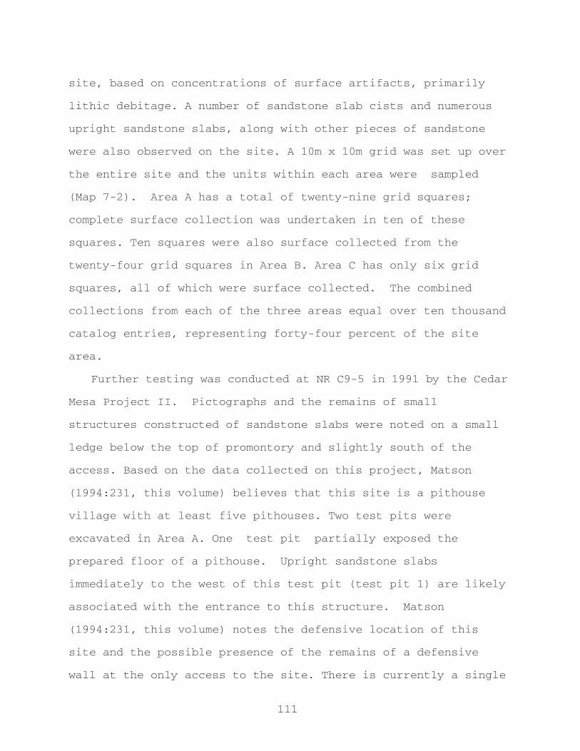
111
site, based on concentrations of surface artifacts, primarily
lithic debitage. A number of sandstone slab cists and numerous
upright sandstone slabs, along with other pieces of sandstone
were also observed on the site. A 10m x 10m grid was set up over
the entire site and the units within each area were sampled
(Map 7-2). Area A has a total of twenty-nine grid squares;
complete surface collection was undertaken in ten of these
squares. Ten squares were also surface collected from the
twenty-four grid squares in Area B. Area C has only six grid
squares, all of which were surface collected. The combined
collections from each of the three areas equal over ten thousand
catalog entries, representing forty-four percent of the site
area.
Further testing was conducted at NR C9-5 in 1991 by the Cedar
Mesa Project II. Pictographs and the remains of small
structures constructed of sandstone slabs were noted on a small
ledge below the top of promontory and slightly south of the
access. Based on the data collected on this project, Matson
(1994:231, this volume) believes that this site is a pithouse
village with at least five pithouses. Two test pits were
excavated in Area A. One test pit partially exposed the
prepared floor of a pithouse. Upright sandstone slabs
immediately to the west of this test pit (test pit 1) are likely
associated with the entrance to this structure. Matson
(1994:231, this volume) notes the defensive location of this
site and the possible presence of the remains of a defensive
wall at the only access to the site. There is currently a single

112
Map 7-2 Surface collection units at NR C9-5 and sampled
units used in this report
113
radiocarbon date for NR C9-5 of 1670+90 BP(WSU 4345) (A.D. 280)
placing the site in the Grand Gulch Phase (Basketmaker II) on
Cedar Mesa (Matson 1994:231).
Sampling Procedures
Due to the large amount of lithic material collected from
this site and limited time for analysis, a stratified random
sample was taken from the collected grid squares. The sample
represents forty-two percent of the total collected grid squares
(by area). The three areas on the site were stratified, based on
their respective median values, into high and low density grid
squares. Using a table of random numbers, one high density grid
square was selected from each area. Also, using a table of
random numbers, three low density grid squares from Areas A and
B were selected for analysis. A smaller number of grid squares
were originally collected from Area C, therefore only two low
density grid squares were selected for the present analysis.
The sample of grid squares selected for Area A, starting with
the high density grid square, in order of selection are as
follows: A6, A25, A26 and A27. The grid squares selected for
Area B, listed in order of selection are: B16, B14, B13 and B3.
Grid squares C2, C4, and C3 were selected for Area C.
Methods
Ten variables were recorded for each specimen in the
sample. The recording system is presented in Appendix I. The
first two variables recorded, collection unit and catalog
114
number, identify the specimen and the area of the site from
which it came. All specimens were assigned to one of twenty-five
classes. The first six classes are debitage and the remaining
nineteen are tools. Tool classes were chosen based on a general
idea of what existed in the assemblage and previous lithic
analysis for Cedar Mesa Basketmaker II sites (Matson 1981).
The manufacture of chipped stone tools is a linear,
reductive process (Collins 1975:16), which is often divided into
steps or stages. Attempting to identify the specific stage
during which a particular flake was manufactured is a difficult
and often ambiguous task. However, certain flake characteristics
often result only during a limited portion of the reduction
process. For example, the cortex on a nodule of raw material is
generally completely removed prior to bifacial thinning. Mauldin
and Amick (1989:67) state that in their experiments the majority
of cortex was removed prior to the half way point in core
reduction. Thus, flakes with cortex present were most likely
removed during the early portion of the reduction sequence. Here
emphasis is placed on relative portions of the reductive process
rather than specific stages.
Four classes of debitage are present in the recording
system used for the NR C9-5 lithic assemblage: cores, flakes,
flake shatter and block shatter. A number of different
variables are recorded for each debitage class. These variables
are designed to provide some indication of the relative
proportions of early and late tending portions of the reductive
sequence present in each of the three areas of the site. Cores
115
are specimens which have no bulb of force and have a surface
from which flakes have been removed (Chapman 1977:374). Although
variables such as the presence or absence of cortex and weight
are recorded for cores, their most important contribution is
their very presence. The presence of a core is a good
indication that earlier portions of the reductive sequence were
performed in that area. Of course, the possibility remains that
the cores were transported into an area where they were never
actually used. However, the assumption made here is that cores
were, in all probability, dropped in the general area of their
use.
Flakes will be the primary class used in the debitage
analysis. Both complete and broken flakes are included in this
class, as long as they retain the striking platform. Four
variables recorded for flakes, but not recorded for other
classes of debitage are: striking platform, length, width and
thickness. Four platform states are recognized: missing, for
cases in which the platform has been sheared off; single facet
platforms; cortex bearing platforms; and multiple platforms
resulting from preparation of the striking platform prior to
flake removal. Cortex bearing and single facet platforms are
representative of the earlier portion of the reductive process.
The presence of cortex on a platform indicates that the flake
was removed during the early portion of reduction.
Single facet platforms are also characteristic of flakes
removed in the earlier portion of the reductive sequence. Magne
(1985:113) suggests that the number of scars, or facets, on the
116
striking platform increases during the later portions of the
reduction sequence. Thus, flakes in the assemblage with multiple
faceted platforms are characteristic of later reduction
activities. Flakes which have had their striking platforms
sheared off are also characteristic of the later portion of
reduction, as the flakes being removed are on the whole
generally thinner and, thus, more susceptible to platform
destruction (based on limited personal observation).
Measurements of size are also important variables in the
relative placement of flakes into a portion of the reductive
sequence. In the reduction of a piece of lithic material the
core becomes progressively smaller, this necessarily requires
that the debitage also decreases in size as the reduction
process proceeds. Mauldin and Amick (1989:77) note that flake
length and maximum width are not good indicators of reduction
stage. In this analysis length, width and thickness are
multiplied together to provide a general measure of flake size
(volume). Stahle and Dunn (1982) have suggested that weight is
an adequate predictor of reduction stage. Their experiments
indicated that seventy-six percent of the differences between
reduction stages can be accounted for by weight.
Only two variables were recorded for flake shatter and
block shatter, the presence or absence of cortex and weight.
The use of both these variables in the placement of specimens
into the relative portions of the reductive sequence has been
discussed above. With the exception of cortex bearing specimens
the use of flake shatter in this vein is somewhat ambiguous. In

117
the absence of a platform the only attribute which may
contribute to the analysis is weight. However, there is no
reliable means of estimating what portion of the original flake
is represented by any given piece of shatter. Thus, the specimen
may be weighed, but that weight is not comparable with that of
complete flakes.
Block shatter is assumed to be representative of the earlier
portion of the reduction sequence. It is unlikely that a piece
of block shatter would result during biface reduction.
Results
A total of 2740 individual specimens were included in this
analysis. Table 7-1 presents a breakdown of the number and
frequency of each artifact class for the three areas of the
site. The sample from Area A contained 1387 specimens, followed
by a sample of 792 specimens from Area B and 561 specimens from
Area C. The rank of the samples used in this analysis is the
same as the rank of the total surface collections from the site.
Area A has the most specimens and Area C the least.
NR C9-5 Tool Analysis
The chipped stone tool analyses was undertaken as the first
step towards answering the question: are there differences
between the three areas identified on the site? This requires
comparison of the types and frequencies of different tool
classes between Areas A, B and C. Originally nineteen classes
of tools were included in the recording system. The initial

118
Table 7-1 Counts and frequencies for all debitage and tool
classes for sample from NR C9-5

119
analysis showed that three of these classes were empty. No
steep or acute angle formed unifaces or modified pebbles were
present in the assemblage. With the exception of utilized flakes
all chipped stone tools included in the assemblage were used in
this analysis. The discussion of utilized flakes is limited to
those tools included in the grid squares selected by the sample.
Given the present organization of the assemblage the time
necessary to separate the utilized flakes from all surface
collection units was not available.
Figure 7-1 plots the frequencies of thirteen tool classes for
each area of the site. Two striking differences are immediately
observable in this figure, both relating to Area B. The
frequency of biface medial fragments in Area B is less than ten
percent of the total tools from this area, whereas biface medial
fragments comprise twenty-two percent of all tools in area C
and twenty-six percent of all tools in Area A. The second
difference is the high frequency of steep angled, unifacially
retouched flakes in Area B relative to the other two areas.
A number of smaller differences in the frequencies of the
various tool classes also exist between Areas A, B and C.
Comparing the frequencies for each tool class shows that Area A
has a slightly higher frequency of gravers. The frequencies of
complete projectile points and projectile point fragments are
higher in Area B. Area B also has the only denticulate. Area C
shows higher frequencies of both complete bifaces and flakes
with marginal bifacial retouch.
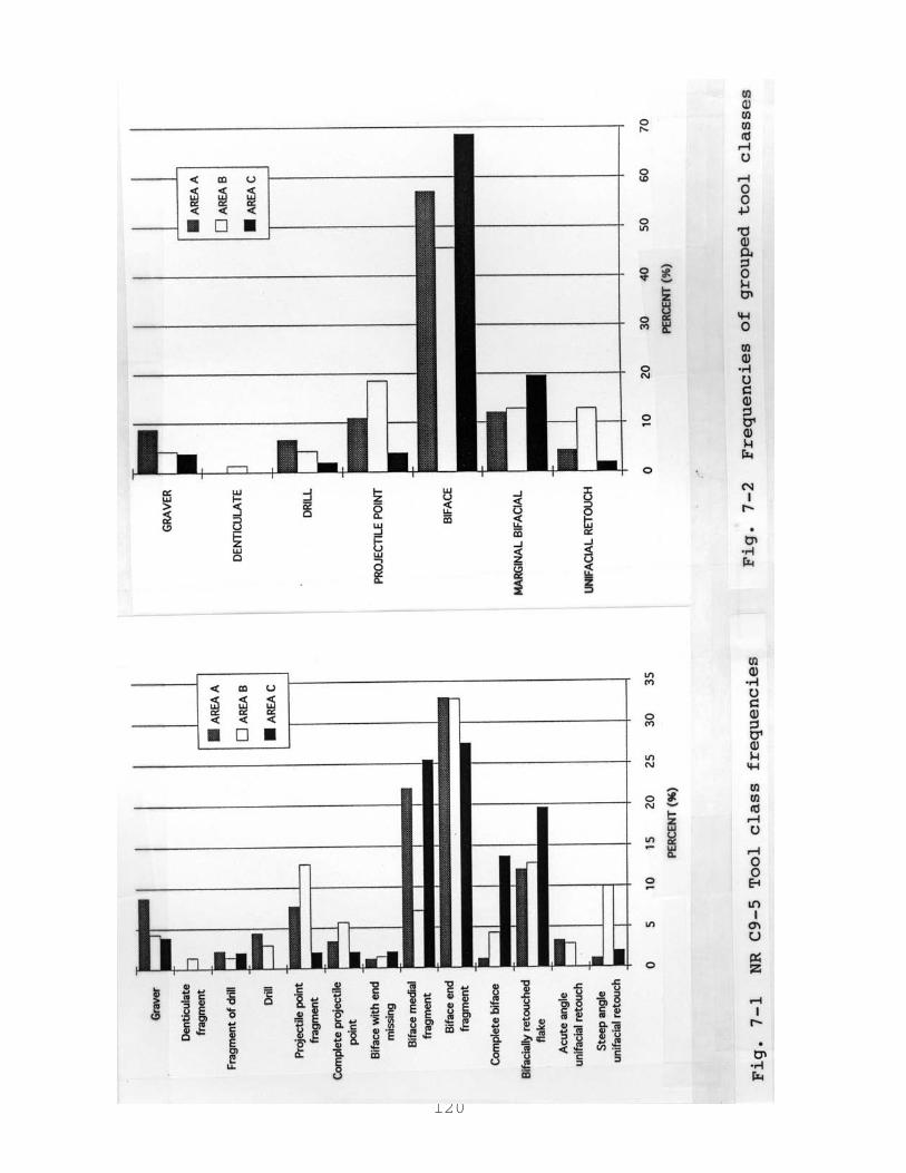
120
121
Areas A and B show comparable frequencies of drills, biface
end fragments and acute angled unifacially retouched flakes. As
noted above Areas A and C have similar frequencies of biface
medial fragments and Area B a much lower frequency. All three
areas share similar frequencies of drill fragments and bifaces
with an end missing.
With two exceptions the differences between the tool class
frequencies in these three areas are small. There is no easily
observable pattern in Figure 7-1 which would indicate marked
differences between the areas of the site. However, the tool
classes plotted in this figure are all very specific. A more
productive approach to this data is to combine a number of
related tool classes. This effectively reduces the number of
classes from thirteen down to seven (Fig. 7-2). Complete biface,
biface end fragment, biface medial fragment and biface with end
missing are all combined into the grouped tool class Biface.
Complete drills and drill fragments are combined into a single
class , as are complete projectile points and projectile point
fragments. Finally steep and acute angled unifacially retouched
flakes are also combined. Gravers, denticulates and flakes with
marginal bifacial retouch remain as individual classes.
Once again there is a mixture of large and small
differences between the frequencies of the tool classes in Areas
A, B and C. There are, however, more obvious differences
observable in this figure. The frequency of unifacially
retouched flakes remains substantially higher in Area B. The
most striking feature of the figure is the differences in the

122
frequencies of bifaces between the three areas. Sixty-nine
percent of the chipped stone tools in Area C are bifaces (or
biface fragments). In Area A fifty-seven percent of the tools
are bifaces and in Area B only forty-five percent of all tools
are included in the biface class. The differences between these
classes is consistently greater than ten percent.
Of particular interest in this figure is the way tool
classes occur together with higher frequencies in specific
areas. Area A has higher frequencies of gravers and drills.
Both these tool classes have utilized projections. It is
interesting that they occur in greater frequencies in Area A,
where one pithouse has been positively identified and evidence
indicates that there may be at least two more in close proximity
(Matson 1994, this volume). The functions of the tools in these
two classes may be related to the activities undertaken near
these dwellings. These tool classes occur with less frequency in
Area B and are less common again in Area C. Surface evidence
indicates that a pithouse may exist in Area B (R.G. Matson,
personal communication 1993). At the present time there in no
indication of a pithouse in Area C.
The frequency of projectile points and denticulates is higher
in Area B than in either Area A or C. The occurrence of higher
frequencies of the two tool types which require the most
elaboration together in one area is of some interest.
Unfortunately the denticulate tool class is only represented by
a single artifact in the entire assemblage. Although it was
collected from Area B, the existence of only one denticulate
123
does reduce the significance of its association with higher
frequencies of projectile points in this area. As noted above,
Area B also has the highest frequency of unifacially retouched
flakes.
Finally, Area C shows higher frequencies of bifaces and
flakes with marginal bifacial retouch. As noted previously the
differences in the frequencies of this tool class are the most
significant differences which exist between the three areas.
A comparison utilized flakes collected in the grid units
included in the present sample show an interesting pattern. The
frequency of utilized flakes in Area B is twice as high as the
frequencies of utilized flakes in Areas A and C. This is an
interesting result in light of the high frequency of unifacially
retouched flakes in the same area. It is also interesting that
the highest frequencies of tools with the lowest and highest
manufacturing costs would occur in the same area.
As a third comparison of Areas A, B and C the seven tool
classes used in Figure 7-2 were further combined into two
classes, tools with a high amount of manufacturing input
(bifaces, drills, denticulates, and projectile points) and those
with a low amount manufacturing input (marginal bifacial
retouch and unifacial retouch) (Fig. 7-3). It is unfortunate
that the utilized flakes discussed here are only from sampled
grid squares and not the entire surface collected assemblage.
As they are it is not possible to include them in this
comparison. This figure indicates that there is very little
variation between the three areas in terms of high and low input
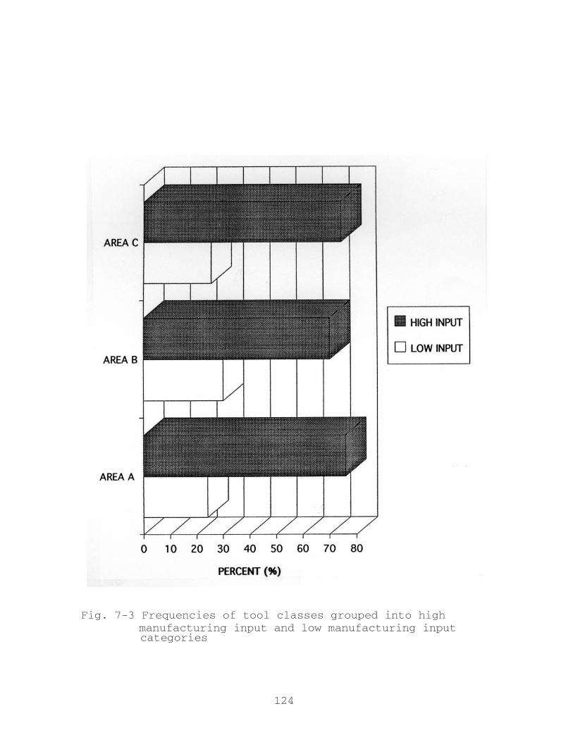
124
Fig. 7-3 Frequencies of tool classes grouped into high manufacturing input and low manufacturing input categories

125
tools.
A comparison of the material types used for different tool
classes and in the different areas of the site produced quite
homogeneous results. Jasper is the dominant material type for
all areas of the site and all artifact classes. The one
exception, excluding the single denticulate, is the higher
frequency of chert used for projectile points in Area B.
NR C9-5 Debitage Analysis
Debitage analysis provides a second means of addressing the
question of intra-site differences at NR C9-5. The
archaeological recovery of chipped stone tools relates to the
location that a tool was dropped in prehistory, through discard
or loss (and any number of post-depositional processes), and is
not necessarily the location of that tool’s use. Debitage,
however, generally remains at the location it was produced.
Thus, through the analysis of lithic debitage it is possible to
be quite certain that the debitage present represents activities
undertaken in that area. The debitage used in this analyses
represents a sample of the material collected from NR C9-5. Four
classes of debitage were recorded for this site: cores, flakes,
flake shatter and block shatter. The variables recorded for each
of these classes, and their importance in the analyses have been
presented earlier (see: Methods).
The approach used in this analysis is based on identifying
relative proportions of debitage representing portions of the
lithic reduction sequence in Areas A, B and C. The reductive

126
process is not considered in terms of discreet stages, or steps,
but rather debitage is classified as having early or late
tendencies. The relative proportions of early and late tending
debitage will be compared between the three areas. This analysis
will focus primarily on flakes, as they have the potential to
provide the most information. Four variables will be used in the
comparison: weight, size, cortex and platform types.
Flake weight can be used as an approximation of flake size,
heavier flakes are considered representative of the earlier
portion of the reductive sequence, lighter flakes represent the
later portion. Figure 7-4 presents box plots for the weight of
all flakes from Areas A,B and C. The mean value for Areas A and
C are quite similar. The mean weight for Area B, however,
appears to be larger, indicating that there may be a greater
proportion of heavier flakes.
Figure 7-4 also shows that there are a number of outliers
for each area which will affect the mean. Thus, a more
appropriate measure may be the median. The median weight in Area
A is 0.8g, with a lower hinge of 0.4g and an upper hinge of 1.5g
(inter-quartile range=1.1). Area C also has a median of 0.8g,
the lower hinge is 0.5g and the upper hinge is 1.7g (inter-
quartile range=1.2). The similarity between these values
indicates no difference between Area A and Area C. The median
weight for Area B is 1.1g, with a lower hinge of 0.6g and an
upper hinge of 2.3g (inter-quartile range=1.7). Area B has a
higher median weight and greater inter-quartile range than the
other two areas. This suggests that Area B may have slightly

127
128
more early tending flakes than Areas A and C.
The second variable, size, was arrived at by multiplying the
length, width and thickness of complete flakes to obtain a
relative approximation of a flakes overall size. Figure 7-5
presents box plots for each of the three areas. The mean values
for flake size from the three areas are quite different. Area B
has the highest mean, 2459.1mm3; the mean value for Area A is
1299mm3, and the mean value for Area C is 2045mm3. This suggests
that on the average there are a greater proportion of large
flakes in Area B.
The median values for size also show large differences
between the three area. Area B has a median value of 1560mm3,
Area C has a median value of only 678mm3, and Area A falls in
between with a median of 724mm3. The median value for Area B is
greater than the upper hinge of Area C. The spread of the inter-
quartile range around the medians for these areas are quite
different. The inter-quartile range for Area B is 2185 (lower
hinge=665, median=1560, upper hinge=2850). Area A has an inter-
quartile range of 1422 (lower hinge=288, median=724, upper
hinge=1650). The inter-quartile range for flake size in Area C
is only 1024 (lower hinge=446, median=678, upper hinge=1470).
Area B not only has a significantly higher median size but the
spread around the median is also greater. Area C has the
tightest spread around the median. These values strongly suggest
that there are differences between the three areas of the site.
Area B has the largest proportion of large, or early tending
flakes, and Area C has the smallest proportion of early tending

129

130
flakes. Although Area A has a greater median value and Inter-
quartile range, the proportion of large, or early tending flakes
in this area is closer to Area C than Area B.
The proportions of debitage with cortex present also provides
a means of comparing Areas A, B and C. Figure 7-6 plots the
percentages of flakes, flake shatter and block shatter with
cortex for each area. The most obvious difference on the graph
is the low frequency of cortex on block shatter from Area A. The
proportion of flake shatter with cortex present is very similar
for all three areas. All three areas have a similar proportion
of flakes with cortex present. The largest difference is only
six percent between Area A (23%) and Area B (17%). As noted
above block shatter is considered to be associated with the
earlier portion of the reductive sequence. Thus, the lower
frequency of cortex bearing block shatter in Area A does not
indicate any greater tendency toward the later portions of the
reductive process for that area. Based on the similar
proportions of flakes and flake shatter with cortex present this
comparison suggests that there is no difference between the
three areas.
Platform type was recorded for all flakes as one of four
categories: missing, single, cortex and multiple. As discussed
above missing and multiple facet platforms are considered
characteristic of late tending debitage. Single facet platforms
and platforms with cortex are considered characteristic of early
tending debitage. Figure 7-7 plots the frequency of all four
platform types for each area. With the exception of missing
131
platforms, there does not appear to be much difference in the
frequency of different platform types between the three areas.
Surprisingly Area B appears to have the highest frequency of
missing platforms. Missing and multiple platforms were combined
and single and cortex platforms were combined to form early
tending and late tending groups. Figure 7-8 plots the
frequencies of these two groups for all three areas. Once again
we see only slightly higher proportions of late tending platform
types in Area B.
Discussion
The analysis of the chipped stone tools and lithic debitage
presented above suggests some interesting intra-site patterning
at NR C9-5. Results from the comparison of stone tool class
frequencies between Areas A,B and C indicate little difference
between the three areas for most classes. The tool class
frequencies are by no means identical across all three areas,
however, the differences which do exist are not large. The one
exception to this is the grouped biface tool class (Fig. 7-2).
All three areas are separated by at least ten percent. The
frequency of bifaces in Area C is sixty-nine percent, whereas in
Area B, bifaces represent only forty-five percent of all chipped
stone tools.
Separating the tool classes presented in Figure 7-2, into
three groups based on the area with the highest frequency for
each class also produces interesting results. This procedure
puts drills and gravers, which both have worked projections,
132
into the same group, Area A. Area C contains the greatest
frequency of bifaces, and flakes with marginal bifacial retouch.
Area B has the highest frequencies of projectile points and
denticulates (although there is only one), both tool types which
require a high degree of elaboration. It is interesting that
Area B also has the highest frequency of unifacially retouched
flakes, which have the lowest manufacturing costs of all classes
included in the tool class comparison. Although a comparison
made between high manufacture input tools and low manufacture
input tools suggested little difference between the three areas,
separate analysis of utilized flakes also showed the highest
frequency of this class in Area B. It is unfortunate that the
utilized flakes included in this analysis only came from the
sampled collections grid squares, and are not comparable with
the other tool classes. However, even though their frequencies
can only be taken from the entire sample from each area (Table
7-1) the frequency of utilized flakes in Area B is three times
that of Areas A and C. This supports the suggestion that the
frequency of expedient tools is greater in Area B. The
possibility of related activities performed in Area B which
resulted in the greater frequencies of highly elaborated tools
and expedient tools is an interesting prospect.
The debitage analysis was aimed at identifying relative
proportions of flakes (and to a lesser degree flake shatter and
block shatter) belonging to early and late tending portions of
the reductive sequence, in each of the three areas. Two parts of
this analysis used variables, weight and size, which approximate

133
relative flake size. Comparison of the weight ranges for each
area indicates that Areas A and C share similar proportions of
late and early tending flakes. Area B, however, appears to have
a somewhat greater proportion of larger flakes. Flake sizes, in
general, become increasingly smaller as the reduction process
proceeds, thus, a higher proportion of larger flakes in Area B
suggests that there are more early tending flakes in this area.
This suggestion is supported by the results from a comparison
of overall flake size (length x width x thickness). Once again
Area B appears to have a greater proportion of larger, or early
tending flakes. Although Area A has a greater proportion of
larger flakes than Area C, the difference between these two
groups is smaller than the difference between Areas A and B.
Area B also has the greatest proportion of cores, however, the
number of cores in the assemblage is small (Area A=1, Area B=3,
Area C=1).
There is, however, some experimental data which complicates
the use of this data. Maudlin and Amick (1989:77) note that
numerous small flakes are produced during the early stages of
core reduction from platform preparation. The further
modification of larger flakes is a second factor which has an
effect on the patterns of large and small debitage in a site.
The fact remains, however, that there are differences in the
proportions of large and small flakes between Areas A, B and C.
To what extent these proportions are affected by the two factors
just mentioned is unknown. Another consideration which relates
to the frequencies of flake size in the NR C9-5 assemblage is

134
the effects of surface collection techniques. Large flakes have
a better probability of being collected, this will bias the
relationship between large and small flakes in the assemblage.
As far as a comparison of flake size for the three areas of the
site is concerned, it is not insensible to assume that small
flakes had the same probability of being collected in all three
areas (i.e., no greater attention was given to small flakes in
one area than in the others).
Comparison of the relative proportions of debitage with
cortex present suggests that there is little difference between
the three areas of the site. The percentage of flakes and flake
shatter with cortex are similar in each area. The only real
difference observed in this comparison was the proportions of
cortex on block shatter. However, block shatter is considered
characteristic of the early portion of the reduction sequence,
which reduces the importance of the different frequencies of
cortex in this class. The proportions of flake shatter and
block shatter are roughly equal in Areas B and C. The two areas
also share similar proportions of both. The proportion of flake
shatter in Area A is twice that of block shatter. The original
size of individual pieces of flake shatter is unknown and as a
result it is not possible to assign the specimens to early or
late portions of the reductive sequence. It is impossible, based
on the variables recorded for this class, to specify whether a
piece of flake shatter represents ninety percent of a small
flake, or only five percent of a large flake. This makes the
difference in the frequencies of flake shatter and block shatter

135
in Area A difficult to interpret.
Comparison of the frequencies of four different platform
types between the three areas provided results which tend to
contradict the size comparison results, which indicate that
higher proportions of early tending flakes occur in Area B. In
the Methods section of this paper single facet and cortex
bearing platforms were identified as characteristic of early
tending flakes, whereas missing and multiple facet platforms are
characteristic of late tending flakes. The frequency of single,
cortex and multiple platforms are similar in all three areas.
Only the frequencies of flakes with missing platforms are
different, and the area with the greatest proportion of flakes
with missing platforms is Area B. The differences in the
frequencies of missing platforms between the three areas is not
vast, but it is greater than the variation in the proportions of
other platform types. If the assumption that flakes with missing
platforms are produced during the later portion of the reductive
sequence is wrong, the results of this comparison would support
the results of the size comparisons. However, no data has been
found to indicate that this is the case.
Conclusion
In conclusion, the analysis of chipped stone tools from NR
C9-5 indicates that there are differences in the frequencies of
bifaces in the three areas of the site. The analysis suggests
some interesting patterning in the types of tools which are
found with the highest frequencies in the same area. Such as the
136
gravers and drills in Area A; projectile points and expedient
tools in Area B and bifaces and flakes with marginal bifacial
retouch in Area C. The high frequencies of both unifacially
retouched flakes and utilized flakes in Area B is particularly
interesting. However, it should be noted that the frequencies
of all these tool classes (with the exception of bifaces) are
not extremely divergent.
The results of the debitage analysis are not as easy to
interpret. Both measures of size, weight and overall flake size,
support each other, and indicate that Area B has greater
proportions of larger flakes. Larger flakes are characteristic
of early portions of the reductive sequence and, thus, Area B
may have higher proportions of early tending debitage.
Unfortunately, this conclusion is not supported by analysis of
the proportions of cortex bearing flakes, which suggests no
difference between the areas, and the proportions of the
different platform types, which shows slightly greater
proportions of late tending platform types in Area B.
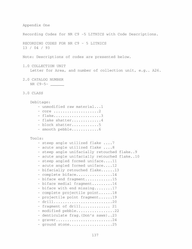
137
Appendix One
Recording Codes for NR C9 -5 LITHICS with Code Descriptions.
RECORDING CODES FOR NR C9 - 5 LITHICS13 / 04 / 93
Note: Descriptions of codes are presented below.
1.0 COLLECTION UNITLetter for Area, and number of collection unit, e.g.. A26.
2.0 CATALOG NUMBERNR C9-5- ______
3.0 CLASS
Debitage:- unmodified raw material...1- core ....................2- flake.....................3- flake shatter.............4- block shatter............5- smooth pebble............6
Tools:- steep angle utilized flake ....7- acute angle utilized flake ....8- steep angle unifacially retouched flake..9- acute angle unifacially retouched flake..10- steep angled formed uniface....11- acute angled formed uniface....12- bifacially retouched flake......13- complete biface................14- biface end fragment............15- biface medial fragment.........16- biface with end missing........17- complete projectile point......18- projectile point fragment......19- drill..........................20- fragment of drill............. 21- modified pebble.................22- denticulate frag.(Don’s saws)..23- graver.........................24- ground stone...................25

138
4.0 RAW MATERIAL
- chert......1- Jasper.....2- Chalcedony.3- Quartzite..4- Other......5
5.0 STRIKING PLATFORM
- missing....0- single.....1- cortex.....2- multiple...3
6.0 CORTEX
- absent...0- present..1
7.0 LENGTH
To the nearest millimeter.
8.0 WIDTH
To the nearest millimeter.
9.0 THICKNESS
To the nearest millimeter.
10.0 WEIGHT
To the nearest tenth of a gram.
11.0 COMMENTS

139
CODE DESCRIPTIONS
1.0 Collection Unit:NR C9-5 is divided in to three separate areas: A, B, and C.
When the site was recorded and collected in 1974 a 10m x 10m grid was laid over the site. The collection grids were numbered independently for each area. A portion of these grids were then sampled through surface collection. Therefore an entry recording both the area and the number of the collection grid is entered for each specimen.
2.0 Catalog Number:Each specimen in the NR C9-5 lithic assemblage has an
individual catalog number. The only exception to this are a number of plastic bags containing two or more small flakes all subsumed under a single catalog number. In these cases the shared number is recorded for each specimen and a note is made in the comments column indicating that this is the case.
3.0 Class:One of the following class designations is recorded for each
and every specimen.
3.1 Unmodified raw material : specimens which, although of the proper material type, show no sign of purposeful modification.
3.2 Core: specimens which have been used to obtain pieces of material for further reduction. According to Chapman (1977:374), cores are specimens which have no bulb of force and have a surface from which flakes have been removed.
3.3 Flake: the primary feature on the specimens in this class is a recognizable striking platform. Platform states are described in section 5.0 Platform, and are discussed below. The exceptions to this rule are specimens which have a complete bulb of force indicating the location of the platform, however, the platform has been sheared away and is missing. This occurrence is indicated by the code ‘0’ in the Platform column. Both complete and broken flakes may be included in this class as long as they fit into one of the two situations noted above. Complete flakes are indicated in the data when length, width and thickness have all been recorded. In the event of broken flakes only one or two of these measurements will be present. These measurements are discussed in detail below.
3.4 Flake shatter : specimens classed as flake shatter have identifiable interior and exterior surfaces, but do not have an identifiable striking platform. Interior surfaces are indicated by ripple marks and force lines ( as well as the bulb of force, although it is not generally a concern in this class) (Sullivan and Rozen 1985:758). Other indicators of an interior surface are the absence of flake scars and in some cases a slightly concave curve, though the latter need not

140
always be the case. Exterior surfaces generally exhibit one or more negative flake scars and/or cortex.
3.5 Block shatter : block shatter, as opposed to flake shatter, does not have any distinguishable interior surface. Specimens in this class are generally irregularly shaped and may have negative flake scars on one or more surfaces.
3.6 Smooth pebble : a number of small smooth pebbles were included in the sampled collection grids. These range in size, though the majority are quite small. Often consisting of the material used in tool production, a number of these stones appear to have been flake shatter which through some process have become rounded and smooth on all surfaces. Provenance cards in some of the collection bags have identified them as turkey gastroliths.
3.7 Steep angle utilized flake : this class consists of flakes, or flake shatter, with edges at an angle greater than 45o which have been utilized. Utilization is indicated by small scarring and chipping along the edge of the flake. This material has been sitting together in bags or trays for twenty years now, and judging by the collections current state of organization it has been used by a number of students in the past. All this amounts to ample opportunity for interaction between flakes resulting in edge damage. Thus, care must be taken in classifying utilized flakes. As a rule I recorded utilization only when a number of fairly well defined and continuous, although minute, scars were observable along the edge of the specimen. Utilization is distinguished from unifacial retouch by the size and regularity of the scarring. Unifacial retouch generally has larger scars which appear in a regular arrangement.
3.8 Acute angle utilized flake : utilized flakes with edge angles less than 45o.
3.9 Steep angle unifacially retouched flake : the specimens in this class have unifacial retouch on one or more sides, on edges with angles greater than 45o.
3.10 Acute angle unifacially retouched flake : specimens with one or more retouched edges with angles less than 45o.
3.11 Steep angle formed uniface : specimens which have had their shape modified by unifacial retouch. Edge angles must be greater than 45o.
3.12 Acute angle formed uniface : same as above (in 3.11) except edge angles are less than 45o.

141
3.13 Bifacially retouched flake : specimens included in this class show marginal bifacial retouch, that is, the retouch is only along the edge of the specimen and does not continue into the interior surface.
3.14 Complete biface : complete bifaces are symmetrical artifacts (Pokotylo 1978:216), which have bifacial flake scars across all surfaces and along all edges. Within the present collection the shape and thickness of these specimens vary. Generally, however, they are triangular in shape and quite thin. Specimens which meet these requirements, but have been broken must be recorded as one of the three classes which follow (3.15 - 3.17).
3.15 Biface end fragment : specimens which are bifacial across both surfaces and show a combination of finished edges with a snapped edge. Within the present collection these include: triangular sections with two finished edges meeting at a point, with a snapped edge opposite the point; specimens which have two parallel, or spreading finished edges which are joined by a third finished edge at right angles to the first two, with a snapped edge opposite this; and combinations of specimens which show finished edges forming corners (although these are less common in the collection).
3.16 Biface medial fragment : these specimens are bifacial across both surfaces but have at least two snapped ends. Within the collection these generally have two finished edges running parallel to one another, or contracting, with the adjacent ends snapped off.
3.17 Biface with end missing : This class is an intermediary between Complete bifaces and Biface end fragments. An example would be a triangular biface which has a small portion of the tip broken off.
3.18 Complete projectile point : projectile points are “bifacially flaked symmetrical artifacts, with a sharply pointed end, acute angled blade margins, and a basal modification facilitate hafting” (Pokotylo 1978:216).
3.19 Projectile point fragment : this class consists of fragments of projectile points which retain a haft element.
3.20 Drill : drills have bifacially shaped projection. These are often shaped like keys. The base of the drill need not be bifacially retouched, however, to be included within this class the projection must be bifacially formed.
3.21 Drill fragment : any specimens with a broken bifacially formed projection.
3.22 Modified pebble : pebbles which have some indication of being modified by flaking, yet retain a portion of their
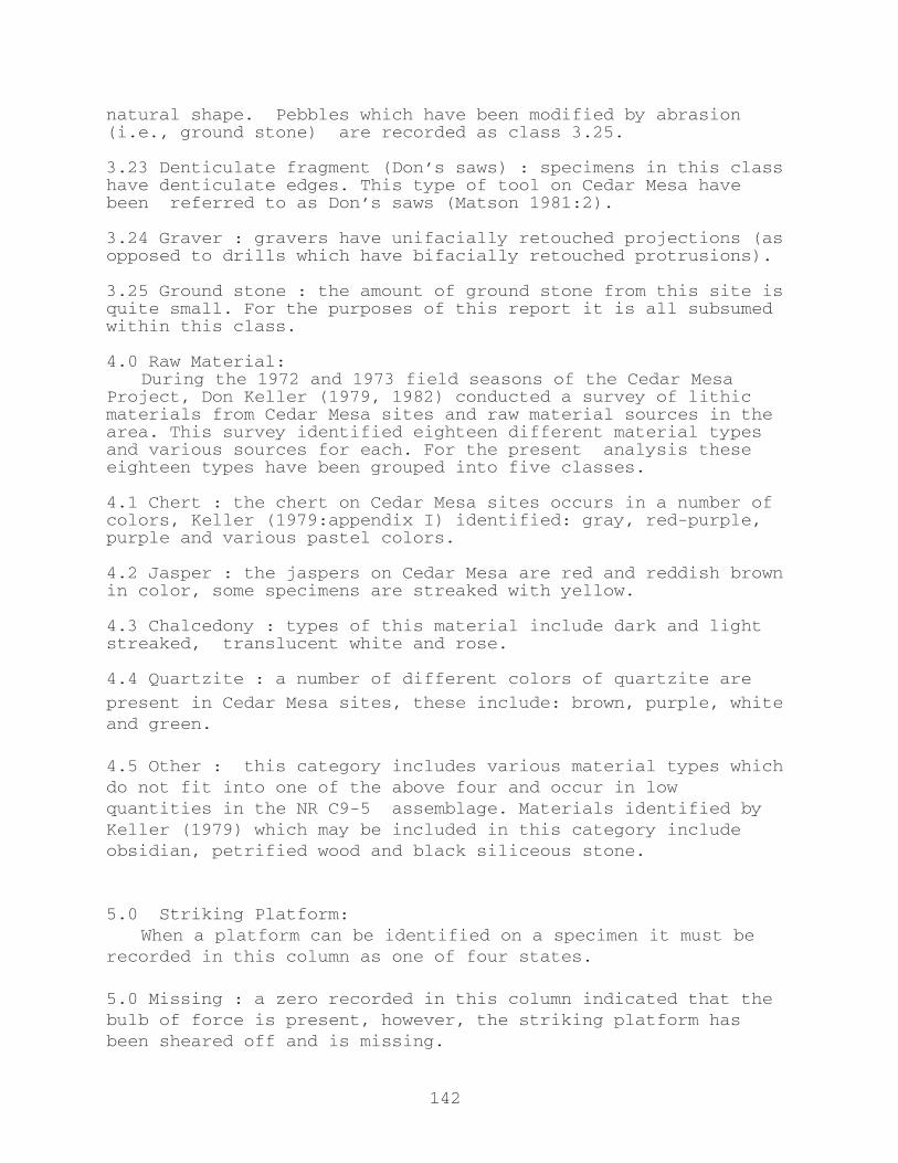
142
natural shape. Pebbles which have been modified by abrasion (i.e., ground stone) are recorded as class 3.25.
3.23 Denticulate fragment (Don’s saws) : specimens in this class have denticulate edges. This type of tool on Cedar Mesa have been referred to as Don’s saws (Matson 1981:2).
3.24 Graver : gravers have unifacially retouched projections (as opposed to drills which have bifacially retouched protrusions).
3.25 Ground stone : the amount of ground stone from this site is quite small. For the purposes of this report it is all subsumed within this class.
4.0 Raw Material:During the 1972 and 1973 field seasons of the Cedar Mesa
Project, Don Keller (1979, 1982) conducted a survey of lithic materials from Cedar Mesa sites and raw material sources in the area. This survey identified eighteen different material types and various sources for each. For the present analysis these eighteen types have been grouped into five classes.
4.1 Chert : the chert on Cedar Mesa sites occurs in a number of colors, Keller (1979:appendix I) identified: gray, red-purple, purple and various pastel colors.
4.2 Jasper : the jaspers on Cedar Mesa are red and reddish brown in color, some specimens are streaked with yellow.
4.3 Chalcedony : types of this material include dark and light streaked, translucent white and rose.
4.4 Quartzite : a number of different colors of quartzite are
present in Cedar Mesa sites, these include: brown, purple, white and green.
4.5 Other : this category includes various material types which do not fit into one of the above four and occur in low quantities in the NR C9-5 assemblage. Materials identified by Keller (1979) which may be included in this category include obsidian, petrified wood and black siliceous stone.
5.0 Striking Platform:When a platform can be identified on a specimen it must be
recorded in this column as one of four states.
5.0 Missing : a zero recorded in this column indicated that the bulb of force is present, however, the striking platform has been sheared off and is missing.
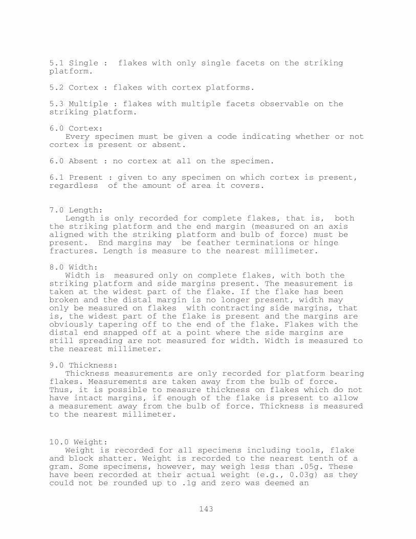
143
5.1 Single : flakes with only single facets on the striking platform.
5.2 Cortex : flakes with cortex platforms.
5.3 Multiple : flakes with multiple facets observable on the striking platform.
6.0 Cortex:Every specimen must be given a code indicating whether or not
cortex is present or absent.
6.0 Absent : no cortex at all on the specimen.
6.1 Present : given to any specimen on which cortex is present, regardless of the amount of area it covers.
7.0 Length:Length is only recorded for complete flakes, that is, both
the striking platform and the end margin (measured on an axis aligned with the striking platform and bulb of force) must be present. End margins may be feather terminations or hinge fractures. Length is measure to the nearest millimeter.
8.0 Width:Width is measured only on complete flakes, with both the
striking platform and side margins present. The measurement is taken at the widest part of the flake. If the flake has been broken and the distal margin is no longer present, width may only be measured on flakes with contracting side margins, that is, the widest part of the flake is present and the margins are obviously tapering off to the end of the flake. Flakes with the distal end snapped off at a point where the side margins are still spreading are not measured for width. Width is measured to the nearest millimeter.
9.0 Thickness:Thickness measurements are only recorded for platform bearing
flakes. Measurements are taken away from the bulb of force. Thus, it is possible to measure thickness on flakes which do not have intact margins, if enough of the flake is present to allow a measurement away from the bulb of force. Thickness is measured to the nearest millimeter.
10.0 Weight:Weight is recorded for all specimens including tools, flake
and block shatter. Weight is recorded to the nearest tenth of a gram. Some specimens, however, may weigh less than .05g. These have been recorded at their actual weight (e.g., 0.03g) as they could not be rounded up to .1g and zero was deemed an

144
unsatisfactory entry. These may later be added to an appropriate category for further study, such as the smallest size class.
11.0 Comments:A comments column has been added to record any remarks
regarding specific specimens which were not part of the formal recording procedure. As noted above small specimens which share a single catalog number are indicated here.

145
Chapter 8
SUMMARY AND CONCLUSION:Results of Exploring Anasazi Origins:
The Cedar Mesa Basketmaker II
R.G. Matson
The previous chapters have reported on different aspects of
the S.S.H.R.C. funded research. I will now compare the results
of the field work with that which was proposed. Next, I will
describe other research, including some that is still to be
concluded. Finally I will review some other research which is
relevant.
Dos Tanques-Dos Fuentes Locality
The most important research proposed in the S.S.H.R.C. grant
was the determination of the nature of the material identified
as Basketmaker II during the 1972/73 survey in Hardscrabble
quadrats 4 and 5. This area was anomalous for Cedar Mesa
Basketmakers in that it was much lower in elevation than other
places with habitations sites and was the surveyed area most
similar to locations with late Archaic material in others areas
of the Southwest, such as Arroyo Cuervo (Irwin-Williams 1973).
Of all the material identified as Basketmaker II on Cedar Mesa
this was the most likely to be mistaken identified Archaic
material.
146
When investigated in 1991, the discovery of two springs and
two tanks (providing the locality name, Dos Tanques-Dos Fuentes)
made the use of this area more understandable, but the presence
of a significant potential floodwater farming area, with run-off
from an extensive slick rock area made its use by farmers (BM
III and Pueblo components were also present) feasible. As
reported in Chapter 2, the material present here, previously
identified as Basketmaker II, clearly dated to Basketmaker II
times, and included two, and likely, three pithouses. Thus,
even this material, was definitely Basketmaker II, although it
is not clear that all of it was coeval with the mesa-top Grand
Gulch Phase. Some of it may date to the previous canyon-
rockshelter White Dog Cave Basketmaker II.
The relatively nearby quadrat Hardscrabble 11 was also
briefly revisited, and the undated, but assigned to Basketmaker
II, “Campsites” found there were dated to the Basketmaker II
period. As well, Basketmaker II cists were found to be
immediately adjacent, something not noted during the original
1970s survey and collection. Previously, only Basketmaker II
pithouses had been dated, so this, and the dates from
Hardscrabble 4 and 5 was an important confirmation that the non-
pithouse material identified as Basketmaker II on the basis of
surface mapping and collection did indeed date to that time.
The combination of the Dos Tanques–Dos Fuentes and
Hardscrabble 11 investigations was an important confirmation of
the inferences made on the basis of the 1970s survey and an
extension of the understanding of the Cedar Mesa Basketmaker II
147
adaptation. Although the negative information about the lack of
Late Archaic is not conclusive – there could always be Late
Archaic somewhere else on Cedar Mesa – it does add support to the
idea that the Cedar Mesa Basketmaker II was not an in situ
development, but instead arrived with the complete Basketmaker
II adaptation.
The Block Survey
The second priority laid out in the 1990 S.S.H.R.C. proposal
was to investigate the nature of spatial distribution of
Basketmaker II pithouses. Because of the nature of quadrat
survey, a wide-area pattern can not be demonstrated. We
therefore proposed to carry out two non-collection block
surveys, one in North Road and one in West Johns drainage. We
actually only completed the North Road block, which is reported
in Chapter 3, by Karen Dohm. She reports 14 to 20 pithouses in
this neighborhood and that the evidence is in accord with the
Basketmaker II pithouse being distributed in dispersed hamlets.
This supports previous inferences based on weaker evidence about
the nature of the Cedar Mesa Basketmaker II adaptation.
Villages are known from several other Basketmaker II
occupations, mainly at Black Mesa, Durango, and Los Pinos, as
Dohm reports.
Absolute convincing evidence, though, of the existence of
villages would require information of contemporaneity. This is
only possible through excavation and the recovery of tree-ring
dateable wood. Otherwise, one can argue that these groups of

148
pithouses are temporal series, however unlikely, that appears.
The Rock Island Site (NR C9-5)
The third field-work priority was further testing of the Rock
Island Site, NR C9-5. As reported in Chapter 2, this site turns
out to be a concentrated “village” of five to nine pithouses, in
a defensible location. A small test not only produced a
radiocarbon sample that dates to the Grand Gulch Phase, but also
evidence of a pithouse floor. This is the most concentrated
Basketmaker II site yet known on Cedar Mesa, and is some
distance from arable soil, indicating that defense was very
important. Michael Brand reports on the lithic technology of
the material collected in 1974 in Chapter 7.
Other Dating
The S.S.H.R.C. proposal also discussed the importance of AMS
dating diagnostic perishables. If the two-rod-and-bundle
basketry was older in Southern Arizona than in Utah, this would
support the migration model for the origin of the Western
Basketmakers. The most important sample for this would be the
specimen reported by Haury (1975:Table 33) from Ventana Cave
from Level 4. Unfortunately I found out while in Tucson,
Arizona in 1992, that provenience had been lost on the basketry
specimens and there was now no way of discovering which specimen
was from Level 4. Without being able to date this artifact, the
relative dates of the other ones suggested in the original
proposal have less value, although I still think they are worth

149
doing. The other specimens mentioned were Durango one-rod-and-
and bundle and the oldest two-rod-and-bundle specimen from
Cowboy Cave. These remain undated today.
Documentation of Earlier Cedar Mesa Pithouse Excavation
The final significant portion of the S.S.H.R.C. proposal was
the documentation of the 1969/70 (by Lipe) and 1984 (by Dohm)
excavations. The basic analyses have been carried out by Reid
Nelson, but the basic descriptions are not yet complete enough
to be distributed. These are planned to be part of Reid Nelson’s
Master’s Thesis (Washington State University) which remains in
process. Some results coming from his analysis are reported in
Chapter 5 of this report and in his article (Kiva 60(2) 1994).
This project will not be completed until this part is finished,
and in the event that Nelson is unable to complete his thesis, I
will undertake to finish this portion. Chapter 7, the
description of the lithic analysis of the Rock Island by Michael
Brand is another portion of this project to describe incomplete
portions of the earlier work.
Subsistence of Basketmaker II
A few words in the S.S.H.R.C. proposal referred to
additional dating and data from the Stable Carbon Isotope
analysis as being in process. Since then two of the manuscripts
have been published, Matson and Chisholm (1991) and Matson
(1991). Additional analyses supported by the current project is
reported in Chapter 4 by Chisholm and Matson and in Chisholm and

150
Matson (1994) in Kiva 60(2). This Kiva paper includes
information derived from the Old Man Cave Basketmaker II
material, adjacent to Cedar Mesa (see Geib and Davidson 1994;
Kiva 60(2). The results reported in the first two papers are
now on much firmer ground and have been cited as having far
reaching implication for the prehistory of the Colorado Plateau
(Fritz 1994:24) and as a case example of the “strength” of this
sort of approach. It appears that our results have gone from
being controversial to something dangeroulys close to
conventional wisdom in the space of three or four years.
The S.S.H.R.C. proposal also indicates that excavated
archaeological samples would be analyzed. At this time, I have
only preliminary reports, as the first analyst (Dana Lepofsky)
after some initial work, begged off, and the second (Lisa
Huckell) has not completed the analysis. This investigation is
not critical to main goals of this project, but would be useful
information. Michael Brand also reports in Chapter 6 in this
volume on the faunal remains recovered in various Cedar Mesa
excavations. In any event, Basketmaker II diet is better known
now than we anticipated it would be by the end of this project.
Other Relevant Results
The classification and dating of the Dos Tanques – Dos
Fuentes and Hardscrabble 11 localities material to Basketmaker
II is both a testimony to the inferences made on surface
collections twenty years ago and a confirmation of the basic
model of continuity of Anasazi adaptations (Matson, Lipe, and
151
Haase 1988) that all Anasazi from Basketmaker II to Pueblo III
share. A recent review of Anasazi diet by Brand (1994) supports
the idea of a basic continuity in diet throughout the Colorado
Plateau from Basketmaker II to Pueblo III. More surprising than
continuity in adaptation is the identification of the Rock
Island site as a defensive site. That the Basketmaker II, like
the Pueblo III, were concerned about defence and involved in
extensive conflict is now very evident. Cole (Kiva 60(2); 1994)
reports on images related to this in rock art, and Matson and
Cole (1995) report on a number of lines of evidence supporting
this proposition, from rock art, to scalps, to burial remains,
and defensive site locations.
There is a recent upsurge in interest about many of these
questions, which this S.S.H.R.C. supported project participated
in, and helped to develop. A symposium of these issues was
organized (mainly by Karen Dohm) at the Society for American
Archaeology meetings in Pittsburg, in April of 1992, that
brought many investigators together to exchange information and
ideas. This symposium then led to a special issue of the Kiva,
the leading journal on Southwestern Archaeology. This issue
(Volume 60, Number 2, 1994) entitled Anasazi Origins: Recent
Research on the Basketmaker II, was organized and edited by the
S.S.H.R.C. principal investigators, Matson and Dohm. About half
of this issue is material that came out of the S.S.H.R.C. funded
programme and the other half contributed by independent
projects.
The current information, both produced by the Exploring

152
Anasazi Origins and other projects supports a migration model
for the Western Basketmaker II. Perhaps the most interesting
results have been reported by Christy Turner (1993) who has
found that the Western Basketmaker II teeth are more similar to
those from central Mexico than other Southwestern remains,
indicating a biological tie with Mesoamerica. Interestingly
enough, this early “Mesoamerican” connection is later swamped by
other forms. This information fits the pattern found by Matson
(1991) in which the “Eastern” or “Los Pinos” Basketmaker II shows
more material similarities with pre-existing Archaic material,
in contrast with the Western Basketmakers, and in which the
dating indicates a later development of Western Basketmakers
than the Eastern variants. As suggested earlier (Matson
1991:313-16) this pattern would result if the Western
Basketmakers were both migrants into the area and the first
fully maize agriculturalists. Surrounding, less densely
distributed, Archaic peoples would acculturate later to
agriculture resulting in the different ethnicity seen in the
Eastern Basketmaker II. The intrusion of a new group into the
northern Southwest may well account for the now well attested
Basketmaker evidence of conflict and at least one defensive
site.
Conclusions
Many questions yet remains, but we are on a much firmer
ground than we were ten years ago about the origin and

153
adaptation of the first Anasazi, the Basketmaker II. It is now
well supported that the Basketmaker were dependent on
agriculture with maize being by far the most important, and a
secondary emphasis on squash (Matson 1991:4-12; Matson and
Chisholm 1991). The Western Basketmakers, at least, share many
similarities with the San Pedro Cochise and were likely migrants
of San Pedro Cochise-like people up onto the Colorado Plateau.
The “Milagro” San Pedro Cochise adaptation of maize-based
pithouse villages in flood-water farming areas in southern
Arizona was established by 800 B.C. (Huckell and Huckell 1984;
Huckell 1990). This was likely the source of the Western
Basketmaker II, first of flood-water farmers in the canyons of
the Plateau, and then later of dry-farmers, such as seen on the
mesa-top of Cedar Mesa. Substantial numbers of Basketmaker II
people lived on places such as Cedar Mesa (estimates of 500-
1000, Matson et al. 1988), and the evidence presented in this
report indicates they lived in dispersed communities on Cedar
Mesa.
This “Mesoamerican” derived content of the Basketmaker II
changes dramatically in the Basketmaker III, where most
innovative traits are seen to originate from the Eastern
Basketmaker II, or from the area. Turner’s (1993) evidence
suggests that the Mesoamerican dental traits are lost during
this period, indicating that the later Anasazi were biologically
closer to the indigenous Archaic than the Western Basketmakers.
Although there was undoubtedly later contact, and the site of
Casas Grandes in many ways appears to be Mesoamerican, the
154
Southwest fundamentally was now a distinct culture area.
It will be interesting to see how evidence from the next
few years fills out this sketch. I expect that we will find
more “early” agriculture on the Colorado Plateau, dating from
1500 to 500 B.C., but that this will be discovered to be
experimental, and that large scale agricultural use will
postdate 500 B.C. I also predict more information along the
lines of Christy Turner’s recent report will be discovered,
confirming the non-Mesoamerican nature of most of the Anasazi. I
also predict that the origin of maize agriculture in the
Southwest will be seen by most archaeologists as part of the
rapid growth initiated about 1500 B.C. of maize agriculture in
central Mesoamerica, which happens very soon upon the
development of the first really productive forms of maize.
155
ReferencesAasen, D. K.1984 Pollen, macrofossil, and charcoal analyses of Basketmaker
coprolites from Turkey Pen Ruin, Cedar Mesa, Utah. Unpublished M.A. thesis, Department of Anthropology, Washington State University.
Agenbroad, Larry D.1975 The Alluvial Geology of Upper Grand Gulch, Utah. Its
Relationship to Anasazi Inhabitation of the Cedar Mesa Area. In Canyonlands Country: Eighth Field Conference -September22-25, 1975, pp. 63-66, edited by James F. Fassett, A Guidebook of the Four Corners Geological Society, Durango, Colorado.
Ahler, Stan1971 Projectile Point Form and Function at Rodgers Shelter,
Missouri. College of Arts and Science, University of Missouri-Columbia and the Missouri Archaeological Society,
Columbia, Missouri.
Amsden, C.A.1949 Prehistoric Southwesterners from Basketmaker to Pueblo.
Southwest Museum. Los Angeles.
Andrefsky, William, Jr.n.d. Raw Material Availability and the Organization of
Technology. In review at American Antiquity.
1991 Inferring Trends in Prehistoric Settlement Behavior from Lithic Production Technology in the Southern Plains. North American Archaeologist 12:129-144.
Arrhenius, Gustaf and Enrico Bonatti1965 The Mesa Verde Loess. In Contributions of the Wetherill
Mesa Archaeological Project, assembled by Douglas Osborne and edited by Bernard S. Katz, pp. 92-100. Memoirs of the Society for American Archaeology 19, Washington, D.C.
Bamforth, Douglas B.1986 Technological Efficiency and Tool Curation. American
Antiquity 51:38-50.
1991 Technological Organization and Hunter-Gatherer Land Use: A California Example. American Antiquity 56:216-232.
Bender, M.M.1968 Mass spectrometric studies of carbon 13 variations in corn and other grasses. Radiocarbon 10(2): 468-472.
Bender, M.M., D.A. Baerreis and R.L. Steventon1981 Further light on carbon isotopes and Hopewell agriculture. American Antiquity 46(2):346-353.
156
Berry, C. F., and M. S. Berry 1986 Chronological and Conceptual Models of the Southwestern
Archaic, in Anthropology of the Desert West, edited by C. J. Condie and D.D.Fowler,pp.243-327,University of Utah
Anthropological Paper No. 110, Salt Lake City.
Berry, M.S.1982 Time, space and transition in Anasazi prehistory.
University of Utah Press. Salt Lake City.
Binford, Lewis R.1979 Organization and Formation Processes:Looking at Curated
Technologies. Journal of Anthropological Research 35:255-273.
1986 An Alyawara Day: Making Men’s Knives and Beyond. American Antiquity 51:547-562.
Brand, Michael J.1992 Cedar Mesa Manual for the Identification and Recording of
Faunal Remains. Manuscript in possession of the author at the Department of Anthropology and Sociology, The University of British Columbia, Vancouver.
1994 Prehistoric Anasazi Diet: A Synthesis of Archaeological Evidence. Unpublished Master’s thesis, Department of Anthropology and Sociology, University of British Columbia, Vancouver.
Broecker, W.S.,and T.-H. Peng1982 Tracers in the sea. Columbia University, Palisades, New
York.
Bumsted, M.P.1984 Human variation: d13C in adult bone collagen and the
relation to diet in an isochronous C4 (maize) archaeological population. Los Alamos National Laboratory, Los Alamos.
Camilli, Eileen1983 Site Occupational History and Lithic Assemblage Structure:
An Example from Southeastern Utah. Unpublished Ph.D. dissertation, Department of Anthropology, University of New Mexico,Albuquerque.
Chapman, R.C.1977 Analysis of the lithic assemblages. In Settlement and
Subsistence Along the Lower Chaco River: The CPG Survey. Ed. by C.A. Reher. University of New Mexico Press, Albuquerque. pp.371-452.
157
Chisholm, Brian Stewart1986 Reconstruction of prehistoric diet in British Columbia
using stable-carbon isotopic analysis. Unpublished Ph.D. thesis, Simon Fraser University.
1989 Variation in diet reconstructions based on stable carbon isotopic evidence. In T.D. Price (ed.) The chemistry of prehistoric human bone. A School of American Research Advanced Seminar volume. Cambridge University Press.
Chisholm, B., D.E. Nelson and R. Howardn.d. The increment in carbon isotope ratios between a consumer
and its diet. Unpublished data from paper in preparation. MS in the possession of the authors.
Chisholm, B.S., D.E. Nelson and H.P. Schwarcz1982 Stable isotope ratios as a measure of marine versus
terrestrial protein in ancient diets. Science 216: 1131-1132.
Chisholm, B.S., D.E. Nelson, K.A. Hobson, H.P. Schwarcz and M. Knyf1983 Carbon isotope measurement techniques for bone collagen:
notes for the archaeologist. Journal of Archaeological Science 10: 355-360.
Cole, Sally J. 1990 Legacy on Stone: Rock-Art of the Colorado Plateau and Four
Corners Region. Johnson Books, Boulder.
1994 Roots of Anasazi and Pueblo Imagery in Basketmaker II Rock art and Material culture. Kiva 60(2):289-311.
Collins, M.B.1975 Lithic technology as a means of processual inference. In
Lithic Technology: Making and Using Stone Tools. Ed by E.Swanson. Mouton Publishers, The Hauge. pp.15-34.
Creel, D., and A. Long1986 Radiocarbon dating of corn. American Antiquity 51:826-837.
Cummings, Byron1910 The Ancient Inhabitants of the San Juan Valley. University
of Utah Bulletin 3(3, Part 2). Salt Lake City.
Decker, K.W. and L.L. Teiszen1989 Isotopic reconstruction of Mesa Verde diet from Basketmaker III to Pueblo III. Kiva 55:33-47.
DeNiro, M.J.1977 I. Carbon isotope distribution in food chains, II
Mechanism of carbon isotope fractionation associated with lipid synthesis. Unpublished Ph.D. dissertation, California Institute of Technology, Pasadena.

158
DeNiro, M.J., and S. Epstein1978 Influence of diet on the distribution of carbon isotopes
in animals. Geochimica et Cosmochimica Acta 42: 495-506.
DeNiro, Michael J. and Christine A. Hastorf1985 Alteration of 15N/14N and 13C/12C ratios of plant matter
during the initial stages of diagenesis: Studies utilizing archaeological specimens from Peru. Geochimica et Cosmochimica Acta 49:97-115.
Des Marais, D.J., J.M. Mitchell, W.G. Meinschein and J.M. Hayes1980 The carbon isotope biogeochemistry of the individual
hydrocarbons in bat guano and the ecology of insectivorous bats in the region of Carlsbad, New Mexico. Geochimica et Cosmochimica Acta 44: 2075-2086.
Dittert, Alfred E., Jr., Frank W. Eddy, and Beth L. Dickey1963 Evidences of Early Ceramic Phases in the Navajo Reservoir
District. El Palacio 70(1-2):5-12.
Dohm, Karen M.1981 Similarities in Spatial Characteristics of Several
Basketmaker II Sites on Cedar Mesa, Utah. Unpublished Master’s Thesis, Department of Anthropology, Washington State
University, Pullman.
1988 The Household in Transition: Spatial Organization of Early Anasazi Residential-Domestic Units, Southeastern Utah. Unpublished Ph.D.dissertation, Department of Anthropology, Washington State University, Pullman.
Driver, J.1990 Crow Canyon Archaeological Center Manual for the
Description of Vertebrate Remains. On file at the Crow Canyon Archaeological Center,Cortez, Colorado.
1992 Identification, classification and zooarchaeology. Circaea 9(1):35-47.
Eddy, F. W. 1961 Excavations at Los Pinos Phase Sites in the Navajo
Reservoir District. Anthropological Papers No. 4, Museum of New Mexico, Santa Fe.
Ehleringer, J.R. and T.A. Cooper1988 Correlations between carbon isotope ratio and microhabitat in desert plants. Oecologia 76: 562-566.

159
Fritz, Gayle J.1994 The Value of Archaeological Plant Remains for Paleodietary Reconstruction. In Paleonutrition, ed. by Kristin Sobolik, pp. 21-33, Center for Archaeological Investigations,
Occasional Paper No. 22, Southern Illinois University, Carbondale.
Fritz, John M.1974 The Hay Hollow Site Subsistence System, East Central
Arizona. Unpublished Ph.D. dissertation, University of Chicago.
Geib, Phil R. and Dale Davidson1994 Anasazi Origins: A Perspective from Preliminary Work at
Old Man Cave. Kiva 60(2):191-203.
Goodyear, A. C.1979 A Hypothesis for the Use of Cryptocrystalline Raw Material
Among Paleo-Indian Groups of North America. Research Manuscript Series 156,Institute of Archaeology and Anthropology, University of South Carolina, Columbia.
Guernsey, S.J. and A.V. Kidder1921 Basket-Maker Caves of Northeastern Arizona. Papers of the
Peabody Museum of American Archaeology and Ethnology Vol. 8, No.2, Cambridge.
Haase, William R.1983 Pueblo II and Pueblo III Settlement Patterns on Cedar Mesa
Southeastern Utah. Unpublished Master’s Thesis, Department of Anthropology, Washington State University, Pullman.
Haury, Emil W.1975[1950] The Archaeology and Stratrigraphy of Ventana Cave.
University of Arizona Press, Tucson.
Haury, Emil W. and Edwin B. Sayles1947 An Early Pithouse Village of the Mogollon Culture,
Forestdale Valley, Arizona. University of Arizona Bulletin 18:4 Soci(al Sciences Bulletin 16). Tucson.
Henry, D. O.1989 Correlations between Reduction Strategies and Settlement
Patterns. In Alternative Approaches to Lithic Analysis, edited by D. O. Henry and G.H. Odell,pp. 139-155. Archaeological Papers of the American Anthropological Association Number 1.
Hobson, K.A., and H.P. Schwarcz1986 The variation in d13C values in bone collagen for two wild herbivore populations: Implications for paleodiet studies. Journal of Archaeological Science 13: 101-106.

160
Hogan, Patrick F.1987 Prehistoric Agricultural Strategies in West-Central New
Mexico. Unpublished Ph.D. dissertation, Department of Anthropology, Washington State University, Pullman.
Hough, W.1930 Ancient Pueblo subsistence. In Proceedings of the Twenty
third International Congress of Americanists, pp. 67-69. New York.
Huckell, Bruce B.1984 The Archaic Occupation of the Rosemont Area, Northern Santa
Rita Mountains, Southeastern Arizona. Archaeological Series 147 (1). Cultural Resource Management Division, Arizona State Museum, Tucson.
1987 Agriculture and Late Archaic Settlements in the River Valleys of Southeastern Arizona. Paper delivered at the Hohokam Symposium, Tempe.
1990 Late Preceramic Farmer-Foragers in Southeastern Arizona: A cultural and ecological consideration of the spread of agriculture into the arid southwestern United States. Unpublished Ph.D. Dissertation, University of Arizona, Tucson.
Hurst, Winston B. and Christy Turner1993 Rediscovering the “Great Discovery:” Wetherill’s First
Cave 7 and its record of Basketmaker Violence. In Anasazi Basketmaker; Papers from the 1990 Wetherill-Grand Gulch Symposium, pp. 143-191, edited by V. Atkins, Cultural Resource Series, No. 24, Bureau of Land Management, Salt Lake City.
Irwin-Williams, C.1973 The Oshara tradition; origins of Anasazi culture. Eastern
New Mexico contributions in Anthropology 5(1), Portales.
Keller, Donald R.1979 Prehistoric lithic materials on Cedar Mesa, southeastern
Utah. Source identification and aspects of regional distribution. Paper Presented at the 23rd annual Meeting Arizona-Nevada Academy of Science, Tempe, Arizona.
1982 Lithic Source Identification Through Macroscopic Analysis: An Example from Cedar Mesa, Southeastern Utah. Kiva 47(3):163-169
Kidder, A. V.1962 [1924] An Introduction to the study of Southwestern
archaeology. Papers of the Southwestern Expedition 1. (Reprinted in 1962 by Yale University Press, New Haven.)

161
Kidder, A.V. and S.J. Guernsey1919 Archaeological explorations in northeastern Arizona.
Bureau of Anthropology and Ethnology Bulletin 65. Washington, D.C.
Lawrence, B.1951 Post-cranial characteristics of deer, pronghorn and sheep-
goat with notes on Bos and Bison. Papers of the Peabody Museum of Archaeology and Ethnology 35(3):8-43. Harvard University.
Libby, W.F., R. Berger, J.F. Mead, G.V. Alexander and J.F. Ross1964 Replacement rates for human tissue from atmospheric
radiocarbon. Science 146: 1170-1172.
Lindsay, A.J., J.R. Ambler, M.A. Stein and P.M. Hobler1968 Survey and excavations north and east of Navajo Mountain,
Utah, 1959 - 1962. Museum of Northern Arizona Bulletin 45, Glen Canyon Series No. 8. Flagstaff, Arizona.
Lipe, William D.1978 Archaeological Work in the Grand Gulch Region, Southeastern
Utah, 1969. In National Geographic Society Research Reports,1969 Projects, edited by Paul H. Oehser and John S. Lea, pp. 389-397. National Geographic Society, Washington, D.C.
Lipe, W.D. and R. G. Matson1971 Human Settlement and Resources in the Cedar Mesa Area,
Southeastern Utah. In The Distribution of Prehistoric Population Aggregates, Edited by G. Gumerman, pp.126-151. Prescott Anthropological Reports, Vol. 1. Prescott College, Prescott, Arizona.
Lipe, W.D. and R.G. Matson1974 Prehistoric cultural adaptation in the Cedar Mesa area,
southeast Utah. Research proposal submitted to the National Science Foundation.
Lipe, W.D. and R.G. Matson1975 Archaeology and alluvium in the Grand Gulch - Cedar Mesa
area, southeastern Utah. In Canyonlands Country: Eighth FieldConference -September 22-25, 1975, pp. 67-71 edited by James F. Fassett, A Guidebook of the Four Corners Geological Society, Durango, Colorado.
Longin, R. 1971 New method of collagen extraction for radiocarbon dating.
Nature 230: 241-242.
Lowdon, J.A. and W. Dyck1974 Seasonal variation in the isotope ratios of carbon in
maple leaves and other plants. Canadian Journal of Earth Science 11: 79-88.
162
Lynott, M.J., T.W. Boutton, J.E. Price and D.E. Nelson 1986 Stable carbon isotopic evidence for maize agriculture in
southeastern Missouri and northeastern Arkansas. American Antiquity 51(1): 51-65.
McGregor, John C.1965 Southwestern Archaeology, Second Edition. University of Illinois Press, Urbana.
Magne, M.P.R.1985 Lithics and Livelihood: Stone Tool Technologies of Central
and Southern Interior British Columbia. National Museum of Man, Mercury series, Archaeological Survey of Canada, Paper 133.
Matson, R. G.1981 Site Function and lithic reduction analysis at Cedar Mesa, Utah. Paper presented at the 1981 Annual meeting of the
Society for American Archaeology, San Diego.
1991 The Origins of Southwestern Agriculture. University of Arizona Press, Tucson.
1994 Anomalous Basketmaker II sites on Cedar Mesa: Not so Anomalous After all. Kiva 60(2): 219-237.
Matson, R.G. and W.D. Lipe 1975 Regional Sampling: A Case Study of Cedar Mesa, Utah. In
Sampling in Archaeology, ed. James Mueller, 124-143, University of Arizona Press, Tucson.
Matson, R.G. and B.S. Chisholm 1991 Basketmaker II Subsistence: Carbon Isotopes and Other
Dietary Indicators from Cedar Mesa Utah. American Antiquity 56:444-459.
Matson, R.G. and Sally J. Cole1995 (i.p.) Ethnicity and Conflict among the Basketmaker II of
the U.S. Southwest. In The Archaeology of Conflict: Processesand Consequences. Ed. by B. Kulle. 25th Annual Chacmool Conference Proceedings, Calgary.
Matson, R. G., and W. D. Lipe 1978 Settlement Patterns on Cedar Mesa: Boom and Bust on the
Northern Periphery. In Investigations by the Southwestern Anthropological Research Group: An Exercise in Archaeological Cooperation edited by R. C. Euler and G. Gumerman, pp. 1-12. oheMuseum of Northern Arizona Bulletin No. 50, Museum of Northern Arizona, Flagstaff.
Matson, R. G., W. D. Lipe and W. Haase 1988 Adaptational Continuities and Occupational Discontinuities: The Cedar Mesa Anasazi, Journal of Field Archaeology 15:245-
264.

163
Matson, R. G., W. D. Lipe, and W. Haasen.d.(1990) Human Adaptation on Cedar Mesa. Ms. in possession of
the authors (850 pp).
Mauldin, R.P. and D.S. Amick1989 Investigating patterns of debitage from experimental
bifacial core reduction. In Experiments in Lithic Technology. Ed by D.S. Amick and R.P. Mauldin. B.A.R. International
Series 528. pp.67-88.
Minagawa, M., and E. Wada1984 Stepwise enrichment of 15N along food chains: Further
evidence and the relation between d15N and animal age. Geochimica et Cosmochimica Acta 48(5):1135-1140.
Minnis, P.E.1985 Social adaptation to food stress, a prehistoric
Southwestern example. University of Chicago Press.
Morris, Earl H. and Robert F. Burgh1954 Basketmaker II Sites Near Durango, Colorado.
Carnegie Institute of Washington Publication 604.
Nelson, Reid1994 Basketmaker II Lithic Technology and Mobility Patterns on
Cedar Mesa, southeast Utah. Kiva 60(2):277-288.
O’Leary, M.H.1981 Carbon isotope fractionation in plants. Phytochemistry
20(4): 553-567.
Parry, William J., and Robert L. Kelly1988 Expedient Core Technology and Sedentism. In The
Organization of Core Technology, edited by J.K. Johnson and C.A. Morrow, pp. 285-304. Westview Press, Boulder.
Pepper, G.H.1902 The ancient Basketmakers of southeastern Utah. American
Museum Journal vol. II, No. 4, Suppl, April 1902. New York.
Pokotylo, D.L.1978 Lithic Technology and Settlement Patterns in Upper Hat
Creek Valley, B.C. Unpublished Ph.D. Dissertation, Department of Anthropology and Sociology. University of British Columbia, Vancouver, B.C..
Prudden, T. Mitchell1903 The Prehistoric Ruins of the San Juan Watershed of Utah,
Arizona, Colorado, and New Mexico. American Anthropologist 5:224-228.

164
Rolland, Nicolas and Harold L. Dibble1990 A New Synthesis of Middle Paleolithic Variability.
American Antiquity 55:480- 499.
Salkin, Philip1975 The Malacology of the Kane Springs Column and the
Paleoecology of Cedar Mesa, Southeastern Utah. In CanyonlandsCountry: Eighth Field Conference -September 22-25, 1975, pp. 73-79 edited by James F. Fassett, A Guidebook of the Four Corners Geological Society, Durango,Colorado.
Schwarcz, Henry P.1991 Some theoretical aspects of isotope paleodiet studies.
Journal of Archaeological Science. 18:261-275.
Schwarcz, H.P., J. Melbye, M.A. Katzenberg and M. Knyf1985 Stable isotopes in human skeletons of southern Ontario:
reconstructing palaeodiet. Journal of Archaeological Science 12: 187-206.
Schoeller, D.A., M. Minagawa, R. Salter and I.R. Kaplan1986 Stable isotopes of carbon, nitrogen and hydrogen in the
contemporary North American human food web. Ecology of Food and Nutrition 18:159-170.
Schoeninger, M.J.1985 Trophic level effects on 15N/14N and 13C/12C ratios in
bone collagen and strontium levels in bone mineral. Journal of Human Evolution 14:515-525.
Smiley, F. E. 1985 Chronometrics and the Lolomai Farmer/Hunter-Gatherers of
Black Mesa: Approaches to the Interpretation of Radiocarbon Determinations. Unpublished Ph.D. Dissertation, Department of Anthropology, University of Michigan, Ann Arbor.
Smiley, F.E., W. Parry, and G. Gumerman 1986 Early Agriculture in the Black Mesa/March Pass Region of
Arizona. Paper given at the 51st annual meeting of the Society of American Archaeology, New Orleans.
Stahle, D.W. and J.E. Dunn1982 An analysis and application of the size distribution of
waste flakes from the manufacture of bifacial stone tools. World Archaeology 14:84-97.
Stenhouse, M.J. and M.S. Baxter 1979 The uptake of bomb 14C in humans: In Radiocarbon Dating,
edited by R. Berger and H. E. Suess, pp. 324-341, University of California Press, Berkeley.
Sternberg, L. and M.J. DeNiro1983 Isotope composition of cellulose from C3, C4 and CAM
plants growing near one another. Science 220: 947-949.

165
Stuiver, M.1978 Atmospheric carbon dioxide and carbon reservoir changes.
Science 199:253-258.
Sullivan, A.P. and K.C. Rozen1985 Debitage analysis and archaeological interpretation.
American Antiquity 50(4):755-779.
Tieszen, L.L., T.W. Boutton, K.G. Tesdahl and N.H. Slade1983 Fractionation and turnover of stable carbon isotopes in
animal tissues:implications for d13C analysis of diet. Oecologia 57:32-37.
Turner, Christy G. II1993 Southwest Indian Teeth. In National Geographic Research &
Exploration. 9(1): 32-53
van der Merwe, N.J. 1982 Carbon isotopes, photosynthesis and archaeology. American
Scientist 70:596-606.
van der Merwe, N.J., A.C. Roosevelt and J.C. Vogel1981 Isotopic evidence for prehistoric subsistence change at
Parmana, Venezuela. Nature 292: 536-538.
van der Merwe, N.J., and J.C. Vogel 1978 13C content of human collagen as a measure of prehistoric
diet in woodland North America. Nature 276: 815-816.
Van Ness, Margaret A.1986 Desha Complex macrobotanical fecal remains: an Archaic
diet in the American Southwest. Unpublished Master’s thesis, Department of Anthropology, Northern Arizona University,
Flagstaff.
Werito, Loretta1989 An Archaeological Survey of Seismic Lines 300-1-2, 300-1-
3, 300-4-9, and 300-5-4 for Chuska Energy Company on Cajon Mesa, San Juan County, Utah. NNAD 88-285; BIA-NAO NTM-88-433; UTAH U88NK557BIS. Submitted by Navajo National Archaeological Department to Area Director BIA-NAO CRCS (Code 305) P.O. Box M, Window Rock, AZ 86515. Prepared for Chuska Energy Company, Farmington.
White, A., P. Handler, E.L. Smith, R.L. Hill and I.R. Lehman1978 Principles of biochemistry. 6th edition.
McGraw Hill, New York.

166
Wiant, M. D. and H. Hassen1985 The Role of Lithic Resource Availability and Accessibility
in the Organization of Technology. In Lithic Resource Procurement: Proceedings from the Second Conference on Prehistoric Chert Exploitation, edited by S. C. Vehik, pp. 101-114. Southern Illinois University, Occasional Paper No. 4, Carbondale.