Embed Size (px)
Citation preview
Working Paper Series
Exploring alternatives to land
acquisition
By
Léna Chiaravalli
Centre for Public Policy Research Door No 28/3656, 1st Floor, Sonoro Church Road
Elamkulam, Kochi, Kerala, India 682020 Ph: +91 484 6469177, Fax: +91 0484 2323895
Email: [email protected] August 2012 ©Copyrights reserved
2 Centre for Public Policy Research
Contents
Contents ..................................................................................................... 2
1. Abstract .............................................................................................. 3
2. Introduction ......................................................................................... 4
3. Background .......................................................................................... 5
3.1. The procedure for land acquisition ......................................................... 5
3.2. The major drawbacks of this practice ..................................................... 6
4. Proposed models ................................................................................... 8
4.1. Land consolidation models, the potential for a win-win outcome ..................... 8
4.2. The applicability of land consolidation schemes in India .............................. 14
4.3. A successful case of land pooling practice in India: the story of Magarpatta ....... 19
5. Conclusion .......................................................................................... 21
6. Bibliography ........................................................................................ 22
3 Centre for Public Policy Research
1. Abstract
In India, the Land Acquisition Act, 1894 gives the right for Government authorities to acquire
parcels of land for the implementation of development projects. In the context of a rapid
growth of cities, the process of urbanisation shall accompany the needs of increasing
populations. Thus, the Government tends to make use of his eminent domain power –the right
to acquire land for a public purpose- very regularly. However, in practice, this process can
imply the displacement of the affected landowners, whom are sometimes forced to give away
their property in exchange of compensations. These events contributed to feed people‟s
bitterness for this practice, and the proposed Reforms of the Land Acquisition Act got stalled.
Moreover, land acquisition can be extremely costly, and this can compromise the well
implementation of related development projects.
Considering the subsequent costs and disadvantages of land acquisition, alternative ways of
mobilizing land to serve public advantage must be explored. Land consolidation, or land
readjustment, consists in putting together inadequately organized proximate plots of land in
order to restructure an area. The main advantages of this technique are the fact that it
required fewer funds than land acquisition, and it does not involve expropriation of
landowners. Diverse adaptations of this method exist throughout the world, and hold
different potential benefits.
In India, Master Plans are commonly used for the design and management of land in large
cities. However, if land consolidation schemes are already used as a tool for these plans‟
implementation in several States of the country, this method is not prevalent and rarely
recognised as an efficient tool for the execution of Master Plans. Even though this tool is
subject to numerous requirements and should be carefully adapted to each particular
situation, its utilisation holds numerous benefits and should therefore be extended and
facilitated.
4
Centre for Public Policy Research
2. Introduction
The origin of the practice of land acquisition by public entities in India goes back to 1824, when
the British Government of India instituted regulations to facilitate urban land public acquisition
from private owners. In fact, the obligation for owners to give up their land had to find a
legitimate justification. The initial reason advanced to acquiring the land against their will was
the need for constructing public buildings in Bengal provinces. These regulations enabled the
British government to take possession of the land for the construction of roads and canals. From
1850 on, the scope of these laws was extended to other provinces in order to facilitate the
operation of further infrastructure projects such as railways.
The Land Acquisition Act was edited in 1894. It harmonized and consolidated previous
regulations into one single act, applicable within the whole British India. After India‟s
independence in 1947, the Indian Government started using this act as a tool to purchase land at
a lower price than that on the regular market, as it was meant to be used in the public interest.
Several amendments have been made on this act, but its procedures have not changed.
At first blush, it seems that land acquisition is a prerequisite to economic development and it
appears logical that Governments need to acquire always more land to support an adaptive
urban development process. Urban land development includes multiple construction works such
as housing, public transportation systems, green spaces, and energy plants. Territory shall
indeed adapt to the needs and livelihood of its growing population. Unfortunately, it can be very
challenging to try and determine how much land is indeed acquired by public authorities, simply
because of the multiplicity of public actors that are entitled to do so. Land can be acquired by
the Central Government, State Governments, Local Bodies (LBs), Development Authorities (DAs)
and can imply various authorities including different ministries at different administrative levels.
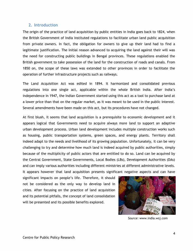
It appears however that land acquisition presents significant negative aspects and can have
significant impacts on people‟s life. Therefore, it should
not be considered as the only way to develop land in
cities. After focusing on the practice of land acquisition
and its potential pitfalls, the concept of land consolidation
will be presented and its possible benefits explored.
Source: www.india.wsj.com
5
Centre for Public Policy Research
3. Background
3.1. The procedure for land acquisition
The process of land acquisition by one public authority is detailed in the Land Acquisition Act,
1894. The first step corresponds to a preliminary investigation that aims at identifying a parcel
of land that could be of use for any public purpose (including a project operated by a company),
and making the notification public. The district collector is responsible to carry out this task and
must take note of any potential objection -that can be made within thirty days- to the
acquisition of the land by a public authority. Any actor who intends to receive later
compensation if land had to be acquired can therefore manifest his interest. The collector
presents the case to the appropriate governmental authority for final decision.
The next step consists in an official declaration stating that land is indeed required to serve a
public purpose. This document must be certified by an authorized officer and indicate the
precise public purpose the parcel of land will be utilized for. After that, the collector will take
order for the acquisition, make sure measures of the land are taken and that a thereof plan has
been made. Then, the collector must make public notice informing all concerned parties that
the Government is about to acquire the land and inviting prejudiced parties to claim
compensation. Such parties include owners, occupiers, and anyone who could claim interest in
the land in question. Fifteen days after the notice, parties must present themselves to inform
the collector of their interests in the land and of the expected amount of related compensation.
The collector will subsequently enquire into the land area, its value, manifested interests of
parties, the amount of required compensation and potential objections. He will decide on all
these terms and inform all concerned parties. The collector‟s award must be conclusive and
signed by all interested persons in his office. The district collector might correct any clerical
errors in the latter within six months. The final step corresponds to the Government taking
possession of the land, free of all hindrances.
However, in case of an emergency declared by the Government, the proceeding will differ. The
collector will acquire special powers that enable him to take possession of any parcel of land
needed for a public purpose in the name of appropriate Government, doing so either
immediately or 15 days after publication of the prior notice, depending on the situation. When
this occurs, the collector shall immediately provide 80 per cent of the compensation to the
persons interested.
6
Centre for Public Policy Research
3.2. The major drawbacks
The Land Acquisition Act encompasses the sovereign right of the Government to take over
parcels of land for public purpose. However, the concept of “public purpose” can be put in
question as to whether the social gain that justifies Government‟s acquisition outweighs
individual losses inflicted on the former owner. Moreover, in theory, this purpose “must be
shared with the people so that they become partners in the project, (…) compensation should be
such that at that price the land owner would voluntarily agree to surrender his land” (Bush
2011). However, this is rarely achieved in practice, as evidenced by numerous conflict cases.
Besides, the Government‟s tendency to use its eminent domain power to acquire land has lead
to many cases of resistance as owners claim insufficient compensation for their land, and as
people might be involuntary displaced and experience regrettable impacts on their livelihood
(India Infrastructure Report 2009).
In addition to the lengthy procedure followed by Government authorities or companies seeking
to acquire land, it appears that many projects become stalled for an undetermined period of
time. Union Ministry of Rural Development researchers noted that compensation in more than
80,000 cases of constrained land acquisition since 1947 are still pending, in Rajasthan only, and
many instances of acquisition contestation remain on the Supreme Court. Similarly, more than
thirty highway development projects, worth over ` 8,800 crore are stalled for lack of land. The
blame is put on the Environment Ministry, State administrations, and the difficulty to reach an
agreement on the amount of compensation that should be paid by companies. For instance,
Kannur-Kuttipuram I and II road projects were awarded 83.2 and 81.5 km length, but the State
of Kerala State stopped land acquisition activity.
In fact, State Governments are responsible for making land available and struggle to conciliate
the interests of companies, owners, environmentalists, or whoever is opposed to the project for
which land is required. This results in a substantial extension of the delay needed to take
possession of the land, and considerably increases the company‟s expenses, as lending agencies
become more hesitant to grant loans and thus interest rates increase. Besides, the expected
returns of the projects likewise postponed and the uncertainty concerning the course of the
project scare investors.
7
Centre for Public Policy Research
3.2.1. The substantial cost of land acquisition
The principal issue in land acquisition by the Government is the compensation cost it engenders.
In the context of a rapid urban population growth adding pressure on the price of land, the cost
of the land needs to be arbitrated between the will of claimants to obtain fair compensation for
what they see as a significant loss, and the public authority‟s or company‟s budget constraint.
The value of the compensation owed to the owner is traditionally based on the average market
value of the land in question at the date of its acquisition by the Government. This price was
determined in comparison to the selling price of similar proximate lands. However, the Supreme
Court ruled in April 2012 that Government shall increase this value to the highest market price
of the land, on the basis that someone who is forced to sell his land should be able to claim a
higher compensation than what a similar land owner would receive if he was willing to sell his
property. Consequently, acquiring land for development is likely to become more and more
costly. Moreover, rehabilitation and resettlement policy for displaced people imply, among other
means, allotment of Government land, grant for house construction and subsistence allowances,
which are adding to the gross cost of land acquisition.
Finally, the social cost of land acquisition cannot be disregarded. It encompasses issues such as
loss of employment, as well as social surroundings and emotional trauma (Dhru 2010).
In addition to the cost, it has been noticed that in most cases rehabilitation and resettlement
aspects that should follow land acquisition are often neglected, leaving the displaced population
suffer the consequences of being uprooted from their land. These negative effects include:
landlessness, homelessness, joblessness and marginalization (Saxena 2011: 23). Another
worrisome aspect in land acquisition is that expropriated owners realize they are often better
off refusing to give up their land, given the increasing pressure on land and thus, its increasing
value over the time.
3.2.2. Amendments, reforms and current developments
Before land acquisition was amended in 1984, the ownership of the land in question could only
be of public entity, which presumed that the purpose for which land was acquired was of public
interest. Since 1984, however, the land ownership could not only be the Government but also a
„company‟, opening the possibility of projects aiming at other objectives. In addition, only the
amount of compensation for the land could be debated but not the term “public purpose”. The
case of India is particular in that sense, as in other democratic nations this purpose can be
challenged to Court, and lead to the nullification of compulsory acquisitions (Morris and Pandey
8
Centre for Public Policy Research
2007: 2086). It appears indeed that the definition of “public purpose” is inclusive and too wide,
and thus can be used to serve the interest of only a portion of the community, rather than
benefit the whole society as a (Dhru 2010: 18-19).
The Land Acquisition, Rehabilitation & Resettlement Bill, 2011 aims at balancing the need of
land for economic development projects with the needs of consequently displaced populations.
It is meant to replace the Land Acquisition Act, 1894. Introduced in Lok Sabha, it has yet to be
approved by the Parliament. Nevertheless, if it is implemented, Public Private Partnership (PPP)
and private companies will need to obtain the agreement of 80 per cent of families affected by
the project to acquire land, while at present agreement from 80 per cent of the landowners only
is required. Besides, compensations to owners will increase, both in rural and urban areas.
Moreover, a Social Impact Assessment being required for every land acquisition, this is likely to
further delay the process. It should thus become more and more difficult for developers to
acquire land, even for a legitimate public purpose.
Besides, in January 2008 Prime Minister Manmohan Singh announced the constitution of the
National Council on Land Reforms (NLRC). This followed the Janadesh yatra 2007, a national
march of about 25,000 said landless people involved in the Janadesh national campaign, who
walked from Gwalior to Delhi on foot to claim land reforms. The first meeting of ten chief
ministers was supposed to take place in October, 2011 but is yet to happen.
4. Proposed models
Considering the current difficulties associated with land acquisition, mostly due to the scarcity
of the land factor that increases the pressure on this resource, there is a strong need to find
alternatives to land acquisition. Moreover, it is possible to consider processes that encourage
populations to become actors of development projects and thus, release the pressure on land
ownership and pacify related disputes. See Annexure 1 to compare the various land based
financing models practiced in different countries.
4.1. Land consolidation models, the potential for a win-win outcome
In ordinary development projects, the required land is already owned, or acquired (by
expropriation or on a volunteer basis) by the developer. However, as exposed above, this
presents numerous disadvantages, high costs being only one of them. Land consolidation, or land
readjustment, consists in putting together inadequately organized proximate plots of land in
9
Centre for Public Policy Research
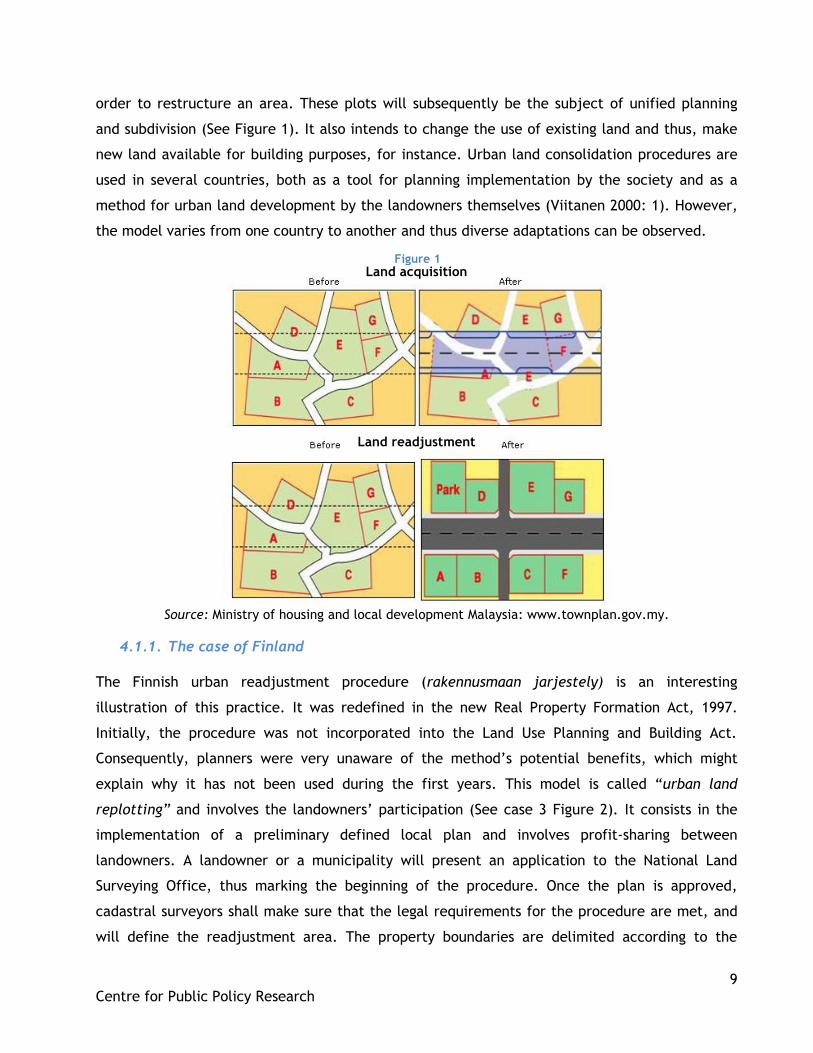
order to restructure an area. These plots will subsequently be the subject of unified planning
and subdivision (See Figure 1). It also intends to change the use of existing land and thus, make
new land available for building purposes, for instance. Urban land consolidation procedures are
used in several countries, both as a tool for planning implementation by the society and as a
method for urban land development by the landowners themselves (Viitanen 2000: 1). However,
the model varies from one country to another and thus diverse adaptations can be observed.
Land acquisition
Land readjustment
Source: Ministry of housing and local development Malaysia: www.townplan.gov.my.
4.1.1. The case of Finland
The Finnish urban readjustment procedure (rakennusmaan jarjestely) is an interesting
illustration of this practice. It was redefined in the new Real Property Formation Act, 1997.
Initially, the procedure was not incorporated into the Land Use Planning and Building Act.
Consequently, planners were very unaware of the method‟s potential benefits, which might
explain why it has not been used during the first years. This model is called “urban land
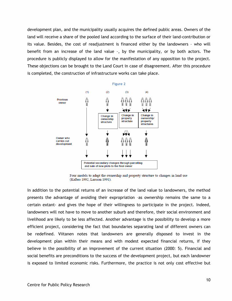
replotting” and involves the landowners‟ participation (See case 3 Figure 2). It consists in the
implementation of a preliminary defined local plan and involves profit-sharing between
landowners. A landowner or a municipality will present an application to the National Land
Surveying Office, thus marking the beginning of the procedure. Once the plan is approved,
cadastral surveyors shall make sure that the legal requirements for the procedure are met, and
will define the readjustment area. The property boundaries are delimited according to the
Figure 1
10
Centre for Public Policy Research
development plan, and the municipality usually acquires the defined public areas. Owners of the
land will receive a share of the pooled land according to the surface of their land-contribution or
its value. Besides, the cost of readjustment is financed either by the landowners – who will
benefit from an increase of the land value –, by the municipality, or by both actors. The
procedure is publicly displayed to allow for the manifestation of any opposition to the project.
These objections can be brought to the Land Court in case of disagreement. After this procedure
is completed, the construction of infrastructure works can take place.
Figure 2
In addition to the potential returns of an increase of the land value to landowners, the method
presents the advantage of avoiding their expropriation –as ownership remains the same to a
certain extant- and gives the hope of their willingness to participate in the project. Indeed,
landowners will not have to move to another suburb and therefore, their social environment and
livelihood are likely to be less affected. Another advantage is the possibility to develop a more
efficient project, considering the fact that boundaries separating land of different owners can
be redefined. Viitanen notes that landowners are generally disposed to invest in the
development plan within their means and with modest expected financial returns, if they
believe in the possibility of an improvement of the current situation (2000: 5). Financial and
social benefits are preconditions to the success of the development project, but each landowner
is exposed to limited economic risks. Furthermore, the practice is not only cost effective but
11
Centre for Public Policy Research
also efficient and environmentally friendly as under-utilised land is mobilized and thus, further
urban expansion is limited. The strength of the Finnish model is that the urban land
readjustment procedure is well-defined, in its structure and organisation.
However, it appears that planners are often uncertain if the procedure can be carried out,
because of extensive and complex legal provisions. Besides, this complex process necessitates
the actors to possess a clear understanding and acknowledgement of the potentialities of the
available land, and a lucid assessment of the situation needs to be made. Conflicts of interests
may also jeopardize the initiative and thus, a transparent and participative approach is required.
4.1.2. The case of Australia
In Western Australia, the process is comparable to that used in Finland, though it is known as
“land pooling”. Although the Town Planning Law authorized its use since 1928, land pooling has
not been undertaken until 1951, when a local council near Perth was asked to provide
infrastructures in the city‟s suburbs. As necessary funds were not available, the council decided
to make use of this technique to redesign the area for the construction of infrastructures, thus
benefiting from the advantage of a total cost recovery for the development project. In most
cases, the councils (local authorities) used this process to turn urban fringe farmlands into
serviced urban land, through development projects. The aim is also to obtain unified subdivision
of proximate parcels of land, which would be suitable for the elaboration of planned urban
development.
In this case, it is the local council who elaborates a draft pooling scheme, in consultation with
the landowners. The scheme is publicly presented, and then reviewed by the State Department
of Town Planning. The Minister for Town Planning shall give his approval before the final scheme
is published. This scheme gives a detailed statement of the involved area, its subdivision,
valuation and presents the project‟s associated budget. The objectives of the project are clearly
defined, as well as the conditions of costs and benefits sharing. The local authorities make
compulsory acquisition of the private, government and public estates required. They decide on
the division of land between building sites, streets and public spaces, and design and carry out
infrastructure works that are funded by borrowed funds. These loans will be repaid when the
council will sell parts of the developed area, and the remaining land will be returned to the
landowners. Hence, no compensations are involved.
12
Centre for Public Policy Research
The major advantages of land pooling practice for the council is that the project‟s costs are
rapidly recovered by the increment in land values, and thus the Government does not have to
finance the project. The urban expansion is planned and controlled by the local authorities.
Besides, the practice of land hoarding for speculative purposes is limited and freed undeveloped
land is mobilized for building arrangements, which increases the supply for housing when the
demand is high. It can be noted that most of these benefits could be obtained if the landowners
joined together and set up their own cooperative pooling project, though this is unlikely to
happen (Archer 1988: 209). Nevertheless, and once again, land pooling will provide these
benefits only if projects are effectively implemented and managed. Moreover, it would be
preferable if these development projects were jointly organised and co-ordinated with
subdivision projects already in progress. Indeed, a consistent planned program should exist for
the design of one city in order to diminish the risk of scattered development.
The difference that exists between urban land replotting and land pooling is that land pooling
involves both organisation and implementation of the readjustment procedure, in accordance
with meticulous land use plans, while in the Finnish case the construction of infrastructure is not
included in the procedure (Viitanen 2000:4).
Moreover, if the Western Australian land pooling model is comparable to the Japanese,
Taiwanese and South-Korean readjustment model, it however involves the transfer of individual
land ownership to the Government agency implicated, whereas separate legal ownership remains
in the latter (Archer 1988: 210).
In Western Australia, most land pooling activities have taken place in Perth, main city of the
State (See Figure 3).
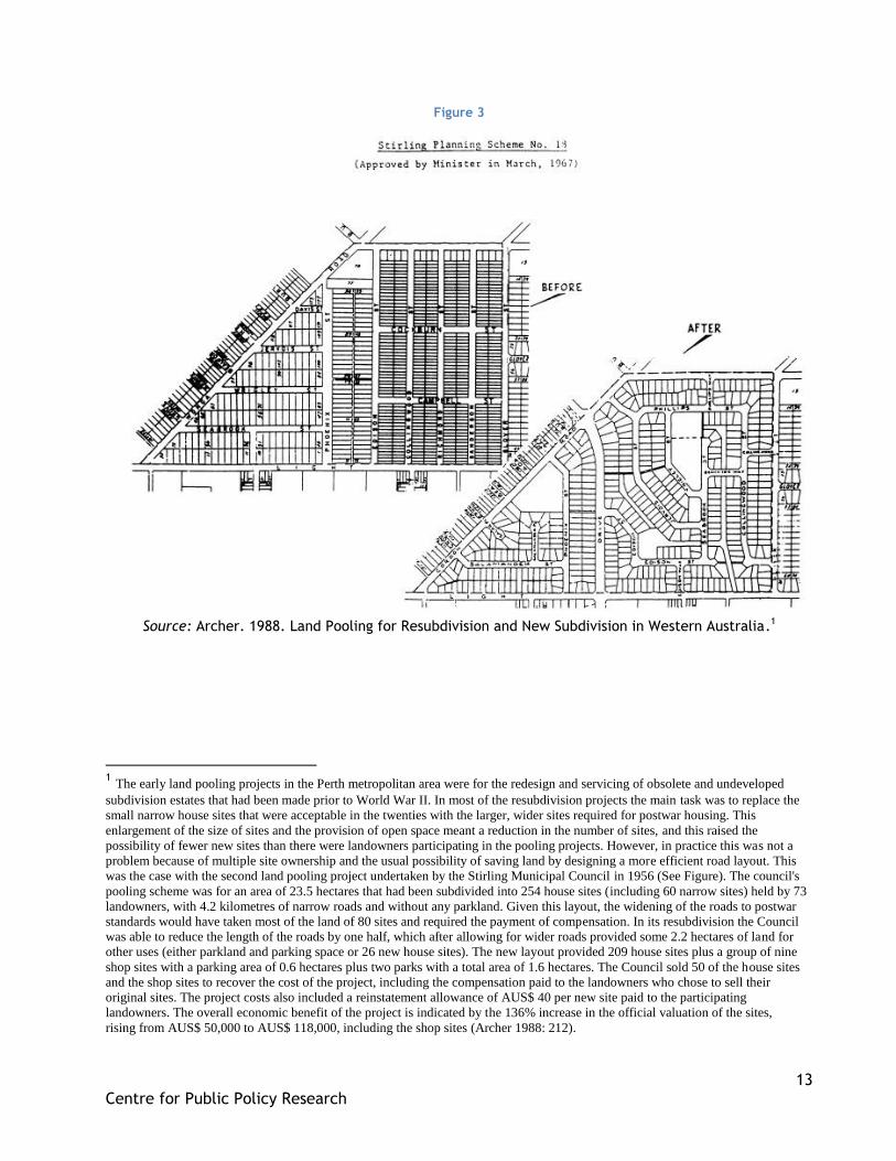
13
Centre for Public Policy Research
Figure 3
Source: Archer. 1988. Land Pooling for Resubdivision and New Subdivision in Western Australia.1
1 The early land pooling projects in the Perth metropolitan area were for the redesign and servicing of obsolete and undeveloped
subdivision estates that had been made prior to World War II. In most of the resubdivision projects the main task was to replace the
small narrow house sites that were acceptable in the twenties with the larger, wider sites required for postwar housing. This
enlargement of the size of sites and the provision of open space meant a reduction in the number of sites, and this raised the
possibility of fewer new sites than there were landowners participating in the pooling projects. However, in practice this was not a
problem because of multiple site ownership and the usual possibility of saving land by designing a more efficient road layout. This
was the case with the second land pooling project undertaken by the Stirling Municipal Council in 1956 (See Figure). The council's
pooling scheme was for an area of 23.5 hectares that had been subdivided into 254 house sites (including 60 narrow sites) held by 73
landowners, with 4.2 kilometres of narrow roads and without any parkland. Given this layout, the widening of the roads to postwar
standards would have taken most of the land of 80 sites and required the payment of compensation. In its resubdivision the Council
was able to reduce the length of the roads by one half, which after allowing for wider roads provided some 2.2 hectares of land for
other uses (either parkland and parking space or 26 new house sites). The new layout provided 209 house sites plus a group of nine
shop sites with a parking area of 0.6 hectares plus two parks with a total area of 1.6 hectares. The Council sold 50 of the house sites
and the shop sites to recover the cost of the project, including the compensation paid to the landowners who chose to sell their
original sites. The project costs also included a reinstatement allowance of AUS$ 40 per new site paid to the participating
landowners. The overall economic benefit of the project is indicated by the 136% increase in the official valuation of the sites,
rising from AUS$ 50,000 to AUS$ 118,000, including the shop sites (Archer 1988: 212).
14
Centre for Public Policy Research
4.2. The applicability of land consolidation schemes in India
4.2.1. India’s main challenges in cities
Indian cities are facing manifold urbanisation issues. Some are institutional, due to inefficient
land management techniques and city planning, especially regarding the large amount of vacant
lands. Failure to collect sufficient levels of property taxation leads to a lack of finance for
municipalities and local bodies, which thus cannot undertake development works through land
acquisition. Land registration systems, when they exist, are frequently dysfunctional. In
addition, those with low incomes cannot afford serviced accommodations, which are too
expensive. Urbanization and land management professionals are lacking, and the level of mutual
trust and cooperation between public authorities and the citizens can be very low.
Urban sprawl is another issue. It signifies spreading of low-density residential development,
beyond the edge of serviced areas. This often results from inefficient city planning and land used
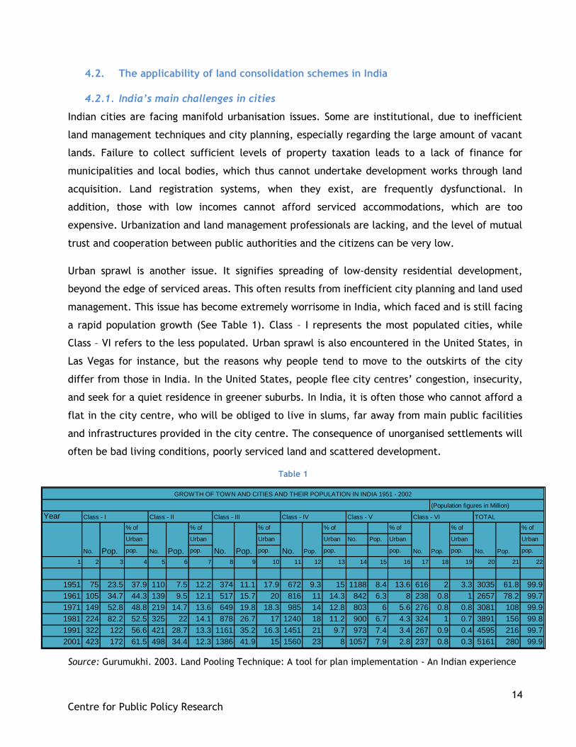
management. This issue has become extremely worrisome in India, which faced and is still facing
a rapid population growth (See Table 1). Class – I represents the most populated cities, while
Class – VI refers to the less populated. Urban sprawl is also encountered in the United States, in
Las Vegas for instance, but the reasons why people tend to move to the outskirts of the city
differ from those in India. In the United States, people flee city centres‟ congestion, insecurity,
and seek for a quiet residence in greener suburbs. In India, it is often those who cannot afford a
flat in the city centre, who will be obliged to live in slums, far away from main public facilities
and infrastructures provided in the city centre. The consequence of unorganised settlements will
often be bad living conditions, poorly serviced land and scattered development.
Source: Gurumukhi. 2003. Land Pooling Technique: A tool for plan implementation - An Indian experience
Year
% of % of % of % of % of % of % of
Urban Urban Urban Urban No. Pop. Urban Urban Urban
pop. pop. pop. pop. pop. pop. pop.
1 2 3 4 5 6 7 8 9 10 11 12 13 14 15 16 17 18 19 20 21 22
1951 75 23.5 37.9 110 7.5 12.2 374 11.1 17.9 672 9.3 15 1188 8.4 13.6 616 2 3.3 3035 61.8 99.9
1961 105 34.7 44.3 139 9.5 12.1 517 15.7 20 816 11 14.3 842 6.3 8 238 0.8 1 2657 78.2 99.7
1971 149 52.8 48.8 219 14.7 13.6 649 19.8 18.3 985 14 12.8 803 6 5.6 276 0.8 0.8 3081 108 99.9
1981 224 82.2 52.5 325 22 14.1 878 26.7 17 1240 18 11.2 900 6.7 4.3 324 1 0.7 3891 156 99.8
1991 322 122 56.6 421 28.7 13.3 1161 35.2 16.3 1451 21 9.7 973 7.4 3.4 267 0.9 0.4 4595 216 99.7
2001 423 172 61.5 498 34.4 12.3 1386 41.9 15 1560 23 8 1057 7.9 2.8 237 0.8 0.3 5161 280 99.9
GROWTH OF TOWN AND CITIES AND THEIR POPULATION IN INDIA 1951 - 2002
No. Pop. No. Pop. No. Pop.No. Pop. No. Pop. No. Pop.
(Population figures in Million)
Class - I TOTALClass - II Class - III Class - IV Class - V Class - VI
Table 1
15
Centre for Public Policy Research
4.2.2. The use of Master Plans
In India, State Town Planning Acts and several Development Acts govern urban planning in each
State. At local level, the State Town Planning Departments are in charge of the city‟s planning,
at the District or administrative level. The first official development plan was probably the
Master Plan for Delhi, which was implemented between 1961 and 1981. Master Plans are used as
a tool to design cities, at times at a 20 years horizon. During the Five Year Plan (from 1961 to
1966), Central Government decided to provide 100 per cent financial assistance for State
Governments to give responsibility to Town Planning Department to prepare Master Plans for the
rapidly growing cities. Since that time, the practice spread and legislation for preparation,
enforcement and implementation was improved.
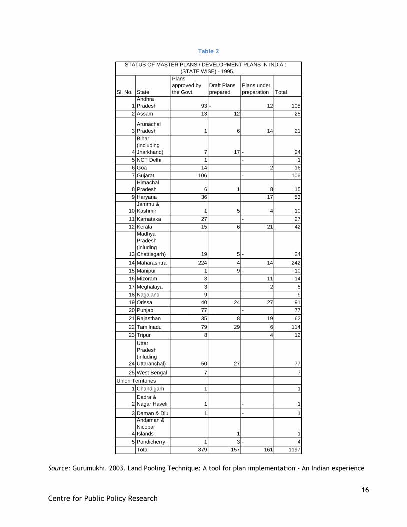
The study realised by the Town and Country Planning Organisation (TCPO) in 1995 shows that
about 879 Master Plans were prepared under the State Town Planning Acts, Town Improvement
Trust Acts, City Development Authority Acts and other related Acts and Legislation (See Table
2). Besides, a number of States also have non-statutory plans, essentially for guidance and policy
purpose as these could not be received because of inappropriate legislative framework
(Gurumukhi 2003).
Nonetheless, these Master Plans are often insufficiently practical and tend to set views without
presenting means to achieve associated objectives. Moreover, they reflect a top-down approach
of the city, rather than the aspirations of affected populations.
16
Centre for Public Policy Research
Table 2
Source: Gurumukhi. 2003. Land Pooling Technique: A tool for plan implementation - An Indian experience
Sl. No. State
Plans approved by the Govt.
Draft Plans prepared
Plans under preparation Total
1 Andhra Pradesh 93 - 12 105
2 Assam 13 12 - 25
3 Arunachal Pradesh 1 6 14 21
4
Bihar (including Jharkhand) 7 17 - 24
5 NCT Delhi 1 - 1 6 Goa 14 2 16 7 Gujarat 106 - 106
8 Himachal Pradesh 6 1 8 15
9 Haryana 36 17 53
10 Jammu & Kashmir 1 5 4 10
11 Karnataka 27 - 27 12 Kerala 15 6 21 42
13
Madhya Pradesh (inluding Chattisgarh) 19 5 - 24
14 Maharashtra 224 4 14 242 15 Manipur 1 9 - 10 16 Mizoram 3 11 14 17 Meghalaya 3 2 5 18 Nagaland 9 - 9 19 Orissa 40 24 27 91 20 Punjab 77 - 77 21 Rajasthan 35 8 19 62 22 Tamilnadu 79 29 6 114 23 Tripur 8 4 12
24
Uttar Pradesh (inluding Uttaranchal) 50 27 - 77
25 West Bengal 7 - 7
1 Chandigarh 1 - 1
2 Dadra & Nagar Haveli 1 - 1
3 Daman & Diu 1 - 1
4
Andaman & Nicobar Islands 1 - 1
5 Pondicherry 1 3 - 4 Total 879 157 161 1197
STATUS OF MASTER PLANS / DEVELOPMENT PLANS IN INDIA : (STATE WISE) - 1995.
Union Territories
17
Centre for Public Policy Research
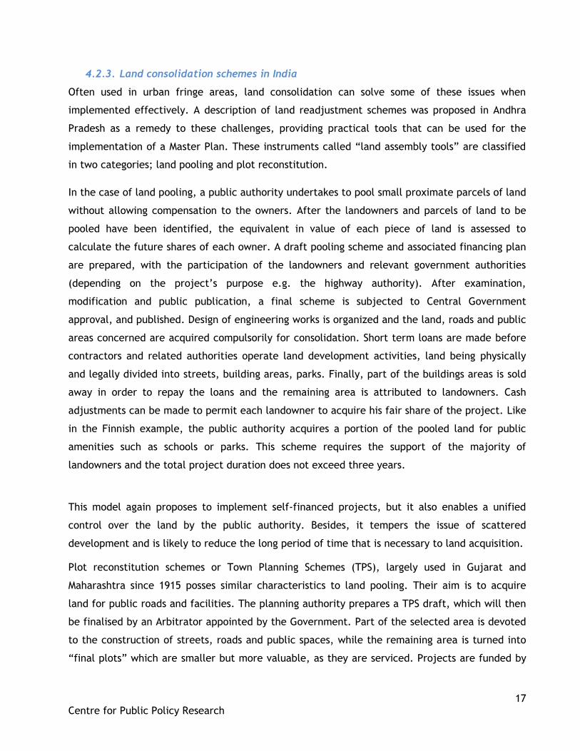
4.2.3. Land consolidation schemes in India
Often used in urban fringe areas, land consolidation can solve some of these issues when
implemented effectively. A description of land readjustment schemes was proposed in Andhra
Pradesh as a remedy to these challenges, providing practical tools that can be used for the
implementation of a Master Plan. These instruments called “land assembly tools” are classified
in two categories; land pooling and plot reconstitution.
In the case of land pooling, a public authority undertakes to pool small proximate parcels of land
without allowing compensation to the owners. After the landowners and parcels of land to be
pooled have been identified, the equivalent in value of each piece of land is assessed to
calculate the future shares of each owner. A draft pooling scheme and associated financing plan
are prepared, with the participation of the landowners and relevant government authorities
(depending on the project‟s purpose e.g. the highway authority). After examination,
modification and public publication, a final scheme is subjected to Central Government
approval, and published. Design of engineering works is organized and the land, roads and public
areas concerned are acquired compulsorily for consolidation. Short term loans are made before
contractors and related authorities operate land development activities, land being physically
and legally divided into streets, building areas, parks. Finally, part of the buildings areas is sold
away in order to repay the loans and the remaining area is attributed to landowners. Cash
adjustments can be made to permit each landowner to acquire his fair share of the project. Like
in the Finnish example, the public authority acquires a portion of the pooled land for public
amenities such as schools or parks. This scheme requires the support of the majority of
landowners and the total project duration does not exceed three years.
This model again proposes to implement self-financed projects, but it also enables a unified
control over the land by the public authority. Besides, it tempers the issue of scattered
development and is likely to reduce the long period of time that is necessary to land acquisition.
Plot reconstitution schemes or Town Planning Schemes (TPS), largely used in Gujarat and
Maharashtra since 1915 posses similar characteristics to land pooling. Their aim is to acquire
land for public roads and facilities. The planning authority prepares a TPS draft, which will then
be finalised by an Arbitrator appointed by the Government. Part of the selected area is devoted
to the construction of streets, roads and public spaces, while the remaining area is turned into
“final plots” which are smaller but more valuable, as they are serviced. Projects are funded by
18
Centre for Public Policy Research
the annual budget of the Urban Development Authority (UDA) or local government and cost
recovery is only partial, operated by collection of betterment charges. Unlike land pooling
schemes, landowners are not consulted for the project design, though they accepted to pool
their land. They will receive shares of reconstituted land as well as compensation for the
reduced land, and share the development cost. In Gujarat, the Town Planning and Urban
Development Act, 1976 identifies the different stages of TPS in order to speed up the process of
their implementation (See Figure 4). Land owners can appeal to the Tribunal of Appeal on
incremental contribution levied.
TPS present the advantage of distributing improved land to landowners equitably. Nonetheless,
in practice, project preparation can take up to ten years, and implementation is contingent on
availability of funds. Besides, though presented as a tool for Master Plan implementation, the
use of these schemes is not compulsory and only a few cities made use of it. Finally, these
schemes are meant to be prepared at local level (about 100 hectares) in order to remain
manageable.
Figure 4
Source : Ballaney and Patel. 2009. Gujarat Town Planning and Urban Development Act, 1976.
19
Centre for Public Policy Research
Whatever the scheme chosen, appropriate Government regulation and monitoring are essential
as well as the involvement of local bodies and Planning Authorities. Besides, the parcels of land
need to be adequate for development (e.g. when public roads can be linked up to proximate
roads of surrounding serviced land) and a strong demand for these services should be identified
beforehand. Furthermore, most landowners need to understand the potential of these projects
and to support them. Once again, responsible actors need to be adequately qualified to ensure
an efficient use of the scheme.
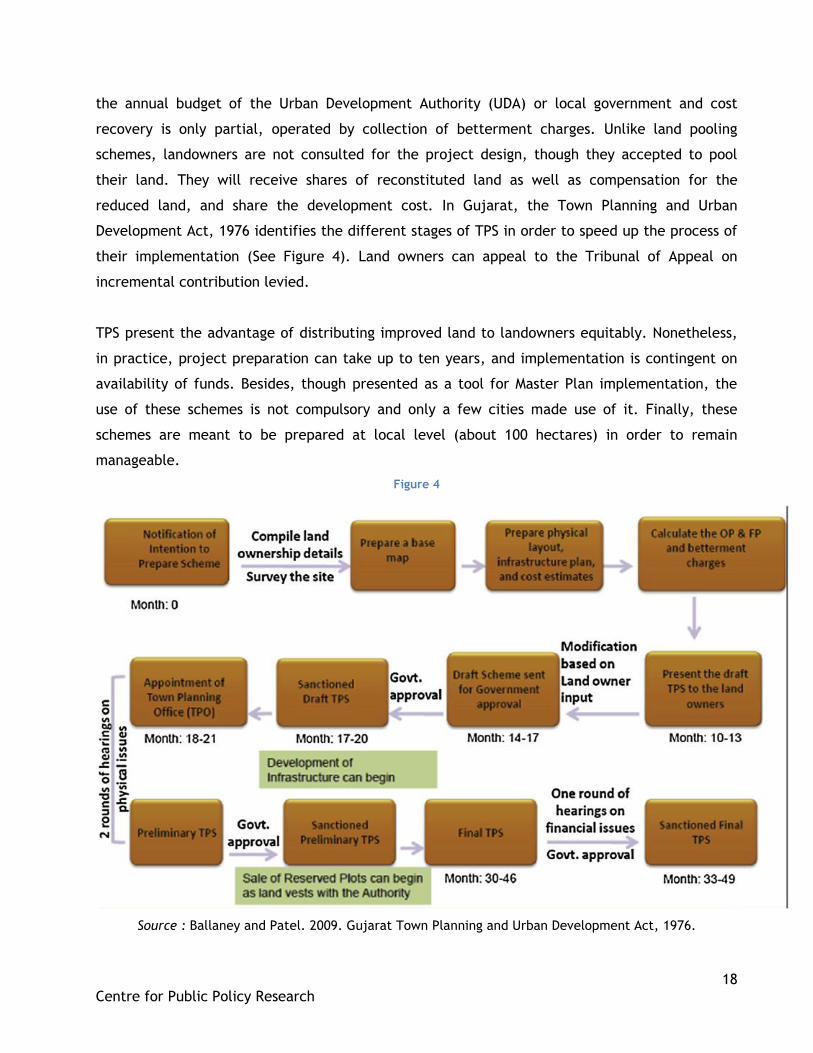
4.3. A successful case of land pooling practice in India: The story of Magarpatta
Magarpatta township, a satellite township of Pune provides an interesting case study for been
developed by its inhabitants through a long successful process. It is an interesting mix of
different land acquisition models presented above. The area is part of Pune Municipal
Corporation. It was diagnosed as agricultural land in the 1982 draft development plan but Satish
Magar, who had studied agriculture after he was sent to a Cambridge school (a Christian Anglo-
Indian school in Pune) feared it would one day be acquired by the Government. His fear was
justified, as Pune was situated in a future urbanisable zone.
From 1987 onwards, some farmers started to sell their land to developers. In 1993, Satish Magar
considered the best way to develop the community‟s land, without losing their ownership; he
decided to try and build a township with the participation of the area‟s farmers. He was able to
lobby with the Government as his family had political contacts. After studying the Regional Town
Planning Act requirements, Satish Magar gathered the landowners. These were already forming a
tight community within which he was respected and trusted, being a farmer himself. 120 farmer
families were involved in the project.
Aware of the farmers‟ fear to soon have to surrender their land, ending up without means of
subsistence, he proposed them to pool their land together and receive proportionate
shareholding of the development company that would thus be created. Then, he met with
Hafeez Contractor, a famous Mumbai architect, and they wrote a report to turn the desired area
into a township. Satish Magar then presented the report to the Chief Minister. They feared that
the project could be challenged by a competitor in High Court, as they wanted to turn 400 acres
of agricultural land in residential land. This was indeed very risky as the farmers‟ community
would certainly no match for such a redoubtable opponent. However, the project was accepted
by the Town Planning Department and the Municipal Corporation after examining multiple
20
Centre for Public Policy Research
reports (See Figure 5). The procedure was long and hazardous, but the final notification was
eventually obtained in 1995.
Source: www.magarpattacity.com Source: www.dsolomondesignpartners.com
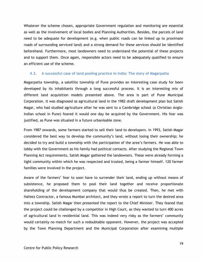
Notably inspired by the design of San Jose City California (See Figure 6), and with the
suggestions and opinion of the farmers and future inhabitants, the planning of the residential
area took place. Building an IT Park appeared as an innovative solution to make the area
attractive without involving as much pollution as heavy industry. Construction started in 2000. In
this process, no extern builder was involved as the farmers became contractors, local resources
were used and quarries were hold in Pune, by the people. A corporate identity was developed
and human resources were mobilized to work on the project that involved them all.
To finance the project, the company got a loan from HDFC in order to start building the
bungalows, first priority to accommodate the farmers. These farmers, working for the company,
would not always ask their money. Infrastructures, the commercial area as well as the IT Park
were also meant to attract people in the area. Aggressive marketing was implemented. The
project had to be eye-catching to work, and after the first IT Park started in 2003, more people
were willing to move into the city. The land value increasing over time, farmers were ready to
wait before starting to sell the first apartments. They were trained in different activities and the
second generation got involved as landowners-entrepreneurs. Small companies were created
within the community to run different services such as broadband, the transportation system,
and landscaping. “Our Township has acted as an agent of social change through a policy of
inclusion. That is the way I want it” says Satish Magar. In 2009, the total sale value of the
project reached Rs 5,000 crore.
Figure 6 Figure 5

21
Centre for Public Policy Research
5. Conclusion
The practice of land acquisition by Government authorities presenting numerous pitfalls,
affected populations in India are claiming for alternatives. Land development processes through
the use of land consolidation, land pooling, Town Planning Schemes or land reconstitution are
many alternatives available. However, the choice of one of these tools to develop an area needs
to be made according to multiple criteria such as; the populations‟ specific needs e.g. housing,
infrastructures; the characteristics of the area considered e.g. the number of landowners, the
size of their estate, the nature of the land; and most importantly, the capacity and motivations
of planners and landowners.
The example of Magarpatta Township shows the possibility of the implantation of an original
land consolidation model in India. It is remarkable because it made the community‟s wish for an
alternative to forced land acquisition a reality. It was operated with the participation of
landowners, and even though they did not originate from urban backgrounds, they were able to
adapt to the evolution of their environment. However, the success of the project was permitted
thanks to the notable entrepreneurship ability and involvement of Satish Magar, his political and
personal connections, and because the landowners were ready to trust him. The landowners
reacted positively also because they were scared that their land could soon be acquired by
force. One might think that this was only an isolated case which could not be replicated in other
contexts. However, it proves that even without legislation regulating the process, the need for
alternatives to land acquisition can be so strong that initiatives emerge from people. Even
though landowners often lack the technical knowledge to operate development projects, one
might argue that they are in the best position to identify their own needs and decide of the
means to answer them. Moreover, when landowners take responsibility in one project, they are
more likely to understand its stake and thus are more inclined to compromise.
However, it is the Government‟s duty to support these initiatives. For that reason, not only the
Land Acquisition Act, 1894 should be amended, but further legislation could frame and
encourage the use of these schemes. On 3 August 2012, Punjab Government gave in-principal
authorisation to the use of land pooling for the development of education and medicine hubs in
Amritsar, Ludhiana and Bathinda, and residential and commercial hubs around Ludhiana airport.
This is therefore encouraging and shows that some Governments start becoming aware of the
method‟s benefits.
22
Centre for Public Policy Research
6. Bibliography
Acharya, Ballabh Prasad. 1988. The Transferability of the Land-Pooling/Readjustment
Techniques. Habitat International. Volume 12. Number 4:103-117.
Archer, R.W. 1988. Land Pooling for Resubdivision and New Subdivision in Western Australia. Journal of Economics and Sociology, Volume 47, Number 2: 207-221.
Arun, T K. 4 July 2011. Alternative to land acquisition. Accessed on 16 August 2012 at
http://blogs.timesofindia.indiatimes.com/cursor/entry/releasing-land-for-industry
Bajwa, Harpreet. 2012. Punjab govt gives nod to land pooling scheme. The Financial Express. 3
August.
Bartl, Hannes. 29 August 2011. Some thoughts on urban sprawl in Indian cities. Accessed on 22
August 2012 at http://www.waterandmegacities.org/some-thoughts-on-urban-sprawl-in-indian-
cities/.
Buch, M N. 26 September 2011. The Right of Eminent Domain: Revisiting the Proposed Land
Acquisition Bill. Accessed on 8 August 2012 at
http://www.vifindia.org/article/2011/september/26/The-Right-of-Eminent-Domain-
Revisiting%20-the-Proposed-Land-Acquisition-Bill
Center For Good Governance. 2010. Managing Urban Growth using the Town Planning Schemes in
Andhra Pradesh.
Dalal, Sucheta and Basu, Debashis . 11 January 2007. The amazing story of Magarpatta. Accessed
on 16 August 2012 at http://www.rediff.com/money/2007/jan/11bspec.htm.
Das, Mamuni. 2012. Over 30 highway projects stalled for want of land. The Hindu, 9 August.
Dhru, Kelly A. 2010. Acquisition of land for „development‟ projects in India: The Road Ahead.
Research Foundation for Governance: in India.
Gurumukhi, K.T. 2003. Land Pooling Technique: A tool for plan implementation - An Indian experience. Town and Country Planning Organisation Government of India, New Delhi. India Infrastructure Report. 2009. Land—A Critical Resource for Infrastructure. New Delhi :
Oxford University Press.
Lok Raj Sangathan. 23 June 2011. Land Acquisition – history and issues. Accessed on 6 August 2012 at http://www.lokraj.org.in/?q=articles/views/land-acquisition-history-and-issues Macionis, J.J, and Parrillo, N.P. 2011. Cities and urban life. Today’s cities and suburbs. New
Delhi: PHI Learning Private Limited.
23
Centre for Public Policy Research
Magarpatta City, The Pride of Pune. Accessed on 16 August 2012 at
http://www.magarpattacity.com/
Mahapatra, Dhananjay. 2012. Govt must pay top market value for land acquisition. The Times of
India, 28 April.
Morris, Sebastian. and Pandey, Ajay. 2007. Towards Reform of Land Acquisition Framework in
India. Economic and Political Weekly, 2 June, Volume 42, Number 22:2083-2090.
OneWorld South Asia. 4 August 2011. India's land acquisition policy. Accessed on 11 August 2012
at http://southasia.oneworld.net/resources/indias-land-acquisition-policy/
PRS Legislative Research. 2012.The Land Acquisition, Rehabilitation and Resettlement Bill, 2011.
Accessed on 16 August 2012 at http://www.prsindia.org/billtrack/the-land-acquisition-
rehabilitation-and-resettlement-bill-2011-1978/
Puja, Mehra. 2011. No Man‟s Land. Business Today, 7 August, 36-44.
Saxena, K B. 2011. Rehabilitation and resettlement of displaced persons. Chapter three in
Development-Induced Displacement, Rehabilitation and Resettlement in India. Routledge
Contemporary South Asia.
Sudip, Roy. December 2009. India falls short on infrastructure. Accessed on 9 August 2012 at
http://www.euromoney.com/Article/2349873/BackIssue/73768/India-falls-short-on-
infrastructure.html
The Hindu. 2012. District administration must compensate farmers. The Hindu, 13 August.
The Hindu. 2012. Farmers‟ organization vow to fight against land acquisition, The Hindu, 30
January.
The Land Acquisition Act, 1894. Government of India.
The Times of India. 2012. PM has no time for panel he chairs, no meet in 4 years, The Times of
India, 9 June.
Venkatesan, J. 2012. Give farmers the highest market value for land acquired, rules SC. The
Hindu, 28 April.
Viitanen, Kauko. 2000. The Finnish Urban Land Readjustment Procedure in an International
Context. Royal Institute of Technology, Real Estate and Construction Management, Real Estate
Planning and Land Law. Publication 4:84. Stockholm. 397 p. ISSN 0348-9469.
24
Centre for Public Policy Research
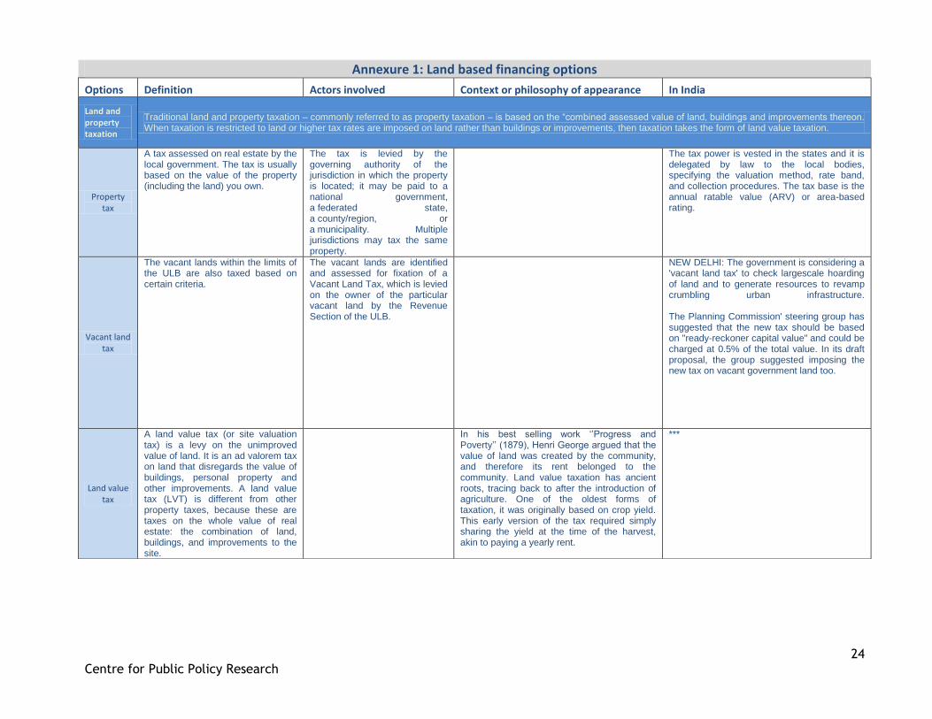
Annexure 1: Land based financing options
Options Definition Actors involved Context or philosophy of appearance In India
Land and property taxation
Traditional land and property taxation – commonly referred to as property taxation – is based on the “combined assessed value of land, buildings and improvements thereon. When taxation is restricted to land or higher tax rates are imposed on land rather than buildings or improvements, then taxation takes the form of land value taxation.
Property tax
A tax assessed on real estate by the local government. The tax is usually based on the value of the property (including the land) you own.
The tax is levied by the governing authority of the jurisdiction in which the property is located; it may be paid to a national government, a federated state, a county/region, or a municipality. Multiple jurisdictions may tax the same property.
The tax power is vested in the states and it is delegated by law to the local bodies, specifying the valuation method, rate band, and collection procedures. The tax base is the annual ratable value (ARV) or area-based rating.
Vacant land tax
The vacant lands within the limits of the ULB are also taxed based on certain criteria.
The vacant lands are identified and assessed for fixation of a Vacant Land Tax, which is levied on the owner of the particular vacant land by the Revenue Section of the ULB.
NEW DELHI: The government is considering a 'vacant land tax' to check largescale hoarding of land and to generate resources to revamp crumbling urban infrastructure. The Planning Commission' steering group has suggested that the new tax should be based on "ready-reckoner capital value" and could be charged at 0.5% of the total value. In its draft proposal, the group suggested imposing the new tax on vacant government land too.
Land value tax
A land value tax (or site valuation tax) is a levy on the unimproved value of land. It is an ad valorem tax on land that disregards the value of buildings, personal property and other improvements. A land value tax (LVT) is different from other property taxes, because these are taxes on the whole value of real estate: the combination of land, buildings, and improvements to the site.
In his best selling work „‟Progress and Poverty‟‟ (1879), Henri George argued that the value of land was created by the community, and therefore its rent belonged to the community. Land value taxation has ancient roots, tracing back to after the introduction of agriculture. One of the oldest forms of taxation, it was originally based on crop yield. This early version of the tax required simply sharing the yield at the time of the harvest, akin to paying a yearly rent.
***
25
Centre for Public Policy Research
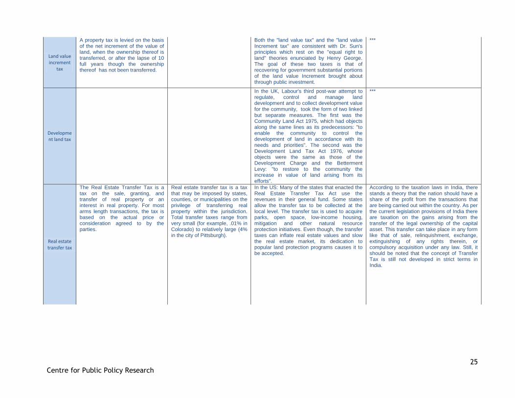
Land value increment
tax
A property tax is levied on the basis of the net increment of the value of land, when the ownership thereof is transferred, or after the lapse of 10 full years though the ownership thereof has not been transferred.
Both the "land value tax" and the "land value Increment tax" are consistent with Dr. Sun's principles which rest on the "equal right to land" theories enunciated by Henry George. The goal of these two taxes is that of recovering for government substantial portions of the land value Increment brought about through public investment.
***
Development land tax
In the UK, Labour's third post-war attempt to regulate, control and manage land development and to collect development value for the community, took the form of two linked but separate measures. The first was the Community Land Act 1975, which had objects along the same lines as its predecessors: "to enable the community to control the development of land in accordance with its needs and priorities". The second was the Development Land Tax Act 1976, whose objects were the same as those of the Development Charge and the Betterment Levy: "to restore to the community the increase in value of land arising from its efforts".
***
Real estate transfer tax
The Real Estate Transfer Tax is a tax on the sale, granting, and transfer of real property or an interest in real property. For most arms length transactions, the tax is based on the actual price or consideration agreed to by the parties.
Real estate transfer tax is a tax that may be imposed by states, counties, or municipalities on the privilege of transferring real property within the jurisdiction. Total transfer taxes range from very small (for example, .01% in Colorado) to relatively large (4% in the city of Pittsburgh).
In the US: Many of the states that enacted the Real Estate Transfer Tax Act use the revenues in their general fund. Some states allow the transfer tax to be collected at the local level. The transfer tax is used to acquire parks, open space, low-income housing, mitigation and other natural resource protection initiatives. Even though, the transfer taxes can inflate real estate values and slow the real estate market, its dedication to popular land protection programs causes it to be accepted.
According to the taxation laws in India, there stands a theory that the nation should have a share of the profit from the transactions that are being carried out within the country. As per the current legislation provisions of India there are taxation on the gains arising from the transfer of the legal ownership of the capital asset. This transfer can take place in any form like that of sale, relinquishment, exchange, extinguishing of any rights therein, or compulsory acquisition under any law. Still, it should be noted that the concept of Transfer Tax is still not developed in strict terms in India.

26
Centre for Public Policy Research
Comprehensive
landholding tax
In South Korea: this tax is levied between 0.5% and 2% for residential houses that exceed KRW600 million (US$521,739). Comprehensive real estate holding tax is levied between 0.75% and 2% for land whose value exceeds KRW500 million (US$434,783). Comprehensive real estate holding tax is levied at different rates, depending on the classification of land.
Property owners whose properties exceed a certain threshold amount are liable to pay the comprehensive real estate holding tax.
***
Real property gains tax
In Malaysia: Real Property Gains Tax (RPGT) is charged on gains arising from the disposal of real property, which is defined as any land situated in Malaysia and any interest, option or other right in or over such land. RPGT is also charged on the disposal of shares in a real property company (RPC).
The tax applies to the gains resulting from disposal by a company, by persons other than companies, by an individual who is not a citizen or permanent resident.
***
Land gains tax
In Vermont, Ontario: The Vermont land gains tax is imposed on gains attributable to the sale of land held for less than six years. Because the purpose of the tax is to inhibit land speculation, there are numerous exemptions to the law to make it better fit the legislative purpose.
Vermont‟s unique land gains tax, with rates ranging from 5% to 80% on land held less than 6 years, was first enacted in 1973 in order to deter land speculators from buying large parcels of land to quickly subdivide and sell. According to the tax commissioner at the time, Norris Hoyt, the tax was instituted at the “tail end of a period when some Vermonters in southern Vermont still didn‟t know the value of the farms they were selling to out-of-staters, and when syndications were being formed in New York City to buy Vermont land.
***
Windfall tax
In Ireland: The “windfall gain” is defined as the increase in the market value of the land which is attributable to rezoning. Income Tax where a profit is made from dealing in or developing land which is subject to Income Tax and some/all of that profit is attributable to the re-zoning of the land after 30 October 2009, then a special 80% rate of Income Tax applies to that part of the profits which are attributable to the re-zoning.
Thu 09 Sep 2009 Windfall tax of 80% aims to prevent speculation on rezoning. The GREEN Party is claiming credit for significant changes to the National Asset Management Agency (Nama) Bill, including a risk-sharing mechanism between Nama and the banks and an 80 per cent windfall tax on developers designed to prevent land speculation in the future.
***
27
Centre for Public Policy Research
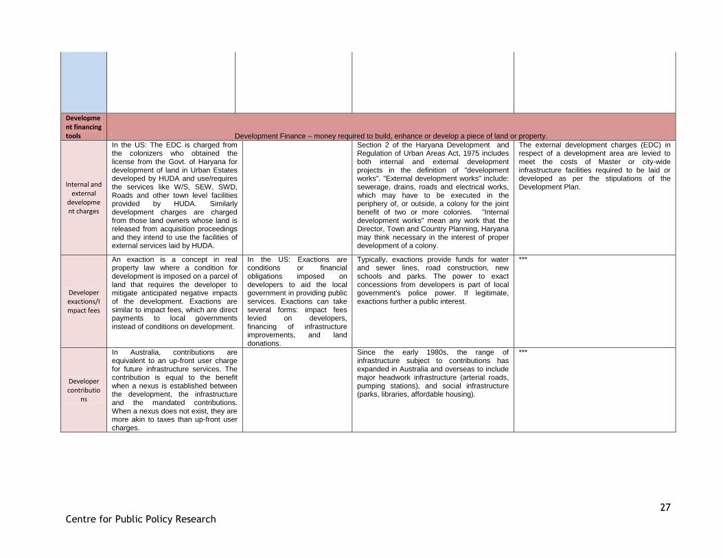
Development financing tools Development Finance – money required to build, enhance or develop a piece of land or property.
Internal and external
development charges
In the US: The EDC is charged from the colonizers who obtained the license from the Govt. of Haryana for development of land in Urban Estates developed by HUDA and use/requires the services like W/S, SEW, SWD, Roads and other town level facilities provided by HUDA. Similarly development charges are charged from those land owners whose land is released from acquisition proceedings and they intend to use the facilities of external services laid by HUDA.
Section 2 of the Haryana Development and Regulation of Urban Areas Act, 1975 includes both internal and external development projects in the definition of "development works". "External development works" include: sewerage, drains, roads and electrical works, which may have to be executed in the periphery of, or outside, a colony for the joint benefit of two or more colonies. "Internal development works" mean any work that the Director, Town and Country Planning, Haryana may think necessary in the interest of proper development of a colony.
The external development charges (EDC) in respect of a development area are levied to meet the costs of Master or city-wide infrastructure facilities required to be laid or developed as per the stipulations of the Development Plan.
Developer exactions/Impact fees
An exaction is a concept in real property law where a condition for development is imposed on a parcel of land that requires the developer to mitigate anticipated negative impacts of the development. Exactions are similar to impact fees, which are direct payments to local governments instead of conditions on development.
In the US: Exactions are conditions or financial obligations imposed on developers to aid the local government in providing public services. Exactions can take several forms: impact fees levied on developers, financing of infrastructure improvements, and land donations.
Typically, exactions provide funds for water and sewer lines, road construction, new schools and parks. The power to exact concessions from developers is part of local government's police power. If legitimate, exactions further a public interest.
***
Developer contributio
ns
In Australia, contributions are equivalent to an up-front user charge for future infrastructure services. The contribution is equal to the benefit when a nexus is established between the development, the infrastructure and the mandated contributions. When a nexus does not exist, they are more akin to taxes than up-front user charges.
Since the early 1980s, the range of infrastructure subject to contributions has expanded in Australia and overseas to include major headwork infrastructure (arterial roads, pumping stations), and social infrastructure (parks, libraries, affordable housing).
***
28
Centre for Public Policy Research
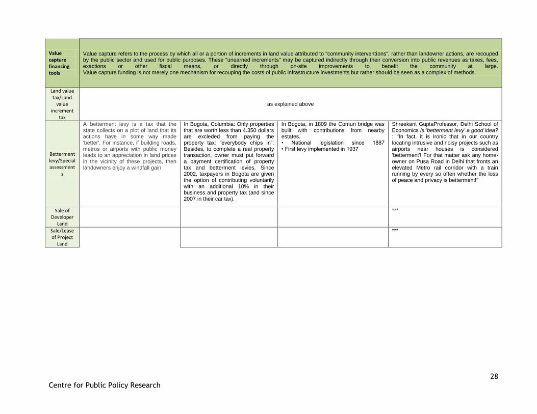
Value capture financing tools
Value capture refers to the process by which all or a portion of increments in land value attributed to "community interventions", rather than landowner actions, are recouped by the public sector and used for public purposes. These "unearned increments" may be captured indirectly through their conversion into public revenues as taxes, fees, exactions or other fiscal means, or directly through on-site improvements to benefit the community at large. Value capture funding is not merely one mechanism for recouping the costs of public infrastructure investments but rather should be seen as a complex of methods.
Land value tax/Land
value increment
tax
as explained above
Betterment levy/Special assessment
s
A betterment levy is a tax that the state collects on a plot of land that its actions have in some way made 'better'. For instance, if building roads, metros or airports with public money leads to an appreciation in land prices in the vicinity of these projects, then landowners enjoy a windfall gain
In Bogota, Columbia: Only properties that are worth less than 4.350 dollars are excleded from paying the property tax: “everybody chips in”. Besides, to complete a real property transaction, owner must put forward a payment certification of property tax and betterment levies. Since 2002, taxpayers in Bogota are given the option of contributing voluntarily with an additional 10% in their business and property tax (and since 2007 in their car tax).
In Bogota, in 1809 the Comun bridge was built with contributions from nearby estates. • National legislation since 1887 • First levy implemented in 1937
Shreekant GuptaProfessor, Delhi School of Economics Is 'betterment levy' a good idea? : "In fact, it is ironic that in our country locating intrusive and noisy projects such as airports near houses is considered 'betterment'! For that matter ask any home-owner on Pusa Road in Delhi that fronts an elevated Metro rail corridor with a train running by every so often whether the loss of peace and privacy is betterment!"
Sale of Developer
Land
***
Sale/Lease of Project
Land
***
29
Centre for Public Policy Research
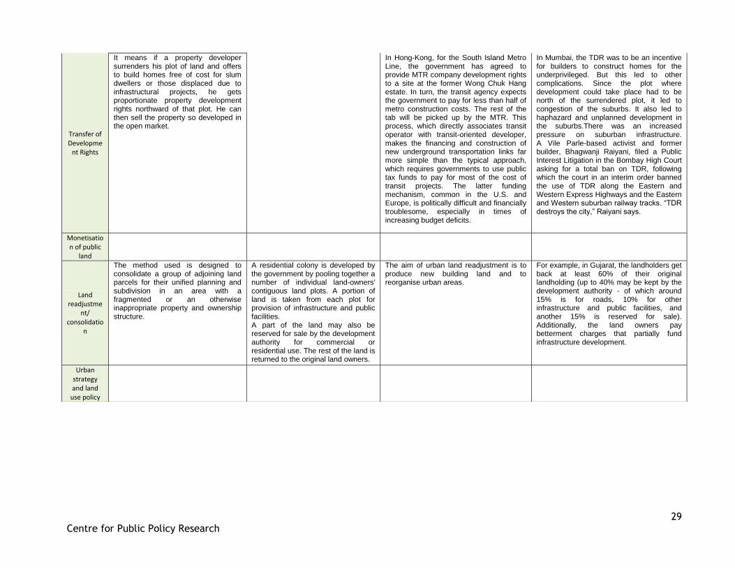
Transfer of Developme
nt Rights
It means if a property developer surrenders his plot of land and offers to build homes free of cost for slum dwellers or those displaced due to infrastructural projects, he gets proportionate property development rights northward of that plot. He can then sell the property so developed in the open market.
In Hong-Kong, for the South Island Metro Line, the government has agreed to provide MTR company development rights to a site at the former Wong Chuk Hang estate. In turn, the transit agency expects the government to pay for less than half of metro construction costs. The rest of the tab will be picked up by the MTR. This process, which directly associates transit operator with transit-oriented developer, makes the financing and construction of new underground transportation links far more simple than the typical approach, which requires governments to use public tax funds to pay for most of the cost of transit projects. The latter funding mechanism, common in the U.S. and Europe, is politically difficult and financially troublesome, especially in times of increasing budget deficits.
In Mumbai, the TDR was to be an incentive for builders to construct homes for the underprivileged. But this led to other complications. Since the plot where development could take place had to be north of the surrendered plot, it led to congestion of the suburbs. It also led to haphazard and unplanned development in the suburbs.There was an increased pressure on suburban infrastructure. A Vile Parle-based activist and former builder, Bhagwanji Raiyani, filed a Public Interest Litigation in the Bombay High Court asking for a total ban on TDR, following which the court in an interim order banned the use of TDR along the Eastern and Western Express Highways and the Eastern and Western suburban railway tracks. “TDR destroys the city,” Raiyani says.
Monetisation of public
land
Land readjustme
nt/ consolidatio
n
The method used is designed to consolidate a group of adjoining land parcels for their unified planning and subdivision in an area with a fragmented or an otherwise inappropriate property and ownership structure.
A residential colony is developed by the government by pooling together a number of individual land-owners' contiguous land plots. A portion of land is taken from each plot for provision of infrastructure and public facilities. A part of the land may also be reserved for sale by the development authority for commercial or residential use. The rest of the land is returned to the original land owners.
The aim of urban land readjustment is to produce new building land and to reorganise urban areas.
For example, in Gujarat, the landholders get back at least 60% of their original landholding (up to 40% may be kept by the development authority - of which around 15% is for roads, 10% for other infrastructure and public facilities, and another 15% is reserved for sale). Additionally, the land owners pay betterment charges that partially fund infrastructure development.
Urban strategy and land
use policy
30
Centre for Public Policy Research
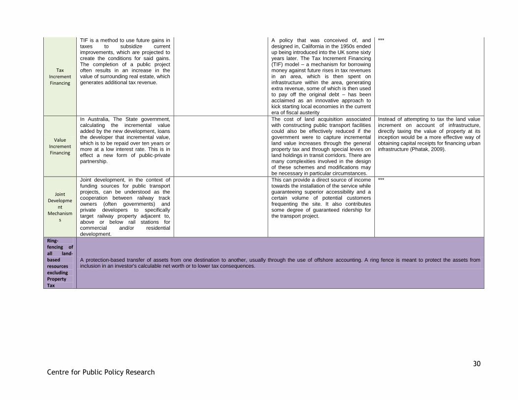
Tax Increment Financing
TIF is a method to use future gains in taxes to subsidize current improvements, which are projected to create the conditions for said gains. The completion of a public project often results in an increase in the value of surrounding real estate, which generates additional tax revenue.
A policy that was conceived of, and designed in, California in the 1950s ended up being introduced into the UK some sixty years later. The Tax Increment Financing (TIF) model – a mechanism for borrowing money against future rises in tax revenues in an area, which is then spent on infrastructure within the area, generating extra revenue, some of which is then used to pay off the original debt – has been acclaimed as an innovative approach to kick starting local economies in the current era of fiscal austerity
***
Value Increment Financing
In Australia, The State government, calculating the incremental value added by the new development, loans the developer that incremental value, which is to be repaid over ten years or more at a low interest rate. This is in effect a new form of public-private partnership.
The cost of land acquisition associated with constructing public transport facilities could also be effectively reduced if the government were to capture incremental land value increases through the general property tax and through special levies on land holdings in transit corridors. There are many complexities involved in the design of these schemes and modifications may be necessary in particular circumstances.
Instead of attempting to tax the land value increment on account of infrastructure, directly taxing the value of property at its inception would be a more effective way of obtaining capital receipts for financing urban infrastructure (Phatak, 2009).
Joint Developme
nt Mechanism
s
Joint development, in the context of funding sources for public transport projects, can be understood as the cooperation between railway track owners (often governments) and private developers to specifically target railway property adjacent to, above or below rail stations for commercial and/or residential development.
This can provide a direct source of income towards the installation of the service while guaranteeing superior accessibility and a certain volume of potential customers frequenting the site. It also contributes some degree of guaranteed ridership for the transport project.
***
Ring-fencing of all land-based resources excluding Property Tax
A protection-based transfer of assets from one destination to another, usually through the use of offshore accounting. A ring fence is meant to protect the assets from inclusion in an investor's calculable net worth or to lower tax consequences.
31
Centre for Public Policy Research
Conversion charges
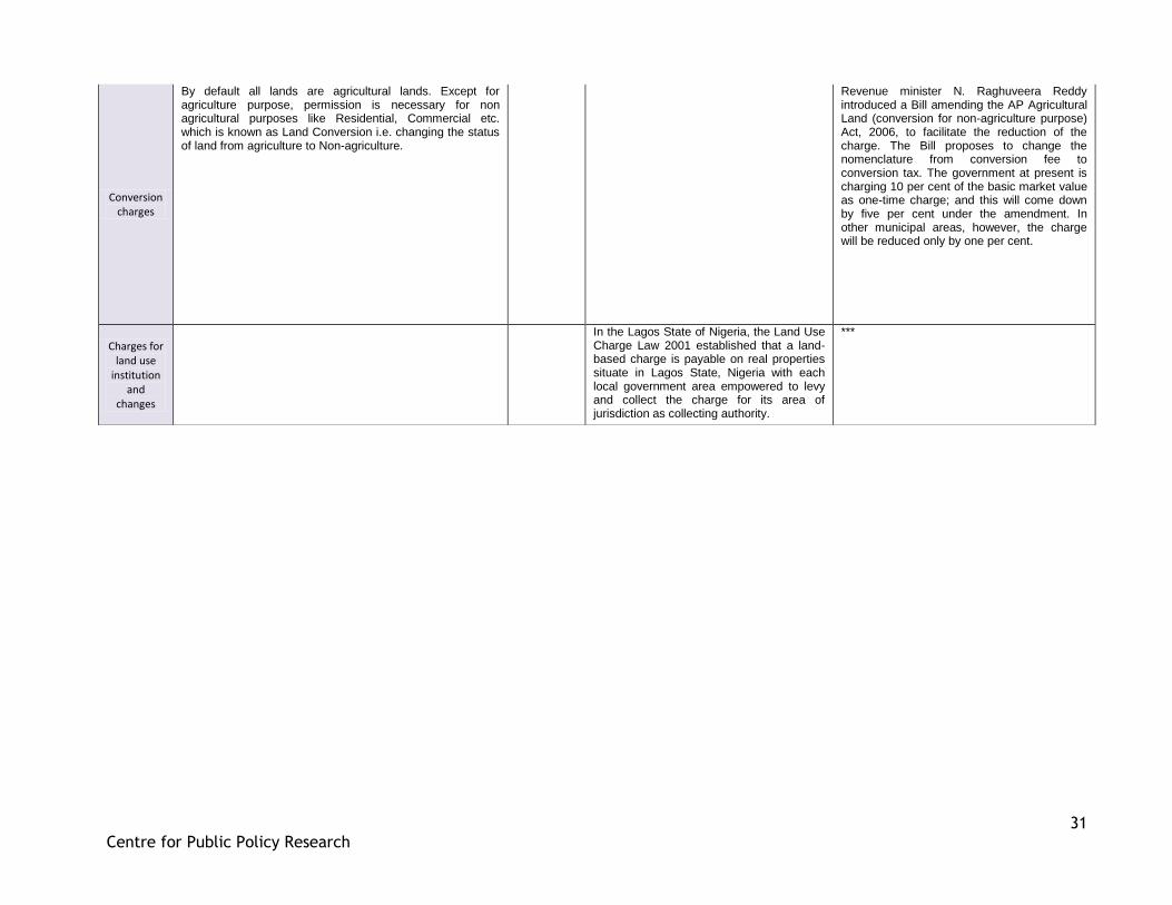
By default all lands are agricultural lands. Except for agriculture purpose, permission is necessary for non agricultural purposes like Residential, Commercial etc. which is known as Land Conversion i.e. changing the status of land from agriculture to Non-agriculture.
Revenue minister N. Raghuveera Reddy introduced a Bill amending the AP Agricultural Land (conversion for non-agriculture purpose) Act, 2006, to facilitate the reduction of the charge. The Bill proposes to change the nomenclature from conversion fee to conversion tax. The government at present is charging 10 per cent of the basic market value as one-time charge; and this will come down by five per cent under the amendment. In other municipal areas, however, the charge will be reduced only by one per cent.
Charges for land use
institution and
changes
In the Lagos State of Nigeria, the Land Use Charge Law 2001 established that a land-based charge is payable on real properties situate in Lagos State, Nigeria with each local government area empowered to levy and collect the charge for its area of jurisdiction as collecting authority.
***


![LAND ACQUISITION ACT, 1894 - PRS Legislative Research Acquisition... · LAND ACQUISITION ACT, 1894 [1 OF 1894] An Act to amend the law for the acquisition of land for public purposes](https://img.pdfslide.us/doc/110x75/5af9118c7f8b9a44658d392e/land-acquisition-act-1894-prs-legislative-acquisitionland-acquisition-act.jpg)