Embed Size (px)
Citation preview

“A nice place to live because it’s naturally beautiful,” says a welcome sign near Post Office Square. Sharon’s natural beauty coupled with its rich history and easy access makes it a true gem. From hiking and biking trails to beautiful lakes and streams to conservation and wildlife areas, Sharon’s open spaces and historical sites have been successfully preserved for residents and visitors to enjoy.
Sharon is located halfway between Boston and Providence, Rhode Island and is easily accessible to Routes 95, 1 and 27. The MBTA’s Commuter Rail Providence/Stoughton line serves the town with a station on Depot Street.
exploreSharonLinking history, linking nature
Ward’s Berry Farm 614 South Main Street 781-784-3600 Pick-Your-Own, farmers market, CSA, bakery, sandwiches, smoothies, hayrides.
Crescent Ridge Dairy 355 Bay Road 781-784-7237Fresh local milk, grass-fed beef, world-famous ice cream, and seasonal farmers market.
Angel’s Café 3 Post Office Square 781-784-8184 Coffee, bakery, sandwiches, salads.
Pizzigando Cafe1 Pond Street 781-784-8161 Pizzeria and grill.
Alice’s Mandarin Taste 37 Pond Street 781-784-7377 Szechuan and Mandarin cuisine.
Carriage House Pizzeria 21 South Main Street 781-784-2700Pizza, subs, salads, Italian fare.
Coriander Bistro5 Post Office Square781-784-2300Indian and Nepali food.
A B
D
TOWN OF CANTONto Canton Aqueduct and Reservoir Pond
TOWN OF EASTONto Children’s Museum and Ames Estate
TOWN OF STOUGHTONto Mary Baker Eddy Historic House and Bird Street Conservation Area
TOWN OF FOXBOROUGHto Gillette Stadium and F. Gilbert Hills State Forest
TOWN OF WALPOLEto Francis William Bird Park
E
BEAVER BROOK TRAIL
HISTORIC BIKE TRAIL
MASSAPOAG TRAIL
LAKE MASSAPOAG
LOOP
KING PHILIP’S ROCK TRAIL
LAKE MASSAPOAG
THE TRUSTEES OF RESERVATIONS
MOOSE HILL FARM & TRAILS
MASS AUDUBON’S MOOSE HILL WILDLIFE SANCTUARY & TRAILS
BORDERLAND STATE PARK &
TRAILS
C
Photos, clockwise from top:American Robin eggs, Garter Snake, Ann-Marie Ford; Cobb’s Tavern, Sharon Historical Society; Fire Engine, Heidi Hewey-Lane; Mann’s Pond, Deer, Ann-Marie Ford; Ward’s Berry Farm, Coriander Bistro, Ann-Marie Ford; Sunset over Lake Massapoag, Peter Higgins; Deborah Sampson’s grave, Matt Ducke; Ward’s Berry Farm, Ann-Marie Ford; Sharon sign, Heidi Hewey-Lane
Local fare
Version 2.0 - January 2017
Massapoag Trail - Private TrailRivers and Streams
Lakes and Ponds
All Open Space
Document Path: S:\DataServices\Projects\Current_Projects\Sharon_Ecotourism\Sharon_Ecotourism_Basemap.mxd
Massapoag Trail - Orange Blaze Trail
Massapoag Trail - Blue Blaze Trail
Roads
Billings St.
Belc
her S
t.
Devils Rock
Sharon High School
LakeMassapoag
4
3
Pond St. Rotary
Pond St
1
Ames St.
Ames St.2
East St.
Deb
orah
Sam
pson S
t.
HammerShopPond
Trowel Shop
Pond
Blue Blaze
Orange Blaze
Private
Massapoag Trails
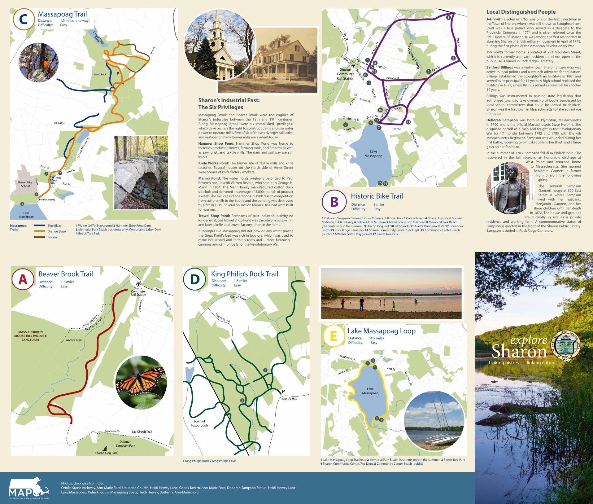
1 Walter Griffin Playground 2 Hammer Shop Pond Dam 3 Memorial Park Beach (residents only Memorial to Labor Day) 4 Beech Tree Park
Front cover
Linking history . . . linking nature
Massapoag Brook and Beaver Brook were the engines of Sharon’s industries between the 18th and 19th centuries. Along Massapoag Brook were six established “privileges,” which gave owners the right to construct dams and use water power to operate mills. Five of six of these privileges still exist, and vestiges of many former mills are evident today.
Hammer Shop Pond: Hammer Shop Pond was home to factories producing knives, farming tools, and firearms as well as saw, grist, and textile mills. The dam and spillway are still intact.
Knife Works Pond: The former site of textile mills and knife factories. Several houses on the north side of Ames Street were homes of knife factory workers.
Mann’s Pond: The water rights originally belonged to Paul Revere’s son, Joseph Warren Revere, who sold it to George H. Mann in 1831. The Mann family manufactured cotton duck sailcloth and delivered an average of 3,000 pounds of product a week. The mill ceased operations in 1900 due to competition from cotton mills in the South, and the building was destroyed by a fire in 1919. Several houses on Mann’s Hill Road were built for workers.
Trowel Shop Pond: Remnants of past industrial activity no longer exist, but Trowel Shop Pond was the site of a cotton mill and later a knife and trowel factory – hence the name.
Although Lake Massapoag did not provide any water power, the Great Pond’s bed was rich in bog ore, which was used to make household and farming tools and – most famously – cannons and cannon balls for the Revolutionary War.
Sharon’s Industrial Past: The Six Privileges
Historical Bike Trail
Rivers and Streams
Lakes and Ponds
All Open Space
Document Path: S:\DataServices\Projects\Current_Projects\Sharon_Ecotourism\Sharon_Ecotourism_Basemap.mxd
Historical Bike Trail
Roads
N. M
ain
St.
LakeMassapoag
Bay Rd.
Billings St.
East St.
Rt. 27
Depot St.
Station St.
S. M
ain
St.
Ames St.
Pond St.
Cottage St.
High St.
School St.
Mass apoag Brook
Debo
rah S
amso
n St.
Quinc
y St.
East St.
Ames St.
Gunhouse St.
Cedar St.
3
Beach St.
Mountain St.
SharonCommuterRail Station
2
1
6
54
10
11
817
7
139
16
1415
12
Job Swift, elected in 1765, was one of the first Selectmen in the Town of Sharon, when it was still known as Stoughtonham. Swift was a true patriot who served as a delegate to the Provincial Congress in 1774 and is often referred to as the “Paul Revere of Sharon.” He was among the first responders in alarming Sharon of British military movement in April of 1778, during the first phase of the American Revolutionary War.
Job Swift’s former home is located at 291 Mountain Street, which is currently a private residence and not open to the public. He is buried in Rock Ridge Cemetery.
Sanford Billings was a well-known Sharon citizen who was active in local politics and a staunch advocate for education. Billings established the Stoughtonham Institute in 1861 and served as its principal for 15 years. A high school replaced the Institute in 1877, where Billings served as principal for another 14 years.
Billings was instrumental in passing state legislation that authorized towns to take ownership of books purchased by local school committees that could be loaned to children. Sharon was the first town in Massachusetts to take advantage of this act.
Deborah Sampson was born in Plympton, Massachusetts in 1760 and is the official Massachusetts State Heroine. She disguised herself as a man and fought in the Revolutionary War for 17 months between 1782 and 1783 with the 4th Massachusetts Regiment. Sampson was wounded during her first battle, receiving two musket balls in her thigh and a large gash on her forehead.
In the summer of 1783, Sampson fell ill in Philadelphia. She recovered in the fall, received an honorable dischage at
West Point, and returned home to Massachusetts. She married
Benjamin Gannett, a farmer from Sharon, the following spring.
The Deborah Sampson Gannett house at 300 East Street is where Sampson
lived with her husband, Benjamin Gannett, and her
three children until her death in 1872. The house and grounds
are currently in use as a private residence and working farm. A commemorative statue of Sampson is erected in the front of the Sharon Public Library. Sampson is buried in Rock Ridge Cemetery.
Local Distinguished People
Pine Grove Ave.
Rivers and Streams
Lakes and Ponds
All Open Space
Document Path: S:\DataServices\Projects\Current_Projects\Sharon_Ecotourism\Sharon_Ecotourism_Basemap.mxd
Beaver Brook Trail
Roads
0 0.3 0.60.15Miles
Station St.
Depot St.
Bay Circuit Tra
il
MASS AUDUBON MOOSE HILL WILDLIFE
SANCTUARY
Ches
tnut
St.
DeborahSampson Park
Sharon Dog Park
Bay Circuit TrailGunhouse St.
SharonCommuterRail Station
Moose Hill
Pkwy
Warner Trail
0.45
1 Deborah Sampson Gannett House 2 Crescent Ridge Dairy 3 Cobbs Tavern 4 Sharon Historical Society 5 Sharon Public Library 6 Police & Fire Museum 7 Massapoag Loop Trailhead 8 Memorial Park Beach (residents only in the summer) 9 Sharon Dog Park 10 Pizzigando 11 Alice’s Mandarin Taste 12 Coriander Bistro 13 Rock Ridge Cemetery 14 Sharon Community Center/Rec Dept. 15 Community Center Beach (public) 16 Walter Griffin Playground 17 Beech Tree Park
King Philip’s Rock TrailsTown of Sharon
Rivers and Streams
Lakes and Ponds
All Open Space
Document Path: S:\DataServices\Projects\Current_Projects\Sharon_Ecotourism\Sharon_Ecotourism_Basemap.mxd
King Philip’s Rock Trails
King Philip Rd.
Mans�eld St.
1
2
Town ofFoxborough
Canoe River
1 King Philip’s Rock 2 King Philip’s Cave
Historical Bike Trail
Rivers and Streams
Lakes and Ponds
All Open Space
Document Path: S:\DataServices\Projects\Current_Projects\Sharon_Ecotourism\Sharon_Ecotourism_Basemap.mxd
Historical Bike Trail
Roads
N. M
ain
St.
LakeMassapoag
Bay Rd.
East St.
Rt. 27
Depot St. School St.
Mass apoag Brook
East St.
Gunhouse St.
Cedar St.
3
Mountain St.
2
5 4
12
3
Photos, clockwise from top:Oriole, Stone Archway, Ann-Marie Ford; Unitarian Church, Heidi Hewey Lane; Cobbs Tavern, Ann-Marie Ford; Deborah Sampson Statue, Heidi Hewey Lane; Lake Massapoag, Peter Higgins; Massapoag Boats, Heidi Hewey; Butterfly, Ann-Marie Ford
Massapoag TrailDistance: 1.5 miles (one way)Difficulty: Easy
Beaver Brook TrailDistance: 1.5 milesDifficulty: Easy
King Philip’s Rock TrailDistance: 1.5 milesDifficulty: Easy
Lake Massapoag LoopDistance: 4.5 milesDifficulty: Easy
A
Historic Bike TrailDistance: 3 milesDifficulty: Easy
B
C
D
E
1 Lake Massapoag Loop Trailhead 2 Memorial Park Beach (residents only in the summer) 3 Beech Tree Park 4 Sharon Community Center/Rec Dept. 5 Community Center Beach (public)