Embed Size (px)
Citation preview
Assessment Report of the damages caused by Tropical
Storm Washi
-June 2012-
TYPHOON COMMITTEE EXPERT MISSION 23-27 April 2012
Dam
ages
cau
sed
by T
ropi
cal S
torm
Was
hi
Expe
rt M
issi
on to
the
Phili
ppin
es
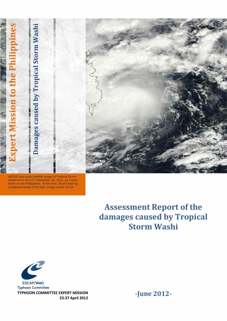
MODIS true-color satellite image of Tropical Storm Washi at 01:45 UTC December 16, 2011, as it bore down on the Philippines. At the time, Washi had top sustatined winds of 50 mph. Image credit: NASA.
1
Contents 1. Introduction ...................................................................................................................................................... 2 2. Meteorological aspects ................................................................................................................................ 2 3. Hydrological aspects..................................................................................................................................... 6 4. Socio-economic impacts ............................................................................................................................. 8 5. Recovery and response .............................................................................................................................14 6. Considerations about DRR Actions .....................................................................................................16 7. Challenges for the Future .........................................................................................................................17 8. Conclusions .....................................................................................................................................................18 9. Recommendations within the Framework of the Activities of the Typhoon
Committee........................................................................................................................................................18 10. References ........................................................................................................................................................19
2
TYPHOON COMMITTEE EXPERT MISSION TO THE PHILIPPINES
Assessment Report of the damages caused by Tropical Storm Washi
and Introduction to the
Typhoon Committee Disaster Information System
23-27 April 2012
1. Introduction The ESCAP/WMO Typhoon Committee (TC) at its 44th Annual Session, held in Hangzhou, China, on 6-11 February 2012, decided to organize a mission to assess the impacts of tropical storm Washi (Sendong, national name in the Philippines). It was also considered opportune to partially accomplish another decision of the TC, which was “to send expert missions on the Web GIS based Typhoon Committee Disaster Information System (WGTCDIS) to three TC Members namely Malaysia, Philippines and USA in 2012. The mission visited Manila and Cagayan de Oro (CDO) city, in Mindanao. A seminar was held in Manila, in PAGASA headquarters, on the WGTCDIS, developed by the National Disaster Management Institute (NDMI) of Republic of Korea. Presentations were also given on the introduction and application to the Frequency Analysis of Rainfall Data and introduction and application to Mountain Flash Flood Prediction System, also developed by NDMI. The main objective of this part of the mission was assisting the Philippines to implement the WGTCDIS. In the past three years similar missions were already accomplished to other Members of the Typhoon Committee, besides the Philippines, namely Cambodia, Lao PDR, Thailand and Viet Nam. On April 24, the team traveled to Cagayan de Oro, Mindanao, where a meeting was held and a visit was made to part of the area affected by Washi, to assess the devastating impacts, keeping in view of future training and research needs in relation to lessons learnt. It was also expected to visit Iligan City but due to security reasons, this part of the mission was not accomplished. However it was possible the delegation of the TC meet with representatives of local government units of Iligan, in CDO. The same seminar that was held in Manila was also held in CDO, for representatives from different local government unities.
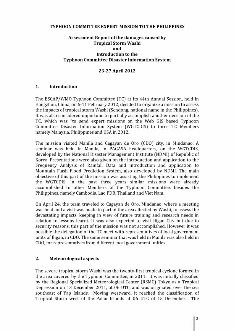
2. Meteorological aspects The severe tropical storm Washi was the twenty-first tropical cyclone formed in the area covered by the Typhoon Committee, in 2011. It was initially classified by the Regional Specialized Meteorological Center (RSMC) Tokyo as a Tropical Depression on 13 December 2011, at 06 UTC, and was originated over the sea southeast of Yap Islands. Moving westward, it reached the classification of Tropical Storm west of the Palau Islands at 06 UTC of 15 December. The
3
maximum sustained winds reached 50 kt, which permitted to be classified as severe tropical storm, and a minimum central pressure of 992 hPa was detected east of Mindanao Island at 06 UTC on 16 December. Keeping its westward track, Washi crossed Mindanao Island that day and the Sulu Sea on 17 December, traversing the provinces of Agusandel Sur, Bukidnon and Misamis Oriental. Keeping its westward track, it was downgraded to tropical depression intensity in the South China Sea at 00 UTC on 19 December and dissipated approximately six hours later.
Fig. 1- Track of Tropical Storm Washi(Sendong) – Philippines local time
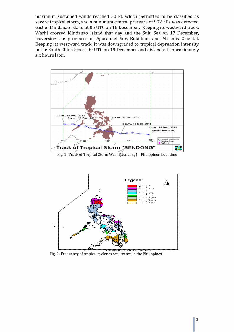
Fig. 2- Frequency of tropical cyclones occurrence in the Philippines
4
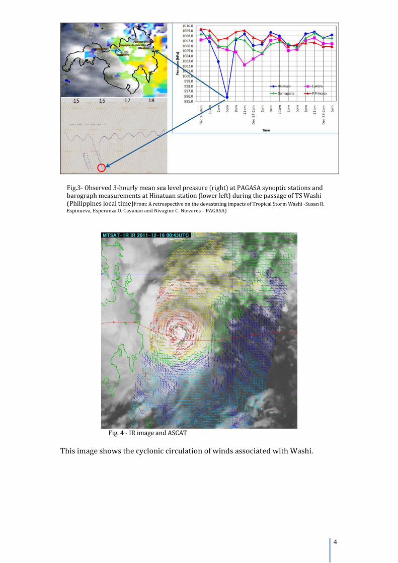
Fig.3- Observed 3-hourly mean sea level pressure (right) at PAGASA synoptic stations and barograph measurements at Hinatuan station (lower left) during the passage of TS Washi (Philippines local time)From: A retrospective on the devastating impacts of Tropical Storm Washi -Susan R. Espinueva, Esperanza O. Cayanan and Nivagine C. Nievares – PAGASA)
Fig. 4 - IR image and ASCAT
This image shows the cyclonic circulation of winds associated with Washi.
5
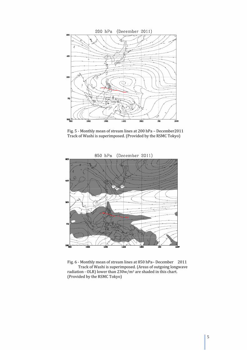
Fig. 5 - Monthly mean of stream lines at 200 hPa – December2011
Track of Washi is superimposed. (Provided by the RSMC Tokyo)
Fig. 6 - Monthly mean of stream lines at 850 hPa– December 2011 Track of Washi is superimposed. (Areas of outgoing longwave radiation - OLR) lower than 230w/m2 are shaded in this chart. (Provided by the RSMC Tokyo)
6
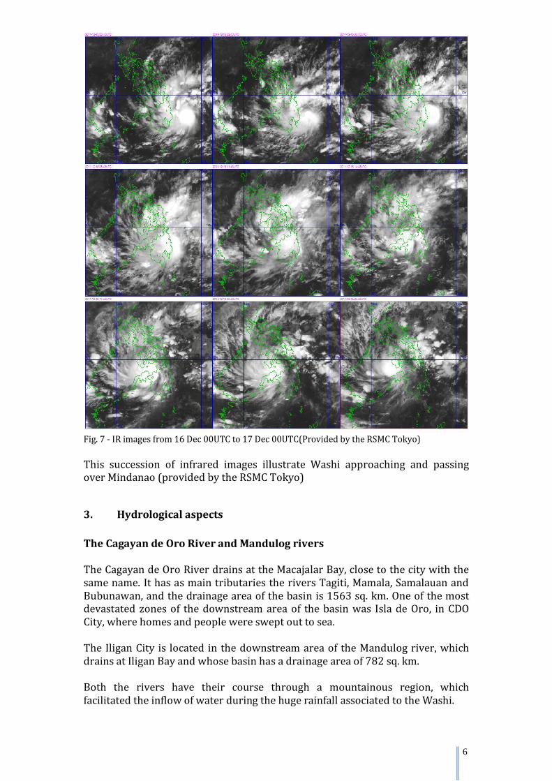
Fig. 7 - IR images from 16 Dec 00UTC to 17 Dec 00UTC(Provided by the RSMC Tokyo) This succession of infrared images illustrate Washi approaching and passing over Mindanao (provided by the RSMC Tokyo)
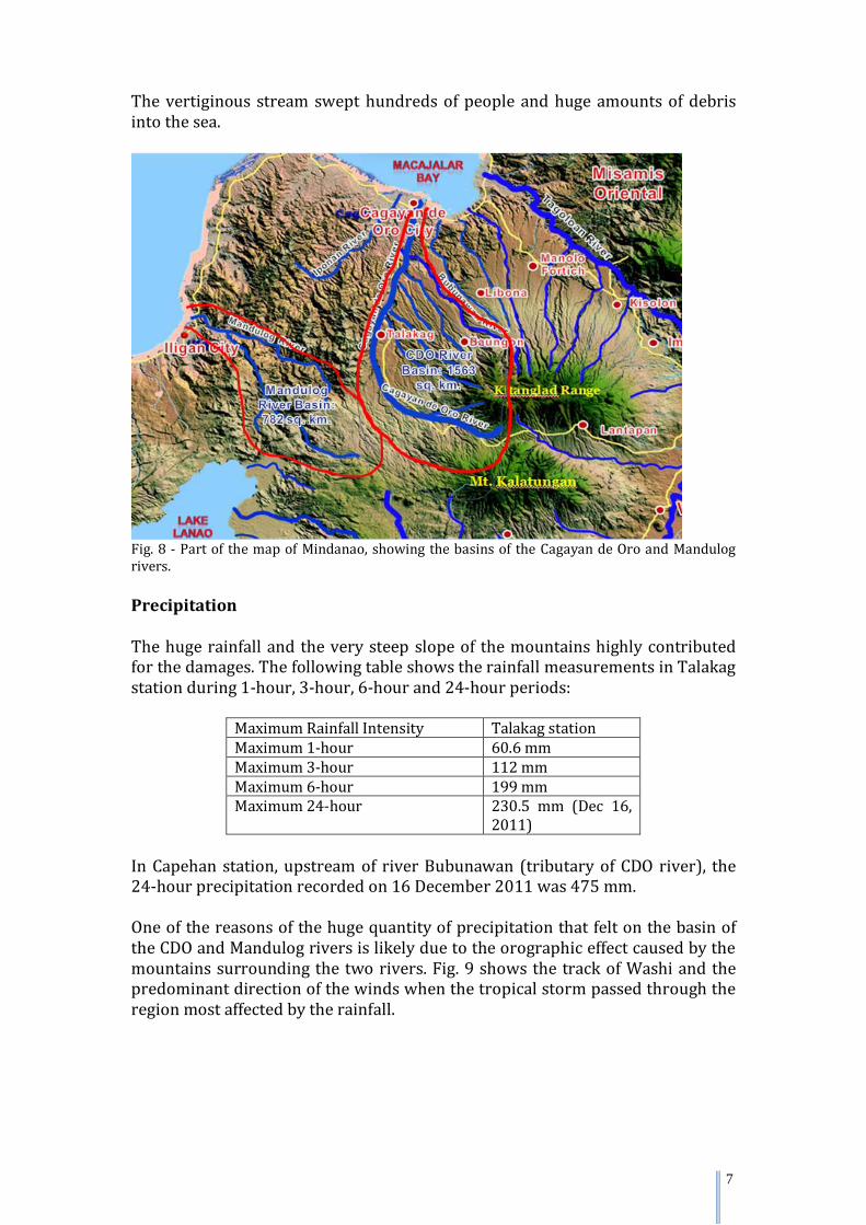
3. Hydrological aspects The Cagayan de Oro River and Mandulog rivers The Cagayan de Oro River drains at the Macajalar Bay, close to the city with the same name. It has as main tributaries the rivers Tagiti, Mamala, Samalauan and Bubunawan, and the drainage area of the basin is 1563 sq. km. One of the most devastated zones of the downstream area of the basin was Isla de Oro, in CDO City, where homes and people were swept out to sea. The Iligan City is located in the downstream area of the Mandulog river, which drains at Iligan Bay and whose basin has a drainage area of 782 sq. km. Both the rivers have their course through a mountainous region, which facilitated the inflow of water during the huge rainfall associated to the Washi.
7
The vertiginous stream swept hundreds of people and huge amounts of debris into the sea.
Fig. 8 - Part of the map of Mindanao, showing the basins of the Cagayan de Oro and Mandulog rivers. Precipitation The huge rainfall and the very steep slope of the mountains highly contributed for the damages. The following table shows the rainfall measurements in Talakag station during 1-hour, 3-hour, 6-hour and 24-hour periods:
Maximum Rainfall Intensity Talakag station Maximum 1-hour 60.6 mm Maximum 3-hour 112 mm Maximum 6-hour 199 mm Maximum 24-hour 230.5 mm (Dec 16,
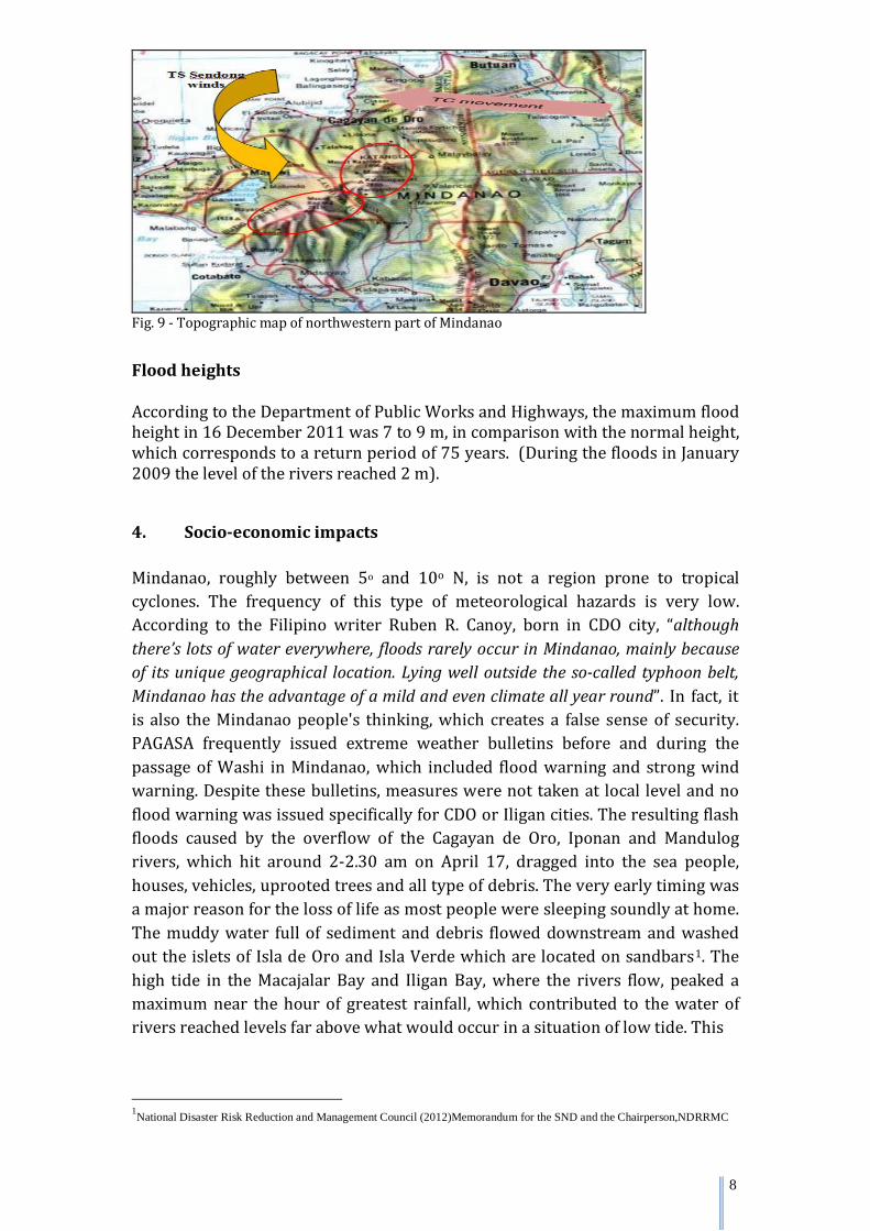
2011) In Capehan station, upstream of river Bubunawan (tributary of CDO river), the 24-hour precipitation recorded on 16 December 2011 was 475 mm. One of the reasons of the huge quantity of precipitation that felt on the basin of the CDO and Mandulog rivers is likely due to the orographic effect caused by the mountains surrounding the two rivers. Fig. 9 shows the track of Washi and the predominant direction of the winds when the tropical storm passed through the region most affected by the rainfall.
8
Fig. 9 - Topographic map of northwestern part of Mindanao
Flood heights According to the Department of Public Works and Highways, the maximum flood height in 16 December 2011 was 7 to 9 m, in comparison with the normal height, which corresponds to a return period of 75 years. (During the floods in January 2009 the level of the rivers reached 2 m).
4. Socio-economic impacts Mindanao, roughly between 5o and 10o N, is not a region prone to tropical cyclones. The frequency of this type of meteorological hazards is very low. According to the Filipino writer Ruben R. Canoy, born in CDO city, “although there’s lots of water everywhere, floods rarely occur in Mindanao, mainly because of its unique geographical location. Lying well outside the so-called typhoon belt, Mindanao has the advantage of a mild and even climate all year round”. In fact, it is also the Mindanao people's thinking, which creates a false sense of security. PAGASA frequently issued extreme weather bulletins before and during the passage of Washi in Mindanao, which included flood warning and strong wind warning. Despite these bulletins, measures were not taken at local level and no flood warning was issued specifically for CDO or Iligan cities. The resulting flash floods caused by the overflow of the Cagayan de Oro, Iponan and Mandulog rivers, which hit around 2-2.30 am on April 17, dragged into the sea people, houses, vehicles, uprooted trees and all type of debris. The very early timing was a major reason for the loss of life as most people were sleeping soundly at home. The muddy water full of sediment and debris flowed downstream and washed out the islets of Isla de Oro and Isla Verde which are located on sandbars1. The high tide in the Macajalar Bay and Iligan Bay, where the rivers flow, peaked a maximum near the hour of greatest rainfall, which contributed to the water of rivers reached levels far above what would occur in a situation of low tide. This 1National Disaster Risk Reduction and Management Council (2012)Memorandum for the SND and the Chairperson,NDRRMC
9
also contributed for the flooding of banks, the overthrow of bridges and entrainment of debris.
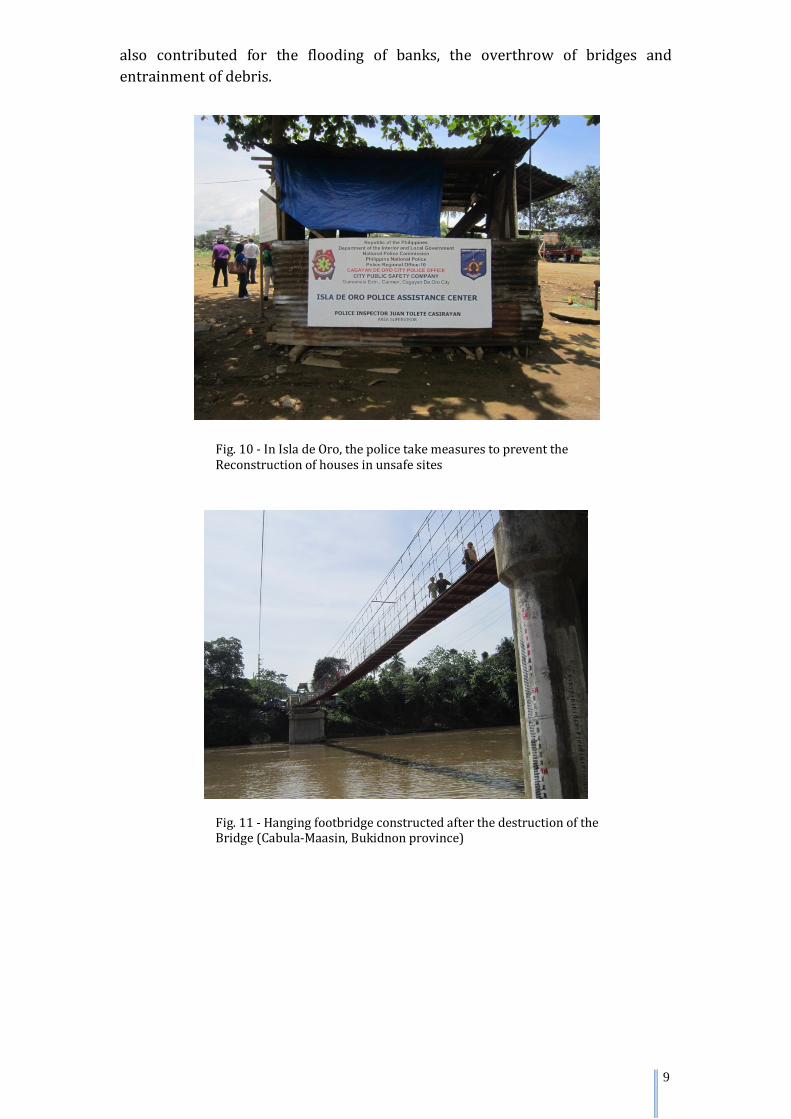
Fig. 10 - In Isla de Oro, the police take measures to prevent the Reconstruction of houses in unsafe sites
Fig. 11 - Hanging footbridge constructed after the destruction of the Bridge (Cabula-Maasin, Bukidnon province)
10
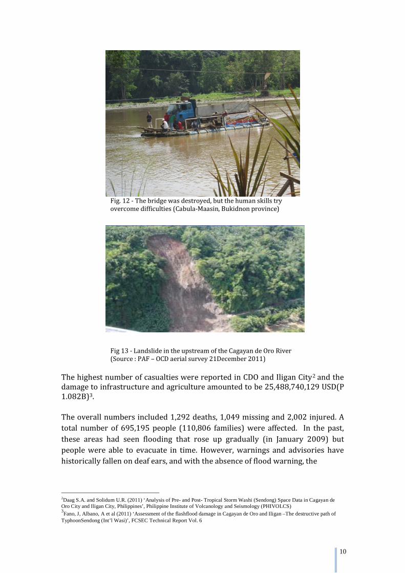
Fig. 12 - The bridge was destroyed, but the human skills try overcome difficulties (Cabula-Maasin, Bukidnon province)
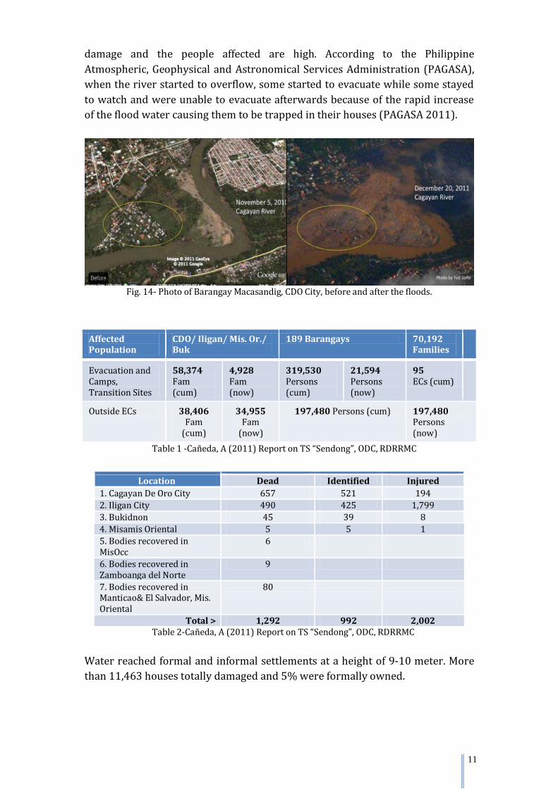
Fig 13 - Landslide in the upstream of the Cagayan de Oro River (Source : PAF – OCD aerial survey 21December 2011)
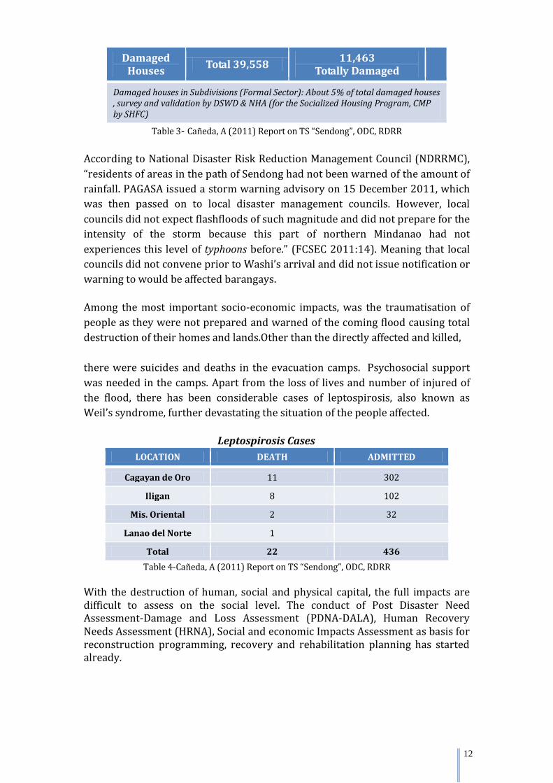
The highest number of casualties were reported in CDO and Iligan City2 and the damage to infrastructure and agriculture amounted to be 25,488,740,129 USD(P 1.082B)3. The overall numbers included 1,292 deaths, 1,049 missing and 2,002 injured. A total number of 695,195 people (110,806 families) were affected. In the past, these areas had seen flooding that rose up gradually (in January 2009) but people were able to evacuate in time. However, warnings and advisories have historically fallen on deaf ears, and with the absence of flood warning, the
2Daag S.A. and Solidum U.R. (2011) ‘Analysis of Pre- and Post- Tropical Storm Washi (Sendong) Space Data in Cagayan de Oro City and Iligan City, Philippines’, Philippine Institute of Volcanology and Seismology (PHIVOLCS) 3Fano, J, Albano, A et al (2011) ‘Assessment of the flashflood damage in Cagayan de Oro and Iligan –The destructive path of TyphoonSendong (Int’l Wasi)’, FCSEC Technical Report Vol. 6
11
damage and the people affected are high. According to the Philippine Atmospheric, Geophysical and Astronomical Services Administration (PAGASA), when the river started to overflow, some started to evacuate while some stayed to watch and were unable to evacuate afterwards because of the rapid increase of the flood water causing them to be trapped in their houses (PAGASA 2011).
Fig. 14- Photo of Barangay Macasandig, CDO City, before and after the floods.
Affected Population
CDO/ Iligan/ Mis. Or./ Buk
189 Barangays 70,192 Families
Evacuation and Camps, Transition Sites
58,374 Fam (cum)
4,928 Fam (now)
319,530 Persons (cum)
21,594 Persons (now)
95 ECs (cum)
Outside ECs 38,406 Fam
(cum)
34,955 Fam
(now)
197,480 Persons (cum) 197,480 Persons (now)
Table 1 -Cañeda, A (2011) Report on TS “Sendong”, ODC, RDRRMC
Location Dead Identified Injured 1. Cagayan De Oro City 657 521 194 2. Iligan City 490 425 1,799 3. Bukidnon 45 39 8 4. Misamis Oriental 5 5 1 5. Bodies recovered in MisOcc
6
6. Bodies recovered in Zamboanga del Norte
9
7. Bodies recovered in Manticao& El Salvador, Mis. Oriental
80
Total > 1,292 992 2,002 Table 2-Cañeda, A (2011) Report on TS “Sendong”, ODC, RDRRMC
Water reached formal and informal settlements at a height of 9-10 meter. More than 11,463 houses totally damaged and 5% were formally owned.
12
Damaged Houses Total 39,558 11,463
Totally Damaged Damaged houses in Subdivisions (Formal Sector): About 5% of total damaged houses , survey and validation by DSWD & NHA (for the Socialized Housing Program, CMP by SHFC)
Table 3- Cañeda, A (2011) Report on TS “Sendong”, ODC, RDRR According to National Disaster Risk Reduction Management Council (NDRRMC), “residents of areas in the path of Sendong had not been warned of the amount of rainfall. PAGASA issued a storm warning advisory on 15 December 2011, which was then passed on to local disaster management councils. However, local councils did not expect flashfloods of such magnitude and did not prepare for the intensity of the storm because this part of northern Mindanao had not experiences this level of typhoons before.” (FCSEC 2011:14). Meaning that local councils did not convene prior to Washi’s arrival and did not issue notification or warning to would be affected barangays. Among the most important socio-economic impacts, was the traumatisation of people as they were not prepared and warned of the coming flood causing total destruction of their homes and lands.Other than the directly affected and killed, there were suicides and deaths in the evacuation camps. Psychosocial support was needed in the camps. Apart from the loss of lives and number of injured of the flood, there has been considerable cases of leptospirosis, also known as Weil’s syndrome, further devastating the situation of the people affected.
Leptospirosis Cases
LOCATION DEATH ADMITTED
Cagayan de Oro 11 302
Iligan 8 102
Mis. Oriental 2 32
Lanao del Norte 1 Total 22 436
Table 4-Cañeda, A (2011) Report on TS “Sendong”, ODC, RDRR With the destruction of human, social and physical capital, the full impacts are difficult to assess on the social level. The conduct of Post Disaster Need Assessment-Damage and Loss Assessment (PDNA-DALA), Human Recovery Needs Assessment (HRNA), Social and economic Impacts Assessment as basis for reconstruction programming, recovery and rehabilitation planning has started already.
13
For the overall socio-economic impacts, the estimated cost of damage to properties is amounted to 97,847,468.65 USD. The table below gives a detailed summary of damage: SUMMARY OF DAMAGE
SECTOR DAMAGE LOSS NEEDS (UNFUNDED) I ECONOMIC 10,478,523.46 USD 8,856,567.06 USD 16,482,145.29 USD
A. Agriculture (Crops/Livestock)
4,166,817.76 USD 7,262,231.41 USD 3,686,295.55 USD
B. Fisheries 788,524.21 USD 525,182.93 USD 249,626.86 USD (Initial funds released – 2,203,050)
(short term) 462,200.86 USD
(long term) C. Industry & Commerce
5,514,920.93 USD 1,061,718.22 USD 11,800,802.75 USD
D. Tourism 8,260.56 USD 7,434.51 USD 283,219.27 USD II SOCIAL 49,651,098.30 USD 710,360.52 USD 163,596,888.71 USD
A. Housing (data from NHA only)
45,938,752.63 USD NOT YET AVAILABLE
162,383,766.19 USD
(Data from DSWD to be submitted) B. Education 3,310,597.20 USD 259,617.66 USD 745,810.73 USD C. Health 401,748.46 USD 450,742.86 USD 467,311.79 USD SECTOR DAMAGE LOSS NEEDS (UNFUNDED) III INFRASTRUCTURE
37,717,846.89 USD 8,752,612.32 USD 398,027,396.57 USD
A. Power 1,840,869.35 USD 377,790.31 USD 3,849,902.56 USD (Iligan& CDO) B. Water Supply 1,606,089.25 USD 1,292,187.90 USD NOT YET AVAILABLE (Data from Iligan CWS only; Cdo Water District still to submit data)
C. Dam Management
14,160,963.30 USD
4,720,321.10 USD 14,160,963.30 USD
D. Transportation, Drainage System, Flood Control
19,518,527.75 USD 2,297,408.60 USD 39,988,200.21 USD
(short term) 7,080,481.65 USD (medium term) 332,947,848.85 USD E. Communication 591,397.23 USD 64,904.42 USD TELCOs DID NOT
GIVE DATA SECTOR DAMAGE LOSS NEEDS (UNFUNDED) IV CROSS – SECTORAL
A. Local Government
B. Social Protection
C. DRRM/CCA D. Environment TOTAL 97,847,468.65 USD 18,319,539.91 USD 578,106,430.57 USD
Table 5- Cañeda, A (2011) Report on TS “Sendong”, ODC, RDRR
14
The electrical power and water supply have been restored to its former capacity. In CDO, 98% of electric power and water restored, with 98% of west pumping stations and 95% of east pumping stations functioning. In Iligan, 75% of electric power restored and 98% of the pumping stations are functioning with only 10% of them had to be restored4.
5. Recovery and response
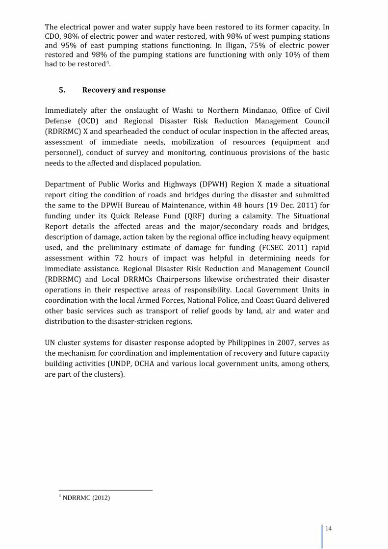
Immediately after the onslaught of Washi to Northern Mindanao, Office of Civil Defense (OCD) and Regional Disaster Risk Reduction Management Council (RDRRMC) X and spearheaded the conduct of ocular inspection in the affected areas, assessment of immediate needs, mobilization of resources (equipment and personnel), conduct of survey and monitoring, continuous provisions of the basic needs to the affected and displaced population. Department of Public Works and Highways (DPWH) Region X made a situational report citing the condition of roads and bridges during the disaster and submitted the same to the DPWH Bureau of Maintenance, within 48 hours (19 Dec. 2011) for funding under its Quick Release Fund (QRF) during a calamity. The Situational Report details the affected areas and the major/secondary roads and bridges, description of damage, action taken by the regional office including heavy equipment used, and the preliminary estimate of damage for funding (FCSEC 2011) rapid assessment within 72 hours of impact was helpful in determining needs for immediate assistance. Regional Disaster Risk Reduction and Management Council (RDRRMC) and Local DRRMCs Chairpersons likewise orchestrated their disaster operations in their respective areas of responsibility. Local Government Units in coordination with the local Armed Forces, National Police, and Coast Guard delivered other basic services such as transport of relief goods by land, air and water and distribution to the disaster-stricken regions. UN cluster systems for disaster response adopted by Philippines in 2007, serves as the mechanism for coordination and implementation of recovery and future capacity building activities (UNDP, OCHA and various local government units, among others, are part of the clusters).
4 NDRRMC (2012)
15
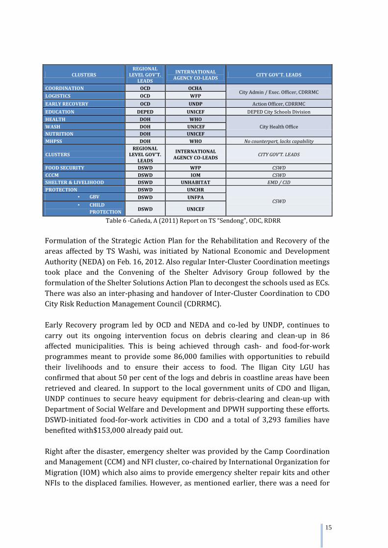
CLUSTERS REGIONAL
LEVEL GOV’T. LEADS
INTERNATIONAL AGENCY CO-LEADS CITY GOV’T. LEADS
COORDINATION OCD OCHA City Admin / Exec. Officer, CDRRMC
LOGISTICS OCD WFP EARLY RECOVERY OCD UNDP Action Officer, CDRRMC EDUCATION DEPED UNICEF DEPED City Schools Division HEALTH DOH WHO
City Health Office WASH DOH UNICEF NUTRITION DOH UNICEF MHPSS DOH WHO No counterpart, lacks capability
CLUSTERS REGIONAL
LEVEL GOV’T. LEADS
INTERNATIONAL AGENCY CO-LEADS CITY GOV’T. LEADS
FOOD SECURITY DSWD WFP CSWD CCCM DSWD IOM CSWD SHELTER & LIVELIHOOD DSWD UNHABITAT EMD / CID PROTECTION DSWD UNCHR
CSWD • GBV DSWD UNFPA • CHILD
PROTECTION DSWD UNICEF
Table 6 -Cañeda, A (2011) Report on TS “Sendong”, ODC, RDRR
Formulation of the Strategic Action Plan for the Rehabilitation and Recovery of the areas affected by TS Washi, was initiated by National Economic and Development Authority (NEDA) on Feb. 16, 2012. Also regular Inter-Cluster Coordination meetings took place and the Convening of the Shelter Advisory Group followed by the formulation of the Shelter Solutions Action Plan to decongest the schools used as ECs. There was also an inter-phasing and handover of Inter-Cluster Coordination to CDO City Risk Reduction Management Council (CDRRMC). Early Recovery program led by OCD and NEDA and co-led by UNDP, continues to carry out its ongoing intervention focus on debris clearing and clean-up in 86 affected municipalities. This is being achieved through cash- and food-for-work programmes meant to provide some 86,000 families with opportunities to rebuild their livelihoods and to ensure their access to food. The Iligan City LGU has confirmed that about 50 per cent of the logs and debris in coastline areas have been retrieved and cleared. In support to the local government units of CDO and Iligan, UNDP continues to secure heavy equipment for debris-clearing and clean-up with Department of Social Welfare and Development and DPWH supporting these efforts. DSWD-initiated food-for-work activities in CDO and a total of 3,293 families have benefited with$153,000 already paid out. Right after the disaster, emergency shelter was provided by the Camp Coordination and Management (CCM) and NFI cluster, co-chaired by International Organization for Migration (IOM) which also aims to provide emergency shelter repair kits and other NFIs to the displaced families. However, as mentioned earlier, there was a need for
16
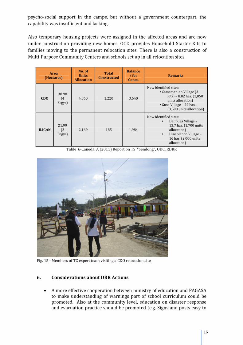
psycho-social support in the camps, but without a government counterpart, the capability was insufficient and lacking. Also temporary housing projects were assigned in the affected areas and are now under construction providing new homes. OCD provides Household Starter Kits to families moving to the permanent relocation sites. There is also a construction of Multi-Purpose Community Centers and schools set up in all relocation sites.
Area (Hectares)
No. of Units
Allocation
Total Constructed
Balance / for
Const. Remarks
CDO 38.98
(4 Brgys)
4,860 1,220 3,640
New identified sites: • Camaman-an Village (3
lots) – 8.02 has. (1,050 units allocation)
• Gusa Village – 29 has. (3,500 units allocation)
ILIGAN 21.99
(3 Brgys)
2,169 185 1,984
New identified sites: • Dalipuga Village –
13.7 has. (1,700 units allocation)
• Hinaplanon Village – 16 has. (2,000 units allocation)
Table 6-Cañeda, A (2011) Report on TS “Sendong”, ODC, RDRR
Fig. 15 - Members of TC expert team visiting a CDO relocation site
6. Considerations about DRR Actions
• A more effective cooperation between ministry of education and PAGASA to make understanding of warnings part of school curriculum could be promoted. Also at the community level, education on disaster response and evacuation practice should be promoted (e.g. Signs and posts easy to
17
understand and follow). Drills could also take place more frequently as well.
• The general public could not comprehend warnings and bulletins broadcasted on TV and radio. The terminology used should be “laymanized”. Local warnings and preparedness/education methods could be further enhanced.
• The practice of Building-Back-Better should be promoted with a people first priority for recovery.
• Attention to sustained mental health and psychosocial support is called for, to
support people’s coping mechanism and assist in their well-being after the shock. It is relevant to avoid situations of extreme stress that can lead to suicide.
• Short-Term, medium-term and long-term structural measures are
needed, in Cagayan de Oro and Iligan (Details in “Assessment of the Flashflood Damage in Cagayan de Oro & Iligan – The Destructive Path of Typhoon Sendong - Int’l Name: Washi)
- Short term: the rehabilitation and improvement of existing dikes and
retaining walls flood fighting activities. - Medium term: Proposed flood control structures built. - Long term: “Sabo” dams are a high priority to catch debris, but very
costly.
• DRR and mitigation should be emphasized. There is a need to move the people away from risk areas.
• More focus needed on controlling improper land use. Specifically flood disaster prevention would be difficult if human settlements impede the natural flow of the drainage.
7. Challenges for the Future
• The No-build zones monitoring of the building of temporary shelters/ bunkhouses from various donors. Alternate livelihood offerings and training is a priority to insure against new informal settlements (ILO and other organizations support this).
• Present communication system (mobile phones) used in relaying bulletins and
warnings not reliable especially during severe weather such as tropical cyclones. Cell sites were down during the floods and mobile phones were of no use for relaying bulletins and warnings. Redundant measures for information dissemination are needed. Power outage for several hours during the flash flooding incapacitated the operations and communication; therefore, UPS and generators are needed in the regional operation centres.
• Some LGUs have no DRRMC Operations Center, thus preventing them from
receiving bulletins and warnings properly. Areas identified by Mines and
18
Geosciences Bureau (MGB) as flood-prone are certainly flood-prone. People are complacent and are not mindful of their safety.
• Personnel of the regional office were themselves affected by the flood which
severely undermined its capacity to address the overwhelming demand for operations in the two cities. Augmentation from the regional centers and from central office was helpful. Deployment of personnel may also be duly accompanied with appropriate terms of reference.
• Need for a Continuity of Operations Plan or staff augmentation plan as
standard operating procedures (SOP) that may be activated for similar surge capacity situations.
• The Strategic Action Plan formulated by NEDA should be implemented
• Need for watershed management to ensure flood and sediment control. Also,
the question of deforestation needs to be taken into consideration, both for the environment and for DRR. One way to remedy deforestation is reforestation. In case of reforestation, it would provide livelihood to people who have lost their jobs and farmlands devastated by Washi, and would also mean the reforested highlands would reduce surface runoff and decrease soil erosion.
• There are risk transfer systems such as government insurance schemes, however, they are still too costly for the poor people and more affordable options are needed.
8. Conclusions
• The disaster reached enormous proportions due mainly to three simultaneous factors: very intense rainfall, occurrence of rainfall during early morning when people were asleep, and high tide that prevented a greater flow of the Cagayan de Oro and Mandulog rivers to the sea.
• Because the area of Northern Mindanao had not experience of this level of tropical storms before, the general population had a false sense of security.
• PAGASA frequently issued extreme weather bulletins before and during the
passage of Washi, which included flood warning and strong wind warning.
• Despite the bulletins from PAGASA, measures were not taken at local level and no flood warning was issued for CDO and Iligan cities.
9. Recommendations within the Framework of the Activities of the Typhoon Committee
• The National Disaster Management Institute (NDMI) of Republic of Korea
is willing to cooperate with the Philippines on the implementation of a pilot project utilizing the Mountain Flash Flood Prediction System, developed by NDMI, in Northern Mindanao. The Typhoon Committee Secretariat is available to collaborate.
19
• The fellowship scheme of the Typhoon Committee might serve to build
capacity of relevant Philippine participants. NDMI participants in the mission expressed interest and are prepared to work with the TC and the Philippines to further develop this possibility.
• PAGASA has got a certain experience in community based warning
system, which might be implemented in other communities prone to floods. The Typhoon Committee published “General Guidelines for setting-up a Community-based Flood Forecasting and Warning System (CBFFWS)”, based in the experience of PAGASA (WMO/TD-No.1472).
• Quantitative precipitation estimation (QPE) and quantitative precipitation forecast (QPF) are important tools for flood risk management, but still under research. TC could assist capacity building in this area.
• In the current year the Hong Kong Observatory is offering two fellowships, through the TC fellowship scheme, for providing training on the installation and operation of Short-range Warning of Intense Rainstorms in Localized Systems (SWIRLS) and its QPE/QPF algorithms. It would be opportune one forecaster from PAGASA to take advantage of this fellowship.
• Necessity of more involvement of Filipino experts in the TC projects
“Urban Flood Risk Management”, “Hazard Mapping for Sediment-related Disasters” and “Development and Application of Flood Disaster Preparedness”.
• Detailed flood hazard maps with inundation simulation for various return periods should be conducted in order to identify extent of vulnerable areas.
10. References Cañeda, A (2011) Report on TS “Sendong”, ODC, RDRR Daag S.A. and Solidum U.R. (2011) ‘Analysis of Pre- and Post- Tropical Storm Washi (Sendong) Space Data in Cagayan de Oro City and Iligan City, Philippines’, Philippine Institute of Volcanology and Seismology (PHIVOLCS) Fano, J, Albano, A et al (2011) ‘Assessment of the flashflood damage in Cagayan de Oro and Iligan –The destructive path of Typhoon Sendong (Int’l Washi)’, FCSEC Technical Report Vol. 6 National Disaster Risk Reduction and Management Council (2012) Memorandum for the SND and the Chairperson, NDRRMC NDRRMC (2012) Final Report re TS Sendong - Memorandum for the SND and Chairperson, NDRRMC
20
Department of Public Works and Highways (DPWH) from Flood Control and Sabo Engineering Center (FCSEC) together with JICA experts - "Damage Assessment of the Flashflood in Cagayan de Oro and Iligan," Susan R. Espinueva, Esperanza O. Cayanan and Nivagine C. Nievares - retrospective on the devastating impacts of Tropical Storm Washi-(Presentation) PAGASA “Post Flood Investigation in Cagayan-Iligan City during the Passage of Tropical Storm Sendong” Composition of the expert team: PAGASA: Dr. Susan R. Espinueva; Mr. Socrates F. Paat, Jr; Ms. Nivagine Nievares; Ms. Tess Pajarillo National Disaster Management Institute - NDMI (Republic of Korea): Dr. Shim, Jae Hyun; Dr. Kim, Yun Tae; Dr. Ahn, Jae Chan; Dr. Lee, Chi Hun. National Emergency Management Agency - NEMA (Republic of Korea): Dr. Jung, In Sung (NEMA) UNDP: Ms. Gemma Dalena ESCAP: Mr. Preminda Joseph Fernando Typhoon Committee: Mr. Olavo Rasquinho Acknowledgements: The participants in the expert mission are grateful to PAGASA and the representatives of the different local government unities of CDO and Iligan cities for their collaboration.