Embed Size (px)
Citation preview

^
§̈¦87
§̈¦540 §̈¦540§̈¦540
§̈¦540
§̈¦540
§̈¦40
§̈¦40
§̈¦40
§̈¦40§̈¦440
§̈¦440
Brookdale Dr
Belin Ct
Landrum Ln
Chelray Ct
Riverport Rd
Airm
axDr
New
Wat
kinsL
n
Cartway Ln
Leeb
rook
Rd JonesbayLn
Park
Hill
Dr
Beec
hBlu
ff Ln
Terre
l Mill
Rd
Wake b rook
Dr
WindyKnoll Rd
Laur
iston
Rd
Willow Lake RdWatkins Town Rd
Peac
hford
Ln
Watkins Rd
Old Watkins Rd
Riverport RdBe
agle
Retre
atDr
Old Watkins RdW
atkins
Town
Rd
R-4
R-4
CM-CU
R-4-CU
IH-CU
R-4
IH
R-4
R-4
CM
CM
CM
MH
R-4
R-4-CU
CM
R-4
R-4
CM
CM
R-4
WC R-30
0 370 740 1,110 1,480Feet
Existing Zoning Z-28-2021
±102.51 acresWake County R-30R-6-CU
2932, 2933, 3029, & 3033 Watkins Town Rd; 1505 Old Watkins Rd; 0 Old Milburnie RdProperty
SizeExistingZoning
RequestedZoning
Location
Map by Raleigh Department of Planning and Development (mansolfj): 5/7/2021

memo
Z-28-21 Watkins Town Road, approximately 99.7 acres located on both sides of WatkinsTown Road, between Watkins Road and Old Watkins Road.
Signed zoning conditions provided on November 12, 2021 require at least 40% of the site to be open space that abuts at least 40% of the lots, with 60% of the open space being contiguous; set a maximum of 280 dwelling units, no more than 190 of which can be detached; prohibit apartments; require stormwater management for a 25-year storm; require a 20-foot average width protective yard on the northern property line of 3033 Watkins Town Road; increase dimensional standards for the conservation development option; prohibit townhouses and duplexes within 1,100 feet of the northern property line of 3033 Watkins Town Road; and require at least two access points to Watkins Town Road from the west.
Current zoning: Residential-30 (R-30) Requested zoning: Residential-6-Conditional Use (R-6-CU) and R-6
The request is consistent with the 2030 Comprehensive Plan. The request is consistent with the Future Land Use Map.
The Planning Commission recommends approval of the request (6 - 0).
Attached are the Planning Commission Certified Recommendation (including Staff Report), the Zoning Conditions, the Petition for Rezoning, and the Neighborhood Meeting Report.
To Marchell Adams-David, City Manager
Thru Patrick O. Young, AICP, Director
From Ira Mabel, AICP, Senior Planner
Department Planning and Development
Date November 17, 2021
Subject City Council agenda item for December 7, 2021 – Z-28-21
On November 16, 2021, City Council authorized the public hearing for the following item:

RALEIGH PLANNING COMMISSION
CERTIFIED RECOMMENDATION CR# 13074
CASE INFORMATION: Z-28-21 WATKINS TOWN ROAD Location On both sides of Watkins Town Road, between Watkins Road and
Old Watkins Road Address: 2932, 2933, 3013, 3029, & 3033 Watkins Town Road; 1505 Old Watkins Road; and 0 Old Milburnie Road PINs: 1746894942, 1747709196, 1747701824, 1747711222, 1747702102, 1746798664, 1747804539 iMaps, Google Maps, Directions from City Hall
Current Zoning R-30 (Wake County) Requested Zoning R-6-CU, R-6 Area of Request 99.7 acres Corporate Limits The site is located outside of the ETJ, but is contiguous with
corporate city limits. An annexation petition has been filed (AX-14- 21) so that the site can connect to city services including sewer and water.
Property Owner See attached Applicant Collier Marsh, ParkerPoe Council District B PC Recommendation Deadline
January 24, 2022
SUMMARY OF PROPOSED CONDITIONS 1. At least 40% of the site shall be open space that abuts at least 40% of the lots, with
60% of the open space being contiguous. 2. There shall be a maximum of 280 dwelling units, no more than 190 of which can be
detached. Apartments are prohibited. 3. Stormwater discharge regulations shall be met for a 25-year storm. 4. A 20-foot average width protective yard shall be provided within the northern property
line of 3033 Watkins Town Road. 5. In a conservation development, detached and attached dwelling lots shall be at least
6,000 square feet, and such perimeter lots shall meet conventional dimensional standards.
6. Townhouses and attached dwellings shall not be within 1,100 feet of the northern property line of 3033 Watkins Town Road.
7. There shall be at least two access points to Watkins Town Road from the west.

Staff Evaluation 2 Z-28-21 Watkins Town Road
COMPREHENSIVE PLAN GUIDANCE Future Land Use Low Density Residential, Special Study Area
Urban Form N/A
Consistent Policies Key policies are marked with a dot () Area Specific Guidance policies are marked with a square ()
LU 1.2—Future Land Use Map and Zoning Consistency LU 2.2–Compact Development LU 3.4—Infrastructure Concurrency LU 5.1–Reinforcing the Urban Pattern LU 8.1–Housing Variety LU 8.9–Open Space in New Development H 1.8–Zoning for Housing
Inconsistent Policies
LU 3.1—Zoning of Annexed Lands LU 3.2—Location of Growth
FUTURE LAND USE MAP CONSISTENCY The rezoning case is Consistent Inconsistent with the Future Land Use Map.
COMPREHENSIVE PLAN CONSISTENCY The rezoning case is Consistent Inconsistent with the 2030 Comprehensive Plan.
PUBLIC MEETINGS
First Neighborhood Meeting
Second Neighborhood
Meeting
Planning Commission City Council
3/2/2021 (75 attendees)
7/21/2021 (25 attendees)
10/26/2021 11/2/2021

Staff Evaluation 3 Z-28-21 Watkins Town Road
PLANNING COMMISSION RECOMMENDATION The rezoning case is Consistent with the Future Land Use Map and Consistent with the relevant policies in the Comprehensive Plan, furthermore Approval is reasonable and in the public interest because:
Reasonableness and Public Interest
Approval of the request is reasonable and in the public interest because it will facilitate new development utilizing public utilities that is compatible with the surrounding neighborhood character.
Change(s) in Circumstances
N/A
Amendments to the Comprehensive Plan
N/A
Recommendation Approve
Motion and Vote Motion: Bennett; Second: O’Haver In Favor: Bennett, Dautel, Fox, Lampman, O’Haver, and Rains Opposed: None
Reason for Opposed Vote(s)
N/A
ATTACHMENTS 1. Staff report 2. Rezoning application 3. Original conditions
This document is a true and accurate statement of the findings and recommendations of the Planning Commission. Approval of this document incorporates all of the findings of the attached Staff Report and Comprehensive Plan Amendment Analysis. _____________________________________________________ Ken A. Bowers, AICP Date: 10/26/2021 Planning and Development Deputy Director Staff Coordinator: Ira Mabel: (919) 996-2652; [email protected]

Staff Evaluation 4 Z-28-21 Watkins Town Road
OVERVIEW This request is to rezone approximately 99.7 acres from Wake County zoning district Residential-30 (R-30) to Residential-6-Conditional Use (R-6-CU) and R-6. The majority of the site will fall within the R-6-CU district; approximately 2.36 acres of 3033 Watkins Town Road, currently containing a single detached house, will be split zoned into the general use R-6 district. Since this site is outside of Raleigh’s extraterritorial jurisdiction (ETJ), approval of an annexation petition will be required to apply City of Raleigh zoning and provide sewer and water services. The applicant for this case has concurrently submitted an annexation petition (AX-14-21) that will be brought forward for the City Council’s review alongside the rezoning application. Proposed zoning conditions require at least 40% of the site to be open space that abuts at least 40% of the lots, with 60% of the open space being contiguous; set a maximum of 280 dwelling units, no more than 190 of which can be detached; prohibit apartments; require stormwater management for a 25-year storm; require a 20-foot average width protective yard on the northern property line of 3033 Watkins Town Road; increase dimensional standards for the conservation development option; prohibit townhouses and duplexes within 1,100 feet of the northern property line of 3033 Watkins Town Road; and require at least two access points to Watkins Town Road from the west. The subject site consists of seven parcels between Watkins Road and Old Watkins Road–84.7 acres on the west side of Watkins Town Road, and 15 acres on the east side. The site currently contains detached dwellings and farm fields. The Harris Creek tributary of the Neuse River and its floodplain crosses the northwestern corner of the site. The site, including a small pond, generally drains westward towards the creek. To the north of the site is the 158-lot Willow Lake subdivision, built primarily in the mid-1990s, and other large-lot detached dwellings. To the east is the Watkins Road property owned by the City of Raleigh. Raleigh Parks is intending for this property to become a city park in the future, but has no timeframe for its planning or construction. To the south are detached dwellings in Wake County’s jurisdiction. To the west are detached dwellings in Raleigh’s jurisdiction, plus Harris Creek. The larger area is zoned fairly uniformly R-4 and R-30. There are two instances of IH zoning nearby, which are mapped on portions of a landfill for land clearing debris. The rezoning site is designated as Low Density Residential, as is most of the land nearby, and Special Study Area on the Future Land Use Map. The Special Study Area corresponds to the city’s short- and long-range utility service areas. No land use study is currently planned or funded.
ZONING STAFF REPORT – CASE Z-28-21 Conditional and General Use Districts

Staff Evaluation 5 Z-28-21 Watkins Town Road
Property to the east of the rezoning site between the site and the creek is designated Rural Residential. The creek itself and the city’s Watkins Road property are designated Public Parkes & Open Space. There is no Urban Form Map guidance in the area. Raleigh’s Street Plan shows a north-south connection through the site between Peachford Lane and Old Watkins Road. This street connection would not necessarily be required if the site were developed under Wake County zoning.
OUTSTANDING ISSUES Outstanding Issues
1. None. Suggested Mitigation
1. None.

Staff Evaluation 6 Z-28-21 Watkins Town Road

Staff Evaluation 7 Z-28-21 Watkins Town Road

Staff Evaluation 8 Z-28-21 Watkins Town Road

Staff Evaluation 9 Z-28-21 Watkins Town Road
Split Zone Z-28-2021

Staff Evaluation 10 Z-28-21 Watkins Town Road
COMPREHENSIVE PLAN Determination of the conformance of a proposed use or zone with the Comprehensive Plan includes consideration of the following questions: A. Is the proposal consistent with the vision, themes, and policies contained in the
Comprehensive Plan? Yes, the request is generally consistent with the vision and themes in the Comprehensive Plan. The request is consistent with the Expanding Housing Choices vision theme, which encourages expanding the supply of affordable and workforce housing. The request would permit up to 300 units, which is a substantial increase over the 145 detached units permitted under the current zoning, and permit duplexes and townhouses. The request is consistent with the Growing Successful Neighborhoods and Communities vision theme, which encourages careful infill that complements the existing character of the area and responds to natural features. If approved, the subject site could accommodate approximately 3 dwelling units per acre, which is nearly identical to the density of Willow Lake. However, the request is inconsistent with the Managing Our Growth vision theme. This theme encourages integrated land uses and development in areas where infrastructure is already in place. This request would result in a mono-use development outside of Raleigh’s jurisdiction that requires utility extensions.
B. Is the use being considered specifically designated on the Future Land Use Map in the area where its location is proposed?
Yes. The subject site is classified as Low Density Residential on the Future Land Use Map, which recommends residential development of up to 6 units per acre. The request would result in a theoretically achievable density of 3 units per acre. That category also considers townhouses appropriate as part of a conservation subdivision. This request will require many of the key features of conservation subdivisions.
C. If the use is not specifically designated on the Future Land Use Map in the area where its location is proposed, is it needed to service such a planned use, or could it be established without adversely altering the recommended land use and character of the area?
N/A. D. Will community facilities and streets be available at City standards to serve the use
proposed for the property?
Community facilities, including water and sewer service, appear to be sufficient to serve the proposed use. However, immediate park and recreation needs could be better met in the near-term with the provision of developer-provided open space and recreational facilities.

Staff Evaluation 11 Z-28-21 Watkins Town Road
Future Land Use Future Land Use designation: Low Density Residential, Special Study Area
The rezoning request is
Consistent with the Future Land Use Map. Inconsistent
The Future Land Use Map designation of Low Density Residential recommends residential development of up to 6 units per acre. The request would result in a theoretically achievable density of 3 units per acre. That category also considers townhouses appropriate as part of a conservation subdivision. This request will require many of the key features of conservation subdivisions.
Urban Form Urban Form designation: N/A
The rezoning request is
Consistent with the Urban Form Map. Inconsistent
Other (no Urban Form designation)
Compatibility The proposed rezoning is
Compatible with the property and surrounding area. Incompatible.
Overall, the request is compatible with the property and the surrounding area and can be established without adversely impacting neighboring properties. The site is surrounded mostly by rural or low density development. A new low density subdivision with a significant open space set-aside is a similar and compatible use.
Public Benefits of the Proposed Rezoning • The request will facilitate new development utilizing public utilities that is compatible
with the surrounding neighborhood character.
Detriments of the Proposed Rezoning • The request will facilitate development outside the city’s ETJ, which is counter to
adopted policy.

Staff Evaluation 12 Z-28-21 Watkins Town Road
Policy Guidance The rezoning request is consistent with the following policies:
LU 1.2—Future Land Use Map and Zoning Consistency The Future Land Use Map shall be used in conjunction with the Comprehensive Plan policies to evaluate zoning consistency including proposed zoning map amendments and zoning text changes.
• The Future Land Use Map designation of Low Density Residential recommends residential development of up to 6 units per acre. The request would result in a theoretically achievable density of 3 units per acre. That category also considers townhouses appropriate as part of a conservation subdivision. This request will require many of the key features of conservation subdivisions.
LU 2.2–Compact Development New development and redevelopment should use a more compact land use pattern to support the efficient provision of public services, improve the performance of transportation networks, preserve open space, and reduce the negative impacts of low intensity and non-contiguous development.
LU 8.9–Open Space in New Development New residential development should be developed with common and usable open space that preserves the natural landscape and the highest quality ecological resources on the site.
• Compared to the development that would result under the current zoning, the request will permit a more compact residential use than what is currently allowed while also preserving a significant portion (40%) of the site as open space.
LU 3.4—Infrastructure Concurrency The City of Raleigh should only approve development within newly annexed areas or Raleigh’s ETJ when the appropriate transportation, water, stormwater, and wastewater infrastructure is programmed to be in place concurrent with the development.
• The subject site is not within Raleigh’s Extraterritorial Planning Jurisdiction (ETJ). However, public water and sewer are adjacent to the site. The developer of the site will be responsible for any extensions and improvements required to serve future development.
LU 5.1–Reinforcing the Urban Pattern New development should acknowledge existing buildings, and, more generally, the surrounding area. Quality design and site planning is required so that new development opportunities within the existing urban fabric of Raleigh are implemented without adverse impacts on local character and appearance.
• The request would permit only residential uses at a density in keeping with the character of the surrounding residential area.
Staff Evaluation 13 Z-28-21 Watkins Town Road
LU 8.1–Housing Variety Accommodate growth in newly developing or redeveloping areas of the city through mixed-use neighborhoods with a variety of housing types.
H 1.8–Zoning for Housing Ensure that zoning policy continues to provide ample opportunity for developers to build a variety of housing types, ranging from single-family to dense multi-family. Keeping the market well supplied with housing will moderate the costs of owning and renting, lessening affordability problems, and lowering the level of subsidy necessary to produce affordable housing. In areas characterized by detached houses, accommodations should be made for additional housing types while maintaining a form and scale similar to existing housing.
• The rezoning request would increase the potential residential entitlement from approximately 145 units to as many as 300 units. Permission of housing types beyond single-family development would also increase the variety of housing stock in the area.
The rezoning request is inconsistent with the following policies:
LU 3.1—Zoning of Annexed Lands The zoning designation for newly annexed land into the City of Raleigh shall be consistent with the Future Land Use Map. In those cases where the annexed lands are within a special study area (as shown on the Future Land Use Map), a special study will need to be completed prior to zoning and development of the property.
• This site is within a Special Study Area corresponding to the city’s short- and long-range utility service areas. No land use study is currently planned or funded
LU 3.2—Location of Growth The development of vacant properties should occur first within the city’s limits, then within the city’s planning jurisdiction, and lastly within the city’s USAs to provide for more compact and orderly growth, including provision of conservation areas.
• The subject site is not within Raleigh’s corporate limits or Extraterritorial Planning Jurisdiction (ETJ). The request would encourage development at the edge of the city’s planning jurisdiction.

Staff Evaluation 14 Z-28-21 Watkins Town Road
EQUITY AND CLIMATE CHANGE ANALYSIS
Transportation Cost and Energy Analysis City Average Site Notes
Transit Score 30 0 The nearest transit service is on Louisburg Road.
Walk Score 30 6 Bike Score 41 14 HUD Low Transportation Cost Index
[N/A, index is expressed as a percentile.] 50 There is no public transit
nearby.
HUD Jobs Proximity Index
[N/A, index is expressed as a percentile.] 17
This area is primarily rural in nature with no job centers nearby.
Source: Walk Score is a publicly available service that measures pedestrian friendliness by analyzing population density and road metrics such as block length and intersection density. The higher the Transit Score or Walk Score, the greater the percentage of trips that will be made on transit or by walking, and the smaller the carbon footprint. HUD index scores are percentiles indicating how well the subject tract performs compared to all other census tracts in the United States. A higher percentile for Low Transportation Cost or Jobs Proximity indicates a lower the cost of transportation and higher access to jobs in the nearby area, respectively.
Housing Energy Analysis Housing Type Average Annual Energy Use
(million BTU) Permitted in this
project? Detached House 82.7 Yes Townhouse 56.5 Yes Small Apartment (2-4 units) 42.1 No Larger Apartment 34.0 No Source: U.S. Energy Information Administration, 2015 survey. Statistics for residential structures in the South.
Staff Evaluation 15 Z-28-21 Watkins Town Road
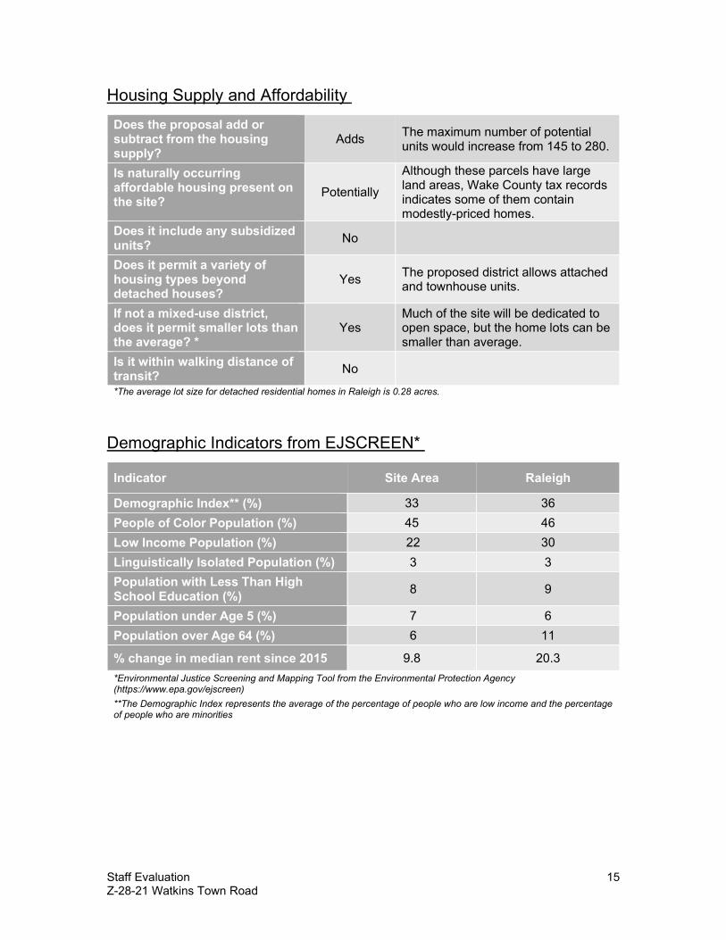
Housing Supply and Affordability Does the proposal add or subtract from the housing supply?
Adds The maximum number of potential units would increase from 145 to 280.
Is naturally occurring affordable housing present on the site?
Potentially Although these parcels have large land areas, Wake County tax records indicates some of them contain modestly-priced homes.
Does it include any subsidized units? No
Does it permit a variety of housing types beyond detached houses?
Yes The proposed district allows attached and townhouse units.
If not a mixed-use district, does it permit smaller lots than the average? *
Yes Much of the site will be dedicated to open space, but the home lots can be smaller than average.
Is it within walking distance of transit? No *The average lot size for detached residential homes in Raleigh is 0.28 acres.
Demographic Indicators from EJSCREEN* Indicator Site Area Raleigh
Demographic Index** (%) 33 36 People of Color Population (%) 45 46 Low Income Population (%) 22 30 Linguistically Isolated Population (%) 3 3 Population with Less Than High School Education (%) 8 9 Population under Age 5 (%) 7 6 Population over Age 64 (%) 6 11 % change in median rent since 2015 9.8 20.3 *Environmental Justice Screening and Mapping Tool from the Environmental Protection Agency (https://www.epa.gov/ejscreen) **The Demographic Index represents the average of the percentage of people who are low income and the percentage of people who are minorities

Staff Evaluation 16 Z-28-21 Watkins Town Road
Health and Environmental Analysis What is the life expectancy in this zip code tract? Is it higher or lower than the City average?
82.6 (yrs) The life expectancy for residents in the area is higher than the county average.
Are there known industrial uses or industrial zoning districts within 1,000 feet?
Yes Carolina Tree Debris LLC operates a landfill for yard waste nearby.
Are there hazardous waste facilities are located within one kilometer?
No NCDEQ does not identify any hazardous waste nearby.
Are there known environmental hazards, such as flood-prone areas, that may directly impact the site?
Yes The northwestern part of the site is within a floodplain.
Is this area considered a food desert by the USDA? No
Land Use History When the property was annexed into the City or originally developed, was government sanctioned racial segregation in housing prevalent?*
N/A
The property is not within Raleigh’s jurisdiction and remains mostly undeveloped.
Has the area around the site ever been the subject of an urban renewal program?*
No
Has the property or nearby properties ever been subject to restrictive covenants that excluded racial groups?*
No
Are there known restrictive covenants on the property or nearby properties that restrict development beyond what the UDO otherwise requires?*
Yes The Willow Lake subdivision to the north contains private covenants that are more restrictive than the UDO.
*The response to this question is not exhaustive, and additional information may be produced by further research. Absence of information in this report is not conclusive evidence that no such information exists.

Staff Evaluation 17 Z-28-21 Watkins Town Road
Analysis Questions 1. Does the rezoning increase the site’s potential to provide more equitable access to
housing, employment, and transportation options? Does the rezoning retain or increase options for housing and transportation choices that reduce carbon emissions? Response: The rezoning request would increase potential housing supply and increase the options for types of housing that could be built. However, this site is not particularly near to transportation or employment options.
2. Is the rezoning in an area where existing residents would benefit from access to lower cost housing, greater access to employment opportunities, and/or a wider variety of transportation modes? Do those benefits include reductions in energy costs or carbon emissions? Response: The existing residents of the area display approximately the same of degree of economic vulnerability as the average Raleigh resident, according to the gathered demographic data. In addition, the median rent in this Census tract has increased at a lower rate over the past five years than the citywide average. While allowing for more housing production at this location would help to reduce market pressure in the city overall, it is not as desperately needed as in other parts of Raleigh.
3. Have housing costs in this area increased in the last few years? If so, are housing costs increasing faster than the city average? Response: Housing costs in this area rose more slowly between 2015 and 2019 than they have in Raleigh as a whole. The median rent increased 9.8% between 2015 and 2019, compared to 20.3% for the city.
4. Are there historical incidences of racial or ethnic discrimination specific to this area that have deprived Black, Indigenous, and People of Color (BIPOC) of access to economic opportunity, public services, or housing? If so, does the rezoning request improve any current conditions that were caused, associated with, or exacerbated by historical discrimination? Response: No specific instances of discriminatory practices have been identified for this site. This area has been a rural and sparsely populated part of Wake County until as recently as the 1990s.
5. Do residents of the area have disproportionately low life expectancy, low access to health insurance, low access to healthy lifestyle choices, or high exposure to environmental hazards and/or toxins? If so, does the rezoning create any opportunities to improve these conditions? Response: The collected indicators suggest nearby residents have similar opportunities for healthy lifestyles and outcomes as the average resident of Raleigh.

Staff Evaluation 18 Z-28-21 Watkins Town Road
IMPACT ANALYSIS
Historic Resources 1. The site is not located within or adjacent to a National Register Historic District or
Raleigh Historic Overlay District. It does not include nor is adjacent to any National Register individually-listed properties or Raleigh Historic Landmarks. 2932 Watkins Town Road has been surveyed and identified as WA1699 Robert Watkins Farm.
Impact Identified: None.
Parks and Recreation 1. This site contains the NR Harris Creek greenway corridor. At the time of a subdivision or
site plan, this corridor will require the dedication of a 75-foot wide greenway easement, measured from waterbody top of bank, along the entire length of the water body within the property boundary (UDO Sec. 8.6.1.B).
2. Nearest existing park access is provided by Horseshoe Farms Nature Preserve (3.1 miles) and Buffaloe Rd. Athletic Park (4.7 miles).
3. Nearest existing greenway trail access is provided by the Neuse River Greenway Trail (2.8 miles).
4. Current park access level of service in this area is graded a F letter grade. However, there is an undeveloped City-owned property at 0 Watkins Rd. (Watkins Road Property) that is designated as a future City of Raleigh park. In addition, there is another undeveloped park property at 5150 Watkins Rd (Hodges Mill Creek Property) which will also be developed as a park in the future. Both of these properties are within 1.5 miles of the rezoning site, so park access level of service is expected to improve at some point in the future, although there is no current timeline or funding available for the planning and development of these park properties. Immediate park and recreation needs could be better met in the near-term with the provision of developer-provided open space and recreational facilities.
Impact Identified: None.

Staff Evaluation 19 Z-28-21 Watkins Town Road
Public Utilities Maximum Demand
(current use) Maximum Demand
(current zoning) Maximum Demand (proposed zoning)
Water 0 gpd 36,250 gpd 70,000 gpd
Waste Water 0 gpd 36,250 gpd 70,000 gpd
1. The proposed rezoning would add 70,000 gpd to the wastewater collection and water
distribution systems of the City. There is an existing 15" sanitary sewer across Harris Creek from the proposed rezoning area (offsite easement acquisition may be required), & there is also access to (1) 8" & (2) 6" water mains via 3 stub streets along the northern edge of assemblage
2. At the time of development plan submittal, a Downstream Sewer Capacity Study may be required to determine adequate capacity to support the proposed development. Any improvements identified by the study would be required to be permitted prior to the issuance of Building Permit & constructed prior to release of a Certificate of Occupancy
3. Verification of water available for fire flow is required as part of the Building Permit process. Any water system improvements recommended by the analysis to meet fire flow requirements will also be required of the Developer.
Impact Identified: None.
Stormwater Floodplain FEMA
Drainage Basin Harris Creek
Stormwater Management Subject to stormwater regulations under Article 9 of UDO
Overlay District none
1. Neuse Riparian Buffer; some alluvial soils Impact Identified: None.

Staff Evaluation 20 Z-28-21 Watkins Town Road
Transportation 1. Location: The Z-28-21 site is in Northeast Raleigh east of Harris Creek Elementary. The
site is on both sides of Waktins Town Road. 2. Area Plans: The Z-28-21 site is not located in an area with an adopted area plan (Map
AP-1) in Comprehensive Plan. The Wake Crossroads Area Plan is approximately one mile north of the site.
3. Other Projects: West of the site, NCDOT plans to widen Louisburg road between the bridge and Leland Rive, as well as add capacity to the intersection of Louisburg Road, Ligon Mill Road, and Mitchell Mill Road. This project is listed as Project U-5748 in the N.C. Department of Transportation's State Transportation Improvement Program (STIP). It is expected to begin construction in 2022. The project includes widening Louisburg Road to eight lanes and the construction of 10-foot multi-use path along the southern portion. Improvements to Mitchell Mill Road and Ligon Mill Road are also included. The project will also be converting intersections from Perry Creek Road to Leeland Drive to “reduced conflict intersections.” Also known as a “superstreet.” This configuration will not allow for left turns onto Louisburg Road nor through movements to cross it. The result will be simpler signal phasing that will increase the capacity of Louisburg Road. There are no other existing or programmed transportation projects near the site.
4. Streets: In addition to Watkins Town Road, the Z-28-21 site has access to three public street stubs from the Willow Lake Subdivision: Sandy Bluff Road, Peachford Lane, and Arden Branch Lane. None are identified in the Street Plan (Map T-1 in the comprehensive plan) and are thus local streets. They are all maintained by the City of Raleigh. Watkins Town Road is currently maintained by NCDOT and is designated in the street plan as a two-lane undivided avenue. In accordance with UDO section 8.3.2, the maximum block perimeter for R-6 zoning districts is set by the average lot size in the block. Minimum lot sizes lead to 4,500 feet for the maximum block perimeter, while the maximum dead-end street length is 550 feet. The existing block perimeter is over 20,000 feet. There are several streets stubs within this block. Connections between these stubs and future subdivisions meeting the requirements of UDO section 8.3.2 will improve the block perimeter. These connections are consistent with the Comprehensive Plan, including Policies T 2.3, T 2.4, T 2.5, and T 2.6, which all concern interconnected streets. These policies and the block perimeter standards in UDO Article 8.3 reduce per-capita vehicle miles traveled and increase the efficiency of providing city services such as solid waste collection. UDO Section 8.3.2.A.1.b.vi.c eliminates requirement to stub street to or cross with a street a creek with a drainage area of more than one square mile. Harris Creek is along the western border of the property appears to meet this condition.
5. Pedestrian Facilities: There are no existing sidewalks along Watkins Town Road. Streets within the Willow Lake Preserve subdivision have sidewalks on one side, as required by City code at the time the subdivision was created. Frontage improvements

Staff Evaluation 21 Z-28-21 Watkins Town Road
and sidewalks on both side of new streets are required for subdivision or tier three site plan approval.
6. Bicycle Facilities and Greenways: There are no existing bikeways near the Z-28-21 site. There is a greenway corridor planned along Harris Creek and the west of the site. There are existing greenway easements north of the site along the creek. These easements connect to two public streets: Tyler Bluff Lane and Sandy Bluff Lane. Connecting streets to greenway corridors frequently improves access to recreation and nonmotorized transportation.
7. Transit: There is no existing or plan transit services near the Z-28-21 site. 8. Access: Vehicle access to the subject site is via Watkins Town Road and the stubbed
streets north of the site. 9. TIA Determination: Based on the Envision results, approval of case Z-28-21 would
increase the amount of projected vehicular peak hour trips to and from the site as indicated in the table below. The proposed rezoning from R-30 to R-6-CU is projected to generate 75 new trips in the AM peak hour and 94 new trips in the PM peak hour. These values do not trigger a rezoning Traffic Impact Analysis based on the trip generation thresholds in the Raleigh Street Design Manual. A TIA may be required during site permit review.
Z-28-21 Existing Land Use Agricultural and Residential
Daily AM PM
47 4 5 Z-28-21 Current Zoning Entitlements
Rural Residential Daily AM PM
1,369 107 144 Z-28-21 Proposed Zoning Maximums
Residential Daily AM PM
2,453 182 238 Z-28-21 Trip Volume Change
(Proposed Maximums minus Current Entitlements) Daily AM PM
1,084 75 94
Impact Identified: None.
Urban Forestry 1. Proposed rezoning does not impact Urban Forestry requirements (UDO 9.1). Impact Identified: None.

Staff Evaluation 22 Z-28-21 Watkins Town Road
Impacts Summary Immediate park and recreation needs could be better met in the near-term with the provision of developer-provided open space and recreational facilities.
Mitigation of Impacts The applicant could add a zoning condition guaranteeing the creation of park space within the development.
CONCLUSION This request is to rezone seven parcels totaling approximately 99.7 acres from Wake County zoning district Residential-30 (R-30) to Residential-6-Conditional Use (R-6-CU) and R-6. Proposed zoning conditions require at least 40% of the site to be open space; set a maximum of 280 dwelling units, no more than 190 of which can be detached; prohibit apartments; require stormwater management for a 25-year storm; require a 20-foot average width protective yard on the northern property line; increase dimensional standards for the conservation development option; prohibit townhouses and duplexes within 1,100 feet of the northern property line; and require at least two access points to Watkins Town Road from the west. The request is consistent with Comprehensive Plan overall and consistent with the Future Land Use Map. The request is consistent with Comprehensive Plan policies regarding compact development and new housing. The request is inconsistent with policies regarding the location of growth. The request would support the Vision Themes of Expanding Housing Choices and Growing Successful Neighborhoods and Communities. The request would not support the Managing Our Growth Vision Theme.
CASE TIMELINE Date Action Notes
5/12/2021 Submitted rezoning petition
5/12/2021 Submitted annexation petition AX-14-21
9/16/21 Amended petition to split zone
10/26/2021 Planning Commission

Staff Evaluation 23 Z-28-21 Watkins Town Road
APPENDIX
SURROUNDING AREA LAND USE/ ZONING SUMMARY SUBJECT
PROPERTY NORTH SOUTH EAST WEST
Existing Zoning R-30 R-4 R-30, R-4 R-30 R-4, IH Additional Overlay - - - - -
Future Land Use
Low Density Residential
Low Density Residential
Low Density Residential
Low Density Residential
Rural Residential, Low Density Residential
Current Land Use
Rural residential/ agriculture
Detached dwellings
Rural residential/ agriculture
Rural residential/ agriculture
Rural residential/ agriculture
Urban Form - - - - -
CURRENT VS. PROPOSED ZONING SUMMARY EXISTING ZONING PROPOSED ZONING
Zoning R-30 R-6-CU, R-6 Total Acreage 99.7 99.7 Setbacks:
Front Side Rear
(detached) 30’ 15’ 30’
(detached) 10’ 5’
20’ Residential Density: 1.45 3.03 Max. # of Residential Units 145 302 Max. Gross Building SF 361,268 548,000 Max. Gross Office SF - - Max. Gross Retail SF - - Max. Gross Industrial SF - - Potential F.A.R 0.08 0.13
*The development intensities for proposed zoning districts were estimated using an impact analysis tool. The estimates presented are only to provide guidance for analysis.

Page 2 of 15 REVISION 10.27.20
raleighnc.gov
Conditional Use District Zoning Conditions
Zoning case #: Date submitted: OFFICE USE ONLY Rezoning case #
___________________Existing zoning: Proposed zoning:
Narrative of Zoning Conditions Offered
The property owner(s) hereby offers, consents to, and agrees to abide, if the rezoning request is approved, the conditions written above. All property owners must sign each condition page. This page may be photocopied if additional space is needed.
Property Owner(s) Signature: _______________________________________________
Printed Name: ______________________________________________________
Z-28-21
R-30 R-6-CU
1. A minimum of forty percent (40%) of the net site area shall be designated as Open Space. Open Space meeting this forty percent (40%) requirement shall have a minimum width of fifty feet (50'). Any Open Space in excess of forty percent (40%) of the net site area shall not be required to meet the fifty feet (50') minimum width requirement. 2. A minimum of forty percent (40%) of lots shall abut Open Space. 3. A minimum of sixty percent (60%) of the Open Space meeting the forty percent (40%) net site area requirement shall be contiguous. 4. No more than 280 dwelling units shall be permitted. Of the 280 maximum dwelling units, no more than 190 single family dwelling units shall be permitted. 5. Apartment building types are prohibited. 6. Runoff limitation for development on the property as defined by UDO Section 9.2.2.E.1 shall be met for the 25-year storm in addition to the 2-year and 10-year storms. 7. A protective yard with a minimum width of 18 feet and an average width of 20 feet shall be provided along the northern property line of 3033 Watkins Town Road (with Wake County PIN 1747711222, also being Tract 1 shown on Wake County Registry Book of Maps 2004 Page 2404). This protective yard shall contain a minimum of four shade trees per 100 lineal feet, three understory trees per 100 lineal feet, and 40 shrubs per 100 lineal feet. Existing vegetation may count toward the planting requirements. Breaks for pedestrian and vehicle access, fences, walls, berms, easements, utilities, and other encroachments as permitted by the UDO shall be permitted in the protective yard. 8. If the conservation development option is selected, perimeter lots for detached house and attached house building types shall meet the dimensional requirements of the conventional development option. 9. Townhouse and attached house building types located west of Watkins Town Road shall not be placed within 1,100 feet of the northern property line of 3033 Watkins Town Road (with Wake County PIN 1747711222, also being Tract 1 shown on Wake County Registry Book of Maps 2004 Page 2404). 10. If the conservation development option is selected, minimum lot area for detached house and attached house building types shall be 6,000 square feet. 11. Subject to the receipt of all necessary approvals from all governmental authorities, the first Tier 3 site plan approved after the effective date of these conditions shall provide for a minimum of two access points from the portion of the property west of Watkins Town Road to Watkins Town Road.
Ronald Edward Duke
DocuSign Envelope ID: 26D60F6E-BCA4-4CC1-88D1-8BDDA168CBCE
10/28/2021 | 7:57 AM CDT
Page 2 of 15 REVISION 10.27.20
raleighnc.gov
Conditional Use District Zoning Conditions
Zoning case #: Date submitted: OFFICE USE ONLY Rezoning case #
___________________Existing zoning: Proposed zoning:
Narrative of Zoning Conditions Offered
The property owner(s) hereby offers, consents to, and agrees to abide, if the rezoning request is approved, the conditions written above. All property owners must sign each condition page. This page may be photocopied if additional space is needed.
Property Owner(s) Signature: _______________________________________________
Printed Name: ______________________________________________________
Z-28-21
R-30 R-6-CU
1. A minimum of forty percent (40%) of the net site area shall be designated as Open Space. Open Space meeting this forty percent (40%) requirement shall have a minimum width of fifty feet (50'). Any Open Space in excess of forty percent (40%) of the net site area shall not be required to meet the fifty feet (50') minimum width requirement. 2. A minimum of forty percent (40%) of lots shall abut Open Space. 3. A minimum of sixty percent (60%) of the Open Space meeting the forty percent (40%) net site area requirement shall be contiguous. 4. No more than 280 dwelling units shall be permitted. Of the 280 maximum dwelling units, no more than 190 single family dwelling units shall be permitted. 5. Apartment building types are prohibited. 6. Runoff limitation for development on the property as defined by UDO Section 9.2.2.E.1 shall be met for the 25-year storm in addition to the 2-year and 10-year storms. 7. A protective yard with a minimum width of 18 feet and an average width of 20 feet shall be provided along the northern property line of 3033 Watkins Town Road (with Wake County PIN 1747711222, also being Tract 1 shown on Wake County Registry Book of Maps 2004 Page 2404). This protective yard shall contain a minimum of four shade trees per 100 lineal feet, three understory trees per 100 lineal feet, and 40 shrubs per 100 lineal feet. Existing vegetation may count toward the planting requirements. Breaks for pedestrian and vehicle access, fences, walls, berms, easements, utilities, and other encroachments as permitted by the UDO shall be permitted in the protective yard. 8. If the conservation development option is selected, perimeter lots for detached house and attached house building types shall meet the dimensional requirements of the conventional development option. 9. Townhouse and attached house building types located west of Watkins Town Road shall not be placed within 1,100 feet of the northern property line of 3033 Watkins Town Road (with Wake County PIN 1747711222, also being Tract 1 shown on Wake County Registry Book of Maps 2004 Page 2404). 10. If the conservation development option is selected, minimum lot area for detached house and attached house building types shall be 6,000 square feet. 11. Subject to the receipt of all necessary approvals from all governmental authorities, the first Tier 3 site plan approved after the effective date of these conditions shall provide for a minimum of two access points from the portion of the property west of Watkins Town Road to Watkins Town Road.
Robert Mantle Duke
DocuSign Envelope ID: 26D60F6E-BCA4-4CC1-88D1-8BDDA168CBCE
10/28/2021 | 8:41 AM CDT

Page 2 of 15 REVISION 10.27.20
raleighnc.gov
Conditional Use District Zoning Conditions
Zoning case #: Date submitted: OFFICE USE ONLY Rezoning case #
___________________Existing zoning: Proposed zoning:
Narrative of Zoning Conditions Offered
The property owner(s) hereby offers, consents to, and agrees to abide, if the rezoning request is approved, the conditions written above. All property owners must sign each condition page. This page may be photocopied if additional space is needed.
Property Owner(s) Signature: _______________________________________________
Printed Name: ______________________________________________________
Z-28-21
R-30 R-6-CU
1. A minimum of forty percent (40%) of the net site area shall be designated as Open Space. Open Space meeting this forty percent (40%) requirement shall have a minimum width of fifty feet (50'). Any Open Space in excess of forty percent (40%) of the net site area shall not be required to meet the fifty feet (50') minimum width requirement. 2. A minimum of forty percent (40%) of lots shall abut Open Space. 3. A minimum of sixty percent (60%) of the Open Space meeting the forty percent (40%) net site area requirement shall be contiguous. 4. No more than 280 dwelling units shall be permitted. Of the 280 maximum dwelling units, no more than 190 single family dwelling units shall be permitted. 5. Apartment building types are prohibited. 6. Runoff limitation for development on the property as defined by UDO Section 9.2.2.E.1 shall be met for the 25-year storm in addition to the 2-year and 10-year storms. 7. A protective yard with a minimum width of 18 feet and an average width of 20 feet shall be provided along the northern property line of 3033 Watkins Town Road (with Wake County PIN 1747711222, also being Tract 1 shown on Wake County Registry Book of Maps 2004 Page 2404). This protective yard shall contain a minimum of four shade trees per 100 lineal feet, three understory trees per 100 lineal feet, and 40 shrubs per 100 lineal feet. Existing vegetation may count toward the planting requirements. Breaks for pedestrian and vehicle access, fences, walls, berms, easements, utilities, and other encroachments as permitted by the UDO shall be permitted in the protective yard. 8. If the conservation development option is selected, perimeter lots for detached house and attached house building types shall meet the dimensional requirements of the conventional development option. 9. Townhouse and attached house building types located west of Watkins Town Road shall not be placed within 1,100 feet of the northern property line of 3033 Watkins Town Road (with Wake County PIN 1747711222, also being Tract 1 shown on Wake County Registry Book of Maps 2004 Page 2404). 10. If the conservation development option is selected, minimum lot area for detached house and attached house building types shall be 6,000 square feet. 11. Subject to the receipt of all necessary approvals from all governmental authorities, the first Tier 3 site plan approved after the effective date of these conditions shall provide for a minimum of two access points from the portion of the property west of Watkins Town Road to Watkins Town Road.
Roger Henderson Duke
DocuSign Envelope ID: 26D60F6E-BCA4-4CC1-88D1-8BDDA168CBCE
10/28/2021 | 7:40 AM CDT

Page 2 of 15 REVISION 10.27.20
raleighnc.gov
Conditional Use District Zoning Conditions
Zoning case #: Date submitted: OFFICE USE ONLY Rezoning case #
___________________Existing zoning: Proposed zoning:
Narrative of Zoning Conditions Offered
The property owner(s) hereby offers, consents to, and agrees to abide, if the rezoning request is approved, the conditions written above. All property owners must sign each condition page. This page may be photocopied if additional space is needed.
Property Owner(s) Signature: _______________________________________________
Printed Name: ______________________________________________________
Z-28-21
R-30 R-6-CU
1. A minimum of forty percent (40%) of the net site area shall be designated as Open Space. Open Space meeting this forty percent (40%) requirement shall have a minimum width of fifty feet (50'). Any Open Space in excess of forty percent (40%) of the net site area shall not be required to meet the fifty feet (50') minimum width requirement. 2. A minimum of forty percent (40%) of lots shall abut Open Space. 3. A minimum of sixty percent (60%) of the Open Space meeting the forty percent (40%) net site area requirement shall be contiguous. 4. No more than 280 dwelling units shall be permitted. Of the 280 maximum dwelling units, no more than 190 single family dwelling units shall be permitted. 5. Apartment building types are prohibited. 6. Runoff limitation for development on the property as defined by UDO Section 9.2.2.E.1 shall be met for the 25-year storm in addition to the 2-year and 10-year storms. 7. A protective yard with a minimum width of 18 feet and an average width of 20 feet shall be provided along the northern property line of 3033 Watkins Town Road (with Wake County PIN 1747711222, also being Tract 1 shown on Wake County Registry Book of Maps 2004 Page 2404). This protective yard shall contain a minimum of four shade trees per 100 lineal feet, three understory trees per 100 lineal feet, and 40 shrubs per 100 lineal feet. Existing vegetation may count toward the planting requirements. Breaks for pedestrian and vehicle access, fences, walls, berms, easements, utilities, and other encroachments as permitted by the UDO shall be permitted in the protective yard. 8. If the conservation development option is selected, perimeter lots for detached house and attached house building types shall meet the dimensional requirements of the conventional development option. 9. Townhouse and attached house building types located west of Watkins Town Road shall not be placed within 1,100 feet of the northern property line of 3033 Watkins Town Road (with Wake County PIN 1747711222, also being Tract 1 shown on Wake County Registry Book of Maps 2004 Page 2404). 10. If the conservation development option is selected, minimum lot area for detached house and attached house building types shall be 6,000 square feet. 11. Subject to the receipt of all necessary approvals from all governmental authorities, the first Tier 3 site plan approved after the effective date of these conditions shall provide for a minimum of two access points from the portion of the property west of Watkins Town Road to Watkins Town Road.
Brothers Seventeen LLC
DocuSign Envelope ID: 783B4AFF-018B-44BC-A264-87C1C73525A5
11/2/2021 | 8:56 PM CDT


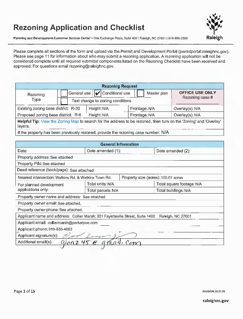
Rezoning Application and ChecklistPlanning and Development Customer Service Center • One Exchange Plaza, Suite 400 | Raleigh, NC 27601 | 919-996-2500
Page 1 of 15 REVISION 10.27.20
raleighnc.gov
Rezoning Request General use Conditional use Master plan OFFICE USE ONLY
Rezoning case # ___________________ change to zoning conditions
Existing zoning base district: Height: Frontage: Overlay(s): Proposed zoning base district: Height: Frontage: Overlay(s): Helpful Tip: View the Zoning Map to search for the address to be rezoned, then turn on the 'Zoning' and 'Overlay' layers.If the property has been previously rezoned, provide the rezoning case number:
General Information Date: Date amended (1): Date amended (2): Property address: Property PIN: Deed reference (book/page):
Nearest intersection: Property size (acres):
For planned development applications only:
Total units: Total square footage: Total parcels: Total buildings:
Property owner name and address: Property owner email: Property owner phone: Applicant name and address: Applicant email: Applicant phone: Applicant signature(s): Additional email(s):
N/A N/A N/AN/A N/A N/A
May 6, 2021See attached
See attached
See attached
Watkins Rd. & Watkins Town Rd. 102.506 acresN/A N/A
N/A N/ASee attached.
See attached.See attached.
Collier Marsh; 301 Fayetteville Street, Suite 1400, Raleigh, NC [email protected]
✔
N/A


PPAB 6112634v1
WATKINS TOWN ROAD REZONING APPLICATION ADDENDUM
OWNER INFORMATION
Parcel 1
Site Address: 2932 Watkins Town Road, Raleigh, NC 27616
PIN: 1746894942
Deed Reference (book/page): 013125/02350
Acreage: 18.33
Owner: Brothers Seventeen LLC
Owner Address: 1220 Old Watkins Road, Raleigh, NC 27616
Parcel 2
Site Address: 2933 Watkins Town Road, Raleigh, NC 27616
PIN: 1747709196
Deed Reference (book/page): 13-E/1365
Acreage: 3.39
Owner: Robert Mantle Duke, Ronald Edward Duke, and Roger
Henderson Duke
Owner Address: 1220 Old Watkins Road, Raleigh, NC 27616
Parcel 3
Site Address: 3029 Watkins Town Road, Raleigh, NC 27616
PIN: 1747701824
Deed Reference (book/page): 011829/01677
Acreage: 19.24
Owner: Donald Lawrence Zeigler. James Edward Murray and Keith
Earl Murray, as Trustees of the Janie W. Murray
Irrevocable Trust
Owner Address: 7712 Brookdale Drive, Raleigh, NC 27616
Parcel 4
Site Address: 3033 Watkins Town Road, Raleigh, NC 27616 (partial*)
PIN: 1747711222
Deed Reference (book/page): 011650/00175
Acreage: 32.839 (35.5 total)
Owner: Cynthia S. Perry as Trustee of the Linda W. Stell
Irrevocable Trust
Owner Address: 3033 Watkins Town Road, Raleigh, NC 27616
*Note: A portion of this parcel is not included in this rezoning
application. See attached metes and bounds description and
graphic.
Parcel 5
Site Address: 1505 Old Watkins Road, Raleigh, NC 27616
PIN: 1747702102
Deed Reference (book/page): 000000/00033
Acreage: 26.74
PPAB 6112634v1 2
Owner: Hilda Watkins
Owner Address: 3200 Old Milburnie Road, Raleigh, NC 27616
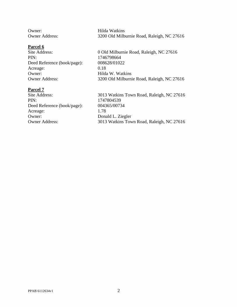
Parcel 6
Site Address: 0 Old Milburnie Road, Raleigh, NC 27616
PIN: 1746798664
Deed Reference (book/page): 008628/01022
Acreage: 0.18
Owner: Hilda W. Watkins
Owner Address: 3200 Old Milburnie Road, Raleigh, NC 27616
Parcel 7
Site Address: 3013 Watkins Town Road, Raleigh, NC 27616
PIN: 1747804539
Deed Reference (book/page): 004365/00734
Acreage: 1.78
Owner: Donald L. Ziegler
Owner Address: 3013 Watkins Town Road, Raleigh, NC 27616

Page 3 of 15 REVISION 10.27.20
raleighnc.gov
Rezoning Application Addendum #1Comprehensive Plan Analysis
OFFICE USE ONLYRezoning case #
____________The applicant is asked to analyze the impact of the rezoning request and its consistency with the Comprehensive Plan. The applicant is also asked to explain how the rezoning request is reasonable and in the public interest.
Statement of ConsistencyProvide brief statements regarding whether the rezoning request is consistent with the future land use designation, the urban form map, and any applicable policies contained within the 2030 Comprehensive Plan.
Public BenefitsProvide brief statements explaining how the rezoning request is reasonable and in the public interest.
See attached addendum.
See attached addendum.

Page 4 of 15 REVISION 10.27.20
raleighnc.gov
Rezoning Application Addendum #2Impact on Historic Resources
OFFICE USE ONLYRezoning case #
____________
The applicant is asked to analyze the impact of the rezoning request on historic resources. For the purposes of this section, a historic resource is defined as any site, structure, sign, or other feature of the property to be rezoned that is listed in the National Register of Historic Places or designated by the City of Raleigh as a landmark or contributing to a Historic Overlay District.
Inventory of Historic ResourcesList in the space below all historic resources located on the property to be rezoned. For each resource, indicate how the proposed zoning would impact the resource.
Proposed MitigationProvide brief statements describing actions that will be taken to mitigate all negative impacts listed above.
N/A
N/A

Page 5 of 15 REVISION 10.27.20
raleighnc.gov
Urban Design GuidelinesThe applicant must respond to the Urban Design Guidelines contained in the 2030 Comprehensive Plan if:a) The property to be rezoned is within a "City Growth Center" or “Mixed-Use Center”, OR;b) The property to be rezoned is located along a "Main Street" or "Transit Emphasis Corridor" as shown on the
Urban Form Map in the 2030 Comprehensive Plan.Urban form designation: Click here to view the Urban Form Map.
1
All Mixed-Use developments should generally provide retail (such as eating establishments, food stores, and banks), and other such uses as office and residential within walking distance of each other. Mixed uses should be arranged in a compact and pedestrian friendly form.Response:
2
Within all Mixed-Use Areas buildings that are adjacent to lower density neighborhoods should transition (height, design, distance and/or landscaping) to the lower heights or be comparable in height and massing.Response:
3
A mixed-use area’s road network should connect directly into the neighborhood road network of the surrounding community, providing multiple paths for movement to and through the mixed-use area. In this way, trips made from the surrounding residential neighborhood(s) to the mixed-use area should be possible without requiring travel along a major thoroughfare or arterial.Response:
4
Streets should interconnect within a development and with adjoining development. Cul-de-sacs or dead-end streets are generally discouraged except where topographic conditions and/or exterior lot line configurations offer no practical alternatives for connection or through traffic. Street stubs should be provided with development adjacent to open land to provide for future connections. Streets should be planned with due regard to the designated corridors shown on the Thoroughfare Plan.Response:
5
New development should be comprised of blocks of public and/or private streets (including sidewalks). Block faces should have a length generally not exceeding 660 feet. Where commercial driveways are used to create block structure, they should include the same pedestrian amenities as public or private streets.Response:
6
A primary task of all urban architecture and landscape design is the physical definition of streets and public spaces as places of shared use. Streets should be lined by buildings rather than parking lots and should provide interest especially for pedestrians. Garage entrances and/or loading areas should be located at the side or rear of a property.Response:
N/A
N/A
N/A
N/A
N/A
N/A
N/A

Page 6 of 15 REVISION 10.27.20
raleighnc.gov
7
Buildings should be located close to the pedestrian-oriented street (within 25 feet of the curb), with off-street parking behind and/or beside the buildings. When a development plan is located along a high-volume corridor without on-street parking, one bay of parking separating the building frontage along the corridor is a preferred option.Response:
8
If the site is located at a street intersection, the main building or main part of the building should be placed at the corner. Parking, loading or service should not be located at an intersection.Response:
9
To ensure that urban open space is well-used, it is essential to locate and design it carefully. The space should be located where it is visible and easily accessible from public areas (building entrances, sidewalks). Take views and sun exposure into account as well.Response:
10
New urban spaces should contain direct access from the adjacent streets. They should be open along the adjacent sidewalks and allow for multiple points of entry. They should also be visually permeable from the sidewalk, allowing passersby to see directly into the space.Response:
11
The perimeter of urban open spaces should consist of active uses that provide pedestrian traffic for the space including retail, cafés, and restaurants and higher-density residential.Response:
12
A properly defined urban open space is visually enclosed by the fronting of buildings to create an outdoor "room" that is comfortable to users.Response:
13
New public spaces should provide seating opportunities.Response:
N/A
N/A
N/A
N/A
N/A
N/A
N/A

Page 7 of 15 REVISION 10.27.20
raleighnc.gov
14
Parking lots should not dominate the frontage of pedestrian-oriented streets, interrupt pedestrian routes, or negatively impact surrounding developments.Response:
15
Parking lots should be located behind or in the interior of a block whenever possible. Parking lots should not occupy more than 1/3 of the frontage of the adjacent building or not more than 64 feet, whichever is less.Response:
16
Parking structures are clearly an important and necessary element of the overall urban infrastructure but, given their utilitarian elements, can give serious negative visual effects. New structures should merit the same level of materials and finishes as that a principal building would, care in the use of basic design elements cane make a significant improvement.Response:
17
Higher building densities and more intensive land uses should be within walking distance of transit stops, permitting public transit to become a viable alternative to the automobile.Response:
18
Convenient, comfortable pedestrian access between the transit stop and the building entrance should be planned as part of the overall pedestrian network.Response:
19
All development should respect natural resources as an essential component of the human environment. The most sensitive landscape areas, both environmentally and visually, are steep slopes greater than 15 percent, watercourses, and floodplains. Any development in these areas should minimize intervention and maintain the natural condition except under extreme circumstances. Where practical, these features should be conserved as open space amenities and incorporated in the overall site design.Response:
20
It is the intent of these guidelines to build streets that are integral components of community design. Public and private streets, as well as commercial driveways that serve as primary pedestrian pathways to building entrances, should be designed as the main public spaces of the City and should be scaled for pedestrians.Response:
N/A
N/A
N/A
N/A
N/A
N/A
N/A

Page 8 of 15 REVISION 10.27.20
raleighnc.gov
21
Sidewalks should be 5-8 feet wide in residential areas and located on both sides of the street. Sidewalks in commercial areas and Pedestrian Business Overlays should be a minimum of 14-18 feet wide to accommodate sidewalk uses such as vendors, merchandising and outdoor seating.Response:
22
Streets should be designed with street trees planted in a manner appropriate to their function. Commercial streets should have trees which complement the face of the buildings and which shade the sidewalk. Residential streets should provide for an appropriate canopy, which shadows both the street and sidewalk, and serves as a visual buffer between the street and the home. The typical width of the street landscape strip is 6-8 feet. This width ensures healthy street trees, precludes tree roots from breaking the sidewalk, and provides adequate pedestrian buffering. Street trees should be at least 6 1/4" caliper and should be consistent with the City's landscaping, lighting and street sight distance requirements.Response:
23
Buildings should define the streets spatially. Proper spatial definition should be achieved with buildings or other architectural elements (including certain tree plantings) that make up the street edges aligned in a disciplined manner with an appropriate ratio of height to width.Response:
24
The primary entrance should be both architecturally and functionally on the front facade of any building facing the primary public street. Such entrances shall be designed to convey their prominence on the fronting facade.Response:
25
The ground level of the building should offer pedestrian interest along sidewalks. This includes windows entrances, and architectural details. Signage, awnings, and ornamentation are encouraged.Response:
26
The sidewalks should be the principal place of pedestrian movement and casual social interaction. Designs and uses should be complementary to that function.Response:
N/A
N/A
N/A
N/A
N/A
N/A

Page 9 of 15 REVISION 10.27.20
raleighnc.gov
Rezoning Checklist (Submittal Requirements)
To be completed by Applicant To be completed by staff
General Requirements – General Use or Conditional Use Rezoning Yes N/A Yes No N/A
1. I have referenced this Rezoning Checklist and by using this as aguide, it will ensure that I receive a complete and thorough first reviewby the City of Raleigh
2. Pre-application conference.
3. Neighborhood meeting notice and report
4. Rezoning application review fee (see Fee Guide for rates).
5. Completed application submitted through Permit and DevelopmentPortal
6. Completed Comprehensive Plan consistency analysis
7. Completed response to the urban design guidelines
8. Two sets of stamped envelopes addressed to all property owners ofarea to be rezoned and properties with 500 feet of area to be rezoned.
9. Trip generation study
10. Traffic impact analysis
For properties requesting a Conditional Use District:
11. Completed zoning conditions, signed by property owner(s).
If applicable, see page 11:
12. Proof of Power of Attorney o Owner Affidavit.
For properties requesting a Planned Development or Campus District:
13. Master plan (see Master Plan submittal requirements).
For properties requesting a text change to zoning conditions:
14. Redline copy of zoning conditions with proposed changes.
15. Proposed conditions signed by property owner(s).
✔
✔
✔
✔
✔
✔
✔
✔
✔
✔
✔
✔
✔
✔
✔

Page 10 of 15 REVISION 10.27.20
raleighnc.gov
Master Plan (Submittal Requirements)
To be completed by Applicant To be completed by staff
General Requirements – Master Plan Yes N/A Yes No N/A
1. I have referenced this Master Plan Checklist and by using this as a guide, it will ensure that I receive a complete and thorough first review by the City of Raleigh.
2. Total number of units and square feet
3. 12 sets of plans
4. Completed application; submitted through Permit & Development Portal
5. Vicinity Map
6. Existing Conditions Map
7. Street and Block Layout Plan
8. General Layout Map/Height and Frontage Map
9. Description of Modification to Standards, 12 sets
10. Development Plan (location of building types)
11. Pedestrian Circulation Plan
12. Parking Plan
13. Open Space Plan
14. Tree Conservation Plan (if site is 2 acres or more)
15. Major Utilities Plan/Utilities Service Plan
16. Generalized Stormwater Plan
17. Phasing Plan
18. Three-Dimensional Model/renderings
19. Common Signage Plan
✔
✔
✔
✔
✔
✔
✔
✔
✔
✔
✔
✔
✔
✔
✔
✔
✔
✔
✔

PPAB 5936464v1
February 19, 2021
Re: Notice of Neighborhood Meeting
Neighboring Property Owners:
You are invited to attend a neighborhood meeting on March 2, 2021 from 6–8pm. The
purpose of the meeting is to discuss an upcoming application to rezone six parcels of land located at
2932 Watkins Town Road (PIN 1746894942), 2933 Watkins Town Road (PIN 1747709196), 3029
Watkins Town Road (PIN 1747701824), 3033 Watkins Town Road (PIN 1747711222), 1505 Old
Watkins Road (PIN 1747702102), and 0 Old Milburnie Road (PIN 1746798664). The site is
currently zoned R-30 (Wake County) and is proposed to be rezoned to R-6-CU. An annexation
petition to annex the properties from Wake County to the City of Raleigh will be filed in conjunction
with the rezoning application. The applicant will describe the nature of this rezoning request and
field any questions from the public. Enclosed are: (1) an aerial photograph of the parcels (2) a
vicinity map outlining the location of the parcels; (3) a zoning map of the subject area; (4) a draft of
the Rezoning Application cover page; and (5) draft conditions for the rezoning.
The meeting will be held virtually. You can participate online via Zoom or by telephone. To
participate in the Zoom online meeting:
Visit: https://zoom.us./join
Enter the following meeting ID: 845 3448 9700
Enter the following password: 792283
To participate by telephone:
Dial: 1 929 436 2866
Enter the following meeting ID: 845 3448 9700 #
Enter the Participant ID: #
Enter the Meeting password: 792283 #
The City of Raleigh requires a neighborhood meeting involving the residents and property
owners within 500 feet of the area requested for rezoning prior to the submittal of any rezoning
application. This notice has been mailed to the property owners within 1,000 feet of the area
requested for rezoning and any landowner who is interested in learning more about this project is
invited to attend. Information about the rezoning process is available online; visit www.raleighnc.gov
and search for “Rezoning Process.” If you have further questions about the rezoning process, please
contact:
Carmen Kuan
Raleigh Planning & Development
(919) 996-2235
If you have any questions about this rezoning, please contact me at (919) 835-4663 or via
email at [email protected].
Thank you,
Collier Marsh
WWW.RALEIGHNC.GOV REVISION .15.19 PAGE 1 OF 1
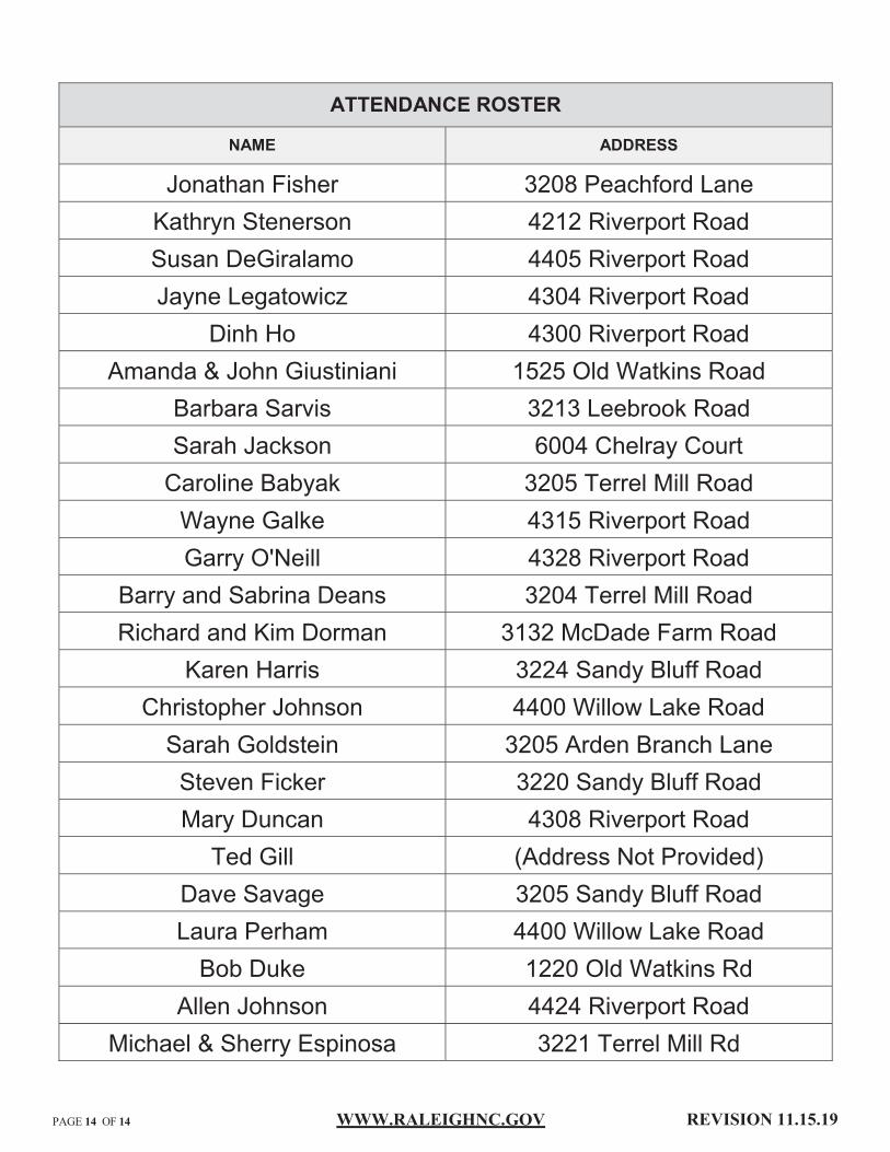
ATTENDANCE ROSTER
NAME ADDRESS
Jonathan Fisher 3208 Peachford LaneKathryn Stenerson 4212 Riverport RoadSusan DeGiralamo 4405 Riverport RoadJayne Legatowicz 4304 Riverport Road
Dinh Ho 4300 Riverport RoadAmanda & John Giustiniani 1525 Old Watkins Road
Barbara Sarvis 3213 Leebrook RoadSarah Jackson 6004 Chelray CourtCaroline Babyak 3205 Terrel Mill RoadWayne Galke 4315 Riverport RoadGarry O'Neill 4328 Riverport Road
Barry and Sabrina Deans 3204 Terrel Mill RoadRichard and Kim Dorman 3132 McDade Farm Road
Karen Harris 3224 Sandy Bluff RoadChristopher Johnson 4400 Willow Lake RoadSarah Goldstein 3205 Arden Branch LaneSteven Ficker 3220 Sandy Bluff RoadMary Duncan 4308 Riverport Road
Ted Gill (Address Not Provided)Dave Savage 3205 Sandy Bluff RoadLaura Perham 4400 Willow Lake RoadBob Duke 1220 Old Watkins Rd
Allen Johnson 4424 Riverport RoadMichael & Sherry Espinosa 3221 Terrel Mill Rd
WWW.RALEIGHNC.GOV REVISION .15.19 PAGE 1 OF 1
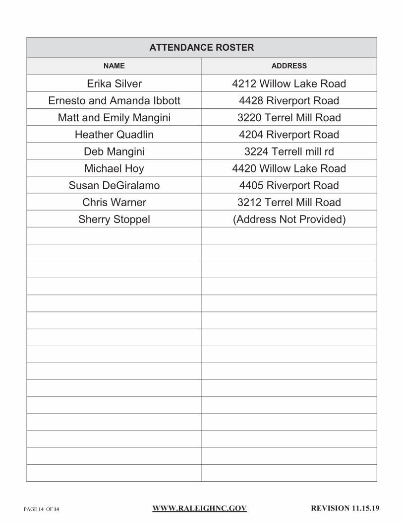
ATTENDANCE ROSTER
NAME ADDRESS
Erika Silver 4212 Willow Lake RoadErnesto and Amanda Ibbott 4428 Riverport RoadMatt and Emily Mangini 3220 Terrel Mill Road
Heather Quadlin 4204 Riverport RoadDeb Mangini 3224 Terrell mill rdMichael Hoy 4420 Willow Lake Road
Susan DeGiralamo 4405 Riverport RoadChris Warner 3212 Terrel Mill RoadSherry Stoppel (Address Not Provided)

WWW.RALEIGHNC.GOV REVISION .15.19 PAGE 1 OF 1
SUMMARY OF ISSUES
A neighborhood meeting was held on (date) to discuss a potential
rezoning located at (property address).
The neighborhood meeting was held at (location).
There were approximately (number) neighbors in attendance. The general issues
discussed were:
Summary of Issues:
March 2, 2021
via Zoom75
Connections between site and Willow Lake Community, Willow Lake Community access to neighborhood amenities.
How are conditions related to open space enforced.
Location of proposed townhouses.
Process for studying impacts to environment, watershed, groundwater, well, and wildlife.
Traffic impacts, widening of lanes on existing roads, and traffic improvements.
Congruity between proposed development and Willow Lake development.
Proposed residential uses; Quantity of each residential type.
Impact of development on home value and property taxes.

WWW.RALEIGHNC.GOV REVISION .15.19 PAGE 1 OF 1
SUMMARY OF ISSUES
A neighborhood meeting was held on (date) to discuss a potential
rezoning located at (property address).
The neighborhood meeting was held at (location).
There were approximately (number) neighbors in attendance. The general issues
discussed were:
Summary of Issues:
March 2, 2021
via Zoom75
Flooding in area and impact of development on stormwater runoff.
Location and number of connections to Watkins Town Road.
Speed bumps in Willow Lake Community.
Lot and building sizes and dimensions.
Requests not to connect to existing street stubs of Willow Lake Community.
Request not to include townhomes and apartments in community.
Request no to include low income or affordable housing.
Annexation process and reasoning for annexation to Raleigh.

WWW.RALEIGHNC.GOV REVISION .15.19 PAGE 1 OF 1
SUMMARY OF ISSUES
A neighborhood meeting was held on (date) to discuss a potential
rezoning located at (property address).
The neighborhood meeting was held at (location).
There were approximately (number) neighbors in attendance. The general issues
discussed were:
Summary of Issues:
March 2, 2021
via Zoom75
Inclusion of sidewalks and greenway connections.
Location of Open Space and Open Space between existing developments.
Reasoning behind R-6 designation and conservation development option.
Any plans to integrate with neighboring properties not included in proposal.
Development of parkland and greenways on property.
Maintenance of open space and common areas, and features that may be included.
Definition of open space and common areas, and features that may be included.
Development team and development timeline.

WWW.RALEIGHNC.GOV REVISION .15.19 PAGE 1 OF 1
SUMMARY OF ISSUES
A neighborhood meeting was held on (date) to discuss a potential
rezoning located at (property address).
The neighborhood meeting was held at (location).
There were approximately (number) neighbors in attendance. The general issues
discussed were:
Summary of Issues:
March 2, 2021
via Zoom75
Construction entrances to development.
Access to site water features for fishing and recreation.


![[XLS]Job Statistical Report - New York Cityhome.nyc.gov/html/dob/downloads/excel/job031415.xls · Web viewJob TABLE TABLE_2 eFiling Filed Existing Zoning Sqft Proposed Zoning Sqft](https://img.pdfslide.us/doc/110x75/5b1913e77f8b9a2d258c4c0f/xlsjob-statistical-report-new-york-web-viewjob-table-table2-efiling-filed.jpg)