Embed Size (px)
Citation preview

{00307133.4}
EXHIBIT "E"
(Conservation Plan)
(Attached)

Syngenta Hawaii-Kunia PLAN OVERVIEW January 2015
RESOURCE CONCERNS:
1. Sheet and rill erosion
2. Concentrated flow erosion (ephemeral & classic gullies)
3. Organic matter depletion
4. Excessive sediment in surface water (water erosion rate > 1 ton/acre/year)
PRACTICES THAT ADDRESS CONCERNS:
1. Row Arrangement
2. Deep Tillage
3. Conservation Cover
4. Vegetative Barriers (in lieu of terraces or diversions to minimize earth moving}
5. Cover Crop
6. Residue Management
7. Water and Sediment Retention Basin
OTHER PRACTICES IN CONSERVATION PLAN:
1. Land Clearing
2. Irrigation Water Management
3. Windbreak
4. Natural Vegetation
OTHER PRACTICES CONSIDERED:
1. Terraces (may be strategically installed if vegetative barriers prove ineffective}
2. Diversions
3. Field Borders
4. Filter Strips
5. Crop Rotation
6. Nutrient Management
7. Integrated Pest Management

Natural Resources Conservation Service Resource Concern Checklist
CROP
Client/Business: Syngenta Hawaii LLC Land Units: Kunia
~--------------------------------------Field Office: N/A
Planner: Maglasang Date: ,...1 -1-1/-13-/2.....,.0-14----,
SOIL EROSION: Excessive bank
erosion from streams,
shorelines or water conveyance
channels (REQUIRED)
Are permanent ground cover> 90% and slope< 10%? No
The Assessment below MUST be completed.
Answer the following questions using the assessment tools: RUSLE2, WEP Any "No" answer to assessment = Resource Concern
Is the water erosion rate ~ T? No
Is the wind rate ~ T? N/A
This is a resource concern in Field All fields.
Do ephemeral gullies occur OR are classic gullies present? Yes The Assessment below MUST be completed.
Answer the following questions using the assessment tools: Field measurements, Planner Observations. Any "No" answer to assessment= Resource Concern
Ephemeral Gullies: Are conservation practices and managements in place to prevent or ephemeral gullies?
c Gullies: Is classic gully management adequate to stop the progression head
No
cutting and widening and are offsite impacts are minimized by vegetation and/or structures? Yes
This is a resource concern in : All fields.
Are streams, shorelines or conveyance channels adjacent to the site? Yes
The Assessment below MUST be completed.
Answer the following questions using the assessment tools: Planner Observations, Client input, HSVAP. Answers to assessment are BOTH "No"= Resource Concern
If bank erosion is present, is it beyond the client's control or commensurate with normal Yes geomorphological processes?
Are the following true (when present)? For shorelines and water conve~ance channels : Banks are stable or commensurate with normal geomorphological processes Yes
For stream banks: The HSVAP bank condition element score > 1.4
. This is NOT a resource concern .
Is permanent ground cover< 80%? Yes The Assessment below MUST be completed.
assessment "No" answer to assessment = Resource Concern
Is the SCI > 0? No
This is a resource concern in Fi : All fields.
PI Conservation Planning Technical Note 1 - Crop Page 1 of 5 August 2014

SOIL QUALITY Are there Histisols present exhibiting subsidence? No DEGRADATION: Assessment below does not need to be completed.
Subsidence Answer the following question using the assessment tools: Client input, Planner observation "No" answer to assessment ;: Resource Concern Is subsidence adequately managed to meet the client's objectives?
This is NOT a resource concern.
SOIL QUALITY Is soil compaction a problem OR do current farming activities cause soil compaction Yes DEGRADATION: problems?
Compaction The Assessment below MUST be completed. Answer the following question using the assessment tools: Client input, Planner observations,
Soil Quality Test Kit, Observation of soil and plant condition "No" answer to assessment = Resource Concern
Is compaction managed to meet the client's production and management objectives? Yes :'
This is NOT a resource concern.
WATER RESOURCES INSUFFICIENT Is the planned land unit irrigated? Yes
WATER: Inefficient The Assessment below MUST be completed. use of irrigation
Answer the following question using the assessment tools: Visual Assessment, Client input, water
National Engineering Handbook. "No" answer to assessment= Resource Concern (REQUIRED)
Does the irrigation system components and management meet NRCS uniformity and efficiency standards? Yes
.This is NOT a resource concern.
WATER QUALITY: Are organic/inorganic nutrients applied OR is the PLU grazed? Yes Excess nutrients in The Assessment below MUST be completed.
surface and Answer the following questions using the assessment tools: Client input, Planner observation,
ground waters (REQUIRED)
Nutrient budget. Any "No" answer to assessment = Resource Concern
Are nutrient and amendment applications based on soil or tissue tests and nutrient budgets Yes for realistic yields?
Are conservation practices and managements in place to minimize surface water impacts? Yes
Are conservation practices and managements in place to minimize ground water impacts? Yes
This is NOT a resource concern.
WATER QUALITY Are pest control chemicals applied? DEGRADATION: The Screening question above MUST be completed. Proceed to assessment, if "Yes."
Pesticides Answer the following questions using the assessment tools: Client input, Planner observation, transported to WinPST. Any "No" answer to assessment= Resource Concern surface and
ground waters Are pesticides stored, handled, disposed and managed to prevent runoff, spills, leaks, and Yes
(REQUIRED) leaching?
Are conservation practices and managements in place to minimize surface water impacts? Yes
Are conservation practices and managements in place to minimize ground water impacts? Yes
This is NOT a resource concern.
PI Conservation Planning Technical Note 1 -Crop Page 2 of 5 August 20 14

WATER QUALITY DEGRADATION:
. Excess pathogens and chemicals from manure, biosolids or
compost applications (REQUIRED
EXCESS WATER: · Pending, flooding,
seasonal high water table, and
seeps
INSUFFICIENT WATER: Inefficient
moisture management
WATER QUALITY DEGRADATION: Excessive salts in
surface and ground waters
Are potential sources of pathogens or pharmaceuticals applied on the land? No
This is NOT a resource concern.
Answer the following question using the assessment tools: Client input, Planner observation "No" answer to assessment = Resource Concern
Are organic materials applied, stored, and/or handled to mitigate negative impacts to surface water sources?
This is NOT a resource concern.
perma ground cover < streams/shoreline on or adjacent to site?
present, or are Yes
The Assessment below MUST be completed .
Answer the following questions using the assessment tools: RUSLE2, Client input, Planner observation, HSVAP, WEPS. Any "No" answer to assessment = Resource Concern
Do upslope treatment and buffer practices address concentrated flows to water bodies? Yes
N/A This IS a resource concern in : All fields.
Is excess water a problem OR do current farming activities cause pending/flooding No problems?
Assessment below does not need to be completed. Answer the following question using the assessment tools: Client input, Planner observation
"No " answer to assessment = Resource Concern Is excess water managed to meet the client's objectives?
This is NOT a resource concern.
Is moisture management a problem OR do current farming activities cause inefficient Yes moisture management?
The Assessment below MUST be completed.
Answer the following question using the assessment tools: Client input, Planner observation "No " answer to assessment= Resource Conc.ern
Are runoff and evapotranspiration levels minimized to meet the client's management Yes objectives?
This is NOT a resource concern.
Is salt concentration a limiting factor? No Assessment below does not need to be completed.
Answer the following questions using the assessment tools: Client input, Planner observation. Any "No" answer to assessment= Resource Concern
Are salt concentrations managed to mitigate offsite transport to surface water? Yes Are salt concentrations managed to mitigate offsite transport to ground water? Yes
·--· This is NOT a resource concern.
PI Conservation Planning Technical Note 1 -Crop Page 3 of 5 August 2014

WATER QUALITY Do activities present the potential for contamination? Yes DEGRADATION: The Assessment below MUST be completed.
Petroleum and Answer the following questions using the assessment tools: Client input, Planner observation.
heavy metals and other pollutants
Any "No" answer to assessment = Resource Concern
transported to Are petroleum, heavy metals or other potential pollutants stored and handled to avoid runoff Yes
receivin~ waters to surface water?
Are petroleum, heavy metals or other potential pollutants stored and handled to avoid Yes leaching to ground water?
This is NOT a resource concern.
WATER QUALITY Is there a water course on or adjacent to the site with State Agency identified temperature No DEGRADATION: impairment OR is water course temperature a client concern?
Elevated water Assessment below does not need to be completed. temperature Answer the following questions using the assessment tools: Client input, Planner observation,
HSVAP. Answers to assessment are BOTH "No"= Resource Concern
Are existing practices in place to address water temperature?
Are both of the following true? HSVAP- riparian condition element score> 0.9
HSVAP- canopy cover element score> 0.9
This is NOT a resource concern.
PLANT DEGRADED Are plant production and health a client concern? Yes
PLANT The Assessment below MUST be completed. CONDITION: Answer the following questions using the assessment tools: Client input, Planner observation,
Undesirable plant Crop Tolerance Table. productivity and Answers to assessment are BOTH "No" = Resource Concern
health Are plants adapted to the site, meet production goals and do not negatively impact other resources? Yes
Is plant damage from wind below Crop Damage Tolerance levels? Yes
This is NOT a resource concern.
DEGRADED Is plant productivity limited from pest pressure? Yes PLANT The Assessment below MUST be completed.
CONDITION: Answer the following questions using the assessment tools: Client input, Planner observation, Excessive plant
Crop Tolerance Table. Any "No" answer to asses.sment = Resource Concern pest pressure
Is pest damage to plants below economic or environmental thresholds or client-identified criteria? Yes
Are plant pests, including noxious and invasive species managed to meet the client's Yes objectives?
This is NOT a resource concern.
DEGRADED Is wildfire hazard a concern? Yes PLANT The Assessment below MUST be completed.
CONDITION: Answer the followmg quest1on usmg the assessment tools: Client mput, Planner observatiOn Wildfire hazard, "No" answer to assessment= Resource Concern
excessive biomass Are fuel loads and fuel ladders managed to provide defensible space and meet the client's accumulation objectives? Yes
This is NOT a resource concern.
PI Conservation Planning Technical Note 1 - Crop Page 4 of 5 August2014

ANIMAL LIVESTOCK Is the client actively grazing animals? No
PRODUCTION Assessment below does not need to be completed. LIMITATION: Answer the following question using the assessment tools: Client Input, Planner observation
Inadequate feed "No" answer to assessment = Resource Concern and forage Are livestock forage, roughage and supplemental nutritional requirements addressed?
(Grazing Modifier) This Is NOT a resource concern.
LIVESTOCK Is the client actively grazing animals? No PRODUCTION Assessment below does not need to be completed. LIMITATION: Answer the following question using the assessment tools: Client input, Planner observation Inadequate "No" answer to assessment = Resource Concern
livestock shelter Do artificial or natural shelters meet animal health needs and client objectives? (Grazing Modifier)
This is NOT a resource concern.
LIVESTOCK Is the client actively grazing animals? No PRODUCTION Assessment below does not need to be completed. LIMITATION- Answer the following question using the assessment tools: Client input, Planner observation
Inadequate ''No" answer to assessment= Resource Concern livestock water Is water of acceptable quality and quantity adequately distributed to meet animal needs?
(Grazing Modifier)
This is NOT a resource concern.
AIR RESOURCES AIR QUALITY Do activities contribute to nuisance air quality conditions or have episodes/complaints of
IMPACTS: emissions of PM (dust, smoke, exhaust etc.) or chemical drift occurred? Yes Objectionable Nuisance-producing activities: Pesticide application, CAFO I manure management,
Odors Composting, etc.
- The Assessment below MUST be completed. Answer the following question using the assessment tools: Client input, Planner observation
"No" answer to assessment = Resource Concern Are odors managed to meet the client's objectives? Yes
This is NOT a resource concern.
NOTES: -
PI Conservation Planning Technical Note 1 -Crop Page 5 of 5 August 2014
Conservation Plan
SYNGENTA HAWAII, LLC P.O. Box8
Kunia, Hawaii 96759
OBJECTIVES
To grow nursery and production fields of seed corn while implementing conservation practices
that minimize sedimentation and erosior1, do not alter drainage patterns, and protect natural
resources. These conservation practices will help sustain long-term health and productivity of
the land and, in turn, success of the enter prise.
Land Clearing (460)
Removing trees, stumps, brush and other vegetation to prepare land for seed corn operations and to install conservation measures. Debris will be pushed to field edges to naturally decompose or chipped and incorporated into the soil.
Planned Amount
Field 2015 2016 2017 2018 2019
8 42 ac 42 ac
Total 42 ac 42 ac
Sediment Basin (350)
A basin will be constructed to capture and detain runoff to allow sediment to settle out.
Planned Amount
Field 2015 2016 2017 2018 2019 4 1 5 1
Total 2
1

Deep Tillage (324)
The soil will be ripped, plowed, and/or disked to a depth of approximately 18-inches to incorporate plant residue and break compacted soil layers to facilitate water infiltration and root growth. Planned amounts are best estimates as of this plan date; actual amounts may deviate depending upon production requirements.
Planned Amount
Field 2015 2016 2017 2018 2019 1 32 ac 32 ac 32 ac 32 ac 32 ac 2 33 ac 33 ac 33 ac 33 ac 33 ac 3 30 ac 30 ac 30 ac 30 ac 30 ac 4 35 ac 35 ac 35 ac 35 ac 35 ac 5 30 ac 30 ac 30 ac 30 ac 30 ac 6 25 ac 25 ac 25 ac 25 ac 25 ac 7 7 ac 7 ac 7 ac 7 ac 7 ac 8 0 ac 60 ac 30 ac 30 ac 30 ac
11 40 ac 40 ac 40 ac 40 ac 40 ac 30 45 ac 45 ac 45 ac 45 ac 45 ac 146 45 ac 45 ac 45 ac 0 ac 0 ac 166 80 ac 80 ac 80 ac 0 ac 0 ac
Total 402 ac 462 ac 432 ac 307 ac 307 ac
Vegetative Barrier (601)
A permanent strip of stiff, dense vegetation will be established and maintained along or close to the field contour, or within watercourses to reduce runoff velocity, trap sediment, and/or direct runoff. In some fields, barrier spacing will be a compromise between slope lengths suggested by RUSLE2 and operational requirements.
Planned Amount
Field 2015 2016 2017 2018 2019
2 ft 900 ft 1500 ft 1500 ft ft 3 ft 560 ft 1000 ft 1000 ft ft 4 ft ft 1675 ft 2000 ft ft
5 ft ft 2270 ft 2000 ft ft 6 1500 ft 1500 ft 3000 ft 3000 ft ft 7 1700 ft 1700 ft ft ft ft
8 ft ft 4000 ft ft 4000 ft
Total 3200 ft 4660 ft 13445 ft 9500 ft 4000 ft
2

Row Arrangement
Tillage and planting operations will be conducted on or close to the contour to increase water infiltration and reduce concentrated runoff. Actual acreage amounts will vary depending upon production requirements.
Planned Amount
Field 2015 2016 2017 2018 2019
1 32 ac 32 ac 32 ac 32 ac 32 ac
2 33 ac 33 ac 33 ac 33 ac 33 ac
3 30 ac 30 ac 30 ac 30 ac 30 ac
4 35 ac 35 ac 35 ac 35 ac 35 ac
5 30 ac 30 ac 30 ac 30 ac 30 ac
6 25 ac 25 ac 25 ac 25 ac 25 ac
7 7 ac 7 ac 7 ac 7 ac 7 ac
8 0 ac 60 ac 30 ac 30 ac 30 ac
11 40 ac 40 ac 40 ac 40 ac 40 ac
30 45 ac 45 ac 45 ac 45 ac 45 ac
146 45 ac 45 ac 45 ac 0 ac 0 ac
166 80 ac 80 ac 80 ac 0 ac 0 ac
Total 402 ac 462 ac 432 ac 307 ac 307 ac
Cover Crop (340) Sunn hemp, oats, or other grasses, legumes, or forbs will be established during fallow periods to reduce erosion, increase soil organic matter, reduce soil compaction and suppress weeds. Syngenta intends to plant cover crops every year in every field, however, the exact amounts for each field will depend upon seed corn production demands.
Planned Amount
Field 2015 2016 2017 2018 2019
1 60 ac 60 ac 60 ac 60 ac 60 ac
2 60 ac 60 ac 60 ac 60 ac 60 ac
3 50 ac 50 ac 50 ac 50 ac 50 ac
4 60 ac 60 ac 60 ac 60 ac 60 ac
5 50 ac 50 ac 50 ac 50 ac 50 ac
6 49 ac 49 ac 49 ac 49 ac 49 ac
7 14 ac 14 ac 14 ac 14 ac 14 ac
8 60 ac 60 ac 60 ac 60 ac 60 ac
11 40 ac 40 ac 40 ac 40 ac 40 ac
30 80 ac 80 ac 80 ac 80 ac 80 ac
146 80 ac 80 ac 0 ac 0 ac 0 ac
166 120 ac 120 ac 0 ac 0 ac 0 ac
Total 723 ac 723 ac 523 ac 523 ac 523 ac
3

Residue Management, Seasonal
The amount, orientation, and distribution of plant residue will be managed to maximize soil protection until immediately prior to planting the following crop.
Planned Amount
Field 2015 2016 2017 2018 2019
1 32 ac 32 ac 32 ac 32 ac 32 ac
2 33 ac 33 ac 33 ac 33 ac 33 ac
3 30 ac 30 ac 30 ac 30 ac 30 ac
4 35 ac 35 ac 35 ac 35 ac 35 ac
5 30 ac 30 ac 30 ac 30 ac 30 ac
6 25 ac 25 ac 25 ac 25 ac 25 ac
7 7 ac 7 ac 7 ac 7 ac 7 ac
8 0 ac 60 ac 30 ac 30 ac 30 ac 11 40 ac 40 ac 40 ac 40 ac 40 ac
30 45 ac 45 ac 45 ac 45 ac 45 ac 146 45 ac 45 ac 45 ac 0 ac 0 ac
166 80 ac 80 ac 80 ac 0 ac 0 ac
Total 402 ac 462 ac 432 ac 307 ac 307 ac
Irrigation Water Management {449)
The volume, frequency, and allocation of irrigation water will be managed to optimize the use of water resources, to minimize pollution of surface and ground water, and minimize irrigation induced soil erosion.
Planned Amount
Field 2015 2016 2017 2018 2019
1 50 ac 50 ac 50 ac 50 ac 50 ac
2 50 ac 50 ac 50 ac 50 ac 50 ac
3 40 ac 40 ac 40 ac 40 ac 40 ac 4 50 ac 50 ac 50 ac 50 ac 50 ac
5 40 ac 40 ac 40 ac 40 ac 40 ac 6 40 ac 40 ac 40 ac 40 ac 40 ac 7 10 ac 10 ac 10 ac 10 ac 10 ac
8 0 ac 40 ac 40 ac 40 ac 40 ac 11 25 ac 25 ac 25 ac 25 ac 25 ac 30 60 ac 60 ac 60 ac 60 ac 60 ac 146 60 ac 60 ac 60 ac 0 ac 0 ac 166 120 ac 120 ac 120 ac 0 ac 0 ac
Total 545 ac 585 ac 585 ac 405 ac 405 ac
4

Windbreak
Linear plantings of single or multiple rows of trees will be established along the field border to provide a living visual screen, intercept dust and chemical drift, and enhance aesthetics.
Planned Amount
Field 2015 2016 2017 2018 2019
11 2500 ft 3300 ft
Total 2500 ft 3300 ft
This plan consists of general guidelines which were developed from Natural Resources Conservation Service conservation planning directives, standards, and specifications. These can be accessed at: http://efotg.sc.egov.usda.gov.
To ensure compliance with NRCS standards, guidance from a qualified engineer is recommended for the installatioin of structural practices, e.g., diversions, waterways and sediment basins.
5

CERTIFICATION
I. Syngenta Hawaii, LLC has been fully involved in the planning process and agree to the practices listed in this plan.
II SyngentaHawaii, LLC will implement the practices listed in the plan and accept the responsibilities of: a) ensuring the practices meet or exceed current NRCS specifications, b) complying with applicable federal, state, or county regulations and policies, and c) acquiring any additional permit or approval that may be required before implementing a practice.
Grant Ma ing 'S ~t--Of.evt:<--+i tN16 M~~ v-~YNGENTA HAWAII. LLC
Syngenta Hawaii - Kunia
__;_~""'""-"=-..:.:J~~ 1/ L t./15 Andrew Smith Date Field Operations Manager
West Oahu SWCD
{ ~1/Ji/-1 Date
t/ J ( /.?-t- IC;. -Date
Planner
K 1vt11s t;_.,B Robert Maglasan Conservationist
' & 20/t~ ate

(/)
~
0. <(
~ CC! ....-
:E z 0 -!;{ 0 0 -I c -I co w c:i -u..
0
.!!! c :::::1 ~
C'O 3: C'O :c
C'O ...... c (1) X 0') c $' 'V
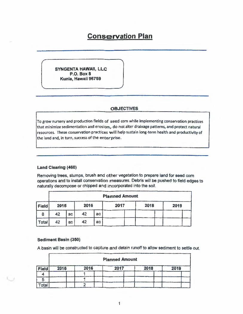
Syngenta"-.,. .unia Field 1: -105 acres
N
+ 0 250 500
FIELD 1 - CONSERVA1tON PLAN MAP
1,000 1,500 2,000 Feet
January 2015
- Existing_Waterway
• • • • • • • • Existing_ Windbreak
Existing_ Veg_Barrier
- ·-.. Existing_Road_Diversion
D Field_1_boundary

,.
Syngenta K\..... .:J
Field 1; -104.8 acres
~
X
SOILS MAP
0 250 500 1,000 1,500 2,000 Feet
1 inch = 500 feet
R. Mag .ng October 2014

Syngenta K\. " Field 1; -104.8 acres
~X
CONTOUR MAP
0 250 500 1,000 1,500 2,000 Feet
1 inch = 500 feet
Field_1_boundary
-- contour5ft_t_hi003
R.Ma~ ~g October2014

Syngentcl:, ~unia Field 2: -88 acres
N
+
FIELD 2 - CONSERVA •• ON PLAN MAP January L.v15
0 250 500 1 ,000 1,500 2,000 Feet
Existing_ Road
Planned_ Vegetative_Barriers
D Fld_2_boundary

Syngenta K\.._ . .J
Field 2; -87.5 acres
~
~ /~
SOILS MAP
0 250 500 1,000 1,500 2,000 Feet
1 inch = 500 feet
R. Ma~ .ng October 2014

Syngenta ~-- J
Field 2; -87.5 acres
~
)( 0 250 500
CONTOUR MAP
1,000 1,500
1 inch = 500 feet
2,000 Feet
R Ma~ .ng October 2014
Field_2_boundary
-- contour5ft_l_hi003

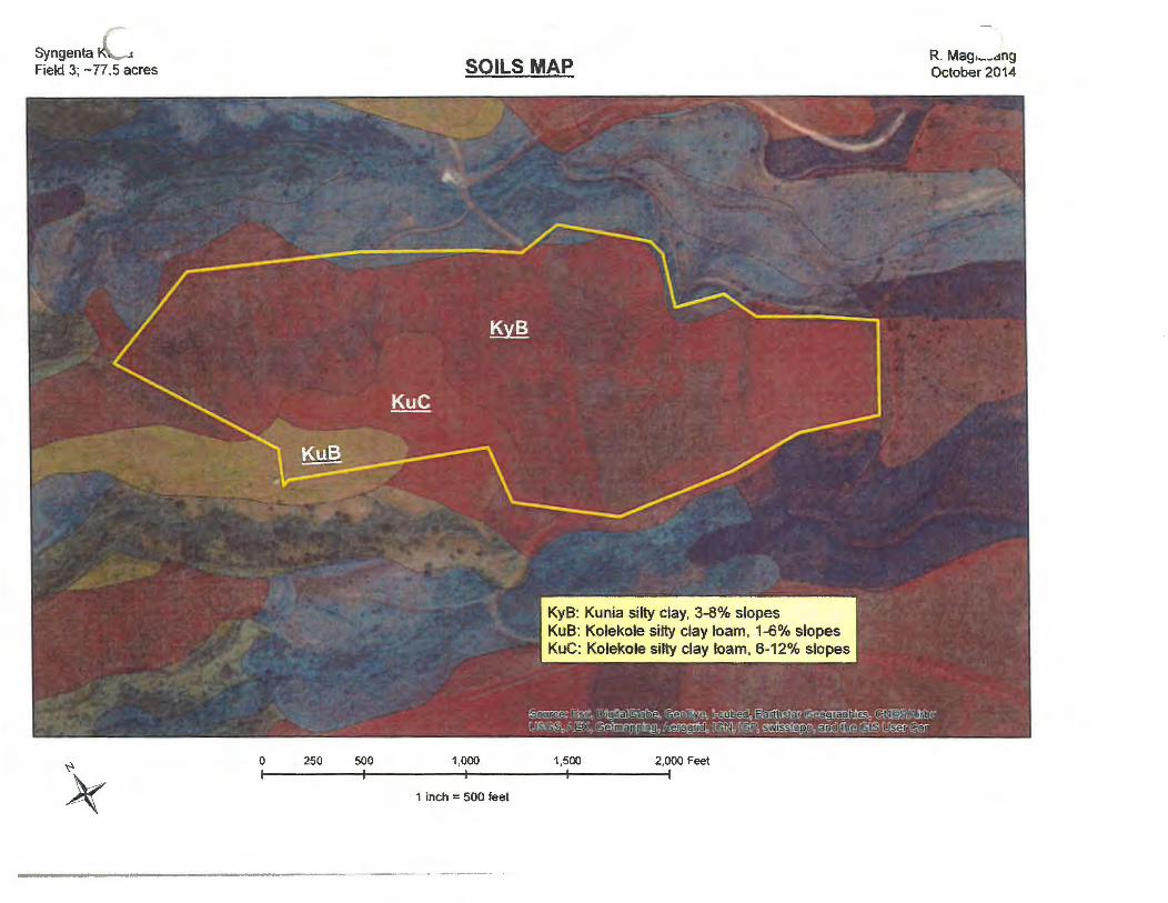
Syngenta \. .unia Field 3: -78 acres
N
+ 0 250 500
FIELD 3- CONSERVATION PLAN MAP
1,000 1,500 2,000 Feet
January 2015
-- Existing_Road
N ... p ~ . .. J Existing_ Conservation_ Cover
Planned_ Vegetative_Barriers
-- Planned_Waterway
D Field_3_boundary
Syngenta !<.\..,. ..1
Field 3; -77.5 acres
~
}(
SOILS MAP
0 250 500 1,000 1,500 2,000 Feet
1 inch = 500 feet
R. Mag•~-.:mg October 2014

Syngenta "''- -' Field 3; -77.5 acres
~
)(
CONTOUR MAP
0 250 500 1,000 1,500 2,000 Feet
1 inch = 500 feet
R. Mag, _ _ ,.mg October 2014
Field_3_boundary
-- contour5ft_l_hi003

Syngenta''- .unia Field 4: -99 acres
N
+ 0 250 500
FIELD 4- CONSERVAltON PLAN MAP
1,000 1,500 2,000 Feet
January 2015
Legend
-·-·· Existing_Road_Diversion
- Existing_Waterway
-- Existing_Road
LLLA Existing_ Vegetative_Barriers
Planned_ Vegetative_Barriers
D Planned_Sediment_Basin
D Field_ 4_boundary

Syngenta 1<.'~--J Field 4 ; -98.7 acres
~
}(
SOILS MAP
0 250 500 1 ,000 1 ,500 2,000 Feet
1 inch = 500 feet
R. Mag•~~dng October 2014

Syngenta 1\\..... ..i
Field 4 ; ~98.7 acres
~
)( 0 250 500
CONTOUR MAP
1,000 1,500
1 inch = 500 feet
2,000 Feet
R. Mag .... ..,ang October 2014
Field_ 4_beundary
- - contour5ft_l_hi003

Syngenta''- .unia Field 5: -79 acres
N
+ 0 250 500
FIELD 5- CONSERVA110N PLAN MAP
1,000 1,500 2,000 Feet
January 2015
-- Existing_Road
- Existing_Waterway_
Planned_ Vegetative_Barriers
D Planned_Sediment_Basin
D Fteld_5_boundary

Syngenta !<:-._ ... Field 5 ; -78.2 acres
~
)(
SOILS MAP
0 250 500 1,000 1,500 2,000 Feet
1 inch = 500 feet
R. Mago-..-dng October 2014

Syngenta 1'\\ J
Field 5 ; -78.2 acres
~
)( 0 250 500
CONTOUR MAP
1,000 1,500
1 inch = 500 feet
2,000 Feet
R. Mag .... _dng October 2014
Fiek1_5 _boundary
-- contour5ft_l_hi003

Syngenta", .unia Field 6: -77 acres
N
+ 0 250 500
FIELD 6 - CONSERVA'hvN PLAN MAP
1,000 1,500 2,000 Feet
January 2015
-- Existing_Road
Planned_ Vegetative_Barriers
D Field_6_boundary

Syngenta ~-- ..a Field 6; -76.9 acres
~ 0 250 500
SOILS MAP
1,000 1,500
1 inch = 500 feet
2,000 Feet
R. Ma~ .ng October 2014

Syngenta " '- ..j
Field 6; -76.9 acres
~
}(
CONTOUR MAP
o 250 500 1,000 1,500 2,000 Feet
1 inch = 500 feet
__ ,.._
R. Ma£t ,ng October 2014
Field_6_boundary
-- contour5ft_l_hi003

Syngenta, .unia Field 7: -31' acres
N
+ 0 250 500
FIELD 7- CONSERVA1auN PLAN MAP
1,000 1,500 2,000 Feet
January 2015
-- Existing_Road
Planned_ Vegetative_Barriers
D Field_7 _boundary
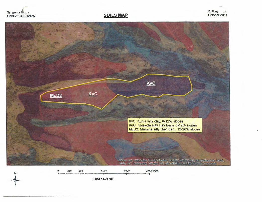
Syngenta K\ . ..a
Field 7; -30.2 acres
N
+ 0 250 500
SOILS MAP
1,000 1,500
1 inch = 500 feet
2,000 Feet
R. Ma!;t .ng October 2014

Syngenta 1\\.~ ..1
Field 7; -30.2 acres
N
+ ----------------------------
0 250 500
CONTOUR MAP
1,000 1,500
1 inch = 500 feet
2,000 Feet
R. Ma~ :ng October 2014
Field_7_boundary
-- contour5ft_l_hi003

Syngenta'-- .unia Field 8: -118 acres
D Existing_Retention_Basin
- Existing_Naturai_Waterway
m~<A Natural_ Vegetation
- Field_Road
Planned_ Vegetative_Barriers
D Fld8_boundary
FIELD 8 - CONSERVA-, .0N PLAN MAP
0 250 500 1,000
--January 2015
N
1,500 2,000 Feet +

Syngenta K-_ ... Field 8; -117.5 acres
~
~ ~
0 250 500
SOILS MAP
1,000 1,500
1 inch = 596 feet
KyB: Kunia silty clay, 3-8% slopes KyC: Kunia silty clay, 8-12% slopes McC2: Mahana silty clay loam, 6-12% slopes Mc02: Mahana silty clay loam, 12-20% slopes KuD: Kolekole silty clay loam 12-25% slopes
2,000 Feet
R. Mas .ng October 2014

Syngent~ :unia Field 8:-1 ra acres
- - contour5ft_l_hi003
FIELD 8 - CONTOUKS
0 250 500 1,000
-.,
January z015
N
1,500 2,000 Feet +

Syngenta·....__ .unia Field 11 :-110 acres
N
+ 0 250 500
FIELD 11 - CONSERVA1ION PLAN MAP
1,000 1,500 2,000 Feet
·.
January 2015
- Existing_ Natural_ Waterway
~}.:;~-::..;_-(] NaturaiVegetation
••••••• • Windbreak
D Fld11_boundary

Syngenta'-.unia Field 30:-230 acres
- Existing_ Natural_ Waterway
t) ;\'~~;.:i NaturaiVegetation
-- Existing_Diversion
D Field_30_boundary
FIELD 30 -CONSERVAtiON PLAN MAP January 2015
N 0 250 500 1,000 1,500 2,000 Feet +

Syngenta K...._ -i
Field 30; -229.8 acres
0 250 500 1,000 N
+
SOILS MAP
1,500 2,000 Feet
1 inch = 750 feet
R. Ma!;J .ng October 2014
MuB: Molokai silty clay loam, 3-7% slopes MuG: Molokai silty clay loam, 7-15% slopes WzA: Waipahu silty clay, 0-2% slopes WzC: Waipahu silty clay, 6-12% slopes
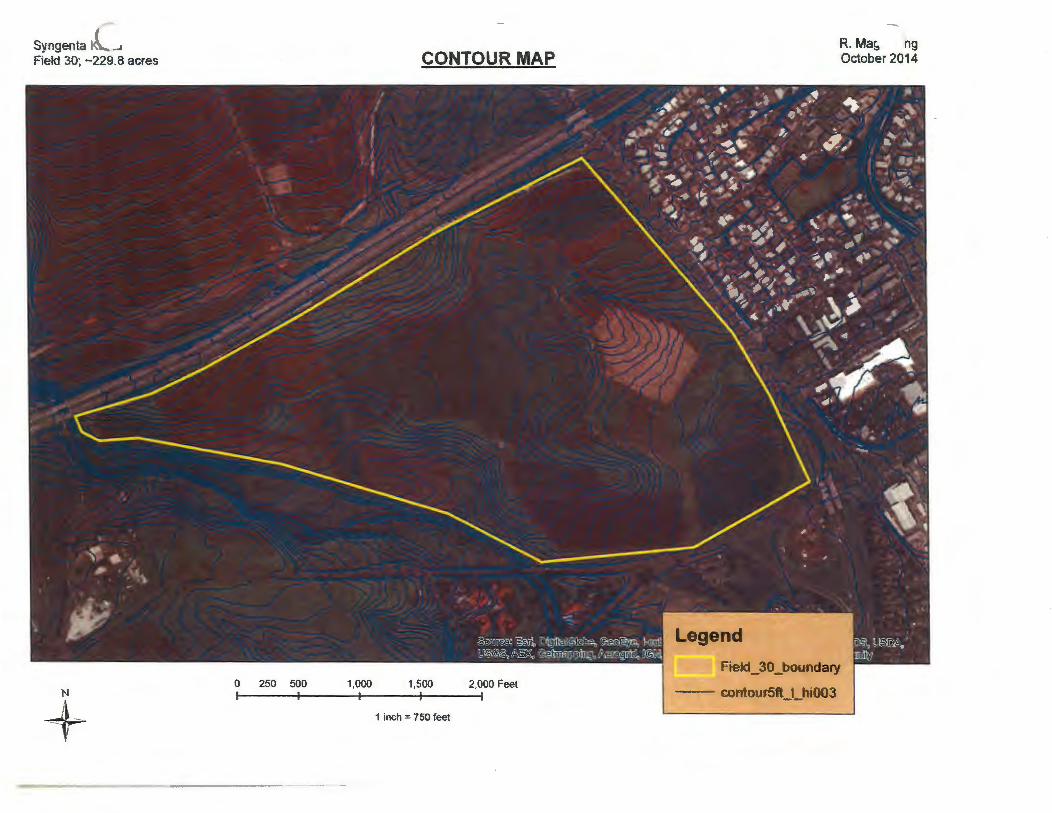
Syngenta !<.."...... ... Field 30; -229.8 acres
N
+
CONTOUR MAP
0 250 500 1,000 1,500 2,000 Feet ,------.--------,.--- - - - --,.----- - --.
1 inch = 750 feet
R. Ma~ ng October 2014
Field_30 _boundary
-- contour5ft_l_hi003

Syngenta'- .unia Field 146:-186 acres
~~ 0 250 500
FIELD 146- CONSER"ATION PLAN MAP
1,000 1,500 2,000 Feet
January 2015
- Existing_ Natural_ Waterway
f,~}~: ~:/:) NaturaiVegetation
CJ Field_146_boundary

Syngenta K\.- . ..t Field 146; -185.5 acres
0 250 500
~~
SOILS MAP
1,000 1,500
1 inch = 500 feet
laA: lahaina silty clay, 0-3% slopes laB: lahaina silty clay, 3-7% slopes
R. Ma£1 .ng October 2014
MuA: Molokai silty clay loam, 0-3% slopes MuC: Molokai silty clay loam, 7-15% slopes HlMG: Hetemano silty clay, 30-90 %. slopes KIB: Kawaihapai clay loam, 2-6% slopes
2,000 Feet
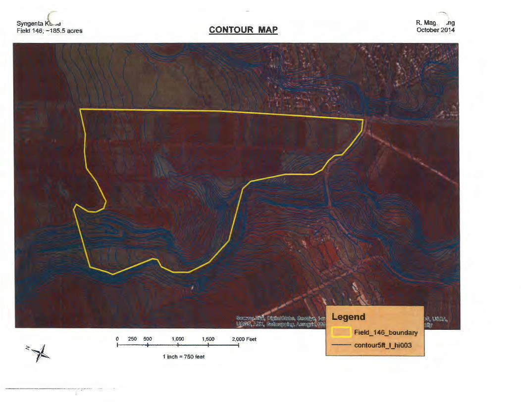
Syngenta Kb. ... d
Field 146; -185.5 acres
0 250 500
<~
CONTOUR MAP
1,000 1,500 2.000 Feet
1 inch = 750 feet
R. Mag. .ng October 2014
Field_146_boundary
- - contour5ft_t_hi003

---,_
Syngenta"'Kunia Field 166; -233.5 acres FIELD 166 CONSERVATION PLAN MAP January 2015
- Existing_Road
0 250 500 1,000 1,500 2,000 Feet - Existing_Waterway
~~ 1 inch = 500 feet D Field_166_boundary

Syngenta K..__ ...~
Field 166; -233.5 acres
0 250 500 1.000
<~
SOILS MAP
1,500 2,000 Feet
1 inch = 750 feet
KyA: Kunia silty clay, 0-3% slopes WaA: Wahiawa silty clay, 0-3% slopes LaB: Lahaina silty clay, 3-7% slopes
R. Mas .ng October 2014
KIB: Kawaihapai silty clay loam, 2-6% slopes HLMG: Helemano silty clay, 30-90 % slopes
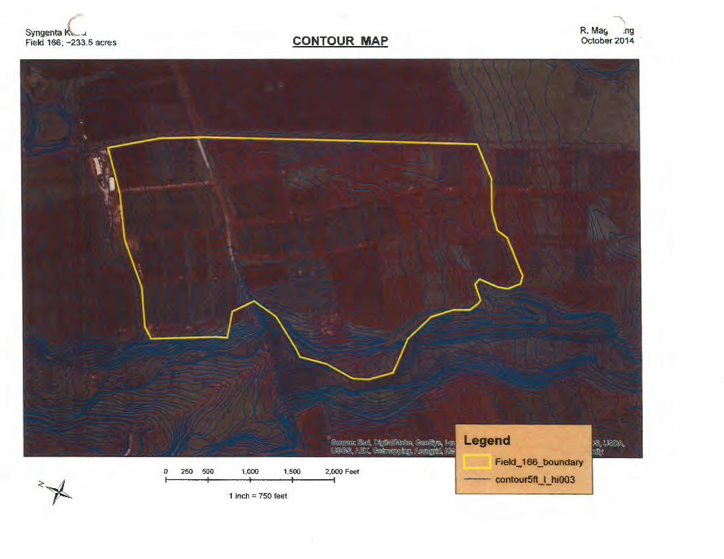
Syngenta ~<'-- ...1
Field 166; -233.5 acres
<~
CONTOUR MAP
0 250 500 1.000 1,500 2,000 Feet r r ----- T -- --------.---------,
1 inch = 750 feet
R. Ma& .ng October 2014
Field_166_boundary
- - contour5ft_l_hi003