Embed Size (px)
Citation preview

New York State Department of Transportation
Excellence in EngineeringContext Sensitive Design Award
2001
Exemplary Project
REGION 8
Taconic State ParkwayMiller Hill Road Interchange

Excellence in Engineering • Context Sensitive Design Award 2001 • Exemplary Project Region 8
Taconic State Parkway - looking north - visualization of the proposed interchange
Taconic State Parkway - looking north - before
Taconic State Parkway - looking north - after
Location
Taconic State Parkway/Miller Hill Road InterchangeTown of East Fishkill, Dutchess County
Description
The Taconic State Parkway (TSP) serves as a primarynorth/south transportation artery for noncommercialtraffic in eastern New York State. It carries bothrecreational and commuter traffic and is part of theNational Highway System. The project’s improvementsbegin 0.5 km (0.3 miles) north of the Dutchess/PutnamCounty line and extend north for 1.6 km (1.0 miles) inthe Town of East Fishkill, Dutchess County. Thepurpose of the project is to improve safety and reducethe accident rate at the TSP/Miller Hill Road at-gradeintersection. This intersection has been the focus ofconcern by the NYSDOT, local officials, and the publicdue to difficult traffic operations and a high number ofaccidents. Of particular concern were the thirty dailyschool bus crossings at this location, as well as theAppalachian Trail crossing by hikers with full packs.The project provided for the replacement of the existingat-grade intersection with a full diamond interchange.
Outside Agency and Community Coordination
The intersection of the Taconic State Parkway andMiller Hill Road has been a growing concern datingback to the mid 1980's. In the early 1990's, a flashingsignal was installed to alert motorists, but as mainlinetraffic volumes and crossing traffic continued toincrease, so did the public demand for improvement.This resulted in a 1996 petition signed by 3,000 townresidents and parkway users, who involved StateSenator Saland and Assemblyman Manning, to implorethe DOT to remedy the situation. The Departmentcommitted to correcting the problem as quickly aspossible. In early 1997, the project was initiated witha one month scoping process that recommended acomplete diamond interchange to replace the at-gradeintersection. An extraordinary one year schedule tocomplete the design was set.

Excellence in Engineering • Context Sensitive Design Award 2001 • Exemplary Project Region 8
Miller Hill Road looking west - visualization of the proposedinterchange
Miller Hill Road looking west - after
Miller Hill Road looking west - before
There were difficult issues that had to be successfully addressed:
• An existing Miller Hill Road grade of 18%• A natural stream and waterfall in the middle of the site• The TSP’s eligibility for the National Historic Register• An Appalachian Trail crossing at this location• The TSP’s designation as a Scenic Byway• Preserving the aesthetic character of the Parkway
A regional project team was appointed to meetmonthly to expedite the design process. Throughclose project coordination, challenges in the area ofproject design, public coordination, real estateacquisition, environmental permitting, and materialavailability were successfully addressed in anefficient manner. The understanding of design andcommunity goals, and the development of strongworking relationships enabled aesthetic andenvironmental details, critical to community andregulatory agency acceptance of the project, to bewell-integrated with an accelerated constructionschedule.
Rapidly building community and interagency supportfor the interchange was critical to maintain theproject schedule. Photographs of the existingparkway location were taken, and visual simulationswere created to present the proposed improvementsin the design approval document at a town meetingwith local officials, later broadcast on local accesscable, and at a public information meeting in June of1997.
The Miller Hill Road alignment was shifted slightlyto the south to accommodate construction activities.It was necessary to accommodate the steep grade ofthe roadway and build the interchange to meet thissteep profile. This required a structure to carry theParkway over Miller Hill Road and a retaining wallto support the shift in alignment of Miller Hill Road.
Excellence in Engineering • Context Sensitive Design Award 2001 • Exemplary Project Region 8
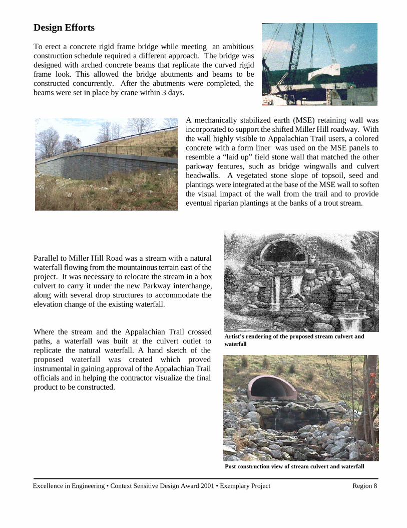
Artist’s rendering of the proposed stream culvert and waterfall
Post construction view of stream culvert and waterfall
Design Efforts
To erect a concrete rigid frame bridge while meeting an ambitiousconstruction schedule required a different approach. The bridge wasdesigned with arched concrete beams that replicate the curved rigidframe look. This allowed the bridge abutments and beams to beconstructed concurrently. After the abutments were completed, thebeams were set in place by crane within 3 days.
A mechanically stabilized earth (MSE) retaining wall wasincorporated to support the shifted Miller Hill roadway. Withthe wall highly visible to Appalachian Trail users, a coloredconcrete with a form liner was used on the MSE panels toresemble a “laid up” field stone wall that matched the otherparkway features, such as bridge wingwalls and culvertheadwalls. A vegetated stone slope of topsoil, seed andplantings were integrated at the base of the MSE wall to softenthe visual impact of the wall from the trail and to provideeventual riparian plantings at the banks of a trout stream.
Parallel to Miller Hill Road was a stream with a naturalwaterfall flowing from the mountainous terrain east of theproject. It was necessary to relocate the stream in a boxculvert to carry it under the new Parkway interchange,along with several drop structures to accommodate theelevation change of the existing waterfall.
Where the stream and the Appalachian Trail crossedpaths, a waterfall was built at the culvert outlet toreplicate the natural waterfall. A hand sketch of theproposed waterfall was created which provedinstrumental in gaining approval of the Appalachian Trailofficials and in helping the contractor visualize the finalproduct to be constructed.
Excellence in Engineering • Context Sensitive Design Award 2001 • Exemplary Project Region 8
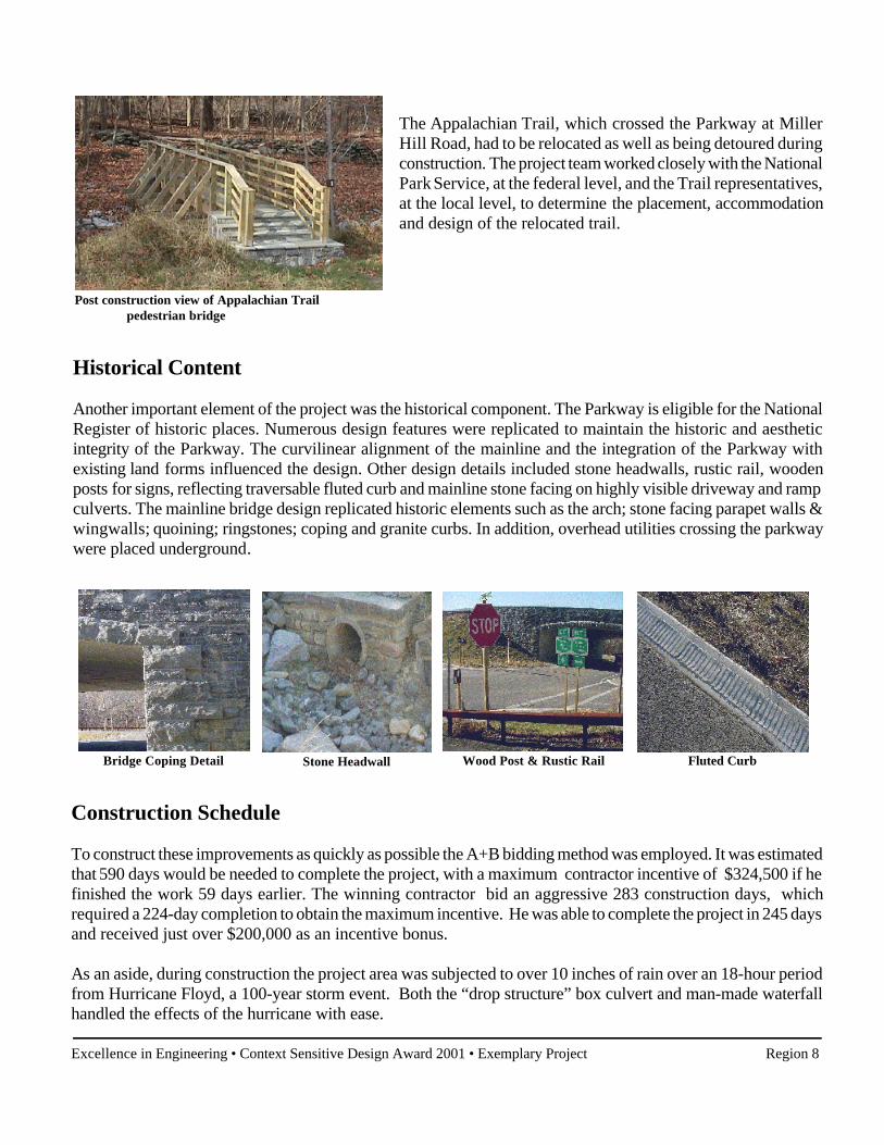
Bridge Coping Detail Fluted Curb
Post construction view of Appalachian Trailpedestrian bridge
Stone Headwall Wood Post & Rustic Rail
The Appalachian Trail, which crossed the Parkway at MillerHill Road, had to be relocated as well as being detoured duringconstruction. The project team worked closely with the NationalPark Service, at the federal level, and the Trail representatives,at the local level, to determine the placement, accommodationand design of the relocated trail.
Historical Content
Another important element of the project was the historical component. The Parkway is eligible for the NationalRegister of historic places. Numerous design features were replicated to maintain the historic and aestheticintegrity of the Parkway. The curvilinear alignment of the mainline and the integration of the Parkway withexisting land forms influenced the design. Other design details included stone headwalls, rustic rail, woodenposts for signs, reflecting traversable fluted curb and mainline stone facing on highly visible driveway and rampculverts. The mainline bridge design replicated historic elements such as the arch; stone facing parapet walls &wingwalls; quoining; ringstones; coping and granite curbs. In addition, overhead utilities crossing the parkwaywere placed underground.
Construction Schedule
To construct these improvements as quickly as possible the A+B bidding method was employed. It was estimatedthat 590 days would be needed to complete the project, with a maximum contractor incentive of $324,500 if hefinished the work 59 days earlier. The winning contractor bid an aggressive 283 construction days, whichrequired a 224-day completion to obtain the maximum incentive. He was able to complete the project in 245 daysand received just over $200,000 as an incentive bonus.
As an aside, during construction the project area was subjected to over 10 inches of rain over an 18-hour periodfrom Hurricane Floyd, a 100-year storm event. Both the “drop structure” box culvert and man-made waterfallhandled the effects of the hurricane with ease.
Excellence in Engineering • Context Sensitive Design Award 2001 • Exemplary Project Region 8
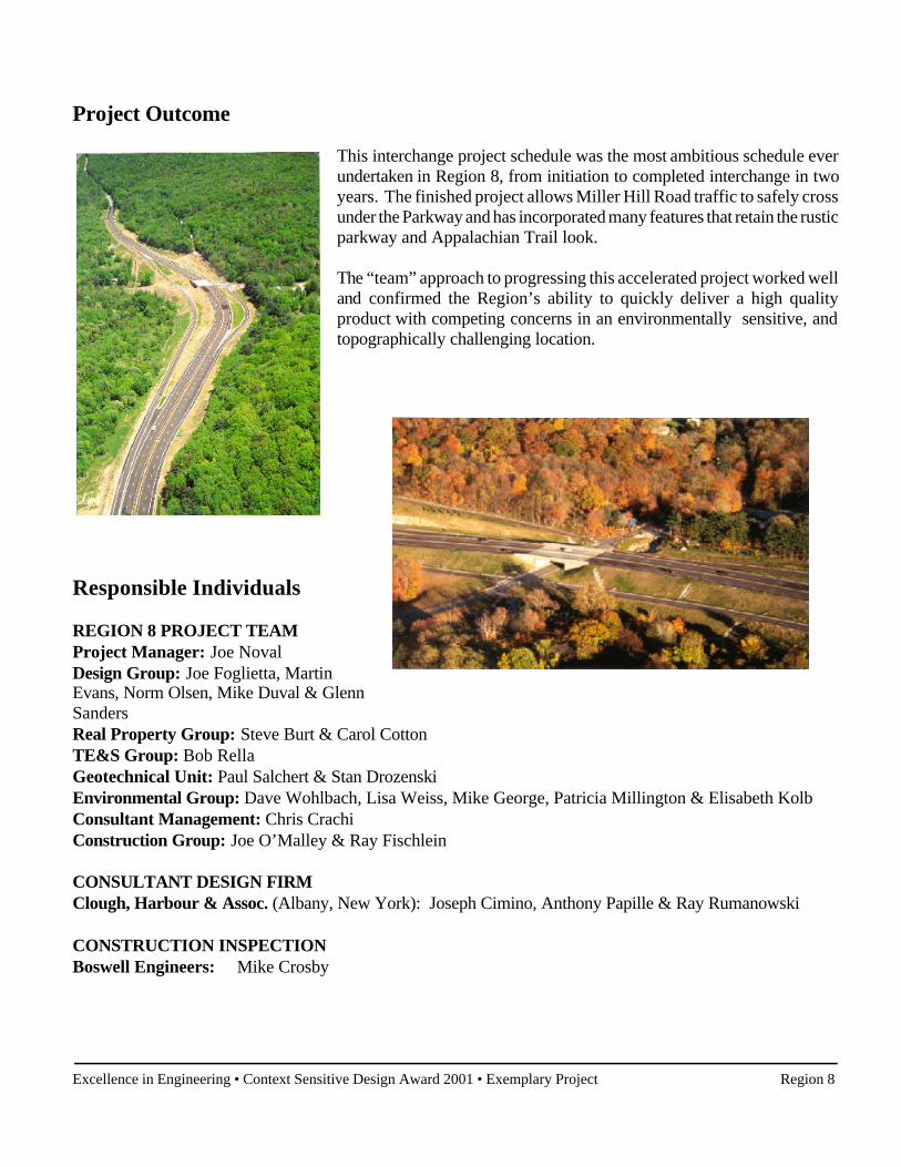
Project Outcome
This interchange project schedule was the most ambitious schedule everundertaken in Region 8, from initiation to completed interchange in twoyears. The finished project allows Miller Hill Road traffic to safely crossunder the Parkway and has incorporated many features that retain the rusticparkway and Appalachian Trail look.
The “team” approach to progressing this accelerated project worked welland confirmed the Region’s ability to quickly deliver a high qualityproduct with competing concerns in an environmentally sensitive, andtopographically challenging location.
Responsible Individuals
REGION 8 PROJECT TEAMProject Manager: Joe NovalDesign Group: Joe Foglietta, MartinEvans, Norm Olsen, Mike Duval & GlennSandersReal Property Group: Steve Burt & Carol CottonTE&S Group: Bob RellaGeotechnical Unit: Paul Salchert & Stan DrozenskiEnvironmental Group: Dave Wohlbach, Lisa Weiss, Mike George, Patricia Millington & Elisabeth KolbConsultant Management: Chris CrachiConstruction Group: Joe O’Malley & Ray Fischlein
CONSULTANT DESIGN FIRM Clough, Harbour & Assoc. (Albany, New York): Joseph Cimino, Anthony Papille & Ray Rumanowski
CONSTRUCTION INSPECTIONBoswell Engineers: Mike Crosby