Embed Size (px)
Citation preview
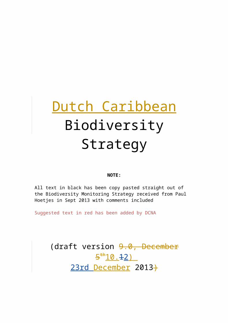
Dutch CaribbeanBiodiversity Strategy
NOTE:
All text in black has been copy pasted straight out of the Biodiversity Monitoring Strategy received from Paul Hoetjes in Sept 2013 with comments included
Suggested text in red has been added by DCNA
(draft version 9.0, December 5th10.12) 23rd December 2013)
Biodiversity Strategy for the Dutch Caribbean
Table of Contents
EXECUTIVE SUMMARY 5
1. INTRODUCTION 6
Vision 6
Goals 6
Key elements 7
Understanding biodiversity 7
Significance of Dutch Caribbean Islands Biodiversity 8
2. GOVERNANCE 9
Nature Commission 9
EEZ Committee 10
Fisheries Commission 10
Biodiversity Monitoring Committee 10
Island Platforms 10
3. CURRENT STATE OF BIODIVERSITY 12
Habitats 12Coral reefs 12Mangrove forests 13Seagrass 14Rainforest 15
Species 15Birds 16Sea Turtles 17Conch 18Lobster 18
4. CAUSES OF BIODIVERSITY LOSS 19
Main Threats 19
Protected Area Threats 20
5. LEGAL TOOLS 24
International treaties and conventions 24
- 2 -
Biodiversity Strategy for the Dutch Caribbean
Convention on Biological Diversity (CBD) 24Convention on International Trade of Endangered Species (CITES) 24Convention on Wetlands of International Importance especially as Waterfowl Habitat (Ramsar Convention) 24The Convention on the Conservation of Migratory Species of Wild Animals (CMS) 24The Migratory Shark Memorandum of Understanding (MoU) 25Cartagena Convention 25Inter-American Sea Turtle Convention (IAC) 26International Whaling Convention (IWRC) 26UNESCO World Heritage Convention 26
National Policy and legislation 26Nature Policy Plan The Caribbean Netherlands 2013-2017 26National and Policy Plans and Ordinances 26Nature Conservation Framework Act BES 26Maritime Management Act BES 27Fisheries Act BES 28Public housing, spatial planning and environmental protection Act BES 28Island Ordinances 30
6. KEY ELEMENTS OF BIODIVERSITY CONSERVATION 31
Protected Area Management 31Internationally protected areas 31Nationally protected areas 32Locally protected areas 33Day to day management 34Management Plans 36
Species Management 36
Genetic Resources 37
7. BIODIVERSITY MONITORING STRATEGY 38
Background 38
Initiative 38
Purpose 39
Goals 39
Baseline – monitoring - research 39
Governance 41Technical Database Management 42
Biodiversity monitoring principles 42Monitoring ++ 42Sustainability 43Standard protocols 43Centralized data storage 43Open access 43Adaptive 43
- 3 -
Biodiversity Strategy for the Dutch Caribbean
Setting monitoring priorities 43Communicating results 44Centralized data storage 44
Prioritizing monitoring activities 45
Communication 47
8. ACTION PLAN 49
9. APPENDIX 50
Internationally protected species in the Dutch Caribbean 50
Definition of Terms 55
RAMSAR SITES 59
Protected Areas: site description and value statements 61Aruba 61Bonaire 62Curaçao 64Saba 66St Eustatius 67St Maarten 69
BACKGROUND AND A PATH FORWARD 71
- 4 -
Biodiversity Strategy for the Dutch Caribbean
Executive Summary
To be completed after Dec 2013 Biodiversity Strategy Workshop
- 5 -
Biodiversity Strategy for the Dutch Caribbean
1. Introduction
The quality of nature on the Dutch Caribbean islands is an important part of the identity of the people who live on these islands and in large part underpins the quality of life and economic wealth of the islands. Our marine and terrestrial ecosystems and habitats, animals and plants are diverse and of high local, regional and international importance.
This Biodiversity Strategy, together with the Nature Policy Plan for the Caribbean Netherlands, and other planning and strategy documents will be used to guideform the framework for the wise sustainable and successful management of our islands’ natural wealth.
The two key strategies identified in the “Nature Policy Plan The Caribbean Netherlands” are mainstreaming and nature management. This document starts where the Nature Policy Plan ends to action the policyBiodiversity Strategy focuses on the second of these.
The Ministry of Economic AffairsKingdom of the Netherlands furthermore has a strong interest in biodiversity conservation and management due to their obligations under various international treaties and conventions and the consequent need to meet international standards and obligations.
Local interest paragraph.. (this may be covered now in the opening).
Vision1. Our vision for the future of biodiversity in the Dutch Caribbean is of no net loss of the islands’ biodiversity: where natural systems are healthy and diverse and support and promote human well-being
OR
2. The people of the Dutch Caribbean work together to conserve the islands’ biological diversity, and all share in the economic and social benefits of biodiversity. The full range of each island’s natural systems and their species are secure and thrive.
GoalsThe goal of the Biodiversity Strategy is to ensure the conservation and enhancement of biological diversity on the islands through the protection of areas and species and the sustainable use of the island’s natural resources, in harmony with economic development and human well-being.
- 6 -
Biodiversity Strategy for the Dutch Caribbean
This can only be achieved by generating awareness about biodiversity and conservation on the islands to inform, motivate and encourage support and active participation in nature conservation by all stakeholders.
Conservation and enhancement includes the protection, maintenance, strengthening and where feasible restoration of nature on the islands.
Protection of areas and species refers to the active management of areas designated as nature or conservation areas and/or selected species
Sustainable use includes prohibiting destructive practices, regulating extractive practices and managing other use to ensure no net loss of biodiversity.
Key elements
The key elements within the Biodiversity Strategy are: Protected area management Species management Genetic resources Biodiversity monitoring
Understanding biodiversityBiodiversity is considered in its widest sense and includes the fluctuation, variability, amount, and distribution of all biodiversity components and their interaction. Biodiversity includes freshwater, marine and terrestrial environments and their attendant flora and fauna. It also includes the relationships between earth systems such as climate change and biodiversity. Biodiversity occurs within and amongst dynamic environmental stressors and a rapidly changing society. Long-term measurements will be fundamental to our understanding and management of biodiversity. Local, regional and global processes are inextricably linked and will thereby assist with predictions and decisions at all spatial scales and where data may be limited.
Understanding the scope of the islands’ biological resources is an essential first step towards effectively managing biodiversity on the islands.
The challenges of understanding biological diversity include but are not limited to: Understanding biodiversity’s role in ecosystems: processes, resilience and
environmental change The development of appropriate tools and techniques to describe
biodiversity and its functions Improve how the abundance and distribution of biodiversity is measured
- 7 -
Biodiversity Strategy for the Dutch Caribbean
How society can predict and mitigate the effects of biodiversity change on processes that sustain life
The development of integrated tools for assessing the benefits of biodiversity
Significance of Dutch Caribbean Islands BiodiversityThe islands of the Caribbean Netherlands are biologically diverse and home to hundreds of endemic species, several globally endangered species and a variety of globally threatened ecosystems. Ecosystems range from arid, cactus dominated landscapes, dry forests and evergreen limestone vegetation, to tropical rainforest and cloud forest. The Caribbean Netherlands form part of the Caribbean Islands Biodiversity Hotspot (Conservation International, 2004), an area with exceptionally diverse ecosystems, rich in plant and animal species, many of which are endemic to one or only a few islands. At the same time the Caribbean islands have suffered from deforestation and human encroachment. As a consequence the islands characteristically have a rich but fragile biodiversity that is in need of special attention. The marine biodiversity of the Caribbean Netherlands is also exceptionally rich. Even within the Caribbean hotspot the Southern Caribbean area has been identified as the second richest area (after the Straits of Florida) for marine species (Conservation International, 2004; Solórzano et al). Much of this biodiversity is still hidden in the deep-sea and has yet to be studied. The surrounding seas and coastal zones of the islands are also rich with mangrove communities, seagrass beds, and coral reefs. The Saba Bank, only recently partly explored, yielded new fish species as well as algae and soft coral species new to science.
- 8 -
Biodiversity Strategy for the Dutch Caribbean
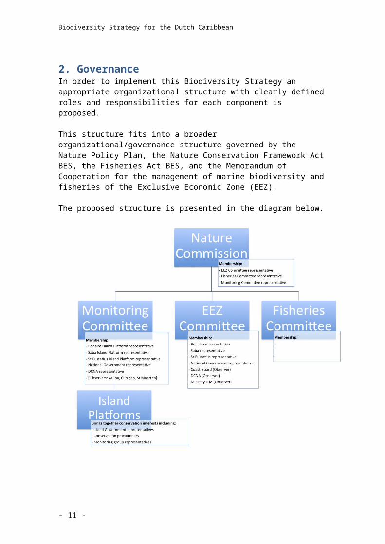
2. GovernanceIn order to implement this Biodiversity Strategy an appropriate organizational structure with clearly defined roles and responsibilities for each component is proposed.
This structure fits into a broader organizational/governance structure governed by the Nature Policy Plan, the Nature Conservation Framework Act BES, the Fisheries Act BES, and the Memorandum of Cooperation for the management of marine biodiversity and fisheries of the Exclusive Economic Zone (EEZ).
The proposed structure is presented in the diagram below.
Since the work of these committees and commissions will overlap significantly each Committee must be represented in the Nature Commission.
Nature CommissionThe Nature Conservation Framework Act BES (Article 3) provides the option of establishing a “Nature Commission” for the BES islands. This Commission would be charged with giving advice, asked for or otherwise, to the Minister
- 9 -
Biodiversity Strategy for the Dutch Caribbean
of EZ and the Island Governments of Bonaire, Saba and St Eustatius, on any issues related to the implementation of the Nature Conservation Framework Act BES. The Nature Policy Plan Caribbean Netherlands (NPP) restates the intention to indeed establish such a Commission.
EEZ CommitteeIn addition to this Nature Commission, there is an Committee for the management of Marine Biodiversity and Fisheries (EEZ Committee) established in 2010, based on a Memorandum of Cooperation intended to include all six Dutch Caribbean islands. The committee meets twice a year.
Fisheries CommissionThe Fisheries Commission was established in 2013 as prescribed by the Fisheries Act BES. This Commission will meet in conjunction with the EEZ Committee
Biodiversity Monitoring CommitteeA Biodiversity Monitoring Committee should be establishedis envisaged to coordinate and oversee the biodiversity monitoring strategy. The tasks and responsibilities of this committee are described in more detail below.
Nature Commission meetings should be preceded by Bi-annual Dutch Caribbean Nature Platform meetings which wcould provide a broad platform for discussion amongst a range of stakeholders (government, non-governmental, businessprivate sector) on nature and nature conservation in the region, identifying themes or issues from a multi-island perspective, and provide recommendations for the Nature Commission and its counterparts in the other Dutch Caribbean islands.
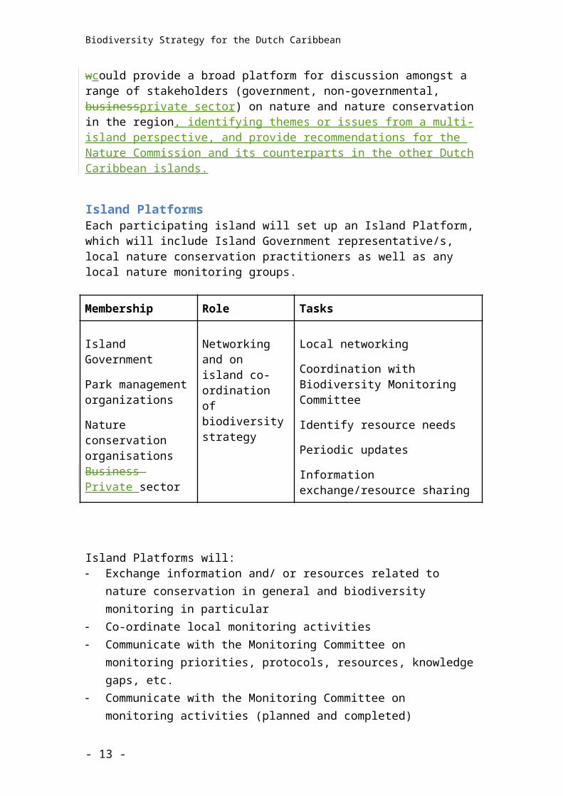
Island PlatformsEach participating island will set up an Island Platform, which will include Island Government representative/s, local nature conservation practitioners as well as any local nature monitoring groups.
Membership Role Tasks
- 10 -
Biodiversity Strategy for the Dutch Caribbean
Island Government
Park management organizations
Nature conservation organisationsBusiness Private sector
Networking and on island co-ordination of biodiversity strategy
Local networking
Coordination with Biodiversity Monitoring Committee
Identify resource needs
Periodic updates
Information exchange/resource sharing
Island Platforms will: Exchange information and/ or resources related to nature conservation in
general and biodiversity monitoring in particular Co-ordinate local monitoring activities Communicate with the Monitoring Committee on monitoring priorities,
protocols, resources, knowledge gaps, etc. Communicate with the Monitoring Committee on monitoring activities (planned
and completed) Flag to the Monitoring Committee, and others, their resource needs (expertise,
funds, materials)
- 11 -
Biodiversity Strategy for the Dutch Caribbean
3. Current state of biodiversityBiological diversity – biodiversity – is the variety of life and its processes and it includes the variety of living organisms, the genetic differences amongst them and the communities and ecosystems in which they occur.
This section presents a summary of our current knowledge of the state of the islands’ biological resources. Since biodiversity in the Dutch Caribbean has not been systematically inventoried and indicators for species and/or ecosystem trends have not been identified information is incomplete.
In general, expert qualitative assessments reveal that all natural habitats show minor or severe signs of degradation. Considering the fact that many endemic and other species depend on the small island habitats it’s obvious that the current status of biodiversity on the islands is threatened [ref: xxx]
HabitatsThe main marine habitats found on and around the islands are coral reefs, mangroves, seagrasses, macro-algal communities, open ocean and a range of subtidal and intertidal habitats including hard, rubble and sand bottoms, rocky shores, sand/rubble beaches, salt and freshwater ponds as well as saliñas and lagoons.
The main terrestrial habitats are semi-desert, dry scrub, dry forest, other woodlands and rainforest and cloudforest. All of these environments are biologically diverse and provide a range of resources and ‘services’ for wild animals and plants as well as humans.
Coral reefs, mangrove forests, seagrass beds and rainforests and cloudforests are all recognised as globally threatened ecosystems of high biodiversity. A number of threats are contributing to declines in health and extent of these habitats as well as others in the Dutch Caribbean.
Coral reefs
Coral reefs occur around all islands of the Dutch Caribbean and are diverse in structure and extent. Bonaire and Curaçao have highly developed fringing coral reefs, which encircle the entire islands. St Maarten has patch/barrier reefs while the reefs on Saba are found on the top of underwater seamounts or pinnacles. St Eustatius by contrast has very well developed patch reefs and Aruba has small areas of patch reef amongst a topographically complex marine landscape.
Coral cover has systematically declined throughout the Caribbean by more than 80% since the 1970s due to a number of factors including chronic overfishing, the insidious effects of population expansion and coastal zone development, climate
- 12 -
Biodiversity Strategy for the Dutch Caribbean
change – which is causing more intense and more frequent storms as well as frequent coral bleaching events and acidification - and invasive species.
Many of the large reef fish (particularly groupers, snappers and grunts) are declining at the same or even greater rate than corals. The greatest threat to fish populations is posed by invasive lionfish, which were first spotted on Bonairethe ABC islands in late 200910 and can now beby 2011 were found also established on all the SSS islands. The situation looks grim as lionfish appear to colonize all depths and habitats and this voracious predator is capable of reducing in situ juvenile fish populations by up to 78%.
Aruba’s patches of coral reefs are widely dispersed and discrete. Little is known about their status and they are not protected.
Bonaire’s fringing coral reefs, which extend around the island of Bonaire and satellite island of Klein Bonaire are protected within the Bonaire National Marine Park and include the Ramsar areas of Lac (Ramsar site # 199) and the fringing reefs around Klein Bonaire (Ramsar site # 201). Within the Marine Park are two Marine Reserves, where all activities are prohibited and two small Fish Protected Areas where fishing activities are banned. Bonaire’s coral reefs are considered to be some of the healthiest in the Caribbean (AGRRA, Carmabi Foundation, 2011), yet remain seriously threatened with collapse, more so than at any time since monitoring began (Steneck et al. 2011). Populations of grouper, snapper and grunt have plummeted since data was first collected in the early 1970s.
Curacao’s fringing coral reefs extend around the island. They are not actively managed although the Curacao Underwater Park officially protects xx of coastline. The coral reefs, particularly in the area adjacent to Oostpunt, are generally regarded as among the healthiest in the Caribbean (Carmabi Foundation, 2011).
Saba’s pinnacles xxx [extent – management – status]
The patch reefs on St Eustatius xxx [extent – management – status]
St Maarten recently established the Man o War Shoals Marine Park to protect their most valuable areas of coral reefs. [extent – management – status]
Mangrove forestsIt is well known that there is considerable interchange between mangrove forest ecosystems and coral reefs with mangroves and adjoining seagrass beds acting as breeding and nursery grounds for countless species of fish and invertebrates many of which spend their adult lives in coral reef environments. Mangroves are also considered globally threatened ecosystems and are under significant pressure throughout the Caribbean region.
- 13 -
Biodiversity Strategy for the Dutch Caribbean
In the Dutch Caribbean mangrove forests are found on Aruba, Bonaire, Curaçao and St. Maarten, with the most commonconsisting of species being Red Mangrove (Rhizophora mangle), and Black Mangrove (Avicennia germinans), White Mangrove (Laguncularia racemosa) and Buttonwood (Conocarpus sperectus.).
Despite the active management offered by protected areas and Ramsar site designation, mangroves are still being cleared for coastal development. This is a particular problem on St Maarten and Curaçao.
On Aruba, well-developed mangrove forests occur at Spanish Water Lagoon (Spaans Lagoen). This is a Ramsar site (# 198), but falls outside of the Parke Nacional Arikok and is therefore not under active management. The status of the mangrove forests is not known.
Bonaire’s best developed mangrove forests are found encircling Lac, a large semi-enclosed bay on the windward shore although mangrove stands are also found at Lagoen and red mangroves have been slowly but systematically colonizing the southern coastal fringe on the leeward shore of Bonaire for over a decade. The mangroves at Lac are well protected within the Bonaire National Marine Park and are a Ramsar site. Special attention has been paid to the study and management of Lac for over twenty years. The mangrove forest is made up of approximately equal parts Red Mangrove, on the seaward edge and Black Mangrove, which colonize the drier interior areas. Changed hydrology and/or natural progression has caused the mangroves in the north-western corner of the bay (at Awa di Lodo) to die off decades ago though the area is now being slowly recolonized by Black Mangrove. Despite this, and increasing tourist use of the bay, the mangrove forests at Lac are considered to be in very good condition and recent studies have shown a high rate of land reclamation (a natural process of mangroves growing seaward and dying off further in land) at Lac Bay Bonaire (Engel, 2013). The unusual hydrology of the bay, with two independent basins, sand bars and fresh water replenishment via sheet flow, puts the mangroves on the landward fringe at risk and the invertebrate life in the mangrove forests appears depleted.
On Curacao mangrove forests can be found xxx [extent – management – status]An incident of oil pollution at Jan Kok on 2012 resulted in xxx
Few of the mangrove forests on St Maarten have escaped land clearance for development. There are still mangroves at xxx [extent – management – status]
Little systematic monitoring has been done of mangrove forests in the Dutch Caribbean. Analysis of satellite images may be the most suitable method for monitoring areal extent, species composition, and health of mangrove areas in the Dutch Caribbean (IMARES, 2012).
- 14 -
Biodiversity Strategy for the Dutch Caribbean
Seagrass Seagrass ecosystems often occur alongside coral reefs and play a vital role in maintaining the health and diversity of adjacent coral reefs. They also form important habitat for the globally endangered Green Turtle (Chelonia mydas) and locally threatened Queen Conch (Lobatus gigas). Seagrass beds are sensitive to land-based pollution, sedimentation, trampling and invasive species, and climate change.
Aruba has extensive sea grass beds around the island. These are not protected and have not been well studied.
The seagrass beds at Lac on Bonaire have been studied since 1969 (Wagenaar Hummelinck and Roos). There has been some decline in the extent and coverage of native seagrass [extent – management – status]
On Curacao, seagrass beds can be found [extent – management – status]
Extensive seagrass beds are found around St Eustatius xxx [extent – management – status]
St. Maarten has extensive seagrass beds in the Simpson Bay lagoon and xxx. None of St Maarten’s seagrass beds are protected or under active conservation management. Much of the Simpson Bay lagoon has been overrun by the invasive H.stipulacea.
An invasive seagrass (Halophila stipulacea) has been found on St. Maarten, Curaçao and Bonaire. The average coverage of H.stipulacea in Lac has increased 14%, in three years (Engel, 2013).
RainforestTropical rainforests are among the most threatened ecosystems globally due primarily to logging and agricultural clearance. Globally, rainforests now cover less than 6% of Earth’s land surface. The rainforests occur on Saba and St. Eustatius
Saba’s rain forests cover the steep slopes of the island from an altitude of xx to the top of Mount Scenery. Most are protected by the Saba Conservation Foundation and some fall within the islands terrestrial protected area. [extent – management – status]
Statia’s rain forests are found around the top of the Quill crater within the Quill Boven National Park [extent – management – status]
however they remain at threat to invasive species, climate change and hurricanes.
SpeciesThe Dutch Caribbean is home to the greatest level of biodiversity within the Kingdom of the Netherlands. There are over 200 endemic plants and animals in the ABC Islands alone that cannot be found anywhere else in the world.
- 15 -
Biodiversity Strategy for the Dutch Caribbean
75 globally endangered or vulnerable species are present on the islands, including trees, snakes, sea turtles, birds, whales and fish. These species are facing a high risk of extinction in the wild in the medium to near future and many are protected by local and international law (see Appendix I for specially protected species in the Dutch Caribbean).
BirdsBirds often provide an indication of changing environmental conditions. In addition to the designation of 23 Important Bird Areas, local conservation organizations and BirdLife International have identified 26 locally or globally important or threatened bird species.
Audubon’s Shearwater (Puffinus lherminieri)The Audubon’s Shearwater is listed as IUCN category Least Concern. Global population estimated at (minimum) to be 500,000 individuals (Croxall et al. 2012). Population trend thought to be declining throughout the region, with dramatic declines at some location, but few specific data. Distribution is poorly known due, in part, to their nocturnal behaviour and activity patterns, and the remoteness and steepness of their nesting terrain. The Audubon’s Shearwater has a population estimate for the Lesser Antilles thought to be approximately 3,000 pairs (Bradley and Norton, 2009). These estimates are largely based on aerial or calling birds and thus subject to inaccuracy and multiple counting.
Caribbean Coot (Fulica caribaea)The species is listed as Near Threatened by IUCN. The total Caribbean population is estimated at 40,000 individuals (BirdLife International 2008). There are no data available on population trends, productivity, nesting requirements, and specific habitat use.
The Caribbean Coot population was estimated at 250 individuals on Bonaire (Well et al., 2008), 280 individuals on Aruba (Delnevo 2008), 1,000 individuals on Curaçao (Debrot et al. 2008), and 75 individuals on St. Maarten (Collier and Brown 2008). Note that these population numbers refer to the respective Important Bird Areas (IBA) for each island. Periodic wetland areas do occur following seasonal rains, particularly on Aruba, and provide ephemeral habitat for this species. Consequently, population estimates may be higher than noted here. There are no breeding records for this species on Saba or St. Eustatius.
Common terns (Sterna hirundo)Common terns do not breed in the Dutch Lesser Antilles. This species nests on Aruba (165 individuals; Delnevo 2008), Bonaire (115 individuals; Wells et al., 2008), and Curaçao (400 individuals; Debrot et al., 2008). These three islands represent the most significant population for this species in the Caribbean. However, some caution should be expressed as the very similar (tropical form) roseate tern is often confused with common tern.
Least terns (Sternula antillarum)
- 16 -
Biodiversity Strategy for the Dutch Caribbean
Least terns occur primarily on Bonaire where an estimated 2,375 individuals have been reported (Wells et al. 2008). On Curaçao 1,860 individuals have been recorded (Wells et al., 2008). A long-term study of terns on Aruba has identified a population of ca. 480 individuals. On St. Maarten the national population is estimated at 450 individuals (Collier and Brown 2008), although recent estimates (2009 and 2010) only list 10 individuals (EPIC 2012). There are no records on breeding least terns on Saba or St. Eustatius. The only population trend exists for Aruba where all nesting tern species have been studied intensively since 1999. Least terns nesting pairs on Aruba have fluctuated widely at some colonies and have ranged from 0 to 55 pairs. The smaller (5-15 pair) colonies tend to remain more stable, and the large fluctuations at the bigger colonies reflect movements between areas. Marked inter-year and inter-colony movement (based on individually marked birds) demonstrates movement but an overall population stability. However, productivity tends to be lower for those colonies exhibiting inter-year movement Delnevo pers. comm.)
Northern Caracara (Caracara cheriway) The Northern Caracara is rare and localized in the Lesser Antilles. This species does not breed on St. Maarten, Saba and St. Eustatius. It does breeds on Aruba, Curaao, and Bonaire. Population data exists for Aruba, but we are not aware of any population status or trend data for either Bonaire or Curaçao. In 2006, Delnevo (pers.comm.) used 52 standardized point counts (based on stratified random design), to estimate a total of 28 nesting pairs and 60 individual Caracara on Aruba. Since 2006, the prevalence of northern Caracara within standardised counts has declined to an estimated 52 total individuals in 2011. Comparable data are not available for other islands.
Yellow-shouldered Amazon (Amazona barbadensis)Bonaire’s Yellow-shouldered Amazon parrot is listed as Vulnerable on IUCN’s Redlist. Habitat loss, degradation and human conflict and poaching are threatening the sustainability of Bonaire’s population.
Red-billed Tropicbirds
Sea TurtlesGlobal trends of sea turtle populations continue to trend downward, bringing the several species close to the brink of extinction.
Of the seven species of sea turtles, four are regulars in the Dutch Caribbean. The Green, Loggerhead, Hawksbill and Leatherback sea turtles have been documented to nest on our islands with Saba being the only island not known as a successful turtle-nesting destination area due to the lack of sandy beaches. The rare and outstanding presence of the Olive Ridley in the Dutch Caribbean is generally attributed to a lost-in-migration individual.
Lesser Antillean Iguana (Iguana delicatissima)The Lesser Antillean Iguana only remains on St. Eustatius. Population sizes on St. Eustatius have been estimated in the past at around a few hundred individuals,
- 17 -
Biodiversity Strategy for the Dutch Caribbean
which is below the minimum viable population size. Earlier in 2013 it became clear that since 2004, population densities have declined to an average of 0.35 iguanas per square hectare across all habitats on the island, which is less than 1% of the average densities of healthy populations documented elsewhere and certain populations on St. Eustatius have even disappeared completely.
Aruba Rattlesnake (Crotalus unicolor)Crotalus unicolor exists on the island of Aruba, Dutch West Indies, in a single, small, isolated population with a total distribution of approximately 76 km2. Between 1993 and 2005, 185 specimens were captured and examined, 57 specimens were telemetrically monitored, and over 3,656 field observations were catalogued. Sampled snakes occupied both desert thorn scrub and baranca (rock terrace) macrohabitats in the interior portion of the island.
ConchConch text to be written by Sabine Engel
Lobster
- 18 -
Biodiversity Strategy for the Dutch Caribbean
4. Causes of Biodiversity Loss
Main Threats
In order to preserve biological resources it is necessary to have a clear understanding of the major threats within terrestrial, freshwater and marine systems. Traditionally the identification of threats, such as insufficiently protected areas, illegal trade and poaching, and introduced species has resulted in such actions as greater protection, law enforcement, and non-native eradication programs. All of these responses may be necessary, but they often respond only to part of the problem. More fundamental problems may lie outside protected areas such as pollution, settlement patterns, capital flows and other factors relating to a larger international community.
Major threats to biodiversity include:
Increased human population and tourism visitation have resulted in increased development, pollution, habitat loss, habitat degradation or fragmentation, and wildlife disturbance
Over-harvesting, particularly overfishing, is a chronic threat to ecosystem stability, with species being harvested at a higher rates than they can sustain by natural reproduction
Pollution is a complex and all-pervasive issue and includes solid waste management, atmospheric pollution, pollution by agricultural chemicals and pesticides, nutrient and waste water, nitrate and phosphate run-off, salt toxicity, and the release of many compounds of heavy metals from industrial sources such as oil refineries. This has a negative impact not only on terrestrial but also on adjacent marine ecosystems.
Climate change is causing a rise in atmospheric and oceanic temperatures resulting in changed weather patterns, bleaching events, sea level rise and ocean acidification. Other predicted impacts include increased storm activity and intensity. The full impacts of global climate change are yet to be determined and the drivers originate far from the areas most strongly affected, such as the small islands of the Dutch Caribbean.
Introduced and invasive species, have had a dramatic effect on native flora and fauna around the world, in some instances replacing or out-competing native species. Introduced plants are a serious threat on all the islands and probably represent the pre-eminent threat to terrestrial ecosystems. Introduced and invasive fauna also pose a real and sustained threat to
- 19 -
Biodiversity Strategy for the Dutch Caribbean
ecosystems such as lionfish in the marine environment, and snakes, rats, cats on land. Moreover, introduced herbivores (e.g., goats, donkeys) threaten native flora and exacerbate habitat degradation.
The rapid destruction of the world’s most diverse ecosystems, especially in the tropics, has led many experts to believe that the earth’s total biological diversity is at serious risk of extinction in the next 20-30 years. The definition of rarity is now understood to be more complex than previously envisaged. Understanding the geographic range, habitat specificity and local population size underlies practical conservation biology. Information on threats or ecological stressors will help determine management strategy and subsequent prioritization.
Caribbean coral reefs have suffered massive loss of cover. The latest scientific review (Status and Trends of Caribbean Coral Reefs 2013) states ”Coral cover has declined by more than 80% since the 1970s, virtually all the large fishes, sharks and turtles are gone”. The consequences include widespread collapse of coral ecosystems, increase in large seaweeds (macro algae), outbreaks of coral bleaching and disease and failure of corals to recover from natural disturbances such as storms and hurricanes.
Major region wide ecological events, which have recently had a negative impact on coral reefs in the Dutch Caribbean include:
Mass mortality of sea urchins (Diadema sp) in 1983 White band disease outbreaks 1970s onwards which resulted in massive loss
of near shore coral reefs (Acropora sp) Repeated bleaching events and disease outbreaks from1990s onwards Lionfish invasion which effected the Dutch Caribbean from 2010 onwards
The signature for overfishing of coral reefs throughout the Caribbean is a long standing feature of the scientific literature whilst the signature for global climate change has only recently become apparent.
Protected Area Threats
The DCNA Management Success threat classification scheme has been developed using IUCN Red List descriptors, WWF scoring with the inclusion of some detail that has been gathered from conservation practitioners since the start of the Management Success Project in 2004.
Six of the most significant threats facing the marine parks of the Dutch CaribbeanThreat Detail
Invasive; Marine predatory fauna
species
Lionfish are not native to the Caribbean and seem to have no natural predators in the Caribbean. They are prolific feeders and effective predators. They also reproduce and grow quickly and are resistant to many parasites. The effect their rapidly increasing population will have on the reefs is not yet fully
- 20 -
Biodiversity Strategy for the Dutch Caribbean
understood.
Waste Water; Sewage
Nutrients are chemicals that are used by plants and animals for growth and energy. The main nutrients used on coral reefs are nitrogen and phosphorus compounds. Sewage from the human population is the main source of nutrient pollution on coral reefs. Corals usually thrive in nutrient poor environments and coral reef ecosystems are designed to quickly recycle any excess nutrients in the system. Any damage to the corals on a reef will affect the whole reef and the human use of the reef e.g. a decline in diving tourism because damaged reefs are less attractive to visitors.
OverfFishing & -harvesting aquatic
resources; Intentional (small
scale)
Artisanal and recreational fishing is a severe problem where fish and crustacean stocks are directly under threat from local fisherfolk targeting species for consumption and some smaller commercial markets.
Waste Water; Run-off
During heavy rainfall, water runs off the land directly into the marine park. This is especially the case after sustained heavy rain when the ground is soaked and during rain after a dry period when the ground is hard and does not soak up rainfall easily. Terrestrial runoff contains nutrients, sediment litter and pollutants all of which affect the values of the marine environment. Sediment or suspended matter is insoluble particles of soil and other solid inorganic and organic materials that become suspended in water Sedimentation is a natural process resulting from erosion of land and transport of soil to the sea (terrigenous sediments), or from resuspension of sediment previously deposited (such as carbonate from coral reefs). The main sources of sediment inputs to the marine environment are considered to be runoff and sewage. Agricultural activities, deforestation, urbanisation and poor land management are key human activities that can increase run-off and consequently sedimentation on coral reefs.
Residential & commercial
development
Building developments for tourism are often carried out near to the water’s edge. This presents particular problems for pollutants entering marine parks through bad practice. When it is windy or it rains, cement, bags and other site rubbish can be blown or washed into the sea if preventative steps are not taken. These can then cause considerable damage to coral reef organisms, seagrasses and mangroves.
Habitat shifting & alteration
Climate change is often cited as a cause of spiking sea temperatures, and a possible cause of increasing annual sea temperatures. Warmer waters absorb more carbon, making them more acidic. Increased temperatures and ocean acidification cause coral bleaching and the attrition of other
- 21 -
Biodiversity Strategy for the Dutch Caribbean
species with calcareous skeletons. This is changing the structure of coral reefs, reducing coral cover, increasing algae cover and altering reef habitats. Many small open water organisms that form an essential base for the food web; have calcareous skeletons that will also be dissolved in warmer, more acidic seas.
Six of the most significant threats facing the marine parks of the Dutch Caribbean
Threat Detail
Small-holder grazing, ranching or farming
Domestic livestock that is allowed to roam and forage in wild habitats, being supported by the resources offered by the parks of the Dutch Caribbean. Goats, sheep, pigs, chickens, donkeys and cows are farmed but not contained. Free roaming animals cause significant damage to park environments cause extensive damage to vegetation on large areas of land. The shrub layer can be reduced to bare soil because of feeding preferences; young shoots are eaten before having a chance to develop and reproduce. Considerable erosion problems develop in heavily grazed areas because there are no roots in the ground to help bind the soil together.
Invasive; Terrestrial predatory fauna species
Cats, dogs, rats, Boa (Aruba) and mongoose (St. Maarten) effect bird, reptile and other small animal populations by eating adults juveniles and eggs of native and vulnerable species.
Invasive; Terrestrial fauna
Domestic livestock that has gone feral (goats, sheep, pigs, chickens, donkeys and cows). There is no record of the numbers of animals and there are no responsible owners. These animals cause significant damage to park environments (see 2.3.2, small-holder grazing).
Invasive; Terrestrial flora
Corallita (also known as Mexican Creeper) is a vine that is often introduced as an ornamental species. It becomes a serious threat to native plants and animals by forming dense impenetrable thickets, smothering the natural vegetation, killing the native species which changes the structure and functions of habitats
Extreme rain One of the main environmental consequences of development is erosion. Soil loss due to increased erosion does considerable damage to terrestrial and marine resources, as the eroded material is no longer available for plants to use on land and also reduces water quality and smothers coral reef organisms. The increased water running off the island also contains pollutants such as oil from roads, and fertilisers that directly kill marine organisms. The rainwater does not get the chance to soak into the soil and replenish the groundwater supplies, which dries out soil and
- 22 -
Biodiversity Strategy for the Dutch Caribbean
stresses remaining plants.
Introduced genetic material; Terrestrial fauna
The Green Iguana (Iguana iguana) on St. Maarten is thought to be breeding with remaining populations of the Lesser Antillean Iguana (Iguana delaicatissima), resulting in hybrid population and loss of the native species. On Saba, it is thought the native species might be a subspecies – a Black Iguana, which is also threatened with hybridisation by with other species of Iguana now prevalent on Saba.
- 23 -
Biodiversity Strategy for the Dutch Caribbean
5. Legal tools
International treaties and conventions
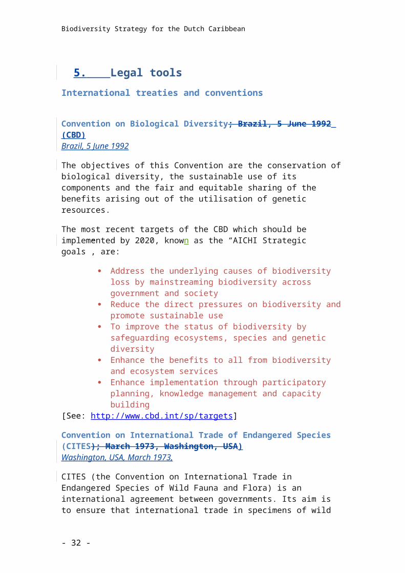
Convention on Biological Diversity; Brazil, 5 June 1992 (CBD)Brazil, 5 June 1992
The objectives of this Convention are the conservation of biological diversity, the sustainable use of its components and the fair and equitable sharing of the benefits arising out of the utilisation of genetic resources.
The most recent targets of the CBD which should be implemented by 2020, known as the “AICHI Strategic goals”, are:
Address the underlying causes of biodiversity loss by mainstreaming biodiversity across government and society
Reduce the direct pressures on biodiversity and promote sustainable use
To improve the status of biodiversity by safeguarding ecosystems, species and genetic diversity
Enhance the benefits to all from biodiversity and ecosystem services Enhance implementation through participatory planning, knowledge
management and capacity building[See: http://www.cbd.int/sp/targets]
Convention on International Trade of Endangered Species (CITES); March 1973, Washington, USA)Washington, USA, March 1973,
CITES (the Convention on International Trade in Endangered Species of Wild Fauna and Flora) is an international agreement between governments. Its aim is to ensure that international trade in specimens of wild animals and plants does not threaten their survival. International trade is regulated via a system of permits.
See Appendix I for specially interationally protected species in the Dutch Caribbean
Convention on Wetlands of International Importance especially as Waterfowl Habitat; (Ramsar Convention(Iran), 2 February 1971)Ramsar, Iran, 2 February 1971
The Convention’s mission is “the conservation and wise use of all wetlands through local and national actions and international cooperation, as a contribution towards achieving sustainable development throughout the world”.
There are currently 10 Ramsar sites in the Dutch Caribbean
- 24 -
Biodiversity Strategy for the Dutch Caribbean
The Convention on the Conservation of Migratory Species of Wild Animals; Bonn, 23 June 1979 (CMS)Bonn, 23 June 1979
The Convention (also known as CMS or Bonn Convention) aims to conserve terrestrial, aquatic and avian migratory species throughout their range. Migratory species threatened with extinction are listed in Appendix I of the Convention.
CMS Parties strive towards strictly protecting these migratory species that need or would significantly benefit from international co-operation are listed in Appendix II of the Convention. For this reason, the Convention encourages the Range States to conclude global or regional Agreements.
See Appendix I for specially internationally protected species in the Dutch Caribbean
The Migratory Shark Memorandum of Understanding (MoU)The Shark Memorandum of Understanding (MoU) has the objective to ensure the conservation and management of migratory sharks and their long-term sustainable use. A number of migratory sharks are included in the MoU for complete protection.
See Appendix I for internationally protected species in the Dutch Caribbean.
Cartagena ConventionThe Cartagena Convention was adopted in Cartagena, Colombia on 24 March 1983 and entered into force on 11 October 1986. The Convention is supplemented by three protocols:
Oil Spill ProtocolThe objective is to strengthen national and regional preparedness to prevent and control major oil spill incidents
Specially Protected Areas and Wildlife Protocol (SPAW)The objective is to protect rare and fragile ecosystems and species.
There are currently three SPAW recognized protected areas in the Dutch Caribbean
Bonaire National Marine Park Saba Bank National Park Quill Boven National Park
Two more areas in the Caribbean Netherlands, as well as one area in St. Maarten and one in Aruba are also eligible for SPAW listing but still need to be submitted:
Saba National Marine Park St. Eustatius National Marine Park Parke Nacional Arikok Man of War Shoal National Marine Park
The SPAW protocol lists species in three annexes, Annex 1 and 2 respectively for
- 25 -
Biodiversity Strategy for the Dutch Caribbean
plants and animals, that require full protection and Annex 3 for plants and animals that need active management to prevent them from becoming endangered.
See Appendix I for specially internationally protected species in the Dutch Caribbean
Land Based Sources and activities Protocol (LBS)The objective is to prevent pollution of the sea from land-based sources.
Inter-American Sea Turtle Convention (IAC) Caracas, Venezuela, 1 December 1 1996.The Convention aims to promote the protection, conservation and recovery of sea turtle populations and of the habitats on which they depend.
International Whaling Convention (IWRC), Washington DC, December 2, 1946Washington DC, December 2, 1946
The Convention aims to promote the conservation of whale stocks and the sustainable development of the whaling industry.
UNESCO World Heritage Convention, Paris, 23 November 1972.Paris, 23 November 1972
The United Nations Educational, Scientific and Cultural Organization (UNESCO) seeks to encourage the identification, protection and preservation of cultural and natural heritage around the world considered to be of outstanding value to humanity.
There is currently one cultural World Heritage site in the Dutch Caribbean: Historic area of Willemstad, Curacao
Two further sites are on the tentative list for nomination: Bonaire National Marine Park (natural site) Plantations in West Curacao (cultural site)
National Policy and legislation
Nature Policy Plan The Caribbean Netherlands 2013-2017The Nature Policy Plan 2013-2017 provides a framework for sound management and the wise use of nature in the Caribbean Netherlands. The Plan’s objective is to ensure that nature on the Caribbean islands is used in a sustainable way so that the island’s ecosystems and ecosystem services can be preserved.
National and Policy Plans and Oordinances
Nature Conservation Framework Act BES
The requirements of the international treaties and conventions, such as the CITES Convention, RAMSAR Convention, Bonn Convention (or the Convention of Biological Diversity), the Inter American Convention for the Protection and Conservation of Sea Turtles, Cartagena Convention and the SPAW ProtocolSPAW protocol under the Cartagena Convention, to which the Kingdom of
- 26 -
Biodiversity Strategy for the Dutch Caribbean
the Netherlands is signatory are anchored in the Nature Conservation Framework Act BES [Wet grondslagen natuurbeheer en -bescherming BES].
The National Government supervises the management of nature on the islands to ensure the proper protection of species and areas and can assist the islands’ governing bodies with implementation at their request.
The act implements the stipulations and obligations of the international CITES Convention, RAMSAR Convention, Bonn Convention (or the Convention of Biological Diversity), the Inter American Convention for the Protection and Conservation of Sea Turtles and the SPAW Protocol into legislation for the Caribbean Netherlands.Relevant parts of the Act include:
Nature Policy Plan Caribbean Netherlands
The Ministry EZ writes a Nature Policy Plan (NPP) every five years in close cooperation with the Island Governments
The Nature Policy Plan sets the framework for nature policy on the Caribbean Netherlands and contains the goals of, as well as an overview of the priorities for, the protection of nature and environment for the following five years
Annual Report to be provided to the Dutch Parliament and Island Governments
RAMSAR
SPAW
Bonn Convention
Minister EZ can instate nature parks in close cooperation with the Island Governments and nominates them with the respective authority
CITES
SPAW
Bonn Convention
The Minister EZ appoints a Control Unit that ensures the compliance of the regulations of the CITES Convention, the SPAW Protocol and the Bonn Convention.
The act states the regulations for the granting of CITES permits for the transport of (parts of) protected animals. The Minister EZ appoints experts to advise the Minister, the Island Governments and the Control Unit on the identification of specimen, species and other occasions concerning nature management and protection
Nature Policy Plan (island)
Island Government develops an Island Nature Policy Plan every five years
Nature Parks The Island Government can instate nature parks and implements the protective measures as required
The Island Government is required to develop regulations for the implementation of obligations emerging from this act. On request of the Island Government, the Minister of Economic Affairs can provide the facilities, resources and assistance needed for the implementation of this act. If the Island Government fails to develop such regulations, the Minister has the authority to do so.
.
By virtue of this act, monitoring and surveillance will be carried out and can lead up to sanctions such as coercive measures or a cease and desist order.
- 27 -
Biodiversity Strategy for the Dutch Caribbean
A Nature Commission will be set up to advise the Minister EZ and the islands’ governing bodies on measures relevant to the implementation of the Nature Conservation Framework Act BES.
Maritime Management Act BESThe Maritime Management Act BES gives the Minister of Infrastructure and Environment (I&M) the responsibility for management of the territorial waters and the Exclusive Economic Zone, concerning swift expedition of marine traffic, safe maritime navigation and protection of the marine environment and provides the possibility to mandate these responsibilities to the Island Governments.
The act also implements the regulations of the UN Maritime Law Convention (maritime order, safety and protection of the environment), the International Regulations for Preventing Collisions at Sea and the International Convention on Oil Pollution Preparedness, Response and Co- operation (OPRC).
Furthermore, a permit system is in place that protects the interests of the marine environment, nature, safety of marine traffic and maritime archaeological heritage. A permit is required for the introduction of structures, objects or other materials in the territorial waters as well as the Exclusive Economic Zone, including intentional pollution, land reclamation or any activities that affect the current state of the sea(bed), including cables and pipelines. For trans shipment and bunkering (ship to ship) also a permit is required. The dumping of waste or deliberate sinking of ships, planes or structures is prohibited under this act. For research, permission is required from the Ministry.
Emergency Response Plans need to be in accordance with the IMO stipulations of the OPRC Treaty and the MARPOL Convention. Emergency Response Plans for the Exclusive Economic Zone are determined by the Minister of I&M and for the territorial waters they are determined by the Island Governor in close cooperation with the Minister of I&M. Oil spills or spills of any other substances need to be reported to the Ministry.
If any of the stipulations stated in this act are infringed, the Minister and/or the Island Governor have the authority to detain ships, shutdown operations or activities and in severe cases coercive measures or a cease and desist order can be used.
The BES Maritime Management Act establishes rules for:- Maintaining order and ensuring safety at sea- Protecting the marine environment and the natural world- Protecting the maritime archaeological heritage- Ensuring compliance with international regulations and treaties
This Act is based in part on various international treaties and regulations, such as the United Nations Convention on the Law of the Sea and is administered from the Netherlands by Rijkswaterstaat (which falls under the Dutch Ministry of Infrastructure and the Environment)
Fisheries Act BES
By virtue of the Authorisation Act for the Establishment of a Fisheries Zone [Machtigingswet instelling visserijzone] of 1977 a fisheries zone has been established covering the territorial waters and the Exclusive Economic Zone, now also covering the waters of the Caribbean Netherlands.
Small-scale fishing within the territorial waters of Bonaire, Saba and St. Eustatius is not regulated up to a certain size. Any larger scale fishing activities are regulated in the Fisheries Act BES. The Minister of Economic Affairs is responsible for establishing a Fisheries Commission that is concerned with permits, the equipment that is allowed to be used and the fish species that are allowed to be caught. The Commission will act as the executive office of the Ministry. Dispensation can be offered
- 28 -
Biodiversity Strategy for the Dutch Caribbean
for scientific research. If deemed necessary, the Minister can declare a prohibition concerning all or certain fishing activities for a certain amount of time.
Public housing, spatial planning and environmental protection Act BES
The Ministry of Infrastructure and Environment (I&M) is responsible for developing an Environmental Policy Plan (EPP) once every five years in consultation with the Island Government and in accordance with the Nature Policy Plan, the Island Nature Policy Plans, the Spatial Development plans and the Basel Convention on the Control of Transboundary Movements of Hazardous Wastes and Their Disposal.
The EPP sets the framework for the islands’ annual environmental programmes, which contain actions to protect the environment, actions to prevent and/or contain of the production and management of waste, actions to manage sewage water, a summary of incidents and a financial prospect. The Island Governments are also required to develop Island EPPs, which should contain the principles, objectives and priorities of the environmental policy that is to be followed.
The act administers the protection of the environment through prevention and/or containment of the production and management of waste and sewage, recycling of waste products and prohibition of dumping waste materials on land (dumping at sea is covered by the Maritime Management Act BES).
The act contains building guidelines and a building permit system, the option for a building ordinance, a housing ordinance, a waste product ordinance containing regulations on waste collection and treatment, and prevention and cleaning of litter, and a sewage water ordinance for the collection and treatment of sewage water and the prohibition of dumping sewage water.
On each of these ordinances the Minister of I&M has to be consulted and if deemed necessary the Minister has the authority to intervene.
Furthermore, the act contains a section on Environmental Impact Assessments (EIA) both for the application of single permit and for larger scale plans.
Dutch National Policy Strategy applies to the entire Kingdom of the Netherlands, both its terrestrial areas and waters including the Dutch Caribbean islands of Bonaire, Saba and St Eustatius and their Exclusive Economic Zone.
Spatial Development Planning Framework Act BES [Wet grondslagen ruimtelijke ontwikkelingsplanning BES]
The act prescribes a national policy for a period of 10 years for the sustainable development of the Caribbean Netherlands. In order to do so, the Minister of Infrastructure and Environment (I&M) consults with the Island Governments of the Caribbean Netherlands and can have research done by a Planning Agency.
The policy aims for:• a sustainable balance between available area and the development to anticipate population
increase• spatial conditions that preserve a healthy environment by safeguarding areas for nature and
recreation in accordance with the population increase as well as the preservation of clean water, earth and air
• availability of residential areas and the accompanying social and cultural facilities to go hand in hand with population increase and the implementation of development projects
• measures to be taken for the modification of existing residential areas to new developments and to improve poor living conditions
- 29 -
Biodiversity Strategy for the Dutch Caribbean
These goals are to be fixed in a development programme in close consultation with the Island Governments.
The development programme states the desired long-term economic, socio-cultural development, as long as it is in compliance with the future spatial development and sets the framework for multi-year programmes and other implementation projects.
Island Governments are to develop long-term development plans in accordance with the national development programme.
A Coordination Commission Development Planning will be instated that aims to stimulate the coherence and focus of the national policy for the development of the Caribbean Netherlands within the spatial development framework. The Commission consists, among others, of representatives of the islands.
Island Ordinances
- 30 -
Biodiversity Strategy for the Dutch Caribbean
6. Key elements of biodiversity conservation
The key elements within the Biodiversity Strategy are: Biodiversity monitoring Nature management
o Habitat (s.l.) managemento Species managemento Genetic resources
Mainstreamingo Participation/Human useo Communication and valueo Social integration
(NOTE: Habitat management includes protected as well as non-protected area management)
The development and implementation of a biodiversity monitoring strategy is the key to informed decision making.
Protected Area ManagementThe establishment and active management of at least one marine and one land park, large enough to have biological integrity, on each island has long been considered the keystone to biodiversity conservation in the Dutch Caribbean.
The designation and protection of nature areas is the prerogative of each island’s governing body.
Successful management requires: Clearly defined goals and objectives Management driven research and monitoring Active communication, education and awareness programmes Legal and policy support Engagement and support from the local community
Internationally protected areas
UNESCO World Heritage sitesThere is currently one cultural World Heritage site in the Dutch Caribbean:
Historic area of Willemstad, Curacao (cultural site)
Two further sites are on the tentative list for nomination: Bonaire National Marine Park (natural site)
- 31 -
Biodiversity Strategy for the Dutch Caribbean
Plantations in West Curacao (cultural site)
Ramsar sitesThere are currently 10 Ramsar sites in the Dutch Caribbean:
Management of these areas is the responsibility of the local island governments who can request assistance from the National Government if necessary particularly for the evaluation and management of these sites.
SPAW areasThere are currently three SPAW recognized protected areas in the Dutch Caribbean
Bonaire National Marine Park Saba Bank National Park Quill Boven National Park
Management of these areas is the responsibility of the local island governments.
Nationally protected areas
Exclusive Economic ZoneThe borders for the Exclusive Economic zone for the Dutch Caribbean were established in June 2010. The area is managed by an EEZ Committee, which
Aruba Spaans Lagoen # 198
Bonaire Pekelmeer # 200
Lac # 199
Klein Bonaire # 201
Salina Slagbaai # 203
Gotomeer # 202
Curaçao Malpais/Sint Michiel. # 2117
Muizenberg # 2118
Northwest Curaçao # 2119
Rif-Sint Marie # 2120
- 32 -
Biodiversity Strategy for the Dutch Caribbean
includes representation from Bonaire, Curacao, Saba and St Eustatius. The Committee oversees the implementation of an EEZ management plan.
Marine Mammal and Shark Sanctuary ReserveIt is the intention to designate the Dutch Caribbean EEZ as a Marine Mammal and Shark Sanctuary.
National ParksThe following National Parks have been designated in the Dutch Caribbean:
Parke Nacional Arikok, Aruba Bonaire National Marine Park Saba National Marine Park Saba Bank National Park Quill Boven National Park St. Eustatius National Marine Park Man of War Shoal National Marine Park
The management of these National Parks is the responsibility of the local islands governments and management is a based on a Management Plan.
Locally protected areasNature conservation is nothing new to the Dutch Caribbean. The first terrestrial protected area, or “park” in the Dutch Caribbean, was established over 40 years ago on Bonaire on the 9th of May 1969 and was followed in 1978 with the Christoffel Park on Curaçao and in 1979 by the creation of the first marine park in the Dutch Caribbean, the now famous Bonaire National Marine Park. Other islands quickly followed suit and the goal is to create at least one terrestrial and one marine park on each island in order to optimally protect and preserve the island’s natural heritage whilst allowing for wise and sustainable use of these resources, particularly by tourism.
Locally protected areas are the responsibility of the local island governments. Common constraints on Dutch Caribbean parks include limited and at times unreliable government support, lack of funding and poor/unregulated spatial planning. The main threats include development pressure, particularly in the coastal zone, invasive species and overuse such as overgrazing by free roaming goats, sheep, cattle and donkeys. There are entrenched local issues over land tenure and persistent over harvesting of marine resources such as grouper, lobster and conch.
Each of the parks within the Dutch Caribbean is managed by a not-for-profit nongovernmental organisation under contract with the island government:
TABLE [overview of parks and management bodies]
- 33 -
Biodiversity Strategy for the Dutch Caribbean
Day to day management Day to day management tasks of the locally protected areas include:
AdministrationThis includes organising an office, correspondence, filing, bookkeeping, accounting, organising invoices and payments. It also includes work planning and developing work schedules for staff, some project management, collecting and administering admission fees and the sale of souvenir items and similar.
Financial administrationManagement will also be responsible for planning, budgeting, routine reporting, as well as all aspects of personnel management. Income related activities including administering government subsidies, admission fee collection, franchises, concessions and similar, grant funding, organising and purchasing souvenir items. Additionally Protected areas may run ‘friends of ...’ groups, actively soliciting donations from the public and from corporate sponsors.
Field OperationsThe maintenance of moorings in MPAs, trails and roads in TPAs accounts for a considerable amount of staff time. Other maintenance tasks include running and maintaining buildings vehicles, boats and communications equipment. Patrolling is also a core field tasks that takes up considerable amounts of staff time. Formal patrols often include some other activities such as assisting PA users, maintaining moorings/trails and basic monitoring e.g. inventory.
Research and MonitoringProtected area management organization are all engaged at some level in collecting information on the state of their natural resources and the use of resources. Monitoring programmes, as well as being used to look at changes over time, are frequently run to address specific management issues. Site characterisation is an important part of every protected area management organisation’s dataset and includes physical mapping and biological inventories. Additionally, they run hypothesis-driven scientific research projects to address specific issues such as the impact or control of invasive species or the impact of user groups on a resource. Damage assessment, evaluation and the effects of restoration work are other possible subjects for research and monitoring work.
Communication and EducationProtected area management organizations are all engaged in multiple activities designed to provide information and to educate islanders, visitors and specific PA user groups. Generally, these are formulated in a communication plan and will include developing programmes for targeted
- 34 -
Biodiversity Strategy for the Dutch Caribbean
audiences to increase knowledge about the PA, change behaviour and/or build stewardship. Some PAs have visitor centres or a museum with information on their protected area. Most provide guided tours, dives and hikes, have signage and outreach materials, including posters, brochures and leaflets (often in multiple languages). Protected area management organisations actively engage their local media through published material, television and radio. In addition to snorkel programmes some have structured Junior Ranger programmes, school programmes and courses for local teachers. All have websites and most have some form of regular newsletter or weblog. Communication refers to the passive supply of information to an audience and the active dissemination of information; education refers to formal training.
Policy and law EnforcementLocal and international legislation forms the basis for the legal protection of the PA and enforcement of conventions, laws, rules and regulations are a core task of every protected area. Managers and their staff are engaged in interpreting the legislation for all user groups, providing guidance and advice as well as actually enforcing the law by issuing verbal and written warnings, giving summary fines and writing up offences. Other legal mechanisms such as forming rules, publishing guidelines, permitting and issuing exemptions are useful tools to control and regulate activities in PAs. Protected area management organisations are frequently involved in the permitting processes not only for activities with the protected area but also in adjacent buffer areas. Protected area management organisations also provide emergency response and are involved in identifying and developing appropriate response scenarios for high-risk threats and site damage assessment.
RepresentationAll Protected area management organisations are represented at DCNA Board meetings; additionally many attend international events such as conferences and symposia in other countries around the world. Staff spend significant also amounts of time representing Protected area management organisations at training courses that are held by other local, regional and international organisations.
Working with StakeholdersProtected area management organisations work with decision makers to integrate management priorities into island and national planning, give advice, petition government and are frequently represented on government advisory boards. Protected area management organisations engage other stakeholder groups through a process of collaboration, providing training, information and advice. Partnerships are built and nurtured with other organisations such as
- 35 -
Biodiversity Strategy for the Dutch Caribbean
research institutions, conservation organisations and funders both on island and abroad to strengthen the PA and to gain access to resources and expertise. Some Protected area management organisations have structured or informal volunteer groups with whom they work on a regular basis.
Management PlansThe following management plans have been developed:
Status Review duePark Nacional Arikok Under developmentWashington Slagbaai National Park Out of date, new
plan under development
Bonaire National Marine Park 2006 PastChristoffel Park NoneCuraçao Underwater Park NoneSaba Terrestrial Park Out of dateSaba National Marine Park Out of dateSaba Bank National Park 2008 PastQuill Boven National Park NoneSt. Eustatius National Marine Park 2007 PastEmilio Wilson Estate 2009Man OWar Shoals Marine Park 2007 Past
Species ManagementOf all the known species occurring in the Dutch Caribbean, 51 are on the IUCN Red List of threatened species as ‘critically endangered’, ‘endangered’ or ‘vulnerable’. This list is generally recognised as the most extensive and objective approach to the evaluation of the protection status of plants and animal species based on strict scientific criteria.
Internationally protected species
Species that occur in more than one country and are under threat globally are protected by international agreements such as CITES (Convention on International Trade in Endangered Species), the Inter-American Convention for the Protection and Conservation of Marine Turtles (IAS), the Convention on the Conservation of Migratory Species (CMS) and the regional SPAW protocol concerning Specially Protected Areas and Wildlife. The species named in these international agreements must be protected, usually according to specific measures, as stated in the corresponding convention. Appendix 2 contains a list of the internationally protected species that occur on the islands of the Dutch Caribbean, their status on the IUCN Red List and their specific protection status on the basis of the various conventions.
Priority species
Red List speciesOf all the species occurring on the islands, 51 appear on the IUCN Red List of threatened species as ‘critically endangered (CR), ‘endangered (EN) or ‘vulnerable’
- 36 -
Biodiversity Strategy for the Dutch Caribbean
(VU). This list is generally recognised as the most extensive and objective global approach to the evaluation of the protection status of plant and animal species, on the basis of strict scientific criteria. It forms the basis for identifying the species that require protection, both locally and internationally, when species occur in more than one country.
Locally endemic and endangered species
The islands’ Red ListsSome species that are not considered to be threatened elsewhere, could be under threat locally on one of the islands. Each island must identify these species and decide on protective measures and so make an island specific Red List. It is necessary to identify these species to effectively protect the island’s biodiversity. If necessary the Minister will support the formulation of island specific Red Lists.
Species Management Plans have been developed in 2012 for the Audubon’s Shearwater, Red-billed Tropicbird and Yellow-shouldered Amazon.
Genetic Resources
- 37 -
Biodiversity Strategy for the Dutch Caribbean
7. Biodiversity Monitoring Strategy
Background The Nature Policy Plan Caribbean Netherlands acknowledges research and monitoring as essential components for the management of protected areas. Species protected by international agreement have to be locally protected, monitored and reported on. Monitoring also provides information relevant for management, provides insight in the biodiversity, the functioning of ecosystems, the success of management actions, and the socio-economic relationships between man and nature. The monitoring focus should be chosen based on the main threats impacting nature on the islands. One of the actions listed in the nature policy plan is the development and implementation of a Biodiversity Monitoring Strategy, including an appropriate governance system, involvement of stakeholders and outreach for the Caribbean Netherlands. This resulted in the document before you. It is the result of a consultation process with the relevant island government departments of Bonaire, St. Eustatius and Saba, the protected area (park) management organizations and other nature conservation organizations of the islands, and the Ministry of EZ. Various scientific experts also provided input. Through DCNA it was also possible to involve the park management organizations of Aruba, Curaçao, and St. Maarten.
Information on biodiversity, human impact, and natural changes on the Islands is currently piecemeal and not always adequate to the requirements of effective safeguarding of biodiversity. Although monitoring has been conducted for many years by many entities, the resulting information tends not to be widely available or coordinated and there are significant gaps in what has been monitored. A strategic approach to biodiversity monitoring is needed to set priorities, fill in information gaps, support monitoring efforts, and establish readily-accessible, centralised data storage, all of which are essential to successfully manage and conserve Islands biodiversity in the face of human pressures and inevitable changes.
InitiativeFollowing the constitutional change of October 10, 2010, the BES Islands became special municipalities of the Netherlands. As a result, the Netherlands has acquired new responsibilities regarding conservation of the rich biodiversity in and around the islands. These responsibilities relate to national obligations for biodiversity conservation and international commitments resulting from treaties and conventions to which the Netherlands is a signatory. Although such responsibilities are formally relegated to the island governments through the Nature Conservation Framework Act BES, the National Government will be held accountable for compliance with the international commitments. Consequently it is important for the Netherlands to work together with the islands on this.
The initiative for this Biodiversity Monitoring Strategy stems from these obligations and commitments and intersects with already-existing monitoring efforts primarily
- 38 -
Biodiversity Strategy for the Dutch Caribbean
carried out by non-governmental conservation organizations, and the government mandated park management organizations,as well as with a strategic monitoring initiative of the Dutch Caribbean Nature Alliance.
PurposeThe purpose of this Biodiversity Monitoring Strategy is to make a significant contribution towards safeguarding biodiversity in the Dutch Caribbean
GoalsThe goals of the Biodiversity Monitoring Strategy are to:
1. Facilitate and support biodiversity conservation management, resource management for sustainable development, and decision-making for sustainable development
2. Provide relevant and timely information to stakeholders on biodiversity in the Dutch Caribbean
3. Contribute to regional and global biodiversity status and trend data by meeting international and national biodiversity conservation reporting obligations
4. Guide policy, regulation and enforcement5. Build awareness and support for biodiversity conservation action among the
BES Islands communities, the Kingdom of the Netherlands and regional and global bodies
The program will enhance the network of expert monitoring groups on the islands to produce a coordinated body of baseline and monitoring data. The scope of data will provide information on the status and trends of the islands biodiversity, as well as the natural and anthropogenic stressors that drive those trends. The program will facilitate effective analysis and accessible data storage to improve our ability to detect significant trends within a reasonable time frame. The program will use the resulting information to communicate the significance of the data to appropriate stakeholders in order to further biodiversity conservation in the BES Islands.
Baseline – monitoring - researchSuccessful biodiversity conservation management requires a combination of information resources, which can be broadly categorized as:
- Baseline data: information on resource status- Monitoring: ongoing evaluation of trends over time- Research: aimed at answering specific questions about biodiversity
- 39 -
Biodiversity Strategy for the Dutch Caribbean
Baseline data: In many cases baseline information is all that is needed to effectively inform conservation management and to ensure that conservation goals are being met. Collecting baseline data is a one time event with periodic reviews to verify the status of the resource. Monitoring: It is essential to study and evaluate how biodiversity is changing over time, such as to assess:
- Effects of resource use- Effectiveness of management interventions- Population or ecosystem trends and natural variability- Impacts of development- Status of endemic, threatened, endangered, keystone or critical species- Monitoring needs to be ongoing, it needs to be carried out at regular time
intervals, normally over long time periods to inform conservation management and drive biodiversity conservation decision-making.
Monitoring needs to be ongoing, it needs to be carried out at regular time intervals, normally over long time periods to inform conservation management and drive biodiversity conservation decision-making. Research: Research projects are effective means of answering specific questions affecting conservation and should be carefully formulated to ensure that they support biodiversity conservation management. Research is a one -time event and is normally of one to three yearthough it durationmay last several or even many years.
- 40 -
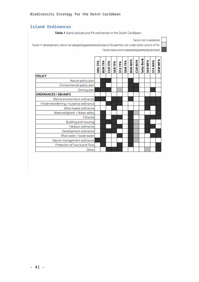
Biodiversity Strategy for the Dutch Caribbean
GovernanceThe Biodiversity Monitoring Committee oversees the implementation of the Biodiversity Monitioring Strategy
Membership Role Tasks
Bonaire, Saba, and St. Eustatius Island Platform representatives
MinEZ representative
DCNA representative
[observers: Aruba, Curaçao, St. Maarten]
Supervisory and co-ordinatory
Agreement on yearly program Oversight/coordination of program implementation
Evaluate and set priorities
Resource acquisition and allocation
Facilitate and support island platforms
identify/engage expertise for specific advice
Liaise with relevant international/regional organizations
Review and submit reports
The Monitoring Committee is responsible for Co-ordinating the implementation of the biodiversity monitoring programme Liaising with relevant international bodies such as ICRI, GCRMN, SCSCB, SCCN and
ECCN Agreeing annual monitoring programmes and setting programme objectives Communicate with Nature Commission Optimizing communication between stakeholders, advisors and all parties
involved in biodiversity monitoring in the Dutch Caribbean Organising regular (annual) meetings Identify/engage necessary (scientific) expertise on a case by case basis With the use of external expertise reviewing and evaluating monitoring priorities,
protocols, resources, knowledge gaps, etc. Providing support to Island Platforms to ensure they are able to achieve their
monitoring objectives Improving the capacity for biodiversity monitoring in the Dutch Caribbean Set policy and oversee database management Agree on communication strategy and oversee its implementation Issuing regular programme reports
- 41 -
Biodiversity Strategy for the Dutch Caribbean
Technical Database Management
Membership Role Tasks
IMARES
?
?
?
Implementation Data input
Data analysis
Data access
Report generation
Biodiversity monitoring principlesMonitoring of biodiversity is an essential tool on three levels. It can guide management action to ensure the sustainability of resource use when it provides data on threats/impacts from human interactions or changing environmental conditions. It is also essential to assess and evaluate the effectiveness of biodiversity conservation management and interventions. Finally it is required to report on the status of particular species and ecosystems to Dutch Parliament as well as in fulfillment of regional and international biodiversity conservation agreements.
The responsibility for effective monitoring lies firstly with the island governments (or the national government in the EEZ), secondly with the organizations that have a mandate of the island government, and finally with the National government as dictated by international agreements.
In order to fulfill its purpose, monitoring must be structural and standardized. Efficient and effective monitoring should be based on widely accepted standards to enable inter-island, regional or global comparisons. Monitoring activities of various kinds are ongoing throughout the Dutch Caribbean islands, and any future or supplementary monitoring activities should be built on these as much as possible. Historical as well as recent data sets need to be identified and reviewed in order to establish solid baselines to compare future data against.
Monitoring ++Monitoring activities of various kinds are ongoing in the BES islands and throughout the Dutch Caribbean, and any future or supplementary monitoring activities should be built on these. Historical as well as recent data sets need to be identified and reviewed in order to establish solid baselines to compare future data against and in some cases new baseline data need to be collected.
- 42 -
Biodiversity Strategy for the Dutch Caribbean
SustainabilityIt is essential that monitoring programmes are sustainable at the islands level. Solutions should be sought to ensure that monitoring can be continued for as long as is necessary such as by providing on-going funding, external support and/or setting up monitoring “swat teams” to collect data. Provision must be made for training as well as periodic retraining in monitoring protocols. Monitoring programmes must be appropriate and ‘do-able’.
Standard protocolsTo be effective biodiversity monitoring must be structured and standardized. Efficient and effective monitoring should be based on widely accepted standards to enable the Dutch Caribbean to contribute to inter-island, regional or global data. For this reason standard monitoring protocols should be adopted and applied throughout the Dutch Caribbean.
Centralized data storageTo optimize the efficiency and effectiveness of monitoring of biodiversity, good coordination and good accessibility of data are essential. Monitoring can only be effective if data are stored, and back-up, in a useful way. This is the basis for analysis and generation of regular reports and prioritization evaluation. Robust mechanisms need to be in place to ensure this. Coordination not only within the BES islands but also with the other Dutch Caribbean islands and Dutch reporting agencies should be sought and supported where possible. A network of monitoring partners, both on island, between islands and with partners in the Netherlands, will be set up to achieve this. Cooperation with regional efforts should also be the aim.
Open accessCentralized data storage is based on the principle of open and transparent access for stakeholders.
AdaptiveStrategic monitoring must feedback to management action in order to optimize its effect. This is achieved through monitoring results of conservation action and then updating knowledge bases and adjusting future action. Monitoring activities themselves should be reviewed regularly and updated to reflect results and identified trends.
Setting monitoring prioritiesThe reality of the BES islands being of small scale and insufficient capacity dictates that efforts must be limited. This can be somewhat ameliorated by bringing in outside expertise and by working together, but funding to do this is also limited. It follows that priorities for monitoring must be set in order to ensure that the limited capacity and funding is used to best effect.
- 43 -
Biodiversity Strategy for the Dutch Caribbean
Communicating resultsA core component of the Monitoring Strategy needs to be the development of a communication plan to deliver the results of on-going monitoring back to stakeholders.
Centralized data storage In order for any monitoring strategy to be successful it needs to address the following core elements:
- Data collection- Data storage- Data access- Data Analysis and Interpretation- Data re-prioritization- Data communication
Data collectionThe program will coordinate and support the development of a network of expert monitoring groups on the islands, which will use standard protocols to collect a body of baseline and monitoring data. This data will provide information on the status and trends of islands biodiversity, as well as natural and anthropogenic stressors, which drive those trends. The program will facilitate effective data analysis.
Data storageTo optimize the efficiency and effectiveness of monitoring of biodiversity, good coordination and good accessibility of data are essential, both within the Caribbean Netherlands as within the whole of the Dutch Caribbean. This program will need a centralized open-access database with data stored in a useful way, including sampling protocols, good metadata, and extraction of data in several formats. The Dutch Caribbean Biodiversity Database will provide the information necessary for analysis and generation of regular reports. Robust mechanisms need to be in place to ensure this. Inclusion of the other Dutch Caribbean islands will be sought through DCNA.
Data accessOpen access to biodiversity information improves our ability to detect significant trends within a reasonable time frame. Biodiversity monitoring information of the Caribbean Netherlands (and other Dutch Caribbean islands) will be stored in a centrally managed, open-access database with transparent access for conservation practitioners, policy makers and all other stakeholders.
- 44 -
Biodiversity Strategy for the Dutch Caribbean
Data Analysis and InterpretationData patterns, trends and relationships should be assessed and underlie subsequent management recommendations. In many instances these data may only require descriptive analyses rather than detailed and statistically significant relationships. In the latter case, it should be important to distinguish between statistical findings and biological relevance. To this end, an a priori list of thresholds and biological significance should be established against which the data may be evaluated.
Data Re-prioritizationData findings may require a re-evaluation of monitoring prioritizations so that a continual loop-feedback mechanism informs subsequent data collection, analysis and subsequent biodiversity management.
Data CommunicationEffective monitoring is the foundation of responsive decision-making: however, unless the right information is reported in the right formats to the right audiences, the results of such monitoring are lost. Therefore, a core component of the Biodiversity Monitoring Plan for the Caribbean Netherlands will be the development of a communications strategy that will identify key audiences for biodiversity information and develop approaches to reach these audiences.
Prioritizing monitoring activitiesBoth available capacity and funding limit the amount of monitoring that is feasible. Also, not all monitoring is equally necessary or useful. Consequently, choices need to be made as to what monitoring is most needed and what can be realized with the available means. In order to make such a selection the following questions were asked:
1. Does it support current biodiversity conservation management or sustainable resource use or development needs?
2. Does it help to evaluate the effectiveness of biodiversity conservation interventions or the sustainability of resource use strategies?
3. Does it address current threats or impacts (e.g. effects of climate change, coastal development)?
4. Does it address globally or regionally important species or ecosystems?5. Does it address national or locally important species and ecosystems (e.g.
key/indicator species/critical habitats/endangered endemics)?6. Does it address communication and awareness needs?7. Is it sustainable (i.e. are there sufficient resources to maintain it in the long
term)?8. Does it build on existing monitoring activities (if a monitoring activity
complies with (one or more of) the previous criteria and continues an existing program it should be chosen above an activity that does not)?
Once potential monitoring topics were identified they were categorized by habitat, species or management and ranked based on the following criteria:
- 45 -
Biodiversity Strategy for the Dutch Caribbean
Habitat[1.] Habitats or Species for which there are National/International Obligations1.[2.] Habitats that are functionally critical2.[3.] Habitats at risk, in decline, or rare3.[4.] Habitats important for key species4.[5.] Habitat associated with a significant threat to biodiversity
Species5.[6.] Species for which there are National/International Obligations6. Locally important or restricted range species7. Species exhibiting or thought to have at least 25% decline8. Species that can act as surrogate9. Species indicating significant threat to biodiversity
Management10. Indicator of climate change11. Supporting management needs12. Evaluating management effectiveness13. Addressing threats/impacts
- 46 -
Biodiversity Strategy for the Dutch Caribbean
CommunicationFor the purposes of developing a communication strategy and identifying target audiences with whom to communicate the results of on-going monitoring the following stakeholder groups can be identified:
Government
Community groups
Media organisations
Park stakeholders
Research institutes
Academic institutions
General public
[Target groups, objectives, who communicates what to whom]
ResourcesMonitoring costs money. With a shared responsibility funding will have to come from the various partners involved. The island governments carry primary responsibility for the island’s biodiversity and will need to provide part of the necessary funding. The management of the nature parks has been delegated to the park organizations on each of the islands and consequently the budget available for this management will also need to provide for monitoring that is considered necessary for park management. Where the National government has delegated international obligations for biodiversity conservation to the islands it will also have to provide the necessary means for this including the costs for monitoring of such biodiversity.
- 47 -
Biodiversity Strategy for the Dutch Caribbean
It is recognized that not all costs can be covered by all the partners and ways have to be sought to minimize the costs of monitoring. One way to do this is to prioritize the monitoring needs. Another way of reducing costs is to engage volunteers to help with monitoring. This has the added advantage of bringing civil society into closer interaction with nature, and serves to increase awareness of the need to protect the islands’ biodiversity.
Implementation
- 48 -
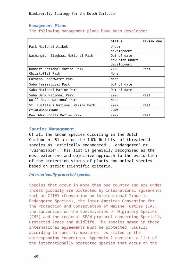
Biodiversity Strategy for the Dutch Caribbean
8.[5.] Action Plan
- 49 -
Biodiversity Strategy for the Dutch Caribbean
9. Appendix
Internationally protected species in the Dutch Caribbean specially protected species list
Common name
IUCN Category
SPAW Annex
CMS Annex
CITES Appendix
PLANTS (15)
All Cactaceae All cacti II
All Orchidaceae All orchids II
Syringodium filiforme (= Cymodocea manitorum) Manatee grass LC 3
Thalassia testudinum Turtlegrass LC 3
Halophila baillonis (= aschersonii) Tapegrass VU 3
Halophila decipiens Tapegrass LC 3
Halophila engelmannii Tapegrass NT 3
Ruppia maritima Wigeongrass LC 3
Rhizophora mangle Red Mangrove LC 3
Avicennia germinans (= nitida) Black Mangrove LC 3
Laguncularia racemosa White Mangrove LC 3
Conocarpus erecta Buttonwood LC 3
Guaiacum officinale Common Lignum Vitae EN 3 II
Guaiacum sanctum Holywood Lignum Vitae EN II
Nectandra krugii Black Sweet Wood EN
Swietenia mahagoni West Indian Mahogany EN
Zanthoxylum flavum West Indian Satinwood VU
CORALS (12)
All Milleporidae All fire corals 3 II
All Stylasteridae All lace corals 3 II
All Antipatharia All black corals 3 II
All Gorgonacea All gorgonians 3
All Scleractinia All hard corals 3 II
Acropora palmata Elkhorn Coral CR 3 II
- 50 -
Biodiversity Strategy for the Dutch Caribbean
Common name
IUCN Category
SPAW Annex
CMS Annex
CITES Appendix
Acropora cervicornis Staghorn Coral CR 3 II
Agaricia lamarcki Lamarck's Sheet Coral VU 3 II
Agaricia tenuifolia Thin Leaf Lettuce Coral NT 3 II
Dendrogyra cylindrus Pillar Coral VU 3 II
Dichocoenia stokesi Elliptical Star Coral VU 3 II
Montastrea franksi Humpy Star Coral VU 3 II
Montastrea annularis Head Star Coral EN 3 II
Montastrea faveolata Boulder Star Coral EN 3 II
Mycetophyllia ferox Rough Cactus Coral VU 3 II
Millepora striata Bladed Box Firecoral VU 3 II
Oculina varicosa Large Ivory Coral VU 3 II
OTHER INVERTEBRATES (3)
Strombus gigas Queen Conch – 3 II
Typhlatya monae Mona Cave Shrimp VU
Panulirus argus Caribbean Spiny Lobster DD 3
FISH (25)
Pristis pectinata Wide Sawfish EN I
Manta birostris Manta Ray NT
Aetobatus narinari Spotted Eagle Ray NT
Rhincodon typus Whale Shark VU 2 II
Alopias vulpinus Thresher Shark VU
Isurus oxyrinchus Shortfin Mako VU 2
Sphyrna mokarran Great Hammerhead Shark EN
Carcharhinus longimanus Oceanic Whitetip Shark VU
Carcharhinus perezi Caribbean Reef Shark NT
Dermatolepis inermis Marble Grouper NT
Epinephelus flavolimbatus Yellowfinned Grouper VU
Epinephelus itajara Goliath Grouper CR
Epinephelus morio Red Grouper NT
Epinephelus niveatus Snowy Grouper/Spotted Grouper VU
Epinephelus striatus Nassau Grouper EN
Balistes vetula Queen Triggerfish VU
- 51 -
Biodiversity Strategy for the Dutch Caribbean
Common name
IUCN Category
SPAW Annex
CMS Annex
CITES Appendix
Lachnolaimus maximus Hogfish VU
Lutjanus analis Mutton Snapper VU
Lutjanus cyanopterus Cubera Snapper VU
Mycteroperca bonaci Black Grouper NT
Mycteroperca interstitialis Yellowmouth Grouper VU
Mycteroperca venenosa Yellowfin Grouper NT
Pagrus pagrus Red Porgy EN
Scarus guacamaia Rainbow Parrotfish VU
Thunnus obesus Bigeye Tuna VU
MAMMALS (27)
Marine mammals (24)
All Cetacaea All cetaceans 2 II
Tursiops truncatus Bottlenose Dolphin LC 2 II
Lagenodelphis hosei Fraser's Dolphin LC 2 II
Delphinus delphis Common Dolphin LC 2 II
Stenella attenuata Pantropical Spotted Dolphin LC 2 II
Stenella frontalis Atlantic Spotted Dolphin DD 2 II
Stenella longirostris Spinner Dolphin DD 2 II
Stenella coeruleoalba Striped Dolphin LC 2 II
Stenella clymene Clymene Dolphin DD 2 II
Grampus griseus Risso's Dolphin/Grey Dolphin LC 2 II
Ziphius cavirostris Cuvier's Whale LC 2 II
Mesoplodon europaeus Gervais's Beaked Whale DD 2 II
Pseudorca crassidens False Killer Whale DD 2 II
Orcinus orca Orca / Killer Whale DD 2 2 II
Kogia breviceps Pygmy Sperm Whale DD 2 II
Kogia simus Dwarf Sperm Whale DD 2 II
Peponocephala electra Melon-headed Whale LC 2 II
Globicephala macrorhynchus Shortfin Pilot Whale DD 2 II
Balaenoptera physalus Fin Whale EN 2 1 I
Balaenoptera borealis Coalfish Whale EN 2 1 I
Balaenoptera edeni Bryde's Whale DD 2 2 I
Balaenoptera musculus Blue Whale EN 2 1 I
- 52 -
Biodiversity Strategy for the Dutch Caribbean
Common name
IUCN Category
SPAW Annex
CMS Annex
CITES Appendix
Megaptera novaeangliae Humpback Whale VU 2 1 I
Physeter macrocephalus Sperm Whale VU 2 1 I
Trichechus manatus West-indian Manatee VU 2 I
Rodents (1)
Calomys hummelincki Hummelinck's Vesper Mouse VU
Bats (2)
Leptonycteris curasoae Lesser Long-nosed Bat VU
Tadarida brasiliensis Mexican Free-tailed Bat LC 2 1
BIRDS (29)
Sarkidiornis melanotos Comb Duck LC 2 II
Buteo albicaudatus White-tailed Hawk LC II
Buteo jamaicensis Red-tailed Hawk LC II
Pandion haliaetus Osprey LC 2 II
Caracara cheriway Northern Caracara LC 2 II
Falco peregrinus Peregrine Falcon LC 2 2 I
Falco sparverius American Kestrel LC 2 II
Falco columbarius Merlin LC 2 II
Tyto alba Barn Owl LC II
Chrysolampis mosquitus Ruby-topaz Hummingbird LC II
Chorostilbon mellisugus Blue-tailed Emerald – II
Eulampis jugularis Purple-throated Carib LC II
Sericotes holocericeus Green-throated Carib – II
Orthorhyncus cristatus Antillean Crested Hummingbird LC II
Cindocerthia ruficauda Brown Trembler LC 2
Aratinga pertinax Brown-throated Conure LC II
Amazona barbadenis Yellow-shouldered Amazon VU 2 I
Charadrius melodus Piping Plover NT 2
Contopus cooperi Olive-sided Flycatcher NT
Dendrocygna arborea West Indian Whistling Duck VU 3 2
Dendrocygna bicolor Fulvous Whistling Duck LC 3 2
Dendroica cerulea Cerulean Warbler VU
Fulica caribaea Caribbean Coot NT
- 53 -
Biodiversity Strategy for the Dutch Caribbean
Common name
IUCN Category
SPAW Annex
CMS Annex
CITES Appendix
Phoenicopterus ruber Flamingo LC 3 2 II
Pterodroma hasitata Black-capped Petrel EN
Puffinus lherminieri Audubon’s Shearwater LC 2
Pelecanus occidentalis Pelican LC 2
Sterna antillarum antillarum Least Tern LC
Sterna dougallii dougallii Roseate Tern LC 2 2
REPTILES (9)
Alsophis rijersmai Leeward Islands Racer EN
Alsophis rufiventrus Red-bellied Racer EN
Iguana delicatissima Lesser Antillean Iguana EN 3 II
Iguana iguana Green Iguana - 3 II
Chelonia mydas Green Turtle EN 2 2 I
Eretmochelys imbricata Hawksbill Turtle CR 2 2 I
Caretta caretta Loggerhead Turtle EN 2 2 I
Lepidochelys olivacea Olive Ridley EN 2 2 I
Dermochelys coriacea Leatherback Turtle CR 2 2 I
INSECTS (1)
Danaus plexippus Monarch Butterfly - 2
Total # species 121
- 54 -
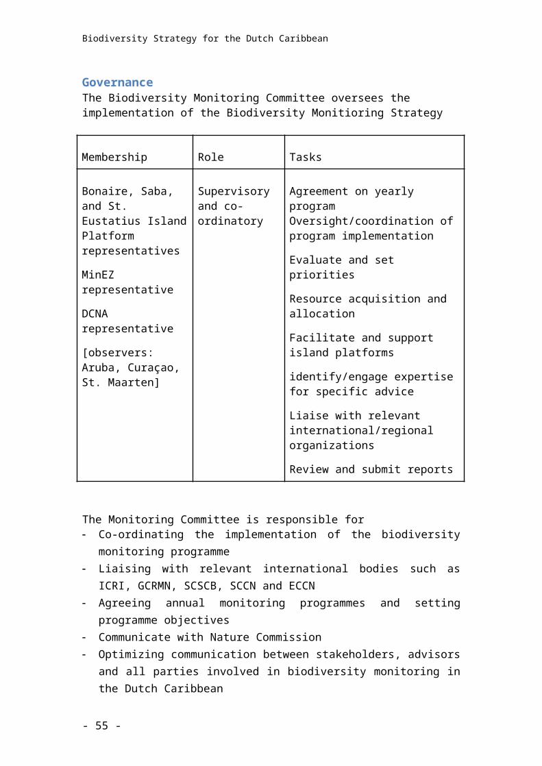
Biodiversity Strategy for the Dutch Caribbean
Definition of Terms
- 55 -
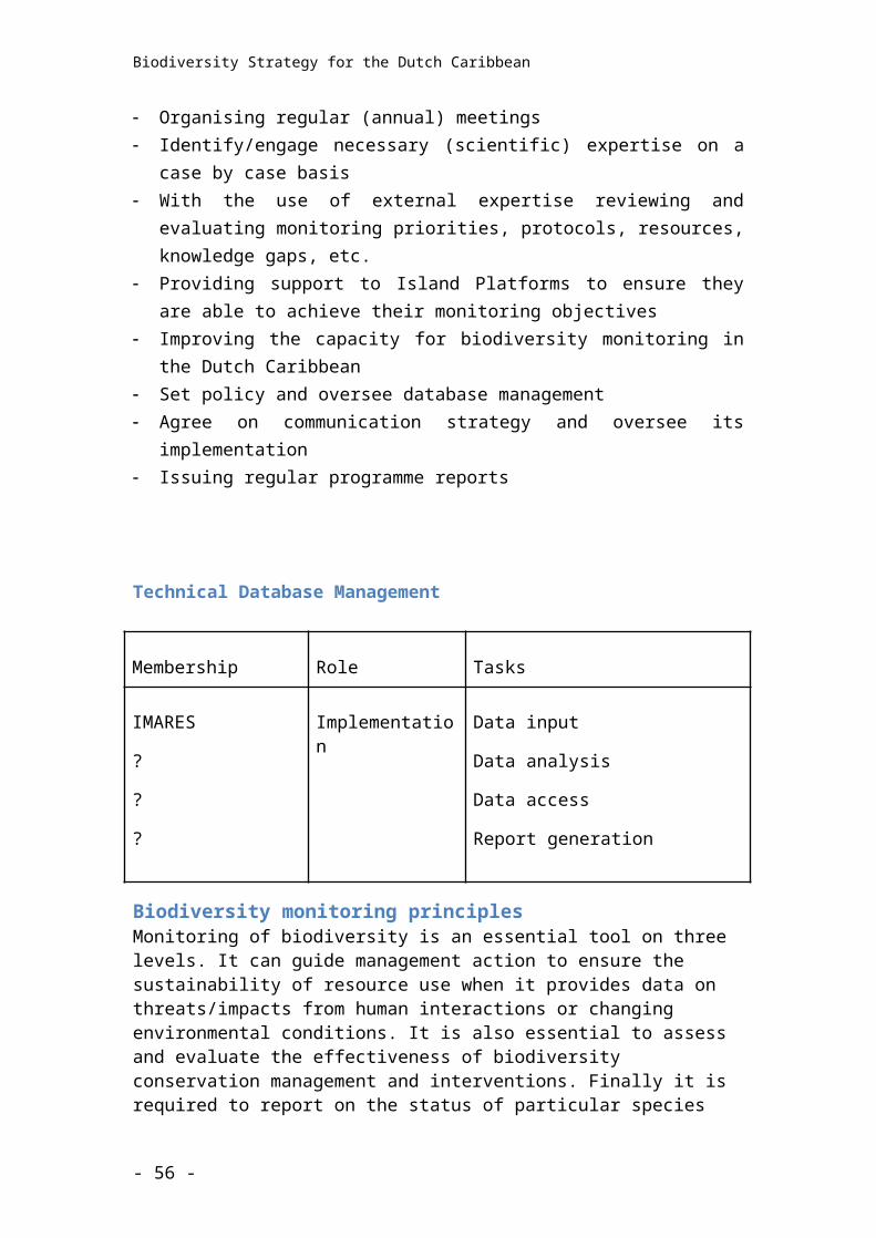
Biodiversity Strategy for the Dutch Caribbean
Baseline data
BES islands
Biodiversity
CARMABI The legally designated protected area management organisation on Curacao
Co-management A system whereby stakeholders are included in the decision making body (Board) of a legally designated protected area management organisation
Conservation management
DCNA Dutch Caribbean Nature Alliance: umbrella organisation supporting and assisting the parks and other conservation organisations in the Dutch Caribbean.
Endangered ecosystem
Endangered species
Endemic species
Indicator species
Issue
Keystone species
Legally designated protected area management organisation
Park management organisation e.g on Bonaire STINAPA Bonaire
Ministry E, L + I
Ministry LNV Ministry of Agriculture
- 56 -
Biodiversity Strategy for the Dutch Caribbean
Monitoring
Nature Foundation The legally designated protected area management organisation on St Maarten
Parke Nacional Arikok The legally designated protected area management organisation on Aruba
RCN Rijks Caribbisch Nederland
Research
Saba Conservation Foundation The legally designated protected area management organisation on Saba
Stakeholder
STENAPA The legally designated protected area management organisation on St Eustatius
STINAPA Bonaire The legally designated protected area management organisation on Bonaire
Threat
- 57 -
Biodiversity Strategy for the Dutch Caribbean
- 58 -
Biodiversity Strategy for the Dutch Caribbean
RAMSAR SITES
ArubaSpaans Lagoen. 23/05/80; Aruba; 70 ha; 12º30’N 070º00’W. Conservation Area. A narrow coastal inlet, fringed by tidal mudflats and mangrove swamps. An important feeding and breeding area for waterbirds, and nursery area for various species of fish and crustaceans. Ramsar site no. 198.
Bonaire
Slagbaai. 23/05/80; Bonaire; 90 ha; 12º16’N 068º25’W. Within a National Park. A shallow, permanent, saline lagoon, isolated from the sea by a bank of beach rock. Brine shrimp and brine flies provide valuable food sources for birds. The lagoon is a resting area for Phalacrocorax olivaceus (max. 50), and a staging area for a variety of Nearctic breeding species. Ramsar site no. 203.
Gotomeer. 23/05/80; Bonaire; 150 ha; 12º14’N 068º22’W. Within a National Park. A shallow, permanent, saline lagoon, isolated from the sea by a beach rock bank. Brine shrimp and brine fly are abundant in the hypersaline areas, providing valuable food sources for birds, including Phoenicopterus ruber ruber (100-500). The site is important for several species of breeding birds and for staging shorebirds which nest in North America. Ramsar site no. 202.
Lac. 23/05/80; Bonaire; 700 ha; 12º06’N 068º14’W. Underwater Park. A shallow bay of dense sea grass, fringed by mangroves and separated from the sea by coral debris and red algae. The mangroves provide shelter for fish and invertebrates and contribute large quantities of organic debris to the bay, creating highly productive waters. An important feeding area for waterbirds and invertebrates, supporting several species of breeding waterbirds. Ramsar site no. 199.
Pekelmeer. 23/05/80; Bonaire; 400 ha; 12º02’N 068º19’W. A shallow seawater lagoon located between a ridge of recrystalized coral debris (beach rock) and a commercial saltworks, linked to the open sea by an artificial channel. Sparsely vegetated, the site provides a flamingo nesting sanctuary and supports one of the most important nesting colonies of Phoenicopterus ruber ruber in the Caribbean (1,000 pairs). It serves as an important feeding area for Pelecanidae, Ardeidae (herons, bitterns, etc.), and various migratory shorebirds which breed in North America. Ramsar site no. 200.
Klein Bonaire Island & adjacent sea. 23/05/80; Bonaire; 600 ha; 12º10’N 068º19’W. Underwater Park. A small uninhabited coral island supporting a sparse cover of shrubs and cacti. Brackish lagoons and fringing coral reefs support a rich marine fauna. The reefs experience heavy diving pressure. Ramsar site no. 201.
Curacao
Malpais/Sint Michiel. 05/02/2013; Curaçao; 1,100 ha; 12°10'N 069°00'W. Important Bird Area. Malpais is a former plantation just to the north of Sint Michiel. There are two freshwater lakes and the hyper-saline St. Michiel lagoon connected to a bay in which coral reefs are found, surrounded by dry deciduous vegetation and a well-developed woodland habitat. The area provides refugee for many birds, such as the IUCN Red Listed Caribbean coot (Fulica caribaea). The lagoon also supports a significant fraction of the global population of the Common tern (Sterna hirundo) and is part of a regional network of foraging sites for the Caribbean flamingo (Phoenicopterus ruber), protected under the Convention of Migratory Species. Freshwater is scarce in Curaçao and therefore of great ecological, social and economic value. The dam of Malpais is located downstream. Freshwater infiltrates into the soil, recharging groundwater reservoirs which allow woodlands to grow in the area. Some of the current threats which may affect the ecological character of the site are the landfill and
- 59 -
Biodiversity Strategy for the Dutch Caribbean
runoff from a pig farm situated only 1km away. Ramsar Site no. 2117. Most recent RIS information: 2013.
Muizenberg. 05/02/2013; Curaçao; 65 ha; 12°09'29"N 068°55'07"W. Important Bird Area; Natural Park. Muizenberg comprises an intermittent shallow lake created by the damming of a stream that drains the surrounding low hills. Periodically inundated grassland and shrubland surround the wetland. A separate small pond, Kaya Fortuna, is situated 200m to the west. This area is internationally significant for its population of the Caribbean coot (Fulica caribaea), near-threatened under the IUCN Red List, and the Caribbean flamingo (Phoenicopterus ruber) conserved under the Convention of Migratory Species, but it also supports many other waterbirds, both residents and migrants. The Muizenberg dam was built by Shell Curaçao in 1915 to collect freshwater for industrial cooling purposes; with a capacity of 650,000 m3, it represents the largest freshwater reservoir on the island. The area was designated as a Natural Park for the improvement of the urban living conditions of the nearby population and is mainly used by hikers for recreational purposes. Illegal dumping of garbage, pollution, drainage of surrounding wetlands, and recreational disturbance are seen as the main potential threats. A general environmental education programme is being implemented. Ramsar Site no. 2118. Most recent RIS information: 2013.
Northwest Curaçao. 05/02/2013; Curaçao; 2,441 ha; 12°21'11"N 069°05'00"W. Important Bird Area, Natural Parks. The area comprises a great variety of ecosystems such as coral reefs, coastal lagoons with sea grass beds and mangroves, coastal limestone terraces, inland hills supporting evergreen woodland, freshwater dams, natural springs and dry deciduous shrublands. The Ramsar site includes parts of Shete Boka and Christoffel Natural Parks. The wetland covers approximately 20 km of the rocky, wave-exposed north coast of Curaçao, including 10 pocket beaches (bokas) and 3 inland bays that are used as nesting and foraging sites for threatened sea turtle species as Dermochelys coriacea and Eretmochely imbricata. There is also a breeding colony of more than 500 individuals of Least Tern. Moreover, the northwestern coast of Curaçao locally harbours a fringing coral reef, characterized by more than 50% coral cover and the presence of such critically endangered coral species as Acropora palmata and Acropora cervicornis as well as endangered fish species like the Epinephelus itajara. Some of the caves in the area were used for spiritual rituals in the past, and Indian drawings can be found estimated to be more than 5,000 years old. Numerous manmade dams in the area retain freshwater for several months after the wet season has passed. Subterraneous groundwater reservoirs in turn sustain local vegetation types year-round which are used by several bird species, pollinating bats and mammals to survive during Curaçao's dry season. Ramsar Site no. 2119. Most Recent RIS information: 2013.
Rif-Sint Marie. 05/02/2013. Curaçao; 667 ha; 12°12'16"N 069°03'16"W. Conservation Area, Important Bird Area. The area of Rif-Sint Marie is relatively undisturbed and undeveloped and comprises a salt mash surrounded by mud flats, shrub land, and forests. The marsh is a strategic feeding habitat for flamingos and several waterbirds. The coral reef of Rif-Sint Marie is well developed and shelters several threatened coral species such as Acropora palmata and Acropora cervicornis, as well as such endangered turtle species as Dermochelys coriacea and Eretmochely imbrica and threatened fishes like Goliath grouper Epinephelus itajara. Dense thickets of Elkhorn coral sustain major ecological processes such as gross community calcification and nitrogen fixation; dense populations of this branching species dissipate wave energy and thus protect the coast. The area is currently used for recreational purposes like hiking, biking and guided eco-tours. The major threats to the site are uncontrolled access of visitors with dogs disturbing flamingos and potentially unwise development of touristic infrastructures in the surrounding area. Ramsar Site no. 2120. Most recent RIS information: 2013.
- 60 -
Biodiversity Strategy for the Dutch Caribbean
Protected Areas: site description and value statements
Aruba
Parke Nacional ArikokParke Naçional Arikok was established in 2000 to protect a terrestrial area of 3,400 hectares (8,400 acres) including desert/shrub, dry forest, sand dunes and sandy shores. The protected area has extensive cave systems that contain freshwater environments as well as culturally valuable pre-Colombian paintings and sites. The area and shoreline is a home, migratory stopover and breeding site for 56 IUCN Red List species, eight CITES Appendix I species and 237 CITES Appendix II species as well as the endemic ‘Cascabel’ or Aruba Island Rattlesnake. Parke Naçional Arikok attracts many local and international visitors every year and helps contribute to the income of the island’s population employed in restaurants, hotels and other services.
The protected area is located in the east of Aruba with most of the hilliest parts of the island located within the park's boundaries, including Aruba's highest hill, Mt. Jamanota (188 metres). The protected area is unofficially divided into four zones (these zones have yet to be ratified by the government):
The northern and southern areas are highly sensitive areas and have controlled access. Cars are not permitted to enter the southern zone and any other activities that may cause disturbance are banned. The northern zone is accessible to motorized vehicles under controlled conditions.
The middle area is a multi-use zone for human activity. It incorporates the main road (a loop) for cars, which leads to a number of cultural and historical landmarks as well as the protected area’s main natural points of interest (Dos Playa, Boca Druif).
The "transition zone" is located on the outskirts of the three other zones. It aims to provide a buffer zone that offers some control on any development within one kilometre of the protected area’s boundaries.
Value statementParke Naçional Arikok was established in 2000 to protect a terrestrial area of 34.9 square kilometres including desert/shrub, dry forest, sand dunes and sandy shores. The PA has extensive cave systems that contain freshwater environments as well as culturally valuable pre-Colombian paintings and sites. The area and shoreline is a home, migratory stopover and breeding site for species that are internationally recognised for conservation, including two IUCN Red List species (one critically endangered), two CITES Appendix I and 23 CITES Appendix II species, 24 island endemic species including the threatened
- 61 -
Biodiversity Strategy for the Dutch Caribbean
‘Cascabel’ or Aruba Rattlesnake, 38 locally endemic and 15 regionally endemic species. Parke Naçional Arikok attracts many local and international visitors every year and helps contribute to the income for the islands population employed in restaurants, hotels and other services. The marine environment around Aruba, none of which is currently protected, is a home to species internationally recognised for conservation, including 54 Red List species and six CITES Appendix I species and 214 CITES Appendix II species.
Bonaire
Washington Slagbaai National ParkLocated in the northwest part of Bonaire, Washington Slagbaai National Park is the first and the largest terrestrial protected area in the Dutch Caribbean. It provides a safe habitat for the island’s native species such as the endemic parrot (Lora), flamingos, parakeets and iguanas. Additionally, many species of migratory birds from North America find shelter in the protected area during their annual migrations and some species have become residents as well.
The parks 15 kilometres (9 miles) of shoreline form part of the Bonaire National Marine Park and its beaches are important nesting sites for Caribbean sea turtles. Originally inhabited by native Indians and later comprising two of the largest and more productive plantations during the colony times, the park is rich in cultural and historical heritage.
Value statementEstablished 1969, Washington Slagbaai National Park protects 5,600 hectares (13,838 acres) of habitats including desert/shrub, dry forest, sand dunes, sandy shores and globally threatened mangroves. The area contains 2 former plantations, which feature a rich diversity of cultural, historical and ecological heritage. The area and shoreline is a home, migratory stopover and breeding site for six IUCN Red List species, two CITES Appendix I species and 34 CITES Appendix II species including the endemic parrot, the Lora. The Park attracts around 40,000 local and international visitors every year and helps contribute to the income for the islands population employed in restaurants, hotels and other services.
Bonaire National Marine ParkThe marine environment of Bonaire is unique as the island is a true oceanic island, which is separated from the South American mainland by a deep-water trench. The marine park was established in 1979 and has been under continuous active management since 1991. It was recognised as a National Park by the Central Government of the Netherlands Antilles in 1999 and has been designated as a Demonstration Site by UNEP (United Nations Environment Programme) and ICRAN (International Coral Reef Action Network).
- 62 -
Biodiversity Strategy for the Dutch Caribbean
The Bonaire National Marine Park, which encircles the island and Klein Bonaire, includes 2,700 hectares (6,672 acres) of globally threatened coral reef, seagrass beds and mangrove ecosystems. Bonaire’s reefs are considered the healthiest in the Caribbean according to data from the Atlantic and Gulf Rapid Reef Assessment protocol. Bonaire’s marine environments are home to 251 globally endangered species including six which are on the IUCN Red list, eight species on CITES Appendix I and 230 on CITES Appendix II.
LacLac is unique in the Dutch Caribbean. Located on the windward shore of Bonaire, it is the largest semi-enclosed bay in the Dutch Caribbean and contains examples of all three threatened marine ecosystems: coral reefs, seagrass beds and mangroves. A fringing barrier reef with stands of rare Elkhorn Coral protects the bay from the high seas that routinely pound Bonaire’s windward shore. Magnificent Frigatebirds nest here and the mangroves provide a safe haven and roosting place for herons, egrets, stilts, terns, flamingos, ospreys and pelicans. The seagrass beds are extensive and together with the adjacent mangroves they form a critical nursery ground for countless species of coral reef fish and invertebrates and a foraging ground for Green Sea Turtles. Cushion Stars and conch can still be found amongst the seagrasses as well as fields of pulsating upside-down jellyfish ‘Cassiopeia’.
Klein BonaireThe entire uninhabited island of Klein Bonaire is managed by the Bonaire National Marine Park and the sandy beach of No Name is particularly important, not only as a tourism attraction but also as it is the most important turtle-nesting site on Bonaire. Popular dive sites are located all around Klein Bonaire but access to the island itself is limited and the only provisions for tourism are two open huts that provide shade, BBQ pits and bins. Overnighting is not permitted in order to safeguard the unspoilt natural beauty of the island.
Value statementThe marine environment of Bonaire is unique in the Caribbean being one of only four true oceanic islands separated from the South American mainland by a deep-water trench. The marine park on Bonaire, which was established in 1979 and has been under active management since 1991, has been recognised as a National Park by the Central Government of the Netherlands Antilles and as a Demonstration site by UNEP (United Nations Environment Programme) and ICRAN (International Coral Reef Action Network). It includes 2,700 hectares (6,672 acres) of globally threatened coral reef, seagrass and mangrove ecosystems all of which are considered to be in excellent condition. Bonaire’s reefs are considered the healthiest in the Caribbean according to data from the Atlantic and Gulf Rapid Reef Assessment protocol. Bonaire’s
- 63 -
Biodiversity Strategy for the Dutch Caribbean
marine environments include all five of the Ramsar sites within the Netherlands Antilles and are home to globally endangered species including 59 on the IUCN Red list, eight species on CITES Appendix I and 230 on CITES Appendix II. In 2010, 50,000 people registered to use the marine park and around 200,000 people visited as cruise boat tourists.
Curaçao
Christoffel Park was established in 1978 and covers 1,860 hectares (4,600 acres) of wooded hills. The Christoffel Park is the largest terrestrial protected area of Curaçao. The park has many species that are rare elsewhere on the island, such as wild orchids and the Palabrua, a rare native Barn Owl species. The Curaçao White-tailed Deer (of which only ~250 individuals are left) also lives in the park. There are eight managed hiking trails, including one to the top of Mt. Christoffel. Scenic roads that were asphalted in 2004 help visitors find their way throughout the park. ‘Landhuis’ Savonet is situated within the park and is one of the oldest plantation houses that remain on the island.
Shete Boka Park was established in 1994 and covers 200 hectares (495 acres). It is an area adjoining the Christoffel Park bordering more than ten0 kilometres (six miles) of the rocky wave-exposed north coast of the island. This stretch of coastline includes ten pocket beaches where three species of sea turtles lay eggs. The most well-known inlet is Boka Tabla, which is accessible by 4-wheel drive via on a dirt road. The road leads from Boka Tabla across the desolate north coast to six smaller inlets: Boka Wandomi, Boka Kortalein, Boka Plate, Boka Mansalina, Boka Djegu and Dos Boka. In addition, there are two hiking trails.
Jeremi hill was established in 1999 and covers 233 hectares (575 acres). With funding from the Dutch DOEN foundation, CARMABI bought this area andadded it to the Christoffelpark because of the high number of rare plant species that occur in this area.
Hato Caves, Kueba di Raton and Kueba di Yèchi cover three hectares (seven acres) in total. Hato Caves are being managed as a tourist attraction by CARMABI. The Kueba di Raton (mouse-cave) and the Kueba di Yèchi, are kept closed and off limits to the public to protect the large number of endemic and ecologically important bats living there.
Kabouterbos was established in 1997 and covers 13.2 hectares (33 acres). A ‘Green Area’ situated in the middle of a suburban area (between Cas Coraweg and Jongbloed) is used mainly for recreation.
- 64 -
Biodiversity Strategy for the Dutch Caribbean
Daaibooi Beach was established in 1999 and covers 110 hectares (270 acres). The beach and surrounding natural area are both known Loggerhead Turtle nesting sites.
Flamingo Park Jan Kok was established in 1998 and covers 81.9 hectares (200 acres). It also includes part of plantation Hermanus, an area known as a saliña.
Midden Senpost was established in 1998 and covers 17 hectares (42 acres). A hill top situated in the middle of a neighbourhood named Roi Santu thathas been extensively reforested by CARMABI since 1998. More than 15 important plant species have been successfully reintroduced to help restore the ecological function of the area.
Value statementThe Christoffel Park (established 1978) and Shete Boka Park (established 1994) protect 2,293 hectares (5,670 acres) of habitats including desert/shrub, dry forest and sandy shores. These parks were merged in 2013. The areas consist of several former plantations and feature a rich diversity of cultural, historical and ecological heritage. The area and shoreline is a home, migratory stopover and breeding site for three IUCN Red List Species, one CITES Appendix 1 species and 37 CITES Appendix 2 species as well as the endemic White-tailed deer. The Parks attract around 35,000 local and international visitors every year that help contribute to the income for the islands population employed in restaurants, hotels and other services.
Curaçao Underwater ParkThere is currently no active management of Curaçao Underwater Park. The marine protected area was established in 1982 and covers 600 hectares (1,480 acres). It runs along the southeast coast of the island, from Breezes Hotel (formerly Princess Beach Hotel) to the most eastern point of the island. It includes the healthiest reefs of the island and several inland bays with mangroves and sea grass beds. CARMABI aims to have a balance between recreation (in this case diving, water sports etc.) and protection of the reef. (E.g. by placing buoys to prevent anchor damage). Spearfishing is not prohibited in Curaçao waters.
Value statementAlthough it is not currently actively managed, the Curaçao Marine Park covers 1,036 hectares (2,560 acres) of globally endangered habitats including mangrove, seagrass beds, coral reef and open ocean. Curaçao Marine Park was established to protect, maintain and/or improve the coral reefs and associated marine ecosystems to safeguard them for the future. The park and the entire coast of Curaçao is a home, migratory stopover and breeding site for 61 IUCN Red List Species, nine CITES Appendix I species and 230 CITES Appendix II species including whales, dolphins, turtles and hard coral species.
- 65 -
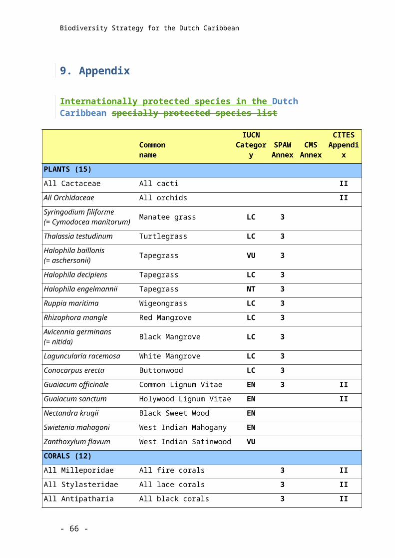
Biodiversity Strategy for the Dutch Caribbean
The Park and coastline of Curaçao attracts many local and international visitors every year and helps contribute to the income for the islands population employed in restaurants, hotels and other services.
Saba
Saba Terrestrial Park and TrailsThe Saba Terrestrial Park has not been formally designated. It belonged to the McNish Sulphur Mining Company and the land was donated to Saba Conservation Foundation (SCF) in 1998, on the condition that it would forever remain wild and developed as a national park. The area covers 43 hectares (106 acres) and is located on the northern side of Saba. It consists of a deep gorge, which runs from an altitude of 820 metres (2,690 feet) on Mount Scenery down to the shoreline. The upper half of the gorge is known as Island Gut, the bottom is called Deep Gut. Two ridges form Island and Deep Gut; the eastern ridge is known as ‘Pirate Cliff’ and the western ridge ‘All Too far Ridge’. The area contains biologically diverse rainforest, montane forest and drought-resistant habitats.
Additionally, Saba has a network of 12 trails that circle the island reaching the coast and the summit of Mt. Scenery, which Saba Conservation Foundation maintains with support of the Island Government. These 15 kilomtres (9.3 miles) of trails offer some of the best hiking in the Caribbean with views of neighbouring St. Eustatius and other islands through pristine forest that clings to the slopes of the magnificent Mt. Scenery.
Value statementThe Saba Sulphur Mine Property (established 1999) and trails consist of 43 hectares of land as well as numerous walking routes. The areas include habitats including dry forest, Elfin forest and some arable/pastoral land. The area and trails have considerable historical, cultural and ecological values. The areas and shoreline is a home, migratory stopover and breeding site for two Red List species, one CITES Appendix I species and 37 CITES Appendix II species as well as the endemic Saban Anole. The property and trails attract many local and international visitors every year and help contribute to the income for the islands population employed in restaurants, hotels and other services.
Saba National Marine ParkThe Saba National Marine Park was established in 1987 with the objective of preserving and managing Saba's marine resources. The Marine Park was not developed to repair a damaged environment but rather to ensure the continued quality of an extraordinary resource for the benefit and enjoyment of everyone. The Marine Park circles the entire island from the high-water mark to a depth of 60 metres, including the seabed and overlying waters. A
- 66 -
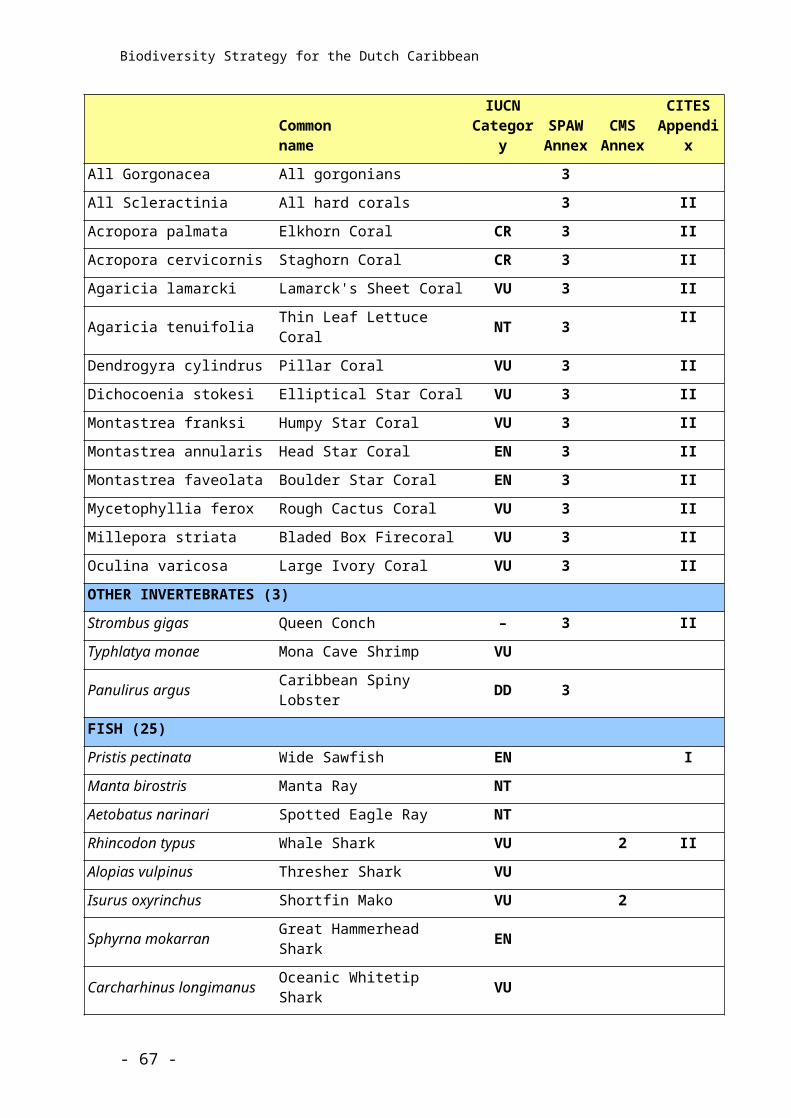
Biodiversity Strategy for the Dutch Caribbean
zoning plan divides the marine park for various recreational and commercial uses. A system of permanent mooring buoys facilitates diving and prevents damage to corals. One of the few self-sustaining marine parks anywhere in the world, the marine park raises revenue through visitor fees, souvenir sales, and donations.
Value statementThe Saba National Marine Park includes more than 1,300 hectares of globally threatened coral reef as well as seagrass habitat. Saba’s marine environment and coastline is a home, migratory stopover or breeding site for 52 IUCN Red List Species, seven CITES Appendix I species and 230 Appendix II species including sea turtles and a number of shark species. The beaches and waters attract around 23,000 visitors a year, creating employment for many of the islands population. Saba National Marine Park is a UNEP target site because of its success in promoting eco-tourism. Tourism contributes significantly to the economy and depends on the well being of Saba’s marine resources.
Saba Bank National ParkSaba Bank NationalPark, established in 2010, protects an offshore atoll covering 268,000 hectares (662,000 acres) — the third largest atoll of its kind in the world. Saba Bank is a flat-topped seamount rising 1,800 meters (5,900 feet) from the sea floor, crowned by living coral reefs. The wealth of biodiversity on the Saba Bank is astounding and includes sea turtles, Humpback Whales, more than 200 species of fish and unique marine plants found nowhere else in the Caribbean.
Value statementThe marine environment of the Saba Bank is 1,800 sqaure kilometres of biologically diverse coral reef, macroalgae, rock pavement, sandy seabed, and open ocean communities. The Bank is one of the, if not the, most diverse in marine macroalgae in the Caribbean. The Saba Bank Management Organization was established in 2008 to manage these marine resources for the benefit and enjoyment of the people and future generations. The Saba Bank Special Marine Area is a home, migratory stopover or breeding site for 52 IUCN Red Listed species and 230 Appendix II species including sea turtles and a number of shark species. The Saba Bank is of high economic importance to the island of Saba. It supports nine full-time fishermen and has a direct economical value of over one million dollars a year.
St Eustatius
Quill Boven National ParkThe Quill/Boven National Park was established in 1997 and was the first national park to be declared in the Dutch Caribbean. The park is divided into two sections, which are spatially separated. The northern park area is known locally as Boven
- 67 -
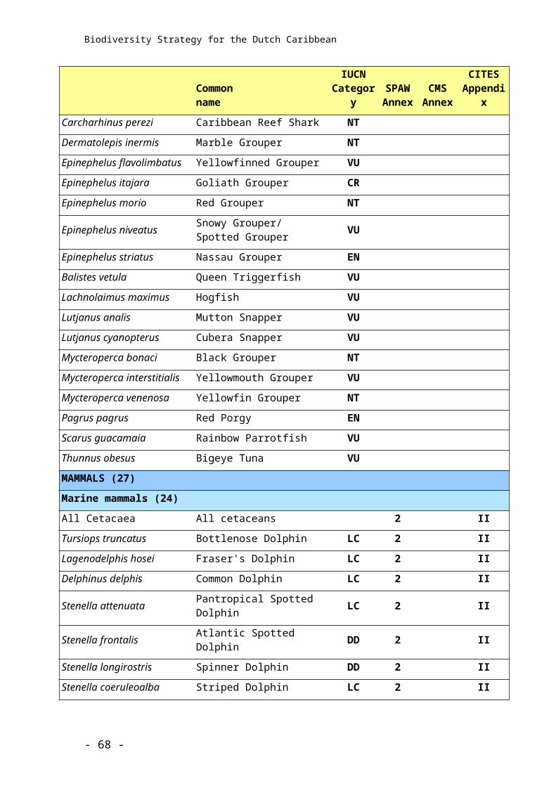
Biodiversity Strategy for the Dutch Caribbean
(Boven sub sector) and the southern park area is known as The Quill (Quill sub sector). Adjacent to The Quill is a Botanical Garden, which is also managed by the park.
The Boven sub-sector encompasses hills, which are the remnants of an extinct volcano, on the northern side of the island. These include Boven, Bergje, Venus and Gilboa Hills as well as Signal Hill. The total surface area is approximately 320 hectares (790 acres).
The Quill sub sector includes the volcano above 250 metres (820 feet) as well as the inside walls of the crater and the adjacent south-eastern side of the White Wall/Sugar Loaf, a very prominent limestone intrusion on the south west of The Quill. The total surface area is approximately 220 hectares (543 acres).
The Miriam Schmidt Botanical Garden is adjacent to the boundary of the Quill sub sector of the National Park and extends for 5.3 hectares (13 acres) across the southern slopes of the Quill. This land was granted as a lease from the Island Government to STENAPA in 1999 and is subject to regulations controlling development and access. The Garden is fenced to prevent entry by roaming livestock.
Value StatementTwenty-six per cent (540 hectares) of the terrestrial environment of St. Eustatius is protected, including biologically diverse rainforest, Elfin forest and drought resistant habitats. The Quill/Boven National Park and Botanical Garden offer some of the best hiking in the Caribbean with views of neighbouring Saba and St. Kitts through pristine forest that clings to the slopes of the magnificent Quill volcano. The Quill/Boven National Park was established in 1997 to protect the islands natural resources. The Botanical Garden was established in 1998 to preserve flora and serve as an attraction for the island as well as place for locals and visitors to spend some leisure time. The National Parks and St. Eustatius are a home, migratory stopover or breeding site for three IUCN Red List species, one CITES Appendix I species and 42 Appendix II species including the endemic plant Statia Morning Glory (Ipomoea sphenophylla) and many others plants and animal species with limited distribution. The island has a rich history, evident as archaeological sites in the National Park include a fort, 10 slave villages, industrial complexes, plantations and related roads and walls from the 16th and 17th century. The Quill/Boven National Park and Botanical Garden attract visitors contributing to income for the 70% of the islands population employed in restaurants, hotels and other services
Statia National Marine ParkSt. Eustatius National Marine Park was established in 1996, predating the land park by one year. It encompasses the entire coastline of St. Eustatius from the high-water mark to the 30-metre (98-feet) depth contour, covering an area of 27,500 hectares (67,953 acres). The distance of the Marine Park boundary from shore varies between one and 3 kilometres (0.62 and 1.86 miles) depending on the slope of the sea bottom. Within the Marine Park are two welldefined and actively managed reserves
- 68 -
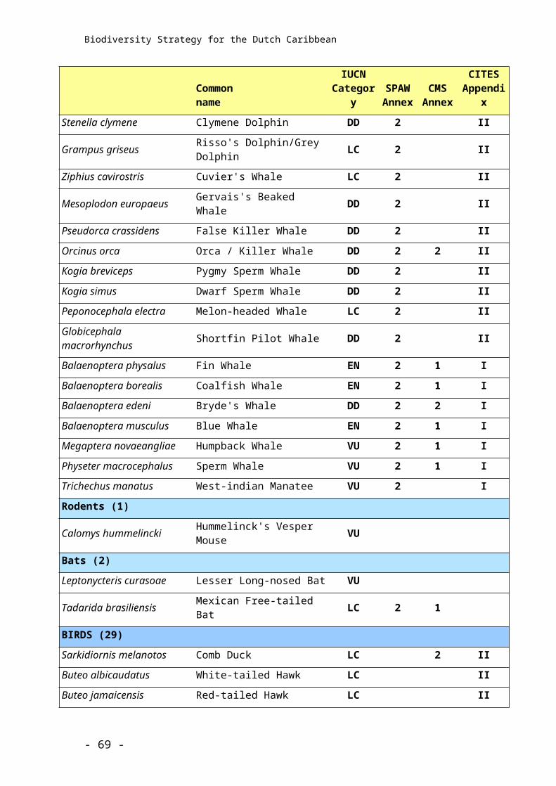
Biodiversity Strategy for the Dutch Caribbean
in which no fishing or anchoring are allowed. The reserves were established to conserve marine biodiversity, restore fish stocks and promote sustainable tourism.
Value statementThe marine environment of St. Eustatius supports 27.5 square kilometres of biologically diverse coral reef, seagrass, sandy seabed and open ocean communities. The Marine Park is one of the top five sites in the Caribbean for healthy coral and fish populations. The St. Eustatius National Marine Park was established in 1996 to manage these marine resources for the benefit and enjoyment of the people and future generations. The two reserves have 43% hard coral cover and the park is a home, migratory stopover or breeding site for 53 IUCN Red List species, nine CITES Appendix I species and 230 Appendix II species. St. Eustatius National Marine Park attracts around 500 yacht visitors and 2500 diving/snorkelling visitors per year contributing to income for the 70% of the islands population employed in restaurants, hotels and other services
St MaartenThere are no terrestrial protected areas on St. Maarten at this time.
Three areas have been identified as having special conservation value on St. Maarten. In 2008, a management planning process was undertaken for the ‘Proposed 2009 St. Maarten Land Parks’. They were given the collective name of ‘St. Maarten Land Parks’.
The terrestrial environment of St. Maarten that is still intact includes biologically diverse rainforest, drought resistant habitats and lagoons. From a tourism perspective, St. Maarten terrestrial parks can offer excellent hiking with views of the island and neighbouring Saba and St. Eustatius. The proposed protected areas will help conserve and restore St. Maarten’s natural, cultural and historical resources for the benefit of current and future generations. St. Maarten and its habitats are a home, migratory stopover or breeding site for two IUCN Red List species, one CITES Appendix I species and 34 Appendix II species including the 2 endemic plants, the endemic Anguilla Bank Bush Anole (Anolis pogus) and many other plants and animal species with limited distribution. St. Maarten terrestrial parks could attract visitors and contribute to income for many people on the island employed in restaurants, hotels and other services
Man of War Shoal Marine ParkThe Man of War Shoal Marine Park covers 3,100 hectares (7,600 acres), which is home and migratory stopover or breeding site for five IUCN Red List Species, eight CITES Appendix I species and 230 Appendix II species. It is an area with a relatively healthy population of marine mammals including migratory whales
- 69 -
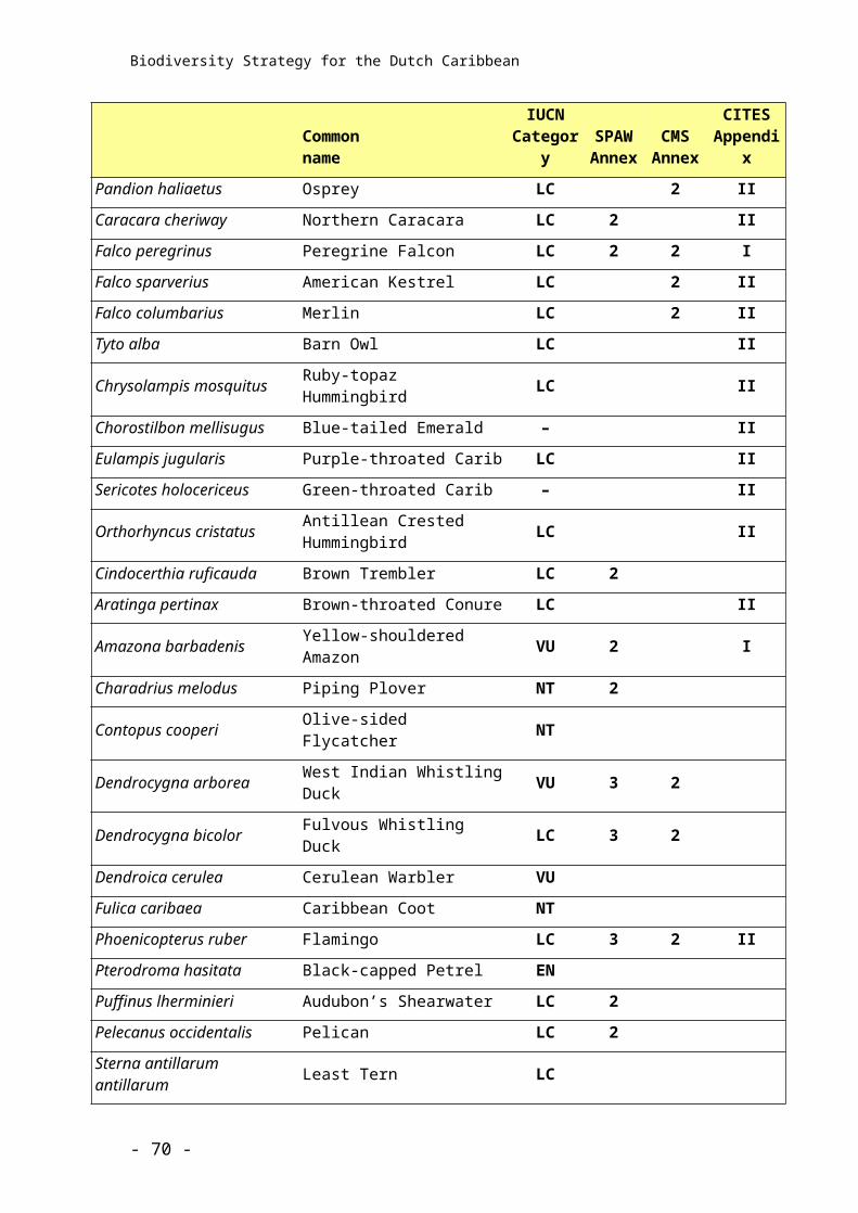
Biodiversity Strategy for the Dutch Caribbean
and dolphins, numerous species of shark, sea turtles and numerous fish species. The Man of War Shoal Marine Park also includes Proselyte Reef, which was named after the HMS Proselyte, a 32-gun frigate which struck the "Man of War Shoal" on September 4, 1801. Artefacts such as large anchors, cannons, barrel hoops, cannon balls, and pottery are still evident on this popular St. Maarten Dive site. The site is also considered a marine archaeological treasure. Studies conducted by the St. Maarten Nature Foundation have shown that biodiversity in the area is high as well as coral cover. The economic value of the goods and services, which the coral reefs of St. Maarten provide are estimated to be worth in excess of fifty million dollars annually. The establishment of the Man of War Shoal Marine Park is also in accordance with the Specially Protected Areas of Wildlife (SPAW) Protocol and with the Federal Decree on Maritime Management.
Value StatementThe marine environment of St. Maarten includes more than 15 square kilometres of habitats including globally threatened coral reef, open water and algae beds. St. Maarten’s marine environment is a home, migratorystop over or breeding site for 52 IUCN Red List Species, eight CITES Appendix I species and 230 Appendix II species. The beaches and waters attract in the region of 2 million visitors a year, creating employment for 85% of the islands population. Tourism and the marine industry contribute $500 million and $30 million to the economy respectively and both depend on the well being of St. Maarten’s marine resources.
- 70 -
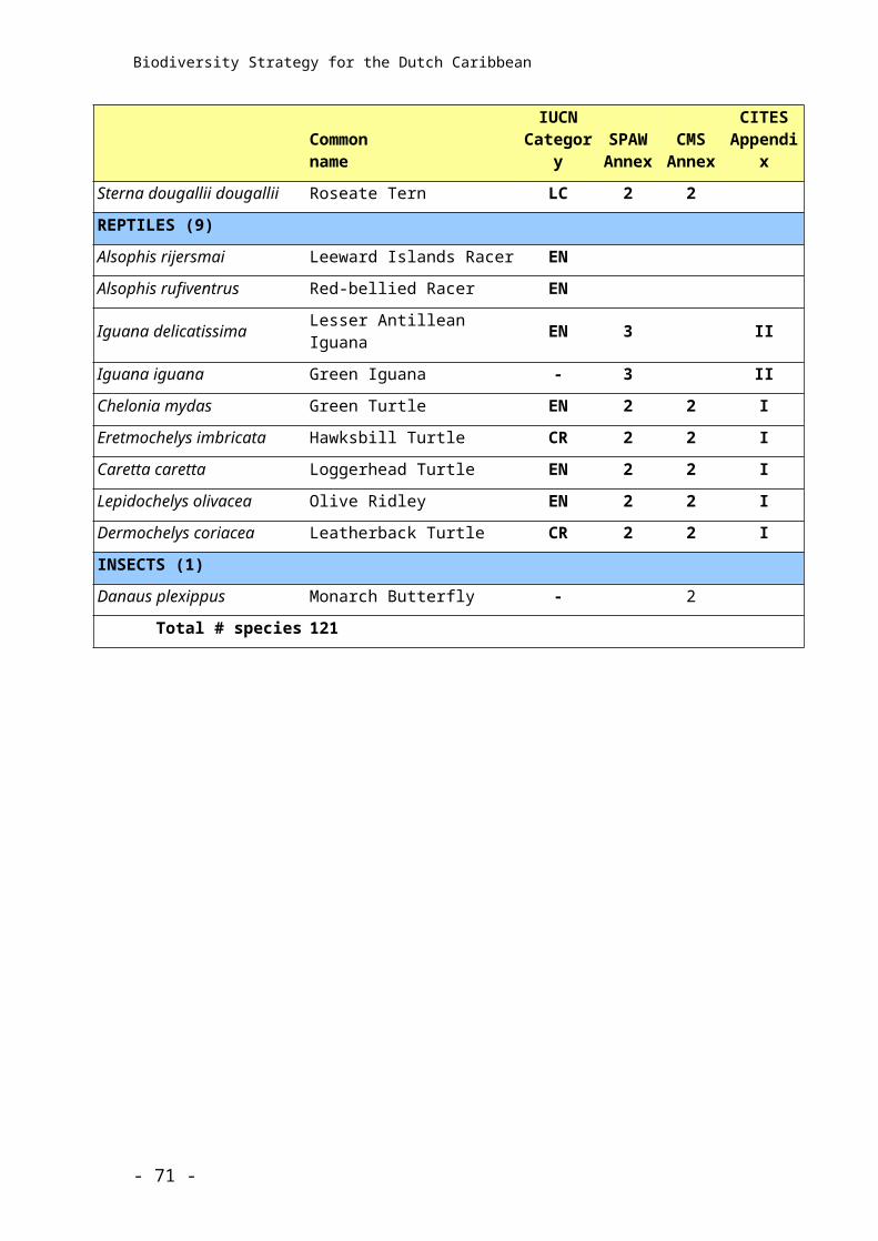
Biodiversity Strategy for the Dutch Caribbean
REDUNDANT TEXT ????
BACKGROUND AND A PATH FORWARD
The Dutch Caribbean consists of the ‘Caribbean Netherlands’ islands (Bonaire, St Eustatius and Saba, also referred to as the “BES islands”), which are ‘special municipalities’ (openbare lichamen) within the Netherlands, and the independent islands of Aruba, Curacao and St Maarten. Whilst the islands differ in their administrative structure and degree of independence from the Netherlands, they all fall within the Kingdom of the Netherlands. The Island Governments have primary responsibility for biodiversity conservation on their island and on each island they have delegated responsibility for biodiversity conservation to local non governmental organisations. As a result of the constitutional changes, which came into effect on the 10th of October 2010, the Netherlands has acquired certain legal obligations regarding conservation of the rich biodiversity in and around the islands. This is not only as a result of national obligations but also international commitments resulting from treaties and conventions to which the Netherlands is or, with the integration of the BES islands, has now become a signatory. The Netherland’s role in terms of biodiversity conservation is therefore primarily supervisory but includes some direct responsibilities, such as with respect to the Exclusive Economic Zone (EEZ), which falls outside of island jurisdiction, and for the BES islands reporting requirements related to international treaties and conventions. The Dutch Ministry of Economics, Agriculture and Innovation (formerly the Ministry of Agriculture, Nature and Food Quality) has full time staff members within the Rijks Caribisch Nederland (RCN) headquartered on Bonaire and within the local Island Governments in the form of the Department of LVV. . They are charged with addressing matters related to nature conservation, fisheries and agriculture, among other things, on the BES islands and within the EEZ. They interact with the local government and conservation bodies and are directed by and report to the Ministry in The Hague. Each Dutch Caribbean island has one or more protected areas (nature parks) managed by local, non-governmental, not-for-profit foundations (stichting). These park management organisations are responsible for conservation management of the protected areas on their island. They function autonomously under management agreements with their island government and are run on a co-management basis with stakeholders. The park management organisations are well organised and firmly grounded in the local community. Despite a chronic lack of funding, resources and personnel, the parks are highly successful and several have been recognised by UNEP, ICRAN and others as global models for conservation management. In 2005 the park management organisations in the Dutch Caribbean came together to create a regional network of protected areas, called the Dutch Caribbean Nature
- 71 -
Biodiversity Strategy for the Dutch Caribbean
Alliance (DCNA). DCNA’s goal is to safeguard nature and promote the sustainable use of nature in the Dutch Caribbean by working with and supporting the park management organisations and other nature conservation organisations. The primary tasks are fundraising to create a sustainable financial future for the parks, representation, creating access to information and building capacity for conservation management. Research and monitoring is a fundamental (‘core’) component of conservation management in the Dutch Caribbean. In the past parks have developed their own research and monitoring plans and have implemented their own management driven research and monitoring programmes with the goal of guiding and informing conservation management and decision-making. The constitutional change has provided an opportunity for the Dutch Caribbean to develop a more structured and strategic approach to biodiversity monitoring which will not only meet the needs of the conservation management organisations locally but will also provide open access to biodiversity conservation information as well as ensure that the Netherlands can meet national and international reporting obligations for the BES islands. This Biodiversity Monitoring Strategy is one component of this new initiative and is a result of a collaboration between RCN, DCNA and the parks and nature conservation organisations throughout the Dutch Caribbean. Local and regional meetings allowed for island consultation of organizations/institutions involved in local monitoring activities to identify the monitoring priorities specific to their island. The document also describes how those monitoring priorities can be implemented, what gaps need to be addressed, the organization of the monitoring including recommendations for data analysis, quality control, a communication plan, and linkages to other regional initiatives. It should be noted that it may not always be possible to implement monitoring priorities due to various constraints.
Path forwardIn order to achieve the challenges outlined above, the following deliverables are proposed. It is important to note that these deliverables are not static, but may need to be adapted or supplemented as circumstances evolve and/or as new information is obtained.
1. Search for, and identify novel biodiversity and increase knowledge of function, distribution and abundance of biodiversity
2. Develop tools for analyzing and managing data which can handle considerable amounts of information
- 72 -
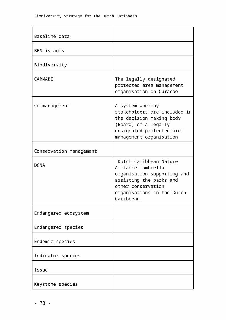
Biodiversity Strategy for the Dutch Caribbean
3. Produce, maintain and analyze long-term data-sets, linking changes in biodiversity physical, chemical, and biological processes. Utilize models to enhance understanding of the role of biodiversity in ecosystem services
4. Develop integrated physical and biological models that predict the impacts of individual and multiple pressures on biodiversity and ecosystems, particularly within marine, unique, prioritized and sensitive habitats
5. Collate evidence of the impact that biodiversity loss or degradation has on people’s well-being and health. Develop indicators and indices of trends and patterns in biodiversity loss. Develop measures for assessing direct and indirect value of biodiversity to society
6. Identify thresholds beyond which a change in biodiversity will lead to extinctions and irreversible population and/or ecosystem change
- 73 -
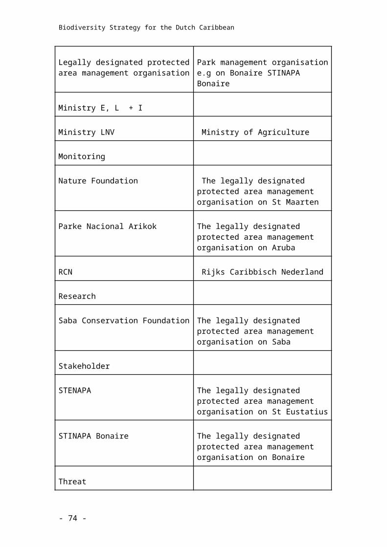
Biodiversity Strategy for the Dutch Caribbean
- 74 -