Embed Size (px)
Citation preview

Draft Final Report Houston Intermodal Center/Multimodal Terminal March 2006
a
EXECUTIVE SUMMARY
The Houston Downtown Management District (HDMD) encompasses a 1,178-acre area in downtown Houston within which private owners pay an assessment for the purpose of improving conditions and revitalizing downtown. The HDMD’s 2001-2005 Service Plan included studies to determine if an intermodal center/multimodal terminal serving multiple modes of transportation is feasible. The perception of the downtown community is that an intermodal center/multimodal terminal would benefit downtown Houston whether it is located within the boundaries of the HDMD service area by enhancing access to the multiple forms of transportation that serve downtown.
Based upon the strength of this concept, the HDMD funded and led a local consortium of agencies to conduct this feasibility study. The other agencies that provided guidance and funding for this study effort are as follows:
§ Texas Department of Transportation
§ City of Houston
§ Metropolitan Transit Authority of Harris County
§ Main Street Coalition
§ Midtown Management District.

Draft Final Report Houston Intermodal Center/Multimodal Terminal March 2006
b
PUBLIC INVOLVEMENT/AGENCY COORDINATION
The initial task of this study effort was to develop a governance structure for the study. This resulted in the formation of a Working Committee and Steering Committee. Both committees were comprised of representatives of local government, community organizations, and project stakeholders. The Working Committee provided technical guidance to the Project Team while the Steering Committee provided policy guidance.
Meetings with these committees were held throughout the course of the study and were supplemented by a Community Open House to share the results of the Regional Location Analysis that indicated that the preferred location for an Intermodal Center/Multimodal Terminal would be in Zone A, located adjacent to and north of downtown Houston.
In addition to the Working Committee, Steering Committee, and Public Open House, study input was also received from a series of Stakeholder Workshops which were conducted with affected parties to validate the study findings relative to the following tasks:
§ Transportation Provider Inventory
§ Project Coordination
§ Facility Program Definition
§ Regional Location Analysis
§ Project Location Analysis
§ Master Plan Concepts.

Draft Final Report Houston Intermodal Center/Multimodal Terminal March 2006
c
STUDY GOALS AND OBJECTIVES
At the outset of the Feasibility Study, the Steering Committee identified the following three primary study goals for the Intermodal Center/Multimodal Terminal:
1. Improve Transportation and Mobility
2. Enhance Economic Investment and Opportunity
3. Sensitivity to Site Characteristics
The identification of these overarching goals for the study resulted in the development of the following study objectives to support the foregoing goals:
GOAL: TRANSPORTATION AND MOBILITY
Objectives:
§ Operation and Maintenance – This quantitative criterion measures the annual incremental cost in current year dollars to operate and maintain the current and projected levels of transit service to alternative sites in comparison to the baseline condition.
§ Intermodal Connectivity – This qualitative criterion considers the ability of the alternative site to accommodate current transit services and potential proposed future bus and fixed guideway linkages.
§ Accessibility – This qualitative criterion takes into consideration the ease and degree to which alternative locations may be accessed by different modes of travel such as bicycles, pedestrians, and taxis.
§ Travel Time Savings – This quantitative criterion measures the change in travel time from selected major activity centers to common destinations.

Draft Final Report Houston Intermodal Center/Multimodal Terminal March 2006
d
GOAL: ECONOMIC OPPORTUNITY AND INVESTMENT
Objectives:
§ Consistency with Land Use Patterns – This qualitative criterion addresses the consistency of alternative locations with existing and future local land use patterns of development and trends.
§ Proximity to Existing Planned Development – This qualitative and quantitative criterion addresses the amount of existing and planned developments located in proximity to the alternative sites.
§ Proximity to Developed and Redevelopable Land – This qualitative and quantitative criterion addresses the amount of existing and planned developments located in proximity to the alternative sites.
§ Resident/Neighborhood Sentiment – This qualitative criterion addresses the level of support or opposition of the local residents of neighborhoods to each of the alternative transit center locations.
§ Business Community Sentiment – This qualitative criterion addresses the level of support or opposition of the business community to each of the alternative operating plans and transit center locations.
§ Environmental Impacts – This qualitative criterion addresses the historical, community, and natural resources that could be impacted by development of a major facility in a given area.
GOAL: SITE CHARACTERISTICS
Objectives:
§ Positive Community Impact – This qualitative criterion will compare the location and size of the site and facility to community goals and objectives.

Draft Final Report Houston Intermodal Center/Multimodal Terminal March 2006
e
§ Avoid Business and Resident Relocation – This quantitative criterion seeks to reduce the number of households and businesses that could potentially be relocated from the site or the nearby area as a result of this project.
§ Personal Security – This qualitative criterion considers the degree to which the transit center locations(s) will reinforce the perception of personal security for riders and pedestrians.
§ Environmental Clearance/Remediation – This quantitative and qualitative criterion assesses the cost and/or level of effort necessary to prepare the site to make it suitable for a transit center.
§ Visibility – This qualitative criterion considers the degree to which the transit center(s) will be readily seen as occupying a location of prominence in the community.
§ Capital Cost – This criterion is a quantitative measure of the total capital cost to implement the improvements under consideration including site acquisition costs.
§ Ease of Site Acquisition – This qualitative criterion relates to the status of ownership of alternative sites and the willingness of the owner to consummate a sale.
§ Ability to Phase Construction – This qualitative and quantitative criterion considers the degree, case and expense associated with the ability to expand the size and/or function of a facility on a particular site.

Draft Final Report Houston Intermodal Center/Multimodal Terminal March 2006
f
CASE STUDIES
One component of this Feasibility Study was to provide case studies of other similar intermodal/multimodal projects in comparable cities for relevance/applicability to the Houston area. To this end, the Project Team identified approximately 20 facilities throughout the country which bore some similarity to that which was envisioned for Houston. From this list, the Steering Committee selected the following four facilities for further analysis:
§ Fort Worth Intermodal Transit Center – Fort Worth, Texas
§ McAllen Transit Center – McAllen, Texas
§ Tower City Center – Cleveland, Ohio
§ Union Station and Gateway Plaza – Los Angeles, California.
This analysis indicated that the approximate land area necessary to accommodate the transportation components of an intermodal facility in Houston would need to be five to seven acres. This notwithstanding, additional land would be necessary to capture the development potential and benefits associated with such a facility located in the urban core of Houston. The two facilities in this case study analysis which achieved the greatest economic development in conjunction with the transportation component of the project were the Tower City Center facility – which occupies 34 acres – and the Union Station and Gateway Plaza – which occupies 51 acres.
The other major finding from this case study analysis is that the two projects which achieved the greatest economic development benefits were the product of public/private partnerships. In both instances, it was a partnership between the local transit authority and a private developer with a significant injection of public funding into the project in the form of grants and/or tax-exempt financing.
Lastly, the economic development benefits from these projects continue to be realized long after the project opens. In Cleveland, a new baseball stadium, an arena, and a 25-story Federal Courthouse were constructed on or adjacent to Tower City Center since its opening. Also, plans

Draft Final Report Houston Intermodal Center/Multimodal Terminal March 2006
g
are underway to construct a new convention center on the site. Similarly additional residential construction is underway at the Union Station and Gateway Plaza in Los Angeles.
TRANSPORTATION PROJECT INVENTORY
Prior to conducting an evaluation of potential locations in the region for an Intermodal Center/Multimodal Terminal, it was necessary for the Project Team to identify the major existing and proposed transportation infrastructure improvements throughout the region. This was accomplished through a series of interviews and meetings with the major transportation providers to develop a thorough understanding of the following existing and planned facilities and potential connectivity issues associated with each:
§ Highways
§ Carpools/vanpools
§ Local arterial streets
§ Light rail transit
§ Bus rapid transit
§ Commuter rail
§ Intercity rail
§ High-speed rail
§ High Occupancy Vehicle (HOV)/managed lanes
§ Local, intercity and international bus transportation
§ Airports.

Draft Final Report Houston Intermodal Center/Multimodal Terminal March 2006
h
The following is a summary of the transportation providers who gave input to this phase of the study effort:
§ METRO
§ TxDOT
§ AMTRAK
§ Union Pacific and Burlington Northern Santa Fe Railroads
§ Harris County Toll Road Authority (HCTRA)
§ Houston Airport System (HAS)
§ Greyhound Bus Lines and other intercity bus carriers
§ International bus carriers.
These providers identified the following planned transportation infrastructure improvements which needed to be considered in the identification and evaluation of prospective locations for an Intermodal Center/Multimodal Terminal in the Houston region:

Draft Final Report Houston Intermodal Center/Multimodal Terminal March 2006
i
Planned Transportation Infrastructure Improvements Project Description Status
Main Street LRT Extension Planning University LRT Planning
Harrisburg BRT Planning
North BRT Planning
Southeast BRT Planning
Uptown BRT Planning
US 90 Commuter Rail Proposal
US 90A Commuter Rail Proposal
SH 3 Commuter Rail Proposal HOT Lanes Proposal
Signature Bus Proposal
US 290 Commuter Rail Proposal
Galveston Commuter Rail Proposal
Southwest/Almeda Commuter Rail Proposal
IH 45 North Freeway Planning
SH 288 South Freeway Feasibility US 290 Northwest Freeway Design
La Porte Freeway Feasibility
SH 35 Feasibility
IH 10 Katy Freeway Construction
Westpark Tollway Construction
Hardy Toll Road Extension Planning
US 290 Northwest Planning
Fort Bend Parkway Extension Construction
The next phase of the study process involved the creation of a Geographic Information System (GIS) base map upon which all of these improvements were plotted to assist the Project Team in identifying potential areas in the region where an intermodal facility would be of beneficial support to these improvements.

Draft Final Report Houston Intermodal Center/Multimodal Terminal March 2006
j
REGIONAL LOCATION ANALYSIS
Once the improvements identified as part of the Transportation Project Inventory were plotted on a regional map, it became readily apparent to the Project Team that no single location would satisfy all of the intermodal connections in the region’s long-range plan. Rather, this analysis indicated that there were seven major transportation modes in the region – all of which could utilize an intermodal facility to support the long-range transportation plan for the Houston area. These seven areas are labeled as Zones A through G using the foregoing evaluation factors. The zones have been ranked as follows:
§ Zone A (North Downtown)
§ Zone B (East Downtown)
§ Zone C (US 59 South at IH 610 West)
§ Zone D (IIH 610 South at Fannin)
§ Zone E (IH 10/US 290 at IH 610)
§ Zone F (IH 45 South at IH 610 South)
§ Zone G (IH 45 North at IH 610 North).
These seven zones, in turn, were evaluated against the following set of criteria to determine a relative ranking for prioritizing the areas in the region:
§ Connectivity to the greatest number of existing transportation infrastructure elements in the region
§ Connectivity to the greatest number of proposed transportation infrastructure elements in the region
§ Best overall proximity to major regional activity centers

Draft Final Report Houston Intermodal Center/Multimodal Terminal March 2006
k
§ Greatest amount of vacant and/or underutilized land in close proximity to existing and proposed transportation infrastructure
§ Most consistent land use patterns which are compatible with the development of an Intermodal Center/Multimodal Terminal facility.
PROJECT LOCATION ANALYSIS
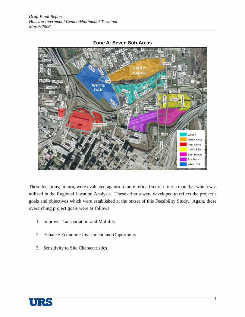
With the selection of Zone A as the preferred area within the region for the development of Houston’s first Intermodal Center/Multimodal Terminal, the Project Team proceeded to identify potential locations within Zone A capable of accommodating such a facility. This exercise resulted in the identification of the following seven locations within Zone A that are capable of accommodating the proposed Intermodal Center/Multimodal Terminal:
Potential Facility Sites Within Zone A Site Name Intersecting Streets
White Oak Northeast of I-45 and I-10 interchange
Hardy Yards Southeast of Main and Burnett
Wilson Property Southeast of Main and Hardy Rail Yards
I-10/US 59 Southwest of I-10 and US 59 interchange
East Bayou Southwest of I-10 and US 59 interchange
Bus Barn Northeast of San Jacinto and Allen
Post Office Southeast of I-45 and I-10 interchange
Draft Final Report Houston Intermodal Center/Multimodal Terminal March 2006
l
Zone A: Seven Sub-Areas
These locations, in turn, were evaluated against a more refined set of criteria than that which was utilized in the Regional Location Analysis. These criteria were developed to reflect the project’s goals and objectives which were established at the outset of this Feasibility Study. Again, these overarching project goals were as follows:
1. Improve Transportation and Mobility
2. Enhance Economic Investment and Opportunity
3. Sensitivity to Site Characteristics.
Wilson
Hardy Yards
Post Office
I-10/US 59
East Bayou
Bus Barn
White Oak
HARDY YARDS
WHITE OAK

Draft Final Report Houston Intermodal Center/Multimodal Terminal March 2006
m
The evaluation criteria developed to measure each of these project goals were as follows:
1. Transportation and Mobility
1.1. Operating and Maintenance Cost
1.2. Intermodal Connectivity
1.3. Accessibility
1.4. Travel Time Savings
2. Economic Opportunity and Investment
2.1. Consistency with Land Use Patterns
2.2. Proximity to Existing and Planned Development
2.3. Proximity to Developed and Redevelopable Land
2.4. Resident/Neighborhood Sentiment
2.5. Business Community Sentiment
2.6. Environmental Impacts
3. Site Characteristics
3.1. Positive Community Impact
3.2. Avoid Business and Resident Relocations
3.3. Personal Security
3.4. Environmental Clearance/Remediation
3.5. Visibility

Draft Final Report Houston Intermodal Center/Multimodal Terminal March 2006
n
3.6. Capital Cost
3.7. Ease of Site Acquisition
3.8. Ability to Phase Construction
Following the application of these criteria to the seven locations identified in Zone A, the areas were ranked in order of preference as follows:
§ Tier 1 – Best Suited
- Hardy Yards
- White Oak
§ Tier 2 - Sufficient
- Wilson Property
- Post Office
- Bus Barn
§ Tier 3 – Least Suited
- East Bayou
- I-10/US 59.
Draft Final Report Houston Intermodal Center/Multimodal Terminal March 2006
o
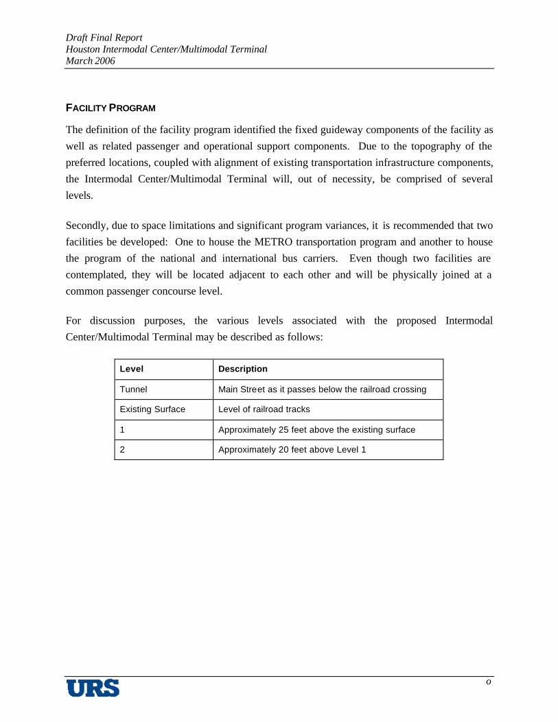
FACILITY PROGRAM
The definition of the facility program identified the fixed guideway components of the facility as well as related passenger and operational support components. Due to the topography of the preferred locations, coupled with alignment of existing transportation infrastructure components, the Intermodal Center/Multimodal Terminal will, out of necessity, be comprised of several levels.
Secondly, due to space limitations and significant program variances, it is recommended that two facilities be developed: One to house the METRO transportation program and another to house the program of the national and international bus carriers. Even though two facilities are contemplated, they will be located adjacent to each other and will be physically joined at a common passenger concourse level.
For discussion purposes, the various levels associated with the proposed Intermodal Center/Multimodal Terminal may be described as follows:
Level Description
Tunnel Main Street as it passes below the railroad crossing
Existing Surface Level of railroad tracks
1 Approximately 25 feet above the existing surface
2 Approximately 20 feet above Level 1

Draft Final Report Houston Intermodal Center/Multimodal Terminal March 2006
p
The following is a description of the transportation modes which occur at each of these levels:
Level Description
Tunnel BRT automobile
Existing Surface
AMTRAK Commuter rail LRT Regional/national/international bus
1 LRT
2 High-speed rail
The building areas necessary to accommodate the METRO program requirements and the national/international bus carriers are 80,000 square feet and 48,000 square feet, respectively. In addition, the site also will accommodate a 2,000-car parking facility of approximately 600,000 square feet.
Inasmuch as the conceptual design of the Intermodal Center/Multimodal Terminal is preliminary, at this juncture, the Project Team has developed a range of capital costs to construct this facility that is between $150 million and $169 million in Year 2005 dollars. A breakdown of cost by major project element follows:
Estimated Construction Cost ($ million) Item
Low High Building (80,000 SF) $ 22 $ 22
Guideway/Platforms $ 40 $ 55
National/International Bus Carriers (48,000 SF) $ 13 $ 13
Transit Center $ 20 $ 20
Garage $ 20 $ 20
Subtotal $ 115 $ 130
Contingency (30 percent) $ 35 $ 39 Total $ 150 $ 169

Draft Final Report Houston Intermodal Center/Multimodal Terminal March 2006
q
OPERATING MODEL
The last task for the Project Team as part of this Feasibility Study was to examine different scenarios for ownership, management and operation of the Intermodal Center/Multimodal Terminal. Due to the uncertainty at this juncture as to ownership and occupancy of the facility, it was not possible to provide a definitive direction of the best avenue to pursue. Nonetheless, five potential ownership/management options were identified as part of this process, each with their own advantages and disadvantages. These five alternatives may be described as follows:
1. Direct Public Ownership (Land and Improvements)
Public Operation or Private (Contract) Operations
Public and Private Lease Tenants
2. Direct Public Ownership (Land and Improvements)
Direct Operation or Contract Operation
Public and Private Lease Tenants
3. Public Ownership/Long-Term Private Ground Lease or Individual Tenant Leases
4. Private Ownership/Long-Term Public Ground Lease (Sale + Leaseback)
Public Operation or Private (Contract) Operation
Public and Private Lease Tenants
5. Mixed Ownership and Lease Arrangements (Subdivided Site)
Based on the size of the buildings necessary to house the program elements for METRO (80,000 square feet) and the national/international bus carriers (48,000 square feet), the cost to operate and maintain the facilities, assuming full build-out, is $650,000 and $400,000 per year, respectively. These operating and maintenance expenses would be partially offset by foot vendors who would generate approximately $43,000 in rental income.

Draft Final Report Houston Intermodal Center/Multimodal Terminal March 2006
r
The subsequent sections of this report and append ices contain more detailed information and methodologies utilized by the Project Team to support these findings and conclusions. The Project Team is most appreciative of the guidance and direction it received throughout the course of this study from the Project Sponsors, Working Committee, Steering Committee, and, most importantly, the Study Managers.

Draft Final Report Houston Intermodal Center/Multimodal Terminal March 2006
1
I. BACKGROUND
A. Introduction
The Houston Downtown Management District (HDMD), together with the Texas Department of Transportation (TXDOT), City of Houston, Metropolitan Transit Authority of Harris County (METRO), Main Street Coalition and Midtown Management District, commissioned a study to analyze the feasibility of locating an Intermodal Center/Multimodal Terminal in Houston (Figure 1). The purpose of this feasibility study is to examine alternative concepts and sites for a facility that provides access to various types of bus and rail service, as well as taxi, bicycle and waterborne transportation. Specifically, the study undertook the following tasks to determine the feasibility of an intermodal facility in Houston:
Project Tasks
1. Community and Project Coordination – This task entailed development of a public involvement plan for the project to obtain input from both project stakeholders and the general public. These two groups included appropriate agencies, officials, transportation service providers, businesses, community groups, interest groups, and residents who may have knowledge about conditions and issues that affect the location of the Intermodal Center/Multimodal Terminal and thus inform the site selection process. This task was instrumental in promoting the study’s goals and objectives. It also served as a conduit for providing information to these various groups on the study’s progress. Additionally, as part of this task, a database of major transportation infrastructure projects was developed to facilitate the identification, evaluation and presentation of potential sites.
As part of this task, two committees were established to guide the feasibility study. The project Working and Steering Committees, made up of representatives and officials of local and state governments, METRO, special districts, metropolitan area transportation providers, the business community and neighborhood organizations, developed the goals and objectives for this feasibility study. (The specific responsibilities of the Working and Steering Committees are described later in this section under Part C, Public Involvement Plan.) These goals and objectives are in three categories –Transportation and Mobility, Economic Opportunity and Investment, and Site Characteristics:

Draft Final Report Houston Intermodal Center/Multimodal Terminal March 2006
2
Figure 1 City of Houston
TRANSPORTATION AND MOBILITY
§ The transportation center(s) should be strategically located to provide convenient passenger access, maximize customer convenience and facilitate bus, rail and traffic circulation to minimize operating costs for transportation providers.
§ The transportation center(s) should result in a demonstrable enhancement to the region’s transportation network.

Draft Final Report Houston Intermodal Center/Multimodal Terminal March 2006
3
ECONOMIC OPPORTUNITY AND INVESTMENT
§ Develop a transportation center facility that will be an asset to the community and which will project a positive image for the City of Houston, while maintaining the general character of the community in which it is located.
§ Develop a transportation center(s) that facilitates the highest and best use of adjacent properties in a manner that is compatible with the goals and objectives of the communities adjacent to the transit facility.
§ Develop a transportation center(s) that encourages the public’s use of the facility(s) and enhances joint development opportunities that further development goals of adjacent communities and the community at- large.
SITE CHARACTERISTICS
§ A wide range of possible sites should be explored for the transportation center(s).
§ The transportation center(s) should be designed with sufficient capacity to accommodate the immediate and long-range needs of the riders and Transportation Providers.
§ The potential transportation center site(s) should minimize or preclude the relocation of households and businesses.
§ The potential sites of the transit center(s) should enable them to be developed in a cost-effective and affordable manner.
§ The site and facility’s design should result in an overall positive impact for adjacent communities.
§ The site and facility’s design should create an inviting gateway to Houston for all who use the transportation facility.

Draft Final Report Houston Intermodal Center/Multimodal Terminal March 2006
4
2. Case Studies – The case studies examined four intermodal facilities in the United States: the Fort Worth Intermodal Transit Center; McAllen Transit Center; Tower City Center in Cleveland; and Union Station and Gateway Plaza in Los Angeles. They documented the history and transportation background of the facilities, including transportation modes served, program components, cost of development, facility management arrangements, leases, planning and land use setting, and identification of significant development and/or operating issues. This task informed the study in defining the proposed facility’s potential physical, operational and administrative shape.
3. Define Facility Program – This task identified potential transportation providers to be accommodated in the facility and each of their requirements. It identified passenger functions and amenities unique to each provider as well as those which may be shared. Space requirements to accommodate the various functions were defined such that the overall size of the proposed intermodal facility could be identified either to house all of the potential providers or various combinations thereof.
4. Operating Model – This step entailed development of alternative facility development scenarios. These operating models identified various combinations of:
- Transportation providers
- Operating and maintenance costs associated with these providers
- Potential revenues and funding sources for each provider
- Potential revenues that could be generated from related attendant commercial activities.
Revenues and expenses for each scenario were prepared to produce a range of reasonable expectations for cash flow that would be realized by the facility owner and/or operator.
5. Location/Site Analysis – This task involved identifying potential regional locations of the proposed intermodal facility in Houston, and specific sites within the selected regions. Using the map of various major transportation infrastructure projects in Houston that was produced in Task 1, general areas within Houston were identified that could accommodate the operating model developed in Task 4. Criteria were developed to evaluate the different regional locations and were designed to measure the effectiveness

Draft Final Report Houston Intermodal Center/Multimodal Terminal March 2006
5
of each location to satisfy the study’s goals and objectives. These criteria included proximity to Houston’s major activity centers, ability to serve international transportation providers; and ability to accommodate future transportation projects.
The first part of Task 5 would either conclude that it is possible to satisfy all of the region’s needs within a single location, or that multiple locations need to be developed. If it is the latter, a preferred area in the region would be identified and a strategy for implementing multiple facilities in the region would be developed.
The second part of Task 5 identified properties within the preferred region that would accommodate the program developed in Task 3. Similarly, these properties were then evaluated against an additional, more refined set of criteria that included economic impact/development potential, capital cost, traffic impacts, and environmental impacts.
6. Project and Site Development – Based on the results of Task 5, a conceptual layout of the facility was developed, primarily formed by three factors: transportation providers to be served; general site configuration; and facility and site program. Based on information from transportation providers, facility program, and operating model, a detailed description of the facility was developed to ensure an accurate accounting of the providers to be accommodated and their respective program requirements. This resulted in the preparation of alternative site configuration plans which included:
- Parking layout
- Internal and external vehicular circulation
- Vehicular entry/exit locations compatible with surrounding streets
- Size and location and relationships of supplemental mixed uses
- Pedestrian ingress/egress locations and vertical circulation elements
- Transit flow within the facility
- Provisions for potential expansion of the facility
- On/off site facility integration opportunities.

Draft Final Report Houston Intermodal Center/Multimodal Terminal March 2006
6
An assessment of inherent security concerns was identified and prepared for this site for consideration in subsequent phases of project development.
Additionally, this task determined competitive market land costs for the Intermodal Center/Multimodal Terminal and related Transit Oriented Development (TOD) sites, including a preliminary financial analysis to estimate the annual land lease payments which would be paid by a private developer if the sites were commercially developed. Task 6 also determined the amount of Revenue Bonds that could be supported by these land lease payments for a portion of project financing. Order-of-magnitude development costs were prepared, including all the major hard and soft costs required to finance, design, develop and construct the Intermodal Center/Multimodal Terminal.
Moreover, using the information developed in Task 4, alternative public/private financial plans were developed for the project that included:
- Rent and leases from transportation providers, concessionaires and tenants
- Identification of sources of financing from all levels of government
- Bonds issued by public partners that would be supported by tax revenue generated by the proposed project(s)
- Land lease payments made by a private developer(s) in exchange for development rights
- Net Operating Income leveraged to support revenue bonds.
Alternative strategies for the development, operation and maintenance of the Intermodal Center/Multimodal Terminal for the consideration of the Steering Committee were also proposed under this task. The objective of these strategies was to:
- Maximize the number and scope of related commercial developments
- Use the revenue from such sources to fully support future possible bond issuance
- Use public/private bond issuances
- Use public/private and public/public partnerships to reduce potential costs and/or risks

Draft Final Report Houston Intermodal Center/Multimodal Terminal March 2006
7
- Possibly to induce private landowners to provide property to the project on a lease or equity position to create market demand for other proximate properties.
7. Area Master Plan – This task examined the purpose and results of a master planning public workshop conducted on October 5, 2005. This workshop was organized at the direction of the Houston Intermodal Center/Multimodal Terminal Feasibility Study Steering Committee in order to examine the potential effects of the planned facility and a planned mixed-use development at the Hardy Yards site on the local Near Northside neighborhood. The planned Hardy Yards mixed-use development caused some Near Northside residents to be concerned about the potential gentrification that could come with such a development. The Intermodal Center/Multimodal Terminal, which may be located in the same general vicinity, was also seen as another significant change to the fabric of the Near Northside neighborhood. This workshop was used as an opportunity to integrate both of these developments with the goals and desires of the neighborhood.

Draft Final Report Houston Intermodal Center/Multimodal Terminal March 2006
8
General Transit Center Planning and Design Principles
There are three key planning and design principles to successful terminal planning and development that apply to the Houston Intermodal Center/Multimodal Terminal Feasibility Study. Figure 2 illustrates these principles that are defined as follows:
Figure 2 Three Key Ingredients to Intermodal Center/Multimodal Terminal Development
Draft Final Report Houston Intermodal Center/Multimodal Terminal March 2006
9
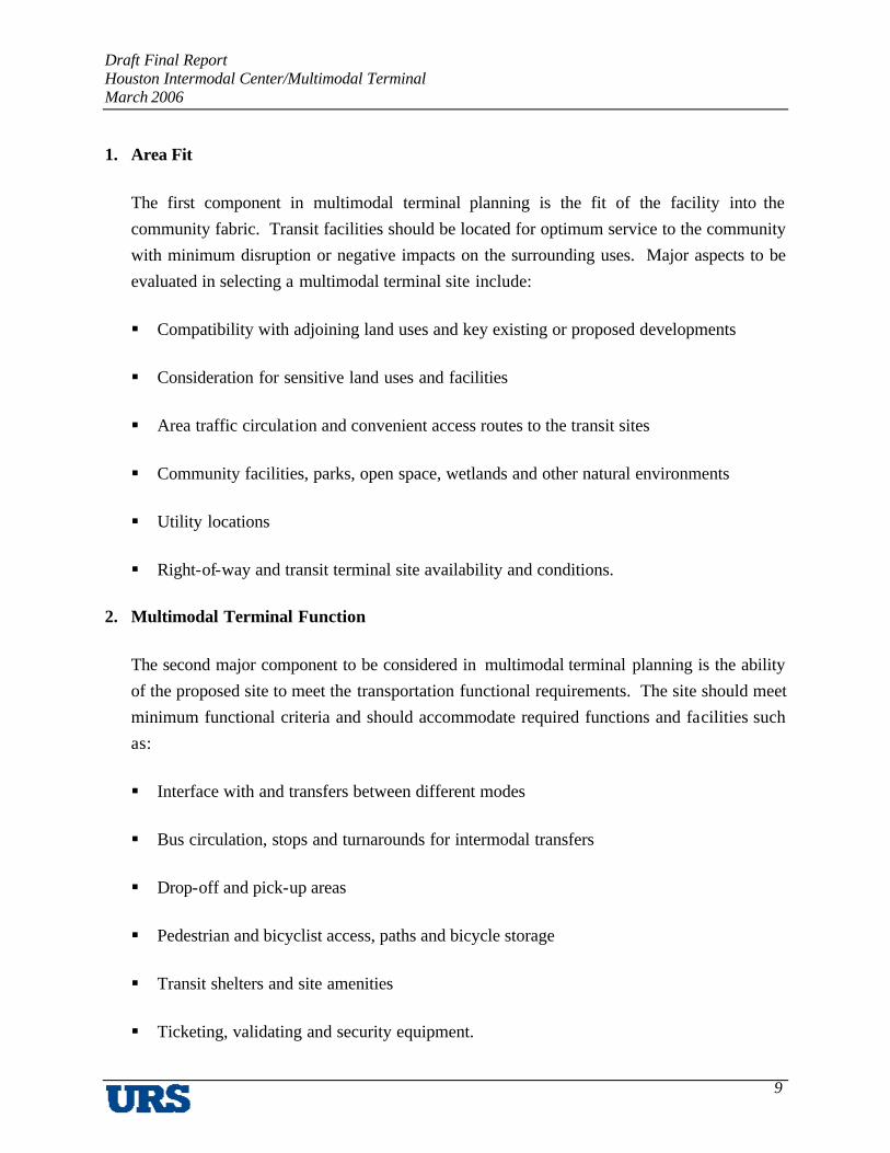
1. Area Fit
The first component in multimodal terminal planning is the fit of the facility into the community fabric. Transit facilities should be located for optimum service to the community with minimum disruption or negative impacts on the surrounding uses. Major aspects to be evaluated in selecting a multimodal terminal site include:
§ Compatibility with adjoining land uses and key existing or proposed developments
§ Consideration for sensitive land uses and facilities
§ Area traffic circulation and convenient access routes to the transit sites
§ Community facilities, parks, open space, wetlands and other natural environments
§ Utility locations
§ Right-of-way and transit terminal site availability and conditions.
2. Multimodal Terminal Function
The second major component to be considered in multimodal terminal planning is the ability of the proposed site to meet the transportation functional requirements. The site should meet minimum functional criteria and should accommodate required functions and facilities such as:
§ Interface with and transfers between different modes
§ Bus circulation, stops and turnarounds for intermodal transfers
§ Drop-off and pick-up areas
§ Pedestrian and bicyclist access, paths and bicycle storage
§ Transit shelters and site amenities
§ Ticketing, validating and security equipment.

Draft Final Report Houston Intermodal Center/Multimodal Terminal March 2006
10
In addition, all transit facilities will need to be designed to meet special local or neighborhood needs and conditions, as well as all Americans with Disabilities Act (ADA) requirements.
3. Development Potential
The third component to be considered in multimodal terminal design is the potential for transit-related developments around transit facilities. Well-designed transit-related developments can enhance the value of the community, enrich the experiences of facility users and increase ridership. A key aspect of multimodal terminal planning is the potential to leverage the transportation capital investments in order to maximize economic development in the transit corridors – especially in and around the multimodal terminal area – in order to:
§ Increase the population base and thus the patronage for the transit system
§ Capture new developments for the communities
§ Further local planning and redevelopment goals and objectives
Some of the primary considerations in selecting a multimodal terminal site, from the standpoint of optimizing development potential, should be the following:
§ Potential to develop vacant and/or underutilized parcels around the facility
§ Potential to increase densities in the surrounding developments
§ Ability to accommodate multi- or mixed-use developments that offer a variety of living, working, shopping and entertainment opportunities
§ Potential for retail and service commercial – especially transit-supportive uses such as dry cleaners, daycare facilities, coffee shops and restaurants.
An additional important consideration for successful free-standing or joint development projects in the multimodal terminal areas would be the successful integration of the need to provide multi-modal facilities while at the same time maintaining well-developed and

Draft Final Report Houston Intermodal Center/Multimodal Terminal March 2006
11
enhanced pedestrian and bicyclist circulation systems between the facility and the surrounding neighborhoods and higher density developments.
General Study Objectives
In addition to the Study goals and objectives, the following design principles were defined for the Houston Intermodal Center/Multimodal Terminal, based on the guidance presented in Figure 2:
§ Optimum Transportation Facility – Develop multi-modal facility that provides effective integration with all forms of transit services (bus, auto and future fixed-guideway) within a safe, convenient and comfortable environment for transit users and operators.
§ Transit-Oriented Development (TOD) – Incorporate complementary TOD uses as part of, or proximate to, the transit facility.
§ Pedestrian Environment – Maximize the pedestrian circulation systems and amenities to create a pedestrian-friendly environment within the facility, as well as between neighboring amenities within the surrounding area.
§ Mixed-Use Development – Provide maximum opportunity and site flexibility in order to encourage further mixed-use development that corresponds with future goals of the City of Houston.
The process, analysis and recommendations for the preferred sites and plans are documented in subsequent sections of this report, and in a series of eight technical memoranda that serve as appendices to this report.
Draft Final Report Houston Intermodal Center/Multimodal Terminal March 2006
12
B. Case Studies
Technical Memorandum #1: Case Studies presented characteristics of existing intermodal facilities in U.S. cities to help guide the project. These characteristics included site history, programming for each facility, cost of development, ownership and management arrangements, a site’s physical aspects, and identification of development and operating issues. For comparison, the Houston Intermodal Center/Multimodal Terminal Steering Committee selected four intermodal facilities, based on geographic location and their success:
§ Fort Worth Intermodal Transit Center in Fort Worth, Texas
§ McAllen Transit Center in McAllen, Texas
§ Tower City Center in Cleveland, Ohio
§ Union Station and Gateway Plaza in Los Angeles, California.
Table 1 presents statistics of the U.S. cities included in this research, including the Houston metropolitan area. The operating statistics represent the figures reported in the Federal Transit Administration’s 2003 National Transit Database for the appropriate transit agency. For example, while there are several transit providers within the Los Angeles area, the figures in Table 1 are only those for the Los Angeles Metropolitan Transit Authority. The following is an overview of each of the four facilities:
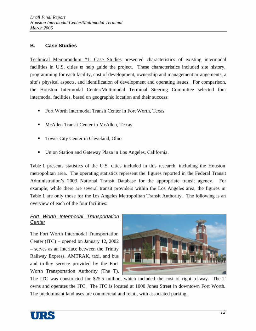
Fort Worth Intermodal Transportation Center
The Fort Worth Intermodal Transportation Center (ITC) – opened on January 12, 2002 – serves as an interface between the Trinity Railway Express, AMTRAK, taxi, and bus and trolley service provided by the Fort Worth Transportation Authority (The T). The ITC was constructed for $25.5 million, which included the cost of right-of-way. The T owns and operates the ITC. The ITC is located at 1000 Jones Street in downtown Fort Worth. The predominant land uses are commercial and retail, with associated parking.

Draft Final Report Houston Intermodal Center/Multimodal Terminal March 2006
13
Table 1 2003 Peer City Statistical Review
Transit Agency1 Metropolitan Transit Authority
of Harris County, TX
(METRO) 2
Fort Worth Transportation
Authority (The T)3
Lower Rio Grande Valley Development
Council (LRGVDC)4
Greater Cleveland
Regional Transit Authority (GCRTA)
Los Angeles County
Metropolitan Transit Authority
(MTA) City Houston, TX Fort Worth, TX McAllen, TX Cleveland, OH Los Angeles, CA
2003 Service Area Characteristics Service Area5 1,285 305 309 458 1,423 Population6 2,796,994 592,800 522,686 1,412,140 11,789,487 Persons per Square Mile
2,177
1,944
1,692
3,083
8,285
2003 Transit System Characteristics Annual Passenger Miles7 Bus Heavy Rail Light Rail
CY 2003 Total
417,399,199 See Note 3.
13,757,9118 417,399,199
24,048,649 13,765,708 See Note 4. 37,814,357
Not available. See Note 2. See Note 2.
Not available
189,098,115 50,159,652 18,678,884
257,936,651
1,440,547,049 151,901,311 225,711,934
1,818,160,294 Annual Vehicle Revenue Miles Bus Heavy Rail Light Rail
CY 2003 Total
37,199,404 See Note 3.
473,3688 37,199,404
3,923,945 667,131
See Note 4. 4,591,076
418,721 See Note 2. See Note 2.
418,721
21,353,812 2,191,748
954,081 24,499,641
88,808,777 5,986,524 6,782,590
101,577,891 Annual One-Way Trips Bus Heavy Rail Light Rail
CY 2003 Total
76,611,462 See Note 3. 5,349,7268
76,611,462
6,303,316 958,620
See Note 4. 7,261,936
378,018 See Note 2. See Note 2.
378,018
48,768,342 7,372,472 3,160,523
59,301,337
366,240,007 31,695,014 31,869,211
429,804,232 Vehicles Operated in Maximum Service Bus Heavy Rail Light Rail
CY 2003 Total
1,017 See Note 3.
178 1,017
144 14
See Note 4. 158
22 See Note 2. See Note 2.
22
548 22 17
587
2,146 74 86
2,306
1 Source: 2003 National Transit Database, Federal Transit Administration. 2 Figure includes bus and light rail service only. No heavy rail component. Source: Metropolitan Transit
Authority of Harris County, Texas. 3 Figure includes bus and heavy rail service only. No light rail transit component. 4 Figure includes bus service only. No rail component. 5 Geographic area measured in square miles. Source: 2003 National Transit Database, Federal Transit
Administration. 6 Source: 2003 National Transit Database, Federal Transit Administration. 7 Figure includes bus, heavy rail and light rail service. Source: 2003 National Transit Database, Federal Transit
Administration. 8 Figure represents the first nine months of 2004 light rail operations. This figure is not included in the CY 2003
totals.

Draft Final Report Houston Intermodal Center/Multimodal Terminal March 2006
14
McAllen Central Station
The McAllen Central Station – also called La Central – is a 22,000-square foot facility located in McAllen’s downtown commercial district, where the predominant land uses include general retail. Central Station opened in 2001 and is one of the top transit facilities in Texas. It is also the only major bus terminal along the border to serve both American and Mexican intercity bus lines and also has city bus service. McAllen Central Station houses numerous bus companies that provide service to local, national and international destinations. These bus companies include McAllen Express, Valley Transit Company, Americanos, Autobuses, Tornado, Turimex, Sendor, Noreste, Transpais and My Bus/Vencedor and ADO. It served approximately 1.3 million patrons in 2002. The cost of developing the station was $4.8 million. The City of McAllen’s Transit Department oversees facility management.
Prior to the construction of Central Station, McAllen’s international buses would arrive in gas stations, restaurants and back alleys. The mayor of McAllen saw the need to improve the transit system to provide safety, quality service and access to all bus services, but in order to receive funding from the Federal Transit Administration the City of McAllen had to become a transit provider. The City began with six fixed routes. The Lower Rio Grand Development Council organized the project and oversaw the grant funds.
Tower City Center
The Terminal Tower complex began development in the 1920s. It served as a regional transportation hub in downtown Cleveland. Due to the Great Depression, the original developer went bankrupt and was never able to complete the complex. The facility stood in decline and disrepair in the following decades – in the late 1970s and early 1980s, the adjacent hotel went bankrupt, cross-country rail service stopped and the nearby United States post office closed.
In 1982 and 1983, Forest City Enterprises purchased the 34-acre site that included the Tower City complex and adjacent U.S. post office. Redevelopment of the site into a shopping mall
Source: http://www.mcallen.net

Draft Final Report Houston Intermodal Center/Multimodal Terminal March 2006
15
began in 1988. The mall included three main spaces – the Tower Court, Station Court and Skylight Concourse.
The redevelopment of the site was based on significant partnerships between public agencies and private businesses. Local, regional and federal transit agencies collaborated with developers on redesigning the transit station. The Greater Cleveland Regional Transit Authority (GCRTA) allowed the developer to manage the construction of the rail transit facilities within the site so that the construction schedule for the entire facility could be coordinated and maintained. The historical significance of the facilities entailed lengthy negotiations between the developer and Ohio’s historical agency and the National Parks Service to approve changes to existing structures. The end result of these intricate partnerships led to a facility that consisted of retail, office, hotel, parking and transit facilities.
Tower City Center – constructed at a cost of $387.7 million –serves as an interface for rail and bus service as well as automobiles and pedestrians. It also includes retail and office space, along with hotel rooms and structured parking. Located in downtown Cleveland along the Cuyahoga River, adjoining land uses include sports venues, retail and office.
Union Station – Gateway Plaza Transit Center
Union Station was built by the Southern Pacific, Union Pacific and Santa Fe railroads for $11 million. It was built on the site of Los Angeles’ first Chinatown (in the current central business district). Union Station opened in 1939 and was the last of the great, single unified train stations in the United States. Over 1.5 million people visited Union Station on the first three days of its opening. At its peak – which occurred in the 1930s and 1940s – it served 7,000 passengers daily. After World War II, and with the dawn of the jet age and freeways, train travel declined.
Recently, train travel has increased again in popularity and Union Station now serves approximately 26,000 passengers per day, arriving and departing on AMTRAK, Metrolink and subway trains.
Source: http://transitorienteddevelopment.dot.ca.gov

Draft Final Report Houston Intermodal Center/Multimodal Terminal March 2006
16
Gateway Plaza is a major joint development project on 52 acres of former rail yards near downtown Los Angeles. It includes the Gateway Intermodal Transit Center and the 28-story headquarters of the Los Angeles County Metropolitan Transit Authority (MTA). Adjacent to the tower is an 80-child day care facility for employees of MTA and other public agencies. The project began in 1993 and was completed in 1995.
Findings
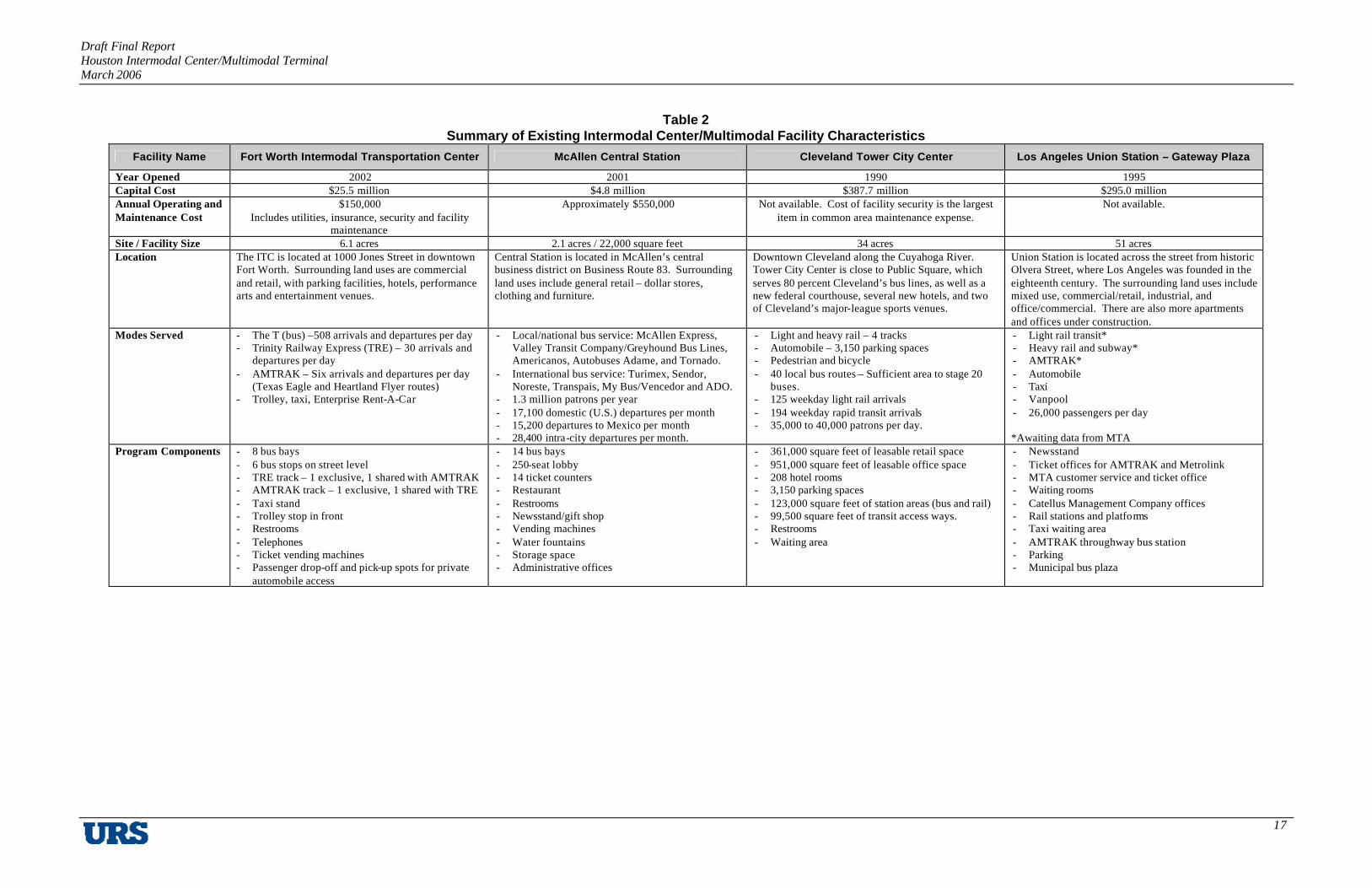
Intermodal centers/multimodal terminals are found in numerous cities throughout the United States. They serve various types of transportation modes and needs and have different paths from concept to reality. The proximity of McAllen’s Central Station to the Mexico border required bilingual administrative transit staff to negotiate contracts with Mexican bus companies. The use of existing railroad right-of-way in Fort Worth’s ITC expedited the project’s construction schedule. The development of Tower City Center in Cleveland utilized a partnership between public agencies and private developers. Union Station – Gateway Plaza in Los Angeles used tax-exempt bonds in addition to a public-private partnership for its construction. Any or all of these features may be applicable to the development of an intermodal center/multimodal terminal in Houston. Table 2 provides a summary of the characteristics of the four intermodal facilities included in this Study. Details for each facility are included in this report in Appendix A.
Draft Final Report Houston Intermodal Center/Multimodal Terminal March 2006
17
Table 2 Summary of Existing Intermodal Center/Multimodal Facility Characteristics
Facility Name Fort Worth Intermodal Transportation Center McAllen Central Station Cleveland Tower City Center Los Angeles Union Station – Gateway Plaza
Year Opened 2002 2001 1990 1995 Capital Cost $25.5 million $4.8 million $387.7 million $295.0 million Annual Operating and Maintenance Cost
$150,000 Includes utilities, insurance, security and facility
maintenance
Approximately $550,000 Not available. Cost of facility security is the largest item in common area maintenance expense.
Not available.
Site / Facility Size 6.1 acres 2.1 acres / 22,000 square feet 34 acres 51 acres Location The ITC is located at 1000 Jones Street in downtown
Fort Worth. Surrounding land uses are commercial and retail, with parking facilities, hotels, performance arts and entertainment venues.
Central Station is located in McAllen’s central business district on Business Route 83. Surrounding land uses include general retail – dollar stores, clothing and furniture.
Downtown Cleveland along the Cuyahoga River. Tower City Center is close to Public Square, which serves 80 percent Cleveland’s bus lines, as well as a new federal courthouse, several new hotels, and two of Cleveland’s major-league sports venues.
Union Station is located across the street from historic Olvera Street, where Los Angeles was founded in the eighteenth century. The surrounding land uses include mixed use, commercial/retail, industrial, and office/commercial. There are also more apartments and offices under construction.
Modes Served - The T (bus) –508 arrivals and departures per day - Trinity Railway Express (TRE) – 30 arrivals and
departures per day - AMTRAK – Six arrivals and departures per day
(Texas Eagle and Heartland Flyer routes) - Trolley, taxi, Enterprise Rent-A-Car
- Local/national bus service: McAllen Express, Valley Transit Company/Greyhound Bus Lines, Americanos, Autobuses Adame, and Tornado.
- International bus service: Turimex, Sendor, Noreste, Transpais, My Bus/Vencedor and ADO.
- 1.3 million patrons per year - 17,100 domestic (U.S.) departures per month - 15,200 departures to Mexico per month - 28,400 intra-city departures per month.
- Light and heavy rail – 4 tracks - Automobile – 3,150 parking spaces - Pedestrian and bicycle - 40 local bus routes – Sufficient area to stage 20
buses. - 125 weekday light rail arrivals - 194 weekday rapid transit arrivals - 35,000 to 40,000 patrons per day.
- Light rail transit* - Heavy rail and subway* - AMTRAK* - Automobile - Taxi - Vanpool - 26,000 passengers per day *Awaiting data from MTA
Program Components - 8 bus bays - 6 bus stops on street level - TRE track – 1 exclusive, 1 shared with AMTRAK - AMTRAK track – 1 exclusive, 1 shared with TRE - Taxi stand - Trolley stop in front - Restrooms - Telephones - Ticket vending machines - Passenger drop-off and pick-up spots for private
automobile access
- 14 bus bays - 250-seat lobby - 14 ticket counters - Restaurant - Restrooms - Newsstand/gift shop - Vending machines - Water fountains - Storage space - Administrative offices
- 361,000 square feet of leasable retail space - 951,000 square feet of leasable office space - 208 hotel rooms - 3,150 parking spaces - 123,000 square feet of station areas (bus and rail) - 99,500 square feet of transit access ways. - Restrooms - Waiting area
- Newsstand - Ticket offices for AMTRAK and Metrolink - MTA customer service and ticket office - Waiting rooms - Catellus Management Company offices - Rail stations and platforms - Taxi waiting area - AMTRAK throughway bus station - Parking - Municipal bus plaza

Draft Final Report Houston Intermodal Center/Multimodal Terminal March 2006
18
Summary of Existing Intermodal Center/Multimodal Facility Characteristics
Facility Name Fort Worth Intermodal Transportation Center McAllen Central Station Cleveland Tower City Center Los Angeles Union Station – Gateway Plaza
Security Cameras are stationed all over the ITC and platforms 24 hours a day. Two security guards on duty from 8:00 AM to 4:00 PM and from 4:00 PM to midnight. One guard on duty from midnight to 8:00 AM. Guards monitor the cameras and walk the entire ITC at least once an hour.
Police patrol the facility on bicycle regularly. Security service within Tower City Center is provided by a combination of Tower City security force (private contract), GRCTA Transit Police and off-duty Cleveland Police Department. RTA transit police is headquartered in Tower City Center.
There are four levels within the facility (subway, rail platforms, common areas and parking and bus plaza) to monitor. Parking structures are monitored with a minimum number of cameras because there is not enough staff to monitor them. Catellus has hired unarmed security to monitor common areas. MTA has a contract with LA County Sheriff’s Department to monitor railways. Other transit organizations use a combination of the County Sheriff’s Department and private security. Security is coordinated through one communication system (one radio frequency). Each transit provider has its own additional security for its area of operation within Union Station.
Facility Management Arrangements
- Owner and operator: The T - Leases: AMTRAK, Enterprise Rent-A-Car.
- Owner and operator: City of McAllen Department of Transportation.
- Leases – Bus companies and restaurant.
Forest City Enterprises, the real estate developer, manages Chase Financial Tower (Ritz-Carlton Hotel and office space), Skylight Office Tower, Terminal Tower, The Avenue at Tower City (office, retail and transit space), Higbee Building and M.K. Ferguson Plaza. The GCRTA has a non-exclusive perpetual easement for all public areas and owns the fee for the rapid transit platforms. In exchange for the easement, the GCRTA participates in the maintenance of common areas within Tower City Center.
Owner and Manager: Catellus Management Company owns and manages the entire site including the rail yard and tracks, except the bus plaza, MTA Office Tower and parking structure, which are owned and managed by MTA. It has provided easements for local transit providers and has a long-term lease for AMTRAK. AMTRAK’s lease includes both trackage and office space.
Lessons Learned The use of existing rail corridors offered significant benefits to project schedule, specifically in obtaining environmental clearance.
- Environmental monitoring of the site due to its previous land use slowed construction.
- Providing for bilingual services is crucial when negotiating with international bus companies.
- Closing down the facility regularly each day would allow for better maintenance.
- Provide space for a police substation to maintain patron safety and security.
- Repairing infrastructure required a significant up front cost for the public sector.
- Restoring a historic building is complicated and may lengthen the project timeline due to permits and restrictions.
- Locating the facility in an area that is revitalized could help ensure higher evening traffic in addition to regular daytime traffic.
- The Tower City Center site included poorly maintained city street bridges. Before site reconstruction could begin, the City of Cleveland had to secure funding for the repair of these bridges.
- Tower City Properties took ownership of the property below the Terminal Tower. Following the exercise of Tower City Properties’ option to acquire the property from the Penn Central Corporation, the GCRTA purchased the land.
- In California, there are limits to the use of tax-exempt bonds for construction projects that include private sector partners.
- During project design, each major design element should be assessed carefully and allow the project to grow in capacity if necessary. Also, a less expensive way to monitor a multi-level facility is to limit access ways.
- Site a jointly developed project in a prominent area to attract other partners, especially in the event of an economic downturn.
- Security cameras must be adequately monitored (monitoring is a larger cost than equipment cost).

Draft Final Report Houston Intermodal Center/Multimodal Terminal March 2006
19
C. Public Involvement Plan
A Public Involvement Plan (PIP) was developed at the beginning of the Study to provide guidance in gaining maximum participation by key stakeholders and the community. The PIP established the goals, process, tools and techniques to interact with people who may have an interest in, or may be affected by, the location of the Intermodal Center/Multimodal Terminal. Public involvement is critical to the success of any public project, especially one as large as the Intermodal Center/Multimodal Terminal. The PIP is documented in detail in Appendix B of this report. This section provides a summary of the study’s outreach efforts.
Goals and Objectives
The goals and objectives of this PIP were established with the Study Working and Steering Committees and seek to:
§ Obtain input during the course of the study from the appropriate agencies, officials, transportation service providers, businesses, community groups, interest groups, and residents who may have knowledge about conditions and issues that affect the location of the Intermodal Center/Multimodal Terminal to inform the site selection process.
§ Provide information at critical points in the process to the agencies, officials, service providers, businesses, community groups, interest groups, and residents who may have an interest in the location of the Intermodal Center/Multimodal Terminal.
§ Seek guidance from public agencies and officials regarding the Intermodal Center to ensure that appropriate rules, regulations, and policies are addressed during the site selection process.
§ Gain consensus from the stakeholders and the local community to support the recommended site for the Intermodal Center in order to aid in obtaining the necessary approvals and funding from the appropriate agencies/government and public/private users of the Intermodal Center/Multimodal Terminal.
§ Identify the stakeholders and local community groups and individuals would should be invited to participate in the study

Draft Final Report Houston Intermodal Center/Multimodal Terminal March 2006
20
§ Develop appropriate ways to keep the stakeholders and local community informed during the study process.
§ Provide appropriate ways to gather input from stakeholders and local community at appropriate milestones during the study process.
§ Comply with appropriate federal and state requirements.
Approach
To achieve the goals and objectives of the PIP, a variety of tools and techniques were used. The approach employed the assumption that the stakeholders would have a general interest in the study process and the location of the Intermodal Center/Multimodal Terminal, regardless of its specific location, while the local community would be most interested in the specific location of the Intermodal Center/Multimodal Terminal, including the site selection criteria.
The tools and techniques used to communicate with the stakeholders and local community were targeted to best suit the needs of the audience and input was solicited at appropriate milestones during the study process. Some of the communication techniques enabled information to be provided to the broadest possible audience (such as newsletters or website) while more specific interests required more detailed information (meetings and presentations).
Transportation service providers were a special subset of the stakeholders, since they are the potential future users of the Intermodal Center/Multimodal Terminal. Specific techniques were employed with transportation providers to obtain their input.
§ Study Committees – To help guide the study, two important groups were established at the start of the process: a Steering Committee and a Working Committee. The Steering Committee was the largest formal committee established in this process and had a wide range of membership. These included local and state elected officials, local and state government officials, METRO officials, special district representatives, business community representatives and neighborhood organizations. The Steering Committee had several meetings over the course of the study. The main purpose of the Steering Committee meetings was to obtain information and direction at key milestones. The Working Committee included local government and agency planners and representatives who discussed and formulated the more technical aspects of the study. Representation on

Draft Final Report Houston Intermodal Center/Multimodal Terminal March 2006
21
the Working Committee included the Downtown District, Main Street Coalition, City of Houston Planning and Development, City of Houston Public Works and Engineering, METRO, Harris County, Houston Airport System (HAS), and H-GAC.
Meeting notes from both the Steering Committee and Working Committee meetings are included as Appendix B to this report.
In addition, elected officials were also included in the Study either through Steering Committee representation or individual meetings. They include the City of Houston, Harris County, and the State of Texas.
§ Stakeholder Workshops – Three workshops were held with key stakeholders. These workshops, as well as the public meeting described later in this report, were an integral step in the regional analysis for the Intermodal Center/Multimodal Terminal and factored strongly in the selection of a recommended location.
Workshops were held with transportation service providers in order to gain knowledge about their specific interests and needs with respect to an Intermodal Center/Multimodal Terminal. Participation included bus companies, rail lines, airport officials and others.
To supplement the information obtained from the transportation providers at the workshops, telephone interviews were also conducted. The information obtained through the survey provided useful information on understanding current services being provided and expectations for the Intermodal Center/Multimodal Terminal. The survey questions and a summary of the responses are included in Appendix B.
The stakeholders for this study also included those governmental, quasi-governmental, and private and neighborhood districts and organizations that would most likely have some interest or feel some impact as a result of the proposed Intermodal Center/Multimodal Terminal. There was strong participation in the process by public agencies through the stakeholder workshops. Table 3 presents the list of public agencies and transportation service providers that were included in this Study. The complete meeting notes for each of the Stakeholder Workshops can be found in Appendix B of this report.

Draft Final Report Houston Intermodal Center/Multimodal Terminal March 2006
22
Table 3 Study Stakeholders
Public Agencies Buffalo Bayou Management District City of Bellaire City of Houston Aviation Dept. (Houston Airport System) City of Houston Planning and Development City of Houston Public Works City of South Side Place City of West University Place East Downtown Management District East Downtown Municipal Management District Greater East End Management District Greater East End Municipal Management District Greater Greenspoint Municipal Management District Greater Northside Management District Greater Southeast Management District Greater Southeast Municipal Management District Hardy/Near Northside Tax Increment Reinvestment Zone 21 (TIRZ 21) Harris County Harris County Flood Control District Harris County Improvement Management District No. 3 (Upper Kirby) Harris County Public Infrastructure Harris County Tax Assessor-Collector Texas Department of Transportation Harris County Toll Road Authority Houston Independent School District Houston-Galveston Area Council Metropolitan Transit Authority of Harris County Midtown Management District Midtown Redevelopment Authority Near Northside Municipal Management District Port of Houston Authority
Transportation Service Providers Advantage Rent-A-Car Airport Shuttle Services Alamo Rent-A Car Americanos USA and CurceroUSA Amtrak Autobuses Adame Autobuses El Conejo, Inc. Autobuses Lucano Avis Rent-A Car BNSF Railroad Brazos Transit District Budget Car Rental Burlington Northern Santa Fe RR Capricorn Bus Lines City of Houston Aviation Dept. (Houston Airport System) Connect Transit Dollar Rent-A Car El Expreso Bus Company Enterprise Rent-A Car Garcia Tours Greyhound Bus Lines Harris County Toll Road Authority Hertz Rent-A Car Houston Transtar Kerrville Bus Line Metropolitan Transit Authority of Harris County National Car Rental Other Bus Companies Pegasso C Tours Port of Houston Authority Taxi Cab and Limousine Companies Texas Department of Transportation Thrifty Car Rental Tornado Bus Co. Tourismo Tierra Caliente TransStar/El Dorado Transportes Del Noreste Transportes Los Chavez Transportes Regiomontanos Transportes El Mexicano Turimex Union Pacific Railroad Company

Draft Final Report Houston Intermodal Center/Multimodal Terminal March 2006
23
§ Public Meeting – A public open house was held on August 18, 2005 at the University of Houston-Downtown campus. A number of individuals and smaller companies, organizations and neighborhood groups were identified as possible interested public participants. The meeting was attended by 32 stakeholders and members of the community.
The initial portion of the meeting was held in an informal, open house format in the lobby outside the UH-Downtown auditorium. There were display materials posted for viewing including case study examples, study goals and objectives, site selection criteria, results of the regional location analysis, and possible sites within Zone A. Members of the study team were available to answer questions.
The group then convened in the auditorium for a formal presentation. Participants were provided with information about the purpose of the study, examples of other intermodal centers and multimodal terminals, study scope of work, study goals and objectives, results of the regional location analysis, site safety design concepts, and schedule of future public meetings. The presentation was followed by questions from the audience and discussion with excellent input by those in attendance.
§ Project Website – A website was established for the Houston Intermodal Center/ Multimodal Terminal Feasibility Study. The URL is http://www.houstonintermodal.org. The website functioned as a source of basic information on the project, including times and locations for all scheduled public meetings and workshops.
The complete Public Involvement Plan for the Houston Intermodal Center/Multimodal Terminal is provided as Appendix B of this report.
Draft Final Report Houston Intermodal Center/Multimodal Terminal March 2006
24
D. Transportation Project Inventory
Technical Memorandum #2: Transportation Project Inventory addressed the known committed and planned major transportation improvement projects that have the potential to influence the location of the Houston Intermodal Center/Multimodal Terminal. The costs associated with modifying existing transportation infrastructure to connect with an intermodal facility are extremely high relative to the costs associated with locating such a facility adjacent to existing access points. Therefore, it is imperative that there be a complete understanding of existing and planned transportation facilities and their potential connectivity to such a facility. Transportation facilities identified in Technical Memorandum #2 included:
§ Highways
§ Carpools, vanpools
§ Local arterial streets
§ Light Rail Transit (LRT)
§ Commuter Rail
§ High-Speed Rail
§ High Occupancy Vehicle (HOV)/managed lanes
§ Local, intercity and international bus transportation
§ Airports.
Planned improvements, such as highways and HOV/managed lanes, are critical to the location of an Intermodal Center/Multimodal Terminal such as the one proposed for Houston. These roadways would provide enhanced access to such a facility for modes utilizing the surface arterial network. Travel time is perhaps the most critical consideration for the selection of routing patterns for the local, intercity and international bus carriers. Augmenting the access to such high-speed roadways serving a given location increases the desirability of serving that location for these providers.

Draft Final Report Houston Intermodal Center/Multimodal Terminal March 2006
25
The information in Technical Memorandum #2: Transportation Project Inventory was used to conduct a regional site selection process in which several possible general areas within the region were evaluated based on connections to existing and proposed transportation infrastructure. Specific areas were selected for further study based upon the presence of multiple modes of transportation connections, which could indicate potential suitability for an intermodal facility within those areas. The result of this regional location evaluation was a baseline comparison of the selected areas, created in order to display each area’s level of existing and proposed connectivity.
This section of the report summarizes the programmed and planned transportation improvements within the study area. Technical Memorandum #2 is included in this document as Appendix C.
Public Transit
In June 2005, METRO announced a new METROSolutions Phase II Implementation Plan, which included bus, LRT, BRT on fixed guideway, eventually to be converted to LRT, expanded bus and HOV lanes, and Commuter Rail. The majority of the proposed projects have a 2011 target completion date. The Plan is illustrated as Figure 3 and includes the following components:

Draft Final Report Houston Intermodal Center/Multimodal Terminal March 2006
26
Table 4 METRO Planned Projects
Description Location/Limits Description Length By 2009: Northern Intermodal Facility
Near North Main Street and Burnett Street
Construction of new intermodal facility
Not applicable
By 2011:
Main Street LRT Extension
University of Houston Downtown Campus – Burnett Street
Extension of existing LRT to the north
½ mile
East-west LRT South Rice Avenue – University of Houston Central Campus (I-45)
New construction 8.3 miles
North-south BRT LRT extension – Northline Mall
Eventually convert to LRT
5 miles
Harrisburg Boulevard BRT
Dowling Street – Magnoilia Transit Center
Eventually convert to LRT 3 miles
BRT southeast Proposed northern intermodal facility – Griggs Road/Loop 610
Eventually convert to LRT 6.8 miles
BRT north-south Uptown – Northwest Transit Center
Eventually convert to LRT
6.8 miles
Long-Term:
US 90 Commuter Rail Proposed Northern Intermodal Facility – Cypress Park/Ride
With possible future extension to Prairie View A&M University and further to Texas A&M University
20 miles
US 90A Commuter Rail METRORail Fannin South Station – Missouri City
With possible future extension to Richmond 8 miles
SH 3 Commuter Rail Proposed Northern Intermodal Facility – Clear Lake/NASA
Not available
Various Managed Lanes/High-Occupancy Toll (HOT) lanes
IH 10, IH 45 and US 59 Not available
Signature bus/suburban BRT service
Connect to managed lanes/HOT lanes on major freeways
Not applicable

Draft Final Report Houston Intermodal Center/Multimodal Terminal March 2006
27
Figure 3 METRO Solutions Phase 2 Implementation Plan

Draft Final Report Houston Intermodal Center/Multimodal Terminal March 2006
28
Freight Rail Corridors
A study is currently underway that is examining the pattern of freight rail movement in the Houston area. Implementation of changes recommended by this study may provide opportunities for the integration of passenger rail (such as commuter rail) into some of the existing freight rail corridors (known as track sharing), in support of METRO’s Phase II Plan. Table 5 and Figure 4 present those existing freight rail lines with potential for sharing with commuter rail service use, as identified by representatives of Union Pacific and the Burlington Northern Santa Fe (BNSF):
Table 5 Existing Freight Rail Lines with Potential for Commuter Rail Service
Name Potential Issues Estimated Cost
Eureka Subdivision (US 290)
Segment through residential area of First Ward could require significant mitigation. Would require double tracks inside Loop 610.
$250 million
Galveston
Difficulty connecting to Downtown Houston; may be limited to the north by Loop 610. Significant improvements required to provide service outside Loop 610
$250 million
US 90A
Additional tracks connecting to downtown AMTRAK Station, METRO Fannin South and/or Uptown Houston. High construction cost due to bridge required to cross Brazos River in Fort Bend County.
$1 billion (min.)
Southwest/Almeda Double tracking to accommodate commuter rail Unknown
Conversely, the following lines are considered unsuitable for commuter rail track sharing by Union Pacific or BNSF:
§ Palestine Subdivision (near the Hardy Toll Road)
§ Lufkin Subdivision (near US 59 North)
§ Northeast
§ BNSF Mykawa.

Draft Final Report Houston Intermodal Center/Multimodal Terminal March 2006
29
Figure 4 Freight Rail Lines

Draft Final Report Houston Intermodal Center/Multimodal Terminal March 2006
30
Freight Rail Districts
In recognition of the potential of commuter rail to address the region’s congestion problems, legislation (HB 2958) has been filed to modify existing laws by adding a new section to the Texas Civil Statutes, authorizing the creation of freight rail districts (FRD’s) in Harris County and its surrounding counties. HB 2958 passed in the Texas Legislature in June 2005. The district is created by the adoption of concurrent order by the counties and a concurrent ordinance by the City of Houston. These orders and ordinance also provide for the board of directors of the district and the presiding officer. Establishing a freight rail district:
§ Will improve mobility in the Houston area
§ Can assist in the identification of dedicated rail corridors for passenger service and freight traffic
§ Facilitate cost-sharing and regional cooperation and relocation of rail yards to outlying areas of the region
§ Improve safety by minimizing the number of conflicts between trains and vehicles and pedestrians at at-grade rail crossings.
HB 2958 also requires that the City of Houston and Harris County be a part of the FRD while allowing other entities to join if they are interested. The local initiative must establish the FRD board membership and its responsibilities and powers (e.g. eminent domain and issuing public debt). The local district would be responsible for funding, although it is prohibited from generating revenue through real estate taxes to pay for FRD projects. There would be no involuntary fees or taxes imposed upon the railroads. There is no prohibition on voluntary financial contributions by railroads or district charges for use of its rail facilities. The legislation also allows local ordinance to include commuter rail design, development and financing, thus, the HCFRD would address both freight and commuter rail issues in the Houston area. Establishment of the HCFRD includes a METRO representative in the HCFRD board. Details of the legislation are provided as Appendix C of this report.

Draft Final Report Houston Intermodal Center/Multimodal Terminal March 2006
31
Highway Access
Access to highways and HOV and High-Occupancy Toll (HOT) lanes is an important component of the Houston Intermodal Center/Multimodal Terminal. METRO buses could use the HOV system to access the Intermodal/Multimodal facility. Greyhound and the other intercity and international carriers need quick and direct access to the freeway system in order to get to their destinations more efficiently. Private vehicles, taxis, airport shuttle, and limousine service would also most likely utilize the freeway system for quick and direct access to and from the Intermodal Center/Multimodal Terminal. To meet continued increases in travel demand, TxDOT and Harris County Toll Road Authority (HCTRA) have proposed several infrastructure improvements. Some of the improvements could be relevant to the location of the Intermodal Center/Multimodal Terminal, and are presented in the following table. Figure 5 illustrates the planned and programmed roadway improvements in both the TxDOT and Harris County Toll Road Authority’s networks.
Table 6 Planned and Programmed Roadway Improvements
Road Name Project Description
Project Status Proposed Improvements
TxDOT IH 45 North Freeway Planning Study Near completion § 4-lane, 2-way toll road; free
access for METRO buses and HOVs
SH 288 South Freeway (US 59 – SH 36)
Feasibility Study
Completed § 2 managed lanes in each direction between US 59 and proposed Grand Parkway in Brazoria County
§ Commuter bus service on SH 288 § Preserve FM 521 (Almeda Road)
for future LRT/Commuter Rail/BRT
US 290 Northwest Freeway (IH 610 – FM 2920)
Major Investment Study
Completed; EIS and Schematic Design underway
§ US 290: Add general purpose lanes
§ Hempstead Highway: 4-lane, 2-way managed facility
§ Preserve future right-of-way for high-capacity transit service
SH 225 La Porte Freeway Feasibility Study
Near completion § Interchange improvements at East Sam Houston Tollway and IH 610 East
SH 35 (IH 45 – SH 288)
Feasibility Study
Near completion § Spur 5 – Sam Houston Tollway: New 6 to 8-lane controlled access facility
§ South Sam Houston Tollway – North Alvin Bypass: New 4-lane

Draft Final Report Houston Intermodal Center/Multimodal Terminal March 2006
32
Road Name Project Description
Project Status Proposed Improvements
controlled access facility § Arterial improvements within
study area § Preserve additional right-of-way
for future high-capacity transit service adjacent to Mykawa railroad.
HCTRA IH 10 Katy Freeway Construction Under
construction § 4-lane, 2-way toll road with High
Occupancy Toll (HOT) lanes and future accommodations for commuter rail. Access to HOT lanes is free for 3+ person pools and buses. Includes connections to Northwest Transit Center.
Westpark Tollway, Phase I (IH 610 – Grand Parkway in Fort Bend County)
Construction First phase completed
§ Facility is for EZ Tag users only and can accommodate future LRT (50 feet of adjoining right-of-way are preserved)
Hardy Toll Road Extension Planning Study Underway § Expansion between IH 610 North and IH 10/US 59.
US 290 Northwest Freeway/Hempstead Highway Managed Facility
See US 290 MIS
Fort Bend Parkway Toll Road Extension (South Sam Houston Tollway – Post Oak Road spur)
Construction § Phase I construction underway
§ Phase 2 pending
§ Both Phase I and Phase II entail extension of the toll road as a 4-lane limited access toll road
Airports
Figure 6 presents the three airports operated by the Houston Airport System (HAS). These facilities are the George Bush Intercontinental located on the north side of Houston, William P. Hobby located to the south, and Ellington Field located to the south. The HAS is projecting substantial growth in demand over the coming years. The airports depend on relatively direct connections for passengers to the main centers of population and major activity centers. The airports are currently served by buses, shuttles, taxis, limos, and private automobiles. There are future plans to provide improved public transit linkages (such as light rail) to Intercontinental and Hobby.
Due to curbside congestion at Intercontinental and Hobby Airports, HAS could be seeking options to establish several satellite parking facilities throughout the area and linking these

Draft Final Report Houston Intermodal Center/Multimodal Terminal March 2006
33
facilities to the airports using a shuttle service. This concept would also include capabilities such as airline passenger check-in and security checkpoints. The Intermodal Center/Multimodal Terminal could emerge as this possible facility for HAS. A goal of the HAS is to locate its facilities relatively proximate to passengers’ residences, because if passengers have to travel beyond a certain distance to any of the three airports, some of these patrons may continue by car instead of by airplane. Thus, for HAS, reasonable access to the center of population is important; and since Houston is growing primarily to the west, a western location could also be logical for a terminal location from the HAS perspective.

Draft Final Report Houston Intermodal Center/Multimodal Terminal March 2006
34
Figure 5 TxDOT and Harris County Toll Road Authority

Draft Final Report Houston Intermodal Center/Multimodal Terminal March 2006
35
Figure 6 Houston Airport System

Draft Final Report Houston Intermodal Center/Multimodal Terminal March 2006
36
AMTRAK
AMTRAK is currently operating out of a passenger station located north of downtown that does not support the quality of service that it would like to offer its customers (Figure 7). It is interested in having a new station and sees the proposed intermodal terminal as a potential opportunity, if it can be located along the east-west rail corridor currently being used by AMTRAK for its passenger service between Florida and California (six trains per week). It is also important to AMTRAK to be able to provide its passengers with easy connections to the HAS facilities.
Greyhound, Intercity and International Bus Carriers
There are numerous private bus carriers operating in the Houston area that provide passenger service between Houston and other communities in the Houston region, and to cities in the U.S., Canada, and Mexico. All bus carriers rely upon quick and easy access to the freeway system (Figure 8).
1. Greyhound has a passenger terminal currently located on Main Street near IH 45, however, the facility is outdated and Greyhound is interested in a new facility within or adjacent to the downtown area. There are currently seven Greyhound routes coming into the Houston area serving the U.S., Canada and Mexico by way of the freeway system.
2. Intercity bus carriers in the Houston area that provide services between city centers, park and ride lots, and major area destination centers include:
- Brazos Transit provides commuter service from southern Montgomery County to downtown Houston, Texas Medical Center and Greenway Plaza.
- Kerrville Bus Lines operates out of the Greyhound terminal and provides service to Austin, Shreveport and Galveston.
- Connect Transit. Provides on-demand paratransit service from Galveston, Brazoria and Fort Bend Counties.

Draft Final Report Houston Intermodal Center/Multimodal Terminal March 2006
37
Figure 7 AMTRAK

Draft Final Report Houston Intermodal Center/Multimodal Terminal March 2006
38
Figure 8 Greyhound, Intercity and International Bus Carriers

Draft Final Report Houston Intermodal Center/Multimodal Terminal March 2006
39
More than a dozen international carriers serve the Houston area, most of whom currently have facilities located within the Harrisburg corridor or along IH 45. A survey of international bus carriers indicated that they are interested in using an intermodal facility and prefer such a facility to be located within or adjacent to the downtown area. (See Appendix C, Technical Memorandum #2 Transportation Project Inventory.) This facility could provide a terminal that is comfortable and more easily accessible to their customer base. Such a facility would provide improved services and amenities over several of the carriers’ current facilities, which include gravel parking lots and shopping center parking lots. Many patrons in these carriers’ markets have limited transportation choices and several locations in the Houston region are not readily accessible. An Intermodal Center/Multimodal Terminal with better access to METRO would also allow passengers to have more flexibility with their arrival times to the station for travel service. Some of the major international bus carriers include Autobuses Adame, Turimex, Tornado Bus Company, Americanos USA, and El Expreso Bus Company.

Draft Final Report Houston Intermodal Center/Multimodal Terminal March 2006
40
II. FACILITY PROGRAM
Technical Memorandum #5: Facility Program identifies the potential transportation providers to be accommodated in the Intermodal Center/Multimodal Terminal and their programming requirements, including passenger functions and amenities unique to the individual providers and those that may be shared. It uses the information that has been gathered from the identified potential transportation providers and each provider’s required accommodations. Technical Memorandum #3: Regional Location Analysis identifies two possible alternatives for the Intermodal Center/Multimodal Terminal—Alternative A and Alternative A1. Alternative A involved a full-capability Intermodal Center/Multimodal Terminal, which includes the relocation of all passenger and operating functions of the national and international bus carriers. Alternative A1 involved a primary intermodal terminal within Zone A which included passenger-related functions for Greyhound and the international bus carriers and a secondary facility located somewhere within Zone B for Greyhound and the international bus carriers. Greyhound and the international bus carriers would be housed in the Zone B facility or retain their existing facilities, but would use the Zone A facility as a passenger pick-up and drop-off location.
A. Providers
The following is a list of the providers that may be accommodated within the proposed facility:
§ METRO – Using the information from METRO that was outlined in Technical Memorandum #2: Transportation Project Inventory, METRO would need accommodations for the following:
- METRO local bus service
- LRT
- BRT
- High-speed rail
- Commuter rail
- Near-term: The Main Street LRT North extension could serve the Intermodal Center/Multimodal Terminal, along with three near-term BRT lines that would be

Draft Final Report Houston Intermodal Center/Multimodal Terminal March 2006
41
converted to LRT in the long-term: Southeast, North, and Harrisburg. One near-term Commuter Rail line (US 290)
- Long-term Commuter Rail line (Galveston) could also interface at the Intermodal Center/Multimodal Terminal.
§ Brazos Transit District – The Brazos Transit District (“The District”) provides commuter service from park-and-ride facilities in southern Montgomery County to downtown Houston, the Texas Medical Center, and Greenway Plaza. The District’s main need at the Intermodal Center/Multimodal Terminal would be one bus bay. METRO provides fare sales services for The District’s passengers. Consequently, The District would not need its own fare sales area.
§ Greyhound – Greyhound’s programming needs vary substantially between Alternative A and Alternative A1. In Alternative A, the Intermodal Center/Multimodal Terminal would serve as Greyhound’s main Houston facility, replacing the current Midtown Houston facility. Greyhound has indicated that it would need four bus bays as well as 28 staging positions in this facility.
§ International Carriers – The Study Team received input from 13 different international bus transportation providers, including
- Autobuses Adame/Omnibus de Mexico
- Turimex International
- Tornado Bus Company
- El Expresso
- Americanos
- Lucano
- Garcia Tours
- Transported Los Chavez
- TransStar/El Dorado

Draft Final Report Houston Intermodal Center/Multimodal Terminal March 2006
42
- Peggasso
- El Mexicano
- Regiomontanos
- Capricornio.
These carriers are scattered throughout the Houston area but are mainly concentrated in the east, southeast, and southwest parts of the region. For the purposes of this feasibility study, these 13 International Carriers and their needs were merged together into one category. Like Greyhound, the International Carriers’ programming needs vary substantially between Alternative A and Alternative A1.
§ Kerrville Bus Company – Kerrville Bus Company is an intercity bus company with regional significance and plans to continue serving Houston. Kerrville currently operates out of the Midtown Houston Greyhound terminal and provides service from Houston to destinations throughout Texas, Louisiana, and Arkansas. In the event of a possible move by Greyhound to the Intermodal Center/Multimodal Terminal (as identified in Alternative A), it is conceivable that Kerrville will do the same. Thus, accommodations may have to be considered for Kerrville’s daily round trips between Houston and Austin (six), Houston and Galveston (two), and Houston and Shreveport, LA (four). For Alternative A, Kerrville’s transportation needs would be two bus bays and six staging positions and its needs for passenger and operational amenities needs would be similar to Greyhound’s, including ticketing space and baggage-handling capabilities. Kerrville’s passenger and operational amenities would be the same as Alternative A but the carrier would need two bus bays and three staging positions in Alternative A1.

Draft Final Report Houston Intermodal Center/Multimodal Terminal March 2006
43
§ AMTRAK – The Intermodal Center/Multimodal Terminal would possibly replace the current AMTRAK station and serve as Houston’s station along AMTRAK’s Sunset Limited route, which travels from Los Angeles to Orlando. For both Alternatives A and A1, AMTRAK’s programming needs are identical. The carrier’s transportation needs would be met with one rail platform. AMTRAK would also have other passenger amenity needs including:
- Ticketing
- Restrooms
- A waiting area
- An information center
- Passenger pickup facilities
- Baggage-handling capabilities
- Long-term parking facilities.
Operational amenity needs include:
- Administrative office space
- An employee break room
- A passenger gate to AMTRAK’s service.
§ Connect Transit – Connect Transit is a paratransit service that provides on-demand transportation to about 50 passengers each day. Trips must originate in Galveston, Brazoria, and Fort Bend County for Medicaid recipients. Connect Transit transports these passengers throughout the region to destinations such as the Texas Medical Center and Veterans Administration Hospital. It also picks up passengers at the airports and transports them to these destinations and could use the Intermodal Center/Multimodal Terminal as another pick-up location. At this time, Connect Transit’s transportation-specific needs are unclear.

Draft Final Report Houston Intermodal Center/Multimodal Terminal March 2006
44
§ Houston Airport System – HAS’ patrons would possibly use the Intermodal Center/Multimodal Terminal as a satellite parking facility. Airline passengers could come to the Intermodal Center by way of transit or by private vehicle and use an Airport System shuttle to the different airports. HAS’ programming needs are identical for both alternatives, which are:
- Two bus bays
- Flight information
- Other customer and operational amenities that are common with the other providers.

Draft Final Report Houston Intermodal Center/Multimodal Terminal March 2006
45
B. Program Summary
The Houston Intermodal Center/Multimodal Terminal would serve several different types of transportation providers. It could possibly serve as the base of operations and passenger service for each provider or it could serve as a major passenger connection point for the Houston region. In both cases, each potential provider has indicated its own passenger and operational needs and amenities. However, several of these needs and amenities are common and could possibly be shared among the providers. These amenities include waiting rooms, restrooms, information facilities, passenger pickup facilities, and long-term parking facilities. Space for some operational amenities could also be shared and include employee break room, lockers and bunking/sleeping facilities. Other amenities such as repair and maintenance space may be needed for each carrier. Each carrier would also need space for separate ticketing capabilities, baggage handling capabilities, and administrative offices.
The calculation of space requirements necessary to accommodate these fixed guideway facilities and attendant amenities would vary based upon the shape and topography of the property that is ultimately selected for development of the Intermodal Center/Multimodal Terminal. The ultimate size would depend further on the required pedestrian facilities to optimize connectivity to the surrounding neighborhoods and/or adjacent developments. Lastly, consideration must be given to additional site space requirements necessary to effect and realize principles of Crime Prevention Through Environmental Design (CPTED), which are discussed in greater detail in Section III of this report and Appendix H, Technical Memorandum #7: Area Master Plan.
Tables 7 and 8 illustrate each of the alternatives with each provider’s itemized needs. Tables 9 and 10 each present the hypothetical space requirements of the programming needs of each provider. Using information from the East End Busport Study9, typical sizes for various elements were estimated. In addition, several transportation providers submitted potential facility requirements for their services through a survey as well as some indication of specific elements (see Appendix F of this report, Technical Memorandum #5: Facility Program). Potential facility requirements that could be shared among the Houston Intermodal Center/Multimodal Terminal’s
9 East End Busport Study, 1997, City of Houston.

Draft Final Report Houston Intermodal Center/Multimodal Terminal March 2006
46
users were combined and the potential size requirements reflected these instances. Potential size requirements were determined for the Alternative A full-capability facility as well as the Alternative A1 primary and secondary facilities.
As indicated in Tables 9 and 10, the estimated gross building area necessary to accommodate the attendant facilities associated with the approved program for the Intermodal Center/Multimodal Terminal amounts to approximately 80,000 square feet for METRO’s services and 48,000 square feet for the national and international bus carriers in a facility located adjacent or proximate to METRO’s facility. Additionally, the Intermodal Center/Multimodal Terminal complex would require a 2,000-space parking garage of approximately 600,000 square feet. These requirements are exclusive of actual transit fixed guideway elements such as platforms and tracks, and bus staging areas such as bays and storage, and access roadways to the facility.
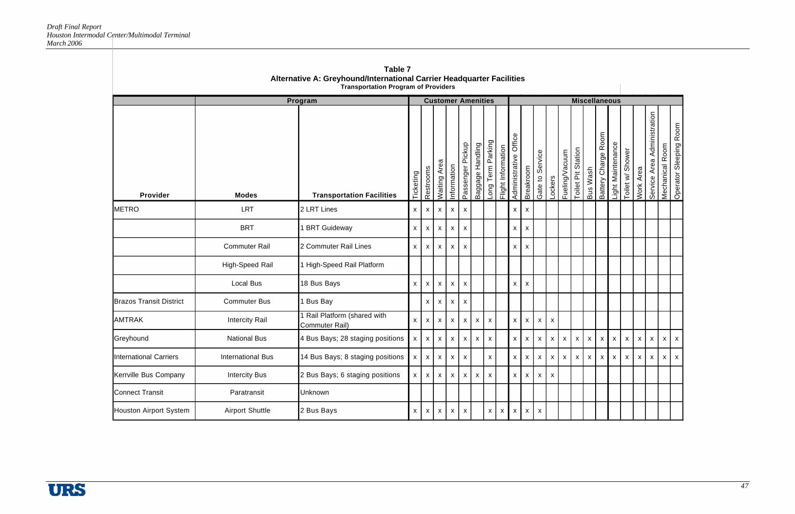
Draft Final Report Houston Intermodal Center/Multimodal Terminal March 2006
47
Table 7 Alternative A: Greyhound/International Carrier Headquarter Facilities
Transportation Program of Providers
Provider Modes Transportation Facilities Tic
ketin
g
Res
troo
ms
Wai
ting
Are
a
Info
rmat
ion
Pas
seng
er P
icku
p
Bag
gage
Han
dlin
g
Long
Ter
m P
arki
ng
Flig
ht In
form
atio
n
Adm
inis
trat
ive
Offi
ce
Bre
akro
om
Gat
e to
Ser
vice
Lock
ers
Fuel
ing/
Vac
uum
Toi
let P
it S
tatio
n
Bus
Was
h
Bat
tery
Cha
rge
Roo
m
Ligh
t M
aint
enan
ce
Toile
t w/ S
how
er
Wor
k A
rea
Ser
vice
Are
a A
dmin
istr
atio
n
Mec
hani
cal R
oom
Ope
rato
r S
leep
ing
Roo
m
METRO LRT 2 LRT Lines x x x x x x x
BRT 1 BRT Guideway x x x x x x x
Commuter Rail 2 Commuter Rail Lines x x x x x x x
High-Speed Rail 1 High-Speed Rail Platform
Local Bus 18 Bus Bays x x x x x x x
Brazos Transit District Commuter Bus 1 Bus Bay x x x x
AMTRAK Intercity Rail1 Rail Platform (shared with Commuter Rail)
x x x x x x x x x x x
Greyhound National Bus 4 Bus Bays; 28 staging positions x x x x x x x x x x x x x x x x x x x x x
International Carriers International Bus 14 Bus Bays; 8 staging positions x x x x x x x x x x x x x x x x x x x x
Kerrville Bus Company Intercity Bus 2 Bus Bays; 6 staging positions x x x x x x x x x x x
Connect Transit Paratransit Unknown
Houston Airport System Airport Shuttle 2 Bus Bays x x x x x x x x x x
Program Customer Amenities Miscellaneous

Draft Final Report Houston Intermodal Center/Multimodal Terminal March 2006
48
Table 8 Alternative A1: Greyhound/International Carrier Pass-Through Passenger Pick-Up Service
Transportation Program of Providers
Provider Modes Transportation Facilities Tic
ketin
g
Res
troom
s
Wai
ting
Are
a
Info
rmat
ion
Pas
seng
er P
icku
p
Bag
gage
Han
dlin
g
Long
Ter
m P
arki
ng
Flig
ht In
form
atio
n
Adm
inis
trativ
e O
ffice
Bre
akro
om
Gat
e to
Ser
vice
METRO LRT 2 LRT Lines x x x x x x x
BRT/LRT 1 BRT Guideway x x x x x x x
Commuter Rail 2 Commuter Rail Lines x x x x x x x
High-Speed Rail 1 High-Speed Rail Platform
Local Bus 18 Bus Bays x x x x x x x
Brazos Transit District Commuter Bus 1 Bus Bay x x x
AMTRAK Intercity Rail 1 Rail Platform (shared with Commuter Rail) x x x x x x x x x x
Greyhound National Bus 4 Bus Bays; 8 staging positions x x x x x x x x x x
International Carriers International Bus 12 Bus Bays; 4 staging positions x x x x x x x x x
Kerrville Bus Company Intercity Bus 2 Bus Bays; 3 staging positions x x x x x x x x x x
Connect Transit Paratransit Unknown
Houston Airport System Airport Shuttle 2 Bus Bays x x x x x x x x x x
MiscellaneousProgram Customer Amenities

Draft Final Report Houston Intermodal Center/Multimodal Terminal March 2006
49
Table 9 Hypothetical Full Capability Facility Program (Alternative A)
TUNNEL LEVEL Sq. Footage UPPER LEVEL Sq. Footage
TRANSIT FEATURES BUILDING AREASBRT Platform - Main St. / Harrisburg / SE 6,000 Concessions/Food CourtVertical Circulation 1,000 4 Food Vendors 3,200The Tunnel Level is below the 100 year Flood Plain General Seating Area 4,400therefore, no Program Spaces are recommended at Property Management Office 330this level Tenant Spaces 500
Promenade (Vert./Horz. Circulation) 3,000GROUND LEVEL Sq. Footage Promenade Interior Area 13,000
Core ElementsBUILDING AREAS Janitorial Closets 200Entry lobby 5,000 Mechanical Rooms 200Meeting / Waiting Areas 1,800 Electrical Rooms 200Information (Visitor Center) 375 Telephone/Data rooms 200METRO RideStore 1,800 Fire Escape Stairwells 300Travel Services 200 Freight Elevators 200Promenade Interior Area 7,000 Public Elevators 300Promenade (Vert./Horz. Circulation) 3,000 Public Escalators 425Package / Mail Interface 3,500 Men's Rooms 600Airport Shuttle Service 500 Women's Rooms 600Taxi / Limo Service 200 High Speed Rail Operations Center 500Building Engineer Office 150 LRT/BRT Operations Center 500Building Maintenance Office 150 Commuter Rail Operations Center 500Cool Trash Storage 120 LRT/BRT/Bus Operator Breakroom 500Dry Trash Storage 120 Shower / Locker Rooms 300Support Building Features LRT/BRT / Bus Management Offices 450
Central Plant (HVAC) 500 Security Command Center 250Electric Vault 100 Interview Room 120Electrical Switch Gear 120 Patrol Office 200Domestic Water Pump Room 120 Police Office 200Fire Pump Surge Tank 200Bulk Storage Room 200 GROUND LEVEL TRANSIT FEATURESEmergency Generators (Life Support) 500 Amtrak Ticketing / Luggage 300Emergency Generators (IT) 500 Amtrak Platform 26,000Traction Power Substation for LRT 4,000 Commuter Rail Platform US290 / Galv. 26,000Loading Dock (Three bays) 1,500 LRT Platform Harrisburg / SE 8,000
Core Elements Airport Ticketing / Luggage Counter 300Janitorial Closets 125 2 Houston Airport System Bays 1,000Mechanical Rooms 200 Taxi/Limo Services 3,000Electrical Rooms 200 Carpool / Vanpool drop-off / pick-up 1,800Telephone/Data rooms 200 METRO 18 Bay Transit Center 9,000Fire Escape Stairwells 300 METROLIFT Bay (Accom. 2 mini-buses) 1,000Freight Elevators 200 METRO Bus Layover Area 10,000Public Elevators 300 Bicycle Parking 320Public Escalators 425 Pedestrian Access 450Men's Rooms 400 Noon day METRO Bus Parking 4,800Women's Rooms 400
Roof Chillerxs 400 UPPER LEVEL TRANSIT FEATURESMain Street LRT Platform (Plus 1) 16,000High Speed Rail (West) Platform (Plus 2) 26,000
PARKING GARAGE2,000 Car Parking Garage 600,000
METRO REGIONAL TERMINAL BUILDING (Air Conditioned Space)PROMENADE INTERIOR AREA 20,000GENERAL INTERIOR AREAS (NSF) 38,410GROSS AREA (Net to Gross Ratio 65%-35%) 20,682
TOTAL GROSS BUILDING AREA 79,092
BRT/LRT TRANSIT PLATFORMS (Covered Non-Conditioned Space)PLATFORM AREA 108,000
METRO BUS TRANSIT CENTER PLATFORMSPLATFORM AREA 10,000
PARKING GARAGE 600,000

Draft Final Report Houston Intermodal Center/Multimodal Terminal March 2006
50
BUILDING FEATURES Sq. Footage
GENERAL FEATURESEntry lobby 3,000Meeting / Waiting Areas 1,800Information (Visitor Center) 375Greyhound / International Bus Services 4,200Travel Services 200Concessions/Food Court
1 Food Vendors 800General Seating Area 1,100
Promenade (Vert./Horz. Circulation) 1,000Package / Mail Interface 3,500
GREYHOUND TRANSIT FEATURESDrivers' Sleeping Rooms 225Drivers' Shower Facilities 100Toilet Pit Station 420Bus Wash 600Parts and Battery Change Room 500Mechanical Room 200Service Area Administration 200Greyhound/International Carrier Bays 5,00028 Greyhound Staging Positions 14,0004 Greyhound Bays 2,000
OTHER TRANSIT FEATURESTaxi / Limo Service 2008 International Carrier Staging Positions 4,0006 Kerrville Bus Line Staging Positions 3,00014 International Bus Carriers 7,0002 Kerrville Bus Line Bays 1,0001 Brazos Transit District Bay 500Drivers' Sleeping Rooms 225Drivers' Shower Facilities 100
SECURITYInterview Room 120Patrol Office 200
NATIONAL / INTERNATIONAL TERMINAL BUILDING(Air Conditioned Space)PROMENADE INTERIOR AREA 10,000GENERAL INTERIOR AREAS (NSF) 24,675GROSS AREA (Net to Gross Ratio 65%-35%) 13,300
TOTAL GROSS BUILDING AREA 47,975
BUILDING FEATURES Sq. Footage
PROPERTY MANAGEMENTProperty Management Office
Reception 180Property Manager 150
Building Engineer Office 150Building Maintenance Office 150Loading Dock Two bays) 1,000Cool Trash Storage 120Dry Trash Storage 120Support Building Features
Central Plant (HVAC) 500Electric Vault 100Electrical Switch Gear 120Domestic Water Pump Room 120Fire Pump Surge Tank 200
Core ElementsJanitorial Closets 200Mechanical Rooms 400Electrical Rooms 400Telephone/Data rooms 400Fire Escape Stairwells 600Freight Elevators 200Public Elevators 300Public Escalators 300Men's Rooms 600Women's Rooms 600
Roof ElementsChillers 400
Other Building FeaturesEmergency Generators (Life Support) 500
ADJACENT FEATURESPedestrian Access 450
Table 10 Hypothetical Multiple Facility Program (Alternative A1)

Draft Final Report Houston Intermodal Center/Multimodal Terminal March 2006
51
III. LOCATION ANALYSES
This chapter of the final report discusses the extensive analyses that have been undertaken to identify the optimal sites in Houston for an intermodal/multimodal facility. The approach for selecting the preferred sites includes a large-scale and area-specific examination. The first step entails a macro- level identification of areas where the proposed facility could be located. The general criteria that are used includes connections to existing and proposed regional transportation facilities, overall proximity to major regional activity centers, land availability, and land use patterns. The next step is then to identify specific parcels within the preferred region where an intermodal/multimodal facility could be best located. The criteria that this step uses are refinements to those from the regional analysis. Finally, a master plan is completed for the preferred site through a workshop to further refine the vision for the proposed intermodal/multimodal facility and its immediate surrounding.
A. Regional Location Analysis
Technical Memorandum #3: Regional Location Analysis presented the process undertaken to determine areas within the Houston region that may be suitable for an Intermodal Center/Multimodal Terminal. During the Regional Location Analysis, information that was developed by the Transportation Provider Input and Community and Project Coordination tasks was used to map the current and proposed fixed facility routing and alignments of major transportation providers in the Houston region.
A stakeholder workshop was conducted in May 2005 to solicit preferred regional locations for the Intermodal Center/Multimodal Terminal from the transportation service providers based on their needs. The workshop garnered ample information from the providers and guided the Study on the most appropriate locations in the Houston region for an intermodal/multimodal facility. Transportation providers who were included in the workshop were the Union Pacific Railroad, BNSF, METRO, Greyhound, AMTRAK, and several international bus carriers such as Tornado Bus Company and Turimex. The information from the Union Pacific Railroad provided guidance on the feasibility of the use of existing freight rail lines for commuter rail transit. Greyhound, AMTRAK, and the international carriers provided information on their volumes of travel as well as their routes and station locations. METRO provided information regarding the agency’s future fixed-guideway transportation improvement plans.

Draft Final Report Houston Intermodal Center/Multimodal Terminal March 2006
52
Using this various information, seven general areas (Zones A through G) were identified within the region, each a candidate for accommodating multiple transportation programs for numerous transportation providers. Each general area was evaluated against a set of criteria designed to measure the effectiveness of each individual site’s ability to meet the goals and objectives developed in the Community and Project Coordination task. Other factors were also evaluated including proximity to Houston’s major activity centers, ability to serve international transportation providers, and the ability to accommodate future transportation projects.
Using the information gathered from transportation providers in Technical Memorandum #2: Transportation Project Inventory, a map was created which presented known existing and committed transportation project improvements for the Houston area within the Sam Houston Tollway. The types of transportation services identified were freeway, tollway, high occupancy vehicle (HOV), light rail transit (LRT), light rail transit/bus rapid transit (LRT/BRT), AMTRAK, the Houston Airport System, local bus, national bus, and international bus. The map facilitated the identification of several major transportation nodes within the Houston region (see Figure 9):
§ Zone A (North Downtown)
§ Zone B (East Downtown)
§ Zone C (US 59 South at IH 610 West)
§ Zone D (IH 610 South at Fannin)
§ Zone E (IH 10/US 290 at IH 610)
§ Zone F (IH 45 South at IH 610 South)
§ Zone G (IH 45 North at IH 610 North)

Draft Final Report Houston Intermodal Center/Multimodal Terminal March 2006
53
Figure 9 Houston Area Transportation Infrastructure

Draft Final Report Houston Intermodal Center/Multimodal Terminal March 2006
54
The regional location analysis for the Houston Intermodal Center/Multimodal Terminal Feasibility Study gave Zone A the highest ranking of all the alternative sites for the following reasons:
§ Connectivity to the greatest number of existing transportation infrastructure elements in the region, including IH 10, IH 45, US 59, SH 288, Main Street LRT, AMTRAK, and local, national and international bus service.
§ Connectivity to the greatest number of proposed transportation infrastructure elements in the region, such as the Hardy Toll Road extension, North, Southeast and Harrisburg BRT/LRT, and US 290, Galveston and SH 35 commuter rail.
§ Best overall proximity to major regional activity centers including Downtown Houston, Uptown Houston, Greenway Plaza, Greenspoint, Westchase, Clear Lake/NASA, and Reliant Park/Texas Medical Center.
§ Greatest amount of vacant and/or underutilized land in close proximity to existing and proposed transportation infrastructure. If the seven zones were rated solely on this criterion, the ranking would be as follows, from high to low: 1) Zone A; 2) Zone B; 3) Zone E; 4) Zone C; 5) Zone D; 6) Zone F; and 7) Zone G.
§ Most consistent land use patterns which are compatible with the development of an Intermodal Center/Multimodal Terminal facility.
Zone B also rated highly on the foregoing evaluation criteria. This led to the development of a recommendation for two alternative solutions for the selection of a preferred location as part of a regional strategy for the development of a network of such facilities throughout the region.
For Alternative A, Zone A is selected as the preferred location for a full-capability Intermodal Center/Multimodal Terminal, which includes the relocation of all passenger and operating functions of the national and international bus carriers. Of all the zones, Zone A has the highest amount of connectivity to the known existing and proposed transportation infrastructure as well as the most amount of vacant and underdeveloped property. Zone A also includes downtown Houston, a major activity center for business, government and entertainment and the Main Street METRORail LRT line.

Draft Final Report Houston Intermodal Center/Multimodal Terminal March 2006
55
Alternative A1 includes Zone A as the location of a primary intermodal terminal which included passenger-related functions for Greyhound and the international bus carriers and a secondary facility located somewhere within Zone B for Greyhound and the international bus carriers. Greyhound and the international bus carriers would be housed in the Zone B facility or retain their existing facilities, but would use the Zone A facility as a passenger pick-up and drop-off location. This alternative may be best in the event that there is insufficient space available to accommodate all of the service needs of the international bus carriers and Greyhound.
In both alternatives, Zones C and E rank as second tier locations for an intermodal facility. Zone C includes the uptown Houston major activity center and is near the densely populated Southwest Houston neighborhoods of Gulfton and Fondren Southwest and work well for the international bus carriers, but its connectivity to the known existing and planned transportation infrastructure is not comparable to the level of connectivity in Zone E. Zone E has the highest level of transportation connectivity outside of downtown Houston, and would benefit from a potential connection to Uptown Houston by the proposed Uptown Houston BRT/LRT facility. Presently, there is no major activity center present within or in close proximity to the zone, but the Houston Independent School District will be establishing a significant office presence in the area, a significant redevelopment has been proposed for the Northwest Mall, and the current Houston Independent School District stadium has been proposed as a candidate site for a Major League Soccer facility.
In both alternatives, Zones D, F, and G rank as third tier intermodal facility locations. Zone D is the only third tier zone that is in close proximity to a major activity center (Texas Medical Center/Reliant Park). It is also the only third tier zone on the METRORail LRT line. Zones F and G are very similar. Both contain junctions of IH 610 and IH 45, both are in close proximity to campuses of the Houston Community College System, both are in close proximity to significant local shopping centers, both are in the two airport corridors, and both are in close proximity to METRO Transit Centers. The major difference between the two is that while both may have planned BRT/LRT transportation available, only Zone F may have access to future commuter rail transportation.
As discussed previously, Zone A is designated as the preferred location, with the second and third-tier locations being necessary for the long-term solution of regional intermodal travel within the Houston region. Though the second and third-tier facilities have been designated in this process based on existing and proposed connectivity, their selection for implementation is

Draft Final Report Houston Intermodal Center/Multimodal Terminal March 2006
56
affected by funding ability and individual transportation infrastructure improvement priority. For example, if the funding ability and/or schedule of major transportation infrastructure improvement shift to improve a third-tier location’s connectivity to a level at or above a second-tier’s connectivity, then it may possibly be implemented sooner than originally planned.
Table 11 presents the connectivity evaluation process of the seven zones. Red column headings depict first-tier locations; orange indicates second-tier locations; and yellow indicates third-tier locations. The preliminary results and findings of this evaluation have been reviewed with the Transportation Service Providers, the Working Committee, and the Steering Committee. While all of the participants in this evaluation process are in general agreement with these findings, the national and international bus carriers have indicated that if accommodations for their operations could not be made in Zone A, then they would prefer Zone B.

Draft Final Report Houston Intermodal Center/Multimodal Terminal March 2006
57
Table 11 Regional Location Analysis Matrix
Zone A Zone B Zone C Zone D Zone E Zone F Zone G Regional
Zone North Downtown East Downtown US 59 at IH 610 South IH 610 South at Fannin IH 10 / US 290 at
IH 610 IH 45 South at IH 610
South IH 45 North at IH 610
North IH 45 IH 45 IH 610 IH 610 IH 10 IH 45 IH 45
IH 10 IH 10 US 59 SH 288 IH 610 IH 610 IH 610
US 59 US 59 Westpark Toll Road Main Street (LRT) US 290 SH 225 Hardy Toll Road
SH 288 SH 288 Local Bus Carrier Local Bus Carrier IH 10 West HOV IH 45 South HOV IH 45 North HOV
IH 45 North HOV IH 45 South HOV US 290 HOV Local Bus Carrier Local Bus Carrier
IH 10 West HOV US 59 North HOV Local Bus Carrier
US 59 North HOV US 59 South HOV
Main Street (LRT) National Bus Carrier
AMTRAK International Bus Carrier
National Bus Carrier Local Bus Carrier
International Bus Carrier
Connectivity to Existing
Infrastructure
Local Bus Carrier
Hardy Toll Road Extension Hardy Toll Road Extension University Line (LRT) US 90A (CRT) Hempstead Toll Road SH 35 Toll Road Hardy Toll Road Extension
North Line (BRT/LRT) North Line (BRT/LRT) Uptown Line (BRT/LRT) SH 288 (CRT-Long Term) Uptown Line (BRT/LRT) Galveston (CRT-Long Term) North Line (BRT/LRT)
Southeast Line (BRT/LRT) Southeast Line (BRT/LRT) Uptown (Suburban BRT) US 290 (CRT) 249/Tidwell (Suburban BRT)
Harrisburg Line (BRT/LRT) Harrisburg Line (BRT/LRT)
US 290 (CRT) Galveston (CRT-Long Term)
Galveston (CRT-Long Term) SH 35 (CRT-Long Term)
Connectivity to Proposed
Infrastructure
SH 35 (CRT-Long Term)

Draft Final Report Houston Intermodal Center/Multimodal Terminal March 2006
58
B. Location Analysis
This section of the report presents the findings of the site evaluation analysis and provides a recommendation of the specific areas best suited for the proposed intermodal/multimodal facility. Upon the identification of Zone A as the preferred regional site for the facility in Technical Memorandum #3: Regional Location Analysis, several specific parcels are identified using GIS data and then examined in detail. Technical Memorandum #6: Location Analysis describes these seven parcels and their individual evaluation in detail. (See Appendix G). These seven areas have been designated as follows and illustrated in Figure 10:
§ White Oak
§ Hardy Yards
§ Wilson
§ Post Office
§ Bus Barn
§ East Bayou
§ I-10/US 59.
Each of the seven areas were evaluated against an additional set of criteria developed by the Steering Committee, including opportunities for intermodal connectivity, a sub-area where an Intermodal Center/Multimodal Terminal would be consistent with land use patterns, the level of economic impact and development potential, and cost considerations related to site development and construction. In addition to Zone A, at the conclusion of Technical Memorandum #3: Regional Location Analysis, Zone B has been identified as a secondary location for some program requirements if a site large enough for all facilities and modes is not available in Zone A. The evaluation criteria are listed in the following pages.

Draft Final Report Houston Intermodal Center/Multimodal Terminal March 2006
59
Figure 10 Zone A Seven Sub-Areas
Transportation and Mobility
§ Operation and Maintenance
§ Intermodal Connectivity
§ Accessibility
§ Travel Time Savings.
Wilson
Hardy Yards
Post Office
I-10/US 59
East Bayou
Bus Barn
White Oak

Draft Final Report Houston Intermodal Center/Multimodal Terminal March 2006
60
Economic Investment and Opportunity
§ Consistency with Land Use Patterns
§ Proximity to Existing Planned Development
§ Proximity to Developed and Redevelopable Land
§ Resident/Neighborhood Sentiment
§ Business Community Sentiment
§ Environmental Impacts.
Site Characteristics
§ Positive Community Impact
§ Avoid Business and Resident Relocation
§ Personal Security
§ Environmental Clearance/Remediation
§ Visibility
§ Capital Cost
§ Ease of Site Acquisition
§ Ability to Phase Construction.
The development of any of the sub-areas for an Intermodal Center/Multimodal Terminal would require a significant level of transportation infrastructure improvements in order to properly manage traffic movements in and around the proposed facility. Any such improvements would be assessed during the detailed engineering phase of this project.

Draft Final Report Houston Intermodal Center/Multimodal Terminal March 2006
61
Description of Zone A Sub-Areas
The following is a description of each of the seven sub-areas within Zone A (illustrated in Figure 10). The physical description of each sub-area includes estimated land area, known number of property owners, land use, and existing and future transportation connections to the sub-area.
White Oak
The White Oak sub-area is located northeast of the I-45/I-10 interchange near north downtown Houston. It is a nearly 48-acre area with land divided among 21 owners. However, three owners own the majority (approximately 33 acres) of the land. The land is relatively undeveloped, except for with University of Houston-Downtown’s parking lots and a few buildings, some of which appear historic. A large portion of the area is within the 500- and 100-year floodplains, and a significant portion of the site is in the White Oak Bayou floodway (Figure 11). Connections to the freeway system exist only on Main Street, which does not have immediate access to Interstate 10 West or Interstate 45.
Figure 11 White Oak Bayou Floodplains

Draft Final Report Houston Intermodal Center/Multimodal Terminal March 2006
62
An active Union Pacific rail line currently traverses the sub-area, and could become a part of the proposed US 290 commuter rail, which may possibly intersect with the proposed Main Street LRT extension, the proposed North Corridor BRT/LRT line, the Southeast Corridor BRT/LRT, and the proposed Galveston commuter rail on the east side of the White Oak sub-area. The White Oak sub-area is connected to numerous existing and proposed transportation linkages, as presented in Table 12:
Table 12 Transportation Linkages: White Oak
Existing Proposed
- IH 45 - IH 10 - US 59 North - SH 288 - IH 45 North HOV - IH 10 West HOV - US 59 North HOV - Main Street (LRT) - AMTRAK - Water-Borne Transportation - Bicycle - National Bus Carrier - International Bus Carrier - Local Bus Carrier
- Hardy Toll Road Extension - North Line (BRT/LRT) - Southeast Line (BRT/LRT) - Harrisburg Line (BRT/LRT) - US 290 (commuter rail – long term) - Galveston (commuter rail – long term) - SH 35 (commuter rail – long term)
Hardy Yards
The Hardy Yards sub-area is a nearly 51-acre site located between Northside Village residential area and the multi- track Union Pacific Hardy Rail Yards. Several structures on this land have recently been demolished as a part of a mixed-used development plan for the area. The Hardy Rail Yards could possibly become a part of the proposed Galveston commuter rail, which may intersect with the proposed Main Street LRT extension, the proposed North Corridor BRT/LRT line, the Southeast Corridor BRT/LRT, and the proposed US 290 commuter rail on the southwest side of the Hardy Yards sub-area. The Hardy Yards sub-area is connected to the following existing and proposed transportation linkages, as shown in Table 13.
Physical evaluation of the Hardy Yards sub-area revealed several potential advantages to ease the development of an Intermodal Center/Multimodal Terminal. One potential advantage is the lack of intense development of the area and its current relative vacancy. There are a small

Draft Final Report Houston Intermodal Center/Multimodal Terminal March 2006
63
number of single-family residences and businesses along Burnett Street. While these residences and businesses are not physically on the Hardy Yards site, they would be directly impacted by the development of this site. On the Hardy Yards site, there were very few buildings standing, and demolition and site work continues to be done. The site is bordered to the south by the Hardy Rail Yards, and the Intermodal Center/Multimodal Terminal could provide a buffer between the rail traffic and the residential area north of the site. One other advantage of this site is that its elevation is higher than the other sub-areas being analyzed, providing a view of the downtown Houston skyline that significantly enhances the image of the region from the viewpoint of the facility’s patrons.
Table 13 Transportation Linkages: Hardy Yards
Existing Proposed
- IH 45 - IH 10 - US 59 North - SH 288 - IH 45 North HOV - IH 10 West HOV - US 59 North HOV - Main Street (LRT) - AMTRAK - Bicycle - National Bus Carrier - International Bus Carrier - Local Bus Carrier
- Hardy Toll Road Extension - North Line (BRT/LRT) - Southeast Line (BRT/LRT) - Harrisburg Line (BRT/LRT) - US 290 (Commuter Rail) - Galveston (commuter rail – long-term) - SH 35 (commuter rail – long-term
A key disadvantage of the site is the lack of connections to the existing freeway system. Main Street is the only arterial that crosses the railroad to provide access to the freeway system and downtown. Connections to an intense, focal use such as the Intermodal Center/Multimodal Terminal will require significant improvements to the transportation infrastructure, including better connections to the freeway system.

Draft Final Report Houston Intermodal Center/Multimodal Terminal March 2006
64
Wilson
The Wilson property is located north of I-10 and downtown Houston, bordered by the Elysian Viaduct to the east, the Hardy Rail Yards to the north, and North Main Street to the west. The site is currently occupied by numerous industrial warehouses owned by Wilson Industries and several other companies. With the exception of the eastern end of the site, most of the uses present are industrial, and the area is almost completely developed.
The Hardy Rail Yards could become a part of the proposed Galveston commuter rail, which may possibly intersect with the proposed Main Street LRT extension, the proposed North Corridor BRT/LRT line, the Southeast Corridor BRT/LRT, and the proposed US 290 commuter rail on the northwest side of the Wilson sub-area. The Wilson sub-area is connected to the following existing and proposed transportation linkages:
Table 14 Transportation Linkages: Wilson Property Existing Proposed
- IH 45 - IH 10 - US 59 North - SH 288 - IH 45 North HOV - IH 10 West HOV - US 59 North HOV - Main Street (LRT) - AMTRAK - Bicycle - National Bus Carrier - International Bus Carrier - Local Bus Carrier
- Hardy Toll Road Extension - North Line (BRT/LRT) - Southeast Line (BRT/LRT) - Harrisburg Line (BRT/LRT) - US 290 (commuter rail) - Galveston (commuter rail – long-term) - SH 35 (commuter rail – long-term)
The physical evaluation of the Wilson sub-area identified the intensity of the predominant industrial use of the area. Several buildings belong to Wilson Industries, but there were also several other warehouses and supply yards in the area. There was very little unused industrial space on this site. Having a predominantly active industrial area could pose some challenges for construction of an Intermodal Center/Multimodal Terminal due to the potential associated relocation costs. There were also three identified single-family housing units, two of which were completely surrounded by an industrial facility.

Draft Final Report Houston Intermodal Center/Multimodal Terminal March 2006
65
On the sub-area’s eastern perimeter, there were small amounts of vacant land and parcels. A small number of buildings that could be deemed historic were also present. While I-10 borders one side of the sub-area, existing connectivity to the freeway system was minimal and would require significant infrastructure improvements. However, infrastructure providing more direct access to the freeway system could be constructed within the limits of the site.
Post Office
The Post Office site is adjacent to the I-45 and I-10 interchange in downtown Houston and includes over 34 acres of land owned predominantly by the U.S. government. A major facility for the U.S. Postal Service (USPS) is currently located on this site, and the existing AMTRAK station is located nearby. Any development of this site for other purposes would entail the identification, purchase and development of an alternative location for the Post Office facility in a suitable location to the USPS. The Post Office site has no immediate access to any existing or proposed fixed guideway transit infrastructure. However, the site has access to the Union Pacific passenger main line, which Union Pacific prefers for commuter rail. The Post Office sub-area is connected to the following existing and proposed transportation linkages:
Table 15 Transportation Linkages: Post Office
Existing Proposed
- IH 45 - IH 10 - US 59 North - SH 288 - IH 45 North HOV - IH 10 West HOV - US 59 North HOV - AMTRAK - Water-Borne Transportation - Bicycle - National Bus Carrier - International Bus Carrier - Local Bus Carrier
No connection to any known proposed infrastructure.
Physical evaluation of the Post Office sub-area was mainly focused on access to the freeway system. This sub-area had a very high level of connectivity to the freeway system with direct connections to I-45 North and I-10 West proximate to the sub-area, but there were no direct connections to the existing Main Street LRT or any known proposed rail transit. The area is

Draft Final Report Houston Intermodal Center/Multimodal Terminal March 2006
66
currently being used intensively by the USPS and is surrounded closely on all sides by several significant uses, including a large number of downtown attractions such as the Theater District and Sesquicentennial Park along with I-45 and I-10. The development of this site for an Intermodal Center/Multimodal Terminal would require a major relocation effort for the USPS.
Bus Barn
The Bus Barn site is currently occupied by the METRO Buffalo Bayou facility, which includes an office building listed on the National Register of Historic Places. The 19-acre site is divided among five different owners, but METRO owns a substantial portion of the property. The Warehouse Arts District borders the sub-area to the north and several Harris County correctional facilities border the sub-area to the south. In addition, a proposed canal that would be used to relieve the impacts of flooding at the White Oak Bayou/Buffalo Bayou confluence is under study and if constructed, would bisect this sub-area. METRO uses this site for midday storage for nearly 240 buses. Any development of this site for other purposes would entail the identification, purchase and development of an alternate location in close proximity to this site for these METRO buses. The Bus Barn sub-area is connected to the following existing and proposed transportation linkages:
Table 16 Transportation Linkages: Bus Barn
Existing Proposed
- IH 45 - IH 10 - US 59 - SH 288 - IH 45 North HOV - IH 10 West HOV - US 59 North HOV - AMTRAK - Water-Borne Transportation - Bicycle - National Bus Carrier - International Bus Carrier - Local Bus Carrier
- Hardy Toll Road Extension - Southeast Line (BRT/LRT) - Harrisburg Line (BRT/LRT)
Physical evaluation of the site identified potential physical constraints to the Bus Barn area. Several Harris County correctional facilities are on the south and west sides of the site, and the Warehouse Arts District is to the north of the site. However, there is a large expanse of vacant

Draft Final Report Houston Intermodal Center/Multimodal Terminal March 2006
67
land on the east side of the site. The site has access to the freeway system via connections from McKee Street to I-10 West and I-45, and from North San Jacinto Street to I-10 East and US 59. The development of this site for an Intermodal Center/Multimodal Terminal would require a major effort to relocate METRO’s existing bus barn facility.
East Bayou
The nearly 20-acre East Bayou sub-area is one of three sub-areas located on Buffalo Bayou. The land is divided among four owners and is almost totally vacant. The site is also divided by the Elysian Viaduct, and overall street connectivity is minimal. The East Bayou sub-area is connected to the following existing and proposed transportation linkages (Table 17):
Table 17 Transportation Linkages: East Bayou
Existing Proposed
- IH 45 - IH 10 - IH 45 North HOV - IH 10 West HOV - Water-Borne Transportation - Bicycle - National Bus Carrier - International Bus Carrier - Local Bus Carrier
- Galveston (commuter rail – long-term) - SH 35 (commuter rail – long-term)
No substantial impediments to the development of the Intermodal Center/Multimodal Terminal were identified. However, the site’s access to the freeway system is very limited. Interstate 10 West and I-45 can be accessed from McKee Street, but travel through the central business district is required for access to I-10 East and US 59. The Elysian Viaduct bisects the area, but there are no connections from the site.

Draft Final Report Houston Intermodal Center/Multimodal Terminal March 2006
68
I-10/US 59 Sub-Area
The I-10/US 59 sub-area is located adjacent to the I-10/US 59 interchange in the far northeastern corner of downtown Houston. There are several existing industrial and potentially historic structures in this sub-area. The I-10/US 59 sub-area is connected to the following existing and proposed transportation linkages:
Table 18 Transportation Linkages: I-10/US 59
Existing Proposed
- IH 45 - IH 10 - IH 45 North HOV - IH 10 West HOV - AMTRAK - Bicycle - National Bus Carrier - International Bus Carrier - Local Bus Carrier
- Galveston (commuter rail – long-term) - SH 35 (CRT-Long Term)
The I-10/US 59 sub-area contained several different industrial buildings. These structures are not centralized in a manner similar to the Wilson sub-area, but are dispersed throughout the area. The current railroad tracks used by AMTRAK pass through the area, as well as the Elysian Viaduct.

Draft Final Report Houston Intermodal Center/Multimodal Terminal March 2006
69
Evaluation of Sub-Areas
The Steering Committee identified three primary goals of Transportation and Mobility, Economic Opportunity and Investment, and Site Characteristics. To evaluate the seven sites associated with Zone A, the following criteria were also established to facilitate the selection of preferred sites for the proposed intermodal/multimodal facility.
Transportation and Mobility
§ Operation and Maintenance – Quantitative measure of the annual incremental cost in current year dollars to operate and maintain the current and projected levels of transit service to alternative sites in comparison to the baseline condition.
§ Intermodal Connectivity – Qualitative measure of the ability of the alternative sites to accommodate current transit services and potential proposed future bus and fixed guideway linkages.
§ Accessibility – Qualitative measure of ease and degree to which alternative locations may be accessed by different modes of travel such as bicycles, pedestrians, and taxis.
§ Travel Time Savings – Quantitative measure of the change in travel time from selected major activity centers to common destinations.
Economic Investment and Opportunity
§ Consistency with Land Use Patterns – Qualitative measure of the consistency of alternative locations with existing and future local land use patterns of development and trends.
§ Proximity to Existing Planned Development – Qualitative and quantitative measures of the amount of existing and planned developments located in proximity to the alternative sites.
§ Proximity to Developed and Redevelopable Land – Qualitative and quantitative measures of the amount of existing and planned developments located in proximity to the alternative sites.

Draft Final Report Houston Intermodal Center/Multimodal Terminal March 2006
70
§ Resident/Neighborhood Sentiment – Qualitative measure of the level of support or opposition of the local residents of neighborhoods to each of the alternative transit center locations.
§ Business Community Sentiment – Qualitative measure of the level of support or opposition of the business community to each of the alternative operating plans and transit center locations.
§ Environmental Impacts – Qualitative measure of the historical, community, and natural resources that could be impacted by development of a major facility in a given area.
Site Characteristics
§ Positive Community Impact – Qualitative measure that compares the location and size of the site and facility to community goals and objectives.
§ Avoid Business and Resident Relocation – Quantitative measure that seeks to reduce the number of households and businesses that could potentially be relocated from the site or the nearby area as a result of this project.
§ Personal Security – Qualitative measure of the degree to which the transit center location(s) will reinforce the perception of personal security for riders and pedestrians.
§ Environmental Clearance/Remediation – Quantitative and qualitative measures of the cost and/or level of effort necessary to prepare the site to make it suitable for a transit center.
§ Visibility – Qualitative measure of the degree to which the transit center(s) will be readily seen as occupying a location of prominence in the community.
§ Capital Cost – Quantitative measure of the total capital cost to implement the improvements under consideration including site acquisition costs.
§ Ease of Site Acquisition – Qualitative measure related to the status of ownership of alternative sites and the willingness of the owner to consummate a sale.
Draft Final Report Houston Intermodal Center/Multimodal Terminal March 2006
71
§ Ability to Phase Construction – Qualitative and quantitative measures of the degree, ease, and expense associated with the ability to expand the size and/or function of a facility on a particular site.
Each evaluation criterion was used to rate each sub-area. Each of these criteria was placed into a matrix and each sub-area was evaluated and given a score based on how well it fulfilled an objective (the evaluation criterion), summarized below:
Rating Number of Points Assigned
Very well 10 points
Good 5 points
Poor None
In accordance with the Intermodal Connectivity objective established by the Steering Committee and due to the high costs associated with modifying existing transportation infrastructure to connect with an intermodal facility in comparison to the costs associated with locating such a facility adjacent to existing access points, each sub-area’s intermodal connectivity to existing and proposed transportation infrastructure improvements was displayed in a separate matrix. As this was the most important factor for the Regional Location Analysis, it is also a critical factor in ultimate site selection for the same reasons.
The summarized sub-area evaluation and connectivity matrices are shown in Tables 19 and 20, respectively. The detailed evaluation is presented in Appendix G, Technical Memorandum #6: Location Analysis.

Draft Final Report Houston Intermodal Center/Multimodal Terminal March 2006
72
Summary of Findings
As previously stated, each sub-area’s rating against an evaluation criterion was given a numerical value. The sum of these numerical values provides the following ranking of the sub-areas:
Hardy Yards – 145 points
White Oak – 120 points
Wilson Property – 95 points
Post Office – 90 points
Bus Barn – 90 points
East Bayou – 80 points
I-10/US 59 – 70 points
By using these point totals, three tiers of sub-areas can be identified, based on site suitability that includes required transportation infrastructure improvements and business relocations:
§ Tier 1, Best Suited: Hardy Yards and White Oak
§ Tier 2, Sufficient: Wilson Property, Post Office, and Bus Barn
§ Tier 3, Least Suited: East Bayou and I-10/US 59

Draft Final Report Houston Intermodal Center/Multimodal Terminal March 2006
73
Table 19 Sub-Area Evaluation Matrix
Site Criteria White
Oak Hardy Yards
Wilson Property
I-10/ US 59
East Bayou
Bus Barn
Post Office
Transportation and Mobility
1.1 Operation and Maintenance Cost
1.2 Intermodal Connectivity
1.3 Accessibility
1.4 Travel Time Savings
Economic Opportunity and Investment
2.1 Consistency with Land Use Patterns
2.2 Proximity to Existing and Planned Development
2.3 Proximity to Developed and Redevelopable Land
2.4 Resident/Neighborhood Sentiment
2.5 Business Community Sentiment
2.6 Environmental Impacts
Site Characteristics
3.1 Positive Community Impact
3.2 Avoid Business and Resident Relocations
3.3 Personal Security
3.4 Environmental Clearance/Remediation Environmental review to be conducted following
selection of preferred sites by METRO.
3.5 Visibility
3.6 Capital Cost
3.7 Ease of Site Acquisition
3.8 Ability to Phase Construction
Assessment Scheme
Very Good. Meets criterion very well (10 points).
Good. Meets criterion sufficiently (5 points).
Poor. Does not meet criterion (0 point).

Draft Final Report Houston Intermodal Center/Multimodal Terminal March 2006
74
Table 20 Zone A Sub-Area Connectivity Evaluation
Subgroup White Oak Hardy Yards Wilson Property I-10/US 59 East Bayou Bus Barn Post Office IH 10 IH 10 IH 10 IH 10 IH 10 IH 10 IH 10 IH 45 IH 45 IH 45 US 59 US 59 US 59 IH 45 US 59 US 59 US 59 SH 288 SH 288 SH 288 US 59 SH 288 SH 288 SH 288 IH 10 West HOV IH 10 West HOV US 59 North HOV SH 288
IH 10 West HOV IH 10 West HOV IH 10 West HOV US 59 North HOV US 59 North HOV AMTRAK IH 10 West HOV
IH 45 North HOV IH 45 North HOV IH 45 North HOV AMTRAK AMTRAK Water-Borne Transportation US 59 North HOV
US 59 North HOV US 59 North HOV US 59 North HOV Bicycle Water-Borne Transportation Bicycle IH 45 North HOV
Main Street LRT Main Street LRT Main Street LRT Local Bus Carrier Bicycle Local Bus Carrier AMTRAK
AMTRAK AMTRAK AMTRAK National Bus Carrier Local Bus Carrier National Bus Carrier Water-Borne Transportation
Water-Borne Transportation
Bicycle Bicycle International Bus Carrier
National Bus Carrier International Bus Carrier
Bicycle
Bicycle Local Bus Carrier Local Bus Carrier International Bus Carrier
Local Bus Carrier
Local Bus Carrier National Bus Carrier National Bus Carrier National Bus Carrier
National Bus Carrier International Bus Carrier
International Bus Carrier International Bus
Carrier
Connectivity to Existing
Infrastructure
International Bus Carrier
Subgroup White Oak Hardy Yards Wilson Property I-10/US 59 East Bayou Bus Barn Post Office
Hardy Toll Road Hardy Toll Road Hardy Toll Road Galveston (CRT-Long Term)
Galveston (CRT-Long Term) Hardy Toll Road
North Line (BRT/LRT)
North Line (BRT/LRT)
North Line (BRT/LRT)
SH 35 (CRT-Long Term)
SH 35 (CRT-Long Term)
Southeast Line (BRT/LRT)
Southeast Line (BRT/LRT)
Southeast Line (BRT/LRT)
Southeast Line (BRT/LRT) Harrisburg Line
(BRT/LRT)
Harrisburg Line (BRT/LRT)
Harrisburg Line (BRT/LRT)
Harrisburg Line (BRT/LRT)
US 290 (CRT) US 290 (CRT) US 290 (CRT)
Connectivity to Proposed
Infrastructure
Galveston (CRT-Long Term)
Galveston (CRT-Long Term)
Galveston (CRT-Long Term)
SH 35 (CRT-Long Term)
SH 35 (CRT-Long Term)
SH 35 (CRT-Long Term)

Draft Final Report Houston Intermodal Center/Multimodal Terminal March 2006
75
C. Area Master Plan
This section of the final report summarizes the findings and conclusions of the master planning efforts for the Near Northside, documented in detail in Appendix H, Technical Memorandum #7: Area Master Plan. Technical Memorandum #7: Area Master Plan examined the purpose and results of a master planning public workshop conducted on October 5, 2005. This workshop was organized at the direction of the Steering Committee to examine the potential effects of the planned facility and a planned mixed-use development at the Hardy Yards site on the local Near Northside neighborhood. The planned Hardy Yards mixed-use development caused concern about potential gentrification of the area among some Near Northside residents. The Intermodal Center/Multimodal Terminal, which may be located in the same general vicinity, was also seen as another significant change to the fabric of the Near Northside neighborhood. The Study team, along with Steering Committee members and Near Northside residents, used this workshop as an opportunity to integrate both of these developments with the goals and desires of the neighborhood.
Workshop
The workshop was conducted in October 2005 and focused on the development issues surrounding the development of the Houston Intermodal Center/Multimodal Terminal and the planned mixed-use development in the vicinity of Main and Burnett Streets. Specifically, there was concern for the implementation and availability of affordable housing.
The workshop was organized into three major topics: Affordable Housing, the Intermodal Center/Multimodal Terminal, and Master Planning Concepts. Existing intermodal centers/multimodal terminals were discussed to illustrate potential impacts on a neighborhood of such a facility; site and location characteristics and joint development possibilities; any desired relation with housing development; desired land uses of the area; and other planning issues of concern for the Near Northside.
Following are the workshop proceedings, grouped by major topic:
§ Affordable Housing – Affordable housing was a major topic of the workshops, and several types of information were given. Two local concepts were presented by The Metropolitan Organization and the Avenue CDC in order to show various types of

Draft Final Report Houston Intermodal Center/Multimodal Terminal March 2006
76
affordable housing currently in place in Houston, and Richard Baron, an experienced developer of mixed-income affordable housing developments throughout the United States, presented case studies of successful housing developments in other cities. Specific housing affordability information was presented related to poverty levels, incomes, and location.
§ Intermodal Center – The topic of the Intermodal Center/Multimodal Terminal began with information on such a facility. A review of other intermodal centers was given along with a review of the general area where the Houston Intermodal Center/Multimodal Terminal could possibly be developed. A review of the facility’s impacts and any site location characteristics was then discussed, followed by a discussion of joint development possibilities and any desired characteristics of Houston’s Intermodal Center/Multimodal Terminal. The discussion with community representatives focused on sites nearest to existing resident ial neighborhoods in order to focus attention on potential impacts the center could have on these areas. Community representatives understood that these sites represented locations that would result in maximum impact and that other candidate sites that are further away would have less impact.
§ Master Planning Concepts – This discussion included the desired relationship (if any) between the affordable housing implementation and the Intermodal Center. This topic also included discussion on general land uses of the area and any other planning issues or concerns that the local residents may have.
Forces and Issues
In Technical Memorandum #3: Regional Location Analysis, the Study identified Zone A as the preferred location for the Intermodal Center/Multimodal Terminal. Zone A is located in the north end of downtown Houston and areas immediately to the north, where the highest amount of connectivity to the existing and proposed transportation infrastructure is present. The following are the forces and issues identified in the workshop:
§ Selection of Hypothetical Site for Discussion Purposes – A major development like the Intermodal Center/Multimodal Terminal can be a catalyst to revitalization of underutilized inner core urban neighborhoods, if properly integrated with the neighboring community. All of the potential sites in Zone A (Figure 12), the preferred location,

Draft Final Report Houston Intermodal Center/Multimodal Terminal March 2006
77
contain large parcels that are either vacant or underutilized commercial properties. None include residential neighborhoods. All of those sites are potentially viable. The sites north of I-10 would impact underdeveloped industrial/commercial areas and residential communities. The sites south of I-10 would impact mostly commercial and institutional downtown development. The issues on both areas would be similar, but the stakeholders would be different. Sites north of I-10, but south of the railroad tracks and east of Main Street, again are viable and could very well be acceptable locations, but they are somewhat buffered from the neighboring community by the freight rail lines and the freeway. The sites west of Main Street and north of the rail lines are the most appropriate for this analysis/discussion because they are closest to the established community and residential areas and, therefore, best highlight the issues and potentials.
Figure 12 Zone A: Seven Sub-Areas
Wilson
Hardy Yards
Post Office
I-10/US 59
East Bayou
Bus Barn
White Oak
HARDY YARDS
WHITE OAK

Draft Final Report Houston Intermodal Center/Multimodal Terminal March 2006
78
§ Forces that Shape the Center: “The Form Givers” – The intersection of the commuter rail and LRT tracks would influence the location of the Intermodal Center/Multimodal Terminal’s center of gravity. Although development of the site should optimally be as compact as possible for the convenience of the transit passengers transferring from one mode of transportation to another, the overall Intermodal Center/Multimodal Terminal site will likely have a panhandle shape to provide right-of-way for ramp and elevated bridge structures that will be required for bus traffic to cross over the tracks and have direct access to freeways. The physical and visual impact of these elevated road structures to the community should be considered.
The minimum site area for the Multimodal Center / Intermodal Terminal will be approximately 7 acres, excluding any major parking component as part of the facility. The site area could increase significantly once mixed-use development is incorporated into the facility. The site selection criteria should include sufficient land for the transit facility program needs, plus public areas for transitional space to integrate into the neighboring community. Additionally, developable property adjacent to, or that is part of, the Multimodal Center is highly desirable.
The actual facility would most likely be multi- level, due to grade-separation requirements created by the crossing commuter /freight rail corridors. Because of limitations in the existing right-of-way widths and existing privately owned structures, the Main Street LRT and vehicular street traffic crossing the freight rail lines could create a three- level intersection. There are valid reasons for all three levels to have direct connection to the facility; therefore, it is possible that the Intermodal Center/Multimodal Terminal will have three levels, one below grade for private car connection and buses, one at-grade for the fixed guideway commuter rail connection, and one above grade for LRT lines.
§ Intermodal Center Impacts: “The Ripple Effect” – The Intermodal Center/Multimodal Terminal could be a catalyst for development. One of the primary goals is for the facility to be a positive economic development generator and a model of sensitive rebuilding of community. There is ample opportunity to supplement the needs of urban renewal of the surrounding community with the necessary infrastructure of the transit facility. The goal should be for the public/private partnership to share the vision for improvements and revitalization.

Draft Final Report Houston Intermodal Center/Multimodal Terminal March 2006
79
Installation of LRT/BRT lines will alter the local street network. Opportunity exists to create an identity for the affected street that can be inventive and reflect the neighborhood. The transformation of the public right of way realm can be a significant catalyst for redevelopment and revitalization of an area.
Street/rail crossings and new freeway connections will create new elevated structures. These grade separations, if addressed properly, are opportunities for improved local vehicular circulation, visually interesting landscaped landform topography, and the creation of signature bridge structures that create identity for the neighborhood.
The street infrastructure environment needed to support the Intermodal Center can become Economic Corridors for new development and much needed connectivity opportunities between the areas in Zone A and Downtown.
§ Joint Development Opportunities – There are many examples nationwide of public/private partnerships in Intermodal Centers/Multimodal Terminals. The potential for the Houston facility to incorporate joint development exists, especially since transit-oriented development is a focus of METRO. Public/private collaboration is also common in the City of Houston. Opportunities range from for-rent and for-ownership affordable housing, a priority of the Near Northside and of the City of Houston, to commercial/retail development either within the Center or in adjoining properties. The ideal joint development would be mixed-use with office space, retail, restaurants, entertainment, and residential. Public facilities such as Educational, Health, Library, Daycare, and Governmental are also desirable and complementary developments to the facility.
§ Neighborhood Integration – The Intermodal Center/Multimodal Terminal should be viewed as the economic development node for revitalization. In that light, it should be located in an area that can support active urban environment. Pedestrian-friendly streetscapes should surround the facility. Pedestrian amenities should be added along the blocks anticipating the greatest concentration of activity. Sidewalks should be wide enough to accommodate unimpeded pedestrian flow as well as outdoor dining for restaurants. Tree shading and other canopies are also highly desirable to maintain an active street environment. It is highly desirable to extend the street activity from day into night. Consider day and night use mixed-use developments around the center to enhance activity and security.

Draft Final Report Houston Intermodal Center/Multimodal Terminal March 2006
80
Sensitive transition from the institutional Intermodal Center/Multimodal Terminal to the residential single-family zone is a factor of density and scale transition. Since housing is a priority for the Near Northside, multi- family housing in decreasing density could transition the potentially larger commercial developments surrounding the Intermodal Center to the single-family residential areas. Green spaces also could be used to compensate higher density.
It is also important to develop a hierarchy of streets, from major thoroughfares serving the Intermodal Center, to pedestrian-friendly commercial corridors, to arteries connecting to the residential neighborhoods. Depending on the site that is selected, extension of several north-south streets across the railroad corridor will be required to provide access to the facility. Primary candidates include a connection from North San Jacinto to Fulton and the McKee/Hardy couplet south of the railroad to the Hardy/Elysian couplet north of the railroad.
The new developments should respect the potential historic district designation of the area north of Burnett, east of Main Street, and West of Elysian, along with several historic industrial structures on various sites throughout Zone A.
Facility Security Concepts
The essence of an Intermodal Center/Multimodal Terminal is an open public facility for travelers and transit users with amenities to support transportation patrons. The transit stations, circulation paths, public waiting rooms, restrooms, food service areas, newsstands, and parking areas should be provided in a safe environment. Principles of Crime Prevention Through Environmental Design (CPTED) should be followed in the design of the facility and supplemented by a maintained uniform security presence and electronic surveillance. Following are security concepts addressed in the workshop:
§ Accessibility – Perhaps the best way to contribute to the security of the Intermodal Center/Multimodal Terminal is to ensure that it is integrated economically with the surrounding community and that it is easily accessed from the adjacent neighborhoods. By so doing, the facility genuinely becomes part of the fabric of the community in which it is located with the seamless connectivity. This, in turn, promotes a sense of ownership among local residents which contributes to the viability of the facility and makes a

Draft Final Report Houston Intermodal Center/Multimodal Terminal March 2006
81
community asset and a source of local pride, which further contributes to a sense of perceived personal security.
§ Edge Zone – The edge definition of the facility’s boundaries is very important for security enforcement. A clearly defined edge (with unifying planting and/or paving treatments) establishes the limits of the perimeter of the transit center’s zone that is applicable to the enforcement rules of conduct. The same edge treatment can also present a positive image to the neighboring community. If the edge zone is to be used by pedestrians, it should be activated along the way as much as possible to avo id desolate paths. Planted edge zones can also be used to buffer heavy rail and bus traffic.
§ Mixed-Use Development Building Zone – Mixed-use developments that generate day and night patronage enhance the activity in the public zones and increases security for the transit users. It is desirable for joint developments to be multi- faced to activate both the street and the internal environment facing the transit areas. Outdoor dinning and plazas also increases the “eyes on the street” and is a passive deterrent to crime. Well lit outdoor public areas and shared parking zones for commercial and transit users minimizes targeting the transit patrons’ cars and help increase security.
§ Multimodal Terminal Zone – The terminal building typically provides shared passenger waiting areas, transit ride stores, food service / food court, and other public amenities. The inclusion of a storefront police station is an excellent way to introduce a sense of safety and security for the transient travelers that may have prolonged stays between transfers. Well- lit and visually connected drop-off areas are also important for passenger safety.

Draft Final Report Houston Intermodal Center/Multimodal Terminal March 2006
82
Conclusions and Recommendations
The following is a summary of the conclusions, recommendations and concerns garnered from the workshop:
Affordable Housing
§ New development in the Near Northside area, generally south of Burnett Street, should serve as a model affordable housing strategy for Houston, and should be implemented as a priority project.
§ A master plan should be developed for the area to be developed that accounts for public right of way, transit, parks, public services and development. Affordable housing should be integrated into the residential component of the plan for implementation in the near future.
§ The needs for affordable housing in the central city are significant, and allocation of up to 50 percent of units for affordable housing should be considered, especially given the recent influx of new Katrina residents. Successful projects in other cities have similar ranges of affordable housing.
§ A minimum of 8.6 acres of affordable housing (the amount designated in the Hardy Place TIRZ plan) or 20 percent of total residential units should be included in development plans, whichever is greater.
§ The community supports well-designed communities with the following basic characteristics:
- Townhomes: 14 dwelling units (DU) per acre (similar to Clinton Drive townhomes but with more yard and public area)
- Up to Mid-Rise: 30 DU/acre (similar to the density of Washington Courts)
- Senior Housing: 40 DU/acre (similar to Primrose Casa Bella Apartments).
§ Architecture and urban design do matter, and the development should integrate with adjacent neighborhoods and create a sense of community. Based on models in other

Draft Final Report Houston Intermodal Center/Multimodal Terminal March 2006
83
cities presented by Richard Baron, there should be little noticeable difference between market rate and affordable housing units.
§ Affordable housing units should range from two bedrooms to at least four bedrooms to accommodate families (as opposed to smaller units for singles only that are often the "affordable housing" component of a residential development ).
§ Within the affordable housing component, the following should be provided with seniors housing included and a bias toward rental housing for seniors and lower incomes:
§ Covenants should restrict rent increases to a measurable standard and for-sale product should include provisions to retain affordable pricing if homes purchased with subsidies are sold in the future.
§ Market rate housing can include high-rise construction if heights are not excessive and if there is some graduation of heights down and buffering for the adjacent neighborhood.
Allocation Income Rent (2 bedrooms) Allocation Income Sales Price/Mthly Pmt.
20% $18,300 $324 20% $30,500 $89,000 / $751
20% $30,500 $599 30% $36,600 $99,000 / $87920% $36,600 $736 30% $48,800 $123,000 / $1,14340% $48,800 $793 20% $61,000 $160,000 / $1,565
Rental Housing For Sale

Draft Final Report Houston Intermodal Center/Multimodal Terminal March 2006
84
Intermodal Facility/Multimodal Terminal
Most participants in the workshop felt that the planned location of the Houston Intermodal Center/Multimodal Terminal in the Near Northside neighborhood would have a positive impact on their community mainly through the improvement in transit access for those with limited transportation choices. However, some concerns were raised:
§ Some residents were concerned with being near the noise and potential odors of more buses in the area.
§ Residents also felt that main transportation access routes should avoid the neighborhood and the Intermodal Center’s design should address flooding.
§ Residents felt that the Intermodal Center should be located within walking distance (up to ten blocks) of the transit-dependent population
§ Residents expressed the need for a buffer between the facility and the neighborhood. This buffer should also include greenspace.
§ Finally, the list of potential transportation providers was reviewed to determine if any specific modes generated objections. Residents raised no concerns about the several transportation services proposed for the facility, although water taxis were seen as an unrealistic service.

Draft Final Report Houston Intermodal Center/Multimodal Terminal March 2006
85
D. Facility Concept Design
This section of the report presents the Intermodal Center/Multimodal Terminal facility design on the preferred White Oak sub-area. As part of this design task, the future extension of METRO’s Main Street LRT is laid out conceptually to assist in defining the potential parcels within the White Oak sub-area to be acquired as part of development of the Intermodal Center/Multimodal Terminal. (In turn, the parcels that are identified serve as the footprint of the Intermodal Center/Multimodal Terminal.)
Future Main Street LRT Extension
Three options for the future extension of the LRT line have been developed and are presented in Figures 13, 14 and 15. Figure 13 includes side platforms on Main Street for the LRT, with an LRT crossover on the south side of the new LRT platform. Similarly, Figure 14 includes side platforms as well except that the LRT crossover is located on the north side of the LRT platforms. Finally, Figure 15 includes a center platform for the LRT extension and a crossover north of the new platform.
Each of the three concept layouts presented in Figures 13, 14 and 15 was reviewed with the Steering Committee. Based on LRT operational and right-of-way requirements as well as ease of vertical circulation between the anticipated different levels of the Intermodal Center/Multimodal Terminal, Figure 14 (side LRT platforms with a crossover to the north) was deemed the most suitable.
Programmatic Site Layout
The programmatic site layout illustrated in the following pages is based on the facility program described in Chapter II and detailed in Tables 21 and 22. The building areas necessary to accommodate the METRO program requirements and the national/international bus carriers are 80,000 square feet and 48,000 square feet, respectively. In addition, the site also will accommodate a 2,000-car parking facility of approximately 600,000 square feet.

Draft Final Report Houston Intermodal Center/Multimodal Terminal March 2006
86
Table 21 Hypothetical Full Capability Facility Program (Alternative A)
TUNNEL LEVEL Sq. Footage UPPER LEVEL Sq. Footage
TRANSIT FEATURES BUILDING AREASBRT Platform - Main St. / Harrisburg / SE 6,000 Concessions/Food CourtVertical Circulation 1,000 4 Food Vendors 3,200The Tunnel Level is below the 100 year Flood Plain General Seating Area 4,400therefore, no Program Spaces are recommended at Property Management Office 330this level Tenant Spaces 500
Promenade (Vert./Horz. Circulation) 3,000GROUND LEVEL Sq. Footage Promenade Interior Area 13,000
Core ElementsBUILDING AREAS Janitorial Closets 200Entry lobby 5,000 Mechanical Rooms 200Meeting / Waiting Areas 1,800 Electrical Rooms 200Information (Visitor Center) 375 Telephone/Data rooms 200METRO RideStore 1,800 Fire Escape Stairwells 300Travel Services 200 Freight Elevators 200Promenade Interior Area 7,000 Public Elevators 300Promenade (Vert./Horz. Circulation) 3,000 Public Escalators 425Package / Mail Interface 3,500 Men's Rooms 600Airport Shuttle Service 500 Women's Rooms 600Taxi / Limo Service 200 High Speed Rail Operations Center 500Building Engineer Office 150 LRT/BRT Operations Center 500Building Maintenance Office 150 Commuter Rail Operations Center 500Cool Trash Storage 120 LRT/BRT/Bus Operator Breakroom 500Dry Trash Storage 120 Shower / Locker Rooms 300Support Building Features LRT/BRT / Bus Management Offices 450
Central Plant (HVAC) 500 Security Command Center 250Electric Vault 100 Interview Room 120Electrical Switch Gear 120 Patrol Office 200Domestic Water Pump Room 120 Police Office 200Fire Pump Surge Tank 200Bulk Storage Room 200 GROUND LEVEL TRANSIT FEATURESEmergency Generators (Life Support) 500 Amtrak Ticketing / Luggage 300Emergency Generators (IT) 500 Amtrak Platform 26,000Traction Power Substation for LRT 4,000 Commuter Rail Platform US290 / Galv. 26,000Loading Dock (Three bays) 1,500 LRT Platform Harrisburg / SE 8,000
Core Elements Airport Ticketing / Luggage Counter 300Janitorial Closets 125 2 Houston Airport System Bays 1,000Mechanical Rooms 200 Taxi/Limo Services 3,000Electrical Rooms 200 Carpool / Vanpool drop-off / pick-up 1,800Telephone/Data rooms 200 METRO 18 Bay Transit Center 9,000Fire Escape Stairwells 300 METROLIFT Bay (Accom. 2 mini-buses) 1,000Freight Elevators 200 METRO Bus Layover Area 10,000Public Elevators 300 Bicycle Parking 320Public Escalators 425 Pedestrian Access 450Men's Rooms 400 Noon day METRO Bus Parking 4,800Women's Rooms 400
Roof Chillerxs 400 UPPER LEVEL TRANSIT FEATURESMain Street LRT Platform (Plus 1) 16,000High Speed Rail (West) Platform (Plus 2) 26,000
PARKING GARAGE2,000 Car Parking Garage 600,000
METRO REGIONAL TERMINAL BUILDING (Air Conditioned Space)PROMENADE INTERIOR AREA 20,000GENERAL INTERIOR AREAS (NSF) 38,410GROSS AREA (Net to Gross Ratio 65%-35%) 20,682
TOTAL GROSS BUILDING AREA 79,092
BRT/LRT TRANSIT PLATFORMS (Covered Non-Conditioned Space)PLATFORM AREA 108,000
METRO BUS TRANSIT CENTER PLATFORMSPLATFORM AREA 10,000
PARKING GARAGE 600,000

Draft Final Report Houston Intermodal Center/Multimodal Terminal March 2006
87
BUILDING FEATURES Sq. Footage
GENERAL FEATURESEntry lobby 3,000Meeting / Waiting Areas 1,800Information (Visitor Center) 375Greyhound / International Bus Services 4,200Travel Services 200Concessions/Food Court
1 Food Vendors 800General Seating Area 1,100
Promenade (Vert./Horz. Circulation) 1,000Package / Mail Interface 3,500
GREYHOUND TRANSIT FEATURESDrivers' Sleeping Rooms 225Drivers' Shower Facilities 100Toilet Pit Station 420Bus Wash 600Parts and Battery Change Room 500Mechanical Room 200Service Area Administration 200Greyhound/International Carrier Bays 5,00028 Greyhound Staging Positions 14,0004 Greyhound Bays 2,000
OTHER TRANSIT FEATURESTaxi / Limo Service 2008 International Carrier Staging Positions 4,0006 Kerrville Bus Line Staging Positions 3,00014 International Bus Carriers 7,0002 Kerrville Bus Line Bays 1,0001 Brazos Transit District Bay 500Drivers' Sleeping Rooms 225Drivers' Shower Facilities 100
SECURITYInterview Room 120Patrol Office 200
NATIONAL / INTERNATIONAL TERMINAL BUILDING(Air Conditioned Space)PROMENADE INTERIOR AREA 10,000GENERAL INTERIOR AREAS (NSF) 24,675GROSS AREA (Net to Gross Ratio 65%-35%) 13,300
TOTAL GROSS BUILDING AREA 47,975
BUILDING FEATURES Sq. Footage
PROPERTY MANAGEMENTProperty Management Office
Reception 180Property Manager 150
Building Engineer Office 150Building Maintenance Office 150Loading Dock Two bays) 1,000Cool Trash Storage 120Dry Trash Storage 120Support Building Features
Central Plant (HVAC) 500Electric Vault 100Electrical Switch Gear 120Domestic Water Pump Room 120Fire Pump Surge Tank 200
Core ElementsJanitorial Closets 200Mechanical Rooms 400Electrical Rooms 400Telephone/Data rooms 400Fire Escape Stairwells 600Freight Elevators 200Public Elevators 300Public Escalators 300Men's Rooms 600Women's Rooms 600
Roof ElementsChillers 400
Other Building FeaturesEmergency Generators (Life Support) 500
ADJACENT FEATURESPedestrian Access 450
Table 22 Hypothetical Multiple Facility Program (Alternative A1)
Draft Final Report Houston Intermodal Center/Multimodal Terminal March 2006
88
Figures 16, 17 and 18 present the site layout of the Intermodal Center/Multimodal Terminal. Figure 16 presents the layout at the tunnel level which includes the BRT platform. Figure 17 illustrates the layout of the facility at the ground level. Finally, Figure 18 presents the facility plan at the upper level.
At the ground level (Figure 17), the following features are located:
§ METRO transit center lobby
§ Lower concourse services
§ Airport ticketing
§ Elevated Main Street LRT
§ Taxi/drop-off (kiss-and-ride)
§ Short-term parking
§ METRO bus transit center
§ Airport shuttle service
§ LRT platform
§ Commuter rail platforms
§ International/national transit center lobby
§ Terminal building
§ Bus driver services
§ Bus loading bays
§ Staging zone

Draft Final Report Houston Intermodal Center/Multimodal Terminal March 2006
89
§ Ramps to parking garage beyond
§ Parking garage/joint development.
At the Upper Level (Figure 18), the following features of the Intermodal Center/Multimodal Terminal are located:
§ Concourse/amenities/food court
§ METRO Terminal upper lobby
§ Main Street LRT platforms
§ International/National Terminal upper lobby
§ International/National Terminal
§ Joint development/parking garage
§ Pedestrian bridge
The site layout illustrated in Figures 16, 17 and 18 demonstrate two features in flexibility that should be emphasized. First, the National/International Bus Terminal can be developed separately from the Intermodal Center/Multimodal Terminal. Second, the Intermodal Center/Multimodal Terminal can be developed on either side of Main Street, depending on the availability of right-of-way at the time that implementation begins.
Inasmuch as the conceptual design of the Intermodal Center/Multimodal Terminal is preliminary, at this juncture, the Project Team has developed a range of capital costs to construct this facility that is between $150 million and $169 million in Year 2005 dollars. A breakdown of cost by major project element follows:

Draft Final Report Houston Intermodal Center/Multimodal Terminal March 2006
90
Table 23 Estimated Construction Cost
Estimated Construction Cost ($ million) Item
Low High
Building (80,000 SF) $ 22 $ 22
Guideway/Platforms $ 40 $ 55
National/International Bus Carriers (48,000 SF) $ 13 $ 13 Transit Center $ 20 $ 20
Garage $ 20 $ 20
Subtotal $ 115 $ 130
Contingency (30 percent) $ 35 $ 39
Total $ 150 $ 169
As further illustration, Figure 19, 20 and 21 present sections of the Intermodal Center/Multimodal Terminal.
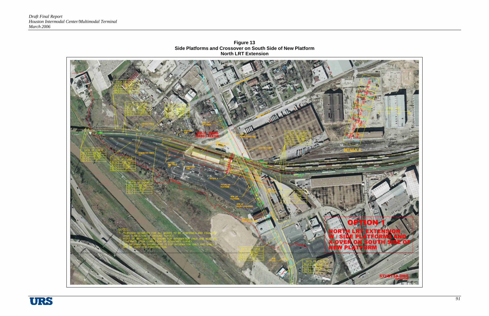
Draft Final Report Houston Intermodal Center/Multimodal Terminal March 2006
91
Figure 13 Side Platforms and Crossover on South Side of New Platform
North LRT Extension

Draft Final Report Houston Intermodal Center/Multimodal Terminal March 2006
92
Figure 14 Side Platforms and Crossover on North Side of New Platform
North LRT Extension

Draft Final Report Houston Intermodal Center/Multimodal Terminal March 2006
93
Figure 15 Center Platform and Crossover on North Side of New Platform
North LRT Extension
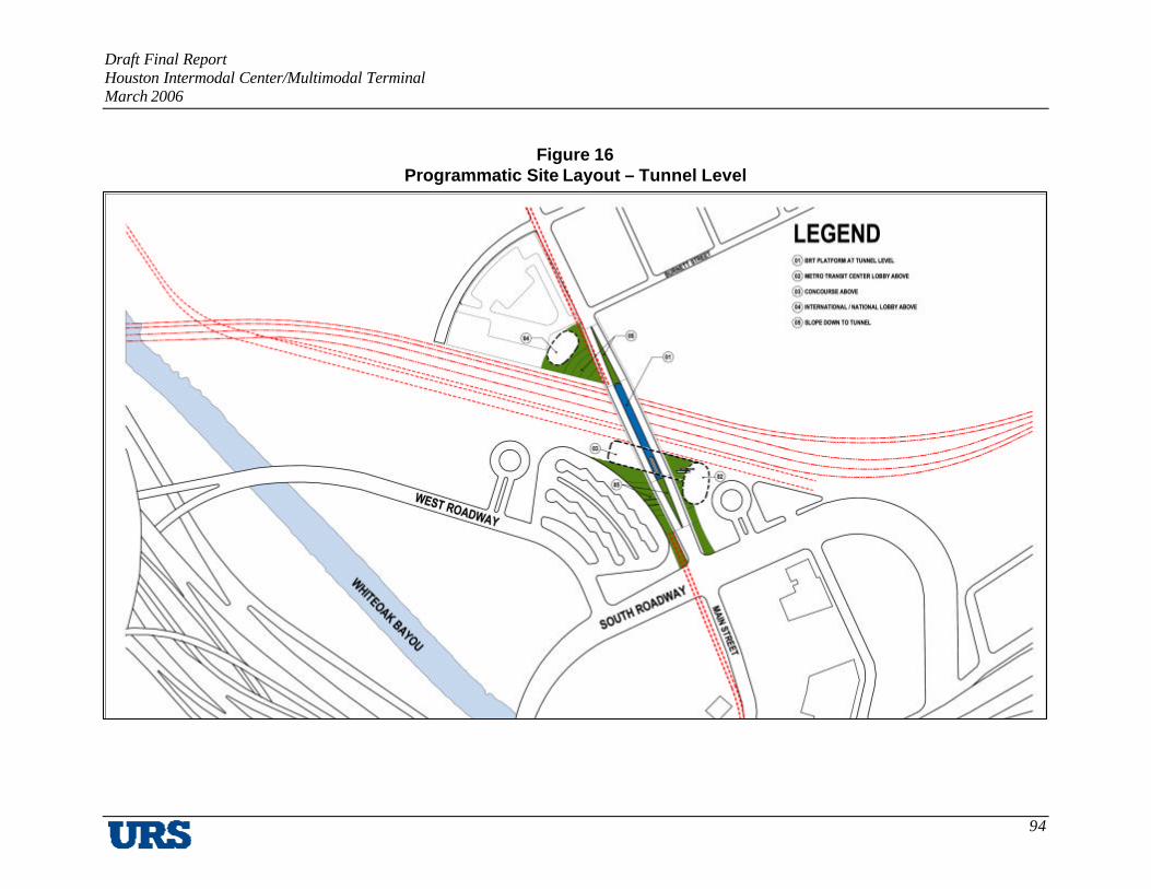
Draft Final Report Houston Intermodal Center/Multimodal Terminal March 2006
94
Figure 16 Programmatic Site Layout – Tunnel Level
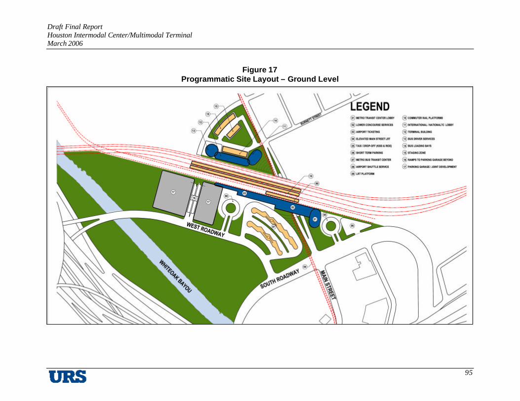
Draft Final Report Houston Intermodal Center/Multimodal Terminal March 2006
95
Figure 17 Programmatic Site Layout – Ground Level

Draft Final Report Houston Intermodal Center/Multimodal Terminal March 2006
96
Figure 18 Programmatic Site Layout – Upper Level

Draft Final Report Houston Intermodal Center/Multimodal Terminal March 2006
97
Figure 19 Programmatic Section – A
Figure 20 Programmatic Section – B
Figure 21 Section With Urban Context

Draft Final Report Houston Intermodal Center/Multimodal Terminal March 2006
98
IV. OPERATING COST MODEL
Technical Memorandum #4: Operating Cost Model presents a review of alternative institutional arrangements for ownership and operation of the proposed Houston Intermodal Center/Multimodal Terminal. The alternatives, based on current assumptions regarding intermodal center services and tenants, are compared using feasibility and effectiveness criteria, leading to preliminary conclusions regarding their suitability for application to the intermodal center/multimodal terminal project.
The Study identified the following potential users and/or tenants of the Houston Intermodal Center/Multimodal Terminal. Of the 13 entities identified in Table 8, only three are of sufficient size and financial capacity to undertake major roles in the project (METRO, AMTRAK and Greyhound). Other possible major participants (all public) include the City of Houston (Houston Airport System or Aviation Department), Harris County, and TxDOT. Due to the significant potential of new development and redevelopment associated with this facility, a private developer could also be utilized in developing the Intermodal Center/Multimodal Terminal as a part of a larger development.
Table 24 Potential Facility Users/Tenants
Grouping Name Type of User/Tenant Public Transit Operators METRO
Brazos Transit District Public
Intercity Rail Carriers AMTRAK Public Intercity Bus Carriers Greyhound
Kerrville Bus Lines Private
Special Carriers Connect Transit Houston Airport System
Public
International Carriers Capricorn Bus Lines El Expreso Bus Company Turimex Tornado Bus Company Americanos USA Autobuses Adame
Private

Draft Final Report Houston Intermodal Center/Multimodal Terminal March 2006
99
A. Types of Partnership
One possible option may be the use of a partnership framework to take on substantia l roles in the project. Five possible types of partnerships have been identified that could be developed for the implementation of the Houston Intermodal Center/Multimodal Terminal, described briefly as follows:
1. Public-Private Partnership
A public-private partnership in its simplest terms would involve cooperation between public entities and private entities for the construction, operation, and ownership of the Houston Intermodal Center/Multimodal Terminal. For example, a hypothetical public-private partnership could involve METRO, Houston Airport System, Greyhound, and AMTRAK. An actual example of a public-private partnership involved in the implementation of an intermodal center/multimodal terminal is the Union Station Master Plan public-private partnership in Denver, Colorado. The public entities involved in developing the master plan are the City and County of Denver, Colorado Department of Transportation, Denver Regional Council of Government, and the Regional Transit District. The private entities, called the “Alliance”, include several companies with broad experience in developing multimodal terminals.
2. Joint Powers Authority
A Joint Powers Authority (JPA) is a cooperative body made up of public entities that seek to jointly participate in the construction, development, and operation of projects. This type of governmental body often takes form in order to defray any potential jurisdictional issues that may arise. In the event that the project’s sponsors select a joint powers agency form of ownership and administration, that method of cooperative action can be implemented in Texas through creation of a “Local Government Corporation” (LGC), pursuant to Chapter 431, Subchapter D, Subtitle I (Transportation Corporations) of the Texas Transportation Code.
Sec. 431.101(a), states: “local government corporation may be created to aid and act on behalf of one or more local governments to accomplish any governmental purpose of those local governments.” Powers, governance, and regulation of LGCs authorized under this statute are in part governed by Chapter 394 of the Local Government Code, which addresses such issues as the:

Draft Final Report Houston Intermodal Center/Multimodal Terminal March 2006
100
§ Manner in which a local government corporation is created and dissolved
§ Appointment of the board of a local government corporation and the members’ terms of service
§ Manner and the conditions under which the board serves
§ Form, execution, approval, filing, and amending of the articles of incorporation and bylaws of a local government corporation.
Literally thousands of joint powers agencies have been created in other states such as California to address situations and conditions very similar to those posed by the proposed Houston Intermodal Center/Multimodal Terminal – namely, establishment of a governance structure, means and methods for allocation of financial responsibility and risk, dispute resolution, and marshalling and merging of technical, financial, and political resources. One pertinent example of a Joint Powers Authority is the Transbay Joint Powers Authority in the San Francisco Bay area. The purpose of this JPA is to develop and construct a new intermodal center/multimodal terminal in place of the old Transbay Terminal in downtown San Francisco. The JPA also intends to manage and operate the new Transbay Terminal in addition to any other related facilities, such as bus storage and staging, and connections to the existing and planned transportation system.
3. Texas Transportation Corporation
The purpose of a Texas Transportation Corporation is to act as a vehicle for the development of public transportation facilities by new and alternative means. These corporations have the ability to secure rights-of-way for transportation improvements, to plan transportation improvements, and to design transportation improvements. A Corporation also has the ability to issue bonds and notes to address its purposes. An example of an actual Texas Transportation Corporation operating in the Houston area is the Grand Parkway Association. The Grand Parkway Association receives funds from several public entities, including TxDOT, METRO, and most of the counties that the Grand Parkway may possibly travel through: Harris, Fort Bend, Galveston, Chambers, and Brazoria. A seven-member board appointed by the Texas Transportation Commission governs the Association.

Draft Final Report Houston Intermodal Center/Multimodal Terminal March 2006
101
4. Regional Mobility Authority
A Regional Mobility Authority (RMA) is a political body formed by one or more counties for the purpose of improving transportation through methods such as financing, designing, constructing, operating, maintaining, expanding, or extending transportation projects at the local level. An RMA also has several powers, including authority to issue revenue bonds and authority to acquire and condemn property. An RMA also has the ability to apply for federal highway and rail funding, to enter into comprehensive development agreements, to enter into contracts with other government entities, and to apply for loans from the Texas State Infrastructure Bank. Several RMAs have already been formed in Texas, including the Central Texas RMA (Austin), Alamo RMA (San Antonio), Grayson County RMA (Sherman-Denison), and Cameron County RMA (Brownsville-Harlingen). While these existing RMAs have focused on implementing toll road facilities, RMAs may also construct passenger and freight rail projects, pedestrian and bicycle facilities, and intermodal hubs.
5. Freight Rail District
In 2005, the Texas Legislature approved House Bill 2958, which led to efforts to create the Harris County Freight Rail District (HCFRD). The HCFRD can be given several powers relating to freight rail infrastructure improvements and commuter rail infrastructure improvements. Many of these powers mirror those of an RMA including eminent domain powers and the ability to issue bonds or other obligations to create public debt. The HCFRD’s possible role in the development and/or operation of the Intermodal Center/Multimodal Terminal is obtained in Section 171.001 of the bill, stating that “Rail facilities…includes property and interests necessary or convenient for the provision of a nonrural rail transportation system”. Efforts are also underway in order to include METRO in the decision-making processes of the HCFRD. Possible recommendations include having a place on the HCFRD board for METRO.

Draft Final Report Houston Intermodal Center/Multimodal Terminal March 2006
102
B. Ownership, Operations, and Management Roles and Functions
Cost-effective operation of the Intermodal Center/Multimodal Terminal facility will require that parties be named to fill specific roles and functions, namely:
§ Ownership (Land and Improvements)
§ Administration (Finance, Legal, Insurance, Etc.)
§ Facility Operations and Maintenance
§ Planning and Construction (Tenant Use, Site Use, Adjacent Land Use)
§ Tenant Leasing
In addition to rail and bus transit, other complementary uses of the site are possible, including retail, commercial, and even higher-density residential development. The presence of such uses would add tenant leasing capability to the requirements of any site owner and/or manager.
Ownership and Management (O&M) Alternatives
A review of facilities serving a mix of public and private activities suggests that there are, broadly, five types of ownership arrangements that are possible for the Houston Intermodal Center/Multimodal Terminal:
1. Direct Public Ownership (Land and Improvements)
Public Operation or Private (Contract) Operation
Public and Private Lease Tenants
2. Direct Private Ownership (Land and Improvements)
Direct Operation or Contract Operation
Public and Private Lease Tenants

Draft Final Report Houston Intermodal Center/Multimodal Terminal March 2006
103
3. Public Ownership/Long-Term Private Ground Lease or Individual Tenant Leases
4. Private Ownership/Long-Term Public Ground Lease (Sale + Leaseback)
Public Operation or Private (Contract) Operation
Public and Private Lease Tenants
5. Mixed Ownership and Lease Arrangements (Subdivided Site)
Formulation of an appropriate and feasible institutional structure should then proceed in two steps:
1. Which parties can best (or only) fill which role(s); and
2. How best should they be combined into a single “team”?

Draft Final Report Houston Intermodal Center/Multimodal Terminal March 2006
104
C. Comparison/Evaluation – Considerations and Criteria
Specific considerations and criteria to be applied to defining and evaluating institutional options include the following factors, at a minimum:
§ Legal Standing and Capabilities (Powers) – e.g., eminent domain, tax-exempt status
§ Functional and Management Capabilities – e.g., facility ownership and management, planning, administration
§ Financial Size and Capability
§ Public – Capital and Ownership and Management Funding Sources
§ Private – Rents and Creditworthiness
§ Stability and Longevity – e.g., years in operation, sensitivity to markets and politics
§ Public Standing (Opinion) – Acceptability to the public
§ Tax Cost Implications – Ability to depreciate assets and pass tax savings through
§ Labor Considerations – Requirements for union workforces (if applicable)

Draft Final Report Houston Intermodal Center/Multimodal Terminal March 2006
105
A comparative evaluation of potential intermodal center/multimodal terminal participants using these criteria is provided in Table 22:
Table 25 Comparison of Characteristics of Participants
Participant
Legal Standing/
Capabilities
Functional & Mgt
Capability Financial Size & Capability
Stability & Longevity
Public Standing
PUBLIC/USER METRO Yes Yes Yes Yes Yes HCFRD Yes Possible Yes Yes Yes
Brazos Transit District
Yes Limited Limited Yes Possible
AMTRAK No Yes Yes Yes Houston Airport
System Yes Yes Yes Yes Yes
Special Carriers No No No No No OTHER PUBLIC
City of Houston Yes Yes Yes Yes Yes Harris County Yes Yes Yes Yes Yes
TxDOT Yes Yes Yes Yes Yes Joint Powers
Authority (JPA) Yes Yes Yes Yes Yes
PRIVATE Greyhound Possible Yes Yes Yes Possible
Kerrville No No No No No International
Carriers No No No No No
Master Developer Yes Possible Possible Unknown Unknown
Comparison of Participants and Sponsors
The relative desirability of various potential participants to fill key facility roles and functions is presented and evaluated in Table 23:

Draft Final Report Houston Intermodal Center/Multimodal Terminal March 2006
106
Table 26 Comparison of Relative Capabilities of Participants10
Participant Ownership/
Lease Status Administration Facility O&M Planning &
Construction Tenant Leasing
PUBLIC/USER METRO Owner or
lessee Prime Candidate Mixed In-
House/Contract for Service
Prime Candidate Contract for Service
HCFRD Owner or lessee
Prime Candidate Mixed In-House/Contract
for Service
Capable Contract for Service
Brazos Transit District
Lessee or fee/service
only
Limited capability
Cooperative role Cooperate role No role
AMTRAK Owner11 or lessee
Not a candidate Rail operations only
Coordination only
No role
Houston Airport System
Owner or lessee
Possible candidate
Cooperative role Cooperative role Cooperative role
Special Carriers
Lessee or fee/service
only
Not a candidate Cooperative role Coordination only
No role
OTHER PUBLIC City of Houston Owner only Capable
Interest unknown Contract service
only Capable
Interest unknown Contract for
Service Harris County Owner only Capable
Interest unknown Contract service
only Capable
Interest unknown Contract for
Service TxDOT Owner only Capable but
unlikely Contract service
only Capable Interest
unknown
Contract for Service
Joint Powers Authority (JPA)
Owner or lessee
Prime Candidate Mixed In-House/Contract
for Service
Prime Candidate Contract for Service
PRIVATE Greyhound Lessee only Capable
but unlikely Capable
Interest unknown Coordination
only Contract for
Service Kerrville Lessee or
fee/service only
Not a candidate Cooperative role Coordination only
No role
International Carriers
Fee/service only
Not a candidate No role Coordination only
No role
Master Developer
Owner or ground
leaseholder
Capable Interest unknown
Capable Interest unknown
Capable Interest Unknown
Prime candidate
10 Stronger capabilities are shown in boldface. 11 Unlikely.

Draft Final Report Houston Intermodal Center/Multimodal Terminal March 2006
107
Comparison of Institutional Options
Advantages and disadvantages of each of the institutional alternatives are listed in Table 24.
Table 27 Comparison of Institutional Options
Alternative Advantages (From Public Perspective)
Disadvantages (From Public Perspective)
1. Direct Public Ownership (Land and Facilities)
Maximizes public control Can use eminent domain if necessary
Loss of tax base to City Complexity for public operators/managers
2. Direct Private Ownership (Land and Facilities)
“Outsources” development and operations complexity, plus some financial risk Keeps property on city tax roll Allows some capture of federal tax benefits (depreciation)
Limited public control; more difficult to address changes and problems later
3. Public Ownership/Long-Term Private Ground Lease
Can use eminent domain if necessary “Outsources” development and operations complexity
Loss of tax base to City; no income tax benefit Limited public control; more difficult to address changes and problems later
4. Private Ownership/Public Lease (Sale+Leaseback)
Keeps property on city tax roll Allows some capture of federal tax benefits (depreciation)
Complexity for public operators/ managers
5. Mixed Ownership/Lease Arrangements (Subdivided Site)
Greatest flexibility – Arrangements based on specific needs and available resources
More complex to develop agreements; more coordination required (including possible labor issues)
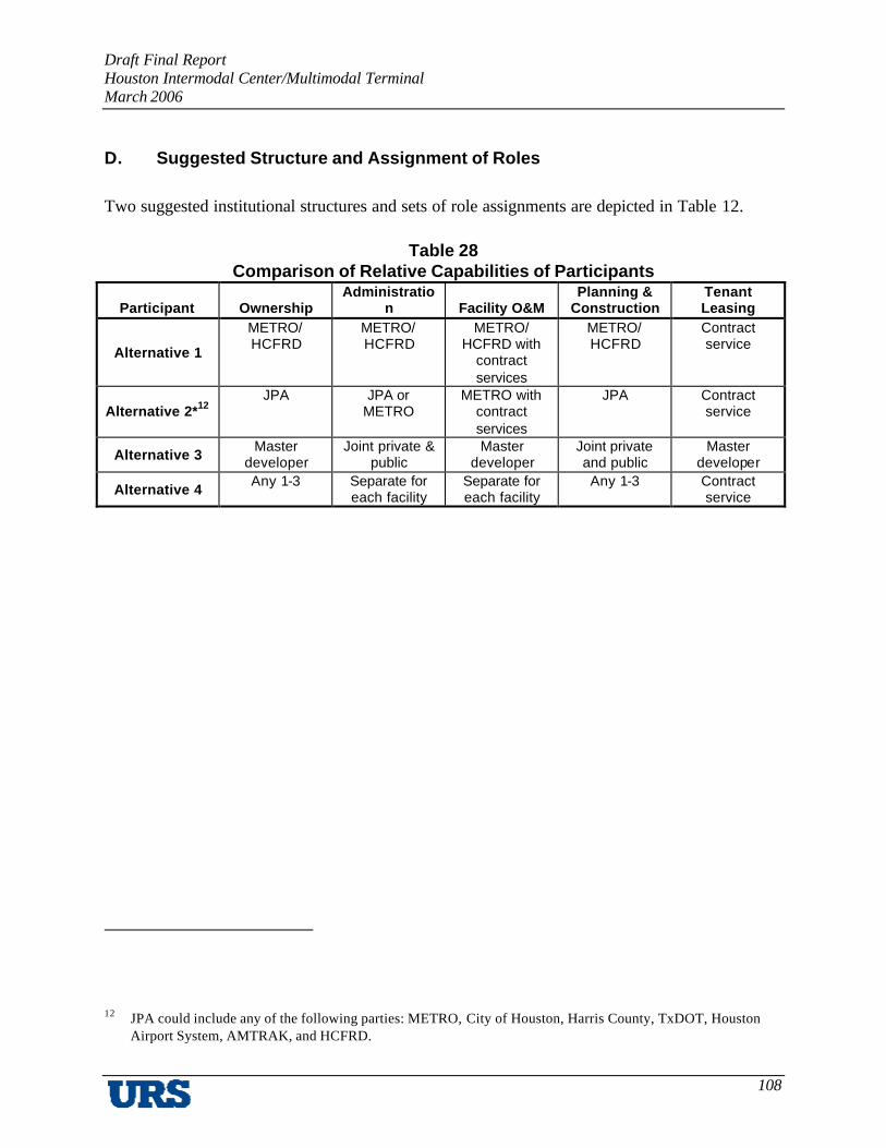
Draft Final Report Houston Intermodal Center/Multimodal Terminal March 2006
108
D. Suggested Structure and Assignment of Roles
Two suggested institutional structures and sets of role assignments are depicted in Table 12.
Table 28 Comparison of Relative Capabilities of Participants
Participant Ownership Administratio
n Facility O&M Planning &
Construction Tenant Leasing
Alternative 1
METRO/ HCFRD
METRO/ HCFRD
METRO/ HCFRD with
contract services
METRO/ HCFRD
Contract service
Alternative 2*12 JPA JPA or
METRO METRO with
contract services
JPA Contract service
Alternative 3 Master
developer Joint private &
public Master
developer Joint private and public
Master developer
Alternative 4 Any 1-3 Separate for
each facility Separate for each facility
Any 1-3 Contract service
12 JPA could include any of the following parties: METRO, City of Houston, Harris County, TxDOT, Houston Airport System, AMTRAK, and HCFRD.

Draft Final Report Houston Intermodal Center/Multimodal Terminal March 2006
109
E. Estimated Facility Operation Costs/Revenues
The purpose of this analysis is to estimate the projected operating expenses, and future revenue from retail establishments in the METRO and National/International terminals of the Intermodal Center/Multimodal Terminal which have been identified in Technical Memorandum 5: Facility Program. At this juncture, the potential retail establishments have been identified as consisting of four food vendors. This is subject to change as the number and type of vendors may change as the project develops further. As the project develops, and specific vendors and service providers are incorporated into the planning process, the operating costs and revenue projections may be more defined and refined.
This analysis is based on the following assumptions from the approved facility program:
§ The Intermodal Center/Multimodal Terminal will consist of two terminals. The first terminal will primarily house METRO services and the building will approximate 80,000 square feet with 3200 square feet of interior retail/food vendor space. The second building will house National/International bus carriers totaling approximately 48,000 square feet with no retail/commercial space. The two buildings will be physically connected at an upper concourse level.
§ It was assumed that there will be two classes of tenants at the facility, retail/food vendors and third party transportation service providers. The scope of this analysis only projects the proposed revenue from leasing the retail/food vendor commercial space within the Intermodal facility as specified in the Metro Regional Terminal.
§ It was assumed that all third-party transportation service providers (Amtrak, Greyhound, etc.) will staff and operate their designated space within the facility, including maintenance, administration, and operational facilities.

Draft Final Report Houston Intermodal Center/Multimodal Terminal March 2006
110
Obtaining Comparable Statistical Data of Similar Facilities
A number of resources were used, including periodicals, reference books, trade associations, and government agencies to obtain relevant operating expense information for the proposed facility. Some of these references included the American Public Transportation Association (APTA), the Federal Transit Administration, US Department of Transportation, and Building Owners and Management Association (BOMA), as well as other similar TOD case studies and transit related facilities. Through this research, it became evident that the reporting standards for these facilities are not widely available and that each facility is unique, based on the number and types of carriers, the size and purpose, and the demand and usage of the facility.
Because of this, it became clear that as the program develops, the projected income and expenses for the facility will become more defined. To estimate the operating expenses at this stage of predevelopment, the TEAM relied heavily on the BOMA Experience Exchange Report (EER), which is the “industry standard for office building financial data and operations information, covering more buildings in more geographic areas than any other publication available”.
Operating Expenses
Within the BOMA EER, the building type category titled ‘Agency Managed’ which was selected is a subcategory of the US Government Sector surveyed data. This category classifies the buildings as being managed by the occupying agency. This classification was chosen because this facility would most resemble the ownership structure proposed for the Intermodal facility as described in earlier sections of this Technical Memorandum.
The BOMA report also classifies statistical data for this group into two sections, 1) properties that are located ‘All Downtown’ and 2) those that are ‘All Suburban’. The operating expenses of these two classifications in our analysis were averaged to obtain a larger sample of data for the operating expenses.
The Intermodal facility will operate both day and night. This increase in operational time and expense was accounted for by determining the ratio of reported business use hours on the BOMA report to the total number of operational hours weekly (168 hours). The operating expenses were then increased by a factor, which represents more closely a facility that will run at a more demanding operational level. This increase represented approximately a 37% average increase between ‘All Downtown’ and ‘All Suburban’ buildings.

Draft Final Report Houston Intermodal Center/Multimodal Terminal March 2006
111
Because the ‘Agency Run’ facilities are reported at the national level, a cost of living factor was applied to estimate the expenses in the Houston region. It was determined that this index factor from the BOMA report for Houston to be 88% of the national average. This factor was applied to the operating expense data, which reduces the expenses to reflect estimated expenditures in the Houston region. Based on this adjustment, the ‘Downtown’ and ‘Suburban’ operating expense data was averaged to determine a comparable estimate of operating expenses for the Houston Intermodal Facility. The following Operating Expenses were applied to both Terminals:
Cleaning/Janitorial $1.56
Repair/Maintenance $1.64
Utilities $2.61
Roads/Grounds $0.21
Security $0.86
Administrative $0.97
Total Expenses: $7.85
Lease Income from Retail/Food Vendors
The potential lease income was estimated that could be generated from the food service/retail providers located in the Intermodal facility. These providers are only included in the METRO Terminal at a total of 3,200sf. The BOMA report was used to determine the reported retail rental rates in Houston office buildings. To obtain a large sample size and gather a more statistically accurate rentals rate for the facility, all Downtown and Suburban office buildings from the Private Sector were selected that contained a retail component. These two lease rates were combined and resulted in an average rate of $13.53/sf for the retail/food vendor space within the Intermodal facility.

Draft Final Report Houston Intermodal Center/Multimodal Terminal March 2006
112
Cash Flow Model
The operating pro forma prepared for the facility uses a lease rate of $13.53/sf as the base rent for each tenant at 800sf of leased area. It was also assumed that tenants would pay, on a pro rata share, the net reimbursable Common Area Maintenance (CAM) expenses back to the owner(s) of the building. For the purposes of this model, a triple-net lease was assumed which will reimburse the owners of the building for a large percentage of the operating expenses for the leased space. The following assumptions were also used in the financial model:
§ 3 percent inflation factor
§ 5-year lease renewals
§ $10.00/sf tenant improvements
§ 4 percent leasing commissions on new leases and 2 percent on lease renewals
§ Vacancy rate of 7 percent
§ Assume leases will start 18 months after the analysis start; operating expenses start at this point.
The operations of the Metro Regional Terminal were organized into two areas totaling 79,092sf. The first area is the non-reimbursable expense area equal to 75,892sf. The second area is the total food vendor space allocated in the facility, which is a common area reimbursable expense area totaling 3,200sf. As the income/revenue projections from the transportation service providers become more defined, these tenants may share in the expenses to manage the remaining common areas within the terminal.

Draft Final Report Houston Intermodal Center/Multimodal Terminal March 2006
113
Comparative Analysis
The results of incorporating the averaged Operating Expenses as determined by this analysis return an annual operating cost of $649,857 (Year 3), or $8.21/SF for the Metro Regional Terminal. The National/International Terminal yields an annual operating expense of $399,539 (Year 3), or $8.53/SF. An illustration of a comparative analysis of the yearly estimated annual expenses is offered on the cash flow pro forma and a summary is illustrated on Table 26.
Tenant Improvements, Leasing Commissions and Capital Expenses for the facility are listed below Net Operating Income on the cash flow statement and are based on market leasing conditions.
Fixed costs have not been included in the model, as these costs would be addressed on a case-by-case basis in a more detailed analysis. These costs would include Real Estate Taxes (which may or may not be applicable), Building Insurance, Personal Property Tax, Other Taxes, or Licensing Fees.
Table 29 Operating Expenses
Alternative
Metro Regional Terminal
National/ International Terminal
Year 1 Construction 12 months Construction
Year 2 $324,117 6 months $193,951
Year 3 $649,857 $399,539
Year 4 $669,352 $411,526
Year 5 $689,435 $423,870
Year 6 $710,116 $436,587
Year 7 $731,419 $449,685
Year 8 $753,362 $463,175
Year 9 $775,963 $477,069
Year 10 $799,242 $491,383
$ 6,102,863 $ 3,746,785

Draft Final Report Houston Intermodal Center/Multimodal Terminal March 2006
114
Detailed Explanation of Operating Expenses
1. Cleaning/Janitorial – This operating expense is typically bid upon by firms after build out. This bid takes place after build out to accurately measure the cleanable space area in the building. The industry average to determine cleanable area is typically 85% of the net usable area of a building. This expenditure constitutes both the day and night time cleaning of offices and common areas. This expense includes payroll for in-house janitorial support, contract service for routine duties and special contracts for irregular services (window washing, carpet cleaning), trash removal, supplies and miscellaneous cleaning expenses. Because the Intermodal facility will operate both day and night, these Cleaning costs were increased to illustrate greater cleaning/janitorial expenses.
2. Repair/Maintenance – This category includes expenditures for the general repairs and maintenance upkeep for the general building and common areas of the facility. This includes both in-house service personnel as well as contracted services for positions that include engineering, elevator, HVAC, electrical, structural/roof, plumbing, fire and life safety expenses and other building maintenance and supplies.
3. Utilities – This expense includes expenditures for all utilities including electricity, gas, and water/sewer.
4. Roads/Grounds – Expenditures related to the exterior maintenance of a building (such as landscaping, parking lot repairs, site signage, site lighting, etc.) are included. This category includes payroll, taxes, and fringe benefits for directly employed roads and grounds personnel, and expenses for individuals/firms contracted to perform specified duties and supplies related to exterior common areas. Parking area maintenance expenses are included in this category (for only the spaces required by building of similar area square footages).

Draft Final Report Houston Intermodal Center/Multimodal Terminal March 2006
115
5. Security – This expense includes the security of the tenants and the building, including payroll and fringe benefits for security personnel as well as expenses for individual/firms contracted to perform specified duties and provide supplies. This category also includes expenses of maintenance security systems and ordinary supplies necessary to operate a security program, such as security access cards, security system components, batteries and control forms as well as any other miscellaneous security expenses such as security personnel uniforms.
6. Administrative – These are expenses, which are directly connected with the administration of a similar, specialized ‘Agency Run’ buildings of similar size. This cost includes payroll taxes and fringe benefits for directly employed administrative personnel, allotted administrative fees, management fees, professional fees (specialty consulting, legal/accounting, data entry, and engineering), employee expenses and general expenses of running and maintaining the Office of Building Management (such as supplies, furniture, telephone, temporary help and postage).

Draft Final Report Houston Intermodal Center/Multimodal Terminal March 2006
116
Cost Analysis Method #1 Agency Managed-Specialty Facility National Level Comparison *Because of the limited reporting function of these facilities, costs are taken at a national level. Total Building Rentable Sq. Ft.: 50,000-99,999 Alternative A Total Area: 79,092 sf
Operating Expenses* Downtown Suburban Cleaning/Janitorial $1.29 $1.34 Repair/Maintenance 1.80 0.90 Utilities 1.77 2.70 Roads/Grounds 0.13 0.24 Security 0.77 0.67 Administrative 0.91 0.72
Total Expenses $6.07 $5.74 Building Hours Per week 93.70 125.80
Factor for 24-hour operations at Houston Intermodal Facility 0.56 0.75 *Median figures were used due to area of the building.
24/7 Operating, 168 hours per week
Operating Expenses Downtown Suburban Cleaning/Janitorial $1.86 $1.68 Repair/Maintenance 2.60 1.13 Utilities 2.55 3.38 Roads/Grounds 0.19 0.30 Security 1.11 0.84 Administrative 1.31 0.90
Total Expenses $8.75 $7.18
Incorperate Cost of Living Factor to National Operating Costs above. ACCRA Cost of Living Index Houston: 88.0
Average Operating Expenses Downtown Suburban
Cleaning/Janitorial $1.64 $1.48 1.56 Repair/Maintenance 2.28 0.99 1.64 Utilities 2.25 2.97 2.61 Roads/Grounds 0.16 0.26 0.21 Security 0.98 0.74 0.86 Administrative 1.15 0.79 0.97
Total Expenses $7.70 $6.32 $7.85 (1) Because the building is located within the 610 loop it will have simliar characteristics to both Downtown and Suburban cost models, for purposes of this analysis we have averaged the two models together to determine a reasonable estimate of expenses. These costs do not take into account Fixed Costs such as Real Estate Tax, Building Insurance, Personal Property Tax, Other Taxes, or Licensing Fees.
Reference: BOMA, 2005 EER Data
Private (1)
Private
Private
Table 30 Cost Analysis

Draft Final Report Houston Intermodal Center/Multimodal Terminal March 2006
117
Retail Space within Office
All All Average Retail Lease $18.5 $8.5 $13.5
Total LSF Retail Space 800 Retail Space 800 Retail Space 800 Retail Space 800
3,20
Gross Potential Annual $43,28
(1) Assume the 3,200sf is leaseable
There is no Retail Leaseable SF in
Reference: BOMA, 2004 EER
Table 31 METRO Regional Terminal and National/International Terminal
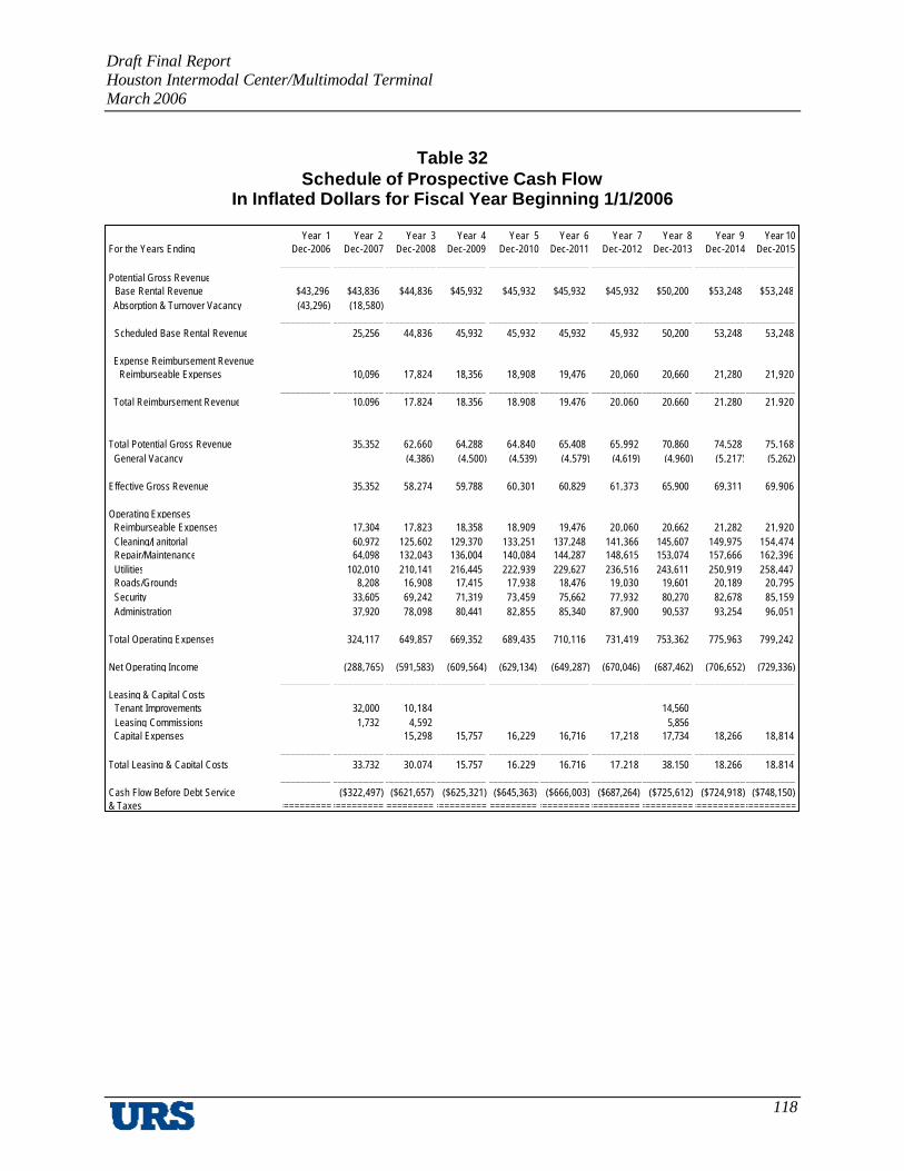
Draft Final Report Houston Intermodal Center/Multimodal Terminal March 2006
118
Year 1 Year 2 Year 3 Year 4 Year 5 Year 6 Year 7 Year 8 Year 9 Year 10For the Years Ending Dec-2006 Dec-2007 Dec-2008 Dec-2009 Dec-2010 Dec-2011 Dec-2012 Dec-2013 Dec-2014 Dec-2015
__________ __________ __________ __________ __________ __________ __________ __________ __________ __________Potential Gross Revenue Base Rental Revenue $43,296 $43,836 $44,836 $45,932 $45,932 $45,932 $45,932 $50,200 $53,248 $53,248 Absorption & Turnover Vacancy (43,296) (18,580)
__________ __________ __________ __________ __________ __________ __________ __________ __________ __________ Scheduled Base Rental Revenue 25,256 44,836 45,932 45,932 45,932 45,932 50,200 53,248 53,248
Expense Reimbursement Revenue Reimburseable Expenses 10,096 17,824 18,356 18,908 19,476 20,060 20,660 21,280 21,920
__________ __________ __________ __________ __________ __________ __________ __________ __________ __________ Total Reimbursement Revenue 10,096 17,824 18,356 18,908 19,476 20,060 20,660 21,280 21,920
__________ __________ __________ __________ __________ __________ __________ __________ __________ __________Total Potential Gross Revenue 35,352 62,660 64,288 64,840 65,408 65,992 70,860 74,528 75,168 General Vacancy (4,386) (4,500) (4,539) (4,579) (4,619) (4,960) (5,217) (5,262)
__________ __________ __________ __________ __________ __________ __________ __________ __________ __________Effective Gross Revenue 35,352 58,274 59,788 60,301 60,829 61,373 65,900 69,311 69,906
__________ __________ __________ __________ __________ __________ __________ __________ __________ __________Operating Expenses Reimburseable Expenses 17,304 17,823 18,358 18,909 19,476 20,060 20,662 21,282 21,920 Cleaning/Janitorial 60,972 125,602 129,370 133,251 137,248 141,366 145,607 149,975 154,474 Repair/Maintenance 64,098 132,043 136,004 140,084 144,287 148,615 153,074 157,666 162,396 Utilities 102,010 210,141 216,445 222,939 229,627 236,516 243,611 250,919 258,447 Roads/Grounds 8,208 16,908 17,415 17,938 18,476 19,030 19,601 20,189 20,795 Security 33,605 69,242 71,319 73,459 75,662 77,932 80,270 82,678 85,159 Administration 37,920 78,098 80,441 82,855 85,340 87,900 90,537 93,254 96,051
__________ __________ __________ __________ __________ __________ __________ __________ __________ __________Total Operating Expenses 324,117 649,857 669,352 689,435 710,116 731,419 753,362 775,963 799,242
__________ __________ __________ __________ __________ __________ __________ __________ __________ __________Net Operating Income (288,765) (591,583) (609,564) (629,134) (649,287) (670,046) (687,462) (706,652) (729,336)
__________ __________ __________ __________ __________ __________ __________ __________ __________ __________Leasing & Capital Costs Tenant Improvements 32,000 10,184 14,560 Leasing Commissions 1,732 4,592 5,856 Capital Expenses 15,298 15,757 16,229 16,716 17,218 17,734 18,266 18,814
__________ __________ __________ __________ __________ __________ __________ __________ __________ __________Total Leasing & Capital Costs 33,732 30,074 15,757 16,229 16,716 17,218 38,150 18,266 18,814
__________ __________ __________ __________ __________ __________ __________ __________ __________ __________Cash Flow Before Debt Service ($322,497) ($621,657) ($625,321) ($645,363) ($666,003) ($687,264) ($725,612) ($724,918) ($748,150)& Taxes ========== ========== ========== ========== ========== ========== ========== ========== ========== ==========
Table 32 Schedule of Prospective Cash Flow
In Inflated Dollars for Fiscal Year Beginning 1/1/2006

Draft Final Report Houston Intermodal Center/Multimodal Terminal March 2006
119
Year 1 Year 2 Year 3 Year 4 Year 5 Year 6 Year 7 Year 8 Year 9 Year 10For the Years Ending Dec-2006 Dec-2007 Dec-2008 Dec-2009 Dec-2010 Dec-2011 Dec-2012 Dec-2013 Dec-2014 Dec-2015
__________ __________ __________ __________ __________ __________ __________ __________ __________ __________Operating Expenses Cleaning/Janitorial 38,543 79,399 81,781 84,234 86,761 89,364 92,045 94,806 97,651 Repair/Maintenance 40,520 83,471 85,975 88,554 91,211 93,947 96,765 99,668 102,658 Utilities 64,486 132,840 136,826 140,930 145,158 149,513 153,998 158,618 163,377 Roads/Grounds 5,188 10,688 11,009 11,339 11,679 12,030 12,391 12,762 13,145 Security 21,243 43,771 45,084 46,437 47,830 49,265 50,743 52,265 53,833 Administration 23,971 49,370 50,851 52,376 53,948 55,566 57,233 58,950 60,719
__________ __________ __________ __________ __________ __________ __________ __________ __________ __________Total Operating Expenses 193,951 399,539 411,526 423,870 436,587 449,685 463,175 477,069 491,383
__________ __________ __________ __________ __________ __________ __________ __________ __________ __________Net Operating Income (193,951) (399,539) (411,526) (423,870) (436,587) (449,685) (463,175) (477,069) (491,383)
__________ __________ __________ __________ __________ __________ __________ __________ __________ __________Leasing & Capital Costs Capital Expenses 9,670 9,960 10,259 10,567 10,884 11,211 11,547 11,893
__________ __________ __________ __________ __________ __________ __________ __________ __________ __________Total Leasing & Capital Costs 9,670 9,960 10,259 10,567 10,884 11,211 11,547 11,893
__________ __________ __________ __________ __________ __________ __________ __________ __________ __________Cash Flow Before Debt Service ($193,951) ($409,209) ($421,486) ($434,129) ($447,154) ($460,569) ($474,386) ($488,616) ($503,276)& Taxes ========== ========== ========== ========== ========== ========== ========== ========== ========== ==========
Table 29 (continued) Schedule of Prospective Cash Flow
In Inflated Dollars for Fiscal Year Beginning 1/1/2006
Draft Final Report Houston Intermodal Center/Multimodal Terminal March 2006
120
F. Recommendations
Based on the analysis completed in Technical Memorandum #4: Operating Cost Model the following recommendations are presented:
§ The proposed Houston Intermodal Center/Multimodal Terminal be developed, owned, and administered by a public entity, either singly (e.g., METRO), or through a cooperative mechanism such as a joint powers agency, incorporating METRO, AMTRAK, Houston Airport System, and – potentially – other railroads and bus operators.
§ Actual management of the facility, including functions such as bus operations, maintenance, tenant leasing, accounting and financial management can be assigned to one or more public or private entities, based on the specific needs involved, the relative availability of skilled managers, and the management philosophies and “styles” of the developer/owner(s).
§ It is not essential at this stage to specify details regarding how participants (the “parties”) would interact; share responsibilities, costs, and risks; mediate disputes, etc. There are, however, hundreds if not thousands of relevant examples of agreements governing co-ownership and co-use of significant infrastructure and facilities – both public and private – which should be consulted early in any process designed to lead to sole- or multi-owner structure.
§ Once issues of ownership, site selection, and program definition have been determined, it will be possible to develop a conceptual layout of the facility. This layout, in turn, will lead to the development of an estimate of the cost of constructing the facility as well as the development of a range of costs to operate and maintain the facility.