Embed Size (px)
Citation preview

Ichthys Gas Field Development Project
ExEcutivE summaryDRAFT ENVIRONMENTAL IMPACT STATEMENT
Ex
Ec
ut
ivE
su
mm
ar
yD
RA
FT E
NVIR
ON
ME
NTA
L IMPA
CT STATE
ME
NT
ich
thys
Ga
s FiE
ld d
EvE
lop
mE
nt p
ro
jEc
t
Ichthys.exec.summary.cover.V2.indd 1 3/6/10 4:29:29 PM

Ichthys Gas Field Development Project: draft environmental impact statement—Executive summary
ISBN 978-0-9808063-2-8 (paperback)
ISBN 978-0-9808063-3-5 (online)
COPYRIGHTThis work is copyright. Apart from any use as permitted under the Copyright Act 1968 (Cwlth), no part may be
used or reproduced by any process without prior written permission from INPEX Browse, Ltd.
Requests and enquiries concerning use or reproduction should be addressed to:
INPEX Browse, Ltd.
Level 22
100 St Georges Terrace
PERTH WA 6000
DISCLAIMERThe Ichthys Gas Field Development Project: draft environmental impact statement (Draft EIS) has been
prepared by INPEX Browse, Ltd. (INPEX) on behalf of the Ichthys Joint Venturers (INPEX and Total E&P
Australia, and such other parties that may become party to the joint venture) for submission to the
Commonwealth’s Minister for the Environment, Heritage and the Arts under the provisions of the Environment
Protection and Biodiversity Conservation Act 1999 (Cwlth) and to the Northern Territory’s responsible minister
under the provisions of the Environmental Assessment Act (NT).
The Draft EIS has been prepared for this purpose only, and no one other than the ministers and their
delegated representatives should rely on the information contained in the Draft EIS to make any decision.
In preparing the Draft EIS, INPEX has relied on information provided by specialist consultants, government
agencies and other third parties identified in the document. INPEX has not verified the accuracy or
completeness of this information except where expressly acknowledged in the Draft EIS.
This publication contains maps that include data that are copyright to the Commonwealth of Australia through
Geoscience Australia (2008 and 2009).
Set in Helvetica Neue and printed on Monza Satin stock
Text designed and typeset by Linkletters Graphic Design, Perth
Cover design by Clarity Communications, Perth
Printed by Quality Press, Perth
This book has been printed on paper from mills that have international environmental management standard
ISO 14001 accreditation and Forest Stewardship Council (FSC) accreditation. These standards promote forest
certification and product labelling to allow papermakers to identify wood pulp that comes from well-managed
forests with sustainable reforestation policies. The FSC label is endorsed by the Worldwide Fund for Nature
(WWF), Friends of the Earth, and Greenpeace.
Ichthys.exec.summary.cover.V2.indd 2 3/6/10 4:29:29 PM

Invitation to comment
Ichthys Gas Field Development Project | Draft Environmental Impact Statement Executive Summary Page 1
All members of the public, businesses and interest
groups are invited to comment on this Draft
Environmental Impact Statement (Draft EIS).
This document presents the case for the environmental
acceptability of the Ichthys Gas Field Development
Project. The Project proposes to construct offshore
extraction and processing facilities in the Browse
Basin off the Western Australian coast, a subsea
pipeline to onshore processing facilities at Blaydin
Point in Darwin Harbour, and product offloading
facilities, including a jetty and a shipping channel,
adjacent to Blaydin Point. The Project will produce
around 8.4 million tonnes of liquefied natural gas per
annum, together with liquefied petroleum gases and
condensate as secondary products.
The proposal is being jointly assessed by the
Australian and Northern Territory governments
under the Environment Protection and Biodiversity
Conservation Act 1999 (Cwlth) and the Environmental
Assessment Act (NT) respectively.
This Draft EIS is available for public review and
comment for a period of eight weeks, which is
advertised in the national and Northern Territory
press. This period will take into account public
holidays in both the Australian Capital Territory and the
Northern Territory.
How to make a submissionA submission may include comment, additional
information, or an opinion relevant to the information
provided in the Draft EIS, or in a general way related to
the proposed development.
Submissions must be made in writing and respondents
should note the following points:
• Refer to the project title (the Ichthys Gas Field
Development Project).
• Each matter raised should refer to the relevant
section and page number of the Draft EIS (e.g.
Chapter 7, Section 7.1.2, page 383).
• Supporting factual information and/or references
should be provided for each point raised.
• The name and address of the respondent(s) and
the date of submission should be included.
• The submission should be delivered by no later
than 5.00 p.m. on the final day of the advertised
review period at the nominated electronic or postal
address below.
• All written submissions should be signed1.
Submissions may be lodged electronically or by post.
Electronic submissions may be dispatched directly to
INPEX online via the INPEX web site (www.inpex.com.au)
or e-mailed directly to [email protected].
Postal submissions should be addressed to:
Ichthys Gas Field Development Project
Draft EIS Comment
PO Box Z5023
St Georges Tce WA 6831
INPEX will forward an acknowledgment of receipt
for all submissions received prior to the close of
the review period and will record and collate all
submissions and provide copies to the relevant
government assessment agencies.
1 Each submission will be treated as a public document unless delivered in confidence.

Page 2 Ichthys Gas Field Development Project | Draft Environmental Impact Statement Executive Summary
accessing tHe documentThe Draft EIS can be viewed online at www.inpex.com.au
and at the following locations:
Northern Territory• department of natural Resources,
environment, the arts and sportLevel 2, Darwin Plaza, 41 Smith Street Mall, Darwin
• development assessment servicesdepartment of Lands and PlanningGround floor, Cavenagh House,
38 Cavenagh Street, Darwin
• minerals and energy infocentredepartment of ResourcesLevel 3, Paspalis Centrepoint Building,
Smith Street Mall, Darwin
• northern territory LibraryParliament House, Bennett Street, Darwin
• darwin city council libraries:
Casuarina Library
17 Bradshaw Terrace, Casuarina
City Library
Civic Centre, Harry Chan Avenue, Darwin
Karama Library
Karama Shopping Centre, Karama
Nightcliff Library
10–12 Pavonia Place, Nightcliff
• Palmerston city LibraryGoyder Square, The Boulevard, Palmerston
• katherine Public LibraryFirst floor, Randazzo Building, Katherine Terrace,
Katherine
• tennant creek Public LibraryCivic Centre, Peko Road, Tennant Creek
• alice springs Public LibraryCorner of Leichhardt Terrace and Gregory Terrace,
Alice Springs
• the environment centre ntUnit 3, 98 Woods Street, Darwin
• northern Land council45 Mitchell Street, Darwin
• Larrakia nation aboriginal corporationUnit 4/1 Pavonia Place, Nightcliff
• Litchfield council7 Bees Creek Road, Freds Pass
• environment HubShop 9, Rapid Creek Business Village
48 Trower Road, Millner
• inPeX darwin officeLevel 8, Mitchell Centre
59 Mitchell Street, Darwin
Australian Capital Territory• the Library of the department of the
environment, water, Heritage and the arts John Gorton Building, King Edward Terrace,
Parkes, Canberra
Western Australia• state Library of western australia
Alexander Library Building
25 Francis Street, Perth
• inPeX Perth officeLevel 22, 100 St Georges Terrace, Perth
Hard copies can be obtained by submitting a request
by e-mail to [email protected] or by telephone
to 1800 705 010.
Additional information can be obtained directly from
the government regulator web sites provided below:
commonwealth government: Department of
the Environment, Water, Heritage, and the Arts
(DEWHA) at <http://www.environment.gov.au/>
northern territory government: Department
of Natural Resources, Environment, the Arts and
Sport (NRETAS) at <http://www.nt.gov.au/nreta/>.

Foreword
Ichthys Gas Field Development Project | Draft Environmental Impact Statement Executive Summary Page 3
On behalf of INPEX Browse, Ltd. and in cooperation
with our joint venturer, Total E&P Australia, I am
pleased to present this draft environmental impact
statement (Draft EIS) for the proposed Ichthys Gas
Field Development Project.
INPEX has been a member of the Australian business
community since 1986. In 2000 INPEX discovered the
giant Ichthys gas and condensate field and since then
we have worked continuously toward developing this
world-class resource in a manner that is technically
and economically viable, and environmentally and
socially responsible.
This document presents a comprehensive description
of the Ichthys Project, the natural and socio-economic
environment in which it will be developed and the
actual and potential impacts it will have. As the
cleanest of all fossil fuels, LNG is an energy source
appropriate for today’s carbon-constrained world. It
is my belief that this Draft EIS demonstrates a sound
case supporting approval of the Ichthys Project.
The commercial development of the Ichthys Project
promises to deliver substantial social and economic
benefits to the people of Darwin, the Northern Territory
and Australia through the creation of employment and
training opportunities, improved infrastructure, and the
significant economic stimulus it will provide.
In designing the Ichthys Project, INPEX and its
contractors have carried out comprehensive
environmental surveys in and around Darwin Harbour,
at the Ichthys Field and along the subsea pipeline route
from the field to Darwin. Extensive socio-economic
studies have also been undertaken to identify the
benefits that will flow from this development.
In addition, this Draft EIS has been prepared
through a process of extensive consultation with
relevant government agencies and non-government
organisations, as well as through engagement with the
broader community at public forums and briefings.
As both the Northern Territory Government and
Australian Government regulators decided on a joint
assessment process, the Draft EIS addresses the
requirements of both jurisdictions and has been
prepared in accordance with the published guidelines.
I thank all those who have contributed to this process
to date and I would now like to invite all members
of the Northern Territory and broader Australian
communities to review this document and provide
feedback on the proposed Ichthys Project.
Your contribution to the evaluation of the Ichthys
Project Draft EIS will be very welcome and can only
improve the quality and integrity of the assessment
process leading to better outcomes for all.
seiya ito
managing director
inPeX browse, Ltd.
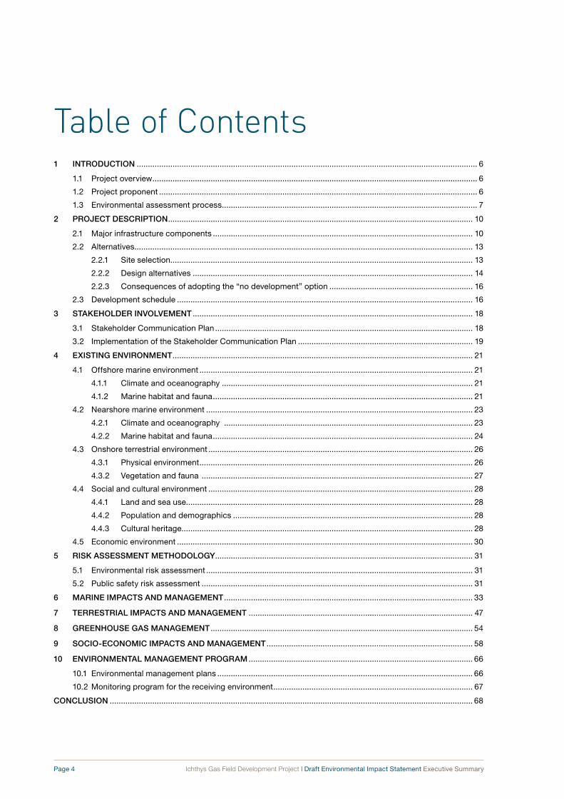
Table of Contents1 INTroduCTIoN ........................................................................................................................................................ 6
1.1 Project overview ................................................................................................................................................. 6
1.2 Project proponent .............................................................................................................................................. 6
1.3 Environmental assessment process .................................................................................................................. 7
2 ProjeCT desCrIPTIoN ........................................................................................................................................ 10
2.1 Major infrastructure components .................................................................................................................... 10
2.2 Alternatives ....................................................................................................................................................... 13
2.2.1 Site selection....................................................................................................................................... 13
2.2.2 Design alternatives ............................................................................................................................. 14
2.2.3 Consequences of adopting the “no development” option ................................................................ 16
2.3 Development schedule .................................................................................................................................... 16
3 sTAKehoLder INvoLvemeNT ............................................................................................................................. 18
3.1 Stakeholder Communication Plan ................................................................................................................... 18
3.2 Implementation of the Stakeholder Communication Plan .............................................................................. 19
4 exIsTINg eNvIroNmeNT ...................................................................................................................................... 21
4.1 Offshore marine environment .......................................................................................................................... 21
4.1.1 Climate and oceanography ................................................................................................................ 21
4.1.2 Marine habitat and fauna .................................................................................................................... 21
4.2 Nearshore marine environment ....................................................................................................................... 23
4.2.1 Climate and oceanography ............................................................................................................... 23
4.2.2 Marine habitat and fauna .................................................................................................................... 24
4.3 Onshore terrestrial environment ...................................................................................................................... 26
4.3.1 Physical environment .......................................................................................................................... 26
4.3.2 Vegetation and fauna ......................................................................................................................... 27
4.4 Social and cultural environment ...................................................................................................................... 28
4.4.1 Land and sea use................................................................................................................................ 28
4.4.2 Population and demographics ........................................................................................................... 28
4.4.3 Cultural heritage.................................................................................................................................. 28
4.5 Economic environment .................................................................................................................................... 30
5 rIsK AssessmeNT meThodoLogy ................................................................................................................... 31
5.1 Environmental risk assessment ....................................................................................................................... 31
5.2 Public safety risk assessment ......................................................................................................................... 31
6 mArINe ImPACTs ANd mANAgemeNT ............................................................................................................... 33
7 TerresTrIAL ImPACTs ANd mANAgemeNT .................................................................................................... 47
8 greeNhouse gAs mANAgemeNT ..................................................................................................................... 54
9 soCIo-eCoNomIC ImPACTs ANd mANAgemeNT ............................................................................................ 58
10 eNvIroNmeNTAL mANAgemeNT ProgrAm .................................................................................................... 66
10.1 Environmental management plans .................................................................................................................. 66
10.2 Monitoring program for the receiving environment ......................................................................................... 67
CoNCLusIoN .................................................................................................................................................................. 68
Page 4 Ichthys Gas Field Development Project | Draft Environmental Impact Statement Executive Summary

FiguResFigure 1-1: The environmental assessment process for the Project ..................................................................... 9
Figure 2-1: Location of the Ichthys Field ...............................................................................................................11
Figure 2-2: Indicative schematic of the offshore floating facilities ....................................................................... 12
Figure 2-3: Location of the onshore processing plant on Blaydin Point and the gas export pipeline
route through Darwin Harbour............................................................................................................ 13
Figure 2-4: Indicative schematic of the onshore and nearshore infrastructure at Blaydin Point ........................ 14
Figure 2-5: Onshore development area infrastructure ......................................................................................... 15
Figure 2-6: Indicative development schedule ....................................................................................................... 17
Figure 3-1: Community forum held in Darwin in November 2008 ........................................................................ 19
Figure 4-1: The offshore development area.......................................................................................................... 22
Figure 4-2: The nearshore development area in Darwin Harbour ........................................................................ 24
Figure 4-3: Marine habitats in Darwin Harbour .................................................................................................... 25
Figure 4-4: The onshore development area .......................................................................................................... 27
Figure 4-5: Vegetation communities of the onshore development area .............................................................. 29
Figure 5-1: Risk assessment methodology .......................................................................................................... 32
Figure 8-1: Estimated annual CO2 emissions over the Project’s 40-year operational life ................................... 54
Figure 8-2: CO2-e emission benchmarking on the basis of electricity generated per megawatt hour ............... 55
Figure 8-3: Life-cycle CO2-e emissions from the use of LNG and coal to produce electricity ........................... 56
Figure 10-1: Health, safety and environment management model ........................................................................ 67
tabLesTable 6-1: Marine impacts, management and residual risks .............................................................................. 36
Table 7-1: Terrestrial impacts, management and residual risks ......................................................................... 48
Table 8-1: Project greenhouse gas emissions relative to the greenhouse gas emissions for
Australia and the Northern Territory in 2007 ...................................................................................... 55
Table 9-1: Socio-economic impacts, management and residual risks .............................................................. 60
Table 10-1: Provisional environmental management plans .................................................................................. 66
Ichthys Gas Field Development Project | Draft Environmental Impact Statement Executive Summary Page 5

1 Introduction
Page 6 Ichthys Gas Field Development Project | Draft Environmental Impact Statement Executive Summary
This document is the Executive Summary for the Ichthys Gas Field Development Project: draft environmental impact statement (Draft EIS). It has been prepared by INPEX Browse, Ltd. (INPEX) as Operator of the Ichthys Project in joint venture with Total E&P Australia.
This Executive Summary outlines the proposed Project, the joint Commonwealth and Northern Territory environmental impact assessment process to which it is subject, the natural and socio-economic environments in which it is set, and the actual and potential impacts associated with the Project. Importantly, it provides details of the management controls proposed by INPEX to reduce the risk of impacts to the natural and socio economic environments and describes the residual risks that remain after the application of such controls.
The Draft EIS has been prepared to comply with guidelines set by the Northern Territory and Commonwealth governments and has taken into account concerns and issues raised in community consultation exercises undertaken in the Darwin region.
It should be noted that further details associated with Project impacts, proposed management controls (including environmental management plans), and a detailed list of management commitments are provided in the Draft EIS and its related technical appendices.
1.1 Project overviewINPEX is seeking the approval of the Northern Territory and Commonwealth governments to develop the Ichthys gas and condensate field to produce liquefied natural gas (LNG), liquefied petroleum gases (LPGs) and condensate for export to markets in Japan and elsewhere.
The Ichthys Field is located in the Browse Basin at the western edge of the Timor Sea, around 450 kilometres north-north-east of Broome and 820 kilometres west-south-west of Darwin. The field encompasses an area of approximately 800 square kilometres in water depths ranging from 235 to 275 metres. Appraisal drilling and development studies suggest that the P50 resources2 of the Ichthys Field are 12.8 trillion cubic feet of sales gas and around 527 million barrels of
2 In the oil & gas industry, P50 resources (often called “proved plus probable”) are in effect a median estimate of the resources expected to be extracted from a hydrocarbon field. A P50 estimate refers to a value which has a 50 per cent probability of being exceeded.
condensate3,4, split between a Cretaceous reservoir in the Brewster Member and a Jurassic reservoir in the Plover Formation.
INPEX proposes to install a floating central processing
facility (CPF) for the extraction of natural gas and
condensate at the Ichthys Field. The bulk of the
condensate would be exported directly from the field
after processing on a floating production, storage
and offtake (FPSO) facility moored some distance
from the CPF. Natural gas and LPGs from the field will
be directed through a gas export pipeline from the
field to onshore facilities at a site zoned for industrial
development at Blaydin Point in Darwin Harbour in the
Northern Territory. The gas will be processed through
a two train 8.4 Mt/a LNG processing plant. LPGs and
the residual condensate will also be produced for
export at the onshore facilities.
The construction phase of the Project would cover
a period of 5 to 6 years from the final investment
decision (FID) to the export of the first cargo of gas
approximately five years later.
1.2 Project proponentINPEX’s parent company INPEX CORPORATION
has been involved in the development of oil and gas
resources for more than four decades and has been
steadily increasing its exploration and development
activities in many countries around the world. It is, for
example, currently taking part in a number of projects
in Australian waters. These include the Van Gogh and
Ravensworth oil extraction projects in the southern part
of the North West Shelf in Western Australia and, until it
ceased production in October 2009, the nearby Griffin
Fields oil & gas project. INPEX has also established
itself with the Darwin and Northern Territory
communities through its partnership, with the major
stakeholder ConocoPhillips, in the Bayu–Undan oil &
gas project in the Timor Sea and the Darwin Liquefied
Natural Gas plant at Wickham Point in Darwin Harbour.
3 The hydrocarbon resources reported in this document are based upon the “Statement of Hydrocarbon Resources” which was registered with Western Australia’s Department of Mines and Petroleum on 27 March 2009. The P50 resources notified were 12.8 trillion cubic feet of sales gas and 527 million barrels of condensate. These figures were INPEX’s best estimates at the time of preparation of this document, but are subject to subsequent review. Modelling and emission estimates are based upon the registered 2009 figures.
4 In metric measure this equates to 361 billion cubic metres of gas and 83 gigalitres of condensate.

Ichthys Gas Field Development Project | Draft Environmental Impact Statement Executive Summary Page 7
In early 1998, INPEX CORPORATION (as Indonesia
Petroleum, Ltd.) bid for a petroleum exploration permit
for permit area WA-285-P in the northern Browse
Basin about 200 kilometres off Western Australia’s
Kimberley coast, at the western edge of the Timor
Sea. This petroleum exploration permit was awarded
to INPEX CORPORATION on 19 August 1998.
The subsidiary company INPEX Browse, Ltd. was
established immediately after the grant of the permit
and became the permit holder, 100 per cent equity
holder and Operator.
The company’s drilling program from March 2000
to February 2001 in the north-western portion of
the permit area resulted in the significant gas and
condensate discovery in the Ichthys Field. Shortly
afterwards INPEX commenced the Ichthys Gas Field
Development Project. In 2006 INPEX transferred a
24 per cent participating interest in the Project to
Total E&P Australia (Total). Total has had a long-
standing partnership with INPEX elsewhere in the
world and also has in-depth experience and expertise
with LNG and LPG projects in many countries.
In September 2009 Retention Lease WA-37-R was
awarded to INPEX as the Operator of the Ichthys
Field. The area covered by the lease is approximately
912 square kilometres.
Since the initial drilling program commenced in
2000, INPEX has drilled eight appraisal wells at
the Ichthys Field and has operated two years of
boat-based field studies at the Maret Islands off the
Kimberley coast. These were undertaken without
any reportable environmental incidents. INPEX has
also been acknowledged by the Australian Petroleum
Production & Exploration Association (APPEA),
which awarded its 2008 Environmental Award
(exploration company category) to INPEX for its
innovative low-environmental-impact approach to its
geotechnical drilling activities on the Maret Islands.
INPEX reports on its global environmental performance
annually through its corporate sustainability report.
Contact details
The addresses of INPEX’s offices in Australia are:PerthINPEX Browse, Ltd.
Level 22
100 St Georges Terrace
PERTH WA 6000
darwinINPEX Browse, Ltd.
Level 8, Mitchell Centre
59 Mitchell Street
DARWIN NT 0800
1.3 environmental assessment processIn May 2008 INPEX referred its Project proposal to
the Commonwealth’s Department of the Environment,
Water, Heritage and the Arts (DEWHA) and the
Northern Territory’s Department of Natural Resources,
Environment and the Arts (now NRETAS)5. Both
agencies determined that the Project should be
formally assessed at the EIS level.
The Project does not require assessment under Western
Australia’s Environmental Protection Act 1986 as
Western Australia’s jurisdiction does not extend beyond
the state’s coastal waters zone (which extends only
3 nautical miles seaward of the territorial sea baseline).
The Project was assessed by the DEWHA as
having the potential to cause a significant impact
on the following “matters of national environmental
significance” that are protected under Part 3 of the
Environment Protection and Biodiversity Conservation
Act 1999 (Cwlth) (EPBC Act):
• listed threatened species and ecological
communities (sections 18 and 18A)
• migratory species protected under international
agreements (sections 20 and 20A)
• the Commonwealth marine environment
(sections 23 and 24A).
In order to ensure that these and other potential
environmental, social and economic impacts from the
Project are adequately investigated, in September
2008 the DEWHA and NRETAS developed a set
of guidelines (Guidelines for preparation of a draft
environmental impact statement: Ichthys Gas Field
Development Project) to direct INPEX’s production
of a single environmental impact assessment
document, the Draft EIS. This is designed to satisfy the
requirements of both the Commonwealth Government
and the Northern Territory Government.
The Draft EIS aims to demonstrate that INPEX has
achieved the following:
• It has studied and developed an understanding
of the existing environment in enough detail to
predict changes that could occur as a result of
Project activities.
• It has incorporated environmental management
controls into the design and planning phases of
the Project to avoid or minimise impacts on the
environment through all phases of the Project—
construction, commissioning, operations and,
where appropriate, decommissioning.
5 The Northern Territory’s Department of Natural Resources, Environment and the Arts (NRETA) became the Department of Natural Resources, Environment, the Arts and Sport (NRETAS) in August 2008.

Page 8 Ichthys Gas Field Development Project | Draft Environmental Impact Statement Executive Summary
• It has generated and documented sufficient detail
about the Project to allow appropriately informed
feedback to be submitted by interested parties
through the public review period for the Draft EIS.
• It has generated and documented sufficient detail
to allow appropriately informed recommendations
to be developed by the Northern Territory
Government’s NRETAS and the Commonwealth
Government’s DEWHA for transmission to their
respective responsible ministers.
Assessment of the Draft EIS will be undertaken in
accordance with the Commonwealth’s EPBC Act
and the Northern Territory’s EA Act. This combined
environmental assessment process will be undertaken
in stages. The whole process, from initial proposal to
final approval, is presented graphically in Figure 1-1.
Scope of the Draft EIS
The Draft EIS includes assessment of the following
Project components:
• offshore infrastructure and activities at the
Ichthys Field
• the gas export pipeline from the Ichthys Field to
Darwin Harbour
• nearshore infrastructure, including the pipeline
shore crossing and associated activities in Darwin
Harbour and at the proposed offshore spoil
disposal ground north of the Harbour
• onshore infrastructure on Blaydin Point and
Middle Arm Peninsula and associated activities
that could cause off-site impacts, such as air
emissions and traffic.
As the accommodation village for the construction
phase of the Project needs to be completed and
available prior to commencement of works at Blaydin
Point, a series of approvals separate from the Draft
EIS are being sought. These approvals require the
assessment of a range of environmental and social
factors. However, the potential social and traffic
impacts associated with introducing a construction
workforce into the Darwin region are discussed in the
Draft EIS.
An expansion of the production capacity beyond two
LNG trains would be subject to future approval but will
depend on further gas reserves being identified as well
as on market and supply variables. Consideration of
any such expansion is therefore not within the scope of
the Draft EIS.

Ichthys Gas Field Development Project | Draft Environmental Impact Statement Executive Summary Page 9
Figure 1‑1: the environmental assessment process for the Project

2 Project Description
Page 10 Ichthys Gas Field Development Project | Draft Environmental Impact Statement Executive Summary
This section of the Executive Summary summarises
the major infrastructure components and supporting
facilities required to take the Ichthys Field to
commercial production. These include the installation
of subsea and processing facilities offshore, the
installation of a subsea gas export pipeline, and the
construction of an onshore gas processing plant and
export facilities.
INPEX intends to install a floating central processing
facility (CPF) for the extraction of natural gas and
condensate at the Ichthys Field (see Figure 2-1). The
condensate will be exported from the field at a rate
of up to 85 000 barrels per day (at the start of LNG
production) from the offshore facilities through a
floating production, storage and offtake (FPSO) facility.
Natural gas and LPGs from the field will be directed
through a gas export pipeline from the field to onshore
facilities at a site zoned for industrial development at
Blaydin Point in Darwin Harbour.
The gas will be processed through a two-train LNG
processing plant with a combined production capacity
of approximately 8.4 megatonnes per annum. This
production rate represents the average plateau rate
over the first 23 years of the Project. Thereafter, LNG
production will gradually decline as the Project slowly
runs out of gas but continues to produce LNG at
rates below 8.4 megatonnes per annum. Total annual
production will vary from year to year depending
on factors such as the composition of the gas from
the reservoir and the duration and frequency of
maintenance activities.
The onshore processing plant will also produce up to
approximately 1.6 megatonnes of LPGs per annum
and 15 000 barrels per day of condensate which will
be carried to the plant with the gas stream through the
gas export pipeline.
2.1 major infrastructure componentsThe infrastructure required for the Project will consist
of offshore gas and condensate extraction, processing,
storage and transportation facilities; a subsea pipeline;
and onshore gas-processing and export facilities at
Blaydin Point. Key considerations in the design of the
offshore and onshore facilities include the following:
• ensuring the health, safety and welfare of
personnel working on the Project
• minimising any negative impacts the Project
might have on the environment and the Northern
Territory community
• fulfilling all relevant Territory and Commonwealth
legislative obligations
• incorporating projected climate-change scenarios
into the design, for example potential rises in sea
level and/or temperature change
• developing and maintaining a culture of corporate
social responsibility in respect of the community
and a wide range of stakeholders
• providing a reliable supply of LNG, LPGs (propane
and butane) and condensate to customers.
The following represents the “base case” infrastructure
proposed as part of this Draft EIS as developed in
the front-end-engineering design phase (FEED).
As FEED progresses and the Project moves into the
detailed-design phase, the design of this infrastructure
will be refined.
Subsea infrastructure at the offshore development
area will consist of the following:
• approximately 50 subsea wells drilled from
between 12 and 15 drill centres, developed over
a period of 40 years
• control umbilicals and service lines.
The subsea infrastructure will be tied back via flexible
risers, flowlines and umbilicals to the CPF and FPSO.
Both the CPF and FPSO, as presented in Figure 2-2,
will be moored in position for the duration of the
expected 40-year life of the Project.
These facilities will provide the following services:
• The CPF will be used for gas–liquid separation; gas
dehydration; gas export; future inlet compression;
and export of a commingled stream of condensate,
monoethylene glycol (MEG) and water to the FPSO.
(The MEG will be used to prevent the formation of
hydrates, primarily between methane and water.)
• The FPSO will be used for condensate dewatering
and stabilisation, condensate storage and export,
MEG regeneration, and produced-water treatment.

Ichthys Gas Field Development Project | Draft Environmental Impact Statement Executive Summary Page 11
A subsea gas export pipeline with an outside
diameter of approximately 42 inches (c.1.07 metres)
and approximate length of 852 kilometres will be
installed between the offshore development area and
the entrance to Darwin Harbour. (The total length of
the pipeline from the CPF to the receiving facilities
at the gas-processing plant at Blaydin Point will be
approximately 885 kilometres.) The pipeline will be
weight-coated with concrete for stabilisation on the
seabed, but sections will also be afforded additional
protection, where required, by trenching and “rock
dumping” depending on depth and location.
The locations of the onshore processing plant on
Blaydin Point and the gas export pipeline route
through Darwin Harbour are shown in Figure 2-3.
Nearshore infrastructure will consist of the following:
• an approximately 27-kilometre length of the subsea
gas export pipeline from the mouth of Darwin
Harbour parallel to the existing Bayu–Undan Gas
Pipeline to the western side of Middle Arm Peninsula
• a pipeline shore crossing on the western side of
Middle Arm Peninsula
• a module offloading facility on Blaydin Point for
receiving prefabricated gas-processing modules
and some construction materials
• a product loading jetty on the north-western end
of Blaydin Point with one berth for LNG export and
one for propane, butane and condensate export
• a shipping channel, approach area, turning basin
and berthing area for the product tankers
• a dredge spoil disposal ground outside Darwin
Harbour, 12 kilometres north-west of Lee Point.
Figure 2‑1: Location of the ichthys Field
Page 12 Ichthys Gas Field Development Project | Draft Environmental Impact Statement Executive Summary
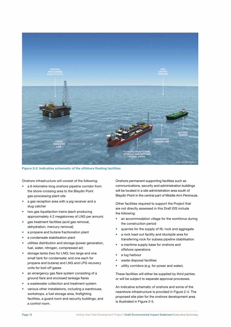
Onshore infrastructure will consist of the following:
• a 6-kilometre-long onshore pipeline corridor from
the shore-crossing area to the Blaydin Point
gas-processing plant site
• a gas reception area with a pig receiver and a
slug catcher
• two gas liquefaction trains (each producing
approximately 4.2 megatonnes of LNG per annum)
• gas treatment facilities (acid gas removal,
dehydration, mercury removal)
• a propane and butane fractionation plant
• a condensate stabilisation plant
• utilities distribution and storage (power generation,
fuel, water, nitrogen, compressed air)
• storage tanks (two for LNG; two large and one
small tank for condensate; and one each for
propane and butane) and LNG and LPG recovery
units for boil-off gases
• an emergency gas flare system consisting of a
ground flare and enclosed tankage flares
• a wastewater collection and treatment system
• various other installations, including a warehouse,
workshops, a fuel storage area, firefighting
facilities, a guard room and security buildings, and
a control room.
Onshore permanent supporting facilities such as
communications, security and administration buildings
will be located in a site administration area south of
Blaydin Point in the central part of Middle Arm Peninsula.
Other facilities required to support the Project that
are not directly assessed in this Draft EIS include
the following:
• an accommodation village for the workforce during
the construction period
• quarries for the supply of fill, rock and aggregate
• a rock load-out facility and stockpile area for
transferring rock for subsea pipeline stabilisation
• a maritime supply base for onshore and
offshore operations
• a tug harbour
• waste disposal facilities
• utility corridors (e.g. for power and water).
These facilities will either be supplied by third parties
or will be subject to separate approval processes.
An indicative schematic of onshore and some of the
nearshore infrastructure is provided in Figure 2-4. The
proposed site plan for the onshore development area
is illustrated in Figure 2-5.
Figure 2‑2: indicative schematic of the offshore floating facilities

Ichthys Gas Field Development Project | Draft Environmental Impact Statement Executive Summary Page 13
2.2 AlternativesDuring the concept selection stage of the Project, a
number of alternatives were considered for different
components of the Project. These included site
selection, assessment of technically feasible design
alternatives, and the “no development” option.
2.2.1 Site selection
Following the appraisal of the Ichthys Field’s gas
and condensate reserves, INPEX investigated the
options to bring the hydrocarbon products to market.
Currently proven technology for the processing of LNG
for export involves the development of large onshore
gas-processing trains with deepwater anchorages
for LNG tankers. A decision was made by INPEX to
pursue this approach for the Project.
The selection of a site for the onshore gas-processing
component of the Ichthys Project commenced with
studies conducted in 2002 that assessed a number
of possible locations. These studies indicated that
the Maret Islands in the Kimberley region of Western
Australia were the most appropriate location for
the onshore facility; this was based on what was
understood at that time of the environmental, political,
engineering and commercial constraints.
INPEX initiated an approvals process with the
Commonwealth Government in May 2006 in order to
pursue the Maret Islands option, referring its proposal
to develop the Ichthys Field to the Commonwealth’s
Department of the Environment and Water Resources
(DEW)6 and Western Australia’s Environmental
6 The Commonwealth’s Department of the Environment and Water Resources became the Department of the Environment, Water, Heritage and the Arts (DEWHA) in December 2007.
Figure 2‑3: Location of the onshore processing plant on blaydin Point and the gas export pipeline route through darwin Harbour

Page 14 Ichthys Gas Field Development Project | Draft Environmental Impact Statement Executive Summary
Protection Authority (EPA). These agencies determined
that the Project should be formally assessed at the
EIS and the environmental review and management
program (ERMP) levels respectively.
Work accordingly began on the preparation of a draft
EIS/ERMP for the Maret Islands location.
By 2007, significant uncertainty relating to INPEX’s
ability to develop the LNG facility at the Maret
Islands location in the Kimberley region became
apparent. Consequently, INPEX revisited sites that
were considered in earlier stages of the Project’s
site-selection phase and determined that it would be
technologically feasible to export Ichthys gas to an
onshore gas-processing location in the Darwin region,
despite the considerably greater length of subsea
pipeline that would have to be constructed to transport
the gas. During this period, the Northern Territory
Government offered INPEX the Blaydin Point site for the
onshore components of the Project. It is the Northern
Territory Government’s preferred site for an LNG facility
and is primarily zoned for industrial development under
the Northern Territory Planning Scheme7.
7 Department of Planning and Infrastructure. 2008. Northern Territory planning scheme. Department of Planning and Infrastructure, Darwin, Northern Territory.
In order to facilitate the acquisition of land tenure,
INPEX initiated discussions with the Northern Territory
Government which led to the signing of a Project
Development Agreement (PDA) on 18 July 2008 by
INPEX Browse, Ltd., Total E&P Australia, and the
Northern Territory Government. The PDA outlined the
approximate plan for the onshore area of the Project
as well as conditions that are required to be fulfilled
in order to gain land tenure. The ongoing discussion
regarding land tenure of the onshore development
area will be based on the adjusted development area
boundaries as presented in the Draft EIS.
2.2.2 Design alternatives
Consideration of environmental, social, economic and
safety criteria has been included in the concepts and
designs selected for the Project. Technically feasible
design concepts that have been particularly influenced
by these criteria include the following:
• alternative subsea pipeline routes, shore-crossing
locations and onshore pipeline routes
• alternative locations for offloading the modules for
the onshore gas-processing plant, that is, whether
to build a new module offloading facility at Blaydin
Point or to use the existing facilities at East Arm
Wharf and transport the modules to site by road
Figure 2‑4: indicative schematic of the onshore and nearshore infrastructure at blaydin Point

Ichthys Gas Field Development Project | Draft Environmental Impact Statement Executive Summary Page 15
Figure 2‑5: onshore development area infrastructure

Page 16 Ichthys Gas Field Development Project | Draft Environmental Impact Statement Executive Summary
• alternative concepts for the product loading jetty
and navigation channels at Blaydin Point
• alternative locations for a dredge spoil
disposal ground
• alternative onshore gas-processing plant layouts.
INPEX has also considered a number of alternative
offshore processing concepts and selected the one
considered most appropriate for the scale of the
Project and the location of the Ichthys Field.
Alternative locations and designs of the
accommodation village for the construction workforce
are subject to a series of separate approvals from the
regulatory authorities that are not within the scope of
the Draft EIS.
2.2.3 Consequences of adopting the “no development” option
As the permit holder and Operator of the Ichthys
Project, INPEX has an obligation to undertake
exploration of its permit area, to verify the nature and
extent of the hydrocarbon reserves which it contains
and to investigate the manner in which these reserves
can be commercialised. Should the Project be
commercially viable and not proceed, INPEX would not
be fulfilling its obligations.
In addition, significant social and economic
advantages resulting from the Project would be lost to
northern Australia in general and to the Darwin region
in particular. The Project has the potential to generate
substantial new export income, to create numerous
employment opportunities and to strengthen the
Northern Territory’s economic development. It would
be the largest private-sector investment in the history
of the Darwin region and would provide opportunities
for business and employment for over four decades.
2.3 development scheduleThe construction phase of the Project will cover
a period of 5 to 6 years from the final investment
decision to the loading of first LNG cargo. Figure 2-6
presents the indicative construction schedule.
As presented, construction and commissioning
of the second LNG train will continue as gas is
being produced from the first LNG train. From the
commencement of commissioning, the aim is to run
both the offshore and onshore facilities continuously
for the duration of the anticipated 40-year life of
the Project.

Ichthys Gas Field Development Project | Draft Environmental Impact Statement Executive Summary Page 17
Figure 2‑6: indicative development schedule

3 Stakeholder Involvement
Page 18 Ichthys Gas Field Development Project | Draft Environmental Impact Statement Executive Summary
INPEX recognises stakeholder consultation as an
important and ongoing process in the Ichthys Project.
From the outset, INPEX has embarked on a program
of consultation and communication with a broad range
of government, industry and community stakeholders.
Such consultation is a vital part of the environmental
assessment process for the Project which adds to the
formal input that will be provided by government and
the public in response to the Draft EIS.
In the preparation of the Draft EIS, INPEX has
consulted widely with government departments,
community groups, business representatives and
users of Darwin Harbour. The Commonwealth and
Northern Territory government reviews of the Draft
EIS and the subsequent period for public review and
comment will offer an opportunity to all interested
parties to provide input into the environmental
assessment process.
INPEX has developed a stakeholder communication
plan to facilitate a considered and coordinated
approach to its engagement with all stakeholders.
This is described in further detail below.
3.1 stakeholder Communication PlanThe purpose of the Stakeholder Communication
Plan is to facilitate effective involvement of
stakeholders throughout the Project’s 40-year
production lifespan, from the approvals phase through
to the construction, commissioning, operations and
decommissioning phases.
As described in the plan, INPEX’s approach is
as follows:
• to identify the full range of stakeholders with an
interest in the Project
• to establish and maintain a consistent and
coordinated approach for communication with
local communities, government agencies,
special-interest groups and industry
• to provide stakeholders with information about
the Project, the approvals process and overall
Project timelines
• to identify known and emerging environmental,
social and cultural heritage aspects of the
Project which might be of interest or concern to
stakeholders
• to inform stakeholders about the key
environmental, social and cultural heritage
factors associated with the Project, the potential
impacts of Project activities, and the management
strategies to be put in place to minimise or mitigate
such impacts
• to consider stakeholder concerns during Project
decision-making processes
• to ensure that there is timely and accurate
feedback and provision of information on how
INPEX will manage any impacts and issues.
The plan also outlines the engagement and
consultation activities that have taken place since the
formal commencement of the environmental impact
assessment process in May 2008 and provides a
summary of what is proposed for the future. To ensure
that it maintains its relevance over the long term, the
Stakeholder Communication Plan will be updated
as required.

Ichthys Gas Field Development Project | Draft Environmental Impact Statement Executive Summary Page 19
3.2 Implementation of the stakeholder Communication Plan
Consultation undertaken by INPEX to date has
included the following:
• open community forums in Darwin and Palmerston
• socio-economic impact assessment interviews
• presentations to a wide range of community and
business groups, including an industry forum in
Darwin
• regular formal meetings with Northern Territory and
Commonwealth government agencies
• regular formal meetings and presentations to
elected and executive representatives of the
Darwin, Palmerston and Litchfield councils
• regular formal meetings with a wide range of
community and business groups, including an
industry forum in Darwin
• discussions with Aboriginal groups, including
the Northern Land Council and the Larrakia
Development Corporation
• sponsorship and representation at events such as
the Freds Pass Rural Show and the Palmerston
Festival
• formal meetings with training and education
providers to identify opportunities for sponsorship
and capacity-building.
In addition, consultation was undertaken with the
Northern Territory Government, local government,
local businesses and the local community during
February 2009 to seek support for the planning
process for the development of INPEX’s proposed
accommodation village at Howard Springs.
Environmental and social impacts for this development
will be assessed under a separate approvals process.
Community forums
INPEX held the first of its open community forums in
Darwin and Palmerston in November 2008 (Figure 3-1).
The forums were widely advertised and attended by
about 400 people and were designed to encourage
stakeholder participation by presenting the key
aspects of the Project, the likely impacts, and the
proposed management controls.
Key issues raised at these forums include the
following:
• employment and training opportunities associated
with the Project
• potential accommodation shortages and pressure
on infrastructure during the peak employment
period
• the dredging program and its potential impact on
other Harbour users
• the visual impact of the development on the
Harbour
Figure 3‑1: community forum held in darwin in november 2008

Page 20 Ichthys Gas Field Development Project | Draft Environmental Impact Statement Executive Summary
• access to waters adjacent to the onshore
processing plant for recreational users
• air emissions and their impact on air quality
• liquid discharges and their impact on water quality.
Consultation with traditional owners
INPEX intends to establish and maintain sustainable
and mutually advantageous relationships with
traditional owners in the Darwin region, including
the original inhabitants of the Blaydin Point area, the
Larrakia people. It aims to achieve this by adopting the
following measures:
• consulting relevant Aboriginal communities
to promote an understanding of each other’s
concerns and aspirations
• helping relevant Aboriginal communities manage
any issues and challenges they might face in
relation to INPEX’s proposed operations
• consulting with Aboriginal communities and other
appropriate organisations to increase the pool of
potential employees for the company
• offering a range of school- and community-level
initiatives
• supporting partnerships that make a positive
difference to Aboriginal communities.
Comprehensive stakeholder communication will
continue throughout the life of the Project as INPEX
continues to consult with key stakeholders about
the progress of the Project and opportunities for
local involvement during its construction, operations
and decommissioning phases. Activities such as
community forums and the establishment of an office
in Darwin’s central business district will ensure that
INPEX will have an open and accessible presence
in the Darwin community while developing and
maintaining an understanding of the issues relating
to the Project.

4 Existing Environment
Ichthys Gas Field Development Project | Draft Environmental Impact Statement Executive Summary Page 21
This section of the Executive Summary summarises the key physical, biological, social and economic features of the existing environment in the areas to be affected by the Project. A description of the regional environment is also included in order to provide context for the significance of the habitats, resources and socio-economic conditions that currently exist in and around the development areas.
The geographical area affected by the Project can be divided into three main components:
• the offshore development area, which includes the Ichthys Field in the Browse Basin off the coast of north-western Australia as well as the pipeline route from the field to the mouth of Darwin Harbour
• the nearshore development area, which includes the pipeline route from the mouth of Darwin Harbour south to the waters around Blaydin Point and Middle Arm Peninsula as well as the offshore spoil disposal ground about 15 kilometres north of the entrance to Darwin Harbour
• the onshore development area, which includes the site proposed for the onshore processing plant at Blaydin Point and the onshore pipeline corridor from the shore crossing south of Wickham Point to the Blaydin Point plant.
4.1 offshore marine environmentThe Ichthys Field is located in Retention Lease WA-37-R, which was granted to INPEX and Total E&P Australia (the Joint Venture Parties) on 21 September 2009 in a portion of petroleum exploration permit area WA-285-P R1 (see Figure 4-1). The nearest sensitive marine habitats are Browse Island, located 33 kilometres to the south-east of the field, and Echuca Shoal, located approximately 55 kilometres to the east.
The subsea pipeline route will extend from the Ichthys
Field to the shore-crossing area south of Wickham
Point on Middle Arm Peninsula in Darwin Harbour, a
distance of around 885 kilometres. Most of this route
is distant from land, with the exception of the eastern
end of the route that curves around Cox Peninsula just
before it enters Darwin Harbour.
4.1.1 Climate and oceanography
The climate in the Browse Basin region is monsoonal
with warm north-west and south-west winds in summer
(October–February) and cooler south-easterly winds in
winter (May–June). This area is also prone to tropical
cyclones, mostly during the tropical wet season
(December–March). It is expected that cyclones could
have an impact on the Ichthys Field at least once every
two years. Under extreme cyclone conditions winds
can reach 300 kilometres per hour.
The Browse Basin generally experiences large tides
and tidal currents. Mean sea level at the Ichthys Field
is about 2.7 metres above Lowest Astronomical Tide
(LAT), with a spring-tide range of about 5.0 metres.
Tides are semidiurnal, with two daily high tides and two
low tides. The swell tends to be higher during winter
(with typical significant wave heights about 0.8 metres)
than in summer (with typical significant wave heights
about 0.7 metres), because the swell-generating storms
move further north in winter. Swell periods are generally
of the order of 12–18 seconds.
The offshore waters in the Ichthys Field area are
between 235 metres and 275 metres deep and are
typified by thermal stratification that varies in strength
according to the season. At the Ichthys Field, surface
water temperatures are about 30 °C in summer (March)
and 26–27 °C in winter (July), with major thermoclines
at 30–50 metres depth in summer and 70–120 metres
in winter. Below the thermocline, water temperatures
decrease by approximately 1 °C per 10 metres of water
depth, dropping to as low as 12 °C at 250 metres.
Extreme weather events, such as cyclones and
monsoons, may also promote temporary mixing of
water layers across the thermocline. In shallower waters
(less than 100 metres deep) along the greater part of the
pipeline route, the seabed water temperature remains
relatively constant at around 25 °C.
Salinity is spatially and temporally consistent at 34–35 parts per thousand as expected for locations that are distant from major freshwater discharges. Dissolved oxygen concentrations in the waters of the Ichthys Field showed constant levels of 6.0–6.5 parts per million above the thermocline in both summer and winter. Below the thermocline, dissolved oxygen decreased with depth with levels as low as 3 parts per million at 250 metres, indicating that mixing is limited because of the strong thermal stratification.
4.1.2 Marine habitat and fauna
Surveys show that the seabed at the Ichthys Field is
generally flat with shallow sand waves. The sediments
grade from soft featureless sandy silts in the north

Page 22 Ichthys Gas Field Development Project | Draft Environmental Impact Statement Executive Summary
to gravelly sands in the south. Very few epibenthic
organisms were observed and the seabed features
indicate strong near-seabed currents and mobile
sediments. Infaunal assemblages are dominated
by deposit-feeding polychaete worms and small
shrimplike crustacean species. Soft substrates are
typical of deep continental shelf seabeds and this
habitat is very widely distributed in the deeper parts of
the Browse Basin.
The greater part of the proposed pipeline route
encompasses featureless, unconsolidated clay–silty
sands with low benthic diversity. Areas of hard
substrate host benthic fauna that is common
throughout the region, including soft corals,
gorgonians and sponges.
Browse Island is an isolated sandy cay surrounded by
an intertidal reef platform and a shallow fringing reef.
It is located approximately 33 kilometres south-east of
the offshore development area. Rocky-shore habitat
around the island is represented only by exposed
beach rock and there are no intertidal sandflats. The
reef platform is high and conspicuously barren in many
places. The reef crest and seaward ramp habitats
around the edge of the reef support moderately rich
assemblages of molluscs, while the shallow subtidal
zone is narrow and supports relatively small areas of
well-developed coral assemblages. Browse Island is
listed as a nature reserve as the coarse coral sand
beach zone is used by green turtles (Chelonia mydas)
as a nesting area.
Echuca Shoal is located approximately 55 kilometres
east of the offshore development area. It supports
small coral colonies with low species richness and
abundance, with coral rubble suggestive of strong
currents. The shallow shoal areas which rise to
Figure 4‑1: the offshore development area

Ichthys Gas Field Development Project | Draft Environmental Impact Statement Executive Summary Page 23
approximately 13 metres below LAT are dominated by
a flat reef platform comprising hard corals, crinoids,
sea whips and soft corals. At greater depths the
density of epibenthic fauna decreases dramatically,
with sea whips and sea fans dominant (particularly
between 80–100 metres). Below the drop-off of the
slope at the edge of Echuca Shoal (at depths of
180–200 metres), bare sand is the dominant
substratum with sponges, crinoids and occasional
echinoderms and gorgonians present.
Baleen whales, toothed whales and dolphins occur in
the offshore development waters at the Ichthys Field
and along the gas export pipeline route, although
these areas do not represent significant breeding or
foraging habitat for these animals. Humpback whales
(Megaptera novaeangliae) are the most common
whale species observed in the region, as they migrate
annually from their Antarctic feeding grounds to their
breeding and calving areas in coastal waters of the
Kimberley region in the north of Western Australia.
Humpback whales are listed as “vulnerable” under
the EPBC Act.
The offshore development area is unlikely to support breeding and feeding grounds for turtles, although the coastal waters and beaches of the Kimberley are known to host significant green turtle and flatback turtle (Natator depressus) rookeries. Both species are listed as “vulnerable” under the EPBC Act. Flatback turtles are also abundant in turbid, shallow inshore waters in the west of the Northern Territory, with nesting areas located on islands such as Bare Sand Island and Indian Island, south-west of the Cox Peninsula. Limited low-density nesting has been observed in Darwin Harbour—at Cox Peninsula near Mandorah and at Casuarina Beach.
A number of EPBC-listed migratory seabirds occur in the offshore development area, although at low densities. Within the region, the Roebuck Bay – Eighty Mile Beach area and Ashmore Reef are important aggregation sites for migratory birds that utilise the East Asian – Australasian Flyway. These are 450 kilometres south-south-west and 160 kilometres north of the Ichthys Field respectively.
4.2 Nearshore marine environmentThe nearshore development area includes the entrance to Darwin Harbour through to the coastal waters around Blaydin Point and Middle Arm Peninsula below the low-water mark (see Figure 4-2).
4.2.1 Climate and oceanography Darwin Harbour lies in the monsoonal (wet–dry) tropics of northern Australia and experiences two distinct seasons—a hot wet season from November to March
and a warm dry season from May to September. The months of April and October are transitional. Maximum temperatures are hot all year round, but November is the hottest month (25–33 °C) while June and July are the coolest (20–30 °C). The mean annual rainfall is 1711 millimetres, with rain falling on an average of 111 days, mainly in the wet season.
Darwin Harbour is a large ria system, or drowned river valley, with an area of about 500 square kilometres. In its southern and south-eastern portions the Harbour has three main components—East Arm, West Arm and Middle Arm—that merge into a single unit, along with the smaller Woods Inlet, before joining the open sea. Freshwater inflow to the Harbour occurs from January to April, when estuarine conditions prevail in all areas.
The main channel of the Port of Darwin is around 15–25 metres deep, with a maximum depth of 36 metres. The channel favours the eastern side of the Harbour, with broader shallower areas occurring on the western side. The channel continues into East Arm, towards Blaydin Point, at water depths of more than 10 m below LAT; the bathymetry in this area has been modified by dredging and reclamation for the development of East Arm Wharf.
Darwin Harbour is characterised by a macrotidal regime, with predominantly semidiurnal tides. Mean sea level is approximately 4.0 metres above LAT, and spring tides can produce tidal ranges of up to 7.5 metres. The large tidal ranges produce strong currents that peak at speeds of up to 2–2.5 metres per second.
Water quality in Darwin Harbour is generally high,
although naturally turbid most of the time. Water-quality
parameters vary greatly with the tide (spring versus
neap), location of sampling (inner versus outer
Harbour), and with the season (wet season versus dry
season). Anthropogenic influences to Harbour water
quality include the port operations at East Arm Wharf,
historical industrial activities at Darwin Waterfront and
Sadgroves Creek, and discharge from the Larrakeyah
sewage plant by the Power and Water Corporation.
Average water temperatures measured in the
nearshore development area were 30.6 °C in the wet
season and 24.5 °C in the dry season. Salinity levels
recorded in the East Arm area ranged from 19.1 parts
per thousand to 36.3 parts per thousand. Mean salinity
levels in the Harbour were lower in the wet season than
the dry season. Algal blooms, which are symptomatic
of excessively nutrient-rich water, have not been
recorded in the Harbour.
Harbour waters remain well oxygenated throughout
the year, with levels ranging from 74 per cent to 96 per
cent saturation (with an average of 84 per cent).
Dissolved oxygen levels are generally higher in the

Page 24 Ichthys Gas Field Development Project | Draft Environmental Impact Statement Executive Summary
surface waters and in the main body of the Harbour.
Levels are lower in the wet season.
Sediments in the nearshore development area range
from terrigenous gravels in the main Harbour channel;
calcareous sands close to small coral communities
and shoals; terrigenous sands on beaches and spits;
and mud and fine sand on broad, gently inclined
intertidal mudflats. Elevated levels of arsenic were
recorded at some sites in surface and subsurface
sediments. This is likely to be an indication of local
geology rather than man-made contamination.
Laboratory testing showed that this arsenic would
not be toxic in the marine environment, as only very
small proportions dissolved into “bioavailable” forms
that can be absorbed by plants or animals (including
humans). Tributyltin (TBT) compounds were not
recorded above laboratory detection limits in surveys
of the sediments of the nearshore development area.
Petroleum hydrocarbons were recorded in some
locations; in all cases, however, the concentrations
were well below the screening levels identified in the
Commonwealth’s National assessment guidelines for
dredging 2009.
4.2.2 Marine habitat and fauna
Marine habitats of Darwin Harbour are shown
in Figure 4-3. Key marine communities include
hard and soft corals, macroalgae and subtidal
soft-sediment invertebrate communities. Mangrove
stands and mudflats dominate the intertidal zone
throughout the Harbour.
Coral-dominated communities in Darwin Harbour are
located in lower intertidal to high subtidal areas to
depths of 5–10 metres below LAT. These areas are
characterised by strong currents where the sediment
load is kept in suspension and light intensity does not
Figure 4‑2: the nearshore development area in darwin Harbour

Ichthys Gas Field Development Project | Draft Environmental Impact Statement Executive Summary Page 25
Figure 4‑3: marine habitats in darwin Harbour

Page 26 Ichthys Gas Field Development Project | Draft Environmental Impact Statement Executive Summary
fall below a minimum value for coral and algal survival.
Known localities of coral-dominated communities are
Channel Island, Weed Reef, north-east Wickham Point
and South Shell Island.
The coral community on the rocky platform at
Channel Island is listed on the Register of the National
Estate and is a declared “Heritage Place” under the
Heritage Conservation Act (NT). The community is
relatively diverse and demonstrates that a coral-based
community can survive in an area where most physical
conditions are adverse (e.g. high turbidity, strong tidal
currents, and seasonally low salinity).
In the vicinity of Blaydin Point, the shoreline comprises
sloping rock platforms or intertidal mudflats with
moderate bioturbation. The deeper subtidal area
(approximately 1500 metres from the shoreline)
comprises moderate soft coral cover (mainly
Sarcophyton and Dendronephthya species) on hard
substrates, together with zoanthids, bryozoans,
hydroids, ascidians and sponges. At deeper sites
where hard pavement is not exposed, the fauna
typically includes gorgonian fans, sea whips, sea pens
and large sponges.
The rock-armour covering the existing Bayu–Undan
pipeline in Darwin Harbour has a high coverage of
soft coral, gorgonians, algae and hydroids with less
than 5 per cent hard-coral coverage. A moderate
abundance of fish life also surrounds the pipeline,
the most noticeable being surgeon fish of the family
Acanthuridae. The surrounding sand- and silt-covered
seabed supports a low coverage of sparse sea whips
and sea pens.
The seabed at the offshore dredge spoil disposal
ground is characterised by flat, featureless benthic
habitat of silt–sand in water depths of 15–20 metres.
The area supports sparse benthic communities of
burrowing infauna and epibenthic fauna such as
bryozoans, sponges and soft corals. No seagrasses or
hard corals were recorded in surveys of the area.
The most commonly recorded cetacean species
in Darwin Harbour are three coastal dolphins—the
Australian snubfin (Orcaella heinsohni), the Indo-Pacific
humpback (Sousa chinensis) and the Indo-Pacific
bottlenose (Tursiops aduncus). Occasional pods of
false killer whales (Pseudorca crassidens), an oceanic
dolphin, are also known to visit the Harbour.
Dugongs are known to occur in Darwin Harbour
waters, although in relatively low numbers, and
have been observed foraging on the rocky reef flats
between Channel Island and the western end of Middle
Arm Peninsula. As no seagrass occurs on the reef
flat in this area, the dugongs were likely to have been
feeding on macroalgae.
Green, flatback and hawksbill (Eretmochelys
imbricata) turtles visit Darwin Harbour regularly to
forage for food. However, the shoreline throughout
Darwin Harbour, largely consisting of mangroves and
mudflats, does not support nesting activity for marine
turtles. This is with the exception of a few locations
at Cox Peninsula and Casuarina Beach, where very
low-density nesting of flatback turtles has been
reported. The green, flatback and hawksbill turtles are
all listed as “vulnerable” under the EPBC Act.
Other large marine animals that inhabit Darwin
Harbour include the saltwater crocodile
(Crocodylus porosus), a diverse range of marine
and mangrove-dwelling snakes and two species of
sawfish listed as “vulnerable” under the EPBC Act:
the freshwater sawfish (Pristis microdon) and green
sawfish (Pristis zijsron). The nearshore waters around
Blaydin Point are not considered significant foraging or
breeding grounds for these species.
Of the 55 potentially invasive marine species identified
by the National Introduced Marine Pests Coordination
Group, none are known to occur in Darwin Harbour
and the region is considered free of marine pests.
4.3 onshore terrestrial environmentThe onshore development area includes the terrestrial
environment above the low-tide mark at Blaydin
Point and parts of Middle Arm Peninsula. An access
road and pipeline corridor also extend the onshore
development area across Middle Arm Peninsula to the
water’s edge south of Wickham Point (Figure 4-4).
4.3.1 Physical environment
Blaydin Point is a low-lying peninsula oriented
north–south, extending from Middle Arm Peninsula
into the waters of East Arm in Darwin Harbour.
Blaydin Point is separated from the mainland by a
mudflat, which is flooded during spring tides.
Soil surveys of the onshore development area identified potential acid sulfate soils (PASSs) in the mangrove and swamp areas. The potential was generally higher in the subsoil than in surface layers. Subsurface soils were typically dark-coloured silty clays, with high organic matter accumulation, anaerobic conditions and the “rotten-egg” odour indicative of hydrogen sulfide.
Throughout the onshore development area the surface soil layer rapidly absorbs rainfall when the soil is dry, such as at the end of the dry season. After regular rainfall the surface layer becomes saturated

Ichthys Gas Field Development Project | Draft Environmental Impact Statement Executive Summary Page 27
and surface-water flows increase. Where water accumulates at the outer edges of Blaydin Point, surface-water flow is likely to become increasingly turbulent and occupy temporary drainage channels. These channels become the ephemeral sections of the tributary creeks that feed into Lightning Creek to the west and East Arm to the east.
Groundwater under the central elevated areas of Blaydin Point is of low salinity and of a similar quality to rainwater and drinking water. The most prominent aquifer is known as the Bathurst Island Group and occurs in the sand and gravel horizons of the soils at the interface between the overlying sediments and bedrock.
Ambient air quality in the Darwin region is influenced by a number of sources including biogenic emissions (from vegetation and soil), smoke from bushfires, and anthropogenic emissions from vehicles and industrial facilities. Ambient air-quality studies showed that
concentrations of nitrogen dioxide, sulfur dioxide and ozone in the Darwin airshed are relatively low, falling well below levels that could affect public health under the criteria provided by the National Environment Protection (Ambient Air Quality) Measure.
4.3.2 Vegetation and fauna Vegetation in the upland portions of the development area is dominated by Eucalyptus miniata and E. tetrodonta woodland, a common vegetation community that is widespread throughout the Darwin Coastal Bioregion. Surveys of the area indicated that this vegetation type provided habitat for the greatest number of animal species, particularly birds. Vegetation communities of the onshore development area are shown in Figure 4-5.
Monsoon vine forest also occurs in the onshore development area and supports species such as Carpentaria acuminata, Acacia auriculiformis and
Figure 4‑4: the onshore development area

Page 28 Ichthys Gas Field Development Project | Draft Environmental Impact Statement Executive Summary
Calophyllum soulattri. While monsoon vine forest is found throughout the Darwin Coastal Bioregion, it occurs in relatively small, isolated patches. This vegetation community provides important habitat for several species of bird that feed on fruit and flowers.
The coastal fringes of the onshore development area are dominated by mangroves. The Darwin Harbour mangrove community is known for species richness, containing 36 of the 50 mangrove species known worldwide. The most common mangrove species in Darwin Harbour are Rhizophora stylosa, Ceriops tagal, Sonneratia alba, Bruguiera exaristata, Avicennia marina and Camptostemon schultzii. The mangrove vegetation community provides habitat for mangrove specialist bird species such as the cicadabird (Coracina tenuirostris), black butcherbird (Cracticus quoyi) and white-breasted whistler (Pachycephala lanioides).
The cycad Cycas armstrongii occurs in the eucalypt woodland community within the development area. The species is listed as “vulnerable” under the Territory Parks and Wildlife Conservation Act (NT) (TPWC Act). C. armstrongii is endemic to the Northern Territory and is locally abundant across the western Top End region, the Cobourg Peninsula and the Tiwi Islands (Melville Island and Bathurst Island).
A number of animal species listed as threatened under the TPWC Act or the Environment Protection and Biodiversity Conservation Act 1999 (Cwlth) (EPBC Act) may occur in and around the onshore development area, such as the northern quoll (Dasyurus hallucatus), water mouse (Xeromys myoides), red goshawk (Erythrotriorchis radiatus) and the floodplain monitor (Varanus panoptes); however these species were not recorded during pre-development surveys.
Twelve species of weeds occur at the onshore development area. Four of these species—hyptis (Hyptis suaveolens), lantana (Lantana camara), mission grass (Pennisetum polystachion) and gamba grass (Andropogon gayanus)—are listed as declared weeds under the Weeds Management Act 2001 (NT), and three are also weeds of significance according to the Commonwealth list of “weeds of national significance”. Introduced animal species that inhabit the onshore development area include the cane toad (Bufo marinus), black rat (Rattus rattus) and feral pig (Sus scrofa).
Extensive biting-insect habitat exists at the onshore
development area. The mangrove biting midge
(Culicoides ornatus) is particularly prevalent and
mosquito species including Aedes vigilax, Culex
annulirostris, Culex sitiens, Verrallina funerea and
Aedes notoscriptus also occur in the area. These
mosquitoes are all potential carriers of disease.
4.4 social and cultural environment
4.4.1 Land and sea use
The onshore development area on Middle Arm
Peninsula is currently undeveloped vacant Crown land
falling under the jurisdiction of the Litchfield Council.
Middle Arm Peninsula was identified as a site for
future industrial development by the Northern Territory
Government and is classified as such under the
Northern Territory Planning Scheme.
Current use of the land and marine environment on
the Middle Arm Peninsula includes a power station
and an aquaculture facility on Channel Island, and
ConocoPhillips’ Darwin LNG plant and offloading
facility at Wickham Point. The area is regularly used
for recreational fishing and by Aboriginal people for
traditional hunting and gathering. Blaydin Point itself is
used informally for camping.
In Darwin Harbour, the most intensive use of the
marine area is for commercial shipping, recreational
boating and military activities. Underwater power and
communication cables extend across the Harbour on
the seafloor between Mandorah and Myilly Point, and
the Bayu–Undan pipeline to the Darwin LNG plant runs
down the centre of the Harbour. Tourism activities such
as charter fishing, scuba-diving, sailing and general
boating are undertaken throughout the Harbour.
4.4.2 Population and demographics
The population of the Northern Territory in 2006 was
192 898 people, representing approximately one per
cent of Australia’s total population. Around half of
this population resided in the Darwin region. Demand
for inner-city housing in Darwin has been continually
increasing, driven by the migration of new workers
in the mining, tourism and defence industries from
interstate and overseas. As a result of this migration,
the Northern Territory’s population is younger than that
of the general Australian population with a median age
of both males and females of 30 years, compared with
the national median ages of 35 and 37 years for males
and females respectively.
4.4.3 Cultural heritage
Middle Arm Peninsula is within the traditional country
of the Larrakia people. Eight Aboriginal archaeological
sites and one isolated artefact are located close to, or
within, the boundary of the onshore development area.
Other historic sites in the onshore development area
include an anti-aircraft searchlight battery from World
War II located on the north side of Blaydin Point and a
Catalina (World War II flying boat) wreck located in the
intertidal area on the east side of Blaydin Point.
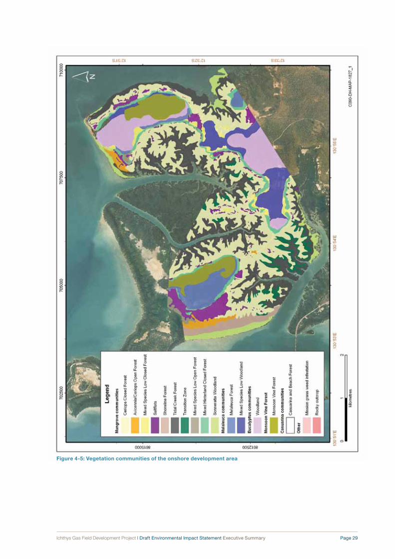
Ichthys Gas Field Development Project | Draft Environmental Impact Statement Executive Summary Page 29
Figure 4‑5: Vegetation communities of the onshore development area

Page 30 Ichthys Gas Field Development Project | Draft Environmental Impact Statement Executive Summary
Shipwrecks such as the SS Ellengowan and the
Diemen and the World War II shipwrecks the
SS Mauna Loa, the British Motorist, the USAT Meigs,
the Neptuna, the SS Zealandia and the USS Peary
are located in Darwin Harbour near, but outside, the
disturbance area for nearshore infrastructure. The
wrecks of five Catalinas are located in Harbour waters
north of Blaydin Point.
4.5 economic environmentThe Northern Territory has a relatively diverse
economy, with a strong reliance on the mining industry.
Construction, government administration, defence,
manufacturing and the service industries also play a
major role in the economy.
In 2006, the labour force participation rate for Darwin
city was 65.6 per cent, higher than the Northern
Territory and Australian participation rates and, in fact,
over recent years Darwin has tended to have lower
unemployment than other areas of Australia.
Employment in City of Darwin is spread across a
range of areas, with a particular focus on the service
industries. The largest industry employer in 2006
was in the area of public administration, probably
associated with the Australian Defence Force.
Similarly, the largest industry employer in the areas
of Palmerston and East Arm is public administration,
much of this attributable to the defence sector,
in particular to the Robertson Barracks situated
near Palmerston. Other important industries in
Palmerston and East Arm include retail trade,
construction, health care and social assistance,
and education and training.
In 2005–06, the mean household income per week in
the Darwin region was $1675, which was higher than
the Australian average of $1410 per week. Disposable
household income was also higher at $730 per week,
compared with $678. These results are likely to be in
part due to a younger population and larger working
population in the area.
Despite these relatively high levels of income, the
population of the Darwin region is not necessarily
“wealthy”. Mean household net worth, an estimate of a
household’s assets such as property and investments,
was the lowest in the country, at $411 569. This
finding would be related to Darwin having the highest
proportion of renters in the country (38.6 per cent of
total households).

5 Risk Assessment Methodology
Ichthys Gas Field Development Project | Draft Environmental Impact Statement Executive Summary Page 31
The systematic identification, assessment and
mitigation of risk to the environment and the
community is an essential component of the way
INPEX conducts its business. This section summarises
the methodology used to identify and categorise
environmental and public safety risks resulting from
planned activities associated with the Project.
5.1 environmental risk assessmentEnvironmental risk assessment is the process of
identifying the likelihood and consequence of potential
environmental impacts from a particular “environmental
aspect” resulting from Project activities.
The risk assessment methodology adopted for
the Draft EIS ensures that a systematic approach
is applied to the assessment and management of
environmental risk. The methodology can be divided
into three main steps:
1 risk scoping and preliminary risk assessment
2 detailed risk assessment
3 communication of residual risk.
The methodology applied as part of this environmental
impact assessment is summarised in the flow diagram
in Figure 5-1.
Assessment was carried out through desk-based and
workshop-based assessments using predetermined
definitions of likelihood and consequences categories
to rank each risk identified. Where appropriate,
quantitative methods were used to assist in evaluating
risks, for example, risk arising from onshore air
emissions were modelled to predict ground-level
concentrations of air pollutants and compared against
national air-quality guidelines. Similarly, oil-spill risks
were quantified referring to industry databases on
oil-spill frequencies and by predicting the fate of spill
events using spill trajectory modelling.
Several iterations of risk assessment were undertaken
where, firstly, higher risk activities and aspects were
identified and, secondly, management controls were
applied and the residual risk was evaluated. The
risk assessment methodology used by INPEX is
undertaken in accordance with Australian Standard
AS/NZS 4360:2004, Risk management together with its
associated document Risk management guidelines—
Companion to AS/NZS 4360:2004 (Handbook
HB 4360:2004).
Proposed management measures and controls,
together with risk assessment outcomes are identified
in sections 6, 7 and 9 of this Executive Summary.
5.2 Public safety risk assessmentIn accordance with Australian and international
practice applied in the oil & gas industry, all Project
infrastructure will be designed and operated in
accordance with the principle of managing risk to
“as low as reasonably practicable” (ALARP) levels.
This principle is supported by various legislative
requirements that include licensing of the onshore
LNG plant site at Blaydin Point (including the product
loading jetty) as a “major hazard facility” under
the Dangerous Goods Act (NT) and the Dangerous
Goods Regulations (NT). Public risk from major
hazard facilities are managed in accordance with
the National Standard for “Control of Major Hazard
Facilities” and the Code of Practice (1996) issued by
Safe Work Australia, formerly the Australian Safety and
Compensation Council.
Part of the process of acquiring a Dangerous Goods
Licence for a major hazard facility such as the onshore
processing plant at Blaydin Point involves undertaking
hazard identification and risk management processes
in order to assess the safety risk to the public from
major incidents resulting from the onshore plant.
These risks are assessed through quantitative risk
assessments (QRAs). QRA involves using specialised
modelling to determining location-specific risks to
off-site populations using failure frequencies, available
literature appropriate to the Project and potential
hazardous scenarios. These location-specific risks can
then be compared against agreed fatality risk criteria
for other Australian industrial developments.
Currently there are no public risk criteria laid down by
legislation in the Northern Territory. The Territory’s NT
Worksafe advised that the “Victorian ‘Interim’ offsite
individual risk criteria” should be used as a guideline.
The risk assessment criteria detailed in this guidance
are applicable to the considerations of land-use
planning and development in the vicinity of potentially
hazardous facilities.
Both the public safety and environmental risk
assessments are summarised in sections 6–9 of this
Executive Summary to the Draft EIS.

Page 32 Ichthys Gas Field Development Project | Draft Environmental Impact Statement Executive Summary
Figure 5‑1: Risk assessment methodology

6 Marine Impacts and Management
Ichthys Gas Field Development Project | Draft Environmental Impact Statement Executive Summary Page 33
This section of the Executive Summary summarises
the potential impacts to the marine environment that
will be associated with the offshore and nearshore
development areas of the Project and identifies the key
management controls which will be applied to mitigate
these impacts.
offshore environmentActivities in the offshore development area that have
the potential to impact on the environment include
the installation of facilities, routine discharges
and emissions (e.g. produced water, drilling muds
and noise), and accidental events such as spills of
condensate or diesel. Baseline surveys and modelling
informed an assessment of the potential environmental
impacts of these activities.
The risk assessment process, taking into account
management controls and mitigating factors, identified
13 “medium” and 26 “low” residual risk potential
environmental impacts associated with the offshore
development area. These risk ratings are considered to
be acceptably low, mitigating risks to sensitive habitats
and significant or migratory species.
“Matters of national environmental significance”
associated with the offshore development area
include the Commonwealth marine environment and
some threatened and migratory animal species that
could occur in the area, including whales and other
cetaceans, turtles, sharks and seahorses. Surveys
at the Ichthys Field recorded only a low number of
whales and the area is not considered significant
to whale breeding or feeding. Development of the
offshore facilities and gas export pipeline would affect
a very small proportion of the extensive and relatively
uniform marine habitats in the region, and would not
reduce the available habitat for significant species. No
threatened ecological communities occur in or near
the offshore development area.
The most significant ecological habitat in the vicinity
of the offshore development area is Browse Island,
which is located approximately 33 kilometres from
the offshore facilities. The island is used for nesting
by green turtles, which are listed as “vulnerable”
under the EPBC Act. The only potential impact to
Browse Island associated with the Project is the risk
of hydrocarbons reaching shore in the unlikely event
of a major condensate spill. Other emissions and
discharges from the Project, including light, noise,
produced water and drilling muds, are expected to
remain distant from the island.
Drill cuttings from the construction of subsea
production wells will generate a turbid plume in
offshore waters, which will be dispersed by the strong
ocean currents and deep water. While water-based
muds (WBMs) will be discharged along with drill
cuttings, synthetic-based muds (SBMs) will be
recovered for recycling and reuse prior to eventual
onshore disposal. The percentage by dry weight of
SBMs released on drill cuttings will be restricted to
10 per cent or less, in accordance with the guidelines
laid down by Western Australia’s Department of Mines
and Petroleum. In addition, an internal target will be set
to achieve 5 per cent or less.
Produced-water volumes from the offshore facilities
will vary throughout the life of the Project and
will contain varying concentrations of production
chemicals. A comparison of expected field dilution
rates against typical produced-water ecotoxicity
indicates that Ichthys Field discharge concentrations
should dilute to below acute toxicity levels within
10–60 metres and to below chronic toxicity levels
within 1.1–3.6 kilometres of the release point.
A large volume of water (1 gigalitre) with low
concentrations of dissolved chemicals will be
discharged offshore after hydrotesting of the gas
export pipeline. This “one-off” discharge is anticipated
to rapidly disperse into the open ocean and will remain
distant from sensitive habitats.
Discharges of drill cuttings, drilling muds, produced
water and hydrotest water will comply with the
requirements of offshore petroleum legislation.
No wastes other than grey water, macerated sewage
and food scraps will be discharged from the CPF
and FPSO.
Ichthys Field condensate is a light oil with low
viscosity and a relatively low proportion of aromatic
hydrocarbons. In the unlikely event of accidental spills,
any hydrocarbons at the water surface would undergo
rapid weathering (evaporation of 70–80 per cent of
the spill volume) within the first day of release. Under
certain wind conditions, however, trajectory modelling
indicates that there is a slight chance that persistent
hydrocarbons from large spills could reach points on
Page 34 Ichthys Gas Field Development Project | Draft Environmental Impact Statement Executive Summary
the shorelines of Browse Island, Seringapatam Reef,
Scott Reef and Western Australia’s Kimberley coast.
Spill scenarios of this scale include the rupturing of a
subsea flowline, a CPF diesel fuel leak, the rupturing
of a condensate transfer line, a ship colliding with
the FPSO, or a subsea well failure. The likelihood of
shoreline oil exposure from these scenarios ranges
from “unlikely” (4.9 × 10⁻⁴) to “remote” (4.9 × 10⁻⁷)
events per annum.
Because of the remote location of the Ichthys Field,
emissions and discharges are very unlikely to combine
with those from other facilities and contribute to
cumulative impacts. The recently proposed Prelude
field is located 15 kilometres to the north of the Ichthys
Field, while the fields of Jabiru, Challis and Montara
are situated between 150 and 270 kilometres to the
north-east.
Nearshore environmentActivities in the nearshore development area that have
the potential to impact on the environment include
the construction of facilities and the associated
dredging program, routine wastewater discharges,
and accidental events such as hydrocarbon spills or
the introduction of marine pests. Baseline surveys,
modelling and comparison of the Project with similar
past developments informed an assessment of the
potential environmental impacts of these activities.
The risk assessment process, taking into account
management controls and mitigating factors,
identified 17 “medium” risk and 24 “low” risk potential
environmental impacts associated with the nearshore
development area. These risk ratings are considered
acceptably low, mitigating the risks to sensitive
habitats and significant or migratory species and
minimising pollution impacts to the surrounding
community.
“Matters of national environmental significance”
associated with the nearshore development area are
threatened and migratory animal species, including
cetaceans, dugongs, birds, turtles, sharks and
seahorses, and migratory birds that could occur in the
area. While coastal dolphins, dugongs, marine turtles
and sawfish are known to occur in Darwin Harbour,
no significant breeding or feeding grounds have been
identified for these species in or near the nearshore
development area.
Dredging is required to provide a shipping channel
and turning basin to provide tanker access to the
product loading jetty, to provide access to the module
offloading facility and to facilitate burial of the gas
export pipeline. The dredging program proposed
during the nearshore construction period will remove
mainly soft-sediment benthic communities and some
areas of rock pavement that support corals and algae.
These marine communities are well represented
elsewhere in the Harbour.
Dredging will generate turbid plumes that are mainly
confined to East Arm. Turbid plumes will reduce the
incident light levels reaching benthic biota, which
could affect sensitive species such as corals and
algae. However, predictive modelling shows that
turbidity will be influenced by tidal currents and
suspended-sediment levels in the water column
in many places fall to close to background during
neap tides as the sediments settle, before being
resuspended by strong spring-tide movements.
Hence, benthic biota will experience periods of
turbidity close to background levels, throughout the
dredging program and this is expected to mitigate
long-term impacts upon these communities.
Turbid plumes can also release nutrients stored in
marine sediments, providing a food source for fish
and subsequently attracting predators such as marine
mammals and reptiles. Conversely, marine megafauna
may be deterred from the area because of the noise and
movements of the various dredging and support vessels.
Predictive modelling of the proposed four-year dredging
program indicates that some fine marine sediments will
build up in shoreline areas around East Arm. Mangrove
vegetation communities occur along these shorelines
and some species rely on specialist root adaptations
such as pneumatophores, stilt roots and buttress roots
to facilitate gas exchange and respiration in anaerobic,
waterlogged soils. Excess sedimentation on these
structures could result in reduced mangrove tree health
and even death. Around 2 hectares of mangroves
are predicted to receive more than 100 millimetres of
sediment as a result of the dredging program, which
may cause tree deaths. An additional 28 hectares
of mangroves are predicted to receive between
50 millimetres and 100 millimetres of sediment which
may cause reduced tree health or even localised deaths.
A monitoring program will be developed to assess
sedimentation and mangrove health in these
areas. If mangrove tree deaths result because of
sedimentation from the dredging program (and are
not attributable to natural causes or activities external
to the Project), rehabilitation of the affected areas
will be undertaken after the completion of dredging
activities through a combination of natural recruitment,
facilitated natural recruitment and active planting.
Sedimentation is not predicted to occur to any
significant extent at coral communities in the Harbour,
as tidal currents will remove any settling particles
relatively quickly.

Ichthys Gas Field Development Project | Draft Environmental Impact Statement Executive Summary Page 35
Offshore disposal of dredge spoil will be carried out in an area of relatively featureless sandy seabed, with sparse benthic biota in water depths of 15–20 metres. Turbid plumes generated by this spoil placement will be dispersed to the north-east and south-west by repeated tidal currents. On large spring tides, this could cause suspended-sediment concentrations of up to 7 milligrams per litre around the Vernon Islands, and up to 12 milligrams per litre in the Howard River in Shoal Bay. During neap tides, however, these concentrations would decrease to near-background levels. Hard corals and seagrasses are rare in these areas and soft-coral and algal communities are expected to be able to withstand these periodic turbidity events without significant decreases in growth. Some low-level sedimentation of intertidal and subtidal areas could result within embayments in Shoal Bay and Adam Bay, which are naturally muddy depositional areas.
Marine blasting will be used during construction to remove hard rock in the vicinity of Walker Shoal. This activity will generate underwater noise and blast impacts that could cause avoidance behaviour or injuries (or even death in the case of blasting) to marine megafauna in close proximity. Confined blasting methods will therefore be used, with micro-delays between blasts to reduce peak pressures and the radius of impact zones. Protection zones will be implemented for marine megafauna, with blasting activities suspended if animals are observed inside these zones. Passive and active acoustic monitoring techniques will be investigated and, if implemented, this would complement vessel-based surveillance for fauna protection zones, reducing risks even further. Some fish deaths are expected, in close proximity to the blasting and these cannot be avoided. Marine blasting is only required during the construction phase and blasting activities will be localised.
Alternative techniques to drilling and blasting are being investigated for the removal of the hard rock material within the shipping channel. At this stage, however, it is not possible to confirm whether there are any viable alternatives.
Piledriving will be required for jetty construction. As with marine blasting, this will generate underwater noise and vibration that could cause avoidance behaviour or injuries to marine megafauna in the close vicinity. An observation zone and a soft-start procedure (in which activities are gradually scaled up over a five-minute period) will be implemented at the commencement of piledriving activities. Piledriving is not expected to significantly disturb local populations of marine megafauna. Piledriving is only associated with the construction phase and the effects will be localised.
Predictive modelling indicates that treated wastewater
discharges from the Project will dilute rapidly to below
biological effect levels and that any hydrocarbons
discharged from the onshore development area will
degrade quickly under natural weathering processes.
Similarly, fresh water discharged after hydrotesting
will mix quickly with nearshore marine waters without
significant disturbance to biota. Other emissions,
such as noise and light, will represent an incremental
increase to the emissions already received by the
nearshore marine environment and are not expected
to significantly affect ecological processes in Darwin
Harbour.
Spill-trajectory modelling indicates that accidental
hydrocarbon spills during vessel refuelling or
condensate loading could be transported to points
on the shorelines of East Arm by tidal movements
and seasonal winds. Mangroves are known to
be particularly sensitive to contamination by
hydrocarbons and could suffer reduced growth or
death in the unlikely event of a spill. Spill prevention
and response controls will decrease the likelihood
of spills occurring and reaching the shore. Leaks or
ruptures of the gas export pipeline are highly unlikely
and are not predicted to cause shoreline exposure
along the greater part of its length because of the
volatility of the gas and condensate in the pipeline.
The use of large slow-moving vessels such as pipelay
barges during the nearshore construction phase
represents the main marine pest transfer risk for
the Project, particularly where these vessels will be
mobilised from overseas ports. Quarantine procedures
will be implemented, in consultation with the Australian
Quarantine and Inspection Service (AQIS) and other
relevant government authorities. This will protect
the marine habitats and the maritime infrastructure
and industries in Darwin Harbour from marine pest
introductions.
A range of monitoring programs are proposed, to
measure potential effects on the receiving nearshore
marine environment. These will include the following:
• a Darwin Harbour water quality monitoring
program, which will determine whether effluent
discharges adversely impact water quality
• a marine sediments and bio-indicators monitoring
program, which will identify changes in pH and
heavy-metal availability in marine sediments as
a result of construction activities in acid sulfate
soils as well as the accumulation of metals and
petroleum hydrocarbons in sediments and selected
bio-indicators as a result of surface-water and
groundwater flows

Page 36 Ichthys Gas Field Development Project | Draft Environmental Impact Statement Executive Summary
• a mangrove health monitoring program, which will
assess any impacts to mangrove health around
Blaydin Point and East Arm as a result of activities
in the onshore development area
• coral monitoring programs, which will identify
stress in corals at Channel Island during dredging
(and will trigger management responses if required)
and which will document the dredging effects of
increased turbidity and sedimentation on corals
in East Arm
• a soft-bottom benthos monitoring program, which
will be developed with pre- and post-dredging
sampling of benthic communities to identify any
changes occurring as a result of both the dredging
and the spoil disposal programs
• a marine pests monitoring program, to identify
the presence of marine pests in a timely manner,
consistent with the monitoring framework proposed
by the Commonwealth Government’s National
Introduced Marine Pests Coordination Group.
INPEX considers that the level of management and risk
reduction presented for the offshore and nearshore
development areas represents a proactive and
conservative approach to maintaining environmental
values, while allowing progress for the Project in a
sustainable fashion. The management controls to be
implemented will be further developed in consultation
with stakeholders and will continue to be updated
throughout the various stages of the Project.
Table 6-1 presents the potential impacts, management
controls, mitigating factors and the residual risks
to the marine environment. The integration of these
controls into the environmental management program
is discussed in Section 10 of the EIS.
table 6‑1: marine impacts, management and residual risks (continued)
Aspect Activity Potential impacts management controls and mitigating factorsresidual
risk
marine – offshore
Seabed disturbance
Installation, operation and decommissioning of offshore infrastructure.
Removal or disturbance of seabed sediments.
Seabed habitat at the Ichthys Field consists of unconsolidated sands with low biodiversity and is similar to wide surrounding areas.
The disturbance area is a very small portion of the total field area.
Flowlines will be laid directly on the seabed, not trenched.
Provisional Decommissioning Management Plan.
Low
Gas export pipeline construction and operation.
Disturbance of a variety of seabed types along the pipeline route.
The gas export pipeline to be installed with concrete weight coating, to minimise the need for trenching or rock-armouring.
The gas export pipeline route avoids sensitive benthic habitats.
The seabed habitat at the Ichthys Field consists of unconsolidated sands with low biodiversity and is similar to wide surrounding areas.
Medium
Artificial habitat
Long-term operation of the CPF, FPSO and other surface and subsea facilities in the offshore marine environment.
Subsea and surface structures provide new habitat for marine fouling communities.
Benthic community composition is altered.
Biological productivity and diversity is increased.
The affected area is a very small portion of the total field area.
Any antifouling paints used on surface or subsurface structures will be selected in accordance with regulatory-authority requirements.
The CPF and FPSO will be removed from the infield location at decommissioning.
Provisional Decommissioning Management Plan.
Low

Ichthys Gas Field Development Project | Draft Environmental Impact Statement Executive Summary Page 37
table 6‑1: marine impacts, management and residual risks (continued)
Aspect Activity Potential impacts management controls and mitigating factorsresidual
risk
Drill cuttings Construction of offshore subsea wells.
Water quality decreased through increase in turbidity.
Temporary disturbance to marine biota.
The strong ocean currents and deep water in the offshore development area will lead to rapid dispersion of turbid plumes.
Drilling Environmental Management Plan as required under the OPGGS(Environment) Regulations7.
Low
Alteration of sediment characteristics.
The strong ocean currents and deep water in the offshore development area will spread cuttings piles in thin layers across the seabed.
The benthic communities present are widespread and extensive in comparison with the disturbance area.
Drilling Environmental Management Plan as required under the OPGGS(Environment) Regulations.
Medium
Drilling mud discharge
Discharge of WBMs to sea.
Toxicity to marine biota.
Increased turbidity.
The strong ocean currents and deep water in the offshore development area will lead to rapid dispersion of cuttings and turbid plumes.
Drilling Environmental Management Plan as required under the OPGGS(Environment) Regulations.
Low
Discharge of SBMs adhering to drill cuttings.
Toxicity to marine biota.
Alteration of sediment characteristics, including depletion of oxygen in surface sediments.
Increased turbidity.
The strong ocean currents and deep water in the offshore development area will lead to rapid dispersion of cuttings and turbid plumes.
Use WBMs in upper-hole sections instead of SBMs.
Recover SBMs after drilling and reuse or dispose of onshore.
The percentage by dry weight of SBMs released on drill cuttings will be restricted to 10 per cent, with an internal target of 5 per cent or less.
Provisional Liquid Discharges, Surface Water Runoff and Drainage Management Plan.
Drilling Environmental Management Plan as required under the OPGGS(Environment) Regulations.
Medium
Release of subsea control fluids
Control of subsea tree valves.
Toxicity to marine biota.
Design of equipment to reduce volume of fluid released.
Selection of water-soluble, low-toxicity control fluid.
Provisional Liquid Discharges, Surface Water Runoff and Drainage Management Plan.
Low
Hydrotest water discharge
Commissioning of offshore gas production infrastructure.
Reduction in water quality because of dissolved chemical additives.
Toxicity to marine biota.
Strong current regime and deep water in the offshore marine environment.
Select hydrotest chemicals with consideration of their ecotoxicity potential.
Precommission modules off site, if practicable.
Hydrotest Management Plan (to be developed).
Provisional Liquid Discharges, Surface Water Runoff and Drainage Management Plan.
Low
7 Offshore Petroleum and Greenhouse Gas Storage (Environment) Regulations 2009 (Cwlth).

Page 38 Ichthys Gas Field Development Project | Draft Environmental Impact Statement Executive Summary
table 6‑1: marine impacts, management and residual risks (continued)
Aspect Activity Potential impacts management controls and mitigating factorsresidual
risk
Produced- water discharge
Routine operation of offshore gas production infrastructure.
Reduction in water quality because of elevated concentrations of dispersed oil, metals and production chemicals.
Toxicity to marine biota.
The strong current regime and deep water in the offshore marine environment will disperse the discharge plume rapidly.
The concentrations of oil-in-water will be ≤30 milligrams per litre (24-hour average) and will be monitored constantly to ensure compliance.
Provisional Liquid Discharges, Surface Water Runoff and Drainage Management Plan.
Medium
Sewage and grey-water discharge
Routine operation of offshore vessels and facilities.
Alteration of marine environment including nutrient enrichment and toxicity.
The strong ocean currents and deep water will result in rapid dispersion in the offshore development area.
Comminuted sewage (<25 millimetres) will be discharged from the CPF and FPSO through submerged caissons.
Sewage and grey water will be treated and disposed of in accordance with the Protection of the Sea (Prevention of Pollution from Ships) Act 1983 (Cwlth) and the Marine Pollution Act (NT).
No discharge from vessels will be made within 3 nautical miles of land. Only treated waste (macerated to <25 millimetres) will be discharged between 3 and 12 nautical miles from land, and untreated waste may be discharged beyond 12 nautical miles.
Provisional Liquid Discharges, Surface Water Runoff and Drainage Management Plan.
Low
Cooling water discharge
Routine operation of offshore facilities.
Alteration of marine environment through increase in water temperature.
The strong ocean currents and deep water will result in rapid dispersion in the offshore development area.
No specific management proposed as this is considered a negligible risk to the marine environment.
Low
Discharge of ballast water
Routine operations of offshore vessels and facilities.
Contamination of the marine environment by hydrocarbons.
Implementation of vetting procedures for condensate tankers, ensuring that ballast-water tanks are segregated from fuel and product tanks.
Low
Antifouling leachate
Routine operation of support vessels, pipelay barge and subsea structures.
Toxic effects on marine biota from leached copper and biocide chemicals.
Leachates will be diluted rapidly in the strong-current, deep-water offshore environment.
Antifouling paints or methods with the least potential for environmental harm will be used on subsea infrastructure, subject to operational requirements.
Antifouling paints containing TBT compounds will not be used on any Project vessels or equipment.
Low

Ichthys Gas Field Development Project | Draft Environmental Impact Statement Executive Summary Page 39
table 6‑1: marine impacts, management and residual risks (continued)
Aspect Activity Potential impacts management controls and mitigating factorsresidual
risk
Accidental hydrocarbon spills
Offshore hydrocarbon spills ranging from 2.5 cubic metres of diesel to 1000 cubic metres of condensate.
Exposure of offshore waters to surface oil.
Low-level exposure of Browse Island, Seringapatam Reef and Scott Reef to surface oil.
Reduced growth of benthic communities.
Range of management controls including the following:
• Facilityintegritywillbeprovidedthroughinitialdesign and shutdown systems.
• Industrystandardequipmentandprocedureswill be employed.
• Ongoingmaintenancesuchasintegritytestingand regular inspections will be carried out.
• Reviewsofsubseaequipmentforsnagginganddropped-object damage will be carried out.
• Radiocontactbetweenvesselsinthefieldand FPSO will be maintained.
• Collisionpreventionprocedureswillbeinstituted.
• TheFPSOwillbedesignedtobe double-sided.
• Amaintenanceandinspectionprogramforthe condensate loading hose will be put in place.
• Offloadingoperationswillbemonitoredby a terminal representative on board the condensate tanker.
• Allvalvesandtransferlineswillbecheckedbefore use.
• Hoses,couplingsandtheseasurfacewillbevisually monitored during refuelling.
• “Dry‑break”orbreakawaycouplingswillbe used where practicable.
• Radiocontactwillbemaintainedbetweenvessels during refuelling.
• Spillresponseequipmentandprocedureswillbe available.
• Blow‑outpreventerswillbeinstalledonallsubsea wells.
• Measurement‑while‑drillingtechniqueswillbe used.
• Awellcontrolmanualwillbeutilised.
• OilSpillContingencyPlan.
Low to medium
Deck drainage and stormwater runoff
Routine washdown of decks during operations, and stormwater runoff.
Reduction in water quality caused by small quantities of oil, grease and detergents.
Toxicity impacts to marine biota.
Containment of areas where small spills are more likely, and treatment of contaminated deck drainage prior to discharge.
Oil-in-water concentrations will meet regulatory-authority requirements:
• notgreaterthananaverageof30milligramsper litre over any period of 24 hours from the FPSO and CPF
• notmorethan15milligramsperlitreforthemobile offshore drilling unit (MODU) and other vessels according to MARPOL 73/78 Annex I (IMO 19788) and the Marine Pollution Regulations (NT).
Spill-response equipment and procedures.
Provisional Liquid Discharges, Surface Water Runoff and Drainage Management Plan.
Low
8 International Maritime Organization. 1978. International convention for the prevention of pollution from ships, 1973, as modified by the protocol of 1978 relating thereto (MARPOL 73/78). International Maritime Organization, London, United Kingdom.

Page 40 Ichthys Gas Field Development Project | Draft Environmental Impact Statement Executive Summary
table 6‑1: marine impacts, management and residual risks (continued)
Aspect Activity Potential impacts management controls and mitigating factorsresidual
risk
Generation of scale with naturally occurring radioactive materials (NORMs)
Well-intervention work, surface equipment operation, maintenance and decommissioning.
Toxicity effects on marine biota, as well as health risks to operators.
Process equipment will be designed to restrict the potential for scale formation and scale inhibition chemicals will be used if required.
Should scale be found to contain NORMs, the disposal method will minimise the potential for environmental harm and will be selected in consultation with the regulatory authorities.
Low
Non-hazardous waste
Generation of non-hazardous waste through routine offshore operations.
Pollution of the marine environment, if disposed of overboard.
Non-hazardous wastes to be retained on board vessels, and transported to onshore facilities for disposal.
Provisional Waste Management Plan.
Low
Food scraps Routine operation of offshore vessels.
Alteration of marine environment including nutrient enrichment.
Low volume of waste, in strong current and deep-water marine environment.
Dispose of to sea according to MARPOL 73/78 Annex V, Regulation 3(1b and 1c) (IMO 1978):
• untreatediftobedisposedofbeyond12 nautical miles of land
• maceratedto<25millimetresiftobedisposed of between 3 and 12 nautical miles from land.
Food scraps will be retained on board and disposed of onshore if generated within 3 nautical miles of land.
Provisional Waste Management Plan.
Low
Hazardous wastes
Generation of hazardous waste through routine offshore operations.
Pollution of the marine environment, if disposed of overboard.
Chemicals and hazardous substances used will be selected to minimise adverse impacts associated with their disposal.
Hazardous wastes to be retained on board vessels and offshore facilities until they can be transported to onshore facilities for disposal.
Provisional Waste Management Plan.
Low
Underwater noise
Noise generation during construction from vertical seismic profiling (VSP), drilling, supply vessels and pipelay barge, and from the installation of field infrastructure (heavy-lift vessels, anchor handlings, tugs, etc.).
Avoidance by marine animals of the immediate area around vessels and facilities.
The offshore development area is distant from critical breeding and feeding grounds for marine mammals and turtles.
Construction noise will be generated on an intermittent basis only.
Procedures put in place for cetacean observation and exclusion during VSP operations.
Provisional Cetacean Management Plan.
Low
Noise generation during operations from FPSO, CPF and supply vessels.
Avoidance by marine animals of the immediate area around vessels and facilities.
The offshore development area is distant from critical breeding and feeding grounds for marine mammals and turtles.
Provisional Cetacean Management Plan.
Low

Ichthys Gas Field Development Project | Draft Environmental Impact Statement Executive Summary Page 41
table 6‑1: marine impacts, management and residual risks (continued)
Aspect Activity Potential impacts management controls and mitigating factorsresidual
risk
Marine pests Operation of vessels between the offshore development area and Australian or overseas ports.
Alteration of marine ecology in biofouling communities on submerged structures at offshore development area.
Carry out biofouling risk assessment for all vessels.
Vessel compliance with regulatory-authority guidelines for biofouling.
Opportunistic monitoring of submerged surfaces using remotely operated vehicles (ROVs).
Provisional Quarantine Management Plan.
Low
Use of pipelay barge and support vessels in coastal areas near Darwin.
Invasion of native marine ecosystems by pests, threatening native marine plants and animals and impacting upon maritime-based industries.
Carry out biofouling risk assessment for all vessels.
Vessel compliance with regulatory-authority guidelines for biofouling.
Provisional Quarantine Management Plan.
Medium
Marine megafauna
Use of operation and construction vessels in the offshore development area.
Physical injury to large marine animals from collision with vessel.
The offshore development area is outside the key breeding and feeding areas for humpback whales.
Construction vessels travel at low speeds.
General noise and activity would deter marine animals from entering the area.
Procedures for avoiding interaction between vessels and helicopters with cetaceans.
Provisional Cetacean Management Plan.
Low
marine – nearshore
Seabed disturbance
Dredging and blasting for construction of access to jetty and module offloading facility.
Removal of soft-bottom biota and habitat.
Removal of some areas of hard substrate.
Provision of new artificial hard substrate habitat.
Soft-bottom habitat is widespread in Darwin Harbour.
The disturbance footprint will be minimised where possible within the constraints of infrastructure engineering and operability.
Dredging vessels will be equipped with navigational aids to ensure that dredging occurs within the specified dredge footprint.
A soft-bottom benthos monitoring program will be put in place.
Provisional Dredging and Dredge Spoil Disposal Management Plan.
Provisional Piledriving and Blasting Management Plan.
Medium
Dredging, trenching and pipelay at pipeline shore crossing.
Removal of soft-bottom biota and habitat.
Provision of new artificial hard substrate habitat.
The disturbance footprint will be minimised where possible within the constraints of infrastructure engineering and operability.
Anchoring plans and procedures for pipelay construction vessels will be developed to avoid sensitive seabed habitats.
Dredging vessels will be equipped with navigational aids to ensure that dredging occurs within the specified dredge footprint.
Provisional Dredging and Dredge Spoil Disposal Management Plan.
Low
Trenching and rock dumping for construction of gas export pipeline.
Removal of soft-bottom biota and habitat.
Provision of new artificial hard substrate habitat.
The disturbance footprint will be minimised where possible within the constraints of infrastructure engineering and operability.
Dredging vessels will be equipped with navigational aids to ensure that dredging occurs within the specified footprint.
An increase in hard-substrate biota and attraction of fish may benefit recreational fishing resources.
Medium

Page 42 Ichthys Gas Field Development Project | Draft Environmental Impact Statement Executive Summary
table 6‑1: marine impacts, management and residual risks (continued)
Aspect Activity Potential impacts management controls and mitigating factorsresidual
risk
Hydro- dynamics
Development of nearshore infrastructure and dredging area.
Reduced flushing of East Arm.
Local changes to sedimentation and hydrodynamic processes affecting benthic habitats.
Dredging channel aligned with normal current directions in East Arm.
Modelling indicates localised changes to currents and sedimentation only, with minimal impact on flushing processes and waves.
Medium
Turbid plumes
Dredging for construction of jetty, module offloading facility and pipeline.
Sedimentation and turbidity impacts to coral communities in the vicinity, leading to reduced growth or death.
Corals found in East Arm occur at other sites throughout Darwin Harbour.
Tidal currents assist in removing sediment from coral surfaces.
Provisional Dredging and Dredge Spoil Disposal Management Plan.
Medium
Sedimentation and turbidity impacts to soft-coral and sponge communities.
Soft-coral and sponge communities in East Arm occur at other sites throughout Darwin Harbour.
Tidal currents assist in removing sediment from soft-coral and sponge surfaces.
Medium
Sedimentation and turbidity impacts to fish eggs and larvae.
Turbid plumes decrease to relatively low levels at mid- and far-field distances.
Mangrove habitats utilised for fish breeding are extensive and widespread throughout Darwin Harbour.
Medium
Reduction in available habitat and food resources for coastal dolphins.
No significant breeding or foraging areas for these species are known in the nearshore area.
Dolphins may benefit from foraging opportunities around plumes.
Other similar habitat within and near Darwin Harbour will remain unaffected by turbid plumes.
Medium
Reduction in available habitat and food resources for marine turtles.
No significant breeding or foraging areas for these species are known in the nearshore area.
Other similar habitat within and near Darwin Harbour will remain unaffected by turbid plumes.
Medium
Dredging for construction of jetty, module offloading facility and pipeline.
Reduction in available habitat and food resources for dugongs.
Key dugong habitats at Channel Island and Weed Reef are not predicted to be affected by plumes.
No significant seagrass habitat exists in the nearshore area.
Macroalgal communities occur throughout Darwin Harbour and most will not be affected by turbid plumes.
Medium
Dredging for pipeline shore crossing.
Sedimentation and turbidity impacts to protected Channel Island coral community, leading to reduced growth or death of benthic biota.
The dredging program in the vicinity of Channel Island is brief in duration.
The corals are likely to be adapted to a high-turbidity environment.
Reactive coral monitoring program.
Provisional Dredging and Dredge Spoil Disposal Management Plan.
Medium
Sand transport
Dredging for construction of jetty, module offloading facility and pipeline.
Smothering of soft-sediment biota in East Arm.
Sand transport already occurs under existing current flows.
The benthic biota are sparse and are likely to be adapted to sand movement.
Soft-sediment biota are well represented throughout the Harbour.
Low

Ichthys Gas Field Development Project | Draft Environmental Impact Statement Executive Summary Page 43
table 6‑1: marine impacts, management and residual risks (continued)
Aspect Activity Potential impacts management controls and mitigating factorsresidual
risk
Coastal sedimen- tation
Dredging for construction of access to jetty and module offloading facility.
Sedimentation of mangroves around East Arm, causing reduced plant growth or death.
Localised deaths or reduced growth of invertebrate fauna communities.
If mangrove tree deaths result because of sedimentation from the dredging program (and are not attributable to natural causes or activities external to the Project), rehabilitation of the affected areas will be undertaken after the completion of dredging activities through a combination of natural recruitment, facilitated natural recruitment and active planting.
The mangrove zone is likely to receive regular influxes of sediment and the invertebrate fauna is likely to be tolerant or to recover quickly.
Intertidal sedimentation monitoring program.
Provisional Dredging and Dredge Spoil Disposal Management Plan.
Medium
Acid sulfate soils
Excavation of mangrove mud for construction of pipeline shore crossing and module offloading facility.
Acid sulfate soil leaching, reducing marine water quality.
Reduced health of intertidal marine animals as a result of acidity or toxic metal levels in local waters.
Daily tidal movements will dilute nearshore waters and flush leachates from the local area.
Excavation volumes will be minimised where possible.
Marine sediments and bio-indicators monitoring program.
Provisional Acid Sulfate Soils Management Plan.
Medium
Seabed disturbance
Offshore dredge spoil disposal.
Smothering of benthic communities inside disposal area, and then outside the area as sediments disperse.
Alteration of seabed sediments.
Sediment types and benthic communities are common throughout the region.
Hydrodynamic modelling was used to select the disposal area in order to minimise remobilisation of sediments into sensitive locations.
Soft-bottom benthos monitoring program.
Provisional Dredging and Dredge Spoil Disposal Management Plan.
Medium
Coastal sedimen- tation
Offshore dredge spoil disposal.
Low-level deposition of sediments on to coastal subtidal and intertidal marine habitats, causing smothering and reduced growth of benthic biota.
Affected areas are naturally depositional environments, where the marine communities are adapted to sedimentation.
There are few seagrasses and hard corals in the affected areas. Macroalgae are more tolerant of variable light conditions.
Medium
Turbid plumes
Offshore dredge spoil disposal.
Low light conditions over coastal benthic biota, causing reduced growth and primary production.
The plumes are transported to coastal areas on spring tides only. The tidal cycle results in clear water conditions between turbid spring tides.
There are few seagrasses and hard corals in affected areas. Macroalgae are more tolerant of variable light conditions.
Medium
Wastewater discharge
Routine operation of onshore processing plant.
Alteration of marine environment through nutrient enrichment, toxic discharges, etc.
A waste discharge licence will be sought for the onshore processing plant from NRETAS under the Water Act (NT).
Drainage systems will isolate potentially contaminated areas and wastewater will be treated through separate drainage systems prior to discharge.
A chemical selection process will be developed and will include consideration of the potential for ecotoxicity.
Monitoring and verification will be carried out to ensure that discharge limits are maintained.
Provisional Liquid Discharges, Surface Water Runoff and Drainage Management Plan.
Medium

Page 44 Ichthys Gas Field Development Project | Draft Environmental Impact Statement Executive Summary
table 6‑1: marine impacts, management and residual risks (continued)
Aspect Activity Potential impacts management controls and mitigating factorsresidual
risk
Wastewater discharge
Hydrotesting of onshore gas processing facility.
Localised reduction in water quality.
Toxic effects on marine biota.
A waste discharge licence will be sought for the onshore processing plant from NRETAS under the Water Act (NT).
A chemical selection process will be developed and will include consideration of the potential for ecotoxicity.
Module systems will be precommissioned off site if practicable.
Hydrotest management plans.
Provisional Liquid Discharges, Surface Water Runoff and Drainage Management Plan.
Low
Operation of vessels in the nearshore development area during construction and operations.
Alteration of marine environment including nutrient enrichment and toxicity.
Discharge of wastewater in accordance with Darwin Port Corporation regulations.
Provisional Liquid Discharges, Surface Water Runoff and Drainage Management Plan.
Low
Accidental hydrocarbon spills
Nearshore hydrocarbon spills ranging from 0.2 cubic metres of diesel to 50 cubic metres of condensate.
Exposure of nearshore waters to surface oil.
Localised areas of mangroves, intertidal communities and possibly corals exposed to oil, leading to reduced growth or death.
Range of management controls including the following:
• Thegasexportpipelinewillbedesignedtomeet the conditions of the area.
• ThegasexportpipelineinDarwinHarbourwill be trenched and rock-dumped for protection and stability.
• Precautionaryzoneswillbeestablishedtoprohibit anchoring in the vicinity.
• Therewillbeanemergencyshutdowninterface between vessels and plant.
• Amaintenanceandinspectionprogramwillbe put in place for the product loading arms.
• Hoses,couplingsandtheseasurfacewillbevisually monitored during vessel refuelling.
• Continuousradiocontactwillbemaintainedbetween the vessel and shore.
• “Dry‑break”couplingsandbreakawaycouplings will be used where practicable.
• Spillresponseequipmentandprocedureswillbe available.
• OilSpillContingencyPlan.
Low to medium
Discharge of food scraps
Routine operation of nearshore vessels.
Alteration of marine environment including nutrient enrichment.
Food scraps will be retained on board all vessels in the nearshore development area for later transport to an onshore facility for disposal.
Provisional Waste Management Plan.
Low
Non-hazardous waste
Routine operation of vessels during nearshore construction and ongoing product export.
Pollution of the marine environment if disposed of overboard.
All wastes will be disposed of to onshore facilities.
Waste minimisation will be included in the tendering and contracting process.
Provisional Waste Management Plan.
Low
Hazardous wastes
Generation of hazardous waste through routine nearshore operations.
Pollution of the marine environment if disposed of overboard.
All wastes will be disposed of to onshore facilities.
Non-hazardous chemicals will be preferentially used where practicable and cost-effective.
Waste minimisation will be included in the tendering and contracting process.
Provisional Waste Management Plan.
Low

Ichthys Gas Field Development Project | Draft Environmental Impact Statement Executive Summary Page 45
table 6‑1: marine impacts, management and residual risks (continued)
Aspect Activity Potential impacts management controls and mitigating factorsresidual
risk
Underwater noise
Piledriving during jetty and module offloading facility construction.
Avoidance of the area by fish, and potentially a small number of injuries in close proximity to the piledriving activity.
Soft-start procedures will be used to reduce startle responses.
Piledriving activities will only be carried out during daylight hours unless construction activities fall significantly behind schedule.
Provisional Piledriving and Blasting Management Plan.
Low
Avoidance of the area by marine megafauna, including threatened species.
No significant breeding, foraging or aggregation areas for threatened species are known to exist in the nearshore development area.
An observation zone will be put in place to ensure that large animals are clear of the area prior to the commencement of piledriving.
Soft-start procedures will be used to reduce startle responses.
Piledriving activities will only be carried out during daylight hours unless construction activities fall significantly behind schedule.
Provisional Piledriving and Blasting Management Plan.
Low
Rock dumping, offshore dredge spoil disposal.
Avoidance of the area by marine megafauna and fish, including threatened species.
No significant breeding, foraging or aggregation areas for threatened species are known to exist in the nearshore development area.
Noise source levels from these activities are relatively low.
Low
Dredging during construction of the nearshore development area.
Avoidance of the area by fish and marine megafauna, including significant species.
Predominantly low-frequency broadband noise.
No significant breeding, foraging or aggregation areas for threatened species are known to exist in the nearshore development area.
The greater part of Darwin Harbour will remain unaffected by changes in underwater noise levels.
Low
Use of explosives on hard rock at Walker Shoal during construction.
Localised injuries or deaths to fish.
Avoidance of the area by fish.
Confined blasting methods with micro-delays between blasts will be used to reduce peak pressures and the radius of impact zones.
Use the minimum required charge for blasting.
Provisional Piledriving and Blasting Management Plan.
Medium
Localised injuries or deaths to marine megafauna, including threatened species.
No significant breeding, foraging or aggregation areas for threatened species are known to exist in the nearshore development area.
Confined blasting methods with micro-delays between blasts, to reduce peak pressures and radius of impact zones.
Use the minimum required charge for blasting.
Fauna protection zones, with blasting activities suspended if marine megafauna are observed inside the zones.
Blasting during daylight and benign sea conditions only.
Provisional Piledriving and Blasting Management Plan.
Medium
General shipping and vessel movements.
Displacement of fish and marine megafauna from the vicinity of vessels.
The nearshore area is located close to an existing port. Marine megafauna may be accustomed to vessel traffic.
No significant breeding, foraging or aggregation areas for threatened species in the nearshore development area.
Provisional Cetacean Management Plan.
Low

Page 46 Ichthys Gas Field Development Project | Draft Environmental Impact Statement Executive Summary
table 6‑1: marine impacts, management and residual risks (continued)
Aspect Activity Potential impacts management controls and mitigating factorsresidual
risk
Marine pests Hull biofouling during construction phase (e.g. on pipelay barge, dredging barge) and operations phase.
Invasion of native marine ecosystems by pests, threatening native marine plant and animal life and impacting maritime industries.
Biofouling risk assessment in place for all vessels.
Ensuring vessel compliance with regulatory-authority guidelines for biofouling.
Marine pest monitoring program.
Provisional Quarantine Management Plan.
Medium
The discharge of ballast water during construction and operations.
Invasion of native marine ecosystems by pests, threatening native marine plant and animal life and impacting maritime industries.
Discharge of ballast water into Darwin Harbour will be carried out in accordance with AQIS requirements.
Marine pest monitoring program.
Provisional Quarantine Management Plan.
Medium
The transfer of exotic marine pests to coastal ports because of infection of vessels at the offshore development area.
Invasion of native marine ecosystems by pests, threatening native marine plants and animals and impacting maritime industries.
Biofouling risk assessment in place for all vessels.
Ensuring vessel compliance with regulatory-authority guidelines for biofouling.
Undertaking opportunistic ROV inspection of submerged infrastructure surfaces at offshore facilities.
Provisional Quarantine Management Plan.
Medium
Vessel movements
Operation of construction and support vessels in the nearshore development area during construction phase, and tanker vessels and support vessels during operations.
Vessel collision, causing injury or death to marine megafauna.
Disturbance to feeding activities and displacement from normal habitat.
No critical breeding or foraging areas for cetaceans, dugongs or turtles are known to exist in the nearshore development area.
Large numbers of vessels already use Darwin Harbour regularly.
Procedures for avoiding interactions between vessels and cetaceans.
Provisional Cetacean Management Plan.
Low
Dredging Operation of trailing suction hopper dredger (TSHD) in nearshore development area during construction.
Entrainment of marine turtles and sawfish, causing injury or death.
No critical breeding or foraging areas for turtles or sawfish are known to exist in the nearshore development area.
Practical options for reducing the risks of marine fauna entrainment in TSHDs will be explored and incorporated into the final dredging management plan.
Provisional Dredging and Dredge Spoil Disposal Management Plan.
Medium

7 Terrestrial Impacts and Management
Ichthys Gas Field Development Project | Draft Environmental Impact Statement Executive Summary Page 47
This section of the Executive Summary summarises
the potential impacts to the terrestrial environment and
the regional airshed that will be associated with the
onshore development area of the Project and identifies
the key management controls which will be applied to
mitigate these impacts.
This area includes land above the low-water mark on
Blaydin Point and Middle Arm Peninsula in Darwin
Harbour.
Activities at the onshore development area that have the potential to impact on the environment include clearing and excavation for site preparation, the construction of the onshore facilities, the generation of emissions during operations (such as air pollutants and noise), and accidental occurrences such as hydrocarbon spills. Baseline surveys and modelling informed an assessment of the potential environmental impacts of these activities.
The risk assessment process, taking into account management controls and mitigating factors, has identified 15 “medium” and 10 “low” residual risk potential terrestrial environmental impacts associated with the onshore development area. These risk ratings are considered acceptably low, mitigating risks to significant or migratory species in the vicinity of the onshore processing plant and minimising pollution impacts to the surrounding community.
“Matters of national environmental significance” associated with the onshore development area are threatened and protected animal species, including a number of small mammals, reptiles and terrestrial and migratory birds that could occur in the area. Fauna surveys on site recorded 12 migratory bird species, but no threatened mammals, reptiles or birds. The removal of vegetation for construction of the onshore facilities will reduce the available habitat for these species on a local scale. No threatened ecological communities or Ramsar wetlands9 occur in, or near, the onshore development area.
The cycad Cycas armstrongii, which is listed as “vulnerable” under the Territory Parks and Wildlife Conservation Act (NT), occurs in the onshore development area in the eucalypt woodland vegetation community. However, the cycad is locally abundant throughout the Darwin Coastal Bioregion and clearing for the Project does not represent a significant impact to this species on a regional scale.
Important terrestrial habitats that will be affected by vegetation-clearing in the onshore development area include monsoon vine forest and mangroves, which support some specialist species (e.g. bird species that feed on particular fruits or flowers). These vegetation communities occur in other areas around the shores of Darwin Harbour and throughout the Darwin Coastal Bioregion. Mangroves are generally protected from clearing through current planning laws in the Northern Territory, and clearing for the Project represents less than 0.3 per cent of the total area of mangroves in Darwin Harbour. Monsoon vine forest occurs in relatively isolated patches and removing individual patches may have ecological consequences for the remaining patches. At present, there are numerous areas of monsoon vine forest located around the broader Darwin Harbour region and clearing for the Project represents 4 per cent of the total existing area. In addition, existing plantings of tropical fruit-bearing trees in the Darwin suburbs and surrounding rural areas effectively supplement the native monsoon vine forest habitat for some frugivorous animal species.
Terrestrial impacts such as soil erosion and exposure of acid sulfate soils will be minimised by management controls. These impacts will only be associated with construction activities and are likely to be short-term and localised. The onshore development area will be designed to minimise disruptions to natural surface-water flows.
The predictive air-quality model developed for the Project represents a cumulative assessment of impacts to the Darwin airshed. It incorporates the emissions from existing sources (both natural and anthropogenic) and then adds in the predicted emissions from the proposed onshore development area. The model indicates that all air pollutants in the Darwin airshed remain well below the relevant National Environment Protection (Ambient Air Quality) Measure (NEPM) guideline limits throughout the operations phase of the Project. However, based on
9 A Ramsar wetland is a site designated for inclusion on the Ramsar List of Wetlands of International Importance. The Ramsar Convention (the “Convention on Wetlands of International Importance, especially as Waterfowl Habitat”) was signed in Ramsar in Iran in 1971 and came into force in 1975. Australia signed the convention in 1971.
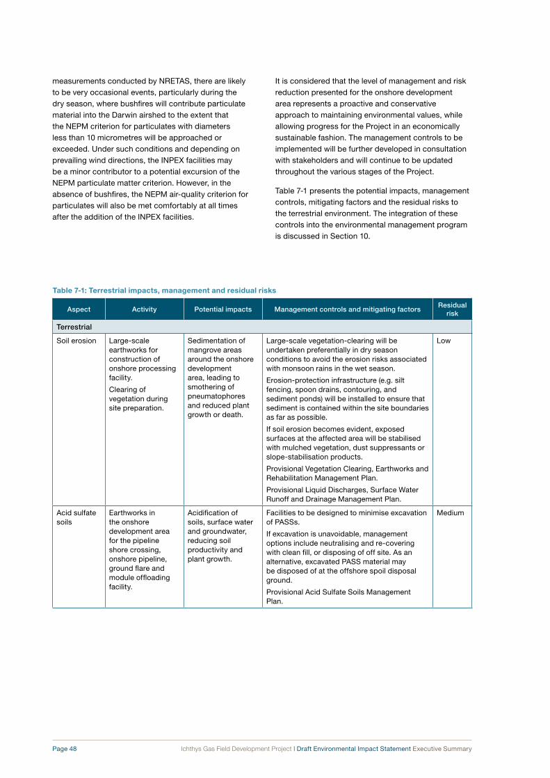
Page 48 Ichthys Gas Field Development Project | Draft Environmental Impact Statement Executive Summary
measurements conducted by NRETAS, there are likely to be very occasional events, particularly during the dry season, where bushfires will contribute particulate material into the Darwin airshed to the extent that the NEPM criterion for particulates with diameters less than 10 micrometres will be approached or exceeded. Under such conditions and depending on prevailing wind directions, the INPEX facilities may be a minor contributor to a potential excursion of the NEPM particulate matter criterion. However, in the absence of bushfires, the NEPM air-quality criterion for particulates will also be met comfortably at all times after the addition of the INPEX facilities.
It is considered that the level of management and risk reduction presented for the onshore development area represents a proactive and conservative approach to maintaining environmental values, while allowing progress for the Project in an economically sustainable fashion. The management controls to be implemented will be further developed in consultation with stakeholders and will continue to be updated throughout the various stages of the Project.
Table 7-1 presents the potential impacts, management controls, mitigating factors and the residual risks to the terrestrial environment. The integration of these controls into the environmental management program is discussed in Section 10.
table 7‑1: terrestrial impacts, management and residual risks (continued)
Aspect Activity Potential impacts management controls and mitigating factorsresidual
risk
Terrestrial
Soil erosion Large-scale earthworks for construction of onshore processing facility.
Clearing of vegetation during site preparation.
Sedimentation of mangrove areas around the onshore development area, leading to smothering of pneumatophores and reduced plant growth or death.
Large-scale vegetation-clearing will be undertaken preferentially in dry season conditions to avoid the erosion risks associated with monsoon rains in the wet season.
Erosion-protection infrastructure (e.g. silt fencing, spoon drains, contouring, and sediment ponds) will be installed to ensure that sediment is contained within the site boundaries as far as possible.
If soil erosion becomes evident, exposed surfaces at the affected area will be stabilised with mulched vegetation, dust suppressants or slope-stabilisation products.
Provisional Vegetation Clearing, Earthworks and Rehabilitation Management Plan.
Provisional Liquid Discharges, Surface Water Runoff and Drainage Management Plan.
Low
Acid sulfate soils
Earthworks in the onshore development area for the pipeline shore crossing, onshore pipeline, ground flare and module offloading facility.
Acidification of soils, surface water and groundwater, reducing soil productivity and plant growth.
Facilities to be designed to minimise excavation of PASSs.
If excavation is unavoidable, management options include neutralising and re-covering with clean fill, or disposing of off site. As an alternative, excavated PASS material may be disposed of at the offshore spoil disposal ground.
Provisional Acid Sulfate Soils Management Plan.
Medium

Ichthys Gas Field Development Project | Draft Environmental Impact Statement Executive Summary Page 49
table 7‑1: terrestrial impacts, management and residual risks (continued)
Aspect Activity Potential impacts management controls and mitigating factorsresidual
risk
Surface- water management
Sealing of parts of the ground surface throughout the onshore development area for the processing plant and associated infrastructure.
Increase in total volume of surface-water runoff.
Alteration of surface-water drainage direction and volumes.
Isolation of groundwater system from freshwater recharge, lowering of water table and potential for seawater intrusion.
Reduced health or mortality of hinterland mangrove community because of reduced access to fresh groundwater.
Some areas of Blaydin Point will remain uncleared or unsealed to allow for groundwater recharge by rainfall.
Install multiple surface-water drains to distribute fresh water into mangroves.
Install culverts to maintain natural tidal flows underneath the causeway from Blaydin Point to Middle Arm Peninsula.
Provisional Liquid Discharges, Surface Water Runoff and Drainage Management Plan.
Medium
Vegetation Clearing of vegetation during site preparation.
Loss of mangrove habitat.
Localised reduction in biodiversity.
The vegetation-clearing footprint for the onshore development area will be minimised during the design of the onshore facilities, subject to design, construction and safety requirements.
Contain all disturbance (including vehicle movement) within the development footprint.
Mangrove communities are common throughout Darwin Harbour and the Darwin Coastal Bioregion.
Temporarily disturbed areas within the onshore development area (e.g. near the pipeline shore crossing, along the onshore pipeline route, and in small areas around the processing plant) will be revegetated and rehabilitated following the completion of construction activities.
Provisional Vegetation Clearing, Earthworks and Rehabilitation Management Plan.
Medium
Clearing of vegetation during site preparation.
Loss of Eucalyptus woodland and Melaleuca forest habitat.
Localised reduction in biodiversity.
The vegetation-clearing footprint for the onshore development area will be minimised during the design of the onshore facilities, subject to design, construction and safety requirements.
Contain all disturbance (including vehicle movement) within the development footprint.
Store topsoil from cleared areas in stockpiles for future use in rehabilitation.
Cleared vegetation will be mulched and stockpiled on site boundaries or off site. Where possible, the mulch will be used for both rehabilitation and soil stabilisation to prevent erosion. Cleared vegetation that cannot be reused will be disposed of off site. No stockpiled vegetation will be burned.
Eucalyptus woodland and Melaleuca forest communities are common throughout the Darwin Coastal Bioregion.
Provisional Vegetation Clearing, Earthworks and Rehabilitation Management Plan.
Low

Page 50 Ichthys Gas Field Development Project | Draft Environmental Impact Statement Executive Summary
table 7‑1: terrestrial impacts, management and residual risks (continued)
Aspect Activity Potential impacts management controls and mitigating factorsresidual
risk
Vegetation Clearing of vegetation during site preparation.
Removal of cycads, which are classed as “vulnerable” under the Territory Parks and Wildlife Conservation Act (NT).
Localised reduction in biodiversity.
Cycas armstrongii is common throughout the Darwin Coastal Bioregion.
Provisional Vegetation Clearing, Earthworks and Rehabilitation Management Plan.
Low
Clearing of vegetation during site preparation.
Loss of monsoon vine forest habitat.
Localised reduction in biodiversity.
The vegetation-clearing footprint for the onshore development area will be minimised during the design of the onshore facilities, subject to design, construction and safety requirements.
Contain all disturbance (including vehicle movement) within the development footprint.
Store topsoil from cleared areas in stockpiles for future use in rehabilitation.
Cleared vegetation will be mulched and stockpiled on site boundaries or off site. Where possible, the mulch will be used for both rehabilitation and soil stabilisation to prevent erosion. Cleared vegetation that cannot be reused will be disposed of off site. No stockpiled vegetation will be burned.
Other monsoon vine forest habitats exist within the region.
Provisional Vegetation Clearing, Earthworks and Rehabilitation Management Plan.
Medium
Habitat Clearing of vegetation for site preparation.
Loss of habitat for terrestrial fauna.
Major clearing activities undertaken to allow animals to move into the remaining vegetation in the vicinity.
Habitat to be cleared is well represented elsewhere on Middle Arm Peninsula, and in the region.
No significant animal species recorded in recent surveys of the onshore development area.
Provisional Vegetation Clearing, Earthworks and Rehabilitation Management Plan.
Medium
Animals Temporary creation of trenches and excavations during construction.
Entrapment of animals, with possibility of injuries or deaths.
“High-risk” entrapment areas (e.g. deep trenches or pits) will have sloping egress ramps. Targeted inspections will be undertaken and any trapped animals will be removed and released.
Provisional Vegetation Clearing, Earthworks and Rehabilitation Management Plan.
Low
Weeds Machinery for earthmoving and clearing of vegetation entering the onshore development area from elsewhere in the Northern Territory or Australia.
Accidental introduction of new weed species to Blaydin Point and Middle Arm Peninsula, displacing native species and altering ecosystem function.
Control infestations of listed weeds in the onshore development area and access road.
Hygiene procedures will be applied to earthmoving and vegetation-clearing equipment.
Weed monitoring.
Provisional Vegetation Clearing, Earthworks and Rehabilitation Management Plan.
Medium

Ichthys Gas Field Development Project | Draft Environmental Impact Statement Executive Summary Page 51
table 7‑1: terrestrial impacts, management and residual risks (continued)
Aspect Activity Potential impacts management controls and mitigating factorsresidual
risk
Pest animals Vehicles and equipment entering the onshore development area from elsewhere in the Northern Territory and Australia (overland).
Accidental introduction of new pest animal species to Blaydin Point and Middle Arm Peninsula, displacing native species and altering ecosystem function.
Inspect earthmoving and clearing vehicles etc. prior to their arrival at the onshore development area.
Covering and storage of putrescible waste, with off-site disposal.
Provisional Quarantine Management Plan.
Medium
Vessels and equipment entering from another country (overseas).
Accidental introduction of new pest animal species to Blaydin Point and Middle Arm Peninsula, displacing native species and altering ecosystem function.
Establish quarantine-approved premises during construction, according to AQIS requirements.
Inspect incoming vessels, modules and equipment for quarantinable material.
Provisional Quarantine Management Plan.
Medium
Fire Vegetation clearing during site preparation (early construction phase).
Bushfire in vegetated areas throughout Blaydin Point and Middle Arm Peninsula. Damage to vegetation, habitat and infrastructure, and risks to public safety.
Emergency response equipment and procedures.
Mulched vegetation stored on site from clearing operations will be stockpiled in designated areas, away from potential ignition sources.
Stockpiled vegetation from clearing activities will not be burned, but will be reused where possible or disposed of off site.
Establish firebreaks around Project infrastructure that borders woodlands, taking advice from the Northern Territory’s Bushfires Council.
Provisional Bushfire Prevention Management Plan.
Medium
Operating heavy machinery, undertaking “hot work” and operating the ground flare in the vicinity of vegetated areas, during construction and operations.
Bushfire in vegetated areas throughout Blaydin Point and Middle Arm Peninsula. Damage to vegetation, habitat, infrastructure and risks to public safety.
Control fuel load in grassed and vegetated areas to minimise risk of intense bushfires through weed control.
Emergency response equipment and procedures.
Establish firebreaks around Project infrastructure that borders woodlands, according to advice from the Northern Territory’s Bushfires Council.
Provisional Bushfire Prevention Management Plan.
Low
Dust Earthworks and vehicle movement at onshore development area during the construction phase.
Nuisance and health impacts (of PM10) on the nearby community.10
Residential and urban areas are located distant from the onshore development area. Prevailing winds during the dry season are mainly easterly, blowing dust away from Palmerston.
Provisional Dust Management Plan.
Low
Earthworks and vehicle movements at onshore development area during the construction phase.
Dust deposition on surrounding vegetation, smothering it and reducing growth.
Health impacts on the workforce.
Dust-control measures, including wetting down exposed surfaces.
Roads required for operations phase to be sealed during construction.
Provisional Dust Management Plan.
Low
10 Particulate matter smaller than 10 micrometres (10 μm) in diameter.

Page 52 Ichthys Gas Field Development Project | Draft Environmental Impact Statement Executive Summary
table 7‑1: terrestrial impacts, management and residual risks (continued)
Aspect Activity Potential impacts management controls and mitigating factorsresidual
risk
Air quality Combustion of fuels (power generation, compression and process heat) during normal operations and upset conditions.
Reduction in local and regional air quality (with respect to oxides of nitrogen (NOx), oxides of sulfur (SOx), ozone (O3), and PM10).
Health impacts on community and local environment.
Design facilities to reduce air emissions to ALARP levels (e.g. low-NOx technology in gas turbines, incineration of amine plant emissions, low-smoke ground flare).
Undertake air-quality monitoring to confirm modelling predictions.
Provisional Air Emissions Management Plan.
Low
Odour Venting of acid gas removal unit (AGRU) exhaust gases (including hydrogen sulfide (H2S) which is responsible for “rotten-egg” odour) during AGRU incinerator shutdowns.
Nuisance odour impacts on community.
Redirect AGRU exhaust gases to the gas turbine stacks during AGRU incinerator shutdowns.
Rapid dispersion of emissions by most ambient weather conditions.
Provisional Air Emissions Management Plan.
Low
Non-hazardous waste
Generation of waste during construction and operations phases (e.g. domestic waste, packing materials, offcuts).
Littering of environment around Blaydin Point.
Attraction of animals.
Odours.
Reduce generation of waste through tender conditions and purchasing.
Provide adequate space and facilities to segregate and contain waste.
Make positive efforts to maximise recycling during all phases of the Project.
Cover all bins to exclude animals and prevent windblown waste.
Provisional Waste Management Plan.
Low
Hazardous waste
Generation of hazardous waste during construction and commissioning phases.
Localised, low-to-medium-level contamination of soils and surface water from accidental spills.
Minimise waste generation through tender conditions and purchasing.
Provide temporary waste-storage facilities during construction, prior to completion of permanent facilities.
Make positive efforts to maximise recycling during all phases of the Project.
Install appropriate bunding around facilities.
Provisional Waste Management Plan.
Medium
Generation of hazardous waste during operations.
Localised, low-level contamination of soils and surface water from accidental spills.
Minimise waste generation through tender conditions and purchasing.
Provide adequate space and facilities to segregate and contain waste.
Make positive efforts to maximise recycling during all phases of the Project.
Install appropriate bunding around facilities.
Provisional Waste Management Plan.
Medium

Ichthys Gas Field Development Project | Draft Environmental Impact Statement Executive Summary Page 53
table 7‑1: terrestrial impacts, management and residual risks (continued)
Aspect Activity Potential impacts management controls and mitigating factorsresidual
risk
Spills and leaks
Storage, handling and transfer of fuels and chemicals during construction.
Localised contamination of soils, surface water or groundwater.
Temporary storage and containment facilities installed while permanent facilities are being constructed.
Training provided to personnel who routinely handle hazardous materials (e.g. refuelling personnel, pump operators, mechanics, stores personnel) in handling, transport, storage and clean-up.
Provisional Onshore Spill Prevention and Response Management Plan.
Medium
Loss of containment of production chemicals (e.g. activated methyldiethanol-amine (aMDEA)).
Localised contamination of soils and groundwater requiring dedicated clean-up and remediation.
Design of facilities for isolation and containment in high-risk areas.
Storage facilities designed in accordance with Australian standards and the requirements of the relevant regulatory authorities.
Chemicals selected and managed to minimise the potential environmental impact associated with their transport, transfer, storage, use and disposal.
Provisional Onshore Spill Prevention and Response Management Plan.
Medium
Storage, handling and transfer of fuel and chemicals during operations.
Localised contamination of soils and groundwater requiring dedicated clean-up and remediation.
Localised contamination of surface-water runoff.
Contamination of groundwater aquifer, with potential flow into Darwin Harbour waters.
Design of facilities for isolation and containment in high-risk areas.
Bunding installed in chemical and hydrocarbon storage, handling and transfer areas.
Storage facilities designed in accordance with Australian standards, and the requirements of the relevant regulatory authorities.
Drainage system will direct potentially contaminated surface runoff to an oily-water treatment system.
Onshore Spill Prevention and Response Management Plan.
Provisional Liquid Discharges, Surface Water Runoff and Drainage Management Plan.
Medium
Long-term bulk storage of liquid hydrocarbons (condensate).
Contamination of soils and groundwater that extends off site (e.g. into Darwin Harbour) and is difficult and expensive to remediate.
Threats to environmental and human health.
Reduction in potential for future use of land and groundwater at Blaydin Point.
Design of facilities for isolation and containment in high risk areas (e.g. condensate tanks).
Storage facilities designed in accordance with Australian standards and the requirements of the relevant regulatory authorities.
Groundwater monitoring program.
Provisional Onshore Spill Prevention and Response Management Plan.
Medium
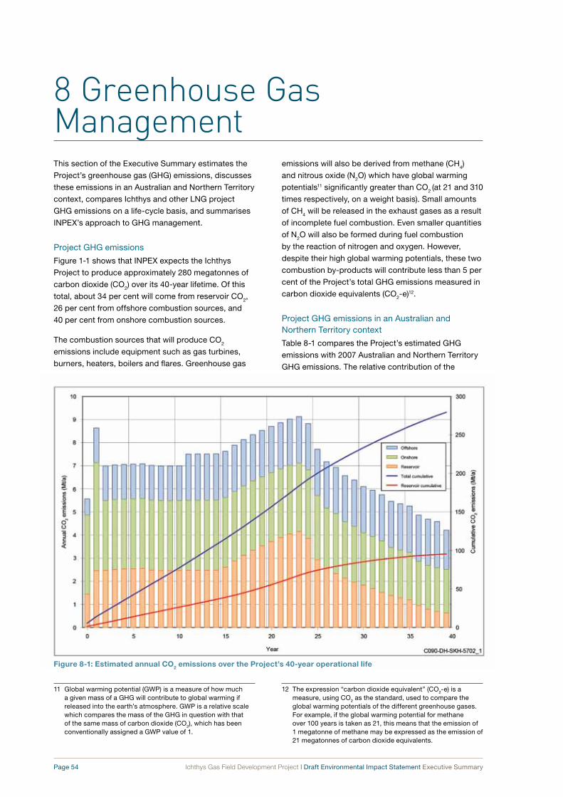
8 Greenhouse Gas Management
Page 54 Ichthys Gas Field Development Project | Draft Environmental Impact Statement Executive Summary
Figure 8‑1: estimated annual co2 emissions over the Project’s 40‑year operational life
This section of the Executive Summary estimates the
Project’s greenhouse gas (GHG) emissions, discusses
these emissions in an Australian and Northern Territory
context, compares Ichthys and other LNG project
GHG emissions on a life-cycle basis, and summarises
INPEX’s approach to GHG management.
Project GHG emissions
Figure 1-1 shows that INPEX expects the Ichthys
Project to produce approximately 280 megatonnes of
carbon dioxide (CO2) over its 40-year lifetime. Of this
total, about 34 per cent will come from reservoir CO2,
26 per cent from offshore combustion sources, and
40 per cent from onshore combustion sources.
The combustion sources that will produce CO2
emissions include equipment such as gas turbines,
burners, heaters, boilers and flares. Greenhouse gas
emissions will also be derived from methane (CH4)
and nitrous oxide (N2O) which have global warming
potentials11 significantly greater than CO2 (at 21 and 310
times respectively, on a weight basis). Small amounts
of CH4 will be released in the exhaust gases as a result
of incomplete fuel combustion. Even smaller quantities
of N2O will also be formed during fuel combustion
by the reaction of nitrogen and oxygen. However,
despite their high global warming potentials, these two
combustion by-products will contribute less than 5 per
cent of the Project’s total GHG emissions measured in
carbon dioxide equivalents (CO2-e)12.
Project GHG emissions in an Australian and Northern Territory context
Table 8-1 compares the Project’s estimated GHG
emissions with 2007 Australian and Northern Territory
GHG emissions. The relative contribution of the
11 Global warming potential (GWP) is a measure of how much a given mass of a GHG will contribute to global warming if released into the earth’s atmosphere. GWP is a relative scale which compares the mass of the GHG in question with that of the same mass of carbon dioxide (CO2), which has been conventionally assigned a GWP value of 1.
12 The expression “carbon dioxide equivalent” (CO2-e) is a measure, using CO2 as the standard, used to compare the global warming potentials of the different greenhouse gases. For example, if the global warming potential for methane over 100 years is taken as 21, this means that the emission of 1 megatonne of methane may be expressed as the emission of 21 megatonnes of carbon dioxide equivalents.

Ichthys Gas Field Development Project | Draft Environmental Impact Statement Executive Summary Page 55
table 8‑1: Project greenhouse gas emissions relative to the greenhouse gas emissions for australia and the northern territory in 2007
Co2-e emissions
(mt/a)
Percentage of 2007 Australian ghg emissions
Percentage of 2007 Northern Territory
ghg emissions
Australian GHG emissions (2007) 597.2 n.a. n.a.
Northern Territory GHG emissions (2007) 17.2 2.9 n.a.
Ichthys Project total GHG emissions (40-year annual average) 7.0 1.2 n.a.
Ichthys Project onshore GHG emissions (40-year annual average)* 5.2 n.a. 30
Source: Department of Climate Change. 2009. Australian national greenhouse accounts: state and territory greenhouse gas inventories 2007.
* Onshore CO2-e emissions include onshore combustion emissions and reservoir emissions. Even though reservoir CO2 emissions will be sourced from Commonwealth waters outside the Northern Territory, the reservoir CO2 will be emitted to atmosphere in the Northern Territory.
n.a. = not applicable.
Project’s GHG emissions compared against 2007
levels is 1.2% of the Australian CO2-e emissions and
30% of the Northern Territory’s CO2-e emissions.
Comparison of Ichthys and other project CO2 emissions on a life-cycle basis
The biggest differences in efficiencies in CO2
emissions between LNG projects typically arise
in relation to:
• the proportion of CO2 naturally present in the
reservoir gases used to make the LNG
• the nature of the offshore facilities (and their
associated combustion CO2 emissions) needed
to get the gas to the liquefaction facility via a gas
export pipeline and, in many cases, to remove a
portion of the hydrocarbon liquids first.
Figure 8-2 shows the comparative CO2 emissions
per megawatt hour (MW·h) for electricity generation
using Ichthys LNG and historical Australian LNG.
The differences reflect the fact that the Ichthys Field’s
Brewster and Plover gas reservoirs contain higher
reservoir CO2 levels than the gas fields that have
historically supplied other LNG plants in Australia.
In addition, the Project will need relatively energy-
intensive offshore facilities because of a combination
of factors: deeper water at the field location, a greater
Adapted from APPEA 2009, J.P. Morgan Equity Research 2008, and Pace 200913.
Figure 8‑2: co2‑e emission benchmarking on the basis of electricity generated per megawatt hour
13 These references are given in full in Chapter 9 Greenhouse gas management in the Draft EIS.

Page 56 Ichthys Gas Field Development Project | Draft Environmental Impact Statement Executive Summary
distance between the field and the onshore LNG plant,
and the need to remove condensate from the gas at
the offshore facility.
Figure 8-3 shows that the use of LNG as an energy
source produces significantly less life-cycle
greenhouse gas emissions (from production,
processing, transportation, and end-use combustion)
than either coal or fuel oil. Electricity produced
from LNG generates 40–60 per cent less CO2 than
electricity produced from coal. Every tonne of LNG
used to generate electricity averts the emission of up
to 4 tonnes of CO2 when compared with coal-fired
electricity generation. Ichthys LNG will be marketed to
the Asia-Pacific region and will in large part be used
for power generation. In a global context, therefore, the
use of Ichthys LNG to generate electricity in Asia will
likely result in a significant reduction in CO2 emissions.
INPEX GHG mitigation and management strategy
INPEX recognises the potential for GHGs to impact
on the environment on a global scale through their
contribution to the phenomenon of global warming.
The company is committed to managing its GHG
emissions by actively promoting the reduction of
GHG emissions across its operations in a safe and
technically and commercially viable manner.
There are a number of alternatives available to INPEX
for GHG management, all with varying costs and risks.
Adapted from APPEA 2009, J.P. Morgan Equity Research 2008, and Pace 2009.
Figure 8‑3: Life‑cycle co2‑e emissions from the use of Lng and coal to produce electricity
As the policy landscape is still evolving and legislation
is yet to be finalised, INPEX is exploring practicable
alternatives in order to be well prepared to respond
once legislative requirements become clear. To this
end INPEX is developing a portfolio of GHG mitigation
opportunities, which may afford the lowest risk and
cost approach for the Project and avoid a reliance
on any single solution. The main opportunities under
evaluation include the following:
• additional engineering abatement techniques
• biosequestration (carbon capture through tree
plantings)
• geosequestration (permanent storage of reservoir
CO2 in underground reservoirs)
• the purchase of offset credits on the open market.
Engineering abatement opportunities that will reduce
GHG emissions and improve energy efficiency are
being identified and assessed by INPEX’s onshore
and offshore facility engineering teams. Options that
are safe and that are technically and commercially
viable are likely to be incorporated into facility design.
INPEX will also monitor and review technological
developments and operational practices to identify
GHG emission reduction opportunities during the
Project’s design phase and through its operational life.

Ichthys Gas Field Development Project | Draft Environmental Impact Statement Executive Summary Page 57
The following range of energy-efficient technologies
has been identified for use on the Project:
• the selection of activated methyldiethanolamine
(aMDEA) as the CO2 removal solvent
• the selection of energy-efficient turbines for
compressor drivers and power generation
• the incorporation of waste-heat recovery units to
minimise the need for supplemental fired heating
• the employment of other technical improvements,
including onshore AGRU flash-gas recovery and
offshore flare-gas recovery
• the possible implementation of combined-cycle
power generation onshore.
The company has already identified and committed
to technical-abatement and energy-efficiency
measures that will reduce CO2 emissions by around
100 megatonnes over the Project’s 40-year life.
Biosequestration is the process of “locking”, through
photosynthesis, the carbon in atmospheric CO2 into
plant biomass (usually trees). Biosequestration offsets
the effect of the CO2 and other GHGs released into the
earth’s atmosphere by the development of natural gas
fields and the burning of fossil fuels.
In 2008 INPEX initiated a “Biosequestration
Assessment Project” with the planting of 1.4 million
trees in south-west Western Australia to gain a better
understanding of the potential for biosequestration to
offset large volumes of CO2.
Related to the biosequestration approach is the
improvement of forestry and land management
practices to reduce CO2 emissions. ConocoPhillips, for
example, as Operator of the Darwin LNG plant, uses
improved fire-management practices in savannah as
a contribution to managing its CO2 emissions. Similar
options are being assessed by INPEX. At this stage,
however, fire-management offsets are not recognised
under the Kyoto Protocol14 and may therefore not be
compliant with Australia’s proposed Carbon Pollution
Reduction Scheme (CPRS) legislation.
Geosequestration is the process of injecting CO2 into
deep geological formations for secure, long-term
storage. The technique is also called “carbon (dioxide)
capture and storage” (CCS). The technology for CO2
injection has been used by oil and gas companies
as an enhanced hydrocarbon recovery technique for
many decades.
The following CO2 offset credits are available for sale
on the international market:
• certified emission reductions (CERs) from clean
development mechanism (CDM) projects
• emission reduction units (ERUs) from joint
implementation (JI) projects
• European Union allowances (EUAs) under the
European Union Emissions Trading Scheme Phase
2 (EU ETS II)
• voluntary emission reductions (VERs)
• removal units (RMUs).
These credits may be acceptable as offsets in
Australia. However, this will only be known when
details of the proposed CPRS and its associated
legislation are finalised.
A Provisional Greenhouse Gas Management Plan
has been developed that outlines the management
strategies and objectives, monitoring and reporting
requirements for all phases of the Project. This plan
will guide the development of more detailed GHG
management plans prior to commissioning of the
onshore gas-processing plant.
14 The Kyoto Protocol is an agreement made under the United Nations Framework Convention on Climate Change (UNFCCC). Countries that ratify the protocol commit to reduce their emissions of CO2 and other GHGs or to engage in activities such as emissions trading if they maintain or increase emissions of these gases. The protocol was adopted in Kyoto, Japan, on 11 December 1997 and entered into force on 16 February 2005. As of November 2009, 187 states had signed and ratified the protocol.

9 Socio-economic Impacts and Management
Page 58 Ichthys Gas Field Development Project | Draft Environmental Impact Statement Executive Summary
This section of the Executive Summary summarises the
potential impacts of the Project on the community in the
vicinity of the development areas in and around Darwin
Harbour, as well as on the wider regional economy.
It also identifies the key management controls which
will be applied to mitigate these impacts.
The socio-economic aspects of the Project’s operating
environment are complex, and are influenced by many
factors that are outside the control of the Project.
These include the fluctuations in national and global
economies and the resulting effects on labour markets.
The risk assessment process, taking into account
management controls and mitigating factors, identified
11 “medium” and 7 “low” residual risk potential
socio-economic impacts associated with the Project.
These risk ratings are considered acceptably low,
mitigating risks to the livelihoods and lifestyles of the
surrounding community.
The Project’s most intense socio-economic impacts
are likely to be associated with the construction phase
of the nearshore and onshore development areas.
Road transport used for ferrying Project personnel
and materials to the onshore development area will
increase local traffic volumes, although modelling
indicates that the incremental increase attributable to
the Project is minor in comparison with the effects of
expected population growth in the Darwin region.
Recreational fishing activities in East Arm and along
the pipeline route will be temporarily disrupted in
the immediate vicinity of Project vessels during
the construction phase. Exclusion zones will be
established around dredging, piledriving, pipelay
and drill-and-blast vessels to manage public safety.
These activities will be focused on localised areas in
the nearshore development area and will not prohibit
fishing and recreational boating nearby, provided that
safe distances are maintained.
Aboriginal people living in the Darwin area frequently
fish and forage for food and other resources in
intertidal areas at low tide, as well as in Darwin
Harbour. In the Harbour itself these activities are
common around Nightcliff, Coconut Grove, Kulaluk,
Sadgroves Creek, Lee Point and Blaydin Point. It
is predicted that there will not be any direct impact
on Nightcliff, Coconut Grove, Kulaluk, Sadgroves
Creek and Lee Point areas and therefore impacts on
traditional fishing practice will be negligible for these
areas. However, there will be an impact on traditional
fishing practices undertaken on and around Blaydin
Point during both the construction and the operations
phases. This is because public access to the onshore
site will be restricted and marine exclusion zones
will be put in place for safety reasons. This impact is
expected to be minimal given that the fishing areas
affected near Blaydin Point represent a very small
proportion of the areas available in Darwin Harbour.
The Project will provide a high level of demand for
personnel during its construction phase, which may
be met locally in Darwin and Palmerston depending
on the skill sets required, but is also likely to require
fly-in, fly-out staff. An accommodation village will be
developed in Howard Springs (east of Palmerston)
to minimise the short-term impacts on the already
constrained local housing market that might otherwise
be caused by a large influx of Project personnel, many
of whom will be single. The development of this facility
is subject to its own approvals process.
Three Aboriginal archaeological sites will be disturbed
during land-clearing for the onshore development area,
subject to permission from NRETAS under the Heritage
Conservation Act (NT). The onshore facilities have been
designed around a number of other heritage sites that
will remain undisturbed. Heritage sites in the vicinity of
the nearshore development area will not be disturbed,
as the maritime infrastructure has been designed
specifically to avoid these sites. This includes a number
of submerged Catalina flying-boat wrecks from World
War II. Low levels of sand movement on to one of
these wrecks (Catalina 3) may occur as a result of
dredging activities, which represents a small increase
in the natural movement of sand that already occurs
throughout East Arm under ambient tidal currents.
This is not expected to negatively affect the heritage
values of the wreck site. The gas export pipeline has
been aligned to avoid Aboriginal sacred sites in the
nearshore development area.
Modelling of noise emissions from the onshore
gas-processing plant indicates that received levels in
the nearest residential areas (in Palmerston) will not
exceed identified noise criteria and are unlikely to be
audible above ambient noise in most conditions. Other
impacts to the community that may be considered on
a cumulative basis include light and visual amenity.

Ichthys Gas Field Development Project | Draft Environmental Impact Statement Executive Summary Page 59
In the local context, where several industrial facilities
already operate on the shores of Darwin Harbour, the
additional impacts imposed by the Ichthys Project are
moderate. These impacts are mitigated by distance—
the onshore development area is 4 kilometres from
Palmerston and 10 kilometres from Darwin’s central
business district.
The Project facilities have been designed to minimise
the risk to public safety associated with accidental
events such as major hydrocarbon leaks or explosions.
Controls to mitigate risks from major incidents include
designing and constructing the facility in line with
established industry standards and codes of practice,
positioning equipment to reduce off-site consequences,
and developing and exercising emergency plans and
response procedures in consultation with the relevant
emergency-response authorities.
The results from the preliminary quantitative risk
assessments (QRAs) conducted to date indicate that
the onshore development area and pipeline do not
pose unacceptable safety risks to the public around
Darwin and neighbouring residential areas such as
Marlow Lagoon (which is adjacent to Palmerston).
Where risks posed to users of the Harbour in the
vicinity of the jetty heads and trestle are higher than
acceptable for active open spaces, nominal safety
exclusion zones will be established. As the acceptable
risk contours border the main channel of Lightning
Creek, risk values will need to be confirmed by a final
QRA based on a complete plant design to determine
whether access to this creek can be maintained.
Socio-economic impacts associated with the offshore
development area are limited to interactions with
commercial fishing and shipping activities. Any impacts
to commercial fishing are likely to be minor. Data on
fishing effort indicate that the offshore facilities will
be located close to an area utilised by the North West
Slope Trawl Fishery. However, it should be noted that
publicly available fishing effort data do not record
fishing areas fished by five operators or fewer and
that it is possible therefore that some low-level fishing
activities may occur in the vicinity of the offshore
facilities. In addition, the gas export pipeline overlaps
an area utilised by the Northern Prawn Fishery. In this
case, however, the standard safety exclusion zone to
be established will not significantly reduce the area
available for fishing.
Potential impacts to shipping activities are also likely to
be minor as there are no identified shipping channels
in the vicinity of the offshore development area.
Economic modelling indicates that the Project will
benefit the Northern Territory economy, contributing
an increase of almost 18 per cent to the gross
state product during each year of operation and
increasing household spending. The Project will
also benefit the Australian economy, with predicted
average annual contributions of A$3.5 billion (an
additional 0.2 per cent) to Australia’s gross domestic
product. The Project offers opportunities for
employment and training, with flow-on potential for
business development and increased investment in
infrastructure and services.
It is considered that the level of management and risk
reduction presented in this Draft EIS represents a
proactive and conservative approach to maintaining
socio-economic values, while allowing the Project to
progress in a sustainable fashion. The management
controls to be implemented will be further developed in
consultation with stakeholders and will continue to be
updated throughout the various stages of the Project.
Table 9-1 presents the potential impacts, management
controls, mitigating factors and, where appropriate, the
residual risks to the social and economic environment.
The integration of these controls into the environmental
management program is discussed in Section 10.

Page 60 Ichthys Gas Field Development Project | Draft Environmental Impact Statement Executive Summary
table 9‑1: socio‑economic impacts, management and residual risks (continued)
Aspect Activity Potential impacts management controls and mitigating factorsresidual
risk
social
Social integration
Recreational activities of construction workforce.
Increase in antisocial behaviour at local recreational venues such as hotels and bars.
Personnel representing the Project will be expected to exhibit professional standards of behaviour as required by the INPEX Code of Conduct.
Project personnel will be subject to random drug and alcohol testing.
A code of conduct for the residents of the accommodation village will be developed and implemented.
The longer working hours required from Project personnel may discourage workers from attending facilities such as hotels and bars outside the accommodation village after hours.
The accommodation village will include facilities such as licensed restaurants and bars, which may reduce the use of existing local facilities by the construction workforce.
A large portion of the construction workforce is likely to be recruited on a fly-in, fly-out basis, with the majority of personnel returning home during their time off.
Not applicable
Recreational activities of construction workforce.
Increase in pressure placed on social venues such as sporting facilities, food outlets, and taverns.
The accommodation village will include a number of licensed restaurants and a range of social and recreational facilities will be established for the benefit of the residents. This will assist in limiting the pressure placed on existing facilities enjoyed by the local community.
Ongoing consultation with the community will be undertaken to monitor the extent and impact of workforce integration.
Not applicable
Housing workforce
Accommodation requirements for the construction workforce in the Darwin area.
Increased pressure placed on an already difficult housing market.
An accommodation village will be constructed to house the greater part of the construction workforce. It is intended that this village will be seen as a desirable place to live and it will be designed to cater for a wide range of people, both singles and couples.
An accommodation strategy is being developed to address accommodation solutions for regular Project personnel as well as for short-term visitors during the operations phase (including teams brought in to carry out periodic maintenance operations).
Not applicable
Social services for Project
Emergency health services for the construction workforce.
Increased pressure placed on emergency health services, e.g. triage services.
First-aid clinics will be established at the onshore development area and at the accommodation village.
INPEX will work in conjunction with the Northern Territory Police, Fire and Emergency Services in order to effectively plan for any major emergencies.
An emergency response plan will be developed for both the construction and operations phase of the Project. Emergency response teams will be established.
Not applicable

Ichthys Gas Field Development Project | Draft Environmental Impact Statement Executive Summary Page 61
table 9‑1: socio‑economic impacts, management and residual risks (continued)
Aspect Activity Potential impacts management controls and mitigating factorsresidual
risk
Social services for Project
Emergency fire services for onshore development area.
Increased pressure on existing emergency fire services.
INPEX will work in conjunction with the Northern Territory Police, Fire and Emergency Services in order to effectively plan for any major emergencies.
A firefighting capability will be available, along with strategically located firefighting stations on the Project plant site.
Fire-protection systems for the operations phase will be designed to enable INPEX personnel to handle fires capably until external help arrives.
Not applicable
Utilities and infrastructure
Use of existing power, water and sewage infrastructure during construction, precommissioning and commissioning.
Increased pressure on utilities supply and infrastructure.
During construction, power will predominantly be supplied using on-site diesel generators with some mains power from the Darwin grid required to support temporary construction buildings and lighting requirements.
Temporary ablution blocks and sewage treatment systems will be in place to meet sewage management and treatment requirements during construction.
The Power and Water Corporation has advised that the water demands for the Project can be met using scheme water, without affecting regional supplies.
Ongoing consultation will be undertaken with local government, the Department of Lands and Planning and the Power and Water Corporation in order to effectively plan for the provision of scheme water for Project requirements.
Not applicable
Use of existing power, water and sewerage infrastructure during operations.
Increased pressure on utilities supply and infrastructure.
Permanent sewage-treatment facilities will be installed for the operations phase of the Project.
The onshore facilities will be self-sufficient in power generation capacity during the operations phase.
The Power and Water Corporation has advised that the water demands for the Project can be met using scheme water, without affecting regional supplies.
Ongoing consultation will be undertaken with local government, the Department of Lands and Planning and the Power and Water Corporation in order to effectively plan for the provision of scheme water for Project requirements.
Not applicable
Traffic and transport
Daily transport of construction personnel to site.
Regular transport of materials and equipment from East Arm Wharf to site during construction.
Transport of rock from the quarries to site.
Increased congestion on local roads.
Increased risk of road accidents.
Buses provided to transport a majority of the Project personnel to and from work to reduce total traffic.
Designated travel routes to and from quarries, accommodation facilities, Darwin’s central business district and East Arm Wharf will be set for the Project.
The Project will work in conjunction with the Department of Lands and Planning to identify any proposed road projects that may need to be brought forward or upgrades that may need to be undertaken to assist in reducing potential pressure on existing road systems.
Provisional Traffic Management Plan.
Medium

Page 62 Ichthys Gas Field Development Project | Draft Environmental Impact Statement Executive Summary
table 9‑1: socio‑economic impacts, management and residual risks (continued)
Aspect Activity Potential impacts management controls and mitigating factorsresidual
risk
Maritime traffic and navigation
Construction and operation of offshore infrastructure in open ocean.
Forced alteration of shipping route.
Low level of shipping activity in the offshore development area.
An application will be made to the relevant government regulatory agencies to implement a safety exclusion zone and restricted navigation zone. These zones will be gazetted on navigational charts.
Standard maritime communications equipment, navigation lights and markers on all Project vessels.
A “Notice to Mariners” on the location of offshore infrastructure and pipeline will be issued.
Low
Use of vessels for pipeline construction in offshore development area.
Forced alteration of shipping route.
Standard maritime communications equipment installed on all vessels.
Activities will be transient and short-term only.
Low
Operation of nearshore construction vessels and dredgers.
Forced alteration of shipping route in the Harbour.
Increase in competition for port resources with other users.
Spoil disposal ground could cause hazards to shipping navigation in the area.
Cooperation with Darwin Port Corporation to manage shipping traffic schedules and exclusion zones during construction.
A “Notice to Mariners” will be issued on nearshore construction activities, e.g. dredging and rock dumping.
Construction-vessel traffic will be short-term in duration.
Periodic bathymetric surveys to be undertaken to confirm sediment deposition depth and patterns.
The spoil disposal ground is not located in a shipping route.
Ensure that under-keel clearance at the spoil disposal ground is maintained for maritime vessels.
Medium
Operation of tanker vessels in nearshore area.
Forced alteration of shipping route in the Harbour.
Increase in competition for port resources with other users.
Exclusion zones will be put in place around product tankers and will be enforced by tugs.
Cooperation with Darwin Port Corporation to manage shipping traffic schedules during operations.
Medium
Recreation Operation of nearshore infrastructure (jetty) with exclusion zones for security and public safety.
Reduction in access to recreational fishing grounds.
Fishing areas to be affected represent a very small proportion of the areas available in Darwin Harbour.
Medium
Dredging during construction of nearshore infrastructure.
Reduced access to recreational diving sites (e.g. wrecks) due to reduced visibility in turbid waters.
Dredging is a construction-phase activity and will only temporarily reduce visibility
Medium
Construction and operation of onshore infrastructure.
Loss of access to camping and four-wheel-drive areas and traditional hunting and gathering areas at Blaydin Point.
Many other similar areas are available around Darwin Harbour.
Medium

Ichthys Gas Field Development Project | Draft Environmental Impact Statement Executive Summary Page 63
table 9‑1: socio‑economic impacts, management and residual risks (continued)
Aspect Activity Potential impacts management controls and mitigating factorsresidual
risk
Recreation Construction and operation of onshore infrastructure.
Loss of access to traditional fishing and foraging grounds on Blaydin Point.
Fishing and foraging areas to be affected represent a very small proportion of the available areas in Darwin Harbour.
Medium
Aboriginal cultural heritage
Land clearing prior to construction in the onshore development area, and vehicle movement in the vicinity of heritage sites.
Disturbance or removal of Aboriginal archaeological sites within or near the onshore development footprint protected under the Heritage Conservation Act (NT).
Design of infrastructure to avoid onshore heritage sites where possible.
Seek ministerial permission to disturb a site. If permission is granted to disturb a site, advice will be sought from the traditional owners on the correct procedures to be adopted for its removal.
Daily toolbox meetings, job hazard analyses, permit systems or similar will be implemented on site prior to the commencement of vegetation-clearing or construction activities.
Where the external boundary of an Aboriginal heritage site is 10 metres or closer to any proposed construction activity, flagging, temporary fencing or similar will be erected 5 metres from the site boundary and appropriate signage will be put in place.
Provisional Heritage Management Plan.
Low
Construction vessel movements and anchoring in Darwin Harbour.
Disturbance to maritime sacred sites protected under the Northern Territory Aboriginal Sacred Sites Act (NT) and the Heritage Conservation Act (NT).
Exclusion zones have been established around the maritime sacred sites by the Aboriginal Areas Protection Authority. No works will be permitted in these exclusion zones.
Anchor management plans will be developed to allow safe anchoring of vessels undertaking pipelay, dredging and piledriving activities in the vicinity of any nearshore heritage or sacred sites.
Provisional Heritage Management Plan.
Low
Non-Aboriginal cultural heritage
Construction activities in the nearshore development area, including dredging and pipelay.
Accidental disturbance to maritime heritage sites listed under the Heritage Conservation Act (NT) or the Historic Shipwrecks Act 1976 (Cwlth).
Design of infrastructure to avoid disturbance to sites.
Anchor management plans will be developed in consultation with NRETAS’s Heritage Branch to allow safe anchoring of vessels undertaking pipelay, dredging and piledriving activities in the vicinity of any heritage sites.
Accurate dGPS locations of all wrecks near the nearshore development area will be provided to construction contractors to enable accurate positioning.
Implementation of controlled zones around the SS Ellengowan, the Kelat, and Catalina flying-boat wrecks.
Validation of dredging sedimentation modelling.
Provisional Heritage Management Plan.
Medium
Vessel operations and periodic maintenance dredging activities within the nearshore development area during the operations phase.
Increases in sedimentation or sediment scouring on or around the Catalina flying-boat wrecks adjoining the shipping channel, the approach area, the turning basin and the berthing area.
INPEX will periodically assess sediment conditions in the vicinity of the Catalina wrecks adjacent to the shipping channel and, in consultation with NRETAS, will determine whether any remedial action is required to address impacts should they arise.
Provisional Heritage Management Plan.
Low

Page 64 Ichthys Gas Field Development Project | Draft Environmental Impact Statement Executive Summary
table 9‑1: socio‑economic impacts, management and residual risks (continued)
Aspect Activity Potential impacts management controls and mitigating factorsresidual
risk
Noise Construction and commissioning activities such as piledriving, drilling and rock blasting; pneumatic testing of pipework; air blowing and flaring.
Noise and vibration causes disturbance or nuisance to the local community.
Onshore development area is located several kilometres from the nearest residential or urban area.
Blasting activities will only be conducted during daylight hours.
Piledriving activities are planned to be undertaken only during daylight hours; however night-time operations may be required if progress falls significantly behind schedule.
Notification will be given to communities to give warning prior to blasting operations.
Notification will be given to communities to give warning prior to night-time piledriving operations.
Provisional Piledriving and Blasting Management Plan.
Medium
Road transport of workforce, vehicles, equipment, rock and materials during the construction phase.
Noise and vibration causes disturbance or nuisance to the local community.
Buses will be used for workforce transport to reduce the total number of vehicles on the roads.
Designated traffic routes will be set for Project vehicles.
Provisional Traffic Management Plan.
Medium
Generation of noise by normal operation of the onshore processing plant.
Noise and vibration causes disturbance or nuisance to the local community.
Onshore development area is located several kilometres from the nearest residential or urban area.
Low
Generation of noise by emergency flaring during operation of the onshore processing plant.
Noise and vibration causes disturbance or nuisance to the local community.
Onshore development area is located several kilometres from nearest residential or urban area.
Noise mitigation measures will be incorporated into the design of the ground flare to reduce noise emissions.
Medium
Visual amenity
Construction of onshore infrastructure.
Reduction in visual amenity resulting from visible dust.
Dust suppressants use on roads and stockpiles during dry conditions.
Minimising ground disturbance and the multiple handling of soil or rock materials.
Sealing the main access roads throughout the site and to the junction with Wickham Point Road.
Provisional Dust Management Plan.
Not applicable
Operation of onshore processing plant.
Reduction in visual amenity resulting from smoke and light emissions from flares.
Ground flare and tankage flare will be designed to minimise the generation of particulates (smoke).
The ground flares will be shielded to reduce light emissions.
Not applicable

Ichthys Gas Field Development Project | Draft Environmental Impact Statement Executive Summary Page 65
table 9‑1: socio‑economic impacts, management and residual risks (continued)
Aspect Activity Potential impacts management controls and mitigating factorsresidual
risk
Commercial fishing
Presence of offshore infrastructure in the open ocean.
Damage to fishing equipment or pipeline.
An application will be made to the relevant government regulatory agencies to implement a safety exclusion zone around surface and subsurface equipment in the offshore development area. This will be gazetted and will appear on navigation charts.
An application will be made to the relevant government regulatory agencies to implement a precautionary zone around the offshore pipeline in consultation with relevant regulatory authorities.
A precautionary zone will be implemented within 200 metres of the gas export pipeline in the nearshore development area.
Notification of the location of the offshore facilities and gas export pipeline will be achieved through the publication of a “Notice to Mariners”.
Navigation lights and markers on offshore infrastructure.
Standard maritime communications equipment on all Project vessels.
Low

10 Environmental Management Program
Page 66 Ichthys Gas Field Development Project | Draft Environmental Impact Statement Executive Summary
This section of the Executive Summary summarises
how INPEX intends to implement a range of
environmental management measures and controls
throughout the life of the Project.
INPEX is committed to applying a systematic pproach
to environmental management which aligns with
the recognised international standard AS/NZS ISO
14001:2004, Environmental management systems—
Requirements with guidance for use and is based on
the principle of continual improvement of environmental
performance (see Figure 10.1). To assist in meeting this
commitment, a Health, Safety and Environmental (HSE)
Management Process has been developed. The HSE
Management Process provides INPEX with a tool for
managing the impacts of its activities on the environment,
as well as providing a structured approach to planning
and implementing environment management controls.
10.1 environmental management plansA range of environmental management controls
identified in the tables above (see tables 6-1, 7-1
and 9-1) will be applied throughout the life of the Project
to ensure that potential negative environmental impacts
identified in the Draft EIS are avoided or minimised to an
acceptable level. These management controls, together
with specified objectives, targets and indicators, are
outlined in provisional environmental management
plans (EMPs). The provisional EMPs prepared as part of
the Draft EIS are listed in Table 10-1.
INPEX is committed to developing detailed
environmental management documentation (e.g.
plans and procedures) according to an agreed
timetable with the Northern Territory Government.
The documents will be based on these provisional
plans and on recommendations from the relevant
agencies and applicable public comments. The
detailed documentation will be prepared either directly
by INPEX’s Environmental Department or by specialist
contractors in conjunction with INPEX.
Matters of national environmental significance
Relevant management controls to minimise impacts
on the “matters of national environmental significance”
defined and discussed in Chapter 2 of the Environment
Protection and Biodiversity Conservation Act
1999 (Cwlth), including the Commonwealth marine
environment, are identified in the following provisional
EMPs in the Draft EIS:
• Provisional Cetacean Management Plan
• Provisional Decommissioning Management Plan
table 10‑1: Provisional environmental management plans
Title
Provisional Acid Sulfate Soils Management Plan
Provisional Air Emissions Management Plan
Provisional Bushfire Prevention Management Plan
Provisional Cetacean Management Plan
Provisional Decommissioning Management Plan
Provisional Dredging and Dredge Spoil Disposal Management Plan
Provisional Dust Management Plan
Provisional Greenhouse Gas Management Plan
Provisional Heritage Management Plan
Provisional Liquid Discharges, Surface Water Runoff and Drainage Management Plan
Provisional Onshore Spill Prevention and Response Management Plan
Provisional Piledriving and Blasting Management Plan
Provisional Quarantine Management Plan
Provisional Traffic Management Plan
Provisional Vegetation Clearing, Earthworks and Rehabilitation Management Plan
Provisional Waste Management Plan

Ichthys Gas Field Development Project | Draft Environmental Impact Statement Executive Summary Page 67
Figure 10‑1: Health, safety and environment management model
• Provisional Liquid Discharges, Surface Water
Runoff and Drainage Management Plan
• Provisional Piledriving and Blasting
Management Plan
• Provisional Vegetation Clearing, Earthworks and
Rehabilitation Management Plan
• Provisional Waste Management Plan.
Environmental management plans required by the Commonwealth for offshore activities
In addition to the EMPs outlined above, INPEX will
develop environment plans and oil-spill contingency
plans as required under the Offshore Petroleum and
Greenhouse Gas Storage (Environment) Regulations
2009 (Cwlth). Specific activities that will require
environment plans under these regulations will
include the following:
• pipeline installation
• drilling
• installation and hook-up of the CPF and the FPSO
• operations of the CPF and the FPSO.
10.2 monitoring program for the receiving environment
INPEX is committed to developing a comprehensive
receiving environment monitoring program that will be
implemented and periodically reviewed in consultation
with the relevant authorities. This program will include
a number of individual programs which aim to achieve
the following:
• to identify environmental change as a result of
Project activities, or due to natural or other causes
• to validate modelling results and predicted impacts
for Project activities
• to allow INPEX to incorporate changes to its
activities if the actual impacts of its activities are
more significant than the predicted impacts
• to complement other monitoring being carried out
in Darwin Harbour by government agencies and/or
other Harbour users.
Each program will be conducted by appropriately
qualified personnel in a systematic and scientifically
defensible manner.

Conclusion
Page 68 Ichthys Gas Field Development Project | Draft Environmental Impact Statement Executive Summary
This Executive Summary provides an overview of the
key elements of the primary environmental impact
assessment document—the Draft EIS.
Through the development and preparation of the
Draft EIS, INPEX has implemented a rigorous risk
assessment approach to identify, assess and reduce
the risk of adverse impacts to the natural and socio-
economic environments in which the Project will be
built and operate.
INPEX’s broad management commitments for the
Project include the following:
• minimising impacts on ecologically valuable areas,
such as mangrove communities, and “matters
of national environmental significance”, such as
threatened and migratory species
• actively promoting the reduction of greenhouse
gases across its operations in a safe and
technically and commercially viable manner
• minimising impacts on the recreational, cultural
and tourism values of Darwin Harbour
• minimising impacts on housing markets, social
infrastructure and services in the major population
centres of Palmerston and Darwin
• providing a major and sustained contribution to the
Northern Territory and Australian economies
• ensuring that the facilities are designed to reduce
safety risks to as low as reasonably practicable
and that risks posed to the public are found to be
acceptably low
• preparing and maintaining an integrated safety
management system in consultation with the
relevant safety authorities
• communicating widely with community and
government stakeholders throughout the
life of the Project about environmental and
community issues, the progress of the Project
and opportunities for local involvement.
INPEX has consulted widely with government
departments, community groups, business
representatives and users of Darwin Harbour during
the development of the Draft EIS. Comprehensive
stakeholder communication will continue throughout
the life of the Project as INPEX continues to
consult with the broader community and with key
stakeholders about the progress and performance
of the Project as well as about opportunities for local
involvement during its construction, operations and
decommissioning phases.
INPEX has demonstrated its commitment to the
reduction of actual and potential Project impacts
through an extensive suite of management controls
listed in this Executive Summary, together with a range
of detailed management commitments which are
presented in the Draft EIS.
The provisional environmental management plans
listed in Section 10 of this Executive Summary will
be further developed and a suite of supporting
procedures and processes will be developed to enable
effective implementation of management controls. The
final documentation will incorporate any conditions
set through the Northern Territory and Commonwealth
regulatory approval processes, any improvements
identified through the public review process of this
Draft EIS, and improvements identified through the
ongoing design and detailed planning processes
undertaken by INPEX and its design and construction
contractors.
INPEX is committed to applying a systematic approach
to environmental management which aligns with
the recognised international standard AS/NZS ISO
14001:2004, Environmental management systems—
Requirements with guidance for use and is based on
the principle of continual improvement of environmental
performance. A Health, Safety and Environmental
(HSE) Management Process has been developed which
will provide a framework for managing the impacts
of the Project’s activities on the environment, as well
as providing a structured approach to planning and
implementing environmental management controls
throughout the life of the Project.

Ichthys Gas Field Development Project | Draft Environmental Impact Statement Executive Summary Page 69
INPEX will implement a comprehensive environmental
monitoring program to quantify the actual impacts on
the receiving environment from activities taking place
through the construction and operations phases and
to allow for improvements in operational practices
should unexpected impacts be identified. Results from
monitoring will be shared with the public, and INPEX will
participate in any future integrated marine monitoring
program for Darwin Harbour which has been proposed
by the Darwin Harbour Advisory Committee.
The Ichthys Gas Field Development Project will deliver
impetus to the Australian economy as a whole and
to the Northern Territory economy in particular over
a 40-year period. It will also promote the emergence
of new technologies and skill sets in the Northern
Territory community and deliver greater opportunities
for the people of Darwin to grow and prosper.
INPEX believes that the residual risks presented in this
Executive Summary demonstrate a sound case for the
environmental and social acceptability of the Project.
The full Draft EIS provides a comprehensive reference
for all issues discussed in this Executive Summary and
it is recommended reading for all those who require
greater detail on the Project.

This page has been left blank intentionally.
Page 70 Ichthys Gas Field Development Project | Draft Environmental Impact Statement Executive Summary

This page has been left blank intentionally.
Ichthys Gas Field Development Project | Draft Environmental Impact Statement Executive Summary Page 71

This page has been left blank intentionally.
Page 72 Ichthys Gas Field Development Project | Draft Environmental Impact Statement Executive Summary