Embed Size (px)
Citation preview

Executive Summary
ES.1 Introduction The Chiquita Canyon Landfill (CCL) Master Plan Revision (Proposed Project) is a proposal by Waste Connections, Inc. to extend the waste footprint at the existing CCL facility located in the northwestern portion of unincorporated Los Angeles County. Implementation of the Proposed Project would require approval of a conditional use permit (CUP) by the County of Los Angeles.
This Draft Environmental Impact Report (DEIR) addresses the potential environmental impacts that are anticipated to result from implementation of the Proposed Project. The DEIR has been prepared in accordance with the California Environmental Quality Act (CEQA). The Los Angeles County Department of Regional Planning (LADRP) is the lead agency for the CEQA process and has independently evaluated, directed, and supervised the preparation of this document.
The Executive Summary identifies the purpose of the DEIR, provides an overview of the Proposed Project and alternatives, summarizes the major findings and conclusions of the DEIR, identifies the potential impacts of the Proposed Project, and summarizes the recommended mitigation measures.
ES.2 Purpose of this Document An environmental impact report (EIR) is a public informational document used for planning and decision-making purposes. The Los Angeles County Planning Commission and Board of Supervisors will consider the information in the EIR, including the public comments and staff response to those comments, during the public hearing process. As a legislative act, the final decision is made by the Board of Supervisors, who may approve, conditionally approve, or deny the project. The purpose of an EIR is to identify:
• Significant potential impacts of the proposed project on the environment and indicate the manner in which those significant impacts can be avoided or mitigated
• Any unavoidable adverse impacts that cannot be mitigated
• Reasonable and feasible alternatives to the project that would eliminate any significant adverse environmental impacts or reduce the impacts to a less-than-significant level
An EIR also discloses growth-inducing impacts; impacts found not to be significant; and significant cumulative impacts of past, present, and reasonably anticipated future projects. CEQA requires an EIR be prepared that reflects the independent judgment of the lead agency regarding the impacts, the level of significance of the impacts both before and after mitigation, and mitigation measures proposed to reduce the impacts. A DEIR is circulated to responsible agencies, trustee agencies with resources affected by the project, and interested agencies and individuals. The purposes of public and agency review of a DEIR include sharing expertise, disclosing agency analyses, checking for accuracy, detecting omissions, discovering public concerns, and soliciting counterproposals. Reviewers of a DEIR are requested to focus on the sufficiency of the document in identifying and analyzing the possible impacts on the environment and ways in which the significant effects of the project might be avoided or mitigated.
This DEIR is being distributed directly to agencies, organizations, and interested groups and persons for comment during a 45-day formal review period in accordance with Section 15087 of the state CEQA Guidelines. The EIR process, including means by which members of the public can comment on the EIR, is discussed further in Chapter 1.0, Introduction.
ES092311093436SCO/ 113110004 DRAFT EIR ES-1
EXECUTIVE SUMMARY
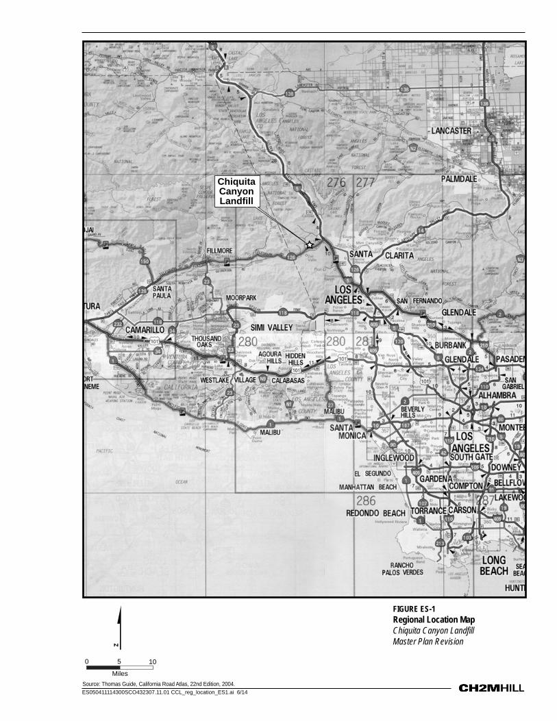
ES.3 Overview of Proposed Project CCL is an existing Class III (municipal solid waste) facility located near the City of Santa Clarita, just west of the Interstate 5 (I-5) and State Route 126 (SR-126) interchange (Figure ES-1). The site is a total of 639 acres, with an existing permitted waste footprint of approximately 257 acres, although not all of the 257 acres has been developed.
The Proposed Project includes the following elements: development of a new entrance and support facilities; better utilization of the landfill’s potential disposal capacity through a lateral extension of the existing waste footprint and increased maximum elevation; increased daily disposal limits; acceptance of all nonhazardous wastes permitted at a Class III solid waste disposal landfill; continued operation of the landfill; new design features; environmental monitoring; development of a Household Hazardous Waste Facility (HHWF); mixed organics composting operation; and set-aside of land for potential future conversion technology. In addition, the Proposed Project includes the relocation of a portion of Southern California Edison’s (SCE) existing Saugus-Elizabeth Lake-Fillmore 66 kilovolt (kV) Subtransmission Line in order to accommodate landfill improvements. Each of these project elements is summarized below and described in detail in Chapter 2.0, Project Description.
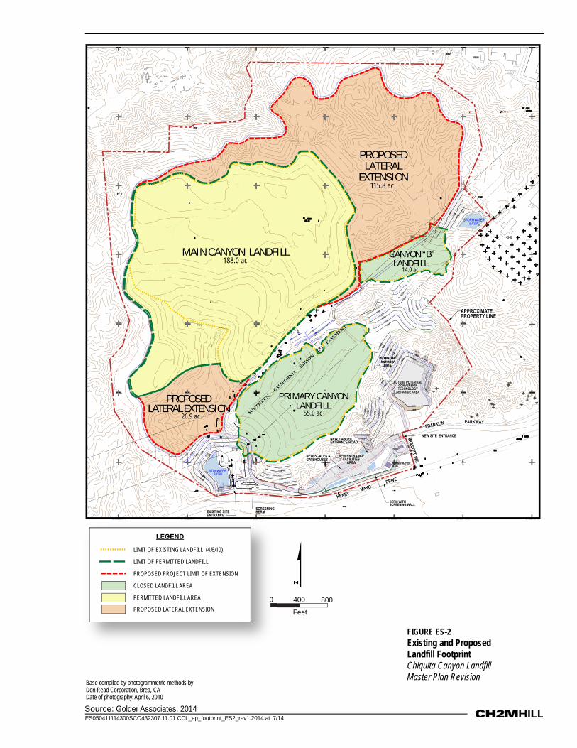
ES.3.1 Entrance and Support Facilities CCL is located on the north side of SR-126, a four-lane paved highway running east-west along the southern boundary of CCL. As part of the Proposed Project, the primary landfill entrance will be located at Wolcott Way, as shown in Figure ES-2. Vehicles traveling to the site will turn from SR-126 onto Wolcott Way, which is a signalized intersection, and then west into the new landfill entrance. The new entrance will include administration buildings, a scale house, scales, and parking. A combination of landscaped screening berm and screening wall along the perimeter of the entrance facilities will screen views from SR-126 and Wolcott Way.
In order to accommodate the Proposed Project, CCL has requested SCE to relocate an approximately 3,260-foot portion of the Saugus-Elizabeth Lake-Fillmore 66 kV line between the east side of Wolcott Way to a location approximately 880 feet west of the current CCL entrance. The 66 kV line will be relocated into a new easement to be provided by CCL.
ES.3.2 Lateral Extension of the Waste Footprint and Increased Maximum Elevation
The Proposed Project will increase the permitted waste footprint within the existing property line by approximately 143 acres by extending it slightly south toward the existing landfill entrance and to the north and east (Figure ES-2). The waste footprint will increase from the currently permitted acreage, approximately 257 acres, to approximately 400 acres. The Proposed Project also will increase the permitted height of the landfill by 133 feet to a maximum elevation of 1,573 feet.
ES.3.3 Disposal Rate and Volume The Proposed Project will increase daily and weekly disposal tonnage. The permitted maximum daily disposal tonnage will increase from 6,000 to 12,000 tons. The permitted maximum weekly disposal tonnage will increase from 30,000 to 60,000 tons. Depending on actual disposal rates under the Proposed Project, the life of the landfill would be increased by 21 to 38 years. The actual site life and corresponding closure date is dependent on a number of factors, including the disposal rate actually achieved over time.
ES-2 DRAFT EIR ES092311093436SCO/ 113110004
ES050411114300SCO432307.11.01 CCL_reg_location_ES1.ai 6/14Source: Thomas Guide, California Road Atlas, 22nd Edition, 2004.
Chiquita Canyon Landfill
FIGURE ES-1Regional Location MapChiquita Canyon Landfill Master Plan Revision
Miles
0 105
ES050411114300SCO432307.11.01 CCL_ep_footprint_ES2_rev1.2014.ai 7/14Source: Golder Associates, 2014
FIGURE ES-2Existing and Proposed Landfill FootprintChiquita Canyon Landfill Master Plan Revision
Feet
0 800400
Base compiled by photogrammetric methods byDon Read Corporation, Brea, CADate of photography: April 6, 2010
0PROPOSED LATERAL EXTENSION
LIMIT OF EXISTING LANDFILL (4/6/10)
LIMIT OF PERMITTED LANDFILL
PROPOSED PROJECT LIMIT OF EXTENSION
CLOSED LANDFILL AREA
PERMITTED LANDFILL AREA
LEGEND
990 TOP DIKE
BENCH
10
2:1
2:1
BBENCH
1032 1100
2:1
2:1
2:1
22::11
DW-21
DW-18
1000
1025
975
10501075
1100
1000
1000
1025
1085
1100112511
50
2:1
WATERTANK
1000
1000
975
1025
1000
SOUTHERN
CALIFORNIA
EDISONCO.EASEMENT1150
GP-22
10001000
1125
1050
1025
1075
1100
10751050
1000
990 TOP DIKE
1000
1050
1075
1025
1175 1200
1225
1250127
5130
01325135
0
1325
1300
1350
1400
1175
1150
1225
10001125
1100
2:1
1150
1050
1075
1050
10501075
1025
2:11.8:1
1050107511
001125
1200
POTENTIALBORROWAREA
1025
1000
970
970
970
960
955
960960954
960970
975
PROPOSEDLATERAL EXTENSION
PROPOSEDLATERAL
EXTENSION115.8 ac.
APPROXIMATEPROPERTY LINE
HENRYMAYO
DRIVE
NEW SCALES &GATEHOUSES
NEW SITE ENTRANCE
EXISTING SITEENTRANCE
FRANKLIN PARKWAY
WOLCOTTWY.
NEW LANDFILLENTRANCE ROAD
NEW ENTRANCEFACILITIES
AREA
MAIN CANYON LANDFILL188.0 ac
STORMWATERBASIN
CANYON “B”LANDFILL
14.0 ac
SCREENINGBERM
PRIMARY CANYONLANDFILL
55.0 ac26.9 ac.
STORWATERBASIN
ADMINISTRATIONBLDG
HHW
BERM WITHSCREENING WALL
FUTURE POTENTIALCONVERSIONTECHNOLOGY
SET-ASIDE AREA

EXECUTIVE SUMMARY
ES.4 Wastes to Be Received The applicant proposes to accept for disposal all nonhazardous wastes acceptable at a Class III solid waste disposal landfill, in accordance with 27 CCR Section 20220, Waste Discharge Requirement (WDR) Order No. 98-086, and Solid Waste Facility Permit No. 19-AA-052.
ES.4.1 Materials to be Diverted from Waste Disposal CCL is actively engaged in waste diversion activities; that is, diverting materials from waste disposal and putting them to beneficial reuse. This activity preserves CCL’s disposal capacity for municipal solid waste to the maximum extent feasible. Diverted materials include shredded curbside green waste, clean soil, contaminated soil, treated auto shredded waste, tire shred, concrete, asphalt, concrete, and processed construction and demolition material. The type and volume of material diverted from waste disposal is highly variable on a daily basis.
ES.4.2 Landfill Construction Construction for the Proposed Project includes development of the entrance and support facilities and landfill cell construction. Construction of the site entrance and associated support facilities would occur immediately upon project approval, and would take approximately 10 months to complete. Construction working hours would generally be daylight hours between 7:00 a.m. and 7:00 p.m., Monday through Saturday.
The landfill is developed in a series of cells. Construction of cells and associated environmental monitoring features would occur periodically over the life of the landfill. Generally, cell construction would occur every 18 months to 5 years over the life of the Project, for approximately 10 months each time. Construction working hours would generally be daylight hours between 7:00 a.m. and 7:00 p.m., Monday through Saturday.
ES.4.3 Landfill Operation Hours of operation for the Proposed Project will be the same as the currently permitted operating hours, which are 24 hours per day, except from 5:00 p.m. Saturday through 4:00 a.m. Monday. Access to the landfill by both commercial and general public vehicles is allowed during all hours the landfill is operating. Landfill maintenance activities may occur 24 hours per day, 7 days per week. CCL also has the option to operate a maximum of four Sundays per year, if desired, for the quarterly Val Verde cleanup days. If CCL exercises the option of Sunday operation, the schedule of operation will be tailored to the specific need of the situation.
Full-time staff for the Proposed Project will increase by approximately 25, for a total of approximately 50, including additional administrative staff, maintenance personnel, equipment operators, scale house personnel, spotters, landfill gas (LFG) technicians, and laborers. Equipment at CCL for the Proposed Project will increase by 15 to 20 additional pieces. Anticipated additional equipment includes two motor graders, three bulldozers, three compactors, two scrapers, two water trucks, five trailer-mounted light plants, and one water wagon. Consistent with existing practices, at all times, CCL will provide sufficient types and numbers of equipment to properly operate in accordance with applicable permits, approvals, safety considerations, and industry standards.
CCL is prohibited from disposing hazardous waste, including household hazardous waste. To prevent hazardous waste from being disposed, CCL will continue to implement its existing load checking program as part of the Proposed Project. Established procedures at CCL are used to prevent hazardous waste entering the landfill. These procedures include posting of signs, education of existing and new customers, verbal and visual screening at the scale house, and daily random checks of incoming vehicles.
No change to disposal and cover procedures will occur as a result of the Proposed Project. Waste will continue to be delivered to CCL in transfer vehicles, collection trucks, and various other vehicles by commercial haulers and the general public. After being processed at the scale house, vehicles follow signs to the active disposal area. CCL will continue to be constructed by the area fill method, wherein waste is spread and compacted in
ES092311093436SCO/ 113110004 DRAFT EIR ES-5
EXECUTIVE SUMMARY
approximately 2-foot-thick layers on a working face of approximately 200 feet by 300 feet and sloped at 3:1 (horizontal:vertical) or flatter. The compaction equipment traverses the entire length of the working face, making three to five passes over each 2-foot-thick (minimum) layer of waste to obtain adequate compaction of all wastes. To prevent bridging of the surrounding waste, large or bulky wastes are separated and placed in the lower portion of the advancing lift, and thoroughly crushed by compaction equipment.
No changes to the water uses onsite or sewage disposal are proposed as a result of the Proposed Project. Sanitary facilities at the landfill office are connected to a permitted septic system, and portable toilets are used for other areas of the site. Unless a sewer line becomes available in the future, the Proposed Project will continue to rely on these facilities. A new septic system may be constructed to support the entrance facilities. Bottled drinking water will continue to be provided at the scale house, landfill office, and equipment maintenance facility for employees. Water for routine landfill operation, including dust control and irrigation, will continue to be supplied from an offsite irrigation well south of the landfill on Newhall Ranch. During periodic construction of new landfill disposal cells, additional construction water will be supplied via a separate water supply line from storage tanks located north of the landfill.
ES.4.4 Landfill Design Features Design of the landfill is premised on prescriptive and performance standards set forth in state and federal regulatory requirements that establish environmental protection standards to prevent harm to the environment. Site excavation is divided into a series of excavation areas associated with fill modules. The excavation sequence is designed for efficient excavation and handling of soils, access, drainage, liner preparation, and controlled waste placement. No change to the landfill liner system is anticipated as a result of the Proposed Project, but the liner system remains subject to the requirements of (Regional Water Quality Control Board (RWQCB). The liner system is designed to contain liquid (leachate) that accumulates in the landfill and direct it to the leachate collection and removal system (LCRS).
Consistent with the existing landfill grading plan, the design of the landfill final grading plan is controlled by surrounding topography, existing limits of the waste fill, waste and soil consolidation and settlement considerations, slope stability requirements, minimum surface gradients required to adequately drain the completed fill, drainage requirements of stormwater drainage control facilities, aesthetics, and site end use considerations.
Final landfill slopes will be constructed no steeper than 3:1. An earthfill berm will be constructed at the south end of the Main Canyon area to serve as a buttress. The landfill is developed sequentially, considering the effects of landfill stability, allowing the final cover and drainage facilities to be completed as the fill progresses. The remaining Main Canyon area and the area to the south of the existing permitted landfill are proposed to be developed in three fill modules, Fill Modules 5, 6, and 7. The East Canyon and North Canyon are proposed to be developed in five fill modules, Fill Modules 8 through 12.
ES.4.5 Environmental Monitoring The landfill environmental monitoring systems are a component of the overall landfill design and operating standards established by state and federal regulations and work in conjunction with the landfill design standards to provide a key assurance of early detection of any potential for impairment of groundwater or air quality.
The monitoring program for the Proposed Project will be similar to the existing program and will require approval by the RWQCB under the landfill facility WDRs. The monitoring program includes Water Quality Monitoring, Groundwater and Vadose Zone Monitoring. Leachate Monitoring, Surface Water Monitoring, Air and Landfill Gas Monitoring, and Nuisance and Health Hazard Monitoring (odor, fire control, dust control, vector control, litter, and noise).
ES-6 DRAFT EIR ES092311093436SCO/ 113110004
EXECUTIVE SUMMARY
ES.4.6 Household Hazardous Waste Facility An HHWF will be constructed at CCL. While the facility will be located in the same area as the new landfill entrance and support facilities, the HHWF will be physically separate from the landfill and will have its own entrance and exit. The HHWF will be a joint effort between CCL and Los Angeles County. CCL will design and construct the HHWF; the County will permit and operate the facility.
The HHWF will be constructed and permitted to receive paint and solvents; used motor oil and filters, anti-freeze, and other automotive fluids; cleaning products; pool and garden chemicals; aerosol cans; all medicine except controlled substances; auto batteries; and household batteries. The HHWF would receive and store these materials in preparation for shipment to markets that would recycle the materials or shipment to a hazardous waste disposal site. Operating hours for the HHWF will be 24 hours per day, 7 days per week, for purposes of processing materials, operating equipment, and/or maintaining the facility. Delivery of material to the HHWF by members of the general public will be limited to 6:00 am to 8:00 pm, 7 days per week. However, actual operating hours for the HHWF would be set by the County, and are anticipated to be one or two weekend days per month. The HHWF will be staffed continuously during operation by an individual trained in hazardous materials management.
ES.4.7 Mixed Organics Composting Facility The Proposed Project includes continued green waste processing and composting operations allowed under the current CUP. The processing and composting operation that was located at the landfill since 1997 suspended operations in 2009 as a result of the economic downturn. CCL intends to resume operation in some manner in the future, likely in late 2014 or early 2015. When it resumes operation, the facility is likely to be located on the landfill surface. As the landfill develops, the composting facility may be relocated periodically to accommodate landfill operations. The composting facility is permitted under the current CUP to receive up to 560 tons per day. Operating hours for the composting operation will be 24 hours per day, 7 days per week. Access by customers for purposes of removing finished mulch biomass fuel, and compost will be limited to 6:00 am to 8:00 pm, 7 days per week, although actual hours may vary within this window. In addition to shredded green waste from curb-side pick up or commercial landscape operations, the Proposed Project would also include pre- and post-consumer food waste as part of a “mixed organics” composting process.
ES.4.8 Land Set-Aside for Potential Future Conversion Technology Facility CCL has included within the Project Description a set-aside of a portion of the site within the existing CCL property boundary that could be used for a potential future conversion facility. The location of the property set-aside is shown in Figure ES-2. The Proposed Project does not include design, permitting, construction or operation of a conversion facility.
ES.4.9 Landfill Closure and Post-Closure Landfill closure will occur on an incremental basis as areas of the landfill reach final grade. Closure activities will be performed in a manner consistent with a final closure plan to be prepared for the site that requires the approval of RWQCB, the Local Enforcement Agency (LEA), and California Department of Resources Recycling and Recovery (CalRecycle). The final closure plan will include a description of the area to be closed, proposed final cover, environmental monitoring and control systems (i.e., groundwater, surface water, leachate, and LFG), structures to be removed, site security, final grading, drainage and erosion control, and revegetation.
In conjunction with the final closure plan, a final post-closure maintenance plan will be prepared. The final post-closure maintenance plan will be submitted to and approved by RWQCB, the LEA, and CalRecycle. The post-closure end use will be consistent with the surrounding terrain, land uses, and zoning. As part of a future closure plan for the landfill, CCL will propose that a park or other type of publicly accessible recreational use on the site be approved in accordance with applicable laws and the covenants, conditions, and restrictions for the landfill. If requested by the County or applicable governmental agency, CCL will offer to dedicate such park or
ES092311093436SCO/ 113110004 DRAFT EIR ES-7
EXECUTIVE SUMMARY
recreational area upon completion. CCL proposes to revegetate exposed slopes and landfill top areas with native plants and other appropriate screening landscape.
The landfill gas-to-energy (LFGTE) plant, LFG flares, and leachate storage/treatment/load-out facilities will continue operation for some period of time after the landfill is closed. Additionally, the HHWF and composting facility could continue operation after landfill closure.
ES.5 Project Alternatives Section 15126(d) of the CEQA Guidelines requires an EIR to describe a range of reasonable alternatives to the Proposed Project, or to the location of the project, which could feasibly attain most of the basic project objectives but would avoid or substantially lessen any of the significant environmental effects of the project.
To determine the alternatives suitable for a detailed discussion in this DEIR, the preparers evaluated a wide range of alternatives, including offsite facility alternatives and non-disposal alternatives. This broader range of alternatives was initially reviewed in light of the Proposed Project’s objectives, to evaluate whether and to what extent the Proposed Project’s objectives and needs could be met by potential alternatives, which might be available either technologically or at other site locations. A summary of the alternatives is provided below and discussed in detail in Chapter 18.0, Project Alternatives.
ES.5.1 Alternatives Considered But Not Evaluated in Detail The Los Angeles County Department of Public Works (LACDPW) and the Los Angeles County Sanitation District have continued to pursue the development of out-of-county disposal through waste-by-rail systems as a partial source of long-term disposal capacity for the greater metropolitan Los Angeles area regional system (referred to as the Haul Transport to Out-of-County Landfills Alternative). Consideration was also given to an alternative that would limit the size of an expansion to provide a smaller amount of additional onsite capacity (referred to as the Alternative Landfill Project Design Alternative).
Based on the initial screening-level evaluation, it was determined that the Rail Haul Transport to Out-of-County Landfills Alternative and the Alternative Landfill Project Design Alternative could not feasibly attain the objectives of the Proposed Project. The Rail Haul Transport to Out-of-County Landfills Alternative would not meet most of the basic project objectives, because consideration of waste-by-rail to remote locations would not secure landfill capacity in proximity to population centers served by CCL prior to projected capacity shortfalls; would not expand CCL within its existing leasehold boundaries; and would not maximize the utilization of available airspace within the Chiquita Canyon site property holdings and realize the value of the property to its fullest potential. The applicant does not own or control a site served by a rail haul or intermodal capability. For all of the above reasons, remote/out-of-county rail haul landfills cannot reasonably be considered a feasible alternative to the Proposed Project and, therefore, rail haul transport to out-of-county landfills has been eliminated from further environmental evaluation in the review of this project.
It was also determined that there are no realistic onsite reduced project alternatives that could feasibly attain most or all of the project objectives, because they would not provide short-term, contingency, or long-term disposal tonnage options to the County; do not offer resource recovery and employment opportunities; would not avoid the significant effects of the expansion; and would not enhance local or regional infrastructure. Therefore the Alternative Landfill Project Design Alternative was also eliminated from further consideration.
ES.5.2 Evaluation of Project Alternatives In accordance with Section 15126(d) of the CEQA Guidelines, the following three alternatives are presented in this DEIR:
A. No Project Alternative B. Waste Reduction and Alternative Technologies C. Alternative New Site in Northern Los Angeles County
ES-8 DRAFT EIR ES092311093436SCO/ 113110004

EXECUTIVE SUMMARY
ES.5.2.1 Alternative A: No Project Alternative CEQA requires that an EIR consider the No Project Alternative. For this DEIR, the No Project Alternative is no approval of an expansion of the existing CCL, resulting in the cessation of waste receipts and consequent closure of the existing landfill operations. The current CUP closure date is 2019; however the facility is expected to reach its permit-based disposal limitation of 23 million tons established in the current CUP between 2015 and 2019. The No Project Alternative would require all existing waste destined for CCL to be redirected to other landfills in the region or otherwise disposed, diverted, or recycled. Under the No Project Alternative, the expansion project’s unavoidable effect on landform alteration would be avoided, but impacts on regional air quality would remain. Impacts of waste disposal on air quality would occur at other locations within the same air basin. The nature of the impacts would depend upon the disposal alternative used. However, most of the basic project objectives would not be achieved under this No Project Alternative, such as expanding CCL with additional capacity and resource recovery operations; providing in-county daily disposal capacity and general long-term capacity; providing convenient access and competitive pricing to landfill users; supporting future infrastructure needs of the area; and maximizing the value of the operations.
ES.5.2.2 Alternative B: Waste Reduction and Alternative Technologies The Waste Reduction and Alternative Technologies alternative describes and evaluates waste reduction techniques and alternative technologies that could potentially be applied to the solid waste management system in Los Angeles County, including source reduction, mechanical volume reduction, resource recovery, and conversion technologies. The alternative waste reduction technologies, including conversion technologies, are not in and of themselves considered feasible alternatives to the Proposed Project. That is, none of these techniques (alone or in combination) can completely offset the need for additional landfill capacity. The discussion of the obstacles and challenges to development of conversion technologies in Los Angeles County and elsewhere in the state demonstrates that the state of the technology is in its infancy and has yet to be demonstrated to be commercially feasible. LACDPW analysis of nine alternative scenarios in its assessment of landfill capacity in the Countywide Integrated Waste Management Plan 2012 Annual Report (LACDPW, 2013) demonstrates that even with an assumed optimistic and aggressive use of conversion technologies with increased diversion rates, expanded landfill capacity is necessary in Los Angeles County to avoid capacity shortfalls. These alternative waste reduction technologies are, however, capable of extending the operational capacity of landfills. LACDPW projections, based on waste generation knowledge, changes in population, and existing and planned development, indicate that waste disposal tonnage will increase by 56 percent by 2020. Alternative waste reduction technologies will be employed as required by Assembly Bill (AB) 939 and County policy; however, their implementation does not offset the ultimate need for the Proposed Project or the expansion of other landfill facilities.
ES.5.2.3 Alternative C: Alternative New Site in Northern Los Angeles County This DEIR evaluates an alternative offsite location as potentially feasible, based on the Proposed Project’s main objective to develop significant new disposal capacity within northern Los Angeles County.
The Proposed Project is the proposed expansion of an existing landfill on property owned by the applicant, a private entity, and the concept of a new landfill to be sited in an alternative location would not meet the most basic objectives of the Proposed Project; and is otherwise not feasible because the applicant has no means of eminent domain to acquire the lands of others for its project purposes. While eminent domain is not available to a private applicant, it is possible to acquire lands through customary commercial dealings.
For an alternative location for the Proposed Project to be considered feasible, the site would have to be suitable for landfill development, and meet the detailed siting and design criteria established in Title 27 California Code of Regulations (CCR). This criteria would preclude any property that would not meet the Title 27 landfill siting requirements. In general, the State of California siting regulations (which are based on the federal Subtitle D regulations) restrict landfills from locating in areas near runways, within 100-year floodplains, in unstable terrain, in wetlands, or in active fault zones. Site feasibility is further determined by the landfill
ES092311093436SCO/ 113110004 DRAFT EIR ES-9

EXECUTIVE SUMMARY
operator’s ability to acquire, control, or otherwise have access to suitable properties. The applicant does not own or control properties in the vicinity of the Proposed Project location suitable for landfill development—the applicant does not own any other property in the general vicinity of the CCL facility.
A variety of requirements and permitting decisions are required to develop a solid waste disposal facility under California laws and regulations governing such facilities. Experience locally and throughout the state demonstrates that siting and permitting a solid waste landfill is a time consuming, expensive, proposition that can easily take between 10 to 12 years or more, without guarantee of a successful or even partially successful result.
ES.5.2.4 Comparison of Alternatives None of the project alternatives would meet most of the Proposed Project objectives and avoid, or substantially lessen, the significant effects of the Proposed Project as required by Section 15126(d) of the CEQA Guidelines. It can be concluded that only the No Project Alternative would avoid the landform alteration effects of the Proposed Project. However, the No Project Alternative shifts daily operational impacts of landfilling operations to other sites, and recognizes that additional capacity has to be created in the system to handle the waste from CCL. In addition, the transportation impacts and associated greenhouse gas (GHG) impacts of transportation on one or more distant landfills have to be considered as significant impacts of the No Project Alternative. The No Project Alternative in effect defeats the important objectives of the Proposed Project, the development of substantial additional disposal capacity to serve the region’s and Los Angeles County’s needs.
The Waste Reduction and Alternative Technologies Alternative provides several worthwhile and important elements of source reduction and diversion to try to reduce the overall contribution to the waste stream, as well as providing alternative methods of disposal. While the concepts are valued, not all have been demonstrated to be feasible for a variety of reasons. In the context of Los Angeles County, which is projected to see an increase of 56 percent in landfill capacity demand in spite of aggressive recycling and source reduction programs, this alternative cannot be considered as a feasible means to eliminate the need for the Proposed Project. Despite Los Angeles County’s aggressive approach to conversion technologies, the technology has not yet been proven to be economically or environmentally viable in California and, thus, it cannot be concluded that conversion along with other waste reduction and alternative technologies can be a viable alternative to the Proposed Project.
The development of a new landfill in the northern Los Angeles County area has several important steps, which must be undertaken, that even under the most favorable conditions as noted in Chapter 18.0 will take on the order of 12 years or longer. Thus, although an offsite new landfill alternative may appear to some to be an attractive alternative, the actual process of locating, identifying, and ultimately permitting such a project is a very expensive, time-consuming process that cannot be achieved within the critical timeframe necessary for development of additional landfill disposal capacity, the primary objective of the Proposed Project. As such, a new site in northern Los Angeles County is simply not a feasible alternative to the Proposed Project.
CEQA requires that this DEIR identify the “environmentally superior alternative from amongst the alternatives evaluated.” Based on the discussion of the various alternatives, the environmentally superior alternative is the No Project Alternative. The State CEQA Guidelines Section 15126.6(e)(2) states, “If the environmentally superior alternative is the ‘no project’ alternative, the EIR shall also identify an environmentally superior alternative among the other alternatives.” Given this guidance, the environmentally superior alternative is Alternative B, Waste Reduction and Alternative Technologies Alternative.
ES-10 DRAFT EIR ES092311093436SCO/ 113110004

EXECUTIVE SUMMARY
ES.6 Major Findings and Conclusions The following section summarizes the major findings and conclusions of the resource area analyses. Detailed information by resource is provided in Chapters 4.0 through 16.0 of this DEIR.
ES.6.1 Land Use Landfill expansion activities associated with the Proposed Project are consistent with the existing land uses (i.e., waste disposal activities) that have occurred at CCL since its inception. Likewise, waste disposal activities would continue to occur within the existing site boundary, and would not disrupt or divide the physical arrangement of an existing community. Additionally, the Proposed Project is consistent with, or would not conflict with, any applicable local plan or policy including general plans, specific plans, the Los Angeles County Integrated Waste Management Plan (CIWMP), zoning ordinances, and habitat conservation plans. No significant impacts associated with land use are expected to occur as a result of the Proposed Project. Furthermore, the Proposed Project, when combined with reasonably foreseeable projects in the project vicinity, would not incrementally contribute to cumulative changes to land use, and no cumulative impacts would result.
Additionally, the proposed composting facility, HHWF, and potential future conversion facility would all be co-located with the landfill, and, therefore, future activities associated with the facilities are anticipated to be consistent with the existing land uses (i.e., waste disposal activities) that have occurred and will continue to occur at CCL. The proposed facilities would maintain the intended land uses of the site and would not conflict with applicable land use plans or adopted policies, and no impacts related to land use are anticipated from these facilities.
ES.6.2 Geology and Hydrogeology There is a potential for the Proposed Project to have a significant geologic and hydrogeologic effect on the environment due to resulting changes in the physical conditions that exist in the area. However, as described, below, the impacts from the Proposed Project due to these changes will be less than significant with mitigation.
The Proposed Project would not expose people or structures to substantial geologic hazards from rupture of a known earthquake fault because there are no known active or Holocene faults within the Proposed Project area. There is a potential for the Proposed Project to expose people or structures to substantial geologic hazards from strong seismic ground shaking. However, the Proposed Project will be designed to meet or exceed the stringent seismic ground shaking regulatory construction standards, and implementation of the design will minimize this impact to a less-than-significant level.
There is a potential for seismically related ground failure and landslides for the North, East, and South Main Canyon areas. The results of the slope stability analyses indicate that all of the cut slopes are grossly stable and any unsuitable material identified during excavation by a geotechnical engineer will be overexcavated and replaced with compacted earthfill. Therefore, these impacts would not be significant.
Erosion will be controlled during implementation of the Proposed Project as required by the National Pollutant Discharge Elimination System (NPDES) General Permit requirements and the associated site-specific Stormwater Pollution Prevention Plan (SWPPP) and Stormwater Monitoring Program (SWMP), as well as CCR Title 27 requirements. The potential soil loss was estimated to be less than 2 tons per acre per year, which is the maximum annual soil loss recommended by the United States Environmental Protection Agency (EPA). Therefore, these impacts would not be significant.
The potential for debris flows exists within the natural drainages and slopes along the north side of the future entrance road, specifically where the entrance road will cross in front of three significant drainage gullies and along the perimeter of the development of the Proposed Project area. The proposed design should allow for the cleanup. The potential impact would be mitigated to below a level of significance by allowing for the control of any debris flow (see Mitigation Measure GH-1). The Proposed Project design has taken into consideration
ES092311093436SCO/ 113110004 DRAFT EIR ES-11
EXECUTIVE SUMMARY
site-specific geologic investigations, and excavation slopes have been designed to avoid adverse bedding conditions. Any unsuitable material, as determined by a geotechnical engineer, present in the subgrade after excavation will be overexcavated and replaced with compacted earthfill. Therefore, the Proposed Project would not be located on a geologic unit or soil that is unstable or that could become unstable. Furthermore, as described above, the results of the slope stability analyses found that all of the cut slopes are grossly stable. Therefore, these impacts would not be significant.
There is a potential for buildings and/or other structures related to the Proposed Project to be located on expansive soil because the site is underlain by bedrock of the Pico and Saugus formations. This potential impact would be mitigated by performing additional testing of the expansive properties of the soils if buildings and/or other structures sensitive to expansive soils are planned for the site (see Mitigation Measure GH-2).
Potential exists for the Proposed Project to incrementally deplete groundwater supplies and interfere with groundwater recharge because the proposed liner and cover system of the Unit and erosion controls over the remaining developed areas would reduce or eliminate recharge of precipitation to the water table. There is also a potential that groundwater extraction may be required for a corrective action program if a release from the Unit occurs to the environment. However, the volume of decreased recharge or potential groundwater extraction related to the Proposed Project would not be measurable compared to the recharge that occurs from precipitation over the Santa Clara River Valley East Subbasin and runoff from the surrounding Santa Clara River Valley watershed. In addition, stormwater runoff discharged from the site would flow into the Santa Clara River, where it could recharge the groundwater system. Therefore, these impacts would not be substantial.
Finally, the Proposed Project, in conjunction with other related projects, would not produce cumulatively significant effects associated with geology and hydrogeology.
ES.6.3 Surface Water Drainage There is a potential for the Proposed Project to substantially alter existing drainage patterns; substantially increase erosion of surface runoff and cause flooding; and create or contribute to runoff that exceeds drainage system capacity. The existing drainage patterns will be altered within CCL during implementation of the Proposed Project as a result of constructing, operating, and maintaining a precipitation drainage and control system. However, this system will be designed and constructed to carry the peak discharge resulting from the 100-year, 24-hour storm event, as required by Title 27, and the stormwater runoff volume resulting from the Capital Flood event (50-year, 24-hour storm), as required by LACDPW. In addition, the system will limit, to the greatest extent possible, ponding, infiltration, inundation, erosion, slope failure, washout, and overtopping under the required design storms. This drainage and control system will prevent substantial erosion of surface runoff and will not cause flooding. Drainage patterns will not be altered downstream of the discharge points from the CCL site. Therefore, no mitigation measures would be required, because all onsite drainage patterns will be altered in accordance with applicable regulatory requirements, and offsite drainages will not be altered.
There is no potential for the Proposed Project to place housing within a 100-year flood area and/or impede or redirect flood flows within a 100-year flood hazard area. The landfill site is above the 100-year floodplain of the Santa Clara River as identified by Federal Emergency Management Agency (FEMA). Stormwater at the landfill site is controlled by diversion berms, drainage channels, overside drains, and sedimentation basins. Exposed soil and interim and final covers are vegetated to control erosion. All surface drainage from the landfill property flows through one or more sedimentation pond before discharging from the site. These controls, together with the landfill site being located above the 100-year floodplain, ensure that the Proposed Project will not impede or redirect flood flows within a 100-year flood hazard area.
Because the drainage and control system will be constructed, operated, and maintained in accordance with regulatory criteria (NPDES, Title 27, and LACDPW), the potential for the Proposed Project to result in flooding, which could expose people or structures to risk of loss, injury, or death would not be significant.
ES-12 DRAFT EIR ES092311093436SCO/ 113110004
EXECUTIVE SUMMARY
There is no potential for the Proposed Project to contribute to inundation by tsunami or seiche. CCL is too far inland and high in elevation to be significantly threatened by tsunami, and there are no enclosed water bodies at or in the vicinity of CCL.
There is a potential for the Proposed Project to contribute to inundation by mudflow (similar terms are debris flow and mudslide). However, implementation of Mitigation Measure GH-1 would allow for the cleanup or control of any debris flows that may encroach into the landfill cell and perimeter maintenance road from the natural drainages and slopes that are not included in the proposed grading and construction of drainage/ debris basins. The potential to expose people to risk of injury or death from this debris flow would be mitigated by requiring operations staff to avoid the potential debris flow areas after an appropriate amount of waiting time following heavy and sustained precipitation events (see Mitigation Measure SW-1).
Finally, no significant cumulative surface water runoff/flooding impacts are expected from the Proposed Project because each project must demonstrate to the County that floodwaters will be accommodated by onsite drainage facilities.
ES.6.4 Water Quality The Proposed Project has the potential to violate surface water quality standards or WDRs; violate groundwater quality standards or WDRs; contaminate public water supply; and otherwise substantially degrade water quality. However, these impacts would be less than significant because the Proposed Project would be in compliance with NPDES requirements, CCR Title 27 requirements, and Orders and WDRs issued by the RWQCB. The Proposed Project will include preparing and implementing a SWPPP and SWMP in accordance with a General Permit, in accordance with NPDES requirements, and in accordance with RWQCB. The Proposed Project will also meet or incorporate siting and design features in accordance with Title 27, Chapter 3, Subchapter 2 and will implement the required water quality monitoring and response programs for detecting, characterizing, and responding to releases to groundwater, surface water, or the unsaturated zone in accordance with CCR Title 27, Chapter 3, Subchapter 3. The monitoring programs will be implemented to ensure no impairment of beneficial use of surface water or groundwater beneath or adjacent to the landfill. Therefore the Proposed Project will not result in significant impacts to surface water and groundwater.
Furthermore, implementation of design features, as well as required implementation of best management practices for stormwater runoff at each cumulative project, would mitigate potential cumulative impacts to below a level of significance. Therefore, cumulative projects are not expected to significantly impact the quality of groundwater.
ES.6.5 Biological Resources The Proposed Project has the potential to result in direct and indirect impacts to plant and wildlife communities, as described below.
Potential Impacts to Vegetation Communities
Proposed Project implementation would result in approximately 276 acres of permanent vegetation impacts throughout the life of the landfill. Ground-disturbing activities may also promote the establishment of invasive plant species and noxious weeds and potentially degrade surrounding communities. Native vegetation communities such as Riversidean Coastal Sage Scrub and Southern Mixed Chaparral have a relatively high biological value, and along with non-native habitats on the site, provide nesting, foraging, roosting, and denning opportunities for many species of wildlife. The impact of loss or degradation of these habitats is anticipated to be less than significant given the small acreage of impacts and availability of alternate large areas of similar habitat, both locally and regionally. In addition, landfill areas would be revegetated with native vegetation when retired from use, offering some compensation from habitats lost during Proposed Project implementation, and further reducing impacts. With mitigation, potential impacts to vegetation communities would be less than significant.
ES092311093436SCO/ 113110004 DRAFT EIR ES-13
EXECUTIVE SUMMARY
Potential Impacts to California Department of Fish and Wildlife and United States Army Corps of Engineers Jurisdictional Areas
United States Army Corps of Engineers (USACE) and California Department of Fish and Wildlife (CDFW) jurisdictional areas could potentially be permanently impacted from grading and filling activities. In the event that any jurisdictional areas are confirmed at CCL, potential losses would include riparian vegetation associated with seasonal washes, including mule fat scrub, Mexican elderberry, and potentially scattered Fremont cottonwood. The permanent loss of CDFG and USACE jurisdictional areas would be considered a significant impact. Impacts would be quantified during the permitting process.
Additional impacts may potentially occur in waterways from construction or operational changes to water quality. Permanent sediment basins are present along all drainages at CCL prior to discharging offsite. These basins capture and retain water quality contaminants with sediments. CCL provides periodic clearing and cleaning of sediment basins. Contaminants captured within these basins are carried away and disposed of within portions of the landfill during maintenance. The operation and maintenance of these basins provides additional mitigation for water quality impacts.
With mitigation, potential impacts would be less than significant.
Potential Impacts from Nuisance Wildlife
Landfill operation may result in the introduction and success of nuisance wildlife, including gulls, ravens, brown-headed cowbirds, common starlings, and rats (Rattus ssp.). These species can displace native wildlife. Negative impacts from vectors and nuisance wildlife in general would be reduced with mitigation, ensuring that potential impacts from nuisance wildlife are less than significant.
Potential Impacts to Special-Status Plant Species
Federal- and state-listed plant species that could occur in the vicinity of CCL include Braunton’s milk-vetch, California orcutt grass, San Fernando Valley spineflower, and slender-horned spineflower. California Native Plant Society List Category 1A and 1B plant species include Los Angeles sunflower, Plummer’s mariposa lily, short-tailed beavertail, and slender mariposa lily. Database analyses indicate limited distribution of these species in the vicinity of CCL. However, there is a limited potential for occurrence of some of the special-status plants at CCL. If individual federal- and state-listed plant species are present at CCL, as well as sizable populations of Category 1B plants, they may be lost through Proposed Project implementation. This would represent a significant impact. With mitigation, the impacts to special-status plants would be reduced to below the level of significance.
Rayless ragwort is a Category 2 plant species with potential for occurrence in the vicinity of CCL; however, because of the low probability of occurrence, no impacts to this species are anticipated from Proposed Project implementation.
Pre-construction rare plant surveys would be conducted and, where feasible, where rare plants are identified, the area would be excluded and avoided. However, some rare plants may be identified in areas that cannot be effectively excluded or avoided. Where this occurs, loss from the Proposed Project would be a significant impact. Mitigation has been provided to address this contingency. Since it is unknown what plants, if any, would be found prior to surveys, consultation with appropriate regulatory agencies and specialists in conservation of the identified species will identify potential for appropriate salvage and relocation of soil or seeds, or purchase of offsite property.
Potential Impacts to Special-Status Wildlife Species
Proposed Project implementation would result in the loss of habitat for several special-status wildlife species expected to occur at CCL. For those species not observed but expected to occur at CCL, potential impacts were evaluated based on the habitat for which the species is expected to occupy. For aquatic species (fish and amphibians), downstream effects to aquatic habitats, primarily through potential impairment of water quality
ES-14 DRAFT EIR ES092311093436SCO/ 113110004

EXECUTIVE SUMMARY
in Castaic Creek and Santa Clara River, were evaluated. These species are discussed in further detail in the remainder of this section.
Potential Impacts to Downstream Water Quality
The Santa Clara River downstream of the Proposed Project has Beneficial Uses, warm freshwater habitat (WARM), wildlife habitat (WILD), rare/threatened/endangered species (RARE), and wetland habitat (WET). Special-status fish species that occur downstream of CCL include arroyo chub, Santa Ana sucker, southern steelhead trout, and unarmored threespine stickleback; all are known to occur in portions of the Santa Clara River or Castaic Creek. Additional special-status amphibians that may occur downstream include California red-legged frog, coast range newt, southwestern arroyo toad, and western spadefoot. Aquatic reptiles are also documented to occur downstream, including southwestern pond turtle and two-striped garter snake.
Chapter 7.0 addresses water quality impacts for the Proposed Project, including impacts to downstream receiving waters. Chapter 7.0 concluded that implementation of all required water quality monitoring and response programs at CCL would ensure that the Proposed Project would not result in significant impacts to downstream water quality, including those associated with urban runoff.
Potential Impacts to Special-Status Amphibians
Special-status species in the area include the California red-legged frog, arroyo toad, western spadefoot, and coast range newt. Proposed Project implementation would not impact critical habitat for any of these species and therefore no direct impacts to these species are anticipated. The east canyon and detention basin at CCL may hold water long enough to support breeding amphibians. Due to the presence of potential habitat for western spadefoot, this species has a moderate potential to occur at CCL.
Potential Impacts to Special-Status Reptile Species
The following special-status reptiles have the potential to occur in the vicinity of CCL: coastal western whiptail, San Diego horned lizard, California legless lizard, southwestern pond turtle, and two-striped garter snake. The southwestern pond turtle and two-striped garter snake have no suitable aquatic habitat onsite; therefore, no impacts to these species would occur.
Special-status lizard species likely to be associated with the grassland, coastal scrub, and chaparral habitats at CCL include coastal western whiptail and California legless lizard. The San Diego horned lizard may be associated with dry wash, coastal scrub, or chaparral habitats at CCL. Direct, permanent loss of these habitats would occur from grading and filling activities. Heavy vehicle traffic and other associated construction impacts could also result in direct mortality or injury of the species. These impacts are considered to be adverse but less than significant, because these populations occur in other areas of their geographic range, and impacts from Proposed Project implementation are not likely to substantially lower the regional populations of these species below a viable level. Given the relatively small acreage of impacts and availability of alternate large areas of such habitat, locally and regionally, potential impacts to these habitats are considered less than significant.
Potential Impacts to Federal- and State-Listed Bird Species
California gnatcatcher, least Bell’s vireo, southwestern willow flycatcher, and California condor are all federal- and state-listed species with potential to occur in the general vicinity of CCL. Marginal, potential nesting habitat for coastal California gnatcatcher occurs in the form of Riversidean coastal sage scrub, and where adjacent to sage scrub, southern mixed chaparral habitat. If gnatcatcher are present at CCL, the loss of occupied habitat, individuals, or nests of this species would represent a significant adverse impact. Designated critical habitat for gnatcatcher occurs over 5 miles south and southeast of CCL; however, no impacts to designated critical habitat would occur from Proposed Project implementation.
CCL does not support lowland riparian habitats that are suitable nesting and breeding habitat for least Bell’s vireo and southwestern willow flycatcher. No physical impacts to downstream riparian habitat would occur from Proposed Project implementation. Indirect impacts from changes in water quality could adversely affect
ES092311093436SCO/ 113110004 DRAFT EIR ES-15
EXECUTIVE SUMMARY
the habitat and forage of these birds. Chapter 6.0 concluded that the drainage and control system at CCL will prevent substantial erosion of surface runoff. Chapter 7.0 concluded that implementation of all required water quality monitoring and response programs at CCL would ensure that the Proposed Project would not result in significant impacts to downstream water quality. Additionally, previously proposed mitigation measures for biological resources will reduce the potential for downstream water quality changes.
With implementation of required water quality monitoring and response programs and biological resources mitigation measures, the impacts to downstream water quality are anticipated to be less than significant. This would include less- than- significant impacts on Beneficial Uses, including the fish, wildlife, and wetland habitat uses. With mitigation, no impacts to least Bell’s vireo or southwestern willow flycatcher are anticipated.
CCL does not support nesting habitat for California condor, but does support potential forage habitat for this wide-ranging species. Proposed Project implementation may render the site unsuitable for condor foraging due to construction and/or operation activities. In general, condors are expected to avoid the area due to current operational activities. Given the large extent of foraging habitat in the region and the wide-ranging nature of the species, the loss of this area as potential forage would not represent a significant impact.
Potential Impacts to Nesting Bird Species of Special Concern
The federal Species of Concern or state Species of Special Concern with potential to nest directly on the landfill include loggerhead shrike, California horned lark, short-eared owl, and burrowing owl. Yellow-breasted chat, tricolor blackbird, and California yellow warbler might nest in downstream riparian habitats.
Potential for the California horned lark, short-eared owl, and loggerhead shrike to occur and breed at CCL is moderate to high. Construction activities involving grading and filling would result in direct permanent loss of nesting and foraging habitat. Although extensive habitat for these species is present in the region, California horned lark and loggerhead shrike are much diminished in their coast populations and short-eared owl has become rare everywhere. Any removal of inhabited area could affect these species adversely. Therefore, impacts from loss of habitat for these species are considered to be significant, and mitigation is required. Direct loss of nesting individuals of these species may also occur during construction activities. Mitigation measures would be implemented to avoid impacts to nesting birds.
Grassland habitat at CCL provides limited potential breeding and foraging habitat for burrowing owl. However, there are no known records of occurrence of this species in the vicinity of CCL, and the species was not observed during field surveys. If the species is present, Proposed Project implementation would result in loss of burrowing owl habitat. This impact, although adverse, would not be significant, because the landfill represents marginal habitat and higher quality habitat is present elsewhere in the area. To avoid direct impacts to nesting birds, avoidance and mitigation measures would be implemented. With these measures, no significant impacts to burrowing owl would be anticipated.
No physical impacts to downstream riparian habitat would occur from Proposed Project implementation. Indirect impacts from changes in water quality could adversely affect the habitat and forage of these birds. Chapter 6.0 concluded that the drainage and control system at CCL will prevent substantial erosion of surface runoff. Chapter 7.0 concluded that implementation of all required water quality monitoring and response programs at CCL would ensure that the Proposed Project would not result in significant impacts to downstream water quality. Additionally, previously proposed mitigation measures for biological resources will reduce the potential for downstream water quality changes. With implementation of required water quality monitoring and response programs and biological resources mitigation measures, the impacts to downstream water quality are anticipated to be less than significant. This would include less-than-significant impacts on Beneficial Uses, including the fish, wildlife, and wetland habitat uses. With mitigation, no impacts to yellow-breasted chat, California yellow warbler, or tricolored blackbird are anticipated. Lighting impacts to nearby riparian areas from night lighting at CCL would be avoided through the use of directional shading, as specified in mitigation measures.
ES-16 DRAFT EIR ES092311093436SCO/ 113110004
EXECUTIVE SUMMARY
Potential Impacts to County Nesting Birds of Special Concern
Potential for the California horned lark, short-eared owl, and loggerhead shrike, County Nesting Birds of Special Concern, to occur and breed at CCL is moderate to high. Construction activities involving grading and filling would result in direct permanent loss of nesting and foraging habitat. Although extensive habitat for these species is present in the region, California horned lark and loggerhead shrike are much diminished in their coast populations and short-eared owl has become rare everywhere. Any removal of inhabited area could affect these species adversely. Therefore, impacts from loss of habitat for these species are considered to be significant, and mitigation is required. Direct loss of nesting individuals of these species may also occur during construction activities. Mitigation measures would be implemented to avoid impacts to nesting birds.
Potential Impacts to Foraging or Transient Bird Species of Special Concern (Passerines)
Tricolored blackbird was detected in the immediate vicinity of CCL during field surveys. However, there is no suitable nesting habitat; therefore, there is no potential for this species to nest onsite. Annual grasslands provide limited foraging habitat for this species although, in general, it prefers agricultural areas or landfills. The loss of marginal forage habitat for this species is not expected to represent a significant impact; however, the impact is generally not known because the local population size is unknown.
Breeding habitat for the California yellow warbler is not present at CCL. Transient birds may occur in chaparral or mule fat habitats onsite. The loss of this habitat for migrating individuals of this species would not represent a significant impact because other mulefat habitat exists in the region.
Potential Impacts to Foraging or Transient Bird Species of Special Concern (Raptors)
Golden eagle, white-tailed kite, and prairie falcon occur in the region and have the potential to forage over grasslands and open country at CCL. With Proposed Project implementation, approximately 125 acres of grassland habitat would be lost. The loss of this additional grassland raptor foraging habitat would represent a significant adverse impact to these species. Mitigation measures for this impact would consist of revegetation of adjacent landfill area with grassland species upon closing and setting it aside as raptor foraging habitat. With mitigation, the impact would be less than significant.
Cooper’s hawk was observed foraging onsite in chaparral habitats during field surveys. Since there are abundant riparian and chaparral habitats in the region, the loss of this foraging habitat would not represent a significant adverse impact.
Potential Impact to Special-Status Mammals (Excluding Bats)
The San Diego black-tailed jackrabbit has a high potential for occurrence at CCL, and the San Diego desert woodrat has a moderate potential for occurrence at CCL. Grading and filling activities from Proposed Project implementation would result in direct, permanent loss of habitat for these species. Some direct mortality of these species also might occur during construction. Despite substantial acreage of appropriate habitat, the jackrabbit is very diminished as a coastal population. The subspecies could drop below self-sustaining levels. Implementation of mitigation to include landfill revegetation would reduce potential adverse effects to less than significant.
The loss of potential habitat for San Diego desert woodrat would represent adverse but less-than-significant impacts to the species, given the substantial acreage of such habitats occur regionally. The impacts would not be expected to reduce local populations below self-sustaining numbers.
Potential Impact to Special-Status Mammals (Bats)
Suitable habitat is present at CCL for both roosting and foraging for long-eared myotis, long-legged myotis, and Yuma myotis, federal Species of Concern; and the California leaf-nosed bat, pallid bat, western mastiff bat, big free-tailed bat, cave myotis, Mexican long-tongued bat, pocketed free-tailed bat, spotted bat, Townsend’s western big-eared bat, California Species of Special Concern. Proposed Project implementation would result in the loss of forage habitat and may cause direct or indirect impacts to roost sites. Direct impacts would result
ES092311093436SCO/ 113110004 DRAFT EIR ES-17
EXECUTIVE SUMMARY
from destruction or filling of roost sites; indirect impacts may result from roost disturbance or abandonment from construction or operation activities. The loss of foraging habitat would not be considered a significant impact, because abundant similar forage habitat occurs in the region. In addition, because abundant sandstone outcrops occur in the mountains and ridges of this region, roost sites for bats that utilize small crevices and caves would not be considered limiting. As such, the loss or abandonment of roost locations is not anticipated to represent a significant impact.
Potential Impact to Special-Status Fish
No aquatic habitat is present on CCL that would support the arroyo chub, the Santa Ana sucker, the southern steelhead trout, or the unarmored threespine stickleback; as such, there would be no physical impact to these species from Proposed Project implementation. Critical habitat for the southern steelhead trout is designated to the west of the landfill, but the Proposed Project implementation would not impact the critical habitat.
The unarmored threespine stickleback is known to be a year-round resident of the Santa Clara River from the confluence of the Santa Clara River and Castaic Creek to I-5. It occurs in the area downstream of the Castaic confluence as far as the Ventura Border during the rainy season and was encountered broadly in the area during surveys for the Newhall Ranch development in the adjacent parts of the river. This area is a part of its essential habitat. The original Significant Ecological Area (SEA) #23 was developed along the Santa Clara River by the County of Los Angeles in part to protect unarmored threespine sticklebacks. Potential for downstream changes in water quality that could affect these species are addressed in Chapters 6.0 and 7.0 of this DEIR. Chapter 6.0 concluded that the drainage and control system at CCL will prevent substantial erosion from surface runoff. Chapter 7.0 concluded that implementation of all required water quality monitoring and response programs at CCL would ensure that the Proposed Project would not result in significant impacts to downstream water quality. Additionally, previously proposed mitigation measures for biological resources will reduce the potential for downstream water quality changes. With implementation of required water quality monitoring and response programs and biological resources mitigation measures, the impacts to downstream water quality area anticipated to be less than significant.
Potential Impact to Wildlife Movement Corridors
Some local wildlife movement may occur along ridgelines or valleys within the general vicinity of CCL. Two major wildlife corridors are known in the vicinity, the Santa Clara River and the Santa Monica-Sierra Madre Connection, and CCL could contribute slightly to movement along both these pathways. Impacts to the Santa Clara River corridor, which may include water quality effects, would be reduced to less-than-significant impacts through implementation of all required water quality monitoring and response programs and proposed mitigation.
Because CCL does not occur directly within the identified Santa Monica-Sierra Madre Connection, but is to the east of this linkage, it is unknown how much the site contributes to wildlife movement within this corridor. Many of the steeper ridgelines will be generally left undisturbed by the Proposed Project, and the existing landfill may currently constrain wildlife movement through the heart of the CCL site. Alternatively, some wildlife may move through the site at night. Mitigation measures associated with water quality, night lighting, and site revegetation would be implemented to address the potential for impacts to wildlife corridors.
Potential Impacts Under Local Policies, Ordinances, and Conservation Plans
Local policies or ordinances protecting biological resources will be complied with, including SEAs designated by the County of Los Angeles. The nearest SEA in the vicinity is along the Santa Clara River, south of CCL. Potential impacts to biological resources or water quality in the Santa Clara River ecosystem are anticipated to be less than significant with mitigation measures.
In addition, no federal Habitat Conservation Plans or state Natural Community Conservation Plans would be affected by Proposed Project implementation. No impacts are anticipated.
ES-18 DRAFT EIR ES092311093436SCO/ 113110004

EXECUTIVE SUMMARY
Potential Impacts to Protected Oak Trees
The Oak Tree Report (SB Horticulture, 2014) identified a total of three coast live oak and one valley oak that qualify for protection under the County Oak Tree Ordinance. One former heritage coast live oak was identified as deceased. The Project has generally avoided impacts to protected trees, but would require the removal of four protected oak trees due to their location in the landfill development area. An oak tree permit would be acquired for removal of the qualifying oaks and all permit terms and conditions would be complied with.
Cumulative Impacts
The cumulative loss of the most abundant habitats would potentially reduce the regional subpopulation numbers of sensitive species, which forage and breed in these open habitats. Although the Proposed Project will reduce the extent of some intact open habitats, mitigation measures have been proposed, which would reduce the impacts to sensitive species that may use those habitats to levels below significance. The development of the majority of the open habitats in the area could eventually reduce the raptor populations in the region. The Proposed Project would contribute to the incremental loss of these habitats, although the limited biological resources onsite would make its contribution minimal. Cumulative projects in the region could eventually sever wildlife habitat connectivity. Major movement corridors are known in the vicinity of CCL. The contribution of the CCL land to these corridor movement and linkage areas is unknown but not anticipated to be substantial. Mitigation measures proposed for the Project would ensure that the Project’s potential contribution to impacts associated with corridor movement and linkage areas are less than significant.
ES.6.6 Cultural and Paleontological Resources The potential direct and indirect impacts to cultural and paleontological resources are summarized below.
Potential Impact to Bowers Cave (CA-LAN-36)
Bowers Cave (CA-LAN-36) is located within the proposed area of disturbance of the Proposed Project. However, Mitigation Measure CR-1 states that grading plans should clearly depict the sensitive area of CA-LAN-36. A buffer around this sensitive area will be established in consultation with a qualified archaeologist and the Permittee, and grading will not occur beyond this established buffer.
Therefore, grading will not impact the cave. The view from the cave will not be significantly altered as the landfill is currently clearly visible from the cave. Mitigation Measure CR-1 also states that a qualified archeologist shall monitor earth-moving activities that would occur within close proximity to the established buffer.
The Proposed Project will not directly affect any historical resources as defined by CEQA. The areas delineated for extension of the grading footprint have already been archaeologically surveyed with negative results; no historical resources are present. The archaeological survey conducted in 2010 confirms the presence of CA-LAN-36 within the Proposed Project, and Mitigation Measure CR-1 will be employed to avoid impacts to the cave.
Potential Impacts to Additional Cultural Resources
The current inventory has demonstrated that the survey area contains prehistoric and historical archaeological resources. Further, the geomorphological environment of CCL is one of alluvial deposition. As with any ground-disturbing project, there remains a potential for the accidental discovery of buried cultural resources not detected through a surface inventory; therefore, Mitigation Measure CR-2 would be followed. Mitigation Measure CR-3 would be implemented if buried cultural resources are found during ground disturbance.
Potential Impacts to Paleontological Resources
The Proposed Project will not directly affect any known paleontological resources as defined by CEQA. The areas delineated for extension of the grading footprint have already been archaeologically surveyed with negative results; no paleontological resources were detected.
ES092311093436SCO/ 113110004 DRAFT EIR ES-19
EXECUTIVE SUMMARY
The Proposed Project (excavation of new cells) and the landfill operation (acquisition of daily cover) could adversely affect presently undetermined/unrecorded fossil sites. Direct impacts would result mostly from earth moving in previously undisturbed strata but also from any earth-moving activity that buried previously undisturbed strata, making the strata and their paleontological resources unavailable for future scientific investigation. As with any ground-disturbing project, there remains a potential for the accidental discovery of buried paleontological resources. Easier access to fresh exposures of fossiliferous strata and the potential for unauthorized collecting by landfill personnel, rock hounds, and amateur and commercial fossil collectors could result in the loss of some additional fossil remains, unrecorded fossil sites, and associated specimen data and corresponding geologic and geographic site data. The loss of these additional paleontological resources is another potentially significant long-term environmental impact.
Measures are proposed to mitigate impacts to paleontological resources in the upper Pico and Saugus Formations, which have both yielded fossil remains from fossil sites near CCL, because there is a high potential for the loss of scientifically important fossil remains, unrecorded fossil sites, and associated specimen data and corresponding geologic and geographic site data. With mitigation, impacts upon paleontological resources as a result of the Proposed Project would be reduced to below the level of significance.
Any adverse environmental impact on paleontological resources resulting from earth moving in the younger alluvium would be of low significance, since it is probably too young at and near the surface to contain remains old enough to be considered fossilized. There would be no impact on paleontological resources associated with earth moving in the artificial fill, which is unfossiliferous.
Potential Cumulative Impacts to Cultural and Paleontological Resources
Impacts to known significant archaeological sites or subsurface archaeological resources from the Proposed Project and other projects in the vicinity could occur. However, project proponents for this and future projects in the area can mitigate impacts to known significant and as yet undiscovered subsurface archaeological sites by implementing mitigation measures. If a large, stratified, buried prehistoric archaeological site or discrete filled-in historic period features were encountered during the Proposed Project, the possibility of cumulative impacts would arise, because such sites might be highly significant, and in the past, others have been destroyed or damaged by agricultural activity and/or commercial/industrial/residential development near the Proposed Project.
However, given the relative low level of impact to such a site that the Proposed Project would cause, it is also possible, but unlikely, that Proposed Project activities would lead to significant cumulative impacts. The potential impact will depend on the extent of any discovered archaeological deposits. The Proposed Project’s contribution to this cumulative impact is considered adverse but not significant. Any potential impact to a known significant cultural resource would be mitigated to a level of insignificance; and potential impact to an unknown site would be minimized by a stop-work procedure if a site were uncovered, allowing time for proper survey and mitigation of the site to occur. No impacts to architectural resources are expected to occur.
ES.6.7 Traffic and Transportation The potential traffic impacts related to the Proposed Project were evaluated based on the traffic impact requirements of the Congestion Management Program (CMP) for Los Angeles County. The analysis focuses on onsite circulation and access, as well as offsite traffic impacts, and addresses the Proposed Project impacts at area intersections. The Proposed Project is estimated to generate 2,332 net new daily trips, of which approximately 6.4 percent will occur in the a.m. peak hour and 6.5 percent will occur in the p.m. peak hour. Based on the analysis, the Proposed Project would not cause an increase in traffic that is substantial in relation to the existing traffic load and capacity of the street system; substantially increase hazards due to a design feature; result in inadequate emergency access or parking capacity; or conflict with adopted policies, plans, or programs supporting alternative transportation. The Proposed Project would temporarily exceed a level of service (LOS) standard established by the regulatory agency.
ES-20 DRAFT EIR ES092311093436SCO/ 113110004
EXECUTIVE SUMMARY
All of the study intersections will operate at LOS D or better in Existing plus Growth plus Project conditions and will not exceed Los Angeles County traffic impact thresholds. However, the Proposed Project will have a temporary significant impact at the intersection of Commerce Center Drive and SR-126 based on the Los Angeles County CMP guidelines. The intersection of Commerce Center Drive and SR-126 will be under construction in 2015 as part of the Commerce Center Drive/SR-126 improvement project. The Commerce Center Drive/SR-126 improvement project is scheduled to be complete in 2016. Upon completion, the planned improvements at this intersection will return operations to LOS D or better during both peak hours. Therefore, no mitigation is required of the Proposed Project since mitigation measures during construction conditions would interfere with the planned staging of the Commerce Center Drive/SR-126 improvement project.
Review of the queue lengths at the I-5 off-ramps shows that the peak-hour queue lengths do not exceed the available off-ramp storage in Existing plus Growth plus Project conditions. There would be no impact. The new CCL entrance is proposed to improve access to the site and will not substantially increase hazards due to a design feature or affect emergency access to the site or any other property. The queuing analysis shows that the storage provided at the CCL main entrance will be able to accommodate the projected number of vehicles arriving at the site throughout the day and will provide enough storage to accommodate projected CCL traffic without queuing onto public roadways. Queuing calculations were also done for the HHWF driveway. The analysis shows that the HHWF can accommodate up to 243 vehicles on a typical event day without queuing through the CCL main entrance driveway. Intersection spacing on Wolcott Way between Franklin Parkway and SR-126 was also evaluated, and it was determined that adequate storage exists on Wolcott Way to accommodate the increase in traffic due to the proposed CCL entrance.
Sufficient parking will be provided onsite to meet the anticipated parking needs of the Proposed Project. No offsite parking will be needed. As a result, the Proposed Project will not result in impacts to parking capacity. The Proposed Project will not conflict with adopted policies, plans, or programs supporting alternative transportation as there will be no changes related to alternative transportation. Construction of the Proposed Project will occur entirely onsite and will not affect transit, bicycle facilities or other forms of alternative transportation.
Potential Interim Impacts
The short-term cumulative traffic impact analysis considers the combined traffic impacts of the Proposed Project (in addition to an ambient growth rate) with a subset of the nearby related projects identified in Chapter 3.0, General Setting and Resource Area Analysis. Based on the analysis, the impacts would be the same as identified for the Existing plus Growth plus Project conditions. No additional impacts beyond those previously identified would occur. The Proposed Project will have a significant impact at the intersection of Commerce Center Drive and SR-126 based on the Los Angeles County CMP guidelines. The Commerce Center Drive/SR-126 improvement project is scheduled to be complete in 2016. Upon completion, the planned improvements at this intersection will return operations to LOS D or better during both peak hours. Therefore, no mitigation is required of the CCL project since mitigation measures during construction conditions would interfere with the planned staging of the Commerce Center Drive/SR-126 improvement project.
Potential Cumulative Impacts
Operation of the Proposed Project will continue for an additional 21 to 38 years depending on when the landfill reaches final grade, thus overlapping with construction and operation of the surrounding cumulative projects. Based on the SR-126 Improvements Project, traffic conditions at the SR 126/Commerce Center Drive intersection will be improved over existing conditions and the project is proposed to accommodate future traffic growth in the area. Furthermore, surrounding proposed Newhall Ranch developments would require detailed CEQA analysis and adequate mitigation measures; therefore it is reasonable to assume that they would also include mitigation measures (including roadway and intersection improvements) to reduce any cumulative traffic impacts on the surrounding road network to a less-than-significant level. Therefore, the long-term cumulative
ES092311093436SCO/ 113110004 DRAFT EIR ES-21

EXECUTIVE SUMMARY
impact that would result from the combination of the Proposed Project’s incremental impact and the effects of other projects is not considered to be significant.
ES.6.8 Air Quality Temporary impacts from construction of the Proposed Project were evaluated for the pollutants nitrogen oxides (NOx), reactive organic gases (ROG), carbon monoxide (CO), sulfur dioxide (SO2), particulate matter with aerodynamic diameter less than or equal to 10 microns (PM10), and particulate matter with aerodynamic diameter less than or equal to 2.5 microns (PM2.5). Construction equipment and vehicle exhaust would be the primary sources of NOx, ROG, CO, SO2, and PM2.5 emissions, while excavation and grading activities would be the primary sources of PM10 emissions. Given the short duration of each construction period (approximately 6 months every 18 months to 5 years), the conservativeness of the emission estimates for determining maximum daily construction emissions, the large size of the Proposed Project site, and characteristics of the construction emission sources, modeled ambient air quality impacts at offsite receptors would be less than significant. Therefore, although the Proposed Project construction periods may temporarily exceed the mass daily emission thresholds, the overall impact from construction activities would be less than significant based on modeled ambient impacts from criteria pollutant emissions. Furthermore, Project Design Measures, including construction equipment and fugitive dust control measures will be implemented by CCL as part of the Proposed Project to control exhaust or fugitive dust emissions.
Construction activities associated with the Proposed Project would result in a net increase in daily mass emission estimates of the nonattainment pollutant ozone precursors (NOx or ROG). Construction-related impacts would be less significant due to implementation of the Project Design Measures, including construction equipment and fugitive dust control measures. Construction would not expose sensitive receptors to substantial pollutant concentrations, and construction impacts would be less than significant.
South Coast Air Quality Management District air quality plans (SCAQMD, 1997; 1999; 2013d) and the air quality objectives in the City of Santa Clarita Draft General Plan Update (City of Santa Clarita, 2010) were reviewed to determine whether the Proposed Project would conflict with air quality plans. SCAQMD’s plans present the strategies and control measures needed to continue to improve air quality in the SCAB. Upon review, it was determined that implementation of the Proposed Project would be consistent with applicable air quality plans; therefore impacts would be less than significant.
Impacts from operation were also evaluated for the pollutants NOx, ROG, CO, SO2, PM10, and PM2.5. Operation-related emissions would result from vehicle exhaust emissions, fugitive dust, flare emissions, and fugitive LFG. Given the conservativeness of the emission estimates for determining maximum daily emissions and the variability of operations of the facility day-to-day, these increases in maximum daily emissions would result in a less-than-significant modeled ambient impact on air quality at offsite receptors. Therefore, although the Proposed Project maximum emissions periods may temporarily exceed the mass daily emission thresholds, the overall impact from operational activities would be less than significant based on modeled ambient impacts from criteria pollutant emissions.
A CO hotspot analysis of the worst intersections and dispersion modeling of emissions from operation activities were conducted to evaluate whether an air quality standard would be violated. Based on the modeled results, the Proposed Project would not cause or significantly contribute to a modeled CO violation. Therefore, operation of the Proposed Project would have a less-than-significant impact for CO at offsite receptors and at hotspots near roadways.
Operation of the Proposed Project would result in a net increase in emissions of the nonattainment pollutant, ozone precursors (NOx or ROG). However, operation impacts would be less than significant due to implementation of off-road diesel equipment and fugitive dust control measures.
Operation would not expose sensitive receptors to substantial pollutant concentrations and would not create objectionable odors affecting a substantial number of people. CCL has sensitive receptors near its boundaries,
ES-22 DRAFT EIR ES092311093436SCO/ 113110004
EXECUTIVE SUMMARY
but based on the existing complaint history and current operational practices, the odor-related impacts are less than significant.
Impacts have been mitigated to the extent feasible through the implementation of Project Design Measures. Therefore additional mitigation measures have not been identified.
Potential Cumulative Impacts
PM10 annual and PM10 and PM2.5 24-hour cumulative concentrations would exceed their respective thresholds for project years 2021 and 2032, primarily due to fugitive dust from travel on onsite paved roads. Continuous watering of onsite paved roads to mitigate PM10 and PM2.5 cumulative impacts was considered; however, it was determined that mitigation would not be feasible because of water availability concerns in the project area. Therefore, the overall cumulative impact from operational activities would be significant and unavoidable for PM10 and PM2.5 based on modeled ambient impacts from criteria pollutant emissions. Impacts would not occur until construction of the proposed Newhall Ranch developments.
ES.6.9 Greenhouse Gas Emissions and Climate Change Implementation of the Proposed Project would generate construction-related GHG emissions. However, these emissions are not included in the 7,000-metric-ton of carbon dioxide equivalent per year threshold and would not hinder or delay California’s ability to meet the reduction targets contained in AB 32. Best management practices to reduce air pollutant emissions during construction also reduce GHGs, including minimization of equipment and vehicle idling and maintenance of equipment and vehicles according to manufacturer’s specifications.
Operation of the Proposed Project would result in the generation of GHG emissions from energy use, onsite equipment exhaust, LFG generation and flaring, and disposal truck/worker vehicle trips. The GHG emissions from the Proposed Project would exceed the significance threshold, and therefore impacts resulting from operation of the Proposed Project would be significant. However, the Proposed Project includes continued operation of a comprehensive LFG collection and removal system and implementation of all feasible mitigation measures to reduce GHGs. These measures include implementing the CARB interim performance standards (see Mitigation Measure GHG-1); submitting a GHG Reduction Plan within 3 years of project approval (see Mitigation Measure GHG-2); using the smallest equipment possible for operations at the landfill to minimize tailpipe exhaust emissions (see Mitigation Measure GHG-3); and following energy conservation practices (see Mitigation Measure GHG-4). Implementation of the mitigation measures would result in less than significant impacts associated with GHG and Climate Change. Furthermore, studies have shown that landfills may have carbon storage in excess of GHG emissions from landfills. When wastes of a biogenic origin are deposited in landfills and do not completely decompose, the carbon that remains is effectively removed from the global carbon cycle, or sequestered. Amounts of CO2e sequestered by the Proposed Project were not quantified as part of the analysis, but it is assumed that the total net GHG emissions associated with the Proposed Project may be less than presented.
Potential Cumulative Impacts to Climate Change
Analysis of a project’s contribution to global climate change is inherently cumulative and to a considerable degree speculative. A good faith effort at disclosing and evaluating the Proposed Project’s potential impact as a portion of climate change associated with buildout of the Santa Clarita Valley Specific Area Plan in Los Angeles County was conducted. Cumulative buildout of the Santa Clarita Valley area would increase GHG emissions by increasing overall population, square footage of commercial, industrial, and other supplementary uses, and by increasing traffic and the associated transportation emissions that make up 38 percent of statewide GHGs. Without corresponding GHG reduction strategies across all new projects and development, significant impacts would occur. However, the analysis of the Proposed Project demonstrates that potential GHG emissions impacts are not significant, and therefore would not hinder or delay California’s attainment of AB 32 objectives.
ES092311093436SCO/ 113110004 DRAFT EIR ES-23
EXECUTIVE SUMMARY
Therefore, the GHG effects of the Proposed Project would not be a significant cumulative impact. No additional mitigation measures beyond those described above are required.
ES.6.10 Noise Construction activities would result in a temporary direct increase in ambient noise levels around the area. The actual increase in ambient noise levels would depend on the construction activity occurring, and the number and mix of construction vehicles and equipment in use. Construction activities would occur during the day when residents are typically less sensitive to noise than they are at night. The estimated construction noise levels at existing surrounding sensitive land uses would be below the statutory requirements of the County of Los Angeles, resulting in a less-than-significant impact.
The operation-related noise at all the existing noise sensitive areas is also expected to be below the statutory requirements of the County of Los Angeles. Furthermore, noise from landfill operations would not cause an appreciable change in existing noise levels at any noise sensitive areas in the vicinity of CCL. In addition, truck and other vehicular traffic to and from the landfill will use SR-126. Project-generated traffic is, and will continue to be, a very small percentage of total vehicle volume on SR-126, and would, therefore, result in negligible changes to traffic noise levels in the area. Finally, the cumulative noise exposure due to simultaneous construction and operation of the Proposed Project in combination with the related projects would result in noise levels below the County’s requirement. Therefore, no significant cumulative impact would result.
ES.6.11 Public Services and Utilities The Proposed Project would not result in any changes that would result in a significant impact to public services and utilities. The Proposed Project would require approximately 25 additional staff at CCL. This small influx of population represents a negligible effect and would not require additional staffing for police and fire services. In addition, it would not diminish the level of service for existing community facilities, electrical supplies, water supplies, and sewage disposal. A Water Supply Assessment has been prepared for the Proposed Project by the Valencia Water Company documenting the availability of water to serve the Project. Therefore, the Proposed Project would not result in a significant impact to public services and utilities.
ES.6.12 Visual Resources Visual resources impacts are generally defined in terms of a project’s physical characteristics and potential visibility and the extent to which the project’s presence would change the perceived visual character and quality of the environment in which it would be located.
Two primary project elements would change the visual landscape of CCL: (1) the new entrance, and (2) landform alteration in the form of the waste footprint extension. These changes would not have a substantial adverse effect on scenic vistas or scenic highways as none are present in the vicinity of the Proposed Project. However, the project elements would degrade the existing visual character of the site and its surroundings. Construction of the relocated entrance would result in short- and long-term impacts that would be visible to travelers along a limited stretch of SR-126. The expanded waste footprint and fill would be visible from several locations near the Proposed Project site and would, to varying degrees, diminish visual quality. Neither project element, however, would result in a significant change to the visual landscape surrounding CCL. The changes at the landfill would be only marginally visible from most locations and, given the intense level of development in the landfill vicinity, the landform alteration is not anticipated to be out of scope or scale with surrounding development.
Though new sources of temporary and permanent lighting would be required at CCL, they would be similar to the existing lighting at the site, and would not be new sources of substantial light or glare that would adversely affect day or nighttime views. No mitigation would be required.
The effect of the cumulative projects would likely be a substantial change to the visual landscape in the vicinity of CCL. Specifically, recent and proposed developments would result in the continued transition of a slightly
ES-24 DRAFT EIR ES092311093436SCO/ 113110004

EXECUTIVE SUMMARY
rural, less developed area into a more developed urban landscape. While the Proposed Project would incrementally contribute to the changes to the landscape in the vicinity of CCL, these changes would not substantially degrade the existing visual character or quality of the site and its surroundings. As such, potential impacts are considered less than significant, and no mitigation for cumulative impacts would be required.
ES.6.13 Environmental Justice and Socioeconomics The Proposed Project would not disproportionately affect a minority population or a low-income population, and potential environmental justice impacts are considered less than significant. The Proposed Project would maintain the intended land uses of the site, and would not conflict with applicable land use plans or adopted policies. Finally, the Proposed Project would not directly or indirectly induce population growth and would not displace existing housing or people; therefore, potential socioeconomic impacts are considered less than significant.
ES.7 Summary of Project Impacts and Mitigation The Proposed Project would not result in a significant impact to the following resource areas. No mitigation is proposed.
• Land Use • Water Quality • Air Quality1 • Noise • Public Services and Utilities • Visual Resources • Environmental Justice and Socioeconomics
Table ES-1 summarizes the potential significant impacts that have been identified by resource area and describes the mitigation measures to be implemented to reduce the impact below the level of significance.
1 This EIR finds that PM10 annual and PM10 and PM2.5 24-hour cumulative concentrations would exceed their respective thresholds under the cumulative project scenario during 2 modeled project years, primarily due to fugitive dust from travel on onsite paved roads. It was determined that mitigation needed to reduce this impact (continuous watering of onsite paved roads) would not be feasible because of water availability concerns.
ES092311093436SCO/ 113110004 DRAFT EIR ES-25
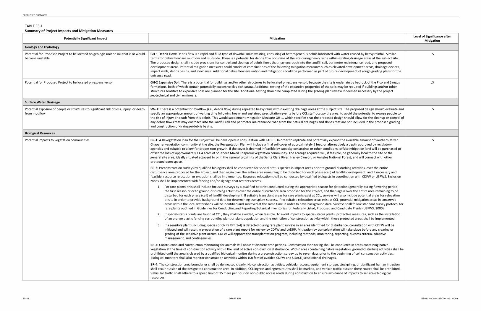
EXECUTIVE SUMMARY
TABLE ES-1 Summary of Project Impacts and Mitigation Measures
Potentially Significant Impact Mitigation Level of Significance after Mitigation
Geology and Hydrology
Potential for Proposed Project to be located on geologic unit or soil that is or would become unstable
GH-1 Debris Flow: Debris flow is a rapid and fluid type of downhill mass wasting, consisting of heterogeneous debris lubricated with water caused by heavy rainfall. Similar terms for debris flow are mudflow and mudslide. There is a potential for debris flow occurring at the site during heavy rains within existing drainage areas at the subject site. The proposed design shall include provisions for control and cleanup of debris flows that may encroach into the landfill cell, perimeter maintenance road, and proposed development areas. Potential mitigation measures could consist of combinations of the following mitigation measures such as elevated development areas, drainage devices, impact walls, debris basins, and avoidance. Additional debris flow evaluation and mitigation should be performed as part of future development of rough grading plans for the entrance road.
LS
Potential for Proposed Project to be located on expansive soil GH-2 Expansive Soil: There is a potential for buildings and/or other structures to be located on expansive soil, because the site is underlain by bedrock of the Pico and Saugus formations, both of which contain potentially expansive clay-rich strata. Additional testing of the expansive properties of the soils may be required if buildings and/or other structures sensitive to expansive soils are planned for the site. Additional testing should be completed during the grading plan review if deemed necessary by the project geotechnical and civil engineers.
LS
Surface Water Drainage
Potential exposure of people or structures to significant risk of loss, injury, or death from mudflow
SW-1: There is a potential for mudflow (i.e., debris flow) during repeated heavy rains within existing drainage areas at the subject site. The proposed design should evaluate and specify an appropriate amount of waiting time following heavy and sustained precipitation events before CCL staff occupy the area, to avoid the potential to expose people to the risk of injury or death from this debris. This would supplement Mitigation Measure GH-1, which specifies that the proposed design should allow for the cleanup or control of any debris flows that may encroach into the landfill cell and perimeter maintenance road from the natural drainages and slopes that are not included in the proposed grading and construction of drainage/debris basins.
LS
Biological Resources
Potential impacts to vegetation communities BR-1: A Revegetation Plan for the Project will be developed in consultation with LADRP. In order to replicate and potentially expand the available amount of Southern Mixed Chaparral vegetation community at the site, the Revegetation Plan will include a final soil cover of approximately 5 feet, or alternatively a depth approved by regulatory agencies and suitable to allow for proper root growth. If the cover is deemed infeasible by capacity constraints or other conditions, offsite mitigation land will be purchased to offset the loss of approximately 14.4 acres of Southern Mixed Chaparral vegetation community. The acreage acquired will, if feasible, be generally local to the site or the general site area, ideally situated adjacent to or in the general proximity of the Santa Clara River, Hasley Canyon, or Angeles National Forest, and will connect with other protected open space.
BR-2: Preconstruction surveys by qualified biologists shall be conducted for special-status species in impact areas prior to ground-disturbing activities, over the entire disturbance area proposed for the Project, and then again over the entire area remaining to be disturbed for each phase (cell) of landfill development, and if necessary and feasible, resource relocation or exclusion shall be implemented. Resource relocation shall be conducted by qualified biologists in coordination with CDFW or USFWS. Exclusion zones shall be implemented with fencing and/or signage that restricts access.
1. For rare plants, this shall include focused surveys by a qualified botanist conducted during the appropriate season for detection (generally during flowering period) the first season prior to ground-disturbing activities over the entire disturbance area proposed for the Project, and then again over the entire area remaining to be disturbed for each phase (cell) of landfill development. If suitable transplant areas for rare plants exist at CCL, surveys will also include potential areas for relocation onsite in order to provide background data for determining transplant success. If no suitable relocation areas exist at CCL, potential mitigation areas in conserved areas within the local watersheds will be identified and surveyed at the same time in order to have background data. Surveys shall follow standard survey protocol for rare plants outlined in Guidelines for Conducting and Reporting Botanical Inventories for Federally Listed, Proposed and Candidate Plants (USFWS, 2000).
2. If special-status plants are found at CCL, they shall be avoided, when feasible. To avoid impacts to special-status plants, protective measures, such as the installation of an orange plastic fencing surrounding plant or plant population and the restriction of construction activity within these protected areas shall be implemented.
3. If a sensitive plant (including species of CNPS RPR 1-4) is detected during rare plant surveys in an area identified for disturbance, consultation with CDFW will be initiated and will result in preparation of a rare plant report for review by CDFW and LADRP. Mitigation by transplantation will take place before any clearing or grading of the sensitive plant occurs. CDFW will approve the transplantation program, including methods, monitoring, reporting, success criteria, adaptive management, and contingencies.
BR-3: Construction and construction monitoring for animals will occur at discrete time periods. Construction monitoring shall be conducted in areas containing native vegetation at the time of construction activity within the limit of active construction disturbance. Within areas containing native vegetation, ground-disturbing activities shall be prohibited until the area is cleared by a qualified biological monitor during a preconstruction survey up to seven days prior to the beginning of cell construction activities. Biological monitors shall also monitor construction activities within 100 feet of avoided CDFW and USACE jurisdictional drainages.
BR-4: The construction area boundaries shall be delineated clearly. No construction activities, vehicular access, equipment storage, stockpiling, or significant human intrusion shall occur outside of the designated construction area. In addition, CCL ingress and egress routes shall be marked, and vehicle traffic outside these routes shall be prohibited. Vehicular traffic shall adhere to a speed limit of 15 miles per hour on non-public access roads during construction to ensure avoidance of impacts to sensitive biological resources.
LS
ES-26 DRAFT EIR ES092311093436SCO/ 113110004

EXECUTIVE SUMMARY
TABLE ES-1 Summary of Project Impacts and Mitigation Measures
Potentially Significant Impact Mitigation Level of Significance after Mitigation
Potential impacts to vegetation communities, Cont. BR-5: Soil or invasive plant seed transfer from clothing, shoes, or equipment shall be minimized through cleaning and monitoring of personnel or equipment transfers between sites, or prior to initial entry at CCL. Contract requirements to ensure vehicles are pressure washed and/or clean and free of soil or invasive weed seeds and other plant parts prior to entering the site will be implemented. Contracts will specify that pressure-washing of construction vehicles is to take place immediately before bringing the vehicle to CCL. The contractor will provide written documentation that the vehicles have been pressure washed or otherwise free of plant material that is checked by both CCL management and the biological monitor, who will jointly assure that this mitigation is implemented. The biological monitoring report will include a record of compliance with this measure. Within 1 year of Project approval invasive tamarisk (Tamarix spp.) located onsite will be identified and removed completely. Removed tamarisk will be disposed of in a landfill.
BR-6: Only vehicles that meet fire safety requirements shall be allowed on the construction sites. Camping, trash-burning fires, and warming fires shall be prohibited in the construction area.
BR-7: A mitigation monitoring plan that outlines how mitigation measures specified herein shall be implemented and monitored shall be prepared and approved by LADRP prior to award of any grading permit. The Plan will address mitigation for special-status plants, including management of salvaged topsoil, relocation of offsite property that could serve as permanent open space areas or a conservation easement. The Plan shall include methods, monitoring, reporting, success criteria, adaptive management, and contingencies.
LS
Potential impacts to CDFW and USACE jurisdictional areas BR-3 will be implemented.
BR-8: For potential impacts to jurisdictional waters, permits shall be obtained for the Proposed Project from USACE (Section 404, CWA) and CDFW (SAA, Section 1603); conditions of these permits would be complied with for the Proposed Project. The terms and conditions of these permits are anticipated to require mitigation consistent with “Compensatory Mitigation for Losses of Aquatic Resources; Final Rule” (USACE, EPA, Federal Register, April 10, 2008), and with CDFW requirements for SAAs. A mitigation plan may be required prior to permit issuance.
BR-9: Stationary equipment such as motors, pumps, generators, and welders shall be located a minimum of 50 feet outside CDFW and USACE jurisdictional drainages where impacts have not been permitted.
Construction staging areas, stockpiling, and equipment storage shall be located a minimum of 50 feet outside non-permitted CDFW and USACE jurisdictional drainages.
BR-10: Construction vehicles and equipment shall be checked periodically to ensure they are in proper working condition and that there shall be no potential for leaks. Refueling or lubrication of vehicles and cleaning of equipment, or other activities that involve open use of fuels, lubricants, or solvents, shall occur at least 100 feet away from CDFW and USACE jurisdictional drainages where impacts have not been permitted, and at least 50 feet from other flagged, sensitive biological resources.
BR-11: Best management practices will be implemented during construction to prevent sediment from entering into non-permitted jurisdictional drainages. Existing sedimentation basins prevent sediment-laden water from draining offsite.
BR-12: Only agency-approved pesticides, herbicides, fertilizers, dust suppressants, or other potentially harmful materials shall be applied at CCL, in accordance with relevant state and federal regulations. Rodenticides will not be used. Instead, methods that do not persist and infiltrate the natural food chain will be used for pest elimination such as trapping, gassing, etc. Sediment basins are present along all drainages at CCL, which capture run-off prior to discharging offsite. Sediment basins will continue to be regularly maintained.
LS
Potential introduction and proliferation of nuisance wildlife during operations BR-13: Construction sites and landfill operation shall be kept free of trash and litter. Food-related trash and litter shall be placed in closed containers and disposed of daily. Nuisance wildlife breeding will be discouraged at CCL by excluding cavities in buildings and/or equipment or facilities left idle for more than 6 months.
LS
Potential impacts to special-status plant species BR-1, BR-2, BR-3, BR-4, BR-5, and BR-7 will be implemented.
BR-14: Mitigation to reduce unavoidable impacts to special-status plants identified during the preconstruction surveys shall be coordinated with and approved by USFWS and CDFW and could include one or more of the following:
1. Salvaging of topsoil to store the seedbank for later spreading of the soil at a suitable location offsite or onsite
2. Relocation of the plant(s) to a suitable location offsite by a qualified botanist
3. Purchase of mitigation credits or offsite property with known populations of the affected species for inclusion in permanent open space areas or a conservation easement
LS
Potential impacts from downstream water quality changes
- Temporary indirect impacts, including erosion and sedimentation
Although no offsite impacts associated with erosion and sedimentation or urban runoff are anticipated, previously proposed mitigation measures BR-7, BR-9, BR-10, BR-11, and BR-12 will be implemented.
LS
Potential impacts to special-status amphibians Although no impacts to special status amphibians are anticipated, previously proposed mitigation measures BR-7, BR-8. BR-9, BR-10, BR-11, and BR-12 will be implemented. LS
Potential impacts to special-status reptile species BR-1, BR-2, BR-3, BR-4, and BR-7 will be implemented. LS
ES092311093436SCO/ 113110004 DRAFT EIR ES-27
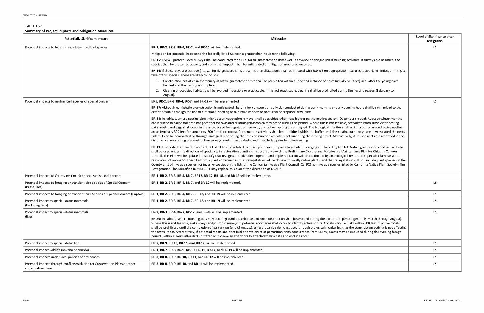
EXECUTIVE SUMMARY
TABLE ES-1 Summary of Project Impacts and Mitigation Measures
Potentially Significant Impact Mitigation Level of Significance after Mitigation
Potential impacts to federal- and state-listed bird species BR-1, BR-2, BR-3, BR-4, BR-7, and BR-12 will be implemented.
Mitigation for potential impacts to the federally listed California gnatcatcher includes the following:
BR-15: USFWS protocol-level surveys shall be conducted for all California gnatcatcher habitat well in advance of any ground-disturbing activities. If surveys are negative, the species shall be presumed absent, and no further impacts shall be anticipated or mitigation measures required.
BR-16: If the surveys are positive (i.e., California gnatcatcher is present), then discussions shall be initiated with USFWS on appropriate measures to avoid, minimize, or mitigate take of this species. These are likely to include:
1. Construction activities in the vicinity of active gnatcatcher nests shall be prohibited within a specified distance of nests (usually 500 feet) until after the young have fledged and the nesting is complete.
2. Clearing of occupied habitat shall be avoided if possible or practicable. If it is not practicable, clearing shall be prohibited during the nesting season (February to August).
LS
Potential impacts to nesting bird species of special concern BR1, BR-2, BR-3, BR-4, BR-7, and BR-12 will be implemented.
BR-17: Although no nighttime construction is anticipated, lighting for construction activities conducted during early morning or early evening hours shall be minimized to the extent possible through the use of directional shading to minimize impacts to nocturnal or crepuscular wildlife.
BR-18: In habitats where nesting birds might occur, vegetation removal shall be avoided when feasible during the nesting season (December through August); winter months are included because this area has potential for owls and hummingbirds which may breed during this period. Where this is not feasible, preconstruction surveys for nesting pairs, nests, and eggs shall occur in areas proposed for vegetation removal, and active nesting areas flagged. The biological monitor shall assign a buffer around active nesting areas (typically 300 feet for songbirds, 500 feet for raptors). Construction activities shall be prohibited within the buffer until the nesting pair and young have vacated the nests, unless it can be demonstrated through biological monitoring that the construction activity is not hindering the nesting effort. Alternatively, if unused nests are identified in the disturbance area during preconstruction surveys, nests may be destroyed or excluded prior to active nesting.
BR-19: Finished/closed landfill areas at CCL shall be revegetated to offset permanent impacts to grassland foraging and breeding habitat. Native grass species and native forbs shall be used under the direction of specialists in restoration plantings, in accordance with the Preliminary Closure and Postclosure Maintenance Plan for Chiquita Canyon Landfill. This Plan will be updated to specify that revegetation plan development and implementation will be conducted by an ecological restoration specialist familiar with restoration of native Southern California plant communities, that revegetation will be done with locally native plants, and that revegetation will not include plant species on the County’s list of invasive species nor invasive species on the lists of the California Invasive Plant Council (CalIPC) nor invasive species listed by California Native Plant Society. The Revegetation Plan identified in MM BR-1 may replace this plan at the discretion of LADRP.
LS
Potential impacts to County nesting bird species of special concern BR-1, BR-2, BR-3, BR-4, BR-7, BR12, BR-17, BR-18, and BR-19 will be implemented.
Potential impacts to foraging or transient bird Species of Special Concern (Passerines)
BR-1, BR-2, BR-3, BR-4, BR-7, and BR-12 will be implemented. LS
Potential impacts to foraging or transient bird Species of Special Concern (Raptors) BR-1, BR-2, BR-3, BR-4, BR-7, BR-12, and BR-19 will be implemented. LS
Potential impact to special-status mammals (Excluding Bats)
BR-1, BR-2, BR-3, BR-4, BR-7, BR-12, and BR-19 will be implemented. LS
Potential impact to special-status mammals (Bats)
BR-2, BR-3, BR-4, BR-7, BR-12, and BR-18 will be implemented.
BR-20: In habitats where roosting bats may occur, ground disturbance and roost destruction shall be avoided during the parturition period (generally March through August). Where this is not feasible, exit surveys and/or roost surveys of potential roost sites shall occur to identify active roosts. Construction activity within 300 feet of active roosts shall be prohibited until the completion of parturition (end of August); unless it can be demonstrated through biological monitoring that the construction activity is not affecting the active roost. Alternatively, if potential roosts are identified prior to onset of parturition, with concurrence from CDFW, roosts may be excluded during the evening forage period (within 4 hours after dark) or fitted with one-way exit doors to effectively eliminate and exclude roost.
LS
Potential impact to special-status fish BR-7, BR-9, BR-10, BR-11, and BR-12 will be implemented. LS
Potential impact wildlife movement corridors BR-1, BR-7, BR-8, BR-9, BR-10, BR-11, BR-17, and BR-19 will be implemented. LS
Potential impacts under local policies or ordinances BR-3, BR-8, BR-9, BR-10, BR-11, and BR-12 will be implemented. LS
Potential impacts through conflicts with Habitat Conservation Plans or other conservation plans
BR-3, BR-8, BR-9, BR-10, and BR-11 will be implemented. LS
ES-28 DRAFT EIR ES092311093436SCO/ 113110004
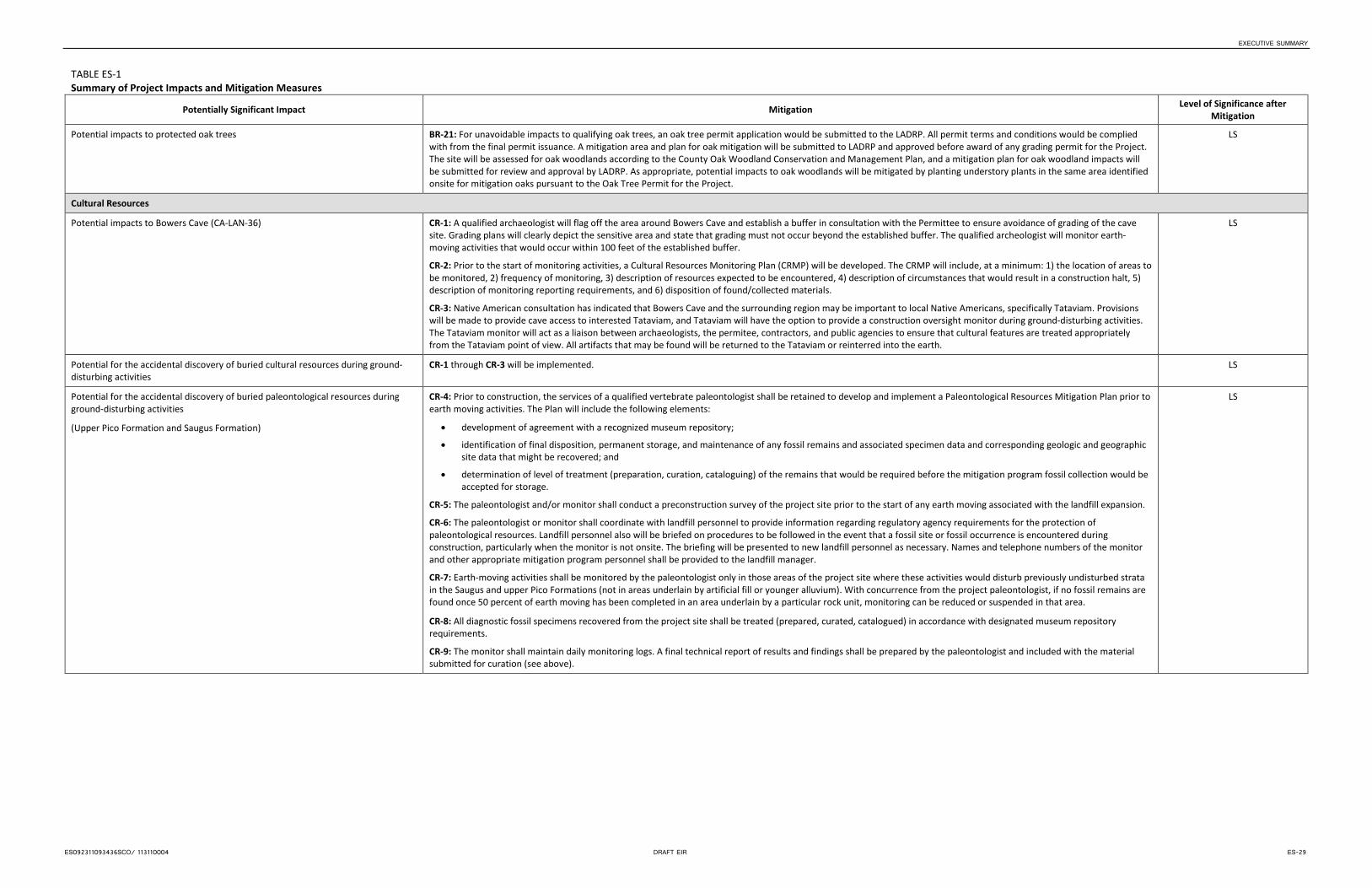
EXECUTIVE SUMMARY
TABLE ES-1 Summary of Project Impacts and Mitigation Measures
Potentially Significant Impact Mitigation Level of Significance after Mitigation
Potential impacts to protected oak trees BR-21: For unavoidable impacts to qualifying oak trees, an oak tree permit application would be submitted to the LADRP. All permit terms and conditions would be complied with from the final permit issuance. A mitigation area and plan for oak mitigation will be submitted to LADRP and approved before award of any grading permit for the Project. The site will be assessed for oak woodlands according to the County Oak Woodland Conservation and Management Plan, and a mitigation plan for oak woodland impacts will be submitted for review and approval by LADRP. As appropriate, potential impacts to oak woodlands will be mitigated by planting understory plants in the same area identified onsite for mitigation oaks pursuant to the Oak Tree Permit for the Project.
LS
Cultural Resources
Potential impacts to Bowers Cave (CA-LAN-36) CR-1: A qualified archaeologist will flag off the area around Bowers Cave and establish a buffer in consultation with the Permittee to ensure avoidance of grading of the cave site. Grading plans will clearly depict the sensitive area and state that grading must not occur beyond the established buffer. The qualified archeologist will monitor earth-moving activities that would occur within 100 feet of the established buffer.
CR-2: Prior to the start of monitoring activities, a Cultural Resources Monitoring Plan (CRMP) will be developed. The CRMP will include, at a minimum: 1) the location of areas to be monitored, 2) frequency of monitoring, 3) description of resources expected to be encountered, 4) description of circumstances that would result in a construction halt, 5) description of monitoring reporting requirements, and 6) disposition of found/collected materials.
CR-3: Native American consultation has indicated that Bowers Cave and the surrounding region may be important to local Native Americans, specifically Tataviam. Provisions will be made to provide cave access to interested Tataviam, and Tataviam will have the option to provide a construction oversight monitor during ground-disturbing activities. The Tataviam monitor will act as a liaison between archaeologists, the permitee, contractors, and public agencies to ensure that cultural features are treated appropriately from the Tataviam point of view. All artifacts that may be found will be returned to the Tataviam or reinterred into the earth.
LS
Potential for the accidental discovery of buried cultural resources during ground-disturbing activities
CR-1 through CR-3 will be implemented. LS
Potential for the accidental discovery of buried paleontological resources during ground-disturbing activities
(Upper Pico Formation and Saugus Formation)
CR-4: Prior to construction, the services of a qualified vertebrate paleontologist shall be retained to develop and implement a Paleontological Resources Mitigation Plan prior to earth moving activities. The Plan will include the following elements:
• development of agreement with a recognized museum repository;
• identification of final disposition, permanent storage, and maintenance of any fossil remains and associated specimen data and corresponding geologic and geographic site data that might be recovered; and
• determination of level of treatment (preparation, curation, cataloguing) of the remains that would be required before the mitigation program fossil collection would be accepted for storage.
CR-5: The paleontologist and/or monitor shall conduct a preconstruction survey of the project site prior to the start of any earth moving associated with the landfill expansion.
CR-6: The paleontologist or monitor shall coordinate with landfill personnel to provide information regarding regulatory agency requirements for the protection of paleontological resources. Landfill personnel also will be briefed on procedures to be followed in the event that a fossil site or fossil occurrence is encountered during construction, particularly when the monitor is not onsite. The briefing will be presented to new landfill personnel as necessary. Names and telephone numbers of the monitor and other appropriate mitigation program personnel shall be provided to the landfill manager.
CR-7: Earth-moving activities shall be monitored by the paleontologist only in those areas of the project site where these activities would disturb previously undisturbed strata in the Saugus and upper Pico Formations (not in areas underlain by artificial fill or younger alluvium). With concurrence from the project paleontologist, if no fossil remains are found once 50 percent of earth moving has been completed in an area underlain by a particular rock unit, monitoring can be reduced or suspended in that area.
CR-8: All diagnostic fossil specimens recovered from the project site shall be treated (prepared, curated, catalogued) in accordance with designated museum repository requirements.
CR-9: The monitor shall maintain daily monitoring logs. A final technical report of results and findings shall be prepared by the paleontologist and included with the material submitted for curation (see above).
LS
ES092311093436SCO/ 113110004 DRAFT EIR ES-29
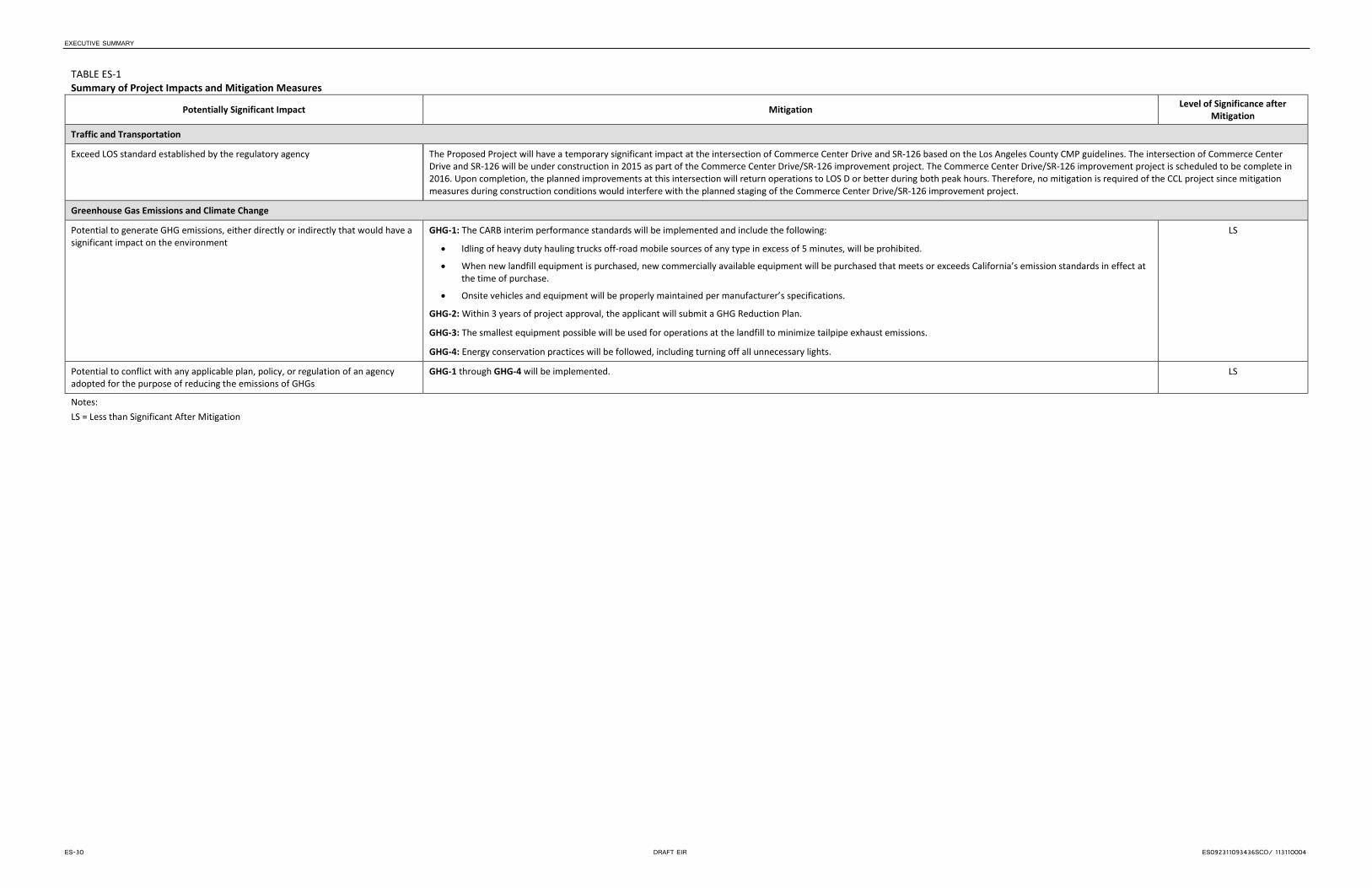
EXECUTIVE SUMMARY
TABLE ES-1 Summary of Project Impacts and Mitigation Measures
Potentially Significant Impact Mitigation Level of Significance after Mitigation
Traffic and Transportation
Exceed LOS standard established by the regulatory agency The Proposed Project will have a temporary significant impact at the intersection of Commerce Center Drive and SR-126 based on the Los Angeles County CMP guidelines. The intersection of Commerce Center Drive and SR-126 will be under construction in 2015 as part of the Commerce Center Drive/SR-126 improvement project. The Commerce Center Drive/SR-126 improvement project is scheduled to be complete in 2016. Upon completion, the planned improvements at this intersection will return operations to LOS D or better during both peak hours. Therefore, no mitigation is required of the CCL project since mitigation measures during construction conditions would interfere with the planned staging of the Commerce Center Drive/SR-126 improvement project.
Greenhouse Gas Emissions and Climate Change
Potential to generate GHG emissions, either directly or indirectly that would have a significant impact on the environment
GHG-1: The CARB interim performance standards will be implemented and include the following:
• Idling of heavy duty hauling trucks off-road mobile sources of any type in excess of 5 minutes, will be prohibited.
• When new landfill equipment is purchased, new commercially available equipment will be purchased that meets or exceeds California’s emission standards in effect at the time of purchase.
• Onsite vehicles and equipment will be properly maintained per manufacturer’s specifications.
GHG-2: Within 3 years of project approval, the applicant will submit a GHG Reduction Plan.
GHG-3: The smallest equipment possible will be used for operations at the landfill to minimize tailpipe exhaust emissions.
GHG-4: Energy conservation practices will be followed, including turning off all unnecessary lights.
LS
Potential to conflict with any applicable plan, policy, or regulation of an agency adopted for the purpose of reducing the emissions of GHGs
GHG-1 through GHG-4 will be implemented. LS
Notes: LS = Less than Significant After Mitigation
ES-30 DRAFT EIR ES092311093436SCO/ 113110004