Embed Size (px)
Citation preview

LAW
NDALE
BLVD
MISSIO
N ST
1ST
AV
E
2ND
AV
E
3RD
AV
E
VILLA ST
SYLVAN ST
LISBON ST
HO
FFM
AN S
T San Bruno MountainState and County Park
S o u t h S a n F r a n c i s c o
UnincorporatedColma
EL CAM
INO
REAL
MISSION RD
HICKEY BLVD
JUN
IPERRO SERRA BLVD
SERRAMONTE BLVD
COLLIN
S AVE
SERRAMONTE
BLVD
OLIV
ETPKWY
HILLSIDE BLVD
COLMA BLVD
ALFRED M. TEGLIABLVD
D ST D ST
C ST
E ST
F ST
ARLINGTON D
R
CLA
RK
AV
E
EL CA
MIN
OR
EAL
COLMASTATION
SOUTHSAN FRANCISCO
STATION
ColmaTown Hall
D a l y C i t y
HILLSIDE BLVD
Mixed-Use-Town Center
Mixed-Use
Commercial-Town Center
Commercial
Residential
Executive Administrative
Public
Cemetery
Town Center/Design Review Overlay
Potential Park/Open Space
Activity Node
Town Limits
Unicorporated Colma
BART
0 1000 2000
FEET
500250
Proposed Land Use
Town of Colma Land Use and Urban Design Strategy
October 2014
Prepared by


CONTENTS
1 Introduction...............................................................................................................................................................................1
1.1 Context and background reports .....................................................................................................................................1
1.2 Regional Location ..............................................................................................................................................................2
1.3 Existing Urban Design Structure .......................................................................................................................................4
1.4 Existing Land Uses..............................................................................................................................................................4
1.5 Guiding Principles ..............................................................................................................................................................6
2 Land Use Framework ................................................................................................................................................................7
2.1 Land Use Strategy ..............................................................................................................................................................8
2.2 Land Use Classifications .....................................................................................................................................................8
3 Streetscape and Key Corridors............................................................................................................................................... 11
3.1 Existing Streetscape Character and Access..................................................................................................................... 11
3.2 Street Typologies.............................................................................................................................................................. 14
4 Key Opportunity Sites ............................................................................................................................................................ 17


1
1 INTRODUCTIONThe planning staff of the Town of Colma is cur-rently preparing an update of the General Plan, and the Land Use and Urban Design Element will be a key part of the updated General Plan. This document, the Town of Colma Land Use and Urban Design Strategy, presents a guiding framework for the element, and is intended to inform and be integrated into the General Plan Update. The material presented here offers a comprehensive land use structure as well as an overall streetscape framework. It also provides illustrations of buildout scenarios possible under the land use strategy, in an effort to illustrate development scale, and show how new develop-ment will fit in the existing setting.
1.1 CONTEXT AND BACKGROUND REPORTS
The Land Use and Urban Design Strategy process began in September 2013. It consid-ers and responds to land use and urban design issues that the Town will likely encounter over the next 20 years, and offers an innovative
and informed framework for the General Plan Update. This document is the culmination of that planning effort.
In 2012, BAE Urban Economics prepared the Colma Economic Development Plan, which lays out potential strategies to address the Town’s overall land use and urban design needs. The associated actions identify the mar-ket demand for a variety of uses; however, the actions do not reflect land availability or con-straints.
In December 2013, the Existing Conditions Report was prepared as the first interim prod-uct in the development of the Strategy. It docu-mented the Town’s existing land use patterns, streetscapes, and urban design conditions, and summarized the existing development regula-tions.
In May 2014, the Draft Concepts for Land Use and Urban Design presented two alterna-tive frameworks for land use and urban design. That work was based on the information pro-
vided in the Existing Conditions Report, as well as additional field observations, discussions with Town staff, and further analysis of individ-ual opportunity sites. The material was largely informed by and consistent with the needs strat-egies outlined in the Colma Economic Plan, Phase 3: Economic Development Strategy and Action Plan.
In September 2014, the community, the Plan-ning Commission, and the Town Council responded to and provided feedback on the Draft Concepts.

TOWN OF COLMA DRAFT CONCEPTS2
1.2 REGIONAL LOCATION
Located between the cities of Daly City and South San Francisco in northern San Mateo County, the Town of Colma is 1.9 square miles, or 1,222 acres, in size. To the east lies the San Bruno Mountain State Park, and along the western border of the Town lies the junction of Highway 1 and Interstate 280. As shown on Figure 1: Regional Context, El Camino Real, or State Route 82, runs north-south through the middle of town, and BART runs underground and roughly parallel to the El Camino Real cor-ridor, with a BART station just to the north of town (Colma station, located in unincorporated San Mateo County) and to the south (South San Francisco station). The San Francisco Inter-national Airport is seven miles to the southeast, and downtown San Francisco is 12 miles to the northeast.
Colma’s General Plan was last updated almost 15 years ago. Since that time, Colma and the north San Mateo County area have changed consider-ably. BART has now been extended past Colma, and South San Francisco has developed a new transit village just south of Colma. Just south of this, and close to Colma’s southeastern bor-der, South San Francisco has approved a new El Camino Real/Chestnut Avenue Area Plan that envisions buildings rising to perhaps 150 feet in height. To the north, new high-density housing has been developed around the Colma BART station.
Figure 1: Regional Context

3
SERRAMONTE BLVD
1/2 Mi le Rad ius f rom B ART Stat ion
1/2M
i leRadius
fromB
ART
Station
LAW
NDALE
BLVD
MISSIO
N ST
HO
FFM
AN S
T
San Bruno MountainState and County Park
S o u t h S a n F r a n c i s c o
UnincorporatedColma
EL CAM
INO
REAL
MISSION RD
HICKEY BLVD
JUN
IPERRO SERRA BLVD
COLLIN
S AVE
SERRAMONTE
BLVD
HILLSIDE BLVD
COLMA BLVD
D ST
F ST
ARLINGTON D
R
ELC
AM
INO
REA
L
SOUTHSAN FRANCISCO
STATION
Landfill
ColmaTownHall
D a l y C i t y
HILLSIDE BLVD
280MetroCenter
HomeDepot
Target
I NT
ER
S TA
TE
2
80
SterlingPark
COLMASTATION
ALFRED M. TEGLIABLVD
SerraCenter
LuckyChances
Commercial
Auto-oriented Commercial
Light Industrial
Public/Institutional
Residential
Cemetery/Planned Cemetery
BART
Town Limits
Unicorporated Colma
Major Gateway
0 1000 2000
FEET
500250
Figure 2: Existing Structure

TOWN OF COLMA DRAFT CONCEPTS4
1.3 EXISTING URBAN DESIGN STRUCTURE
Figure 2 diagrams the Town’s overall exist-ing structure based on land use. It shows that almost all the residential uses lie in the Sterling Park neighborhood; that regional shopping cen-ters are generally clustered near the highway along Junipero Serra and Colma boulevards; and that auto-oriented commercial uses line the Serramonte Boulevard corridor. Along Mission Road and the south side of Collins Avenue are primarily light industrial uses, and the node at the intersection of El Camino Real and Serra-monte Boulevard contains the Town’s anchor of public uses as well as a single large commer-cial site. East of Hillside Boulevard is exclusively cemetery, golf course, and vacant land.
The major connections within the Town’s exist-ing structure are vehicular. The Town is accessed
Lucky Chances at Serramonte and Hillside boulevards attracts customers from throughout the region.
primarily through six major gateways: the Inter-state 280 Serramonte Boulevard exit; El Camino Real at F Street; El Camino Real at Arlington Drive; Hillside Boulevard at Hoffman Street; Hillside Boulevard at Lawndale Boulevard; and Mission Road at Lawndale Boulevard. Addi-tional gateways include Junipero Serra Boule-vard, south of D Street; Junipero Serra Boule-vard north of Hickey Boulevard; and Junipero Serra Boulevard at Southgate Avenue.
While two BART stations lie just outside of the Town limits, Figure 2 shows that the majority of commercial activity is not within a half-mile, or a ten-minute walk from a BART station.
1.4 EXISTING LAND USES
Figure 3: Existing Land Use shows the cur-rent uses for all parcels within the Town of Colma. Land use categories shown on Figure 3
Cemetery lawns and buildings characterize El Camino Real along the length of the Town.
are derived from the PUC (Property Use Code) within the County Assessors’ file.
Colma developed as a town of cemeteries. Open space/cemeteries dominate the Town’s land use, with 72 percent of the total land area used or dedicated for future use as cemetery or mortu-ary.
Within the remaining developable area, about 132 acres currently house commercial and light industrial uses. Commercial uses are dominated by two development types: automobile dealers along Serramonte Boulevard, which has grown into one of the most significant cluster of auto-mobile dealers in the county; and highly suc-cessful regionally-oriented retail centers—with establishments including Target and Home Depot—clustered around Junipero Serra and Colma boulevards. The Collins Avenue corri-dor—much of it much higher in elevation than Serramonte Boulevard—is lined with Auto-Ori-ented Commercial and Light Industrial/Ware-house uses. The only Commercial Recreation use, and the only significant commercial use along Hillside Boulevard outside of the Sterling Park neighborhood, is the Lucky Chances card-room.
Almost all the Town’s residential uses are clus-tered in the Sterling Park neighborhood, and outside of the Sterling Park neighborhood, pub-lic uses are concentrated at the intersection of Serramonte Boulevard and El Camino Real.

5
1
280
DALY CITY
SAN BRUNO MTN PARK (Unincorporated)
SOUTH SAN FRANCISCO
DALY CITY
UNINCORPORATEDCOLMA
ChineseCemetery
San BrunoMountain State
and CountyPark
WinstonManorPark
ColmaTown Hall
LuckyChances
Colma CreekGellertPark
HILLSIDE BLVD
STATE HIG
HWAY 82
F ST
A ST
B ST
MISSION RD
C ST
D ST
RA
DIO
RD
EVER
GREEN D
R
COLLIN
S AVE
HO
LLY
AV
E
LAW
NDALE BLV
DDUVAL D
R
COLMA BLVD
FRANCISCAN DR
HIL
L STSA
N PEDRO
RD
GARDENSID
E AVE
E ST
HO
FFM
AN S
T
OLIVET
PKWY
VALLEY ST
CLA
RK
AV
E
ARLINGTON D
R
5TH AVE
GEL
LERT
BLV
D
3RD
AV
E
2ND
AV
E
SYLVAN ST
SERRAMONTE B
LVD
CHES
TER
ST
REI
NER
ST
VILLA ST
FOR
EST
VIE
W D
R
MORNINGSIDE AVE
LON
GFO
RD D
R
HICKEY BLVD
B ST
D ST
F ST
SERRAMONTE B
LVD
F ST
SAN
D H
ILL
RD
Source: Town of Colma, 2013; San Mateo County GIS, 2013; Dyett & Bhatia, 2013.
0 1,250 2,500625Feet
Existing Land Use
Single Family Residential
Multi Family Residential
Auto-Oriented Commercial
General Commercial
Commercial Recreation
Office
Mixed Use
Light Industrial/Warehouse
Nurseries & Greenhouses
Existing/Future Cemetery, Mortuary
Public/Institutional
Park & Recreation
Driving Range
Surface Parking
Vacant
Other Uses
Colma Town Limit
Figure 3: Existing Land Uses

TOWN OF COLMA DRAFT CONCEPTS6
1.5 GUIDING PRINCIPLESThe following Guiding Principles for the Urban Design Strategy emerged from discussions and analysis. Taken together, these ideas establish the overall priorities for future development within the Town.
• A Walkable Town Center Destination. There is demand for a retail, dining, and entertainment district within the Town of Colma, and the updated General Plan should identify a location and accom-modate development scaled to suit this need. A central location that is accessible by local residents, workers, visitors, and travellers is preferred. The district should include pedestrian-oriented streets and/or paths; incorporate a density that sustains pedestrian traffic; and project a recog-nizable style or identity that is consistent with the Town’s existing Design Review Overlay Requirements.
• Community Facilities and a Cohesive Open Space Scheme. Future develop-ment should provide services for local residents near the center of town. These should include recreational open space, a public plaza, and small-scale retail, office, and dining uses. Intensification of devel-opment along and near corridors as well as a unified aesthetic will facilitate place-making for the community.
• Improved Accessibility. The updated General Plan should establish measures consistent with the San Mateo County Comprehensive Bicycle and Pedestrian Plan as well as the Town’s own priori-ties for bicycle and pedestrian accessibil-ity. A cohesive bike network, localized streetscape improvements that prioritize pedestrian movements, and building-to-street relationships that enhance the pedestrian realm will all help create an inviting urban environment.
• A Stronger Commercial Base. The Gen-eral Plan should facilitate the expansion of Colma’s existing businesses. Auto Row along Serramonte Boulevard; the Lucky Chances cardroom; and dining options for cemetery visitors, the local workforce and travelers are examples of uses that the General Plan should seek to accom-modate. A new hotel will also serve to complement and strengthen Colma’s commercial base.
A small number of additional residential uses are located at the end of Hoffman Avenue and along Mission Road.
El Camino Real is one of the most significant travel corridors in the county. However, devel-opment along this corridor is limited in Colma as it is largely fronted by cemeteries or land ded-icated for cemetery uses. Smaller neighborhood-serving commercial uses occur on the east side of El Camino Real between A Street in Daly City and F Street. Minor commercial uses and public uses including flower and monument shops occur between Colma Boulevard and Ser-ramonte Boulevard.
The most significant commercial development in the Town is between Serramonte Boulevard and Collins Avenue; at the latter intersection is a cluster of offices and banks, but also several vacant sites or buildings. Mission Road, which begins in the southern portion of the Town from El Camino Real, has a wide range of uses. New housing units anchor the south end adja-cent to the South San Francisco BART station, and a mix of auto service centers, industrial uses, office uses, residential uses, and vacant parcels extend up to the Y intersection.

7
2 LAND USE FRAMEWORKThis chapter presents the land use strategy for the Town of Colma. While exact locations of specific uses are not explicitly identified on the land use diagram, the strategy described here seeks to achieve the principles stated in Chapter 1 and accommodates the Town’s various needs that are anticipated over the next 20 years.
The land use strategy introduces new land use categories which are not currently in the Gen-eral Plan. The Mixed Use (MU) and Mixed Use-Town Center (MU-TC) designations accommo-date a mix of uses, including residential, commer-cial, executive/administrative, and public. Within these designations, active uses are required at the ground floor in order to promote an active pedestrian environment. Active ground floor uses such as restaurants, retail, and entertainment are encouraged. Active uses may also include hotel lobbies, personal service uses, small office and professional services. The MU and MU-TC des-ignations differ only in terms of maximum allow-able intensity, as determined by height and FAR.
The land use strategy also includes commercial uses; however, the commercial land use designa-
tions are simplified. In the new General Plan, all commercial districts are reduced to two separate designations: Commercial (C) and Commercial-Town Center (C-TC), which also differ only in maximum allowable FAR and height.
In addition to land uses, the strategy proposes a revised Design Review overlay district. The Design Review overlay district, which requires the incorporation of building, site, and land-scape design elements that represent the Span-ish/Mediterranean style, currently applies to the whole Town, with the exception of the Sterling Park neighborhood. The Design Review Over-lay applies along the length of the El Camino Real corridor as well as at key areas close to the BART stations and Town gateways.
Following the land use map is a summary of the development regulations (height, FAR, density, and setbacks) for each land use category, as well as a height map that applies to the MU-TC dis-trict only. The categories as described here are simplified, and may be further elaborated upon or stratified in the Land Use Element.
The land use strategy addresses the future intensity and character of key areas within the Town of Colma. The El Camino Real corridor at the north end of Town (top) and near the center of Town (bottom) are two key areas.

TOWN OF COLMA DRAFT CONCEPTS8
2.1 LAND USE STRATEGY
Figure 4: Land Use Strategy identifies the over-all land use framework for the Town of Colma. This strategy creates multiple potential mixed-use destinations within the Town as well as commercial-only areas that allow for more flex-ibility in building massing and design.
In this framework, a new compact Town Center is accommodated on the existing Kohl’s block at the southwest corner of El Camino Real and Serramonte Boulevard. Designated as Mixed-Use Town Center (MU-TC), development on this site would likely be located along new internally-focused pedestrian-oriented streets with commercial uses at the ground level and residential uses rising up to eight stories. At the same time, commercial uses facing El Camino Real project a unified identity along the boule-vard.
Alternatively, the Town Center site could poten-tially accommodate a hotel and/or a relocated cardroom—uses which would benefit from the central location and proximity to an expanded commercial sector, particularly retail and din-ing uses.
Residential uses are also permitted as part of mixed-use development at the Town’s northern and southern ends, in areas within walking dis-tance of BART stations—specifically, north of F Street and along Mission Road.
The Design Review Overlay, which applies along the length of the El Camino Real corri-dor and at key locations near BART and Town gateways, is greatly reduced in size compared to present. In areas where it no longer applies, larger-scale commercial uses, auto uses, and light-industrial uses would be permitted to show a more modern or contemporary aesthetic. Auto dealerships in particular may choose an archi-tectural style that reflects the company’s design philosophy.
2.2 LAND USE CLASSIFICATIONS
Uses and development standards within the Residential, Executive Administrative, Pub-lic, and Cemetery land use designations would remain as is under the existing General Plan. New and revised land uses are described below.
Mixed Use (MU)The new Mixed Use land use designation applies to several parcels on the east side of El Camino Real in the Sterling Park neighborhood, as well as the east side of Mission Road south of the Y. These parcels will accommodate development up to 56 feet in height and an overall FAR of up to 2.0. A range of uses is permitted, with active uses required at the ground floor and residential uses encouraged above.
City Toyota - Scion on Junipero Serra Boulevard and San Pedro Road in Daly City shows a more intense auto dealer-ship design. Its multi-story garage brings the total FAR to 1.0.
The Design Review Overlay, which requires Spanish/Med-iterranean-style building design, will continue to apply to the length of the El Camino as well as to key commercial and gateway areas throughout the Town.
LAW
NDALE
BLVD
MISSIO
N ST
1ST
AV
E
2ND
AV
E
3RD
AV
E
VILLA ST
SYLVAN ST
LISBON ST
HO
FFM
AN S
T San Bruno MountainState and County Park
S o u t h S a n F r a n c i s c o
UnincorporatedColma
EL CAM
INO
REAL
MISSION RD
HICKEY BLVD
JUN
IPERRO SERRA BLVD
SERRAMONTE BLVD
COLLIN
S AVE
SERRAMONTE
BLVD
OLIV
ETPKWY
HILLSIDE BLVD
COLMA BLVD
ALFRED M. TEGLIABLVD
D ST D ST
C ST
E ST
F ST
ARLINGTON D
R
CLA
RK
AV
E
EL CA
MIN
OR
EAL
COLMASTATION
SOUTHSAN FRANCISCO
STATION
D a l y C i t y
HILLSIDE BLVD
Mixed-Use-Town Center
Mixed-Use
Commercial-Town Center
Commercial
Residential
Executive Administrative
Public
Cemetery
Design Review Overlay
Activity Node
Town Limits
Unicorporated Colma
BART
0 1000 2000
FEET
500250
Proposed Land Use

9
LAW
NDALE
BLVD
MISSIO
N ST
1ST
AV
E
2ND
AV
E
3RD
AV
E
VILLA ST
SYLVAN ST
LISBON ST
HO
FFM
AN S
T San Bruno MountainState and County Park
S o u t h S a n F r a n c i s c o
UnincorporatedColma
EL CAM
INO
REAL
MISSION RD
HICKEY BLVD
JUN
IPERRO SERRA BLVD
SERRAMONTE BLVD
COLLIN
S AVE
SERRAMONTE
BLVD
OLIV
ETPKWY
HILLSIDE BLVD
COLMA BLVD
ALFRED M. TEGLIABLVD
D ST D ST
C ST
E ST
F ST
ARLINGTON D
R
CLA
RK
AV
E
EL CA
MIN
OR
EAL
COLMASTATION
SOUTHSAN FRANCISCO
STATION
D a l y C i t y
HILLSIDE BLVD
Mixed-Use-Town Center
Mixed-Use
Commercial-Town Center
Commercial
Residential
Executive Administrative
Public
Cemetery
Design Review Overlay
Activity Node
Town Limits
Unicorporated Colma
BART
0 1000 2000
FEET
500250
Proposed Land UseFigure 4: Land Use Strategy

TOWN OF COLMA DRAFT CONCEPTS10
Figure 5: MU-TC Height Diagram
TABLE 1: NEW LAND USE DESIGNATIONSLand Use Mixed Use (MU) Mixed Use-Town
Center (MU-TC)Commercial (C) Commercial-Town
Center (C-TC)Residential Density 20-40 du/ac 20-60 du/ac - -Maximum FAR 2.0 3.0 1.5 1.0Maximum Height (ft) 56 See Figure 2: MU-TC
Height Diagram48 36
Mixed Use-Town Center (MU-TC)The MU-TC land use designation is limited to two locations: the current Bocci site near the Colma BART station, and the Kohl’s block at the southwest corner of El Camino Real and Serramonte Boulevard. The General Plan envi-sions future development on these sites to be similar in nature to uses on the MU parcels. Height limits; however, will be context-sen-sitive, to ensure that the scale of buildings is both responsive to and respectful of neighbor-ing development.
Heights in the MU-TC district are determined by Figure 5: MU-TC Height Diagram. On the Bocci site, heights up to 72 feet are allowed, enabling development to meet the scale of the neighboring La Terrazza. The Town’s tallest heights—up to 110 feet—will be allowed on the west side of the Kohl’s block, where tall build-ings will neither obscure views of nearby hills nor detract from the rural quality of El Camino
Real. Heights are required to step down across the site to a maximum of 36 feet, so as not to overshadow existing key civic structures along El Camino Real.
Commercial (C)The Commercial land use designation applies throughout the Town, including Auto Row, shopping centers, and outlying commercial areas. This designation allows development of a commercial nature up to 1.5 FAR and 48 feet in height.
Commercial-Town Center (C-CT)The C-TC designation is limited to the com-mercial parcels along the east side of El Camino Real in the center of Town. The uses allowed are the same as those in the Commercial (C) dis-trict; however, heights are limited to 36 feet so that development will remain consistent in scale with buildings across El Camino Real, and will not overshadow existing nearby key civic struc-tures.
EL CAM
INO
REAL
COLLINS AVE
OLI
VET
PKWY
HILLSIDE BLVD
D ST
C ST
E ST
F ST
CLA
RK
AV
E
CO
LMA
BLVD
SERRAMONTE
BLVD
72 Ft
110 Ft
56 Ft
36 Ft

11
3 STREETSCAPE AND KEY CORRIDORS
This chapter discusses the Town’s existing streetscape, introduces basic streetscape typol-ogies that can be applied to the Town’s rights-of-way, and presents a new overall streetscape scheme.
3.1 EXISTING STREETSCAPE CHARACTER AND ACCESS
The proximity of the Town to Highway 1 and Interstate 280 is beneficial in providing both easy access and visibility to much of the Town’s development. Likewise, the major thorough-fares El Camino Real, Serramonte Boulevard and Junipero Serra Boulevard provide direct vehicular access to virtually all of the non-cem-etery development within the Town.
Existing roadways are not, however, generally accommodating to pedestrian traffic. Develop-ment is also not close to BART stations—no portion of Serramonte Boulevard or Collins Avenue, and only part of the Mission Road dis-trict, is within a half-mile, or a ten minute walk from BART.
Figure 6 illustrates the existing rights-of-way for several of the Town’s key roadways: Serra-monte Boulevard; El Camino Real; Collins Avenue; and Mission Road. These sections show that where sidewalks exist, they are uniformly six feet in width, and where street lighting is installed, it is uniformly a cobra-head style. A consistent street tree scheme exists only for a short distance along the west side of Mission Road south of the Y, and street parking is pro-vided only along portions of Collins Avenue and Mission Road. With the exception of a short segment of Serramonte Boulevard, there are no buffers between the sidewalk and roadway.
The sections also demonstrate a wide range of building setbacks along key corridors. While the zoning code requires a minimum of 30 feet along El Camino Real north of its intersection with Mission Road, existing setbacks vary from 20 to over 300 feet. Along Serramonte Boule-vard, setbacks vary from 20 to 200 feet. Only the west side of the Mission Road corridor maintains a narrower range, with setbacks con-sistently between 15 and 40 feet.
Colma’s key corridors, including Auto Row on Serramonte Boulevard (top) and El Camino Real near the Colma BART station (bottom) would benefit from streetscape improv-ment that enhance pedestrian accessibility and comfort.

12
Figure 6: Existing Sections of Key Roadways
59’ Right-of-Way
47’ Roadway
6'Side-walk
40’ to 100’ Setbacks 40’ to 200’ Setbacks
12'Travel
11'-6"Travel
11'-6"Travel
12'Travel
6’Side-walk
50’ Right-of-Way
38’ Roadway
6'Side-walk
Parking Travel ParkingTravel
8’ to 200’Setbacks
40’ Setbacks
6’Side-walk
62’ Right-of-Way
46’ Roadway
10’Planted
Area
20’ to 150’ Setbacks
12'Travel
11'Travel
11’Travel
12'Travel
6’Side-walk
Collins Avenue near El Camino RealTypical, Looking East
Serramonte Boulevard, east of El Camino RealTypical, Looking East
Serramonte Boulevard, west of El Camino RealTypical, Looking East
1” = 20’

13
20’ to 25’Setbacks
25’ to 330’Setbacks
126’ Right-of-Way
108’ Roadway
28’Median/
Median+Left Turn Lane
6'Side-walk
6'Side-walk
10'Shoulder/Turn Lane
10'Shoulder/Turn Lane
3'Planted
Area
3'Planted
Area
10'Travel
10'Travel
10'Travel
10'Travel
10'Travel
10'Travel
102’ Right-of-Way
46’ Roadway
12'Travel
11'Travel
11’Travel
12'Travel
60’ Right-of-Way
44’ Roadway
4’Area with
Street Trees
6’Side-walk
6’Side-walk
Parking Travel ParkingTravel
15’-40’Setbacks
El Camino Real at Serramonte BoulevardTypical, Looking North
El Camino Real, south of the Y intersectionTypical, Looking North
Mission RoadTypical, Looking North
1” = 20’
TOWN OF COLMA DRAFT CONCEPTS14
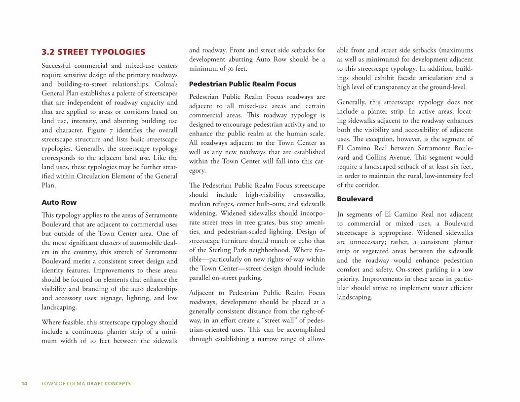
3.2 STREET TYPOLOGIES
Successful commercial and mixed-use centers require sensitive design of the primary roadways and building-to-street relationships. Colma’s General Plan establishes a palette of streetscapes that are independent of roadway capacity and that are applied to areas or corridors based on land use, intensity, and abutting building use and character. Figure 7 identifies the overall streetscape structure and lists basic streetscape typologies. Generally, the streetscape typology corresponds to the adjacent land use. Like the land uses, these typologies may be further strat-ified within Circulation Element of the General Plan.
Auto Row
This typology applies to the areas of Serramonte Boulevard that are adjacent to commercial uses but outside of the Town Center area. One of the most significant clusters of automobile deal-ers in the country, this stretch of Serramonte Boulevard merits a consistent street design and identity features. Improvements to these areas should be focused on elements that enhance the visibility and branding of the auto dealerships and accessory uses: signage, lighting, and low landscaping.
Where feasible, this streetscape typology should include a continuous planter strip of a mini-mum width of 10 feet between the sidewalk
and roadway. Front and street side setbacks for development abutting Auto Row should be a minimum of 50 feet.
Pedestrian Public Realm Focus
Pedestrian Public Realm Focus roadways are adjacent to all mixed-use areas and certain commercial areas. This roadway typology is designed to encourage pedestrian activity and to enhance the public realm at the human scale. All roadways adjacent to the Town Center as well as any new roadways that are established within the Town Center will fall into this cat-egory.
The Pedestrian Public Realm Focus streetscape should include high-visibility crosswalks, median refuges, corner bulb-outs, and sidewalk widening. Widened sidewalks should incorpo-rate street trees in tree grates, bus stop ameni-ties, and pedestrian-scaled lighting. Design of streetscape furniture should match or echo that of the Sterling Park neighborhood. Where fea-sible—particularly on new rights-of-way within the Town Center—street design should include parallel on-street parking.
Adjacent to Pedestrian Public Realm Focus roadways, development should be placed at a generally consistent distance from the right-of-way, in an effort create a “street wall” of pedes-trian-oriented uses. This can be accomplished through establishing a narrow range of allow-
able front and street side setbacks (maximums as well as minimums) for development adjacent to this streetscape typology. In addition, build-ings should exhibit facade articulation and a high level of transparency at the ground-level.
Generally, this streetscape typology does not include a planter strip. In active areas, locat-ing sidewalks adjacent to the roadway enhances both the visibility and accessibility of adjacent uses. The exception, however, is the segment of El Camino Real between Serramonte Boule-vard and Collins Avenue. This segment would require a landscaped setback of at least six feet, in order to maintain the rural, low-intensity feel of the corridor.
Boulevard
In segments of El Camino Real not adjacent to commercial or mixed uses, a Boulevard streetscape is appropriate. Widened sidewalks are unnecessary; rather, a consistent planter strip or vegetated areas between the sidewalk and the roadway would enhance pedestrian comfort and safety. On-street parking is a low priority. Improvements in these areas in partic-ular should strive to implement water efficient landscaping.
LAW
NDALE
BLVD
MISSIO
N ST
1ST
AV
E
2ND
AV
E
3RD
AV
E
VILLA ST
SYLVAN ST
LISBON ST
HO
FFM
AN S
T San Bruno MountainState and County Park
S o u t h S a n F r a n c i s c o
UnincorporatedColma
EL CAM
INO
REAL
MISSION RD
HICKEY BLVD
JUN
IPERRO SERRA BLVD
SERRAMONTE BLVD
COLLIN
S AVE
SERRAMONTE
BLVD
OLIV
ETPKWY
HILLSIDE BLVD
COLMA BLVD
ALFRED M. TEGLIABLVD
D ST D ST
C ST
E ST
F ST
ARLINGTON D
R
CLA
RK
AV
E
ELC
AM
INO
REA
L
COLMASTATION
SOUTHSAN FRANCISCO
STATION
ColmaTown Hall
D a l y C i t y
HILLSIDE BLVD
LuckyChances
280MetroCenter
Boulevard
Pedestrian Public Realm Focus
Auto Row
Activity Node
Gateway
Mixed-Use-Town Center
Mixed-Use
Commercial-Town Center
Commercial
Residential
Executive Administrative
Public
Cemetery
Town Limits
Unicorporated Colma
BART
0 1000 2000
FEET
500250
Streetscape Improvements

15
LAW
NDALE
BLVD
MISSIO
N ST
1ST
AV
E
2ND
AV
E
3RD
AV
E
VILLA ST
SYLVAN ST
LISBON ST
HO
FFM
AN S
T San Bruno MountainState and County Park
S o u t h S a n F r a n c i s c o
UnincorporatedColma
EL CAM
INO
REAL
MISSION RD
HICKEY BLVD
JUN
IPERRO SERRA BLVD
SERRAMONTE BLVD
COLLIN
S AVE
SERRAMONTE
BLVD
OLIV
ETPKWY
HILLSIDE BLVD
COLMA BLVD
ALFRED M. TEGLIABLVD
D ST D ST
C ST
E ST
F ST
ARLINGTON D
R
CLA
RK
AV
E
ELC
AM
INO
REA
L
COLMASTATION
SOUTHSAN FRANCISCO
STATION
ColmaTown Hall
D a l y C i t y
HILLSIDE BLVD
LuckyChances
280MetroCenter
Boulevard
Pedestrian Public Realm Focus
Auto Row
Activity Node
Gateway
Mixed-Use-Town Center
Mixed-Use
Commercial-Town Center
Commercial
Residential
Executive Administrative
Public
Cemetery
Town Limits
Unicorporated Colma
BART
0 1000 2000
FEET
500250
Streetscape ImprovementsFigure 7: Streetscape Structure

TOWN OF COLMA DRAFT CONCEPTS16
This page intentionally left blank.

17
4 KEY OPPORTUNITY SITES
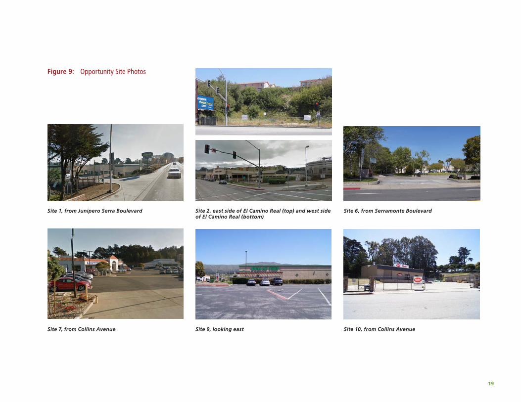
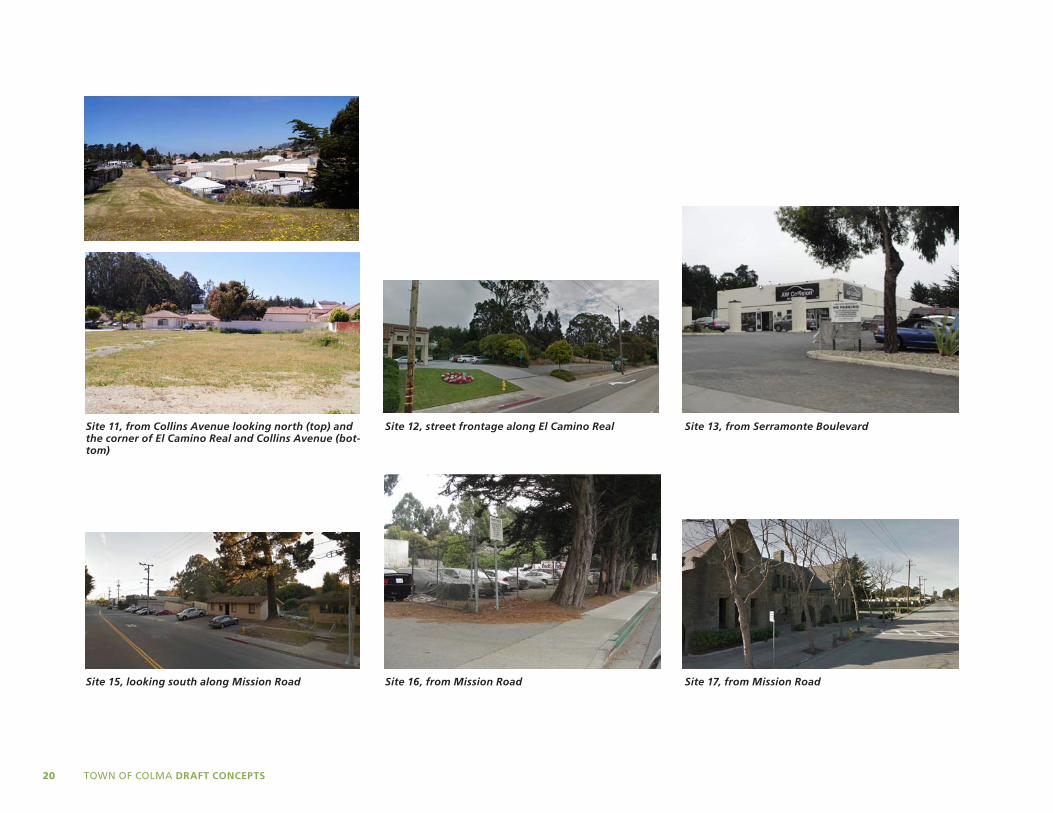
This chapter identifies all opportunity sites within Colma and presents conceptual site plans for several key sites. The opportunity sites, which are defined as vacant or underuti-lized areas which have the greatest potential to undergo a land use or intensity change, are shown on Figure 8 and described in Table 2. Figure 9, photographs of several opportunity sites folllows Figure 8.
The conceptual site plans, massing diagrams, and photosimulations that follow—figures 10 through 17—illustrate potential approaches to development on key Focus Areas which are identified in Figure 8. Overall build-out data is provided, and, unless noted, parking ratios com-ply with the Town’s existing standards. Where relevant, potential circulation and open space connections are called out. These diagrams are intended to help visualize the scale and massing of development under the proposed land uses and development regulations.
TABlE 2: OPPORTUNITY SITESSite Location Description/Tenant(s) Size (ac.)
1 3601 Junipero Serra Extra Space Storage site 5.3
2 Colma BART station area Bocci site, Sandblaster site, and former Prime Auto Detail site
1.3
3 1160 El Camino Real Vacant site adjacent to Art in Stone Memorials, por-tion east of Colma Creek only
0.2
4 Corner of Olivet Parkway and Serramonte Blvd. Parcels on the north side and south side of Olivet Parkway
1.6
5 600 Serramonte, portion along Serramonte Blvd. Serramonte Certified Used car sales 1.6
6 Northwest corner of El Camino Real and Serramonte Town Hall and Town Hall Annex site 1.8
7 1500 Collins Avenue at Junipero Serra Hyundai Serramonte site 3.7
8 600, 650, and 900 Collins Ave Parking lots and Uniake Construction 2.8
9 735 Serramonte Blvd. Dollar Tree site 2.0
10 248 Collins Ave. Standard Plumbing site 0.7
11 SW Corner of El Camino Real and Serramonte Blvd. Kohl’s site and adjacent parcels 13.1
12 The southeast corner of El Camino Real and Serramonte Vacant office building and surface parking 2.4
13 435, 445 and 455 Serramonte Blvd. Vacant former Serramonte Body Shop and existing Serramonte Auto Plaza Body Shop
8.8
14 1299 El Camino Real, southern portion Vacant part of Hills of Eternity along El Camino Real 2.3
15 Northern portion of Mission Road corridor The Y intersection between Mission Road and El Camino Real
4.9
16 1670-1692 Mission Road The triangle-shaped parcel across Mission Road from the Y intersection
3.2
17 1545/1595 Mission Road Site with historic structure in southern portion of Mission Road corridor
0.4
18 27 Colma Blvd. West half of 280 Metro Center Approx. 11

18
LAW
NDALE
BLVD
MISSIO
N ST
1ST
AV
E
2ND
AV
E
3RD
AV
E
VILLA ST
SYLVAN ST
LISBON ST
HO
FFM
AN S
T San Bruno MountainState and County Park
S o u t h S a n F r a n c i s c o
UnincorporatedColma
EL CAM
INO
REAL
MISSION RD
HICKEY BLVD
JUN
IPERRO SERRA BLVD
SERRAMONTE BLVD
COLLIN
S AVE
5TH AVE
SERRAMONTE
BLVD
OLIV
ETPKWY
HILLSIDE BLVD
COLMA BLVD
ALFRED M. TEGLIABLVD
D ST D ST
C ST
E ST
F ST
ARLINGTON D
R
CLA
RK
AV
E
EL CA
MIN
OR
EAL
COLMASTATION
SOUTHSAN FRANCISCO
STATION
EASTMOOR AVE
Cypress HillsGolf Course
ColmaTown Hall
D a l y C i t y
D a l yC i t y
HILLSIDE BLVD
Opportunity Sites
Focus Areas (massingmodel provided)
Building Footprints
Golf Course
Cemetery
BART
Town Limits
Unicorporated Colma
0 1000 2000
FEET
500250
12
1
2
3
4
56
7
8
9
10
1112
13
14
15 16
17
18
Bocci Site
South of Y
Kohl’s Block
280 Metro Center, west half
Figure 8: Opportunity Sites
19
Site 1, from Junipero Serra Boulevard Site 2, east side of El Camino Real (top) and west side of El Camino Real (bottom)
Site 6, from Serramonte Boulevard
Site 7, from Collins Avenue Site 9, looking east Site 10, from Collins Avenue
Figure 9: Opportunity Site Photos
TOWN OF COLMA DRAFT CONCEPTS20
Site 11, from Collins Avenue looking north (top) and the corner of El Camino Real and Collins Avenue (bot-tom)
Site 12, street frontage along El Camino Real Site 13, from Serramonte Boulevard
Site 15, looking south along Mission Road Site 16, from Mission Road Site 17, from Mission Road

EL CAMINO REAL ALBERT M
C ST
COLMA BART
Pedestrian-oriented commercial
Parking garage access• 8,500 SF Commercial
• 42 Residential units; 52 du/ac
• 5 Stories; 68 feet
• Total FAR = 2.4
• No commercial parking provided
EL CAMINO REAL
SER
RA
MO
NTE
BLV
D
Pedestrian-oriented retail street
Plaza/town square
Colma Creek daylighted in southern half of block
Residential units above retail and parking
TOWN HALL
• 160,000 SF Commercial
• 240 Residential units; 22 du/ac
• Max. 5 Stories; 72 feet
• Total FAR = 1.8
• Colma Creek restored aboveground
21
Figure 10: Conceptual Site Plan for the Bocci Site (west side of Opportunity Site 2)
Figure 11: Conceptual Site Plan for Town Center on Opportunity Site 11

TOWN OF COLMA DRAFT CONCEPTS22
Figure 12: Town Center Photosimulation from Eye-level

23
Figure 13: Town Center Photosimulation from Police Station Balcony

MISSION RD
ARLINGTON DR
DUVALL DR
EL CA
MIN
O R
EA
L
Two-story office buildings
Three-storyoffice building; FAR=1.0
Two and three-story commercial; FAR=1.5
Parking behind ground-floor retail; commercial above
• Mix of commercial and office
uses along Mission Road;
office uses along El Camino Real
• 2 to 3 Stories; Max 42 feet
• Structured parking
MISSION RD
EL CAMINO REAL
Residential parking
Commercial parking
Access road shared with BART easement
Pedestrian-oriented commercial uses
• 15,000 SF Commercial
• 64 Multi-family units; 22 du/acre
• 5 Stories, 56 feet
• Total FAR = 1.3
24
Figure 14: Conceptual Site Plan for Opportunity Site 15
Figure 15: Conceptual Site Plan for Opportunity Site 16

25
Figure 16: South of the Y Photosimulation (Opportunity Sites 15 and 16)

TOWN OF COLMA DRAFT CONCEPTS26
Figure 17: Conceptual Site Plan for West Half of 280 Metro Center
COLMA BLVD
JUN
IPERO
SERRA B
LVD
COLMA BLVDCOLMA BLVD
SECTION
SECTION
Existing drive aisles remain
Existing surface parking and buildings
Entrances/exits from parking garage
Plaza
Vehicular connection
Three levels of parking
• New parking garage and plaza
• 110,000 SF Net new commercial
• 46,000 SF Plaza
• 2 Story commercial; Max. 36 feet
• Three levels parking garage built into terrain
• East half of shopping center and buildings along Colma Blvd remain as is


D Y E T T & B H AT I AUrban and Reg iona l P lanners
755 Sansome Street, Suite 400San Francisco, California 94111
415 956 4300 415 956 7315


![COLMA MUNICIPAL CODE CHAPTER ONE: ORGANIZATION, … · City Council and Mayor Colma Municipal Code (October 2015) Page 1.02-5 [Reference: GOV’T CODE §36813, 54954.2] 1.02.090 Special](https://img.pdfslide.us/doc/110x75/5f225decb0a48e0be647b08d/colma-municipal-code-chapter-one-organization-city-council-and-mayor-colma-municipal.jpg)