Embed Size (px)
Citation preview

ABN 48 116 296 541
EXCHANGE RELEASE
Baobab Project Update
22 September 2015
Baobab Project positioned for an expected decision to proceed with mining in the coming months
Environmental Impact Study at final stage of approval
Water drilling MOU signed with Bauer
Expert product assessment by CRU Consulting confirms attractive specifications and premium market pricing
Infill drilling confirms the presence of a significant mineralised body within the Small Mine Permit
Minemakers Managing Director and CEO Cliff Lawrenson said, “We continue to make rapid progress towards a decision to commence mining at the Baobab Project. We are particularly pleased by the expert’s validation of our ability to deliver a potential premium product and the outstanding infill drilling results that have been achieved over the past several months. We look forward to further progress toward commencement of mining.”
Minemakers Limited (“Minemakers”) is pleased to announce a number of key achievements as the Company progresses the Baobab Rock Phosphate Project (the “Baobab Project”) towards a decision to commence mining over the next few months. The decision will ultimately be made by the board of Minemakers with reference to technical and economic information, permits and other factors at the time of such decision.
For
per
sona
l use
onl
y
Small Mine Permit The application for a Small Mine Permit (SMP) was submitted in March 2015 and was subsequently granted in May 2015, subject to the completion of an Environmental Impact Study (“EIS”) and Community Support and Relocation Plan (“CSRP”). Both the EIS and CSRP are in the final stages of approval, and are expected to be formally approved by the Senegal Government in the next few weeks. Water Drilling Preparation for water drilling is currently underway in accordance with an MOU previously signed with Bauer, the preferred drilling contractor for this task. The drill rig is now in Dakar and final review of the drilling contract is due to be completed before the end of September, with a view to commencing drilling shortly thereafter. Product Assessment and Offtake Minemakers commissioned a value in use analysis by CRU Consulting, a division of CRU International Limited, in relation to two product specifications derived from representative material gathered in technical drilling within the area of the SMP. This analysis estimates market values, FOB Dakar, for each product to various export markets and indicates premiums for both products over the Moroccan benchmark specification for producers of wet process phosphoric acid and related fertilisers. The analysis further indicates that the Brazilian and SE Asian markets offer the highest netback prices to FOB Dakar. While CRU Consulting identifies possible marketability issues and considerations with both products, Minemakers believes that these considerations are not material. Offtake discussions with potential local and export customers are progressing with samples having been provided to these parties for further assessment. Drilling Results The results of an infill drilling program conducted over the past few months has confirmed the presence of a significant body of phosphate mineralisation within the SMP. Infill drilling is to resume after a planned four week break and it is expected that by the end of 2015, Minemakers will have sufficient supporting data to enable estimation of an Indicated Resource within the SMP. The current Inferred Resource estimate stands at 25 million tonnes @ 23% P2O5, as announced on 11 May 2015. The infill program focused on the SMP area to improve the understanding of the resource and to gather samples for metallurgical testing. This program has included 53 air core holes for 2,340 metres and 61 diamond holes for 2,522 metres of drilling. While there is further drilling to complete, initial assay results have confirmed that there is a significant body of mineralisation in the north-east sector of the Project area, Area C, and that the mineralisation extends to the south and east. There is also a significant thickness of mineralisation to the east of the SMP with further drilling required to determine whether it is contiguous with the Area C mineralisation. Thick mineralisation in the north-west and south sectors of the SMP have been defined by 250 x 250 metre grid spacing and will be infilled to 125 x 125 metre grid spacing over the next 12 months. Selected mineralised intercepts are presented in Table 1 below. Details of all drilling are included in a table of material drill intercepts, included in Appendix 1. Other material information is included in the mandatory JORC 2012 Table 1, include as Appendix 2. F
or p
erso
nal u
se o
nly

Table 1. Selected drill intercepts. (Note: all drilling is vertical therefore no azimuth shown) Cliff Lawrenson Managing Director
From To Width P2O5% Fe2O3% Al2O3% MgO%
RGDD0047 340756 1645496 33 -90° 45.4 31.6 42.6 11.0 22.8 2.32 1.27 0.02
36.6 40.6 4.0 30.5 3.19 0.82 0.01
RGDD0045 340874 1645498 33 -90° 44.1 30.7 41.3 10.6 24.5 1.79 1.66 0.07
30.7 36.3 5.6 32.7 1.91 2.22 0.12
30.7 33.3 2.6 38.1 1.70 0.56 0.01
RGRC0413 340628 1645380 34 -90° 48 36 46 10 20.6 2.60 1.71 0.10
37 40 3 31.4 2.40 0.74 <0.05
RGDD0041 340995 1645249 32 -90° 45.3 34 43 9.0 27.2 3.79 1.27 0.03
35 39 4.0 31.8 2.95 0.87 0.02
38 39 1.0 36.4 1.89 0.59 0.01
RGRC0408 340503 1645625 31 -90° 48 37 46 9 24.9 1.56 2.11 0.22
38 42 4 35.8 1.19 1.10 <0.05
RGDD0092 341254 1645377 44 -90° 45 35.4 43.4 8.0 23.7 5.32 2.27 0.24
36.4 40.4 4.0 31.2 3.57 1.18 0.02
37.4 39.4 2.0 35.5 3.49 0.76 0.02
RGRC0426 341124 1645499 31 -90° 45 35 42 7 28.5 1.46 2.00 0.09
36 40 4 35.1 0.39 0.84 <0.05
37 38 1 39.4 0.19 0.48 <0.05
RGDD0089A 341369 1645379 39 -90° 44.5 35.4 42.4 7.0 26.3 1.97 1.88 0.03
37.4 41.4 4.0 30.7 1.58 1.61 0.02
38.4 39.4 1.0 38.1 1.51 0.95 <0.01
RGRC0380 341275 1644717 34 -90° 38 30 37 7 24.2 2.74 3.30 0.81
30 35 5 30.5 2.22 1.59 <0.05
31 34 3 34.4 1.12 0.89 <0.05
RGDD0088 341125 1644501 40 -90° 38 31.1 37.1 6.0 25.8 3.21 3.41 0.41
32.1 34.1 2.0 35.6 1.53 1.18 0.02
Maximum of 2 metres of internal waste excluded
Total
depth
Mineralised intercept data (average grade over width)Hole ID Easting Northing RL Dip
For
per
sona
l use
onl
y

Competent Persons’ and Qualified Person’s Statement
The scientific and technical information in this document is based on, and fairly represents, information and supporting
documentation prepared by Russell Fulton, who is the Geological Manager of the Company and a Member of the Australian Institute
of Geoscientists, and who has reviewed and approved the scientific and technical information in this document. Mr Fulton has
sufficient experience deemed relevant to the style of mineralisation and type of deposit under consideration and to the activity which
he is undertaking to qualify as a Competent Person as defined in the 2012 Edition of the ‘Australasian Code for Reporting of
Exploration Results, Mineral Resources and Ore Reserves’ and a ‘Qualified Person’ as defined in National Instrument 43-101 –
Standards of Disclosure for Mineral Projects. Mr Fulton consents to the inclusion in the report of the matters based on his information
in the form and context in which it appears.
For further information on the Senegal Phosphate Project please refer to Minemakers’ market announcements dated 27 April 2015
and 11 May 2015 (“Prior Announcements”) and the NI43-101 technical report entitled "Technical Report Mineral Resource Estimation
for the Gadde Bissik Phosphate Deposit, Republic of Senegal" dated 9 June, 2015 and available on SEDAR at www.sedar.com. .
Minemakers is not aware of any new information or data that materially affects the information included in those Prior
Announcements.
Cautionary Statement Regarding Forward-Looking Information
All statements, trend analysis and other information contained in this document relative to markets for Minemakers’ trends in
resources, recoveries, production and anticipated expense levels, as well as other statements about anticipated future events or results
constitute forward-looking statements. Forward-looking statements are often, but not always, identified by the use of words such as
“seek”, “anticipate”, “believe”, “plan”, “estimate”, “expect” and “intend” and statements that an event or result “may”, “will”, “should”,
“could” or “might” occur or be achieved and other similar expressions. Forward-looking statements are subject to business and
economic risks and uncertainties and other factors that could cause actual results of operations to differ materially from those
contained in the forward-looking statements. Forward-looking statements are based on estimates and opinions of management at
the date the statements are made. Minemakers does not undertake any obligation to update forward-looking statements even if
circumstances or management’s estimates or opinions should change. Investors should not place undue reliance on forward-looking
statements.
For
per
sona
l use
onl
y

APPENDIX 1 – Exploration Details Drilling at the Baobab Project has been continuous since recommencing in early March this year with a total of 53 air core holes (2,340 metres) and 57 diamond holes (2,385 metres) drilled. An air core drilling program on a 250 x 250 meter spaced grid was completed in late April. A small portion of thicker, higher grade mineralisation was drilled out at 125 x 125 metres grid spacing with air core drilling before switching to PQ (90mm) diameter diamond drilling. The first phase of the diamond drilling program was designed to recover core for metallurgical test work in South Africa and also to provide six additional duplicate holes to existing air core drill holes for quality assurance purposes. The second phase of the diamond program was resource definition drilling on a 125 x 125 metres grid pattern. Diamond drilling was selected as the preferred method for closer-scale infill drilling in order to provide more detailed geological information and to allow for samples for ongoing density determination as well as providing samples for marketing and more metallurgical test work if required. Drill hole locations are shown in Figure 1 and coordinates and intercept data are shown in Table 1. An additional 32 diamond holes (1,284 metres) have been completed and are analytical results are awaited. Although sample recovery in mineralisation has been more consistent in the diamond drilling than the air core drilling, a comparison of twinned air core /diamond holes indicates that there are similar average mineralisation thicknesses and phosphate grades in both types of drilling. There is no evidence of a systematic bias due to preferential sample loss or gain. Material drill hole data is included in Table 1 below.
Figure 1 – Drill hole location
Following the completion of the 250 x 250 metre program, drilling concentrated on infilling and extending one of the better mineralised areas defined by the 250 x 250 metre drilling, in the north-east sector of the SMP. A small amount of sterilisation drilling has also taken place to aid in planning of potential future mine infrastructure. Figure 2 shows the thickness of mineralisation at a cut-off grade of 5% P2O5 modelled with ordinary kriging. The data source is from drill results and from geological logging for holes that have not been
For
per
sona
l use
onl
y

analysed. Phosphate mineralisation is relatively coarse-grained and easily visible in both air core and diamond drill core. Figure 3 depicts modelling of grade x metre (5% P2O5 cut-off), used as a proxy for contained phosphate. There is generally good correlation between contained phosphate and thickness of mineralisation. The infill drilling to date has confirmed that there is a significant body of mineralisation in the north-east sector, Area C, and that the mineralisation extends to the south and east. There is also a significant thickness of mineralisation to the east of the SMP with further drilling required to determine whether it is a separate body to the SMP. Thick mineralisation in the north-west and south sectors of the SMP have been defined by 250 x 250 metre grid spacing and will be infilled to 125 x 125 metre grid spacing over the next 12 months. Mineralisation to the south of Area C has been shown to be less continuous that defined by the wider-spaced drilling. The infill drilling has continued to demonstrate the consistent and relatively simple stratigraphic succession in the Gadde Bissik area. Basal units of the Senegal Sedimentary Basin comprise a sequence limestone or dolostones which have been rarely intersected by drilling. These units are overlain by marls and local zones of nummulitic limestones and they underlie the phosphatic sediments. The contact between basement units and phosphatic sediments is commonly marked by a variably developed but distinctive ferruginous marly clay layer, uncomfortably overlaying the basement. Where present this layer generally ranges from around 1 to 3 metres in thickness. This layer typically carries low to medium grade phosphate mineralisation. The main phosphate zone comprises poorly consolidated clayey sandstone generally ranging from around two to twelve metres thick and averaging around three metres thick. Within this layer phosphate mineralisation is variably developed and occurs as soft to hard pebbles of phosphate of lime, gravels of phosphate of alumina and ferruginous gravels. In higher grade zones the phosphate generally occurs as pebbles varying from brown to beige to white. Phosphate grades range from 5% up to 38% P2O5. The main phosphate layer is typically overlain by a gravelly layer containing aluminium phosphates with P2O5 grades generally less than 5%. Where present, this layer is generally around one to rarely five metres thick. The aluminium phosphate zone is overlain by clayey sands. A schematic section through the mineralisation is depicted in Figure 4 below.
For
per
sona
l use
onl
y

Figure 2 – Modelled phosphate mineralisation thickness (5% P2O5 cut-off)
Figure 3 – Modelled grade x metre (5% P2O5 cut-off)
For
per
sona
l use
onl
y
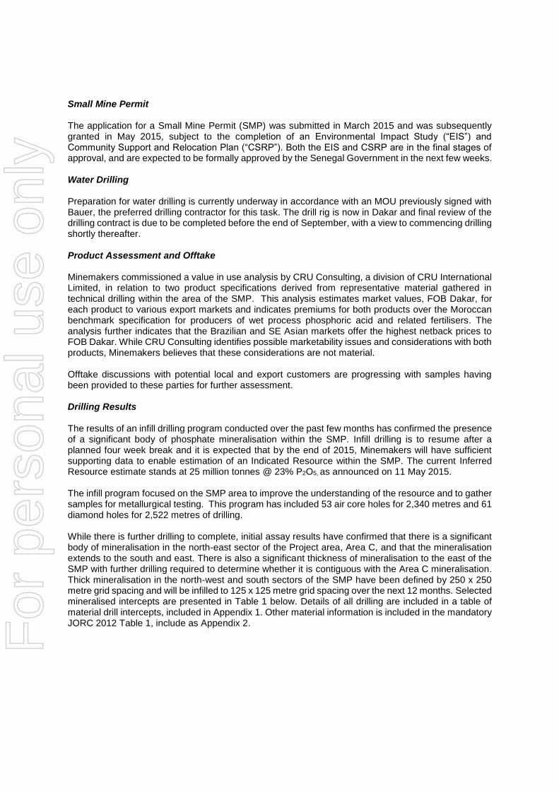
Figure 4. Schematic geological cross-section oriented north-south at approximately
345000mE. Refer to Figure 1 for collar locations. Not all drilling is shown. Table 1. Table of material drill intercepts for exploration drilling within the Small Mine Permit. Drill holes RGDC0378-0430 and RGDD0041-0101 (Note: all drilling is vertical therefore no azimuth shown)
Hole ID Easting Northing RL Dip Total depth
Mineralised intercept data (average grade over width)
From To Width P2O5% Fe2O3% Al2O3% MgO%
RGDD0047 340756 1645496 33.43 -90° 45.35 31.63 42.63 11.0 22.8 2.32 1.27 0.02
36.63 40.63 4.0 30.5 3.19 0.82 0.01
RGRC0422 340875 1645498 32.61 -90° 44 31 42 11 20.0 1.70 2.17 0.09
32 37 3 31.5 1.11 1.62 <0.05
RGDD0045 340874 1645498 32.51 -90° 44.1 30.7 41.3 10.6 24.5 1.79 1.66 0.07
30.7 36.3 5.6 32.7 1.91 2.22 0.12
30.7 33.3 2.6 38.1 1.70 0.56 0.01
RGRC0413 340628 1645380 33.98 -90° 48 36 46 10 20.6 2.60 1.71 0.10
37 40 3 31.4 2.40 0.74 <0.05
RGDD0050A 340564 1645568 42 -90° 49.0 35.5 46.38 9.9 15.7 1.89 0.99 0.02
36.38 38.38 2.0 27.4 1.25 1.37 0.02
37.38 38.38 1.0 31.9 0.98 0.69 <0.01
RGDD0098 341499 1645624 44 -90° 45.6 34.0 43.2 9.2 22.4 4.11 2.06 0.04
34.0 34.2 0.2 30.1 2.99 1.48 0.02
40.2 41.2 1.0 32.5 1.05 0.94 <0.01
RGRC0407 340625 1645754 30.73 -90° 40 28 37 9 29.8 2.56 1.04 <0.05
30 33 3 33.1 3.21 0.83 <0.05
RGDD0041 340995 1645249 32.29 -90° 45.25 33.95 42.95 9.0 27.2 3.79 1.27 0.03
34.95 38.95 4.0 31.8 2.95 0.87 0.02
37.95 38.95 1.0 36.4 1.89 0.59 0.01
For
per
sona
l use
onl
y

Hole ID Easting Northing RL Dip Total depth
Mineralised intercept data (average grade over width)
From To Width P2O5% Fe2O3% Al2O3% MgO%
RGRC0408 340503 1645625 31.23 -90° 48 37 46 9 24.9 1.56 2.11 0.22
38 42 4 35.8 1.19 1.10 <0.05
RGRC0382 341249 1644998 33.8 -90° 42 30 39 9 23.5 1.97 3.75 0.16
30 37 7 25.6 1.96 1.30 <0.05
34 35 1 30.5 2.30 1.43 <0.05
RGDD0077 340875 1644999 50 -90° 42.1 31.62 40.2 8.6 19.1 2.01 2.65 0.14
31.62 33.2 1.6 25.3 1.07 1.36 0.01
RGDD0048A 340690 1645440 46 -90° 45.9 34.9 43.4 8.5 24.8 2.59 1.07 0.02
38.4 39.4 1.0 36.1 1.33 0.61 <0.01
RGDD0068 340499 1645125 50 -90° 44.5 33.47 41.85 8.4 19.9 2.83 1.29 0.02
33.47 36.85 3.4 28.6 1.89 1.23 0.01
33.85 34.85 1 37.2 1.11 1.13 <0.01
RGDD0049A 340677 1645563 35 -90° 47.5 35.23 45.63 8.4 19.7 1.15 1.83 0.02
37.63 42.63 3.0 23.1 1.08 1.26 <0.01
40.63 41.63 1.0 28.8 1.15 0.66 <0.01
RGRC0409 340627 1645626 32.1 -90° 48 37 45 8 26.2 1.38 1.41 0.05
40 42 2 31.3 1.64 1.12 <0.05
RGDD0093 341123 1645625 40 -90° 41.1 30.7 38.7 8.0 25.3 1.12 1.44 0.02
31.7 33.7 2.0 33.1 1.16 0.95 <0.01
RGRC0395 339499 1646246 35.06 -90° 46 36 44 8 24.9 3.88 2.39 0.16
40 43 3 34.9 1.11 0.93 <0.05
RGRC0421 341000 1645374 31.84 -90° 46 35 43 8 24.0 3.00 3.11 0.40
36 38 2 30.4 0.63 1.43 <0.05
RGRC0428 341128 1645251 32.55 -90° 46 35 43 8 23.4 4.35 1.86 0.10
35 39 3 27.7 1.37 0.99 <0.05
RGDD0092 341254 1645377 44 -90° 45 35.4 43.4 8.0 23.7 5.32 2.27 0.24
36.4 40.4 4.0 31.2 3.57 1.18 0.02
37.4 39.4 2.0 35.5 3.49 0.76 0.02
RGRC0415 340749 1645376 30.91 -90° 45 34 42 8 23.0 3.65 2.54 0.15
36 41 5 28.0 1.97 1.02 <0.05
40 41 1 32.6 1.88 1.19 <0.05
RGRC0414 340625 1645248 31.92 -90° 46 35 44 8 22.1 2.72 2.11 0.10
37 39 2 27.2 2.10 1.22 <0.05
RGRC0403 340500 1646000 31.03 -90° 39 27 36 8 21.4 2.30 2.36 0.30
29 32 3 26.1 1.57 1.71 <0.05
RGDD0091 341500 1644623 41 -90° 39.5 29.65 37.65 8.0 20.5 4.32 2.56 0.25
29.65 32.65 3.0 27.2 1.35 1.12 <0.01
30.65 31.65 1.0 35.5 1.50 0.52 <0.01
RGRC0390 339751 1645499 37.53 -90° 54 43 51 8 19.5 4.69 1.11 <0.05
49 51 2 28.4 7.59 0.69 <0.05
RGRC0396 339751 1646250 36.17 -90° 45 37 45 8 19.3 2.11 1.81 <0.05
38 39 1 25.2 2.67 1.46 <0.05
RGDD0046 340811 1645560 32.87 -90° 45.6 35.28 43.28 8.0 18.0 2.04 1.60 0.05
42.28 43.28 1.0 22.8 2.21 1.70 0.03
RGDD0043A 340995 1645499 31.74 -90° 42.5 32.3 40 7.7 22.1 4.01 1.86 0.04
35 36 1.0 31.7 3.59 0.87 <0.01
RGDD0051 340625 1645628 44 -90° 47.0 37.9 45.2 7.3 26.1 1.47 1.61 0.02
40.2 42.2 2.0 31.9 1.96 1.03 <0.01
RGRC0426 341124 1645499 31.2 -90° 45 35 42 7 28.5 1.46 2.00 0.09
36 40 4 35.1 0.39 0.84 <0.05
37 38 1 39.4 0.19 0.48 <0.05
RGDD0089A 341369 1645379 39 -90° 44.5 35.36 42.36 7.0 26.3 1.97 1.88 0.03
37.36 41.36 4.0 30.7 1.58 1.61 0.02
38.36 39.36 1.0 38.1 1.51 0.95 <0.01
RGRC0380 341275 1644717 33.71 -90° 38 30 37 7 24.2 2.74 3.30 0.81
30 35 5 30.5 2.22 1.59 <0.05
For
per
sona
l use
onl
y

Hole ID Easting Northing RL Dip Total depth
Mineralised intercept data (average grade over width)
From To Width P2O5% Fe2O3% Al2O3% MgO%
31 34 3 34.4 1.12 0.89 <0.05
RGRC0430 340375 1645248 31.98 -90° 47 38 45 7 23.0 4.01 2.02 0.40
38 41 3 30.2 4.38 1.43 <0.05
RGRC0411 340626 1645496 33.32 -90° 47 37 44 7 22.3 2.34 1.88 0.06
40 44 3 26.9 2.38 1.80 0.06
RGRC0383 340501 1643751 36.18 -90° 31 22 29 7 21.4 4.42 4.20 0.26
22 27 5 23.3 1.81 1.38 <0.05
RGRC0392 339251 1645998 36.62 -90° 49 39 46 7 17.6 1.69 1.01 <0.05
45 46 1 21.7 2.34 1.00 <0.05
RGDD0078 340752 1645123 48 -90° 44.5 35.2 42.1 6.9 28.5 2.32 1.18 0.01
36.1 38.1 2.0 30.6 0.59 0.92 <0.01
RGDD0053 340628 1645752 36 -90° 38.34 28.76 35.6 6.8 30.6 2.23 1.09 0.01
29.6 30.6 1.0 38.8 1.02 0.51 <0.01
RGDD0060 341378 1645126 42 -90° 41 32.2 38.78 6.6 16.9 2.57 1.70 0.02
RGDD0076 340751 1644872 38 -90° 40.73 33.15 39.4 6.3 18.8 6.20 3.79 0.28
34.4 35.4 1.0 22.7 6.00 1.92 <0.01
RGRC0391A 339250 1645499 38.14 -90° 50 44 50 6 28.1 2.69 1.42 <0.05
47 50 3 32.0 3.17 1.05 <0.05
RGDD0088 341125 1644501 40 -90° 38 31.14 37.14 6.0 25.8 3.21 3.41 0.41
32.14 34.14 2.0 35.6 1.53 1.18 0.02
RGRC0423 340873 1645622 32.34 -90° 43 35 41 6 23.9 2.70 1.85 0.35
36 39 3 31.8 2.42 0.66 <0.05
RGDD0086 341086 1644616 40 -90° 39.51 32.35 38.36 6.0 23.0 2.94 4.17 0.24
33.35 36.35 3.0 29.3 0.95 1.71 0.03
33.35 34.35 1.0 31.9 0.93 0.91 0.03
RGRC0429 341139 1645129 32.8 -90° 43 34 40 6 21.3 2.97 2.56 0.20
35 36 1 26.6 0.71 1.08 <0.05
RGRC0427 341125 1645374 32.13 -90° 46 37 43 6 21.3 4.44 2.57 0.07
40 41 1 24.7 2.28 1.64 <0.05
RGRC0420 341002 1645123 33.06 -90° 43 35 41 6 20.1 6.07 4.51 0.50
36 40 4 25.0 6.89 2.49 0.05
RGRC0389 339752 1645248 34.46 -90° 50 41 47 6 18.9 3.55 2.33 0.06
42 45 2 23.0 3.18 1.35 <0.05
RGRC0386 339249 1644747 38.29 -90° 49 39 47 6 18.8 2.32 3.43 <0.4
44 45 1 28.0 2.63 2.29 <0.05
RGDD0096 341250 1645626 36 -90° 43.1 33.15 41.15 6.0 18.6 0.94 1.84 0.06
38.15 39.15 1.0 27.6 1.01 1.52 0.02
RGRC0416 340873 1645376 31.64 -90° 43 35 41 6 18.6 2.85 2.96 0.30
35 39 3 21.0 2.47 2.36 <0.05
RGDD0081 340874 1644754 43 -90° 36.9 27.16 33.16 6.0 18.5 8.59 2.18 0.03
27.16 29.16 2.0 28.1 1.11 2.08 0.03
RGDD0067 340624 1645000 41 -90° 44 36.27 42.3 6.0 15.6 4.02 3.81 0.25
40.3 41.3 1.0 19.3 5.30 1.66 0.02
RGRC0410 340749 1645629 32.31 -90° 46 37 43 6 14.6 2.44 2.25 0.10
38 39 1 21.7 1.48 1.58 <0.05
RGRC0425 340999 1645623 31.29 -90° 42 33 39 6 13.9 2.61 3.24 <0.05
34 35 1 19.3 2.56 2.50 <0.05
RGDD0058 341265 1644884 41 -90° 41 32.35 38.15 5.8 25.6 1.24 3.11 0.01
35.15 38.15 3 31.4 1.13 1.42 0.01
RGRC0379 341501 1644747 33.84 -90° 39 31 36 5 29.9 3.40 2.34 <0.07
31 34 3 31.8 2.39 1.49 <0.05
31 32 1 35.0 2.90 1.43 <0.05
RGDD0042 340934 1645442 31.43 -90° 42.55 33.6 39.6 5.0 22.3 3.34 2.35 0.03
37.6 38.6 1.0 27.7 3.55 1.77 0.02
RGDD0061 341500 1645125 40 -90° 42.7 35.6 40.6 5.0 20.4 5.65 1.17 0.03
35.6 36.6 1.0 35.6 0.60 0.70 <0.01
For
per
sona
l use
onl
y

Hole ID Easting Northing RL Dip Total depth
Mineralised intercept data (average grade over width)
From To Width P2O5% Fe2O3% Al2O3% MgO%
RGRC0412 340500 1645374 32.61 -90° 46 38 43 5 19.7 1.22 1.44 <0.05
38 40 2 27.2 0.58 1.43 <0.05
RGRC0394 339001 1646248 34.14 -90° 46 39 44 5 18.9 1.74 2.10 0.43
40 41 1 34.6 1.08 0.85 <0.05
RGRC0393 339250 1646251 33.32 -90° 45 38 43 5 18.4 5.19 3.96 0.39
39 42 3 21.0 3.70 2.79 <0.05
RGRC0399 340377 1645619 32.69 -90° 50 42 48 5 17.5 1.94 1.96 0.18
42 44 2 23.9 1.27 1.27 <0.05
RGDD0070 340375 1645123 37 -90° 44.4 38.21 43.24 5.0 17.2 5.20 3.84 0.54
38.21 40.24 2.0 25.4 0.91 1.71 0.01
RGDD00101 341120 1645752 35 -90° 35 28.1 33.1 5.0 16.6 2.46 2.76 0.08
29.1 30.1 1.0 21.2 2.38 2.29 0.06
RGDD0095 341496 1645373 35 -90° 46.7 38.2 43.2 5.0 13.5 0.96 2.93 0.05
38.2 39.2 1.0 20.3 0.74 3.05 0.02
RGDD0085 341004 1644624 51 -90° 37 31.29 36.29 5.0 13.4 3.32 3.40 0.49
RGDD0071 340251 1645128 49 -90° 44.3 37.63 42.51 4.9 19.7 4.69 4.15 0.24
37.63 39.51 1.9 25.0 3.25 1.88 0.01
RGDD0044A 340812 1645437 32.28 -90° 43.8 36.15 40.94 4.8 22.6 4.76 2.24 0.04
38.94 40.94 2.0 36.1 1.47 0.64 0.02
RGDD0055 341113 1645007 40 -90° 40 33.27 38 4.7 23.0 1.87 1.82 0.01
34 35 1.0 29.6 0.46 0.24 0.02
RGDD0056 341124 1644876 43 -90° 38.37 30.5 37.2 4.7 15.1 14.45 4.33 0.75
RGDD0075 340623 1644754 37 -90° 39 32.88 37 4.1 15.1 3.11 3.61 0.78
35 36 1.0 29.1 2.80 1.38 0.02
RGDD0059 341249 1645126 42 -90° 42.3 35.9 39.9 4.0 22.2 7.65 1.70 0.02
36.9 37.9 1.0 26.3 2.71 1.43 <0.01
RGDD0100 341498 1645751 42 -90° 38.5 32.55 36.55 4.0 22.0 5.81 1.59 0.06
32.55 33.55 1 33.9 1.40 1.05 0.04
RGRC0419 340753 1645258 31.29 -90° 45 39 43 4 18.3 2.57 2.29 0.10
40 41 1 26.9 0.93 1.06 <0.05
RGDD0054 340561 1645685 38 -90° 37.95 31.45 35.45 4.0 17.9 2.63 1.64 0.05
32.45 35.45 2.0 22.4 3.01 1.56 0.05
RGRC0397 340374 1645376 31.32 -90° 47 40 44 4 17.7 2.04 2.00 <0.05
43 44 1 21.2 3.14 2.38 <0.05
RGDD0083 341364 1645246 44 -90° 45.7 40 44 4.0 16.9 58.63 5.60 0.33
40 43 2.0 23.7 3.86 2.59 0.04
RGRC0402 340499 1645875 33.26 -90° 42 34 38 4 14.5 2.56 2.55 0.08
RGDD0087A 341253 1644623 45 -90° 38.6 32.75 36.75 4.0 13.8 5.36 1.82 0.04
RGRC0385 339250 1644501 34.59 -90° 44 38 42 4 9.76 2.31 2.81 0.28
41 42 1 14.8 7.51 1.12 1.12
RGDD0064 341374 1644750 44 -90° 37 31.9 35.65 3.8 18.5 3.74 4.58 0.70
31.9 33.65 1.8 26.0 0.58 1.48 0.03
RGDD0057 341081 1644766 44 -90° 38.35 32.55 36.15 3.6 19.6 1.66 2.11 0.03
35.15 36.15 1.0 31.5 2.90 1.20 0.02
RGDD0073 340499 1644876 42 -90° 43 37.91 41.17 3.3 16.6 8.32 2.00 0.04
RGDD0097 341367 1645632 42 -90° 43 36.82 39.82 3.0 21.8 0.79 1.95 0.03
37.82 38.82 1.0 30.7 0.53 1.12 0.01
RGRC0404 340625 1646004 32.41 -90° 41 36 39 3 20.9 4.39 2.67 0.20
RGDD0066 340624 1645125 39 -90° 43.9 38.55 41.55 3.0 18.7 4.18 5.15 0.65
39.55 40.55 1.0 32.3 1.77 1.17 0.06
RGRC0417 340875 1645247 32.98 -90° 46 40 43 3 17.2 4.57 3.61 0.10
41 42 1 22.7 2.96 2.16 <0.05
RGDD0080 340999 1644875 43 -90° 40 34.7 37.7 3.0 15.9 5.55 6.39 0.71
RGRC0406 340624 1645875 32.58 -90° 41 35 38 3 15.5 4.71 4.37 0.18
RGRC0424 340872 1645747 31.45 -90° 39 32 36 3 15.3 3.23 2.42 <0.05
34 35 1 22.0 2.92 1.56 <0.05
For
per
sona
l use
onl
y

Hole ID Easting Northing RL Dip Total depth
Mineralised intercept data (average grade over width)
From To Width P2O5% Fe2O3% Al2O3% MgO%
RGDD0082A 340874 1644621 46 -90° 36.7 30.32 35.32 3.0 14.8 8.92 5.56 0.62
RGRC0405 340750 1645873 29.55 -90° 35 29 32 3 13.8 2.46 2.08 0.20
RGRC0401 340375 1645871 31.95 -90° 40 33 37 3 11.3 3.21 3.07 0.25
RGRC0388 339750 1644998 35.28 -90° 47 41 44 3 10.6 11.15 1.67 <0.05
43 44 1 14.9 3.78 2.33 <0.05
RGDD0069 340374 1644998 39 -90° 41.4 36.9 39.35 2.5 13.7 3.04 2.42 0.02
RGDD0062 341375 1645003 35 -90° 41.53 38.25 40.62 2.4 13.9 5.47 7.00 1.06
38.62 39.62 1.0 17.1 4.43 2.15 0.02
RGDD0079 340876 1644876 48 -90° 41.47 36.45 39.7 2.3 15.8 7.68 6.43 1.50
RGRC0418 340875 1645123 32.3 -90° 43 30 32 2 31.5 2.29 0.81 <0.05
RGDD0065 341503 1644868 49 -90° 37.55 33.25 35.2 2.0 25.2 3.87 2.60 0.02
RGDD0094A 341376 1645496 40 -90° 45.4 35.4 37.4 2.0 23.1 1.37 1.49 0.07
36.4 37.4 1.0 31.2 1.16 1.23 0.04
RGDD0072 340377 1644874 38 -90° 42.7 39.5 41.5 2.0 16.2 5.26 6.24 1.03
39.5 40.5 1.0 21.1 5.24 1.77 0.04
RGRC0381 341254 1644491 34.68 -90° 39 34 36 2 14.9 5.34 5.53 0.95
RGRC0400 340374 1645753 33.09 -90° 41 36 38 2 12.0 2.13 2.53 <0.05
RGDD0090A 341372 1644624 38 -90° 40.7 36.58 37.58 1.0 11.4 3.27 3.45 0.05
RGDD0099 341371 1645754 43 -90° 36.5 30.75 31.75 1.0 11.3 1.90 2.46 0.07
RGRC0387 339500 1644751 33.96 -90° 45 42 43 1 9.9 6.17 8.35 2.16
RGRC0384 339250 1644250 34.64 -90° 43 40 41 1 9.4 11.3 7.61 0.18
RGDD0052 340688 1645690 52 -90° 38.45 35.2 36.2 1.0 9.1 2.27 1.98 0.04
RGDD0074 340624 1644874 37 -90° 42.35 40.25 41.25 1.0 6.6 7.12 12.90 2.87
RGDD0084A 341495 1645247 33 -90° 46 43.64 44.64 1.0 6.5 4.99 4.68 0.07
RGRC0379 341501 1644747 33.84 -90° 39 38 39 1 6.2 6.98 9.57 3.02
RGRC0398 340375 1645500 30.94 -90° 45 42 43 1 5.8 4.37 6.05 5.17
RGDD0063 341374 1644878 39 -90° 37.98 33.8 34.5 0.7 26.1 5.44 1.74 0.03
Intervals restricted to those with ≥ 10% P2O5 except for holes with a maximum grade ≤ 10% P2O5
Maximum of 2 metres of internal waste excluded
For
per
sona
l use
onl
y

Appendix 2
JORC Code, 2012 Edition – Table 1
Section 1 Sampling Techniques and Data
(Criteria in this section apply to all succeeding sections.)
Criteria JORC Code explanation Commentary
Sampling techniques
Nature and quality of sampling (e.g. cut channels, random chips, or specific specialised industry standard measurement tools appropriate to the minerals under investigation, such as down hole gamma sondes, or handheld XRF instruments, etc). These examples should not be taken as limiting the broad meaning of sampling.
Exploration and resource drilling undertaken in 2015 by BMCC, in association with Minemakers planning and program management, includes air core (AC) and diamond core (DD) drilling.
The database compiled for the current study comprises 53 AC holes for 2,340 metres and 61 DD holes for 2,552 metres of drilling, all within the Small Mine Permit at the Gadde Bissik Project. Another 32 recently completed DD holes have results pending.
AC drilling was undertaken by local contractor IDC using a track-mounted Schramm T450G reverse circulation drill rig. Diamond drilling was undertaken by local contractor Senelabo using three track-mounted drill rigs; two GEOTEC 350TB geotechnical drill rigs and a FORDIA OPTIMA geotechnical drill rig
Include reference to measures taken to ensure sample representivity and the appropriate calibration of any measurement tools or systems used.
All drilling and sampling was supervised by field geologists.
AC holes were sampled over 1 m down-hole intervals with sub-sampling generally by riffle splitting.
Diamond core was halved or quartered for assaying using a diamond saw.
Aspects of the determination of mineralisation that are Material to the Public Report.
Phosphate mineralisation is typically associated with elevated uranium grades. Hand-held radiation detection measurements were used to aid selection of intervals for assaying in AC drilling.
In cases where ‘industry standard’ work has been done this would be relatively simple (e.g. ‘reverse circulation drilling was used to obtain 1 m samples from which 3 kg was pulverised to produce a 30 g charge for fire assay’). In other cases more explanation may be required, such as where there is coarse gold that has inherent sampling problems. Unusual commodities or mineralisation types (e.g. submarine nodules) may warrant disclosure of detailed information.
All assaying was undertaken by SGS, with sample preparation in Dakar, Senegal and analysis at either Lakefield in Canada or Booysens in South Africa. DD samples from the resource area were analysed at Lakefield and AC samples were analysed at Booysens.
SGS’s sample preparation comprised oven drying and crushing of the entire sample to 75% passing -2mm. A 1.5kg sub-sample collected by riffle splitting was pulverised to 85% passing -75 microns in a ring and puck pulveriser (SGS Method PRP89, PRP94).
For
per
sona
l use
onl
y
Criteria JORC Code explanation Commentary
20g samples of pulverised material were air freighted to the analytical laboratory. A 0.2-0.5 gram sub-sample of the pulverised material was fused with lithium metaborate and analysed by XRF for P2O5, Al2O3, CaO, Fe2O3, K2O, MgO, MnO, Na2O, SiO2 and TiO2 (± Cr2O5 and V2O5). (SGS Method XRF76C,V). LOI was determined gravimetrically at 1000°C.
Drilling techniques
Drill type (e.g. core, reverse circulation, open-hole hammer, rotary air blast, auger, Bangka, sonic, etc) and details (e.g. core diameter, triple or standard tube, depth of diamond tails, face-sampling bit or other type, whether core is oriented and if so, by what method, etc).
The AC drilling utilised bit diameters of 134 to 136mm.
All diamond drilling was triple tube, at 90mm diameter with rotary mud tri-cone pre-collars through un-mineralised overburden. Diamond core was not oriented.
All Gadde Bissik drilling was vertical.
Drill sample recovery
Method of recording and assessing core and chip sample recoveries and results assessed.
Measures taken to maximise sample recovery and ensure representative nature of the samples.
Whether a relationship exists between sample recovery and grade and whether sample bias may have occurred due to preferential loss/gain of fine/coarse material.
AC sample recovery was assessed by weighing total recovered sample material. The sample recovery of around 70% is slightly less than expectations for high quality AC sampling. Reasons for this trend are unclear. Additional investigations, including further bulk density measurements are on-going.
AC samples showed with no notable association between recovery and phosphate grade.
Additional confirmation of the general reliability of AC sampling is provided by 6 twinned diamond holes which show similar average mineralisation thicknesses and phosphate grades to the paired AC holes.
Diamond core recovery measurements based on recovered lengths for core runs are available for all holes and show an average recovery of 94% for mineralised intervals, which is consistent with good quality diamond drilling.
Available information suggests that sampling is reasonably representative and does not include a systematic bias due to preferential sample loss or gain.
Logging Whether core and chip samples have been geologically and geotechnically logged to a level of detail to support appropriate Mineral Resource estimation, mining studies and metallurgical studies.
Whether logging is qualitative or quantitative in nature. Core (or costean, channel, etc) photography.
The total length and percentage of the relevant intersections logged.
AC and diamond holes were routinely geologically logged by industry standard methods with logs available for around 100% of this round of exploration drilling.
Sub-samples of AC chips were retained in chip trays. Diamond core and AC chip trays were routinely photographed.
The geological logging is qualitative in nature, and of sufficient detail to support the current interpretation.
For
per
sona
l use
onl
y
Criteria JORC Code explanation Commentary
Sub-sampling techniques and sample preparation
If core, whether cut or sawn and whether quarter, half or all core taken.
If non-core, whether riffled, tube sampled, rotary split, etc and whether sampled wet or dry.
For all sample types, the nature, quality and appropriateness of the sample preparation technique.
Quality control procedures adopted for all sub-sampling stages to maximise representivity of samples.
Measures taken to ensure that the sampling is representative of the in situ material collected, including for instance results for field duplicate/second-half sampling.
Whether sample sizes are appropriate to the grain size of the material being sampled.
AC samples were collected over 1 m down-hole intervals and generally sub-sampled with a three tier riffle splitter.
The majority of AC samples were dry, with very few samples logged as wet.
Diamond core was halved or quartered for assaying using a diamond saw.
Measures taken to ensure the representivity of AC and diamond sub-sampling include close supervision by field geologists, use of appropriate sub-sampling methods, routine cleaning of splitter and cyclones, and rigs with sufficient capacity to provide generally dry AC samples.
Information available to demonstrate the representivity of AC sub-sampling includes field duplicates and paired diamond holes.
The available information demonstrates that the sub-sampling methods and sub-sample sizes are appropriate for the grain size of the material being sampled, and provide sufficiently representative sub-samples for resource estimation.
Quality of assay data and laboratory tests
For geophysical tools, spectrometers, handheld XRF instruments, etc, the parameters used in determining the analysis including instrument make and model, reading times, calibrations factors applied and their derivation, etc.
Nature of quality control procedures adopted (e.g. standards, blanks, duplicates, external laboratory checks) and whether acceptable levels of accuracy (i.e. lack of bias) and precision have been established.
Hand-held radiation detection measurements were used to aid selection of intervals for assaying for AC samples.
Assay quality control procedures include certified reference standards and coarse blanks. These results have established acceptable levels of precision and accuracy for the attributes included in the current Inferred resource estimates.
Verification of sampling and assaying
The verification of significant intersections by either independent or alternative company personnel.
Minemakers’ Geological Manager verifies significant intersections by checking against logging and reference to adjacent drill holes and during field visits by inspection of core and drill chips and the use of a portable XRF.
The use of twinned holes. Diamond drilling includes 6 holes drilled within 10 m of AC holes. The twinned diamond and AC holes show similar mineralisation grades and thicknesses providing some confidence in the general reliability of the AC sampling.
Documentation of primary data, data entry procedures, data verification, data storage (physical and electronic) protocols.
Sample intervals and geological logs were recorded on logging sheets and subsequently entered into desk-top or lap-top computers. These logs and laboratory assay files were merged directly into a central Micromine database.
For
per
sona
l use
onl
y
Criteria JORC Code explanation Commentary
Database and geological staff routinely validate database entries with reference to original data.
The Competent Person’s independent checks of database validity included: Comparison of assay values with geological logging, comparison of assay values between nearby holes, checking for internal consistency between, and within database tables, comparisons between assay results from different sampling phases.
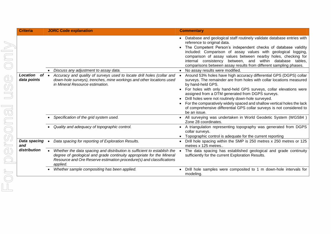
Discuss any adjustment to assay data. No assay results were modified.
Location of data points
Accuracy and quality of surveys used to locate drill holes (collar and down-hole surveys), trenches, mine workings and other locations used in Mineral Resource estimation.
Around 53% holes have high accuracy differential GPS (DGPS) collar surveys. The remainder are from holes with collar locations measured by hand-held GPS.
For holes with only hand-held GPS surveys, collar elevations were assigned from a DTM generated from DGPS surveys.
Drill holes were not routinely down-hole surveyed.
For the comparatively widely spaced and shallow vertical holes the lack of comprehensive differential GPS collar surveys is not considered to be an issue.
Specification of the grid system used. All surveying was undertaken in World Geodetic System (WGS84 ) Zone 28 coordinates.
Quality and adequacy of topographic control. A triangulation representing topography was generated from DGPS collar surveys.
Topographic control is adequate for the current reporting
Data spacing and distribution
Data spacing for reporting of Exploration Results. Drill hole spacing within the SMP is 250 metres x 250 metres or 125 metres x 125 metres..
Whether the data spacing and distribution is sufficient to establish the degree of geological and grade continuity appropriate for the Mineral Resource and Ore Reserve estimation procedure(s) and classifications applied.
The data spacing has established geological and grade continuity sufficiently for the current Exploration Results.
Whether sample compositing has been applied. Drill hole samples were composited to 1 m down-hole intervals for modeling.
For
per
sona
l use
onl
y

Criteria JORC Code explanation Commentary
Orientation of data in relation to geological structure
Whether the orientation of sampling achieves unbiased sampling of possible structures and the extent to which this is known, considering the deposit type.
If the relationship between the drilling orientation and the orientation of key mineralised structures is considered to have introduced a sampling bias, this should be assessed and reported if material.
The mineralisation is flat lying to gently undulating, and perpendicular to the generally vertical drill holes.
The drilling orientation achieves un-biased sampling of the mineralisation.
Sample security
The measures taken to ensure sample security. Sample collection for BMCC drilling was supervised by BMCC geologists using protocols established by Minemakers.
The project is in a largely rural area with easy access to the general public. AC samples selected for assaying were collected in heavy-duty polyweave plastic bags that were immediately sealed and placed inside a BMCC vehicle. The bagged samples were then taken by BMCC employees directly to the BMCC site office in the regional town of Tivaouane where they were kept under lock and key. Samples were transferred to the BMCC office in Dakar weekly where paperwork was prepared and samples then delivered directly to SGS in Dakar by BMCC personnel. No contractors or third parties were permitted unsupervised access to samples before delivery to SGS.
Core samples were taken to the BMCC site office at the end of each day. Sampling was undertaken with a core saw at the site office, samples bagged and despatched to Dakar using the same protocols as described above for AC sampling.
Results of field duplicates twinned holes, and the general consistency of results between sampling phases and drilling methods provide confidence in the general reliability of the resource data.
Audits or reviews
The results of any audits or reviews of sampling techniques and data. Data reviews have included comparisons between various sampling phases and methods which provide some confidence in the general reliability of the data.
An independent Competent Person has reviewed the quality and reliability of previous exploration data (not the data reported here). These reviews included observation of drilling and sampling, review of database consistency, spot check comparisons between original sampling sheets and database entries and comparison of laboratory source files with database entries, and review of QAQC information.
The Competent Person considers that the sample preparation, security
For
per
sona
l use
onl
y

Criteria JORC Code explanation Commentary
and analytical procedures adopted for the BMCC drilling provide an adequate basis for the future Mineral Resource estimates.
For
per
sona
l use
onl
y

Section 2 Reporting of Exploration Results
(Criteria listed in the preceding section also apply to this section.)
Criteria JORC Code explanation Commentary
Mineral tenement and land tenure status
Type, reference name/number, location and ownership including agreements or material issues with third parties such as joint ventures, partnerships, overriding royalties, native title interests, historical sites, wilderness or national park and environmental settings.
The security of the tenure held at the time of reporting along with any known impediments to obtaining a licence to operate in the area.
The Gadde Bissik project lies within BMCC’s 1553km2 Research Permit “Cherif-Lo Ngakham” in the region of Thies. The licence was renewed on 28 July 2014 for three years.
A 5km2 higher grade, more closely drilled portion, is the subject of a granted small Mine Permit (SMP) to BMCC. Minemakers has entered into an agreement with BMCC to acquire the tenement and certain fees and royalties apply, the nature of which are subject to confidentiality. The obligations in regard to fees and future royalties are not considered by the company to be commercially onerous. There are no known impediments to obtaining a licence to operate in the area.
Exploration done by other parties
Acknowledgment and appraisal of exploration by other parties. Data from an earlier phase of exploration by BMCC is not considered material to this Public Reporting.
Geology Deposit type, geological setting and style of mineralisation. Gadde Bissik phosphate mineralisation is part of the widespread marine phosphate phase within the in the Middle Eocene (48.6 to 40.4 million years) Senegalese sedimentary basin. Phosphate mineralisation in the Gadde Bissik area is predominantly a product of dismantling and reworking of primary high grade “residual” phosphate deposits and subsequent deposition under palaeo-morphological control. The “reworked” deposits at Gadde Bissik are thicker and higher grade than typically recorded in the broader area and may indicate a more proximal source resulting in a lower degree of dilution through mixing with non-phosphatic material.
The Gadde Bissik stratigraphic succession comprises a footwall of marl and marly clays, with locally overlying nummulitic limestone, discordantly overlain by the phosphatic sequences. The contact is typically marked by elevated iron levels within the marly clay. The main phosphatic unit comprises phosphate sands with hard and soft phosphate pebbles, phosphatic conglomerates and varying degrees of ferruginous gravels. The unit varies from 1 to 12 m thick with the thicker areas interpreted as lenticular or pod-like bodies. Grades vary from around 5 to 37% P2O5. Above the main phosphate unit a discontinuous layer of white gravelly aluminum phosphate is locally developed with
For
per
sona
l use
onl
y

Criteria JORC Code explanation Commentary
grades typically in the range of 1-5% P2O5 locally ranging up to 10%. Where present the layer varies from 1 to 5 m thick. The lower part of this unit grades into the main phosphatic unit in some places. The phosphatic units are overlain by clayey sands ranging from around 10 to 50 m thick.
Drill hole Information
A summary of all information material to the understanding of the exploration results including a tabulation of the following information for all Material drill holes: o easting and northing of the drill hole collar o elevation or RL (Reduced Level – elevation above sea level in
metres) of the drill hole collar o dip and azimuth of the hole o down hole length and interception depth o hole length.
If the exclusion of this information is justified on the basis that the information is not Material and this exclusion does not detract from the understanding of the report, the Competent Person should clearly explain why this is the case.
This information is presented in Appendix 1 of this Public Reporting.
Data aggregation methods
In reporting Exploration Results, weighting averaging techniques, maximum and/or minimum grade truncations (e.g. cutting of high grades) and cut-off grades are usually Material and should be stated.
Where aggregate intercepts incorporate short lengths of high grade results and longer lengths of low grade results, the procedure used for such aggregation should be stated and some typical examples of such aggregations should be shown in detail.
Drill results are reported as weighted averages using a cut-off grade of 10% P2O5 except for drill holes with no intervals above or equal to 10% P2O5.
The assumptions used for any reporting of metal equivalent values should be clearly stated.
No metal equivalents are reported here.
Relationship between mineralisation widths and intercept lengths
These relationships are particularly important in the reporting of Exploration Results.
If the geometry of the mineralisation with respect to the drill hole angle is known, its nature should be reported.
If it is not known and only the down hole lengths are reported, there should be a clear statement to this effect (e.g. ‘down hole length, true width not known’).
The mineralisation is flat lying to gently undulating, and perpendicular to the generally vertical drill holes, with down-hole lengths representing true thicknesses.
Diagrams Appropriate maps and sections (with scales) and tabulations of intercepts should be included for any significant discovery being
Included in text of announcement.
For
per
sona
l use
onl
y

Criteria JORC Code explanation Commentary
reported These should include, but not be limited to a plan view of drill hole collar locations and appropriate sectional views.
Balanced reporting
Where comprehensive reporting of all Exploration Results is not practicable, representative reporting of both low and high grades and/or widths should be practiced to avoid misleading reporting of Exploration Results.
All drill holes are reported.
Other substantive exploration data
Other exploration data, if meaningful and material, should be reported including (but not limited to): geological observations; geophysical survey results; geochemical survey results; bulk samples – size and method of treatment; metallurgical test results; bulk density, groundwater, geotechnical and rock characteristics; potential deleterious or contaminating substances.
Immersion density measurements are available for 64 diamond core samples, including 45 mineralised samples. The measurements, did not include oven-drying or wax coating and suggest an average value of around 1.8 t/m3 for mineralisation. For the current estimates, this value was discounted by around 10% reflecting the lack of wax coating and air drying giving a value of 1.6 t/bcm.
Density data is routinely collected by weighing core runs. The data has not been rigorously analysed yet but the densities are similar to those obtained by the immersion method.
Additional bulk density measurements, including and oven-drying and wax coating are planned.
Initial analyses of deleterious elements of commercial significance were conducted on samples from selected drill holes within Area C of the SMP and indicate the following:
o Cadmium levels lie between 20-50pppm o Uranium levels lie between 50-150ppm o Chlorine levels are between 50-150ppm o Mercury levels are below 0.04ppm o Lead levels are below 10ppm o Arsenic levels are below 10ppm o Organic carbon levels are below 0.2%
Analyses were carried out at ALS Vancouver on pulps supplied by BMCC retained and returned from major element analysis by SGS. The following analytical methods were used:
o Organic carbon by method C-IR06a - dissolution of carbonate with HCL (25%), Leco furnace and infrared spectroscopy.
o Chlorine by method Cl-ELE81a – Chlorine by KOH fusion and specific ion electrode
o Mercury by method Hg-MS42 – trace mercury analysis
For
per
sona
l use
onl
y

Criteria JORC Code explanation Commentary
by aqua regia digest and ICPMS finish o Fluorine by method F-ELE82 – F by ion selective
electrode after sodium peroxide fusion and citric acid leach
o Cadmium, uranium, lead and arsenic by method ME-ICP61 – HF, HHO3-HClO4 acid digestion, HCl leach and ICP-AES finish
Further analyses of exploration samples are planned.
Further work The nature and scale of planned further work (e.g. tests for lateral extensions or depth extensions or large-scale step-out drilling).
Diagrams clearly highlighting the areas of possible extensions, including the main geological interpretations and future drilling areas, provided this information is not commercially sensitive.
Further infill drilling is being carried out within and around the SMP area, as well as drilling to recover samples for metallurgical and geotechnical test work prior to any proposed mining.
Future exploration work is planned at a regional scale, starting at 4 kilometres by 4 kilometres grid spacing.
For
per
sona
l use
onl
y

Section 3 Estimation and Reporting of Mineral Resources
(Criteria listed in section 1, and where relevant in section 2, also apply to this section.)
Criteria JORC Code explanation Commentary
Database integrity
Measures taken to ensure that data has not been corrupted by, for example, transcription or keying errors, between its initial collection and its use for Mineral Resource estimation purposes.
Data validation procedures used.
No Mineral Resources are reported here.
Site visits Comment on any site visits undertaken by the Competent Person and the outcome of those visits.
If no site visits have been undertaken indicate why this is the case.
No Mineral Resources are reported here.
Geological interpretation
Confidence in (or conversely, the uncertainty of) the geological interpretation of the mineral deposit.
Nature of the data used and of any assumptions made.
The effect, if any, of alternative interpretations on Mineral Resource estimation.
The use of geology in guiding and controlling Mineral Resource estimation.
The factors affecting continuity both of grade and geology.
No Mineral Resources are reported here.
Dimensions The extent and variability of the Mineral Resource expressed as length (along strike or otherwise), plan width, and depth below surface to the upper and lower limits of the Mineral Resource.
No Mineral Resources are reported here. .
Estimation and modelling techniques
The nature and appropriateness of the estimation technique(s) applied and key assumptions, including treatment of extreme grade values, domaining, interpolation parameters and maximum distance of extrapolation from data points. If a computer assisted estimation method was chosen include a description of computer software and parameters used.
No Mineral Resources are reported here.
The availability of check estimates, previous estimates and/or mine production records and whether the Mineral Resource estimate takes appropriate account of such data.
No Mineral Resources are reported here.
The assumptions made regarding recovery of by-products.
Estimation of deleterious elements or other non-grade variables of economic significance (e.g. sulphur for acid mine drainage characterisation).
No Mineral Resources are reported here.
In the case of block model interpolation, the block size in relation to the average sample spacing and the search employed.
No Mineral Resources are reported here.
For
per
sona
l use
onl
y
Criteria JORC Code explanation Commentary
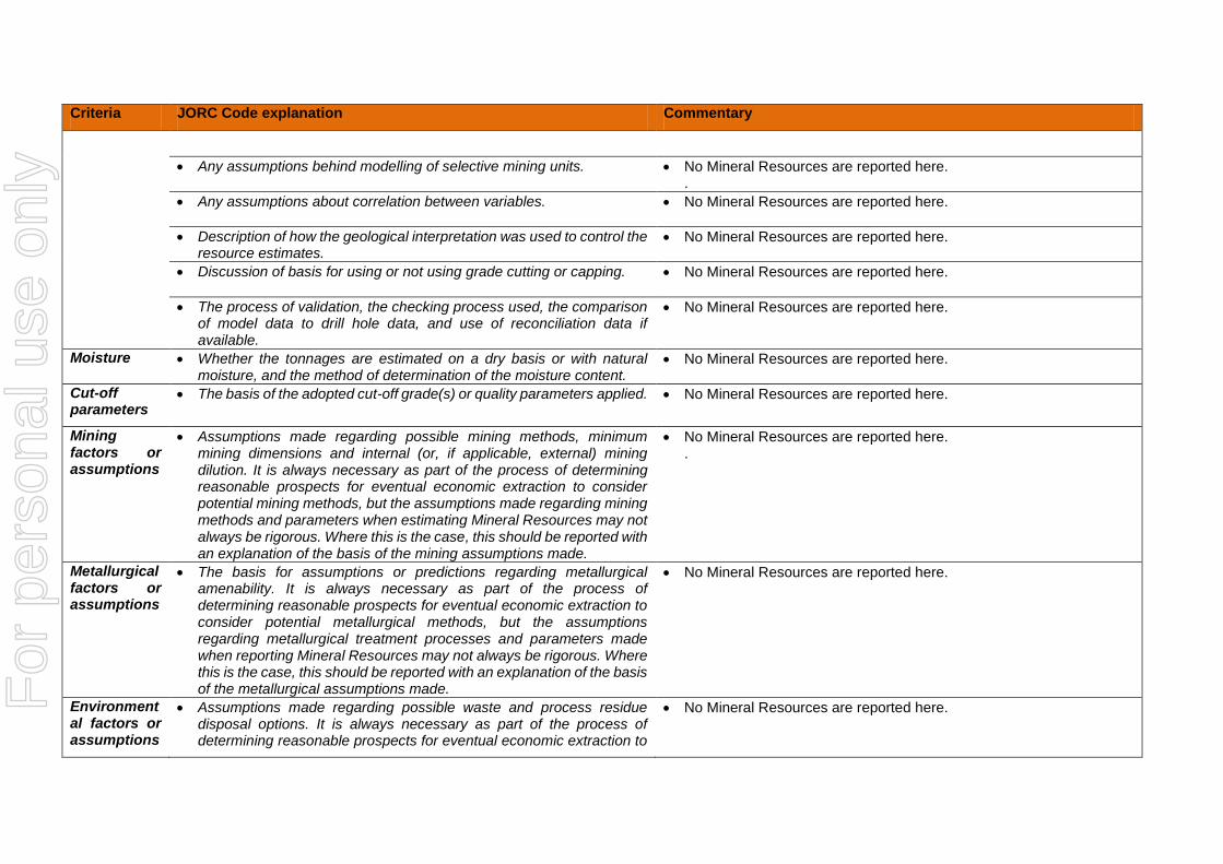
Any assumptions behind modelling of selective mining units. No Mineral Resources are reported here. .
Any assumptions about correlation between variables. No Mineral Resources are reported here.
Description of how the geological interpretation was used to control the resource estimates.
No Mineral Resources are reported here.
Discussion of basis for using or not using grade cutting or capping. No Mineral Resources are reported here.
The process of validation, the checking process used, the comparison of model data to drill hole data, and use of reconciliation data if available.
No Mineral Resources are reported here.
Moisture Whether the tonnages are estimated on a dry basis or with natural moisture, and the method of determination of the moisture content.
No Mineral Resources are reported here.
Cut-off parameters
The basis of the adopted cut-off grade(s) or quality parameters applied. No Mineral Resources are reported here.
Mining factors or assumptions
Assumptions made regarding possible mining methods, minimum mining dimensions and internal (or, if applicable, external) mining dilution. It is always necessary as part of the process of determining reasonable prospects for eventual economic extraction to consider potential mining methods, but the assumptions made regarding mining methods and parameters when estimating Mineral Resources may not always be rigorous. Where this is the case, this should be reported with an explanation of the basis of the mining assumptions made.
No Mineral Resources are reported here. .
Metallurgical factors or assumptions
The basis for assumptions or predictions regarding metallurgical amenability. It is always necessary as part of the process of determining reasonable prospects for eventual economic extraction to consider potential metallurgical methods, but the assumptions regarding metallurgical treatment processes and parameters made when reporting Mineral Resources may not always be rigorous. Where this is the case, this should be reported with an explanation of the basis of the metallurgical assumptions made.
No Mineral Resources are reported here.
Environmental factors or assumptions
Assumptions made regarding possible waste and process residue disposal options. It is always necessary as part of the process of determining reasonable prospects for eventual economic extraction to
No Mineral Resources are reported here.
For
per
sona
l use
onl
y

Criteria JORC Code explanation Commentary
consider the potential environmental impacts of the mining and processing operation. While at this stage the determination of potential environmental impacts, particularly for a greenfields project, may not always be well advanced, the status of early consideration of these potential environmental impacts should be reported. Where these aspects have not been considered this should be reported with an explanation of the environmental assumptions made.
Bulk density Whether assumed or determined. If assumed, the basis for the assumptions. If determined, the method used, whether wet or dry, the frequency of the measurements, the nature, size and representativeness of the samples.
The bulk density for bulk material must have been measured by methods that adequately account for void spaces (vugs, porosity, etc), moisture and differences between rock and alteration zones within the deposit.
Discuss assumptions for bulk density estimates used in the evaluation process of the different materials.
No Mineral Resources are reported here.
Classification
The basis for the classification of the Mineral Resources into varying confidence categories.
No Mineral Resources are reported here.
Whether appropriate account has been taken of all relevant factors (i.e. relative confidence in tonnage/grade estimations, reliability of input data, confidence in continuity of geology and metal values, quality, quantity and distribution of the data).
No Mineral Resources are reported here.
Whether the result appropriately reflects the Competent Person’s view of the deposit.
No Mineral Resources are reported here.
Audits or reviews
The results of any audits or reviews of Mineral Resource estimates. No Mineral Resources are reported here.
Discussion of relative accuracy/ confidence
Where appropriate a statement of the relative accuracy and confidence level in the Mineral Resource estimate using an approach or procedure deemed appropriate by the Competent Person. For example, the application of statistical or geostatistical procedures to quantify the relative accuracy of the resource within stated confidence limits, or, if such an approach is not deemed appropriate, a qualitative discussion of the factors that could affect the relative accuracy and confidence of the estimate.
The statement should specify whether it relates to global or local
No Mineral Resources are reported here.
For
per
sona
l use
onl
y
Criteria JORC Code explanation Commentary
estimates, and, if local, state the relevant tonnages, which should be relevant to technical and economic evaluation. Documentation should include assumptions made and the procedures used.
These statements of relative accuracy and confidence of the estimate should be compared with production data, where available.
For
per
sona
l use
onl
y


![250 250 3.79 500 500 750 O 750 1000m 1000m 7} 250 500 ......250 250 3.79 500 500 750 O 750 1000m 1000m 7} 250 500 750 O 1000m 15—30 ; 0 2.5 5 km C] t— N 250 O x-x 1 71 15kgCÿ0](https://img.pdfslide.us/doc/110x75/60130bdc4f651657181d83e9/250-250-379-500-500-750-o-750-1000m-1000m-7-250-500-250-250-379-500-500.jpg)


![INDEX [d18rn0p25nwr6d.cloudfront.net]d18rn0p25nwr6d.cloudfront.net/CIK-0000012927/94553d8b... · 2019. 4. 24. · Net earnings $2,149 $2,477 Basic earnings per share $3.79 $4.19 Diluted](https://img.pdfslide.us/doc/110x75/60c72e870b3c3042e809ae50/index-2019-4-24-net-earnings-2149-2477-basic-earnings-per-share-379.jpg)


![RAILROAD COMMISSION OF TEXAS H D · Similarly, a gas well is defined in 16 Tex. Admin. Code § 3.79(11) (“Statewide Rule” 3.79[11]) as any well: A. Which produces natural gas](https://img.pdfslide.us/doc/110x75/5f0f2fdc7e708231d442eafb/railroad-commission-of-texas-h-d-similarly-a-gas-well-is-defined-in-16-tex-admin.jpg)