Embed Size (px)
Citation preview
Downtown Design Professionals Workgroup
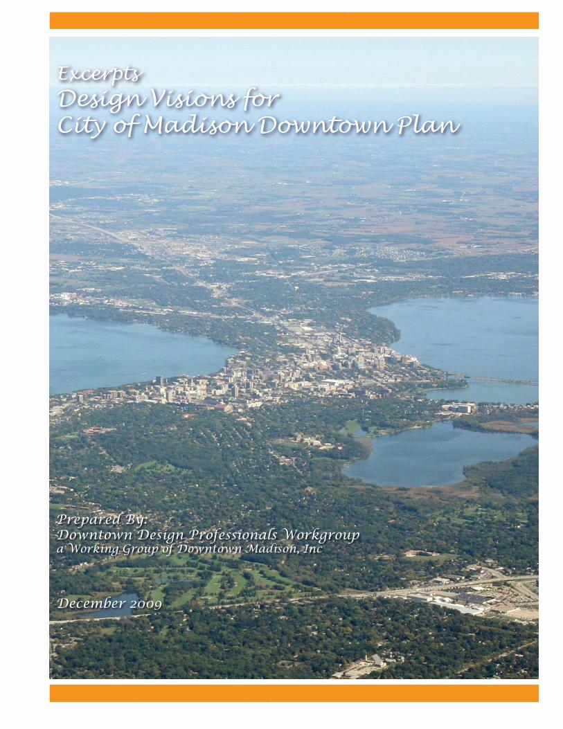
Design Visions for City of Madison Downtown Plan
1
Design Visions for City of Madison Downtown Plan
Prepared By:Downtown Design Professionals Workgroupa Working Group of Downtown Madison, Inc
December 2009
D iExcerpts
Downtown Design Professionals Workgroup
Design Visions for City of Madison Downtown Plan
2
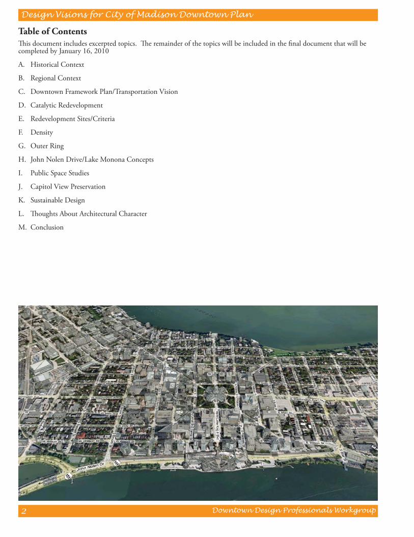
Table of Contents Th is document includes excerpted topics. Th e remainder of the topics will be included in the fi nal document that will be completed by January 16, 2010
A. Historical Context
B. Regional Context
C. Downtown Framework Plan/Transportation Vision
D. Catalytic Redevelopment
E. Redevelopment Sites/Criteria
F. Density
G. Outer Ring
H. John Nolen Drive/Lake Monona Concepts
I. Public Space Studies
J. Capitol View Preservation
K. Sustainable Design
L. Th oughts About Architectural Character
M. Conclusion
Downtown Design Professionals Workgroup
Design Visions for City of Madison Downtown Plan
3
Introduction
Th e Downtown Design Professionals workgroup was created by Downtown Madison. Inc. (DMI) to serve as a resource to the City of Madison in the development of a comprehensive Downtown Master Plan. Tim Anderson, Principal of Schreiber Anderson Associates and long standing member of the DMI Board of Directors, chaired this eff ort and assembled a team of downtown professionals with expertise in architecture, landscape architecture, urban planning, urban design, historic preservation and real estate development. Th is group, which also shared a collective knowledge, commitment and passion for Downtown Madison, volunteered to meet monthly, starting in April 2008, to generate ideas, identify issues, and critically evaluate alternatives to assist the city staff in creating a comprehensive and compelling vision for Downtown Madison for the next 20 years. Th e work of the Downtown Design Professionals was informed by critical issues and opportunities identifi ed in the City-sponsored public meetings as well as the group’s individual and collective insights on what is needed to create an exciting, vibrant and successful Downtown. Th e work of the Downtown Design Professionals was guided by the following key goals:
• Create a bold and exciting vision.• Build on Downtown’s historical and regional context.• Identify catalytic opportunities that stimulate economic development and jobs growth.• Promote density, place making and sustainable design.• Create a multi-modal transportation vision that enhances the Downtown’s pedestrian experience.• Improve connections to our lakes.
Th is document is not intended to be a plan. Rather, it is a compilation of planning and design ideas and principles that can inform the preparation of the Downtown Plan. It is our hope that ideas contained in this document will inspire the Madison community about the potential future of Downtown Madison. Th e Downtown Plan is a once in 20 year opportunity to make a bold statement about our future and what kind of place we want our downtown to be. We can succeed if we work together.
Acknowledgements
Th e following design professionals participated in the preparation of design visions included in this document.
Tim Anderson, Schreiber Anderson Associates
Phil Lewis, Phil Lewis Design Center
Doug Kozel, KEE Architecture
Kevin Pomeroy, 1000 Friends of Wisconsin
Gary Peterson, Sustainable Design Solutions
Steve Steinhoff Arlan Kay, Architecture Network
Amy Hasselman, Architecture Network
Ed Linville, Linville Design
Dan Williams, JJRChristine Chambliss, BWZ Architects
Mary Roley, UW Landscape Architecture student
Lucas Dailey, Logical Consensus
Brian Weingold, We-Design-Partners

Downtown Design Professionals Workgroup
Design Visions for City of Madison Downtown Plan
4
Downtown Design Professionals Workgroup
Design Visions for City of Madison Downtown Plan
5
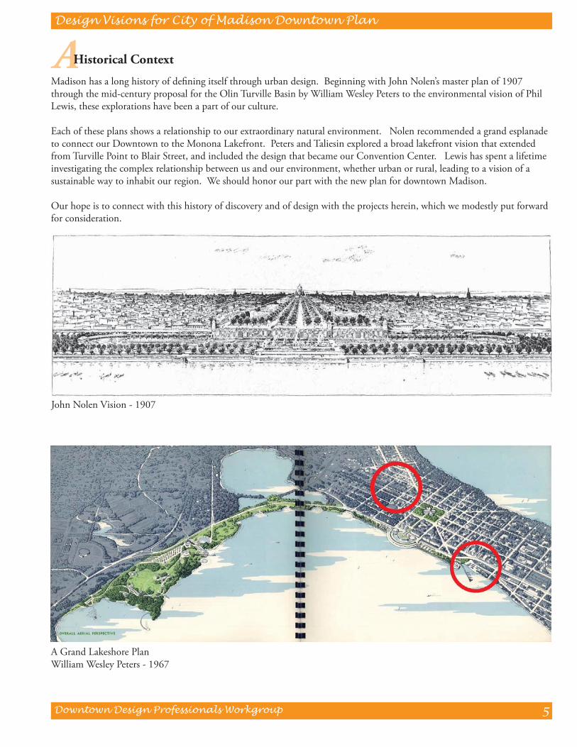
A Historical Context
Madison has a long history of defi ning itself through urban design. Beginning with John Nolen’s master plan of 1907 through the mid-century proposal for the Olin Turville Basin by William Wesley Peters to the environmental vision of Phil Lewis, these explorations have been a part of our culture.
Each of these plans shows a relationship to our extraordinary natural environment. Nolen recommended a grand esplanade to connect our Downtown to the Monona Lakefront. Peters and Taliesin explored a broad lakefront vision that extended from Turville Point to Blair Street, and included the design that became our Convention Center. Lewis has spent a lifetime investigating the complex relationship between us and our environment, whether urban or rural, leading to a vision of a sustainable way to inhabit our region. We should honor our part with the new plan for downtown Madison.
Our hope is to connect with this history of discovery and of design with the projects herein, which we modestly put forward for consideration.
John Nolen Vision - 1907
A Grand Lakeshore PlanWilliam Wesley Peters - 1967
Downtown Design Professionals Workgroup
Design Visions for City of Madison Downtown Plan
6
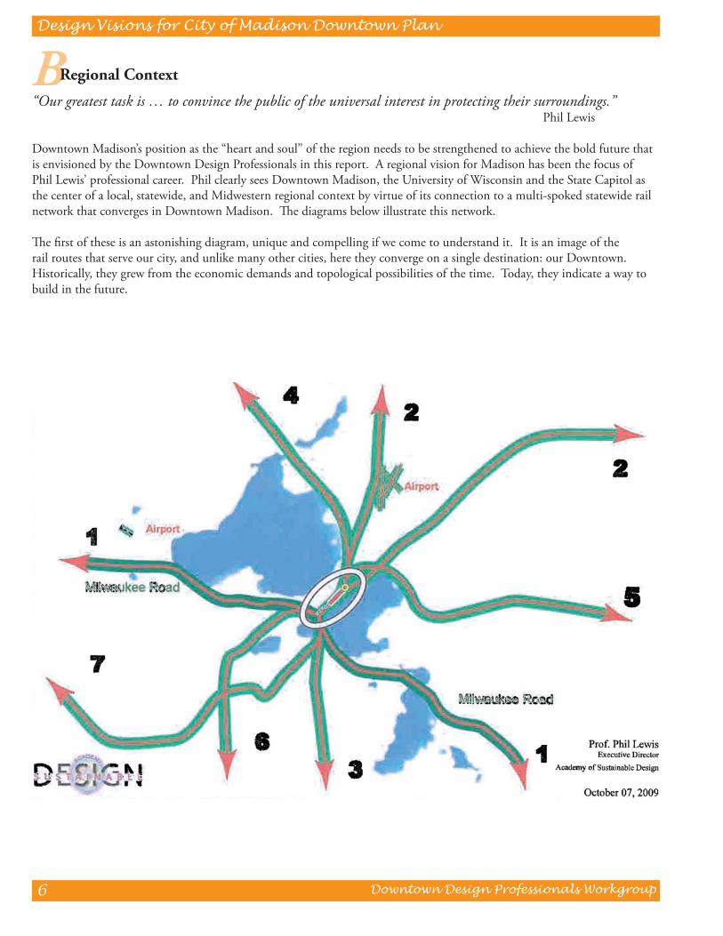
B Regional Context
“Our greatest task is … to convince the public of the universal interest in protecting their surroundings.” Phil Lewis
Downtown Madison’s position as the “heart and soul” of the region needs to be strengthened to achieve the bold future that is envisioned by the Downtown Design Professionals in this report. A regional vision for Madison has been the focus of Phil Lewis’ professional career. Phil clearly sees Downtown Madison, the University of Wisconsin and the State Capitol as the center of a local, statewide, and Midwestern regional context by virtue of its connection to a multi-spoked statewide rail network that converges in Downtown Madison. Th e diagrams below illustrate this network.
Th e fi rst of these is an astonishing diagram, unique and compelling if we come to understand it. It is an image of the rail routes that serve our city, and unlike many other cities, here they converge on a single destination: our Downtown. Historically, they grew from the economic demands and topological possibilities of the time. Today, they indicate a way to build in the future.
Downtown Design Professionals Workgroup
Design Visions for City of Madison Downtown Plan
7
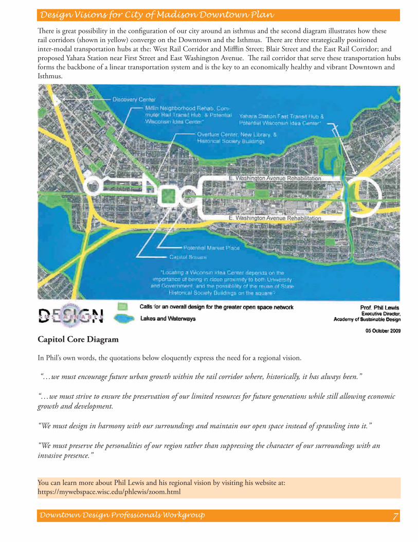
Th ere is great possibility in the confi guration of our city around an isthmus and the second diagram illustrates how these rail corridors (shown in yellow) converge on the Downtown and the Isthmus. Th ere are three strategically positioned inter-modal transportation hubs at the: West Rail Corridor and Miffl in Street; Blair Street and the East Rail Corridor; and proposed Yahara Station near First Street and East Washington Avenue. Th e rail corridor that serve these transportation hubs forms the backbone of a linear transportation system and is the key to an economically healthy and vibrant Downtown and Isthmus.
Capitol Core Diagram
In Phil’s own words, the quotations below eloquently express the need for a regional vision.
“…we must encourage future urban growth within the rail corridor where, historically, it has always been.”
“…we must strive to ensure the preservation of our limited resources for future generations while still allowing economic growth and development.
“We must design in harmony with our surroundings and maintain our open space instead of sprawling into it.”
“We must preserve the personalities of our region rather than suppressing the character of our surroundings with an invasive presence.”
You can learn more about Phil Lewis and his regional vision by visiting his website at:https://mywebspace.wisc.edu/phlewis/zoom.html
Downtown Design Professionals Workgroup
Design Visions for City of Madison Downtown Plan
8
C Downtown Framework Plan/Transportation Vision
Th e Downtown represents a “canvas” for creating a comprehensive vision where land use districts, open space corridors and a multi-modal transportation system overlaid in an interrelated, interconnected framework. Th is framework plan captures the multitude of specifi c design opportunities studied by the Downtown Design Professionals and presented in this document. Central features of a unifi ed and integrated Downtown concept include:
Land Use Districts
Downtown Madison is an assembly of many diverse, mixed use districts that are each unique by virtue of their respective land use mix, building character and scale, street patterns, open spaces and relationships. Defi nition, development and enhancement of these districts are key to creating a vibrant Downtown.
Open Space System
Continuous public access to the Lake Monona and Lake Mendota shorelines is a priority feature in a 2030 vision and one that will implement the historic John Nolen Plan for Downtown Madison. “Green” cross Isthmus corridors including Murray Mall, State Street, our E-W and N-S boulevards, and our local and collector grid street system will interconnect both lakes and, with the inclusion of large and small public parks and plazas, will create a comprehensive pedestrian-oriented open space system for the Downtown Madison. Th is open space system will necessary to support increased density for the Downtown.
Transportation Vision
Th e Downtown transportation system will evolve over the next 20 years to include new systems to move people including high capacity transit and improvements in pedestrian and bicycle facilities. A key question for a 2030 transportation vision is “What kind of place do we want to be?” Th e collective vision of the Design Professionals is a transportation system that creates connections rather than barriers and one that off ers attractive and safe settings for vibrant street level activity. Th e foundation of Downtown Madison’s future transportation system will be a high capacity linear transit system (commuter rail or rapid bus transit) with local transit, bicycle and pedestrian connections designed to provide access to all Downtown destinations. Planned growth and density should be focused on this transit corridor with structured parking planned as part of high density development. John Nolen Drive should be designed as a free fl ow corridor to accommodate through Isthmus traffi c and the core of the Downtown should be served by a destination-oriented grid street system. A shift towards increased transit, bicycle and pedestrian use will allow us to return to a friendlier, two-way grid street pattern for our Downtown arterial streets which will create a more walkable Downtown and stimulate greater business activity.
Downtown Design Professionals Workgroup
Design Visions for City of Madison Downtown Plan
9
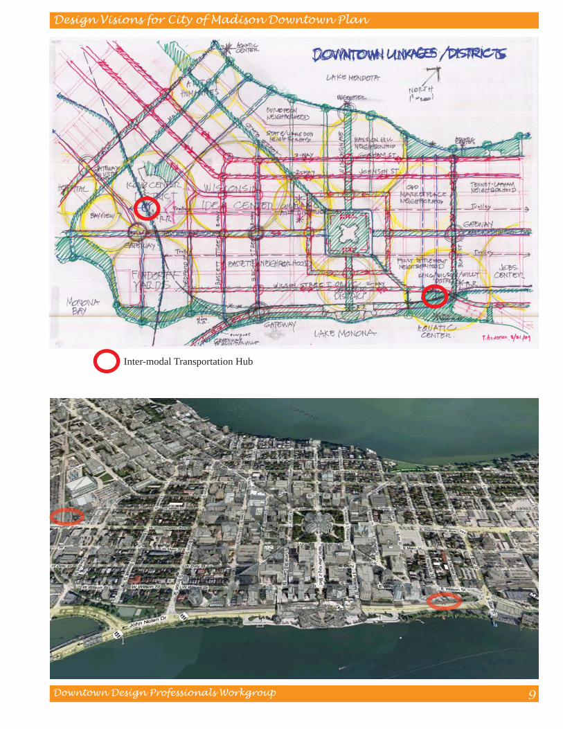
Inter-modal Transportation Hub
Downtown Design Professionals Workgroup
Design Visions for City of Madison Downtown Plan
10
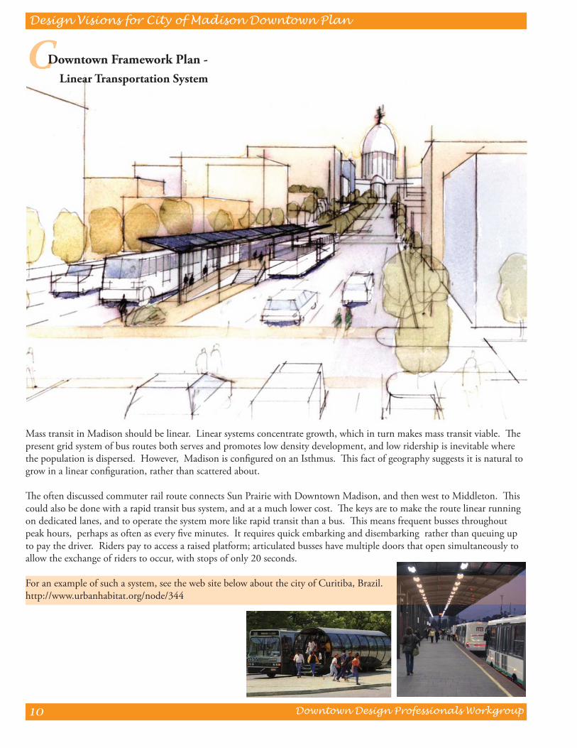
C Downtown Framework Plan - Linear Transportation System
Mass transit in Madison should be linear. Linear systems concentrate growth, which in turn makes mass transit viable. Th e present grid system of bus routes both serves and promotes low density development, and low ridership is inevitable where the population is dispersed. However, Madison is confi gured on an Isthmus. Th is fact of geography suggests it is natural to grow in a linear confi guration, rather than scattered about.
Th e often discussed commuter rail route connects Sun Prairie with Downtown Madison, and then west to Middleton. Th is could also be done with a rapid transit bus system, and at a much lower cost. Th e keys are to make the route linear running on dedicated lanes, and to operate the system more like rapid transit than a bus. Th is means frequent busses throughout peak hours, perhaps as often as every fi ve minutes. It requires quick embarking and disembarking rather than queuing up to pay the driver. Riders pay to access a raised platform; articulated busses have multiple doors that open simultaneously to allow the exchange of riders to occur, with stops of only 20 seconds.
For an example of such a system, see the web site below about the city of Curitiba, Brazil. http://www.urbanhabitat.org/node/344
Downtown Design Professionals Workgroup
Design Visions for City of Madison Downtown Plan
11
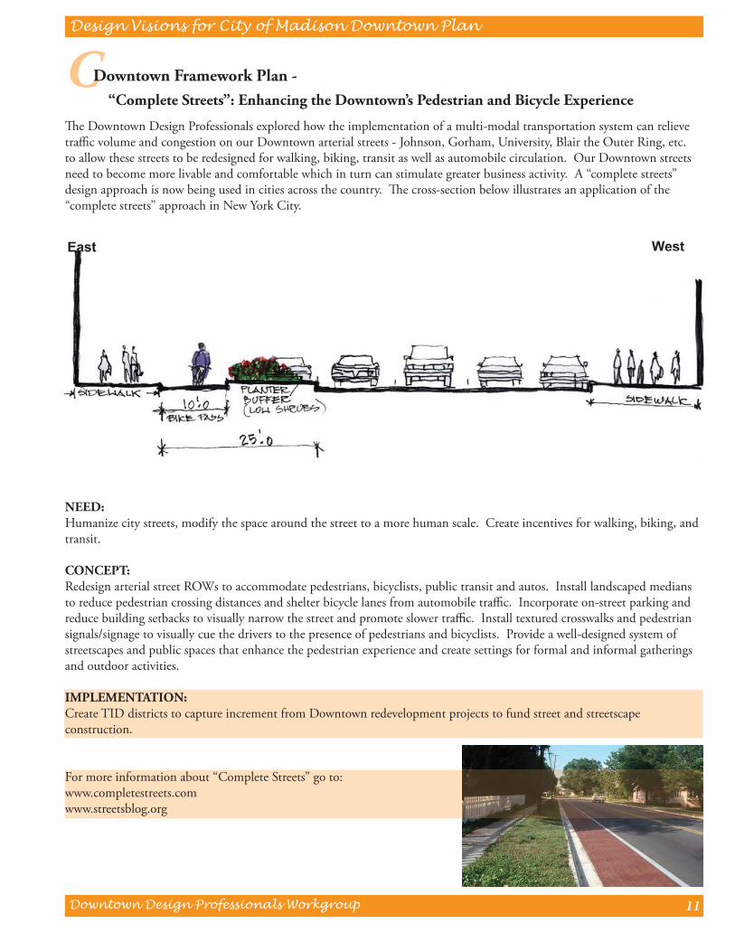
Th e Downtown Design Professionals explored how the implementation of a multi-modal transportation system can relieve traffi c volume and congestion on our Downtown arterial streets - Johnson, Gorham, University, Blair the Outer Ring, etc. to allow these streets to be redesigned for walking, biking, transit as well as automobile circulation. Our Downtown streets need to become more livable and comfortable which in turn can stimulate greater business activity. A “complete streets” design approach is now being used in cities across the country. Th e cross-section below illustrates an application of the “complete streets” approach in New York City.
NEED:Humanize city streets, modify the space around the street to a more human scale. Create incentives for walking, biking, and transit.
CONCEPT:Redesign arterial street ROWs to accommodate pedestrians, bicyclists, public transit and autos. Install landscaped medians to reduce pedestrian crossing distances and shelter bicycle lanes from automobile traffi c. Incorporate on-street parking and reduce building setbacks to visually narrow the street and promote slower traffi c. Install textured crosswalks and pedestrian signals/signage to visually cue the drivers to the presence of pedestrians and bicyclists. Provide a well-designed system of streetscapes and public spaces that enhance the pedestrian experience and create settings for formal and informal gatherings and outdoor activities.
IMPLEMENTATION:Create TID districts to capture increment from Downtown redevelopment projects to fund street and streetscape construction.
For more information about “Complete Streets” go to:www.completestreets.comwww.streetsblog.org
C Downtown Framework Plan - “Complete Streets”: Enhancing the Downtown’s Pedestrian and Bicycle Experience

Downtown Design Professionals Workgroup
Design Visions for City of Madison Downtown Plan
12
Downtown Design Professionals Workgroup
Design Visions for City of Madison Downtown Plan
13
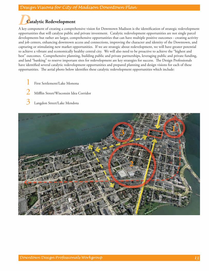
D Catalytic RedevelopmentA key component of creating a comprehensive vision for Downtown Madison is the identifi cation of strategic redevelopment opportunities that will catalyze public and private investment. Catalytic redevelopment opportunities are not single parcel developments but rather are larger, comprehensive opportunities that can have multiple positive outcomes - creating activity and job centers, enhancing downtown access and connections, improving the character and identity of the Downtown, and capturing or stimulating new market opportunities. If we are strategic about redevelopment, we will have greater potential to achieve a vibrant and economically healthy central city. We will also need to be proactive to achieve the “highest and best” outcomes. Comprehensive planning, building public and private partnerships, leveraging public and private funding, and land “banking” to reserve important sites for redevelopment are key strategies for success. Th e Design Professionals have identifi ed several catalytic redevelopment opportunities and prepared planning and design visions for each of these opportunities. Th e aerial photo below identifi es these catalytic redevelopment opportunities which include:
1 First Settlement/Lake Monona
2 Miffl in Street/Wisconsin Idea Corridor
3 Langdon Street/Lake Mendota
11
22
33
Downtown Design Professionals Workgroup
Design Visions for City of Madison Downtown Plan
14
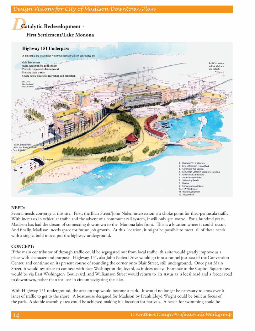
NEED:Several needs converge at this site. First, the Blair Street/John Nolen intersection is a choke point for thru-peninsula traffi c. With increases in vehicular traffi c and the advent of a commuter rail system, it will only get worse. For a hundred years, Madison has had the dream of connecting downtown to the Monona lake front. Th is is a location where it could occur. And fi nally, Madison needs space for future job growth. At this location, it might be possible to meet all of these needs with a single, bold move: put the highway underground.
CONCEPT:If the main contributor of through traffi c could be segregated out from local traffi c, this site would greatly improve as a place with character and purpose. Highway 151, aka John Nolen Drive would go into a tunnel just east of the Convention Center, and continue on its present course of rounding the corner onto Blair Street, still underground. Once past Main Street, it would resurface to connect with East Washington Boulevard, as it does today. Entrance to the Capitol Square area would be via East Washington Boulevard, and Williamson Street would return to its status as a local road and a feeder road to downtown, rather than for use in circumnavigating the lake.
With Highway 151 underground, the area on top would become a park. It would no longer be necessary to cross over 6 lanes of traffi c to get to the shore. A boathouse designed for Madison by Frank Lloyd Wright could be built as focus of the park. A sizable assembly area could be achieved making it a location for festivals. A beech for swimming could be
D Catalytic Redevelopment - First Settlement/Lake Monona
Downtown Design Professionals Workgroup
Design Visions for City of Madison Downtown Plan
15
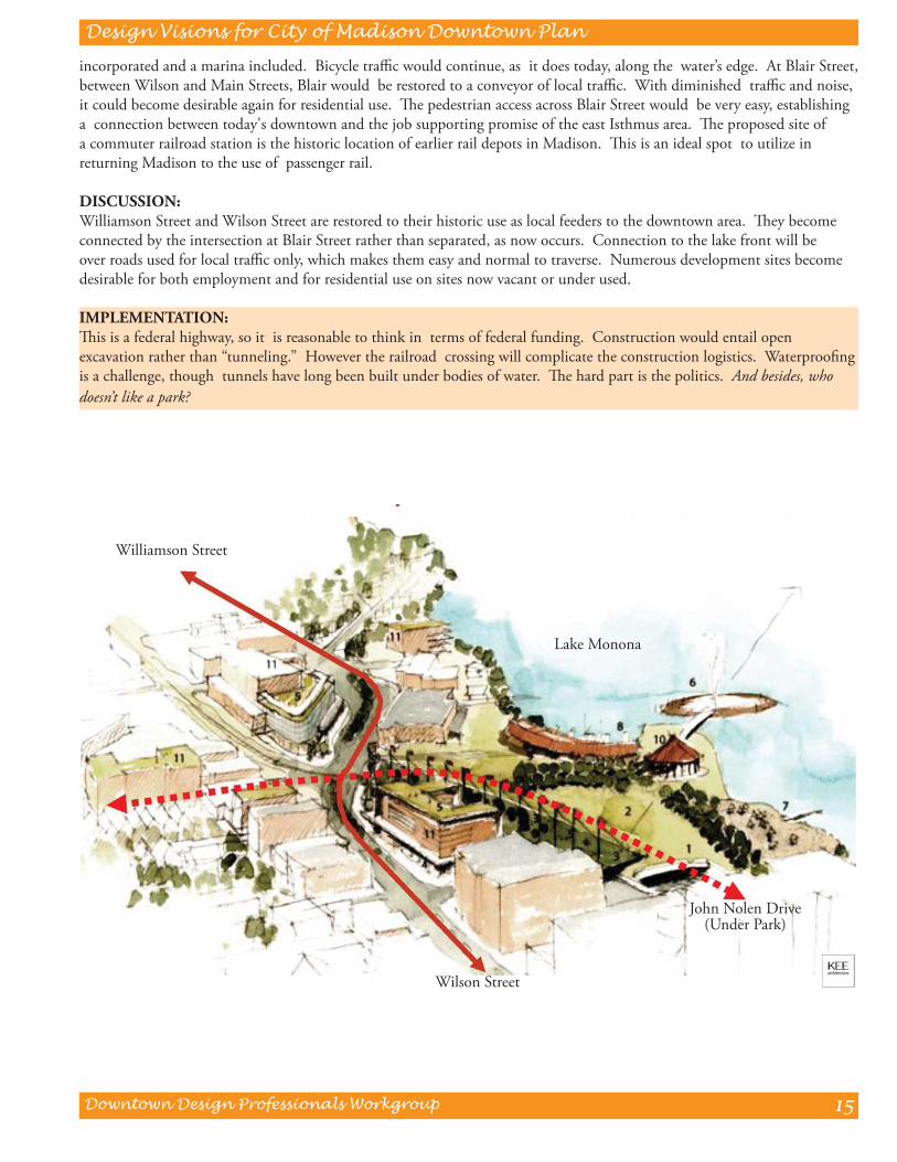
incorporated and a marina included. Bicycle traffi c would continue, as it does today, along the water’s edge. At Blair Street, between Wilson and Main Streets, Blair would be restored to a conveyor of local traffi c. With diminished traffi c and noise, it could become desirable again for residential use. Th e pedestrian access across Blair Street would be very easy, establishing a connection between today's downtown and the job supporting promise of the east Isthmus area. Th e proposed site of a commuter railroad station is the historic location of earlier rail depots in Madison. Th is is an ideal spot to utilize in returning Madison to the use of passenger rail.
DISCUSSION:Williamson Street and Wilson Street are restored to their historic use as local feeders to the downtown area. Th ey become connected by the intersection at Blair Street rather than separated, as now occurs. Connection to the lake front will be over roads used for local traffi c only, which makes them easy and normal to traverse. Numerous development sites become desirable for both employment and for residential use on sites now vacant or under used.
IMPLEMENTATION:Th is is a federal highway, so it is reasonable to think in terms of federal funding. Construction would entail open excavation rather than “tunneling.” However the railroad crossing will complicate the construction logistics. Waterproofi ng is a challenge, though tunnels have long been built under bodies of water. Th e hard part is the politics. And besides, who doesn’t like a park?
Williamson Street
Wilson Street
Lake Monona
John Nolen Drive(Under Park)

Downtown Design Professionals Workgroup
Design Visions for City of Madison Downtown Plan
16
Miffl in Street and its’ adjacent neighborhood is an anomaly. We think of it as “the hole in the donut.” It is a neighborhood of small and medium sized residential structures, formerly single family homes, now divided up into multi-family units. For the past 50 years, the population has been primarily students, though that is now changing. During that time little has been done to update the dwellings, and many are in physical decline. It is an anomaly because it is in a very important location, but underutilized. Situated between Downtown and the Capitol on one side, with the University on the other, it is the ideal location for a meeting of town and gown. As the University and Downtown expand, this is a great location for it to occur.
Guiding principles and features for development of the area include:
• Regional transportation hub
• UW Arts Center
• Phil Lewis Wisconsin Idea Center
• An Urban - jobs, housing, education, retail, entertainment, arts/culture, public spaces
• An emerging market - new jobs and services related to the UW Institute for Discovery
• Intersection of the University, City and State Capitol
• A physical expression of the “Wisconsin Idea”
• A demonstration project for urban sustainability
11
22 33
44
55
66
D Catalytic Redevelopment - Miffl in Corridor/ Wisconsin Idea
1 Transportation Hub 3 Phil Lewis Center 5 Miffl in Corridor - Mid Block Study
2 UW Arts Center 4 Miffl in Corridor - Full Block Redevelopment 6 Miffl in/Overture Block
Downtown Design Professionals Workgroup
Design Visions for City of Madison Downtown Plan
17
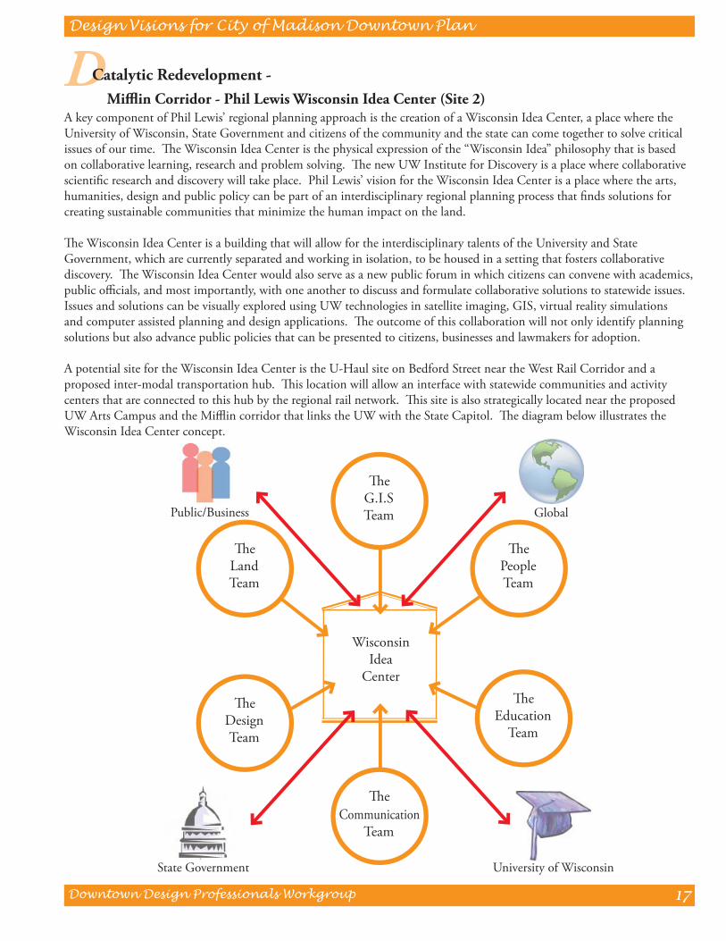
A key component of Phil Lewis’ regional planning approach is the creation of a Wisconsin Idea Center, a place where the University of Wisconsin, State Government and citizens of the community and the state can come together to solve critical issues of our time. Th e Wisconsin Idea Center is the physical expression of the “Wisconsin Idea” philosophy that is based on collaborative learning, research and problem solving. Th e new UW Institute for Discovery is a place where collaborative scientifi c research and discovery will take place. Phil Lewis’ vision for the Wisconsin Idea Center is a place where the arts, humanities, design and public policy can be part of an interdisciplinary regional planning process that fi nds solutions for creating sustainable communities that minimize the human impact on the land.
Th e Wisconsin Idea Center is a building that will allow for the interdisciplinary talents of the University and State Government, which are currently separated and working in isolation, to be housed in a setting that fosters collaborative discovery. Th e Wisconsin Idea Center would also serve as a new public forum in which citizens can convene with academics, public offi cials, and most importantly, with one another to discuss and formulate collaborative solutions to statewide issues. Issues and solutions can be visually explored using UW technologies in satellite imaging, GIS, virtual reality simulations and computer assisted planning and design applications. Th e outcome of this collaboration will not only identify planning solutions but also advance public policies that can be presented to citizens, businesses and lawmakers for adoption.
A potential site for the Wisconsin Idea Center is the U-Haul site on Bedford Street near the West Rail Corridor and a proposed inter-modal transportation hub. Th is location will allow an interface with statewide communities and activity centers that are connected to this hub by the regional rail network. Th is site is also strategically located near the proposed UW Arts Campus and the Miffl in corridor that links the UW with the State Capitol. Th e diagram below illustrates the Wisconsin Idea Center concept.
Th e Education
Team
Th e DesignTeam
Th ePeopleTeam
Th eLandTeam
Th eG.I.STeam
Th eCommunication
Team
State Government
Public/Business Global
University of Wisconsin
WisconsinIdea
Center
D Catalytic Redevelopment - Miffl in Corridor - Phil Lewis Wisconsin Idea Center (Site 2)
Downtown Design Professionals Workgroup
Design Visions for City of Madison Downtown Plan
18
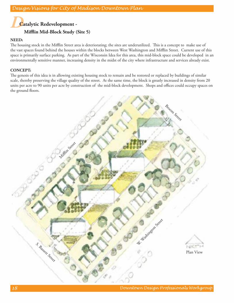
NEED:Th e housing stock in the Miffl in Street area is deteriorating; the sites are underutilized. Th is is a concept to make use of the vast spaces found behind the houses within the blocks between West Washington and Miffl in Street. Current use of this space is primarily surface parking. As part of the Wisconsin Idea for this area, this mid-block space could be developed in an environmentally sensitive manner, increasing density in the midst of the city where infrastructure and services already exist.
CONCEPT:Th e genesis of this idea is in allowing existing housing stock to remain and be restored or replaced by buildings of similar scale, thereby preserving the village quality of the street. At the same time, the block is greatly increased in density from 20 units per acre to 90 units per acre by construction of the mid-block development. Shops and offi ces could occupy spaces on the ground fl oors.
D Catalytic Redevelopment - Miffl in Mid-Block Study (Site 5)
Plan View
Miffl
in Str
eet
S. Bassett Street
W. Wash
ington
Stree
t
Broom Street
Downtown Design Professionals Workgroup
Design Visions for City of Madison Downtown Plan
19
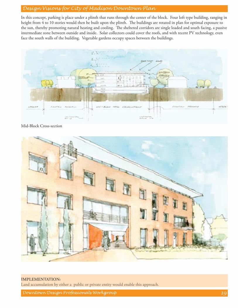
In this concept, parking is place under a plinth that runs through the center of the block. Four loft type building, ranging in height from 4 to 10 stories would then be built upon the plinth. Th e buildings are rotated in plan for optimal exposure to the sun, thereby promoting natural heating and cooling. Th e sheltered corridors are single loaded and south facing, a passive intermediate zone between outside and inside. Solar collectors could cover the roofs, and with recent PV technology, even face the south walls of the building. Vegetable gardens occupy spaces between the buildings.
IMPLEMENTATION:Land accumulation by either a public or private entity would enable this approach.IMPLEMENTATION:Land accumulation by either a public or private entity would enable this approach.
Mid-Block Cross-section