Embed Size (px)
Citation preview
Excavations in the Chapel of St. Vartan in the Holy SepulchreAuthor(s): M. BROSHI and G. BARKAYSource: Israel Exploration Journal, Vol. 35, No. 2/3 (1985), pp. 108-128Published by: Israel Exploration SocietyStable URL: http://www.jstor.org/stable/27925979 .
Accessed: 08/12/2013 22:11
Your use of the JSTOR archive indicates your acceptance of the Terms & Conditions of Use, available at .http://www.jstor.org/page/info/about/policies/terms.jsp
.JSTOR is a not-for-profit service that helps scholars, researchers, and students discover, use, and build upon a wide range ofcontent in a trusted digital archive. We use information technology and tools to increase productivity and facilitate new formsof scholarship. For more information about JSTOR, please contact [email protected].
.
Israel Exploration Society is collaborating with JSTOR to digitize, preserve and extend access to IsraelExploration Journal.
http://www.jstor.org
This content downloaded from 128.197.26.12 on Sun, 8 Dec 2013 22:11:21 PMAll use subject to JSTOR Terms and Conditions
Excavations in the Chapel of St. Vartan in the Holy Sepulchre*
M. BROSHI and G. BARKAY
Israel Museum, Jerusalem Tel Aviv University
I. REMAINS FROM THE IRON AGE
The Church of the Holy Sepulchre is a large complex of structures located in the heart
of the Christian Quarter of the Old City of Jerusalem. This complex originated in the
days of Constantine the Great in the fourth century C.E.; since that time, it has
undergone various phases of destruction, reconstruction and entirely new construction.
Most of the extant building is of the Crusader period.
Beginning in 1960, extensive restoration work was carried out in the complex, within
the framework of which archaeological excavations were conducted. The first general review, including data stemming from these excavations, was published by Co?asnon,1 and a well-illustrated final report in three volumes was recently published by C orbo.2
Naturally, the main point of interest in the excavations was the revealing of the church
building of the Byzantine and medieval periods. However, in the course of the
excavations remains were found from earlier periods, including some from the end of
the Iron Age, though in the report they are rather summarily treated. The Iron Age finds dealt with in the final report are from all parts of the building complex.3
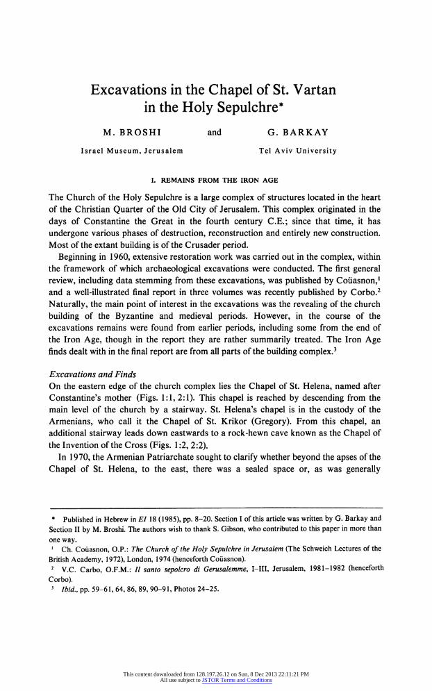
Excavations and Finds On the eastern edge of the church complex lies the Chapel of St. Helena, named after
Constantine's mother (Figs. 1:1, 2:1). This chapel is reached by descending from the main level of the church by a stairway. St. Helena's chapel is in the custody of the
Armenians, who call it the Chapel of St. Krikor (Gregory). From this chapel, an
additional stairway leads down eastwards to a rock-hewn cave known as the Chapel of
the Invention of the Cross (Figs. 1:2, 2:2). In 1970, the Armenian Patriarchate sought to clarify whether beyond the apses of the
Chapel of St. Helena, to the east, there was a sealed space or, as was generally
* Published in Hebrew in ?"/ 18 (1985), pp. 8-20. Section I of this article was written by G. Barkay and
Section II by M. Broshi. The authors wish to thank S. Gibson, who contributed to this paper in more than
one way. 1 Ch. Co?asnon, O.P.: The Church of the Holy Sepulchre in Jerusalem (The Schweich Lectures of the
British Academy, 1972), London, 1974 (henceforth Co?asnon). 2 V.C. Carbo, O.F.M.: // santo sepolcro di Gerusalemme, I?III, Jerusalem, 1981-1982 (henceforth
Corbo). 3
Ibid., pp. 59-61, 64, 86, 89, 90-91, Photos 24-25.
This content downloaded from 128.197.26.12 on Sun, 8 Dec 2013 22:11:21 PMAll use subject to JSTOR Terms and Conditions
EXCAVATIONS IN THE CHAPEL OF ST. VARTAN 109
^
^^^^ _to /:
Fig. 1. Plan of the Holy Sepulchre complex. 1 - Chapel of St. Helena (Chapel of St. Krikor); 2-Chapel of
the Invention of the Cross; 3-Chapel of St. Vartan; 4-the northern space.
This content downloaded from 128.197.26.12 on Sun, 8 Dec 2013 22:11:21 PMAll use subject to JSTOR Terms and Conditions
110 M. BROSHI AND G. BARKAY
I 1
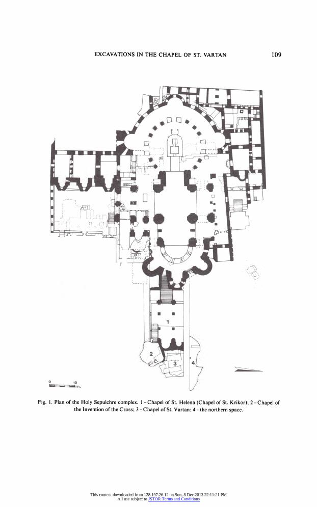
_m Fig. 2. Plan of the excavated area and its surroundings. 1 - Chapel of St. Helena (Chapel of St. Krikor);
2-Chapel of the Invention of the Cross; 3-Chapel of St. Vartan; 4-the northern space; 5-6-ancient
cisterns.
suspected, merely bedrock.4 A brief excavation showed that there was indeed a space, blocked up already in antiquity (Figs. 1:3, 2:3). This space, the continuation of the cave of the Chapel of the Invention of the Cross, was excavated by the Armenian
Patriarchate, which subsequently fitted it out as a chapel, today called the Chapel of St. Vartan and the Armenian Martyrs.5
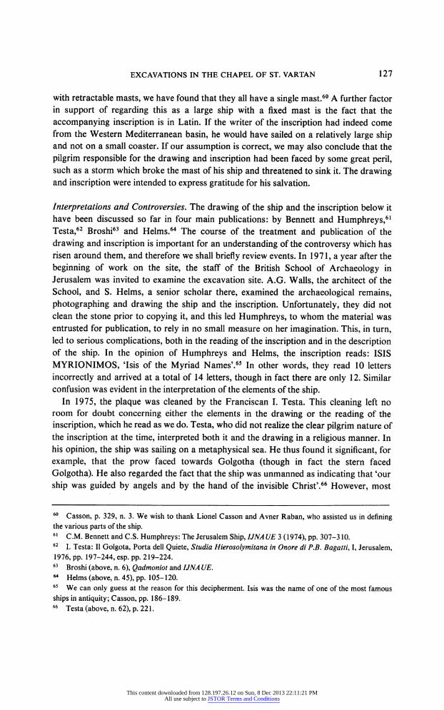
In the period between November 1975 and February 1976, M. Broshi supervised the excavations conducted on behalf of the Armenians in this area.6 The space cleared in these excavations measured 9.8 X 10.3 m. and a depth of 13 m. was reached below the initial level of work. The space cleared is a hollow created during the quarrying of the
meleke rock, with the higher 'crust' of mizzi hilu rock forming a kind of ceiling (PI.
4 E.g. H. Vincent and F.M. Abel: J?rusalem nouvelle, II, Paris, 1914, Fig. 84 on p. 131: ligne probable
du rocher'. 5 The spaces east of the Chapel of St. Helena were also discussed by Corbo (where they are denoted Loci
307-309), pp. 110-113, Plates 57-58, Photos 103-109. 6 The clearance was conducted by several labourers, We wish to express our gratitude to Bishop Guregh
Kapikian, who invited M. Broshi to supervise this work. Part of the clearance was completed prior to his
This content downloaded from 128.197.26.12 on Sun, 8 Dec 2013 22:11:21 PMAll use subject to JSTOR Terms and Conditions
EXCAVATIONS IN THE CHAPEL OF ST. VARTAN 111
(14:A). In the ceiling of the cave thus formed, in the south-eastern corner, a karst flue can be seen, indicating that there were natural hollows here even prior to the quarrying.
Above the quarried floor there was a floor of beaten earth mixed with ashes.7 The
floor overlaid a fill of terra rossa and white stone chips. Beneath the floor and the fill was the surface of the quarry, showing signs of the quarrying; between the traces of the
blocks removed from the quarry were channels hewn while separating the blocks. The
floor of the quarry was found covered by grey to blackish earth. The thickness of the fill
below the beaten earth floor varied between a few centimetres and 1.3 m. All the
potsherds found within this fill and on the floor are of the Iron Age II.8 Below the floor, two loci were discerned in which the pottery was entirely homogeneous, all the sherds
belonging to the Iron Age. The maximal length of the preserved floor fragment was
6.5 m., but it was difficult to determine the limits of the floor since it was cut through by foundation trenches of later walls, W2 and W3 from the Late Roman period and W4
from the early Byzantine period (see the plan and sections in Fig. 5).9 Thus, it is not
clear whether the floor represents a roofed or an open occupational level, as no
associated walls were found abutting it. The floor has been dated approximately to the
seventh century B.C.E. on the basis of the potsherds found in the fill beneath it. The
overall dating to the Iron Age II has been strengthened by the results of Carbon-14 tests
of the ash found admixed in the floor. The age of the sample tested was determined as
1053 (?210) B.C.E.10
The pottery uncovered in the excavations was found in seven loci:
Locus 1: Beneath the floor. The sherds here included an ostracon fragment (see below).
Locus 2: Beneath the floor. Under a large, split stone, all the sherds are of the Iron
Age II.
arrival on the site, and excavations there continued alongside restoration and construction. For previous notes and reports on Broshi's excavations, see M. Broshi: Fourth Archaeological Conference in Israel,
Jerusalem, March 1976, p. 28 (Hebrew); idem, Investigations in the Holy Sepulchre, Hadashot
Archeologiyot 59-60 (1976), pp. 30-31 (Hebrew); idem, Recent Excavations in the Church of the Holy
Sepulchre, Qadmoniot 10 (1977), pp. 31-32 (Hebrew); idem, Evidence of Earliest Christian Pilgrimage to
the Holy Land Come to Light in the Holy Sepulchre Church, Biblical Archaeology Review 3 (1977), pp.
37-39; idem, Recent Excavations in the Holy Sepulchre Compound, Ariel 45-46 (1978), pp. 28-32; idem, The Jerusalem Ship Reconsidered, International Journal of Nautical Archaeology and Underwater
Exploration (=IJNAUE) 6 (1977), pp. 349-352. Measurements and drawings were made by S. Gibson, the
photographs were taken by Z. Radovan and the pottery was drawn by Piri Yard?n ? all of whom are
thanked for their fine work. 7 For earth and ash floors, see A.F. Rainey: Dust and Ashes, Tel Aviv 1 (1974), pp. 77-81. 8 Isolated sherds of later date intruded into the pottery baskets, apparently originating in higher levels;
this probably occurred during the time when there was no proper archaeological supervision. 9 See also below, Section II. 10 The examination was made at the laboratory of the Isotopes Department of the Weizmann Institute,
Rehovot (Test No. 478). The results are quoted from a letter of 1 February 1977 by Dr. Y. Karmi, whom we thank for his assistance in this matter.
This content downloaded from 128.197.26.12 on Sun, 8 Dec 2013 22:11:21 PMAll use subject to JSTOR Terms and Conditions
112 M. BROSHI AND G. BARKAY
Locus 3: Between W3 and W4, actually from the foundation trench of W4
(Constantinian). This locus has the nature of a fill, and the sherds are mixed.
Locus 4: Between W2 and W3 (Late Roman). The sherds are not from a clear level
and are mixed.
Locus 5: Around the large stone resting on the floor; the sherds are from above the
floor and from the fill of the floor itself, mainly from the latter.
Locus 6: Fills between W2 and W3. Six baskets of potsherds labelled SH6/1-611 were found here, the lowest of them gathered on the floor and including only
homogeneous material from the Iron Age. Locus 7: Beneath the foundations of W2, to the east.
Among the sherds found beneath the floor was a fragment of an ostracon in paleo Hebrew. The ostracon was registered as SH 1/1 and was examined by Lemaire.12 The
sherd measures 5.5 X 6 cm.; traces of the ends of three lines of script can be discerned,
apparently numerals. The first line contains four clear signs and the two other lines, three signs each. The sherd may be an account or a receipt, like some of the Arad
ostraca13 or the ostraca discovered in Kenyon's excavations in the City of David.14 On
the other hand, in Lemaire's opinion, the ostracon could have been a pupil's exercise in
writing numerals, as found in the ostraca from Kadesh-Barnea.15 The fragmentary nature of the inscription does not allow for a decision between these two interpretations.
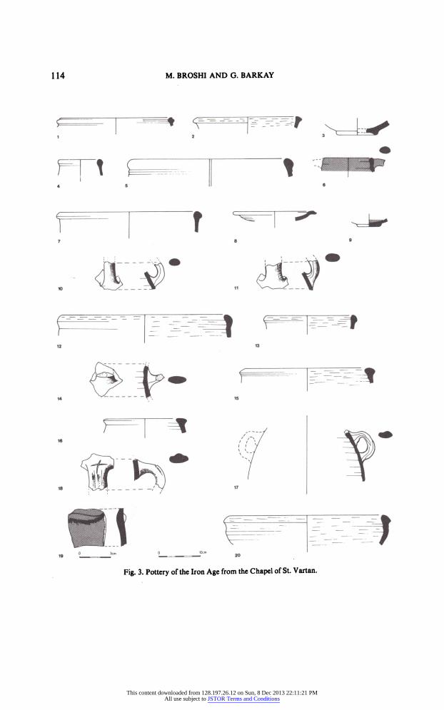
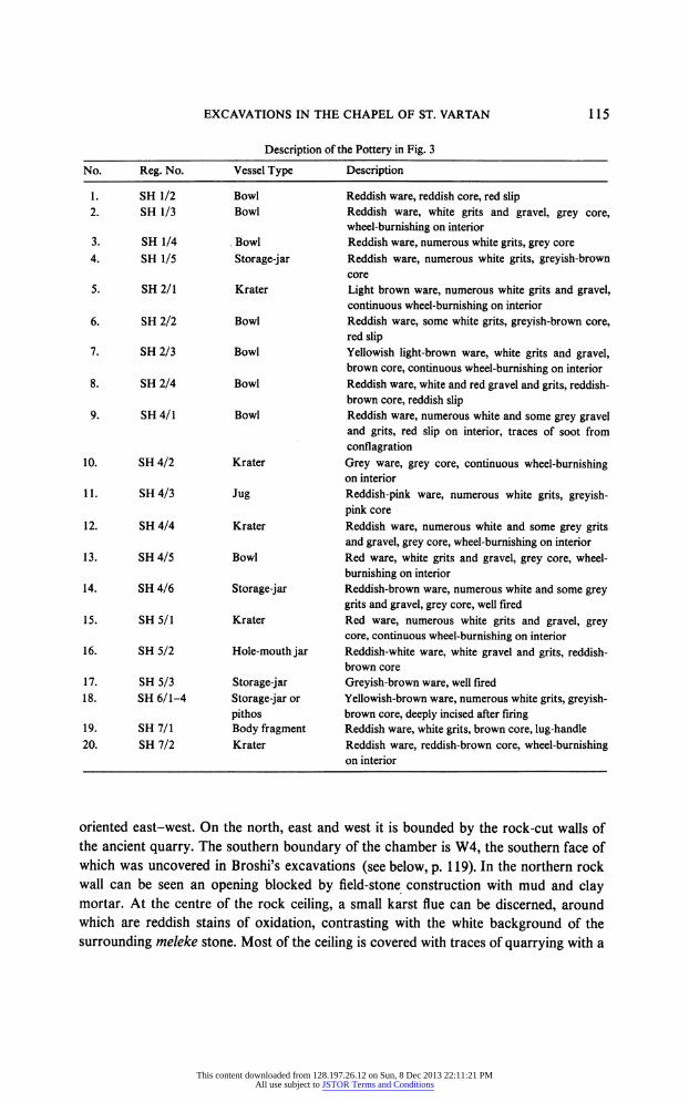
Twenty sherds of the Iron Age II, found on the floor and beneath it, are presented here (Fig. 3). All the vessel types are typical of the pottery of the end of the Kingdom of
Judah, throughout Judah and in Jerusalem. The date of these sherds is from the end of the eighth to the early sixth centuries B.C.E.
Corbo has expressed doubts as to Broshi's conclusions as published in the
preliminary report.16 In his opinion, the floor did not belong to the Iron Age and was
merely a levelling of the surface carried out at the time of the building of the later walls,
apparently in the Late Roman period. The pottery found above and below the floor
does not, in his opinion, indicate the date of the floor, for Iron Age pottery is known
also from other spots within the complex of the Holy Sepulchre, even close to the site of
the excavations in the Chapel of St. Helena. In Corbo's view, the early pottery is
indicative only of the beginning of quarrying activity on the site. He does not believe
that the Iron Age finds here indicate the extent of the city in that period. Further, he
doubts the value of the Carbon-14 test on material from the floor. He holds that his
11 The designation 'SH' on the sherds denotes 'St. Helena'. 12 Details about the ostracon are from a letter from Dr. A. Lemaire to M. Broshi of 26 June 1980. We are
grateful to him for his assistance. 13 Y. Aharoni: Arad Inscriptions, Jerusalem, 1981, Nos. 25, 31, 33, 34, 46,49, 67, 72, 76, 81, 87. 14 A. Lemaire: Les ostraca pal?o-h?breux des fouilles de lOphel, Levant 10 (1978), pp. 158-161. 15 A. Lemaire and P. Vernus: Les ostraca pal?o-h?breux de Qadesh-Barn?a, Orientalia 49 (1980), pp.
342-345. 16
Corbo,pp. 112-113.
This content downloaded from 128.197.26.12 on Sun, 8 Dec 2013 22:11:21 PMAll use subject to JSTOR Terms and Conditions
EXCAVATIONS IN THE CHAPEL OF ST. VARTAN 113
views are strengthened and confirmed by the results of Kenyon's excavations in her Area C, in the Muristan.17
Both Corbo and Lux, who excavated beneath the Church of the Redeemer,18 seem to have accepted the archaeological conclusions and topographical-historical concepts of
Kenyon, following her excavations in the Muristan, and they sought to draw an analogy between their excavations and Kenyon's results. In our opinion, Corbo's criticism is
unacceptable in the light of analysis of the excavation results in the area of the Muristan. Re-examination of the results of Kenyon's and Lux's soundings indicates the existence
of quarries overlaid by fills with settlement remains and a large quantity of Iron Age II
pottery. Corbo dated the quarry in the Holy Sepulchre to the Iron Age II, which we
accept. However, the question is whether, at the time of the construction on the site in
the Late Roman period, the floor of the quarry was re-exposed; i.e. was this area
levelled by a fill and the laying of a floor?
Methodically, too, the dating of the floor should be based on the latest sherds found within the fill sealed by it; we cannot assume that a fill containing sherds beneath a floor
is of no significance for dating that floor. The very fact that the floor-level is lower than the bases of W2 and W3, which were dated to the Late Roman period, does not permit their dating to the same period. It seems to us, therefore, that Corbo's objections are to
be rejected. The Armenian Patriarchate continued excavating, extending northwards the space
which had previously been uncovered.19 In excavations which they conducted in
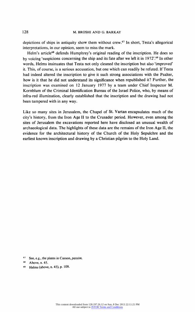
1977-1980, a further space was uncovered (Figs. 1:4, 2:4; PI. 14:B), entered through a
modern breach and through a massive Byzantine wall (W4) abutting Broshi's excavations on the north. Clearance in this area was conducted without archaeological
supervision, and no report concerning it has been published. In March 1981, we
conducted a series of measurements and photographs, following earlier visits, and all the elements observed were examined, as were the sherds which had been gathered and
kept on the site.20 The maximal dimensions of this additional space which was uncovered are 7.4 X 18
m.; it is entirely covered over by rock. The height of the rock ceiling at the centre is about 6.5 m. The shape of the chamber as revealed by the clearance is long and narrow,
17 Kathleen M. Kenyon: Jerusalem, Excavating 3000 Years of History, London, 1967, pp. 151-153, Pis.
71-72; idem, Digging Up Jerusalem, London, 1974, pp. 227-231, 261, Pis. 96, 98. 18 U. Lux: Vorl?ufiger Bericht ?ber die Ausgrabung unter der Erl?serkirche im Muristan in der Altstadt
von Jerusalem, in den Jahren 1970 und 1971, ZZW 88 (1972), pp. 185-203, esp. pp. 191-192. 19 This is Corbo's Locus 307 (pp. 110-112, PI. 57). 20 The work, using several labourers, was conducted by Bishop Guregh Kapikian on behalf of the
Armenian Patriarchate. G. Barkay visited the site, with Bishop Kapikian's kind permission, during work
there on 11 November 1979, 8 February 1980, 1 April 1980, 28 February 1981 and 7 March 1981.
Archaeology students of the American Institute of Holy Land Studies (M. Mutafian, R. Tappy, L. Wissel and B. Wilson) participated in the measuring and description of the finds. The photographs were taken by Y. Weinberg.
This content downloaded from 128.197.26.12 on Sun, 8 Dec 2013 22:11:21 PMAll use subject to JSTOR Terms and Conditions
114 M. BROSHI AND G. BARKAY
? -
Fig. 3. Pottery of the Iron Age from the Chapel of St. Vartan.
This content downloaded from 128.197.26.12 on Sun, 8 Dec 2013 22:11:21 PMAll use subject to JSTOR Terms and Conditions
EXCAVATIONS IN THE CHAPEL OF ST. VARTAN 115
Description of the Pottery in Fig. 3
No. Reg. No. Vessel Type Description
1. SH 1/2 Bowl Reddish ware, reddish core, red slip 2. SH 1/3 Bowl Reddish ware, white grits and gravel, grey core,
wheel-burnishing on interior
3. SH 1/4 Bowl Reddish ware, numerous white grits, grey core
4. SH 1/5 Storage-jar Reddish ware, numerous white grits, greyish-brown core
5. SH 2/1 Krater Light brown ware, numerous white grits and gravel, continuous wheel-burnishing on interior
6. SH 2/2 Bowl Reddish ware, some white grits, greyish-brown core, red slip
7. SH 2/3 Bowl Yellowish light-brown ware, white grits and gravel, brown core, continuous wheel-burnishing on interior
8. SH 2/4 Bowl Reddish ware, white and red gravel and grits, reddish
brown core, reddish slip 9. SH 4/1 Bowl Reddish ware, numerous white and some grey gravel
and grits, red slip on interior, traces of soot from
conflagration 10. SH 4/2 Krater Grey ware, grey core, continuous wheel-burnishing
on interior
11. SH4/3 Jug Reddish-pink ware, numerous white grits, greyish
pink core
12. SH4/4 Krater Reddish ware, numerous white and some grey grits and gravel, grey core, wheel-burnishing on interior
13. SH4/5 Bowl Red ware, white grits and gravel, grey core, wheel
burnishing on interior
14. SH 4/6 Storage-jar Reddish-brown ware, numerous white and some grey
grits and gravel, grey core, well fired
15. SH 5/1 Krater Red ware, numerous white grits and gravel, grey core, continuous wheel-burnishing on interior
16. SH 5/2 Hole-mouth jar Reddish-white ware, white gravel and grits, reddish
brown core
17. SH 5/3 Storage-jar Greyish-brown ware, well fired
18. SH 6/1-4 Storage-jar or Yellowish-brown ware, numerous white grits, greyish
pithos brown core, deeply incised after firing 19. SH 7/1 Body fragment Reddish ware, white grits, brown core, lug-handle
20. SH 7/2 Krater Reddish ware, reddish-brown core, wheel-burnishing on interior
oriented east-west. On the north, east and west it is bounded by the rock-cut walls of the ancient quarry. The southern boundary of the chamber is W4, the southern face of which was uncovered in Broshi's excavations (see below, p. 119). In the northern rock wall can be seen an opening blocked by field-stone construction with mud and clay mortar. At the centre of the rock ceiling, a small karst flue can be discerned, around which are reddish stains of oxidation, contrasting with the white background of the
surrounding meleke stone. Most of the ceiling is covered with traces of quarrying with a
This content downloaded from 128.197.26.12 on Sun, 8 Dec 2013 22:11:21 PMAll use subject to JSTOR Terms and Conditions
116 M. BROSHI AND G. BARKAY
sharp implement (chisel or quarrying adze). The height of the ceiling is not uniform, and all over its surface are scars and negative impressions of stones removed during
quarrying. Traces of the quarrying ?
separation channels between blocks and stumps of removed blocks ? can also be seen on the walls and floor of the cave (PL 15:A). On
the walls and ceiling, the stones were separated vertically, while close to the floor there were indications of horizontal removal. The sizes of the blocks quarried here can be
estimated from the traces remaining on the floor and walls. The stones were large, good quality ashlars. Several sizes are represented, e.g. 0.51 X 1.2 m., 0.5 X 1.2 m., 0.7 X
1.84 m. and 0.76 X 1.96 m. There are also negative traces of ashlars more than 2 m.
long. The traces of quarrying give the impression that the stones here were intended for a high-quality public project.
The excavations of the Armenian Patriarchate on this site were, as noted, conducted
without scientific supervision. Among the large quantities of pottery here, mainly from
the fills, the number of Iron Age II sherds was noticeable. On our visit during the course
of the clearance, we discerned that most of the Iron Age pottery came from the lower
parts, adjacent to the rock floor, and we had the impression that at several spots
homogeneous pottery of Iron Age date was coming to light. On the basis of this
impression (but without an actual quantitative check), it would seem that more than
10% of the sherds collected here were of the Iron Age. During our visits to the site, we
also collected several sherds, which had been removed and dumped along with earth
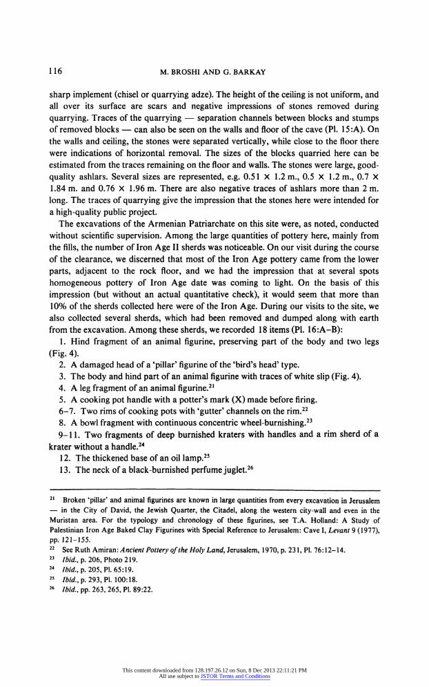
from the excavation. Among these sherds, we recorded 18 items (PL 16:A-B): 1. Hind fragment of an animal figurine, preserving part of the body and two legs
(Fig. 4). 2. A damaged head of a 'pillar' figurine of the 'bird's head' type. 3. The body and hind part of an animal figurine with traces of white slip (Fig. 4). 4. A leg fragment of an animal figurine.21 5. A cooking pot handle with a potter's mark (X) made before firing. 6-7. Two rims of cooking pots with 'gutter' channels on the rim.22 8. A bowl fragment with continuous concentric wheel-burnishing.23 9-11. Two fragments of deep burnished kraters with handles and a rim sherd of a
krater without a handle.24 12. The thickened base of an oil lamp.25 13. The neck of a black-burnished perfume juglet.26
21 Broken 'pillar' and animal figurines are known in large quantities from every excavation in Jerusalem ? in the City of David, the Jewish Quarter, the Citadel, along the western city-wall and even in the
Muristan area. For the typology and chronology of these figurines, see T.A. Holland: A Study of
Palestinian Iron Age Baked Clay Figurines with Special Reference to Jerusalem: Cave I, Levant 9 (1977),
pp. 121-155. 22 See Ruth Amiran: Ancient Pottery of the Holy Land, Jerusalem, 1970, p. 231, PI. 76:12-14. 23
Ibid., p. 206, Photo 219. 24
Ibid., p. 205, PI. 65:19. 25
Ibid., p. 293, PI. 100:18. 26
Ibid., pp. 263, 265, PI. 89:22.
This content downloaded from 128.197.26.12 on Sun, 8 Dec 2013 22:11:21 PMAll use subject to JSTOR Terms and Conditions
EXCAVATIONS IN THE CHAPEL OF ST. VARTAN 117
14-17. Three 'folded' rims of bowls bearing traces of wheel-burnishing27 and a ring base of another bowl.
18. A storage-jar handle with two ridges of the lamelekh jar-handle type.28 Further, the excavations uncovered sherds of hole-mouth jar rims, storage-jars and
deep burnished kraters ? all types characteristic of the late Iron Age II, commonly found on Judean sites and in the various excavations in Jerusalem.
It would thus appear that the cave of the Chapel of the Invention of the Cross was
part of a much larger cave, separated today by later walls into several units. Besides the
chapel, the ancient cave quarry included the space with the Iron Age floor uncovered by Broshi, as well as the space north of it cleared by the Armenians. This was a large, artificial cave originating in a quarry of the Iron Age II. The cave may continue further
northwards, into the area beneath the building of the Coptic monastery. It should be
noted here that beneath the Coptic monastery a burial cave was discovered in 1885; on
the basis of its plan and the burial customs reflected in the plan, it should be ascribed to
the Iron Age II.29 The overall length of the large, artificial cave on the east of the Holy Sepulchre complex is about 25 m. and its height is between 6.5 and 13 m.
Fig. 4. Fragments of two Iron Age figurines from the northern space: above, No. 1; below. No. 3.
The Significance of the Iron Age Finds
Ancient quarries are known throughout the area of the Holy Sepulchre complex,30 as
they are in other excavations in the immediate vicinity. The quarries are earlier than all
the other activities for which evidence was found here and predate the Iron Age pottery
27 Ibid., pp. 242, 247, Pl. 82:1.
28 Ibid., p. 242, Photos 247-248.
29 C. Schick: Neu aufgedeckte Felsengr?ber bei der Grabeskirche in Jerusalem. ZDPV 8 (1885). pp.
170-173; idem, Notes from Jerusalem, PEFQSt(\$&l\ pp. 154-155. 30
Corbo, PI. 67 and Photos 12, 18-19, 21, 27, 32, 37, 45, 48, 50, 53-55, 62. 75, 97. 103-105. 109-110.
In Corbo's plan, no absolute heights are given for the bedrock. These would have facilitated reconstruction
This content downloaded from 128.197.26.12 on Sun, 8 Dec 2013 22:11:21 PMAll use subject to JSTOR Terms and Conditions
118 M. BROSHI AND G. BARKAY
assemblages discovered here. Quarrying activity alone would not justify the large
quantities of pottery discovered. Moreover, the quarry cannot belong to the same
archaeological phase as the earth and pottery covering it. The quarrying activities in the
vicinity of the Holy Sepulchre took place in the ninth-eighth centuries B.C.E., a time when this area was outside the city and at some distance from it. It is possible, of
course, that quarrying on this site continued in later periods when this area was not built over. This would apply to the Hellenistic and Early Roman periods, until the time when this region was once more included within the city by the Third Wall'. However, there can be no doubt that the beginnings of this large quarry beneath the Holy Sepulchre and
its main period of use were in the days of the Judean Monarchy. The quarry was subterranean; a similar quarry is that known today as 'Zedekiah's
Cave' or 'Solomon's Quarries', east of the Damascus Gate. There, too, the initial
quarrying phase was in the Iron Age II, judging from the sphinx carved in Phoenician
style on the wall of the cave31 and the pottery found within it.32 This type of closed
quarry, in the form of a cave with a rock ceiling above the quarried area, is unknown at
any other site. The rock quarried in these artificial caves, fine meleke, is not that
obtained in the other known quarries of the Iron Age. At Ramat Rahel, Samaria and
Megiddo, quarries of the same period have come to light, all of them open, in which the
quarrying was horizontal and the stone quarried was the lower-quality nari limestone.33
There is no doubt that the stone quarried in the Holy Sepulchre and its vicinity was
utilized for fine ashlars, serving for the construction of fortifications or major public buildings of the Judean capital.
After the quarry had been abandoned and with the growth and development of
Jerusalem, sporadic settlement took place above the quarries. Evidence for this phase can be seen in the large quantities of pottery, which could not conceivably have been
brought here from afar. The cave was substantially cleared during the Late Roman
period down to the level of the earthen floor, in order to insert W2 and W3. The
buildings of these northern extramural quarters were dismantled and reused as building material in subsequent periods, from Second Temple times up to the construction of the
church early in the Byzantine period. All that is left of this occupation phase is the floor
fragment uncovered in our excavations. It can be assumed that careful excavations in
other parts of the complex of the Holy Sepulchre would reveal further segments of
floors or even building remains of this phase. Poor but significant remains of the
of the ancient topography of the area. Corbo's base height was at the present floor-level of the church. In
earlier plans absolute heights are given for the points of rock known prior to the recent excavations; see
Vincent and Abel (above, n. 4), Planches, Paris, 1926, Pis. XII-XIII. 31 C. Clermont-Ganneau: Archaeological Researches in Palestine, I, London, 1899, pp. 242-245. 32 This pottery was discovered in Captain Monckton's excavation in the cave in 1924. The evidence
concerning this material has never been published, but is included among the reports in the archives of the
Department of Antiquities and Museums at the Rockefeller Museum in Jerusalem (File No. 101, Region
A2). 33 Y. Shiloh and A. Horowitz: Ashlar Quarries in the Iron Age in the Hill Country of Israel, BASOR 217
(1975), pp. 37-48.
This content downloaded from 128.197.26.12 on Sun, 8 Dec 2013 22:11:21 PMAll use subject to JSTOR Terms and Conditions
EXCAVATIONS IN THE CHAPEL OF ST. VARTAN 119
occupation level of this period have been discovered in other excavations in this region ? those of Kenyon and Lux in the Muristan.34 The intensity of building activity here in
Byzantine times and the principal interest of the excavators in the church structures
certainly contributed to the fact that further remains of this phase have not come to
light. One might postulate that the floor does not represent an occupational level or a living
floor, but was a technical level used for dragging the large stones out of the quarry in a
later phase of its use. However, the large quantities of Iron Age pottery and the nature
of the floor do not justify such an interpretation. The floor which was uncovered thus represents, in our opinion, a phase of extramural
quarters which spread north of the city wall exposed by Avigad.35 We date the
settlement phase from the late eighth century B.C.E. to the Babylonian destruction of
the city in 587/86 B.C.E.
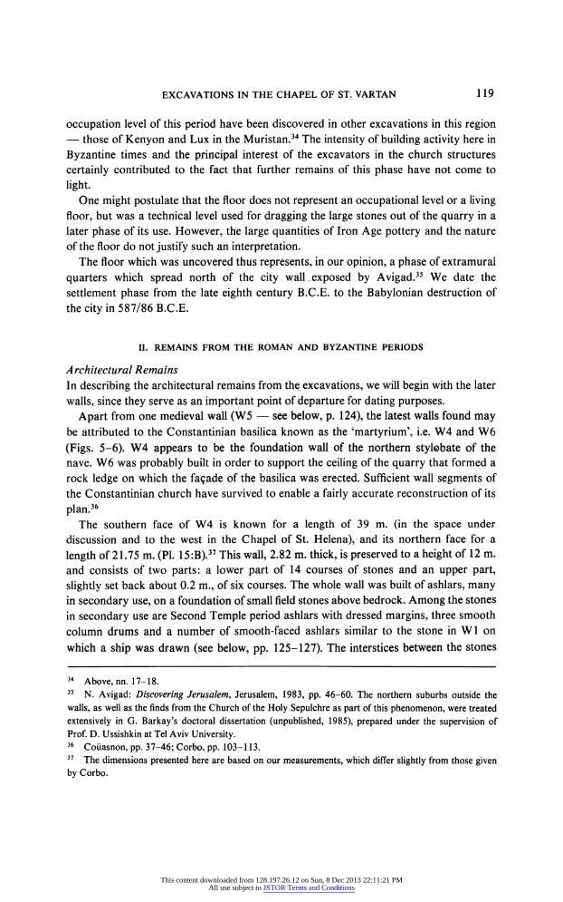
II. REMAINS FROM THE ROMAN AND BYZANTINE PERIODS
Architectural Remains
In describing the architectural remains from the excavations, we will begin with the later
walls, since they serve as an important point of departure for dating purposes.
Apart from one medieval wall (W5 ? see below, p. 124), the latest walls found may
be attributed to the Constantinian basilica known as the 'martyrium', i.e. W4 and W6
(Figs. 5-6). W4 appears to be the foundation wall of the northern stylobate of the nave. W6 was probably built in order to support the ceiling of the quarry that formed a
rock ledge on which the fa?ade of the basilica was erected. Sufficient wall segments of
the Constantinian church have survived to enable a fairly accurate reconstruction of its
plan.36
The southern face of W4 is known for a length of 39 m. (in the space under
discussion and to the west in the Chapel of St. Helena), and its northern face for a
length of 21.75 m. (PI. 15:B).37 This wall, 2.82 m. thick, is preserved to a height of 12 m.
and consists of two parts: a lower part of 14 courses of stones and an upper part,
slightly set back about 0.2 m., of six courses. The whole wall was built of ashlars, many in secondary use, on a foundation of small field stones above bedrock. Among the stones
in secondary use are Second Temple period ashlars with dressed margins, three smooth
column drums and a number of smooth-faced ashlars similar to the stone in Wl on
which a ship was drawn (see below, pp. 125-127). The interstices between the stones
34 Above, nn. 17-18.
35 . Avigad: Discovering Jerusalem, Jerusalem, 1983, pp. 46-60. The northern suburbs outside the
walls, as well as the finds from the Church of the Holy Sepulchre as part of this phenomenon, were treated
extensively in G. Barkay's doctoral dissertation (unpublished, 1985), prepared under the supervision of
Prof. D. Ussishkin at Tel Aviv University. 36
Co?asnon, pp. 37-46; Corbo, pp. 103-113. 37 The dimensions presented here are based on our measurements, which differ slightly from those given
by Corbo.
This content downloaded from 128.197.26.12 on Sun, 8 Dec 2013 22:11:21 PMAll use subject to JSTOR Terms and Conditions
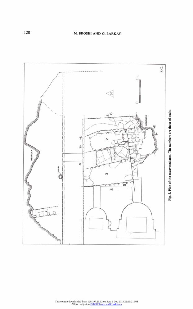
Fig. 5. Plan of the excavated area. The numbers are those of walls.
This content downloaded from 128.197.26.12 on Sun, 8 Dec 2013 22:11:21 PMAll use subject to JSTOR Terms and Conditions
EXCAVATIONS IN THE CHAPEL OF ST. VARTAN 121
Fig. 6. Sections A-A, B-B and C-C of the excavated area.
were filled in with a hard grey plaster. Although the craftmanship of this wall is fine, it seems unlikely that it was visible at the time when the basilica was in use. This wall is the best-preserved part of the martyrium and of the entire Constantinian complex.38
The western face of W6 is known for a length of 6.8 m. and stands to a height of 6.4 m. (PL 15:B). Judging by the eastern extent of the northern face of W4, we may
38 For various reasons, it can be assumed that during the period of the existence of the Constantinian
martyrium, the subterranean spaces on the east (the space under discussion, the Chapel of the Invention of the Cross to the south and the Chapel of St. Helena on the west) were blocked. As for the Chapel of the Invention of the Cross, the wall parallel to W4 (Carbo's Wall 304) cut off the cave and prevented access to it.
This content downloaded from 128.197.26.12 on Sun, 8 Dec 2013 22:11:21 PMAll use subject to JSTOR Terms and Conditions
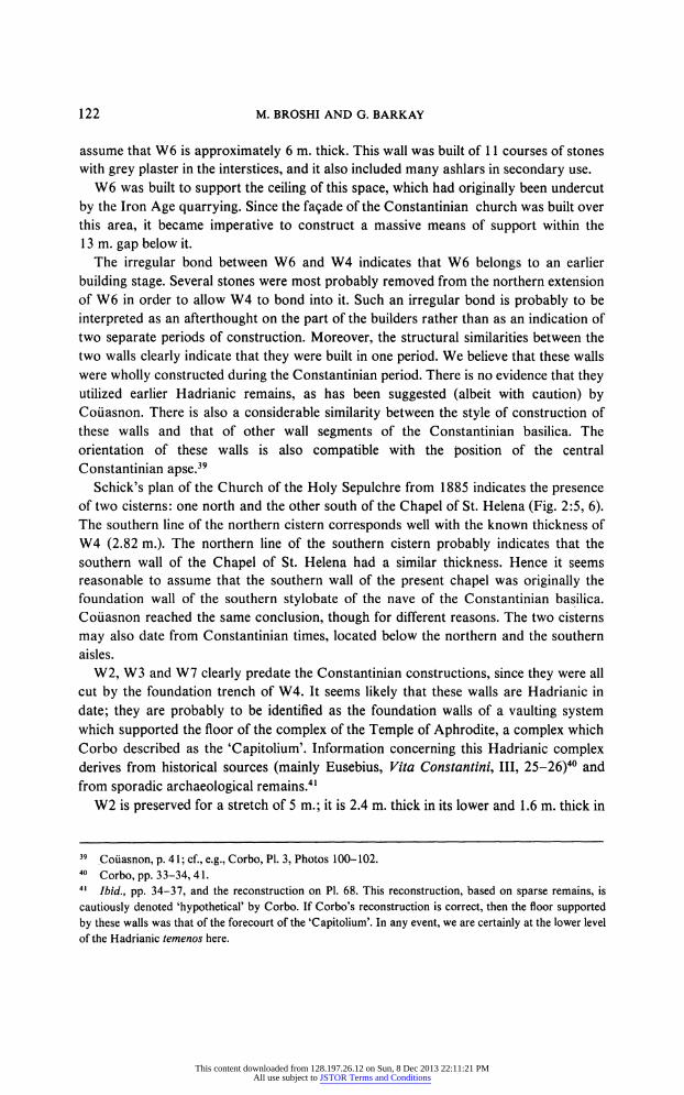
122 M. BROSHI AND G. BARKAY
assume that W6 is approximately 6 m. thick. This wall was built of 11 courses of stones
with grey plaster in the interstices, and it also included many ashlars in secondary use.
W6 was built to support the ceiling of this space, which had originally been undercut
by the Iron Age quarrying. Since the fa?ade of the Constantinian church was built over
this area, it became imperative to construct a massive means of support within the 13 m. gap below it.
The irregular bond between W6 and W4 indicates that W6 belongs to an earlier
building stage. Several stones were most probably removed from the northern extension of W6 in order to allow W4 to bond into it. Such an irregular bond is probably to be
interpreted as an afterthought on the part of the builders rather than as an indication of two separate periods of construction. Moreover, the structural similarities between the two walls clearly indicate that they were built in one period. We believe that these walls were wholly constructed during the Constantinian period. There is no evidence that they utilized earlier Hadrianic remains, as has been suggested (albeit with caution) by Couasnon. There is also a considerable similarity between the style of construction of these walls and that of other wall segments of the Constantinian basilica. The
orientation of these walls is also compatible with the position of the central
Constantinian apse.39
Schick's plan of the Church of the Holy Sepulchre from 1885 indicates the presence of two cisterns: one north and the other south of the Chapel of St. Helena (Fig. 2:5, 6). The southern line of the northern cistern corresponds well with the known thickness of W4 (2.82 m.). The northern line of the southern cistern probably indicates that the
southern wall of the Chapel of St. Helena had a similar thickness. Hence it seems reasonable to assume that the southern wall of the present chapel was originally the foundation wall of the southern sty lobate of the nave of the Constantinian basilica. Co?asnon reached the same conclusion, though for different reasons. The two cisterns
may also date from Constantinian times, located below the northern and the southern aisles.
W2, W3 and W7 clearly predate the Constantinian constructions, since they were all cut by the foundation trench of W4. It seems likely that these walls are Hadrianic in
date; they are probably to be identified as the foundation walls of a vaulting system which supported the floor of the complex of the Temple of Aphrodite, a complex which
Corbo described as the 'Capitolium'. Information concerning this Hadrianic complex derives from historical sources (mainly Eusebius, Vita ConstantinU , 25-26)40 and
from sporadic archaeological remains.41
W2 is preserved for a stretch of 5 m.; it is 2.4 m. thick in its lower and 1.6 m. thick in
39 Co?asnon, p. 41; cf., e.g., Corbo, Pl. 3, Photos 100-102.
40 Corbo, pp. 33-34,41.
41 Ibid., pp. 34-37, and the reconstruction on Pl. 68. This reconstruction, based on sparse remains, is
cautiously denoted 'hypothetical' by Corbo. If Corbo's reconstruction is correct, then the floor supported
by these walls was that of the forecourt of the 'Capitolium'. In any event, we are certainly at the lower level
of the Hadrianic t?menos here.
This content downloaded from 128.197.26.12 on Sun, 8 Dec 2013 22:11:21 PMAll use subject to JSTOR Terms and Conditions
EXCAVATIONS IN THE CHAPEL OF ST. VARTAN 123
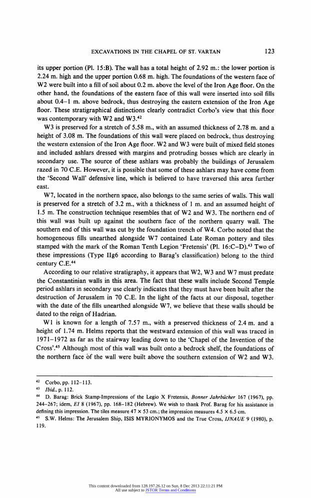
its upper portion (PL 15:B). The wall has a total height of 2.92 m.: the lower portion is
2.24 m. high and the upper portion 0.68 m. high. The foundations of the western face of W2 were built into a fill of soil about 0.2 m. above the level of the Iron Age floor. On the other hand, the foundations of the eastern face of this wall were inserted into soil fills about 0.4-1 m. above bedrock, thus destroying the eastern extension of the Iron Age floor. These stratigraphical distinctions clearly contradict Corbo's view that this floor was contemporary with W2 and W3.42
W3 is preserved for a stretch of 5.58 m., with an assumed thickness of 2.78 m. and a
height of 3.08 m. The foundations of this wall were placed on bedrock, thus destroying the western extension of the Iron Age floor. W2 and W3 were built of mixed field stones and included ashlars dressed with margins and protruding bosses which are clearly in
secondary use. The source of these ashlars was probably the buildings of Jerusalem razed in 70 C.E. However, it is possible that some of these ashlars may have come from the 'Second Wall' defensive line, which is believed to have traversed this area further east.
W7, located in the northern space, also belongs to the same series of walls. This wall is preserved for a stretch of 3.2 m., with a thickness of 1 m. and an assumed height of 1.5 m. The construction technique resembles that of W2 and W3. The northern end of this wall was built up against the southern face of the northern quarry wall. The southern end of this wall was cut by the foundation trench of W4. Corbo noted that the
homogeneous fills unearthed alongside W7 contained Late Roman pottery and tiles
stamped with the mark of the Roman Tenth Legion 'Fretensis' (PL 16:C-D).43 Two of these impressions (Type IIg6 according to Barag's classification) belong to the third
century C.E.44
According to our relative stratigraphy, it appears that W2, W3 and W7 must predate the Constantinian walls in this area. The fact that these walls include Second Temple period ashlars in secondary use clearly indicates that they must have been built after the destruction of Jerusalem in 70 C.E. In the light of the facts at our disposal, together with the date of the fills unearthed alongside W7, we believe that these walls should be dated to the reign of Hadrian.
Wl is known for a length of 7.57 m., with a preserved thickness of 2.4 m. and a
height of 1.74 m. Helms reports that the westward extension of this wall was traced in 1971-1972 as far as the stairway leading down to the 'Chapel of the Invention of the
Cross'.45 Although most of this wall was built onto a bedrock shelf, the foundations of the northern face ?f the wall were built above the southern extension of W2 and W3.
42 Corbo,pp. 112-113.
43 Ibid., p. 112.
44 D. Barag: Brick Stamp-Impressions of the Legio X Fretensis, Bonner Jahrb?cher 167 (1967), pp.
244-267; idem, El 8 (1967), pp. 168-182 (Hebrew). We wish to thank Prof. Barag for his assistance in
defining this impression. The tiles measure 47 X 53 cm.; the impression measures 4.5 X 6.5 cm. 45 S.W. Helms: The Jerusalem Ship, ISIS MYRIONYMOS and the True Cross, UN AUE 9 (1980), p. 119.
This content downloaded from 128.197.26.12 on Sun, 8 Dec 2013 22:11:21 PMAll use subject to JSTOR Terms and Conditions
124 M. BROSHI AND G. BARKAY
The wall was built of field stones and included many Second Temple period ashlars and column drums in secondary use.46 Built into the second course of the eastern end of this
wall is a smooth-faced ashlar, in secondary use, with a drawing of a ship and an
inscription (see below, pp. 126-128). It is noteworthy that while this kind of stone was
not included in the stones used in W2, W3 and W7, it does exist in secondary use within the Constantinian W4 and W6. In our opinion, these smooth-faced stones originally came from buildings razed in 70 C.E. Because of the high quality of these stones, they were used during Hadrianic times only for important substructural walls such as Wl
and not for minor foundation walls. During Constantinian times, these smooth-faced stones were reused once again for the construction of W4 and W6. It seems likely that
W2, *W3 and W7 are the remains of a grid of foundation walls which were built to
support a system of vaulted substructures. W1 was probably part of this latter vaulting system. The closest parallel is the vaults of the huge cistern located beneath the
Monastery of St. Abraham, to the south of our area, which is generally believed to be of Hadrianic date.47 The drawing of the ship and the inscription were probably done at the time of the erection of the Constantinian basilica. Corbo has made a suggestion, which we find doubtful, that Wl was built during the eleventh-twelfth centuries C.E. in order to set apart the 'Chapel of the Invention of the Cross', and that at that time the stone
with the ship drawing was added into the wall.48 W5 is known for a length of 6.33 m. and consists of at least three courses of field
stones visible to a height of 1.57 m. The foundations of this wall were built above the rubble core of W3. Its southern end was built up against the north face of Wl.
Although the date of this wall is uncertain, it may represent the foundation courses of the eastern wall of the Chapel of St. Helena, even though its alignment is slightly irregular. Hence it is possible that this wall dates from Crusader times.
The area to the north of W4 (Area 307 according to Corbo's designation) was
probably blocked up during the Constantinian period. In the northern part of this area a
blocked rock-cut entrance can be seen, which formerly linked this area with another
space used today as a cistern. A drainpipe was also found, visible for a height of 9.5 m.,
abutting the northern face of W4 and descending to the rock floor (PI. 17:B). This
drainpipe consists of 18 stone segments bonded with grey mortar. The diameter of
these segments is 0.46 m. and they are each 0.53 m. high.49
46 This wall includes, inter alia, the drum of a fluted column with flat ridges (Doric) and a stone plaque with chip-carved ornament apparently originating from a ceiling of the Second Temple period (PI. 17:A). 47 For this cistern, see C. Schick: Large Cistern under the New Greek Building South East of the Church of the Holy Sepulchre, PEFQSt (1889), pp. 110-112; Vincent and Abel (above, n. 4), Pl. XII ('Citerne XI, dite de Sainte H?l?ne'). 48
Corbo, p. 113. 49 For a drainpipe similar in form and identical in dimensions in the Church of the Holy Sepulchre,
contemporary with the Constantinian complex, see C. Katsimbinis: The Uncovering of the Eastern Side of
the Hill of Calvary and its Base, Liber Annuus 27 (1977), p. 204, Figs. 11, 12, Pis. 28, 29.
This content downloaded from 128.197.26.12 on Sun, 8 Dec 2013 22:11:21 PMAll use subject to JSTOR Terms and Conditions
EXCAVATIONS IN THE CHAPEL OF ST. VARTAN 125
In conclusion, we may list the architectural remains found during the excavations in the following chronological order:
1. Quarry, Iron Age II. 2. Beaten-earth floor, Iron Age II.
3. W2, W3, W7 and possibly also Wl, Hadrianic period. 4. W4 and W6, cisterns and drainpipe, Constantinian period. 5. W5, Crusader (?) period.
The Inscription and Drawing: Their Date and Significance
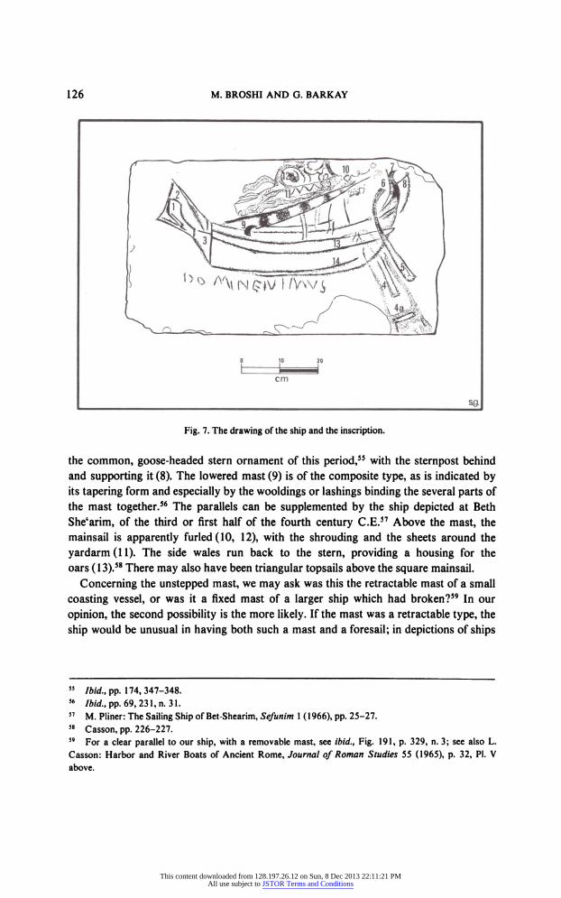
The Inscription. At the eastern end of Wl, a finely smoothed stone plaque (31 X
65 cm.) is affixed, bearing an ink drawing of a ship and, below, a Latin inscription in ink
reading: DOMINE IVIMVS, 'Lord, we shall go' (Fig. 7; PI. 17:C). This inscription is
somewhat enigmatic, especially as regards the second word. We may possibly regard it as an allusion to the Latin version (whether the Old Latin or the Vulgate) of Psalm
121:1 (MT 122:1), which reads: In domum Domini ibimus, 'Let us go to the house of
the Lord'.50 Our inscription displays a slight variation from the biblical verse, for the noun appears in the vocative rather than the genitive, while is substituted for b in the
second word. This exchange is known in Christian inscriptions and in vulgar Latin
inscriptions in general (though the reverse exchange is more common).51 These two
words are also associated in the New Testament, in John 6:68: Domine, ad quern
ibimusl, 'Lord, to whom shall we go?' The use of a verse from the Psalter, from the well-known pilgrims' psalm, indicates that the inscription was probably made by Christian pilgrims, among the earliest who were able to make their way to Jerusalem
openly and express their Christian feelings explicitly. The use of Latin indicates that these pilgrims were from the Western Empire
? Italy, Gaul, Spain or North Africa.
The Ship. The ship is depicted with its bows to the left and stern to the right and with its mast unstepped, lying on its side. This is a small merchant sailing vessel typical of the
Roman period, for which there are numerous parallels.52 A foresail (No. 2 in Fig. 7) or artemon is shown above the bows (l).53 The upper line is apparently the raked foremast. The artist depicted two rudders, the left one of which is visible only in its lower part (4), while the right-hand one is seen in full (5), with its tiller (6).54 We do not know how to
interpret the detail drawn around the left-hand rudder (4a). On the stern in a cheniscus,
50 P?re P. Benoit orally suggested this allusion to M. Broshi, for which we are most grateful. 51
According to Prof. V. V??n?nen, of the Historical-Philological Institute of the University of Helsinki,
in a letter to M. Broshi dated 8 January 1977. 52 L. Casson: Ships and Seamanship in the Ancient World, Princeton, 1971, Fig. 191 (henceforth
Casson); for the shape of the hull, see ibid., Figs. 149, 151, 156 etc. 53
Ibid., Fig. 147 and, in more detail, Figs. 179 etc. and pp. 240-243. 54
Ibid., pp. 224-228.
This content downloaded from 128.197.26.12 on Sun, 8 Dec 2013 22:11:21 PMAll use subject to JSTOR Terms and Conditions
126 M. BROSHI AND G. BARKAY
_ Sft
Fig. 7. The drawing of the ship and the inscription.
the common, goose-headed stern ornament of this period,55 with the sternpost behind and supporting it (8), The lowered mast (9) is of the composite type, as is indicated by its tapering form and especially by the wooldings or lashings binding the several parts of the mast together.56 The parallels can be supplemented by the ship depicted at Beth
She'arim, of the third or first half of the fourth century CE.57 Above the mast, the mainsail is apparently furled (10, 12), with the shrouding and the sheets around the
yardarm(ll). The side wales run back to the stern, providing a housing for the oars (13).58 There may also have been triangular topsails above the square mainsail.
Concerning the unstepped mast, we may ask was this the retractable mast of a small
coasting vessel, or was it a fixed mast of a larger ship which had broken?59 In our
opinion, the second possibility is the more likely. If the mast was a retractable type, the
ship would be unusual in having both such a mast and a foresail; in depictions of ships
55 Ibid., pp. 174,347-348.
56 Ibid., pp. 69, 231, . 31.
57 . Pliner: The Sailing Ship of Bet-Shearim, Sefunim 1 (1966), pp. 25-27. 58
Casson, pp. 226-227. 59 For a clear parallel to our ship, with a removable mast, see ibid., Fig. 191, p. 329, n. 3; see also L.
Casson: Harbor and River Boats of Ancient Rome, Journal of Roman Studies 55 (1965), p. 32, Pl. V
above.
This content downloaded from 128.197.26.12 on Sun, 8 Dec 2013 22:11:21 PMAll use subject to JSTOR Terms and Conditions
EXCAVATIONS IN THE CHAPEL OF ST. VARTAN 127
with retractable masts, we have found that they all have a single mast.60 A further factor in support of regarding this as a large ship with a fixed mast is the fact that the
accompanying inscription is in Latin. If the writer of the inscription had indeed come from the Western Mediterranean basin, he would have sailed on a relatively large ship and not on a small coaster. If our assumption is correct, we may also conclude that the
pilgrim responsible for the drawing and inscription had been faced by some great peril, such as a storm which broke the mast of his ship and threatened to sink it. The drawing and inscription were intended to express gratitude for his salvation.
interpretations and Controversies. The drawing of the ship and the inscription below it have been discussed so far in four main publications: by Bennett and Humphreys,61 Testa,62 Broshi63 and Helms.64 The course of the treatment and publication of the
drawing and inscription is important for an understanding of the controversy which has risen around them, and therefore we shall briefly review events. In 1971, a year after the
beginning of work on the site, the staff of the British School of Archaeology in Jerusalem was invited to examine the excavation site. A.G. Walls, the architect of the
School, and S. Helms, a senior scholar there, examined the archaeological remains,
photographing and drawing the ship and the inscription. Unfortunately, they did not clean the stone prior to copying it, and this led Humphreys, to whom the material was entrusted for publication, to rely in no small measure on her imagination. This, in turn, led to serious complications, both in the reading of the inscription and in the description of the ship. In the opinion of Humphreys and Helms, the inscription reads: ISIS
MYRIONIMOS, 'Isis of the Myriad Names'.65 In other words, they read 10 letters
incorrectly and arrived at a total of 14 letters, though in fact there are only 12. Similar confusion was evident in the interpretation of the elements of the ship.
In 1975, the plaque was cleaned by the Franciscan I. Testa. This cleaning left no room for doubt concerning either the elements in the drawing or the reading of the
inscription, which he read as we do. Testa, who did not realize the clear pilgrim nature of the inscription at the time, interpreted both it and the drawing in a religious manner. In his opinion, the ship was sailing on a metaphysical sea. He thus found it significant, for
example, that the prow faced towards Golgotha (though in fact the stern faced
Golgotha). He also regarded the fact that the ship was unmanned as indicating that Our
ship was guided by angels and by the hand of the invisible Christ'.66 However, most
60 Casson, p. 329, . 3. We wish to thank Lionel Casson and Avner Raban, who assisted us in defining
the various parts of the ship. 61 CM. Bennett and CS. Humphreys: The Jerusalem Ship, UNA UE 3 (1974), pp. 307-310. 62 I. Testa: Il Golgota, Porta dell Quiete, Studia Hierosolymitana in Onore di P.B. BagattU I, Jerusalem,
1976, pp. 197-244, esp. pp. 219-224. 63 Broshi (above, . 6), Qadmoniot and UNA UE. 64 Helms (above, . 45), pp. 105-120. 65 We can only guess at the reason for this decipherment. Isis was the name of one of the most famous
ships in antiquity; Casson, pp. 186-189. 66 Testa (above, n. 62), p. 221.
This content downloaded from 128.197.26.12 on Sun, 8 Dec 2013 22:11:21 PMAll use subject to JSTOR Terms and Conditions
128 M. BROSHI AND G. BARKAY
depictions of ships in antiquity show them without crew.67 In short, Testa's allegorical
interpretations, in our opinion, seem to miss the mark.
Helm's article68 defends Humphrey's original reading of the inscription. He does so
by voicing 'suspicions concerning the ship and its fate after we left it in 1972'.69 In other
words, Helms insinuates that Testa not only cleaned the inscription but also 'improved' it. This, of course, is a serious accusation, but one which can readily be refuted. If Testa
had indeed altered the inscription to give it such strong associations with the Psalter, how is it that he did not understand its significance when republished it? Further, the
inscription was examined on 12 January 1977 by a team under Chief Inspector M.
Kornblum of the Criminal Identification Bureau of the Israel Police, who, by means of
infra-red illumination, clearly established that the inscription and the drawing had not
been tampered with in any way.
Like so many sites in Jerusalem, the Chapel of St. Vartan encapsulates much of the
city's history, from the Iron Age II to the Crusader period. However, even among the
sites of Jerusalem the excavations reported here have disclosed an unusual wealth of
archaeological data. The highlights of these data are the remains of the Iron Age II, the
evidence for the architectural history of the Church of the Holy Sepulchre and the
earliest known inscription and drawing by a Christian pilgrim to the Holy Land.
67 See, e.g., the plates in Casson, passim.
68 Above, n. 45.
69 Helms (above, n. 45), p. 109.
This content downloaded from 128.197.26.12 on Sun, 8 Dec 2013 22:11:21 PMAll use subject to JSTOR Terms and Conditions
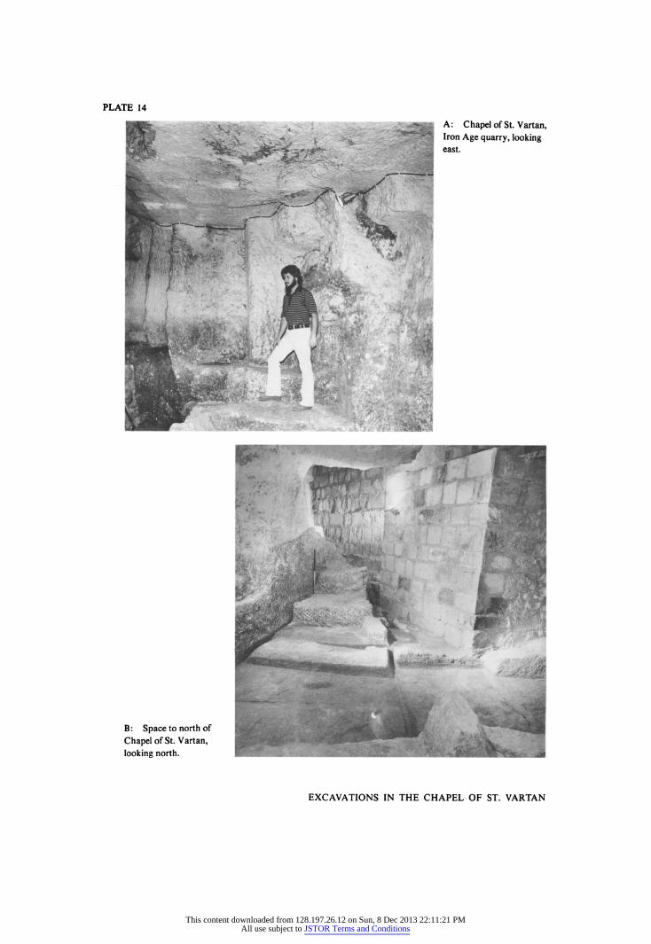
PLATE 14
EXCAVATIONS IN THE CHAPEL OF ST. VARTAN
This content downloaded from 128.197.26.12 on Sun, 8 Dec 2013 22:11:21 PMAll use subject to JSTOR Terms and Conditions
PLATE 15
: Chapel of St. Vartan, looking north-west. The labourer stands on Wall W2; to left, W4; in
background, W6.
EXCAVATIONS IN THE CHAPEL OF ST. VARTAN
This content downloaded from 128.197.26.12 on Sun, 8 Dec 2013 22:11:21 PMAll use subject to JSTOR Terms and Conditions
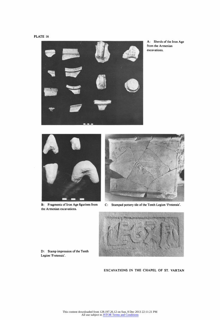
PLATE 16
: Fragments of Iron Age figurines from C : Stamped pottery tile of the Tenth Legion 'Fretensis'.
the Armenian excavations.
D: Stamp impression of the Tenth
Legion 'Fretensis'.
EXCAVATIONS IN THE CHAPEL OF ST. VARTAN
This content downloaded from 128.197.26.12 on Sun, 8 Dec 2013 22:11:21 PMAll use subject to JSTOR Terms and Conditions
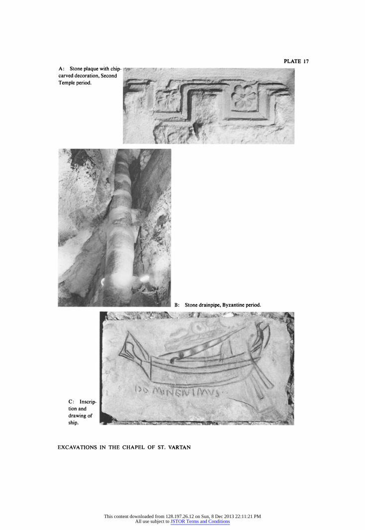
PLATE 17
EXCAVATIONS IN THE CHAPEL OF ST. VARTAN
This content downloaded from 128.197.26.12 on Sun, 8 Dec 2013 22:11:21 PMAll use subject to JSTOR Terms and Conditions