Embed Size (px)
Citation preview

Excavations atLarkwhistle Farm, Brimpton,
BerkshireBy Alan Hardy and Cecily Cropper
OAU Occasional Paper Number 2
ISBN 0-904220-12-5
The Oxford Archaeological Unit (OAU) carried out an excavationon c.8 hectares of gravel terrace south of Brimpton, at one timepart of Brimpton Common, on the south borders of Berkshire.This followed the decision in December 1994 by Berkshire CountyCouncil to allow the extraction of gravel from the site by ARC(Planning Application 144973), subject to a legal agreementallowing a programme of archaeological investigation andpublication. The OAU had performed an archaeologicalassessment of the site in 1987 following the initial proposal forthe extraction of gravel. Excavations in 1995 revealed features ofa middle Iron Age date, consisting of one rectangular enclosure,two associated circular gullies and one four-post structure. Thearchaeological evidence indicated a settlement that was short-lived and possibly marginal to a nucleus situated to the south.

Excavations at Larkwhistle Farm, Brimpton, Berkshire
by Alan Hardy and Cecily Cropper
with contributions by
Jane R Timby, Philippa Bradley and Mark Robinson
OAU Occasional Paper No. 21999
Series editor Angela Boyle

ii
Excavations at Larkwhistle Farm, Brimpton, Berkshire
ISBN 0-904220-12-5
© Oxford Archaeological Unit
This book is the second in a series of OccasionalPapers to be published by the Oxford ArchaeologicalUnit. The series aims to provide a means for rapidpublication and dissemination of short reports forwhich there is no established provision elsewhere.

iii
OAU Occasional Paper Number 2
Plate 1 Aerial photograph of Area A

iv
Excavations at Larkwhistle Farm, Brimpton, Berkshire
CONTENTS
SUMMARY .......................................................................................................................................................................... 1
INTRODUCTION .............................................................................................................................................................. 1Location and geology ............................................................................................................................................. 1Historical and archaeological background ....................................................................................................... 1The 1987 evaluation ............................................................................................................................................... 1Methodology ........................................................................................................................................................... 1
ARCHAEOLOGICAL DESCRIPTION .......................................................................................................................... 2Area A ....................................................................................................................................................................... 4
The rectangular enclosure, structure 112 ..................................................................................................... 4Circular structure 194 ..................................................................................................................................... 4Circular structure 209 ..................................................................................................................................... 7The four-post structure 133 ............................................................................................................................ 7
Area A phasing ........................................................................................................................................................ 7Phase 1 .............................................................................................................................................................. 7Phase 2 .............................................................................................................................................................. 7
Area B ........................................................................................................................................................................ 9Area C ....................................................................................................................................................................... 9
THE FINDS .......................................................................................................................................................................... 9The pottery by Jane R Timby ............................................................................................................................... 9
Introduction ..................................................................................................................................................... 9Fabrics and forms ............................................................................................................................................ 9Flint tempered wares ...................................................................................................................................... 9Sandy wares ..................................................................................................................................................... 9Site distribution .............................................................................................................................................. 9Discussion ........................................................................................................................................................ 10Catalogue of illustrated sherds ..................................................................................................................... 11
Fired clay by Jane R Timby .................................................................................................................................. 11The worked flint by Philippa Bradley ............................................................................................................... 11
THE ENVIRONMENTAL REMAINS............................................................................................................................. 11Charred plant remains by Mark Robinson ....................................................................................................... 11
DISCUSSION ...................................................................................................................................................................... 12Structures ................................................................................................................................................................. 12Function of the enclosures and the structures .................................................................................................. 13Local environment .................................................................................................................................................. 13
THE ARCHIVE ................................................................................................................................................................... 13
ACKNOWLEDGEMENTS ................................................................................................................................................ 13
BIBLIOGRAPHY ................................................................................................................................................................ 14
v
OAU Occasional Paper Number 2
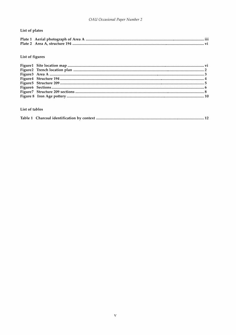
List of plates
Plate 1 Aerial photograph of Area A ............................................................................................................................ iiiPlate 2 Area A, structure 194 .......................................................................................................................................... vi
List of figures
Figure1 Site location map ............................................................................................................................................... viFigure2 Trench location plan ......................................................................................................................................... 2Figure3 Area A .................................................................................................................................................................. 3Figure4 Structure 194 ....................................................................................................................................................... 4Figure5 Structure 209 ....................................................................................................................................................... 5Figure6 Sections ................................................................................................................................................................ 6Figure7 Structure 209 sections ....................................................................................................................................... 8Figure 8 Iron Age pottery ................................................................................................................................................ 10
List of tables
Table 1 Charcoal identification by context ................................................................................................................. 12

vi
Excavations at Larkwhistle Farm, Brimpton, Berkshire
N
Newbury
Newbury
Tadley
Kingsclere
A339
A34
A34
3
Thatcham
B3051
A340
A4
the site
0 5 km.
55
60
65
555045
Figure 1 Site location map
Plate 1 Area A, structure 194

1
OAU Occasional Paper Number 2
INTRODUCTION
Location and geology (Figure 1)
Larkwhistle Farm, Brimpton, is located approximately11 km to the south-east of Newbury. The site, centredat SU 573625, lies within fields to the south of the B3501and immediately north of the alignment of scheduledprehistoric barrows known as the Borson group. Thewell-preserved bell barrow 6b (Scheduled AncientMonument 122343) is immediately adjacent.
The site is essentially flat (106.9 m OD), and lies ona wide sheet of Lower Hill Terrace gravel, south of theRiver Kennet (OS Geological Map 268, 1946). Themiddle Thames gravels are predominantly composedof flint pebbles derived from the chalk and the overlyingchalk and flints. The site geology corresponded withthis, with the addition, in places, of overlying depositsof mid-brown silty clay representing palaeochannels.The water table was reasonably stable during the periodof the excavation at approximately 106 m OD, but hasbeen known to fluctuate considerably.
Historical and archaeological background
The Borson barrow complex is considered to date tothe Bronze Age. Barrows 6a and 6b were ‘exhaustively’examined by Greenwell and Money in the late 19thcentury (Newbury District Field Club iv, 1886–95, 186;Wymer 1968, 115), but with negative results. In 1961Mr R Sheridan found two handaxes in the vicinity ofbarrow 6b but their precise location in relation to thebarrow was not recorded.
Rocques’ Map of 1761 and the Ordnance Survey of1817 and 1877 show Larkwhistle Farm to have been partof Brimpton Common until 1877. The land was brieflycultivated but neglected between the 1920s and 1950s
SUMMARY
The Oxford Archaeological Unit (OAU) carried out an excavation on c.8 hectares of gravel terrace south of Brimpton,at one time part of Brimpton Common, on the south borders of Berkshire. This followed the decision in December1994 by Berkshire County Council to allow the extraction of gravel from the site by ARC (Planning Application144973), subject to a legal agreement allowing a programme of archaeological investigation and publication. TheOAU had performed an archaeological assessment of the site in 1987 following the initial proposal for the extractionof gravel. Excavations in 1995 revealed features of a middle Iron Age date, consisting of one rectangular enclosure,two associated circular gullies and one four-post structure. The archaeological evidence indicated a settlementthat was short-lived and possibly marginal to a nucleus situated to the south.
Excavations at Larkwhistle Farm,Brimpton, Berkshire
by Alan Hardy and Cecily Cropper
with contributions by
Jane R Timby, Philippa Bradley and Mark Robinson
until its return to arable use in the 1970s. The excavationrevealed evidence of modern field drains and deep‘prairie busting’ plough furrows.
The 1987 evaluation (Figure 2)
The OAU undertook an archaeological assessment in1987 as a response to the initial proposal by ARC for theextraction of gravel (Miles and Lange 1987). The entiresite was subjected to a 2% sample excavation, by meansof 48 machine-excavated trenches. All the trenches were30 m in length and were aligned either north-south oreast-west. Archaeological remains were poorly preservedhaving been subject to severe plough disturbance.However, three areas of undated archaeological activitywere defined. A series of curved and linear ditches wereidentified in Area A while Areas B and C each containeda line of small and shallow postholes.
Methodology
Although the results of the evaluation were in-conclusive, areas A, B and C were targeted for furtherattention with particular aims in mind. Area A wouldbe examined to define the date, extent and character ofthe structures which would be compared with otherstructures locally and regionally. Environmentalevidence would be used to determine the nature of theprehistoric landscape. Areas B and C would beexamined to determine whether the posthole linerelated to activity in Area A or to the barrow group andpossible associated funerary practices. Any other relatedfeatures in these areas would be investigated.

2
Excavations at Larkwhistle Farm, Brimpton, Berkshire
The three areas were accurately surveyed into theOS grid. The topsoil and ploughsoil were removed,using a mechanical excavator equipped with a toothlessbucket , down to the natural gravel subsoil. A 10 m gridwas laid out over the three areas and tied into theOS grid. Areas of archaeological potential werehand-cleaned to reveal the features, which showeddistinctively dark against the lighter coloured gravel.Manual cleaning was abandoned within archaeo-logically barren areas after consultation with P Fasham,the Principal Archaeologist of Babtie Public ServicesDivision on behalf of Berkshire County Council.
All archaeological features were planned at a scaleof 1:50. The two circular structures, and any associatedfeatures, were completely excavated in order tomaximise the recovery of material evidence and torecord spatial distribution. Approximately 10% of thelarge enclosure ditch was excavated. Excavation inAreas B and C was limited to 50% sampling, by volume,of the features. All recording was by the standard OAUmethod (Wilkinson 1992).
A comprehensive photographic record wasmaintained during excavation. Furthermore, aerialphotographs were taken of Area A, during and afterexcavation, using a large kite carrying a 35 mm camerawith a radio-controlled shutter release (see Plates1 and 2). The sampling strategy involved taking10 or 20 litre environmental samples from thesections excavated in the enclosure ditch and fromvarious sections from both circular gully features(see Robinson below).
Once Areas A, B and C had been excavated, awatching brief was maintained over the southern halfof the entire extraction area during the topsoil strippingby ARC.
ARCHAEOLOGICAL DESCRIPTION
The topsoil/ploughsoil, a dark brown silty loam with30–40% gravel, varied in depth from 0.20– 0.30 m. Thisdirectly overlay the natural gravel/subsoil into whichall archaeological features were cut. The gravel,
Figure 2 Trench location plan
N
Area C
Area B
Barrow 6b
Tumuli
Area A
112
133
209
194
0100 100 m.
571 572 574573 575 576 577 578
629
626
625
624
628
627
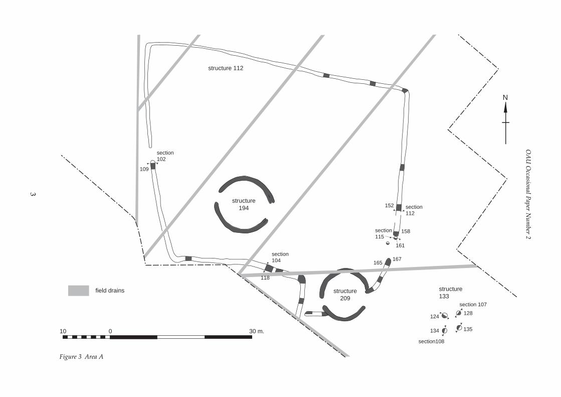
3
OA
U O
ccasional Paper N
umber 2
Figure 3 Area A
152 section112
158section115
161
167165
structure209
section104
structure194
section102
109
structure 112
section 107
128
135
section108
134
124
structure133
N
010 30 m.
field drains
118

4
Excavations at Larkwhistle Farm, Brimpton, Berkshire
particularly in Area A, was disturbed by numeroustree-throw holes (not on plan).
Area A (Figures 2 and 3; Plates 1 and 2)
The rectangular enclosure, structure 112(Figures 3 and 6, Sections 102, 104, 112 and 115)
The gravel was cut by a shallow, roughly V-shapedditch, structure 112, that defined a sub-rectangularenclosure. The long axis was aligned roughly east-westand enclosed an area of approximately 2000 m². Theditch fills were similar throughout, consisting of verydark grey-brown silt with coarse gravel inclusions,overlain by a very dark brown-grey fine silt. Thedimensions of the ditch varied from 0.80 m in widthand 0.60 m in depth on the east side, to 0.20 m inwidth and 0.05 m in depth in the north-west cornerwhere later truncation had been at its most severe. Thewest side of the enclosure ditch was interrupted halfwayalong its length by an entrance, 3 m wide. A secondentrance, facing east and 4.3 m in width, was formed
by the southern terminus of the western side of theenclosure and northern terminus of the spur runningnorth from the circular structure 209. A single posthole(241), 0.30 m in diameter and 0.18 m in depth, wassituated towards the centre of this gap, approximately2 m to the south-west of the terminus of the enclosure’swestern arm. A further posthole (161), c.0.64 m indiameter and c0.14 m in depth, was situated at the endof this terminus. A possible corresponding posthole(167), with an average diameter of 0.50 m and a depthof c.0.20 m, was located at the northern tip of the north-running spur (165). There was, however, no differencein fill between this and the enclosure gully terminus.The enclosure ditch was recut for part of its length.
Circular structure 194(Figures 3, 4 and 6, sections 121, 138, 137 and 133)
Structure 194 was situated within the south-westquadrant of the rectangular enclosure, approximately6 m north of its southern arm. The circular structureconsisted of two opposing curved gullies that formed a
Figure 4 Structure 194
N
221
100
100 170
section 121
228
section 138
253
section 137
235
section 133
192
0 5 10 m.

5
OA
U O
ccasional Paper N
umber 2
Figure 5 Structure 209
N
0 5 10 m.
section 140
section 122
section 131/177
182171
215
section 123
165
167
1987 evaluation trench
196
section 127
section 126
195
255
211
section 130
236
field drain

6
Excavations at Larkwhistle Farm, Brimpton, Berkshire
Figure 6 Sections
107.00m. O.D.
Enclosure 112
W ES N
E W
section 102section 104
section 115
110111
109120
118137
136
119162 162164
161
E W
section 112
153 154152
107.00m. O.D. 107.00m. O.D.Structure 194
N S NE SW
section 138 section 121
229
223177 189
176 188
190228
107.00m. O.D.
NE SW107.00m. O.D.
section 137section 133
230 231
235
193192
170
169
107.00m. O.D. 107.00m. O.D.Structure 133
N SSW NE
section 108section 107
145 143
134
129 130130
128
0 1 m.1

7
OAU Occasional Paper Number 2
circular enclosure with an internal diameter of 10.2 m.The opposing terminals of the gullies left a gap on thenorth-west and south-east sides of 2 m and 3.2 mrespectively. A posthole (221), with a width of 0.25 mand a depth of 0.09 m, was situated to the centre of thesouth-eastern gap. The gullies averaged 0.45 m in widthand 0.25 m in depth. Re-cuts to the north-east and south-east ends of the ditches were seen in plan as bifurcatingterminals. In section (Fig. 6, nos 121 and 133) it couldbe seen that the outermost terminals (cuts 176 to thenorth and 192 to the south) were later. The northerncrescent of the gully cut a tree-throw hole (253) located2 m to the east along from its western terminus. A smallassemblage of middle Iron Age pottery was recoveredfrom the eastern termini of the arcs.
The profile of the gullies varied slightly accordingto the nature of the subsoil. Where the ditch cut intogravel towards the east its cut was shallow and with amore rounded base (Fig. 6, nos 121 and 133). However,to the west, where the natural surface contained moreclay, the sections were more irregular, in some placesshowing evidence of a ‘slot’ at the base of the ditch(Fig. 6, nos 137 and 138).
The fills reflected this difference in subsoil, ingeneral being clay-loams to the west and silty-loams tothe east. All fills were mid to dark grey-brown in colourand contained an average of 15% gravel inclusions.No internal features of any kind were identified withinthe circle.
Circular structure 209 (Figures 3, 5 and 7, sections 131/177, 122, 140, 127, 123, 126 and 130)
Structure 209 was situated in the south-east corner ofthe enclosure and consisted of two opposing curvedgullies that formed a circle with an internal diameter ofapproximately 9.5 m. The northern crescent wastruncated by a field drain running east-west. Thenorthern crescent averaged 0.55 m in width and rangedin depth from 0.20 m in the west and 0.40 m in the east.The southern crescent averaged 0.70 m in width and0.20 m in depth. The gaps created by the opposingterminals faced south-east and west and in width were2.2 m and 2.8 m respectively.
A gully (including cuts 182 and 167), forming a spur,ran from the eastern terminus of the northern crescentnorthwards for a length of 8.7 m towards the southernterminus of the eastern arm of the enclosure. The spuraveraged 0.75 m in width and 0.18 m in depth. Therelationship between this and structure 209 wasuncertain. A corresponding gully (cuts 195 and 211) ranfrom near the tip of the western terminus of thesouthern crescent westwards for a distance of 4.8 mand terminated approximately 0.75 m short of theenclosure gully that ran directly south. This latter spuraveraged 0.70 m in width and 0.23 m in depth. Fromthe sections (Fig. 6, nos 126 and 131/177) it wouldappear that both spurs are cut by the curved gulliesand it is likely that the spurs are related to therectangular enclosure 112.
A possible posthole (167) was located at the end ofthe terminus (165) of the north-running spur. This
posthole was slightly deeper (0.20 m) than the terminusand had a diameter of c.0.57 m. The relationship couldnot be determined because the fills of the posthole andthe terminus were identical, thus making the featurescontemporary.
The fills were predominantly silty loams and rangedconsiderably in colour and gravel content throughoutthe structure.
The four-post structure 133(Figures 3 and 6, sections 107–8)
The square four-post structure 133 was represented byfour postholes situated approximately 19 m east of theeast-facing gap in structure 209, and 16 m east ofenclosure 112. The postholes had an average diameterof 0.68 m and an average depth of 0.24 m. Postpipes,visible in all four postholes, had an average diameterof 0.29 m and depth of 0.19 m. All holes were flatbottomed except posthole 135 and postpipe 132 inposthole 124 which had rounded bases. Fills of bothpostholes and respective pipes contained in generalfriable or compact mid to dark brown silty loams, withgreater amounts of gravel inclusions within thepostpipes. Measurements taken between the centres ofthe postpipes show that they were a common distanceapart, c.2.90 m, and formed a roughly true square thatenclosed an area of c.8.41 m².
Area A phasing
Two phases of activity were suggested from the structuralevidence rather than from the pottery evidence which,by its homogeneity, suggested short-term occupationor site-usage (see Timby below). Four-post structure 133had no relationship with other features and therefore ithas not been possible to phase this structure.
Phase 1 (enclosure 112 and circular structure 194)
The southern east-west running gully of enclosure 112showed evidence of re-cutting (Fig. 6, section 104) withthe primary cut (136) appearing to have terminatedapproximately 22 m east of the south-west corner ofthe enclosure. This would suggest that the originalenclosure was constructed with a gap of approximately24 m between this original terminus on the south sideand the terminus (158) on the east side. There was noevidence of postholes defining a fence line or otherbarrier across this gap. Although there is no evidencelinking the internal circular gully with the enclosure112 or structure 209, it is proposed that structure 194was part of this phase.
Phase 2 (addition of structure 209 and extension ofsouth ditch of enclosure 112)
The re-cutting (118) of the southern arm (136) extendedenclosure 112 to the east for approximately 5 m. Theditch then turned a sharp 90° to the south and continuedbeyond the edge of the trench. There was no evidencefor re-cutting of the northern part of the enclosure ditch.

8
Excavations at Larkw
histle Farm, B
rimpton, B
erkshire
Figure 7 Structure 209 sections
107.00m. O.D.
0 1 m.1
107.00m. O.D.
107.00m. O.D.
107.00m. O.D.
107.00m. O.D.
Structure 209
107.00m. O.D.
218 184
172217
216
215
172
240
185
171
182
184
166
165
196
199
201
237
238
236
184
185
172
240
171
195 196
197
198
199
200
202
213
214
211
212
section 130
section 126
section 123section 127
section 140section 122
section 131/177
N S
WE
NW SE
NE SWE
W
E W
E
W

9
OAU Occasional Paper Number 2
It would seem likely that the original gap in the south-east corner of the enclosure was bridged at this time bythe circular structure 209 and associated spurs.Although the pottery suggests that structure 209pre-dated structure 194, the purportedly earliersand-tempered wares represented only a very smallproportion of the total assemblage. It is entirely possiblethat these coexisted with the flint-tempered wares andany change in fabric was gradual and localised.
Area B (Figure 2)
The original 1987 assessment trench (No. 42), locatedwithin the excavation area, revealed the line of supposedpostholes. Closer inspection of these revealed that theywere very shallow and sub-rectangular in plan andfilled with compacted topsoil. It is most likely that theyrepresent the footprints of the stabilisers of a JCBexcavator and were presumably made during theoriginal excavation of the assessment trench. No otherarchaeological features or deposits were revealed in thestripped area.
Area C (Figure 2)
A line of six postholes was revealed, aligned approx-imately east-west. The dimensions of the postholes werebroadly similar, averaging 0.25 m in diameter and 0.25m in depth. The spacing between the postholes variedfrom 3.0 m to 5.0 m. A further random scatter of fivesmaller postholes was identified at the west end of theline. All the features excavated had a similar fill, a darkgreyish brown silty loam, with some inclusions derivedfrom the natural gravel or the overlying pale brownsilty clay. No artefactual evidence was found in any ofthe features in this area. However, while we cannot ruleout a prehistoric origin for these postholes, the fact thatthey run almost parallel with a modern field boundarysuggests that they are more likely to be a post-medievalprecursor to the present boundary.
THE FINDS
The pottery by Jane R Timby
Introduction
The excavation produced a moderately small collectionof middle Iron Age pottery amounting to some 482sherds (3342 g). The material was of variable conditionwith a number of very small sherds, resulting in anoverall average sherd weight of just 7 g. There were nocomplete profiles. In most cases surface finish could bedetected although in a few instances this had been lost.The material was sorted macroscopically, with the aidof a x20 binocular microscope into fabric types, andquantified by sherd count, weight and estimated vesselequivalent (eve), based on rim fragments only, for eachexcavated context.
The pottery was recovered from fifteen individualcontexts although some of these may be from essentiallythe same cuts. The greatest concentration came fromthe south-east corner of the site, with lesser quantities
from the gully of the sub-rectangular enclosure (112)and from the circular gully (194) within this. There werefew stratigraphic relationships available thus limitingany potential refinement of dating of what appears tobe a fairly homogenous assemblage.
Fabrics and forms
Broadly the pottery could be split into two main fabricgroups based on the main inclusions present in theclays: flint-tempered wares (fabrics F1, F2) and sandywares (fabrics S1–3).
Flint-tempered wares account for 94 per cent by weight,85.5 per cent by count. Two main forms are representedin the flint fabrics; saucepan pots, both straight-sidedand slightly globular forms and slack-sided jars withinturned slightly beaded rims. No decorated sherds arepresent although burnishing had been extensivelyemployed on the external and, with the saucepan pots,internal surfaces. Eleven sherds have evidence of burntresidue on the interior and one saucepan pot on theexterior surface.
F1: a moderately hard ware with a hackley fracture.The paste contains a sparse scatter of white, angularcalcined flint up to 1 mm in size and sparse iron grains.One sherd from context 172 shows the impression of asmall piece of bracken frond on the exterior surface.
F2: a moderately hard ware similar to F1 but dis-tinguished by a generally slightly coarser range of flint,up to 2 mm, and the presence of an admixture ofpatinated brown and white angular fragments.
Sandy wares account for the remaining six per cent byweight. The sherds are of a much more fragmentarynature with an average size of just 3 g. Some sherdshave external surface burnishing.
S1: a thick-walled fine sandy ware, dark brown incolour. The paste shows a dense frequency of well-sorted, sub-angular to rounded quartz sand visible asindividual grains at x20 magnification.
S2: a brown sandy ware with a sparse to moderatescatter of black iron (?limonite)
S3: a very fine sandy, finely micaceous clay containingsparse elongated voids from vegetative matter.
Site distribution
The shallow ditch defining the sub-rectangularenclosure, structure 112, produced just twelve smallabraded bodysherds of fabric F2 from 140. The circularstructure within this enclosure produced a small groupof thirty-five sherds of pottery from gully terminal 170and a single sherd from 177. The pottery is exclusivelyflint-tempered (fabrics F1, F2), and both contextscontained sherds from vessels in the saucepan pottradition.

10
Excavations at Larkwhistle Farm, Brimpton, Berkshire
The sub-circular enclosure in the south-east corner,structure 209, produced 239 sherds, 1800 g, from thegully (contexts 172, 183, 185, 199, 237, 256–7 and 262). Afurther 170 sherds, 1224 g, were recovered from the gullyto the north-east of this enclosure (117, 166 and 168),and ten small sherds from the south-west gully extension(197). Whilst the group was dominated by flint temperedfabrics a small number of sandy ware sherds werepresent. In most cases fabrics S1 and S2 came from thelower fills, notably 168, 197, 237 and 257. Further sherdscame from fill 183, while upper fills 117 and 262 con-tained sherds of fabric S3, not found in the earlier fills.
Discussion
The range of forms places this assemblage firmly withinthe middle Iron Age traditions of central southernEngland. Evidence from contemporary sites to thesouth, in particular Brighton Hill South, Basingstoke(Rees 1995), and Old Down Farm near Andover (Davies1981), suggests that sandy wares dominate the early tomiddle Iron Age phases predating the flint-temperedtradition. The sandy wares at Brighton Hill feature asslack-sided jars and proto-saucepan pots and, as atBrimpton, occur alongside the later classic saucepanpots in the flint-tempered fabrics. On this basis it couldbe argued that the complex in the south-east area of thesite which produced all the sandy wares predates both
the other circular and the sub-rectangular enclosures,although this does not necessarily preclude theircoexistence. Similarly, at Danebury a change in the useof sandy to flint based fabrics is witnessed throughoutthe middle-later Iron Age period (Cunliffe 1984, 248).
Several other middle Iron Age sites are known inthe Reading area, in particular, Binfield (Roberts 1995)and Fairclough Farm, Bracknell (Torrance and Durden1994) to the east, Risely Farm, Swallowfield (Lobb andMorris 1991–93) to the south, Southcote just west ofReading (Piggott and Seaby 1937), Beedon Manor Farm,Newbury to the west (Pocock 1990), and Ufton Nervet(Manning 1974) and Aldermaston Wharf (Cowell et al.1977–78), both adjacent to the River Kennet immediatelynorth-east of Brimpton.
The pottery from both Risely Farm, Swallowfield(Lobb and Morris 1991–93) and Fairclough Farm,Bracknell (Timby 1994) was dominated by a range ofsandy wares and no saucepan pots. However, slack-sided jars similar to the Brimpton examples were acommon feature. Conversely the Brimpton assemblagedid not include any examples of scored ware as foundat Risely Farm associated with a radiocarbon date of2250 + 60 BP (Lobb and Morris 1991–93, 53). It is likely,therefore, that both these sites predate Brimpton.
A similar picture occurred at Binfield (Booth 1995)where sandy wares dominated the middle Iron Ageassemblage and flint-tempered wares were rare.
Figure 8 Iron Age pottery
0100 100 mm.
87
9
5
1 2
6
3
residue4

11
OAU Occasional Paper Number 2
Saucepan pots similarly did not feature, perhapssuggesting a break in continuity here between themiddle and later Iron Age occupation phases.
Saucepan pots, however, are a common feature ofsites to the south, for example Brighton Hill South,Basingstoke (Rees 1995). A small number also appearto be present, possibly residually, at Ufton Nervet (forexample, Thompson and Manning 1974, fig. 13.18;20.166) and flint-tempered examples occur at Southcote,Reading (Piggott and Seaby 1937, fig. 3, B3; fig. 4, 9).The latter site, unlike Brimpton, also features a largenumber of decorated sherds, as well as some later IronAge vessels, and would appear to be of fairlylong duration which may be considered in partcontemporary with Brimpton.
The middle Iron Age assemblage from AldermastonWharf dated to the 3rd–1st century BC, mainly consistsof flint-tempered wares, with examples of slack-sidedjars and plain saucepan pots (Cowell et al. 1977–78,fig. 13.7–8, 13–4). Like Risely Farm there are somevessels decorated with shallow scored decoration.Again there would appear to be some contemporaneitywith Brimpton but in the former case occupationcontinues into the later Iron Age/early Roman period.Brighton Hill South is another longer lived sitewith the same elements in its assemblage as thosefound at Brimpton, but again the repertoire is morediverse and includes a considerable number ofdecorated wares.
In conclusion, the absence of any decorated waresand the overall predominance of flint-tempered waresat Brimpton might argue for the site being activetowards the latter part of the middle Iron Age, perhapsaround the 2nd century BC. The marked absence of anydecorated vessels, however, could be interpreted severalways: it may be due to the small size of the assemblage,it may be a reflection of the character/status of the siteor it may be a chronological factor. Unlike many of theother sites in the locality with evidence of middle IronAge occupation, this particular area of Brimpton wasapparently only in use for a relatively short periodof time.
Catalogue of illustrated sherds (Figure 8)
1. Straight-sided saucepan pot with a single tooled linebelow the rim. Burnished interior, smoothed, possiblyoriginally burnished exterior. Fabric F2. (172)
2. Slightly globular saucepan type pot with a singletooled line below the rim. Burnished on the interiorand exterior surfaces. Fabric F2. (172)
3. Slightly globular, slack-sided jar with a burnishedexterior and smoothed interior. Blackened residue onthe exterior surface. Fabric F2. (172)
4. Slightly beaded rim from a large jar. Fabric F2. (199)5. Slightly globular saucepan style pot. Fabric F2. (168)6–7. Slightly beaded rim slack-sided jars with a
burnished finish. Fabric F2. (168)8. Globular jar with a well-burnished exterior finish
extending to just inside the rim. Fabric F2. (168)9. Thinner-walled slack-sided jar with a slightly
thickened rim. Burnished finish. Fabric F2. (117)
Fired clay by Jane R Timby
The excavations produced 1043 g, 560 pieces, of firedclay from five contexts (117, 168, 177, 199 and 262). Onepiece, from 168, showed one flat surface with organicimpressions and may be part of a loomweight. Aparticularly large fragment, 836 g, with one flat surfacemarked by a small depression also came from thiscontext. All the other fragments were small abradedpieces with no discernible form and no features.
The worked flint by Philippa Bradley
Eleven pieces of worked flint and twenty-one pieces ofburnt unworked flint were recovered from theexcavation. All of the material was found in Iron Ageor later contexts. The flint is dark brown in colour witha thick grey cortex. It is of relatively good quality andmay have been available locally.
The assemblage consists of eight flakes, one slightlyblade-like flake, a multi-platform flake core and a corefragment. The core had been extensively worked andwas probably discarded when no further flakes couldbe removed. The flakes are mostly hard-hammer struck,the blade-like flake is probably not a deliberate product.The burnt unworked flint is generally heavily calcinedand includes one or two large nodules weighing up to180 g. The assemblage is too small to provide any datingevidence but it does indicate earlier prehistoric activityin the area.
THE ENVIRONMENTAL REMAINS
Charred plant remains by Mark Robinson
During the excavation samples were taken from theditches to recover charred plant remains (Table 1). Thestandard sample volume was ten litres but in someinstance a pair of samples were taken from the samecontext, giving a total of twenty litres. Twenty ninesamples from twenty three contexts were floated ontoa 0.5 mm mesh and the dried flots sorted under abinocular microscope. The only charred item found otherthan charcoal was a tuber of the grass Arrhenatherumelatius sp. bulbosum (onion couch grass) from samples12/13, context 172. Seeds and chaff were entirely absent.The charcoal was identified using incident light highpower microscopy and the results are listed in Table 1,which gives an indication of the abundance of taxa. Inaddition, sample 42 from context 110 contained somecharcoal, which probably represented the woody stemsof sub-shrubs. One fragment could be matched withCalluna vulgaris (heather).
The absence of charred cereal remains from any ofthe samples is somewhat unusual for a settlement ofmiddle Iron Age date given that many of the contextssampled contained occupation debris. It suggests thatlittle crop-processing activity occurred on the site. Thesoils of the terrace gravels here have a low fertility so itwould not be surprising if the settlement primarily hada pastoral function. The possible charred heather wouldsuggest acid soil supporting heathland in the vicinity,perhaps even on the site itself.

12
Excavations at Larkwhistle Farm, Brimpton, Berkshire
The charcoal from the site was primarily Quercussp. (oak) but included Betula sp. (birch), a tree whichtends to be associated with non-calcareous soils of lownutrient status. With the exception of a single small pieceof oak charcoal from sample 35, context 166, all thewood charcoal was recovered from ‘hut circle’ gullies.This would be appropriate to domestic activities beingcentred upon these two areas. Hut Circle 194 onlyyielded oak charcoal whereas the full range of taxa listedin Table 1 were found in the gullies of Hut Circle 209.
DISCUSSION
The area around Brimpton and along the Enbourne andthe Lower Kennet Valleys has been mainly investigatedthrough small-scale excavations, fieldwalking andsurveys, predominantly by the Berkshire ArchaeologicalUnit and Wessex Archaeology. Cropmark sites havebeen identified but lack of excavation can only suggestthat this evidence is of an Iron Age date (Lobb and Rose1996, 84). Middle and late Iron Age activity isrepresented primarily by agricultural settlement withrectangular enclosures and associated field systems(Lobb 1977–78, 39–41), a landscape into which theactivity at Larkwhistle Farm comfortably fits. Examplesof other middle Iron Age settlement occur at RiseleyFarm, within the Blackwater Valley (Lobb and Morris1991–93) and Aldermarston Wharf (Cowell et al.1977–8). On a wider regional scale, the settlement atLarkwhistle Farm, although smaller and short-lived,echoes the larger areas of extensive activity such asAldermarston Wharf in the county of Berkshire andWittenham Clumps (Hingley 1979–80, 21–55), nowplaced in the county of Oxfordshire, and also siteswithin the Upper Thames Valley such as Farmoor(Lambrick and Robinson 1979), Mingies Ditch,Hardwick (Allen and Robinson 1993) and Deer ParkRoad (Walker 1995) in Oxfordshire, and Pennyland(Williams 1993) and Bancroft (Williams and Zeepvat1994) in the county of Buckinghamshire.
Structures
It would appear that the rectangular enclosure andassociated structures at Larkwhistle Farm can be placedwithin the category of enclosed farmstead sites such asthat at Old Down Farm, Andover (Davies 1981) andthat represented within the early phases of middle IronAge settlement development at Claydon Pike, Lechlade(Hingley and Miles 1984, 61). It is difficult, however, to
say whether the Larkwhistle Farm enclosure is anexample of an isolated farmstead or part of a largercomplex, even though the unit appears to be integral.
Penannular gullies, either within or directlyassociated with the surrounding enclosure area, are acommon feature of middle Iron Age sites although theopposed curved gullies as seen at Larkwhistle Farmwould appear to be less common. Roundhouse 6 atPennyland (Williams 1993, 21, fig. 14) is just such astructure, also House 3 at Mingies Ditch (Allen et al.1993, 48, fig. 22) and within Area A at Deer Park Road(Walker 1995, 73, fig. 4), although the latter is moresegmented and slightly more complex in form.Structural postholes were notably absent at LarkwhistleFarm as were other penannular/curved structures suchas those mentioned above.
While the area has suffered from localised truncation,as shown by the north-west corner of the enclosure ditch(112), the survival of the four large postholes of the four-post structure (133) indicates that the southern half ofthe site has not been affected to the same degree. Theperimeters of the field showed no evidence of theaccumulation of ‘headlands’ which would supportmass movement of material through long-termploughing that may destroy structural evidence. Thusthe lack of structural post/stakeholes must be explainedon a constructional level. One possibility is that thecurved gullies were settings for upright posts, or thatcill beams, supporting timber uprights, were laid alongthe bottom of the gullies. Although some inconclusiveevidence was found in part of the northern gully ofstructure 194 to suggest a slot to accommodate a cillbeam (Fig. 6, no. 138), no evidence of post/stakeholeswas found within the gullies. If the gullies representedthe actual wall line of the structure, then it is difficult tosee the logic for the width (up to 2.4 m) of the twoopposing ‘entrances’.
The current and generally accepted interpretationargues that these gullies acted as open features servingas drainage channels or ‘eaves drips’ for run-off fromthe roof of the building. As eaves drips they indicatethat the roof covering was constructed to throw waterwell to the side of the doorway, thereby maintaining adry environment in the vicinity of the entrances. There-cutting of the eastern half of the gullies of structure194 is arguably the result of the reconstruction of theroof of the structure. If so, the new roof extended slightlyfurther to the east, requiring the repositioning of thedrainage gullies to catch the run-off. A further argumentfor the gullies being open drains rather than slots for a
Table 1 Charcoal identification by context
Sample 4 5 10/11 12/13 14 19/20 22/23 24/25 35Context 177 189 185 172 204 237 256 257 166Phase 1 2 3 3 1 2 2 2 2
Pomoideae indet. Hawthorn, Apple etc. - - ++ ++ - - - + -Betula sp. Birch - - - - - + + - -Almus glutinosa Alder - - - + - - +++ - -Quercus sp. Oak ++ ++ ++ ++ ++ + +++ + +
Key: + present, ++ some, +++ much

13
OAU Occasional Paper Number 2
timber structure is the accumulation of pottery in thefill of the gully’s eastern terminals. Were the gullieseffectively construction trenches, the pottery wouldhave collected after the structure was demolished, andpresumably the site (or at least that part of it) wasunoccupied. The presence of pottery in the easternterminals suggests that this was the side of the trueentrance. There is no evidence to suggest that theopposing gaps in the western sides of the gulliesare entrances at all, though Allen et al. (1993, 43–50)argued that a concentration of gravel at the westerngap in House 3 at Mingies Ditch did indicate useas a doorway.
Presented with a similar lack of structural evidenceon other sites such as Farmoor, Mingies Ditch,Pennyland and Deer Park Road, the possibility of ‘mass’walls of turf or cob have been suggested. Walls of thistype of material would not necessarily leave anyarchaeologically detectable trace, especially on a sitewith a shallow overburden. Conceivably the mass wallscould have incorporated a timber armature to supporta roof structure. Such postholes as would be requiredfor this method of construction may have been littlemore than shallow stakeholes, which may well havebeen truncated, or did not necessarily penetrate thenatural subsoil. The single posthole (221) within thesouth-east entrance of structure 194 cannot be provento be contemporaneous with the crescentic gullies butfrom its position may indicate the sole structuralevidence remaining of a doorway.
Function of the enclosure and the structures
Even allowing for some truncation of the enclosureditch, it was still far too shallow and narrow to haveserved, on its own, as a physical barrier either to keepstock in or to keep predators out. However, the ditchsupplemented by a hedge or a fence could have formeda more effective barrier. No evidence for fence postholeswas identified along the length of the gully althoughone probable and two definite postholes were identifiedat the eastern entrance of the enclosure. This wouldindicate an entrance structure associated with anupstanding boundary within the enclosure gully. Alightweight ‘hurdle’ fence would require only smallstakeholes, which may have been destroyed by laterploughing. A hedge is a possible alternative but wouldarguably require at least a few seasons to establish, andother evidence from the site suggests that it wasoccupied for a very short period of time.
There is very little evidence of crop processing orarable farming on the site. The environmental evidencesuggests that in the middle Iron Age the area was likelyto be scrubby heathland of poor fertility, at best suitablefor marginal pasture. The complete absence of bone,either animal or human, is almost certainly due to theprevious soil conditions. The environmental evidencesuggests the middle Iron Age soil was acid and unsuitedto arable farming. The Iron Age site at Brimpton (Lobb1977–8) produced very little bone, as did the excavationsat Dunston Park (Fitzpatrick 1994). As the land was onlyseemingly good for marginal pasture, this may well help
to explain, though tentatively, the reason for theapparent short-lived nature of the settlement atLarkwhistle Farm.
It is impossible to determine the nature of the four-post structure as no material or environmental evidencewas recovered to suggest a function. All that can be saidis that it is most probably contemporary with the otherstructures.
The assemblage of pottery was modest in quantity,and derived exclusively from the south-east corner ofthe enclosure and the two circular structures, moreprecisely the eastern termini of their gullies. Thisconcentration of pottery around the eastern porch isnot uncommon and has been noted at Dunston Park(Fitzpatrick 1994), Deer Park Road (Walker 1995) andMingies Ditch (Allen et al. 1993). Hill (1994), amongstothers, speculates that the orientation of entrances inprehistoric houses (mostly to the east and south-east)and the concentrations of pottery around the entrancesmay be due to reasons other than the utilitarian andpractical, and that symbolic or ritual behaviouralpatterns may have played a part.
Local environment
No evidence was found to link the enclosure andstructures to the barrow complex. Although theentrances of structure 209 are in direct alignment withthe largest barrow in the vicinity, this may not have beenintentionally for a ritual purpose. If the enclosurecomplex served a purely pastoral function for a family,as the evidence indicates, it may be that, by this time,the immediate environs of the barrows was notconsidered to be an ‘exclusion zone’ for occupation ordomestic activity. If the site is marginal to a largersettlement site, the lack of evidence to the north suggeststhat further occupation evidence would lie to the south.This is supported by the re-cut, associated with Phase 2,of the southern side of the enclosure 112, running southand continuing beyond the site.
THE ARCHIVE
The archive has been microfilmed and is currently heldat the Oxford Archaeological Unit. The records and thefinds from the excavation will be deposited at NewburyDistrict Museum, Berkshire.
ACKNOWLEDGEMENTS
The excavation and publication were funded by ARCLtd and the authors would like to record their thanksfor the assistance and cooperation of the ARCstaff involved on site. The efforts of the OxfordArchaeological Unit excavation team are gratefullyacknowledged, in particular Mick Parsons, theSupervisor, and Bryan Matthews, the AssistantSupervisor. The contributions of P Fasham of BabtiePublic Services Division on behalf of Berkshire CountyCouncil were much appreciated. The illustrations arethe work of Paul Hughes and the final text was editedby Kate Atherton.

14
Excavations at Larkwhistle Farm, Brimpton, Berkshire
BIBLIOGRAPHY
Allen, T G and Robinson, M A, 1993 The Prehistoriclandscape and Iron Age enclosed settlement atMingies Ditch, Hardwick-with-Yelford, Oxon,Thames Valley Landscapes: The Windrush Valley2, Oxford Univ Comm Archaeol and OxfordArchaeological Unit
Booth, P M, 1995 Iron Age and Romano-British pottery,in Roberts 1995, 106–117
Cowell, R W, Fulford, M G and Lobb, S, 1977–78Excavations of Prehistoric and Roman settlementat Aldermaston Wharf 1976–77, Berkshire ArchaeolJ 69, 1–35
Cunliffe, B, 1984 Danebury: an Iron Age hillfort inHampshire, vol. 2. The excavations 1969–1978: thefinds, CBA Res Rep 52, London
Davies, S M, 1981 Excavations at Old Down Farm,Andover. Part II: Prehistoric and Roman, Proc.Hants. Field Club and Archaeol Soc 37, 81–163
Fitzpatrick, A P, 1994 Outside in: the Structure of anEarly Iron Age House at Dunston Park, Thatcham,Berkshire, in Fitzpatrick and Morris 1994, 68–72
Fitzpatrick, A P and Morris, E L (eds), 1994 The IronAge in Wessex: recent work, Wessex Archaeology,Salisbury
Hill, J D, 1994 Why We Should Not Take the Data fromIron Age Settlements for Granted: Recent Studiesof Intra-Settlement Patterning, in Fitzpatrick andMorris 1994, 4–9
Hingley, R C, 1979–80 Excavations by R.A. Rutland onan Iron Age site at Wittenham Clumps, BerkshireArchaeol J 70, 21–55
Hingley, R C and Miles, D, 1984 Aspects of Iron AgeSettlement in the Upper Thames Valley, in Aspectsof the Iron Age in central southern Britain (eds BCunliffe and D Miles), Oxford Univ CommArchaeol Monograph 2, 52–71
Lambrick, G and Robinson, M, 1979 Iron Ageand Roman Riverside Settlements at Farmoor,Oxfordshire, CBA Res Rep 32, London
Lobb, S J, 1977–78 Notes From The BerkshireArchaeological Unit, Berkshire Archaeol J 69, 37–48
Lobb, S J and Morris, E L, 1991–93 Investigations ofBronze Age and Iron Age features at RiseleyFarm, Swallowfield, Berkshire Archaeol J 74, 37–69
Lobb, S J and Rose, P G, 1996 ArchaeologicalSurvey of the Lower Kennet Valley, Berk-shire, Wessex Archaeology Report 9, Trust forWessex Archaeology
Manning, W H, 1974 Excavations on the late IronAge, Roman and Saxon sites at Ufton Nervet,Berkshire in 1961–1963, Berkshire ArchaeolJ 67, 1–62
Miles, D and Lange, J, 1987 Archaeological Assess-ment at Larkwhistle Farm, Brimpton Common,Berkshire, unpublished archive report, OxfordArchaeological Unit
Newbury District Field Club, Vol. iv, 1886–95 Appendix:Archaeological Notes, 186
Piggott, C M, and Seaby, W A, 1937 Early Iron Age siteat Southcote, Reading, Proc Prehist Soc 111 part 1,43–57
Pocock, V, 1990 Excavations at the Romano-British site,Beedon Manor Farm, Newbury, Berkshire, secondinterim report, unpublished
Rees, H, 1995 Iron Age/early Roman pottery, inBrighton Hill South (Hatch Warren): an Iron Agefarmstead and deserted medieval village inHampshire (P J Fasham and G Keevill),Wessex Archaeological Report 6, Trust forWessex Archaeology
Roberts, M R, 1995 Excavations at Park Farm, Binfield,1990: an Iron Age and Romano-British Settle-ment and two Mesolithic flint scatters, in EarlySettlement in Berkshire: Mesolithic-Romanoccupation in the Thames and Kennet Valleys (edsI Barnes, W A Boismier, R M J Cleal, A P Fitz-patrick and M R Roberts), Wessex ArchaeologyReport No. 6, 93–132, Wessex Archaeology/OxfordArchaeology Unit
Thompson, J, and Manning, W H, 1974 The potteryfrom enclosures I and II, in Manning 1974, 24–39
Timby, J R, 1994 The pottery, in Torrance and Durden1994, archive report
Torrance, L J and Durden, T, 1994 A middle Iron Agesite at Fairclough Farm, Bracknell, Berkshire,Thames Valley Archaeol Services archive report92/5
Walker, G T, 1995 A middle Iron Age settlement atDeer Park Road, Witney: excavations in 1992,Oxoniensia lx, 67–92
Wilkinson, D (ed.), 1992, OAU Field Manual, OxfordArchaeological Unit
Williams, R J, 1993 Pennyland and Hartigans: twoIron Age and Saxon sites in Milton Keynes,Buckinghamshire Archaeol. Soc. MonographSeries 4
Williams, R J and Zeepvat, R J, 1994 Bancroft: a lateBronze Age/Iron Age settlement, Roman Villa andTemple-Mausoleum, Vol. 1: excavations andbuilding materials, Buckinghamshire Archaeol.Soc. Monograph Series 7
Wymer, J J, 1968 Lower Palaeolithic Archaeology inBritain, as represented by the Thames Valley,London