Embed Size (px)
Citation preview

Ice2sea Open Forum 2 - 19, March 2011
Vincent Favier, Christophe Genthon, Gerhard Krinner, Hubert Gallée
Evolution of Antarctic Surface Mass Balance by high-resolution downscaling of LMDZ4 AGCM
and contribution to sea-level change
Cécile AGOSTA

Cécile AGOSTA - LGGE Ice2sea - Open Forum 2011 19, March 2011
1
Antarctic Surface Mass Balance
(van de Berg et al., 2006)
Coastal areas : snowy and windy
Antarctic Plateau :cold and dry
4000
2000
1000
700
500
300
200
100
50
20
0
-400
mm w.e. a-1

Cécile AGOSTA - LGGE Ice2sea - Open Forum 2011 19, March 2011
1
Antarctic Surface Mass Balance
(van de Berg et al., 2006)
4000
2000
1000
700
500
300
200
100
50
20
0
-400
mm w.e. a-1
Climate models: major SMB changes expected in coastal areas
Coastal areas : snowy and windy
Antarctic Plateau :cold and dry

Cécile AGOSTA - LGGE Ice2sea - Open Forum 2011 19, March 2011
SMB Downscaling : Why ?
Spatial extentAntarctica (5600 km x 5600 km)
➙ Reduced computation time needed
Time extent~800 yrs (1980-2200 * 2 Scenarios * 2 Boundary conditions)
SMB estimationPrecipitation, Sublimation, Melting, Refreezing, Blowing snow
GCM resolution : ~ 60 km Required resolution : ≤ 15 km
2

HiDEP
Cécile AGOSTA - LGGE Ice2sea - Open Forum 2011 19, March 2011
3
The HiDEP modelHigh-Resolution Downscaling of surface Energy balance and Precipitation
GCM Outputs :P, T, Qv, U, V, W
3D FieldsTime step : 6H
Surface FieldsTime step : 3H
High-resolution topography
INPUTS (~50 KM RESOLUTION)

HiDEP
Cécile AGOSTA - LGGE Ice2sea - Open Forum 2011 19, March 2011
GCM Outputs :P, T, Qv, U, V, W
3D FieldsTime step : 6H
Surface FieldsTime step : 3H
OUTPUTS (15 KM RES.)Precipitation
High-resolution topography
The HiDEP modelHigh-Resolution Downscaling of surface Energy balance and Precipitation
INPUTS (~50 KM RESOLUTION)
3

HiDEP
Cécile AGOSTA - LGGE Ice2sea - Open Forum 2011 19, March 2011
GCM Outputs :P, T, Qv, U, V, W
3D FieldsTime step : 6H
Surface FieldsTime step : 3H
RainHIDEP
SnowHiDEP
Precipitation
High-resolution topography
The HiDEP modelHigh-Resolution Downscaling of surface Energy balance and Precipitation
OUTPUTS (15 KM RES.)
INPUTS (~50 KM RESOLUTION)
3

HiDEP
Cécile AGOSTA - LGGE Ice2sea - Open Forum 2011 19, March 2011
GCM Outputs :P, T, Qv, U, V, W
3D FieldsTime step : 6H
Surface FieldsTime step : 3H
RainHIDEP
SnowHiDEP
Precipitation
Surface Energy Balance
High-resolution topography
The HiDEP modelHigh-Resolution Downscaling of surface Energy balance and Precipitation
OUTPUTS (15 KM RES.)
INPUTS (~50 KM RESOLUTION)
3

SublimationHIDEP
MeltingHiDEP
RefreezingHiDEP
HiDEP
Cécile AGOSTA - LGGE Ice2sea - Open Forum 2011 19, March 2011
GCM Outputs :P, T, Qv, U, V, W
3D FieldsTime step : 6H
Surface FieldsTime step : 3H
RainHIDEP
SnowHiDEP
Precipitation
Surface Energy Balance
High-resolution topography
The HiDEP modelHigh-Resolution Downscaling of surface Energy balance and Precipitation
OUTPUTS (15 KM RES.)
INPUTS (~50 KM RESOLUTION)
3

Cécile AGOSTA - LGGE Ice2sea - Open Forum 2011 19, March 2011
4
Upward wind ➙ Adiabatic cooling ➙ ρsat ↓
Integration of the Clausius-Clapeyron equation at saturation :
ρ=ρsat(t1)
z
W ⇒Δρsat = precipitation
when ρ≥ρsat and W upwardρ=ρsat(t2)
Δρsat
Precipitation downscaling : an orographic precipitation model
Δρsat/Δt = F (ρsat,T,P) × Wwhen ρ≥ρsat and W upward

Cécile AGOSTA - LGGE Ice2sea - Open Forum 2011 19, March 2011
Precipitation downscaling : an orographic precipitation model
4
Upward wind ➙ Adiabatic cooling ➙ ρsat ↓
Integration of the Clausius-Clapeyron equation at saturation :
ρ=ρsat(t1)
z
W ⇒Δρsat = precipitation
when ρ≥ρsat and W upwardρ=ρsat(t2)
Δρsat
Δρsat/Δt = F (ρsat,T,P) × Wwhen ρ≥ρsat and W upward
➙ Feedback on ρsat,T,P➙ Time-delay for hydrometeor formation➙ Hydrometeor advection

Cécile AGOSTA - LGGE Ice2sea - Open Forum 2011 19, March 2011
5
Orographic precipitation :Determination of the vertical wind W
At the surface : the wind is tangent to the topography

Cécile AGOSTA - LGGE Ice2sea - Open Forum 2011 19, March 2011
Orographic precipitation :Determination of the vertical wind W
At the surface : the wind is tangent to the topography➙ new vertical wind at the surface
5

Cécile AGOSTA - LGGE Ice2sea - Open Forum 2011 19, March 2011
Orographic precipitation :Determination of the vertical wind W
At the surface : the wind is tangent to the topography➙ new vertical wind at the surface
➙ Computation for W : resolution of mountain gravity wave
5

Cécile AGOSTA - LGGE Ice2sea - Open Forum 2011 19, March 2011
Total precipitation : Orographic + Non-Orographic
GCM Grid (~50 km res.) HiDEP Grid (15 km res.)GCM
Topography
GCM Precipitation6
Cécile AGOSTA - LGGE Ice2sea - Open Forum 2011 19, March 2011
Total precipitation : Orographic + Non-Orographic
GCM Grid (~50 km res.) HiDEP Grid (15 km res.)GCM
Topography
GCM Precipitation
Interpolation
6
Cécile AGOSTA - LGGE Ice2sea - Open Forum 2011 19, March 2011
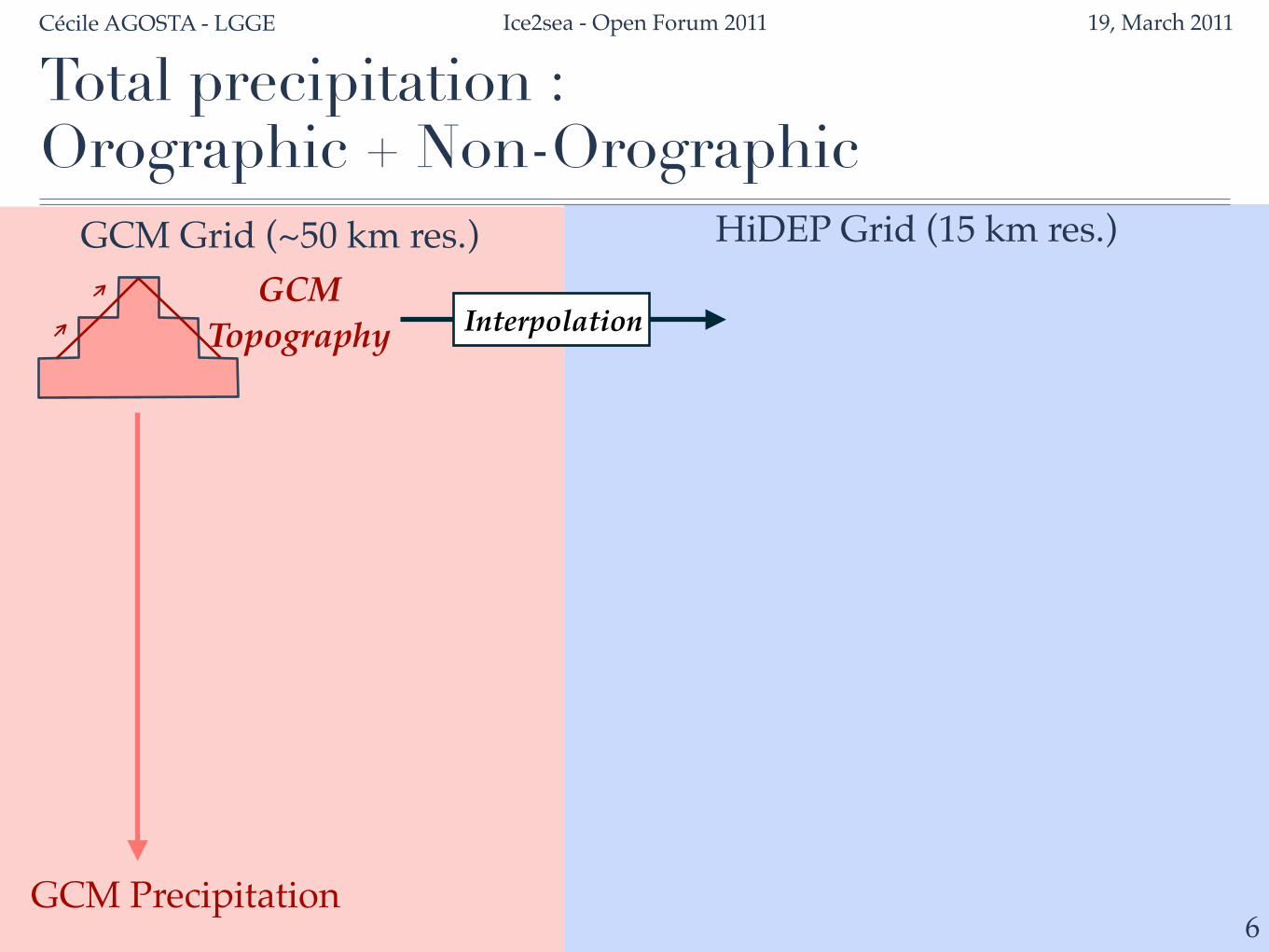
Total precipitation : Orographic + Non-Orographic
GCM Grid (~50 km res.) HiDEP Grid (15 km res.)GCM
TopographyGCM
InterpolatedTopography
GCM Precipitation
Interpolation
6

Cécile AGOSTA - LGGE Ice2sea - Open Forum 2011 19, March 2011
Total precipitation : Orographic + Non-Orographic
GCM Grid (~50 km res.) HiDEP Grid (15 km res.)GCM
TopographyGCM
InterpolatedTopography
GCM Precipitation
Interpolation
6
Low-res. Oro. Precip.

Cécile AGOSTA - LGGE Ice2sea - Open Forum 2011 19, March 2011
Total precipitation : Orographic + Non-Orographic
GCM Grid (~50 km res.) HiDEP Grid (15 km res.)GCM
TopographyGCM
InterpolatedTopography
GCM Precipitation
Interpolation
6
High-res.Topography
Low-res. Oro. Precip.

Cécile AGOSTA - LGGE Ice2sea - Open Forum 2011 19, March 2011
Total precipitation : Orographic + Non-Orographic
GCM Grid (~50 km res.) HiDEP Grid (15 km res.)GCM
TopographyGCM
InterpolatedTopography
GCM Precipitation
Interpolation
6
High-res.Topography
High-res. Oro. Precip.
Low-res. Oro. Precip.

Cécile AGOSTA - LGGE Ice2sea - Open Forum 2011 19, March 2011
Total precipitation : Orographic + Non-Orographic
GCM Grid (~50 km res.) HiDEP Grid (15 km res.)GCM
TopographyGCM
InterpolatedTopography
GCM Precipitation
Interpolation
6Interpolation
High-res.Topography
High-res. Oro. Precip.
Low-res. Oro. Precip.
Low-res. Total Precip. (Oro. + Non-Oro.)

Cécile AGOSTA - LGGE Ice2sea - Open Forum 2011 19, March 2011
7
High-resolution Total Precip.
Low-res. Total Precip. (Interpolated from GCM)
+ High-resolution Orographic Precip.
Low-res. NON-Orographic Precipitation
− Low-resolution Orographic Precip.
Total precipitation : Orographic + Non-Orographic

Cécile AGOSTA - LGGE Ice2sea - Open Forum 2011 19, March 2011
8
Surface Energy Balance
×
z
Var
×
Extrapolation of GCM surface fields against the topography

Cécile AGOSTA - LGGE Ice2sea - Open Forum 2011 19, March 2011
8
Surface Energy Balance
Surface Scheme
×
z
Var
×
Extrapolation of GCM surface fields against the topography

Cécile AGOSTA - LGGE Ice2sea - Open Forum 2011 19, March 2011
8
Surface Energy Balance
×
z
Var
×
Extrapolation of GCM surface fields against the topography
Surface Scheme
SublimationMelting
Refreezing

Cécile AGOSTA - LGGE Ice2sea - Open Forum 2011 19, March 2011
9
Application to LMDZ4 : 1980-2007
HiDEP-LMDZ4LMDZ44000
2000
1000
700
500
300
200
100
50
20
0
-400
mm w.e. a-1SMB

Cécile AGOSTA - LGGE Ice2sea - Open Forum 2011 19, March 2011
10
Application to LMDZ4 : 1980-2007
4000
2000
1000
700
500
300
200
100
50
20
0
-400
mm w.e. a-1van de Berg et al, 2006Arthern et al, 2006
HiDEP-LMDZ4
SMB

Cécile AGOSTA - LGGE Ice2sea - Open Forum 2011 19, March 2011
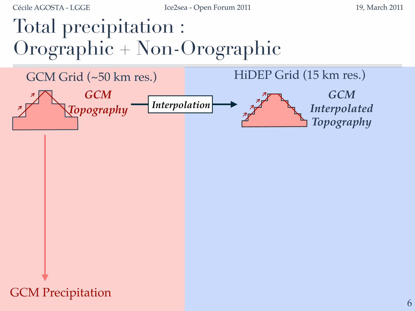
Validation with a quality-controlled SMB data-set (Magand et al., 2007) : 90° – 180°E
0
200
400
600
800
0 200 400 600 800Observed SMB (mm w.e. a-1)
Mod
eled
SM
B (m
m w
.e. a
-1)
LMDZ4 vs. ObsHiDEP-LMDZ4 vs. Obs
HiDEP grid box
LMDZ4 grid box
Obs. Point
Average :in each LMDZ4 Box
1 Obs ↔1 HiDEP Box
R2 = 0.68Slope = 1.10
R2 = 0.73Slope = 0.97
11

Cécile AGOSTA - LGGE Ice2sea - Open Forum 2011 19, March 2011
Validation with a quality-controlled SMB data-set (Magand et al., 2007) : 90° – 180°E
00,20,40,60,81,0
0 500 1000 1500 2000 2500 3000 3500 4000
R2 weighted by the number of observation in LMDZ4 grid boxes
Elevation range of Observations (m)
0306090120
0 500 1000 1500 2000 2500 3000 3500080160240320
R2N
b. o
f Obs
.C
um. N
b. of Obs.
LMDZ4 vs. ObsHiDEP-LMDZ4 vs. Obs
12
Cécile AGOSTA - LGGE Ice2sea - Open Forum 2011 19, March 2011
Validation with a quality-controlled SMB data-set (Magand et al., 2007) : 90° – 180°E
Elevation bins of Observations (m)
0
200
400
600
800
0 500 1000 1500 2000 2500 3000 3500 4000
SMB
(mm
w.e
. a-1
)
0306090120
0 500 1000 1500 2000 2500 3000 3500080160240320
Nb.
of O
bs.
Cum
. Nb. of O
bs.
ObsLMDZ4HiDEP-LMDZ4
13

Cécile AGOSTA - LGGE Ice2sea - Open Forum 2011 19, March 2011
Validation with a quality-controlled SMB data-set (Magand et al., 2007)
14
Extension of the data quality-control to the rest of Antarctica :Work in progress at LGGE
For further information, you can contact Soazig Parouty

Cécile AGOSTA - LGGE Ice2sea - Open Forum 2011 19, March 2011
15
Grounded SMB 1980-2007
208 mm a -1 = kg m -2 a -1
⇔ 2410 Gt a -1
⇔ 6.7 mm a -1 sea level equivalent
Present SMB (1950-2000) : ‣ Range : 1475 à 2331 Gt a -1 [Monaghan et al., 2006]
175.2 mm a-1 = kg m-2 a -1
⇔ 2159 Gt a -1
⇔ 6.0 mm a -1 sea level equivalent
LMDZ4P-E
HiDEP-LMDZ4SMB

Cécile AGOSTA - LGGE Ice2sea - Open Forum 2011 19, March 2011
16
Conclusion
• High-resolution SMB (15 km) obtained from LMDZ4 downscalingPartial validation for present :
✦ Downscaled SMB close to LMDZ4 SMB performance✦ Increase the wet bias of LMDZ4 in coastal areas
BUT lack of field data in (crucial) coastal areas
Runing :• HiDEP-LMDZ4 for :
ScenarioScenarioA1B E1
LMDZ4 Boundary Conditions
HadCM3 21C 21C & 22CLMDZ4 Boundary Conditions ECHAM5 21C 21C
Just Finished

Cécile AGOSTA - LGGE Ice2sea - Open Forum 2011 19, March 2011
17
Outlook
Further validation :• Extended quality-controlled data set over all Antarctica• Coastal-to-plateau transects
Model development in progress :• MAR Surface Scheme• Humidity advection

Thank you

Cécile AGOSTA - LGGE Ice2sea - Open Forum 2011 19, March 2011
Validation with a quality-controlled SMB data-set (Magand et al., 2007)
Quality criteria defined of the basis of :1 - Essential information available : location, time period, method2 - Quality rating of SMB measurement methods
11

Cécile AGOSTA - LGGE Ice2sea - Open Forum 2011 19, March 2011
Validation with a quality-controlled SMB data-set (Magand et al., 2007)
Quality criteria defined of the basis of :1 - Essential information available : location, time period, method2 - Quality rating of SMB measurement methods
Applied to the 90° – 180°E Antarctic sector :Review of references compiled by Vaughan and Russell (1997)+ New results from recent field campaigns
11
Cécile AGOSTA - LGGE Ice2sea - Open Forum 2011 19, March 2011
Validation with a quality-controlled SMB data-set (Magand et al., 2007)
Quality criteria defined of the basis of :1 - Essential information available : location, time period, method2 - Quality rating of SMB measurement methods
Applied to the 90° – 180°E Antarctic sector :Review of references compiled by Vaughan and Russell (1997)+ New results from recent field campaigns
➜ Quality-controlled data set for the 1950–2005 time period - Reduction in density and coverage- BUT reduced uncertainties compared to other compilations
11

400
800
600
400
1000
Cécile AGOSTA - LGGE Ice2sea - Open Forum 2011 19, March 2011
11
Law Dome
Climatologie SMB van Ommen et al., 2004
LMDZ4SMB 1980-2007

Cécile AGOSTA - LGGE Ice2sea - Open Forum 2011 19, March 2011
11
Law Dome
Climatologie SMB van Ommen et al., 2004
400
800
600
1000
600
HiDEP-LMDZ4SMB 1980-2007

Snow Sublimation
Melt
Cécile AGOSTA - LGGE Ice2sea - Open Forum 2011 19, March 2011
9
Application to LMDZ4 : 1980-2007
4000
2000
1000
700
500
300
200
100
50
20
0
-400
mm w.e. a-1LMDZ4
Snow-Sublim.

Cécile AGOSTA - LGGE Ice2sea - Open Forum 2011 19, March 2011
9
Application to LMDZ4 : 1980-2007
4000
2000
1000
700
500
300
200
100
50
20
0
-400
mm w.e. a-1HiDEP-LMDZ4
Snow Sublimation
Melt SMB
Cécile AGOSTA - LGGE Ice2sea - Open Forum 2011 19, March 2011
29
Désagrégateur de précipitationLimites du désagrégateur de précipitation
Pas de dynamique (coûteux en temps de calculs)• Pas de rétro-action de la physique sur la dynamique• Pas de contournement du relief• Pas d’effet de blocage

+ Hypothesis to simplify and linearize the equations :• Small perturbations around the hydrostatic equilibrium• Horizontal wind >> Vertical wind• Mean values slowly varying horizontally• 2D• Scorer parameter l(z)=f (T(z),P(z)) slowly varying
Cécile AGOSTA - LGGE Ice2sea - Open Forum 2011 19, March 2011
5
W : nouvelle vitesse verticale Momentum equation+ Continuity equation+ Thermal dynamic equation+ Steady adiabatic, inviscid, no-rotating flow
Orographic precipitation :Determination of the vertical wind W
➙ Wave equation on W (Mountain gravity wave) : WG