Embed Size (px)
Citation preview
Paper&in#the#Spring#2015#issue#(Volume#76:#1)#of#the#Bulletin(of(the(Massachusetts(Archaeological(Society&©&Mary&Ellen&Lepionka&&&Mark&Carlotto,&Nov.&18,&2014&
Evidence(of(a(Native(American(Solar(Observatory(on(Sunset(Hill(in(Gloucester,(Massachusetts(
&&
Mary%Ellen%Lepionka%Mark%Carlotto%
&&&
ABSTRACT&
Evidence&supporting&the&existence&of&a&solar&observatory&on&Sunset&Hill,&also&known&as&Poles&Hill&or&Pole&Hill,&in&Gloucester&Massachusetts,&is&presented.&Sitting&atop&a&kame&overlooking&two&tidal&rivers,&the&Annisquam&and&Mill&River,&the&site&was&important&to&Native&Americans.&Archaeological&data&indicate&they&occupied&nearby&Riverview&seasonally&during&the&Archaic&and&Woodland&periods&up&to&the&time&of&English&contact&(Lepionka&2013;&Phillips&1940U41;&Pool&1823).&This&study&is&the&result&of&collaboration&between&an&anthropologist&(Lepionka)&and&an&aerospace&engineer&(Carlotto).&Combining&ground&observations&with&aerial&data&we&have& identified& three& key& seasonal& alignments.& Two& alignments& (summer& solstice& sunrise&and&sunset)&are&marked&by&fixed&boulders&relative&to&a¢ral&reference&boulder&or&gnomon&near&the&middle&of&the&site.&The&winter&solstice&sunrise&is&defined&by&two&large,&flat,&stacked&stones&to&the&southeast.&There&is&also&evidence&of&an&equinox&sunrise&alignment.&We&describe&tools& and& methods& used& to& identify& these& markers& and& determine& line& of& sight.& We& also&provideðnological&background&information&and&discuss&several&areas&for&future&work.&&&&
(
(
(&
(&&&
& 2&
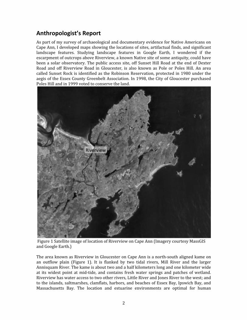
Anthropologist’s(Report(As&part&of&my&survey&of&archaeological&and&documentary&evidence&for&Native&Americans&on&Cape&Ann,&I&developed&maps&showing&the&locations&of&sites,&artifactual&finds,&and&significant&landscape& features.& Studying& landscape& features& in& Google& Earth,& I& wondered& if& the&escarpment&of&outcrops&above&Riverview,&a&known&Native&site&of&some&antiquity,&could&have&been&a&solar&observatory.&The&public&access&site,&off&Sunset&Hill&Road&at& the&end&of&Dexter&Road& and& off& Riverview& Road& in& Gloucester,& is& also& known& as& Pole& or& Poles& Hill.& An& area&called&Sunset&Rock& is& identified&as&the&Robinson&Reservation,&protected& in&1980&under&the&aegis&of&the&Essex&County&Greenbelt&Association.&In&1998,&the&City&of&Gloucester&purchased&Poles&Hill&and&in&1999&voted&to&conserve&the&land.&&
&Figure&1&Satellite&image&of&location&of&Riverview&on&Cape&Ann&(Imagery&courtesy&MassGIS&and&Google&Earth.)&&The&area&known&as&Riverview&in&Gloucester&on&Cape&Ann&is&a&northUsouth&aligned&kame&on&an& outflow& plain& (Figure& 1).& It& is& flanked& by& two& tidal& rivers,& Mill& River& and& the& larger&Annisquam&River.&The&kame&is&about&two&and&a&half&kilometers&long&and&one&kilometer&wide&at& its&widest& point& at&midUtide,& and& contains& fresh&water& springs& and& patches& of&wetland.&Riverview&has&water&access&to&two&other&rivers,&Little&River&and&Jones&River&to&the&west;&and&to&the&islands,&saltmarshes,&clamflats,&harbors,&and&beaches&of&Essex&Bay,&Ipswich&Bay,&and&Massachusetts& Bay.& The& location& and& estuarine& environments& are& optimal& for& human&
& 3&
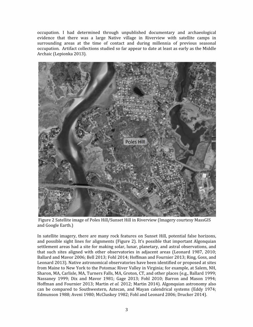
occupation.& I& had& determined& through& unpublished& documentary& and& archaeological&evidence& that& there& was& a& large& Native& village& in& Riverview& with& satellite& camps& in&surrounding& areas& at& the& time& of& contact& and& during& millennia& of& previous& seasonal&occupation.&&Artifact&collections&studied&so&far&appear&to&date&at&least&as&early&as&the&Middle&Archaic&(Lepionka&2013).&&
&Figure&2&Satellite&image&of&Poles&Hill/Sunset&Hill&in&Riverview&(Imagery&courtesy&MassGIS&and&Google&Earth.)&&In& satellite& imagery,& there&are&many& rock& features&on&Sunset&Hill,&potential& false&horizons,&and&possible&sight& lines& for&alignments& (Figure&2).& It’s&possible& that& important&Algonquian&settlement&areas&had&a&site&for&making&solar,&lunar,&planetary,&and&astral&observations,&and&that& such& sites& aligned& with& other& observatories& in& adjacent& areas& (Leonard& 1987,& 2010;&Ballard&and&Mavor&2006;&Bell&2013;&Fohl&2014;&Hoffman&and&Fournier&2013;&Ring,&Goss,&and&Leonard&2013).&Native&astronomical&observatories&have&been&identified&or&proposed&at&sites&from&Maine&to&New&York&to&the&Potomac&River&Valley&in&Virginia;&for&example,&at&Salem,&NH,&Sharon,&MA,&Carlisle,&MA,&Turners&Falls,&MA,&Groton,&CT,&and&other&places&(e.g.,&Ballard&1999;&Nassaney& 1999;& Dix& and& Mavor& 1981;& Gage& 2013;& Fohl& 2010;& Barron& and& Mason& 1994;&Hoffman&and&Fournier&2013;&Martin&et#al.&2012;&Martin&2014).&Algonquian&astronomy&also&can& be& compared& to& Southwestern,& Aztecan,& and&Mayan& calendrical& systems& (Eddy& 1974;&Edmunson&1988;&Aveni&1980;&McCluskey&1982;&Fohl&and&Leonard&2006;&Drucker&2014).&
& 4&
&Ethnographic&data&records&the&importance&of&solstice&and&equinox&dates&in&Native&American&ceremonial&time,&as&well&as&the&position&of&the&stars,&Milky&Way,&and&other&events,&such&as&the&position&of&Draco& in&relation&to&the&horizon,& the&rising&and&setting&of& the&Pleiades,&and&&eclipses& (Mitchell& 1984;& Hoffman& 1987;& Gookin& 1674;&Morton& 1637;& Rale& 1901;&Williams&1643;&Hranicky&2001).&The&Milky&Way,&when&perpendicular&to&and&touching&the&horizon,&for&example,& was& seen& as& a& way& for& spirits& to& enter& the& skyworld.& Algonquian& cosmology& is&based&on&a&view&of&the&universe&as&circular&and&cyclical&and&defined&by&the& intersection&of&astronomical&phenomena&with&earthly&horizons&(Campion&2012).&The&rising&and&setting&of&the& sun& at& particular& times& of& the& year,& the& lunar& cycle,& the& ascension& of& the& planets& and&brightest& stars,& the& wheeling& of& the& constellations,& position& of& the& Milky& Way,& meteor&showers&–&these&guide&or&dictate&daily&life&(Chamberlain&1982;&Wood&1978;&Lankford&2007).&Daily& life& is& a& slow&dance& in&nonlinear& time&within&a& circular& space&defined& in&part&by& the&cardinal&directions.&&Dimensions&of&experience&may&be&organized&in&relation&to&north,&south,&east,&west—the&sky&itself,&the&medicine&wheel,&village&planning,&offerings&and&prayers,&colors&and&attributes,&the&human&life&cycle,&and&burial&alignments&(Bragdon&1996;&Kidwell&2003).&&&This& cosmology& is& the& basis& of& Algonquian& astrology,& in& which& astronomical& phenomena&directly&affect&individuals,&their&community,&and&the&natural&world.&Like&a&CaddoanUspeaking&Skidi&Pawnee&on&a&vision&quest,&for&example,&an&individual&may&choose&a&particular&star&as&a&personal&guardian&(Speck&1920,&1935;&Chamberlain&1982;&Torrence&1994).&The&community&may& traditionally& conduct& ceremonies& such& as& namings& and& healings& and& initiations,& and&seasonal&celebrations&such&as&the&Green&Corn&Festival,&at&the&right×&as&determined&by&astronomical&observations.&Last&harvest& follows& the&appearance&of& the&Pleiades& in& the& fall,&for& example,& signaling& the& coming& of& the& first& hard& frost.& First& sowing& follows& its&disappearance&(Ceci&1978).&&&The&Algonquian&natural&world&is&populated&with&entities&and&events&that&are&gods&or&spirits&or& are& governed& by& gods& or& spirits& or& contain& spiritual& power,& or&manitou,& including,& for&example,&springs,&trees,&rocks,&animals,&people,&and&weather,&all&of&which&are&influenced&by&astronomical&phenomena&or&are&understood&in&terms&of& them&(Simmons&1986;&Mavor&and&Dix& 1989).& Algonquian& mythology& links& this& spiritual& natural& world& with& the& skyworld,&earthworld,& and& underworld& in& their& stories& of& gods& and& creation,& moral& dilemmas,& and&culture& history& (Leland& 1884;&Winiarski& 2005).& & For& example,& the& story& of& the& hunters& in&pursuit&of&the&Great&Bear&–&which&rises,& is&wounded,&retreats,&and&reappears&–&mirrors&the&celestial&movements&of&the&constellation&known&as&the&Big&Dipper&(Olcott&1911).&&On&June&21,&2013,&having&decided&to&see&if&my&theory&could&have&any&merit,&I&stumbled&over&a& big& outcrop& onto& Poles& Hill/Sunset& Hill& and& found& myself& on& an& expanse& of& grooved&bedrock.&Serendipitously,&before&me&was&a& large&slopeUshouldered&pointed&boulder&with&a&smaller&companion&beyond& it.& I& took&pictures&of& them.&These&boulders&sit&at& the&head&of&a&serpentine&ribbon&of&bedrock.&In&Algonquian&mythology,&the&serpent&motif&–&the&one&with&a&long&winding&tail&–&represented&rivers&and&a&river&spirit®arded&as&potentially&dangerous&to& people& (Boutet& 2011).& The& serpent& motif& is& also& associated& with& the& circumpolar&constellation,&Draco,&the&dragon,&and&its&star&Thuban,&which&was&in&the&position&of&the&North&Star&millennia&ago&(Lankford&2007;&Kreisberg&2010).&&I&had&earlier&photographed&all&the&faces&of&the&hill&and&used&my&compass&to&establish&their&cardinal& directions,& subtracting& 15& degrees& to& account& for& the& declination& between& true&north&and&magnetic&north.&Then,&wondering&if&the&pointed&rock&could&possibly&be&some&kind&
& 5&
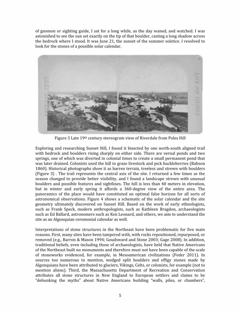
of&gnomon&or&sighting&guide,& I& sat& for&a& long&while,&as& the&day&waned,&and&watched.& I&was&astonished&to&see&the&sun&set&exactly&on&the&tip&of&that&boulder,&casting&a&long&shadow&across&the&bedrock&where&I&stood.&It&was&June&21,&the&sunset&of&the&summer&solstice.&I&resolved&to&look&for&the&stones&of&a&possible&solar&calendar.&&&
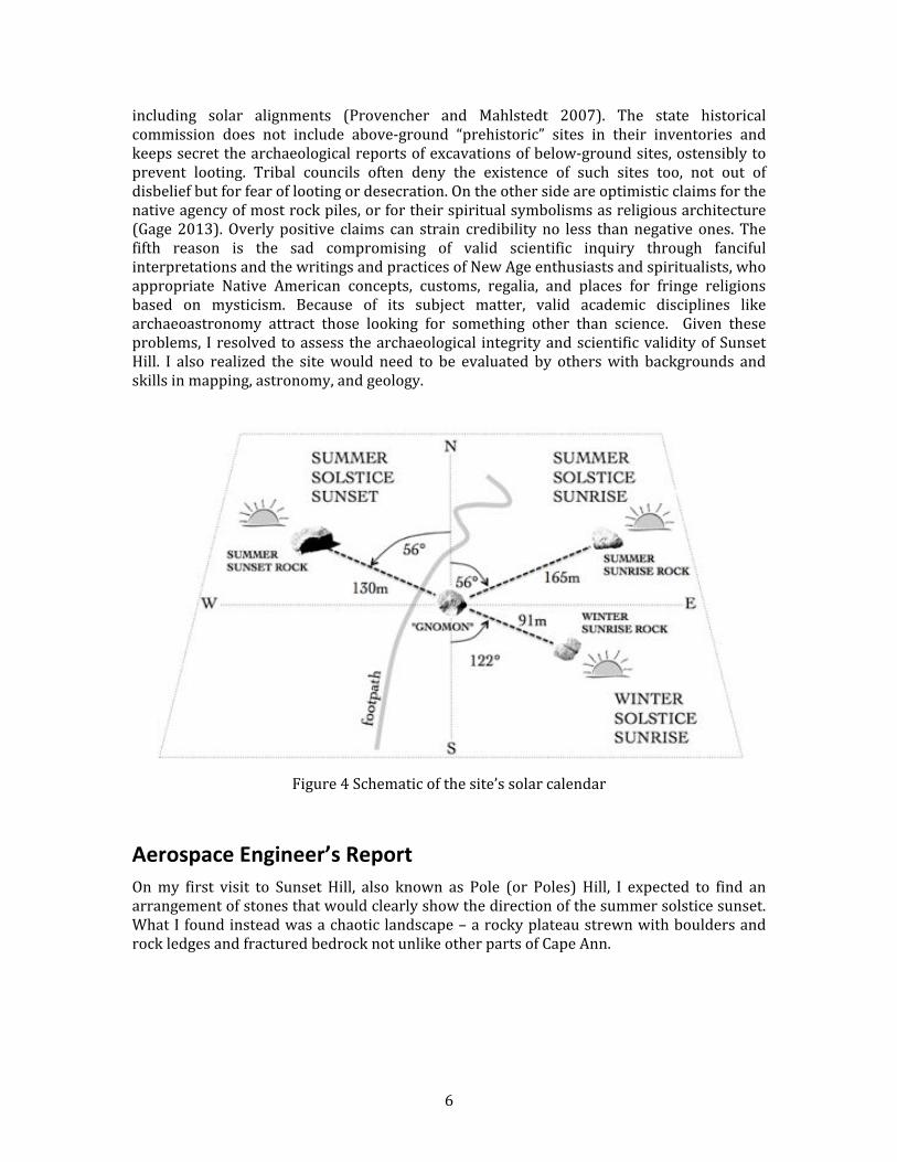
Figure&3&Late&19th¢ury&stereogram&view&of&Riverdale&from&Poles&Hill&&Exploring&and&researching&Sunset&Hill,& I& found& it&bisected&by&one&northUsouth&aligned&trail&with&bedrock&and&boulders& rising&sharply&on&either&side.&There&are&vernal&ponds&and& two&springs,&one&of&which&was&diverted&in&colonial×&to&create&a&small&permanent&pond&that&was&later&drained.&Colonists&used&the&hill&to&graze&livestock&and&pick&huckleberries&(Babson&1860).&Historical&photographs&show&it&as&barren&terrain,&treeless&and&strewn&with&boulders&(Figure&3)& .&The& trail& represents& the& central& axis&of& the& site.& I& returned&a& few& times&as& the&season& changed& to&provide&better& visibility,& and& I& found&a& landscape& strewn&with&unusual&boulders&and&possible& features&and&sightlines.&The&hill& is& less& than&40&meters& in&elevation,&but& in& winter& and& early& spring& it& affords& a& 360Udegree& view& of& the& entire& area.& The&panoramics& of& the& place&would& have& constituted& an& optimal& false& horizon& for& all& sorts& of&astronomical& observations.& Figure&4& shows& a& schematic& of& the& solar& calendar& and& the& site&geometry& ultimately& discovered& on& Sunset& Hill.& Based& on& the& work& of& early& ethnologists,&such& as& Frank& Speck,& modern& anthropologists,& such& as& Kathleen& Bragdon,& archaeologists&such&as&Ed&Ballard,&astronomers&such&as&Ken&Leonard,&and&others,&we&aim&to&understand&the&site&as&an&Algonquian&ceremonial&calendar&as&well.&&Interpretations& of& stone& structures& in& the&Northeast& have& been& problematic& for& five&main&reasons.&First,&many&sites&have&been&tampered&with,&with&rocks&repositioned,&repurposed,&or&removed&(e.g.,&Barron&&&Mason&1994;&Goudsward&and&Stone&2003;&Gage&2008).&In&addition,&traditional&beliefs,&even&including&those&of&archaeologists,&have&held&that&Native&Americans&of&the&Northeast&built&no&monuments&and&therefore&must¬&have&been&capable&of&the&scale&of& stoneworks& evidenced,& for& example,& in& Mesoamerican& civilizations& (Feder& 2011).& In&sources& too& numerous& to& mention,& wedged& split& boulders& and& effigy& stones& made& by&Algonquians&have&been&attributed&to&glaciers,&Vikings,&Celts,&or&colonists,&for&example&(not&to&mention& aliens).& Third,& the& Massachusetts& Department& of& Recreation& and& Conservation&attributes& all& stone& structures& in& New& England& to& European& settlers& and& claims& to& be&“debunking& the& myths”& about& Native& Americans& building& “walls,& piles,& or& chambers”,&
& 6&
including& solar& alignments& (Provencher& and& Mahlstedt& 2007).& The& state& historical&commission& does& not& include& aboveUground& “prehistoric”& sites& in& their& inventories& and&keeps&secret&the&archaeological&reports&of&excavations&of&belowUground&sites,&ostensibly&to&prevent& looting.& Tribal& councils& often& deny& the& existence& of& such& sites& too,& not& out& of&disbelief&but&for&fear&of&looting&or&desecration.&On&the&other&side&are&optimistic&claims&for&the&native&agency&of&most&rock&piles,&or&for&their&spiritual&symbolisms&as&religious&architecture&(Gage&2013).&Overly&positive& claims& can& strain& credibility&no& less& than&negative&ones.&The&fifth& reason& is& the& sad& compromising& of& valid& scientific& inquiry& through& fanciful&interpretations&and&the&writings&and&practices&of&New&Age&enthusiasts&and&spiritualists,&who&appropriate& Native& American& concepts,& customs,& regalia,& and& places& for& fringe& religions&based& on& mysticism.& Because& of& its& subject& matter,& valid& academic& disciplines& like&archaeoastronomy& attract& those& looking& for& something& other& than& science.& & Given& these&problems,& I&resolved&to&assess& the&archaeological& integrity&and&scientific&validity&of&Sunset&Hill.& I& also& realized& the& site&would& need& to& be& evaluated& by& others&with& backgrounds& and&skills&in&mapping,&astronomy,&and&geology.&&&&
Figure&4&Schematic&of&the&site’s&solar&calendar&&&
Aerospace(Engineer’s(Report(On&my& first& visit& to& Sunset& Hill,& also& known& as& Pole& (or& Poles)& Hill,& I& expected& to& find& an&arrangement&of&stones&that&would&clearly&show&the&direction&of&the&summer&solstice&sunset.&What&I&found&instead&was&a&chaotic&landscape&–&a&rocky&plateau&strewn&with&boulders&and&rock&ledges&and&fractured&bedrock¬&unlike&other&parts&of&Cape&Ann.&&&
& 7&
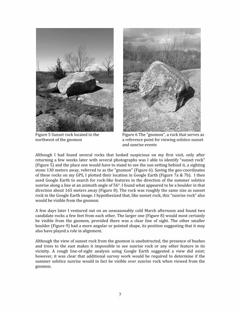
&Figure&5&Sunset&rock&located&to&the&northwest&of&the&gnomon&&
&Figure&6&The&“gnomon”,&a&rock&that&serves&as&a&reference&point&for&viewing&solstice&sunset&and&sunrise&events&&
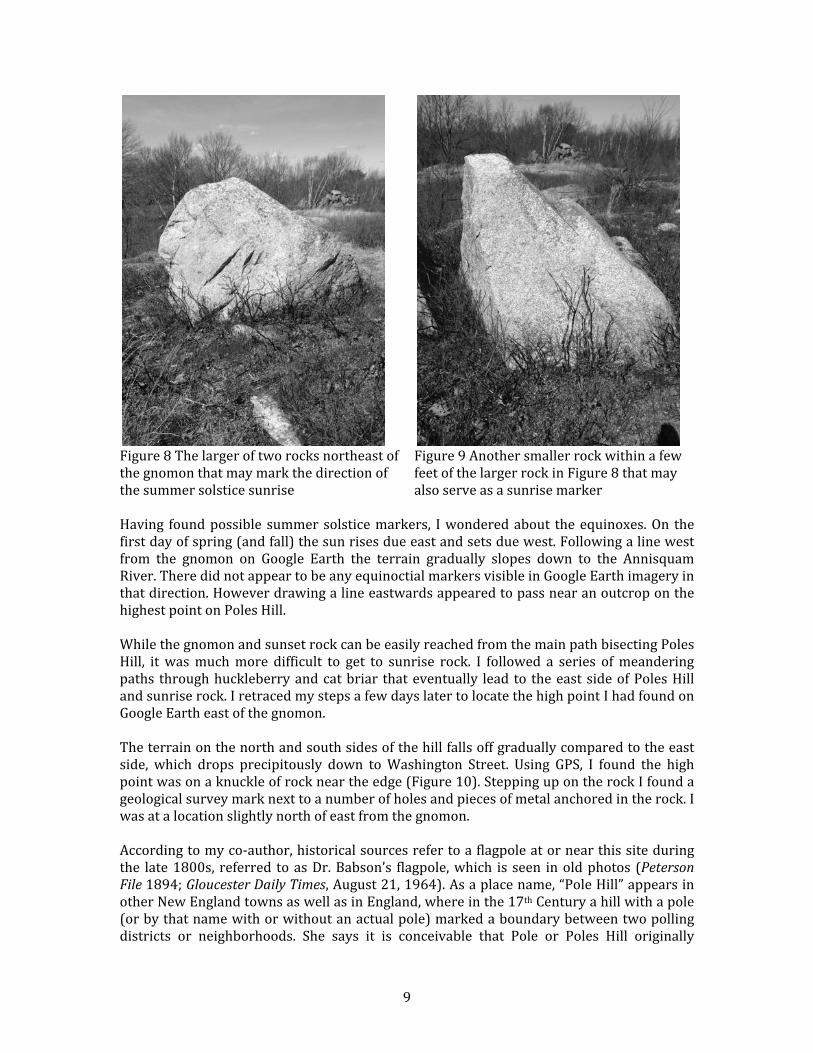
&Although& I& had& found& several& rocks& that& looked& suspicious& on& my& first& visit,& only& after&returning&a& few&weeks& later&with&several&photographs&was& I&able& to& identify&“sunset&rock”&(Figure&5)&and&the&place&one&would&have&to&stand&to&see&the&sun&setting&behind&it,&a&sighting&stone&130&meters&away,&referred&to&as&the&“gnomon”&(Figure&6).&Saving&the&geoUcoordinates&of&these&rocks&on&my&GPS,&I&plotted&their&location&in&Google&Earth&(Figure&7a&&&7b).& &I&then&used&Google&Earth& to& search& for& rockUlike& features& in& the&direction&of& the&summer&solstice&sunrise&along&a&line&at&an&azimuth&angle&of&56°.&I&found&what&appeared&to&be&a&boulder&in&that&direction&about&165&meters&away&(Figure&8).&The&rock&was&roughly&the&same&size&as&sunset&rock&in&the&Google&Earth&image.&I&hypothesized&that,&like&sunset&rock,&this&“sunrise&rock”&also&would&be&visible&from&the&gnomon.&&A& few&days& later& I&ventured&out&on&an&unseasonably&cold&March&afternoon&and& found& two&candidate&rocks&a&few&feet&from&each&other.&The&larger&one&(Figure&8)&would&most&certainly&be& visible& from& the& gnomon,& provided& there& was& a& clear& line& of& sight.& The& other& smaller&boulder&(Figure&9)&had&a&more&angular&or&pointed&shape,&its&position&suggesting&that&it&may&also&have&played&a&role&in&alignment.&&Although&the&view&of&sunset&rock&from&the&gnomon&is&unobstructed,&the&presence&of&bushes&and& trees& to& the& east&makes& it& impossible& to& see& sunrise& rock& or& any& other& feature& in& its&vicinity.& A& rough& lineUofUsight& analysis& using& Google& Earth& suggested& a& view& did& exist;&however,& it&was& clear& that& additional& survey&work&would& be& required& to& determine& if& the&summer&solstice&sunrise&would& in& fact&be&visible&over&sunrise&rock&when&viewed& from&the&gnomon.&&&
& 8&
&
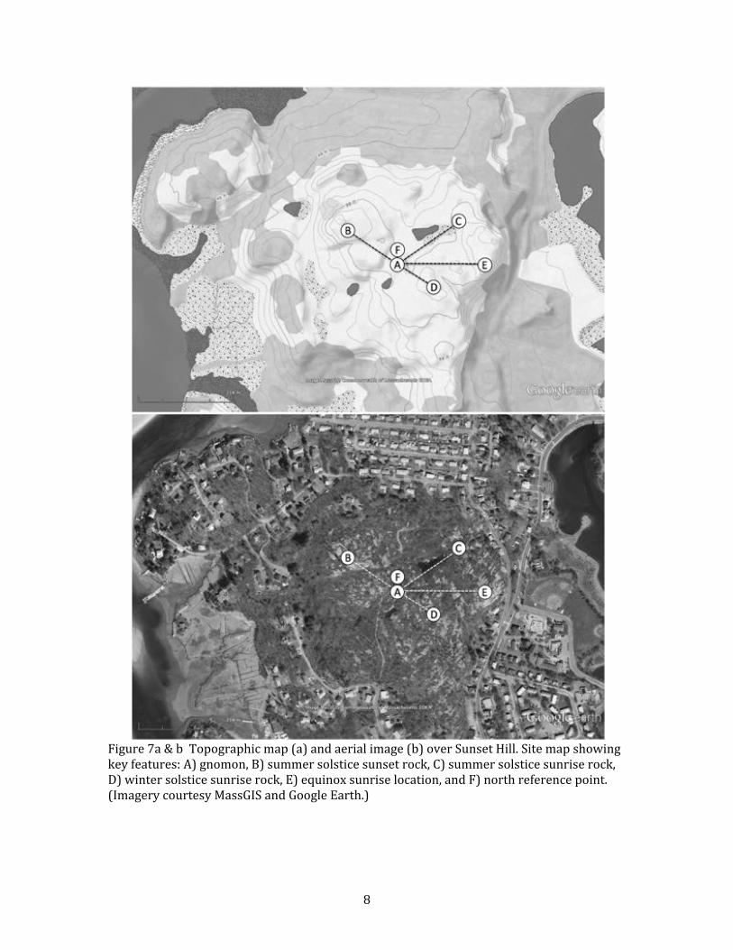
&Figure&7a&&&b&&Topographic&map&(a)&and&aerial&image&(b)&over&Sunset&Hill.&Site&map&showing&key&features:&A)&gnomon,&B)&summer&solstice&sunset&rock,&C)&summer&solstice&sunrise&rock,&D)&winter&solstice&sunrise&rock,&E)&equinox&sunrise&location,&and&F)&north&reference&point.&(Imagery&courtesy&MassGIS&and&Google&Earth.)&&&&
& 9&
&Figure&8&The&larger&of&two&rocks&northeast&of&the&gnomon&that&may&mark&the&direction&of&the&summer&solstice&sunrise&&
&Figure&9&Another&smaller&rock&within&a&few&feet&of&the&larger&rock&in&Figure&8&that&may&also&serve&as&a&sunrise&marker&&
&Having& found&possible& summer&solstice&markers,& I&wondered&about& the&equinoxes.&On& the&first&day&of&spring&(and&fall)&the&sun&rises&due&east&and&sets&due&west.&Following&a&line&west&from& the& gnomon& on& Google& Earth& the& terrain& gradually& slopes& down& to& the& Annisquam&River.&There&did¬&appear&to&be&any&equinoctial&markers&visible&in&Google&Earth&imagery&in&that&direction.&However&drawing&a&line&eastwards&appeared&to&pass&near&an&outcrop&on&the&highest&point&on&Poles&Hill.&&&While&the&gnomon&and&sunset&rock&can&be&easily&reached&from&the&main&path&bisecting&Poles&Hill,& it&was&much&more& difficult& to& get& to& sunrise& rock.& I& followed& a& series& of&meandering&paths& through&huckleberry&and&cat&briar& that&eventually& lead& to& the&east&side&of&Poles&Hill&and&sunrise&rock.&I&retraced&my&steps&a&few&days&later&to&locate&the&high&point&I&had&found&on&Google&Earth&east&of&the&gnomon.&&&The&terrain&on&the&north&and&south&sides&of&the&hill&falls&off&gradually&compared&to&the&east&side,& which& drops& precipitously& down& to&Washington& Street.& Using& GPS,& I& found& the& high&point&was&on&a&knuckle&of&rock&near&the&edge&(Figure&10).&Stepping&up&on&the&rock&I&found&a&geological&survey&mark&next&to&a&number&of&holes&and&pieces&of&metal&anchored&in&the&rock.&I&was&at&a&location&slightly&north&of&east&from&the&gnomon.&&&According&to&my&coUauthor,&historical&sources&refer&to&a&flagpole&at&or&near&this&site&during&the& late&1800s,& referred& to&as&Dr.&Babson’s& flagpole,&which& is& seen& in&old&photos& (Peterson#File#1894;&Gloucester#Daily#Times,&August&21,&1964).&As&a&place&name,&“Pole&Hill”&appears&in&other&New&England&towns&as&well&as&in&England,&where&in&the&17th&Century&a&hill&with&a&pole&(or&by&that&name&with&or&without&an&actual&pole)&marked&a&boundary&between&two&polling&districts& or& neighborhoods.& She& says& it& is& conceivable& that& Pole& or& Poles& Hill& originally&
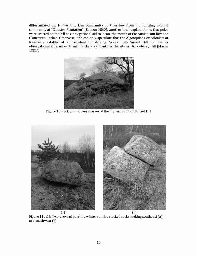
& 10&
differentiated& the& Native& American& community& at& Riverview& from& the& abutting& colonial&community&at&“Gloaster&Plantation”&(Babson&1860).&Another&local&explanation&is&that&poles&were&erected&on&the&hill&as&a&navigational&aid&to&locate&the&mouth&of&the&Annisquam&River&or&Gloucester&Harbor.&Otherwise,&one&can&only&speculate&that& the&Algonquians&or&colonists&at&Riverview& established& a& precedent& for& driving& “poles”& into& Sunset& Hill& for& use& as&observational&aids.&An&early&map&of&the&area&identifies&the&site&as&Huckleberry&Hill&(Mason&1831).&&&
&Figure&10&Rock&with&survey&marker&at&the&highest&point&on&Sunset&Hill&
&&
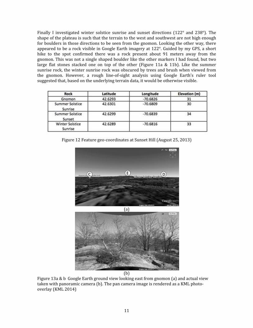
(a)& (b)&Figure&11a&&&b&Two&views&of&possible&winter&sunrise&stacked&rocks&looking&southeast&(a)&and&southwest&(b)&
& 11&
Finally& I& investigated&winter& solstice& sunrise& and& sunset& directions& (122°& and& 238°).& The&shape&of&the&plateau&is&such&that&the&terrain&to&the&west&and&southwest&are¬&high&enough&for&boulders&in&those&directions&to&be&seen&from&the&gnomon.&Looking&the&other&way,&there&appeared&to&be&a&rock&visible& in&Google&Earth& imagery&at&122°.&Guided&by&my&GPS,&a&short&hike& to& the& spot& confirmed& there& was& a& rock& present& about& 91& meters& away& from& the&gnomon.&This&was¬&a&single&shaped&boulder&like&the&other&markers&I&had&found,&but&two&large& flat& stones& stacked& one& on& top& of& the& other& (Figure& 11a& && 11b).& Like& the& summer&sunrise&rock,&the&winter&sunrise&rock&was&obscured&by&trees&and&brush&when&viewed&from&the& gnomon.& However,& a& rough& lineUofUsight& analysis& using& Google& Earth’s& ruler& tool&suggested&that,&based&on&the&underlying&terrain&data,&it&would&be&otherwise&visible.&&&
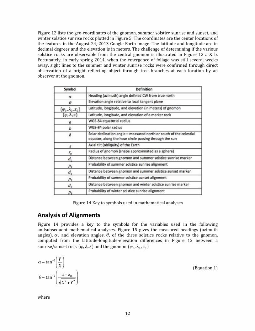
Figure&12&Feature&geoUcoordinates&at&Sunset&Hill&(August&25,&2013)&&
&(a)&
&(b)&
Figure&13a&&&b&&Google&Earth&ground&view&looking&east&from&gnomon&(a)&and&actual&view&taken&with&panoramic&camera&(b).&The&pan&camera&image&is&rendered&as&a&KML&photoUoverlay&(KML&2014)&
& 12&
Figure&12&lists&the&geoUcoordinates&of&the&gnomon,&summer&solstice&sunrise&and&sunset,&and&winter&solstice&sunrise&rocks&plotted&in&Figure&5.&The&coordinates&are&the¢er&locations&of&the& features& in&the&August&24,&2013&Google&Earth& image.&The& latitude&and& longitude&are& in&decimal°rees&and&the&elevation&is&in&meters.&The&challenge&of&determining&if&the&various&solstice& rocks& are& observable& from& the& central& gnomon& is& illustrated& in& Figure& 13& a& && b.&Fortunately,& in& early& spring& 2014,&when& the& emergence& of& foliage&was& still& several&weeks&away,& sight& lines& to& the& summer&and&winter& sunrise& rocks&were& confirmed& through&direct&observation& of& a& bright& reflecting& object& through& tree& branches& at& each& location& by& an&observer&at&the&gnomon.&&
Figure&14&Key&to&symbols&used&in&mathematical&analyses&&
Analysis(of(Alignments(Figure& 14& provides& a& key& to& the& symbols& for& the& variables& used& in& the& following&andsubsequent& mathematical& analyses.& Figure& 15& gives& the& measured& headings& (azimuth&angles),&
€
α ,& and& elevation& angles,&
€
θ ,& of& the& three& solstice& rocks& relative& to& the& gnomon,&computed& from& the& latitudeUlongitudeUelevation& differences& in& Figure& 12& between& a&sunrise/sunset&rock&!!!!
€
(ϕ ,λ , z)&and&the&gnomon&!!!!
€
(ϕ0 ,λ0 , z0 )&&
!!!!
€
α = tan−1 YX
$
% &
'
( )
θ = tan−1 z − z0
X 2 +Y 2
$
% & &
'
( ) )
& (Equation&1)&&
% % % % % %
where&&&
& 13&
&
!!!!
€
X =ϕ −ϕ0360
$
% &
'
( ) 2π acos ϕ +ϕ0
2$
% &
'
( )
Y =λ − λ0360
$
% &
'
( ) 2π b
& (Equation&2)&&
& & & & & &and& the& constants&!!!!
€
a = 6378137.0 &and&!!!!
€
b= 6356752.3&are& the&WGSU84& equatorial& and& polar&radii&(WGS&2014).&&&
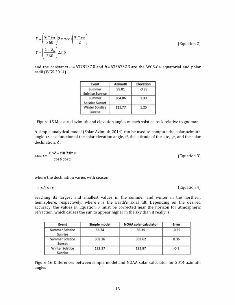
Figure&15&Measured&azimuth&and&elevation&angles&at&each&solstice&rock&relative&to&gnomon&&A&simple&analytical&model&(Solar&Azimuth&2014)&can&be&used&to&compute&the&solar&azimuth&angle&
€
α &as&a&function&of&the&solar&elevation&angle,&
€
θ ,&the&latitude&of&the&site,&
€
ϕ ,&and&the&solar&declination,&
€
δ :&&
!!
€
cosα =sinδ − sinθ sinϕcosθ cosϕ &
&
(Equation&3)&&
% % % % %
where&the&declination&varies&with&season&&
€
−ε ≤δ ≤ +ε & (Equation&4)&&reaching& its& largest& and& smallest& values& in& the& summer& and& winter& in& the& northern&hemisphere,& respectively,& where& &is& the& Earth’s& axial& tilt.& Depending& on& the& desired&accuracy,& the& values& in& Equation& 3& must& be& corrected& near& the& horizon& for& atmospheric&refraction,&which&causes&the&sun&to&appear&higher&in&the&sky&than&it&really&is.&&
&Figure&16&Differences&between&simple&model&and&NOAA&solar&calculator& for&2014&azimuth&angles&&
€
ε
& 14&
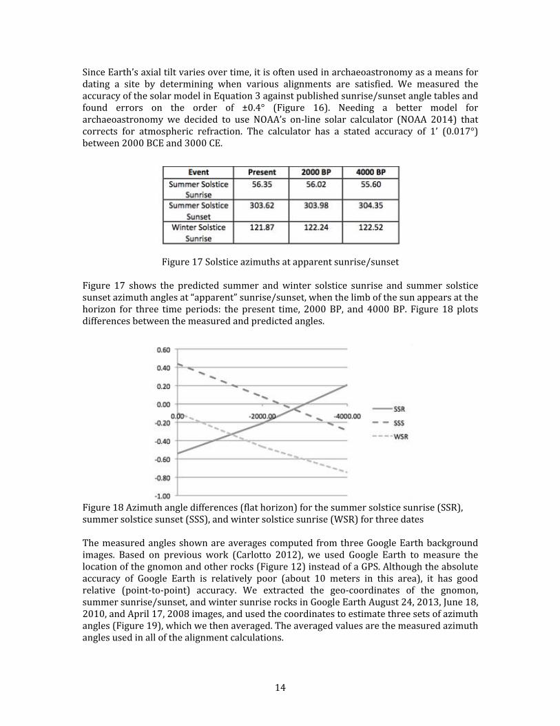
Since&Earth’s&axial&tilt&varies&over&time,&it&is&often&used&in&archaeoastronomy&as&a&means&for&dating& a& site& by& determining& when& various& alignments& are& satisfied.& We& measured& the&accuracy&of&the&solar&model&in&Equation&3&against&published&sunrise/sunset&angle&tables&and&found& errors& on& the& order& of& ±0.4°& (Figure& 16).& Needing& a& better& model& for&archaeoastronomy& we& decided& to& use& NOAA’s& onUline& solar& calculator& (NOAA& 2014)& that&corrects& for& atmospheric& refraction.& The& calculator& has& a& stated& accuracy& of& 1’& (0.017°)&between&2000&BCE&and&3000&CE.&&
Figure&17&Solstice&azimuths&at&apparent&sunrise/sunset&&Figure& 17& shows& the& predicted& summer& and&winter& solstice& sunrise& and& summer& solstice&sunset&azimuth&angles&at&“apparent”&sunrise/sunset,&when&the&limb&of&the&sun&appears&at&the&horizon& for& three& time& periods:& the& present& time,& 2000&BP,& and& 4000&BP.& Figure& 18& plots&differences&between&the&measured&and&predicted&angles.&&&
&Figure&18&Azimuth&angle&differences&(flat&horizon)&for&the&summer&solstice&sunrise&(SSR),&summer&solstice&sunset&(SSS),&and&winter&solstice&sunrise&(WSR)&for&three&dates&&The&measured&angles&shown&are&averages&computed& from&three&Google&Earth&background&images.& Based& on& previous& work& (Carlotto& 2012),& we& used& Google& Earth& to& measure& the&location&of&the&gnomon&and&other&rocks&(Figure&12)&instead&of&a&GPS.&Although&the&absolute&accuracy& of& Google& Earth& is& relatively& poor& (about& 10& meters& in& this& area),& it& has& good&relative& (pointUtoUpoint)& accuracy.& We& extracted& the& geoUcoordinates& of& the& gnomon,&summer&sunrise/sunset,&and&winter&sunrise&rocks&in&Google&Earth&August&24,&2013,&June&18,&2010,&and&April&17,&2008&images,&and&used&the&coordinates&to&estimate&three&sets&of&azimuth&angles&(Figure&19),&which&we&then&averaged.&The&averaged&values&are&the&measured&azimuth&angles&used&in&all&of&the&alignment&calculations.&&&
& 15&
Figure&19&Measured&azimuth&angles&from&three&Google&Earth&images&&Where& presentUday& angular& differences& between& the& summer& solstice& directions& and&sightlines& are& off& by& more& than& 0.4°,& the& differences& 2000& to& 4000& years& ago& were&considerably&less,&about&0.07°.&The&winter&solstice&sunrise&angle&error&increases&over&time,&suggesting& the&winter&marker&was& established&more& recently.&According& to&my& coUauthor,&this& finding&may&be&consistent&with&archaeological&and&historical&evidence&suggesting& that&the&Eastern&Woodland&Indians&did¬&occupy&Cape&Ann&in&winter&until&sometime&in&the&15th¢ury& at& the& earliest,& although& earlier&marineUadapted& coastal& Archaic& people&may&well&have&done&so.&&&&
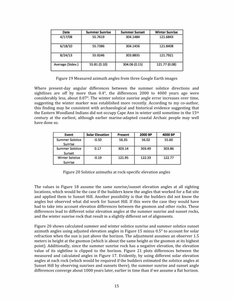
Figure&20&Solstice&azimuths&at&rockUspecific&elevation&angles&&&The& values& in& Figure& 18& assume& the& same& sunrise/sunset& elevation& angles& at& all& sighting&locations,&which&would&be&the&case&if&the&builders&knew&the&angles&that&worked&for&a&flat&site&and&applied& them&to&Sunset&Hill.&Another&possibility& is& that& the&builders&did¬&know&the&angles&but&observed&what&did&work& for&Sunset&Hill.& If& this&were& the&case& they&would&have&had&to&take&into&account&elevation&differences&between&the&gnomon&and&other&rocks.&These&differences&lead&to&different&solar&elevation&angles&at&the&summer&sunrise&and&sunset&rocks,&and&the&winter&sunrise&rock&that&result&in&a&slightly&different&set&of&alignments.&&&Figure&20&shows&calculated&summer&and&winter&solstice&sunrise&and&summer&solstice&sunset&azimuth&angles&using&adjusted&elevation&angles&in&Figure&15&minus&0.5°&to&account&for&solar&refraction&when&the&sun&is&just&above&the&horizon.&The&adjustment&assumes&an&observer&1.5&meters&in&height&at&the&gnomon&(which&is&about&the&same&height&as&the&gnomon&at&its&highest&point).&Additionally,&since&the&summer&sunrise&rock&has&a&negative&elevation,&the&elevation&value& of& its& sightline& is& clipped& to& the& horizon.& Figure& 21& plots& differences& between& the&measured&and&calculated&angles& in&Figure&17.&Evidently,&by&using&different& solar&elevation&angles&at&each&rock&(which&would&be&required&if&the&builders&estimated&the&solstice&angles&at&Sunset&Hill&by&observing&sunrises&and&sunsets&there),&the&summer&sunrise&and&sunset&angle&differences&converge&about&1000&years&later,&earlier&in&time&than&if&we&assume&a&flat&horizon.&&
& 16&
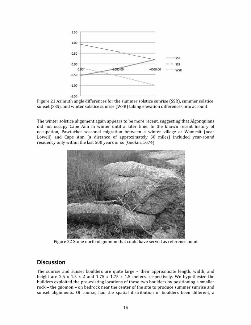
&Figure&21&Azimuth&angle&differences&for&the&summer&solstice&sunrise&(SSR),&summer&solstice&sunset&(SSS),&and&winter&solstice&sunrise&(WSR)&taking&elevation&differences&into&account&
&The&winter&solstice&alignment&again&appears&to&be&more&recent,&suggesting&that&Algonquians&did& not& occupy& Cape& Ann& in& winter& until& a& later& time.& In& the& known& recent& history& of&occupation,& Pawtucket& seasonal& migration& between& a& winter& village& at& Wamesit& (near&Lowell)& and& Cape& Ann& (a& distance& of& approximately& 30& miles)& included& yearUround&residency&only&within&the&last&500&years&or&so&(Gookin,&1674).&&&&
&Figure&22&Stone&north&of&gnomon&that&could&have&served&as&reference&point&
Discussion(The& sunrise& and& sunset& boulders& are& quite& large& –& their& approximate& length,& width,& and&height& are& 2.5& x& 1.5& x& 2& and& 1.75& x& 1.75& x& 1.5& meters,& respectively.& We& hypothesize& the&builders&exploited&the&preUexisting&locations&of&these&two&boulders&by&positioning&a&smaller&rock&–&the&gnomon&–&on&bedrock&near&the¢er&of&the&site&to&produce&summer&sunrise&and&sunset& alignments.& Of& course,& had& the& spatial& distribution& of& boulders& been& different,& a&
& 17&
different&arrangement&(or&no&arrangement&at&all)&might&have&occurred.&Based&on&alignment&dates&we&conjecture&that&the&emplacement&of&the&winter&sunrise&stone(s)&took&advantage&of&a&serendipitous&sightline&to&the&southeast&at&a&later&time.&&In& order& to& produce& the& correct& alignments& from&prior& knowledge& of& angles,& the& builders&would&have&to&know&the&direction&of&true&north&in&order&to&compute&the&solstice&angles.&We&have&found&a&stone&north&of& the&gnomon&that&could&have&served&that&purpose&(Figure&22).&We&hypothesize&that&the&builders&first&found&the&summer&solstice&sunrise&and&sunset&rocks&and&then&identified&the&north&reference&stone.&A&sightline&was&then&drawn&through&the&north&reference& stone& in& the& direction& of& the& north& celestial& pole.& The& gnomon,&which& has& been&narrowed&at&the&base&to&facilitate&reorientation&by&slightly&pivoting&it,&was&then&positioned&along& this& line& until& the& angles& to& the& summer& solstice& sunrise& and& sunset& stones& were&correct.& The& winter& solstice& sunrise& stone& was& positioned& at& a& later& date& using& the& same&sightline&reference.&&If&the&builders&did¬&posses&prior&knowledge&of&angles&but&did&know&approximately&when&the&longest&days&occurred,&they&could&have&created&the&alignments&for&the&summer&sunrise&and&sunset&rocks&in&one&day,&on&the&summer&solstice&about&2000&years&ago.&At&sunrise&a&line&would&be&drawn&in&the&direction&of&the&sunrise&rock.&At&sunset&another&line&would&be&drawn&in&the&direction&of&the&sunset&rock.&On&the&next&day,&the&gnomon&would&be&positioned&at&the&intersection&of&the&two&lines,&completing&the&original&site.&&&That& the&equinoctial& line& through& the&gnomon&passes&close& to& the&highest&point&on&Sunset&Hill& is& another& piece& of& evidence& supporting& an& emerging& hypothesis& U& namely& that& early&people&on&Cape&Ann&constructed&an&accurate&solar&observatory&using&only&boulders&and&did&so&with&a&minimal&amount&of&effort&U&that&being&the&initial&emplacement&of&one&boulder,&the&gnomon,& at& the& center& of& the& arrangement.& The& following&probability& analysis& argues& that&the&likelihood&of&this&arrangement&occurring&naturally&by&chance&is&extremely&small.&&Given&a&random&distribution&of&points&on&a&plane,&pick&any&two&points&P1&and&P2.&For&each&point&draw&a&line&in&any&direction&through&that&point.&Provided&they&are¬¶llel,&the&two&lines&will&always&intersect&at&a&third&point&P0.&Without&loss&of&generality,&let&points&P1&and&P2&be&the&locations&of&the&summer&sunrise&and&sunset&stones,&and&the&point&of&intersection&P0&be&the&gnomon.&Let&!!!!
€
r0 &be&the&radius&of&the&gnomon&and&!!!!
€
d1 &be&the&distance&between&P0&and&P1.&The&probability&that&P0&and&P1&are&oriented&such&that&the&line&passing&through&the&two&points&is&at&a&particular&angle&(i.e.,&the&angle&of&the&summer&solstice&sunrise)&is&&&
!!!!
€
p1 = 2r0 /d1( )/2π & (Equation&5)&
&Similarly&if&!!!!
€
d2 &is&the&distance&between&P0&and&P2,&the&probability&that&P0&and&P2&are&oriented&such& that& the& line& passing& through& the& two& points& is& at& another& particular& angle& (i.e.,& the&angle&of&the&summer&solstice&sunset)&is&&&
!!!!
€
p2 = 2r0 /d2( )/2π & (Equation&6)&
& & & & &For& the&measured&distances&!!!!
€
d1=&165&meters& feet&and&!!!!
€
d2=&130&meters&and&a& radius&!!!!
€
r0=0.6&meters,&the&probability&that&these&two&summer&solstice&alignments&occurred&by&chance&is&&

& 18&
!!!!
€
p1 × p2 = 1.8×10⁻⁶ & (Equation&7)&&
&& & & & &The& probability& that& the& Sunset& Hill& formation& is& a& random& occurrence& decreases& even&further&when&we&take&into&account&the&winter&solstice&sunrise&alignment&&
!!!!
€
p3 = 2r0 /d3( )/2π & (Equation&8)&&
%% % % % % %
where&!!!!
€
d3 &is&the&distance&of&the&winter&sunrise&rock&P3&from&the&gnomon&(about&91&meters)&Assuming&each&event&is&independent&the&joint&probability&is&
!!!!
€
p1 × p2 × p3 = 4 ×10⁻⁹ & (Equation&9)&&
& & &In& other&words& for& the& three& solstice& alignments& to& occur& at& random,& assuming& statistical&independence,&the&probability&is&on&the&order&of&one&in&a&billion.&&&In& general,& the& probability& of& any& specific& arrangement& of& points& occurring& at& random&becomes& extremely& small& as& the&number&of& points& increases.&Nature&does¬& conspire& to&produce&any&particular&arrangement,& including& the&one&on&Sunset&Hill.&Against& such&a& low&background&probability& the&existence&of& a& configuration& containing& three&possible& solstice&angles&would&therefore&appear&to&be&highly&significant.&&
&
&
&Figure&23a,&b,&&&c&&Google&Earth&renderings&of&solstice&sunrise/sunset&at&present&revealing&shifts&from&sightlines&caused&by&change&in&obliquity:&(a)&Summer&solstice&sunrise,&(b)&Winter&solstice&sunrise,&and&(c)&Summer&solstice&sunset&
& 19&
Figure&23&a,&b,&and&c&depict& solstice&sunrises&and&sunsets&using&Google&Earth& for& the&most&recent& year& 2014.& Notice& the& differences& between& the& sightlines& to& the& rocks& (lines& with&arrows)&and&the&position&of&the&sun&at&apparent&sunrise/sunset.&Since&Earth’s&obliquity&now&(23.43°)&is&less&than&it&was&2000U4000&years&ago&(23.7U23.9°)&the&summer&sun&rises&and&sets&south&of&where&it&did&then.&At&that&time&the&summer&sightlines&would&have&lined&up&to&within&about&a&tenth&of&a°ree.&
Conclusions(We&believe&the&landscape&of&Sunset&Hill&was&modified&and&used&by&Native&Americans&as&an&astronomical& observatory& some& time& prior& to& the& Contact& Period.& Relevant& historical& andðnological& research& will& be& ongoing,& and& we& are& undertaking& further& work& to& assess&possible& archaeological& features& seen& in& aerial& photographs:& a& stone& circle& or&wheel,& a& UUshaped&stone&structure,&a&doubleUrow&of&rocks,&a&serpentine&structure,&a&possible&quarry&site,&and&possible&sightlines&to&astronomical&bodies&or&events&other&than&solstices&and&equinoxes,&such&as&lunations,&that&may&have&been&marked&with&stones&or&grooved&into&the&bedrock.&We&suspect&that&the&use&of&landscape&features&for&astronomical&observation&was¬&tied&solely&to&agricultural&needs&but&predated&the&introduction&of&maize&horticulture&in&New&England.&&We& hope& to& date& the& alignments& using& input& from& geologists& about& the& rocks& on& the& site,&their&configurations,&and&physical&evidences&that&they&were&moved,&worked,&or&used.&Dating&methods&include&soil&cores&in&the&vernal&pools&to&verify&that&the&hill&had&little&vegetation&to&obscure& sight& lines& in& the&past& and& lichenology& to& estimate& the& age&of& the&boulders& in& the&array.&In&addition,&we&are&documenting&and&analyzing&other&boulders&in&the&landscape&that&appear& to&have&been& intentionally&gouged,& carved,&or&pecked&with&petroglyphs& U& such&as&a&horned&serpent&U&and&as&effigies,&including&a&possible&Manitou&stone.&On&May&20,&2014,&Tim&Fohl& of& Carlisle,& a& physicist& and& amateur& archaeologist,& came& to& Sunset& Hill& upon& our&invitation,&confirmed&the&presence&of&a&ceremonial&landscape,&identified&significant&features&in&that&landscape,&and&observed&that&the&site&is&still&being&visited.&Our&joint&paper,&The&Spirit&Rocks&of&Sunset&Hill,&is&forthcoming.&&&&&
Acknowledgements(Many& thanks& to&William&Mueller& of& Rockport& for& his& encouragement& and& for& introducing&Mary&Ellen&and&Mark.&Thanks,&too,&to&Allen&Stanish,&formerly&of&Rockport,&Stevens&Brosnihan&of& Gloucester,& and&Martin& DelVecchio& of& Desire& Drone& Service,& who& assisted&with& aircraft&photography& to& create& aerial& video.& & We& are& also& indebted& to& the& New& England&archaeologists&and&archaeoastronomers&who&reviewed&a&draft&of&our&paper&and&guided&us&in&finalizing& it& for& publication,& including& Fred& Martin,& David& Drucker,& and& Tim& Fohl.& Tim’s&observations& along& with& his& and& his& son& Nick’s& photographs& were& crucial& to& our&understanding&of&the&site&as&a&ceremonial&landscape&in&addition&to&its&significance&as&a&solar&observatory.&We&welcome&others’&input.&Contact&Mary&Ellen&at&[email protected]&or&Mark&at&[email protected].&&&&&
& 20&
References(Cited((&Aveni,&Anthony&&1980& Skywatchers#of#Ancient#Mexico.&University&of&Texas&Press,&Austin,&TX.&&Babson,&John&James&1860& History#of#the#Town#of#Gloucester,#Cape#Ann:#Including#the#Town#of#Rockport.&Samuel&
Chandler,&Procter&Brothers.&Gloucester,&MA.&&Ballard,&Edwin&C.&1999& For&Want&of&a&Nail:&An&Analysis&of&the&Function&of&Some&Horseshoe&or&UUShaped&
Stone&Structures.&Bulletin#of#the#Massachusetts#Archaeological#Society&60&(2):&38U53.&&Ballard,&Edwin&C.&and&James&W.&Mavor,&Jr.&&2006& Case&for&the&use&of&above&surface&stone&constructs&in&a&Native&American&ceremonial&
landscape&in&the&Northeast.&NEARA#Journal&40&(1):&33U45.&&Barron,&David&P.&&&Sharon&Mason&&1994& The#Greater#Gungywamp:#A#Guidebook.&Gungywamp&Society,&Groton,&CT.&&Bell,&Edward&L.&&2013& Discerning&Native&Placemaking:&Archaeologies&and&Histories&of&the&Den&Rock&Area,&
Lawrence&and&Andover,&Massachusetts.&Bulletin#of#the#Archaeological#Society#of#Connecticut&75:&69U101.&&
&Bragdon,&Kathleen&J.&1996& Native#People#of#Southern#New#England#1500O1650.&University&of&Oklahoma&Press&
,Norman,&OK.&&Boutet,&MichelUGerald&&&2011& The&Great&Long&Tailed&Serpent:&An&Iconographical&study&of&the&serpent&in&Middle&
Woodland&Algonquian&culture.&(Laval,&Quebec,&Canada):&http://www.academia.edu/3537441/The_Snake_motif_in_Algonquian_Culture&
%Campion,&Nicholas&&2012& Astrology#and#Cosmology#in#the#World’s#Religions.&NYU&Press,&New&York,&NY.&&Carlotto,&Mark&&2012& The#Island#Woods:#Abandoned#settlement,#granite#quarries,#and#enigmatic#boulders#of#
Cape#Ann,#Massachusetts.&Mark&Carlotto,&Gloucester,&MA.&&Ceci,&Lynn&&1978& Watchers&of&the&Pleiades:&Ethnoastronomy&Among&Native&Cultivators&in&
Northeastern&North&America.&Ethnohistory#25&(4):&301U317.&&Chamberlain,&Von&Del&&1982& When#the#Stars#Came#Down#to#Earth:#Cosmology#of#the#Skidi#Pawnee#Indians#of#North#
America.&Ballena&Press.&Los&Altos,&CA.&&
& 21&
Dix,&Byron&E.&and&James&W.&Mavor,&Jr.&&1981& Two&Possible&Calendar&Sites&in&Vermont.&In&Archaeoastronomy#in#the#Americas,#Ray&
Williamson,&ed.&Ballena&Press&Anthropological&Papers.&Los&Altos,&CA.&&&Drucker,&R.&David&2014& Personal&communication&at&the&spring&meeting&of&the&Massachusetts&Archaeological&
Society&Maine&Archaeological&Society,&and&New&Hampshire&Archaeological&Society,&Andover,&MA.&
&Eddy,&John&A.&&1974& Astronomical&Alignment&of&the&Big&Horn&Medicine&Wheel.&Science#174:&1035U43.&&Edmonson,&Munro&S.&&1988& The#Book#of#the#Year:#Middle#American#Calendrical#Systems.#University&of&Utah&Press,&
Salt&Lake&City,&UT.&&Feder,&Kenneth&L.&&2011& Encyclopedia#of#Dubious#Archaeology:#From#Atlantis#to#the#Walam#Olum:&131U132.&
ABCUCLIO/Greenwood.&Santa&Barbara,&CA.&&Fohl,&Timothy&&2010& Integrated&WetlandUDry&Land&Features&with&Astronomical&Associations.&
http://www.terrainnavigator.com/Product/PDF/9.&Also&in&the&Bulletin#of#the#Massachusetts#Archaeological#Society#71:1&(2010).&
&2014& Personal&communication&at&the&spring&2014&meeting&of&the&Massachusetts&
Archaeological&Society,&and&New&Hampshire&Archaeological&Society,&&Andover,&MA.&&Fohl,&Timothy&and&Kenneth&Leonard.&&2006& Similarities&of&Ceremonial&Structures&in&New&England&and&Mesoamerica.&Paper&
presented&at&the&73rd&Annual&Meeting&of&the&Eastern&States&Archaeological&Federation&jointly&with&the&Massachusetts&Archaeological&Society&and&The&New&England&Antiquities&Research&Association,&Fitchburg,&MA.&
&Gage,&Mary&&2008& Handbook#of#Stone#Structures#in#Northeastern#United#States.&Powwow&River&Books,&
Amesbury,&MA.&&2013& New&England&Native&American&Spirit&Structures.&Bulletin#of#the#Massachusetts#
Archaeological#Society&74&(1):&25U32.&&Gloucester#Daily#Times&1964& Photograph&of&Dr.&Babson’s&Flagpole&(August&21,&1964).&&&&Gookin,&Daniel&&1674& &Historical#collections#of#the#Indians#of#New#England#and#their#several#nations,#
numbers,#customs,#manners,#religion,#and#government#before#the#English#planted#
there.&Massachusetts&Historical&Society&Special&Collections&Paper&13.&(Boston,&MA):&http://digitalcommons.uri.edu/sc_pubs/13/.&
&
& 22&
Goudsward,&David&with&Robert&E.&Stone&&2003& &America’s#Stonehenge:#The#Mystery#Hill#Story.&Branden&Books,&Inc.,&Boston,&MA.&&Hoffman,&Curtiss&&1987& Book&Review:&Ceremonial&Time&(by&John&Hanson&Mitchell,&Warner&Books,&1984).&
Bridgewater#Review&5&(2):&Article&16.&Virtual&Commons:&http://vc.bridgew.edu/br_rev/vol5/iss2/16/.&
&Hoffman,&Curtiss&and&Cory&Fournier&&2013& Native&American&Stone&Structures&of&the&Eastern&Seaboard.&Paper&read&at&the&
Eastern&States&Archaeological&Federation&Annual&Meeting,&October&31,&2013,&South&Portland,&ME.&
&Hranicky,&William&Jack&&2001& Difficult&Run&Petroglyphs:&A&Prehistoric&Solar&Observatory&in&the&Potomac&River&
Valley&of&Virginia.&Quarterly#Bulletin#of#the#Archaeological#Society#of#Virginia#56&(2):&37U50.&
&Kidwell,&Clara&Sue&&2003& Ethnoastronomy&as&the&Key&to&Human&Intellectual&Development&and&Social&
Organization.&In&Native#Voices:#American#Indian#Identity#and#Resistance:&5U19.&Richard&A.&Grounds,&George&E.&Tinker,&and&David&E.&Wilkins,&eds.&Lawrence,&Kansas:&University&Press&of&Kansas,&Lawrence,&KS.&
&KML&(Keyhole&Markup&Language)&2014& KML&Language:&https://developers.google.com/kml/documentation/kmlreference&&Kreisberg,&Glenn&N.&&2010& Serpent&of&the&North:&The&Overlook&Mountain/Draco&Correlation.&The&Graham&
Hancock&Forum.&http://www.grahamhancock.com/forum/KreisbergG5.php&&Lankford,&George&E.&&2007& Reachable#Stars:#Patterns#in#the#Ethnoastronomy#of#Eastern#North#America.&
University&of&Alabama&Press,&Tuscaloosa,&AL.&&Leland,&Charles&G.&&1884& The#Algonquin#Legends#of#New#England,&Houghton&Mifflin,&Boston,&MA.&&Leonard,&Kenneth&C.,&Jr.&1987& Calendric&Keystone?&Archaeoastronomy&10:&76U87.&&2010& Identification&and&Preliminary&Analysis&of&a&Late&&Woodland&Ceremonial&Site&in&
Southeastern&Massachusetts.&Bulletin#of#the#Massachusetts#Archaeological#Society&71&(1).&
&Lepionka,&Mary&Ellen&&2013& Unpublished&papers&on&Cape&Ann&Prehistory.&Bulletin#of#the#Massachusetts#
Archaeological#Society#74&(2):&45U92.&&Martin,&Frederick&W.&&
& 23&
2014& Personal&communication&at&the&spring&meeting&of&the&Massachusetts&Archaeological&Society&and&New&Hampshire&Archaeological&Society,&April&5,&201,.&Andover,&MA.&
&&Martin,&Frederick&W.&and&Elizabeth&F.&Martin,&Polly&Midgley,&and&Walter&Wheeler.&&2012& ArchaeoUAstronomical&Prospecting&at&the&Moose&Hill&Stone&Chambers.&Archaeology#
of#Eastern#North#America#40:&145U162.&http://www.neara.org/images/pdf/pp145U162%20Martin%20AENA(2012).pdf.&
&Mason,&John&1831& Map&of&Gloucester,&Cape&Ann&Museum,&Gloucester,&MA.&&Mavor,&James&and&Byron&Dix&1989& Manitou:#The#Sacred#Landscape#of#New#England’s#Native#Civilization,&Inner&
Traditions,&Rochester,&VT.&& &McCluskey,&Stephen&C.&&1982& Historical&Archaeoastronomy:&The&Hopi&Example.&In&Archaeoastronomy#in#the#New#
World,&A.F.&Aveni,&ed.&Cambridge&University&Press,&New&York,&NY.&&Mitchell,&John&Hanson&&1984& Ceremonial#Time:#Fifteen#Thousand#Years#on#One#Square#Mile.&University&Press&of&
New&England,&Lebanon,&NH.&&Morton,&Thomas&&1637& The#New#English#Canaan,#Charles&Francis&Adams,&ed.&The&Prince&Society&(1883),&John&
Adams&Library,&Boston,&MA&&1637& Manners&and&Customs&of&the&Indians&[of&New&England].&In&Oliver&J.&Thatcher,&ed.&
(1907),&The#Library#of#Original#Sources#Vol.#V,#9th&to&16th¢uries:&360U377.&University&Research&Extension&Co.,&Milwaukee,&WI.&
&Nassaney,&Michael&S.&1999&&&&&The&Significance&of&the&Turners&Falls&Locality&in&Connecticut&River&Archaeology.&In&
The#Archaeological#Northeast.&Mary&Ann&Levine,&Kenneth&E.&Sassaman,&and&Michael&S.&Nassaney,&eds.&Greenwood&Publishing&Group,&Westport,&CT.&
&NOAA&(National&Oceanic&and&Atmosphere&Administration)&2014& NOAA&Solar&Calculator:&http://www.esrl.noaa.gov/gmd/grad/solcalc/&&Olcott,&William&Tyler&1911& Star#Lore#of#all#Ages:#A#Collection#of#Myths,#Legends,#and#Facts#concerning#the#
Constellations#of#the#Northern#Hemisphere.&G.&Putnam’s&Sons,&New&York,&NY.& &&Peterson#File#
1894& Letter&from&B.&Frank&Ellery&(Gloucester&Alderman),&June&1,&1894.&Gloucester&Archives,&Gloucester,&MA.&
&Phillips,&N.&Carleton&&1940& Unpublished&untitled&transcripts&of&talks&given&in&Gloucester&(MA)&in&1940&and&1941&
on&the&archaeology&of&Cape&Ann.&Cape&Ann&Museum,&Gloucester,&MA.&
& 24&
&Pool,&Ebenezer&&1823& Pool#Papers,&Vol.&I.&Typescript&Ms,&in&the&Cape&Ann&Museum,&Gloucester,&MA&(original&
is&in&the&basement&of&the&Sandy&Bay&Historical&Society,&Rockport,&MA.& Provencher, Shawn and Tom Mahlstedt. 2007 Terra Firma 5: Putting Historic Landscape Preservation on Solid Ground, Massachusetts
Dept. of Conservation and Recreation, Boston, MA: http://www.mass.gov/eea/docs/dcr/stewardship/histland/terra-firma5.pdf
Rale,&Sebastien.&&1901& Letters#of#Father#Rale.&In&Reuben&Gold&Thwaites,&ed.,&Jesuit#Relations#and#Allied#
Documents,#1610‑1791.&Cleveland&Press,&Cleveland,&OH:&http://puffin.creighton.edu/jesuit/relations/.&&
&Ring,&Noel,&Ken&Goss,&and&Ken&Leonard&&2013& Northeast&Native&North&American&Astronomy&and&Engineering.&Paper&read&at&the&
Eastern&States&Archaeological&Federation&Annual&Meeting,&October&31,&2013,&South&Portland,&ME.&
&Simmons,&William&S.&&1986& Spirit#of#the#New#England#Tribes:#Indian#History#and#Folklore#1620O1984.&University&
of&New&England&Press,&Lebanon,&NH.&&Speck,&Frank&G.&&1920& Penobscot&Shamanism,&Memoirs#of#the#American#Anthropological#Association&7&(3).&&1935& Penobscot&Tales&and&Religious&Beliefs,&The#Journal#of#American#Folklore,&48&(187).&&&Solar&Azimuth&Angle&Formulas&2014& http://en.wikipedia.org/wiki/Solar_azimuth_angle&&Torrence,&Robert&Mitchell&&1994& The#Spiritual#Question:#Transcendence#in#Myth,#Religion,#and#Science,#University&of&
California&Press,&Oakland,&CA.&&WGS&(World&Geodetic&System)&2014& http://en.wikipedia.org/wiki/WGS84&&Williams,&Roger&&1643& A#Key#into#the#Language#of#America.&Gregory&Dexter,&London:&&
https://archive.org/details/keyintolanguageo02will.&&&Winiarski,&Douglas&L.&&2005& Native&American&Popular&Religion&in&New&England’s&Old&Colony&1670U1770.&Religion#
and#American#Culture&15&(2):&147U186.&&Wood,&John&Edwin&1978& Sun,#Moon,#and#Standing#Stones.&Oxford&University&Press,&London.&&