Embed Size (px)
Citation preview
Evidence of active tectonics on a Roman aqueduct system (II–III century
A.D.) near Rome, Italy
Fabrizio Marra*, Paola Montone, Mario Pirro, Enzo Boschi
Istituto Nazionale di Geofisica e Vulcanologia, Via di Vigna Murata, 605, 00143 Rome, Italy
Received 13 November 2002
Abstract
In this paper we describe evidence of strong tectonic deformation affecting two aqueducts of Roman age (II–III century A.D.). The
channels are located approximately 20 km northeast of Rome along the ancient Via Tiburtina. Brittle and ductile deformation affects these
two structures, including extensional joint systems, NE-oriented faults, and horizontal distortion. This deformation is consistent with right-
lateral movement on major N-striking faults, and represents the first evidence that tectonic deformation took place in historical times in the
vicinity of Rome, with local strike–slip movement superimposed on a regional extensional fault system.
q 2003 Elsevier Ltd. All rights reserved.
Keywords: Strike–slip tectonics; Active tectonics; Geo-archaeology; Rome; Italy
1. Introduction
The ancient Via Tiburtina was one of the consular
highways of imperial Rome and connected the city to Tibur
(nowadays known as Tivoli). Along the modern Via
Tiburtina, approximately 20 km from Rome, recent archae-
ological excavations have uncovered a system of aqueduct
tunnels and the remains of a necropolis that can be dated to
the Middle Imperial era (II–III century A.D., Moscetti,
2001; Di Sante and Presen, 2002). We have discovered
evidence of tectonic deformation affecting portions of the
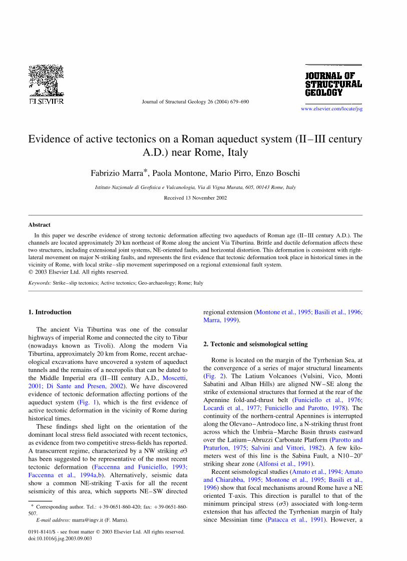
aqueduct system (Fig. 1), which is the first evidence of
active tectonic deformation in the vicinity of Rome during
historical times.
These findings shed light on the orientation of the
dominant local stress field associated with recent tectonics,
as evidence from two competitive stress-fields has reported.
A transcurrent regime, characterized by a NW striking s3
has been suggested to be representative of the most recent
tectonic deformation (Faccenna and Funiciello, 1993;
Faccenna et al., 1994a,b). Alternatively, seismic data
show a common NE-striking T-axis for all the recent
seismicity of this area, which supports NE–SW directed
regional extension (Montone et al., 1995; Basili et al., 1996;
Marra, 1999).
2. Tectonic and seismological setting
Rome is located on the margin of the Tyrrhenian Sea, at
the convergence of a series of major structural lineaments
(Fig. 2). The Latium Volcanoes (Vulsini, Vico, Monti
Sabatini and Alban Hills) are aligned NW–SE along the
strike of extensional structures that formed at the rear of the
Apennine fold-and-thrust belt (Funiciello et al., 1976;
Locardi et al., 1977; Funiciello and Parotto, 1978). The
continuity of the northern-central Apennines is interrupted
along the Olevano–Antrodoco line, a N-striking thrust front
across which the Umbria–Marche Basin thrusts eastward
over the Latium–Abruzzi Carbonate Platform (Parotto and
Praturlon, 1975; Salvini and Vittori, 1982). A few kilo-
meters west of this line is the Sabina Fault, a N10–208
striking shear zone (Alfonsi et al., 1991).
Recent seismological studies (Amato et al., 1994; Amato
and Chiarabba, 1995; Montone et al., 1995; Basili et al.,
1996) show that focal mechanisms around Rome have a NE
oriented T-axis. This direction is parallel to that of the
minimum principal stress (s3) associated with long-term
extension that has affected the Tyrrhenian margin of Italy
since Messinian time (Patacca et al., 1991). However, a
0191-8141/$ - see front matter q 2003 Elsevier Ltd. All rights reserved.
doi:10.1016/j.jsg.2003.09.003
Journal of Structural Geology 26 (2004) 679–690
www.elsevier.com/locate/jsg
* Corresponding author. Tel.: þ39-0651-860-420; fax: þ39-0651-860-
507.
E-mail address: [email protected] (F. Marra).
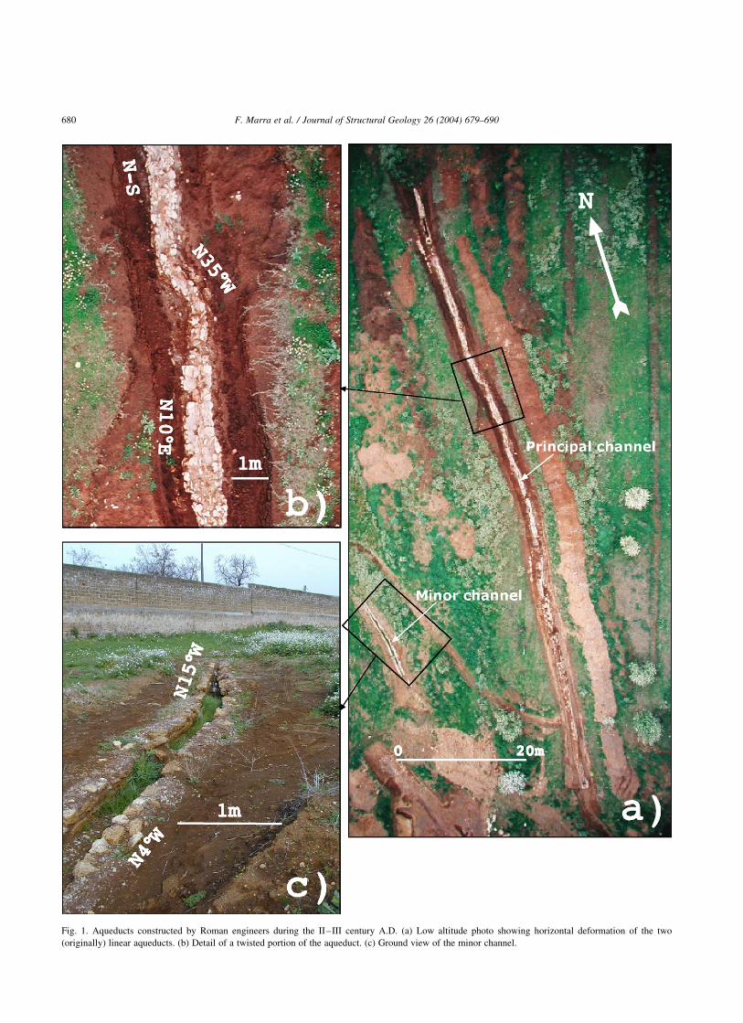
Fig. 1. Aqueducts constructed by Roman engineers during the II–III century A.D. (a) Low altitude photo showing horizontal deformation of the two
(originally) linear aqueducts. (b) Detail of a twisted portion of the aqueduct. (c) Ground view of the minor channel.
F. Marra et al. / Journal of Structural Geology 26 (2004) 679–690680
competitive stress field, characterized by a NW-striking s3,
was superimposed locally on these extensional features in
the area of Rome during the Quaternary period (Marra,
2001). This tectonic regime was characterized by strike–
slip faulting from Pliocene through middle–late Pleistocene
times, and manifested in the area of Rome through a series
of N-striking right-lateral en echelon fault segments at the
southern end of the Sabina Fault (Faccenna and Funiciello,
1993; Faccenna et al., 1994b). A kinematic effect linked to
the presence of a crustal discontinuity along the Sabina
Fault has been suggested as the causal mechanism for
concurrent strike–slip and extensional tectonics around
Rome (Marra, 1999).
3. Geology of the area
The archaeological site is located inside the Acque
Albule basin (Fig. 3). Here, a travertine plateau of upper
Pleistocene age and with a maximum thickness of
approximately 60 m covers a sedimentary sequence of
clay, sand and conglomerate of Pliocene–Pleistocene age.
The Acque Albule basin is bordered to the south and east by
pyroclastic products from the Alban Hills volcanic district
situated ,20 km to the south. The Alban Hills were
characterized by an intense explosive activity in the time
span 561 ^ 1–355 ^ 2 ka (Karner et al., 2001a), followed
by a strombolian/effusive phase between 300 and 250 ka
and a more recent phreato–magmatic phase that, perhaps,
should not even be considered completely extinct at this
time (Karner et al., 2001b). The northeast edge of the basin
consists of middle Pliocene age clay deposits, while along
the eastern border Mesozoic–Cenozoic age carbonate rocks
associated with the central Apennines thrust-and-fold belt
are exposed.
The Acque Albule basin has been interpreted as a
rhombic shaped pull-apart basin of approximately 4 £ 7 km,
created by strike–slip faulting within a N–S oriented shear
zone that crosses the Rome area (Faccenna et al., 1994a). Its
formation and evolution are attributed to middle–late
Pleistocene time. Isopachs of the travertine deposit are
N–S elongated and mimic the trend of the isotherm lines
associated with the Bagni Albule thermal spring in the area
where the travertine reaches its maximum thickness (Fig. 3).
The drainage system in the surrounding area is mainly N–S
oriented, suggesting that the local morphology is controlled
by N–S oriented tectonic displacement. Accordingly, N-
striking fault segments, mainly with a right-lateral com-
ponent, N308E oblique-to-normal faults and N30–608E
extensional joints, represent the main fault systems
recognized in the area of the Acque Albule basin. This
fault and joint system displaces both the travertine plateau
and the surrounding pyroclastic rocks. In particular, the U-
series ages of calcite that fills fractures and faults in the
Pliocene-age deposits range from 49 (^8) to 178 (þ66/
244) ka, whereas the formation age of travertine that was
affected by strike–slip faulting is 28 (þ16/215) ka
(Faccenna et al., 1994a). This deformational pattern defines
a strike–slip tectonic system acting on principal N–S right-
lateral fault segments and is characterized by a minimum
stress tensor (s3) oriented N50–608W.
4. Site geology and structure of the aqueducts
The archaeological site is located at the western margin
of the Acque Albule basin (Fig. 3) and is partially covered
by travertine deposits. One particular necropolis associated
with a Roman villa dating from the II–III century A.D. was
identified following an excavation that completely removed
the recent, 1–1.5-m-thick travertine cover. The tombs were
originally dug in the pyroclastic rock beneath the travertine
layer, which verifies that this travertine mantle was
deposited after the abandonment of the settlement, probably
around the 5th century A.D. The two aqueduct channels, in
which tectonic deformation was identified, are located
Fig. 2. Structural scheme of Central Italy (modified from Marra, 1999).
F. Marra et al. / Journal of Structural Geology 26 (2004) 679–690 681

Fig. 3. Location and geological map of the investigated area (redrawn from De Rita et al., 1998). The archaeological site is located at the western margin of the
Acque Albule basin.
F. Marra et al. / Journal of Structural Geology 26 (2004) 679–690682

immediately to the north of the travertine plate edge, on
pyroclastic rock pertaining to the ‘Pozzolane Rosse’
eruption (457 ^ 4 ka; Karner et al., 2001a). Of these two
structures, the principal N–S channel shows evidence of
both brittle (extensive) and ductile (compressive) defor-
mation (Fig. 4), whereas the shorter channel to the
southwest shows predominantly ductile deformation. Both
channels were constructed of the same materials and have
cross-sectional dimensions of about 85 cm wide and 150 cm
high (Fig. 5). The foundation trench for the aqueducts had
followed the natural slope of the land. The walls of the
aqueduct channel were made with irregular blocks of
travertine held together with a cement mortar mix (‘malta
pozzolanica’). The base and sidewalls of the tunnel were
sealed with crushed ceramic mortar mix (‘cocciopesto’) that
rendered them impermeable. A ridged tile system (‘cap-
puccina’) covered the length of the structure with the peak at
par with the surrounding ground level. The remaining space
between the tiles and the ground level was backfilled with
blocks of travertine (Fig. 5).
Today, the longer channel is in a better state of
preservation as it had remained completely buried prior to
recent exhumation. Oriented more or less N–S the channel
extends for 118 m and displays a difference in elevation of
approximately 1.5 m (portable GPS measurement) between
the northern and southern ends (Fig. 6a). The average
gradient of 1.6% (,28) across the total length is comparable
with the topographical gradient along the natural ground
surface. A variation in the gradient (solid blue lines in Fig.
6a) is evident approximately at the middle of the aqueduct’s
length. The archaeological excavation was carried out to a
width of approximately 2 m and to depths varying from a
minimum of 1 m to a maximum of 3 m in the northernmost
part. Here there is evidence of a thick accumulation of
sedimentary material covering the aqueduct subsequent to
its construction (Fig. 6a). Such an accumulation indicates
that differential subsidence has occurred since construction.
However, subsidence on the order of 1 m cannot alone
explain the horizontal distortion of the aqueduct that is
principally manifested through horizontal displacement,
resulting in an estimated total offset of approximately 4 m
(Fig. 6b). Numerous extensional joints and faults were
surveyed all along the archaeological excavations of the
principal channel (Fig. 7). Open fractures from between 0.5
and 4 cm are filled with alloisite (an argillaceous mineral
derived from alteration of the pyroclastic rock). Such
tectonic features (Fig. 7b–b0) are more concentrated along
the southern portion of the excavation (first 30–40 m),
whereas the rocks to the north do not show such
deformation. In fact, at least four different lithological
facies are observed along the course of the excavation (Fig.
6). In the southern part of the channel a pristine facies of
pyroclastic rock (Pozzolane Rosse) crops out. This is a
scoriaceous ash-tuff of weak coherency, compact and with
small number of fractures (,1 fracture/5 m). About 20 m
Fig. 4. Post-construction ductile deformation of the principal channel. (a)
View from south. (b) View from north.
Fig. 5. Cross-section showing the structure of the aqueduct channel.
F. Marra et al. / Journal of Structural Geology 26 (2004) 679–690 683

further north, a N308E oriented fault, dipping 658NW (Fig.
7c), marks the contact between the zone of pure ‘Pozzolane
Rosse’ pyroclastic deposits and a transitional zone of their
zeolitized facies (zeolith is a phyllosilicate formed during
the devitrification process of the amorphous silica that
constitutes the matrix of pyroclastic rocks). This latter is
semi-lithified and characterized by a greater degree of
fracturing (approximately 1 fracture/0.5 m). Based on the
numerous faults and fractures found at the site, the origin of
this particular zeolithic facies can be attributed to an
increase in circulation of hydrothermal fluids from the
nearby Acque Albule basin area. A different lithological
facies resulting from a stronger alteration of the pyroclastic
deposits become evident approximately 10 m further north,
once again at the point where a fault (approximately N158
oriented and dipping 858W) intersects the channel. This
facies introduces a lack of coherency and represents a
portion of deposit that has endured a partial process of
pedogenesis as well as an alteration occurring through fluid
circulation similar to that of the semi-lithic zeolithic facies.
Also in this case there is a high degree of fracturing that
seems to end as the lithological alteration increases. In fact,
this highly altered facies grades upwards into a brown soil,
gradually increasing in thickness from about 0.5 m to more
than 2.5 m as the channel progresses northwards, making
brittle elements no longer recognizable. This later section of
the channel excavation effectively reveals a change in the
deformation style, with considerable evidence of ductile
deformation. Tectonic elements concerning outcrops of
Pozzolane Rosse, with the same orientation and character-
istics as those observed along the course of the excavated
channels, are also found in concentrated zones throughout
the entire archaeological area. A total of 30 meso-structural
tectonic elements were surveyed (Fig. 7d). The greater
number of these are extensional joints with a lesser number
of faults.
Whereas these faults are identifiable by the abrupt facies
changes of the Pozzolane Rosse, kinematic data are less
clearly recognizable. Faint horizontal striations along fault
planes developed through the alloisite alteration material
suggest a prevalent strike – slip motion. A stereonet
projection indicates a preferential strike of N30–408E and
a dip ranging between 70 and 908 SE in most instances (Fig.
7d).
The detailed survey of the principal channel shows that
its course has been segmented, with individual segments
striking between N108E and N108W, and with one particular
section oriented at N358W (Fig. 1b). The points where the
Fig. 6. Geology of the area surrounding the principal channel. (a) Longitudinal profile: elevation detected by GPS measurements. Tectonic subsidence of ,1 m
with respect to a constant gradient (blue dashed line) is evident. (b) Map view of the principal channel showing geology and structural information. Horizontal
displacement of ,4 m with respect to the original linear trend (blue dashed line) is evident.
F. Marra et al. / Journal of Structural Geology 26 (2004) 679–690684
various segments vary direction often coincide with a break
and a slight dislocation (less than 50 cm offset) in the
structure (Fig. 7a). A few segments, however, appear to be
deformed in a more ductile manner. For example, a section
approximately 2 m in length curves N358W (Fig. 1b), but
has not undergone brittle deformation. Perhaps the cause of
this more ductile behavior is that the rock surrounding the
aqueduct here is very altered Pozzolane Rosse and soil. The
smaller channel (Fig. 1c) situated to the southwest of the
principal excavation is cut back to approximately half its
depth, probably due to modification of the original
topography by agricultural development. Deformation of
this second channel can essentially be explained by
transverse compression resulting in a restriction of the
inner trough (from 45 to 15 cm) and rotation of the structure.
5. Tectonic deformation affecting the aqueducts
A necessary component of our study is to evaluate the
possibility that the observed anomalies in the structure of
the aqueduct are due to defective construction or to the
unforeseen presence of underground obstacles, rather than
to deformation of an originally straight structure.
The investigated portion of the aqueduct is only 120 m
long and is excavated in a flat field, and through an
extremely soft pyroclastic unit. Given this information it is
highly unlikely that Roman engineers of the Middle
Imperial age were unable to excavate a straight trench; the
only possible obstacles could have been trees. Additionally,
the aqueduct is curved both on large and small scales (Fig.
1a). If intentionally built in this manner, the aqueduct
Fig. 7. Most tectonic elements affecting the rock surrounding the principal channel are concentrated in the central portion. (a) The aqueduct is seriously
damaged at the location of the major structural elements. (b)–(b0) Detail of the fracture system that affects the ground along the twisted portion of the aqueduct.
(c) N308E striking, 658NW dipping fault that marks the contact between the volcanic rock and the travertine. (d) Detail of most strongly deformed section and
stereonet diagram with orientations of the surveyed joints and faults.
F. Marra et al. / Journal of Structural Geology 26 (2004) 679–690 685
section that we have investigated would have been
constructed differently than all other aqueducts that date
to this time. Trees did not stop Roman engineers from the
Middle Imperial age from building straight aqueducts.
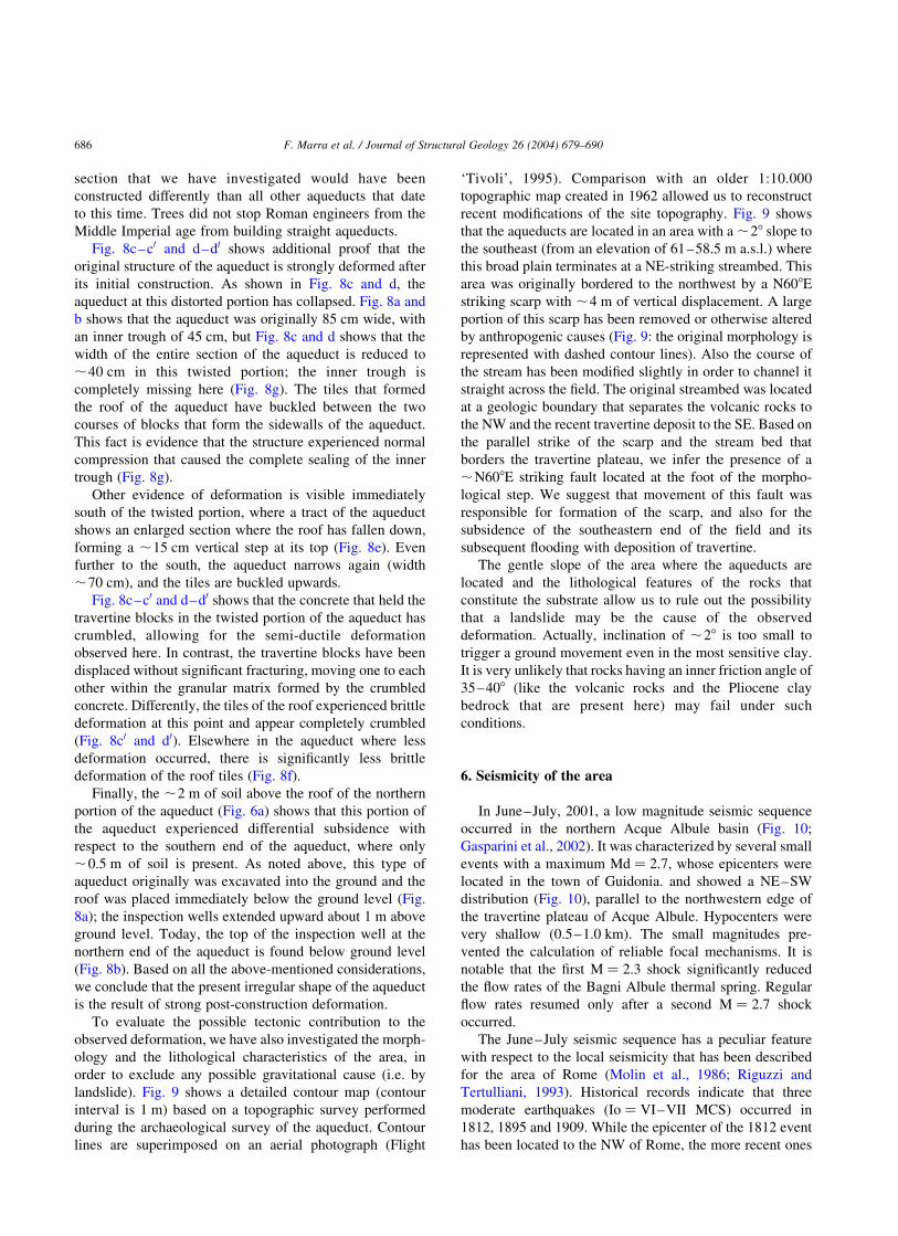
Fig. 8c–c0 and d–d0 shows additional proof that the
original structure of the aqueduct is strongly deformed after
its initial construction. As shown in Fig. 8c and d, the
aqueduct at this distorted portion has collapsed. Fig. 8a and
b shows that the aqueduct was originally 85 cm wide, with
an inner trough of 45 cm, but Fig. 8c and d shows that the
width of the entire section of the aqueduct is reduced to
,40 cm in this twisted portion; the inner trough is
completely missing here (Fig. 8g). The tiles that formed
the roof of the aqueduct have buckled between the two
courses of blocks that form the sidewalls of the aqueduct.
This fact is evidence that the structure experienced normal
compression that caused the complete sealing of the inner
trough (Fig. 8g).
Other evidence of deformation is visible immediately
south of the twisted portion, where a tract of the aqueduct
shows an enlarged section where the roof has fallen down,
forming a ,15 cm vertical step at its top (Fig. 8e). Even
further to the south, the aqueduct narrows again (width
,70 cm), and the tiles are buckled upwards.
Fig. 8c–c0 and d–d0 shows that the concrete that held the
travertine blocks in the twisted portion of the aqueduct has
crumbled, allowing for the semi-ductile deformation
observed here. In contrast, the travertine blocks have been
displaced without significant fracturing, moving one to each
other within the granular matrix formed by the crumbled
concrete. Differently, the tiles of the roof experienced brittle
deformation at this point and appear completely crumbled
(Fig. 8c0 and d0). Elsewhere in the aqueduct where less
deformation occurred, there is significantly less brittle
deformation of the roof tiles (Fig. 8f).
Finally, the ,2 m of soil above the roof of the northern
portion of the aqueduct (Fig. 6a) shows that this portion of
the aqueduct experienced differential subsidence with
respect to the southern end of the aqueduct, where only
,0.5 m of soil is present. As noted above, this type of
aqueduct originally was excavated into the ground and the
roof was placed immediately below the ground level (Fig.
8a); the inspection wells extended upward about 1 m above
ground level. Today, the top of the inspection well at the
northern end of the aqueduct is found below ground level
(Fig. 8b). Based on all the above-mentioned considerations,
we conclude that the present irregular shape of the aqueduct
is the result of strong post-construction deformation.
To evaluate the possible tectonic contribution to the
observed deformation, we have also investigated the morph-
ology and the lithological characteristics of the area, in
order to exclude any possible gravitational cause (i.e. by
landslide). Fig. 9 shows a detailed contour map (contour
interval is 1 m) based on a topographic survey performed
during the archaeological survey of the aqueduct. Contour
lines are superimposed on an aerial photograph (Flight
‘Tivoli’, 1995). Comparison with an older 1:10.000
topographic map created in 1962 allowed us to reconstruct
recent modifications of the site topography. Fig. 9 shows
that the aqueducts are located in an area with a ,28 slope to
the southeast (from an elevation of 61–58.5 m a.s.l.) where
this broad plain terminates at a NE-striking streambed. This
area was originally bordered to the northwest by a N608E
striking scarp with ,4 m of vertical displacement. A large
portion of this scarp has been removed or otherwise altered
by anthropogenic causes (Fig. 9: the original morphology is
represented with dashed contour lines). Also the course of
the stream has been modified slightly in order to channel it
straight across the field. The original streambed was located
at a geologic boundary that separates the volcanic rocks to
the NW and the recent travertine deposit to the SE. Based on
the parallel strike of the scarp and the stream bed that
borders the travertine plateau, we infer the presence of a
,N608E striking fault located at the foot of the morpho-
logical step. We suggest that movement of this fault was
responsible for formation of the scarp, and also for the
subsidence of the southeastern end of the field and its
subsequent flooding with deposition of travertine.
The gentle slope of the area where the aqueducts are
located and the lithological features of the rocks that
constitute the substrate allow us to rule out the possibility
that a landslide may be the cause of the observed
deformation. Actually, inclination of ,28 is too small to
trigger a ground movement even in the most sensitive clay.
It is very unlikely that rocks having an inner friction angle of
35–408 (like the volcanic rocks and the Pliocene clay
bedrock that are present here) may fail under such
conditions.
6. Seismicity of the area
In June–July, 2001, a low magnitude seismic sequence
occurred in the northern Acque Albule basin (Fig. 10;
Gasparini et al., 2002). It was characterized by several small
events with a maximum Md ¼ 2.7, whose epicenters were
located in the town of Guidonia. and showed a NE–SW
distribution (Fig. 10), parallel to the northwestern edge of
the travertine plateau of Acque Albule. Hypocenters were
very shallow (0.5–1.0 km). The small magnitudes pre-
vented the calculation of reliable focal mechanisms. It is
notable that the first M ¼ 2.3 shock significantly reduced
the flow rates of the Bagni Albule thermal spring. Regular
flow rates resumed only after a second M ¼ 2.7 shock
occurred.
The June–July seismic sequence has a peculiar feature
with respect to the local seismicity that has been described
for the area of Rome (Molin et al., 1986; Riguzzi and
Tertulliani, 1993). Historical records indicate that three
moderate earthquakes (Io ¼ VI–VII MCS) occurred in
1812, 1895 and 1909. While the epicenter of the 1812 event
has been located to the NW of Rome, the more recent ones
F. Marra et al. / Journal of Structural Geology 26 (2004) 679–690686
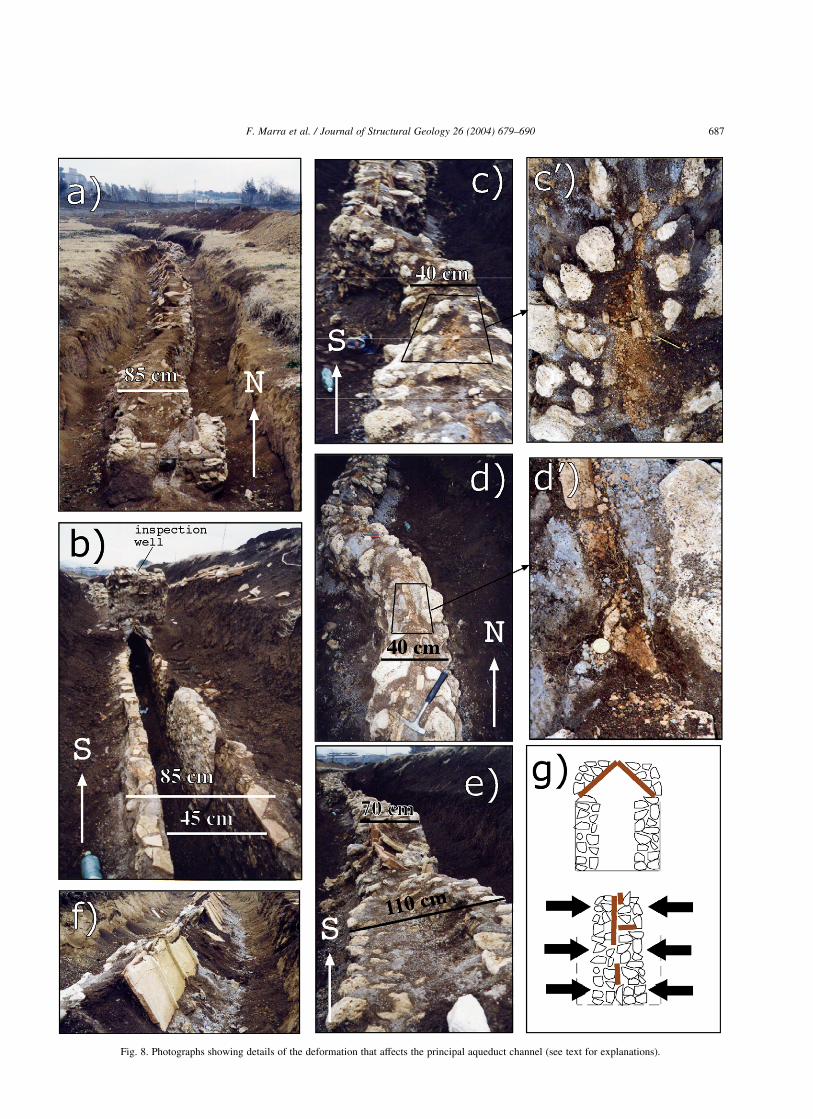
Fig. 8. Photographs showing details of the deformation that affects the principal aqueduct channel (see text for explanations).
F. Marra et al. / Journal of Structural Geology 26 (2004) 679–690 687
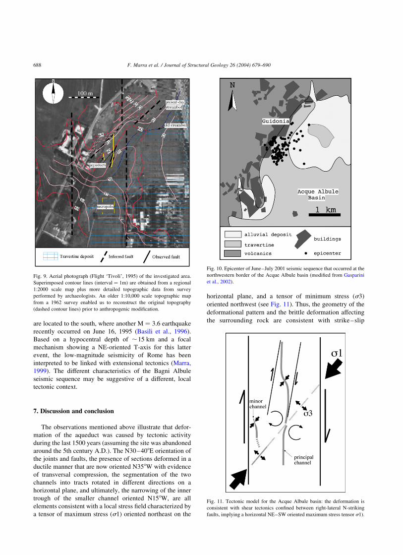
are located to the south, where another M ¼ 3.6 earthquake
recently occurred on June 16, 1995 (Basili et al., 1996).
Based on a hypocentral depth of ,15 km and a focal
mechanism showing a NE-oriented T-axis for this latter
event, the low-magnitude seismicity of Rome has been
interpreted to be linked with extensional tectonics (Marra,
1999). The different characteristics of the Bagni Albule
seismic sequence may be suggestive of a different, local
tectonic context.
7. Discussion and conclusion
The observations mentioned above illustrate that defor-
mation of the aqueduct was caused by tectonic activity
during the last 1500 years (assuming the site was abandoned
around the 5th century A.D.). The N30–408E orientation of
the joints and faults, the presence of sections deformed in a
ductile manner that are now oriented N358W with evidence
of transversal compression, the segmentation of the two
channels into tracts rotated in different directions on a
horizontal plane, and ultimately, the narrowing of the inner
trough of the smaller channel oriented N158W, are all
elements consistent with a local stress field characterized by
a tensor of maximum stress (s1) oriented northeast on the
horizontal plane, and a tensor of minimum stress (s3)
oriented northwest (see Fig. 11). Thus, the geometry of the
deformational pattern and the brittle deformation affecting
the surrounding rock are consistent with strike–slip
Fig. 9. Aerial photograph (Flight ‘Tivoli’, 1995) of the investigated area.
Superimposed contour lines (interval ¼ 1m) are obtained from a regional
1:2000 scale map plus more detailed topographic data from survey
performed by archaeologists. An older 1:10,000 scale topographic map
from a 1962 survey enabled us to reconstruct the original topography
(dashed contour lines) prior to anthropogenic modification.
Fig. 10. Epicenter of June–July 2001 seismic sequence that occurred at the
northwestern border of the Acque Albule basin (modified from Gasparini
et al., 2002).
Fig. 11. Tectonic model for the Acque Albule basin: the deformation is
consistent with shear tectonics confined between right-lateral N-striking
faults, implying a horizontal NE–SW oriented maximum stress tensor s1).
F. Marra et al. / Journal of Structural Geology 26 (2004) 679–690688

tectonics creating a pull-apart basin at Acque Albule. In
particular, ,N20–308E striking oblique–slip faults and
associated fractures located at the northwestern border of
the travertine basin (see Fig. 3) highlight a right-step in the
major N–S lineament that crosses the area. Evidence of
travertine deposits flooding the archaeological site since the
3rd century AD indicates a westward growth of the
sedimentary basin and suggests that strike–slip movement
of the border faults and associated collapses of the basin
occurred during historical times.
Based on the absence of significant local earthquakes in
the historical records (Molin and Guidoboni, 1989), we
believe that the described deformation should be attributed
to aseismic fault creep. Our inability to resolve any
kinematic indicators from the 2000–2001 seismic events
of Bagni Albule prevents us from showing any direct
linkage with the strike–slip tectonics responsible for the
deformation of the aqueduct channels. However, the
variation of the hydraulic capacity of the Bagni Albule
thermal spring in coincidence with the seismic sequence
suggests a possible interaction between this shallow
seismicity and the tectonic structures that control the basin
and that constitute preferential pathways to the circulation
of thermal fluids.
Also in the absence of significant related seismicity, the
observed deformation linked with the strike–slip regime is a
potential factor of hazard with respect to human settlements
in the area of the Acque Albule basin. With respect to a few
years ago, when the Roman volcanoes were considered
extinct and with no signs of tectonic activity present in the
area, it seems today that the Eternal City is not still
destined—geologically speaking—to eternal rest!
Acknowledgements
Our sincere thanks to archaeologists E. Moscetti, G.
Presen and S. Di Sante for their precious information and for
making access to the site available. We would like to thank
Albert Ammerman for his kind advice and useful sugges-
tions. We also thank Daniel Karner for revising the English
of the manuscript and providing useful comments. Particu-
lar thanks to Fabio Florindo for his assistance at the site and
for his contribution to the scientific argument. Many thanks
also to M. Marchetti and A. Zirizzotti who performed the
relief GPS altimetry of the channel.
References
Alfonsi, L., Funiciello, R., Mattei, M., Girotti, O., Maiorani, A., Preite
Martinez, M., Trudu, C., Turi, B., 1991. Structural and geochemical
features of the Sabina strike–slip fault (Central Apennines). Bollettino
della Societa Geologica Italiana 110, 217–230.
Amato, A., Chiarabba, C., 1995. Earthquake occurrence and crustal
structure. In: Trigila, R. (Ed.), “The Volcano of the Alban Hills”,
Special issue, Universita degli Studi di Roma “La Sapienza”, Roma,
pp. 193–211.
Amato, A., Chiarabba, C., Cocco, M., Di Bona, M., Selvaggi, G., 1994. The
1989–1990 seismic swarm in the Alban Hills volcanic area, central
Italy. Journal of Volcanology and Geothermal Research 61, 225–237.
Basili, A., Cantore, L., Cocco, M., Frepoli, A., Margheriti, L., Nostro, C.,
Selvaggi, G., 1996. The June 12, 1995 microearthquake sequence in the
city of Rome. Annali di Geofisica 39, 1167–1175.
De Rita, D., Funiciello, R., Parotto, M., 1988. Carta geologica del
Complesso vulcanico dei Colli Albani. C.N.R., Roma, scale 1:50.000.
Di Sante, S., Presen, G., 2002. Guidonia: nota di scavo in localita
Martellona. Notiziario Archeologico Ass. Nomentana di Storia e
Archeologia, Annali 2002, Monterotondo, Rome, Italy, pp. 88–101.
Faccenna, C., Funiciello, R., 1993. Tettonica pleistocenica tra il Monte
Soratte ed i Monti Cornicolani (Lazio). Il Quaternario 6, 103–118.
Faccenna, C., Funiciello, R., Montone, P., Parotto, M., Voltaggio, M.,
1994a. An example of late Pleistocene strike–slip tectonics: the Acque
Albule basin (Tivoli, Latium). Memorie Descrittive della Carta
Geologica d’Italia 49, 37–50.
Faccenna, C., Funiciello, R., Mattei, M., 1994b. Late Pleistocene N–S
shear zones along the Latium Tyrrhenian margin: structural characters
and volcanological implications. Bollettino di Geofisica Teorica
Applicata 36, 507–522.
Funiciello, R., Parotto, M., 1978. Il substrato sedimentario nell’area dei
Colli Albani: considerazioni geodinamiche e paleogeografiche sul
margine tirrenico dell’Appennino centrale. Geologica Romana 17,
233–287.
Funiciello, R., Locardi, E., Parotto, M., 1976. Lineamenti geologici
dell’area sabatina orientale. Bollettino della Societa Geologica Italiana
95, 831–849.
Gasparini, C., Di Maro, R., Pagliuca, N.M., Pirro, M., Marchetti, A., 2002.
Recent seismicity of the “Acque Albule” travertine basin. Annals of
Geophysics 45, 537–550.
Karner, D.B., Marra, F., Renne, P., 2001a. The history of the Monti Sabatini
and Alban Hills Volcanoes: groundwork for assessing volcanic–
tectonic hazards for Rome. Journal of Volcanology and Geothermal
Research 107, 185–219.
Karner, D.B., Marra, F., Florindo, F., Boschi, E., 2001b. Pulsed uplift
estimated from terrace elevations in the coast of Rome: evidence for a
new phase of volcanic activity? Earth and Planetary Science Letters
188, 135–148.
Locardi, E., Lombardi, G., Funiciello, R., Parotto, M., 1977. The main
volcanic groups of Latium (Italy): relations between structural
evolution and petrogenesis. Geologica Romana 15, 279–300.
Marra, F., 1999. Low-magnitude earthquakes in Rome: structural
interpretation and implications for local stress-field. Geophysical
Journal International 138, 231–243.
Marra, F., 2001. Strike–slip faulting and block rotation: a possible
triggering mechanism for lava flows in the Alban Hills? Journal of
Structural Geology 23 (2), 129–141.
Molin, D., Guidoboni, E., 1989. Effetto fonti, effetto monumenti a Roma: i
terremoti dell’antichita a oggi. In: Guidoboni, E., (Ed.), “I Terremoti
prima del Mille in Italia e nell’Area Mediterranea”, S.G.A., Bologna,
pp. 194–223.
Molin, D., Ambrosini, S., Castenetto, S., Di Loreto, E., Liperi, L., Paciello,
A., 1986. Aspetti della sismicita storica di Roma. Memorie della
Societa Geologica Italiana 35, 439–448.
Montone, P., Amato, A., Chiarabba, C., Buonasorte, G., Fiordelisi, A.,
1995. Evidence of active extension in Quaternary volcanoes of Central
Italy from breakout analysis and seismicity. Geophysical Research
Letters 22, 1909–1912.
Moscetti, E., 2001. Notiziario Archeologico Ass. Nomentana di Storia e
Archeologia, Annali 2001, 112–114.
Parotto, M., Praturlon, A., 1975. Geological summary of the Central
Apennines. In: Ogniben, L., Parotto, M., Praturlon, A. (Eds.), Structural
Model of Italy. Quaderni della Ricerca Scientifica Vol. 90, C.N.R.,
Rome, pp. 257–311.
F. Marra et al. / Journal of Structural Geology 26 (2004) 679–690 689

Patacca, E., Sartori, R., Scandone, P., 1991. Tyrrhenian Basin and
Apenninic arcs: kinematic relations since late Tortonian times.
Memorie della Societa Geologica Italiana 45, 425–451.
Riguzzi, F., Tertulliani, A., 1993. Re-evaluation of minor events: the
examples of the 1895 and 1909 Rome earthquakes. Natural Hazards 7,
219–235.
Salvini, F., Vittori, E., 1982. Analisi strutturale della linea Olevano–
Antrodoco–Posta (Ancona–Anzio Auct.): metodologia di studio delle
deformazioni fragili e presentazione del tratto meridionale. Memorie
della Societa Geologica Italiana 24, 337–355.
F. Marra et al. / Journal of Structural Geology 26 (2004) 679–690690