Embed Size (px)
Citation preview
331
Evidence for Early to Late Cretaceoussinistral deformation in
the Tchaikazan River area,southwestern British Columbia:
Implications for the tectonic evolutionof the southern Coast belt
Steve IsraelYukon Geological Survey, PO Box 2703,
Whitehorse, Yukon Y1A 2C6, Canada; [email protected]
Paul SchiarizzaBritish Columbia Geological Survey, Victoria, British Columbia V8V 1X4, Canada
Lori A. KennedyDepartment of Earth and Ocean Sciences, 6339 Stores Road, University of British Columbia,
Vancouver, British Columbia V6T 1Z4, Canada
Richard M. FriedmanDepartment of Earth and Ocean Sciences, 6339 Stores Road, University of British Columbia,
Vancouver, British Columbia V6T 1Z4, Canada
Michael VilleneuveGeological Survey of Canada, 601 Booth Street, Ottawa, Ontario K1A 0E8, Canada
Israel, S., Schiarizza, P., Kennedy, L.A., Friedman, R.M. and Villeneuve, M., 2006, Evidence for Early to LateCretaceous sinistral deformation in the Tchaikazan River area, southwestern British Columbia: Implications for thetectonic evolution of the southern Coast belt, in Haggart, J.W., Enkin, R.J. and Monger, J.W.H., eds., Paleogeography ofthe North American Cordillera: Evidence For and Against Large-Scale Displacements: Geological Association ofCanada, Special Paper 46, p. 331-350.

INTRODUCTIONThe western part of the Canadian Cordillera, comprising theIntermontane, Coast, and Insular belts is constructed froma collage of crustal fragments (terranes) that were accretedto the former western continental margin of North Americaduring Mesozoic through Paleogene time. The Coast belt,characterized by rugged mountains underlain in large part byLate Jurassic to Paleogene granitic rocks of the Coast plu-tonic complex, forms the boundary between an inner, conti-nentward, group of terranes (Intermontane superterrane) thatprobably was accreted to the old continental margin byMiddle Jurassic time, and a group of outer terranes (Insularsuperterrane) whose time of accretion is more problematical.Earlier models (e.g. Davis et al., 1978; Monger et al., 1982)interpreted the Coast belt as containing a mid-Cretaceoussuture between the Intermontane and Insular superterranes,
whereas later models (e.g. van der Heyden, 1992; McClel-land et al., 1992) suggested that the granitic rocks of theCoast belt were intruded across Intermontane and Insularterranes that had all been mutually juxtaposed and accretedto western North America by Middle Jurassic time.
Critical to evaluating these and other models of Coast belttectonics are relationships in southern British Columbia,where the Coast belt can be divided into western and easternparts based on differences in plutonic rocks, metamorphism,supracrustal rocks, and structural style (Fig. 1; Monger andJourneay, 1994). The southwestern Coast belt (SWCB) isdominated by Middle Jurassic to mid-Cretaceous plutonicrocks. These plutons intrude Wrangellia (part of the Insularsuperterrane) along the western margin of the belt, andenclose pendants and septa of variably metamorphosedand deformed Early Cretaceous and older volcanic and
332
ISRAEL ET AL.
AbstractGeological mapping in the Tchaikazan River area has found evidence for Cretaceous sinistral translation within thesouthern Coast belt. Previously unrecognized large sinistral shear zones are documented within the study area, withlatest movement along these zones dated at 89 Ma. The newly recognized Twin Creek assemblage, a sedimentarysequence cut by a Permian-Triassic aplitic dyke (ca. 251 Ma), is correlated with rocks of the Cadwallader terrane. Basedon this correlation, we interpret the adjacent Tchaikazan fault to be the locus of at least 40 to 50 km of sinistral displace-ment, and as much as 180 km, prior to its reactivation as an Eocene dextral strike-slip fault. Lower Cretaceous rocks ofthe Tchaikazan River formation are correlated with the East Waddington thrust belt and may have provided sourcematerial for the Hauterivian through Albian portion of the Tyaughton-Methow basin. The sinistral displacement we inferalong the Tchaikazan fault may be part of a broad zone of Cretaceous sinistral faults that translated the southwest Coastbelt, together with slivers of Stikine and Cadwallader terranes, southward to a position outboard of the Bridge Riverterrane and overlying Tyaughton-Methow basin.
These relationships are consistent with the model proposed by Monger et al. (1994) for Cretaceous sinistral displace-ment of the southwest Coast belt and related terranes. Early Cretaceous emplacement of the southwestern Coast belt, assuggested by Umhoefer et al. (2002), cannot be proven but is suspected based on stratigraphic relationships from theTchaikazan River area.
RésuméLa cartographie géologique dans la région de la rivière Tchaikazan a révélé des preuves de translation sénestre durantle Crétacé dans le sud du Domaine côtier. De larges zones de cisaillement sénestres, auparavant méconnues, sontdocumentées dans la région d’étude. Les plus récents mouvements le long de ces zones remontent à 89 Ma. L’assemblagenouvellement reconnu de Twin Creek, une séquence sédimentaire recoupée par un dyke aplitique d’âge permien-triassique (environ 251 Ma), est corrélé avec les roches du terrane de Cadwallader. Cette corrélation nous permetd’interpréter que la faille Tchaikazan attenante aurait accommodé au moins 40 à 50 km, et peut-être jusqu’à 180 km, dedéplacement sénestre, avant sa réactivation en décrochement dextre à l’Éocène. Les roches du Crétacé inférieur de laformation de Tchaikazan River sont corrélées avec la zone de charriage d’East Waddington, et pourraient avoir alimentéla portion hauterivienne à albienne du bassin Tyaughton-Methow. Le déplacement sénestre que nous interprétons le longde la faille Tchaikazan pourrait faire partie d’une vaste zone de failles sénestres crétacées le long desquelles la partiesud-ouest du Domaine côtier ainsi que des écailles appartenant aux terranes de Cadwallader et de Stikine, ont subi unetranslation vers le sud pour se retrouver dans un emplacement au large du terrane de Bridge River et du bassin sus-jacent Tyaughton-Methow.
Ces relations sont compatibles avec le modèle proposé par Monger et al. (1994) pour le déplacement sénestre crétacéde la partie sud-ouest du Domaine côtier et des terranes affiliés. La mise en place au Crétacé précoce de la partie sud-ouest du Domaine côtier, tel que suggéré par Umhoefer et al. (2002), ne peut être prouvée mais est soupçonnée enraison des relations stratigraphiques dans la région de la rivière Tchaikazan.

sedimentary rocks correlated with Wrangellia terraneexposed on Vancouver Island and that are found across thefull width of the southwestern Coast belt.
The southeastern Coast belt (SECB) contains a smallerpercentage of granitic rocks than the southwestern Coastbelt, and these range in age from mid-Cretaceous throughPaleogene. Supracrustal rocks include upper Paleozoicthrough mid-Mesozoic rocks assigned to the oceanic BridgeRiver terrane and the Cadwallader-Methow arc terrane, aswell as overlapping upper Middle Jurassic to mid-Cretaceousclastic sedimentary rocks of the Tyaughton-Methow basinthat are in places metamorphosed to high grade and intenselydeformed. These assemblages are mutually juxtaposed andseparated from the adjacent southwestern Coast belt by com-plex systems of contractional, strike-slip, and extensionalfaults of mainly Late Cretaceous and Cenozoic age.
According to the Cretaceous collisional model, contrac-tional structures and associated high-grade metamorphism
and plutonism within and adjacent to the southeastern Coastbelt reflect crustal thickening associated with accretion of theInsular superterrane (including the southwestern Coast belt)to the western margin of the Intermontane superterrane dur-ing mid-Cretaceous to early Late Cretaceous time (Monger etal., 1982; Fig. 2A). Convergence was accomplished by east-dipping subduction, as interpreted from Early to mid-Creta-ceous tectonic elements that include the Okanagan-SpencesBridge arc built across the western Intermontane belt, anassociated fore-arc basin (lower part of Tyaughton-Methowbasin) within the adjacent southeast Coast belt, and a subduc-tion-accretion complex (part of Bridge River terrane) fartherwest within the southeastern Coast belt. The coeval Gambierarc of the southwestern Coast belt, together with youngermagmatic arc rocks of the Coast belt, are interpreted as prod-ucts of a separate east-dipping subduction zone along theoutboard margin of the Insular superterrane that continues tobe active at the present time.
The older model of mid-Cretaceouscollision has been challenged on the basisof data from central and northern BritishColumbia and adjacent Alaska, wherethere is no indication of a mid-Cretaceousoceanic suture between the Insular and In-termontane superterranes, and evidencefavours Early to Middle Jurassic tiesbetween them (van der Heyden, 1992;McClelland et al., 1992; Mahoney, 1994;Gehrels, 2001). These relationshipsspawned models in which the Insular su-perterrane was amalgamated with theIntermontane superterrane by MiddleJurassic time, and the Coast belt is a long-lived (Middle Jurassic to Cenozoic)Andean-style magmatic arc built acrossboth superterranes (van der Heyden,1992; McClelland et al., 1992). In this in-terpretation, the mid-Cretaceous contrac-tional structures within the Coast belt areintraplate structures that in part collapseda series of intra-arc basins (Fig. 2B).
Monger et al. (1994) presented a varia-tion on the single-arc model that attemptsto reconcile the conflicting data from thesouthern versus the central and northernparts of the Coast belt. The salient geolog-ical data that must be addressed in anymodel for the evolution of the southernCoast belt include: (a) the pinching out ofremnants of a long-lived oceanic basinnorth of 50° latitude (the Bridge River ter-rane); (b) the apparent doubling of anEarly to Late Cretaceous volcanic arc(Gambier and Okanagan-Spences Bridgearcs); and (c) paleocurrent data from
333
SINISTRAL DEFORMATION, SOUTHWESTERN BRITISH COLUMBIA
Figure 1. Location of study area (modified from Schiarizza et al., 1997).Small box represents the field area. The area highlighted by the large box isshown in Figure 3A.

sedimentary basins (Tyaughton-Methow basin) along thewestern margin of the orogen that record an abrupt change indirection during the Early Cretaceous and an increase in vol-canic detritus (Umhoefer et al., 2002). Monger et al. (1994)suggested that the Okanagan-Spences Bridge arc of thesouthwestern Intermontane belt and the Gambier arc of thesouthwestern Coast belt are parts of the same arc that wasbuilt on the Jurassic-Cretaceous North American platemargin, across previously accreted terranes of the Insular andIntermontane belts. The southwest Coast belt arc was origi-nally along strike and to the north of the Okanagan-SpencesBridge arc, but was displaced ~800 km southward along anorogen-parallel sinistral fault system during the late EarlyCretaceous, such that it lay west of the accretionary fore-arccomplex of the southeastern Coast belt, to be subsequentlyimbricated beneath it during the mid-Cretaceous to earlyLate Cretaceous contractional deformation event (Fig. 2C).Umhoefer et al. (2002) presented a similar model except thatthey push the timing of onset of the sinistral fault systemback to the Late Jurassic (Fig. 2D).
Here, we describe the stratigraphy and structural relation-ships within the Tchaikazan River area, located just north ofthe northern termination of the Bridge River terrane and
straddling the boundary between the southeastern and south-western Coast belts. We document the presence of sinistralshear zones that were active during early Late Cretaceoustime, and we present evidence that the Tchaikazan fault mayhave been the locus for significant sinistral displacementprior to its reactivation as an Eocene dextral strike-slip fault.Finally, we present a model of tectonic evolution for thesouthern Coast belt that builds on the models of Monger etal. (1994) and Umhoefer et al. (2002).
REGIONAL GEOLOGICALSETTINGThe study area is located at the boundary between the south-western and southeastern Coast belts, ~200 km north ofVancouver (Fig. 1). The Tchaikazan fault, a major structurethat separates rocks of sharply contrasting character alongmost of its length, cuts through the northern portion of thestudy area (Fig. 3A; Umhoefer et al., 1994). Northeast of thefault, rocks associated with the southeastern Coast belt com-prise a nearly complete section of Middle Jurassic to mid-Cretaceous dominantly clastic rocks of the Tyaughton-Methow basin, including the Relay Mountain, Jackass
Mountain, and Taylor Creekgroups. The Jackass MountainGroup overlies rocks of theCadwallader terrane to the northand the Relay Mountain andTaylor Creek groups overlie theBridge River terrane to thesouth (Fig. 3B; Rusmore andWoodsworth, 1991; Garver,1992; Umhoefer et al., 1994;Schiarizza et al., 1997). In con-trast, rocks southwest of theTchaikazan fault comprise theEast Waddington thrust belt, astructurally and stratigraphi-cally complex belt of rocks con-sisting of Triassic volcanicrocks of the Mount Moore andMosely formations and Creta-ceous volcanic, volcaniclastic,and sedimentary rocks of the
334
ISRAEL ET AL.
Figure 2. Tectonic models forthe western margin of the Cana-dian Cordillera. (A) Monger etal. (1982); (B) van der Heyden(1992); (C) Monger et al.(1994); (D) Umhoefer et al.(2002). Modified from Mongerand Journeay (1994).
335
SINISTRAL DEFORMATION, SOUTHWESTERN BRITISH COLUMBIA
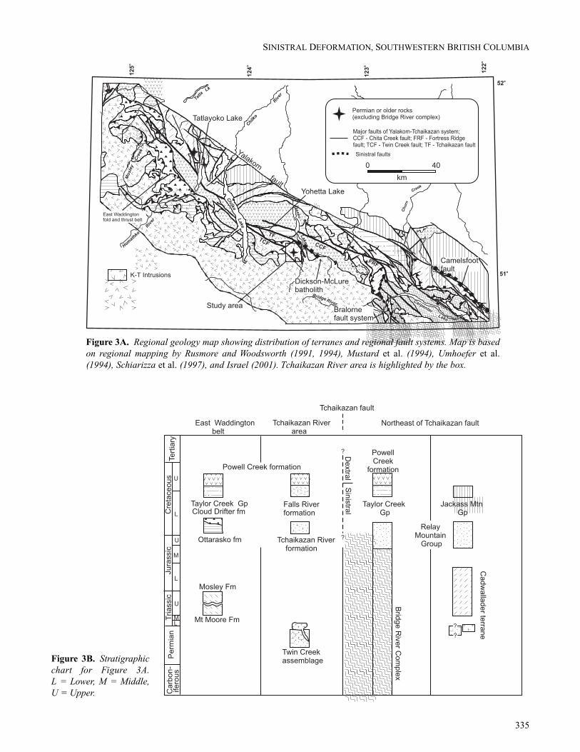
Figure 3A. Regional geology map showing distribution of terranes and regional fault systems. Map is basedon regional mapping by Rusmore and Woodsworth (1991, 1994), Mustard et al. (1994), Umhoefer et al.(1994), Schiarizza et al. (1997), and Israel (2001). Tchaikazan River area is highlighted by the box.
Figure 3B. Stratigraphicchart for Figure 3A.L = Lower, M = Middle,U = Upper.

336
ISRAEL ET AL.
Figure 4. Generalized geology of the Tchaikazan River area. GCP = Grizzly Creek pluton.
Cloud Drifter and Ottarasko formations and the Monarchvolcanics (Fig. 3B; Rusmore and Woodsworth, 1991;Umhoefer et al., 1994; Mustard and van der Heyden, 1994;van der Heyden et al., 1994; Schiarizza et al., 1997; Rusmoreet al., 2000). The Mount Moore and Mosely formations aretentatively correlated with the Stikine terrane (Rusmore andWoodsworth, 1994; Umhoefer et al., 1994), while the CloudDrifter and Ottarasko formations and Monarch volcanicshave been correlated with the Lower Cretaceous GambierGroup of the southwestern Coast belt (Rusmore andWoodsworth, 1991; Rusmore and Woodsworth, 1994;Umhoefer et al., 1994; Rusmore et al., 2000). The UpperCretaceous Powell Creek formation overlaps rocks to thenortheast and southwest of the Tchaikazan fault.
Mid-Cretaceous contraction of the Coast belt was accom-modated primarily by the development of southwest-vergingthrust faults, located near the eastern edge of the Insularsuperterrane, that were active between 100 and 91 Ma(Journeay and Friedman, 1993; Umhoefer and Miller, 1996).Younger (ca. 95–85 Ma) north- to northeast-verging thrust
faults, located near the western edge of the Intermontanesuperterrane, as exemplified in the East Waddington thrustbelt, are interpreted as back thrusts to the major southwest-verging faults (Rusmore and Woodsworth, 1994). South ofthe Tchaikazan fault in the East Waddington thrust belt, thenortheast-verging thrust sheets consist of amphibolite-grademetamorphic rocks, whereas across the Tchaikazan fault,thrust faults are rare and, when found, typically within verylow-grade rocks.
A regionally developed system of latest(?) Cretaceous toEocene dextral strike-slip and locally important faults cuts allother structures (Umhoefer and Schiarizza, 1996; Schiarizzaet al., 1997). This system is characterized by large faultarrays and associated minor structures with hundreds of kilo-metres of accumulated offset. Examples include theYalakom, Fortress Ridge, Chita Creek, and Tchaikazan faultsystems (Fig. 3A).
SINISTRAL DEFORMATION, SOUTHWESTERN BRITISH COLUMBIA
337
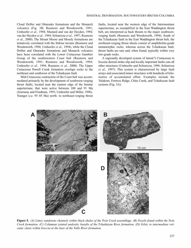
Figure 5. (A) Limey sandstone channels within black shales of the Twin Creek assemblage. (B) Fossils found within the TwinCreek formation. (C) Columnar jointed andesitic basalts of the Tchaikazan River formation. (D) Felsic to intermediate vol-canic clasts within breccia at the base of the Falls River formation.

STRATIGRAPHY OF THETCHAIKAZAN RIVER AREAThe Tchaikazan River area is underlain by Permian-Triassicto mid-Cretaceous sedimentary, volcanic, and volcaniclasticrocks associated with several tectonostratigraphic assem-blages intruded by mid- to Late Cretaceous granitic rocks ofthe Coast plutonic complex (Fig. 4; Jeletzky and Tipper,1968; Tipper, 1978; McLaren, 1990; Israel and Kennedy,2000). We describe these rock units in detail below to il-lustrate their stratigraphic characteristics, and we suggestpotential correlations to place the study area into a regionaltectonic framework.
Twin Creek AssemblageTwo fault-bound packages of marine sedimentary rocksfound in the south-central portion of the study area areassigned to the Twin Creek assemblage (Fig. 4). This unit is
not well dated but must be older than an aplitic/dacitic dykethat yields a U-Pb zircon age of 251 ± 16 Ma (AppendixTable A1; Appendix Fig. A1A). The thickness of the forma-tion is not known as both upper and lower contacts with otherunits are everywhere faulted. The Twin Creek assemblageconsists mainly of turbiditic sediments likely deposited in anearshore marine environment.
The assemblage is characterized by dark grey to black,silty turbidites, dark brown to black shale and minor beds ofgrey weathering limestone and medium-grained sandstone.In most areas, the silty turbidites dominate, yet periods ofrelative quiescence are indicated by shale beds up to severalmetres thick. The shale beds locally include limey sandstonechannels (Fig. 5A). Rare limestone beds up to several cen-timetres thick and always overlain by medium-grained, grittysandstone are found in the most northerly exposure of theTwin Creek assemblage. Structures of probable organicorigin characterize the contact between the limestone andsandstone beds locally (Fig. 5B). Breccia of unknown thick-ness, exposed at the structural top of the section, consists ofcobble-sized pyroxene porphyry clasts and minor, angularfragments of siltstone and shale, probably derived from thelower beds, within a dark shaley matrix.
Tchaikazan River FormationThe informal Tchaikazan River formation is the most areallyextensive unit within the field area and is characterized bypackages of rock that can be subdivided into a sedimentary-dominated facies and a volcanic-dominated facies (Fig. 4).The formation is found in fault contact with the Twin Creekassemblage and the Falls River formation, and, in the north-west corner of the study area, is thrust over top of the lowerUpper Cretaceous Powell Creek formation. Deposition of thesedimentary facies of the Tchaikazan River formation isthought to have taken place in a turbiditic fan that shallowedupwards and eventually became overrun by shallow-marineto subaerial volcanic and volcaniclastic material. The age ofthe Tchaikazan River formation is Early Cretaceous (Hau-terivian or older), based on fossils found within the sedimen-tary facies (McLaren, 1990).
Sedimentary FaciesThe sedimentary facies of the Tchaikazan River formation ischaracterized by a sequence of fine-grained marine clasticrocks, pebble conglomerates, volcaniclastic material, andminor volcanic flows (Fig. 6). The lowest exposed rocks arefinely laminated siltstone turbidites with individual beds upto 10 cm thick, interbedded with shales and argillites thatcontain rare belemnites, gastropods, and bivalves. Approxi-mately one-third of the way up the section a well-sortedpebble conglomerate forms a laterally continuous bed up toone metre thick composed of rounded to subangular clastsof siltstone, sandstone, and minor chert less than 7 cm indiameter, within a fine-grained silty matrix. Crystal lithictuff beds, commonly less than 2 m thick, but locally up to
338
ISRAEL ET AL.
Figure 6. Schematic stratigraphic columns for the Tchaika-zan River and the Falls River formations.

several tens of metres thick, are characterized by pebble-sized fragments of intermediate volcanic rocks, siltstone, andshale that lie within a crystal-rich volcanic matrix. The tuffgrades into turbidites similar to, but slightly coarser than,those lower in the section. The turbidites pass sharply upsec-tion into coarser grained, massive to well-bedded volcani-clastic rocks that resemble the matrix of the crystal lithic tuffbeds. Alternating red and green volcaniclastic strata becomedominant near the top of the exposed section which culmi-nates in rare vesicular andesitic to basaltic flows.
Volcanic FaciesThe volcanic facies of the Tchaikazan River formation ischaracterized by subaqueous to subaerial volcanic rock,intercalated with shallow-marine sedimentary rocks that de-fine an overall shallowing-upward sequence (Fig. 6). Thebase of the exposed section is defined by a monomictbreccia composed of angular fragments of intermediatevolcanic rock, closely packed in a dark silty matrix. Thebreccia is overlain by massive basaltic to andesitic flows over100 m thick. The flows commonly exhibit columnar jointsdefining columns that range in diameter from 20 cm to overone metre across (Fig. 5C). Pillowed flows cap most of themassive flows, which in turn are overlain by well-beddedvolcaniclastic turbidites consisting of pumice-rich pebbleconglomerate that exhibits normal grading, and also coarse-grained, commonly cross-stratified volcanic sandstone. Mi-nor metre-scale flows are intercalated with the sandstone andturbidites. Similar sequences of flows, coarse sandstone, andturbidites are repeated several times through the section. Thetop quarter of the section is dominated by fine- to medium-grained sandstone that has abundant terrestrial plant fossilsthroughout. Oxidized, subaerial volcanic material is wide-spread at the top of the exposed section.
Falls River FormationThe informal Falls River formation includes volcanic brec-cia, volcaniclastic sandstone, marine sedimentary strata, andrare volcanic flow rock that outcrop in fault-bound lensesthroughout the field area. It is distinguished from theTchaikazan River formation by the more intermediate tofelsic composition of the volcanic rocks and the abundanceof fine-grained marine strata. The age of the Falls Riverformation is not well defined but is probably late EarlyCretaceous. The Mt. McLeod batholith cuts the Falls Riverformation in the southeast corner of the study area (Fig. 4)and provides a minimum age of deposition of 103.8 ± 0.5 Ma(Appendix Table A1; Appendix Fig. A1B). A felsic tuffhorizon within the Falls River formation yields an impreciseU/Pb zircon age of 102–105 Ma.
The lowest exposure of the section is defined by almost100 m of massive volcanic breccia, characterized by interme-diate to felsic volcanic clasts up to 50 cm in diameter withina crystal-rich, medium-grained matrix (Fig. 5D). A thickpackage of massive to well-bedded volcaniclastic sandstone,
displaying normal grading, overlies the breccias gradation-ally. Thin ash layers and lapilli-sized pumice fragments arefound throughout the sandstone. The volcaniclastic rockgrades into siltstone turbidites that eventually give way toblack, finely laminated siltstone and massive shale. Abovethe sedimentary rocks the unit again becomes dominantlyvolcanic, and is characterized by felsic to intermediatevolcaniclastic strata and minor flows. The flows are an-desitic, no more than one metre thick, commonly a deepmaroon to purple colour and contain abundant feldsparphenocrysts and variable amounts of vesicles. The flows areassociated with thin breccia beds that contain abundant redjasper fragments, a characteristic that makes them verydistinct from flows in the Tchaikazan River formation.
Powell Creek FormationIn the northwestern part of the study area, a large expanse ofsubaerial volcanic and volcaniclastic rocks, previouslymapped as an undifferentiated volcanic and volcaniclasticunit by McLaren (his unit LKpv, 1990), forms the footwall toseveral large thrust faults, with rocks of the Tchaikazan Riverformation in their hanging walls (Fig. 4). This unit is similarto rocks mapped to the northeast of the Tchaikazan Riverarea by Schiarizza et al. (1997) and is here assigned to the in-formal Powell Creek formation on the basis of lithologicalsimilarities and relationships with other units.
The Powell Creek formation is composed of massive-to well-bedded pyroclastic and volcaniclastic rocks of adeep maroon to red colour that are heavily weathered,which results in poor exposures that are characterized byhundreds of metres of rubble. The volcaniclastic rocks varyfrom fine-grained tuffaceous horizons to pebble brecciaswith intermediate volcanic, siltstone, and sandstone clasts.Bedded intervals are commonly up to 2 m thick, whereasmassive portions are several tens of metres thick. Lahardeposits up to 20 m thick are found near the top of thesection, with clasts of intermediate volcanic rocks severalmetres in diameter within a fine- to medium-grained muddymatrix.
The Powell Creek formation has been well studied inareas to the northeast and east of the Tchaikazan River area.There, it overlies Albian-Cenomanian rocks and is intrudedby the 92 Ma Dickson-McClure batholith, relationships thatsuggest the base must be Turonian in age (Schiarizza et al.,1997). Maxson (1996) reported ages of 94.6 ± 6.6 Ma and95.9 ± 3.7 Ma from near the bottom of the formation alongthe south limb of the Tatlow syncline (north of Yohetta Lake)that probably represent the best date for the base of theformation.
Regional Correlations
Twin Creek AssemblageThe Twin Creek assemblage is significant as it represents theonly known rocks in the area that are Permian-Triassic or
339
SINISTRAL DEFORMATION, SOUTHWESTERN BRITISH COLUMBIA

older; however, correlation with other units is made difficultby the fact that rocks of this age range are rare in this part ofthe Cordillera. We correlate the Twin Creek assemblage withrocks believed to be the basement of the Cadwallader terranebased on the following lines of evidence.
Rocks most similar to the Twin Creek assemblage both inage and lithological characteristics are found near TatlayokoLake, northwest of the study area (Fig. 3). On the east shoreof Tatlayoko Lake rocks of the Cadwallader terrane overlie atonalite dated at ca. 254 Ma (Schiarizza et al., 2002;Schiarizza et al., 1995). Found to the west of Tatlayoko Lakeis a large pendant comprised of a Paleozoic to Triassic meta-siltstone-sandstone sequence within a 220 Ma tonalite(Schiarizza et al., 2002). The relationships observed at Tat-layoko Lake suggest that the 254 Ma tonalite and the pendantof meta-sediments form part of the basement upon which theCadwallader arc-terrane was built. The 254 Ma tonalite is theclosest intrusive rock of similar age to the dyke that intrudesthe Twin Creek assemblage, and the meta-sedimentary rocksthat form the pendant also have characteristics that are simi-lar to the Twin Creek assemblage. Based upon these similar-ities, we believe that a viable correlation can be madebetween the rocks found in the Tatlayoko Lake area and theTwin Creek assemblage.
Tchaikazan River FormationPrevious maps of the Tchaikazan River area placed many ofthe rocks that are now mapped as Tchaikazan River forma-tion within the Taylor Creek Group (Jeletzky and Tipper,1968; Tipper, 1978; McLaren, 1990). This is unlikely as theTaylor Creek Group is a dominantly sedimentary unit ofAlbian age (Garver, 1992) whereas rocks within theTchaikazan River formation are dominantly volcanic and areHauterivian or older. Rocks of similar age and compositioninclude the Ottarasko and Cloud Drifter formations and theMonarch volcanics of the East Waddington thrust belt (vander Heyden, 1991; Mustard and van der Heyden, 1994;Umhoefer et al., 1994; Schiarizza et al., 1997; Rusmore etal., 2000). The Monarch volcanics are characterized byvolcanic breccias, crystal lithic tuff, and andesitic to basalticflows (van der Heyden, 1991; Rusmore et al., 2000), and theOttarasko formation consists of basaltic to andesitic breccia,purple to green tuff horizons, and rare massive rhyolite(Umhoefer et al., 1994). The Cloud Drifter formation,described by Umhoefer et al. (1994), overlies rocks of theOttarasko formation in some areas, is a coeval facies inothers, and is similar to some of the sedimentary rocks withinthe Tchaikazan River formation.
The similarities in age and composition of rocks withinthe East Waddington thrust belt with the Tchaikazan Riverformation suggests a strong correlation, consistent with theiralong-strike position from one another. The new correlationsreinforce the differences in rock types and tectonic settings,described by Umhoefer et al. (1994), that are found acrossthe Tchaikazan fault.
Falls River FormationFelsic, fragmental volcanic rocks are described both to thenorthwest (Mustard and van der Heyden, 1997) and to theeast (Schiarizza et al., 1997) of the study area. In both cases,the rocks are assigned to the Taylor Creek Group. Mustardand van der Heyden (1997) described thrust slices of 106.8+7/-0.4 Ma felsic volcanic rocks within the East Waddingtonthrust belt and assign them to the Taylor Creek Group basedupon their age. To the east, Schiarizza et al. (1997) docu-mented a similar package of volcanic rocks within the TaylorCreek Group that overlies the Lizard formation of Albian agethat is overlain by Albian to Cenomanian Beece Creeksuccession.
Although the age of the Falls River formation is not wellconstrained, the felsic to intermediate nature of the packagesuggests a reasonable correlation with the Taylor CreekGroup volcanic unit described above. The stratigraphic andstructural relationships found in the Tchaikazan River areaare similar to those described by Mustard and van derHeyden (1997) in the East Waddington thrust belt. Further-more, McLaren (1990) and Umhoefer et al. (1994) describeda package of similar felsic to intermediate tuffs and volcanicbreccias just west of the field area that yielded definitiveearly Albian fossils.
STRUCTURAL GEOLOGYThe study area is characterized by folded panels of rockseparated by thrust faults or steeply dipping strike-slip faults.The rocks are either unmetamorphosed or of low metamor-phic grade and cleavage development is localized within ornear strike-slip faults or folds. Deformation within the studyarea has been separated into three events: (a) north- to north-east-directed large-scale thrust/reverse faulting and fault-related folding; (b) regional and local sinistral faulting; and(c) dextral strike-slip faulting.
D1 ContractionLarge north- to northeast-verging thrust/reverse faults are bestdisplayed in the northwest, central, and eastern portions of thestudy area (Fig. 4). The faults dip moderately to the south-southwest and generally strike east-west. They are dissectedby younger strike-slip faults except in the northwest wherethey continue for several kilometres to the west, outside of themapped area (McLaren, 1990). Fault gouge and brecciatedwall rock associated with thrust faults are up to several metresthick locally. D1 fold axes trend northwest-southeast and arefound throughout the field area. The folds are asymmetric,verge to the north-northeast and are closed to open in formwith wavelengths of approximately 100 m. Smaller, parasiticfolds are common throughout the study area.
Contraction causing these structures must have been post-Albian as rocks of the Twin Creek assemblage in the centralpart of the study area are thrust over the Grizzly Cabinpluton, which has been dated at 101.5 ± 0.2 Ma (AppendixTable A1; Appendix Fig. A1C). This interpretation is sup-
340
ISRAEL ET AL.

ported by the presence of thrust faults in the northwestcorner of the study area that place rocks of the TchaikazanRiver formation over rocks of the Powell Creek formation. Itis likely that contraction in the Tchaikazan River area is partof the East Waddington thrust belt (Fig. 3A); deformationwithin the belt is known to have been active by 87 Ma, pos-sibly earlier, and finished by 84 Ma (Rusmore andWoodsworth, 1994; Umhoefer et al., 1994).
D2 Sinistral FaultsIn the southeast corner of the map are several zones of defor-mation that are interpreted to have accommodated sinistralshear. The zones are steeply dipping faults with strike lengthsup to several kilometres (Fig. 4). Thickness of the fault zonesrange from several metres to hundreds of metres and cutthrough rocks of the Twin Creek assemblage and theTchaikazan River and Falls River formations to juxtaposefault slices of each unit against one another. The amount ofmovement across any fault is unknown because of the lack ofgood marker horizons; however, it is likely that there isseveral hundred metres of combined offset, based on thedistribution of the different stratigraphic units.
The sinistral faults are associated with both brittle andductile structures and relatively low metamorphic conditions.The fault zones are characterized by highly sheared rock withwell-developed foliations mainly defined by illite, chlorite,and calcite mineral growths. Lineations associated withsinistral slip are rare but include stretched quartz grains withshallow plunges towards the northwest. Within the largest ofthe sinistral faults, competent stratigraphic horizons sur-rounded by less competent units are isoclinally folded aboutvertical fold axes.
Kinematic relationships within the fault zones are inter-preted from outcrop exposures where sigmoidal shear fabricsclearly indicate sinistral translation (Fig. 7). These fabrics areconsistent wherever seen and are found along nearly theentire lengths of the exposed structures. Folded stratigraphiclayers within some of the fault zones are asymmetric andindicate sinistral deformation. At the perimeter of several ofthe faults, tension veins filled with quartz and chlorite alsosupport the sense of sinistral motion seen on nearby struc-tures (Fig. 7). Along one fault where direction of motion isnot well constrained, sedimentary layering in the host rock isfolded into the fault zone so as to suggest sinistral movement.This same fault may be interpreted to offset the Grizzly Cabinpluton in sinistral fashion; however caution must be used asthe pluton is not well constrained in three dimensions (Fig. 7).
These faults are significant as they represent the firstdocumented, large sinistral faults in the region. Constraintson the timing of sinistral shearing is provided by an 89 ± 0.9Ma date derived from illite that defines the sinistral shearfabric in the largest of the fault zones (Appendix Table A2;Appendix Fig. A2). Because of the low closure temperatureof illite (~200–250°C), this age is considered to be the mini-mum age of deformation along the faults.
The sinistral faults in the field area are interpreted to bepart of a regionally extensive sinistral system with the mainlocus of deformation along the Tchaikazan fault (expandedon below).
D3 Dextral FaultsThe two largest structures in the mapped area are theTchaikazan and the Twin Creek faults (Fig. 4). These aremap-scale structures that cut across all other features and arebelieved to have formed during a latest Cretaceous to Eocenedextral strike-slip event that affected the entire southeasternCoast belt (McLaren, 1990; Schiarizza et al., 1997). Numer-ous smaller faults that crosscut all other structures are relatedto these larger structures.
The Tchaikazan fault has a traceable strike length ofnearly 200 km and has a suggested 7 to 8 km of dextralmovement along it, based on offset portions of a distinctlimestone package within the Mt. Moore formation at thenorthwest end of the fault (Mustard and van der Heyden,1994). Within the study area, the Tchaikazan fault occupieslarge glacial valleys and its position there is, for the mostpart, inferred. Rocks of the Taylor Creek Group on the northside of the fault are juxtaposed against rocks of the PowellCreek and Falls River formations to the south of the fault. Arare outcrop of the fault along the Tchaikazan River is char-acterized by a 200 m wide zone of intense, penetrativelydeformed and highly altered shale and volcaniclastic rocksthat probably belong to the Tchaikazan River formation.Fabrics within the fault zone have several orientations but aredominated by a vertical foliation and associated fault lin-eations that plunge shallowly towards the southeast.
Timing on the Tchaikazan fault is not well constrained.Schiarizza et al. (1997) mapped a portion of the Tchaikazanfault to the southeast of the study area where it is apparentlyintruded by the 92 Ma Dickson-McLure batholith (Fig. 3).However, as it is mapped in this study, the Tchaikazan faultappears to splay off the portion mapped by Schiarizza et al.(1997), with the strike changing sharply to the southeast(Fig. 3). This bend to the southeast at the termination of largestrike-slip faults is found along almost all other majorEocene dextral faults in the Yalakom fault system (Fig. 3).
The Twin Creek fault is located in the southern portion ofthe study area and extends the length of the mapped region,parallel to the Tchaikazan fault. Dextral movement on thisfault is not proven, but is suspected, based partly on mercuryshowings found along its length, which are observed withindextral strike-slip faults elsewhere in the region (McLaren,1990; Schiarizza et al., 1997). The amount of offset along theTwin Creek fault is unknown. This fault cuts the Mt. McLeodbatholith, dated at 103.8 ± 0.5 Ma, and therefore must beyounger than mid-Cretaceous.
Numerous smaller-scale faults found throughout the studyarea exhibit orientations and geometries consistent withthose anticipated for a left-stepping Riedel shear and areinterpreted as transfer structures that accommodated strain
341
SINISTRAL DEFORMATION, SOUTHWESTERN BRITISH COLUMBIA

between the Tchaikazan and Twin Creek faults. These cross-cut the 76 ± 14 Ma Tchaikazan Rapids pluton (AppendixTable A1; Appendix Fig. A1D) and thus represent the latestCretaceous to Eocene dextral strike-slip faulting that affected
much of the western margin of the Canadian Cordillera (e.g.Gabrielse, 1985; Struik, 1993; Umhoefer and Schiarizza,1996).
342
ISRAEL ET AL.
Figure 7. Fault trace map showing the distribution of sinistral faults within the Tchaikazan River area and location of asso-ciated kinematic structures.

DISCUSSION
Sinistral Displacement Along the TchaikazanFaultIn the previous section, we documented the presence of earlyLate Cretaceous sinistral shear zones in rocks on the south-west side of the Tchaikazan fault. In this section, we presentlocal and regional evidence suggesting that the Tchaikazanfault was the locus of significant sinistral displacement priorto its reactivation as part of a Late Cretaceous to Eocene dex-tral fault system. From this we infer that the sinistral shearzones documented in the Tchaikazan River area are com-ponents of a Cretaceous sinistral fault system that in partcoincided with the present-day Tchaikazan fault.
The Tchaikazan fault has a strike length of almost 200 km,and extends from just east of the Tchaikazan River areanorthwestward to near Tatla Lake, where it apparentlymerges with, or is truncated by, the Yalakom fault (Fig. 8).The sense and amount of displacement on the Tchaikazanfault have been determined only along the northwestern partof the fault, where Mustard and van der Heyden (1997)suggested there was 7 to 8 km of apparent dextral offset. Thisdisplacement is compatible with the interpretation that the
Tchaikazan fault forms part of a left-stepping dextral faultarray that also includes the Chita Creek and Fortress Ridgefaults to the east. These faults are components of the Yalakomfault system that was active mainly during early to middleEocene time (Fig. 3A; Umhoefer and Kleinspehn, 1996;Umhoefer and Schiarizza, 1996). However, an earlier historyfor the Tchaikazan fault system is suggested by the presenceof a fault mapped by Schiarizza et al. (1997) that crosses thesouth end of Taseko Lake and is truncated by the 92 MaDickson-McClure batholith a short distance east of thepresent study area (Fig. 3). It is this fault that we interpret tobe the remnants of the sinistral fault system.
A lens of fossiliferous Lower Jurassic sedimentary rocksdocumented along the Tchaikazan fault near Yohetta Lake byMcLaren (1990; Fig. 8) has no counterpart within the BridgeRiver terrane, but is readily correlated with the Lower Juras-sic rocks of Cadwallader terrane, which are well exposednortheast of the Tchaikazan fault in the Chilko Lake-Tatlay-oko Lake area. Schiarizza et al. (1997) suggested that thislens may have been translated to its present position by aminimum of 20 km of sinistral displacement along theTchaikazan fault (the distance between the lens and theTaseko fault, the northern boundary between the Bridge
343
SINISTRAL DEFORMATION, SOUTHWESTERN BRITISH COLUMBIA
Figure 8. Regional map showing “basement” terranes north and south of the Tchaikazan fault.

River and Cadwallader terranes; Fig. 8). Likewise, neitherthe Twin Creek assemblage nor the dyke that intrudes it havecounterparts within the adjacent Bridge River terrane. Bothdo have, however, plausible correlatives within the Cadwal-lader terrane near Tatlayoko Lake. These Paleozoic to EarlyTriassic components of Cadwallader terrane are approx-imately 75 km northwest of the Twin Creek assemblageexposures in the Tchaikazan River area. Allowing thatsimilar rocks might be found in the subsurface beneathTriassic-Jurassic rocks of Cadwallader terrane anywherenorthwest of the Taseko fault, a minimum of 40 to 50 km ofsinistral displacement is required to match the Twin Creekassemblage of the Tchaikazan River area with the Cadwal-lader terrane northeast of the Tchaikazan fault (Fig. 8).
Implications for the Sinistral DisplacementModel for the Southwestern Coast BeltSimply stated, the geological elements found within thesouthern Coast belt can be described as: (a) a Jurassic-Creta-ceous arc; (b) the East Waddington thrust belt and GambierGroup, built upon an older arc (Stikine/Cadwallader terranesand associated Twin Creek assemblage) found outboard of anaccretionary complex (Bridge River terrane) overlain byfore-arc basin strata (lower Relay Mountain Group); and (c)basinal deposits reminiscent of a back-arc (upper RelayMountain Group and Taylor Creek Group). These relation-ships, along with hints of sinistral faults, led Monger et al.(1994) to propose that during Cretaceous time part of theJurassic-Cretaceous North American plate margin wasdisplaced southward along a major sinistral fault system(Fig. 2C). As stated earlier, the geometric features of thismodel include the northern truncation of Bridge River ter-rane, and the repositioning of Jurassic-Cretaceous arc rocksand their basement terranes that originally formed a northerncontinuation of rocks found inboard of Bridge River terrane,to a position outboard of it. This geometry is exactly thatobserved in and adjacent to the Tchaikazan River area, wherethe Tchaikazan fault is interpreted to mark the position of thesinistral fault system. Relationships documented heredemonstrate that the sinistral fault system developed partlywithin the Cadwallader terrane, the northern part of whichformed along the eastern edge of Stikine terrane (Rusmoreand Woodsworth, 1991; Friedman and Schiarizza, 1999).Movement along the fault system translated slices of Cad-wallader and Stikine terranes, together with more outboardterranes including Wrangellia and associated Jurassic-Creta-ceous plutonic and volcanic rocks of the southwestern Coastbelt, to a position west of the Bridge River terrane.
In the model of Monger et al. (1994), the Spences Bridgearc of the southwestern Intermontane belt and the Gambierarc of the southwestern Coast belt are different segments ofa single Early Cretaceous arc that was doubled as a result ofsouthward displacement of the Gambier arc along the sin-istral fault system. Their model requires that most of thesinistral movement occurred after about 100 Ma (the younger
age limit of the Spences Bridge and Gambier arc systems),but prior to about 96 Ma, when the southwestern Coast belt,including the Gambier arc system, was thrust beneath BridgeRiver terrane and related rocks of the southeastern Coast belt(Journeay and Friedman, 1993). This timing requires that theHauterivian to Albian arc-related volcanic and sedimentaryrocks of the East Waddington thrust belt, including theTchaikazan River and Falls River formations of the presentstudy area, accumulated to the north of their current locationas a continuation of the Spences Bridge arc. They were sub-sequently translated southward, together with their Cadwal-lader and Stikine basements, along the sinistral fault system.
The sinistral faults identified within the Tchaikazan Rivermap area support this interpretation because they cut rocks asyoung as the Albian (?) Falls River formation, and one faultzone contains illite dated at 89 Ma, which probably repre-sents a minimum age of movement. Likewise, the oldeststrand of the Tchaikazan fault cuts mid-Cretaceous rocks butis truncated by the early Late Cretaceous (92 Ma) Dickson-McClure batholith. Other faults with known sinistral move-ment in the region also formed during mid-Cretaceous toearly Late Cretaceous time, and in part overlapped with theearly Late Cretaceous contractional structures that mark thefinal suturing of the southwestern and southeastern Coastbelts (Miller, 1988; Leitch et al., 1991; Greig, 1992; Hurlow,1993; Chardon, 2003).
The model of post-100 Ma sinistral emplacement of thesouthwestern Coast belt requires that the Bridge Riverterrane and overlying Tyaughton-Methow basin did not havea western margin close enough to deposit material into thebasin until after 100 Ma. Although supported by the ages ofknown sinistral faults in the region, this timing is not consis-tent with provenance and paleocurrent data from theTyaughton-Methow basin itself. Umhoefer et al. (2002)documented the abrupt initiation of a western volcanicsource for upper Valanginian to Hauterivian (~135 to 130Ma) rocks of the basin (upper Relay Mountain Group), and awestern volcanic source is also documented for overlyingmiddle Aptian-early Albian (~120 to 107 Ma) sedimentaryrocks within the basin (volcanic petrofacies of the TaylorCreek Group, including the Falls River formation; Garver,1992; Garver and Brandon, 1994).
These relationships suggest that the southwestern Coastbelt was outboard of the Tyaughton-Methow basin (whichoverlaps the northern end of the Bridge River terrane) byabout 135 Ma and that, if sinistral faulting was responsiblefor its emplacement, significant sinistral translation hadalready occurred by that time (Fig. 9). Adopting this time-frame for the sinistral displacement model suggests that atleast some of the Lower Cretaceous volcanic rocks withinthe East Waddington thrust belt were deposited after thebasement terranes had already been translated to the west ofthe Bridge River terrane. These Lower Cretaceous volcanicrocks formed part of an active arc system that fed detrituseastward into an adjacent back-arc basin represented by the
344
ISRAEL ET AL.

Hauterivian through Albian part of the Tyaughton-Methowbasin (Fig. 9). Such a relationship, between the Lower Creta-ceous volcanic rocks of the East Waddington thrust belt andcoeval sedimentary rocks within the adjacent Tyaughton-
Methow basin, has been proposed by McLaren (1990),Garver (1992), and Umhoefer et al. (1994). The lithofaciesidentified within the Hauterivian through Albian rocks of theTchaikazan River and Falls River formations are consistent
345
SINISTRAL DEFORMATION, SOUTHWESTERN BRITISH COLUMBIA
Figure 9. Schematic diagram showing the tectonic evolution for the southern Coast belt.
with this interpretation (Israel and Kennedy, 2000). However,they do not display such unequivocal ties to the presently ad-jacent Tyaughton-Methow basin that other sites of depositionare precluded.
In summary, the sinistral faults recognized in the area,together with the known distribution of Cadwallader terrane,provide strong support for the sinistral displacement modelof Monger et al. (1994). The western volcanic sourcedemanded by Hauterivian through Albian rocks of theTyaughton-Methow basin led to a modified version of thismodel (Umhoefer et al., 1994), whereby significant displace-ment must have occurred by Hauterivian time. This modifiedversion of the model is preferred here, although the Hauteri-vian through Albian rocks within the Tchaikazan River areado not record a unique site of deposition outboard of theTyaughton-Methow basin.
CONCLUSIONSDetailed geological mapping in the Tchaikazan River areahas documented previously unrecognized sinistral shearzones of, at least in part, early Late Cretaceous age. Thestudy has also documented a previously unrecognizedPermian or older sedimentary sequence cut by a Permian-Triassic dyke. Correlation of these rocks with Cadwalladerterrane suggests that the adjacent Tchaikazan fault was thelocus of at least 40 to 50 km of sinistral displacement, priorto its reactivation as an Eocene dextral strike-slip fault. Theserelationships are consistent with the model of Monger et al.(1994) for Cretaceous sinistral displacement of the southwestCoast belt and related terranes to a position outboard of theBridge River terrane and overlying Tyaughton-Methowbasin.
The mid-Cretaceous timing of sinistral displacement pro-posed by Monger et al. (1994) requires that Lower Creta-ceous volcanic rocks within the Tchaikazan River formationbe translated southward with their Cadwallader basement. Inthe modified version of Umhoefer et al. (2002), these Creta-ceous rocks may, at least in part, have been deposited afterthe basement terranes had already undergone significantsouthward translation, thus forming part of the active arcsystem that shed detritus into an adjacent back-arc basinrepresented by Hauterivian through Albian rocks of theTyaughton-Methow basin. Although the model of Umhoeferet al. (2002) is preferred, the Cretaceous rocks of the EastWaddington thrust belt are not sufficiently well-understoodto uniquely support it.
ACKNOWLEDGMENTSThis research was supported by an NSERC CollaborativeResearch and Development grant to Kennedy and by Interna-tional Jaguar Equities who are thanked for their financial andlogistical support. The able field assistance provided byChris Roach, Adrian Garner, and Danny Lilly is appreciated.J.W. Haggart and the late H.W. Tipper kindly provided fossil
identifications. Comments made by Stephen T. Johnston andan anonymous reviewer were very helpful and led to im-provements to the manuscript.
REFERENCESChardon, D., 2003, Strain partitioning and batholith emplacement at the root of a trans-
pressive magmatic arc: Journal of Structural Geology, v. 25, p. 91-107.Davis, G.A., Monger, J.W.H. and Burchfiel, B.C., 1978, Mesozoic construction of the
Cordilleran collage, central British Columbia to central California, in D.G. Howelland K.A. McDougall eds., Mesozoic Paleogeography of the Western United States,Proceedings of the Pacific Coast Paleogeography Symposium: Society of Eco-nomic Paleontologists and Mineralogists (SEPM), Pacific Section, v. 2, p. 133-145.
Friedman, R.M. and Schiarizza, P., 1999, Permian and Triassic intrusions and volcanicsin southwestern British Columbia: Implications for tectonic setting and terranecorrelations [abstract]; Geological Society of America, Abstracts with Programs, v.31, no. 6, p. 55.
Gabrielse, H., 1985, Major dextral transcurrent displacements along the northernRocky Mountain Trench and related lineaments in north-central British Columbia:Geological Society of America, Bulletin, v. 86, p. 1-44.
Garver, J.I., 1992, Provenance of Albian-Cenomanian rocks of the Methow andTyaughton basins, southern British Columbia: A mid-Cretaceous link betweenNorth America and the Insular terrane: Canadian Journal of Earth Sciences, v. 29,p. 1274-1295.
Garver, J.I. and Brandon, M.T., 1994, Fission-track ages of detrital zircons from Creta-ceous strata, southern British Columbia: Implications for the Baja BC hypothesis;Tectonics, v. 13, p. 401-420.
Gehrels, G., 2001, Geology of the Chatham Sound region, southeast Alaska and coastalBritish Columbia: Canadian Journal of Earth Sciences, v. 38, p. 1579-1599.
Greig, C.J., 1992, Jurassic and Cretaceous plutonic and structural styles of the Eagleplutonic complex, southwestern British Columbia, and their regional significance:Canadian Journal of Earth Sciences, v. 29, p. 793-811.
Hurlow, H., 1993, Mid-Cretaceous strike-slip and contractional fault zones in the Wash-ington Intermontane terrane, Washington, and their relation to the North Cascades-southeastern Coast belt orogen: Tectonics, v. 12, p. 1240-1257.
Israel, S., 2001, Structural and stratigraphic relationships within the Tchaikazan Riverarea, southwestern British Columbia: Implications for the tectonic evolution of thesouthern Coast belt: M.Sc. thesis, University of British Columbia, Vancouver,129 p.
Israel, S. and Kennedy, L., 2000, Geology and mineralization of the Tchaikazan Riverarea, southwestern British Columbia: British Columbia Ministry of Energy andMines, Paper 2000-1, p. 157-172.
Jeletzky, J.A. and Tipper, H.W., 1968, Upper Jurassic and Cretaceous rocks of TasekoLakes map-area and their bearing on the geological history of southwestern BritishColumbia: Geological Survey of Canada, Paper 67-54, 218 p.
Journeay, J.M. and Friedman, R.M., 1993, The Coast belt thrust system: Evidence ofLate Cretaceous shortening in southwest British Columbia: Tectonics, v. 12, p.756-775.
Leitch, C.H.B., van der Heyden, P., Godwin, C.I., Armstrong, R.L. and Harakal, J.E.,1991, Geochronometry of the Bridge River camp, southwestern British Columbia:Canadian Journal of Earth Sciences, v. 86, p. 318-353.
Mahoney, J.B., 1994, Nd isotopic signatures and stratigraphic correlations: Examplesfrom western Pacific marginal basins and Middle Jurassic rocks of the southernCanadian Cordillera: Ph.D. thesis, University of British Columbia, 328 p.
Maxson, J.A. 1996, A sedimentary record of Late Cretaceous tectonic restructuring ofthe North American Cordillera: The Tyaughton-Methow basin, southwest BritishColumbia: Ph.D. thesis, University of Minnesota, 290 p.
McClelland, W.C., Gehrels, G.E. and Saleeby, J.B., 1992, Upper Jurassic-LowerCretaceous basinal strata along the Cordilleran margin: Implications for the accre-tionary history of the Alexander-Wrangellia-Peninsular terrane: Tectonics, v. 11, p.823-845.
McLaren, G.P., 1990, A mineral resource assessment of the Chilko Lake planning area:British Columbia Ministry of Energy, Mines and Petroleum Resources, Bulletin 81,117 p.
Miller, M.G., 1988, Possible pre-Cenozoic left-lateral slip on the Yalakom fault, south-western British Columbia: Geology, v. 16, p. 584-587.
Monger, J.W.H. and Journeay, J.M., 1994, Guide to the geology and tectonic evolutionof the southern Coast Mountains: Geological Survey of Canada, Open File 2490,77 p.
Monger, J.W.H., Price, R.A. and Tempelman-Kluit, D.J., 1982, Tectonic accretion andthe origin of the two major metamorphic and plutonic belts in the CanadianCordillera: Geology, v. 10, p. 70-75.
346
ISRAEL ET AL.

Monger, J.W.H., van der Heyden, P., Journeay, J.M., Evenchick, C.A. and Mahoney,J.B., 1994, Jurassic-Cretaceous basins along the Canadian Coast belt: Their bear-ing on pre-mid-Cretaceous sinistral displacements: Geology, v. 22, p. 175-178.
Mustard, P.S. and van der Heyden, P., 1994, Stratigraphy and sedimentology of the TatlaLake – Bussel Creek map areas, west-central British Columbia: Geological Surveyof Canada, Paper 1994-A, p. 95-104.
Mustard, P.S. and van der Heyden, P., 1997, Geology of Tatla Lake (92N/15) and theeast half of Bussel Creek (92N/14) map area, in Diakow, L.J. and Newell, J.M.,eds., Interior Plateau Geoscience Project: Summary of Geological, Geochemicaland Geophysical Studies: Geological Survey of Canada, Open File 3448 p.103-118.
Renne, P.R., Deino, A.L., Walter, R.C., Turrin, B.D., Swisher, C.C., III, Becker, T.A.,Curtis, G.H., Sharp, W.D. and Jaouni, A-R., 1994, Intercalibration of astronomicaland radioisotopic time: Geology, v. 22, p. 783-786.
Rusmore, M.E. and Woodsworth, G.J., 1991, Distribution and tectonic significance ofUpper Triassic terranes in the eastern Coast Mountains and adjacent Intermontanebelt, British Columbia: Canadian Journal of Earth Sciences, v. 28, p. 532-541.
Rusmore, M.E. and Woodsworth, G. J., 1994, Evolution of the eastern Waddingtonthrust belt and its relation to the mid-Cretaceous Coast Mountains arc, westernBritish Columbia: Tectonics, v. 13, p. 1052-1067.
Rusmore, M.E., Woodsworth, G.J. and Gehrels, G.E., 2000, Late Cretaceous evolutionof the eastern Coast Mountains, Bella Coola, British Columbia, in Stowell, H.H.and McClelland, W.C., eds., Tectonics of the Coast Mountains, Southeastern Alaskaand British Columbia: Boulder Colorado, Geological Society of America SpecialPaper 343, p. 89-105.
Schiarizza, P., Gaba, R.G., Glover, J.K., Garver, J.I. and Umhoefer, P.J., 1997, Geologyand mineral occurrences of the Taseko – Bridge River area: British ColumbiaMinistry of Employment and Investment, Bulletin 100, 291 p.
Schiarizza, P., Melville, D.M., Riddell, J., Jennings, B.K., Umhoefer, P.J. and Robinson,M.J., 1995, Geology and mineral occurrences of the Tatlayoko Lake map area(92N/8,9 and 10): British Columbia Ministry of Energy, Mines and PetroleumResources, Paper 1995-1, p. 296-320.
Schiarizza, P., Riddell, J., Gaba, R.G., Melville, D.M., Umhoefer, P.J., Robinson, M.J.,Jennings, B.K. and Hick, D., 2002, Geology of the Beece Creek – Niut Mountainarea, British Columbia (NTS 92N/8, 9, 10; 92O/5, 6, 12): British Columbia Min-
istry of Energy and Mines, Geoscience Map 2002-3, scale 1:100,000.Stacey, J.S. and Kramers, J.D., 1975, Approximation of terrestrial lead isotope evolu-
tion by a two-stage model: Earth and Planetary Science Letters, v. 26, p. 207-221.Struik, L.C., 1993, Intersecting intracontinental Tertiary transform fault systems in the
North American Cordillera: Canadian Journal of Earth Sciences, v. 30, p.1262-1274.
Tipper, H.W., 1978, Taseko Lakes (92O) map-area: Geological Survey of Canada, OpenFile 534, scale 1:250,000.
Umhoefer, P.J. and Kleinspehn, K.L., 1996, Mesoscale and regional kinematics of thenorthwestern Yalakom fault system: Major Paleogene dextral faulting in BritishColumbia, Canada: Tectonics, v. 14, p. 78-94.
Umhoefer, P.J. and Miller, R.B., 1996, Mid-Cretaceous thrusting in the southern Coastbelt, British Columbia and Washington, after strike-slip fault reconstruction: Tec-tonics, v. 15, p. 545-565.
Umhoefer, P.J., Rusmore, M.E. and Woodsworth, G.J., 1994, Contrasting tectono-stratigraphy and structure in the Coast belt near Chilko Lake, British Columbia:Unrelated terranes or an arc – back-arc transect?: Canadian Journal of EarthSciences, v. 31, p. 1700-1713.
Umhoefer, P.J. and Schiarizza, P., 1996, Latest Cretaceous to early Tertiary dextralstrike-slip faulting on the southeastern Yalakom fault system, southeastern Coastbelt, British Columbia: Geological Society of America Bulletin, v. 108, p. 768-785.
Umhoefer, P.J., Schiarizza, P. and Robinson, M., 2002, Relay Mountain Group,Tyaughton Methow basin, southwest British Columbia: A major Middle Jurassic toEarly Cretaceous terrane overlap assemblage: Canadian Journal of Earth Sciences,v. 39, p. 1143-1167.
van der Heyden, P., 1991, Preliminary U-Pb dates and field observations from the east-ern Coast belt near 52°N, British Columbia: Geological Survey of Canada, Paper91-1A, p. 79-84.
van der Heyden, P., 1992, A Middle Jurassic to early Tertiary Andean-Sierran arc modelfor the Coast belt of British Columbia; Tectonics, v. 11, p. 82-97.
van der Heyden, P., Mustard, P. and Friedman, R.M., 1994, Northern continuation of theeastern Waddington thrust belt and Tyaughton trough, Tatla Lake-Bussel Creekmap areas, west-central British Columbia: Geological Survey of Canada, Paper1994-A, p. 87-94.
347
SINISTRAL DEFORMATION, SOUTHWESTERN BRITISH COLUMBIA
APPENDIX. GEOCHRONOLOGY
Twin Creek AssemblageA yellow/green weathered, aplite to dacitic dyke cross cutsthe sedimentary rocks of the Twin Creek assemblage. It isseveral meters wide, has a variable strike and dip (it is prob-ably folded), and is truncated by a fault. Samples werecollected from the same locality during two consecutive fieldseasons (1999 and 2000) and were processed separately. Inboth cases, only a trace of zircon was recovered. Zircon fromthe 1999 sample comprised a single population of clear,colourless, equant to stubby prismatic grains. In contrast,zircon grains from the 2000 sample were heterogeneous interms of their clarity, colour, and shape. Three unabradedfractions that represented all of the material from the 1999sample were analysed (Table A1; Appendix Fig. A1A,fractions A–C). The results of these analyses, plotted on astandard concordia diagram, define a linear array suggestingPb loss and provide and age estimate of 251 ± 16 Ma, basedon the weighted mean of 207Pb/206Pb ages. Fractions D, E, andG from the 2000 sample are highly discordant with Precam-brian 207Pb/206Pb ages. We interpret these grains asxenocrysts, likely derived from inclusions in the aplite host.Discordance is interpreted to be largely the result of Pb lossduring intrusion of the dyke. A regression through theseanalyses projected from the interpreted magmatic age of the
dyke (ca. 250 Ma) gives a poorly constrained upper interceptof ca. 1.8 Ga, which is interpreted as a reasonable estimatefor the age of xenocrystic zircon in the 2000 sample.
Mt. McLeod BatholithThe Mt. McLeod batholith is a medium-grained, hornblende-rich granodiorite to diorite that intrudes rocks of theTchaikazan River and Falls River formations. It is cut by theTwin Creek fault as well as a number of smaller structuresrelated to latest Cretaceous to Eocene dextral strike-slipfaulting. Both zircon and titanite were recovered from thissample. Zircons are clear and colourless to pale yellow ortan, stubby to elongate prisms. Titanites are clear to slightlycloudy, pale yellow to virtually colourless, and are seen com-monly as blocky, wedge-shaped fragments of larger euhedralgrains. Seven abraded zircon fractions and two unabradedtitanite fractions were analysed (Appendix Fig. A1B, TableA1). An age estimate of 103.8 ± 0.5 Ma is based on the206Pb/238U age for concordant zircon fraction C. Concordanttitanite T1 constrains a minimum age for the rock at 101.1 ±0.3 Ma. Fractions A and D contain old inherited zircon withpossible ages of 0.6 Ga to >2 Ga. Fractions E, F and G havelikely undergone Pb loss.

Grizzly Cabin PlutonThe Grizzly Cabin pluton forms an elongate, fine-grainedhornblende-plagioclase porphyry intrusion that cuts rocks ofthe Twin Creek assemblage and Tchaikazan River formation.Three abraded zircon fractions give concordant results sug-gesting an age of about 102–99 Ma (Fig. A1C). We favour aninterpretation in which older fraction D, which is concordantat ca. 101.5 Ma, records the crystallization age of the rock.However, a slightly younger age of about 99 Ma, based onconcordant fractions B and C, cannot be ruled out.
Tchaikazan Rapids PlutonThe Tchaikazan Rapids pluton, located along the TchaikazanRiver, is a plagioclase-hornblende porphyry exposed north ofthe Tchaikazan fault. It intrudes rocks assigned to the TaylorCreek Group (McLaren, 1990) and is cut by east- to south-east-verging thrust faults. Seven abraded zircon fractionsgive slightly discordant results that plot as a linear array (Fig.A1D). This array is interpreted to reflect the presence of in-
herited zircon, likely in all analysed fractions. A six point re-gression line (excluding fraction D, see below; MSWD-3.0)gives an upper intercept of 243 +13/-11 Ma, interpreted as anestimate for the average age of inherited zircon, and a lowerintercept of 76 +13/-14 Ma, considered to be a minimum agefor crystallization of the intrusion. Fraction D was excludedfrom the regression because it lies off the main trend, due toa slightly older average age of inheritance, and/or significantpost-crystallization Pb loss. We note that there is no evidencefor Precambrian inherited zircon in this rock as is the case forseveral rocks form the south of the Tchaikazan fault.
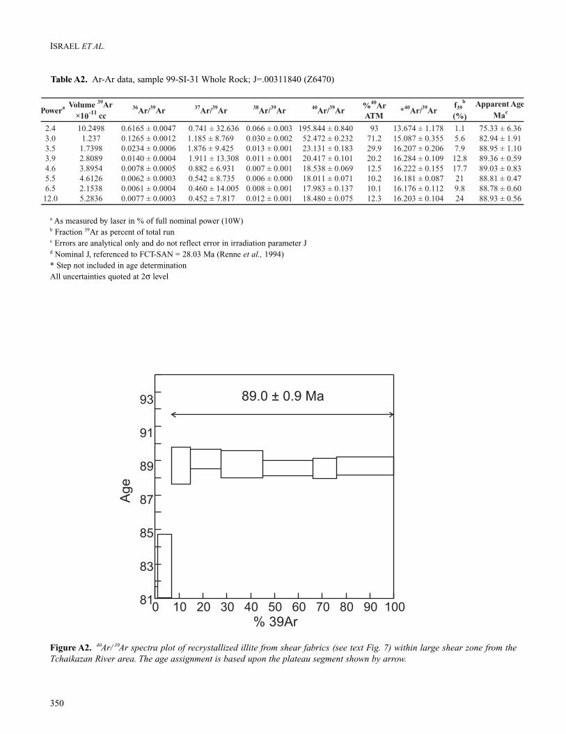
Ar-Ar DatesFault rocks along a large, sinistral shear zone in the southeastportion of the study area were collected for Ar-Ar dating. TheS surface of the fault rock is defined by recrystallized illitethat was used for Ar-Ar dating. Standard Ar-Ar analysis wascarried out at the Geological Survey of Canada, Ottawa. Thedata are presented in Table A2 and plotted on a standard gas
348
ISRAEL ET AL.
Figure A1. Standard concordia plots showing U-Pb zircon and titanite results for samples from the Tchaikazan River area.Error ellipses are plotted at 2σ (level of uncertainty). Data represented by crosses do not reflect precision of those analyses(see Table A1 for analytical precision). (A) Dyke in Twin Creek assemblage; (B) Mt. McLeod batholith; (C) Grizzly Cabin plu-ton; (D) Tchaikazan Rapids pluton.

release spectra plot (Fig. A2). The estimated age is 89 ± 0.9Ma and may reflect the timing of formation of the illite dur-ing last phase of deformation within the shear zone. Due tothe low closure temperature of illite, however, it is possible
that the sinistral faulting event is older and the 89 ± 0.9 Maage for the illite represents either a younger thermal event orcooling to the closure temperature after shearing.
349
SINISTRAL DEFORMATION, SOUTHWESTERN BRITISH COLUMBIA
Wt U2
Pb*3 206
Pb4
Pb5 208
Pb6
(mg) (ppm) (ppm) 204Pb (pg) (%)
Twin Creek assemblage aplite
A ff,p,s,eu 0.005 701 25 363 22 11.2 0.03463 (0.20) 0.2449 (0.61) 0.05131 (0.49) 219.4 (0.8) 222.5 (2.5) 255 (23)
B ff,p,s,eu 0.010 511 19 318 39 10.8 0.03628 (0.23) 0.2559 (0.68) 0.05115 (0.54) 229.7 (1.0) 231.3 (2.8) 248 (25)
C ff,p,s,eu 0.005 814 30 231 44 10.5 0.03668 (0.19) 0.2588 (1.6) 0.05117 (1.5) 232.2 (0.9) 233.7 (6.7) 249 (68/71)D f,p,s,eu 0.005 611 29 1205 7.7 7.2 0.04785 (0.14) 0.4895 (0.25) 0.07420 (0.17) 301.3 (0.8) 404.6 (1.7) 1046.8 (7.0)
E ff,p,eq,eu 0.004 670 80 3027 6.4 8.0 0.11605 (0.10) 1.5262 (0.17) 0.09538 (0.09) 707.8 (1.4) 941.0 (2.1) 1535.6 (3.4)
F f,p,cy,b 0.005 285 5.1 479 3.3 12.9 0.01717 (0.58) 0.1427 (1.8) 0.06025 (1.7) 109.8 (1.3) 135.4 (4.6) 612.6 (70/-74)
G ff,p,eq 0.005 317 53 1719 9.4 8.3 0.16142 (0.15) 2.4029 (0.22) 0.10796 (0.13) 964.7 (2.6) 1243.5 (3.2) 1765.3 (4.9)
Mt. McLeod batholith
A m,p,s 0.025 148 2.6 657 6.2 12.6 0.01708 (0.20) 0.1151 (0.50) 0.04887 (0.41) 109.2 (1.6) 202.6 (1.7) 142 (19/20)
B f,p,e 0.020 105 1.7 917 2.4 11.8 0.01615 (0.38) 0.1132 (0.65) 0.05084 (0.56) 103.3 (0.8) 108.9 (1.3) 234 (26)
C f,p,s 0.024 109 1.8 949 2.8 10.8 0.01624 (0.26) 0.1078 (0.63) 0.04815 (0.56) 103.8 (0.5) 103.9 (1.2) 107 (26./27)
D f,p,s 0.024 168 2.8 1957 2.1 11.6 0.01643 (0.26) 0.1121 (0.44) 0.04948 (0.37) 105.0 (0.5) 107.8 (0.9) 171 (17/18)
E f,p,eu 0.065 192 3.1 2272 5.5 9.6 0.01595 (0.11) 0.1068 (0.26) 0.04854 (0.20) 102.0 (0.3) 103.0 (0.6) 125.9 (9.3/9.4)
F f,p,s 0.067 265 4.2 2203 7.9 10.2 0.01565 (0.13) 0.1047 (0.25) 0.04854 (0.18) 100.1 (0.3) 101.1 (0.6) 125.9 (8.5)
G f,p,s 0.063 209 3.3 1168 11 9.2 0.016 (0.13) 0.1068 (0.33) 0.04843 (0.25) 102.3 (0.4) 103.1 (0.6) 120.4 (12)
T1 f,su,b 0.560 208 3.4 350 343 11.7 0.01581 (0.16) 0.1047 (0.59) 0.04804 (0.49) 101.1 (0.3) 101.1 (0.6) 101.4 (23/24)
T2 f,su,b 0.580 212 3.4 322 398 13.7 0.01549 (0.19) 0.1027 (0.65) 0.04809 (0.53) 99.1 (0.4) 99.3 (1.2) 103.7 (25)
Grizzly Cabin pluton
B f,p,e 0.025 187 3.1 1022 4.4 14.7 0.01548 (0.12) 0.1026 (0.35) 0.04808 (0.29) 99.0 (0.2) 99.2 (0.7) 103 (14)
C f,p 0.025 192 3.1 951 4.9 12.9 0.01552 (0.19) 0.103 (0.47) 0.04811 (0.39) 99.3 (0.4) 99.5 (0.9) 105 (18)
D f,p 0.025 247 4.0 1136 5.4 11.7 0.01587 (0.11) 0.1052 (0.29) 0.04807 (0.23) 101.5 (0.2) 101.5 (0.6) 103 (11)
99SGC-2A ff,p,eu 0.015 192 2.8 265 10 13.0 0.01392 (0.23) 0.0936 (1.3) 0.04876 (1.2) 89.1 (0.4) 90.8 (2.3) 136 (57/59)B ff,p,s,eu 0.005 161 2.8 239 3.6 19.7 0.01566 (0.24) 0.1047 (2.2) 0.04848 (2.0) 100.2 (0.5) 101.1 (4.2) 123 (94/99)C ff,p,e,eu 0.005 104 1.7 106 5.9 13.6 0.01593 (0.41) 0.1067 (4.9) 0.04857 (4.7) 101.9 (0.8) 102.9 (9.6) 127 (206/235)
Tchaikazan Rapids pluton
A cc,p,e 0.030 272 6.9 1378 9.9 5.5 0.02666 (0.12) 0.1840 (0.26) 0.05006 (0.21) 169.6 (0.4) 171.5 (0.8) 197.8 (9.5/-9.6)B c,p,eu 0.050 156 3.0 2072 4.7 7.3 0.02003 (0.17) 0.1375 (0.27) 0.04978 (0.21) 127.8 (0.4) 130.8 (0.7) 184.6 (9.7)
C m,p,e 0.050 131 2.1 324 22 6.9 0.01639 (0.22) 0.1107 (0.78) 0.04898 (0.67) 104.8 (0.5) 106.6 (1.6) 147 (31/-32)
D m,p,e 0.070 133 1.8 1654 4.8 7.8 0.01364 (0.19) 0.0931 (0.41) 0.04949 (0.33) 87.3 (0.3) 90.4 (0.7) 171 (15)
E c,p,eu 0.016 574 20 4937 4.0 8.9 0.03453 (0.11) 0.2425 (0.20) 0.05093 (0.12) 218.8 (0.5) 220.6 (0.8) 237.6 (5.4/-5.5)
F m,p,s 0.016 411 12 2777 4.4 8.5 0.02941 (0.12) 0.2051 (0.20) 0.05059 (0.12) 186.8 (0.4) 189.5 (0.7) 222.3 (5.5/-5.6)
G ff,m,p 0.020 227 4.3 1977 2.8 7.1 0.01955 (0.16) 0.1335 (0.26) 0.04952 (0.18) 124.8 (0.4) 127.2 (0.6) 172.4 (8.3)
Fraction1 Isotopic ratios (1 , %)
7Apparent ages (2 , Ma)
7
206Pb/
238U
207Pb/
235U
207Pb/
206 206Pb/
238U
207Pb/
235U
207Pb/
206PbPb
1 Upper case letter = zircon fraction identifier; T1, T2, etc, for titanites. All zircon fractions air abraded. Grain size, intermediate dimension:cc = >250mm, c = <250mm and >134mm, m = <134mm and >104mm, f = <104mm and >74mm, ff <74mm; Grain character codes:b = broken, cy = cloudy; e = elongate, eq = equant; eu = euhedral, p = prismatic, s = stubby, su = subhedral. Zircons nonmagnetic on Franzmagnetic separator at field strength of 1.8A and sideslopes of 1°–5°. Titanites nonmagnetic at 0.6A and 20° sideslope, and magnatic at 1.8Aand 5° sideslope. Front slope of 20°for all.2 U blank correction of 1pg ± 20%; U fractionation corrections were measured for each run with a double 233U–235U spike (about0.004/amu)3 Radiogenic Pb4 Measured ratio corrected for spike and Pb fractionation of 0.0035/amu ± 20% (Daly collector), which was determined by repeated analy-sis of NBS Pb 981 standard throughout the course of this study5 Total common Pb in analysis based on blank isotopic composition6 Radiogenic Pb7 Corrected for blank Pb (1–4 pg), U (1–3 pg) and common Pb concentrations based on Stacey Kramers model Pb at the age or the207Pb/206Pb age of the rock (Stacey and Kramers, 1975)
Table A1. U-Pb analytical data for rocks from the Tchaikazan River area
350
ISRAEL ET AL.
Figure A2. 40Ar/ 39Ar spectra plot of recrystallized illite from shear fabrics (see text Fig. 7) within large shear zone from theTchaikazan River area. The age assignment is based upon the plateau segment shown by arrow.
a As measured by laser in % of full nominal power (10W)b Fraction 39Ar as percent of total runc Errors are analytical only and do not reflect error in irradiation parameter Jd Nominal J, referenced to FCT-SAN = 28.03 Ma (Renne et al., 1994)* Step not included in age determinationAll uncertainties quoted at 2σ level
Table A2. Ar-Ar data, sample 99-SI-31 Whole Rock; J=.00311840 (Z6470)


![215905main sts123 press kit b[1] · 2012-08-11 · Dextre, 1the 1Canadian 1device, 1will 1work 1with 1the 1 station’s 1robotic 1arm, 1Canadarm2. 1 1Designed 1for 1 station 1maintenance](https://img.pdfslide.us/doc/110x75/5f7c54c24e6e1176b7437fa6/215905main-sts123-press-kit-b1-2012-08-11-dextre-1the-1canadian-1device-1will.jpg)