Embed Size (px)
Citation preview

Disclaimer:Every effort has been made to ensure the accuracy of the contents of this publication. The author or the organization do not acceptany responsibility of any omission as it is not deliberate. Nevertheless, we will appreciate provision of accurate information toimprove our work. The views expressed in this report do not necessarily represent the views of the Friedrich-Naumann-Stiftungfür die Freiheit.
Author will welcome reproduction and dissemination of the contents of this report with proper acknowledgment.
SHEHRI - CITIZENS FOR A BETTER ENVIRONMENT88-R, Block-2, P.E.C.H.S., Karachi-75400, Pakistan.Tel : 021-34530646, 34382298, Fax : 021-34530646E-mail : [email protected] Web site : www.shehri.orgfacebook.com/shehri.citizens, twitter.com/shehricbe
With the support of
Friedrich-Naumann-Stiftung für die FreiheitHouse # 1, Street # 58, Sector # F-7/4, Islamabad - Pakistan.Tel: 051-2655750 - 051-2655751, Fax: 051-2655752E-mail: [email protected] Website : www.southasia.fnst.org
ISBN: ______________________
EDITION: 2014
NO OF PRINTED COPIES: 1,000
LAYOUT & DESIGN:SAUDAGAR ENTERPRISES
Group
www.thegridart.comwww.graphitework.com
04
Contents
INTRODUCTION 07
SECTION 1:A 'GOTH' EVOLVES INTO A MEGAPOLIS 08
SECTION 2:RURAL SETTLEMENT PATTERNS-SINDH AND KARACHI CITY 12
SECTION 3:RURAL KARACHI’S NATURAL CAPITAL – A CASE STUDY OF GADAP REGION 16
SECTION 4:THE DYNAMICS OF LAND AND IMPLICATIONS FOR RURAL LAND ENCROACHMENT 23
SECTION 5:THE CHALLENGES AHEAD 30
05

06
BLANK
INTRODUCTION
When we have a scenario where urban and rural spaceare parceled together and are part of the same politicaljurisdiction, the dynamics of land management, usage andsocial, cultural integration or otherwise are factors thatresult in presenting a complex set of problems andchallenges. The present Study tries to understand thisrelationship and the associated challenges within thecontext of Karachi City. The research conducted for thisStudy has evaluated the socioeconomic, political,environmental challenges, some recent land basedlegislations and the consequent forms of developmenttaking place in the city that now threatens the sustainabilityof Karachi’s rural land, environment and the livelihoods ofthe rural/farming population. This research has also takeninto account relevant policy and strategic developmentinterventions within an understanding of the prevailingpolitical and economic processes in the rural hinterland.The analysis and resulting findings will therefore not justlook at the services - entitlements dynamics but at thelarger contextual space that would account for theencroachment of rural land.
Farhan AnwarUrban Planner
December, 2014
07
Section 1:A 'goth' evolves into a megapolis
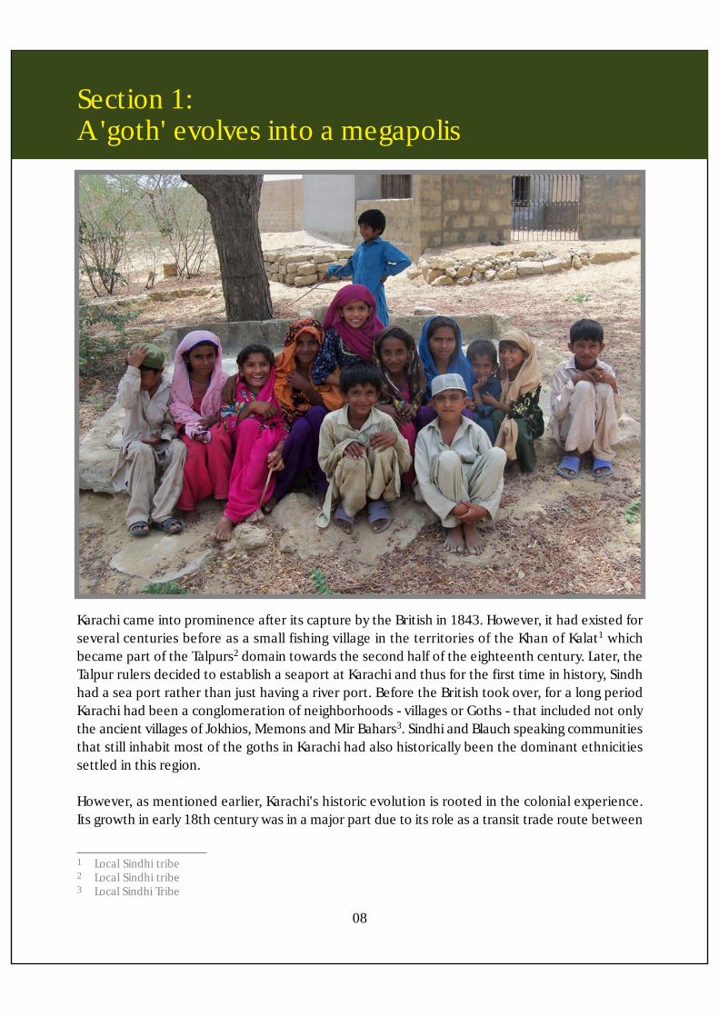
Karachi came into prominence after its capture by the British in 1843. However, it had existed forseveral centuries before as a small fishing village in the territories of the Khan of Kalat1 whichbecame part of the Talpurs2 domain towards the second half of the eighteenth century. Later, theTalpur rulers decided to establish a seaport at Karachi and thus for the first time in history, Sindhhad a sea port rather than just having a river port. Before the British took over, for a long periodKarachi had been a conglomeration of neighborhoods - villages or Goths - that included not onlythe ancient villages of Jokhios, Memons and Mir Bahars3. Sindhi and Blauch speaking communitiesthat still inhabit most of the goths in Karachi had also historically been the dominant ethnicitiessettled in this region.
However, as mentioned earlier, Karachi's historic evolution is rooted in the colonial experience.Its growth in early 18th century was in a major part due to its role as a transit trade route between
1 Local Sindhi tribe2 Local Sindhi tribe3 Local Sindhi Tribe
08

Section 1: A 'goth' evolves into a megapolis
the Indian peninsula, Central Asia, Africa and Eastern Europe. The British occupied it in 1839, andused to land troops and armor for campaigns in Afghanistan against the Russians. In 1843, theBritish annexed Sindh to their empire and shifted the provincial capital from Hyderabad to Karachiand Karachi thus also became an important administrative center. Later, its role as an export cityincreased significantly, when in 1870, a railway linking it to the agricultural areas of the Punjabwas completed.
As a result of these initiatives, a number of British companies opened their offices and warehousesin Karachi and by 1868, Karachi became the largest exporter of wheat and cotton in India. Theopening of the Suez Canal in 1869 made Karachi the first port of call for ships coming to India fromEurope. During the First World War, Karachi became the headquarters for British interventionsin Central Asia. As a result, its cantonments expanded. In 1935, Sindh became a province after itsseparation from the Bombay Presidency and Karachi became its capital. Government offices andtrade organizations shifted from Bombay to Karachi as a result and the first industrial estate inKarachi was created and finally when in 1947, Pakistan was created Karachi became its first capital.4
Karachi lies in the foothill of the Khirthar range of hills and is not part of the Indus delta. It hasformed part of the territories of the chieftains who have controlled the Hub Malir region and theMakran coast, which, though part of Balochistan, has been a Sindhi speaking area right up to the'Jamdom' of Lasbella, the most important regional chiefdom. In the seventeenth century, theregion was in control of the Kalmati Maliks5 who had dominated the area since the thirteenthcentury.
Control of Karachi, earlier held by the Baloch chieftains later passed on to the Sindhi speakingclans. In the eighteenth century it was part of the chiefdom of the Kalmati Maliks. In the earlyperiods, the settlement in Karachi was mostly characterized by fishing villages. British CommanderCarless who was deputed with the task of surveying the coast of Karachi wrote that the populationof Karachi consists of seamen and fishermen, and their total number is nearly 14000 (Karachi: thePearl of the Arabian Sea, Karachi, 1996). However, later on, the people of different castes andtribes settled in different spots away from each other and started cultivation with simplecontemporary tools on the available pieces of land and produced crops for their the unificationof Sindh, under their rule, saw the control of Karachi passing to them in this period. This is confirmedin the records of Lieutenant John Porter who visited Sindh in 1774-5. He mentions that it formerlybelonged to the Baloachees and then says that the Prince of Scindy, finding it better situated thanany part of his sea coast for the caravans from Inland Countries; made an exchange with someother part of it. 14 requirements (Abdul Hamid Shaikh, 1990).
4 The Case of Karachi, Pakistan, 2003, Arif Hasan, Masooma Mohib5 Baloch speaking tribe
09
Section 1: A 'goth' evolves into a megapolis
10
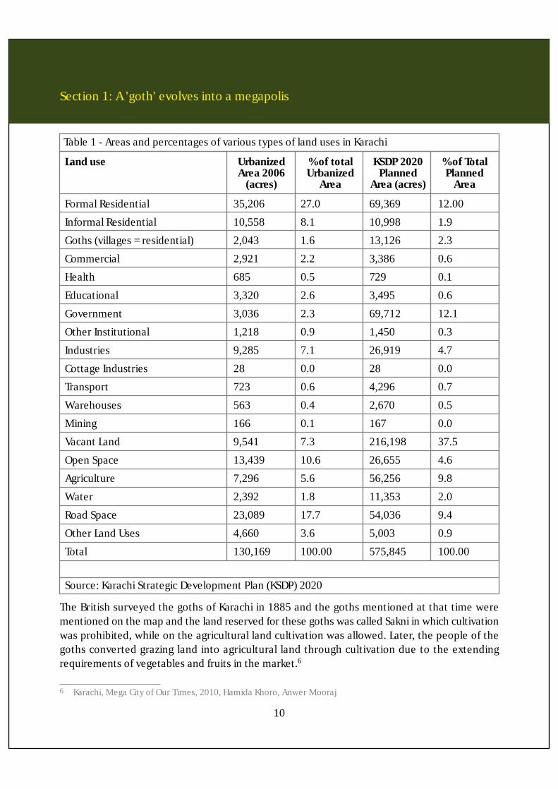
Formal Residential 35,206 27.0 69,369 12.00
Informal Residential 10,558 8.1 10,998 1.9
Goths (villages = residential) 2,043 1.6 13,126 2.3
Commercial 2,921 2.2 3,386 0.6
Health 685 0.5 729 0.1
Educational 3,320 2.6 3,495 0.6
Government 3,036 2.3 69,712 12.1
Other Institutional 1,218 0.9 1,450 0.3
Industries 9,285 7.1 26,919 4.7
Cottage Industries 28 0.0 28 0.0
Transport 723 0.6 4,296 0.7
Warehouses 563 0.4 2,670 0.5
Mining 166 0.1 167 0.0
Vacant Land 9,541 7.3 216,198 37.5
Open Space 13,439 10.6 26,655 4.6
Agriculture 7,296 5.6 56,256 9.8
Water 2,392 1.8 11,353 2.0
Road Space 23,089 17.7 54,036 9.4
Other Land Uses 4,660 3.6 5,003 0.9
Total 130,169 100.00 575,845 100.00
% of TotalPlanned
Area
Table 1 - Areas and percentages of various types of land uses in Karachi
Land use UrbanizedArea 2006
(acres)
% of totalUrbanized
Area
KSDP 2020Planned
Area (acres)
Source: Karachi Strategic Development Plan (KSDP) 2020
The British surveyed the goths of Karachi in 1885 and the goths mentioned at that time werementioned on the map and the land reserved for these goths was called Sakni in which cultivationwas prohibited, while on the agricultural land cultivation was allowed. Later, the people of thegoths converted grazing land into agricultural land through cultivation due to the extendingrequirements of vegetables and fruits in the market.6
6 Karachi, Mega City of Our Times, 2010, Hamida Khoro, Anwer Mooraj
Section 1: A 'goth' evolves into a megapolis
11
Types of goths
Most of the goths got developed on the basis of caste, community or tribe. The Karachi basedgoths can be characterized as follows:
• Coastal Goths• Rural Goths• Urbanized Goths
a) Coastal Goths: these are settlements along the coast where livelihoods are dependent on fishingand allied activities. These communities are considered as the descendants of the original settlersin Karachi.
b) Rural Goths: these goths are located on the fringes of the city forming Karachi’s rural hinterlandwith agriculture and farming as their basic sources of livelihoods. A small part of the rural populationearns their living as laborers in the urbanized settlements within Karachi.
c) Urbanized Goths: these are goths that though had earlier existed as purely rural goths, however,owing to their relative proximity to the city are now being affected by the urban sprawl andresultant changes are being reflected in their choice of jobs, housing, lifestyles, etc.
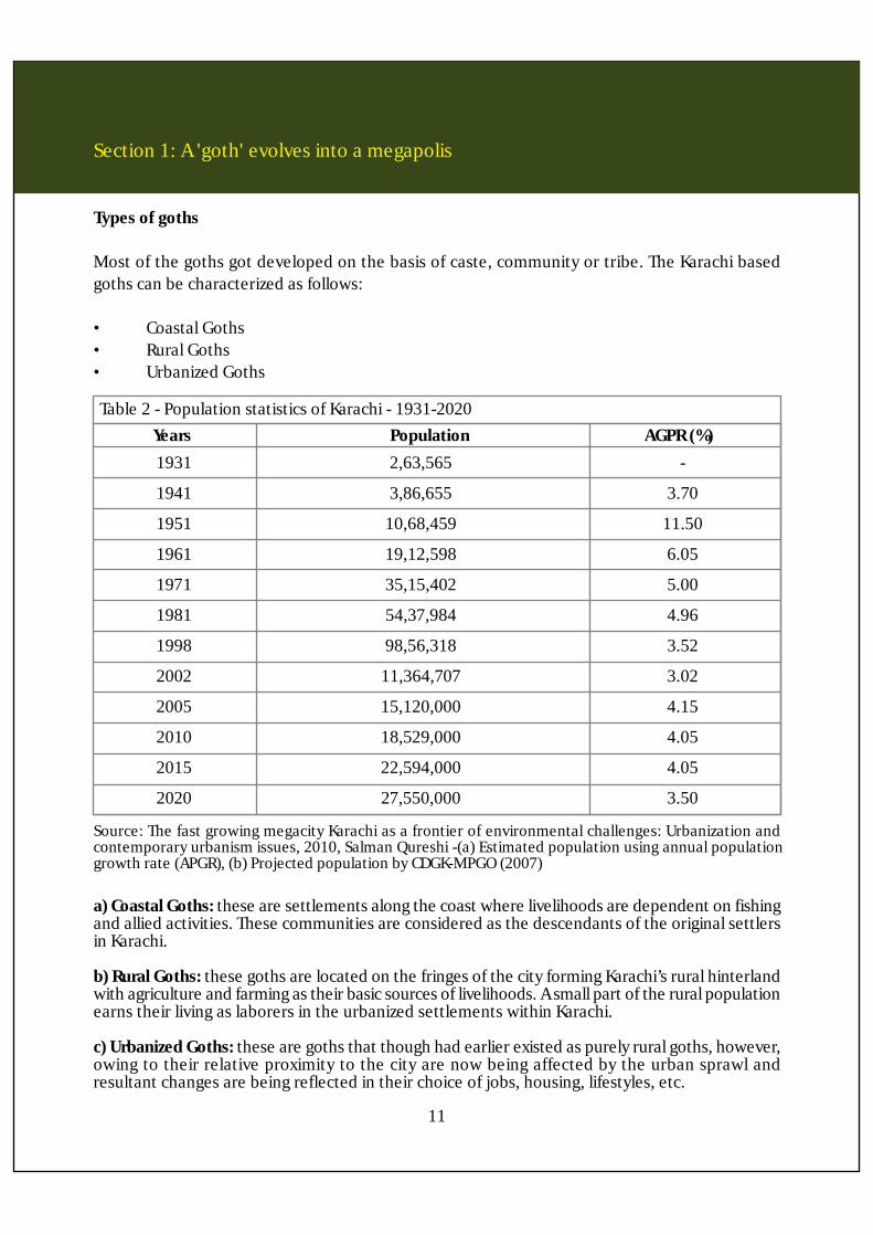
1931 2,63,565 -
1941 3,86,655 3.70
1951 10,68,459 11.50
1961 19,12,598 6.05
1971 35,15,402 5.00
1981 54,37,984 4.96
1998 98,56,318 3.52
2002 11,364,707 3.02
2005 15,120,000 4.15
2010 18,529,000 4.05
2015 22,594,000 4.05
2020 27,550,000 3.50
Table 2 - Population statistics of Karachi - 1931-2020Years Population AGPR (%)
Source: The fast growing megacity Karachi as a frontier of environmental challenges: Urbanization andcontemporary urbanism issues, 2010, Salman Qureshi -(a) Estimated population using annual populationgrowth rate (APGR), (b) Projected population by CDGK-MPGO (2007)
Section 2:Rural settlement patterns-Sindh and Karachi City
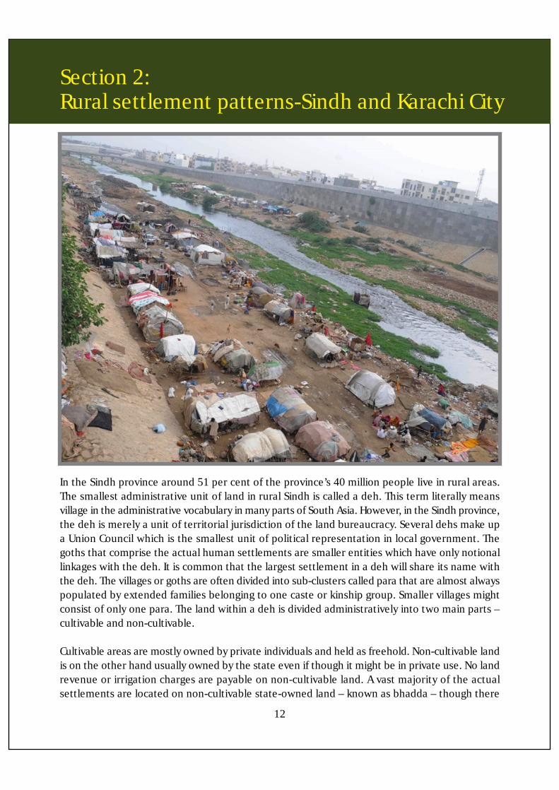
In the Sindh province around 51 per cent of the province’s 40 million people live in rural areas.The smallest administrative unit of land in rural Sindh is called a deh. This term literally meansvillage in the administrative vocabulary in many parts of South Asia. However, in the Sindh province,the deh is merely a unit of territorial jurisdiction of the land bureaucracy. Several dehs make upa Union Council which is the smallest unit of political representation in local government. Thegoths that comprise the actual human settlements are smaller entities which have only notionallinkages with the deh. It is common that the largest settlement in a deh will share its name withthe deh. The villages or goths are often divided into sub-clusters called para that are almost alwayspopulated by extended families belonging to one caste or kinship group. Smaller villages mightconsist of only one para. The land within a deh is divided administratively into two main parts –cultivable and non-cultivable.
Cultivable areas are mostly owned by private individuals and held as freehold. Non-cultivable landis on the other hand usually owned by the state even if though it might be in private use. No landrevenue or irrigation charges are payable on non-cultivable land. A vast majority of the actualsettlements are located on non-cultivable state-owned land – known as bhadda – though there
12
Section 2: Rural settlement patterns-Sindh and Karachi City
is no bar on individuals setting up homesteads on their own privately owned land, or making theirland available to others such as their tenants for setting up their homesteads.
There are customary norms recognized by the land administration that govern access to bhaddaland. Those who own cultivated area adjacent to bhadda – the local term for such proximity ismohaga – have the first right of use in the bhadda. Conventionally, this right of mohaga has beeninterpreted to mean the entitlement to set up a homestead, or to provide space for homesteadto a tenant or other dependent. The right of mohaga is also used to convert non-cultivable stateowned land to cultivable privately owned area in the favor of the incumbent.
The division of space within a settlement is strongly influenced by patriarchal social organization.The para is composed of close relatives and there are no restrictions on the mobility of men andwomen belonging to a para within its confines. Para boundaries are often physically marked usingthorn bushes, dividing private and public spaces. Adult women have very limited access to publicspaces outside the para, while adult men from outside the para or village are generally not allowedto enter the para.
An important institution in a para or a village is the autaq [male meeting place] where men fromoutside the para or village can also be received, and where economic and political business –including buying and selling of produce, the population census, might be transacted betweenmen. Women generally do not enter the autaq, and men from outside the village or para traditionallydo not go beyond the autaq. The autaq might be a grand building or it could also exist in the formof a modest shelter.
Although it is privately owned, by convention all male residents of a village or para have accessto it. In fact, the owner of an autaq actively encourages the use of the autaq as a meeting placeas a means of acquiring political and social status.7
13
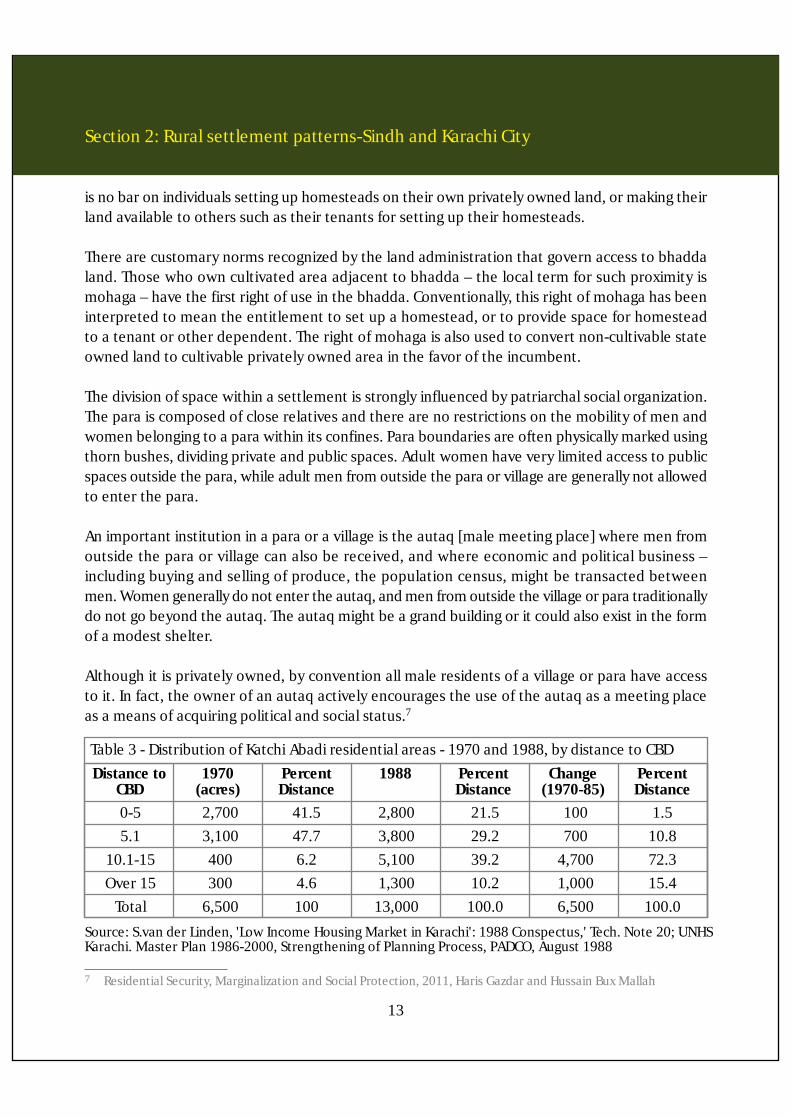
0-5 2,700 41.5 2,800 21.5 100 1.55.1 3,100 47.7 3,800 29.2 700 10.8
10.1-15 400 6.2 5,100 39.2 4,700 72.3Over 15 300 4.6 1,300 10.2 1,000 15.4
Total 6,500 100 13,000 100.0 6,500 100.0
Table 3 - Distribution of Katchi Abadi residential areas - 1970 and 1988, by distance to CBDDistance to
CBD
Source: S.van der Linden, 'Low Income Housing Market in Karachi': 1988 Conspectus,' Tech. Note 20; UNHSKarachi. Master Plan 1986-2000, Strengthening of Planning Process, PADCO, August 1988
1970(acres)
PercentDistance
1988 PercentDistance
Change(1970-85)
PercentDistance
7 Residential Security, Marginalization and Social Protection, 2011, Haris Gazdar and Hussain Bux Mallah

Section 2: Rural settlement patterns-Sindh and Karachi City
Efforts at land reforms - Background and description of SGAHSThe Sindh Gothabad (Housing Scheme) Act 1987 was introduced in February 1987 with an objectto provide institutional arrangements for undertaking of regularization of villages of rural areasof Sindh including Karachi. According to this Act, the Deputy Commissioners being Collectors oftheir respective Districts were authorized to sanction the village and issue sanads8 to the genuinepersons residing in the village. SGAHS was basically aimed at improving the physical conditionsof villages in addition to enhancing the tenancy status of existing residents. The scheme openedup a window for applying for regularization of their villages.
According to official data over 11,000 villages have been regularized through this scheme, andindividual leases have been allotted to over 700,000 beneficiary households, benefiting over fourmillion people. Until 1993, the SGAHS office was authorized to purchase private and governmentland for regularizing villages and compensation for khatooni land (i.e. land recorded on record ofrights) was fixed by the revenue department in accordance with revised land market rates. However,this practice was then banned because of open misuse of the Act, such as the doling out of moneyto private land owners. In 1993 also, the SGAHS became an autonomous directorate linked to theBoard of Revenue through the Government of Sindh (Haris Gazdar and Hussain Bax Mallah).
As the situation had existed, to begin with entire villages had insecure property rights to the landon which they were located. Then, the regularization of tenancy rights of existing residents hadto precede or accompany the physical development of the village. The broader socioeconomiccontext that defined the justification for the scheme's intervention was characterized by aneconomy dominated by landlords where landless share-cropping tenants did not enjoy securerights over their homesteads.
According to the SGAHS Act, regularization of villages requires residents of a village to make anapplication for regularization to the Deputy Collector (or Additional Deputy Commissioner) forwardsthe application to the Mukhtiarkar Headquarter State9 who in turn has to forward it to the tapedar.Tapedars are deh-wise verification officers of the revenue department, in charge of collecting allrequired documents from applicants, surveying the land and houses in the village, etc. The SGAHSdefines a village as a settlement comprising of at least ten houses located within a reasonabledistance from each other, and at least five kilometers away from the city center.
Applying for village regularizationApplication for the regularization of a village requires submission and authentication of thefollowing documents:• Surveys noting the physical area of the village, the status of land and occupants, as well as
details about the number of houses and population of the village
14
8 Certificate of land ownership9 Prior to the devolution plan implemented in 2002, there was one mukhtiarkar in each district for SGAS. The
Mukhtiarkar Headquarter State (official title for the mukhtiarkar) is given different portfolios such as SGAS, katchaland (river banks), and barrage land
Section 2: Rural settlement patterns-Sindh and Karachi City
• Survey map of the village• In case of qabooli (i.e. private land), written consent of the owner• In case of the government land, a No Objection Certificate (NOC) from the relevant department• Photocopies of National Identity Card (NIC) of residents• Report of the tapedar• List of residents provided by the tapedar• Voter list
The tapedar is primarily responsible for collecting and certifying the above listed documents andfor carrying out a physical verification, while noting any objections that village inhabitants mayhave. The tapedar is also required to generate a detailed physical map of the village demarcatinghouses and plots. Moreover, he is required to settle aasaish land, grazing land and other commonland among the villagers before finally submitting the completed application/documents back tothe SGAHS mukhtiarkar. If the land in question is state owned it is then leased out to the applicantsupon satisfactory completion of the administrative process. For privately owned land, SGAHS hasbeen authorized to acquire it against the payment of compensation to the owner.
According to survey conducted in the year 1989-90 of villages of Karachi,808 villages were identifiedfor regularization purpose, out of which 458 villages were regularized and 51421 sanads wereissued to the beneficiaries leaving 350 villages to be regularized after completing all pre-requisitefor malities if they are fit under the Province of Sindh Gothabad (Housing Scheme) Act 1987.10
As Arif Hasan documents in his recent publication – Karachi : The Land Use (2012), the disposalof rural land, whose objective was to grant de-jure ownership to the goth residents and pave theway for the provision of infrastructure and planning for the Goths, soon became accessible toencroachers who developed informal settlements in the rural areas of Karachi.
Many of the encroachers have been supported by local political interest groups. In addition, theowners of land in Gothabad often developed informal partnerships with land developers forplanning of urban land sales schemes. With the enforcement of SLGO 2001, the rural district ofKarachi was integrated into the towns of the newly created Karachi city district. As a result, theentire urban and rural areas of Karachi, barring a few sensitive locations, became available forurbanization and their planning and development as per the regulations of the KBCA, became theresponsibility of the LDA and MDA in whose jurisdictions they are located. This policy move furtheraccelerated the transformation of Gothabad Schemes into peri-urban housing locations. Malir,Gadap and Bin Qasim areas have many evidence of this trend.’
Estimates of the number of goths in the Karachi region vary. The Orangi Pilot Project- Researchand Training Institute (OPP-RTI), which works in supporting the regularization and upgrading ofthese goths, puts the figure at 2,173. It is not clear as to how many of these goths are genuineand how many of them have been informally created so that they can be regularized. Mediareports claim that most of them are a part of a well-organized land scam supported by politicalparties (Arif Hasan, 2012).
15
10 Board of Revenue, Government of Sindh

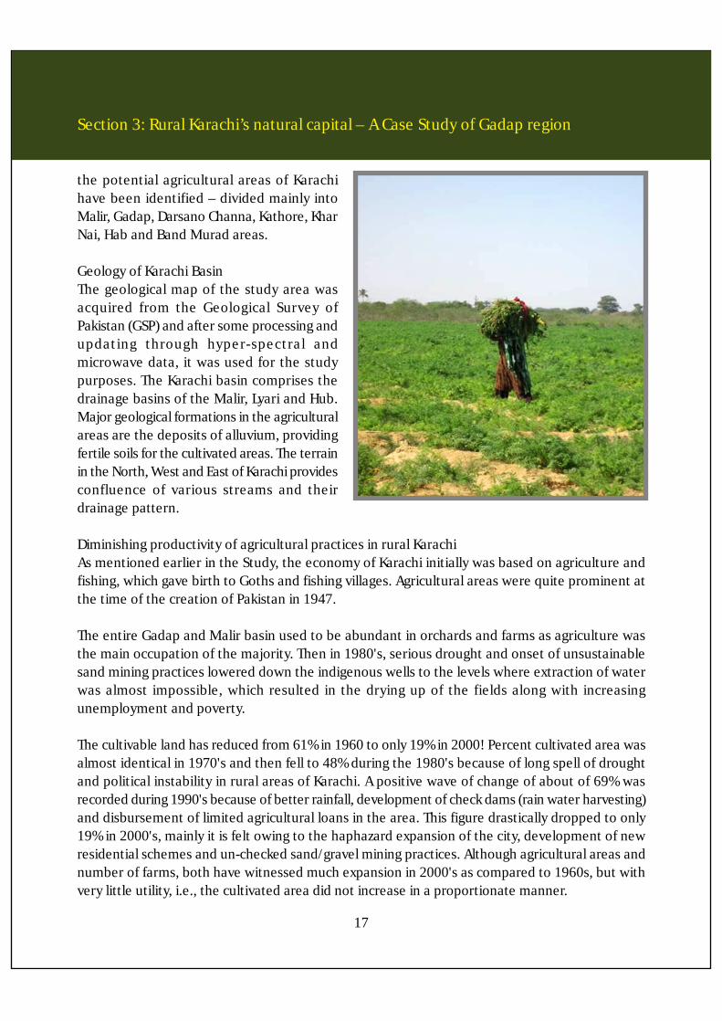
Section 3:Rural Karachi’s natural capital – A Case Study ofGadap regionHistorically, agricultural areas in Karachi, suchas Malir and Gadap, have been prominentdue to the richness of their fruits andvegetables produce. These areas used toprovide tremendous amount of vegetables,fruits, fodder and some grains to Karachi andother areas of Lower Sindh. Karachi's ruralareas were famous for mangoes, guavas,chiko, bair and papaya cultivation. In addition,Karachites utilized these places as picnicresorts - a refuge from the busy life of Karachi(Kazmi and Ghori, 1994). Karachi's farms andgardens become the fruits and vegetable bowlfor the entire lower Indus valley especially forthe city residents (Bengali, 1974). Karachi ishome to about 18 dry rivers.
These are perennial streams, dependent ontheir flow on seasonal rains. Thus the entirearea and related agricultural practices depend heavily on rains. Since centuries rainwater has beenharvested in these areas in small bands (dams) thus also helping recharge the underground wateraquifers. Traditional water wells have been developed and have existed in the rural areas of Karachisince the last two centuries. In Karachi, most of deh boundaries were around river catchments,as the rain-fed agriculture totally depends on proximity to rivers. Therefore, major wells werelocated around the river systems providing access to underground aquifers.
Through a network of small unlined canals the water from these wells was conveyed to theagricultural fields. 78 Initially, these wells were all hand-drawn which were then converted intodiesel engines in 1950s and then to electric tube wells in late 1970s. Based on topography anddrainage pattern of Karachi, the potential agricultural areas of Karachi have been identified-dividedmainly into Malir, Gadap, Darsano Channa, Kathore, Khar Nai, Hab and Band Murad areas.
Physical and natural resource baseIf we consider Karachi's physiographic profile, it is bounded by mountains (on its three sides) withlow height mounts, basically anticlines, viz., Manghopir, Khand, Pawallo and Pab extensions,underlying in unlined canals the water from these wells was conveyed to the agricultural fields.
Initially, these wells were all hand-drawn which were then converted into diesel engines in 1950sand then to electric tube wells in late 1970s. Based on topography and drainage patternof Karachi,
16
Section 3: Rural Karachi’s natural capital – A Case Study of Gadap region
the potential agricultural areas of Karachihave been identified – divided mainly intoMalir, Gadap, Darsano Channa, Kathore, KharNai, Hab and Band Murad areas.
Geology of Karachi BasinThe geological map of the study area wasacquired from the Geological Survey ofPakistan (GSP) and after some processing andupdating through hyper-spectral andmicrowave data, it was used for the studypurposes. The Karachi basin comprises thedrainage basins of the Malir, Lyari and Hub.Major geological formations in the agriculturalareas are the deposits of alluvium, providingfertile soils for the cultivated areas. The terrainin the North, West and East of Karachi providesconfluence of various streams and theirdrainage pattern.
Diminishing productivity of agricultural practices in rural KarachiAs mentioned earlier in the Study, the economy of Karachi initially was based on agriculture andfishing, which gave birth to Goths and fishing villages. Agricultural areas were quite prominent atthe time of the creation of Pakistan in 1947.
The entire Gadap and Malir basin used to be abundant in orchards and farms as agriculture wasthe main occupation of the majority. Then in 1980's, serious drought and onset of unsustainablesand mining practices lowered down the indigenous wells to the levels where extraction of waterwas almost impossible, which resulted in the drying up of the fields along with increasingunemployment and poverty.
The cultivable land has reduced from 61% in 1960 to only 19% in 2000! Percent cultivated area wasalmost identical in 1970's and then fell to 48% during the 1980's because of long spell of droughtand political instability in rural areas of Karachi. A positive wave of change of about of 69% wasrecorded during 1990's because of better rainfall, development of check dams (rain water harvesting)and disbursement of limited agricultural loans in the area. This figure drastically dropped to only19% in 2000's, mainly it is felt owing to the haphazard expansion of the city, development of newresidential schemes and un-checked sand/gravel mining practices. Although agricultural areas andnumber of farms, both have witnessed much expansion in 2000's as compared to 1960s, but withvery little utility, i.e., the cultivated area did not increase in a proportionate manner.
17
Section 3: Rural Karachi’s natural capital – A Case Study of Gadap region
18
During the last sixty years the agricultural land, especially cultivated areas have exhibited a highlysignificant decline. On the contrary, the built-up land/settled urbanized areas showed an exponentialgrowth but at the cost of the agricultural land. The data plotted is obtained from Pakistan AgriculturalCensus of 1960, 1970, 1980, 1990 and 2000, whereas, the data for 1948 developed from thehistorical map of Pithawalla (1948) and agricultural areas of 2010 acquired from Landsat TM Imager i es through Supervised Classification, with an accuracy assessment of 95%. The built-up landdata has been extracted simultaneously for 1948 from Pithawalla (1948), 1960 from AerialPhotograph of Colombo Plan,1970-74 and 1980 built-up land from the existing Land use maps ofKarachi Development Authority (KDA) Master Plans (1974 and 1985) and rest of built-up landacquired through Land sat TM imageries of 1990, 2000 and 2010.
The cultivated areas were about four times of the built-up land in 1948, which remains almostidentical in 1960. The agricultural areas were 5.2 times of the urban built-up land in 1948 andremain only 0.41 times in 2010 – a very drastic change. The total area of about 6000 hectares ofagricultural land is being encroached by the built-up land, which is about 16% of the agriculturalland.
However, in few UCs it is more than 40%. The main reasons contributing to good agriculturalpractices during the 1960's in Karachi can be attributed to the green revolution (throughgovernment policy, mechanization and modernization of agricultural practices) in Pakistan, veryheavy rainfall during the entire decade (2539 mm), electrification of tube-wells and good localdemand of truck farming which reflected the peak period for urban agriculture in Karachi in1970. The trend slowed a little in the 1970's but agricultural practices were still significant andviable where most of the agricultural land was cultivated - supported by the amount of heavyrainfall during the decade of 1970's (2525 mm). The result of strong drought with decreasedrainfall during the 1980's, deteriorating conditions of law and order and heavy sand/gravelmining for newly planned areas were critically important causes for the decline in urban farmingin Karachi, as they relate to the degradation of the natural resource base necessary for sustainingagricultural practices.
The changing pattern of crops also shows some interesting results. Till the 1980's rice had a goodshare in the total cropped area, a crop that requires good amount of water - available at that timein sufficient amount. However, fruits, fodder and vegetables are now the key-share holder of thekey agricultural areas right from 1980's till 2010.
Degradation of land and resourcesDiscussed in detail below are some critically important factors that have contributed to thedegradation of the land and physical and natural resources essential for maintaining the viabilityof agricultural practices in rural Karachi.
Section 3: Rural Karachi’s natural capital – A Case Study of Gadap region
19
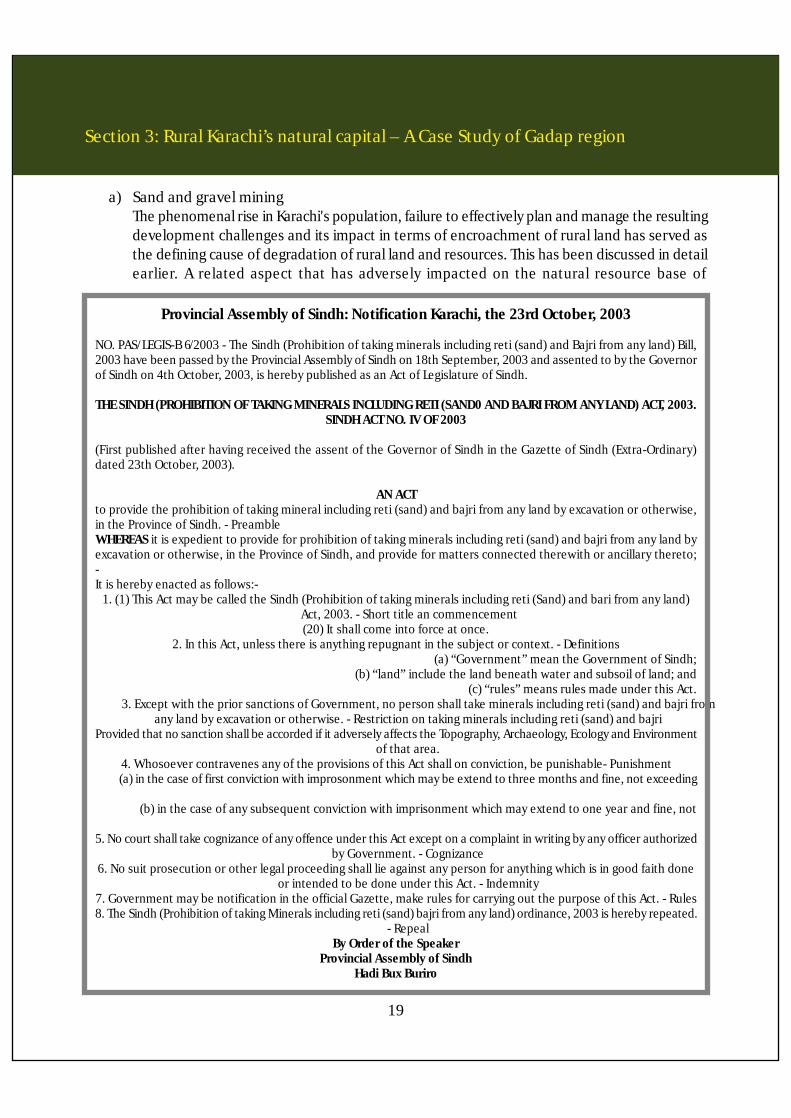
a) Sand and gravel miningThe phenomenal rise in Karachi's population, failure to effectively plan and manage the resultingdevelopment challenges and its impact in terms of encroachment of rural land has served asthe defining cause of degradation of rural land and resources. This has been discussed in detailearlier. A related aspect that has adversely impacted on the natural resource base of
Provincial Assembly of Sindh: Notification Karachi, the 23rd October, 2003
NO. PAS/LEGIS-B 6/2003 - The Sindh (Prohibition of taking minerals including reti (sand) and Bajri from any land) Bill,2003 have been passed by the Provincial Assembly of Sindh on 18th September, 2003 and assented to by the Governorof Sindh on 4th October, 2003, is hereby published as an Act of Legislature of Sindh.
THE SINDH (PROHIBITION OF TAKING MINERALS INCLUDING RETI (SAND0 AND BAJRI FROM ANY LAND) ACT, 2003.SINDH ACT NO. IV OF 2003
(First published after having received the assent of the Governor of Sindh in the Gazette of Sindh (Extra-Ordinary)dated 23th October, 2003).
AN ACTto provide the prohibition of taking mineral including reti (sand) and bajri from any land by excavation or otherwise,in the Province of Sindh. - PreambleWHEREAS it is expedient to provide for prohibition of taking minerals including reti (sand) and bajri from any land byexcavation or otherwise, in the Province of Sindh, and provide for matters connected therewith or ancillary thereto;-It is hereby enacted as follows:-
1. (1) This Act may be called the Sindh (Prohibition of taking minerals including reti (Sand) and bari from any land)Act, 2003. - Short title an commencement(20) It shall come into force at once.
2. In this Act, unless there is anything repugnant in the subject or context. - Definitions(a) “Government” mean the Government of Sindh;
(b) “land” include the land beneath water and subsoil of land; and(c) “rules” means rules made under this Act.
3. Except with the prior sanctions of Government, no person shall take minerals including reti (sand) and bajri fromany land by excavation or otherwise. - Restriction on taking minerals including reti (sand) and bajri
Provided that no sanction shall be accorded if it adversely affects the Topography, Archaeology, Ecology and Environmentof that area.
4. Whosoever contravenes any of the provisions of this Act shall on conviction, be punishable- Punishment(a) in the case of first conviction with improsonment which may be extend to three months and fine, not exceeding
ten thousand rupees, and(b) in the case of any subsequent conviction with imprisonment which may extend to one year and fine, not
exceeding twenty thousand rupees5. No court shall take cognizance of any offence under this Act except on a complaint in writing by any officer authorized
by Government. - Cognizance6. No suit prosecution or other legal proceeding shall lie against any person for anything which is in good faith done
or intended to be done under this Act. - Indemnity7. Government may be notification in the official Gazette, make rules for carrying out the purpose of this Act. - Rules8. The Sindh (Prohibition of taking Minerals including reti (sand) bajri from any land) ordinance, 2003 is hereby repeated.
- RepealBy Order of the Speaker
Provincial Assembly of SindhHadi Bux Buriro
rural Karachi is the extraction of huge quantitiesof sand to be used for supporting theconstruction activities in the city.
The Malir River bed has been providingimportant construction materials like graveland sand for a long time. This gravel and sandis being excavated since 1940s, and the rateof excavation was effectively regulated andwas fairly sustainable till the 1970s. However,with the phenomenal growth in the realestate/construction industry starting in thelate 70's, the sand extraction rates magnifiedmany fold.
Gravel and sand of Malir provides thefoundation of the agro-based economy of theregion. The whole Malir River and its tributariesare rain-fed (Barani) and hence most of thecultivation is totally dependent upon theviability of the ground water reserves trappedin the aquifers. It is interesting to note herethat Karachi perhaps is the only big city ofPakistan where red-clay bricks are not in usedue to the unavailability of river deposited siltclay. Consequently, the buildings in Karachicontain a high percentage of gravel and sand.This sand and gravel excavation played a vitalrole in the development of Karachi. However, on the contrary this phenomenon has also had ahuge impact on the devastation of the fertile valley of Malir and Gadap basins. In the 1950's and1960's excavation was allowed from Drigh Road area only. Now it has gradually spread in the entireMalir river valley upto Gadap, Darsano Channa, Kharnai and Kathore. An average truck approximatelycarries 318 cubic feet of gravel. On taking an average of 1000 truck per day the daily frequencyof sand and gravel excavation amounts to approximately 318,000 cubic feet!
Estimates indicate that most of the river belt has now been excavated upto 20 feet depth. In someplaces like near Saleh Mohammad and Kohli Goth, the excavated depth has reached a dangerouslevel mark of 30 feet. Extraction is continuing even in the proximity of some very sensitive areas,e.g., near natural gas and water pipelines. Extraction near Siphon 10 and 20 which providesapproximately 75 % of water to Karachi is also being carried out (Kazmi and Ghori, 1994). Thisextraction has exposed the water pipelines which in any torrential rainfall may breach and will
Section 3: Rural Karachi’s natural capital – A Case Study of Gadap region
20
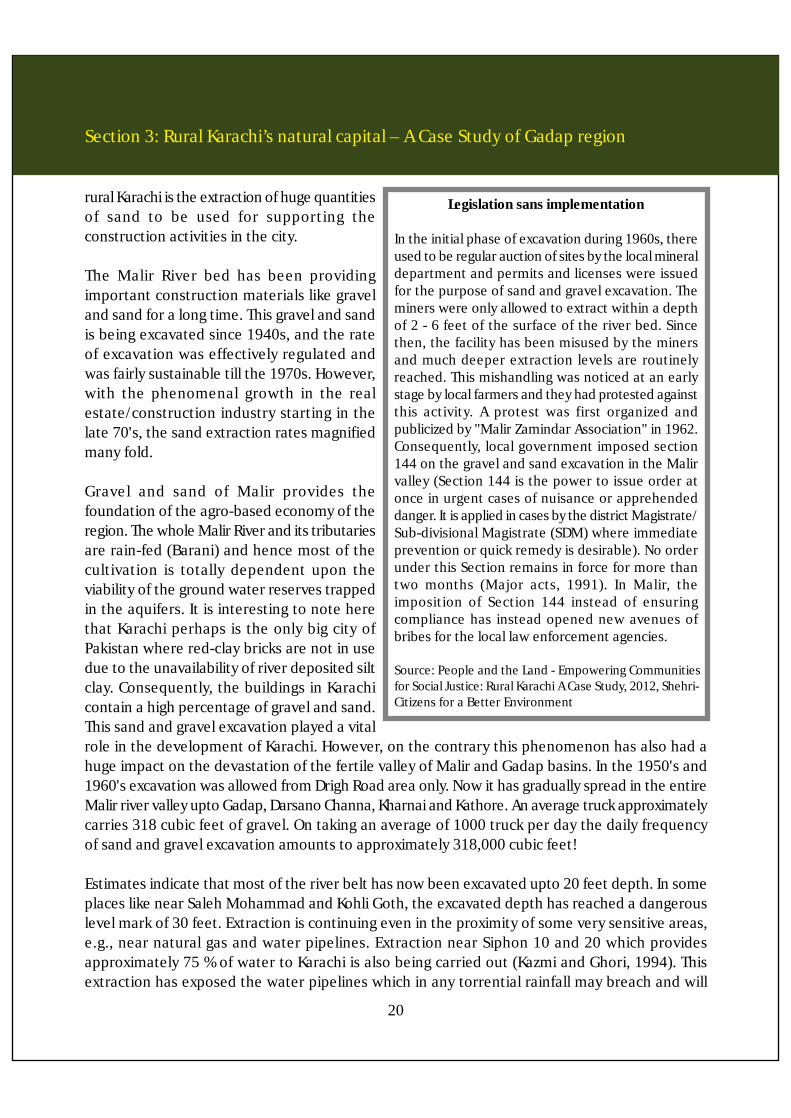
Legislation sans implementation
In the initial phase of excavation during 1960s, thereused to be regular auction of sites by the local mineraldepartment and permits and licenses were issuedfor the purpose of sand and gravel excavation. Theminers were only allowed to extract within a depthof 2 - 6 feet of the surface of the river bed. Sincethen, the facility has been misused by the minersand much deeper extraction levels are routinelyreached. This mishandling was noticed at an earlystage by local farmers and they had protested againstthis activity. A protest was first organized andpublicized by "Malir Zamindar Association" in 1962.Consequently, local government imposed section144 on the gravel and sand excavation in the Malirvalley (Section 144 is the power to issue order atonce in urgent cases of nuisance or apprehendeddanger. It is applied in cases by the district Magistrate/Sub-divisional Magistrate (SDM) where immediateprevention or quick remedy is desirable). No orderunder this Section remains in force for more thantwo months (Major acts, 1991). In Malir, theimposition of Section 144 instead of ensuringcompliance has instead opened new avenues ofbribes for the local law enforcement agencies.
Source: People and the Land - Empowering Communitiesfor Social Justice: Rural Karachi A Case Study, 2012, Shehri-Citizens for a Better Environment

create a shortage of water in the city (daily Jang, May 18, 1994). However, the most alarmingimpact is the lowering down of the ground water table to an average depth of 300 feet! Moreover,the withdrawal rate of water from the wells has fallen from 24 hours to matter of minutes only.
b) Water resourcesGravel is a permeable and porous rock which permits water to soak in the strata and itacts as a water bearing medium. Consequently, if gravel is removed, as in the case of theproject area, then the rain water will evaporate and run off directly into the Arabian Seawithout recharging the underground water reservoirs of the area. The removal of graveland sand has therefore drastically depleted the ground water resources. In addition, erosionof productive and fertile land is increasing either in the form of sheet, gully and 'lateral'erosion. Some early indications of impending desertification of land have also beenobserved. In some part of Malir, especially on the river beds, accumulation of sand in theform of sand ripples has been noticed, which indicates an early stage of formation of sanddunes.
c) Atmospheric pollutionMovement of hundreds of trucks on a daily basis in the area is further aggravating thesituation. The removal of the topsoil, diminishing the vegetation cover and emitting ofCO2, creates air pollution in the area. The movement of trucks, excavation of sand andgravel and resulting wind disturbance disintegrates the leaves of the plants and results inunproductive plant development.
d) Salt water intrusionHeavy extraction of ground water can lead to aquifer depletion, subsidence (sinking ofland when ground water is withdrawn) and intrusion of saltwater into aquifers. Whenfreshwater is withdrawn from an aquifer near a coastal area faster than its recharge volume,salt water/ sea water intrudes into the aquifer. Saltwater intrusion now also threatens tocontaminate the ground water in the Study area as first pointed out by Ahmed (1987) andfurther disseminated by SCOPE (local NGO) in various research news articles in differentnewspapers. Pithawalla (1950) pointed out that in the porous alluvium of Malir aninexhaustible flow of fresh water is locked up; however, as present research indicates, ifcorrective actions are not taken, in 30 to 40 years this inexhaustible water reserve will gettotally exhausted! It is evident from the analysis of water samples that the values of PH,TDS, conductivity and chlorine are showing terraces of saltwater intrusion in the waterwells of Malir. The values of these chemical indicators are alarmingly high especially in thelower part of the valley.
e) Extinction of wildlife and vegetationIt is evident from the studies of Chudhari (1960) that most of the fertile land of Karachi is
Section 3: Rural Karachi’s natural capital – A Case Study of Gadap region
21

located in the alluvium of Malir River. The area had been documented to support morethan 50 plant species. It is also obvious from recent research and available data, that therehas been a sharp decline in cropped area and production, the crop pattern has changedentirely and most of the delicacies of Malir like guava, banana and papaya are losing theirground.
f) Effects on the river morphologyThe effects of gravel extraction on river morphology as determined by the Department ofGeography, University of Karachi is listed as follows:
1. Extraction of bed material in excess of replenishment by transport from upstream hascaused the bed to lower (degrade) upstream and downstream of the site.
2. Bed degradation has undermined bridge supports, pipeline, or other structures.
3. Degradation has changed the morphology of the riverbed, which constitutes one aspectof the aquatic habitat.
4. Lowering of the water table has contributed to the destruction of riparian vegetation.
5. Rapid bed degradation and erosion by increasing the heights of banks.
g) OvergrazingAfter diminishing returns from agricultural practices, people of the rural Karachi are nowfocusing more on livestock especially goat ranging. This has created enormous pressureon already diminished resources of Gadap. Over grazing is further denting the viability ofrangelands of many Goths of Gadap and Malir.
h) Overexploitation of water resourcesDuring an earlier research carried out by the Department of Geography, University ofKarachi, hydrological data was collected in the field (project area). The information relatedto construction of wells, cost of construction, rate of withdrawal of water, reason ofdecreasing water table, sources of obtaining water, depth of wells and changes in waterquality etc. In addition, mapping was done of both dry and running wells of KDA constructedin the year 1971 It is evident from these maps that there is a marked decline in the numberof wells and most the wells are now abandoned which were in running condition in 1971.
- Information documented in this Section courtesy Dr. Syed Jamil Hasan Kazmi, Professor,Department of Geography, University of Karachi
Section 3: Rural Karachi’s natural capital – A Case Study of Gadap region
22

Section 4:The dynamics of land and implications for ruralland encroachment
Land ownership in Karachi is divided between a number of agencies and about 90% of the landis owned by government entities. Though there is nothing wrong with government agencies owningland per se, but when these public sector institutions do not respond or respond slowly andinappropriately to the needs and development trends of the population they serve, then thereis a problem. Unfortunately, that is what has happened in Karachi. These agencies mostly ownlarge tracts of vacant land in both the city center and in the suburban areas. The incapacity of thegovernment to effectively meet the residential, commercial and related demands of a very rapidlygrowing population has meant that there is a huge supply and demand gap of land for commercialand residential purposes, pushing up real estate prices and resultantly pricing out the averagehomeowner and small scale business operator from the market.
23

Section 4: The dynamics of land and implications for rural land encroachment
24
The spread of slums and squatter colonies can partly be attributed to a dysfunctional landmanagement policy. As a result, Karachi is witnessing the phenomenon of urban sprawl – that isadversely impacting the rural hinterland – an impact that is both significant in its scale and scopebut more disturbingly is unplanned and unregulated. This is the sprawl that now poses the mostserious challenge to the rural hinterland. Adding to this crisis is the fact that in addition to a highpercentage of government ownership of land, there is a large share of public sector and quasi-public sector institutions in the land ownership structure that in the absence of an enablinglegislative and coordinating mechanism has led to complicated land market distortions.
The problem of lack of clear property titles in Karachi is a derivative of having multiple landowners,each with its own procedure tore record and register ownership.11 The most commonly useddocument to establish ownership is the registered sale deed. However, the law is unclear aboutits status as an authentic document of title. The Registrar registers a document, and records atransaction but is neither empowered nor is required to go into the question of title and thelegality of its transactions. Another widely used legal instrument that can be used as a substitutefor title and for effecting property transfers is the power of attorney. This document allows ownersof property to designate their representatives to conduct transactions on their behalf. While thepower of attorney is commonly employed for reasons of convenience and to avoid stamp duty,it does not confer property rights and evidence suggests has been extensively abused.
11 This is unlike the rural areas where the Board of Revenue maintains the record of rights in all agricultural land
0-5 999,801 30.3 1,316,937 27.9 1,401,063 18.85.1-10 1,088,588 33 1,124,913 23.8 2,085,778 28.0
10.1-15 472,732 14.3 910,065 19.3 1,832,009 24.615.1-20 411,198 12.4 882,492 18.7 1,273,400 17.1
Table 5 - Population distribution by distance to CBDDistance to
CBDPopulation
(1972)PercentDistance
Population(1981)
PercentDistance
Population(1987)
PercentDistance
1948 4,678.00 904.00 5.1747791960 44,124.00 12,500.00 3.529921970 88,830.00 28,630.00 3.1026891980 77,584.00 40,297.00 1.92535051990 32,912.00 41,795.00 0.7874632000 32,912.00 66,079.00 0.498072010 37,868.00 90,642.00 0.417775
Table 4 : Urban built-up verses agricultural land KarachiYears Agricultural Area (ha.) (a) Built-up land (ha.) (b)
Source: Department of Geography, University of Karachi
a/b Ratio
Section 4: The dynamics of land and implications for rural land encroachment
25
In Karachi, a large amount of land and property is in a flux, in that it is neither being developednor renovated owing to the presence of inflexible laws, protected tenancies, rent control, and lowFARs. Among the various land owning agencies within their building bye-laws, the ceilings on theheight of buildings that operate through the permissible floor-to-plot area ratio are low relativeto most cities with comparable population size. This factor has also led to urban sprawl and spreadof population - a relevant example being the development of strip business districts along majorroads, as well as serious violations of the FAR and height restrictions.
The rent laws in Sindh favor tenants and have made owners hesitant in renting out their property.For example despite a fixed period lease, the tenant has an automatic right to retain possessionof the property and stay on, an exception being made only in the case of landlord establishinghis/her bonfide personal need for the return of property or that the law allows tenancy rightsto pass on automatically to the legal heirs of the dead tenant. It is often difficult to recoverrented properties from tenants or to increase rents, and land disputes stay pending in courtsfor years. Due to these factors that apply to the urban parcels of land within the city, what hashappened is that while it has been difficult to utilize vacant land parcels in the inner core of thecity or initiate vertical expansion, the city has spread outwards, initially managed by thegovernment (KDA schemes) but later through the informal actors encroaching into the ruralhinterland.
Dr. D.Dowall in his Study - Karachi Land and Housing Study (1989) documents that over 12,000acres of land, sufficient to accommodate 1,200,000 people, lies underutilized in the heart of thecity and in other parts of the built-up area; at the same time, public infrastructure is still beingextended into outlying areas. Dr. D.Dowall further estimated that in 1985, only 75% of the corearea (within 5 kilometers of the CBD) was urbanized while only 42% of the land between 5-10kilometers was urbanized. In contrast, nearly 85% of all urban land conversion took place beyond10 kilometers from the city center. Another failing was the incapacity of the development authorityto understand the market dynamics related with land. KDA offered plots at an average at one-fifthof their developed market value. As a result three key factors were brought into play that resultedin distorting the urban growth process. Firstly, as KDA had to self-finance land development, theunderpricing of plots meant that it effectively reduced resources available for infrastructuredevelopment. Secondly, it created powerful incentives for land speculation (the allottee wasallowed to resell plots thereby introducing a powerful potential for land speculation) and thirdly,it forced low income households desperately in need of housing to seek alternatives in the informalsector.12
12 People and the Land - Empowering Communities for Social Justice: Rural Karachi A Case Study, 2012, ShehriCitizensfor a Better Environment

Section 4: The dynamics of land and implications for rural land encroachment
26
13 Urban Land Management Study, Karachi Special Development Project, 1990, World Bank
Request is made to acquireand convert rural land under
BoR to Urban
Decision / notification forconversion
Expropriation and removalof encumbrances (if any)
Balloting and transfer tosuccessful individuals
Land Subdivision plan,demarcation, announcementof schemes and invitation ofallotment applications from
individuals
Bulk Acquisition byconcerned authority at
agreed price
A The road map to rural land use conversion
Source: Karachi: The land issue, Urban research & development cell, NED University/11ED, 2012
Katchi abadis at an average have had a less pronounced footprint in the urban sprawl and subsequentencroachment in the rural hinterland, however, the more recent informal component of the katchiabadi as represented by the illegal land grabber (illegal sub-divisions) is having the major impact.
It is clear that policy and implementation lapses in the KDA led development, mostly to meet thehousing needs have facilitated the extending of unplanned urban growth into the rural hinterland.In addition, the land related policies being employed by the Board of Revenue (BoR) in rural landhave also contributed to the conversion of rural land uses. Until the early 1970's, land was allocatedvirtually free. It is felt that the lack of foresight to capture the economic potential of land allocated,compounded by total ad-hocism in allotment at the district revenue official level, is the result ofthe absence of any form of land allocation policy. A large part of the land that BoR considered tobe under its ownership is encroached upon, especially the area lying within about 15 miles of theCentral Business District (CBD). BoR's lack of responsiveness to the issue of encroachment and itspractice of issuing short term leases for poultry farms and agriculture (thirty and ten years) hasled to the creation of a major form of economic enterprise in what is known as illegal sub-divisions.13
The political dimensions relating with the land ownership profile in Karachi can also be linked withits historical legacy. Government ownership of land finds its roots in the colonial legacy passedon to us that we have chosen to continue with and it is has a larger footprint in the province ofSindh in terms of percentage of government land ownership. Karachi served as the first capitalof Pakistan and as such still houses major national institutions e.g. Pakistan Steel Mills, PakistanPort Trust and Pakistan Railways that account for a significant percentage of federal governmentland holdings. Cantonment land is also part of the colonial legacy.

Section 4: The dynamics of land and implications for rural land encroachment
27
Land – the legislative contextIn the Sindh province land management scenario, a critical shortcoming is the absence of a urbanland disposal law. In order to regulate the disposal of urban land in Sindh, an Ordinance, titled theSindh Disposal of Urban Land Ordinance 1999, was promulgated on May 20th 1999. This ordinanceexpired after three months and as of today, the provincial matters related with land are managedin the absence of an umbrella urban land disposal law! In the past, the Special Sindh DevelopmentProject of the World Bank had recommended streamlining of issues and procedures in landmanagement in the province. The World Bank had identified that state land, particularly aroundurban centers, was a significant resource for the government, and the government had until thenbeen unable to capitalize on this asset. What was worse was that a public resource was beingcapitalized upon by the land mafia. The governments land disposal policy was said to have led toa paradox, with huge vacant plots of land on the one hand, and with people demanding housingand land, on the other. The government had failed to provide low cost land and housing to peopleof low income groups, and many of their schemes had been hijacked by land grabbers andspeculators.14
In the light of these findings, the World Bank proposed a land management policy backed withspecific legislation. The legislation was designed to determine the value of government land onmarket prices that could reduce land speculation, ensure security of title through a proper recordkeeping system and provide a workable system where the low income groups could have fairaccess to shelter. The World Bank had also suggested that the Sindh Disposal of Plots Ordinanceand the Sindh Land Consolidation Act, should be amended in light of the demands of a growingpopulation and the complexity of new realities, in which several actors (land grabbers, speculators,builders) have come to play a decisive role, undermining the authority of the government as wellas its source of revenue.
a) Land revenue lawsLand revenue laws apply to the non-urban lands. These laws determine the rental statusand schedule of land taxation that apply on various categories of land. Before 2001, therural areas of Karachi were clearly demarcated in the district and union council jurisdictions.However the promulgation of SLGO 2001 caused the amalgamation of the entire area inKarachi Division into the newly constituted Karachi district. The land revenue is based uponland categorization.
The applicable classes of land include barani (dependent on rainfall), sailaba (flooded or keptpermanently moist by river), abi (watered by lift from tanks, jheels streams or flow from streams),nahri (irrigated by canals by flow or lift), chahi (watered from walls), banjerjadid (land which hasremained unsown for eight successive harvests), banjarqadim (land which has remained unsown
14 Government of Sindh Task Force on Municipal-Services - Setting directions for good gover-nance,1999

Section 4: The dynamics of land and implications for rural land encroachment
28
for more than eight successive harvests) and ghairmumkin (land which has for any reason becomeuncultivable, such as land under roads, buildings, streams, canals,tanks, or the like, or land whichis barren sand or ravines). It is obvious that much of the peri-urban lands in Karachi belong tobanjarqadim, banjarjadid and ghairmumkin class. This land is incrementally incorporated intourban development through formal and informal processes and procedures. (Arif Hasan, 2012)
b) Land Acquisition ActThe Land Acquisition Act has been used to provide land for questionable developmentprojects of government and of powerful interest groups and in the process has displaceda large number of poor settlements. Since 1992, 40,900 houses have been demolisheddislocating 286,300 persons. (Arif Hasan, 2012) The Land Administration Manual (2011)lays down the system of land management of such lands utilized for agricultural production.Record keeping, maintenance of crop production statistics, filing of agricultural returnsand mutations are the common functions assigned to relevant staff in this respect. TheLand Record Manual lays down the procedure for listing, updating and revising the landrecords in a tehsil / taluka / town. The statute also possesses the binding clauses for transfer/ alteration of shamilat lands. This category refers to lands under community ownershipand use. Grazing grounds, sand or stone quarries, clumps of trees to provide fuel wood orconstruction timber etc. were the usual functions for which these lands were used. Thekey functionary in land administration in a rural territory is a patwari or village registrarcum accountant. Land Settlement Manual (2011) lays down the outline of various kindsof rights and privileges of village communities pertinent to land. Tenures are categorizedas Zamindari (full proprietary rights),pattidari (land is divided amongst different proprietorsaccording to ancestral or customary shares)and bhaichara (normally inferior lands are heldon customary basis). Regular updating or records is denoted as the essential requirementfor carrying out land settlement. Land survey unit constituted under Provincial Board ofRevenue is the key functionary in discharging this essential responsibility (Arif Hasan, 2012).
Where stands the City Government?When it comes to ensuring good governance, the institution most likely to guarantee protectionof a city’s interests is a strong city government. This institution has never gained the level ofempowerment and capacity to make them truly viable and effective in Pakistan. Even the muchtrumpeted Devolution Plan and the subsequently enacted Local Government Ordinance failed todo that and the institution continues to function as an appendage of provincial governments.
Prior to the enactment of the Sindh Local Government Ordinance 2001 (SLGO 2001) relevantfunctions were performed under the umbrella of the Sindh Local Government Ordinance 1979(SLGO 1979). In that system the council of the Karachi Municipal Corporation (KMC) was an electedbody. However, the planning and implementation agency for Karachi’s development was KDA thatwas a parallel agency run by technocrats and was in no way accountable to the KMC and henceto the people.
Section 4: The dynamics of land and implications for rural land encroachment
29
The city residents had no direct or indirect say in the manner in which their city developed. Inaddition, the KMC Council could be dismissed by the Secretary of Local Bodies, who is a governmentservant, if the provincial government felt that the council had failed to discharge its duties andobligations.
There is little autonomy in what the local governments can do and their existence is dependentupon their relationship with the provincial governments. A number of functions that ought to beperformed by the municipal governments are actually taken care of by various departments ofthe provincial government. Land owning agencies other than CDGK, besides controlling theiroperational areas, continuously extend their civilian areas, thus increasing the burden and pressureon the CDGK. In addition, they extend their jurisdiction beyond their original areas by includingmore civil areas through issuance of notifications. The Plan proposed that since land use controlswould be the most powerful tool for CDGK to control the physical development of Karachi in linewith the Plan, therefore, the development activities in the entire jurisdiction of the City Districtneed to be regulated through the CDGK’s citywide Land Use Plan which needs to be binding forall the stakeholders irrespective of the jurisdiction. It defined the KSDP-2020 Development Zone,and controlling land allotment within the zone. In the proposed zone boundaries various ruralareas were bifurcated so that they were partially included in the Protected/Interim Control Zone.In addition, no master plan has enjoyed legal cover or mandate. This has been mainly due to thefact that land has come to be associated with corruption, political patronage and has since longbeen considered as a financial commodity rather than as a means to deliver social good. Providinglegal cover to the planning document deprives the corrupt political and bureaucratic entities ofthe discretionary powers that they would otherwise enjoy and through which they can by-passrules and regulations. These discretionary powers are essential to buy and reward political supportand use land as a financial commodity. If we relate these fault lines with the focus of this study,then the Karachi Development Plan 1974-1985 is a classic case in point. The Plan laid out detailedand comprehensive recommendations for promoting urban agriculture integrating planning anddevelopment of the agriculture sector with appropriate urban sectors such as economy and waterresources. However, the recommendations came to a naught as there was a total absence ofimplementation.15
15 People and the Land - Empowering Communities for Social Justice: Rural Karachi A Case Study, 2012, ShehriCitizensfor a Better Environment
Section 5:The challenges ahead
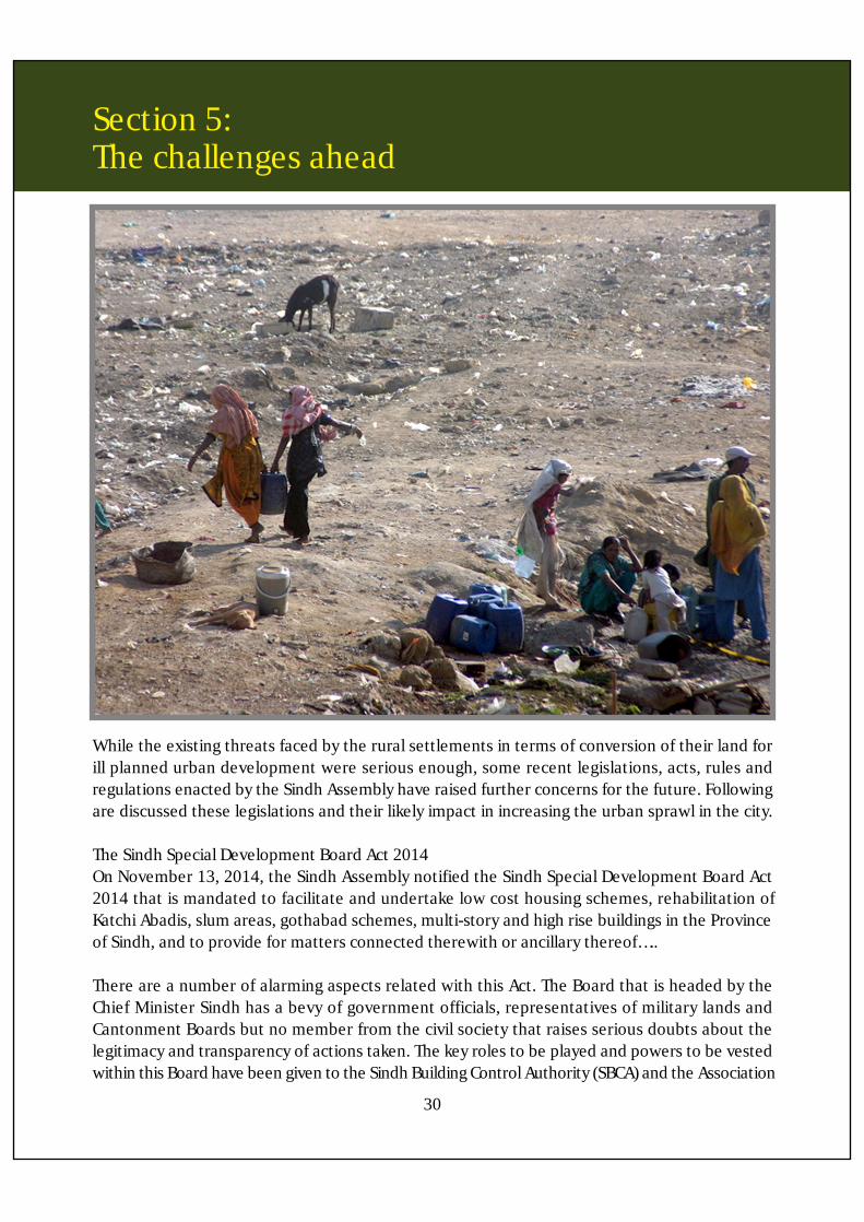
While the existing threats faced by the rural settlements in terms of conversion of their land forill planned urban development were serious enough, some recent legislations, acts, rules andregulations enacted by the Sindh Assembly have raised further concerns for the future. Followingare discussed these legislations and their likely impact in increasing the urban sprawl in the city.
The Sindh Special Development Board Act 2014On November 13, 2014, the Sindh Assembly notified the Sindh Special Development Board Act2014 that is mandated to facilitate and undertake low cost housing schemes, rehabilitation ofKatchi Abadis, slum areas, gothabad schemes, multi-story and high rise buildings in the Provinceof Sindh, and to provide for matters connected therewith or ancillary thereof…..
There are a number of alarming aspects related with this Act. The Board that is headed by theChief Minister Sindh has a bevy of government officials, representatives of military lands andCantonment Boards but no member from the civil society that raises serious doubts about thelegitimacy and transparency of actions taken. The key roles to be played and powers to be vestedwithin this Board have been given to the Sindh Building Control Authority (SBCA) and the Association
30
Section 5: The challenges ahead
31
of Builders and Developers (ABAD). The Director General, SBCA, shall act as the Secretary of theBoard while the Board will consider proposals submitted by ABAD through the SBCA. This nexusin itself is enough to ring serious alarm bells about the future of land management in the citygiven the history and background of these two institutional entities in playing havoc with the landand environment of the city. The functional role in terms of execution of projects the SCBA willtransfer to ABAD. For example in the section on Rehabilitation of Katachi Abadis and slum structures,it is stated:
the Board shall appoint a developer from amongst the members of Association to execute theproject who shall put his resources in form of money, men and material for construction of freeunits in such Katchi Abadis or slum structure….
ABAD representatives are being given all kinds of benefits and facilities to build aplenty. Forexample, the Act states that:
The developer shall be compensated for his efforts and investment in the form of free land outof the Katchi Abadis or slum area where he may build a commercial project for public sale…
The focus on commercial development is further reinforced in quantifiable terms also. Stated ina clause is:
The developer may be facilitated in the form of additional incentive of 12.5% commercial areaavailable in the project…
Then quite amazingly, the developers are being given the responsibility to provide services normallynot associated with them and for which they have no expertize. Like education and health byproviding insurance coverages. However, if all these things are not provided, if the housing facilitiesare not of the required quality than the user seems to have been given no discourse to claimdamages or legal action as the Board had protected itself completely from any such action byputting in clauses in the Act that are listed as follows:
No act done or proceedings taken or order passed under this Act shall be rendered invalid merelyon the ground of the existence of any vacancy in, or any defect in the Constitution of the Board…
No suit, prosecution, or any other legal proceedings shall lie against the Board, the Chairpersonor any member, officer, servants, advisors or consultants of the Board in respect of anything ingood faith done or intended to be done under this Act or the rules and regulations made thereunder…
And as mentioned earlier, the Board has no member of the civil society is represented in the Boardcomposition, so that much more difficult to keep track of what is going on. In addition, only halfof the total membership of the Board shall constitute a quorum for a meeting of the Board.
Section 5: The challenges ahead
32
Then as always, there is no consideration given on the stresses such an ambitious developmentprocess can pose on the already fractured and inadequate civic infrastructure and services. TheAct states that it will be within the powers and functions of the Board shall be:
To issue instruction to concerned utility agencies for provision of utility connections as one windowsolution and to provide infrastructure in accordance with international standards…
The fear that rural land is also going to be threatened from the anticipated disastrous consequencesof the implementation of this Act are indicated by the fact that there is the mention of gothabadschemes that come under the mandate of this Act and that the Director Generals of the Malir andLyari Development Authorities are members of the Board. While there is the focus being highlightedto provide affordable and viable housing options for the marginalized communities, commercialdevelopment of a significant scale is part of the Act’s mandate and there is also mention of verticaldevelopment taking place in the slum areas.
It would appear that this Act could result in providing sanction to or ‘regularizing’ the presentlyunregulated and unplanned urban sprawl taking place and urban sprawl whether planned orunplanned is now being discouraged all over the world as an environmentally unsustainablepractice and the focus is now on developing compact cities.

SHEHRI - CBECITIZENS FOR A BETTER ENVIRONMENT
Shehri-CBE’s mandate to work for the betterment and protection of the environment doesnot simply mean tackling air and water pollution or growing more trees; it means promotingall those laws, policies and actions of government which make our living environmentconducive to happiness. In our quest for a better environment, Shehri’s group of volunteershas, for the past two decades, with help from within and outside Pakistan, raised awarenessamong the citizens, judiciary, professional bodies, press / media, politicians and otherconcerned institutions about the problems facing our urban landscape and how closed-door discussions and non-transparent decision making processes employed by pubicservants and elected representatives continue to play havoc with our daily lives.
Shehri-CBE has exposed through advocacy efforts, using social accountability tools publicinterest litigation (PIL), citizens’ help desk, seminars / workshops, newsletters / brochures,press statements and website, the lack of transparency and accountability within thesystem which thwarts the citizens’ attempts to get good governance. In 2007, we used theFreedom of Information (FOI) Ordinance 2002, including an appeal before the FederalOmbudsman, and were successful in obtaining relevant information that was successfullyused in a high court petition against violations of the town-planning rules. Since then, wehave used the FOI Ordinance 2002 where necessary to obtain similar information.
As happens in all developing countries, especially where corruption is high, awareness ofpeople’s rights among citizens and government department is extremely limited. Ourgovernment officials are so used to violating laws-they simply are unwilling to acceptrequirements of FOI legislation.
The recent inclusion of Article 19-A in our Constitution has generated an opportune momentto promote awareness about FOI as a universally accepted tool for good governance.
“Our detractors give us credit for making building violations an issue that the entire countryis now aware of”.
SHEHRI - CITIZENS FOR A BETTER ENVIRONMENT88-R, Block-2, P.E.C.H.S., Karachi-75400, Pakistan. Tel : 021-34530646, 34382298, Fax : 021-34530646
E-mail : [email protected] Web site : www.shehri.org, facebook.com/shehri.citizens, twitter.com/shehricbe
CITIZENS FORA B E T T E RENVIRONMENT
SHEHRI