Embed Size (px)
Citation preview

Ever wonder how those satellite products are used?
Ralph Ferraro Chief, Satellite Climate Studies Branch NOAA/NESDIS/STAR/CoRP With contributions from MANY others….
24-25 November 2015
4th CICS-MD Science Meeting
1

My Motivation… • We work on a lot of satellite-based
projects…but how are they really used at NOAA?
• How do they all come together to
generate a “prediction”? ▫ Today’s products ▫ Future products (GOES-R, JPSS-1,
non-NOAA, etc.)
• Super Storm Sandy example ▫ First sort of attempt to do this
• Here, I’ll focus on the “Joaquin
Event” – Sept/Oct 2015 ▫ I will highlight examples from
across CICS (not 100% inclusive) and some from CIRA and CIMSS
▫ Will stress imagery type of products – “see” the meteorology
24-25 November
2015
4th CICS-MD Science Meeting
2

A Review of Satellites Used at NOAA
• NOAA (Baseline satellite systems) ▫ Geostationary Operational Environmental Satellites
(GOES) GOES-E (75oW; Atl. Ocean); GOES-W (135oW; Pac. Ocean) GOES-R (2017)
New sensors – ABI, GLM
▫ Polar-orbiting Operational Environmental Satellites (POES) NOAA-18, 19; MetOp-A, B ; DMSP F-17, 18, 19 S-NPP and JPSS
New Sensors – VIIRS, ATMS, CrIS, … JPSS-A (2017)
Collectively, global coverage ~3 hrs
• Non-NOAA (and there are plenty of them!) ▫ NASA – Jason (w/CNES), EOS, GPM, SMAP, others… ▫ DOD - Windsat ▫ JAXA- GCOM-W1 – AMSR-2 (part of JPSS) ▫ JMA – MTSAT, Himawari-8 ▫ ESA – Jason, ERS-2, Sentinel, others… ▫ EUMETSAT – MetOp, Meteosat ▫ ISRO– Megha-Tropiques (w/CNES), others…
24-25 November
2015
4th CICS-MD Science Meeting
3
GOES-14 GOES-13

Satellite attributes
GOES POES (and LEO)
• Fixed location • Visible and IR (and lightning)
▫ Rapid scan available • Movement ▫ Clouds, water vapor, ocean
currents, etc. • Rapidly changing events –
hurricanes, thunderstorms, fires, volcanic ash, aerosols,…
• Cloud drift winds/NWP
• (Near) global coverage ▫ Snow and Ice
• Wider variety of sensors and applications ▫ Visible and IR (including
hyperspectral sounders) ▫ Passive (active) MW
• Unique capabilities, including ▫ Vertical profiles of atmos. (NWP) ▫ Atmospheric Chemistry ▫ Vegetation ▫ MW – cloud penetration, ocean
surface
24-25 November
2015
4
4th CICS-MD Science Meeting
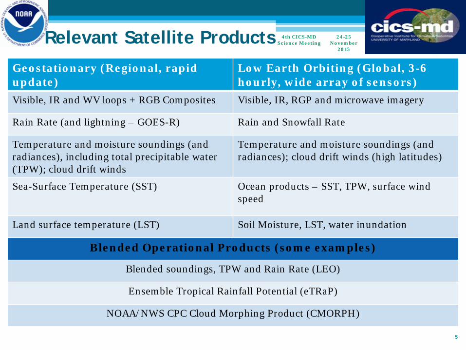
Relevant Satellite Products Geostationary (Regional, rapid update)
Low Earth Orbiting (Global, 3-6 hourly, wide array of sensors)
Visible, IR and WV loops + RGB Composites Visible, IR, RGP and microwave imagery
Rain Rate (and lightning – GOES-R) Rain and Snowfall Rate
Temperature and moisture soundings (and radiances), including total precipitable water (TPW); cloud drift winds
Temperature and moisture soundings (and radiances); cloud drift winds (high latitudes)
Sea-Surface Temperature (SST) Ocean products – SST, TPW, surface wind speed
Land surface temperature (LST) Soil Moisture, LST, water inundation
Blended Operational Products (some examples)
Blended soundings, TPW and Rain Rate (LEO)
Ensemble Tropical Rainfall Potential (eTRaP)
NOAA/NWS CPC Cloud Morphing Product (CMORPH)
5
24-25 November
2015
4th CICS-MD Science Meeting

Who are some of the 24 hr x 7 day users…
• NWS National Centers ▫ Weather Prediction Center (WPC) ▫ Ocean Prediction Center (OPC) ▫ National Hurricane Center (NHC)
• NWS Forecast Offices (NWSFO) and regional centers • Other agencies ▫ Naval Research Laboratory (NRL) ▫ Air Force Weather Agency (AFWA) ▫ Joint Typhoon Warning Center (JTWC) ▫ NASA – e.g., GPM program
24-25 November
2015
4th CICS-MD Science Meeting
6

The “Joaquin” Event 29 Sep – 7 Oct 2015
• An interesting interaction between the tropics and mid-latitudes ▫ Somewhat analogous to Sandy
2012 ▫ If Joaquin did not exist, this
still would have been major weather event
• Far reaching impacts ▫ Caribbean (Cat 4 storm), US
East Coast, Bermuda, even Portugal
▫ Tidal flooding, wind damage, ship (El Faro)/lives lost, historic rain flooding, …
▫ It was a long duration event Wind/tides Atmospheric River/Historic
rains 1000 year flood in SC 19 lives lost
24-25 November
2015
4th CICS-MD Science Meeting
7

Products we’ll focus on
• GOES-based Visible/IR ▫ Visible imagery and Super Rapid Scan imagery ▫ WV imagery ▫ RGB imagery ▫ Ground lightning (GOES-R proxy) ▫ Precipitation
• POES-based microwave ▫ Imagery ▫ Temp and RH profiles (MiRS) and warm core anomalies ▫ TPW/Atm. Rivers ▫ Precipitation – rates, accumulations, eTRaP ▫ Ocean surface winds
24-25 November
2015
4th CICS-MD Science Meeting
8

Visible Imagery 24-25 November
2015
4th CICS-MD Science Meeting
9
S-NPP VIIRS GOES-13 Courtesy of NRL
End Users – Just about everyone! CICS Contributors – Anyone doing VIS “calibration” Including S. Blonski, L. Wang, M. Bali, …

IR Imagery 24-25 November
2015
4th CICS-MD Science Meeting
10 End Users – Just about everyone! CICS Contributors – Anyone doing IR “calibration” Including S. Blonski, L. Wang, M. Bali, …
S-NPP VIIRS GOES-13

GOES-13 Rapid Scan
24-25 November
2015
4th CICS-MD Science Meeting
11
Courtesy of CIMSS
• Current GOES can have rapid scan mode “on demand”
• GOES-R will have routine rapid scan modes
• Amazing science to come from this!
CICS Contributors – GOES-R/JPSS Satellite Liaison – Michael Folmer

The Role of MW 24-25
November 2015
4th CICS-MD Science Meeting
12 CICS Contributors – J. Park, P. Meyers, T. Yang
Courtesy of NRL
GOES-13 IR GCOM-W AMSR-2

Use of VIS and MW together
24-25 November
2015
4th CICS-MD Science Meeting
13 End Users – National Hurricane Center, Naval Research Laboratory, Joint Typhoon Warning Center
Courtesy of NRL

Use of Imagery – Visible, IR, MW
24-25 November
2015
4th CICS-MD Science Meeting
14
• Eye location and structure
• Storm motion
• Intensity (Dvorak Technique)
• Intensity changes
• Surrounding Environment
• Prediction Critical is the quality of the satellite measurements – CICS-MD scientists (H. Yang, X. Zou, J. Park, Y. Ma, Y. Chen, S. Blonski, S. Pan, others) are HEAVILY involved with sensor calibration

Satellite Sounders - Warm Core, Moisture,
Assimilation • Microwave sensors can provide
“all weather” capability ▫ Penetrate cirrus clouds
• Microwave Integrated Retrieval System (MiRS) ▫ All MW sensors!
• Attributes for tropical systems include ▫ Warm core structure
Changes signal intensification ▫ Atmospheric Moisture ▫ Precipitation rates
• These MW (and IR) radiances are assimilated in NWP models and are critical for storm prediction! ▫ Several CICS researchers support
activities at JCSDA – Kalnay, Moradi, Masutani, Casey, Chen, …
24-25 November
2015
4th CICS-MD Science Meeting
15 End Users – Just about everyone! CICS Contributors – C. Grassotti
ATMS 600 mb
Joaquin - >5 K warmer than surrounding regions

NESDIS Satellite Applications Branch (SAB)
24-25 November
2015
4th CICS-MD Science Meeting
16
0640 UTC 2 October 2015
End Users – NWSFO’s; NWS WPC

NESDIS Satellite Applications Branch (SAB)
24-25 November
2015
4th CICS-MD Science Meeting
17
1639 UTC 4 October 2015
End Users – NWSFO’s; NWS WPC

Weather Prediction Center (WPC)
• Generate QPF out to several days over CONUS • Also make storm related predictions • “Fuse” together NWP, satellite (SAB), etc. products
24-25 November
2015
4th CICS-MD Science Meeting
18
End Users – NWSFO’s, media, etc.
CICS Contributors – M. Folmer

GOES Sounder Air Mass RGB 10/02/15
DISCUSSION...DEEP STRATOSPHERIC FOLD SEEN WELL IN STANDARD WV AS WELL AS RGB AIR MASS OCCURRING OVER THE EXTREME NORTHEAST GULF OF MEXICO... ALLOW EXCELLENT DIVERGENCE WITH STRONG 100-110 KT JET...WHICH WILL SUPPORT VERY STRONG LARGE SCALE ASCENT ACROSS THE DISCUSSION AREA. SURFACE FRONTAL ZONE HUGS THE SOUTH CAROLINA COASTLINE THROUGH CAPE FEAR INTO THE OUTER BANKS OF NC...BROAD/DEEP LOW LEVEL WITH AN EXTREME MOISTURE TONGUE PULLED FROM THE OUTER PORTIONS OF HURRICANE JOAQUIN ARE POOLED AROUND 2.4-2.5" WITHIN TPW ANALYSIS POINTED UPP THE FRONT TOWARD KCHS. ~Gallina
End Users – NWSFO’s, media, etc.
CICS Contributors – M. Folmer
Courtesy of M. Folmer

IR and 15-min Lightning Density
10/03/15
CURRENT SATELLITE IMAGERY AND LIGHTNING DATA SHOWS A PERSISTENT AREA OF CONVECTIVE REGENERATION JUST OFFSHORE OF CHARLESTON SC WITH AN INCREASE IN LIGHTNING ACTIVITY ACROSS THIS REGION. THE 07Z RAP OBJECTIVE ANALYSIS INDICATED THIS CONTINUAL REGENERATION PROCESS IS OCCURRING IN THE PRESENCE OF MUCAPES ABOVE 3000 J/KG WITH 500 TO 1000 J/KG VALUES EXTENDING ALONG THE MOISTURE PLUME INTO UPSTATE SC. HOURLY RAINFALL RATES IN THE 1 TO 2 INCH RANGE ARE LIKELY ALONG THE COAST WITH SLIGHTLY LOWER RATES FARTHER INLAND WHERE THE INSTABILITY DECREASES. ~Rubin-Oster
Courtesy of M. Folmer

GCOM Products Composite –
Rain Rates over TPW
• Products include: ▫ Radiances ▫ Imagery ▫ Rain Rate ▫ Water vapor (TPW) ▫ Cloud water ▫ Ocean surface wind speed ▫ Soil Moisture ▫ Snow cover/water equiv. ▫ Sea ice cover/concentration
End Users – Just about everyone CICS Contributors – P. Meyers, J. Park, N-Y. Wang, C. Hain, T. Yang,…

Ocean Prediction Center (OPC) Use
• OPC is responsible for off-shore forecasts • Both passive and active MW products aid in their interpretation of
weather features and how to issue warnings • Additionally, off-shore lightning and RGB products have been vital to
improving short-term forecast critical for shipping interests
24-25 November
2015
4th CICS-MD Science Meeting
22 End Users – NWSFO’s, maritime industry CICS Contributors – J. Park, M. Folmer
AMSR-2 ASCAT OPC Wind and Wave Forecast

Soil Moisture Operational Products System (SMOPS)
• Fuses together passive and active MW measurements from a variety of satellites
• Product is used in a variety of applications ▫ Hydrological
forecasts ▫ Agriculture ▫ NWP assimilation LDAS
24-25 November
2015
4th CICS-MD Science Meeting
23
End Users – NWS RFC’s, EMC
CICS Contributors – C. Hain

Atmospheric Rivers (AR)
24-25 November
2015
4th CICS-MD Science Meeting
24
*
CICS Contributors – W. Yang
• If you have a flood event, there is typically an AR associated with it
• AR prevalent with Joaquin, connecting tropics with mid-latitudes
• W. Yang, working on an automated AR detection scheme so that global AR climatology can be developed ▫ Look for changes in
characteristics over time Origin regions Rain regions

TPW from S-NPP ATMS – Atmospheric Rivers
24-25 November
2015
4th CICS-MD Science Meeting
25
Despite apparent disconnection between cloud circulations of coastal low and Hurricane Joaquin, there was strong tropospheric moisture connection!
CICS Contributors – C. Grassotti

TPW from S-NPP ATMS – Atmospheric Rivers
24-25 November
2015
4th CICS-MD Science Meeting
26
Despite apparent disconnection between cloud circulations of coastal low and Hurricane Joaquin, there was strong tropospheric moisture connection!
CICS Contributors – C. Grassotti

Why Satellite Rainfall • Fills in data voids over CONUS from radar & gauges
▫ Offshore systems ▫ Beam blockage ▫ OCONUS domain ▫ In-situ data can stop working in extreme weather ▫ NOAA has global responsibilities
• Radar and gauges don’t always agree! • Climatology
24-25 November
2015
4th CICS-MD Science Meeting
27
24 hr totals (mm) ending 1200 UTC 4 Oct 2015
GOES IR Rain Gauge Passive MW/GOES IR
End Users – WPC, SAB, TPC, CPC
CICS Contributors – N-Y. Wang, Y. You, P. Meyers, M. Nichols, R. Smith

Ensemble Tropical Rainfall Potential (eTRaP)
24-25 November
2015
4th CICS-MD Science Meeting
28
/data/Petrap/2015/JOAQUIN/2015JOAQUIN.WTNT21.KNHC.011455.AMSUM2.10011445 /data/Petrap/2015/JOAQUIN/2015JOAQUIN.WTNT21.KNHC.011455.AMSUNN.10011030 /data/Petrap/2015/JOAQUIN/2015JOAQUIN.WTNT21.KNHC.011455.SSMISC.10011245 /data/Petrap/2015/JOAQUIN/2015JOAQUIN.WTNT21.KNHC.011455.SSMISD.10011206 /data/Petrap/2015/JOAQUIN/2015JOAQUIN.WTNT21.KNHC.020240.AMSUNN.10012147 /data/Petrap/2015/JOAQUIN/2015JOAQUIN.WTNT21.KNHC.020240.GHEHR.10020200 /data/Petrap/2015/JOAQUIN/2015JOAQUIN.WTNT21.KNHC.020240.SSMISB.10012321 /data/Petrap/2015/JOAQUIN/2015JOAQUIN.WTNT21.KNHC.020240.SSMISD.10012321 Grid information: nc,nr,clat,clon: 800 800 23.80 74.40 Total independent TRaPs used: 8 Ensemble members before cull to 200 : 3 x 3 x 7 x 8 = 504 Total Ensemble TRaP members: 200
24-hr Rainfall Forecast ending 00 UTC 2 Oct 2015
Probability of 24-hr rain exceeding 100 mm
End Users – SAB, WPC, NHC, JTWC
Used POES (3), DMSP (4) and GOES (1) rain estimates
CICS Contributors – P. Meyers, C. Grassotti, N-Y. Wang, Y. You

Summary and Final Thoughts
• CICS work clearly supports the NOAA core mission goals! ▫ The cal/val activities are extremely critical for the quality of the
downstream product generation • There is a lot I did not show ▫ NWP Data Assimilation and impacts ▫ Cloud drift winds ▫ SST, Ocean color related products
• The future…we need to think beyond “our piece” but how improvements can come about through ▫ Common approaches to multiple sensors ▫ Exploitation of other sensors/technologies ▫ Putting things together to better understand physical processes ▫ Don’t forget the fundamentals; imagery shows a lot! ▫ Engaging your colleagues “next door” to accomplish this! This building – CICS, ESSIC, JGCRI, IMSG, … NCWCP NASA/GSFC
24-25 November
2015
4th CICS-MD Science Meeting
29

Backup
24-25 November
2015
4th CICS-MD Science Meeting
30

24-25 November
2015
4th CICS-MD Science Meeting
31

24-25 November
2015
4th CICS-MD Science Meeting
32