Embed Size (px)
Citation preview
Evaluation of Potential Environmental Impacts of theExport and Discharge of Salton Sea Water to the
Gulf of California or Pacific Ocean
Charles Keene
INTRODUCTION
The Salton Sea is a below sea-level hypersaline lake located in a closed desert depressioneast of Los Angeles and San Diego . Absent a natural outlet, evaporation is the only escape forwater entering this, the largest inland body of water in California . Over time, this condition hasresulted in the continued accumulation of salts, nutrients, and other contaminants within the Seaand its sediments . The resulting degradation of water quality is associated with negative impactson the Sea's biota (e.g ., fish kills) and aesthetic qualities (e.g., algal blooms and noxious odors) .These and other impacts have resulted in restoration of the Sea becoming a subject of renewedfocus. Stabilization and reduction of salinity levels, which have now reached 44 parts-per-thousand (ppt), is one of the major actions being pursued . One of several possible actions beingevaluated for salinity control is to pump water out of the Salton Sea to the upper Gulf ofCalifornia or to the Pacific Ocean. This would provide an outlet for the Sea and a means for theremoval of salts and some nutrients . The purpose of this report is to assess the potentialenvironmental impacts associated with the transport and discharge of Salton Sea waters into theupper Gulf of California or to the Pacific Ocean .
PROPOSED ACTIONS
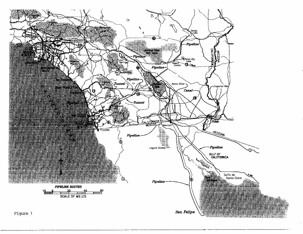
The U.S . Bureau of Reclamation (USBR) and the Salton Sea Authority are evaluatingtwo different possibilities for pumping water out of the Salton Sea as part of their Phase 2restoration alternatives (Figure 1) (USBR, 1999) . The Phase 2 alternative actions, if approved,could be operational by 2015 . One possibility involves pumping water to the Gulf of Californiaby one of two different water conveyance routes : (1) exporting water from the Sea to the eastside of the Gulf through a 140-mile long pipeline that would terminate near El Golfo de SantaClara and outside the core of the Biosphere Reserve ; and (2) exporting water from the Sea to thewest side of the Gulf through a 177-mile long pipeline that would terminate approximately onemile into the Gulf near San Felipe (Figure 2) . Much of the upper Gulf of California is protectedby its status as a Biosphere Reserve. Neither route violates the core of the Reserve, but theeastern route invades the buffer zone around the core area .
The second possibility being considered involves pumping water to the Pacific Ocean offthe coast of southern California by one of two different conveyance routes: (1) exporting waterfrom the Sea to the Pacific Ocean through a 101-mile long pipeline/tunnel that would terminateat an outfall site near Oceanside (Camp Pendleton) ; and (2) exporting water from the Sea to thePacific Ocean through a 108-mile long pipeline/tunnel that would terminate at an outfall site nearSan Diego (Point Loma) (Figure 3) .
Each of the Gulf of California export routes would utilize a 112-inch diameter, polymer-lined, steel pipe to convey nearly 223 million gallons per day (250,000 acre-feet per year) ofwater from the Salton Sea to the selected terminus point . Each route would require two or morepumping plants to lift water over small grades along the pipeline alignment .
Because of the need to cross the rugged San Jacinto Mountains at different points, theproposed design details of the two Pacific Ocean export routes differ from one another . Eachroute, however, would consist of two variable diameter pipeline segments, or reaches,interconnected by a concrete-lined tunnel segment beneath the mountains . Depending on theexport route, as many as nine pumping plants and eight powerplants would be needed at specific points
1
Evaluation of Potential Environmental Impacts of theExport and Discharge of Salton Sea Water to the
Gulf of California or Pacific Ocean
Salton Sea Science Subcommittee
INTRODUCTION
The Salton Sea is a below sea-level hypersaline lake located in a closed desert depressioneast of Los Angeles and San Diego . Absent a natural outlet, evaporation is the only escape forwater entering this, the largest inland body of water in California . Over time, this condition hasresulted in the continued accumulation of salts, nutrients, and other contaminants within the Seaand its sediments . The resulting degradation of water quality is associated with negative impactson the Sea's biota (e .g ., fish kills) and aesthetic qualities (e .g ., algal blooms and noxious odors) .These and other impacts have resulted in restoration of the Sea becoming a subject of renewedfocus . Stabilization and reduction of salinity levels, which have now reached 44 parts-per-thousand (ppt), is one of the major actions being pursued . One of several possible actions beingevaluated for salinity control is to pump water out of the Salton Sea to the upper Gulf of Californiaor to the Pacific Ocean. This would provide an outlet for the Sea and a means for the removal ofsalts and some nutrients . The purpose of this report is to assess the potential environmentalimpacts associated with the transport and discharge of Salton Sea waters into the upper Gulf ofCalifornia or to the Pacific Ocean .
PROPOSED ACTIONS
The U.S . Bureau of Reclamation (USBR) and the Salton Sea Authority are evaluating twodifferent possibilities for pumping water out of the Salton Sea as part of their Phase 2 restorationalternatives (Figure 1) (USBR, 1999). The Phase 2 alternative actions, if approved, could beoperational by 2015 . One possibility involves pumping water to the Gulf of California by one oftwo different water conveyance routes : (1) exporting water from the Sea to the east side of the Gulfthrough a 140-mile long pipeline that would terminate near El Golfo de Santa Clara and outside thecore of the Biosphere Reserve ; and (2) exporting water from the Sea to the west side of the Gulfthrough a 177-mile long pipeline that would terminate approximately one mile into the Gulf nearSan Felipe (Figure 2) . Much of the upper Gulf of California is protected by its status as aBiosphere Reserve . Neither route violates the core of the Reserve, but the eastern route invadesthe buffer zone around the core area .
The second possibility being considered involves pumping water to the Pacific Ocean offthe coast of southern California by one of two different conveyance routes : (1) exporting waterfrom the Sea to the Pacific Ocean through a 101-mile long pipeline/tunnel that would terminate atan outfall site near Oceanside (Camp Pendleton) ; and (2) exporting water from the Sea to thePacific Ocean through a 108-mile long pipeline/tunnel that would terminate at an outfall site nearSan Diego (Point Loma) (Figure 3) .
Each of the Gulf of California export routes would utilize a 112-inch diameter, polymer-lined, steel pipe to convey nearly 223 million gallons per day (250,000 acre-feet per year) of waterfrom the Salton Sea to the selected terminus point . Each route would require two or more pumpingplants to lift water over small grades along the pipeline alignment .
Because of the need to cross the rugged San Jacinto Mountains at different points, theproposed design details of the two Pacific Ocean export routes differ from one another . Eachroute, however, would consist of two variable diameter pipeline segments, or reaches,interconnected by a concrete-lined tunnel segment beneath the mountains . Depending on the exportroute, as many as nine pumping plants and eight powerplants would be needed at specific points
1
along the route alignment to lift water over small grades and/or to recover power . Each routewould convey about 223 million gallons of water per day (250,000 acre-feet per year) from the Seato the selected ocean outfall locations .
The average water velocity in the pipelines and/or tunnels would be approximately 5 feetper second, thereby requiring nearly 41 hours and 52 hours for conveyance time from the SaltonSea to El Golfo de Santa Clara and San Felipe, respectively . Transit time to probable PacificOcean outfalls would be approximately 30 hours and 32 hours for conveyance to Oceanside andSan Diego, respectively . The average water temperature within the pipeline during transit to theGulf or to the Pacific Ocean will be similar to that of Salton Sea water at the point of intake (withminor adjustments for potential heat loss/gain through the pipeline) .
ISSUES
Several basic issues are associated with the discharge of water from the Salton Sea intoother water bodies . These include : (1) possible environmental effects of hypersaline waterdischarged into oceanic water environments ; (2) introduction of viable exotic organisms into thearea of discharge ; (3) introduction of possible hazardous wastes that may be present in dischargewaters; and (4) nutrient loading of the receiving waters . Each of these is addressed in thisevaluation .
EVALUATIONS
Hypersaline Discharges
Discharges from the pipeline will involve water that has a salinity of approximately 51ppt(i.e ., projected salinity of the Sea in 2015, assuming no appreciable reduction in inflows to theSea) (USBR, 1999). Salinity of the receiving waters will range seasonally from 37ppt to 39ppt forthe upper Gulf (Lavin et al ., 1998) and will be approximately 35ppt for the Pacific Ocean sites .Because of the hypersaline nature of the Sea, any discharges to the Gulf of California or the PacificOcean have the potential to negatively affect the biotic environment of the receiving waters . Thefollowing information provides a synopsis of physical processes at play in the upper Gulf andnearshore waters off the coast of southern California that could affect the dispersion or dilution ofthe hypersaline discharge from the Sea .
Background . The upper Gulf is a relatively shallow (<30meters depth), triangular-shaped, tidal area located at the head or northernmost part of the Gulf of California . It has beencharacterized by Lavin et al . (1998), as an inverse estuary because of its high evaporation rate andpaucity of freshwater input from rainwater and the Colorado River . Hydrographic data suggeststhat the area is vertically well mixed throughout the year, primarily because of strong tidalinfluences and vertical convection . Salinity levels gradually increase toward the head of the Gulf,as do water densities . The pressure gradients thus formed lead to water-mass formation andgravity currents (-0.1 ms- ') that result in a residual cyclonic circulation pattern within the upperGulf .
The main physical oceanographic factors that influence temperature structure and mixing inshallow nearshore areas of the Pacific Ocean along the southern California coast are primarilyseasonal water density stratification (caused by water temperature variations), seasonal windregimes, and major oceanic anomalies such as El Nino and La Nina conditions . Several timesduring the year, changes in surface water temperatures result in the formation of convectioncurrents that produce thorough mixing of relatively warm nearshore waters . Oceanic circulationseveral miles off the coast of southern California is influenced by colder, southerly moving watersof the California Current system .
2
The following case studies of outfalls within marine environments were evaluated toprovide guidance regarding probable outcomes associated with discharges of water from the SaltonSea. Each case study evaluates the effects of discharge and dispersion of a concentrated effluentstream of wastewater to an oceanic environment and describes its relative effects on the biota .
Case Study No . 1 . The Southwest Florida Water Management District and University ofSouth Florida jointly investigated the effects on marine benthic communities from the discharge ofdesalination brines, or concentrates, from an operating sea water reverse osmosis (RO) facility(Hammond et al ., 1998) . The objective of the study was to provide the evidence necessary toadequately predict effects from the concentrate discharged in areas such as west-central Florida .
Initial laboratory tests were conducted to determine if discharges from a sea water ROfacility could meet Florida water quality standards. The initial test results, using a bench-scale ROunit and acute and chronic toxicity bioassays on standard marine organisms (i .e ., inlandsilversides, Menidia beryllina, and mysid shrimp, Mysidopsis bahia), showed that by blending theRO concentrate with three parts sea water, the discharge could not only meet the state water qualitystandards, but also test organisms did not show any observable effects with respect to growth,reproduction, or survival .
To further document possible discharge impacts under actual field conditions, theinvestigators next studied the structure and health of the benthic communities within the dischargezone of an operating sea water RO facility at Antigua in the Caribbean Sea . The Antigua RO plantis located in a shallow (less than 30 feet deep), largely protected and relatively calm harbor with atotal surface area of about three square miles .
The Antigua RO plant has a production capacity of 1 .32 million gallons of fresh water perday and about 1 .8 million gallons of concentrate per day . The concentrate, which has a salinity of57ppt, is discharged via a channel outfall into the harbor . Background salinity within the harborwas measured at 35ppt. As part of the investigation, a new 12-inch diameter pipe was constructedto divert the discharged brine to a study area approximately 20 meters offshore and about 26 meterseast of the RO plant discharge channel . Prior to diverting the discharged brine, biological, waterquality, and other related data were collected from the study area along six 10-meter long radialtransects spaced at 60-degree intervals from the discharge outfall (ground zero) . Two additionalsurveys along the radial transects were conducted three months and six months after the initialdiversion of the brine .
The water quality sampling results from these later surveys suggest that temperature (whichis higher in the discharge) and pH (which is lower in the discharge) returned to background levelswithin 2 to 6 meters from ground zero (e.g., surveys detected only 39ppt salinity within 2 metersof ground zero) . Elevated salinity levels, which are the best "tracer" of the spatial influence of theplume, were found up to ten meters and beyond for those transects that extended into deeper waterfrom ground zero. The brine discharge seemed to dissipate mostly as a density-driven plume .
Next, the structure and health of the nearshore, or littoral, communities within the studyarea were evaluated with respect to impacts caused by the discharge plume . The communitiesincluded expansive areas of sea grasses and macroalgae, benthic microalgae, benthic foraminifera,and typical tropical reef invertebrates or macrofauna and fish . The benthic communities were ofparticular interest because they are immobile and cannot escape the effects of materials dischargedinto their surroundings, thereby making them potentially sensitive indicators of ecological impactsfrom such things as brine discharges .
In general, the surveys showed no detectable toxic effects of the discharge plume onseagrass (Thalassia testudinum) density, biomass, or production . However, the survey at monththree showed a positive, but weak correlation between the intensity of the plume (measured as
3
change in salinity vs . background) in the abundance of the alga Dictyota dichotoma . Interestingly,algal abundance for the survey at month six showed no significant differences from densitiesrecorded prior to the start of the study and no effect on algal productivity or biomass . It seemsprobable that the elevated algal abundances found at month three were from higher nutrient inflowsto the study area caused by episodic events associated with back flushing, detergent discharges,and/or storm water runoff from the RO plant complex and not from chronic effects associated withthe discharge. In addition, the discharge plume apparently had no observable effect on the grazingrate or feeding behavior of a major seagrass consumer, the bucktooth parrotfish (Sparisomaradians) .
The surveys also showed that the discharge of high salinity effluent had no detectable effecton the biomass (i .e ., chlorophyll concentration) or abundance of the benthic microalgal communityin the study area . In fact, the biomass increased and remained elevated during the study period andthere were no significant differences in average chlorophyll concentrations for samples takenwithin three meters and at greater than three meters from ground zero .
Benthic foraminifera, because of their relative sensitivity to environmental change andpredicable responses to salinity stress, were considered key indicators of the effects of desalinationeffluents on nearshore benthic communities . However, the surveys revealed no significantdifferences in the foraminiferal assemblages between transects or with distance from the outfall,thus indicating that salinity stress was not a factor affecting the relative abundance (or ratio)between key genera.
No evidence of stress or mortality in the macrofaunal assemblage was observed within thestudy area; in fact, two species of coral (soft coral, Pseudoterogorgia acerosa, and hard coral,Porites asteroides) were found seemingly unaffected within one meter of the point of dischargethroughout the study and two mobile species, the queen conch, Strombus gigas, and the cushionstarfish, Oreaster reticulatus, were observed within two meters of the discharge point . Theelevated salinities also did not limit the ability of organisms to colonize available substrates, evenwithin the area of maximum salinity . In addition, no obvious or statistically significant effects ofthe saline discharge were observed on the macro-epifauna or pelagic fish .
In conclusion, this study showed no obvious effects of the concentrate on the benthic orpelagic biological communities present in the discharge zone of the RO plant if the concentrate isblended with sea water at a ratio of 1 :1 or 2:1 . A rapidly dissipating density-driven plume wasevident in the study area, but no significant difference in aquatic productivity or relative abundanceof micro- and macroalgae or changes in the foraminiferal populations and macrofaunal assemblagewere noted between the time the project began and after brine effluents had been continuouslydischarged for six months . These findings were also consistent with the conclusions of Smith(1995) and others who have studied the effects of a discharge plume from sea water desalinationplants elsewhere in the Caribbean and the Middle East .
Case Study No . 2 . For the last 35 years, the San Diego Metropolitan WastewaterDepartment has been monitoring the environmental effects of discharging nearly 195 milliongallons per day of primary-treated effluent from the Point Loma Wastewater Treatment Plant to thePacific Ocean off the coast of San Diego . The Point Loma Ocean Outfall was initially constructedas a 108-inch diameter concrete pipe that extended 2 .5 miles offshore, ultimately discharging at adepth of about 220 feet . To avoid contamination of an important nearshore kelp bed zone, theoutfall was extended in 1993 to 4 .5 miles offshore and a depth of about 320 feet, making it one ofthe longest and deepest ocean outfalls in the world . A Y-shaped diffuser pipe further extendsabout 2,500 feet from the end of the west-facing outfall in a northerly and southerly direction tobetter disperse treated wastewater .
4
In December 1998, the Metropolitan Wastewater Department completed the South BayOcean Outfall, which currently discharges primary-treated effluent from the new InternationalWastewater Treatment Plant and, in the future, from the planned South Bay Water ReclamationPlant and South Bay Wastewater Treatment Plant to the Pacific Ocean near Imperial Beach . TheSouth Bay Ocean Outfall, which has a capacity of about 174 million gallons per day, uses a 144-inch diameter pipe that extends approximately 3 .5 miles offshore . The outfall consists of a dropshaft structure, a 2 .5-mile long tunnel and pipeline section, a riser assembly, and an about 1 .5-milelong seabed pipeline and diffuser system .
The Metropolitan Wastewater Department has established one of the largest and mostcomprehensive ocean monitoring programs in the United States to study the effects of its regionaltreatment processes on the marine environment . The objectives of the program are to: (1) identifypotential health concerns associated with the recreational uses of nearshore waters along the SanDiego coastline, (2) document the temporal and spatial changes to the marine environment andensure its protection, (3) differentiate between natural changes to marine ecosystems and those thatmay be caused by sewage discharge, and, finally, (4) measure compliance with state and federalregulations .
As part of the ocean monitoring program, numerous monitoring stations have beenestablished, using a GPS tracking system, to monitor the biological and physical components ofthe ocean environment . The monitoring area encompasses nearly 120 square miles from Del Mar,California, to Punta Bandera, Mexico, and seaward approximately 10 miles to depths of 600 feet .Each week, several thousand samples of the water and wastewater column, ocean sediments, andmarine biota are collected and analyzed for compliance with state and federal water qualityparameters at various depths (e.g ., pH, clarity, temperature, DO, coliforms, heavy metals,nutrients, and other organic loading), possible sediment contaminants, and signs of effluenttoxicity . In addition, annual aerial surveys of the kelp bed canopy, ranging from southern OrangeCounty to the US/Mexico border, are conducted to determine temporal and spatial changes to thekelp bed caused by the operation of the outfalls .
After nearly 35 years of monitoring, there have been no detectable environmental problemsassociated with the effluent discharge from the Point Loma Ocean Outfall (except for elevatedcoliform levels) . Not enough information is available to adequately evaluate the environmentaleffects of the effluent discharge from the South Bay Ocean Outfall .
Case Study No. 3 . Parsons Engineering Science recently conducted a phasedoceanographic study off the coast of Lima, Peru, to determine the extent of wastewatercontamination from the discharge of domestic and industrial wastes via three coastal rivers(Meiorin et al., 1997) . The objective of the investigation was to evaluate several wastewaterdisposal scenarios to determine which would reduce the nearshore pollution to acceptable levels .Phase one of the study entailed documenting environmental baseline conditions of the receivingwaters within Miraflores Bay, off the coast of metropolitan Lima . Phase two involved thedevelopment of three-dimensional outfall models to help simulate different project scenarios .Lastly, phase three of the study compared the baseline conditions and model results to provide abetter understanding of the expected long-term changes in the ocean environment .
To characterize the existing environmental conditions, data on the physical and biologicalattributes and extent of contamination of waters within Miraflores Bay were collected during phaseone . Two extensive oceanographic surveys of the approximately 500-square-kilometer projectimpact area (50 km of shoreline and out to 10 km offshore) were conducted . The surveys of thenearshore waters showed strong evidence of wastewater pollution, with beach and other shorelineareas having total coliform concentrations exceeding 10 6MPN/100ml, while offshore areas near themiddle of the bay showed concentrations of up to 2.5 x 10⁴MPN/100ml . In addition, microbialpathogens, such as Salmonella and Vibrio, as well as several parasites and elevated metal
5
concentrations were found in fish inhabiting the bay . Biological oxygen demand (BOD) was muchhigher than normal sea water levels, which is characteristic of waters with high external inputs oforganic matter and often produces hypoxia in the water column and anoxic conditions in the bottomsediments . Typical pH values near the river outlets were as high as 10.27, levels which aregenerally very stressful to marine life . The high nutrient content of the waste effluent frequentlyspurred algal blooms within the bay despite poor water transparency caused by unusually highconcentrations of suspended solids (50 percent higher than those of typical sea water). As wouldbe expected, these inhospitable conditions combined to significantly reduce overall marineproductivity within the bay .
The next phase of the study included development of detailed hydrodynamic and waterquality models simulating offshore current patterns, water quality profiles, and potential plumedispersion patterns that could be expected from the four ocean outfall scenarios evaluated . Thefour scenarios, or situations, evaluated were : (1) existing conditions (i .e ., the discharge ofuntreated or partially treated sewage to the ocean via existing coastal rivers or shoreline pipes), (2)primary treatment of all sewage and discharge through two outfalls, (3) primary treatment of allsewage but discharge (of about one-third of the treated wastewater) through only one outfall (withthe remainder discharged via existing coastal rivers or shoreline pipes), and (4) varying levels oftreatment of wastewater and discharge through two outfalls . Model runs were conducted for eachsituation, simulating both summer and winter hydrodynamic conditions, at three different oceandepths (surface, mid-water, and bottom) . The runs used 11 separate physical-chemical andbiological parameters (i .e ., BOD5 , DO, Total N, NH 3 , N03, NO4, Total P, P04 , algae, coliforms,and other tracers) . In all, 264 different model runs, comprising 66 representations of eachscenario, were produced, depicting the probable transport, mixing, and chemical interactions thatwould occur within the bay .
Phase three of the investigation compared the results of the modeling runs to the existingbaseline environmental conditions to determine frequency of compliance with water qualitystandards among the four scenarios . The results indicated that Scenarios 2 and 4 comply with thewater quality standards and would, therefore, be the most suitable alternatives for safe use ofbeaches and nearshore waters for recreational activities and other public uses . Scenario 3 showedsome improvement over baseline conditions (Scenario 1), but standards for nutrients (NH 4),tracer, DO, and coliforms were still exceeded . Comparisons of the modeling results indicate thatthe greatest improvement in nearshore water quality was achieved with the use of an outfall ratherthan with increased treatment . Specifically, the outfall must be long enough to carry the dischargeto a point in the ocean where it will not significantly harm the environment . The initial dilution(ratio of discharge to receiving water) is critical with regard to toxicity and must be considered,with other oceanographic parameters, such as eddy diffusivity, density structure (i .e ., salinity,temperature, etc .), marine topography, and marine geology, to determine the potential dispersionof effluents and possible environmental consequences .
Analysis . According to direct hydrographic measurements from Argote et al . (1995), theshallow (<- 50m depth) coastal areas of the upper Gulf exhibit a strong tidal influence that, alongwith vertical convection currents and seasonally wind-induced turbulence, results in a thoroughmixing of the nearshore waters . As an example, the tidal range at San Felipe ranges from less than1 m to almost 6m with a maximum current speed of 0.5ms- ' (Lavin et al ., 1998) .
A direct measure of how well a water column is mixed is the difference in temperaturebetween the surface and the bottom (AT) . Argote et al . measured the distribution of AT in theupper Gulf; results showed that a complete vertically mixed coastal area (AT = 0), from Puertecitoson the Baja peninsula to Point Lobos on the mainland coast, extended to approximately the 30misobath in September and to about 60m in December .
6
Alvarez-Borrego (1983) described the surface salinities in the shallow coastal areas of theupper Gulf as increasing to the northwest, with a seasonal maximum (39ppt) in May-Septemberand minimum (37ppt) in December-February . Surface densities also increased to the northwestwith greater winter (December-February) densities than summer . In addition, a slight densitystratification was evident throughout the year in most of the upper Gulf, but not enough to causeinversions . Lavin noted that the coldest, saltiest, and densest water in the upper Gulf wasgenerally found in the shallow, gently sloping, extended shelf adjacent to the Baja peninsula .Hydrographic data suggest that the slightly denser bottom water, originating from the Bajapeninsula side, moves gradually (-0 .lms) as a near-bottom gravity intrusion as deep as the 30misobath where surrounding water densities are similar . By comparison, the mainland side of theupper Gulf has a much smaller shelf that rapidly drops off to deeper water .
Based on this information, a hypersaline discharge from the Salton Sea would likely moveat a relatively slow density gradient into deeper regions (>- 50m depth) of the upper Gulf.Although shallower areas of the upper Gulf are generally well mixed, the discharge plume wouldnot be expected to dissipate rapidly given its relatively high density and temperature profilecompared to ambient conditions .
Hydrographic conditions along the southern California coast are dominated by seasonalwind regimes and variations in surface water temperature that result in water column stratificationand, in nearshore areas, the formation of convection currents that cause the thorough verticalmixing of littoral waters . Like conditions in the upper Gulf, convective vertical circulation orthermohaline circulation of the water column is typically density driven caused by thermal andsalinity changes . As surface water temperatures along the coast decrease, the waters becomeincreasingly dense and sink, gradually flowing southward at depth along the continental shelf .This process results in the creation of water layers based on the physical characteristics of the wateritself (e.g ., salinity, temperature, and density) . These homogeneous water layers or gradients aretypically slow to dissipate and mix with adjacent waters .
Similar to the situation in the upper Gulf, a discharge from the Salton Sea into southernCalifornia coastal waters near Oceanside would likely create a distinct water gradient or plumebecause of its high salinity, temperature, and density differential compared to ambient water qualitynear the discharge point . Furthermore, this plume could persist well beyond (-- 5-10m) theimmediate discharge location . However, given the case studies above and the relatively smallvolume of water discharged from the Sea compared to the volume and mixing potential of oceanwater, any plume or gradient so generated would also likely dissipate rapidly beyond 10m from thedischarge point .
Conclusions . The ocean is often the ultimate sink for waste products . However, theability of the ocean to assimilate wastes often depends upon physical oceanographic factors such aswind, wave, swell, littoral currents, variable currents, density gradients, upwelling, etc ., as wellas conventional physical, chemical, and biological characteristics of the oceanic environment .Because these factors and characteristics differ markedly between the upper Gulf of California andthe coast of southern California, each location's ability to dilute and rapidly disperse hypersalinedischarges from the Salton Sea will differ . An analysis of the current circulation patterns for theupper Gulf and southern California coast would be required to accurately predict the degree ofinitial dilution and dispersion that can be achieved at each of the proposed outfall sites .
However, based on the case studies evaluated plus the physical characteristics of the upperGulf as compared to the southern California coast, it is clear that mixing forces in an open oceansetting would achieve a higher level of initial dilution and dispersion of hypersaline dischargesfrom the Salton Sea . Consequently, possible adverse effects on the local benthic and pelagiccommunities near the discharge sites would likely be less for discharges off the coast of Oceanside .
7
Introduction of Exotic Organisms
The discharge of water from the Salton Sea could potentially introduce exotic organismsinto - the upper Gulf of California or to waters along the southern California coast . Many of theseorganisms may have the capacity to colonize the receiving waters, thus radically transforming thesemarine communities by out competing, killing, or infecting native species and by eventuallydominating the ecosystem or affecting its health and productivity .
Background. The Salton Sea is known to be a highly productive, biologically richecosystem with a complex community structure . Because of elevated salinities, acceleratedeutrophication, and dramatic temperature and water quality fluctuations, many of the marineorganisms of the Sea have become highly adaptive . Photosynthetic algae are the majorphytoplanktonic component of the Sea . Some of the more abundant algal species found in the Sea,like various dinoflagellates and the raphidophyte Chattonella cf. marina (which may be responsiblefor the Sea's "green tides" frequently observed in summer months), are known to produceneurotoxins that can be extremely injurious to fish . In general, diatoms and dinoflagellates co-dominate in the plankton biomass with the superimposition of an abundance of Chattonella in thewarmer months (Dexter et al., 1998) .
The Sea also has an abundance of various zooplankton species, dominated by the rotifersBrachionus plicatilis and Synchaeta sp., the copepod Cyclops dimorphus, planktonic larvae of thebarnacle Balanus and the marine polychaete worm Neanthes succinea, and an assemblage of ciliateprotozoans . Other common nektonic invertebrate organisms include brineshrimp (Artemiafranciscana) and water boatmen (Trichocorixa reticulata ), which are commonly found swimmingat the surface of the water in protected embayments and isolated pools along the shore, wheresalinity is usually higher than in the main body of the Sea . .
Several benthic invertebrate species are known to play an important role in the Salton Seafood chain. These include the amphipod Gammarus mucronatus, which has been shown to be animportant food source of eared grebes and is presumably available to other bird species that feed inshallow waters ; Neanthes succinea, whose free swimming larvae stage is the key linking the Sea'sdetrital food chain to fish and birds (Dexter et al ., 1998) ; and Balanus, whose naupliar larvae is afood source for the gulf croaker Bairdiella icistius .
The Salton Sea fish community had its beginnings in 1929 with the introduction of about25 marine species that were mainly taken from the Gulf of California near San Felipe . Of thespecies planted, only orangemouth corvina (Cynoscion xanthulus), bairdiella (Bairdiella icistius),and sargo (Anisotremus davidsoni) became established and flourished in the Sea. Later, in theearly 1960s, tilapia (Oreochromis spp.) were accidentally introduced into the Sea and quicklybecame the dominant fish species in the Sea and the most important prey for the increasingnumbers of piscivorous birds (Costa-Pierce, 1998) . Several less abundant species of fish are alsoknown to inhabit the Sea and its associated freshwater rivers and inlets, including the endangereddesert pupfish (Cyprinodon macularius), the only fish species endemic to the Salton Sink .
Analysis . The northern part of the upper Gulf of California is considered among the mostproductive marine regions in the entire world . Its fertility mainly results from its hydrodynamicproperties, characterized by strong surface and tidal currents (> 3m/sec) and extremely shallowzones, which promote extensive vertical mixing and upwelling of the nutrient-laden bottom waters(Alvarez-Borrego, 1983) . The waters of the upper Gulf exhibit variable levels of productivity,with the west side of the upper Gulf being the more biologically productive zone and exhibitinggreater biotic diversity (Thomson, 1969) .
Walker (1960) identified 22 species of fish endemic to the upper Gulf that inhabit waters ofmoderate depth (5 - 100m), including the totoaba (Totoaba macdonaldi), the only marine fish in
8
the world considered in danger of extinction. In addition, three species of endemic grunion arealso found in relatively shallow waters of the upper Gulf . At least ten species of marine mammalshave been recorded in the Gulf of California, including the endangered vaquita (Phocoena sinus),the only cetacean species endemic to Mexico, whose range is seemingly restricted to the extremenorthern Gulf of California corresponding with waters of the Biosphere Reserve .
Besides being an important reproduction and nursery area for many other species, theupper Gulf is also important for its commercial fishery consisting of shrimp, shark, sardine, andother species that form the economic backbone for the entire upper Gulf region .
Conclusions .
Introduction of Hazardous Wastes
Background .
Analysis .
Conclusions .
Nutrient Loading
Background .
Analysis .
Conclusions .
GENERAL COMMENTS AND CONCLUSIONS
FIGURES
Figure 1 - Proposed Pipeline Routes to the Gulf of California and the Pacific Ocean .
Figure 2 - Potential Pump-out Routes : Salton Sea to the Gulf of California
Figure 3 - Potential Pump-out Routes: Salton Sea to the Pacific Ocean
9
References
Alvarez-Borrego, S ., 1983. Gulf of California . In: Ketchum, B .H . (Ed), Estuaries and Enclosed Seas .Elsevier Scientific Publishing Company . Chapter 17 (1-23), pp. 427-449 .
Argote, M.L ., A. Amador, M .F. Lavin, J .R. Hunter, 1995 . Tidal Dissipation and Stratification in the Gulfof California. Journal of Geophysical Research, Vol . 100, No. C8, pp. 16, 103-16, 118 .
California Coastal Commission . Seawater Desalination in California. Chapter 3 : Potential EnvironmentalImpacts/Coastal Act Issues . October 1993, pp . 1-14 .
CICTUS, et al., 1994 . Management Program for the Biosphere Reserve of the Upper Gulf of Californiaand the Colorado River Delta . The Center for Scientific and Technological Research . Universityof Sonora . June 1994, pp. 1-59 .
Costa-Pierce, B ., 1998 . Final Synthesis Document - Fish and Fisheries of the Salton Sea . Institute ofMarine Science, University of Southern Mississippi .
Dexter, D .M ., M.A. Tiffany, K. Reifel, and S .H. Hurlbert, 1998. A Synthesis of Our Knowledge of theBiological Limnology of the Salton Sea . Center for Inland Waters and Department of Biology,San Diego State University .
Duxbury, A.C ., 1971 . The Earth and its Oceans . Addison-Wesley Publishing Company . Chapter 6 (1-18), pp. 114-121 .
Foster, M .S ., and D.R. Schiel, 1985. The Ecology of Giant Kelp Forests in California: A CommunityProfile . U.S. Fish and Wildlife Service Biological Report 85 . 152pp .
FWQA, 1970. Salton Sea, California. Water Quality and Ecological Management Considerations. U.S .Department of the Interior, Federal Water Quality Administration, Pacific Southwest Region .
Hammond, M.A ., N.J . Blake, C.W. Dye, and D .A. Tomasko, 1998 . Effects of Seawater Reverse OsmosisConcentrate on Marine Benthic Communities . In : Proceedings of the American DesaltingAssociation, "The Desalting Revolution ." August 1998, pp . 3-14 .
Holdren, C.G ., 1999. Literature Review : Chemical and Physical Analyses of the Salton Sea, California .U.S. Department of the Interior, Bureau of Reclamation, Denver . Unpublished information .
Horn, M .H ., and L .G. Allen, 1978 . A Distribution Analysis of California Coastal Marine Fishes. Journalof Biogeography 5 : 23-42 .
Lavin, M.F ., V.M. Godinez, and L .G. Alvarez, 1998 . Inverse-estuarine Features of the Upper Gulf ofCalifornia. Estuarine, Coastal and Shell Science (1998) 47, pp . 769-795, Report No . ec980387 .
Meiorin, L., 1995 . Marine Wastewater Disposal - Presentation to the XI Peruvian Congress of Sanitaryand Environmental Engineering, 30 October - 03 November 1995, Cusco, Peru . November 1995,pp. 1-8 .
Meiorin, L. and R.N. Pissani, 1997 . Environmental Evaluation of Treatment/Discharge Alternatives forthe City of Lima, Peru . Parsons Engineering Science, Inc . La Jolla, California.
San Diego Metropolitan Wastewater Department . Annual Reports on Ocean Monitoring Program for PointLoma Ocean Outfall .
San Diego Metropolitan Wastewater Department . Web pages: Point Loma Wastewater Treatment Plant andSouth Bay Ocean Outfall, from : http ://www .sannet.gov/mwwd//general/facilities .html, and OceanMonitoring Program, from http://www.sannet.gov/mwwd/community/oceanmon .html .
Smith, S.R ., 1995 . Final report on the marine environmental impact of the Watlington Water Worksreverse osmosis plant. Bermuda Biological Station for Research, Inc. Ferry Reach, Bermuda .
Southern California Edision Company, 1998 . Annual Marine Environmental Analysis and Interpretation ;Report on 1997 Data . San Onofre Nuclear Generating Station .
Thomson, R.W., 1969. Tidal currents and general circulation . In : Environmental impact of brine effluentson Gulf of California . U.S. Report Insurance and Development Program Report No . 387 .
USBR, 1999 . Potential Export Options to the Gulf of California . U.S . Department of the Interior, Bureauof Reclamation, Lower Colorado Region . Unpublished data .
Walker, B.W., 1960. The distribution and affinities of the marine fish fauna of the Gulf of California . InSymposium: The biogeography of Baja California and adjacent Seas . Part II . Marine Biotas .Syst. Zool. 9(3):123-133