Embed Size (px)
Citation preview
EVALUATION OF AN OFFSHORE BREAKWATER SYSTEM ADJACENT TO AND SOUTH OF GREAT KILLS HARBOR
PROJECT GOALS AND ASSUMPTIONS
• Identifyandevaluateapproachesforashoreprotectionsystemthatmaximizesstormprotectionandmarinehabitatvalueandincludesanoffshorebreakwatersystem
• Modeleffectivenessoftwoapproachestoattenuatewavesandotherwiseincreasetheresiliencyoftheshoreline
• Evaluateandsummarizethecosts,benefits,andenvironmentalandsocialimplicationsfortheselectedapproaches
• InformUSACEComprehensiveStudy,ORRinitiatives,andotheragencyprojectsinthearea• Thestudyisnotmeanttolookatstrategiesthatsolelyreducestillwaterflooding,anddoes
notincludewaterqualityandcirculationorsedimentanalysis
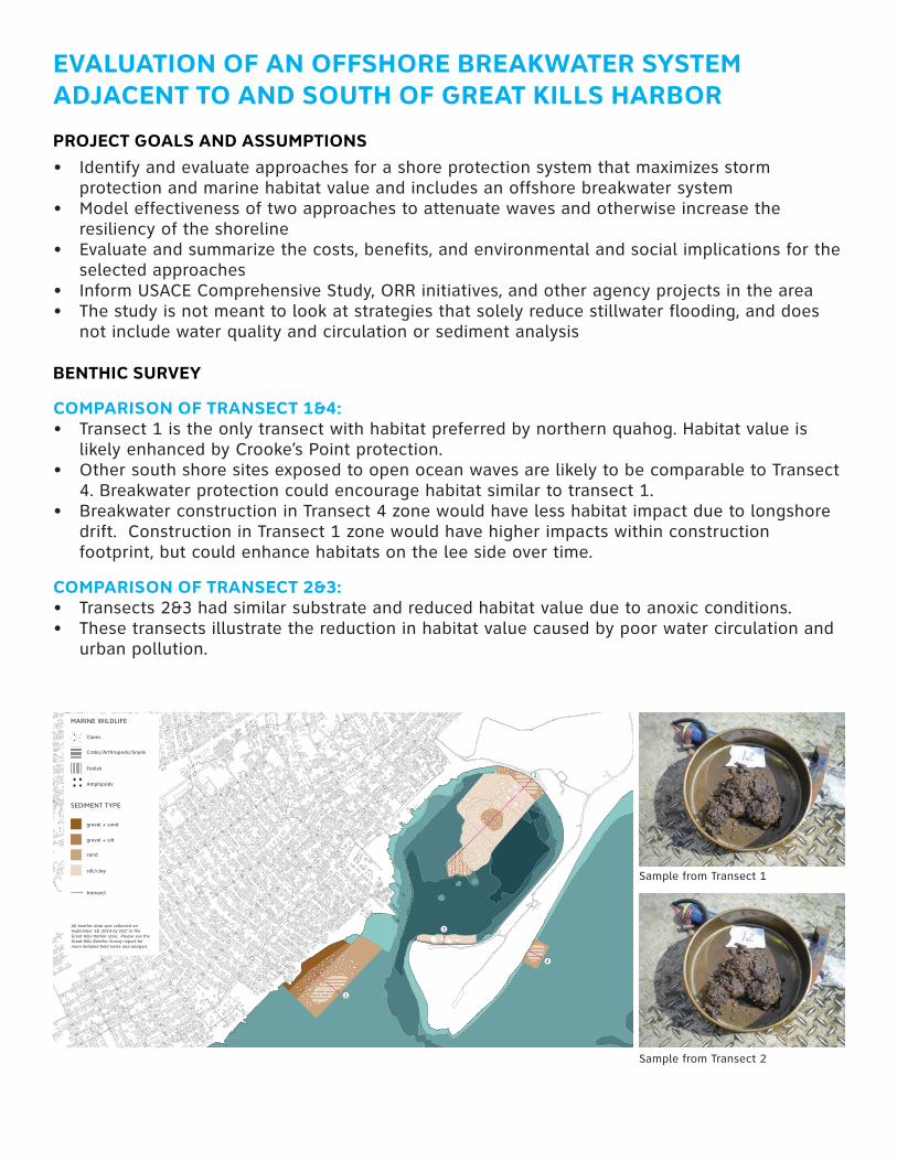
BENTHIC SURVEY
COMPARISON OF TRANSECT 1&4: • Transect1istheonlytransectwithhabitatpreferredbynorthernquahog.Habitatvalueis
likelyenhancedbyCrooke’sPointprotection.• OthersouthshoresitesexposedtoopenoceanwavesarelikelytobecomparabletoTransect
4.Breakwaterprotectioncouldencouragehabitatsimilartotransect1.• BreakwaterconstructioninTransect4zonewouldhavelesshabitatimpactduetolongshore
drift.ConstructioninTransect1zonewouldhavehigherimpactswithinconstructionfootprint,butcouldenhancehabitatsontheleesideovertime.
COMPARISON OF TRANSECT 2&3: • Transects2&3hadsimilarsubstrateandreducedhabitatvalueduetoanoxicconditions.• Thesetransectsillustratethereductioninhabitatvaluecausedbypoorwatercirculationand
urbanpollution.
1
2
3
4
MARINE WILDLIFE
Clams
Crabs/Arthropods/Snails
Finfish
Amphipods
gravel + sand
gravel + silt
sand
silt/clay
All benthic data was collected on September 18, 2014 by OCC in the Great Kills Harbor area. Please see the Great Kills Benthic Survey report for more detailed field notes and analysis.
SEDIMENT TYPE
transect
SamplefromTransect1
SamplefromTransect2
Nor’eastermodelingresults,toprow:option0,option1,option2Sandymodelingresults,bottomrow:option0,option1,option2
DESIGN CONCLUSIONS
CROOKE’S POINTactsasaneffectivewaveattenuatorfortheharborinteriorforstormgeneratedwaves.Localwindgeneratedwavescanbeeffectivelymitigatedthroughwavesscreensorcomparablestructures.ThepointiscurrentlymigratingtothesouthintotheUSACEfederalchannel,whichwasdredgedin2014.Couldconsidermovingthechannelsouthwardtoallowpeninsulamigrationtoprovideadditionalprotection.
NICHOLS MARINAwasshowntobeprotectedbyCrooke’sPointandnotimpactedbyoffshorewaves.On-shoreandoffshorestrategiescouldhaveerosionandotherstormprotectionbenefits.
CRESCENT BEACHisvulnerabletostorm-generatedwaves.Neitheroptionstudiedwasoptimal,howeverlessonscanbelearnedfromboth:
-Effectivewaveattenuationcanbe providedbybreakwatersintheCrescentBeacharea
-Option1providesmoreprotectiontosmallersectionofshoreline.
-Option2provideslessprotection,mostlyduetothesizeofthegapsinthebreakwaterdesign.
OPTION 2 BREAKWATER ALIGNMENT
1/10mile
250ft
varia
ble
(73
- 94
ft)
600
ft
EXPOSED BREAKWATER UNDERWATER BREAKWATER FOOTPRINT 11’ NAVD88 height 16’ crest width
DUNE
14’ NAVD88
0.25 0.50.125
miles
N
OPTION 1BREAKWATER ALIGNMENT EXPOSED BREAKWATER UNDERWATER BREAKWATER FOOTPRINT 11’ NAVD88 height 16’ crest width
1/4 mile
1450
ft
600 ft
450 ftfrom channel
1/10mile
1400
ft
0.25 0.50.125
miles
N
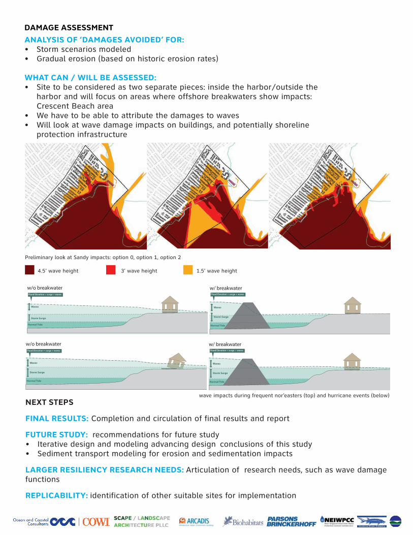
DAMAGE ASSESSMENT
ANALYSIS OF ‘DAMAGES AVOIDED’ FOR: • Stormscenariosmodeled• Gradualerosion(basedonhistoricerosionrates)
WHAT CAN / WILL BE ASSESSED:• Sitetobeconsideredastwoseparatepieces:insidetheharbor/outsidethe
harborandwillfocusonareaswhereoffshorebreakwatersshowimpacts: CrescentBeacharea
• Wehavetobeabletoattributethedamagestowaves• Willlookatwavedamageimpactsonbuildings,andpotentiallyshoreline
protectioninfrastructure
PreliminarylookatSandyimpacts:option0,option1,option2
4.5’waveheight 3’waveheight 1.5’waveheight
NEXT STEPS
FINAL RESULTS:Completionandcirculationoffinalresultsandreport
FUTURE STUDY: recommendationsforfuturestudy• Iterativedesignandmodelingadvancingdesignconclusionsofthisstudy• Sedimenttransportmodelingforerosionandsedimentationimpacts
LARGER RESILIENCY RESEARCH NEEDS: Articulationofresearchneeds,suchaswavedamagefunctions
REPLICABILITY: identificationofothersuitablesitesforimplementation
Storm Surge
Normal Tide
Normal Tide
Waves
Storm Surge
Waves
Flood Elevation = surge + waves
Flood Elevation = surge + waves
w/o breakwater
w/ breakwater
Storm Surge
Normal Tide
Normal Tide
Waves
Storm Surge
Waves
Flood Elevation = surge + waves
Flood Elevation = surge + waves
w/o breakwater
w/ breakwater
Storm Surge
Normal Tide
Normal Tide
Waves
Storm Surge
Waves
Flood Elevation = surge + waves
Flood Elevation = surge + waves
w/o breakwater
w/ breakwater
Storm Surge
Normal Tide
Normal Tide
Waves
Storm Surge
Waves
Flood Elevation = surge + waves
Flood Elevation = surge + waves
w/o breakwater
w/ breakwater
waveimpactsduringfrequentnor’easters(top)andhurricaneevents(below)