Embed Size (px)
Citation preview
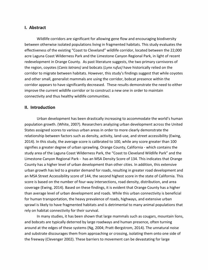
Evaluating Wildlife Use in the Coast to
Cleveland Wildlife Corridor in Orange County
UCLA Environmental Science Practicum 2015-2016
Client: Laguna Greenbelt, Inc.
Team Members: Austin Avan, Caleb Chi, Lauren Gray, Matthew Im, Megan Reed,
Alyssa Worsham
Advisor: Debra Shier
I. Abstract
Wildlife corridors are significant for allowing gene flow and encouraging biodiversity
between otherwise isolated populations living in fragmented habitats. This study evaluates the
effectiveness of the existing “Coast to Cleveland” wildlife corridor, located between the 22,000
acre Laguna Coast Wilderness Park and the Limestone Canyon Regional Park, in light of recent
redevelopment in Orange County. As past literature suggests, the two primary carnivores of
the region, coyotes (Canis latrans) and bobcats (Lynx rufus) have historically relied on the
corridor to migrate between habitats. However, this study’s findings suggest that while coyotes
and other small, generalist mammals are using the corridor, bobcat presence within the
corridor appears to have significantly decreased. These results demonstrate the need to either
improve the current wildlife corridor or to construct a new one in order to maintain
connectivity and thus healthy wildlife communities.
II. Introduction
Urban development has been drastically increasing to accommodate the world’s human
population growth. (White, 2007). Researchers analyzing urban development across the United
States assigned scores to various urban areas in order to more clearly demonstrate the
relationship between factors such as density, activity, land-use, and street accessibility (Ewing,
2014). In this study, the average score is calibrated to 100, while any score greater than 100
signifies a greater degree of urban sprawling. Orange County, California - which contains the
study area of the Laguna Coast Wilderness Park, the “Coast to Cleveland Wildlife Park” and the
Limestone Canyon Regional Park - has an MSA Density Score of 134. This indicates that Orange
County has a higher level of urban development than other cities. In addition, this extensive
urban growth has led to a greater demand for roads, resulting in greater road development and
an MSA Street Accessibility score of 144, the second highest score in the state of California. This
score is based on the number of four-way intersections, road density, distribution, and area
coverage (Ewing, 2014). Based on these findings, it is evident that Orange County has a higher
than average level of urban development and roads. While this urban connectivity is beneficial
for human transportation, the heavy prevalence of roads, highways, and extensive urban
sprawl is likely to have fragmented habitats and is detrimental to many animal populations that
rely on habitat connectivity for their survival.
In many studies, it has been shown that large mammals such as cougars, mountain lions,
and bobcats are typically deterred by large roadways and human presence, often turning
around at the edges of these systems (Ng, 2004; Pratt-Bergstrom, 2014). The unnatural noise
and substrate discourages them from approaching or crossing, isolating them onto one side of
the freeway (Clevenger 2002). These barriers to movement can be devastating for large
carnivorous species such as mountain lions because they require such an expansive territory –
200 square km for males and 75 for females (Jao, 2015). Additionally, since they are typically
solitary animals with non-overlapping home ranges, males may kill other mountain lions that
wander into their territory (Jao, 2015). When these types of carnivores experience barriers to
movement and are restricted to an area below its home range requirements, the genetic
effects of small populations such as inbreeding depression and genetic drift can occur,
ultimately reducing that species’ diversity and fitness. In the Santa Monica Mountains, for
example, mountain lion populations are so low that the mortality of even one individual can
severely impact genetic diversity to the point of threatening the collapse of the entire
population (Jao, 2015).
In a recent study by the United States Geological Survey, bobcat home ranges within
Orange County were studied and mapped using GPS-collars and camera traps. Overall, it was
found that human-induced barriers prevented mobility between sections in this area (Alonso,
2008). Bobcats were often observed approaching the side of a highway before ultimately
turning around and returning the way it had come. While there were many attempts by wildlife
to cross to the freeway, very few were documented successfully making it across the freeway to
the natural habitat on the other side (Alonso, 2008). A similar study indicated that human
activity is one of the main deterrences to movement for a large range of animals, including
coyotes and mountain lions (Trombulak, 2001). In general, natural vegetation, substrate, and
lighting, in addition to limited roads and human activity, have proved to be most effective at
successfully promoting habitat connectivity between fragmented regions (Barnum, 2003; Mass
Highway, 2009). These studies are critical in determining where and how wildlife will traverse
anthropogenic road systems.
Since the initial construction of the nation’s interstate highway systems in the 1950s,
road systems have greatly impacted much of the valuable natural habitat necessary for many
species’ survival (White, 2007). Roads can impede migration, fragment populations, and
separate animals from their food and other resources, thus contributing to habitat loss for
many animals (Jackson “Overview”, 2000). This significant contribution to habitat loss and
fragmentation can result in large declines in population density for many species (Jaeger &
Bowman, 2004; Forman et al, 2003; Forman, 1998).
It is clear that the influence of roads is high, especially in densely human populated
cities where wildlife habitats are smaller and more spread out due to urban development,
habitat destruction and degradation, and fragmentation. Another major impact that roads have
on wildlife is increasing mortality among wildlife populations due to direct collisions (Gibbs,
2002). Fences and highway walls are a common approach to deter wildlife from entering roads.
While this helps to decrease wildlife mortality, it also further contributes to population and
habitat fragmentation (Jaeger and Fahrig, 2004). The ability to move between fragmented
habitats can be imperative to certain species survival, and thus, wildlife corridors and crossings
are vital for the health of many animal populations (Cavallaro, 2005). There are many types of
wildlife crossings, which is the broad term for paths by which animals can cross manmade
barriers and obstacles, such as roads or highways (Barnum, 2003). These help to minimize the
effects of habitat fragmentation by connecting habitats separated by urban barriers.
Due to the heavy urban development in Orange County, our targeted study area is the
existing “Coast to Cleveland” wildlife corridor that connects the Laguna Coast Wilderness Park
with the inland Limestone Canyon Regional Park in the Cleveland National Forest. This six mile
long corridor, which was originally a drainage path, was adapted as a means to allow wildlife to
pass through areas of heavy urban development and to keep a connection between these two
larger areas of natural habitat. Following the path of the San Diego Creek bed, wildlife must
travel along a revegetated path before ultimately crossing under the I-5 highway via an unlit
corridor.
Unfortunately, it is unclear whether animal species are making it under the I-5 highway
to reach the inland habitat. In a 2007 study conducted by the USGS, they found that bobcats
were deterred from advancing past the southwestern side of the I-5 and were failing to
successfully cross to the inland side of the highway. Since the completion of this study, there
has been extensive redevelopment in the area, potentially affecting wildlife movement along
this designated corridor. Despite this recent development, there has been little research to
determine whether or not species are utilizing this pathway and thus, a reassessment of the
corridor is necessary. Tt is critical that connectivity between the Laguna Greenbelt and
Limestone Canyon is successful because it contributes so heavily to the longevity and overall
survival of many species living in the study area (Harry Huggins, Director, Laguna Greenbelt, inc,
pers. comm). It is imperative to provide an easily accessible route from one habitat to the other
in order to increase the overall area of viable territory for large mammals and to preserve gene
flow and population diversity. This study aims to determine exactly how this wildlife corridor
functions: if species use this corridor to travel between habitats and if so, which species are
utilizing it the most.
III. Research Questions
After careful consideration of the client’s interest and information from our field
surveys, we have developed three questions that we would like to address with our project.
Due to the nature of the issue, our research questions are arranged in a hierarchical order.
They are, as follows:
1. Are bobcats and coyotes using the existing wildlife corridor?
2. If they are using it, how far are they traveling before turning around?
3. Are there specific portions of the corridor in which many animals are averse to?
First, we want to address whether the corridor is still being used by wildlife after the
recent redevelopment of Irvine. We predict that the animals are partially using the wildlife
corridor, but we would like to confirm this for bobcats and other species of interest.
If wildlife are in fact using the tunnel, knowing the areas of the wildlife corridor in which
animals are most likely to turn back will aid us in identifying specific bottleneck locations within
the corridor where animals show the most aversion. For the purposes of this study, we will not
explore why animals are failing to travel through the entire corridor but for future research, we
have several hypotheses:
1. Wildlife cannot see the end of the tunnel due to curves found within the corridor.
Since wildlife prefer a clear line-of-sight, they are averse to using that part of the corridor.
2. Diurnal species may have a preference for well-lit areas and the lack of sufficient
lighting within the tunnel may impact corridor usage for diurnal species, while it should not
impact nocturnal species.
3. Significant human presence in the culvert, as exemplified by empty cans and graffiti,
is repelling animals from continuing through this part of the corridor.
4. Because the corridor was originally designed and co-opted onto an existing flood-
control system, wildlife are averse to using the corridor during rainstorms when areas such as
the culvert are almost completely flooded from water.
Although we cannot predict which, if any, of the hypotheses may explain why wildlife
are averse to using the corridor, we expect that by answering our questions, we can accurately
assess the effectiveness of the existing corridor for wildlife movement and connectivity.
IV. Methodology
Study Site
The study site is the Serrano Creek leading up to the I-5 freeway at Bake Parkway in
Irvine, California. This area is the main crossing between the 22,000 acres of the Laguna
Greenbelt nature preserve and the 120,000 acres of the Limestone Canyon in Cleveland
National Park (Figure 1). In addition to the I-5 undercrossing, a field survey led to the
identification of three additional potential barriers to crossing between the natural areas, all
along the Serrano creek. These three choke points are located at Lake Forest Drive, Irvine
Center Drive, and Research Drive. These are all roads with adjacent human development which
may hinder wildlife crossing. We used both camera-traps and track-pads in order to increase
the probability of capturing wildlife presence in the study area.
Camera-Traps
We installed a total of 18 Cuddeback infrared, motion sensor cameras. These cameras
are ‘no flash’ and have the capability to record up to thirty seconds of video after being
triggered, providing information about presence/absence and behavior. The cameras take eight
AA batteries and are equipped with 32 GB memory cards. We affixed the cameras either to
trees, nearby metal protrusions, or to wooden stakes approximately 24-30 inches above the
ground. Because of the exposed visibility of the cameras in urban areas, one camera was
equipped with a lock to prevent theft after some cameras were stolen. Each of the potential
road barriers (Lake Forest Drive, Irvine Center Drive, and Research Drive) was equipped with
four cameras - two on each side - for a total of twelve cameras. Two cameras were also placed
at the entrance to the culvert near the I-5 freeway. Additionally, we placed one camera
midway between each barrier for a total of three cameras as well as one camera in the culvert
running perpendicular to the North Serrano Creek. Data collection occurred every week on
Friday, during which time the field team exchanged memory cards and checked to ensure that
the batteries were functioning. Images and videos were backed up immediately on an external
hard drive to prevent any data loss. Data collection started on March 11 and ended on May 13
however camera placement was staggered throughout this time due to permitting delays. The
total time of data collection ranged from 2-6 weeks depending on location.
Track-Pads
In addition to the camera traps, we utilized track-pads to increase the probability of
capturing wildlife movement. These track-pads (1 x 1 m) were constructed with wooden
frames. The target species of interest are bobcats and coyotes, thus larger, uncovered
trackpads are necessary. Data collection occurred during the rainy season, which made the dirt
in these areas relatively impressionable. For this reason, we had originally chose to use the
natural substrate rather than a petroleum and sand mixture, which is often used in trackpad
studies over hard substrates. However, after initial data collection began we found that the silt
in the area was too fine to reliably capture tracks and we replaced the substrate with thick-
grained construction grade sand mixed with water. We placed a total of eleven track-pads. Each
of the barriers were equipped with two track-pads, one on either side of the barrier. Three
additional track-pads were placed between barriers. Data collection occurred every week on
Friday, coinciding with camera check-up times. The field team took a picture from above of the
track-pad, if tracks were present, and then wiped the substrate flat. Any pictures with clear,
defined tracks were sent for identification to the local wildlife tracks organization, Orange
County Trackers.
V. Results
There were a total of 436 wildlife sightings from the seventeen usable cameras at the
end of the study. Eight species in total were detected throughout the trapping period: coyotes
(Canis latrans), bobcats (Lynx rufus), desert cottontails (Sylvilagus audubonii), raccoons
(Procycon lotor), dusky-footed woodrats (Neotoma fuscipes), California ground squirrels
(Otospermophilus beecheyi), fox squirrels (Sciurus niger) and humans (Homo sapiens). The two
target species of interest are bobcats and coyotes. 397 of the 436 total sightings were
composed of target species sightings. Of these, 396 of the sightings were coyotes while only
one sighting was that of a bobcat.
There was approximately eighty sightings per week throughout the eleven locations.
The locations with large numbers of sightings were at barrier bottlenecks. Location 6, located in
a tunnel, had zero sightings while Location 1, which is near the Laguna Coast Wilderness Park,
had the plurality of target species sightings. Notably, it was also the location where the single
bobcat was seen. 68.3% of animal sightings occurred between sunset and sunrise while 83.3%
of human sightings also occurred within this time. There is a moderate negative correlation
between the percentage of daytime animal activity and total daytime human sightings.
Among the other species captured by the cameras, there were, in total: 28 cottontails,
4 raccoons, 4 squirrels, 3 woodrats, and 24 humans. Small mammal sightings are noticeably
fewer at each location, when compared to the number of target species sightings. The data for
the results were gathered solely from the camera traps as the trackpads failed to collect prints
due to inadequate silty substrate.
Below are collaborated summarized results from the data period, with the two targeted species
of interest being bobcats and coyotes.
VI. Discussion
As seen by the results, there is a moderate negative correlation between the times of
greatest human daytime activity and that of animals. This can explain why the wildlife, with the
exception of squirrels, seem to be using the corridor more during the night. However, if the
time of day is disregarded, there is a weak positive correlation between human and animal
sightings. This is slightly unexpected as we thought there might be a negative correlation
between the two. This could be because human activity was fairly random and low density. The
highest density of target animals was also at Location 1 whereas the highest density of humans
was at Location 11, which are on opposite ends of the corridor. However, this information does
not disregard the clear human presence throughout the corridor in the forms of heavy graffiti,
litter, and incidents where our cameras were stolen. The impact of human presence is also
supported by the moderate negative correlation stated above.
Wildlife were sighted at ten of the eleven locations. Locations 1, 5, 8, and 11 have the
most sightings and from the map, all of these locations are placed a fair distance from each
other throughout Serrano Creek. Location 1 is at the entrance of the corridor while Location 11
is the last part of Serrano Creek before it enters the I-5 freeway. This appears to suggest that
the wildlife are using the full length and expanse of the corridor despite redevelopment of the
area. However, it is important to consider that this does not mean that the corridor is
functioning as intended. There is still uncertainty whether the corridor is successfully
facilitating gene flow between populations. There is also the matter of the unknown impact on
specialist species. Coyotes are generalist species and can adapt to urban environments. For
example, coyotes are diurnal but from our study, it is clear that coyotes have shifted to a more
nocturnal lifestyle to avoid human presence. Bobcats, though, are specialist species.
However, this is not to say that there are no problems with coyotes. Several videos at
Location 8 have shown coyotes staring at a large grate over a culvert and then turning and
walking away instead of attempting to slip through. More concerning is the species
composition of the detected wildlife. A vast majority of the total sightings are of coyotes, which
was one of our target species. This indicates that the local coyote population has continued to
utilize the wildlife corridor despite recent development, which is consistent with existing
literature that states the coyotes are able to persist even in heavily developed areas.
Unfortunately, the cameras were only able to capture one bobcat. It appears even more poorly
in contrast to the last major study done in this area, the 2007 USGS Bobcat Study, which geo-
tracked the movements of a number of bobcats and coyotes, to a lesser extent.
The USGS Study, whose study site overlapped with our study in the coastal area of the
405/5 freeway, had 47 bobcat sightings in 8 months. The authors also commented that several
bobcats and coyotes suffered mortalities after encountering increased human presence due to
the start of redevelopment in Orange County. Nine years later and our study has only camera-
trapped one bobcat in two months of study. Bobcats are solitary and have a large home range
and even if our study site included the range of only one bobcat, it should have been multiple
times, not just once. This illustrates that increased redevelopment since 2007 has had an
impact on the bobcat populations. While coyotes may have survived in urban areas, due to
their generalist natures, bobcats might have had more difficulties in passing through the more
urbanized wildlife corridor which accounts for their significant reduction in the corridor.
Generalist species, which can do well in human-caused habitat fragmented areas, are
the primary users of the corridor as evidenced by the numbers of coyotes, raccoons, and
squirrels. Specialist species, such as bobcats, woodrats, and cottontails tend to have more
difficulties when encountering urbanization and significant human presence. One concept to
consider is the vegetation of the corridor and its ends. The primary vegetation type of the
Laguna Coast Wilderness Park near the corridor is coastal sage scrub whereas that of the
Limestone Canyon on the inland end of the corridor is coastal sage scrub and chaparral.
However, the corridor itself was revegetated heavily with riparian vegetation, which is suitable
for running along creek beds. Perhaps the difference in vegetation is negatively impacting the
corridor for specialist species like bobcats.
In order to better understand the ineffectiveness of the wildlife corridor for bobcats,
expanded studies are needed. One study that may be useful would be to camera-trap the area
around the I-5 freeway in order to see if wildlife are successfully making their way completely.
From our video at Location 8, coyotes are facing an increasing number of difficulties such as
grates and other obstacles that come with more human development. Another potential study
we recommend would be looking into either investing in the new, proposed wildlife corridor or
to invest in a renovation of the existing wildlife corridor to assist the wildlife attempting to
cross. Studying the effects of a new corridor might benefit fragmented wildlife communities.
With the study concluded, we have four recommendations. First, clear and specific
goals must be needed before proposing any changes to the corridor. Is the corridor designed
for generalist or specialist species? Is the corridor designed for all species or only medium-sized
wildlife? Specific details are crucial before garnering enough political capital to justify any
changes to the corridor. Second, the continuation of the camera trap study needs to
incorporate trapping on both sides of the 5 freeway as well as GPS trapping in order to see if
animals are moving continuously throughout the habitats of the corridor. Such telemetry data
will be very useful in any corridor renovation proposals. Third, stronger barriers are needed
along the corridor to keep humans out and to keep the wildlife in. The USGS study commented
that bobcats were getting killed while attempting to use the streets and roads so appropriate
fencing might reduce such casualties by forcing the bobcats to use the corridor instead of the
road. Finally, it would be ideal to widen the corridor or to create a flyover to buffer humans as
well as expand the coastal sage scrub habitat. Species would be more inclined to live along the
corridor if the habitat had their preferred vegetation type, in this case, coastal sage scrub.
However, coastal sage scrub does not grow well in tunnels or major drainage areas so this
would require major infrastructure development for the corridor.
VII. Literature Cited
Alonso, R.S., Boydston, E.E., Crooks, K.R., & Lyra, L.M. (2008). “Evaluation of Functional
Connectivity for Bobcats and Coyotes Across the Former El Toro Marine Base, Orange County,
California.” USGS: Science for a Changing World.
Ancrenaz, M., Hearn, A., Ross, J., Sollmann, R., & Wilting, A. (2012). “Handbook for wildlife
monitoring using camera traps.” BBEC.
Barnum, Sarah A. (2003). "Identifying the Best Locations Along Highways to Provide Safe
Crossing Opportunities for Wildlife." Department of Transportation Research. Colorado Branch
of Transportation Research Branch.
Beier, P., Majka, D., Newell, S., Garding, E., & Northern Arizona University (2008). “Best
Management Practices for Wildlife Corridors.”
Bond, M. (2003). “Principles of Wildlife Corridor Design.” Center for Biological Diversity.
Brudin III, C.O. (2003). “Wildlife use of existing culverts and bridges in north central
Pennsylvania.” Road Ecology Center.
Lindsey, C., Sanden, K., Schellhase, J., & Tanaka, M. (2005) "Designing Road Crossings for Safe
Wildlife Passage: Ventura County Guidelines." Donald Bren School of Environmental Science and
Management. University of California: Santa Barbara.
Cerqueira, Rui, Loretto, D., Olifiers, N., & Rademaker, V. (2011). “Comparing the effectiveness
of tracking methods for medium to large-sized mammals of Pantanal.” ZOOLOGIA, 28(2): pp
207–213.
Chandler, R.B., Gardner, B., Andrew, R.J., & Sollmann, R. (2014). “Spatial Capture-Recapture.”
Academic Press.
Clevenger, A.P. & Sawaya, M.A. (2010). “Piloting a Non-Invasive Genetic Sampling Method for
Evaluating Population-Level Benefits of Wildlife Crossing Structures.” Ecology and Society 7th
series, 15(1).
Clevenger, A.P., Chruszcz, B., & Gunson, K. (2002). “Drainage culverts as habitat linkages and
factors affecting passage by mammals”. Journal of Applied Ecology, 38(6): pp 1340-1349.
Coffin, A.W. (2007). “From roadkill ecology: A review of the ecological effects of roads.” Journal
of Transport Geography, 15(5): pp 396-406.
County of Orange (1996). “Natural Community Conservation Plan & Habitat Conservation Plan,
County of Orange, Central & Coastal Subregion, Parts I & II: NCCP/HCP.” Prepared for County of
Orange Environmental Management Agency by R.J. Meaded Consulting, Inc.
Crooks, K.R. & Soule, M.E. (1999). “Mesopredator release and avifaunal extinctions in a
fragmented system.” Nature, 400: pp 563 - 566.
Delaney, K.S., Riley, S., & Fisher, R. (2010). “A Rapid, Strong, and Convergent Genetic Response
to Urban Habitat Fragmentation in Four Divergent and Widespread Vertebrates.” PLoS ONE,
5(9): e12767.
Ewing, R. & Hamidi, S. (2014). “Measuring Sprawl 2014.” Smart Growth America. Report.
Fischer, Joern, and David B. Lindenmayer. (2002). “The conservation value of paddock trees for
birds in a variegated landscape in southern New South Wales. 2. Paddock trees as stepping
stones.” Biodiversity & Conservation, 11(5): pp 833-849.
Fleury, Allison M., and Robert D. Brown. (1997). “A framework for the design of wildlife
conservation corridors with specific application to southwestern Ontario.” Landscape and
Urban Planning, 37(3): pp 163-186.
Ford, A.T., Clevenger, A.P. & Bennett, A. (2009). “Comparison of Methods of Monitoring
Wildlife Crossing-Structures on Highways.” The Journal of Wildlife Management, 73(7): pp
1213-222.
Foresman, K.R., & Pearson, D.E. (1998). “Comparison of Proposed Survey Procedures for
Detection of Forest Carnivores.” The Journal of Wildlife Management, 62(4): pp 1217.
Forman, R.T. (1998). “Road ecology: A solution for the giant embracing us.” Landscape Ecology,
3(5).
Forman, R. & Deblinger, R.D. (2001). “The Ecological Road-Effect Zone of a Massachusetts (USA)
Suburban Highway.” Conservation Biology, 14(1).
Forman, R., Sperling, D., Bissonette, J.A., Clevenger, A.P., Cutshall, C.D., Dale, V.H., Fahrig, L.,
France, R., Goldman, C.R., Heanue, K., Jones, J.A., Swanson, F.J., Turrentine, T., & Winter, T.C.
(2003). “Road ecology: science and solutions.” Island Press.
Gese, E.M., Bekoff, M., Andelt, W., Carbyn, L., & Knowlton, F. (2008). “Canis Iatrans.” The IUCN
Red List of Threatened Species 2008.
Gibbs, J.P. & Shriver, G.W. (2002). “Estimating the Effects of Road Mortality on Turtle
Populations.” Conservation Biology, 16(6): pp 1647- 1652
Glennon, M.J., Porter, W.F., & Demers, C.L. (2002). “An Alternative Field Technique For
Estimating Diversity Of Small-Mammal Populations.” Journal of Mammalogy, 83(3): pp 734-42.
Government of the United States. (2007). “Proposal for deletion of Lynx rufus from Appendix
II.” CITES CoP14 Prop 2.
Gužvica, G., Bošnjak, I., Bielen, A., Babić, D., Radanović-Gužvica, B., & Šver, L. (2014).
“Comparative Analysis of Three Different Methods for Monitoring the Use of Green Bridges by
Wildlife.” PLoS ONE, 9(8).
Hanson, C.C., Bonham, J.E., Campbell, K.J., Keitt, B.S., Little, A.E., & Smith, G. (2010). “The
Removal of Feral Cats from San Nicolas Island: Methodology.” University of California, Davis, pp
72-78.
Hilty, J. A., Lidicker, W.Z, & Merenlender, A. (2006). “Corridor ecology: the science and practice
of linking landscapes for biodiversity conservation.” Island Press.
Jackson, S.D. (2000). “A Strategy for Mitigating Highway Impacts on Wildlife.” Wildlife and
Highways: Seeking Solutions to an Ecological and Socio-economic Dilemma, pp. 143-159.
Jackson, S.D. (2000). “Overview of transportation impacts on wildlife movement and
populations.” Wildlife and Highways Seeking Solutions to an Ecological and Socio-economic
Dilemma, pp 7-20.
Jaeger, J., Bowman, J., & Brennan, J. (2004). “Predicting when an animal population is at risk
from roads: an interactive model of road avoidance behavior.” Ecological Modeling, 185(2-4):
pp 329-348.
Jaeger, J. & Fahrig, L. (2004). “Effects of Road Fencing on Population Persistence.” Conservation
Biology, 18(6): pp 1651-1657.
Jao, C. (2015). “Walk on the wild side: the multimillion- dollar freeway crossing aiming to give
California’s cougars the space they need.” Rockerfeller Foundation.
Karanth, K. (1995). “Estimating tiger Panthera tigris populations from camera-trap data using
capture--recapture models.” Biological Conservation, 71(3): pp 333-338.
Kautz, R.S., Bittner, S.R, & Logan, T.H. (2010). “Wildlife Crossing Handbook.” BDA Environmental
Consultants.
Keller, I. & Largiader, C.R. (2003). “Recent habitat fragmentation caused by major roads leads to
reduction of gene flow and loss of genetic variability in ground beetles.” The Royal Society,
270(1513).
Kelly, M., Caso, A. & Lopez Gonzalez, C. (2008). “Lynx rufus.” The IUCN Red List of Threatened
Species 2008.
Kusak, J., Huber, D., Gomerčić, T., Schwaderer, G., & Gužvica, G. (2008). “The Permeability of
Highway in Gorski Kotar (Croatia) for Large Mammals.” European Journal of Wildlife Research,
55(1): pp 7-21.
Lantschner M.V., Rusch V. & Hayes J.P. (2012). “Habitat use by carnivores at different spatial
scales in a plantation forest landscape in Patagonia, Argentina.” Forest Ecology and
Management, 269: pp 271-278.
Levey, D.J., et al. (2005). “Effects of landscape corridors on seed dispersal by birds.” Science,
309(5731): pp 146-148.
Levi, T. & Wilmers, C.C. (2012). “Wolves-coyotes-foxes: a cascade among carnivores.” Ecology,
93(4): pp 921-929.
“LGB Speaks About Corridors at SCAG” (2016). A Little Laguna History. Coast to Cleveland:
Wildlife Corridor. Blog.Litvaitis, J. & Harrison, D. (1989). “Bobcat-coyote niche relationships
during a period of coyote population increase.” Canadian Journal of Zoology, 67: pp 1180-1188.
Long, R.A. , MacKay, P., Ray, J., & Zielinski, W. (2008). “Noninvasive Survey Methods for
Carnivores.” Island Press, pp 1-31.
Massachusetts Department of Transportation. (2006). “Wildlife Accommodation.” Mass
Highway. Design Guide.
Mateus, A.R., Grilo, C., & Santos-Reis, M. (2010). “Surveying Drainage Culvert Use by
Carnivores: Sampling Design and Cost–benefit Analyzes of Track-pads vs. Video-surveillance
Methods.” Environmental Monitoring and Assessment, 181(1-4): pp 101-09.
McDonald, R.I., Kareiva, P., & Forman, R. (2008). “The implications of current and future
urbanization for global protected areas and biodiversity conservation.” Biological Conservation,
141: pp 1695-1703.
McKinney, M.L. (2002). “Urbanization, Biodiversity, and Conservation.” BioScience, 52(10): pp
883-890.
Meek, P.D. & Pittet, A. (2012). “User-based design specifications for the ultimate camera trap
for wildlife research.” Wildlife Research, 39(8), pp 649-660.
Meese, R.J., Shilling, F.M., & Quinn, J.F. (2009). “Wildlife Crossings Guidance Manual.” California
Department of Transportation.
Moore, G.C. & Parker, G.R. (1992). “Colonization by the eastern coyote (Canis latrans).” Ecology
and management of the eastern coyote. Edited by A.H. Boer, Wildlife Research Unit, University
of New Brunswick, pp 23-37.
Moruzzi, T.L., Fuller, T.K., Degraaf, R.M., Brooks, R.T. & Li, W. (2002). “Assessing remotely
triggered cameras for surveying carnivore distribution.” Wildlife Society Bulletin, 30: pp 380-
386.
Newmark, W.D. (1993). “The role and design of wildlife corridors with examples from
Tanzania.” Ambio, pp 500-504.
Ng, S.J., Dole, J.W., Suavajot, R.M., Riley, S., & Volone, T.J. (2004). “Use of highway
undercrossings by wildlife in southern California.” Biological Conservation, pp 499-507.
Pereira, P. et al. (2012). “Coexistence of carnivores in a heterogeneous landscape: habitat
selection and ecological niches.” Ecological Research, 27(4): pp 745-753.
Pratt-Bergstrom, B. (2014). “Good News for Los Angeles Mountain Lions! CalTrans Pursuing
Wildlife Crossing.” National Wildlife Federation.
Riley, S., Bromley, C., Poppenga R.H., Uzal, F.A., Whited, L., & Sauvajot, R.M. (2007).
“Anticoagulant Exposure and Notoedric Mange in Bobcats and Mountain Lions in Urban
Southern California.” Journal of Wildlife Management, 71(6): pp 1874-1884.
Riley, S., Pollinger, J.P., Sauvajot, R.M., York, E.C., Bromley, C., Fuller, T.K., & Wayne, R.K. (2006).
“FAST-TRACK: A southern California freeway is a physical and social barrier to gene flow in
carnivores.” Molecular Ecology, 15(7): pp 1733-1741
Riley, S., Sauvajot, R.M., Fuller, T.K., York, E.C., Kamradt, D.A., Bromley, C., & Wayne, R.K.
(2003). “Effects of Urbanization and Habitat Fragmentation on Bobcats and Coyotes in Southern
California.” Conservation Biology, 17(2): pp 566-576.
“Roadkill hot spots identified in California.” (2015). Biology Ecology. Phys.org
Rowcliffe J.M. et al. (2011). “Quantifying the sensitivity of camera traps: an adapted distance
sampling approach.” Methods in Ecology and Evolution, 2: pp 464-476.
Ruell, E.W., Riley, S., Douglas, M.R., Pollinger, J.P., & Crooks, K.R., (2009). “Estimating Bobcat
Population Sizes and Densities in a Fragmented Urban Landscape Using Noninvasive Capture-
Recapture Sampling.” Journal of Mammalogy, 90(1): pp 129-135.
Santos, S.M. (2013). “Relative Effects of Road Risk, Habitat Suitability, and Connectivity on
Wildlife Roadkills: The Case of Tawny Owls (Strix Aluco).” NCBI. US National Library of Medicine.
Sillero-Zubiri, C., Hoffmann, M. & Macdonald, D.W. (eds). (2004). “Canids: Foxes, Wolves,
Jackals and Dogs. Status Survey and Conservation Action Plan.” IUCN/SSC Canid Specialist
Group, IUCN, Gland, Switzerland and Cambridge, UK.
Sovada, M.A., Sargeant, A.B. & Grier, J.W. (1995). “Differential effects of coyotes and red foxes
on duck nest success.” Journal of Wildlife Management, 59: pp 1 - 9.
State of California. (2016). “State & Federally Listed Endangered & Threatened Animals of
California.” California Natural Diversity Database, Department of Fish and Game.
Taylor, C.A., & Raphael, M.G. (1988). “Identification of Mammal Tracks From Sooted Track
Stations in the Pacific Northwest.” California Department Fish and Game, 74(1): pp 4-15.
Thornton, D.H., Sunquist, M.E., & Martin, M.B. (2004). “Ecological Separation within Newly
Sympatric Populations of Coyotes and Bobcats in South-Central Florida.” Journal of
Mammalogy, 85(5): pp 973-982.
Tigas, L.A., Van Vuren, D.H., & Sauvajot, R.M. (2002). “Behavioral responses of bobcats and
coyotes to habitat fragmentation and corridors in an urban environment.” Biological
Conservation, 108(3): pp 299-306.
Trombulak, S.C. & Frissell, C.A. (2001). “Review of Ecological Terrestrial and Aquatic
Communities.” Conservation Biology, 14(1): pp 18-20.
USCB (2015). “California Quick Facts from the U.S. Census Bureau.” U.S. Census Bureau, State &
County Quick Facts. Web. 07 Dec 2015.
Vie, J., Hilton-Taylor, C., & Stuart, S.N. (2009). “Wildlife in a changing world: An analysis of the
2008 IUCN Red List of Threatened Species.” IUCN Publication.
White, Patricia A., 2007. “Getting Up to Speed: A conservationist’s guide to wildlife and
highways.” Defenders of Wildlife.
Wiewel, A.S., Clark, W.R., & Sovada, M.A. (2007). “Assessing Small Mammal Abundance With
Track-Tube Indices And Mark–Recapture Population Estimates.” Journal of Mammalogy, 88(1):
250-60.
Williams, J.C. (1998). “Delineating protected wildlife corridors with multi‐objective
programming.” Environmental Modeling & Assessment, 3(1-2): pp 77-86.
Yanes, M., Velasco, J.M., & Suarez, F. (1995). “Permeability of roads and railways to
vertebrates: The importance of culverts.” Biological Conservation, 71(3).
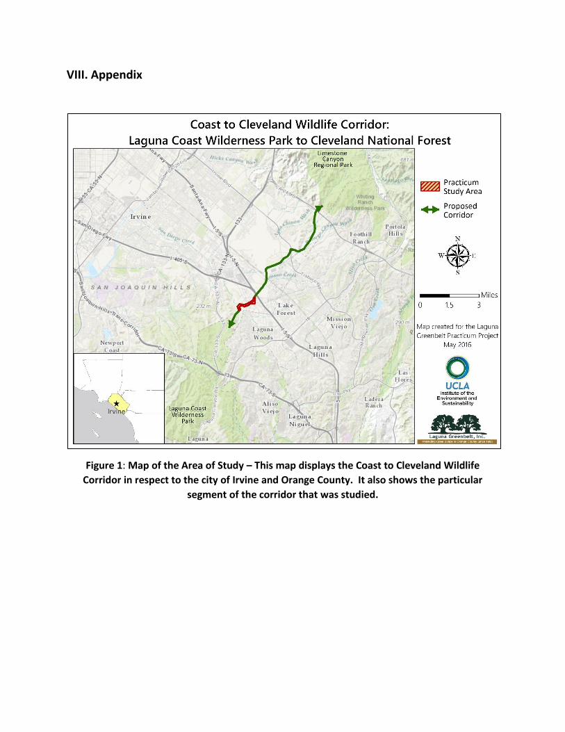
VIII. Appendix
Figure 1: Map of the Area of Study – This map displays the Coast to Cleveland Wildlife
Corridor in respect to the city of Irvine and Orange County. It also shows the particular
segment of the corridor that was studied.
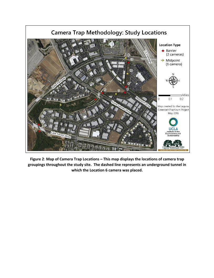
Figure 2: Map of Camera Trap Locations – This map displays the locations of camera trap
groupings throughout the study site. The dashed line represents an underground tunnel in
which the Location 6 camera was placed.
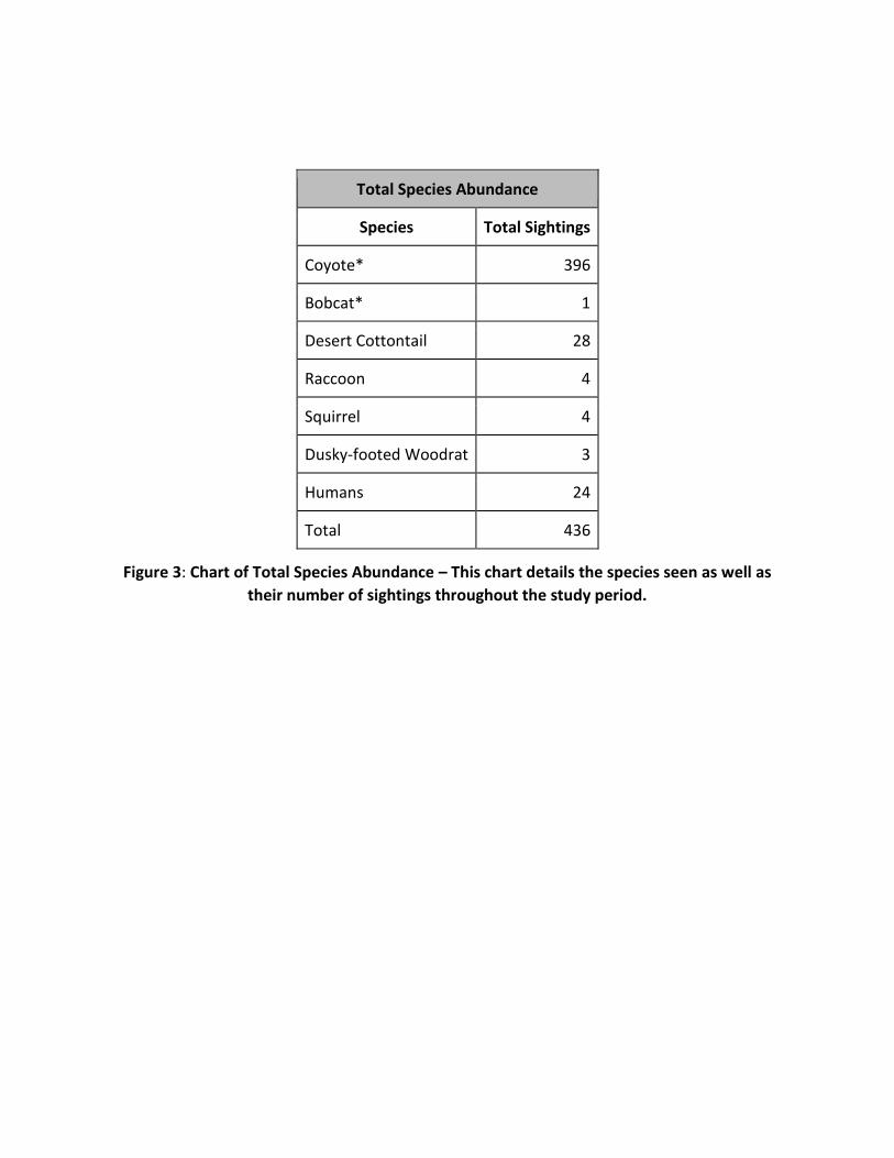
Total Species Abundance
Species Total Sightings
Coyote* 396
Bobcat* 1
Desert Cottontail 28
Raccoon 4
Squirrel 4
Dusky-footed Woodrat 3
Humans 24
Total 436
Figure 3: Chart of Total Species Abundance – This chart details the species seen as well as
their number of sightings throughout the study period.
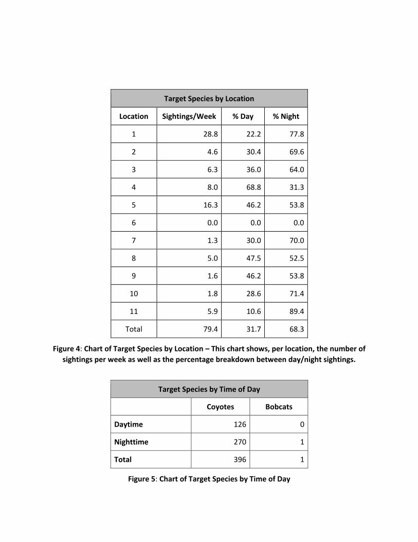
Target Species by Location
Location Sightings/Week % Day % Night
1 28.8 22.2 77.8
2 4.6 30.4 69.6
3 6.3 36.0 64.0
4 8.0 68.8 31.3
5 16.3 46.2 53.8
6 0.0 0.0 0.0
7 1.3 30.0 70.0
8 5.0 47.5 52.5
9 1.6 46.2 53.8
10 1.8 28.6 71.4
11 5.9 10.6 89.4
Total 79.4 31.7 68.3
Figure 4: Chart of Target Species by Location – This chart shows, per location, the number of
sightings per week as well as the percentage breakdown between day/night sightings.
Target Species by Time of Day
Coyotes Bobcats
Daytime 126 0
Nighttime 270 1
Total 396 1
Figure 5: Chart of Target Species by Time of Day
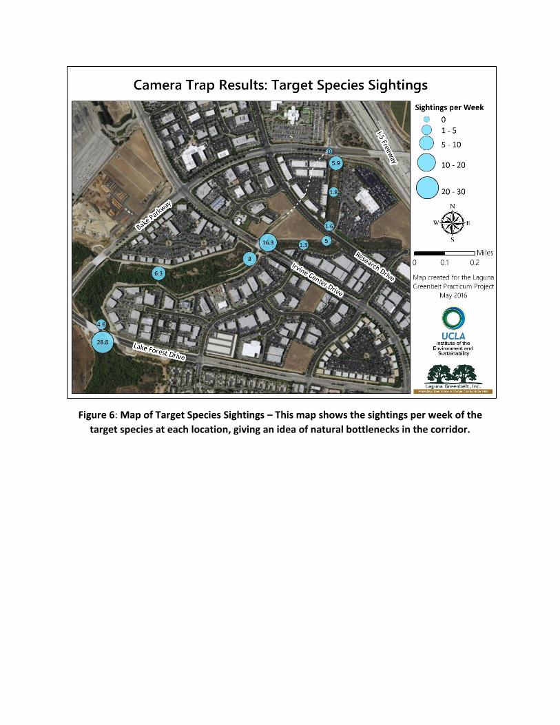
Figure 6: Map of Target Species Sightings – This map shows the sightings per week of the
target species at each location, giving an idea of natural bottlenecks in the corridor.
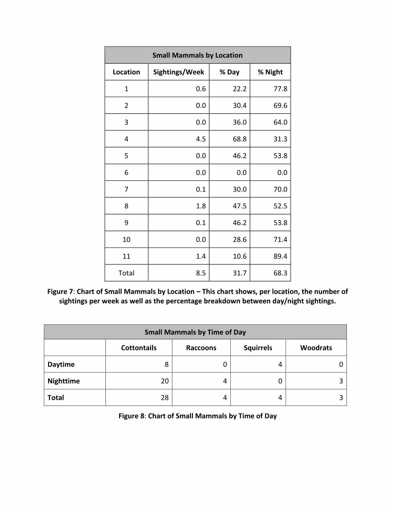
Small Mammals by Location
Location Sightings/Week % Day % Night
1 0.6 22.2 77.8
2 0.0 30.4 69.6
3 0.0 36.0 64.0
4 4.5 68.8 31.3
5 0.0 46.2 53.8
6 0.0 0.0 0.0
7 0.1 30.0 70.0
8 1.8 47.5 52.5
9 0.1 46.2 53.8
10 0.0 28.6 71.4
11 1.4 10.6 89.4
Total 8.5 31.7 68.3
Figure 7: Chart of Small Mammals by Location – This chart shows, per location, the number of sightings per week as well as the percentage breakdown between day/night sightings.
Small Mammals by Time of Day
Cottontails Raccoons Squirrels Woodrats
Daytime 8 0 4 0
Nighttime 20 4 0 3
Total 28 4 4 3
Figure 8: Chart of Small Mammals by Time of Day
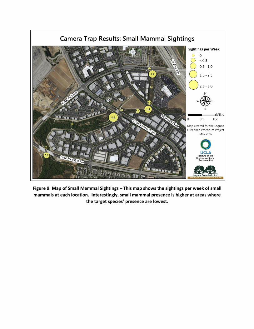
Figure 9: Map of Small Mammal Sightings – This map shows the sightings per week of small
mammals at each location. Interestingly, small mammal presence is higher at areas where
the target species’ presence are lowest.
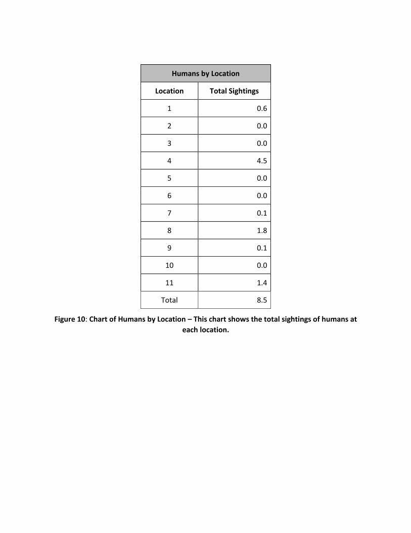
Humans by Location
Location Total Sightings
1 0.6
2 0.0
3 0.0
4 4.5
5 0.0
6 0.0
7 0.1
8 1.8
9 0.1
10 0.0
11 1.4
Total 8.5
Figure 10: Chart of Humans by Location – This chart shows the total sightings of humans at
each location.
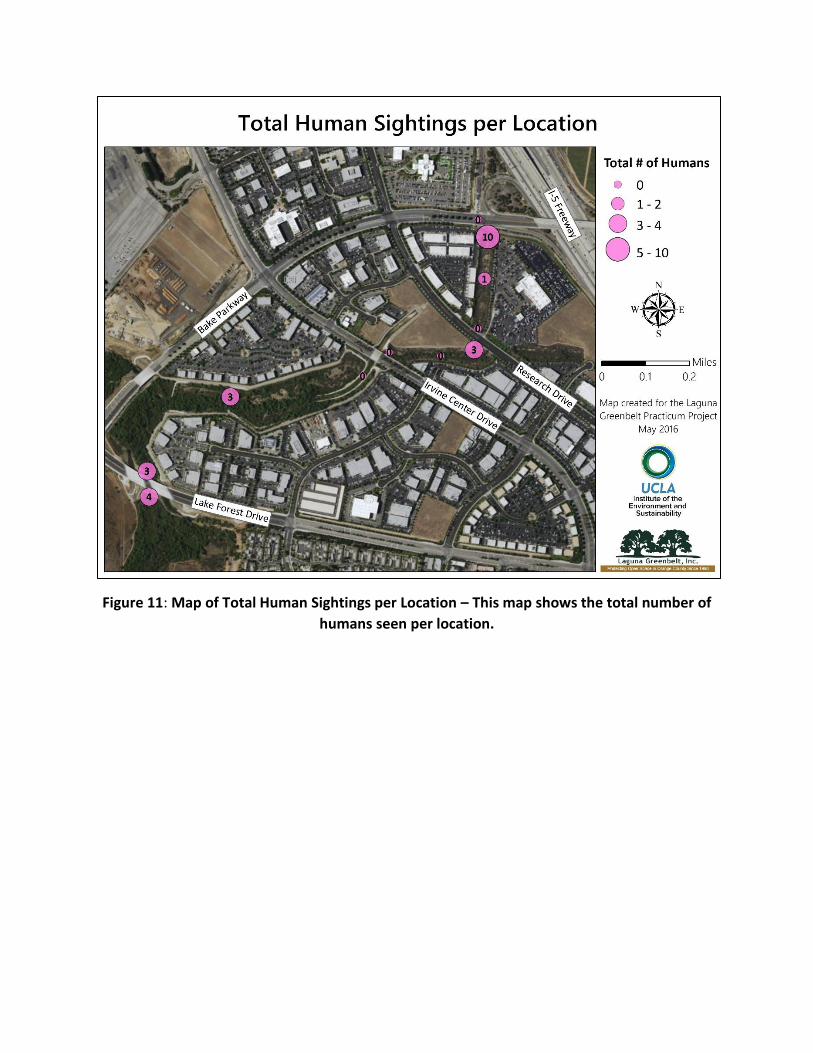
Figure 11: Map of Total Human Sightings per Location – This map shows the total number of
humans seen per location.
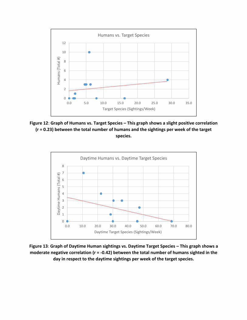
Figure 12: Graph of Humans vs. Target Species – This graph shows a slight positive correlation
(r = 0.23) between the total number of humans and the sightings per week of the target
species.
Figure 13: Graph of Daytime Human sightings vs. Daytime Target Species – This graph shows a
moderate negative correlation (r = -0.42) between the total number of humans sighted in the
day in respect to the daytime sightings per week of the target species.
0
2
4
6
8
10
12
0.0 5.0 10.0 15.0 20.0 25.0 30.0 35.0
Hu
man
s (T
ota
l #)
Target Species (Sightings/Week)
Humans vs. Target Species
0
1
2
3
4
5
6
7
8
0.0 10.0 20.0 30.0 40.0 50.0 60.0 70.0 80.0
Day
tim
e H
um
ans
(To
tal #
)
Daytime Target Species (Sightings/Week)
Daytime Humans vs. Daytime Target Species