Embed Size (px)
Citation preview

Rev. Roum. Géogr./Rom. Journ. Geogr., 62, (2), p. 249–258, 2018, Bucureşti.
EVALUATING THE SPATIAL CONNECTIVITY DEGREE OF THE DOBROGEA SETTLEMENT NETWORK
FLORIN-ALEXANDRU ZAHARIA*, ANA-MARIA TALOŞ
*
Key-words: transport network, connectivity, settlement network, GIS evaluation.
Abstract. The spatial connectivity of settlements within a regional settlement network is an essential component for the mobility of people and goods and consequently for a sustainable regional and economic development. A two-way correlation is established for the economic development of settlements and the development of the transportation network that serves them, both influencing each other. The aim of the paper is to evaluate the spatial connectivity degree of the Dobrogea settlement network and its impact on the local and regional development. The further assessment targets two major aspects of the transportation network that influence the economic development of settlements in Dobrogea. The first issue refers to the quality of the transport network and the second to the connectivity degree of the network. The analysis of the transport network in Dobrogea is also motivated by the existence of all types of transport modalities (road, rail, maritime, fluvial, intermodal), even if the analysis will take into consideration land transportation modalities. The present analysis uses a Geographical Information System (GIS) that allowed us to achieve a statistical modelling and computation of the connectivity indicators of the transport network in Dobrogea infrastructure. The changes in the degree of economic development of settlements in Dobrogea could be explained by the different values of spatial connectivity that appear in a specific area within the region. The paper provides a methodological approach to the evaluation of a regional transportation network and represents a first step in identifying its roles in the process of economic development of the Dobrogea settlement network.
1. INTRODUCTION
The spatial connectivity of settlements within a regional settlement network is an essential component for the mobility of people and goods and consequently for a sustainable regional and economic development. The economic development of settlements and the development of the transportation network that serves them is established by a two-way correlation, both influencing each other. The aim of the present study is to evaluate the spatial connectivity degree of the Dobrogea settlement network and its impact on the local and regional development. The connectivity of a network may be defined as the degree of completeness of the links between nodes (Bamford & Robinson, 1978).
The degree of connection between all vertices is defined as the connectivity of the networks (Bamford & Robinson, 1978). The greater the degree of connectivity within a transportation network, the more efficient that system can be (Marr, 2007). One of the most important attributes of a transportation network relates to accessibility, and the geographer is particularly concerned with accessibility as a locational feature (Bamford & Robinson, 1978).
Network analysis is an important aspect of transport geography because it involves the description of the disposition of nodes and their relationships and line or linkage of distribution (Knowles, Shawn & Docherty, 2008). It gives measures of accessibility and connectivity and also allows comparisons to be made between regional networks within a country and between other countries (Marr, 2007). As Kennedy & Derrible (2012) said, variations in the characteristics of networks may be considered to reflect certain spatial aspects of the socio-economic system.
* Ph.D. Student, Faculty of Geography, University of Bucharest, Department of Human and Economic Geography,
Nicolae Bălcescu Blvd., no. 1, Bucharest, 1st district, code 010041, Romania; Ministry of Transports, Government of
Romania, Dinicu Golescu Street, no.1, Bucharest, 1st district, code 010873, Romania; [email protected]. * Assistant, Faculty of Geography, University of Bucharest, Department of Human and Economic Geography, Nicolae
Bălcescu Blvd., no. 1, Bucharest, 1st district, code 010041, Romania; [email protected].
Florin-Alexandru Zaharia, Ana-Maria Taloş 2
250
When examining a transportation network, a geographer is also interested in node-linkage associations in terms of accessibility (Taaffee, Gauthier, & O'Kelly, 1996). A high degree of connectivity means high geographic accessibility, while a low degree of connectivity involves limited accessibility, both with direct and indirect consequences in terms of the economic and social development of some localities (Marr, 2007). The structure of a network changes in response to the addition of new linkages, or the improvement of existing linkages. These changes are reflected in changes in nodal accessibility. The measurement of nodal accessibility is usually based on the graph theory (Kansky, 1963).
Accessibility is defined as the measure of the capacity of a location to be reached by, or there from reach different locations. Therefore, the capacity and the structure of the transport infrastructure are key-elements in the determination of accessibility (Rodrigue, Comtois, & Slack, 2006).
Given the increased interest in the regional analysis of transport networks and human settlements, in the context of emerging regional development policies and their importance in investment documentations, the paper aims to make a methodological approach to assessing the geographical accessibility of a regional transportation network in terms of the impact of the regional settlement system on the socio-economic characteristics. We believe that direct beneficiaries of such analyses, which can identify the needs for regional and local transport network development, are the population of the region. Methodological approaches in research studies may be starting points in identifying solutions to the regional needs of communities. Geography plays an important role in the spatial aspects of territorial disparities, both in human settlements and in local, regional and macroregional transport systems. The integrated functionality of these individual systems can be overcome a spatial analysts and territorial plan to identify solutions that optimize the degree to which these systems service the population.
The main objective of this study is to assess the degree of connectivity of the network of settlements to the national road and rail network. The human settlement system in Dobrogea presents a number of peculiarities resulting from the natural build-up of the region. The Black Sea and the Danube River, together with its delta have created, since ancient times, the premises for the development of a system of settlements with some distinct regional particularities. The paper deals with the interaction of the settlement system with the regional transport network (rail and road).
The present study aims to identify the territorial discontinuities in the degree of accessibility of human settlements to the national transport network through the regional one and to present a methodology for assessing the efficiency of the regional transport system functionality in relation with the settlement system it serves. The isolated character of Dobrogea as a natural barrier, formed by the Danube River in the west of the region, justifies the need to carry out such an analysis and to assess the impact on the urban and rural settlements in the region.
The regional analysis of the transport network performance in assessing the degree of connectivity of settlements in a region isolated by natural barriers, to the national network it belongs to, may be a starting-point in identifying the need for new network-links. The need thus identified can argue the necessity for developing a transport infrastructure in the region, such as new railways, or road bridges, a temporary solution being a ferry-boat crossings infrastructure. The proposed methodology aims to be a right step in evaluating the efficiency of the regional transport networks in relation to the territory served, in terms of human settlements and the population living there.
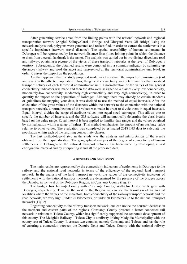
2. STUDY-AREA
The study-area is represented by the historical region, Dobrogea, located in the south-eastern part of Romania (Fig. 1). Dobrogea is the Romanian region that has been inhabited since ancient times, falling into the administration of modern Romanian in 1878. Currently, the connection with the national transport network is made by 3 bridges: 2 bridges between Cernavodă and Feteşti, generically named Anghel Saligny Bridges (King Carol the I
st Bridges), built between 1890–1895 and the
Giurgeni-Vadu Oii Road Bridge, which started being used in 1970 (Iordănescu, Georgescu, 1986 &
3 Spatial connectivity of Dobrogea settlement
251
Grigor, 1984). The King Carol Ist bridges (renamed the Anghel Saligny Bridges during the Communist
period) were built between 1890 and 1895 to ensure the railway link between Bucharest and Constanţa (Dae, 2016).
The two counties in the study-area, Tulcea and Constanţa, have about 885 000 inhabitants (2011
Census data), that is almost 5% of the total population of Romania (National Institute of Statistics –
INS, 2011). The human settlement system is made up 17 towns, the main ones, Constanţa and Tulcea,
are also county capitals. The region has 121 administrative units (communes and towns), consisting of
353 distinct human settlements (National Institute of Statistics – INS, 2011). From a socio-economic
point of view Constanţa County (southern Dobrogea) is better placed than its northern neighbour,
Tulcea, the localities being much better connected to the transport network. Thus, differences in the
development of the land transport network (road and rail) are due largely to natural conditions. Tulcea
County has one of the largest wetlands in Europe, the Danube Delta. Most of its territory is covered by
wetlands (lakes, canals, dams and an alluvial relief) (Carp, 1980). The settlement system has a lower
density and a high degree of isolation. Its acute isolation and harsh living conditions, based mainly on
subsistence, made the Danube Delta a place of emigration or of transit at least. Very few of those born
in the region stay there through adulthood. The Delta influences the demographic structure of Tulcea
County, population density being of 25.7 inhabitants/km2, compared to 96.7 km
2 in Constanţa
(National Institute of Statistics – INS, 2011). This situation is reflected in the economic and social
development of the two counties, Constanţa being better developed economically.
Fig. 1 – Geographical location of Dobrogea and the settlement network system.
3. METHODOLOGY
In order to achieve the objectives proposed in this study, a series of methods specific to these
types of studies were used: the interpretative-descriptive method, the statistical-mathematical method
(network analysis method) and the graphical and cartographic method.
Florin-Alexandru Zaharia, Ana-Maria Taloş 4
252
The network analysis is a method of Transport Geography that considers the spatial and
temporal characteristics and dimensions that the transport network organization points at the level of
the territories (Docherty, Giuliano & Houston, 2008). This is based on the mathematical sub-
disciplines of the graph theory and of topology (Marr, 2007). Cartographic representation is a method
specific to Geography which allows, by means of graphical representations, scale, to get a graphical
representation of different natural, social, economic, demographic phenomena, etc.
The present analysis uses the Geographical Information System (GIS) that allowed us to achieve
a statistical modelling and computation of the connectivity indicators that are related to the
infrastructure of the transport network in Dobrogea. A specific branch of GIS applied to transportation
issues, commonly labeled as GIS-T, has emerged. The Geographical Information Systems for
transportation (GIS-T) refer to the principles and applications of geographical information
technologies to transportation problems (Rodrigue, Comtois, & Slack, 2006).
GIS-T studies have employed both object-based and field-based data models to represent the
relevant geographical data. Some transportation problems tend to better fit one type of GIS data model
than another (Higgs, 2004). For example, the network analysis based on the graph theory typically
represents a network as a set of nodes interconnected with a set of links (Dramowicz, 1994). The
object-based GIS data model, therefore, is a better candidate for such transportation network
representations (Rodrigue, Comtois, & Slack, 2006).
The working steps consisted in the elaboration of a database (transport network and human
settlements) and the actual analysis (evaluating the connectivity of the settlement network). Elaborating the
database involved geocoding and construction of the transport network (road and railway) and the
human settlement network. A main source of data was the Open Source portal: Open Street Map (OSM).
This is an open source collective project that aims to build a global geographical database such as road
atlases using both manually entered data with background images, as well as data collected from GPS
(OpenStreetMap Foundation, 2017). During the construction of the geospatial database of the railway
and road transportation networks, the geolocation of the characteristic features of connecting the
Dobrogea regional network with the national transport network of Romania (represented by the
bridges described in the introduction had been considered). In the second stage, that is the actual
analysis, these features will represent the points of origin in assessing the spatial accessibility degree
in the light of the connectivity of the human settlement network to the national transportation network.
The transport network database consists of the national road network and the Dobrogea railway
network, while the database of localities as destinations in the analysis, in relation to the features of
origin (the links with the national network), are represented by the region’ human settlements (353).
For processing statistical data, cartographic and remote sensing data, several software programmes were
used: QGIS 2.18 and ArcMap 10.4 as GIS software, and Microsoft Excel 2013 as a statistical software.
The analysis of the connectivity degree of human settlements to the national transport network
was made by using the ArcMap 10.4 "network analysis" tool. The Network Analyst toolbox from
ArcMap 10.4 contains tools that perform network analysis and network dataset maintenance. With the
tools in this toolbox, one can maintain network datasets that model transportation networks and perform
routes, the closest facility, service areas, origin-destination cost matrix, vehicle routing problem, and
location-allocation network analyses on transportation networks. The tools within the Analysis toolset
perform analyses using a network-based impedance such as travel time or distance (ESRI Company,
2017). The assessment of connectivity to the national transport network of the settlement system in
Dobrogea referred only to spatial accessibility. The calculation of indicators and their representation
on the map was made by using the data obtained from the OSM through the Arc Map `network
analysis` tool. The analysis was carried out by calculating the distance within the transport network
(railway and road) from the interconnection infrastructure (bridges over the Danube) with the national
transport network, to each locality within the Dobrogea settlement system.
5 Spatial connectivity of Dobrogea settlement
253
After generating service areas from the linking points with the national network and regional transportation network (Anghel Salingy/Carol I Bridge, and Giurgeni–Vadu Oii Bridge) using the
network analysis tool, polygons were generated and reclassified, in order to extract the settlements in a specific impedance (network travel distance). The spatial accessibility of human settlements in
Dobrogea will be represented by iso-network distance lines (lines joining points in which the distance
to them from a certain landmark is the same). The analysis was carried out in two distinct directions: road and railway, obtaining a picture of the yields of these transport networks at the level of Dobrogea’s
territory. Subsequently, the obtained results were compiled into a common indicator by summing up distances (railway and road distance) and represented at the territorial administrative unit level, in
order to assess the impact on the population. Another approach that the study proposed made was to evaluate the impact of transmission (rail
and road) on the affected population. Thus, the general connectivity was determined for the terrestrial transport network of each territorial administrative unit, a normalization of the values of the general
connectivity indicators was made and then the data were assigned to 4 classes (very low connectivity, moderately-low connectivity, moderately-high connectivity and very high connectivity), in order to
quantify the impact on the population of Dobrogea. Although there may already be certain standards or guidelines for mapping your data, it was decided to use the method of equal intervals. After the
calculation of the gross values of the distances within the network to the connection with the national transport network, a normalization of the values was made in order to divide them in equal intervals.
Equal interval divides the range of attribute values into equal-sized subranges. This allows one to specify the number of intervals, and the GIS software will automatically determine the class breaks
based on the value range. Equal interval is best applied to familiar data ranges and the values obtained
by normalization within a range of values. This method emphasizes the amount of an attribute value relative to other values. The evaluation was completed by estimated 2018 INS data to calculate the
population within each of the resulting connectivity classes. The last methodological step in the study was the analysis and interpretation of the results
obtained from their spatialization. The geographical analysis of the degree of connectivity of human settlements in Dobrogea to the national transport network has been made by developing a vast
cartographic material and by interpreting it and all the processed data.
4. RESULTS AND DISCUSSION
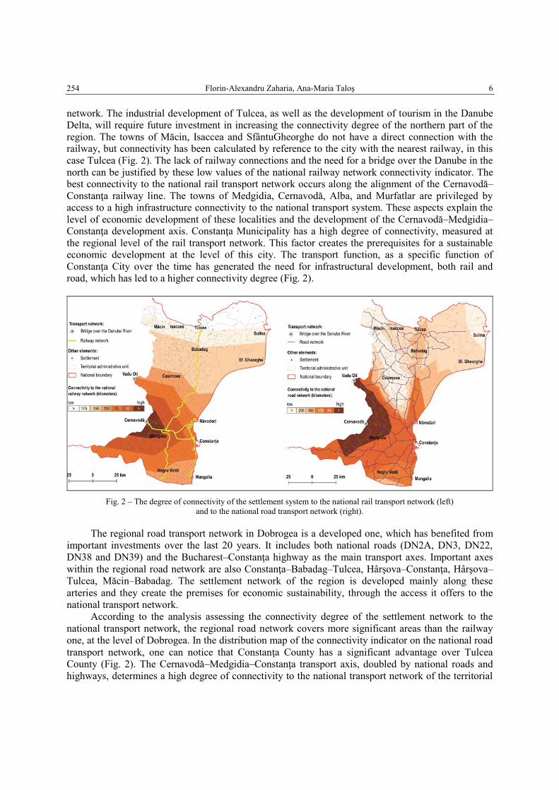
The main results are represented by the connectivity indicators of settlements in Dobrogea to the railway and the national road networks in terms of the efficiency of the regional land transport
network. In the analysis of the land transport network, the values of the connectivity indicators of settlements with the national transport network are determined by the presence of the bridges across
the Danube, in the west of the Dobrogea Region, in Constanţa County (Fig. 2). The bridges link Ialomiţa County with Constanţa County, Wallachia Historical Region with
Dobrogea, respectively. Thus, in the west of the Region we can see the formation of an area of localities where the values of the indicators, both connectivity of the railway transport network and the
road network, are very high (under 25 kilometers, or under 50 kilometers up to the national transport network) (Fig. 2).
Regarding connectivity to the railway transport network, one can notice the constant decrease in
the northern and eastern parts of the regions. Constanţa County presents a better connected rail network in relation to Tulcea County, which has significantly supported the economic development of
this county. The Medgidia Railway – Tulcea City is a railway linking Medgidia Municipality with the county seat of Tulcea County. It crosses two counties, namely Constanţa and Tulcea, and has the role
of ensuring a connection between the Danube Delta and Tulcea County with the national railway
Florin-Alexandru Zaharia, Ana-Maria Taloş 6
254
network. The industrial development of Tulcea, as well as the development of tourism in the Danube Delta, will require future investment in increasing the connectivity degree of the northern part of the
region. The towns of Măcin, Isaccea and SfântuGheorghe do not have a direct connection with the railway, but connectivity has been calculated by reference to the city with the nearest railway, in this
case Tulcea (Fig. 2). The lack of railway connections and the need for a bridge over the Danube in the
north can be justified by these low values of the national railway network connectivity indicator. The best connectivity to the national rail transport network occurs along the alignment of the Cernavodă–
Constanţa railway line. The towns of Medgidia, Cernavodă, Alba, and Murfatlar are privileged by access to a high infrastructure connectivity to the national transport system. These aspects explain the
level of economic development of these localities and the development of the Cernavodă–Medgidia–Constanţa development axis. Constanţa Municipality has a high degree of connectivity, measured at
the regional level of the rail transport network. This factor creates the prerequisites for a sustainable economic development at the level of this city. The transport function, as a specific function of
Constanţa City over the time has generated the need for infrastructural development, both rail and road, which has led to a higher connectivity degree (Fig. 2).
Fig. 2 – The degree of connectivity of the settlement system to the national rail transport network (left)
and to the national road transport network (right).
The regional road transport network in Dobrogea is a developed one, which has benefited from
important investments over the last 20 years. It includes both national roads (DN2A, DN3, DN22,
DN38 and DN39) and the Bucharest–Constanţa highway as the main transport axes. Important axes
within the regional road network are also Constanţa–Babadag–Tulcea, Hârşova–Constanţa, Hârşova–
Tulcea, Măcin–Babadag. The settlement network of the region is developed mainly along these
arteries and they create the premises for economic sustainability, through the access it offers to the
national transport network.
According to the analysis assessing the connectivity degree of the settlement network to the
national transport network, the regional road network covers more significant areas than the railway
one, at the level of Dobrogea. In the distribution map of the connectivity indicator on the national road
transport network, one can notice that Constanţa County has a significant advantage over Tulcea
County (Fig. 2). The Cernavodă–Medgidia–Constanţa transport axis, doubled by national roads and
highways, determines a high degree of connectivity to the national transport network of the territorial
7 Spatial connectivity of Dobrogea settlement
255
administrative units on this alignment, as well as to neighbouring localities (Fig. 2). According to the
analysis, the Constanţa–Babadag–Tulcea transport axis offers moderate connectivity for the adjacent
localities to the national road network, making up for the absence of a bridge over the Danube in the
North side of this part of Dobrogea. Areas with a low degree of connectivity, hence a high degree of
isolation, are the Danube Delta (eg. Sfântu Gheorghe, Sulina) and the north-western area of Dobrogea
(eg. Isaccea, Măcin). In the southern region of Dobrogea, both networks (railway and road) meet the transport needs
of the respective localities. The railway network via Medgidia–Negru Vodă and the Constanţa–Mangalia railway offer a high degree of connectivity, for both the southern central region of Dobrogea
and the southern Romanian seaside. The road network is also sufficiently developed from the viewpoint of network configuration in relation to the local system, covering the southern regions of
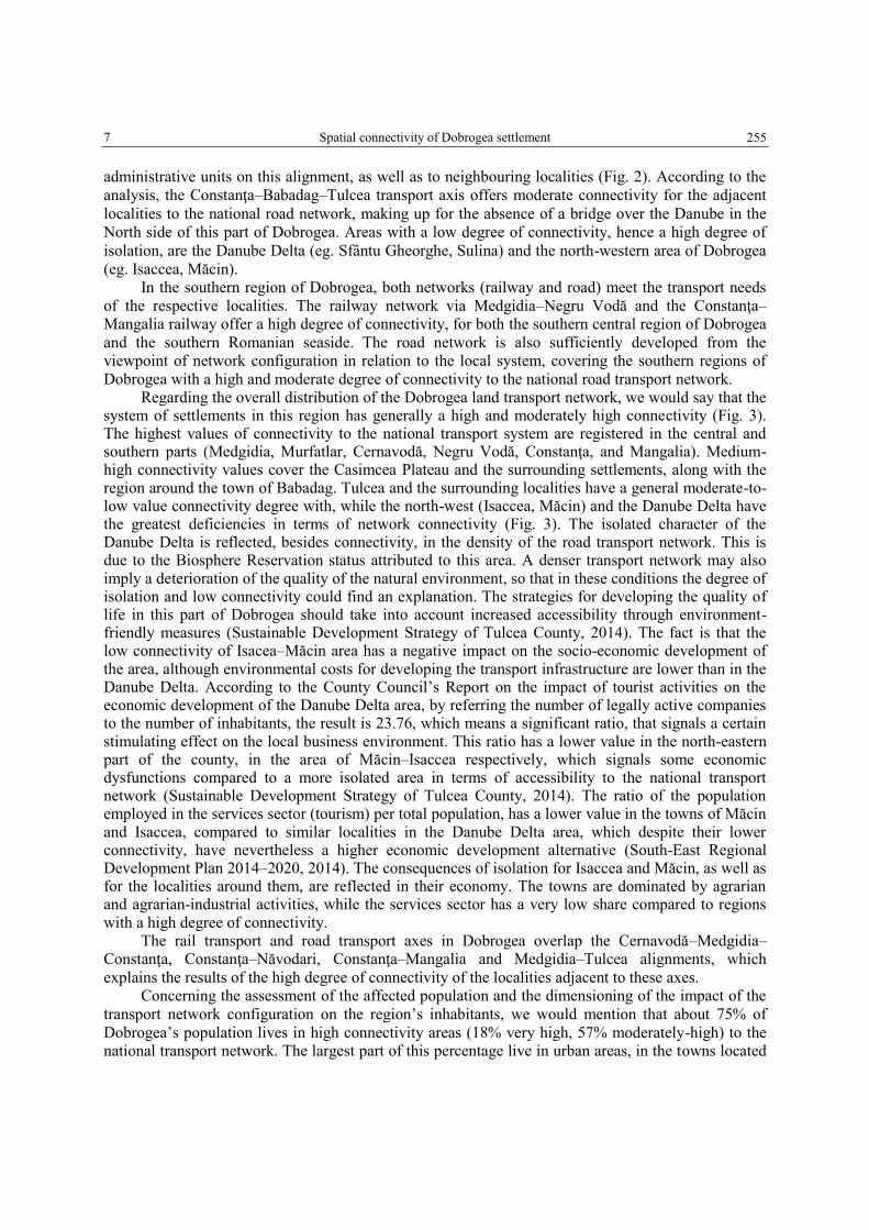
Dobrogea with a high and moderate degree of connectivity to the national road transport network. Regarding the overall distribution of the Dobrogea land transport network, we would say that the
system of settlements in this region has generally a high and moderately high connectivity (Fig. 3). The highest values of connectivity to the national transport system are registered in the central and southern parts (Medgidia, Murfatlar, Cernavodă, Negru Vodă, Constanţa, and Mangalia). Medium-high connectivity values cover the Casimcea Plateau and the surrounding settlements, along with the region around the town of Babadag. Tulcea and the surrounding localities have a general moderate-to-low value connectivity degree with, while the north-west (Isaccea, Măcin) and the Danube Delta have the greatest deficiencies in terms of network connectivity (Fig. 3). The isolated character of the Danube Delta is reflected, besides connectivity, in the density of the road transport network. This is due to the Biosphere Reservation status attributed to this area. A denser transport network may also imply a deterioration of the quality of the natural environment, so that in these conditions the degree of isolation and low connectivity could find an explanation. The strategies for developing the quality of life in this part of Dobrogea should take into account increased accessibility through environment-friendly measures (Sustainable Development Strategy of Tulcea County, 2014). The fact is that the low connectivity of Isacea–Măcin area has a negative impact on the socio-economic development of the area, although environmental costs for developing the transport infrastructure are lower than in the Danube Delta. According to the County Council’s Report on the impact of tourist activities on the economic development of the Danube Delta area, by referring the number of legally active companies to the number of inhabitants, the result is 23.76, which means a significant ratio, that signals a certain stimulating effect on the local business environment. This ratio has a lower value in the north-eastern part of the county, in the area of Măcin–Isaccea respectively, which signals some economic dysfunctions compared to a more isolated area in terms of accessibility to the national transport network (Sustainable Development Strategy of Tulcea County, 2014). The ratio of the population employed in the services sector (tourism) per total population, has a lower value in the towns of Măcin and Isaccea, compared to similar localities in the Danube Delta area, which despite their lower connectivity, have nevertheless a higher economic development alternative (South-East Regional Development Plan 2014–2020, 2014). The consequences of isolation for Isaccea and Măcin, as well as for the localities around them, are reflected in their economy. The towns are dominated by agrarian and agrarian-industrial activities, while the services sector has a very low share compared to regions with a high degree of connectivity.
The rail transport and road transport axes in Dobrogea overlap the Cernavodă–Medgidia–Constanţa, Constanţa–Năvodari, Constanţa–Mangalia and Medgidia–Tulcea alignments, which
explains the results of the high degree of connectivity of the localities adjacent to these axes. Concerning the assessment of the affected population and the dimensioning of the impact of the
transport network configuration on the region’s inhabitants, we would mention that about 75% of
Dobrogea’s population lives in high connectivity areas (18% very high, 57% moderately-high) to the national transport network. The largest part of this percentage live in urban areas, in the towns located
Florin-Alexandru Zaharia, Ana-Maria Taloş 8
256
along the Cernavodă–Constanţa transport axes (Constanţa, Cernavodă, Medgidia, Năvodari, and Ovidiu). The share of the population living in localities with a low degree of connectivity to the
national transport network is 25%, of which 20% is very low and 5% moderately-low. Most of them live in the urban and rural localities of the Danube Delta, as well as in the Măcin–Isaccea area (Fig. 3).
Fig. 3 – The overall connectivity index of the settlement system to the national land transport system (rail and road)
(population’s data source: National Institute of Statistics – Government of Romania – 2018).
An overview of the results obtained regarding the spatial distribution of the overall connectivity
indicator in relation to the national land transport system, as well as the calculation of population
distribution for each degree of connectivity, makes us suggest a hypothesis for a future study on the
extent to which the socio-economic development of a locality is influenced by its connectivity to the
transport network. The results reported herein represent the findings of a regional evaluation of the
connectivity degree of the settlement system.
5. CONCLUSIONS
The study has focussed on territorial discontinuities in the degree of connectivity to part of the
transport system of the settlement system of a very isolated region. The paper provides a
methodological approach to the evaluation of a regional transportation network and represents a first
step in identifying its roles in the process of the economic development of Dobrogea’s settlement
9 Spatial connectivity of Dobrogea settlement
257
network. The results presented in this section, if economically substantiated, could be a starting point
for finding alternatives and solutions to connecting low connectivity areas. The economic disparities
between Tulcea and Constanţa can also be explained on the basis of this connectivity indicator, which
synthesizes the performance that the design of a regional transport network has in relation to its users
(population and territory).
The main transport axes, both rail and road, are attractive for the development of localities.
Industrial and services activities are located along these lines, given the need for the mobility of goods
and services; therefore, areas with a high degree of connectivity have a significantly larger population
than areas with a high degree of isolation. Areas with a high degree of connectivity, also urban, have a
higher share of agrarian activities, suggesting assumptions on the relation between connectivity, access
to the transport infrastructure and the degree of development and economic diversity of a human
settlement. The analysis of the settlement system’s connectivity degree has revealed a series of
differences between the general connectivity of the settlements in Tulcea and in Constanţa, which
demonstrates the necessity for developing an infrastructure to connect Tulcea County with the rest of
the national transport network (road and / or rail link).
Assessing the characteristics of the transport networks, the higher the connectivity degree and
the need to connect other spaces, must be made in parallel with outlining the demographic dimensions
that the transport networks aim to serve. The analysis looked at how this demographic dimension can
be assessed, the result being that, in Dobrogea, the most densely populated areas are generally well-
connected to the national transport infrastructure.
Assessing the characteristics of transport networks in terms of their impact on population and
territorial services is an area which geographers can increasingly tackle, thanks to their specific tools
and methods (GIS-T, as a new branch).
REFERENCES
Bamford, C., Robinson, H. (1978), Geography of transport,s MacDonald and Evans, Plymouth.
Carp, E. (1980), Directory of Wetlands of International Importance in the Western Palearctic, UNEP-IUCN, Bidless Ltd.,
Switzerland.
Dae, G. (2016), Evoluţia căilor ferate dobrogene (1860–1938), Ex-Ponto Publishing-house, Constanţa.
Docherty, I., Giuliano, G. & Houston, D. (2008), Connected Cities, in: Transport Geography. Mobilities, Flows and Spaces
[eds. R. Knowles, J. Shaw & I. Docherty], Blackwell Publishing, Oxford, pp. 83–10.
Dramowicz, K. (1994), Application of graph theory to network evaluation: theoretical and practical issues, Proc. 6th
Canadian Conf. on GIS (Ottawa, 6–10 June).
Grigor, P. (1984), Romania – Geografia circulaţiei. Bucureşti, Edit. Ştiinţifică şi Enciclopedică.
Higgs, G. (2004. ), A Literature Review of the Use of GIS-Based Measures of Access to Health Care Services, Health
Services & Outcomes Research Methodology.
Iordănescu, D., Georgescu, C. (1986), Construcţii pentru transporturi în România, 1–2, Centrala de Construcţii Căi Ferate,
Bucureşti.
Kansky, K. J. (1963), Structure of Transportation Networks: Relationships Between Network Geometry and Regional
Characteristics (3 ed.), Chicago Press, University of Chicago.
Kennedy, C., Derrible, S. (2012), Network Analysis of World Subway Systems Using Updated Graph Theory, Transportation
Research Record: Journal of the Transportation Research Board, 21(12), pp. 112–123.
Knowles, R., Shaw, J. & Docherty, I. (2008), Transport Geographies. Mobilities, Flows and Spaces, 1st edition,
Blackwell Publishing, Oxford.
Marr, P. (2007), Changes in accessibility in the Meseta Purépecha region of Michoacán, Mexico: 1940–2000, Journal of
Transport Geography, 15(6), pp. 465–475.
Rodrigue, J., Comtois, C., Slack, B. (2006), The Geography of Transport Systems, Routledge – Taylor and Francis Group,
New York.
Taaffee, E., Gauthier, H., O'Kelly, M. (1996), Geography of Transportation, Prentice Hall; Subsequent edition (February 27,
1996).

Florin-Alexandru Zaharia, Ana-Maria Taloş 10
258
*** ESRI Company, ArcGIS Desktop tools, Retrieved from ArcGIS Desktop tools: http://desktop.arcgis.com/en/
arcmap/10.3/tools/network-analyst-toolbox/an-overview-of-the-network-analyst-toolbox.htm, last accesed on August
28th, 2018.
*** “The Danube Delta – Halmyris”, www.halmyris.org, last accesd on Octomber 20th, 2018.
*** National Institute of Statistics (INS), Recensământul populaţiei şi locuinţelor României – 2011. Bucuresti.
*** National Institute of Statistics (INS), Baza de date TEMPO, 2018, Retrieved from Baza de date TEMPO:
http://statistici.insse.ro/shop/, last accesed on September 1st, 2018.
*** OpenStreetMap Foundation (OSM), Retrieved from OpenStreetMap – Wikipedia.
https://ro.wikipedia.org/wiki/OpenStreetMap, last accesed on September 1st, 2018.
*** ` Sustainable Development Strategy of Tulcea County ` (2014), Tulcea County Council.
https://www.cjtulcea.ro/sites/cjtulcea/AnunturiPublice/Pages/diverse-anunturi.aspx, last accesed on Octomber 20th, 2018.
*** South-east Regional Development Plan 2014–2020 (2014), Southeast Regional Development Agency,
http://www.adrse.ro/Documente/Planificare/PDR/2014/PDR.Sud_Est_2014.pdf, last accesed on Octomber 20th, 2018.
Received May 17, 2018