Embed Size (px)
Citation preview
1
European Seas and Territorial Development Opportunities and Risks (ESaTDOR)
ESPON Applied Research Project
2013/1/15
APPENDICES to Interim Report September 2011
Appendix 1: Economic Use Briefing Paper .............................................................................................. 2
Appendix 2: Energy, Cables and Pipelines Briefing Paper .................................................................... 25
Appendix 3: Environment Thematic Briefing Paper .............................................................................. 50
Appendix 4: Transport Briefing Paper .................................................................................................. 72
Appendix 5: Data Protocols and Mapping Briefing Paper .................................................................. 119
Appendix 6: Coastal and Marine Governance Briefing Paper ............................................................. 141
Appendix 7: European Sea Profiles - the Baltic Sea ............................................................................ 150
Appendix 8: European Sea Profile - the Black Sea .............................................................................. 165
Appendix 9: Case Study Methodology Briefing Notes ........................................................................ 179
2
Appendix 1: Economic Use Briefing Paper
1. Introduction
The most important economic activities connected with the European Seas are the traditional maritime sectors, tourism and fisheries. The traditional maritime sectors comprise shipbuilding, marine equipment, maritime services, exploitation of marine aggregates, offshore supply, maritime works, navy and coastguard, inland navigation, recreational boating, seaports and shipping. The Policy Research Council, commissioned by the European Commission (DG MARE), calculated that in 2004/2005 total value added connected with the traditional maritime sectors, coastal and marine tourism and fisheries in EU27 and Norway amounted to 186 600 million euro and employed 4.78 million persons (representing 2.25 per cent of all European employment), see Table 11. Table 1: Value added and employment in EU27 and Norway
Value added Employment
Traditional maritime sectors 66 per cent 40 per cent
Coastal and sea-related (marine) recreation and tourism
25 per cent 51 per cent
Fisheries (maritime and inland fishing; fish processing, aquaculture)
9 per cent 9 per cent
Sum 100 per cent 100 per cent
Total 186 600 million € 4.78 million persons
Source: Policy Research Corporation Offshore supply includes the construction and installation of platforms, storage vessels and equipment; drilling; offshore-related transport, engineering, communication, consultancy and other support; seismic research; manufacturing, installation and maintenance of offshore and coastal wind turbines. However, the extraction of oil (such as operators of oil rigs) is not covered. Maritime works includes dredging, nautical cable and pipelines; river works; construction of canals, dykes and ports; support vessels and sand transport. For definitions of the remaining traditional maritime sectors, see footnote 2.2
1 http://ec.europa.eu/maritimeaffairs/clusters_en.html#2. Data in the study of the Policy Research Council
(2008) are again partly based on Ecotech’s study from 2006, which applies data from different years, but mainly for 2004 and 2005, see http://ec.europa.eu/maritimeaffairs/studies/employment/main_report.pdf. 2 Marine equipment: Manufacturing and wholesale trade in maritime equipment for all maritime (sub-)
sectors. Maritime services: Research and development; education; classification and inspection; bunkering; maritime insurance; maritime financing; maritime brokerage; maritime law; crewing, associations; government services; rescue; diving; ship supply (no port services). Recreational boating: Boat chartering and renting; marinas; inland boat basins; supporting services concerning the construction of an trade in recreational vessels; boated-related training and trade (no manufacturing).
3
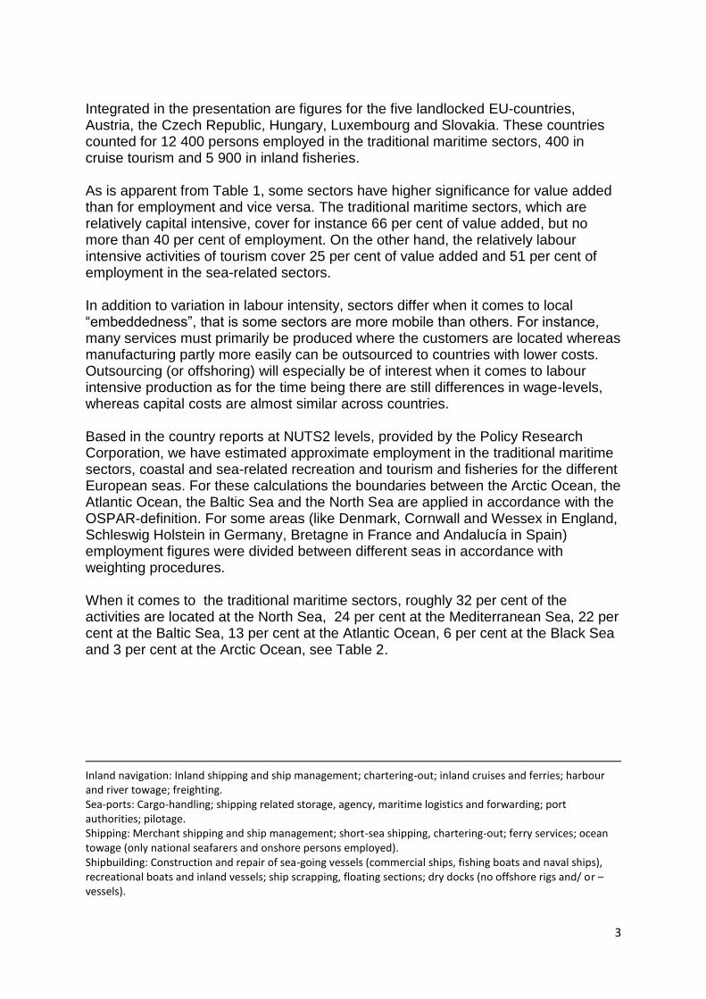
Integrated in the presentation are figures for the five landlocked EU-countries, Austria, the Czech Republic, Hungary, Luxembourg and Slovakia. These countries counted for 12 400 persons employed in the traditional maritime sectors, 400 in cruise tourism and 5 900 in inland fisheries. As is apparent from Table 1, some sectors have higher significance for value added than for employment and vice versa. The traditional maritime sectors, which are relatively capital intensive, cover for instance 66 per cent of value added, but no more than 40 per cent of employment. On the other hand, the relatively labour intensive activities of tourism cover 25 per cent of value added and 51 per cent of employment in the sea-related sectors. In addition to variation in labour intensity, sectors differ when it comes to local ―embeddedness‖, that is some sectors are more mobile than others. For instance, many services must primarily be produced where the customers are located whereas manufacturing partly more easily can be outsourced to countries with lower costs. Outsourcing (or offshoring) will especially be of interest when it comes to labour intensive production as for the time being there are still differences in wage-levels, whereas capital costs are almost similar across countries. Based in the country reports at NUTS2 levels, provided by the Policy Research Corporation, we have estimated approximate employment in the traditional maritime sectors, coastal and sea-related recreation and tourism and fisheries for the different European seas. For these calculations the boundaries between the Arctic Ocean, the Atlantic Ocean, the Baltic Sea and the North Sea are applied in accordance with the OSPAR-definition. For some areas (like Denmark, Cornwall and Wessex in England, Schleswig Holstein in Germany, Bretagne in France and Andalucía in Spain) employment figures were divided between different seas in accordance with weighting procedures. When it comes to the traditional maritime sectors, roughly 32 per cent of the activities are located at the North Sea, 24 per cent at the Mediterranean Sea, 22 per cent at the Baltic Sea, 13 per cent at the Atlantic Ocean, 6 per cent at the Black Sea and 3 per cent at the Arctic Ocean, see Table 2.
Inland navigation: Inland shipping and ship management; chartering-out; inland cruises and ferries; harbour and river towage; freighting. Sea-ports: Cargo-handling; shipping related storage, agency, maritime logistics and forwarding; port authorities; pilotage. Shipping: Merchant shipping and ship management; short-sea shipping, chartering-out; ferry services; ocean towage (only national seafarers and onshore persons employed). Shipbuilding: Construction and repair of sea-going vessels (commercial ships, fishing boats and naval ships), recreational boats and inland vessels; ship scrapping, floating sections; dry docks (no offshore rigs and/ or – vessels).
4
Table 2: Persons employed in traditional maritime sectors–EU27 and Norway–divided by the different seas. Approximate number and percentages Arctic
Ocean Atlantic Ocean
Baltic Sea
Black Sea
Mediterranean Sea
North Sea
Sum Per cent
Number of employees
Seaports and maritime services
1 13 21 5 20 40 100 398 100
Navy and coastguard
1 22 11 5 32 29 100 318 800
Shipping 3 8 35 7 28 19 100 278 700
Marine equipment
2 8 36 10 18 26 100 254 400
Shipbuilding 5 12 23 11 18 31 100 243 400
Recreational boating
- 14 8 - 53 25 100 157 600
Offshore supply
12 14 13 - 5 56 100 148 800
Inland navigation
- 9 19 9 11 52 100 36 300
Maritime works - 10 23 7 7 53 100 21 800
Exploitation of marine aggregates
- 29 - - 3 68 100 2 800
Total 49700 244000 411000 110000 446800 600100 1.86 million
Distribution of traditional maritime activities among the seas. Percentages
3 13 22 6 24 32 100
Source: Own calculations based on figures provided by Policy Research Corporation 13 November
2008–28 country reports. http://ec.europa.eu/maritimeaffairs/clusters_en.html#2.
The highest employment is to be found in seaports and maritime services (totally 398 100 persons), in navy and coastguard (318 800 persons), shipping (278 700 persons), production of marine equipment (254 400 persons) and in shipbuilding (243 400 persons). According to the Policy Research Corporation, additionally 45 000 persons were employed in the production of marine equipment in the South of Germany (Baden Württemberg, Bavaria and Nord-Rhein Westfalen). Also in the landlocked EU-countries, 12 400 persons were employed in traditional maritime sectors. Although the connection between coast and the surrounding areas is important (we will return to this question below), for the time being–except for the production of marine equipment in Germany–we are not provided with such data. In our presentation of employment connected with the different European seas in Table 2 and Figures 1 and 2 below we therefore exclude the figures of the hinterland production. Looking closer at Table 2, we see that the different European seas have diverse relative strengths. For instance, whereas the Arctic Sea is especially strong in offshore supply, the Atlantic Ocean has its force in the exploitation of marine
5
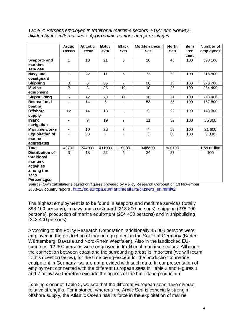
aggregates, navy and coastguard. The Baltic Sea has it‘s relatively strength in marine equipment as well as in shipping; the Black Sea in shipbuilding and marine equipment and the Mediterranean in recreational boating, navy and coastguard. Furthermore, the North Sea has a quite high part of the employment in the exploitation of marine aggregates (68 per cent of total employment in EU27 and Norway), in offshore supply, maritime works, inland navigation, ports and maritime services. Figure 1: Employment in costal and marine tourism – EU27 and Norway–divided by the different seas. Total: 2.42 million persons.
Source: Own calculations based on figures provided by Policy Research Corporation 13 November 2008–28 country reports
Figure 1 shows the estimated employment in coastal and marine tourism, divided by the different European seas. The Mediterranean Sea employs the main part (52 per cent) of the people working in this sector. Nevertheless, also the Atlantic Ocean (21 per cent) and the North Sea (16 per cent) are relatively important destinations for coastal and marine tourism.
1%
21%
5%
5%
52%
16%
Artic Ocean
Atlantic Ocean
Baltic Sea
Black Sea
Mediterranean Sea
North Sea
6
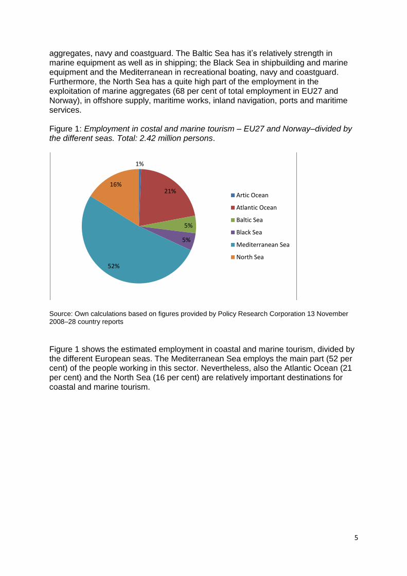
Figure 2: Employment in fisheries in EU27 and Norway–divided by the different seas. Total: 440 900 persons.
Source: Own calculations based on figures provided by Policy Research Corporation 13 November 2008–28 country reports
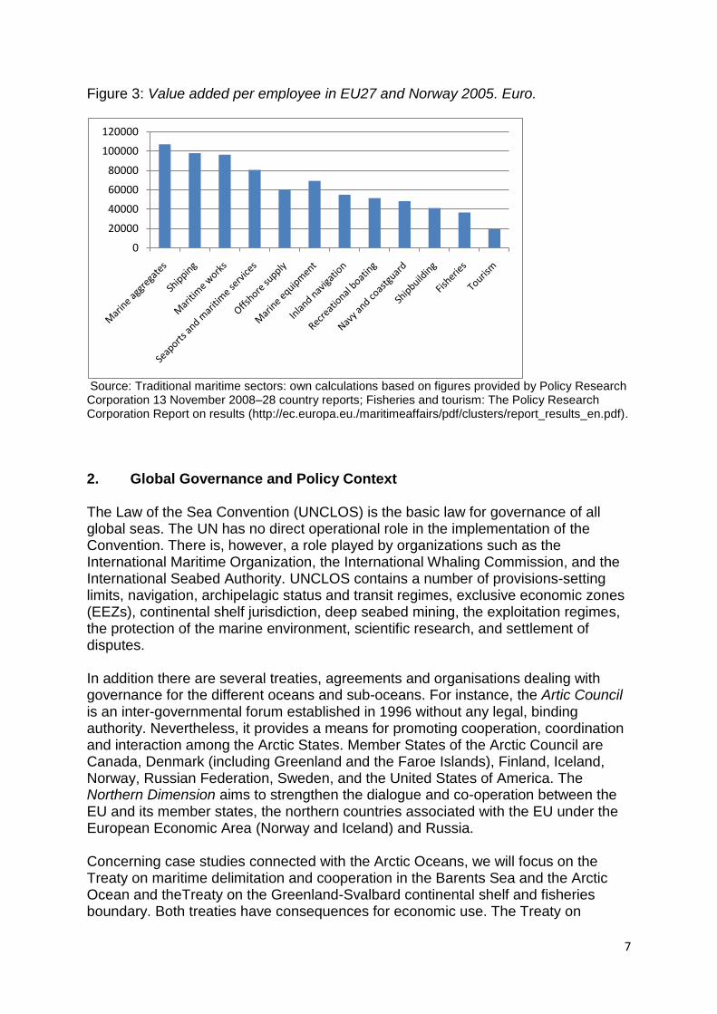
As is noticeable from Figure 2, the most important destination for employment in the fisheries sector in EU27 and Norway are the Atlantic Ocean (35 per cent) and the Mediterranean Sea (29 per cent). Nevertheless, also the North Sea (16 per cent) and the Baltic Sea (14 per cent) play important roles for employment among people living at their coastlines. The figures do not take account of Island. With Island included in the Arctic Ocean, this sea would have contributed to a larger part of European employment in fisheries. Figure 3 shows value added per employee in the traditional maritime sectors, estimated on basis of the different reports from the Policy Research Corporation. Figures, published by the Policy Research Corporation, on coastal and marine tourism and fisheries are also displayed. Comparing figure 3 with the above information about the location of different activities, it is apparent that activities with relatively high value added per employee more often is located around the Arctic Ocean, the Baltic Sea and the North Sea, whereas activities with relatively low high value added per employee to a higher degree are located around the Atlantic Ocean, the Black Sea and the Mediterranean Sea.
3%
35%
14%
3%
29%
16%
Artic Ocean
Atlantic Ocean
Baltic Sea
Black Sea
Mediterranean Sea
North Sea
7
Figure 3: Value added per employee in EU27 and Norway 2005. Euro.
Source: Traditional maritime sectors: own calculations based on figures provided by Policy Research Corporation 13 November 2008–28 country reports; Fisheries and tourism: The Policy Research Corporation Report on results (http://ec.europa.eu./maritimeaffairs/pdf/clusters/report_results_en.pdf).
2. Global Governance and Policy Context The Law of the Sea Convention (UNCLOS) is the basic law for governance of all global seas. The UN has no direct operational role in the implementation of the Convention. There is, however, a role played by organizations such as the International Maritime Organization, the International Whaling Commission, and the International Seabed Authority. UNCLOS contains a number of provisions-setting limits, navigation, archipelagic status and transit regimes, exclusive economic zones (EEZs), continental shelf jurisdiction, deep seabed mining, the exploitation regimes, the protection of the marine environment, scientific research, and settlement of disputes. In addition there are several treaties, agreements and organisations dealing with governance for the different oceans and sub-oceans. For instance, the Artic Council is an inter-governmental forum established in 1996 without any legal, binding authority. Nevertheless, it provides a means for promoting cooperation, coordination and interaction among the Arctic States. Member States of the Arctic Council are Canada, Denmark (including Greenland and the Faroe Islands), Finland, Iceland, Norway, Russian Federation, Sweden, and the United States of America. The Northern Dimension aims to strengthen the dialogue and co-operation between the EU and its member states, the northern countries associated with the EU under the European Economic Area (Norway and Iceland) and Russia. Concerning case studies connected with the Arctic Oceans, we will focus on the Treaty on maritime delimitation and cooperation in the Barents Sea and the Arctic Ocean and theTreaty on the Greenland-Svalbard continental shelf and fisheries boundary. Both treaties have consequences for economic use. The Treaty on
0
20000
40000
60000
80000
100000
120000
8
maritime delimitation and cooperation in the Barents Sea and the Arctic Ocean (also called the Barents Sea border treaty), agreed September 2010, establishes the boundary between Norway and Russia in the Barents Sea and the Arctic Ocean. It also contains provisions that ensure the continuation of the Norwegian-Russian fisheries cooperation, as well as provisions concerning cooperation on the exploitation of any petroleum deposits that extend across the delimitation line. The treaty on the Greenland-Svalbard continental shelf and fisheries boundary, agreed February 2006, governs the area that lies within 200 nautical miles of both Svalbard and Greenland. 3. EU Level Governance and Policy Context The general guidelines for economic use related to marine and maritime policies in Europe are to be found in several documents such as the Lisbon and Gothenburg Agenda, Europe 2020, the Territorial Agenda of the European Union 2020, The Marine Strategy Framework Directive and EU Integrated Maritime Policy (IMP). The EU Commission launched in 2006 a Green Paper for an Integrated Maritime Policy for the European Union, which covers sectors such as shipping, shipbuilding, tourism, fisheries and offshore oil and gas production (http://ec.europe.eu/maritimeaffairs). With the publication of the Blue Book An Integrated Maritime Policy for the European Union in October 20073, the Commission proposed a policy combining measures aimed at enhancing competitiveness and sustainable development, following the Lisbon and Gothenburg strategies. The Blue Book and its Action Plan proposed the development of database on economic and social data for maritime sectors and coastal regions (Action 6.5 of the Action Plan). Furthermore, challenges and potentials for territorial development connected with the seas are also emphasized in The Territorial Agenda of the European Union 2020 (Towards an Inclusive, Smart and Sustainable Europe of Diverse Regions): ‗Increased and uncoordinated exploitation of maritime space and marine resources may have consequences for sustainable territorial development. Changes in land- and sea use, urbanisation and mass tourism threaten cultural assets and landscapes and may lead to fragmentation of natural habitats and ecological corridors. In historic and cultural environments, as well as areas for new development or constructions, attention paid to the character of the place can improve the coherence and quality of the built environment.‘ The Agenda for a sustainable and competitive European tourism (which builds on the Tourist Sustainability report) ‗represents a further contribution to the implementation of the renewed Lisbon Strategy for Growth and Jobs and on the renewed Sustainable Development Strategy‘, see COM (2007) 621 final. The Commission is also proposing a reform on the Common Fishery Policy (CFP) against the background on overfished fish stocks and the difficult economic situation in the sector, see COM (2011) 417 final. Furthermore, the EU Commission has enhanced focus on the significance of industrial clusters for development with EU (see COM (2008) 652). This has partly to
3 http://eur-lex.europa.eu/LexUriServ/LexUriServ.do?uri=COM:2007:0575:FIN:EN:PDF.
9
do with an assumed relationship between clusters and increased innovation. In COM (2008) 652 are the findings from several empirical cluster studies referred to. Concerning economic growth the Progress Report on the EU's Integrated Maritime Policy: questions and answers MEMO/09/455 (Brussels, 15 October 2009) states the following: ‗The Community needs to support sustainable economic growth for maritime activities through further exploration of the possibilities linked to marine resources, including deep-sea ocean technologies, emerging markets and industrial innovation, as well as through the cross-sectoral ―cluster‖ approach to maritime economic activities.‘
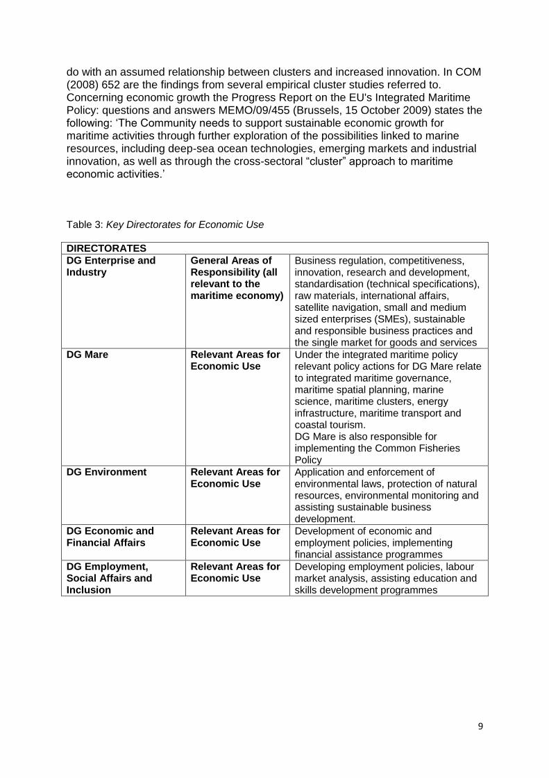
Table 3: Key Directorates for Economic Use
DIRECTORATES
DG Enterprise and Industry
General Areas of Responsibility (all relevant to the maritime economy)
Business regulation, competitiveness, innovation, research and development, standardisation (technical specifications), raw materials, international affairs, satellite navigation, small and medium sized enterprises (SMEs), sustainable and responsible business practices and the single market for goods and services
DG Mare Relevant Areas for Economic Use
Under the integrated maritime policy relevant policy actions for DG Mare relate to integrated maritime governance, maritime spatial planning, marine science, maritime clusters, energy infrastructure, maritime transport and coastal tourism. DG Mare is also responsible for implementing the Common Fisheries Policy
DG Environment Relevant Areas for Economic Use
Application and enforcement of environmental laws, protection of natural resources, environmental monitoring and assisting sustainable business development.
DG Economic and Financial Affairs
Relevant Areas for Economic Use
Development of economic and employment policies, implementing financial assistance programmes
DG Employment, Social Affairs and Inclusion
Relevant Areas for Economic Use
Developing employment policies, labour market analysis, assisting education and skills development programmes
10
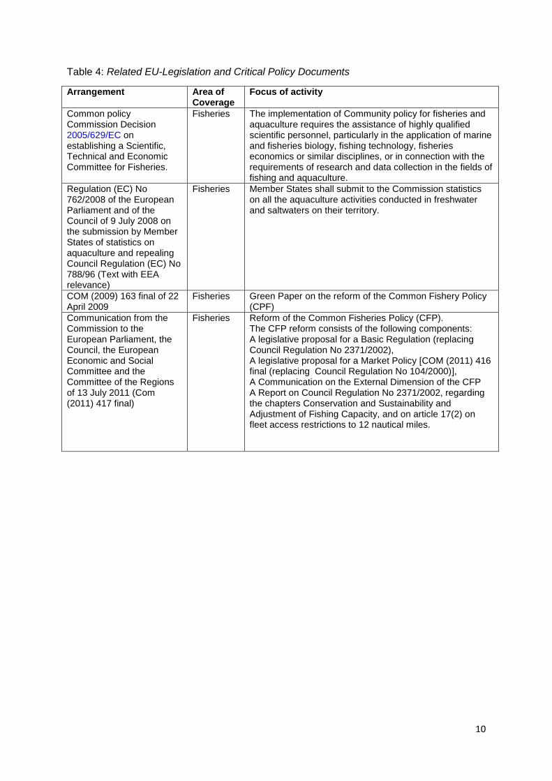
Table 4: Related EU-Legislation and Critical Policy Documents
Arrangement Area of Coverage
Focus of activity
Common policy Commission Decision 2005/629/EC on establishing a Scientific, Technical and Economic Committee for Fisheries.
Fisheries The implementation of Community policy for fisheries and aquaculture requires the assistance of highly qualified scientific personnel, particularly in the application of marine and fisheries biology, fishing technology, fisheries economics or similar disciplines, or in connection with the requirements of research and data collection in the fields of fishing and aquaculture.
Regulation (EC) No 762/2008 of the European Parliament and of the Council of 9 July 2008 on the submission by Member States of statistics on aquaculture and repealing Council Regulation (EC) No 788/96 (Text with EEA relevance)
Fisheries Member States shall submit to the Commission statistics on all the aquaculture activities conducted in freshwater and saltwaters on their territory.
COM (2009) 163 final of 22 April 2009
Fisheries Green Paper on the reform of the Common Fishery Policy (CPF)
Communication from the Commission to the European Parliament, the Council, the European Economic and Social Committee and the Committee of the Regions of 13 July 2011 (Com (2011) 417 final)
Fisheries Reform of the Common Fisheries Policy (CFP). The CFP reform consists of the following components: A legislative proposal for a Basic Regulation (replacing Council Regulation No 2371/2002), A legislative proposal for a Market Policy [COM (2011) 416 final (replacing Council Regulation No 104/2000)], A Communication on the External Dimension of the CFP A Report on Council Regulation No 2371/2002, regarding the chapters Conservation and Sustainability and Adjustment of Fishing Capacity, and on article 17(2) on fleet access restrictions to 12 nautical miles.
11
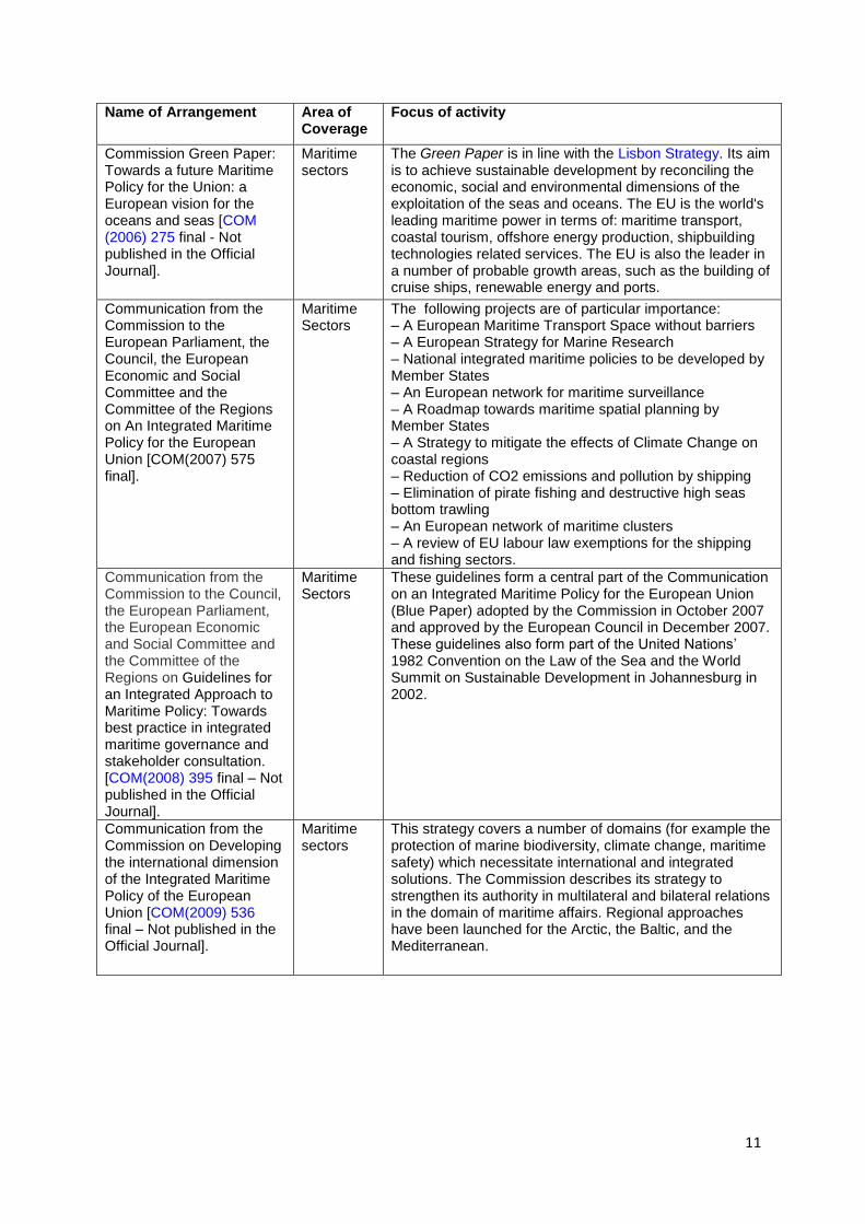
Name of Arrangement Area of Coverage
Focus of activity
Commission Green Paper: Towards a future Maritime Policy for the Union: a European vision for the oceans and seas [COM (2006) 275 final - Not published in the Official Journal].
Maritime sectors
The Green Paper is in line with the Lisbon Strategy. Its aim is to achieve sustainable development by reconciling the economic, social and environmental dimensions of the exploitation of the seas and oceans. The EU is the world's leading maritime power in terms of: maritime transport, coastal tourism, offshore energy production, shipbuilding technologies related services. The EU is also the leader in a number of probable growth areas, such as the building of cruise ships, renewable energy and ports.
Communication from the Commission to the European Parliament, the Council, the European Economic and Social Committee and the Committee of the Regions on An Integrated Maritime Policy for the European Union [COM(2007) 575 final].
Maritime Sectors
The following projects are of particular importance: – A European Maritime Transport Space without barriers – A European Strategy for Marine Research – National integrated maritime policies to be developed by Member States – An European network for maritime surveillance – A Roadmap towards maritime spatial planning by Member States – A Strategy to mitigate the effects of Climate Change on coastal regions – Reduction of CO2 emissions and pollution by shipping – Elimination of pirate fishing and destructive high seas bottom trawling – An European network of maritime clusters – A review of EU labour law exemptions for the shipping and fishing sectors.
Communication from the Commission to the Council, the European Parliament, the European Economic and Social Committee and the Committee of the Regions on Guidelines for an Integrated Approach to Maritime Policy: Towards best practice in integrated maritime governance and stakeholder consultation. [COM(2008) 395 final – Not published in the Official Journal].
Maritime Sectors
These guidelines form a central part of the Communication on an Integrated Maritime Policy for the European Union (Blue Paper) adopted by the Commission in October 2007 and approved by the European Council in December 2007. These guidelines also form part of the United Nations‘ 1982 Convention on the Law of the Sea and the World Summit on Sustainable Development in Johannesburg in 2002.
Communication from the Commission on Developing the international dimension of the Integrated Maritime Policy of the European Union [COM(2009) 536 final – Not published in the Official Journal].
Maritime sectors
This strategy covers a number of domains (for example the protection of marine biodiversity, climate change, maritime safety) which necessitate international and integrated solutions. The Commission describes its strategy to strengthen its authority in multilateral and bilateral relations in the domain of maritime affairs. Regional approaches have been launched for the Arctic, the Baltic, and the Mediterranean.
12
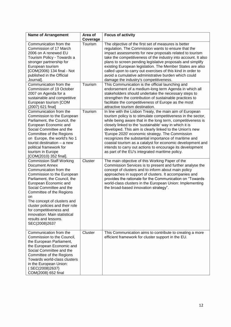
Name of Arrangement Area of
Coverage Focus of activity
Communication from the Commission of 17 March 2006 on A renewed EU Tourism Policy - Towards a stronger partnership for European tourism [COM(2006) 134 final - Not published in the Official Journal].
Tourism The objective of the first set of measures is better regulation. The Commission wants to ensure that the impact assessments for new proposals related to tourism take the competitiveness of the industry into account. It also plans to screen pending legislative proposals and simplify existing European legislation. The Member States are also called upon to carry out exercises of this kind in order to avoid a cumulative administrative burden which could damage the industry's competitiveness.
Communication from the Commission of 19 October 2007 on Agenda for a sustainable and competitive European tourism [COM (2007) 621 final]
Tourism This Communication is the official launching and endorsement of a medium-long term Agenda in which all stakeholders should undertake the necessary steps to strengthen the contribution of sustainable practices to facilitate the competitiveness of Europe as the most attractive tourism destination.
Communication from the Commission to the European Parliament, the Council, the European Economic and Social Committee and the Committee of the Regions on Europe, the world's No 1 tourist destination – a new political framework for tourism in Europe [COM(2010) 352 final].
Tourism In line with the Lisbon Treaty, the main aim of European tourism policy is to stimulate competitiveness in the sector, while being aware that in the long term, competitiveness is closely linked to the 'sustainable' way in which it is developed. This aim is clearly linked to the Union's new 'Europe 2020' economic strategy. The Commission recognizes the substantial importance of maritime and coastal tourism as a catalyst for economic development and intends to carry out actions to encourage its development as part of the EU's integrated maritime policy.
Commission Staff Working Document Annex Communication from the Commission to the European Parliament, the Council, the European Economic and Social Committee and the Committee of the Regions on The concept of clusters and cluster policies and their role for competitiveness and innovation: Main statistical results and lessons. SEC(2008)2637
Cluster The main objective of this Working Paper of the Commission Services is to present and further analyse the concept of clusters and to inform about main policy approaches in support of clusters. It accompanies and provides the rationale for the Communication on ―Towards world-class clusters in the European Union: Implementing the broad-based innovation strategy‖.
Communication from the Commission to the Council, the European Parliament, the European Economic and Social Committee and the Committee of the Regions Towards world-class clusters in the European Union: { SEC(2008)2637} COM(2008) 652 final
Cluster This Communication aims to contribute to creating a more efficient framework for cluster support in the EU.
13
4. Thematic Data Ambitions Economic use is mainly connected to the traditional maritime sectors (included energy production and transport), coastal and sea-related recreation and tourism and fisheries (fishing, fish processing, and aquaculture). In addition to mapping the importance of these activities in the different European territories when it comes to value added and employment, an aim of the project is to investigate the existence and development of industrial clusters. Industrial clusters are characterized by related industries that are embedded within a supporting infrastructural and institutional environment (Porter 1990, 1998). Backward and forward linkages, technological externalities and sunk costs are assumed to generate the self-reinforcing agglomeration of economic activities (see, for example, Fujita et al. 1999; Henderson et al. 2001; Krugman 1991). For example, the higher demand for a certain type of intermediate good, the easier it is for suppliers to reach the necessary critical mass to exploit internal economies of scale, which in turn may lower prices and thereby create advantages for producers that use these intermediates. Another example of economic externalities that may be connected with industrial clusters is knowledge diffusion; that is, one firm gains access to another firm‘s competence without paying for it. A common labour pool facilitates such knowledge diffusion. Most empirical work has been based on two different concepts of clustering of interconnected economic activities: the theory of flexible specialization and industrial districts (Piore and Sabel 1984; Pyke and Sengenberger 1990) and the theory of competitive advantages and industrial clusters (Porter 1990, 1998). Although Porter emphasizes the spatial dimension of clusters, regions have been often used synonymously with nations in the empirical studies in which Porter‘s hypothesis is tested. There are several challenges connected with the measurement of clusters. Basically, one could apply statistical methods or case studies or a combination. In addition to employment and value added in the different industries within a cluster, linkages between the industries (for instance by means of input-output analyses) should be mapped. Furthermore, the assessment of possible agglomeration in a region due to maritime activities requires econometric analyses and extensive data. In this project the mapping as well as description of cluster development will be based on easy accessible data and secondary sources. In addition to the activities directly connected with the seas, different kinds of production and services are taking place in the hinterland. The study should also include the meaning of the maritime sectors for the broader economy. In addition to the 34 themes addressed by the INSPIRE directive it would useful to have data on the following themes by NUTS3 regions:
Energy production (petroleum, renewable energy sources);
Coastal and sea-related recreation and tourism (recreational boating, coastal tourism, cruise tourism, whalespotting, agro-tourism, etc);
Fisheries (fishing, fish processing, aquaculture, related services and sales);
14
Seaports and maritime services;
Navy and coastguard;
Shipping;
Marine equipment;
Shipbuilding;
Exploitation of marine aggregates;
Offshore supply;
Inland navigation;
Maritime works.
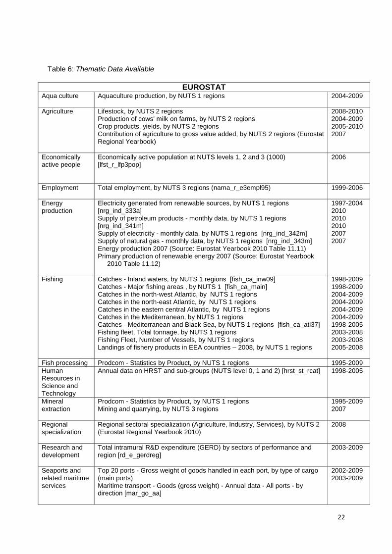
5. Thematic Data Availability The most important data base for Economic Use is Eurostat and the European Cluster Observatory. When it comes to the mapping of aquaculture and fishing activities, data from FAO and OECD also seem useful. Eurostat provides so-called Prodcom-statistics on the production of manufactured goods. The term comes from the French "PRODuction COMmunautaire" (Community Production) for mining, quarrying and manufacturing: sections B and C of the Statistical Classification of Economy Activity in the European Union. These data are very relevant for our purpose; however, they are given only by NUTS 1 regions. Although some of the activities (like shipbuilding, fish processing, offshore supply) probably will be located at the coast, there will be challenges in placing activities to one particular sea for countries bordering several seas. Eurostat covers most economic activities and countries under investigation and are mostly available for the period 2000-2008. Furthermore, Eurostat provides data on regional specialization, human resources in science and technology, technology and knowledge intensive sectors, employment and unemployment rates, see Table 6.
The European Cluster Observatory http://www.clusterobservatory.eu/index.html#!view=aboutobservatory;url=/about-observatory/) is an online platform that provides a single access point to information and analysis of clusters and cluster policy in Europe. According to own presentation on the web: ‗The Cluster Mapping tool gives access to an advanced data set on clusters and regions in Europe. It provides statistical information from a wide range of sources, both on the geographic concentration of various industries and indicators of economic performance. In addition, the Observatory offers data on the framework conditions that shape regional competitiveness. Users can access data for standard sectors and regions, or use special definitions that will be added gradually to the mapping tool. Users can also apply their own customised regional definitions.‘ For most countries the most recent data is for 2008 or 2007. The Observatory uses NUTS-2 regions as the basic unit. For the industry dimension, the 4-digit industry level of NACE classification (Rev 2) is applied.
15
6. Key Thematic Risks and Development Opportunities
The Arctic Ocean The Arctic Ocean is rich in natural resources such as oil and gas, fish, marine mammals (polar bears, seals and whales), and minerals such as coal, nickel, copper, tungsten, lead, zinc, gold, silver, diamonds, manganese, chromium and titanium.
Fisheries The only significant Arctic fisheries occur at present in the Barents Sea and to the east and south of the Norwegian Sea. However, climate change might bring increased productivity in some fish stocks and changes in spatial distributions of others. New areas may become attractive for fishing with increased access due to reduced sea ice coverage. For some of the Arctic high seas waters there is not yet an international conservation and management regime in place. This might lead to unregulated fisheries. Furthermore, there are no special IMO fuel content, discharge, emission or ballast water exchange standards. Tourism Cruise ship traffic in the Arctic region has increased significantly in recent years. As passenger and cruise vessel traffic continues to increase in the Arctic, infrastructure and passenger safety needs will become of increasing concern. The large number of tourists already cruising Arctic waters now exceeds the emergency response capabilities of local communities. Traditional maritime sectors The Norwegian coast is especially strong in offshore supply and shipbuilding.
The Atlantic Ocean Fisheries Whilst fisheries production (including aquaculture) in Europe as a whole has declined in recent years, the North East Atlantic remains the most important fisheries resource to Europe. Also, of Europe‘s total aquaculture production from 2004-2007, a large part came from Atlantic waters. Tourism Coastal tourism takes a number of forms on the Atlantic, from destinations on the remote, unspoilt coastlines of Western Scotland, Ireland and Wales to the beach resorts of the Algarve and Andalucia. Several ports connect tourists to coastal destinations, such as those at Cork, Santander and Cadiz, with Lisbon and Bilbao major cruise ship destinations. The continuing demand for coastal tourism and recreation has potential to cause severe environmental damage through increased pressure on local infrastructure, with implications for energy use, sewage outflows, marine litter and waste management.
16
Traditional maritime sectors The Atlantic Ocean has its force in the exploitation of marine aggregates, navy and coastguard. Exploitation of the Atlantic seabed for sand and gravel for beach nourishment and construction tends to be concentrated in a few small areas and employs around 800 people. Navy and coastguard, on the other side, employ nearly 70 000 people. Other important industries, when it comes to employment, are seaports and maritime services (over 51 000 people), shipbuilding and marine equipment (together over 50 000 people).
The Baltic Sea Fisheries Fisheries have been in decline since the 1980s whereas the interest in aquaculture is increasing. Tourism Coastal tourism is of great economic importance in all Baltic Sea states. With respect to climatic conditions mainly the southwestern destinations in Denmark and Germany and partly in Sweden and Poland have developed a complex tourism infrastructure. A rising number of cruise ships enter and cross the Baltic Sea mainly during the summer season and calling mainly in urban ports. Traditional maritime sectors The Baltic Sea has it‘s relatively strength in marine equipment as well as in shipping. Shipping employs over 97 000 people, shipbuilding and maritime equipment together around 149 000 people, seaports and maritime services more than 83 000 people.
The Black Sea Fisheries During the last few decades eutrophication has been identified as a key ecological problem for the coastal Black Sea regions and especially for its northwestern part where strong anthropogenic nutrient and pollution loads have resulted in dramatic alterations in chemical and biological regimes. In addition to eutrophication, other high priority transboundary ecological problems are the decline in living resources (mostly fish stocks), chemical pollution, biodiversity change, habitat destruction, alien species invasions, climate-change impacts, and mesoscale variability of the circulation system. The EU fisheries ministers political agreement on fixing for 2011 established the fishing opportunities for certain fish stocks applicable in the Black Sea, including a reduction of 10% in the EU total allowable catches (TACs) in the Black Sea for turbot and sprat. In addition, it was agreed that regional cooperation on fishing in the Black Sea should be established to promote sustainable stock management. They also invited the Commission to propose the establishment of minimum landing and mesh sizes for the turbot fishery in the Black Sea, while underlining that the TAC levels
17
established for 2011 have been set at a level taking into account the continuous application of national provisions existing in Bulgaria and Romania in this regard. Tourism The gateway to all the coastal destinations is the city of Constanta, the main Romanian port. The tourism model characterising this European coastal area is similar to that of Bulgaria. Apart from the modern facilities offered by the seaside resorts, tourists can visit many historical sites, ancient monuments and traditional villages preserving their cultural heritage. The Romanian coastal region of Sud-Est is also famous for its vineyards and its spas, especially in Eforie Nord and Mangalia where there are specialized mud-baths. Most accommodation is in medium to large-sized hotels. Conversely, the average size of other collective establishments is lower and their number has been reducing in recent years. Besides bathing tourism, cultural tourism has been developed based on Greek remains of the 7th century BC. Health tourism is an increasing target market, thanks to the good reputation of the Black Sea for curing joint ailments and the development of spas specialising in mud baths and internationally famous treatments. Traditional maritime sectors Shipbuilding and marine equipment are the most important activities when it comes to employment in the traditional maritime sectors with more than 50 000 employees. However, shipping, seaports and maritime services, navy and coastguard together also employ over 50 000 people.
The Mediterranean Sea Fisheries Fishing in the Mediterranean is characterized by its biodiversity which allows the development of region-specific fauna and fisheries. Production is essentially concentrated on the continental shelf and capture fishing on the coasts. According to FAO a strong demand over limited resources, poor governance and failure of institutions and policies in most countries are elements of the unsustainability of fishing activity in the Mediterranean. As regards to aquaculture, large differences exist between Mediterranean countries. Tourism is an essential economic activity in all riparian countries of the Mediterranean. As a source of employment and foreign currencies, international tourism contributes to the growth of national economies. However, the economy of highly specialized destinations where tourism is the prevalent economic sector is highly vulnerable to downturns in tourism activity. The seasonal and spatial concentration of tourist activities strongly amplifies their impacts on the environment, generating pressures on water resources and natural environments, mostly due to coastal construction, and increasing waste production. Traditional maritime sectors The Mediterranean Sea has its relative strength in recreational boating, navy and coastguard with more than 83 000 employees and more than 81 000 employees
18
respectively. Nevertheless, the most important sector, when it comes to employment is navy and coastguard with nearly 102 000 employees. Furthermore, shipping employs almost 78 000 people and marine equipment and shipbuilding together approximately 90 000 people.
The North Sea Fisheries The commercially important fish stocks are heavily exploited and the majority of those landed for human consumption are considered to be in a seriously depleted condition. Tourism The coast in general is popular for recreational and tourism activities, and particularly in the southern North Sea. Traditional maritime sectors Around 50-60 million m3 of marine mineral deposits are extracted each year, mainly for the construction industry, for use as fill sand, or for beach nourishment. Sand and gravel are the main material extracted, but maerl (calcareous seaweed) is extracted in France to improve agricultural soils and as a filter in water treatment. Small amounts of shell are extracted in the Netherlands, for example for paving hiking trails (OSPAR Commission 2010). Quite a high part of the employment in the exploitation of marine aggregates is located at the North Sea (68 per cent of total employment in EU27 and Norway or more than 11 000 people). Nevertheless, the most important activities when it comes to employment are seaports and maritime services (nearly 160 000 people), navy and coastguard (more than 93 000 people), offshore supply (more than 83 000 people), marine equipment and shipbuilding (together approximately 140 000 people).
Opportunities and risks connected with some maritime sectors
Shipbuilding Europan yards are world leaders in the production of high tech vessels and are no longer significantly active in low-cost segments, which are taken over by Korean, Chinese and Japanese yards, see European Commission (2006:16). ‗[...] the complex and comprehensive interaction in shipbuilding projects between the various stakeholders (e.g. yards, suppliers, and owners) increases chances for the leakage of knowledge. Because European shipbuilders and suppliers depend more on technological leadership than low costs when compared to Far east competitors, this possibility of knowledge leaking (loss of know-how) may therefore be harmful to the European shipbuilding sector‘, see European Commission (2008 Reports on results:16). Marine equipment European equipment industries are world leaders in propulsion, cargo handling, communication, automation and environmental systems. Since the marine
19
equipment is heavily dependent on the shipbuilding sector, marine equipment tends to be small in countries with limited shipbuilding activity. The most important strengths of the European marine equipment market are strong innovation which results in specialised solutions for special problems. The weaknesses are that the products are relatively expensive and that the companies do not sufficiently cooperate with universities (see European Commission 2006:32). Shipping The strength of the European maritime transport industry lies in high standards and quality and relatively efficiency of port controls in Europe. There are, however, difficulties in remaining competitive when it comes to labour costs (see European Commission 2006:58). 7. Priorities for Regional Seas Data Collection
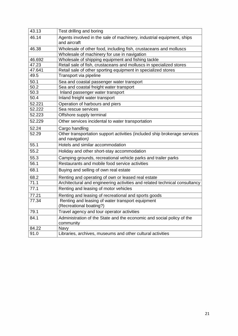
The actual data request is displayed in the Table below. We are in dialogue with the European Cluster Observatory concerning possible cooperation when it comes to some of the required data.
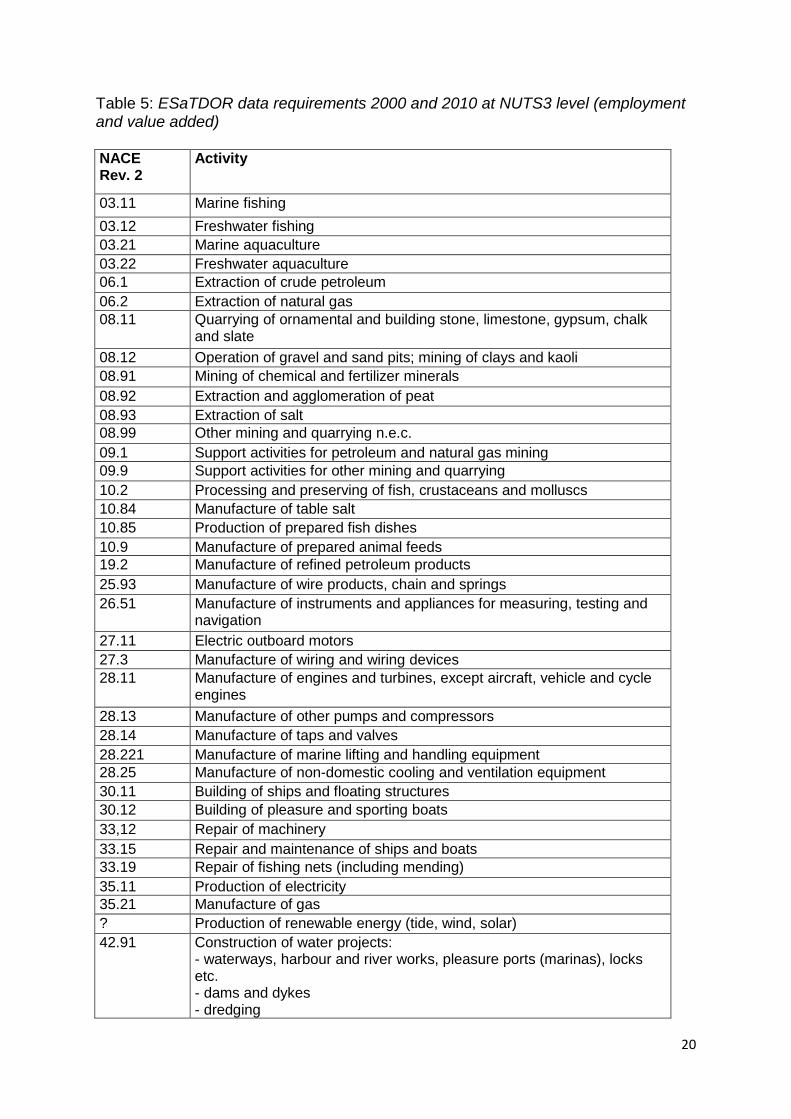
20
Table 5: ESaTDOR data requirements 2000 and 2010 at NUTS3 level (employment and value added) NACE Rev. 2
Activity
03.11 Marine fishing
03.12 Freshwater fishing
03.21 Marine aquaculture
03.22 Freshwater aquaculture
06.1 Extraction of crude petroleum
06.2 Extraction of natural gas
08.11 Quarrying of ornamental and building stone, limestone, gypsum, chalk and slate
08.12 Operation of gravel and sand pits; mining of clays and kaoli
08.91 Mining of chemical and fertilizer minerals
08.92 Extraction and agglomeration of peat
08.93 Extraction of salt
08.99 Other mining and quarrying n.e.c.
09.1 Support activities for petroleum and natural gas mining
09.9 Support activities for other mining and quarrying
10.2 Processing and preserving of fish, crustaceans and molluscs
10.84 Manufacture of table salt
10.85 Production of prepared fish dishes
10.9 Manufacture of prepared animal feeds
19.2 Manufacture of refined petroleum products
25.93 Manufacture of wire products, chain and springs
26.51 Manufacture of instruments and appliances for measuring, testing and navigation
27.11 Electric outboard motors
27.3 Manufacture of wiring and wiring devices
28.11 Manufacture of engines and turbines, except aircraft, vehicle and cycle engines
28.13 Manufacture of other pumps and compressors
28.14 Manufacture of taps and valves
28.221 Manufacture of marine lifting and handling equipment
28.25 Manufacture of non-domestic cooling and ventilation equipment
30.11 Building of ships and floating structures
30.12 Building of pleasure and sporting boats
33,12 Repair of machinery
33.15 Repair and maintenance of ships and boats
33.19 Repair of fishing nets (including mending)
35.11 Production of electricity
35.21 Manufacture of gas
? Production of renewable energy (tide, wind, solar)
42.91 Construction of water projects: - waterways, harbour and river works, pleasure ports (marinas), locks etc. - dams and dykes - dredging
21
43.13 Test drilling and boring
46.14 Agents involved in the sale of machinery, industrial equipment, ships and aircraft
46.38 Wholesale of other food, including fish, crustaceans and molluscs
Wholesale of machinery for use in navigation
46.692 Wholesale of shipping equipment and fishing tackle
47.23 Retail sale of fish, crustaceans and molluscs in specialized stores
47.641 Retail sale of other sporting equipment in specialized stores
49.5 Transport via pipeline
50.1 Sea and coastal passenger water transport
50.2 Sea and coastal freight water transport
50.3 Inland passenger water transport
50.4 Inland freight water transport
52.221 Operation of harbours and piers
52.222 Sea rescue services
52.223 Offshore supply terminal
52.229 Other services incidental to water transportation
52.24 Cargo handling
52.29 Other transportation support activities (included ship brokerage services and navigation)
55.1 Hotels and similar accommodation
55.2 Holiday and other short-stay accommodation
55.3 Camping grounds, recreational vehicle parks and trailer parks
56.1 Restaurants and mobile food service activities
68.1 Buying and selling of own real estate
68.2 Renting and operating of own or leased real estate
71.1 Architectural and engineering activities and related technical consultancy
77.1 Renting and leasing of motor vehicles
77.21 Renting and leasing of recreational and sports goods
77.34 Renting and leasing of water transport equipment (Recreational boating?)
79.1 Travel agency and tour operator activities
84.1 Administration of the State and the economic and social policy of the community
84.22 Navy
91.0 Libraries, archives, museums and other cultural activities
22
Table 6: Thematic Data Available
EUROSTAT Aqua culture Aquaculture production, by NUTS 1 regions
2004-2009
Agriculture Lifestock, by NUTS 2 regions Production of cows' milk on farms, by NUTS 2 regions Crop products, yields, by NUTS 2 regions Contribution of agriculture to gross value added, by NUTS 2 regions (Eurostat Regional Yearbook)
2008-2010 2004-2009 2005-2010 2007
Economically active people
Economically active population at NUTS levels 1, 2 and 3 (1000) [lfst_r_lfp3pop]
2006
Employment Total employment, by NUTS 3 regions (nama_r_e3empl95)
1999-2006
Energy production
Electricity generated from renewable sources, by NUTS 1 regions [nrg_ind_333a] Supply of petroleum products - monthly data, by NUTS 1 regions [nrg_ind_341m] Supply of electricity - monthly data, by NUTS 1 regions [nrg_ind_342m] Supply of natural gas - monthly data, by NUTS 1 regions [nrg_ind_343m] Energy production 2007 (Source: Eurostat Yearbook 2010 Table 11.11) Primary production of renewable energy 2007 (Source: Eurostat Yearbook
2010 Table 11.12)
1997-2004 2010 2010 2010 2007 2007
Fishing Catches - Inland waters, by NUTS 1 regions [fish_ca_inw09] Catches - Major fishing areas , by NUTS 1 [fish_ca_main] Catches in the north-west Atlantic, by NUTS 1 regions Catches in the north-east Atlantic, by NUTS 1 regions Catches in the eastern central Atlantic, by NUTS 1 regions Catches in the Mediterranean, by NUTS 1 regions Catches - Mediterranean and Black Sea, by NUTS 1 regions [fish_ca_atl37] Fishing fleet, Total tonnage, by NUTS 1 regions Fishing Fleet, Number of Vessels, by NUTS 1 regions Landings of fishery products in EEA countries – 2008, by NUTS 1 regions
1998-2009 1998-2009 2004-2009 2004-2009 2004-2009 2004-2009 1998-2005 2003-2008 2003-2008 2005-2008
Fish processing Prodcom - Statistics by Product, by NUTS 1 regions 1995-2009
Human Resources in Science and Technology
Annual data on HRST and sub-groups (NUTS level 0, 1 and 2) [hrst_st_rcat]
1998-2005
Mineral extraction
Prodcom - Statistics by Product, by NUTS 1 regions Mining and quarrying, by NUTS 3 regions
1995-2009 2007
Regional specialization
Regional sectoral specialization (Agriculture, Industry, Services), by NUTS 2 (Eurostat Regional Yearbook 2010)
2008
Research and development
Total intramural R&D expenditure (GERD) by sectors of performance and region [rd_e_gerdreg]
2003-2009
Seaports and related maritime services
Top 20 ports - Gross weight of goods handled in each port, by type of cargo (main ports) Maritime transport - Goods (gross weight) - Annual data - All ports - by direction [mar_go_aa]
2002-2009 2003-2009
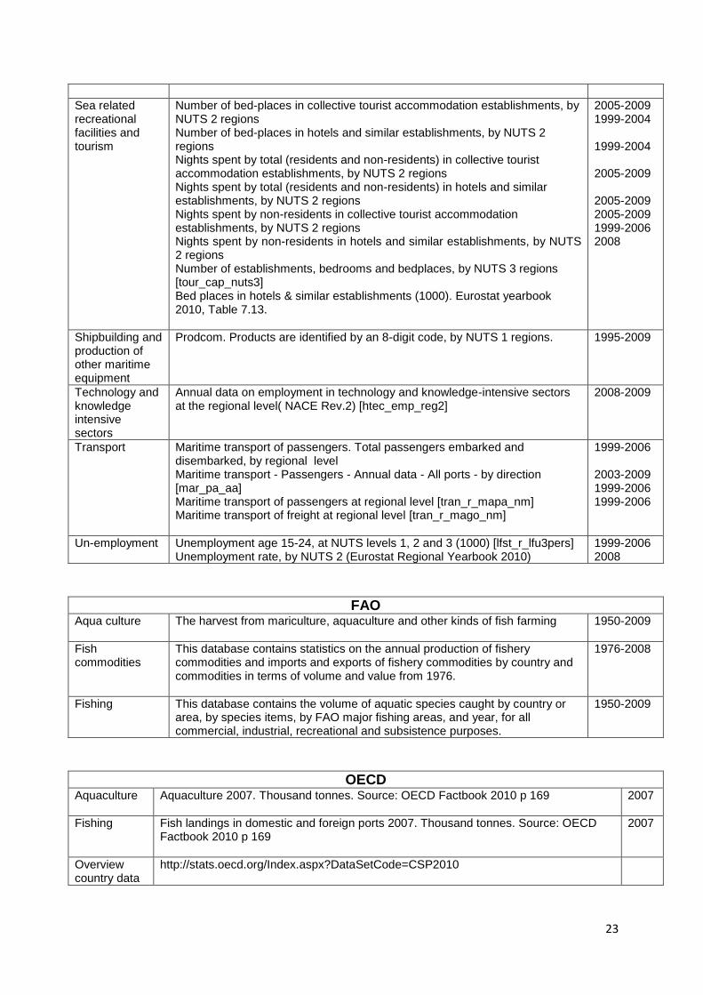
23
Sea related recreational facilities and tourism
Number of bed-places in collective tourist accommodation establishments, by NUTS 2 regions Number of bed-places in hotels and similar establishments, by NUTS 2 regions Nights spent by total (residents and non-residents) in collective tourist accommodation establishments, by NUTS 2 regions Nights spent by total (residents and non-residents) in hotels and similar establishments, by NUTS 2 regions Nights spent by non-residents in collective tourist accommodation establishments, by NUTS 2 regions Nights spent by non-residents in hotels and similar establishments, by NUTS 2 regions Number of establishments, bedrooms and bedplaces, by NUTS 3 regions [tour_cap_nuts3] Bed places in hotels & similar establishments (1000). Eurostat yearbook 2010, Table 7.13.
2005-2009 1999-2004 1999-2004 2005-2009 2005-2009 2005-2009 1999-2006 2008
Shipbuilding and production of other maritime equipment
Prodcom. Products are identified by an 8-digit code, by NUTS 1 regions. 1995-2009
Technology and knowledge intensive sectors
Annual data on employment in technology and knowledge-intensive sectors at the regional level( NACE Rev.2) [htec_emp_reg2]
2008-2009
Transport Maritime transport of passengers. Total passengers embarked and disembarked, by regional level Maritime transport - Passengers - Annual data - All ports - by direction [mar_pa_aa] Maritime transport of passengers at regional level [tran_r_mapa_nm] Maritime transport of freight at regional level [tran_r_mago_nm]
1999-2006 2003-2009 1999-2006 1999-2006
Un-employment Unemployment age 15-24, at NUTS levels 1, 2 and 3 (1000) [lfst_r_lfu3pers] Unemployment rate, by NUTS 2 (Eurostat Regional Yearbook 2010)
1999-2006 2008
FAO Aqua culture The harvest from mariculture, aquaculture and other kinds of fish farming
1950-2009
Fish commodities
This database contains statistics on the annual production of fishery commodities and imports and exports of fishery commodities by country and commodities in terms of volume and value from 1976.
1976-2008
Fishing This database contains the volume of aquatic species caught by country or area, by species items, by FAO major fishing areas, and year, for all commercial, industrial, recreational and subsistence purposes.
1950-2009
OECD Aquaculture Aquaculture 2007. Thousand tonnes. Source: OECD Factbook 2010 p 169
2007
Fishing Fish landings in domestic and foreign ports 2007. Thousand tonnes. Source: OECD Factbook 2010 p 169
2007
Overview country data
http://stats.oecd.org/Index.aspx?DataSetCode=CSP2010
24
8. References
European Commission DG Fisheries and Maritime Affairs (2006), Employment trends in all sectors related to the sea or using sea resources. http://ec.europa.eu/maritimeaffairs/studies/employment/main_report.pdf. European Commission DG Fisheries and Maritime Affairs (2008), The role of Maritime Clusters to enhance the strength and development in European maritime sectors. Different reports. http://ec.europa.eu/maritimeaffairs/clusters_en.html#2.
Fujita, M., P. Krugman, A. J. Venables (1999), The spatial economy. Cites, regions and international trade (Cambridge: MIT Press). Henderson, J. V., Z. Shalizi, A. J. Venables (2001), ‗Geography and development‘, Journal of Economic Geography , 1, 81-105. Krugman, P. (1991), ‗Increasing returns and economic geography‘, Journal of Political Economy, 99(3), 483–499. Piore, M.J., C. F. Sabel (1984), The second industrial divide: Possibilities for prosperity (New York: Basic Books). Porter, M.E. (1990), The competitive advantage of nations (New York: Free Press). Porter, M.E. (1998), ‗Clusters and the new economies of competition‘, Harvard Business Review, 76 (6), 77–90. Pyke, F., W. Sengenberger (1990), ‗Introduction‘, in F. Pyke, G. Becattini, W. Sengenberger (eds), Industrial districts and inter-firm co-operation in Italy (Geneva: International Institute for Labour Studies).
25
Appendix 2: Energy, Cables and Pipelines Briefing Paper
1. Introduction
European Seas are an important source of the EU‘s conventional energy resources thanks to the significant offshore reserves of oil and gas, especially in the North Sea (and smaller reserves elsewhere, such as in the Black Sea). However, these resources are in decline, with the UK having experienced a particularly steep drop since 2000 from its position as the dominant producer of primary energy. This, along with the decrease in conventional onshore resources, has led to the EU becoming increasingly reliant on energy imports, especially from Russia, Norway, Libya and Algeria (though Norway‘s North Sea reserves are also set to decline). More than half of the EU‘s energy now comes from outside the EU, raising growing concerns about energy security and hence the need to find new resources and diversify supply. This and the EU‘s commitment to reduction of greenhouse gas emissions provide the underlying rationale of recently formulated EU energy policy. Policy is also directed to completion of the internal energy market and the development of transnational energy networks. Hence the Sustainable Development Strategy places energy at the heart of European activity, with an emphasis on market-based tools (taxes, subsidies and the CO2 emissions trading scheme) and developing energy technologies (for energy efficiency and renewable and low-carbon energy). The strategy prioritises combating climate change and the transition to clean forms of energy production. These themes are being reiterated in territorial cohesion and maritime policy, as well as energy policy (see below). Hence European Seas are being recognised as an important focus for the achievement of these goals. Firstly, rapid and large-scale deployment of offshore wind energy is anticipated, especially in the shallower northern seas, to be followed in the longer term by other marine renewables. Secondly, and closely associated with this, marine grid systems will be developed to enable more efficient electricity transmission across regions. Thirdly, the potential for carbon storage under the seabed (in exhausted gas and oil fields and in deep saline aquifers) will be explored. The seas will also play a continuing, and in some respects, growing role in the current patterns of energy production and distribution. It is anticipated that newly discovered offshore hydrocarbon reserves will be exploited, especially in the Arctic Ocean. Conventional resources will continue to be transported by ship, including from new points of supply, such as for liquefied natural gas. The network of gas pipelines will be expanded, with new links from the east and the south of the EU crossing marine areas. Similarly, the seabed will continue to host the growing network of telecommunications cables.
26
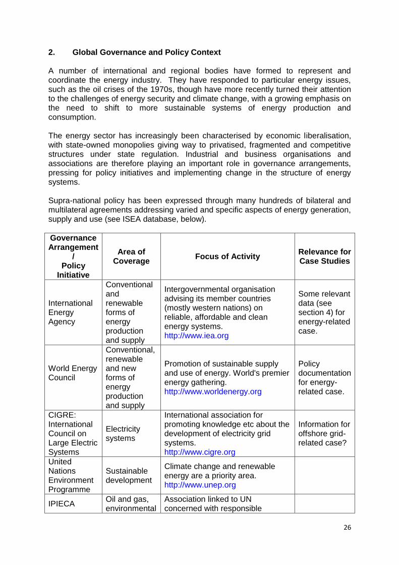
2. Global Governance and Policy Context A number of international and regional bodies have formed to represent and coordinate the energy industry. They have responded to particular energy issues, such as the oil crises of the 1970s, though have more recently turned their attention to the challenges of energy security and climate change, with a growing emphasis on the need to shift to more sustainable systems of energy production and consumption. The energy sector has increasingly been characterised by economic liberalisation, with state-owned monopolies giving way to privatised, fragmented and competitive structures under state regulation. Industrial and business organisations and associations are therefore playing an important role in governance arrangements, pressing for policy initiatives and implementing change in the structure of energy systems. Supra-national policy has been expressed through many hundreds of bilateral and multilateral agreements addressing varied and specific aspects of energy generation, supply and use (see ISEA database, below).
Governance Arrangement
/ Policy
Initiative
Area of Coverage
Focus of Activity Relevance for Case Studies
International Energy Agency
Conventional and renewable forms of energy production and supply
Intergovernmental organisation advising its member countries (mostly western nations) on reliable, affordable and clean energy systems. http://www.iea.org
Some relevant data (see section 4) for energy-related case.
World Energy Council
Conventional, renewable and new forms of energy production and supply
Promotion of sustainable supply and use of energy. World's premier energy gathering. http://www.worldenergy.org
Policy documentation for energy-related case.
CIGRE: International Council on Large Electric Systems
Electricity systems
International association for promoting knowledge etc about the development of electricity grid systems. http://www.cigre.org
Information for offshore grid-related case?
United Nations Environment Programme
Sustainable development
Climate change and renewable energy are a priority area. http://www.unep.org
IPIECA Oil and gas, environmental
Association linked to UN concerned with responsible
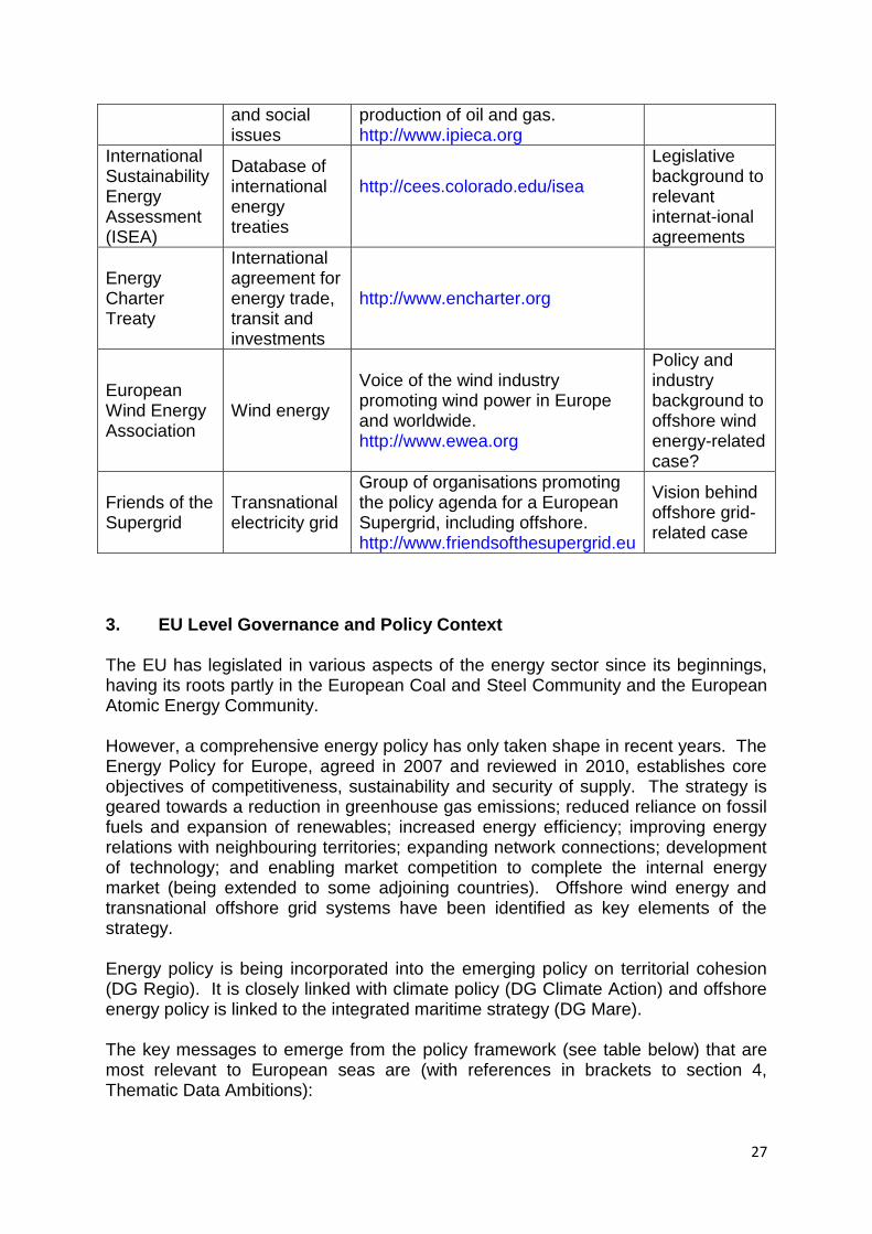
27
and social issues
production of oil and gas. http://www.ipieca.org
International Sustainability Energy Assessment (ISEA)
Database of international energy treaties
http://cees.colorado.edu/isea
Legislative background to relevant internat-ional agreements
Energy Charter Treaty
International agreement for energy trade, transit and investments
http://www.encharter.org
European Wind Energy Association
Wind energy
Voice of the wind industry promoting wind power in Europe and worldwide. http://www.ewea.org
Policy and industry background to offshore wind energy-related case?
Friends of the Supergrid
Transnational electricity grid
Group of organisations promoting the policy agenda for a European Supergrid, including offshore. http://www.friendsofthesupergrid.eu
Vision behind offshore grid-related case
3. EU Level Governance and Policy Context
The EU has legislated in various aspects of the energy sector since its beginnings, having its roots partly in the European Coal and Steel Community and the European Atomic Energy Community. However, a comprehensive energy policy has only taken shape in recent years. The Energy Policy for Europe, agreed in 2007 and reviewed in 2010, establishes core objectives of competitiveness, sustainability and security of supply. The strategy is geared towards a reduction in greenhouse gas emissions; reduced reliance on fossil fuels and expansion of renewables; increased energy efficiency; improving energy relations with neighbouring territories; expanding network connections; development of technology; and enabling market competition to complete the internal energy market (being extended to some adjoining countries). Offshore wind energy and transnational offshore grid systems have been identified as key elements of the strategy. Energy policy is being incorporated into the emerging policy on territorial cohesion (DG Regio). It is closely linked with climate policy (DG Climate Action) and offshore energy policy is linked to the integrated maritime strategy (DG Mare).
The key messages to emerge from the policy framework (see table below) that are most relevant to European seas are (with references in brackets to section 4, Thematic Data Ambitions):
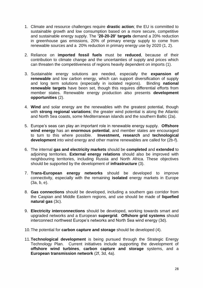
28
1. Climate and resource challenges require drastic action; the EU is committed to sustainable growth and low consumption based on a more secure, competitive and sustainable energy supply. The ’20-20-20’ targets demand a 20% reduction in greenhouse gas emissions, 20% of primary energy supply to come from renewable sources and a 20% reduction in primary energy use by 2020 (1, 2).
2. Reliance on imported fossil fuels must be reduced, because of their
contribution to climate change and the uncertainties of supply and prices which can threaten the competitiveness of regions heavily dependent on imports (1).
3. Sustainable energy solutions are needed, especially the expansion of
renewable and low carbon energy, which can support diversification of supply and long term solutions (especially in isolated regions). Binding national renewable targets have been set, though this requires differential efforts from member states. Renewable energy production also presents development opportunities (2).
4. Wind and solar energy are the renewables with the greatest potential, though
with strong regional variations; the greater wind potential is along the Atlantic and North Sea coasts, some Mediterranean islands and the southern Baltic (2a).
5. Europe‘s seas can play an important role in renewable energy supply. Offshore
wind energy has an enormous potential, and member states are encouraged to turn to this where possible. Investment, research and technological development into wind energy and other marine renewables are called for (2b-f).
6. The internal gas and electricity markets should be completed and extended to
adjoining territories. External energy relations should also be improved with neighbouring territories, including Russia and North Africa. These objectives should be supported by the development of infrastructure (3).
7. Trans-European energy networks should be developed to improve
connectivity, especially with the remaining isolated energy markets in Europe (3a, b, e).
8. Gas connections should be developed, including a southern gas corridor from
the Caspian and Middle Eastern regions, and use should be made of liquefied natural gas (3c).
9. Electricity interconnections should be developed, working towards smart and
upgraded networks and a European supergrid. Offshore grid systems should interconnect northwest Europe‘s networks and North Sea wind energy (3d).
10. The potential for carbon capture and storage should be developed (4). 11. Technological development is being pursued through the Strategic Energy
Technology Plan. Current initiatives include supporting the development of offshore wind turbines, carbon capture and storage systems, and a European transmission network (2f, 3d, 4a).
29
12. Market-based instruments should be used to facilitate the transition to sustainable energy systems (2e).
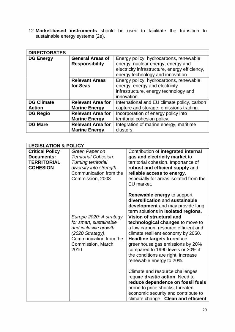
DIRECTORATES
DG Energy General Areas of Responsibility
Energy policy, hydrocarbons, renewable energy, nuclear energy, energy and electricity infrastructure, energy efficiency, energy technology and innovation.
Relevant Areas for Seas
Energy policy, hydrocarbons, renewable energy, energy and electricity infrastructure, energy technology and innovation.
DG Climate Action
Relevant Area for Marine Energy
International and EU climate policy, carbon capture and storage, emissions trading.
DG Regio Relevant Area for Marine Energy
Incorporation of energy policy into territorial cohesion policy.
DG Mare Relevant Area for Marine Energy
Integration of marine energy, maritime clusters.
LEGISLATION & POLICY
Critical Policy Documents: TERRITORIAL COHESION
Green Paper on Territorial Cohesion: Turning territorial diversity into strength, Communication from the Commission, 2008
Contribution of integrated internal gas and electricity market to territorial cohesion. Importance of robust and efficient supply and reliable access to energy, especially for areas isolated from the EU market. Renewable energy to support diversification and sustainable development and may provide long term solutions in isolated regions.
Europe 2020: A strategy for smart, sustainable and inclusive growth (2020 Strategy), Communication from the Commission, March 2010
Vision of structural and technological changes to move to a low carbon, resource efficient and climate resilient economy by 2050. Headline targets to reduce greenhouse gas emissions by 20% compared to 1990 levels or 30% if the conditions are right, increase renewable energy to 20%. Climate and resource challenges require drastic action. Need to reduce dependence on fossil fuels prone to price shocks, threaten economic security and contribute to climate change. Clean and efficient
30
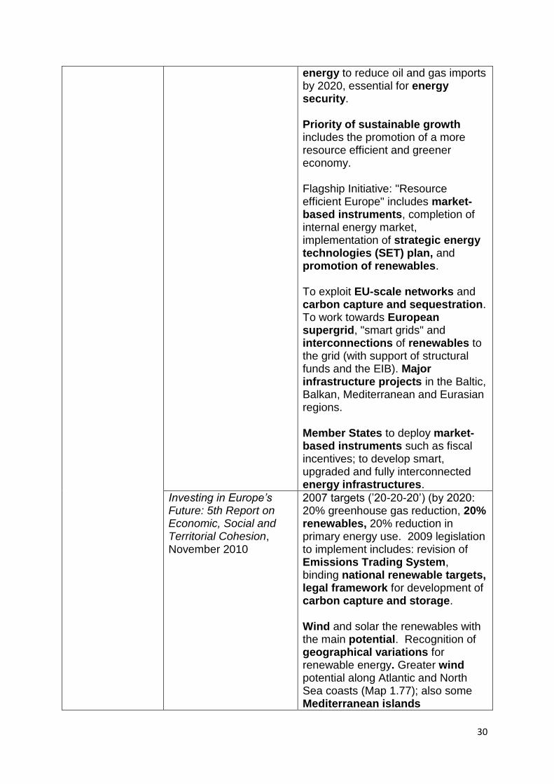
energy to reduce oil and gas imports by 2020, essential for energy security. Priority of sustainable growth includes the promotion of a more resource efficient and greener economy. Flagship Initiative: "Resource efficient Europe" includes market-based instruments, completion of internal energy market, implementation of strategic energy technologies (SET) plan, and promotion of renewables. To exploit EU-scale networks and carbon capture and sequestration. To work towards European supergrid, "smart grids" and interconnections of renewables to the grid (with support of structural funds and the EIB). Major infrastructure projects in the Baltic, Balkan, Mediterranean and Eurasian regions. Member States to deploy market-based instruments such as fiscal incentives; to develop smart, upgraded and fully interconnected energy infrastructures.
Investing in Europe’s Future: 5th Report on Economic, Social and Territorial Cohesion, November 2010
2007 targets (‘20-20-20‘) (by 2020: 20% greenhouse gas reduction, 20% renewables, 20% reduction in primary energy use. 2009 legislation to implement includes: revision of Emissions Trading System, binding national renewable targets, legal framework for development of carbon capture and storage. Wind and solar the renewables with the main potential. Recognition of geographical variations for renewable energy. Greater wind potential along Atlantic and North Sea coasts (Map 1.77); also some Mediterranean islands
31
and southern Baltic. Role of regions in facilitating renewables. Varying member state efforts needed, eg UK having to increase by 12.7%, Romania by 3.7% (Figure 1.40). Investment in wind energy, especially along Atlantic and North Sea coasts. Investment, research and technological development in wave, tidal, etc. Development of intelligent energy distribution networks for power sharing.
Territorial Agenda of the European Union 2020: Towards an inclusive, smart and sustainable Europe of diverse regions, May 2011
Review of the territorial agenda launched in 2007. To support territorial cohesion as a new EU goal introduced by the Treaty of Lisbon. Development opportunities of climate change, such as renewable energy. Energy challenges threaten regional competitiveness: regions heavily dependent on fossil fuel imports or specialized in energy intensive activities. Sustainable energy solutions needed in the face of rising energy prices and emissions. Insufficient energy infrastructure call for diversification of energy production and supply, and development of energy market and integration. Trans-European energy networks to improve territorial connectivity. Decentralized, efficient, secure and environmentally-friendly production and use of renewable and low carbon energy. Energy production increasing in marine environments. Need to balance various interests by
32
maritime spatial planning, to be integrated into existing systems to enable a land-sea continuum.
Critical Policy Documents: ENERGY
Energy for the Future, Communication from the Commission, 1997
Promotion of renewable sources of energy; ―enormous potential for offshore wind farms‖.
A European Strategy for Sustainable, Competitive and Secure Energy (COM 105), 2006
Prioritises internal electricity and gas markets, a European grid, investment in generation, security of supply, etc. Three core objectives: sustainability, competitiveness, security of supply.
An Energy Policy for Europe, Communication from the Commission, 2007
Commitment to a low consumption economy based on more secure, more competitive and more sustainable energy. Objectives involve ensuring the smooth functioning of the internal market in energy, security of strategic supply, concrete reductions in greenhouse gas emissions caused by the production or consumption of energy and the EU's ability to speak with a single voice on the international stage.
Second Strategic Energy Review: an EU energy security and solidarity action plan (COM 781) 2008
Proposes connecting the remaining isolated energy markets in Europe; developing a southern gas corridor for the supply of gas from Caspian region and Middle Eastern sources; making use of liquefied natural gas; Europe with the Southern Mediterranean through electricity and gas interconnections; developing gas and electricity interconnections crossing Central and South-East Europe; developing interconnections between the electric networks of the North-West of Europe so as to optimise wind energy in the North Sea.
Energy 2020: A strategy for competitive, sustainable and secure energy (COM 639) 2010
Further action needed to achieve 2007 strategy. Priorities: Achieving an energy efficient Europe; Building a truly pan-European integrated energy market; Empowering consumers and achieving the highest level of safety and security; Extending Europe's
33
leadership in energy technology and innovation; Strengthening the external dimension of the EU energy market.
Offshore Wind Energy: action needed to deliver on the energy policy objectives for 2020 and beyond, Communication of the Commission, 2008
Encourages member states to turn to marine wind energy in the pursuit of wider energy goals where possible.
Energy infrastructure pri-orities for 2020 and beyond: A Blueprint for an integrated European energy network (COM 677/4) 2010
Sets out a strategy for upgrading and developing energy network infrastructure in the EU in order to enable the achievement of wider energy goals.
Supporting early demonst-ration of sustainable power generation from fossil fuels [COM 13) 2008
The financial stakes and an initiative for an early demonstration of the capture and storage of CO2.
An Integrated Maritime Policy for the European Union, Communication of the Commission (COM 574), 2007
Highlights importance of Europe’s seas to energy supply, especially renewable resources, and transportation.
Related EU Legislation (Directives/ Regulations)
Directive on the Promotion of the Use of Energy from Renewable Sources, 2009/28/EC. Amending / repealing 2001/77/EC, 2003/30/EC.
Sets national indicative targets for renewable energy production from individual member states, in order to achieve the EU‘s overall target of 20% by 2020.
Regulation establishing a programme to aid economic recovery by granting Com-munity financial assistance to projects in the field of energy, 663/2009.
Sets up a European Energy Programme for Recovery to fund projects in gas and electricity infrastructures, offshore wind energy and carbon capture and storage.
Concerning Common Rules for the Internal Market in Electricity, 2009/72/EC. Amending / repealing 2003/54/EC.
Overcoming obstacles to an internal European market for electricity.
To Improve and Extend the Greenhouse Gas Emission Allowance Trading Scheme of the
Establishing and reforming the EU‘s emissions trading scheme.
34
Community, 2009/29/EC. Amending 2004/101/EC, 2003/87/EC, 96/61/EC.
On the Geological Storage of Carbon Dioxide 2009/31/EC. Amending 85/337/EEC, 2000/60/EC, 2001/80/EC, 2004/35/EC, 2006/12/EC, 2008/1/EC and Regulation 1013/2006.
Providing for carbon storage sites.
Related EU Programmes & Bodies
Energy Community Treaty
The Energy Community extends the EU internal energy market to South East Europe and beyond on the grounds of a legally binding framework.
Trans-European Networks
Information networks
Europe‘s Energy Portal http://www.energy.eu/
Invaluable source of information about organisations, legislation, production etc.
European Energy Forum Forum within the EU for energy debate.
ISLENET: European Islands Network on Energy and Environment
Sustainable energy for smaller European islands.
4. Thematic Data Ambitions In order to inform the key issues emerging from the EU energy policy framework in section 3 above, data should be sought covering the following issues. 1. The current and possible future contribution of European Seas to conventional
forms of energy supply: a. the distribution of offshore oil and gas facilities; b. member state levels and trends of offshore production; c. patterns of offshore exploration for oil and gas.
2. The potential contribution of European Seas to the expansion of renewable
sources of energy to providing 20% of primary energy supply by 2020 (thus contributing to the reduction of greenhouse gas emissions and dependence on imported fossil fuels):
a. the distribution of marine renewable resources, especially for wind energy;
35
b. actual and projected development of marine renewable energy, especially wind, including location of offshore wind farm sites and levels of production;
c. the potential of marine renewables, especially wind, to contribute to member states' individual 2020 renewable energy target;
d. the development opportunities presented by the expansion of marine renewables, especially wind, for the EU, member states and regions;
e. member states‘ policy and financial incentives for the development of marine renewables, especially wind energy;
f. EU, member states' and regions' levels of investment into research, technological and infrastructure development and manufacturing capacity into marine renewables, especially wind energy;
3. The contribution of existing and potential marine energy networks to the
completion and extension of internal gas and electricity networks, especially to isolated markets, and to improving connectivity with surrounding supplier regions:
a. the distribution and capacity of existing and projected sea-bed pipelines and cables and their land-fall;
b. the emergence of transnational agreements for the development of offshore networks;
c. the potential for expanding marine gas networks, including their contribution to the creation of a southern gas corridor;
d. the potential for developing marine electricity grids, including their contribution to the creation of a European supergrid and the interconnection of northwest Europe‘s networks and North Sea wind power, and their integration with terrestrial grids;
e. the potential for offshore energy supply and networks to benefit regions at risk of energy poverty.
4. The potential contribution of European Seas to contribute to carbon capture and
long-term storage: a. member states' policy initiatives for marine carbon storage; b. the location of potential marine sites for carbon storage.
5. Thematic Data Availability There are some existing data sources which can provide information to meet the data ambitions set out in section 4. However, these are not all complete, and frequently do not separate marine-related data from that for national jurisdictions as a whole. (References in brackets are again to the data ambitions of section 4.) General A number of international organisations (eg. International Energy Agency, BP, OECD) provide regional and national statistics on energy production and consumption. Similar statistics are available for Europe (eg. Eurostat, European Environment Agency). Production figures are generally given for conventional and renewable forms of energy supply, but there is no disaggregation into onshore and offshore information, eg for oil production. However, patterns and trends are shown for national energy mixes, overall consumption etc, which has some relevance for
36
demonstrating falling reserves of oil and gas in Europe and over-reliance on fossil fuels, especially from beyond the EU, which is one of the main drivers for the intended shift to a sustainable energy system. Hydrocarbons Some more detailed information on hydrocarbons, including some specific marine data, is available from some other bodies, including regional seas organisations:
data on offshore oil and gas platform locations and production is available for the OSPAR and HELCOM regions, which include the most important areas of production (1a, b);
broad indications of known and possible marine hydrocarbon reserves are available (US Geological Survey), including for the Arctic (Arctic Portal) (1c).
However, more comprehensive information should still be sought on offshore production figures for national or sea areas (1b), eg, via the International Association of Oil & Gas Producers. Renewables Much more marine-oriented data is available for renewable sources of energy. In addition to the general national statistics referred to above, Europe-wide information is available for:
the distribution of marine renewable resources, such as wind speeds and wave height: (Eurostat, European Environment Agency, European Science Foundation, DG Mare) (2a);
national offshore wind energy production figures (ECN & EEA) (2b);
the location and capacity of existing and planned offshore wind farms (Offshore Center Danmark, European Wind Energy Association); regional data is also available for the most important areas of current activity (OSPAR, HELCOM) (2b);
national economic support for offshore wind energy (Europe‘s Energy Portal) (2e);
national targets for marine (non-wind) renewable energy (European Ocean Energy Association) (2e).
However, data is lacking on investment, research and development opportunities related to marine renewables (2d, f), and is poor on member states‘ policy and financial incentives for marine renewables (2e). Further analysis would also be required to assess the potential of marine renewables to contribute to member states' 2020 renewable energy targets (2c). Other ESPON projects may provide leads to possible synergies between the expansion of marine renewables and onshore development. There are a number of relevant EU projects focusing on:
the development of renewable technologies and strategies in European seas (FP7: MARINA, ORECCA);
offshore wind for the North Sea (INTERREG: POWER Cluster), the sustainable use, including marine renewables, of the Baltic (INTERREG: SUBMARINER) and coastal wind energy (INTERREG: POWER WICO).
Contact should be made with these projects for possible data sharing. For example, MARINA has data on marine renewable resources (2a).
37
Networks Relatively good information is available on seabed pipelines and cables, including mapped data, though generally at a low level of resolution. Although information is often integrated with terrestrial data, marine components are clearly identifiable:
the location of Trans-European Energy Networks (gas and electricity) (DG Mare) (3a);
the location and capacity of existing and planned oil and gas pipelines throughout Europe (Theodora) (3a);
the location of gas pipelines and flow of gas throughout Europe (IEA) (3a);
information on seabed telecommunications and power cables throughout Europe (International Cable Protection Committee) (3a)
Some additional information is available for certain areas: the location of cables in the OSPAR region , cables and pipelines in the Baltic, gas pipelines in the Mediterranean and cables around the UK (OSPAR, HELCOM, Plan Bleu, KISCA) (3a). Some information is available for projected transnational gas routes (Europe‘s Energy Portal) (3c). However, there is little other data to inform the possible development of marine networks (3b) for gas supply (3c), electricity (3d) or to connect regions at risk of energy poverty (3e). Some contribution to these issues might be made from the ESPON project on Regions at Risk of Energy Poverty (RERISK). Carbon Capture and Storage Some mapping of potential carbon storage sites, such as in the North Sea, is taking place (Scottish Carbon Capture & Storage) (4a, b). Also, the FP7 project on deep saline aquifers for carbon storage (MUSTANG) might provide leads. 6. Key Thematic Risks and Development Opportunities Opportunities and risks for energy etc development in European Seas relate to:
the continued exploitation of fossil fuels;
the transition to more sustainable forms of energy supply;
growing transnational interconnection of energy and telecommunications systems;
the potential for carbon storage under the seabed. These all:
involve infrastructure development at sea, generally of a dispersed nature: oil and gas platforms, wind arrays, seabed networks, etc;
have significant, generally negative, consequences for the marine environment, though with some possibilities for synergies, such as the creation of artificial reefs;
restrict other marine uses, such as navigation, fishing and aggregate extraction;
38
have associated onshore development, especially marine energy supply, which can involve substantial coastal industrial clusters with sea and air transit to production facilities.
The way in which these features will play out in the coming years will vary greatly between the different seas, but broad patterns are as follows. The Baltic Sea The Baltic Sea is not an important source of conventional energy resources, having only a couple of oil platforms. However, it is becoming an important area of gas transit, with major pipelines planned or under construction, including a supply route from Russia to northern Europe. Also, the Baltic is now playing host to marine wind energy, with a number of arrays operating and plans coming forward for others, mostly in the southern area, facilitated by the relatively calm, shallow waters. Seabed power and telecommunications cables also link Baltic countries, with additional cables likely to be developed, especially for the transfer of power, not least from marine wind arrays, possibly becoming part of a European supergrid. Other marine renewables have limited potential in the Baltic because of its enclosed nature (hence small wave size, tides and currents), and carbon storage does not appear to be under consideration at present. The main opportunities for the Baltic are therefore the continued expansion of marine wind energy and the development of an associated transnational grid system. The development of coastal centres for the construction and servicing of marine wind arrays should be explored, as should the potential of grid connections to assist regions at risk of energy poverty. However, the risks associated with wind arrays should also be studied, especially conflict with other interests, such as shipping lanes and environmentally sensitive areas, as should possible synergies with other interests. The Baltic‘s role in building energy relations with Russia should also be considered. The North Sea The North Sea is one of Europe‘s premier energy-production regions, due to large-scale oil and gas production over the last four decades, mostly in Norwegian, UK and Dutch waters. However, overall production is now declining quite rapidly, having peaked in 1999. Nonetheless, exploration continues, and smaller fields are still being opened up. Hundreds of platforms are dispersed throughout two main, large areas in northern and southern parts of the North Sea. An extensive network of pipelines connects supply to a number of main land terminals. The North Sea has also become home to the greatest concentration of offshore wind arrays in the world, mostly developed in the last few years, and benefiting from shallow waters, consistent and high wind speeds and relative proximity to centres of electricity demand. North Sea countries, especially the UK and Germany, plan to expand massively this wind energy capacity, including moving into new areas far from the coast, making marine wind energy a major component of their national energy mixes. Associated with this is the development of offshore grid systems to bring supply onshore, and plans to develop a transnational North Sea grid to facilitate power sharing across northern Europe. Also, the North Sea already has a high
39
concentration of power and telecommunications cables linking its bordering countries. Finally, marine renewable innovation is moving ahead in Scottish waters and a carbon storage facility is already in operation in Norwegian waters. The North Sea therefore has unparalleled opportunities to contribute to European energy goals. It will continue to be an important source of fossil fuels, supporting shore-based industry as well as meeting energy needs. However, associated risks should be highlighted, such as the continuing contribution that use of North Sea oil and gas makes to greenhouse gas emissions, and potential damage to ecosystems, especially from ongoing exploration and the opening up of new fields. But the greatest opportunity is for the North Sea to continue on its trajectory of becoming a major contributor of sustainable energy supply through the large-scale development of marine wind arrays, for which it has very favourable conditions. The development of industrial clusters for technological development, manufacturing, construction and servicing of arrays in strategic locations along North Sea coasts should be explored. The development of offshore grid systems and a North Sea grid (as part of a European supergrid) should also be studied, including its potential to assist regions at risk of energy poverty. The outlook for other marine renewables should also be considered. However, the risks associated with marine renewables, especially wind, should also be explored, especially conflict with other interests, such as the major international shipping lanes and environmentally sensitive areas, though possible synergies with other interests should also be considered. In addition, the prospect for the North Sea to become a centre for carbon storage, making use of depleted oil and gas fields, should be investigated. The Arctic Sea The main focus of attention in the Arctic Sea is the likelihood of large oil and gas finds and exploitation on a major scale, facilitated by the melting of the Arctic ice cap. Although most activity will be outside ESPON space, some new production is likely in Norwegian waters. New pipeline connections are possible in connection with this development. Renewable forms of energy and carbon storage, though not inconceivable in the long-term, do not appear to be receiving any attention. The Arctic therefore presents the opportunity of increased supply of fossil fuels within the ESPON area and neighbouring countries, especially Russia. The possibility of supporting shore-based industry and pipeline connections with ESPON countries, especially Norway, should be explored further. Associated risks should also be highlighted, especially increased greenhouse gas emissions, running counter to 20-20-20 targets, and potential damage to sensitive ecosystems. The Arctic‘s role in building up energy relations with Russia should also be considered. The Atlantic Area The Atlantic is a diverse area as far as energy, cables and pipelines are concerned. Relatively small-scale exploitation of oil and gas takes place, with no expectation of substantial growth. The sea has very substantial renewable energy resources, including some of the best wave, current and tidal resources in Europe, and some offshore wind farms are already operating in the Irish Sea. However, wave etc technologies are still far from commercially viable, and wind power faces greater
40
challenges in much of the Atlantic area because of deeper waters and rougher seas. Many of the more favourable areas for marine renewables are also heavily used for shipping etc and/or are environmentally sensitive. Despite these obstacles, member states are seeking to develop marine renewables in Atlantic waters and technological development is underway. The Atlantic lacks large exhausted oil and gas fields that might serve for carbon storage, though there may be other possibilities for storage. The Atlantic area contains some pipelines and power cables, especially in the Irish Sea, and is host to a large number of telecommunications cables, many of which are trans-Atlantic. The Atlantic‘s main opportunity is therefore the development of marine renewables. This includes both the expansion of conventional offshore wind arrays and the development of new technologies, including the so-far untapped non-wind options, for which the Atlantic has some of the greatest potential in Europe. It could also be the testing-ground for wind arrays designed for more challenging settings. At the same time, the incorporation of marine renewables into areas that are already under considerable pressure is both a risk to other interests and an opportunity to seek synergies with other interests. The opportunity for centres of technological development, manufacturing, construction and servicing of marine renewables in strategic locations along Atlantic coasts should be explored. Finally, the development of more comprehensive offshore grid systems to connect renewable energy production to onshore points of demand should be considered. The Mediterranean Sea The Mediterranean region contains major centres of oil and gas production, though these are mostly land-based in North African countries; there are offshore fields, though these are relatively small, especially the few that are in the waters of EU countries [check]. The Mediterranean Sea is more important as a zone of transit for oil and gas, with major, mostly gas, pipelines connecting North African supply to European demand; new pipelines are also under construction or being planned, with the aim of increasing and diversifying gas supply to Europe. There are also important international telecommunications cables running through the Mediterranean. There is relatively little marine renewable energy activity in the Mediterranean, partly due to relatively poor resources, given the enclosed nature of the sea (hence limited wave size, tides and currents) and generally low wind speeds. However, there are some areas with a good wind resource, and there have been proposals to exploit currents in the Strait of Gibraltar. But the scope for development of energy resources in the Mediterranean is generally limited to coastal waters due to the lack of agreed exclusive economic zones. The most important opportunity for the Mediterranean is therefore as a gateway for the import of fossil fuels from relatively nearby sources of supply; its role in building up energy relations with North African countries should be considered, through, for example, infrastructure development (pipelines and terminals) and governance arrangements, with a view to reducing risks of over-reliance on any one source. The potential for new lines of supply to assist regions at risk of energy poverty should be looked into. In addition, the scope for marine renewables, especially wind arrays in favourable locations and their grid connections, should be explored, without overlooking associated risks, such as conflict with other uses, and possible
41
synergies with other interests. The Mediterranean‘s continuing role as a corridor for international telecommunications cables should also be highlighted. The Black Sea Some oil production takes place in the Black Sea. Regional interest in renewable energy is growing, though there are no plans for marine renewable projects and the potential in Bulgarian and Romanian waters is limited. Of more importance is the transit of energy across the Black Sea: oil pipelines terminate at ports for onward shipment, with planned expansion of capacity; a gas pipeline crosses from Russia to Turkey; a major gas pipeline is under construction across the Black Sea to supply gas from Russia to central and southern Europe; and a trans-Caspian-Black Sea gas corridor is under consideration. Some non-EU Black Sea countries are also becoming more integrated to the EU energy market through the Energy Community Treaty. The possibility of carbon storage does not appear to be receiving any attention. Some telecommunications cables also cross the Black Sea. One opportunity for the Black Sea is therefore as a transit zone for the movement of fossil fuels primarily from Russia to surrounding countries and further west into Europe. Its role in improving energy relations with Russia should be considered, through continued infrastructure development (pipelines and terminals) and governance arrangements. Associated risks should also be highlighted, especially increased greenhouse gas emissions resulting from greater use of gas. The potential for new lines of supply to assist regions at risk of energy poverty should be looked into. In addition, the provisional scope for marine renewables, especially wind arrays, should be explored.
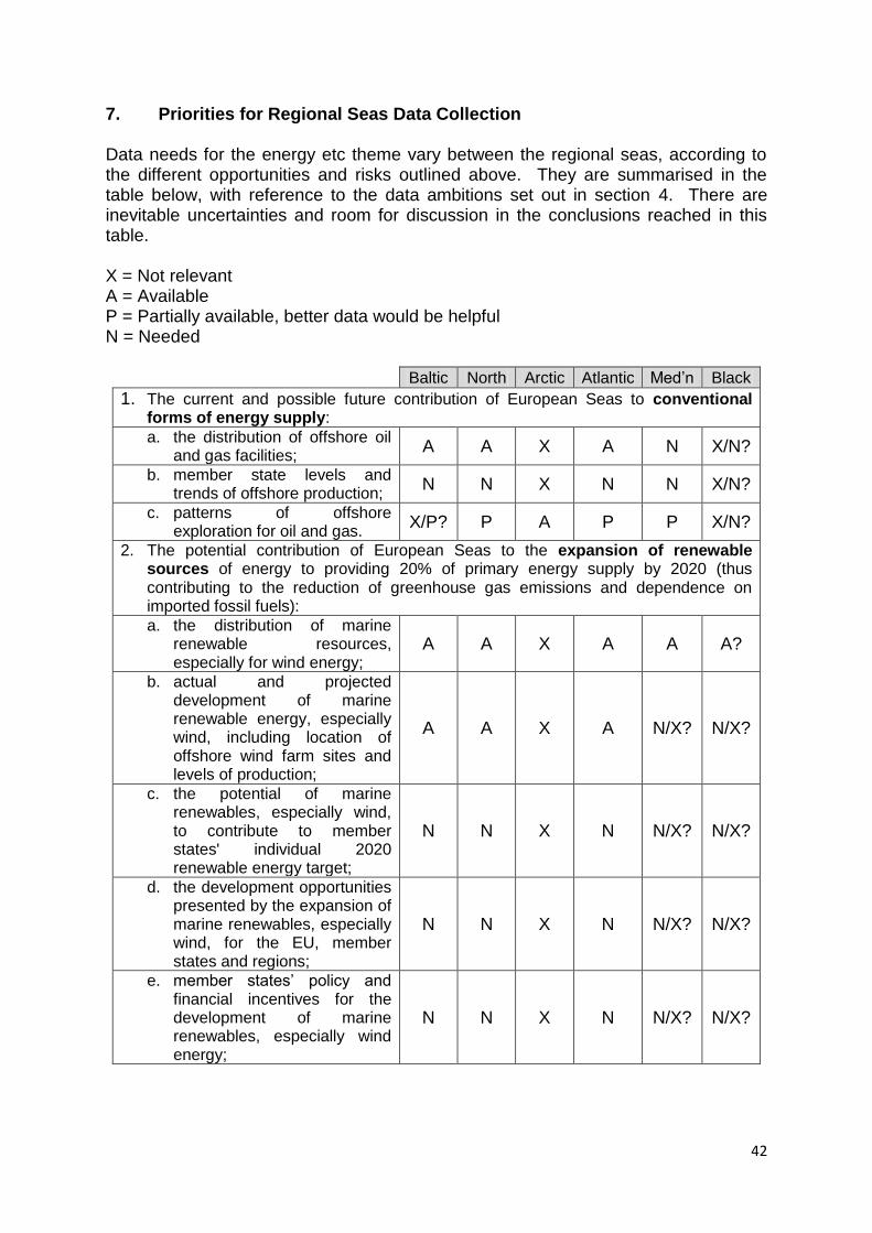
42
7. Priorities for Regional Seas Data Collection Data needs for the energy etc theme vary between the regional seas, according to the different opportunities and risks outlined above. They are summarised in the table below, with reference to the data ambitions set out in section 4. There are inevitable uncertainties and room for discussion in the conclusions reached in this table. X = Not relevant A = Available P = Partially available, better data would be helpful N = Needed
Baltic North Arctic Atlantic Med‘n Black
1. The current and possible future contribution of European Seas to conventional forms of energy supply: a. the distribution of offshore oil
and gas facilities; A A X A N X/N?
b. member state levels and trends of offshore production;
N N X N N X/N?
c. patterns of offshore exploration for oil and gas.
X/P? P A P P X/N?
2. The potential contribution of European Seas to the expansion of renewable sources of energy to providing 20% of primary energy supply by 2020 (thus contributing to the reduction of greenhouse gas emissions and dependence on imported fossil fuels):
a. the distribution of marine renewable resources, especially for wind energy;
A A X A A A?
b. actual and projected development of marine renewable energy, especially wind, including location of offshore wind farm sites and levels of production;
A A X A N/X? N/X?
c. the potential of marine renewables, especially wind, to contribute to member states' individual 2020 renewable energy target;
N N X N N/X? N/X?
d. the development opportunities presented by the expansion of marine renewables, especially wind, for the EU, member states and regions;
N N X N N/X? N/X?
e. member states‘ policy and financial incentives for the development of marine renewables, especially wind energy;
N N X N N/X? N/X?

43
Baltic North Arctic Atlantic Med‘n Black
f. EU, member states' and regions' levels of investment into research, technological and infrastructure development and manufacturing capacity into marine renewables, especially wind energy;
N N X N N/X? N/X?
3. The contribution of existing and potential marine energy networks to the completion and extension of internal gas and electricity networks, especially to isolated markets, and to improving connectivity with surrounding supplier regions:
a. the distribution and capacity of existing and projected sea-bed pipelines and cables and their land-fall;
A A P/X? A P P
b. the emergence of transnational agreements for the development of offshore networks;
N N N/X? N N N
c. the potential for expanding marine gas networks, including their contribution to the creation of a southern gas corridor;
P P/X? P/X? P/X? P P
d. the potential for developing marine electricity grids, including their contribution to the creation of a European supergrid and the interconnection of northwest Europe‘s networks and North Sea wind power, and their integration with terrestrial grids;
P P X P P/X? P/X?
e. the potential for offshore energy supply and networks to benefit regions at risk of energy poverty.
N N X N N N
4. The potential contribution of European Seas to contribute to carbon capture and long-term storage: a. member states' policy
initiatives for marine carbon storage;
N/X? N X N N/X? N/X?
b. the location of potential marine sites for carbon storage.
N/X? N X N N/X? N/X?
8. References See sources in annex, below.
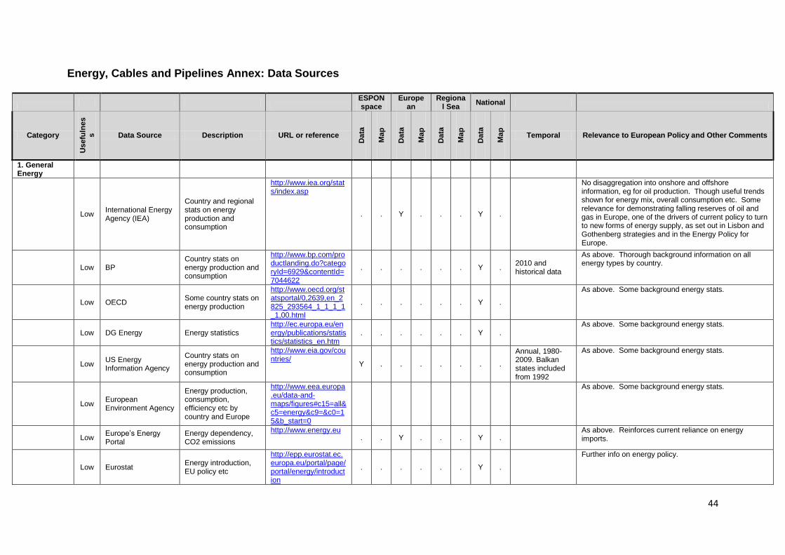
44
Energy, Cables and Pipelines Annex: Data Sources
ESPON space
European
Regional Sea
National
Category
Usefu
lne
ss
Data Source Description URL or reference
Data
Ma
p
Data
Ma
p
Data
Ma
p
Data
Ma
p
Temporal Relevance to European Policy and Other Comments
1. General Energy
Low International Energy Agency (IEA)
Country and regional stats on energy production and consumption
http://www.iea.org/stats/index.asp
. . Y . . . Y .
No disaggregation into onshore and offshore information, eg for oil production. Though useful trends shown for energy mix, overall consumption etc. Some relevance for demonstrating falling reserves of oil and gas in Europe, one of the drivers of current policy to turn to new forms of energy supply, as set out in Lisbon and Gothenberg strategies and in the Energy Policy for Europe.
Low BP Country stats on energy production and consumption
http://www.bp.com/productlanding.do?categoryId=6929&contentId=7044622
. . . . . . Y . 2010 and historical data
As above. Thorough background information on all energy types by country.
Low OECD Some country stats on energy production
http://www.oecd.org/statsportal/0,2639,en_2825_293564_1_1_1_1_1,00.html
. . . . . . Y .
As above. Some background energy stats.
Low DG Energy Energy statistics
http://ec.europa.eu/energy/publications/statistics/statistics_en.htm
. . . . . . Y . As above. Some background energy stats.
Low US Energy Information Agency
Country stats on energy production and consumption
http://www.eia.gov/countries/
Y . . . . . . .
Annual, 1980-2009. Balkan states included from 1992
As above. Some background energy stats.
Low European Environment Agency
Energy production, consumption, efficiency etc by country and Europe
http://www.eea.europa.eu/data-and-maps/figures#c15=all&c5=energy&c9=&c0=15&b_start=0
As above. Some background energy stats.
Low
Europe‘s Energy Portal
Energy dependency, CO2 emissions
http://www.energy.eu
. . Y . . . Y . As above. Reinforces current reliance on energy imports.
Low Eurostat Energy introduction, EU policy etc
http://epp.eurostat.ec.europa.eu/portal/page/portal/energy/introduction
. . . . . . Y .
Further info on energy policy.
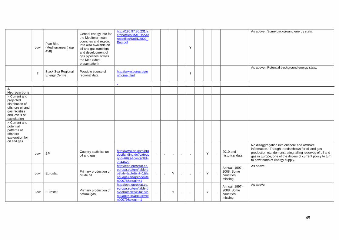
45
Low Plan Bleu (Mediterranean) (pp 45ff)
Geneal energy info for the Mediterannean countries and region. Info also available on oil and gas transfers and development of gas pipelines across the Med (Mcrit presentation).
http://195.97.36.231/acrobatfiles/MAPDocAcrobatfiles/SoED2009_Eng.pdf
Y
As above. Some background energy stats.
? Black Sea Regional Energy Centre
Possible source of regional data
http://www.bsrec.bg/en/home.html
?
As above. Potential background energy stats.
2. Hydrocarbons
> Current and projected distribution of offshore oil and gas facilities and levels of exploitation
> Current and potential patterns of offshore exploration for oil and gas
Low BP Country statistics on oil and gas
http://www.bp.com/productlanding.do?categoryId=6929&contentId=7044622
. . . . . . Y . 2010 and historical data
No disaggregation into onshore and offshore information. Though trends shown for oil and gas production etc, demonstrating falling reserves of oil and gas in Europe, one of the drivers of current policy to turn to new forms of energy supply.
Low Eurostat Primary production of crude oil
http://epp.eurostat.ec.europa.eu/tgm/table.do?tab=table&init=1&language=en&pcode=ten00078&plugin=1
. . Y . . . Y .
Annual, 1997-2008. Some countries missing
As above
Low Eurostat Primary production of natural gas
http://epp.eurostat.ec.europa.eu/tgm/table.do?tab=table&init=1&language=en&pcode=ten00079&plugin=1
. . Y . . . Y .
Annual, 1997-2008. Some countries missing
As above
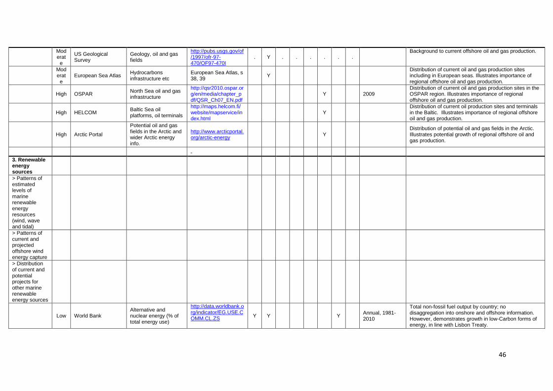
46
Moderat
e
US Geological Survey
Geology, oil and gas fields
http://pubs.usgs.gov/of/1997/ofr-97-470/OF97-470I
. Y . . . . . . Background to current offshore oil and gas production.
Moderat
e European Sea Atlas
Hydrocarbons infrastructure etc
European Sea Atlas, s 38, 39
Y Distribution of current oil and gas production sites including in European seas. Illustrates importance of regional offshore oil and gas production.
High OSPAR
North Sea oil and gas infrastructure
http://qsr2010.ospar.org/en/media/chapter_pdf/QSR_Ch07_EN.pdf
Y 2009 Distribution of current oil and gas production sites in the OSPAR region. Illustrates importance of regional offshore oil and gas production.
High HELCOM
Baltic Sea oil platforms, oil terminals
http://maps.helcom.fi/website/mapservice/index.html
Y Distribution of current oil production sites and terminals in the Baltic. Illustrates importance of regional offshore oil and gas production.
High Arctic Portal
Potential oil and gas fields in the Arctic and wider Arctic energy info.
http://www.arcticportal.org/arctic-energy
Y Distribution of potential oil and gas fields in the Arctic. Illustrates potential growth of regional offshore oil and gas production.
3. Renewable energy sources
> Patterns of estimated levels of marine renewable energy resources (wind, wave and tidal)
> Patterns of current and projected offshore wind energy capture
> Distribution of current and potential projects for other marine renewable energy sources
Low World Bank Alternative and nuclear energy (% of total energy use)
http://data.worldbank.org/indicator/EG.USE.COMM.CL.ZS
Y Y Y Annual, 1981-2010
Total non-fossil fuel output by country; no disaggregation into onshore and offshore information. However, demonstrates growth in low-Carbon forms of energy, in line with Lisbon Treaty.
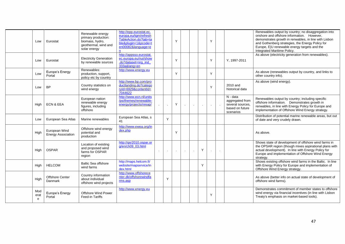
47
Low Eurostat
Renewable energy primary production: biomass, hydro, geothermal, wind and solar energy
http://epp.eurostat.ec.europa.eu/tgm/refreshTableAction.do?tab=table&plugin=1&pcode=ten00082&language=en
Y Y
Renewables output by country; no disaggregation into onshore and offshore information. However, demonstrates growth in renwables, in line with Lisbon and Gothenberg strategies, the Energy Policy for Europe, E|U renewable energy targets and the Integrated Maritime Policy.
Low Eurostat Electricity Generation by renewable sources
http://appsso.eurostat.ec.europa.eu/nui/show.do?dataset=nrg_ind_333a&lang=en
Y Y Y, 1997-2011
As above (electricity generation from renewables).
Low
Europe‘s Energy Portal
Renewables: production, support, policy etc by country
http://www.energy.eu
Y Y As above (renewables output by country, and links to other country info).
Low BP Country statistics on wind energy
http://www.bp.com/productlanding.do?categoryId=6929&contentId=7044622
Y 2010 and historical data
As above (wind energy).
High ECN & EEA
European nation renewable energy figures, including offshore
http://www.ecn.nl/units/ps/themes/renewable-energy/projects/nreap/ . . Y . . . . .
N - data aggregated from several sources, based on future scenarios
Renewables output by country; including specific offshore information. Demonstrates growth in renwables, in line with Energy Policy for Europe and implementation of Offshore Wind Energy strategy.
Low European Sea Atlas Marine renewables
European Sea Atlas, s 41
Y Distribution of potential marine renewable areas, but out of date and very crudely drawn.
High European Wind Energy Association
Offshore wind energy potential and production
http://www.ewea.org/index.php
Y As above.
High OSPAR
Location of existing and proposed wind farms for OSPAR region
http://qsr2010.ospar.org/en/ch09_03.html
. . . . . Y . .
Shows state of development of offshore wind farms in the OPSAR region (though mixes aspirational plans with actual development). In line with Energy Policy for Europe and implementation of Offshore Wind Energy strategy.
High HELCOM
Baltic Sea offshore wind farms
http://maps.helcom.fi/website/mapservice/index.html
Y Shows existing offshore wind farms in the Baltic. In line with Energy Policy for Europe and implementation of Offshore Wind Energy strategy.
High Offshore Center Danmark
Country information about individual offshore wind projects
http://www.offshorecenter.dk/offshorewindfarms.asp
Y As above (better info on actual state of development of offshore wind farms).
Moderat
e
Europe‘s Energy Portal
Offshore Wind Power Feed-in Tariffs
http://www.energy.eu
Y
Demonstrates commitment of member states to offshore wind energy via financial incentives (in line with Lisbon Treaty's emphasis on market-based tools).
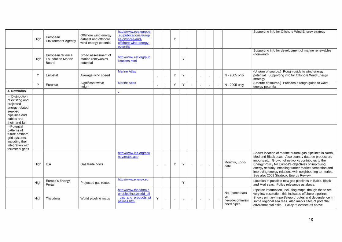
48
High European Environment Agency
Offshore wind energy dataset and offshore wind energy potential
http://www.eea.europa.eu/publications/europes-onshore-and-offshore-wind-energy-potential
Y
Supporting info for Offshore Wind Energy strategy
High European Science Foundation Marine Board
Broad assessment of marine renewables potential
http://www.esf.org/publications.html
Y
Supporting info for development of marine renewables (non-wind)
? Eurostat Average wind speed
Marine Atlas . . Y Y . . . . N - 2005 only
(Unsure of source.) Rough guide to wind energy potential. Supporting info for Offshore Wind Energy strategy
? Eurostat
Significant wave height
Marine Atlas . . Y Y . . . . N - 2005 only
(Unsure of source.) Provides a rough guide to wave energy potential.
4. Networks
> Distribution of existing and projected energy-related, sea-bed pipelines and cables and their land-fall
> Potential patterns of future offshore grid systems, including their integration with terrestrial grids
High IEA Gas trade flows
http://www.iea.org/country/maps.asp
. . Y Y . . . . Monthly, up-to-date
Shows location of marine nutural gas pipelines in North, Med and Black seas. Also country data on production, imports etc. Growth of networks contributes to the Energy Policy for Europe's objectives of improving energy security, enabling further market competion and improving energy relations with neighbouring territories. See also 2008 Strategic Energy Review.
High
Europe‘s Energy Portal
Projected gas routes http://www.energy.eu
Y Location of possible new gas pipelines in Baltic, Black and Med seas. Policy relevance as above.
High Theodora World pipeline maps
http://www.theodora.com/pipelines/world_oil_gas_and_products_pipelines.html
Y . . . . . . .
No - some data on new/decommissioned pipes
Pipeline information, including maps, though these are very low-resolution; this indicates offshore pipelines. Shows primary import/export routes and dependence in some regional sea reas. Also marks sites of potential environmental risks. Policy relevance as above.
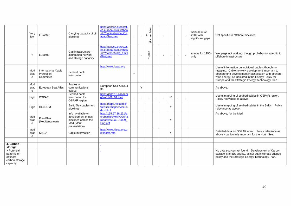
49
Very low
Eurostat Carrying capacity of oil pipelines
http://appsso.eurostat.ec.europa.eu/nui/show.do?dataset=pipe_if_capac&lang=en
. . Y
(in
com
ple
te)
. . . . . Annual 1992-2009 with significant gaps
Not specific to offshore pipelines.
? Eurostat Gas infrastructure - distribution network and storage capacity
http://appsso.eurostat.ec.europa.eu/nui/show.do?dataset=nrg_112a&lang=en
. .
Y,
part
. . . . . annual for 1990s only
Webpage not working, though probably not specific to offshore infrastructure
Moderat
e
International Cable Protection Committee
Seabed cable information
http://www.iscpc.org
Y
Useful information on individual cables, though no mapping. Cable network development important to offshore grid development in association with offshore wind energy, as indicated in the Energy Policy for Europe and the Strategic Energy Technology Plan.
Moderat
e European Sea Atlas
Routes of communications cables
European Sea Atlas, s 36
Y As above.
High OSPAR
Seabed cable information for OSPAR region
http://qsr2010.ospar.org/en/ch09_04.html . . . . . Y . .
Useful mapping of seabed cables in OSPAR region. Policy relevance as above.
High HELCOM
Baltic Sea cables and pipelines
http://maps.helcom.fi/website/mapservice/index.html
Y Useful mapping of seabed cables in the Baltic. Policy relevance as above.
Moderat
e
Plan Bleu (Mediterranean)
Info available on development of gas pipelines across the Med (Mcrit presentation).
http://195.97.36.231/acrobatfiles/MAPDocAcrobatfiles/SoED2009_Eng.pdf
Y
As above, for the Med.
Moderat
e KISCA Cable information
http://www.kisca.org.uk/charts.htm Y
Detailed data for OSPAR area. Policy relevance as above - particularly important for the North Sea.
4. Carbon storage
> Potential patterns of offshore carbon storage capacity
No data sources yet found. Development of Carbon storage is an EU priority, as set out in climate change policy and the Strategic Energy Technology Plan.
50
Appendix 3: Environment Thematic Briefing Paper
Alison Gilbert and Ron Janssen, Institute for Environmental Studies, VU University Amsterdam.
1. Introduction
The Lisbon and Gothenburg Agendas (now called the EU's Sustainable Development Strategy or SDS) are a commitment to renewal in the EU based on the principles of sustainable development and its three core elements: economy, society and the environment. The 2009 Review of the EU Sustainable Development Strategy (EU SDS) confirmed that sustainable development remains a fundamental objective of the European Union under the Lisbon Treaty. The SDS will continue to provide a long-term vision and constitute the overarching policy framework for all Union policies and strategies. Environmental sustainability is a major cross-cutting theme for 2007-2013. The Gothenburg European Council highlighted four priority areas – climate change, sustainable transport, public health and resource management – all of which have implications for the coastal and marine environment. 2. Global Governance and Policy Context
Global and supra-EU governance is dominated by conventions under the auspices of the United Nations, notably United Nations Environment Programme (UNEP) and the International Maritime Organisation (IMO). These conventions focus on giving protection to species (e.g. migratory, mammals, endangered, but not forgetting biodiversity in general) and limiting pollution. The degree of ratification of the various conventions varies. UNEP‘s Regional Seas Programme is the origin of the various European regional sea commissions such as HELCOM and OSPAR. While the EU is a part of these commissions, individual member states both in- and outside the EU are also involved. A number of regional sea commissions have developed action plans to orchestrate environmental measures among member nations. Some governance arrangements have origins that do not derive from the UN. These include various transboundary river commissions which explicitly have objectives relating to their effects on the quality of receiving waters.
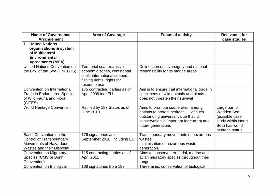
51
Name of Governance Arrangement
Area of Coverage Focus of activity
Relevance for case studies
1. United Nations organisations & system of Multilateral Environmental Agreements (MEA)
United Nations Convention on the Law of the Sea (UNCLOS)
Territorial sea, exclusive economic zones, continental shelf, international seabed, fishing rights, rights for resource use
Delineation of sovereignty and national responsibility for its marine areas
Convention on International Trade in Endangered Species of Wild Fauna and Flora (CITES)
175 contracting parties as of April 2009 inc. EU
Aim is to ensure that international trade in specimens of wild animals and plants does not threaten their survival
World Heritage Convention Ratified by 187 States as of June 2010
Aims to promote cooperation among nations to protect heritage ... of such outstanding universal value that its conservation is important for current and future generations
Large part of Wadden Sea (possible case study within North Sea) has world heritage status.
Basel Convention on the Control of Transboundary Movements of Hazardous Wastes and their Disposal
176 signatories as of September 2010, including EU
Transboundary movements of hazardous wastes; minimisation of hazardous waste generation.
Convention on Migratory Species (CMS or Bonn Convention)
115 contracting parties as of April 2011
Aims to conserve terrestrial, marine and avian migratory species throughout their range
Convention on Biological 168 signatories from 193 Three aims: conservation of biological
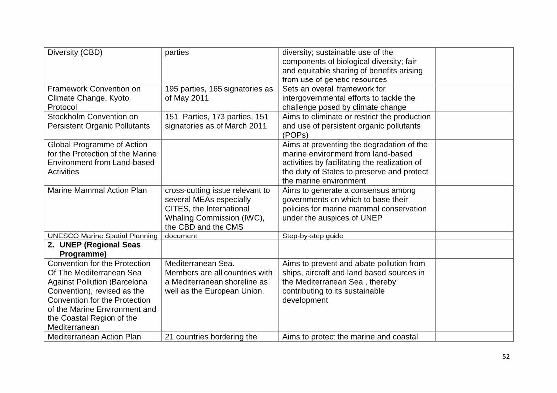
52
Diversity (CBD) parties diversity; sustainable use of the components of biological diversity; fair and equitable sharing of benefits arising from use of genetic resources
Framework Convention on Climate Change, Kyoto Protocol
195 parties, 165 signatories as of May 2011
Sets an overall framework for intergovernmental efforts to tackle the challenge posed by climate change
Stockholm Convention on Persistent Organic Pollutants
151 Parties, 173 parties, 151 signatories as of March 2011
Aims to eliminate or restrict the production and use of persistent organic pollutants (POPs)
Global Programme of Action for the Protection of the Marine Environment from Land-based Activities
Aims at preventing the degradation of the marine environment from land-based activities by facilitating the realization of the duty of States to preserve and protect the marine environment
Marine Mammal Action Plan cross-cutting issue relevant to several MEAs especially CITES, the International Whaling Commission (IWC), the CBD and the CMS
Aims to generate a consensus among governments on which to base their policies for marine mammal conservation under the auspices of UNEP
UNESCO Marine Spatial Planning document Step-by-step guide
2. UNEP (Regional Seas Programme)
Convention for the Protection Of The Mediterranean Sea Against Pollution (Barcelona Convention), revised as the Convention for the Protection of the Marine Environment and the Coastal Region of the Mediterranean
Mediterranean Sea. Members are all countries with a Mediterranean shoreline as well as the European Union.
Aims to prevent and abate pollution from ships, aircraft and land based sources in the Mediterranean Sea , thereby contributing to its sustainable development
Mediterranean Action Plan 21 countries bordering the Aims to protect the marine and coastal
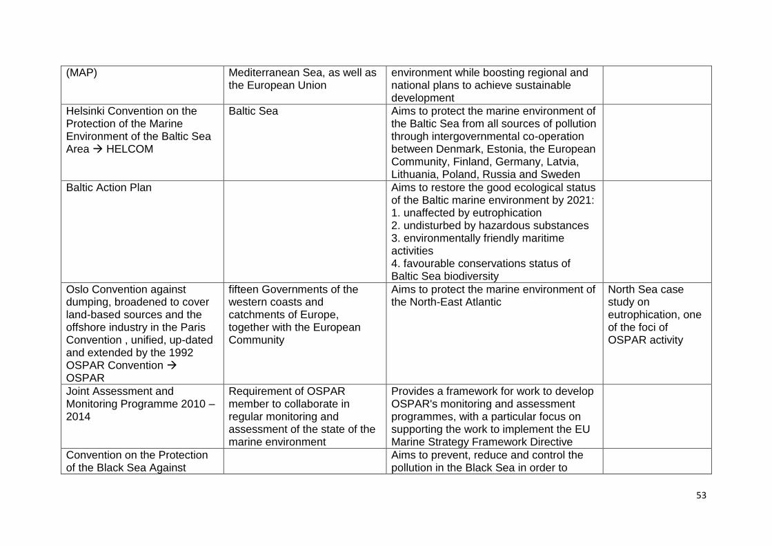
53
(MAP) Mediterranean Sea, as well as the European Union
environment while boosting regional and national plans to achieve sustainable development
Helsinki Convention on the Protection of the Marine Environment of the Baltic Sea Area HELCOM
Baltic Sea Aims to protect the marine environment of the Baltic Sea from all sources of pollution through intergovernmental co-operation between Denmark, Estonia, the European Community, Finland, Germany, Latvia, Lithuania, Poland, Russia and Sweden
Baltic Action Plan Aims to restore the good ecological status of the Baltic marine environment by 2021: 1. unaffected by eutrophication 2. undisturbed by hazardous substances 3. environmentally friendly maritime activities 4. favourable conservations status of Baltic Sea biodiversity
Oslo Convention against dumping, broadened to cover land-based sources and the offshore industry in the Paris Convention , unified, up-dated and extended by the 1992 OSPAR Convention OSPAR
fifteen Governments of the western coasts and catchments of Europe, together with the European Community
Aims to protect the marine environment of the North-East Atlantic
North Sea case study on eutrophication, one of the foci of OSPAR activity
Joint Assessment and Monitoring Programme 2010 – 2014
Requirement of OSPAR member to collaborate in regular monitoring and assessment of the state of the marine environment
Provides a framework for work to develop OSPAR's monitoring and assessment programmes, with a particular focus on supporting the work to implement the EU Marine Strategy Framework Directive
Convention on the Protection of the Black Sea Against
Aims to prevent, reduce and control the pollution in the Black Sea in order to
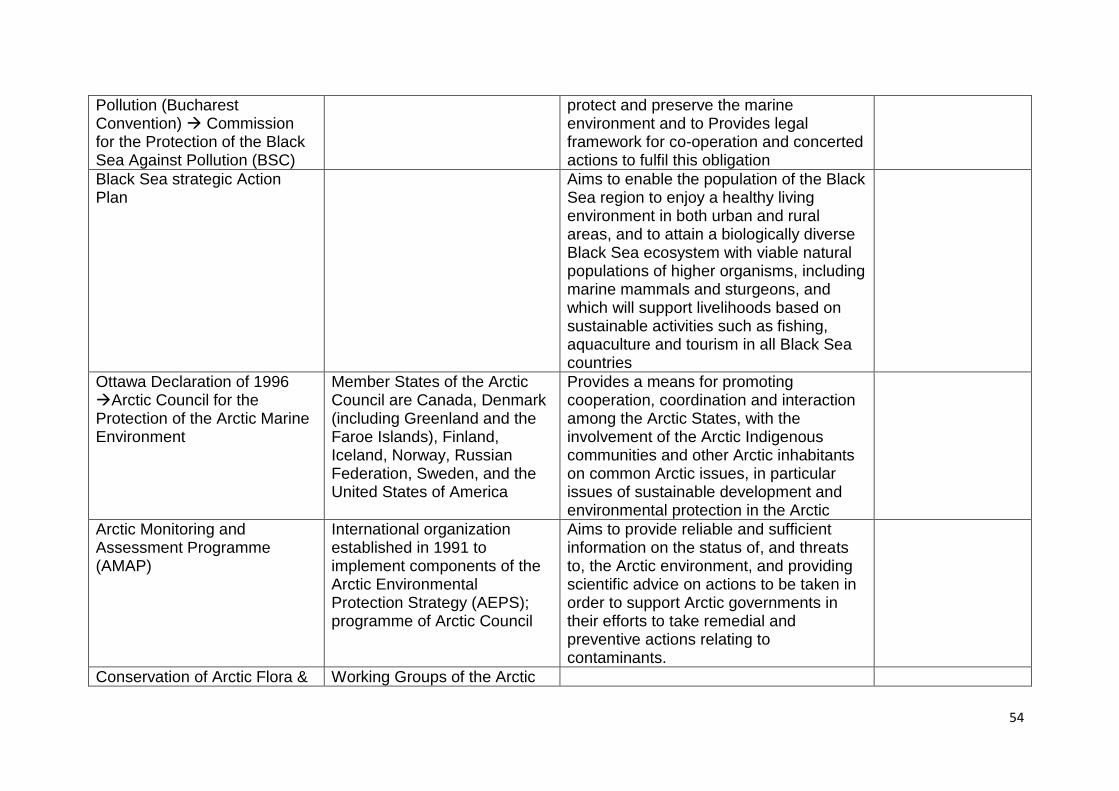
54
Pollution (Bucharest Convention) Commission for the Protection of the Black Sea Against Pollution (BSC)
protect and preserve the marine environment and to Provides legal framework for co-operation and concerted actions to fulfil this obligation
Black Sea strategic Action Plan
Aims to enable the population of the Black Sea region to enjoy a healthy living environment in both urban and rural areas, and to attain a biologically diverse Black Sea ecosystem with viable natural populations of higher organisms, including marine mammals and sturgeons, and which will support livelihoods based on sustainable activities such as fishing, aquaculture and tourism in all Black Sea countries
Ottawa Declaration of 1996 Arctic Council for the Protection of the Arctic Marine Environment
Member States of the Arctic Council are Canada, Denmark (including Greenland and the Faroe Islands), Finland, Iceland, Norway, Russian Federation, Sweden, and the United States of America
Provides a means for promoting cooperation, coordination and interaction among the Arctic States, with the involvement of the Arctic Indigenous communities and other Arctic inhabitants on common Arctic issues, in particular issues of sustainable development and environmental protection in the Arctic
Arctic Monitoring and Assessment Programme (AMAP)
International organization established in 1991 to implement components of the Arctic Environmental Protection Strategy (AEPS); programme of Arctic Council
Aims to provide reliable and sufficient information on the status of, and threats to, the Arctic environment, and providing scientific advice on actions to be taken in order to support Arctic governments in their efforts to take remedial and preventive actions relating to contaminants.
Conservation of Arctic Flora & Working Groups of the Arctic
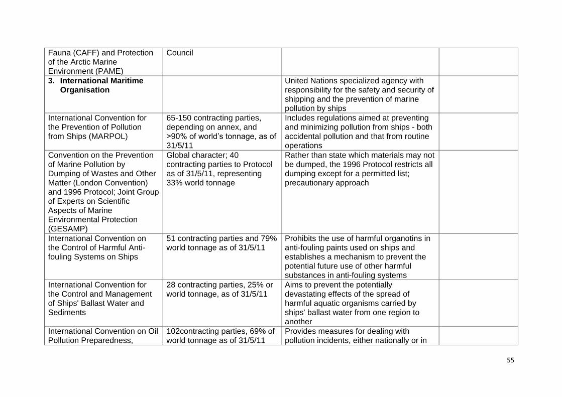
55
Fauna (CAFF) and Protection of the Arctic Marine Environment (PAME)
Council
3. International Maritime Organisation
United Nations specialized agency with responsibility for the safety and security of shipping and the prevention of marine pollution by ships
International Convention for the Prevention of Pollution from Ships (MARPOL)
65-150 contracting parties, depending on annex, and >90% of world‘s tonnage, as of 31/5/11
Includes regulations aimed at preventing and minimizing pollution from ships - both accidental pollution and that from routine operations
Convention on the Prevention of Marine Pollution by Dumping of Wastes and Other Matter (London Convention) and 1996 Protocol; Joint Group of Experts on Scientific Aspects of Marine Environmental Protection (GESAMP)
Global character; 40 contracting parties to Protocol as of 31/5/11, representing 33% world tonnage
Rather than state which materials may not be dumped, the 1996 Protocol restricts all dumping except for a permitted list; precautionary approach
International Convention on the Control of Harmful Anti-fouling Systems on Ships
51 contracting parties and 79% world tonnage as of 31/5/11
Prohibits the use of harmful organotins in anti-fouling paints used on ships and establishes a mechanism to prevent the potential future use of other harmful substances in anti-fouling systems
International Convention for the Control and Management of Ships' Ballast Water and Sediments
28 contracting parties, 25% or world tonnage, as of 31/5/11
Aims to prevent the potentially devastating effects of the spread of harmful aquatic organisms carried by ships' ballast water from one region to another
International Convention on Oil Pollution Preparedness,
102contracting parties, 69% of world tonnage as of 31/5/11
Provides measures for dealing with pollution incidents, either nationally or in
56
Response and Co-operation co-operation with other countries
Hong Kong International Convention for the Safe and Environmentally Sound Recycling of Ships
Aims to ensure that ships, when being recycled after reaching the end of their operational lives, do not pose any unnecessary risk to human health and safety or to the environment
4. Other inter-governmental treaties
Ramsar (or Wetlands) Convention
works closely with the UN MEAs; full partner among the "biodiversity-related cluster" of treaties and agreements; 160 contracting parties as of September 2010
Aims to maintain ecological character of wetlands of international Importance; plan for the wise, or sustainable, use of all of the wetlands in their territories.
International Convention for the Regulation of Whaling
Membership of the IWC is open to any country in the world that formally adheres to the 1946 Convention
Aims to provide for the proper conservation of whale stocks and thus make possible the orderly development of the whaling industry
Danube River Protection Convention International Commission for the Protection of the Danube River (ICPDR)
Danube River as source of contaminants to Black Sea
Aims to ensure the sustainable and equitable use of waters and freshwater resources in the Danube River Basin
Convention for the protection of the Rhine International Commission for the Protection of the Rhine
Rhine River as source of contaminants to North Sea
For the benefit of the Rhine and of all of its tributaries; focal points are sustainable development of the Rhine, its alluvial areas and the good state of all waters in the watershed.
North Sea case study on eutrophication
Convention on the International Commission for the Protection of the Elbe International Commission for the Protection of the Elbe
Elbe River as source of contaminants to North Sea
Aims to prevent the pollution of the Elbe and its drainage area; one main goal includes reducing the bad effects of Elbe river basin on the North Sea.
North Sea case study on eutrophication
57
Convention on the International Commission for the Protection of the Oder
Oder River as source of contaminants to Baltic Sea
Aims to prevent the pollution of the Oder and the Baltic Sea by contaminants and to achieve a sustained reduction in the pollution thereof (and other objectives)
Bern Convention on the Conservation of European Wildlife and Natural Habitats
Nature conservation at European (incl north African) level
international legal instrument, which covers most of the natural heritage of the European continent and extends to some States of Africa; are to conserve wild flora and fauna and their natural habitats; emphasis on endangered natural habitats and endangered vulnerable species, including migratory species
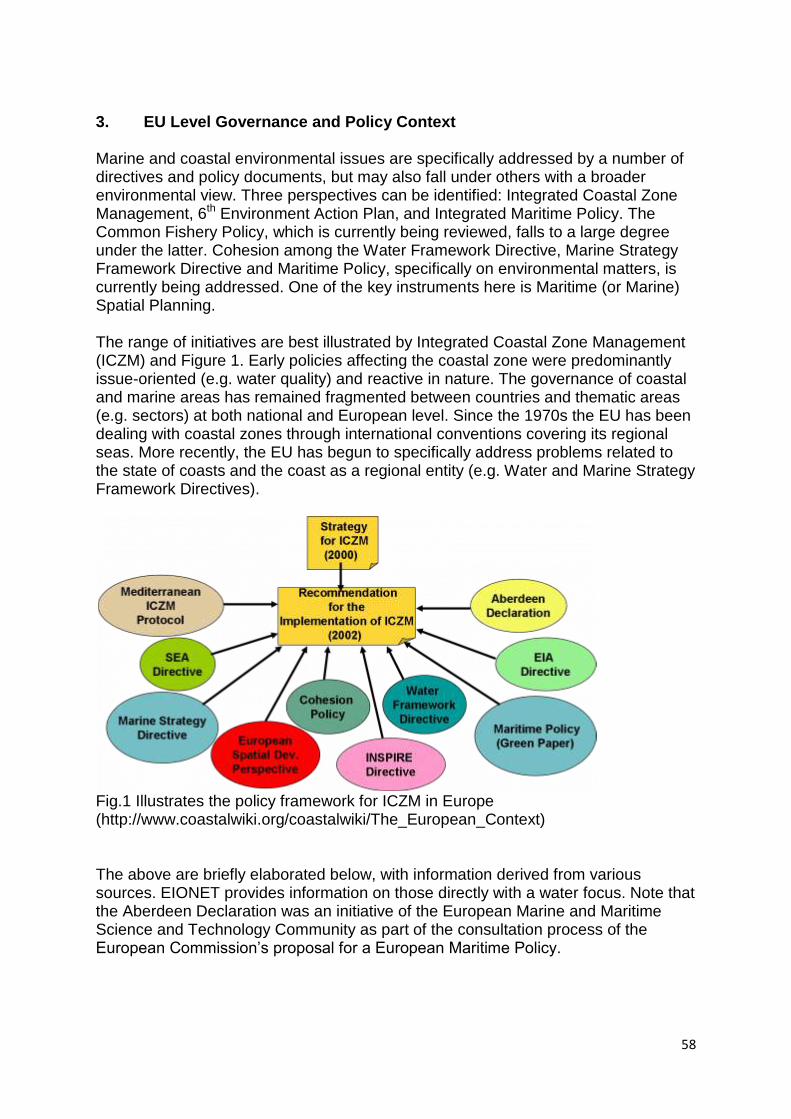
58
3. EU Level Governance and Policy Context
Marine and coastal environmental issues are specifically addressed by a number of directives and policy documents, but may also fall under others with a broader environmental view. Three perspectives can be identified: Integrated Coastal Zone Management, 6th Environment Action Plan, and Integrated Maritime Policy. The Common Fishery Policy, which is currently being reviewed, falls to a large degree under the latter. Cohesion among the Water Framework Directive, Marine Strategy Framework Directive and Maritime Policy, specifically on environmental matters, is currently being addressed. One of the key instruments here is Maritime (or Marine) Spatial Planning. The range of initiatives are best illustrated by Integrated Coastal Zone Management (ICZM) and Figure 1. Early policies affecting the coastal zone were predominantly issue-oriented (e.g. water quality) and reactive in nature. The governance of coastal and marine areas has remained fragmented between countries and thematic areas (e.g. sectors) at both national and European level. Since the 1970s the EU has been dealing with coastal zones through international conventions covering its regional seas. More recently, the EU has begun to specifically address problems related to the state of coasts and the coast as a regional entity (e.g. Water and Marine Strategy Framework Directives).
Fig.1 Illustrates the policy framework for ICZM in Europe (http://www.coastalwiki.org/coastalwiki/The_European_Context) The above are briefly elaborated below, with information derived from various sources. EIONET provides information on those directly with a water focus. Note that the Aberdeen Declaration was an initiative of the European Marine and Maritime Science and Technology Community as part of the consultation process of the European Commission‘s proposal for a European Maritime Policy.
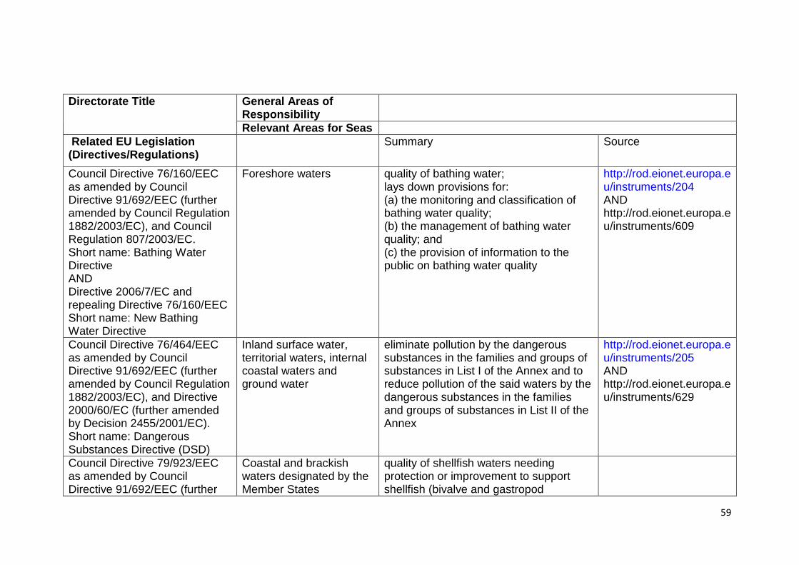
59
Directorate Title
General Areas of Responsibility
Relevant Areas for Seas
Related EU Legislation (Directives/Regulations)
Summary Source
Council Directive 76/160/EEC as amended by Council Directive 91/692/EEC (further amended by Council Regulation 1882/2003/EC), and Council Regulation 807/2003/EC. Short name: Bathing Water Directive AND Directive 2006/7/EC and repealing Directive 76/160/EEC Short name: New Bathing Water Directive
Foreshore waters quality of bathing water; lays down provisions for: (a) the monitoring and classification of bathing water quality; (b) the management of bathing water quality; and (c) the provision of information to the public on bathing water quality
http://rod.eionet.europa.eu/instruments/204 AND http://rod.eionet.europa.eu/instruments/609
Council Directive 76/464/EEC as amended by Council Directive 91/692/EEC (further amended by Council Regulation 1882/2003/EC), and Directive 2000/60/EC (further amended by Decision 2455/2001/EC). Short name: Dangerous Substances Directive (DSD)
Inland surface water, territorial waters, internal coastal waters and ground water
eliminate pollution by the dangerous substances in the families and groups of substances in List I of the Annex and to reduce pollution of the said waters by the dangerous substances in the families and groups of substances in List II of the Annex
http://rod.eionet.europa.eu/instruments/205 AND http://rod.eionet.europa.eu/instruments/629
Council Directive 79/923/EEC as amended by Council Directive 91/692/EEC (further
Coastal and brackish waters designated by the Member States
quality of shellfish waters needing protection or improvement to support shellfish (bivalve and gastropod
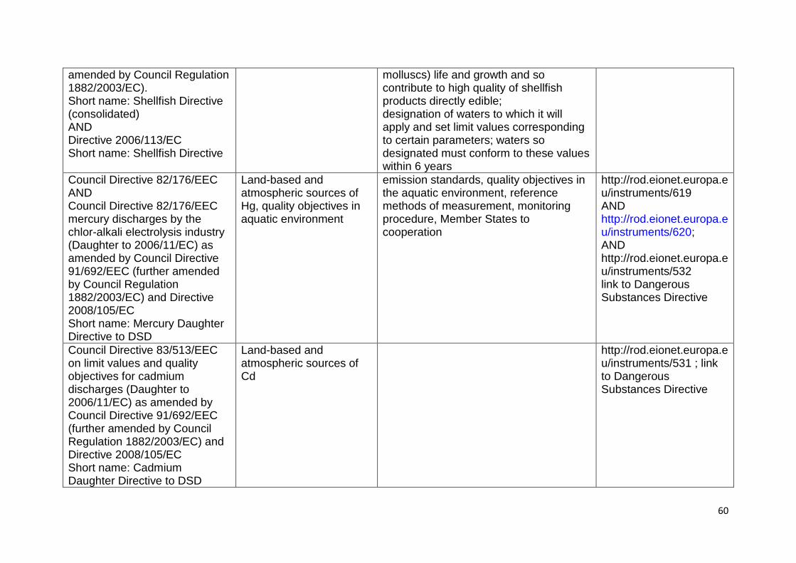
60
amended by Council Regulation 1882/2003/EC). Short name: Shellfish Directive (consolidated) AND Directive 2006/113/EC Short name: Shellfish Directive
molluscs) life and growth and so contribute to high quality of shellfish products directly edible; designation of waters to which it will apply and set limit values corresponding to certain parameters; waters so designated must conform to these values within 6 years
Council Directive 82/176/EEC AND Council Directive 82/176/EEC mercury discharges by the chlor-alkali electrolysis industry (Daughter to 2006/11/EC) as amended by Council Directive 91/692/EEC (further amended by Council Regulation 1882/2003/EC) and Directive 2008/105/EC Short name: Mercury Daughter Directive to DSD
Land-based and atmospheric sources of Hg, quality objectives in aquatic environment
emission standards, quality objectives in the aquatic environment, reference methods of measurement, monitoring procedure, Member States to cooperation
http://rod.eionet.europa.eu/instruments/619 AND http://rod.eionet.europa.eu/instruments/620; AND http://rod.eionet.europa.eu/instruments/532 link to Dangerous Substances Directive
Council Directive 83/513/EEC on limit values and quality objectives for cadmium discharges (Daughter to 2006/11/EC) as amended by Council Directive 91/692/EEC (further amended by Council Regulation 1882/2003/EC) and Directive 2008/105/EC Short name: Cadmium Daughter Directive to DSD
Land-based and atmospheric sources of Cd
http://rod.eionet.europa.eu/instruments/531 ; link to Dangerous Substances Directive
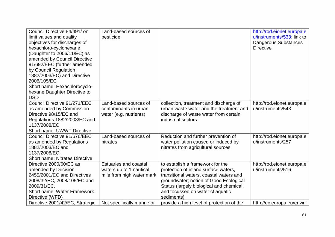
61
Council Directive 84/491/ on limit values and quality objectives for discharges of hexachloro-cyclohexane (Daughter to 2006/11/EC) as amended by Council Directive 91/692/EEC (further amended by Council Regulation 1882/2003/EC) and Directive 2008/105/EC Short name: Hexachlorocyclo-hexane Daughter Directive to DSD
Land-based sources of pesticide
http://rod.eionet.europa.eu/instruments/533; link to Dangerous Substances Directive
Council Directive 91/271/EEC as amended by Commission Directive 98/15/EC and Regulations 1882/2003/EC and 1137/2008/EC Short name: UWWT Directive
Land-based sources of contaminants in urban water (e.g. nutrients)
collection, treatment and discharge of urban waste water and the treatment and discharge of waste water from certain industrial sectors
http://rod.eionet.europa.eu/instruments/543
Council Directive 91/676/EEC as amended by Regulations 1882/2003/EC and 1137/2008/EC. Short name: Nitrates Directive
Land-based sources of nitrates
Reduction and further prevention of water pollution caused or induced by nitrates from agricultural sources
http://rod.eionet.europa.eu/instruments/257
Directive 2000/60/EC as amended by Decision 2455/2001/EC and Directives 2008/32/EC, 2008/105/EC and 2009/31/EC. Short name: Water Framework Directive (WFD)
Estuaries and coastal waters up to 1 nautical mile from high water mark
to establish a framework for the protection of inland surface waters, transitional waters, coastal waters and groundwater; notion of Good Ecological Status (largely biological and chemical, and focussed on water cf aquatic sediments)
http://rod.eionet.europa.eu/instruments/516
Directive 2001/42/EC, Strategic Not specifically marine or provide a high level of protection of the http://ec.europa.eu/envir
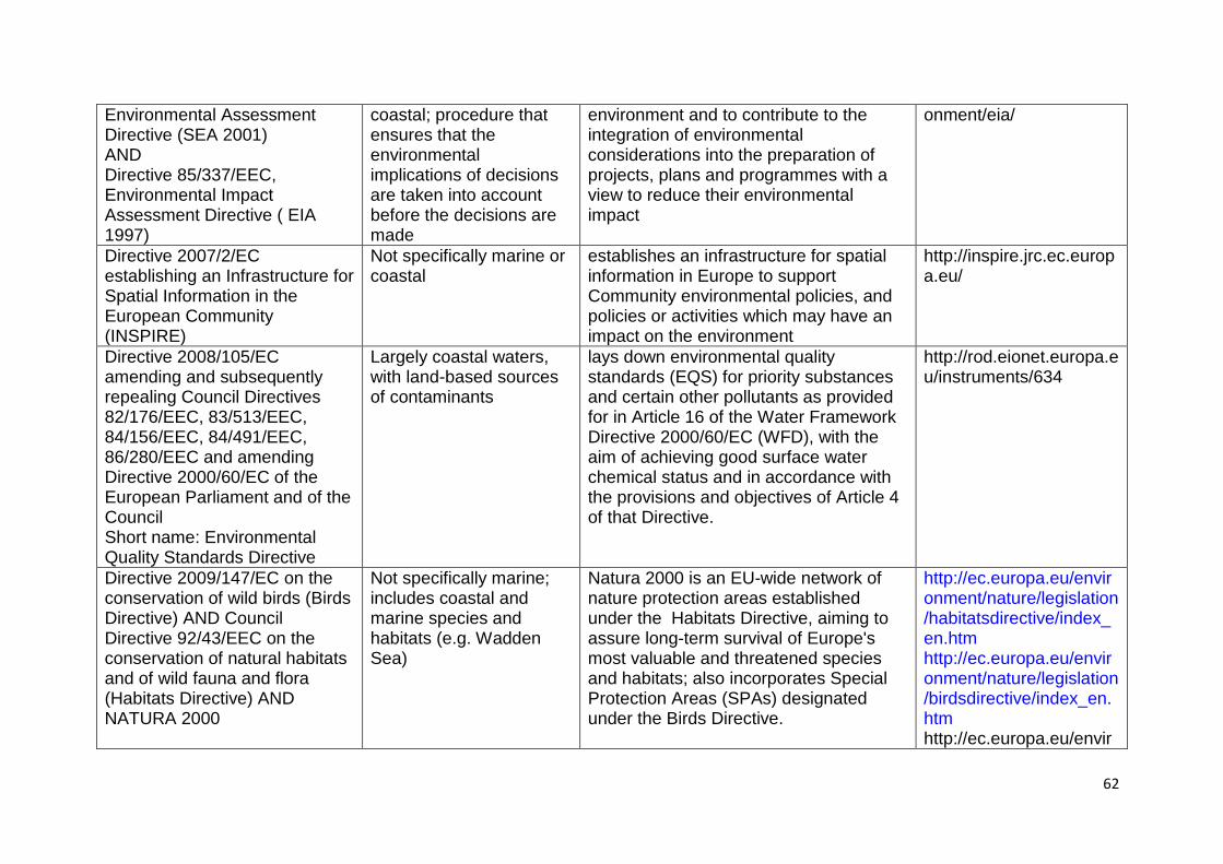
62
Environmental Assessment Directive (SEA 2001) AND Directive 85/337/EEC, Environmental Impact Assessment Directive ( EIA 1997)
coastal; procedure that ensures that the environmental implications of decisions are taken into account before the decisions are made
environment and to contribute to the integration of environmental considerations into the preparation of projects, plans and programmes with a view to reduce their environmental impact
onment/eia/
Directive 2007/2/EC establishing an Infrastructure for Spatial Information in the European Community (INSPIRE)
Not specifically marine or coastal
establishes an infrastructure for spatial information in Europe to support Community environmental policies, and policies or activities which may have an impact on the environment
http://inspire.jrc.ec.europa.eu/
Directive 2008/105/EC amending and subsequently repealing Council Directives 82/176/EEC, 83/513/EEC, 84/156/EEC, 84/491/EEC, 86/280/EEC and amending Directive 2000/60/EC of the European Parliament and of the Council Short name: Environmental Quality Standards Directive
Largely coastal waters, with land-based sources of contaminants
lays down environmental quality standards (EQS) for priority substances and certain other pollutants as provided for in Article 16 of the Water Framework Directive 2000/60/EC (WFD), with the aim of achieving good surface water chemical status and in accordance with the provisions and objectives of Article 4 of that Directive.
http://rod.eionet.europa.eu/instruments/634
Directive 2009/147/EC on the conservation of wild birds (Birds Directive) AND Council Directive 92/43/EEC on the conservation of natural habitats and of wild fauna and flora (Habitats Directive) AND NATURA 2000
Not specifically marine; includes coastal and marine species and habitats (e.g. Wadden Sea)
Natura 2000 is an EU-wide network of nature protection areas established under the Habitats Directive, aiming to assure long-term survival of Europe's most valuable and threatened species and habitats; also incorporates Special Protection Areas (SPAs) designated under the Birds Directive.
http://ec.europa.eu/environment/nature/legislation/habitatsdirective/index_en.htm http://ec.europa.eu/environment/nature/legislation/birdsdirective/index_en.htm http://ec.europa.eu/envir
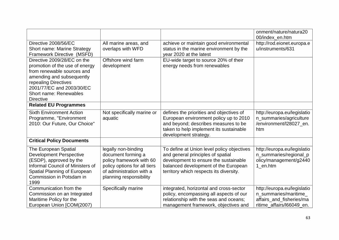
63
onment/nature/natura2000/index_en.htm
Directive 2008/56/EC Short name: Marine Strategy Framework Directive (MSFD)
All marine areas, and overlaps with WFD
achieve or maintain good environmental status in the marine environment by the year 2020 at the latest
http://rod.eionet.europa.eu/instruments/631
Directive 2009/28/EC on the promotion of the use of energy from renewable sources and amending and subsequently repealing Directives 2001/77/EC and 2003/30/EC Short name: Renewables Directive
Offshore wind farm development
EU-wide target to source 20% of their energy needs from renewables
Related EU Programmes
Sixth Environment Action Programme, "Environment 2010: Our Future, Our Choice"
Not specifically marine or aquatic
defines the priorities and objectives of European environment policy up to 2010 and beyond; describes measures to be taken to help implement its sustainable development strategy.
http://europa.eu/legislation_summaries/agriculture/environment/l28027_en.htm
Critical Policy Documents
The European Spatial Development Perspective (ESDP), approved by the Informal Council of Ministers of Spatial Planning of European Commission in Potsdam in 1999
legally non-binding document forming a policy framework with 60 policy options for all tiers of administration with a planning responsibility
To define at Union level policy objectives and general principles of spatial development to ensure the sustainable balanced development of the European territory which respects its diversity.
http://europa.eu/legislation_summaries/regional_policy/management/g24401_en.htm
Communication from the Commission on an Integrated Maritime Policy for the European Union [COM(2007)
Specifically marine integrated, horizontal and cross-sector policy, encompassing all aspects of our relationship with the seas and oceans; management framework, objectives and
http://europa.eu/legislation_summaries/maritime_affairs_and_fisheries/maritime_affairs/l66049_en.
64
575 instruments proposed are developed in this Communication which is founded on the Lisbon and Gothenburg strategies.
htm
Commission Green Paper: Towards a future Maritime Policy for the Union: a European vision for the oceans and seas [COM (2006) 275
Specifically marine maritime policy must aim to promote a maritime industry that is innovative, competitive and environmentally-friendly
http://europa.eu/legislation_summaries/maritime_affairs_and_fisheries/maritime_affairs/l66029_en.htm
Communication from the Commission - Developing the international dimension of the Integrated Maritime Policy of the European Union [COM(2009) 536
Strengthen EU authority in multilateral and bilateral relations in the domain of maritime affairs
should allow EU to exercise greater influence over international debate on marine issues to, a.o., increase protection of the environment; should also contribute to sustainable maritime governance at global level; strategy incl. protection of marine biodiversity, climate change, and research into the marine environment.
http://europa.eu/legislation_summaries/maritime_affairs_and_fisheries/maritime_affairs/pe0010_en.htm
Recommendation 2002/413/EC concerning the implementation of Integrated Coastal Zone Management in Europe [Official Journal L 148 of 06.06.2002]
Coastal strategic approach to management based on, a.o.: protection of the coastal environment; recognition of threat posed by climate change; implementation of coastal protection measures.
http://europa.eu/legislation_summaries/maritime_affairs_and_fisheries/maritime_affairs/g24229_en.htm
Communication from the Commission - Towards an Integrated Maritime Policy for better governance in the Mediterranean [COM(2009) 466
Mediterranean addresses different maritime challenges incl. fisheries, aquaculture, environmental protection and climate change; based on improving governance that balances economic development with environmental protection
http://europa.eu/legislation_summaries/maritime_affairs_and_fisheries/maritime_affairs/pe0009_en.htm
Communication from the Commission – ‗Offshore Wind Energy: Action needed to deliver on the Energy Policy
Marine development of maritime and offshore wind energy in the European Union
65
Objectives for 2020 and beyond‘ [COM(2008) 768
Cohesion Policy (2007-2013) (see also Fifth Report on Economic, Social and Territorial Cohesion)
Not specifically marine or aquatic
seeks to strengthen the economic, social and territorial cohesion of the Union
http://ec.europa.eu/environment/integration/cohesion_policy_en.htm http://ec.europa.eu/regional_policy/sources/docoffic/official/reports/cohesion5/index_en.cfm
Structural Funds and the Cohesion Fund
Not specifically marine or aquatic
financial tools set up to implement the Cohesion policy; aim to reduce regional disparities in terms of income, wealth and opportunities.
http://ec.europa.eu/regional_policy/sources/docoffic/official/regulation/newregl0713_en.htm http://europa.eu/legislation_summaries/agriculture/general_framework/g24233_en.htm
An Integrated Maritime Policy for the European Union -The Blue Book
Specifically marine vision based on the clear recognition that all matters relating to Europe's oceans and seas are interlinked, and that sea-related policies must develop in a joined-up way if are to reap the desired results; Blue Book lays the foundation for the governance framework and cross-sectoral tools necessary for an EU Integrated Maritime Policy
http://ec.europa.eu/maritimeaffairs/subpage_en.html
Communication from the Commission – Roadmap for Maritime Spatial Planning: Achieving Common Principles in the EU [COM(2008) 791
Specifically marine key instrument for the Blue Book above; helps public authorities and stakeholders to coordinate their action and optimises the use of marine space to benefit economic development and the marine
http://eur-lex.europa.eu/LexUriServ/LexUriServ.do?uri=COM:2008:0791:FIN:EN:PDF
66
environment.
Communication from the Commission – Our life insurance, our natural capital: an EU biodiversity strategy to 2020 {SEC(2011) 540 final} {SEC(2011) 541 final}
Not specifically marine; follows from the 2006 Biodiversity Action Plan
in line with commitments made by EU leaders in March 2010: 1) 2020 headline target: "Halting the loss of biodiversity ... and restoring [it] ..., while stepping up the EU contribution to averting global biodiversity loss"; 2) 2050 vision: ―By 2050, EU ... natural capital ... [is] protected, valued and appropriately restored..‖; also in line with global commitments made in Nagoya in October 2010, in the context of the CBD.
67
4. Thematic Data Ambitions INSPIRE categories, on the whole, mesh poorly with terminology from, for example, the Marine Strategy Framework Directive. See below. There are instances where INSPIRE categories are too detailed (e.g. oceanographic – variables in databases did not match these categories, or matched many of the categories, or used slightly different terms). Other categories are too general. One example is ‗12. Natural risk zones/Coastal and Maritime Pressures‘. MSFD Annex III Table 2 lists coastal and marine pressures and their impacts. Table 1 below repeats this table, adding a column to indicate possible links to more specific INSPIRE categories. Most pressures are already accommodated in other INSPIRE categories, notably ‗Natural risk zones‘ and ‗Land use‘. Two MSFD pressures not well accommodated by INSPIRE are underwater noise and marine litter. Table 1: Columns 1 and 2 give pressures and impact, from Marine Strategy Framework Directive; column 3 provides a corresponding category from INSPIRE Pressure Impact INSPIRE Physical loss Smothering (e.g. by man-made structures,
disposal of dredge spoil), Natural risk zones/trawling effects
Sealing (e.g. by permanent constructions). Land use/ coastal and marine existing and planned initiatives
Physical damage Changes in siltation (e.g. by outfalls, increased run-off, dredging/disposal of dredge spoil),
Natural risk zones/coastal erosion
Abrasion (e.g. Impact on the seabed of commercial fishing, boating, anchoring),
Natural risk zones/trawling effects; Land use/fishing
Selective extraction (e.g. exploration and exploitation of living and non-living).
Land use/exploitation of raw materials, fisheries and mariculture
Other physical disturbance
Underwater noise (e.g. from shipping, underwater acoustic equipment),
Land use/shipping, wind energy, military uses, exploitation
Marine litter. Interference with hydrological
Significant changes in thermal regime (e.g. by outfalls from power stations),
Production and industrial facilities/ coastal and maritime industries
processes Significant changes in salinity regime (e.g. by constructions impeding water movements).
Production and industrial facilities/ coastal and maritime industries
Contamination by hazardous substances
Introduction of synthetic compounds, non-synthetic substances and radio-nuclides
Natural risk zones/marine contaminants; Human health
Systematic and/or intentional release of substances
Introduction of other substances Production and industrial facilities/ coastal and maritime industries; Human health
Nutrient and organic enrichment
Inputs of fertilisers and other nitrogen and phosphorus-rich substances
Natural risk zones/marine contaminants; Human health
Inputs of organic matter (e.g. sewers, mariculture, riverine inputs).
Natural risk zones/marine contaminants; Human health
Biological Introduction of microbial pathogens, Human health disturbance Introduction of non-indigenous species
and translocations, Bio-geographical regions
Selective extraction of species, including incidental non-target catches (e.g. by commercial and recreational fishing).
Land use/fishing
68
5. Thematic Data Availability Databases exist to support many of the INSPIRE categories, although the quality of the data and their geographical distribution is highly variable. The EEA provides the best access to environmental data. It is supported by the various regional seas commissions and by EUROSTAT. In general, northeastern Europe (especially North and Baltic Seas) are data-rich. The Mediterranean and Black Seas are generally data poor except for high profile issues. E.g. non-indigenous species (NIS) for the Mediterranean, eutrophication issues for the Black. Data list are the most common form, although geo-referencing is gaining ground rapidly. Oceanographic data are widespread, sometime patchy, but often coordinated at a global or supra-EU level. UN organs such as UNEP and IMO are frequently active. ICES and other multi-governmental initiatives often provide coordination for specific users – e.g. ICES is strongly linked to fishing but is also active for oceanography and ocean ecosystem data. Contaminants have the longest history as an environmental issue, with considerable legislation at national, EU and global levels. Associated databases are patchy, with a tendency for good data associated with past high profile issues. Emergent contaminants present a considerable challenge for databases. Species, habitats, ecosystems etc. databases are growing rapidly, as a result of a high profile on biodiversity issues as well as the requirements for NATURAL 2000. Lists of NIS are quite abundant. Spatial referencing is less so. 6. Key Thematic Risks and Development Opportunities Our analysis of risks and opportunities makes use of the Drivers-Pressures-States-Impacts-Response (DPSIR) framework and defined by the European Environment Agency (EEA: http://glossary.eea.europa.eu/terminology/concept_html?term=dpsir) as:
―the causal framework for describing the interactions between society and the environment adopted by the European Environment Agency: driving forces, pressures, states, impacts, responses (extension of the PSR model developed by OECD)‖.
Further information on the framework and its applications can be found in Luiten (1999), Salomons (2004), Kristensen (2004), and Farmer et al. (2009). See also Figure 1. We interpret risks and opportunities as the Impact on societal welfare from ecosystem States and their capacity to generate ecosystem goods and services. Consequently, risks stem poor environmental status, and opportunities from good environmental quality. This is essentially the link between environmental State and societal Impact in Figure 1. Following the Marine Strategy Framework Directive, environmental States are encompassed within eleven descriptors (see Annex I of the

69
directive). These descriptors may be grouped into two broad classes: those that reflect poor environmental quality and those that capture good environmental quality. The former need to be reduced whereas the latter need to be maintained or restored. The former then lies behind risks and the latter behind opportunities. Tables 2 and 3 present an overview.
Figure 1. The DPSIR framework. Drivers, notably economic sectors, exert Pressure on environmental States. State changes can affect the quantity and quality of ecosystem goods and services, and so Impact societal welfare. The trade-off between the benefits accruing to Drivers and the losses to society from environmental State change determines the need for a governance Response. That Response can influence Driver behaviour (e.g. implementation of clean technology), can directly affect Pressure (e.g. change in mesh size of fishing nets), can directly affect environmental states (e.g. dredging of contaminated harbour sediments), and can reduce adverse Impact (e.g. compensation). Table 2. Socio-economic activities with opportunities from good environmental status
Descriptor Brief elaboration Opportunities
Biological diversity
Biological diversity is an umbrella descriptor, as virtually all descriptors can be linked to this one. From species, through habitat to ecosystem levels; biodiversity is tentatively linked to resilience, and so a good diversity supports the generation of all ecosystem goods and services
Ecotourism; conservation; all sectors dependent on ecosystem goods and services; society in general (via existence values and carbon buffering)
Commercial fish Maintenance of fish stocks Fisheries
Food webs Similar to biological diversity, with emphasis on select species such as top predators
Ecotourism; conservation; society in general (via existence values)
Driver
Response
State
Change
Impact
(on welfare)Pressure
ecosystem goods & services
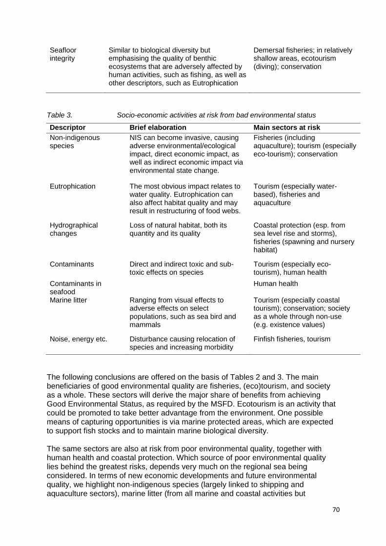
70
Seafloor integrity
Similar to biological diversity but emphasising the quality of benthic ecosystems that are adversely affected by human activities, such as fishing, as well as other descriptors, such as Eutrophication
Demersal fisheries; in relatively shallow areas, ecotourism (diving); conservation
Table 3. Socio-economic activities at risk from bad environmental status
Descriptor Brief elaboration Main sectors at risk
Non-indigenous species
NIS can become invasive, causing adverse environmental/ecological impact, direct economic impact, as well as indirect economic impact via environmental state change.
Fisheries (including aquaculture); tourism (especially eco-tourism); conservation
Eutrophication The most obvious impact relates to water quality. Eutrophication can also affect habitat quality and may result in restructuring of food webs.
Tourism (especially water-based), fisheries and aquaculture
Hydrographical changes
Loss of natural habitat, both its quantity and its quality
Coastal protection (esp. from sea level rise and storms), fisheries (spawning and nursery habitat)
Contaminants Direct and indirect toxic and sub-toxic effects on species
Tourism (especially eco-tourism), human health
Contaminants in seafood
Human health
Marine litter Ranging from visual effects to adverse effects on select populations, such as sea bird and mammals
Tourism (especially coastal tourism); conservation; society as a whole through non-use (e.g. existence values)
Noise, energy etc. Disturbance causing relocation of species and increasing morbidity
Finfish fisheries, tourism
The following conclusions are offered on the basis of Tables 2 and 3. The main beneficiaries of good environmental quality are fisheries, (eco)tourism, and society as a whole. These sectors will derive the major share of benefits from achieving Good Environmental Status, as required by the MSFD. Ecotourism is an activity that could be promoted to take better advantage from the environment. One possible means of capturing opportunities is via marine protected areas, which are expected to support fish stocks and to maintain marine biological diversity. The same sectors are also at risk from poor environmental quality, together with human health and coastal protection. Which source of poor environmental quality lies behind the greatest risks, depends very much on the regional sea being considered. In terms of new economic developments and future environmental quality, we highlight non-indigenous species (largely linked to shipping and aquaculture sectors), marine litter (from all marine and coastal activities but
71
particularly from fisheries), and noise (from offshore windfarms) as the main potential sources of future poor environmental quality. Note that fisheries is a major driver of marine environmental change through, for example, overfishing, benthic trawling, and by-catch. 7. Priorities for Regional Seas Data Collection Two items that arise from the previous discussion are:
1) the use of Marine Protected Areas to support fisheries, (eco)tourism and conservation; and,
2) The need for inventories and spatial data on the establishment and spread of non-indigenous and alien invasive species.
The world database on marine protected areas (http://www.wdpa-marine.org/#/countries/about) provides some spatial data on the location of these areas. Inventories of NIS exist (e.g. DASIE, see data tables) and mapping activities exist but are not yet well coordinated. The discussion has addressed climate change issues only lightly. In part, this is because the MSFD descriptors do not specifically address climate change as an anthropogenic pressure in marine states. In part, this is because it is not yet possible to separate signals of anthropogenic climate change from natural climatic variability. In part, the effects of climate change on marine ecosystem are seen as beyond the 2020 deadline for achieving Good Environmental Status. Of the various possible effects on marine environments, sea level risk is perhaps the one with the greatest pertinence to coastal and marine activities. Via the EEA, there is a database on hydrodynamics and sea level rise (http://www.eea.europa.eu/data-and-maps/data/hydrodynamics-and-sea-level-rise).
8. References
Farmer, A., Mee, L. D., Langmead, O., & Kershaw, P. 2009, The Ecosystem Approach. KnowSeas Deliverable 2.1.
Kristensen,P. 2004. The DPSIR Framework. Paper presented at the 27-29 September 2004 workshop on a comprehensive / detailed assessment of the vulnerability of water resources to environmental change in Africa using river basin approach. UNEP Headquarters, Nairobi, Kenya. http://enviro.lclark.edu:8002/rid=1145949501662_742777852_522/DPSIR%20Overview.pdf.
Luiten, H. 1999, "A legislative view on science and predictive models", Environmental Pollution, vol. 100, no. 1-3, pp. 5-11.
Salomons, W. 2004, European catchments: catchment changes and their impact on the coast, Institute for Environmental Studies, VU University Amsterdam, http://www.cs.iia.cnr.it/EUROCAT/publications/EuroCatSummary.pdf, Report R-04/01.
72
Appendix 4: Transport Briefing Paper
1. Introduction: Basic facts
Today, there are more than 1200 ports in the coasts of the European Union but most traffic is concentrated in a few major ports, most notably in the Atlantic and Northern ranges. In 2009, only 15 ports managed more than 40 million freight tones (general cargo, containers, solid bulk and liquids), and only the 3 largest ports in the EU concentrated 37% of all maritime freight managed in EU ports, all in the North of the continent (Rotterdam with 387MTn, Antwerp with 158MTn and Hamburg with 110MTn). The increasing traffic of manufactured goods from China, Japan and other Far East countries currently runs and will most likely continue to run through Suez channel and the Mediterranean Sea. Even with an upgraded Panama Channel, the Far East – Europe route through Suez is still shorter, between 25% and 60% in distance and between 7% and 50% in travel time depending on the origin/destination ports. Most interestingly, a primary element with potential to alter current east-west flow patterns is related to climate change: with an increased global temperature the Arctic Sea route could become practicable for significant periods of the year, with shortened travel distances for Japanese and Korean ports and for some Chinese ports. This scenario, however, seems only reasonable in the long term and difficulties for navigation (necessity of icebreakers, short opening period, few easily accessible ports of refuge) would still remain, making it difficult to exploit.
Only 25% of the Asiatic traffic enters Europe through the Mediterranean ports, while 75% of freight continues through Gibraltar up to Northern European ports with an additional two days of travel, and subsequent increase in CO2 emissions. With a total maritime container throughput of an estimated 90.7 million TEU in 2008, only 13 ports managed more than 1MTEU and 40% of the total traffic was concentrated in the four largest ports, all in the Northern range. An important share of container business in the Mediterranean is transhipment traffic (i.e. 95% in Algeciras and 50% in Valencia in 2009), with the Atlantic ports still being the major entrance for goods bound to the Mediterranean area. However, Mediterranean ports are attempting to increase their share in the maritime sector by planning important rail projects intended to enlarge their hinterlands up to central Europe. Figure A below shows three alternative scenarios for the development of shipping in European seas, each displaying a different volume of maritime transport passing through the Mediterranean. In particular, the possibility of an Arctic shipping corridor will substantially reduce traffic.
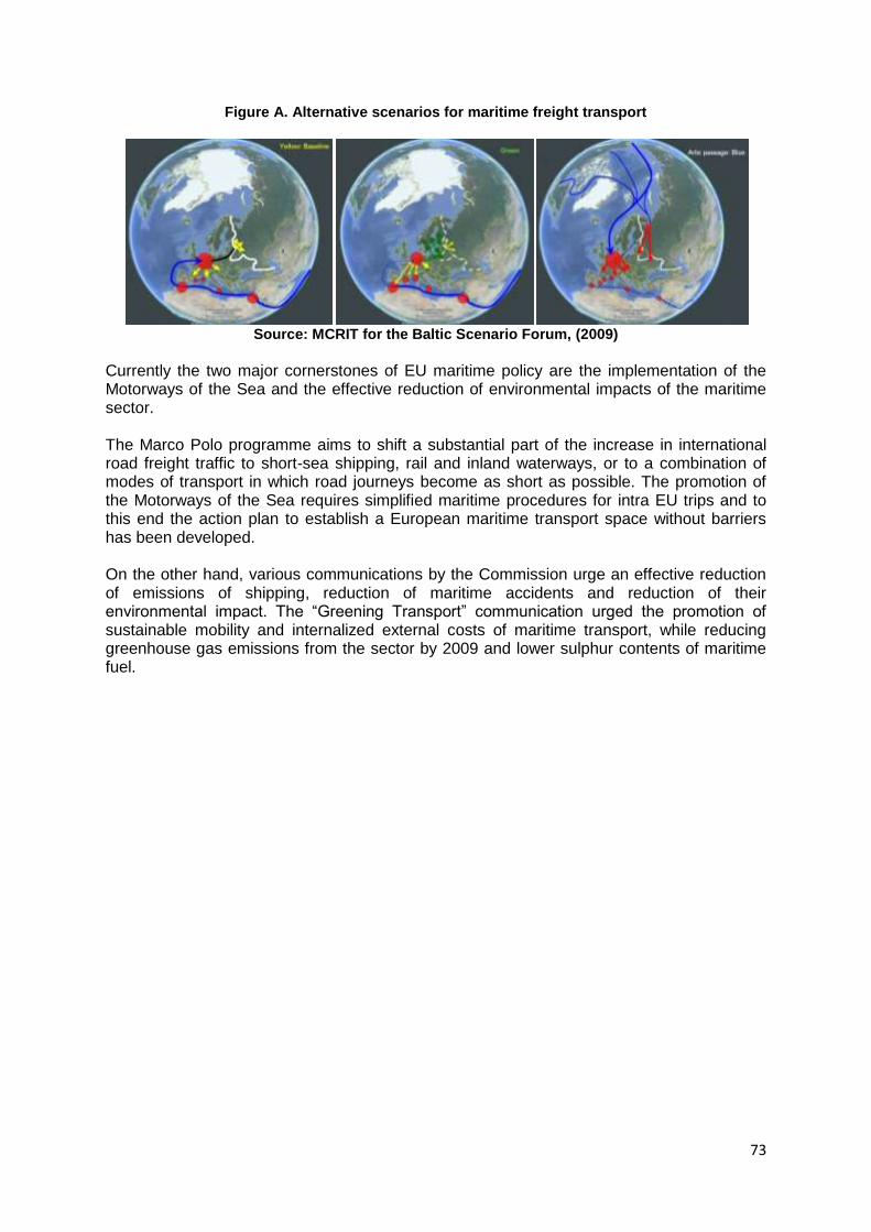
73
Figure A. Alternative scenarios for maritime freight transport
Source: MCRIT for the Baltic Scenario Forum, (2009)
Currently the two major cornerstones of EU maritime policy are the implementation of the Motorways of the Sea and the effective reduction of environmental impacts of the maritime sector. The Marco Polo programme aims to shift a substantial part of the increase in international road freight traffic to short-sea shipping, rail and inland waterways, or to a combination of modes of transport in which road journeys become as short as possible. The promotion of the Motorways of the Sea requires simplified maritime procedures for intra EU trips and to this end the action plan to establish a European maritime transport space without barriers has been developed. On the other hand, various communications by the Commission urge an effective reduction of emissions of shipping, reduction of maritime accidents and reduction of their environmental impact. The ―Greening Transport‖ communication urged the promotion of sustainable mobility and internalized external costs of maritime transport, while reducing greenhouse gas emissions from the sector by 2009 and lower sulphur contents of maritime fuel.
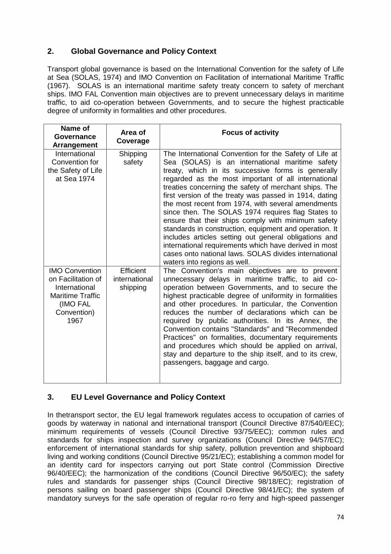
74
2. Global Governance and Policy Context
Transport global governance is based on the International Convention for the safety of Life at Sea (SOLAS, 1974) and IMO Convention on Facilitation of international Maritime Traffic (1967). SOLAS is an international maritime safety treaty concern to safety of merchant ships. IMO FAL Convention main objectives are to prevent unnecessary delays in maritime traffic, to aid co-operation between Governments, and to secure the highest practicable degree of uniformity in formalities and other procedures.
Name of
Governance Arrangement
Area of Coverage
Focus of activity
International Convention for
the Safety of Life at Sea 1974
Shipping safety
The International Convention for the Safety of Life at Sea (SOLAS) is an international maritime safety treaty, which in its successive forms is generally regarded as the most important of all international treaties concerning the safety of merchant ships. The first version of the treaty was passed in 1914, dating the most recent from 1974, with several amendments since then. The SOLAS 1974 requires flag States to ensure that their ships comply with minimum safety standards in construction, equipment and operation. It includes articles setting out general obligations and international requirements which have derived in most cases onto national laws. SOLAS divides international waters into regions as well.
IMO Convention on Facilitation of
International Maritime Traffic
(IMO FAL Convention)
1967
Efficient international
shipping
The Convention's main objectives are to prevent unnecessary delays in maritime traffic, to aid co-operation between Governments, and to secure the highest practicable degree of uniformity in formalities and other procedures. In particular, the Convention reduces the number of declarations which can be required by public authorities. In its Annex, the Convention contains "Standards" and "Recommended Practices" on formalities, documentary requirements and procedures which should be applied on arrival, stay and departure to the ship itself, and to its crew, passengers, baggage and cargo.
3. EU Level Governance and Policy Context In thetransport sector, the EU legal framework regulates access to occupation of carries of goods by waterway in national and international transport (Council Directive 87/540/EEC); minimum requirements of vessels (Council Directive 93/75/EEC); common rules and standards for ships inspection and survey organizations (Council Directive 94/57/EC); enforcement of international standards for ship safety, pollution prevention and shipboard living and working conditions (Council Directive 95/21/EC); establishing a common model for an identity card for inspectors carrying out port State control (Commission Directive 96/40/EEC); the harmonization of the conditions (Council Directive 96/50/EC); the safety rules and standards for passenger ships (Council Directive 98/18/EC); registration of persons sailing on board passenger ships (Council Directive 98/41/EC); the system of mandatory surveys for the safe operation of regular ro-ro ferry and high-speed passenger
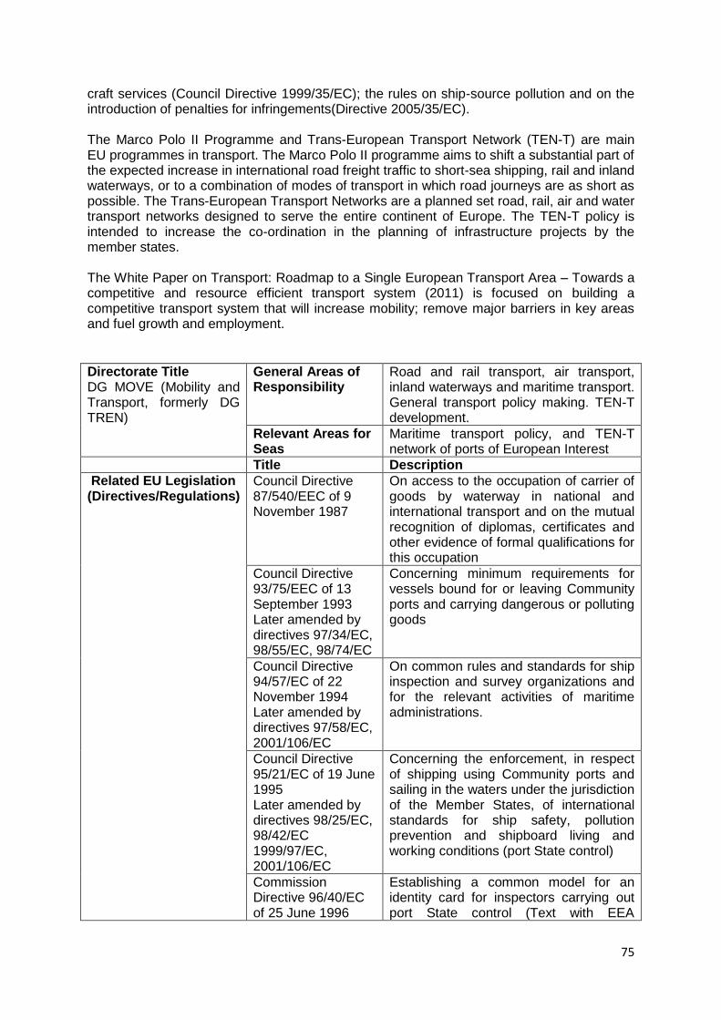
75
craft services (Council Directive 1999/35/EC); the rules on ship-source pollution and on the introduction of penalties for infringements(Directive 2005/35/EC). The Marco Polo II Programme and Trans-European Transport Network (TEN-T) are main EU programmes in transport. The Marco Polo II programme aims to shift a substantial part of the expected increase in international road freight traffic to short-sea shipping, rail and inland waterways, or to a combination of modes of transport in which road journeys are as short as possible. The Trans-European Transport Networks are a planned set road, rail, air and water transport networks designed to serve the entire continent of Europe. The TEN-T policy is intended to increase the co-ordination in the planning of infrastructure projects by the member states. The White Paper on Transport: Roadmap to a Single European Transport Area – Towards a competitive and resource efficient transport system (2011) is focused on building a competitive transport system that will increase mobility; remove major barriers in key areas and fuel growth and employment.
Directorate Title DG MOVE (Mobility and Transport, formerly DG TREN)
General Areas of Responsibility
Road and rail transport, air transport, inland waterways and maritime transport. General transport policy making. TEN-T development.
Relevant Areas for Seas
Maritime transport policy, and TEN-T network of ports of European Interest
Title Description
Related EU Legislation (Directives/Regulations)
Council Directive 87/540/EEC of 9 November 1987
On access to the occupation of carrier of goods by waterway in national and international transport and on the mutual recognition of diplomas, certificates and other evidence of formal qualifications for this occupation
Council Directive 93/75/EEC of 13 September 1993 Later amended by directives 97/34/EC, 98/55/EC, 98/74/EC
Concerning minimum requirements for vessels bound for or leaving Community ports and carrying dangerous or polluting goods
Council Directive 94/57/EC of 22 November 1994 Later amended by directives 97/58/EC, 2001/106/EC
On common rules and standards for ship inspection and survey organizations and for the relevant activities of maritime administrations.
Council Directive 95/21/EC of 19 June 1995 Later amended by directives 98/25/EC, 98/42/EC 1999/97/EC, 2001/106/EC
Concerning the enforcement, in respect of shipping using Community ports and sailing in the waters under the jurisdiction of the Member States, of international standards for ship safety, pollution prevention and shipboard living and working conditions (port State control)
Commission Directive 96/40/EC of 25 June 1996
Establishing a common model for an identity card for inspectors carrying out port State control (Text with EEA
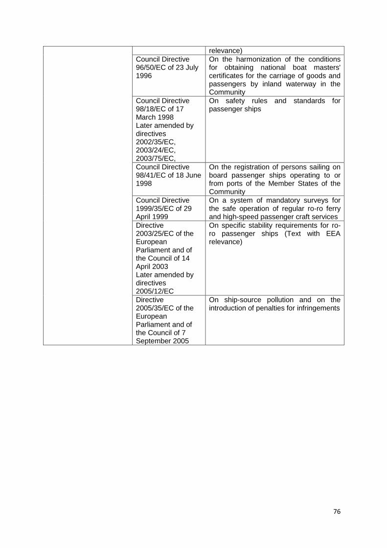
76
relevance)
Council Directive 96/50/EC of 23 July 1996
On the harmonization of the conditions for obtaining national boat masters' certificates for the carriage of goods and passengers by inland waterway in the Community
Council Directive 98/18/EC of 17 March 1998 Later amended by directives 2002/35/EC, 2003/24/EC, 2003/75/EC,
On safety rules and standards for passenger ships
Council Directive 98/41/EC of 18 June 1998
On the registration of persons sailing on board passenger ships operating to or from ports of the Member States of the Community
Council Directive 1999/35/EC of 29 April 1999
On a system of mandatory surveys for the safe operation of regular ro-ro ferry and high-speed passenger craft services
Directive 2003/25/EC of the European Parliament and of the Council of 14 April 2003 Later amended by directives 2005/12/EC
On specific stability requirements for ro-ro passenger ships (Text with EEA relevance)
Directive 2005/35/EC of the European Parliament and of the Council of 7 September 2005
On ship-source pollution and on the introduction of penalties for infringements
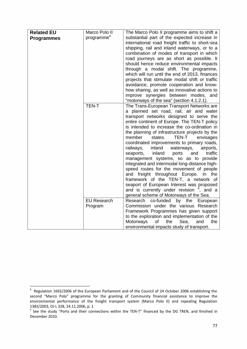
77
Related EU Programmes
Marco Polo II programme4
The Marco Polo II programme aims to shift a substantial part of the expected increase in international road freight traffic to short-sea shipping, rail and inland waterways, or to a combination of modes of transport in which road journeys are as short as possible. It should hence reduce environmental impacts through a modal shift. The programme, which will run until the end of 2013, finances projects that stimulate modal shift or traffic avoidance, promote cooperation and know-how sharing, as well as innovative actions to improve synergies between modes, and "motorways of the sea" (section 4.1.2.1).
TEN-T The Trans-European Transport Networks are a planned set road, rail, air and water transport networks designed to serve the entire continent of Europe. The TEN-T policy is intended to increase the co-ordination in the planning of infrastructure projects by the member states. TEN-T envisages coordinated improvements to primary roads, railways, inland waterways, airports, seaports, inland ports and traffic management systems, so as to provide integrated and intermodal long-distance high-speed routes for the movement of people and freight throughout Europe. In the framework of the TEN-T, a network of seaport of European Interest was proposed and is currently under revision 5, and a general scheme of Motorways of the Sea.
EU Research Program
Research co-funded by the European Commission under the various Research Framework Programmes has given support to the exploration and implementation of the Motorways of the Sea, and the environmental impacts study of transport.
4 Regulation 1692/2006 of the European Parliament and of the Council of 24 October 2006 establishing the
second "Marco Polo" programme for the granting of Community financial assistance to improve the environmental performance of the freight transport system (Marco Polo II) and repealing Regulation 1382/2003, OJ L 328, 24.11.2006, p. 1 5 See the study “Ports and their connections within the TEN-T” financed by the DG TREN, and finished in
December 2010.
78
Critical Policy Documents
White Paper on Transport (2011): Roadmap to a Single European Transport Area – Towards a competitive and resource efficient transport system
This With Paper on Transport is the document of strategic reflection of the European Commission. It has adopted a roadmap of 40 concrete initiatives for the next decade to build a competitive transport system that will increase mobility, remove major barriers in key areas and fuel growth and employment. At the same time, the proposals will dramatically reduce Europe's dependence on imported oil and cut carbon emissions in transport by 60% by 2050. Related to maritime transport, White Paper is focused on safer shipping, removing barriers on short sea shipping, improving efficient hinterland connections in sea ports and reducing CO2 maritime transport emissions up to 40% by 2050 compared to 2005 levels.
Strategic goals and recommendations for the EU‘s maritime transport policy until 2018. Communication from the Commission to the European Parliament, the Council, the European Economic and Social Committee and the Committee of the Regions COM(2009) 8
These strategic goals and recommendations of the Commission Communication refer to two main issues: i) The ability of the maritime transport sector to provide cost-efficient maritime transport services adapted to the needs of sustainable economic growth of the EU and world economies and ii) The long-term competitiveness of the EU shipping sector, enhancing its capacity to generate value and employment in the EU, both directly and indirectly, through the whole cluster of maritime industries.
Communication and action plan with a view to establishing a European maritime transport space without barriers COM(2009) 10
The communication states the need to simplify maritime procedures for intra EU trips, mostly in order to support the development of Short-sea shipping. The action plan includes for the short term (by 2010) the ―Simplification of customs formalities for vessels only sailing between EU ports‖, a ―Guidelines for speeding up documentary checks related to animal and plant products carried between EU ports‖ and the ―Rationalisation of documents requested under different bodies of legislations‖. For the mid term (by 2013), it urges for the ―simplification of administrative formalities for vessels sailing between EU ports, but having a call in a third country or a free zone‖, an ―Enhanced electronic data transmission‖, an ―Administrative single window‖, the ―Simplification of rules on
79
carriage of dangerous goods by sea‖.
A sustainable future for transport: Towards an integrated, technology-led and user friendly system (Communication from the Commission) COM(2009) 279
This communication states the low degree of shifting transport to more efficient modes, including through the development of short sea shipping. It also states that the maritime sector is a valuable alternative to land transport in the view of the large amount of coast km and seaports in the EU. It adds that the full implementation of the European Maritime Space without Barriers and the maritime transport strategy for 2018 can make the ‗motorways of the sea‘ a reality and exploit the potential of intra-European short sea shipping. Logistics operations using synergies between sea and rail and/or river also have great potential for development
Greening Transport (Communication from the Commission to the European Parliament and the Council) COM(2008) 433
This communication claims for promoting sustainable mobility and internalising external costs of transport. In the maritime sector, the communication urged to increase safe to prevent accidents involving ships, passengers and crew, and to reduce their environmental impact. It also urged to specify concrete measures to reduce greenhouse gas emissions from the sector by 2009, stating the need of the Commission to take action if the IMO had not done so by then. Commission action might include integrating the sector into the EU‘s ETS. This strategy will be evaluated in 2013. In the short term, the communication urged to further reducing the sulphur content of liquid fuels, including maritime transport fuels.
European Integrated Maritime Policy COM (2007) 575
In the transport sector, the European Maritime Policy basically proposes to work for the objectives of creation of a European Maritime Transport Space without barriers (it urges to the simplification of administrative and customs formalities for intra-EU maritime services), the reduction of CO2 emissions and pollution by shipping (supports the creation of the Motorways of the Sea/Short-sea shipping networks), and a review of EU labour law exemptions for the shipping and fishing sectors. It urges to prepare a comprehensive maritime transport strategy for 2008-2018. It also
80
urges the commission to propose a new ports policy, taking account of the multiple roles of ports and the wider context of European logistics.
White Paper on Transport (2001). European transport policy for 2010: time to decide
The White Paper on Transport is the document of strategic reflection providing the conceptual framework for the CTP, having had substantial influence on EU, national and regional policies since 1992 (i.e. liberalisation of transport markets and modal change from road to rail). Related to maritime transport, White Paper on Transport 2001 is focused on improving on short-sea shipping building sea motorways. It required better connections between ports and the rail with improvements in the quality of port services. The 2009 EC communication triggered the debate for the 2011 White Book revision, proposing that focus should now turn on improving efficiency of the transport system through co-modality, technology development, and priority infrastructure investment on links with highest returns.
81
4. Thematic Data Ambitions The key themes for transport to be explored are the evolution of freight transport, transport of passengers, short sea shipping (SSS), as well as investment on infrastructures. Other relevant political themes are related to pollution, energy transport and fishing (catches and fleet). Shipping and international trade are closely related. Datasets needed on freight are traffic data by seas and major flows between European sub-seas, main routes between European ports, traffic by ports, container traffic between European ports (in TEU) , total traffic by sub-categories (liquid bulk, dry bulk, containers …), the size of the merchant fleet and characteristics by country. The impact of the shipping activity in GDP and the job market is also an important information needed. Datasets that should be available on short sea shipping (SSS) are number and routes by port, major routes by seas and between ports, volume of administrative formalities and delays per port. Datasets needed on passengers‘ transport are cruises and ferries traffic between ports. Major passengers‘ routes and passengers flows between ports and by sea. Economic impact of cruises. Available on-line databases:
Datasets are to some extent available in EUROSTAT, and OECD websites.
Specific freight transport datasets are available on European Sea Port Organisation (ESPO) and the World Bank websites.
In the UNCTAD website is available fleet registration by flag.
Specific cruise transport datasets are available on Med Cruise and Cruise Transport websites.
The International Maritime Organisation (IMO) provides security infrastructures and pollution equipment.
In the COMEXT and SESRIC websites there are available datasets about international trade; there are also available shipping datasets specifically by sea.
Marine accidents and oil spills, petrol shipping routes in ITOPF website.
Arctic Data, Plan Bleu and Helcom contain information for the Arctic Sea, Mediterranean Sea and Baltic Sea, respectively. In the IPTOF website there is available datasets about oil spills of tankers.
In the EU Marine Atlas are available datasets about maritime goods transport, fishing fleet, fishing catches and networks of existing and projected energy-related, sea-bed pipelines and cables.
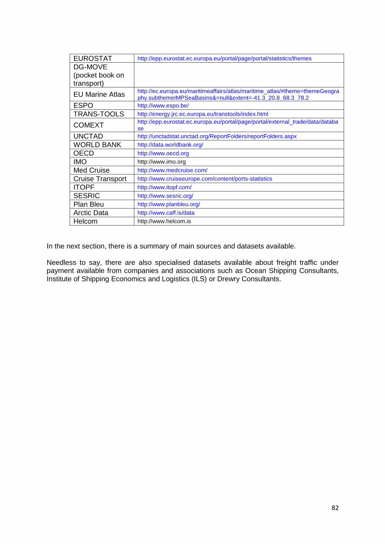
82
EUROSTAT http://epp.eurostat.ec.europa.eu/portal/page/portal/statistics/themes
DG-MOVE (pocket book on transport)
EU Marine Atlas http://ec.europa.eu/maritimeaffairs/atlas/maritime_atlas/#theme=themeGeography.subthemeIMPSeaBasins&=null&extent=-41.3_20.8_68.3_78.2
ESPO http://www.espo.be/
TRANS-TOOLS http://energy.jrc.ec.europa.eu/transtools/index.html
COMEXT http://epp.eurostat.ec.europa.eu/portal/page/portal/external_trade/data/database
UNCTAD http://unctadstat.unctad.org/ReportFolders/reportFolders.aspx
WORLD BANK http://data.worldbank.org/
OECD http://www.oecd.org
IMO http://www.imo.org
Med Cruise http://www.medcruise.com/
Cruise Transport http://www.cruiseeurope.com/content/ports-statistics
ITOPF http://www.itopf.com/
SESRIC http://www.sesric.org/
Plan Bleu http://www.planbleu.org/
Arctic Data http://www.caff.is/data
Helcom http://www.helcom.is
In the next section, there is a summary of main sources and datasets available. Needless to say, there are also specialised datasets available about freight traffic under payment available from companies and associations such as Ocean Shipping Consultants, Institute of Shipping Economics and Logistics (ILS) or Drewry Consultants.
83
5. Thematic Data Availability EUROSTAT is the Official database of the European Union. Maritime transport for freight and passengers (excluding cruises) are available.
For maritime freight transport: Annual datasets about goods handled in all European ports from 1998, by type of cargo, by type of traffic (national or international) and by volume of containers from 2000. This datasets is available in country level and to 20 main ports of Europe. Per each country it is available data quarterly: transport by direction and transport by type of cargo. Time period is different in each country: usually start date is between 1995 and 2000 and finish date is 2009- 2010.
In relation to maritime passenger‘s transport: Annual passengers embarked and disembarked a country level in all ports, by direction and by type of traffic (national and international) and annual transported from/ to main ports. Also there are available detailed quarterly data per country. Datasets starting date is 1997 and finishing date is 2010.
In case of Short Sea shipping there are annual datasets concerning gross weight of goods transported to/ from main ports by direction, by sea region of partner ports from 2005 to 2008. Annual datasets by type of cargo and volume (in TEU‘s) of containers transported to/ from main ports from 2000 to 2008 is also available. Both datasets are available in country level. Top 20 ports in EU annual datasets are available for gross weight of goods transported to/from main ports and top 5 ports datasets are available of gross weight transported in liquid bulk, dry bulk, containers, and ro-ro units. Both datasets start date is 2000 and finish date is 2008.
Transport good and passenger transport datasets are available for 27 Union European countries and Norway. In some cases Iceland, Turkey and Croatia are included (as candidate Countries).
Regional level annual datasets (NUTS2) from 1999 are also available for maritime transport of passengers and maritime transport of freight.
Annual dataset concerning export of goods (% of GDP) and import of goods (% of GDP) from 1995. Annual datasets about growth of maritime transport (%) is available from 2006. Is also available annual datasets about external trade total product (COMEXT), external trade of food, drinks and tobacco datasets chemical and related products datasets, machinery and transport equipment datasets (trade balanced million EUR) from 1999. Quarterly datasets are also available from 1995. Spatial coverage is 27 UE countries, and in some cases Norway, Iceland, Switzerland are also included.
DG MOVE is the official website of European Commission on Mobility and Transport and there is available an annual pocketbook statistics, from 2009 to 2011. The content of this pocketbook is based on a range of sources including Eurostat, international organisations, national statistics and, where no data were available, own estimates. It is available datasets about freight maritime transport and passengers maritime transport and European Level.
TRANS-TOOLS is a European transport network model for passengers and freight. It is a four step classic model with economic, trade, logistics and regional development modules. TRANS-TOOLS was calibrated with 2005 data. It contains real 2005 traffics for major transport networks in Europe, mostly road, rail and air. It includes specific data for ferry
84
transport, including volumes of passengers and fares. TRANS-TOOLS is recognised as the reference software for transport modelling in the EU. The European Sea Port Organisation (ESPO) represents the port authorities, port associations and port administrations of the seaports of the Member States of the European Union, Norway and Iceland. The ESPO Rapid data Exchange System includes annual data on the following traffics from 2002: total tonnage of goods carries, including packaging and including the tare weight of containers or ro-ro units, total liquid bulk (tons), total dry bulk (tons), total general cargo (tons), containers (tons, TEU), passengers. Form 2009, quarterly datasets are also available. The World Bank provides worldwide information concerning containers port traffic in TEU at country level from 1981 until 2010. It measures the worldwide flow of containers from land to sea transport modes, and vice versa. UNCTAD provides a world merchant fleet registration by type of ship and by flag from 1980 to 2010 and liner shipping connectivity index from 2004. Cruise Europe website (North Sea, Baltic Sea and Atlantic Sea) and Med Cruise website (Mediterranean Sea and Black Sea) provides information on cruises. Datasets with marine casualties and incidents are available at the International Maritime Organisation (IMO) website. In the International tanker owners pollution federation restricted website (ITOPF) are available datasets about oil spills of tankers. For the Mediterranean Sea, the Plan Bleu website provides figures on imports and exports in US dollars in 2000 in Mediterranean countries. It is also available annual figures about petrol and gas transportation by ship and pipeline in Mediterranean Sea (2003), large major conurbations with more than million inhabitants in Mediterranean (2003) and urbanisation rate in Mediterranean countries and forecasts in 2025. In Baltic Sea, Helcom (Helsinki Commission: Baltic Marine Environment Protection Commission) website is available Baltic Sea Maritime Traffic Information, from 2007 to 2010, and traffic estimation for 2015 in Baltic Sea. Information about passage lines in Baltic Sea and top 20 ports for international passenger in 2008 it is also available. In addition, it is available maps about shipping accidents and illegal discharge is Sea Baltic until 2010, cables, pipelines and offshore wind farms installed on Baltic Sea. All information presented above is on map format online and it is downloaded in GIS format. In the Arctic Sea, the Arctic Data website are available datasets about Marine Activity in Arctic Sea divided by countries: Norway and Faroes Islands, Iceland, Greenland, Svalbard Canada, USA and Russia. This datasets contains information about routes in the Arctic Sea, ports by country (latitude and longitude), population size, type of vessels (oil tankers, chemical tankers, bulk, general cargo, reefers, roro cargo, passengers …), main features of this vessels and number of vessels in Arctic Routes. This information is only available by 2006 in Norway and Faroes, by 2004 in Iceland, Canada, USA, Russia and Savalbard and 2009 in Greenland. It is also available Arctic shipping routes and ports in Arctic Sea in GIS format. It is available historical information (1995 – 2004) about shipping accidents in Arctic Sea. According to transport framework policy, datasets about increasing of traffics and reducing CO2 and pollution present high policy relevance.
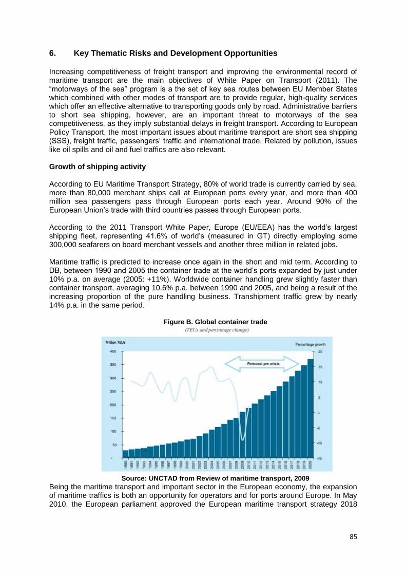
85
6. Key Thematic Risks and Development Opportunities Increasing competitiveness of freight transport and improving the environmental record of maritime transport are the main objectives of White Paper on Transport (2011). The ―motorways of the sea‖ program is a the set of key sea routes between EU Member States which combined with other modes of transport are to provide regular, high-quality services which offer an effective alternative to transporting goods only by road. Administrative barriers to short sea shipping, however, are an important threat to motorways of the sea competitiveness, as they imply substantial delays in freight transport. According to European Policy Transport, the most important issues about maritime transport are short sea shipping (SSS), freight traffic, passengers‘ traffic and international trade. Related by pollution, issues like oil spills and oil and fuel traffics are also relevant. Growth of shipping activity According to EU Maritime Transport Strategy, 80% of world trade is currently carried by sea, more than 80,000 merchant ships call at European ports every year, and more than 400 million sea passengers pass through European ports each year. Around 90% of the European Union‘s trade with third countries passes through European ports. According to the 2011 Transport White Paper, Europe (EU/EEA) has the world‘s largest shipping fleet, representing 41.6% of world‘s (measured in GT) directly employing some 300,000 seafarers on board merchant vessels and another three million in related jobs. Maritime traffic is predicted to increase once again in the short and mid term. According to DB, between 1990 and 2005 the container trade at the world‘s ports expanded by just under 10% p.a. on average (2005: +11%). Worldwide container handling grew slightly faster than container transport, averaging 10.6% p.a. between 1990 and 2005, and being a result of the increasing proportion of the pure handling business. Transhipment traffic grew by nearly 14% p.a. in the same period.
Figure B. Global container trade
Source: UNCTAD from Review of maritime transport, 2009
Being the maritime transport and important sector in the European economy, the expansion of maritime traffics is both an opportunity for operators and for ports around Europe. In May 2010, the European parliament approved the European maritime transport strategy 2018
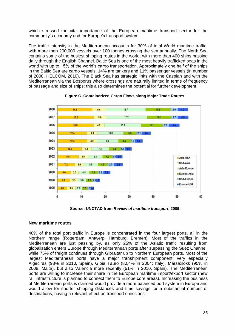
86
which stressed the vital importance of the European maritime transport sector for the community‘s economy and for Europe‘s transport system.
The traffic intensity in the Mediterranean accounts for 30% of total World maritime traffic, with more than 200,000 vessels over 100 tonnes crossing the sea annually. The North Sea contains some of the busiest shipping routes in the world, with more than 400 ships passing daily through the English Channel. Baltic Sea is one of the most heavily trafficked seas in the world with up to 15% of the world‘s cargo transportation. Approximately one half of the ships in the Baltic Sea are cargo vessels, 14% are tankers and 11% passenger vessels (in number of 2008, HELCOM, 2010). The Black Sea has strategic links with the Caspian and with the Mediterranean via the Bosporus where crossings are naturally limited in terms of frequency of passage and size of ships; this also determines the potential for further development.
Figure C. Containerized Cargo Flows along Major Trade Routes.
Source: UNCTAD from Review of maritime transport, 2009.
New maritime routes 40% of the total port traffic in Europe is concentrated in the four largest ports, all in the Northern range (Rotterdam, Antwerp, Hamburg, Bremen). Most of the traffics in the Mediterranean are just passing by, as only 25% of the Asiatic traffic resulting from globalisation enters Europe through Mediterranean ports after surpassing the Suez Channel, while 75% of freight continues through Gibraltar up to Northern European ports. Most of the largest Mediterranean ports have a major transhipment component, very especially Algeciras (93% in 2010, Spain), Gioia Tauro (80,4% in 2004; Italy), Marsaxlokk (95% in 2008, Malta), but also Valencia more recently (51% in 2010, Spain). The Mediterranean ports are willing to increase their share in the European maritime import/export sector (new rail infrastructure is planned to connect them to Europe core areas). Increasing the business of Mediterranean ports is claimed would provide a more balanced port system in Europe and would allow for shorter shipping distances and time savings for a substantial number of destinations, having a relevant effect on transport emissions.
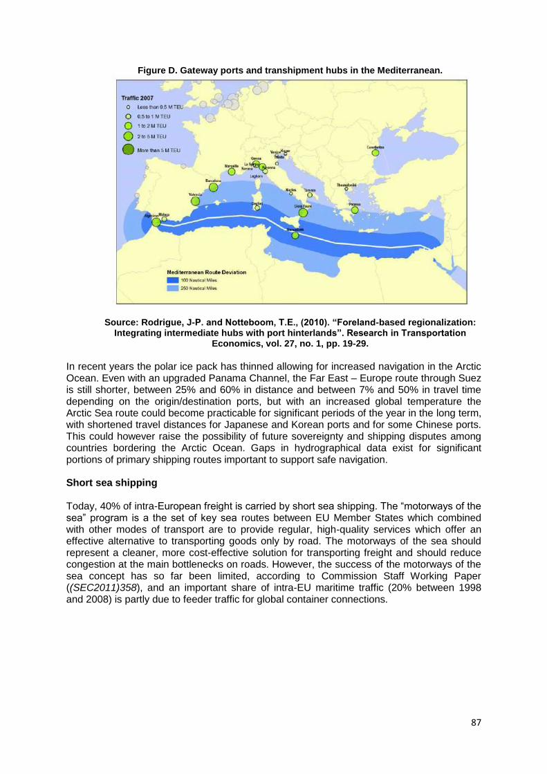
87
Figure D. Gateway ports and transhipment hubs in the Mediterranean.
Source: Rodrigue, J-P. and Notteboom, T.E., (2010). “Foreland-based regionalization: Integrating intermediate hubs with port hinterlands”. Research in Transportation
Economics, vol. 27, no. 1, pp. 19-29.
In recent years the polar ice pack has thinned allowing for increased navigation in the Arctic Ocean. Even with an upgraded Panama Channel, the Far East – Europe route through Suez is still shorter, between 25% and 60% in distance and between 7% and 50% in travel time depending on the origin/destination ports, but with an increased global temperature the Arctic Sea route could become practicable for significant periods of the year in the long term, with shortened travel distances for Japanese and Korean ports and for some Chinese ports. This could however raise the possibility of future sovereignty and shipping disputes among countries bordering the Arctic Ocean. Gaps in hydrographical data exist for significant portions of primary shipping routes important to support safe navigation. Short sea shipping Today, 40% of intra-European freight is carried by short sea shipping. The ―motorways of the sea‖ program is a the set of key sea routes between EU Member States which combined with other modes of transport are to provide regular, high-quality services which offer an effective alternative to transporting goods only by road. The motorways of the sea should represent a cleaner, more cost-effective solution for transporting freight and should reduce congestion at the main bottlenecks on roads. However, the success of the motorways of the sea concept has so far been limited, according to Commission Staff Working Paper ((SEC2011)358), and an important share of intra-EU maritime traffic (20% between 1998 and 2008) is partly due to feeder traffic for global container connections.
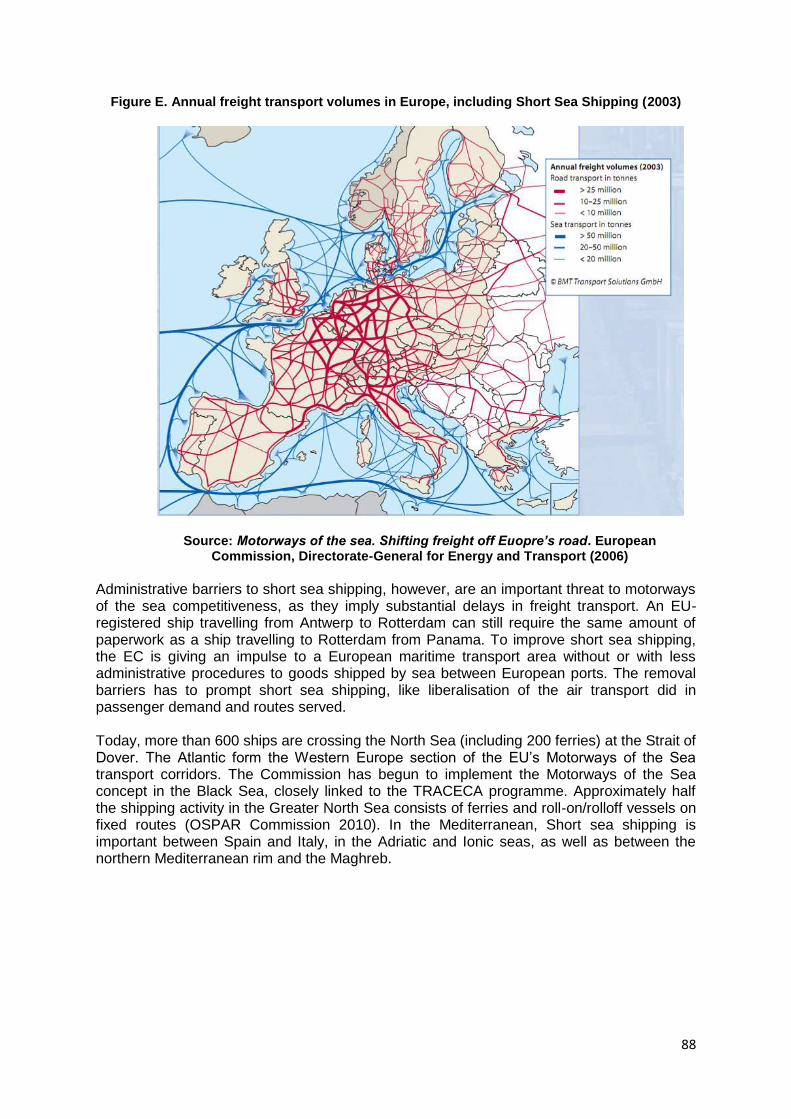
88
Figure E. Annual freight transport volumes in Europe, including Short Sea Shipping (2003)
Source: Motorways of the sea. Shifting freight off Euopre’s road. European Commission, Directorate-General for Energy and Transport (2006)
Administrative barriers to short sea shipping, however, are an important threat to motorways of the sea competitiveness, as they imply substantial delays in freight transport. An EU-registered ship travelling from Antwerp to Rotterdam can still require the same amount of paperwork as a ship travelling to Rotterdam from Panama. To improve short sea shipping, the EC is giving an impulse to a European maritime transport area without or with less administrative procedures to goods shipped by sea between European ports. The removal barriers has to prompt short sea shipping, like liberalisation of the air transport did in passenger demand and routes served. Today, more than 600 ships are crossing the North Sea (including 200 ferries) at the Strait of Dover. The Atlantic form the Western Europe section of the EU‘s Motorways of the Sea transport corridors. The Commission has begun to implement the Motorways of the Sea concept in the Black Sea, closely linked to the TRACECA programme. Approximately half the shipping activity in the Greater North Sea consists of ferries and roll-on/rolloff vessels on fixed routes (OSPAR Commission 2010). In the Mediterranean, Short sea shipping is important between Spain and Italy, in the Adriatic and Ionic seas, as well as between the northern Mediterranean rim and the Maghreb.
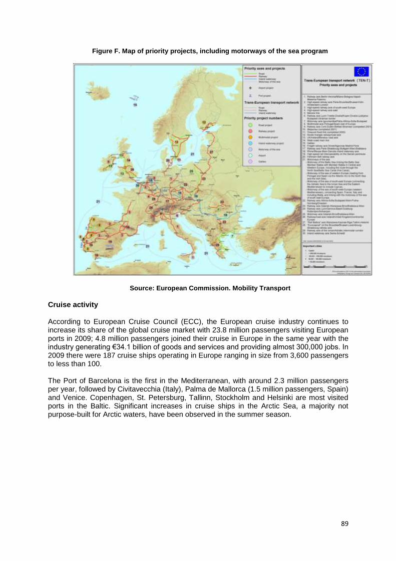
89
Figure F. Map of priority projects, including motorways of the sea program
Source: European Commission. Mobility Transport
Cruise activity According to European Cruise Council (ECC), the European cruise industry continues to increase its share of the global cruise market with 23.8 million passengers visiting European ports in 2009; 4.8 million passengers joined their cruise in Europe in the same year with the industry generating €34.1 billion of goods and services and providing almost 300,000 jobs. In 2009 there were 187 cruise ships operating in Europe ranging in size from 3,600 passengers to less than 100. The Port of Barcelona is the first in the Mediterranean, with around 2.3 million passengers per year, followed by Civitavecchia (Italy), Palma de Mallorca (1.5 million passengers, Spain) and Venice. Copenhagen, St. Petersburg, Tallinn, Stockholm and Helsinki are most visited ports in the Baltic. Significant increases in cruise ships in the Arctic Sea, a majority not purpose-built for Arctic waters, have been observed in the summer season.
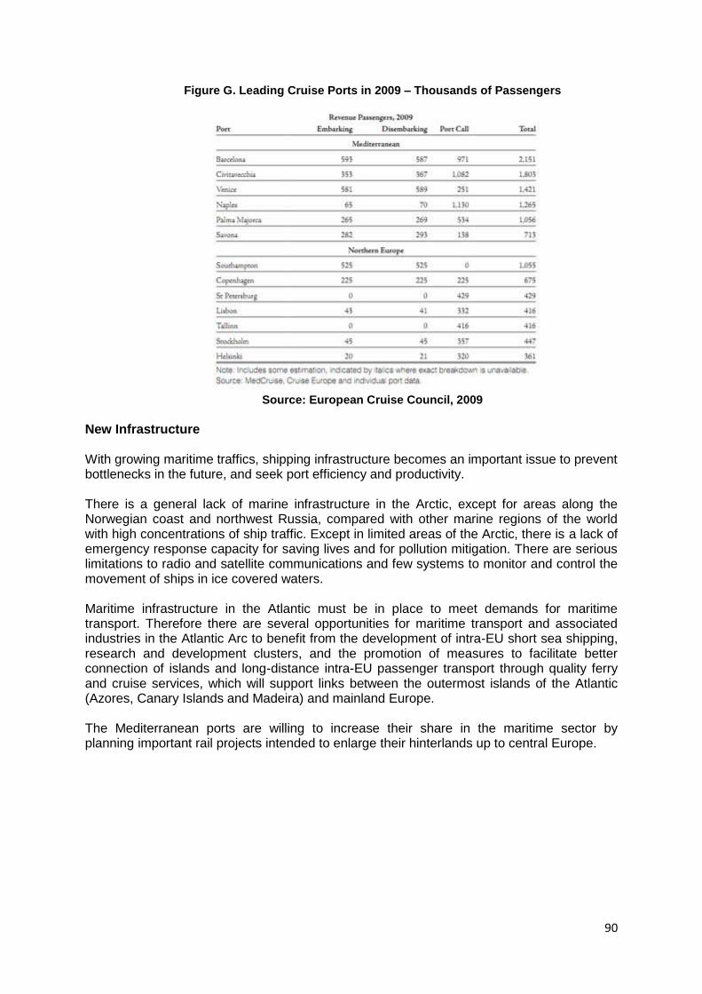
90
Figure G. Leading Cruise Ports in 2009 – Thousands of Passengers
Source: European Cruise Council, 2009
New Infrastructure With growing maritime traffics, shipping infrastructure becomes an important issue to prevent bottlenecks in the future, and seek port efficiency and productivity. There is a general lack of marine infrastructure in the Arctic, except for areas along the Norwegian coast and northwest Russia, compared with other marine regions of the world with high concentrations of ship traffic. Except in limited areas of the Arctic, there is a lack of emergency response capacity for saving lives and for pollution mitigation. There are serious limitations to radio and satellite communications and few systems to monitor and control the movement of ships in ice covered waters. Maritime infrastructure in the Atlantic must be in place to meet demands for maritime transport. Therefore there are several opportunities for maritime transport and associated industries in the Atlantic Arc to benefit from the development of intra-EU short sea shipping, research and development clusters, and the promotion of measures to facilitate better connection of islands and long-distance intra-EU passenger transport through quality ferry and cruise services, which will support links between the outermost islands of the Atlantic (Azores, Canary Islands and Madeira) and mainland Europe. The Mediterranean ports are willing to increase their share in the maritime sector by planning important rail projects intended to enlarge their hinterlands up to central Europe.
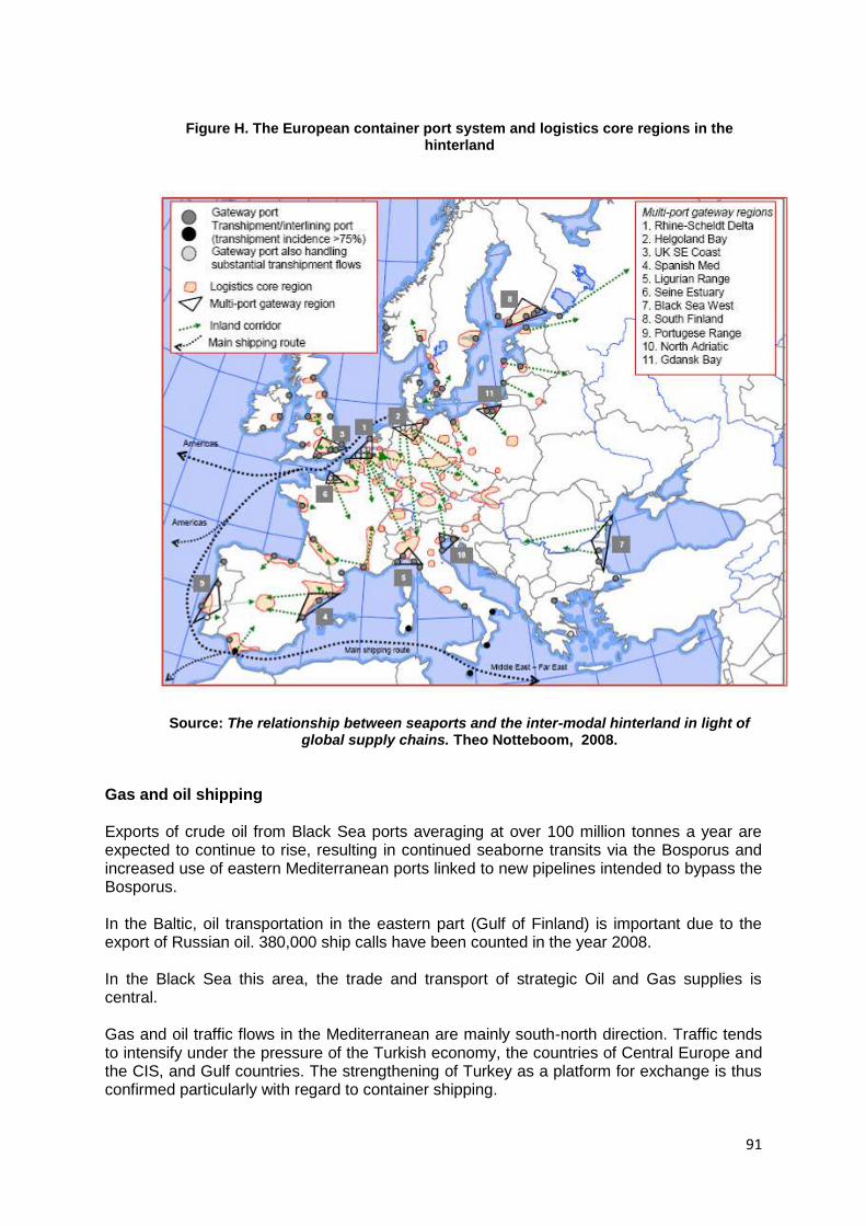
91
Figure H. The European container port system and logistics core regions in the
hinterland
Source: The relationship between seaports and the inter-modal hinterland in light of global supply chains. Theo Notteboom, 2008.
Gas and oil shipping Exports of crude oil from Black Sea ports averaging at over 100 million tonnes a year are expected to continue to rise, resulting in continued seaborne transits via the Bosporus and increased use of eastern Mediterranean ports linked to new pipelines intended to bypass the Bosporus. In the Baltic, oil transportation in the eastern part (Gulf of Finland) is important due to the export of Russian oil. 380,000 ship calls have been counted in the year 2008. In the Black Sea this area, the trade and transport of strategic Oil and Gas supplies is central. Gas and oil traffic flows in the Mediterranean are mainly south-north direction. Traffic tends to intensify under the pressure of the Turkish economy, the countries of Central Europe and the CIS, and Gulf countries. The strengthening of Turkey as a platform for exchange is thus confirmed particularly with regard to container shipping.
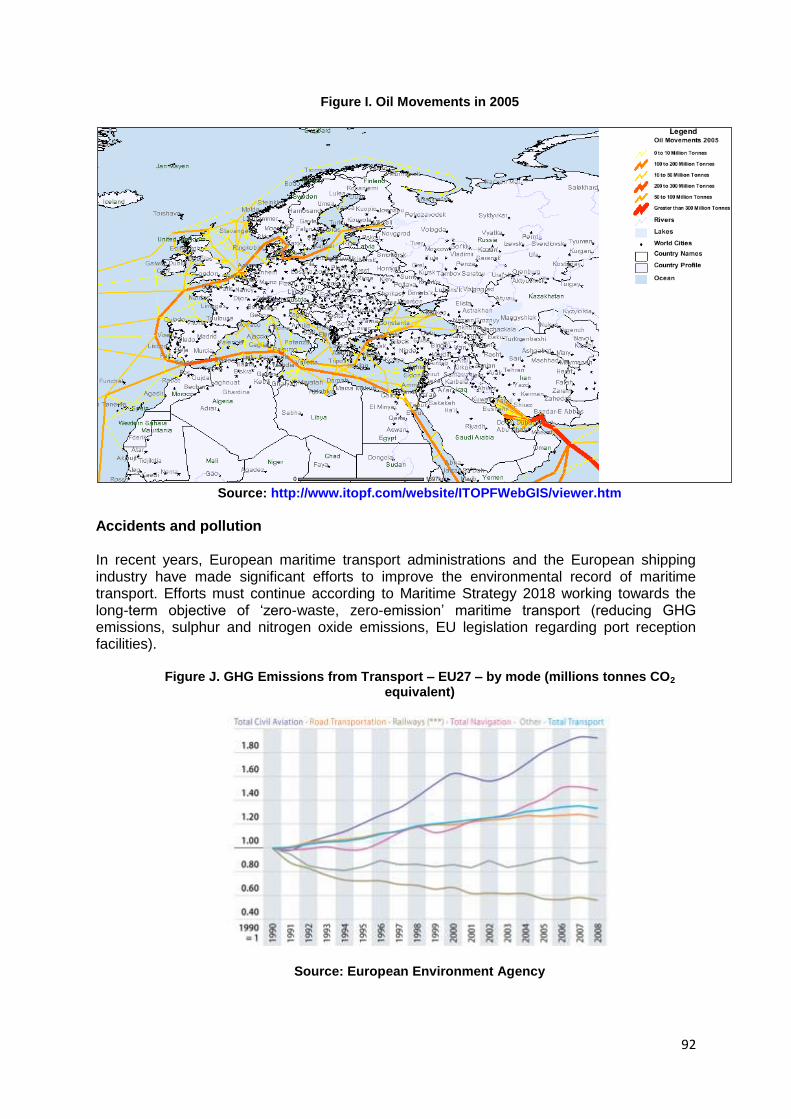
92
Figure I. Oil Movements in 2005
Source: http://www.itopf.com/website/ITOPFWebGIS/viewer.htm
Accidents and pollution In recent years, European maritime transport administrations and the European shipping industry have made significant efforts to improve the environmental record of maritime transport. Efforts must continue according to Maritime Strategy 2018 working towards the long-term objective of ‗zero-waste, zero-emission‘ maritime transport (reducing GHG emissions, sulphur and nitrogen oxide emissions, EU legislation regarding port reception facilities).
Figure J. GHG Emissions from Transport – EU27 – by mode (millions tonnes CO2 equivalent)
Source: European Environment Agency
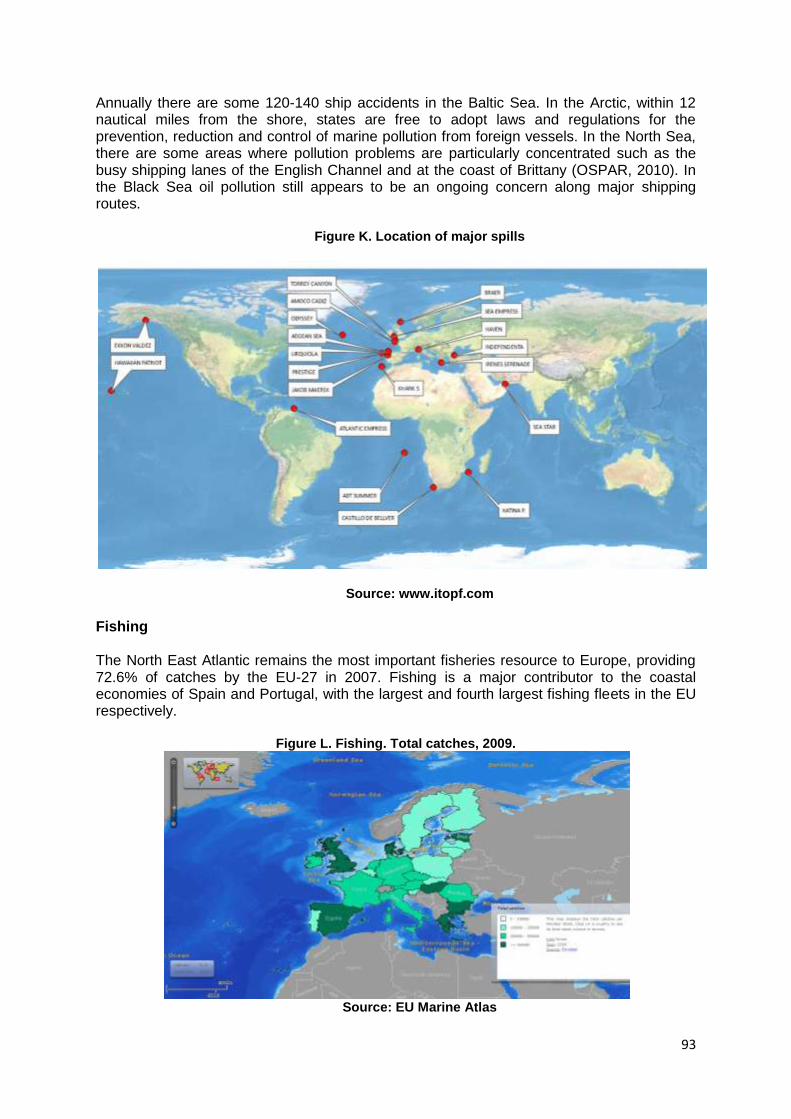
93
Annually there are some 120-140 ship accidents in the Baltic Sea. In the Arctic, within 12 nautical miles from the shore, states are free to adopt laws and regulations for the prevention, reduction and control of marine pollution from foreign vessels. In the North Sea, there are some areas where pollution problems are particularly concentrated such as the busy shipping lanes of the English Channel and at the coast of Brittany (OSPAR, 2010). In the Black Sea oil pollution still appears to be an ongoing concern along major shipping routes.
Figure K. Location of major spills
Source: www.itopf.com
Fishing The North East Atlantic remains the most important fisheries resource to Europe, providing 72.6% of catches by the EU-27 in 2007. Fishing is a major contributor to the coastal economies of Spain and Portugal, with the largest and fourth largest fishing fleets in the EU respectively.
Figure L. Fishing. Total catches, 2009.
Source: EU Marine Atlas
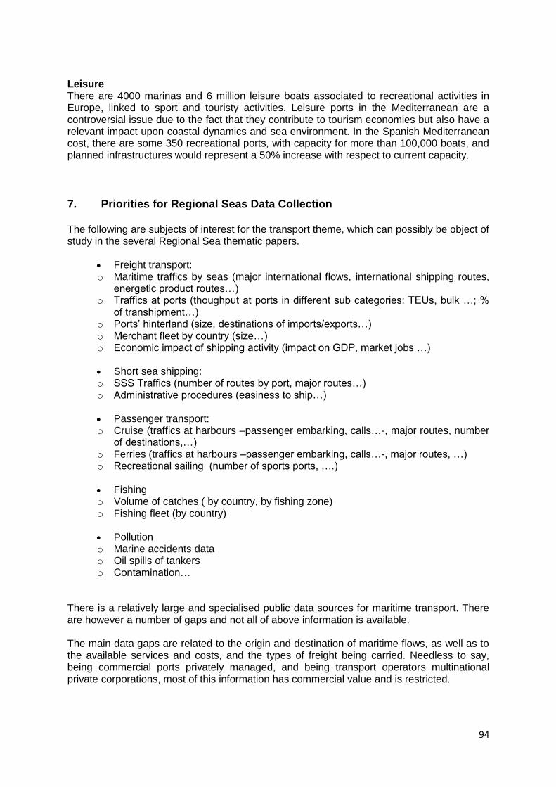
94
Leisure There are 4000 marinas and 6 million leisure boats associated to recreational activities in Europe, linked to sport and touristy activities. Leisure ports in the Mediterranean are a controversial issue due to the fact that they contribute to tourism economies but also have a relevant impact upon coastal dynamics and sea environment. In the Spanish Mediterranean cost, there are some 350 recreational ports, with capacity for more than 100,000 boats, and planned infrastructures would represent a 50% increase with respect to current capacity.
7. Priorities for Regional Seas Data Collection The following are subjects of interest for the transport theme, which can possibly be object of study in the several Regional Sea thematic papers.
Freight transport: o Maritime traffics by seas (major international flows, international shipping routes,
energetic product routes…) o Traffics at ports (thoughput at ports in different sub categories: TEUs, bulk …; %
of transhipment…) o Ports‘ hinterland (size, destinations of imports/exports…) o Merchant fleet by country (size…) o Economic impact of shipping activity (impact on GDP, market jobs …)
Short sea shipping: o SSS Traffics (number of routes by port, major routes…) o Administrative procedures (easiness to ship…)
Passenger transport: o Cruise (traffics at harbours –passenger embarking, calls…-, major routes, number
of destinations,…) o Ferries (traffics at harbours –passenger embarking, calls…-, major routes, …) o Recreational sailing (number of sports ports, ….)
Fishing o Volume of catches ( by country, by fishing zone) o Fishing fleet (by country)
Pollution o Marine accidents data o Oil spills of tankers o Contamination…
There is a relatively large and specialised public data sources for maritime transport. There are however a number of gaps and not all of above information is available. The main data gaps are related to the origin and destination of maritime flows, as well as to the available services and costs, and the types of freight being carried. Needless to say, being commercial ports privately managed, and being transport operators multinational private corporations, most of this information has commercial value and is restricted.
95
Also, data on economic impact of the shipping activity or cruise activity on local economies is not available.
8. References
CaffPortal - Data. 2011. CaffPortal - Data. [ONLINE] Available at: http://www.caff.is/data. [Accessed 10 June 2011] Centre for Transportation Studies for the Western Mediterranean (CETMO), 2009. Transport Training Needs in Western Mediterranean Countries Centre for Transportation Studies for the Western Mediterranean (CETMO) 2008. Definition of a Euro-Mediterranean Transport Network COMEXT (http://epp.eurostat.ec.europa.eu/newxtweb/) Container Trade Statistics. 2011. Container Trade Statistics. [ONLINE] Available at: http://www.containerstatistics.com. [Accessed 10 June 2011]. Deutsche Bank Research. 2006. Container Shipping. Overcapacity inevitable despite increasing demand. Available at: http://www.dbresearch.com/PROD/DBR_INTERNET_DE-PROD/PROD0000000000198081.PDF [Accessed 15 June 2011]. DESTIN Project Database 2005 European Commission, Mobility and Transport. Statistics . 2011. [ONLINE] Available at: http://ec.europa.eu/transport/publications/statistics/statistics_en.htm ESPO - European Sea Ports Organisation - Welcome. 2011. ESPO - European Sea Ports Organisation - Welcome. [ONLINE] Available at: http://www.espo.be/index.php?option=com_content&view=article&id=95&Itemid=90. [Accessed 10 June 2011] Euromed Cooperation On Maritime Safety And Prevention Of Pollution From Ships (SAFEMED), 2008. Study of Maritime Traffic Flows in the Mediterranean Sea EuroMed Transport Project, 2007. Regional Transport Action Plan for the Mediterranean Region 2007-2013 EuroMed Transport Project, 2005. Blue Paper on Euro-Mediterranean Transport Policy. Communication from the Euro-Mediterranean Transport Forum to the First Euro-Mediterranean Conference of Transport Ministers, 2005. Towards an Integrated Euro-Mediterranean Transport SysteM. Transport Policies and Priorities Commonly Agreed by MEDA Partners. European Commission, 2001. Transport White Paper: European transport policy for 2010: time to decide.
96
European Commission, 2006. Transport White Paper mid-term review: Keep Europe Moving – sustainable mobility for our continent. European Commission, 2007. Logistics: keep freight moving European Commission, 2008. The Greening transport package European Commission, 2009. Maritime transport strategy 2018. European Commission, 2009. A sustainable future for transport: towards an integrated, technology-led and user friendly system. European Commission, 2011. Roadmap to a Single European Transport Area – Towards a competitive and resource efficient transport system. European Community Shipowners Association (ECSA) . 2011. Annual Report 2009 – 2010. [ONLINE] Available at: http://www.ecsa.be/ar/Rapport 2009-2010.pdf. [Accessed 15 June 2011]. Homepage. 2011. Homepage. [ONLINE] Available at: http://www.eurostat.com. [Accessed 10 June 2011]. Helcom : shipping main. 2011. Helcom : shipping main. [ONLINE] Available at: http://www.helcom.fi/shipping/en_GB/main/. [Accessed 10 June 2011] IMO | Global Integrated Shipping Information System (GISIS). 2011. IMO | Global Integrated Shipping Information System (GISIS). [ONLINE] Available at: http://gisis.imo.org/Public/Default.aspx International Road Federation (IRF), 2007. The socio-economic benefits of roads in Europe. ITOPF - Information Services - Data & Statistics. 2011. ITOPF - Information Services - Data & Statistics. [ONLINE] Available at: http://www.itopf.com/information-services/data-and-statistics/. [Accessed 10 June 2011]. MEDSTAT. The regional statistical co-operation programme between: the 27 EU Member States and 10 Mediterranean countries: Algeria, Egypt, Israel, Jordan, Lebanon, Morocco, occupied Palestinian territory, Syria, Tunisia and Turkey. (http://epp.eurostat.ec.europa.eu/portal/page/portal/medstat/introduction/) NESTEAR, 2004. Pertinence et potentiel de l’intermodalité dans la région de la Méditerranée et de la mer Noire. In: CEMT / CEE-ONU Seminar, Kiev 2004. Peraldi, X. (1999) La desserte des îles de la Méditerranée occidentale et l'idée d'une continuité territoriale méditerranéenne intégrée. Université de Corse. Organisation for Economic Co-operation and Development. 2011. Organisation for Economic Co-operation and Development. [ONLINE] Available at: http://www.oecd.org/home/0,2987,en_2649_201185_1_1_1_1_1,00.html. [Accessed 10 June 2011].

97
Petersen M.S., Enei R., Hansen C.O., Larrea E., Biosca O., Sessa C., Timms P.M., Ulied A, 2009: Report on Transport Scenarios with a 20 and 40 year Horizon, Final report. TRANSvisions. Funded by DG TREN. Rodríguez JP, 2010. Maritime transportation: drivers for the shipping and port industries. International Transport Forum. SECEG, 2002. Informe estadístico 2001. Base de datos Socio-Económicos y de flujos de tráfico Europa-África SESRIC. Statistical Economic and Social Research and training centre for Islamic Countries. Statistical Yearbook for Islamic Coutries. 2008, 2009 Mediterranean Information System on Environment and Development (SIMEDD). 2011. Mediterranean Information System on Environment and Development (SIMEDD). [ONLINE] Available at: http://www.planbleu.org/methodologie/Simedd_Uk.html. [Accessed 10 June 2011] World Merchant Fleet Statistics (UNCTADStat). 2011. [ONLINE] Available at: http://unctadstat.unctad.org/ReportFolders/reportFolders.aspx. [Accessed 10 June 2011] UNEP/MAP-Plan Bleu Regional Activity Centre 2010. State of the Environment and Development in the Mediterranean 2009 Data | The World Bank. 2011. Data | The World Bank. [ONLINE] Available at: http://data.worldbank.org. [Accessed 10 June 2011]
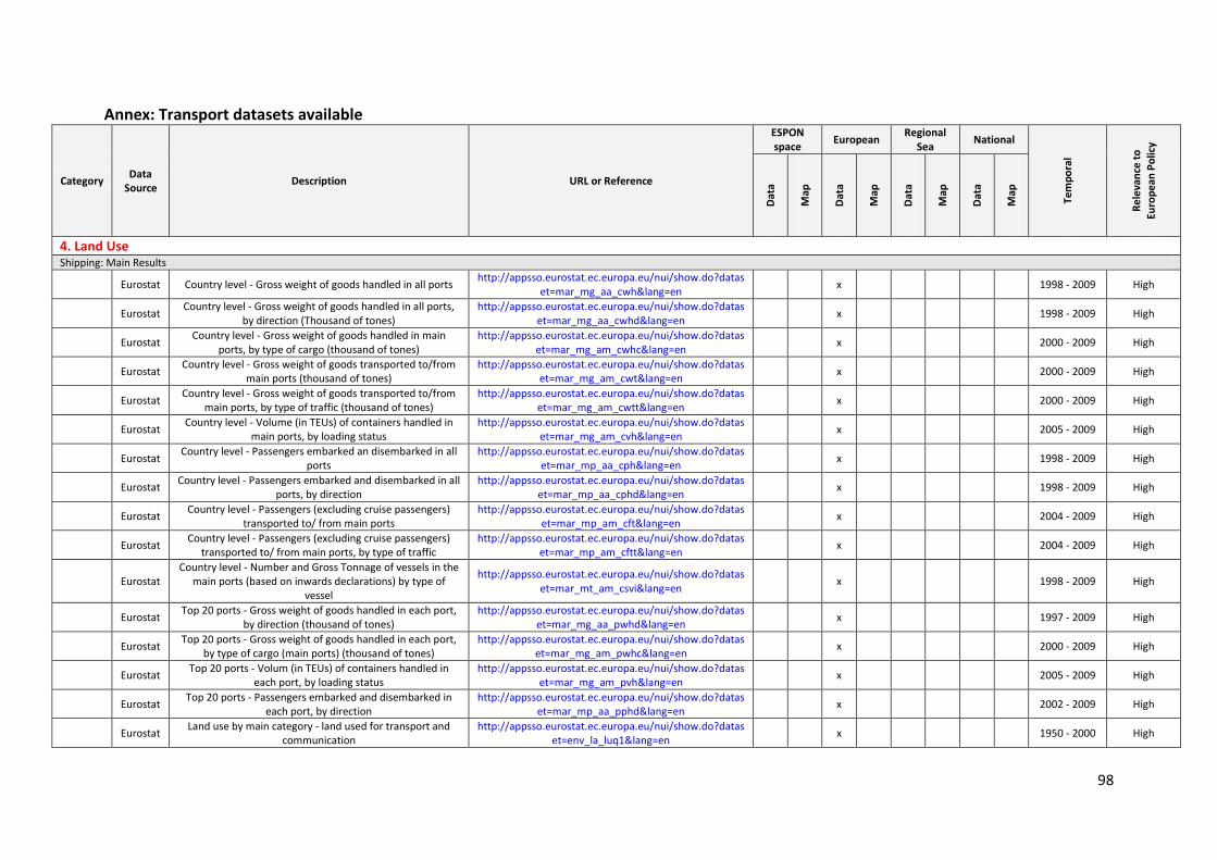
98
Annex: Transport datasets available
Category Data
Source Description URL or Reference
ESPON space
European Regional
Sea National
Tem
po
ral
Re
leva
nce
to
Euro
pe
an P
olic
y
Dat
a
Map
Dat
a
Map
Dat
a
Map
Dat
a
Map
4. Land Use Shipping: Main Results
Eurostat Country level - Gross weight of goods handled in all ports http://appsso.eurostat.ec.europa.eu/nui/show.do?datas
et=mar_mg_aa_cwh&lang=en x
1998 - 2009 High
Eurostat Country level - Gross weight of goods handled in all ports,
by direction (Thousand of tones) http://appsso.eurostat.ec.europa.eu/nui/show.do?datas
et=mar_mg_aa_cwhd&lang=en x
1998 - 2009 High
Eurostat Country level - Gross weight of goods handled in main
ports, by type of cargo (thousand of tones) http://appsso.eurostat.ec.europa.eu/nui/show.do?datas
et=mar_mg_am_cwhc&lang=en x
2000 - 2009 High
Eurostat Country level - Gross weight of goods transported to/from
main ports (thousand of tones) http://appsso.eurostat.ec.europa.eu/nui/show.do?datas
et=mar_mg_am_cwt&lang=en x
2000 - 2009 High
Eurostat Country level - Gross weight of goods transported to/from
main ports, by type of traffic (thousand of tones) http://appsso.eurostat.ec.europa.eu/nui/show.do?datas
et=mar_mg_am_cwtt&lang=en x
2000 - 2009 High
Eurostat Country level - Volume (in TEUs) of containers handled in
main ports, by loading status http://appsso.eurostat.ec.europa.eu/nui/show.do?datas
et=mar_mg_am_cvh&lang=en x
2005 - 2009 High
Eurostat Country level - Passengers embarked an disembarked in all
ports http://appsso.eurostat.ec.europa.eu/nui/show.do?datas
et=mar_mp_aa_cph&lang=en x
1998 - 2009 High
Eurostat Country level - Passengers embarked and disembarked in all
ports, by direction http://appsso.eurostat.ec.europa.eu/nui/show.do?datas
et=mar_mp_aa_cphd&lang=en x
1998 - 2009 High
Eurostat Country level - Passengers (excluding cruise passengers)
transported to/ from main ports http://appsso.eurostat.ec.europa.eu/nui/show.do?datas
et=mar_mp_am_cft&lang=en x
2004 - 2009 High
Eurostat Country level - Passengers (excluding cruise passengers)
transported to/ from main ports, by type of traffic http://appsso.eurostat.ec.europa.eu/nui/show.do?datas
et=mar_mp_am_cftt&lang=en x
2004 - 2009 High
Eurostat Country level - Number and Gross Tonnage of vessels in the
main ports (based on inwards declarations) by type of vessel
http://appsso.eurostat.ec.europa.eu/nui/show.do?dataset=mar_mt_am_csvi&lang=en
x
1998 - 2009 High
Eurostat Top 20 ports - Gross weight of goods handled in each port,
by direction (thousand of tones) http://appsso.eurostat.ec.europa.eu/nui/show.do?datas
et=mar_mg_aa_pwhd&lang=en x
1997 - 2009 High
Eurostat Top 20 ports - Gross weight of goods handled in each port,
by type of cargo (main ports) (thousand of tones) http://appsso.eurostat.ec.europa.eu/nui/show.do?datas
et=mar_mg_am_pwhc&lang=en x
2000 - 2009 High
Eurostat Top 20 ports - Volum (in TEUs) of containers handled in
each port, by loading status http://appsso.eurostat.ec.europa.eu/nui/show.do?datas
et=mar_mg_am_pvh&lang=en x
2005 - 2009 High
Eurostat Top 20 ports - Passengers embarked and disembarked in
each port, by direction http://appsso.eurostat.ec.europa.eu/nui/show.do?datas
et=mar_mp_aa_pphd&lang=en x
2002 - 2009 High
Eurostat Land use by main category - land used for transport and
communication http://appsso.eurostat.ec.europa.eu/nui/show.do?datas
et=env_la_luq1&lang=en x
1950 - 2000 High
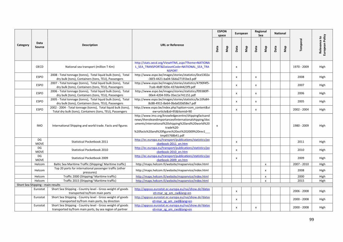
99
Category Data
Source Description URL or Reference
ESPON space
European Regional
Sea National
Tem
po
ral
Re
leva
nce
to
Euro
pe
an P
olic
y
Dat
a
Map
Dat
a
Map
Dat
a
Map
Dat
a
Map
OECD National sea transport (million T-Km) http://stats.oecd.org/ViewHTML.aspx?Theme=NATIONAL_SEA_TRANSPORT&DatasetCode=NATIONAL_SEA_TRA
NSPORT x
1970 - 2009 High
ESPO 2008 - Total tonnage (tonns), Total liquid bulk (tons), Total
dry bulk (tons), Containers (tons, TEU), Passengers http://www.espo.be/images/stories/statistics/0ce5302a
-36f3-4421-ba04-56da27191be3.pdf x x
2008 High
ESPO 2007 - Total tonnage (tonns), Total liquid bulk (tons), Total
dry bulk (tons), Containers (tons, TEU), Passengers http://www.espo.be/images/stories/statistics/4790f4f5-
7cab-4b8f-920e-437de44423f9.pdf x x
2007 High
ESPO 2006 - Total tonnage (tonns), Total liquid bulk (tons), Total
dry bulk (tons), Containers (tons, TEU), Passengers http://www.espo.be/images/stories/statistics/f09380ff-
00e4-4204-93fa-35ec1e741151.pdf x x
2006 High
ESPO 2005 - Total tonnage (tonns), Total liquid bulk (tons), Total
dry bulk (tons), Containers (tons, TEU), Passengers http://www.espo.be/images/stories/statistics/bc10fa84-
8c88-4915-8e64-0bda020d58e7.pdf x x
2005 High
ESPO 2002 - 2004 - Total tonnage (tonns), Total liquid bulk (tons),
Total dry bulk (tons), Containers (tons, TEU), Passengers http://www.espo.be/index.php?option=com_content&vi
ew=article&id=95&Itemid=90 x x
2002 - 2004 High
IMO International Shipping and world trade. Facts and figures
http://www.imo.org/knowledgecentre/shippingfactsandnews/theroleandimportanceofinternationalshipping/documents/international%20shipping%20and%20world%20
trade%20-%20facts%20and%20figures%20oct%202009%20rev1___
tmp65768b41.pdf
x
1980 - 2009 High
DG
MOVE Statistical Pocketbook 2011
http://ec.europa.eu/transport/publications/statistics/pocketbook-2011_en.htm
x
2011 High
DG
MOVE Statistical Pocketbook 2010
http://ec.europa.eu/transport/publications/statistics/pocketbook-2010_en.htm
x
2010 High
DG
MOVE Statistical Pocketbook 2009
http://ec.europa.eu/transport/publications/statistics/pocketbook-2009_en.htm
x
2009 High
Helcom Baltic Sea Maritime Traffic (Shipping/ Maritime traffic) http://maps.helcom.fi/website/mapservice/index.html x 2007 - 2010 High
Helcom Top 20 ports for international passenger traffic (other
pressures) http://maps.helcom.fi/website/mapservice/index.html
x 2008 High
Helcom Traffic 2000 (Shipping/ Maritime traffic) http://maps.helcom.fi/website/mapservice/index.html x 2000 High
Helcom Traffic 2015 (Shipping/ Maritime traffic) http://maps.helcom.fi/website/mapservice/index.html x 2015 High
Short Sea Shipping - main results
Eurostat Short Sea Shipping - Country level - Gross weight of goods
transported to/from main ports http://appsso.eurostat.ec.europa.eu/nui/show.do?datas
et=mar_sg_am_cw&lang=en x 2006 - 2008 High
Eurostat Short Sea Shipping - Country level - Gross weight of goods
transported to/from main ports, by direction http://appsso.eurostat.ec.europa.eu/nui/show.do?datas
et=mar_sg_am_cwd&lang=en x 2000 - 2008 High
Eurostat Short Sea Shipping - Country level - Gross weight of goods
transported to/from main ports, by sea region of partner http://appsso.eurostat.ec.europa.eu/nui/show.do?datas
et=mar_sg_am_cws&lang=en x x 2000 - 2008 High
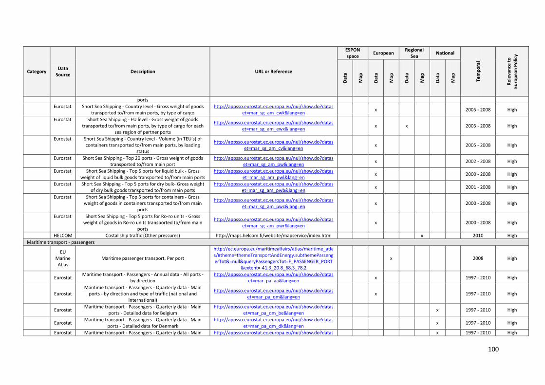
100
Category Data
Source Description URL or Reference
ESPON space
European Regional
Sea National
Tem
po
ral
Re
leva
nce
to
Euro
pe
an P
olic
y
Dat
a
Map
Dat
a
Map
Dat
a
Map
Dat
a
Map
ports
Eurostat Short Sea Shipping - Country level - Gross weight of goods
transported to/from main ports, by type of cargo http://appsso.eurostat.ec.europa.eu/nui/show.do?datas
et=mar_sg_am_cwk&lang=en x 2005 - 2008 High
Eurostat Short Sea Shipping - EU level - Gross weight of goods
transported to/from main ports, by type of cargo for each sea region of partner ports
http://appsso.eurostat.ec.europa.eu/nui/show.do?dataset=mar_sg_am_ewx&lang=en
x x 2005 - 2008 High
Eurostat Short Sea Shipping - Country level - Volume (in TEU's) of
containers transported to/from main ports, by loading status
http://appsso.eurostat.ec.europa.eu/nui/show.do?dataset=mar_sg_am_cv&lang=en
x 2005 - 2008 High
Eurostat Short Sea Shipping - Top 20 ports - Gross weight of goods
transported to/from main port http://appsso.eurostat.ec.europa.eu/nui/show.do?datas
et=mar_sg_am_pw&lang=en x 2002 - 2008 High
Eurostat Short Sea Shipping - Top 5 ports for liquid bulk - Gross
weight of liquid bulk goods transported to/from main ports http://appsso.eurostat.ec.europa.eu/nui/show.do?datas
et=mar_sg_am_pwl&lang=en x 2000 - 2008 High
Eurostat Short Sea Shipping - Top 5 ports for dry bulk- Gross weight
of dry bulk goods transported to/from main ports http://appsso.eurostat.ec.europa.eu/nui/show.do?datas
et=mar_sg_am_pwb&lang=en x 2001 - 2008 High
Eurostat Short Sea Shipping - Top 5 ports for containers - Gross
weight of goods in containers transported to/from main ports
http://appsso.eurostat.ec.europa.eu/nui/show.do?dataset=mar_sg_am_pwc&lang=en
x 2000 - 2008 High
Eurostat Short Sea Shipping - Top 5 ports for Ro-ro units - Gross
weight of goods in Ro-ro units transported to/from main ports
http://appsso.eurostat.ec.europa.eu/nui/show.do?dataset=mar_sg_am_pwr&lang=en
x 2000 - 2008 High
HELCOM Costal ship traffic (Other pressures) http://maps.helcom.fi/website/mapservice/index.html x 2010 High
Maritime transport - passengers
EU
Marine Atlas
Maritime passenger transport. Per port
http://ec.europa.eu/maritimeaffairs/atlas/maritime_atlas/#theme=themeTransportAndEnergy.subthemePassengerTot&=null&queryPassengersTot=F_PASSENGER_PORT
&extent=-41.3_20.8_68.3_78.2
x 2008 High
Eurostat Maritime transport - Passengers - Annual data - All ports -
by direction http://appsso.eurostat.ec.europa.eu/nui/show.do?datas
et=mar_pa_aa&lang=en x 1997 - 2010 High
Eurostat Maritime transport - Passengers - Quarterly data - Main
ports - by direction and type of traffic (national and international)
http://appsso.eurostat.ec.europa.eu/nui/show.do?dataset=mar_pa_qm&lang=en
x 1997 - 2010 High
Eurostat Maritime transport - Passengers - Quarterly data - Main
ports - Detailed data for Belgium http://appsso.eurostat.ec.europa.eu/nui/show.do?datas
et=mar_pa_qm_be&lang=en x 1997 - 2010 High
Eurostat Maritime transport - Passengers - Quarterly data - Main
ports - Detailed data for Denmark http://appsso.eurostat.ec.europa.eu/nui/show.do?datas
et=mar_pa_qm_dk&lang=en x 1997 - 2010 High
Eurostat Maritime transport - Passengers - Quarterly data - Main http://appsso.eurostat.ec.europa.eu/nui/show.do?datas x 1997 - 2010 High
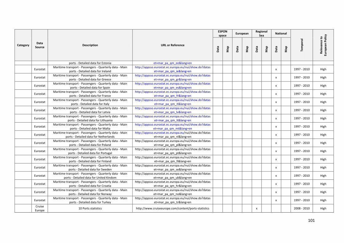
101
Category Data
Source Description URL or Reference
ESPON space
European Regional
Sea National
Tem
po
ral
Re
leva
nce
to
Euro
pe
an P
olic
y
Dat
a
Map
Dat
a
Map
Dat
a
Map
Dat
a
Map
ports - Detailed data for Estonia et=mar_pa_qm_ee&lang=en
Eurostat Maritime transport - Passengers - Quarterly data - Main
ports - Detailed data for Ireland http://appsso.eurostat.ec.europa.eu/nui/show.do?datas
et=mar_pa_qm_ie&lang=en x 1997 - 2010 High
Eurostat Maritime transport - Passengers - Quarterly data - Main
ports - Detailed data for Greece http://appsso.eurostat.ec.europa.eu/nui/show.do?datas
et=mar_pa_qm_gr&lang=en x 1997 - 2010 High
Eurostat Maritime transport - Passengers - Quarterly data - Main
ports - Detailed data for Spain http://appsso.eurostat.ec.europa.eu/nui/show.do?datas
et=mar_pa_qm_es&lang=en x 1997 - 2010 High
Eurostat Maritime transport - Passengers - Quarterly data - Main
ports - Detailed data for France http://appsso.eurostat.ec.europa.eu/nui/show.do?datas
et=mar_pa_qm_fr&lang=en x 1997 - 2010 High
Eurostat Maritime transport - Passengers - Quarterly data - Main
ports - Detailed data for Italy http://appsso.eurostat.ec.europa.eu/nui/show.do?datas
et=mar_pa_qm_it&lang=en x 1997 - 2010 High
Eurostat Maritime transport - Passengers - Quarterly data - Main
ports - Detailed data for Latvia http://appsso.eurostat.ec.europa.eu/nui/show.do?datas
et=mar_pa_qm_lv&lang=en x 1997 - 2010 High
Eurostat Maritime transport - Passengers - Quarterly data - Main
ports - Detailed data for Lithuania http://appsso.eurostat.ec.europa.eu/nui/show.do?datas
et=mar_pa_qm_lt&lang=en x 1997 - 2010 High
Eurostat Maritime transport - Passengers - Quarterly data - Main
ports - Detailed data for Malta http://appsso.eurostat.ec.europa.eu/nui/show.do?datas
et=mar_pa_qm_mt&lang=en x 1997 - 2010 High
Eurostat Maritime transport - Passengers - Quarterly data - Main
ports - Detailed data for Netherlands http://appsso.eurostat.ec.europa.eu/nui/show.do?datas
et=mar_pa_qm_nl&lang=en x 1997 - 2010 High
Eurostat Maritime transport - Passengers - Quarterly data - Main
ports - Detailed data for Poland http://appsso.eurostat.ec.europa.eu/nui/show.do?datas
et=mar_pa_qm_pl&lang=en x 1997 - 2010 High
Eurostat Maritime transport - Passengers - Quarterly data - Main
ports - Detailed data for Portugal http://appsso.eurostat.ec.europa.eu/nui/show.do?datas
et=mar_pa_qm_pt&lang=en x 1997 - 2010 High
Eurostat Maritime transport - Passengers - Quarterly data - Main
ports - Detailed data for Finland http://appsso.eurostat.ec.europa.eu/nui/show.do?datas
et=mar_pa_qm_fi&lang=en x 1997 - 2010 High
Eurostat Maritime transport - Passengers - Quarterly data - Main
ports - Detailed data for Sweden http://appsso.eurostat.ec.europa.eu/nui/show.do?datas
et=mar_pa_qm_se&lang=en x 1997 - 2010 High
Eurostat Maritime transport - Passengers - Quarterly data - Main
ports - Detailed data for United Kindom http://appsso.eurostat.ec.europa.eu/nui/show.do?datas
et=mar_pa_qm_uk&lang=en x 1997 - 2010 High
Eurostat Maritime transport - Passengers - Quarterly data - Main
ports - Detailed data for Croatia http://appsso.eurostat.ec.europa.eu/nui/show.do?datas
et=mar_pa_qm_hr&lang=en x 1997 - 2010 High
Eurostat Maritime transport - Passengers - Quarterly data - Main
ports - Detailed data for Norway http://appsso.eurostat.ec.europa.eu/nui/show.do?datas
et=mar_pa_qm_no&lang=en x 1997 - 2010 High
Eurostat Maritime transport - Passengers - Quarterly data - Main
ports - Detailed data for Turkey http://appsso.eurostat.ec.europa.eu/nui/show.do?datas
et=mar_pa_qm_tr&lang=en x 1997 - 2010 High
Cruise Europe
10 Ports statistics http://www.cruiseeurope.com/content/ports-statistics x 2008 - 2010 High
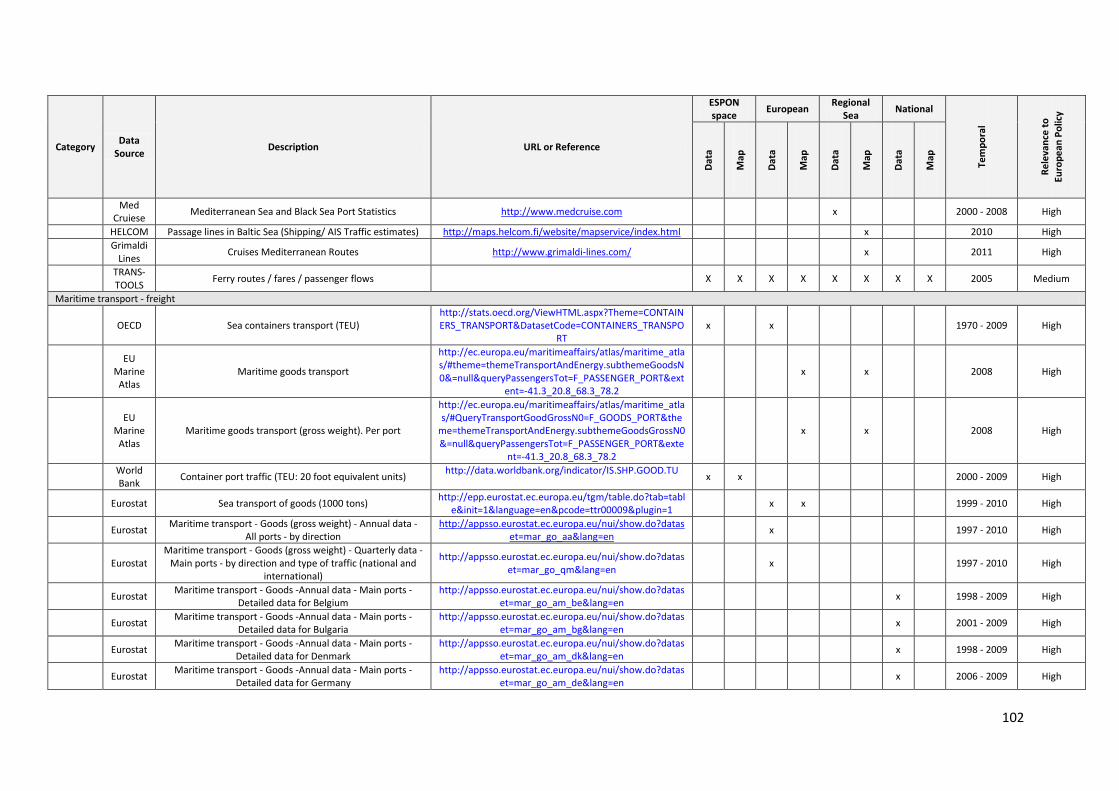
102
Category Data
Source Description URL or Reference
ESPON space
European Regional
Sea National
Tem
po
ral
Re
leva
nce
to
Euro
pe
an P
olic
y
Dat
a
Map
Dat
a
Map
Dat
a
Map
Dat
a
Map
Med
Cruiese Mediterranean Sea and Black Sea Port Statistics http://www.medcruise.com x 2000 - 2008 High
HELCOM Passage lines in Baltic Sea (Shipping/ AIS Traffic estimates) http://maps.helcom.fi/website/mapservice/index.html x 2010 High
Grimaldi
Lines Cruises Mediterranean Routes http://www.grimaldi-lines.com/ x 2011 High
TRANS-TOOLS
Ferry routes / fares / passenger flows X X X X X X X X 2005 Medium
Maritime transport - freight
OECD Sea containers transport (TEU) http://stats.oecd.org/ViewHTML.aspx?Theme=CONTAINERS_TRANSPORT&DatasetCode=CONTAINERS_TRANSPO
RT x x 1970 - 2009 High
EU
Marine Atlas
Maritime goods transport
http://ec.europa.eu/maritimeaffairs/atlas/maritime_atlas/#theme=themeTransportAndEnergy.subthemeGoodsN0&=null&queryPassengersTot=F_PASSENGER_PORT&ext
ent=-41.3_20.8_68.3_78.2
x x 2008 High
EU
Marine Atlas
Maritime goods transport (gross weight). Per port
http://ec.europa.eu/maritimeaffairs/atlas/maritime_atlas/#QueryTransportGoodGrossN0=F_GOODS_PORT&the
me=themeTransportAndEnergy.subthemeGoodsGrossN0&=null&queryPassengersTot=F_PASSENGER_PORT&exte
nt=-41.3_20.8_68.3_78.2
x x 2008 High
World Bank
Container port traffic (TEU: 20 foot equivalent units) http://data.worldbank.org/indicator/IS.SHP.GOOD.TU
x x 2000 - 2009 High
Eurostat Sea transport of goods (1000 tons) http://epp.eurostat.ec.europa.eu/tgm/table.do?tab=tabl
e&init=1&language=en&pcode=ttr00009&plugin=1 x x 1999 - 2010 High
Eurostat Maritime transport - Goods (gross weight) - Annual data -
All ports - by direction http://appsso.eurostat.ec.europa.eu/nui/show.do?datas
et=mar_go_aa&lang=en x 1997 - 2010 High
Eurostat Maritime transport - Goods (gross weight) - Quarterly data -
Main ports - by direction and type of traffic (national and international)
http://appsso.eurostat.ec.europa.eu/nui/show.do?dataset=mar_go_qm&lang=en
x 1997 - 2010 High
Eurostat Maritime transport - Goods -Annual data - Main ports -
Detailed data for Belgium http://appsso.eurostat.ec.europa.eu/nui/show.do?datas
et=mar_go_am_be&lang=en x 1998 - 2009 High
Eurostat Maritime transport - Goods -Annual data - Main ports -
Detailed data for Bulgaria http://appsso.eurostat.ec.europa.eu/nui/show.do?datas
et=mar_go_am_bg&lang=en x 2001 - 2009 High
Eurostat Maritime transport - Goods -Annual data - Main ports -
Detailed data for Denmark http://appsso.eurostat.ec.europa.eu/nui/show.do?datas
et=mar_go_am_dk&lang=en x 1998 - 2009 High
Eurostat Maritime transport - Goods -Annual data - Main ports -
Detailed data for Germany http://appsso.eurostat.ec.europa.eu/nui/show.do?datas
et=mar_go_am_de&lang=en x 2006 - 2009 High
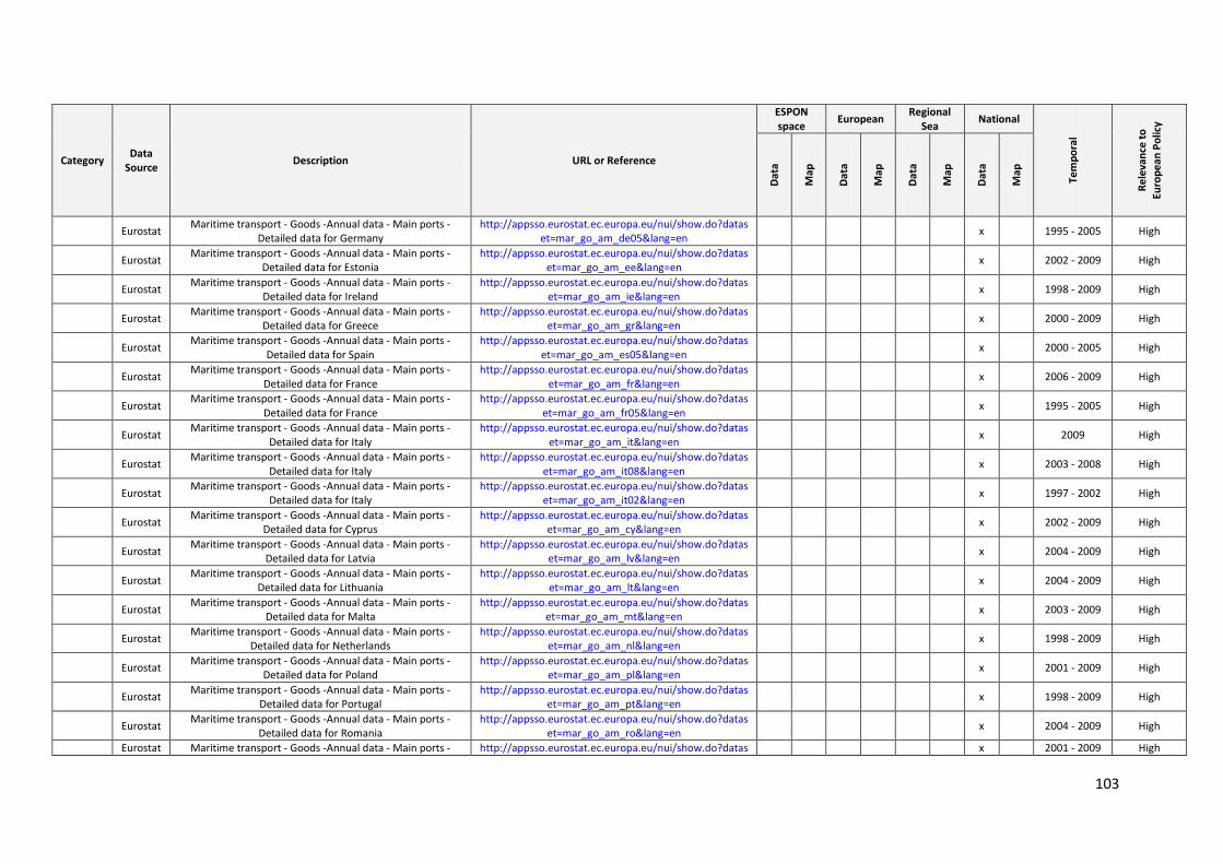
103
Category Data
Source Description URL or Reference
ESPON space
European Regional
Sea National
Tem
po
ral
Re
leva
nce
to
Euro
pe
an P
olic
y
Dat
a
Map
Dat
a
Map
Dat
a
Map
Dat
a
Map
Eurostat Maritime transport - Goods -Annual data - Main ports -
Detailed data for Germany http://appsso.eurostat.ec.europa.eu/nui/show.do?datas
et=mar_go_am_de05&lang=en x 1995 - 2005 High
Eurostat Maritime transport - Goods -Annual data - Main ports -
Detailed data for Estonia http://appsso.eurostat.ec.europa.eu/nui/show.do?datas
et=mar_go_am_ee&lang=en x 2002 - 2009 High
Eurostat Maritime transport - Goods -Annual data - Main ports -
Detailed data for Ireland http://appsso.eurostat.ec.europa.eu/nui/show.do?datas
et=mar_go_am_ie&lang=en x 1998 - 2009 High
Eurostat Maritime transport - Goods -Annual data - Main ports -
Detailed data for Greece http://appsso.eurostat.ec.europa.eu/nui/show.do?datas
et=mar_go_am_gr&lang=en x 2000 - 2009 High
Eurostat Maritime transport - Goods -Annual data - Main ports -
Detailed data for Spain http://appsso.eurostat.ec.europa.eu/nui/show.do?datas
et=mar_go_am_es05&lang=en x 2000 - 2005 High
Eurostat Maritime transport - Goods -Annual data - Main ports -
Detailed data for France http://appsso.eurostat.ec.europa.eu/nui/show.do?datas
et=mar_go_am_fr&lang=en x 2006 - 2009 High
Eurostat Maritime transport - Goods -Annual data - Main ports -
Detailed data for France http://appsso.eurostat.ec.europa.eu/nui/show.do?datas
et=mar_go_am_fr05&lang=en x 1995 - 2005 High
Eurostat Maritime transport - Goods -Annual data - Main ports -
Detailed data for Italy http://appsso.eurostat.ec.europa.eu/nui/show.do?datas
et=mar_go_am_it&lang=en x 2009 High
Eurostat Maritime transport - Goods -Annual data - Main ports -
Detailed data for Italy http://appsso.eurostat.ec.europa.eu/nui/show.do?datas
et=mar_go_am_it08&lang=en x 2003 - 2008 High
Eurostat Maritime transport - Goods -Annual data - Main ports -
Detailed data for Italy http://appsso.eurostat.ec.europa.eu/nui/show.do?datas
et=mar_go_am_it02&lang=en x 1997 - 2002 High
Eurostat Maritime transport - Goods -Annual data - Main ports -
Detailed data for Cyprus http://appsso.eurostat.ec.europa.eu/nui/show.do?datas
et=mar_go_am_cy&lang=en x 2002 - 2009 High
Eurostat Maritime transport - Goods -Annual data - Main ports -
Detailed data for Latvia http://appsso.eurostat.ec.europa.eu/nui/show.do?datas
et=mar_go_am_lv&lang=en x 2004 - 2009 High
Eurostat Maritime transport - Goods -Annual data - Main ports -
Detailed data for Lithuania http://appsso.eurostat.ec.europa.eu/nui/show.do?datas
et=mar_go_am_lt&lang=en x 2004 - 2009 High
Eurostat Maritime transport - Goods -Annual data - Main ports -
Detailed data for Malta http://appsso.eurostat.ec.europa.eu/nui/show.do?datas
et=mar_go_am_mt&lang=en x 2003 - 2009 High
Eurostat Maritime transport - Goods -Annual data - Main ports -
Detailed data for Netherlands http://appsso.eurostat.ec.europa.eu/nui/show.do?datas
et=mar_go_am_nl&lang=en x 1998 - 2009 High
Eurostat Maritime transport - Goods -Annual data - Main ports -
Detailed data for Poland http://appsso.eurostat.ec.europa.eu/nui/show.do?datas
et=mar_go_am_pl&lang=en x 2001 - 2009 High
Eurostat Maritime transport - Goods -Annual data - Main ports -
Detailed data for Portugal http://appsso.eurostat.ec.europa.eu/nui/show.do?datas
et=mar_go_am_pt&lang=en x 1998 - 2009 High
Eurostat Maritime transport - Goods -Annual data - Main ports -
Detailed data for Romania http://appsso.eurostat.ec.europa.eu/nui/show.do?datas
et=mar_go_am_ro&lang=en x 2004 - 2009 High
Eurostat Maritime transport - Goods -Annual data - Main ports - http://appsso.eurostat.ec.europa.eu/nui/show.do?datas x 2001 - 2009 High
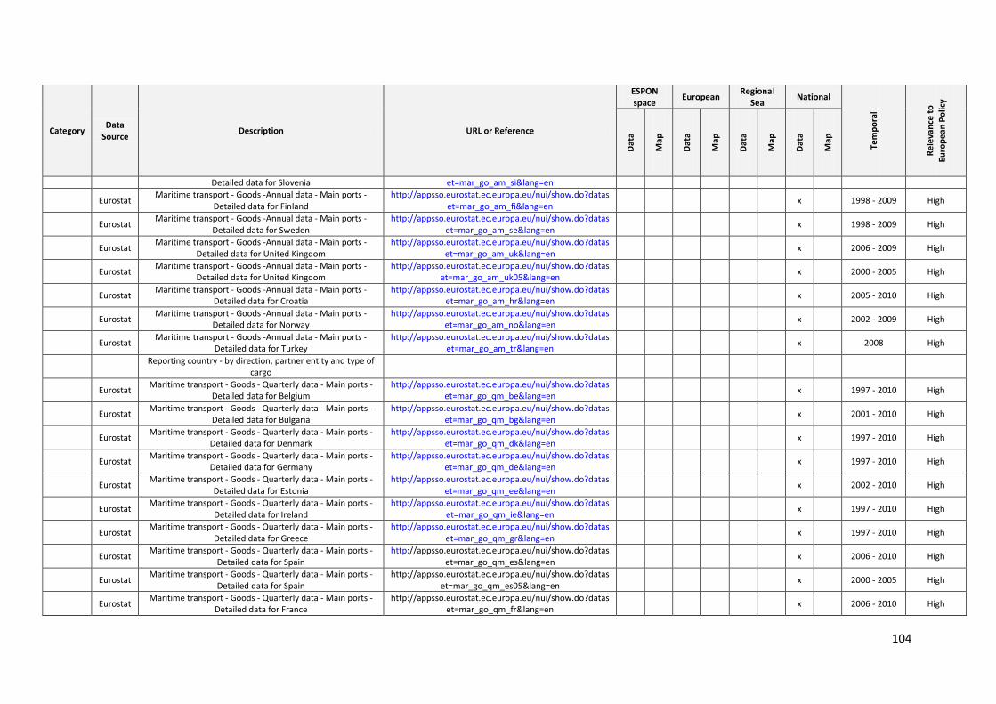
104
Category Data
Source Description URL or Reference
ESPON space
European Regional
Sea National
Tem
po
ral
Re
leva
nce
to
Euro
pe
an P
olic
y
Dat
a
Map
Dat
a
Map
Dat
a
Map
Dat
a
Map
Detailed data for Slovenia et=mar_go_am_si&lang=en
Eurostat Maritime transport - Goods -Annual data - Main ports -
Detailed data for Finland http://appsso.eurostat.ec.europa.eu/nui/show.do?datas
et=mar_go_am_fi&lang=en x 1998 - 2009 High
Eurostat Maritime transport - Goods -Annual data - Main ports -
Detailed data for Sweden http://appsso.eurostat.ec.europa.eu/nui/show.do?datas
et=mar_go_am_se&lang=en x 1998 - 2009 High
Eurostat Maritime transport - Goods -Annual data - Main ports -
Detailed data for United Kingdom http://appsso.eurostat.ec.europa.eu/nui/show.do?datas
et=mar_go_am_uk&lang=en x 2006 - 2009 High
Eurostat Maritime transport - Goods -Annual data - Main ports -
Detailed data for United Kingdom http://appsso.eurostat.ec.europa.eu/nui/show.do?datas
et=mar_go_am_uk05&lang=en x 2000 - 2005 High
Eurostat Maritime transport - Goods -Annual data - Main ports -
Detailed data for Croatia http://appsso.eurostat.ec.europa.eu/nui/show.do?datas
et=mar_go_am_hr&lang=en x 2005 - 2010 High
Eurostat Maritime transport - Goods -Annual data - Main ports -
Detailed data for Norway http://appsso.eurostat.ec.europa.eu/nui/show.do?datas
et=mar_go_am_no&lang=en x 2002 - 2009 High
Eurostat Maritime transport - Goods -Annual data - Main ports -
Detailed data for Turkey http://appsso.eurostat.ec.europa.eu/nui/show.do?datas
et=mar_go_am_tr&lang=en x 2008 High
Reporting country - by direction, partner entity and type of
cargo
Eurostat Maritime transport - Goods - Quarterly data - Main ports -
Detailed data for Belgium http://appsso.eurostat.ec.europa.eu/nui/show.do?datas
et=mar_go_qm_be&lang=en x 1997 - 2010 High
Eurostat Maritime transport - Goods - Quarterly data - Main ports -
Detailed data for Bulgaria http://appsso.eurostat.ec.europa.eu/nui/show.do?datas
et=mar_go_qm_bg&lang=en x 2001 - 2010 High
Eurostat Maritime transport - Goods - Quarterly data - Main ports -
Detailed data for Denmark http://appsso.eurostat.ec.europa.eu/nui/show.do?datas
et=mar_go_qm_dk&lang=en x 1997 - 2010 High
Eurostat Maritime transport - Goods - Quarterly data - Main ports -
Detailed data for Germany http://appsso.eurostat.ec.europa.eu/nui/show.do?datas
et=mar_go_qm_de&lang=en x 1997 - 2010 High
Eurostat Maritime transport - Goods - Quarterly data - Main ports -
Detailed data for Estonia http://appsso.eurostat.ec.europa.eu/nui/show.do?datas
et=mar_go_qm_ee&lang=en x 2002 - 2010 High
Eurostat Maritime transport - Goods - Quarterly data - Main ports -
Detailed data for Ireland http://appsso.eurostat.ec.europa.eu/nui/show.do?datas
et=mar_go_qm_ie&lang=en x 1997 - 2010 High
Eurostat Maritime transport - Goods - Quarterly data - Main ports -
Detailed data for Greece http://appsso.eurostat.ec.europa.eu/nui/show.do?datas
et=mar_go_qm_gr&lang=en x 1997 - 2010 High
Eurostat Maritime transport - Goods - Quarterly data - Main ports -
Detailed data for Spain http://appsso.eurostat.ec.europa.eu/nui/show.do?datas
et=mar_go_qm_es&lang=en x 2006 - 2010 High
Eurostat Maritime transport - Goods - Quarterly data - Main ports -
Detailed data for Spain http://appsso.eurostat.ec.europa.eu/nui/show.do?datas
et=mar_go_qm_es05&lang=en x 2000 - 2005 High
Eurostat Maritime transport - Goods - Quarterly data - Main ports -
Detailed data for France http://appsso.eurostat.ec.europa.eu/nui/show.do?datas
et=mar_go_qm_fr&lang=en x 2006 - 2010 High
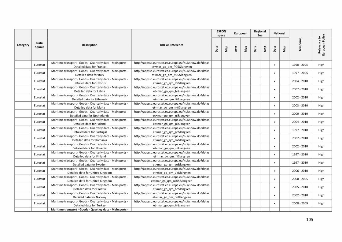
105
Category Data
Source Description URL or Reference
ESPON space
European Regional
Sea National
Tem
po
ral
Re
leva
nce
to
Euro
pe
an P
olic
y
Dat
a
Map
Dat
a
Map
Dat
a
Map
Dat
a
Map
Eurostat Maritime transport - Goods - Quarterly data - Main ports -
Detailed data for France http://appsso.eurostat.ec.europa.eu/nui/show.do?datas
et=mar_go_qm_fr05&lang=en x 1998 - 2005 High
Eurostat Maritime transport - Goods - Quarterly data - Main ports -
Detailed data for Italy http://appsso.eurostat.ec.europa.eu/nui/show.do?datas
et=mar_go_qm_it05&lang=en x 1997 - 2005 High
Eurostat Maritime transport - Goods - Quarterly data - Main ports -
Detailed data for Cyprus http://appsso.eurostat.ec.europa.eu/nui/show.do?datas
et=mar_go_qm_cy&lang=en x 2004 - 2010 High
Eurostat Maritime transport - Goods - Quarterly data - Main ports -
Detailed data for Latvia http://appsso.eurostat.ec.europa.eu/nui/show.do?datas
et=mar_go_qm_lv&lang=en x 2002 - 2010 High
Eurostat Maritime transport - Goods - Quarterly data - Main ports -
Detailed data for Lithuania http://appsso.eurostat.ec.europa.eu/nui/show.do?datas
et=mar_go_qm_lt&lang=en x 2002 - 2010 High
Eurostat Maritime transport - Goods - Quarterly data - Main ports -
Detailed data for Malta http://appsso.eurostat.ec.europa.eu/nui/show.do?datas
et=mar_go_qm_mt&lang=en x 2003 - 2010 High
Eurostat Maritime transport - Goods - Quarterly data - Main ports -
Detailed data for Netherlands http://appsso.eurostat.ec.europa.eu/nui/show.do?datas
et=mar_go_qm_nl&lang=en x 2000 - 2010 High
Eurostat Maritime transport - Goods - Quarterly data - Main ports -
Detailed data for Poland http://appsso.eurostat.ec.europa.eu/nui/show.do?datas
et=mar_go_qm_pl&lang=en x 2004 - 2010 High
Eurostat Maritime transport - Goods - Quarterly data - Main ports -
Detailed data for Portugal http://appsso.eurostat.ec.europa.eu/nui/show.do?datas
et=mar_go_qm_pt&lang=en x 1997 - 2010 High
Eurostat Maritime transport - Goods - Quarterly data - Main ports -
Detailed data for Romania http://appsso.eurostat.ec.europa.eu/nui/show.do?datas
et=mar_go_qm_ro&lang=en x 2002 - 2010 High
Eurostat Maritime transport - Goods - Quarterly data - Main ports -
Detailed data for Slovenia http://appsso.eurostat.ec.europa.eu/nui/show.do?datas
et=mar_go_qm_si&lang=en x 2002 - 2010 High
Eurostat Maritime transport - Goods - Quarterly data - Main ports -
Detailed data for Finland http://appsso.eurostat.ec.europa.eu/nui/show.do?datas
et=mar_go_qm_fi&lang=en x 1997 - 2010 High
Eurostat Maritime transport - Goods - Quarterly data - Main ports -
Detailed data for Sweden http://appsso.eurostat.ec.europa.eu/nui/show.do?datas
et=mar_go_qm_se&lang=en x 1997 - 2010 High
Eurostat Maritime transport - Goods - Quarterly data - Main ports -
Detailed data for United Kingdom http://appsso.eurostat.ec.europa.eu/nui/show.do?datas
et=mar_go_qm_uk&lang=en x 2006 - 2010 High
Eurostat Maritime transport - Goods - Quarterly data - Main ports -
Detailed data for United Kingdom http://appsso.eurostat.ec.europa.eu/nui/show.do?datas
et=mar_go_qm_uk05&lang=en x 2000 - 2005 High
Eurostat Maritime transport - Goods - Quarterly data - Main ports -
Detailed data for Croatia http://appsso.eurostat.ec.europa.eu/nui/show.do?datas
et=mar_go_qm_hr&lang=en x 2005 - 2010 High
Eurostat Maritime transport - Goods - Quarterly data - Main ports -
Detailed data for Norway http://appsso.eurostat.ec.europa.eu/nui/show.do?datas
et=mar_go_qm_no&lang=en x 2002 - 2010 High
Eurostat Maritime transport - Goods - Quarterly data - Main ports -
Detailed data for Turkey http://appsso.eurostat.ec.europa.eu/nui/show.do?datas
et=mar_go_qm_tr&lang=en x 2008 - 2009 High
Maritime transport - Goods - Quartley data - Main ports -
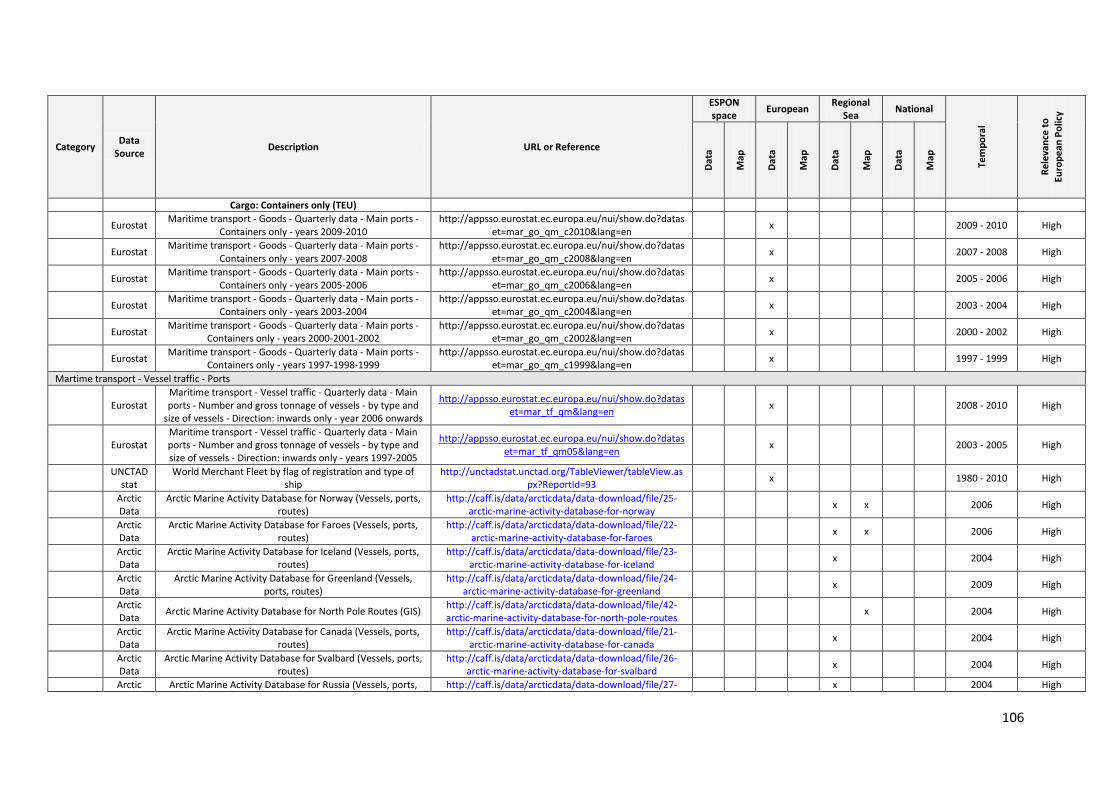
106
Category Data
Source Description URL or Reference
ESPON space
European Regional
Sea National
Tem
po
ral
Re
leva
nce
to
Euro
pe
an P
olic
y
Dat
a
Map
Dat
a
Map
Dat
a
Map
Dat
a
Map
Cargo: Containers only (TEU)
Eurostat Maritime transport - Goods - Quarterly data - Main ports -
Containers only - years 2009-2010 http://appsso.eurostat.ec.europa.eu/nui/show.do?datas
et=mar_go_qm_c2010&lang=en x 2009 - 2010 High
Eurostat Maritime transport - Goods - Quarterly data - Main ports -
Containers only - years 2007-2008 http://appsso.eurostat.ec.europa.eu/nui/show.do?datas
et=mar_go_qm_c2008&lang=en x 2007 - 2008 High
Eurostat Maritime transport - Goods - Quarterly data - Main ports -
Containers only - years 2005-2006 http://appsso.eurostat.ec.europa.eu/nui/show.do?datas
et=mar_go_qm_c2006&lang=en x 2005 - 2006 High
Eurostat Maritime transport - Goods - Quarterly data - Main ports -
Containers only - years 2003-2004 http://appsso.eurostat.ec.europa.eu/nui/show.do?datas
et=mar_go_qm_c2004&lang=en x 2003 - 2004 High
Eurostat Maritime transport - Goods - Quarterly data - Main ports -
Containers only - years 2000-2001-2002 http://appsso.eurostat.ec.europa.eu/nui/show.do?datas
et=mar_go_qm_c2002&lang=en x 2000 - 2002 High
Eurostat Maritime transport - Goods - Quarterly data - Main ports -
Containers only - years 1997-1998-1999 http://appsso.eurostat.ec.europa.eu/nui/show.do?datas
et=mar_go_qm_c1999&lang=en x 1997 - 1999 High
Martime transport - Vessel traffic - Ports
Eurostat Maritime transport - Vessel traffic - Quarterly data - Main ports - Number and gross tonnage of vessels - by type and
size of vessels - Direction: inwards only - year 2006 onwards
http://appsso.eurostat.ec.europa.eu/nui/show.do?dataset=mar_tf_qm&lang=en
x 2008 - 2010 High
Eurostat Maritime transport - Vessel traffic - Quarterly data - Main ports - Number and gross tonnage of vessels - by type and size of vessels - Direction: inwards only - years 1997-2005
http://appsso.eurostat.ec.europa.eu/nui/show.do?dataset=mar_tf_qm05&lang=en
x 2003 - 2005 High
UNCTAD
stat World Merchant Fleet by flag of registration and type of
ship http://unctadstat.unctad.org/TableViewer/tableView.as
px?ReportId=93 x 1980 - 2010 High
Arctic Data
Arctic Marine Activity Database for Norway (Vessels, ports, routes)
http://caff.is/data/arcticdata/data-download/file/25-arctic-marine-activity-database-for-norway
x x 2006 High
Arctic Data
Arctic Marine Activity Database for Faroes (Vessels, ports, routes)
http://caff.is/data/arcticdata/data-download/file/22-arctic-marine-activity-database-for-faroes
x x 2006 High
Arctic Data
Arctic Marine Activity Database for Iceland (Vessels, ports, routes)
http://caff.is/data/arcticdata/data-download/file/23-arctic-marine-activity-database-for-iceland
x 2004 High
Arctic Data
Arctic Marine Activity Database for Greenland (Vessels, ports, routes)
http://caff.is/data/arcticdata/data-download/file/24-arctic-marine-activity-database-for-greenland
x 2009 High
Arctic Data
Arctic Marine Activity Database for North Pole Routes (GIS) http://caff.is/data/arcticdata/data-download/file/42-arctic-marine-activity-database-for-north-pole-routes
x 2004 High
Arctic Data
Arctic Marine Activity Database for Canada (Vessels, ports, routes)
http://caff.is/data/arcticdata/data-download/file/21-arctic-marine-activity-database-for-canada
x 2004 High
Arctic Data
Arctic Marine Activity Database for Svalbard (Vessels, ports, routes)
http://caff.is/data/arcticdata/data-download/file/26-arctic-marine-activity-database-for-svalbard
x 2004 High
Arctic Arctic Marine Activity Database for Russia (Vessels, ports, http://caff.is/data/arcticdata/data-download/file/27- x 2004 High
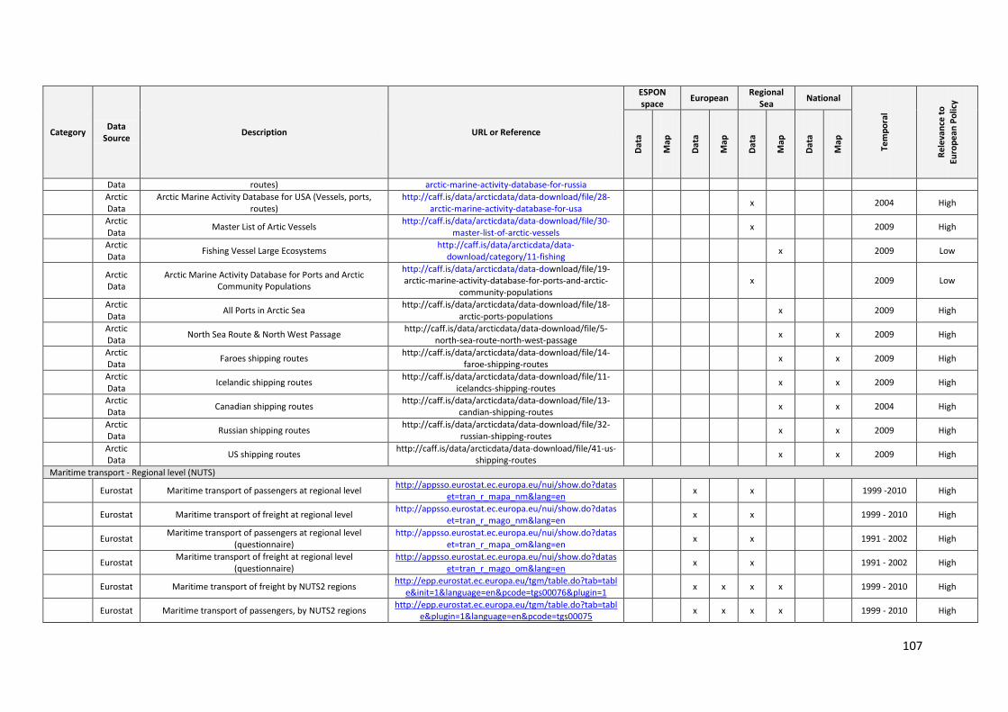
107
Category Data
Source Description URL or Reference
ESPON space
European Regional
Sea National
Tem
po
ral
Re
leva
nce
to
Euro
pe
an P
olic
y
Dat
a
Map
Dat
a
Map
Dat
a
Map
Dat
a
Map
Data routes) arctic-marine-activity-database-for-russia
Arctic Data
Arctic Marine Activity Database for USA (Vessels, ports, routes)
http://caff.is/data/arcticdata/data-download/file/28-arctic-marine-activity-database-for-usa
x 2004 High
Arctic Data
Master List of Artic Vessels http://caff.is/data/arcticdata/data-download/file/30-
master-list-of-arctic-vessels x 2009 High
Arctic Data
Fishing Vessel Large Ecosystems http://caff.is/data/arcticdata/data-
download/category/11-fishing x 2009 Low
Arctic Data
Arctic Marine Activity Database for Ports and Arctic Community Populations
http://caff.is/data/arcticdata/data-download/file/19-arctic-marine-activity-database-for-ports-and-arctic-
community-populations x 2009 Low
Arctic Data
All Ports in Arctic Sea http://caff.is/data/arcticdata/data-download/file/18-
arctic-ports-populations x 2009 High
Arctic Data
North Sea Route & North West Passage http://caff.is/data/arcticdata/data-download/file/5-
north-sea-route-north-west-passage x x 2009 High
Arctic Data
Faroes shipping routes http://caff.is/data/arcticdata/data-download/file/14-
faroe-shipping-routes x x 2009 High
Arctic Data
Icelandic shipping routes http://caff.is/data/arcticdata/data-download/file/11-
icelandcs-shipping-routes x x 2009 High
Arctic Data
Canadian shipping routes http://caff.is/data/arcticdata/data-download/file/13-
candian-shipping-routes x x 2004 High
Arctic Data
Russian shipping routes http://caff.is/data/arcticdata/data-download/file/32-
russian-shipping-routes x x 2009 High
Arctic Data
US shipping routes http://caff.is/data/arcticdata/data-download/file/41-us-
shipping-routes x x 2009 High
Maritime transport - Regional level (NUTS)
Eurostat Maritime transport of passengers at regional level http://appsso.eurostat.ec.europa.eu/nui/show.do?datas
et=tran_r_mapa_nm&lang=en x x 1999 -2010 High
Eurostat Maritime transport of freight at regional level http://appsso.eurostat.ec.europa.eu/nui/show.do?datas
et=tran_r_mago_nm&lang=en x x 1999 - 2010 High
Eurostat Maritime transport of passengers at regional level
(questionnaire) http://appsso.eurostat.ec.europa.eu/nui/show.do?datas
et=tran_r_mapa_om&lang=en x x 1991 - 2002 High
Eurostat Maritime transport of freight at regional level
(questionnaire) http://appsso.eurostat.ec.europa.eu/nui/show.do?datas
et=tran_r_mago_om&lang=en x x 1991 - 2002 High
Eurostat Maritime transport of freight by NUTS2 regions http://epp.eurostat.ec.europa.eu/tgm/table.do?tab=tabl
e&init=1&language=en&pcode=tgs00076&plugin=1 x x x x 1999 - 2010 High
Eurostat Maritime transport of passengers, by NUTS2 regions http://epp.eurostat.ec.europa.eu/tgm/table.do?tab=tabl
e&plugin=1&language=en&pcode=tgs00075 x x x x 1999 - 2010 High
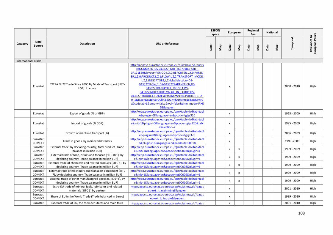
108
Category Data
Source Description URL or Reference
ESPON space
European Regional
Sea National
Tem
po
ral
Re
leva
nce
to
Euro
pe
an P
olic
y
Dat
a
Map
Dat
a
Map
Dat
a
Map
Dat
a
Map
International Trade
Eurostat EXTRA EU27 Trade Since 2000 By Mode of Transport (HS2-
HS4): In euros
http://appsso.eurostat.ec.europa.eu/nui/show.do?query=BOOKMARK_DS-043327_QID_263791D3_UID_-
3F171EB0&layout=PERIOD,L,X,0;REPORTER,L,Y,0;PARTNER,L,Z,0;PRODUCT,L,Z,1;FLOW,L,Z,2;TRANSPORT_MODE,
L,Z,3;INDICATORS,L,Z,4;&zSelection=DS-043327FLOW,1;DS-043327PARTNER,CN;DS-
043327TRANSPORT_MODE,1;DS-043327INDICATORS,VALUE_IN_EUROS;DS-
043327PRODUCT,TOTAL;&rankName1=REPORTER_1_2_0_1&rStp=&cStp=&rDCh=&cDCh=&rDM=true&cDM=true&codelab=L&empty=false&wai=false&time_mode=FIXE
D&lang=en
x
2000 - 2010 High
Eurostat Export of goods (% of GDP) http://epp.eurostat.ec.europa.eu/tgm/table.do?tab=tabl
e&plugin=0&language=en&pcode=tgigs310 x
1995 - 2009 High
Eurostat Import of goods (% GDP) http://epp.eurostat.ec.europa.eu/tgm/table.do?tab=table&init=1&plugin=0&language=en&pcode=tgigs320&tabl
eSelection=2 x
1995 - 2009 High
Eurostat Growth of maritime transport (%) http://epp.eurostat.ec.europa.eu/tgm/table.do?tab=tabl
e&plugin=0&language=en&pcode=tgigs370 x
2006 - 2009 High
Eurostat COMEXT
Trade in goods, by main world traders http://epp.eurostat.ec.europa.eu/tgm/table.do?tab=tabl
e&plugin=1&language=en&pcode=tet00018 x
1999 -2009 High
Eurostat COMEXT
External trade, by declaring country, total product (Trade balance in million EUR)
http://epp.eurostat.ec.europa.eu/tgm/table.do?tab=table&init=1&language=en&pcode=tet00002&plugin=1
x x 1999 - 2009 High
Eurostat COMEXT
External trade of food, drinks and tobacco (SITC 0+1), by declaring country (Trade balance in million EUR)
http://epp.eurostat.ec.europa.eu/tgm/table.do?tab=table&init=1&language=en&pcode=tet00005&plugin=1
x x 1999 - 2009 High
Eurostat COMEXT
External trade of chemicals and related products (SITC 5), by declaring country (Trade balance in million EUR)
http://epp.eurostat.ec.europa.eu/tgm/table.do?tab=table&init=1&language=en&pcode=tet00008&plugin=1
x x 1999 - 2009 High
Eurostat COMEXT
External trade of machinery and transport equipment (SITC 7), by declaring country (Trade balance in million EUR)
http://epp.eurostat.ec.europa.eu/tgm/table.do?tab=table&init=1&language=en&pcode=tet00009&plugin=1
x x 1999 - 2009 High
Eurostat COMEXT
External trade of other manufactured goods (SITC 6+8), by declaring country (Trade balance in million EUR)
http://epp.eurostat.ec.europa.eu/tgm/table.do?tab=table&init=1&language=en&pcode=tet00010&plugin=1
x x 1999 - 2009 High
Eurostat COMEXT
Extra-EU trade of mineral fuels, lubricants and related materials (SITC 3) by partner
http://appsso.eurostat.ec.europa.eu/nui/show.do?dataset=ext_lt_mainmine&lang=en
x 2001 - 2010 High
Eurostat COMEXT
Share of EU in the World Trade (Trade balanced in Euros) http://appsso.eurostat.ec.europa.eu/nui/show.do?datas
et=ext_lt_introle&lang=en x 1999 - 2010 High
Eurostat External trade of EU, the Member States and main third http://appsso.eurostat.ec.europa.eu/nui/show.do?datas x 2001 - 2010 High
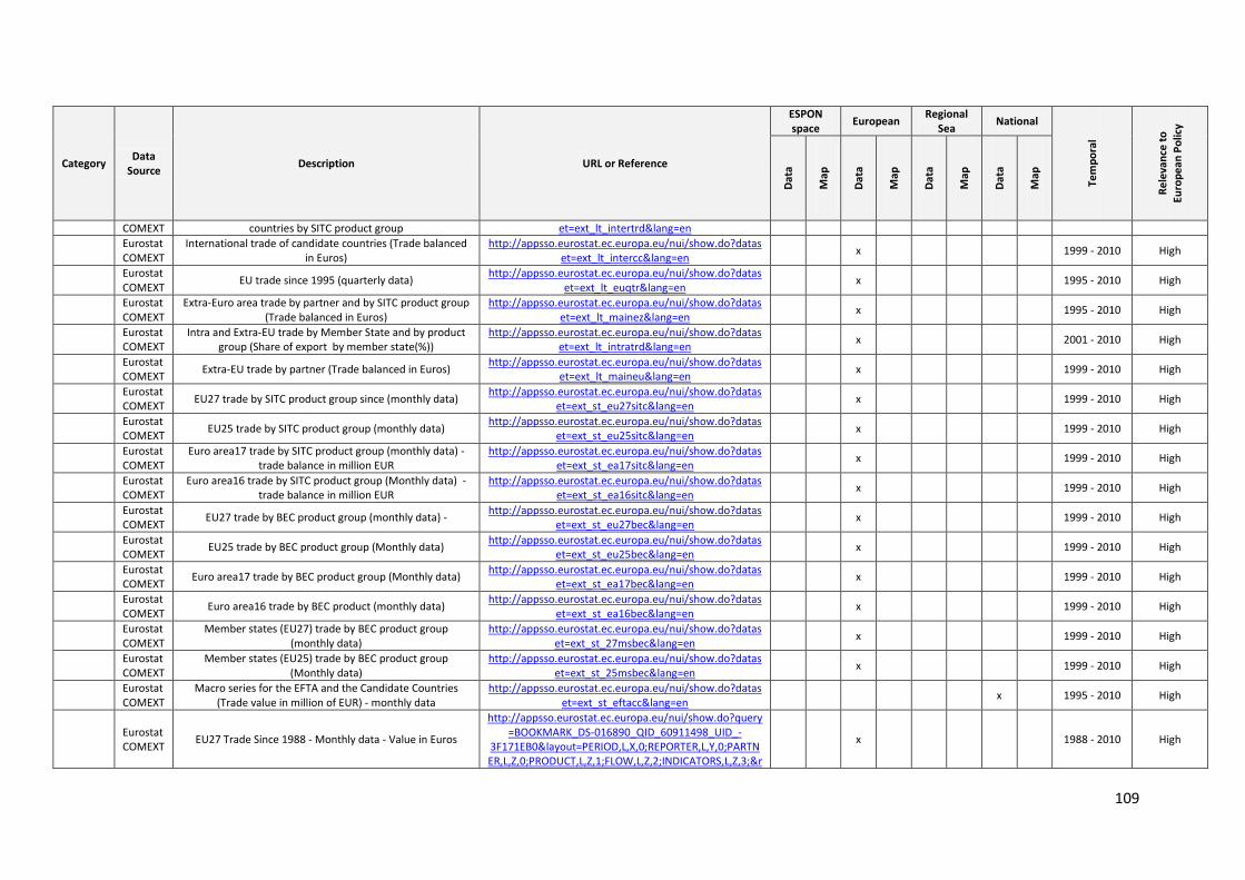
109
Category Data
Source Description URL or Reference
ESPON space
European Regional
Sea National
Tem
po
ral
Re
leva
nce
to
Euro
pe
an P
olic
y
Dat
a
Map
Dat
a
Map
Dat
a
Map
Dat
a
Map
COMEXT countries by SITC product group et=ext_lt_intertrd&lang=en
Eurostat COMEXT
International trade of candidate countries (Trade balanced in Euros)
http://appsso.eurostat.ec.europa.eu/nui/show.do?dataset=ext_lt_intercc&lang=en
x 1999 - 2010 High
Eurostat COMEXT
EU trade since 1995 (quarterly data) http://appsso.eurostat.ec.europa.eu/nui/show.do?datas
et=ext_lt_euqtr&lang=en x 1995 - 2010 High
Eurostat COMEXT
Extra-Euro area trade by partner and by SITC product group (Trade balanced in Euros)
http://appsso.eurostat.ec.europa.eu/nui/show.do?dataset=ext_lt_mainez&lang=en
x 1995 - 2010 High
Eurostat COMEXT
Intra and Extra-EU trade by Member State and by product group (Share of export by member state(%))
http://appsso.eurostat.ec.europa.eu/nui/show.do?dataset=ext_lt_intratrd&lang=en
x 2001 - 2010 High
Eurostat COMEXT
Extra-EU trade by partner (Trade balanced in Euros) http://appsso.eurostat.ec.europa.eu/nui/show.do?datas
et=ext_lt_maineu&lang=en x 1999 - 2010 High
Eurostat COMEXT
EU27 trade by SITC product group since (monthly data) http://appsso.eurostat.ec.europa.eu/nui/show.do?datas
et=ext_st_eu27sitc&lang=en x 1999 - 2010 High
Eurostat COMEXT
EU25 trade by SITC product group (monthly data) http://appsso.eurostat.ec.europa.eu/nui/show.do?datas
et=ext_st_eu25sitc&lang=en x 1999 - 2010 High
Eurostat COMEXT
Euro area17 trade by SITC product group (monthly data) - trade balance in million EUR
http://appsso.eurostat.ec.europa.eu/nui/show.do?dataset=ext_st_ea17sitc&lang=en
x 1999 - 2010 High
Eurostat COMEXT
Euro area16 trade by SITC product group (Monthly data) - trade balance in million EUR
http://appsso.eurostat.ec.europa.eu/nui/show.do?dataset=ext_st_ea16sitc&lang=en
x 1999 - 2010 High
Eurostat COMEXT
EU27 trade by BEC product group (monthly data) - http://appsso.eurostat.ec.europa.eu/nui/show.do?datas
et=ext_st_eu27bec&lang=en x 1999 - 2010 High
Eurostat COMEXT
EU25 trade by BEC product group (Monthly data) http://appsso.eurostat.ec.europa.eu/nui/show.do?datas
et=ext_st_eu25bec&lang=en x 1999 - 2010 High
Eurostat COMEXT
Euro area17 trade by BEC product group (Monthly data) http://appsso.eurostat.ec.europa.eu/nui/show.do?datas
et=ext_st_ea17bec&lang=en x 1999 - 2010 High
Eurostat COMEXT
Euro area16 trade by BEC product (monthly data) http://appsso.eurostat.ec.europa.eu/nui/show.do?datas
et=ext_st_ea16bec&lang=en x 1999 - 2010 High
Eurostat COMEXT
Member states (EU27) trade by BEC product group (monthly data)
http://appsso.eurostat.ec.europa.eu/nui/show.do?dataset=ext_st_27msbec&lang=en
x 1999 - 2010 High
Eurostat COMEXT
Member states (EU25) trade by BEC product group (Monthly data)
http://appsso.eurostat.ec.europa.eu/nui/show.do?dataset=ext_st_25msbec&lang=en
x 1999 - 2010 High
Eurostat COMEXT
Macro series for the EFTA and the Candidate Countries (Trade value in million of EUR) - monthly data
http://appsso.eurostat.ec.europa.eu/nui/show.do?dataset=ext_st_eftacc&lang=en
x 1995 - 2010 High
Eurostat COMEXT
EU27 Trade Since 1988 - Monthly data - Value in Euros
http://appsso.eurostat.ec.europa.eu/nui/show.do?query=BOOKMARK_DS-016890_QID_60911498_UID_-
3F171EB0&layout=PERIOD,L,X,0;REPORTER,L,Y,0;PARTNER,L,Z,0;PRODUCT,L,Z,1;FLOW,L,Z,2;INDICATORS,L,Z,3;&r
x
1988 - 2010 High
110
Category Data
Source Description URL or Reference
ESPON space
European Regional
Sea National
Tem
po
ral
Re
leva
nce
to
Euro
pe
an P
olic
y
Dat
a
Map
Dat
a
Map
Dat
a
Map
Dat
a
Map
ankName1=REPORTER_1_2_0_1&rStp=&cStp=&rDCh=&cDCh=&rDM=true&cDM=true&codelab=L&wai=false&ti
me_mode=FIXED&lang=en
Eurostat COMEXT
EXTRA EU27 Trade Since 1999 By Mode of Transport (NSTR)- Value in Euros - Monthly data
http://appsso.eurostat.ec.europa.eu/nui/show.do?query=BOOKMARK_DS-022469_QID_-53E0B381_UID_-
3F171EB0&layout=PERIOD,L,X,0;REPORTER,L,Y,0;PARTNER,L,Z,0;PRODUCT,L,Z,1;FLOW,L,Z,2;TRANSPORT_MODE,L,Z,3;INDICATORS,L,Z,4;&rankName1=REPORTER_1_2_0_1&rStp=&cStp=&rDCh=&cDCh=&rDM=true&cDM=true
&codelab=L&wai=false&time_mode=FIXED&lang=en
x
1999 - 2010 High
Eurostat COMEXT
EXTRA EU27 Trade Since 2000 By Mode of Transport (HS6) - Value in Euros - Monthly Data
http://appsso.eurostat.ec.europa.eu/nui/show.do?query=BOOKMARK_DS-043328_QID_6F60D0A4_UID_-
3F171EB0&layout=PERIOD,L,X,0;REPORTER,L,Y,0;PARTNER,L,Z,0;PRODUCT,L,Z,1;FLOW,L,Z,2;TRANSPORT_MODE,
L,Z,3;INDICATORS,L,Z,4;&zSelection=DS-043328PARTNER,CN;DS-043328PRODUCT,TOTAL;DS-
043328TRANSPORT_MODE,1;DS-043328INDICATORS,VALUE_IN_EUROS;DS-
043328FLOW,1;&rankName1=REPORTER_1_2_0_1&rStp=&cStp=&rDCh=&cDCh=&rDM=true&cDM=true&codela
b=L&wai=false&time_mode=FIXED&lang=en
x
2000 - 2010 High
Eurostat COMEXT
EXTRA EU27 Trade Since 2000 By Mode of Transport (HS2-HS4) - Value in Euros - Monthly Data
http://appsso.eurostat.ec.europa.eu/nui/show.do?query=BOOKMARK_DS-043327_QID_263791D3_UID_-
3F171EB0&layout=PERIOD,L,X,0;REPORTER,L,Y,0;PARTNER,L,Z,0;PRODUCT,L,Z,1;FLOW,L,Z,2;TRANSPORT_MODE,
L,Z,3;INDICATORS,L,Z,4;&zSelection=DS-043327FLOW,1;DS-043327PARTNER,CN;DS-
043327TRANSPORT_MODE,1;DS-043327INDICATORS,VALUE_IN_EUROS;DS-
043327PRODUCT,TOTAL;&rankName1=REPORTER_1_2_0_1&rStp=&cStp=&rDCh=&cDCh=&rDM=true&cDM=true&codelab=L&empty=false&wai=false&time_mode=FIXE
D&lang=en
x
2000 - 2010 High
Eurostat COMEXT
EFTA Trade Since 1995 By
http://appsso.eurostat.ec.europa.eu/nui/show.do?query=BOOKMARK_DS-043227_QID_-61A5BEE2_UID_-
3F171EB0&layout=PERIOD,L,X,0;REPORTER,L,Y,0;PARTNER,L,Z,0;PRODUCT,L,Z,1;FLOW,L,Z,2;INDICATORS,L,Z,3;&r
x 1995 - 2010 High
111
Category Data
Source Description URL or Reference
ESPON space
European Regional
Sea National
Tem
po
ral
Re
leva
nce
to
Euro
pe
an P
olic
y
Dat
a
Map
Dat
a
Map
Dat
a
Map
Dat
a
Map
ankName1=REPORTER_1_2_0_1&rStp=&cStp=&rDCh=&cDCh=&rDM=true&cDM=true&codelab=L&wai=false&ti
me_mode=FIXED&lang=en
Eurostat PRODCOM ANNUAL SOLD
http://appsso.eurostat.ec.europa.eu/nui/show.do?query=BOOKMARK_DS-043408_QID_49EF1C8F_UID_-
3F171EB0&layout=INDICATORS,L,X,0;DECLARANT,L,Y,0;PERIOD,L,Z,0;PRCCODE,L,Z,1;&zSelection=DS-
043408PRCCODE,13101030;DS-043408PERIOD,200752;&rankName1=DECLARANT_1_2_
0_1&sortR=DND_-1&prRK=FIRST&prSO=NO&sortC=DND_-
1&rLShi=30:0,31:28,29:1,12:29-1,28:31,0:2-11&cLShi=2:8,4:3,9:2,8:0,1:9,3:7,10:4,7:1,0:10&rStp=&cStp=&rDCh=&cDCh=&rDM=true&cDM=true&codelab=B&empty=false&wai=false&time_mode=ROLLING&lang=en
x 2007 - 2009 High
Eurostat PRODCOM ANNUAL TOTAL
http://appsso.eurostat.ec.europa.eu/nui/show.do?query=BOOKMARK_DS-043409_QID_3330576A_UID_-
3F171EB0&layout=INDICATORS,L,X,0;DECLARANT,L,Y,0;PERIOD,L,Z,0;PRCCODE,L,Z,1;&zSelection=DS-
043409PERIOD,200752;DS-043409PRCCODE,14111133;&rankName1=DECLARANT_
1_2_0_1&sortR=DND_-1&prRK=FIRST&prSO=NO&rLShi=30:0,29:1,12:28-
1,28:30,0:2-11&rStp=&cStp=&rDCh=&cDCh=&rDM=true&cDM=true&codelab=B&empty=false&wai=false&time_mode=ROLL
ING&lang=en
x 2007 - 2009 High
Eurostat PRODCOM ANNUAL SOLD (NACE Rev. 2.)
http://appsso.eurostat.ec.europa.eu/nui/show.do?query=BOOKMARK_DS-066341_QID_-47D72158_UID_-
3F171EB0&layout=INDICATORS,C,X,0;DECL,L,Y,0;PRCCODE,B,Z,0;PERIOD,L,Z,1;&zSelection=DS-
066341PERIOD,200952;DS-066341PRCCODE,07101000;&rankName1=PRCCODE_1_
0_-1_2&rankName2=DECL_1_0_0_1&rankName3=INDICAT
ORS_1_0_0_0&rankName4=PERIOD_1_0_-1_2&sortR=ASC_-1_FIRST&sortC=ASC_-
1_FIRST&rStp=&cStp=&rDCh=&cDCh=&rDM=true&cDM=
x 2009 High
112
Category Data
Source Description URL or Reference
ESPON space
European Regional
Sea National
Tem
po
ral
Re
leva
nce
to
Euro
pe
an P
olic
y
Dat
a
Map
Dat
a
Map
Dat
a
Map
Dat
a
Map
true&footnes=false&empty=false&wai=false&time_mode=ROLLING&lang=en
Eurostat PRODCOM ANNUAL TOTAL (NACE Rev. 2.)
http://appsso.eurostat.ec.europa.eu/nui/show.do?query=BOOKMARK_DS-066342_QID_-725FFEE6_UID_-
3F171EB0&layout=INDICATORS,C,X,0;DECL,L,Y,0;PRCCODE,B,Z,0;PERIOD,L,Z,1;&zSelection=DS-
066342PRCCODE,08111133;DS-066342PERIOD,200952;&rankName1=PRCCODE_1_0_-
1_2&rankName2=DECL_1_0_0_1&rankName3=INDICATORS_1_0_0_0&rankName4=PERIOD_1_0_-
1_2&sortR=ASC_-1_FIRST&sortC=ASC_-1_FIRST&rStp=&cStp=&rDCh=&cDCh=&rDM=true&cDM=true&footnes=false&empty=false&wai=false&time_mod
e=ROLLING&lang=en
x 2009 High
UNCTAD
stat Liner Shipping Connectivity Index
http://unctadstat.unctad.org/TableViewer/tableView.aspx?ReportId=92
x 2004 - 2010 High
Plan Bleu
Exportations (Milions US$) Average - 1998-2000 except services
http://www.planbleu.org/donnees/libreEchange/carte/exportations_en.html
x 2003 High
Plan Bleu
Importations (Milions US$) Averge - 1998 -2000 except services
http://www.planbleu.org/donnees/libreEchange/carte/importations_en.html
x 2003 High
Plan Bleu
Les transports maritimes de marchandises en mediterranée: prespectives 2025. (pag 41)
http://www.planbleu.org/publications/Cahier7_transport_FR.pdf
x 2000 - 2006 High
SESRIC Libya - Exports of goods and services (% of GDP) http://www.sesric.org/oic-member-countries-
linecharts.php?ind_code=121&c_code=26 x 1970 - 2008 High
SESRIC Albania - Exports of goods and services (% of GDP) http://www.sesric.org/oic-member-countries-
linecharts.php?ind_code=121&c_code=4 x 1970 - 2008 High
SESRIC Morroco - Exports of goods and services (% of GDP) http://www.sesric.org/oic-member-countries-
linecharts.php?ind_code=121&c_code=36 x 1970 - 2008 High
SESRIC Algeria - Exports of goods and services (% of GDP) http://www.sesric.org/oic-member-countries-
linecharts.php?ind_code=121&c_code=5 x 1970 - 2008 High
SESRIC Egypt - Exports of goods and services (% of GDP) http://www.sesric.org/oic-member-countries-
linecharts.php?ind_code=121&c_code=17 x 1970 - 2008 High
SESRIC Tunisia - Exports of goods and services (% of GDP) http://www.sesric.org/oic-member-countries-
linecharts.php?ind_code=121&c_code=53 x 1970 - 2008 High
SESRIC Lebanon - Exports of goods and services (% of GDP) http://www.sesric.org/oic-member-countries-
linecharts.php?ind_code=121&c_code=32 x 1970 - 2008 High
SESRIC Syria - Exports of goods and services (% of GDP) http://www.sesric.org/oic-member-countries- x 1970 - 2008 High
113
Category Data
Source Description URL or Reference
ESPON space
European Regional
Sea National
Tem
po
ral
Re
leva
nce
to
Euro
pe
an P
olic
y
Dat
a
Map
Dat
a
Map
Dat
a
Map
Dat
a
Map
linecharts.php?ind_code=121&c_code=50
SESRIC Turkey - Exports of goods and services (% of GDP) http://www.sesric.org/oic-member-countries-
linecharts.php?ind_code=121&c_code=1 x 1970 - 2008 High
SESRIC Libya - Imports of goods and services (% of GDP) http://www.sesric.org/oic-member-countries-
linecharts.php?ind_code=126&c_code=26 x 1970 - 2008 High
SESRIC Albania - Imports of goods and services (% of GDP) http://www.sesric.org/oic-member-countries-
linecharts.php?ind_code=126&c_code=4 x 1970 - 2008 High
SESRIC Morroco - Imports of goods and services (% of GDP) http://www.sesric.org/oic-member-countries-
linecharts.php?ind_code=126&c_code=36 x 1970 - 2008 High
SESRIC Algeria - Imports of goods and services (% of GDP) http://www.sesric.org/oic-member-countries-
linecharts.php?ind_code=126&c_code=5 x 1970 - 2008 High
SESRIC Egypt - Imports of goods and services (% of GDP) http://www.sesric.org/oic-member-countries-
linecharts.php?ind_code=126&c_code=17 x 1970 - 2008 High
SESRIC Tunisia - Imports of goods and services (% of GDP) http://www.sesric.org/oic-member-countries-
linecharts.php?ind_code=126&c_code=53 x 1970 - 2008 High
SESRIC Lebanon - Imports of goods and services (% of GDP) http://www.sesric.org/oic-member-countries-
linecharts.php?ind_code=126&c_code=32 x 1970 - 2008 High
SESRIC Syria - Imports of goods and services (% of GDP) http://www.sesric.org/oic-member-countries-
linecharts.php?ind_code=126&c_code=50 x 1970 - 2008 High
SESRIC Turkey - Imports of goods and services (% of GDP) http://www.sesric.org/oic-member-countries-
linecharts.php?ind_code=126&c_code=1 x 1970 - 2008 High
SESRIC Libya - Fuel exports (% of merchandise exports) http://www.sesric.org/oic-member-countries-
linecharts.php?ind_code=123&c_code=26 x 1970 - 1998 High
SESRIC Albania - Fuel exports (% of merchandise exports) http://www.sesric.org/oic-member-countries-
linecharts.php?ind_code=123&c_code=4 x 1996 - 2009 High
SESRIC Morroco - Fuel exports (% of merchandise exports) http://www.sesric.org/oic-member-countries-
linecharts.php?ind_code=123&c_code=36 x 1970 - 2009 High
SESRIC Algeria - Fuel exports (% of merchandise exports) http://www.sesric.org/oic-member-countries-
linecharts.php?ind_code=123&c_code=5 x 1970 - 2009 High
SESRIC Egypt - Fuel exports (% of merchandise exports) http://www.sesric.org/oic-member-countries-
linecharts.php?ind_code=123&c_code=17 x 1970 - 2008 High
SESRIC Tunisia - Fuel exports (% of merchandise exports) http://www.sesric.org/oic-member-countries-
linecharts.php?ind_code=123&c_code=53 x 1970 - 2009 High
SESRIC Lebanon - Fuel exports (% of merchandise exports) http://www.sesric.org/oic-member-countries-
linecharts.php?ind_code=123&c_code=32 x 1970 - 2008 High
SESRIC Syria - Fuel exports (% of merchandise exports) http://www.sesric.org/oic-member-countries-
linecharts.php?ind_code=123&c_code=50 x 1974 - 2007 High
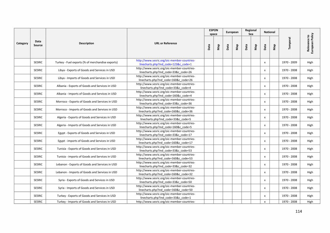
114
Category Data
Source Description URL or Reference
ESPON space
European Regional
Sea National
Tem
po
ral
Re
leva
nce
to
Euro
pe
an P
olic
y
Dat
a
Map
Dat
a
Map
Dat
a
Map
Dat
a
Map
SESRIC Turkey - Fuel exports (% of merchandise exports) http://www.sesric.org/oic-member-countries-
linecharts.php?ind_code=123&c_code=1 x 1970 - 2009 High
SESRIC Libya - Exports of Goods and Services in USD http://www.sesric.org/oic-member-countries-
linecharts.php?ind_code=33&c_code=26 x 1970 - 2008 High
SESRIC Libya - Imports of Goods and Services in USD http://www.sesric.org/oic-member-countries-
linecharts.php?ind_code=160&c_code=26 x 1970 - 2008 High
SESRIC Albania - Exports of Goods and Services in USD http://www.sesric.org/oic-member-countries-
linecharts.php?ind_code=33&c_code=4 x 1970 - 2008 High
SESRIC Albania - Imports of Goods and Services in USD http://www.sesric.org/oic-member-countries-
linecharts.php?ind_code=160&c_code=4 x 1970 - 2008 High
SESRIC Morroco - Exports of Goods and Services in USD http://www.sesric.org/oic-member-countries-
linecharts.php?ind_code=33&c_code=36 x 1970 - 2008 High
SESRIC Morroco - Imports of Goods and Services in USD http://www.sesric.org/oic-member-countries-
linecharts.php?ind_code=160&c_code=36 x 1970 - 2008 High
SESRIC Algeria - Exports of Goods and Services in USD http://www.sesric.org/oic-member-countries-
linecharts.php?ind_code=33&c_code=5 x 1970 - 2008 High
SESRIC Algeria - Imports of Goods and Services in USD http://www.sesric.org/oic-member-countries-
linecharts.php?ind_code=160&c_code=5 x 1970 - 2008 High
SESRIC Egypt - Exports of Goods and Services in USD http://www.sesric.org/oic-member-countries-
linecharts.php?ind_code=33&c_code=17 x 1970 - 2008 High
SESRIC Egypt - imports of Goods and Services in USD http://www.sesric.org/oic-member-countries-
linecharts.php?ind_code=160&c_code=17 x 1970 - 2008 High
SESRIC Tunisia - Exports of Goods and Services in USD http://www.sesric.org/oic-member-countries-
linecharts.php?ind_code=33&c_code=53 x 1970 - 2008 High
SESRIC Tunisia - imports of Goods and Services in USD http://www.sesric.org/oic-member-countries-
linecharts.php?ind_code=160&c_code=53 x 1970 - 2008 High
SESRIC Lebanon - Exports of Goods and Services in USD http://www.sesric.org/oic-member-countries-
linecharts.php?ind_code=33&c_code=32 x 1970 - 2008 High
SESRIC Lebanon - Imports of Goods and Services in USD http://www.sesric.org/oic-member-countries-
linecharts.php?ind_code=160&c_code=32 x 1970 - 2008 High
SESRIC Syria - Exports of Goods and Services in USD http://www.sesric.org/oic-member-countries-
linecharts.php?ind_code=33&c_code=50 x 1970 - 2008 High
SESRIC Syria - Imports of Goods and Services in USD http://www.sesric.org/oic-member-countries-
linecharts.php?ind_code=160&c_code=50 x 1970 - 2008 High
SESRIC Turkey - Exports of Goods and Services in USD http://www.sesric.org/oic-member-countries-
linecharts.php?ind_code=33&c_code=1 x 1970 - 2008 High
SESRIC Turkey - Imports of Goods and Services in USD http://www.sesric.org/oic-member-countries- x 1970 - 2008 High
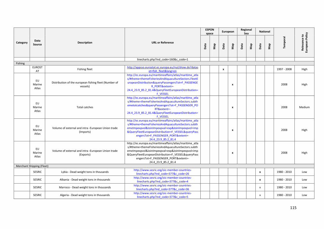
115
Category Data
Source Description URL or Reference
ESPON space
European Regional
Sea National
Tem
po
ral
Re
leva
nce
to
Euro
pe
an P
olic
y
Dat
a
Map
Dat
a
Map
Dat
a
Map
Dat
a
Map
linecharts.php?ind_code=160&c_code=1
Fishing
EUROST
AT Fishing fleet
http://appsso.eurostat.ec.europa.eu/nui/show.do?dataset=fish_fleet&lang=en
x 1997 - 2008 High
EU
Marine Atlas
Distribution of the european fishing fleet (Number of vessels)
http://ec.europa.eu/maritimeaffairs/atlas/maritime_atlas/#theme=themeFisheriesAndAquacultureSectors.FleetEuropeanDistribution&queryPassengersTot=F_PASSENGE
R_PORT&extent=-24.4_23.9_85.2_81.4&QueryFleetEuropeanDistribution=
F_VESSEL
x 2008 High
EU
Marine Atlas
Total catches
http://ec.europa.eu/maritimeaffairs/atlas/maritime_atlas/#theme=themeFisheriesAndAquacultureSectors.subthemetotcatches&queryPassengersTot=F_PASSENGER_PO
RT&extent=-24.4_23.9_85.2_81.4&QueryFleetEuropeanDistribution=
F_VESSEL
x 2008 Medium
EU
Marine Atlas
Volume of external and intra -European Union trade (Imports)
http://ec.europa.eu/maritimeaffairs/atlas/maritime_atlas/#theme=themeFisheriesAndAquacultureSectors.subthemeImpexpvol&JoinImpexpval=exp&JoinImpexpvol=imp&QueryFleetEuropeanDistribution=F_VESSEL&queryPass
engersTot=F_PASSENGER_PORT&extent=-24.4_23.9_85.2_81.4
x 2008 High
EU
Marine Atlas
Volume of external and intra -European Union trade (Exports)
http://ec.europa.eu/maritimeaffairs/atlas/maritime_atlas/#theme=themeFisheriesAndAquacultureSectors.subthemeImpexpvol&JoinImpexpval=exp&JoinImpexpvol=imp&QueryFleetEuropeanDistribution=F_VESSEL&queryPass
engersTot=F_PASSENGER_PORT&extent=-24.4_23.9_85.2_81.4
x 2008 High
Merchant Shipping (Fleet)
SESRIC Lybia - Dead weight tons in thousands http://www.sesric.org/oic-member-countries-
linecharts.php?ind_code=377&c_code=26 x 1980 - 2010 Low
SESRIC Albania - Dead weight tons in thousands http://www.sesric.org/oic-member-countries-
linecharts.php?ind_code=377&c_code=4 x 1980 - 2010 Low
SESRIC Marroco - Dead weight tons in thousands http://www.sesric.org/oic-member-countries-
linecharts.php?ind_code=377&c_code=36 x 1980 - 2010 Low
SESRIC Algeria - Dead weight tons in thousands http://www.sesric.org/oic-member-countries-
linecharts.php?ind_code=377&c_code=5 x 1980 - 2010 Low
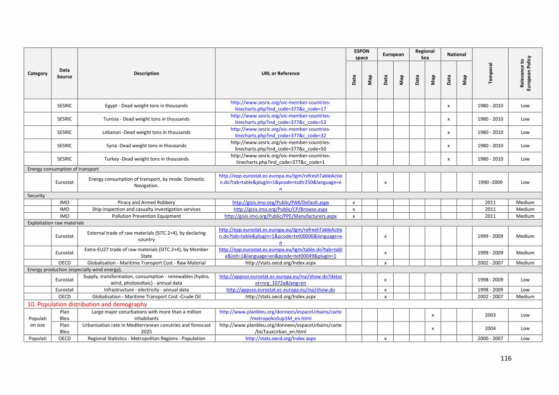
116
Category Data
Source Description URL or Reference
ESPON space
European Regional
Sea National
Tem
po
ral
Re
leva
nce
to
Euro
pe
an P
olic
y
Dat
a
Map
Dat
a
Map
Dat
a
Map
Dat
a
Map
SESRIC Egypt - Dead weight tons in thousands http://www.sesric.org/oic-member-countries-
linecharts.php?ind_code=377&c_code=17 x 1980 - 2010 Low
SESRIC Tunisia - Dead weight tons in thousands http://www.sesric.org/oic-member-countries-
linecharts.php?ind_code=377&c_code=53 x 1980 - 2010 Low
SESRIC Lebanon -Dead weight tons in thousands http://www.sesric.org/oic-member-countries-
linecharts.php?ind_code=377&c_code=32 x 1980 - 2010 Low
SESRIC Syria -Dead weight tons in thousands http://www.sesric.org/oic-member-countries-
linecharts.php?ind_code=377&c_code=50 x 1980 - 2010 Low
SESRIC Turkey -Dead weight tons in thousands http://www.sesric.org/oic-member-countries-
linecharts.php?ind_code=377&c_code=1 x 1980 - 2010 Low
Energy consumption of transport
Eurostat Energy consumption of transport, by mode. Domestic
Navigation.
http://epp.eurostat.ec.europa.eu/tgm/refreshTableAction.do?tab=table&plugin=1&pcode=tsdtr250&language=e
n x 1990 -2009 Low
Security
IMO Piracy and Armed Robbery http://gisis.imo.org/Public/PAR/Default.aspx x 2011 Medium
IMO Ship inspection and casualty investigation services http://gisis.imo.org/Public/CP/Browse.aspx x 2011 Medium
IMO Pollution Prevention Equipment http://gisis.imo.org/Public/PPE/Manufacturers.aspx x 2011 Medium
Exploitation raw materials
Eurostat External trade of raw materials (SITC 2+4), by declaring
country
http://epp.eurostat.ec.europa.eu/tgm/refreshTableAction.do?tab=table&plugin=1&pcode=tet00006&language=e
n x 1999 - 2009 Medium
Eurostat Extra-EU27 trade of raw materials (SITC 2+4), by Member
State http://epp.eurostat.ec.europa.eu/tgm/table.do?tab=tabl
e&init=1&language=en&pcode=tet00049&plugin=1 x 1999 - 2009 Medium
OECD Globalisation - Maritime Transport Cost - Raw Material http://stats.oecd.org/Index.aspx x 2002 - 2007 Medium
Energy production (especially wind energy),
Eurostat Supply, transformation, consumption - renewables (hydro,
wind, photovoltaic) - annual data http://appsso.eurostat.ec.europa.eu/nui/show.do?datas
et=nrg_1072a&lang=en x 1998 - 2009 Low
Eurostat Infrastructure - electricity - annual data http://appsso.eurostat.ec.europa.eu/nui/show.do x 1998 - 2009 Low
OECD Globalisation - Maritime Transport Cost -Crude Oil http://stats.oecd.org/Index.aspx x 2002 - 2007 Medium
10. Population distribution and demography
Population size
Plan Bleu
Large major conurbations with more than a million inhabitants
http://www.planbleu.org/donnees/espaceUrbains/carte/metropolesSup1M_en.html
x 2003 Low
Plan Bleu
Urbanisation rate in Mediterranean conutries and forescast 2025
http://www.planbleu.org/donnees/espaceUrbains/carte/bisTauxUrban_en.html
x 2004 Low
Populati OECD Regional Statistics - Metropolitan Regions - Population http://stats.oecd.org/Index.aspx x 2000 - 2007 Low
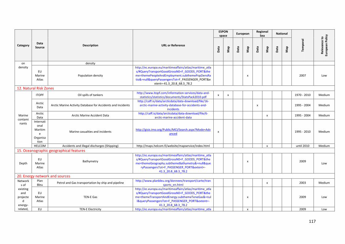
117
Category Data
Source Description URL or Reference
ESPON space
European Regional
Sea National
Tem
po
ral
Re
leva
nce
to
Euro
pe
an P
olic
y
Dat
a
Map
Dat
a
Map
Dat
a
Map
Dat
a
Map
on density
density
EU Marine
Atlas Population density
http://ec.europa.eu/maritimeaffairs/atlas/maritime_atlas/#QueryTransportGoodGrossN0=F_GOODS_PORT&theme=themePeopleAndEmployment.subthemePopDensRatio&=null&queryPassengersTot=F_PASSENGER_PORT&e
xtent=-41.3_20.8_68.3_78.2
x 2007 Low
12. Natural Risk Zones
Marine contami
nants
ITOPF Oil spills of tankers http://www.itopf.com/information-services/data-and-
statistics/statistics/documents/StatsPack2010.pdf x x 1970 - 2010 Medium
Arctic Data
Arctic Marine Activity Database for Accidents and Incidents http://caff.is/data/arcticdata/data-download/file/16-
arctic-marine-activity-database-for-accidents-and-incidents
x 1995 - 2004 Medium
Arctic Data
Arctic Marine Accident Data http://caff.is/data/arcticdata/data-download/file/6-
arctic-marine-accident-data x 1995 - 2004 Medium
International
Maritime
Organisation
Marine casualties and incidents http://gisis.imo.org/Public/MCI/Search.aspx?Mode=Adv
anced x 1995 - 2010 Medium
HELCOM Accidents and illegal discharges (Shipping) http://maps.helcom.fi/website/mapservice/index.html x until 2010 Medium
15. Oceanographic geographical features
Depth EU
Marine Atlas
Bathymetry
http://ec.europa.eu/maritimeaffairs/atlas/maritime_atlas/#QueryTransportGoodGrossN0=F_GOODS_PORT&theme=themeGeography.subthemeBathymetry&=null&que
ryPassengersTot=F_PASSENGER_PORT&extent=-41.3_20.8_68.3_78.2
x
2009
Low
20. Energy network and sources Network
s of existing
and projecte
d energy-related,
Plan Bleu
Petrol and Gas transportation by ship and pipeline http://www.planbleu.org/donnees/transport/carte/tran
sports_en.html
x 2003 Medium
EU Marine
Atlas TEN-E Gas
http://ec.europa.eu/maritimeaffairs/atlas/maritime_atlas/#QueryTransportGoodGrossN0=F_GOODS_PORT&the
me=themeTransportAndEnergy.subthemeTeneGas&=null&queryPassengersTot=F_PASSENGER_PORT&extent=-
41.3_20.8_68.3_78.2
x
2009 Low
EU TEN-E Electricity http://ec.europa.eu/maritimeaffairs/atlas/maritime_atla x 2009 Low
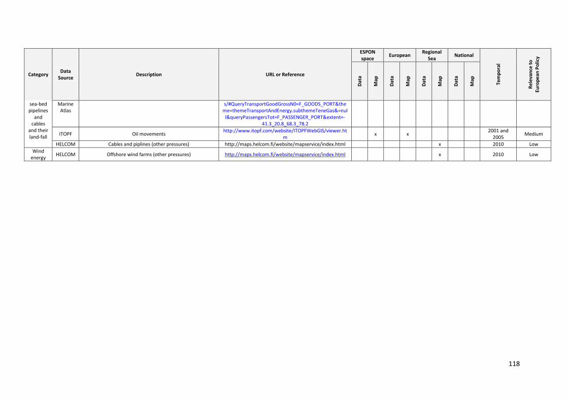
118
Category Data
Source Description URL or Reference
ESPON space
European Regional
Sea National
Tem
po
ral
Re
leva
nce
to
Euro
pe
an P
olic
y
Dat
a
Map
Dat
a
Map
Dat
a
Map
Dat
a
Map
sea-bed pipelines
and cables
and their land-fall
Marine Atlas
s/#QueryTransportGoodGrossN0=F_GOODS_PORT&theme=themeTransportAndEnergy.subthemeTeneGas&=nul
l&queryPassengersTot=F_PASSENGER_PORT&extent=-41.3_20.8_68.3_78.2
ITOPF Oil movements http://www.itopf.com/website/ITOPFWebGIS/viewer.ht
m x
x
2001 and 2005
Medium
HELCOM Cables and piplines (other pressures) http://maps.helcom.fi/website/mapservice/index.html x 2010 Low
Wind energy
HELCOM Offshore wind farms (other pressures) http://maps.helcom.fi/website/mapservice/index.html
x 2010 Low
119
Appendix 5: Data Protocols and Mapping Briefing Paper
1. Introduction
Different initiatives related to marine mapping in EU seas exist, but until present no common typology defining EU Seas is available. Existing ESPON projects focus on territorial/land based dynamics but research is limited when it comes to maritime dynamics. Territorial Impacts of European Fisheries Policy (ESPON 2.1.5) is one of the few projects of relevance to ESaTDOR with a direct sea land interface, but challenges exist in terms of data availability at any or appropriate spatial scales. 6 Similarly, projects like the Options for Delivering Ecosystem-Based Marine Management (ODEMM) have databases that provide references, links to reports and may point to some accessible datasets, but do not include any mapping. 7 A recurring challenge facing regional maritime mapping in the EU / ESPON area is both the availability of data and the extent to which it is available at the appropriate spatial scale. Data sources related to the seas/themes of focus to this research also highlight some challenges for the project. Each Sea of interest to ESaTDOR has its own data peculiarities, richness and details. The multi sources and scales of data already known and present are very much scattered and heterogeneous. Homogeneous statistical information is scarce or practically absent when it related to Sea Areas and scales vary from fine grained information resulting from localised projects in the region (sub-sea or country specific data) to wide regional data EU (e.g. EEA; EUROSTAT). For example, the North Sea is thematically data abundant in different organs such as EUROSTAT, the EEA and ICES. In the case of the Mediterranean Sea, some data are present (MEDSTAT) but specific to socio-economic themes whereas limited in other thematic areas of interest namely transport, energy and network sources. Some inconsistencies in the definition and use of Sea boundaries in the EU region are an additional issue especially with data sets where countries border more than one sea. The Marine Strategy Framework Directive Marine Regions and Marine Sub Regions, the Exclusive Economic Zones of Norway and Denmark (corresponding to the Arctic) use definitions that do not necessarily conform to national jurisdictions. OSPAR divisions are at variance with the MSFD Marine Regions in some key respects. Marine areas of relevance to EU Integrated Maritime Policy extend beyond EU or ESPON marine space, reflecting namely regional ecosystem functioning and marine transport routes making a wider Sea level view sometimes necessary. Though regionally available sometimes, data may be in spatial levels that are not relevant to ESaTDOR‘s purposes. Namely, spatial information that is available at NUTS level 0 creating difficulties for this project when nation states border different regional seas. And fisheries data results (ESPON 2.1.5), developed at NUTS 3 level, making fishing activities too fine to map at anything other than a point scale. Governance data is frequently presented in multiple scales and not always centralised making data availability variable and not always compatible. When it comes to ESaTDOR‘s thematic activities, a lack of land/sea disaggregation is a major concern like the case of energy, cables and pipelines where statistical data are rich at the terrestrial side, and rarely including some aggregated statistics on the Sea. Areas of information paucity have also been identified in the initial review exercise, like marine litter and underwater noise, both key aspects of marine pollution where data is presently scarce, and in addition to marine aggregate extraction being a key maritime industry where data is rather limited. Further problems envisaged include lack of data of important descriptors like
6http://www.espon.eu/main/Menu_Projects/Menu_ESPON2006Projects/Menu_PolicyImpactProjects/fisheries.html 7 http://www.liv.ac.uk/odemm/Project_Partners.html
120
seafloor integrity, trawling activity in the Sea. In parallel, data confidentiality is a concern (e.g. fisheries data) and though detailed data exist, they are not accessible publicly. These identified constraints related to data availability, accessibility, coverage, varying temporal and spatial characteristics and reliability for covering the six Seas in question, and other compatibility considerations are emergent key issues in tackling data for ESPON mapping purposes. They are raised towards the project initial objective which is the mapping of different types of Sea use across Europe to create typologies of different types of coastal/sea regions drawing upon existing ESPON terrestrial typologies.
2. INSPIRE and Implications for the Project
A growing recognition and realization of an interface between the land and the sea (integrated coastal zone management) and indeed the seas themselves have been highlighted through EU‘s Integrated Maritime Policy established in 2007.8 But, until present, there is no clearly articulated regional spatial vision for the use of marine areas in EU Seas, and a plan-based approach to management is therefore essential knowing the important resources present within the EU marine environments and the need to consider and manage them more carefully in an integrated approach (maritime spatial planning).9 The ESaTDOR research project seeks to contribute to the emerging policy debate by exploring in greater detail the land sea inter-actions and the extent to which various marine based activities can contribute to economic growth and societal wellbeing, and ensuring that critical environmental assets are effectively managed and protected. One of the main objectives of ESaTDOR is to map the different types of sea Uses across Europe with the objective of creating coastal / Sea typologies typologies following an integrated coastal zone management approach. Following this approach, marine spatial planning (MSP) is a tool that brings together multiple users of the Ocean and the coastal areas– including energy, industry, government, conservation and recreation – to make informed and coordinated decisions about how to use marine resources sustainably. MSP uses maps to create a more comprehensive picture of a marine area – identifying where and how an ocean area is being used and what natural resources and habitat exist. 10
As EU countries are starting to develop and apply spatial planning systems in their marine environment, there is a need of common understanding of the scope, objectives, and added value of a regional marine spatial planning approach that can have a significant and substantial positive economic effect on Europe‘s maritime economy. 11 This would include a set of principles that underpin the application of marine spatial planning effectively and sustainably over time. This is especially important in marine regions where neighbouring national states are required to cooperate to achieve an integrated management at a broader ecosystem level (e.g. the Baltic Sea, Adriatic Sea, North Sea, etc.). This is achieved through a harmonization of spatial information at the regional level. At the present, challenges regarding the availability, quality, organisation, accessibility, and harmonisation of marine spatial information at the EU Seas level are still present. In order to accommodate these issues, the EU INSPIRE Directive (European Parliament & European Council 2007) is one of the EU legislation which aims to establish an infrastructure for sharing information within the
8 http://europa.eu/rapid/pressReleasesAction.do?reference=MEMO/09/455
9 F., Douvere and C., Ehler. The International Perspective: Lessons from recent European Experience with Marine Spatial Planning. Paper presented at the Symposium on Management for Spatial and Temporal Complexity in Ocean Ecosystems in the 21st Century at the 20th Annual Meeting of the Society for Conservation Biology, San Jose, California, 24-28 June 2006 10 http://en.wikipedia.org/wiki/Marine_Spatial_Planning. Consulted on the June 10, 2011. 11 Directorate General of Maritime Affairs and Fisheries 2011. Study on the economic effects of Maritime Spatial Planning. http://ec.europa.eu/maritimeaffairs/studies/economic_effects_maritime_spatial_planning_en.pdf
121
European Community, and which is adopted in this research and by all Member States in
their national laws.12
In annex 11 of the ESaTDOR Inception report, we provide valid reasons for basing our
spatial information infrastructure on the INSPIRE Directive in order to enable a coherent and harmonised assessment for an entire EU Marine Region. Nevertheless, we need to take into consideration and discuss more in details in this section:
The terminology, definitions and requirements provided in the data collection template are, where relevant and practicable, as close as possible to existing official regional Directives, such as e.g. the EC Marine Strategy Framework Directive, the EU Water Framework Directive, EC Habitats Directive and EU INSPIRE. Therefore, these definition, e.g. marine landscapes, zoning need to be considered as the starting point of the data collection and collation of this research as they are considered the future policy-drivers for EU European waters.
Specifically, there is variability in defining geographical Sea boundaries of the appropriate marine region and subregions that are in place at the present time. Here is a need to agree on a common boundaries definition for the whole EU Seas with no overlap in the area covered. This common definition is considered a basic step towards a harmonisation of the boundaries between Regional Seas based on relevant Conventions (e.g. the Marine Strategy Framework Directive).
The data quality and the analysis based upon it determine the success of the entire plan. The quality of the collected and used data can be significantly improved by following a systematic data collection, storage and management process according to internationally agreed guiding principles which also speeds up data retrieval and data use.
An important issue to consider throughout the data collection phase is the provision of complete and accurate spatial data. All data collected need to be as complete as possible. Increasing data accuracy involves the correction of existing data, addition of any missing data and the real-time capturing of any data discrepancies. This process eliminates the erroneous data in the system. Ongoing database synchronization ensures that new errors are quickly identified and corrected. Special care needs to be given to the sources of data gathered.
A comprehensive, exhaustive, and fully referenced description and highlights of any national and/or regional state of the coast/ocean reports that are available. It should review current knowledge and knowledge gaps. Good regional coverage of some digital data that are taken for granted in other countries, states and territories.
References to additional datasets that either needs to be acquired or converted from paper form into digital form are important to be cited in the references section of the data collection template.
12
An updated overview of the national measures officially notified to the Commission by Member States can be found on EUR-Lex
http://eurlex.europa.eu/LexUriServ/LexUriServ.do?uri=CELEX:72007L0002:EN:NOT.
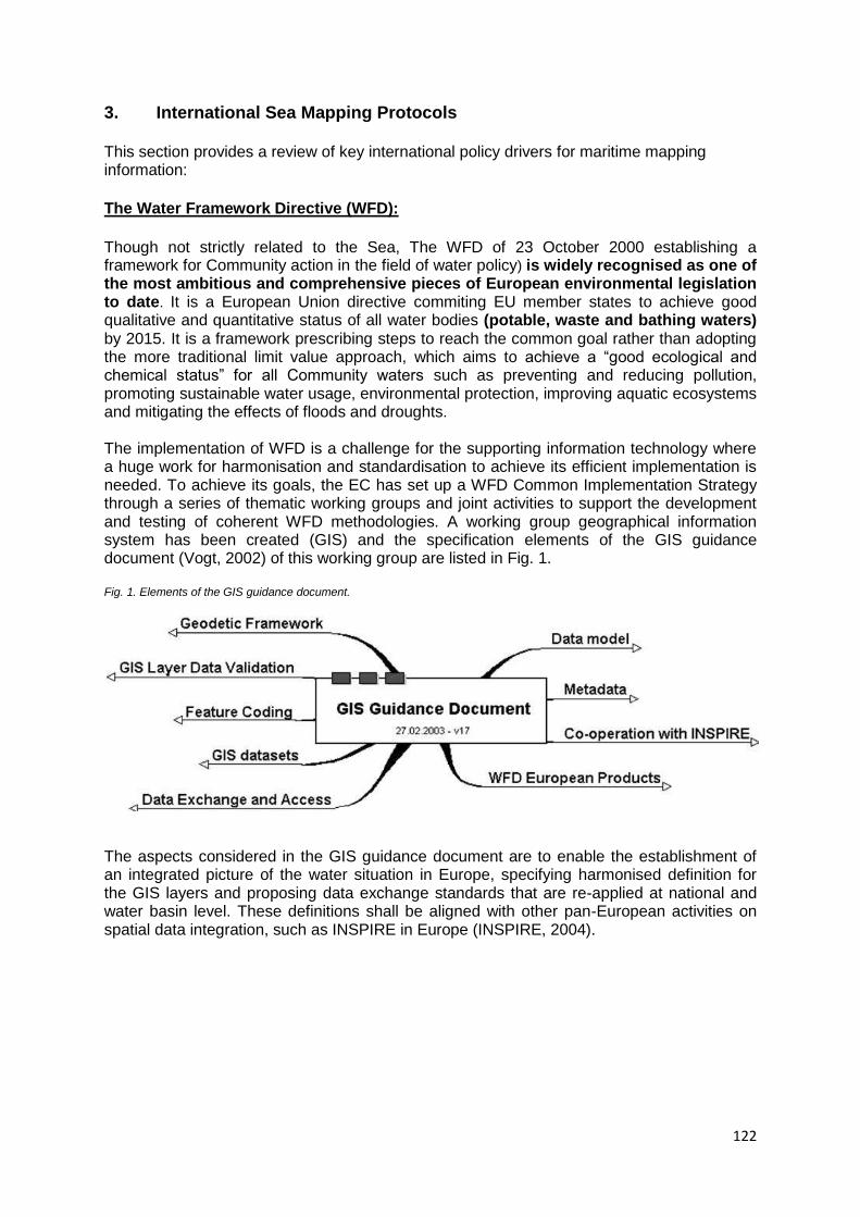
122
3. International Sea Mapping Protocols This section provides a review of key international policy drivers for maritime mapping information:
The Water Framework Directive (WFD):
Though not strictly related to the Sea, The WFD of 23 October 2000 establishing a framework for Community action in the field of water policy) is widely recognised as one of the most ambitious and comprehensive pieces of European environmental legislation to date. It is a European Union directive commiting EU member states to achieve good qualitative and quantitative status of all water bodies (potable, waste and bathing waters) by 2015. It is a framework prescribing steps to reach the common goal rather than adopting the more traditional limit value approach, which aims to achieve a ―good ecological and chemical status‖ for all Community waters such as preventing and reducing pollution, promoting sustainable water usage, environmental protection, improving aquatic ecosystems and mitigating the effects of floods and droughts. The implementation of WFD is a challenge for the supporting information technology where a huge work for harmonisation and standardisation to achieve its efficient implementation is needed. To achieve its goals, the EC has set up a WFD Common Implementation Strategy through a series of thematic working groups and joint activities to support the development and testing of coherent WFD methodologies. A working group geographical information system has been created (GIS) and the specification elements of the GIS guidance document (Vogt, 2002) of this working group are listed in Fig. 1. Fig. 1. Elements of the GIS guidance document.
The aspects considered in the GIS guidance document are to enable the establishment of an integrated picture of the water situation in Europe, specifying harmonised definition for the GIS layers and proposing data exchange standards that are re-applied at national and water basin level. These definitions shall be aligned with other pan-European activities on spatial data integration, such as INSPIRE in Europe (INSPIRE, 2004).
123
EC Marine environmental policy (Marine Strategy Framework Directive - MSFD): This Directive (17 June 2008) establishes a framework for community action in the field of marine environmental policy. The overarching goal of the Directive is to achieve ‗Good Environmental Status‘ (GES) by 2020 across Europe‘s marine environment. In order to achieve GES coherently, the MSFD establishes four European Marine Regions, based on geographical and environmental criteria. Each Member State is required to develop a marine strategy for their waters, in coordination with other countries within the same marine region or subregion. This coordination is to be achieved through the Regional Seas Conventions (i.e., OSPAR Convention for the North-East Atlantic, etc.). This directive calls for adoption of methodological standards for the assessment of the status of the marine environment, monitoring, environmental targets and the adoption of technical formats for the purposes of transmission and processing of data in line with INSPIRE. The MSFD is complementary to, and provide the overarching framework for, a number of other key Directives and legislation at the European and EU countries level. Examples include the EC Habitats Directive, the EC Birds Directive, the EU Water Framework Directive, and the Common Fisheries Policy. It aims at supporting the fulfilment of international commitments undertaken at the World Summit on Sustainable Development and under the Convention on Biological Diversity and the OSPAR Convention.13
An initial assessment of the state of the marine environment is expected to be published this year (2011). This will include the provision of information on the range of marine habitats present in each Member State, and further details and maps for habitats of conservation importance. The marine strategies to be developed by each Member State must contain an initial assessment of the current environmental status of that Member State‘s marine waters determining a Good Environmental for those waters, targets and indicators showing the achievement of GES goals, a monitoring programme to measure progress towards GES; and a programme of measures designed to achieve or maintain GES. In 2010, further decisions on appropriate tools for assessing the criteria and methodological standards on good environmental status of marine waters have been taken by the commission 14 including spatial protection measures and measures in the list in Annex VI to Directive 2008/56/EC, notably spatial and temporal distribution controls, such as maritime spatial planning. This includes assessment and mapping of the distribution and pressures and the extent, vulnerability and resilience of the different ecosystem components in order to identify where marine ecosystems have or may have been adversely affected. Modelling using GIS platform is expected for mapping a range of biodiversity features and human activities and their pressures, provided that any errors involved are properly assessed and described when applying the results. This type of data is a prerequisite for ecosystem-based management of human activities and for developing related spatial tools and to develop further the mapping of energy issues, including underwater noise. Integrated Coastal Zone Management (ICZM): ICZM is a dynamic, multidisciplinary and iterative process to promote sustainable management of coastal zones. It covers the full cycle of information collection, planning (in its broadest sense), decision making, management and monitoring of implementation. It seeks, over the long-term, to balance environmental, economic, social, cultural and recreational objectives, all within the limits set by natural dynamics. It aims at integration all relevant policy areas, sectors, and levels of administration meaning the integration of
13
(1) OJ L 108, 25.4.2007, p. 1. 14
http://eur-lex.europa.eu/LexUriServ/LexUriServ.do?uri=OJ:L:2010:232:0014:0024:EN:PDF
124
terrestrial and marine components of the target territory, in both time and space. OURCOAST 15 , commissioned by the Directorate General (DG) Environment of the European Commission, is a project that takes a step further in the joint efforts of the European Commission, Member States, coastal regions and networks to support and implement sustainable coastal planning and management and ensure the exchange of experiences and best practices in coastal planning and management.
EU Integrated maritime policy (MSP) 16
Adopted in 2007 by the EC, the MSP is accompanied by a detailed action plan 17 setting out
implementation mechanisms over the next few years which key elements are listed below:
• A European Maritime Transport Space without barriers; • A European Strategy for Marine Research; • National integrated maritime policies to be developed by EU Member States; • An integrated network for maritime surveillance; • A roadmap towards marine spatial planning by Member States; • Elimination of pirate fishing and destructive high seas bottom trawling; • Promotion of a European network of maritime clusters; • A review of EU labour law exemptions for the shipping and fishing sectors; • A European Marine Observation and Data Network; and • A strategy to mitigate the effects of climate change on coastal regions.
The main element addressed in this action plan and needs to be highlighted in our research are the tools for integrated policy – making. This provides cross-cutting tools to help policy makers and economic and environmental actors to join up their policies interlink their activities and optimise the use of the marine and coastal space in an environmentally sustainable manner. These tools, as set out in the Integrated Maritime Policy Communication comprise: the development of a more integrated network of surveillance systems for European waters, the development of maritime spatial planning, assisted by a road map drawn up by Commission, and an EU Marine Observation and Data Network (EMODNET) 18 to optimise and bring coherence to the current fragmented initiatives that gather data on oceans and seas. Annex 1 provides a list of the specific actions planned. It is worth mentioning some regional conventions that are present at specific Sea levels within the EU Seas, a list of some is presented in Annex 2.
15
http://ec.europa.eu/environment/iczm/ourcoast.htm 16
COMMUNICATION FROM THE COMMISSION TO THE EUROPEAN PARLIAMENT, THE COUNCIL, THE EUROPEAN ECONOMIC AND SOCIAL COMMITTEE AND THE COMMITTEE OF THE REGIONS: An Integrated Maritime Policy for the European Union 17
http://ec.europa.eu/maritimeaffairs/pdf/ActionPaper/action_plan_en.pdf 18
Building inter alia on the GMES initiative.
125
4. Possible Approaches to Mapping for ESaTDOR
ESaTDOR‘s aim is ―to map the different types of sea use across Europe with the objective of creating a typology (or typologies) of different types of coastal/sea regions‖ and throughout the team discussions, it is becoming clearer that creating these typologies based on land/sea relationship is a difficult task. Though there are some applied and targeted research projects identified that provide useful insights and potential data sets, but this project has unique challenges to be faced, which are yet not resolved till the moment. Recent marine legislations stress the importance of registering the function of coastal landscapes and ensuring their joint planning and management with marine environments in a more holistic and effective way. The need to address how the land and sea connect is becoming more important because of the consequences of the increased demands placed on coastal areas and their adjoining waters. The WFD establishes a comprehensive framework for EC actions in the field of water and introduces new principles of modern water management, especially the spatial integration of river basins, coastal and coastal waters as well as the focus on biological ecosystem quality elements. One very important aspect in the WFD, which goes in line with the purpose of our research, is the creation of typologies. By now, all member states are expected to have developed typologies for their national and transitional waters providing a starting point for common water quality classification schemes and for the development of regional typologies. For our research purposes these typologies could be considered the basis for the definition of reference conditions among the countries and Seas in question. Figure 2 provides an example of the national designation of water bodies as management units in the Latvian coastal waters. The Baltic Sea has succeeded in generalizing a Sea wide typology based on a science-based reclassification of the complex and diverse Baltic ecosystem into simplified units, making it accessible for spacious analyses and comparisons (Schernewski & Wielgat 2004). Making use of WFD‘s as a framework, this research can make use of its underlying parameters for the creation of a regional typology of the EU Seas. A special attention should be taken during the practical development of typologies as it can cause a simplification and bears the danger that existing complex dependencies are not reflected in an appropriate manner. 19 The EU project entitled ―Characterization of the Baltic Sea Ecosystem: Dynamics and Function of Coastal Types‖ (CHARM) tested and validated a methodology for establishing coastal types in the Baltic Sea Ecoregion. Furthermore, it developed recommendations on reference conditions and monitoring strategies for facilitation of the WFD implementation for all Baltic Sea coastal waters. 20
Many national typologies would complicate large scale comparisons across the EU Seas and therefore, a joint approach towards typology is required for all EU Seas. In the case of the Baltic Sea, a Common Implementation Strategy (CIS) was created. The CIS Working Group established reference points for monitoring purposes in order to allow inter-comparison between types and formulated a general typology – a classification system for the Baltic Sea ecoregion aiming at covering the Baltic Sea in a flexible manner. 19
http://www.eucc-d.de/coastline_reports.php 20
http://www2.dmu.dk/1_viden/2_miljoe-tilstand/3_vand/4_charm/charm_main.htm
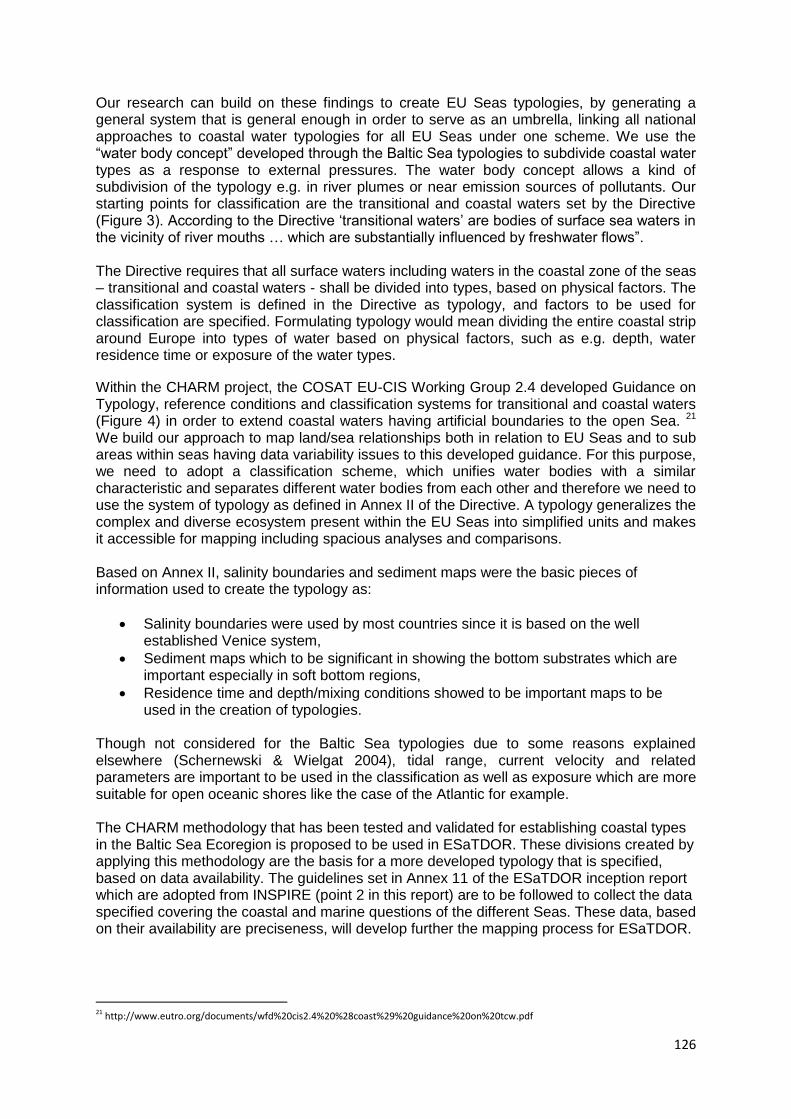
126
Our research can build on these findings to create EU Seas typologies, by generating a general system that is general enough in order to serve as an umbrella, linking all national approaches to coastal water typologies for all EU Seas under one scheme. We use the ―water body concept‖ developed through the Baltic Sea typologies to subdivide coastal water types as a response to external pressures. The water body concept allows a kind of subdivision of the typology e.g. in river plumes or near emission sources of pollutants. Our starting points for classification are the transitional and coastal waters set by the Directive (Figure 3). According to the Directive ‗transitional waters‘ are bodies of surface sea waters in the vicinity of river mouths … which are substantially influenced by freshwater flows‖. The Directive requires that all surface waters including waters in the coastal zone of the seas – transitional and coastal waters - shall be divided into types, based on physical factors. The classification system is defined in the Directive as typology, and factors to be used for classification are specified. Formulating typology would mean dividing the entire coastal strip around Europe into types of water based on physical factors, such as e.g. depth, water residence time or exposure of the water types.
Within the CHARM project, the COSAT EU-CIS Working Group 2.4 developed Guidance on Typology, reference conditions and classification systems for transitional and coastal waters (Figure 4) in order to extend coastal waters having artificial boundaries to the open Sea. 21 We build our approach to map land/sea relationships both in relation to EU Seas and to sub areas within seas having data variability issues to this developed guidance. For this purpose, we need to adopt a classification scheme, which unifies water bodies with a similar characteristic and separates different water bodies from each other and therefore we need to use the system of typology as defined in Annex II of the Directive. A typology generalizes the complex and diverse ecosystem present within the EU Seas into simplified units and makes it accessible for mapping including spacious analyses and comparisons. Based on Annex II, salinity boundaries and sediment maps were the basic pieces of information used to create the typology as:
Salinity boundaries were used by most countries since it is based on the well established Venice system,
Sediment maps which to be significant in showing the bottom substrates which are important especially in soft bottom regions,
Residence time and depth/mixing conditions showed to be important maps to be used in the creation of typologies.
Though not considered for the Baltic Sea typologies due to some reasons explained elsewhere (Schernewski & Wielgat 2004), tidal range, current velocity and related parameters are important to be used in the classification as well as exposure which are more suitable for open oceanic shores like the case of the Atlantic for example. The CHARM methodology that has been tested and validated for establishing coastal types in the Baltic Sea Ecoregion is proposed to be used in ESaTDOR. These divisions created by applying this methodology are the basis for a more developed typology that is specified, based on data availability. The guidelines set in Annex 11 of the ESaTDOR inception report which are adopted from INSPIRE (point 2 in this report) are to be followed to collect the data specified covering the coastal and marine questions of the different Seas. These data, based on their availability are preciseness, will develop further the mapping process for ESaTDOR.
21 http://www.eutro.org/documents/wfd%20cis2.4%20%28coast%29%20guidance%20on%20tcw.pdf
127
Figure 2: Designation of water bodies as management units of the WDF based on environmental pressure; example of Latvian coastal waters.
128
Figure 3: Map B from the WFD. System A: Ecoregions for transitional and coastal waters.
129
Figure 4 Coastal and transitional water bodies delineated by the Water Framework Directive. Source: The Scottish Government22
22
http://www.scotland.gov.uk/Publications/2008/04/03093608/15
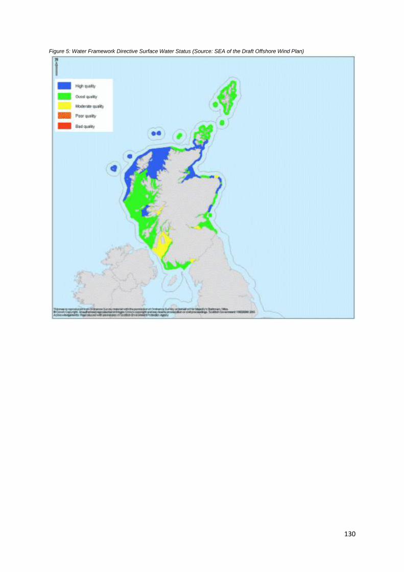
130
Figure 5: Water Framework Directive Surface Water Status (Source: SEA of the Draft Offshore Wind Plan)
131
5. Conclusion
The data recording and mapping for WP 2.2 needs to be in line with annex 11 of the inception report. The spatial information infrastructure of ESaTDOR bases on the INSPIRE Directive in order to enable a coherent and harmonised assessment for an entire EU Marine Region based on the specified categories of the guidelines, whenever possible. Data restrictions in some thematic areas or some Seas are expected throughout the project, but information on common categories needs to be fulfilled by the different working groups involved in collecting data (WP2.2). The terminology, definitions and requirements provided in the data collection template need to be in line with existing official regional Directives, such as e.g. the EC Marine Strategy Framework Directive, the EU Water Framework Directive, EC Habitats Directive and EU INSPIRE. General definitions, namely marine landscapes, zoning need to be used adequately throughout the data collection and collation of this research as they are considered the future policy-drivers for EU European waters. There is a need to agree on a common boundaries definition for the whole EU Seas with no overlap in the area covered. This common definition might be set by the leading partners after discussions and agreements with the partners. This is the basic step towards a harmonisation of the boundaries between Regional Seas based on relevant Conventions (e.g. the Marine Strategy Framework Directive). At each Sea level, partners involved in collecting data of the same Sea need to agree on a common definition of Geographical Sea boundaries of their marine region and subregions. This should be based on existing global or regional directives. Furthermore, the quality of data and analysis based upon it determine the success of the entire plan. The quality of the collected and used data can be significantly improved by following a systematic data collection, storage and management process according to internationally agreed guiding principles which also speeds up data retrieval and data use. An important issue to consider throughout the data collection phase is the provision of complete and accurate spatial data. All data collected need to be as complete as possible. Increasing data accuracy involves the correction of existing data, addition of any missing data and the real-time capturing of any data discrepancies. This process eliminates the erroneous data in the system. Ongoing database synchronization ensures that new errors are quickly identified and corrected. Special care needs to be given to the sources of data gathered. National and/or regional state of the coast/ocean reports that are available need to be used whenever possible in the data collection and collation. Comprehensive, exhaustive, and fully referenced information is expected to insure the quality standards of the collected data and its further use in the future. In case some data are unavailable at the present time and their expected date is known, full references to these datasets needs to be collected. This will help the work of updating the research outcomes in the future. Statistical information, paper maps…that exist, are of interest for the project, and are not used during this phase for a valid reason need to be cited in the references section of the data collection template.
132
6. References INSPIRE (2004). The Infrastructure for Spatial Information in Europe (INSPIRE) initiative homepage, http://www.ec-gis.org/inspire
Johansson, S., R. Sedin & T. Lundeberg (2000): Environmental Quality Criteria for the Swedish coastal waters - a useful tool for implementation of the Water Framework Directive? Presentation at the International Conference: Ecological Status of Transitional & Coastal Waters. Towards classification for the EC Water Framework Directive. Edinburgh 20-22 November 2000. Manuscript. Schernewski, G. and M. Wielgat (2004). A Baltic Sea typology according to the EC-Water Framework Directive: integration of national typologies and the water body concept. In: Baltic Sea typology. Ed. by G. Schernewski and M. Wielgat. Warnemünde: EUCC - The Coastal Union; Die Küsten Union Deutschlands e.V. (Coastline reports; 4): 1-26 Schernewski, G. and M. Wielgat (2004). Towards a Typology for the Baltic Sea. In: Baltic Sea typology. Ed. by G. Schernewski and M. Wielgat. Warnemünde: EUCC - The Coastal
Union; Die Küsten Union Deutschlands e.V. (Coastline reports; 2): 35-52. Vogt, J. (ed.). (2002). Guidance Document of Implementing the GIS Elements of the Water Framework Directive, European Communities.
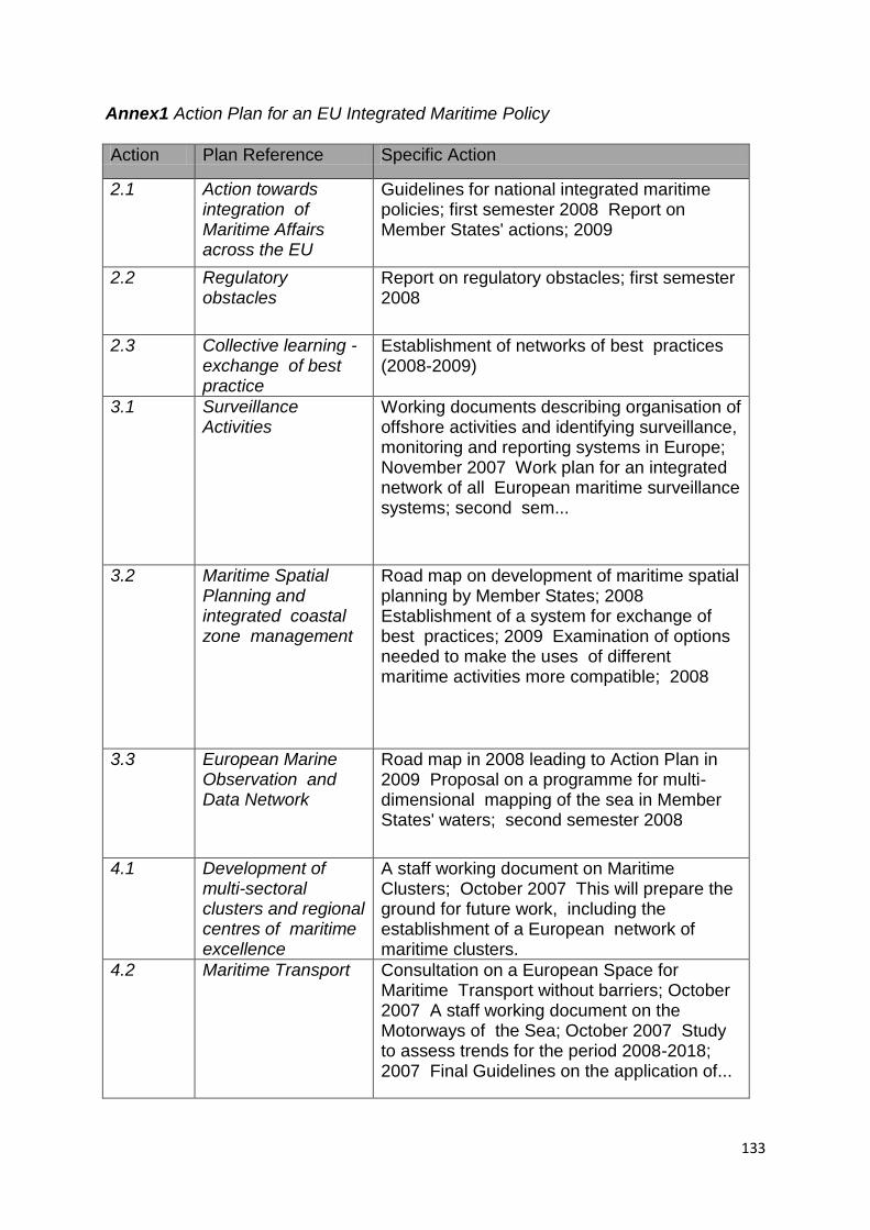
133
Annex1 Action Plan for an EU Integrated Maritime Policy
Action Plan Reference Specific Action
2.1 Action towards integration of Maritime Affairs across the EU
Guidelines for national integrated maritime policies; first semester 2008 Report on Member States' actions; 2009
2.2 Regulatory obstacles
Report on regulatory obstacles; first semester 2008
2.3 Collective learning - exchange of best practice
Establishment of networks of best practices (2008-2009)
3.1 Surveillance Activities
Working documents describing organisation of offshore activities and identifying surveillance, monitoring and reporting systems in Europe; November 2007 Work plan for an integrated network of all European maritime surveillance systems; second sem...
3.2 Maritime Spatial Planning and integrated coastal zone management
Road map on development of maritime spatial planning by Member States; 2008 Establishment of a system for exchange of best practices; 2009 Examination of options needed to make the uses of different maritime activities more compatible; 2008
3.3 European Marine Observation and Data Network
Road map in 2008 leading to Action Plan in 2009 Proposal on a programme for multi-dimensional mapping of the sea in Member States' waters; second semester 2008
4.1 Development of multi-sectoral clusters and regional centres of maritime excellence
A staff working document on Maritime Clusters; October 2007 This will prepare the ground for future work, including the establishment of a European network of maritime clusters.
4.2 Maritime Transport Consultation on a European Space for Maritime Transport without barriers; October 2007 A staff working document on the Motorways of the Sea; October 2007 Study to assess trends for the period 2008-2018; 2007 Final Guidelines on the application of...
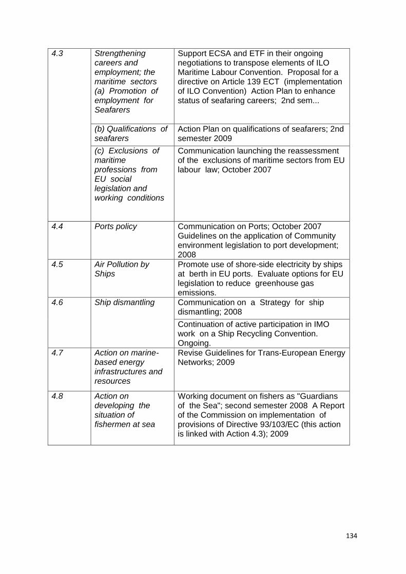
134
4.3 Strengthening careers and employment; the maritime sectors (a) Promotion of employment for Seafarers
Support ECSA and ETF in their ongoing negotiations to transpose elements of ILO Maritime Labour Convention. Proposal for a directive on Article 139 ECT (implementation of ILO Convention) Action Plan to enhance status of seafaring careers; 2nd sem...
(b) Qualifications of seafarers
Action Plan on qualifications of seafarers; 2nd semester 2009
(c) Exclusions of maritime professions from EU social legislation and working conditions
Communication launching the reassessment of the exclusions of maritime sectors from EU labour law; October 2007
4.4 Ports policy Communication on Ports; October 2007 Guidelines on the application of Community environment legislation to port development; 2008
4.5 Air Pollution by Ships
Promote use of shore-side electricity by ships at berth in EU ports. Evaluate options for EU legislation to reduce greenhouse gas emissions.
4.6
Ship dismantling
Communication on a Strategy for ship dismantling; 2008
Continuation of active participation in IMO work on a Ship Recycling Convention. Ongoing.
4.7 Action on marine-based energy infrastructures and resources
Revise Guidelines for Trans-European Energy Networks; 2009
4.8 Action on developing the situation of fishermen at sea
Working document on fishers as "Guardians of the Sea"; second semester 2008 A Report of the Commission on implementation of provisions of Directive 93/103/EC (this action is linked with Action 4.3); 2009
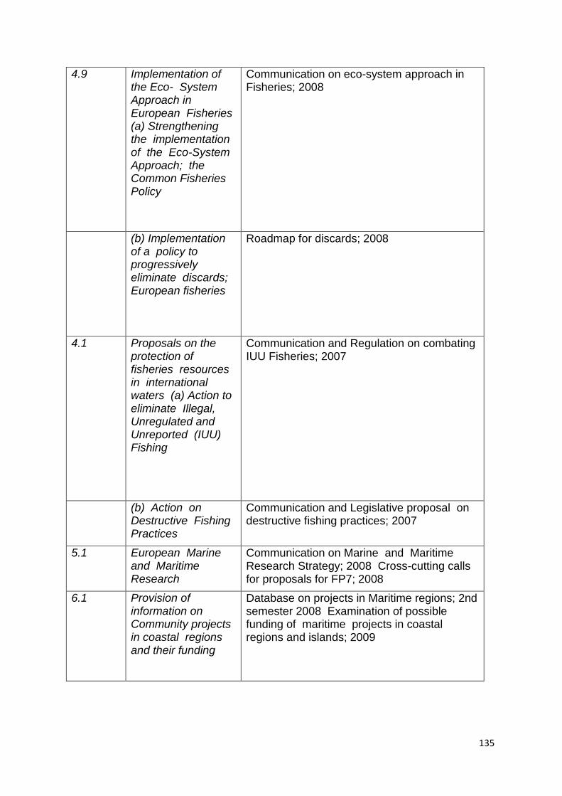
135
4.9 Implementation of the Eco- System Approach in European Fisheries (a) Strengthening the implementation of the Eco-System Approach; the Common Fisheries Policy
Communication on eco-system approach in Fisheries; 2008
(b) Implementation of a policy to progressively eliminate discards; European fisheries
Roadmap for discards; 2008
4.1 Proposals on the protection of fisheries resources in international waters (a) Action to eliminate Illegal, Unregulated and Unreported (IUU) Fishing
Communication and Regulation on combating IUU Fisheries; 2007
(b) Action on Destructive Fishing Practices
Communication and Legislative proposal on destructive fishing practices; 2007
5.1 European Marine and Maritime Research
Communication on Marine and Maritime Research Strategy; 2008 Cross-cutting calls for proposals for FP7; 2008
6.1 Provision of information on Community projects in coastal regions and their funding
Database on projects in Maritime regions; 2nd semester 2008 Examination of possible funding of maritime projects in coastal regions and islands; 2009
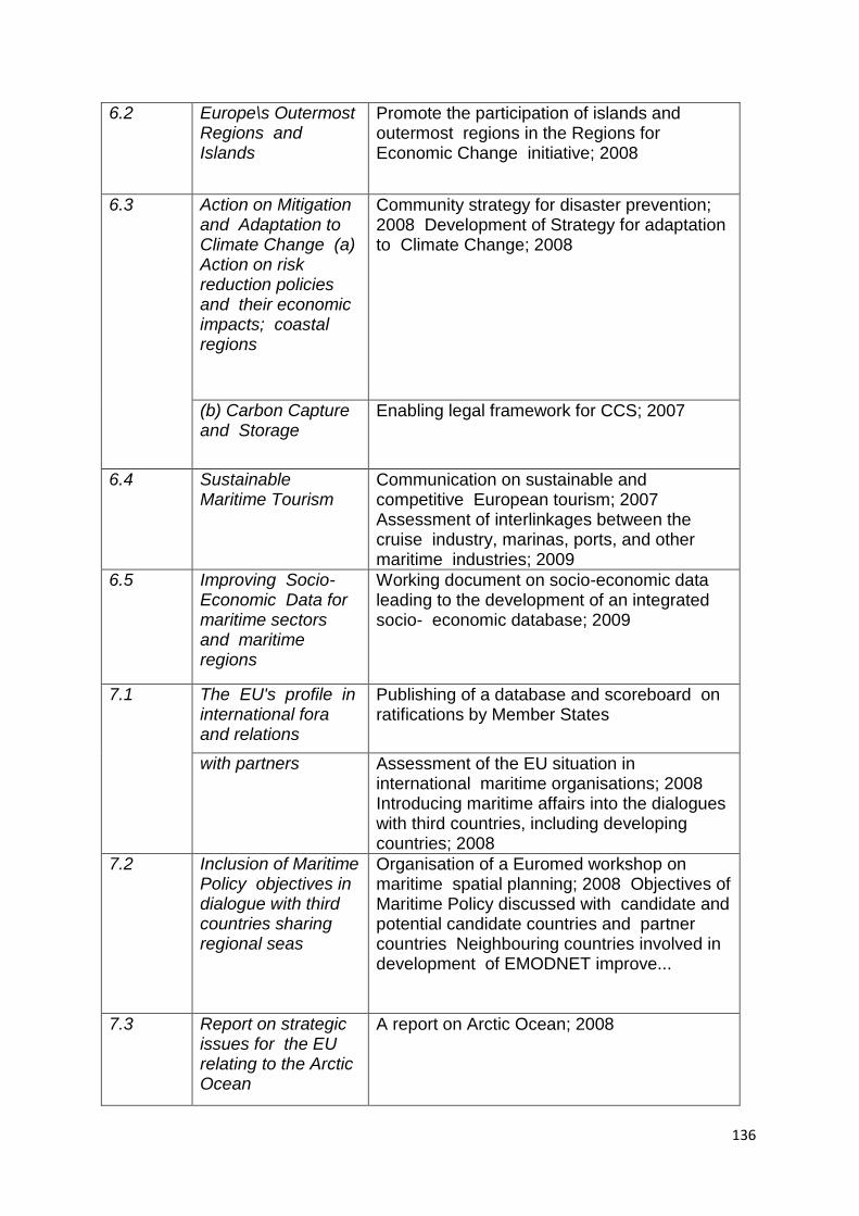
136
6.2 Europe\s Outermost Regions and Islands
Promote the participation of islands and outermost regions in the Regions for Economic Change initiative; 2008
6.3 Action on Mitigation and Adaptation to Climate Change (a) Action on risk reduction policies and their economic impacts; coastal regions
Community strategy for disaster prevention; 2008 Development of Strategy for adaptation to Climate Change; 2008
(b) Carbon Capture and Storage
Enabling legal framework for CCS; 2007
6.4 Sustainable Maritime Tourism
Communication on sustainable and competitive European tourism; 2007 Assessment of interlinkages between the cruise industry, marinas, ports, and other maritime industries; 2009
6.5 Improving Socio-Economic Data for maritime sectors and maritime regions
Working document on socio-economic data leading to the development of an integrated socio- economic database; 2009
7.1 The EU's profile in international fora and relations
Publishing of a database and scoreboard on ratifications by Member States
with partners Assessment of the EU situation in international maritime organisations; 2008 Introducing maritime affairs into the dialogues with third countries, including developing countries; 2008
7.2 Inclusion of Maritime Policy objectives in dialogue with third countries sharing regional seas
Organisation of a Euromed workshop on maritime spatial planning; 2008 Objectives of Maritime Policy discussed with candidate and potential candidate countries and partner countries Neighbouring countries involved in development of EMODNET improve...
7.3 Report on strategic issues for the EU relating to the Arctic Ocean
A report on Arctic Ocean; 2008
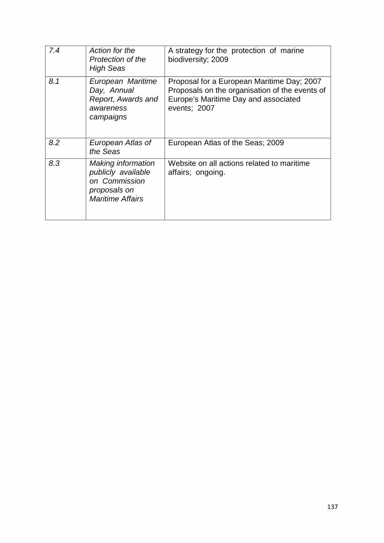
137
7.4 Action for the Protection of the High Seas
A strategy for the protection of marine biodiversity; 2009
8.1 European Maritime Day, Annual Report, Awards and awareness campaigns
Proposal for a European Maritime Day; 2007 Proposals on the organisation of the events of Europe's Maritime Day and associated events; 2007
8.2 European Atlas of the Seas
European Atlas of the Seas; 2009
8.3 Making information publicly available on Commission proposals on Maritime Affairs
Website on all actions related to maritime affairs; ongoing.
138
Annex2. A list of regional conventions to specific Seas within the EU Seas.
Barcelona Convention:
The United Nations Environment Programme/Mediterranean Action Plan (UNEP/MAP) adopted in 1976 in Barcelona, is the first UNEP's regional Sea Convention. It sets the governance structure of Mediterranean countries to protect the Marine environment and the coastal region of the Mediterranean basin. This Barcelona convention and its 7 Protocols constitute legally binding instruments for the Mediterranean countries that adopted it. 23 The MAP was originally a framework for common actions (preparation of regional and national policies, capacity building and technical assistance) needed by the Mediterranean Countries to combat the pollution of the Mediterranean Sea itself (MAP Phase I). In 1995, the Barcelona conventions was extensively amended to give a sustainable development focus and to deal with costal area as well ( MAP Phase II). Indeed activities carried out between 1976 and 1995 confirmed that socio-economic trends, combined with inadequate development planning and management are the root of most environmental problems. Estimates showed that up to 80 per cent of marine pollution was originated by land-based activities. Convention on the Protection of the Black Sea Against Pollution
Also referred to as "Bucharest Convention", it is the basic framework of agreement and three specific Protocols, which are: (1) the control of land-based sources of pollution; (2) dumping of waste; and (3) joint action in the case of accidents (such as oil spills).
The implementation of the Convention is managed by the Commission for the Protection of the Black Sea against Pollution (also sometimes referred to as the Istanbul Commission), and its Permanent Secretariat in Istanbul, Turkey OSPAR Convention OSPAR is the mechanism by which fifteen Governments of the western coasts and catchments of Europe, together with the European Community, cooperate to protect the marine environment of the North-East Atlantic. At its Biodiversity Committee (BDC) meeting in 2003, OSPAR agreed to proceed with a programme to collate existing data on the distribution of the fourteen habitats on this list, as part of a wider programme to develop measures for their protection and conservation. BDC 2004 agreed on working definitions for each habitat type for the purposes of this mapping programme. A web-mapping application has been developed to disseminate the data collated through the OSPAR mapping programme. Data coverage: The data available to date provide an initial indication of the distribution of each OSPAR priority habitat type; further data will be added as it becomes available. The maps are not yet considered to be comprehensive for the OSPAR area as a whole and may not be comprehensive within any given Contracting Party‘s waters. The following table provides a summary of the coverage of data for the distribution of listed habitats within the OSPAR area. Below is a summary of the distribution of listed habitats within the OSPAR area by OSPAR Contracting Party and for the high seas, (last updated March 2006). .
23
http://195.97.36.231/dbases/webdocs/BCP/BCP_eng.pdf
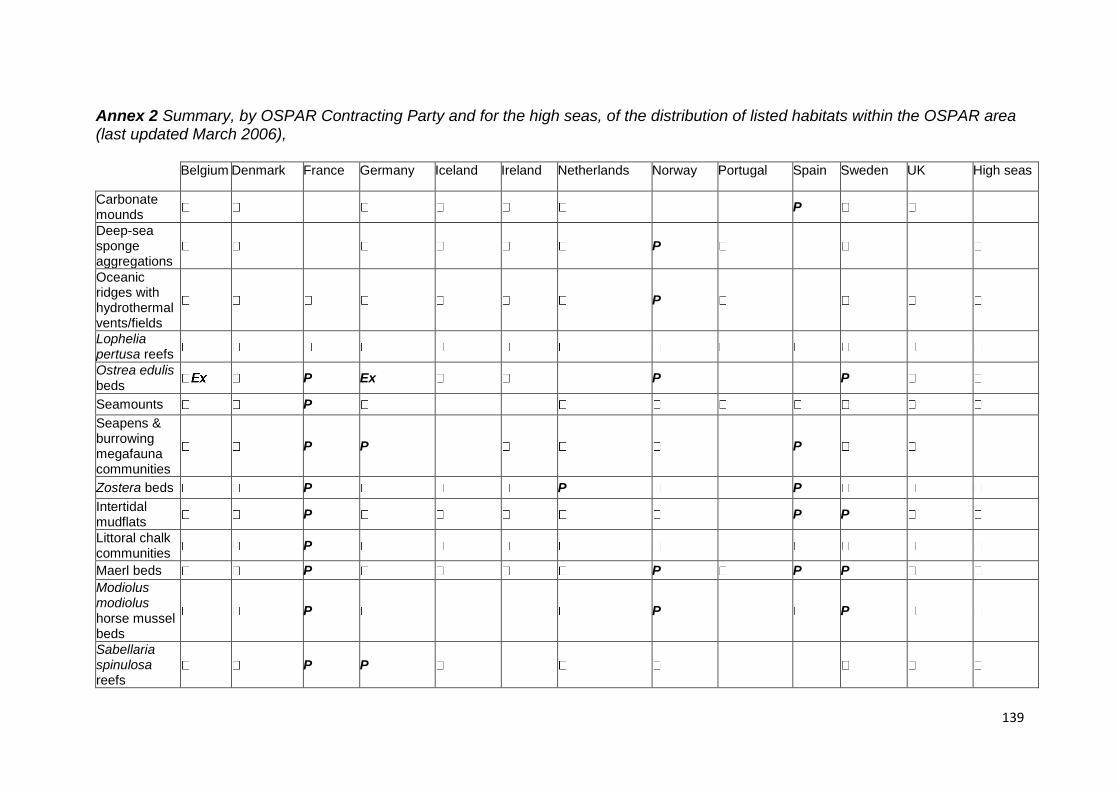
139
Annex 2 Summary, by OSPAR Contracting Party and for the high seas, of the distribution of listed habitats within the OSPAR area (last updated March 2006), Belgium Denmark France Germany Iceland Ireland Netherlands Norway Portugal Spain Sweden UK High seas
Carbonate mounds
P
Deep-sea sponge aggregations
P
Oceanic ridges with hydrothermal vents/fields
P
Lophelia pertusa reefs
Ostrea edulis beds
P Ex P P
Seamounts P
Seapens & burrowing megafauna communities
P P P
Zostera beds P P P
Intertidal mudflats
P P P
Littoral chalk communities
P
Maerl beds P P P P
Modiolus modiolus horse mussel beds
P P P
Sabellaria spinulosa reefs
P P
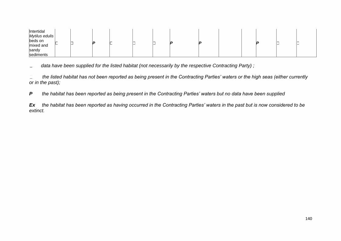
140
Intertidal Mytilus edulis beds on mixed and sandy sediments
P P P P
data have been supplied for the listed habitat (not necessarily by the respective Contracting Party) ;
the listed habitat has not been reported as being present in the Contracting Parties’ waters or the high seas (either currently or in the past);
P the habitat has been reported as being present in the Contracting Parties’ waters but no data have been supplied
Ex the habitat has been reported as having occurred in the Contracting Parties’ waters in the past but is now considered to be extinct.
141
Appendix 6: Coastal and Marine Governance Briefing Paper
Ximo Farinós (Draft, 24.06.11)
1. Introduction Some points of departure have to be taken into account in order to have an operational definition of governance (territorial governance) and if it could be applied, in similar way or not, to the seas.
Even though clearly related, Governance is not exactly the same as current good or wrong practices by government. Application of legislation and the rule of law are not considered as new governance practices; however it could be interesting for the project to analyse and determine factors for good government. In this sense it is very important to introduce a strong legal basis in our project.
According with this, the ESaTDOR project will focus on Governance as ‗Structure‘ or pre-conditions; but also on ‗processes‘ through decisions and actions (policies, plans, programmes, actions‘ design, implementation and evaluation) are taken and developed under this legal umbrella.
We understand Governance as ‗Democratic Governance‘; that is, meta-governance relationships between the three spheres (State, Market and Civil Society) are based in mutual deference in order to achieve best results from social and environmental population rights, but also appropriate economic performance (exploiting accurately local potentials).
Furthermore, based on this three-spheres composition of governance (State, Market and Civil Society), the ESaTDOR project will consider four Governance dimensions to be include in its case study analysis:
a) Vertical/Multi-level relationships between political-administrative levels: EU, National, Local-Regional
b) Horizontal: b.1) cross-sectoral (coherent, integrated approach); b.2) across territories (territorial cooperation practices); b.3) among territorial and economic actors (partnerships)
c) Public participation
d) Governance as a factor for spatial development: Institutions and governments' efficacy and capacity, regulation quality, rule of law strength and control of corruption (from the public side), and corporative governance quality (from the private sector -Corporative Social, Environmental and Territorial Responsibilities), represent fundamental pillars to improve regional economies potential.
It seems that only the last one of these things interests policy makers, however, this can‘t be correctly understood nor interpreted, nor possible alternatives proposed, without the three previous ones. So all four of these dimensions will be considered by the ESaTDOR team.
European Integrated Marine Policy (Blue Paper and its Action Plan) is understood as the socio-economic dimension (concreted in European Marine Spatial Planning
142
–non binding), complementing that of the Environmental dimension (that EU Marine Strategy Framework Directive –MSFD, 2008/56/EC- develops; this time with a clear normative character).
The ESaTDOR project tries to complement both, but focuses mainly on the first one and on Marine Spatial Planning as essential instrument for IMP, due it is the nearest one to our understanding of Governance practices.
Marine Spatial Planning is need because both traditional and new uses represent conflicts between uses, users and between economic development and environmental impacts. MSP is more than bi-dimensional; it incorporates two other additional dimensions for planning: the vertical (water column) also time (temporal vs. permanent uses).
On this basis, and because seas waters depart -as extension- from territory under States‘ sovereignty that in fact is not exclusive and depends on coast‘s distance, we will explore if Spatial (inland) Planning techniques can be translated -or not-, and to which extend as well as with the more appropriate planning technique, to Marine Space. these two types of planning are not identical, but have a common nature.
MSP applies into Exclusive Economic Zones (EEZ). From a legal point of view (see Parejo, 2011) International Convention and Laws only make possible a Sectoral approach for MSP. Besides, EEZ present a double statute:
- Territorial: exclusive competences for States are not possible and so territorial cooperation multilevel and horizontal agreements are unavoidable.
- Exploitation activities: diverse degrees of freedom for States, regulation and rights depending on different activities. Besides international agreements for fishing rights, submarine pipelines or free and innocent shipping transit, it has to be taken into account EU Right has to be applied in EEZ (see KOKOTT arguments in Case C-6/04 Commission v United Kingdom [2005] ECR 1-9017).
From ‗territorial‘ statute, MSP at this moment asks for Soft Planning (spaces, geometries and Laws) and for multi-level agreements, and leads necessarily to the previous sectoral approach (much better legally defined; but not all is regulated), as previous step for future cross-sectoral exercise of coherence (i.e. trough Ecosystem Based Approach and Multiple Use Approach planning techniques).
IZCM, binding in some case as in the Mediterranean Sea, could be considered as an interesting interface leading from Spatial Planning in the coast to MSP and future Marine Strategies (according with EU Marine Strategy Framework Directive). This continuous Spatial Planning – IZCM – MSP (as essential instrument of IMP) - MSFD will be considered in our tasks.
Integrated coherent planning that joins all territories, coastal areas and regional seas will only be possible if Spatial Planning coordinates with MSP.
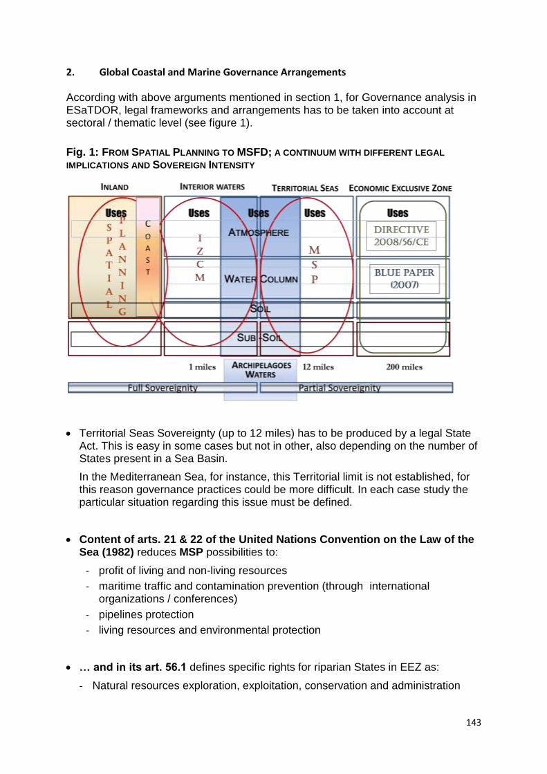
143
2. Global Coastal and Marine Governance Arrangements
According with above arguments mentioned in section 1, for Governance analysis in ESaTDOR, legal frameworks and arrangements has to be taken into account at sectoral / thematic level (see figure 1).
Fig. 1: FROM SPATIAL PLANNING TO MSFD; A CONTINUUM WITH DIFFERENT LEGAL
IMPLICATIONS AND SOVEREIGN INTENSITY
Territorial Seas Sovereignty (up to 12 miles) has to be produced by a legal State Act. This is easy in some cases but not in other, also depending on the number of States present in a Sea Basin.
In the Mediterranean Sea, for instance, this Territorial limit is not established, for this reason governance practices could be more difficult. In each case study the particular situation regarding this issue must be defined.
Content of arts. 21 & 22 of the United Nations Convention on the Law of the Sea (1982) reduces MSP possibilities to:
- profit of living and non-living resources
- maritime traffic and contamination prevention (through international organizations / conferences)
- pipelines protection
- living resources and environmental protection
… and in its art. 56.1 defines specific rights for riparian States in EEZ as:
- Natural resources exploration, exploitation, conservation and administration
144
- Economic activities exploration and exploitation: i.e. energy production (from water and wind sources)
- Artificial islands – the production and use of,
- Marine scientific research
- Marine environment protection and preservation
This general framework has been developed at each sectoral / thematic and also at regional sea level. At thematic level (Environment, Economic activity, Energy, Cables-
pipelines, Transport) an overview was made in past ESaTDOR Inception Report.
3. Possible Case Studies Our interest is in good and best practice analysis in order to extract conclusions and recommendations to inspire guidelines or improved practice.
With this basis, a final goal, some arguments to be considered in case studies are the following:
1. Analysis of the context (national and transnational) for each Case Study: legal basis, initiatives, update…
2. Analysis of the specific case study experiences and their contextualization in the national context .
3. New ways and options for development; combining development and sustainability. Finding appropriate ways to solve conflicts
- among users (sectoral or comprehensive approach; including temporal dimension)
- among uses and environment: Ecosystem Based Management, Marine Protected Areas and Comprehensive techniques (institutional map of actors involved)
4. Possibilities to apply Spatial Planning techniques to Marine Space are much more complex: 3 dimensions (subsoil+soil, water column and surface) + Time dimension (permanent and temporal changing activities).
The combination of IZCM, MSP and Marine Strategies in case studies as examples of/in a Continuum.
ESaTDOR should also consider taking advantage of two related on-going projects run by EU-Integrated Marine Policy as the two following (because innovative and positive lessons could be extracted):
North Sea: - MASPNOSE : https://www.surfgroepen.nl/sites/CMP/maspnose/Presentations/MASPNOSE%20presentation%2020110105.pdf
Baltic Sea: - PLANBOTHNIA: http://planbothnia.org/about/
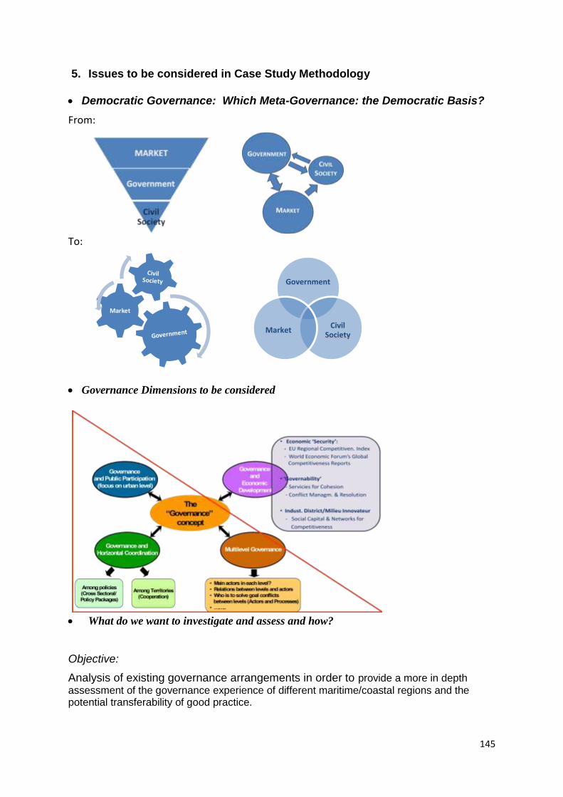
145
5. Issues to be considered in Case Study Methodology
Democratic Governance: Which Meta-Governance: the Democratic Basis?
From:
To:
Governance Dimensions to be considered
What do we want to investigate and assess and how?
Objective:
Analysis of existing governance arrangements in order to provide a more in depth
assessment of the governance experience of different maritime/coastal regions and the potential transferability of good practice.
Market
Government
Civil Society
Market
146
Through:
Documentary analysis, data collection and analysis of actors (Economic, State, Third Sector -inventory) by interviews and round tables when appropriate.
According with the Inception Report, tasks for each Case Study are:
Documentary analysis and data collection related to each thematic area in order to develop and understanding of spatial structure and dynamics of environmental/human interactions and relationships. Determining if EBA is possible, combined natural and anthropological pressures; co-dominance or balance among them; level of integration leading to a integrated approach. A first basis is available in the Inception Report Thematic and Regional Seas Annexes.
Identification of maritime related policies, plans, agreements, conventions and relationships to territorial planning. Revision and updated of Spatial Planning tradition (according with ESPON 2.3.2 Project), and how existing with new IZCM and MSP and Marine Strategies)
Identification of actors and stakeholders involved and their role, influence, participation and contribution to decision making: Inventory and map of relationships (individual, institutional, economics... both individually considered or in cluster)
Identification of future opportunities, threats, conflicts and obstacles to action. SWOT techniques could be applied for this issue, including documentary analysis and data treatment.
Development of conclusions and recommendations related to lessons and potential transferability of good practice:
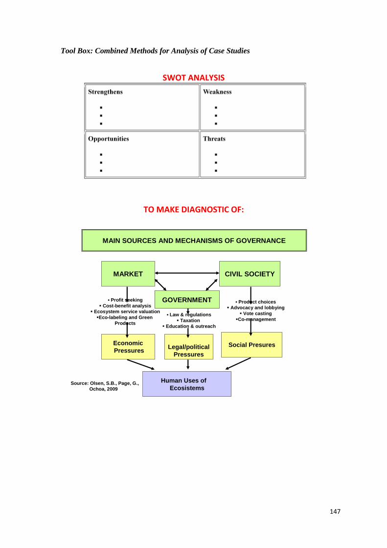
147
Tool Box: Combined Methods for Analysis of Case Studies
SWOT ANALYSIS
TO MAKE DIAGNOSTIC OF:
MAIN SOURCES AND MECHANISMS OF GOVERNANCE
MARKET
GOVERNMENT
CIVIL SOCIETY
Economic
PressuresLegal/political
Pressures
Social Presures
Human Uses of
EcosistemsSource: Olsen, S.B., Page, G.,
Ochoa, 2009
Profit seeking
Cost-benefit analysis
Ecosystem service valuation
Eco-labeling and Green
Products
Product choices
Advocacy and lobbying
Vote casting
Co-management Law & regulations
Taxation
Education & outreach
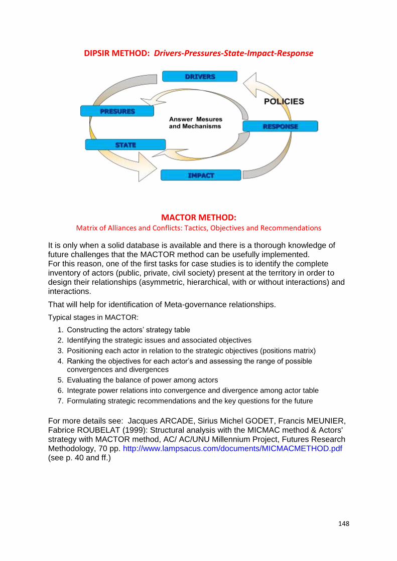
148
DIPSIR METHOD: Drivers-Pressures-State-Impact-Response
MACTOR METHOD: Matrix of Alliances and Conflicts: Tactics, Objectives and Recommendations
It is only when a solid database is available and there is a thorough knowledge of future challenges that the MACTOR method can be usefully implemented. For this reason, one of the first tasks for case studies is to identify the complete inventory of actors (public, private, civil society) present at the territory in order to design their relationships (asymmetric, hierarchical, with or without interactions) and interactions.
That will help for identification of Meta-governance relationships.
Typical stages in MACTOR:
1. Constructing the actors‘ strategy table
2. Identifying the strategic issues and associated objectives
3. Positioning each actor in relation to the strategic objectives (positions matrix)
4. Ranking the objectives for each actor‘s and assessing the range of possible convergences and divergences
5. Evaluating the balance of power among actors
6. Integrate power relations into convergence and divergence among actor table
7. Formulating strategic recommendations and the key questions for the future
For more details see: Jacques ARCADE, Sirius Michel GODET, Francis MEUNIER, Fabrice ROUBELAT (1999): Structural analysis with the MICMAC method & Actors' strategy with MACTOR method, AC/ AC/UNU Millennium Project, Futures Research Methodology, 70 pp. http://www.lampsacus.com/documents/MICMACMETHOD.pdf (see p. 40 and ff.)
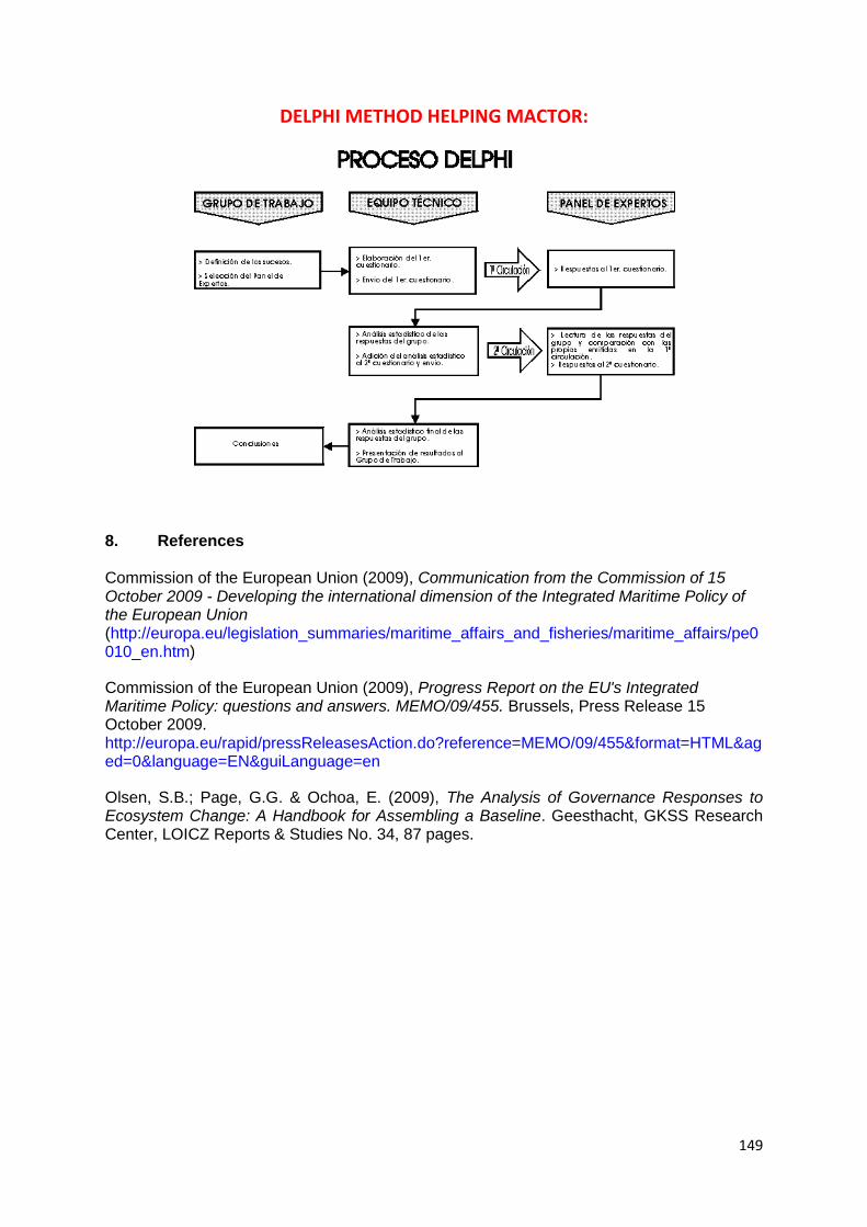
149
DELPHI METHOD HELPING MACTOR:
8. References Commission of the European Union (2009), Communication from the Commission of 15 October 2009 - Developing the international dimension of the Integrated Maritime Policy of the European Union (http://europa.eu/legislation_summaries/maritime_affairs_and_fisheries/maritime_affairs/pe0010_en.htm)
Commission of the European Union (2009), Progress Report on the EU's Integrated Maritime Policy: questions and answers. MEMO/09/455. Brussels, Press Release 15 October 2009. http://europa.eu/rapid/pressReleasesAction.do?reference=MEMO/09/455&format=HTML&aged=0&language=EN&guiLanguage=en
Olsen, S.B.; Page, G.G. & Ochoa, E. (2009), The Analysis of Governance Responses to Ecosystem Change: A Handbook for Assembling a Baseline. Geesthacht, GKSS Research Center, LOICZ Reports & Studies No. 34, 87 pages.
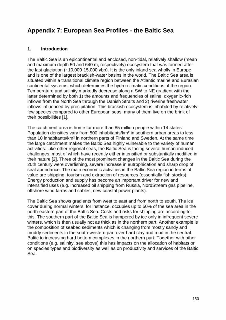
150
Appendix 7: European Sea Profiles - the Baltic Sea
1. Introduction
The Baltic Sea is an epicontinental and enclosed, non-tidal, relatively shallow (mean and maximum depth 50 and 640 m, respectively) ecosystem that was formed after the last glaciation (~10,000-15,000 ybp). It is the only inland sea wholly in Europe and is one of the largest brackish-water basins in the world. The Baltic Sea area is situated within a transitional climate region between the Atlantic marine and Eurasian continental systems, which determines the hydro-climatic conditions of the region. Temperature and salinity markedly decrease along a SW to NE gradient with the latter determined by both 1) the amounts and frequencies of saline, oxygenic-rich inflows from the North Sea through the Danish Straits and 2) riverine freshwater inflows influenced by precipitation. This brackish ecosystem is inhabited by relatively few species compared to other European seas; many of them live on the brink of their possibilities [1]. The catchment area is home for more than 85 million people within 14 states. Population densities vary from 500 inhabitants/km² in southern urban areas to less than 10 inhabitants/km² in northern parts of Finland and Sweden. At the same time the large catchment makes the Baltic Sea highly vulnerable to the variety of human activities. Like other regional seas, the Baltic Sea is facing several human-induced challenges, most of which have recently either intensified or substantially modified in their nature [2]. Three of the most prominent changes in the Baltic Sea during the 20th century were overfishing, severe increase in eutrophication and sharp drop of seal abundance. The main economic activities in the Baltic Sea region in terms of value are shipping, tourism and extraction of resources (essentially fish stocks). Energy production and supply has become an important driver for new and intensified uses (e.g. increased oil shipping from Russia, NordStream gas pipeline, offshore wind farms and cables, new coastal power plants). The Baltic Sea shows gradients from west to east and from north to south. The ice cover during normal winters, for instance, occupies up to 50% of the sea area in the north-eastern part of the Baltic Sea. Costs and risks for shipping are according to this. The southern part of the Baltic Sea is hampered by ice only in infrequent severe winters, which is then usually not as thick as in the northern part. Another example is the composition of seabed sediments which is changing from mostly sandy and muddy sediments in the south-western part over hard clay and mud in the central Baltic to increasing hard bottom complexes in the northern part. Together with other conditions (e.g. salinity, see above) this has impacts on the allocation of habitats or on species types and biodiversity as well as on productivity and services of the Baltic Sea.
151
Figure 13: Main basins of the Baltic Sea
152
2. Current situation
The Baltic Sea underlies manifold uses. To illustrate this by a single sector of major concern: Around 2,000 ships are at sea at any time. The number of ships entering or leaving the Baltic Sea via Skaw in 2009 has increased by 20% since 2006. Each year 120-140 shipping accidents occur in the Baltic Sea [2]. Reading these numbers it has to be considered that the Baltic Sea is a comparatively small sea. Despite of limited space some parts of the Baltic Sea show a high density of uses. These uses can be classified into 13 sectors: • Cables and pipelines • Defence • Fishery • Heritage • Mariculture • Nature protection and marine protected areas (MPA) • Marine research • Maritime transport • Offshore wind farms • Oil and gas extraction • Other infrastructure • Sand and gravel extraction • Tourism and leisure uses The intensity and spatial distribution of uses differs from sub-basin to sub-basin. Especially southern-western areas of the Baltic Sea underlie high density of uses while northern parts (Bothnian Bay) show low levels of anthropogenic use (fig. 2). Reasons are, among others, low population density in adjacent land areas as well as the fact that parts of the sea are covered by ice for several months per year.
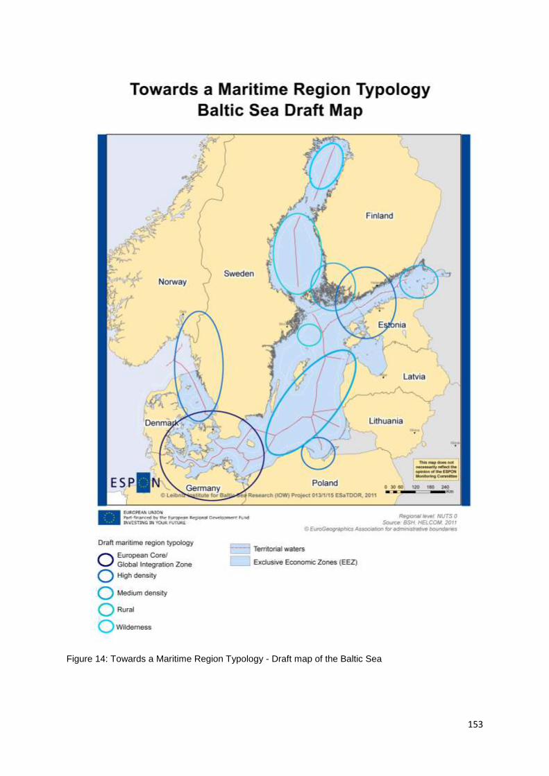
153
Figure 14: Towards a Maritime Region Typology - Draft map of the Baltic Sea
154
Conflicts and competition among uses have a strong spatial dimension. Within some areas of the Baltic Sea up to nine spatial claims of different uses exist. Following areas and regions are among the hotspots of multiple uses: • Gulf of Gdansk • Danish straits • Main shipping routes (traffic separation schemes) • Western Gulf of Finland • Southern Arkona basin • South-western Baltic Sea However, one of the most serious problems within the Baltic Sea is mainly caused by land based anthropogenic processes. Eutrophication caused by riverine nutrient loads is a threat to the marine environment and coastal development. Impacts of eutrophication, among others, are murky water, algae blooms, reduced distribution of benthic habitats or oxygen depletion resulting in fish kills. Nutrients originate from a variety of activities. Phosphorus originates mainly from point sources (municipalities) while nitrogen mainly originates from diffuse sources (here: agriculture). Hypoxia or even anoxia can be caused and/or intensified by eutrophication. Partly they are also caused or intensified by the limited inflow of salty oxygen-rich water from the North Sea. Oxygen depletion in the Baltic Sea may be episodic, annually occurring in summer or autumn (common) or persistent (deep basins of the Baltic Sea). Other environmental issues are the living conditions of marine and freshwater species in the Baltic Sea as well as the limited biodiversity. Furthermore hazardous substances (heavy metals, chemical substances, persistent organic pollutants) and pumped (chemical) munitions are of concern for the Baltic Sea. In terms of economy agriculture plays an important role in the Baltic Sea Region. Between 60% and 70% of the drainage area in Denmark, Germany and Poland consists of arable land [2]. In the Baltic States the percentage is 30-40% while only about 10% of the catchment in Sweden, Finland and Russia is arable. Silviculture is of importance in Sweden and Finland. Almost half of the Baltic Sea catchment area is forest (48%). While this is a land based activity it has a direct impact on the Baltic Sea because of its nutrient discharges. Fishery is subsequently in decline in the Baltic Sea since the 1980s. Cod, sprat and salmon are the most important fish stocks in the Baltic Sea for international markets. Other, mostly locally important commercial fishes are pikeperch, pike, perch, vendace, whitefish, turbot and eel [2]. Together with salinity gradients the spatial distribution of fish abundance and therefore of catches differs from species to species. The largest amounts of commercial fish catches can be observed in south-eastern parts of the Baltic Sea.
The interest in aquaculture is increasing in the Baltic Sea. So far marine aquaculture is operated mainly in Finland and Sweden. Because of its limited exchange of water (retention periods of more than 30 years) the Baltic Sea gives no ideal conditions for
155
mariculture in many cases. New aquaculture technologies are needed to achieve a breakthrough. Coastal tourism is of great economic importance in all Baltic Sea states. With respect to the climate conditions mainly the south-western destinations in Denmark and Germany and partly in Sweden and Poland have developed a complex tourism infrastructure. A rising number of cruise ships enters and crosses the Baltic Sea mainly during the summer season calling mainly urban ports. Energy production has so far been a minor issue in the Baltic Sea. Currently oil is extracted on only two platforms in Polish and Russian waters. However, offshore wind farms are of increasing importance. Eleven operating wind farms and about 32 planned wind farms show a clear trend. Most of the current large wind farms are operated in the south-western Baltic Sea. But the Baltic Sea has a potential for offshore wind energy which is not fully tapped yet. In any case wind farms will lead to a number of new power cables. Today most of the power cables are linkages between neighbouring countries or between islands and the mainland. Several existing and planned communication cables complete the cable network across the Baltic Sea. Three gas pipelines are planned (Balticconnector, Baltic Pipe) or under construction (NordStream), connecting existing or new pipelines of the European natural gas network. With up to 15% of the world‘s cargo transportation the Baltic Sea is one of the most heavily trafficked seas in the world. Approximately one half of the ships in the Baltic Sea are cargo vessels, 14% are tankers and 11% passenger vessels (in number of 2008, [2]. Maritime traffic is predicted to increase. This is especially true for oil transportation in the eastern part (Gulf of Finland) due to the export of Russian oil. 380,000 ship calls have been counted in the year 2008. Annually there are some 120-140 ship accidents in the Baltic Sea (2008: 288) [2]. When talking about spatial structures of anthropogenic uses on resp. in the Baltic Sea it has to be considered that the Baltic Sea Region still is a non-homogenous region. Countries like Denmark, Germany, Finland and Sweden are developed economies and high-income countries while Estonia, Latvia, Lithuania, Poland and Russia are transitional economies with lower incomes. This has impacts on types and intensities of anthropogenic sea uses. Among the above mentioned 13 different uses 683 conflicts may occur [3] if all spatial dimensions (3D space) as well as disturbing interactions (pollution, noise and light emissions, disturbance of landscape functions) are analysed. Most of these conflicts are direct spatial conflicts on the sea surface, in the water column or on/in the seabed. This category also includes the consumption of resources (e.g. sediment) where one use might compete with other uses. The number of 30 conflicts evoked by emissions of noise, light or different kinds of pollution seems to be relatively low compared to the high number of potential conflicts. However, uses causing these kinds of conflicts may also have impacts especially on changes in species distribution and productivity.
156
Multiple use of marine space does not in all cases lead to conflicts nor does it mean that additional uses have to be excluded. Temporary uses e.g. defence and fishery are able to share the same space like in this case surface waters and parts of the water column. Also uses needing different spatial levels of the same locality may coexist. For instance maritime transport on the sea surface may go together with sand and gravel extraction with in the seabed under certain circumstances. The marine areas dedicated to conservation are perhaps the most conflicting because they restrict or even exclude other uses (such as resource extraction or uses that disturb the seabed and water column or result in acoustical pollution). The areas of conflict are expected to increase: currently between 5% and 30% of marine areas in the EU are designated for protection, but Lunney et al. [4] suggested the minimal standard for Europe should be 20%. However, due the already existing density of uses in case of the Baltic Sea expansions of existing uses (e.g. shipping) and implementations of new uses (e.g. wind farms) will lead to conflicts in many cases. This should be taken into mind when weighting the influence of different drivers. Most likely their development will not happen in open space.
3. Outlook The Baltic Sea Region (BSR) has shown a successful convergence process over the
last two decades. Revitalised historic ties around the Baltic Sea, increased pan-
Baltic co-operation and the EU Cohesion Policy have let to new opportunities for
growth and employment as well as increased environmental and social development.
The Baltic Sea itself is both an obstacle and a driver for the development of the
Baltic Sea Region. The VASAB Long-Term Perspective for the Territorial
Development of the Baltic Sea Region [5], which is aiming for a well-integrated and
coherent Baltic Sea macroregion in 2030, states: ―The Baltic Sea presents a natural
obstacle for the expansion of the terrestrial means of transport, such as road and
rail. At the same time, however, it is an outstanding asset for the development of an
integrated maritime transport network between the BSR countries and regions to
further enhance mobility and integrate labour markets.
The intense development of a range of economic activities, including, inter alia, the
offshore energy production, maritime tourism and sea-borne traffic, results in
conflicting interests in using the Baltic Sea resources. Complemented with onshore
based pollution of the Baltic Sea waters by nitrogen and phosphorus, as well as by
hazardous substances from the catchment area, these sea use conflicts contribute to
a gradual depletion of the resources and deterioration of marine landscapes. In a
long run, they may negatively influence the development and quality of life of the
BSR community.‖ The ESaTDOR thematic briefing papers have identified a number
of risks and opportunities for the territorial development of European Seas similar to
the above VASAB statement. In the following these chances and threats will be
highlighted shortly for the Baltic Sea Region.
157
Energy and Pipelines
Opportunities
Fossil fuel Development
Extracting fossil energies plays no major role in the Baltic Sea. Only two oil
platforms exist (one in Polish, one in Russian waters). Extended exploitation is
possible in single onshore regions but this will be a minor development due to
geological reasons. However, transport of fossil energy carriers, mainly Russian
oil and gas, might lead to increased shipping capacities and further extend
pipeline networks.
Marine Renewables
Being a semi-enclosed sea with relatively low salinity values, very limited tides
and changing wave heights it is not likely that renewable ocean energies as tidal
power, wave power or osmotic power will play a substantial role in the near
future. But the Baltic Sea has a potential for offshore wind energy which is not
fully tapped yet. While so far Denmark and Germany are leading in the
development of offshore wind farms new wind farms are projected in Finland (for
2014), Estonia (2015), Poland (2015, 2018-2020) with an assumed capacity of
2800 MW [6].
International energy and telecommunication grids
Currently three new interconnector cables are under development (Finland-
Estonia, Sweden Latvia, Finland-Sweden). It is likely that additional grids will be
established within the next 10-15 years against the background of the EU‘s 2020
renewable energy 20% target and to further improve the energy supply [7].
Carbon storage
CO2 storage capacities have been found mainly in south-eastern areas of the
Baltic Sea (waters of Poland, Russia, Lithuania and Latvia). Carbon Capture and
Storage (CCS) research and development projects are currently under
development in Denmark and Germany (onshore) while mainland projects are
planned in Poland. Maritime carbon storage is not developed yet but likely to be
developed in the future [8]. Initial proposals already exist in Poland.
Risks
Increased carbon emissions associated with oil and gas development
Like other areas the Baltic Sea suffers from climate change in a large variety of
ways. Impacts differ along diverse gradients from north to south and east to
west, for details please see the BACC report [9].
Environmental damage associated with new energy sources
New energy sources (offshore wind farms) and new energy transport grids
(cables, pipelines) can lead to various environmental impacts with the Baltic
including changes in food web and habitat structures. Intensive development of
new energy sources could be an additional pressure on the Baltic Sea. This is
158
however depending on local conditions wherefore a general assessment is not
possible here.
Restrictions to other sea uses associated with energy development
The Baltic Sea is already today heavily used with multiple spatial claims for most
of the area. Additional anthropogenic uses will lead to an increasing number of
spatial conflicts.
Transport
Opportunities
Growth of shipping
The Baltic Sea is among the busiest seas (each month around 3,500-5,000 ships
ply the waters of the Baltic Sea and about 2,000 ships are on Baltic waters at
any given moment).
Both the number of ships and the size of ships (and so the quantities of cargo)
on the Baltic have been growing rapidly until 2008 with a decrease in 2009 due
to the economic crisis 2008/2009 [10]. Further growth of maritime transport is
assumed (see transport briefing paper) in the near future.
New maritime routes
Being a semi-enclosed sea it is unlikely that shipping routes within the Baltic will
change within the near future. In the long run decreasing ice coverage might
lead to more frequent shipping into the Bothnian Bay (e.g. heading for mines in
northern Finland) and an Artic passage could lead to increased shipping via
northern ports.
Short Sea Shipping
Short Sea Shipping is due to the geographical situation of the Baltic Sea the
major type of maritime transport and is likely to increase further.
Cruise activity
Cruise shipping is of major importance for various ports around the Baltic Sea.
The number of cruise ship passengers has increased from 1.1 million in 2000 to
3.1 million in 2010. For 2011 almost 3.5million passengers are expected. It
cannot be expected that these annual growth rates around 11-12% will continue
in future but further increase of passengers seems possible for single ports [11].
New infrastructure
In general there is a sufficient maritime infrastructure in place within the Baltic
Sea Region. Increased shipping, technological revolutions and changes in
demand will however lead to constant reconstruction and infrastructural adaption
of Baltic ports.
Gas and oil shipping
Oil transportation is important in the Baltic Sea due to the export of Russian oil.
The export of Russian oil alone is expected to reach 180 million tons by 2020
[12]. The overall export of oil from Russia is unlikely to increase and might
159
decrease from 2036 on or earlier [13]. A significant increase of oil tankers over a
longer period therefore seems also unlikely. Russian gas will be transported via
the North Stream pipeline from late 2011 on. Transport of liquefied natural gas is
likely to increase after a first terminal has been opened near Nynäshamn,
Sweden.
Fishing
Fishery is in decline in the Baltic Sea since the 1980s. The interest in
aquaculture is increasing but limited water exchange in the Baltic is a large
obstacle for conventional aquaculture.
Leisure development
Using yachts and sporting boats has a long tradition especially in Scandinavia.
Increasing living standard mainly in the Baltic States, Poland and Russia and on-
going increase in tourism development might lead to an increased number of
leisure boats and marinas especially in southern parts of the Baltic.
Risks
Shipping accidents and pollution
Between 2004 and 2009 the number of yearly shipping accidents has varied
between 105 and 146 accidents per year without a clear trend [14]. Most of the
accidents occurred near shore or within ports. Only a small amount of accidents
leads to pollution (e.g. ten accidents resulted in 2009). Increasing maritime
transport is likely to cause also an increasing number of accidents in the future.
Other ship based sources of pollution are illegal oil discharges (149 in 2010
[15]), ballast water and exhaust emissions. Assuming that the Ballast Water
Convention might be ratified in the near future and that the status of being a
Particularly Sensitive Sea Area (PSSA) declared by the International Maritime
Organization in 2005 has further effects the overall amount of pollution could
possibly be limited to a minimum in the near future. But increased shipping might
cause contrary results.
Administrative barriers to shipping
Like in other European seas the EU customs legislation is an obstacle for
maritime transport. A hurdle which can be cleared but raises transport costs. A
solution to this problem would be to eliminate the border formalities in maritime
transport in intra EU trade. Elimination of customs formalities in maritime
transport has been proposed by the European Commission initiative of the
Common European Maritime Transport Space without Barriers. This initiative
may enhance trade development and intermodal maritime transport in the Baltic
Sea region [16].
160
Environment
Opportunities
Ecosystem preservation/improvement
Baltic Sea habitats and species are threatened mainly by eutrophication and
hazardous substances. The inputs of some hazardous substances to the Baltic
Sea have reduced considerably over the past 20 to 30 years, in particular
discharges of heavy metals (1990-2007: -46% for cadmium, -23% for mercury,
and -69% for lead). A range of anthropogenic activities contribute to the
significant inputs of nutrient to the sea. Although nutrient inputs from point
sources such as industries and municipalities have been cut significantly, the
total input of nitrogen to the Baltic Sea is still almost 837,500 tonnes per year.
The main source of nutrient loads to the Baltic Sea is agriculture. Mainly
because of interannual changes in meteorological conditions, annual nitrogen
deposition to the Baltic Sea and its sub-basins varies significantly from one year
to another in the period 1995 - 2007. Nevertheless, the annual deposition of
oxidized, reduced and total nitrogen in 2007 was respectively 14%, 2% and 8%
lower than in 1995 [17]. The Marine Strategy Framework Directive and the Water
Framework Directive may lead to further improvement of marine water quality
but setbacks are likely due to climate change and changes in agriculture.
Ecotourism
Sustainable tourism plays a strong role in the Baltic Sea Strategy and is currently
supported by a number of projects [18]. It seems likely that ecotourism will play
an increasing role in the near future.
Maintaining fish stocks
Currently 33% of commercial fish stocks in the Baltic Sea are overfished and
fishery fleets still have overcapacity in the Baltic. While the Common Fisheries
Policy seeks to achieve a balanced commercial fishing system it is hard to tell
how fish stocks will develop in future [19].
Increased resilience
Resilience of the Baltic Sea is dependent on various variables, e.g. the
catchment generating nutrient loads, the marine basins with their temporal and
spatial nutrient and oxygen regimes in the water and in the sediments, and the
food web as a responsive system to bottom up (salinity, temperature, nutrients,
oxygen) and top down (fishery, seabird and seal predation) effects [20]. While
the resilience has increased during recent years future development is currently
unsure as it is dependent on manifold parameters.
Carbon buffering
According to [21] the Baltic Sea is a net CO2 source (1.05 Mt C/year) caused by
high carbon discharge from land (riverine discharge: 10.9 Mt C/year) and
remineralisation of organic matter in sediments (1.14 Mt C/year). However, Baltic
Sea sediments serve as a carbon sink for 3.87 Mt C/year. Changes in climate
and riverine discharges will changes these numbers in both directions.
161
Risks
Fisheries and aquaculture depletion
Fishery is in decline in the Baltic Sea and larger fishery fleets are left only in
Denmark and Poland. There is a risk of further decrease in fishery while the
possibility to establish aquaculture (based on today‘s technology) is limited due
to limited water exchange in the Baltic Sea.
Species loss
About 59 species in the Baltic Sea are threatened or in decline [22]. There are
manifold reasons for this situation which might further worsen due to climate
change. Salinity changes for instance are of great importance for the Baltic Sea
which is a sensitive ecosystem on the edge between marine and fresh water
conditions.
Loss of natural sea defences
Erosion is a serious problem especially in the southern Baltic Sea. There are
controversial discussions whether this situation might become worse e.g. by
climate change or not. However, costs for coastal protection measures are
increasing and it seems to be illusory to believe in total coastal protection for all
parts of the coastlines in the long-run.
Decline in water-based tourism
Bathing tourism is of great importance in the south-western Baltic Sea and good
water quality is one of the main demands of summer tourist in this region [23].
Decreasing water quality would hamper one of the most import economic sectors
in the southern Baltic Sea Region. But also increasing water quality is
sometimes not attractive for tourists if it goes together with larger amounts of
biomass on the beach (e.g. algae, seaweed).
Human health impacts
Hygienic water quality of coastal waters is of great importance for human health
especially in areas with bathing and leisure activities. Coli and vibrio bacteria
cause problems in the Baltic Sea in single events but it does not seem likely that
this will increase. Heavy metal values are still too high in some areas of the
Baltic Sea but inputs of heavy metals into the Baltic are in decrease (see above).
Economic use
Opportunities
Climate Change > new fishery species
Climate change might change the distribution and abundance of fish in the Baltic
Sea. Currently 28 alien fish species have been observed with the Baltic Sea [24].
But so far there are no references that they might reach the status of a
commercial fish species in the near future.
Infrastructure associated with new maritime routes
(see topic New infrastructure under ―Transport‖)
162
Aquaculture development
Due to decreasing fish stocks it seems likely that aquaculture will further develop
within the Baltic Sea in the long-run. However, limited water exchange leads to
insufficient water qualities caused by aquaculture. Therefore new aquaculture
technologies are needed for many Baltic Sea regions to reach a substantial
level.
Increased cruise tourism
(see topic Cruise activity under ―Transport‖)
Ecotourism
(see topic Ecotourism under ―Environment‖)
New technologies in shipbuilding and marine renewable energy production
Maritime industry is of importance for many regions around the Baltic Sea. While
shipbuilding on a larger scale is in decline there has been a notable innovation
capacity in the last years, especially by SMEs. Core topics are green shipping,
off-shore installations (energy and mariculture), maintenance as well as issues of
security, safety and surveillance. Currently these markets cannot be quantified
exactly as most of the technology existing has a pre-commercial status [25].
Risks
Environmental pressures caused by intensive (coastal) land use
Eutrophication is a major problem in the Baltic Sea. It is caused by large
amounts of nutrient loads mainly due to a high population density and a well-
developed agricultural sector. Eutrophication causes impacts like changes in the
structure and functioning of the entire marine ecosystem and a reduction in
ecosystem resilience [26]. The Baltic Sea Action Plan, the Marine Strategy
Framework Directive and the Water Framework Directive may lead to further
improvement of marine water quality but setbacks are likely due to climate
change and changes in agriculture.
Pollution threat to marine living an non-living resources
The entire Baltic Sea was an area highly contaminated with hazardous
substances during the period 1999-2007 according to the CHASE assessment
[27]. Many of these substances are quite persistent. Discharges of PCBs, DDT,
TBT and heavy metals that took place decades ago are still detectable in the
Baltic Sea. Dredging contaminated sediments therefore causes resuspension of
hazardous substances. Although there are decreasing trends of certain
substances there is still a long way to reach the goals of the Baltic Sea Action
Plan. Furthermore prolonged growth seasons and increased precipitation both
due to climate change are likely to increase the discharge of hazardous
substances again.
Relatively high labour costs in production call for high capital intensity and on-
going innovation
163
According to the Swedbank unit labour costs are expected to decrease in the
Baltic Sea Region – albeit to a varying extent – ―in nominal and real terms in
most Baltic Sea region countries. In relative terms, compared with other
industrial nations, Latvia will gain most in competitiveness (but starting from low
levels), followed by Estonia and Lithuania. In the Nordic countries and Germany,
developments will stabilise [28]‖.
4. References
[1] Rheinheimer G (ed.): Meereskunde der Ostssee. Berlin Heidelberg: Springer, 1995 [2] HELCOM: Atlas of the Baltic Sea. Helsinki, 2010 [3] Janssen, in prep.: Conflicts in marine and maritime uses and functions – Lessons learned from the Baltic Sea [4] Lunney D, Pressey B, Archer M, Hand S, Godthelp H, Curtin A: Integrating ecology and economics: Illustrating the need to resolve the conflicts of space and time, Ecological Economics, 23, 135-143, 1997. [5] VASAB: Long-Term Perspective for the Territorial Development of the Baltic Sea Region. Riga, 2010
[6] N N: Europe to Take Advantage of Baltic Offshore Wind. http://www.offshorewind.biz/2011/05/31/europe-to-take-advantage-of-baltic-offshore-wind/, accessed 2011-08-11
[7] De Decker J, Woyte A: D4.2 – Four offshore grid scenarios for the North Sea and the Baltic Sea. Brussels, 2011.
[8] Haszeldine S, Ainger D, Arent S: Feasibility Study for Europe-wide CO2 Infrastructures. www.sccs.org.uk/, accessed 2011-08-11
[9] The BACC Author Team. Assessment of Climate Change for the Baltic Sea Basin. Springer, 2008
[10] Eurostat. Maritime transport statistics, data from April 2011. http://epp.eurostat.ec.europa.eu, accessed 2011-08-11
[11] Cruise Baltic: Cruise Baltic market review 2011. http://www.cruisebaltic.com/composite-682.htm, accessed 2011-08-11
[12] HELCOM: Atlas of the Baltic Sea. Helsinki, 2010.
[13] Mäkivierikko A: Russian Oil - a Depletion Rate Model estimate of the future Russian oil production and export. http://www.tsl.uu.se/uhdsg/Publications/Aram_Thesis.pdf, accessed 2011-08-11
164
[14] HELCOM: Report on shipping accidents in the Baltic Sea area during 2009. http://www.helcom.fi/stc/files/shipping/shipping_accidents_2009.pdf, accessed 2011-08-11
[15] HELCOM: Illegal oil discharges observed in the Baltic Sea during aerial surveillance in 2010 (Map). http://www.helcom.fi/stc/files/shipping/MapOilspills2010.pdf, accessed 2011-08-11
[16] Kowalczyk U et al.: Study report on Implications of the EU Transport Policy on development of sustainable transport in the Baltic Sea Region. http://www.transbaltic.eu, accessed 2011-08-12
[17] HELCOM: HELCOM Indicator Fact Sheets for 2009. http://www.helcom.fi, accessed 2011-08-12
[18] Baltic21: Sustainable Tourism as a Part of the EU Strategy for the Baltic Sea Region. EcoRegion Perspectives, 1st Issue, 2010
[15] HELCOM: Commercial Fisheries and the management of the Baltic stocks. http://www.helcom.fi, accessed 2011-08-12
[20] BNI: Regime Shifts in the Baltic Sea Ecosystem. http://www.balticnest.com/42/balticnest/baltic-nest/research/, accessed 2011-08-12
[21] Kulinski K, Pempkowiak, J: The carbon budget of the Baltic Sea. Biogeosciences Discuss., 8, 4841–4869, 2011
[22] HELCOM: Fact sheets on threatened and/or declining species and biotopes/habitats. http://www.helcom.fi/environment2/biodiv/endangered/, accessed 2011-08-12
[23] Schernewski G, Janßen H, Schumacher S. (eds.): Coastal Change in the southern Baltic Sea Region, Coastline Reports 12, 2009.
[24] Baltic Sea Alien Species Database. http://www.corpi.ku.lt/nemo/mainnemo.html, accessed 2011-08-12
[25] Baltic Supply. http://www.balticsupply.eu/, accessed 2011-08-17
[26] HELCOM: Eutrophication in the Baltic Sea – An integrated assessment of the effects of nutrient enrichment and eutrophication in the Baltic Sea region. Balt. Sea Environ. Proc. No. 115B, 2009
[27] HELCOM: Hazardous substances in the Baltic Sea – An integrated thematic assessment of hazardous substances in the Baltic Sea. Balt. Sea Environ. Proc. No. 120B, 2010
[28] Swedbank: Baltic Sea Report - Swedbank‘s analysis of the economic conditions and structure of the countries around the Baltic Sea from a corporate perspective, Swedbank Baltic Sea Analysis No. 24, 2010
165
Appendix 8: European Sea Profile - the Black Sea
Costel STANCA, Ghiorghe BĂTRÎNCA, Alina BOŞTINĂ and Ramona BEJAN
1. Introduction
The Black Sea is the largest, low tide, brackish-water intercontinental sea connected to the Mediterranean Sea through Bosphorus and the Dardanelles Straits and with the Sea of Azov in the northeast through the Kerch Strait.
The large European rivers Danube, Dnieper and Don (via the Sea of Azov), flow into this sea together with other important rivers such as Rioni, Kodori and Inguri Chorokh, Kyzyl-Irmak, Eshil-Irmak, Sakarya, Southern Bug and Dnister.
The seabed is divided into the shelf, the continental slope and the deep-sea depression. The shelf occupies a large area in the north-western part of the Black Sea, where is over 200 km wide and has a depth ranging from 0 to 160 meters. In other parts of the sea it has a depth of less than 100 m and a width of 2.2 to 15 km. Near the Caucasian and Anatolian coasts the shelf is only a narrow intermittent strip.
The Black Sea forms in an east-west trending elliptical depression which lies between Bulgaria, Romania, Ukraine, Russia, Georgia and Turkey,. Only 2 neighbouring countries belong to the EU, namely Romania and Bulgaria. The longest east-west extent is about 1,175 km.
Important cities along the coast include Batumi, Burgas, Constanţa, Giresun, Hopa, Istanbul, Kerch, Kherson, Mangalia, Năvodari, Novorossiysk, Odessa, Ordu, Poti, Rize, Samsun, Sevastopol, Sochi, Sukhumi, Trabzon, Varna, Yalta and Zonguldak.
The Black Sea has a positive water balance; that is, a net outflow of water 300 km3 per year through the Bosphorus and the Dardanelles into the Aegean Sea. Mediterranean water flows into the Black Sea as part of a 2-way hydrological exchange. The Black Sea outflow is cooler and less saline, and therefore floats over the warm, more saline Mediterranean inflow, leading to a significant anoxic layer well below the surface waters.
The population of the greater Black Sea basin is more than 160 million.
The Black Sea biological species include 1,619 fungi, algae and higher plants, 1,983 invertebrates, 168 fishes and 4 marine mammals [1].
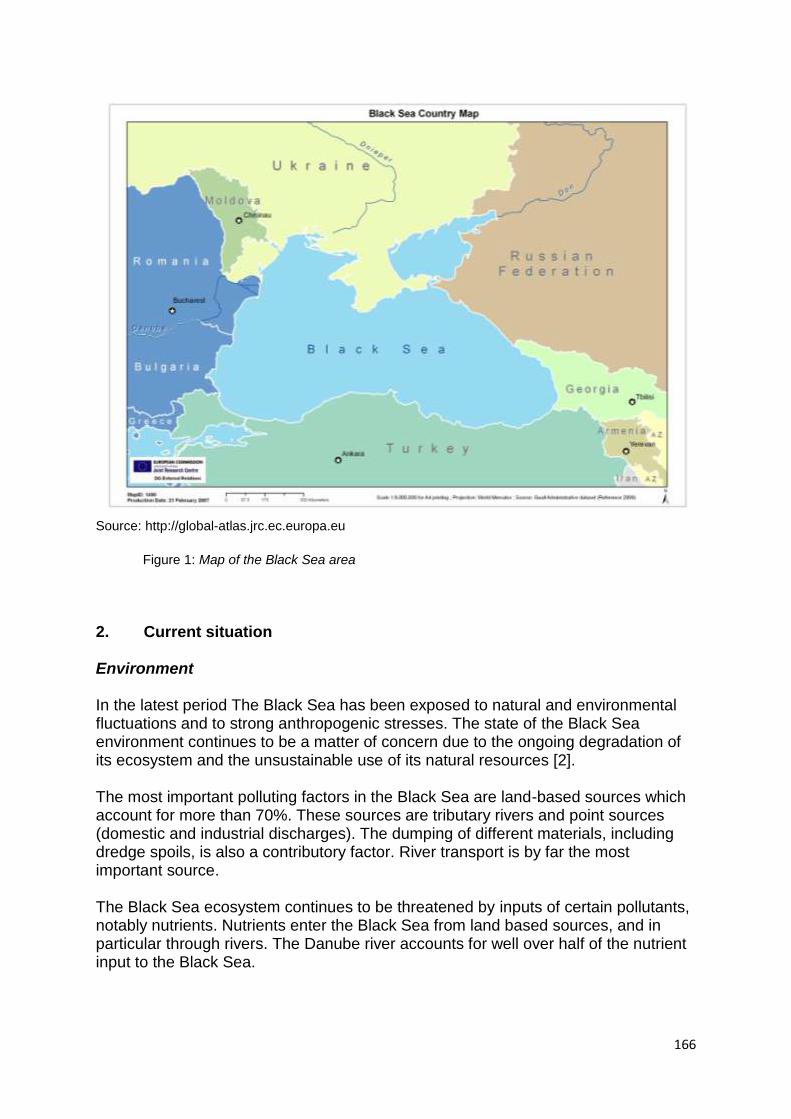
166
Source: http://global-atlas.jrc.ec.europa.eu
Figure 1: Map of the Black Sea area
2. Current situation
Environment In the latest period The Black Sea has been exposed to natural and environmental fluctuations and to strong anthropogenic stresses. The state of the Black Sea environment continues to be a matter of concern due to the ongoing degradation of its ecosystem and the unsustainable use of its natural resources [2]. The most important polluting factors in the Black Sea are land-based sources which account for more than 70%. These sources are tributary rivers and point sources (domestic and industrial discharges). The dumping of different materials, including dredge spoils, is also a contributory factor. River transport is by far the most important source. The Black Sea ecosystem continues to be threatened by inputs of certain pollutants, notably nutrients. Nutrients enter the Black Sea from land based sources, and in particular through rivers. The Danube river accounts for well over half of the nutrient input to the Black Sea.
167
Eutrophication is a phenomenon which occurs over wide areas of the Black Sea and should be of concern to the countries of the Black Sea basin. A large amount of data has been gathered on the heavy metals content of the Black Sea. The trace metal contamination is generally limited to areas where high concentrations occur, well defined source-related hot-spots, and is not a basin-wide phenomenon. Those hot-spots are in front of deltas or estuaries, commercial ports or industrial water discharges. Unfortunately these are the coastal waters where the most important biological processes take place. It was estimated that 111,000 tons of oil enter the Black Sea each year. Of this quantity, the Danube accounts for 48%. Most of the remainder comes from land-based sources (wastewater without proper treatment and accidents in handling oil or oil products). A considerable amount of oil reaches the Black Sea from ballast water discharged by ships but an accurate figure is unknown. The past introduction of exotic species, through the de-ballasting of vessels, has seriously damaged the Black Sea ecosystem and constitutes a threat to the adjacent Mediterranean Sea.
The thin upper layer of marine water (up to 150 m) supports the unique biological life in the Black Sea ecosystem. The deeper and more dense water layers are saturated with hydrogen sulfide, that over thousands years, accumulated from decaying organic matter in the Black Sea. Due to the unique geomorphological structure and specific hydrochemical conditions, specific organisms, basically on the level of protozoa, bacteria, and some multi-cellular invertebrates inhabit the deep-sea waters. Knowledge about biological forms of life in the deep waters of the Black Sea is very limited. The disturbance of the natural balance between the two layers could trigger irreversible damage to the people and ecosystem of the Black Sea [1].
Economic Use From 2000 to the third quarter of 2008, was a period of high and sustained growth with real GDP increases for the Black Sea region as a whole averaging 6% per annum. As a result living standards started to rise and trade and investment to increase. Since the third quarter of 2008, has been marked by a sharp halt in growth coupled with a low inflow of foreign capital due to the global financial crisis [3]. The economic activities connected to the Black Sea are: traditional maritime sectors, tourism and fisheries. Out the maritime activities with onshore employees (shipping, shipbuilding, marine equipment, maritime services, recreational boating, seaports, offshore supply, navy, maritime works and marine aggregates) Black Sea countries remains one of the most important seaman work force provider (East European countries are providing 20.3% of officers and 14.6% of ratings from the world total, where Romania, Bulgaria and Ukraine constitute a large part) [4]. In August 2007 a maritime cluster was established in Varna (Bulgaria) and soon will be developed another one in Constanta (Romania).
168
Black Sea is still the most popular tourist destination for people in nearby countries. But more significant is the large volume of traffic passing through the area – both people and goods, including gas and oil on its way from the Caspian Sea. These are mostly transported on tankers, but major construction work is currently underway on pipelines.
Mass tourism development in the Black Sea coastal regions has relatively recent origins, and as compared to other EU destinations, the figures already show good results. Focusing on their natural and cultural heritage, they have developed the typical
Mediterranean urban tourism model, and offer a combination of sandy beaches, ancient monuments and modern resorts aimed at addressing the demands of international tourism.
There is no doubt that the Black Sea‘s fisheries have deteriorated dramatically in the past three decades. The diversity of commercial fish caught has decreased over this period from about 26 species to some six. The volume of fish caught has actually increased, despite a near collapse in 1990, but this is almost entirely due to the large anchovy fishery of Turkey. Main factor behind this decline are: changes to the ecosystem as a result of eutrophication, arrival of alien species, overfishing. Transport The importance of Black Sea ports in international maritime trade is continuously increasing and this tendency will continue for the near future due improved grains harvest. Number of ships, size of ships and cargo volumes have grown constantly up to 2008, have decreased in 2009 and started to recover during 2010 and 2011. Cruise shipping is of major importance for various ports around the Black Sea area, but unfortunately number of cruises is quite limited and the same goes for their size. A significantly greater number of vessels were reported to have had accidents in the EU sector of the Black Sea in 2010 than in the previous three years, and the loss of life and damage caused was also greater.
However, it should be noted that the overall number reported is always relatively small in comparison to the other EU regions. The 18 vessel accidents reported in 2010 was over 150% up on 2009 and 64% up on 2008, with collisions being the predominant accident category (around 45% of the vessels were involved in this type of accident). 7 people were reported to have lost their lives on board ships in the region in 2010, which is an increase on the figures for 2009, but this was largely the result of the Karim I sinking off Cape Emine, Bulgaria, with the loss of 5 lives. There were no significant spills reported by ships in this region in 2010 [5].
169
Energy and pipelines The Black Sea region lies at the crossroads of major oil and gas export flows to the world energy markets. Wider Black Sea area is increasingly becoming very important in terms of energy production, transportation and distribution.
In November 2006 the 2nd Energy Ministerial Conference was held under the Baku Initiative sponsored by the European Commission, and a new Energy Road Map was agreed by the European Commission and Governments of Armenia, Azerbaijan, Belarus, Georgia, Kazakhstan, Kyrgyzstan, Moldova, Tajikistan, Turkey, Ukraine, Uzbekistan and the Russian Federation (as an observer) setting out a plan of action to bridge the gap between the current situation in the energy sector of these countries and the long-term vision for a common energy strategy. The priority areas identified in the Road Map include supporting to sustainable energy development - including energy efficiency, renewable energy sources and demand side management - and attracting investment into energy projects of common interest [2]. The Energy Community Treaty, having as main goal to set up a legal and economic framework in relation to Network Energy, entered into force on 1st July 2006, accepted Georgia as observer in December 2007 and was enlarged with Moldova (full member from 1st May 2010) and Ukraine (full member from 1st February 2011) . The Contracting Parties established to adopt and implement the acquis communautaire on energy, environment, competition and renewables. Turkey has confirmed the intention to engage in formal negotiations to join the Energy Community Treaty [4]. In the Black Sea Region each country is distinct in terms of its energy use and potential for renewable energy, but several trends are clear. First is that renewables are clearly underexploited. Second is that of the renewables sources, hydropower is the best known, but at large scale (and hence questionably ‗renewable‘); the massive growth in wind power seen globally is beginning to make itself known in the region. The abundance of oil and gas in the Caspian region has left countries there using that resource for
domestic use, as in Azerbaijan, while many other countries continue to rely heavily on fossil fuels that
have historically been available at cheaper than market prices, complicating the economic argument
for alternatives.
The State Agency of Ukraine for Energy Efficiency and Energy Conservation
(SAUEEEC) launched in 2010 a project of which includes the largest European solar
power plant (80 MV) in Okhotnykovo, Crimea. The project aims to produce electric
energy from ―clean‖ sources – the sun and the wind – to the amount of 2,000 MW.
SAUEEEC expects the production share of alternative energy to make up 30 percent
of Ukrainian energy market by 2015.
Ukraine funds its energy saving projects by the profits the government receives from
selling CO2 quota under the Kyoto protocol. In 2009; having traded its CO2 emission
quota to Japan, Ukraine has received almost USD 400 m.
The amount of solar radiation in Ukraine varies between 800 and 1450 W/m² per
year and provides an extensive potential market of solar energy projects. As of 2009,
170
Ukraine is the twelfth largest energy market in the world with an installed capacity of
54 GW. Ukraine exports its excess electricity to Hungary, Moldova, Poland,
Romania, Russia, and Slovakia [8].
A dynamic development of onshore wind power capacity installation may be
observed in the latest period in Romania and Bulgaria [9].
A small number of oil platforms are operated by Romania and Ukraine. In the latest
period Turkey started exploration using modern platforms to discover oil and natural
gas reserves, based on recent seismic research.
Pipelines in the region
The Druzhba pipeline is the world‘s longest oil pipeline with 4000 km length reaching Ukraine, Hungary, Poland and Germany. Pipeline was built in 1964 and currently has a capacity of 60–62 million tons per year. There are two project proposals with regard to the further extension of the Druzhba pipeline: extension of the northern branch of pipeline to the German North Sea port of Wilhelmshaven and extension of the pipeline to pass through Hungary and Croatia for reaching Adriatic Sea. The Baku–Tbilisi–Ceyhan pipeline is a 1,768 km long crude oil pipeline from the Azeri-Chirag-Guneshli oil field in the Caspian Sea to the Mediterranean Sea. It connects Baku, the capital of Azerbaijan; Tbilisi, the capital of Georgia; and Ceyhan, a port on the south-eastern Mediterranean coast of Turkey, hence its name. It is operational from 10 May 2006 and is projected to transport 1 million barrels per day. The Odessa–Brody pipeline (also known as Sarmatia pipeline) is a crude oil pipeline between the Ukrainian cities Odessa at the Black Sea, and Brody near the Ukrainian-Polish border (674 km). There are plans to expand the pipeline to Płock, and furthermore to Gdańsk in Poland. Blue Stream is a major trans-Black Sea gas pipeline that carries natural gas from Russia into Turkey. Operating at full capacity delivers 16 bcm per year. The pipeline was built with the intent of diversifying Russian gas delivery routes to Turkey and avoiding third countries. It is planned to build the second leg of pipeline to allow expanding Russian gas export to the south (via Samsun-Ceyhan gas pipeline further to Israel and Lebanon). South Caucasus Gas Pipeline (Baku-Tbilisi-Erzurum route) is to transport natural gas from the Shah Deniz gas field in the Azerbaijan sector of the Caspian Sea to Turkey. First deliveries of gas started in December 2006. The pipeline is being constructed in the same corridor as the Baku-Tbilisi-Ceyhan oil pipeline in order to minimize the environmental and social impact. The pipeline is 692-km-long and the annual capacity will be up to 16 bcm, with the potential of being connected to Turkmen and Kazakh producers through the planned Trans-Caspian Pipeline. The first aim of pipeline is to supply Georgia and Turkey. In longer perspective South Caucasus pipeline will supply Europe with Caspian natural gas, including Iran and Turkmenistan, through the planned NABUCCO project, Turkey-Greece and Greece-Italy pipelines.
171
NABUCCO is a gas pipeline project connecting the Caspian region, Middle East and Egypt via Turkey, Bulgaria, Romania, and Hungary with Austria and further on with the Central and Western European gas markets. The pipeline planned length is 3.900 km and the transport capacity of pipeline will be 31 bcm per year. Another proposed route aiming at the transportation of natural gas from Kazakhstan and Turkmenistan to Central Europe is expansion of Central Asian-Centre gas pipeline, which runs from Turkmenistan via Uzbekistan and Kazakhstan to Russia. Burgas-Alexandropoulos oil pipeline (279 km) is a project for transportation of Russian and Caspian oil from the Bulgarian Black Sea port of Burgas to the Greek Aegean port of Alexandroupoli. It would be an alternative route for Russian oil for bypassing the Bosporus and the Dardanelles. However, in June 2010 it was announced that Bulgaria will not participate in the project to due strong opposition of local population of Burgas and an environmental impact assessment is needed before making a final decision about the project. The Pan-European Oil Pipeline is a proposed oil pipeline from Constanţa in Romania via Serbia and Croatia to Rijeka and from there through Slovenia to Trieste in Italy (1,856 km). The aim of the pipeline is to bypass Turkish straits in the transportation of Russian and Caspian oil to Central Europe. In Trieste the pipeline will be connected with the Transalpine Pipeline, running to Austria and Germany [10]. Trans-Caspian Pipeline project is a proposed submarine pipeline between city of Turkmenbashy in Turkmenistan and Baku in Azerbaijan and considered as a part of the South Caucasus pipeline and NABUCCO project. Along with South Caucasus and Trans-Caucasus pipelines the Iran-Turkey gas pipeline with extension of 2.577 km is the third essential branch of the NABUCCO project. The construction of pipeline was completed in 2001. In Erzurum the Iran-Turkey pipeline is linked to the South Caucasus pipeline. Iran-Armenia gas pipeline is a 140 km pipeline between two countries running from Tabriz to Iran-Armenia border. The initial capacity of the pipeline is 1.1 bcm annually, which will be increased up to 2.3 bcm by 2019. The Armenian side plans to lay some more 197 km of the pipe in order to reach the planned amount. The pipeline operation started on December 2006 and was officially inaugurated on 19 March 2007. AMBO (Trans-Balkan pipeline) project is planned oil pipeline from Bulgarian Black Sea port Burgas via Former Yugoslav Republic of Macedonia (FYROM) to Albanian Adriatic port Vlore. The 894-km pipeline is expected to transport 750 000 barrels of oil per day. Trilateral convention on the AMBO project was signed on 31 January 2007.
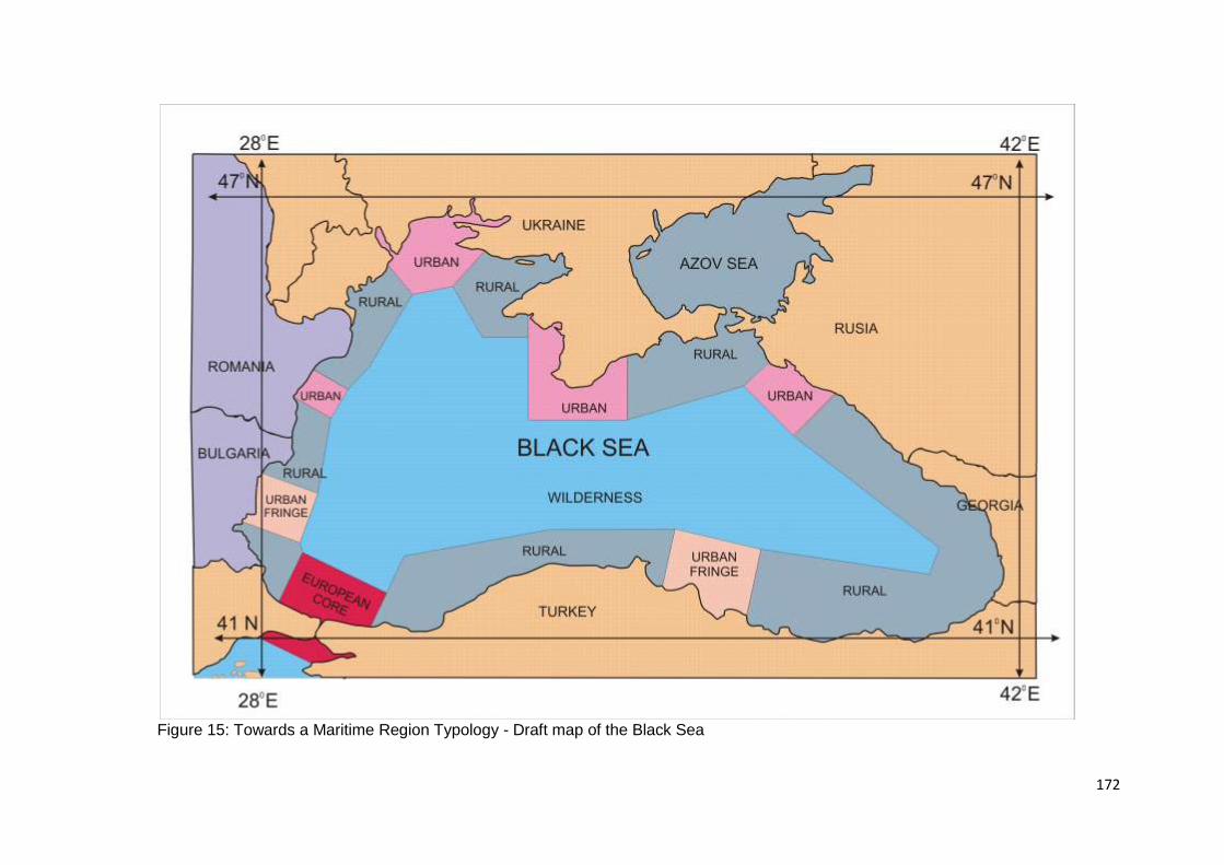
172
Figure 15: Towards a Maritime Region Typology - Draft map of the Black Sea
173
3. Outlook The future developments on energy, transport and economic use will continue to increase the risks on environment condition. Current investments in treatment plants and other environment related projects will lead to visible improvements in Bulgaria and Romania, but a lot of efforts should be made all countries in the region. A focus on implementation of the environmental strategic plan, approved by the Black Sea countries, looks to be very important. The economic data and improving socio-economic indicators, at least until the onset of the global financial crisis, demonstrated that this was, and hence could be again, one of the fastest growing regions of the world. However, wide ranging disparities among and within the states of the region remain. Despite the diversity of the countries in question in terms of size, economic structure and levels of development, a number of challenges and issues concern the region as a whole. Their measurability is made more difficult by the different levels of integration of the countries into the global economy and the EU. Contrast for example Greece, Romania, Bulgaria and Turkey with the relatively small and sometimes isolated economies of Moldova and the states of the Caucasus. Then we need to consider the challenges of social heterogeneity, the political system and economic structure of Ukraine and the challenges of economic diversification faced by energy exporters, Russia and Azerbaijan [6]. All countries of the Black Sea region will remain service-oriented. In Russia, Ukraine and Georgia, about 60 percent of gross value added originates in the services sector; the respective shares are somewhat smaller in Bulgaria, Romania and Turkey. In Bulgaria, Turkey and Georgia tourism is of growing importance — though still below its potential. At the same time, Romania, Turkey, and particularly Georgia (20 percent of gross value added) are still highly dependent on agriculture [10]. The maritime transport will continue to develop in the next future due to the economic growth and oil / gas transport. When compared with other areas of Europe, Black Sea appears to be less developed in respect of ferry services. It is expected that ferry traffic will increase significantly in the 5-10 years. Most of the Black Sea, both the shelf and the deeper areas, is believed to be prospective for oil and gas. Indeed, numerous discoveries have been made on the shelf of Ukraine (including the Sea of Azov), Romania, and Bulgaria. Russia excluded, imports of oil and gas are rapidly rising in volume and value, to the extent that they cause considerable foreign trade deficits in some countries, for example Bulgaria.
Previously inaccessible technology is now increasingly available. And – except for the Ukraine – all of the countries have improved the terms of access for investors in
174
the petroleum industry in general, in offshore exploration, and in production business in particular. Similar opportunities may exist offshore of Georgia, Ukraine, and Bulgaria. Similar to the North Sea of 50 years ago, the Black Sea may be on the verge of becoming a major oil and gas producing area. Last global tendencies in energy field indicate that the Black Sea region plays an important role in formation of new energy map of the Eurasian continent, which in perspective will contain such aspects, as diversification of oil and gas supplies, new routes of transportation of energy sources to the European markets and ensuring security of these projects. The concept of wider Black Sea region implies along with Russian oil and gas resources an increasing role of the energy sources of the Caspian basin with participation of Trans-Caspian countries – Iran, Kazakhstan and Turkmenistan in regional energy projects. The Black Sea region is a strategically important region as well as for own fossil reserves [11].
Energy and Pipelines
Opportunities
New pipelines
Construction of export pipelines to deliver hydrocarbons to the European
markets will improve the access to Caspian resources.
Fossil fuel development
The latest research leads to extension of efforts in development of potential
offshore exploitation in the Turkish area. In the Georgian area it is possible to
see future developments also. However, transport of fossil energy will lead to
increased shipping capacities in connection with further extend of pipeline
networks.
Marine Renewables
There is a wind potential in the area. Romania and Bulgaria started to invest in
onshore wind power and Ukraine taken into consideration this field. All countries
in the region should focus on this potential.
Regional development
The new role of the countries in the region (Bulgaria and Romania) as distributors on transportation routes will give them a chance of regional development including creation of work places, new incomes sources etc.
Risks
Increased oil transport and Bosphorus Strait constrains
Future developments of the oil export flows from the Caspian region will increase
the tankers passage though straits. Proposed projects, which in perspective will
175
bypass Bosphorus Strait, could eliminate the environmental risks and possibility
of physical break of energy supply in the region.
Environmental damage associated with new energy transport
New developments in energy transport in the Black sea Region will lead to
various environmental impacts and will increase the pollution risk due to ships
accidents.
Need for effective communication
The energy cooperation in the region should assure an effective sharing of information in case of an external energy crisis, as well as for assisting the early response and reactions in case of energy threats.
Infrastructure development
Wider investment policy for the improvement and liberalization of investment
opportunities in the energy sector is needed for rehabilitation and modernization
of existing energy infrastructure and construction of new energy capacities.
Transport
Opportunities
Growth of shipping
The importance of Black Sea ports in international maritime trade will increase
continuously due improved grains harvest and economic development.
Development of ferry services
The future condition will be favourable to develop ferry traffic.
Short Sea Shipping
Short Sea Shipping is due to the geographical situation of the Black Sea the
major type of maritime transport and is likely to increase further. One other
important aspect is integration of short sea shipping with Danube –Maine - Rhine
river transport.
Cruise activity
We can notice more and more cruise lines adding Black Sea to their offer. Also
cruising started to become a popular travel destination for more and more
citizens of Black Sea countries.
New infrastructure
In general there is a sufficient maritime infrastructure in place within the Black
Sea Region. Increased shipping, technological revolutions and changes in
demand will however lead to constant reconstruction and infrastructural adaption
of Black Sea ports.
Gas and oil shipping
Most of the oil and gas routes (pipelines included) are connected by different
Black Sea ports. The future energy developments will lead to increase of gas
and oil shipping
176
Leisure development
Using yachts and sporting boats is increasingly getting into summer holiday
resorts offer during the last 5-10 years and we expect that these activities will
increase in the same time with living standards of the local citizens. There is a
continuous increase in the number of new marinas that are opening or enlarging
every year.
Risks
Substandard shipping and maritime accidents
The Black Sea remained an area where most of the subsatndard ships are still trading and this probably due to use of lower PSC standards. The apparently low number of accidents reported in the EU sector of the Black Sea is due to relatively low traffic volumes in the area.
Administrative barriers to shipping
Black Sea is an important gate for cargoes entering the European Union and therefore it is extremely important to have in place a fast and effective custom and administrative system for management of cargoes.
Environment
Opportunities
Improved monitoring and communication
The latest environmental related projects lead to improvements in monitoring
and exchange of data among Black Sea countries with potential results in
increasing of awareness and establishing proper environmental protection
measures
Implementation of EU regulations and regional agreements
The measures taken by EU countries (Bulgaria and Romania) in order to fulfil
European requirements and implementation of initiated environmental projects
together with common efforts to put in practice the regional agreements signed
by all Black Sea countries may permit to obtain better results in environmental
protection.
Risks
Eutrophication
The anthropogenic eutrophication is the key ecological problem for the coastal
Black Sea region (especially it is North-Western part subjected to the strong
influence of freshwater input), resulted in dramatic alterations in the chemical
and biological regimes
177
Nutrient enrichment
The Black Sea environment continue to be threaten by nutrients discharged to
the Sea via rivers, of which the Danube is by far the most important, direct
discharges from large municipal/industrial plants and atmospheric deposition of
nitrogen to the Sea.
Marine living resources
Important marine living resources have been greatly affected by alien species
introductions, eutrophication, over-fishing and habitats change/damage. Annual
total fish catch statistics show an improving situation, but these figures are
dominated by catches of anchovy and sprat. There have been recent
improvements in catches of some other fish, such as bonito, but turbot, dogfish
and whiting catches have either shown no improvement or have fallen over the
past decade-or-so. Sturgeons remain endangered. Unsustainable fishing
practices are still in relatively common use [2].
Biodiversity
The invasive aliens lead to a serious impact on the Black Sea native biological
diversity, with negative consequences for human activities and economic
interests [12].
Economic use
Opportunities
Services related to energy transport infrastructure development
The new role played by the Black Sea countries in the development of energy
transport infrastructure will allow them to increase the connected services and to
create a large number of work places
Agriculture development
It is expected that the agriculture outcomes to increase in the future years in
countries like Romania, Ukraine, Bulgaria and Georgia.
Increased tourism
There is a big tourism potential, including cruising, in the area, which may be
exploited with good results
Risks
Low investments in infrastructure
The very low level of the investments in infrastructure will constitute a major
barrier in economic development.
Administrative barriers
178
The low level of administrative reform in Black Sea countries still it is an important barrier into attract foreign investments and develop the economy of the coastal area.
Environmental pressures caused by land use
Eutrophication in Black Sea is caused mainly by large amounts of nutrient loads
with river and land based sources. The future developments of economic use in
the coastal area will increase the pressure on environment.
4. References
[1] www.blacksea-commission.org , official site of the Commission on the Protection of Black Sea Against Pollution – Permanent Secretariat, accessed 2011-08-22 [2] Strategic Action Plan for the Environmental Protection and Rehabilitation of the Black Sea, Commission on the Protection of Black Sea Against Pollution, adopted in Sofia 17 April 2009 [3] A 2020 Vision for the Black Sea Region, A Report by the Commission on the Black Sea, www.blackseacom.eu [4] Manpower 2010 Update. The Worldwide Demand for and Supply of Seafarers, BIMCO / ISF, www.bimco.org
[5] Maritime Accident Review 2010, European Maritime Safety Agency, www.emsa.europa.eu
[6] www.europeanlawmonitor.org, accessed 2011-08-22 [7] Report on the first year of implementation of the Black Sea Synergy, Commission of the European Communities, Communication from the Commission to the Council and the Puropean Parliament, Brussels, 19.6.2008, COM(2008) 391 [8] Worldwide News Ukraine, www.inogate.org, accessed 2011-08-22 [9] Wind in Power – 2010 European statistics, The European Wind Energy Association, February 2011
[10] The Wider Black Sea Region in the 21st Century, Strategic, Economic and Energy Perspectives, Hamilton D., Mangott G. (eds.), Center for Transatlantic Relations, 2008
[11] The priorities of cooperation between BSEC member states in the field of energy: oil and gas sector, Report adopted by The Thirtieth Plenary session of the PABSEC General Assembly, 20th November 2007
[12] ‗Diagnostic Report‘ to guide improvements to the regular reporting process on the state of the Black Sea environment, Commission on the Protection of Black Sea Against Pollution, 3rd August 2010
179
Appendix 9: Case Study Methodology Briefing Notes
Introduction The case studies must be seen as an integral component of the project, related very clearly and explicitly to the governance experience in different maritime/coastal regions and the potential transferability of good practice. The emphasis here is on an evaluation of whether the governance arrangements are helping to deliver the desired outcomes of the project. This paper has two main purposes:-
To adopt a common methodology in terms of how each case study will be undertaken, accepting of course that each of the case studies will be unique.
To agree a generic template to structure the individual case study reports so that a common framework for reporting is adopted. This will enable comparisons of case studies so that lessons and identification of good or better practice can be made.
Case Study Selection It has been agreed that each regional sea will undertake three case studies. Each case study has been allocated the equivalent of 10 person days per case and whilst resources are tight, judicious selections of the case studies (especially if the team members are familiar with the case might expedite the evaluation). It has been agreed that there are two types of case study. The first looks at a governance arrangement that seeks to manage in some way the resources associated with the whole of the regional seas (see Table 1). From the feedback we received from the Inception Report these have now been accepted as appropriate by the ESPON monitoring committee and our experts. For the sub-seas case studies we were asked to reflect again whether our chosen projects were appropriate. It was agreed that following our discussions in Valencia we would circulate a brief paper to the ESPON Sounding Board to gain final approval of our selected case studies. This has now been done and the following case studies have been approved. The critical criteria for selection has been:-
is there some form of transnational governance arrangement in place?
does the case study deal with a marine opportunity, risk or threat for territorial development?
are these the most interesting cases to choose?
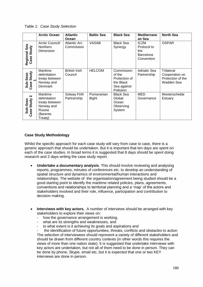
180
Table 1: Case Study Selection Arctic Ocean Atlantic
Ocean Baltic Sea Black Sea Mediterrane
an Sea North Sea
Reg
ion
al
Sea
Case S
tud
y Arctic Council/
Northern Dimension
Atlantic Arc Commission
VASAB Black Sea Synergy
ICZM Protocol to the Barcelona Convention
OSPAR
Su
b-S
ea
s
Case S
tud
y
1
Maritime delimitation treaty between Norway and Denmark
British Irish Council
HELCOM Commission of the Protection of the Black Sea against Pollution
Adriatic Sea Partnership
Trilateral Cooperation on Protection of the Wadden Sea
Su
b-S
ea
s
Case S
tud
y 2
Maritime delimitation treaty between Norway and Russia (Barents Treaty)
Solway Firth Partnership
Pomeranian Bight
Black Sea Global Ocean Observing System
MED Governance
Westerschelde Estuary
Case Study Methodology Whilst the specific approach for each case study will vary from case to case, there is a generic approach that should be undertaken. But it is important that ten days are spent on each of the case studies. In broad terms it is suggested that 8 days should be spent doing research and 2 days writing the case study report.
Undertake a documentary analysis. This should involve reviewing and analysing reports, programmes, minutes of conferences etc. to develop an understanding of spatial structure and dynamics of environmental/human interactions and relationships. The website of the organisation/agreement being studied should be a good starting point to identify the maritime related policies, plans, agreements, conventions and relationships to territorial planning and a ‗map‘ of the actors and stakeholders involved and their role, influence, participation and contribution to decision making.
Interviews with key actors. A number of interviews should be arranged with key stakeholders to explore their views on: - how the governance arrangement is working, - what are its strengths and weaknesses, and - to what extent is it achieving its goals and aspirations and - the identification of future opportunities, threats, conflicts and obstacles to action The selection of interviewees should represent a variety of different stakeholders and should be drawn from different country contexts (in other words this requires the views of more than one nation state). It is suggested that undertake interviews with key actors are undertaken, but not all of them need to be done in person. They can be done by phone, Skype, email etc, but it is expected that one or two KEY interviews are done in person.
181
Synthesis. The outcome of the previous two activities should be written up as a narrative that seeks to evaluate the effectiveness and robustness of the governance arrangement to deal with the transnational planning issue under consideration.
Structure and format of the Case Study Reports Each case study needs to be approximately 5-6,000 words in length, although the precise length and weight given to each section will to some extent depend on local circumstances. The case study report should address the following issues, using the suggested sub-headings to encourage comparability, accepting of course the diversity of projects being explored.
Introduction to the case study This should be brief and include a description of the case study. A short description of the governance regime and geographic area covered. What is it? What are the issues and problems that lie at the heart of the case study? What is the spatial coverage of the case study (including a map)?
Context and Conditions This should be brief and provide examination of the spatial structure of the area and nature/human interactions. What are the key issues and links with land development and potential conflicts? What are the international, European and (if relevant) national and regional policies programmes and projects that provide a framework for this issue? How is the project funded? A summary of existing coastal/maritime related policies, plans, agreements and conventions and relationships to terrestrial planning should be provided.
Actors and Agencies Who are the key public private and voluntary actors that are involved in the process? How do they work together? Where do you think power lies? How is the project funded? Are there any key actors not involved in the project?
Chronology or sequence of events What have been the main events activities that have and continue to take place in terms of the way the issue is being dealt with? What has been the timescale for these events? A diagram should be used to illustrate the time sequence of key events which can accompany the narrative.
Project Evaluation What are the outputs from the project and how successful do you think the governance arrangements are at dealing with the issue/s that the project is trying to deal with? To what extent are the governance arrangements sufficiently robust and powerful to deal with the particular issues under consideration? How sustainable do you think the partnership is in terms of sustaining a network to deal with the particular problem?
182
Lessons for Marine Spatial Planning What, if any lessons can be learnt from the case study in terms of the effectiveness of the governance arrangements to deal with this particular issue? What are the strength and weaknesses of the approach adopted? To what extent are EU programmes and initiatives critical in addressing the issue, or is it another international organisation or national/regional governments working co-operatively that have enabled the network to be created and maintained? What are the key messages and issues that can be drawn from the case study? (How sustainable is the governance arrangement in terms of in continuing its work into the future, how powerful is it and what conflicts does this arrangement have with other agencies, interests or governance arrangements that might have an interest in the sea or resources in the area under consideration?)

183


![docs.house.gov€¦ · Web viewDAV resolution No. 016, states in part, “…[t]he exclusion of territorial seas or waters from the term “Republic of Vietnam” is contrary to](https://img.pdfslide.us/doc/110x75/5f060d517e708231d4160cdd/docshousegov-web-view-dav-resolution-no-016-states-in-part-aoethe-exclusion.jpg)